Embed Size (px)
Citation preview
ELSEVIER Sedimentary Geology 128 (1999) 179–199
Oligocene to Holocene sediment drifts and bottom currents on theslope of Gabon continental margin (west Africa)
Consequences for sedimentation and southeast Atlantic upwelling
Michel Seranne Ł, Cesar-Rostand Nze Abeigne
Institut des Sciences de la Terre de l’Eau et de l’Espace de Montpellier, UMR 5573, CNRS, Universite Montpellier 2, Case 060,34095 Montpellier cedex 05, France
Received 10 June 1998; accepted 7 June 1999
Abstract
Seismic reflection profiles on the slope of the south Gabon continental margin display furrows 2 km wide andsome 200 m deep, that develop normal to the margin in 500–1500 m water depth. Furrows are characterised by anaggradation=progradation pattern which leads to margin-parallel, northwestward migration of their axes through time.These structures, previously interpreted as turbidity current channels, display the distinctive seismic image and internalorganisation of sediment drifts, constructed by the activity of bottom currents. Sediment drifts were initiated above a majorOligocene unconformity, and they developed within a Oligocene to Present megasequence of general progradation of themargin, whilst they are markedly absent from the underlying Late Cretaceous–Eocene aggradation megasequence. Thepresence of upslope migrating sediment waves, and the northwest migration of the sediment drifts indicate deposition bybottom current flowing upslope, under the influence of the Coriolis force. Such landwards-directed bottom currents on theslope probably represent coastal upwelling, which has been active along the west Africa margin throughout the Neogene. 1999 Elsevier Science B.V. All rights reserved.
Keywords: west Africa margin; southeast Atlantic; contourites; drifts; slope deposits; Oligocene; Neogene
1. Introduction
Sedimentation on continental shelves has beenthe subject of intense studies for several decades.Sedimentary processes on continental margins arepresently receiving increased attention since the dis-covery of large hydrocarbon reservoirs in the deepoffshore South Atlantic, and was prompted by theprogress of technology allowing deep-water indus-
Ł Corresponding author. Tel.: C33-467-544-811; Fax: C33-467-523-908; E-mail: [email protected]
trial drilling. Knowledge of sediments and sedimen-tary processes in deep water (>200 m bathymetry)relies on facies analyses of sedimentary basins (e.g.Carminatti and Scarton, 1991; Mutti et al., 1992).Stratal relationships across the slope are critical inunderstanding the sedimentary processes involved.This is particularly true in areas where geometry isthe only feature available for investigation.
In spite of the variety of both sedimentary facies(Pickering et al., 1986) and processes involved in thedeep-sea environment (Stow, 1994), a great deal ofattention has been focused on turbidites. The current
0037-0738/99/$ – see front matter 1999 Elsevier Science B.V. All rights reserved.PII: S 0 0 3 7 - 0 7 3 8 ( 9 9 ) 0 0 0 6 9 - X
180 M. Seranne, C.-R. Nze Abeigne / Sedimentary Geology 128 (1999) 179–199
view is that most sedimentation in deep water canbe related to a generalised ‘turbidite model’. Thiscomprises an upper area where sediment is suppliedor reworked, an intermediate area where sedimentis transported (channels), and a lower area wheremost of the deposition occurs (fan lobes). The pre-dictive properties of this model explain its successamongst explorationists. However, a controversy re-cently arose about whether the turbidite paradigmcould be applied to a number of reputed turbidites(Shanmugam and Moiola, 1995, 1997; Slatt et al.,1997). Observations in the modern ocean provide ev-idence for a wide distribution of sediment drifts andsuggest that bottom currents played a significant rolein their deposition (e.g. Faugeres et al., 1984; Stoker,1998; Stow et al., 1998). In addition, interpretationsof seismic reflection surveys show that sedimentdrifts represent a significant part of the Neogenegeological record, not only in the abyssal basins(e.g. Tucholke and Mountain, 1979), but also on theslopes of continental margins (Fulthorpe and Carter,1991; Howe et al., 1994; Carter et al., 1996; Stoker,1998; Viana et al., 1998). These findings stronglycontrast with the scarce field-based descriptions ofcontourites and sediment drifts (Stow et al., 1998),and it may suggest that some bottom-current depositshave erroneously been interpreted as turbidites (seediscussion in Mutti et al., 1992).
Although the existence of bottom currents withthe ability to erode, transport and deposit sediment,has been recognised for several decades (Heezenet al., 1966), contourite deposits remain relativelypoorly described deposits. The diversity of sedi-ment drifts, expressed by variable geometry (Stoker,1998), and with a wide distribution across abyssalbasins (Driscoll and Laine, 1996) and continentalslopes (Howe et al., 1994), and in different bathy-metric settings (Faugeres et al., 1984; Marani etal., 1993), reflect the complexity of interaction ofdeep-water circulation and sediment supply.
The aim of this paper is to describe the geom-etry of large-scale sediment drifts on the slope ofthe Gabon continental passive margin. The existenceof a significant proportion of sediment drifts in theTertiary sequences of the west Africa continentalmargin has implications for the sedimentary modelsused for exploration. This is particularly the casefor the presence and expected geometry of reser-
voirs on the slope, correlation between slope andbasin deposits, and in terms of the origin and natureof the sediment supply. The geometry of sedimentdrifts can provide basic information on the currentsresponsible for their formation. Conversely, analy-ses of sediment drifts can be useful in decipheringthe Oligocene–Neogene history of ocean circulationin the low-latitude southeast Atlantic. This paper isbased on the interpretation of structures observed onindustrial multichannel seismic reflection profiles,and limited borehole data, subsequently, the precisestratigraphy and the sedimentology of the drifts re-main unknown. However, the large-scale geometricalfeatures are sufficiently well documented to proposean interpretation and to fuel new discussions onthe processes responsible for the formation of slopesediment drifts.
2. Physiography and oceanography
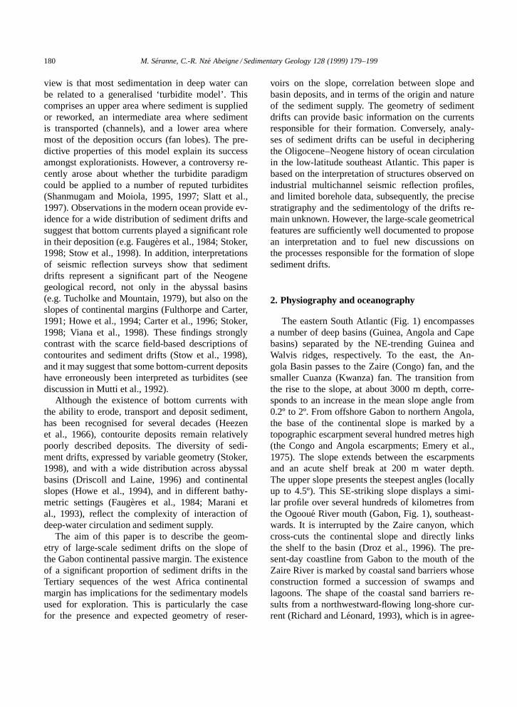
The eastern South Atlantic (Fig. 1) encompassesa number of deep basins (Guinea, Angola and Capebasins) separated by the NE-trending Guinea andWalvis ridges, respectively. To the east, the An-gola Basin passes to the Zaire (Congo) fan, and thesmaller Cuanza (Kwanza) fan. The transition fromthe rise to the slope, at about 3000 m depth, corre-sponds to an increase in the mean slope angle from0.2º to 2º. From offshore Gabon to northern Angola,the base of the continental slope is marked by atopographic escarpment several hundred metres high(the Congo and Angola escarpments; Emery et al.,1975). The slope extends between the escarpmentsand an acute shelf break at 200 m water depth.The upper slope presents the steepest angles (locallyup to 4.5º). This SE-striking slope displays a simi-lar profile over several hundreds of kilometres fromthe Ogooue River mouth (Gabon, Fig. 1), southeast-wards. It is interrupted by the Zaire canyon, whichcross-cuts the continental slope and directly linksthe shelf to the basin (Droz et al., 1996). The pre-sent-day coastline from Gabon to the mouth of theZaire River is marked by coastal sand barriers whoseconstruction formed a succession of swamps andlagoons. The shape of the coastal sand barriers re-sults from a northwestward-flowing long-shore cur-rent (Richard and Leonard, 1993), which is in agree-
M. Seranne, C.-R. Nze Abeigne / Sedimentary Geology 128 (1999) 179–199 181
Zaire fan
Orangefan
escarpment
shelfbreak
surface current
fracture zone
isobath (metres)
Orange R.
Wal
vis
Rid
ge NAMIBIA
Cunene R.
ANGOLA
Cuanza R.
Zaire
R.
Zaire canyon
GABON
CONGO
R.D. CONGO
EQUAT.GUINEA
CAMEROON
Ogooué R.
10002000
4000
4000
3000
5000
4000
5000
5500
5000
5500
4000
4000 3000
4000
100020003000
ANGOLA BASIN
Nigerdelta
Romanche FZ
Fernando FZ
Ascension FZ
Guinea Ridge0˚
10˚S
20˚S
30˚S
10˚W 0˚ 10˚E 20˚E
South Equatorial Current
Guinea Current
Benguela C
oastal C.Benguela C
urrentstudyarea
Ang
ola
coas
talC
urre
nt
CAPEBASIN
Niger fan
Ogoouéfan
3.0
2.5
2.01.5
1.0
0.50.2
2.5 seafloor isochron (in sec twt)
210a
7
8
6c6b
6a 10b
5 3position of profiles shown
reference well
0 50km
SW boundary of seismic data
shelfbreak
slope
shelf
basin
b
a
Fig. 1. (a) Map of the west Africa margin and southeast Atlantic, showing the main study area, the important physiographic features, andthe principal surface currents. (b) Location map of the study area, offshore south Gabon. Seismic reflection data (Western Geophysicaland GECO) cover the shelf and the slope. Sections shown in this contribution are indicated.
182 M. Seranne, C.-R. Nze Abeigne / Sedimentary Geology 128 (1999) 179–199
ment with Pleistocene and Recent oceanographicdata (Jansen et al., 1984). The Gulf of Guinea ispresently subjected to seasonal monsoons associatedwith upwelling along the coast (Servain et al., 1985;Schneider et al., 1997; Berger et al., 1998).
3. Geological setting
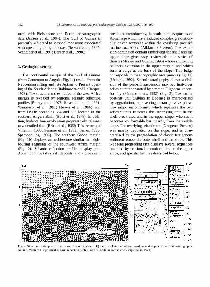
The continental margin of the Gulf of Guinea(from Cameroon to Angola, Fig. 1a) results from theNeocomian rifting and late Aptian to Present open-ing of the South Atlantic (Rabinowitz and LaBreque,1979). The structure and evolution of the west Africamargin is revealed by regional seismic reflectionprofiles (Emery et al., 1975; Rosendahl et al., 1991;Wannesson et al., 1991; Meyers et al., 1996), andfrom DSDP boreholes 364 and 365 located in thesouthern Angola Basin (Bolli et al., 1978). In addi-tion, hydrocarbon exploration progressively releasesnew detailed data (Brice et al., 1982; Teisserenc andVillemin, 1989; Seranne et al., 1992; Turner, 1995;Spathopoulos, 1996). The southern Gabon margin(Fig. 1b) displays an architecture similar to neigh-bouring segments of the southwest Africa margin(Fig. 2). Seismic reflection profiles display pre-Aptian continental synrift deposits, and a prominent
Fig. 2. Structure of the post-rift sequence of south Gabon (left) and correlation of seismic markers and sequences with lithostratigraphiccolumn. Western Geophysical seismic reflection profile, vertical scale in seconds two-way-time (s TWT).
break-up unconformity, beneath thick evaporites ofAptian age which have induced complex gravitation-ally driven tectonics within the overlying post-riftmarine succession (Albian to Present). The exten-sion-dominated domain underlying the shelf and theupper slope gives way basinwards to a series ofthrusts (Morley and Guerin, 1996) whose shorteningbalances extension in the upper margin, and whichform a bulge at the base of the slope. This bulgecorresponds to the topographic escarpments (Fig. 1a)(Uchupi, 1992). Seismic stratigraphy allows a divi-sion of the post-rift succession into two first-orderseismic units separated by a major Oligocene uncon-formity (Seranne et al., 1992) (Fig. 2). The earlierpost-rift unit (Albian to Eocene) is characterisedby aggradation, representing a transgressive phase.The major unconformity which separates the twoseismic units truncates the underlying unit in theshelf-break area and in the upper slope, whereas itbecomes conformable basinwards, from the middleslope. The overlying seismic unit (Neogene–Present)was mostly deposited on the slope, and is char-acterised by the progradation of clastic terrigenoussediment across the outer shelf and the slope. ThisNeogene prograding unit displays several sequencesbounded by erosional unconformities on the upperslope, and specific features described below.
M. Seranne, C.-R. Nze Abeigne / Sedimentary Geology 128 (1999) 179–199 183
4. Geometry from seismic reflection profiles
The sedimentary features we document arepresent on regional, 10 km spaced, 2D migratedseismic reflection surveys, acquired by Western Geo-physical and GECO. The seismic data cover thewhole shelf and upper slope, down to 2800 mbathymetry (Fig. 1b). Borehole data from wells lo-cated on the upper slope do not allow a sedimen-tological study, nor a precise biochronology, for thetime interval of interest (post-Eocene). They have
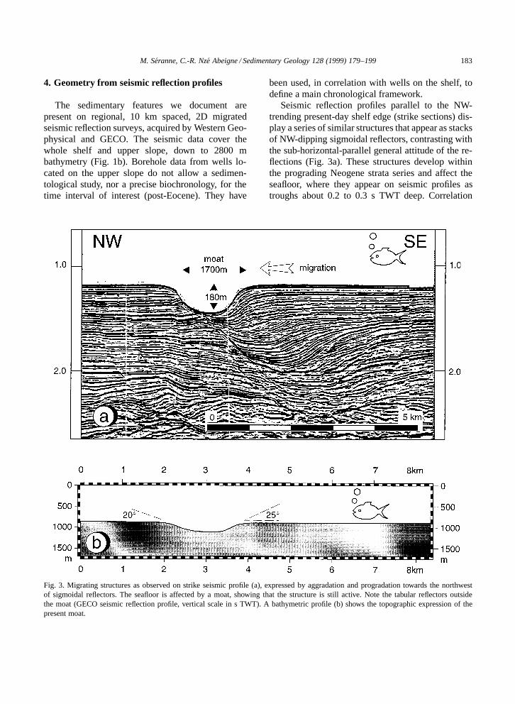
Fig. 3. Migrating structures as observed on strike seismic profile (a), expressed by aggradation and progradation towards the northwestof sigmoidal reflectors. The seafloor is affected by a moat, showing that the structure is still active. Note the tabular reflectors outsidethe moat (GECO seismic reflection profile, vertical scale in s TWT). A bathymetric profile (b) shows the topographic expression of thepresent moat.
been used, in correlation with wells on the shelf, todefine a main chronological framework.
Seismic reflection profiles parallel to the NW-trending present-day shelf edge (strike sections) dis-play a series of similar structures that appear as stacksof NW-dipping sigmoidal reflectors, contrasting withthe sub-horizontal-parallel general attitude of the re-flections (Fig. 3a). These structures develop withinthe prograding Neogene strata series and affect theseafloor, where they appear on seismic profiles astroughs about 0.2 to 0.3 s TWT deep. Correlation

184 M. Seranne, C.-R. Nze Abeigne / Sedimentary Geology 128 (1999) 179–199
of these features on parallel profiles across the slopereveals elongated furrows which we term moats.
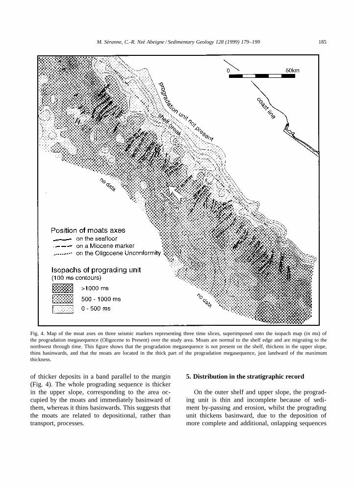
Sub-parallel moats are observed on the presentseafloor, just seaward of the shelf edge, at depthsbetween 0.5 s TWT (two-way-time) and less than2.2 s TWT, i.e. between 400 m and 1650 m waterdepth. Depth conversion of the seismic profile, usinga velocity of 1500 m=s in water yields the profile ofthe moats (Fig. 3b). They are 100–200 m deep andabout 2 km wide, with lateral slopes of some 20º to25º. They are broadly U-shaped with wider examplesdisplaying a flattened floor. The spacing betweenadjacent moats ranges from 2 to 10 km, 7 to 8 kmbeing the most frequent spacing. Moats are straightand can be traced in the dip direction for more than15 km. In strike section they appear as a stackingof clinoforms aggrading and prograding northwest-wards at an average rate of 350 m per 0.1 s TWT. Atany time, the southeast limb of the moat is formed bythe top of the clinoform, while the northwest flankis a concave-up surface onto which the clinoformsdownlap. The most striking feature is the consistencyof the northwestward direction of migration. In theuppermost part of the slope, the moats are filled byonlapping younger formations. The map in Fig. 4depicts the location of the axes of the moats on threehorizons, representing three successive time slices.The older horizon corresponds to the Oligocene ma-jor unconformity (see that marker on Fig. 2), thenext horizon corresponds to a marker located withinthe (Upper?) Miocene, and finally, the seafloor indi-cates the present-day position of the moats. This mapemphasises the lateral migration of individual moatsand the persistency of some through time. The north-western part of the area is characterised by narrowermoats that cannot be correlated from one profile tothe next. These moats present a different structure, inthat they are not migrating and their position seemsto be constrained by synsedimentary faulting. Theirrelationship with the moats which are the topic ofthe present study is questionable, and they will notbe considered further in the rest of this contribution.
The characteristics of the seafloor reflector inthe migrating moats (Fig. 3) suggest that they arenot filled with slumps or ooze, but are flushed aswell as the inter-moat areas. Inter-moat zones arecharacterised by continuous sub-horizontal-parallelreflectors. Unlike seismic images of channels (e.g.
Pirmez and Flood, 1995), there is no evidence oflevee deposits on either side of a moat.
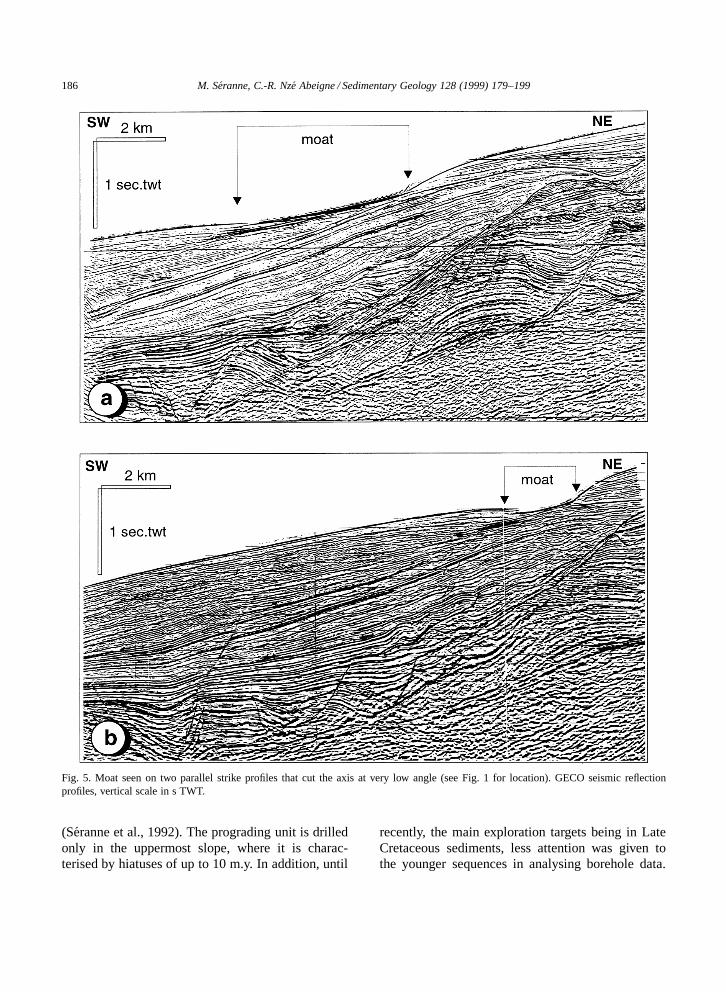
Moats can seldom be directly observed in dip sec-tion. This is mostly due to their orientation. However,some sections (Fig. 5) show the top of one moat cross-cut at a low angle with respect to its axis. The land-ward side of the moat consists of a surface which ei-ther truncates or drapes the underlying reflectors. Thebasinward margin is characterised by convex-upwardreflectors that converge and onlap upslope. The floorof the moat is characterised by high-amplitude re-flectors. The margins imaged on this dip section thuscorrespond to the NW-eroding and the SE-progradingmargins of the moat, respectively.
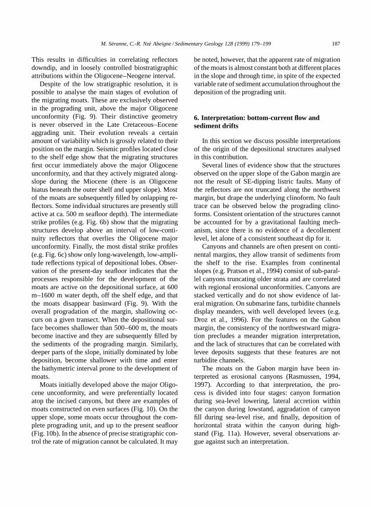
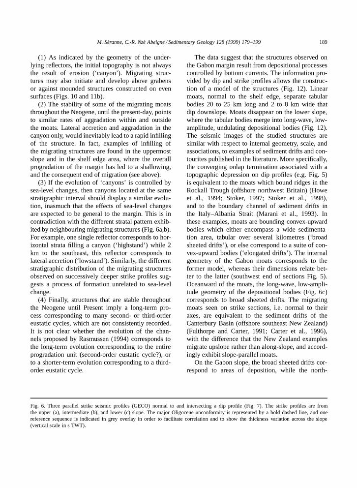
Cross-correlation of the strike lines (Fig. 6) withdip profiles (Fig. 7) shows that the migrating moatsdevelop on the upper slope, on the seabed withslopes at 3º to 4º. The seafloor reflector is re-markably smooth in comparison to the underlyingreflectors of the Neogene prograding unit which isaffected by faulting and long-wave folding (Fig. 7).Smaller sediment waves with a component of up-slope migration sometimes occur on the seafloor,between the moats (Fig. 8). Both features stronglysuggest bottom-current flow on the slope. The areaoccupied by the moats on the upper slope (Fig. 6a)appears on the dip profile as an aggrading intervalconsisting of semi-continuous, parallel reflectors of-ten cut by minor, low-angle erosional surfaces. In theintermediate slope (Fig. 6b), moats are not presentlyactive, but there is evidence of migrating moatsin earlier sequences. The dip profile displays 10–20-km-long clinoforms that downlap onto the mid-dle slope. Several sequences of progradation can beidentified. The clinoforms are separated by downlapsurfaces characterised by energetic and continuousseismic reflections overlain by a transparent intervalinto which merge the apparently downlapping reflec-tors. In fact, the latter may distally pass to a verythin interval of sediment, below seismic resolution,thus resulting in a downlapping ‘surface’. On strikesection (Fig. 6c), prograding clinoforms display re-duced thickness in comparison to the upper slope.Sequences show long-wavelength thickness varia-tions, and low-angle downlap and=or onlap, thusdefining a lobe geometry for the envelope of theprograding clinoforms. This stacking of clinoformsbeneath the upper slope results in the production
M. Seranne, C.-R. Nze Abeigne / Sedimentary Geology 128 (1999) 179–199 185
Fig. 4. Map of the moat axes on three seismic markers representing three time slices, superimposed onto the isopach map (in ms) ofthe progradation megasequence (Oligocene to Present) over the study area. Moats are normal to the shelf edge and are migrating to thenorthwest through time. This figure shows that the progradation megasequence is not present on the shelf, thickens in the upper slope,thins basinwards, and that the moats are located in the thick part of the progradation megasequence, just landward of the maximumthickness.
of thicker deposits in a band parallel to the margin(Fig. 4). The whole prograding sequence is thickerin the upper slope, corresponding to the area oc-cupied by the moats and immediately basinward ofthem, whereas it thins basinwards. This suggests thatthe moats are related to depositional, rather thantransport, processes.
5. Distribution in the stratigraphic record
On the outer shelf and upper slope, the prograd-ing unit is thin and incomplete because of sedi-ment by-passing and erosion, whilst the progradingunit thickens basinward, due to the deposition ofmore complete and additional, onlapping sequences
186 M. Seranne, C.-R. Nze Abeigne / Sedimentary Geology 128 (1999) 179–199
Fig. 5. Moat seen on two parallel strike profiles that cut the axis at very low angle (see Fig. 1 for location). GECO seismic reflectionprofiles, vertical scale in s TWT.
(Seranne et al., 1992). The prograding unit is drilledonly in the uppermost slope, where it is charac-terised by hiatuses of up to 10 m.y. In addition, until
recently, the main exploration targets being in LateCretaceous sediments, less attention was given tothe younger sequences in analysing borehole data.
M. Seranne, C.-R. Nze Abeigne / Sedimentary Geology 128 (1999) 179–199 187
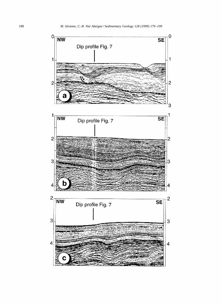
This results in difficulties in correlating reflectorsdowndip, and in loosely controlled biostratigraphicattributions within the Oligocene–Neogene interval.
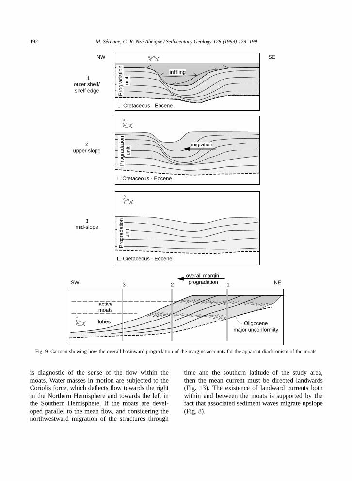
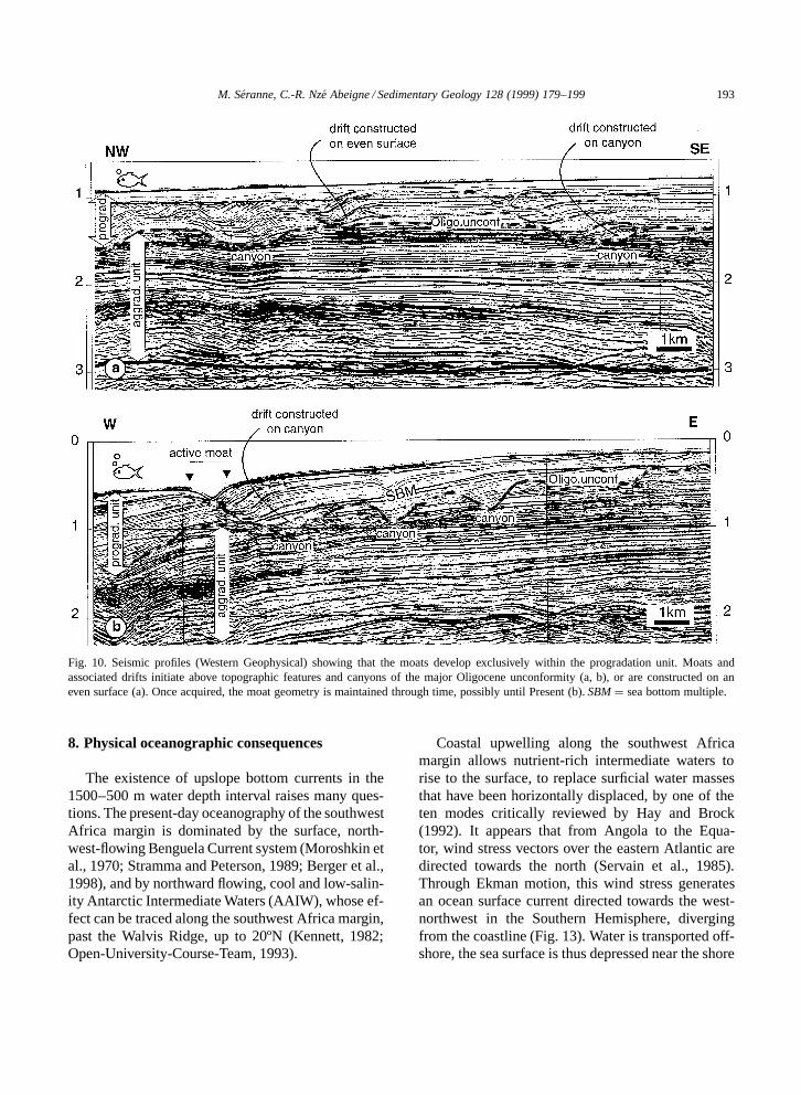
Despite of the low stratigraphic resolution, it ispossible to analyse the main stages of evolution ofthe migrating moats. These are exclusively observedin the prograding unit, above the major Oligoceneunconformity (Fig. 9). Their distinctive geometryis never observed in the Late Cretaceous–Eoceneaggrading unit. Their evolution reveals a certainamount of variability which is grossly related to theirposition on the margin. Seismic profiles located closeto the shelf edge show that the migrating structuresfirst occur immediately above the major Oligoceneunconformity, and that they actively migrated along-slope during the Miocene (there is an Oligocenehiatus beneath the outer shelf and upper slope). Mostof the moats are subsequently filled by onlapping re-flectors. Some individual structures are presently stillactive at ca. 500 m seafloor depth). The intermediatestrike profiles (e.g. Fig. 6b) show that the migratingstructures develop above an interval of low-conti-nuity reflectors that overlies the Oligocene majorunconformity. Finally, the most distal strike profiles(e.g. Fig. 6c) show only long-wavelength, low-ampli-tude reflections typical of depositional lobes. Obser-vation of the present-day seafloor indicates that theprocesses responsible for the development of themoats are active on the depositional surface, at 600m–1600 m water depth, off the shelf edge, and thatthe moats disappear basinward (Fig. 9). With theoverall progradation of the margin, shallowing oc-curs on a given transect. When the depositional sur-face becomes shallower than 500–600 m, the moatsbecome inactive and they are subsequently filled bythe sediments of the prograding margin. Similarly,deeper parts of the slope, initially dominated by lobedeposition, become shallower with time and enterthe bathymetric interval prone to the development ofmoats.
Moats initially developed above the major Oligo-cene unconformity, and were preferentially locatedatop the incised canyons, but there are examples ofmoats constructed on even surfaces (Fig. 10). On theupper slope, some moats occur throughout the com-plete prograding unit, and up to the present seafloor(Fig. 10b). In the absence of precise stratigraphic con-trol the rate of migration cannot be calculated. It may
be noted, however, that the apparent rate of migrationof the moats is almost constant both at different placesin the slope and through time, in spite of the expectedvariable rate of sediment accumulation throughout thedeposition of the prograding unit.
6. Interpretation: bottom-current flow andsediment drifts
In this section we discuss possible interpretationsof the origin of the depositional structures analysedin this contribution.
Several lines of evidence show that the structuresobserved on the upper slope of the Gabon margin arenot the result of SE-dipping listric faults. Many ofthe reflectors are not truncated along the northwestmargin, but drape the underlying clinoform. No faulttrace can be observed below the prograding clino-forms. Consistent orientation of the structures cannotbe accounted for by a gravitational faulting mech-anism, since there is no evidence of a decollementlevel, let alone of a consistent southeast dip for it.
Canyons and channels are often present on conti-nental margins, they allow transit of sediments fromthe shelf to the rise. Examples from continentalslopes (e.g. Pratson et al., 1994) consist of sub-paral-lel canyons truncating older strata and are correlatedwith regional erosional unconformities. Canyons arestacked vertically and do not show evidence of lat-eral migration. On submarine fans, turbidite channelsdisplay meanders, with well developed levees (e.g.Droz et al., 1996). For the features on the Gabonmargin, the consistency of the northwestward migra-tion precludes a meander migration interpretation,and the lack of structures that can be correlated withlevee deposits suggests that these features are notturbidite channels.
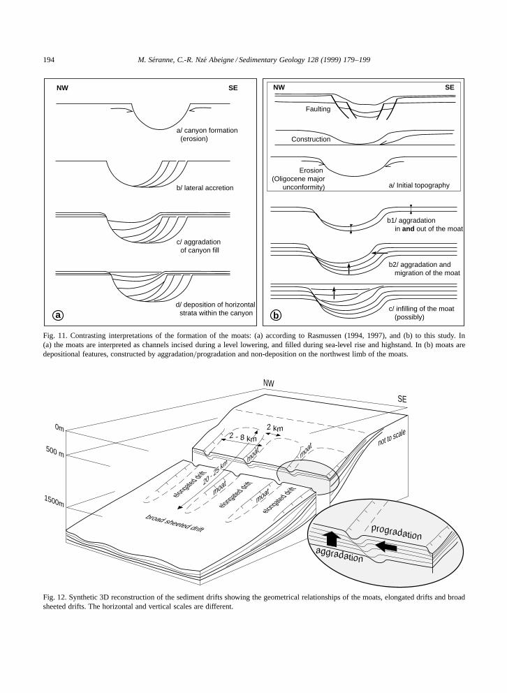
The moats on the Gabon margin have been in-terpreted as erosional canyons (Rasmussen, 1994,1997). According to that interpretation, the pro-cess is divided into four stages: canyon formationduring sea-level lowering, lateral accretion withinthe canyon during lowstand, aggradation of canyonfill during sea-level rise, and finally, deposition ofhorizontal strata within the canyon during high-stand (Fig. 11a). However, several observations ar-gue against such an interpretation.
188 M. Seranne, C.-R. Nze Abeigne / Sedimentary Geology 128 (1999) 179–199
M. Seranne, C.-R. Nze Abeigne / Sedimentary Geology 128 (1999) 179–199 189
(1) As indicated by the geometry of the under-lying reflectors, the initial topography is not alwaysthe result of erosion (‘canyon’). Migrating struc-tures may also initiate and develop above grabensor against mounded structures constructed on evensurfaces (Figs. 10 and 11b).
(2) The stability of some of the migrating moatsthroughout the Neogene, until the present-day, pointsto similar rates of aggradation within and outsidethe moats. Lateral accretion and aggradation in thecanyon only, would inevitably lead to a rapid infillingof the structure. In fact, examples of infilling ofthe migrating structures are found in the uppermostslope and in the shelf edge area, where the overallprogradation of the margin has led to a shallowing,and the consequent end of migration (see above).
(3) If the evolution of ‘canyons’ is controlled bysea-level changes, then canyons located at the samestratigraphic interval should display a similar evolu-tion, inasmuch that the effects of sea-level changesare expected to be general to the margin. This is incontradiction with the different stratal pattern exhib-ited by neighbouring migrating structures (Fig. 6a,b).For example, one single reflector corresponds to hor-izontal strata filling a canyon (‘highstand’) while 2km to the southeast, this reflector corresponds tolateral accretion (‘lowstand’). Similarly, the differentstratigraphic distribution of the migrating structuresobserved on successively deeper strike profiles sug-gests a process of formation unrelated to sea-levelchange.
(4) Finally, structures that are stable throughoutthe Neogene until Present imply a long-term pro-cess corresponding to many second- or third-ordereustatic cycles, which are not consistently recorded.It is not clear whether the evolution of the chan-nels proposed by Rasmussen (1994) corresponds tothe long-term evolution corresponding to the entireprogradation unit (second-order eustatic cycle?), orto a shorter-term evolution corresponding to a third-order eustatic cycle.
Fig. 6. Three parallel strike seismic profiles (GECO) normal to and intersecting a dip profile (Fig. 7). The strike profiles are fromthe upper (a), intermediate (b), and lower (c) slope. The major Oligocene unconformity is represented by a bold dashed line, and onereference sequence is indicated in grey overlay in order to facilitate correlation and to show the thickness variation across the slope(vertical scale in s TWT).
The data suggest that the structures observed onthe Gabon margin result from depositional processescontrolled by bottom currents. The information pro-vided by dip and strike profiles allows the construc-tion of a model of the structures (Fig. 12). Linearmoats, normal to the shelf edge, separate tabularbodies 20 to 25 km long and 2 to 8 km wide thatdip downslope. Moats disappear on the lower slope,where the tabular bodies merge into long-wave, low-amplitude, undulating depositional bodies (Fig. 12).The seismic images of the studied structures aresimilar with respect to internal geometry, scale, andassociations, to examples of sediment drifts and con-tourites published in the literature. More specifically,the converging onlap termination associated with atopographic depression on dip profiles (e.g. Fig. 5)is equivalent to the moats which bound ridges in theRockall Trough (offshore northwest Britain) (Howeet al., 1994; Stoker, 1997; Stoker et al., 1998),and to the boundary channel of sediment drifts inthe Italy–Albania Strait (Marani et al., 1993). Inthese examples, moats are bounding convex-upwardbodies which either encompass a wide sedimenta-tion area, tabular over several kilometres (‘broadsheeted drifts’), or else correspond to a suite of con-vex-upward bodies (‘elongated drifts’). The internalgeometry of the Gabon moats corresponds to theformer model, whereas their dimensions relate bet-ter to the latter (southwest end of sections Fig. 5).Oceanward of the moats, the long-wave, low-ampli-tude geometry of the depositional bodies (Fig. 6c)corresponds to broad sheeted drifts. The migratingmoats seen on strike sections, i.e. normal to theiraxes, are equivalent to the sediment drifts of theCanterbury Basin (offshore southeast New Zealand)(Fulthorpe and Carter, 1991; Carter et al., 1996),with the difference that the New Zealand examplesmigrate upslope rather than along-slope, and accord-ingly exhibit slope-parallel moats.
On the Gabon slope, the broad sheeted drifts cor-respond to areas of deposition, while the north-
190M
.Seranne,C
.-R.N
zeA
beigne/Sedim
entaryG
eology128
(1999)179–199
Fig. 7. Dip seismic profile across the slope (GECO) showing the general basinward progradation. The Oligocene major unconformity and the same reference sequence asin Fig. 6 are indicated, as well as the intersections with the strike profiles (vertical scale in s TWT).
M. Seranne, C.-R. Nze Abeigne / Sedimentary Geology 128 (1999) 179–199 191
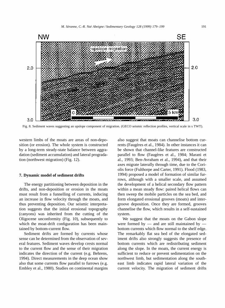
Fig. 8. Sediment waves suggesting an upslope component of migration. (GECO seismic reflection profiles, vertical scale in s TWT).
western limbs of the moats are areas of non-depo-sition (or erosion). The whole system is constructedby a long-term steady-state balance between aggra-dation (sediment accumulation) and lateral prograda-tion (northwest migration) (Fig. 12).
7. Dynamic model of sediment drifts
The energy partitioning between deposition in thedrifts, and non-deposition or erosion in the moatsmust result from a funnelling of currents, inducingan increase in flow velocity through the moats, andthus preventing deposition. Our seismic interpreta-tion suggests that the initial erosional topography(canyons) was inherited from the cutting of theOligocene unconformity (Fig. 10), subsequently towhich the moat-drift configuration has been main-tained by bottom-current flow.
Sediment drifts are formed by currents whosesense can be determined from the observation of sev-eral features. Sediment waves develop crests normalto the current flow and the sense of their migrationindicates the direction of the current (e.g. Behrens,1994). Direct measurements in the deep ocean showalso that some currents flow parallel to furrows (e.g.Embley et al., 1980). Studies on continental margins
also suggest that moats can channelise bottom cur-rents (Faugeres et al., 1984). In other instances it canbe shown that channel-like features are constructedparallel to flow (Faugeres et al., 1984; Marani etal., 1993; Ben-Avraham et al., 1994), and that theiraxes migrate laterally through time, due to the Cori-olis force (Fulthorpe and Carter, 1991). Flood (1983,1994) proposed a model of formation of similar fur-rows, although with a smaller scale, and assumedthe development of a helical secondary flow patternwithin a mean steady flow: paired helical flows canthen sweep the mobile particles on the sea bed, andform elongated erosional grooves (moats) and inter-groove deposition. Once they are formed, grooveschannelise the flow, which results in a self-sustainedsystem.
We suggest that the moats on the Gabon slopewere formed by — and are still maintained by —bottom currents which flow normal to the shelf edge.The remarkably flat sea bed of the elongated sed-iment drifts also strongly suggests the presence ofbottom currents which are redistributing sedimentalong the slope. In the moats, the current energy issufficient to reduce or prevent sedimentation on thenorthwest limb, but sedimentation along the south-east limb indicates rapid lateral variation of thecurrent velocity. The migration of sediment drifts
192 M. Seranne, C.-R. Nze Abeigne / Sedimentary Geology 128 (1999) 179–199
migration
infilling
Oligocenemajor unconformity
L. Cretaceous - Eocene
L. Cretaceous - Eocene
L. Cretaceous - Eocene
Pro
grad
atio
nun
itP
rogr
adat
ion
unit
Pro
grad
atio
nun
it
activemoats
lobes
overall margin progradation
NW SE
123
3mid-slope
2upper slope
1outer shelf/shelf edge
SW NE
Fig. 9. Cartoon showing how the overall basinward progradation of the margins accounts for the apparent diachronism of the moats.
is diagnostic of the sense of the flow within themoats. Water masses in motion are subjected to theCoriolis force, which deflects flow towards the rightin the Northern Hemisphere and towards the left inthe Southern Hemisphere. If the moats are devel-oped parallel to the mean flow, and considering thenorthwestward migration of the structures through
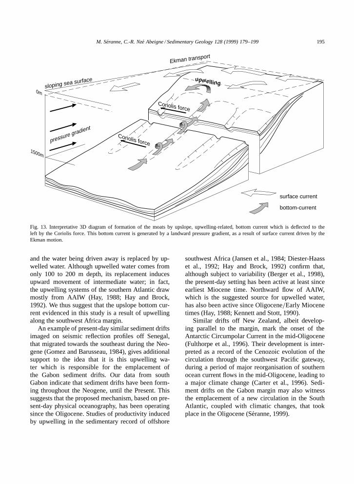
time and the southern latitude of the study area,then the mean current must be directed landwards(Fig. 13). The existence of landward currents bothwithin and between the moats is supported by thefact that associated sediment waves migrate upslope(Fig. 8).
M. Seranne, C.-R. Nze Abeigne / Sedimentary Geology 128 (1999) 179–199 193
Fig. 10. Seismic profiles (Western Geophysical) showing that the moats develop exclusively within the progradation unit. Moats andassociated drifts initiate above topographic features and canyons of the major Oligocene unconformity (a, b), or are constructed on aneven surface (a). Once acquired, the moat geometry is maintained through time, possibly until Present (b). SBM D sea bottom multiple.
8. Physical oceanographic consequences
The existence of upslope bottom currents in the1500–500 m water depth interval raises many ques-tions. The present-day oceanography of the southwestAfrica margin is dominated by the surface, north-west-flowing Benguela Current system (Moroshkin etal., 1970; Stramma and Peterson, 1989; Berger et al.,1998), and by northward flowing, cool and low-salin-ity Antarctic Intermediate Waters (AAIW), whose ef-fect can be traced along the southwest Africa margin,past the Walvis Ridge, up to 20ºN (Kennett, 1982;Open-University-Course-Team, 1993).
Coastal upwelling along the southwest Africamargin allows nutrient-rich intermediate waters torise to the surface, to replace surficial water massesthat have been horizontally displaced, by one of theten modes critically reviewed by Hay and Brock(1992). It appears that from Angola to the Equa-tor, wind stress vectors over the eastern Atlantic aredirected towards the north (Servain et al., 1985).Through Ekman motion, this wind stress generatesan ocean surface current directed towards the west-northwest in the Southern Hemisphere, divergingfrom the coastline (Fig. 13). Water is transported off-shore, the sea surface is thus depressed near the shore
194 M. Seranne, C.-R. Nze Abeigne / Sedimentary Geology 128 (1999) 179–199
c/ infilling of the moat (possibly)
a/ canyon formation (erosion)
b/ lateral accretion
c/ aggradation of canyon fill
d/ deposition of horizontal strata within the canyon
b1/ aggradation in and out of the moat
b2/ aggradation and migration of the moat
Erosion (Oligocene major
unconformity)
Construction
a/ Initial topography
Faulting
SENW SENW
a b
Fig. 11. Contrasting interpretations of the formation of the moats: (a) according to Rasmussen (1994, 1997), and (b) to this study. In(a) the moats are interpreted as channels incised during a level lowering, and filled during sea-level rise and highstand. In (b) moats aredepositional features, constructed by aggradation=progradation and non-deposition on the northwest limb of the moats.
moat
moat
moat
moat
broad sheeted drift
elongated drift
elongated drift
0m
500 m
1500m
2 - 8 km
2 km
elongated drift
aggradation
progradation
20 - 2
5 km
NW
SE
not to scale
Fig. 12. Synthetic 3D reconstruction of the sediment drifts showing the geometrical relationships of the moats, elongated drifts and broadsheeted drifts. The horizontal and vertical scales are different.
M. Seranne, C.-R. Nze Abeigne / Sedimentary Geology 128 (1999) 179–199 195
0m
1500m
pressure gradient
upwelling
Coriolis force
Coriolis force
surface current
Ekman transport
bottom-current
sloping sea surface
Fig. 13. Interpretative 3D diagram of formation of the moats by upslope, upwelling-related, bottom current which is deflected to theleft by the Coriolis force. This bottom current is generated by a landward pressure gradient, as a result of surface current driven by theEkman motion.
and the water being driven away is replaced by up-welled water. Although upwelled water comes fromonly 100 to 200 m depth, its replacement inducesupward movement of intermediate water; in fact,the upwelling systems of the southern Atlantic drawmostly from AAIW (Hay, 1988; Hay and Brock,1992). We thus suggest that the upslope bottom cur-rent evidenced in this study is a result of upwellingalong the southwest Africa margin.
An example of present-day similar sediment driftsimaged on seismic reflection profiles off Senegal,that migrated towards the southeast during the Neo-gene (Gomez and Barusseau, 1984), gives additionalsupport to the idea that it is this upwelling wa-ter which is responsible for the emplacement ofthe Gabon sediment drifts. Our data from southGabon indicate that sediment drifts have been form-ing throughout the Neogene, until the Present. Thissuggests that the proposed mechanism, based on pre-sent-day physical oceanography, has been operatingsince the Oligocene. Studies of productivity inducedby upwelling in the sedimentary record of offshore
southwest Africa (Jansen et al., 1984; Diester-Haasset al., 1992; Hay and Brock, 1992) confirm that,although subject to variability (Berger et al., 1998),the present-day setting has been active at least sinceearliest Miocene time. Northward flow of AAIW,which is the suggested source for upwelled water,has also been active since Oligocene=Early Miocenetimes (Hay, 1988; Kennett and Stott, 1990).
Similar drifts off New Zealand, albeit develop-ing parallel to the margin, mark the onset of theAntarctic Circumpolar Current in the mid-Oligocene(Fulthorpe et al., 1996). Their development is inter-preted as a record of the Cenozoic evolution of thecirculation through the southwest Pacific gateway,during a period of major reorganisation of southernocean current flows in the mid-Oligocene, leading toa major climate change (Carter et al., 1996). Sedi-ment drifts on the Gabon margin may also witnessthe emplacement of a new circulation in the SouthAtlantic, coupled with climatic changes, that tookplace in the Oligocene (Seranne, 1999).
196 M. Seranne, C.-R. Nze Abeigne / Sedimentary Geology 128 (1999) 179–199
9. Sedimentological consequences
Identification of sediment drifts on the upperslope of the Gabon continental margin has importantconsequence for regional sedimentological interpre-tation. Cenozoic sequences on the west Africa mar-gin are attributed to slumping, canyon incision andchannel fill in relation with predicted fan-lobe depo-sition in the basin (e.g. Massala, 1993; Kolla et al.,1997; Mougamba, 1998). According to Teisserencand Villemin (1989), major erosion of the shelf edgein the Oligocene produced deep canyons which arewell documented north of the study area and whichrepresent up-dip feeders for inferred Miocene tur-bidite fans. Canyons are several kilometres wideand they were filled during the Miocene with fineto coarse channel sands (Mougamba, 1998). Suchcanyons clearly truncate the underlying Palaeogeneand Late Cretaceous and their onlapping infill. Theirsinuous nature suggests control by tectonic activity(Nze Abeigne, 1997). Such canyons are clearly dis-tinct from the sediment drift-related moats describedhere, though the two features overlap in the north-ern part of the study area. It appears that Oligoceneerosional canyons become prevalent northwards, to-wards the Ogooue River mouth (see location onFig. 1a). In that area, strong basinward prograda-tion of the Neogene sequences (Mougamba, 1998)indicates an enhanced terrigenous sediment sup-ply, from the adjacent Ogooue River. South of thepresent study area, Oligocene–Neogene sequencesalso thicken towards the Zaire River mouth (Mas-sala, 1993), which feeds the deep Zaire fan (vanWeering and van Iperen, 1984; Droz et al., 1996).The study area is therefore located between two im-portant turbiditic systems which are characterised bycanyon incision on the slope and subsequently fill-ing by turbiditic sand. The Gabon sediment driftshave developed on the slope between these twomajor turbiditic systems. The sediment drift-relatedmoats cannot be interpreted as feeders for deep-sea fan lobes, as proposed by Rasmussen (1994,1996), because the fan lobes in the basin would thusbe geometrically disconnected from the upper-slopesedimentation system.
We are unable to determine the source of thesediments reworked by the bottom currents on theslope. In its present setting, the shelf is not fed by
coastal rivers. However, the position between Zaireand Ogooue rivers, and the along-strike thickening ofNeogene series towards both rivers, strongly suggestthat they constitute the main source for the terrige-nous sediment input, through long-shore currents onthe shelf or by winnowing of the Zaire and Ogoouesediment plumes.
Finally, in the absence of direct analyses of sam-ples, it is not possible to determine whether sedi-ment drifts make up the whole Oligocene–Neogenesequence, or if gravity sediments (turbidites) con-stitute part of the interval. Turbidite and contouritesedimentation may interfere in various ways: (1) atransition with turbidite deposits, off the Ogooueand Zaire rivers could correspond to alternation ofthe two processes; and=or (2) variations in upwellingintensity through time could result in varying propor-tions of turbidites and contourites. Coastal upwellingbeing seasonal (Servain et al., 1985), it is likelythat the upslope bottom current, and thus sediment-drift accumulation, are in fact subjected to periodical(seasonal) variation.
10. Conclusions
Industrial seismic reflection profiles on the con-tinental slope, offshore southern Gabon show depo-sitional structures that migrate parallel to the shelfedge, and have the distinctive external geometry andinternal organisation of sediment drifts. The sedi-ment drifts migrate northwest and were depositedby an upslope current. The present interpretationcontrasts with that, previously proposed, of turbiditechannels feeding deep-sea fans. Turbidites do occurin the basin, fed by the Zaire and the Ogooue rivers,respectively, to the southeast and to the northwest ofthe studied area. It thus appears that sediment depo-sition on the west Africa margin is a consequence ofa complex — and still largely unknown — interplaybetween gravity processes and reworking by bottomcurrents. End-member deposits may correspond to(1) turbidites deposited in the slope and basin off thelarge rivers, and (2) the slope sediment drifts locatedbetween these large terrigenous sediment supplies.Future studies in the intermediate area should bringnew information about the interaction of the twoprocesses.
M. Seranne, C.-R. Nze Abeigne / Sedimentary Geology 128 (1999) 179–199 197
The sediment drifts documented in this studyform part of a progradational megasequence thatspans the Oligocene to Present. This suggests thatupwelling has been active along the southwest Africamargin throughout the Neogene. The stratal patternimaged on the seismic profiles provides an importantstratigraphic record of the history of upwelling andof ocean circulation along the south Gabon margin.Future, better chronostratigraphic resolution of theTertiary sequences will place closer constraints onthe timing of onset of upwelling, and on relationshipswith global events.
Acknowledgements
We are grateful to Elf Gabon for providing dataand for allowing publication. Elf Gabon financiallysupported one of us (C.-R.N.A.). Western Geophys-ical and GECO provided the seismic data for thisstudy and are warmly thanked. Discussions withDominique Claude and Michel Lopez helped clari-fying certain points of this contribution, and MartynStoker kindly provided us with unpublished workon sediment drifts. Review by Luba Jansa is ac-knowledged and the very detailed comments andsuggestions made by Bob Carter and John Howegreatly improved the paper.
References
Behrens, E.W., 1994. Abyssal sediment waves in the Gulf ofMexico: an enigma. Paleoceanography 9, 1087–1094.
Ben-Avraham, Z., Niemi, T.M., Hartnady, C.J.H., 1994. Mid-Tertiary changes in deep ocean circulation patterns in the Na-tal Valley and Traskei basin, Southwest Indian Ocean. EarthPlanet. Sci. Lett. 121, 639–646.
Berger, W.H., Wefer, G., Richter, C., Lange, C.B., Giraudeau,J., Hermelin, O., Party, S.S., 1998. The Angola–Benguelaupwelling system: paleoceanographic synthesis of shipboardresults from Leg 175. Proc. ODP, Init. Rep. 175, 505–531.
Bolli, H.M., Ryan, W.B.F., Foresman, J.B., Hottman, W.E.,Kagami, H., Longoria, J.F., McKnight, B.K., Melguen, M.,Natland, J.M., Proto-Decima, F., Siesser, W.G., 1978. Angolacontinental margin — Sites 364 and 365. DSDP, Init. Rep. 40,357–390.
Brice, S.E., Cochran, M.D., Pardo, G., Edwards, A.D., 1982.Tectonics and sedimentation of the South Atlantic rift se-quence: Cabinda, Angola. In: Watkins, J.S., Drake, C.L.(Eds.), Studies in Continental Margin Geology. Am. Assoc.
Pet. Geol., Mem. 34, 5–18.Carminatti, M., Scarton, J.C., 1991. Sequence stratigraphy of the
Oligocene turbidite complex of the Campos Basin, offshoreBrazil. In: Weimer, P., Link, M.H. (Eds.), Seismic Faciesand Sedimentary Processes of Submarine Fans and TurbiditesSystems. Springer, Berlin, pp. 241–246.
Carter, R.M., Carter, L., McCave, I.N., 1996. Current controlledsediment deposition from the shelf to the deep ocean: theCenozoic evolution of circulation through the SW Pacificgateway. Geol. Rundsch. 85, 438–451.
Diester-Haass, L., Meyers, P.A., Rothe, P., 1992. The BenguelaCurrent and associated upwelling on the southwest AfricanMargin: a synthesis of the Neogene–Quaternary sedimentaryrecord at DSDP sites 362 and 532. In: Summerhayes, C.P.,Prell, W.L., Emeis, K.C. (Eds.), Upwelling Systems: Evolutionsince the Early Miocene. Geol. Soc. London, Spec. Publ. 63,331–342.
Driscoll, N.W., Laine, E.P., 1996. Abyssal current influence onthe southwest Bermuda Rise and surrounding region. Mar.Geol. 130, 231–263.
Droz, L., Rigaut, F., Cochonat, P., Tofani, R., 1996. Morphologi-cal and recent evolution of the Zaire turbidite system (Gulf ofGuinea). Geol. Soc. Am. Bull. 108, 253–269.
Embley, R.W., Hoose, P.J., Lonsdale, P., Mayer, L., Tucholke,B.E., 1980. Furrowed mud waves on the western BermudaRise. Geol. Soc. Am. Bull. 91, 731–740.
Emery, K.O., Uchupi, E., Phillips, J., Bowin, C.O., Mascle, J.,1975. Continental margin off western Africa: Angola to SierraLeone. Am. Assoc. Pet. Geol. Bull. 59, 2209–2265.
Faugeres, J.-C., Gonthier, E., Stow, D.A.V., 1984. Contouritedrift molded by deep Mediterranean outflow. Geology 12,296–300.
Flood, R.D., 1983. Classification of sedimentary furrows anda model for furrow initiation and evolution. Geol. Soc. Am.Bull. 94, 630–639.
Flood, R.D., 1994. Abyssal bedforms as indicators of chang-ing bottom current flow: examples from the U.S. East Coastcontinental rise. Paleoceanography 9, 1049–1060.
Fulthorpe, C.S., Carter, R.M., 1991. Continental-shelf prograda-tion by sediment-drift accretion. Geol. Soc. Am. Bull. 103,300–309.
Fulthorpe, C.S., Carter, R.M., Miller, K.G., Wilson, J., 1996.Marshall Paraconformity: a mid-Oligocene record of in-ception of the Antarctic Circumpolar Current and coevalglacio-eustatic lowstand? Mar. Pet. Geol. 13, 61–77.
Gomez, R., Barusseau, J.-P., 1984. Disposition des formationspost-eocenes de la marge continentale senegalaise. Bull. Soc.Geol. Fr. 26, 1107–1116.
Hay, W.H., 1988. Paleoceanography: a review for the GSACentennial. Geol. Soc. Am. Bull. 100, 1934–1956.
Hay, W.W., Brock, J.C., 1992. Temporal variation in intensity ofupwelling off southwest Africa. In: Summerhayes, C.P., Prell,W.L., Emeis, K.C. (Eds.), Upwelling Systems: Evolution sincethe Early Miocene. Geol. Soc. London, Spec. Publ. 63, 463–497.
Heezen, B.C., Hollister, C.D., Ruddiman, W.F., 1966. Shaping
198 M. Seranne, C.-R. Nze Abeigne / Sedimentary Geology 128 (1999) 179–199
of the continental rise by deep geostrophic contour currents.Science 152, 502–508.
Howe, J.A., Stoker, M.S., Stow, D.A.W., 1994. Late Cenozoicsediment drift complex, northeast Rockall Trough, North At-lantic. Paleoceanography 9, 989–999.
Jansen, J.H.F., Van Weering, T.C.E., Gieles, R., Van Iperen, J.,1984. Middle and Late Quaternary oceanography and clima-tology of the Zaire–Congo fan and the adjacent eastern Angolabasin. Neth. J. Sea Res. 17, 201–249.
Kennett, J.P., 1982. Marine Geology. Prentice-Hall, EnglewoodCliffs, NJ, 813 pp.
Kennett, J.P., Stott, L.D., 1990. Proteus and Proto-Oceanus:ancestral Paleogene oceans as revealed from Antarctic stableisotopic results; ODP Leg 113. Proc. ODP, Sci. Results 113,865–880.
Kolla, V., Ashworth, D., Cazzola, C., Claude, D., Clergeat, B.,Dall’Asta, M., 1997. Deep-water meandering channels fromsubsurface and recent fans. Am. Assoc. Pet. Geol. AnnualMeeting, Dallas, TX, April 6–7, 1997 (abstr.).
Marani, M., Argnani, A., Roveri, M., Trincardi, F., 1993. Sed-iment drifts and erosional surfaces in the central Mediter-ranean: seismic evidence of bottom-current activity. Sediment.Geol. 82, 207–220.
Massala, A., 1993. Le Cretace superieur et le Tertiaire du bassincotier congolais — biochronologie et stratigraphie sequen-tielle. Doctorat, Univ. Bourgogne, Dijon.
Meyers, J.B., Rosendahl, B.R., Groschel-Beker, H., Austin,J.A., Rona, P.A., 1996. Deep penetrating MCS imaging ofthe rift-to-drift transition, offshore Douala and North Gabonbasins, West Africa. Mar. Pet. Geol 13, 791–835.
Morley, C.K., Guerin, G., 1996. Comparison of gravity-drivendeformation styles and behaviour associated with mobileshales and salt. Tectonics 15, 1154–1170.
Moroshkin, K.V., Bubnov, V.A., Butalov, R.P., 1970. Water cir-culation in the eastern South Atlantic Ocean. Oceanology 10,27–34.
Mougamba, R., 1998. Chronology et architecture des systemesturbiditiques cenozoıques du prisme sedimentaire de l’Ogooue(Marge Nord-Gabon). Doctorat, Univ. Lille 1.
Mutti, E., collaboration of Davoli, G., Segadelli, S., Cavalli, C.,Carminatti, M., Stocchi, S., Mora, S., Amdreozzi, M., 1992.Turbidite sandstones. AGIP – Istituto di Geologia, Universitadi Parma, Parma, 275 pp.
Nze Abeigne, C.R., 1997. Evolution post-rift de la marge con-tinentale sud Gabon: controles tectonique et climatique sur lasedimentation. Doctorat, Univ. Montpellier 2.
Open-University-Course-Team, 1993. Ocean Circulation. Perga-mon Press=The Open University, Oxford, 238 pp.
Pickering, K.T., Stow, D.A.V., Watson, M.P., Hiscott, R.R., 1986.Deep-water facies, processes and models: a review and classi-fication scheme for modern and ancient sediments. Earth Sci.Rev. 23, 74–174.
Pirmez, C., Flood, R.D., 1995. Morphology and structure ofAmazon channel. Proc. ODP, Init. Rep. 155, 23.
Pratson, L.F., Ryan, W.B.F., Mountain, G.S., Twichell, D.C.,1994. Submarine canyon initiation by downslope-eroding sed-
iment flows: evidence in late Cenozoic strata on the NewJersey continental slope. Geol. Soc. Am. Bull. 106, 395–412.
Rabinowitz, P.D., LaBreque, J., 1979. The Mesozoic South At-lantic Ocean and evolution of its continental margins. J. Geo-phys. Res. 84, 5973–6003.
Rasmussen, E.S., 1994. The relationship between submarinecanyon fill and sea-level change: an example from MiddleMiocene offshore Gabon, West Africa. Sediment. Geol. 90,61–75.
Rasmussen, E.S., 1996. Structural evolution and sequence forma-tion offshore South Gabon during the Tertiary. Tectonophysics266, 509–523.
Rasmussen, E.S., 1997. Depositional evolution and sequencestratigraphy of the shelf and slope area off south Gabon, WestAfrica. J. Sediment. Res. 67, 715–724.
Richard, A., Leonard, G., 1993. Le Gabon — Geographie Active.Institut Pedagogique National – EDIG – EDICEF, Libreville,288 pp.
Rosendahl, B.R., Grosche-Becker, H., Meyers, J., Kaczmarick,K., 1991. Deep seismic reflection study of a passive margin,southeastern Gulf of Guinea. Geology 19, 291–295.
Schneider, R.R., Brice, B., Mueller, P.J., Kroon, D., Alexander,I., 1997. Monsoon related variations in Zaire (Congo) sedi-ment load and influence of fluvial silicate supply on marineproductivity in the East Equatorial Atlantic during the last200 000 years. Paleoceanography 12, 463.
Seranne, M., 1999. Early Oligocene turnover on SW Africancontinental margin: A signature of Tertiary Greenhouse toIcehouse transition? Terra Nova (in press).
Seranne, M., Seguret, M., Fauchier, M., 1992. Seismic super-units and post-rift evolution of the continental passive marginof southern Gabon. Bull. Soc. Geol. Fr. 163, 135–146.
Servain, J., Picaut, J., Busalacchi, A.J., 1985. Interannual andseasonal variability of the Tropical Atlantic Ocean depictedby sixteen years of sea-surface temperature and wind stress.In: Nihoul, J.C.J. (Ed.), Coupled Ocean–Atmosphere Models.Elsevier, Amsterdam, pp. 211–237.
Shanmugam, G., Moiola, R., 1995. Reinterpretation of deposi-tional processes in a classic flysch sequence (PennsylvanianJackfork Group), Ouachita Mountains, Arkansas and Okla-homa. Am. Assoc. Pet. Geol. Bull. 79, 672–695.
Shanmugam, G., Moiola, R., 1997. Reinterpretation of deposi-tional processes in a classic flysch sequence (PennsylvanianJackfork Group), Ouachita Mountains, Arkansas and Okla-homa: Reply. Am. Assoc. Pet. Geol. Bull. 81, 476–491.
Slatt, R.M., Wiemer, P., Stone, C.G., Lowe, D.R., Coleman, J.L.,Bouma, A.H., DeVries, M.B., D’Agostino, A.E., Jordan, D.W.,1997. Reinterpretation of depositional processes in a classicflysch sequence (Pennsylvanian Jackfork Group), OuachitaMountains, Arkansas and Oklahoma: Comment. Am. Assoc.Pet. Geol. Bull. 81, 449–475.
Spathopoulos, F., 1996. An insight on salt tectonics in the AngolaBasin, South Atlantic. In: Aslop, G.I., Blundell, D.J., Davison,I. (Eds.), Salt Tectonics. Geol. Soc. London, Spec. Publ. 100,153–174.
Stoker, M.S., 1997. Mid- to late Cenozoic sedimentation on the
M. Seranne, C.-R. Nze Abeigne / Sedimentary Geology 128 (1999) 179–199 199
continental margin off NW Britain. J. Geol. Soc. London 154,509–515.
Stoker, M.S., 1998. Sediment-drift development on the continen-tal margin off NW Britain. In: Stoker, M.S., Evans, D., Cramp,A. (Eds.), Geological Processes on Continental Margins: Sed-imentation, Mass-Wasting and Stability. Geol. Soc. London,Spec. Publ. 129, 229–254.
Stoker, M.S., Akhurst, M.C., Howe, J.A., Stow, D.A.W., 1998.Sediment drifts and contourites on the continental margin offnorth-west Britain. Sediment. Geol. 115, 33–51.
Stow, D.A.V., 1994. Deep sea processes of sediment transportand deposition. In: Pye, K. (Ed.), Sediment Transport andDepositional Processes. Blackwell, Oxford, pp. 257–291.
Stow, D.A.V., Faugeres, J.C., Viana, A., Gonthier, E., 1998.Fossil contourites: a critical review. Sediment. Geol. 115, 3–31.
Stramma, L., Peterson, R.G., 1989. Geostrophic transport in theBenguela current region. J. Phys. Oceanogr. 19, 1440–1448.
Teisserenc, P., Villemin, J., 1989. Sedimentary basin of Gabon— geology and oil systems. In: Edwards, J.D., Santogrossi,P.A. (Eds.), Divergent=Passive Margin Basins. Am. Assoc. Pet.Geol., Mem. 48, 177–199.
Tucholke, B.E., Mountain, G.S., 1979. Seismic stratigraphy,lithostratigraphy and paleosedimentation patterns in the NorthAmerican Basin. In: Talwani, M., Hay, M., Ryan, W.B.F.
(Eds.), Deep Drilling Results in the Atlantic Ocean: Continen-tal Margins and Paleoenvironments. Am. Geophys. Union, M.Ewing Ser. 3, 58–86.
Turner, J.P., 1995. Gravity-driven structures and rift basin evolu-tion: Rio Muni Basin, offshore Equatorial West Africa. Am.Assoc. Pet. Geol. Bull. 79, 1138–1158.
Uchupi, E., 1992. Angola Basin: geohistory and constructionof the continental rise. In: Poag, C.W., Graciansky, P.C.D.(Eds.), Geologic Evolution of Atlantic Continental Rises. VanNostrand Reinhold, New York, pp. 77–99.
Van Weering, T.C.E., van Iperen, J., 1984. Fine grained sedi-ments of the Zaire deep-sea fan, southern Atlantic Ocean. In:Stow, D.V.A., Piper, D.J.W. (Eds.), Fine-Grained Sediments:Deep-Water Processes and Facies. Geol. Soc. London, Spec.Publ. 15, 95–113.
Viana, A.R., Faugeres, J.C., Kowsmann, R.O., Lima, J.A.M.,Caddah, L.F.G., 1998. Hydrology, morphology and sedimen-tology of the Campos continental margin, offshore Brazil.Sediment. Geol. 115, 133–157.
Wannesson, J., Icart, J.-C., Ravat, J., 1991. Structure and evolu-tion of adjoining segments of the West African margin deter-mined from deep seismic profiling. In: Meissner, R., Brown,L., Durbaum, H.-J., Fuchs, K., Seifert, F. (Eds.), Continen-tal Lithosphere: Deep Seismic Reflections. Geodynamics 22,American Geophysical Union, Washington, DC, pp. 275–289.