Embed Size (px)
Citation preview

Proposed (Without Legal Effect) Plan Change 73: Omnibus 2 Amendments 19 December 2020
Tasman Resource Management Plan C73 – 17/i
PROPOSED PLAN CHANGE NO. 73WITHOUT LEGAL EFFECT
Omnibus 2 AmendmentsNotified: 19 December 2020
CHAPTER 17: ZONE RULES
17.1 RESIDENTIAL ZONE RULES
[Unchanged or irrelevant text omitted]
17.1.2 Land Use
17.1.2.1 Permitted Activities (Land Use - General)
Any land use is a permitted activity that may be undertaken without a resource consent, if it complies with the following conditions:
Particular Activities
(a) The activity is not one of the following:
(i) an activity that emits odour causing a nuisance beyond the site boundary;
(ii) intensive livestock farming or commercial boarding or breeding of animals;
(iii) an industrial or commercial activity, except: as allowed as a home occupation; or as provided for in rule 16.6.2.1(o);
(iv) spray painting, motor vehicle repairs or dismantling, fibre-glassing, sheet-metal work, bottle or scrap storage, rubbish collection, motor body building, or fish or meat processing;
(v) a landing area or pad for helicopters (other than for medical or fire fighting purposes), an aircraft landing strip, aerodrome or airport;
(vi) a papakainga development;(vii) clearance of more than 20 percent of indigenous coastal shrubland or coastal forest on
CT 782346 Record of Title NL 13A/194 (Talisman Heights, Kaiteriteri) or its successive titles between Cook Crescent at Stephens Bay and Rowling Road at Little Kaiteriteri and in the Coastal Environment Area;
[Unchanged or irrelevant text omitted]
NOTE: Red underlined text denotes proposed new text inserted or amended. Blue strikethrough text denotes text deleted.

Proposed (Without Legal Effect) Plan Change 73: Omnibus 2 Amendments 19 December 2020
C73 – 17/ii Tasman Resource Management Plan
17.1.2.2 Permitted Activities (Home Occupations)
A home occupation on the site of any dwelling is a permitted activity that may be undertaken without a resource consent, if it complies with the following conditions:
[Unchanged or irrelevant text omitted]
(da) The activity does not involve spray painting, motor vehicle repairs or dismantling, fibre-glassing, sheet-metal work, bottle or scrap storage, rubbish collection, motor body building, or fish or meat processing.
[Unchanged or irrelevant text omitted]
17.1.2.4 Restricted Discretionary Activities (Home Occupations)
A home occupation that does not comply with the conditions of rule 17.1.2.2 is a restricted discretionary activity.
A resource consent is required. Consent may be refused or conditions imposed, only in respect of the following matters to which the Council has restricted its discretion:
[Unchanged or irrelevant text omitted]
General Adverse Effects
(4) Adverse effects of the home occupation in terms of noise, odour, dust, visual impact, vibration, glare, loss of privacy, traffic and parking congestion.
[Unchanged or irrelevant text omitted]
17.1.3 Building Construction or Alteration
17.1.3.1 Permitted Activities (Building Construction or Alteration — Standard Density Development)
Construction or alteration of a building for a standard density development is a permitted activity that may be undertaken without a resource consent, if it complies with the following conditions:
[Unchanged or irrelevant text omitted]
(b) The activity is not the construction or alteration of any building within or 10 metres from any indicative road or indicative reserve in the Richmond West, Richmond South or Richmond East or Motueka West development areas as shown on the planning maps.
[Unchanged or irrelevant text omitted]
Maximum Dwellings per Site
(g) At Milnthorpe, a maximum of one dwelling for CT Record of Title 11A/641 (20 Nelson St, Milnthorpe) and one dwelling for each certificate of title issued before 12 November 1987, except for Sections 24, 28, 29 and 30 which are in one title where there is one dwelling for Section 24 and one dwelling for the other sections combined.
[Unchanged or irrelevant text omitted]
Building Envelope – Daylight Over and Around

Proposed (Without Legal Effect) Plan Change 73: Omnibus 2 Amendments 19 December 2020
Tasman Resource Management Plan C73 – 17/iii
(m) No building projects beyond a building envelope constructed by daylight admission lines commencing from points 2.5 metres above ground level from all side and rear boundaries. The angle to be used is to be determined using the diagram in Schedule 17.1A. except that:
(in) for any roof with a slope of 15 degrees or greater and the roof ridge generally at right angles to the boundary, the end of the ridge may be up to 1.5 metres above the daylight admission line indicator plane and the end area up to 2.5 square metres when viewed in elevation; and
(ii) any solar panel mounted flush to a building roof may project through the daylight admission line, provided they extend no greater than 250 millimetres above the roof plane on which they are mounted.
EXCEPT
(o) As an alternative to conditions (m) of this rule and (n), buildings on south-facing slopes (between west and east) over 10 degrees comply with the following on any nominated boundary:
[Unchanged or irrelevant text omitted]
(t) Accessory buildings are set back at least 1.5 metres from side and rear boundaries, but less than 1.5 metres if all of the following apply:
(i) where any accessory building has a the wall of the building adjacent to the boundary, that wall contains no windows;
(ii) any accessory buildings adjacent to the an individual boundary does not exceed a cumulative total of 7.2 metres in length or 50 percent of the length of the boundary, whichever is the lesser;
(iii) stormwater is contained within the site.
[Unchanged or irrelevant text omitted]
(u) Dwellings are set back at least 25 metres from a rural zone boundary and at least 10 metres from an industrial zone boundary, except that:
(i) on CT Record of Title NL 13A/194 Ltd (Talisman Heights, Kaiteriteri) or its successive titles, the setback from the rural zone is at least 5 metres,
(w) Every building is set back a minimum of 25 metres from any boundary with Milnthorpe Quay Esplanade Reserve, except that on CT Record of Title 11A/641 (20 Nelson St, Milnthorpe) and CT Record of Title NL 9B/454 (14 Nelson St, Milnthorpe) the minimum setback is 16.5 metres.
(wa) The building is not located within, or within 10 metres of any indicative road or indicative reserve, except for the following:
(i) This condition does not apply once the road or reserve intended to be established by the indicative road or indicative reserve is shown on a Land Transfer Plan and a s224 certificate pursuant to section 224 of the Resource Management Act 1991 has been issued by Council for the subdivision concerned.
(ii) No building setback is required under this condition on properties which do not have the indicative road or indicative reserve shown within that property’s boundaries.
[Unchanged or irrelevant text omitted]

Proposed (Without Legal Effect) Plan Change 73: Omnibus 2 Amendments 19 December 2020
C73 – 17/iv Tasman Resource Management Plan
17.1.3.3 Controlled Activities (Building Construction or Alteration — Compact Density Development)
Construction or alteration of a building on a site within an approved subdivision plan for a compact density development in the Richmond South, Richmond West and Mapua Special development areas and the Motueka West Compact Density Residential Area, as shown on the planning maps, is a controlled activity, if it complies with the following conditions:
[Unchanged or irrelevant text omitted]
Internal Boundaries
(e) Notwithstanding condition 17.1.3.3(g), all buildings are set back at least 2 metres from the front road boundary, and no more than 5 metres, except that:
(i) all garages and carports are set back at least 5.5 metres from road front boundaries if the vehicle entrance of the garage or carport faces the road;
(ii) there is no side boundary setback where there is vehicular access to the rear of the site from a legal road or approved access;
(iii) where there is no vehicular access to the rear of the site, a side boundary setback of at least 1.5 metres on at least one side is provided, enabling access to the rear of the site;
(iv) there is at least a 5-metre setback from the rear boundary;
(v) a minimum of 4.5 metres applies in the Mapua Special Development Area with an intrusion no more than 1.5 metres deep and 3 metres wide for an entry feature or bay window.
Building Envelope
(f) All buildings comply with the following requirements:
(i) There is no front road boundary building envelope requirement.
(ii) All buildings are wholly within an envelope created by taking a vertical line from the boundary 6 metres above ground level and then at an angle of 45 degrees inwards from that point. This applies for no more than 50 percent of the total boundary length.
(iii) For the balance 50 percent of the total boundary length, the envelope is taken from a point 3 metres vertical above the boundary and then at an angle 45 degrees inwards from that point.
[Unchanged or irrelevant text omitted]
17.1.3.4 Restricted Discretionary Activities (Building Construction or Alteration — Standard Density Development (excluding the Development Areas))
Construction or alteration of a building that does not comply with the conditions of rules 17.1.3.1 or 17.1.3.2 is a restricted discretionary activity, if it complies with the following conditions:
[Unchanged or irrelevant text omitted]
(d) At Milnthorpe, a maximum of one dwelling for CT Record of Title 11A/641 (20 Nelson St, Milnthorpe) and one dwelling for each certificate of title issued before 12 November 1987, except for Sections 24, 28, 29 and 30 which are in one title where there is one dwelling for Section 24 and one dwelling for the other sections combined.
[Unchanged or irrelevant text omitted]
Proposed (Without Legal Effect) Plan Change 73: Omnibus 2 Amendments 19 December 2020
Tasman Resource Management Plan C73 – 17/v
A resource consent is required. Consent may be refused or conditions imposed, only in respect of the following matters to which the Council has restricted its discretion:
[Unchanged or irrelevant text omitted]
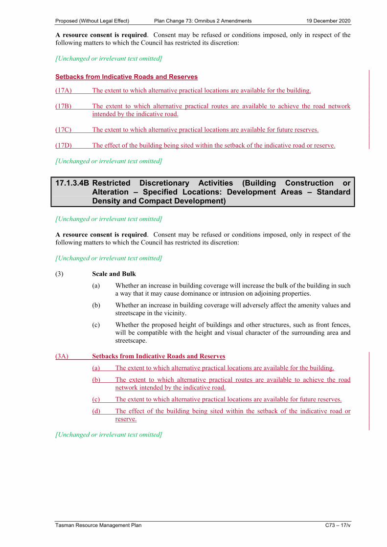
Setbacks from Indicative Roads and Reserves
(17A) The extent to which alternative practical locations are available for the building.
(17B) The extent to which alternative practical routes are available to achieve the road network intended by the indicative road.
(17C) The extent to which alternative practical locations are available for future reserves.
(17D) The effect of the building being sited within the setback of the indicative road or reserve.
[Unchanged or irrelevant text omitted]
17.1.3.4B Restricted Discretionary Activities (Building Construction or Alteration – Specified Locations: Development Areas – Standard Density and Compact Development)
[Unchanged or irrelevant text omitted]
A resource consent is required. Consent may be refused or conditions imposed, only in respect of the following matters to which the Council has restricted its discretion:
[Unchanged or irrelevant text omitted]
(3) Scale and Bulk
(a) Whether an increase in building coverage will increase the bulk of the building in such a way that it may cause dominance or intrusion on adjoining properties.
(b) Whether an increase in building coverage will adversely affect the amenity values and streetscape in the vicinity.
(c) Whether the proposed height of buildings and other structures, such as front fences, will be compatible with the height and visual character of the surrounding area and streetscape.
(3A) Setbacks from Indicative Roads and Reserves
(a) The extent to which alternative practical locations are available for the building.
(b) The extent to which alternative practical routes are available to achieve the road network intended by the indicative road.
(c) The extent to which alternative practical locations are available for future reserves.
(d) The effect of the building being sited within the setback of the indicative road or reserve.
[Unchanged or irrelevant text omitted]

Proposed (Without Legal Effect) Plan Change 73: Omnibus 2 Amendments 19 December 2020
C73 – 17/vi Tasman Resource Management Plan
17.1.3.4C Restricted Discretionary Activities (Building Construction or Alteration — Specified Location: Richmond Intensive Development Area - Intensive Development)
Construction or alteration of a building in the Richmond Intensive Development Area is a Restricted Discretionary activity, if it complies with the following conditions:
Location
(a) The site is located in the Richmond Intensive Development Area.
Dwellings on a Site
(b) More than one dwelling may be constructed on any site.
Allotment Area
(c) The minimum net area for each allotment is at least 200 square metres.
Site Coverage
(d) The maximum site coverage is 70 percent.
Building Coverage
(e) Maximum building coverage on a site is 50 percent.
Fences
(ea) Any fence, wall or screen erected in the front yard is no more than 0.8 metres in height.
Outdoor Living Space
(eb) Each dwelling complies with the following requirements:
Units at Ground Floor Units Above Ground FloorAt least 20 square metres of contiguous private outdoor living space which is capable of containing a 4-metre diameter circle within its shape.
(i) At least 7 square metres of balcony with a minimum depth of 1.5 metres, with at least a 1 metre wide roof or overhang (including balcony above).
(ii) Any balcony, including a roof top balcony, is no closer than 4 metres from an internal or side boundary.
(ec) Outdoor living spaces are readily accessible or contiguous from a living area of the dwelling.
(ed) Outdoor living spaces are not obstructed by buildings, vehicular access, manoeuvring or parking areas, from the ground level upwards.
(ef) Outdoor living spaces are not located on the southern or eastern side of the dwelling.
(eg) Outdoor living spaces are designed in accordance with the Urban Design Guide (Part II, Appendix 2).
Outdoor Living Space and Fences
(f) Conditions (ga) - (l) of rule 17.1.3.3 apply.
Internal Boundaries

Proposed (Without Legal Effect) Plan Change 73: Omnibus 2 Amendments 19 December 2020
Tasman Resource Management Plan C73 – 17/vii
(fa) Except as provided for in condition (fc) of this rule, all buildings are set back at least 2 metres from the front boundary, and no more than 5 metres, except that:
(i) all garages and carports are set back at least 5.5 metres from road front boundaries if the vehicle entrance of the garage or carport faces the road;
(ii) there is at least a 4-metre setback from one side or rear boundary;
(iii) where there is no vehicular access to the rear of the site from a legal road or approved access, in addition to condition (fa)(ii) of this rule, a side boundary setback of at least 1.5 metres on at least one side is provided, enabling access to the rear of the site.
Road Boundary Setback
(faa) All buildings are set back at least 2 metres from the road boundary and no more than 5 metres, except that all garages and carports are set back at least 5.5 metres from road boundaries if the vehicles entrance of the garage or carport faces the road.
Side and Rear Boundary Setbacks for Boundaries where Adjoining Land does not contain a Standard Density Dwelling
(fab) Except where condition (fd) of this rule applies:
(i) all buildings are set back 4-metres from one side or rear boundary to an adjoining site;
(ii) if there is a shared access/right-of-way within the 4-metre setback, the setback shall be taken from the external boundary common to the adjoining site;
(iii) where there is no vehicular access to the rear of the site from a legal road or approved access, in addition to items (i) and (ii) of this condition, a side boundary setback of at least 1.5 metres on at least one side is provided, enabling access to the rear of the site.
Building Envelope for Boundaries where Adjoining Land does not contain a Standard Density Dwelling
(fb) Except as provided for in where condition (fd) of this rule applies, all buildings comply with the following requirements:
(i) There is no front road boundary building envelope requirement.
(ii) For the most southern orientated side or rear boundary, the envelope is taken from a point 3 metres vertical above the boundary and then at an angle 45 degrees inwards from that point along the entire boundary.
(iii) For the remaining side and rear boundaries, all buildings are wholly within an envelope created by taking a vertical line from the boundary 6 metres above ground level and then at an angle of 45 degrees inwards from that point. This applies for no more than 50 percent of the total boundary length. For the balance 50 percent of the total boundary length, the envelope is taken from a point 3 metres vertical above the boundary and then at an angle 45 degrees inwards from that point.
(fc) All buildings at the boundary of every allotment comply with the building envelope and setback rules of permitted activity conditions 17.1.3.1 (m) to (o) and (r) to (v), under the following conditions:
(i) where the land adjoining the boundary is not part of an intensive development subdivision; or
(ii) where the land adjoining the boundary is not or is not being developed as an intensive development; or
(iii) where the boundary is a front boundary, all buildings are set back at least 2 metres from the front boundary, and no more than 5 metres, except that all garages and carports are set back at least 5.5 metres from road front boundaries if the vehicle entrance of the garage or carport faces the road.

Proposed (Without Legal Effect) Plan Change 73: Omnibus 2 Amendments 19 December 2020
C73 – 17/viii Tasman Resource Management Plan
For the avoidance of doubt, this means that, except for a front boundary or a boundary to a road, every side or rear boundary of the intensive development complies with permitted activity conditions for standard density development relating to the building envelope and building setbacks from boundaries where it adjoins land that is:
(i) not part of an intensive development subdivision or an intensive development; or
(ii) is being developed to a standard density within the same development proposal; or
(iii) is a standard density development.
Note: The separation between developments of different densities may be achieved by using roads or reserves. This creates a clear delineation without losing amenity values or the inefficient use of land resources.
Adjoining Land that Contains a Dwelling that was Not Constructed as Part of an Intensive Development
(fd) Where the land adjoining the boundary of the site contains a dwelling that was not constructed as part of an intensive development subdivision; or there exists a current building consent for a dwelling that is not being developed as an intensive development, the following provisions apply:
Building Envelope – daylight over and around
(i) No building projects beyond a building envelope constructed by daylight admission lines commencing from points 2.5 metres above ground level from all side and rear boundaries. The angle to be used is to be determined using the diagram in Schedule 17.1A.
(ii) For any roof with a slope of 15 degrees or greater and the roof ridge is generally at right angles to the boundary, the end of the ridge may be up to 1.5 metres above the indicator plane and the end area up to 2.5 square metres when viewed in elevation.
(iii) As an alternative to conditions (i) and (ii), buildings on south-facing slopes (between west and east) over 10 degrees comply with the following on any nominated boundary:
A building must fit within the arms of a 110-degree angle shape placed 35 degrees from the boundary (as shown in Schedule 17.1B). Only one angle may be used on any one boundary.
Permitted intrusions into the daylight around angle are:
a) eaves (not more than 600 millimetres);
b) buildings and structures complying with the special height limiting lines outside the angle.
The following applies with respect to (b). Parts of the building or detached outbuildings may be outside the daylight around angle but only up to a certain height. To find out how high a building outside the arms may be, use the following steps:
(1) Apply the daylight around angle (Schedule 17.1C) to find out how high exceptions may be. Start at 2 metres above ground level at point “P”. The maximum height then increases 0.5 metres for each 2 metres distance from the boundary. All heights are measured relative to point “P”.
(2) The right-hand side of the indicator is at 1:200 scale, and 1:100 on the left-hand side. Apply the one that is appropriate to your site plan.
Side and Rear Boundary Setbacks
(iv) Buildings are set back at least 1.5 metres from the side or rear boundaries on one side and at least 3 metres from all other side or rear boundaries in the case of all buildings except:
a) no setback is required from side or rear boundaries for buildings with a common wall on the boundary along that part of the boundary covered by the common wall;

Proposed (Without Legal Effect) Plan Change 73: Omnibus 2 Amendments 19 December 2020
Tasman Resource Management Plan C73 – 17/ix
b) where a garage or carport is an integral part of a dwelling and forms an external wall adjoining a site boundary; or a carport is attached to an external wall of a dwelling; the provisions of (v) apply to that part of the dwelling that is a garage or carport;
c) accessory buildings;
d) telecommunication and radio-communication facilities less than 10 square metres in area and less than 3 metres in height.
(v) Accessory buildings are set back at least 1.5 metres from side and rear boundaries, but less than 1.5 metres if all of the following apply:
a) the wall of the building adjacent to the boundary contains no windows;
b) any accessory building adjacent to the boundary does not exceed 7.2 metres in length or 50 percent of the length of the boundary, whichever is the lesser;
Note:
For the avoidance of doubt, this means that for any boundary of the site where the land beyond contains a dwelling that was not constructed as part of an intensive development, then the building envelope and setback rules for the standard density development apply. (Note these standard density rules are in (i) – (v) of this condition).
In any case, where the adjoining land does not contain a dwelling or the dwellings were constructed as part of an intensive development, then the rules in (fab) and (fb) apply.
The separation between developments of different densities may be achieved by using roads, reserves or vacant lots. This creates a clear delineation without losing amenity values or the inefficient use of land resources.
Setback from a rural or industrial zone
(fe) Dwellings are set back at least 25 metres from a rural zone boundary and at least 10 metres from an industrial zone boundary.
Setbacks from a river
(ff) Buildings are set back at least:
(i) 3 metres from the top of the bank of any river with a bed less than 1.5 metres in width;
(ii) 8 metres from the top of the bank of any river with a bed between 1.5 metres and 5 metres;
(iii) 20 metres from the top of the bank of any river with a bed between 5 and 20 metres in width.
Privacy Setback
(fg) Notwithstanding conditions (faa), (fab) and (fd) of this rule, dwellings shall be set back at least 3 metres from the nearest part of any other dwellings, except that no separation is required when there is a common wall.
Height
(g) The maximum height of any building is 7.5 metres.
Building Length
(h) The maximum length of any exterior upper floor wall is 12 metres before a recess with a minimum dimension of 3 metres depth by 3 metres length is required in the wall with a corresponding non-continuous eave.
Privacy
Proposed (Without Legal Effect) Plan Change 73: Omnibus 2 Amendments 19 December 2020
C73 – 17/x Tasman Resource Management Plan
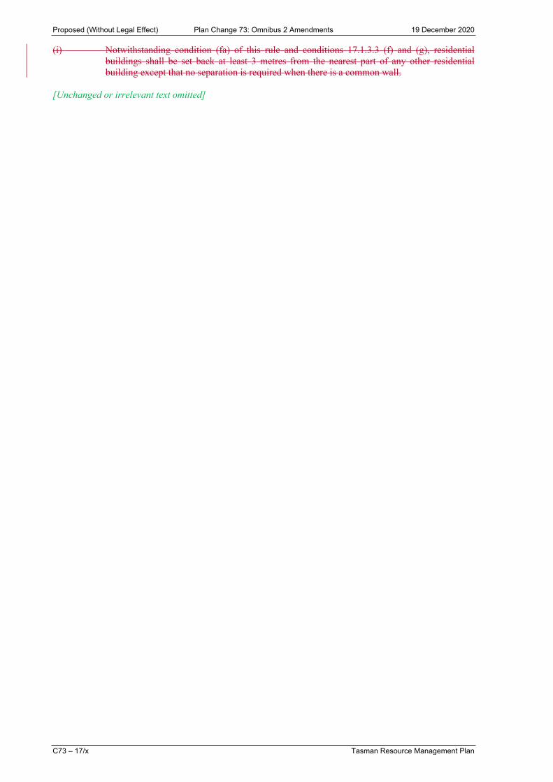
(i) Notwithstanding condition (fa) of this rule and conditions 17.1.3.3 (f) and (g), residential buildings shall be set back at least 3 metres from the nearest part of any other residential building except that no separation is required when there is a common wall.
[Unchanged or irrelevant text omitted]

Proposed (Without Legal Effect) Plan Change 73: Omnibus 2 Amendments 19 December 2020
Tasman Resource Management Plan C73 – 17/xi
17.1.20 Principal Reasons for Rules
[Unchanged or irrelevant text omitted]
Setback from Roads
[Unchanged or irrelevant text omitted]
The setback for compact density and intensive building development from the road boundary is less than the setback for standard development. The reduced setback enables buildings to front onto the street. This is encouraged for both amenity and safety reasons provided that the safe functioning of the road is not compromised.
Indicative Roads and Reserves
The indicative road and reserve networks are a critical element to managing growth within the Tasman District. A planned network provides well-connected and accessible living and business environments. The design and placement of roads and reserves also has the potential to contribute to the level of amenity and character of each area. The building setback requirement protects the future alignment and ability to establish these roads and reserves. The final location and construction of indicative roads and reserves (and walkways) are managed through the subdivision consenting process in Chapter 16.3. Other rules relevant to indicative roads and reserves can be found in Chapter 28.
[Unchanged or irrelevant text omitted]
Building Height
[Unchanged or irrelevant text omitted]
Daylight Admission
Daylight admission lines are intended to reduce shading of adjoining sites by ensuring that buildings fall within an angle that allows sunlight to penetrate onto the adjoining site. The angle of the line is based on obtaining some sun onto sites even in mid-winter at midday. The angles ensure reasonable amenity protection, whilst allowing reasonable development potential on adjoining sites. Some exceedances of the daylight admission lines are allowable for the end of a roof ridge or for solar panels, recognising the limited dimensions of these items. These allowances only apply to standard density development in the Residential Zone. Exceedance of daylight admission lines in compact density, intensive, and comprehensive residential developments may have a greater level of effect that should be considered through a resource consent process.
Home Occupations
Home occupations have the potential to impact on neighbours in terms of traffic generation, parking congestion, noise, odour, dust, visual effects, vibration, glare, and loss of privacy, and visual effectstraffic and parking congestion. Specific activities (spray painting, motor vehicle repairs or dismantling, fibre-glassing, sheet-metal work, bottle or scrap storage, rubbish collection, motor body building, or fish or meat processing) are not permitted home occupations due to the activities inherent unsuitability to the residential environment. The controls are intended to ensure that the residential areas of the District remain dominated by residential, rather than by non-residential, activities.
[Unchanged or irrelevant text omitted]

Proposed (Without Legal Effect) Plan Change 73: Omnibus 2 Amendments 19 December 2020
C73 – 17/xii Tasman Resource Management Plan
17.2 CENTRAL BUSINESS, COMMERCIAL AND TOURIST SERVICES ZONE RULES
[Unchanged or irrelevant text omitted]
17.2.3 Land Use - Tourist Services Zone
17.2.3.1 Permitted Activities (Land Use – Tourist Services Zone)
Any land use in the Tourist Services Zone is a permitted activity that may be undertaken without a resource consent, if it complies with the following conditions:
(a) Except as provided for in (b) and (c), the activity is one of the following:
(i) tourist accommodation, including those licensed to sell liquor, and associated office, service, tourist and recreation promotion and sales activities;
(ii) hire and servicing of sport and recreational equipment;
(iii) tutoring and training in outdoor recreational pursuits and life skills;
(iv) sale of souvenirs, and arts and crafts;
(v) recreational activities and recreational tour bases;
(vi) open space areas, walkways and children’s play areas;
(vii) visitor car and bus parking areas;
(viii) restaurants, including those licensed to sell liquor;
(ix) one caretaker's or manager's dwelling per site;
(x) motor garage and service station on the area of land described as Lot 1 DP 10923 and Lot 1 DP 2821 (Main Road, Riwaka);
(xa) public toilets;
(xb) a public refuse or recycling collection facility of less than 5 square metres in base area and less than 1.8 metres in height;
and in relation to CTs NL5C/273 and 11C/391 (Sandy Bay-Marahau Road, Marahau):
(xi) conference and function facilities;
(xii) cultural centre.
[Unchanged or irrelevant text omitted]
17.2.4 Building Construction or Alteration
17.2.4.1 Permitted Activities (Building Construction or Alteration)
Construction or alteration of a building in the Central Business, Commercial or Tourist Services Zone, except any building in either the Three Brothers Corner Commercial Zone or in the Richmond North Commercial Zone, is a permitted activity that may be undertaken without a resource consent, if it complies with the following conditions:
[Unchanged or irrelevant text omitted]
(i) The building is set back at least:
(i) 8 metres from the top of the bank of any river with a bed less than 5 metres in width;

Proposed (Without Legal Effect) Plan Change 73: Omnibus 2 Amendments 19 December 2020
Tasman Resource Management Plan C73 – 17/xiii
(iii) 20 metres from the top of the bank of any river with a bed between 5 and 20 metres in width.
(ia) The building is not located within, or within 10 metres of, any indicative road or indicative reserve, except for the following:
(i) This rule does not apply once the road or reserve intended to be established by the indicative road or indicative reserve is shown on a Land Transfer Plan and a s224 certificate pursuant to section 224 of the Resource Management Act 1991 has been issued by Council for the subdivision concerned.
(ii) No building setback is required under this rule on properties which do not have the indicative road or indicative reserve shown within that property’s boundaries.
[Unchanged or irrelevant text omitted]
17.2.4.2 Restricted Discretionary Activities (Building Construction or Alteration)
[Unchanged or irrelevant text omitted]
A resource consent is required. Consent may be refused or conditions imposed, only in respect of the following matters to which the Council has restricted its discretion:
[Unchanged or irrelevant text omitted]
(13A) Setbacks from Indicative Roads and Reserves
(a) The extent to which alternative practical locations are available for the building.
(b) The extent to which alternative practical routes are available to achieve the road network intended by the indicative road.
(c) The extent to which alternative practical locations are available for future reserves.
(d) The effect of the building being sited within the setback of the indicative road or reserve.
[Unchanged or irrelevant text omitted]
17.2.20 Principal Reasons for Rules
[Unchanged or irrelevant text omitted]
Building Setbacks
Setback is a means of mitigating various adverse effects, such as loss of privacy, loss of amenity, the visual impact of buildings from the street and from other zones (especially the Residential Zone), the lack of available parking areas and lack of opportunity for landscaping. Natural hazards, particularly erosion, are also a consideration.
[Unchanged or irrelevant text omitted]
Indicative Roads and Reserves
The indicative road and reserve networks are a critical element to managing growth within the Tasman District. A planned network provides well-connected and accessible living and business environments. The design and placement of roads and reserves also has the potential to contribute to the level of amenity and character of each area. The building setback requirement protects the future alignment and ability to establish these roads and reserves. The final location and construction of indicative roads and reserves (and walkways)

Proposed (Without Legal Effect) Plan Change 73: Omnibus 2 Amendments 19 December 2020
C73 – 17/xiv Tasman Resource Management Plan
are managed through the subdivision consenting process in Chapter 16.3. Other rules relevant to indicative roads and reserves can be found in Chapter 28.
[Unchanged or irrelevant text omitted]
17.3 MIXED BUSINESS ZONE RULES
[Unchanged or irrelevant text omitted]
17.3.3 Building Construction or Alteration
17.3.3.1 Permitted Activities (Building Construction or Alteration)
Construction or alteration of a building is a permitted activity, if it complies with the following conditions:
(a) The activity is not the construction or alteration of any building:
(i) within, or 10 metres from, any indicative road or indicative reserve;
(ii) where any side of the building is more than 50 metres in length (regardless of any wall off set provided in condition 17.3.3.1(i));
(iii) where the gross floor area is greater than 2,000 square metres.
[Unchanged or irrelevant text omitted]
(h) In the Richmond West Development Area, notwithstanding condition (g) of this rule, the building is set back at least 20 metres from the centreline of any electricity transmission line as shown on the planning maps.
(ha) The building is not located within, or within 10 metres of, any indicative road or indicative reserve, except for the following:
(i) This condition does not apply once the road or reserve intended to be established by the indicative road or indicative reserve is shown on a Land Transfer Plan and a s224 certificate pursuant to section 224 of the Resource Management Act 1991 has been issued by Council for the subdivision concerned.
(ii) No building setback is required under this condition on properties which do not have the indicative road or indicative reserve shown within that property’s boundaries.
[Unchanged or irrelevant text omitted]
17.3.3.4 Discretionary Activities (Building Construction or Alteration)
Construction or alteration of a building that does not comply with the conditions of rule 17.3.3.1, 17.3.3.2 or 17.3.3.3 is a discretionary activity, if it complies with the following conditions:
(a) Fences no higher than 600 millimetres are constructed along the Retail Frontage shown on the planning maps and are set back at least 2.5 metres from lower Queen Street, behind the amenity planting.
(b) Fences (including security fences) along site boundaries that adjoin a road, a reserve, or an Open Space or Recreation zone are set back behind the width of amenity plantings required in condition 16.3.4.1(t) and condition 17.3.3.1(n)(iii), and are no higher than 1.8 metres.
(c) The activity is not the construction or alteration of a building within, or 10 metres from, any indicative road or indicative reserve shown on the planning maps.

Proposed (Without Legal Effect) Plan Change 73: Omnibus 2 Amendments 19 December 2020
Tasman Resource Management Plan C73 – 17/xv
(d) The building is not located within, or within 10 metres of, any indicative road or indicative reserve, except for the following:
(i) This condition does not apply once the road or reserve intended to be established by the indicative road or indicative reserve is shown on a Land Transfer Plan and a s224 certificate pursuant to section 224 of the Resource Management Act 1991 has been issued by Council for the subdivision concerned.
(ii) No building setback is required under this condition on properties which do not have the indicative road or indicative reserve shown within that property’s boundaries.
[Unchanged or irrelevant text omitted]
17.3.20 Principal Reasons for Rules
[Unchanged or irrelevant text omitted]
Indicative Roads and Reserves
The indicative road and reserve networks are a critical element to managing growth within the Tasman District. A planned network provides well-connected and accessible living and business environments. The design and placement of roads and reserves also has the potential to contribute to the level of amenity and character of each area. The building setback requirement protects the future alignment and ability to establish these roads and reserves. The final location and construction of indicative roads and reserves (and walkways) are managed through the subdivision consenting process in Chapter 16.3. Other rules relevant to indicative roads and reserves can be found in Chapter 28.
[Unchanged or irrelevant text omitted]
17.4 INDUSTRIAL ZONE RULES
[Unchanged or irrelevant text omitted]
17.4.3 Building Construction or Alteration
17.4.3.1 Permitted Activities (Building Construction or Alteration)
Construction or alteration of a building is a permitted activity that may be undertaken without a resource consent, if it complies with the following conditions:
(a) The building is not on any of the Specified Sites in the Light Industrial Zone at Brightwater (as shown on the planning maps).
(b) The activity is not the construction or alteration of any building either within or 10 metres from any indicative road or indicative reserve in the Richmond West Development Area and the Richmond South Development Area shown on the planning maps.
[Unchanged or irrelevant text omitted]
(k) The building is set back from road boundaries at least:
(i) 3 metres in the Light Industrial Zone, except that in the Richmond West Development Area (other than in the Light Industrial Zone location at Beach Road as shown on the planning maps) buildings are set back at least 10 metres from roads, and in Motueka West Development Area buildings along the east side of Queen Victoria Street are set back at least 15 metres.

Proposed (Without Legal Effect) Plan Change 73: Omnibus 2 Amendments 19 December 2020
C73 – 17/xvi Tasman Resource Management Plan
(ii) 10 metres in the Heavy Industrial Zone;
except that telecommunication and radio-communication facilities less than 10 square metres in area and less than 3 metres in height are exempt from this requirement.
Note: Refer to 16.6.2.1(j)(ii) for applicable telecommunication and radio-communication facility setback requirements.
(ka) The building is not located within, or within 10 metres of, any indicative road or indicative reserve, except for the Light Industrial Zone where buildings are set back at least 10 metres from indicative roads and 5 metres from indicative reserves, except for the following:
(i) This condition does not apply once the road or reserve intended to be established by the indicative road or indicative reserve is shown on a Land Transfer Plan and a s224 certificate pursuant to section 224 of the Resource Management Act 1991 has been issued by Council for the subdivision concerned.
(ii) No building setback is required under this condition on properties which do not have the indicative road or indicative reserve shown within that property’s boundaries.
(l) In the Light Industrial Zone, the building is set back from roads and zone boundaries at least:
(i) 5 metres from indicative reserves;
(ii) 20 metres from the boundaries of sites in an adjoining Rural 1 Zone, except adjoining Swamp Road where the setback is 15 metres and adjoining McShane Road, where the setback is 10 metres;
(iii) 10 metres from the Open Space Zone.
[Unchanged or irrelevant text omitted]
17.4.3.3 Restricted Discretionary Activities (Building Construction or Alteration)
Construction or alteration of a building that does not comply with the conditions of rules 17.4.3.1, 17.4.3.2(a) or 17.4.3.3A is a restricted discretionary activity.
A resource consent is required. Consent may be refused or conditions imposed, only in respect of the following matters to which the Council has restricted its discretion:
[Unchanged or irrelevant text omitted]
Setbacks from Indicative Roads and Reserves
(15A) The extent to which alternative practical locations are available for the building.
(15B) The extent to which alternative practical routes are available to achieve the road network intended by the indicative road.
(15C) The extent to which alternative practical locations are available for future reserves.
(15D) The effects of the building being sited within the setback of the indicative road or reserve.
[Unchanged or irrelevant text omitted]

Proposed (Without Legal Effect) Plan Change 73: Omnibus 2 Amendments 19 December 2020
Tasman Resource Management Plan C73 – 17/xvii
17.4.20 Principal Reasons for Rules
[Unchanged or irrelevant text omitted]
Building Setbacks
[Unchanged or irrelevant text omitted]
Side and rear yards are required where Industrial zones adjoin a Residential Zone or public reserve to allow for screening, landscaping and to provide a degree of separation to protect the amenity of residential areas and reserves from dominance by industrial buildings.
Indicative Roads and Reserves
The indicative road and reserve networks are a critical element to managing growth within the Tasman District. A planned network provides well-connected and accessible living and business environments. The design and placement of roads and reserves also has the potential to contribute to the level of amenity and character of each area. The building setback requirement protects the future alignment and ability to establish these roads and reserves. The final location and construction of indicative roads and reserves (and walkways) are managed through the subdivision consenting process in Chapter 16.3. Other rules relevant to indicative roads and reserves can be found in Chapter 28.
[Unchanged or irrelevant text omitted]
17.5 RURAL 1 ZONE RULES
[Unchanged or irrelevant text omitted]
17.5.2 Land Use
[Unchanged or irrelevant text omitted]
17.5.2.8A Discretionary Activities (Cooperative Living)
Cooperative living is a discretionary activity. if it meets the following conditions:
(a) The activity meets permitted conditions (a) – (o) of rule 17.5.2.1.
(b) All buildings, including dwellings, meet permitted conditions (f) - (n) of rule 17.5.3.1.
(c) All dwellings meet the controlled conditions of rule 17.5.3.2 (d), (e), (f) and (g).
A resource consent is required. Consent may be refused or conditions imposed. In considering the applications and determining conditions, Council will have particular regard to the following criteria and to other provisions of the Plan or Act:
[Unchanged or irrelevant text omitted]
(4) The proposed legal arrangement regarding the collective ownership or use of the land and buildings.
(4) The extent to which the proposed legal arrangement establishes, in an enduring manner:
(a) the purpose or intent of the cooperative living activity;
(b) how it will be managed now and in the future; and
(c) how the individual members will be bound by this arrangement.

Proposed (Without Legal Effect) Plan Change 73: Omnibus 2 Amendments 19 December 2020
C73 – 17/xviii Tasman Resource Management Plan
[Unchanged or irrelevant text omitted]
17.5.2.9 Discretionary Activities (Land Use)
Any land use that does not comply with the conditions of rules 17.5.2.1 to 17.5.2.8A 17.5.2.3 is a discretionary activity, if it complies with the following conditions:
[Unchanged or irrelevant text omitted]
(c) Where relevant, the conditions in rule 17.5.2.8A.
[Unchanged or irrelevant text omitted]
17.5.2.10 Non-Complying Activities (Land Use)
Any activity in the Rural 1 Zone that does not comply with the conditions of rule 17.5.2.8A or 17.5.2.9 is a non-complying activity.
[Unchanged or irrelevant text omitted]
17.5.3 Building Construction, Alteration, or Use
17.5.3.1 Permitted Activities (Building Construction, Alteration, or Use)
Construction, alteration, or use of a building is a permitted activity that may be undertaken without a resource consent, if it complies with the following conditions:
(a) The activity is not the construction or alteration of any building within, or 10 metres from, any indicative road or indicative reserve in the Richmond West Development Area and the Richmond South Development Area.
[Unchanged or irrelevant text omitted]
(h) The building is set back at least:
(i) 10 metres from road boundaries (15 metres from the east side of Queen Victoria Street between Green Lane and Whakarewa Street) and, except as provided for under condition (ka) or condition (kc), 5 metres from internal boundaries (subject, in the case of artificial shelter, to condition 17.5.4.1(b)), except:
that telecommunication and radio-communication facilities less than 10 square metres in area and less than 3 metres in height are exempt from this requirement,
(Refer to 16.6.2.1(j)(iii) for applicable telecommunication and radio-communication facility setback requirements)
as provided for in Schedule 17.5A (Hope Depot site);
(ii) 20 metres from the margins of lakes, Open Space, Recreation and Conservation zones;
(iii) 8 metres from the top of the bank of any river with a bed less than 5 metres in width;
(iv) 20 metres from the top of the bank of any river with a bed greater than 5 metres in width;
(v) 30 metres from a plantation forest.
(vi) 10 metres from the boundary, and not within the boundary, of any indicative road or indicative reserve, except for the following:

Proposed (Without Legal Effect) Plan Change 73: Omnibus 2 Amendments 19 December 2020
Tasman Resource Management Plan C73 – 17/xix
(a) This rule does not apply once the road or reserve intended to be established by the indicative road or indicative reserve is shown on a Land Transfer Plan and a s224 certificate pursuant to section 224 of the Resource Management Act 1991 has been issued by Council for the subdivision concerned; except that if the certificate pursuant to section 224 of the Resource Management Plan lapses, then this rule shall apply.
(b) No building setback is required under this rule on properties which do not have the indicative road or indicative reserve shown within that property’s boundaries.
[Unchanged or irrelevant text omitted]
17.5.3.2 Controlled Activities (Building Construction, Alteration, or Use)
Construction, alteration, or use of a building that does not comply with the conditions of rule 17.5.3.1 is a controlled activity, if it complies with the following conditions:
[Unchanged or irrelevant text omitted]
(c) The site has a minimum area of 12 hectares or the site was created by a subdivision which was approved by the relevant territorial authority prior to 25 May 1996, except for sites created pursuant to condition 16.3.5.1(c) on Lot 1, DP 12203 in Golden Hills Road, where there can be up to seven dwellings on separate sites, each of which is no less than four hectares in area.
[Unchanged or irrelevant text omitted]
(i) On Lot 1, DP 12203 iIn the Rural 1 Closed Zone at Golden Hills Road, the exterior cladding of dwellings and ancillary buildings (including roofing) is to be in recessive colour tones.
[Unchanged or irrelevant text omitted]
(p) The activity is not the construction or alteration of any building within, or 10 metres from, any indicative road, indicative reserve (including Borck Creek) or amenity planting setback in the Richmond West Development Area.The building is not located within, or within 10 metres of, any indicative road or indicative reserve (including Borck Creek) or amenity planting setback in the Richmond West Development Area, except for the following:
(i) This rule does not apply once the road or reserve intended to be established by the indicative road or indicative reserve is shown on a Land Transfer Plan and a s224 certificate pursuant to section 224 of the Resource Management Act 1991 has been issued by Council for the subdivision concerned.
(ii) No building setback is required under this rule on properties which do not have the indicative road or indicative reserve shown within that property’s boundaries.
17.5.20 Principal Reasons for Rules
[Unchanged or irrelevant text omitted]
Setback of Buildings from Lake Margins and Other Zone Boundaries
The setback of buildings from the margins of natural occurring lakes and large impounded lakes, and from the boundary with Open Space, Recreation and Conservation zones provides for open space to retain natural character and possible public access or recreational use through esplanade reserves or strips. The setbacks also help reduce possible conflict between lake use and adjacent residential or other uses of buildings.

Proposed (Without Legal Effect) Plan Change 73: Omnibus 2 Amendments 19 December 2020
C73 – 17/xx Tasman Resource Management Plan
Indicative Roads and Reserves
The indicative road and reserve networks are a critical element to managing growth within the Tasman District. A planned network provides well-connected and accessible living and business environments. The design and placement of roads and reserves also has the potential to contribute to the level of amenity and character of each area. The building setback requirement protects the future alignment and ability to establish these roads and reserves. The final location and construction of indicative roads and reserves (and walkways) are managed through the subdivision consenting process in Chapter 16.3. Other rules relevant to indicative roads and reserves can be found in chapter 28.
[Unchanged or irrelevant text omitted]
17.6 RURAL 2 ZONE RULES
[Unchanged or irrelevant text omitted]
17.6.2 Land Use
[Unchanged or irrelevant text omitted]
17.6.2.8A Discretionary Activities (Cooperative Living)
Cooperative living is a discretionary activity if it meets the following conditions:
(a) The activity meets permitted conditions (a) – (o) of rule 17.6.2.1.
(b) All buildings, including dwellings, meet permitted conditions (e) - (t) of rule 17.6.3.1, where applicable.
A resource consent is required. Consent may be refused or conditions imposed. In considering the applications and determining conditions, Council will have regard to the following particular criteria and to other provisions of the Plan or Act:
[Unchanged or irrelevant text omitted]
(4) The proposed legal arrangement regarding the collective ownership or use of the land and buildings.
(4) The extent to which the proposed legal arrangement establishes, in an enduring manner:
(a) the purpose or intent of the cooperative living activity;
(b) how it will be managed now and in the future; and
(c) how the individual members will be bound by this arrangement.
[Unchanged or irrelevant text omitted]
17.6.2.9 Discretionary Activities (Land Use)
Any land use that does not comply with the conditions of rules 17.6.2.1 to 17.6.2.8A 17.6.2.3 is a discretionary activity, if it complies with the following conditions:
(a) Where relevant, the conditions in rule 18.6.4.1 affecting quarrying.
(b) Where relevant, the conditions in rule 17.6.2.8A.
[Unchanged or irrelevant text omitted]

Proposed (Without Legal Effect) Plan Change 73: Omnibus 2 Amendments 19 December 2020
Tasman Resource Management Plan C73 – 17/xxi
17.6.2.10 Non-Complying Activities (Land Use)
Any activity in the Rural 2 Zone that does not comply with the conditions of rule 17.6.2.8A or 17.6.2.9 is a non-complying activity.
A resource consent is required. Consent may be refused, or conditions imposed. In considering the applications and determining conditions, Council will have regard to any provisions of the Plan or Act.
[Unchanged or irrelevant text omitted]
17.6.3 Building Construction, Alteration, or Use
17.6.3.1 Permitted Activities (Building Construction, Alteration, or Use)
Construction, alteration, or use of a building is a permitted activity that may be undertaken without a resource consent, if it complies with the following conditions:
(a) The activity is not the construction or alteration of any building within, or 10 metres from, any indicative road or indicative reserve in the Richmond West Development Area and the Richmond South Development Area.
[Unchanged or irrelevant text omitted]
Setbacks
(j) The building is set back at least:
(i) 10 metres from road boundaries and, except as provided for under condition (ma), condition (n) or condition (na), 5 metres from internal boundaries (subject, in the case of artificial shelter, to condition 17.6.4.1(b)), except that telecommunication and radio-communication facilities less than 10 square metres in area and less than 3 metres in height are exempt from this requirement;
(Refer to 16.6.2.1(j)(iii) for applicable telecommunication and radio-communication facility setback requirements)
(ii) 20 metres from the margins of lakes, and from the boundaries of Open Space, Recreation and Conservation zones;
(iii) 8 metres from the top of the bank of any river with a bed less than 5 metres in width;
(iv) 20 metres from the top of the bank of any river with a bed greater than 5 metres in width;
(v) 30 metres from a plantation forest.
(vi) 10 metres from the boundary, and not within the boundary, of any indicative road or indicative reserve, except for the following:
(a) This condition does not apply once the road or reserve intended to be established by the indicative road or indicative reserve is shown on a Land Transfer Plan and a s224 certificate pursuant to section 224 of the Resource Management Act 1991 has been issued by Council for the subdivision concerned; except that if the certificate pursuant to section 224 of the Resource Management Plan lapses, then this rule shall apply.
(b) No building setback is required under this condition on properties which do not have the indicative road or indicative reserve shown within that property’s boundaries.
[Unchanged or irrelevant text omitted]

Proposed (Without Legal Effect) Plan Change 73: Omnibus 2 Amendments 19 December 2020
C73 – 17/xxii Tasman Resource Management Plan
17.6.3.2 Controlled Activities (Building Construction, Alteration, or Use)
Construction, alteration, or use of any building that does not comply with the conditions of rule 17.6.3.1 is a controlled activity, if it complies with the following conditions:
[Unchanged or irrelevant text omitted]
(i) The activity is not the construction or alteration of any building within, or 10 metres from, any indicative road, indicative reserve (including Borck Creek) or amenity planting setback in the Richmond West Development Area.The building is not located within, or within 10 metres of, any indicative road or indicative reserve, except for the following:
(i) This condition does not apply once the road or reserve intended to be established by the indicative road or indicative reserve is shown on a Land Transfer Plan and a s224 certificate pursuant to section 224 of the Resource Management Act 1991 has been issued by Council for the subdivision concerned.
(ii) No building setback is required under this condition on properties which do not have the indicative road or indicative reserve shown within that property’s boundaries.
[Unchanged or irrelevant text omitted]
17.6.20 Principal Reasons for Rules
[Unchanged or irrelevant text omitted]
Setback of Buildings from Lake Margins and Other Zone Boundaries
The setback of buildings from the margins of natural occurring lakes and large impounded lakes, and from the boundary with Open Space, Recreation and Conservation zones provides for open space to retain natural character and possible public access or recreational use through esplanade reserves or strips. The setbacks also help reduce possible conflict between lake use and adjacent residential or other uses of buildings.
Indicative Roads and Reserves
The indicative road and reserve networks are a critical element to managing growth within the Tasman District. A planned network provides well-connected and accessible living and business environments. The design and placement of roads and reserves also has the potential to contribute to the level of amenity and character of each area. The building setback requirement protects the future alignment and ability to establish these roads and reserves. The final location and construction of indicative roads and reserves (and walkways) are managed through the subdivision consenting process in Chapter 16.3. Other rules relevant to indicative roads and reserves can be found in Chapter 28.
Proposed (Without Legal Effect) Plan Change 73: Omnibus 2 Amendments 19 December 2020
Tasman Resource Management Plan C73 – 17/xxiii
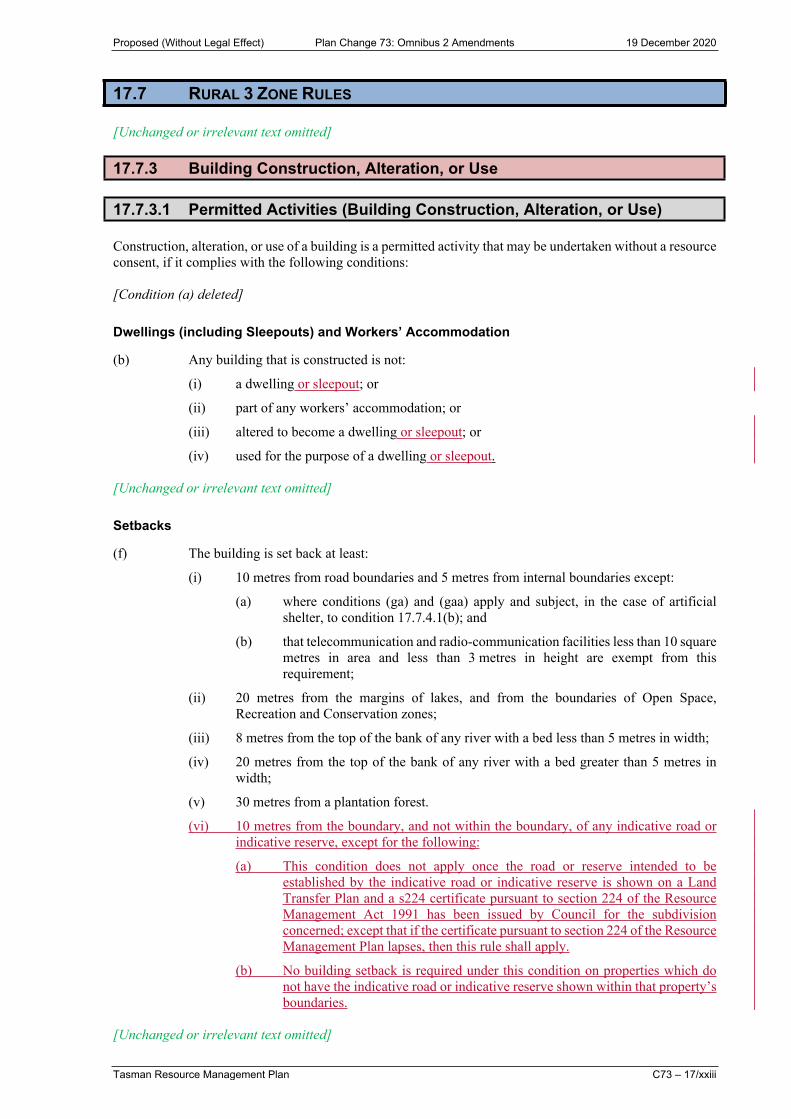
17.7 RURAL 3 ZONE RULES
[Unchanged or irrelevant text omitted]
17.7.3 Building Construction, Alteration, or Use
17.7.3.1 Permitted Activities (Building Construction, Alteration, or Use)
Construction, alteration, or use of a building is a permitted activity that may be undertaken without a resource consent, if it complies with the following conditions:
[Condition (a) deleted]
Dwellings (including Sleepouts) and Workers’ Accommodation
(b) Any building that is constructed is not:
(i) a dwelling or sleepout; or
(ii) part of any workers’ accommodation; or
(iii) altered to become a dwelling or sleepout; or
(iv) used for the purpose of a dwelling or sleepout.
[Unchanged or irrelevant text omitted]
Setbacks
(f) The building is set back at least:
(i) 10 metres from road boundaries and 5 metres from internal boundaries except:
(a) where conditions (ga) and (gaa) apply and subject, in the case of artificial shelter, to condition 17.7.4.1(b); and
(b) that telecommunication and radio-communication facilities less than 10 square metres in area and less than 3 metres in height are exempt from this requirement;
(ii) 20 metres from the margins of lakes, and from the boundaries of Open Space, Recreation and Conservation zones;
(iii) 8 metres from the top of the bank of any river with a bed less than 5 metres in width;
(iv) 20 metres from the top of the bank of any river with a bed greater than 5 metres in width;
(v) 30 metres from a plantation forest.
(vi) 10 metres from the boundary, and not within the boundary, of any indicative road or indicative reserve, except for the following:
(a) This condition does not apply once the road or reserve intended to be established by the indicative road or indicative reserve is shown on a Land Transfer Plan and a s224 certificate pursuant to section 224 of the Resource Management Act 1991 has been issued by Council for the subdivision concerned; except that if the certificate pursuant to section 224 of the Resource Management Plan lapses, then this rule shall apply.
(b) No building setback is required under this condition on properties which do not have the indicative road or indicative reserve shown within that property’s boundaries.
[Unchanged or irrelevant text omitted]

Proposed (Without Legal Effect) Plan Change 73: Omnibus 2 Amendments 19 December 2020
C73 – 17/xxiv Tasman Resource Management Plan
17.7.20 Principal Reasons for Rules
[Unchanged or irrelevant text omitted]
Setback of Buildings from Lake Margins and Other Zone Boundaries
The setback of buildings from the margins of natural occurring lakes and large impounded lakes, and from the boundary with Open Space, Recreation and Conservation zones provides for open space to retain natural character and possible public access or recreational use through esplanade reserves or strips. The setbacks also help reduce possible conflict between lake use and adjacent residential or other uses of buildings.
Indicative Roads and Reserves
The indicative road and reserve networks are a critical element to managing growth within the Tasman District. A planned network provides well-connected and accessible living and business environments. The design and placement of roads and reserves also has the potential to contribute to the level of amenity and character of each area. The building setback requirement protects the future alignment and ability to establish these roads and reserves. The final location and construction of indicative roads and reserves (and walkways) are managed through the subdivision consenting process in Chapter 16.3. Other rules relevant to indicative roads and reserves can be found in Chapter 28.
[Unchanged or irrelevant text omitted]
Sleepouts
The number of sleepouts able to be constructed as a controlled activity on any given property is two sleepouts per principal dwelling and or second dwelling, where that second dwelling is not a minor dwelling. Those sleepouts may be located within 20 metres of any dwelling, including any minor dwelling.
17.8 RURAL RESIDENTIAL ZONE RULES
[Unchanged or irrelevant text omitted]
17.8.2 Land Use
17.8.2.1 Permitted Activities (Land Use - General)
[Unchanged or irrelevant text omitted]
Any land use is a permitted activity that may be undertaken without a resource consent, if it complies with the following conditions:
(a) The activity is not one of the following:
[Unchanged or irrelevant text omitted]
(vii) cooperative living.
[Unchanged or irrelevant text omitted]
17.8.2.6A Discretionary Activities (Cooperative Living)
Cooperative living is a discretionary activity if it meets the following conditions:
(a) The activity meets permitted conditions (a) – (p) of rule 17.8.2.1.

Proposed (Without Legal Effect) Plan Change 73: Omnibus 2 Amendments 19 December 2020
Tasman Resource Management Plan C73 – 17/xxv
(b) All buildings, including dwellings, meet permitted conditions (e) – (q) of rule 17.8.3.1 where applicable.
A resource consent is required. Consent may be refused, or conditions imposed. In considering the applications and determining conditions, Council will have regard to the following particular criteria and to other provisions of the Plan or Act:
(1) The proposed legal arrangement regarding land and building ownership.
(1) The extent to which the proposed legal arrangement establishes, in an enduring manner:
(a) the purpose or intent of the cooperative living activity;
(b) how it will be managed now and in the future; and
(c) how the individual members will be bound by this arrangement.
[Unchanged or irrelevant text omitted]
17.8.3 Building Construction, Alteration, or Use
17.8.3.1 Permitted Activities (Building Construction, Alteration, or Use)
Construction, alteration, or use of a building is a permitted activity that may be undertaken without a resource consent, if it complies with the following conditions:
[Unchanged or irrelevant text omitted]
Sleepouts
(ba) There are no more than two sleepouts associated with any principal dwelling or second dwelling that is not a minor dwelling.
(c) The gross floor area of each sleepout is no more than 36 square metres.
(d) The location of each sleepout is within 20 metres of any dwelling, including any minor dwelling on the site.
(da) The sleepout is not part of a cooperative living activity.
[Unchanged or irrelevant text omitted]
Setbacks
(g) The building is set back at least:
(i) 10 metres from road boundaries and 5 metres from internal boundaries except:
(a) where condition (h)(i) applies and subject, in the case of artificial shelter, to condition 17.8.2.1(f)); and
(b) that telecommunication and radio-communication facilities less than 10 square metres in area and less than 3 metres in height are exempt from this requirement;
(ii) 20 metres from the margins of lakes and from the boundaries of Open Space, Recreation and Conservation zones;
(iii) 8 metres from the top of the bank of any river with a bed less than 5 metres in width;
(iv) 20 metres from the top of the bank of any river with a bed greater than 5 metres in width;

Proposed (Without Legal Effect) Plan Change 73: Omnibus 2 Amendments 19 December 2020
C73 – 17/xxvi Tasman Resource Management Plan
(v) 30 metres from a plantation forest;
(vi) 10 metres from internal boundaries in the case of buildings housing livestock.
(vii) 32 metres from the centreline of any electricity transmission line in the Richmond East Development Area (notwithstanding condition (g)(i)) as shown on the planning maps);
(viii) 10 metres from the boundary, and not within the boundary, of any indicative road or indicative reserve, except for the following:
(a) This condition does not apply once the road or reserve intended to be established by the indicative road or indicative reserve is shown on a Land Transfer Plan and a s224 certificate pursuant to section 224 of the Resource Management Act 1991 has been issued by Council for the subdivision concerned; except that if the certificate pursuant to section 224 of the Resource Management Plan lapses, then this rule shall apply.
(b) No building setback is required under this condition on properties which do not have the indicative road or indicative reserve shown within that property’s boundaries.
[Unchanged or irrelevant text omitted]
17.8.20 Principal Reasons for Rules
[Unchanged or irrelevant text omitted]
Building Setback from Rivers
The setback of buildings from rivers avoids or mitigates the risk to buildings from bank erosion and provides for access in order to maintain channels or bank stability. Setbacks provide a degree of mitigation from flooding. They also provide for open space to maintain natural character, and possible public access or recreational use through esplanade reserves or strips.
Setbacks help reduce possible conflicts between river use and adjacent residential or other uses of buildings. The variation in setback from rivers of different widths reflects the varying risks and access requirements.
The setbacks for dwellings for quarry areas and activities ensures that the potential adverse effects of present and future quarries on nearby dwellings are avoided, remedied or mitigated, and that any potential reverse sensitivity (where future residents may try to limit quarry activities), are addressed.
Indicative Roads and Reserves
The indicative road and reserve networks are a critical element to managing growth within the Tasman District. A planned network provides well-connected and accessible living and business environments. The design and placement of roads and reserves also has the potential to contribute to the level of amenity and character of each area. The building setback requirement protects the future alignment and ability to establish these roads and reserves. The final location and construction of indicative roads and reserves (and walkways) are managed through the subdivision consenting process in Chapter 16.3. Other rules relevant to indicative roads and reserves can be found in Chapter 28.
[Unchanged or irrelevant text omitted]

Proposed (Without Legal Effect) Plan Change 73: Omnibus 2 Amendments 19 December 2020
Tasman Resource Management Plan C73 – 17/xxvii
17.9 OPEN SPACE ZONE RULES
[Unchanged or irrelevant text omitted]
17.9.2 Land Use
17.9.2.1 Permitted Activities (Land Use)
Any land use is a permitted activity that may be undertaken without a resource consent, if it complies with the following conditions:
Activities
(a) The activity is one of the following:
(i) a playground, picnic facility, public shelter or neighbourhood open space;
(ii) a public garden and accessory buildings;
(iii) a walkway or cycleway;
(iv) public toilets;
(v) a public refuse or recycling collection facility of less than 5 square metres in base area and less than 1.8 metres in height;
(iv) an activity consistent with any reserve management plan approved for the land under the Reserves Act or any subsequent legislation.
[Unchanged or irrelevant text omitted]
(da) The building is not located within, or within 10 metres of, any indicative road or indicative reserve, except for the following:
(i) This condition does not apply once the road or reserve intended to be established by the indicative road or indicative reserve is shown on a Land Transfer Plan and a s224 certificate pursuant to section 224 of the Resource Management Act 1991 has been issued by Council for the subdivision concerned.
(ii) No building setback is required under this condition on properties which do not have the indicative road or indicative reserve shown within that property’s boundaries.
[Unchanged or irrelevant text omitted]
17.10 RECREATION ZONE RULES
[Unchanged or irrelevant text omitted]
17.10.2 Land Use
17.10.2.1 Permitted Activities (Land Use)
Any land use is a permitted activity that may be undertaken without a resource consent, if it complies with the following conditions:
Activities
(a) The activity is one of the following:

Proposed (Without Legal Effect) Plan Change 73: Omnibus 2 Amendments 19 December 2020
C73 – 17/xxviii Tasman Resource Management Plan
(i) indoor or outdoor sporting and recreation activity;
(ii) public gardens;
(iii) playground, picnic facility or public shelters;
(iv) public car park, walkway or cycleway;
(v) craft fair, gala or fête;
(va) public toilets;
(vb) a public refuse or recycling collection facility of less than 5 square metres in base area and less than 1.8 metres in height
(vi) buildings for any of the above activities, or for purposes accessory to the above activities, and for the storage of equipment for reserve maintenance;
(vii) an activity consistent with any reserve management plan approved for the land under the Reserves Act or any subsequent legislation.
17.10.3 Building Construction or Alteration
17.10.3.1 Permitted Activities (Building Construction or Alteration)
Construction or alteration of a building is a permitted activity that may be undertaken without a resource consent, if it complies with the following conditions:
(a) The activity is not the construction or alteration of any building in, or 10 metres from:
(i) the boundary of any indicative road or indicative reserve in the Richmond West Development Area as shown on the planning maps;
(ii) any amenity planting setback in the Richmond West Development Area;
(iii) the 10-metre wide reserve through the Recreation Zone adjoining the Rural 2 and Open Space zones.
Except in regard to item (i) above:
(1) This condition does not apply once the road or reserve intended to be established by the indicative road or indicative reserve is shown on a Land Transfer Plan and a s224 certificate pursuant to section 224 of the Resource Management Act 1991 has been issued by Council for the subdivision concerned; except that if the certificate pursuant to section 224 of the Resource Management Plan lapses, then this rule shall apply.
(2) No building setback is required under this condition on properties which do not have the indicative road or indicative reserve shown within that property’s boundaries.
[Unchanged or irrelevant text omitted]
17.11 CONSERVATION ZONE RULES
[Unchanged or irrelevant text omitted]
17.11.2 Land Use
17.11.2.1 Permitted Activities (Land Use)
Any land use is a permitted activity that may be undertaken without a resource consent, if it complies with the following conditions:

Proposed (Without Legal Effect) Plan Change 73: Omnibus 2 Amendments 19 December 2020
Tasman Resource Management Plan C73 – 17/xxix
[Unchanged or irrelevant text omitted]
Setback
(d) The building is set back at least 10 metres from any boundary, except that telecommunication and radio-communication facilities which are less than 10 square metres in area and 3 metres in height; and masts and poles and their antennas and mounting structures less than 7 metres in height, must be set back a minimum of 10 metres from a zone boundary.
(da) The building is not located within, or within 10m of, any indicative road or indicative reserve, except for the following:
(i) This condition does not apply once the road or reserve intended to be established by the indicative road or indicative reserve is shown on a Land Transfer Plan and a s224 certificate pursuant to section 224 of the Resource Management Act 1991 has been issued by Council for the subdivision concerned.
(ii) No building setback is required under this condition on properties which do not have the indicative road or indicative reserve shown within that property’s boundaries.
[Unchanged or irrelevant text omitted]
17.12 RURAL INDUSTRIAL ZONE RULES
[Unchanged or irrelevant text omitted]
17.12.2 Land Use
17.12.2.1 Permitted Activities (Land Use)
Any land use is a permitted activity, except where specified in rule 17.12.2.3A, that may be undertaken without a resource consent, if it complies with the following conditions:
[Unchanged or irrelevant text omitted]
(p) The building is set back at least 10 metres from:
(i) all site boundaries, including existing and proposed legal road frontages; except that telecommunication and radio-communication facilities less than 10 square metres in area and less than 3 metres in height are exempt from this requirement;
(ii) the boundary, and not within the boundary, of any indicative road or indicative reserve, except that:
(a) this rule does not apply once the road or reserve intended to be established by the indicative road or indicative reserve is shown on a Land Transfer Plan and a s224 certificate pursuant to section 224 of the Resource Management Act 1991 has been issued by Council for the subdivision concerned; except that if the certificate pursuant to section 224 of the Resource Management Plan lapses, then this rule shall apply;
(b) no building setback is required under this rule on properties which do not have the indicative road or indicative reserve shown within that property’s boundaries.
(Refer to 16.6.2.1(j)(ii) for applicable telecommunication and radio-communication facility setback requirements)
except also that in the following locations, the stated setbacks apply:

Proposed (Without Legal Effect) Plan Change 73: Omnibus 2 Amendments 19 December 2020
C73 – 17/xxx Tasman Resource Management Plan
(iii) Not less than 100 metres from Waimea West Road (for the Eves Valley Rural Industrial Zone).
(iiv) Not less than 3 metres from the north-eastern toe of the bund mound erected parallel to Lower Queen Street, or at least 5 metres from Queen Street, whichever is the greater distance, within the Golden Edge Rural Industrial Zone.
(iiiv) Not less than 3 metres from the boundary of any new legal road within the Golden Edge Rural Industrial Zone.
(ivi) Not less than 15 metres from mean high water springs on Record of Title 7254638 within the Golden Edge Rural Industrial Zone (520 Lower Queen Street).
(vii) Elsewhere in the Zone, not less than 30 metres from the Coastal Marine Area boundary, except that this rule only applies to buildings constructed after 25 May 1996.
Electricity Transmission Corridor
(q) In the Richmond West Development Area, notwithstanding the exemption in condition (p)(i)(iii) relating to telecommunication and radio-communication facilities, the building is set back at least 20 metres from the centreline of the electricity transmission line as shown on the planning maps.
17.13 PAPAKAINGA ZONE RULES
[Unchanged or irrelevant text omitted]
17.13.2 Land Use
17.13.2.1 Permitted Activities (Land Use)
Any land use is a permitted activity that may be undertaken without a resource consent, if it complies with the following conditions:
[Unchanged or irrelevant text omitted]
(ea) The building is not located within, or within 10m of, any indicative road or indicative reserve, except for the following:
(i) This rule does not apply once the road or reserve intended to be established by the indicative road or indicative reserve is shown on a Land Transfer Plan and a s224 certificate pursuant to section 224 of the Resource Management Act 1991 has been issued by Council for the subdivision concerned.
(ii) No building setback is required under this rule on properties which do not have the indicative road or indicative reserve shown within that property’s boundaries.
17.14 DEFERRED ZONE RULES
17.14.1 Scope of Section
This section deals with the procedure for removal of deferrals of future urban or rural residential zones on rural, residential or rural residential zoned land in the Deferred Residential, Deferred Mixed Business, Deferred Light Industrial, Deferred Rural Residential, Deferred Tourist Services, Deferred Heavy Industrial and Deferred Papakainga zones.
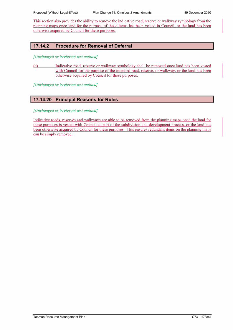
Proposed (Without Legal Effect) Plan Change 73: Omnibus 2 Amendments 19 December 2020
Tasman Resource Management Plan C73 – 17/xxxi
This section also provides the ability to remove the indicative road, reserve or walkway symbology from the planning maps once land for the purpose of those items has been vested in Council, or the land has been otherwise acquired by Council for these purposes.
17.14.2 Procedure for Removal of Deferral
[Unchanged or irrelevant text omitted]
(e) Indicative road, reserve or walkway symbology shall be removed once land has been vested with Council for the purpose of the intended road, reserve, or walkway, or the land has been otherwise acquired by Council for these purposes.
[Unchanged or irrelevant text omitted]
17.14.20 Principal Reasons for Rules
[Unchanged or irrelevant text omitted]
Indicative roads, reserves and walkways are able to be removed from the planning maps once the land for these purposes is vested with Council as part of the subdivision and development process, or the land has been otherwise acquired by Council for these purposes. This ensures redundant items on the planning maps can be simply removed.