Embed Size (px)
Citation preview
IdentifyingSettlementPatternsandTerritories 1
Jens Andresen – Rasmus Birch Iversen – Peter Jensen
OntheWar-Path: TerrestrialMilitaryOrganisationinPrehistoricDenmark
Abstract: Throughtheuseofvector-basedGIS-technology,quantitativemethods,historicalandtraditionalarchaeologicalsources,theauthorspointtoacloserelationbetweenthelocationofIronandVikingAgefinds,sites,andstructuresrelatedtowarfareandtheDanishhighwaynetworkasitisknownfromthelateeighteenthandearlynineteenthcenturies.Itisargued,thatthisrelationshipreflectsasystemofmilitaryorganisationembeddedinthesettlementstructureandthatitsrootscanbetracedasfarbackastheearlyfirstcenturyBC.
Introduction
Foralongtimetheconceptofwarhasbeenunder-statedinDanisharchaeology.Duringthe1970sand1980s,thefocuswasonsettlementarchaeology,ru-raleconomy,trade,andsocial issues.Mildlyexag-gerated,onecouldsaythatsocietywasdescribedasanessentiallypeacefulcosyShireinhabitedbypipe-smoking,gardentendinghobbits,livinginoblivionofthechaoticworldoutsideandonlyoccasionallyharassedbyexternalthreats.OnlyinrecentyearswehavewitnessedwarfarediscussedasaprimemoverintheformativeprocessoftheprehistoricsocietyofDenmark (Otto / Thrane / Vandkilde 2006). ThistrendisalsovisibleinthestudyofIronAgeandVi-kingsocieties,which increasinglyareperceivedasmartial societies, i.e. societies inwhich preparationforwarandconflictwasimbeddedinthesocialor-ganisation,oreventhatsocialorganisationsimplywas military organisation (Hedenstierna-Jonson2006).Admittedly,someinsightsinthestructureofpre-
historicarmieshavebeenuncovered (Ilkjær1990;Müller-Wille1977;Näsman1991;Pedersen2004).However,attemptstoproduceaquantitivesynthe-sisoftheseresultsandresultsfromthestudyoftheapparently peaceful daily life in the rural settle-mentsareveryscarce(Ringtved1999).Additionally,the study of maritime aspects of military organi-sation inNorthernEuropehas achievedmany in-teresting conclusions onmaritimewarfare (Crum-lin-Pedersen 1991; Graham-Campbell et al. 2001;Jørgensen 2002; Skoglund 2002; Varenius 1998).Atthesametimehowever,themaritimefocushasdefinedalimitedscientifichorizonper se, focusingonships,harboursandcoastalzones.Inthispaper,
wewill focusonnon-maritime(terrestrial)aspects only.Acentralaspectinthestudyofwarandconflict
inlandaregravescontainingweaponsand/orridinggear.Inpreviousstudies,thespatialdistributionhasbeenillustratedbydot-maps.Asthebackgroundin-formationof thedots, natural –not cultural –pa-rameters,suchascoastline,heightabovesea-level,lakes, and water-drainage were chosen. One ofthe benefits ofGIS-technology is the easewith bywhichallsortsofgeographical informationcanbeoverlaid.Comparedwithpaper-basedinformation,GIS-technology offers superior features for spatialexploratorydataanalysis.Theconventionalpaper-basedinformationmanagementmaybetheprimaryreasonwhynobodyseemstohavenoticedthatthedistributionofgravesofhorsemenandwarriorsinthe IronAgeandVikingperiodstronglyassociatewith the network ofmajor roads known from theendof the18thcentury.Theaimof thispaper is toconfirmtheobservedcorrelationstatisticallyandtodiscussinferencesconcerningthemilitaryorganisa-tioninprehistoricDenmark.
The Terrestrial Infrastructure of the Martial Society
From the earliest written sources describing theGermanictribes,thesourcesunanimouslytellusofsocietieswith an unusuallymartial ideology. Thisis clear from the accounts ofCaesar, Tacitus,Am-mianusMarcellinus orVegetius,who for instancestates:
Even today the barbarians think this art [of war] alone deserves their attention; they are sure that everything
2 LayersofPerception–CAA2007
else either depends on this art or can be obtained by them through it. (Vegetius: Epitoma ReiMilitaris III; 10.FromMilner1993,86)The accounts of continuous Viking assaults on
Anglo-Saxon England and the Frankish realm isprobably only a continuation of this ideology ofwar.InthefollowingwewillapproachthequestionofthecomplexityofIronAgemilitaryorganisationinDenmarkinalongtimeperspective.Thisisdonein a statistical, logistic and landscape perspective,whichwill reveal fragmentsofacomplexmilitaryorganisationofsociety.
The Relative Permanence of Road Networks
Armiesofthesizeweseereflectedinthewar-bootycollectionsoftheRomanIronAgeandindeedintheVikingAge, cannot have operatedwithout inlandroads.Althoughwe candemonstrate roads in thearchaeological record – ranging from gravel-filledwheel tracks to stone and plank built roads – theevidenceismostoftenfromrivercrossingsorotherprotectedlocations.Theyaresparseandtheyarenot
helpfulinreconstructingthecommunicativelinesoftheprehistoriclandscape.Ontheotherhand,roadsystems are commonly and rightly regarded asone of themost stable human artefacts. There aregoodreasonsforthisbeingso,culturallyaswellasnaturally.Aculturalreasonisthatroadslinksettledareas: roads and settlements mutually determinetheirpositioninthelandscape.Anaturalreasonisthatroadsystemsrelatetothegeomorphologyofagivenarea,whichinahumanperspectiveisaverystatic property of the landscape. Mountain areasfor instance areoftenpracticallypassable throughvalleysonly,whichessentiallydefinenaturalwaterdrainagesystems.Thisrelationshipbetweenwater-drainagevs. road systems isquite theopposite inflatland areas, where ridges/watersheds definethemostcost-efficient location fornon-local traffic(Møller2005).
Historic Road Systems
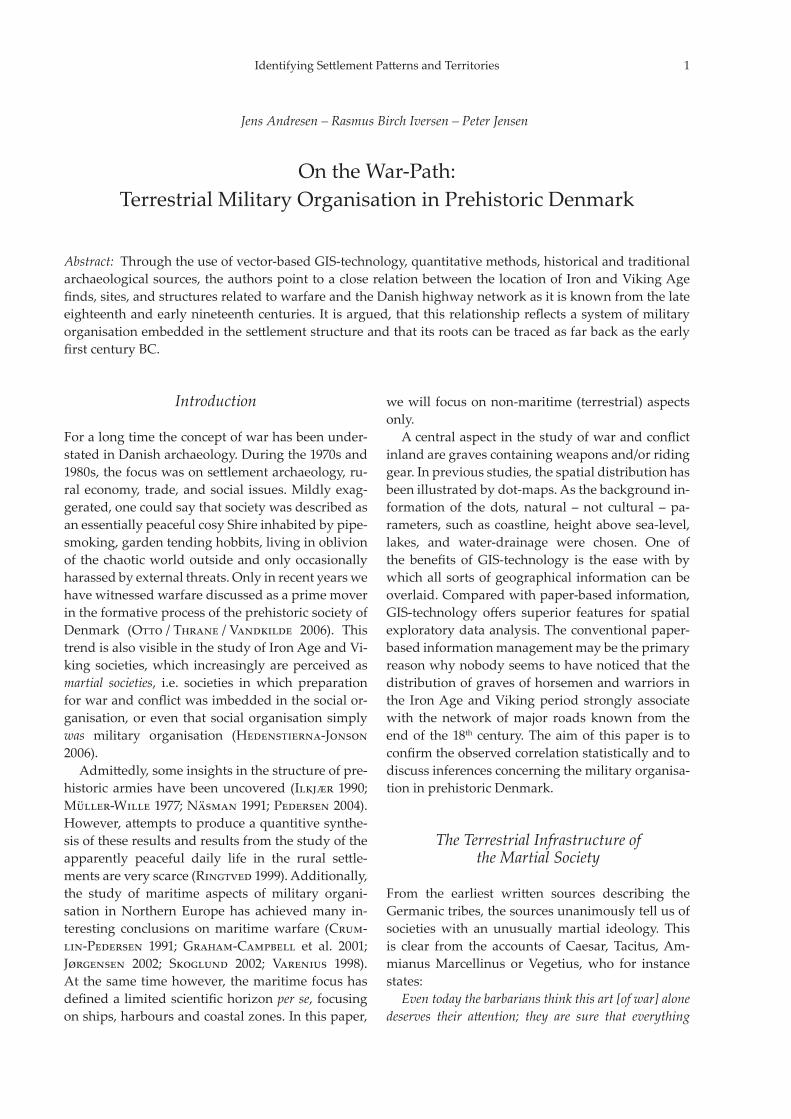
Around1800ADtheDanishRoyalAcademyofSci-encesandLettersproducedaseriesofmapswhichareconsideredthefirstreliablegeodeticrepresenta-
Fig.2. Main roads in Denmark and Schleswig around1800withcontemporarycoast-linesasdepictedonmapsproducedbytheDanishRoyalAcademyofSciencesand
Letters.
Fig.1.Exampleofanoriginalmapdating1786fromthearea around Jelling. The land-use and road-systems ofthattimeareclearlymarked.TheN-SrunningmainroadW of the small lake has a special signature. Lines con-nectingprehistoric(probablyBronzeAge)grave-moundsarealsovisible,asthemounds(aswellaschurch-towers)wereusedastriangulationpointsbythesurveyors.
IdentifyingSettlementPatternsandTerritories 3
tionofDenmark(Korsgaard2004).Themapswereproducedinascaleof1 : 20,000(Fig. 1).Subsequent-ly theywere reduced to the scaleof 1 : 80,000and1 : 120,000 printed on copper-plates. The produc-tionprocess tookplace from1762 to1820.Theuseof this source in amodernGIS-systemwasmadepossible by one of the authors of this paper, JensAndresen. In1997hedevelopedamethod togeo-reference these and other historical maps. He re-questedacompletelistofthegeographicpositionsofDanishchurch-towersfromtheDanishOrdnanceSurvey (KMS). Because a substantial part of thechurches were used as geodetic reference pointson theoldmaps too, they easily canbe identifiedandusedasreferencepoints.Thismadeitpossibletodigitize (vectorize) features from themaps andtransfer the features to geo-referencedmap-layersinaGIS-system.ThecoastlineandthehighwaysofDenmarkonthemap(Fig. 2)werecreatedwiththis technique.Theresultingmapofhistoricroadnetworksisa
quiteheterogeneoushistoricalsource.Itisveryno-ticeablethatthelatestmappedareaoftheduchyofSchleswigdisplaysamuchdenserhighway-networkthantherestoftheJutlandpeninsula.Thiscausesthesuspicionthatthesurveyormappedsomebywaysashighways.Also,somelocalroadsmighthavebeen“upgraded” in thisperioddue to royalprovisionsdating1784 (DuchyofSchleswig)and1793 (King-dom of Denmark) (Krünitz 1773–1858; Møller2005).Thisprovision resulted in the improvementofthehighway-systemwhichalsostraightenedoutformer roads. Either version of the highwayswasdepicted on partly revised copper-plates, clearlyvisibleontheislandofZealandonFig. 2(Dam2005, 41).Byconsultingtheoriginalsin1 : 20,000someofthese“newartefacts”couldbeeliminated.Whatisleftis theclosestwecanget tothemedievalhigh-way-system, which generally speaking connectedmarket towns,harboursandother important loca-tions but by-passed rural settlements,whichwerefencedatnight.
Dykes and the Hærvejen
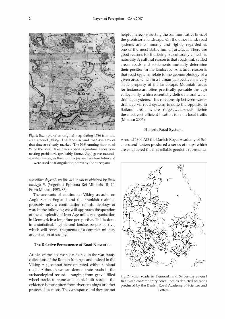
An important, but less investigated type of struc-ture inDanish IronAge researchare the so-calleddykes.Thefewdatedfallintheperiodofthefirsttotheearlyfourthcenturies.Thedykesarecharacter-isedbyV-shapedditches,anearthenrampartandapalisadeoftenstretchingseveralkilometresclosing
passagesthroughwetlandareas.Thedykeshaveaninterestingdistribution, since they form a straightlineupthroughthemiddlepartofJutlandconsist-entwith the so-calledHærvej, themajormedievalroadusedforoxenexportfromDenmarktoGerma-nyandtheNetherlands(Jørgensen1988;Ringtved1999; Jørgensen 2003, seeFig. 3). The name of theroad,aswellitsassociationtothedykes,isnotthatpeaceful.Theroadwas locatedat themainwater-shedof the Jutlandpeninsula, and itwas also themainchannelforthetransportofland-basedtroopsin timesofwar. Itranthroughsparselypopulatedareasendingatthemostsouthernpartofourstudyarea – theDannevirke near present-day Schleswig.Theearliestdatedphaseisfromtheearlypartoftheeighthcentury,butthereisanearlierundatedphase.Thiswas the focal point controlling essentially allkindsofnorth-southtraffictoandfromtheJutlandpeninsulaattheKarle-gat–thegateofthewarriors.Interestingly,nameandfunctionseemparalleledintheanglo-saxonhere-path,therouteprimarilyusedby campaigning (Viking) armies (Halsall 2005, 148).
Fig.3. Dykes,barragesandotherdefensivefeatures(afterRingtved1999).Approximatepositionofthestructures.
4 LayersofPerception–CAA2007
Iron Age War Booty Offerings and Historic Highways
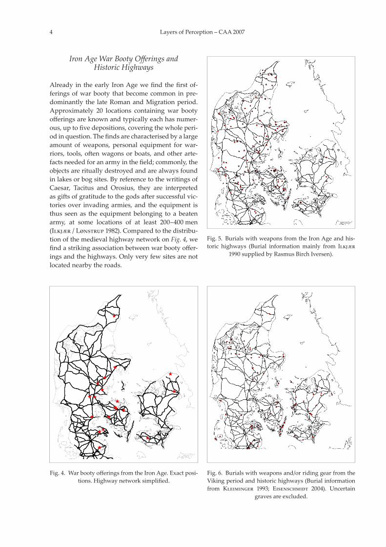
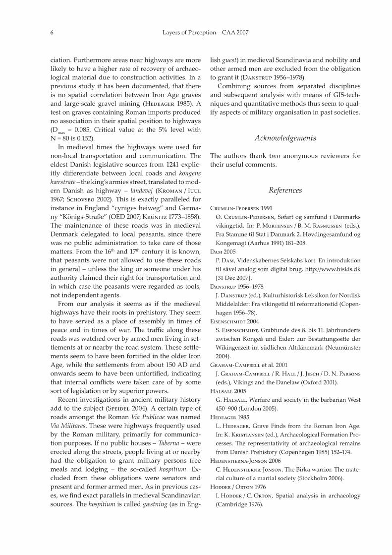
Already in theearly IronAgewefind thefirstof-feringsofwarbooty thatbecomecommon inpre-dominantly the lateRomanandMigrationperiod.Approximately 20 locations containing war bootyofferingsareknownandtypicallyeachhasnumer-ous,uptofivedepositions,coveringthewholeperi-odinquestion.Thefindsarecharacterisedbyalargeamount ofweapons, personal equipment forwar-riors, tools,oftenwagonsorboats,andotherarte-factsneededforanarmyinthefield;commonly,theobjectsarerituallydestroyedandarealwaysfoundinlakesorbogsites.ByreferencetothewritingsofCaesar, Tacitus and Orosius, they are interpretedasgiftsofgratitudetothegodsaftersuccessfulvic-toriesover invadingarmies, and theequipment isthus seen as the equipmentbelonging to a beatenarmy, at some locations of at least 200–400 men (Ilkjær / Lønstrup1982).Comparedtothedistribu-tionofthemedievalhighwaynetworkonFig. 4,wefindastrikingassociationbetweenwarbootyoffer-ingsandthehighways.Onlyveryfewsitesarenotlocatednearbytheroads.
Fig.5. BurialswithweaponsfromtheIronAgeandhis-toric highways (Burial informationmainly from Ilkjær
1990suppliedbyRasmusBirchIversen).
Fig.4. WarbootyofferingsfromtheIronAge.Exactposi-tions.Highwaynetworksimplified.
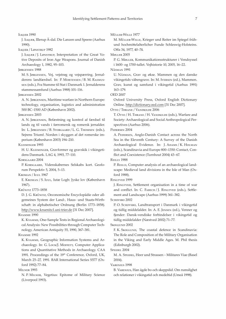
Fig.6. Burialswithweaponsand/orridinggearfromtheVikingperiodandhistorichighways(Burialinformationfrom Kleiminger 1993; Eisenschmidt 2004). Uncertain
gravesareexcluded.

IdentifyingSettlementPatternsandTerritories 5
touseavector-basedsolution.Theadvantageisthatvectoroperationsaremuchmoreaccurateandscal-ablewithoutlossofaccuracy.Ashortdescriptionoftheoperativepartfollows
here: The position of the graves from publishedsources was collected from www.dkconline.dk.An unedited version of digitized highways fromJutlandwasusedforthecomputationoftheback-ground information (theareacoveredby thebuff-ersaroundthehighways).Thebuffersin200 min-crementswerecreatedandtheirareacomputedinMapInfo (Fig. 7). Openwater and largerwetlandswere subtracted, as no grave can be placed there.OnlygravesfromJutlandwereconsidered,inorderto minimize the influence of coastal defence sys-tems.Thedistancefromthegravestonearesthigh-wayswascomputedasdescribedbyReilly (1988)andwasperformedwithafreelyavailableprogramdevelopedbyPeter Jensen indotNet.Thebin-sizeofthecumulativepercentageofdistanceswassetto200 mlikethebackgroundinformation(Fig. 8).TheKolomogorov-Smirnov one sample testwasmadeinMicrosoftExcel.This resulted inaconfirmationthattheassociationbetweengravesandhighwaysisstatisticallysignificantatthe1%level.
Highways and Weapon-graves – Where is the Link?
Due to space limitations, data bias issues cannotbethoroughlydiscussed,althoughtheyhavebeeninvestigatedvery carefully. Sincemanygraves arefoundingravelandgravelisusedforconstructinghighways, this may influence the observed asso-
Fig.7. Buffer-analysis of the highway-network. The dis-tancebetweenbuffersis200 meters.Sea,lakesandlarger
wetlandsaresubtracted.
Fig.8. Cumulated percentage of distances from burialsto nearest highway.Cumulatedpercentage of buffer-ar-easaroundhistorichighways. Jutlandonly.Dmaxof Iron Age=0.154withN =163.DmaxofVikingperiod=0.212
withN=65.
Prehistoric Weapon Graves and Historic Highways
InspiteoftheclearsignsofearlierwarfaretheIronAgeweapongravesonlyappearaspartofanony-mous burial customs towards the end of the Pre-RomanIronAge,duringthelast100yearsorsoBC.Inthisinitialphasetheyareverycommon,whichisalsotrueforthefirsthalfofthesecondcenturyandtoadegreeagaininthesecondpartofthethirdcen-tury.Inthefifthcenturyweonlyknowofonegravefieldwithweapons, and after 500 ADand for thenext250yearsonlyfourweapongravesareknownfromallofDenmark(Fig. 5).Thisisduetothefactthatgravefieldsfromthisperiodaremissingalmostcompletely.WeapongravesreappearasacommontraitintheVikingAgeinthelateninthandthefirsthalfofthetenthcenturyclearlydiscernableintotwocategories:weapongraveswith ridingequipment,commonlyrichchambergraves,andmoreordinaryweapon graves without association to horse gear(Fig. 6).Theweapongravecustomalsoshowsadistinct
regional distribution. From the outset, weapongraves are almost totally absent on the island ofZealanduntiltheVikingAge,whereastheweaponsdisappear fromgraves on the islandof Funenbe-forethemiddleofthethirdcentury.Asinthepre-viouscases,wefindanoverallvisuallydiscernableassociationofthearchaeologicalfind-spotsandthehistoric highways.Amore rigorous test is neededin this case, sowe adopted themethoddescribedbyHodder / Orton(1976)forthestatisticalanalysisofdistancesbetweenlinearfeaturesandpointphe-nomena. In contrast to Kvamme (1990; 1992), whoadvocatedaraster-basedGISsolution,wedecided
6 LayersofPerception–CAA2007
ciation.Furthermoreareasnearhighwaysaremorelikelytohaveahigherrateofrecoveryofarchaeo-logicalmaterialdue toconstructionactivities. Inapreviousstudyithasbeendocumented,thatthereis no spatial correlation between IronAge gravesand large-scale gravelmining (Hedeager 1985).AtestongravescontainingRomanimportsproducednoassociationintheirspatialpositiontohighways(Dmax = 0.085. Critical value at the 5% level withN=80is0.152).Inmedieval times the highways were used for
non-local transportation and communication. TheeldestDanish legislative sources from1241explic-itly differentiate between local roads and kongens hærstrate–theking’sarmiesstreet,translatedtomod-ern Danish as highway – landevej (Kroman / Iuul1967;Schovsbo2002).This isexactlyparalleled forinstanceinEngland“cynigesheiweg”andGerma-ny“Königs-Straße”(OED2007;Krünitz1773–1858).The maintenance of these roads was in medievalDenmark delegated to local peasants, since therewasnopublicadministrationto takecareof thosematters.Fromthe16thand17thcenturyitisknown,thatpeasantswerenotallowed touse these roadsingeneral–unlessthekingorsomeoneunderhisauthorityclaimedtheirrightfortransportationandinwhichcasethepeasantswereregardedastools,notindependentagents.From our analysis it seems as if the medieval
highwayshavetheirrootsinprehistory.Theyseemto have served as a place of assembly in times ofpeace and in times ofwar. The traffic along theseroadswaswatchedoverbyarmedmenlivinginset-tlementsatornearbytheroadsystem.Thesesettle-mentsseemtohavebeenfortifiedintheolderIronAge,whilethesettlementsfromabout150ADandonwardsseemtohavebeenunfortified, indicatingthat internal conflictswere taken care of by somesortoflegislationorbysuperiorpowers.Recent investigations inancientmilitaryhistory
addtothesubject(Speidel2004).Acertaintypeofroadsamongst theRomanVia PublicaewasnamedVia Militares.Thesewerehighwaysfrequentlyusedby the Romanmilitary, primarily for communica-tionpurposes.Ifnopublichouses–Taberna–wereerectedalongthestreets,peoplelivingatornearbyhad the obligation to grant military persons freemeals and lodging – the so-called hospitium. Ex-cluded from these obligations were senators andpresentandformerarmedmen.Asinpreviouscas-es,wefindexactparallelsinmedievalScandinaviansources.Thehospitiumiscalledgæstning(asinEng-
lishguest)inmedievalScandinaviaandnobilityandotherarmedmenareexcludedfromtheobligationtograntit(Danstrup1956–1978).Combining sources from separated disciplines
and subsequent analysis withmeans of GIS-tech-niquesandquantitativemethodsthusseemtoqual-ifyaspectsofmilitaryorganisationinpastsocieties.
Acknowledgements
The authors thank two anonymous reviewers fortheirusefulcomments.
References
Crumlin-Pedersen1991O.Crumlin-Pedersen,SøfartogsamfundiDanmarksvikingetid. In: P.Mortensen / B.M.Rasmussen (eds.),FraStammetilStatiDanmark2.HøvdingesamfundogKongemagt(Aarhus1991)181–208.
Dam2005P.Dam,VidenskabernesSelskabskort.Enintroduktiontilsåvelanalogsomdigitalbrug.http://www.hiskis.dk [31Dec2007].
Danstrup1956–1978J.Danstrup(ed.),KulturhistoriskLeksikonforNordiskMiddelalder:Fravikingetidtilreformationstid(Copen-hagen1956–78).
Eisenschmidt2004S.Eisenschmidt,Grabfundedes8.bis11.Jahrhundertszwischen Kongeå und Eider: zur Bestattungssitte derWikingerzeit imsüdlichenAltdänemark(Neumünster2004).
Graham-Campbelletal.2001J.Graham-Campbell / R.Hall / J.Jesch / D.N.Parsons (eds.),VikingsandtheDanelaw(Oxford2001).
Halsall2005G.Halsall,WarfareandsocietyinthebarbarianWest450–900(London2005).
Hedeager1985L.Hedeager,Grave Finds from the Roman IronAge.In:K.Kristiansen(ed.),ArchaeologicalFormationPro-cesses. The representativity of archaeological remainsfromDanishPrehistory(Copenhagen1985)152–174.
Hedenstierna-Jonson2006C.Hedenstierna-Jonson,TheBirkawarrior.Themate-rialcultureofamartialsociety(Stockholm2006).
Hodder / Orton1976I.Hodder / C.Orton, Spatial analysis in archaeology(Cambridge1976).
IdentifyingSettlementPatternsandTerritories 7
Ilkjær1990J.Ilkjær,IllerupÅ-dal.DieLanzenundSpeere(Aarhus1990).
Ilkjær / Lønstrup1982J.Ilkjær / J.Lønstrup, Interpretation of the Great Vo-tiveDepositsof IronAgeWeapons. JournalofDanishArchaeology1,1982,95–103.
Jørgensen1988M.S.Jørgensen, Vej, vejstrøg og vejspærring. Jernal-derens landfærdsel. In: P.Mortensen / B.M.Rasmus-sen(eds.),FraStammetilStatiDanmark1.Jernalderensstammessamfund(Aarhus1988)101–116.
Jørgensen2002A.N.Jørgensen,MaritimewarfareinNorthernEurope:technology, organisation, logistics and administration500BC–1500AD(København2002).
Jørgensen2003A.N.Jørgensen, Befæstning og kontrol af færdsel tillands og til vands i førromersk og romersk jernalder.In: L.Jørgensen / B.Storgaard / L.G.Thomsen (eds.),SejrensTriumf.Nordeniskyggenafdetromerskeim-perium(København2003)194–210.
Kleiminger1993H.U.Kleiminger,Gravformeroggravskikivikingeti-densDanmark.LAG4,1993,77–110.
Korsgaard2004P.Korsgaard, Videnskabernes Selskabs kort. Geofo-rumPerspektiv5,2004,5–13.
Kroman / Iuul1967E.Kroman / S.Iuul,IutæLogh:Jyskelov(København1967).
Krünitz1773–1858D.J.G.Krünitz,OeconomischeEncyclopädieoderall-gemeines Systemder Land-,Haus- und Staats-Wirth-schaft: in alphabetischer Ordnung (Berlin 1773–1858).http://www.kruenitz1.uni-trier.de[31Dec2007].
Kvamme1990K.Kvamme,One-SampleTestsinRegionalArchaeologi-calAnalysis:NewPossibilitiesthroughComputerTech-nology.AmericanAntiquity55,1990,367–381.
Kvamme1992K.Kvamme,Geographic Information Systems andAr-chaeology. In: G.Lock/J.Moffett, ComputerApplica-tionsandQuantitativeMethods inArchaeology.CAA1991.Proceedingsof the19thConference,Oxford,UK,March25–27,1991.BARInternationalSeriesS577(Ox-ford1992)77–84.
Milner1993N.P.Milner, Vegetius: Epitome of Military Science(Liverpool1993).
Müller-Wille1977M.Müller-Wille,KriegerundReiterimSpiegelfrüh-und hochmittelalterlicher Funde Schleswig-Holsteins.Offa34,1977,40–74.
Møller2005P.G.Møller,KommunikationsstruktureriVendsysseli1600-og1700-tallet.Vejhistorie10,2005,16–22.
Näsman1991U.Näsman, Grav og økse. Mammen og den danskevikingetidsvåbengrave.In:M.Iversen(ed.),Mammen.Grav, kunst og samfund i vikingetid (Aarhus 1991)163–179.
OED2007Oxford University Press, Oxford English DictionaryOnline.http://dictionary.oed.com[31Dec2007].
Otto / Thrane / Vandkilde2006T.Otto / H.Thrane / H.Vandkilde(eds.),WarfareandSociety:ArchaeologicalandSocialAnthropologicalPer-spectives(Aarhus2006).
Pedersen2004A.Pedersen, Anglo-Danish Contact across the NorthSea in the EleventhCentury:A Survey of theDanish Archaeological Evidence. In: J.Adams / K.Holman (eds.),ScandinaviaandEurope800–1350:Contact,Con-flictandCoexistence(Turnhout2004)43–67.
Reilly1988P.Reilly,Computeranalysisofanarchaeologicalland-scape:MedievallanddivisionsintheIsleofMan(Ox-ford1988).
Ringtved1999J.Ringtved, Settlement organisation in a time of warand conflict. In: C. Fabech / J. Ringtved (eds.), Settle-mentandLandscape(Aarhus1999)361–382.
Schovsbo2002P.O.Schovsbo, Landtransport iDanmark i vikingetidogtidligmiddelalder.In:A.E.Jensen(ed.),Vennerogfjender: Dansk-vendiske forbindelser i vikingetid ogtidligmiddelalder(Næstved2002)71–77.
Skoglund2002F.K.Skoglund, The coastal defence in Scandinavia:TheRoleandCompositionoftheMilitaryOrganisationin the Viking and EarlyMiddleAges. M. Phil thesis(Edinburgh2002).
Speidel2004M.A.Speidel,HeerundStrassen–MilitaresViae(Basel2004).
Varenius1998B.Varenius,Hanägdeboochskeppslid.Omrumslighetochrelationerivikingatidochmedeltid(Umeå1998).
8 LayersofPerception–CAA2007
Illustration Credits
Fig.1. CopyrightoftheDanishOrdnanceSurvey(KMS)andisreproducedwiththeallowanceKMSA404/85.Fig.2. The coastline is digitized by the project “Settle-mentandLandscape”attheUniversityofAarhusFigs. 2–7. The digitized highways inside the nationalboundaries of Denmark are downloaded from http://www.hiskis.dkandarecreatedby:Dam,Peder;Nielsen,Peter Steen;Dam,Claus andBill, Jan. The highways ofthesouthernpartofSchleswigaredigitizedbyoneoftheauthors(JensAndresen).Fig.3. ReproducedwiththepermissionofJytteRingtved,UniversityofAarhus.
Jens AndresenRasmus Birch Iversen
Peter Jensen
University of AarhusInstitute of Anthropology, Archaeology and Linguistics
Department of Prehistoric ArchaeologyMoesgård
8270 HøjbjergDenmark

![Advt No. : 93/2016-17 (AAC) Date of Pre Subject ... 93... · AAC-A ] [ 43 ] [ P.T.O. 177. Which of the following is also known as military organisation? (A) Line and staff organisation](https://img.pdfslide.net/doc/110x75/5c950c1309d3f2a17b8bfc58/advt-no-932016-17-aac-date-of-pre-subject-93-aac-a-43-pto.jpg)