Embed Size (px)
Citation preview

A
ONA
TRENCH SAMPLING PROGRAM
ON THE
AMY PROPERTY
AMI 1 - 8 MINERAL CLAIMS
TOOTSEE LAKE AREA
NTS: LATITUDE: LONGITUDE: OWNER: OPERATOR: AUTHOR: DATE:
LIARD MINING DIVISION, B.C.
1040/15e, 16~ 59” 56’ N 130”3O’W W.R. Gilmour Discovery Consultants T.H. Carpenter, P.Geo. September 29, 1999
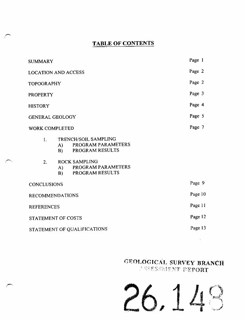
TABLE OF CONTENTS
P
SUMMARY
LOCATION AND ACCESS
TOPOGRAPHY
PROPERTY
HISTORY
GENERAL GEOLOGY
WORK COMPLETED
CONCLUSIONS
RECOMMENDATIONS
REFERENCES
STATEMENT OF COSTS
STATEMENT OF QUALIFICATIONS
Page 1
Page 2
Page 2
Page 3
Page 4
Page 5
Page 7
Page 9
Page 10
Page 11
Page 12
Page 13
1. TRENCH/SOIL SAMPLING A) PROGRAM PARAMETERS B) PROGRAM RESULTS
2. ROCK SAMPLING A) PROGRAM PARAMETERS B) PROGRAM RESULTS

LIST OF ILLUSTRATIONS
FIGURE 1 Location Map
FIGURE 2 Claim Location Map (150,000)
Following Page 2
Following Page 3
FIGURE 3
FIGURE 4
FIGURE 5
FIGURE 6
Sample Location Map
Lead Values
Zinc Values
Silver Values
In Pocket
In Pocket
In Pocket
In Pocket
APPENDICES
Appendix 1 Soil Sampling, Analytical Procedures and Results
Appendix 2 Rock Sample Description, Analytical Procedures and Results
SUMMARY
The Amy property is a developed prospect comprising a galena and sphalerite “manto”
body formed by replacement mineralization in folded Cambro-Ordovician Kechika Group
metasediments. Sulphide zones averaging 1.8 metres wide occur primarily in marble units in a
phyllite-talc-silicate, hornfels-quartzite package.
Mineralization, consisting of sphalerite, galena, pyrite, arsenopyrite and fiiebergite can be
traced along strike for 170 metres. Indicated reserves of 72,000 tonnes grading 367 grams per
tonne silver, 6.0% zinc and 2.8% lead were reported by Marbaco Resources Ltd. in 1973.
However a comparison by Fosco Mining Ltd. in 197 1, between the grade of drill intercepts near
the underground workings and assays from channel samples taken from the drift on the property,
suggests the estimated grade is probably low by an unknown but significant amount.
In 1999, old trenches on the property east and west of underground workings were
sampled as an aid in evaluating previously reported geochemical data.

LOCATION AND ACCESS
The AMY property is located approximately 130 km (80 miles) west-southwest of
Watson Lake, Yukon Territory, in the Liard Mining Division of British Columbia. The property
is accessible by four-wheel drive vehicle from Mile 701 at George’s Gorge on the Alaska
Highway. From Mile 701 a road leads south, partly along the Tootsee River to the Silver-tip
Deposit at a distance of 30 kilometres. A branch road forking off the Silver-tip road, some 5
kilometres north of the deposit, leads 8 kilometres southwesterly to the Amy property. The road
to the Amy is passable in the dry season only, by a ford on the Tootsee River.
TOPOGRAPHY
The claims are located in the Cassiar Mountains at elevations ranging from 1,200 to
1,600 metres. Peaks in the general area rise to about 2,000 metres.
The general topography is moderately rugged and accessible. At higher elevations the
country is open. In the valleys, small timber and heavy undergrowth make travel difficult.

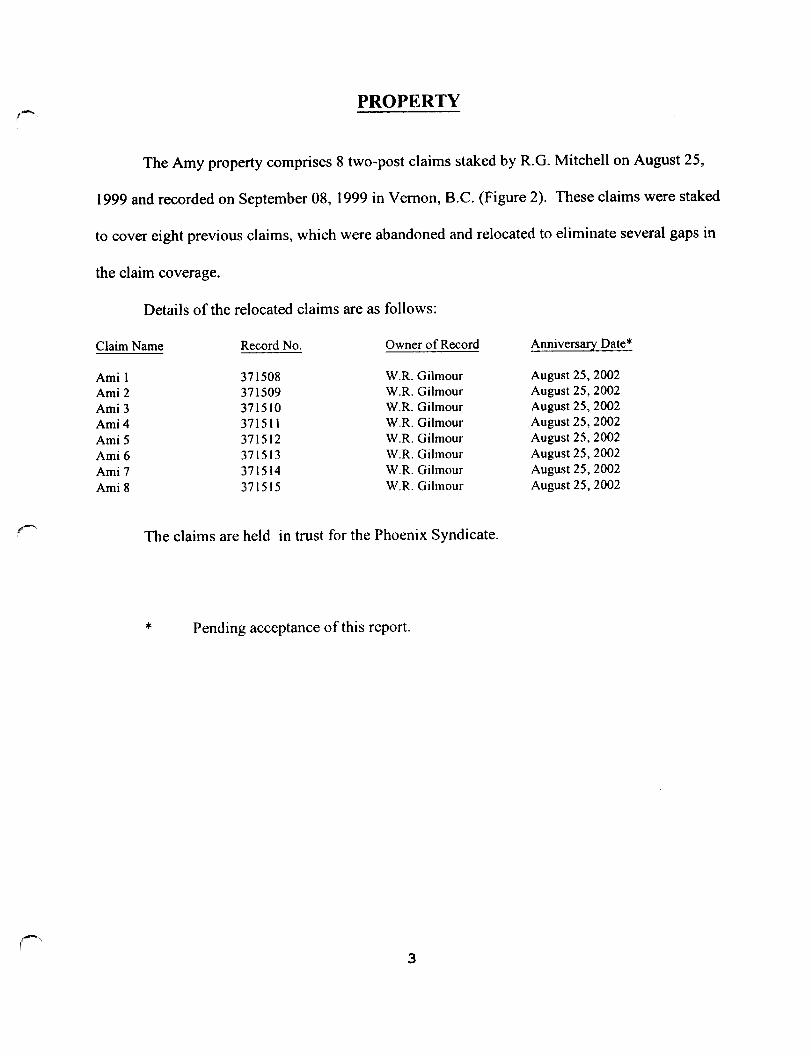
PROPERTY
The Amy property comprises 8 two-post claims staked by R.G. Mitchell on August 25,
1999 and recorded on September 08, 1999 in Vernon, B.C. (Figure 2). These claims were staked
to cover eight previous claims, which were abandoned and relocated to eliminate several gaps in
the claim coverage.
Details of the relocated claims are as follows:
Claim Name --
Ami 1 Ami 2 Ami 3 Ami Ami 5 Ami 6 Ami 7 Ami 8
Record No.
371508 W.R. Gilmour 371509 W.R. Gilmour 371510 W.R. Gilmour 371511 W.R. Gilmour 371512 W.R. Gilmour 371513 W.R. Gilmour 371514 W.R. Gilmour 371515 W.R. Gilmour
Owner of Record
The claims are held in trust for the Phoenix Syndicate.
Anniversary Date*
August 25,2002 August 25,2002 August 25,2002 August 25,2002 August 25,2002 August 25,2002 August 25,2002 August 25,2002
* Pending acceptance of this report.


HISTORY
High-grade silver-lead-zinc mineralization was discovered in 1948 on Camp Creek in the
present claim area. In 1949 the Hudson Bay Mining and Smelting Company drilled eight
diamond drill holes along a strike length of 236 metres (775 ft). Four holes intersected
mineralization.
In 1962 the property was acquired by the Rancheria Mining Company Ltd., which from
1963 to 1965 conducted a significant amount of exploration including 24 diamond drill holes and
an adit some 835 ft. (254 m) in length.
In 1966 and 1967 a limited amount of work on the property was carried out.
Irwin Engineering attempted a short percussion drilling program on the property in 1968
and the claims were allowed to lapse.
Later staking included the Amy property and the adjacent Cub property. From 197 1 and
1973 Fosco Mining Ltd. completed 200 ft (61 m) of drifting and 1400 ft (427 m) of cross-cutting
to explore the mineralized zone on the 1280 m (4200 ft) level.
In 1977 the Cub claims adjoining the Amy deposit were located. DuPont of Canada
conducted geological and geochemical surveys on the Cub property in 1979, primarily to
evaluate skarn zones with values in tungsten and molybdenum.
In 198 1 and 1982 Morbaco Mines Ltd., a successor to Fosco Mining Ltd., optioned the
Cub property and conducted geochemical surveys and limited bulldozer trenching.
Sovereign Metals Corporation in 1984 carried out exploration on the Cub property to test
for potential extensions to the Amy deposit and to locate the source of high-grade float. Eight
diamond drill holes comprising 439 metres were completed.
4

In 1985 Reg Resources carried out an exploration program including an electromagnetic
survey and diamond drilling (3 holes totalling 358 metres) on the Amy property.
Discovery Consultants carried out a limited heavy mineral sampling program on the
property in 1995.

GENERAL GEOLOGY
The claims are situated near the contact zone of the east flank of the Cassiar batholith,
which extends over 300 km from the Wolfe Lake map sheet in the Yukon, southeast to the
Kechika map area in British Columbia.
In this region the batholith intrudes a metamorphic package of Cambrian to Silurian
metasediments. These include members of the Atan and Good Hope Groups (dolomites,
limestones, skams and quartzites) which are in turn overlain by calcareous phyllite and phyllitic
limestone of the Kechika group. The upper part of the Kechika Group also includes black
graptolitic shales and platy sandstones. The above sequence exhibits evidence of intense
multiple deformations.
Overlying the above rocks and outcropping to the east is the McDame Group of Middle
Devonian age comprising fetid fossiliferous dolomites and limestones.
The Lower Sylvester Group, which forms part of the Sylvester allocthonous slab is in
low-angle fault contact with the McDame. The lower Sylvester comprises fine grained, black,
locally graphitic slates and phyllites with grey to black bedded and ribbon cherts.
The Sylvester allocthon is characterized by a broad, northwesterly trending synclinal
feature referred to as the McDame Synclinoriun. This structure generally parallels the contact of
the Cassiar batholith. Strong northwest to northeast steep, normal faults affect the area.
The Amy deposit occurs as a replacement zone along a limestone-argillite contact within
the Kechika Group. Measured and drill indicated reserves reported by Marbaco Resources
include 72,000 tonnes of 367 g/t silver, 6.0% zinc and 2.8% lead with an additional 59,000 tons
6

inferred with no assigned grade.
A review of the underground sampling data in 197 1 however showed that drill hole
intersections were in general much lower grade than the values revealed by underground
development in the same general area. Measured reserves from the underground development
showed grades very similar to the Silvertip Deposit.
Eight kilometres east of the Amy deposit, the Silvertip (Midway) deposit of Imperial
Metals contains an estimated 2,570,OOO tonnes of 15.2% combined Pb-Zn and 325 g/t Ag within
the McDame dolomite, localized by the McDame-Sylvester contact.
Work in 1985 demonstrated mineralization in the Midway deposit to be Tertiary in age
and possibly related to intrusions in the area. Exploration in the area need not therefore be
restricted to a particular sedimentary horizon. Mineralization could be found in any location
where there is a suitable stratigraphic trap.

WORK COMPLETED
Work carried out on the property in 1999 comprised minor rock sampling and the
collection of soil samples from previously constructed “cat” trenches on the property.
1. - Trench/Soil Sampling
A) Program Parameters
Thirty-eight soil samples were taken from 7 trenches and above the upper adit on the
property.
Trenches were numbered by the distance at which they were intersected along the claim
line from the easternmost claim post. For example trench 1+8OW was intersected 180 metres
west of the Ami 1 & 2 Initial Post and trench 15+05W was intersected 1505 metres west of the
Ami 1 & 2 Initial Post.
Samples were collected at 10 metre intervals north and south of the claim line where
applicable, starting at the claim line. Samples were collected from near the bottoms of the
trenches, which averaged about 4-5 metres in width, up to 60 metres in length and up to 3 metres
in depth.
Many of the trenches were dug in till largely comprising rounded intrusive boulders
which probably originated uphill from the trenches and may not have been representative of
underlying bedrock. It was felt therefore that material collected from the bottom of the -trenches
might be more representative of underlying material than a standard soil sample in the same
vicinity,
8

Samples were collected by shovel, placed in 9cm by 25 cm kraft sample bags and sent to
Chemex Labs in North Vancouver, B.C. At Chemex, analyses were carried out for gold by F.A.-
A.A. methods and for 32 other elements by ICP. Sample locations are shown on Figure 3.
Results for lead, zinc and silver2 are shown on Figures 4 to 6 respectively. Complete analytical
results are contained in Appendix I.
B) Program Results
Significant zinc values in excess of 100 ppm were noted in almost all trenches sampled
except trench 10+88W. Higher values (to 544ppm) were found in trench 6+45W in the eastern
part of the property. In the western part of the property, the maximum value obtained was 288
ppm zinc in trench 15+05W. However, as noted, many of the trenches in the west half of the
property, were dug in till largely composed of intrusive material, which may be masking
mineralization in possible metasediments underlying the trenches.
Other anomalous elements, including Pb and Ag show a similar trend, with higher values
found in trenches on the eastern half of the property. The maximum values obtained for Pb and
Ag were 720 ppm and 9.2 ppm respectively in trench 2+4OW. A definite correlation exists
between Pb and Ag values.
2. -
A)
Rock Sampling
Program Parameters
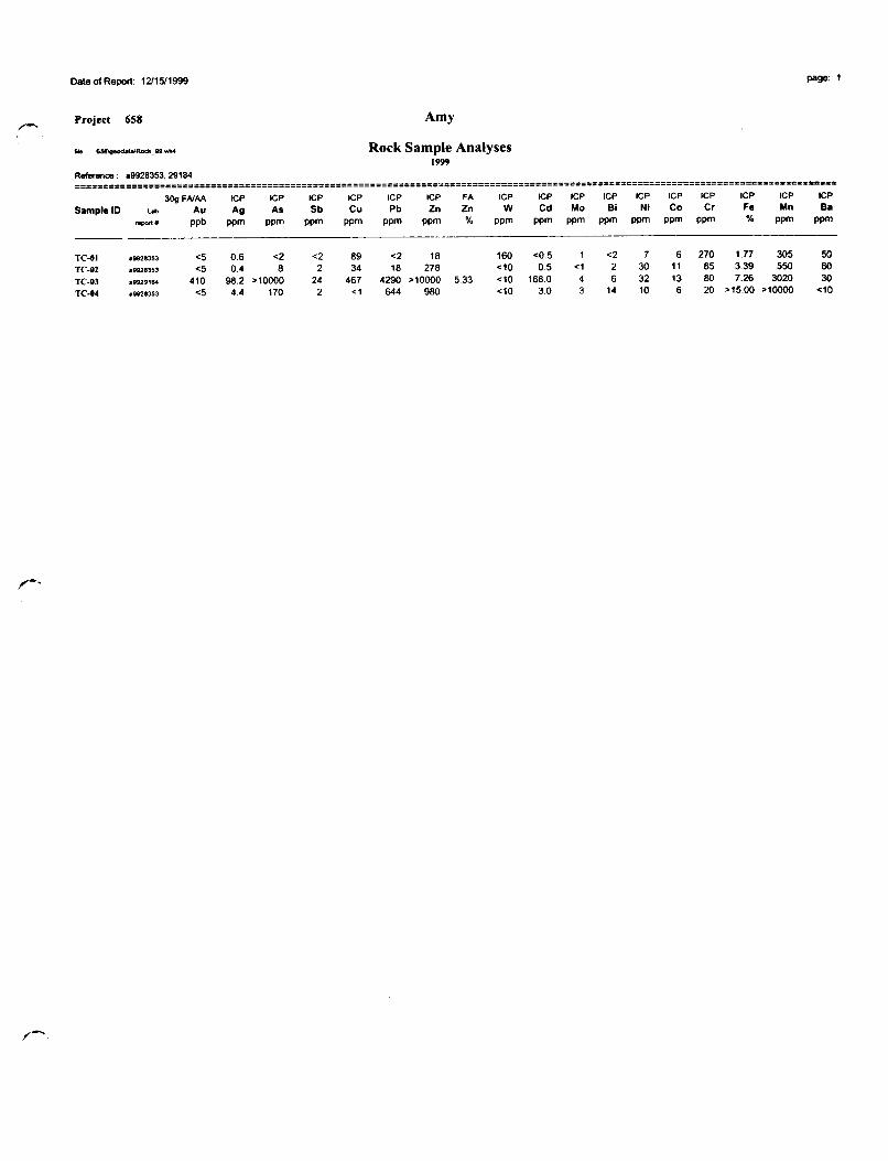
Three rock samples were collected from various locations on the property. As well, one
sample from an old ore dump at the upper adit was submitted for analysis.
All samples were shipped to Chemex Labs Ltd. in North Vancouver, B.C. where they
9

were crushed and analyzed for gold by FA-AA and for a 32 element package by ICP analysis.
Rock descriptions, analytical methods and analytical results are contained in Appendix 2.
B) Program Results
The sample collected from the ore dump comprised a sphalerite rich sample which
assayed 5.33% zinc, 98.2 ppm silver and 4290 ppm lead. Perhaps significantly, this sample also
contained 4 10 ppb gold. No gold values have been previously reported from the property.
Of the remaining three samples, two were anomalous in zinc, containing 980 ppm and
278 ppm, (TC-04 and TC-02). Sample TC-04 also contained anomalous lead (644 ppm). The
fourth sample, TC-01 , contained no significant lead or zinc values but contained anomalous
tungsten (160 ppm).
10
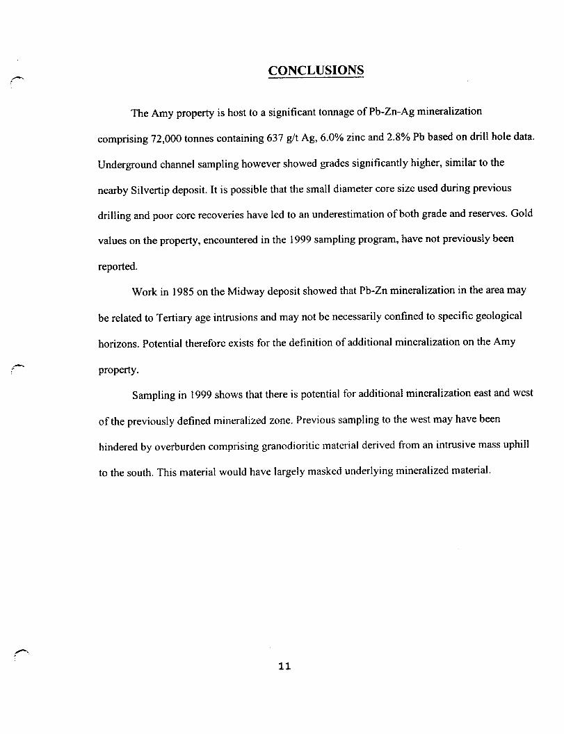
CONCLUSIONS
h P
The Amy property is host to a significant tonnage of Pb-Zn-Ag mineralization
comprising 72,000 tonnes containing 637 g/t Ag, 6.0% zinc and 2.8% Pb based on drill hole data.
Underground channel sampling however showed grades significantly higher, similar to the
nearby Silvertip deposit. It is possible that the small diameter core size used during previous
drilling and poor core recoveries have led to an underestimation of both grade and reserves. Gold
values on the property, encountered in the 1999 sampling program, have not previously been
reported.
Work in 1985 on the Midway deposit showed that Pb-Zn mineralization in the area may
be related to Tertiary age intrusions and may not be necessarily confined to specific geological
horizons. Potential therefore exists for the definition of additional mineralization on the Amy
property.
Sampling in 1999 shows that there is potential for additional mineralization east and west
of the previously defined mineralized zone. Previous sampling to the west may have been
hindered by overburden comprising granodioritic material derived from an intrusive mass uphill
to the south. This material would have largely masked underlying mineralized material.
11

RECOMMENDATIONS
- ,
The previous exploration grid on the property should be re-established and geophysical
surveys, including an IP survey, should be carried out to define mineralization and/or alteration
along strike from the developed zone.
The old workings on the property should be rehabilitated and an underground sampling
program carried out to determine average grade of the mineralization. Previous drilling has not
adequately defined the eastern or western extent or the grade of mineralization. A well-designed
drill program should be carried out using large diameter drill equipment to test the down dip and
lateral extent of known mineralization.
Exploration should be carried to the west of the claims to search for the cause of
anomalous mineralization detected in sample heavy mineral sample 629-HM003, collected in
1995.
Vernon, B.C. September 29, 1999
12

‘
- s
British Columbia Ministry of Energy, Mines and Petroleum Resources Annual Report
1949-p. 70
1964-p. 9
1965 -pp. lo-12
British Columbia Ministry of Energy, Mines and Petroleum Resources - Geology, Exploration and Mining in British Columbia
1972 - p. 560
1973-p. 516
1974 - p. 352
British Columbia Ministry of Energy, Mines and Petroleum Resources - Exploration in British Columbia
1978 -p. E276
1979-p. 314
1980 -p. 508
British Columbia Ministry of Energy, Mines and Petroleum Resources - Assessment Reports #44,734,3566,6798,7539, 10066, 11997, 13376, 14788
13

STATEMENT OF COSTS
Professional Services T. Carpenter (P.Geo.) Planning, Data Interpretation & Report Writing
1.25 days @ S350/day Field & Geological Work
3.0 days @%350/day
$437.50
1,050.oo ------------
708.00
240.09
Field Personnel R. Mitchell (August 24 - 26, 1999) Grid Establishment & Soil Sampling
2.5 days @$283.20iday 708.00 _-----------
Office Personnel Drafting 116.19 Secretarial 79.65
Data Compilation 44.25 ------------
Expenses Analysis - Chemex Labs Ltd.
(Au + 32 elements ICP) 4 rocks @$18.28/sample 73.12 37 soils @S i5.921sample 589.04
_---_------- $ 662.16 Field Supplies 29.78 Equipment Rental 22.00 Freight 45.00 Lodging 8c Meals 283.75 Maps & Publications 15.00 Communications, Report & Map printing 95.00
____--_----- 1,152.69 __--_--------
Exploration Costs : $3588.28 Transportation
4x4 Truck 2.0 days @$40lday $ 80.00 933 km @$0.3O/km 279.90
gas 94.83 _-----------
a) total transportation costs $454.73 b) @20% of Exploration Costs of $:3,588.28 7 17.66
a orb - whichever is less ------------ 454.73 -------------
Total Exploration Costs : $4,043.01 --------
$1,487.50
14

STATEMENT OF QUALIFICATIONS
I, THOMAS H. CARPENTER of 3902 14th Street, Vernon, B.C., VlT 3V2, DO HEREBY CERTIFY that:
1. I am a consulting geologist in mineral exploration associated with Discovery Consultants, Vernon, B.C.
2. I am a 197 1 graduate of the Memorial University of Newfoundland with a Bachelor of Science degree in geology.
3.
4.
I have been practicing my profession since graduation.
I am a Professional Geoscientist with the Association of Professional Engineers and Geoscientists of British Columbia.
5. This report is based upon knowledge of the Amy property gained from property work, research and supervision.
6. I hold no interest either directly or indirectly in the Amy property.
T.H. Carpenter, P.Geo.
Vernon, B.C.
15

Appendix 1


APPENDIX 2

658 - Amy Project
TC-0 1
TC-02
TC-03
TC-04
ROCK DESCRIPTIONS
Quartz vein in highly siliceous, rusty pyritic rock with occasional vugs on fractures. Possible drill hole off road at south end of trench between road and trench. T. 12+55W, 0+4OS Float.
Sample collected on claim line at trench. 14+56W. Comprises rusty carbonate with calcite veining in contact with siliceous material. Similar material in trench sides to north. Trench trending - 205” for 60m + 025” for 20 m.
Sphalerite sample. Collected from dump at upper adit.
Float from trench 15+5OW, 0+70N. Gossanous meta-sediment.
n:\658\@99-0927a.doc