Embed Size (px)
Citation preview
U.S. Geological Survey and The National Academies; USGS OF-2007-1047, Extended Abstract 030
One hundred negative magnetic anomalies over the West Antarctic Ice Sheet (WAIS), in particular Mt. Resnik, a subaerially erupted volcanic peak, indicate eruption through at least one field reversal
J. C. Behrendt,1 C. Finn,2 D. L. Morse,3 and D. D.Blankenship3
1INSTAAR, University of Colorado, Boulder, CO 80309-0450, USA also U.S. Geological Survey Denver, CO 80225, USA, ([email protected]) 2U.S. Geological Survey Denver, CO 80225, USA ([email protected]) 3UTIG, University of Texas, Austin TX 78759-8500, USA ([email protected])
Summary Mt. Resnik is one of 18 subglacial, subaerially-erupted volcanoes, which have high elevation and high bed relief beneath the WAIS in the Central West Antarctica (CWA) aerogeophysical survey. Mt. Resnik, 300 m below the surface of the WAIS, has 1.6 km topographic relief. It has an associated complex negative magnetic anomaly. We calculated and interpreted magnetic models fit to the Mt. Resnik anomaly as a volcanic source comprising both reversely and normally magnetized 0.5-2.5-km thick flows erupted subaerially during a time of magnetic field reversal. The Mt. Resnik model may represent the reversal at 780 Ka (or earlier). There are ~100 short-wavelength, steep-gradient, negative magnetic anomalies observed over the West Antarctic Ice Sheet (WAIS), or about 10% of the approximately 1000 short-wavelength, shallow-source, high-amplitude (50->1000 nT) "volcanic" magnetic anomalies in the CWA survey. These negative anomalies also indicate volcanic activity during a period of magnetic reversal >780 Ka.
Citation: Behrendt, J. C., C. Finn, D. L. Morse, and D. D.Blankenship (2007), One hundred negative magnetic anomalies over the West Antarctic Ice Sheet (WAIS), in particular Mt. Resnik, a subaerially erupted volcanic peak, indicate eruption through at least one field reversal, in Antarctica: A Keystone in a Changing World – Online Proceedings of the 10tth ISAES, edited by A. K. Cooper and C.R. Raymond et al., USGS Open-File Report 2007-1047, Extended Abstract 030, 4 p.
Introduction In this paper we use aeromagnetic and airborne radar ice sounding data collected from 1990-1997 over central West Antarctica to extend previously published interpretations of inferred volcanic rocks beneath the WAIS. The new result here is the recognition of complex “negative” anomalies comprising about 10% of the 1000 steep gradient, short wavelength, high-amplitude anomalies previously interpreted as marking “volcanic centers.” Overview of Central West Antarctica (CWA) aerogeophysical survey area Analysis of a block of coincident aeromagnetic and radar ice sounding data (Blankenship et al., 1993; Behrendt et al., 1996; 2002, 2004; 2006; and papers referenced therein) acquired as part of the CWA aerogeophysical survey over the WAIS (Fig. 1) reveals ~1000 50->1000-nT short-wavelength magnetic anomalies. These anomalies are interpreted as caused primarily by subglacial intrusions, (Behrendt et al., 2004), associated with the Oligocene to Recent (LeMasurier, 2006), bimodal, alkaline volcanism of the West Antarctic rift system. The flight elevation was about 1 km above the ice surface and the ice is 2-3 km thick, so these magnetic amplitudes are unusually high. The steep gradients of these anomalies require their sources to be essentially at the glacier bed (Behrendt et al., 2004) as demonstrated by a number of models shown in these cited papers. About 400 of these anomalies (conservatively selected) have topographic expression as revealed by the 20-m contour interval glacier bed elevation map. More than 80% of these topographic features have <200 m relief (Behrendt et al., 2004). This low relief, even if extremely magnetic, could not produce the observed overlying anomalies at the 3-4 km observation elevation above them; the sources must have thicknesses of the order of several kilometers. Behrendt et al. (1995; 2002; 2004) interpreted and discussed the removal of volcanic edifices comprising hyaloclastite, and other volcanic debris injected into the moving ice during eruption, and which formerly overlaid the subvolcanic intrusions causing the anomalies. Magnetic models fit to anomalies over the "volcanic" centers require 1-2-km thick bodies having apparent susceptibilities as great as 0.3 SI (e.g. Behrendt et al., 2004), imply a very high remanent component in the present field direction. Several hundred meter-thick volcanic flows or sills could not produce these anomalies. These very high apparent susceptibilities and remanent magnetizations fall in the ranges measured for volcanic rocks in the McMurdo area (Behrendt et al., 1996). Because the Antarctic plate has been essentially stationary since 100 Ma, the sources could be that old and still have present field direction. However, Jurassic age intrusive and extrusive tholeiitic rocks associated with initial rifting of Gondwanaland would be unlikely as sources because they would be expected to cause
10th International Symposium on Antarctic Earth Sciences
2
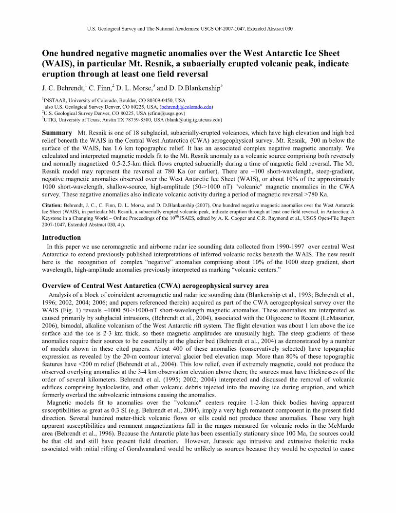
Figure 1. CWA aeromagnetic anomaly map, 10nT CI. The steep-gradient, high-amplitude magnetic anomaly field is indicative of the shallow source volcanic centers interpreted to underlie most of this area of the WAIS. Black dots indicate locations of negative magnetic anomalies. See Behrendt et al., 2006 for index map, and bed topography. anomalies incompatible with the present field direction, for the high Q (ratio of remanent to induced magnetization) rocks beneath the WAIS apparently required. For this reason, Paleozoic or older intrusions would also be very unlikely as sources even were they to have the subtle topographic expression observed at the glacier bed. Mt. Resnik Mt. Resnik (Behrendt et al., 2006) is a ~1.6-km local-relief peak (Fig. 2) centered at 80o,9' S, 116o, 20' W only 300-m below the WAIS surface (Morse et al., 2002) and has an associated complex 350-nT magnetic anomaly. The high bed topography (about 1.5 km above sea level, high bed relief conical form, and associated magnetic anomaly indicate to us that this peak is a subaerially erupted volcano similar to the other 17 inferred subaerially erupted volcanoes in the CWA survey (Behrendt et al., 2004). Several models (e.g. Behrendt et al., 2006) calculated to fit the anomaly led to our interpretation that Mt. Resnik was erupted during a period of magnetic reversal. The reversed magnetism, required to fit the anomaly indicates that this peak was partially erupted prior the Brunhes-Matuyama reversal at 780 ka but it could be very much older. Behrendt et al. (1996) reported an anomaly and calculated models similar to that over Mt. Resnik over Hut Point at Ross Island, Antarctica (also part of the West Antarctic rift system), which required both normal and reversed magnetizations. At Hut Point rocks having both normal and reversed magnetizations are exposed and were recovered in drill holes (Kyle,1990a,and b) with ages > the Brunhes-Matuyama boundary (780ka).
Behrendt et al.: One hundred negative magnetic anomalies over the West Antarctic Ice Sheet
3
Mt. Resnik and the 17 other high-altitude, high-relief subaerially erupted volcanoes (Behrendt et al., 2004) beneath the WAIS were interpreted as having been erupted during a period when the WAIS was absent. The WAIS and the late Cenozoic volcanic activity in the West Antarctic rift system have been coeval since at least Miocene time, although the area has been deglaciated at times during this period as recently as 400 Ka (e.g. Scherer, 1991, Scherer, et al. 1998). Therefore it is not unexpected to find evidence of subaerial volcanic eruption of Mt. Resnik prior to 780 Ka when the WAIS may also have been absent. Because of its association with a glacially smoothed source of the anomaly to the west (Behrendt et al., 2006) we believe it likely that Mt. Resnik erupted since the origin of the WAIS (>15 Ma) no matter what its age within this range.
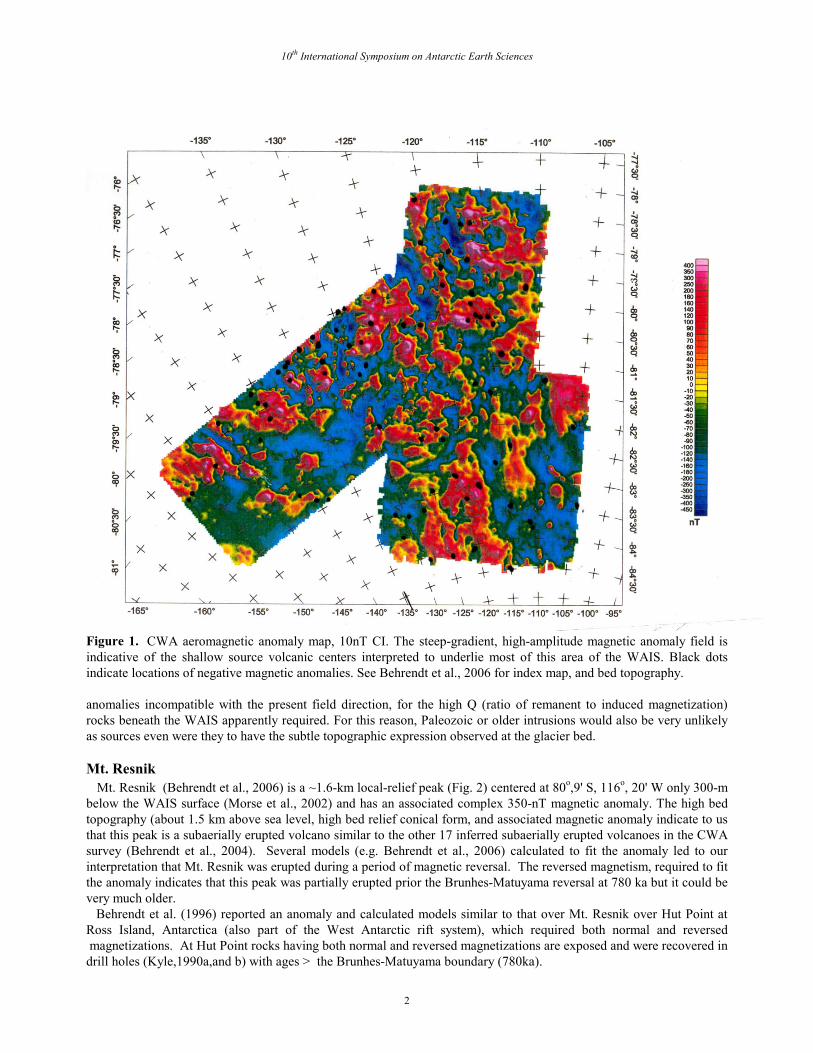
Figure 2. a. (above left) a. Bed elevation map of Mt. Resnik area. Orthogonal, 5-km spaced survey lines were flown about 600 m above ice sheet surface in this area Contour interval 20 m. Note that Mt. Resnik has about 1600 m local relief, but the topographic structure interpreted as a glacially modified subvolcanic intrusion extending to the west has only about 400 m relief. b. (above right) Aeromagnetic map of Mt. Resnik area. Contour interval 10 nT. Flight lines as indicated in a. The complex anomaly over Mt. Resnik requires normal and reversed, high-Q magnetization as shown by model profile A-B in Fig. 3. We interpret that former volcanic edifices, which may have been erupted beneath the WAIS associated with this structure, have been removed by the moving ice. In contrast the interpreted volcanic peak of Mt Resnik was probably erupted subaerially, similar the other exposed volcanic peaks in the West Antarctic rift-WAIS area. Figure 3. Theoretical 2 1/2 D model fit to aeromagnetic profile A-B (location in Fig. 2) for Mt. Resnik. Apparent susceptibilities indicated in SI. Bodies have strike lengths ranging from 4 to 7 km, as appropriate to the magnetic map (Fig. 2b) to east and west. Reversed magnetizations (indicated by red outline) were required to fit this anomaly as indicated by negative apparent susceptibility contrast at the summit of the peak. An alternate model not shown here (Behrendt, et al., 2006) has normal magnetization overlying reversed. We cannot determine which model is most likely, but interpretation that Mt. Resnik was erupted during a period of magnetic reversal is valid in either case. Note vertical exaggeration (VE) is 1 in the upper profile of the model and 10 in the lower.
Negative magnetic anomalies over the WAIS We examined each of the ~1000 shallow-source, steep-gradient, anomalies in the CWA survey over the WAIS (Fig.1) interpreted as caused by volcanic centers. These included, of course, the ~400 anomalies correlated with bed topography
10th International Symposium on Antarctic Earth Sciences
4
(Behrendt et al., 2004). About 100 of these anomalies have strong negative components similar to Mt Resnik (Fig.1); the sources of all but one other (not discussed here) have <400 m of bed relief indicating they were erupted into the WAIS and their edifices comprising of hyaloclastite and other volcanic debris were removed by the moving ice (Behrendt et al., 1995) similar to the case in Iceland (Behrendt et al., 2002, Bougeois et al., 1998; Gudmundsson, et al., 1997). In general, the negative magnetic anomalies are uniformly distributed throughout the aeromagnetic survey area. We do not infer post-Brunhes-Matuyama volcanism for the 90% of anomalies showing normal magnetization, because magnetic anomalies occur over volcanic exposures in the WAIS area older than 10 Ma (Behrendt et al., 1996). Because no geologic samples have yet been acquired from the rock "outcrops" defined by radar ice sounding at the bed of the ice sheet, there is no direct information about their ages. Despite some evidence of active volcanism beneath the WAIS (Blankenship et al., 1993) none of the interpretations of this paper is meant to imply anything about active volcanism beneath the WAIS. We infer that ice contact modified the volcanic material erupted into the WAIS since >15 Ma, not that volcanism is effecting the regime of the WAIS at present. However, considering volcanically active Mt. Erebus and the >780-ka Bruhnes-Matuyama magnetically reversed flows on its slopes, the possibility of recent volcanism beneath large areas of the WAIS cannot be ruled out. There are differing interpretations as to the likelihood of active volcanism beneath the extended crustal lithosphere through which the WAIS flows. Two recent papers giving somewhat contradictory results (Winberry and Anandakrishnan, 2004; Maule et al. 2005) for late Cenozoic volcanism are examples. But, measured ages of volcanic rocks characterizing the West Antarctic rift system extend from the present to Oligocene time (e.g. LeMasurier, 2006). Until samples of the inferred volcanic rocks interpreted beneath the WAIS are available for analysis and dating, this question cannot be resolved. Acknowledgements I thank co-editor W. LeMasurier. National Science Foundation and the U.S. Geological Survey provided funding for this work.
References Behrendt J.C.,(1964), Distribution of narrow-width magnetic anomalies in Antarctica, Science, 144, 995-999. Behrendt J.C., D.D.Blankenship , D.L. Morse.and R.E. Bell, (2004), Shallow source aeromagnetic anomalies observed over the West Antarctic Ice
Sheet compared with coincident bed topography from radar ice sounding - New evidence for glacial "removal" of subglacially erupted Late Cenozoic rift related volcanic edifices. Global and Planetary Change, 42/1-4, 177-193.
Behrendt J.C., D.D. Blankenship., D.L. Morse, C.A. Finn, and R.E. Bell, (2002), Subglacial volcanic features beneath the West Antarctic Ice Sheet interpreted from aeromagnetic and radar ice sounding, edited by J.L. Smellie,and M.G.Chapman, Volcano-Ice Interaction on Earth and Mars, Geological Society, London, Special Publication, 202, 337-355.
Behrendt, J.C., C.A. Finn, D.L. Morse, and D.D. Blankenship, (2006), Negative Magnetic Anomaly over Mt. Resnik, a subaerially erupted volcanic peak beneath the West Antarctic Ice Sheet, Terra Antarctica Reports, 12, p. 203-213.
Behrendt J.C., R. Saltus, D. Damaske, A. McCafferty, C. Finn, D. D. Blankenship, and R.E.Bell., (1996), Patterns of Late Cenozoic volcanic tectonic activity in the West Antarctic rift system revealed by aeromagnetic surveys. Tectonics, 15, 660-676.
Blankenship D.D., R.E. Bell, A.M. Hodge, J.M. Brozena, J.C. Behrendt,, and C.A. Finn, (1993). Active volcanism beneath the West Antarctic ice sheet. Nature, 361, 526-529.
Bourgeois O, O. Dauteuil, B.Van Vliet-Lanoe, (2000). Geothermal control on flow patterns in the last glacial maximum ice sheet of Iceland. Earth Surface Processes and Landforms, 25, 59-76.
Gudmundsson M.T., F.Sigmundsson, and H. Björnsson, (1997), Ice-volcano interaction of the 1996 Gjálp subglacial eruption, Vatnajökull, Iceland. Nature, 389, 994-957.
Kyle, P. R., 1990b. A. 18. Hut Point Peninsula: , In: Volcanoes of the Antarctic Plate and Southern Oceans, Antarct. Res. Ser., AGU, Washington, D.C.. 48, edited by W. E. LeMasurier, and J. W. Thomson , 109- 112.
LeMasurier, W.E., 2006. What supports the Marie Byrd Land dome? An evaluation of potential uplift mechanisms in a continental rift system, Antarctica. Contributions to Global earth Sciences, Springer, Berlin- Heidelberg, 299- 302.
LeMasurier W.E., and J. W. Thomson, 1990. Volcanoes of the Antarctic Plate and Southern Oceans, Antarct. Res. Ser., AGU, Washington, D.C. 48, 487 p.
Maule C.F., M.E. Perucker., N.Olsen , and K. Mosegaard, (2005), Heat flux anomalies in Antarctica revealed by satellite magnetic data, Science, 309,464-467.
Morse D.L., D.D.Blankenship, E.D. Waddington., and T.A. Neumann, (2001). A site for deep ice coring in West Antarctica: results from aerogeophysical surveys and thermo-kinematic modeling. Annals. of Glac., 354, p. 36-44.
Scherer R.P., A. Aldahan, S. Tulaczyk, G. Possnert, H. Engelhardt, and B. Kamb, (1998), Pleistocene collapse of the West Antarctic Ice Sheet. Science, 281, 82-85.
Winberry J.P., and S. Anandakrishnan., 2004.Crustal structure of the West Antarctic rift system and Marie Byrd Land hotspot, Geology, 32, 997-980.


![Spring land temperature anomalies in northwestern US and ......(less) snow water equivalent (SWE) and/or positive (negative) snowfall anomalies [31, 32] are associated with cooler](https://img.pdfslide.net/doc/110x75/609967c7cb4f1b52ae47db01/spring-land-temperature-anomalies-in-northwestern-us-and-less-snow-water.jpg)