Embed Size (px)
Citation preview
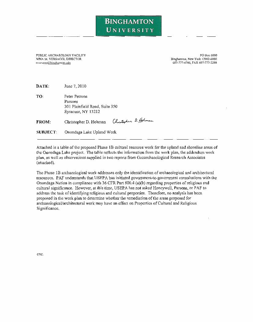
BINGHAMTONUNIVERSITY
I
PUBLIC ARCHAEOLOGY FACILITYNINA M. VERSAGGI. DIRECTORI1versa!!uU/:binl.!hamton.cdu
PO Box 6000Binghamton, New York 13902-6000
607-777-4786, FAX 607-777·2288
DATE:
TO:
June 7, 2010
Peter PetroneParsons301 Plainfield Road, Suite 350Syracuse, NY 13212
FROM: Christopher D. Hohman
SUBJECT: Onondaga Lake Upland Work
Attached is a table of the proposed Phase IB cultural resource work for the upland and shoreline areas ofthe Onondaga Lake project. The table reflects the information from the work plan, the addendum workplan, as well as observations supplied in two reports from Geoarchaeological Research Associates(attached).
The Phase IB archaeological work addresses only the identification of archaeological and architecturalresources. PAF understands that USEPA has initiated government-to-government consultations with theOnondaga Nation in compliance with 36 CFR Part 80004 (a)(b) regarding properties of religious andcultural significance. However, at this time, USEPA has not asked Honeywell, Parsons, or PAF toaddress the task of identifying religious and cultural properties. Therefore, no analysis has beenproposed in the work plan to detennine whether the remediation of the areas proposed forarchaeological/architectural work may have an effect on Properties of Cultural and ReligiousSignificance.
enc.
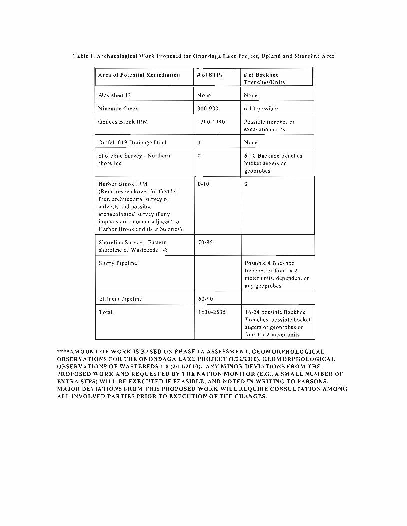
Table 1. Archaeological Work Proposed for Onondaga Lake Project, Upland and Shoreline Area
Area of Potential Remediation # or STPs # of BackhoeTrenchcsfUnits
Wastebed 13 None None
Ninemile Creek 300-900 6-10 possible
Geddes Brook IRM 1200-1440 Possible trenches orexcavation units
Outfall 019 Drainage Ditch 0 None
Shoreline Survey - Northern 0 6-10 Backhoe trenches.shoreline bucket augers or
geoprobes.
Harbor Brook JRM 0-10 0(Requires walkover for GeddesPier. architectural survey ofculvcrts and possiblearchaeological survey ifanyimpacts arc to occur adjacent toHarbor Brook and its tributaries)
Shoreline Survey - Eastern 70-95shordinc of Wastebeds 1-8
Slurry Pipeline Possible 4 Backhoetrenches or four Ix 2meter units. dependent all
any geoprobcs
Effiucllt Pipeline 60-90
Total 1630-2535 16-24 possible BackhoeTrenches, possible bucketaugers or geoprabes orfour 1 x 2 meIer units
• .. ·AMOUNT OF WORK IS BASED ON PHASE IA ASSESSMENT, GEOMORPHOLOGICALOBSERVATIO/,;S FOR THE ONONDAGA LAKE PROJECT (I/22120IO), GEOMORPHOLOGICALOBSERVATIONS OF WASTE BEDS 1-8 (2II1/2010). ANY MmOR DEVIA TlO 'S FROM THEPROPOSED WORK AND REQUESTED BY THE 'ATION MONITOR (E.G., A SMALL UMBER OFEXTRA STPS) WILL BE EXECUTED IF FEASIBLE, A D 'OTED IN WRITING TO PARSONS.MAJOR DEVIA TlONS FROM THIS PROPOSED WORK WILL REQUIRE CONSULTA TlO/,; AMONGALL INVOLVED PARTIES PRIOR TO EXECUTION OF THE CHANGES.
PRELIMI ARY GEOMORPHOLOGICAL OBSERVATIONS FOR THEONONDAGA LAKE PROJECT
Preparedfor:PAF, Binghamton University, Binghamton, New York
Prepared by:Michael Aiuvalasit and Joseph Schuldenrein
Geoarcheology Research Associates, Yonkers, New York1/22/2010
Geoarcheology Research Associates (GRA) has been contracted by the PublicArchaeology Facility (PAF) to examine the geomorphic contexts of properties slated forremedial measures as part of the Onondaga Lake Project, which is sponsored byHoneywell and being conducted by Parsons. GRA's role is to evaluate whether projectareas are intact and contain buried deposits with the potential for archeological materials.Evaluations are based on reviewing historical documents compiled by PAF (Hohman2004 and Hohman and Versaggi 2009), the background literature on the geological andnatural setting of Onondaga Lake, and examining logs from geotechnical and soil boringsconducted in select portions of the project areas. A brief field visit on December 17,2009 provided opportunities to examine the project areas fust-hand. This documentpresents initial observations of the project areas (see Figures 31-33, 48-49, 74-75, and 8688 in Workplan - Hohman and Versaggi 2009). Recommendations are made for use inthe plal1l1ing of upcoming fieldwork.
Ninemile Creek
Ninemile Creek consists of a narrow area of potential effects (APE) which is largelyconfined to the chal1l1el and adjacent banks of Ninemile Creek (Figures 31-33 inWorkplan - Hohman and Versaggi 2009). Our geomorphic evaluation of NinemileCreek is broken into segments using the New York State Department of EnvironmentalConservation (NYSDEC) Reach Boundaries: A) shoreline and mouth of Ninemile Creek;B) between the shoreline and 1-690; C) between 1-690 and the intersection of PumphouseRoad and the exit ramp ofI-690; and D) between the Pumphouse Road intersection andthe most upstream portion of the project area, approximately 400 feet upstream past theconfluence of Ninemile Creek with Geddes Brook.
Segment A is the confluence ofNinemiJe Creek and Onondaga Lake. The mouth ofthisartificial chal1l1el has also been dredged in the late 1960s. Historical maps from the early19th century depict segment A to be near salt springs and swamplands with muck soils(Carlisle and Edwards series) identified in historical soil surveys (USDA 1938, USDA1977). Subsurface testing did not extend into segment A as it is offshore andsubaqueous. The potential for deeply buried archaeological surfaces is low due to the
extensive disturbances which were involved in both the creation and maintenanceactivities along the mouth of the channel.
Segment B extends from the confluence ofNinemile Creek upstream to where it iscrossed by 1-690. This segment is an artificial channel created in 1927 after theplacement of Wastebeds 1-8. The channel is narrow and runs parallel to the north of the1-690 right-of-way. Segment B includes a wetland adjacent to the mouth of the creekidentified as SWY-10. Subsurface investigations have consisted of shallow groundwatertest pits (series labeled GW-) conducted by Parsons and Geoprobe borings into thechannel bottom conducted by Blasland, Bouck, and Lee (series labeled TN-; logs foundin Hohman and Versaggi 2009: Appendix II). None of the groundwater test pits extendedto depths greater than 36 inches (0.9 m). Two sequences were registered: shalloworganic topsoil over Solvay waste (n=5); and soft black topsoil over mottled silts (n=5).Neither sequence is indicative of contexts which would preserve intact precontactdeposits or buried soils. The seemingly undisturbed mottled silts are very likelyhistorically recent alluvium accumulating along the channel and near the mouth of thestream.
Segment C is a narrow project area of the channel and banks of Ninemile Creek between1-690 and the intersection of Pumphonse Road. Subsurface investigations have consistedof shallow groundwater test pits (series labeled GW-) conducted by Parsons andGeoprobe borings into the channel bottom conducted by Blasland, Bouck, and Lee (serieslabeled TN-; logs found in Hohman and Versaggi 2009: Appendix II). The subsurfacetests registered stratigraphy similar to what was observed in Segment B.
A narrow segment, Segment D on the southern sides of Ninemile Creek downstream ofthe confluence with Geddes Brook, is slated for remediation. Logs for this area (NMCSB-07 to -21 (Hohman and Versaggi 2009: Appendix II)) were reviewed. The logsidentified two sequences: either shallow impenetrable gravels with a veneer ofapproximately 6" (0.15 m) of black silts: or black and brown silts capping stiff clays todepths of2-3'(0.6-0.9 m). Disturbances in the form of Solvay waste are noted in some ofthe test pits. Such contrasts between cores suggest a buried 'ridge and swale'topography, with gravel bar ridges and swales infilled with fines of clay and silt.
This shallowly buried landscape may register shallowly buried archeological surfaces insediment either capping gravel bars and in swales infilled with clay. Archeologicalinvestigations in the form of shovel testing and the additional field observations of openshovel tests by geomorphologists are recommended to assess the floodplain segmentsalong the southern banks of Ninemile Creek within segment D.
2
Geddes Brook
The Geddes Brook project area is an expanse of tloodplain at the confluence of GeddesBrook and Ninemile Creek, which includes SYW-18 (Figures 48-49 in WorkplanHohman and Versaggi 2009). The floodplain has already been delineated as wetlands.The vegetation is dominated by Phragmites. Bermed roads and utilities cross through thefloodplain, and stand above lower floodplain surfaces heavily vegetated by Phragmites.Logs from soil testing (GW-l to -IS and SB-l to -54) were reviewed. The stratigraphicobservations were recorded with differing levels of detail. The borings with the prefix"GW" were less detailed than those labeled "SB." The GW borings describe the soilslargely as "gray or brown organic topsoil" with underlying "brown and gray clay."While the SB logs offer more detailed stratigraphy, the field for stratigraphicdocumentation on the majority of the printed log sheets obscures the entire description.Regardless, a review of all of the logs provides general impressions of the subsurfacestratigraphy. Generally the logs register surface organic horizons (histic epipedons) to adepth of 12." Below are mineral horizons of sands, silts, and clays. While the logsdescribe the sediments as moist the water table is typically only encountered towards thebase of the sequences (which average maximum depths of 36"). The mineral horizonsunderlying the organic surface horizons likely represent floodplain sequences (i.e. coarsersediments found within or adjacent to former channels, finer sediments in backchannelsand swales) associated with Ninemile Creek and Geddes Brook. A cutbank acrossNinemile Creek showed a thick sequence of alluvial sands below waste materials whichsuggests the potential for intact alluvial sequences. There are instances of disturbancesin the form of Solvay waste and fill gravels, as noted in many of the logs.
While the project area is currently a wetlands the diversity of intact sediment typesrecorded in test pits suggest that there are alluvial contexts below more recent organicaccumulations associated with wetlands. These buried sediments have the potential toregister floodplain settings along the confluence of Ninemile Creek and Geddes Brookwhich are different than modern conditions.
These contexts have the potential to register archeological surfaces within what wasdepicted historically as a cedar swamp and alluvial contexts. Archeological surveyemploying shovel testing should go forward within this project area to test for intactalluvial surfaces below the approximately 12" of organic smface horizons. 1n-fieldgeomorphic observations of select shovel tests could provide a clearer understanding ofthe alluvial sequences and wetland development of the project area through detailedexamination of pedogenic features (redoximorphic concentrations, depletions) andcorrelating facies relationships between subsurface stratigraphic sequences.
3
Outfall 019 Drainage Ditell
The Outfall 019 Drainage Ditch is located along the southern edge of the floodplain ofNinemile Creek and Geddes Brook (Figures 61-62 in Workplan - Hohman and Versaggi2009). Historical background research conducted by PAF (Hohman and Versaggi 2009)indicates that this tributary is an artificial drainage ditch created in the mid_20th century.GRA examined the logs of eighteen borings conducted within the project area. Typicalprofiles consist of organic muck (0 horizons) in the upper two feet, with commonorganic fragments, roots, and disturbances. Solvay waste is identified in four of thecores, typically within or immediately below the organic muck epipedon. Red-brown siltand clay underlie the muck horizons. These deposits are stitT and moist, with tracegravels identified at the top ofthe horizon in four of the cores. Trace organics arecommon at the top of the deposit. The underlying fine silts and clays are largelyindicative oflake-bottom sedimentation, which would have been deposited during eitherhigher levels of Onondaga Lake, or preceding sequences of glacial lakes during the LateWisconsinan. The potential for intact archaeological resources within the project area ofthe Outfall 019 Drainage Ditch is low. The channel is artificial, and therefore is notrepresentative of a natural body of water. Historical maps describe the area as a cedarswanlp and wetlands, and the muck soils cOlToborate this finding. The entire Holocenerecord is likely confined to the muck and disturbances within the upper two (2) feet of thesequence. This compressed sequence indicative of wetland contexts has been heavilyimpacted by historical disturbances. From a geomorphological perspective no additionalarcheological investigations are walTanted.
Shoreline
Three shoreline locations adjacent to Ninemile Creek have been identified (Figures 74-75in Workplan - Hohman and Versaggi 2009). Historical background research hasidentified that these areas were historical shorelines as well, and may have buriedarcheological surfaces. There are no soil boring logs for these areas to evaluate, thereforesubsurface testing is recommended. As the vertical stratigraphy has not been established,testing should attain depths that span the entire Holocene sequence. Therefore limiteddeep testing in the form of either bucket augers or backhoe trenching should beconducted before devising an archeological testing strategy.
Harbor BrooklWastebed B
Harbor Brook and the Wastebed B are located along the southwest shore of OnondagaLake (Figures 86-88 in Workplan - Hohman and Versaggi 2009). Wastebed B is situatedalong the shoreline of Onondaga Lake behind artificial bulkheads. The waste bedconsists of fill deposits placed atop Solvay wastes. Previews of subsurface stratigraphycome from two sources: engineering cross sections along Wastebed B near the shorelinecompiled by Geosyntec Consultants and geotechnical borings by Parsons (Hohman andVersaggi 2009: Appendix Il).
4
Nearly all of the borings identify a general sequence of: till; Solvay waste; marl; silt andclay; silt and sand; and sand and gravel. The thickness of fill and waste materials extendsto depths of 20 ft. The marl is typically described in Parsons geotechnical logs as a graysilt with lilt.le fine sand. Also observed are trace organics (peat), trace shells, andoncolites. None of the borings logs are suggestive of deeply buried intact shorelines ornearshore settings. Instead the thick marl deposits are indicative of basin and subaqueousshoreline deposits, which are nether conducive to precontact settlement, nor archeologicalpreservation.
The course of Harbor Brook has been extensively modified across the project area toaccOlrunodate transportation structures (Erie Canal, highway and railroad) as well as theplacement of waste beds. The site visit confirmed the widespread historical alteration ofadjacent landscapes which are extensively documented by PAF (Hohman 2004 andHohman and Versaggi 2009). There appears to be little potential for Harbor Brook toretain deeply buried intact sediments and soils.
Conclusiol/s
Based on our preliminary evaluation of boring and test pit logs in relationship tobackground investigations GRA offers the following recommendations:
• The Outfall 019 Drainage Ditch and Harbor Brook areas do not requireadditional field investigations. Both areas were disturbed by historicalactivities and logs of subsurface tests indicate that these contexts havevery limited potential for buried archeological surfaces.
• No subsurface testing has taken place in the three Shoreline locations.Geomorphological testing in the form of either deep bucket augers orbackhoe trenching in each of the three segments is recommended toestablish a baseline stratigraphy for these project areas, which willguide future archeological investigations.
• inemile Creek is also largely disturbed by historical activities. Theonly section that retains intact deposits is within segment D, along thesouthern banks of Ninemile Creek downstream of the confluence withGeddes Brook. Logs suggest that underneath a veneer of modemalluvium are ridge and swales of former alluvial channels of NinemileCreek. Shovel tests within tins area should be adequate for testing thisarea. Inspection of representative shovel tests by a geomorphologistwill provide opportunities to model alluvial stratigraphy of thissegment ofNinemile Creek.
5
• The Geddes Brook IRM has the potential for buried archeologicalsurfaces. Logs indicate that below approximately I' (0.30 m) oforganic muck are intact alluvial sequences of sands, silts, and clays.While evidence of disturbances were recorded in some of the cores,these underlying alluvial deposits within the Geddes Brook IRM havethe potential to register shallowly buried landforms which may havethe potential for archeological deposits. It is recommended that shoveltesting be conducted within this area. A geomorphologist shouldinspect a representative sample of the shovel tests and conduct limiteddeep testing in the form of bucket augering. Shovel testing should beconducted to the depth of I m or until silt or clay marls areencountered. A limited number of bucket augers should be excavatedif necessary to correlate stratigraphic sequences between shovel tests.
6
Works Cited
Hohman, C.2004 Cultural Resource Management RepOli, Phase IA Cultural Resource Assessment,
Onondaga Lake Project, Onondaga Lake, Wastebed Band Wastebed 13, Townsof Camillus, Geddes and Salina and City of Syracuse, Onondaga County, NewYork, Prepared for Parsons, Liverpool, New York, Prepared by PublicArchaeological Facility. Binghamton, New York.
Hohman, C. and N. Versaggi2009 Cultural Resource Management Report, Phase IB Archaeological Work Plan,
Onondaga Lake Project, upland and shoreline area, Wastebed 13, Geddes BrookIRM, Tributary of Geddes Brook, Ninemile Creek RIfFS, Shoreline Survey, andWastebed BfHarbor Brook IRM, Towns of Camillus and Geddes, OnondagaCounty, New York. Prepared for Honeywell, East Syracuse, New York.Prepared by Public Archaeology Facility, Binghamton, New York and Parsons,Syracuse, New York.
United States Depmiment of Agriculture1938 Soil Survey ofOnondaga County. New York. USDA, Washington, D.C.
United States Depat1ment of Agriculture1977 Soil Survey olOnondaga County. New York. USDA, Washington, D.C.
7
PRELIMINARY GEOMORPHOLOGICAL OBSERVAnONS FORWASTEBEDS 1-8, ONONDAGA LAKE PROJECT
Prepared/or:PAF, Binghamton University, Binghamton, New York
Prepared by:Michael Aiuvalasit and Joseph Schuldenrein
Geoarcheology Research Associates, Yonkers, New York211112010
Geoarcheology Research Associates (GRA) has been contracted by the PublicArchaeology Facility (PAF) to examine the geomorphic contexts of properties slated forremedial measures as part of the Onondaga Lake Project, which is sponsored byHoneywell and being conducted by Parsons. GRA's role is to evaluate whether projectareas are intact and contain buried deposits with the potential for archeological materials.Evaluations are based on reviewing historical docWllents compiled by PAF (Hohman2004 and Hohman and Versaggi 2009), the background literature on the geological andnatural setting of Onondaga Lake, and examining logs from geotechnical and soil boringsconducted in select portions of the project areas. A brief tield visit on December 17,2009 provided opportunities to inspect the project area first-hand. This documentpresents initial observations of Wastebeds 1-8. Recommendations are made for use in theplanning of upcoming fieldwork.
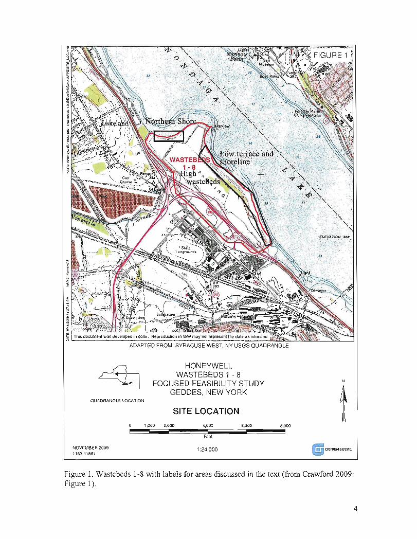
Wastebeds 1-8 run parallel to 2.1 miles of Onondaga Lake's southwest shoreline.The entire site covers approximately 404 acres (Figure 1). The topography consists of anapproximately 200 ft wide shoreline terrace along the eastem third of the project areawith the remainder of the project area dominated by high wastebeds. A small terrace andshoreline are found below the high wastebeds along the northem side of the project,while the northeastem portion of the project area is a steep promontory. Elevations rangefrom approximately 363 ft along the shoreline to 430 ft at the highest point atop thewastebeds. The lake level is at 362.5 ft. The wastebeds consist primarily of Solvaywaste. Extensive geotechnical borings have been conducted across the project area fordeveloping an interim remedial measure (lRM) for Wastebeds 1-8. This summary reportis an evaluation of the geomorphic context and the archeological potential of Wastebeds1-8.
The project area was significantly different prior to historical manipulations ofOnondaga Lake. In 1822 the water levels of the lake were lowered to present levels tofacilitate an outlet to the Seneca River (Hohman 2004 and Crawford 2009). Beforelowering water levels much of the current project area would have been marshes,swamps, salt springs, and areas immediately offshore. After tlle drop in water levelsmore land was created and the area became known as Geddes Marsh. In addition the
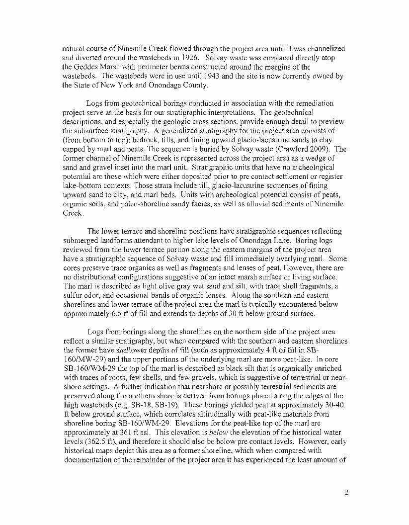
natural course of Ninemile Creek t10wed through the project area until it was channelizedand diverted around the wastebeds in 1926. Solvay waste was emplaced directly atopthe Geddes Marsh with perimeter berms constructed around the margins of thewastebeds. The wastebeds were in use until 1943 and the site is now cUiTently owned bythe State of New York and Onondaga County.
Logs from geotechnical borings conducted in association with the remediationproject serve as the basis for our stratigraphic interpretations. The geotechnicaldescriptions, and especially the geologic cross sections, provide enough detail to previewthe subsurface stratigraphy. A generalized stratigraphy for the project area consists of(from bottom to top): bedrock, tills, and fining upward glacio-lacustrine sands to claycapped by marl and peats. The sequence is buried by Solvay waste (Crawford 2009). Theformer channel of Ninemile Creek is represented across the project area as a wedge ofsand and gravel inset into the marl unit. Stratigraphic units that have no archeologicalpotential are those which were either deposited prior to pre contact settlement or registerlake-bottom contexts. Those strata include till, glacio-lacustrine sequences of finingupward sand to clay, and marl beds. Units with archeological potential consist of peats,organic soils, and paleo-shoreline sandy facies, as well as alluvial sediments ofNinemileCreek.
The lower terrace and shoreline positions have stratigraphic sequences ret1ectingsubmerged landforms attendant to higher lake levels of Onondaga Lake. Boring logsreviewed from the lower terrace portion along the eastern margins of the project areahave a stratigraphic sequence of Solvay waste and fill immediately overlying mar!. Somecores preserve trace organics as well as fragments and lenses of peat. However, there areno distributional configurations suggestive of an intact marsh surface or living surface.The marl is described as light olive gray wet sand and silt, with trace shell fragments, asulfur odor, and occasional bands of organic lenses. Along the southern and easternshorelines and lower terrace of the project area the marl is typically encountered belowapproximately 6.5 ft offill and extends to depths ono ft below ground surface.
Logs from borings along the shorelines on the northern side of the project areareflect a similar stratigraphy, but when compared with the southern and eastern shorelinesthe former have shallower depths offill (such as approximately 4 ft offill in SB160/MW-29) and the upper portions ofthe underlying marl are more peat-like. In coreSB-160/WM-29 the top of the marl is described as black silt that is organically enrichedwith traces of roots, few shells, and few gravels, which is suggestive of terrestrial or nearshore settings. A further indication that nearshore or possibly terrestrial sediments arepreserved along the northern shore is derived from borings placed along the edges of thehigh wastebeds (e.g. SB-18, SB-19). These borings yielded peat at approximately 30-40ft below ground surface, which correlates altitudinally with peat-like materials fromshoreline boring SB-160/WM-29. Elevations for the peat-like top of the marl areapproximately at 361 ft as!. This elevation is below the elevation of the historical waterlevels (362.5 ft), and therefore it should also be below pre contact levels. However, earlyhistorical maps depict this area as a former shoreline, which when compared withdocumentation of the remainder of the project area it has experienced the least amount of
2
disturbance. These findings support the recommendations made in ORA's preliminaryobservations for the Shoreline Survey. which recommended limited deep testing in APEalong the northern shoreline.
Testing along the northern shore of Wastebeds 1-8 is recommended to confinn thepresence of these deposits, and to assess whether they are indicative of former terrestrialsettings or are near-shore marshes and wetlands. Deep testing is necessitated because ofthe thickness of Solvay waste present atop these deposits. Depending on conditions andcircumstances either backhoe trenches, bucket augers, or a geoprobe could be used to testpotentially sensitive deposits at approximately 4 ft below ground surface. Based oncharacteristics of soil development, sediment types, and facies relationships betweendeposits a geomorphologist should be able to detennine if the peat-like marls are intactand if they derive from either terrestrial settings and have the potential to containarcheological deposits, or if they are from offshore wetlands or sub-littoral zones withlittle to no potential.
Logs from the promontory in the northeastern section of the project area and thehigh wastebeds that make up the western half of the project area show that both oftheseareas have very thick accumulations (30-50 ftl of Solvay waste overlying naturaldeposits. POliions of the promontory overlie the former channel course of NinemileCreek. Deposits associated with the creek were identified in boring MW-04 and SB-17.In both cases marl overlies sand and gravel deposits of Ninemile Creek at depths of 39 ftand 51 ft below ground surface, respectively. Along the western half of the project areathick Solvay waste overlies a marl and peat horizon which becomes increasingly moreorganically enriched from east to west. This likely reflects buried landforms along themargin of Onondaga Lake that becoming more terrestrial landward from the lake basin.While these peat deposits have the potential to represent former terresh'ial environmentsthe thick waste deposits atop the peat is likely to have severely impacted thearcheological potential of these sediments. First, as opposed to the northem shorelinelocations which historical documentation suggests are relatively intact, the areas withhigh wastebed piles were likely subjected to greater disturbances. Such disturbance ispresumed initially because of ground contouring for wastebed preparation. An additionalsource of disturbance is compression due to the weight of the wastes and contaminationby leachate. No work is recommended in these areas.
3
.'..'i>- " .'o \; .' .:.
, . -."': , . ."': ...:..v·" :,'
ADAPTED FROM: SYRACUSE WEST. NY USGS QUADRANGLE
." :.-
~O~~,~.O~OOi.iii;2.~OO~O~~~~~'~,O~OO~iiiiiiiiiiii;i6i:i.O~O~O~~~~8~,OOOiFeel
~QUADRANGLE LOCATION
HONEYWELLWASTEBEDS 1 - 8
FOCUSED FEASIBILITY STUDYGEDDES, NEW YORK
SITE LOCATION
N
NOVEMBER 20091163.41861
1:24,000
Figure 1. Wastebeds 1-8 with labels for areas discussed in the text (trom Crawford 2009:Figure 1).
4
Works Cited
Crawford, D. E.2009 Focused Feasibility Study: Wastebeds I through 8 Geddes, New York. Rep011
prepared for Honeywell. Prepared by O'Brien & Gere Engineers, Inc.
Hohman, C.2004 Cultural Resource Management Rep011, Phase 1A Cultural Resource Assessment,
Onondaga Lake Project, Onondaga Lake, Wastebed Band Wastebed 13, Townsof Camillus, Geddes and Salina and City of Syracuse, Onondaga County, NewYork. Prepared for Parsons, Liverpool, New York. Prepared by PublicArchaeological Facility, Binghamton, New York.
Hohman, C. and N. Versaggi2009 Cultural Resource Management Rep011, Phase IB Archaeological Work Plan,
Onondaga Lake Project, upland and shoreline area, Wastebed 13, Geddes BrookIRM, Tributary of Geddes Brook, Ninemile Creek RIfFS, Shoreline Survey, andWastebed BfHarbor Brook TRM, Towns of Camillus and Geddes, OnondagaCounty, New York. Prepared for Honeywell, East Syracuse, New York.Prepared by Public Archaeology Facility, Binghamton, New York and Parsons,Syracuse, New York.
5