Embed Size (px)
Citation preview
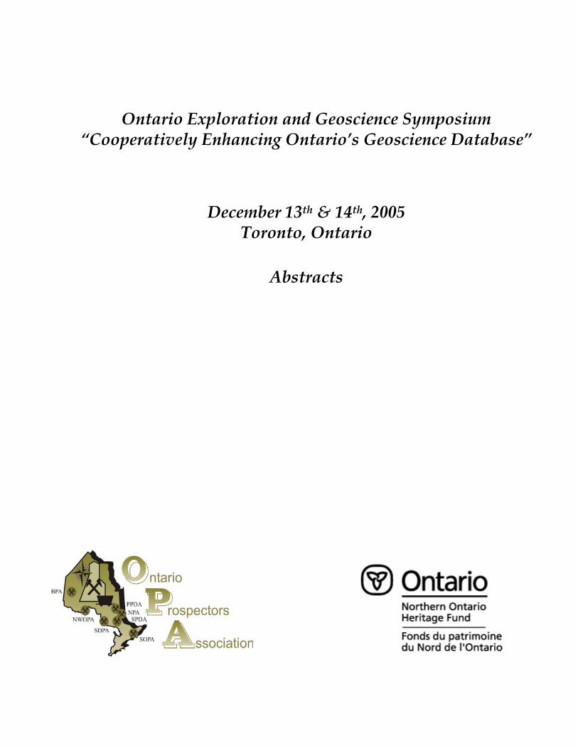
Ontario Exploration and Geoscience Symposium
“Cooperatively Enhancing Ontario’s Geoscience Database”
December 13th & 14th, 2005 Toronto, Ontario
Abstracts
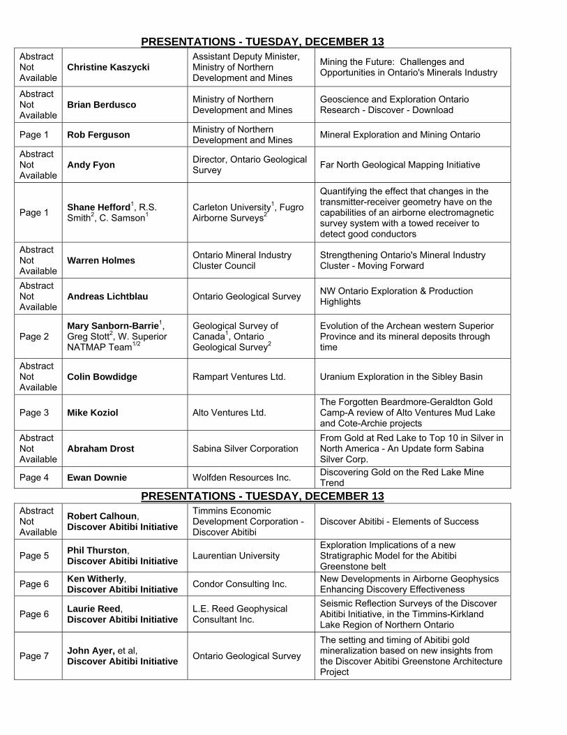
PRESENTATIONS - TUESDAY, DECEMBER 13Abstract Not Available
Christine Kaszycki Assistant Deputy Minister, Ministry of Northern Development and Mines
Mining the Future: Challenges and Opportunities in Ontario's Minerals Industry
Abstract Not Available
Brian Berdusco Ministry of Northern Development and Mines
Geoscience and Exploration Ontario Research - Discover - Download
Page 1 Rob Ferguson Ministry of Northern Development and Mines Mineral Exploration and Mining Ontario
Abstract Not Available
Andy Fyon Director, Ontario Geological Survey Far North Geological Mapping Initiative
Page 1 Shane Hefford1, R.S. Smith2, C. Samson1
Carleton University1, Fugro Airborne Surveys2
Quantifying the effect that changes in the transmitter-receiver geometry have on the capabilities of an airborne electromagnetic survey system with a towed receiver to detect good conductors
Abstract Not Available
Warren Holmes Ontario Mineral Industry Cluster Council
Strengthening Ontario's Mineral Industry Cluster - Moving Forward
Abstract Not Available
Andreas Lichtblau Ontario Geological Survey NW Ontario Exploration & Production Highlights
Page 2 Mary Sanborn-Barrie1, Greg Stott2, W. Superior NATMAP Team1/2
Geological Survey of Canada1, Ontario Geological Survey2
Evolution of the Archean western Superior Province and its mineral deposits through time
Abstract Not Available
Colin Bowdidge Rampart Ventures Ltd. Uranium Exploration in the Sibley Basin
Page 3 Mike Koziol Alto Ventures Ltd. The Forgotten Beardmore-Geraldton Gold Camp-A review of Alto Ventures Mud Lake and Cote-Archie projects
Abstract Not Available
Abraham Drost Sabina Silver Corporation From Gold at Red Lake to Top 10 in Silver in North America - An Update form Sabina Silver Corp.
Page 4 Ewan Downie Wolfden Resources Inc. Discovering Gold on the Red Lake Mine Trend
PRESENTATIONS - TUESDAY, DECEMBER 13Abstract Not Available
Robert Calhoun, Discover Abitibi Initiative
Timmins Economic Development Corporation - Discover Abitibi
Discover Abitibi - Elements of Success
Page 5 Phil Thurston, Discover Abitibi Initiative Laurentian University
Exploration Implications of a new Stratigraphic Model for the Abitibi Greenstone belt
Page 6 Ken Witherly, Discover Abitibi Initiative Condor Consulting Inc. New Developments in Airborne Geophysics
Enhancing Discovery Effectiveness
Page 6 Laurie Reed, Discover Abitibi Initiative
L.E. Reed Geophysical Consultant Inc.
Seismic Reflection Surveys of the Discover Abitibi Initiative, in the Timmins-Kirkland Lake Region of Northern Ontario
Page 7 John Ayer, et al, Discover Abitibi Initiative Ontario Geological Survey
The setting and timing of Abitibi gold mineralization based on new insights from the Discover Abitibi Greenstone Architecture Project
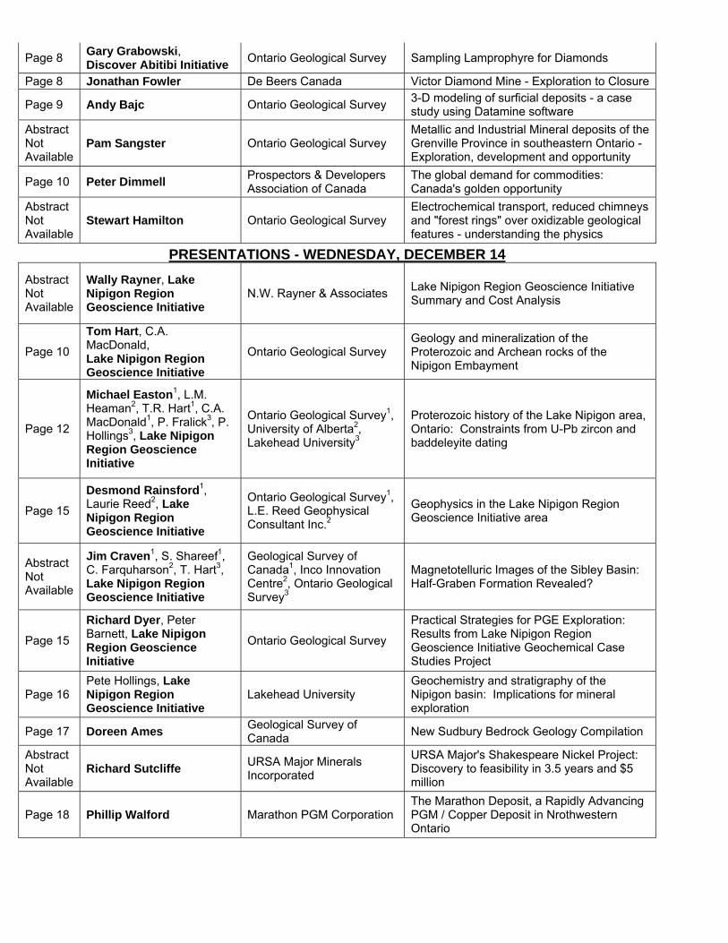
Page 8 Gary Grabowski, Discover Abitibi Initiative Ontario Geological Survey Sampling Lamprophyre for Diamonds
Page 8 Jonathan Fowler De Beers Canada Victor Diamond Mine - Exploration to Closure
Page 9 Andy Bajc Ontario Geological Survey 3-D modeling of surficial deposits - a case study using Datamine software
Abstract Not Available
Pam Sangster Ontario Geological Survey Metallic and Industrial Mineral deposits of the Grenville Province in southeastern Ontario - Exploration, development and opportunity
Page 10 Peter Dimmell Prospectors & Developers Association of Canada
The global demand for commodities: Canada's golden opportunity
Abstract Not Available
Stewart Hamilton Ontario Geological Survey Electrochemical transport, reduced chimneys and "forest rings" over oxidizable geological features - understanding the physics
PRESENTATIONS - WEDNESDAY, DECEMBER 14Abstract Not Available
Wally Rayner, Lake Nipigon Region Geoscience Initiative
N.W. Rayner & Associates Lake Nipigon Region Geoscience Initiative Summary and Cost Analysis
Page 10
Tom Hart, C.A. MacDonald, Lake Nipigon Region Geoscience Initiative
Ontario Geological Survey Geology and mineralization of the Proterozoic and Archean rocks of the Nipigon Embayment
Page 12
Michael Easton1, L.M. Heaman2, T.R. Hart1, C.A. MacDonald1, P. Fralick3, P. Hollings3, Lake Nipigon Region Geoscience Initiative
Ontario Geological Survey1, University of Alberta2, Lakehead University3
Proterozoic history of the Lake Nipigon area, Ontario: Constraints from U-Pb zircon and baddeleyite dating
Page 15
Desmond Rainsford1, Laurie Reed2, Lake Nipigon Region Geoscience Initiative
Ontario Geological Survey1, L.E. Reed Geophysical Consultant Inc.2
Geophysics in the Lake Nipigon Region Geoscience Initiative area
Abstract Not Available
Jim Craven1, S. Shareef1, C. Farquharson2, T. Hart3, Lake Nipigon Region Geoscience Initiative
Geological Survey of Canada1, Inco Innovation Centre2, Ontario Geological Survey3
Magnetotelluric Images of the Sibley Basin: Half-Graben Formation Revealed?
Page 15
Richard Dyer, Peter Barnett, Lake Nipigon Region Geoscience Initiative
Ontario Geological Survey
Practical Strategies for PGE Exploration: Results from Lake Nipigon Region Geoscience Initiative Geochemical Case Studies Project
Page 16 Pete Hollings, Lake Nipigon Region Geoscience Initiative
Lakehead University Geochemistry and stratigraphy of the Nipigon basin: Implications for mineral exploration
Page 17 Doreen Ames Geological Survey of Canada New Sudbury Bedrock Geology Compilation
Abstract Not Available
Richard Sutcliffe URSA Major Minerals Incorporated
URSA Major's Shakespeare Nickel Project: Discovery to feasibility in 3.5 years and $5 million
Page 18 Phillip Walford Marathon PGM Corporation The Marathon Deposit, a Rapidly Advancing PGM / Copper Deposit in Nrothwestern Ontario
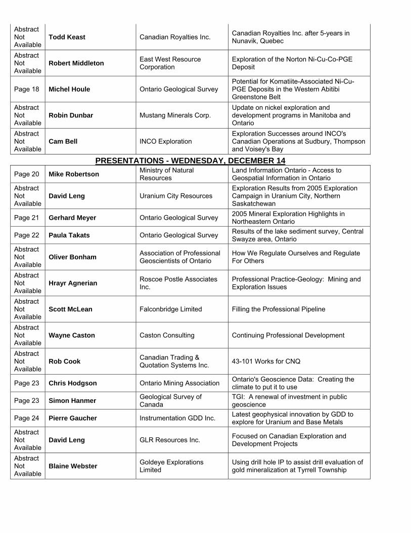
Abstract Not Available
Todd Keast Canadian Royalties Inc. Canadian Royalties Inc. after 5-years in Nunavik, Quebec
Abstract Not Available
Robert Middleton East West Resource Corporation
Exploration of the Norton Ni-Cu-Co-PGE Deposit
Page 18 Michel Houle Ontario Geological Survey Potential for Komatiite-Associated Ni-Cu-PGE Deposits in the Western Abitibi Greenstone Belt
Abstract Not Available
Robin Dunbar Mustang Minerals Corp. Update on nickel exploration and development programs in Manitoba and Ontario
Abstract Not Available
Cam Bell INCO Exploration Exploration Successes around INCO's Canadian Operations at Sudbury, Thompson and Voisey's Bay
PRESENTATIONS - WEDNESDAY, DECEMBER 14Page 20 Mike Robertson Ministry of Natural
Resources Land Information Ontario - Access to Geospatial Information in Ontario
Abstract Not Available
David Leng Uranium City Resources Exploration Results from 2005 Exploration Campaign in Uranium City, Northern Saskatchewan
Page 21 Gerhard Meyer Ontario Geological Survey 2005 Mineral Exploration Highlights in Northeastern Ontario
Page 22 Paula Takats Ontario Geological Survey Results of the lake sediment survey, Central Swayze area, Ontario
Abstract Not Available
Oliver Bonham Association of Professional Geoscientists of Ontario
How We Regulate Ourselves and Regulate For Others
Abstract Not Available
Hrayr Agnerian Roscoe Postle Associates Inc.
Professional Practice-Geology: Mining and Exploration Issues
Abstract Not Available
Scott McLean Falconbridge Limited Filling the Professional Pipeline
Abstract Not Available
Wayne Caston Caston Consulting Continuing Professional Development
Abstract Not Available
Rob Cook Canadian Trading & Quotation Systems Inc. 43-101 Works for CNQ
Page 23 Chris Hodgson Ontario Mining Association Ontario's Geoscience Data: Creating the climate to put it to use
Page 23 Simon Hanmer Geological Survey of Canada
TGI: A renewal of investment in public geoscience
Page 24 Pierre Gaucher Instrumentation GDD Inc. Latest geophysical innovation by GDD to explore for Uranium and Base Metals
Abstract Not Available
David Leng GLR Resources Inc. Focused on Canadian Exploration and Development Projects
Abstract Not Available
Blaine Webster Goldeye Explorations Limited
Using drill hole IP to assist drill evaluation of gold mineralization at Tyrrell Township

Abstract Not Available
Ed Walker Pele Mountain Resources
1 Ontario Prospectors Association www.ontarioprospectors.com
Ontario Exploration and Geoscience Symposium “Cooperatively Enhancing Ontario’s Geoscience Database”
Toronto, December 13th and 14th, 2005.
ABSTRACTS
Mineral Exploration and Mining Ontario Rob Ferguson MNDM
The Ministry of Northern Development and Mines working jointly with ServiceOntario, is developing an internet gateway for the mineral exploration and mining industry. This new service is an important part of the Ontario’s new mineral development strategy to improve the long term sustainability and global competitiveness of Ontario’s mineral sector by developing a more efficient and more transparent permitting and approval system. This new internet site is a one-stop electronic window into government services related to exploration and mining. The Gateway provides fast up-to-date information on all the regulatory aspects of developing a mineral property, from prospecting to building a new mine. The presentation is an overview the new website. The internet address of the web site is www.serviceontario.ca/mining.
Quantifying the effect that changes in the transmitter-receiver geometry have on
the capabilities of an airborne electromagnetic survey system with a towed receiver to detect good conductors
Authors: S.W. Hefford, Department of Earth Sciences Carleton University, 1125 Colonel By Drive Ottawa, ON K1S 5B6 [email protected] R.S. Smith, Fugro Airborne Surveys 2060 Walkley Road, Ottawa, ON, Canada K1G 3P5 Tel: (613) 731-9575 RSmith @fugroairborne.com C. Samson, Department of Earth Sciences Carleton University, 1125 Colonel By Drive Ottawa, ON K1S 5B6 Tel: (613) 520-2600 ext. 4396 [email protected]
2 Ontario Prospectors Association www.ontarioprospectors.com
Current airborne time-domain electromagnetic systems that are capable of measuring during the transmitter on-time are limited by their ability to correctly remove the primary field. With a receiver that is towed separate from the transmitter, there are variations in geometric configuration that significantly change the primary field strength. These geometric changes are not currently accounted for. This limits the system’s ability to detect highly conductive bodies in the subsurface, which have responses very similar to the primary field. If the geometry could be determined, the ability of the system to detect these good conductors would increase substantially. There are several variables that impact the geometry of the transmitter and the receiver. These include changes in the position of the receiver with respect to the transmitter in each of the three dimensions, variations in transmitter attitude (roll, pitch and yaw) and transmitter loop deformation. The most significant variables involve changes in the relative position of the receiver with respect to the transmitter along the direction of flight. This may occur as a loop deformation, a change in transmitter pitch, or the receiver moving towards or away from the transmitter. The level of accuracy necessary to completely remove the effects due to changes in geometry is different for each of the variables. A very high level of accuracy (of the order of a centimetre) is necessary for variations involving the relative position of the receiver along the direction of flight. The accuracy required for motions along the vertical direction can be at least one order of magnitude greater.
Evolution of the Archean western Superior Province & its mineral deposits through time
M. Sanborn-Barrie, G. M. Stott & the western Superior Province working group Recent integrated geoscience studies across the Superior Province have advanced our understanding of its stratigraphic, magmatic and structural record, providing us with a more solid foundation for understanding the processes of its accretionary growth and its heterogeneous metallogenic framework. This is particularly true for the western Superior Province, where a better understanding of its architectural evolution through time has developed from bedrock mapping, structural analysis, and geochemical and isotopic studies integrated with Lithoprobe seismic reflection and EM data.
The oldest (i.e., >3 Ga) rock record within the western Superior Province is preserved within three widely spaced crustal blocks, the Northern Superior; Winnipeg River; and Minnesota River Valley terranes. The ancient affinity of these blocks, in contrast to intervening, diverse oceanic crust, is compelling evidence that terrane accretion was the driving force behind significant Neoarchean regional-scale deformation and localized alteration, both of which exert major impacts on mineralization styles. These ancient crustal blocks amalgamated upon a central nucleus, the North Caribou terrane, composed of ca. 3 Ga basement locally overlain by a basal quartzite veneer with widespread ca. 2.99 Ga rift-related tholeiite-komatiite assemblages (structural host to Red Lake's lode gold deposits) and associated iron formation (host to the Musselwhite Gold Mine), with interior ca. 2.95-2.85 Ga shallow-water "platformal" sequences and peripheral tracts of intermediate-dominated calc-alkaline sequences such as the 2.94 Ga and 2.925 Ga Ball and 2.892 Ga Bruce Channel assemblages.
3 Ontario Prospectors Association www.ontarioprospectors.com
Mafic volcanic sequences of ocean floor affinity (i.e., Sachigo, Stull Lake, Edmund Lake, Rorke Lake, Trout Lake and Jutten assemblages) emerge as important in the western Superior rock record at ca. 2.85 Ga. These may represent an important metallotect for Cu-Ni-PGE mineralization if spatially associated sills (i.e., Big Trout Lake intrusion, Trout Bay Red Lake) are contemporaneous. Laterally extensive tracts of ca. 2.75-2.71 Ga arc – arc rift volcanic rocks and associated TTG plutons along the north and south margins of the North Caribou terrane, and elsewhere, signalled the start of the Kenoran accretionary event whereby consumption of oceanic crust via subduction initially led to generation of arc rocks, evolved to diachronous arc-rifting and the generation of economically significant ca. FIII-type tholeiitic mafic and felsic rocks (i.e., 2.742 Ga South Bay base metal deposits of the Uchi Subprovince; ca. 2.735 Ga South Sturgeon VMS deposits of the Wabigoon Subprovince; ca. 2.72 Ga Manitouwadge-Winston Lake VMS mineralization of the Wawa Subprovince), and ultimately resulted in diachronous collision between the various crustal blocks. Progressive pre- syn- and post-collisional convergence is evident from the regional-scale development of penetrative structures which have both localized (i.e, lode gold) and disrupted (i.e., VMS) mineralization. A variety of mineral deposit types were introduced during late- to post-collisional magmatic activity, including Alaskan-type magmatism along terrane boundaries (ca. 2692 Ma Lac des Iles PGE), calc-alkaline lamprophyric volcanism (ca. 2674 Ma diamondiferous breccias near Wawa), and peraluminous magmatism (ca. 2673-2646 Ma Pakeagama and Separation Rapids rare-metal pegmatites).
The Forgotten Beardmore-Geraldton Gold Camp A Review of Alto Ventures Mud Lake and Cote-Archie Projects
Alto Ventures Ltd. is a TSX Ventures exchange listed company (ATV:TSX-V) which is focused on gold exploration in the Superior Province of Ontario, Quebec and Manitoba. The company holds interests in three advanced projects, Despinassy Project in Quebec, Coldstream Project in the Shebandowan greenstone belt in Ontario, and the Oxford Lake project in Manitoba. The company also controls six medium and early stage projects including three in the Beardmore-Geraldton Gold Belt. The Beardmore-Geraldton gold district produced in excess of four million ounces gold, during a thirty-five year operating period extending through the late 1960's, from high grade, shear-hosted quartz vein systems and lower grade deposits related to banded iron formations. Since then exploration activity has been sporadic with the most significant occurring between the late 1980’s to early 1990’s and resulting in the discovery of the Brookbank gold deposit with a published resource of 1.6 million tonnes grading 7.1 g/t. Since then nominal exploration has been carried out. The Cote - Archie Lake gold property consists of 21 claims totalling 2,672 hectares. It is located five kilometres north of Beardmore and east of the historic Leitch mine which produced 860,000 ounces gold at an average grade of 0.92 opt (31.5 grams per tonne) gold. The 2005 Alto summer program confirmed the existence of an extensive shear hosted gold-quartz vein system (Cote-Archie Shear) that was traced along strike for over two kilometres. Individual shears are up to 12 metres wide and carry highly anomalous gold values, with higher grades up to 11.2 g/t over 1.0m continuous chip sample.
4 Ontario Prospectors Association www.ontarioprospectors.com
Previous work by Placer in the late 1980’s focused at the northeast end of the shear near Archie Lake. Surface showings were discovered in 2000 to the southwest by prospecting and the property was trenched, sampled and mapped by Alto in 2004 and 2005. The Cote-Archie Shear is a major auriferous shear system that is interpreted to lie on strike with the shear system associated with the Leitch Mine. It has not been recognized before and consequently has only been sparsely drilled at its northeast end near Archie Lake. The Cote-Archie Shear is a new and highly prospective structure that is ready to be drill tested. The Mud Lake gold property is located 25 kilometres northeast of Beardmore, and consists of 1,696 hectares. Alto’s 2005 summer program of prospecting and mapping confirmed the presence of 10 significant gold showings along a major auriferous shear zone that has been traced for over six km along strike within the Coyle Lake Intrusive. Gold values up to 50.6 g/t were obtained from quartz and quartz-carbonate veins occurring along the shear zone. Several of the veined shears that are cut by stringers of pyrite and chalcopyrite carry the best gold values. Results from Alto’s IP/Resistivity survey over a segment of the shear have detected the mineralized zones along strike beyond the surface showings and have also identified new targets. Historical work consisted of prospecting and surface trenching but only limited drilling was carried out. The Alto work has advanced the Mud Lake project to the drill ready stage. Alto’s Cote-Archie and Mud Lake properties host classic Archean shear hosted gold-quartz vein systems exposed on surface that have not yet been drilled. These are new targets in a historically prolific gold-producing belt.
DISCOVERING GOLD ON THE RED LAKE MINE TREND, Red Lake, Canada Wolfden Resources Inc.
The Red Lake Mining District is world renowned for high-grade gold with Goldcorp’s Red Lake Mine and Placer Dome’s Campbell Mine being two of the highest grade producing gold mines in the world. The Bonanza (Follansbee) Gold discovery is located just kilometers from the existing mines on what is referred to as the “Red Lake Mine Trend”. The Red Lake Mine Trend has seen numerous mines produce tens of millions of ounces of gold, making Red Lake one of the most prolific gold camps in the world.
The historic Red Lake mining camp is situated in the Red Lake greenstone belt in Northwestern Ontario. The town of Red Lake is a full service community and the Red Lake belt is host to numerous producing and past-producing gold mines, including Placer Dome’s Campbell Gold Mine and Goldcorp’s Red Lake Mine that have been producing gold since the 1940’s.
Wolfden owns a 100% interest in the Bonanza Property following the acquisition of joint venture partner, Sabina Resources’, interest. The Bonanza-Follansbee gold discovery was made in late 2004 when Sabina drilling intersected a new high-grade gold horizon while exploring along strike from historic drilling on the Follansbee Property. Further Follow-up drilling further along strike led to the discovery of gold on Wolfden’s adjacent Bonanza Property on a horizon presently called the “Bonanza Zone”.
5 Ontario Prospectors Association www.ontarioprospectors.com
Three drills are actively chasing this potentially major gold discovery, and several parallel zones of silicification and sulphide mineralization have now been identified. Some of the broadest gold intersections ever reported in the Red Lake camp have been intersected leading the companies to pursue a lower cost, near surface “bulk-tonnage” model to recover the gold. Gold intersections of over 30 meters (100 feet) are not uncommon in the discovery area with grades comparable to many of North America’s major gold mines.
In addition to the bulk-tonnage prospect, numerous drill holes have intersected narrower, high-grade gold mineralization up to several ounces of gold per ton. These intersections are similar in gold tenor to those that have made Red Lake famous. These higher-grade intersections could be viewed as targets for underground mining methods like those used in all past mines in Red Lake.
The goal is to develop a substantial gold resource and move the project toward a potential mining decision as quickly as possible. Stripping, surface sampling, and drilling will continue to be fast-tracked in an effort to build Red Lake’s next mine.
An old mining saying suggests that “there is no better place to explore for gold than in the shadow of a headframe” – Wolfden is on track to prove this to be a true statement.
Exploration Implications of a new Stratigraphic Model for the Abitibi Greenstone belt. By: P.C. Thurston1, A.J. Ayer2, A.S. Péloquin1, and B. Hathway1
1Mineral Exploration Research Centre, Laurentian University; 2Ontario Geological Survey. The Greenstone Architecture project of Discover Abitibi produced new developments of importance to exploration for syngenetic mineralization. 1) Field evidence indicates the greenstone belt developed in place – dikes of Tisdale age from the Muskasenda gabbro cut Deloro assemblage units of the Abitibi greenstone belt and many of the mafic/ultramafic intrusions cutting the Kidd-Munro assemblage are of Tisdale age. 2) We created revised stratigraphic nomenclature with the aid of further U-Pb geochronology. Changes to the stratigraphy are: a) the Duff-Coulson-Rand assemblage is now the lower part of the Kidd-Munro assemblage, b) the Tisdale assemblage is subdivided into lower and upper parts, c) the Kinojevis assemblage has been re-named the lower unit of the Blake River assemblage to remove conflict with the type area of the Kinojevis in Quebec. The area of most extensive change in stratigraphic affiliation is the Kamiskotia area where the area previously considered to be of Tisdale age is now recognized as the upper unit of the Blake River assemblage. 3) We have identified a series of submarine unconformities at the base of the 5 Keewatin volcanic assemblages fully preserved in the belt. The unconformities are characterized by mass flows including distinctive chert breccia/iron formation conglomerate units. Unconformity-bounded major stratigraphic units suggest broad scale correlation across the belt is possible beyond the DA region. The unconformities at assemblage or group level suggest that future work may define formation-scale packages in locations such as in the Kamiskotia area. 4) Isotopic inheritance occurs in most units of the belt and widespread occurrence of Pacaud & Deloro inheritance implies a formerly greater extent for these units which are
6 Ontario Prospectors Association www.ontarioprospectors.com
presently not extensive. 5) The new U-Pb zircon ages on the Upper unit of the Blake River assemblage establishes that part of the Upper Blake River assemblage in Ontario is similar in age to the post-cauldron phase of the Blake River Group in Quebec. The ages obtained for the Kamiskotia area place it in the upper Blake River assemblage. Lithologically, Kamiskotia volcanism resembles the Noranda subgroup in Québec; the Kamiskotia ages in Ontario range from the pre-to post-cauldron volcanism recognized in that subgroup.
New Developments in Airborne Geophysics Enhancing Discovery Effectiveness
In the last five years there have been a number of significant improvements in the capabilities of airborne geophysical technology. Some of these can be considered as ‘incremental’ changes while others should be classed as ‘totally new’ and therefore have the possibility of significantly impacting how exploration is done and the hopefully, the economic outcomes. Three technologies are felt to fit in the ‘totally new’ category; airborne gravity gradiometry, helicopter time domain EM and ternary processing of airborne data. All three technologies have basically appeared in the last five years and all are seeing a considerable degree of industry uptake, in no small part due to the exploration boom of the last two years. While these three applications are viewed as ‘totally new’, each has a special story; airborne gravity gradiometry is truly a new technology; nothing existed prior that could be used for minerals exploration. Helicopter time domain technology has been through a long gestation period (over 20 years) with likely more failures than any other major technology. Ternary processing is different from the other two in that it represents a breaking away from a long-held industry assumption that better outcomes almost always meant new and better hardware (termed the Bigger Hammer syndrome). These technologies are seen as part of a major effort of the geophysics industry trying to re-invent itself. While exploration expenditures are up considerably, significant new discoveries are getting harder to find especially in mature areas. Geoscientists recognize that simply doing the same thing time and again is showing little return and to stay viable within the exploration community, doing it better is no longer a option but critical if geophysics is to remain an important contributor to the overall sustainability of the mining industry. SEISMIC SURVEYS IN THE TIMMINS/KIRKLAND LAKE REGION AS PART OF THE
DISCOVER ABITIBI PROJECT AND REVISION OF LITHOPROBE DATA
Vibroseis seismic reflection surveying was carried out as part of the Discover Abitibi project in 2004 in the Timmins/Kirkland Lake region of northern Ontario. The products of these surveys were published by the Ontario Geological Survey in September 2005 as Open File Report 6169 and Miscillaneous Release-Data 163. These two dimensional (2D) surveys were designed to evaluate the structure and stratigraphy in this
7 Ontario Prospectors Association www.ontarioprospectors.com
economically significant mineralized area. 146 line kilometres of regional surveying and 50 line kilometres of high resolution surveying were collected on eight lines. Regional surveying in this context means geophones at 25 metre intervals with “shooting” at 50 metres. High resolution surveying halved these intervals. Lines were designed to cross the Porcupine-Destor and Kirkland/Larder Lake structures, as well as extensive areas of Abitibi volcanic and sedimentary rocks. One of the traverses passed by the Kidd Creek polymetallic sulphide orebody. Others passed over the Hollinger/McIntyre and Dome gold systems. Seismic reflectors have been imaged from near surface (a few hundred metres) to depths of greater than 30 kilometres. Reflectors and terminations of reflectors in the upper few kilometres may be correlated to surface lithologies and structures and may have implications for mining exploration in the accessible near surface.
The products of re-processing the 1988 Lithoprobe line 12 are presented. This line, lying north and east of Kirkland Lake and crossing both the Kirkland-Lake and Porcupine-Destor structures, was processed as part of the Discover Abitibi seismic program.
Acoustic properties (density and p-wave velocity), measured on rock samples as part of the Discover Abitibi program, are used to assist the interpretation of the reflection seismic data. Laurie E. Reed* (*denotes speaker) L.E. Geophysical Consultant Inc. RR 2 Rockwood, Ont. N0B 2K0 Dr. David Snyder Research Scientist Seismology and Electromagnetic Section Continental Geoscience Division Geological Survey of Canada 615 Booth St., Room 204 Ottawa, Ont., K1A 0E8 Dr. Matthew H. Salisbury Senior Research Scientist Geological survey of Canada Bedford Institute of Oceanography Dartmouth, N.S. B2Y 4A2 The setting and timing of Abitibi gold mineralization based on new insights from the Discover Abitibi Greenstone Architecture Project. J. Ayer, R. Bateman, V. Ispolatov, B. Lafrance and B. Dube. In the Timmins, Kirkand Lake and Harker-Holloway camps, gold occurred in multiple mineralization episodes closely tied to regional deformation zones, late tectonic supracrustal assemblages and late magmatic events. Both the Porcupine and Timiskaming represent late-tectonic assemblages unconformably overlying older volcanic assemblages and spatially associated with regional faults. The Porcupine ranges in age from 2690 to 2685 Ma and consists of felsic volcanics of the Krist
8 Ontario Prospectors Association www.ontarioprospectors.com
formation and coeval porphyry intrusions (both with adakitic geochemical affinities), succeeded by turbiditic sediments. The Timiskaming ranges in age from 2676 to 2670 Ma and consists of conglomerates and sandstones, with alkalic volcanics and coeval syenites and albitites. At Timmins, regional deformation and 10 km of strike-slip sinistral movement on the Porcupine Destor deformation zone coincided with opening of the Timiskaming depositional basin. Here gold is associated with folding and faulting both coeval with, and post-dating the Timiskaming assemblage including a replacement gold event associated with base metal sulfides with a Re-Os molybdenite age of 2672 ± 7 Ma at the McIntyre mine; and a later quartz carbonate veining event and a Re-Os molybdenite age of 2670 ± 10 Ma at the Dome mine. In the eastern part of the Porcupine Destor deformation zone at the Holloway mine, an early disseminated gold event predates an intermineral lamprophyre dike with an age of 2672 ± 2 Ma, while a late auriferous veining event postdates the dike. At Kirkland Lake, early gold mineralization is post-Timiskaming and is associated with disseminated sulfides widespread alteration and ductile deformation proximal to the Larder Lake deformation zone and associated splays. An apparently later quartz carbonate veining style gold mineralization event with associated tellurides and thin alteration selvages is related to the development of the Kirkland Lake fault, an upper crustal brittle-ductile fault north of the Larder Lake deformation zone.
Sampling Lamprophyre Dikes for Diamonds; Discover Abitibi Initiative
Gary Grabowski, District Geologist, Kirkland Lake, Ontario Geological Survey Abstract The Discover Abitibi Initiative is funded by the private sector and, the federal and provincial governments (respectively Industry Canada through FedNor and the Ontario Ministry of Northern Development and Mines through the Northern Ontario Heritage Fund). The program is designed to stimulate mineral exploration in the Ontario portion of the Abitibi greenstone belt. A project to sample lamprophyre dikes, in the Kirkland Lake – Cobalt area, was approved by the Discover Abitibi program. Forty-five samples were submitted to SGS Lakefield Research Ltd. in Lakefield, Ontario for litho-geochemical analysis and diamond extraction, selection and description. Six of the forty-five samples submitted returned diamonds. Samples GGDA0402 and GGDA0432 each returned one microdiamond. Samples GGDA0433, GGDA0435 and GGDA0441 returned 5, 3 and 23 microdiamonds respectively. Sample GGDA0410 contained one 0.011 carat (2.214 mg) macrodiamond.
Victor Diamond Mine – Exploration to Closure J.A. Fowler, De Beers Canada Inc., Suite 400, 65 Overlea Boulevard, Toronto, ON, M4H 1P1 AbstractThe Victor kimberlites were discovered in 1988, and will see the construction of Ontario’s first diamond mine start in early 2006. Production from an open pit should
9 Ontario Prospectors Association www.ontarioprospectors.com
commence in the fourth quarter of 2008 and the mine will have a life of 12 years, producing around 600,000 carats a year with an annual throughput of 2.5 million tonnes. Project life, including construction and active closure, is estimated at 17 years. The exploration and evaluation will be outlined, together with some of the significant technical issues associated with working in an extensive wetland area with no permanent roads. The outlines of the closure plan will be demonstrated in a short animated video clip.
3D Modelling of Surficial Deposits – A Case Study Using Datamine Software®
A.F. Bajc1 and M.J. Newton21 Sedimentary Geoscience Section, Ontario Geological Survey 2 Datamine Corporate, United Kingdom The Ontario Geological Survey (OGS) has embarked on a pilot project of 3-dimensional mapping of Quaternary deposits within the Regional Municipality of Waterloo in southwestern Ontario. This project is part of a broader OGS program designed to provide basic geoscience information for the protection and preservation of the provincial groundwater resource. The main objective of this project is to develop a series of protocols for detailed 3-dimensional mapping of Quaternary deposits in the province. This protocol shall be used as a standard for similar surveys to be undertaken in other areas of the province. 3-dimensional mapping involves the characterization of the geometry and inherent properties of subsurface deposits (aquifers and aquitards). This information can: 1) aid in studies involving groundwater extraction, protection and remediation; 2) assist with the development of policies surrounding land use and nutrient management; and 3) help to better understand the interaction between surface and groundwater systems. The working subsurface database for Waterloo Region contains approximately 26 000 records and nearly 73 000 sediment layers of varying data quality. In addition, approximately 450 geophysically interpreted borehole logs, 17.5 km of seismic reflection profiling and 16 km of ground penetrating radar data is currently available for the region. Clearly, a powerful 3-dimensional viewing and modelling software package was required to successfully interpret this huge dataset. Datamine Studio®, a software package developed for and used primarily by the mining sector for ore reserve definition and mine development was selected because it: 1) excels in 3-D visualization; 2) provides excellent linkage and live update capacity to our working database; 3) provides a wide selection of interpolation and geostatistical tools; 4) creates wireframe surfaces and solid models; 5) can import ArcInfo® shape files and drape base information over a 3-D model; 6) can import raster images such as seismic sections into the model for added interpretation; 7) can create isopach and structural contour maps of individual strata; 8) can export in, ASCII format, top of formation and formation thickness data at a user-specified grid spacing; and 9) comes with a free viewing software that allows for flexible client interaction with the 3-D model. The flexible and comprehensive database and modelling options available in Datamine Studio have allowed a method to be created that follows a logic which is appropriate for the modelling of aquifers and aquitards. As is often the case in this type of study, the modelling steps are repeated many times during the course of a project as data is
10 Ontario Prospectors Association www.ontarioprospectors.com
refined and corrected and interpretations change. The ability to put the entire model build behind a single button on a tailored interface has been a major contributor to the success of this project. The high quality 3-D visualization and display options allow the different data types (boreholes, points, wireframes, block models) to be selectively displayed and manipulated. This greatly facilitates the validation of the base data from which the models are created. The ability to easily select subsets of the project area and create models for these sub-areas means that the models can be created in a matter of minutes which makes it a very practical tool for regular use. Few changes would be required to apply the system to other similar project areas.
The protocols developed as part of this study could also be used for a variety of other applications that require a clear understanding of the 3-dimensional geometry and properties of Phanerozoic deposits. These include aggregate resource delineation, geologic modelling of Paleozoic strata in the Michigan and Hudson Bay basins and geotechnical investigations related to infrastructure development, open pit design and hazardous lands.
The global demand for commodities: Canada’s golden opportunity
Strong global demand for mineral products, particularly base metals, is expected to last for the next two to three decades. Canada should be well positioned to benefit from this commodity boom. However, this country’s slump in base metal reserves will restrict our ability to do so. Prolonged and high levels of exploration investment are required to make the new discoveries that will replenish these needed reserves. The Prospectors and Development Association of Canada is proposing short- and long-term strategies to deal with the challenges ahead, including the continuation of the highly successful Investment Tax Credit for Exploration and the launching of the Cooperative Geological Mapping Strategy. Geology and mineralization of the Proterozoic and Archean rocks of the Nipigon
Embayment; Lake Nipigon Region Geoscience Initiative Hart, T.R.1 and MacDonald, C.A.2 1 Precambrian Geoscience Section, Ontario Geological Survey 2Caracle Creek International Consulting Inc., Sudbury, Ontario The Nipigon Embayment is an approximately 19 000 km2 area of Proterozoic rocks centered on Lake Nipigon, north of Lake Superior. Mapping at 1:50 000 scale was completed west and south of Lake Nipigon to investigate the potential for platinum group element (PGE) bearing mafic to ultramafic intrusions. Half of the mapping was conducted under a contract agreement between the Ontario Geological Survey (OGS) and the Ontario Prospectors Association (OPA) for the Lake Nipigon Region Geoscience Initiative (LNRGI), and half was mapped by the OGS as part of its commitment of in-kind support to the LNRGI. The LNRGI is a geoscience-based geological data acquisition and compilation program operated by the OPA and funded through an agreement with the Northern Ontario Heritage Fund Corporation (NOHFC). The Embayment is underlain by Archean rocks of the Wabigoon Subprovince to the north, and the Quetico Subprovince to the south. Sedimentary rocks of the relatively
11 Ontario Prospectors Association www.ontarioprospectors.com
flat-lying Sibley Group unconformably overlie the Archean rocks. Paleoproterozoic Badwater Intrusion and flat-lying Pillar Lake volcanic rocks, located in the northwest portion of the Embayment, represent newly discovered occurrences of Proterozoic rocks (MacDonald and Tremblay 2005; Heaman and Easton 2005). The Paleoproterozoic English Bay Complex is located along the northwest shore of Lake Nipigon and is composed of felsic volcanic and intrusive rocks. Four mafic to ultramafic intrusions (Disraeli, Seagull, Hele, and Kitto) and the Shillabeer, Jackfish, and Kama sills, intrude the Archean and Paleoproterozoic rocks. All four intrusions are composed of a pyroxene peridotite core predominately cumulate textured with an irregular olivine gabbro to olivine melagabbro border zone (e.g. Hart 2005). Nipigon diabase sills intrude all other rock types, and include the Inspiration sill in the northwest portion of the Embayment and the McIntyre sill in the west-central portion of the Embayment. Sills range in thickness from a few 10s of metres to nearly 200 m, but in the Muskrat and Gieke lakes area there are 250 and 400 m thick sills that may indicate a proximity to a feeder zone. Generally, the sills form shallow-dipping broad saucers with interiors occupied by older rock types suggesting a geometry similar to that proposed for other diabase sill complexes (e.g., Thomson and Hutton 2004). The Nipigon sills are part of the Mesoproterozoic Logan Sill Complex, but are geochemically and petrographically distinct from the diabase sills located south of Thunder Bay (Hart, 2004). A series of regionally extensive north and northwest-trending faults defining the Black Sturgeon Fault Zone appear to have controlled emplacement of the diabase sills and mafic to ultramafic intrusions. Styles of mineralization in the Embayment are directly related to the age of the host rocks. The style and potential for mineralization in the Archean rocks generally reflects the potential present in the areas surrounding the Embayment, and the continuity of these rocks under the Proterozoic (e.g. gold and base metal sulphides). A number of layered mafic intrusions located to the west side of the Embayment (e.g. Hart and MacDonald 2000) appear to be contemporaneous with the Lac des Iles Intrusion (Heaman and Easton 2005) suggesting a potential for Late Archean PGE mineralization. There are 3 uranium occurrences in Black Sturgeon Lake area, including the Split Rapid Dam occurrence, associated with a series of north-trending hematite-rich fractures that subparallel one of the major fault orientations of the Black Sturgeon fault system. A U/Pb age for the mineralization of 1090+/-20 Ma (Ruzicka and LeCheminant 1984) for the Black Sturgeon occurrence suggests fluid circulation during the late stages of the Keweenawan Midcontinent Rift event. The Seagull Intrusion contains at least four stratiform zones of ultramafic cumulate-hosted PGE mineralization interpreted to be a result of sulphur saturation of the magma as a result of influxes of less evolved magma (Heggie and Hollings 2004). PGE and Cu values for the other mafic to ultramafic intrusions, and the Jackfish and Kama sills, indicates a depletion of the PGEs (Barnes et al. 1987). This depletion suggests that these bodies may also be part of mineralized magmatic systems, and there is the potential for additional PGE mineralization in the Nipigon Embayment. REFERENCES Barnes, S.J., Boyd, R., Korneliussen, A., Nilsson, L-P., Often, M., Pedersen, R.B. and Robins, B. 1987.
The use of mantle normalization and metal ratios in discriminating between the effects of partial melting, crystal fractionation and sulphide segregation on platinum group elements, gold, nickel and copper: examples from Norway; in Geo-Platinum ’87, Elsevier, Barking, United Kingdom, p.113-143.
12 Ontario Prospectors Association www.ontarioprospectors.com
Hart, T.R. 2004. Geochemistry of the Proterozoic intrusive rocks of the Nipigon Embayment; abstract in Institute on Lake Superior Geology, Proceedings, 50th Annual Meeting, Duluth, Minnesota, v.50, pt.1, p.68-69.
Hart, T.R. 2005. Precambrian Geology of the South Black Sturgeon River and Seagull Lake Area, Northwestern Ontario; Ontario Geological Survey, Open File Report 6165, 63 p.
Hart, T.R. and C.A. MacDonald, C.A. 2000. Geology of the Lac des Iles Greenstone Belt, Central Wabigoon Subprovince; Ontario Geological Survey, Open File Report 6032, p 18-1 to 18-8.
Heaman, L.M., and Easton, R.M., 2005. Proterozoic history of the Lake Nipigon area, Ontario: Constraints from U-Pb zircon and baddeleyite dating. ; Institute of Lake Superior Geology, 51st Annual Meeting, Nipigon, Ontario, Part 1 - Proceeding and Abstracts, v.51, part 1, 24-25.
Heggie, G.J., and Hollings, P., 2004. Controls on PGE Mineralization in the Seagull Intrusion, Northwestern Ontario; Geological Association of Canada-Mineralogical Association of Canada, Joint Annual Meeting, St. Catharines 2004, Program with Abstracts
MacDonald, C.A. and Tremblay, E. 2005. Precambrian Geology of the west-central map area, Nipigon Embayment, northwestern Ontario; Ontario Geological Survey, Open File Report 6164, 49 p.
Ontario Geological Survey 2004. Ontario geophysical surveys, gravity data, grid and point data (ASCII and Geosoft(r) formats) and vector data, Lake Nipigon Embayment area; Ontario Geological Survey, Geophysical Data Set 1052.
Ruzicka, V. and LeCheminant, G.M., 1984. Uranium deposit research, 1983; in Current Research, Part A, Geological Survey of Canada, Paper 84-1a, p. 39-51.
Thomson K. and Hutton, D. 2004. Geometry and growth of sill complexes: insights using 3D seismic from the North Rockall Trough; Bulletin of Volcanology v.66, p.364-375.
Proterozoic history of the Lake Nipigon area, Ontario: Constraints from U-Pb zircon and baddeleyite dating
L.M. Heaman, Department of Earth and Atmospheric Sciences, University of Alberta, Edmonton, Alberta, T6G 2E3 [email protected]; R.M. Easton, T.R. Hart, C.A. MacDonald, Precambrian Geoscience Section, Ontario Geological Survey, Sudbury, Ontario P3E 6B5, P. Fralick and P. Hollings, Department of Earth Sciences, Lakehead University, Thunder Bay Ontario, P7B 5E1.
The Lake Nipigon Region Geoscience Initiative, a 2-year, science-focused, Industry-Government-University collaborative geological study, collected new geoscience data in the Lake Nipigon region of Ontario between May 2003 and December 2005. As part of this study, over 40 new U-Pb baddeleyite and zircon age determinations were acquired from predominantly mafic rocks of the Lake Nipigon region. Preliminary results of this study are reported herein.
The best estimate for a maximum depositional age of a greywacke from the upper Rove Formation is provided by a 1777 Ma concordant detrital zircon grain, as the youngest grain in the sample, at 1731 Ma, is 5% discordant. This interpretation is supported by the abundance of grains (n=10) between 1796 to 1777 Ma, and is consistent with U-Pb ash bed ages of 1836±5 and 1832±3 Ma from the basal Rove Formation (Addison et al. 2005).
Detrital zircon ages from sandstones of the lower (Pass Lake Formation) and upper (Nipigon Bay Formation) Sibley Group indicate maximum depositional ages of 1634 and 1670 Ma, respectively, with a predominance of Geon 17 and 18, not Archean, detritus. Data from the middle to upper (Outan Island Formation) Sibley Group indicates a maximum depositional age of 1450 Ma, as well as Geon 15 and 17 detritus, but no Geon 18 grains. The Geon 15 detritus may be locally derived, e.g. from the 1547±4 Ma English Bay complex volcanic rocks, the 1590±1 Ma Badwater Creek felsic intrusion (formerly Pillar Lake intrusion), and the 1599±1 Ma Badwater Creek gabbro (formerly
13 Ontario Prospectors Association www.ontarioprospectors.com
Pillar Lake gabbro). In addition, sediment interbedded with flat-lying mafic volcanic rocks south of Armstrong are younger than 1514 Ma, based on detrital zircons in interbedded sediments, but older than overlying, circa 1159 Ma (minimum age of 1120±1 Ma), Inspiration diabase sills.
The abundance of Geon 15 ages in the western Nipigon Embayment is impressive, as the period between 1600 and 1520 Ma in eastern North America has been recognized for some time as a period of quiescence throughout Laurentia (Gower et al. 1990). Gower (1996) suggested that, at least in the eastern Grenville Province, this quiescence might be linked with the development of a passive continental margin, however, such a setting does not explain the felsic magmatism present in the Nipigon area.
The new U-Pb data obtained in this study suggest the presence of an earlier period of magnetically normal, localized alkalic (lamprophyre dikes, Queen et al. 1996) and mafic magmatism (Inspiration sills, and the Pigeon River (1141±20 Ma), Empey Lake (~1144 Ma) and Mine Center (~1137 Ma) diabase dikes) between 1150 and 1135 Ma in the MCR in Ontario.
Attempts to directly date metavolcanic rocks in the Pillar Lake area south of Armstrong have yielded equivocal results. The metavolcanic rocks are bracketed between 1514 Ma, the age of the youngest zircon present in interbedded sedimentary beds, and 1120±1 Ma, the minimum age of an overlying Inspiration sill, indicating that they are Mesoproterozoic. A titanite fraction from an andesitic flow gave a preliminary 207Pb/206Pb titanite age of 1129±5 Ma, which could be a minimum age, or it could approximate the age of extrusion. Pb/Pb isotopic data from Pillar Lake mafic volcanic rocks suggests a potential Geon 15 age for the Pillar Lake mafic volcanic rocks (Richardson et al. 2005), although the high radiogenic U and Sr contents in these samples could be the result of post-extrusion hydrothermal activity.
Baddeleyite U-Pb data from the 4 ultramafic intrusions in the region (Disraeli, Hele, Kitto, Seagull), indicates a range of emplacement ages from circa 1124 to 1107 Ma. A range of ages spanning ~10 m.y. was obtained for the Seagull intrusion and it is unclear at this point whether this range reflects protracted cooling or multiple intrusions, or both? Ages obtained from Nipigon diabase sills cutting the Seagull and Kitto intrusions indicate that there is a range in the emplacement times for the ultramafic intrusions. The Seagull and Kitto intrusions are both older than the diabase sills (1114±9 Ma and 1111±4 Ma, respectively) that cut them. These diabase ages are similar to those from other Nipigon sills. The Disraeli and Hele ultramafic intrusions are somewhat younger, being emplaced at 1112±2 Ma and 1107±2 Ma, respectively. A related ultramafic body, the Jackfish Island sill, cuts the English Bay complex and is geochemically similar to the Kitto intrusion, although it appears to be slightly younger in age (1112±3 Ma versus 1118±2 Ma, respectively).
In contrast, baddeleyite ages from 5 different Nipigon diabase sills analyzed so far cluster between 1110 and 1114 Ma. Although geochemically distinct from the Nipigon sills (Hart 2003), a sample from the Logan sill at Mount McKay in Thunder Bay, is similar in age, at 1115±1 Ma.
Thus, most mafic and ultramafic rocks in the Lake Nipigon and Superior areas, including the Nipigon and Logan sills, appear to have been emplaced in a short, magnetically reversed, internal between 1115 and 1100 Ma. Emplacement of alkalic
14 Ontario Prospectors Association www.ontarioprospectors.com
intrusions, such as the 1108 Ma Coldwell Complex (Heaman and Machado 1992), and filling of much of the submerged part of the rift in Lake Superior, also occurred in this period. This was followed by a period of magnetically normal, waning mafic and felsic magmatism, between 1096 and 1085 Ma, that is preserved mainly along the Lake Superior shore by units such as the Crystal Lake (1099±1 Ma), Moss Lake (1095±2 Ma) and Blake (1095±2 Ma) gabbros, and the Arrow River dike (1093±3 Ma).
References Addison, W.D., Brumpton, G.R., Vallini, D.A., McNaughton, N.J. Davis, D.W. Kissin, S.A.
Fralick, P.W. Hammond A.L. 2005. Discovery of detrital ejecta from the 1850 Ma Sudbury impact event; Geology, v.33, p.193-196.
Hart, T.R. 2003. Keweenawan mafic and ultramafic intrusive rocks of the Lake Nipigon and Crystal Lake areas, northwest Ontario; Institute on Lake Superior Geology, Proceedings, 49, pt.1, Programs and Abstracts, p.21-22.
Heaman, L.M. and Machado, N. 1992. Timing and origin of Midcontinent Rift alkaline magmatism, North America: Evidence from the Coldwell Complex; Contributions to Mineralogy and Petrology, v.110, p.289-303
Gower, C.F. 1996. The evolution of the Grenville Province in eastern Labrador Canada; in Precambrian crustal evolution in the North Atlantic Region, Geological Society of London, Special Publication 112, p.197-218.
Gower, C.F., Ryan, A.B. and Rivers, T. 1990. Mid-ProterozoicLaurentia-Baltica: an overview of its geological evolution and a summary of the contributions made by this volume, in Mid-Proterozoic Laurentia-Baltica, Geological Association of Canada, Special Paper 38, p.1-20.
Queen, M., Heaman, L.M., Hanes, J.A., Archibald, D.A. and Farrar, E. 1996. 40Ar/39Ar phlogopite and U-Pb perovskite dating of lamprophyre dikes from the eastern Lake Superior region: evidence for a 1.14 Ga magmatic precursor to Midcontinent Rift volcanism; Canadian Journal of Earth Sciences, v.33, p.958-965.
Richardson, A., Hollings, P. and Franklin, J. 2005. Geochemistry and radiogenic isotope characteristics of the sills of the Nipigon Embayment. Lake Nipigon Region Geoscience Initiative; Ontario Geological Survey, Open File Report 6175.
15 Ontario Prospectors Association www.ontarioprospectors.com
Geophysics in the Lake Nipigon Region Geoscience Initiative area By Desmond Rainsford1, Laurie Reed2
As part of the Lake Nipigon Region Geoscience Initiative a program of geophysics was carried out along the western and south margins of Lake Nipigon. The program comprised an airborne magnetic and gamma radiometric survey, a ground gravity survey, petrophysical measurements (magnetic susceptibility and density), an audio magnetotelluric survey (AMT) and downhole logging. Interpretation of the data included the use of 3-D inversion modelling. The surveys, measurements and modelling were designed to assist in the interpretation of the regional structure, aid the geological mapping and help stimulate mineral exploration in the district. The assembly of a large database of magnetic susceptibility and density values has helped to distinguish the geophysical signatures of different rock types and has greatly assisted in the geological interpretation of the aeromagnetic and gravity surveys. It has also provided a better understanding of the inversion modelling results. Using the physical property data it was found that the Inspiration and Nipigon sills could be differentiated on the basis of magnetic susceptibility and density. Where surficial conditions permitted, the gamma-ray spectrometer data was used to help map certain lithologies. One of the challenges to the understanding of the geological structure of the Lake Nipigon basin is the masking of the Archean basement by areally extensive Proterozoic diabase sills. In spite of the sills having elevated densities and magnetic susceptibilities, it was possible to delineate bodies within the basement using the newly acquired magnetic and gravity data. The inversion modelling was able to define bodies within the basement and in two cases drill core measurements, from existing holes, were used to verify the results of the modelling. The model results were also able to provide context to isolated inliers of Archean rocks exposed through windows in the sills. The AMT survey, conducted under the supervision of the Geological Survey of Canada as part of a Targeted Geoscience Initiative, along with high resolution (250 metre station interval) gravity lines was designed to investigate the geometry of the Black Sturgeon graben, south of Lake Nipigon. Initial results have been encouraging. Downhole physical property logging was carried out primarily to provide electrical resistivity data to assist in the processing of the AMT. The logging has demonstrated good electrical contrasts between diabase sill, Sibley sediments and Archean basement. 1 Precambrian Geoscience Section, Ontario Geological Survey, Sudbury, Ontario 2 L.E. Reed Geophysical Consultant Inc., Rockwood, Ontario
Practical Stategies for PGE Exploration: Results from Lake Nipigon Region
Geoscience Initiative Geochemical Case Studies Project Richard Dyer, Peter Barnett, Ontario Geological Survey
16 Ontario Prospectors Association www.ontarioprospectors.com
Abstract The goal of the Lake Nipigon Region Geoscience Initiative (LNRGI) Surficial Geochemistry Case Studies Project was to evaluate, develop and recommend cost-effective strategies and sampling methodologies for PGE exploration using various surficial media. Over Archean terrain, there is often excellent geochemical contrast between the PGE target rock type (mafic to ultramafic) intrusive and surrounding rock type (e.g., granitic rocks). This geochemical contrast is mirrored in the geochemistry of most surficial media sampled during this project. Over Nipigon sills, the geochemical contrast is much weaker for copper, palladium and gold due to a relatively high background in the sills. Readily weathered (and locally intensely weathered) diabase results in an enhanced (apparently “anomalous”) geochemical signal for copper and palladium. “Seagull”-type intrusions share similar weathering characteristics, therefore, explorationists need to focus on the geochemical differences between the diabase sills and the mafic to ultramafic intrusive rocks of interest. Well-defined geochemical dispersal trains were observed in sample results of C-horizon till and heavy mineral concentrates of the till, particularly at Lac des Iles, where sampling density was sufficient. Dispersal trains for PGEs were found to be commonly short, however, the trains of associated elements such as nickel and copper are much larger and provide a much bigger target area for mineral exploration. The behaviour of nickel in the soil environment is similar to that of platinum and can be used as a proxy for geochemical exploration in most settings. In areas of elevated pH, nickel does not appear to be as mobile as platinum and, therefore, their pathways through the soil environment diverge. The behaviour of copper in the soil environment is similar to that of palladium with respect to relative mobility. In general, a prudent exploration strategy for PGE mineralization includes targeting the associated metals (Cu, Ni, Cr) to vector to prospective ground prior to detailed work involving the determination of PGEs and/or indicator minerals in surficial media. Relative to the metals copper and nickel, the PGEs have significantly lower initial concentrations (ppb levels), are much less mobile in the surficial environment and are less reliably determined at the laboratory (poorer reproducibility in part due to the classic “nugget effect” and higher potential for contamination).
Geochemistry and stratigraphy of the Nipigon basin: Implications for mineral exploration
P. Hollings, P. Fralick, R. Metsaranta, A. Richardson Department of Geology, Lakehead University, Thunder Bay, Ontario As part of the Lake Nipigon Region Geoscience Initiative (LNRGI) Lakehead University undertook a multidisciplinary study of the Lake Nipigon basin. The Nipigon embayment comprises a series of mafic sills, interpreted to be an intrusive basaltic sequence emplaced into the relatively undeformed Sibley Group sediments during the 1.1 Ga Keweenawan rift event centered in the Lake Superior region of the Superior Province. The sills are part of the Mesoproterozoic mid-continent (MCR) rift event, which lasted for approximately 25 m.y. and generated in excess of 1.5 million km3 of intrusive and extrusive rocks.
17 Ontario Prospectors Association www.ontarioprospectors.com
The sills vary from 10-250m thick, are relatively flat lying hypabyssal, medium-grained subophitic to ophitic olivine gabbronorite. Five distinct sill suites have been identified; the Nipigon, Shillabeer and McIntyre suite (this study) and the Jackfish and Inspiration sills (MacDonald et al., 2005). The Nipigon suite outcrops over much of the Nipigon embayment and is characterized by TiO2 values of 0.7 to 2.7 and La/Ybcn ratios of 2-5. The spatially restricted McIntyre suite comprises 10 surface samples and is characterized by higher TiO2 (2.7 to 3.1 wt%) and La/Ybcn (6.4 to 7.2) than the Nipigon sills. The Shillabeer suite is represented by only six drill core samples and is characterized by elevated TiO2 (2.6 to 2.8 wt%), and the highest La/Ybcn ratios (12.3 to 14.9) of the three suites. Geochemically the five sill suites all broadly resemble plume-related basalts comparable to modern OIB, however the majority of samples are characterised by negative Nb anomalies that are not typical of OIB, but are found in continental flood basalts. The negative Nb anomalies and elevated Th contents of the sills are consistent with contamination by an older LREE enriched source comparable to Archean granites. All the diabase samples have negative εNd values consistent with contamination by an older source. Variations in the trace element and isotope systematics suggest that sills underwent a pervasive contamination by an Archean source deep in the crust followed by limited and spatially restricted contamination by both Archean and Proterozoic sources during emplacement. Detailed logging of drill core and cliff sections reveals the presence of one thick sill intruded into the Kama Hill Formation of the Sibley Group rocks near the north shore of Lake Superior in the east and down-ramping to the Rossport in the west. There are thicker sills toward the central basin area in the region around Muskrat Lake and a second thick diabase sill appears in the stratigraphy. Changes in stratigraphic position and elevation of both the sills and the Sibley Group may imply the existence of faults with vertical displacements. The Sibley Group sedimentary rocks present in the central basin area, where the sills are thickest, are extensively thermally metamorphosed probably reaching temperatures of approximately 400-500°C even tens of meters from the major diabase sills. References MacDonald, C.A., Tremblay, E. and Easton, R.M. 2005. Precambrian geology of the west-central map area, Nipigon Embayment, northwestern Ontario, Lake Nipigon Region Geoscience Initiative; Ontario Geological Survey, Open File Report 6164, 49p.
New Sudbury Bedrock Geology Compilation Geological Survey of Canada Open File 4570, Scale 1:50,000 (Release December 13, 2005).
Ames, D.E., Davidson, A., Buckle, J.L. and Card, K.D. This 1:50 000 scale bedrock geology open file map presents a geological synthesis of Canada’s most prolific base metal environment, the Ni-Cu-PGE endowed Sudbury basin. This compilation map integrates the geology, geochronology, impact features and metallogeny across 9 NTS sheets providing an improved tectonostratigraphic framework for resource exploration and development in the Sudbury mining camp.
18 Ontario Prospectors Association www.ontarioprospectors.com
The Marathon Deposit, a Rapidly Advancing PGM / Copper Deposit in Northwestern Ontario
The Marathon PGM / Copper Deposit is located 10 km north of the town of Marathon and near the Hemlo Gold Camp. The mineralization is found on the eastern margin of the Coldwell Complex, a zoned Proterozoic basic intrusion. All the mineralization found to date is within the Two Duck Lake Gabbro which intrudes the earlier and barren Eastern Gabbro. The current resource of 23 million tonnes of measured and indicated contains 1.4 million ounces of PGM and gold as well as 198 million lbs of copper. There is additional 8 million tonnes of similar grade of inferred material. The steady rise in metal prices over the last year has been very favourable in the economic evaluation of the deposit. The 2005 Exploration Program of 14,000 m of diamond drilling as well as several kilometers of stripping and channel cutting has had the goal of increasing the amount of material that could be mined by open pit to 30 million tonnes or more. Much of the exploration effort has been south of the Main Zone where 90 % of the resource is located. The new zones called the Malachite, RD and BR presently have little resources. The results to date demonstrate good potential for additional near surface resources with very few drill holes not having economically interesting intercepts . Mineralization in this area is geologically more complex than the Main Zone and not fully understood. The presentation will cover progress to date on developing new resources with emphasis on the new zones.
POTENTIAL FOR KOMATIITE-ASSOCIATED NI-CU-(PGE) DEPOSITS IN THE WESTERN ABITIBI GREENSTONE BELT
M.G. Houlé1,2,3, H.L. Gibson2,31 Precambrian Geoscience Section, Ontario Geological Survey, Sudbury 2 Mineral Exploration Research Centre, Department of Earth Sciences, Laurentian University, Sudbury 3 Ottawa-Carleton Geoscience Center, Department of Earth Sciences, University of Ottawa, Ottawa Nickel-copper and platinum-group element (PGE) deposits associated with komatiitic rocks in Archean and Proterozoic greenstone represent nearly 20% of the global nickel resources, and a third of these resources are located within (e.g., Abibiti greenstone belt) and along the margins of (e.g., Thompson and Cape Smith belts) the Canadian Shield. Komatiitic rocks within the ~2.7 Ga Abitibi greenstone belt occur within at least four time-stratigraphic intervals: the Pacaud assemblage (2750-2735 Ma), the Stoughton-Roquemaure assemblage (2723-2720 Ma), the Kidd-Munro assemblage (2719-2711 Ma), and the Tisdale assemblage (2710-2704 Ma) (Ayer et al. 2005). All 14 of the known komatiite-associated Ni-Cu-(PGE) deposits in the Abitibi greenstone belt, which are clustered within 7 districts comprised of 1 (e.g., Bartlett Dome) to 5 (e.g., Shaw Dome) deposits, occur within the Kidd-Munro and Tisdale assemblages.
19 Ontario Prospectors Association www.ontarioprospectors.com
Factors considered critical to the genesis of economically significant magmatic sulfide deposits (e.g., Lesher and Keays 2002, Naldrett 2004), include: 1) the magma must be initially undersaturated in sulfide so that it contains sufficient concentrations of Ni, Cu, and PGE; 2) the magma must have access to an external sulfur source to achieve early sulfide saturation (prior to significant fractionation) and to segregate a significant abundance of immiscible sulfides at a high crustal level; 3) the sulfides must be concentrated by a physical trap (embayment, inflection); and 4) the ores must form in a dynamic system where the magmas can interact with country rocks (to extract S) and where the sulfides can equilibrate with a sufficient amount of magma to generate high chalcophile element contents (i.e., high R factor). Komatiitic assemblages in the Abitibi greenstone belt meet most or all of these factors. A review of chalcophile element data (PGE, Ni, Cu, Co) of barren komatiitic rocks throughout the Abitibi greenstone belt reveals that all komatiitic rocks, regardless of age, display the same overall unfractionated trends (Sproule et al. in press). Thus, the komatiitic magmas, regardless of assemblage, represent favourable magma sources for Ni-Cu-PGE mineralization. Most of the komatiitic sequences in the Kidd-Munro and Tisdale assemblages contain or are underlain by assemblages (e.g., Deloro) that contain sulfide-bearing metasediments. Most deposits are localized within transgressive embayments produced or enhanced via thermomechanical erosion (e.g., Alexo, Dundeal, Dundonald Beach, Hart, Langmuir #1 and #2, Redstone, Thalweg, Galata, and Mickel). All deposits are hosted by cumulate-rich units that have been interpreted as lava channels, subvolcanic sills or feeder dikes and many contain evidence of magma-wallrock interaction (e.g., xenoliths, geochemical contamination), consistent with them having formed in dynamic systems. Unfortunately, although the systems satisfy all of the critical factors a large komatiite-associated Ni-Cu-(PGE) ore-system has not yet been discovered in the Abitibi greenstone belt. The reason for this may be two fold. One, the mineralized extrusive and intrusive units thus far discovered may be smaller, less dynamic, and/or less extensive than those hosting deposits in Western Australia, the Cape Smith Belt or the Thompson Nickel Belt. In this case the critical questions are whether larger, more dynamic komatiitic ore systems, like those at Kambalda, occur in the Abitibi and if so why have we not recognized them, and, if not, why are there not analogous komatitic ore systems in the Abitibi? Two, it may reflect variability in the morphology and architecture of komattitic volcanoes and lava fields that make it difficult to predict the location of mineralized lava channels or channelized sheet flows/sills within different komatiitic sequences. For example, the well-understood thermomechanical erosion genetic model for komatiite-associated deposits developed primarily in the Kambalda District has led to exploration strategies that focus on the identification of large embayments, thick high-MgO komatiite lava channels/sills and sulfide-bearing metasediments in their vicinity, where they could potentially represent the sulfur source for ore genesis (e.g., Lesher and Keays 2002). Exploration strategies based on this model operate successfully in old rifted continental crust environments overlain by thick sequences of basaltic strata as at Kambalda but may be not be suitable for rifted island arcs/back arcs geodynamic settings that contain a combination of juvenile felsic and mafic volcanic, volcaniclastic and sedimentary strata as in the Abitibi greenstone belt. Furthermore, like other magma types, komatiitic magmas appear to have produced a variety of volcano types that posses significant differences in their architecture reflecting different geodynamic settings and this may result in differences in where, how and why
20 Ontario Prospectors Association www.ontarioprospectors.com
Ni-Cu-PGE sulfide deposits are located. Some of theses differences in volcanic architecture reflect the surface and near surface characteristic of the host rocks and Houlé et al (submitted) have suggested there may be a spectrum of komatiite volcano types between those characterized by flow-dominated successions, which are more likely to be extrusive, and those characterized on the other end by volcaniclastic and/or sediment-dominated successions, which are more likely to be intrusive and extrusive. Within this spectrum it is the nature of the near-surface rocks that plays a critical role in developing the architecture of submarine komatiitic volcanoes, their subvolcanic plumbing systems, and on where Ni-Cu-(PGE) sulfides will segregate and accumulate. References Ayer, J.A., Thurston ,P.C., Bateman, R., Dubé, B., Gibson, H.L., Hamilton, M.A.,
Hathway, B., Hocker, S.M., Houlé, M.G., Hudak, G., Ispolatov, V.O., Lafrance, B., Lesher, C.M., MacDonald, P.J., Péloquin, A.S., Piercey, S.J., Reed, L.E. and Thompson, P.H. 2005. Overview of results from the Greenstone Architecture Project: Discover Abitibi Initiative; Geological Survey, Open File Report 6154, 146p.
Houlé, M.G., Gibson, H.L., Lesher, C.M., Davis, P.C., Cas, R.A.F., Beresford, S.W., Arndt, N.T., Trofimovs, J. and Rosengren submitted. Role of Komatiitic Sills and Multi-generational Peperite in Establishing the Architecture of Komatiitic Volcanoes and the Formation of Subseafloor and Seafloor Ni-Cu-(PGE) Deposits: Economic Geology.
Lesher, C.M. and Keays, R.R. 2002. Komatiite-associated Ni-Cu-PGE deposits: geology, mineralogy, geochemistry and genesis; in The geology, geochemistry, mineralogy and mineral beneficiation of platinum-group elements, Canadian Institute of Mining, Metallurgy and Petroleum, Special Volume 54, p.579-618.
Naldrett, A.J. 2004. Magmatic sulfide deposits: geology, geochemistry and exploration; Springer-Verglag, Berlin, 727p.
Sproule, R.A., Lesher, C.M., Houlé, M.G., Keays, R.R., Ayer, J.A. and Thurston, P.C. in press. Chalcophile element geochemistry and metallogenesis of komatiitic rocks in the Abitibi greenstone belt, Canada: Economic Geology.
Land Information Ontario: Access to Geospatial Information in Ontario
Mike Robertson, Policy Analyst, Land Information Ontario
Land Information Ontario, Ontario Ministry of Natural Resources 300 Water Street
Peterborough, Ontario, Canada Telephone (705) 755-1280 Fax (705) 755-1880
E-mail [email protected]
ABSTRACT Like many jurisdictions, land information holdings in Ontario are not widely documented, publicized or accessible; compiled in various formats and media; non-standardized; difficult to integrate, share and maintain; and, become quickly obsolete. Land Information Ontario (LIO), in conjunction with the Canadian Geo-Spatial Data Initiative (CGDI) Project, has created an infrastructure that will support the development of partnerships in the collection, management and distribution of Ontario’s land information
21 Ontario Prospectors Association www.ontarioprospectors.com
assets. The Ontario Land Information Infrastructure (OLII) has two major thrusts: ensuring the existence of certain important data sets, and ensuring access to, and widespread general use of, geospatial data. Self-sustaining, well managed, good quality, important data sets are created through a wide variety of cross-jurisdictional projects and policy initiatives. Access to geospatial data are encouraged through data catalogues, data sharing organizational structures and data sharing tools. This discussion reviews the objectives, the history and the reality of Land Information Ontario and its role among the users and managers of geospatial data in Ontario. It focuses specifically on how organizations using Ontario geographic information can, and have already participated in LIO’s programs and offerings. One of the main goals is to implement a collaborative approach to spatial data in the province through the development of data sharing opportunities that will benefit a wide variety of organizations. The geologic sector plays a large role in environmental, hydrological and resource management across Ontario. Through data sharing, development of data standards and adoption of collaborative approaches to data collection and management significant benefits can be realized amongst both private and public sector organizations. Those who are interested in Ontario geospatial data will have the opportunity to discover how LIO is developing and fostering relationships and how the geologic sector can become involved.
2005 Mineral Exploration Highlights in Northeastern Ontario.
Gerhard Meyer, Ontario Geological Survey – Resident Geologist Program An increase in gold, nickel, copper and platinum prices has translated into an increase in exploration activities for these metals. Some projects, with previously defined resources, are advancing to become the next mines. Other known deposits were further explored to increase indicated resources and several new discoveries were made. Kirkland Lake Gold Inc. is completing a $21 million exploration program on properties in the Kirkland Lake gold camp. Several new high-grade gold-bearing structures were discovered. Apollo Gold Corp., Richmond Mines Inc. and St Andrew Goldfields Ltd. are in the advanced stage of exploration at their respective gold projects at the Black Fox property east of Matheson; the Island Gold property, northwest of Wawa; and the Clavos, Stock and Taylor properties west of Matheson. The following junior mining companies reported high-grade gold intersections and are as follows: Goldeye Explorations Limited in Tyrrell Township, Goldstake Explorations Inc. in McGarry Township, Gowest Amalgamated Resources Ltd. in Tully Township, Pelangio Mines Inc. and Trade Winds Ventures Ltd., in the Detour Lake gold camp, Queenston Mining Inc. in Gauthier Township, Vedron Gold Inc. at the Davidson Tisdale Mine property. Sudbury continues as a vibrant base metals mining and exploration camp. Inco Ltd., Falconbridge Limited and FNX Mining Company Inc. are all enjoying mining and exploration success. FNX discovered high-grade Cu-Ni-Pt-Pd-Au mineralization at the Levack Mine. Junior companies, such as Ursa Major Minerals Incorporated and
22 Ontario Prospectors Association www.ontarioprospectors.com
Wallbridge Mining Company Limited, are also advancing properties in and around the Sudbury Basin. Pacific North West Capital completed a $3.0 million exploration program on the River Valley properties to increase Pd-Pt resources. Nikos Explorations Ltd. explored the iron oxide copper-gold potential at their Coppercorp property 65 km northwest of Sault Ste Marie. Drilling by Spider Resources Inc. and KWG Resources Inc. identified several additional VMS style copper-zinc mineralized zones on their McFaulds Lake property located 300 km north of Nakina. Probe Mines Limited made a similar new copper-zinc discovery in the same general area. With the green light for De Beers Canada Inc.’s Victor Diamond Mine, construction of Ontario’s first diamond mine will commence this winter. Four new kimberlite occurrences were discovered in 2005, two each, in the Attawapiskat area by Metalex Ventures Ltd. and joint venture partners Spider Resources Inc. and KWG Resources Inc. and in the Kirkland Lake – New Liskeard area by Contact Diamond Corporation and joint venture partners Tres-Or Resources Ltd. and Arctic Star Diamond Corp. In the Wawa area, Dianor Resources, Pele Mountain Resources, and joint venture partners Spider Resources and KWG Resources Inc. further explored the diamond content of favourable rock types such as lamprophyre, heterolithic breccia and conglomerate. A sampling program of lamprophyre dikes in the Kirkland Lake area revealed that some are diamondiferous. Randsburg International Gold Corporation is advancing the iron titanium-vanadium Titan Project 120 km northeast of Sudbury Five companies have acquired approximately 1000 mining claim units with uranium potential in the Elliott Lake – Agnew Lake area. Note: Handouts, “Exploration Highlights 2005 – Northeastern Ontario”, “Diamonds 2006”, “Recommendations for Mineral Exploration 2005-2006” and commodity handouts are available at the OGS – Resident Geologist Program booth.
Results of a Lake Sediment Survey, central Swayze The Swayze greenstone belt is located within the western Abitibi subprovince of the Superior Province, a Neoarchean granitoid-greenstone terrane that developed between 2.8 and 2.6 Ga. The Abitibi subprovince is host to the world’s largest and best preserved Archean greenstone belt and has been the focus of extensive mineral exploration and significant mineral production. Although the Swayze greenstone belt shares many features in common with the mineral-rich Abitibi belt, it has yet to generate any significant mineral production. A high-density regional lake sediment and water geochemical survey was carried out in the central portion of the Swayze greenstone belt in July 2003 by OGS staff. The results
23 Ontario Prospectors Association www.ontarioprospectors.com
of this survey are being published as OGS Open File 6173 and MRD – 188 (December 14, 2005). This survey complements a similar one carried out over the south Swayze area in 2002, published as OGS Open File Report 6166 and MRD-150 (April 2005). The central Swayze study area is bound by longitudes –83° and –82° and latitudes 47°15′ to 48°00′ and encompasses the towns of Biscotasing, Ramsey and Kormak. The northern part of the survey extends to the southern tips of Ivanhoe and Horwood lakes. Lake sediments and water samples were collected from approximately 1400 lakes over an area of 4400 km2. The samples were analyzed by ICP-MS (sediments and water) and INAA (sediments) for more than 50 elements. The results of the geochemical analyses and a preliminary interpretation will be presented.
Ontario’s Geoscience Data: Creating the climate to put it to use. Chris Hodgson, President of the Ontario Mining Association will outline the Association’s new Strategic Plan and provide some thoughts on the province’s Mineral Development Strategy. As a component of this, he will consider the business climate that must exist if we are to make the most of our database. From alienation of land and uncertainty in the permitting process to rising energy costs and shortage of workers, Ontario has to get the mix right to make the most of our outstanding geology.
TGI3: A renewal of investment in public geoscience Simon Hanmer, Geological Survey of Canada, 601 Booth St, Ottawa, Ontario K1A 0E8 [email protected] A modern, accessible public geoscience knowledge base has been repeatedly recognised by the private sector as a key competitive advantage in profiling Canada’s mineral potential and attracting both domestic and foreign investment in mineral exploration and development. In terms of current government thinking, public geoscience is a public good whose role is to improve Canada's competitiveness and stimulate improved productivity in the geological resource sector. In addition to public geoscience in direct support of enhanced exploration, industry has made clear the need for a major effort to fill the increasingly critical gap in highly qualified personnel, both in terms of the field-based training of new university students at the graduate and post-graduate levels, and in terms of the upgrading of the skills of existing experts already involved in the exploration industry. In this context, the Government of Canada has funded the Targeted Geoscience Initiative (TGI) in two phases over the past 5 years. Now the federal government has renewed the TGI mandate at $5M/year for 5 years, explicitly focused on mapping to help sustain the reserves of base-metals in established mining communities (TGI3). TGI3 will be a program of collaborative initiatives with Provincial, academic and industry partners across Canada. After consultations with the Provinces, the primary project areas are Central Newfoundland, the Abitibi region straddling Quebec and Ontario, central Manitoba and Saskatchewan between the Flin Flon and Thompson Belts, and SE BC including and east of the Highland Valley copper mine. In addition recent developments have opened a new opportunity to make a strategically targeted contribution in the Bathurst Mining Camp in NB. However, simply undertaking more of
24 Ontario Prospectors Association www.ontarioprospectors.com
what we have done in the past is unlikely to bring about the outcomes that the TGI3 Program promises to achieve. We have to go about some things differently, such as adapting geochemical and geophysical methodologies, determining and extending new sampling and analytical protocols, creating new tools for integrating remotely-sensed and directly-measured data to build robust predictive 3D models at the interface between the local mine scale and the regional setting, and providing improved predictive mineral deposit models. Such thematic studies will be grouped under the "Deep Search" project; Canada's equivalent of Australia's Glass Earth initiative. However, TGI3 is a highly focused public geoscience program that can only address a fraction of the issues related to improved competitiveness and productivity in Canada's mineral and energy sectors. This contrasts with the more comprehensive Cooperative Geological Mapping Strategies (CGMS) Implementation Plan, endorsed by Canada’s Mines Ministers in 2004.
Latest geophysical innovation by GDD to explore for Uranium and Base Metals Enhanced GDD 3600W Induced Polarization Transmitter used in Master-Slave Dual Mode configuration enable to transmit up to 4800 Volts. Late in 2005, Instrumentation GDD inc. designed and field-tested in Saskatchewan new control circuit boards for the GDD 3600W IP transmitters. These prototypes will ultimately provide the field operator the additional voltage gaps needed to survey in high resistive ground, especially for uranium exploration in Saskatchewan where occasionally, one needs very high voltage to be able to penetrate up to 1 km deep to find the alteration zone associated to graphite. Cogema Resources and the biggest producer of uranium in Canada are among the customers who had I.P. surveys done with this new technology in Northern Saskatchewan with the collaboration of Discovery International Geophysics Inc. New GDD TRM supplies power for Pulse EM Surveys using the GDD 3600W I.P. transmitter The light GDD TRM module is used to boost the power signal from a OEM signal generator to a large 1 to 4km loop for Pulse EM surveys. The GDD TRM uses the power of the GDD 3600W I.P. transmitter to energize the loop. The TRM module can drive 10A, from 150V to 2400V (14 steps), with a peak power up to 3600W. Field tests in Sudbury, Ontario, have been very positive. GDD Chain + Level, model Bluetooth, speeds up levelling surveys such as gravity profiles. The new GDD Chain+Level is lighter, up to 3 times more accurate, immune to temperatures fluctuations, and has been built with applications software such as gravity, profiles and probing. Profile readings are memorized and transferred daily to a PC. Enhanced GDD MPP-EM2S+ Multi-Parameter Probe with optional Bluetooth Several enhancements took place in 2005 to make it easier to use: new push buttons, software, caps, modifications to the circuit board, etc. Field tests confirmed that the readings are now more stable and repeatable. Enhanced Beep Mat, model BM7+ with GPS

25 Ontario Prospectors Association www.ontarioprospectors.com
Thanks to its increased memory and its new software, the BM7+ enables the storage of up to 100 hours of field survey. The BM7+ reading module records the magnetic susceptibility and the conductivity 10 times per second while the GPS position is recorded once per second.