Embed Size (px)
Citation preview

Good morning, I’m Travis Griggs, and I run a company called StrikeLines Charts. Briefly, what we do at StrikeLines is use side scan sonar data, like you see in the background here,
1

To make high-end digital maps of both natural bottom
2

And Artificial reef structure in Northwest Florida.
3
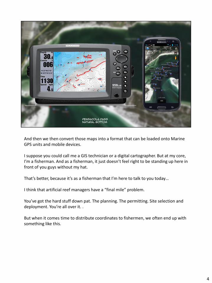
And then we then convert those maps into a format that can be loaded onto Marine GPS units and mobile devices. I suppose you could call me a GIS technician or a digital cartographer. But at my core, I’m a fisherman. And as a fisherman, it just doesn’t feel right to be standing up here in front of you guys without my hat. That’s better, because it’s as a fisherman that I’m here to talk to you today… I think that artificial reef managers have a “final mile” problem. You’ve got the hard stuff down pat. The planning. The permitting. Site selection and deployment. You’re all over it. . But when it comes time to distribute coordinates to fishermen, we often end up with something like this.
4

On the internet, they call stuff like this a “Great Wall of Text.”
5

Here’s why this is a problem. The other night I did an experiment. I printed off a couple pages of coordinates, sat down on the couch to watch “Shark Tank”, and started manually plugging coordinates into a handheld GPS.
6

By the second commercial break, I’d managed to enter 28 coordinates, about 2 per minute. Extrapolating, that means that doing all the reefs in Escambia County would take an entire viewing of March of the Penguins. It would take FIVE ENTIRE SEASONS of Duck Dynasty to enter all the reefs statewide. Do you want that on your conscience?
7

But it gets worse. I loaded those coordinates on the computer to check them for accuracy, and I’d screwed up 17 percent of them while entering them. And I do this stuff for a living. Doing some extrapolating, that means I would have had 32 bunk numbers when I finished in Escambia County, or nearly 500 by the time I finished the state of Florida.
8

Now sure, you could argue that I should have been more careful, and as a GIS professional, I’d say you’re absolutely right. But as a fisherman…
9

…a fisherman who just burned $100 of gas and two hours of daylight looking for a phantom reef, I’m not going to consider that maybe I screwed up. I’m going to be looking for someone to blame! And who are these guys going to blame for the “Bad Coordinates”? YOU GUYS.
10

So how do we fix it? Well, the private sector is doing it’s part to meet the need.
11

Several businesses are selling Florida “Map Chips,” which, in large part, are your Great Wall Of Text coordinates converted into a format that fishermen can actually use. Now, my background is in newspapers and I’m a freedom of information kind of guy. Selling public reef coordinates back to the public always kind of rubbed me the wrong way. So I started thinking about ways of distributing coordinates FOR FREE, in a way that macthed the convenience of the commercial Map chips.
12

The first option that jumps to mind is to have you guys glue free public numbers chip to the back of everyone’s fishing license. But that requires funding, and legislative cooperation, so my “free fish chip” idea is probably about as likely as a federal “Unlimited Red Snapper Stamp,” or a 20 dollar a head lionfish bounty.
13

14

But even if you do get legislative support for free reef chips, then you’ve got to figure out how to make them compatible
15

with hardware from a half dozen different manufacturers, each one with it’s own baffling propriatary format. To be fair, some of these coordinates I just made up, but you get my point.
16

So what CAN you do?
17
Well good news, I already figured it out! I’ve been giving away free “map chip” files for over a year, More than 20,000 people have downloaded, And in the next three minutes, I’m going to teach you how you can do it too!
18

Well good news, I already figured it out! I’ve been giving away free “map chip” files for over a year, More than 20,000 people have downloaded my files, and in the next three minutes, I’m going to teach you how you can do it too!
19

The key element to making GPS compatible files is an up-and-coming file format known as the GPS Exchange, or GPX file. Over the last few years, the GPX format has become the Industry Standard file format for transfering GPS waypoints and track files between different brands of GPS hardware. For you guys, it is a game changer. It works with every major GPS brand, it works with navigation software, it works with mobile devices. For some reason, this file format is still relatively unknown, but everyone in this room should burn it into your memory. GPX
20

Alright, so how do we go from the spreadsheet to this fancy new GPX format?
21

We are going to use a piece of software called QGIS. There’s the website. QGIS is fantastic. It is free. It is incredibly powerful, and it is so much easier to learn than ArcGIS. Constantly upgraded, new features all the time. Excellent online support forums. I love this software, and you should to! Alright, so here’s how we do it. I’m going to move fast here just to show you the process, but I’ve put up a full tutorial video and sample files on my website that will walk you through every step of the process. Once you figure out how to do this, it’s about a 10 minute job, start to finish, including a trip to refil your coffee.
22

Step 1: Clean all the extra “stuff” out of your excel spreadsheet. Strip it down to just a Name column, A comment Column and the coordinates. Step 2: Save your spreadsheet as a CSV text file. Step 3: Import it into QGIS.
23

Step 4, Right click the imported file, select “Save as GPX”, and you’re done! Seriously, that’s it. Post that file online with some basic instructions, and your users can take it from there! If you have a little bit of extra time, and you want to make a kml to send your boss.
24

Right click again, save as KML, this time. And bam. You’ve got a perfectly formatted KML that can be viewed by anyone with google earth. KML files are MADE to work with Google Maps. So you can slap that map on your web site.
25

On that same page, you can post a convenient link to the GPX file that we made a minute ago, and Guess What?
26

You are done!
27

So in closing, I’d like to leave you with a couple of thoughts.
28

The world of digital mapping can seem overwhelming, and in a lot of ways, it really is. Especially if you came into this business more than 3-4 years ago. But that really has begun to change. there’s a renaissance in the digital mapping world right now. Software is getting more powerful, much cheaper and much easier to use. And if you’ve been putting off learning about GIS and digital mapping, now is the time to take another look. I’d like to leave you with a quick show and tell of what’s possible with a with a couple days practice using a 150 dollar piece of software called Reefmaster.
29

If you have a lowrance or humminbird GPS with Side Scan, you already know how easy it is to ground proof reef structure. Well you can also save those sonar files.
30

Taking that to the next level, lets say that you start recording sonar data, and then drive a quasi-straight grid over an entire permitted reef site after a deployment. (by the way, I say quasi straight because I’d just like to point out that this is Horseshoe Reef in Dixie County, and Keith was actually driving during these squiggly tracks right here) But That’s OK! The software is forgiving. You can bring that data back to the office, and load it into reef master to review your track files. Watch this. You can load up all of your sonar tracks
31

Review your data and take measurements of your reefs.
32

Create a mosaic of your side scan sonar tracks.
33

Mark all of your reef structure, and save it to a GPS file that can be used by fishermen! But it gets even more cool.
34

Generate a high res map of bottom contours
35
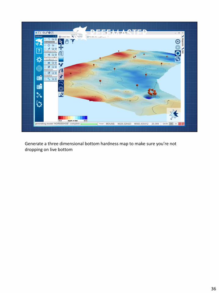
Generate a three dimensional bottom hardness map to make sure you’re not dropping on live bottom
36

And of course the software will spit out clean GPX files for the fishermen,
37

A google earth live bottom map for the permitting folks.
38

A google earth sidescan mosaic for your boss,
39

A shapefile for the guys in the GIS department,
40

A waypoints KML for the website, and last but not least,
41

You can generate a good old fashioned Excel Spreadsheet for your files. Because you never had a problem with spreadsheets in the first place. And if it ain’t broke, there’s no reason to fix it. A few years ago, this kind of capability was in the realm of professional contractors running expensive equipment. Now, you can do it for the price of a good bottom machine and a few hours learning some new software. To be sure, this isn’t going to be the same quality of that professional survey. Absolutely not. But an important question to ask, is how good is good enough. I’ve been marking structure and selling making maps using a method very similar to this for two years now. And I get fish pictures emailed to me every day from customers, that make me think that for our purposes, this method is good as gold. There’s still a learning curve, but I want to urge you guys to give digital mapping another look. Learn a simple process, and you’ll be amazed at what possibilities it opens up.
42

43