Embed Size (px)
Citation preview
1
Geologic structure and petroleum source rocksof the Tucumcari Basin, east-central New Mexico
Ronald F. Broadhead, Karl E. Frisch, and Glen JonesNew Mexico Bureau of Geology and Mineral Resources
A Division of New Mexico Institute of Mining and TechnologySocorro, NM 87801
ABSTRACT
The Tucumcari Basin of east-central New Mexico is an asymmetric structural depression that
existed as a depositional basin from the Atokan (Early Pennsylvanian) through the Wolfcampian (Early
Permian). The deepest parts of the Tucumcari Basin are in elevator basins along the northern margin of the
basin. Depth to Precambrian basement may exceed 10,000 ft in the deepest parts of these elevator basins.
On the shelf areas to the south of the elevator basins, depth to Precambrian ranges from 2,000 to 5,000 ft in
most places.
Two stratigraphic intervals, the San Andres Formation (Permian: Leonardian) and the
Pennsylvanian System have generally been considered as having significant source rocks. Potential source-
bearing strata occur at depths of 500 to 2,500 ft in the San Andres and from 5,000 ft to 10,000 ft in the
Pennsylvanian.
The San Andres is a poor to marginal source rock throughout the Tucumcari Basin. Potential
source facies are dark-gray limestones. Total organic carbon (TOC) levels within San Andres source facies
are less than 0.5 percent throughout most of the basin, barely adequate for petroleum generation. Thermal
maturity of the San Andres is also insufficient for petroleum generation throughout most of the basin.
Pennsylvanian shales are good to excellent source rocks of gas, oil, and condensate. Source facies
are dark-gray to black shales and thin shaly coals. Shales in the elevator basins are thicker and have
enhanced TOC levels. Within the elevator basins, the shales have TOC levels in excess of 2 percent in most
places and in the 6 to 10 percent range over large areas. Shaly coals, unknown from outside the elevator
basins, have TOC levels approaching 50 percent.
Thermal maturity of Pennsylvanian strata is also enhanced within the elevator basins. Throughout
the shelf areas, source facies are only marginally mature. Within the elevator basins, however, deeper burial
resulted in enhanced thermal maturity and the Pennsylvanian source facies are within the oil and
condensate windows.
INTRODUCTION
This report presents and summarizes digital data and maps concerning geologic structure,
petroleum source rock attributes, and oil and natural gas well data of the Tucumcari Basin, east-central
2
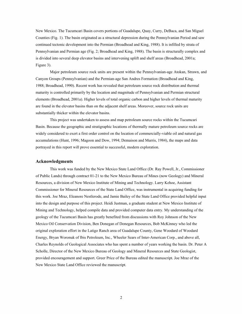
New Mexico. The Tucumcari Basin covers portions of Guadalupe, Quay, Curry, DeBaca, and San Miguel
Counties (Fig. 1). The basin originated as a structural depression during the Pennsylvanian Period and saw
continued tectonic development into the Permian (Broadhead and King, 1988). It is infilled by strata of
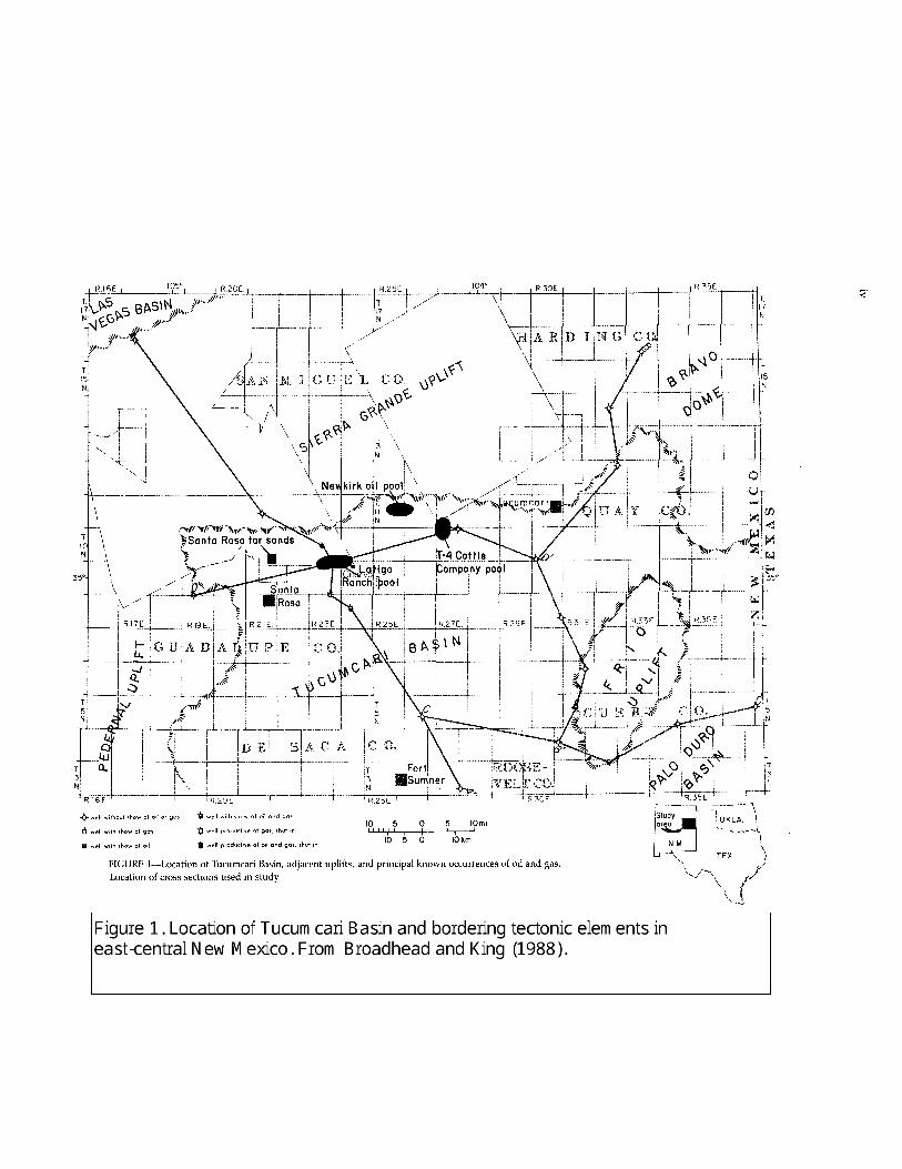
Pennsylvanian and Permian age (Fig. 2; Broadhead and King, 1988). The basin is structurally complex and
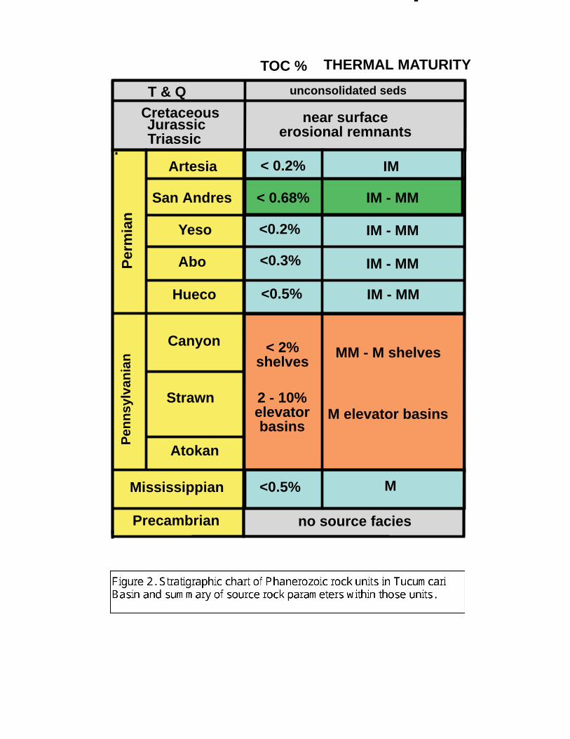
is divided into several deep elevator basins and intervening uplift and shelf areas (Broadhead, 2001a;
Figure 3).
Major petroleum source rock units are present within the Pennsylvanian-age Atokan, Strawn, and
Canyon Groups (Pennsylvanian) and the Permian-age San Andres Formation (Broadhead and King,
1988; Broadhead, 1990). Recent work has revealed that petroleum source rock distribution and thermal
maturity is controlled primarily by the location and magnitude of Pennsylvanian and Permian structural
elements (Broadhead, 2001a). Higher levels of total organic carbon and higher levels of thermal maturity
are found in the elevator basins than on the adjacent shelf areas. Moreover, source rock units are
substantially thicker within the elevator basins.
This project was undertaken to assess and map petroleum source rocks within the Tucumcari
Basin. Because the geographic and stratigraphic locations of thermally mature petroleum source rocks are
widely considered to exert a first order control on the location of commercially-viable oil and natural gas
accumulations (Hunt, 1996; Magoon and Dow, 1994; Demaison and Murris, 1984), the maps and data
portrayed in this report will prove essential to successful, modern exploration.
Acknowledgments
This work was funded by the New Mexico State Land Office (Dr. Ray Powell, Jr., Commissioner
of Public Lands) through contract 01-21 to the New Mexico Bureau of Mines (now Geology) and Mineral
Resources, a division of New Mexico Institute of Mining and Technology. Larry Kehoe, Assistant
Commissioner for Mineral Resources of the State Land Office, was instrumental in acquiring funding for
this work. Joe Mraz, Eleanore Nestlerode, and Jamie Bailey of the State Land Office provided helpful input
into the design and purpose of this project. Heidi Justman, a graduate student at New Mexico Institute of
Mining and Technology, helped compile data and provided computer data entry. My understanding of the
geology of the Tucumcari Basin has greatly benefited from discussions with Roy Johnson of the New
Mexico Oil Conservation Division, Ben Donegan of Donegan Resources, Bob McKinney who led the
original exploration effort in the Latigo Ranch area of Guadalupe County, Gene Woodard of Woodard
Energy, Bryan Woronuk of Ibis Petroleum, Inc., Wheeler Sears of Inter-American Corp., and above all,
Charles Reynolds of Geological Associates who has spent a number of years working the basin. Dr. Peter A
Scholle, Director of the New Mexico Bureau of Geology and Mineral Resources and State Geologist,
provided encouragement and support. Greer Price of the Bureau edited the manuscript. Joe Mraz of the
New Mexico State Land Office reviewed the manuscript.
T & QCretaceousJurassicTriassic
Per
mia
nP
enns
ylva
nian
Artesia
San Andres
Yeso
Abo
Hueco
Atokan
MM - M shelves
M elevator basins
IM
IM - MM
IM - MM
IM - MM
IM - MM
M
< 0.2%
< 0.68%
<0.2%
<0.3%
<0.5%
near surfaceerosional remnants
unconsolidated seds
< 2%shelves
<0.5%
no source facies
Strawn
Mississippian
Precambrian
2 - 10%elevatorbasins
Canyon
THERMAL MATURITYTOC %
3
STRUCTURE MAPS
Two geologic structure maps were prepared for this project. The maps are presented in ARCMAP
and ARCVIEW format in separate files on this CD-ROM as well as within this text. One map depicts
structures mappable at the ground surface (surface structures) that have been mapped and reported in the
published literature (Figure 4). The second map is a structure contour map that indicates the structural
configuration of the top of Precambrian basement (Figure 5).
Surface structure map
This map (Fig. 4) shows geologic structures mapped at the surface in the Tucumcari Basin.
Shown are anticlines, synclines, and faults that appear on published maps. The structural features on this
map were compiled from the published literature (Bates, 1942; Bureau of Economic Geology, 1978, 1983;
Darton, 1928; Dobrovolny et al., 1946; Kelley, 1972a; Winchester, 1933). Portrayed features are limited to
structures that may act as hydrocarbon traps. Surface structures are summarized in a Microsoft Excel
database (Tucumcari surface structures.xls) that accompanies this report. Regional structures such as
monoclines are not shown. The regional structures are portrayed better on the structural contour map of the
Precambrian basement as well as published structure contour maps of the San Andres Formation
(Broadhead, 1984) and the Abo Formation (Broadhead and King,1988).
The anticlines, synclines, and faults appear to be predominantly Laramide (Late Cretaceous
through Early Tertiary) in age. The observation that several of these structures in central Quay County
disappear southward under the Ogallala Formation (Tertiary) and have no expression within the Ogallala
(Bates, 1942) is evidence for a pre-Ogallala age. These structures involve deformation of Triassic strata,
and in some cases Late Cretaceous strata (Bates, 1942). This involvement of Late Cretaceous strata is
evidence that the structures saw substantial movement during the latest Cretaceous or pre-Ogallala Tertiary.
Hence, they appear to be predominantly of Laramide origin. Many of the surface structures probably
represent Laramide reactivation of Late Paleozoic structures of the Ancestral Rocky Mountains
(Broadhead, 2001a, 2001b, 2001c). Many of the anticlinal features may represent movement or drape of
strata over fault blocks of late Paleozoic age (Dobrovolny et al., 1946) and appear to be concentrated over
or near large buried faults of the Ancestral Rocky Mountains.
San Miguel Guadalupe
Harding
DeBaca Roosevelt
Quay
Curry
Tucumcari
Logan
SantaRosa
Fort Sumner
Faults
Dikes
Anticlines
North Edge CaprockNew Mexico
Areashown
0 5025
0 25 50 Miles
75 Kilometers
Surface Structures
25
00
-
-
--
4000
-- 30 0 0
0
15
00
10
00
25
00
0
25
00
2
50
0
50
0
-
l l l l l l
l l l l l l
l l l l l l l l l l
l
l l
l l
l l
l l
l l l l
l
l l l l l l l
l l l l l l l l l l l
l
l
l l
l l
l l
l l
l l
l l
l l l
l l
l l l
l l
l l l
l l
l
l l l
l l
l l
l l l
l ll l
l l
l l l l l l
l
l l
l l l l l l l l l l
l
l
l l l
�2
00
0
�
0
2 0 0 01
00
0
�1
0 0 0�
�2000
� 3 0 00
�
�400
0
�
�3
000
�2 0
00
�
�2
50
0
�3000
�3
00
0
�
�2
00
0
�
�
� �
�
4000
� �
20
00
�
0
0
2 0 0 0
�
�
0
1000
2000
40
00
4000
3000
�5
00
0
�25
00
15
00
�1
00
0
25
00
-
-
-
3500
-
- - --
-50 00
-
-
-40
00
-
-
-
-
l l l l l l
- -
-
1000 -
500
l
l l l l l l l l
l l
San
Mig
uel
Gua
dalu
pe
Hard
ing
DeBa
caRo
osev
elt
Qua
y
Curry
Tucu
mca
ri
Loga
n
Sant
aRo
sa
Fort
Sum
ner
Faul
t
Thru
st
Wel
l
Cont
our a
bove
sea
leve
l
Cont
our b
elow
sea
leve
l
Cont
our i
nter
val =
500
feet
New
Mex
icoArea
show
n
050
25
025
50 M
iles
75 K
ilom
eter
s
Prec
ambr
ian
Stru
ctur
e
4
Precambrian structure contour map
Contouring techniques: This map shows the structural configuration of the upper surface of Precambrian
basement in the Tucumcari Basin. This map is modified from an earlier published map (Broadhead and
King, 1988) and reflects the utilization of additional data not available when the earlier map was prepared.
Primary data are from petroleum exploration wells drilled into basement (see accompanying database
Tucumcari well data.xls). In these wells, depth to Precambrian was identified from geophysical borehole
logs and sample logs on file at the New Mexico Bureau of Mines and Mineral Resources. Where depth to
basement could not be unambiguously determined from these data sources, drill cuttings and core were
examined to determine depth to Precambrian. Because the Precambrian basement in the basin is variously
composed of granitic rocks, gabbros, diabases, bedded rhyolites and metasediments, geophysical logs do
not always yield a unique and unambiguous response through the Precambrian section and examination of
samples is essential for determination of depth to Precambrian. Furthermore, several wells in the basin were
drilled prior to the invention and common use of geophysical borehole logs and drill cuttings are the only
information available on the lithology of penetrated rocks.
Contouring was aided by several other types of data. These other data sources include the mapped
surface structures previously discussed, seismic reflection lines, regional Bouguer gravity anomaly maps,
surface drainages (streams), and regional aeromagnetic anomaly maps.
Seismic reflection lines were available from the north-central and eastern portions of the basin. In
the eastern part of the Cuervo sub-basin, several seismic lines were made available by Mr. Gene Woodard
of Woodard Energy Company. These proved invaluable in identifying and mapping faults in the subsurface
and in contouring this area. The structure map is more detailed in the vicinity of those seismic lines.
Several regional seismic lines were examined from the eastern part of the basin and were used as general
guides to contouring in this area although the exact locations of these lines are unknown to the author. In
addition, Montgomery (1986) presented some structure maps of parts of the Cuervo sub-basin which were
incorporated into the regional map produced as part of this report. His maps were at least in part based
upon seismic reflection lines.
Bouguer gravity data were used to aid in contouring basinal areas, uplift areas, and fault locations.
The regional gravity anomaly map of Keller and Cordell (1983) was used for this project. Regional gravity
anomalies were found to correspond to larger-scale variations in basement structure as defined by well data
and seismic data.
Seismic data revealed that many surface drainage features (streams) coincide with deeper faults of
Pennsylvanian and Wolfcampian (Early Permian) age. Although the seismic lines do not indicate fault
movement in post-Wolfcampian strata, the coincidence with surface drainage features suggests that subtle
Laramide or post-Laramide tectonic movements reactivated late Paleozoic structures and resulted in slight
displacement of rocks at the ground surface. In places, streams utilized the lines of weakness provided by
these fault lines. To aid in the process of geomorphic interpretation of faults, linear stream segments were
identified on 1:250,000 scale topographic maps. These geomorphic features were used to aid in fault
5
location where precise seismic data were not available but where well data and gravity data indicated a
fault is present.
Use of the above-described procedures resulted in a structure contour map that has better
definition of buried fault blocks and configuration of the Precambrian surface than previously published
maps (Broadhead and King, 1988; Montgomery, 1986; Foster et al., 1972; Foster and Stipp, 1961). Also of
use were generalized structure contour maps of the Precambrian surface in the Texas panhandle (Dutton et
al., 1982; Rose, 1986). Major structural elements on the Texas maps were projected into adjacent areas of
New Mexico.
An attempt was made to utilize residual aeromagnetic anomaly maps in the contouring process.
These maps were obtained from Cordell (1983) as well as a more recent unpublished map acquired from
the U.S. Geological Survey during 2001. However, it was determined that these aeromagnetic anomaly
maps do not correspond to Precambrian structure data obtained from wells. Because the well data are
considered to be both definite and determinate, it was concluded that the aeromagnetic data represent large-
scale variations in the magnetic composition of the Precambrian basement and do not generally represent
variations in structural elevation of the Precambrian surface. Therefore, the aeromagnetic data were not
used as a contouring guide.
Precambrian structure: The Tucumcari Basin (Figures 3, 5) is an asymmetric structural depression that
existed as a depositional basin from the Atokan (Early Pennsylvanian) through Wolfcampian (Early
Permian). The basin covers an area of approximately 5,000 mi2. The Tucumcari Basin is bordered on its
northern, eastern, and western sides by uplifts of the Ancestral Rocky Mountains. To the north and
northwest, the Sierra Grande uplift separates the Tucumcari Basin from the Pecos Shelf of Baltz and Myers
(1999). To the northeast, the Bravo dome separates the basin from the Dalhart Basin of the Texas
panhandle. To the east, the Frio uplift (Roberts et al., 1976) separates the Tucumcari Basin from the Palo
Duro Basin of the Texas panhandle. To the west, the San Ignacio platform of Reynolds and Reynolds (in
press) separates the Tucumcari Basin from the Vaughn Basin. The Pedernal uplift, a major north-south
trending tectonic element of the Ancestral Rocky Mountains, lies to the west of the Vaughn Basin. On the
south flank of the Tucumcari Basin, a gentle arch separates the Tucumcari Basin from the northwest shelf
of the Permian Basin.
The internal structure of the Tucumcari Basin is complex and is comprised of several tectonic
elements (Figure 3). The northern part of the basin is subdivided into several deep, fault-bounded elevator
basins and intervening shelf areas and uplifts (Broadhead, 2001a). The southern part of the basin is
characterized by a shelf -like setting with structures that are less pronounced than in the north. The deepest
parts of the basin are in the elevator basins to the north where depth to Precambrian basement may exceed
10,000 ft.
Elevator basins are defined as long, narrow, and structurally deep troughs bounded by high-angle
faults (Broadhead 2001a, 2001b, 2001c). They are typically 20 to 50 miles long and 5 to 15 miles wide.
6
Bounding faults have vertical offsets that can exceed 5,000 ft. Internally, elevator basins may be
structurally complex with internal grabens, horsts, tilted half-grabens, and anticlines. Known elevator
basins adjoin uplifts of the Ancestral Rocky Mountains. The axes of the elevator basins may be either
elongate parallel to the axes of adjoining Ancestral Rocky Mountains uplifts or they may be oblique to the
uplifts. If oblique, they are incised into the flanks of those uplifts. The basins with axes elongate parallel to
the uplifts appear to be pull-apart structures formed along strike-slip faults of regional extent (see Dooley
and McClay, 1997; Nilsen and Sylvester, 1995; Broadhead, 2001a). The basins that are oblique to the
adjoining uplifts have an enigmatic origin that is not well understood (Broadhead, 2001a) but appear to be
tied to a regional northwest-southeast system of basement-involved faults that has been identified by Hills
(1970), Stevenson and Baars (1986), Wilson and Jordan (1988), Ye et al (1996), and Baltz and Myers
(1999).
There are four elevator basins within the northern part of the Tucumcari Basin (Figure 3). Two of
these, the Cuervo sub-basin and the Quay sub-basin, are elongate parallel to the Sierra Grande uplift. The
other two, the Trementina and Trigg Ranch sub-basins, are elongate perpendicular to the Sierra Grande
uplift and cut into its southern flank. Unpublished seismic data furnished by Gene Woodard suggest depth
to Precambrian basement may exceed 10,000 ft in the deepest, undrilled eastern parts of the Cuervo sub-
basin. Precambrian basement lies at depths exceeding 9,000 ft in the Quay sub-basin. In the Trementina and
Trigg Ranch sub-basins, depth to Precambrian exceeds 7,000 ft.
The shelf to the south of the Cuervo and Quay sub-basins is characterized by a gentle, northward-
inclined regional dip. High-angle faults of relatively small displacement cut across this shelf. The shelf may
be more structurally complex than portrayed, but a lack of reflection seismic lines caused the contouring to
be accomplished in a general manner in this area but both the well data and the gravity data indicate less
complexity than in the elevator basins. To the west, the shelf rises upward onto the San Ignacio platform.
On the San Ignacio platform, the stratigraphic section is attenuated and Pennsylvanian and Permian strata
are thinner than in the Tucumcari Basin to the east.
The Frio uplift separates the eastern side of the Tucumcari Basin from the Palo Duro Basin. The
Frio uplift is structurally complex and is comprised of several tilted fault blocks formed dominantly by
northeast-southwest trending faults. Pennsylvanian strata are absent over the highest parts of the uplift and
Wolfcampian (Lower Permian strata are substantially thinner than in the basin (Broadhead and King,
1988).
Relationship of stratigraphy to structure: The major tectonic movements that formed the Tucumcari Basin
were Pennsylvanian and Wolfcampian (Early Permian) in age (Broadhead and King, 1988). Mississippian
lithofacies are unrelated to the tectonic architecture of the basin. Therefore, Mississippian strata are
apparently pre-basinal. Pennsylvanian and Wolfcampian strata exhibit lithofacies trends that are controlled
by tectonic elements that evolved during the late Paleozoic. The elevator basins (Cuervo, Quay,
Trementina, Trigg Ranch) and the various uplifts (Sierra Grande, Pedernal, and Frio uplifts and the San
7
Ignacio platform) were particularly influential on the distribution of facies belts in Pennsylvanian and
Wolfcampian strata. Lithofacies tracts in post-Wolfcampian strata seem little affected by tectonic
framework. It is possible that subtle effects of subdued basin topography and bathymetry are present but
unrecognized in Middle and Upper Permian strata and in the Triassic as well. The conglomerates and sands
of the Ogallala Formation (Tertiary) record a major episode of uplift of the entire area with greater uplift in
the west and the formation of the Rocky Mountains to the west of the Tucumcari Basin; the Rocky
Mountains provided the source area for the Ogallala sediments (Frye et al., 1982). Although the Ogallala is
a major aquifer in the region, it is very shallow or occurs as erosional remnants at the surface and is
therefore unimportant to the occurrence or distribution of oil and gas resources in the region.
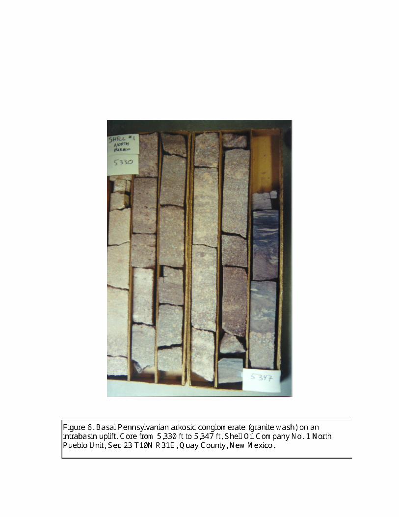
Pennsylvanian depositional elements are strongly influenced by geographic proximity to uplifts,
elevator basins, and shelf areas (Broadhead and King, 1988; Broadhead 2001a, 2001c). On the flanks of the
uplifts, Pennsylvanian strata consist primarily of arkosic conglomerates and coarse-grained sandstones
(Figure 6). Interbedded gray to red shales are common, but decrease as a percentage of the section on the
flanks and crests of the uplifts.
Lithofacies within the elevator basins are marine and marginal marine. Dark-gray to black shales
with marine fossils are present in sections several hundred feet thick. These are source rocks in the elevator
basins. Fluvial to deltaic, arkosic sandstones that are somewhat finer grained than those found on adjoining
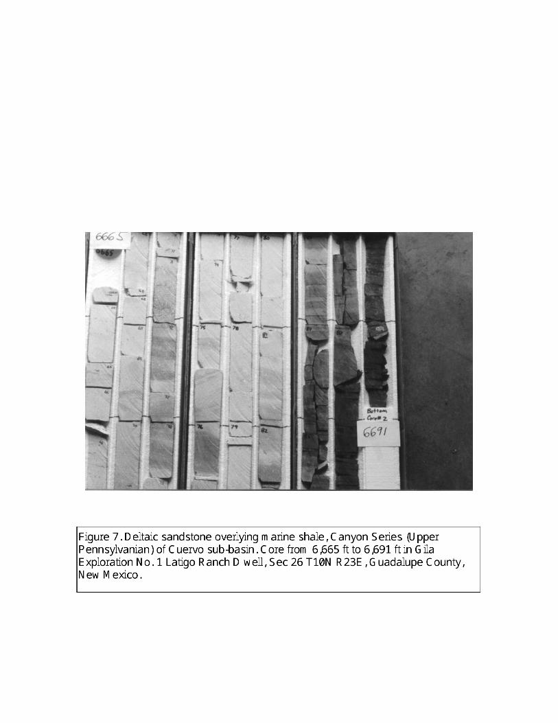
uplifts are interbedded with the shales (Figure 7). Thin coals are also interbedded with the shales in the
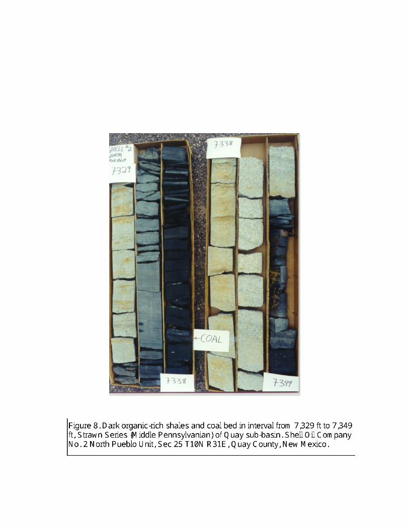
elevator basins (Figure 8).
Lithofacies on the shelf areas consist of interbedded gray to red shales, limestones, dolomitic
limestones, and fine-to medium-grained sandstones. The shales are thinner than in the elevator basins.
Sandstones are also more thinly bedded than in the elevator basins and are also fine grained. Limestones
and dolomitic limestones are low- to high-energy types.
The Wolfcampian (Lower Permian) section consists primarily of interbedded arkosic sandstones,
conglomerates, and red shales. Gray shales are present in the Hueco Group in the lower part of the
Wolfcampian. Conglomerates and coarse-grained fluvial to alluvial sandstones predominate on top of
uplifts and on the flanks of uplifts. Fine-grained fluvial sandstones and red shales predominate in the more
distal reaches of the depositional system in the central and southern parts of the Tucumcari Basin.
8
PETROLEUM SOURCE ROCKS
Introduction: A petroleum source rock can be defined as any unit of rock that has generated and expelled
oil and/or gas in commercial quantities (Hunt, 1996). When assessing source-rock potential, four questions
must be answered (Dow, 1978; Barker, 1980; Brooks et al., 1987; Hunt, 1996). First, does the rock have
sufficient organic matter? Second, is the organic matter capable of generating petroleum and, if so, is it oil
prone or gas prone? Third, is the organic matter thermally mature? Fourth, have generated hydrocarbons
been expelled from the rock?
The question of whether or not the rock has sufficient organic matter to be a source rock can be
answered on the basis of total organic carbon (TOC) measurements. Rocks that have insufficient TOC
content can be rule out as possible source rocks. Jarvie (1991) has summarized TOC ratings systems for
screening potential source rocks (Table 1). The TOC content needed for petroleum generation is thought to
be greater in siliciclastic shales than in carbonate source rocks.
The second question asks what type of organic matter is present within the rock. The type of
organic matter, if present in sufficient quantity, will determine if a source rock will produce principally oil
or principally gas upon maturation (Table 2). For this project, identification of organic-matter type was
based mainly on petrographic analyses of kerogen concentrate. Algal, herbaceous, and much amorphous
kerogen (kerogen types I and II) will generate oil and associated gas upon maturation (Hunt, 1996; Brooks
et al., 1987; Tyson, 1987). Woody kerogen (kerogen type III) and some amorphous kerogen will generate
gas and possibly a minor amount of oil or condensate upon maturation. Inertinites are type IV kerogens that
have extremely low hydrogen contents and are incapable of generating significant amounts of
hydrocarbons. Although it is possible to differentiate kerogen types I, II, and III using Rock-Eval pyrolysis
(e.g. Tissot and Welte, 1978; Peters, 1986), some type III kerogens may be confused with other types of
kerogens and result in misleading characterization of kerogen types when using pyrolysis (Tyson, 1987).
Oxidation of kerogen may also alter its Rock-Eval character. Also, pyrolysis can not discern the different
varieties of kerogens present in samples with mixed kerogen assemblages. For these reasons, Rock-Eval
pyrolysis was used only as reinforcement for petrographically determined kerogen identification.
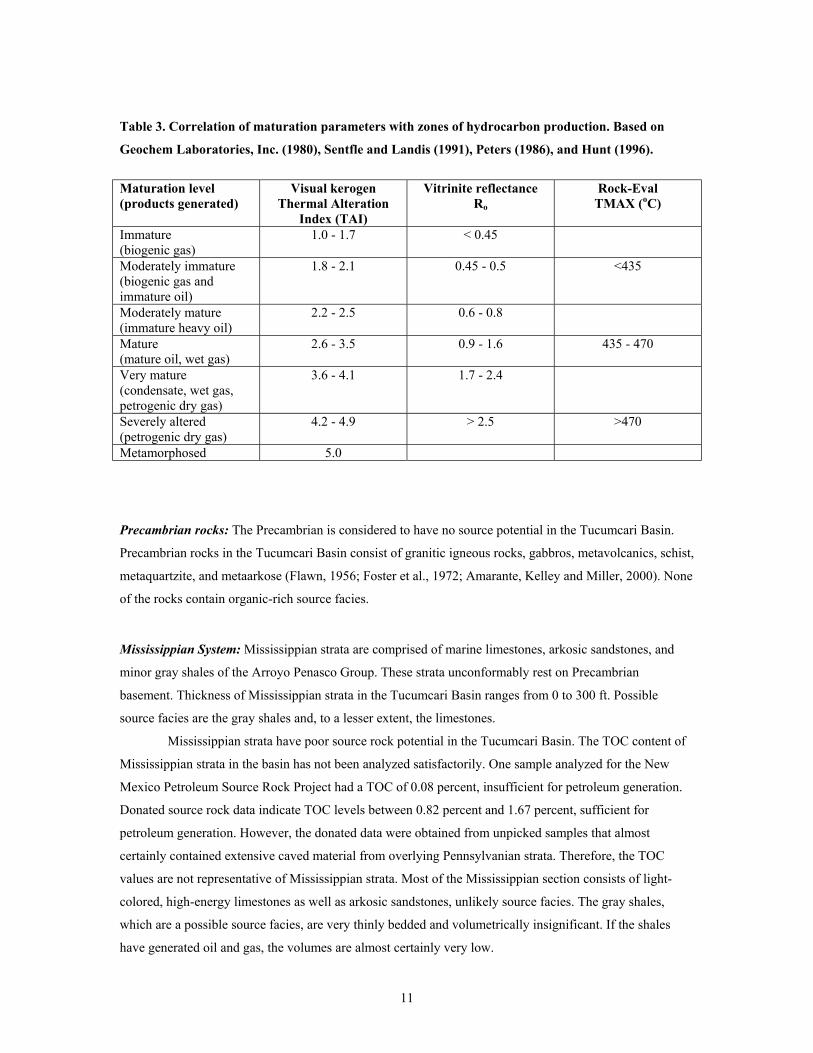
The level of thermal maturity was evaluated primarily using visual kerogen analyses. For the
Petroleum Source Rock Project and for the analyses made specifically for this project, the color of the
kerogen concentrate was analyzed. Kerogen color changes from yellow to orange to brown to black with
increasing maturation (Staplin, 1969). Based on calibrated color charts, the sample is assigned a numerical
value (Thermal Alteration Index or TAI) which ranges from 1.0 (immature) to 5.0 (metamorphosed; Table
3).
Vitrinite reflectance (Ro) is a measure of the percentage of incident light that is reflected from the
surface of vitrain, a type of woody kerogen. It can be used to assess thermal maturity of a source rock and
is a standard measurement of maturity. Essentially, at vitrinite reflectance increases with thermal maturity
9
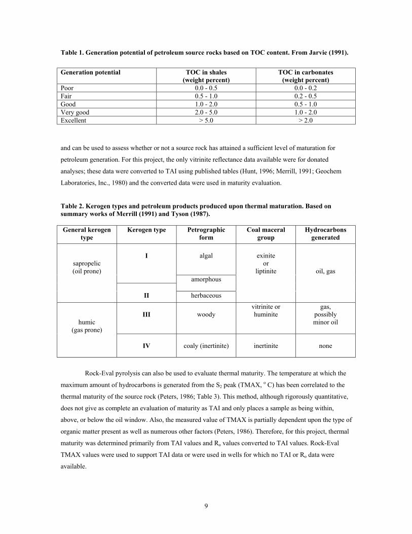
Table 1. Generation potential of petroleum source rocks based on TOC content. From Jarvie (1991).
Generation potential TOC in shales(weight percent)
TOC in carbonates(weight percent)
Poor 0.0 - 0.5 0.0 - 0.2Fair 0.5 - 1.0 0.2 - 0.5Good 1.0 - 2.0 0.5 - 1.0Very good 2.0 - 5.0 1.0 - 2.0Excellent > 5.0 > 2.0
and can be used to assess whether or not a source rock has attained a sufficient level of maturation for
petroleum generation. For this project, the only vitrinite reflectance data available were for donated
analyses; these data were converted to TAI using published tables (Hunt, 1996; Merrill, 1991; Geochem
Laboratories, Inc., 1980) and the converted data were used in maturity evaluation.
Table 2. Kerogen types and petroleum products produced upon thermal maturation. Based onsummary works of Merrill (1991) and Tyson (1987).
General kerogentype
Kerogen type Petrographicform
Coal maceralgroup
Hydrocarbonsgenerated
sapropelic(oil prone)
I algal exiniteor
liptinite oil, gasamorphous
II herbaceous
humic(gas prone)
III woodyvitrinite orhuminite
gas,possiblyminor oil
IV coaly (inertinite) inertinite none
Rock-Eval pyrolysis can also be used to evaluate thermal maturity. The temperature at which the
maximum amount of hydrocarbons is generated from the S2 peak (TMAX, o C) has been correlated to the
thermal maturity of the source rock (Peters, 1986; Table 3). This method, although rigorously quantitative,
does not give as complete an evaluation of maturity as TAI and only places a sample as being within,
above, or below the oil window. Also, the measured value of TMAX is partially dependent upon the type of
organic matter present as well as numerous other factors (Peters, 1986). Therefore, for this project, thermal
maturity was determined primarily from TAI values and Ro values converted to TAI values. Rock-Eval
TMAX values were used to support TAI data or were used in wells for which no TAI or Ro data were
available.
10
The fourth question concerns the expulsion of generated hydrocarbons from the source rock. This
question is more difficult to answer than the other three questions. For the most part, studies of thermal
maturity of a source rock are empirically correlated with the presence of oil in associated reservoirs. It is
generally assumed that once a sufficient volume of hydrocarbons have been generated in a source rock,
they will be expelled and migrate into reservoirs. Reservoirs that are thinly interbedded with reservoirs will
expel hydrocarbons at lower levels of thermal maturity than thick source rocks that contain few or no
interbedded reservoirs (Leythauser et al., 1980; Cornford et al., 1983; Lewan, 1987).
Two gross stratigraphic intervals, the Pennsylvanian section and the San Andres Formation
(Permian), have generally been considered by industry and by the literature (Broadhead, 1990;
Montgomery, 1986) as having source potential in the Tucumcari Basin. Source rock data presented in the
accompanying Source Rock Database (Tucumcari source rock data.xls) indicate that other stratigraphic
units generally have insufficient levels of organic carbon to have generated significant volumes of
hydrocarbons, although it is possible that localized accumulations of oil or gas were generated within
Hueco (Permian: Wolfcampian) or Yeso (Permian: Leonardian) strata. Therefore, mapping and analysis
were concentrated on the Pennsylvanian section and on the San Andres Formation, although a summary of
the source potential of all major stratigraphic units is presented. Two types of source rock maps were
prepared for the major postulated source units. One map type shows regions of TOC content. The other
map type shows levels of thermal maturity. The data used in map production are presented in the Petroleum
Source Rock Database. Analytical and sampling procedures are discussed in Appendix III. These source
rock maps are also presented as ARCMAP and ARCVIEW files on this CD-ROM. Maps that show regions
of TOC content were prepared from the total organic carbon measurements. Mapped regions indicate
generative potential of source facies. When more than one TOC analysis was available from a well, the one
with the maximum TOC content was used in map preparation. Most of the analyses were performed on
drill cuttings from composite 100 ft intervals because of limited volumes of cuttings available for analytical
work. The TOC analyses should therefore generally be considered as the average TOC of source facies
within the sampled depth interval with actual TOC contents bracketing the average value. If the measured
TOC content is, for example 3.2 percent, actual TOC values within source strata in the sample interval
probably exceed 3.2 percent in some source beds and are less than 3.2 percent in other source beds.
11
Table 3. Correlation of maturation parameters with zones of hydrocarbon production. Based on
Geochem Laboratories, Inc. (1980), Sentfle and Landis (1991), Peters (1986), and Hunt (1996).
Maturation level(products generated)
Visual kerogenThermal Alteration
Index (TAI)
Vitrinite reflectanceRo
Rock-EvalTMAX (oC)
Immature(biogenic gas)
1.0 - 1.7 < 0.45
Moderately immature(biogenic gas andimmature oil)
1.8 - 2.1 0.45 - 0.5 <435
Moderately mature(immature heavy oil)
2.2 - 2.5 0.6 - 0.8
Mature(mature oil, wet gas)
2.6 - 3.5 0.9 - 1.6 435 - 470
Very mature(condensate, wet gas,petrogenic dry gas)
3.6 - 4.1 1.7 - 2.4
Severely altered(petrogenic dry gas)
4.2 - 4.9 > 2.5 >470
Metamorphosed 5.0
Precambrian rocks: The Precambrian is considered to have no source potential in the Tucumcari Basin.
Precambrian rocks in the Tucumcari Basin consist of granitic igneous rocks, gabbros, metavolcanics, schist,
metaquartzite, and metaarkose (Flawn, 1956; Foster et al., 1972; Amarante, Kelley and Miller, 2000). None
of the rocks contain organic-rich source facies.
Mississippian System: Mississippian strata are comprised of marine limestones, arkosic sandstones, and
minor gray shales of the Arroyo Penasco Group. These strata unconformably rest on Precambrian
basement. Thickness of Mississippian strata in the Tucumcari Basin ranges from 0 to 300 ft. Possible
source facies are the gray shales and, to a lesser extent, the limestones.
Mississippian strata have poor source rock potential in the Tucumcari Basin. The TOC content of
Mississippian strata in the basin has not been analyzed satisfactorily. One sample analyzed for the New
Mexico Petroleum Source Rock Project had a TOC of 0.08 percent, insufficient for petroleum generation.
Donated source rock data indicate TOC levels between 0.82 percent and 1.67 percent, sufficient for
petroleum generation. However, the donated data were obtained from unpicked samples that almost
certainly contained extensive caved material from overlying Pennsylvanian strata. Therefore, the TOC
values are not representative of Mississippian strata. Most of the Mississippian section consists of light-
colored, high-energy limestones as well as arkosic sandstones, unlikely source facies. The gray shales,
which are a possible source facies, are very thinly bedded and volumetrically insignificant. If the shales
have generated oil and gas, the volumes are almost certainly very low.
12
Pennsylvanian System: Pennsylvanian strata are Atokan (Early Pennsylvanian) through Missourian (Late
Pennsylvanian) in age throughout the Tucumcari Basin (Broadhead and King, 1988). These strata are
significantly thicker in the elevator basins than on the adjacent shelves and are for the most part absent
from the uplifts adjacent to the basin (Broadhead and King, 1988; Broadhead, 2001a). Pennsylvanian strata
are absent from the uplifts that border the basin. Generally, Pennsylvanian strata in the elevator basins
consist of fine- to coarse-grained arkosic sandstones and conglomerates (granite wash) and dark-gray to
black shales. Thickness exceeds 4,000 ft in the deepest parts of the elevator basins. Pennsylvanian strata on
the shelves consist of limestones, red to dark-gray shales, fine- to medium-grained arkosic sandstones, and
minor dolostones. Thickness of Pennsylvanian strata varies from 500 ft to 1,500 ft in shelf areas. The dark-
gray to black shales constitute the organic-rich source facies and are substantially thicker in the elevator
basins than on the shelves. Thin coal beds have also been identified in the elevator basins but not on the
shelves. These coal beds, where mature, are also source rocks.
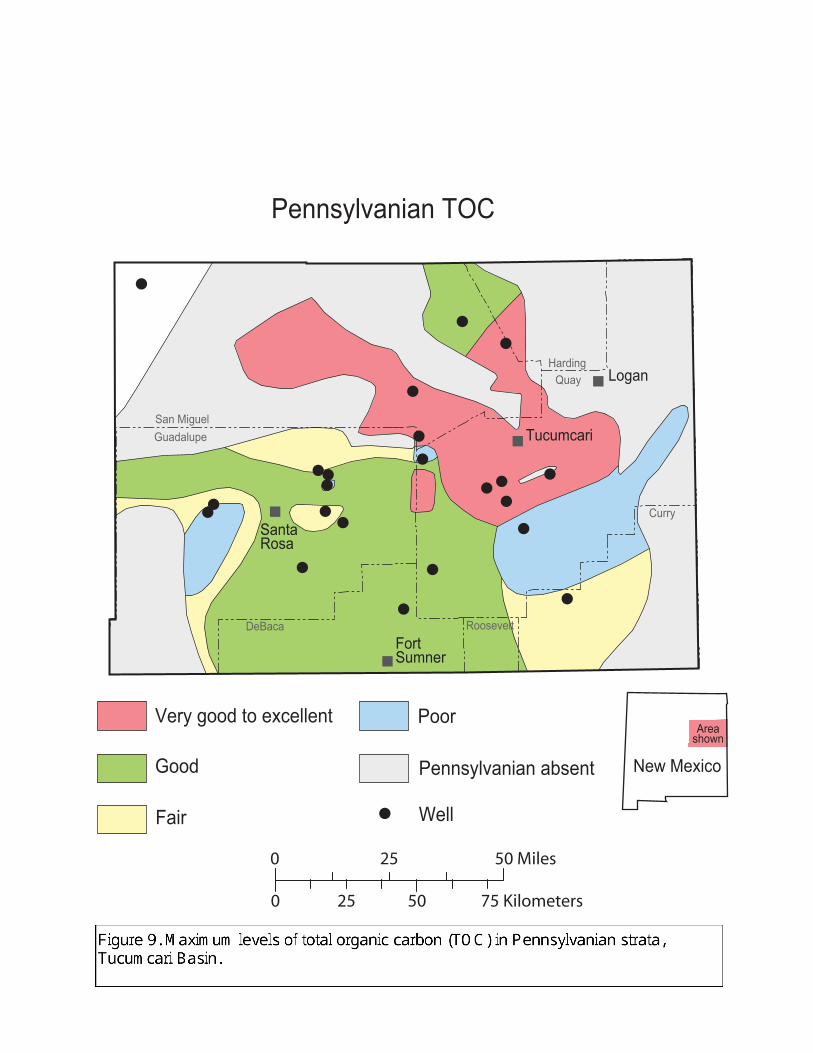
The Pennsylvanian section contains good to excellent organic-rich source rocks throughout large
portions of the Tucumcari Basin. The elevator basins contain thick shale sections in which 100 ft composite
samples of cuttings have in excess of 2 percent TOC in most places and TOC levels in the 6 to 10 percent
range throughout large areas (Figure 9). shaly coals have TOC levels approaching 50 percent. Source facies
in the Quay, Trementina, and Trigg Ranch sub-basins have the highest levels of organic carbon. The
Cuervo sub-basin has lower, but still good, levels of organic carbon that approach 2 percent in some
samples. The deepest parts of the Cuervo sub-basin remain unsampled and most of this sub-basin remains
untested by drilling. Unsampled, undrilled areas may contain higher levels of TOC than have been
identified because the geologic setting is similar to the other elevator basins.
The shelf to the south of the elevator basins has good generation potential with levels of organic
carbon in the 1 to 2 percent range. Only the eastern part of the basin in southeastern Quay and Curry
Counties has inadequate (<0.5 percent TOC) to marginally adequate (0.5 to 1.0 percent TOC) levels of
organic carbon in the Pennsylvanian section. This is the western flank of the Frio uplift where the
Pennsylvanian section is thin and strata are dominated by sandstones and carbonates and not by shale
source rocks (Broadhead and King, 1988).
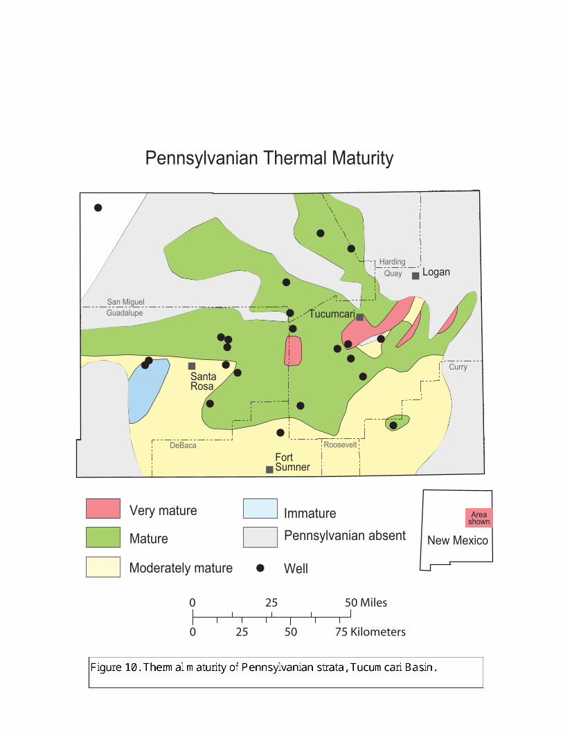
Thermal maturity of Pennsylvanian strata is sufficient for petroleum generation throughout most
of the Tucumcari Basin (Figure 10). In the northern parts of the basin, source rocks are mature and in the
oil window with TAI values between 2.7 and 3.5 in most places. Maturity is greatest in the deepest parts of
the elevator basins. The lower part of the Pennsylvanian section is within the condensate window in the
Quay sub-basin with Rock-Eval TMAX values exceeding 470o C. The deeper parts of the Cuervo sub-basin
may also be within the condensate window.
On the shelf areas in the southern part of the Tucumcari Basin, Pennsylvanian source rocks are
marginally mature with TAI values between 2.2 and 2.5. In this area the source facies have, perhaps,
generated heavier oils. Because peak generation has not been attained, the source facies in this area have
New Mexico
Areashown
Tucumcari
Logan
SantaRosa
Fort Sumner
Good
Very good to excellent Poor
Fair
Pennsylvanian absent
Well
Pennsylvanian TOC
San Miguel Guadalupe
Harding
DeBaca Roosevelt
Quay
Curry
0 5025
0 25 50 Miles
75 Kilometers
San Miguel Guadalupe
Harding
DeBaca Roosevelt
Quay
Curry
Tucumcari
Logan
SantaRosa
Fort Sumner
Pennsylvanian absentMature
Very mature
Moderately mature
Immature
Well
New Mexico
Areashown
0 5025
0 25 50 Miles
75 Kilometers
Pennsylvanian Thermal Maturity
13
yielded lesser volumes of oil per cubic kilometer of sediment than in the more deeply buried, more mature
elevator basins to the north. The southern shelf areas should be considered places of lesser generative
potential than the elevator basins to the north because source strata are thinner, have lower TOC values and
are less mature than in the elevator basins,
Pennsylvanian source facies are generally dominated by herbaceous and amorphous kerogens.
Woody gas-prone kerogens generally constitute less than 25 percent of the kerogen population. Therefore,
where generative, Pennsylvanian source rocks would have in most places yielded oil and associated gas
upon maturation rather than gas alone. Even the shaly coals in the Quay sub-basin are dominated by a
herbaceous kerogen population and therefore may have generated oil as well as gas upon maturation.
Where buried more deeply in the condensate window, hydrocarbons trapped in reservoirs adjacent to the
source facies would be gas and gas condensate.
Hueco Group (Permian: Wolfcampian): The Hueco Group (Permian: Wolfcampian) is the lowermost
lithostratigraphic unit of Permian age in the Tucumcari Basin. It unconformably overlies Pennsylvanian
strata. It consists of 0 to 1,850 ft of red to gray shales, arkosic sandstones and conglomerates (granite wash)
in the north in and around the elevator basins. To the south in the shelf areas, the Hueco consists of red to
gray shales, arkosic sandstones, low- to high-energy marine limestones, and dolostones. The most likely
source rocks are the gray shales. The gray shales are potential source facies. Low-energy limestones are
also potential source facies.
The Hueco has poor source potential in the Tucumcari Basin. The TOC content of potential source
facies in the Hueco Group is less than 0.5 percent, an amount insufficient for petroleum generation
throughout most of the basin. TOC levels exceed 1 percent only in the Trementina sub-basin and on the
eastern flank of the Frio uplift, which can be considered to be part of the Palo Duro Basin.
In addition, Hueco strata are thermally immature throughout most of the Tucumcari Basin. They
are mature and in the oil window only in the Cuervo and Quay sub-basins where they have insufficient
TOC for petroleum generation. Hueco strata are thermally immature to moderately mature throughout the
southern shelf areas.
Within the Trementina sub-basin, the Hueco Group has moderate to good source potential. At
levels of TOC in excess of 1 percent, Hueco strata contain sufficient amounts of kerogen for petroleum
generation in this area. In addition, they are moderately mature to mature.
Abo Formation (Permian: Wolfcampian): Red beds of the Abo Formation (Permian: Wolfcampian)
conformably overlie the Hueco Group in the Tucumcari Basin. Thickness of the Abo ranges from 0 ft on
the highest parts of the uplifts to 2,400 ft in the basin. The Abo consists of nonmarine red shales, arkosic
conglomerates and conglomeratic sandstones, and fine-grained red sandstones. Fine-grained sandstones and
shales are prevalent to the south and conglomerates dominate the Abo section in the northern part of the
basin. The source potential of the Abo Formation is poor. The Abo red beds contain insufficient TOC for
14
petroleum generation. TOC contents are less than 0.5 percent in all samples. In most samples, TOC levels
are less than 0.2 percent.
Yeso Formation (Permian: Leonardian): The Yeso Formation (Permian: Leonardian) overlies the Abo
Formation in the Tucumcari Basin. The Yeso is 400 to 2,000 ft thick. The Yeso is thickest in the southern
part of the Tucumcari Basin and thins gradually northward as it onlaps the Sierra Grande uplift and Bravo
dome. It consists of marine to marginal-marine fine-grained orange sandstones, orange shales, dolostones,
anhydrite, and salt (Kelley, 1972a; Foster et al., 1972). The most likely source facies are thin-bedded, dark
dolostones.
The source potential of the Yeso Formation is poor. Yeso strata contain insufficient TOC for
petroleum generation. TOC content is less than 0.5 percent in all 18 samples analyzed and less than 0.2
percent in 13 of the samples. Although thermal maturity data are limited, the Yeso appears to be thermally
immature throughout most of the Tucumcari Basin. The Yeso is moderately mature in the north, but low
levels of TOC preclude the mature areas from containing significant source rocks.
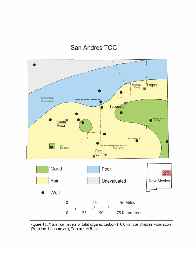
San Andres Formation (Permian: Leonardian): The San Andres Formation (Permian: Leonardian)
consists of interbedded limestones, dolostones, anhydrite, gypsum, salt, and minor red mudstones
throughout the Tucumcari Basin (Kelley, 1972a; Foster and others, 1972; Pitt and Scott, 1981). Many of
the limestones are dark-gray lime mudstones that have been long been considered by many industry
geologists to be petroleum source rocks. The presence of numerous oil shows in the San Andres in
exploration wells drilled throughout the basin (Structure Database Part I - wells, well structure data and
shows in wells; Pitt and Scott, 1981) has reinforced the idea that the San Andres is a major source rock.
The San Andres is a poor to marginal source rock throughout the Tucumcari Basin. The TOC
map of the San Andres (Figure 11) indicates that TOC levels are barely adequate for petroleum generation
throughout most of the basin where TOC contents are less than 0.5 percent. TOC levels exceed 0.5 percent
(the minimum considered sufficient for good generative potential in carbonate rocks) along a trend that
extends from central Quay County into eastern Curry County. However, TOC values barely exceed 0.5%
along this trend so generative potential, based upon TOC content, should still be considered somewhat
marginal.
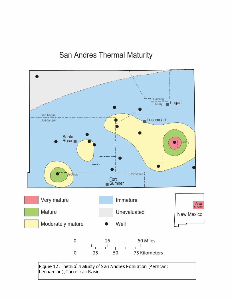
Thermal maturity of the San Andres is also insufficient for petroleum generation throughout most
of the Tucumcari Basin (Figure 12). In most of the basin, possible source rocks are immature with TAI
values less than 2.1 and TMAX values less than 435o C. A trend in central Quay and northern Curry
Counties is at the lower ranges of marginal thermal maturity with TAI values of 2.2 and Rock-Eval TMAX
values less than 435o C. This trend may have generated some heavy oils, but given the low levels of organic
carbon it is unlikely that major volumes of hydrocarbons were generated. Nevertheless, with its slightly
elevated thermal maturity, this trend should be considered to have moderate source potential.
good
San Miguel Guadalupe
Harding
DeBaca Roosevelt
Quay
Curry
Tucumcari
Logan
SantaRosa
Fort Sumner
Good
Fair
Well
Poor
Unevaluated New Mexico
Areashown
0 5025
0 25 50 Miles
75 Kilometers
San Andres TOC
New Mexico
Areashown
Tucumcari
Logan
SantaRosa
Fort Sumner
Very mature
Mature
Moderately mature
Immature
Unevaluated
Well
San Andres Thermal Maturity
San Miguel Guadalupe
Harding
DeBaca Roosevelt
Quay
Curry
0 5025
0 25 50 Miles
75 Kilometers
15
There are two identified, isolated areas of elevated thermal maturity associated with wells in T8N
R34E (Quay County) and T4 R19E (Guadalupe County). These areas are mature to very mature and the
San Andres is in the oil window or wet gas - condensate window. The anomalous nature of these areas
suggests that local heat sources and not regional heat sources such as differential burial or variations in the
geothermal gradient are responsible for the maturation anomalies. Perhaps Tertiary-age basalts intruded
strata near the analyzed wells and caused local maturation or perhaps deep, hot waters migrated upward
along faults and caused enhanced maturation that brought local areas of the San Andres within the oil
window. If so, other areas of locally enhanced maturation may exist that remain unsampled and
unanalyzed.
San Andres source facies are generally dominated by amorphous and herbaceous kerogens.
Woody kerogens constitute less than 20 percent of the sample in most cases but can be as much as 60% of
the sample. Therefore, where generative, San Andres source rocks would in most places have yielded oil
with associated gas rather than gas alone.
Artesia Group (Permian: Guadalupian): The Artesia Group (Permian: Guadalupian) unconformably
overlies the San Andres Formation in the Tucumcari Basin. It consists of 130 to 920 ft of red shales, fine-
grained sandstones, and anhydrite. Source facies are absent. TOC contents are less than 0.2 percent and are
insufficient for petroleum generation. Therefore, the Artesia Group has poor source potential within the
basin.
Triassic System: Triassic strata in the Tucumcari Basin consist of the Santa Rosa Formation (Middle to
Upper Triassic) and the Chinle Formation (Upper Triassic). The Santa Rosa Formation unconformably
overlies the Artesia Group. It is 70 to 350 ft thick and consists of fine- to medium-grained sandstones and
interbedded red shales (Broadhead, 1984). It is primarily a fluvial deposit (McGowen et al., 1979). The
overlying Chinle Formation is 700 to 1,300 ft thick. The Chinle consists predominantly of red shales, minor
fine- to medium-grained sandstones, and minor thin-bedded, argillaceous, reddish-gray, finely crystalline
limestones. It was deposited in lacustrine and fluvial environments (McGowen et al., 1979).
Triassic strata have poor source rock potential. TOC content is less than 0.15 percent, insufficient
for petroleum generation. Although a few coal beds are present within the Santa Rosa and Chinle
(Berkstresser and Mourant, 1966; Broadhead, 1984), they are almost certainly too thin and of too localized
extent to form significant source rocks.
Post-Triassic strata: Erosional remnants of Jurassic, Cretaceous, Tertiary, and Quaternary strata are present
throughout scattered areas in northeast and east-central New Mexico. Where present, they either crop out at
the surface or are buried to very shallow depths on mesas in the region. The limited areal extent and surface
or near-surface occurrence precludes these stratigraphic units from being significant source rocks.
16
SUMMARY AND CONCLUSIONS
Pennsylvanian strata are the primary petroleum source rocks in the Tucumcari Basin. Dark-gray to
black shales are the major source facies within the Pennsylvanian section. Thin coal beds may be secondary
source rocks. Source facies in other stratigraphic units either contain insufficient total organic carbon to be
major generative source rocks or are thermally immature. Pennsylvanian shales are substantially thicker
and contain greater levels of organic carbon in elevator basins of late Paleozoic age in the northern part of
the Tucumcari Basin as compared to shallower shelf areas in the central and southern parts of the
Tucumcari Basin. Furthermore, source facies in the elevator basins have heightened thermal maturity as
compared to the shelf areas and are in the oil or gas condensate windows in the elevator basins.
The primary hydrocarbon kitchens in the Tucumcari Basin are located in the elevator basins.
Pennsylvanian strata on the central shelf area are also generative, but the source facies are thinner, contain
lower percentages of organic carbon, and are less mature than in the elevator basins.
17
APPENDIX I
Structure Database Part 1 -
Wells, Well Structure Data, and Shows in Wells
Ronald F. Broadhead1 and Heidi A. Justman2
1New Mexico Bureau of Geology and Mineral ResourcesA Division of New Mexico Institute of Mining and Technology
Socorro, NM 878012Earth and Environmental Sciences Department
New Mexico Institute of Mining and Technology, Socorro NM 87801Present address
Schlumberger Geoquest, Houston TX
A database of oil and gas wells, subsurface structure data, and oil and gas shows in Microsoft
Excel format (Tucumcari wells.xls) accompanies this report. This database contains data on well location,
total depth, dates of drilling, surface elevation, structural elevation of the top surface of the Abo Formation
and Precambrian surface, as well as data on oil and gas shows encountered in the wells. The following data
fields are present for each well.
API Number (Some wells in the New Mexico Bureau of Mines databases have no API number. For these
wells, an identifying number was constructed from the section-township-range location data, for
example 14N32E16, which indicates a location in sec. 16 T14N R32E; if more than one well is
present in any one section, then each of the wells in that section has a letter added after our
constructed API number so that each well has a unique number in this database, e.g. 14N32E16A.
If an API number becomes available, the user may wish to substitute it for our constructed
number.)
Operator
Lease name
Well number
County
Location (section-township-range)
Footage from section boundaries
Longitude
Latitude
Spud date (month/year)
Completion date (month/year)
Total depth (feet)
18
Surface elevation (feet above sea level)
Surface datum (KB = Kelly Bushing; DF = derrick floor; GL = ground level)
Depth to top of Abo Formation (feet)
Subsea depth top of Abo Formation (feet above or below sea level)
Depth to top of Precambrian (feet)
Subsea depth top of Precambrian (feet above or below sea level)
All data were derived from files and records at the New Mexico Bureau of Mines and Mineral
Resources Library of Subsurface Data. Longitude and latitude for most wells were with the Geographix
Exploration System Landgrid Module and the Whitestar Corp. digital land grid. For wells within the
boundaries of Spanish Land Grants (which are internally unsurveyed with respect to the Township-Range
cadastral grid of the U.S. Bureau of Land Management), the wells were manually plotted on U.S.
Geological Survey topographic maps with the best location information available and latitude and longitude
were calculated manually from these plots.
Depths to the top of the Abo Formation and Precambrian basement were mostly obtained from the
published literature (Broadhead and King, 1988) or from unpublished data at the New Mexico Bureau of
Mines and Mineral Resources. For many wells, depth to the top of the Precambrian was confirmed with
additional examination of electric logs or sample logs. Where needed, drill cuttings and core were
examined to identify or verify depth of the top of Precambrian.
Oil and Gas Shows
The well database contains substantial information on oil and gas shows compiled from records on
file at the New Mexico Bureau of Mines and Mineral Resources. Oil and gas shows are identified by the
stratigraphic unit they occur in. The following stratigraphic terms were employed.
Triassic (undivided)
Chinle Formation (Triassic)
Santa Rosa sandstone (Triassic)
Artesia Group (Permian)
San Andres Formation (Permian)
Glorieta Sandstone (Permian)
Yeso Formation (Permian)
Tubb member of Yeso Formation (Permian)
Abo Formation (Permian)
Canyon Series (Pennsylvanian)
Strawn and Atoka Series (Pennsylvanian)
Arroyo Penasco Group (Mississippian)
Precambrian
19
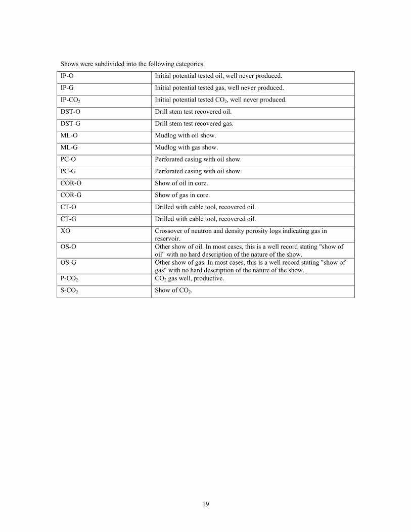
Shows were subdivided into the following categories.
IP-O Initial potential tested oil, well never produced.
IP-G Initial potential tested gas, well never produced.
IP-CO2 Initial potential tested CO2, well never produced.
DST-O Drill stem test recovered oil.
DST-G Drill stem test recovered gas.
ML-O Mudlog with oil show.
ML-G Mudlog with gas show.
PC-O Perforated casing with oil show.
PC-G Perforated casing with oil show.
COR-O Show of oil in core.
COR-G Show of gas in core.
CT-O Drilled with cable tool, recovered oil.
CT-G Drilled with cable tool, recovered oil.
XO Crossover of neutron and density porosity logs indicating gas inreservoir.
OS-O Other show of oil. In most cases, this is a well record stating "show ofoil" with no hard description of the nature of the show.
OS-G Other show of gas. In most cases, this is a well record stating "show ofgas" with no hard description of the nature of the show.
P-CO2 CO2 gas well, productive.
S-CO2 Show of CO2.
20
APPENDIX II
Structure Database Part 2 -
Surface Structures
Heidi A Justman1 and Ronald F. Broadhead2
1Earth and Environmental Sciences DepartmentNew Mexico Institute of Mining and Technology
Socorro, NM 87801Present address
Schlumberger Geoquest, Houston TX
2New Mexico Bureau of Geology and Mineral ResourcesA Division of New Mexico Institute of Mining and Technology
Socorro, NM 87801
This database in Microsoft Excel format (Tucumcari surface structures.xls) is a companion to the
INFO map of mapped surface structures. It is presented in Microsoft Excel format. Where available,
several attributes are given for each structure, including:
Name of structure
Location (township, range)
Location within township (described verbally, not quantitatively)
Reported structural closure, feet
Other comments, including thickness of closure and area within closed contours, if known
Source of data
21
APPENDIX III
Petroleum Source Rock Database
Ronald F. Broadhead1 and Heidi A. Justman2
1New Mexico Bureau of Geology and Mineral ResourcesA Division of New Mexico Institute of Mining and Technology
Socorro, NM 878012Earth and Environmental Sciences Department
New Mexico Institute of Mining and Technology, Socorro NM 87801Present address
Schlumberger Geoquest, Houston TX
This database (Tucumcari source rock data.xls) is a companion to the INFO maps of petroleum
source rock data presented on this CD. Analytical data are presented for 328 samples from 29 key
exploration wells drilled in the Tucumcari Basin. Most analyses were performed on composite samples of
drill cuttings from 100 ft intervals, but a few of the samples were obtained from cores. Several attributes
are given for each sample, including:
API number of the well
Operator
Lease name
Well number
County
Location (section-township-range)
Footage from section boundaries
Longitude
Latitude
Top of sampled interval (recorded as depth in well, in feet)
Bottom of sampled interval (recorded as depth in well, in feet)
Geologic system (e.g. Permian, Pennsylvanian, etc.)
Geologic series (e.g. Wolfcampian, Desmoinesian, etc.)
Lithostratigraphic group (e.g. Artesia, Canyon, etc.)
Lithostratigraphic formation (e.g. San Andres, Abo, etc.)
TOC - total organic carbon (weight percent)
Algal - percentage of kerogen that is algal material, by visual estimate
Amorphous - percentage of kerogen that is amorphous material, by visual estimate
Herbaceous - percentage of kerogen that is herbaceous material, by visual estimate
Woody - percentage of kerogen that is woody material, by visual estimate
Inertinite - percentage of kerogen that is inertinite, by visual estimate
22
Maturation - level of thermal maturity as interpreted from TAI, Ro, or TMAX
TAI (Geochem) - the Thermal Alteration Index as provided on analyses performed by Geochem
Laboratories, Inc. A measure of thermal maturity.
TAI (equiv) - the Thermal Alteration Index derived from vitrinite reflectance measurements. These were
converted from Ro measurements using published tables and charts that show equivalence between these
two measurements of thermal maturity.
Ro - vitrinite reflectance, in percent. A measure of thermal maturity.
TMAX - the temperature, in degrees centigrade, of the S2 peak derived from Rock-Eval pyrolysis. A
measure of thermal maturity.
Sample type - cuttings or core
Analysis - the origin of the source rock analysis. The analysis could come from the New Mexico Petroleum
Source Rock Project, it could be donated, or it could have been performed explicitly for this project.
Data sources
Most source rock data used in this report were obtained from a published digital database
(Broadhead et al., 1998). Other data are analyses performed explicitly for this project. All of the source
rock data used in this report were obtained from analyses and cores curated at the New Mexico Library of
Subsurface Data at the New Mexico Bureau of Geology and Mineral Resources. There are three sources for
the analyses:
1. New Mexico Petroleum Source Rock Project. This project ran from the late 1980's until the mid
1990's. It was a joint effort between private industry and the New Mexico Bureau of Mines (now
Geology) and Mineral Resources. Well cuttings from key exploration wells throughout New Mexico
were analyzed for petroleum source rock attributes. Geochem Laboratories, Inc. was selected by
competitive bid to perform the analyses. The following standard set of analyses were performed on
each sample:
• Total organic carbon (TOC) measurement
• Visual kerogen assessment for kerogen type
• Visual kerogen assessment for thermal maturity using the Thermal Alteration Index (TAI)
• Rock-Eval pyrolysis
Most of the analyses presented in this report were performed as part of the New Mexico Petroleum Source
Rock Project. For all samples of drill cuttings analyzed as part of this project, the cuttings were selectively
picked under a binocular microscope in order to exclude non-source lithologies (e.g. sandstone) from the
sample. This procedure, although time consuming, helps insure analyses that are representative of source
facies encountered in the borehole.
23
2. Donated data. These are source rock data donated to the New Mexico Bureau of Geology and Mineral
Resources by private industry. The analyses were made by private industry on samples in the
collections of the New Mexico Bureau of Geology and Mineral Resources. In return for allowing the
samples to undergo destructive source rock analysis, the analytical results were given to the Bureau
and were made public. Most of the donated analyses were performed by either Robertson Research or
Geochem Laboratories. The Robertson Research data generally include vitrinite reflectance as well as
Rock-Eval pyrolysis but do not generally include visual petrographic analysis of the kerogen fraction.
The vitrinite reflectance values were converted to Thermal Alteration Index values using published
charts and tables (Geochem Laboratories, Inc., 1980; Hunt, 1996) in order to allow comparison of
thermal maturity between the two types of analyses. Cuttings samples from donated data have
generally not been sorted to exclude non-source lithologies and obvious cavings from the samples. As
a result, the analyzed sample may have contained a large percentage of non-source lithologies that are
either caved or interbedded with the source rocks. This is a particularly acute problem in the
Pennsylvanian of the Tucumcari basin where arkosic sandstones ("granite wash") are interbedded with
black shale source rocks. Although unsorted samples probably yield good values of thermal maturity,
the presence of non-source lithologies such as sandstones will result in artificially low values of total
organic carbon (TOC). Therefore, the analyzed TOC values for the donated samples should be
considered minimum values not necessarily representative of what may actually be in the source
facies.
3. Analyses performed explicitly for this project. A few samples of cores and cuttings from the
Pennsylvanian section and the San Andres Formation were analyzed as part of this project in order to
fill in gaps of existing source rock coverage. Analyses were performed by Geochem Laboratories and
the same types of analyses were performed as for the New Mexico Petroleum Source Rock Project.
Cuttings samples were picked to exclude non-source lithologies.
24
REFERENCES
Amarante, J.F.A., Kelley, S.A., and Miller, K.C., 2000, Characterization of the Precambrian basement in Mescalero #1, Guadalupe County, New Mexico (abstract): American Association of Petroleum Geologists, Bulletin, v. 84, p. 1235.
Baltz, E.H., and Myers, D.M., 1999, Stratigraphic framework of upper Paleozoic rocks, southeastern Sangre de Cristo Mountains, New Mexico: New Mexico Bureau of Mines and Mineral Resources, Memoir 48, 269 pp.
Barker, C., 1980, Organic geochemistry in petroleum exploration: American Association of Petroleum Geologists, Continuing education course note series no. 10, 159 pp.
Bates, R.L., 1942, The oil and gas resources of New Mexico, second edition: New Mexico Bureau of Minesand Mineral Resources, Bulletin 18, 318 pp.
Berkstresser, C.F., Jr., and Mourant, W.A., 1966, Ground-water resources and geology of Quay County, New Mexico: New Mexico Bureau of Mines and Mineral Resources, Ground-water report 9, 115 pp.
Broadhead, R.F., 1984, Subsurface petroleum geology of Santa Rosa Sandstone (Triassic), northeast New Mexico. New Mexico Bureau of Mines and Mineral Resources, Circular 193, 22 pp.
Broadhead, R.F., 1990, Petroleum source rocks in the Tucumcari Basin, east-central New Mexico: West Texas Geological Society, Bulletin, v. 29, no. 8, pp. 5-16.
Broadhead, R.F., 2001a, New Mexico elevator basins - 1: Petroleum systems studies: Oil and Gas Journal, v. 99.2, pp. 32-38.
Broadhead, R.F., 2001b, New Mexico elevator basins - 2: Petroleum systems described: Oil and Gas Journal, v. 99.3, pp. 31-35.
Broadhead, R.F., 2001c, New Mexico elevator basins - 3: Elevator basin models: Oil and Gas Journal, v. 99.4, pp. 30-36.
Broadhead, R.F., and King, W.E., 1988, Petroleum geology of Pennsylvanian and Lower Permian strata, Tucumcari Basin, east-central New Mexico: New Mexico Bureau of Mines and Mineral Resources, Bulletin 119, 75 pp.
Broadhead, R.F., Wilks, M., Morgan, M., and Johnson, R.E., 1998, The New Mexico petroleum source rock database: New Mexico Bureau of Mines and Mineral Resources, Digital data series DB2, 1 CD-ROM.
Brooks, J., Cornford, C., and Archer, R., 1987, The role of hydrocarbon source rocks in petroleum exploration; in Brooks, J., and Fleet, A.J. (eds.), Marine petroleum source rocks: Geological Society of London, Special Publication 26, pp. 17-46.
Bureau of Economic Geology, 1978, Geologic atlas of Texas, Clovis sheet: Bureau of Economic Geology, University of Texas at Austin, scale 1:250,000.
Bureau of Economic Geology, 1983, Geologic atlas of Texas, Tucumcari sheet: Bureau of Economic Geology, University of Texas at Austin, scale 1:250,000.
25
Cordell, L., 1983, Composite residual total intensity aeromagnetic map of New Mexico: New Mexico State University Energy Institute, Geothermal resources map of New Mexico, scale 1:500,000.
Cornford, C., Morrow, J., Turrington, A., Miles, J.A., and Brooks, J., 1983, Some geological controls on oilcomposition in the North Sea; in Brooks, J. (ed.), Petroleum geochemistry and exploration of Europe: Geological Society of London, Special Publication 12, pp. 175-194.
Darton, N.H., 1928, Red beds and associated formations in New Mexico: U.S. Geological Survey, Bulletin 794, 356 pp.
Demaison, G., and Murris, R.J., eds., 1984, Petroleum geochemistry and basin evaluation: American Association of Petroleum Geologists, Memoir 35, 426 pp.
Dobrovolny, E., Bates, R.L., and Summerson, C.H., 1946, Geology of northwestern Quay County, New Mexico: U.S. Geological Survey, Oil and Gas Investigations Map OM-62, scale 1 inch equals 1 mile.
Dooley, T., and McClay, K., 1997, Analog modeling of pull-apart basins: American Association of Petroleum Geologists, Bulletin, v. 81, pp. 1804-1826.
Dow, W. G., 1978, Petroleum source-beds on continental slopes and rises: American Association of Petroleum Geologists, Bulletin, v. 62, pp. 1584-1606.
Dutton, S.P., Goldstein, A.G., and Ruppel, S.C., 1982, Petroleum potential of the Palo Duro Basin, Texas panhandle: Bureau of Economic Geology, University of Texas at Austin, Report of Investigations 123, 87 pp.
Flawn, P.T., 1956, Basement rocks of Texas and southeast New Mexico: Bureau of Economic Geology, University of Texas at Austin, Publication No. 5605, 261 pp.
Foster, R.W., and Stipp, T.F., 1961, Preliminary geologic and relief map of the Precambrian rocks of New Mexico: New Mexico Bureau of Mines and Mineral Resources, Circular 57, 37 pp., map scale 1:500,000.
Foster, R.W., Frentress, R.M., and Riese, W.C., 1972, Subsurface geology of east-central New Mexico: New Mexico Geological Society, Special publication 4, 22 pp.
Frye, J.C., Leonard, A.B., and Glass, H.D., 1982, Western extent of Ogallala Formation in New Mexico: New Mexico Bureau of Mines and Mineral Resources, Circular 175, 41 pp.
Geochem Laboratories, Inc., 1980, Source rock evaluation reference manual: Geochem Laboratories, Inc., Houston TX, pages not consecutively numbered.
Hills, J.M., 1970, Late Paleozoic structural directions in southern Permian Basin, west Texas and southeastern New Mexico: American Association of Petroleum Geologists, Bulletin, v. 54, pp. 1809-1827.
Hunt, J.M., 1996, Petroleum geology and geochemistry, second edition: W.H. Freeman and Company, NewYork, 743 pp.
Jarvie, D.M., 1991, Total organic carbon (TOC) analysis, in; Merrill, R.K. (ed.), Source and migration processes and evaluation techniques: American Association of Petroleum Geologists, Treatise of petroleum geology, Handbook of petroleum geology, pp. 113-118.
Keller, G.R., and Cordell, L., 1983, Bouguer gravity anomaly map of New Mexico: New Mexico State University Energy Institute, Geothermal resources map of New Mexico, scale 1:500,000.
26
Kelley, V.C., 1972a, Geology of the Fort Sumner sheet, New Mexico: New Mexico Bureau of Mines and Mineral Resources, Bulletin 98, 55 pp.
Kelley, V.C., 1972b, Geology of the Santa Rosa area: New Mexico Geological Society, Guidebook to 23rd
field conference, pp. 218-220.
Lewan, M.D., 1987, Petrographic study of primary petroleum migration in the Woodford Shale and related rock units; in Doligez (ed.), Migration of hydrocarbons in sedimentary basins: Editions Technip, Paris, pp. 113-130.
Leythauser, D., Hageman, H.W., Hollerback, A., and Schafer, R.G., 1980, Hydrocarbon generation in source beds as a function of type and maturation of their organic matter: a mass balance approach: Proceedings of the 10th World Petroleum Congress, Bucharest, 1979, pp. 31-41.
Magoon, L.B., and Dow, W.G., eds., 1994, The petroleum system from source to trap: American Association of Petroleum Geologists, Memoir 60, 655 pp.
McGowen, J.H., Granata, G.E., and Seni, S.J., 1979, Depositional framework of the lower Dockum Group (Triassic), Texas panhandle: Bureau of Economic Geology, University of Texas at Austin, Report of Investigations No. 97, 60 pp.
Merrill, R.K., 1991, Preface to this volume, inMerrill, R.K. (ed.), Source rock and migration processes and evaluation techniques: American Association of Petroleum Geologists, Treatise of petroleum geology, Handbook of petroleum geology, pp. xiii-xvii.
Montgomery, S.L., 1986, New Mexico's frontier on the verge: Petroleum Frontiers, v. 3, no. 2, 61 pp. Published by Petroleum Information Corporation.
Nilsen, T.H., and Sylvester, A.G., 1995, Strike-slip basins; in Busby, C.J., and Ingersoll, R.V. (eds.), Tectonics of sedimentary basins: Blackwell Science, Cambridge MA, pp. 425-457.
Peters, K.E., 1986, Guidelines for evaluating petroleum source rock using programmed pyrolysis: American Association of Petroleum Geologists, Bulletin, v. 70, pp. 318-329.
Pitt, W.D., and Scott, G.L., 1981, Porosity zones of lower part of San Andres Formation, east-central New Mexico: New Mexico Bureau of Mines and Mineral Resources, Circular 179, 20 pp.
Reynolds, C.B., and Reynolds, I., in press, South margin of the Cuervo trough: New Mexico Geology.
Roberts, J.W., Barnes, J.J., and Wacker, H.J., 1976, Subsurface Paleozoic stratigraphy of the northeastern New Mexico basin and arch complex: New Mexico Geological Society, Guidebook to 27th field conference, pp. 141-152.
Rose, P.R., 1986, Petroleum geology of the Palo Duro Basin, Texas panhandle: Battelle Memorial Institute,Office of Nuclear Waste Isolation, Report BMI/ONWI-589, 72 pp.
Sentfle, J.T., and Landis, C.R., 1991, Vitrinite reflectance as a tool to assess thermal maturity; inMerrill, R.K. (ed.), Source rock and migration processes and evaluation techniques: American Association of Petroleum Geologists, Treatise of petroleum geology, Handbook of petroleum geology, pp. 119-125.
Staplin, F.L., 1969, Sedimentary organic matter, organic metamorphism and oil and gas occurrence: Bulletin of Canadian Petroleum Geology, v. 17, pp. 47-66.
27
Stevenson, G.M., and Baars, D.L., 1986, The Paradox - a pull-apart basin of Pennsylvanian age, inPeterson, J.A., ed., Paleotectonics and sedimentation in the Rocky Mountain region: American Association of Petroleum Geologists, Memoir 41, pp. 513-540.
Tissot, B.P., and Welte, D.H., 1978, Petroleum formation and occurrence: A new approach to oil and gas exploration: Springer-Verlag, Berlin, 538 pp.
Tyson, R.V., 1987, The genesis and palynofacies characteristics of marine petroleum source rocks; inBrooks, J., and Fleet, A.J. (eds.), Marine petroleum source rocks: Geological Society of London, Special Publication 26, pp. 47-67.
Wilson, J.L., and Jordon, C.F., Jr., 1988, Late Paleozoic - Early Mesozoic rifting in southern New Mexico and northern Mexico: controls on subsequent platform development, in Robichaud, S.R., and Gallick, C.M., eds., Basin to shelf facies transition of the Wolfcampian stratigraphy of the Orogrande Basin: Permian Basin Section SEPM, Publication No. 88-28, pp. 79-88.
Winchester, D.E., 1933, The oil and gas resources of New Mexico: New Mexico Bureau of Mines and Mineral Resources, Bulletin 9, 223 pp.
Ye, H., Royden, L., Burchfiel, C., and Schuebach, M., 1996, Late Paleozoic deformation of interior North America: the greater Ancestral Rocky Mountains: American Association of Petroleum Geologists,Bulletin, v. 80, pp. 1397-1432.