Embed Size (px)
Citation preview

Open Research OnlineThe Open University’s repository of research publicationsand other research outputs
Navigation strategies in the cityscape/datascapeConference or Workshop Item
How to cite:
Wolff, Annika and Mulholland, Paul (2015). Navigation strategies in the cityscape/datascape. In: AdjunctProceedings of the 2015 ACM International Joint Conference on Pervasive and Ubiquitous Computing and Proceedingsof the 2015 ACM International Symposium on Wearable Computers, ACM, New York, pp. 1143–1151.
For guidance on citations see FAQs.
c© 2015 ACM
Version: Accepted Manuscript
Link(s) to article on publisher’s website:http://dx.doi.org/doi:10.1145/2800835.2800978http://cpemis.eng.cmu.ac.th/ santi/purba2015/paper/PURBA-2015 submission 8.pdf
Copyright and Moral Rights for the articles on this site are retained by the individual authors and/or other copyrightowners. For more information on Open Research Online’s data policy on reuse of materials please consult the policiespage.
oro.open.ac.uk
Navigation Strategies in the Cityscape/Datascape
Abstract The work described in this paper focuses on how to reveal culturally-related data to city tourists to help them in navigating both the physical space through which they are moving (the cityscape) and a conceptual space around points of interest which links them through shared stories of time, place, people and theme (the datascape). The research goal is to discover to what extent navigational strategies in a conceptual space should be reflected in a physical space, or vice versa. This paper describes preliminary analysis of results from two studies. These studies suggest that tourists have a strong preference for visiting places in order of ‘closest next’. However, tourists also want to understand how places are conceptually related. Providing this type of information may assist tourists in their informal learning from a city visit.
Author Keywords Mobile learning; smart tourism; datascape; narrative
ACM Classification Keywords H.5.1. Multimedia Information Systems: Hypertext navigation and maps
Annika Wolff The Open University Walton Hall, MK7 6AA, UK [email protected] Paul Mulholland The Open University Walton Hall, MK7 6AA, UK [email protected]

Introduction Standard museum practice reflects the idea that visitors are interested in exploring the relationships between cultural artefacts. In a museum exhibition, objects are selected according to an overarching theme, then organized to reveal relationships between exhibits. A visitor following typical paths through the museum will encounter items in an order intended by the curator to convey a particular storyline [4] For example, artworks in a biographical exhibition are usually placed into a chronological order to reflect the lifetime of the artist. This works well in a museum, where exhibits are portable and the object order can be manipulated.
By contrast, points of interest within a city develop over time. They are not acquired as part of a narrative, yet narratives can be found to exist and these are reflected through the city tours in which points of interest are chosen according to an overarching theme, such as architecture, ghost walk, the life of person X. City tourist sites cannot be physically re-organized. Instead, within official tours, visitors are directed as to where to visit and in what order. A quick glance at any guidebook will reveal that ‘directed’ tours (where route is given) are generally organized so that places are visited in terms of shortest distance next. Any internal narrative connections that exist between points of interest may be either supported or disrupted by the tour order, depending on the physical layout of the city and the chosen route.
This paper describes an approach for supporting tourist engagement with city narratives through mobile devices. The paper first explores tourist behavior and frames it in the context of navigation through both a
physical cityscape and a conceptual datascape of narrative entities and relationships. Next, existing mobile applications for supporting tourists are explored along with some discussion of their possible shortcomings. Finally, preliminary analysis of results from two studies are described which aim to answer questions around tourist behavior in a physical space and how information provided via a mobile device does or does not influence the routes that tourists travel and how it can support tourists in informal learning across multiple related points of interest.
Tourist behaviour Physical navigation Tourists commonly have a goal to visit several points of interest in succession and in a short timeframe. Visitors often also like to also stop at cafes, restaurants, bars and shops as part of their visit. This navigation between sights (via other locations) takes place across the physical cityscape. In most cases, a coherent path between sights in a physical space is based on proximity of one item to the next, as measured by the physical distance between them [8]. However, in reality other affordances may guide visitor movements, such as line of sight [5]. Two places that are in direct line of sight to each other may be visited consecutively more often than two places that are closer, but ‘hidden’ from each other.
Conceptual Navigation As well as the physical experience of being ‘in the place’, tourists generally engage with a range of conceptual information about the sights they see. This information can be obtained from a mixture of human guides, audio tours, guidebooks and leaflets. These narratives might provide conceptual links between

places that also exist in the physical space. For example, Shakespeare’s birthplace and grave are both found in Stratford upon Avon, UK, as are other places related to his family and married life. Information related to Shakespeare’s birthplace might mention where his grave is to be found, and vice versa. Thus, a narrative of Shakespeare’s life can provide a way to conceptually traverse between a set of physical points of interest, providing an ordering of places according to different stages of Shakespeare’s life. In the same way that physical proximity between places of interest is measured using physical distance, the conceptual proximity between places can be found using some measure of conceptual distance.
Aligning the Physical and Conceptual Navigation In an ideal tourist visit, the conceptual and physical pathways will align and a tourist can encounter a story in both a physically and conceptually coherent order. In reality, this rarely happens. In addition visits to places that do not fit the narrative will occur, such as visits to cafes and shops, or other tourist sites that are not part of an overarching theme. Unrelated narrative threads can be intermingled. The tourist must therefore make a choice as to whether to follow a coherent physical or coherent conceptual path. Figure 1 shows a mapping between a timeline of Shakespeare’s life and points of interest in the town of Stratford upon Avon.
Figure 2 shows key tourist sites of Stratford upon Avon on a map. From this map it can be seen that while it would be possible to follow a coherent physical and conceptual route taking in Shakespeare’s birthplace, his daughters house that she lived in with her husband (Hall’s Croft) and his grave, a visit to his wife’s cottage takes the visitor some distance out of town. It is also
likely that visitors would want to visit the other key tourist locations while they were there.
Figure 1. Mapping between a timeline and points of interest in Stratford upon Avon
Figure 2. A map showing key tourist sites within Stratford upon Avon.
Mobile Apps to support Tourists Mobile apps combine tourist-related data with other data collected from tourists, such as current location, cultural preferences, or past trajectory and provide contextual information to support visits to cities and museums. They are usually targeted at independent

travellers who want to plan their own route, make spontaneous choices, or be able to make deviations from a suggested tour narrative for something that catches their interest.
Most research in this area focuses on how to produce adaptive, personalized tours, prompting users towards conceptually related items and away from items that fall outside a narrative, whilst adapting to a users changing preferences. Examples include the CHIP adaptive museum guide [7] which provides a museum tour based on some user preferences and then tracks a visitors path through a museum. If the visitor deviates from a planned route, for example they stop to look at something additional that has caught their eye, the system recognizes this and adapts the subsequent tour to take into account their new interest. Another example for city tourism is the GUIDE system [1], GUIDE assists a city visitor in planning a tour, selecting attractions to visit based on their interests or highlighting the key points of interest and then in finding best routes between selected locations. GUIDE integrates data about the attractions opening times and the best time to visit to avoid queues and uses this as part of the tour planning. If a visitor does not want to visit the attraction suggested by GUIDE they can choose a different one from the tour.
These personalised tours, which offer suggestions as to where to go next based on a tourist’s current location and their interests, assume that tourists will be willing to deviate from a more ‘natural’ route through a museum or city in order to experience a more coherent narrative.
However, some recent research into the use of mobile apps - both in museums and across the city - is beginning to question the extent to which tourists are willing to follow suggestions. Kramer et al., 2007 [2] evaluated two different modes of a Dynamic Tour Guide. In Explorer mode, the app provides only location-based information on request and a list of close attractions. In Planner mode, the device creates a personalized tour based on some initial preferences such as tour duration. Evaluation of Planner mode revealed that not only did users rarely complete a planned tour (on average seeing only 50% of proposed tourist sites), they also visited a number of unplanned attractions. Users who undertook sightseeing supported by Explorer mode visited on average 3 more sights, walked further and spent longer.
Sharples et al, 2013 [6] evaluated a museum audio guide system ‘CAGE’ which aimed to reveal conceptual connections between paintings in a gallery through audio guide descriptions, in cases where the connections were not immediately afforded by the layout of the museum. Evaluation of the system revealed that while visitors could be prompted to glance towards related items mentioned in an audio guide, they did not walk across the gallery floor in order to visit pieces in a narratively coherent order.
Similarly, Wolff et al, 2014 [8] evaluated the behavior of visitors to a sculpture garden who were provided with both physical and conceptual information via a mobile app. Visitors scanned QR codes that were placed next to sculptures. These landed on a page giving some in depth information about the item itself (thus addressing the issue that detailed information was not available in the outside space) and which also
contained story links that told the visitor about other sculptures in the garden that were related. Analysis of visitors movements through the physical space, as reconstructed through QR code scans, compared to their conceptual navigation revealed that while visitors were interested in clicking on the story links, they would not find and scan related items but instead would carry on along the routes afforded by the garden layout.
Mitchell and Chuah, 2013 [3] developed and evaluated the Travel Teller system for mobile story telling across tourist sites. The system was designed to recommend places for visitors to go to allow them to experience and tell stories on the move. They discovered that visitors showed a strong preference for spontaneous independent travel. Visitors were rarely prompted to follow recommendations of the mobile tour guide in pursuit of a story, but instead preferred to restructure their experiences into a story after the fact.
Taking all of the above into consideration, it would seem that museum and city visitors may be interested in the narrative connections between artefacts and places of interest, but not to the extent of making detours through a physical space to encounter places in a narratively logical ordering.
Research Questions The above leads to the formation of the following research questions. Firstly, how can city visitors be best supported in simultaneous coherent navigation of both a physical and conceptual space when the two do not match. Secondly, what data is available that can be used to support these two types of navigation.
Conceptual tour guide. We propose an approach in which a mobile device is used to provide a visitor with information about the conceptual relatedness of items within a city. In this approach, the device is not used to plan tours or direct a visitor where to travel within the physical city, but instead to act as a conceptual tour guide, prompting a visitor to understand how places that they might have, or may yet visit are related by showing places related to current location on the device. Visitors remain free to choose for themselves where they go next. They might prefer to find somewhere interesting close to where they are, or else they might decide to use the narratives provided on the device to plan a route to a nearby conceptually related item. We hypothesise that providing information to help with coherent navigation through the conceptual space around a point of interest will assist the visitor in telling stories about their visit and in their recall of information about the places they have visited, especially in situations where the natural coherent order is disrupted by visiting other non-related sights. Two studies have been conducted to investigate the above hypothesis and to further investigate whether tourists will choose a physically coherent route over a route that directs them towards a more coherent narrative experience across points of interest. The studies further aim to:
- Discover to what extent are people interested in understanding relationships between places in a city.
- Evaluate to what extent analysis of typical visitor movement and choice of next attraction or venue reflects physical or conceptual proximity
This paper will now focus on describing these two studies and some preliminary analysis of the results.
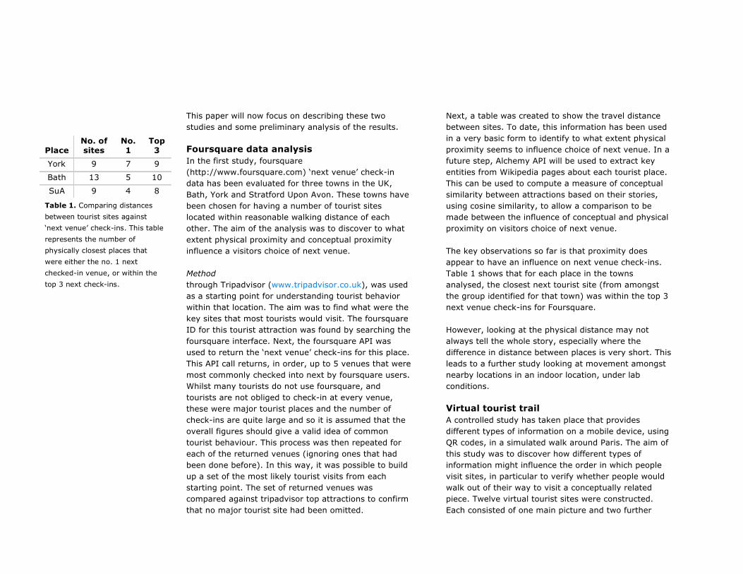
Foursquare data analysis In the first study, foursquare (http://www.foursquare.com) ‘next venue’ check-in data has been evaluated for three towns in the UK, Bath, York and Stratford Upon Avon. These towns have been chosen for having a number of tourist sites located within reasonable walking distance of each other. The aim of the analysis was to discover to what extent physical proximity and conceptual proximity influence a visitors choice of next venue.
Method through Tripadvisor (www.tripadvisor.co.uk), was used as a starting point for understanding tourist behavior within that location. The aim was to find what were the key sites that most tourists would visit. The foursquare ID for this tourist attraction was found by searching the foursquare interface. Next, the foursquare API was used to return the ‘next venue’ check-ins for this place. This API call returns, in order, up to 5 venues that were most commonly checked into next by foursquare users. Whilst many tourists do not use foursquare, and tourists are not obliged to check-in at every venue, these were major tourist places and the number of check-ins are quite large and so it is assumed that the overall figures should give a valid idea of common tourist behaviour. This process was then repeated for each of the returned venues (ignoring ones that had been done before). In this way, it was possible to build up a set of the most likely tourist visits from each starting point. The set of returned venues was compared against tripadvisor top attractions to confirm that no major tourist site had been omitted.
Next, a table was created to show the travel distance between sites. To date, this information has been used in a very basic form to identify to what extent physical proximity seems to influence choice of next venue. In a future step, Alchemy API will be used to extract key entities from Wikipedia pages about each tourist place. This can be used to compute a measure of conceptual similarity between attractions based on their stories, using cosine similarity, to allow a comparison to be made between the influence of conceptual and physical proximity on visitors choice of next venue.
The key observations so far is that proximity does appear to have an influence on next venue check-ins. Table 1 shows that for each place in the towns analysed, the closest next tourist site (from amongst the group identified for that town) was within the top 3 next venue check-ins for Foursquare.
However, looking at the physical distance may not always tell the whole story, especially where the difference in distance between places is very short. This leads to a further study looking at movement amongst nearby locations in an indoor location, under lab conditions.
Virtual tourist trail A controlled study has taken place that provides different types of information on a mobile device, using QR codes, in a simulated walk around Paris. The aim of this study was to discover how different types of information might influence the order in which people visit sites, in particular to verify whether people would walk out of their way to visit a conceptually related piece. Twelve virtual tourist sites were constructed. Each consisted of one main picture and two further
Place No. of sites
No. 1
Top 3
York 9 7 9
Bath 13 5 10
SuA 9 4 8
Table 1. Comparing distances between tourist sites against ‘next venue’ check-ins. This table represents the number of physically closest places that were either the no. 1 next checked-in venue, or within the top 3 next check-ins.
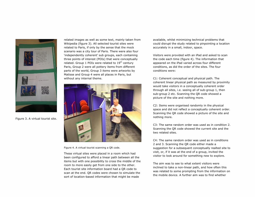
related images as well as some text, mainly taken from Wikipedia (figure 3). All selected tourist sites were related to Paris, if only by the sense that the mock scenario was a city tour of Paris. There were also four ‘independently coherent’ sub groups, each containing three points of interest (POIs) that were conceptually related. Group 1 POIs were related to 19th century Paris, Group 2 were all pottery items from different parts of the world, Group 3 items were artworks by Matisse and Group 4 were all places in Paris, but without any internal theme.
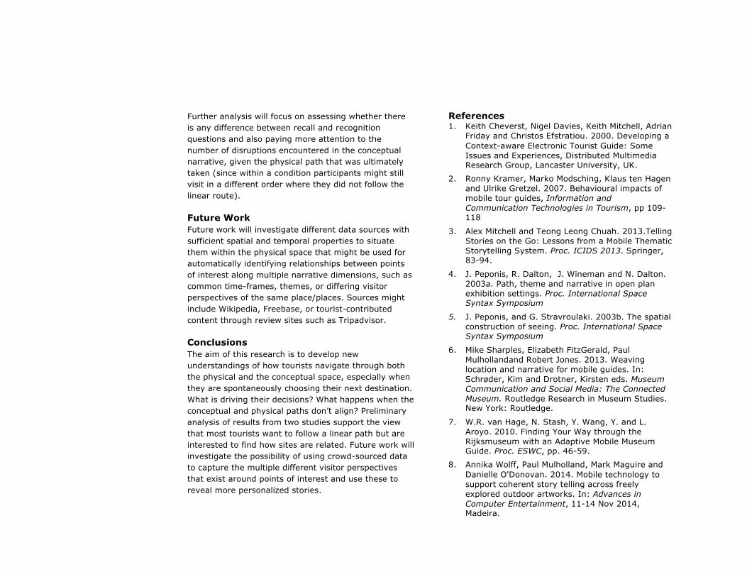
Figure 4. A virtual tourist scanning a QR code.
These virtual sites were placed in a room which had been configured to afford a linear path between all the items but with one possibility to cross the middle of the room to more easily get from one side to the other. Each tourist site information board had a QR code to scan at the end. QR codes were chosen to simulate the sort of location-based information that might be made
available, whilst minimizing technical problems that could disrupt the study related to pinpointing a location accurately in a small, indoor, space.
Visitors were provided with an iPad and asked to scan the code each time (figure 4). The information that appeared on the iPad varied across four different conditions, as did the order of the sites. The four conditions were:
C1: Coherent conceptual and physical path. The coherent linear physical path as measured by proximity would take visitors in a conceptually coherent order through all sites, i.e. seeing all of sub-group 1, then sub-group 2 etc. Scanning the QR code showed a picture of the site and nothing more.
C2: Items were organised randomly in the physical space and did not reflect a conceptually coherent order. Scanning the QR code showed a picture of the site and nothing more.
C3: The same random order was used as in condition 2. Scanning the QR code showed the current site and the two related sites.
C4: The same random order was used as in conditions 2 and 3. Scanning the QR code either made a suggestion for a subsequent conceptually realted site to visit, or, if it was at the end of a group, invited the visitor to look around for something new to explore.
The aim was to see to what extent visitors were inclined to take a non-linear path, and how often this was related to some prompting from the information on the mobile device. A further aim was to find whether
Figure 3. A virtual tourist site.

either visiting POIs in a conceptual order, or finding how sites were conceptually related by seeing them presented each time as coherent groups on the device, even when they weren’t visited in that order, would help recall or lead to better stories after the visit than if sites were visited in a non-conceptual order. A further aim was to discover whether being prompted to follow a conceptual route at the expense of following a more coherent physical route might in fact disrupt recall.
Visitors took a pre and post questionnaire, in the pre questionnaire the main focus was on their normal travel preferences. In the post questionnaire, participants were asked to summarise their trip for someone who hadn’t been there, then to answer a number of questions that tested their recognition (e.g. ‘did you see….) and recall (e.g. what was…). 20 participants completed the virtual tour, 5 in each condition. What follows is a very preliminary analysis of their data.
The routes can be categorized in terms of whether they are linear or not. 15 participants chose a linear route. Of the 5 participants who chose a non-linear route, 4 were in the last two conditions where the device was either presenting information that revealed the whole subgroup (C3) or the device was prompting the visitor towards where a closely related item could be found (C4). While it is hard to draw firm conclusions from such a small sample, this does appear to backup the idea that people will generally select a route based on ‘nearest first’. Of the remaining 5, three appeared to be random routes that could not be explained by the prompts that would have been presented on the device. In the last two cases, one participant in C3 had deliberately sought out all of the related items presented on the device before moving onto the next
group, therefore seeing items in a coherent order similar to condition 1. A participant in C4 appeared to be trying to follow the instruction in most cases, but on some occasions had been sidetracked along the route by a different item, which they then scanned. Therefore, they saw some coherent groupings whilst others were disrupted.
A preliminary analysis of the number of correct question answers against the different conditions shows an interesting trend. Participants in conditions where they either visited in a coherent order (C1) or were presented with coherent groupings regardless of their physical path (C3) tended to get higher mean scores (5.4 and 5.2, respectively) than participants who either visited in a random order (C2) or were directed to follow the conceptual path (C4) (4.4 and 3.6, respectively). In fact, the experience in C2 and C4 was often similar, because many participants chose not to follow the recommended order. These findings could suggest that whilst conceptual coherence can help recall in some situations, such as when the physical and conceptual path happen to align, or when a visitor follows a coherent physical path in a physical space and a coherent conceptual one on a device, there may be some disruption when a tourist is prompted to take non-coherent physical path in order to experience a cultural narrative in a coherent conceptual order. This could be due to tourists being sidetracked by other points of interest while they are travelling between the conceptually related sites and making detours. Preliminary analysis of the stories and comments of participants reveals a strong interest in understanding how the places are related, with at least 8 participants explicitly mentioning (unprompted) that this improves their experience of a tour.
Further analysis will focus on assessing whether there is any difference between recall and recognition questions and also paying more attention to the number of disruptions encountered in the conceptual narrative, given the physical path that was ultimately taken (since within a condition participants might still visit in a different order where they did not follow the linear route).
Future Work Future work will investigate different data sources with sufficient spatial and temporal properties to situate them within the physical space that might be used for automatically identifying relationships between points of interest along multiple narrative dimensions, such as common time-frames, themes, or differing visitor perspectives of the same place/places. Sources might include Wikipedia, Freebase, or tourist-contributed content through review sites such as Tripadvisor.
Conclusions The aim of this research is to develop new understandings of how tourists navigate through both the physical and the conceptual space, especially when they are spontaneously choosing their next destination. What is driving their decisions? What happens when the conceptual and physical paths don’t align? Preliminary analysis of results from two studies support the view that most tourists want to follow a linear path but are interested to find how sites are related. Future work will investigate the possibility of using crowd-sourced data to capture the multiple different visitor perspectives that exist around points of interest and use these to reveal more personalized stories.
References 1. Keith Cheverst, Nigel Davies, Keith Mitchell, Adrian
Friday and Christos Efstratiou. 2000. Developing a Context-aware Electronic Tourist Guide: Some Issues and Experiences, Distributed Multimedia Research Group, Lancaster University, UK.
2. Ronny Kramer, Marko Modsching, Klaus ten Hagen and Ulrike Gretzel. 2007. Behavioural impacts of mobile tour guides, Information and Communication Technologies in Tourism, pp 109-118
3. Alex Mitchell and Teong Leong Chuah. 2013.Telling Stories on the Go: Lessons from a Mobile Thematic Storytelling System. Proc. ICIDS 2013. Springer, 83-94.
4. J. Peponis, R. Dalton, J. Wineman and N. Dalton. 2003a. Path, theme and narrative in open plan exhibition settings. Proc. International Space Syntax Symposium
5. J. Peponis, and G. Stravroulaki. 2003b. The spatial construction of seeing. Proc. International Space Syntax Symposium
6. Mike Sharples, Elizabeth FitzGerald, Paul Mulhollandand Robert Jones. 2013. Weaving location and narrative for mobile guides. In: Schrøder, Kim and Drotner, Kirsten eds. Museum Communication and Social Media: The Connected Museum. Routledge Research in Museum Studies. New York: Routledge.
7. W.R. van Hage, N. Stash, Y. Wang, Y. and L. Aroyo. 2010. Finding Your Way through the Rijksmuseum with an Adaptive Mobile Museum Guide. Proc. ESWC, pp. 46-59.
8. Annika Wolff, Paul Mulholland, Mark Maguire and Danielle O'Donovan. 2014. Mobile technology to support coherent story telling across freely explored outdoor artworks. In: Advances in Computer Entertainment, 11-14 Nov 2014, Madeira.