Embed Size (px)
Citation preview

Licence GNU FDL OSLANDIA SARL / 25. novembre 2009 / www.oslandia.com / [email protected]
Open Source – OGC Web ServicesOlivier COURTIN - 2nd Worshop on the use od GIS/OGC Standards in Meteorology

OslandiaYoung and Small CompanyExpertise in GIS OpenSource
Mainly Focus on:Spatial Databases (PostGIS, SpatiaLite)OGC/ISO Web ServicesRouting, Network and Graphs Solutions
OGC member inscription in progress

Summary
OGC Web Services, with some OSS implementations:WMSWFSWPSSOS
PostGIS & TinyOWS: Reducing stack concept
Conclusions/Questions

WMS with SLD synopsis
WMS ServerWMS Client
GetCapabilities
GetMap
DescribeLayer
GetLegendGraphic

MapServer ApplicationOsGeo MemberWritten in COGR/GDAL abstraction data accessUsed as CGI or FastCGIWidely used and matureConfiguration via a text-based file (MapFile)

GeoServer ApplicationOsGeo incubation processWritten in JAVAGDAL plugin to raster data accessUsed with Tomcat and deployed as a .warWidely used and matureNative Administration Web InterfaceOGC reference application for WFS 1.0.0
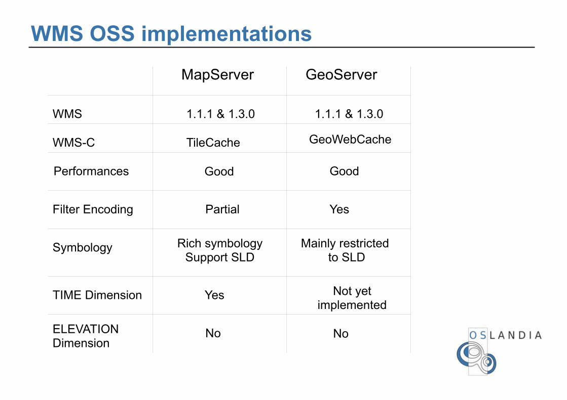
WMS OSS implementations
MapServer GeoServer
WMS 1.1.1 & 1.3.0 1.1.1 & 1.3.0
Performances GoodGood
Filter Encoding Partial Yes
Symbology Rich symbologySupport SLD
Mainly restricted to SLD
TIME Dimension Yes Not yetimplemented
ELEVATIONDimension
NoNo
WMS-C TileCache GeoWebCache

WFS synopsis
WFS ServerWFS Client
GetCapabilities
DescribeFeatureType
GetFeature

WFS-T synopsis
WFS ServerWFS Client
GetCapabilities
DescribeFeatureType
GetFeature
Transaction
LockFeature

TinyOWSHigh performance WFS-T architecturePostGIS frontend applicationWritten in CCGI based

WFS OSS implementations
MapServer GeoServer TinyOWS
WFS1.0.0
(Only Basic Profile) 1.0.0 & 1.1.0 1.0.0 & 1.1.0
ISO 19142(aka WFS 2.0.0)
NoNoNo
GML 2.1.2 & 3.1.1 2.1.2 & 3.1.1 2.1.2 & 3.1.1
DatabasesBackend
PostGISOracleSpatial
ArcSDEPostGIS
PostGISOracleSpatial
ArcSDE

WPS synopsis
WPS ServerWPS Client
GetCapabilities
DescribeProcess
Execute

PyWPS ApplicationOsGeo incubation processWritten in PythonUsed as a CGIProcessing tools with Python API libs & applications:
GRASS
R
GRASS
OGR/GDAL
PostGIS
PyWPS

52 North WPS ApplicationWritten in JAVADeployed with TomCat environmentProcessing tools with some JAVA libs:
GeoTools
JTS
GeoAPI
52 NorthWPS

WPS OSS implementations
PyWPS 52 North WPS
WPS 1.0.0
1.0.0
HTTP Method GET / POSTGET / POST
SOAP &WSDL support
No
YesRaster support
Yes
No

SOS synopsis
SOS ServerSOS Client
GetCapabilities
DescribeSensor
GetObservation

SOS-T synopsis
SOS ServerSOS Client
GetCapabilities
DescribeSensor
GetObservation
RegisterSensorRegisterSensor
InsertObservation

OSS SOS implementations 52 North SOS project
JAVA applicationDeploy as a Tomcat .war
OOS ThetysJAVA application
NetCDF datas
Python application (PySOS)Spatial databases datas

SOS OSS implementations
MapServer 52 North SOS PySOS
SOS 1.0.0(Only Basic Profile)
1.0.0Basic, enhancedTransactional
DatabasesBackend
PostGISOracle Spatial
Arc SDEPostGISPostGIS
1.0.0(Only Basic Profile)

Summary
OGC Web Services, with some OSS implementations:WMSWFSWPSSOS
PostGIS & TinyOWS: Reducing stack concept
Conclusions

Why TinyOWS
Begin as a R&D projectYet another WFS server
Keep Lightweight architecturePerfect couple with MapServer as a WMSNo need to use Tomcat to provide WFS-T
Performances in mind

Reduce Web Services stackImplement Web Services directly in front of PostGISPerformances in mind
Data Storage
Data API
OWS Server
Data API
Map Engine
OWS Client
OWS Server
OWS Client
PostGIS
OWS Client
TinyOWS
Common OWS Architecture Stack
TinyOWS Architecture Stack

PostGIS GML import/export functions
ST_AsGMLGML 3.1.1 compliant
OGC CRS urn formatLat/lon reverse axis order issue
Availabilty: 1.4.0
ST_GeomFromGMLGML 3.1.1 Simple Features profile SF-2GML 2.1.2 GML 3.2.1 Namespace supportAvailability: 1.5.0

PostGIS GML import/export functions
ST_AsGMLGML 3.1.1 compliant
OGC CRS urn formatLat/lon reverse axis order issue
Availabilty: 1.4.0
ST_GeomFromGMLGML 3.1.1 Simple Features profile SF-2GML 2.1.2 GML 3.2.1 Namespace supportAvailability: 1.5.0

TinyOWS History
October 2007First public presentation: FOSS4G 2007 – VictoriaVersion 0.6.0 (alpha)
2008MapGears contributions Add MapGears project demonstration Lot of improves and bugfixes
March 2009 (Toronto Code Sprint)DMSolutions contributionAchieve export function rewrite and bugfixes (1.4.0 branch)
July 2009TinyOWS 0.7.0 released (tied on PostGIS stable 1.4.0)OGRS presentation
December 2009Plan to TinyOWS 0.8 (tied on PostGIS 1.5.0)

GetFeature Benchmarck on a single Layer
200 Features 1000 Features
TinyOWS
MapServer
GeoServer
2.5s
4.3s
0.5s
12.1s
1.0s
1.7s
5000 Features
11.4s
20.1s
39.5s

TinyOWS: Units tests policyOGC CITE Units Test development driven
Valgrind testmemory leak check

Current reflexionsIs it also meaningfull to bring SOS operations like getObservation as close as possible to PostGIS ?
WKT Raster could provide some WCS rasters primitives ?

QuestionsThanks you !