Embed Size (px)
Citation preview
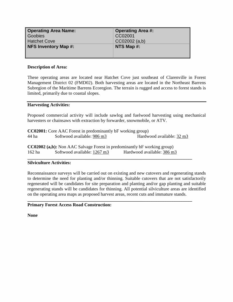
Description of Area: These operating areas are located near Hatchet Cove just southeast of Clarenville in Forest Management District 02 (FMD02). Both harvesting areas are located in the Northeast Barrens Subregion of the Maritime Barrens Ecoregion. The terrain is rugged and access to forest stands is limited, primarily due to coastal slopes. Harvesting Activities: Proposed commercial activity will include sawlog and fuelwood harvesting using mechanical harvesters or chainsaws with extraction by forwarder, snowmobile, or ATV. CC02001: Core AAC Forest in predominantly bF working group) 44 ha Softwood available: 986 m3 Hardwood available: 32 m3 CC02002 (a,b): Non AAC Salvage Forest in predominantly bF working group) 162 ha Softwood available: 1267 m3 Hardwood available: 386 m3 ________________________________________________________________________ Silviculture Activities: Reconnaissance surveys will be carried out on existing and new cutovers and regenerating stands to determine the need for planting and/or thinning. Suitable cutovers that are not satisfactorily regenerated will be candidates for site preparation and planting and/or gap planting and suitable regenerating stands will be candidates for thinning. All potential silviculture areas are identified on the operating area maps as proposed harvest areas, recent cuts and immature stands. ________________________________________________________________________ Primary Forest Access Road Construction: None
Operating Area Name: Goobies Hatchet Cove
Operating Area #: CC02001 CC02002 (a,b)
NFS Inventory Map #:
NTS Map #:

________________________________________________________________________ Non Timber Considerations and Mitigations: Hatchet Cove Road Mapsheet Protected Road Zone: Permits for operating within Protected Road Zone will be obtained for CC02001. Water bodies: A minimum 20 meter buffer will be maintained on both sides of all rivers, brooks, ponds or other water bodies that are shown on 1:50,000 Topographic maps. Cottage Areas: There will be no cutting within 100 meters of a designated cabin development area and 20 meters of a registered legal cabin. Raptor Nest: No forestry activity is to occur within 800 meters of a bald eagle or osprey nest during the nesting season (Mar 15 to July 31) and 200 meters during the remainder of the year.

Description of Area: These operating areas are located near Beaver Pond just southwest of Clarenville in Forest Management District 02 (FMD02). Both harvesting areas are located in the Northcentral Subregion of the Central Newfoundland Ecoregion. The terrain is rugged and access to forest stands is limited. Harvesting Activities: Proposed commercial activity will include sawlog and fuelwood harvesting using mechanical harvesters or chainsaws with extraction by forwarder, snowmobile, or ATV. CC02008: Core AAC Forest in predominantly sH working group) 35 ha Softwood available: 2485 m3 Hardwood available: 521 m3 CC02009 (a): Core AAC Salvage Forest in predominantly bS working group) CC02009 (b,c): Core AAC Forest in predominantly bS working group) 293 ha Softwood available: 22837 m3 Hardwood available: 1457 m3 _______________________________________________________________________ Silviculture Activities: Reconnaissance surveys will be carried out on existing and new cutovers and regenerating stands to determine the need for planting and/or thinning. Suitable cutovers that are not satisfactorily regenerated will be candidates for site preparation and planting and/or gap planting and suitable regenerating stands will be candidates for thinning. All potential silviculture areas are identified on the operating area maps as proposed harvest areas, recent cuts and immature stands. ________________________________________________________________________ Primary Forest Access Road Construction: CC02009 – 0.75 km of new construction required
Operating Area Name: Northwest Brook Beaver Pond
Operating Area #: CC02008, CC02009(a,b,c)
NFS Inventory Map #:
NTS Map #:

Non Timber Considerations and Mitigations: Beaver Pond Mapsheet Viewscape Interest: In operating area CC02009 harvesting will be restricted on slopes highly visible from Trailway. Provincial T’Railway: A portion of the Provincial T’Railway (7.0 km between Northwest Brook Access Road and Beaver Pond Access Road) will be used for timber extraction from operating area CC02009. No extraction will occur during periods when the Newfoundland and Labrador Snowmobile Federation is in operation. As pursuant to Section 10 of the Provincial Parks Regulations the Forest Service Branch will request a permit to access the T’Railway prior to any harvesting operations. There will be no cutting within 100 meters of the Provincial T’Railway. Outfitters: In operating area CC02009 FSB will work with Outfitters and Harvesters to accommodate hunting/harvesting schedules. Scheduled Salmon Rivers: 100 meters no cut buffer. Water bodies: A minimum 20 meter buffer will be maintained on both sides of all rivers, brooks, ponds or other water bodies that are shown on 1:50,000 Topographic maps. Cottage Areas: There will be no cutting within 100 meters of a designated cabin development area and 20 meters of a registered legal cabin. No cottage development recommended within CC02009. Raptor Nest: No forestry activity is to occur within 800 meters of a bald eagle or osprey nest during the nesting season (Mar 15 to July 31) and 200 meters during the remainder of the year.
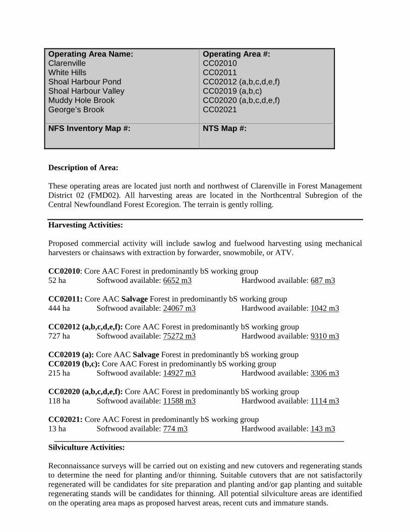
Description of Area: These operating areas are located just north and northwest of Clarenville in Forest Management District 02 (FMD02). All harvesting areas are located in the Northcentral Subregion of the Central Newfoundland Forest Ecoregion. The terrain is gently rolling. Harvesting Activities: Proposed commercial activity will include sawlog and fuelwood harvesting using mechanical harvesters or chainsaws with extraction by forwarder, snowmobile, or ATV. CC02010: Core AAC Forest in predominantly bS working group 52 ha Softwood available: 6652 m3 Hardwood available: 687 m3 CC02011: Core AAC Salvage Forest in predominantly bS working group 444 ha Softwood available: 24067 m3 Hardwood available: 1042 m3 CC02012 (a,b,c,d,e,f): Core AAC Forest in predominantly bS working group 727 ha Softwood available: 75272 m3 Hardwood available: 9310 m3 CC02019 (a): Core AAC Salvage Forest in predominantly bS working group CC02019 (b,c): Core AAC Forest in predominantly bS working group 215 ha Softwood available: 14927 m3 Hardwood available: 3306 m3 CC02020 (a,b,c,d,e,f): Core AAC Forest in predominantly bS working group 118 ha Softwood available: 11588 m3 Hardwood available: 1114 m3 CC02021: Core AAC Forest in predominantly bS working group 13 ha Softwood available: 774 m3 Hardwood available: 143 m3 ________________________________________________________________________ Silviculture Activities: Reconnaissance surveys will be carried out on existing and new cutovers and regenerating stands to determine the need for planting and/or thinning. Suitable cutovers that are not satisfactorily regenerated will be candidates for site preparation and planting and/or gap planting and suitable regenerating stands will be candidates for thinning. All potential silviculture areas are identified on the operating area maps as proposed harvest areas, recent cuts and immature stands.
Operating Area Name: Clarenville White Hills Shoal Harbour Pond Shoal Harbour Valley Muddy Hole Brook George’s Brook
Operating Area #: CC02010 CC02011 CC02012 (a,b,c,d,e,f) CC02019 (a,b,c) CC02020 (a,b,c,d,e,f) CC02021
NFS Inventory Map #: NTS Map #:
________________________________________________________________________ Primary Forest Access Road Construction: CC02011 – 2.00 km of new construction required CC02012 – 6.40 km of new construction required CC02012 – 1.35 km of reconstruction required CC02019 – 3.50 km of new construction required CC02020 – 1.10 km of new construction required CC02020 – 1.50 km of reconstruction required ________________________________________________________________________ Non Timber Considerations and Mitigations: White Hills Road Mapsheet Newfoundland Marten: Where operationally feasible, harvesting operations will be avoided in Commercial Harvest Blocks CC02011, CC02012 (A, B, C, D, E, F), CC02019 (A, B, C), CC02020 (A, B, C, D, E ,F) from April to June which is the critical denning period for marten: Provincial T’Railway: There will be no cutting within 100 meters of the Provincial T’Railway. Protected Water Supply Areas: Road construction, harvesting and silviculture all constitute development within a PWSA and will be conducted under permit from the Water Resources Division of the Department of Environment and Conservation, in consultation with the appropriate Municipal Council or Local Service District. Mitigating measures prescribed within permits will be adhered to. White Hills Ski Resort: No cut reserve around White Hills Ski Resort. Timber extraction on the access road to White Hills Ski resort will be limited to light traffic only. Highway Viewscapes: The Forest Service, where operationally feasible, will implement strategies to provide a balance between forest harvesting and the non-timber values identified by Tourism in Commercial Harvest Blocks CC02011, CC02012, CC02019, CC02020. At a minimum, the Forest Service will maintain a 100 m no cut buffer along all highways. Scheduled Salmon Rivers: 100 meters no cut buffer. Water bodies: A minimum 20 meter buffer will be maintained on both sides of all rivers, brooks, ponds or other water bodies that are shown on 1:50,000 Topographic maps. Cottage Areas: There will be no cutting within 100 meters of a designated cabin development area and 20 meters of a registered legal cabin. Raptor Nest: No forestry activity is to occur within 800 meters of a bald eagle or osprey nest during the nesting season (Mar 15 to July 31) and 200 meters during the remainder of the year.

Description of Area: These operating areas are located on Random Island in Forest Management District 02 (FMD02). All harvesting areas are located in the Northeastern Barrens Subregion of the Maritime Barrens Ecoregion. The terrain is gently rolling. Harvesting Activities: Proposed commercial activity will include sawlog and fuelwood harvesting using mechanical harvesters or chainsaws with extraction by forwarder, snowmobile, or ATV. CC02003: Core AAC Forest in predominantly bS working group 244 ha Softwood available: 18622 m3 Hardwood available: 2070 m3 CC02004: Core AAC Forest in predominantly bS working group 57 ha Softwood available: 5678 m3 Hardwood available: 532 m3 CC02005: Core AAC Forest in predominantly bS/BF working group 259 ha Softwood available: 19382 m3 Hardwood available: 2031 m3 CC02006: Non-AAC Salvage Forest in predominantly bF working group 202 ha Softwood available: 1675 m3 Hardwood available: 37 m3 CC02007: Core AAC Forest in predominantly bS working group 58 ha Softwood available: 3684 m3 Hardwood available: 260 m3 ________________________________________________________________________ Silviculture Activities: Reconnaissance surveys will be carried out on existing and new cutovers and regenerating stands to determine the need for planting and/or thinning. Suitable cutovers that are not satisfactorily regenerated will be candidates for site preparation and planting and/or gap planting and suitable regenerating stands will be candidates for thinning. All potential silviculture areas are identified on the operating area maps as proposed harvest areas, recent cuts and immature stands. ________________________________________________________________________ Primary Forest Access Road Construction: CC02005 – 3.50 km of reconstruction required ________________________________________________________________________
Operating Area Name: Burnt Point Snook’s Harbour Foster’s Marsh Hickman’s Harbour Road Bluff Head Pond
Operating Area #: CC02003 CC02004 CC02005 CC02006 CC02007
NFS Inventory Map #:
NTS Map #:
Non Timber Considerations and Mitigations: Random Island Mapsheet Water bodies: A minimum 20 meter buffer will be maintained on both sides of all rivers, brooks, ponds or other water bodies that are shown on 1:50,000 Topographic maps. Cottage Areas: There will be no cutting within 100 meters of a designated cabin development area and 20 meters of a registered legal cabin. Raptor Nest: No forestry activity is to occur within 800 meters of a bald eagle or osprey nest during the nesting season (Mar 15 to July 31) and 200 meters during the remainder of the year.

Description of Area: These operating areas are located North of Smith’s Sound, Trinity Bay near Big Pond in Forest Management District 02 (FMD02). They fall within the transition zone of three different ecoregions, namely, the Central Newfoundland Forest, the North Shore Forest and the Maritime Barrens. More specifically: area C0224 is within both the North Shore Forest Ecoregion and the Northcentral Subregion of the Central Newfoundland Forest Ecoregion; area C0246 is within the Northeastern Barrens Subregion of the Maritime Barrens Ecoregion; area 247 is within both the North Shore Forest Ecoregion and Northeastern Barrens Subregion of the Maritime Barrens Ecoregion; and area C0264 is within the North Shore Forest Ecoregion. The terrain is relatively flat becoming more rugged in the southeast. Access to forest stands in area C0246 is limited. Harvesting Activities: Proposed commercial activity will include sawlog and fuelwood harvesting using mechanical harvesters or chainsaws with extraction by forwarder, snowmobile, or ATV. CC02022: Core AAC Forest in predominantly bS working group 13 ha Softwood available: 791 m3 Hardwood available: 23 m3 CC02023 (a,b,c,d,e): Core AAC Salvage Forest in predominantly bS working group 153 ha Softwood available: 8018 m3 Hardwood available: 505 m3 CC02028 (a,b,c,d,e): Core AAC Forest in predominantly bS working group 179 ha Softwood available: 10344 m3 Hardwood available: 2324 m3 CC02029 (a): Core AAC Forest in predominantly bS working group CC02029 (b,c): Core AAC Forest in predominantly sH working group CC02029 (d,e): Core AAC Salvage Forest in predominantly sH working group 75 ha Softwood available: 4811 m3 Hardwood available: 159 m3 CC02030 (a,b,c,d,e): Core AAC Salvage Forest in predominantly bS working group 46 ha Softwood available: 3271 m3 Hardwood available: 204 m3 _______________________________________________________________________ Silviculture Activities: Reconnaissance surveys will be carried out on existing and new cutovers and regenerating stands to determine the need for planting and/or thinning. Suitable cutovers that are not satisfactorily
Operating Area Name: Barton Harcourt Access Road Big Pond Gull Pond Island Pond
Operating Area #: CC02022 CC02023 (a,b,c,d,e) CC02028 (a,b,c,d,e) CC02029 (a,b,c,d,e) CC02030
NFS Inventory Map #:
NTS Map #:
regenerated will be candidates for site preparation and planting and/or gap planting and suitable regenerating stands will be candidates for thinning. All potential silviculture areas are identified on the operating area maps as proposed harvest areas, recent cuts and immature stands. Operating areas C0224 and C0264 are within the Agriculture Development Area and will not be scheduled for follow up silviculture treatments. ________________________________________________________________________ Primary Forest Access Road Construction: CC02028 – 3.80 km of new construction required. ________________________________________________________________________ Non Timber Considerations and Mitigations: Harcourt Road Mapsheet Protected Road Zone: Permits for operating within Protected Road Zone will be obtained for CC02029. Highway Viewscapes: The Forest Service, where operationally feasible, will implement strategies to provide a balance between forest harvesting and the non-timber values identified by Tourism in Commercial Harvest Blocks CC02029. At a minimum, the Forest Service will maintain a 100 m no cut buffer along all highways. Water bodies: A minimum 20 meter buffer will be maintained on both sides of all rivers, brooks, ponds or other water bodies that are shown on 1:50,000 Topographic maps. Cottage Areas: There will be no cutting within 100 meters of a designated cabin development area and 20 meters of a registered legal cabin. In addition there will be no cutting within 150 meters of Long Pond and Oates Pond, adjacent area C0247. Raptor Nest: No forestry activity is to occur within 800 meters of a bald eagle or osprey nest during the nesting season (Mar 15 to July 31) and 200 meters during the remainder of the year.
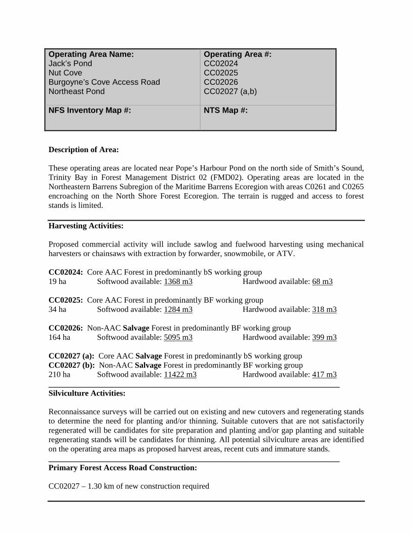
Description of Area: These operating areas are located near Pope’s Harbour Pond on the north side of Smith’s Sound, Trinity Bay in Forest Management District 02 (FMD02). Operating areas are located in the Northeastern Barrens Subregion of the Maritime Barrens Ecoregion with areas C0261 and C0265 encroaching on the North Shore Forest Ecoregion. The terrain is rugged and access to forest stands is limited. Harvesting Activities: Proposed commercial activity will include sawlog and fuelwood harvesting using mechanical harvesters or chainsaws with extraction by forwarder, snowmobile, or ATV. CC02024: Core AAC Forest in predominantly bS working group 19 ha Softwood available: 1368 m3 Hardwood available: 68 m3 CC02025: Core AAC Forest in predominantly BF working group 34 ha Softwood available: 1284 m3 Hardwood available: 318 m3 CC02026: Non-AAC Salvage Forest in predominantly BF working group 164 ha Softwood available: 5095 m3 Hardwood available: 399 m3 CC02027 (a): Core AAC Salvage Forest in predominantly bS working group CC02027 (b): Non-AAC Salvage Forest in predominantly BF working group 210 ha Softwood available: 11422 m3 Hardwood available: 417 m3 ________________________________________________________________________ Silviculture Activities: Reconnaissance surveys will be carried out on existing and new cutovers and regenerating stands to determine the need for planting and/or thinning. Suitable cutovers that are not satisfactorily regenerated will be candidates for site preparation and planting and/or gap planting and suitable regenerating stands will be candidates for thinning. All potential silviculture areas are identified on the operating area maps as proposed harvest areas, recent cuts and immature stands. ________________________________________________________________________ Primary Forest Access Road Construction: CC02027 – 1.30 km of new construction required
Operating Area Name: Jack’s Pond Nut Cove Burgoyne’s Cove Access Road Northeast Pond
Operating Area #: CC02024 CC02025 CC02026 CC02027 (a,b)
NFS Inventory Map #:
NTS Map #:
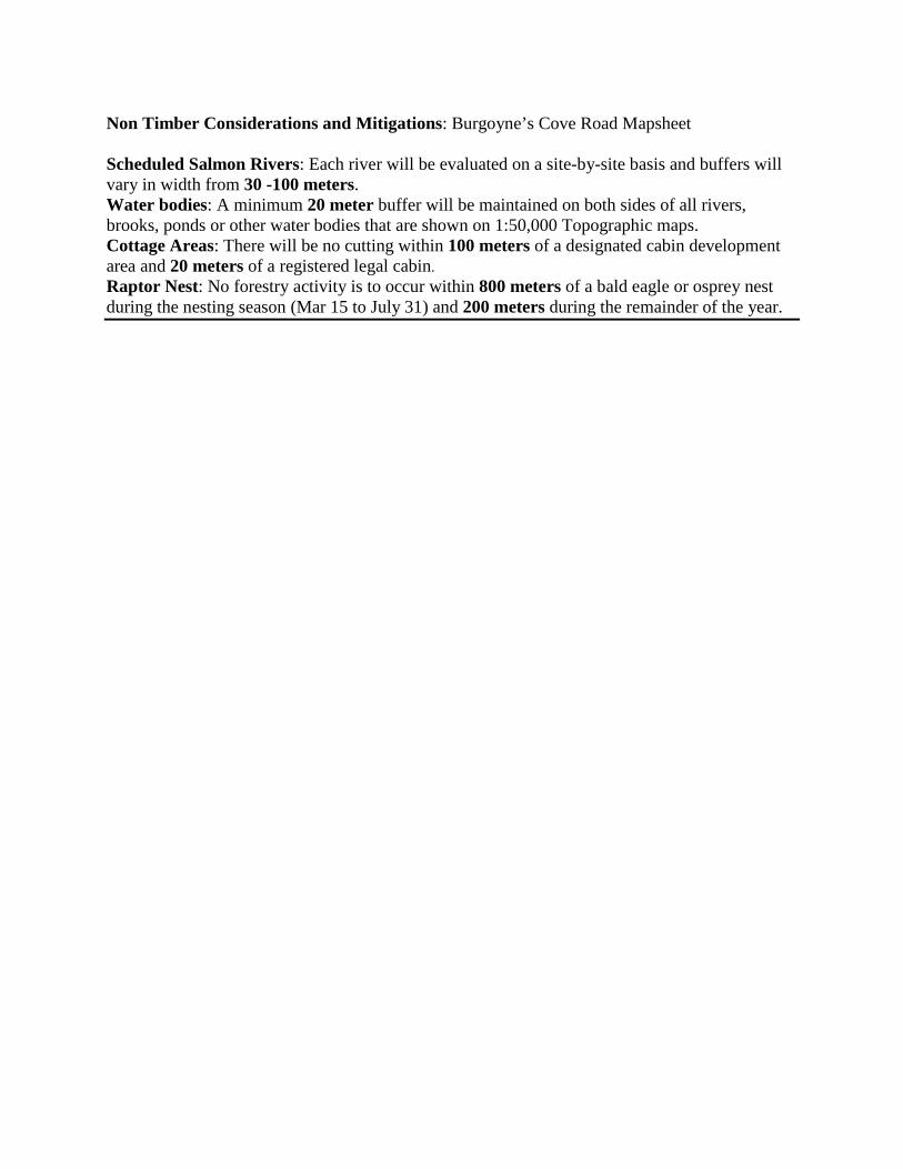
Non Timber Considerations and Mitigations: Burgoyne’s Cove Road Mapsheet Scheduled Salmon Rivers: Each river will be evaluated on a site-by-site basis and buffers will vary in width from 30 -100 meters. Water bodies: A minimum 20 meter buffer will be maintained on both sides of all rivers, brooks, ponds or other water bodies that are shown on 1:50,000 Topographic maps. Cottage Areas: There will be no cutting within 100 meters of a designated cabin development area and 20 meters of a registered legal cabin. Raptor Nest: No forestry activity is to occur within 800 meters of a bald eagle or osprey nest during the nesting season (Mar 15 to July 31) and 200 meters during the remainder of the year.
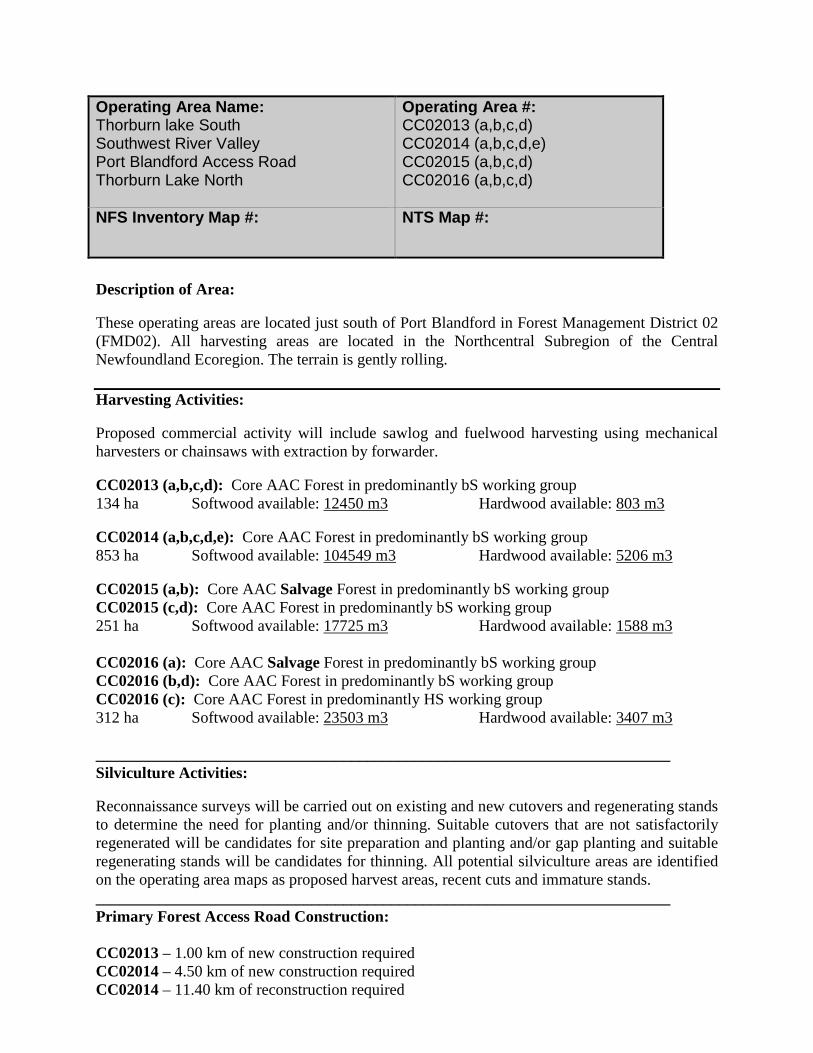
Description of Area: These operating areas are located just south of Port Blandford in Forest Management District 02 (FMD02). All harvesting areas are located in the Northcentral Subregion of the Central Newfoundland Ecoregion. The terrain is gently rolling. Harvesting Activities: Proposed commercial activity will include sawlog and fuelwood harvesting using mechanical harvesters or chainsaws with extraction by forwarder. CC02013 (a,b,c,d): Core AAC Forest in predominantly bS working group 134 ha Softwood available: 12450 m3 Hardwood available: 803 m3 CC02014 (a,b,c,d,e): Core AAC Forest in predominantly bS working group 853 ha Softwood available: 104549 m3 Hardwood available: 5206 m3 CC02015 (a,b): Core AAC Salvage Forest in predominantly bS working group CC02015 (c,d): Core AAC Forest in predominantly bS working group 251 ha Softwood available: 17725 m3 Hardwood available: 1588 m3 CC02016 (a): Core AAC Salvage Forest in predominantly bS working group CC02016 (b,d): Core AAC Forest in predominantly bS working group CC02016 (c): Core AAC Forest in predominantly HS working group 312 ha Softwood available: 23503 m3 Hardwood available: 3407 m3 ________________________________________________________________________ Silviculture Activities: Reconnaissance surveys will be carried out on existing and new cutovers and regenerating stands to determine the need for planting and/or thinning. Suitable cutovers that are not satisfactorily regenerated will be candidates for site preparation and planting and/or gap planting and suitable regenerating stands will be candidates for thinning. All potential silviculture areas are identified on the operating area maps as proposed harvest areas, recent cuts and immature stands. ________________________________________________________________________ Primary Forest Access Road Construction: CC02013 – 1.00 km of new construction required CC02014 – 4.50 km of new construction required CC02014 – 11.40 km of reconstruction required
Operating Area Name: Thorburn lake South Southwest River Valley Port Blandford Access Road Thorburn Lake North
Operating Area #: CC02013 (a,b,c,d) CC02014 (a,b,c,d,e) CC02015 (a,b,c,d) CC02016 (a,b,c,d)
NFS Inventory Map #:
NTS Map #:

CC02015 – 1.10 km of new construction required CC02016 – 1.40 km of new construction required CC02016 – 1.30 km of reconstruction required _______________________________________________________________________ Non Timber Considerations and Mitigations: Port Blandford Mapsheet Viewscape Interest: In operating area CC02013, CC02015, and CC02016, harvesting will be restricted on slopes highly visible from the Trans Canada Highway and the Town of Port Blandford.. Terra Nova National Park: Viewscape preservation principles will be used when planning harvest in CC02013, CC02014, and CC02015 where harvesting would be visible from particular vantage points in TNNP. Protected Road Zone: Permits for operating within Protected Road Zone will be obtained for CC02014 and CC02015. Provincial T’Railway: A portion of the Provincial T’Railway (2.0 km at Thorburn Lake) will be used for timber extraction from operating area CC02013. No extraction will occur during periods when the Newfoundland and Labrador Snowmobile Federation is in operation. As pursuant to Section 10 of the Provincial Parks Regulations the Forest Service Branch will request a permit to access the T’Railway prior to any harvesting operations. There will be no cutting within 100 meters of the Provincial T’Railway. Newfoundland Marten: Harvesting operations are not to occur in Commercial Harvest Blocks CC02013 (A, B, C, D) between April 1st to June 30th which is the critical denning period for marten. Where operationally feasible, harvesting operations will be avoided in Commercial Harvest Blocks CC02014 (A, B, C, D), CC02015 (A, B, C, D), CC02016 (A,B,C,D) from April to June which is the critical denning period for marten. Protected Water Supply Areas: Road construction, harvesting and silviculture all constitute development within a PWSA and will be conducted under permit from the Water Resources Division of the Department of Environment and Conservation, in consultation with the appropriate Municipal Council or Local Service District. Mitigating measures prescribed within permits will be adhered to. Highway Viewscapes: The Forest Service, where operationally feasible, will implement strategies to provide a balance between forest harvesting and the non-timber values identified by Tourism in Commercial Harvest Blocks CC02013, CC02014. At a minimum, the Forest Service will maintain a 100 m no cut buffer along all highways. Scheduled Salmon Rivers: Each river will be evaluated on a site-by-site basis and buffers will vary in width from 30 -100 meters. Water bodies: A minimum 20 meter buffer will be maintained on both sides of all rivers, brooks, ponds or other water bodies that are shown on 1:50,000 Topographic maps. Cottage Areas: There will be no cutting within 100 meters of a designated cabin development area and 20 meters of a registered legal cabin. Raptor Nest: No forestry activity is to occur within 800 meters of a bald eagle or osprey nest during the nesting season (Mar 15 to July 31) and 200 meters during the remainder of the year.
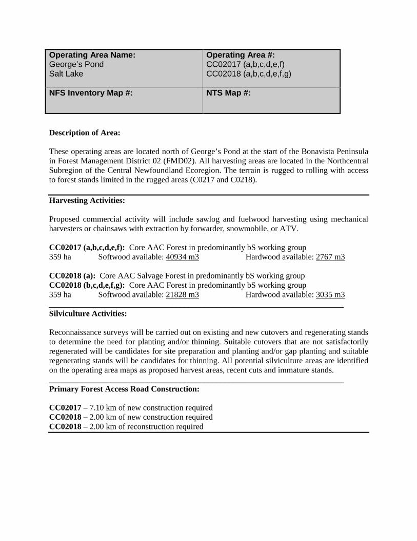
Description of Area: These operating areas are located north of George’s Pond at the start of the Bonavista Peninsula in Forest Management District 02 (FMD02). All harvesting areas are located in the Northcentral Subregion of the Central Newfoundland Ecoregion. The terrain is rugged to rolling with access to forest stands limited in the rugged areas (C0217 and C0218). Harvesting Activities: Proposed commercial activity will include sawlog and fuelwood harvesting using mechanical harvesters or chainsaws with extraction by forwarder, snowmobile, or ATV. CC02017 (a,b,c,d,e,f): Core AAC Forest in predominantly bS working group 359 ha Softwood available: 40934 m3 Hardwood available: 2767 m3 CC02018 (a): Core AAC Salvage Forest in predominantly bS working group CC02018 (b,c,d,e,f,g): Core AAC Forest in predominantly bS working group 359 ha Softwood available: 21828 m3 Hardwood available: 3035 m3 ________________________________________________________________________ Silviculture Activities: Reconnaissance surveys will be carried out on existing and new cutovers and regenerating stands to determine the need for planting and/or thinning. Suitable cutovers that are not satisfactorily regenerated will be candidates for site preparation and planting and/or gap planting and suitable regenerating stands will be candidates for thinning. All potential silviculture areas are identified on the operating area maps as proposed harvest areas, recent cuts and immature stands. ________________________________________________________________________ Primary Forest Access Road Construction: CC02017 – 7.10 km of new construction required CC02018 – 2.00 km of new construction required CC02018 – 2.00 km of reconstruction required
Operating Area Name: George’s Pond Salt Lake
Operating Area #: CC02017 (a,b,c,d,e,f) CC02018 (a,b,c,d,e,f,g)
NFS Inventory Map #:
NTS Map #:
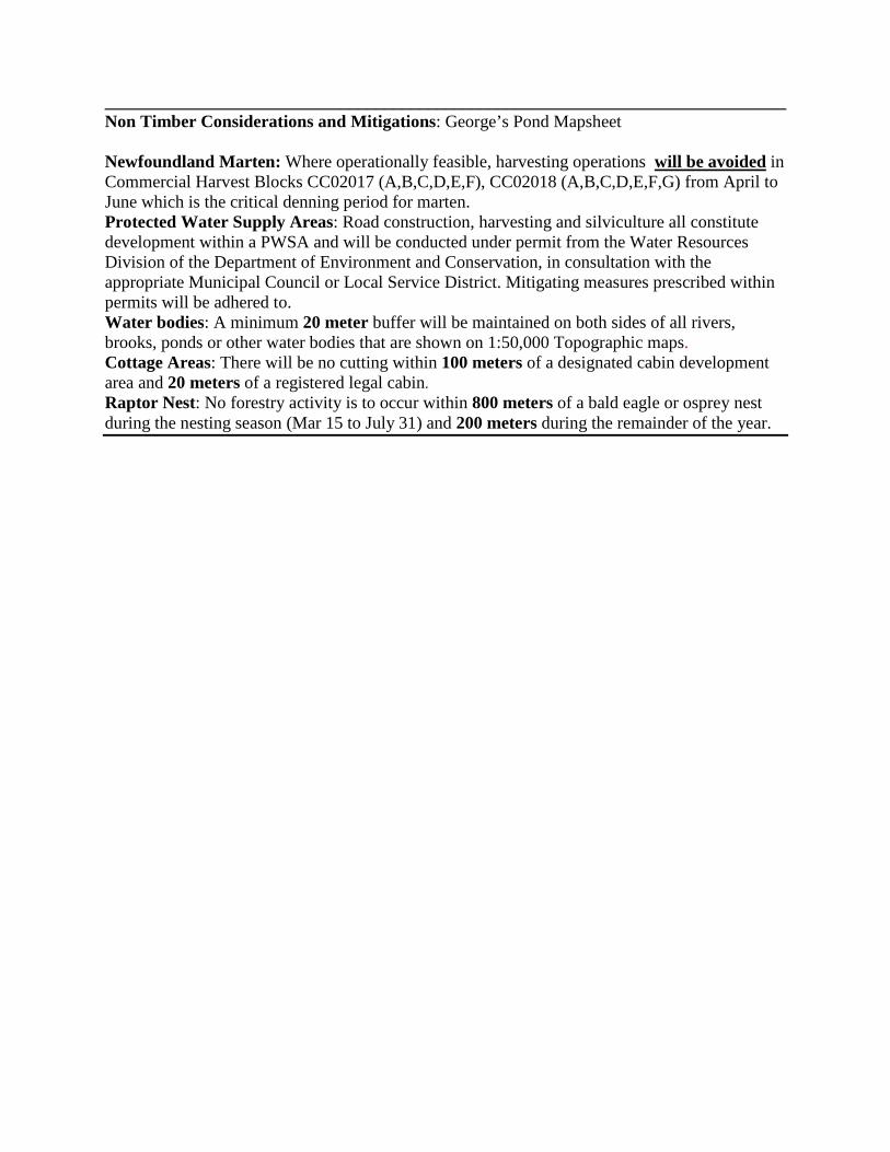
______________________________________________________________________________ Non Timber Considerations and Mitigations: George’s Pond Mapsheet Newfoundland Marten: Where operationally feasible, harvesting operations will be avoided in Commercial Harvest Blocks CC02017 (A,B,C,D,E,F), CC02018 (A,B,C,D,E,F,G) from April to June which is the critical denning period for marten. Protected Water Supply Areas: Road construction, harvesting and silviculture all constitute development within a PWSA and will be conducted under permit from the Water Resources Division of the Department of Environment and Conservation, in consultation with the appropriate Municipal Council or Local Service District. Mitigating measures prescribed within permits will be adhered to. Water bodies: A minimum 20 meter buffer will be maintained on both sides of all rivers, brooks, ponds or other water bodies that are shown on 1:50,000 Topographic maps. Cottage Areas: There will be no cutting within 100 meters of a designated cabin development area and 20 meters of a registered legal cabin. Raptor Nest: No forestry activity is to occur within 800 meters of a bald eagle or osprey nest during the nesting season (Mar 15 to July 31) and 200 meters during the remainder of the year.

Description of Area: These operating areas are located near the community of Bunyan’s Cove in Clode Sound, Bonavista Bay in Forest Management District 02 (FMD02). Both harvesting areas are located in the Northcentral Subregion of the Central Newfoundland Ecoregion. The terrain is rugged and access to forest stands is limited. Harvesting Activities: Proposed commercial activity will include sawlog and fuelwood harvesting using mechanical harvesters or chainsaws with extraction by forwarder, snowmobile, or ATV. CC02031 (a,b): Core AAC Salvage Forest in predominantly bS working group CC02031 (c,d,e,f): Core AAC Forest in predominantly bS working group 180 ha Softwood available: 13938 m3 Hardwood available: 798 m3 CC02032 (a,b): Core AAC Forest in predominantly bS working group 248 ha Softwood available: 24776 m3 Hardwood available: 3878 m3 CC02033 (a,b,c): Core AAC Forest in predominantly bS working group 325 ha Softwood available: 26297m3 Hardwood available: 2920 m3 CC02034 (a,b,c): Core AAC Salvage Forest in predominantly SH working group 91 ha Softwood available: 4693 m3 Hardwood available: 1472 m3 ________________________________________________________________________ Silviculture Activities: Reconnaissance surveys will be carried out on existing and new cutovers and regenerating stands to determine the need for planting and/or thinning. Suitable cutovers that are not satisfactorily regenerated will be candidates for site preparation and planting and/or gap planting and suitable regenerating stands will be candidates for thinning. All potential silviculture areas are identified on the operating area maps as proposed harvest areas, recent cuts and immature stands. ________________________________________________________________________ Primary Forest Access Road Construction: CC02032 – 1.50 km of new construction required CC02033 – 0.80 km of new construction required CC02034 – 1.40 km of new construction required
Operating Area Name: Bloomfield Access Road North Brook Branches Pond Access Road Stagg Steady
Operating Area #: CC02031 (a,b,c,d,e,f) CC02032 (a,b) CC02033 (a,b,c) CC02034 (a,b,c)
NFS Inventory Map #:
NTS Map #:

________________________________________________________________________ Non Timber Considerations and Mitigations: Bunyan’s Cove Road Mapsheet Terra Nova National Park: Viewscape preservation principles will be used when planning harvest in CC02033 and CC02034 where harvesting would be visible from particular vantage points in TNNP. Harvesting in blocks CC02033 AND CC02034 will be restricted on slopes highly visible from Terra Nova National Park. Newfoundland Marten: Where operationally feasible, harvesting operations will be avoided in Commercial Harvest Blocks CC02031 (A,B,C,D,E,F), CC02032 (A,B), CC02033 (A,B,C), CC02034 (A,B,C) from April to June which is the critical denning period for marten. Water bodies: A minimum 20 meter buffer will be maintained on both sides of all rivers, brooks, ponds or other water bodies that are shown on 1:50,000 Topographic maps. Cottage Areas: There will be no cutting within 100 meters of a designated cabin development area and 20 meters of a registered legal cabin. Raptor Nest: No forestry activity is to occur within 800 meters of a bald eagle or osprey nest during the nesting season (Mar 15 to July 31) and 200 meters during the remainder of the year.
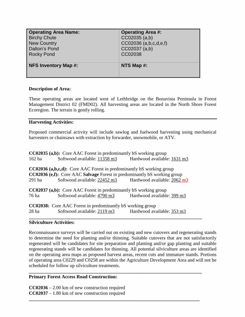
Description of Area: These operating areas are located west of Lethbridge on the Bonavista Peninsula in Forest Management District 02 (FMD02). All harvesting areas are located in the North Shore Forest Ecoregion. The terrain is gently rolling. Harvesting Activities: Proposed commercial activity will include sawlog and fuelwood harvesting using mechanical harvesters or chainsaws with extraction by forwarder, snowmobile, or ATV. CC02035 (a,b): Core AAC Forest in predominantly bS working group 162 ha Softwood available: 11358 m3 Hardwood available: 1631 m3 CC02036 (a,b,c,d): Core AAC Forest in predominantly bS working group CC02036 (e,f): Core AAC Salvage Forest in predominantly bS working group 291 ha Softwood available: 22452 m3 Hardwood available: 2062 m3 CC02037 (a,b): Core AAC Forest in predominantly bS working group 76 ha Softwood available: 4790 m3 Hardwood available: 399 m3 CC02038: Core AAC Forest in predominantly bS working group 28 ha Softwood available: 2119 m3 Hardwood available: 353 m3 ________________________________________________________________________ Silviculture Activities: Reconnaissance surveys will be carried out on existing and new cutovers and regenerating stands to determine the need for planting and/or thinning. Suitable cutovers that are not satisfactorily regenerated will be candidates for site preparation and planting and/or gap planting and suitable regenerating stands will be candidates for thinning. All potential silviculture areas are identified on the operating area maps as proposed harvest areas, recent cuts and immature stands. Portions of operating area C0229 and C0258 are within the Agriculture Development Area and will not be scheduled for follow up silviculture treatments. ________________________________________________________________________ Primary Forest Access Road Construction: CC02036 – 2.00 km of new construction required CC02037 – 1.80 km of new construction required _______________________________________________________________________
Operating Area Name: Birchy Chute New Country Dalton’s Pond Rocky Pond
Operating Area #: CC02035 (a,b) CC02036 (a,b,c,d,e,f) CC02037 (a,b) CC02038
NFS Inventory Map #:
NTS Map #:

Non Timber Considerations and Mitigations: Lethbridge Road Mapsheet Protected Road Zone: Permits for operating within Protected Road Zone will be obtained for CC02035, and CC02036. Highway Viewscapes: The Forest Service, where operationally feasible, will implement strategies to provide a balance between forest harvesting and the non-timber values identified by Tourism in Commercial Harvest Block CC02035. At a minimum, the Forest Service will maintain a 100 m no cut buffer along all highways. Water bodies: A minimum 20 meter buffer will be maintained on both sides of all rivers, brooks, ponds or other water bodies that are shown on 1:50,000 Topographic maps. Cottage Areas: There will be no cutting within 100 meters of a designated cabin development area and 20 meters of a registered legal cabin. Raptor Nest: No forestry activity is to occur within 800 meters of a bald eagle or osprey nest during the nesting season (Mar 15 to July 31) and 200 meters during the remainder of the year.
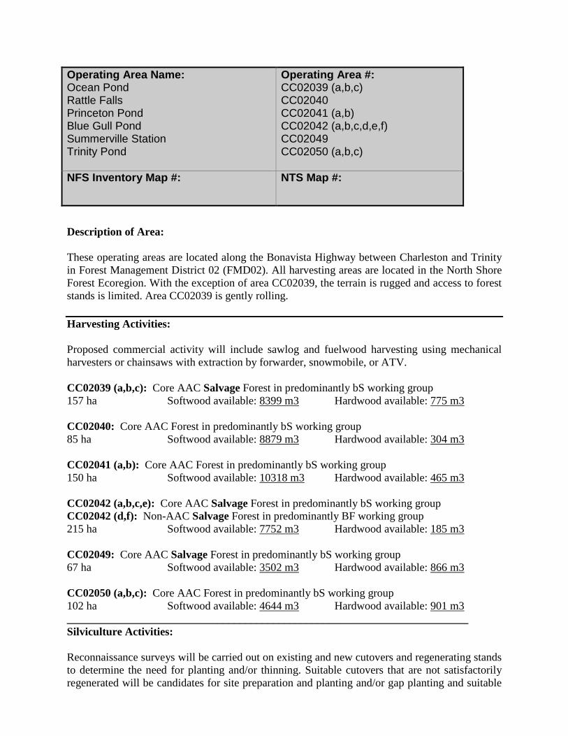
Description of Area: These operating areas are located along the Bonavista Highway between Charleston and Trinity in Forest Management District 02 (FMD02). All harvesting areas are located in the North Shore Forest Ecoregion. With the exception of area CC02039, the terrain is rugged and access to forest stands is limited. Area CC02039 is gently rolling. Harvesting Activities: Proposed commercial activity will include sawlog and fuelwood harvesting using mechanical harvesters or chainsaws with extraction by forwarder, snowmobile, or ATV. CC02039 (a,b,c): Core AAC Salvage Forest in predominantly bS working group 157 ha Softwood available: 8399 m3 Hardwood available: 775 m3 CC02040: Core AAC Forest in predominantly bS working group 85 ha Softwood available: 8879 m3 Hardwood available: 304 m3 CC02041 (a,b): Core AAC Forest in predominantly bS working group 150 ha Softwood available: 10318 m3 Hardwood available: 465 m3 CC02042 (a,b,c,e): Core AAC Salvage Forest in predominantly bS working group CC02042 (d,f): Non-AAC Salvage Forest in predominantly BF working group 215 ha Softwood available: 7752 m3 Hardwood available: 185 m3 CC02049: Core AAC Salvage Forest in predominantly bS working group 67 ha Softwood available: 3502 m3 Hardwood available: 866 m3 CC02050 (a,b,c): Core AAC Forest in predominantly bS working group 102 ha Softwood available: 4644 m3 Hardwood available: 901 m3 ________________________________________________________________________ Silviculture Activities: Reconnaissance surveys will be carried out on existing and new cutovers and regenerating stands to determine the need for planting and/or thinning. Suitable cutovers that are not satisfactorily regenerated will be candidates for site preparation and planting and/or gap planting and suitable
Operating Area Name: Ocean Pond Rattle Falls Princeton Pond Blue Gull Pond Summerville Station Trinity Pond
Operating Area #: CC02039 (a,b,c) CC02040 CC02041 (a,b) CC02042 (a,b,c,d,e,f) CC02049 CC02050 (a,b,c)
NFS Inventory Map #:
NTS Map #:
regenerating stands will be candidates for thinning. All potential silviculture areas are identified on the operating area maps as proposed harvest areas, recent cuts and immature stands. ________________________________________________________________________ Primary Forest Access Road Construction: CC02039 – 2.20 km of new construction required CC02040 – 0.70 km of new construction required _______________________________________________________________________ Non Timber Considerations and Mitigations: Ocean Pond – Charleston Mapsheet Viewscape Interest: In operating area CC02041 harvesting will be restricted on slopes highly visible from the Princeton Pond Cabin Area. Likewise, in operating area CC02040 harvesting will be restricted on slopes highly visible from the Bonavista Peninsula Highway. Protected Road Zone: Permits for operating within Protected Road Zone will be obtained for CC02040, CC02049, and CC02050. Highway Viewscapes: The Forest Service, where operationally feasible, will implement strategies to provide a balance between forest harvesting and the non-timber values identified by Tourism in Commercial Harvest Blocks CC02042, CC02049, CC02050. At a minimum, the Forest Service will maintain a 100 m no cut buffer along all highways. Water bodies: A minimum 20 meter buffer will be maintained on both sides of all rivers, brooks, ponds or other water bodies that are shown on 1:50,000 Topographic maps. Cottage Areas: There will be no cutting within 100 meters of a designated cabin development area and 20 meters of a registered legal cabin. Raptor Nest: No forestry activity is to occur within 800 meters of a bald eagle or osprey nest during the nesting season (Mar 15 to July 31) and 200 meters during the remainder of the year.

Description of Area: These operating areas are located north of the Bonavista Highway between Lethbridge and Charleston on the Bonavista Peninsula in Forest Management District 02 (FMD02). All harvesting areas are located in the Northshore Forest Ecoregion. The terrain is gently rolling. Harvesting Activities: Proposed commercial activity will include sawlog and fuelwood harvesting using mechanical harvesters or chainsaws with extraction by forwarder, snowmobile, or ATV. CC02043 (a,b,c,d,e): Core AAC Forest in predominantly bS working group 383 ha Softwood available: 21546 m3 Hardwood available: 6175 m3 CC02044 (a,b): Core AAC Forest in predominantly bS working group CC02044 (c): Core AAC Salvage Forest in predominantly bS/BF working group 264 ha Softwood available: 15914 m3 Hardwood available: 5258 m3 CC02047 (a,b,c,d): Core AAC Salvage Forest in predominantly bS working group CC02047 (e): Core AAC Forest in predominantly sH working group 270 ha Softwood available: 15554 m3 Hardwood available: 1701 m3 CC02048 (a,b): Core AAC Forest in predominantly bS working group 272 ha Softwood available: 18107 m3 Hardwood available: 2605 m3 ________________________________________________________________________ Silviculture Activities: Reconnaissance surveys will be carried out on existing and new cutovers and regenerating stands to determine the need for planting and/or thinning. Suitable cutovers that are not satisfactorily regenerated will be candidates for site preparation and planting and/or gap planting and suitable regenerating stands will be candidates for thinning. All potential silviculture areas are identified on the operating area maps as proposed harvest areas, recent cuts and immature stands. ________________________________________________________________________ Primary Forest Access Road Construction: CC02043 – 0.50 km of new construction required. CC02044 – 0.50 km of new construction required CC02047 – 3.30 km of new construction required CC02048 – 1.50 km of new construction required
Operating Area Name: Portland Winterbrook Charleston Southern Bay
Operating Area #: CC02043 (a,b,c,d,e) CC02044 (a,b,c) CC02047 (a,b,c,d,e) CC02048 (a,b)
NFS Inventory Map #:
NTS Map #:
Non Timber Considerations and Mitigations: Winterbrook Mapsheet Newfoundland Marten: Harvesting operations are not to occur in Commercial Harvest Block CC02048 between April 1st to June 30th which is the critical denning period for marten. Where operationally feasible, harvesting operations will be avoided in Commercial Harvest Blocks CC02044 (A,B,C), CC02047 (A,B,C,D,E), from April to June which is the critical denning period for marten. Protected Road Zone: Permits for operating within Protected Road Zone will be obtained for CC02047. Highway Viewscapes: The Forest Service, where operationally feasible, will implement strategies to provide a balance between forest harvesting and the non-timber values identified by Tourism in Commercial Harvest Blocks CC02047, CC02012. At a minimum, the Forest Service will maintain a 100 m no cut buffer along all highways. Water bodies: A minimum 20 meter buffer will be maintained on both sides of all rivers, brooks, ponds or other water bodies that are shown on 1:50,000 Topographic maps. Cottage Areas: There will be no cutting within 100 meters of a designated cabin development area and 20 meters of a registered legal cabin. Raptor Nest: No forestry activity is to occur within 800 meters of a bald eagle or osprey nest during the nesting season (Mar 15 to July 31) and 200 meters during the remainder of the year.
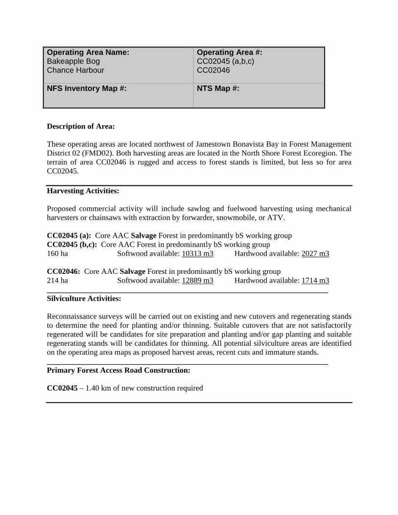
Description of Area: These operating areas are located northwest of Jamestown Bonavista Bay in Forest Management District 02 (FMD02). Both harvesting areas are located in the North Shore Forest Ecoregion. The terrain of area CC02046 is rugged and access to forest stands is limited, but less so for area CC02045. Harvesting Activities: Proposed commercial activity will include sawlog and fuelwood harvesting using mechanical harvesters or chainsaws with extraction by forwarder, snowmobile, or ATV. CC02045 (a): Core AAC Salvage Forest in predominantly bS working group CC02045 (b,c): Core AAC Forest in predominantly bS working group 160 ha Softwood available: 10313 m3 Hardwood available: 2027 m3 CC02046: Core AAC Salvage Forest in predominantly bS working group 214 ha Softwood available: 12889 m3 Hardwood available: 1714 m3 ________________________________________________________________________ Silviculture Activities: Reconnaissance surveys will be carried out on existing and new cutovers and regenerating stands to determine the need for planting and/or thinning. Suitable cutovers that are not satisfactorily regenerated will be candidates for site preparation and planting and/or gap planting and suitable regenerating stands will be candidates for thinning. All potential silviculture areas are identified on the operating area maps as proposed harvest areas, recent cuts and immature stands. ________________________________________________________________________ Primary Forest Access Road Construction: CC02045 – 1.40 km of new construction required
Operating Area Name: Bakeapple Bog Chance Harbour
Operating Area #: CC02045 (a,b,c) CC02046
NFS Inventory Map #:
NTS Map #:
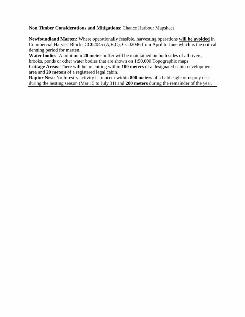
Non Timber Considerations and Mitigations: Chance Harbour Mapsheet Newfoundland Marten: Where operationally feasible, harvesting operations will be avoided in Commercial Harvest Blocks CC02045 (A,B,C), CC02046 from April to June which is the critical denning period for marten. Water bodies: A minimum 20 meter buffer will be maintained on both sides of all rivers, brooks, ponds or other water bodies that are shown on 1:50,000 Topographic maps. Cottage Areas: There will be no cutting within 100 meters of a designated cabin development area and 20 meters of a registered legal cabin. Raptor Nest: No forestry activity is to occur within 800 meters of a bald eagle or osprey nest during the nesting season (Mar 15 to July 31) and 200 meters during the remainder of the year.

Description of Area: These operating areas are located near the mid point of the Bonavista Peninsula on the northwest side, between Plate Cove and King’s Cove in Forest Management District 02 (FMD02). All harvesting areas are located in the North Shore Forest Ecoregion. The terrain is rugged and access to forest stands is limited. Harvesting Activities: Proposed commercial activity will include sawlog and fuelwood harvesting using mechanical harvesters or chainsaws with extraction by forwarder, snowmobile, or ATV. CC02051 (a,b,c,d,e,f,g,h,i): Core AAC Forest in predominantly bS working group 1116 ha Softwood available: 117138 m3 Hardwood available: 5837 m3 CC02052 (a,b,c): Core AAC Forest in predominantly bS working group 349 ha Softwood available: 34909 m3 Hardwood available: 1800 m3 ________________________________________________________________________ Silviculture Activities: Reconnaissance surveys will be carried out on existing and new cutovers and regenerating stands to determine the need for planting and/or thinning. Suitable cutovers that are not satisfactorily regenerated will be candidates for site preparation and planting and/or gap planting and suitable regenerating stands will be candidates for thinning. All potential silviculture areas are identified on the operating area maps as proposed harvest areas, recent cuts and immature stands. ________________________________________________________________________ Primary Forest Access Road Construction: CC02051 – 14.30 km of new construction required CC02051 – 3.20 km of reconstruction required CC02052 – 1.20 km of new construction required
Operating Area Name: Plate Cove Access Road Stock Cove Access Road
Operating Area #: CC02051 (a,b,c,d,e,f,g,h,i) CC02052 (a,b,c)
NFS Inventory Map #:
NTS Map #:
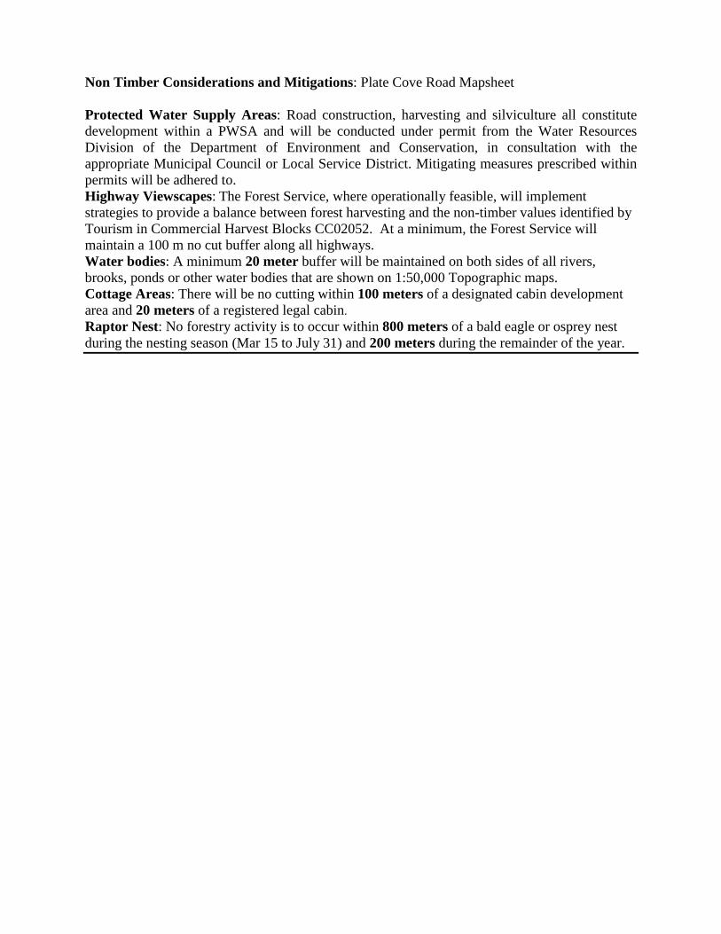
Non Timber Considerations and Mitigations: Plate Cove Road Mapsheet Protected Water Supply Areas: Road construction, harvesting and silviculture all constitute development within a PWSA and will be conducted under permit from the Water Resources Division of the Department of Environment and Conservation, in consultation with the appropriate Municipal Council or Local Service District. Mitigating measures prescribed within permits will be adhered to. Highway Viewscapes: The Forest Service, where operationally feasible, will implement strategies to provide a balance between forest harvesting and the non-timber values identified by Tourism in Commercial Harvest Blocks CC02052. At a minimum, the Forest Service will maintain a 100 m no cut buffer along all highways. Water bodies: A minimum 20 meter buffer will be maintained on both sides of all rivers, brooks, ponds or other water bodies that are shown on 1:50,000 Topographic maps. Cottage Areas: There will be no cutting within 100 meters of a designated cabin development area and 20 meters of a registered legal cabin. Raptor Nest: No forestry activity is to occur within 800 meters of a bald eagle or osprey nest during the nesting season (Mar 15 to July 31) and 200 meters during the remainder of the year.

Description of Area: These operating areas are located near the mid point of the Bonavista Peninsula along the road from Lockston, Trinity Bay to Stock Cove, Bonavista Bay in Forest Management District 02 (FMD02). With the exception of area CC02053, all harvesting areas are located in the Northeaster Barrens Subregion of the Maritime Barrens. Area CC02053 is in the North Shore Forest Ecoregion. The terrain is rugged and access to forest stands is limited. Harvesting Activities: Proposed commercial activity will include sawlog and fuelwood harvesting using mechanical harvesters or chainsaws with extraction by forwarder, snowmobile, or ATV. CC02053: Core AAC Forest in predominantly bS working group 15 ha Softwood available: 1485 m3 Hardwood available: 67 m3 CC02054 (a,b,d,g): Core AAC Salvage Forest in predominantly bS working group CC02054 (c,e): Core AAC Forest in predominantly bS working group CC02054 (f,h): Non-AAC Salvage Forest in predominantly BF working group 776 ha Softwood available: 48797 m3 Hardwood available: 2656 m3 CC02055 (a,b,c,d,e): Core AAC Forest in predominantly bS working group 133 ha Softwood available: 4836 m3 Hardwood available: 742 m3 CC02056: Core AAC Forest in predominantly sH working group 156 ha Softwood available: 8274 m3 Hardwood available: 1253 m3 ________________________________________________________________________ Silviculture Activities: Reconnaissance surveys will be carried out on existing and new cutovers and regenerating stands to determine the need for planting and/or thinning. Suitable cutovers that are not satisfactorily regenerated will be candidates for site preparation and planting and/or gap planting and suitable regenerating stands will be candidates for thinning. All potential silviculture areas are identified on the operating area maps as proposed harvest areas, recent cuts and immature stands. ________________________________________________________________________ Primary Forest Access Road Construction: CC02054 – 2.80 km of new construction required
Operating Area Name: Trout Pond World Pond Ryder’s Road Black Bay
Operating Area #: CC02053 CC02054 (a,b,c,d,e,f,g,h) CC02055 (a,b,c,d,e) CC02056
NFS Inventory Map #:
NTS Map #:
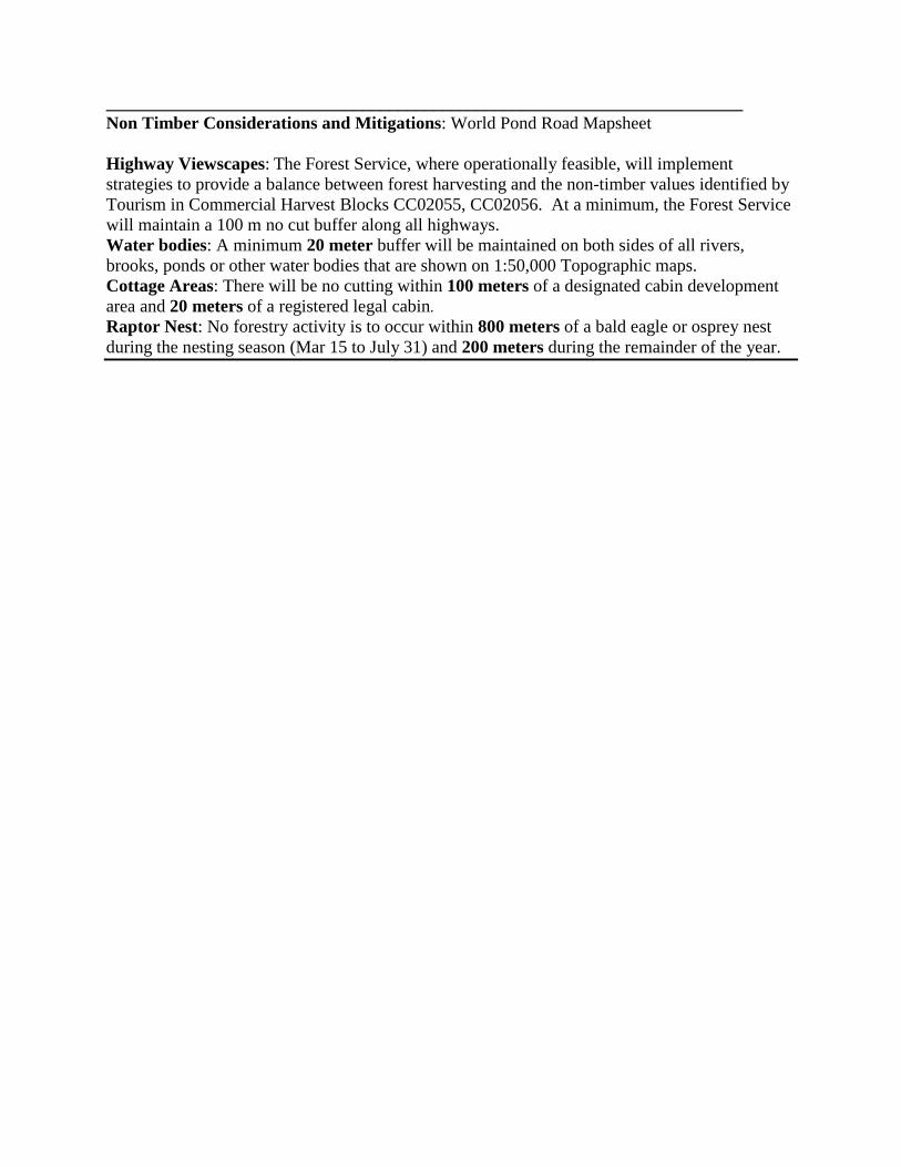
________________________________________________________________________ Non Timber Considerations and Mitigations: World Pond Road Mapsheet Highway Viewscapes: The Forest Service, where operationally feasible, will implement strategies to provide a balance between forest harvesting and the non-timber values identified by Tourism in Commercial Harvest Blocks CC02055, CC02056. At a minimum, the Forest Service will maintain a 100 m no cut buffer along all highways. Water bodies: A minimum 20 meter buffer will be maintained on both sides of all rivers, brooks, ponds or other water bodies that are shown on 1:50,000 Topographic maps. Cottage Areas: There will be no cutting within 100 meters of a designated cabin development area and 20 meters of a registered legal cabin. Raptor Nest: No forestry activity is to occur within 800 meters of a bald eagle or osprey nest during the nesting season (Mar 15 to July 31) and 200 meters during the remainder of the year.
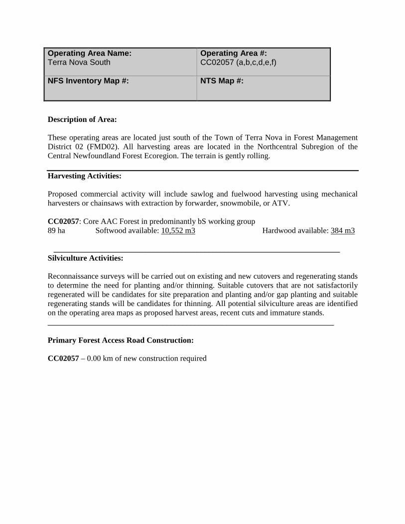
Description of Area: These operating areas are located just south of the Town of Terra Nova in Forest Management District 02 (FMD02). All harvesting areas are located in the Northcentral Subregion of the Central Newfoundland Forest Ecoregion. The terrain is gently rolling. Harvesting Activities: Proposed commercial activity will include sawlog and fuelwood harvesting using mechanical harvesters or chainsaws with extraction by forwarder, snowmobile, or ATV. CC02057: Core AAC Forest in predominantly bS working group 89 ha Softwood available: 10,552 m3 Hardwood available: 384 m3 ________________________________________________________________________ Silviculture Activities: Reconnaissance surveys will be carried out on existing and new cutovers and regenerating stands to determine the need for planting and/or thinning. Suitable cutovers that are not satisfactorily regenerated will be candidates for site preparation and planting and/or gap planting and suitable regenerating stands will be candidates for thinning. All potential silviculture areas are identified on the operating area maps as proposed harvest areas, recent cuts and immature stands. ________________________________________________________________________ Primary Forest Access Road Construction: CC02057 – 0.00 km of new construction required
Operating Area Name: Terra Nova South
Operating Area #: CC02057 (a,b,c,d,e,f)
NFS Inventory Map #: NTS Map #:

________________________________________________________________________ Non Timber Considerations and Mitigations: Terra Nova South Mapsheet Newfoundland Marten: Harvesting operations are not to occur in Commercial Harvest Block CC02057 between April 1st to June 30th which is the critical denning period for marten. Scheduled Salmon Rivers: 100 meters no cut buffer. Water bodies: A minimum 20 meter buffer will be maintained on both sides of all rivers, brooks, ponds or other water bodies that are shown on 1:50,000 Topographic maps. Cottage Areas: There will be no cutting within 100 meters of a designated cabin development area and 20 meters of a registered legal cabin. Raptor Nest: No forestry activity is to occur within 800 meters of a bald eagle or osprey nest during the nesting season (Mar 15 to July 31) and 200 meters during the remainder of the year.