Embed Size (px)
Citation preview
1
Operational Forecasting of Wind-Waves at the Great Lakes for the US National Weather Service
Jose-Henrique Alves Marine Modeling and Analysis Branch
SRG at Environmental Modeling Center, NOAA/NCEP

2
Presentation Outline
Overview: NCEP’s WAVEWATCHIII in the Great Lakes
– Pre-History
• SOO Dinosaurs
– Ancient History
• The First GLW/NAM Model
– Middle Ages
• The first GLWN/NDFD model
– Renaissance
• How new science gave our credibility a boost
– The Future

3
Pre-History: The WW3 Myth
Pre-History of WAVEWATCH III in the Great Lakes
• First implementation of WAVEWATCH III
– WFO at Marquette, Michigan,
– Tom Hultquist 2004
– Several case studies with RAMS,
– Results were promising, established loosely the feasibility of running WAVEWATCH III operationally for the Great Lakes.
(Dinosaur? Chanhassen, MN)

4
The First GLW/NAM Model
2005: Great Lakes Wave system (GLW) pre-operational prototype is tested at NCEP
08/2006: Great Lakes Wave system (GLW) is made operational
• 4 X daily forecasts at 00Z, 06Z, 12Z and 18Z
• Initialization using 0h nowcast from previous run, with 6h hindcast forced with NDAS, then 84h forecasts.
• WFOs feedback
– Forecasts under more severe storms: unremarkable
5
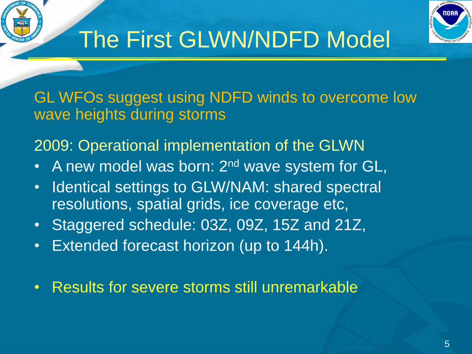
The First GLWN/NDFD Model
GL WFOs suggest using NDFD winds to overcome low wave heights during storms
2009: Operational implementation of the GLWN
• A new model was born: 2nd wave system for GL,
• Identical settings to GLW/NAM: shared spectral resolutions, spatial grids, ice coverage etc,
• Staggered schedule: 03Z, 09Z, 15Z and 21Z,
• Extended forecast horizon (up to 144h).
• Results for severe storms still unremarkable

The Middle Ages: Chasing GLERL
6
• GL WFOs indicated GLERL wave
model superior to WW3
• Developers outlined reasons
– Main hypothesis: TC 96 source terms:
– Limitations in short fetches, early growth
and rapidly changing/intensifying winds,
– TC96 tuned in WAVEWATCH III to provide
good predictions of deep-water waves,
– Poorer performance in basins with short,
irregular wind fetches,
• Conclusions
– TC96: major obstacle in making the GLW
model a reliable source of wave forecasts,
particularly during severe sea-states,
– GLERL wave model, the dinousaur that
eluded extinction...

7
Winds of Change
Great Lakes Wave (GLW) Forecast System
• No upgrades since 2009…
• System largely unused by NWS forecasters.
• In contrast, many new developments in wave model technology – New physics parameterizations dealing with shorter fetches
– New grid types more adequate for complex basins, with smaller scale features (curvilinear, unstructured).
• Higher resolution wind fields available – NAM 4km
– Envisaged: NDFD 2.5km
• A keen Developer, a committed SOO

8
• Taking advantage of new technology in WW3, tests
made to prove TC96 was main problem
– Newly developed Ardhuin et al (2010) physics package:
• New wind input source term
• New term for dissipation due to wave breaking.
• Establishment of a development team led by NCEP,
Detroit SOO (GL WFO POC), and GLERL
– Numerical experiments, challenging GLW model
configuration,
• GLERL surface wind analyses: minimize uncertainties,
emphasize differences in model runs,
• GLERL wave model outputs as a reference (e.g., can we
put this dinosaur to rest?)
Renaissance of 2011: GLW Reborn

The GLW System Reborn
9
• WW3 with A+10 Physics
– Breakthrough-level
improvement to GLW in
term of Hs
– Improved GLW’s already
good bulk statistics (bias,
RMS error, correlation)
– Matched GLERL STD
– Higher precision in
tracking observations
– Much improved wave
periods relative to GLERL
2009

Bridging the Severe Storm Gap
10
Performance in Severe Storms
• Metric: 99%, normalized by obs
• GLERL wind analyses have a
superb quality
– great accuracy in upper wind
speeds at 99%
• WW3 with A+10 Physics
– Breakthrough-level
improvement in predicting
99%wave heights
2009

GLW Nailing a PTS: Sandy Waves
11
Buoys 45007 & 45149

12
Publications
• The GLW taskforce published a paper with main
results of effort in Weather and Forecasting (2014)

13
GLW system (NAM and NDFD) upgrades
– New physics package
• Replacement of TC96 with A+10
– Unification of systems
• One GLW, two configs
• Systems were run as separate jobs by NCO, were unified for better maintenance, usage of resources,
• GLW/NAM (“early”) + GLWN/NDFD (“late”)
• 4 + 4 Cycles/day (early, glw; late; glwn)
– HR regular spherical grid
• 0.05 x 0.035 (~4km), 327 x 235
• Single domain covering all major lakes (Superior, Michigan, Huron, Erie, St. Clair)
Q1FY14 GLW Upgrade

14
Collaborating Towards a Better GLW
Planning for the FY15 Upgrade: Constructive Dialog
• Intense feedback from field offices in GL
– New system finally caught your attention!
– Sometimes heated debate...
– Generally very constructive outcomes,
– Priority of development work to issues relevant to forecasters.
• WFO alerted for several issues
– GLW still using ice “concentrations” from NAM model,
• Turns out ice in NAM is a very conservative ice mask,
– Bug unnoticed: no validation data (buoys pulled), and little
feedback from field,
– NDFD wind update cycles skipped.
15
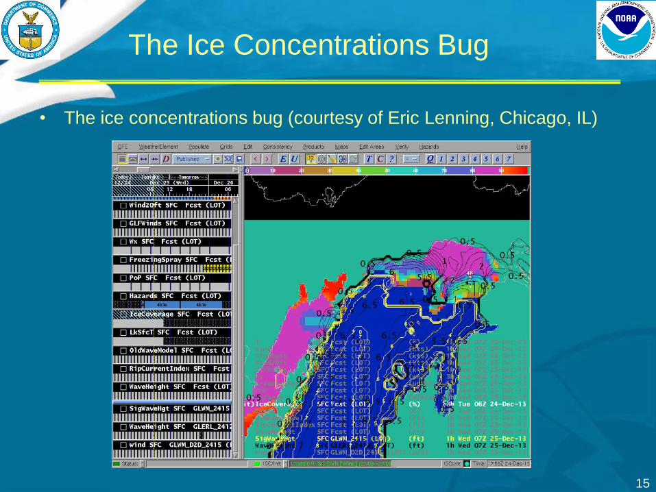
• The ice concentrations bug (courtesy of Eric Lenning, Chicago, IL)
The Ice Concentrations Bug

16
The NDFD Mosaic
Several bugs were found in the process
11 WFOs (DLH MQT APX GRB MKX LOT IWX GRR DTX CLE BUF) send data to MDL, then to NCEP
• Files were clobbered, duplicate records, missing data
– Issue with file names at NCEP: only hour, records arriving at H:01
and H:59 were jammed into the same file Added minute to name
• Transition to 2.5km: files much larger, delivery not on time
for GLWN runs
– MDL servers too old, network without required bandwidth
– Tim Boyer reshuffled send times, GLWN runs delayed (not ideal)
• NDFD mosaic not covering lake points at Canadian coasts
WFO N wind
files
Single
Mosaic
file
MDL GLW

17
The NDFD Mosaic
• NDFD mosaic not
cover lake along
Canadian coast
– Courtesy Mike Dutter
(Marquette, MI)
• Unrealistic Hs
• Winds were masked
in GLW
– Solved Hs error
• Persisting issue?

18
Development Path for New Upgrades • Other persisting sticky issues
– GLW still using ~4km grids (no nearshore value),
– GLW still using 12km NAM (4km available),
– GLWN still using 5km NDFD (2.5km available),
• Alongside WFOs, prioritized item to be upgraded – Higher resolution wind intake: 5km to 2.5km NDFD
– Higher resolution wave model grid, outputs: ~4km to ~2km
– Intake of ice concentrations instead of sea-ice mask.
Q2FY15 Development Cycle
19
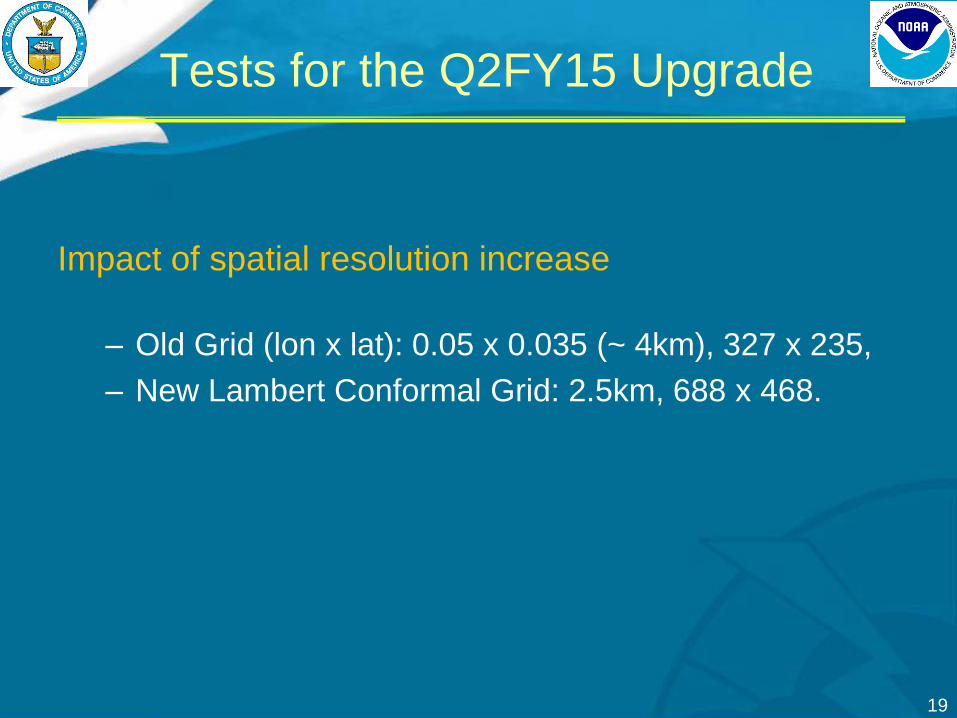
Tests for the Q2FY15 Upgrade
Impact of spatial resolution increase
– Old Grid (lon x lat): 0.05 x 0.035 (~ 4km), 327 x 235,
– New Lambert Conformal Grid: 2.5km, 688 x 468.

The GLW Curvilinear Grid
Effect of
higher
resolution grid
Strong
westerlies
Oct 3rd 2014
21
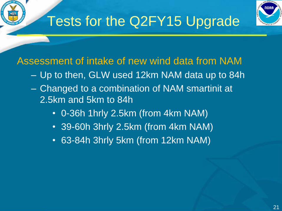
Assessment of intake of new wind data from NAM
– Up to then, GLW used 12km NAM data up to 84h
– Changed to a combination of NAM smartinit at
2.5km and 5km to 84h
• 0-36h 1hrly 2.5km (from 4km NAM)
• 39-60h 3hrly 2.5km (from 4km NAM)
• 63-84h 3hrly 5km (from 12km NAM)
Tests for the Q2FY15 Upgrade

• Impact of a change in winds
– Current operations: 12km NAM
– Upgrade: 2.5km from NAM 4km
Tests for the Q2FY15 Upgrade

Tests for the Q2FY15 Upgrade
24
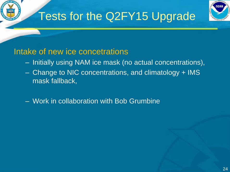
Intake of new ice concetrations
– Initially using NAM ice mask (no actual concentrations),
– Change to NIC concentrations, and climatology + IMS
mask fallback,
– Work in collaboration with Bob Grumbine
Tests for the Q2FY15 Upgrade

25
• Ice concentrations bug
– Image provided by Eric
Lenning (Chicago SOO):
focal issue
– NAM ice mask (IMS) is
extremely conservative
– Large areas where there
should be waves are
masked out
Tests for the Q2FY15 Upgrade

26
Intake of NIC ice
concentrations
• Verification of new
approach for Jan
2014
• Hs swath from
altimeter track
• New approach
provides better
description of
measured swath
• Actual Hs value from
altimeter requires
investigation
Tests for the Q2FY15 Upgrade

27
The Q2FY15 Upgrade
What changed
• Spatial resolution increased from ~4km to 2.5km
– Old Grid (lon x lat): 0.05 x 0.035 (~ 4km), 327 x 235
– New Lambert Conformal Grid: 2.5km, 688 x 468
– Matches point-by-point NDFD and NAM-smartinit grids at the lakes
• Request from WFOs: higher resolution near coastal regions
• Intake of new wind data from NAM
– Old GLW used 12km NAM data up to 84h
– Changed to combination of NAM smartinit at 2.5km, 5km to 84h
• Intake of new ice concentrations
– Old GLW: NAM ice mask (no actual concentrations)
– Changed to NIC concentrations, and climatology+IMS fallback.

28
Achieved benefits • Significant improvement resolving coastal features
– Including better representation of nearshore wind fetch geometry.
• Improve storm wave forecasting and nearshore wave growth – Higher resolution wave model grid and NAM wind input.
• Improve wave forecasts in when ice present (Winter) – Improved ice concentration data intake
• Extension of GLWN to forecast hour 147 – Attend Great Lakes WFOs current requirements.
Implemented: 28 January 2015 • New data stream added to NOAAPORT (AWIPS): 28 April 2015
The Q2FY15 Upgrade

Where we are now: towards FY16
Focus for next upgrade
• Target: Q2FY16
• Problems identified by Great Lakes WFO SOOs
– GLWN not using all relevant changes by forecasters to NDFD,
– Nearshore wind speed bias in NAM and NDFD,
– Nearshore wave-height bias in GLW and GLWN,
– Ice concentrations inconsistencies, 5km grid,
– Not fully resolving coastal features important to some WFOs,

Upcoming Q2FY16 Upgrades
Mitigation Plan
• Changes being made to GLWN system
– NDFD mosaic update
Hourly GLWN runs to 36h + current cycles
– Will require shutting down GLW (NAM) cycles
– Nearshore wind bias
Downscaling (NAM and/or Greg Mann)
– Nearshore wave bias
Alternative source-terms (focus shallow water physics),
– Ice concentrations
Requested NIC, HR files with concentration and thickness
– Coastal features
HR curvilinear grid 1.25km or unstructured grid

Beyond Q2FY16 Upgrades
Future plans
• GLWENS - Great Lakes Wave Ensemble System
– Tandem with Environment Canada,
• Great Lakes RTMA wind and wave analyses,
• Data assimilation using buoys and altimeters,
• Add Water levels,
• Addition of a fully coupled deterministic system (so-
called “next-gen system”), Great Lakes suite becomes:
– GLWN hourly SRF,
– GLWENS – with combined NWS/EC products,
– Coupled WW3/fvcom/WRF.

GLW Q1FY16 Upgrades
Questions, Suggestions, Requests?
Base FVCOM grid being used to develop a specialized wave model
grid for hourly GLWN runs (courtesy Eric Anderson, GLERL/NOAA).