Embed Size (px)
Citation preview
OPTIONS OF THE YALA WETLAND MANAGEMENT FOR SUSTAINABLE DEVELOPMENT AND
BIODIVERSITY CONSERVATION
F. Mwaura, M., Ngugi, E. Were, E. Kagure, L. Wanjohi, J. Mbuthia, J. Otieno & M.
Makala
1
Preface For the last two years, Yala swamp controversy has been in the headlines in the Kenyan media. Although the controversy seem to have been in place for the last 50 years as concerns the infringement and displacement of humans by the papyrus, the ownership of the swamp and, the rehabilitation and development of the wetland, it took a new dimension in the year 2002. In this year Dominion Company from USA showed interest of developing the wetland for rice growing and put its proposal to the Kenyan Government. The Lake Basin Development Authority did the Environmental Impact Assessment (EIA). A perusal through the EIA report, proved the partiality of the study. The poverty level of the locals and the desperation for improved living standard may justify the bias. Immediately it became clear that Dominion was to rehabilitate the wetland, two county councils cum districts (Siaya and Bondo) started boundary tussles over the wetland. It was agreed that the two county councils share the land in question. To date, the inhabitants will show you different boundary points, each respondent impressing you of how the wetland is in their own district. This study was carried out when tension was high in the region, especially in both Bondo and Siaya Districts, where the activities of Dominion Group of Company will have direct impact. Initially most of the locals associated themselves with the developers as they hoped to benefit directly, largely through employment for themselves and their relatives. Attitude changed immediately it became clear that the formerly rehabilitated land was which handled more than 1800 herds of cattle daily was to be restricted for grazing. Those who relied entirely on the site for grazing and their dependents changed their minds and became bitter with the investor. The complaints reached the local politicians and later the central government. On 27th November 2004, the Ministries of Regional Development, Water Resources and Natural Resources independently revoked the Dominion permit of developing the wetland and ordered the company to withdraw its equipments and staff from the swamp. This announcement provoked demonstrations against the concerned ministries’ directives in the region’s urban centres including Kisumu, Bondo and Siaya. The media focused on the urban demonstrators and failed to capture the locals, who have been the main stakeholders of the Yala Wetland. By this time Dominion had imported equipment worth millions of shillings. Two days later the Ministry of Planning and National Development issued a statement claiming that the project will continue. A day later the Lake Basin Development (LBDA), a statutory body with a responsibility to advice the government on matters pertaining to development in the region made a press statement on the circumstances surrounding the confusion on the wetland. In the statement LBDA doubted the technical capacity of the Dominion Farm Ltd to manage such a delicate environment especially with its local representatives. The Dominion Group failed to follow the procedures agreed with government in developing the wetland including providing information on critical issues such as situation analysis, project feasibility/viability, implementation strategy, work plan, indigenous institutional capacity enhancements, budgets, logical framework, monitoring and evaluation plan and performance target. On 3rd February 2004 the project was inaugurated with government appearing to speak in one voice. On March 2004 the Dominion Farms Ltd., Country Director, was elected the Parliamentary Representative in a neigbouring constituency with the victory associated to the Yala wetland rehabilitation initiative.
2
In such a conflicting environment, it’s necessary for sufficient, reliable and unbiased information that would be used to prescribe the best management option of the natural resource. This report presents information on the nature of resources in Yala swamp, options available in utilizing the wetland and attempt to provide an insight on the practicability of each use for sustainable development and biodiversity conservation.
3
Introduction: Yala swamp is a rare resource in western Kenya that has been a centre of controversy between the developers and conservationist since 1950s. To socio-economists the wetland provides a unique environment for agricultural production while to conservationist it is a rich ecosystem that needs to be sustained. In each case the developers through the government have been winning, but have been hindered by lack of sufficient financial resources. Sir Alexander Gibbs and partners investigated the agricultural potential for wetland in 1954. The Kenyan government through funding from United Nations Development Programme commenced reclamation in 1967. An area of 2300 hectares was reclaimed but more area (9200 hectares) was recommended for draining by a Dutch firm, ILACO in 1972. In 1982, Bish International designed a pumped irrigation system for 149 ha which proved to be expensive. In the process of reclaiming the wetland, the Lake Kanyaboli was cut off from its catchment as the dyke made spilt over. In 1986 a Kenya-Netherlands governments recommended improvement and conservation of ecological situation of Lake Kanyaboli. The Lake basin Development Authority (LBDA), has been managing the area on behalf of the government. Ever since it started developing the wetland, LBDA has had little success due to financial constraints. Dominion Group of Companies has shown interest in investing KShs. 2 billion (US$ 26.3 million) for 25 years on a rice irrigation scheme. Although the government has the mandate of assuring the natural resources are developed for sustainable development, it has had conflicts with the conservationist. A battery of conservation agencies has recommended the wetland conservation as it represents a unique habitat with rare species. Yala swamp is categorized as an Important Bird Area (Site Code 41) in Kenya due to its unique biodiversity including globally threatened species and biome restricted species (Bennun and Njoroge, 1999). Ole Nkako (1992) recommended its conservation and conversion to either a National Park or Reserve due to its birdlife, high biodiversity and endemism, water catchment control, riverine forest and tourism value. The swamp has a very important hydrological function as it acts as a natural filter of agricultural pollutants and silt from the surrounding catchment, before it enters Lake Victoria (Crafter et al., 1992). The wetland is significant as a living museum of the fish fauna of L. Victoria. It contains some haplochromine fish, some of which are no longer found in the L. Victoria and two threatened to almost extinct cichlids (Mavuti, 1992). The wetland has not escaped the attention of international wetland conservationists, who would like more information to confirm its potential as a Ramsar Convention Site. To locals it’s a source of religious inspiration (sacred sites), and a source of livelihood (Abila, 1998). Others see it as a “useless wilderness” associated with breeding of disease vectors like mosquitoes and tsetse flies (Okondo, 1989). The LBDA considers the wetland as well endowed with agricultural potential that it could feed the entire western region with a population of more than 5 millions persons. The site is an important research area on wetlands and their land-use capability. The area has not escaped the attention of natural resources managers, who are keen to first evaluate the potential of a resource before making a blanket recommendation and they appear as a compromise between the two extremes in either development or conservationist. They look at the
4
wetland as a unique resource, which should be managed for sustainable development and biodiversity conservation. The latter school of thought considers the interests of all stakeholders in the wetland and encourages establishment of the most sound management option for a resource. Yala swamp is largely composed of papyrus vegetation and an assemblage of fauna, hence a renewable resource. Its location on an arid area invites a large population of dependents whose survival relies on the resource. It calls for a better understanding of the resource, the inhabitants, inhabitants’ desires and relationship with the resource. It also calls for sound management options, which need to be evaluated for their potential benefits and dangers to both the human and the resource’s sustainability. Through a grant from the BP-Conservation programme, the Yala Wetland Management Team has been establishing the possible options of managing the swamp for sustainable development and biodiversity conservation. The team with upcoming scientists from Moi University is composed of natural resources economists, botanists, conservationists and resources development agents. Even with the commencement of rehabilitation activity on the wetland, the study was important in that it addresses the resource in situ, the interaction of the locals with the resource, inculcates conservation awareness and articulates on the feasibility and viability of various options of management considering the nature of the endowment and inhabitants’ desires. Considering all the viable option in the wetland management one is likely to ask whether the Yala swamp is worth only KShs 2 billions in the next 25 years. How far will any recommended use improve the livelihood of the locals as well as maintain the scenic, fauna, flora and ecological endowment of the swamp? How harmonious will all beneficiaries of the wetland co-exists free of crisis?
Methods: Consultative Meetings Consultative meetings were done with local groups including Kandenge elders, Osielo Youth group, Neela Marachi group and sellers of the papyrus products. The choice of the group was based on its relationship with the wetland, its potential information wealth and willingness to share unbiased information. Other groups targeted were local schools with an aim of inculcating conservation and sound resource management to future managers. These consultative meeting provided fora for public awareness on the need for sustainable utilization of the wetland resources and biodiversity conservation. They also provided vital information on the historical and current aspects of the wetland, locals’ general attitude on the wetland and its utilization. Discussion with the groups that are involved in harvesting and adding value on papyrus provided information on how and when the plant is harvested, how various parts are used and the monetary aspect of utilizing the plant. The discussions were also meant to inculcate interest on the wetland, elicit nostalgic relationship between locals and their environment before increased population that would led to inability of the resource to cater for their needs, hence degradation of the environment and high levels of poverty. The findings of the study have been presented at the Forum for Organic Resources Management and Agricultural Technologies (FORMAT). Two undergraduate dissertations (Fisheries and Botany) have
5
been presented and approved for awards of B. Sc degrees by the examination body at Moi University. Another student is preparing a dissertation for a B.Sc degree in Chemistry of Moi University. The study was a rich source of information and a strong reference case study for a St. Paul Theological College, degree course on Sustainable Environment and Development. A paper “ Yala wetland a resource or a weed has been published by a local leading NGO newsletter that printed and distributed about 2000 copies to individuals, other developing agents and government ministries.
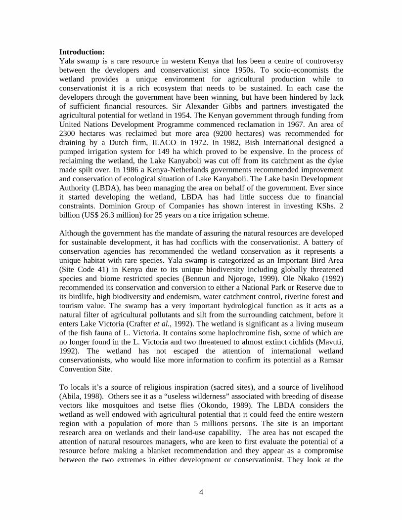
Figure 1: Both the elderly and young were involved in the study through varies strategies: Left a team member explain a point to the school pupils: Right elders participate in the project. Survey of the locals A survey form was administered to 225 inhabitants of the area surrounding the wetland to establish the benefits derived from the wetland and also the challenges faced by locals living around the wetland. The survey queried the locals on the benefits accrued from the wetland resources. The means of resource exploitation, extent of utilization, level of reliance on the wetland and potential utilization were evaluated. Locals were also requested to outline the challenges associated with living around the wetland, the costs associated with these challenges and the extent of the losses. Other information requested on the respondents which will aid in categorization of the inhabitants include, the household size and its characteristics, distance from the wetland, general socio-economic activities either based on the wetland or not. The respondents lived around the wetland with their homes distance from the wetland ranging from 0.5 km to 12 km. The enumerators estimated the distance from the homestead to the wetland. Table 1 shows the proportion of respondents’ beneficiaries of the wetland and the distance they covered to the wetland.
6
Table 1: Distance covered by the respondents to the wetland
Distance to the wetland proportion of respondents (%)
Less than 2 km 74 2 to 4 km 21 More than 4 km 5
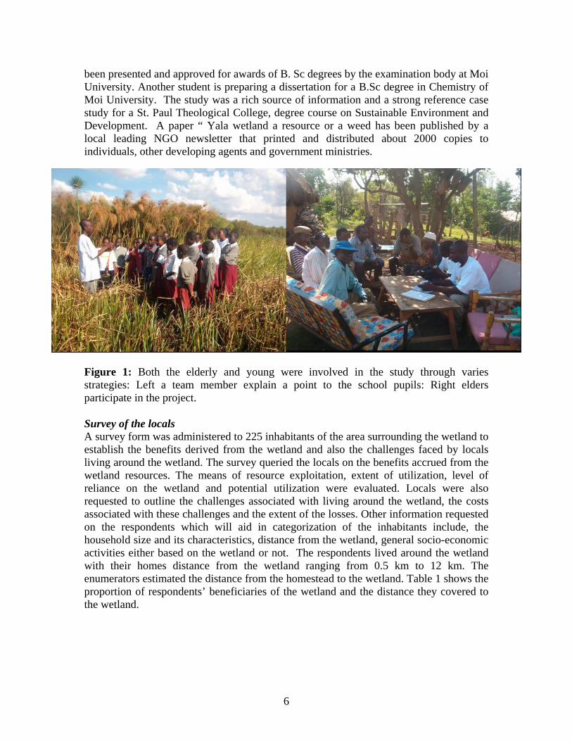
Experimental sites: Six experimental sites were established randomly within the swamp in a manner that is representative for the various habitats (dense, disturbed and areas under extreme pressure) to establish papyrus vegetation growth rates. The team took an inventory around the wetland and observed the influence of the wetland on its margin (riverine), the size of the riverine and its utilization. Another inventory around and in the papyrus led to categorization of the papyrus vegetation subject to its structure in terms of human pressure by fire and harvesting, papyrus growing on the anthills, on the fringes of the vegetation and on the depth of the papyrus. All these sites were chosen subject to safety and accessibility of the team into the papyrus vegetation. The experiment was monitored by a botany student of Moi University. Result from the experiment has been published in her dissertation which have been approved in she will be soon graduating. Resource base Yala Wetland provides a resource base in three aspects subject to composition in terms of water body, papyrus vegetation and the riverine area. The water body comprising of three lakes (Lake Kanyaboli, L. Namboyo and L. Sare), provides fishery resources, water for domestic and livestock consumption, and a recommended site for attraction of tourists who may visit for boating, sport fishing and swimming. The water bodies are habitat for micro- and macro-organisms. The papyrus vegetation provides another resource harvested for handcrafts, mats making, construction, animal feeding and human food
Figure 2: Resource endowment zones in Yala Wetland
7
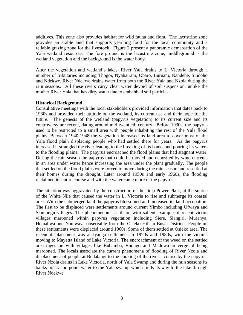
additives. This zone also provides habitat for wild fauna and flora. The lacustrine zone provides an arable land that supports yearlong food for the local community and a reliable grazing zone for the livestock. Figure 2 present a panoramic demarcation of the Yala wetland resources. The fore ground is the lacustrine zone, middleground is the wetland vegetation and the background is the water body. After the vegetation and wetland’s lakes, River Yala drains to L. Victoria through a number of tributaries including Thogoi, Nyahairani, Obaro, Buruani, Nandehe, Sindoho and Ndekwe. River Ndekwe drains water from both the River Yala and Nzoia during the rain seasons. All these rivers carry clear water devoid of soil suspension, unlike the mother River Yala that has dirty water due to embebbed soil particles. Historical Background Consultative meetings with the local stakeholders provided information that dates back to 1930s and provided their attitude on the wetland, its current use and their hope for the future. The genesis of the wetland (papyrus vegetation) to its current size and its controversy are recent, dating around mid twentieth century. Before 1930s, the papyrus used to be restricted to a small area with people inhabiting the rest of the Yala flood plains. Between 1940-1948 the vegetation increased its land area to cover most of the Yala flood plain displacing people who had settled there for years. As the papyrus increased it strangled the river leading to the breaking of its banks and pouring its waters to the flooding plains. The papyrus encroached the flood plains that had stagnant water. During the rain season the papyrus mat could be moved and deposited by wind currents in an area under water hence increasing the area under the plant gradually. The people that settled on the flood plains were forced to move during the rain season and resettled at their homes during the drought. Later around 1950s and early 1960s, the flooding reclaimed its entire course and with the water came more of the papyrus. The situation was aggravated by the construction of the Jinja Power Plant, at the source of the White Nile that caused the water in L. Victoria to rise and submerge its coastal area. With the submerged land the papyrus blossomed and increased its land occupation. The first to be displaced were settlements around current Yimbo including Ufwaya and Siamungu villages. The phenomenon is still on with salient example of recent victim villages marooned within papyrus vegetation including Siere, Siangiri, Muranya, Hemabwa and Namwaya observable from the Osieko Hill in Busia District. People on these settlements were displaced around 1960s. Some of them settled at Osieko area. The recent displacement was at Iyanga settlement in 1970s and 1980s, with the victims moving to Mayetta Island of Lake Victoria. The encroachment of the weed on the settled area rages on with villages like Bubamba, Buongo and Maduwa in verge of being marooned. The locals associate the current phenomena of flooding of River Nzoia and displacement of people at Budalangi to the choking of the river’s course by the papyrus. River Nzoia drains in Lake Victoria, north of Yala Swamp and during the rain seasons its banks break and pours water to the Yala swamp which finds its way to the lake through River Ndekwe.
8
In around 1973, the Lake Basin Development Authority displaced many people from their ancestral land in and around the wetland without any compensation. Only those whose farms were by-passed by the canal that was dug in 1969 received compensation. Before the diversion of Yala River, its original course used to be next to Sigulu hill with four tributaries including Goye, Ufwaya, Siamungu and Umawa. The River Goye is the main outlet from the swamp through L. Sare to Lake Victoria. In between these tributaries there were settlements. Before the diversion L. Kanyaboli used to have a many varieties and bigger fishes. About four species of fish have disappeared from L. Kanyaboli after the diversion of Yala including the locally called Okoka, Suma, Sire and Seu. Others that are still there but in small quantities and sizes include duri (Clarias alluaudi), ngege (Oreochromis esculentus), mumi (Clarias gariepinus), fulu (haprochromis spp.), ongala and kamongo. The impact of rehabilitation of the wetland had negative effects on the vegetation too. Some tree species that were associated with the lacustrine zone have locally disappeared around L. Kanyaboli including Oyieko, pocho (F. thuningi), Orindi, Ogungu (A. polyacantha), Hafifi (treats measles), Angwe, Anywonyi, Olasi (Ranunculus aquartilis), and Olandra. Socioeconomic The survey covered inhabitants of Busonga, Alego and Usigu divisions of Busia, Siaya and Bondo districts respectively. The respondents had lived in the area for an average of 40 years ranging between 89 years and a year. They were members of families with an average of 6 individuals with a large proportion (95%) employed directly in natural resources harvesting through agriculture, fishing, animal husbandly and handcraftship. Mostly they are involved in subsistence farming; growing maize, beans, sorghum and millet as limited by agroclimatic conditions. The low rainfall and high evaporation is not conducive for food sufficient agriculture. Even in the seasons when the weather conditions are conducive, the locals do not produce sufficient food for the household for a whole year. The average food requirement per household for those interviewed was about 10.8 bags of maize, while they produced an average of 5.33 bags of maize. Maize is the stable food in Kenya and highly valued in western region that it has been used as an indicator of food security. The reliability of harvest for annual household food demand was about 50%. Although the respondents are subsistence farmers, 97% could not produce enough and were forced to buy. On average 2.6 acres are cultivated by every household using the rainfed system. Uses of the swamp. Agriculture: A small margin around the wetland provided a yearlong arable land where the locals cultivated high value crops. Six in every ten households had small parcels of land along the wetland that was irrigated. On average every household had 664 m2, which were planted with kales, tomatoes, sweet potatoes, arrowroots, sugar canes, cowpeas and banana. The production level of each of these crops could not well be established, as the locals could not state their value. Intercropping of the crops was intense that one could find about 5 crops in a 100m2 plot.
9
Table 2: Crops farmed along the wetland.
Crop number of farmers % of the total respondent Cabbage & kales 106 46 Tomatoes 51 22 Banana 27 12 Sugar cane 37 16 Arrow roots 59 26 Sweet potatoes 62 27 Cassava 28 13 Cow pea 17 7 Maize 25 11 Beans 21 9 Millets 9 4
The farms on which these crops were cultivated were found to form a 100m margin along the wetland on the east and an area estimated at VVGV hectares previously reclaimed by the Lake Basin Development Authority. Most of the southern coast has not been cultivated as it is rocky. Three factors have contributed to agricultural activity around the wetland including availability of irrigation water, deep and fertile soil that has been deposited for years. The entire area around the wetland has shallow soils, which together with aridity deter reliable agricultural activity. The above crops contribute to household food security with some contributing income for the locals. Of the 135 who irrigate the land, 18% could not estimate the income or the production level of their farms. The estimated income from the total area irrigated by respondent (115,612m2) was KShs. 521732, averaging KShs. 2596 per respondent per year on a plot of 504 m2. Grazing area Cattle grazing around the wetland is an important socio-economic activity among the locals. All those respondents with cattle (58%) depended entirely on the wetland for foliage and water. On average every household interviewed had 4 cows grazing on daily basis on the wetland. The total value of the cattle owned by the respondent was KShs. 6.98 millions with an average of KShs. 30,452 belonging to every household. A total of about 795 liters of milk was being produced daily during the study time. The average cost of milk per liter was KShs. 22.80. The value of milk harvested daily was KShs. 18134 and KShs. 79.20 average per overall and in every household respectively. Some of the cattle were oxen that aided the locals in ploughing. A total of 154 oxen were reared by 52 respondents (23%). On average ploughing of an acre by oxen was valued at KShs. 1280 with a total of about 122 acres ploughed during the year of study by 24% of respondents. The value added by oxen to cattle value was KShs. 156160 with an average of KShs. 682 per household. Goat and sheep were grazed in the wetland too. Ninety-eight households, 43% of all respondents, reared a total of 545 goats. The goats were valued at KShs. 730950. Of the respondents who reared goats 9 didn’t graze them on the wetland. Thirty-nine
10
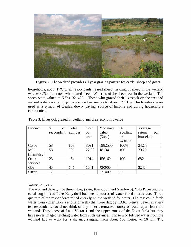
Figure 2: The wetland provides all year grazing pasture for cattle, sheep and goats households, about 17% of all respondents, reared sheep. Grazing of sheep in the wetland was by 82% of all those who reared sheep. Watering of the sheep was in the wetland. The sheep were valued at KShs. 321400. Those who grazed their livestock on the wetland walked a distance ranging from some few metres to about 12.5 km. The livestock were used as a symbol of wealth, dowry paying, source of income and during household’s ceremonies. Table 3. Livestock grazed in wetland and their economic value Product % of
respondent Total number
Cost per unit
Monetary value (Kshs)
% Feeding on wetland
Average return per household
Cattle 58 863 8091 6982500 100% 24273 Milk (liters/day)
58 795 22.80 18134 100 79.20
Oxen services
23 154 1014 156160 100 682
Goat 43 545 1341 730950 3248 Sheep 17 321400 82 Water Source:- The wetland through the three lakes, (Sare, Kanyaboli and Namboyo), Yala River and the canal dug to feed Lake Kanyaboli has been a source of water for domestic use. Three quarters of the respondents relied entirely on the wetland for water. The rest could fetch water from either Lake Victoria or wells that were dug by CARE Kenya. Seven in every ten respondents could not think of any other alternative source of water apart from the wetland. They knew of Lake Victoria and the upper zones of the River Yala but they have never imaged fetching water from such distances. Those who fetched water from the wetland had to walk for a distance ranging from about 100 metres to 16 km. The
11
availability of the water bodies in the neighbourhood led to the local community especially in both Bondo and Siaya districts to adopt bathing from the river. Bathing in the river was considered to be part of domestic usage of water, as they would have otherwise drawn it. Construction and Handcrafts: The wetland vegetation found a lot of use in construction and handcrafts especially the papyrus and the reeds. The papyrus plant is a resource in that it has some uses locally. The use of papyrus was intense among the locals that out of all the respondents, it was only in 2 homesteads where a papyrus product, part or by-product was not readily visible to the interviewers. The papyrus products visible included huts thatching, papyrus mats used as ceiling boards, papyrus tables, chairs, stools, fishing baskets and papyrus by- products that littered the compound after being used as animal foliage. Ninety-eight percent of the respondents confirmed using papyrus products on a daily basis. The local residents’ construction relies largely on wetland resources with 68 % of houses thatched with vegetation harvested from the wetland, 6% of houses constructed or finished with papyrus. A large number of houses are constructed during the rain season to avoid the labour of fetching water but in some cases the water for baking the mud paste used in construction of the 88% of the houses is fetched from the wetland. Table 4: Contribution of the wetland in construction and handcrafts industries Construction Number Proportion % Total number of houses in respondents’ households 1071 - Iron sheet thatched 341 32 Grass thatched 730 68 Mud walled 941 88 Wood/ bricks or blocks walled 100 9 Papyrus walled 30 3 Papyrus interior subdivisions in wood and mud walled 31 3 Total numbers of seats 1573 -Capacity of seats 1701 - Papyrus seats 110 7 Papyrus made tables 80 14 Timber made tables 498 86 Table capacity 1541 - Mattress 534 - Sleeping Mats (Papyrus mattresses) 220 - Mats and mattress capacity 1396 - The locals rely heavily on wood made furniture. They reported owning about 1573 seats with seat capacity of 1701, of which only 110 (7%) were papyrus made. About 70 households (31%) had some of their seats made at home by family members. These seats were made from Acacia brasvicas, which is found on riverine valleys. It’s surprising that this particular species of tree is uncommon in the wetland’s lacustrine vegetation. On
12
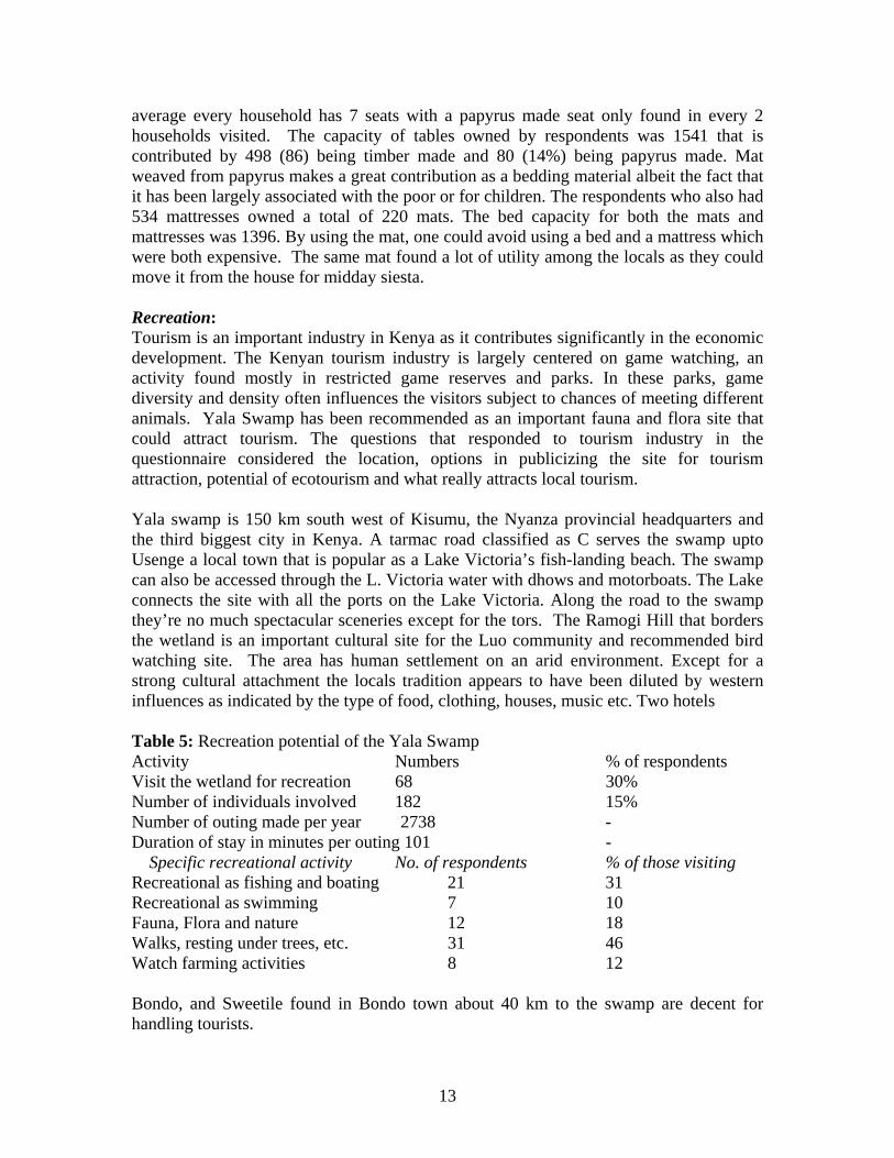
average every household has 7 seats with a papyrus made seat only found in every 2 households visited. The capacity of tables owned by respondents was 1541 that is contributed by 498 (86) being timber made and 80 (14%) being papyrus made. Mat weaved from papyrus makes a great contribution as a bedding material albeit the fact that it has been largely associated with the poor or for children. The respondents who also had 534 mattresses owned a total of 220 mats. The bed capacity for both the mats and mattresses was 1396. By using the mat, one could avoid using a bed and a mattress which were both expensive. The same mat found a lot of utility among the locals as they could move it from the house for midday siesta. Recreation: Tourism is an important industry in Kenya as it contributes significantly in the economic development. The Kenyan tourism industry is largely centered on game watching, an activity found mostly in restricted game reserves and parks. In these parks, game diversity and density often influences the visitors subject to chances of meeting different animals. Yala Swamp has been recommended as an important fauna and flora site that could attract tourism. The questions that responded to tourism industry in the questionnaire considered the location, options in publicizing the site for tourism attraction, potential of ecotourism and what really attracts local tourism. Yala swamp is 150 km south west of Kisumu, the Nyanza provincial headquarters and the third biggest city in Kenya. A tarmac road classified as C serves the swamp upto Usenge a local town that is popular as a Lake Victoria’s fish-landing beach. The swamp can also be accessed through the L. Victoria water with dhows and motorboats. The Lake connects the site with all the ports on the Lake Victoria. Along the road to the swamp they’re no much spectacular sceneries except for the tors. The Ramogi Hill that borders the wetland is an important cultural site for the Luo community and recommended bird watching site. The area has human settlement on an arid environment. Except for a strong cultural attachment the locals tradition appears to have been diluted by western influences as indicated by the type of food, clothing, houses, music etc. Two hotels Table 5: Recreation potential of the Yala Swamp Activity Numbers % of respondents Visit the wetland for recreation 68 30% Number of individuals involved 182 15% Number of outing made per year 2738 - Duration of stay in minutes per outing 101 - Specific recreational activity No. of respondents % of those visiting Recreational as fishing and boating 21 31 Recreational as swimming 7 10 Fauna, Flora and nature 12 18 Walks, resting under trees, etc. 31 46 Watch farming activities 8 12 Bondo, and Sweetile found in Bondo town about 40 km to the swamp are decent for handling tourists.
13
The wetland is a recreational facility for the locals, with 68 respondents confirming that their family members are attracted to visit it. From the survey it was learnt that a total of 182 members of household out of the entire 1215 visited the wetland. They made about 2738 outings with each outing lasting less than two hours (101 minutes). The largest proportion of visitors (46%) enjoyed relaxing around the wetland. They claimed the environment of the wetland was cool, silent, refreshing and admirable hence they could walk around or choose a place to either sleep or sit as they meditated. Some who toured the wetland were attracted to boating and fishing 31%, swimming 10%, watching the birds, animals and the vegetation 18%. Others found a lot of utility in visiting farms around the wetland 12%. A part from the respondents’ family members, other neighbours also enjoyed touring the wetland. The respondents had observed about 328 neighbours touring wetland regularly. Visiting the wetland was affordable as no charges were made and locals were able to walk to the site. A relative large proportion of the respondents (58%), believed the wetland could attract foreign tourists. Activities that could attract tourist in Yala Swamp included game watching including birds, mammals, and the vegetation. Recommendation of Yala swamp for game watching was by 54 respondents (41%) of those who felt the site was feasible as a tourist destination. Recommendation of the wetland as a site feasible for sport fishing, boating and swimming was by 11% of the respondents. Seven percent and 6% of those interviewed felt the area could attract tourist for retreats and watching farming activities respectively. Others, 93 respondents (62%) felt that although the site was feasible as a tourist destination, it needed some improvements to attract the tourists. The improvements included infrastructure; where the roads network to the wetland were to be improved and accessibility to the water bodies in the wetland. Accessing the water bodies for tourism entailed choosing the spectacular areas for beaches/ ports, clearing the papyrus and having connection roads to these sites. The improvement of infrastructure was recommended by 29 respondents, a 22% of those who felt the area could attract tourists. Fishery resources: Fishing within the wetland is an important endeavour that provides food and employment to locals. Ninety-seven percent of the respondents had fish as an important component of their food. The fishery resources are harvested from both the wetland lakes and Lake Victoria. Six in every ten respondents relied on the wetland lakes for fish while the rest 39% depended on L. Victoria. Prices of fish depend on size and type. Even catches of the same species differed in size and prices depending on place. Locals relying on catches from the wetland (both L. Kanyaboli and Sare) enjoyed a larger variety of fish species than those depending on L. Victoria nearby. A large proportion of the respondents enjoyed three varieties of fish. More than a third of households relying on L. Kanyaboli enjoyed more than 3 varieties of fish. Fish harvested from Kanyaboli were relatively expensive (Kshs. 84.1) than those at other sites. Those at L. Sare were the least expensive (Kshs. 72.2). The low price for fish at L. Sare is associated with the fact that it borders L. Victoria which could be producing fish at low prices. The higher prices for catches from L. Kanyaboli are associated with relative distance from other two lakes. Higher prices of fish from L. Victoria could be associated with the fact that the catches
14
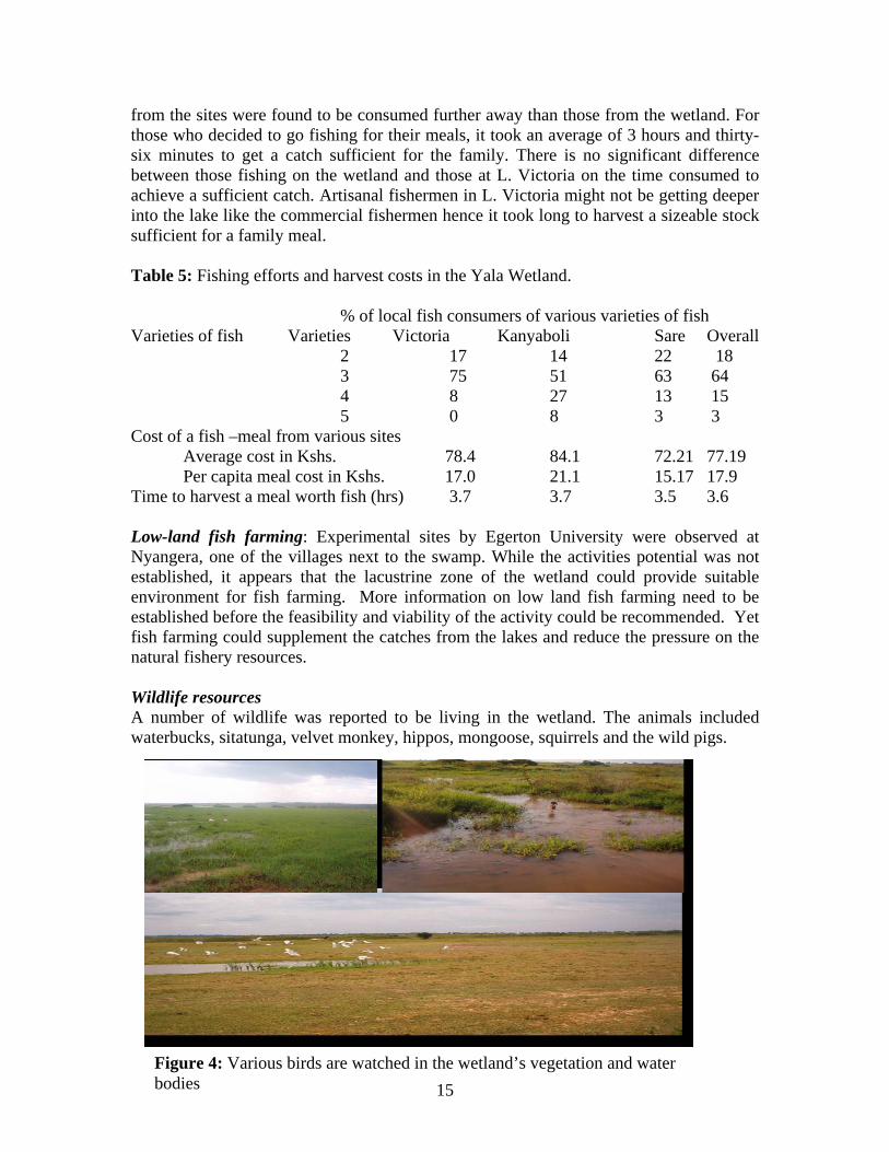
from the sites were found to be consumed further away than those from the wetland. For those who decided to go fishing for their meals, it took an average of 3 hours and thirty-six minutes to get a catch sufficient for the family. There is no significant difference between those fishing on the wetland and those at L. Victoria on the time consumed to achieve a sufficient catch. Artisanal fishermen in L. Victoria might not be getting deeper into the lake like the commercial fishermen hence it took long to harvest a sizeable stock sufficient for a family meal. Table 5: Fishing efforts and harvest costs in the Yala Wetland. % of local fish consumers of various varieties of fish Varieties of fish Varieties Victoria Kanyaboli Sare Overall 2 17 14 22 18 3 75 51 63 64 4 8 27 13 15 5 0 8 3 3 Cost of a fish –meal from various sites Average cost in Kshs. 78.4 84.1 72.21 77.19 Per capita meal cost in Kshs. 17.0 21.1 15.17 17.9 Time to harvest a meal worth fish (hrs) 3.7 3.7 3.5 3.6 Low-land fish farming: Experimental sites by Egerton University were observed at Nyangera, one of the villages next to the swamp. While the activities potential was not established, it appears that the lacustrine zone of the wetland could provide suitable environment for fish farming. More information on low land fish farming need to be established before the feasibility and viability of the activity could be recommended. Yet fish farming could supplement the catches from the lakes and reduce the pressure on the natural fishery resources. Wildlife resources A number of wildlife was reported to be living in the wetland. The animals included waterbucks, sitatunga, velvet monkey, hippos, mongoose, squirrels and the wild pigs.
15Figure 4: Various birds are watched in the wetland’s vegetation and water bodies
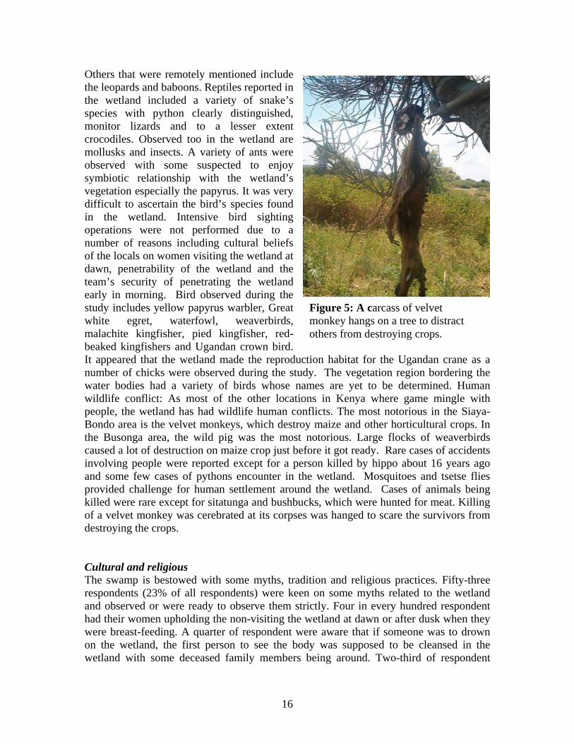
Others that were remotely mentioned include the leopards and baboons. Reptiles reported in the wetland included a variety of snake’s species with python clearly distinguished, monitor lizards and to a lesser extent crocodiles. Observed too in the wetland are mollusks and insects. A variety of ants were observed with some suspected to enjoy symbiotic relationship with the wetland’s vegetation especially the papyrus. It was very difficult to ascertain the bird’s species found in the wetland. Intensive bird sighting operations were not performed due to a number of reasons including cultural beliefs of the locals on women visiting the wetland at dawn, penetrability of the wetland and the team’s security of penetrating the wetland early in morning. Bird observed during the study includes yellow papyrus warbler, Great white egret, waterfowl, weaverbirds, malachite kingfisher, pied kingfisher, red-beaked kingfishers and Ugandan crown bird. It appeared that the wetland made the reproduction habitat for the Ugandan crane as a number of chicks were observed during the study. The vegetation region bordering the water bodies had a variety of birds whose names are yet to be determined. Human wildlife conflict: As most of the other locations in Kenya where game mingle with people, the wetland has had wildlife human conflicts. The most notorious in the Siaya-Bondo area is the velvet monkeys, which destroy maize and other horticultural crops. In the Busonga area, the wild pig was the most notorious. Large flocks of weaverbirds caused a lot of destruction on maize crop just before it got ready. Rare cases of accidents involving people were reported except for a person killed by hippo about 16 years ago and some few cases of pythons encounter in the wetland. Mosquitoes and tsetse flies provided challenge for human settlement around the wetland. Cases of animals being killed were rare except for sitatunga and bushbucks, which were hunted for meat. Killing of a velvet monkey was cerebrated at its corpses was hanged to scare the survivors from destroying the crops.
Figure 5: A carcass of velvet monkey hangs on a tree to distract others from destroying crops.
Cultural and religious The swamp is bestowed with some myths, tradition and religious practices. Fifty-three respondents (23% of all respondents) were keen on some myths related to the wetland and observed or were ready to observe them strictly. Four in every hundred respondent had their women upholding the non-visiting the wetland at dawn or after dusk when they were breast-feeding. A quarter of respondent were aware that if someone was to drown on the wetland, the first person to see the body was supposed to be cleansed in the wetland with some deceased family members being around. Two-third of respondent
16
knew that it was compulsory for the deceased family members to be cleansed in the wetland after the household head dies. Table 6: Cultural and religious believes associated with the wetland.
Issues Number % worst repercussions Myths 53 curse/death Breasting mothers 2 didn’t know Death in the waters 14 death Burial 35 death Ceremonies 54 torment/death Cleansing 27 torment/death Snakes biting 12 death Baptism 14 -- -- Boating ceremony 6 no fish-caught Rain making 12 drought/famine Diseases and pathogens A number of diseases have been associated with the wetland. Only 4 respondents (2%) didn’t associate the wetland with any diseases. Other respondents 37%, 34% and 23% claimed the wetland to be associated to 1, 2 and 3 diseases respectively. The diseases associated with the wetland include:- malaria (214), Typhoid and amoeba (86), Cholera and dysentery (41), sleeping sickness (37), Bilhazia ( 25), skin infection (11) and others (6). The locals rarely keep records on the costs of diseases treatment and preventions especially for non-endemic ones. Only 44% of those who had been infected or affected by sleeping sickness could remember the amounts that have been spent. A total of 38 members of the households interviewed have been infected with sleeping sickness and have had 84 days on treatment incurring a cost of Kshs. 6250. The prevention cost of sleeping sickness is Kshs. 10860. This prevention cost doesn’t include the effort of assembling dung that was being burnt in most households to repel tsetse flies. Skin infection was one of unsuspected diseases associated directly with visiting, swimming or bathing using the swamp’s water. On average more than one in every household has been affected. It costs Kshs. 264 to treat the diseases and Kshs. 326 to protect the disease. The cost of prevention and treatment does not include that of failure to use the water or visit the wetland and that of using some locally available herbs to treat respectively. Most respondents (97%) claimed to have had members of their households suffering from malaria, which they associated with wetland. At least 4 members in every household suffers from malaria with cases of more than one individual suffering concurrently. Every household spends Kshs 454 to prevent malaria. During the month of the study 266 cases of malaria were reported among the 221 households with every household spending KShs. 341 to treat every case of malaria for a week. Twenty six respondents reported having had their 60 immediate family members suffering from typhoid. A total of Kshs
17
42790 (713.20 per capita) were used in treatment that lasted for 442 days (average 1 week). It costed about Kshs 41,300 to protect family members from typhoid. Cholera and dysentery was reported among 8 households. It infected 14 members with 14 cases of infection. The cost of treating cholera was estimated at KShs. 4150 and took about 184 days for treatment. Prevention was estimated at Kshs. 3260. Medicinal Plants: Two strategies were used to determine the availability of medicinal plants in the wetland. The elders meeting was supposed to provide detailed information on the species used and the diseases treated or prevented. This strategy failed to yield any important information as the practicing herbalist were not willing to share the information with us as they could lose control of their job. The art of herbalist is passed from the expert to an intern through apprenticeship. Mostly the practice of herbalist is passed from a father to a preferred son or grandson. Among the respondents interviewed, 102 (45%) had treated or had received treatment from plants collected from the wetland. A sizeable number 61 (27%) informed Table 7: Wetland associated plants with medicinal values Vernacular name Botanical/ English name Diseases treated
Hafifi measles Oyieko Cassia siamea birth problems/ worms/ joint Okeke malaria Nyayado Carisa mangium teeth-ach Oluoro chieng stop bleeding Olandra Flemingia grah curse (locally called chira) Nyohanyoha curse (locally called chira) Olasi Owino Senna didymobotrya swellings/skin/protozoan Oyumbe Joint pains Morakado Rosa canina skin Ombulu Abrus prec cough and chest problems Amayo Salium elli ear and eye infection Aringo ear and eye infection
Ober Albizia coriaria skin and tooth decay Osiri boils and swellings Anyuongi Talinum triangulare rashes and measles Osadhi Vernonia hild Onyodhi stop bleeding Olamu Ogaka Aloe spp skin problems Nyakisumo Centaurea cyanus stomach ache/ witches Nyambudue Centaurea kirkii birharzia
Vegetables Ododo Amaranthus dubius Nyasigumba NB: The real scientific names of the trees are being confirmed
18
on some medicinal plants used and some diseases treated. The diseases treated using wetland vegetation include: skin infection, malaria, snake bites, measles, stomach aches, intestinal worms, bilharzias, coughs, eye and ears problems, joints aches, body swellings, weil and cira (bewitched) and mothers with delivery problems. Livestock diseases including anthrax, foot and mouth and delivery problems have been addresses with local herbs. About 23 plant species were associated with medicinal values with some specific diseases treated by these plants reported. Scientifically the plant species should be listed with the botanical name or common names for a wider audience but this was not possible as in the survey we received the vernacular names and we had to use some reference books. Most of these names are not found in our main reference books Kenya Trees, Shrubs and Liana, 1994 by Henk Beentji, Useful Trees and Shrubs for Uganda by Katende and others in 2000 and International Centre for Research in Agroforestry’s (ICRAF), Yet even the vernacular names differed among the same ethnic group and a local herb, Oyieko had different scientific names in each reference book considered. Vegetables were also harvested from the wetland reported by 11 (5%) respondents. The vegetables plants were Ododo (Amaranthus dubius) and Nyasigumba. Fuel wood About a quarter of the respondents (54) depend on the wetland as a source of fuel wood. The fuel wood is from the rhizomes of papyrus and other plants including VBVBVB. The papyrus rhizomes as firewood was used to smoke a preferred type of fish that was mostly sold to distance markets. Locals set fire on the papyrus to access the rhizomes, which are later dried and transported to the market. Apiculture The acacia-grewia bushes largely dominate the wetland’s surrounding. Other species that is intruding the region and seem to be more competitive than the native vegetation is the Lantana camara. Swarms of bees are regularly heard around the wetland. The survey form failed to adequately capture the apiculture industry as only in very few cases were hives observed with respondent failing to provide more information. More information on apiculture was collected from the Ministry of Livestock and Fisheries in Usigu division of Bondo District. According to the Ministry’s data, the total number of hives in the entire division was 56. The hives were of different types and differed in numbers. The Kenya Top Bar (KTBH) had the largest number reported (37) with other being the traditional (9) and langstroth types (10). Low proportion of bee occupying the hives was reported as only 17 of the 56 had bees. The KTBH had 15 hives occupied while the tradition type had only 2 hives occupied. None of the langstroth hives was occupied. Challenges associated with the apiculture industry in the region include the migration of bees during the dry spells and insufficient food for the bees. In average every hive (KTBH and traditional) produces 6 liters of honey that is locally marketed at Kshs 150.
19

Respondents’ view of the swamp The study was carried out in a very tense environment and the survey intentionally avoided directly querying the respondent about their opinion on whether to rehabilitate or not to rehabilitate the wetland. Asked on any other information they could provide on the wetland, 137 (60%) respondents were afraid to lose access to the wetland with its rehabilitation, while 15 (7%) supported its rehabilitation. Of those afraid of losing the wetland after rehabilitation 42 (32%) were for its conservation. Some respondents supported more research and innovations to establish the most viable and profitable option to utilize the wetland. Example of potential utilization of the wetland that needed to be evaluated includes: - paper (pulp) factory and handcraft industry. Eight respondents felt that the wetland was their ancestral land and the government should hand it over to them after rehabilitation. The rest 31% failed to raise information on whether to rehabilitate or not to rehabilitate the wetland.
Resource base inventory
A transect taken around and within the wetland observed that the main vegetation was the papyrus with some patches of reeds visible. There was a distinct boundary between the patches of the reeds and that of papyrus. The reeds were found on the shallow waters around the wetland especially near Lake Kanyaboli with the papyrus found on the deep waters around the water bodies. A transect across the vegetation at around Jusa in Bondo district observed a dense papyrus vegetation covering the first 50 m, followed by about 150 m margin of a mixture of grasses, (two species), low dense papyrus and some patches of reeds and a dense papyrus vegetation that extending to the a lake. The inner thicket of papyrus was estimated to be about 200 m wide. In areas with narrow wetland vegetation sandwiched between the dry land and water body, the entire vegetation was composed of largely papyrus. Three woody plants were observed among the wetland vegetation in the grasses zones while a large number of non-woody (herbs and vines) some of which appeared ephemeral in all the zones. The proportion size of various wetland plants and their densities could be used to estimate the resource base of each, and hence valuation of the wetland. A lacustrine ecosystem was found around the wetland. The ecosystem extended to a margin of 50-120 metres all around the non-rehabilitated area of the wetland except the southern side. The southern side made a distance of about 15 km between Usenge and Osielo and had rocky terrestrial ecosystem bordering the papyrus. Lacustrine ecosystem was used by locals for cultivation and grazing. A representative area was evaluated for its grazing potential. Grazing Potential: A transect was taken across the area that was once rehabilitated by the Lake Basin Development Basin, which is currently utilized for grazing. A quadrant with a dimension of 1.5m by 1.5 m was used to assess the foliage density and species distribution. Ten sites were chosen randomly after every 100 metres. Plant species found in the quadrant were
20
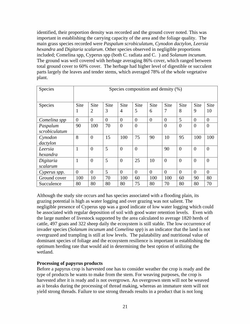
identified, their proportion density was recorded and the ground cover noted. This was important in establishing the carrying capacity of the area and the foliage quality. The main grass species recorded were Paspalum scrobiculatum, Cynodon dactylon, Leersia hexandra and Digitaria scalarum. Other species observed in negligible proportions included; Comelina spp, Cyperus spp (both C. radiata and C. ) and Solanum incunum. The ground was well covered with herbage averaging 86% cover, which ranged between total ground cover to 60% cover. The herbage had higher level of digestible or succulent parts largely the leaves and tender stems, which averaged 78% of the whole vegetative plant. Species Species composition and density (%)
Species Site 1
Site 2
Site 3
Site 4
Site 5
Site 6
Site 7
Site 8
Site 9
Site 10
Comelina spp 0 0 0 0 0 0 0 5 0 0 Paspalum scrobiculatum
90 100 70 0 0 0 0 0 0
Cynodon dactylon
8 0 15 100 75 90 10 95 100 100
Leersia hexandra
1 0 5 0 0 90 0 0 0
Digitaria scalarum
1 0 5 0 25 10 0 0 0 0
Cyperus spp. 0 0 5 0 0 0 0 0 0 0 Ground cover 100 10 70 100 60 100 100 60 90 80 Succulence 80 80 80 80 75 80 70 80 80 70
Although the study site occurs and has species associated with a flooding plain, its grazing potential is high as water logging and over grazing was not salient. The negligible presence of Cyperus spp was a good indicate of low water logging which could be associated with regular deposition of soil with good water retention levels. Even with the large number of livestock supported by the area calculated to average 1820 herds of cattle, 497 goats and 322 sheep daily the ecosystem is still stable. The low occurrence of invader species (Solanum incunum and Comelina spp) is an indicator that the land is not overgrazed and trampling is still at low levels. The palatability and nutritional value of dominant species of foliage and the ecosystem resilience is important in establishing the optimum herding rate that would aid in determining the best option of utilizing the wetland. Processing of papyrus products Before a papyrus crop is harvested one has to consider weather the crop is ready and the type of products he wants to make from the stem. For weaving purposes, the crop is harvested after it is ready and is not overgrown. An overgrown stem will not be weaved as it breaks during the processing of thread making, whereas an immature stem will not yield strong threads. Failure to use strong threads results in a product that is not long
21
lasting hence of low quality. Mats are made from the overgrown crop, which will have achieved the necessary height and strength. Stages of the papyrus maturity levels are determined by; a) shape of the inflorescence (tillers) b) succulence of the crop c) appearance in vigour Folded tillers: The shape of the tillers is a main indicator of the maturity level of a papyrus crop. When the tillers are closed or still attached together, it indicates that a particular stem is not yet mature for harvesting especially for handcrafts. During the drought season or when one has enclosed cattle due to their inability to graze freely in the pastures, this crop may be harvested for the tillers which are palatable and fed to cows. At this time the stem are succulent, dark green in colour and rustle in appearance. Open elect tillers: This is an indicator of crop maturity. The crop is ready for harvesting for weaving purposes. This sign of maturity was observed for the first time in 14 days after crop was harvested and sprouted. The maturity time differed from crop to crop after the sprouting of the crops even in sites with similar environmental attributes. The harvested crop is made into threads with every papyrus stem yielding 3 threads. The stem is hewed into three with a sharp object mostly a knife with the whitish sponge interior part (xylem) removed and stored to make food additives. Every third of the stem is rolled to make a strong thread while is still wet and then dried. These threads are locally used in weaving handcrafts or are sold as are easy to store and carry. About 100 threads are processed from 33 papyrus stems per hour. The process requires expertise, which is gained through apprenticeship. The quality of threads depends on experience, personal skills and the papyrus age. The products of semi-mature papyrus include:- Twines: The threads are dried under shade or mild sunlight to retain the affinity for weaving. About 150 threads are lumped together to form a bunch which is sold to other artists in the local or further markets. The selling prices for the bunch of twines range between Ksh. 40-60. To make a beautiful product, some locally available plants including Lindondo and Limuhuayo) are used to dye the twines. The threads are ferried to further markets including Eldoret (300 km), Bungoma (150 km), Kitale (250 km) and as far as Nairobi (700 km). The twines are used in weaving handcrafts including tables, chairs, baskets and kitchen racks and bookshelves. Tables: Various sizes of tables are made subject to market demand and customers specification. Coffee tables are the largely made size as they are intact, durable and are on high demand. Shrubs provide the sticks which make the legs and provide the frame upon which the twines are woven on. Depending on the size of the table 12 sticks about 1 inch in diameter framed together to provide 4 legs, the top frame and the lower frame to strengthen the table. The twines are woven on the top frame and in some cases on the lower frame making the table firm with shelf. Twines are scrolled on the stick. A typical papyrus coffee table uses about 250 twines and costs Ksh. 350.
22
23
Chairs: Chairs of varying sizes and makes are made from papyrus twines. They use varying numbers of twines and cost differently. A more luxuries and expensive sofa set has been made with addition of imported papyrus species sticks locally called makoroe. The sticks are imported from Uganda with 50 pieces selling at Kshs. 500. The set uses about 2000 twines and costs Kshs. 6800. The 50 sticks are used to make a single set. The frame of the seats especially the sofa sets are made from Markhamia lutea sticks, locally Table 9: Prices of various chair products Type number of twines Cost Pajero chair 210 Single chair 150 200 Sofa set single 300 250 Big sofa set 900 1000 3 seater marachi sofa 3000 3000 2 seater marachi sofa 2500 2800 Stool 500 450 called Siala in Luo or Lusiola (Luhya). The cost of sticks averages Ksh. 50 if one has to purchase them instead of harvesting from the wilderness. Baskets: Woven from the papyrus threads with two sizes largely produced, the small requiring 100 threads (Ksh. 250) and the big requiring 300 threads and costs Ksh. 400. Trays: The largely produced tray required 150 threads and was sold at Ksh. 150. Food additives: A prestigious food additive is derived from the xylem of the papyrus stem. Locally the food addictive is called katukulo by the Luos with the Marachi (a sub-tribe of Luhya) naming it subject to the process used in its making. When the stuff is processed through burning to yield ash it costs Ksh. 40-50 per unit produced from about 100 papyrus stems. This ash used as food additive is called msherekha (Luhya) and is very popular in making indigenous vegetables. When the salt is done through boiling and distillation the resultant salt is locally called mvuma. Its an expensive salt and is generally used for special visitors especially the in-law and is applied on meat (roast or fried). A scoop spoon on about 5 grams costs Ksh. 20. The salts are also medicinal and reported to be used largely by those suffering from diabetes and coughing. Mats: Mats were made from mature papyrus stems. The whole stem is woven together with sisal threads. A 9 by 6 feet mat was retailing at Ksh. 170 and had 21-27 papyrus stems per feet. The papyrus stems are sowed together in three points along their height with the sisal threads. The mats are used for sleeping, drying grains, for makeshift structures (kiosks), walling and ceilings.


![Ngugi Wa Thiong'o - The River Between [LR]](https://img.pdfslide.net/doc/110x75/5501e9b64a795971028b4a93/ngugi-wa-thiongo-the-river-between-lr.jpg)


![[Wa Thiong'o Ngugi] Decolonising the Mind(Bookos.org)](https://img.pdfslide.net/doc/110x75/55cf9a92550346d033a268fd/wa-thiongo-ngugi-decolonising-the-mindbookosorg.jpg)