Embed Size (px)
Citation preview
CASEDHOLE SOLUTIONS WIRELINE
OPTV Tooltrade Optical Televiewer
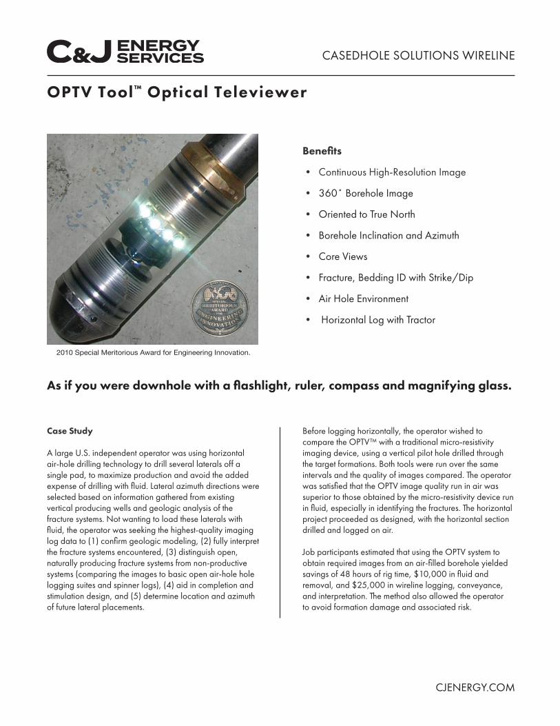
Benefts
bull Continuous High-Resolution Image
bull 360deg Borehole Image
bull Oriented to True North
bull Borehole Inclination and Azimuth
bull Core Views
bull Fracture Bedding ID with StrikeDip
bull Air Hole Environment
bull Horizontal Log with Tractor
2010 Special Meritorious Award for Engineering Innovation
As if you were downhole with a fashlight ruler compass and magnifying glass
Case Study
A large US independent operator was using horizontal air-hole drilling technology to drill several laterals off a single pad to maximize production and avoid the added expense of drilling with fuid Lateral azimuth directions were selected based on information gathered from existing vertical producing wells and geologic analysis of the fracture systems Not wanting to load these laterals with fuid the operator was seeking the highest-quality imaging log data to (1) confrm geologic modeling (2) fully interpret the fracture systems encountered (3) distinguish open naturally producing fracture systems from non-productive systems (comparing the images to basic open air-hole hole logging suites and spinner logs) (4) aid in completion and stimulation design and (5) determine location and azimuth of future lateral placements
Before logging horizontally the operator wished to compare the OPTVtrade with a traditional micro-resistivity imaging device using a vertical pilot hole drilled through the target formations Both tools were run over the same intervals and the quality of images compared The operator was satisfed that the OPTV image quality run in air was superior to those obtained by the micro-resistivity device run in fuid especially in identifying the fractures The horizontal project proceeded as designed with the horizontal section drilled and logged on air
Job participants estimated that using the OPTV system to obtain required images from an air-flled borehole yielded savings of 48 hours of rig time $10000 in fuid and removal and $25000 in wireline logging conveyance and interpretation The method also allowed the operator to avoid formation damage and associated risk
CJENERGYCOM
N
CASEDHOLE SOLUTIONS WIRELINE
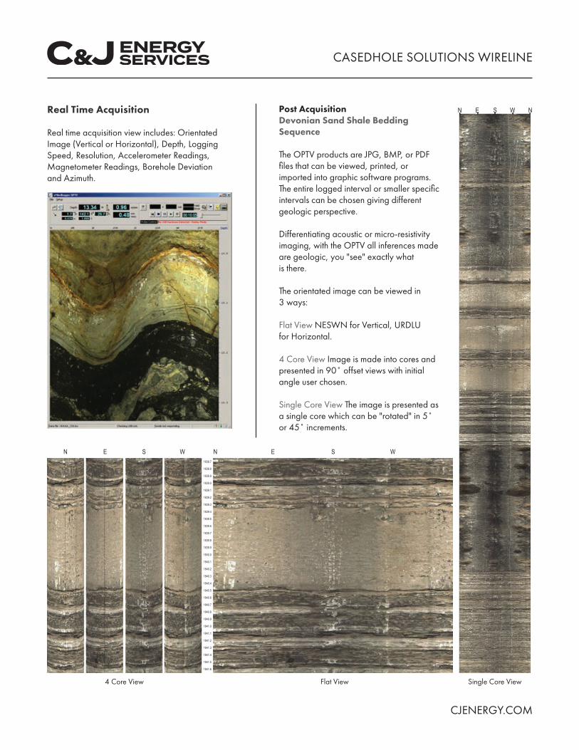
Real Time Acquisition
Real time acquisition view includes Orientated Image (Vertical or Horizontal) Depth Logging Speed Resolution Accelerometer Readings Magnetometer Readings Borehole Deviation and Azimuth
N E S W N 18387
18388
18389
18390
18391
18392
18393
18394
18395
18396
18397
18398
18399
18400
18401
18402
18403
18404
18405
18406
18407
18408
18409
18410
18411
18412
18413
18414
18415
18416
4 Core View
Post Acquisition Devonian Sand Shale Bedding Sequence
The OPTV products are JPG BMP or PDF fles that can be viewed printed or imported into graphic software programs The entire logged interval or smaller specifc intervals can be chosen giving different geologic perspective
Differentiating acoustic or micro-resistivity imaging with the OPTV all inferences made are geologic you see exactly what is there
The orientated image can be viewed in 3 ways
Flat View NESWN for Vertical URDLU for Horizontal
4 Core View Image is made into cores and presented in 90deg offset views with initial angle user chosen
Single Core View The image is presented as a single core which can be rotated in 5deg or 45deg increments
E S W
Flat View
N E S W N
Single Core View
CJENERGYCOM
CASEDHOLE SOLUTIONS WIRELINE
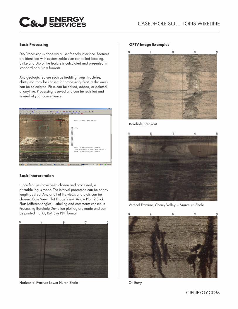
Basic Processing
Dip Processing is done via a user friendly interface Features are identifed with customizable user controlled labeling Strike and Dip of the feature is calculated and presented in standard or custom formats
Any geologic feature such as bedding vugs fractures clasts etc may be chosen for processing Feature thickness can be calculated Picks can be edited added or deleted at anytime Processing is saved and can be revisited and revised at your convenience
Basic Interpretation
Once features have been chosen and processed a printable log is made The interval processed can be of any length desired Any or all of the views and plots can be chosen Core View Flat Image View Arrow Plot 2 Stick Plots (different angles) Labeling and comments chosen in Processing Borehole Deviation plot log are made and can be printed in JPG BMP or PDF format
N E S W N
Horizontal Fracture Lower Huron Shale
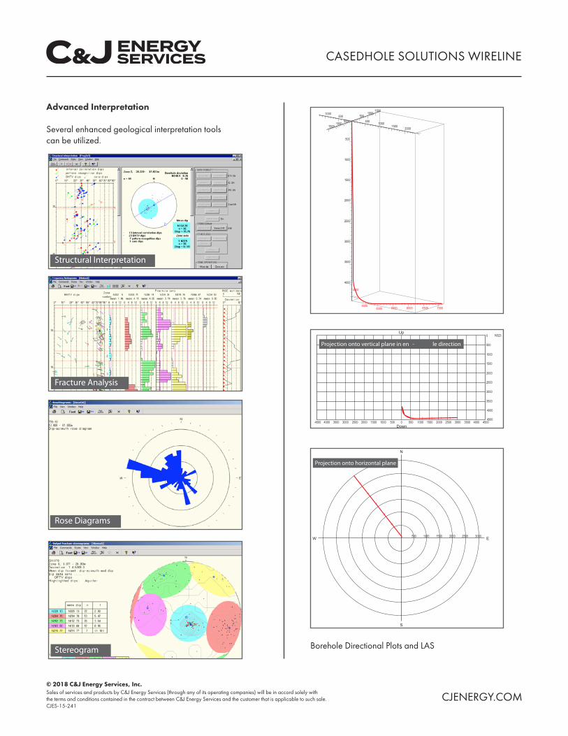
OPTV Image Examples
N E S W N
Borehole Breakout
N E S W N
Vertical Fracture Cherry Valley ndash Marcellus Shale
N E S W N
Oil Entry
CJENERGYCOM
CASEDHOLE SOLUTIONS WIRELINE
Advanced Interpretation
Several enhanced geological interpretation tools can be utilized
1500
500
500
500
1000
1500
2000
2500
3000
3500
4000
4500 5000 5500 6000 6500 7000
500
500
1000 1000
100010001500 1500 2000
4000
4500 4000 3500 3000 2500 2000 2000 2500 3000 3500 4000 4500
Up 0 N323
500
1000
1500
2000
2500
3000
3500
4000
4500 1500 1000 500 0 500 1000 1500
Down
N
E
S
W 500 1000 1500 2000 2500 3000
Borehole Directional Plots and LAS
copy 2018 CampJ Energy Services Inc Sales of services and products by CampJ Energy Services (through any of its operating companies) will be in accord solely with the terms and conditions contained in the contract between CampJ Energy Services and the customer that is applicable to such sale CJENERGYCOM CJES-15-241
N
CASEDHOLE SOLUTIONS WIRELINE
Real Time Acquisition
Real time acquisition view includes Orientated Image (Vertical or Horizontal) Depth Logging Speed Resolution Accelerometer Readings Magnetometer Readings Borehole Deviation and Azimuth
N E S W N 18387
18388
18389
18390
18391
18392
18393
18394
18395
18396
18397
18398
18399
18400
18401
18402
18403
18404
18405
18406
18407
18408
18409
18410
18411
18412
18413
18414
18415
18416
4 Core View
Post Acquisition Devonian Sand Shale Bedding Sequence
The OPTV products are JPG BMP or PDF fles that can be viewed printed or imported into graphic software programs The entire logged interval or smaller specifc intervals can be chosen giving different geologic perspective
Differentiating acoustic or micro-resistivity imaging with the OPTV all inferences made are geologic you see exactly what is there
The orientated image can be viewed in 3 ways
Flat View NESWN for Vertical URDLU for Horizontal
4 Core View Image is made into cores and presented in 90deg offset views with initial angle user chosen
Single Core View The image is presented as a single core which can be rotated in 5deg or 45deg increments
E S W
Flat View
N E S W N
Single Core View
CJENERGYCOM
CASEDHOLE SOLUTIONS WIRELINE
Basic Processing
Dip Processing is done via a user friendly interface Features are identifed with customizable user controlled labeling Strike and Dip of the feature is calculated and presented in standard or custom formats
Any geologic feature such as bedding vugs fractures clasts etc may be chosen for processing Feature thickness can be calculated Picks can be edited added or deleted at anytime Processing is saved and can be revisited and revised at your convenience
Basic Interpretation
Once features have been chosen and processed a printable log is made The interval processed can be of any length desired Any or all of the views and plots can be chosen Core View Flat Image View Arrow Plot 2 Stick Plots (different angles) Labeling and comments chosen in Processing Borehole Deviation plot log are made and can be printed in JPG BMP or PDF format
N E S W N
Horizontal Fracture Lower Huron Shale
OPTV Image Examples
N E S W N
Borehole Breakout
N E S W N
Vertical Fracture Cherry Valley ndash Marcellus Shale
N E S W N
Oil Entry
CJENERGYCOM
CASEDHOLE SOLUTIONS WIRELINE
Advanced Interpretation
Several enhanced geological interpretation tools can be utilized
1500
500
500
500
1000
1500
2000
2500
3000
3500
4000
4500 5000 5500 6000 6500 7000
500
500
1000 1000
100010001500 1500 2000
4000
4500 4000 3500 3000 2500 2000 2000 2500 3000 3500 4000 4500
Up 0 N323
500
1000
1500
2000
2500
3000
3500
4000
4500 1500 1000 500 0 500 1000 1500
Down
N
E
S
W 500 1000 1500 2000 2500 3000
Borehole Directional Plots and LAS
copy 2018 CampJ Energy Services Inc Sales of services and products by CampJ Energy Services (through any of its operating companies) will be in accord solely with the terms and conditions contained in the contract between CampJ Energy Services and the customer that is applicable to such sale CJENERGYCOM CJES-15-241
CASEDHOLE SOLUTIONS WIRELINE
Advanced Interpretation
Several enhanced geological interpretation tools can be utilized
1500
500
500
500
1000
1500
2000
2500
3000
3500
4000
4500 5000 5500 6000 6500 7000
500
500
1000 1000
100010001500 1500 2000
4000
4500 4000 3500 3000 2500 2000 2000 2500 3000 3500 4000 4500
Up 0 N323
500
1000
1500
2000
2500
3000
3500
4000
4500 1500 1000 500 0 500 1000 1500
Down
N
E
S
W 500 1000 1500 2000 2500 3000
Borehole Directional Plots and LAS
copy 2018 CampJ Energy Services Inc Sales of services and products by CampJ Energy Services (through any of its operating companies) will be in accord solely with the terms and conditions contained in the contract between CampJ Energy Services and the customer that is applicable to such sale CJENERGYCOM CJES-15-241


![State-of-the-Art RF Signal Generation From Optical ...optv [22], [23] while simulta-neously stabilizing the laser offset frequency, o [10]. This f transfers the stability of the optical](https://img.pdfslide.net/doc/110x75/614a239a12c9616cbc6938be/state-of-the-art-rf-signal-generation-from-optical-optv-22-23-while-simulta-neously.jpg)