Embed Size (px)
Citation preview

State of Oregon Natural Hazards Mitigation Plan February 2012
Emergency Management Plan 3‐V‐1
VOLCANO HAZARDS CHAPTER The volcanic peaks of the Cascade Range provide some of Oregon’s most spectacular scenery and popular recreational areas. The beauty of these mountains comes with a price: as volcanoes, they also present a hazard.
The 1980 eruption of Washington’s Mount St. Helens showed how much these sleeping giants can affect not just individual communities but the region as a whole. In response to the volcanic hazard, the U.S. Geological Survey (USGS) opened the Cascades Volcano Observatory (CVO) in Vancouver, Washington. CVO scientists continually monitor the peaks and study the geologic processes. Oregon’s Department of Geology and Mineral Industries (DOGAMI) also keeps an eye on the sleeping giants.
As population increases in Oregon, more areas near active volcanoes are being developed and recreational usage is expanding. As a result, more people and property are at risk from volcanic activity. The next eruption in the Cascades could affect hundreds of thousands of people.
Hazard Analysis/Characterization The volcanic Cascade Range extends southward from British Columbia into northern California. The volcanoes are a result of the complex interaction of tectonic plates along the Cascadia Subduction Zone. Subduction is the process that results in the Juan de Fuca plate (oceanic crust) subducting, or sinking, underneath the North American plate (continental crust) on which we live. As the subducted plate descends, it heats up and begins to melt. This provides the reservoir of heat and molten rock needed to create the magma chambers that lie kilometers deep underneath the Cascades.
Stratovolcanoes like Mount Hood, also called composite volcanoes, are generally tall, steep, conical shaped features, built up through layering of volcanic debris, lava, and tephra. Eruptions tend be explosive, for example, the violent 1980 eruption of Mt. Saint Helens, and they produce volcanic mudflows (lahars) that can travel far from the mountain. Future eruptions are likely to be similar and present a severe hazard to the surrounding area. Volcanoes also pose other hazards because of their geology and resulting geomorphology. The relatively high elevation of volcanoes usually results in the meteorological effect called orographic lifting,
Figure V‐1:
(Jose Vigil, USGS)

February 2012 Natural Hazards Mitigation Plan State of Oregon
3‐V‐2 Emergency Management Plan
which causes high precipitation and snow on the mountains that can result in flooding. The geologic material tends to be relatively weak and, when combined with the steep slopes, can cause frequent and hazardous landslides. Cascade Mountain Range volcanoes are also located near the active Cascadia Subduction Zone and nearby potentially active crustal faults, which contribute to moderate seismic hazard in the area.
The volcanoes of the Cascade Range have a long history of eruption and intermittent quiescence. Note that in the diagram below, each volcano has a different frequency of eruption. Not all Cascade volcanoes have been active in the recent past. This is typical of a volcanic range and is one of the reasons forecasting eruptions can be difficult.
Figure V‐3: (Myers and Driedger, 2008a, USGS GIP‐63)
Figure V‐2: (photo by Bill Burns, 2008, DOGAMI)

State of Oregon Natural Hazards Mitigation Plan February 2012
Emergency Management Plan 3‐V‐3
Volcano-Associated Hazards A number of hazards are associated with volcanoes (see figure below). In general, volcanic hazards are commonly divided into those that occur in proximal (near the volcano) and distal (far from the volcano) hazard zones. In the distal hazard zone, volcanic activity includes lahars (volcanic mudflows or debris flows) and fallout of tephra (volcanic ash); in the proximal hazard zone, activity can be much more devastating and includes rapidly moving pyroclastic flows (glowing avalanches), lava flows, and landslides. Each eruption is a unique combination of hazards. Not all hazards will be present in all eruptions, and the degree of damage will vary. It is important to know that during an active period for a volcano many individual eruptions may occur and each eruption can vary in intensity and length. For example, Mount Saint Helens’ first eruption occurred in March 1980, but the volcanic activity continues to this day with minor eruptions and dome building again occurring in October 1986 and, later, from 2004 until 2008.
ERUPTIVE HAZARDS
Tephra (Ash) Fall One of the hazards from an eruption is rock (bombs) and dust‐sized ash particles ‐ called tephra ‐ blown into the air. In general, ash fall is considered a distal hazard. Dust‐sized ash particles can travel enormous distances and are a serious by‐product of volcanic eruptions. Within a few miles of the vent, the main tephra hazards to man‐made structures and humans include high temperatures, being buried, and being hit by falling fragments. Within ten to twelve miles, hot tephra may set fire to forests and flammable structures. Structural damage can also result from the weight of ash, especially if it is wet. Four inches of wet ash may cause buildings to collapse. A half inch of ash can impede the movement of most vehicles, disrupt transportation, communication, and utility systems, and cause problems for human and animal respiratory systems. It is extremely dangerous for aircraft, particularly jet planes, as volcanic ash accelerates wear to critical engine components, can coat exposed electrical components, and erodes exposed structure. Ashfall may severely decrease visibility, even cause darkness, which can further disrupt transportation and other systems. Recent work by the Volcano Hazards Group of the USGS has attempted to rank the relative hazard of volcanoes in North America. According to this study, Oregon has four Very High Threat Volcanoes:
Figure V‐4:
(Myers and Driedger, 2008b, USGS GIP‐64)

February 2012 Natural Hazards Mitigation Plan State of Oregon
3‐V‐4 Emergency Management Plan
Crater Lake, Mount Hood, Newberry Volcano, and South Sister (Ewert and others, 2005).
Ashfall can severely degrade air quality and trigger health problems. In areas with considerable ashfall, people with breathing problems might need additional services from doctors or emergency rooms. In severe events, an air quality warning, similar to those given on summer problem air quality days, could be issued. This would, for example, warn people with breathing problems not to go outside. On roads and streets, ashfall can create serious traffic problems as well as road damage. Vehicles moving over even a thin coating of ash can cause great clouds of ash to swell. This results in grave visibility problems for other drivers, calling for speed restrictions, and often forcing road closures. It also adds to the potential for health problems for residents of the area. Extremely wet ash creates slippery and hazardous road conditions. Ash filling roadside ditches and culverts can prevent proper drainage and cause shoulder erosion and road damage. Blocked drainages can also trigger debris flows or lahars if the blockage causes water to pool on or above susceptible slopes. Conventional snow removal methods do not work on dry ash, as they only stir it up and cause it to resettle on the roadway. When ash is pushed to the side of travel lanes, wind and vehicle movement continue to cause it to billow. During an eruption that emits ash, the ashfall deposition is controlled by the prevailing wind direction. The predominant wind pattern over the Cascades is from the west, and previous eruptions seen in the geologic record have resulted in most ashfall drifting to the east of the volcanoes. The potential and geographical extent of volcanic ashfall in the Pacific Northwest is depicted in the figure below.
Figure V‐5:
(Scott and others, 1997, USGS OFR 97‐89)
State of Oregon Natural Hazards Mitigation Plan February 2012
Emergency Management Plan 3‐V‐5
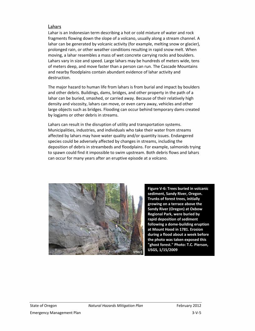
Lahars Lahar is an Indonesian term describing a hot or cold mixture of water and rock fragments flowing down the slope of a volcano, usually along a stream channel. A lahar can be generated by volcanic activity (for example, melting snow or glacier), prolonged rain, or other weather conditions resulting in rapid snow melt. When moving, a lahar resembles a mass of wet concrete carrying rocks and boulders. Lahars vary in size and speed. Large lahars may be hundreds of meters wide, tens of meters deep, and move faster than a person can run. The Cascade Mountains and nearby floodplains contain abundant evidence of lahar activity and destruction.
The major hazard to human life from lahars is from burial and impact by boulders and other debris. Buildings, dams, bridges, and other property in the path of a lahar can be buried, smashed, or carried away. Because of their relatively high density and viscosity, lahars can move, or even carry away, vehicles and other large objects such as bridges. Flooding can occur behind temporary dams created by logjams or other debris in streams.
Lahars can result in the disruption of utility and transportation systems. Municipalities, industries, and individuals who take their water from streams affected by lahars may have water quality and/or quantity issues. Endangered species could be adversely affected by changes in streams, including the deposition of debris in streambeds and floodplains. For example, salmonids trying to spawn could find it impossible to swim upstream. Both debris flows and lahars can occur for many years after an eruptive episode at a volcano.
Figure V‐6: Trees buried in volcanic sediment, Sandy River, Oregon. Trunks of forest trees, initially growing on a terrace above the Sandy River (Oregon) at Oxbow Regional Park, were buried by rapid deposition of sediment following a dome‐building eruption at Mount Hood in 1781. Erosion during a flood about a week before the photo was taken exposed this "ghost forest." Photo: T.C. Pierson, USGS, 1/15/2009

February 2012 Natural Hazards Mitigation Plan State of Oregon
3‐V‐6 Emergency Management Plan
Lava Flow Lava flows are streams of molten rock that erupt relatively non‐explosively from a volcano and move downslope, causing extensive damage or total destruction by burning, crushing, or burying everything in their paths. Lava flows are generally not life threatening because people can usually out‐walk or out‐run them. Secondary effects can include forest fires, flooding, and permanent reconfiguration of stream channels. The Parkdale Lava Flow (see figure below), located along the north flank of Mount Hood, erupted from a small vent roughly 7,600 years ago.
Pyroclastic Flow and Surges Pyroclastic flows are avalanches of rock and gas at temperatures of 600 to 1500 degrees Fahrenheit. They typically sweep down the flanks of volcanoes at speeds of up to 150 miles per hour. Pyroclastic surges are a more dilute mixture of gas and rock. They can move even more rapidly than a pyroclastic flow and are more mobile. Both generally follow valleys, but surges especially may have enough momentum to overtop hills or ridges in their paths. Because of their high speed, pyroclastic flows and surges are difficult or impossible to escape. If it is expected that they will occur, evacuation orders should be issued as soon as possible for the hazardous areas. Objects and structures in the path of a pyroclastic flow are generally destroyed or swept away by the impact of debris or by accompanying hurricane‐force winds. Wood and other combustible materials are commonly burned. People and animals may also be burned or killed by inhaling hot ash and gases. The deposit that results from pyroclastic flows is a combination of rock bombs and ash and is termed ignimbrite. These deposits may accumulate to
Figure V‐7:
(image by Bill Burns, DOGAMI)
State of Oregon Natural Hazards Mitigation Plan February 2012
Emergency Management Plan 3‐V‐7
hundreds of feet thick and can harden to resistant rock. Pyroclastic flows and surges are considered a proximal hazard.
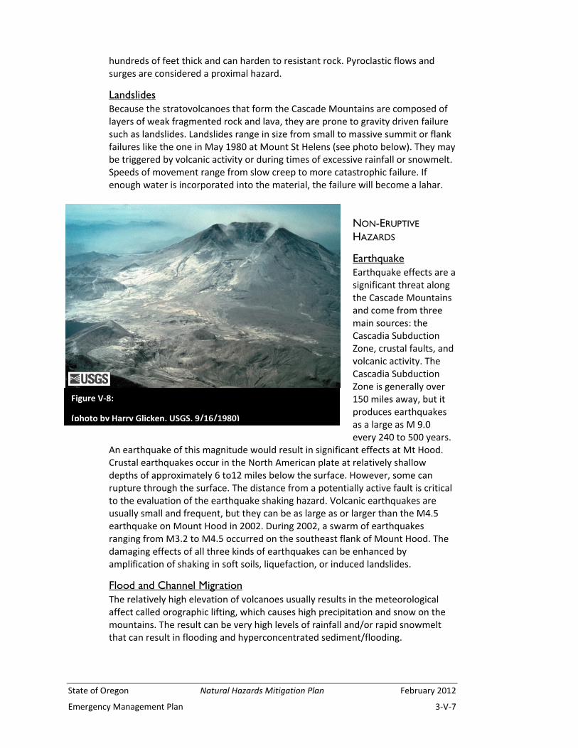
Landslides Because the stratovolcanoes that form the Cascade Mountains are composed of layers of weak fragmented rock and lava, they are prone to gravity driven failure such as landslides. Landslides range in size from small to massive summit or flank failures like the one in May 1980 at Mount St Helens (see photo below). They may be triggered by volcanic activity or during times of excessive rainfall or snowmelt. Speeds of movement range from slow creep to more catastrophic failure. If enough water is incorporated into the material, the failure will become a lahar.
NON-ERUPTIVE
HAZARDS
Earthquake Earthquake effects are a significant threat along the Cascade Mountains and come from three main sources: the Cascadia Subduction Zone, crustal faults, and volcanic activity. The Cascadia Subduction Zone is generally over 150 miles away, but it produces earthquakes as a large as M 9.0 every 240 to 500 years.
An earthquake of this magnitude would result in significant effects at Mt Hood. Crustal earthquakes occur in the North American plate at relatively shallow depths of approximately 6 to12 miles below the surface. However, some can rupture through the surface. The distance from a potentially active fault is critical to the evaluation of the earthquake shaking hazard. Volcanic earthquakes are usually small and frequent, but they can be as large as or larger than the M4.5 earthquake on Mount Hood in 2002. During 2002, a swarm of earthquakes ranging from M3.2 to M4.5 occurred on the southeast flank of Mount Hood. The damaging effects of all three kinds of earthquakes can be enhanced by amplification of shaking in soft soils, liquefaction, or induced landslides.
Flood and Channel Migration The relatively high elevation of volcanoes usually results in the meteorological affect called orographic lifting, which causes high precipitation and snow on the mountains. The result can be very high levels of rainfall and/or rapid snowmelt that can result in flooding and hyperconcentrated sediment/flooding.
Figure V‐8:
(photo by Harry Glicken, USGS, 9/16/1980)
February 2012 Natural Hazards Mitigation Plan State of Oregon
3‐V‐8 Emergency Management Plan
Floods cause damage to assets through inundation of water and by erosion and deposition of soil and/or large objects. Defining the hazard associated with inundation by flooding is done by calculating the area that is likely to be flooded during different levels of flooding. Larger floods are less frequent than smaller floods, so flood levels may be defined by their return period. The longer the return period, the deeper the flood waters, and hence the larger the area that is inundated. Some common return periods used in flood hazard mapping include 10‐year, 25‐year, 100‐year, and 500‐year floods. Most flooding on Cascade Range volcanoes occurs when heavy, warm rain during large winter or spring storms falls on accumulations of low‐elevation snow. Channel migration hazards can occur slowly, for example, by continuous erosion along a cutbank meander and deposition onto a point bar during high flows, or very rapidly during storm events through avulsion or rapid abandonment of the current river channel for a new one. Such rapid migration can not only destroy structures but even remove the land beneath structures.
Flooding is discussed further in the Flood chapter.
Landslide The general term landslide refers to a range of geologic events including rock falls, debris flows, earth slides, and other mass movements. Most landslides that occur on volcanoes are large deep‐seated landslide complexes or debris flows. Deep‐seated landslides have failure surfaces usually tens of feet below the surface and can cover large areas from acres to square miles. These types of landslides tend to move relatively slowly, but they can lurch forward if shaken by an earthquake or if disturbed by removal of material from the toe, by addition of material to the head, or by addition of water into the slide mass. Debris flows tend to initiate in the upper portions of a drainage, picking up water, sediment, and speed as they come down the drainage. As they reach the mouth of the confined/steep portion of the drainage, they tend to spread out and deposit the majority of the material, generally creating a fan. Some debris flows can then change into hyperconcentrated flows and/or torrents and even flood flows. Debris flows are also commonly initiated by other types of landslides that occur on slopes near a channel. They can also initiate within the channel in areas of accelerated erosion during heavy rainfall or snowmelt.
Characterization of Individual Volcanoes Each volcano presents a different set of hazards. The explosive 1980 Mount St. Helens eruption is only one style of eruption for Cascade Range volcanoes. Most events are less explosive. The following is a thumbnail sketch of the volcanoes and their hazards most likely to cause problems for Oregonians (from south to north): Crater Lake (Bacon and others, 1997), Newberry Volcano (Sherrod and others, 1997), Three Sisters Region (Scott and others, 2001), Mount Jefferson (Walder and others, 1999), Mount Hood (Burns and others, 2011; Scott and others, 1997), and Mount St. Helens (Wolfe and Pierson, 1995). For a detailed inventory of each volcano’s history and hazards, please refer to the appropriate report, listed in the Appendix.

State of Oregon Natural Hazards Mitigation Plan February 2012
Emergency Management Plan 3‐V‐9
CRATER LAKE About 7,700 years ago, ancient Mount Mazama erupted with great violence, leaving the caldera that Crater Lake now occupies. Layers of ash produced from that eruption have been found in eight western states and three Canadian provinces. The countryside surrounding Crater Lake was covered by pyroclastic flows. Wizard Island is the result of much smaller eruptions since that cataclysm. The most recent eruption was about 5,000 years ago and occurred within the caldera. No eruptions have occurred outside the caldera since 10,000 years ago.
This potentially active volcanic center is contained within Crater Lake National Park. The western half of the caldera is considered the most likely site of future activity. Effects from volcanic activity (e.g., ashfall, lava flows) are likely to remain within the caldera. If an eruption occurs outside the caldera, pyroclastic flows and lahars could affect valleys up to a few dozen miles from the erupting vent. The probability of another caldera‐forming eruption is very low, as is the probability of eruptions occurring outside the caldera.
NEWBERRY VOLCANO Newberry Volcano is a different type of volcano than the stratovolcanoes of the Cascade Range. It is a shield volcano, with broad, relatively gently sloping flanks. It is about 600,000 years old and has had thousands of eruptions both from the central vent area and along its flanks. The most recent eruption was 1,300 years ago when rhyolite lava erupted within the caldera, but the volcano has been active at other times in the past 10,000 years. Newberry Volcano has attracted interest for its geothermal potential. The heat under the volcano, with temperatures in some areas in excess of 265 degrees Centigrade, is evidence that it is only dormant.
Future eruptions are likely to include lava flows, pyroclastic flows, lahars, and ashfall. Most effects from these activities would be felt within, or up to a few miles beyond, the existing caldera. Ash could fall a few dozen miles from the eruptive center.
THREE SISTERS REGION North Sister has probably been inactive for at least 100,000 years. Middle Sister last erupted between 25,000 and 15,000 years ago. South Sister had a very small ongoing uplift, which began in 1996 and became undetectable by 2003. The uplift was about one inch a year and likely indicated movement of a small amount of magma. At this writing, there is no indication that the uplift will ever develop into a volcanic eruption. However, that possibility cannot be ruled out. Hence, the CVO has increased their monitoring of the area over the past several years.
Future eruptions at South Sister (and possibly Middle Sister) are likely to include lava flows, pyroclastic flows, and lahars. The possibility exists for lahars to travel many miles down valley floors, if an eruption melts a large amount of snow and ice. Ashfall would likely be contained within 20 miles of the vent.
February 2012 Natural Hazards Mitigation Plan State of Oregon
3‐V‐10 Emergency Management Plan
MOUNT JEFFERSON Mount Jefferson is located in a relatively unpopulated part of the Cascade Range. The last eruptive episode at Mount Jefferson was about 15,000 years ago. Research at stratovolcanoes around the world indicates that Mount Jefferson should be regarded as dormant, not extinct.
The steep slopes of the volcano provide the setting for possible debris flows and lahars, even without an eruption. These would be confined to valleys, generally within 10 miles of the volcano.
A major eruption, however unlikely in the short term, could generate pyroclastic flows and lahars that would travel up to a few dozen miles down river valleys. Two reservoirs could be affected by pyroclastic flows from a major eruption: Detroit Lake and Lake Billy Chinook. An explosive eruption could spew ash for hundreds of miles in the downwind direction.
Many smaller volcanoes are located between Mount Jefferson and Mount Hood to the north and Three Sisters to the south. Eruptions from any of these would be very localized, primarily erupting cinders and ash to form cinder cones.
MOUNT HOOD The last major eruption of Mount Hood occurred in approximately 1805 (~200 years ago). The Sandy River that drains the volcano’s northwest side was originally named Quicksand River by Lewis and Clark, who traversed the area only a couple of years after an eruption. Lahars had filled the river channel with debris, much of which has now been scoured away. There were two other minor periods of eruptions during the last 500 years, the last in the mid‐1800s. Typically, these involved lava flows near the summit, pyroclastic flows, and lahars but little ashfall. From its recent eruptive history, the volcano is most likely to erupt from the south side, but planning should be done assuming eruptions could be centered anywhere on the mountain. A large eruption could generate pyroclastic flows and lahars that could inundate the entire length of the Sandy and White River Valleys. An eruption from the north flank could affect the Hood River Valley.
Due to its proximity to the Portland metropolitan area, major east‐west highways, the Bull Run Reservoir (which supplies water to a majority of Portland area residents), and ski and summer recreation areas, Mount Hood the greatest potential volcanic hazard to Oregonians. In addition, a large volume of debris and sediment in lahars could affect shipping lanes in the Columbia River and operation of Bonneville and The Dalles dams.
In recent years, numerous debris flows caused by winter storms have flowed down river drainages. Highway 35 is periodically closed for repair work after these events damaged the bridge over the White River. If a volcanic event occurred, the same drainages would be affected.
MOUNT ST. HELENS The May 18, 1980, eruption of Mount St. Helens is the best‐known example of volcanism to Oregonians. That eruption included a debris avalanche as part of the volcanic edifice collapse. This caused a lateral blast of rock, ash, and gas that
State of Oregon Natural Hazards Mitigation Plan February 2012
Emergency Management Plan 3‐V‐11
devastated areas to the north of the volcano. Lahars rushed down the Toutle and Cowlitz River valleys, reaching the Columbia River and halting shipping for some time. All other river valleys on the volcano experienced smaller lahars. Pyroclastic flows devastated an area up to five miles north. Ashfall deposits affected people as far away as Montana, and ash circled the earth in the upper atmosphere for over a year.
Except for the debris avalanche and lateral blast, the events of this eruptive period are typical of a Mount St. Helens eruption and can be expected to occur again. The primary hazards that will affect Oregonians are ashfall and lahars that affect the Columbia River. Since the major eruptive activity in the early 1980s, Mount St. Helens has experienced two episodes of dome building activity. The latest activity lasted from 2004 until 2008. Another eruption from Mount Saint Helens is very likely in the near future.
Other volcanic areas of Oregon On the scale of geologic time, volcanic eruptions may occur in other parts of Oregon. However, on a human time scale, the probability of an eruption outside the Cascades is so low as to be negligible.
Although the high, snow‐topped mountains of the Cascades are Oregon’s most visible volcanoes, other potential eruptive centers exist. These include smaller peaks, such as the Belknap shield volcano in central Oregon, which had a lava flow about 1,400 years ago. Most of these basaltic volcanoes are active for only brief periods, so forecasting an eruption for a specific site is impossible. However, eruptions of this type are to be expected in the Cascades; the most recent one was in 1851, near Lassen Peak, California. These eruptions are typically not explosive, consisting mostly of lava flows concentrated in a small area.
Volcanism due to Basin and Range extensional tectonics is responsible for some cinder cones and flows in south‐central and southeastern Oregon. The rate of
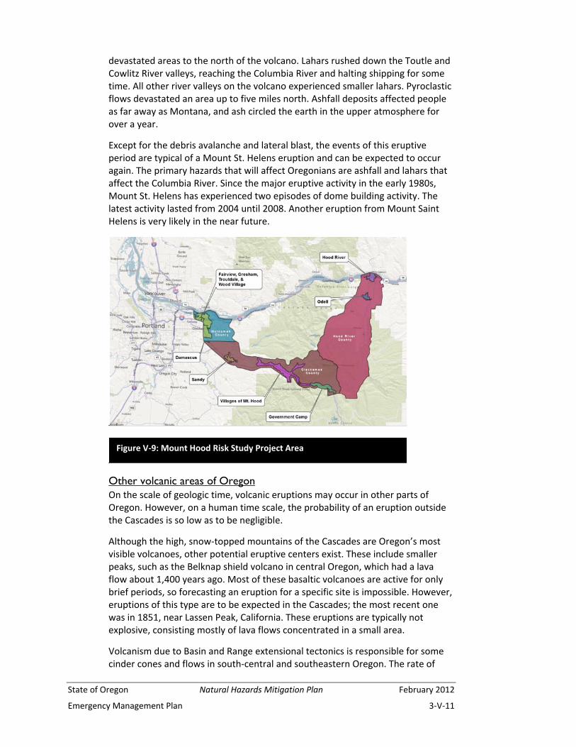
Figure V‐9: Mount Hood Risk Study Project Area
February 2012 Natural Hazards Mitigation Plan State of Oregon
3‐V‐12 Emergency Management Plan
eruptions in this area is very low, so future eruptions are likely to be rare and infrequent.
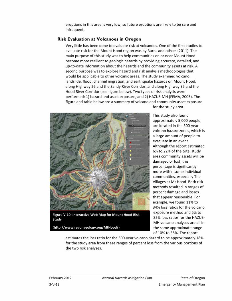
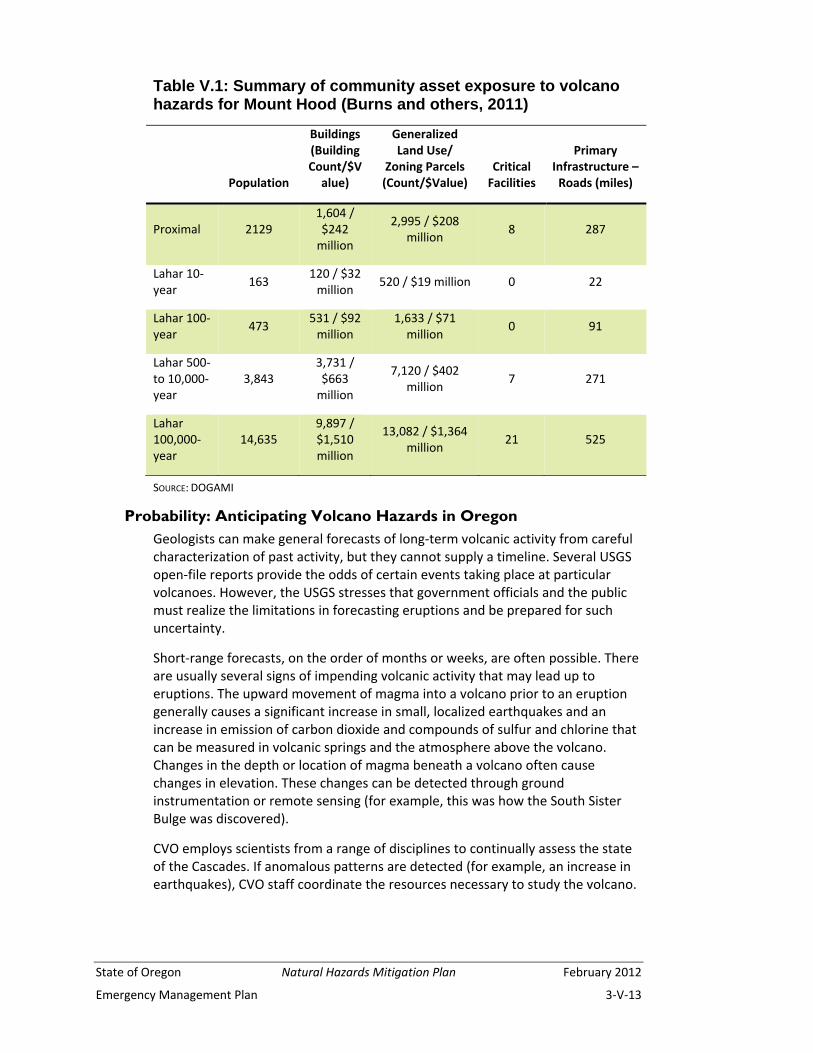
Risk Evaluation at Volcanoes in Oregon Very little has been done to evaluate risk at volcanoes. One of the first studies to evaluate risk for the Mount Hood region was by Burns and others (2011). The main purpose of this study was to help communities on or near Mount Hood become more resilient to geologic hazards by providing accurate, detailed, and up‐to‐date information about the hazards and the community assets at risk. A second purpose was to explore hazard and risk analysis methodologies that would be applicable to other volcanic areas. The study examined volcano, landslide, flood, channel migration, and earthquake hazards on Mount Hood, along Highway 26 and the Sandy River Corridor, and along Highway 35 and the Hood River Corridor (see figure below). Two types of risk analysis were performed: 1) hazard and asset exposure, and 2) HAZUS‐MH (FEMA, 2005). The figure and table below are a summary of volcano and community asset exposure
for the study area.
This study also found approximately 5,000 people are located in the 500‐year volcano hazard zones, which is a large amount of people to evacuate in an event. Although the report estimated 6% to 22% of the total study area community assets will be damaged or lost, this percentage is significantly more within some individual communities, especially The Villages at Mt Hood. Both risk methods resulted in ranges of percent damage and losses that appear reasonable. For example, we found 11% to 34% loss ratios for the volcano exposure method and 5% to 35% loss ratios for the HAZUS‐MH volcano analyses are all in the same approximate range of 10% to 35%. The report
estimates the loss ratio for the 500‐year volcano hazard to be approximately 18% for the study area from these ranges of percent loss from the various portions of the two risk analyses.
Figure V‐10: Interactive Web Map for Mount Hood Risk Study
(http://www.regongeology.org/MtHood/)
State of Oregon Natural Hazards Mitigation Plan February 2012
Emergency Management Plan 3‐V‐13
Table V.1: Summary of community asset exposure to volcano hazards for Mount Hood (Burns and others, 2011)
Population
Buildings (Building Count/$Value)
Generalized Land Use/
Zoning Parcels (Count/$Value)
Critical Facilities
Primary Infrastructure – Roads (miles)
Proximal 2129 1,604 / $242 million
2,995 / $208 million
8 287
Lahar 10‐year
163 120 / $32 million
520 / $19 million 0 22
Lahar 100‐year
473 531 / $92 million
1,633 / $71 million
0 91
Lahar 500‐ to 10,000‐year
3,843 3,731 / $663 million
7,120 / $402 million
7 271
Lahar 100,000‐year
14,635 9,897 / $1,510 million
13,082 / $1,364 million
21 525
SOURCE: DOGAMI
Probability: Anticipating Volcano Hazards in Oregon Geologists can make general forecasts of long‐term volcanic activity from careful characterization of past activity, but they cannot supply a timeline. Several USGS open‐file reports provide the odds of certain events taking place at particular volcanoes. However, the USGS stresses that government officials and the public must realize the limitations in forecasting eruptions and be prepared for such uncertainty.
Short‐range forecasts, on the order of months or weeks, are often possible. There are usually several signs of impending volcanic activity that may lead up to eruptions. The upward movement of magma into a volcano prior to an eruption generally causes a significant increase in small, localized earthquakes and an increase in emission of carbon dioxide and compounds of sulfur and chlorine that can be measured in volcanic springs and the atmosphere above the volcano. Changes in the depth or location of magma beneath a volcano often cause changes in elevation. These changes can be detected through ground instrumentation or remote sensing (for example, this was how the South Sister Bulge was discovered).
CVO employs scientists from a range of disciplines to continually assess the state of the Cascades. If anomalous patterns are detected (for example, an increase in earthquakes), CVO staff coordinate the resources necessary to study the volcano.

February 2012 Natural Hazards Mitigation Plan State of Oregon
3‐V‐14 Emergency Management Plan
Existing Strategies and Programs The Pacific Northwest Seismograph Network, operated jointly by the Geophysics Program at the University of Washington and the USGS, monitors earthquake activity throughout western Oregon and Washington. An additional seismic network has been set up in the Cascades and is monitored by CVO. The scientific research and abilities of CVO staff are an important resource for residents of the Pacific Northwest.
A major existing strategy to address volcanic hazards is to publicize and distribute volcanic hazard maps through DOGAMI and USGS. The volcanoes most likely to constitute a hazard to Oregon communities or activities have been the subject of USGS research. Open‐file reports (OFR) address the geologic history of these volcanoes and lesser known volcanoes in their immediate vicinity. These reports also cover associated hazards and possible mitigation strategies. They are available for the following volcanoes in or near Oregon: Mount Saint Helens, Mount Adams, Mount Hood, Mount Jefferson, Three Sisters, Newberry Volcano, Crater Lake, and Mount Shasta (see Appendix).
Planning documents that focus on natural hazards and volcano hazards in Oregon include the Mount Hood Coordination Plan (Mount Hood Facilitating Committee, 2005) and natural hazard mitigation plans for each county in Oregon with potential volcano hazards. These documents outline responsibilities, preparedness, response, recovery, and action items for predisaster mitigation.
Most of the land occupied by the Cascade volcanoes is in public ownership (e.g., National Forests, National Park Service). Still, ownership and the size of the land parcel are not as important as the location near a volcano. For example, a small private lot could have its potable water source cut off by volcanic activity. Potentially affected land is owned by Native American tribes (e.g., Confederated Tribes of the Warm Springs), private landholders, or administered as mining claims. Both federal and state governments have stringent standards that tend to curtail development on these lands, thereby reducing vulnerability to volcano hazards. The Portland Water Bureau, which takes its water from the Bull Run Reservoir along the western flank of Mount Hood, has a backup system of water wells for use if Bull Run water is not available due to transmission or quality issues.
Proposals to develop federal lands (e.g., widen a highway or expand or create a ski area) must undergo lengthy public hearings and environmental scrutiny. Proposals to develop private land are subject to Oregon’s land use laws (Oregon Revised Statutes, Chapter 197; http://www.leg.state.or.us/ors/197.html). Volcano hazards may be a consideration in both instances.
Oregon Statewide Planning Goal 7 (http://www.oregon.gov/LCD/docs/goals/goal7.pdf?ga=t) does not require counties and incorporated cities to address volcano hazards in their mandatory comprehensive land use plans. However, revised Goal 7 language (effective June 1, 2002) states “local governments may identify and plan for other natural hazards” (Oregon Administrative Rule Chapter 660, Division 15;
State of Oregon Natural Hazards Mitigation Plan February 2012
Emergency Management Plan 3‐V‐15
http://arcweb.sos.state.or.us/pages/rules/oars_600/oar_660/660_028.html). Although some communities have addressed volcanic hazards in their land use plans, the resource goals (e.g., protection of forest lands) are the greatest deterrent to development in areas with volcanic hazards. In addition, communities are required to plan for earthquakes and landslides, both of which generally occur as part of a volcanic eruption.
Oregon’s Department of Environmental Quality has adopted an administrative rule to address ashfall, called “fallout” in the DEQ rule, as well as windblown dust. Excerpts from this rule are included as Appendix DS‐2 to the Dust Storms Chapter of this plan.
In 2004, Mount St. Helens began erupting again. Monitoring of Mount St. Helens since the 1980s by the Cascade Volcano Observatory was put to the test. Volcanologists observed a change in the seismicity as well as the heat output on the dome area and were able to give notice of an impending eruption. Although the volcanic activity remained limited to occasional steam and ash plumes with almost continual lava extrusion on the dome, the media and public interest remained intense for several months. The activity lasted until late in January of 2008, when the alert level was lowered to Normal and the aviation color code returned to Green (volcano in typical background or noneruptive state). From October 2004 until the cessation of active eruption in 2008, about 125 million cubic yards of lava formed a new dome on the crater floor. Some hazards persist in the form of heat in the new lava dome and in the risk of minor explosions that could send a dusting of ash up to 50 miles away.

February 2012 Natural Hazards Mitigation Plan State of Oregon
3‐V‐16 Emergency Management Plan
Appendix V-1: Relevant Publications and Websites
Bacon, C.R., Mastin, L.G., Scott, K.M., and Nathenson, M., 1997, Volcano and earthquake hazards in the Crater Lake region, Oregon: U.S. Geological Survey Open‐File Report 97‐487. [http://vulcan.wr.usgs.gov/Volcanoes/CraterLake/Hazards/OFR97‐487/framework.html]
Beaulieu, J.D., and Olmstead, D.L., 1999a, Mitigating geologic hazards in Oregon: A technical reference manual: Oregon Department of Geology and Mineral Industries Special Paper 31, 60 p.
Beaulieu, J.D., and Olmstead, D.L., 1999b, Geologic hazards: Reducing Oregon’s losses: Oregon Department of Geology and Mineral Industries Special Paper 32, 27 p.
Burns, W.J., Hughes, K.B., Olson, K.V., McClaughry, J.D., Mickelson, K.A., Coe, D.E., English, J.T., Roberts, J.T., Lyles Smith, R.R., Madin, I.P., 2011, Multi‐hazard and risk study for the Mount Hood region, Multnomah, Clackamas, and Hood River Counties, Oregon: Oregon Department of Geology and Mineral Industries, Open‐File Report O‐11‐16.
Ewert, J. W., Guffanti, M., and Murray, T. L., 2005, An assessment of volcanic threat and monitoring capabilities in the United States: Framework for a National Volcano Early Warning System: U.S. Goelogical Survey Open‐File Report 2005‐1164, 62 p. [http://pubs.usgs.gov/of/2005/1164/2005‐1164.pdf]
FEMA (Federal Emergency Management Agency), 2005, HAZUS‐MH software, FEMA’s tool for estimating potential losses from natural disasters. Available on CD‐ROM disks from the Federal Emergency Management Agency (FEMA) or the National Institute of Building Sciences 1090 Vermont Avenue, NW, Suite 700 Washington, DC, 20005‐4905, phone (202) 289‐7800, fax (202) 289‐1092, e‐mail [email protected]. Web: http://www.fema.gov/hazus/ .
Mount Hood Facilitating Committee, 2005, Mount Hood coordination plan: coordinating efforts among governmental agencies in the event of volcanic unrest at Mount Hood, Oregon, 31 p. [http://www.oregongeology.org/sub/earthquakes/mthoodplanfinal0905.pdf]
Myers, B., and Driedger, C., 2008a, Eruptions in the Cascade Range during the past 4,000 years: U.S. Geological Survey General Information Product GIP‐63, poster. [http://pubs.er.usgs.gov/publication/gip63]
Myers, B., and Driedger, C., 2008b, Geologic hazards at volcanoes: U.S. Geological Survey General Information Product GIP‐64, poster. [http://pubs.er.usgs.gov/publication/gip64]
Scott, W.E., Pierson, T.C., Schilling, S.P., Costa, J.E., Gardner, C.A., Vallance, J.W., and Major, J.J., 1997, Volcano hazards in the Mount Hood region, Oregon: U.S. Geological Survey Open‐File Report 97‐89, 14 p. [http://vulcan.wr.usgs.gov/Volcanoes/Hood/Hazards/OFR97‐89/framework.html]
State of Oregon Natural Hazards Mitigation Plan February 2012
Emergency Management Plan 3‐V‐17
Scott, W.E., Iverson, R. M., Schilling, S.P., and Fisher, B.J., 2001, Volcano hazards in the Three Sisters region, Oregon: U.S. Geological Survey Open‐File Report 99‐437. [http://geopubs.wr.usgs.gov/open‐file/of99‐437/]
Sherrod, D.R., Mastin, L.G., Scott, W.E., and Schilling, S.P., 1997, Volcano hazards at Newberry Volcano, Oregon: U.S. Geological Survey Open‐File Report 97‐513. [http://vulcan.wr.usgs.gov/Volcanoes/Newberry/Hazards/OFR97‐513/framework.html]
Walder, J.S., Gardner, C.A., Conrey, R.M., Fisher, B.J., and Schilling, S.P., 1999, Volcano hazards in the Mount Jefferson region, Oregon: U.S. Geological Survey Open‐File Report 99‐24. [http://vulcan.wr.usgs.gov/Volcanoes/Jefferson/Hazards/OFR99‐24/framework.html]
Wolfe, E.W., and Pierson, T.C., 1995, Volcanic‐hazard zonation for Mount St. Helens, Washington: U.S. Geological Survey Open‐File Report 95‐497. [http://vulcan.wr.usgs.gov/Volcanoes/MSH/Hazards/OFR95‐497/framework.html]
Websites with further information
Cascade Volcano Observatory http://vulcan.wr.usgs.gov/
Oregon Department of Geology and Mineral Industries www.oregongeology.org
USGS Volcano Hazard Program http://volcanoes.usgs.gov/
Volcano Glossary http://library.thinkquest.org/17457/glossary/glossary.html

February 2012 Natural Hazards Mitigation Plan State of Oregon
3‐V‐18 Emergency Management Plan
Appendix V-2: Glossary
The following glossary of geologic terms was taken, except as noted, from the USGS website: http://wrgis.wr.usgs.gov/docs/parks/misc/glossaryAtoC.html
Ash: Fine particles of volcanic rock and glass blown into the atmosphere by a volcanic eruption Bombs: Fragments of tephra (particles ejected into the air during volcanic eruptions) larger than 2.5 inches Caldera: Large, generally circular, fault‐bounded depression caused by the withdrawal of magma from below a volcano or volcanoes; commonly the magma erupts explosively as from a giant volcano, and falling back to Earth as volcanic ash, fills the caldera so formed Cascadia Subduction Zone: The area where the seafloor plate (the Juan de Fuca or Gorda) is sliding down and below the North American plate (from DOGAMI)
Cinder: A bubbly (vesicular) volcanic rock fragment that forms when molten, gas‐filled lava is thrown into the air, then solidifies as it falls Ignimbrite: The rock formed by the widespread deposition and consolidation of pyroclastic flows or surges (from Volcano and Geologic Terms http://volcano.und.nodak.edu/vwdocs/glossary.html )
Lahar: A type of mudflow that originates on the slopes of volcanoes when volcanic ash and debris becomes saturated with water and flows rapidly downslope Lava: Magma that reaches the Earth’s surface through a volcanic eruption; when cooled and solidified, forms extrusive (volcanic) igneous rock
Magma: Molten rock; magma may be completely liquid or a mixture of liquid rock, dissolved gases and crystals; molten rock that flows out onto the Earth’s surface is called lava Pyroclastic flow: An extremely hot mixture of gas, ash and pumice fragments that travels down the flanks of a volcano or along the surface of the ground at speeds up to 150 miles per hour and tends to flow down valleys
Pyroclastic surge: A dilute version of a pyroclastic flow, which can move even more rapidly and easily moves up and over ridges Shield volcano: A gently sloping volcano in the shape of a flattened dome and built almost exclusively of lava flows (from Volcano and Geologic Terms http://volcano.und.nodak.edu/vwdocs/glossary.html )
Stratovolcano: A relatively long‐lived volcano built up of both lava flows and pyroclastic material
Subduction: Process of one crustal plate sliding down and below another crustal plate as the two converge; the subduction zone is the area between the two plates Tectonic plate: A slab of rigid lithosphere (crust and uppermost mantle) that moves over the asthenosphere Tephra: General term for all sizes of particles ejected into the air during volcanic eruptions; includes particles as tiny as volcanic ash and as large as bombs and blocks (see pyroclastic)