Embed Size (px)
Citation preview
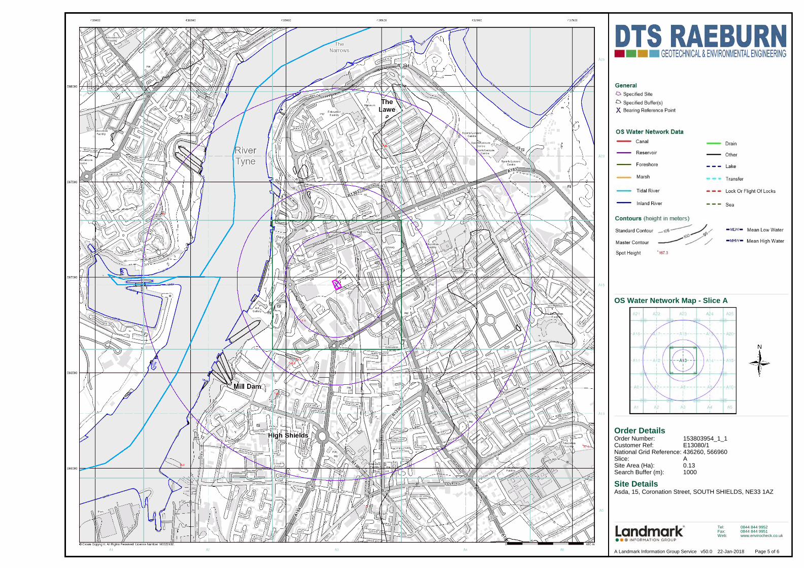
Order Details
Site DetailsAsda, 15, Coronation Street, SOUTH SHIELDS, NE33 1AZ
Order Number:Customer Ref:National Grid Reference:Slice:Site Area (Ha):Search Buffer (m):
153803954_1_1E13080/1436260, 566960A0.131000
Tel:Fax:Web:
0844 844 99520844 844 9951www.envirocheck.co.uk
Page 5 of 6A Landmark Information Group Service v50.0 22-Jan-2018
OS Water Network Map - Slice A

Order Details
Site DetailsAsda, 15, Coronation Street, SOUTH SHIELDS, NE33 1AZ
Order Number:Customer Ref:National Grid Reference:Slice:Site Area (Ha):Search Buffer (m):
153803954_1_1E13080/1436260, 566960A0.131000
Tel:Fax:Web:
0844 844 99520844 844 9951www.envirocheck.co.uk
Page 6 of 6A Landmark Information Group Service v50.0 22-Jan-2018
EA/NRW Suitability Map - Slice A

E13080/1 ASDA South Shields February 2018
Enclosure C
Environmental Database Information
(94 pages)

Order Number: 153803954_1_1 Date: 22-Jan-2018 rpr_ec_datasheet v53.0 A Landmark Information Group Service
Datasheet
Order Details:Order Number:
Customer Reference:
National Grid Reference:
Slice:
Site Area (Ha):
Search Buffer (m):
Site Details:
Client Details:
153803954_1_1
E13080/1
436260, 566960
A
0.13
1000
Asda, 15Coronation StreetSOUTH SHIELDSNE33 1AZ
Mr S JohnsonDTS RaeburnMoor LaneWittonBirminghamWest MidlandsB6 7HG
Report:®Envirocheck

Order Number: 153803954_1_1 Date: 22-Jan-2018 rpr_ec_datasheet v53.0 A Landmark Information Group Service
Summary
Agency & Hydrological
Waste
Hazardous Substances
Geological
Industrial Land Use
Sensitive Land Use
Data Currency
Data Suppliers
Useful Contacts
Introduction
Copyright Notice
Natural England Copyright Notice
Ove Arup Copyright Notice
Peter Brett Associates Copyright Notice
Radon Potential dataset Copyright Notice
The Environment Act 1995 has made site sensitivity a key issue, as the legislation pays as much attention to the pathways by which contamination could spread, and to the vulnerable targets of contamination, as it does the potential sources of contamination. For this reason, Landmark's Site Sensitivity maps and Datasheet(s) place great emphasis on statutory data provided by the Environment Agency/Natural Resources Wales and the Scottish Environment Protection Agency; it also incorporates data from Natural England (and the Scottish and Welsh equivalents) and Local Authorities; and highlights hydrogeological features required by environmental and geotechnical consultants. It does not include any information concerning past uses of land. The datasheet is produced by querying the Landmark database to a distance defined by the client from a site boundary provided by the client.
In the attached datasheet the National Grid References (NGRs) are rounded to the nearest 10m in accordance with Landmark's agreements with a number of Data Suppliers.
© Landmark Information Group Limited 2018. The Copyright on the information and data and its format as contained in this Envirocheck® Report ("Report") is the property of Landmark Information Group Limited ("Landmark") and several other Data Providers, including (but not limited to) Ordnance Survey, British Geological Survey, the Environment Agency/Natural Resources Wales and Natural England, and must not be reproduced in whole or in part by photocopying or any other method. The Report is supplied under Landmark's Terms and Conditions accepted by the Customer. A copy of Landmark's Terms and Conditions can be found with the Index Map for this report. Additional copies of the Report may be obtained from Landmark, subject to Landmark's charges in force from time to time. The Copyright, design rights and any other intellectual rights shall remain the exclusive property of Landmark and /or other Data providers, whose Copyright material has been included in this Report.
Site of Special Scientific Interest, National Nature Reserve, Ramsar, Special Protection Area, Special Conservation Area, Marine Nature Reserve data (derived from Ordnance Survey 1:10000 raster) is provided by, and used with the permission of, Natural England who retain the copyright and Intellectual Property Rights for the data.
The Data provided in this report was obtained on Licence from Ove Arup & Partners Limited (for further information, contact [email protected]). No reproduction or further use of such Data is to be made without the prior written consent of Ove Arup & Partners Limited. The information and data supplied in the product are derived from publicly available records and other third party sources and neither Ove Arup & Partners nor Landmark warrant the accuracy or completeness of such information or data.
The cavity data presented has been extracted from the PBA enhanced version of the original DEFRA national cavity databases. PBA/DEFRA retain the copyright & intellectual property rights in the data. Whilst all reasonable efforts are made to check that the information contained in the cavity databases is accurate we do not warrant that the data is complete or error free. The information is based upon our own researches and those collated from a number of external sources and is continually being augmented and updated by PBA. In no event shall PBA/DEFRA or Landmark be liable for any loss or damage including, without limitation, indirect or consequential loss or damage arising from the use of this data.
Information supplied from a joint dataset compiled by The British Geological Survey and Public Health England.
Report Section Page Number
Contents
Report Version v53.0
-
1
35
42
43
54
81
82
87
88

Order Number: 153803954_1_1 Date: 22-Jan-2018 rpr_ec_datasheet v53.0 A Landmark Information Group Service
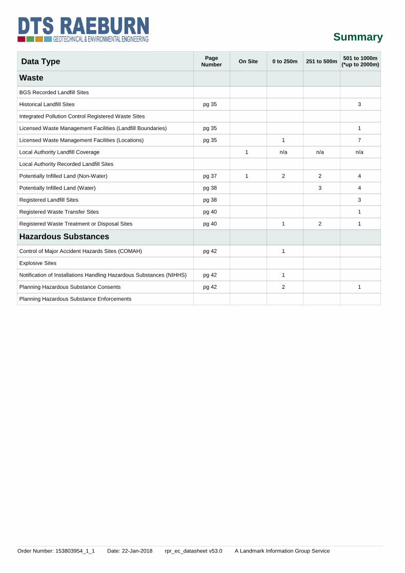
Summary
Data Type PageNumber On Site 0 to 250m 251 to 500m
Agency & Hydrological
501 to 1000m
BGS Groundwater Flooding Susceptibility
Contaminated Land Register Entries and Notices
Discharge Consents
Prosecutions Relating to Controlled Waters
Enforcement and Prohibition Notices
Integrated Pollution Controls
Integrated Pollution Prevention And Control
Local Authority Integrated Pollution Prevention And Control
Local Authority Pollution Prevention and Controls
Local Authority Pollution Prevention and Control Enforcements
Nearest Surface Water Feature
Pollution Incidents to Controlled Waters
Prosecutions Relating to Authorised Processes
Registered Radioactive Substances
River Quality
River Quality Biology Sampling Points
River Quality Chemistry Sampling Points
Substantiated Pollution Incident Register
Water Abstractions
Water Industry Act Referrals
Groundwater Vulnerability
Drift Deposits
Bedrock Aquifer Designations
Superficial Aquifer Designations
Source Protection Zones
Extreme Flooding from Rivers or Sea without Defences
Flooding from Rivers or Sea without Defences
Areas Benefiting from Flood Defences
Flood Water Storage Areas
Flood Defences
OS Water Network Lines
Yes
Yes
Yes
Yes
Yes
n/a
2
1
n/a
n/a
n/a
n/a
Yes
29
n/a
4
Yes
2
1
n/a
n/a
n/a
n/a
n/a
n/a
n/a
n/a
n/a
n/a
67
n/a
12
1
5
14
1
n/a
n/a
n/a
n/a
n/a
n/a
n/a
n/a
n/a
5
(*up to 2000m)
pg 1
pg 2
pg 26
pg 28
pg 28
pg 30
pg 30
pg 33
pg 33
pg 33
pg 33
pg 33
pg 33
Order Number: 153803954_1_1 Date: 22-Jan-2018 rpr_ec_datasheet v53.0 A Landmark Information Group Service
Summary
Data Type PageNumber On Site 0 to 250m 251 to 500m
Waste
Hazardous Substances
501 to 1000m
BGS Recorded Landfill Sites
Historical Landfill Sites
Integrated Pollution Control Registered Waste Sites
Licensed Waste Management Facilities (Landfill Boundaries)
Licensed Waste Management Facilities (Locations)
Local Authority Landfill Coverage
Local Authority Recorded Landfill Sites
Potentially Infilled Land (Non-Water)
Potentially Infilled Land (Water)
Registered Landfill Sites
Registered Waste Transfer Sites
Registered Waste Treatment or Disposal Sites
Control of Major Accident Hazards Sites (COMAH)
Explosive Sites
Notification of Installations Handling Hazardous Substances (NIHHS)
Planning Hazardous Substance Consents
Planning Hazardous Substance Enforcements
1
1
1
n/a
2
1
1
1
2
n/a
2
3
2
3
1
7
n/a
4
4
3
1
1
1
(*up to 2000m)
pg 35
pg 35
pg 35
pg 37
pg 38
pg 38
pg 40
pg 40
pg 42
pg 42
pg 42

Order Number: 153803954_1_1 Date: 22-Jan-2018 rpr_ec_datasheet v53.0 A Landmark Information Group Service
Summary
Data Type PageNumber On Site 0 to 250m 251 to 500m
Geological
Industrial Land Use
501 to 1000m
BGS 1:625,000 Solid Geology
BGS Estimated Soil Chemistry
BGS Recorded Mineral Sites
BGS Urban Soil Chemistry
BGS Urban Soil Chemistry Averages
CBSCB Compensation District
Coal Mining Affected Areas
Mining Instability
Man-Made Mining Cavities
Natural Cavities
Non Coal Mining Areas of Great Britain
Potential for Collapsible Ground Stability Hazards
Potential for Compressible Ground Stability Hazards
Potential for Ground Dissolution Stability Hazards
Potential for Landslide Ground Stability Hazards
Potential for Running Sand Ground Stability Hazards
Potential for Shrinking or Swelling Clay Ground Stability Hazards
Radon Potential - Radon Affected Areas
Radon Potential - Radon Protection Measures
Contemporary Trade Directory Entries
Fuel Station Entries
Points of Interest - Commercial Services
Points of Interest - Education and Health
Points of Interest - Manufacturing and Production
Points of Interest - Public Infrastructure
Points of Interest - Recreational and Environmental
Gas Pipelines
Underground Electrical Cables
Yes
Yes
Yes
Yes
Yes
Yes
Yes
Yes
n/a
Yes
7
n/a
n/a
n/a
Yes
Yes
Yes
Yes
n/a
n/a
54
1
20
8
1
n/a
Yes
3
n/a
n/a
n/a
n/a
n/a
n/a
n/a
n/a
n/a
n/a
n/a
n/a
64
1
14
1
6
9
n/a
Yes
8
n/a
n/a
n/a
n/a
n/a
n/a
n/a
n/a
n/a
n/a
n/a
n/a
78
21
23
6
6
(*up to 2000m)
pg 43
pg 43
pg 49
pg 52
pg 52
pg 52
pg 52
pg 52
pg 52
pg 53
pg 54
pg 71
pg 71
pg 75
pg 76
pg 79
pg 80

Order Number: 153803954_1_1 Date: 22-Jan-2018 rpr_ec_datasheet v53.0 A Landmark Information Group Service
Summary
Data Type PageNumber On Site 0 to 250m 251 to 500m
Sensitive Land Use
501 to 1000m
Ancient Woodland
Areas of Adopted Green Belt
Areas of Unadopted Green Belt
Areas of Outstanding Natural Beauty
Environmentally Sensitive Areas
Forest Parks
Local Nature Reserves
Marine Nature Reserves
National Nature Reserves
National Parks
Nitrate Sensitive Areas
Nitrate Vulnerable Zones
Ramsar Sites
Sites of Special Scientific Interest
Special Areas of Conservation
Special Protection Areas
World Heritage Sites 1 1
(*up to 2000m)
pg 81

Order Number: 153803954_1_1 Date: 22-Jan-2018 rpr_ec_datasheet v53.0 A Landmark Information Group Service Page 1 of 88
Agency & Hydrological
MapID Details
QuadrantReference (Compass Direction)
EstimatedDistanceFrom Site
Contact NGR
BGS Groundwater Flooding Susceptibility
BGS Groundwater Flooding Susceptibility
BGS Groundwater Flooding Susceptibility
BGS Groundwater Flooding Susceptibility
BGS Groundwater Flooding Susceptibility
BGS Groundwater Flooding Susceptibility
BGS Groundwater Flooding Susceptibility
BGS Groundwater Flooding Susceptibility
BGS Groundwater Flooding Susceptibility
BGS Groundwater Flooding Susceptibility
BGS Groundwater Flooding Susceptibility
BGS Groundwater Flooding Susceptibility
BGS Groundwater Flooding Susceptibility
BGS Groundwater Flooding Susceptibility
BGS Groundwater Flooding Susceptibility
BGS Groundwater Flooding Susceptibility
BGS Groundwater Flooding Susceptibility
BGS Groundwater Flooding Susceptibility
BGS Groundwater Flooding Susceptibility
BGS Groundwater Flooding Susceptibility
BGS Groundwater Flooding Susceptibility
BGS Groundwater Flooding Susceptibility
A13NW(W)
A13NW(SW)
A13NW(N)
A13NW(W)
A13SW(SW)
A13SE(E)
A13NE(E)
A13NW(N)
A13SE(E)
A13NW(N)
A13SW(W)
A13NW(N)
A13SE(SE)
A13NW(N)
A13SW(SW)
A13SW(S)
A13NE(E)
A13NW(N)
A13NW(N)
A13SW(SW)
A13SW(S)
A18SW(N)
0
0
64
93
106
162
162
164
170
175
195
214
221
222
229
236
262
264
271
295
307
314
1
1
1
1
1
1
1
1
1
1
1
1
1
1
1
1
1
1
1
1
1
1
Flooding Type:
Flooding Type:
Flooding Type:
Flooding Type:
Flooding Type:
Flooding Type:
Flooding Type:
Flooding Type:
Flooding Type:
Flooding Type:
Flooding Type:
Flooding Type:
Flooding Type:
Flooding Type:
Flooding Type:
Flooding Type:
Flooding Type:
Flooding Type:
Flooding Type:
Flooding Type:
Flooding Type:
Flooding Type:
Limited Potential for Groundwater Flooding to Occur
Potential for Groundwater Flooding to Occur at Surface
Potential for Groundwater Flooding to Occur at Surface
Limited Potential for Groundwater Flooding to Occur
Potential for Groundwater Flooding to Occur at Surface
Potential for Groundwater Flooding of Property Situated Below Ground Level
Potential for Groundwater Flooding to Occur at Surface
Potential for Groundwater Flooding of Property Situated Below Ground Level
Potential for Groundwater Flooding to Occur at Surface
Potential for Groundwater Flooding of Property Situated Below Ground Level
Potential for Groundwater Flooding to Occur at Surface
Potential for Groundwater Flooding of Property Situated Below Ground Level
Potential for Groundwater Flooding to Occur at Surface
Limited Potential for Groundwater Flooding to Occur
Limited Potential for Groundwater Flooding to Occur
Limited Potential for Groundwater Flooding to Occur
Limited Potential for Groundwater Flooding to Occur
Limited Potential for Groundwater Flooding to Occur
Limited Potential for Groundwater Flooding to Occur
Limited Potential for Groundwater Flooding to Occur
Limited Potential for Groundwater Flooding to Occur
Limited Potential for Groundwater Flooding to Occur
436250566961
436264566961
436264567050
436150566961
436200566850
436450566950
436450566961
436264567150
436450566900
436200567150
436050566950
436264567200
436450566800
436200567200
436050566850
436250566700
436550566961
436250567250
436200567250
436000566800
436150566650
436264567300

Order Number: 153803954_1_1 Date: 22-Jan-2018 rpr_ec_datasheet v53.0 A Landmark Information Group Service Page 2 of 88
Agency & Hydrological
MapID Details
QuadrantReference (Compass Direction)
EstimatedDistanceFrom Site
Contact NGR
1
BGS Groundwater Flooding Susceptibility
BGS Groundwater Flooding Susceptibility
BGS Groundwater Flooding Susceptibility
BGS Groundwater Flooding Susceptibility
BGS Groundwater Flooding Susceptibility
BGS Groundwater Flooding Susceptibility
BGS Groundwater Flooding Susceptibility
BGS Groundwater Flooding Susceptibility
BGS Groundwater Flooding Susceptibility
BGS Groundwater Flooding Susceptibility
BGS Groundwater Flooding Susceptibility
BGS Groundwater Flooding Susceptibility
BGS Groundwater Flooding Susceptibility
BGS Groundwater Flooding Susceptibility
BGS Groundwater Flooding Susceptibility
BGS Groundwater Flooding Susceptibility
Discharge Consents
A18SE(N)
A18SW(NW)
A13SW(SW)
A13NW(NW)
A18SE(N)
A8NW(SW)
A14NW(E)
A8NW(S)
A18SW(NW)
A18SE(NE)
A14NW(E)
A18SW(NW)
A18SE(NE)
A14SW(E)
A14SW(E)
A8NW(S)
A12NE(W)
316
352
352
364
366
373
376
391
398
409
412
419
464
465
486
486
345
1
1
1
1
1
1
1
1
1
1
1
1
1
1
1
1
2
Flooding Type:
Flooding Type:
Flooding Type:
Flooding Type:
Flooding Type:
Flooding Type:
Flooding Type:
Flooding Type:
Flooding Type:
Flooding Type:
Flooding Type:
Flooding Type:
Flooding Type:
Flooding Type:
Flooding Type:
Flooding Type:
Operator:Property Type:Location:
Authority:Catchment Area:Reference:Permit Version:Effective Date:Issued Date:Revocation Date:Discharge Type:Discharge Environment:Receiving Water:Status:
Positional Accuracy:
Potential for Groundwater Flooding of Property Situated Below Ground Level
Potential for Groundwater Flooding of Property Situated Below Ground Level
Limited Potential for Groundwater Flooding to Occur
Potential for Groundwater Flooding of Property Situated Below Ground Level
Limited Potential for Groundwater Flooding to Occur
Limited Potential for Groundwater Flooding to Occur
Potential for Groundwater Flooding of Property Situated Below Ground Level
Limited Potential for Groundwater Flooding to Occur
Potential for Groundwater Flooding of Property Situated Below Ground Level
Potential for Groundwater Flooding of Property Situated Below Ground Level
Potential for Groundwater Flooding of Property Situated Below Ground Level
Potential for Groundwater Flooding to Occur at Surface
Potential for Groundwater Flooding of Property Situated Below Ground Level
Potential for Groundwater Flooding of Property Situated Below Ground Level
Limited Potential for Groundwater Flooding to Occur
Potential for Groundwater Flooding to Occur at Surface
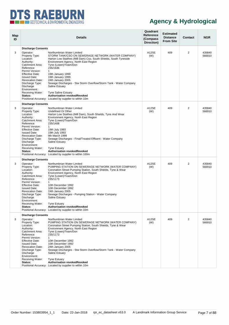
Northumbrian Water LimitedSTORM TANK/CSO ON SEWERAGE NETWORK (WATER COMPANY)Harton Low Staithes Cso Near Grass Field And Footpath To, Ferry Terminal, South Shields, South TynesideEnvironment Agency, North East RegionNot Supplied235/1908125th January 200525th January 20051st December 2010Sewage Discharges - Stw Storm Overflow/Storm Tank - Water CompanySaline Estuary
Tyne Saline EstuaryNew Consent (Water Resources Act 1991, Section 88 & Schedule 10 as amended by Environment Act 1995)Located by supplier to within 10m
436300567300
436100567300
436000566700
436000567250
436300567350
436100566600
436650567050
436200566550
436100567350
436450567350
436700566961
436050567350
436550567350
436750566900
436750566800
436264566450
435920567100

Order Number: 153803954_1_1 Date: 22-Jan-2018 rpr_ec_datasheet v53.0 A Landmark Information Group Service Page 3 of 88
Agency & Hydrological
MapID Details
QuadrantReference (Compass Direction)
EstimatedDistanceFrom Site
Contact NGR
1
1
1
1
Discharge Consents
Discharge Consents
Discharge Consents
Discharge Consents
A12NE(W)
A12NE(W)
A12NE(W)
A12NE(W)
345
345
351
351
2
2
2
2
Operator:Property Type:Location:
Authority:Catchment Area:Reference:Permit Version:Effective Date:Issued Date:Revocation Date:Discharge Type:Discharge Environment:Receiving Water:Status:
Positional Accuracy:
Operator:Property Type:Location:
Authority:Catchment Area:Reference:Permit Version:Effective Date:Issued Date:Revocation Date:Discharge Type:Discharge Environment:Receiving Water:Status:Positional Accuracy:
Operator:Property Type:Location:Authority:Catchment Area:Reference:Permit Version:Effective Date:Issued Date:Revocation Date:Discharge Type:Discharge Environment:Receiving Water:Status:
Positional Accuracy:
Operator:Property Type:Location:Authority:Catchment Area:Reference:Permit Version:Effective Date:Issued Date:Revocation Date:Discharge Type:Discharge Environment:Receiving Water:Status:
Positional Accuracy:
Northumbrian Water LimitedSTORM TANK/CSO ON SEWERAGE NETWORK (WATER COMPANY)Harton Low Staithes Cso Near Grass Field And Footpath To, Ferry Terminal, South Shields, South TynesideEnvironment Agency, North East RegionNot Supplied235/190822nd December 201025th January 2005Not SuppliedSewage Discharges - Stw Storm Overflow/Storm Tank - Water CompanySaline Estuary
Tyne Saline EstuaryNew Consent (Water Resources Act 1991, Section 88 & Schedule 10 as amended by Environment Act 1995)Located by supplier to within 10m
Northumbrian Water LimitedSTORM TANK/CSO ON SEWERAGE NETWORK (WATER COMPANY)Harton Low Staithes Cso Near Grass Field And Footpath To, Ferry Terminal, South Shields, South TynesideEnvironment Agency, North East RegionTyne (Lower)/Team/Don235/1637120th January 199920th January 199925th January 2005Sewage Discharges - Stw Storm Overflow/Storm Tank - Water CompanySaline Estuary
Tyne Saline EstuaryAuthorisation revokedRevokedLocated by supplier to within 10m
Northumbrian Water LimitedSTORM TANK/CSO ON SEWERAGE NETWORK (WATER COMPANY)King Street Cso, South Shields, Tyne And WearEnvironment Agency, North East RegionNot Supplied235/1904124th January 200524th January 20051st April 2010Sewage Discharges - Stw Storm Overflow/Storm Tank - Water CompanySaline Estuary
Tyne EstuaryRevoked (Water Resources Act 1991, Section 88 & Schedule 10 as amended by Environment Act 1995)Located by supplier to within 10m
Northumbrian Water LimitedPUMPING STATION ON SEWERAGE NETWORK (WATER COMPANY)Harton Low Staithes Pumping Station, South Shields, South TynesideEnvironment Agency, North East RegionTyne (Lower)/Team/Don235/1638120th January 199920th January 1999Not SuppliedSewage Discharges - Pumping Station - Water CompanySaline Estuary
Tyne Saline EstuaryNew Consent (Water Resources Act 1991, Section 88 & Schedule 10 as amended by Environment Act 1995)Located by supplier to within 10m
435920567100
435920567100
435910567090
435910567090

Order Number: 153803954_1_1 Date: 22-Jan-2018 rpr_ec_datasheet v53.0 A Landmark Information Group Service Page 4 of 88
Agency & Hydrological
MapID Details
QuadrantReference (Compass Direction)
EstimatedDistanceFrom Site
Contact NGR
1
1
1
1
Discharge Consents
Discharge Consents
Discharge Consents
Discharge Consents
A12NE(W)
A12NE(W)
A12NE(W)
A12NE(NW)
351
351
351
358
2
2
2
2
Operator:Property Type:Location:Authority:Catchment Area:Reference:Permit Version:Effective Date:Issued Date:Revocation Date:Discharge Type:Discharge Environment:Receiving Water:Status:Positional Accuracy:
Operator:Property Type:Location:Authority:Catchment Area:Reference:Permit Version:Effective Date:Issued Date:Revocation Date:Discharge Type:Discharge Environment:Receiving Water:Status:Positional Accuracy:
Operator:Property Type:Location:Authority:Catchment Area:Reference:Permit Version:Effective Date:Issued Date:Revocation Date:Discharge Type:Discharge Environment:Receiving Water:Status:Positional Accuracy:
Operator:Property Type:Location:Authority:Catchment Area:Reference:Permit Version:Effective Date:Issued Date:Revocation Date:Discharge Type:Discharge Environment:Receiving Water:Status:Positional Accuracy:
Northumbrian Water LimitedSTORM TANK/CSO ON SEWERAGE NETWORK (WATER COMPANY)Harton Low Staithes Cso, South Shields, Tyne And WearEnvironment Agency, North East RegionTyne (Lower)/Team/Don235/1169129th October 199229th October 19929th March 1999Sewage Discharges - Final/Treated Effluent - Water CompanySaline Estuary
Tyne EstuaryAuthorisation revokedRevokedLocated by supplier to within 10m
Northumbrian Water LimitedSTORM TANK/CSO ON SEWERAGE NETWORK (WATER COMPANY)King Street Cso, South Shields, Tyne And WearEnvironment Agency, North East RegionTyne (Lower)/Team/Don235/117017th September 19927th September 199224th January 2005Sewage Discharges - Stw Storm Overflow/Storm Tank - Water CompanySaline Estuary
Tyne EstuaryAuthorisation revokedRevokedLocated by supplier to within 100m
Redundant - Northumbrian Water LtdSTORM TANK/CSO ON SEWERAGE NETWORK (WATER COMPANY)Harton Low Staithes Cso, South Shields, Tyne And WearEnvironment Agency, North East RegionNot Supplied235/X/0022118th February 198718th February 19877th September 1992UnspecifiedSaline Estuary
Tyne EstuaryAuthorisation revokedRevokedLocated by supplier to within 10m
Redundant - Northumbrian Water LtdUndefined Or OtherHarton Low Staithes North - B6, South ShieldsEnvironment Agency, North East RegionNot Supplied235/X/013415th June 19875th June 198710th December 1992UnspecifiedSaline Estuary
Tyne EstuaryAuthorisation revokedRevokedLocated by supplier to within 10m
435910567090
435910567090
435910567090
435910567110

Order Number: 153803954_1_1 Date: 22-Jan-2018 rpr_ec_datasheet v53.0 A Landmark Information Group Service Page 5 of 88
Agency & Hydrological
MapID Details
QuadrantReference (Compass Direction)
EstimatedDistanceFrom Site
Contact NGR
1
2
3
3
Discharge Consents
Discharge Consents
Discharge Consents
Discharge Consents
A12NE(NW)
A13NW(NW)
A12SE(W)
A12SE(W)
358
402
409
409
2
2
2
2
Operator:Property Type:Location:Authority:Catchment Area:Reference:Permit Version:Effective Date:Issued Date:Revocation Date:Discharge Type:Discharge Environment:Receiving Water:Status:Positional Accuracy:
Operator:Property Type:Location:Authority:Catchment Area:Reference:Permit Version:Effective Date:Issued Date:Revocation Date:Discharge Type:Discharge Environment:Receiving Water:Status:Positional Accuracy:
Operator:Property Type:Location:
Authority:Catchment Area:Reference:Permit Version:Effective Date:Issued Date:Revocation Date:Discharge Type:Discharge Environment:Receiving Water:Status:
Positional Accuracy:
Operator:Property Type:Location:Authority:Catchment Area:Reference:Permit Version:Effective Date:Issued Date:Revocation Date:Discharge Type:Discharge Environment:Receiving Water:Status:Positional Accuracy:
Redundant - Northumbrian Water LtdUndefined Or OtherHarton Low Staithes North - B6, South ShieldsEnvironment Agency, North East RegionNot Supplied235/X/0081128th April 198728th April 198729th October 1992UnspecifiedSaline Estuary
Tyne EstuaryAuthorisation revokedRevokedLocated by supplier to within 10m
Northumbrian Water LimitedCSO ON UNADOPTED SEWERAGE NETWORK (NOT WATER COMPANY)Spring Lane Sewer, South Shields, Tyne And WearEnvironment Agency, North East RegionTyne (Lower)/Team/Don235/1168129th October 199229th October 19929th March 1999Sewage Discharges - Final/Treated Effluent - Water CompanySaline Estuary
Tyne EstuaryAuthorisation revokedRevokedLocated by supplier to within 100m
Northumbrian Water LimitedSTORM TANK/CSO ON SEWERAGE NETWORK (WATER COMPANY)Tudor Road Cso Near Police Hq & Magistrates Ct, Tudor Road, South Shields, Tyne & WearEnvironment Agency, North East RegionNot Supplied235/1905124th January 200524th January 20051st December 2010Sewage Discharges - Stw Storm Overflow/Storm Tank - Water CompanySaline Estuary
Tyne EstuaryNew Consent (Water Resources Act 1991, Section 88 & Schedule 10 as amended by Environment Act 1995)Located by supplier to within 10m
Northumbrian Water LimitedPUMPING STATION ON SEWERAGE NETWORK (WATER COMPANY)Coronation Street Pumping Station, South Shields, Tyne & WearEnvironment Agency, North East RegionNot Supplied235/1906124th January 200524th January 2005Not SuppliedSewage Discharges - Pumping Station - Water CompanySaline Estuary
Tyne EstuaryNew Consent, by Application (Water Resources Act 1991, Section 88)Located by supplier to within 10m
435910567110
435930567230
435840566910
435840566910

Order Number: 153803954_1_1 Date: 22-Jan-2018 rpr_ec_datasheet v53.0 A Landmark Information Group Service Page 6 of 88
Agency & Hydrological
MapID Details
QuadrantReference (Compass Direction)
EstimatedDistanceFrom Site
Contact NGR
3
3
3
3
Discharge Consents
Discharge Consents
Discharge Consents
Discharge Consents
A12SE(W)
A12SE(W)
A12SE(W)
A12SE(W)
409
409
409
409
2
2
2
2
Operator:Property Type:Location:Authority:Catchment Area:Reference:Permit Version:Effective Date:Issued Date:Revocation Date:Discharge Type:Discharge Environment:Receiving Water:Status:Positional Accuracy:
Operator:Property Type:Location:Authority:Catchment Area:Reference:Permit Version:Effective Date:Issued Date:Revocation Date:Discharge Type:Discharge Environment:Receiving Water:Status:
Positional Accuracy:
Operator:Property Type:Location:
Authority:Catchment Area:Reference:Permit Version:Effective Date:Issued Date:Revocation Date:Discharge Type:Discharge Environment:Receiving Water:Status:
Positional Accuracy:
Operator:Property Type:Location:Authority:Catchment Area:Reference:Permit Version:Effective Date:Issued Date:Revocation Date:Discharge Type:Discharge Environment:Receiving Water:Status:
Positional Accuracy:
Northumbrian Water LimitedPUMPING STATION ON SEWERAGE NETWORK (WATER COMPANY)Coronation Street Pumping Station, South Shields, Tyne & WearEnvironment Agency, North East RegionNot Supplied235/1906124th January 200524th January 2005Not SuppliedSewage Discharges - Stw Storm Overflow/Storm Tank - Water CompanySaline Estuary
Tyne EstuaryNew Consent, by Application (Water Resources Act 1991, Section 88)Located by supplier to within 10m
Northumbrian Water LimitedSTORM TANK/CSO ON SEWERAGE NETWORK (WATER COMPANY)Harton Low Staithes (Mill Dam) Cso, South Shields, South TynesideEnvironment Agency, North East RegionNot Supplied235/1907124th January 200524th January 2005Not SuppliedSewage Discharges - Stw Storm Overflow/Storm Tank - Water CompanySaline Estuary
Tyne Saline EstuaryNew Consent (Water Resources Act 1991, Section 88 & Schedule 10 as amended by Environment Act 1995)Located by supplier to within 10m
Northumbrian Water LimitedSTORM TANK/CSO ON SEWERAGE NETWORK (WATER COMPANY)Tudor Road Cso Near Police Hq & Magistrates Ct, Tudor Road, South Shields, Tyne & WearEnvironment Agency, North East RegionNot Supplied235/190522nd December 201024th January 2005Not SuppliedSewage Discharges - Stw Storm Overflow/Storm Tank - Water CompanySaline Estuary
Tyne EstuaryNew Consent (Water Resources Act 1991, Section 88 & Schedule 10 as amended by Environment Act 1995)Located by supplier to within 10m
Northumbrian Water LimitedPUMPING STATION ON SEWERAGE NETWORK (WATER COMPANY)Harton Low Staithes Pumping Station, South Shields, South TynesideEnvironment Agency, North East RegionNot Supplied235/1638120th January 199920th January 1999Not SuppliedSewage Discharges - Pumping Station - Water CompanySaline Estuary
Tyne Saline EstuaryNew Consent (Water Resources Act 1991, Section 88 & Schedule 10 as amended by Environment Act 1995)Located by supplier to within 10m
435840566910
435840566910
435840566910
435840566910
Order Number: 153803954_1_1 Date: 22-Jan-2018 rpr_ec_datasheet v53.0 A Landmark Information Group Service Page 7 of 88
Agency & Hydrological
MapID Details
QuadrantReference (Compass Direction)
EstimatedDistanceFrom Site
Contact NGR
3
3
3
3
Discharge Consents
Discharge Consents
Discharge Consents
Discharge Consents
A12SE(W)
A12SE(W)
A12SE(W)
A12SE(W)
409
409
409
409
2
2
2
2
Operator:Property Type:Location:Authority:Catchment Area:Reference:Permit Version:Effective Date:Issued Date:Revocation Date:Discharge Type:Discharge Environment:Receiving Water:Status:Positional Accuracy:
Operator:Property Type:Location:Authority:Catchment Area:Reference:Permit Version:Effective Date:Issued Date:Revocation Date:Discharge Type:Discharge Environment:Receiving Water:Status:Positional Accuracy:
Operator:Property Type:Location:Authority:Catchment Area:Reference:Permit Version:Effective Date:Issued Date:Revocation Date:Discharge Type:Discharge Environment:Receiving Water:Status:Positional Accuracy:
Operator:Property Type:Location:Authority:Catchment Area:Reference:Permit Version:Effective Date:Issued Date:Revocation Date:Discharge Type:Discharge Environment:Receiving Water:Status:Positional Accuracy:
Northumbrian Water LimitedSTORM TANK/CSO ON SEWERAGE NETWORK (WATER COMPANY)Harton Low Staithes (Mill Dam) Cso, South Shields, South TynesideEnvironment Agency, North East RegionTyne (Lower)/Team/Don235/1636119th January 199919th January 199924th January 2005Sewage Discharges - Stw Storm Overflow/Storm Tank - Water CompanySaline Estuary
Tyne Saline EstuaryAuthorisation revokedRevokedLocated by supplier to within 10m
Northumbrian Water LimitedUndefined Or OtherHarton Low Staithes (Mill Dam), South Shields, Tyne And WearEnvironment Agency, North East RegionTyne (Lower)/Team/Don235/1408119th July 199319th July 19939th March 1999Sewage Discharges - Final/Treated Effluent - Water CompanySaline Estuary
Tyne EstuaryAuthorisation revokedRevokedLocated by supplier to within 100m
Northumbrian Water LimitedPUMPING STATION ON SEWERAGE NETWORK (WATER COMPANY)Coronation Street Pumping Station, South Shields, Tyne & WearEnvironment Agency, North East RegionTyne (Lower)/Team/Don235/1173110th December 199210th December 199224th January 2005Sewage Discharges - Pumping Station - Water CompanySaline Estuary
Tyne EstuaryAuthorisation revokedRevokedLocated by supplier to within 10m
Northumbrian Water LimitedPUMPING STATION ON SEWERAGE NETWORK (WATER COMPANY)Coronation Street Pumping Station, South Shields, Tyne & WearEnvironment Agency, North East RegionTyne (Lower)/Team/Don235/1173110th December 199210th December 199224th January 2005Sewage Discharges - Stw Storm Overflow/Storm Tank - Water CompanySaline Estuary
Tyne EstuaryAuthorisation revokedRevokedLocated by supplier to within 10m
435840566910
435840566910
435840566910
435840566910

Order Number: 153803954_1_1 Date: 22-Jan-2018 rpr_ec_datasheet v53.0 A Landmark Information Group Service Page 8 of 88
Agency & Hydrological
MapID Details
QuadrantReference (Compass Direction)
EstimatedDistanceFrom Site
Contact NGR
3
3
3
3
Discharge Consents
Discharge Consents
Discharge Consents
Discharge Consents
A12SE(W)
A12SE(W)
A12SE(W)
A12SE(W)
409
409
409
409
2
2
2
2
Operator:Property Type:Location:Authority:Catchment Area:Reference:Permit Version:Effective Date:Issued Date:Revocation Date:Discharge Type:Discharge Environment:Receiving Water:Status:Positional Accuracy:
Operator:Property Type:Location:
Authority:Catchment Area:Reference:Permit Version:Effective Date:Issued Date:Revocation Date:Discharge Type:Discharge Environment:Receiving Water:Status:Positional Accuracy:
Operator:Property Type:Location:Authority:Catchment Area:Reference:Permit Version:Effective Date:Issued Date:Revocation Date:Discharge Type:Discharge Environment:Receiving Water:Status:Positional Accuracy:
Operator:Property Type:Location:Authority:Catchment Area:Reference:Permit Version:Effective Date:Issued Date:Revocation Date:Discharge Type:Discharge Environment:Receiving Water:Status:Positional Accuracy:
Northumbrian Water LimitedUndefined Or OtherHarton Low Staithes (Mill Dam), South Shields, Tyne And WearEnvironment Agency, North East RegionNot Supplied235/1172129th October 199229th October 199219th July 1993Sewage Discharges - Final/Treated Effluent - Water CompanySaline Estuary
Tyne EstuaryAuthorisation revokedRevokedLocated by supplier to within 10m
Northumbrian Water LimitedSTORM TANK/CSO ON SEWERAGE NETWORK (WATER COMPANY)Tudor Road Cso Near Police Hq & Magistrates Ct, Tudor Road, South Shields, Tyne & WearEnvironment Agency, North East RegionTyne (Lower)/Team/Don235/117112nd September 19922nd September 199224th January 2005Sewage Discharges - Stw Storm Overflow/Storm Tank - Water CompanySaline Estuary
Tyne EstuaryAuthorisation revokedRevokedLocated by supplier to within 10m
Redundant - Northumbrian Water LtdUndefined Or OtherHarton Low Staithes (Mill Dam), South Shields, Tyne And WearEnvironment Agency, North East RegionNot Supplied235/X/0082128th April 198728th April 198729th October 1992UnspecifiedSaline Estuary
Tyne EstuaryAuthorisation revokedRevokedLocated by supplier to within 10m
Redundant - Northumbrian Water LtdUndefined Or OtherHarton Low Staithes (Mill Dam), South Shields, Tyne And WearEnvironment Agency, North East RegionNot Supplied235/X/0023118th February 198718th February 19872nd September 1992UnspecifiedSaline Estuary
Tyne EstuaryAuthorisation revokedRevokedLocated by supplier to within 10m
435840566910
435840566910
435840566910
435840566910

Order Number: 153803954_1_1 Date: 22-Jan-2018 rpr_ec_datasheet v53.0 A Landmark Information Group Service Page 9 of 88
Agency & Hydrological
MapID Details
QuadrantReference (Compass Direction)
EstimatedDistanceFrom Site
Contact NGR
3
4
5
5
Discharge Consents
Discharge Consents
Discharge Consents
Discharge Consents
A12SE(W)
A12NE(NW)
A12SE(W)
A12SE(W)
413
409
435
455
2
2
2
2
Operator:Property Type:Location:
Authority:Catchment Area:Reference:Permit Version:Effective Date:Issued Date:Revocation Date:Discharge Type:Discharge Environment:Receiving Water:Status:Positional Accuracy:
Operator:Property Type:Location:Authority:Catchment Area:Reference:Permit Version:Effective Date:Issued Date:Revocation Date:Discharge Type:Discharge Environment:Receiving Water:Status:Positional Accuracy:
Operator:Property Type:Location:Authority:Catchment Area:Reference:Permit Version:Effective Date:Issued Date:Revocation Date:Discharge Type:Discharge Environment:Receiving Water:Status:Positional Accuracy:
Operator:Property Type:Location:Authority:Catchment Area:Reference:Permit Version:Effective Date:Issued Date:Revocation Date:Discharge Type:Discharge Environment:Receiving Water:Status:Positional Accuracy:
Northumbrian Water LimitedPUMPING STATION ON SEWERAGE NETWORK (WATER COMPANY)Coronation St Cso, 10 Coronation St, South Shields, Newcastle Upon Tyne, Ne33 1azEnvironment Agency, North East RegionSouth Tyne; Allen; NentEprbp3720xy114th June 201014th June 2010Not SuppliedSewage Discharges - Stw Storm Overflow/Storm Tank - Water CompanyFreshwater Stream/River
River TyneNew issued under EPR 2010Located by supplier to within 10m
Redundant - Northumbrian Water LtdUndefined Or OtherSpring Lane Outfall G - B5, South ShieldsEnvironment Agency, North East RegionNot Supplied235/X/0080128th April 198728th April 198729th October 1992UnspecifiedSaline Estuary
Tyne EstuaryAuthorisation revokedRevokedLocated by supplier to within 10m
Northumbrian Water LimitedUndefined Or OtherDalton Lane Police Station, Mill Dam, South Shields, Tyne And WearEnvironment Agency, North East RegionTyne (Lower)/Team/Don235/1383120th April 199320th April 19939th March 1999Sewage Discharges - Final/Treated Effluent - Water CompanySaline Estuary
TyneAuthorisation revokedRevokedLocated by supplier to within 100m
Northumbrian Water LimitedUndefined Or OtherDalton Lane Depot, Mill Dam, South Shields, Tyne And WearEnvironment Agency, North East RegionTyne (Lower)/Team/Don235/1380129th April 199329th April 199329th September 1998Sewage Discharges - Final/Treated Effluent - Water CompanySaline Estuary
Tyne EstuaryAuthorisation revokedRevokedLocated by supplier to within 10m
435837566907
435920567230
435820566880
435810566840

Order Number: 153803954_1_1 Date: 22-Jan-2018 rpr_ec_datasheet v53.0 A Landmark Information Group Service Page 10 of 88
Agency & Hydrological
MapID Details
QuadrantReference (Compass Direction)
EstimatedDistanceFrom Site
Contact NGR
6
7
7
7
Discharge Consents
Discharge Consents
Discharge Consents
Discharge Consents
A18SW(NW)
A12SE(SW)
A12SE(SW)
A7NE(SW)
502
666
666
671
2
2
2
2
Operator:Property Type:Location:Authority:Catchment Area:Reference:Permit Version:Effective Date:Issued Date:Revocation Date:Discharge Type:Discharge Environment:Receiving Water:Status:
Positional Accuracy:
Operator:Property Type:Location:Authority:Catchment Area:Reference:Permit Version:Effective Date:Issued Date:Revocation Date:Discharge Type:Discharge Environment:Receiving Water:Status:Positional Accuracy:
Operator:Property Type:Location:Authority:Catchment Area:Reference:Permit Version:Effective Date:Issued Date:Revocation Date:Discharge Type:Discharge Environment:Receiving Water:Status:Positional Accuracy:
Operator:Property Type:Location:Authority:Catchment Area:Reference:Permit Version:Effective Date:Issued Date:Revocation Date:Discharge Type:Discharge Environment:Receiving Water:Status:
Positional Accuracy:
Northumbrian Water LimitedPUMPING STATION ON SEWERAGE NETWORK (WATER COMPANY)Market Dock Pumping Station, South Shields, South TynesideEnvironment Agency, North East RegionTyne (Lower)/Team/Don235/1639120th January 199920th January 1999Not SuppliedSewage Discharges - Pumping Station - Water CompanySaline Estuary
Tyne Saline EstuaryNew Consent (Water Resources Act 1991, Section 88 & Schedule 10 as amended by Environment Act 1995)Located by supplier to within 10m
Northumbrian Water LimitedUndefined Or OtherHarton Low Staithes (Middle Dock) S, South Shields, Tyne And WearEnvironment Agency, North East RegionTyne (Lower)/Team/Don235/1174129th October 199229th October 19929th March 1999Sewage Discharges - Final/Treated Effluent - Water CompanySaline Estuary
Tyne EstuaryAuthorisation revokedRevokedLocated by supplier to within 100m
Redundant - Northumbrian Water LtdUndefined Or OtherHarton Low Staithes (Middle Dock) S, South Shields, Tyne And WearEnvironment Agency, North East RegionNot Supplied235/X/0083128th April 198728th April 198729th October 1992UnspecifiedSaline Estuary
Tyne EstuaryAuthorisation revokedRevokedLocated by supplier to within 10m
Northumbrian Water LimitedPUMPING STATION ON SEWERAGE NETWORK (WATER COMPANY)East Holborn Pumping Station, South Shieldsd, South TynesideEnvironment Agency, North East RegionTyne (Lower)/Team/Don235/164617th August 19987th August 1998Not SuppliedSewage Discharges - Pumping Station - Water CompanySaline Estuary
Tyne Saline EstuaryNew Consent (Water Resources Act 1991, Section 88 & Schedule 10 as amended by Environment Act 1995)Located by supplier to within 10m
435970567400
435670566630
435670566630
435670566620

Order Number: 153803954_1_1 Date: 22-Jan-2018 rpr_ec_datasheet v53.0 A Landmark Information Group Service Page 11 of 88
Agency & Hydrological
MapID Details
QuadrantReference (Compass Direction)
EstimatedDistanceFrom Site
Contact NGR
7
7
7
8
Discharge Consents
Discharge Consents
Discharge Consents
Discharge Consents
A7NE(SW)
A7NE(SW)
A7NE(SW)
A12NW(W)
671
671
671
780
2
2
2
2
Operator:Property Type:Location:Authority:Catchment Area:Reference:Permit Version:Effective Date:Issued Date:Revocation Date:Discharge Type:Discharge Environment:Receiving Water:Status:
Positional Accuracy:
Operator:Property Type:Location:Authority:Catchment Area:Reference:Permit Version:Effective Date:Issued Date:Revocation Date:Discharge Type:Discharge Environment:Receiving Water:Status:
Positional Accuracy:
Operator:Property Type:Location:Authority:Catchment Area:Reference:Permit Version:Effective Date:Issued Date:Revocation Date:Discharge Type:Discharge Environment:Receiving Water:Status:
Positional Accuracy:
Operator:Property Type:Location:Authority:Catchment Area:Reference:Permit Version:Effective Date:Issued Date:Revocation Date:Discharge Type:Discharge Environment:Receiving Water:Status:
Positional Accuracy:
Northumbrian Water LimitedSTORM TANK/CSO ON SEWERAGE NETWORK (WATER COMPANY)East Holborn East Cso, South Shields, South TynesideEnvironment Agency, North East RegionTyne (Lower)/Team/Don235/164517th August 19987th August 1998Not SuppliedSewage Discharges - Stw Storm Overflow/Storm Tank - Water CompanySaline Estuary
Tyne Saline EstuaryNew Consent (Water Resources Act 1991, Section 88 & Schedule 10 as amended by Environment Act 1995)Located by supplier to within 10m
Northumbrian Water LimitedSTORM TANK/CSO ON SEWERAGE NETWORK (WATER COMPANY)East Holborn West Cso, South Shields, South TynesideEnvironment Agency, North East RegionTyne (Lower)/Team/Don235/164417th August 19987th August 1998Not SuppliedSewage Discharges - Stw Storm Overflow/Storm Tank - Water CompanySaline Estuary
Tyne Saline EstuaryNew Consent (Water Resources Act 1991, Section 88 & Schedule 10 as amended by Environment Act 1995)Located by supplier to within 10m
Northumbrian Water LimitedWWTW/SEWAGE TREATMENT WORKS (WATER COMPANY)East Holborn Septic Tank, South Shields, South TynesideEnvironment Agency, North East RegionTyne (Lower)/Team/Don235/164717th August 19987th August 1998Not SuppliedSewage Discharges - Final/Treated Effluent - Water CompanySaline Estuary
Tyne Saline EstuaryNew Consent (Water Resources Act 1991, Section 88 & Schedule 10 as amended by Environment Act 1995)Located by supplier to within 10m
Northumbrian Water LimitedSTORM TANK/CSO ON SEWERAGE NETWORK (WATER COMPANY)Howdon Road Cso, Wallsend, Tyne And WearEnvironment Agency, North East RegionNot Supplied235/189925th July 20105th July 2010Not SuppliedSewage Discharges - Stw Storm Overflow/Storm Tank - Water CompanyFreshwater Stream/River
Tyne, Tributary OfNew Consent (Water Resources Act 1991, Section 88 & Schedule 10 as amended by Environment Act 1995)Located by supplier to within 10m
435670566620
435670566620
435670566620
435480567140

Order Number: 153803954_1_1 Date: 22-Jan-2018 rpr_ec_datasheet v53.0 A Landmark Information Group Service Page 12 of 88
Agency & Hydrological
MapID Details
QuadrantReference (Compass Direction)
EstimatedDistanceFrom Site
Contact NGR
8
8
9
9
Discharge Consents
Discharge Consents
Discharge Consents
Discharge Consents
A12NW(W)
A12NW(W)
A17SW(NW)
A17SW(NW)
780
780
810
810
2
2
2
2
Operator:Property Type:Location:Authority:Catchment Area:Reference:Permit Version:Effective Date:Issued Date:Revocation Date:Discharge Type:Discharge Environment:Receiving Water:Status:Positional Accuracy:
Operator:Property Type:Location:Authority:Catchment Area:Reference:Permit Version:Effective Date:Issued Date:Revocation Date:Discharge Type:Discharge Environment:Receiving Water:Status:Positional Accuracy:
Operator:Property Type:Location:Authority:Catchment Area:Reference:Permit Version:Effective Date:Issued Date:Revocation Date:Discharge Type:Discharge Environment:Receiving Water:Status:Positional Accuracy:
Operator:Property Type:Location:Authority:Catchment Area:Reference:Permit Version:Effective Date:Issued Date:Revocation Date:Discharge Type:Discharge Environment:Receiving Water:Status:Positional Accuracy:
Northumbrian Water LimitedUndefined Or OtherOutfall At Dock Road South, North Shields, Tyne And WearEnvironment Agency, North East RegionTyne (Lower)/Team/Don235/134816th November 19956th November 19953rd August 2000Sewage Discharges - Final/Treated Effluent - Water CompanySaline Estuary
Tyne EstuaryAuthorisation revokedRevokedLocated by supplier to within 10m
Redundant - Northumbrian Water LtdUndefined Or OtherOutfall At Dock Road South, North Shields, Tyne And WearEnvironment Agency, North East RegionNot Supplied235/X/005319th April 19879th April 19876th November 1995UnspecifiedSaline Estuary
Tyne EstuaryAuthorisation revokedRevokedLocated by supplier to within 10m
Port Of Tyne AuthorityWWTW (NOT WATER CO) (NOT STP AT A PRIVATE PREMISES)Offices Of Lep International/Fred O, North Shields, Tyne And WearEnvironment Agency, North East RegionTyne (Lower)/Team/Don235/1120123rd April 199223rd April 19925th December 1996Sewage Discharges - Final/Treated Effluent - Not Water CompanySaline Estuary
Tyne EstuaryAuthorisation revokedRevokedLocated by supplier to within 100m
Port Of Tyne AuthorityWWTW (NOT WATER CO) (NOT STP AT A PRIVATE PREMISES)Offices Of Lep International/Fred O, North Shields, Tyne And WearEnvironment Agency, North East RegionNot Supplied235/B/024817th June 19797th June 19791st April 1992Sewage Discharges - Final/Treated Effluent - Not Water CompanySaline Estuary
TyneAuthorisation revokedRevokedLocated by supplier to within 10m
435480567140
435480567140
435500567300
435500567300

Order Number: 153803954_1_1 Date: 22-Jan-2018 rpr_ec_datasheet v53.0 A Landmark Information Group Service Page 13 of 88
Agency & Hydrological
MapID Details
QuadrantReference (Compass Direction)
EstimatedDistanceFrom Site
Contact NGR
10
11
11
12
Discharge Consents
Discharge Consents
Discharge Consents
Discharge Consents
A17SW(NW)
A12SW(W)
A12SW(W)
A12NW(W)
819
844
844
846
2
2
2
2
Operator:Property Type:
Location:
Authority:Catchment Area:Reference:Permit Version:Effective Date:Issued Date:Revocation Date:Discharge Type:Discharge Environment:Receiving Water:Status:Positional Accuracy:
Operator:Property Type:Location:Authority:Catchment Area:Reference:Permit Version:Effective Date:Issued Date:Revocation Date:Discharge Type:Discharge Environment:Receiving Water:Status:Positional Accuracy:
Operator:Property Type:Location:Authority:Catchment Area:Reference:Permit Version:Effective Date:Issued Date:Revocation Date:Discharge Type:Discharge Environment:Receiving Water:Status:Positional Accuracy:
Operator:Property Type:Location:Authority:Catchment Area:Reference:Permit Version:Effective Date:Issued Date:Revocation Date:Discharge Type:Discharge Environment:Receiving Water:Status:Positional Accuracy:
Places For PeoplePUMPING STN ON UNADOPTED SEWERAGE NETWRK (NOT WATER CO)Smiths Dock Sewage Pumping Station, Smiths Dock, North Shields, Tyne & WearEnvironment Agency, North East RegionNot Supplied235/2010125th July 200725th July 2007Not SuppliedSewage Discharges - Pumping Station - Not Water CompanySaline Estuary
Tyne EstuaryNew Consent, by Application (Water Resources Act 1991, Section 88)Located by supplier to within 10m
Port Of Tyne AuthorityUndefined Or OtherOutfall No 12, Tyne Commission, North ShieldsEnvironment Agency, North East RegionTyne (Lower)/Team/Don235/1076121st May 199121st May 199111th September 2001Sewage Discharges - Final/Treated Effluent - Not Water CompanySaline Estuary
Tyne (Tidal)Authorisation revokedRevokedLocated by supplier to within 100m
Unknown,Undefined Or OtherOutfall No 12, Tyne Commission, North ShieldsEnvironment Agency, North East RegionNot Supplied235/X/0307124th July 198724th July 198721st May 1991UnspecifiedSaline Estuary
Tyne EstuaryAuthorisation revokedRevokedLocated by supplier to within 10m
Unknown,Undefined Or OtherPort Of Tyne - Albert Edward Dock E, North ShieldsEnvironment Agency, North East RegionNot Supplied235/X/0304124th July 198724th July 19873rd May 1991UnspecifiedSaline Estuary
Tyne EstuaryAuthorisation revokedRevokedLocated by supplier to within 10m
435560567430
435400566940
435400566940
435400567040

Order Number: 153803954_1_1 Date: 22-Jan-2018 rpr_ec_datasheet v53.0 A Landmark Information Group Service Page 14 of 88
Agency & Hydrological
MapID Details
QuadrantReference (Compass Direction)
EstimatedDistanceFrom Site
Contact NGR
13
13
13
14
Discharge Consents
Discharge Consents
Discharge Consents
Discharge Consents
A17NE(NW)
A17NE(NW)
A17NE(NW)
A17SW(NW)
850
850
850
864
2
2
2
2
Operator:Property Type:Location:Authority:Catchment Area:Reference:Permit Version:Effective Date:Issued Date:Revocation Date:Discharge Type:Discharge Environment:Receiving Water:Status:
Positional Accuracy:
Operator:Property Type:Location:Authority:Catchment Area:Reference:Permit Version:Effective Date:Issued Date:Revocation Date:Discharge Type:Discharge Environment:Receiving Water:Status:Positional Accuracy:
Operator:Property Type:Location:Authority:Catchment Area:Reference:Permit Version:Effective Date:Issued Date:Revocation Date:Discharge Type:Discharge Environment:Receiving Water:Status:Positional Accuracy:
Operator:Property Type:Location:Authority:Catchment Area:Reference:Permit Version:Effective Date:Issued Date:Revocation Date:Discharge Type:Discharge Environment:Receiving Water:Status:Positional Accuracy:
Northumbrian Water LimitedWWTW/SEWAGE TREATMENT WORKS (WATER COMPANY)Wapping Street Septic Tank, South Shields, South TynesideEnvironment Agency, North East RegionTyne (Lower)/Team/Don235/164317th August 19987th August 1998Not SuppliedSewage Discharges - Final/Treated Effluent - Water CompanySaline Estuary
Tyne Saline EstuaryNew Consent (Water Resources Act 1991, Section 88 & Schedule 10 as amended by Environment Act 1995)Located by supplier to within 10m
Northumbrian Water LimitedUndefined Or OtherWapping Street B4 Outfall, South Shields, Tyne And WearEnvironment Agency, North East RegionTyne (Lower)/Team/Don235/1167129th October 199229th October 19929th March 1999Sewage Discharges - Final/Treated Effluent - Water CompanySaline Estuary
Tyne EstuaryAuthorisation revokedRevokedLocated by supplier to within 100m
Redundant - Northumbrian Water LtdUndefined Or OtherWapping Street B4 Outfall, South Shields, Tyne And WearEnvironment Agency, North East RegionNot Supplied235/X/0079128th April 198728th April 198729th October 1992UnspecifiedSaline Estuary
Tyne EstuaryAuthorisation revokedRevokedLocated by supplier to within 10m
Northumbrian Water LimitedUndefined Or OtherAn Outfall At Bull Ring Docks, North Shields, Tyne And WearEnvironment Agency, North East RegionTyne (Lower)/Team/Don235/135416th November 19956th November 19953rd August 2000Sewage Discharges - Final/Treated Effluent - Water CompanySaline Estuary
Tyne EstuaryAuthorisation revokedRevokedLocated by supplier to within 10m
435910567760
435910567760
435910567760
435570567520

Order Number: 153803954_1_1 Date: 22-Jan-2018 rpr_ec_datasheet v53.0 A Landmark Information Group Service Page 15 of 88
Agency & Hydrological
MapID Details
QuadrantReference (Compass Direction)
EstimatedDistanceFrom Site
Contact NGR
14
14
14
15
Discharge Consents
Discharge Consents
Discharge Consents
Discharge Consents
A17SW(NW)
A17SW(NW)
A17SW(NW)
A7NW(SW)
864
866
866
878
2
2
2
2
Operator:Property Type:Location:Authority:Catchment Area:Reference:Permit Version:Effective Date:Issued Date:Revocation Date:Discharge Type:Discharge Environment:Receiving Water:Status:Positional Accuracy:
Operator:Property Type:Location:Authority:Catchment Area:Reference:Permit Version:Effective Date:Issued Date:Revocation Date:Discharge Type:Discharge Environment:Receiving Water:Status:Positional Accuracy:
Operator:Property Type:Location:Authority:Catchment Area:Reference:Permit Version:Effective Date:Issued Date:Revocation Date:Discharge Type:Discharge Environment:Receiving Water:Status:Positional Accuracy:
Operator:Property Type:Location:Authority:Catchment Area:Reference:Permit Version:Effective Date:Issued Date:Revocation Date:Discharge Type:Discharge Environment:Receiving Water:Status:Positional Accuracy:
Redundant - Northumbrian Water LtdUndefined Or OtherAn Outfall At Bull Ring Docks, North Shields, Tyne And WearEnvironment Agency, North East RegionNot Supplied235/X/005919th April 19879th April 19876th November 1995UnspecifiedSaline Estuary
Tyne EstuaryAuthorisation revokedRevokedLocated by supplier to within 10m
Northumbrian Water LimitedPUMPING STATION ON SEWERAGE NETWORK (WATER COMPANY)Burdon Main Row Pumping Station, North Shields, Tyne & WearEnvironment Agency, North East RegionNot Supplied235/1753121st February 200021st February 200021st December 2006Sewage Discharges - Pumping Station - Water CompanySaline Estuary
River Tyne Saline EstuaryAuthorisation revokedRevokedLocated by supplier to within 10m
Northumbrian Water LimitedPUMPING STATION ON SEWERAGE NETWORK (WATER COMPANY)Burdon Main Row Pumping Station, North Shields, Tyne & WearEnvironment Agency, North East RegionNot Supplied235/1753121st February 200021st February 200021st December 2006Sewage Discharges - Stw Storm Overflow/Storm Tank - Water CompanySaline Estuary
River Tyne Saline EstuaryAuthorisation revokedRevokedLocated by supplier to within 10m
Unknown,WWTW (NOT WATER CO) (NOT STP AT A PRIVATE PREMISES)Whitehill Point Care Ferry Terminal, Albert Edward Dock, North ShieldsEnvironment Agency, North East RegionNot Supplied235/B/0041116th July 196516th July 196525th December 1965Sewage Discharges - Final/Treated Effluent - Not Water CompanySaline Estuary
TyneAuthorisation revokedRevokedLocated by supplier to within 10m
435570567520
435560567510
435560567510
435500566500

Order Number: 153803954_1_1 Date: 22-Jan-2018 rpr_ec_datasheet v53.0 A Landmark Information Group Service Page 16 of 88
Agency & Hydrological
MapID Details
QuadrantReference (Compass Direction)
EstimatedDistanceFrom Site
Contact NGR
16
16
17
17
Discharge Consents
Discharge Consents
Discharge Consents
Discharge Consents
A12SW(W)
A12SW(W)
A7NW(SW)
A7NW(SW)
881
881
904
904
2
2
2
2
Operator:Property Type:Location:Authority:Catchment Area:Reference:Permit Version:Effective Date:Issued Date:Revocation Date:Discharge Type:Discharge Environment:Receiving Water:Status:Positional Accuracy:
Operator:Property Type:Location:Authority:Catchment Area:Reference:Permit Version:Effective Date:Issued Date:Revocation Date:Discharge Type:Discharge Environment:Receiving Water:Status:Positional Accuracy:
Operator:Property Type:Location:
Authority:Catchment Area:Reference:Permit Version:Effective Date:Issued Date:Revocation Date:Discharge Type:Discharge Environment:Receiving Water:Status:
Positional Accuracy:
Operator:Property Type:Location:
Authority:Catchment Area:Reference:Permit Version:Effective Date:Issued Date:Revocation Date:Discharge Type:Discharge Environment:Receiving Water:Status:
Positional Accuracy:
Port Of Tyne AuthorityUndefined Or OtherOutfall No 4, Tyne Commission Quay, North Shields, Tyne And WearEnvironment Agency, North East RegionTyne (Lower)/Team/Don235/1074121st May 199121st May 199111th September 2001Sewage Discharges - Final/Treated Effluent - Not Water CompanySaline Estuary
Tyne (Tidal)Authorisation revokedRevokedLocated by supplier to within 100m
Unknown,Undefined Or OtherOutfall No 4, Tyne Commission Quay, North Shields, Tyne And WearEnvironment Agency, North East RegionNot Supplied235/X/0299124th July 198724th July 198721st May 1991UnspecifiedSaline Estuary
Tyne EstuaryAuthorisation revokedRevokedLocated by supplier to within 10m
Northumbrian Water LimitedSTORM TANK/CSO ON SEWERAGE NETWORK (WATER COMPANY)Eldon Street Cso, Junction Of Eldon St & Reed St, South Shields, Tyne & Wear, Ne33 5axEnvironment Agency, North East RegionNot Supplied235/194421st April 201029th March 20101st December 2010Sewage Discharges - Stw Storm Overflow/Storm Tank - Water CompanySaline Estuary
Tyne EstuaryModified (Water Resources Act 1991, Schedule 10 as amended by Environment Act 1995)Located by supplier to within 10m
Northumbrian Water LimitedSTORM TANK/CSO ON SEWERAGE NETWORK (WATER COMPANY)Eldon Street Cso, Junction Of Eldon St & Reed St, South Shields, Tyne & Wear, Ne33 5axEnvironment Agency, North East RegionNot Supplied235/194432nd December 201029th March 2010Not SuppliedSewage Discharges - Stw Storm Overflow/Storm Tank - Water CompanySaline Estuary
Tyne EstuaryModified (Water Resources Act 1991, Schedule 10 as amended by Environment Act 1995)Located by supplier to within 10m
435390566760
435390566760
435548566381
435548566381

Order Number: 153803954_1_1 Date: 22-Jan-2018 rpr_ec_datasheet v53.0 A Landmark Information Group Service Page 17 of 88
Agency & Hydrological
MapID Details
QuadrantReference (Compass Direction)
EstimatedDistanceFrom Site
Contact NGR
17
17
17
17
Discharge Consents
Discharge Consents
Discharge Consents
Discharge Consents
A7NW(SW)
A7NW(SW)
A7NW(SW)
A7NW(SW)
911
911
911
911
2
2
2
2
Operator:Property Type:Location:
Authority:Catchment Area:Reference:Permit Version:Effective Date:Issued Date:Revocation Date:Discharge Type:Discharge Environment:Receiving Water:Status:Positional Accuracy:
Operator:Property Type:Location:Authority:Catchment Area:Reference:Permit Version:Effective Date:Issued Date:Revocation Date:Discharge Type:Discharge Environment:Receiving Water:Status:Positional Accuracy:
Operator:Property Type:Location:
Authority:Catchment Area:Reference:Permit Version:Effective Date:Issued Date:Revocation Date:Discharge Type:Discharge Environment:Receiving Water:Status:Positional Accuracy:
Operator:Property Type:Location:Authority:Catchment Area:Reference:Permit Version:Effective Date:Issued Date:Revocation Date:Discharge Type:Discharge Environment:Receiving Water:Status:
Positional Accuracy:
Northumbrian Water LimitedSTORM TANK/CSO ON SEWERAGE NETWORK (WATER COMPANY)Temple Street Cso Opposite Junction Of, Temple St West & South Eldon St, South Shields, Tyne & Wear, Ne33 5alEnvironment Agency, North East RegionNot Supplied235/1943128th January 200528th January 20052nd December 2010Sewage Discharges - Stw Storm Overflow/Storm Tank - Water CompanySaline Estuary
Tyne EstuaryNew Consent, by Application (Water Resources Act 1991, Section 88)Located by supplier to within 10m
Northumbrian Water LimitedSTORM TANK/CSO ON SEWERAGE NETWORK (WATER COMPANY)Corstorphine Town Cso, South Shields, South TynesideEnvironment Agency, North East RegionNot Supplied235/1941128th January 200528th January 200521st September 2010Sewage Discharges - Stw Storm Overflow/Storm Tank - Water CompanySaline Estuary
Tyne Saline EstuarySurrendered under EPR 2010Located by supplier to within 10m
Northumbrian Water LimitedSTORM TANK/CSO ON SEWERAGE NETWORK (WATER COMPANY)Eldon Street Cso, Junction Of Eldon St & Reed St, South Shields, Tyne & Wear, Ne33 5axEnvironment Agency, North East RegionNot Supplied235/1944128th January 200528th January 200531st March 2010Sewage Discharges - Stw Storm Overflow/Storm Tank - Water CompanySaline Estuary
Tyne EstuaryNew Consent, by Application (Water Resources Act 1991, Section 88)Located by supplier to within 10m
Northumbrian Water LimitedSTORM TANK/CSO ON SEWERAGE NETWORK (WATER COMPANY)Mitre Place Cso, South Shields, South TynesideEnvironment Agency, North East RegionNot Supplied235/1940128th January 200528th January 2005Not SuppliedSewage Discharges - Stw Storm Overflow/Storm Tank - Water CompanySaline Estuary
Tyne Saline EstuaryNew Consent (Water Resources Act 1991, Section 88 & Schedule 10 as amended by Environment Act 1995)Located by supplier to within 10m
435540566380
435540566380
435540566380
435540566380

Order Number: 153803954_1_1 Date: 22-Jan-2018 rpr_ec_datasheet v53.0 A Landmark Information Group Service Page 18 of 88
Agency & Hydrological
MapID Details
QuadrantReference (Compass Direction)
EstimatedDistanceFrom Site
Contact NGR
17
17
17
17
Discharge Consents
Discharge Consents
Discharge Consents
Discharge Consents
A7NW(SW)
A7NW(SW)
A7NW(SW)
A7NW(SW)
911
911
911
911
2
2
2
2
Operator:Property Type:Location:Authority:Catchment Area:Reference:Permit Version:Effective Date:Issued Date:Revocation Date:Discharge Type:Discharge Environment:Receiving Water:Status:Positional Accuracy:
Operator:Property Type:Location:
Authority:Catchment Area:Reference:Permit Version:Effective Date:Issued Date:Revocation Date:Discharge Type:Discharge Environment:Receiving Water:Status:Positional Accuracy:
Operator:Property Type:Location:
Authority:Catchment Area:Reference:Permit Version:Effective Date:Issued Date:Revocation Date:Discharge Type:Discharge Environment:Receiving Water:Status:
Positional Accuracy:
Operator:Property Type:Location:Authority:Catchment Area:Reference:Permit Version:Effective Date:Issued Date:Revocation Date:Discharge Type:Discharge Environment:Receiving Water:Status:Positional Accuracy:
Northumbrian Water LimitedSTORM TANK/CSO ON SEWERAGE NETWORK (WATER COMPANY)Smith Street Cso, South Shields, South TynesideEnvironment Agency, North East RegionNot Supplied235/1942128th January 200528th January 200521st September 2010Sewage Discharges - Stw Storm Overflow/Storm Tank - Water CompanySaline Estuary
Tyne Saline EstuarySurrendered under EPR 2010Located by supplier to within 10m
Northumbrian Water LimitedSTORM TANK/CSO ON SEWERAGE NETWORK (WATER COMPANY)Temple Street Cso Opposite Junction Of, Temple St West & South Eldon St, South Shields, Tyne & Wear, Ne33 5alEnvironment Agency, North East RegionNot Supplied235/194323rd December 201028th January 2005Not SuppliedSewage Discharges - Stw Storm Overflow/Storm Tank - Water CompanySaline Estuary
Tyne EstuaryNew Consent, by Application (Water Resources Act 1991, Section 88)Located by supplier to within 10m
Northumbrian Water LimitedPUMPING STATION ON SEWERAGE NETWORK (WATER COMPANY)Smith Street Pumping Station, Jct Smith St & Corstorphine Town, South Shields, Tyne & Wear, Ne33 1qxEnvironment Agency, North East RegionTyne (Lower)/Team/Don235/1652110th August 199810th August 199830th March 2010Sewage Discharges - Pumping Station - Water CompanySaline Estuary
Tyne Saline EstuaryNew Consent (Water Resources Act 1991, Section 88 & Schedule 10 as amended by Environment Act 1995)Located by supplier to within 10m
Northumbrian Water LimitedSTORM TANK/CSO ON SEWERAGE NETWORK (WATER COMPANY)Corstorphine Town Cso, South Shields, South TynesideEnvironment Agency, North East RegionTyne (Lower)/Team/Don235/1649110th August 199810th August 199828th January 2005Sewage Discharges - Stw Storm Overflow/Storm Tank - Water CompanySaline Estuary
Tyne Saline EstuaryAuthorisation revokedRevokedLocated by supplier to within 10m
435540566380
435540566380
435540566380
435540566380

Order Number: 153803954_1_1 Date: 22-Jan-2018 rpr_ec_datasheet v53.0 A Landmark Information Group Service Page 19 of 88
Agency & Hydrological
MapID Details
QuadrantReference (Compass Direction)
EstimatedDistanceFrom Site
Contact NGR
17
17
17
17
Discharge Consents
Discharge Consents
Discharge Consents
Discharge Consents
A7NW(SW)
A7NW(SW)
A7NW(SW)
A7NW(SW)
911
911
911
911
2
2
2
2
Operator:Property Type:Location:Authority:Catchment Area:Reference:Permit Version:Effective Date:Issued Date:Revocation Date:Discharge Type:Discharge Environment:Receiving Water:Status:Positional Accuracy:
Operator:Property Type:Location:Authority:Catchment Area:Reference:Permit Version:Effective Date:Issued Date:Revocation Date:Discharge Type:Discharge Environment:Receiving Water:Status:Positional Accuracy:
Operator:Property Type:Location:Authority:Catchment Area:Reference:Permit Version:Effective Date:Issued Date:Revocation Date:Discharge Type:Discharge Environment:Receiving Water:Status:Positional Accuracy:
Operator:Property Type:Location:
Authority:Catchment Area:Reference:Permit Version:Effective Date:Issued Date:Revocation Date:Discharge Type:Discharge Environment:Receiving Water:Status:Positional Accuracy:
Northumbrian Water LimitedSTORM TANK/CSO ON SEWERAGE NETWORK (WATER COMPANY)Mitre Place Cso, South Shields, South TynesideEnvironment Agency, North East RegionTyne (Lower)/Team/Don235/1650110th August 199810th August 199828th January 2005Sewage Discharges - Stw Storm Overflow/Storm Tank - Water CompanySaline Estuary
Tyne Saline EstuaryAuthorisation revokedRevokedLocated by supplier to within 10m
Northumbrian Water LimitedSTORM TANK/CSO ON SEWERAGE NETWORK (WATER COMPANY)Smith Street Cso, South Shields, South TynesideEnvironment Agency, North East RegionTyne (Lower)/Team/Don235/1648110th August 199810th August 199828th January 2005Sewage Discharges - Stw Storm Overflow/Storm Tank - Water CompanySaline Estuary
Tyne Saline EstuaryAuthorisation revokedRevokedLocated by supplier to within 10m
Northumbrian Water LimitedUndefined Or OtherHarton High Staithes Sewer, South Shields, Tyne And WearEnvironment Agency, North East RegionTyne (Lower)/Team/Don235/1176129th October 199229th October 19929th March 1999Sewage Discharges - Final/Treated Effluent - Water CompanySaline Estuary
Tyne EstuaryAuthorisation revokedRevokedLocated by supplier to within 10m
Northumbrian Water LimitedSTORM TANK/CSO ON SEWERAGE NETWORK (WATER COMPANY)Eldon Street Cso, Junction Of Eldon St & Reed St, South Shields, Tyne & Wear, Ne33 5axEnvironment Agency, North East RegionTyne (Lower)/Team/Don235/117512nd September 19922nd September 199228th January 2005Sewage Discharges - Stw Storm Overflow/Storm Tank - Water CompanySaline Estuary
Tyne EstuaryAuthorisation revokedRevokedLocated by supplier to within 10m
435540566380
435540566380
435540566380
435540566380

Order Number: 153803954_1_1 Date: 22-Jan-2018 rpr_ec_datasheet v53.0 A Landmark Information Group Service Page 20 of 88
Agency & Hydrological
MapID Details
QuadrantReference (Compass Direction)
EstimatedDistanceFrom Site
Contact NGR
17
17
17
17
Discharge Consents
Discharge Consents
Discharge Consents
Discharge Consents
A7NW(SW)
A7NW(SW)
A7NW(SW)
A7NW(SW)
911
911
911
911
2
2
2
2
Operator:Property Type:Location:
Authority:Catchment Area:Reference:Permit Version:Effective Date:Issued Date:Revocation Date:Discharge Type:Discharge Environment:Receiving Water:Status:Positional Accuracy:
Operator:Property Type:Location:Authority:Catchment Area:Reference:Permit Version:Effective Date:Issued Date:Revocation Date:Discharge Type:Discharge Environment:Receiving Water:Status:Positional Accuracy:
Operator:Property Type:Location:Authority:Catchment Area:Reference:Permit Version:Effective Date:Issued Date:Revocation Date:Discharge Type:Discharge Environment:Receiving Water:Status:Positional Accuracy:
Operator:Property Type:Location:Authority:Catchment Area:Reference:Permit Version:Effective Date:Issued Date:Revocation Date:Discharge Type:Discharge Environment:Receiving Water:Status:Positional Accuracy:
Northumbrian Water LimitedSTORM TANK/CSO ON SEWERAGE NETWORK (WATER COMPANY)Temple Street Cso Opposite Junction Of, Temple St West & South Eldon St, South Shields, Tyne & Wear, Ne33 5alEnvironment Agency, North East RegionTyne (Lower)/Team/Don235/117712nd September 19922nd September 199228th January 2005Sewage Discharges - Stw Storm Overflow/Storm Tank - Water CompanySaline Estuary
Tyne EstuaryAuthorisation revokedRevokedLocated by supplier to within 10m
Redundant - Northumbrian Water LtdSTORM TANK/CSO ON SEWERAGE NETWORK (WATER COMPANY)Eldon Street/Reed Street Sso, South Shields, Tyne And WearEnvironment Agency, North East RegionNot Supplied235/X/0024118th February 198718th February 19872nd September 1992UnspecifiedSaline Estuary
Tyne EstuaryAuthorisation revokedRevokedLocated by supplier to within 10m
Redundant - Northumbrian Water LtdUndefined Or OtherTemple Street, South Shields, Tyne And WearEnvironment Agency, North East RegionNot Supplied235/X/0025118th February 198718th February 19872nd September 1992UnspecifiedSaline Estuary
Tyne EstuaryAuthorisation revokedRevokedLocated by supplier to within 10m
Redundant - Northumbrian Water LtdUndefined Or OtherHarton High Staithes Sewer, South Shields, Tyne And WearEnvironment Agency, North East RegionNot Supplied235/X/0040111th February 198711th February 198729th October 1992UnspecifiedSaline Estuary
Tyne EstuaryAuthorisation revokedRevokedLocated by supplier to within 10m
435540566380
435540566380
435540566380
435540566380

Order Number: 153803954_1_1 Date: 22-Jan-2018 rpr_ec_datasheet v53.0 A Landmark Information Group Service Page 21 of 88
Agency & Hydrological
MapID Details
QuadrantReference (Compass Direction)
EstimatedDistanceFrom Site
Contact NGR
18
19
19
19
Discharge Consents
Discharge Consents
Discharge Consents
Discharge Consents
A12SW(W)
A18NW(N)
A18NW(N)
A18NW(N)
914
924
928
928
2
2
2
2
Operator:Property Type:Location:Authority:Catchment Area:Reference:Permit Version:Effective Date:Issued Date:Revocation Date:Discharge Type:Discharge Environment:Receiving Water:Status:
Positional Accuracy:
Operator:Property Type:Location:Authority:Catchment Area:Reference:Permit Version:Effective Date:Issued Date:Revocation Date:Discharge Type:Discharge Environment:Receiving Water:Status:Positional Accuracy:
Northumbrian Water LimitedPUMPING STATION ON SEWERAGE NETWORK (WATER COMPANY)Whitehill Point Pumping Station, Royal Quays, Newcastle Upon TyneEnvironment Agency, North East RegionTyne (Lower)/Team/Don235/162214th March 19984th March 1998Not SuppliedSewage Discharges - Pumping Station - Water CompanySaline Estuary
Tyne EstuaryNew Consent (Water Resources Act 1991, Section 88 & Schedule 10 as amended by Environment Act 1995)Located by supplier to within 10m
Redundant - Northumbrian Water LtdUndefined Or OtherWapping Street Outfall A - B3, South ShieldsEnvironment Agency, North East RegionNot Supplied235/X/0078128th April 198728th April 198729th October 1992UnspecifiedSaline Estuary
Tyne EstuaryAuthorisation revokedRevokedLocated by supplier to within 10m
Northumbrian Water LimitedPUMPING STATION ON SEWERAGE NETWORK (WATER COMPANY)Wapping Street Pumping Station, South Shields, South TynesideEnvironment Agency, North East RegionTyne (Lower)/Team/Don235/164217th August 19987th August 1998Not SuppliedSewage Discharges - Pumping Station - Water CompanySaline Estuary
Tyne Saline EstuaryNew Consent (Water Resources Act 1991, Section 88 & Schedule 10 as amended by Environment Act 1995)Located by supplier to within 10m
Northumbrian Water LimitedUndefined Or OtherWapping Street B3 Outfall, South Shields, Tyne And WearEnvironment Agency, North East RegionTyne (Lower)/Team/Don235/1166129th October 199229th October 19929th March 1999Sewage Discharges - Final/Treated Effluent - Water CompanySaline Estuary
Tyne EstuaryAuthorisation revokedRevokedLocated by supplier to within 100m
435380566680
435960567860
435950567860
435950567860

Order Number: 153803954_1_1 Date: 22-Jan-2018 rpr_ec_datasheet v53.0 A Landmark Information Group Service Page 22 of 88
Agency & Hydrological
MapID Details
QuadrantReference (Compass Direction)
EstimatedDistanceFrom Site
Contact NGR
19
20
21
21
Discharge Consents
Discharge Consents
Discharge Consents
Discharge Consents
A18NW(N)
A12NW(W)
A12SW(W)
A12SW(W)
959
925
931
931
2
2
2
2
Operator:Property Type:Location:Authority:Catchment Area:Reference:Permit Version:Effective Date:Issued Date:Revocation Date:Discharge Type:Discharge Environment:Receiving Water:Status:
Positional Accuracy:
Operator:Property Type:Location:Authority:Catchment Area:Reference:Permit Version:Effective Date:Issued Date:Revocation Date:Discharge Type:Discharge Environment:Receiving Water:Status:Positional Accuracy:
Operator:Property Type:Location:Authority:Catchment Area:Reference:Permit Version:Effective Date:Issued Date:Revocation Date:Discharge Type:Discharge Environment:Receiving Water:Status:Positional Accuracy:
Operator:Property Type:Location:Authority:Catchment Area:Reference:Permit Version:Effective Date:Issued Date:Revocation Date:Discharge Type:Discharge Environment:Receiving Water:Status:Positional Accuracy:
South Tyneside CollegeUndefined Or OtherMerchant Navy Fire Training Centre, Wapping Street, South ShieldsEnvironment Agency, North East RegionNot Supplied235/184916th November 20026th November 2002Not SuppliedTrade Discharges - Site DrainageSaline Estuary
River Tyne Saline EstuaryNew Consent (Water Resources Act 1991, Section 88 & Schedule 10 as amended by Environment Act 1995)Located by supplier to within 10m
Northumbrian Water LimitedPUMPING STATION ON SEWERAGE NETWORK (WATER COMPANY)Ballast Hill Ps, Royal Quays, Alber, North Shields, Tyne And WearEnvironment Agency, North East RegionTyne (Lower)/Team/Don235/112117th February 19927th February 1992Not SuppliedSewage Discharges - Pumping Station - Water CompanySaline Estuary
Tyne EstuaryNew Consent, by Application (Water Resources Act 1991, Section 88)Located by supplier to within 100m
Port Of Tyne AuthorityUndefined Or OtherOutfall No 13, Albert Edward Dock, North ShieldsEnvironment Agency, North East RegionTyne (Lower)/Team/Don235/1077121st May 199121st May 199111th September 2001Sewage Discharges - Final/Treated Effluent - Not Water CompanySaline Estuary
Tyne (Tidal)Authorisation revokedRevokedLocated by supplier to within 100m
Unknown,Undefined Or OtherOutfall No 13, Albert Edward Dock, North ShieldsEnvironment Agency, North East RegionNot Supplied235/X/0308124th July 198724th July 198721st May 1991UnspecifiedSaline Estuary
Tyne EstuaryAuthorisation revokedRevokedLocated by supplier to within 10m
435970567900
435320567030
435330566800
435330566800

Order Number: 153803954_1_1 Date: 22-Jan-2018 rpr_ec_datasheet v53.0 A Landmark Information Group Service Page 23 of 88
Agency & Hydrological
MapID Details
QuadrantReference (Compass Direction)
EstimatedDistanceFrom Site
Contact NGR
21
22
22
23
Discharge Consents
Discharge Consents
Discharge Consents
Discharge Consents
A12SW(W)
A12NW(W)
A12NW(W)
A12SW(W)
960
947
947
964
2
2
2
2
Operator:Property Type:Location:
Authority:Catchment Area:Reference:Permit Version:Effective Date:Issued Date:Revocation Date:Discharge Type:Discharge Environment:Receiving Water:Status:Positional Accuracy:
Operator:Property Type:Location:Authority:Catchment Area:Reference:Permit Version:Effective Date:Issued Date:Revocation Date:Discharge Type:Discharge Environment:Receiving Water:Status:
Positional Accuracy:
Operator:Property Type:Location:Authority:Catchment Area:Reference:Permit Version:Effective Date:Issued Date:Revocation Date:Discharge Type:Discharge Environment:Receiving Water:Status:Positional Accuracy:
Operator:Property Type:Location:Authority:Catchment Area:Reference:Permit Version:Effective Date:Issued Date:Revocation Date:Discharge Type:Discharge Environment:Receiving Water:Status:Positional Accuracy:
Unknown,WWTW (NOT WATER CO) (NOT STP AT A PRIVATE PREMISES)Customs Car Examination Shed, Tyne, Albert Edward Dock, North Shields, Tyne And WearEnvironment Agency, North East RegionNot Supplied235/B/001311st May 19611st May 196125th December 1965Sewage Discharges - Final/Treated Effluent - Not Water CompanySaline Estuary
TyneAuthorisation revokedRevokedLocated by supplier to within 10m
Northumbrian Water LimitedSTORM TANK/CSO ON SEWERAGE NETWORK (WATER COMPANY)Howdon Road Cso, Wallsend, Tyne And WearEnvironment Agency, North East RegionNot Supplied235/1899124th January 200524th January 20055th July 2010Sewage Discharges - Stw Storm Overflow/Storm Tank - Water CompanyFreshwater Stream/River
Tyne, Tributary OfNew Consent (Water Resources Act 1991, Section 88 & Schedule 10 as amended by Environment Act 1995)Located by supplier to within 10m
Northumbrian Water LimitedSTORM TANK/CSO ON SEWERAGE NETWORK (WATER COMPANY)Howdon Road Cso, Wallsend, Tyne And WearEnvironment Agency, North East RegionTyne (Lower)/Team/Don235/X/0033111th February 198711th February 1987Not SuppliedSewage Discharges - Stw Storm Overflow/Storm Tank - Water CompanySaline Estuary
Tyne EstuaryTransferred from COPA 1974Located by supplier to within 100m
Unknown,Undefined Or OtherPort Of Tyne - Albert Edward Dock E, North ShieldsEnvironment Agency, North East RegionNot Supplied235/X/0306124th July 198724th July 19873rd May 1991UnspecifiedSaline Estuary
Tyne EstuaryAuthorisation revokedRevokedLocated by supplier to within 10m
435300566800
435310567140
435310567140
435280566950

Order Number: 153803954_1_1 Date: 22-Jan-2018 rpr_ec_datasheet v53.0 A Landmark Information Group Service Page 24 of 88
Agency & Hydrological
MapID Details
QuadrantReference (Compass Direction)
EstimatedDistanceFrom Site
Contact NGR
24
25
25
25
Discharge Consents
Discharge Consents
Discharge Consents
Discharge Consents
A17NW(NW)
A17NW(NW)
A17NE(NW)
A17NE(NW)
965
966
982
982
2
2
2
2
Operator:Property Type:Location:Authority:Catchment Area:Reference:Permit Version:Effective Date:Issued Date:Revocation Date:Discharge Type:Discharge Environment:Receiving Water:Status:Positional Accuracy:
Operator:Property Type:Location:Authority:Catchment Area:Reference:Permit Version:Effective Date:Issued Date:Revocation Date:Discharge Type:Discharge Environment:Receiving Water:Status:
Positional Accuracy:
Operator:Property Type:Location:Authority:Catchment Area:Reference:Permit Version:Effective Date:Issued Date:Revocation Date:Discharge Type:Discharge Environment:Receiving Water:Status:Positional Accuracy:
Operator:Property Type:Location:Authority:Catchment Area:Reference:Permit Version:Effective Date:Issued Date:Revocation Date:Discharge Type:Discharge Environment:Receiving Water:Status:Positional Accuracy:
Northumbrian Water LimitedUndefined Or OtherAn Outfall At Ferry Landing/Duke St, Newcastle Upon TyneEnvironment Agency, North East RegionTyne (Lower)/Team/Don235/135516th November 19956th November 199514th January 1998Sewage Discharges - Final/Treated Effluent - Water CompanySaline Estuary
Tyne EstuaryAuthorisation revokedRevokedLocated by supplier to within 10m
Northumbrian Water LimitedSTORM TANK/CSO ON SEWERAGE NETWORK (WATER COMPANY)Burdon Main Row, Smiths Dock, North Shields, Tyne And WearEnvironment Agency, North East RegionNot Supplied235/2006121st December 200621st December 2006Not SuppliedSewage Discharges - Stw Storm Overflow/Storm Tank - Water CompanySaline Estuary
Tyne EstuaryNew Consent (Water Resources Act 1991, Section 88 & Schedule 10 as amended by Environment Act 1995)Located by supplier to within 10m
Redundant - Northumbrian Water LtdUndefined Or OtherHowdon Road/Coach Lane - A14/102, North Shields, Tyne And WearEnvironment Agency, North East RegionNot Supplied235/X/006119th April 19879th April 198710th February 1994UnspecifiedSaline Estuary
Tyne EstuaryAuthorisation revokedRevokedLocated by supplier to within 10m
Redundant - Northumbrian Water LtdUndefined Or OtherHowdon Road/Coach Lane - A14/102, North Shields, Tyne And WearEnvironment Agency, North East RegionNot Supplied235/X/0034111th February 198711th February 19878th July 1992UnspecifiedSaline Estuary
Tyne EstuaryAuthorisation revokedRevokedLocated by supplier to within 10m
435550567650
435590567690
435600567720
435600567720
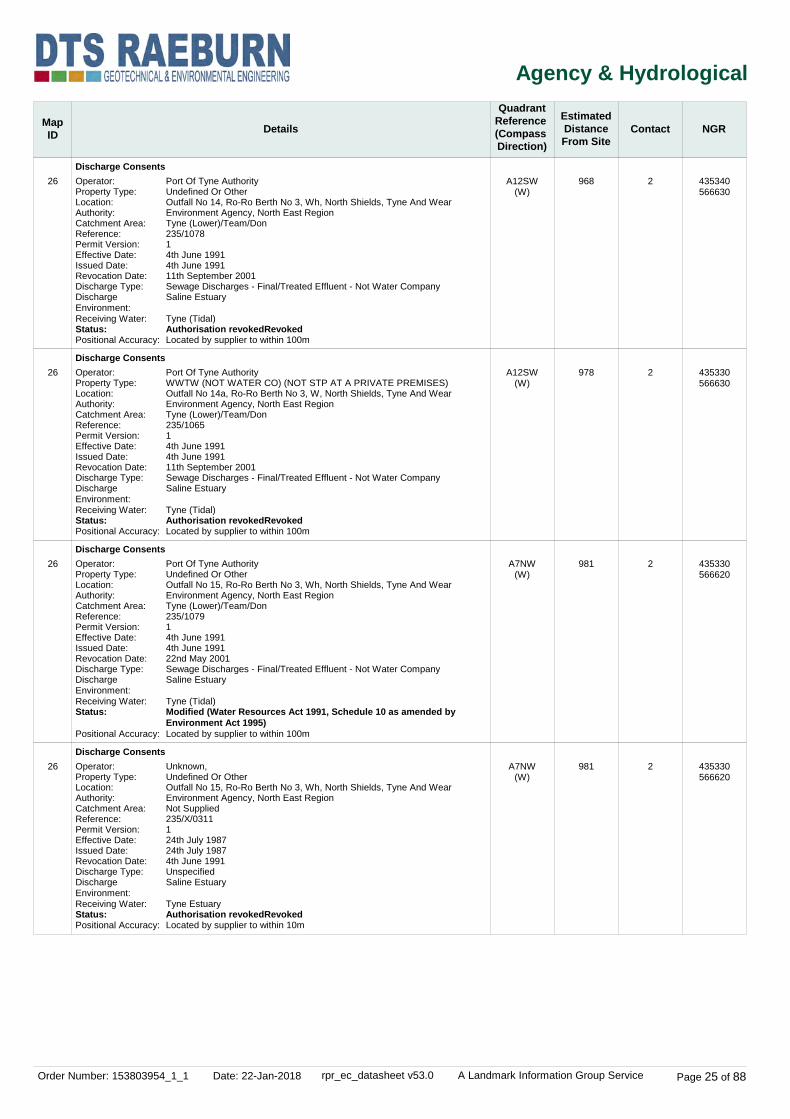
Order Number: 153803954_1_1 Date: 22-Jan-2018 rpr_ec_datasheet v53.0 A Landmark Information Group Service Page 25 of 88
Agency & Hydrological
MapID Details
QuadrantReference (Compass Direction)
EstimatedDistanceFrom Site
Contact NGR
26
26
26
26
Discharge Consents
Discharge Consents
Discharge Consents
Discharge Consents
A12SW(W)
A12SW(W)
A7NW(W)
A7NW(W)
968
978
981
981
2
2
2
2
Operator:Property Type:Location:Authority:Catchment Area:Reference:Permit Version:Effective Date:Issued Date:Revocation Date:Discharge Type:Discharge Environment:Receiving Water:Status:Positional Accuracy:
Operator:Property Type:Location:Authority:Catchment Area:Reference:Permit Version:Effective Date:Issued Date:Revocation Date:Discharge Type:Discharge Environment:Receiving Water:Status:Positional Accuracy:
Operator:Property Type:Location:Authority:Catchment Area:Reference:Permit Version:Effective Date:Issued Date:Revocation Date:Discharge Type:Discharge Environment:Receiving Water:Status:
Positional Accuracy:
Operator:Property Type:Location:Authority:Catchment Area:Reference:Permit Version:Effective Date:Issued Date:Revocation Date:Discharge Type:Discharge Environment:Receiving Water:Status:Positional Accuracy:
Port Of Tyne AuthorityUndefined Or OtherOutfall No 14, Ro-Ro Berth No 3, Wh, North Shields, Tyne And WearEnvironment Agency, North East RegionTyne (Lower)/Team/Don235/107814th June 19914th June 199111th September 2001Sewage Discharges - Final/Treated Effluent - Not Water CompanySaline Estuary
Tyne (Tidal)Authorisation revokedRevokedLocated by supplier to within 100m
Port Of Tyne AuthorityWWTW (NOT WATER CO) (NOT STP AT A PRIVATE PREMISES)Outfall No 14a, Ro-Ro Berth No 3, W, North Shields, Tyne And WearEnvironment Agency, North East RegionTyne (Lower)/Team/Don235/106514th June 19914th June 199111th September 2001Sewage Discharges - Final/Treated Effluent - Not Water CompanySaline Estuary
Tyne (Tidal)Authorisation revokedRevokedLocated by supplier to within 100m
Port Of Tyne AuthorityUndefined Or OtherOutfall No 15, Ro-Ro Berth No 3, Wh, North Shields, Tyne And WearEnvironment Agency, North East RegionTyne (Lower)/Team/Don235/107914th June 19914th June 199122nd May 2001Sewage Discharges - Final/Treated Effluent - Not Water CompanySaline Estuary
Tyne (Tidal)Modified (Water Resources Act 1991, Schedule 10 as amended by Environment Act 1995)Located by supplier to within 100m
Unknown,Undefined Or OtherOutfall No 15, Ro-Ro Berth No 3, Wh, North Shields, Tyne And WearEnvironment Agency, North East RegionNot Supplied235/X/0311124th July 198724th July 19874th June 1991UnspecifiedSaline Estuary
Tyne EstuaryAuthorisation revokedRevokedLocated by supplier to within 10m
435340566630
435330566630
435330566620
435330566620

Order Number: 153803954_1_1 Date: 22-Jan-2018 rpr_ec_datasheet v53.0 A Landmark Information Group Service Page 26 of 88
Agency & Hydrological
MapID Details
QuadrantReference (Compass Direction)
EstimatedDistanceFrom Site
Contact NGR
26
27
27
28
28
Discharge Consents
Discharge Consents
Discharge Consents
Integrated Pollution Controls
Integrated Pollution Controls
A7NW(W)
A11NE(W)
A11NE(W)
A7NE(SW)
A7NE(SW)
985
994
994
658
662
2
2
2
2
2
Operator:Property Type:Location:Authority:Catchment Area:Reference:Permit Version:Effective Date:Issued Date:Revocation Date:Discharge Type:Discharge Environment:Receiving Water:Status:Positional Accuracy:
Operator:Property Type:Location:Authority:Catchment Area:Reference:Permit Version:Effective Date:Issued Date:Revocation Date:Discharge Type:Discharge Environment:Receiving Water:Status:Positional Accuracy:
Operator:Property Type:Location:Authority:Catchment Area:Reference:Permit Version:Effective Date:Issued Date:Revocation Date:Discharge Type:Discharge Environment:Receiving Water:Status:Positional Accuracy:
Name:Location:Authority:Permit Reference:Dated:Process Type:Description:Status:
Positional Accuracy:
Name:Location:Authority:Permit Reference:Dated:Process Type:Description:Status:
Positional Accuracy:
Port Of Tyne AuthorityUndefined Or OtherOutfall No 15, Ro-Ro Berth No 3, Wh, North Shields, Tyne And WearEnvironment Agency, North East RegionNot Supplied235/1809122nd May 200122nd May 2001Not SuppliedSewage Discharges - Final/Treated Effluent - Not Water CompanySaline Estuary
River Tyne Saline EstuaryConsent without application (Water Resources Act 1991, Schedule 10)Located by supplier to within 10m
Port Of Tyne AuthorityUndefined Or OtherOutfall No 10, Albert Edward Dock, North ShieldsEnvironment Agency, North East RegionTyne (Lower)/Team/Don235/1075121st May 199121st May 199111th September 2001Sewage Discharges - Final/Treated Effluent - Not Water CompanySaline Estuary
Tyne (Tidal)Authorisation revokedRevokedLocated by supplier to within 100m
Unknown,Undefined Or OtherOutfall No 10, Albert Edward Dock, North ShieldsEnvironment Agency, North East RegionNot Supplied235/X/0305124th July 198724th July 198721st May 1991UnspecifiedSaline Estuary
Tyne EstuaryAuthorisation revokedRevokedLocated by supplier to within 10m
Tyne Dock Engineering LtdPo Box 7 Hill Street, SOUTH SHIELDS, Tyne And Wear, NE33 1RNEnvironment Agency, North East RegionBD429524th November 1998IPC minor (non-substantial) variation to previous variation6.5 A (A) Coating processes and Printing within Miscellaneous IndustriesAuthorisation superseded by a substantial or non substantial variationSupersededManually positioned to the road within the address or location
Tyne Dock Engineering LtdP O Box 7, Hill Street, SOUTH SHIELDS, Tyne And Wear, NE33 1RNEnvironment Agency, North East RegionAU688911th September 1996IPC new application6.5 A (A) Coating processes and Printing within Miscellaneous IndustriesAuthorisation superseded by a substantial or non substantial variationSupersededManually positioned to the road within the address or location
435330566610
435250567010
435250567010
435796566471
435796566466

Order Number: 153803954_1_1 Date: 22-Jan-2018 rpr_ec_datasheet v53.0 A Landmark Information Group Service Page 27 of 88
Agency & Hydrological
MapID Details
QuadrantReference (Compass Direction)
EstimatedDistanceFrom Site
Contact NGR
29
30
30
30
30
30
30
Integrated Pollution Controls
Integrated Pollution Controls
Integrated Pollution Controls
Integrated Pollution Controls
Integrated Pollution Controls
Integrated Pollution Controls
Integrated Pollution Controls
A7NE(SW)
A7SE(SW)
A7SE(SW)
A7SE(SW)
A7SE(SW)
A7SE(SW)
A7SE(SW)
675
921
924
926
928
928
928
2
2
2
2
2
2
2
Name:Location:Authority:Permit Reference:Dated:Process Type:Description:Status:Positional Accuracy:
Name:Location:Authority:Permit Reference:Dated:Process Type:Description:Status:
Positional Accuracy:
Name:Location:Authority:Permit Reference:Dated:Process Type:Description:Status:
Positional Accuracy:
Name:Location:Authority:Permit Reference:Dated:Process Type:Description:Status:
Positional Accuracy:
Name:Location:Authority:Permit Reference:Dated:Process Type:Description:Status:Positional Accuracy:
Name:Location:Authority:Permit Reference:Dated:Process Type:Description:Status:
Positional Accuracy:
Name:Location:Authority:Permit Reference:Dated:Process Type:Description:Status:
Positional Accuracy:
Tyne Dock Engineering LtdPO Box 7, Hill Street, SOUTH SHIELDS, Tyne and Wear, NE33 1RNEnvironment Agency, North East RegionBF59261st March 2000IPC minor (non-substantial) variation to previous variation6.5 A (A) Coating processes and Printing within Miscellaneous IndustriesAuthorisation revokedRevokedManually positioned to the road within the address or location
Circ Realisations LtdEldon Street, SOUTH SHIELDS, Tyne And Wear, NE33 5BUEnvironment Agency, North East RegionBB968721st December 1998IPC minor (non-substantial) variation to previous variation4.4 A (A) processes involving Halogens within the Chemical IndustryAuthorisation superseded by a substantial or non substantial variationSupersededAutomatically positioned to the address
Circ Realisations LtdEldon Street, SOUTH SHIELDS, Tyne And Wear, NE33 5BUEnvironment Agency, North East RegionBD616624th November 1998IPC minor (non-substantial) variation to previous variation4.4 A (A) processes involving Halogens within the Chemical IndustryAuthorisation superseded by a substantial or non substantial variationSupersededAutomatically positioned to the address
Circ Realisations LtdEldon Street, SOUTH SHIELDS, Tyne And Wear, NE33 5BUEnvironment Agency, North East RegionAV817830th August 1996IPC minor (non-substantial) variation to previous variation4.4 A (A) processes involving Halogens within the Chemical IndustryAuthorisation superseded by a substantial or non substantial variationSupersededAutomatically positioned to the address
Circ Realisations LtdEldon Street, SOUTH SHIELDS, Tyne and Wear, NE33 5BUEnvironment Agency, North East RegionBu06215th March 2003IPC minor (non-substantial) variation to previous variation4.4 A (A) processes involving Halogens within the Chemical IndustryAuthorisation revokedRevokedAutomatically positioned to the address
Circ Realisations LtdEldon Street, SOUTH SHIELDS, Tyne and Wear, NE33 5BUEnvironment Agency, North East RegionBl170323rd November 2001IPC major (substantial) variation4.4 A (A) processes involving Halogens within the Chemical IndustryAuthorisation superseded by a substantial or non substantial variationSupersededAutomatically positioned to the address
Circ Realisations LtdEldon Street, South Shields, Tyne And Wear, NE33 5BUEnvironment Agency, North East RegionBj936320th December 2000IPC minor (non-substantial) variation to previous variation4.4 A (A) processes involving Halogens within the Chemical IndustryAuthorisation superseded by a substantial or non substantial variationSupersededAutomatically positioned to the address
435718566536
435821566127
435816566127
435821566122
435816566122
435816566122
435816566122

Order Number: 153803954_1_1 Date: 22-Jan-2018 rpr_ec_datasheet v53.0 A Landmark Information Group Service Page 28 of 88
Agency & Hydrological
MapID Details
QuadrantReference (Compass Direction)
EstimatedDistanceFrom Site
Contact NGR
30
30
30
31
32
33
34
Integrated Pollution Controls
Integrated Pollution Controls
Integrated Pollution Controls
Local Authority Integrated Pollution Prevention And Control
Local Authority Pollution Prevention and Controls
Local Authority Pollution Prevention and Controls
Local Authority Pollution Prevention and Controls
A7SE(SW)
A7SE(SW)
A7SE(SW)
A7SE(SW)
A13NW(NW)
A13NE(E)
A13SE(SE)
928
930
932
928
90
144
257
2
2
2
3
3
3
3
Name:Location:Authority:Permit Reference:Dated:Process Type:Description:Status:
Positional Accuracy:
Name:Location:Authority:Permit Reference:Dated:Process Type:Description:Status:
Positional Accuracy:
Name:Location:Authority:Permit Reference:Dated:Process Type:Description:Status:
Positional Accuracy:
Name:Location:Authority:
Permit Reference:Dated:Process Type:Description:Status:Positional Accuracy:
Name:Location:Authority:
Permit Reference:Dated:Process Type:Description:Status:Positional Accuracy:
Name:Location:Authority:
Permit Reference:Dated:Process Type:Description:Status:Positional Accuracy:
Name:Location:Authority:
Permit Reference:Dated:Process Type:Description:Status:Positional Accuracy:
Circ Realisations LtdEldon Street, SOUTH SHIELDS, Tyne And Wear, NE33 5BUEnvironment Agency, North East RegionAR191417th May 1995IPC minor (non-substantial) variation to previous variation4.4 A (A) processes involving Halogens within the Chemical IndustryAuthorisation superseded by a substantial or non substantial variationSupersededAutomatically positioned to the address
Circ Realisations LtdEldon Street, SOUTH SHIELDS, Tyne And Wear, NE33 5BUEnvironment Agency, North East RegionAI828511th August 1993IPC new application4.4 A (A) processes involving Halogens within the Chemical IndustryAuthorisation superseded by a substantial or non substantial variationSupersededAutomatically positioned to the address
Circ Realisations LtdEldon Street, SOUTH SHIELDS, Tyne And Wear, NE33 5BUEnvironment Agency, North East RegionAK30485th November 1993IPC minor (non-substantial) variation to previous variation4.4 A (A) processes involving Halogens within the Chemical IndustryAuthorisation superseded by a substantial or non substantial variationSupersededAutomatically positioned to the address
Circatex LtdEldon Street, South Shields, Tyne & Wear, NE33 5BUSouth Tyneside Metropolitan Borough Council, Environmental Health Department001/6.4(a)Not SuppliedOther ActivitiesCoating plasticsApplication Not Yet AuthorisedManually positioned to the address or location
SutherlandsCoronation Street, SOUTH SHIELDS, Tyne and Wear, NE33 1ASSouth Tyneside Metropolitan Borough Council, Environmental Health Department070/1.4(B)Not SuppliedLocal Authority Air Pollution ControlPG1/14 Petrol filling stationApplication Not Yet AuthorisedManually positioned to the road within the address or location
Streamline Garages LtdFranklin Street, SOUTH SHIELDS, Tyne and Wear, NE33South Tyneside Metropolitan Borough Council, Environmental Health Department0.48/6.5(b)Not SuppliedLocal Authority Air Pollution ControlPG6/34 Respraying of road vehiclesAuthorisedManually positioned to the road within the address or location
Town Hall Service StationCrossgate, SOUTH SHIELDS, Tyne and Wear, NE33 5QXSouth Tyneside Metropolitan Borough Council, Environmental Health DepartmentSTC/EPR/0058th September 1999Local Authority Pollution Prevention and ControlPG1/14 Petrol filling stationPermittedManually positioned to the address or location
435816566122
435821566117
435816566117
435816566122
436162567017
436425566991
436506566814

Order Number: 153803954_1_1 Date: 22-Jan-2018 rpr_ec_datasheet v53.0 A Landmark Information Group Service Page 29 of 88
Agency & Hydrological
MapID Details
QuadrantReference (Compass Direction)
EstimatedDistanceFrom Site
Contact NGR
35
36
36
37
37
38
39
Local Authority Pollution Prevention and Controls
Local Authority Pollution Prevention and Controls
Local Authority Pollution Prevention and Controls
Local Authority Pollution Prevention and Controls
Local Authority Pollution Prevention and Controls
Local Authority Pollution Prevention and Controls
Local Authority Pollution Prevention and Controls
A8NW(S)
A8NW(S)
A8NW(S)
A7NE(SW)
A7NE(SW)
A7NE(SW)
A8SE(S)
446
471
471
620
647
699
773
3
3
3
3
3
3
3
Name:Location:Authority:
Permit Reference:Dated:Process Type:Description:Status:Positional Accuracy:
Name:Location:Authority:
Permit Reference:Dated:Process Type:Description:Status:Positional Accuracy:
Name:Location:Authority:
Permit Reference:Dated:Process Type:Description:
Status:Positional Accuracy:
Name:Location:Authority:
Permit Reference:Dated:Process Type:Description:Status:Positional Accuracy:
Name:Location:Authority:
Permit Reference:Dated:Process Type:Description:Status:Positional Accuracy:
Name:Location:Authority:
Permit Reference:Dated:Process Type:Description:Status:Positional Accuracy:
Name:Location:Authority:
Permit Reference:Dated:Process Type:Description:Status:Positional Accuracy:
Reg Vardy PlcTudor Road, SOUTH SHIELDS, Tyne and Wear, NE33 4PQSouth Tyneside Metropolitan Borough Council, Environmental Health Department021/6.5(B)Not SuppliedLocal Authority Air Pollution ControlPG6/34 Respraying of road vehiclesAuthorisation revokedRevokedManually positioned to the address or location
Be Modern LtdWestern Approach, SOUTH SHIELDS, Tyne and Wear, NE33 5QZSouth Tyneside Metropolitan Borough Council, Environmental Health DepartmentPPC/08/131st July 1994Local Authority Pollution Prevention and ControlPG6/2 Manufacture of timber and wood-based productsPermittedAutomatically positioned to the address
Be Modern LtdWestern Approach, SOUTH SHIELDS, Tyne and Wear, NE33 5QZSouth Tyneside Metropolitan Borough Council, Environmental Health DepartmentPPC/08/131st July 1994Local Authority Pollution Prevention and ControlPG1/12 Combustion of fuel manufactured from/or comprised of, solid waste in appliances between 0.4-3MW thermal inputPermittedAutomatically positioned to the address
J R SelbyCommercial Road, SOUTH SHIELDS, Tyne and Wear, NE33 1RQSouth Tyneside Metropolitan Borough Council, Environmental Health Department028/6.5(B)Not SuppliedLocal Authority Pollution Prevention and ControlPG6/34 Respraying of road vehiclesAuthorisation revokedRevokedManually positioned to the address or location
Tyne Auto BodiesHill Street, Commercial Road, SOUTH SHIELDS, Tyne anSouth Tyneside Metropolitan Borough Council, Environmental Health Department029/6.4(B)Not SuppliedLocal Authority Pollution Prevention and ControlPG6/34 Respraying of road vehiclesAuthorisation revokedRevokedManually positioned to the road within the address or location
Jennings Accident Repair CentreCommercial Road, SOUTH SHIELDS, Tyne and Wear, NE33 1RWSouth Tyneside Metropolitan Borough Council, Environmental Health Department015/6.5(b)Not SuppliedLocal Authority Pollution Prevention and ControlPG6/34 Respraying of road vehiclesAuthorisation certificate surrendered by operatorSurrenderedAutomatically positioned to the address
Posh Wash North East Ltd168 Sunderland Road, South Shields, Ne33 4hnSouth Tyneside Metropolitan Borough Council, Environmental Health DepartmentSTC/EPR/0521st September 2007Local Authority Pollution Prevention and ControlPG6/46 Dry cleaningPermittedLocated by supplier to within 100m
436124566512
436184566472
436184566472
435866566459
435842566443
435790566421
436500566200

Order Number: 153803954_1_1 Date: 22-Jan-2018 rpr_ec_datasheet v53.0 A Landmark Information Group Service Page 30 of 88
Agency & Hydrological
MapID Details
QuadrantReference (Compass Direction)
EstimatedDistanceFrom Site
Contact NGR
40
41
42
43
43
Local Authority Pollution Prevention and Controls
Nearest Surface Water Feature
Pollution Incidents to Controlled Waters
Pollution Incidents to Controlled Waters
Pollution Incidents to Controlled Waters
Pollution Incidents to Controlled Waters
A7SE(SW)
A12NE(W)
A12NE(W)
A12NE(NW)
A17SE(NW)
A17SE(NW)
928
348
444
495
540
543
3
-
2
2
2
2
Name:Location:Authority:
Permit Reference:Dated:Process Type:Description:Status:Positional Accuracy:
Property Type:Location:Authority:Pollutant:Note:Incident Date:Incident Reference:Catchment Area:Receiving Water:Cause of Incident:Incident Severity:Positional Accuracy:
Property Type:Location:Authority:Pollutant:Note:Incident Date:Incident Reference:Catchment Area:Receiving Water:Cause of Incident:Incident Severity:Positional Accuracy:
Property Type:Location:Authority:Pollutant:Note:Incident Date:Incident Reference:Catchment Area:Receiving Water:Cause of Incident:Incident Severity:Positional Accuracy:
Property Type:Location:Authority:Pollutant:Note:Incident Date:Incident Reference:Catchment Area:Receiving Water:Cause of Incident:Incident Severity:Positional Accuracy:
Circatex LtdEldon Street, SOUTH SHIELDS, Tyne and Wear, NE33 5BUSouth Tyneside Metropolitan Borough Council, Environmental Health Department001/6.4(A)22nd February 1999Local Authority Pollution Prevention and ControlPG6/23 Coating of metal and plasticTransferred to LAIPPCAutomatically positioned to the address
Other General PremisesSOUTH SHIELDSEnvironment Agency, North East RegionNot GivenTyne Est2nd September 1990235/000280Not GivenSaline EstuarySewage - OtherCategory 2 - Significant IncidentLocated by supplier to within 100m
VesselS Shields Ferry LandingEnvironment Agency, North East RegionNot GivenTyne Estuary28th February 1992235/001126Not GivenSaline EstuaryOil Boat/ShipCategory 2 - Significant IncidentLocated by supplier to within 100m
ConstructionMarket Dock, SOUTH SHIELDSEnvironment Agency, North East RegionMiscellaneous - Inert Suspended SolidsPollution Found; No Fish Killed30th April 1996NT960124Lower TyneSaline EstuaryUnknownCategory 3 - Minor IncidentLocated by supplier to within 100m
ConstructionMarket Dock, SOUTH SHIELDSEnvironment Agency, North East RegionMiscellaneous - Inert Suspended SolidsNo Fish Killed30th April 1996NT960124Lower TyneSaline EstuaryNot GivenCategory 3 - Minor IncidentLocated by supplier to within 100m
435816566122
435916567097
435800567000
435800567200
435900567395
435900567400

Order Number: 153803954_1_1 Date: 22-Jan-2018 rpr_ec_datasheet v53.0 A Landmark Information Group Service Page 31 of 88
Agency & Hydrological
MapID Details
QuadrantReference (Compass Direction)
EstimatedDistanceFrom Site
Contact NGR
44
45
45
46
47
48
Pollution Incidents to Controlled Waters
Pollution Incidents to Controlled Waters
Pollution Incidents to Controlled Waters
Pollution Incidents to Controlled Waters
Pollution Incidents to Controlled Waters
Pollution Incidents to Controlled Waters
A17SE(NW)
A12SE(W)
A12SE(W)
A7NE(SW)
A8SW(S)
A7NE(SW)
547
572
574
742
781
792
2
2
2
2
2
2
Property Type:Location:Authority:Pollutant:Note:Incident Date:Incident Reference:Catchment Area:Receiving Water:Cause of Incident:Incident Severity:Positional Accuracy:
Property Type:Location:Authority:Pollutant:Note:Incident Date:Incident Reference:Catchment Area:Receiving Water:Cause of Incident:Incident Severity:Positional Accuracy:
Property Type:Location:Authority:Pollutant:Note:Incident Date:Incident Reference:Catchment Area:Receiving Water:Cause of Incident:Incident Severity:Positional Accuracy:
Property Type:Location:Authority:Pollutant:Note:Incident Date:Incident Reference:Catchment Area:Receiving Water:Cause of Incident:Incident Severity:Positional Accuracy:
Property Type:Location:Authority:Pollutant:Note:Incident Date:Incident Reference:Catchment Area:Receiving Water:Cause of Incident:Incident Severity:Positional Accuracy:
Property Type:Location:Authority:Pollutant:Note:Incident Date:Incident Reference:Catchment Area:Receiving Water:Cause of Incident:Incident Severity:Positional Accuracy:
Other General PremisesSOUTH SHIELDSEnvironment Agency, North East RegionNot GivenTyne Estuary23rd October 1992235/001584Not GivenSaline EstuaryOil General SpillageCategory 3 - Minor IncidentLocated by supplier to within 100m
Other General PremisesSOUTH SHIELDSEnvironment Agency, North East RegionNot GivenTyne7th September 1992235/001507Not GivenNo PollutionOther CauseCategory 3 - Minor IncidentLocated by supplier to within 100m
VesselWest DockEnvironment Agency, North East RegionNot GivenTyne Tidal29th September 1993235/002126Not GivenSaline EstuaryOil Boat/ShipCategory 2 - Significant IncidentLocated by supplier to within 100m
Other General PremisesRiver Tyne, Royal Keys Development ShieldsEnvironment Agency, North East RegionOther SewageNo Fish Killed29th August 1995NT950184Lower TyneSaline EstuaryNot GivenCategory 3 - Minor IncidentLocated by supplier to within 100m
Water Company Sewage: Surface Water OutfallSOUTH SHIELDS, Tyne And WearEnvironment Agency, North East RegionChemicals - AcidPollution Found; No Fish Killed1st October 1996NT960270Lower TyneCoastal WaterUnknownCategory 3 - Minor IncidentLocated by supplier to within 100m
Miscellaneous Premises: UnknownJarrow / South ShieldsEnvironment Agency, North East RegionNot GivenRiver Tyne23rd May 1992235/001314Not GivenSaline EstuaryOther OilCategory 3 - Minor IncidentLocated by supplier to within 100m
435800567300
435700566800
435700566795
435600566600
436000566200
435600566500

Order Number: 153803954_1_1 Date: 22-Jan-2018 rpr_ec_datasheet v53.0 A Landmark Information Group Service Page 32 of 88
Agency & Hydrological
MapID Details
QuadrantReference (Compass Direction)
EstimatedDistanceFrom Site
Contact NGR
49
50
50
51
52
53
Pollution Incidents to Controlled Waters
Pollution Incidents to Controlled Waters
Pollution Incidents to Controlled Waters
Pollution Incidents to Controlled Waters
Pollution Incidents to Controlled Waters
Pollution Incidents to Controlled Waters
A12SW(W)
A12SW(W)
A12SW(W)
A12SW(W)
A18NW(N)
A17NE(NW)
847
862
863
888
950
985
2
2
2
2
2
2
Property Type:Location:Authority:Pollutant:Note:Incident Date:Incident Reference:Catchment Area:Receiving Water:Cause of Incident:Incident Severity:Positional Accuracy:
Property Type:Location:Authority:Pollutant:Note:Incident Date:Incident Reference:Catchment Area:Receiving Water:Cause of Incident:Incident Severity:Positional Accuracy:
Property Type:Location:Authority:Pollutant:Note:Incident Date:Incident Reference:Catchment Area:Receiving Water:Cause of Incident:Incident Severity:Positional Accuracy:
Property Type:Location:Authority:Pollutant:Note:Incident Date:Incident Reference:Catchment Area:Receiving Water:Cause of Incident:Incident Severity:Positional Accuracy:
Property Type:Location:Authority:Pollutant:Note:Incident Date:Incident Reference:Catchment Area:Receiving Water:Cause of Incident:Incident Severity:Positional Accuracy:
Property Type:Location:Authority:Pollutant:Note:Incident Date:Incident Reference:Catchment Area:Receiving Water:Cause of Incident:Incident Severity:Positional Accuracy:
Other General PremisesAlbert Edward Dock, NORTH SHIELDSEnvironment Agency, North East RegionMiscellaneous - OtherNo Fish Killed5th September 1995NT950183Lower TyneSaline EstuaryNot GivenCategory 3 - Minor IncidentLocated by supplier to within 100m
VesselAdjacent Albert Edward DockEnvironment Agency, North East RegionNot GivenTyne Estuary3rd November 1990235/000362Not GivenSaline EstuaryOil Boat/ShipCategory 3 - Minor IncidentLocated by supplier to within 100m
DemolitionQuayside Of Albert Edward Dock, NORTH SHIELDSEnvironment Agency, North East RegionOils - Black Fuel OilPollution Found; No Fish Killed18th September 1996NT960259Lower TyneSaline EstuaryUnknownCategory 3 - Minor IncidentLocated by supplier to within 100m
Other General PremisesAlbert Edward Dock, NORTH SHIELDSEnvironment Agency, North East RegionMiscellaneous - OtherNo Fish Killed11th September 1995NT950180Lower TyneSaline EstuaryNot GivenCategory 3 - Minor IncidentLocated by supplier to within 100m
Industrial PremisesSouth Shields - Plant DischargeEnvironment Agency, North East RegionNot GivenTyne Estuary9th January 1992235/001031Not GivenSaline EstuaryTrade Effluent Non-ComplyingCategory 2 - Significant IncidentLocated by supplier to within 100m
Other General PremisesNORTH SHIELDSEnvironment Agency, North East RegionNot GivenTyne1st September 1994235/002471Not GivenSaline EstuaryOil Boat/ShipCategory 3 - Minor IncidentLocated by supplier to within 100m
435400566900
435400566800
435400566795
435400566700
436000567900
435700567800

Order Number: 153803954_1_1 Date: 22-Jan-2018 rpr_ec_datasheet v53.0 A Landmark Information Group Service Page 33 of 88
Agency & Hydrological
MapID Details
QuadrantReference (Compass Direction)
EstimatedDistanceFrom Site
Contact NGR
54
55
56
57
Prosecutions Relating to Authorised Processes
Registered Radioactive Substances
Registered Radioactive Substances
Groundwater Vulnerability
Drift Deposits
Bedrock Aquifer Designations
Superficial Aquifer Designations
Extreme Flooding from Rivers or Sea without Defences
Flooding from Rivers or Sea without Defences
Areas Benefiting from Flood Defences
Flood Water Storage Areas
Flood Defences
OS Water Network Lines
A7SE(SW)
A13NW(W)
A13SW(SW)
A13NW(SW)
A13NW(SW)
A13NW(SW)
A12NE(W)
827
145
422
0
0
0
588
2
2
2
2
1
1
4
Location:Prosecution Text:
Prosecution Act:Hearing Date:Verdict:Fine:Costs:Positional Accuracy:
Name:Location:
Authority:Permit Reference:Dated:Process Type:
Description:Status:Positional Accuracy:
Name:Location:
Authority:Permit Reference:Dated:Process Type:
Description:Status:
Positional Accuracy:
Soil Classification:
Map Sheet:Scale:
Aquifer Designation:
Aquifer Designation:
Watercourse Form:Watercourse Length:Watercourse Level:Permanent:Watercourse Name:Catchment Name:Primacy:
Eldon Street, South Shield, NEWCASTLE, Tyne & Wear, NE33 5BYEA News Release 13/06/1997, Failure to ensure the proper disposal of waste from the business.EPA9013th June 1997Guilty24003202Manually positioned to the road within the address or location
Aker McnultyCommercial Road, South Shields, SOUTH SHIELDS, Tyne And Wear, NE33 1RZEnvironment Agency, North East RegionAZ346125th July 1997Authorisation under S13 RSA for the disposal of Radioactive waste (was RSA60 S7)Minor variation to authorisation under RSAAuthorisation either revoked or cancelledCancelledUnknown
Mcnulty Offshore Construction LtdCommercial Road,South Shields, SOUTH SHIELDS, Tyne And Wear, NE33 1RZEnvironment Agency, North East RegionCC74122nd September 2008Authorisation under S13 RSA for the disposal of Radioactive waste (was RSA60 S7)Authorisation under RSAApplication has been authorised and any conditions apply to the operatorAuthorisedManually positioned to the road within the address or location
Soils of High Leaching Potential (U) - Soil information for restored mineral workings and urban areas is based on fewer observations than elsewhere. A worst case vulnerability classification (H) assumed, until proved otherwiseSheet 5 Tyne and Tees1:100,000
Secondary Aquifer - A
Secondary Aquifer - A
Tidal river2383.7On ground surfaceTrueRiver TyneNot Supplied1
None
None
None
None
None
None
435909566188
436100567000
435953566648
436264566961
436264566961
436264566961
435656567001

Order Number: 153803954_1_1 Date: 22-Jan-2018 rpr_ec_datasheet v53.0 A Landmark Information Group Service Page 34 of 88
Agency & Hydrological
MapID Details
QuadrantReference (Compass Direction)
EstimatedDistanceFrom Site
Contact NGR
58
59
60
61
OS Water Network Lines
OS Water Network Lines
OS Water Network Lines
OS Water Network Lines
A12NE(NW)
A12NW(W)
A12NW(W)
A12NW(W)
601
697
819
819
4
4
4
4
Watercourse Form:Watercourse Length:Watercourse Level:Permanent:Watercourse Name:Catchment Name:Primacy:
Watercourse Form:Watercourse Length:Watercourse Level:Permanent:Watercourse Name:Catchment Name:Primacy:
Watercourse Form:Watercourse Length:Watercourse Level:Permanent:Watercourse Name:Catchment Name:Primacy:
Watercourse Form:Watercourse Length:Watercourse Level:Permanent:Watercourse Name:Catchment Name:Primacy:
Tidal river1792.6On ground surfaceTrueRiver TyneNot Supplied1
Tidal river122.4On ground surfaceTrueNot SuppliedNot Supplied1
Tidal river386.8On ground surfaceTrueNot SuppliedNot Supplied1
Tidal river361.0On ground surfaceTrueNot SuppliedNot Supplied2
435723567280
435547567003
435425567000
435425567000

Order Number: 153803954_1_1 Date: 22-Jan-2018 rpr_ec_datasheet v53.0 A Landmark Information Group Service Page 35 of 88
Waste
MapID Details
QuadrantReference (Compass Direction)
EstimatedDistanceFrom Site
Contact NGR
62
63
64
65
66
Historical Landfill Sites
Historical Landfill Sites
Historical Landfill Sites
Licensed Waste Management Facilities (Landfill Boundaries)
Licensed Waste Management Facilities (Locations)
A18SW(NW)
A7NE(SW)
A7NE(SW)
A7NE(SW)
A13NW(W)
608
761
767
761
145
2
2
2
2
2
Licence Holder:Location:Name:Operator Location:Boundary Accuracy:Provider Reference:First Input Date:Last Input Date:Specified Waste Type:EA Waste Ref:Regis Ref:WRC Ref:BGS Ref:Other Ref:
Licence Holder:Location:Name:Operator Location:Boundary Accuracy:Provider Reference:First Input Date:Last Input Date:Specified Waste Type:EA Waste Ref:Regis Ref:WRC Ref:BGS Ref:Other Ref:
Licence Holder:Location:Name:Operator Location:Boundary Accuracy:Provider Reference:First Input Date:Last Input Date:Specified Waste Type:EA Waste Ref:Regis Ref:WRC Ref:BGS Ref:Other Ref:
Name:Licence Number:Location:
Licence Holder:Authority:Site Category:Max Input Rate:Licence Status:Issued:Positional Accuracy:Boundary Accuracy:
Licence Number:Location:Operator Name:Operator Location:Authority:Site Category:Licence Status:Issued:Last Modified:Expires:Suspended:Revoked:Surrendered:IPPC Reference:Positional Accuracy:
Mowlem Northern LimitedWapping Street, The Lawe, South Shield, Tyne and WearBrigham and CowansNot SuppliedAs SuppliedEAHLD0626321st October 19861st December 1986Deposited Waste included Inert Waste
0YO1/L/MOW0014500/0082Not SuppliedTW 151 ST, ST 047
West DockCommercial Road, South Shields, Costerphine Town, Tyne & WearWest DockCommercial Road, South Shields, Costerphine Town, Tyne & WearAs SuppliedEAHLD35707Not SuppliedNot SuppliedNot Supplied
67611Not SuppliedNot SuppliedNot SuppliedNot Supplied
Borough Of South TynesideLaygate, South Shield, Tyne and WearWest HolbornNot SuppliedAs SuppliedEAHLD062641st March 198331st March 1983Not Supplied
0YO1/L/BOR0154500/0293Not SuppliedTW 104 ST, ST 038
Aker Mc Nulty Ltd67611West Dock, Commercial Road, Costerphine Town, South Shields, Tyne & Wear, NE33 1RZAker Mc Nulty LtdEnvironment Agency - North East Region, North East AreaLandfills Taking Non-biodegradeable Wastes (Not Construction)Not SuppliedInactive25th July 1997Positioned by the supplierAs Supplied
67536Oyston Street, South Shields, Tyne & Wear, NE33 1ATWoodward DavidNot SuppliedEnvironment Agency - North East Region, North East AreaMetal Recycling Sites (Mixed)Surrendered27th April 1995Not SuppliedNot SuppliedNot SuppliedNot Supplied8th February 2002Not SuppliedLocated by supplier to within 100m
435971567522
435684566440
435676566441
435684566440
436100567000

Order Number: 153803954_1_1 Date: 22-Jan-2018 rpr_ec_datasheet v53.0 A Landmark Information Group Service Page 36 of 88
Waste
MapID Details
QuadrantReference (Compass Direction)
EstimatedDistanceFrom Site
Contact NGR
67
68
68
69
Licensed Waste Management Facilities (Locations)
Licensed Waste Management Facilities (Locations)
Licensed Waste Management Facilities (Locations)
Licensed Waste Management Facilities (Locations)
A12SE(SW)
A17SE(NW)
A17SE(NW)
A8SE(S)
519
624
624
869
2
2
2
2
Licence Number:Location:Operator Name:Operator Location:Authority:Site Category:Licence Status:Issued:Last Modified:Expires:Suspended:Revoked:Surrendered:IPPC Reference:Positional Accuracy:
Licence Number:Location:Operator Name:Operator Location:
Authority:Site Category:Licence Status:Issued:Last Modified:Expires:Suspended:Revoked:Surrendered:IPPC Reference:Positional Accuracy:
Licence Number:Location:Operator Name:Operator Location:Authority:Site Category:Licence Status:Issued:Last Modified:Expires:Suspended:Revoked:Surrendered:IPPC Reference:Positional Accuracy:
Licence Number:Location:Operator Name:Operator Location:Authority:Site Category:Licence Status:Issued:Last Modified:Expires:Suspended:Revoked:Surrendered:IPPC Reference:Positional Accuracy:
675523 Cone Street, South Shields, Tyne & Wear, NE33 1REK J Baker & P BakerNot SuppliedEnvironment Agency - North East Region, North East AreaMetal Recycling Sites (Mixed)Surrendered27th January 1994Not SuppliedNot SuppliedNot SuppliedNot Supplied29th March 2006Not SuppliedLocated by supplier to within 100m
0South Shields, Tyne & Wear, NE33Mowlem Northern LtdSaltmeadows Road, East Gateshead Ind Est, Gateshead, Tyne & Wear, NE8 3AHEnvironment Agency - North East Region, Northumbria AreaLandfills Taking Non-biodegradeable Wastes (Not Construction)Surrendered21st October 1986Not SuppliedNot SuppliedNot SuppliedNot Supplied31st March 1994Not SuppliedLocated by supplier to within 100m
64533South Shields, Tyne & Wear, NE33Mowlem Northern LtdNot SuppliedEnvironment Agency - North East Region, North East AreaLandfills Taking Non-biodegradeable Wastes (Not Construction)Surrendered21st October 1986Not SuppliedNot SuppliedNot SuppliedNot Supplied31st March 1994Not SuppliedLocated by supplier to within 100m
67498111 Chichester Road, South Shields, Tyne & Wear, NE33 4HEArthurs RaymondNot SuppliedEnvironment Agency - North East Region, North East AreaMetal Recycling Sites (Mixed)Surrendered23rd February 1992Not SuppliedNot SuppliedNot SuppliedNot Supplied23rd December 1994Not SuppliedLocated by supplier to within 100m
435800566700
435900567500
435900567500
436500566100

Order Number: 153803954_1_1 Date: 22-Jan-2018 rpr_ec_datasheet v53.0 A Landmark Information Group Service Page 37 of 88
Waste
MapID Details
QuadrantReference (Compass Direction)
EstimatedDistanceFrom Site
Contact NGR
70
70
71
72
73
74
75
76
Licensed Waste Management Facilities (Locations)
Licensed Waste Management Facilities (Locations)
Licensed Waste Management Facilities (Locations)
Local Authority Landfill Coverage
Local Authority Landfill Coverage
Potentially Infilled Land (Non-Water)
Potentially Infilled Land (Non-Water)
Potentially Infilled Land (Non-Water)
Potentially Infilled Land (Non-Water)
Potentially Infilled Land (Non-Water)
A18NW(N)
A18NW(N)
A12SW(W)
A13SE(SE)
A13SE(E)
A13SE(SE)
A13NE(NE)
A8NW(SW)
916
916
984
0
667
0
109
203
354
424
2
2
2
5
6
-
-
-
-
-
Licence Number:Location:Operator Name:Operator Location:Authority:Site Category:Licence Status:Issued:Last Modified:Expires:Suspended:Revoked:Surrendered:IPPC Reference:Positional Accuracy:
Licence Number:Location:Operator Name:Operator Location:Authority:Site Category:Licence Status:Issued:Last Modified:Expires:Suspended:Revoked:Surrendered:IPPC Reference:Positional Accuracy:
Licence Number:Location:
Operator Name:Operator Location:Authority:Site Category:Licence Status:Issued:Last Modified:Expires:Suspended:Revoked:Surrendered:IPPC Reference:Positional Accuracy:
Name:
Name:
Bearing Ref:Use:Date of Mapping:
Bearing Ref:Use:Date of Mapping:
Bearing Ref:Use:Date of Mapping:
Bearing Ref:Use:Date of Mapping:
Bearing Ref:Use:Date of Mapping:
0River Drive, South Shields, Tyne & Wear, NE33 1LHVelva Liquids ( North Shields ) LtdRiver Drive, South Shields, Tyne & Wear, NE3 1LHEnvironment Agency - North East Region, Northumbria AreaSpecial Waste Transfer StationsSurrendered21st July 1977Not SuppliedNot SuppliedNot SuppliedNot Supplied31st March 1994Not SuppliedLocated by supplier to within 100m
64441River Drive, South Shields, Tyne & Wear, NE33 1LHVelva Liquids ( North Shields ) LtdNot SuppliedEnvironment Agency - North East Region, North East AreaSpecial Waste Transfer StationsSurrendered21st July 1977Not SuppliedNot SuppliedNot SuppliedNot Supplied31st March 1994Not SuppliedLocated by supplier to within 100m
67602Royal Quays - Ballast Hill, Dock Road, North Shields, Tyne & Wear, NE29 6EHEdmund Nuttall LtdNot SuppliedEnvironment Agency - North East Region, North East AreaTransfer Stations Taking Non-biodegradable WastesSurrendered7th June 1996Not SuppliedNot SuppliedNot SuppliedNot Supplied4th June 1998Not SuppliedLocated by supplier to within 100m
South Tyneside Metropolitan Borough Council - Has no landfill data to supply
North Tyneside Metropolitan District Council - Has supplied landfill data
SEUnknown Filled Ground (Pit, quarry etc)1993
EUnknown Filled Ground (Pit, quarry etc)1993
SEUnknown Filled Ground (Pit, quarry etc)1993
NEUnknown Filled Ground (Pit, quarry etc)1993
SWUnknown Filled Ground (Pit, quarry etc)1993
436200567900
436200567900
435300566700
436264566961
435604567170
436279566945
436397566949
436408566786
436482567263
436072566556

Order Number: 153803954_1_1 Date: 22-Jan-2018 rpr_ec_datasheet v53.0 A Landmark Information Group Service Page 38 of 88
Waste
MapID Details
QuadrantReference (Compass Direction)
EstimatedDistanceFrom Site
Contact NGR
77
78
79
80
81
82
83
84
85
86
87
88
Potentially Infilled Land (Non-Water)
Potentially Infilled Land (Non-Water)
Potentially Infilled Land (Non-Water)
Potentially Infilled Land (Non-Water)
Potentially Infilled Land (Water)
Potentially Infilled Land (Water)
Potentially Infilled Land (Water)
Potentially Infilled Land (Water)
Potentially Infilled Land (Water)
Potentially Infilled Land (Water)
Potentially Infilled Land (Water)
Registered Landfill Sites
A8NE(S)
A18NW(N)
A12NW(W)
A9SW(SE)
A13SE(SE)
A8NE(S)
A18SE(N)
A9NW(SE)
A19SW(NE)
A9NE(SE)
A9NE(SE)
A18SW(NW)
629
675
851
951
385
398
459
519
713
962
990
696
-
-
-
-
-
-
-
-
-
-
-
2
Bearing Ref:Use:Date of Mapping:
Bearing Ref:Use:Date of Mapping:
Bearing Ref:Use:Date of Mapping:
Bearing Ref:Use:Date of Mapping:
Use:Date of Mapping:
Use:Date of Mapping:
Use:Date of Mapping:
Use:Date of Mapping:
Use:Date of Mapping:
Use:Date of Mapping:
Use:Date of Mapping:
Licence Holder:Licence Reference:Site Location:Licence Easting:Licence Northing:Operator Location:
Authority:Site Category:Max Input Rate:Waste Source Restrictions:Status:Dated:Preceded By Licence:Superseded By Licence:Positional Accuracy:Boundary Accuracy:Authorised Waste
Prohibited Waste
SUnknown Filled Ground (Pit, quarry etc)1993
NUnknown Filled Ground (Pit, quarry etc)1993
WUnknown Filled Ground (Pit, quarry etc)1993
SEUnknown Filled Ground (Pit, quarry etc)1993
Unknown Filled Ground (Pond, marsh, river, stream, dock etc)1898
Unknown Filled Ground (Pond, marsh, river, stream, dock etc)1862
Unknown Filled Ground (Pond, marsh, river, stream, dock etc)1862
Unknown Filled Ground (Pond, marsh, river, stream, dock etc)1862
Unknown Filled Ground (Pond, marsh, river, stream, dock etc)1862
Unknown Filled Ground (Pond, marsh, river, stream, dock etc)1862
Unknown Filled Ground (Pond, marsh, river, stream, dock etc)1862
Mowlem Northern LtdTW 151 STBrigham & Cowan Dry Dock Yard, South Shields, Tyne And Wear435930567600Saltmeadows Road, Easr Gateshead Industrial Estate, GATESHEAD, Tyne and Wear, NE8 3AHEnvironment Agency - North East Region, Northumbria AreaLandfillVery Large (Equal to or greater than 250,000 tonnes per year)No known restriction on source of waste
Licence known to be surrenderedSurrendered21st October 1986Not Given
Not Given
Manually positioned to the address or locationNot ApplicableTyne And Wear, Renfrew C -Rubble *Tyne And Wear,Renfrew Di -Coh.Inorg *Tyne And Wear,Renfrew Dii -Coh.Inorg *Tyne And Wear,Renfrew E -Frict.Inorg *Waste N.O.S
436289566308
436126567647
435445567275
436694566089
436521566644
436296566539
436439567410
436632566561
436807567445
437070566389
437183566526
435930567600
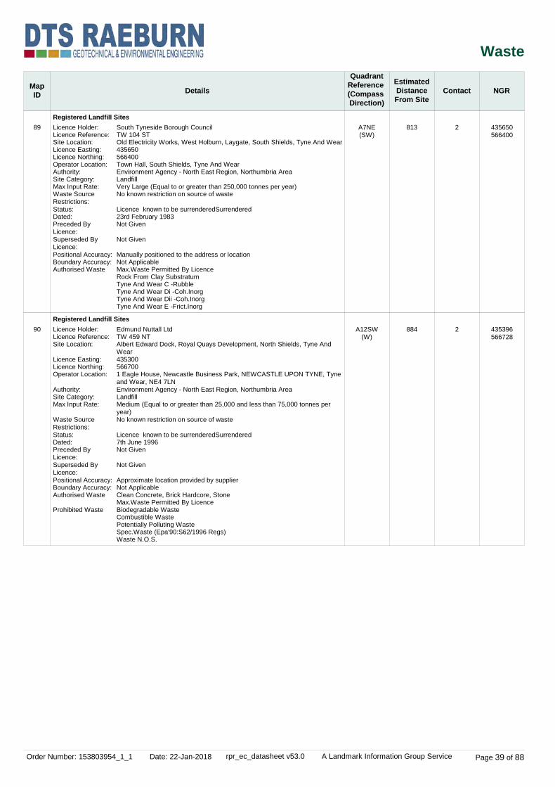
Order Number: 153803954_1_1 Date: 22-Jan-2018 rpr_ec_datasheet v53.0 A Landmark Information Group Service Page 39 of 88
Waste
MapID Details
QuadrantReference (Compass Direction)
EstimatedDistanceFrom Site
Contact NGR
89
90
Registered Landfill Sites
Registered Landfill Sites
A7NE(SW)
A12SW(W)
813
884
2
2
Licence Holder:Licence Reference:Site Location:Licence Easting:Licence Northing:Operator Location:Authority:Site Category:Max Input Rate:Waste Source Restrictions:Status:Dated:Preceded By Licence:Superseded By Licence:Positional Accuracy:Boundary Accuracy:Authorised Waste
Licence Holder:Licence Reference:Site Location:
Licence Easting:Licence Northing:Operator Location:
Authority:Site Category:Max Input Rate:
Waste Source Restrictions:Status:Dated:Preceded By Licence:Superseded By Licence:Positional Accuracy:Boundary Accuracy:Authorised Waste
Prohibited Waste
South Tyneside Borough CouncilTW 104 STOld Electricity Works, West Holburn, Laygate, South Shields, Tyne And Wear435650566400Town Hall, South Shields, Tyne And WearEnvironment Agency - North East Region, Northumbria AreaLandfillVery Large (Equal to or greater than 250,000 tonnes per year)No known restriction on source of waste
Licence known to be surrenderedSurrendered23rd February 1983Not Given
Not Given
Manually positioned to the address or locationNot ApplicableMax.Waste Permitted By LicenceRock From Clay SubstratumTyne And Wear C -RubbleTyne And Wear Di -Coh.InorgTyne And Wear Dii -Coh.InorgTyne And Wear E -Frict.Inorg
Edmund Nuttall LtdTW 459 NTAlbert Edward Dock, Royal Quays Development, North Shields, Tyne And Wear4353005667001 Eagle House, Newcastle Business Park, NEWCASTLE UPON TYNE, Tyne and Wear, NE4 7LNEnvironment Agency - North East Region, Northumbria AreaLandfillMedium (Equal to or greater than 25,000 and less than 75,000 tonnes per year)No known restriction on source of waste
Licence known to be surrenderedSurrendered7th June 1996Not Given
Not Given
Approximate location provided by supplierNot ApplicableClean Concrete, Brick Hardcore, StoneMax.Waste Permitted By LicenceBiodegradable WasteCombustible WastePotentially Polluting WasteSpec.Waste (Epa'90:S62/1996 Regs)Waste N.O.S.
435650566400
435396566728

Order Number: 153803954_1_1 Date: 22-Jan-2018 rpr_ec_datasheet v53.0 A Landmark Information Group Service Page 40 of 88
Waste
MapID Details
QuadrantReference (Compass Direction)
EstimatedDistanceFrom Site
Contact NGR
91
92
93
Registered Waste Transfer Sites
Registered Waste Treatment or Disposal Sites
Registered Waste Treatment or Disposal Sites
A18NW(N)
A13SW(W)
A12SE(SW)
928
24
443
2
2
2
Licence Holder:Licence Reference:Site Location:Operator Location:Authority:Site Category:Max Input Rate:Waste Source Restrictions:Licence Status:Dated:Preceded By Licence:Superseded By Licence:Positional Accuracy:Boundary Quality:Authorised WasteEnvironment Agencyrequires prior notification before waste can be acceptedWaste requires approval
Environment Agencymust give specific authorisation for this waste to be acceptedWaste requires prior approval
Licence Holder:Licence Reference:Site Location:Operator Location:Authority:Site Category:Max Input Rate:Waste Source Restrictions:Licence Status:Dated:Preceded By Licence:Superseded By Licence:Positional Accuracy:Boundary Quality:Authorised WasteProhibited Waste
Licence Holder:Licence Reference:Site Location:Operator Location:Authority:Site Category:Max Input Rate:Waste Source Restrictions:Licence Status:Dated:Preceded By Licence:Superseded By Licence:Positional Accuracy:Boundary Quality:Authorised Waste
Prohibited Waste
Velva Liquids LtdTW 28 STRiver Drive, SOUTH SHIELDS, Tyne and Wear, NE33 1LHAs Site AddressEnvironment Agency - North East Region, Northumbria AreaTransferUndefinedNo known restriction on source of waste
Licence known to be surrenderedSurrendered21st June 1977Not Given
Not Given
Manually positioned to the road within the address or locationNot SuppliedLiquid WastesNotifiable Wastes
Special WastesTyne And Wear G *
D WoodwardTW 340 STOld Gas Yard, Oyston Street, SOUTH SHIELDS, Tyne and Wear, NE33 1AT108 Hardie Drive, WEST BOLDON, Tyne and Wear, NE36 0JLEnvironment Agency - North East Region, Northumbria AreaScrapyardVery Small (Less than 10,000 tonnes per year)No known restriction on source of waste
Operational as far as is knownOperational27th April 1995Not Given
Not Given
Manually positioned to the road within the address or locationNot SuppliedMotor Vehicles & Assoc.PartsSpec.Waste (Epa'90:S62/1996 Regs)N.O.SWaste N.O.S.
K J & P Baker t/a Baker BrosTW 362 ST3 Cone Street, SOUTH SHIELDS, Tyne and Wear, NE33 1REAs Site AddressEnvironment Agency - North East Region, Northumbria AreaScrapyardVery Small (Less than 10,000 tonnes per year)No known restriction on source of waste
Operational as far as is knownOperational20th December 2000TW 362 ST
Not Given
Manually positioned to the address or locationNot SuppliedMaximum Waste Permitted By LicenceMetal Waste/Scrap Metal (As In Post'98 E.A.Lics And Equivalent To 23.00.00)Motor Vehicle BatteriesDegradable Household/Commercial/Industrial Waste (As In Post'98 E.A.Lics And Equivalent To 22.09.00)Inert Materials (As In Post'98 E.A.Lics And Equivalent To 21.00.00)Other Waste/Waste Not Otherwise SpecifiedSpecial Waste (As In Epa 1990:S62 Of 1996 Regs) Not Otherwise Specified
436100567900
436230566950
435900566680

Order Number: 153803954_1_1 Date: 22-Jan-2018 rpr_ec_datasheet v53.0 A Landmark Information Group Service Page 41 of 88
Waste
MapID Details
QuadrantReference (Compass Direction)
EstimatedDistanceFrom Site
Contact NGR
93
94
Registered Waste Treatment or Disposal Sites
Registered Waste Treatment or Disposal Sites
A12SE(SW)
A8SE(S)
443
802
2
2
Licence Holder:Licence Reference:Site Location:Operator Location:Authority:Site Category:Max Input Rate:Waste Source Restrictions:Licence Status:Dated:Preceded By Licence:Superseded By Licence:Positional Accuracy:Boundary Quality:Authorised WasteProhibited Waste
Licence Holder:Licence Reference:Site Location:
Operator Location:Authority:Site Category:Max Input Rate:Waste Source Restrictions:Licence Status:Dated:Preceded By Licence:Superseded By Licence:Positional Accuracy:Boundary Quality:Authorised Waste
Prohibited Waste
K J & P Baker t/a Baker BrosTW 362 ST3 Cone Street, SOUTH SHIELDS, Tyne and Wear, NE33 1REAs Site AddressEnvironment Agency - North East Region, Northumbria AreaScrapyardVery Small (Less than 10,000 tonnes per year)No known restriction on source of waste
Record supersededSuperseded27th January 1994Not Given
TW 362 ST
Manually positioned to the address or locationNot SuppliedScrap Metal As In S.M.Dealers Act'64AsbestosClinical WastesFlammable SolventsLiable To Cause Environmental HazardsMedical (Misuse Of Drugs Act '71)Percussive/Explosive/Similar WastePoisonous, Noxious, Polluting WastesSpec.Waste (Epa'90:S62/1996 Regs)Transf./Capacitors Assumed/Cont. PcbsWaste N.O.S.
R ArthursTW 273 STChichester Metals, 111 Chichester Road, SOUTH SHIELDS, Tyne and Wear, NE33 4HE2 Dunnock Drive, Ayton, Washington, Tyne And WearEnvironment Agency - North East Region, Northumbria AreaScrapyardVery Small (Less than 10,000 tonnes per year)No known restriction on source of waste
Licence known to be surrenderedSurrendered23rd January 1992Not Given
Not Given
Manually positioned to the road within the address or locationNot SuppliedAsbestosHaz.Items Normally Assoc.With VehiclesNormally Less ThanOilsPetrolScrap Metal As In S.M.Dealers Act '64Such As BatteriesAsbestosCapac'Rs/Transformers Cont. Pcb/Pct'SClinical WastesFlammable SolventsLiable To Cause Environmental HazardsLiquid/Sludge WastesMedical (Misuse Of Drugs Act)Percussive/Explosive WasteRadioactive WastesSpecial Wastes
435900566680
436500566170
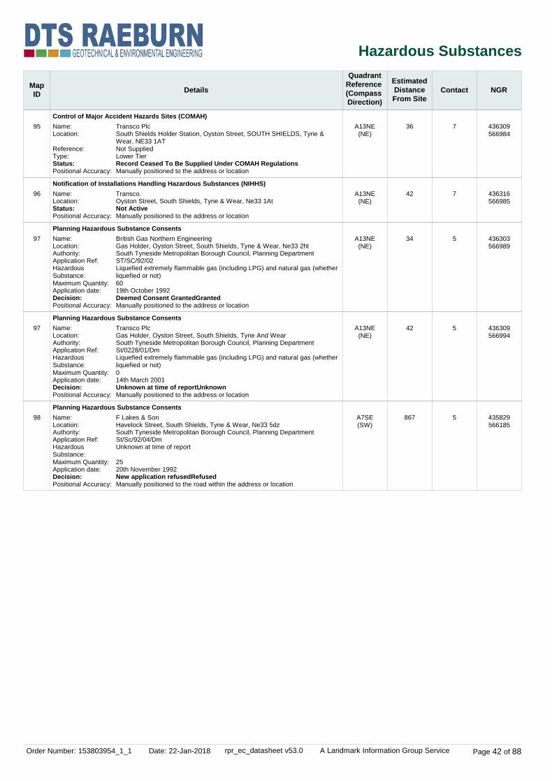
Order Number: 153803954_1_1 Date: 22-Jan-2018 rpr_ec_datasheet v53.0 A Landmark Information Group Service Page 42 of 88
Hazardous Substances
MapID Details
QuadrantReference (Compass Direction)
EstimatedDistanceFrom Site
Contact NGR
95
96
97
97
98
Control of Major Accident Hazards Sites (COMAH)
Notification of Installations Handling Hazardous Substances (NIHHS)
Planning Hazardous Substance Consents
Planning Hazardous Substance Consents
Planning Hazardous Substance Consents
A13NE(NE)
A13NE(NE)
A13NE(NE)
A13NE(NE)
A7SE(SW)
36
42
34
42
867
7
7
5
5
5
Name:Location:
Reference:Type:Status:Positional Accuracy:
Name:Location:Status:Positional Accuracy:
Name:Location:Authority:Application Ref:Hazardous Substance:Maximum Quantity:Application date:Decision:Positional Accuracy:
Name:Location:Authority:Application Ref:Hazardous Substance:Maximum Quantity:Application date:Decision:Positional Accuracy:
Name:Location:Authority:Application Ref:Hazardous Substance:Maximum Quantity:Application date:Decision:Positional Accuracy:
Transco PlcSouth Shields Holder Station, Oyston Street, SOUTH SHIELDS, Tyne & Wear, NE33 1ATNot SuppliedLower TierRecord Ceased To Be Supplied Under COMAH RegulationsManually positioned to the address or location
Transco.Oyston Street, South Shields, Tyne & Wear, Ne33 1AtNot ActiveManually positioned to the address or location
British Gas Northern EngineeringGas Holder, Oyston Street, South Shields, Tyne & Wear, Ne33 2htSouth Tyneside Metropolitan Borough Council, Planning DepartmentST/SC/92/02Liquefied extremely flammable gas (including LPG) and natural gas (whether liquefied or not)6019th October 1992Deemed Consent GrantedGrantedManually positioned to the address or location
Transco PlcGas Holder, Oyston Street, South Shields, Tyne And WearSouth Tyneside Metropolitan Borough Council, Planning DepartmentSt/0228/01/DmLiquefied extremely flammable gas (including LPG) and natural gas (whether liquefied or not)014th March 2001Unknown at time of reportUnknownManually positioned to the address or location
F Lakes & SonHavelock Street, South Shields, Tyne & Wear, Ne33 5dzSouth Tyneside Metropolitan Borough Council, Planning DepartmentSt/Sc/92/04/DmUnknown at time of report
2520th November 1992New application refusedRefusedManually positioned to the road within the address or location
436309566984
436316566985
436303566989
436309566994
435829566185

Order Number: 153803954_1_1 Date: 22-Jan-2018 rpr_ec_datasheet v53.0 A Landmark Information Group Service Page 43 of 88
Geological
MapID Details
QuadrantReference (Compass Direction)
EstimatedDistanceFrom Site
Contact NGR
BGS 1:625,000 Solid Geology
BGS Estimated Soil Chemistry
BGS Estimated Soil Chemistry
BGS Estimated Soil Chemistry
BGS Estimated Soil Chemistry
BGS Estimated Soil Chemistry
BGS Estimated Soil Chemistry
A13NW(SW)
A13NW(SW)
A13NW(N)
A13SW(SW)
A13SW(W)
A13NE(NE)
A13SW(W)
0
0
0
96
150
252
271
1
1
1
1
1
1
1
Description:
Source:Soil Sample Type:Arsenic Concentration:Cadmium Concentration:Chromium Concentration:Lead Concentration:Nickel Concentration:
Source:Soil Sample Type:Arsenic Concentration:Cadmium Concentration:Chromium Concentration:Lead Concentration:Nickel Concentration:
Source:Soil Sample Type:Arsenic Concentration:Cadmium Concentration:Chromium Concentration:Lead Concentration:Nickel Concentration:
Source:Soil Sample Type:Arsenic Concentration:Cadmium Concentration:Chromium Concentration:Lead Concentration:Nickel Concentration:
Source:Soil Sample Type:Arsenic Concentration:Cadmium Concentration:Chromium Concentration:Lead Concentration:Nickel Concentration:
Source:Soil Sample Type:Arsenic Concentration:Cadmium Concentration:Chromium Concentration:Lead Concentration:Nickel Concentration:
Pennine Middle Coal Measures Formation And South Wales Middle Coal Measures Formation (Undifferentiated)
British Geological Survey, National Geoscience Information ServiceSediment<15 mg/kg
<1.8 mg/kg
60 - 90 mg/kg
<100 mg/kg15 - 30 mg/kg
British Geological Survey, National Geoscience Information ServiceSediment<15 mg/kg
<1.8 mg/kg
60 - 90 mg/kg
<100 mg/kg30 - 45 mg/kg
British Geological Survey, National Geoscience Information ServiceSediment<15 mg/kg
<1.8 mg/kg
60 - 90 mg/kg
<100 mg/kg15 - 30 mg/kg
British Geological Survey, National Geoscience Information ServiceSediment<15 mg/kg
<1.8 mg/kg
60 - 90 mg/kg
<100 mg/kg15 - 30 mg/kg
British Geological Survey, National Geoscience Information ServiceSediment<15 mg/kg
<1.8 mg/kg
60 - 90 mg/kg
<100 mg/kg30 - 45 mg/kg
British Geological Survey, National Geoscience Information ServiceSediment<15 mg/kg
<1.8 mg/kg
60 - 90 mg/kg
<100 mg/kg15 - 30 mg/kg
436264566961
436264566961
436260566972
436200566861
436110566909
436512567065
435975566942

Order Number: 153803954_1_1 Date: 22-Jan-2018 rpr_ec_datasheet v53.0 A Landmark Information Group Service Page 44 of 88
Geological
MapID Details
QuadrantReference (Compass Direction)
EstimatedDistanceFrom Site
Contact NGR
BGS Estimated Soil Chemistry
BGS Estimated Soil Chemistry
BGS Estimated Soil Chemistry
BGS Estimated Soil Chemistry
BGS Estimated Soil Chemistry
BGS Estimated Soil Chemistry
A12NE(W)
A12NE(NW)
A8NW(S)
A14SW(E)
A8NE(S)
A14NW(E)
345
345
386
393
586
600
1
1
1
1
1
1
Source:Soil Sample Type:Arsenic Concentration:Cadmium Concentration:Chromium Concentration:Lead Concentration:Nickel Concentration:
Source:Soil Sample Type:Arsenic Concentration:Cadmium Concentration:Chromium Concentration:Lead Concentration:Nickel Concentration:
Source:Soil Sample Type:Arsenic Concentration:Cadmium Concentration:Chromium Concentration:Lead Concentration:Nickel Concentration:
Source:Soil Sample Type:Arsenic Concentration:Cadmium Concentration:Chromium Concentration:Lead Concentration:Nickel Concentration:
Source:Soil Sample Type:Arsenic Concentration:Cadmium Concentration:Chromium Concentration:Lead Concentration:Nickel Concentration:
Source:Soil Sample Type:Arsenic Concentration:Cadmium Concentration:Chromium Concentration:Lead Concentration:Nickel Concentration:
British Geological Survey, National Geoscience Information ServiceSedimentno data
<1.8 mg/kg
no data
<100 mg/kgno data
British Geological Survey, National Geoscience Information ServiceSediment<15 mg/kg
<1.8 mg/kg
60 - 90 mg/kg
<100 mg/kg30 - 45 mg/kg
British Geological Survey, National Geoscience Information ServiceSediment<15 mg/kg
<1.8 mg/kg
60 - 90 mg/kg
<100 mg/kg15 - 30 mg/kg
British Geological Survey, National Geoscience Information ServiceSediment<15 mg/kg
<1.8 mg/kg
60 - 90 mg/kg
<100 mg/kg30 - 45 mg/kg
British Geological Survey, National Geoscience Information ServiceSediment<15 mg/kg
<1.8 mg/kg
60 - 90 mg/kg
<100 mg/kg30 - 45 mg/kg
British Geological Survey, National Geoscience Information ServiceSediment<15 mg/kg
<1.8 mg/kg
60 - 90 mg/kg
<100 mg/kg30 - 45 mg/kg
435916567088
435926567115
436123566576
436655566810
436373566361
436843567174

Order Number: 153803954_1_1 Date: 22-Jan-2018 rpr_ec_datasheet v53.0 A Landmark Information Group Service Page 45 of 88
Geological
MapID Details
QuadrantReference (Compass Direction)
EstimatedDistanceFrom Site
Contact NGR
BGS Estimated Soil Chemistry
BGS Estimated Soil Chemistry
BGS Estimated Soil Chemistry
BGS Estimated Soil Chemistry
BGS Estimated Soil Chemistry
BGS Estimated Soil Chemistry
A8NW(S)
A8NE(S)
A8NE(S)
A14NE(E)
A14SE(E)
A14SE(E)
610
613
643
712
733
743
1
1
1
1
1
1
Source:Soil Sample Type:Arsenic Concentration:Cadmium Concentration:Chromium Concentration:Lead Concentration:Nickel Concentration:
Source:Soil Sample Type:Arsenic Concentration:Cadmium Concentration:Chromium Concentration:Lead Concentration:Nickel Concentration:
Source:Soil Sample Type:Arsenic Concentration:Cadmium Concentration:Chromium Concentration:Lead Concentration:Nickel Concentration:
Source:Soil Sample Type:Arsenic Concentration:Cadmium Concentration:Chromium Concentration:Lead Concentration:Nickel Concentration:
Source:Soil Sample Type:Arsenic Concentration:Cadmium Concentration:Chromium Concentration:Lead Concentration:Nickel Concentration:
Source:Soil Sample Type:Arsenic Concentration:Cadmium Concentration:Chromium Concentration:Lead Concentration:Nickel Concentration:
British Geological Survey, National Geoscience Information ServiceSediment<15 mg/kg
<1.8 mg/kg
60 - 90 mg/kg
<100 mg/kg30 - 45 mg/kg
British Geological Survey, National Geoscience Information ServiceSediment<15 mg/kg
<1.8 mg/kg
60 - 90 mg/kg
<100 mg/kg30 - 45 mg/kg
British Geological Survey, National Geoscience Information ServiceSediment<15 mg/kg
<1.8 mg/kg
60 - 90 mg/kg
<100 mg/kg30 - 45 mg/kg
British Geological Survey, National Geoscience Information ServiceSediment<15 mg/kg
<1.8 mg/kg
60 - 90 mg/kg
100 - 200 mg/kg15 - 30 mg/kg
British Geological Survey, National Geoscience Information ServiceSediment<15 mg/kg
<1.8 mg/kg
60 - 90 mg/kg
<100 mg/kg30 - 45 mg/kg
British Geological Survey, National Geoscience Information ServiceSediment<15 mg/kg
<1.8 mg/kg
60 - 90 mg/kg
100 - 200 mg/kg30 - 45 mg/kg
436259566326
436306566324
436410566310
437000566961
436986566726
437000566737

Order Number: 153803954_1_1 Date: 22-Jan-2018 rpr_ec_datasheet v53.0 A Landmark Information Group Service Page 46 of 88
Geological
MapID Details
QuadrantReference (Compass Direction)
EstimatedDistanceFrom Site
Contact NGR
BGS Estimated Soil Chemistry
BGS Estimated Soil Chemistry
BGS Estimated Soil Chemistry
BGS Estimated Soil Chemistry
BGS Estimated Soil Chemistry
BGS Estimated Soil Chemistry
A12NW(W)
A12NW(W)
A17SW(NW)
A17SW(NW)
A9NE(SE)
A9NE(SE)
761
771
775
784
794
804
1
1
1
1
1
1
Source:Soil Sample Type:Arsenic Concentration:Cadmium Concentration:Chromium Concentration:Lead Concentration:Nickel Concentration:
Source:Soil Sample Type:Arsenic Concentration:Cadmium Concentration:Chromium Concentration:Lead Concentration:Nickel Concentration:
Source:Soil Sample Type:Arsenic Concentration:Cadmium Concentration:Chromium Concentration:Lead Concentration:Nickel Concentration:
Source:Soil Sample Type:Arsenic Concentration:Cadmium Concentration:Chromium Concentration:Lead Concentration:Nickel Concentration:
Source:Soil Sample Type:Arsenic Concentration:Cadmium Concentration:Chromium Concentration:Lead Concentration:Nickel Concentration:
Source:Soil Sample Type:Arsenic Concentration:Cadmium Concentration:Chromium Concentration:Lead Concentration:Nickel Concentration:
British Geological Survey, National Geoscience Information ServiceSediment<15 mg/kg
<1.8 mg/kg
60 - 90 mg/kg
<100 mg/kg30 - 45 mg/kg
British Geological Survey, National Geoscience Information ServiceSediment<15 mg/kg
<1.8 mg/kg
60 - 90 mg/kg
<100 mg/kg15 - 30 mg/kg
British Geological Survey, National Geoscience Information ServiceSediment<15 mg/kg
<1.8 mg/kg
60 - 90 mg/kg
<100 mg/kg15 - 30 mg/kg
British Geological Survey, National Geoscience Information ServiceSediment<15 mg/kg
<1.8 mg/kg
60 - 90 mg/kg
<100 mg/kg15 - 30 mg/kg
British Geological Survey, National Geoscience Information ServiceSediment<15 mg/kg
<1.8 mg/kg
60 - 90 mg/kg
<100 mg/kg30 - 45 mg/kg
British Geological Survey, National Geoscience Information ServiceSediment<15 mg/kg
<1.8 mg/kg
90 - 120 mg/kg
100 - 200 mg/kg15 - 30 mg/kg
435528567240
435492567153
435548567322
435556567357
436943566501
437000566577

Order Number: 153803954_1_1 Date: 22-Jan-2018 rpr_ec_datasheet v53.0 A Landmark Information Group Service Page 47 of 88
Geological
MapID Details
QuadrantReference (Compass Direction)
EstimatedDistanceFrom Site
Contact NGR
BGS Estimated Soil Chemistry
BGS Estimated Soil Chemistry
BGS Estimated Soil Chemistry
BGS Estimated Soil Chemistry
BGS Estimated Soil Chemistry
BGS Estimated Soil Chemistry
A12SW(W)
A9NE(SE)
A9NE(SE)
A9NE(SE)
A9SW(SE)
A9NW(SE)
806
809
856
857
898
908
1
1
1
1
1
1
Source:Soil Sample Type:Arsenic Concentration:Cadmium Concentration:Chromium Concentration:Lead Concentration:Nickel Concentration:
Source:Soil Sample Type:Arsenic Concentration:Cadmium Concentration:Chromium Concentration:Lead Concentration:Nickel Concentration:
Source:Soil Sample Type:Arsenic Concentration:Cadmium Concentration:Chromium Concentration:Lead Concentration:Nickel Concentration:
Source:Soil Sample Type:Arsenic Concentration:Cadmium Concentration:Chromium Concentration:Lead Concentration:Nickel Concentration:
Source:Soil Sample Type:Arsenic Concentration:Cadmium Concentration:Chromium Concentration:Lead Concentration:Nickel Concentration:
Source:Soil Sample Type:Arsenic Concentration:Cadmium Concentration:Chromium Concentration:Lead Concentration:Nickel Concentration:
British Geological Survey, National Geoscience Information ServiceSediment<15 mg/kg
<1.8 mg/kg
60 - 90 mg/kg
<100 mg/kg15 - 30 mg/kg
British Geological Survey, National Geoscience Information ServiceSediment<15 mg/kg
<1.8 mg/kg
60 - 90 mg/kg
100 - 200 mg/kg15 - 30 mg/kg
British Geological Survey, National Geoscience Information ServiceSediment15 - 25 mg/kg
<1.8 mg/kg
60 - 90 mg/kg
100 - 200 mg/kg15 - 30 mg/kg
British Geological Survey, National Geoscience Information ServiceSediment15 - 25 mg/kg
<1.8 mg/kg
60 - 90 mg/kg
<100 mg/kg15 - 30 mg/kg
British Geological Survey, National Geoscience Information ServiceSediment<15 mg/kg
<1.8 mg/kg
90 - 120 mg/kg
<100 mg/kg15 - 30 mg/kg
British Geological Survey, National Geoscience Information ServiceSediment<15 mg/kg
<1.8 mg/kg
90 - 120 mg/kg
<100 mg/kg15 - 30 mg/kg
435438566953
437000566567
437009566489
437000566473
436632566117
436908566287

Order Number: 153803954_1_1 Date: 22-Jan-2018 rpr_ec_datasheet v53.0 A Landmark Information Group Service Page 48 of 88
Geological
MapID Details
QuadrantReference (Compass Direction)
EstimatedDistanceFrom Site
Contact NGR
BGS Estimated Soil Chemistry
BGS Estimated Soil Chemistry
BGS Estimated Soil Chemistry
BGS Estimated Soil Chemistry
BGS Estimated Soil Chemistry
BGS Estimated Soil Chemistry
A17SW(NW)
A9SW(SE)
A14NE(E)
A14NE(E)
A12NW(W)
A8SW(S)
908
930
934
934
955
972
1
1
1
1
1
1
Source:Soil Sample Type:Arsenic Concentration:Cadmium Concentration:Chromium Concentration:Lead Concentration:Nickel Concentration:
Source:Soil Sample Type:Arsenic Concentration:Cadmium Concentration:Chromium Concentration:Lead Concentration:Nickel Concentration:
Source:Soil Sample Type:Arsenic Concentration:Cadmium Concentration:Chromium Concentration:Lead Concentration:Nickel Concentration:
Source:Soil Sample Type:Arsenic Concentration:Cadmium Concentration:Chromium Concentration:Lead Concentration:Nickel Concentration:
Source:Soil Sample Type:Arsenic Concentration:Cadmium Concentration:Chromium Concentration:Lead Concentration:Nickel Concentration:
Source:Soil Sample Type:Arsenic Concentration:Cadmium Concentration:Chromium Concentration:Lead Concentration:Nickel Concentration:
British Geological Survey, National Geoscience Information ServiceSediment<15 mg/kg
<1.8 mg/kg
60 - 90 mg/kg
100 - 200 mg/kg15 - 30 mg/kg
British Geological Survey, National Geoscience Information ServiceSediment<15 mg/kg
<1.8 mg/kg
60 - 90 mg/kg
<100 mg/kg30 - 45 mg/kg
British Geological Survey, National Geoscience Information ServiceSediment<15 mg/kg
<1.8 mg/kg
90 - 120 mg/kg
100 - 200 mg/kg15 - 30 mg/kg
British Geological Survey, National Geoscience Information ServiceSediment<15 mg/kg
<1.8 mg/kg
90 - 120 mg/kg
<100 mg/kg15 - 30 mg/kg
British Geological Survey, National Geoscience Information ServiceSediment<15 mg/kg
<1.8 mg/kg
60 - 90 mg/kg
<100 mg/kg30 - 45 mg/kg
British Geological Survey, National Geoscience Information ServiceSediment<15 mg/kg
<1.8 mg/kg
60 - 90 mg/kg
100 - 200 mg/kg30 - 45 mg/kg
435500567500
436749566142
437221567000
437219567017
435296567099
436000566000

Order Number: 153803954_1_1 Date: 22-Jan-2018 rpr_ec_datasheet v53.0 A Landmark Information Group Service Page 49 of 88
Geological
MapID Details
QuadrantReference (Compass Direction)
EstimatedDistanceFrom Site
Contact NGR
99
100
101
102
103
104
BGS Recorded Mineral Sites
BGS Recorded Mineral Sites
BGS Recorded Mineral Sites
BGS Recorded Mineral Sites
BGS Recorded Mineral Sites
BGS Recorded Mineral Sites
A13SE(SE)
A13SE(S)
A13SE(S)
A13SW(SW)
A13NE(NE)
A13SE(S)
32
99
118
126
152
186
1
1
1
1
1
1
Site Name:Location:Source:Reference:Type:Status:Operator:Operator Location:Periodic Type:Geology:Commodity:Positional Accuracy:
Site Name:Location:Source:Reference:Type:Status:Operator:Operator Location:Periodic Type:Geology:Commodity:Positional Accuracy:
Site Name:Location:Source:Reference:Type:Status:Operator:Operator Location:Periodic Type:Geology:Commodity:Positional Accuracy:
Site Name:Location:Source:Reference:Type:Status:Operator:Operator Location:Periodic Type:Geology:Commodity:Positional Accuracy:
Site Name:Location:Source:Reference:Type:Status:Operator:Operator Location:Periodic Type:Geology:Commodity:Positional Accuracy:
Site Name:Location:Source:Reference:Type:Status:Operator:Operator Location:Periodic Type:Geology:Commodity:Positional Accuracy:
Swinburne'S Brick FieldSouth Shields, Tyne And WearBritish Geological Survey, National Geoscience Information Service120994OpencastCeasedNot SuppliedNot SuppliedQuaternaryGlaciolacustrine Deposits, DevensianCommon Clay and ShaleLocated by supplier to within 10m
Swinburne'S Brick FieldSouth Shields, Co. DurhamBritish Geological Survey, National Geoscience Information Service233613OpencastCeasedNot SuppliedNot SuppliedQuaternary, DevensianGlaciolacustrine Deposits, DevensianCommon Clay and ShaleLocated by supplier to within 10m
Swinburne'S Brick FieldSouth Shields, Co. DurhamBritish Geological Survey, National Geoscience Information Service233614OpencastCeasedNot SuppliedNot SuppliedQuaternary, DevensianGlaciolacustrine Deposits, DevensianCommon Clay and ShaleLocated by supplier to within 10m
St. Hilda CollierySouth Shields, Tyne And WearBritish Geological Survey, National Geoscience Information Service128036UndergroundCeasedNot SuppliedNot SuppliedCarboniferousHigh Main Coal (Northumberland And Durham)Coal - DeepLocated by supplier to within 10m
Oyston'S Brick FieldSouth Shields, Tyne And WearBritish Geological Survey, National Geoscience Information Service120993OpencastCeasedNot SuppliedNot SuppliedQuaternaryGlaciolacustrine Deposits, DevensianCommon Clay and ShaleLocated by supplier to within 10m
Swinburne'S Brick FieldSouth Shields, Co. DurhamBritish Geological Survey, National Geoscience Information Service233615OpencastCeasedNot SuppliedNot SuppliedQuaternary, DevensianGlaciolacustrine Deposits, DevensianCommon Clay and ShaleLocated by supplier to within 10m
436285566912
436266566837
436316566831
436183566838
436415567035
436342566768
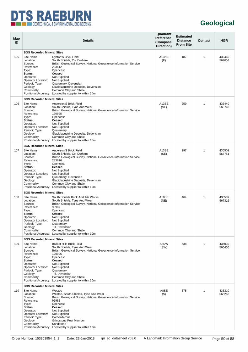
Order Number: 153803954_1_1 Date: 22-Jan-2018 rpr_ec_datasheet v53.0 A Landmark Information Group Service Page 50 of 88
Geological
MapID Details
QuadrantReference (Compass Direction)
EstimatedDistanceFrom Site
Contact NGR
105
106
107
108
109
110
BGS Recorded Mineral Sites
BGS Recorded Mineral Sites
BGS Recorded Mineral Sites
BGS Recorded Mineral Sites
BGS Recorded Mineral Sites
BGS Recorded Mineral Sites
A13NE(E)
A13SE(SE)
A13SE(SE)
A18SE(NE)
A8NW(SW)
A8SE(S)
187
259
297
464
538
675
1
1
1
1
1
1
Site Name:Location:Source:Reference:Type:Status:Operator:Operator Location:Periodic Type:Geology:Commodity:Positional Accuracy:
Site Name:Location:Source:Reference:Type:Status:Operator:Operator Location:Periodic Type:Geology:Commodity:Positional Accuracy:
Site Name:Location:Source:Reference:Type:Status:Operator:Operator Location:Periodic Type:Geology:Commodity:Positional Accuracy:
Site Name:Location:Source:Reference:Type:Status:Operator:Operator Location:Periodic Type:Geology:Commodity:Positional Accuracy:
Site Name:Location:Source:Reference:Type:Status:Operator:Operator Location:Periodic Type:Geology:Commodity:Positional Accuracy:
Site Name:Location:Source:Reference:Type:Status:Operator:Operator Location:Periodic Type:Geology:Commodity:Positional Accuracy:
Oyston'S Brick FieldSouth Shields, Co. DurhamBritish Geological Survey, National Geoscience Information Service233612OpencastCeasedNot SuppliedNot SuppliedQuaternary, DevensianGlaciolacustrine Deposits, DevensianCommon Clay and ShaleLocated by supplier to within 10m
Anderson'S Brick FieldSouth Shields, Tyne And WearBritish Geological Survey, National Geoscience Information Service120995OpencastCeasedNot SuppliedNot SuppliedQuaternaryGlaciolacustrine Deposits, DevensianCommon Clay and ShaleLocated by supplier to within 10m
Anderson'S Brick FieldSouth Shields, Co. DurhamBritish Geological Survey, National Geoscience Information Service233616OpencastCeasedNot SuppliedNot SuppliedQuaternary, DevensianGlaciolacustrine Deposits, DevensianCommon Clay and ShaleLocated by supplier to within 10m
South Shields Brick And Tile WorksSouth Shields, Tyne And WearBritish Geological Survey, National Geoscience Information Service95987OpencastCeasedNot SuppliedNot SuppliedQuaternaryTill, DevensianCommon Clay and ShaleLocated by supplier to within 10m
Ballast Hills Brick FieldSouth Shields, Tyne And WearBritish Geological Survey, National Geoscience Information Service120996OpencastCeasedNot SuppliedNot SuppliedQuaternaryTill, DevensianCommon Clay and ShaleLocated by supplier to within 10m
WestoeWestoe, South Shields, Tyne And WearBritish Geological Survey, National Geoscience Information Service95988OpencastCeasedNot SuppliedNot SuppliedCarboniferousGrindstone Post MemberSandstoneLocated by supplier to within 10m
436466567004
436440566740
436509566751
436589567316
436030566450
436310566262

Order Number: 153803954_1_1 Date: 22-Jan-2018 rpr_ec_datasheet v53.0 A Landmark Information Group Service Page 51 of 88
Geological
MapID Details
QuadrantReference (Compass Direction)
EstimatedDistanceFrom Site
Contact NGR
111
112
113
114
115
116
BGS Recorded Mineral Sites
BGS Recorded Mineral Sites
BGS Recorded Mineral Sites
BGS Recorded Mineral Sites
BGS Recorded Mineral Sites
BGS Recorded Mineral Sites
A18NW(N)
A7NE(SW)
A7SE(SW)
A14SE(E)
A12NW(W)
A9SW(SE)
709
789
799
940
988
996
1
1
1
1
1
1
Site Name:Location:Source:Reference:Type:Status:Operator:Operator Location:Periodic Type:Geology:Commodity:Positional Accuracy:
Site Name:Location:Source:Reference:Type:Status:Operator:Operator Location:Periodic Type:Geology:Commodity:Positional Accuracy:
Site Name:Location:Source:Reference:Type:Status:Operator:Operator Location:Periodic Type:Geology:Commodity:Positional Accuracy:
Site Name:Location:Source:Reference:Type:Status:Operator:Operator Location:Periodic Type:Geology:Commodity:Positional Accuracy:
Site Name:Location:Source:Reference:Type:Status:Operator:Operator Location:Periodic Type:Geology:Commodity:Positional Accuracy:
Site Name:Location:Source:Reference:Type:Status:Operator:Operator Location:Periodic Type:Geology:Commodity:Positional Accuracy:
St Stephen'S Brick WorksSouth Shields, Tyne And WearBritish Geological Survey, National Geoscience Information Service99016OpencastCeasedNot SuppliedNot SuppliedQuaternaryTill, DevensianCommon Clay and ShaleLocated by supplier to within 10m
High Shields Clay PitHigh Shields, South Shields, Co. DurhamBritish Geological Survey, National Geoscience Information Service233618OpencastCeasedNot SuppliedNot SuppliedQuaternary, DevensianGlaciolacustrine Deposits, DevensianCommon Clay and ShaleLocated by supplier to within 10m
Leygate Brick FieldHigh Shields, South Shields, Co. DurhamBritish Geological Survey, National Geoscience Information Service233617OpencastCeasedNot SuppliedNot SuppliedQuaternary, DevensianGlaciolacustrine Deposits, DevensianCommon Clay and ShaleLocated by supplier to within 10m
Westoe CollieryWestoe, South Shields, Tyne And WearBritish Geological Survey, National Geoscience Information Service4060UndergroundCeasedNot SuppliedNot SuppliedCarboniferousPennine Coal Measures GroupCoal - DeepLocated by supplier to within 10m
Burdon Main Colliery, Engine PitNorth Shields, NorthumberlandBritish Geological Survey, National Geoscience Information Service233627UndergroundCeasedNot SuppliedNot SuppliedCarboniferousPennine Middle Coal Measures FormationCoal - DeepLocated by supplier to within 10m
Carston QuarryWestoe, South Shields, Tyne And WearBritish Geological Survey, National Geoscience Information Service95989OpencastCeasedNot SuppliedNot SuppliedPermianRaisby Formation (Lower Magnesian Limestone)DolomiteLocated by supplier to within 10m
436093567675
435715566367
435901566223
437222566849
435289567234
436710566047

Order Number: 153803954_1_1 Date: 22-Jan-2018 rpr_ec_datasheet v53.0 A Landmark Information Group Service Page 52 of 88
Geological
MapID Details
QuadrantReference (Compass Direction)
EstimatedDistanceFrom Site
Contact NGR
BGS Measured Urban Soil Chemistry
BGS Urban Soil Chemistry Averages
Coal Mining Affected Areas
Mining Instability
Non Coal Mining Areas of Great Britain
Potential for Collapsible Ground Stability Hazards
Potential for Collapsible Ground Stability Hazards
Potential for Compressible Ground Stability Hazards
Potential for Compressible Ground Stability Hazards
Potential for Compressible Ground Stability Hazards
Potential for Compressible Ground Stability Hazards
Potential for Compressible Ground Stability Hazards
Potential for Compressible Ground Stability Hazards
Potential for Compressible Ground Stability Hazards
Potential for Ground Dissolution Stability Hazards
Potential for Landslide Ground Stability Hazards
Potential for Running Sand Ground Stability Hazards
Potential for Running Sand Ground Stability Hazards
Potential for Running Sand Ground Stability Hazards
Potential for Running Sand Ground Stability Hazards
Potential for Running Sand Ground Stability Hazards
A13NW(SW)
A13NW(SW)
A13NW(SW)
A13SE(SE)
A13NW(SW)
A13SE(SE)
A13SE(E)
A13NE(E)
A13SE(SE)
A13SW(W)
A13SW(SW)
A13NW(SW)
A13NW(SW)
A13NW(SW)
A13SE(SE)
A13SE(E)
A13NW(NW)
A13SE(SE)
0
0
0
4
0
4
143
182
220
224
245
0
0
0
4
21
91
220
8
-
1
1
1
1
1
1
1
1
1
1
1
1
1
1
1
1
Description:
Mining Evidence:Source:Boundary Quality:
Hazard Potential:Source:
Hazard Potential:Source:
Hazard Potential:Source:
Hazard Potential:Source:
Hazard Potential:Source:
Hazard Potential:Source:
Hazard Potential:Source:
Hazard Potential:Source:
Hazard Potential:Source:
Hazard Potential:Source:
Hazard Potential:Source:
Hazard Potential:Source:
Hazard Potential:Source:
Hazard Potential:Source:
Hazard Potential:Source:
Hazard Potential:Source:
In an area which may be affected by coal mining activity. It is recommended that a coal mining report is obtained from the Coal Authority. Contact details are included in the Useful Contacts section of this report.
Inconclusive Coal MiningOve Arup & PartnersAs Supplied
No HazardBritish Geological Survey, National Geoscience Information Service
Very LowBritish Geological Survey, National Geoscience Information Service
ModerateBritish Geological Survey, National Geoscience Information Service
Very LowBritish Geological Survey, National Geoscience Information Service
No HazardBritish Geological Survey, National Geoscience Information Service
Very LowBritish Geological Survey, National Geoscience Information Service
Very LowBritish Geological Survey, National Geoscience Information Service
ModerateBritish Geological Survey, National Geoscience Information Service
No HazardBritish Geological Survey, National Geoscience Information Service
No HazardBritish Geological Survey, National Geoscience Information Service
Very LowBritish Geological Survey, National Geoscience Information Service
LowBritish Geological Survey, National Geoscience Information Service
Very LowBritish Geological Survey, National Geoscience Information Service
No HazardBritish Geological Survey, National Geoscience Information Service
No HazardBritish Geological Survey, National Geoscience Information Service
Very LowBritish Geological Survey, National Geoscience Information Service
No data available
No data available
No Hazard
436264566961
436264566961
436264566961
436276566938
436264566961
436276566938
436430566936
436452567026
436438566788
436022566947
436038566836
436264566961
436264566961
436264566961
436276566938
436308566954
436218567067
436438566788

Order Number: 153803954_1_1 Date: 22-Jan-2018 rpr_ec_datasheet v53.0 A Landmark Information Group Service Page 53 of 88
Geological
MapID Details
QuadrantReference (Compass Direction)
EstimatedDistanceFrom Site
Contact NGR
Potential for Running Sand Ground Stability Hazards
Potential for Shrinking or Swelling Clay Ground Stability Hazards
Potential for Shrinking or Swelling Clay Ground Stability Hazards
Potential for Shrinking or Swelling Clay Ground Stability Hazards
Radon Potential - Radon Affected Areas
Radon Potential - Radon Protection Measures
A13SW(W)
A13NW(SW)
A13SE(SE)
A13SE(E)
A13NW(SW)
A13NW(SW)
224
0
4
143
0
0
1
1
1
1
1
1
Hazard Potential:Source:
Hazard Potential:Source:
Hazard Potential:Source:
Hazard Potential:Source:
Affected Area:
Source:
Protection Measure:
Source:
No HazardBritish Geological Survey, National Geoscience Information Service
Very LowBritish Geological Survey, National Geoscience Information Service
LowBritish Geological Survey, National Geoscience Information Service
No HazardBritish Geological Survey, National Geoscience Information Service
The property is in a Lower probability radon area (less than 1% of homes are estimated to be at or above the Action Level).British Geological Survey, National Geoscience Information Service
No radon protective measures are necessary in the construction of new dwellings or extensionsBritish Geological Survey, National Geoscience Information Service
436022566947
436264566961
436276566938
436430566936
436264566961
436264566961

Order Number: 153803954_1_1 Date: 22-Jan-2018 rpr_ec_datasheet v53.0 A Landmark Information Group Service Page 54 of 88
Industrial Land Use
MapID Details
QuadrantReference (Compass Direction)
EstimatedDistanceFrom Site
Contact NGR
117
118
118
118
118
118
119
120
121
121
121
Contemporary Trade Directory Entries
Contemporary Trade Directory Entries
Contemporary Trade Directory Entries
Contemporary Trade Directory Entries
Contemporary Trade Directory Entries
Contemporary Trade Directory Entries
Contemporary Trade Directory Entries
Contemporary Trade Directory Entries
Contemporary Trade Directory Entries
Contemporary Trade Directory Entries
Contemporary Trade Directory Entries
A13SW(SW)
A13SW(S)
A13SW(S)
A13SW(S)
A13SW(S)
A13SE(S)
A13SE(SE)
A13NE(NE)
A13SE(E)
A13SE(E)
A13SE(E)
21
44
85
85
87
116
48
49
51
67
68
-
-
-
-
-
-
-
-
-
-
-
Name:Location:Classification:Status:Positional Accuracy:
Name:Location:
Classification:Status:Positional Accuracy:
Name:Location:
Classification:Status:Positional Accuracy:
Name:Location:
Classification:Status:Positional Accuracy:
Name:Location:
Classification:Status:Positional Accuracy:
Name:Location:
Classification:Status:Positional Accuracy:
Name:Location:Classification:Status:Positional Accuracy:
Name:Location:Classification:Status:Positional Accuracy:
Name:Location:Classification:Status:Positional Accuracy:
Name:Location:Classification:Status:Positional Accuracy:
Name:Location:Classification:Status:Positional Accuracy:
D WoodwardCar Dismantlers, Oyston Street, South Shields, Tyne and Wear, NE33 1ATScrap Metal MerchantsInactiveAutomatically positioned in the proximity of the address
Levant Office InteriorsUnit 313,Tedco Business Works,Henry Robson Way, South Shields, Tyne andWear, NE33 1RFOffice Furniture & EquipmentActiveManually positioned to the address or location
SafesolUnit 206, South Shields Business Works, Henry Robson Way, South Shields, NE33 1RFChemicals - Distributors & WholesalersActiveAutomatically positioned to the address
B-Able LtdUnit 201,Tedco Business Works,Henry Robson Way, South Shields, Tyne And Wear, NE33 1RFDisability Equipment - Manufacturers & SuppliersInactiveManually positioned to the address or location
Maxiflo Technologies LtdUnit 208,Tedco Business Works,Henry Robson Way, South Shields, Tyne andWear, NE33 1RFHydraulic Systems & Equipment ManufacturersInactiveManually positioned to the address or location
Multimedia InstallationsTedco Business Works,Henry Robson Way, South Shields, Tyne And Wear, NE33 1RFCinema EquipmentInactiveManually positioned within the geographical locality
C M C1, Forest Road, South Shields, Tyne and Wear, NE33 1PTPhotocopiersInactiveAutomatically positioned to the address
SutherlandsCoronation St, South Shields, Tyne & Wear, NE33 1AZTyre DealersInactiveManually positioned to the address or location
Colourclear3-4 Forest Rd, South Shields, Tyne and Wear, NE33 1PTClothing & Fabrics - ManufacturersInactiveManually positioned to the address or location
Vechicle Diagnostics4 Forest Rd, South Shields, Tyne and Wear, NE33 1PTGarage ServicesInactiveManually positioned to the address or location
Colourclear Ltd3-4, Forest Road, South Shields, Tyne and Wear, NE33 1PTClothing & Fabrics - ManufacturersInactiveAutomatically positioned to the address
436236566943
436254566892
436246566852
436246566852
436246566850
436272566820
436320566914
436296567022
436338566944
436355566952
436356566953

Order Number: 153803954_1_1 Date: 22-Jan-2018 rpr_ec_datasheet v53.0 A Landmark Information Group Service Page 55 of 88
Industrial Land Use
MapID Details
QuadrantReference (Compass Direction)
EstimatedDistanceFrom Site
Contact NGR
122
122
122
122
123
123
123
123
123
124
124
Contemporary Trade Directory Entries
Contemporary Trade Directory Entries
Contemporary Trade Directory Entries
Contemporary Trade Directory Entries
Contemporary Trade Directory Entries
Contemporary Trade Directory Entries
Contemporary Trade Directory Entries
Contemporary Trade Directory Entries
Contemporary Trade Directory Entries
Contemporary Trade Directory Entries
Contemporary Trade Directory Entries
A13SE(E)
A13SE(SE)
A13SE(SE)
A13SE(SE)
A13NE(E)
A13SE(E)
A13NE(E)
A13NE(E)
A13NE(E)
A13NE(NE)
A13NE(NE)
120
133
133
133
122
126
127
155
158
136
136
-
-
-
-
-
-
-
-
-
-
-
Name:Location:Classification:Status:Positional Accuracy:
Name:Location:Classification:Status:Positional Accuracy:
Name:Location:Classification:Status:Positional Accuracy:
Name:Location:Classification:Status:Positional Accuracy:
Name:Location:Classification:Status:Positional Accuracy:
Name:Location:Classification:Status:Positional Accuracy:
Name:Location:Classification:Status:Positional Accuracy:
Name:Location:Classification:Status:Positional Accuracy:
Name:Location:Classification:Status:Positional Accuracy:
Name:Location:Classification:Status:Positional Accuracy:
Name:Location:Classification:Status:Positional Accuracy:
R Cars52-56, Garden Lane, South Shields, Tyne and Wear, NE33 1PSCar Dealers - UsedInactiveAutomatically positioned to the address
Steve'S Auto Sprays62, Garden Lane, South Shields, Tyne and Wear, NE33 1PSCar Body RepairsInactiveManually positioned to the address or location
Truewood Furniture & Joinery Ltd62, Garden Lane, South Shields, Tyne and Wear, NE33 1PSFurniture Manufacturers - Home & OfficeInactiveManually positioned to the address or location
Rolls62, Garden Lane, South Shields, Tyne and Wear, NE33 1PSCommercial Cleaning ServicesInactiveAutomatically positioned to the address
Vts12, Franklin Street, South Shields, Tyne and Wear, NE33 1PRGarage ServicesInactiveAutomatically positioned to the address
Leighton Motors14, Franklin Street, South Shields, NE33 1PRGarage ServicesActiveAutomatically positioned to the address
Motoreay Services8, Franklin Street, South Shields, Tyne and Wear, NE33 1PRGarage ServicesInactiveAutomatically positioned to the address
Eddie Burke Motor Bodies5, Franklin Street, South Shields, Tyne and Wear, NE33 1PRCar Body RepairsInactiveAutomatically positioned to the address
Dean Printing Works11, Franklin Street, South Shields, Tyne and Wear, NE33 1PRPrintersInactiveAutomatically positioned to the address
Snug Fit Doors & Windows2-6 Franklin St, South Shields, Tyne and Wear, NE33 1PRWindow Frames - Sales & ServiceInactiveManually positioned to the address or location
The Window Fitter Warehouse2-8, Franklin Street, South Shields, Tyne and Wear, NE33 1PRWindow Frames - Sales & ServiceActiveAutomatically positioned to the address
436399566906
436402566881
436402566881
436402566881
436408566967
436413566957
436407566993
436436566997
436444566971
436404567020
436404567020

Order Number: 153803954_1_1 Date: 22-Jan-2018 rpr_ec_datasheet v53.0 A Landmark Information Group Service Page 56 of 88
Industrial Land Use
MapID Details
QuadrantReference (Compass Direction)
EstimatedDistanceFrom Site
Contact NGR
125
126
126
126
126
126
126
126
126
127
127
Contemporary Trade Directory Entries
Contemporary Trade Directory Entries
Contemporary Trade Directory Entries
Contemporary Trade Directory Entries
Contemporary Trade Directory Entries
Contemporary Trade Directory Entries
Contemporary Trade Directory Entries
Contemporary Trade Directory Entries
Contemporary Trade Directory Entries
Contemporary Trade Directory Entries
Contemporary Trade Directory Entries
A13SE(S)
A13SE(SE)
A13SE(SE)
A13SE(SE)
A13SE(SE)
A13SE(SE)
A13SE(SE)
A13SE(SE)
A13SE(SE)
A13SW(SW)
A13SW(SW)
167
173
178
178
178
178
188
205
205
177
177
-
-
-
-
-
-
-
-
-
-
-
Name:Location:
Classification:Status:Positional Accuracy:
Name:Location:Classification:Status:Positional Accuracy:
Name:Location:
Classification:Status:Positional Accuracy:
Name:Location:
Classification:Status:Positional Accuracy:
Name:Location:
Classification:Status:Positional Accuracy:
Name:Location:
Classification:Status:Positional Accuracy:
Name:Location:Classification:Status:Positional Accuracy:
Name:Location:Classification:Status:Positional Accuracy:
Name:Location:Classification:Status:Positional Accuracy:
Name:Location:
Classification:Status:Positional Accuracy:
Name:Location:
Classification:Status:Positional Accuracy:
PressitUnit 306,Tedco Business Works,Henry Robson Way, South Shields, Tyne andWear, NE33 1RFIroning & Home Laundry ServicesInactiveManually positioned to the address or location
The Clutch CentreUnit 5, Redhead Buildings, Garden Lane, South Shields, NE33 1PSGarage ServicesActiveAutomatically positioned to the address
Bede Furnishings LtdUnit 1/5, Redhead Buildings, Garden Lane, South Shields, Tyne and Wear, NE33 1PSUpholstery ManufacturersInactiveAutomatically positioned to the address
Lawnmower & Power Tool Repair CentreUnit 8, Redhead Buildings, Garden Lane, South Shields, Tyne and Wear, NE33 1PSLawnmowers & Garden Machinery - Sales & ServiceInactiveAutomatically positioned to the address
Ocean Laundry ServicesUnit 6/7, Redhead Buildings, Garden Lane, South Shields, Tyne and Wear, NE33 1PSLaundries & LaunderettesInactiveAutomatically positioned to the address
A C Wrought IronUnit 1-5, Redhead Buildings, Garden Lane, South Shields, Tyne and Wear, NE33 1PSWrought IronworkInactiveAutomatically positioned to the address
Town Hall Tyres LtdUnit 2, Redhead Buildings, Garden Lane, South Shields, NE33 1PSTyre DealersActiveAutomatically positioned to the address
Speciality Mirror Shop9, St. Hilda Street, South Shields, Tyne and Wear, NE33 1QDMirrors & Decorative GlassInactiveAutomatically positioned to the address
Speciality Mirror Shop9, St. Hilda Street, South Shields, Tyne and Wear, NE33 1QDPicture & Picture Frame Renovating & RestoringInactiveAutomatically positioned to the address
Eternal FlameUnit 7, St. Hilda Industrial Estate, Station Road, SOUTH SHIELDS, Tyne and Wear, NE33 1RAFireplaces & MantelpiecesActiveAutomatically positioned to the address
Wizz PrintUnit 5, St. Hilda Industrial Estate, Station Road, South Shields, Tyne and Wear, NE33 1RAPrintersInactiveAutomatically positioned to the address
436296566772
436403566820
436405566816
436405566816
436405566816
436405566816
436438566837
436435566807
436435566807
436120566829
436132566815

Order Number: 153803954_1_1 Date: 22-Jan-2018 rpr_ec_datasheet v53.0 A Landmark Information Group Service Page 57 of 88
Industrial Land Use
MapID Details
QuadrantReference (Compass Direction)
EstimatedDistanceFrom Site
Contact NGR
127
127
127
128
128
129
130
130
130
131
131
Contemporary Trade Directory Entries
Contemporary Trade Directory Entries
Contemporary Trade Directory Entries
Contemporary Trade Directory Entries
Contemporary Trade Directory Entries
Contemporary Trade Directory Entries
Contemporary Trade Directory Entries
Contemporary Trade Directory Entries
Contemporary Trade Directory Entries
Contemporary Trade Directory Entries
Contemporary Trade Directory Entries
A13SW(SW)
A13SW(SW)
A13SW(SW)
A13NW(N)
A13NW(N)
A13NE(NE)
A13NW(NW)
A13NW(NW)
A13NW(NW)
A13SE(S)
A13SE(S)
177
183
199
184
195
185
195
233
240
213
225
-
-
-
-
-
-
-
-
-
-
-
Name:Location:
Classification:Status:Positional Accuracy:
Name:Location:
Classification:Status:Positional Accuracy:
Name:Location:Classification:Status:Positional Accuracy:
Name:Location:Classification:Status:Positional Accuracy:
Name:Location:Classification:Status:Positional Accuracy:
Name:Location:Classification:Status:Positional Accuracy:
Name:Location:Classification:Status:Positional Accuracy:
Name:Location:Classification:Status:Positional Accuracy:
Name:Location:Classification:Status:Positional Accuracy:
Name:Location:
Classification:Status:Positional Accuracy:
Name:Location:Classification:Status:Positional Accuracy:
Washington Patterns LtdUnit 8, St. Hilda Industrial Estate, Station Road, South Shields, Tyne and Wear, NE33 1RAWood Products, Except Furniture - ManufacturersInactiveAutomatically positioned to the address
G W ForemanUnit 2, St. Hilda Industrial Estate, Station Road, South Shields, Tyne and Wear, NE33 1RAMetal WorkersInactiveAutomatically positioned to the address
Halfords AutocentreStation Road,Millbank, South Shields, Tyne and Wear, NE33 1RDGarage ServicesActiveManually positioned to the road within the address or location
Northern Energy Solutions6, Waterloo Vale, South Shields, NE33 1BSElectricity Generating & Distributing EquipmentInactiveAutomatically positioned to the address
Currys87, King Street, South Shields, Tyne and Wear, NE33 1DPElectrical Goods Sales, Manufacturers & WholesalersInactiveAutomatically positioned to the address
John Carey Motor Services8, William Street, South Shields, NE33 1PQGarage ServicesInactiveAutomatically positioned to the address
Currys Digital111, King Street, South Shields, Tyne and Wear, NE33 1DPElectrical Goods Sales, Manufacturers & WholesalersInactiveAutomatically positioned to the address
M I Dickson Ltd107, King Street, South Shields, Tyne and Wear, NE33 1DPMeat Product Manufacturers & WholesalersInactiveAutomatically positioned to the address
Brighthouse116, King Street, South Shields, NE33 1JEElectrical Goods Sales, Manufacturers & WholesalersActiveAutomatically positioned to the address
Tool Repair CentreUnit 4/6, Holman Court, Henry Robson Way, South Shields, Tyne and Wear, NE33 1RLTool Sharpening, Repairing & ServicingInactiveAutomatically positioned to the address
Plastics Centre South Shields LtdUnit 4, Holman Court, Henry Robson Way, South Shields, NE33 1RLPVC-U Products - Manufacturers & SuppliersActiveAutomatically positioned to the address
436112566841
436144566795
436111566806
436226567166
436197567170
436396567114
436134567140
436128567181
436093567166
436312566729
436320566718
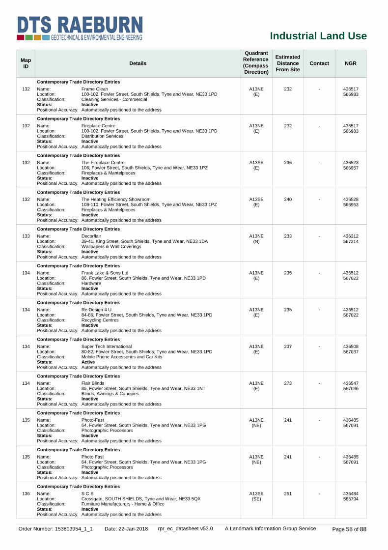
Order Number: 153803954_1_1 Date: 22-Jan-2018 rpr_ec_datasheet v53.0 A Landmark Information Group Service Page 58 of 88
Industrial Land Use
MapID Details
QuadrantReference (Compass Direction)
EstimatedDistanceFrom Site
Contact NGR
132
132
132
132
133
134
134
134
134
135
135
136
Contemporary Trade Directory Entries
Contemporary Trade Directory Entries
Contemporary Trade Directory Entries
Contemporary Trade Directory Entries
Contemporary Trade Directory Entries
Contemporary Trade Directory Entries
Contemporary Trade Directory Entries
Contemporary Trade Directory Entries
Contemporary Trade Directory Entries
Contemporary Trade Directory Entries
Contemporary Trade Directory Entries
Contemporary Trade Directory Entries
A13NE(E)
A13NE(E)
A13SE(E)
A13SE(E)
A13NE(N)
A13NE(E)
A13NE(E)
A13NE(E)
A13NE(E)
A13NE(NE)
A13NE(NE)
A13SE(SE)
232
232
236
240
233
235
235
237
273
241
241
251
-
-
-
-
-
-
-
-
-
-
-
-
Name:Location:Classification:Status:Positional Accuracy:
Name:Location:Classification:Status:Positional Accuracy:
Name:Location:Classification:Status:Positional Accuracy:
Name:Location:Classification:Status:Positional Accuracy:
Name:Location:Classification:Status:Positional Accuracy:
Name:Location:Classification:Status:Positional Accuracy:
Name:Location:Classification:Status:Positional Accuracy:
Name:Location:Classification:Status:Positional Accuracy:
Name:Location:Classification:Status:Positional Accuracy:
Name:Location:Classification:Status:Positional Accuracy:
Name:Location:Classification:Status:Positional Accuracy:
Name:Location:Classification:Status:Positional Accuracy:
Frame Clean100-102, Fowler Street, South Shields, Tyne and Wear, NE33 1PDCleaning Services - CommercialInactiveAutomatically positioned to the address
Fireplace Centre100-102, Fowler Street, South Shields, Tyne and Wear, NE33 1PDDistribution ServicesInactiveAutomatically positioned to the address
The Fireplace Centre106, Fowler Street, South Shields, Tyne and Wear, NE33 1PZFireplaces & MantelpiecesInactiveAutomatically positioned to the address
The Heating Efficiency Showroom108-110, Fowler Street, South Shields, Tyne and Wear, NE33 1PZFireplaces & MantelpiecesInactiveAutomatically positioned to the address
Decorflair39-41, King Street, South Shields, Tyne and Wear, NE33 1DAWallpapers & Wall CoveringsInactiveAutomatically positioned to the address
Frank Lake & Sons Ltd86, Fowler Street, South Shields, Tyne and Wear, NE33 1PDHardwareInactiveAutomatically positioned to the address
Re-Design 4 U84-86, Fowler Street, South Shields, Tyne and Wear, NE33 1PDRecycling CentresInactiveAutomatically positioned to the address
Super Tech International80-82, Fowler Street, South Shields, Tyne and Wear, NE33 1PDMobile Phone Accessories and Car KitsActiveAutomatically positioned to the address
Flair Blinds85, Fowler Street, South Shields, Tyne and Wear, NE33 1NTBlinds, Awnings & CanopiesInactiveAutomatically positioned to the address
Photo-Fast64, Fowler Street, South Shields, Tyne and Wear, NE33 1PGPhotographic ProcessorsInactiveAutomatically positioned to the address
Photo Fast64, Fowler Street, South Shields, Tyne and Wear, NE33 1PGPhotographic ProcessorsInactiveAutomatically positioned to the address
S C SCrossgate, SOUTH SHIELDS, Tyne and Wear, NE33 5QXFurniture Manufacturers - Home & OfficeInactiveAutomatically positioned to the address
436517566983
436517566983
436523566957
436528566953
436312567214
436512567022
436512567022
436508567037
436547567036
436485567091
436485567091
436484566794

Order Number: 153803954_1_1 Date: 22-Jan-2018 rpr_ec_datasheet v53.0 A Landmark Information Group Service Page 59 of 88
Industrial Land Use
MapID Details
QuadrantReference (Compass Direction)
EstimatedDistanceFrom Site
Contact NGR
136
136
136
137
138
138
138
139
139
140
141
Contemporary Trade Directory Entries
Contemporary Trade Directory Entries
Contemporary Trade Directory Entries
Contemporary Trade Directory Entries
Contemporary Trade Directory Entries
Contemporary Trade Directory Entries
Contemporary Trade Directory Entries
Contemporary Trade Directory Entries
Contemporary Trade Directory Entries
Contemporary Trade Directory Entries
Contemporary Trade Directory Entries
A13SE(SE)
A13SE(SE)
A13SE(SE)
A13SW(SW)
A13NE(N)
A13NE(N)
A13NE(N)
A13NE(NE)
A13NE(NE)
A13NE(E)
A13NE(NE)
257
260
262
255
262
290
290
263
267
275
305
-
-
-
-
-
-
-
-
-
-
-
Name:Location:
Classification:Status:Positional Accuracy:
Name:Location:
Classification:Status:Positional Accuracy:
Name:Location:Classification:Status:Positional Accuracy:
Name:Location:Classification:Status:Positional Accuracy:
Name:Location:Classification:Status:Positional Accuracy:
Name:Location:Classification:Status:Positional Accuracy:
Name:Location:Classification:Status:Positional Accuracy:
Name:Location:Classification:Status:Positional Accuracy:
Name:Location:Classification:Status:Positional Accuracy:
Name:Location:Classification:Status:Positional Accuracy:
Name:Location:Classification:Status:Positional Accuracy:
Town Hall Service StationTown Hall Filling Station, Crossgate, South Shields, Tyne and Wear, NE33 5QXPetrol Filling Stations - 24 HourInactiveManually positioned to the address or location
EssoTown Hall Filling Station, Crossgate, South Shields, Tyne and Wear, NE33 5QXPetrol Filling StationsInactiveAutomatically positioned to the address
Esso Service StationTown Hall Filling Station, Crossgate, South Shields, NE33 5QXPetrol Filling StationsActiveAutomatically positioned to the address
Aa Service CentreStation Road, South Shields, Tyne and Wear, NE33 1EDGarage ServicesInactiveAutomatically positioned to the address
Eclipse Technology Uk Ltd27, Smithy Street, South Shields, Tyne and Wear, NE33 1BTComputer ManufacturersInactiveAutomatically positioned to the address
Klick Photopoint24, King Street, South Shields, Tyne and Wear, NE33 1HTPhotographic ProcessorsInactiveAutomatically positioned to the address
Klick24, King Street, South Shields, Tyne and Wear, NE33 1HTPhotographic ProcessorsInactiveAutomatically positioned to the address
Klick50, Fowler Street, South Shields, Tyne and Wear, NE33 1PGPhotographic ProcessorsInactiveAutomatically positioned to the address
The Jewellery Repair Centre44, Fowler Street, South Shields, Tyne and Wear, NE33 1PGJewellery Manufacturers & RepairersInactiveAutomatically positioned to the address
Home StyleFowler St, South Shields, Tyne And Wear, NE33 1NUCookers - Sales & ServiceInactiveManually positioned within the geographical locality
Homefair Blinds Uk Ltd4, Fowler Street, South Shields, Tyne and Wear, NE33 1NFBlinds, Awnings & CanopiesActiveAutomatically positioned to the address
436506566814
436514566822
436516566821
436038566814
436364567228
436346567264
436346567264
436483567131
436477567143
436558566998
436417567249

Order Number: 153803954_1_1 Date: 22-Jan-2018 rpr_ec_datasheet v53.0 A Landmark Information Group Service Page 60 of 88
Industrial Land Use
MapID Details
QuadrantReference (Compass Direction)
EstimatedDistanceFrom Site
Contact NGR
141
142
142
143
144
144
144
144
144
144
145
146
Contemporary Trade Directory Entries
Contemporary Trade Directory Entries
Contemporary Trade Directory Entries
Contemporary Trade Directory Entries
Contemporary Trade Directory Entries
Contemporary Trade Directory Entries
Contemporary Trade Directory Entries
Contemporary Trade Directory Entries
Contemporary Trade Directory Entries
Contemporary Trade Directory Entries
Contemporary Trade Directory Entries
Contemporary Trade Directory Entries
A13NE(NE)
A13SE(S)
A8NE(S)
A13NE(NE)
A14SW(E)
A14SW(E)
A14SW(E)
A14SW(E)
A14SW(E)
A14SW(E)
A18SE(N)
A8NE(S)
333
315
320
315
320
320
320
321
340
353
346
355
-
-
-
-
-
-
-
-
-
-
-
-
Name:Location:Classification:Status:Positional Accuracy:
Name:Location:Classification:Status:Positional Accuracy:
Name:Location:Classification:Status:Positional Accuracy:
Name:Location:Classification:Status:Positional Accuracy:
Name:Location:Classification:Status:Positional Accuracy:
Name:Location:Classification:Status:Positional Accuracy:
Name:Location:Classification:Status:Positional Accuracy:
Name:Location:Classification:Status:Positional Accuracy:
Name:Location:Classification:Status:Positional Accuracy:
Name:Location:Classification:Status:Positional Accuracy:
Name:Location:Classification:Status:Positional Accuracy:
Name:Location:Classification:Status:Positional Accuracy:
Supasnaps2, Denmark Centre, South Shields, Tyne and Wear, NE33 2LRPhotographic ProcessorsInactiveAutomatically positioned to the address
Harlow Printing Ltd7-21, Maxwell Street, South Shields, NE33 4PUPrintersActiveAutomatically positioned to the address
South Tyneside Auto Electrics1 Maxwell St, South Shields, Tyne and Wear, NE33 4PUElectronic EngineersInactiveManually positioned to the road within the address or location
Johnson Cleaners (Uk) Ltd17, Denmark Centre, South Shields, Tyne and Wear, NE33 2LRDry CleanersInactiveAutomatically positioned to the address
Century Hose7, Beach Road, South Shields, NE33 2QAHose, Tubing & FittingsActiveAutomatically positioned to the address
Newlife Cleaning Systems North Ltd7, Beach Road, South Shields, Tyne and Wear, NE33 2QACommercial Cleaning ServicesActiveAutomatically positioned to the address
At Your Service7, Beach Road, South Shields, Tyne and Wear, NE33 2QACommercial Cleaning ServicesInactiveAutomatically positioned to the address
Orchid Games Studios7 Beach Rd, South Shields, Tyne and Wear, NE33 2QAToys, Games & Sporting Goods - ManufacturersInactiveManually positioned to the address or location
South Shields Printing13, Beach Road, South Shields, Tyne and Wear, NE33 2QAPrintersInactiveManually positioned to the address or location
Dentures Direct17a, Beach Road, South Shields, Tyne and Wear, NE33 2QAMedical & Dental LaboratoriesInactiveAutomatically positioned to the address
C K Property ServicesMoorgate House, 5, Mile End Road, South Shields, NE33 1TACommercial Cleaning ServicesActiveAutomatically positioned to the address
N P S Services14, Maxwell Street, South Shields, Tyne and Wear, NE33 4PUWrought IronworkInactiveAutomatically positioned to the address
436450567261
436354566635
436314566620
436487567207
436608566939
436608566939
436608566939
436608566939
436628566950
436641566955
436374567314
436334566589

Order Number: 153803954_1_1 Date: 22-Jan-2018 rpr_ec_datasheet v53.0 A Landmark Information Group Service Page 61 of 88
Industrial Land Use
MapID Details
QuadrantReference (Compass Direction)
EstimatedDistanceFrom Site
Contact NGR
146
146
146
147
148
149
150
150
150
151
151
152
Contemporary Trade Directory Entries
Contemporary Trade Directory Entries
Contemporary Trade Directory Entries
Contemporary Trade Directory Entries
Contemporary Trade Directory Entries
Contemporary Trade Directory Entries
Contemporary Trade Directory Entries
Contemporary Trade Directory Entries
Contemporary Trade Directory Entries
Contemporary Trade Directory Entries
Contemporary Trade Directory Entries
Contemporary Trade Directory Entries
A8NE(S)
A8NE(S)
A8NE(S)
A8NW(S)
A8NE(S)
A13SW(SW)
A8NE(S)
A8NE(S)
A8NE(S)
A8NW(SW)
A8NW(SW)
A13SW(SW)
371
382
403
362
364
380
390
417
417
400
400
415
-
-
-
-
-
-
-
-
-
-
-
-
Name:Location:Classification:Status:Positional Accuracy:
Name:Location:Classification:Status:Positional Accuracy:
Name:Location:Classification:Status:Positional Accuracy:
Name:Location:Classification:Status:Positional Accuracy:
Name:Location:Classification:Status:Positional Accuracy:
Name:Location:Classification:Status:Positional Accuracy:
Name:Location:Classification:Status:Positional Accuracy:
Name:Location:Classification:Status:Positional Accuracy:
Name:Location:Classification:Status:Positional Accuracy:
Name:Location:Classification:Status:Positional Accuracy:
Name:Location:Classification:Status:Positional Accuracy:
Name:Location:Classification:Status:Positional Accuracy:
Euro Hire & Sales LtdMaxwell St, South Shields, Tyne and Wear, NE33 4PUCorrosion Prevention & ControlInactiveManually positioned to the road within the address or location
Toney Minchella18-20, Maxwell Street, South Shields, NE33 4PUIce Cream Manufacturers & SuppliersActiveAutomatically positioned to the address
M A P Engineering (Ne) LtdMaxwell St, South Shields, Tyne & Wear, NE33 4PUMechanical EngineersInactiveManually positioned to the address or location
CrownCrown House, Western Approach, South Shields, NE33 5QUPVC-U Products - Manufacturers & SuppliersInactiveAutomatically positioned to the address
Ats Euromaster LtdWestern Approach, South Shields, Tyne and Wear, NE33 5QUTyre DealersActiveAutomatically positioned to the address
Mill Dam Garage133 Mill Dam, South Shields, Tyne And Wear, NE33 1EQGarage ServicesInactiveAutomatically positioned to the address
J W RaeUnit A, Western Approach, SOUTH SHIELDS, Tyne and Wear, NE33 5QUManufacturersActiveAutomatically positioned to the address
The Arndale GroupUnit D-e, Western Approach, South Shields, Tyne and Wear, NE33 5NNNuts, Bolts & FixingsActiveAutomatically positioned to the address
Arndale EngineeringD-E, Unit, Western Approach, South Shields, Tyne and Wear, NE33 5NNNuts, Bolts & FixingsInactiveAutomatically positioned to the address
Tandem BeckAmne Buildings,Tudor Rd, South Shields, Tyne and Wear, NE33 5RDTextile ManufacturingInactiveAutomatically positioned to the address
Automotive Maintenance CoUnit 2, Amna Buildings, Tudor Road, South Shields, NE33 4PQGarage ServicesActiveAutomatically positioned to the address
Malac Trading LtdCommercial Rd, South Shields, Tyne and Wear, NE33 1RPMarine EngineersInactiveManually positioned to the road within the address or location
436352566576
436339566562
436336566540
436221566576
436274566572
435935566742
436300566548
436285566519
436285566519
436100566570
436100566570
435956566656

Order Number: 153803954_1_1 Date: 22-Jan-2018 rpr_ec_datasheet v53.0 A Landmark Information Group Service Page 62 of 88
Industrial Land Use
MapID Details
QuadrantReference (Compass Direction)
EstimatedDistanceFrom Site
Contact NGR
152
153
154
154
154
154
155
155
155
155
156
Contemporary Trade Directory Entries
Contemporary Trade Directory Entries
Contemporary Trade Directory Entries
Contemporary Trade Directory Entries
Contemporary Trade Directory Entries
Contemporary Trade Directory Entries
Contemporary Trade Directory Entries
Contemporary Trade Directory Entries
Contemporary Trade Directory Entries
Contemporary Trade Directory Entries
Contemporary Trade Directory Entries
A13SW(SW)
A18SW(NW)
A8NE(S)
A8NE(S)
A8NE(S)
A8NE(S)
A8NW(S)
A8NW(S)
A8NW(S)
A8NW(S)
A14SW(SE)
439
425
427
437
445
453
438
447
460
460
450
-
-
-
-
-
-
-
-
-
-
-
Name:Location:
Classification:Status:Positional Accuracy:
Name:Location:Classification:Status:Positional Accuracy:
Name:Location:Classification:Status:Positional Accuracy:
Name:Location:Classification:Status:Positional Accuracy:
Name:Location:Classification:Status:Positional Accuracy:
Name:Location:Classification:Status:Positional Accuracy:
Name:Location:Classification:Status:Positional Accuracy:
Name:Location:Classification:Status:Positional Accuracy:
Name:Location:Classification:Status:Positional Accuracy:
Name:Location:Classification:Status:Positional Accuracy:
Name:Location:Classification:Status:Positional Accuracy:
Riverview Cars1a The Foundry, Commercial Road, South Shields, Tyne And Wear, NE33 5TECar DealersActiveManually positioned to the road within the address or location
The Direct Group Ltd7, Broad Landing, South Shields, Tyne and Wear, NE33 1JLPrintersInactiveAutomatically positioned to the address
Tyneside Tyre Services28-30, Maxwell Street, South Shields, NE33 4PUTyre DealersActiveAutomatically positioned to the address
Performance Cars29-35, Maxwell Street, South Shields, Tyne and Wear, NE33 4PUGarage ServicesInactiveAutomatically positioned to the address
S M H Products Ltd29-35, Maxwell Street, South Shields, NE33 4PUGlass Fibre Moulding, Materials & ManufacturersActiveAutomatically positioned to the address
Maxwell Street Motors32-36, Maxwell Street, South Shields, NE33 4PUGarage ServicesActiveAutomatically positioned to the address
Harkers M O TTudor Road, SOUTH SHIELDS, Tyne and Wear, NE33 4PQMot Testing CentresActiveAutomatically positioned to the address
Tudor Road GarageTudor Rd, South Shields, Tyne & Wear, NE33 4PQCar Dealers - UsedInactiveManually positioned to the road within the address or location
Tyneside Car Sales LtdTudor Road, South Shields, Tyne and Wear, NE33 5RDCar DealersInactiveAutomatically positioned to the address
Tyneside Car SalesTudor Road, South Shields, Tyne and Wear, NE33 5RDCar Dealers - UsedInactiveAutomatically positioned to the address
M A C Electronics8, Derby Terrace, South Shields, NE33 4PNElectronic EngineersActiveAutomatically positioned to the address
435944566633
435997567326
436339566516
436371566513
436373566505
436341566490
436128566519
436092566522
436126566496
436126566496
436605566630

Order Number: 153803954_1_1 Date: 22-Jan-2018 rpr_ec_datasheet v53.0 A Landmark Information Group Service Page 63 of 88
Industrial Land Use
MapID Details
QuadrantReference (Compass Direction)
EstimatedDistanceFrom Site
Contact NGR
157
158
158
159
159
159
159
159
159
160
161
162
Contemporary Trade Directory Entries
Contemporary Trade Directory Entries
Contemporary Trade Directory Entries
Contemporary Trade Directory Entries
Contemporary Trade Directory Entries
Contemporary Trade Directory Entries
Contemporary Trade Directory Entries
Contemporary Trade Directory Entries
Contemporary Trade Directory Entries
Contemporary Trade Directory Entries
Contemporary Trade Directory Entries
Contemporary Trade Directory Entries
A14NW(E)
A12SE(SW)
A12SE(SW)
A14SW(SE)
A14SW(SE)
A14SW(SE)
A9NW(SE)
A9NW(SE)
A9NW(SE)
A8NE(S)
A8NW(S)
A8NE(S)
461
462
487
468
474
497
499
516
551
469
471
481
-
-
-
-
-
-
-
-
-
-
-
-
Name:Location:Classification:Status:Positional Accuracy:
Name:Location:Classification:Status:Positional Accuracy:
Name:Location:Classification:Status:Positional Accuracy:
Name:Location:Classification:Status:Positional Accuracy:
Name:Location:Classification:Status:Positional Accuracy:
Name:Location:Classification:Status:Positional Accuracy:
Name:Location:Classification:Status:Positional Accuracy:
Name:Location:Classification:Status:Positional Accuracy:
Name:Location:Classification:Status:Positional Accuracy:
Name:Location:Classification:Status:Positional Accuracy:
Name:Location:Classification:Status:Positional Accuracy:
Name:Location:Classification:Status:Positional Accuracy:
MotortuneRear Of, 35, Beach Road, South Shields, Tyne and Wear, NE33 2QUCar Engine Tuning & Diagnostic ServicesInactiveAutomatically positioned to the address
Tyne Slipway & EngineeringCommercial Rd, South Shields, Tyne and Wear, NE33 1RPShip Builders, Repairs & FittingsInactiveManually positioned to the address or location
Falcon Engineering4, Cone Street, South Shields, Tyne and Wear, NE33 1REEngineers - GeneralInactiveAutomatically positioned to the address
Ironing Maids26 Westoe Rd, South Shields, Tyne and Wear, NE33 4LZIroning & Home Laundry ServicesInactiveManually positioned to the address or location
Websitesandprint.Com26, Westoe Road, South Shields, NE33 4LZPrintersActiveAutomatically positioned to the address
Fires & Stoves45, Westoe Road, South Shields, NE33 4LUWoodburning StovesInactiveAutomatically positioned to the address
Hi-Spec Fabrications Ltd34, Westoe Road, South Shields, NE33 4NAWindow Frames - Sales & ServiceActiveAutomatically positioned to the address
Heat Uk48-50, Westoe Road, South Shields, NE33 4NABoilers - Servicing, Replacements & RepairsActiveAutomatically positioned to the address
D D'S Print Shop64, Westoe Road, South Shields, Tyne and Wear, NE33 4NAT-ShirtsActiveAutomatically positioned to the address
ScrewfixUnit G, Western Approach, South Shields, NE33 5QUBuilders' MerchantsActiveAutomatically positioned to the address
North Eastern DistributionWestern Approach, South Shields, Tyne and Wear, NE33 5QZFireplaces & MantelpiecesInactiveAutomatically positioned to the address
Henderson MotorsMaxwell St, South Shields, Tyne and Wear, NE33 4PUCar Dealers - UsedInactiveManually positioned to the road within the address or location
436740567037
435880566675
435876566639
436629566629
436640566632
436667566628
436649566605
436655566587
436661566544
436280566467
436184566472
436354566464

Order Number: 153803954_1_1 Date: 22-Jan-2018 rpr_ec_datasheet v53.0 A Landmark Information Group Service Page 64 of 88
Industrial Land Use
MapID Details
QuadrantReference (Compass Direction)
EstimatedDistanceFrom Site
Contact NGR
162
162
162
162
162
162
162
163
164
165
165
165
Contemporary Trade Directory Entries
Contemporary Trade Directory Entries
Contemporary Trade Directory Entries
Contemporary Trade Directory Entries
Contemporary Trade Directory Entries
Contemporary Trade Directory Entries
Contemporary Trade Directory Entries
Contemporary Trade Directory Entries
Contemporary Trade Directory Entries
Contemporary Trade Directory Entries
Contemporary Trade Directory Entries
Contemporary Trade Directory Entries
A8NE(S)
A8NE(S)
A8NE(S)
A8NE(S)
A8NE(S)
A8NE(S)
A8NE(S)
A8NW(SW)
A14SW(SE)
A14NW(E)
A14NW(E)
A14NW(E)
482
491
494
499
505
527
528
492
498
533
533
550
-
-
-
-
-
-
-
-
-
-
-
-
Name:Location:Classification:Status:Positional Accuracy:
Name:Location:Classification:Status:Positional Accuracy:
Name:Location:Classification:Status:Positional Accuracy:
Name:Location:Classification:Status:Positional Accuracy:
Name:Location:Classification:Status:Positional Accuracy:
Name:Location:Classification:Status:Positional Accuracy:
Name:Location:Classification:Status:Positional Accuracy:
Name:Location:Classification:Status:Positional Accuracy:
Name:Location:Classification:Status:Positional Accuracy:
Name:Location:Classification:Status:Positional Accuracy:
Name:Location:Classification:Status:Positional Accuracy:
Name:Location:Classification:Status:Positional Accuracy:
Gary Tuck Workshops Ltd38, Maxwell Street, South Shields, NE33 4PUCar DealersActiveAutomatically positioned to the address
G & N'SMaxwell St, South Shields, Tyne & Wear, NE33 4PUCar Dealers - UsedInactiveManually positioned to the road within the address or location
Carmeleon Concepts39, Maxwell Street, South Shields, NE33 4PUCar Customisation & Conversion SpecialistsInactiveAutomatically positioned to the address
Beacon Safety ShowersBeacon House,Maxwell St, South Shields, Tyne and Wear, NE33 4PUGlass Fibre Moulding, Materials & ManufacturersInactiveManually positioned to the road within the address or location
C V N Print42, Maxwell Street, South Shields, Tyne and Wear, NE33 4PUPrintersActiveAutomatically positioned to the address
Lees Premier Cleaning Ltd43, Maxwell Street, South Shields, NE33 4PUCommercial Cleaning ServicesInactiveAutomatically positioned to the address
Lees Cleaning43 Maxwell st, South Shields, Tyne And Wear, NE33 4PUCommercial Cleaning ServicesActiveManually positioned to the address or location
Osborne Motor Transport LtdCommercial Road, South Shields, Tyne and Wear, NE33 1RQRoad Haulage ServicesActiveAutomatically positioned to the address
N Print & Design Local41, Westoe Road, South Shields, Tyne and Wear, NE33 4LUPrintersInactiveAutomatically positioned to the address
Warm Protection Ltd51, Beach Road, South Shields, Tyne and Wear, NE33 2QURoller Shutter ManufacturersInactiveAutomatically positioned to the address
Warm Protection51, Beach Road, South Shields, Tyne and Wear, NE33 2QURoller Shutter ManufacturersInactiveAutomatically positioned to the address
L A AutosSouth Shields, NE33 2QUGarage ServicesActiveAutomatically positioned to the address
436341566460
436354566454
436375566455
436355566446
436331566436
436365566419
436364566418
435968566541
436673566635
436811567050
436811567050
436821567084
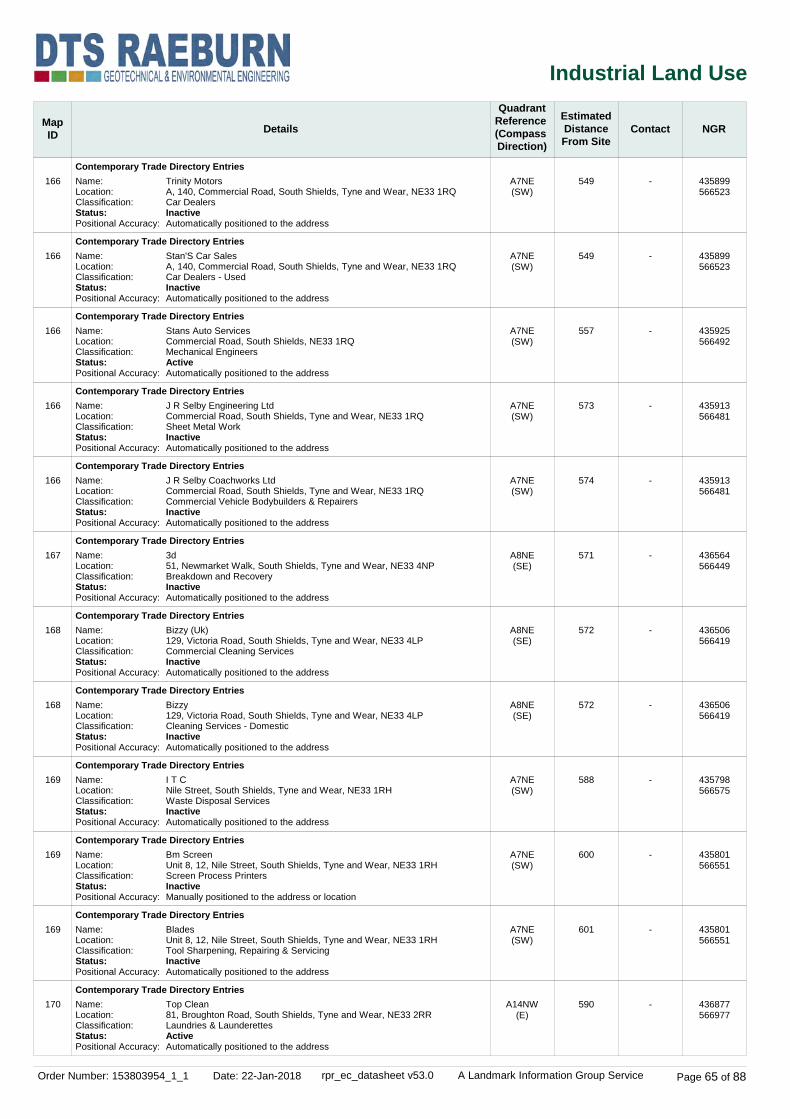
Order Number: 153803954_1_1 Date: 22-Jan-2018 rpr_ec_datasheet v53.0 A Landmark Information Group Service Page 65 of 88
Industrial Land Use
MapID Details
QuadrantReference (Compass Direction)
EstimatedDistanceFrom Site
Contact NGR
166
166
166
166
166
167
168
168
169
169
169
170
Contemporary Trade Directory Entries
Contemporary Trade Directory Entries
Contemporary Trade Directory Entries
Contemporary Trade Directory Entries
Contemporary Trade Directory Entries
Contemporary Trade Directory Entries
Contemporary Trade Directory Entries
Contemporary Trade Directory Entries
Contemporary Trade Directory Entries
Contemporary Trade Directory Entries
Contemporary Trade Directory Entries
Contemporary Trade Directory Entries
A7NE(SW)
A7NE(SW)
A7NE(SW)
A7NE(SW)
A7NE(SW)
A8NE(SE)
A8NE(SE)
A8NE(SE)
A7NE(SW)
A7NE(SW)
A7NE(SW)
A14NW(E)
549
549
557
573
574
571
572
572
588
600
601
590
-
-
-
-
-
-
-
-
-
-
-
-
Name:Location:Classification:Status:Positional Accuracy:
Name:Location:Classification:Status:Positional Accuracy:
Name:Location:Classification:Status:Positional Accuracy:
Name:Location:Classification:Status:Positional Accuracy:
Name:Location:Classification:Status:Positional Accuracy:
Name:Location:Classification:Status:Positional Accuracy:
Name:Location:Classification:Status:Positional Accuracy:
Name:Location:Classification:Status:Positional Accuracy:
Name:Location:Classification:Status:Positional Accuracy:
Name:Location:Classification:Status:Positional Accuracy:
Name:Location:Classification:Status:Positional Accuracy:
Name:Location:Classification:Status:Positional Accuracy:
Trinity MotorsA, 140, Commercial Road, South Shields, Tyne and Wear, NE33 1RQCar DealersInactiveAutomatically positioned to the address
Stan'S Car SalesA, 140, Commercial Road, South Shields, Tyne and Wear, NE33 1RQCar Dealers - UsedInactiveAutomatically positioned to the address
Stans Auto ServicesCommercial Road, South Shields, NE33 1RQMechanical EngineersActiveAutomatically positioned to the address
J R Selby Engineering LtdCommercial Road, South Shields, Tyne and Wear, NE33 1RQSheet Metal WorkInactiveAutomatically positioned to the address
J R Selby Coachworks LtdCommercial Road, South Shields, Tyne and Wear, NE33 1RQCommercial Vehicle Bodybuilders & RepairersInactiveAutomatically positioned to the address
3d51, Newmarket Walk, South Shields, Tyne and Wear, NE33 4NPBreakdown and RecoveryInactiveAutomatically positioned to the address
Bizzy (Uk)129, Victoria Road, South Shields, Tyne and Wear, NE33 4LPCommercial Cleaning ServicesInactiveAutomatically positioned to the address
Bizzy129, Victoria Road, South Shields, Tyne and Wear, NE33 4LPCleaning Services - DomesticInactiveAutomatically positioned to the address
I T CNile Street, South Shields, Tyne and Wear, NE33 1RHWaste Disposal ServicesInactiveAutomatically positioned to the address
Bm ScreenUnit 8, 12, Nile Street, South Shields, Tyne and Wear, NE33 1RHScreen Process PrintersInactiveManually positioned to the address or location
BladesUnit 8, 12, Nile Street, South Shields, Tyne and Wear, NE33 1RHTool Sharpening, Repairing & ServicingInactiveAutomatically positioned to the address
Top Clean81, Broughton Road, South Shields, Tyne and Wear, NE33 2RRLaundries & LaunderettesActiveAutomatically positioned to the address
435899566523
435899566523
435925566492
435913566481
435913566481
436564566449
436506566419
436506566419
435798566575
435801566551
435801566551
436877566977

Order Number: 153803954_1_1 Date: 22-Jan-2018 rpr_ec_datasheet v53.0 A Landmark Information Group Service Page 66 of 88
Industrial Land Use
MapID Details
QuadrantReference (Compass Direction)
EstimatedDistanceFrom Site
Contact NGR
171
171
171
172
173
174
175
175
175
176
176
Contemporary Trade Directory Entries
Contemporary Trade Directory Entries
Contemporary Trade Directory Entries
Contemporary Trade Directory Entries
Contemporary Trade Directory Entries
Contemporary Trade Directory Entries
Contemporary Trade Directory Entries
Contemporary Trade Directory Entries
Contemporary Trade Directory Entries
Contemporary Trade Directory Entries
Contemporary Trade Directory Entries
A9NW(SE)
A9NW(SE)
A9NW(SE)
A7NE(SW)
A8NW(S)
A18SE(NE)
A7NE(SW)
A7NE(SW)
A7NE(SW)
A7NE(SW)
A7NE(SW)
595
613
636
606
625
649
655
663
668
673
699
-
-
-
-
-
-
-
-
-
-
-
Name:Location:Classification:Status:Positional Accuracy:
Name:Location:
Classification:Status:Positional Accuracy:
Name:Location:Classification:Status:Positional Accuracy:
Name:Location:Classification:Status:Positional Accuracy:
Name:Location:Classification:Status:Positional Accuracy:
Name:Location:Classification:Status:Positional Accuracy:
Name:Location:Classification:Status:Positional Accuracy:
Name:Location:Classification:Status:Positional Accuracy:
Name:Location:Classification:Status:Positional Accuracy:
Name:Location:Classification:Status:Positional Accuracy:
Name:Location:Classification:Status:Positional Accuracy:
Motor Vehicle Solutions1, Robinson Street, South Shields, NE33 4PRCar Dealers - UsedActiveAutomatically positioned to the address
Gordon BriggsDomestic Appliance Centre, 87, Westoe Road, South Shields, Tyne and Wear, NE33 4LXDomestic Appliances - Servicing, Repairs & PartsInactiveAutomatically positioned to the address
Walter Metcalfe101, Westoe Road, South Shields, NE33 4LXWallpapers & Wall CoveringsActiveAutomatically positioned to the address
C J PrintRiverside Ho,Commercial Rd, South Shields, Tyne & Wear, NE33 1RWPrintersInactiveManually positioned to the road within the address or location
Decorative Shades 214, New Green Street, SOUTH SHIELDS, Tyne and Wear, NE33 5DLPainting & Decorating SuppliesInactiveAutomatically positioned to the address
Soapsuds147-151, Coston Drive, South Shields, Tyne and Wear, NE33 2DULaundries & LaunderettesInactiveAutomatically positioned to the address
BapsHill Street, South Shields, Tyne and Wear, NE33 1RNPackaging & Wrapping Equipment & SuppliesInactiveAutomatically positioned in the proximity of the address
Charles W Taylor & Son Ltd30 Hill St, South Shields, Tyne & Wear, NE33 1RNFoundriesInactiveManually positioned to the road within the address or location
Cammell LairdHill St, South Shields, Tyne & Wear, NE33 1RNShip Builders, Repairs & FittingsInactiveManually positioned to the road within the address or location
Tyne AutoHill Street, South Shields, Tyne and Wear, NE33 1RNCar Body RepairsInactiveAutomatically positioned to the address
Jennings Of South ShieldsCommercial Road, South Shields, Tyne and Wear, NE33 1RWGarage ServicesInactiveAutomatically positioned to the address
436684566506
436721566516
436724566487
435862566480
436168566318
436593567545
435763566512
435781566480
435765566490
435811566436
435790566421

Order Number: 153803954_1_1 Date: 22-Jan-2018 rpr_ec_datasheet v53.0 A Landmark Information Group Service Page 67 of 88
Industrial Land Use
MapID Details
QuadrantReference (Compass Direction)
EstimatedDistanceFrom Site
Contact NGR
177
178
179
180
180
180
180
180
181
181
182
183
Contemporary Trade Directory Entries
Contemporary Trade Directory Entries
Contemporary Trade Directory Entries
Contemporary Trade Directory Entries
Contemporary Trade Directory Entries
Contemporary Trade Directory Entries
Contemporary Trade Directory Entries
Contemporary Trade Directory Entries
Contemporary Trade Directory Entries
Contemporary Trade Directory Entries
Contemporary Trade Directory Entries
Contemporary Trade Directory Entries
A8SE(S)
A19SW(NE)
A7NE(SW)
A7NE(SW)
A7NE(SW)
A7NE(SW)
A7NE(SW)
A7NE(SW)
A8SW(S)
A8SW(S)
A9NW(SE)
A14NE(E)
699
730
746
747
747
747
747
749
762
791
793
817
-
-
-
-
-
-
-
-
-
-
-
-
Name:Location:Classification:Status:Positional Accuracy:
Name:Location:Classification:Status:Positional Accuracy:
Name:Location:Classification:Status:Positional Accuracy:
Name:Location:Classification:Status:Positional Accuracy:
Name:Location:Classification:Status:Positional Accuracy:
Name:Location:Classification:Status:Positional Accuracy:
Name:Location:Classification:Status:Positional Accuracy:
Name:Location:Classification:Status:Positional Accuracy:
Name:Location:Classification:Status:Positional Accuracy:
Name:Location:Classification:Status:Positional Accuracy:
Name:Location:Classification:Status:Positional Accuracy:
Name:Location:Classification:Status:Positional Accuracy:
Steward Site Engineering Ltd28, Frost Mews, South Shields, Tyne and Wear, NE33 4ALAgricultural EngineersInactiveAutomatically positioned to the address
Jadnet Designs26, Roman Road, South Shields, Tyne and Wear, NE33 2HAT-ShirtsInactiveAutomatically positioned to the address
Peterson Printers12, Laygate, South Shields, Tyne and Wear, NE33 5RPPrintersInactiveAutomatically positioned to the address
Garage & Recovery6, Laygate, South Shields, Tyne and Wear, NE33 1SHGarage ServicesInactiveAutomatically positioned to the address
Mvh Motors6, Laygate, South Shields, Tyne and Wear, NE33 1SHGarage ServicesInactiveAutomatically positioned to the address
D M Auto Services6, Laygate, South Shields, Tyne and Wear, NE33 1SHMechanical EngineersInactiveAutomatically positioned to the address
Premier Motor Co6, Laygate, South Shields, Tyne and Wear, NE33 1SHCar Dealers - UsedInactiveManually positioned to the address or location
John Nicol Fabrications4, Laygate, South Shields, Tyne and Wear, NE33 1SHMetal Products - FabricatedActiveAutomatically positioned to the address
Community Design & Print9-13, Frederick Street, South Shields, Tyne and Wear, NE33 5DYPhotocopiersInactiveAutomatically positioned to the address
Buyproducts17, Frederick Street, South Shields, Tyne and Wear, NE33 5DYHardwareInactiveAutomatically positioned to the address
Westoe Electricals1, Madeira Terrace, South Shields, Tyne and Wear, NE33 3AQElectrical EngineersInactiveAutomatically positioned to the address
Domestic Appliance Repairs29, Seaview Terrace, SOUTH SHIELDS, Tyne and Wear, NE33 2NWDomestic Appliances - Servicing, Repairs & PartsInactiveAutomatically positioned to the address
436463566267
436783567498
435883566293
435835566323
435835566323
435835566323
435835566323
435829566325
436123566186
436117566159
436816566358
437042567263

Order Number: 153803954_1_1 Date: 22-Jan-2018 rpr_ec_datasheet v53.0 A Landmark Information Group Service Page 68 of 88
Industrial Land Use
MapID Details
QuadrantReference (Compass Direction)
EstimatedDistanceFrom Site
Contact NGR
183
184
185
185
185
186
187
188
189
190
190
190
Contemporary Trade Directory Entries
Contemporary Trade Directory Entries
Contemporary Trade Directory Entries
Contemporary Trade Directory Entries
Contemporary Trade Directory Entries
Contemporary Trade Directory Entries
Contemporary Trade Directory Entries
Contemporary Trade Directory Entries
Contemporary Trade Directory Entries
Contemporary Trade Directory Entries
Contemporary Trade Directory Entries
Contemporary Trade Directory Entries
A14NE(E)
A8SW(S)
A9SW(SE)
A9SW(SE)
A9SW(SE)
A8SW(S)
A8SE(S)
A9NE(SE)
A18NE(N)
A18NW(N)
A18NW(N)
A18NW(N)
817
827
847
849
849
849
853
855
860
861
895
895
-
-
-
-
-
-
-
-
-
-
-
-
Name:Location:Classification:Status:Positional Accuracy:
Name:Location:Classification:Status:Positional Accuracy:
Name:Location:Classification:Status:Positional Accuracy:
Name:Location:Classification:Status:Positional Accuracy:
Name:Location:Classification:Status:Positional Accuracy:
Name:Location:Classification:Status:Positional Accuracy:
Name:Location:Classification:Status:Positional Accuracy:
Name:Location:Classification:Status:Positional Accuracy:
Name:Location:Classification:Status:Positional Accuracy:
Name:Location:Classification:Status:Positional Accuracy:
Name:Location:Classification:Status:Positional Accuracy:
Name:Location:Classification:Status:Positional Accuracy:
Domestic Appliance Repairs29, Seaview Terrace, SOUTH SHIELDS, Tyne and Wear, NE33 2NWDomestic Appliances - Servicing, Repairs & PartsActiveAutomatically positioned to the address
Timber Line (Diy) Ltd38, Frederick Street, South Shields, Tyne and Wear, NE33 5EAFencing ManufacturersInactiveAutomatically positioned to the address
Merry Maids130, Westoe Road, South Shields, NE33 3PFCleaning Services - DomesticActiveAutomatically positioned to the address
Merry Maids130, Westoe Road, South Shields, Tyne and Wear, NE33 3PFCleaning Services - DomesticInactiveAutomatically positioned to the address
Servicemaster Contract Services130, Westoe Road, South Shields, Tyne and Wear, NE33 3PFCommercial Cleaning ServicesInactiveAutomatically positioned to the address
Kwik Fit132, Laygate, South Shields, Tyne and Wear, NE33 4JDTyre DealersActiveAutomatically positioned to the address
Aquila SystemsAquila House, 283, Laygate, SOUTH SHIELDS, Tyne and Wear, NE33 4QNComputer ManufacturersActiveAutomatically positioned to the address
Osbrown Engineering Services Ltd21, Osborne Avenue, South Shields, Tyne and Wear, NE33 3DQMechanical EngineersInactiveAutomatically positioned to the address
Able Handyman & Decorating Services25, Trajan Street, South Shields, NE33 2AWGlass Fibre ManufacturersActiveAutomatically positioned to the address
Sealane Inshore LtdWapping Street, South Shields, Tyne and Wear, NE33 1LQMarine Engineering Equipment ManufacturersInactiveAutomatically positioned to the address
North East Maritime Trust2, Wapping Street, SOUTH SHIELDS, Tyne and Wear, NE33 1LQBoatbuilders & RepairersActiveAutomatically positioned to the address
Funky Chunky Furniture1, Wapping Street, South Shields, Tyne and Wear, NE33 1LQFurniture Manufacturers - Home & OfficeInactiveAutomatically positioned to the address
437042567263
436070566132
436809566282
436807566278
436807566278
436262566087
436333566086
436969566431
436573567788
435943567786
435965567830
435965567830

Order Number: 153803954_1_1 Date: 22-Jan-2018 rpr_ec_datasheet v53.0 A Landmark Information Group Service Page 69 of 88
Industrial Land Use
MapID Details
QuadrantReference (Compass Direction)
EstimatedDistanceFrom Site
Contact NGR
191
192
193
194
195
196
196
196
196
196
196
Contemporary Trade Directory Entries
Contemporary Trade Directory Entries
Contemporary Trade Directory Entries
Contemporary Trade Directory Entries
Contemporary Trade Directory Entries
Contemporary Trade Directory Entries
Contemporary Trade Directory Entries
Contemporary Trade Directory Entries
Contemporary Trade Directory Entries
Contemporary Trade Directory Entries
Contemporary Trade Directory Entries
A7SE(SW)
A8SW(S)
A19NW(NE)
A19NW(NE)
A9SW(SE)
A7SE(SW)
A7SE(SW)
A7SE(SW)
A7SE(SW)
A7SE(SW)
A7SE(SW)
867
869
875
884
900
928
928
928
928
933
941
-
-
-
-
-
-
-
-
-
-
-
Name:Location:
Classification:Status:Positional Accuracy:
Name:Location:Classification:Status:Positional Accuracy:
Name:Location:Classification:Status:Positional Accuracy:
Name:Location:Classification:Status:Positional Accuracy:
Name:Location:Classification:Status:Positional Accuracy:
Name:Location:Classification:Status:Positional Accuracy:
Name:Location:Classification:Status:Positional Accuracy:
Name:Location:Classification:Status:Positional Accuracy:
Name:Location:Classification:Status:Positional Accuracy:
Name:Location:
Classification:Status:Positional Accuracy:
Name:Location:Classification:Status:Positional Accuracy:
Scrap Cars Vans Caravans BuyerEldon House, Rekendyke Industrial Estate, South Shields, Tyne and Wear, NE33 5BZCar Breakers & DismantlersInactiveAutomatically positioned to the address
Plastic Cladding Centre45, Frederick Street, South Shields, NE33 5DYBuilders' MerchantsActiveAutomatically positioned to the address
Susan Hawes Design26, Lawe Road, South Shields, Tyne and Wear, NE33 2EXWallpapers & Wall CoveringsInactiveAutomatically positioned to the address
Four Seasons36, Trajan Avenue, South Shields, Tyne and Wear, NE33 2ANCarpet, Curtain & Upholstery CleanersInactiveAutomatically positioned to the address
Bizzy Uk Cleaning Services146 Westoe Rd, South Shields, Tyne & Wear, NE33 3PHCleaning Services - CommercialInactiveManually positioned to the address or location
Hedley (Engineering Services) LtdHavelock Street, South Shields, Tyne and Wear, NE33 5DZEngineers - GeneralInactiveAutomatically positioned to the address
Eldon Street Factory TheEldon Street, South Shields, Tyne and Wear, NE33 5BUClothing & Fabrics - ManufacturersInactiveAutomatically positioned to the address
CircatexEldon Street, South Shields, Tyne and Wear, NE33 5BUPrinted Circuit ManufacturersInactiveAutomatically positioned to the address
Punjab KitchenEldon Street, South Shields, Tyne and Wear, NE33 5BUFood Products - ManufacturersActiveAutomatically positioned to the address
East Coast Fibreglass SuppliesEast Coast Fibreglass Supplies Ltd, West Walpole Street, South Shields, NE33 5BYGlass Fibre Moulding, Materials & ManufacturersActiveAutomatically positioned to the address
Hi-Spec CompositesWest Walpole Street, South Shields, Tyne and Wear, NE33 5BYGlass Fibre ManufacturersActiveAutomatically positioned to the address
435877566159
436097566083
436848567636
436628567791
436836566236
435816566122
435816566122
435816566122
435816566122
435841566103
435842566094

Order Number: 153803954_1_1 Date: 22-Jan-2018 rpr_ec_datasheet v53.0 A Landmark Information Group Service Page 70 of 88
Industrial Land Use
MapID Details
QuadrantReference (Compass Direction)
EstimatedDistanceFrom Site
Contact NGR
196
196
197
197
197
198
198
199
200
201
202
Contemporary Trade Directory Entries
Contemporary Trade Directory Entries
Contemporary Trade Directory Entries
Contemporary Trade Directory Entries
Contemporary Trade Directory Entries
Contemporary Trade Directory Entries
Contemporary Trade Directory Entries
Contemporary Trade Directory Entries
Contemporary Trade Directory Entries
Contemporary Trade Directory Entries
Contemporary Trade Directory Entries
A7SE(SW)
A7SE(SW)
A8SW(S)
A8SW(S)
A8SW(S)
A18NW(N)
A18NW(N)
A7SE(SW)
A7SE(S)
A19NW(NE)
A7SE(SW)
948
959
938
940
959
939
946
954
973
982
986
-
-
-
-
-
-
-
-
-
-
-
Name:Location:
Classification:Status:Positional Accuracy:
Name:Location:Classification:Status:Positional Accuracy:
Name:Location:Classification:Status:Positional Accuracy:
Name:Location:Classification:Status:Positional Accuracy:
Name:Location:Classification:Status:Positional Accuracy:
Name:Location:Classification:Status:Positional Accuracy:
Name:Location:Classification:Status:Positional Accuracy:
Name:Location:Classification:Status:Positional Accuracy:
Name:Location:
Classification:Status:Positional Accuracy:
Name:Location:Classification:Status:Positional Accuracy:
Name:Location:Classification:Status:Positional Accuracy:
C-Tech North EastUnit 2, Rekendyke Industrial Estate, South Shields, Tyne and Wear, NE33 5BZCommercial Cleaning ServicesInactiveManually positioned to the address or location
Hi SpecWest Walpole St, South Shields, Tyne And Wear, NE33 5BYMould ManufacturersInactiveManually positioned to the road within the address or location
Newcoats77, Frederick Street, South Shields, Tyne and Wear, NE33 5EDPlaster Manufacturers & SuppliersInactiveAutomatically positioned to the address
New Coates77 Frederick St, South Shields, Tyne and Wear, NE33 5EDPlaster Manufacturers & SuppliersInactiveAutomatically positioned to the address
The Creations Workshop89, Frederick Street, SOUTH SHIELDS, Tyne and Wear, NE33 5EDWrought IronworkInactiveAutomatically positioned to the address
Can'T Stop Won'T Stop Cleaning ServicesWapping St, South Shields, Tyne And Wear, NE33 1LQCleaning Services - DomesticInactiveManually positioned within the geographical locality
Northeast Engineering & Supply Co LtdWapping St, South Shields, Tyne & Wear, NE33 1LQMarine EngineersInactiveManually positioned to the road within the address or location
Select Car Centre N E LtdCommercial Road, South Shields, NE33 1RWCar Dealers - UsedActiveAutomatically positioned to the address
General Laboratory ServicesUnit 1b, Rekendyke Industrial Estate, South Shields, Tyne and Wear, NE33 5BZSheet Metal WorkInactiveAutomatically positioned to the address
Atex Inspections Ltd62, Lawe Road, South Shields, Tyne and Wear, NE33 2ALEngineering ServicesActiveAutomatically positioned to the address
Tyne & Wear AccessPlot C Portberry Way, South Shields, Tyne and Wear, NE33 1SBScaffolding & Work PlatformsActiveManually positioned to the road within the address or location
435802566107
435830566079
436097566013
436087566012
436092565992
436003567889
436046567907
435657566198
435887566038
436664567883
435690566132

Order Number: 153803954_1_1 Date: 22-Jan-2018 rpr_ec_datasheet v53.0 A Landmark Information Group Service Page 71 of 88
Industrial Land Use
MapID Details
QuadrantReference (Compass Direction)
EstimatedDistanceFrom Site
Contact NGR
203
204
205
206
207
207
207
207
207
208
208
Contemporary Trade Directory Entries
Fuel Station Entries
Fuel Station Entries
Points of Interest - Commercial Services
Points of Interest - Commercial Services
Points of Interest - Commercial Services
Points of Interest - Commercial Services
Points of Interest - Commercial Services
Points of Interest - Commercial Services
Points of Interest - Commercial Services
Points of Interest - Commercial Services
A9NE(SE)
A13NE(NE)
A13SE(SE)
A13SW(SW)
A13SE(E)
A13SE(E)
A13SE(E)
A13SE(SE)
A13SE(SE)
A13NE(E)
A13NE(E)
993
51
260
17
67
67
67
132
137
122
122
-
-
-
9
9
9
9
9
9
9
9
Name:Location:Classification:Status:Positional Accuracy:
Name:Location:Brand:Premises Type:Status:Positional Accuracy:
Name:Location:Brand:Premises Type:Status:Positional Accuracy:
Name:Location:Category:Class Code:Positional Accuracy:
Name:Location:Category:Class Code:Positional Accuracy:
Name:Location:Category:Class Code:Positional Accuracy:
Name:Location:Category:Class Code:Positional Accuracy:
Name:Location:Category:Class Code:Positional Accuracy:
Name:Location:Category:Class Code:Positional Accuracy:
Name:Location:Category:Class Code:Positional Accuracy:
Name:Location:Category:Class Code:Positional Accuracy:
Intertank Services16, Mowbray Road, South Shields, Tyne and Wear, NE33 3AUTank Cleaning & RepairingActiveAutomatically positioned to the address
Garden Lane Service StationGarden Lane, South SHIELDS, Tyne & Wear, NE33 1PSObsoleteNot ApplicableObsoleteManually positioned to the address or location
Rss Town HallCross Gate, South Shields, Tyne & Wear, NE33 5QXEssoPetrol StationOpenManually positioned to the address or location
Scrap YardNot SuppliedRecycling ServicesScrap Metal MerchantsPositioned to an adjacent address or location
Automotive Maintenance Co4 Forest Rd, South Shields, Tyne And Wear, NE33 1PTRepair and ServicingVehicle Repair, Testing and ServicingPositioned to address or location
Vechicle Diagnostics4 Forest Rd, South Shields, Tyne And Wear, NE33 1PTRepair and ServicingVehicle Repair, Testing and ServicingPositioned to address or location
Vechicle Diagnostics4 Forest Road, South Shields, Tyne And Wear, NE33 1PTRepair and ServicingVehicle Repair, Testing and ServicingPositioned to address or location
South Tyneside Coachworks62 Garden Lane, South Shields, NE33 1PSRepair and ServicingVehicle Repair, Testing and ServicingPositioned to address or location
A C Wrought IronUnit 3, 62 Garden Lane, South Shields, Tyne And Wear, NE33 1PSConstruction ServicesMetalworkers Including BlacksmithsPositioned to address or location
Vehicle Tyre Services Ltd12 Franklin Street, South Shields, NE33 1PRRepair and ServicingVehicle Repair, Testing and ServicingPositioned to address or location
Vts12 Franklin Street, South Shields, NE33 1PRRepair and ServicingVehicle Repair, Testing and ServicingPositioned to address or location
437038566299
436297567023
436508566812
436242566938
436355566952
436355566952
436355566952
436401566881
436408566884
436408566967
436408566967
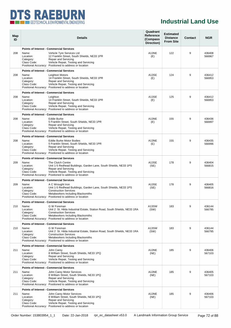
Order Number: 153803954_1_1 Date: 22-Jan-2018 rpr_ec_datasheet v53.0 A Landmark Information Group Service Page 72 of 88
Industrial Land Use
MapID Details
QuadrantReference (Compass Direction)
EstimatedDistanceFrom Site
Contact NGR
208
208
208
208
208
209
209
210
210
211
211
211
Points of Interest - Commercial Services
Points of Interest - Commercial Services
Points of Interest - Commercial Services
Points of Interest - Commercial Services
Points of Interest - Commercial Services
Points of Interest - Commercial Services
Points of Interest - Commercial Services
Points of Interest - Commercial Services
Points of Interest - Commercial Services
Points of Interest - Commercial Services
Points of Interest - Commercial Services
Points of Interest - Commercial Services
A13NE(E)
A13SE(E)
A13SE(E)
A13NE(E)
A13NE(E)
A13SE(SE)
A13SE(SE)
A13SW(SW)
A13SW(SW)
A13NE(NE)
A13NE(NE)
A13NE(NE)
122
124
125
155
155
178
178
183
183
185
185
185
9
9
9
9
9
9
9
9
9
9
9
9
Name:Location:Category:Class Code:Positional Accuracy:
Name:Location:Category:Class Code:Positional Accuracy:
Name:Location:Category:Class Code:Positional Accuracy:
Name:Location:Category:Class Code:Positional Accuracy:
Name:Location:Category:Class Code:Positional Accuracy:
Name:Location:Category:Class Code:Positional Accuracy:
Name:Location:Category:Class Code:Positional Accuracy:
Name:Location:Category:Class Code:Positional Accuracy:
Name:Location:Category:Class Code:Positional Accuracy:
Name:Location:Category:Class Code:Positional Accuracy:
Name:Location:Category:Class Code:Positional Accuracy:
Name:Location:Category:Class Code:Positional Accuracy:
Vehicle Tyre Services Ltd12 Franklin Street, South Shields, NE33 1PRRepair and ServicingVehicle Repair, Testing and ServicingPositioned to address or location
Leighton Motors14 Franklin Street, South Shields, NE33 1PRRepair and ServicingVehicle Repair, Testing and ServicingPositioned to address or location
Leighton14 Franklin Street, South Shields, NE33 1PRRepair and ServicingVehicle Repair, Testing and ServicingPositioned to address or location
Eddie Burke5 Franklin Street, South Shields, NE33 1PRRepair and ServicingVehicle Repair, Testing and ServicingPositioned to address or location
Eddie Burke Motor Bodies5 Franklin Street, South Shields, NE33 1PRRepair and ServicingVehicle Repair, Testing and ServicingPositioned to address or location
The Clutch CentreUnit 1-5 Redhead Buildings, Garden Lane, South Shields, NE33 1PSRepair and ServicingVehicle Repair, Testing and ServicingPositioned to address or location
A C Wrought IronUnit 1-5 Redhead Buildings, Garden Lane, South Shields, NE33 1PSConstruction ServicesMetalworkers Including BlacksmithsPositioned to address or location
G W ForemanUnit 2 St. Hilda Industrial Estate, Station Road, South Shields, NE33 1RAConstruction ServicesMetalworkers Including BlacksmithsPositioned to address or location
G W ForemanUnit 2 St. Hilda Industrial Estate, Station Road, South Shields, NE33 1RAConstruction ServicesMetalworkers Including BlacksmithsPositioned to address or location
John Carey8 William Street, South Shields, NE33 1PQRepair and ServicingVehicle Repair, Testing and ServicingPositioned to address or location
John Carey Motor Services8 William Street, South Shields, NE33 1PQRepair and ServicingVehicle Repair, Testing and ServicingPositioned to address or location
John Carey Motor Services8 William Street, South Shields, NE33 1PQRepair and ServicingVehicle Repair, Testing and ServicingPositioned to address or location
436408566967
436412566953
436412566953
436436566997
436435566996
436404566815
436405566816
436144566795
436144566795
436406567103
436405567103
436406567103

Order Number: 153803954_1_1 Date: 22-Jan-2018 rpr_ec_datasheet v53.0 A Landmark Information Group Service Page 73 of 88
Industrial Land Use
MapID Details
QuadrantReference (Compass Direction)
EstimatedDistanceFrom Site
Contact NGR
212
213
213
214
214
215
215
215
215
215
215
215
Points of Interest - Commercial Services
Points of Interest - Commercial Services
Points of Interest - Commercial Services
Points of Interest - Commercial Services
Points of Interest - Commercial Services
Points of Interest - Commercial Services
Points of Interest - Commercial Services
Points of Interest - Commercial Services
Points of Interest - Commercial Services
Points of Interest - Commercial Services
Points of Interest - Commercial Services
Points of Interest - Commercial Services
A13SW(SW)
A13SE(S)
A8NE(S)
A8NW(SW)
A8NW(S)
A8NE(S)
A8NE(S)
A8NE(S)
A8NE(S)
A8NE(S)
A8NE(S)
A8NE(S)
253
311
355
400
438
426
437
452
452
452
478
491
9
9
9
9
9
9
9
9
9
9
9
9
Name:Location:Category:Class Code:Positional Accuracy:
Name:Location:Category:Class Code:Positional Accuracy:
Name:Location:Category:Class Code:Positional Accuracy:
Name:Location:Category:Class Code:Positional Accuracy:
Name:Location:Category:Class Code:Positional Accuracy:
Name:Location:Category:Class Code:Positional Accuracy:
Name:Location:Category:Class Code:Positional Accuracy:
Name:Location:Category:Class Code:Positional Accuracy:
Name:Location:Category:Class Code:Positional Accuracy:
Name:Location:Category:Class Code:Positional Accuracy:
Name:Location:Category:Class Code:Positional Accuracy:
Name:Location:Category:Class Code:Positional Accuracy:
Halfords AutocentreStation Road, Millbank, South Shields, NE33 1RDRepair and ServicingVehicle Repair, Testing and ServicingPositioned to address or location
Car Electrical UK Ltd5 Maxwell Street, South Shields, NE33 4PURepair and ServicingVehicle Repair, Testing and ServicingPositioned to address or location
N P S Services14 Maxwell Street, South Shields, NE33 4PUConstruction ServicesMetalworkers Including BlacksmithsPositioned to address or location
Automotive Maintenance CoUnit 2 Amna Buildings, Tudor Road, South Shields, NE33 4PQRepair and ServicingVehicle Repair, Testing and ServicingPositioned to address or location
Harkers M O TTudor Road, South Shields, NE33 4PQRepair and ServicingVehicle Repair, Testing and ServicingPositioned to address or location
Performance Cars Ltd28-30 Maxwell Street, South Shields, NE33 4PURepair and ServicingVehicle Repair, Testing and ServicingPositioned to address or location
Performance Cars29-35 Maxwell Street, South Shields, NE33 4PURepair and ServicingVehicle Repair, Testing and ServicingPositioned to address or location
Total Detailing International32-36 Maxwell Street, South Shields, NE33 4PUPersonal, Consumer and other ServicesVehicle Cleaning ServicesPositioned to address or location
Maxwell Street Motors32 Maxwell Street, South Shields, NE33 4PURepair and ServicingVehicle Repair, Testing and ServicingPositioned to address or location
Maxwell Street Motors32-36 Maxwell Street, South Shields, NE33 4PURepair and ServicingVehicle Repair, Testing and ServicingPositioned to address or location
Gary Tuck Workshops Ltd37-38 Maxwell Street, South Shields, NE33 4PURepair and ServicingVehicle Repair, Testing and ServicingPositioned to address or location
Car Cosmetics-Graphics Sunroofs39 Maxwell Street, South Shields, NE33 4PURepair and ServicingVehicle Repair, Testing and ServicingPositioned to address or location
436040566815
436337566634
436334566589
436100566570
436128566519
436337566516
436371566513
436331566489
436332566490
436331566489
436364566469
436364566455

Order Number: 153803954_1_1 Date: 22-Jan-2018 rpr_ec_datasheet v53.0 A Landmark Information Group Service Page 74 of 88
Industrial Land Use
MapID Details
QuadrantReference (Compass Direction)
EstimatedDistanceFrom Site
Contact NGR
215
215
215
215
215
216
216
216
216
217
217
218
Points of Interest - Commercial Services
Points of Interest - Commercial Services
Points of Interest - Commercial Services
Points of Interest - Commercial Services
Points of Interest - Commercial Services
Points of Interest - Commercial Services
Points of Interest - Commercial Services
Points of Interest - Commercial Services
Points of Interest - Commercial Services
Points of Interest - Commercial Services
Points of Interest - Commercial Services
Points of Interest - Commercial Services
A8NE(S)
A8NE(S)
A8NE(S)
A8NE(S)
A8NE(S)
A8NW(SW)
A8NW(SW)
A7NE(SW)
A7NE(SW)
A14NW(E)
A14NW(E)
A9NW(SE)
524
524
527
527
527
492
492
556
573
556
556
676
9
9
9
9
9
9
9
9
9
9
9
9
Name:Location:Category:Class Code:Positional Accuracy:
Name:Location:Category:Class Code:Positional Accuracy:
Name:Location:Category:Class Code:Positional Accuracy:
Name:Location:Category:Class Code:Positional Accuracy:
Name:Location:Category:Class Code:Positional Accuracy:
Name:Location:Category:Class Code:Positional Accuracy:
Name:Location:Category:Class Code:Positional Accuracy:
Name:Location:Category:Class Code:Positional Accuracy:
Name:Location:Category:Class Code:Positional Accuracy:
Name:Location:Category:Class Code:Positional Accuracy:
Name:Location:Category:Class Code:Positional Accuracy:
Name:Location:Category:Class Code:Positional Accuracy:
S M H Products Ltd29-35 Maxwell Street, South Shields, NE33 4PURecycling ServicesRecycling, Reclamation and DisposalPositioned to address or location
Bills Motor Services29-35 Maxwell Street, South Shields, NE33 4PURepair and ServicingVehicle Repair, Testing and ServicingPositioned to address or location
Milburns Services Ltd43 Maxwell Street, South Shields, NE33 4PURecycling ServicesRecycling, Reclamation and DisposalPositioned to address or location
Milburn Services Ltd43 Maxwell Street, South Shields, NE33 4PURecycling ServicesRecycling, Reclamation and DisposalPositioned to address or location
Milburn Services Ltd43 Maxwell Street, South Shields, NE33 4PURecycling ServicesRecycling, Reclamation and DisposalPositioned to address or location
Osborne Motor Transport LtdCommercial Road, South Shields, NE33 1RQTransport, Storage and DeliveryDistribution and HaulagePositioned to address or location
Osborne Motor Transport LtdCommercial Road, South Shields, NE33 1RQTransport, Storage and DeliveryDistribution and HaulagePositioned to address or location
Stans Auto Services140 Commercial Road, South Shields, NE33 1RQRepair and ServicingVehicle Repair, Testing and ServicingPositioned to address or location
J R Selby Engineering LtdCommercial Road, South Shields, NE33 1RQConstruction ServicesMetalworkers Including BlacksmithsPositioned to address or location
L A Autos57 Beach Road, South Shields, NE33 2QURepair and ServicingVehicle Repair, Testing and ServicingPositioned to address or location
L A Autos57 Beach Road, South Shields, NE33 2QURepair and ServicingVehicle Repair, Testing and ServicingPositioned to address or location
IMO - arc Clean Car CentresChichester Road, South Shields, NE33 4HNPersonal, Consumer and other ServicesVehicle Cleaning ServicesPositioned to address or location
436327566416
436327566416
436365566419
436365566419
436365566419
435968566541
435968566541
435896566517
435913566481
436832567062
436832567061
436694566409

Order Number: 153803954_1_1 Date: 22-Jan-2018 rpr_ec_datasheet v53.0 A Landmark Information Group Service Page 75 of 88
Industrial Land Use
MapID Details
QuadrantReference (Compass Direction)
EstimatedDistanceFrom Site
Contact NGR
219
220
220
221
221
222
222
223
223
224
225
226
Points of Interest - Commercial Services
Points of Interest - Commercial Services
Points of Interest - Commercial Services
Points of Interest - Commercial Services
Points of Interest - Commercial Services
Points of Interest - Commercial Services
Points of Interest - Commercial Services
Points of Interest - Commercial Services
Points of Interest - Commercial Services
Points of Interest - Commercial Services
Points of Interest - Commercial Services
Points of Interest - Education and Health
A19SW(NE)
A7NE(SW)
A7NE(SW)
A7NE(SW)
A7NE(SW)
A8SE(S)
A8SE(S)
A8SW(S)
A8SE(S)
A8SW(S)
A7SE(S)
A13NE(N)
678
699
699
749
749
799
799
850
878
959
973
290
9
9
9
9
9
9
9
9
9
9
9
9
Name:Location:Category:Class Code:Positional Accuracy:
Name:Location:Category:Class Code:Positional Accuracy:
Name:Location:Category:Class Code:Positional Accuracy:
Name:Location:Category:Class Code:Positional Accuracy:
Name:Location:Category:Class Code:Positional Accuracy:
Name:Location:Category:Class Code:Positional Accuracy:
Name:Location:Category:Class Code:Positional Accuracy:
Name:Location:Category:Class Code:Positional Accuracy:
Name:Location:Category:Class Code:Positional Accuracy:
Name:Location:Category:Class Code:Positional Accuracy:
Name:Location:Category:Class Code:Positional Accuracy:
Name:Location:Category:Class Code:Positional Accuracy:
M H Autoservice Ltd154 Ocean Road, South Shields, NE33 2JFRepair and ServicingVehicle Repair, Testing and ServicingPositioned to address or location
Jennings of South ShieldsCommercial Road, South Shields, NE33 1RWRepair and ServicingVehicle Repair, Testing and ServicingPositioned to address or location
Jennings of South ShieldsCommercial Road, South Shields, NE33 1RWRepair and ServicingVehicle Repair, Testing and ServicingPositioned to address or location
John Nicol4 Laygate, South Shields, NE33 1SHConstruction ServicesMetalworkers Including BlacksmithsPositioned to address or location
John Nicol Fabrications4 Laygate, South Shields, NE33 1SHConstruction ServicesMetalworkers Including BlacksmithsPositioned to address or location
Scrap YardNot SuppliedRecycling ServicesScrap Metal MerchantsPositioned to an adjacent address or location
Scrap YardNE33Recycling ServicesScrap Metal MerchantsPositioned to address or location
Kwik-Fit (GB) Limited132 Laygate, South Shields, NE33 4JDRepair and ServicingVehicle Repair, Testing and ServicingPositioned to address or location
Kwik-Fit (GB) Limited134 Laygate, South Shields, NE33 4JDRepair and ServicingVehicle Repair, Testing and ServicingPositioned to address or location
Creations Workshop89 Frederick Street, South Shields, NE33 5EDConstruction ServicesMetalworkers Including BlacksmithsPositioned to address or location
General Laboratory ServicesUnit 1b, Rekendyke Industrial Estate, South Shields, NE33 5BZConstruction ServicesMetalworkers Including BlacksmithsPositioned to address or location
Edinburgh BuildingsEdinburgh Buildings 2, Station Approach, South Shields, NE33 1HRHealth Practitioners and EstablishmentsHospitalsPositioned to address or location
436797567403
435790566421
435790566421
435829566325
435829566325
436487566169
436488566170
436261566086
436282566058
436092565992
435887566038
436346567264

Order Number: 153803954_1_1 Date: 22-Jan-2018 rpr_ec_datasheet v53.0 A Landmark Information Group Service Page 76 of 88
Industrial Land Use
MapID Details
QuadrantReference (Compass Direction)
EstimatedDistanceFrom Site
Contact NGR
227
228
228
228
229
229
229
229
230
231
231
231
Points of Interest - Manufacturing and Production
Points of Interest - Manufacturing and Production
Points of Interest - Manufacturing and Production
Points of Interest - Manufacturing and Production
Points of Interest - Manufacturing and Production
Points of Interest - Manufacturing and Production
Points of Interest - Manufacturing and Production
Points of Interest - Manufacturing and Production
Points of Interest - Manufacturing and Production
Points of Interest - Manufacturing and Production
Points of Interest - Manufacturing and Production
Points of Interest - Manufacturing and Production
A13SE(SE)
A13SE(S)
A13SE(S)
A13SW(S)
A13SE(SE)
A13SE(SE)
A13SE(SE)
A13SE(SE)
A13SW(SW)
A12SE(SW)
A12SE(SW)
A12SE(SW)
74
88
106
146
128
135
195
198
291
436
446
490
9
9
9
9
9
9
9
9
9
9
9
9
Name:Location:Category:Class Code:Positional Accuracy:
Name:Location:Category:Class Code:Positional Accuracy:
Name:Location:Category:Class Code:Positional Accuracy:
Name:Location:Category:Class Code:Positional Accuracy:
Name:Location:Category:Class Code:Positional Accuracy:
Name:Location:Category:Class Code:Positional Accuracy:
Name:Location:Category:Class Code:Positional Accuracy:
Name:Location:Category:Class Code:Positional Accuracy:
Name:Location:Category:Class Code:Positional Accuracy:
Name:Location:Category:Class Code:Positional Accuracy:
Name:Location:Category:Class Code:Positional Accuracy:
Name:Location:Category:Class Code:Positional Accuracy:
Forest Road Industrial EstateNE33Industrial FeaturesBusiness Parks and Industrial EstatesPositioned to an adjacent address or location
Tedco Business WorksNE33Industrial FeaturesUnspecified Works Or FactoriesPositioned to an adjacent address or location
Tedco Business WorksNot SuppliedIndustrial FeaturesUnspecified Works Or FactoriesPositioned to an adjacent address or location
St Hilda Industrial EstateNE33Industrial FeaturesBusiness Parks and Industrial EstatesPositioned to an adjacent address or location
FactoryNE33Industrial FeaturesUnspecified Works Or FactoriesPositioned to address or location
FactoryNot SuppliedIndustrial FeaturesUnspecified Works Or FactoriesPositioned to an adjacent address or location
FactoryNot SuppliedIndustrial FeaturesUnspecified Works Or FactoriesPositioned to an adjacent address or location
FactoryNE33Industrial FeaturesUnspecified Works Or FactoriesPositioned to address or location
Millbank Industrial EstateNE33Industrial FeaturesBusiness Parks and Industrial EstatesPositioned to an adjacent address or location
FactoryNot SuppliedIndustrial FeaturesUnspecified Works Or FactoriesPositioned to an adjacent address or location
FactoryNE33Industrial FeaturesUnspecified Works Or FactoriesPositioned to address or location
WorksNE33Industrial FeaturesUnspecified Works Or FactoriesPositioned to an adjacent address or location
436337566894
436269566848
436281566832
436228566794
436405566898
436410566892
436462566863
436463566857
436025566766
435911566677
435902566672
435872566639

Order Number: 153803954_1_1 Date: 22-Jan-2018 rpr_ec_datasheet v53.0 A Landmark Information Group Service Page 77 of 88
Industrial Land Use
MapID Details
QuadrantReference (Compass Direction)
EstimatedDistanceFrom Site
Contact NGR
231
232
233
234
235
235
236
237
237
237
237
238
Points of Interest - Manufacturing and Production
Points of Interest - Manufacturing and Production
Points of Interest - Manufacturing and Production
Points of Interest - Manufacturing and Production
Points of Interest - Manufacturing and Production
Points of Interest - Manufacturing and Production
Points of Interest - Manufacturing and Production
Points of Interest - Manufacturing and Production
Points of Interest - Manufacturing and Production
Points of Interest - Manufacturing and Production
Points of Interest - Manufacturing and Production
Points of Interest - Manufacturing and Production
A12SE(SW)
A14SW(SE)
A8NE(S)
A8NE(S)
A7NE(SW)
A7NE(SW)
A9NW(SE)
A7NE(SW)
A7NE(SW)
A7SE(SW)
A7SE(SW)
A8SW(S)
494
462
513
514
564
604
646
751
751
801
805
755
9
9
9
9
9
9
9
9
9
9
9
9
Name:Location:Category:Class Code:Positional Accuracy:
Name:Location:Category:Class Code:Positional Accuracy:
Name:Location:Category:Class Code:Positional Accuracy:
Name:Location:Category:Class Code:Positional Accuracy:
Name:Location:Category:Class Code:Positional Accuracy:
Name:Location:Category:Class Code:Positional Accuracy:
Name:Location:Category:Class Code:Positional Accuracy:
Name:Location:Category:Class Code:Positional Accuracy:
Name:Location:Category:Class Code:Positional Accuracy:
Name:Location:Category:Class Code:Positional Accuracy:
Name:Location:Category:Class Code:Positional Accuracy:
Name:Location:Category:Class Code:Positional Accuracy:
WorksNot SuppliedIndustrial FeaturesUnspecified Works Or FactoriesPositioned to an adjacent address or location
TankNE33Industrial FeaturesTanks (Generic)Positioned to an adjacent address or location
Maxwell Street Industrial EstateNE33Industrial FeaturesBusiness Parks and Industrial EstatesPositioned to an adjacent address or location
Western Approach Industrial EstateNE33Industrial FeaturesBusiness Parks and Industrial EstatesPositioned to an adjacent address or location
WorksNot SuppliedIndustrial FeaturesUnspecified Works Or FactoriesPositioned to an adjacent address or location
WorksNot SuppliedIndustrial FeaturesUnspecified Works Or FactoriesPositioned to an adjacent address or location
WorksNot SuppliedIndustrial FeaturesUnspecified Works Or FactoriesPositioned to an adjacent address or location
WorksNot SuppliedIndustrial FeaturesUnspecified Works Or FactoriesPositioned to an adjacent address or location
WorksNE33Industrial FeaturesUnspecified Works Or FactoriesPositioned to an adjacent address or location
FactoryNot SuppliedIndustrial FeaturesUnspecified Works Or FactoriesPositioned to an adjacent address or location
FactoryNE33Industrial FeaturesUnspecified Works Or FactoriesPositioned to address or location
TankNE33Industrial FeaturesTanks (Generic)Positioned to address or location
435868566638
436715566775
436372566435
436276566422
435840566561
435832566511
436635566405
435835566318
435835566318
435800566281
435800566276
435993566230

Order Number: 153803954_1_1 Date: 22-Jan-2018 rpr_ec_datasheet v53.0 A Landmark Information Group Service Page 78 of 88
Industrial Land Use
MapID Details
QuadrantReference (Compass Direction)
EstimatedDistanceFrom Site
Contact NGR
238
238
239
239
239
239
239
239
240
240
241
241
Points of Interest - Manufacturing and Production
Points of Interest - Manufacturing and Production
Points of Interest - Manufacturing and Production
Points of Interest - Manufacturing and Production
Points of Interest - Manufacturing and Production
Points of Interest - Manufacturing and Production
Points of Interest - Manufacturing and Production
Points of Interest - Manufacturing and Production
Points of Interest - Manufacturing and Production
Points of Interest - Manufacturing and Production
Points of Interest - Manufacturing and Production
Points of Interest - Manufacturing and Production
A8SW(S)
A8SW(S)
A7SE(SW)
A7SE(SW)
A7SE(SW)
A7SE(SW)
A7SE(SW)
A7SE(SW)
A18NW(N)
A18NW(N)
A8SW(S)
A8SW(S)
755
839
874
877
930
930
933
933
901
902
918
997
9
9
9
9
9
9
9
9
9
9
9
9
Name:Location:Category:Class Code:Positional Accuracy:
Name:Location:Category:Class Code:Positional Accuracy:
Name:Location:Category:Class Code:Positional Accuracy:
Name:Location:Category:Class Code:Positional Accuracy:
Name:Location:Category:Class Code:Positional Accuracy:
Name:Location:Category:Class Code:Positional Accuracy:
Name:Location:Category:Class Code:Positional Accuracy:
Name:Location:Category:Class Code:Positional Accuracy:
Name:Location:Category:Class Code:Positional Accuracy:
Name:Location:Category:Class Code:Positional Accuracy:
Name:Location:Category:Class Code:Positional Accuracy:
Name:Location:Category:Class Code:Positional Accuracy:
TanksNE33Industrial FeaturesTanks (Generic)Positioned to an adjacent address or location
FactoryNot SuppliedIndustrial FeaturesUnspecified Works Or FactoriesPositioned to an adjacent address or location
FactoryNot SuppliedIndustrial FeaturesUnspecified Works Or FactoriesPositioned to an adjacent address or location
FactoryNE33Industrial FeaturesUnspecified Works Or FactoriesPositioned to address or location
WorksNot SuppliedIndustrial FeaturesUnspecified Works Or FactoriesPositioned to an adjacent address or location
WorksNE33Industrial FeaturesUnspecified Works Or FactoriesPositioned to an adjacent address or location
WorksNot SuppliedIndustrial FeaturesUnspecified Works Or FactoriesPositioned to an adjacent address or location
WorksNE33Industrial FeaturesUnspecified Works Or FactoriesPositioned to an adjacent address or location
WorksNE33Industrial FeaturesUnspecified Works Or FactoriesPositioned to an adjacent address or location
WorksNot SuppliedIndustrial FeaturesUnspecified Works Or FactoriesPositioned to an adjacent address or location
FactoryNot SuppliedIndustrial FeaturesUnspecified Works Or FactoriesPositioned to an adjacent address or location
FactoryNot SuppliedIndustrial FeaturesUnspecified Works Or FactoriesPositioned to an adjacent address or location
435993566230
435965566151
435882566149
435882566145
435841566106
435841566106
435805566122
435805566122
435970567839
435971567840
436011566053
436011565971

Order Number: 153803954_1_1 Date: 22-Jan-2018 rpr_ec_datasheet v53.0 A Landmark Information Group Service Page 79 of 88
Industrial Land Use
MapID Details
QuadrantReference (Compass Direction)
EstimatedDistanceFrom Site
Contact NGR
242
243
244
244
244
244
245
245
245
245
246
247
Points of Interest - Manufacturing and Production
Points of Interest - Public Infrastructure
Points of Interest - Public Infrastructure
Points of Interest - Public Infrastructure
Points of Interest - Public Infrastructure
Points of Interest - Public Infrastructure
Points of Interest - Public Infrastructure
Points of Interest - Public Infrastructure
Points of Interest - Public Infrastructure
Points of Interest - Public Infrastructure
Points of Interest - Public Infrastructure
Points of Interest - Public Infrastructure
A7SE(SW)
A13NE(NE)
A13SE(SE)
A13SE(SE)
A13SE(SE)
A13SE(SE)
A13SW(SW)
A13SW(SW)
A13SW(SW)
A13SW(SW)
A12SE(W)
A14SE(E)
1000
243
253
259
260
260
346
346
346
347
350
707
9
9
9
9
9
9
9
9
9
9
9
9
Name:Location:Category:Class Code:Positional Accuracy:
Name:Location:Category:Class Code:Positional Accuracy:
Name:Location:Category:Class Code:Positional Accuracy:
Name:Location:Category:Class Code:Positional Accuracy:
Name:Location:Category:Class Code:Positional Accuracy:
Name:Location:Category:Class Code:Positional Accuracy:
Name:Location:Category:Class Code:Positional Accuracy:
Name:Location:Category:Class Code:Positional Accuracy:
Name:Location:Category:Class Code:Positional Accuracy:
Name:Location:Category:Class Code:Positional Accuracy:
Name:Location:Category:Class Code:Positional Accuracy:
Name:Location:Category:Class Code:Positional Accuracy:
TanksNE33Industrial FeaturesTanks (Generic)Positioned to an adjacent address or location
Bus StationNE33Public Transport, Stations and InfrastructureBus and Coach Stations, Depots and CompaniesPositioned to address or location
Town Hall Service StationTown Hall Filling Station, Crossgate, South Shields, NE33 5QXRoad And RailPetrol and Fuel StationsPositioned to address or location
Town Hall Service StationCrossgates, South Shields, Newcastle, Tyne & Wear, NE33 5QXRoad And RailPetrol and Fuel StationsPositioned to address or location
EssoTown Hall Filling Station, Crossgate, South Shields, NE33 5QXRoad And RailPetrol and Fuel StationsPositioned to address or location
Rss Town HallCross, Gate, South Shields, Tyne & Wear, NE33 5QXRoad And RailPetrol and Fuel StationsPositioned to address or location
Northumbria PolicePolice Station Millbank, Station Road, South Shields, NE33 1RRCentral and Local GovernmentPolice StationsPositioned to address or location
Northumbria PolicePolice Station Millbank, Station Road, South Shields, NE33 1RRCentral and Local GovernmentPolice StationsPositioned to address or location
South Shields Police StationPolice Station Millbank, Station Road, South Shields, NE33 1RRCentral and Local GovernmentPolice StationsPositioned to address or location
South Shields Police StationPolice Station Millbank, Station Road, South Shields, NE33 1RRCentral and Local GovernmentPolice StationsPositioned to address or location
Mill DamNE33WaterWeirs, Sluices and DamsPositioned to an adjacent address or location
CemeteryNE33Infrastructure and FacilitiesCemeteries and CrematoriaPositioned to an adjacent address or location
435655566141
436374567202
436503566816
436513566821
436514566822
436508566812
436076566643
436076566643
436076566643
436076566643
435918566851
436972566770

Order Number: 153803954_1_1 Date: 22-Jan-2018 rpr_ec_datasheet v53.0 A Landmark Information Group Service Page 80 of 88
Industrial Land Use
MapID Details
QuadrantReference (Compass Direction)
EstimatedDistanceFrom Site
Contact NGR
247
248
249
250
250
251
251
252
252
253
253
Points of Interest - Public Infrastructure
Points of Interest - Public Infrastructure
Points of Interest - Public Infrastructure
Points of Interest - Public Infrastructure
Points of Interest - Public Infrastructure
Points of Interest - Recreational and Environmental
Points of Interest - Recreational and Environmental
Points of Interest - Recreational and Environmental
Points of Interest - Recreational and Environmental
Points of Interest - Recreational and Environmental
Points of Interest - Recreational and Environmental
A14SE(E)
A18NW(N)
A14SE(E)
A18NW(N)
A18NW(N)
A8NE(S)
A8NE(S)
A14SW(SE)
A14SW(SE)
A7SE(SW)
A7SE(SW)
715
757
824
908
909
633
633
682
682
937
937
9
9
9
9
9
9
9
9
9
9
9
Name:Location:Category:Class Code:Positional Accuracy:
Name:Location:Category:Class Code:Positional Accuracy:
Name:Location:Category:Class Code:Positional Accuracy:
Name:Location:Category:Class Code:Positional Accuracy:
Name:Location:Category:Class Code:Positional Accuracy:
Name:Location:Category:Class Code:Positional Accuracy:
Name:Location:Category:Class Code:Positional Accuracy:
Name:Location:Category:Class Code:Positional Accuracy:
Name:Location:Category:Class Code:Positional Accuracy:
Name:Location:Category:Class Code:Positional Accuracy:
Name:Location:Category:Class Code:Positional Accuracy:
Westoe CemeteryNot SuppliedInfrastructure and FacilitiesCemeteries and CrematoriaPositioned to an adjacent address or location
Bus DepotNE33Public Transport, Stations and InfrastructureBus and Coach Stations, Depots and CompaniesPositioned to an adjacent address or location
Westoe CemeteryNE33Infrastructure and FacilitiesCemeteries and CrematoriaPositioned to an adjacent address or location
Burial GroundNE33Infrastructure and FacilitiesCemeteries and CrematoriaPositioned to an adjacent address or location
Burial GroundNot SuppliedInfrastructure and FacilitiesCemeteries and CrematoriaPositioned to an adjacent address or location
PlaygroundNot SuppliedRecreationalPlaygroundsPositioned to an adjacent address or location
PlaygroundSt Mark'S Way, NE33RecreationalPlaygroundsPositioned to an adjacent address or location
PlaygroundNot SuppliedRecreationalPlaygroundsPositioned to an adjacent address or location
PlaygroundHyde Street, NE33RecreationalPlaygroundsPositioned to an adjacent address or location
PlaygroundNot SuppliedRecreationalPlaygroundsPositioned to an adjacent address or location
PlaygroundCornwallis Square, NE33RecreationalPlaygroundsPositioned to an adjacent address or location
436980566772
436155567736
437102566826
436144567887
436144567888
436303566304
436303566304
436894566638
436894566638
435714566175
435714566175

Order Number: 153803954_1_1 Date: 22-Jan-2018 rpr_ec_datasheet v53.0 A Landmark Information Group Service Page 81 of 88
Sensitive Land Use
MapID Details
QuadrantReference (Compass Direction)
EstimatedDistanceFrom Site
Contact NGR
254
255
World Heritage Sites
World Heritage Sites
A18SE(N)
A18NE(N)
458
814
11
11
Name:Reference:Area(m²):Source:Designation Date:
Name:Reference:Area(m²):Source:Designation Date:
Frontiers of the Roman Empire (Hadrian's Wall)1000098449252168.54Historic England1st January 1987
Frontiers of the Roman Empire (Hadrian's Wall)100009816929888.91Historic England1st January 1987
436328567439
436476567772
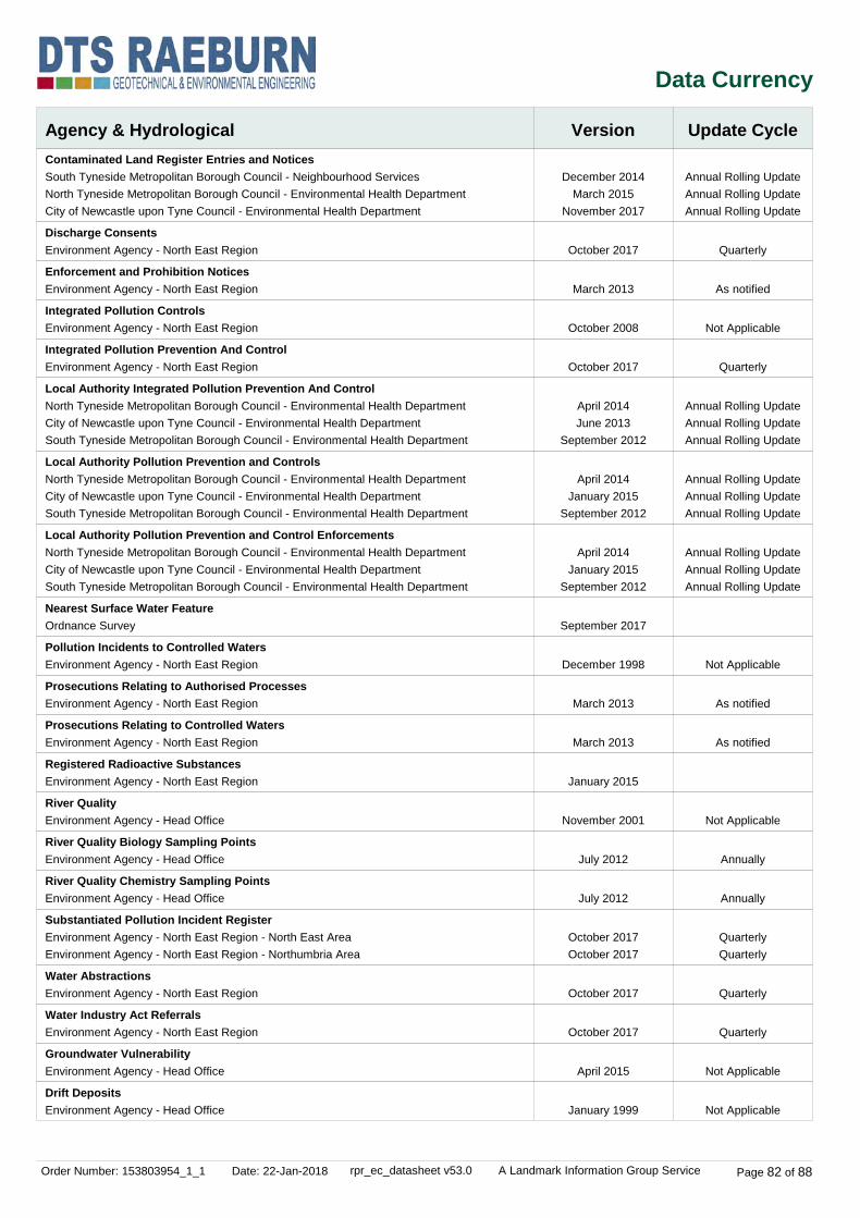
Order Number: 153803954_1_1 Date: 22-Jan-2018 rpr_ec_datasheet v53.0 A Landmark Information Group Service Page 82 of 88
Data Currency
Agency & Hydrological Version Update CycleContaminated Land Register Entries and Notices
Discharge Consents
Enforcement and Prohibition Notices
Integrated Pollution Controls
Integrated Pollution Prevention And Control
Local Authority Integrated Pollution Prevention And Control
Local Authority Pollution Prevention and Controls
Local Authority Pollution Prevention and Control Enforcements
Nearest Surface Water Feature
Pollution Incidents to Controlled Waters
Prosecutions Relating to Authorised Processes
Prosecutions Relating to Controlled Waters
Registered Radioactive Substances
River Quality
River Quality Biology Sampling Points
River Quality Chemistry Sampling Points
Substantiated Pollution Incident Register
Water Abstractions
Water Industry Act Referrals
Groundwater Vulnerability
Drift Deposits
December 2014March 2015
November 2017
October 2017
March 2013
October 2008
October 2017
April 2014June 2013
September 2012
April 2014January 2015
September 2012
April 2014January 2015
September 2012
September 2017
December 1998
March 2013
March 2013
January 2015
November 2001
July 2012
July 2012
October 2017October 2017
October 2017
October 2017
April 2015
January 1999
Annual Rolling UpdateAnnual Rolling UpdateAnnual Rolling Update
Quarterly
As notified
Not Applicable
Quarterly
Annual Rolling UpdateAnnual Rolling UpdateAnnual Rolling Update
Annual Rolling UpdateAnnual Rolling UpdateAnnual Rolling Update
Annual Rolling UpdateAnnual Rolling UpdateAnnual Rolling Update
Not Applicable
As notified
As notified
Not Applicable
Annually
Annually
QuarterlyQuarterly
Quarterly
Quarterly
Not Applicable
Not Applicable
South Tyneside Metropolitan Borough Council - Neighbourhood ServicesNorth Tyneside Metropolitan Borough Council - Environmental Health DepartmentCity of Newcastle upon Tyne Council - Environmental Health Department
Environment Agency - North East Region
Environment Agency - North East Region
Environment Agency - North East Region
Environment Agency - North East Region
North Tyneside Metropolitan Borough Council - Environmental Health DepartmentCity of Newcastle upon Tyne Council - Environmental Health DepartmentSouth Tyneside Metropolitan Borough Council - Environmental Health Department
North Tyneside Metropolitan Borough Council - Environmental Health DepartmentCity of Newcastle upon Tyne Council - Environmental Health DepartmentSouth Tyneside Metropolitan Borough Council - Environmental Health Department
North Tyneside Metropolitan Borough Council - Environmental Health DepartmentCity of Newcastle upon Tyne Council - Environmental Health DepartmentSouth Tyneside Metropolitan Borough Council - Environmental Health Department
Ordnance Survey
Environment Agency - North East Region
Environment Agency - North East Region
Environment Agency - North East Region
Environment Agency - North East Region
Environment Agency - Head Office
Environment Agency - Head Office
Environment Agency - Head Office
Environment Agency - North East Region - North East AreaEnvironment Agency - North East Region - Northumbria Area
Environment Agency - North East Region
Environment Agency - North East Region
Environment Agency - Head Office
Environment Agency - Head Office
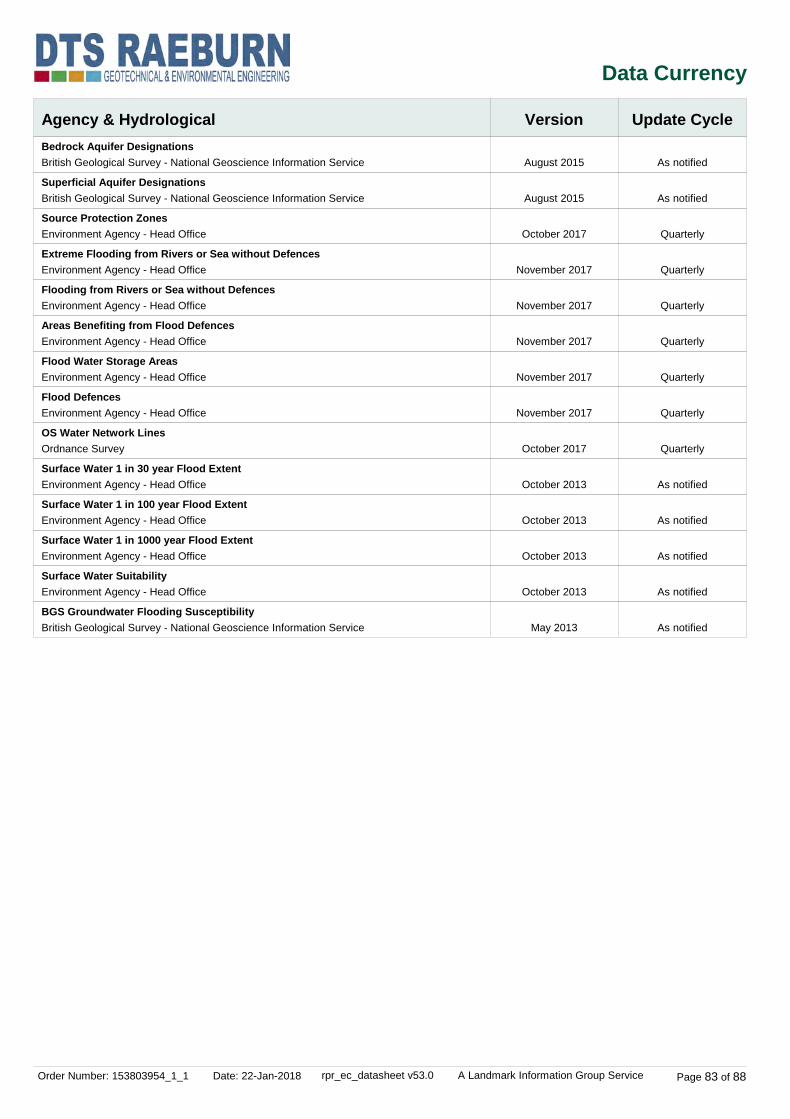
Order Number: 153803954_1_1 Date: 22-Jan-2018 rpr_ec_datasheet v53.0 A Landmark Information Group Service Page 83 of 88
Data Currency
Agency & Hydrological Version Update CycleBedrock Aquifer Designations
Superficial Aquifer Designations
Source Protection Zones
Extreme Flooding from Rivers or Sea without Defences
Flooding from Rivers or Sea without Defences
Areas Benefiting from Flood Defences
Flood Water Storage Areas
Flood Defences
OS Water Network Lines
Surface Water 1 in 30 year Flood Extent
Surface Water 1 in 100 year Flood Extent
Surface Water 1 in 1000 year Flood Extent
Surface Water Suitability
BGS Groundwater Flooding Susceptibility
August 2015
August 2015
October 2017
November 2017
November 2017
November 2017
November 2017
November 2017
October 2017
October 2013
October 2013
October 2013
October 2013
May 2013
As notified
As notified
Quarterly
Quarterly
Quarterly
Quarterly
Quarterly
Quarterly
Quarterly
As notified
As notified
As notified
As notified
As notified
British Geological Survey - National Geoscience Information Service
British Geological Survey - National Geoscience Information Service
Environment Agency - Head Office
Environment Agency - Head Office
Environment Agency - Head Office
Environment Agency - Head Office
Environment Agency - Head Office
Environment Agency - Head Office
Ordnance Survey
Environment Agency - Head Office
Environment Agency - Head Office
Environment Agency - Head Office
Environment Agency - Head Office
British Geological Survey - National Geoscience Information Service

Order Number: 153803954_1_1 Date: 22-Jan-2018 rpr_ec_datasheet v53.0 A Landmark Information Group Service Page 84 of 88
Data Currency
Waste
Hazardous Substances
Version
Version
Update Cycle
Update Cycle
BGS Recorded Landfill Sites
Historical Landfill Sites
Integrated Pollution Control Registered Waste Sites
Licensed Waste Management Facilities (Landfill Boundaries)
Licensed Waste Management Facilities (Locations)
Local Authority Landfill Coverage
Local Authority Recorded Landfill Sites
Potentially Infilled Land (Non-Water)
Potentially Infilled Land (Water)
Registered Landfill Sites
Registered Waste Transfer Sites
Registered Waste Treatment or Disposal Sites
Control of Major Accident Hazards Sites (COMAH)
Explosive Sites
Notification of Installations Handling Hazardous Substances (NIHHS)
Planning Hazardous Substance Enforcements
Planning Hazardous Substance Consents
June 1996
October 2017
October 2008
October 2017October 2017
October 2017October 2017
May 2000May 2000May 2000
May 2000May 2000May 2000
December 1999
December 1999
March 2003March 2003
March 2003March 2003
March 2003March 2003
September 2017
March 2017
November 2000
February 2016February 2016February 2016
February 2016February 2016February 2016
Not Applicable
Quarterly
Not Applicable
QuarterlyQuarterly
QuarterlyQuarterly
Not ApplicableNot ApplicableNot Applicable
Not ApplicableNot ApplicableNot Applicable
Not Applicable
Not Applicable
Not ApplicableNot Applicable
Not ApplicableNot Applicable
Not ApplicableNot Applicable
Bi-Annually
Variable
Not Applicable
Annual Rolling UpdateAnnual Rolling UpdateAnnual Rolling Update
Annual Rolling UpdateAnnual Rolling UpdateAnnual Rolling Update
British Geological Survey - National Geoscience Information Service
Environment Agency - Head Office
Environment Agency - North East Region
Environment Agency - North East Region - North East AreaEnvironment Agency - North East Region - Northumbria Area
Environment Agency - North East Region - North East AreaEnvironment Agency - North East Region - Northumbria Area
City of Newcastle upon Tyne Council - Environmental Health DepartmentNorth Tyneside Metropolitan Borough Council - Environmental Health DepartmentSouth Tyneside Metropolitan Borough Council - Planning Department
City of Newcastle upon Tyne Council - Environmental Health DepartmentNorth Tyneside Metropolitan Borough Council - Environmental Health DepartmentSouth Tyneside Metropolitan Borough Council - Planning Department
Landmark Information Group Limited
Landmark Information Group Limited
Environment Agency - North East Region - North East AreaEnvironment Agency - North East Region - Northumbria Area
Environment Agency - North East Region - North East AreaEnvironment Agency - North East Region - Northumbria Area
Environment Agency - North East Region - North East AreaEnvironment Agency - North East Region - Northumbria Area
Health and Safety Executive
Health and Safety Executive
Health and Safety Executive
City of Newcastle upon Tyne CouncilNorth Tyneside Metropolitan Borough Council - Development FunctionSouth Tyneside Metropolitan Borough Council - Planning Department
City of Newcastle upon Tyne CouncilNorth Tyneside Metropolitan Borough Council - Development FunctionSouth Tyneside Metropolitan Borough Council - Planning Department

Order Number: 153803954_1_1 Date: 22-Jan-2018 rpr_ec_datasheet v53.0 A Landmark Information Group Service Page 85 of 88
Data Currency
Geological
Industrial Land Use
Version
Version
Update Cycle
Update Cycle
BGS 1:625,000 Solid Geology
BGS Estimated Soil Chemistry
BGS Recorded Mineral Sites
CBSCB Compensation District
Coal Mining Affected Areas
Mining Instability
Non Coal Mining Areas of Great Britain
Potential for Collapsible Ground Stability Hazards
Potential for Compressible Ground Stability Hazards
Potential for Ground Dissolution Stability Hazards
Potential for Landslide Ground Stability Hazards
Potential for Running Sand Ground Stability Hazards
Potential for Shrinking or Swelling Clay Ground Stability Hazards
Radon Potential - Radon Affected Areas
Radon Potential - Radon Protection Measures
Contemporary Trade Directory Entries
Fuel Station Entries
Gas Pipelines
Points of Interest - Commercial Services
Points of Interest - Education and Health
Points of Interest - Manufacturing and Production
Points of Interest - Public Infrastructure
Points of Interest - Recreational and Environmental
Underground Electrical Cables
January 2009
October 2015
November 2017
August 2011
March 2014
October 2000
May 2015
June 2015
June 2015
June 2015
June 2015
June 2015
June 2015
July 2011
July 2011
November 2017
November 2017
July 2014
December 2017
December 2017
December 2017
December 2017
December 2017
December 2015
Not Applicable
As notified
Bi-Annually
Not Applicable
As notified
Not Applicable
Not Applicable
As notified
As notified
As notified
As notified
As notified
As notified
As notified
As notified
Quarterly
Quarterly
Quarterly
Quarterly
Quarterly
Quarterly
Quarterly
Quarterly
Bi-Annually
British Geological Survey - National Geoscience Information Service
British Geological Survey - National Geoscience Information Service
British Geological Survey - National Geoscience Information Service
Cheshire Brine Subsidence Compensation Board (CBSCB)
The Coal Authority - Property Searches
Ove Arup & Partners
British Geological Survey - National Geoscience Information Service
British Geological Survey - National Geoscience Information Service
British Geological Survey - National Geoscience Information Service
British Geological Survey - National Geoscience Information Service
British Geological Survey - National Geoscience Information Service
British Geological Survey - National Geoscience Information Service
British Geological Survey - National Geoscience Information Service
British Geological Survey - National Geoscience Information Service
British Geological Survey - National Geoscience Information Service
Thomson Directories
Catalist Ltd - Experian
National Grid
PointX
PointX
PointX
PointX
PointX
National Grid

Order Number: 153803954_1_1 Date: 22-Jan-2018 rpr_ec_datasheet v53.0 A Landmark Information Group Service Page 86 of 88
Data Currency
Sensitive Land Use Version Update CycleAncient Woodland
Areas of Adopted Green Belt
Areas of Unadopted Green Belt
Areas of Outstanding Natural Beauty
Environmentally Sensitive Areas
Forest Parks
Local Nature Reserves
Marine Nature Reserves
National Nature Reserves
National Parks
Nitrate Vulnerable Zones
Ramsar Sites
Sites of Special Scientific Interest
Special Areas of Conservation
Special Protection Areas
World Heritage Sites
October 2017
November 2017November 2017November 2017
November 2017November 2017November 2017
August 2017
January 2017
April 1997
August 2017
August 2017
August 2017
August 2017
October 2015
August 2017
August 2017
August 2017
August 2017
November 2017
Bi-Annually
As notifiedAs notifiedAs notified
As notifiedAs notifiedAs notified
Bi-Annually
Annually
Not Applicable
Bi-Annually
Bi-Annually
Bi-Annually
Bi-Annually
Bi-Annually
Bi-Annually
Bi-Annually
Bi-Annually
Bi-Annually
Natural England
City of Newcastle upon Tyne CouncilNorth Tyneside Metropolitan Borough CouncilSouth Tyneside Metropolitan Borough Council - Planning Department
City of Newcastle upon Tyne CouncilNorth Tyneside Metropolitan Borough CouncilSouth Tyneside Metropolitan Borough Council - Planning Department
Natural England
Natural England
Forestry Commission
Natural England
Natural England
Natural England
Natural England
Department for Environment, Food and Rural Affairs (DEFRA - formerly FRCA)
Natural England
Natural England
Natural England
Natural England
Historic England

Order Number: 153803954_1_1 Date: 22-Jan-2018 rpr_ec_datasheet v53.0 A Landmark Information Group Service Page 87 of 88
Data Suppliers
Ordnance Survey
Environment Agency
Scottish Environment Protection Agency
The Coal Authority
British Geological Survey
Centre for Ecology and Hydrology
Natural Resources Wales
Scottish Natural Heritage
Natural England
Public Health England
Ove Arup
Peter Brett Associates
Data Supplier Data Supplier Logo
A selection of organisations who provide data within this report

Order Number: 153803954_1_1 Date: 22-Jan-2018 rpr_ec_datasheet v53.0 A Landmark Information Group Service Page 88 of 88
Useful Contacts
Contact Name and Address Contact Details
1
2
3
4
5
6
7
8
9
10
11
12
-
-
British Geological Survey - Enquiry Service
Environment Agency - National Customer Contact Centre (NCCC)
South Tyneside Metropolitan Borough Council - Environmental Health Department
Ordnance Survey
South Tyneside Metropolitan Borough Council - Planning Department
North Tyneside Metropolitan Borough Council - Environmental Health Department
Health and Safety Executive
The Coal Authority - Property Searches
PointX
Natural England
Historic England
Environment Agency - Head Office
Public Health England - Radon Survey, Centre for Radiation, Chemical and Environmental Hazards
Landmark Information Group Limited
British Geological Survey, Kingsley Dunham Centre, Keyworth, Nottingham, Nottinghamshire, NG12 5GG
PO Box 544, Templeborough, Rotherham, S60 1BY
Central Library Building, Prince George Square, South Shields, Tyne And Wear, NE33 2PE
Adanac Drive, Southampton, Hampshire, SO16 0AS
Town Hall & Civic Offices, Westoe Road, South Shields, Tyne & Wear, NE33 2RL
D1 Quadrant 1L, Quadrant East, Silverlink North,, Cobalt Business Park, North Tyneside, North Shields, NE27 0BY
5S.2 Redgrave Court, Merton Road, Bootle, L20 7HS
200 Lichfield Lane, Mansfield, Nottinghamshire, NG18 4RG
7 Abbey Court, Eagle Way, Sowton, Exeter, Devon, EX2 7HY
County Hall, Spetchley Road, Worcester, WR5 2NP
1 Waterhouse Square, 138 - 142 Holborn, London, EC1N 2ST
Rio House, Waterside Drive, Aztec West, Almondsbury, Bristol, Avon, BS32 4UD
Chilton, Didcot, Oxfordshire, OX11 0RQ
Imperium, Imperial Way, Reading, Berkshire, RG2 0TD
Telephone: 0115 936 3143Fax: 0115 936 3276Email: [email protected]: www.bgs.ac.uk
Telephone: 03708 506 506Email: [email protected]
Telephone: 0191 427 1717Fax: 0191 427 7171Website: www.s-tyneside-mbc.gov.uk
Telephone: 03456 05 05 05Email: [email protected]: www.ordnancesurvey.gov.uk
Telephone: 0191 427 1717Fax: 0191 427 7171Website: www.s-tyneside-mbc.gov.uk
Telephone: 0345 2000 101Email: [email protected]: www.northtyneside.gov.uk
Website: www.hse.gov.uk
Telephone: 0345 762 6848Fax: 01623 637 338Email: [email protected]: www2.groundstability.com
Website: www.pointx.co.uk
Telephone: 0300 060 3900Email: [email protected]: www.naturalengland.org.uk
Telephone: 0370 333 0607Email: [email protected]: www.historicengland.org.uk
Telephone: 01454 624400Fax: 01454 624409
Telephone: 01235 822622Fax: 01235 833891Email: [email protected]: www.ukradon.org
Telephone: 0844 844 9952Fax: 0844 844 9951Email: [email protected]: www.landmarkinfo.co.uk
Please note that the Environment Agency / Natural Resources Wales / SEPA have a charging policy in place for enquiries.

E13080/1 ASDA South Shields February 2018
Enclosure D
Historical Map Extracts
(10 pages)
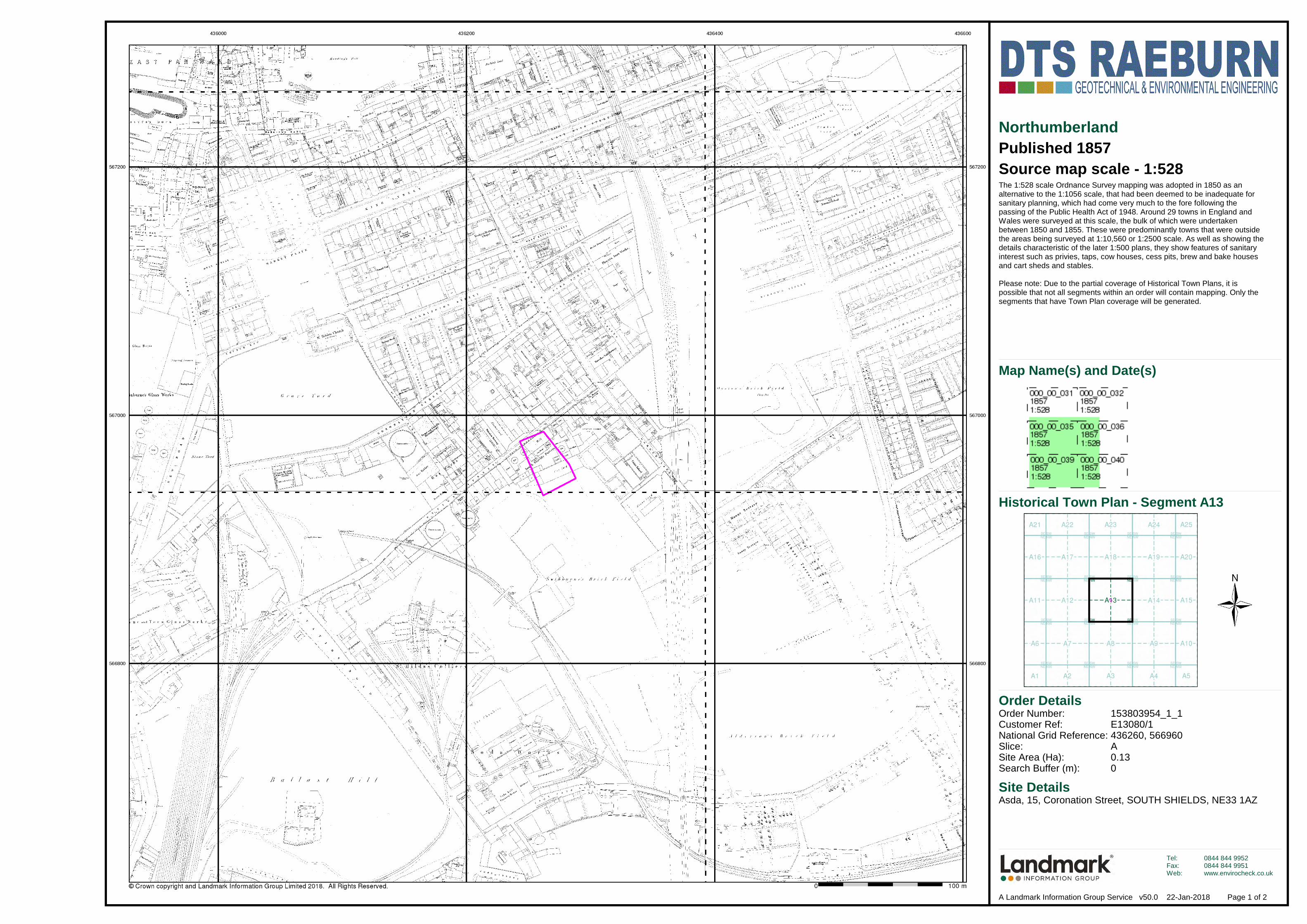
Order Details
Site DetailsAsda, 15, Coronation Street, SOUTH SHIELDS, NE33 1AZ
Order Number:Customer Ref:National Grid Reference:Slice:Site Area (Ha):Search Buffer (m):
153803954_1_1E13080/1436260, 566960A0.130
Tel:Fax:Web:
0844 844 99520844 844 9951www.envirocheck.co.uk
Page 1 of 2A Landmark Information Group Service v50.0 22-Jan-2018
NorthumberlandPublished 1857Source map scale - 1:528The 1:528 scale Ordnance Survey mapping was adopted in 1850 as an alternative to the 1:1056 scale, that had been deemed to be inadequate for sanitary planning, which had come very much to the fore following the passing of the Public Health Act of 1948. Around 29 towns in England and Wales were surveyed at this scale, the bulk of which were undertaken between 1850 and 1855. These were predominantly towns that were outside the areas being surveyed at 1:10,560 or 1:2500 scale. As well as showing thedetails characteristic of the later 1:500 plans, they show features of sanitary interest such as privies, taps, cow houses, cess pits, brew and bake houses and cart sheds and stables.
Please note: Due to the partial coverage of Historical Town Plans, it is possible that not all segments within an order will contain mapping. Only the segments that have Town Plan coverage will be generated.
Historical Town Plan - Segment A13
Map Name(s) and Date(s)

Order Details
Site DetailsAsda, 15, Coronation Street, SOUTH SHIELDS, NE33 1AZ
Order Number:Customer Ref:National Grid Reference:Slice:Site Area (Ha):Search Buffer (m):
153803954_1_1E13080/1436260, 566960A0.130
Tel:Fax:Web:
0844 844 99520844 844 9951www.envirocheck.co.uk
Page 2 of 2A Landmark Information Group Service v50.0 22-Jan-2018
NorthumberlandPublished 1896Source map scale - 1:500The 1:500 scale Ordnance Survey mapping was introduced in 1855 as a replacement for the 1:528 scale and to compliment the 1:2500 scale that had been implemented in 1853. By 1895, the 1:500 scale covered most towns over a population of about 4000 at the time of survey, although very few towns were mapped more than once at this scale, and none have been since 1910. The 1:500 scale gives particular emphasis to such features as lamp posts, man holes, arched passages and minor building projections. Also oftenfeatured are divisions between tenements, interior ground floor layouts of public buildings, and on earlier plans, the functions of the various parts of larger industrial premises are also indicated. Content of the plans does vary however, from one town to the next in terms of, for example, the completeness of railway tracks and the coverage of public buildings.
Please note: Due to the partial coverage of Historical Town Plans, it is possible that not all segments within an order will contain mapping. Only the segments that have Town Plan coverage will be generated.
Historical Town Plan - Segment A13
Map Name(s) and Date(s)

Order Details
Site DetailsAsda, 15, Coronation Street, SOUTH SHIELDS, NE33 1AZ
Order Number:Customer Ref:National Grid Reference:Slice:Site Area (Ha):Search Buffer (m):
153803954_1_1E13080/1436260, 566960A0.13100
Tel:Fax:Web:
0844 844 99520844 844 9951www.envirocheck.co.uk
Page 5 of 19A Landmark Information Group Service v50.0 22-Jan-2018
DurhamPublished 1915Source map scale - 1:2,500The historical maps shown were reproduced from maps predominantly held at the scale adopted for England, Wales and Scotland in the 1840`s. In 1854 the 1:2,500 scale was adopted for mapping urban areas and by 1896 it covered the whole of what were considered to be the cultivated parts of GreatBritain. The published date given below is often some years later than the surveyed date. Before 1938, all OS maps were based on the Cassini Projection, with independent surveys of a single county or group of counties, giving rise to significant inaccuracies in outlying areas.
Historical Map - Segment A13
Map Name(s) and Date(s)

Order Details
Site DetailsAsda, 15, Coronation Street, SOUTH SHIELDS, NE33 1AZ
Order Number:Customer Ref:National Grid Reference:Slice:Site Area (Ha):Search Buffer (m):
153803954_1_1E13080/1436260, 566960A0.13100
Tel:Fax:Web:
0844 844 99520844 844 9951www.envirocheck.co.uk
Page 7 of 19A Landmark Information Group Service v50.0 22-Jan-2018
Ordnance Survey PlanPublished 1956Source map scale - 1:2,500The historical maps shown were reproduced from maps predominantly held at the scale adopted for England, Wales and Scotland in the 1840`s. In 1854 the 1:2,500 scale was adopted for mapping urban areas and by 1896 it covered the whole of what were considered to be the cultivated parts of GreatBritain. The published date given below is often some years later than the surveyed date. Before 1938, all OS maps were based on the Cassini Projection, with independent surveys of a single county or group of counties, giving rise to significant inaccuracies in outlying areas.
Historical Map - Segment A13
Map Name(s) and Date(s)

Order Details
Site DetailsAsda, 15, Coronation Street, SOUTH SHIELDS, NE33 1AZ
Order Number:Customer Ref:National Grid Reference:Slice:Site Area (Ha):Search Buffer (m):
153803954_1_1E13080/1436260, 566960A0.13100
Tel:Fax:Web:
0844 844 99520844 844 9951www.envirocheck.co.uk
Page 8 of 19A Landmark Information Group Service v50.0 22-Jan-2018
Ordnance Survey PlanPublished 1963 - 1975Source map scale - 1:1,250The historical maps shown were reproduced from maps predominantly held at the scale adopted for England, Wales and Scotland in the 1840`s. In 1854 the 1:2,500 scale was adopted for mapping urban areas and by 1896 it covered the whole of what were considered to be the cultivated parts of GreatBritain. The published date given below is often some years later than the surveyed date. Before 1938, all OS maps were based on the Cassini Projection, with independent surveys of a single county or group of counties, giving rise to significant inaccuracies in outlying areas.
Historical Map - Segment A13
Map Name(s) and Date(s)

Order Details
Site DetailsAsda, 15, Coronation Street, SOUTH SHIELDS, NE33 1AZ
Order Number:Customer Ref:National Grid Reference:Slice:Site Area (Ha):Search Buffer (m):
153803954_1_1E13080/1436260, 566960A0.13100
Tel:Fax:Web:
0844 844 99520844 844 9951www.envirocheck.co.uk
Page 11 of 19A Landmark Information Group Service v50.0 22-Jan-2018
Supply of Unpublished Survey InformationPublished 1973 - 1975Source map scale - 1:1,250SUSI maps (Supply of Unpublished Survey Information) were produced between 1972 and 1977, mainly for internal use at Ordnance Survey. These were more of a `work-in-progress' plan as they showed updates of individual areas on a map. These maps were unpublished, and they do not represent a single moment in time. They were produced at both 1:2,500 and 1:1,250 scales.
Historical Map - Segment A13
Map Name(s) and Date(s)