Embed Size (px)
Citation preview
Report of the Chief Planning Officer SOUTH & WEST PLANS PANEL Date: 01ST JULY 2021 Subject: 20/07516/FU- Phased erection of industrial/warehouse buildings with ancillary office space with associated access; car parking; servicing; pedestrian infrastructure; drainage infrastructure; landscaping; and associated works at Leeds Valley Park, Savannah Way, Rothwell, Leeds LS10 1AB Applicant: Delta Park Developments Ltd Date Valid: 26.11.2020 Target Date: 15.07.2021
RECOMMENDATION: DEFER AND DELEGATE, subject to no objection being raised by the Coal Authority, approval of planning permission to the Chief Planning Officer subject to the conditions specified below (and alteration to or addition of any further conditions as deemed appropriate) and the completion of a s106 legal agreement in respect of the planning application within three months from the date of resolution unless otherwise agreed in writing by the Chief Planning Officer to include the following obligation:
1. Off-site contribution of £244 750 towards biodiversity units in Hunslet & Riverside
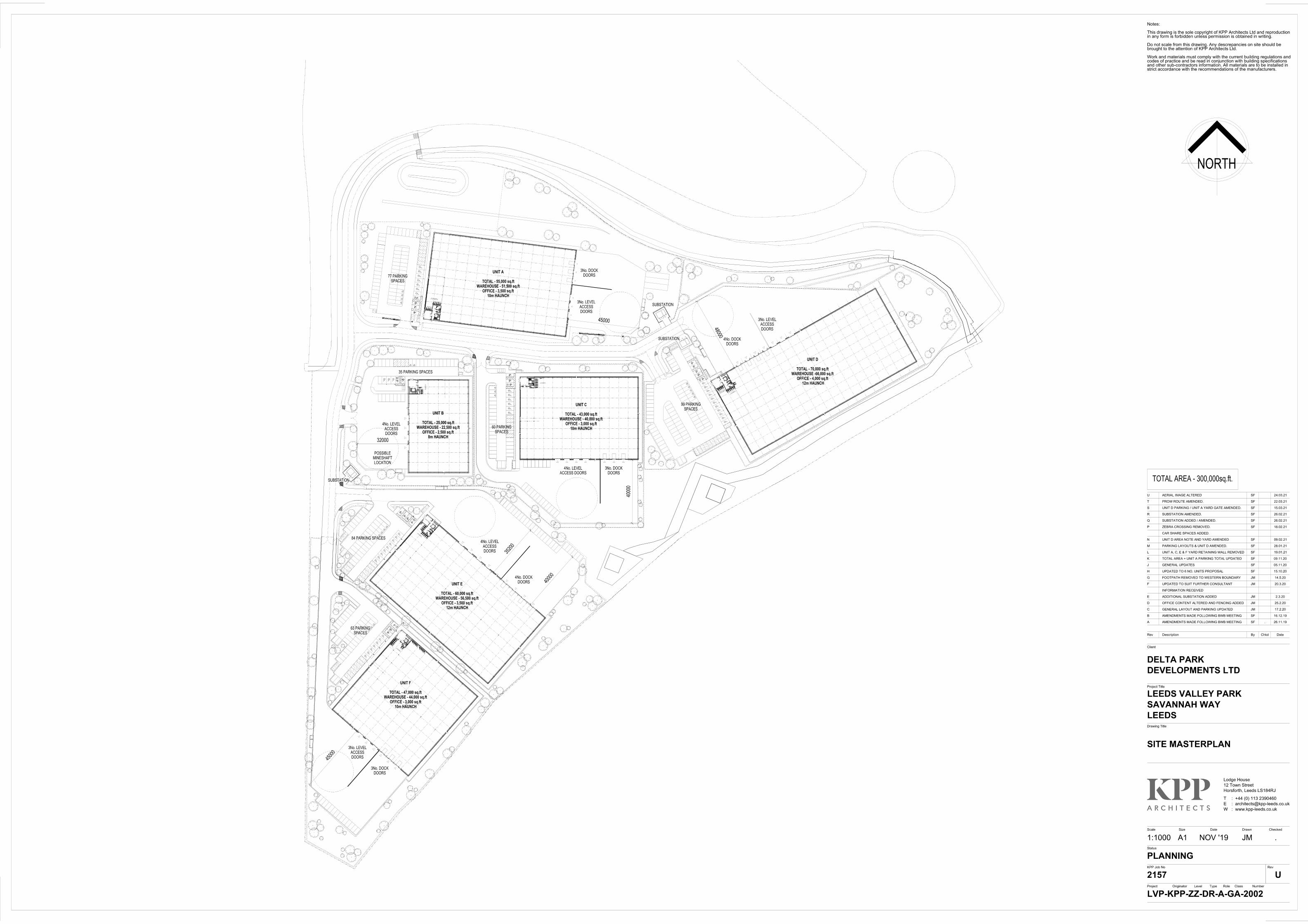
2. Commitment by the developer / Management Company to maintain the proposed access and internal private roads in perpetuity;
Electoral Wards Affected: Hunslet & Riverside
Specific Implications For: Equality and Diversity
Community Cohesion
Narrowing the Gap
Originator: Hannah Lucitt Tel: 0113 3781413
Ward Members consulted
(referred to in report)
Yes
3. Contribution amounting to £76,000 towards Rothwell 3 PROW improvements; 4. Contribution of £20,000 provision of real-time bus information to bus stops
45025408 and 45011647 (Leeds Valley Park); and, 5. Contribution of £57,000 to A61 corridor sustainable infrastructure
improvements, including identified packages/schemes for A61 Wakefield Road / Wood Lane, A61 Leeds Road / Sharp Lane / Copley Lane and A61 Leeds Road / A654 Thorpe Lower Lane / Leadwell Lane.
6. Travel Plan review fee of £7573 should be include within the s.106 agreement, subject to a 3% increase annually on 1st April.
7. Travel Plan Measures £20,000 to cover a range of potential eventualities regarding the effectiveness of the Travel Plan
1. Time limit of 3 years 2. Plans to be approved 3. Ground investigation report 4. Ground investigation remediation report 5. Ground investigation verification report 6. Details of drainage 7. Approved vehicular access 8. Off- site highways works 9. Details of cycle parking facilities prior to completion of building 10.Provision of electric vehicle charging facilities 11.Details of Car Parking and Servicing Management Plan 12.Details and Provision of Vehicle Spaces to be Laid Out 13.Details of lighting scheme across site 14.Details of the biodiversity management plan 15.Details of Construction Environmental Management Plan 16.Details of landscaping scheme 17.Details of retention of landscaping 18.Details of tree protection measures 19.Details of a landscape management plan 20.Removal of permitted development rights for changes of use of land falling within Use Class E 24.Details of materials 25.Renewable energy provision 28. Archaeological mitigation works
INTRODUCTION:
1. The application relates to a site that is allocated for ‘office uses’ within the
AVLAAP. Whilst it is acknowledged that the current proposal is not strictly in compliance with the allocated ‘office use within policy AVL1, policy AVL4 (3) refers to site AV81 as also being a suitable location of general employment uses, which covers the uses specified in the proposal, consequentially, the proposal for mixed (Use Class E(g)(i), B2, B8) is considered to be acceptable in principle.
2. Further, there are no nearby residential dwellings which would be impacted by
virtue of the proposal, and any noise and disturbance caused by the operation of the site to nearby office workers is considered negligible.
3. An update will be provided in regard access, coal, landscaping and biodiversity,
as the applicant has provided information to satisfy the concerns raised.
4. Subject to the above being considered satisfactory, it is recommended that this application is approved, subject to the suggested conditions and s.106 set out at the head of this report.
PROPOSAL:
5. The proposal seeks full planning permission for the phased erection of six, two storey, grey clad units comprising 27,871 sqm floorspace, to be used for B2 General industrial use, B8 Storage or distribution use and associated offices to carry out any operational or administrative functions (Use Class E(g)(i), B2, B8).
6. The access to the site would be via a continuation of Savannah Way. Each
industrial unit will have an associated service yard and parking, amounting to a total 362 car parking spaces, 21 disability spaces, 29 motorcycle spaces and 150 cycle spaces. The proposed site layout shows areas of landscaping throughout the site.
SITE AND SURROUNDINGS:
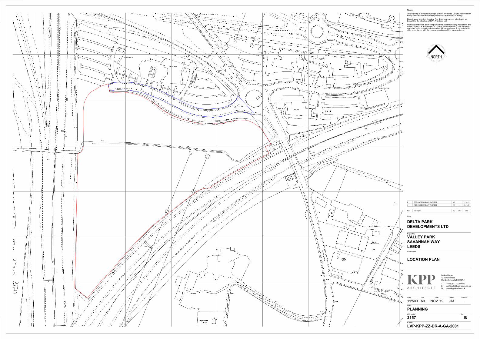
7. The site comprises of an undeveloped, 9.7ha triangular area of land to the south
of Phase 3 of the Leeds Valley Park site.
8. Leeds Valley Park is an office park which so far has three phases of development completed to the east and west of a connecting roundabout on the A61 Wakefield Road.
9. The application site is bounded by Savannah Way, to the north, the M1 to the
south and the M621 to the west. AVL AAP Map 11 shows an indicative proposed core cycle network route running east-west through the site (policy AVL12 (8).
10. Public Bridleway No.5 Rothwell subsists around the development site. This bridleway is subject to a Public Path Diversion Order and is awaiting its completion before it can be made operational.
11. The site is also adjacent to the footbridge over the M621 to Middleton and Belle Isle is a locally strategic link.
12. There are a number of trees on the periphery of the site boundary to the west along the landscaping buffer to the M621. There are also a number of mature trees within the application site to the east, adjacent to the connecting roundabout on the A61 Wakefield Road.
13. There is a green corridor along the eastern boundary of the site. There are other
areas of green infrastructure along the western boundary.
RELEVANT PLANNING HISTORY:
14. The wider Leeds Valley Park site has a number of planning applications submitted.
15. The only planning application directly relevant to this application site is as
follows:
16. 21/162/01/OT ‘Outline application to layout access and erect b1 office development with ancillary a1/a3 uses & childrens nursery’ was granted conditional outline planning permission on 21.03.2002.
PUBLIC/LOCAL RESPONSE:
17. The application was publicised by site and press notices and neighbour notification letters. In response 13 letters of objection were received.
Points raised therein can be summarised as follows:
- Proposal will impact local wildlife and wildflowers; - Loss of local greenspace will impact mental health of nearby residents and
users of application site; - Concerns raised about the veracity of the information contained within the
Biodiversity Statement; - Proposed development will cause increased noise and disturbance; - Increased traffic caused by virtue of the proposal will have an adverse
impact on local air quality; - There is no demand for development of this kind; - Proposal is in conflict with the Development Plan; - Proposal would have an unacceptable impact on highways safety and
amenity; - Design of the proposal is harmful to the character of the area; - Proposal does not provide enough opportunities for segregated
cycleways.
Ward Members have been briefed about the scheme and have raised no objection.
CONSULTATION RESPONSES:
18. Highways: No objection, subject to the inclusion of conditions addressing provision of contractors, details of vehicular access, vehicle space laid out, provision of forward visibility, cycle/motorcycle facilities, electric vehicle charging points.
19. The Highways Team also require the inclusion of a s.106 agreement addressing
contributions in regard:
- Commitment by the developer / Management Company to maintain the proposed access and internal private roads in perpetuity;
- Contribution amounting to £76,000 towards Rothwell 3 PROW improvements;
- Contribution of £20,000 provision of real-time bus information to bus stops 45025408 and 45011647 (Leeds Valley Park); and,
- Contribution of £57,000 to A61 corridor sustainable infrastructure improvements, including identified packages/schemes for A61 Wakefield Road / Wood Lane, A61 Leeds Road / Sharp Lane / Copley Lane and A61 Leeds Road / A654 Thorpe Lower Lane / Leadwell Lane.
20. Influencing Travel Behaviour: No objection subject to the inclusion of conditions
addressing cycle parking, motorcycle parking, car share spaces, showers, electric vehicle charging points prior to occupation, no parking on any roads within the development site, barriers to car parks of unoccupied units must remain closed whilst the unit is unoccupied, no parking on undeveloped parts of the site, and only park in lined bay, no double parking.
21. A Travel Plan review fee of £7573 should be include within the s.106 agreement,
subject to a 3% increase annually on 1st April.
22. Highways England: No objection, subject to the inclusion of conditions addressing the need for further information by way of gantry, boundary treatment, geotechnical and/or structural submissions. A Construction Management Plan, Construction Traffic Management Plan, site drainage details and a condition restricting uses outside of those directly associated with the development.
23. Environmental Studies Transport Strategy Team: No objection.
24. Sustainable Transport Policy: No objection, subject to the inclusion of conditions
addressing the need for sufficient secure cycle parking, lockers, drying facilities and showers for visitors and staff should be provided along with electric car charging points.
25. Nature Team: Further information is required in regard Biodiversity Matrix.
Further information has been provided by the applicant which achieves biodiversity neutrality on site by way of both works to the site its self and through contributions to be spent in Hunslet & Riverside.
26. Environmental Health Team: No objections, site noise generated will be sufficiently below the prevailing level of environmental noise at sensitive receptors such that no further consideration of noise is required.
27. West Yorkshire Archaeology Advisory Service: No objection to proposed
archaeological mitigation works, subject to these works being secured by an appropriately worded condition.
28. Yorkshire Water: No objection, subject to the inclusion of conditions addressing
foul and surface water run-off, piped discharge, and waste water.
29. West Yorkshire Police: No objection, subject to the inclusion of conditions addressing the need for CCTV, cycle storage and 24/7 site management.
30. Coal Authority: Further information required as the layout implications of the mine
entries is yet to be clearly determined. In regard to areas of opencast, the report author of the Coal Mining Risk Assessment Report recommends intrusive site investigations to determine the ground conditions in these areas of the site.
31. Further information has been submitted by the applicant which appears to
address concerns raised, an update will be provided at Plans Panel.
32. Contaminated Land: No objection, subject to the inclusion of conditions addressing Phase 2 site investigation report.
33. Ramblers: Further work required to public right of way which runs across the site.
34. Flood Risk Management: No objection, subject to the inclusion of conditions
addressing the need for site specific SUDS features and suitable drainage.
35. Access Officer: No objection.
36. Landscaping Team: Awaiting comment.
37. Local Plans: Awaiting comment.
PLANNING POLICIES: 38. Section 38(6) of the Planning and Compulsory Purchase Act 2004 requires the
application to be determined in accordance with the development plan unless material considerations indicate otherwise. The development plan is the adopted Core Strategy (amended 2019), the Sites Allocation Plan (adopted 2019) saved policies within the Unitary Development Plan (Review 2006) (UDP), the Natural
Resources and Waste DPD and any made Neighbourhood Plans. These development plan policies are complemented by supplementary planning guidance and documents.
39. The Site Allocations Plan was adopted in July 2019. Following a statutory challenge, Policy HG2, so far as it relates to sites which immediately before the adoption of the SAP were within the green belt, has been remitted to the Secretary of State and is to be treated as not adopted. All other policies within the SAP remain adopted and should be afforded full weight.
40. The site is unallocated by the SAP.
41. Aire Valley Leeds Area Action Plan (AVLAAP)
The application site lies within the AVLAAP and has been identified for ‘office use’ under policy AVL1 (site AV81) and is supported by AVL3 also. The following policies are also considered to be relevant:
AVL4: General Employment development in AVL AVL5: Local job opportunities AVL8: Improving public health in AVL AVL12: Strategic Transport Infrastructure Improvements in AVL AVL13: Aire Valley Leeds Green Infrastructure Network AVL17: Heat Networks in Aire Valley Leeds
42. Local Planning Policy
The Core Strategy sets out the strategic planning policy framework for the district until 2028. In considering the proposals, the following Core Strategy policies are considered relevant: SP1: Delivery of spatial development strategy. SP4: Regeneration priority programme areas, including East Leeds. Priority will be given to developments that improve … access to employment and skills development, enhance green infrastructure and greenspace, up grade the local business environment...; SP8: A competitive local economy will be supported through provision and safeguarding a supply of land to match employment needs and opportunities for B class uses; seeking to improve accessibility to employment opportunities by public transport, walking and cycling across the district; supporting training/ skills and job creation initiatives. SP9: Provision for offices, industry and warehouse employment land and premises.
a. EC1: General employment land will be identified, in the first instance, to meet the identified need for land to accommodate research and development, industry, warehousing and waste uses over the plan period.
b. EC3: Safeguarding existing employment land and industrial areas. c. P10: Good design that is appropriate to its location, scale and function.
d. P12: Landscaping considerations. e. T2: New development should be located in accessible locations f. EN1: Carbon Dioxide reductions for major developments. g. EN2: Sustainable design and construction. h. EN4: District Heating i. EN5: Seeks to manage and mitigate flood risk. j. EN8: Electric vehicle charging
43. The following UDP Review (2006) policies are considered to be of relevance:
a. GP5: Seeks to ensure that development proposals resolve detailed
planning considerations, including amenity. b. N23: Incidental space around built development should provide a visually
attractive setting. c. N25: Boundaries of sites designed in a positive manner with paving to
accord with surrounding character. d. LD1: Seeks for landscape schemes to complement and where possible
enhance the quality of the existing environment. e. BD5: Seeks to ensure new development protects amenity.
44. The following Natural Resources and Waste Local Plan policies are considered
to be relevant: a. WATER7: No increase in surface water run-off, incorporate SUDs. b. LAND1: Land contamination to be dealt with. c. LAND2: Development should conserve trees and introduce new tree
planting. d. AIR: Air quality considerations e. MINERALS3: Surface Coal Mineral Safeguarding Area
45. The following Supplementary Planning Guidance / Documents are also
considered to be of relevance: a. SPG Sustainable Urban Drainage b. SPD Street Design Guide c. SPG Sustainable Design and Construction - Building for Tomorrow
Today. d. SPD Leeds Parking Policy
46. National Planning Policy
The revised National Planning Policy Framework (NPPF, 2019) sets out the Government’s planning policies for England and how these are expected to be applied. It provides a framework within which locally-prepared plans for housing and other development can be produced.
Planning law requires that applications for planning permission must be determined in accordance with the development plan, unless material considerations indicate otherwise. The NPPF must be taken into account in the
preparation of local and neighbourhood plans and is a material consideration in planning decisions. The policy guidance in Annex 1 to the NPPF is that due weight should be given to relevant policies in existing plans according to their degree of consistency with the NPPF. The closer the policies in the plan to the policies in the Framework, the greater the weight that may be given. It is considered that the local planning policies mentioned above are consistent with the wider aims of the NPPF.
The NPPF gives a presumption in favour of sustainable development (para. 11).
Chapter 6 deals with building a strong, competitive economy and advises that planning policies and decisions should help create the conditions in which businesses can invest, expand and adapt. Significant weight should be placed on the need to support economic growth and productivity, taking into account both local business needs and wider opportunities for development (para.80).
Chapter 8 covers the promotion of healthy and safe communities and advises that access to a network of high-quality open spaces and opportunities for sport and physical activity is important for the health and well-being of communities (para. 96). Existing open space, sports and recreational buildings/land, incl. playing fields should not be built on unless specific criteria are met (para 97).
Chapter 9 covers the promotion of sustainable transport modes and achieving safe and suitable access to sites for all users (para.108) and to refuse developments on highway grounds if there would be an unacceptable impact on highway safety or the residual cumulative impacts on the road network would be severe (para.109).
Chapter 12 identifies that good design is a key aspect of sustainable development creation of high quality buildings and places is fundamental to sustainable development (para.124).
Chapter 14 requires account be given to flood risk and that when determining planning applications, local planning authorities should ensure that flood risk is not increased elsewhere (para.163).
Chapter 15 states that planning policies and decisions should contribute to and enhance the natural and local environment (para.170) and ensuring that a site is suitable for its proposed use taking account of ground condition and any risk arising from land instability and contamination (para.178).
MAIN ISSUES:
• Principle of Development • Highways Considerations
• Design & Layout • Residential Amenity • Biodiversity • Other matters
APPRAISAL:
Principle of Development
47. The application site is allocated for ‘office uses’ within the AVLAAP. This allocation was made on the basis of the previous outline planning permission for offices. Whilst it is acknowledged that the current proposal is not strictly in compliance with the allocated ‘office use’ within policy AVL1, policy AVL4 (3) refers to site AV81 as also being a suitable location of general employment uses, which covers the uses specified in the proposal.
48. Given the above, the proposed flexible B2/B8 and ancillary office uses are
considered to be broadly compliant with AVLAAP policies and would support the delivery of employment uses as set out in the Core Strategy. The proposed uses are therefore consistent with the AVL AAP and are considered to be acceptable in principle.
Design & Layout
49. Policies within the Leeds Development Plan and the advice contained within the revised NPPF seek to promote new development that responds to local character, reflects the identity of local surroundings, and reinforce local distinctiveness.
50. Paragraph 130 of the NPPF states that that permission should be refused for
development of poor design and that fails to take the opportunities available for improving the character and quality of an area and the way it functions, taking into account any local design standards or style guides in plans or supplementary planning documents. Policy P10 of the Leeds Core Strategy deals with design and context and states that new development, should be based on a thorough contextual analysis and provide good design that is appropriate to its location, scale and function.
51. Developments should respect and enhance, streets, spaces and buildings
according to the particular local distinctiveness and wider setting of the place with the intention of contributing positively to place making, quality of life and wellbeing. Proposals will be supported where they accord with the principles of the size, scale, design and layout of the development and that development is appropriate to its context and respects the character and quality of surrounding
buildings; the streets and spaces that make up the public realm and the wider locality.
52. The proposal includes the erection of six, two storey units, varying in height from
8-12m. They grey clad units would have associated office space, service yards and car parking. The location and scale of the development is considered appropriate to its surroundings, which include commercial, industrial and office buildings.
53. The proposed units have clearly been designed to reflect a simple pallet of
materials, while maintaining a visual separation of the office elements of the scheme. This helps to break down the visual bulk of the units, against the appearance of the landscaping scheme which provides a verdant buffer to the site.
54. The proposal does include the loss of some 60 category C trees on site. A
landscaping scheme has been provided to mitigate against this loss with tree planting at a minimum ratio of 1:3.
55. Subject to the inclusion of conditions addressing the protection of trees on the
periphery of the site, and the provision of a robust landscaping scheme the development is considered to comply with policies N23, N25, GP5 and LAND2.
56. The scheme is considered to be compliant with the aims of the strands of Core
Strategy Policy P10 that refers to character and context (the amenity strands of P10 are dealt with below), saved UDP Policy GP5 and the advice contained within the NPPF.
Highways Considerations
57. Core Strategy policy T2 and saved UDP policy GP5 note that development
proposals must resolve detailed planning considerations and should seek to maximise highway safety. This means that the applicants must demonstrate that the development can achieve safe access and will not overburden the capacity of existing infrastructure. As outlined within the spatial policies of the Core Strategy, it is also expected that development is sited within sustainable locations and meets the accessibility criteria of the Core Strategy.
58. The main access to the site will be via an extension to Savannah Way, which is a
private road. The road would be 7.3m wide. 2.0m wide footway is proposed along the site frontage and 3.0m shared footway/cycleway is proposed on the western side.
59. Each industrial unit will have an associated service yard and parking, amounting
to a total 362 car parking spaces, 21 disability spaces, 29 motorcycle spaces and 150 cycle spaces. The proposed site layout shows areas of landscaping
throughout the site. Parking has been provided at the rate of 1 space per 66 sq.m which is the requirement for B2 general industrial in ‘Elsewhere’ areas as per the parking standards.
60. The internal access junctions have been assessed in terms of visibility,
vehicular/HGV access and pedestrian safety, with proposed dropped kerbs with tactile paving crossings and are considered acceptable in regard highway safety and amenity.
61. A pedestrian link is also proposed between the diverted Rothwell 5 PROW and
the site, via a link to the north of Unit D.
62. The cycle route represents an important connection in the pedestrian / cycle network between Rothwell and Belle Isle which is otherwise road dominated. It also provides an important link into to Leeds Valley Park from those communities. The site layout shows a connection running around the northern and western boundaries of the site. This satisfies the plan requirement of Policy AVL12.
63. The following improvements would be delivered to the sustainable infrastructure,
as part of the S106 agreement:
o Improvements (surfacing works and signage) to PROW Definitive Footpath Rothwell 3 to provide walking/cycling links to the Stourton Park & Ride site;
o Provision of real-time bus information to the high frequency bus stops immediately to the northwest of the A61 Wakefield Road / Savannah Way roundabout. The costs have been obtained from West Yorkshire Combined Authority (WYCA) at £10,000 per bus stop (£20,000 total), which includes installation of the equipment and maintenance; and
o Contribution of £57,000 towards sustainable infrastructure improvements for schemes proposed along the A61 Corridor. This includes the following cumulative impact junctions: A61 Wakefield Road / Wood Lane A61 Leeds Road / Sharp Lane / Copley Lane A61 Leeds Road / A654 Thorpe Lower Lane / Leadwell Lane.
64. The traffic impact of the proposed development has now been established,
resulting in off-site highway contributions of £57,000 towards the A61 corridor, covering key cumulative impact junctions. The money will be spent on sustainable travel improvements, such as bus lanes/gates, pedestrian/cycling infrastructure and signal optimisation.
65. Subject to the delivery of the above, there are no highway safety concerns raised
in relation to the proposals, which are considered to be in compliance with Core Strategy policy T2 and saved UDP policy GP5.
Residential Amenity and Noise
66. Saved UDP Policy GP5 requires inter alia that development proposals should
seek to avoid problems of environmental intrusion and loss of amenity. Paragraph 180 of the
67. NPPF states that planning policies and decisions should also ensure that new development is appropriate for its location taking into account the likely effects (including cumulative effects) of pollution on health, living conditions and the natural environment, as well as the potential sensitivity of the site or the wider area to impacts that could arise from the development. In doing so they should mitigate and reduce to a minimum potential adverse impacts resulting from noise from new development – and avoid noise giving rise to significant adverse impacts on health and the quality of life
68. In terms of amenity impacts, the adjacent land uses and lack of housing means
the proposed development is not expected to result in any serious impacts although noise.
69. The Noise Survey submitted with this application confirms that noise caused by
virtue of the proposal would be negligible to the nearest dwellings (which are some distance from the site) as well as adjacent office users, the Environmental Health Team have assessed the Noise Survey submitted and agree with its findings.
70. In light of the technical advice provided by Environmental Health, Officers are of
the view that the scheme is compliant with Core Strategy Policy P10, saved UDP Policy GP5 and with the policy set out in the NPPF.
Other matters
Landscaping, Trees and Ecology:
71. As shown in the AVLAPP there is a Green Infrastructure corridor running along
the motorway boundaries. There are also a number of existing trees on site.
72. The Arboricultural Impact Assessment (AIA) confirms that a total of 60 Category C trees would be felled by virtue of the proposed development. A replacement planting scheme with a minimum replanting ratio of 1:3 will be sought by way of condition.
73. While the proposal does not represent a 10% increase in the number of
biodiversity units the site provides, the applicant has agreed to a £225,000 contribution to achieve biodiversity neutrality. After discussions with the Nature Team surrounding the difficulties of achieving further units on site, a contribution has been agreed which will ensure that the site can be considered to deliver
biodiversity neutrality as a minimum. The contribution will be used to deliver the biodiversity units elsewhere in the Hunslet and Riverside ward.
74. Comments from Landscaping Team and Nature Team will be provided at Plans
Panel.
Air Quality:
75. The Air Quality Assessment concludes that, subject to incorporation of standard mitigation measures (e.g. Construction Environmental Management Plan), any air quality impacts arising from the construction and operational phases of the development will be negligible.
76. The proposals accord with policies GP5, AVL8, and Air 1 in relation to air quality.
Coal and Minerals:
77. The application site lies partly within a Coal Mining Referral area and the Surface
Coal Mineral Safeguarding Area. In view of both policies relating to parts of the site. A Coal Mining Risk Assessment Report has been provided, and the Coal Authority have asked for additional information.
78. Information has been provided which appears to address the concerns raised by
the Coal Authority, the LPA are awaiting comments from the Coal Authority to confirm.
Flood Risk:
79. Following the receipt of a Flood Risk Assessment, Leeds City Council Flood Risk
Management (FRM) as Lead Local Flood Authority will comment on surface water drainage considerations. FRM comment that conditions are required to set minimum internal floor levels (150 mm above adjacent levels) and a fully detailed surface water drainage scheme, which demonstrates sustainable urban drainage solutions, and which results in greenfield run-off rates. Subject to these conditions the development would not be at undue risk of flooding and nor would the proposal result in an increased risk of flooding elsewhere.
80. The proposals accord with policies GP5, Water 1 and Water 7.
Sustainability measures and climate change:
81. The Council declared a Climate Emergency in March 2019. Existing planning
policies seek to address the issue of climate change by ensuring that development proposals incorporate measures to reduce the impact of non-renewable resources.
82. The Energy Statement demonstrates that at least 10% of the energy needs of the proposed development can be met through PV installations.
83. The buildings will be constructed so as to reduce carbon emissions beyond 20%
less than the Buildings Regulations target.
84. The development will be certified to BREEAM ‘very good’ standard. It is not feasible to secure an ‘excellent’ rating for a speculative scheme of this nature and scale, not least as the fit out and operational requirements of occupiers are unknown. This does not rule out improvements being made beyond ‘very good’ standard in due course, linked to the fit out of the respective buildings, for example.
85. Within this context it is considered that the proposals accord with CS policies
EN1, EN2 and EN4.
86. Consequently, the proposals also accord with Policies AVL17 (AVLAAP), and GP5.
Archaeology:
87. An Archaeological Written Scheme of Investigation (WSI) has been submitted to
provide an overview of previous recorded finds and surveys of the site. The West Yorkshire Archaeology Service (WYAS) raise no objection to the approach taken.
Contaminated Land:
88. A Phase 2 Desk Study is required which may recommend further investigation
works are necessary. Whilst it would be preferable to have further clarity of these matter, ultimately appropriate conditions could be imposed to secure these details, including any requirements for remediation works that may be necessary.
Representations:
Concerns raised about the veracity of the information contained within the Biodiversity Statement; Proposal will impact local wildlife and wildflowers
- While concerns for local wildlife and wildflowers are noted, the scheme includes a robust landscaping scheme, including 40 replacement trees will be planted on site, as well as 4,000 sqm of woodland tree planting and shrub mixes and 800m of hedgerows. See section ‘Other’ which includes Landscaping, Trees and Ecology.
Proposed development will cause increased noise and disturbance;
- See section on Residential Amenity and Noise
Increased traffic caused by virtue of the proposal will have an adverse impact on local air quality;
- See section ‘Other’ which includes Air Quality There is no demand for development of this kind; Proposal is in conflict with the Development Plan; Loss of local greenspace will impact mental health of nearby residents and users of application site;
- See ‘Principle of Development’ section. While loss of space currently used by local residents is regrettable, the site lies within the boundary covered by the Aire Valley Leeds Area Action Plan (AVLAAP) which was adopted by the Council on 8 November 2017. Therefore, the principle of allowing development on this site is accepted.
Proposal would have an unacceptable impact on highways safety and amenity; Proposal does not provide enough opportunities for segregated cycleways;
- Proposal is considered to have an acceptable impact on highway safety and amenity, including considerations for cyclists. See ‘Highway Considerations’ section
Design of the proposal is harmful to the character of the area;
- See ‘Design & Layout section.
CONCLUSION:
89. The proposal is considered to comply with both national and local planning policy. The principle of development is accepted, and subject to the contributions as set out of the s.106, which mitigate matters raised in relation to highway safety and amenity and biodiversity to create, on balance, a scheme which is acceptable in terms of local and national policy compliance.
90. Further, there are no nearby residential dwellings which would be impacted by
virtue of the proposal, and any noise and disturbance caused by the operation of the site to nearby office workers is considered negligible.
91. An update will be provided in regard access, coal, landscaping and biodiversity,
as the applicant has provided information to satisfy the concerns raised.
92. Subject to the above being considered satisfactory, it recommended that this application is approved, subject to the suggested conditions and s.106 set out at the head of this report.
Background Papers: Application file 20/07516/FU


![[PVG] Hannah Montana - Hannah Montana 3](https://img.pdfslide.net/doc/110x75/56d6bf381a28ab30169562c0/pvg-hannah-montana-hannah-montana-3.jpg)