Embed Size (px)
Citation preview

Origin of the Blue Ridge escarpment along thepassivemargin of Eastern North AmericaJames A. Spotila,n Greg C. Bank,n Peter W. Reiners,w Charles W. Naeser,z Nancy D.Naeserz and Bill S. Henikan
nDepartment of Geosciences,Virginia Polytechnic Institute and State University, Blacksburg,Virginia, USAwDepartment of Geology and Geophysics,Yale University, NewHaven, Connecticut, USAzUSGeological Survey, 926A National Center, Reston,Virginia, USA
ABSTRACT
The Blue Ridge escarpment is a rugged landform situatedwithin the ancient Appalachian orogen.While similar in some respects to the great escarpments along other passive margins, which haveevolved by erosion following rifting, its youthful topographic expression has inspired proposals ofCenozoic tectonic rejuvenation in eastern North America.To better understand the post-orogenicand post-rift geomorphic evolution of passive margins, we have examined the origin of this landformusing low-temperature thermochronometry and manipulation of topographic indices. Apatite (U^Th)/He and ¢ssion-track analyses along transects across the escarpment reveal a younging trendtowards the coast.This pattern is consistent with other great escarpments and ¢ts with aninterpretation of having evolved by prolonged erosion, without the requirement of tectonicrejuvenation.Measured ages are also comparable speci¢cally to those measured along other greatescarpments that are as much as100Myr younger.This suggests that erosional mechanisms thatmaintain rugged escarpments in the early post-rift stages may remain active on ancient passivemargins for prolonged periods.The precise erosional evolution of the escarpment is less clear,however, and several end-member models can explain the data. Our preferred model, which ¢ts withall data, involves a signi¢cant degree of erosional escarpment retreat in the Cenozoic. Although thissuggests that early onset of topographic stability is not required of passive margin evolution, moredata are required to better constrain the details of the escarpment’s development.
INTRODUCTION
Post-orogenic Appalachian topography
The AppalachianMountains have been scrutinized by in-vestigators of long-term landscape evolution for over acentury (cf. Mills et al., 1987; Morisawa, 1989).The dilem-ma of the moderate ruggedness of the modern Appala-chians (up to 2 km relief) is that convergent tectonism,which is normally linked with construction of mountains,terminatedB300Myr ago with the cessation of the Alle-ghanian orogeny. At that time, the ancestral AppalachianMountains may have been comparable to today’s Andes(Slingerland & Furlong, 1989). The sutured continentrifted apart during theMesozoic, and denudation has sub-sequently dominated.The modern highlands may thus re-present slow, long-lived erosion and topographicresilience above a thickened orogenic crustal root (Eng-
land & Richardson, 1977; Stephenson & Lambeck, 1985;Baldwin etal., 2003). Some aspects of theAppalachian’s to-pographic form are consistent with slow, steady erosionalprocesses, including apparent adjustment to regional cli-mate and bedrock erodibility (Hack, 1960, 1980) as well asslow rates of Cenozoic denudation, saprolite production,and exhumation (B10^30mMyr� 1; Hack, 1980; Velbel,1985; Gates & Glover, 1989; Pavich, 1989; Roden,1991; Granger et al., 1997; Naeser et al., 2001; Matmonet al., 2003).
However, the Appalachian Mountains may be toorugged and eroding too rapidly for an orogen that has notexperienced tectonic activity for such a long duration, gi-ven expectations of geomorphic cycles or the timescalesof topographic decay above orogenic roots (e.g. Davis,1903; Schumm, 1963; Ahnert, 1970; Pinet & Souriau, 1988;Prowell&Christopher, 2000).Alternatively, it mayhave ex-perienced rejuvenation by post-Permian tectonism. Rift-ing of the continental margin in Late Triassic may haveproduced signi¢cant surface uplift, although this wouldrequire similarly long resilience. Rejuvenation may havetaken place in the Cenozoic, due to convergence along thepassive margin, although at strain rates much slower thanoccur at active plate boundaries. Minor active faulting
Correspondence: James A. Spotila, Department of Geosciences,Virginia Polytechnic Institute and StateUniversity, 4044DerringHall, Blacksburg,VA 24061, USA. E-mail: [email protected] address: Greg C. Bank, Advanced Resources Interna-tional, Inc., 1110 N. Glebe Road, Suite 600, Arlington,VA 22201,USA.
BasinResearch (2004) 16, 41–63, doi: 10.1046/j.1365-2117.2003.00219.x
r 2003 Blackwell Publishing Ltd 41

along the Fall Zone of the central and southern UnitedStates has occurred since the middle Tertiary (Mixon &Newell, 1977; Prowell, 1988; Gardner, 1989; Marple &Tal-wani, 2000), and the region currently exhibits minor seis-micity (Bollinger, 1973). Although this deformation hasnot been shown to have produced the modern topography,it does indicate a state of tectonic compression that couldbe driving uplift (Pazzaglia & Brandon, 1996).
A major landform that has been di⁄cult to explain byslow, steady erosion and argues strongly for tectonic reju-venation is the Blue Ridge escarpment (BRE) of the cen-tral and southern Appalachians (Fig. 1). This east-facingescarpment is B500 km long, averages 300^500m high,and is locally as steep as hillslopes of active mountainranges (B20^301). It separates the Blue Ridge and Valleyand Ridge highlands from the low-relief Piedmont andCoastal Plain, with its crest marking an asymmetric dividebetween the Atlantic andGulf ofMexico drainages (Hayes& Campbell, 1894; Davis, 1903; Wright, 1927a; Dietrich,1957; Hack, 1973) (Fig. 2a). In northern North Carolinaand southern Virginia the Blue Ridge highlands exhibitlow relief, such that the escarpment is a striking boundarybetween two subdued surfaces, which we refer to as theUpland and Piedmont surfaces. Unlike other major topo-graphic features in the Appalachians, this central stretchof the BRE is manifest within a single, easily eroded andweatherable lithology (schist and mica-rich gneiss of theAlligator Back Formation) and thus cannot be explained
(sensu stricto) by variations in bedrock erodibility (Dietrich,1959; Hack, 1980,1982).This makes the escarpment an im-portant subject for evaluating the landscape evolution oftheAppalachianMountains and old passive margins.Herewe investigate the origin of this prominent landform usingthermochronometry and geomorphic observations.
Great escarpments of rifted continentalmargins
Prominent, ‘great’ escarpments are fundamental land-forms of rifted passive margins and are generally thoughtto develop by rift- £ank uplift and subsequent erosion (Ol-lier, 1984; Kooi & Beaumont, 1994; Gallagher & Brown,1997). Examples of such escarpments exist along activeand recently rifted margins (e.g. the Red Sea (Bohannonetal., 1989; Steckler &Omar,1994)) as well as older margins(e.g. o60Ma Transantarctic Mountains (ten Brink &Stern, 1992); 80^100Ma southeastern Australia (Mooreet al., 1986; Seidl et al., 1996; Bishop & Goldrick, 2000);120^140Ma Brazil (Gallagher et al., 1994); and 100^150Masouthwestern Africa (Gilchrist et al., 1994; Brown et al.,2000)). Uplift of rift £anks consists of a short-lived(B50Myr) dynamic component due to thermal buoyancyand mantle upwelling, as well as a static component asso-ciatedwith underplating of continental crust and £exural^isostatic response to mechanical unloading and extensionin the rift (Weissel &Karner, 1989;Wernicke &Tilke, 1989;
Fig.1. (a) Location of the Blue Ridge escarpment (BRE) in the eastern United States. Distribution of rugged topography in theAppalachianMountains is shown as grey.The box indicates the location of Fig. 3. (b) Frequency of elevation (i.e. percentage of pixels)from a 90-m resolution digital elevation model for the entire geomorphic domains of the easternPiedmont, escarpment, andUpland inNorth Carolina and Virginia.
r 2004 Blackwell Publishing Ltd,Basin Research, 16, 41^6342
J. A. Spotilaet al.

Stuwe,1991;Gallagher &Brown,1997; Bishop&Goldrick,2000). Long-lived topography associated with rifting canbe as high as 2^3 km.
Following rifting, these uplifted, asymmetric £anks areshaped by erosion.Erosion is more rapid along the steeper,rift-facing £ank, which experiences a sharper drop in re-gional base level than the gentle hinterland (Young &McDougall,1993;Weissel &Seidl,1998). In one view, basedon case studies and landscape evolution models, escarp-ments evolve by slow, irregular inland erosional retreat ofthe escarpment and drainage divide (Ollier,1984; tenBrink& Stern, 1992; Gallagher et al., 1994; Gilchrist et al., 1994;Steckler & Omar, 1994; Tucker & Slingerland, 1994; Seidlet al., 1996; Weissel & Seidl, 1998). The escarpment mor-phology is maintained in part by dynamic coupling be-tween erosion and isostatic £exural adjustment, whichhelps keep the divide atop the escarpment even in the ab-sence of resistant caprocks or tectonic deformation(Gilchrist et al., 1994; Kooi & Beaumont, 1994; Tucker &Slingerland, 1994). In the wake of a retreating escarpmentis a low-relief erosion surface, which sits between the es-carpment and coast and has been the site of focused exhu-mation.
Erosional retreat may be possible only under certainconditions, however. For example, where di¡usive hill-slope erosion dominates (i.e. transport-limited condi-tions), escarpments are not likely to be maintained(Tucker & Slingerland, 1994; Kooi & Beaumont, 1994). Es-carpment retreat should also be irregular over time anddecelerate as escarpment height and relief are reduced
(Gilchrist et al., 1994; van der Beek & Braun, 1999). Insteadof having formed by prolonged retreat of a steady-statelandform, escarpments may be sculpted out of rift- £ankuplifts by widespread denudation between the coast andcontinental drainage divide (Gilchrist et al., 1994; Persanoet al., 2002). Escarpment evolution also depends on preex-isting topography, and in some cases the drainage dividemay lie inland of the escarpment (‘arch’ or ‘gorge-head’type) rather than atop it (‘shoulder’ or ‘drainage-divide’type) (Ollier, 1984; Seidl et al., 1996; Matmon et al., 2002).Recent studies even suggest a more dynamic view of es-carpment development. Some landscape evolution mod-els are best ¢t when the drainage divide becomes ¢xedsoon after rifting (Kooi & Beaumont, 1994; van der Beek& Braun, 1999). Some escarpments, such as southwesternAfrica and southeastAustralia, appear to have experiencedlittle migration since the early stages of development(Bishop &Goldrick, 2000; Cockburn et al., 2000).This re-quires rapid erosion of the rift- £ank and coastal plain andsubsequent landscape stability, which is consistent withinterpretations of thermochronometry and other data(Moore et al., 1986; Gilchrist et al., 1994; Matmon et al.,2002; Persano et al., 2002). However, not all escarpmentsexperienced rapid denudation only at the time of rifting(Bohannon et al., 1989; Gallagher et al., 1994; Steckler &Omar, 1994; Brown et al., 2000) and escarpments can con-tinue to retreat in their late stages (Weissel & Seidl, 1998).
Although it is generally agreed that great escarpmentsare formed erosionally, there is thus disagreement abouthow they evolve. If the BRE has a similar erosional origin
Fig. 2. (a) Elevation pro¢le across the BRE along a northwest^southeast line. Average slopes for each topographic domain (Upland,Piedmont, and escarpment) are based on 90-m resolution digital topography. Slopes on the escarpment face are nearly as high as foundin active mountain belts.Total relief of the Upland and Piedmont ‘low-relief ’ surfaces are shown in parentheses. Location of pro¢leshown in Fig.1. (b) Longitudinal stream pro¢les descending from the asymmetric divide at the top of the BRE.The upper diagramshows the full length of river pro¢les to the sea,with amuch longer distance required for theGulf ofMexico drainage system than for theAtlantic system.The bottom diagram is a detailedversion of the area denoted by the box in the upper pro¢le.This illustrates that despitethe longer distance of the Gulf drainage system,most of its relief is lost in a distance comparable to the Atlantic system. In the samedistance the Piedmont rivers reach sea level, the rivers on the Gulf side drop nearly as low (165m).The asterisks denote the location ofresistant strata in the Appalachian Plateau (AP), which are thought to represent local base level for rivers draining theValley and Ridge(VR) and Blue Ridge (BR) (Hack, 1973).
r 2004 Blackwell Publishing Ltd,Basin Research, 16, 41^63 43
Origin of the Blue Ridge escarpment

as other great escarpments, it mayhold important insightsfor how such landforms develop. A unique aspect of theNorth America passive margin is that rifting terminatedat B210Ma, considerably older than rifting that createdmost other escarpments (Ollier, 1984; Gallagher & Brown,1997). Other Triassic passive margins, such as the anti-thetic margin of northwestern Africa, do not exhibit greatescarpments (Wright et al., 1985; Klitgord et al., 1988).Thecharacter of the BRE could thus be important to the land-scape evolution of passive margins, which is generally un-derstood from studies of much younger escarpments.However, the origin of the BRE has not yet been fully ex-plained.
Origin of the BRE
Previous reviews of great escarpments have only brie£ydiscussed the BRE as a candidate relict of rift- £ank uplift(Ollier, 1984; Tucker & Slingerland, 1994). The BRE issmaller and more discontinuous than other great escarp-ments. It is also located closer to the margins of inland riftbasins (B70 km) than younger great escarpments (e.g.Tucker & Slingerland, 1994; Seidl et al., 1996).The old ageof the North American passive margin may itself be a rea-son as to why this escarpment has been previously over-looked. However, Pazzaglia & Gardner (2000) postulatedthat the BRE is a great escarpment created by base-leveldrop associated with subsidence during early stages ofcontinental break-up.They suggested that £exural defor-mation associated with erosion and o¡shore ¢xed theasymmetric divide and produced the escarpment,although the magnitude of £exural uplift is much smallerthan the height of the Blue Ridge above the Piedmont.
Although not linking the modern escarpment to rift-£ank uplift, several hypotheses for the BRE have alludedto a similar erosional origin.Davis (1903) suggested the es-carpment was linked to the position of regional drainagedivide. Greater vigour of streams that drain directly to theAtlantic Ocean, which travel only one- ¢fth the distancethat western streams travel to the Gulf of Mexico, couldmaintain the sharp landform. However, this is unlikely gi-ven that western rivers descend to the low continental in-terior over a comparable distance (White,1950;Hack,1982)(Fig. 2b). Dietrich (1957, 1959) advocated a similar topo-graphic evolution, without speculating on the cause. Heexplained the details of the topography by northwestwardretreat of the asymmetric divide, which resulted in under-fed, beheaded streams draining westward from the divideand steep, captured streams £owing eastward across the di-vide. A more advanced stage of escarpment retreat bystream piracy has been described where Atlantic streams(e.g. the James River) have penetrated the divide and ac-cessed weak rocks of the Valley and Ridge, leaving behinda narrow Blue Ridge rather than the low-relief Upland(Wright, 1927a;White, 1950; Dietrich, 1959; Harbor, 1996).Hack (1973) invoked a similar topographic evolution of theescarpment, but proposed that the persistence of theasymmetric divide is due to the resistant Pennsylvanian
sandstones that crop out on the western margin of the Ap-palachianPlateau and set base level for rivers draining westfrom the divide (Fig. 2b).
Other explanations for the BRE have involved active,geodynamic or tectonic forcing.White (1950) proposed itwas produced by local, normal-sense reactivation of a faultwithin the Brevard zone inVirginia and North Carolina inthe Mesozoic (Fig. 1). This was based on di¡use shearplanes and aligned bedrock schistosity, but the existenceof these fault features and evidence for such reactivationhave not been corroborated (Stose & Stose, 1951; Dietrich,1957; Edelman et al., 1987; Vauchez, 1987). Other studieshave suggested the escarpment formed by uplift of theBlue Ridge highlands above the Piedmont via broad,monoclinal tectonic warping (Hayes & Campbell, 1894;Wright, 1927a). Battiau-Queney (1989) proposed localizeduplift along the axis of the divide associated with lowercrustal £ow towards the west, driven by regional tectoniccompression.This was based on the association of the es-carpment and a steep gravity gradient produced by a grav-ity high in the inner (i.e. westernmost) Piedmont (B10^50km east of theBRE),which may re£ect a zone of thinner(B35 km thick) crust than is present to the east or west(B40^50km thick) (Pratt et al., 1988; Hubbard et al., 1991).Another explanation is that the escarpment was erosion-ally etched out of rejuvenated, thermally supported, dy-namic topography in the Cenozoic (Pazzaglia & Brandon,1996).
Hypotheses for the origin of the BRE thus relate to thecurrent debate of Appalachian topographic evolution.Theescarpment could be a relict landform,produced by purelyerosional processes acting on an ancient orogenic belt. Inparticular, the landform may have been initiated by rift-£ank uplift during theMesozoic, like other passive margingreat escarpments. Alternatively, the escarpment may bethe result of Cenozoic tectonic or geodynamic rejuvena-tion.We have investigated the origin of the BRE, to testwhether it is a great escarpment, to see what implicationsit might have for the evolution of such escarpments, and tobetter understand the post-orogenic and post-rift evolu-tion of the North American passive margin.
Data that should provide insight into the evolution ofthe BRE relate to ‘erosional kinematics’, or the spatial andtemporal distribution of erosion and topography duringthe evolution of a landscape. A consistent feature of greatescarpments is seaward-younging patterns of low-tem-perature cooling ages along the coastal plain (Moore et al.,1986; Bohannon et al., 1989; Gallagher et al., 1994; Steckler& Omar, 1994; O’Sullivan et al., 1996; Gallagher & Brown,1997; Brown et al., 2000; Persano et al., 2002). These pat-terns are essentially ‘‘¢ngerprints’’ of great escarpmentsand are thought to indicateB2^4 km of exhumation anderosional origins of escarpments, rather than rift-relatedthermal transients (Gallagher & Brown, 1997). We testedfor this exhumation pattern using low-temperature ther-mochronometry. Because proposed origins of the BREmake predictions for erosion patterns that may leave ameasurable imprint on topography, we have also investi-
r 2004 Blackwell Publishing Ltd,Basin Research, 16, 41^6344
J. A. Spotilaet al.

gated topographic trends as qualitative indicators of ero-sional history.
METHODOLOGY
Thermochronometry
Patterns of recent exhumation were inferred using radio-genic He ((U T̂h)/He) and ¢ssion-track analyses in apatite(AHE and AFT, respectively) for samples roughly alongtwo transects normal to the BRE (Fig. 3). These are ourprimary data, from which we test possible models of es-carpment formation. Sample transects are B80 km apartandB100 km long, with samples spaced atB25-km inter-vals. Seventeen samples have been datedwith AHE and/orAFT, but more samples were collected thatwere undatabledue to poor-quality apatite. Mica-rich, schistose litholo-gies proved undatable, and most data are from granitic orhigh-grade metamorphic rocks.
AHE thermochronometry constrains cooling in thetemperature range of 40^90 1C (closure temperature(Tc)5 70 1C for 10 1CMyr� 1 cooling (Zeitler et al., 1987;Wolf et al., 1996; Farley, 2000)) and is a valuable techniquefor studies of landscape evolution (e.g. House et al., 1998;Spotila et al., 1998). Ages were obtained in two separate fa-cilities during the early stages of their development (Table1). At VirginiaTech (Spotila), 4He contents were measuredon aliquots ofB10 apatite grains in a high-vacuum extrac-tion line with resistor furnace, using a 3He-spike and 4He-
standard, cryogenic concentration of gas at 16K, andquadrupole mass spectrometry. U and Th nuclides weremeasured on the same grains by ICP-MS atActivation La-boratories (Ancaster, Ontario). At Washington State Uni-versity (Reiners), 4He, U, and Th contents were similarlymeasured, with the exception that He was extracted usingaCO2 laser withZnSwindow (Reiners etal., 2003). Consis-tent ages were obtained on individual samples from thesetwo facilities, demonstrating the accuracy of independentcalibrations. Uncertainties in individual ages measured atWashington State University areB6% (2s), based on re-producibility of replicate analyses, propagation of analyti-cal uncertainties, and successful age determination(32.511.5Ma) of the 32Ma Durango £uorapatite standard(Farley, 2000). Uncertainties in ages measured at VirginiaTech are larger (B10%, 2s), because of a low He concen-tration of samples and high furnace blanks (4He detectionlimit B0.001pmol). The Durango age is less well repro-duced at VirginiaTech (3073Ma, n515), but is within er-ror bars of the accepted standard.
Apatites collected in this study presented several chal-lenges to age determinations. Inclusions were nearly ubi-quitous in many samples, and one sample (GB4) couldnot be dated usingAHE(althoughAFTagewas measured).Several samples also exhibited low concentrations of par-ent radionuclides (e.g. o1ppm, GB10 and GB20), andthus contained low, di⁄cult-to-measure 4He contents,corresponding to greater error bars in measured ages(B25%, 2s) (Table 1). Zonation of parent radionuclides
Fig. 3. Locations of thermochronometry samples and topographic subsets on a shaded-relief elevation map of the BRE and vicinity.The mapwas generated from 30-m resolution digital elevation models usingRivertools software.The location of the map area is showninFig.1. Ages are given inMa.The numbered red boxes, polygons (basins), and dotted lines (dots are centres of 25-km2 boxes used inFig.9) indicate locations of areas used for topographic comparisons. Letters indicate basin names as A5 Ararat River, C5CrookedCreek,D5DeepCreek, F5Fisher River, L5Little River,M5MuddyCreek, R5 Little Reed IslandCreek, Ro5RoaringRiver, S5SandyRiver.The Brevard fault zone (BFZ) andDan River boundary fault (DRBF) are shown.
r 2004 Blackwell Publishing Ltd,Basin Research, 16, 41^63 45
Origin of the Blue Ridge escarpment

Tab
le1.
AHEdatafortheBRE.
Sample
Elevation
(m)
Latitu
de,
long
itude
Rocktype
Mass
(mg)
mwar
(mm)
He
(pmol)
U (ppm
)Th
(ppm
)Raw
age
(Ma)
Zon
ation
ratio(g
f )FT
Corrected
age(M
a)Av
erage
age(M
a)n
Tc(1C)
GB1a
(P)
260
36.0185�80.0592
gr0.0156
410.0642
6.7
5.2
96.7
2.67
1.90.76
(0.71)
127
1277
1355
GB1b
0.0385
530.2653
10.0
9.2
104
0.82
(0.75
)127
GB2b
(P)
246
36.2159�80.4300
gn0.0128
330.0307
5.90.9
72.7
5.87
3.9
0.74
(0.63)
98.2
97.9713
50GB2-2
0.0231
390.0477
3.8
1.4
94.7
0.81
(0.68)
117
GB2-3
0.0557
470.0697
3.4
0.6
67.5
0.86
(0.73)
78.5
GB3a
(P)
268
36.4079�80.5641
gn/sch
0.0141
420.1759
27.1
1.2
84.2
3.57
2.0
0.79
(0.71)
107
91.0711
55GB3-2
0.0129
470.2156
45.0
24.4
62.6
0.83
(0.74)
75.4
GB6a
(P)
226
36.7215�79.7865
amph
0.0055
320.0585
21.9
62.0
89.1
1.27
0.5
0.61
89.0
94.276
50GB6b
0.0243
430.3964
26.0
70.0
99.3
0.70
99.7
GB7a
(P)
281
36.6114�80.0383
gn0.0282
650.1036
4.5
15.6
82.7
2.37
2.3
0.85
(0.80)
97.3
1067
1157
GB7b
0.126
841.1149
8.5
30.7
103
0.90
(0.84)
114
GB8a
(U)
750
36.7668�80.7260
gn0.0287
720.0320
1.2
1.2
136
3.07
2.2
0.89
(0.83)
153
1467
1557
GB8b
0.0742
720.0671
1.2
0.8
122
0.88
(0.82)
139
GB10a(U
)792
36.9182�80.16
86gr/gn
0.0154
350.0062
0.3
1.1129
2.87
1.8
0.69
(0.66)
187
2047
2650
GB10-2
0.0047
310.0012
0.9
10.5
139w
0.63
(0.59)
221
GB13-1(P)
195
36.6780�79.4170
gr0.0113
420.0547
4.0
77.0
40.8
1.67
1.3
0.70
58.4
68.477
50GB13-2
0.0062
350.0282
4.7
52.4
50.1
0.64
78.3
GB14-1(P)
350
36.8220�80.2020
sch
0.0652
710.0321
2.3
2.3
33.0
1.57
1.2
0.94z
35.3
40.174
GB14-2
0.2464
113
0.0826
1.4
2.4
32.0
0.97z
32.9
GB14-3
0.0746
125
0.0695
2.6
4.7
47.6
0.91z
52.1
GB17-1(P)
357
36.7960�80.1184
gn0.0126
370.0183
0.8
12.5
72.1
1.37
1.10.66
109
1097
1150
GB18-1(P)
342
36.5799�80.3812
gr0.0132
490.0697
8.5
1.8
112
4.77
3.8
0.83
(0.72)
135
1497
2250
GB18-2
0.0054
310.0262
7.91.7
112
0.69
(0.60)
162
GB19-1(P)
448
36.6027�80.4259
gr0.0188
340.1500
8.4
11.9
135
6.57
3.5
0.78
(0.65)
173
1737
2650
GB20
-1(U
)1211
36.7463�80.4778
amph
0.0305
640.0147
0.2
0.7
217w
4.07
2.0
0.88
(0.79)
247
1827
46w
57GB20
-20.04
08120
0.0137
0.02
2.3
111w
0.94
(0.87)
117
GB21-1(P)
260
36.1775�80.2625
gn/amph
0.0159
460.2323
23.7
44.7
80.6
5.172.5
0.86
(0.74)
93.7
91.5714
55GB21-2
0.0759
670.8211
17.7
32.6
80.7
0.91
(0.80)
88.7
GB21-3
0.0310
420.3431
18.4
38.2
76.5
0.83
(0.71)
92.2
GB23-1(U
)762
37.1178
�80.1128
amph
0.0100
370.3158
28.3
176
84.7
1.57
0.9
0.67
126
1227
1250
GB23-2
0.0066
420.2537
36.5
220
81.9
0.69
119
GB27-1(P)
442
37.1175�80.0704
gn0.0057
320.1107
22.0
49.3
109
1.971.9
0.62
176
1647
1650
GB27-2
0.0060
370.1391
26.5
75.1
99.3
0.65
152
Samples
measuredatVirginiaT
ech(VT);averagenu
mbero
fgrains5
10;sam
ples
initalicsw
eremeasuredatWashingtonStateUniversity
(WSU
);averagenu
mbero
fgrains5
9.nWitherrorbars(2s)56%
and10%
forW
SUandVTmeasurementswhenno
tzon
ed,and
10%
and15%
forW
SUandVTmeasurementswhenzoned.
wErrorsareassumed
25%
becauseoflowheliu
mcontentsassociated
with
lowUandTh.
Fvalues
forg
42resultedin
aspecialcorrectionforU
zonation
totheaejection
correction
parameterFT(prezonation
correction
FTisgiveninparentheses).
zVeryhigh
FTvalues
aredu
eto
broken
grains
withrarecrystalfaces.
BRE5
BlueRidge
escarpment;mwar5
mass-weightedaverageradius;T
c5
assumed
closuretemperature;F
T5aejection
correction
;U5
Upland;P
5Piedmon
t.
r 2004 Blackwell Publishing Ltd,Basin Research, 16, 41^6346
J. A. Spotilaet al.

presented another complication. The method used forcorrection ofa ejection assumes homogenous distributionof U and Th (Farley et al., 1996), but zonation can lead togreater or lesser fractions of 4He lost.We identi¢edU con-centrations in crystal cores in about half of our samples(most from the southern transect) by the distribution offossil ¢ssion tracks in etched grain mounts.The degree ofzonation was quanti¢ed as the ratio (g) of fossil track den-sities in the crystal core (de¢ned as 415mm within allcrystal faces) to the crystal perimeter, based on countingB20^30 randomly selected apatite grains per sample (notthe grains actuallydated) (Table1). SampleswithgZ2 wereconsidered to be signi¢cantly zoned and should have lostlessHe bya ejection.For these samples, thea ejection cor-rection factor (FT) was calculated speci¢cally for the ob-served g, using the approximation of a spherical crystalwith the same surface area to volume ratio (Farley et al.,1996).These special cases result in large values of FT (i.e.less correction of the raw age), and ignoring this parent nu-clide zonation would result in age overestimation.
AFT thermochronometry constrains cooling fromslightly higher temperature. The temperature range oftrack annealing in apatite depends on cooling history andchemical composition. Apatite with composition similartoDurango £uorapatite that cools steadily in a stable ther-motectonic environment should experience signi¢canttrack annealing over a ‘partial annealing zone’ of B60^110 1C (Fitzgerald et al., 1995). Tc for such slowly cooled(o10 1CMyr� 1) apatite is typically B90^100 1C. Tracklength distributions provide an additional tool for recon-structing cooling histories (Naeser, 1979; Gleadow et al.,1986). Thermal annealing (progressive shortening) of ¢s-sion tracks occurs in the partial annealing zone, such thatshort mean track length is an indicator of how long it takesto cool through this temperature range.
AFT ages were measured on seven samples using theexternal detector method (Naeser & McKee, 1970; Naeseret al., 1989). Some samples were not dated, because of lowU content and low density of fossil ¢ssion tracks. Apatiteseparateswere mounted in epoxy, polished to expose inter-nal grain surfaces, and etched in 7% nitric acid for 40 s at23 1C. Grain mounts were irradiated with low-U musco-vite external detectors. Grain mounts and external detec-tors were counted at �1250 magni¢cation using a �100oil objective. Ages were calculated using the zeta calibra-tion method (Hurford & Green, 1983) (Table 2). Uncer-tainties on AFT ages are generally 10^15% (72s).Separate grain mounts for AFT length measurementswere etched in 7% nitric acid for 60 s at 24 1C. Mostmounts were irradiated with a 252Cf source prior to etch-ing. Track lengths were measured in transmitted light at� 1875 magni¢cation using a �100 oil objective, digitiz-ing table, and projection tube calibrated by a stage micro-meter. Only well-etched, horizontal, con¢ned tracks insurfaces approximately parallel to the cystallographic c-axis were measured. Reported track lengths are the actual,uncorrected measurements. Preliminary modelling ofAFT ages and track lengths followedGallagher’s (1995) ge-
netic algorithm time-temperature program and Laslettet al. (1987) annealing model for Durango apatite, which isappropriate given the similar annealing susceptibility ofour samples based on mean pit widths of tracks.
Topography
As a check on interpretations based on thermochronome-try, we examined the topography of the escarpment andsurrounding region. We speci¢cally compared the topo-graphy of the Upland and Piedmont surfaces, to evaluatethe degree of their similarity and measure which is morerugged.These surfaces share low relief and appear very si-milar based on a visual comparison of topographic maps,airphotos, and in the ¢eld, leading previous workers tosuggest that they were once connected as a continuouserosion surface but were o¡set by relative uplift at the es-carpment (Wright, 1927a; White, 1950). Topographic rug-gedness may be a qualitative indicator of erosionalintensity (e.g. Ahnert, 1970), and relative uplift of the Up-land may have resulted in increased erosion (i.e. 410^30mMyr� 1, the ‘background’ erosion rate of the Appala-chians) due to base-level drop. We also investigatedchanges in the topographic character of the Piedmontwithdistance from the escarpment.A history of escarpment re-treat predicts that a zone of focused erosion has migratedwestward across the Piedmont, which may have left an im-print in topographic expression near the escarpment orevidence of drainage divide migration atop the Upland.
Topography of theUpland andPiedmontwas comparedusing square subsets and drainage basins. All topographiccomparisons are within an area of roughly similar meta-morphic bedrock and humid temperate climate. Four 25-km2 boxes were selected from each domain and comparedfor di¡erences in slope, relief at di¡erent wavelengths, andhypsometry (Fig. 3). Each box was selected manually fromthe lowest-relief areas of either region, corresponding tointer£uves where trunk streams are most broadly sepa-rated. Slope and relief are basic, easily measured metricsof ruggedness that are commonly investigated in land-scape studies (e.g. Ahnert, 1970). Hypsometry, or thearea^altitude function, is typically measured from drai-nage basins (Strahler, 1952), but is used here on boxes toevaluate the similarity in elevation distribution of similar,low-relief inter£uves. Parameterswere calculated from30-m resolution digital elevation models using Microdemsoftware (Guth, 1995). Three similarly sized drainage ba-sins were also selected from both the Upland and Pied-mont (Fig. 3). These basins drain away from theasymmetric divide but do not have headwaters along theescarpment itself. For each basin, river network geometrywas extracted from30-m resolution digital elevation mod-els using Rivertools 2.0 software (Research Systems Inc.,Boulder, CO, USA). We calculated parameters of the ex-tracted networks, including drainage density (streamlength per area), magnitude density (number of ¢rst-orderstreams per area), sinuosity, and hypsometry.These para-meters are ¢rst-order metrics of drainage networks and
r 2004 Blackwell Publishing Ltd,Basin Research, 16, 41^63 47
Origin of the Blue Ridge escarpment

Tab
le2.
Apatite¢ssion
trackdata.
Sample
number
Num
bero
fgrains
coun
ted
r sn�106
(trcm
�2 )
r in�106
(trcm
�2 )
r dn�105
(trcm
�2 )
P(w2)w
(%)
Agez
(Ma7
2s)
Meantrack
length
(mm71s
)
Standard
deviation
track-length
distribu
tion
(mm)
Num
bero
ftracks
measured
GB1
100.734
2.39
0.390
42127.4714.3
13.557
0.14
1.38
100
(595)‰
(970)‰
(2370)‰
GB4
100.235
2.87
1.40
24122.47
22.3
12.887
0.21
1.72
69(149)
(908)
(2041)
GB6
101.50
6.15
0.474
15123.1
713.8
13.447
0.15
1.55
100
(533)
(1093)
(2972)
GB8
90.352
4.08
1.40
16128.67
18.9
12.967
0.19
1.81
92(238)
(1379)
(2041)
GB21
101.62
7.38
0.474
45111.27
12.0
13.647
0.16
1.56
100
(558)
(1268)
(2972)
GB23
103.20
12.1
0.474
60133.27
15.4
12.867
0.15
1.53
100
(506)
(958)
(2972)
GB27
103.05
10.1
0.474
67151.9719.9
13.1970.18
1.49
72(406)
(673)
(2972)
Analysts:C.W.N
aeserand
N.D.N
aeser.
nr s,spo
ntaneous
trackdensity.r
i,indu
cedtrackdensity
(reportedindu
cedtrackdensity
52�
measuredvalue).r
d,trackdensity
inmuscovitedetector
covering
standard
glassS
RM
963(Carpenter&Reimer,1974);listedvalue
was
calculated
byinterpolationbetweenvalues
determ
ined
forstand
ards
placed
atthetopandbottom
oftheirradiationtube.
wMeasureofprobabilitythatallind
ividualgrainsc
ounted
inasamplearefrom
asingleagepo
pulation
;valueso
fP(w
2 )o5%
aregenerally
takenasan
indication
ofarealspread
insinglegrainages(G
albraith,1981;Green
etal.,
1989).
zCalculatedfrom
the¢ssion
-track
ageequation
ofHurford
&Green
(1983),using
thesumsofthespon
taneou
sandindu
cedtrackcoun
tsobtained
forallgrains
coun
tedin
thesample,andthefollowingvalues:
l D51.551�10
�10yr
�1 ,g5
0.5,z510
752.Standard
deviationcalculated
bycombining
Poissonerrorson
spon
taneousandindu
cedcoun
tsandon
coun
tsin
thedetector
covering
glassstandard
(McG
eeetal.,1985).
‰Num
berinparenthesesisnu
mbero
ftrackscoun
ted.
r 2004 Blackwell Publishing Ltd,Basin Research, 16, 41^6348
J. A. Spotilaet al.
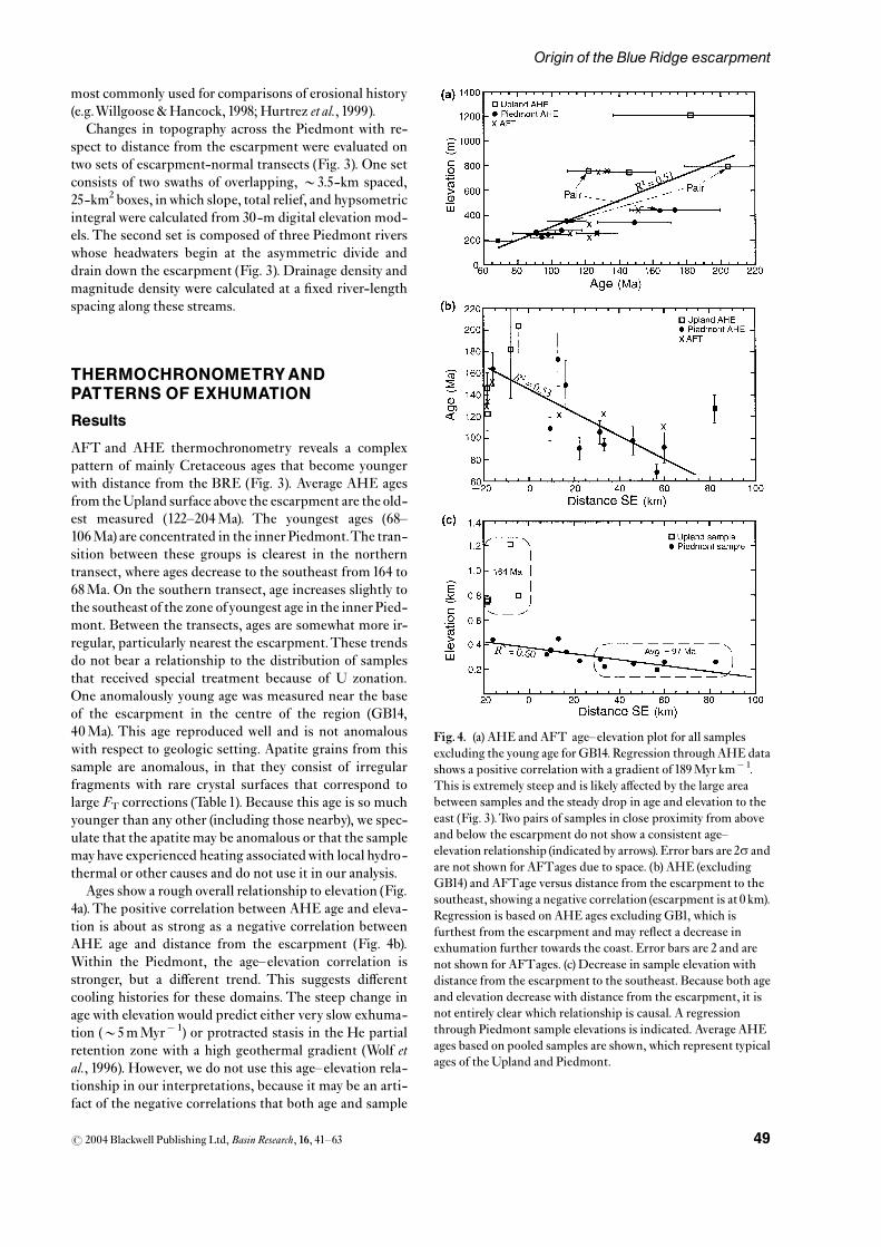
most commonly used for comparisons of erosional history(e.g.Willgoose &Hancock, 1998; Hurtrez et al., 1999).
Changes in topography across the Piedmont with re-spect to distance from the escarpment were evaluated ontwo sets of escarpment-normal transects (Fig. 3). One setconsists of two swaths of overlapping, B3.5-km spaced,25-km2 boxes, inwhich slope, total relief, and hypsometricintegral were calculated from 30-m digital elevation mod-els.The second set is composed of three Piedmont riverswhose headwaters begin at the asymmetric divide anddrain down the escarpment (Fig. 3). Drainage density andmagnitude density were calculated at a ¢xed river-lengthspacing along these streams.
THERMOCHRONOMETRYANDPATTERNS OF EXHUMATION
Results
AFT and AHE thermochronometry reveals a complexpattern of mainly Cretaceous ages that become youngerwith distance from the BRE (Fig. 3). Average AHE agesfrom theUpland surface above the escarpment are the old-est measured (122^204Ma). The youngest ages (68^106Ma) are concentrated in the inner Piedmont.The tran-sition between these groups is clearest in the northerntransect, where ages decrease to the southeast from164 to68Ma. On the southern transect, age increases slightly tothe southeast of the zone ofyoungest age in the innerPied-mont. Between the transects, ages are somewhat more ir-regular, particularly nearest the escarpment.These trendsdo not bear a relationship to the distribution of samplesthat received special treatment because of U zonation.One anomalously young age was measured near the baseof the escarpment in the centre of the region (GB14,40Ma). This age reproduced well and is not anomalouswith respect to geologic setting. Apatite grains from thissample are anomalous, in that they consist of irregularfragments with rare crystal surfaces that correspond tolarge FT corrections (Table 1). Because this age is so muchyounger than any other (including those nearby), we spec-ulate that the apatite may be anomalous or that the samplemayhave experienced heating associatedwith local hydro-thermal or other causes and do not use it in our analysis.
Ages show a rough overall relationship to elevation (Fig.4a).The positive correlation between AHE age and eleva-tion is about as strong as a negative correlation betweenAHE age and distance from the escarpment (Fig. 4b).Within the Piedmont, the age^elevation correlation isstronger, but a di¡erent trend. This suggests di¡erentcooling histories for these domains. The steep change inage with elevationwould predict either very slow exhuma-tion (B5mMyr� 1) or protracted stasis in the He partialretention zone with a high geothermal gradient (Wolf etal., 1996). However, we do not use this age^elevation rela-tionship in our interpretations, because it may be an arti-fact of the negative correlations that both age and sample
Fig.4. (a) AHE and AFT age^elevation plot for all samplesexcluding the young age forGB14. Regression throughAHE datashows a positive correlation with a gradient of 189Myr km� 1.This is extremely steep and is likely a¡ected by the large areabetween samples and the steady drop in age and elevation to theeast (Fig. 3).Two pairs of samples in close proximity from aboveand below the escarpment do not show a consistent age^elevation relationship (indicated by arrows). Error bars are 2s andare not shown for AFTages due to space. (b) AHE (excludingGB14) and AFTage versus distance from the escarpment to thesoutheast, showing a negative correlation (escarpment is at 0 km).Regression is based on AHE ages excluding GB1, which isfurthest from the escarpment and may re£ect a decrease inexhumation further towards the coast. Error bars are 2 and arenot shown for AFTages. (c) Decrease in sample elevation withdistance from the escarpment to the southeast. Because both ageand elevation decrease with distance from the escarpment, it isnot entirely clear which relationship is causal. A regressionthrough Piedmont sample elevations is indicated. Average AHEages based on pooled samples are shown, which represent typicalages of the Upland and Piedmont.
r 2004 Blackwell Publishing Ltd,Basin Research, 16, 41^63 49
Origin of the Blue Ridge escarpment

elevation have with distance from the escarpment (Fig. 4band c).The elevation di¡erences between samples are alsomuch smaller than the horizontal distances that separatethem (Fig. 4c). Sample suites used to derive age^elevationrelationships are typically more closely spaced (B10^20 km) (e.g.Reiners etal., 2003). It is unlikely that isochronswould be horizontal over distances of4100 km, given thatisotherms were probably not horizontal and that exhuma-tion has probably been laterally variant. Sample pairs con-sisting of closely spaced samples from above and below theescarpment also do not show consistent age^elevation re-lationships (Fig. 4a). To better constrain variations in agewith elevation in this region, borehole samples are re-quired.
AFT ages show less variability along the transects (Table2). Four ages from the southern transect vary from 110 to133Ma and have overlapping error bars, thus showing onlya weak decrease in age away from the BRE. Three agesalong the northern transect decrease slightly away fromthe escarpment from152^123Ma, but these similarly haveoverlapping error bars.Two of these samples span an eleva-tion range of 0.5 km in close proximity, but show an inverseage^elevation relationship (the higher sample is younger).
In most cases, AFTages are older than the AHE ages,consistent with the higher closure temperature of theAFT system. However, this is less clear near the escarp-ment and atop the Upland, where AHE ages are closer oreven older than AFT ages.This may indicate that samplesfrom the Upland cooled more quickly through the AFTand AHE closure temperatures than samples from thePiedmont, although subsequent cooling would have beenslower for theUpland.Rapid exhumation in theEarlyCre-taceous is also suggested by the minimal variation in AFTage with elevation throughout the region. However, thisinterpretation is complicated by track length data. Sam-ples on the northwest that yield concordant AFT andAHE ages tend to yield shorter mean track lengths thanthose to the southeast where AHE ages are younger (Table2). This implies that samples of the Upland cooled moreslowly through the AFT partial annealing zone. Prelimin-ary modelling of track lengths and ages suggests an inter-mediate cooling history for Upland samples, in which aperiod of accelerated cooling through the AFTand AHEclosure temperatures was superimposed on overall slowcooling through the AFT annealing zone, which can ex-tend to temperatures below the closure temperature ofAHE.
It is also possible that the concordance of AHE andAFTages on the Upland is linked to unknown analyticalcomplications or in our understanding of closure tem-perature systematics. AFTages would have to be B160^200Ma atop the Upland to match the age di¡erence be-tween AFTand AHE observed on the inner Piedmont. Atthis time, however, the rocks of the Blue Ridge and Pied-mont were much hotter than the annealing temperatureof AFT (e.g. Gates & Glover, 1989). It is thus likely thatAHE ages are overestimated or that they re£ect closuretemperatures that are hotter than generally known (Wolf
etal.,1996).These discrepancieswould beworse if U zona-tion had not been corrected for on AHE ages, suggestingthat some variability may result from errors in these cor-rections. Higher temperature sensitivity might also resultfrom increased He retentivity in the perimeter of apatitegrains associated with He di¡usion gradients (Meesters &Dunai, 2002), an e¡ect that may be particularly importantfor slowly cooled samples such as these. Despite these dif-ferences, however, the changes in ages with distance fromthe BRE are su⁄cient to have important implications forexhumation.
Inferred exhumation
These data are comparable to AHE and AFTages mea-sured elsewhere in the Appalachians, including New Eng-land, the central Valley and Ridge, and the Great SmokyMountains (Roden, 1991; Blackmer et al., 1994; Boettcher& Milliken, 1994; Corrigan et al., 1998; Becker et al., 1999;Naeser et al., 2001; Roden-Tice & Wintsch, 2002; Reed etal., 2002; Zeitler et al., 2002). Because ages are generallyMesozoic, they indicate that recent erosional rejuvenationof the Appalachians, associated with climatic or tectonicforcing such as that suggested by an acceleration in o¡-shore sedimentation since the Miocene (Poag & Sevon,1989; Pazzaglia, 1993; Pazzaglia & Brandon, 1996), has notbeen of su⁄cient magnitude to exhume rocks from depthsat or exceeding the closure isotherms of the AHE andAFT systems. It is surprising that AHE ages are notyounger, given the magnitude of accelerated sedimenta-tion and estimates of exhumation in the past 50Myr basedon modelling ¢ssion-track data (Blackmer et al., 1994;Boettcher & Milliken, 1994; Corrigan et al., 1998). Most ofourAFTandAHE ages imply that average cooling (and, byinference, exhumation) was slower from the He closuretemperature to present than from the ¢ssion-track closuretemperature to present, implying the more rapid coolingin between (i.e. middle Cretaceous). This could match apulse of sedimentation in the Barremian (127^121Ma)(Poag & Sevon, 1989), yet leaves a mysterious mis¢t in thelate Cenozoic.
The pattern of ages argues against the relative uplift ofthe Upland above the Piedmont via warping or faulting inthe vicinity of the escarpment. If the escarpment had beenbuilt by west- side-up faulting at its base, it would juxta-pose a deeper exposure level (i.e. younger isochrons) atthe base of the Upland against a more shallow level (i.e.older isochrons) in the Piedmont. If the low-relief surfacesof the Upland and Piedmont were connected prior towarping or faulting and shared a similar structural levelwith respect to previous cooling through AHE or AFTclosure temperatures, we would expect ages from thedownthrown Piedmont to be roughly equal to ages fromthe upthrownUpland surface (e.g. Spotila etal.,1998). Agesalso show no clear change across the Brevard fault zone ortheTriassic border faults of the Dan River basin, suggest-ing that most major motion on the faults predated cooling(Fig. 3).
r 2004 Blackwell Publishing Ltd,Basin Research, 16, 41^6350
J. A. Spotilaet al.

The negative correlation between age and distance fromthe escarpment mimics a ‘¢ngerprint’ found on othergreat escarpments (Gallagher&Brown,1997).We interpretthis to represent spatial variation in exhumation rate andmagnitude, with greater denudation having occurred onthe Piedmont. Our interpretations are limited withoutage^elevation data from closely spaced vertical sampletransects, although more exhumation on the Piedmont isindicated even if ages are related to sample elevation (Fig.4a). Interpretations of exhumation from these data are alsonon-unique. The problem is one of numerous variables(Z(x, t),T(x, d, t), E(x, t)) that cannot be solved by one formof data (dT/dt) (where Z5 elevation, T5 temperature,E5 erosion, x5 distance, t5 time, d5 depth). To exam-ine geomorphic evolutionwith these data, we thus presentend-member interpretations that relate to di¡erent ero-sional origins for the escarpment.
In the ¢rst case, we interpret data assuming topo-graphic and thermal steady state (Willett & Brandon,2002).We calculate how long-term exhumation rates varyalong the transects based on the cooling ages, assumedclosure temperatures and geothermal gradient, and anon-migrating escarpment (Fig. 5). We assign closuretemperatures to AHE ages of 501^60 1C, based on thesmall but variable apatite grain size and the slow coolinghistory such old ages probably experienced (Wolf et al.,1996; Farley, 2000; Reiners etal., 2003) (Table1).We assumea closure temperature for AFT of 90 1C, based on pre-sumed slow cooling and preliminary modelling of tracklengths.We assume a geothermal gradient of 25 1C km� 1,which is an upper limit based on modern regional heat£ow data but is chosen to represent that heat £ow waslikely higher in the Mesozoic (Costain & Speer, 1988). As-suming a surface ambient temperature ofB10 1C, closuretemperatures correspond to closure depths of B1.6^2.0 km (AHE) and 3.2 km (AFT). For such shallow depths,reasonable geothermal parameters, and the low-amplitudetopography that extends across the transects, isothermsshould be nearly parallel to the topography and thus atequal depths below the Upland and Piedmont surfaces(Turcotte & Schubert, 1982). Lateral variations in geother-mal gradientwouldviolate this, but cooling ages are gener-ally too young to have been a¡ected by major heat £owanomalies associated with Triassic rifting. Exhumationrates calculated for AHE ages based on these assumptionsincrease from the Upland to the Piedmont by nearly a fac-tor of two (11^18mMyr� 1) (Fig. 5). Rates based on AFTages are higher, but increase only slightly to the southeast.Age data are thus consistent with topographic stability ofthe BRE, provided that some condition drives faster ero-sion of the inner Piedmont.
In a second interpretation, we invoke a history of es-carpment erosion and retreat in which samples coolthrough closure temperatures prior to passage of the erod-ing escarpment above them. If the topographic surfacenorthwest and above the migrating escarpment was simi-lar to the modern low-reliefUpland, isochronswould haveformed as gently west-tilting surfaces parallel to the topo-
graphy and isotherms (Fig. 6a). Isochrons would then beexhumed by laterally varying erosion as the escarpmentretreated into the study area.To use AHE ages as markersof the depth of erosion into a ‘stratigraphy’of gently tiltingisochrons, we must assume the vertical spacing of iso-chrons (i.e. an age^elevation gradient). If exhumation ofsamples through closure isotherms occurred at a rate ap-proximated by the long-term average denudation rate in-ferred from all AHE ages and a geothermal gradient of25 1C km� 1, the age^elevation gradient would beB0.017 kmMyr� 1. With this gradient, we can estimatethe position of isochrons above the present-day samplepositions. Fig. 6a shows where the smoothed 150-Ma iso-chron would roughly project. The results indicate thatB0.4^1.4 km greater exhumation occurred over the innerPiedmont. The gentle southeast-upward tilt of the refer-ence isochrons also matches what the Upland surface mayhave looked like prior to escarpment retreat, although the
Fig. 5. (a) Diagram illustrating a steady-state explanation ofAHE and AFTage patterns.The AHE closure depth for AHE(Dc, based on a typical sample closure temperature of 50^60 1Cand an assumed geothermal gradient of 25 1C km� 1) is shown atthe same depth beneath the Upland and Piedmont based oncalculations for the e¡ect of long-wavelength topography(Turcotte & Schubert, 1982).The topography and isotherms areassumed to be maintained in steady state during sample cooling.The exhumation rates required to produce the observedvariation in cooling age can thus be calculated. Results show thatthe average exhumation rate (dz/dt) would have to be greater onthe Piedmont than on the Upland by about a factor of about 2 toyield observed ages. (b) Plots of estimated exhumation rate inmMyr� 1vs. distance normal to the escarpment (escarpment is atdistance5 0 km), calculated for the steady-state case in part (a).Rates based onAHE ages increase linearlywith distance,whereasrates based on AFTages are generally higher and show lessincrease towards the southeast. Regression of AHE-based ratesdoes not includeGB1, which falls o¡ the main trend as in Fig. 4c.
r 2004 Blackwell Publishing Ltd,Basin Research, 16, 41^63 51
Origin of the Blue Ridge escarpment

exhumational bulge does not necessarily equal former to-pography.
To develop a more realistic sense of how cooling agesmight relate to a history of escarpment retreat, we con-structed a simple, forward kinematic model. The modeltracks the position of imaginary AHE samples during re-
treat and lowering of an escarpment and slow, regional ex-humation. It is initiated at 150Ma with a B0.9-km highescarpment far to the east, which then retreats atB1.3 kmMyr� 1to a ¢nal position on thewest and a heightof 450m (Fig. 6b).The original height of the escarpment isas important as geothermal gradient, given that it a¡ects
r 2004 Blackwell Publishing Ltd,Basin Research, 16, 41^6352
J. A. Spotilaet al.

the depth of closure isotherms in the shallow crust. Wechose 0.9 km because it is roughly double the present es-carpment height, and thus implies some downwearing ofthe escarpment as it retreats.The shape of the topographyis drawn to represent simple retreat, and we do not takeinto account variations in erosive power that could resultfrom microclimate, relief, or distance from the main drai-nage divide. In addition to localized erosion at the escarp-ment, regional background exhumation is imposed,whichis uniform across the region but varies with time.This re-presents slow, uniform erosion of the continental margin,associated with an aging orogenic crustal root (e.g. Hack,1980).We assume erosion decelerated in the earlyCenozoicand accelerated in the Late Eocene, to crudely mimicchanges in erosion based on o¡shore sedimentation (Poag& Sevon, 1989).
The topographic evolution imposed by the model hastwo results that could a¡ect the shape of isochrons.One ef-fect is the changing position of the closure isotherm dur-ing escarpment retreat. Assuming the closure isotherm isshallow and heat £ow is laterally invariant, the depth to theisotherm should be the same on either side of the escarp-ment and gradational in between (Fig. 6b). As the escarp-ment retreats over a given position, the isotherm deepens,which causes the depth separation of pre- and post-retreatisochrons to expand (i.e. decrease in age^elevation gradi-ent). It also results in a perturbation in the shape of iso-chrons, such that the youngest ages are exhumed in aspeci¢c area throughwhich the escarpment has retreated.A second e¡ect is isostatic compensation of localized ero-sional unloading.The degree of isostatic rebound shouldbe 0.8 (i.e. ratio of crust and mantle density) of the averagedepth of erosion. However, the distribution of isostatic re-bound depends on the elastic properties of the litho-sphere. Based on models of £exural deformation andgeophysical studies, the lithosphere of this passive marginhas a £exural rigidity ofB4� 1023Nm (Pazzaglia &Gard-
ner,1994).The degree of local isostatic compensation nearthe escarpment (i.e. withinB100 km) should thus be only afew per cent, while the degree of compensation across theentire length of the model should be only about two-thirds(Turcotte & Schubert, 1982; Montgomery, 1994). The re-maining compensation would be distributed over a widerregion. Isochrons should thus not be locally warped up-wards by isostatic rebound in the wake of the eroding es-carpment. If the lithosphere is actually less rigid,however, the e¡ect of local isostasy would be to make ex-humed isochrons in the area of retreat even younger thanfrom isotherm perturbation.
Results of this model mimic the observed pattern ofAHE ages towithin uncertainties (Fig. 6b). Ages are oldeston the Upland (144Ma) and decrease away from the es-carpment towards the coast. A zone of the youngest ages(84Ma) occurs B50km in front of the escarpment, butages become older with greater distance to the east. Thisyoung zone partly re£ects the magnitude of exhumation,but also re£ects the original shape of the closure isothermbeneath the Upland in the advance of escarpment retreat.Ages in this zone could be evenyounger, if the escarpmentwere higher or if signi¢cant local £exural rebound oc-curred. This detailed model therefore demonstrates thefeasibility of producing observed age patterns by slow,steady erosional retreat and lowering of an escarpment fol-lowing rift- £ankuplift (e.g.Ollier,1984;Kooi&Beaumont,1994; Gallagher & Brown, 1997). The key to the model isthat it focuses exhumation along di¡erent parts of thePiedmont at di¡erent times, thus producing zones ofyoung ages that match observations. Results di¡er fromthe ‘slow retreat’ model of Persano et al. (2002), which wasdesigned to explain comparableAHE ages from the south-east Australian escarpment, primarily because our modeluses a smaller initial escarpment height and takes into ac-count regional, background exhumation in the post-riftperiod. However, our model is non-unique and ignores
Fig. 6. (a) Exhumation restored in the migrating escarpment model. AHE ages are treated as marker horizons that formed prior tolaterally varying exhumation. Isochron spacing is based on an age^elevation gradient of 58Myr km� 1 and isochrons are assumed to benearly £at when formed.The position of the150-Ma reference isochron is projected above the Piedmont by restoring the missingthickness of rock above AHE ages, using the assumed age^elevation gradient.The resulting tilt of these isochrons to the southeastindicates that up to1.4 kmmore exhumation occurred over the Piedmont since samples cooled below closure temperatures. For the sakeof simpli¢cation, these calculations ignore several outlier samples (GB14, GB19, GB23, GB27). BRZ5 Brevard fault zone,DRBF5DanRiver boundary fault. (b) Sequential model of a retreating escarpment.Model initiates at150Ma,with anB0.9-km-highescarpment (surface topography5S at t1) and closure isotherm at a uniform depth of 1.8 km (Dc at t1; based onTc5 55 1C andgeothermal gradient of 25 1C km� 1).The gradational shape of the isotherm beneath the escarpment is estimated for periodictopography using reasonable geothermal parameters (Turcotte & Schubert, 1982).The escarpment and closure isotherm retreat atB1.3 kmMyr� 1Former positions of the topographic surface in each time frame are illustrated by a dashed line (S1, S2, etc.). Imaginarysamples (solid circles, squares, and triangles) situated at the closure isotherm in a given time frame are assigned that time as their coolingage.This simpli¢es the model, although it would also be possible to de¢ne precise thermal histories and predict resulting ages usingnumerical solutions to the helium production^di¡usion equation (Wolf et al., 1998). Samples are exhumed by erosion concentrated atthe escarpment as well as regionally uniform exhumation that varies within each step as shown. Sample depths prior to rock uplift ineach time frame are illustrated un¢lled symbols.The magnitude of exhumation in each step is illustrated by vertical lines at the surface.Isostatic rebound should recoverB80% of the eroded depth, but we assume that local compensation (i.e. within the pro¢le shown) istwo-thirds of this. Between each time frame, the average lowering of the topographic surface is thusB50% of the average depth oferosion across the pro¢le.The ¢nal patterns of cooling ages and exhumation magnitude are illustrated at the bottom.
3
r 2004 Blackwell Publishing Ltd,Basin Research, 16, 41^63 53
Origin of the Blue Ridge escarpment

complexities such as lateral variations in geothermal gra-dient or local relative uplift at inland rifts.
We experimented with other models that are not illu-strated.Amodel of downwearing and etching out of the es-carpment from a rift- £ank uplift, rather than erosionalretreat, would produce observed ages if the vertical ero-sion was spatially non-uniform over a prolonged period.For example, the young ages of the inner Piedmont couldbe produced if the rift- £ank uplift were a bulge centredover this area and remained a focus of exhumation in theCenozoic. However, models that involve rapid erosion of arift- £ankuplift followed by topographic stability generallyfail to produce observed age patterns. These models canproduce observed age patterns immediately following theerosional event, but such age patterns are not subse-quently preserved. For example, rapid erosion of an es-carpment at the time of rifting (210Ma) would leavebehind a zone of relatively younger ages in the inner Pied-mont, but these would be removed by subsequent erosionassociated with regional isostatic adjustment and contin-ued removal of the thickenedAppalachian crustal root (i.e.10^30mMyr� 1). It could take as little asB50Myr to ex-hume rocks whose low-temperature cooling history post-dated the erosional event. Given that closure isothermswould be nearly parallel to the topography, subsequentcooling ages would be roughly uniform across the Pied-mont and Upland and show no e¡ect of escarpment ero-sion. This is true even for models in which the erosionalevent takes place well after rifting. For example, a modelin which the escarpment is formed by rapid downwearingatB80Ma would produce the observed ages of the innerPiedmont but fails to preserve old ages on the Upland.These models can bemade towork only by laterallyvaryingerosion subsequent to the erosional event that forms theescarpment. However, like in the steady-state model (Fig.5), this requires a cause of laterally varying erosion ratesand would mean that exhumation patterns re£ect this,rather than an erosional event responsible for the escarp-ment.
Observations are thus consistent with an erosional ori-gin of the BRE, but do not provide unique solution to itstopographic evolution. Models involving greater exhuma-tion of the Piedmont and slow retreat and downwearing ofthe escarpment ¢t observations better than those invol-ving rapid excavation from a rift- £ank uplift and subse-quent topographic stability. However, the models cannotdetermine the degree to which prolonged retreat versusvertical excavation are responsible for the exhumation pat-tern (Persano etal., 2002). It is also possible to produce ob-served age patterns by completely di¡erent erosionalevolution, such as by varying steady-state erosion ratesacross the current topography. However, we consider thisless likely, as it is not clear why the inner Piedmont, whichis already near base level, would erode more rapidly thanthe Upland. One possible driver of Piedmont erosion is£exure associated with o¡shore loading, but this is likely asmall e¡ect (Pazzaglia &Gardner,1994).Thus, althoughwefavour a model of slow erosion and escarpment retreat, ad-
ditional data are required to fully constrain the topo-graphic evolution of the BRE.
TOPOGRAPHYAND RELATIVEEROSIONAL HISTORY
Observations
Topographic indices from square subsets and drainage ba-sins of the Upland and Piedmont are dissimilar. Slope andrelief are uniform among boxes from the Piedmont, buthigher and more variable within the Upland (Fig. 7a).Thisindicates that the Upland is more rugged. Hypsometriccurves of subsets are uniform within either domain, butare distinct between them (Fig.7b).All hypsometric curvesare similarly shaped, but Upland curves are lower thanPiedmont curves and correspond to smaller hypsometricintegrals.This indicates that the Upland has a larger frac-tion of its surface at relatively low elevation, while isolatedhighs (e.g. monadnocks like Bu¡alo Mountain) produce alarger range in total relief. Upland and Piedmont basinsare also distinct (Figs 7c and 8). Piedmont basins havehigher drainage and magnitude densities, whereas sinuos-ity is greater for Upland basins. These di¡erences are vi-sually apparent in the line drawings of the streamnetworks themselves, particularly the greater meanderingof Upland streams (Fig. 8). In contrast, basin hypsometryis more variable within theUpland andPiedmont (Fig.7d).Hypsometric curves are similarly shaped, overlap, andhave a limited range of hypsometric integrals. On average,however, theUpland basins have higher integrals.This dif-fers from the hypsometry of subsets, due to di¡erent reliefstructure of inter£uves andwhole basins.
Escarpment transects indicate a wide zone of transi-tional topography along the westernmost Piedmont thatis less rugged than the escarpment but more rugged thanthe Piedmont to the east. For the two swaths of square sub-sets across the escarpment, highest slope, relief, and hyp-sometric integral occur in boxes that overlap theescarpment face (Fig. 9a). No box is entirely containedwithin the most rugged zone, so values underestimatepeak slope and relief of the escarpment. Hypsometric in-tegrals in the escarpment zone are high (B0.7), consistentwith being dominated by steep hillslopes. Although reliefand hypsometric integral decrease to minimal values justbelow the escarpment, slope remains elevated relative tothe average Piedmont slope ofB81 (Fig. 7a) to a distanceofB30 km from the escarpment. Stream transects reveala similar transitional zone. Drainage and magnitude den-sity are low andvariable withinB5 km of the divide, due tohigh relief andvariation in topography and the integrationof drainage network in headwater regions (Fig. 9b).There-after, values increase at a rate that decreases with distance,resulting in asymptotic curves that gradually approach theaverage values for Piedmont drainage basins over a dis-tance of B30 km.This transitional zone is not otherwiseobvious on topographic maps and greatly exceeds the 3-kmwidth of the escarpment face itself.
r 2004 Blackwell Publishing Ltd,Basin Research, 16, 41^6354
J. A. Spotilaet al.

Fig.7.
(a)A
verage
slop
eandreliefatd
i¡erentw
avelengths
of25-km
2boxesfromtheUplandandPiedmon
t(show
ninFig.3).(b)Hyp
sometry
andaveragehypsom
etricintegrals(HI)forU
plandand
Piedmon
t25-km
2boxes(Strahler,1952).(c)Drainagedensity
(kmkm
�2 ),m
agnitude
density
(num
bero
f¢rst-orderstreamsk
m�2 ,usingStrahler(1957)order),sinu
osity
averaged
forstreamso
ffou
rth
orderand
higher,and
relation
ship
ofdrainage
density
andtotalbasin
relieffor
Piedmon
tand
Uplandbasins
(showninFigs
3,8).L
ettersreferto
basinname:C5
Crooked
Creek,D
5DeepCreek,
L5
LittleRiver,M
5Mud
dyCreek,R
5LittleReedIsland
Creek,S
5SandyRiver.(d)Hyp
sometryandaveragehypsom
etricintegrals(HI)forU
plandandPiedmon
tbasins(Strahler,1952).N
otethat
allvaluesarecalculated
from
30-m
resolution
digitalelevation
mod
elsu
sing
MicrodemandRivertoolssoftware.Nocalculationissign
i¢cantlya¡ectedby
variations
intheoriginalcontou
rintervalof
topo
graphicmapsu
sedtoextractthe
digitaltop
ography,becausecontou
rintervalsaregenerally
thesameon
mapso
fthe
comparable,low-reliefU
plandandPiedmon
tsurfaces.Valueswerealso
locally
checkedby
manualm
easurementu
sing
topo
graphicmaps.
r 2004 Blackwell Publishing Ltd,Basin Research, 16, 41^63 55
Origin of the Blue Ridge escarpment

Interpretations
Di¡erences in topography of theUpland andPiedmont areconsistentwith the interpretation that the escarpment hasevolved by westward erosional retreat.There is no indica-tion that the Piedmont andUplandwere a continuous ero-sion surface with like erosional histories prior to relativeuplift at the escarpment. The greater ruggedness of theUpland implies that it may erode more rapidly than thePiedmont. Relief and slope increase with rates of erosionand in turn increase erosive power (e.g. Ahnert, 1970; Hur-trez et al., 1999; Whipple & Tucker, 1999; Roering et al.,2001; Spotila etal., 2002). A di¡erence in erosion rate couldbe due to the greater height of theUpland above local baselevel (B700m forUpland,B300m for Piedmont (Fig. 2)),but the di¡erence in ruggedness is not so great as to sug-gest major rejuvenation of the Upland by relative uplift. A
lower erosion rate of the Piedmont is also consistent withescarpment retreat. The Piedmont surface would havebeen beveled to low relief as the zone of intense escarp-ment erosion passed and has since been more slowlyeroded. The lower occurrence of residual highs in thePiedmont that is evident in subset hypsometry is also con-sistent with having been beveled during retreat.
Drainage networks of theUpland andPiedmont are alsoconsistent with erosional retreat of the BRE. Parametersare di¡erent between the domains and fail to indicate thatthe surfaces were once contiguous or that the Upland hasbeen uplifted above the Piedmont. Lower drainage andmagnitude densities of theUpland (and the escarpment it-self) are probably related to higher relief (Figs. 7c, 9b), gi-ven that more relief means longer hillslope length andmore erosion by di¡usive creep and landsliding (Oguchi,1997;Moglen et al., 1998;Tucker & Bras, 1998).This is typi-
Fig. 8. Drainage networks forUpland (top) andPiedmont (bottom) basins, used for calculating channelization parameters. Locations ofbasins are shown in Fig. 3.
r 2004 Blackwell Publishing Ltd,Basin Research, 16, 41^6356
J. A. Spotilaet al.

Fig.9.
(a)A
verage
slop
e,total(5-km
wavelength)relief,andhypsom
etricintegralcalculated
in25-km
2boxesarrangedintwoswaths
perpendiculartotheescarpment(show
ninFig.3).T
helocation
oftheescarpmentisshownasag
reyband
.(b)Drainagedensity
(kmkm
�2 )andmagnitude
density
(num
berof¢rst-orderstreamsk
m�2 )calculated
at0.7-km
river-length
intervalsalong
threeriversthat
drainfrom
theasym
metricdivide,dow
ntheescarpment,andintotheP
iedm
ont(Fig.3).C
alculation
sareincrem
ental,representing
thedrainage
andmagnitude
density
ofthebasinarea
thatisadded
tothetrun
kstream
ateach
0.7km
reach.Valuesfalling
o¡themaintrendaredu
etothee¡ectoftribu
taries,w
hich
sometim
esviolatean
assumptionofun
iform
change
inbasinarea
withun
itstream
length
thatwas
requ
ired
bythecalculationmetho
d.Notethatvalues
£atten
outn
earaverage
Piedmon
tvalues(dashed
lines)atd
istances
of15^35km
from
theescarpment(verticalgrey
band
).
r 2004 Blackwell Publishing Ltd,Basin Research, 16, 41^63 57
Origin of the Blue Ridge escarpment

cal of humid climates and transport-limited conditions, inwhich dense vegetation and transmissive saprolite resultin large hillslope area required to attain saturation thresh-old for channel initiation (Chorley, 1957; Carlston, 1963;Mills et al., 1987). Under such conditions drainage densityshould not be indicative of erosion rate, unlike basins de-veloped in arid climates or areas of rapid tectonic uplift(Strahler, 1957; Willgoose et al., 1991; Hurtrez et al., 1999).Hypsometric curves of Upland and Piedmont basins aretypical of ‘graded’ rivers in humid climates that are not ex-periencing rapid rockuplift (Strahler,1952;Willgoose etal.,1991).Hypsometric integrals are probably not indicative ofrelative erosion rates, unlike rapidly uplifting mountaincatchments (Ohmori, 1993; Hurtrez et al., 1999). Instead,higher hypsometric integrals of the Upland basins arelikely linked with the Upland’s greater relief and irregularbasin shape (Willgoose & Hancock, 1998; Hurtrez et al.,1999). Greater sinuosity and meandering of high-orderUpland streams may indicate that the drainage area feed-ing Upland streams has been reduced, given the similardrainage areas of Upland and Piedmont basins and the re-lationship between meander wavelength and drainage area(Carlston, 1965; Leopold &Langbein, 1966). Although thisis a weak suggestion given the complexity of controls onriver meandering, it is consistentwith retreat of the divide.
The 30-km-wide zone of transitional topography on thewesternmost Piedmont, indicated by escarpment-normaltransects, is also consistent with erosional escarpment re-treat.The escarpment itself is rugged, suggesting it erodesmore rapidly than the neighbouring lowlands.The transi-tional zone may be a band of intermediate topographic ad-justment, where erosion is more rapid and hillslopeprocesses are relatively more important than on the Pied-mont further east.This matches intuitive expectations ofescarpment retreat, in which a zone of recently eroded to-pography is left in its path.This is a speculative interpreta-tion, however, and other data would be required to testwhether this zone of transitional topography has migratedwestward over time.
In summary, these topographic clues are qualitativelyconsistent with the model of escarpment origin by ero-sional retreat. There is no strong argument that the Up-land and Piedmont surfaces are remnants of a oncecontiguous erosion surface. The Upland may be slightlymore rugged and incised due to its higher elevation abovebase level, but is not so much more rugged as to imply ma-jor rejuvenation due to uplift above the Piedmont. Thereare also vague clues that the escarpment and drainage di-vide have migratedwestward.However,we recognize that alandscape’s topographic expression re£ects not only ero-sional evolution but also the sum of interaction of ero-sional processes with regional, changing boundaryconditions, such as bedrock, climate, tectonics, and baselevel. Local variation in bedrock or climate may be respon-sible for some observed variations in topography. Yetwithin the topographic character of these domains,there is nothing that argues against the model of escarp-ment retreat.
DISCUSSIONS
These data indicate that the BRE had an erosional origin.The BRE thus appears to be a true passive margin greatescarpment, as suggested previously by Pazzaglia & Gard-ner (2000). Given that rifting along the North Americanpassive margin occurred in the Triassic, this may be theoldest margin to display a prominent great escarpmentwith an erosional origin (Ollier, 1984). This implies thatsuch landforms may persist due to slow, stable erosionalprocesses for a protracted period following rifting. Thisalso implies that Appalachian topography, although locallyrugged and impressive, can be explained without callingon late Cenozoic tectonic rejuvenation (Baldwin et al.,2003).
Thermochronometry indicates that the Piedmont hasexperienced greater exhumation throughout the Ceno-zoic. This is consistent with the Piedmont having hadhigher topography than at present, and thuswith erosionalretreat and excavation of the BRE. Signi¢cant late Ceno-zoic erosion of the escarpment may have contributed tothe increase in sedimentation rates observed in the Balti-more Canyon Trough and Cape Hatteras Basin since theMiocene (Poag & Sevon, 1989; Pazzaglia, 1993).The originof this topography and erosion across the Piedmont islikely to have been Mesozoic rift- £ank uplift, as has beenargued for other great escarpments (Ollier, 1984). Inlandrift systems may have contributed to this uplift, given thatthey lie much closer to the BRE than the coastline wheretrue sea- £oor spreading initiated (Thayer et al., 1970).Events since rifting mayhave also played a role. Finite, tec-tonically driven thermal events, such as magmatic under-plating, have been proposed as sources of dynamictopography and sporadic o¡shore sediment pulses in thepast 200Ma (Pazzaglia & Brandon, 1996). It is also likelythat broadly focused isostatic rebound and £exure asso-ciated with continental erosion and o¡shore sedimenta-tion have contributed to uplift and perhaps helped tokeep the asymmetric divide pinned at the escarpment’stop (Pazzaglia & Gardner, 2000). Late Cenozoic climatechange may have also increased erosional e⁄ciency andsharpened the landform’s expression.
The speci¢c erosional and topographic evolution of theBRE is not well de¢ned by these data.We prefer a modelthat involves steady, protracted erosion of a rift- £ank upliftthat continues to the present and involved both retreat anddownwearing of the escarpment over many tens of kilo-metres (Fig. 6b).Topographic clues also qualitatively sug-gest escarpment retreat and asymmetric drainage dividemigration.This is consistent with other lines of evidence.Drainage divide migration is suggested by an apparent de-crease in drainage area ofUpland basins, which is exempli-¢ed by isolated terrace deposits atop the divide. Litters ofloose, rounded, weathered cobbles up to 30-cm diameteroccur locally on the Upland surface within a few hundredmetres of the Gulf of Mexico^Atlantic divide (Wright,1927b).These cobbles appear oversized and over-roundedfor the small streams that currently drain the valleys they
r 2004 Blackwell Publishing Ltd,Basin Research, 16, 41^6358
J. A. Spotilaet al.

rest in. In some cases, these clasts also have compositionsthat indicate derivation from the Piedmont to the east,such as amphibolite and diabase (Dietrich, 1959). Therehave also been arguments made for individual stream cap-ture events of large Upland streams, such as of the DanRiver (Dietrich, 1959; Hack, 1982). Projecting the dividewestward into the gently rolling topography of theUpland,it is easy to envision howdivide migration could evolve as aseries of smaller basin captures. Large-scale and piece-meal capture of Upland drainages could actually foster re-treat of the escarpment face by increasing the power ofescarpment-face streams to incise, much like how arch-type/gorge-head escarpments evolve (Weissel & Seidl,1998).
The degree and timing of this proposed westward mi-gration of the escarpment and drainage divide are notknown. It is plausible that vertical erosion has played a sig-ni¢cant role in excavating the escarpment out of a preex-isting topographic high across the inner Piedmont. Thishas been suggested for other great escarpments, but is dif-¢cult to test using models of low-temperature thermo-chronometry (Persano et al., 2002).Vertical erosion would¢twith interpretations that escarpment retreat is not likelyto be maintained at a linear pace following rifting (Mat-mon etal., 2002). Prolonged survival of a retreating escarp-ment in the temperate climate of the southernAppalachians may con£ict with the process-based under-standing of long-term landscape evolution. Numerical si-mulations predict that preservation of a steep escarpmentmay require a low rate of hillslope di¡usion (relative to £u-vial advection), which is uncommon in humid climates(Gilchrist etal.,1994;Kooi&Beaumont,1994).Escarpmentmigration may also be dependent on the presence of incis-ing bedrock channels on the escarpment, high relative ele-vation of the continental hinterland, certain preexistingtopography on the rift £ank (Gilchrist et al., 1994; Kooi &Beaumont, 1994;Tucker & Slingerland, 1994), and speci¢cgeodynamic conditions such as low lithospheric rigidity(ten Brink & Stern, 1992; Gallagher et al., 1994). Instead ofmigrating, escarpments may degrade as streams adjust tobase level, as erosion in valleys exceeds that on escarp-ment-face inter£uves, and due to an inability of escarp-ment streams to incise given the small drainage area.Theobservation of slow erosion on some escarpment faces isconsistent with this (Bierman & Ca¡ee, 2001). One localcondition that may have fostered the persistence of the es-carpment, however, is microclimate; the escarpment trapslow-altitude moisture and produces a belt of concentratedannual precipitation along its face that could focus erosion(USDA,1999).
The existence of an erosional escarpment along such anold passive margin has important implications. Low-tem-perature cooling ages from coastal plains of some great es-carpments, such as southeast Australia, are equal to orolder than the time of the rifting responsible for produ-cing rift- £ank uplift (e.g. Moore et al., 1986; Bishop &Goldrick, 2000; Persano etal., 2002).This has led to the in-terpretation that great escarpments evolve by very rapid
downwearing and become ¢xed shortly after rifting (Paz-zaglia & Gardner, 2000; Matmon et al., 2002). In contrast,cooling ages from the Piedmont are 4100Myr youngerthan the age of rifting. In fact, AHE ages from along trans-ects across the BRE are the same range as those from thegreat escarpment along southeast Australia, which experi-enced Late Cretaceous rifting (Persano et al., 2002). Thishas also been observed on other Atlantic-margin great es-carpments, such as southwest Africa and Brazil, wherepulses of erosion post-date rifting (Gallagher et al., 1994;Brown et al., 2000).That great escarpments along old pas-sive margins display similar cooling age patterns as thoseon younger margins implies that the erosional mechan-isms of escarpment formation that are active early afterrifting can continue for a very long period and that earlyonset of topographic stability is not strictly required ofpassive margin evolution. This is further suggested byAFT ages from east of our study area near the coast, whichare older (B150^200Ma) than the ages we observe in theinner Piedmont (Zimmermann, 1979; Horton et al., 2002).These imply that the focused denudation that a¡ected theinner Piedmont in the Late Cretaceous had occurredfurther east at the time of rifting, and thus that this zoneof active erosion has migrated inland over the 200Myr his-tory of the passive margin.
CONCLUSIONS
Apatite He and ¢ssion-track thermochronometry alongtransects across the BRE match a ¢ngerprint-like patternof passive margin great escarpments. AHE ages are oldestatop the Blue Ridge Upland (B120^200Ma) and decreasetowards a zone in the inner Piedmont (B70^100Ma).Thisdi¡erence in cooling history, as well as topographic di¡er-ences in their low-relief surfaces, indicate that the UplandandPiedmontwere not recently connected as a continuouserosion surface and that late Cenozoic relative uplift of theUpland has not occurred. As with other great escarp-ments, the age pattern implies a greater magnitude of ex-humation across the lowland.We favour an interpretationof this exhumation as involving long-term, steady ero-sional processes. However, the exhumation pattern in-ferred from the ages is non-unique, and thus multiplescenarios of an erosional evolution are feasible. One end-member explanation is a case of topographic and exhuma-tional steady state, sustained for a protracted period, inwhich younger ages in the Piedmont are caused by highererosion rates. However, there is no obvious reason for thePiedmont to erode more quickly than the Blue Ridge Up-land. A second model invokes long-term erosional retreatof the escarpment and asymmetric divide throughout theCenozoic. In this case, younger ages in the Piedmont aredue to greater exhumation and the non-planar geometryof isochrons produced by topographically warped iso-therms prior to escarpment retreat. This model ¢ts withthermochronometry and several geomorphic observa-tions, including a zone of transitional topography to the
r 2004 Blackwell Publishing Ltd,Basin Research, 16, 41^63 59
Origin of the Blue Ridge escarpment

east of the escarpment and the character of drainage basinsatop the Upland. Although we favour this second model,additional data are required to better constrain the ero-sional evolution of the escarpment.
ACKNOWLEDGEMENTS
The majority of this workwas completed by Greg Bank asanMS thesis at VirginiaTech. Research was supported byVirginiaTech, a student grant toGregBank from theGeo-logical Society of America, NSFAwards EAR9906357 andEAR0001239 to Spotila, and the US Geological Survey’sNational Cooperative Geologic Mapping Program. Wethank reviewers Paul Bishop and Frank Pazzaglia for theire¡orts and Ray Donelick for assistance with apatite sepa-rates. Hugh Sinclair is acknowledged for an e⁄cient andfair review process.
REFERENCES
Ahnert,F. (1970)Functional relationships between denudation,relief, and uplift in large mid-latitude drainage basins. Am. J.Sci., 268, 243^263.
Baldwin, J.A.,Whipple,K.X. &Tucker,G.E. (2003) Implica-tions of the shear^stress river incision model for the timescaleof post-orogenic decay of topography. J.Geophys. Res., 108(B3),2158.
Battiau-Queney,Y. (1989)Constraints from deep crustal struc-ture on long-term landform development of the British Islesand eastern United States.Geomorphology, 2, 53^70.
Becker,T.P., Pazzaglia, F.J., Zeitler, P.K. & Idleman, B.D.(1999) Late-stage exhumation of the Central and NorthernAppalachians utilizingU T̂h/He dating of apatite.EOSTrans.,Am. Geophys. Union, 80(46), 1171.
Bierman, P.R. & Caffee, M. (2001) Steady state rates of rocksurface erosion and sediment production across the hyperaridNamibDesert and theNamibian escarpment, southernAfrica.Am. J. Sci., 301, 326^358.
Bishop,P.&Goldrick,G. (2000)Geomorphological evolutionof the East Australian continental margin. In: Geomorphologyand Global Tectonics (Ed. by M.A Summer¢eld), pp. 225^254.JohnWiley and Sons, NewYork.
Blackmer,G.C.,Omar,G.I.&Gold,D.P. (1994)Post-Allegha-nian unroo¢nghistory of theAppalachianBasin, Pennsylvania,from apatite ¢ssion track analysis and thermal models. Tec-tonics, 13, 1259^1276.
Boettcher, S.S.&Milliken,K.L. (1994)Mesozoic^Cenozoicunroo¢ng of the southern Appalachian Basin: apatite ¢ssiontrack evidence from Middle Pennsylvanian sandstones. J.Geol., 102, 655^663.
Bohannon, R.G., Naeser, C.W., Schmidt, D.L. & Zimmer-
mann,R.A. (1989)The timing of uplift, volcanism, and riftingperipheral to the Red Sea: a case for passive rifting? J.Geophys.Res., 94, 1683^1701.
Bollinger, G.A. (1973) Seismicity and crustal uplift in thesoutheastern United States.Am. J. Sci., 273-A, 396^408.
Brown, R.W., Gallagher, K., Gleadow, A.J.W. & Summer-
field, M.A. (2000) Morphotectonic evolution on the SouthAtlantic margins of Africa and South America. In: Geomor-
phology and Global Tectonics (Ed. by M.A. Summer¢eld), pp.255^281. JohnWiley and Sons, NewYork.
Carpenter, B.S. & Reimer, G.M. (1974) Standard referencematerials ^ calibrated glass standards for ¢ssion track use.Natl. Bur. Stand. Spec. Publ., 260 -49, 16pp.
Carlston, C.W. (1963) Drainage density and stream£ow. USGeol. Surv. Prof. Pap., 422-C, 1^8.
Carlston,C.W. (1965)The relationship of free meander geome-try to stream discharge and its geomorphic implications. Am.J. Sci., 263, 864^885.
Chorley,R.J. (1957)Climate andmorphometry. J.Geol.,65, 628^638.
Cockburn,H.A.,Brown,R.W.,Summerfield,M.A.&Seidl,M.A. (2000) Quantifying passive margin dunudation andlandscape development using a combined ¢ssion-track ther-mochronology and cosmogenic isotope analysis approach.Earth Planet. Sci. Lett., 179, 429^435.
Corrigan, J., Cervany, P.F.,Donelick, R. & Bergman, S.C.(1998) Postorogenic denudation along the late Paleozoic Oua-chita trend, south central United States of America: magni-tude and timing constraints from apatite ¢ssion track data.Tectonics, 17, 587^603.
Costain, J.K.& Speer, J.A. (1988) Heat £ow and geothermal re-source potential of theAtlanticCoastal Plain. In:TheGeology ofNorth America, the Atlantic Continental Margin, U.S. (Ed. by R.E.Sheridan& J.A.Grow), pp. 521^528Decade ofNorthAmericanGeology Series, Vol. I-2. Geological Society of America,Boulder, CO.
Davis,W.M. (1903) The stream contest along the Blue Ridge.Geol. Soc. Philadelphia Bull., 3, 213^244.
Dietrich, R.V. (1957) Origin of the Blue Ridge Escarpment di-rectly southwest of Roanoke, Virginia. Virginia J. Sci., 8,233^246.
Dietrich, R.V. (1959) Geology and mineral resources of FloydCounty of the Blue Ridge Upland, southwesternVirginia.Bull.Virginia Polytech. Inst., 134, 160pp.
Edelman, S.H., Liu, A. & Hatcher, R.D. (1987) The Brevardzone in South Carolina and adjacent areas: an Alleghanianorogen-scale dextral shear zone reactivated as a thrust fault.J. Geol., 95, 793^806.
England, P.C. & Richardson, S.W. (1977) The in£uenceof erosion upon the mineral facies of rocks from di¡erentmetamorphic environments. J. Geol. Soc. London, 134,201^213.
Farley, K.A. (2000) Helium di¡usion from apatite: general be-havior as illustrated by Durango £uorapatite. J. Geophys. Res.,105, 2903^2914.
Farley, K.A.,Wolf, R.A. & Silver, L.T. (1996) The e¡ects oflong alpha-stopping distances on (U T̂h)/He ages. Geochim.Cosmochim. Acta, 60, 4223^4229.
Fitzgerald,P.G.,Sorkhabi,P.B.,Redfield,T.F.&Stump,E.(1995) Uplift and denudation of the central Alaska Range ^ acase study in the use of apatite ¢ssion track thermochronologyto determine absolute uplift parameters. J. Geophys. Res., 100,20,175^20,191.
Galbraith, R. (1981) On statistical models for ¢ssion trackcounts.Math. Geol., 13, 471^488.
Gallagher,K. (1995) Evolving temperature histories from apa-tite ¢ssion track data. Earth Planet. Sci. Lett., 136, 421^435.
Gallagher,K.&Brown,R. (1997) The onshore record of pas-sive margin evolution. J. Geol. Soc. London, 154, 451^457.
Gallagher, K., Hawkesworth, C.J. &Mantovani,M.S.M.
(1994) The denudation history of the onshore continental
r 2004 Blackwell Publishing Ltd,Basin Research, 16, 41^6360
J. A. Spotilaet al.

margin of SE Brazil inferred from apatite ¢ssion track data. J.Geophys. Res., 99, 18,117^18,145.
Gardner,T.W. (1989) Neotectonism along the Atlantic passivecontinental margin: a review.Geomorphology, 2, 71^97.
Gates, A.E. & Glover, L. (1989) Alleghanian tectono-thermalevolution of the dextral transcurrentHylas zone,Virginia Pied-mont, USA. J. Struct. Geol., 11, 407^419.
Gilchrist,A.R.,Kooi,H.&Beaumont,C. (1994) Post-Gond-wana geomorphic evolution of southwestern Africa: implica-tions for the controls on landscape development fromobservations and numerical experiments. J. Geophys. Res., 99,12, 211^12, 228.
Gleadow, A.J.W., Duddy, I.R., Green, P.F. & Lovering, J.F.(1986) Con¢ned ¢ssion track lengths in apatite: a diagnostictool for thermal history analysis. Contrib. Mineral. Petrol., 94,405^415.
Granger, D.E., Kirchner, J.W. & Finkel, R.C. (1997) Qua-ternary downcutting rate of the NewRiver,Virginia, measuredfrom di¡erential decay of cosmogenic 26-Al and 10-Be incave-deposited alluvium.Geology, 25, 107^110.
Green, P.F., Duddy, I.R., Gleadow, A.J.W. & Lovering, J.F.(1989) Apatite ¢ssion-track analysis as a paleotemperature in-dicator for hydrocarbon exploration. In:Thermal History of Se-dimentary Basins ^ Methods and Case Histories (Ed. by N.D.Naeser & T.H. McCulloh), pp. 181^185. Springer-Verlag, NewYork.
Guth,P.L. (1995) Slope and aspect calculations on gridded digi-tal elevation models: examples from a geomorphometric tool-box for personal computers. Z. Geomorphol. N.F. Suppl., 101,31^52.
Hack, J.T. (1960) Interpretation of erosional topography in hu-mid temperate regions.Am. J. Sci., 258-A, 80^97.
Hack, J.T. (1973) Drainage adjustment in the Appalachians. In:Fluvial Geomorphology (Ed. by M. Morisawa), pp. 51^69. StateUniversity of NewYork, Binghamton.
Hack, J.T. (1980) Rock control and tectonism; their importancein shaping the Appalachian highlands. US Geol. Surv. Prof.Pap., 1126 -B, 1^17.
Hack, J.T. (1982) Physiographic divisions and di¡erential upliftin the Piedmont and Blue Ridge. US Geol. Surv. Prof. Pap.,1265, 49pp.
Harbor,D.J. (1996) Nonuniform erosion patterns in the Appa-lachian Mountains of Virginia. Geol. Soc. Am. Abstr. Prog., 28,(7), 116.
Hayes, C.W. & Campbell,M.R. (1894) Geomorphology of thesouthern Appalachians.Natl. Geog.Mag., 6, 63^126.
Horton, J.W. JR, Kunk, M.J., Naeser, C.W., Naeser, N.D.,Aleinikoff, J.N. & Izett,G.A. (2002) Petrography, geochro-nology, and signi¢cance of crystalline basement rocks and im-pact-derived clasts in the Chesapeake Bay impact structure,southeasternVirginia.Geol. Soc. of Am. Abstr. Prog., 34(6), 466.
House,M.A.,Wernicke,B.P.&Farley,K.A. (1998)Dating to-pography of the Sierra Nevada, California, using apatite (U^Th)/He ages.Nature, 396, 66^69.
Hubbard,S.S.,Coruh,C.&Costain, J.K. (1991)Paleozoic andGrenvillian structures in the southern Appalachians: ex-tended interpretation of seismic re£ection data. Tectonics, 10,141^170.
Hurford, A.J. &Green, P.F. (1983) The zeta age calibration of¢ssion-track dating. Chem. Geol. (Isotope Geosci. Sect.), 1, 285^317.
Hurtrez, J.E.,Lave, J.&Avouac, J.P. (1999) Investigation of therelationships between basin morphology, tectonic uplift, and
denudation from the study of an active fold belt in the SiwalikHills, central Nepal. J. Geophys. Res., 104, 12,779^12,796.
Klitgord, K.D., Hutchinson, D.R. & Schouten, H. (1988)U.S. Atlantic continental margin: structural and tectonic fra-mework. In:TheGeology ofNorthAmerica, theAtlanticContinentalMargin, U.S. (Ed. by R.E. Sheridan & J.A. Grow), pp. 19^57Decade of North American Geology Series,Vol. I-2. Geologi-cal Society of America, Boulder, CO.
Kooi,H.&Beaumont,C. (1994)Escarpment evolution on high-elevation rifted margins: insights derived from a surface pro-cesses model that combines di¡usion, advection, and reaction.J. Geophys. Res., 99, 12,191^12,209.
Laslett, G.M., Green, P.F., Duddy, I.R. & Gleadow,A.J.W. (1987) Thermal annealing of ¢ssion tracks in apatite 2. Aquantitative analysis.Chem.Geol. (IsotopeGeosci. Sect.), 65, 1^13.
Leopold, L.B. & Langbein,W.G. (1966) River meanders. Sci.Am., 214, 60^70.
Marple, R.T. & Talwani, P. (2000) Evidence for a buried faultsystem in the Coastal Plain of the Carolinas andVirginia ^ Im-plications for neotectonics in the southeastern United States.Geol. Soc. Amer. Bull., 112, 200^220.
Matmon,A.,Bierman,P.&Enzel,Y. (2002) Pattern and tempoof great escarpment erosion.Geology, 30, 1135^1138.
Matmon, A., Bierman, P., Larsen, J., Southworth, S., Pa-vich, M. & Caffee, M. (2003) Temporally and spatially uni-form rates of erosion in the southern Appalachian GreatSmokyMountains.Geology, 31, 155^158.
Meesters, A.G.C.A. & Dunai,T.J. (2002) Solving the produc-tion^di¡usion equation for ¢nite di¡usion domains of variousshapes, Part II. Application to cases with a-ejection and non-homogenous distribution of the source.Chem. Geol., 186, 347^363.
McGee,V.E., Johnson,N.M. &Naeser,C.W. (1985) Simulated¢ssioning of uranium and testing of the ¢ssion-track datingmethod.Nucl.Tracks Radiat.Meas., 10, 365^379.
Mills, H.H., Brakenridge, G.R., Jacobson, R.B., Newell,W.L., Pavich, M.J. & Pomeroy, J.S. (1987) Appalachianmountains and plateaus. In:Geomorphic Systems of North Amer-ica (Ed. by W.L. Graf), pp. 5^50 Centennial Special, Vol. 2.Geological Society of America, Boulder, CO.
Mixon, R.B. & Newell, W.L. (1977) Sta¡ord fault system:structures documentingCretaceous andTertiary deformationalong the Fall Line in northeastern Virginia. Geology, 5, 437^440.
Moglen, G.E., Eltahir, E.A.B. & Bras, R.L. (1998) On thesensitivity of drainage density to climate changes.Water Resour.Res., 34, 855^862.
Montgomery, D.R. (1994) Valley incision and the uplift ofmountain peaks. J. Geophys. Res., 99, 13,913^13,921.
Moore,M.E.,Gleadow, A.J.W. & Lovering, J.F. (1986)Ther-mal evolution of rifted continental margins: new evidencefrom ¢ssion tracks in basement apatites from southeasternAustralia. Earth Planet. Sci. Lett., 78, 255^270.
Morisawa, M. (1989) Rivers and valleys of Pennsylvania, revis-ited.Geomorphology, 2, 1^22.
Naeser,C.W. (1979) Fission-track dating and geologic annealingof ¢ssion tracks. In:Lectures in IsotopeGeology (Ed. by E. Jager &J.C. Hunziker), pp.154^169. Springer-Verlag, NewYork.
Naeser, C.W. & McKee, E.H. (1970) Fission-track and K^Arages of Tertiary ash- £ow tu¡s, north-central Nevada. Geol.Soc. Am. Bull., 81, 3375^3384.
Naeser, C.W., Naeser, N.D., Kunk, M.J., Morgan, B.A. III,Schultz, A.P., Southworth, C.S. & Weems, R.E. (2001)
r 2004 Blackwell Publishing Ltd,Basin Research, 16, 41^63 61
Origin of the Blue Ridge escarpment

Paleozoic through Cenozoic uplift, erosion, stream capture,and deposition history in the Valley and Ridge, Blue Ridge,Piedmont, and Coastal Plain provinces of Tennessee, NorthCarolina, Virginia, Maryland, and District of Columbia (ab-stract).Geol. Soc. Am. Abstr. Prog., 33(6), A312.
Naeser,N.D.,Naeser,C.W.&McCulloh,T.H. (1989) The ap-plication of ¢ssion-track dating to the depositional and ther-mal history of rocks in sedimentary basins. In: ThermalHistory of Sedimentary Basins - Methods and Case Histories (Ed.by N.D. Naeser & T.H. McCulloh), pp. 157^180. Springer-Ver-lag, NewYork.
Oguchi,T. (1997) Drainage density and relative relief in humidsteep mountains with frequent slope failure. Earth Surf. Pro-cesses Landforms, 22, 107^120.
Ohmori, H. (1993) Changes in the hypsometric curve throughmountain building resulting from concurrent tectonics anddenudation.Geomorphology, 8, 263^277.
Ollier, C.D. (1984) Morphotectonics of continental marginswith great escarpments. In:Tectonic Geomorphology (Ed. by M.Morisawa & J.T. Hack), pp. 3^25. Allen &Unwin, London.
O’Sullivan, P.B., Foster, D.A., Kohn, B.P. & Gleadow,A.J.W. (1996)Multiple postorogenic denudation events: an ex-ample from the eastern Lachlan fold belt. Australia. Geology,24, 563^566.
Pavich, M.J. (1989) Regolith residence time and the concept ofsurface age of the Piedmont ‘Peneplain’. Geomorphology, 2,181^196.
Pazzaglia, F.J. (1993) Stratigraphy, petrography, and correlationof late Cenozoic middle Atlantic Coastal Plain deposits: impli-cations for late-stage passive-margin geologic evolution.Geol.Soc. Am. Bull., 105, 1617^1634.
Pazzaglia, F.J. & Brandon, M.T. (1996) Macrogeomorphicevolution of the post-Triassic Appalachian mountains deter-mined by deconvolution of the o¡shore basin sedimentary re-cord.Basin Res., 8, 243^254.
Pazzaglia, F.J. & Gardner,T.W. (1994) Late Cenozoic £exuraldeformation of the middle U.S. Atlantic passive margin. J.Geophys. Res., 99, 12,143^12,157.
Pazzaglia, F.J. & Gardner, T.W. (2000) Late Cenozoic land-scape evolution of the US Atlantic passive margin: insightsinto a North American Great Escarpment. In: Geomorphologyand Global Tectonics (Ed. by M.A. Summer¢eld), pp. 282^302.JohnWiley and Sons, NewYork.
Persano, C., Stuart, F.M., Bishop, P. & Barfod,D.N. (2002)Apatite (U T̂h)/He age constraints on the development of theGreat Escarpment on the southeastern Australian passivemargin. Earth Planet. Sci. Lett., 200, 79^90.
Pinet, P. & Souriau,M. (1988) Continental erosion and large-scale relief.Tectonics, 7, 563^582.
Poag,W.C.&Sevon,W.D. (1989) A record of Appalachian denu-dation in postriftMesozoic andCenozoic sedimentary depos-its of the U.S. Middle Atlantic continental margin.Geomorphology, 2, 119^157.
Pratt,T.L., Coruh, C., Costain, J.K. & Glover, L. (1988) Ageophysical study of the earth’s crust in centralVirginia: impli-cations for Appalachian crustal structure. J. Geophys. Res., 93,6649^6667.
Prowell, D.C. (1988) Cretaceous and Cenozoic tectonism onthe Atlantic coastal margin. In:The Geology of North America,the Atlantic Continental Margin, U.S. (Ed. by R.E. Sheridan &J.A. Grow), pp. 557^564 Decade of North AmericanGeology Series, Vol. I-2. Geological Society of America,Boulder, CO.
Prowell,D.C. & Christopher, R.A. (2000) The last Appala-chian orogeny: evidence for Cenozoic tectonism and uplift ofmountains in the eastern United States. Geol. Soc. Am. Abstr.Prog., 32(2), 67.
Reed, J.S., Spotila, J.A., Bodnar, R.J. & Eriksson, K.A.
(2002) Paleothermometry and thermochronology of Carboni-ferous strata, central Appalachian Basin, southernWest Virgi-nia: burial and geomorphic evolution of the AppalachianPlateau.Geol. Soc. Am. Abstr. Prog., 34(6), 133.
Reiners,P.W.,Zhou,Z.,Ehlers,T.A.,Xu,C.,Brandon,M.T.,Donelick, R.A. &Nicolescu, S. (2003) Post-orogenic evo-lution of the Dabie Shan, eastern China, from (U T̂h)/He and¢ssion-track thermochronology.Am. J. Sci., 303, 489^518.
Roden,M.K. (1991) Apatite ¢ssion-track thermochronology ofthe southern Appalachian Basin: Maryland, West Virginia,and Virginia. J. Geol., 99, 41^53.
Roden-Tice, M.K. & Wintsch, R.P. (2002) Early Cretaceousnormal faulting in southernNewEngland; evidence from apa-tite and zircon ¢ssion-track ages. J. Geol., 110, 159^178.
Roering, J.J., Kirchner, J.W., Sklar, L.S. & Dietrich,W.S.
(2001) Hillslope evolution by nonlinear creep and landsliding:an experimental study.Geology, 29, 143^146.
Schumm, S.A. (1963) The disparity between present rates of de-nudation and orogeny.USGeol. Surv. Prof. Pap., 454-H, 1^13.
Seidl, M.A.,Weissel, J.K. & Pratson, L.F. (1996) The kine-matics and pattern of escarpment retreat across the rifted con-tinental margin of SE Australia.Basin Res., 8, 301^316.
Slingerland, R. & Furlong, K.P. (1989) Geodynamic andgeomorphic evolution of the Permo-Triassic Appalachianmountains.Geomorphology, 2, 23^37.
Spotila, J.A.,Farley,K.A.&Sieh,K. (1998)Uplift and erosionof the San Bernardino Mountains associated with transpres-sion along the San Andreas fault, California, as constrainedby radiogenic helium thermochronometry. Tectonics, 17, 360^378.
Spotila, J.A., House, M.A., Blythe, A.E., Niemi, N.A. &Bank, G.C. (2002) Controls on the erosion and geomorphicevolution of the San Bernardino and San Gabriel Mountains,southern California. In: Contributions to Crustal Evolution of theSouthwestern United States (Ed. by A. Barth),Geol. Soc. Am. Spec.Pap., 365, 205^230.
Steckler, M.S. & Omar, G.I. (1994) Controls on erosional re-treat of the uplifted rift £anks of theGulf of Suez and northernRed Sea. J. Geophys. Res., 99, 12,159^12,173.
Stephenson, R. & Lambeck, K. (1985) Erosion-isostatic re-bound models for uplift: an application to southeastern Aus-tralia.Geophys. J. R. Astron. Soc., 82, 31^55.
Stose,G.W.&Stose,A.J. (1951) BlueRidgeFront ^ a fault scarp.Geol. Soc. Am. Bull., 62, 1371^1374.
Strahler, A.N. (1952) Hypsometric (area-altitude) analysis oferosional topography.Geol. Soc. Am. Bull., 63, 1117^1142.
Strahler, A.N. (1957) Quantitative analysis of watershed geo-morphology.Am.Geophys. UnionTrans., 38, 913^920.
Stuwe, K. (1991) Flexural constraints on denudation of asym-metric mountain belts. J. Geophys. Res., 96, 10,401^10,408.
ten Brink, U. & Stern,T. (1992) Rift £ank uplifts and hinter-land basins: comparison of theTransantarcticMountains withthe Great Escarpment of Southern Africa. J. Geophys. Res., 97,569^585.
Thayer, P.A.,Kirstein,D.S. & Ingram, R.L. (1970) Stratigra-phy, sedimentology, and economic geology ofDanRiverBasin,North Carolina. Carolina Geological Society Field Trip Guidebook.Raleigh, NC, 44pp. Carolina Geological Society, Raleigh, NC.
r 2004 Blackwell Publishing Ltd,Basin Research, 16, 41^6362
J. A. Spotilaet al.

Tucker,G.E. & Bras,R.L. (1998) Hillslope processes, drainagedensity, and landscape morphology.WaterResour.Res., 34, 2751^2764.
Tucker,G.E.&Slingerland,R.L. (1994) Erosional dynamics,£exural isostasy, and long-lived escarpments: a numericalmodeling study. J. Geophys. Res., 99, 12,229^12,242.
Turcotte, D.L. & Schubert, G. (1982) Geodynamics, 1st edn.JohnWiley and Sons, NewYork, 450pp.
US Department of Agriculture (1999) Virginia annual pre-cipitation (1961^1990). USDA Natural Resource ConservationService, National Cartography and Geospatial Center, FortWorth,TX.
van der Beek, P.&Braun, J. (1999) Controls on post-mid-Cre-taceous landscape evolution in the southeastern highlands ofAustralia: insights from numerical surface process models. J.Geophys. Res., 104, 4945^4966.
Vauchez,A. (1987) Brevard fault zone, southern Appalachians: amedium-angle, dextral, Alleghanian shear zone. Geology, 15,669^672.
Velbel,M.A. (1985)Geochemical mass balances andweatheringrates in forestedwatersheds of the southern Blue Ridge.Am. J.Sci., 285, 904^930.
Weissel, J.K. & Karner, G.D. (1989) Flexural uplift of rift£anks due to mechanical unloading of the lithosphere duringextension. J. Geophys. Res., 94, 13,919^13,950.
Weissel, J.K. & Seidl,M.A. (1998) Inland propagation of ero-sional escarpments and river pro¢le evolution across theSoutheastern Australia passive continental margin. In: RiversOver Rock: Fluvial Processes in Bedrock Channels (Ed. by K.Tink-ler & E.Wohl), pp. 189^206 Geophysical Monograph,Vol. 107.American Geophysical Union,Washington, DC.
Wernicke, B. & Tilke, P.G. (1989) Extensional tectonic frame-work of the U.S. Central Atlantic passive margin. In: Exten-sional Tectonics and Stratigraphy of the North Atlantic Margins (Ed.by A.J.Tankard &H.R. Balkwill),AAPGMem., 46, 7^21.
Whipple,K.X.&Tucker,G.E. (1999)Dynamics of the stream-power river incision model: implications for height limits ofmountain ranges, landscape response timescales, and researchneeds. J. Geophys. Res., 104, 17,661^17,674.
White,W.A. (1950) Blue Ridge Front ^ a fault scarp. Geol. Soc.Amer. Bull., 61, 1309^1346.
Willett, S.D. & Brandon, M.T. (2002) On steady state inmountain belts.Geology, 30, 175^178.
Willgoose, G., Bras, R.L. & Rodriguez-Iturbe, I. (1991) Acoupled channel network growth and hillslope evolution mod-el. 2. Nondimensionalization and application. Water Resour.Res., 27, 1685^1696.
Willgoose, G. & Hancock, G. (1998) Revisiting thehypsometric curve as an indicator of form and process intransport-limited catchments. Earth Surf. Proc. Landforms, 23,611^623.
Wolf,R.A., Farley,K.A.&Kass,D. (1998) A sensitivity analy-sis of the apatite (U T̂h)/He thermochronometer.Chem. Geol.,148, 105^114.
Wolf,R.A,Farley,K.A.&Silver,L.T. (1996)Helium di¡usionand low temperature thermochronometry of apatite.Geochim.Cosmochim. Acta, 60, 4231^4240.
Wright, F.J. (1927a) The Blue Ridge of southern Virginia andwestern north Carolina. J. Sci. Lab. Denison Univ. (Granville,Ohio), 22, 116^132.
Wright,F.J. (1927b) Gravels on the Blue Ridge. J. Sci. Lab. Deni-sonUniv. (Grainville, Ohio), 22, 133^135.
Wright, J.B.,Hastings,D.A., Jones,W.B. &Williams,H.R.
(1985) Geology and Mineral Resources of West Africa. Allen & Un-win, London, 187pp.
Young, R. &McDougall, I. (1993) Long-term landscape evo-lution: early Miocene and modern rivers in southern NewSouthWales, Australia. J. Geol., 101, 35^49.
Zeitler, P.K., Ault, A.L., Idleman, B.D., Pazzaglia, F.J. &Koons, P.O. (2002) Evolution of shallow isotherms under dy-namic 3D topography and sampling strategies for U T̂h/Hedating: examples from theAppalachianBlueRidge and south-easternTibet (abstract).EOSTrans., Am.Geophys.Union, 83(47),F1303.
Zeitler, P.K., Herczeg, A.L., McDougall, I. & Honda, M.
(1987) U-Th-He dating of apatite: a potential thermochron-ometer.Geochim. Cosmochim. Acta, 51, 2865^2868.
Zimmermann, R.A. (1979) Apatite ¢ssion track age evidence ofpost-Triassic uplift in theCentral and SouthernAppalachians.Geol. Soc. Amer. Abstr. Prog., 11(4), 219.
Manuscript received 19 August 2003; Manuscript accepted 22September 2003.
r 2004 Blackwell Publishing Ltd,Basin Research, 16, 41^63 63
Origin of the Blue Ridge escarpment


![Can You Sew Seam bl^P ?muIDS Rain Goat...u» Moonstone, The WilkieI..Ilin* 56 Napoleon and HisMarshals Headfe] 57 OldCuriosity Shop Dk ker.^ 58 Oliver Twist IMolten* 59 Originof Species](https://img.pdfslide.net/doc/110x75/5fbf55bc6ff05c092c6e3303/can-you-sew-seam-blp-muids-rain-goat-u-moonstone-the-wilkieiilin-56.jpg)