Embed Size (px)
Citation preview
2
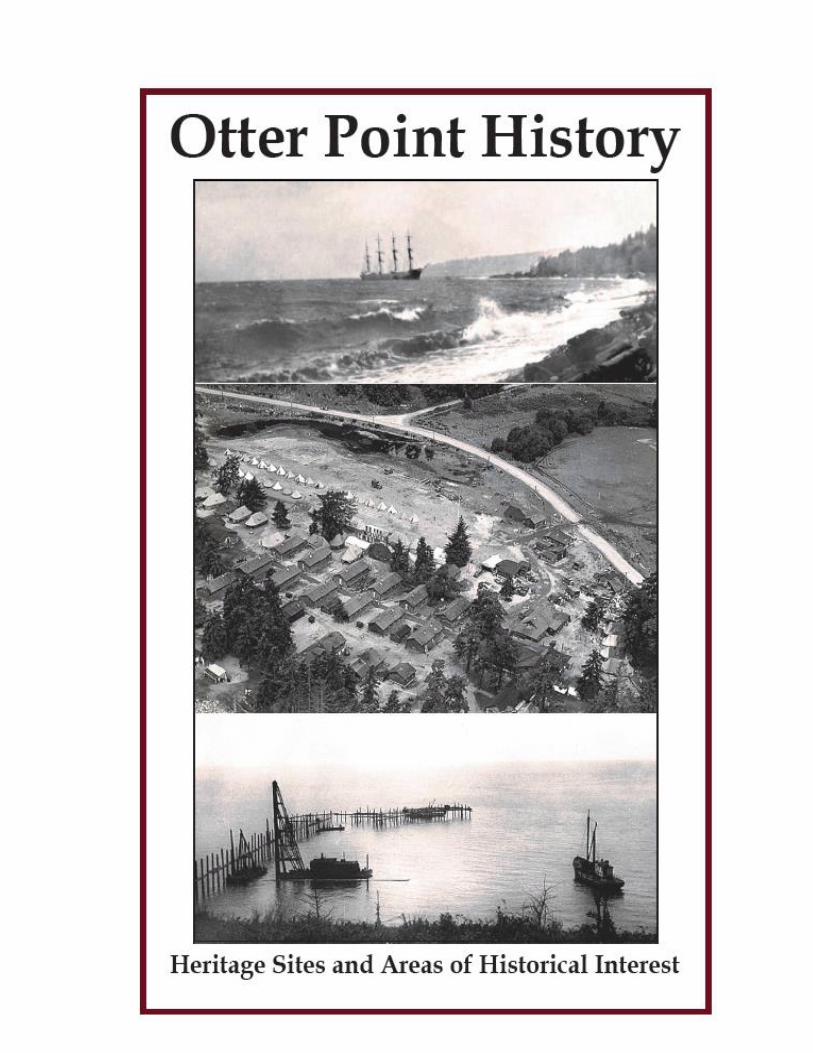
AN OVERVIEW OF THE MODERN ERA HISTORY OF OTTER POINT
Table of Contents Page # Introduction 1
1. Muir Creek Watershed 2
2. Muir Creek 2
3. Muir Creek Flats 3
4. Oil Well Drilling Site/Muir Creek 4
5. Tan Bark Trail/Muir Creek 4
6. Burial Site/ Muir Creek 5
7. Elder’s Camp & School 5
8. Malahat Farm 6
9. Malahat Cottage – Anderson Road 8
10. Tugwell Creek School 8
11. Old Skookum Gulch Bridge 10
12. Clark Farm House 10
13. Tugwell/ Gordon Farm 10
14. Gordon’s Beach 13
15. Old Slough/Gordon’s Beach 15
16. Gordon’s Fish Trap 16
17. Seaside/Kaulitz Sawmill 17
18. Old Kaulitz Logging Road 17
19. Otter Point 18
20. Memorial (Otter Point) Hall 19
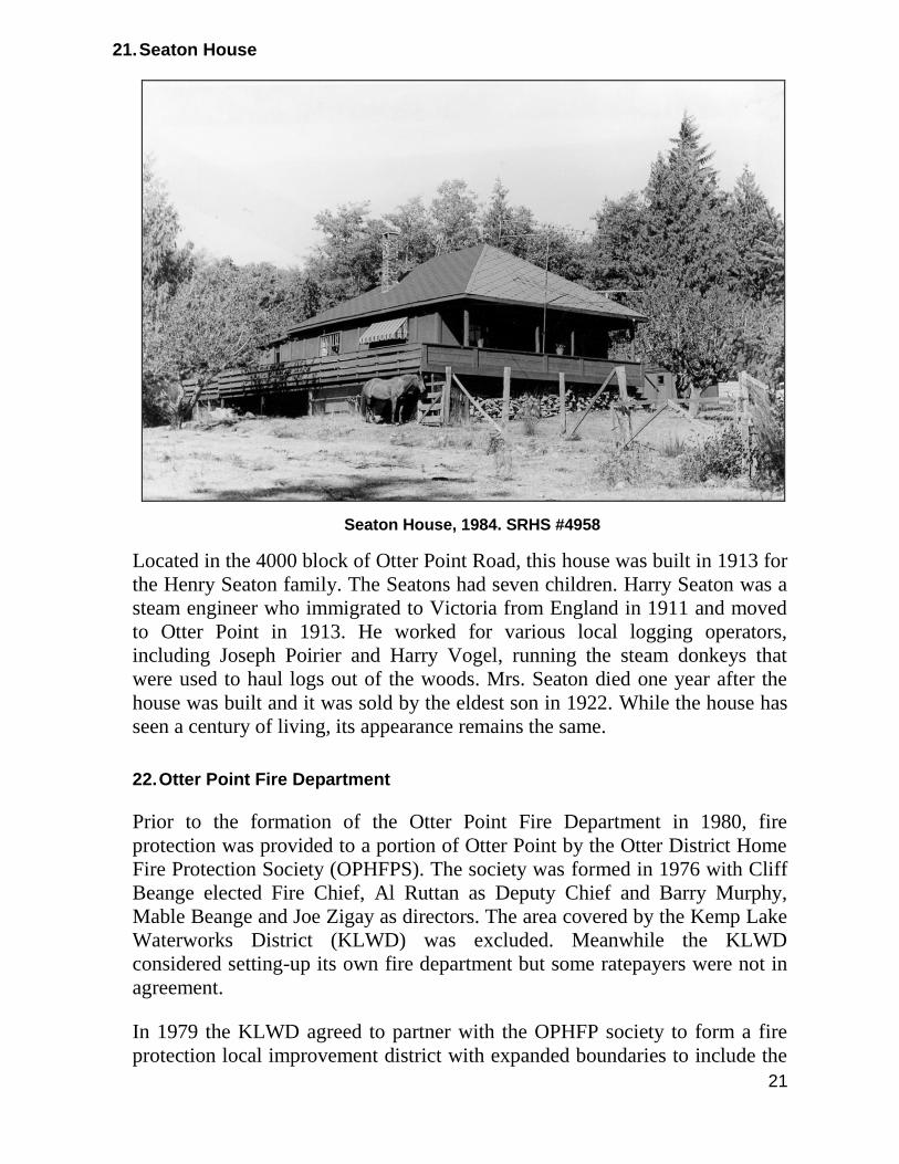
21. Seaton House 20
22. Otter Point Fire Department 20
23. Emerson School 22
24. Final Otter Point School 23
25. St. Francis Xavier Church 23
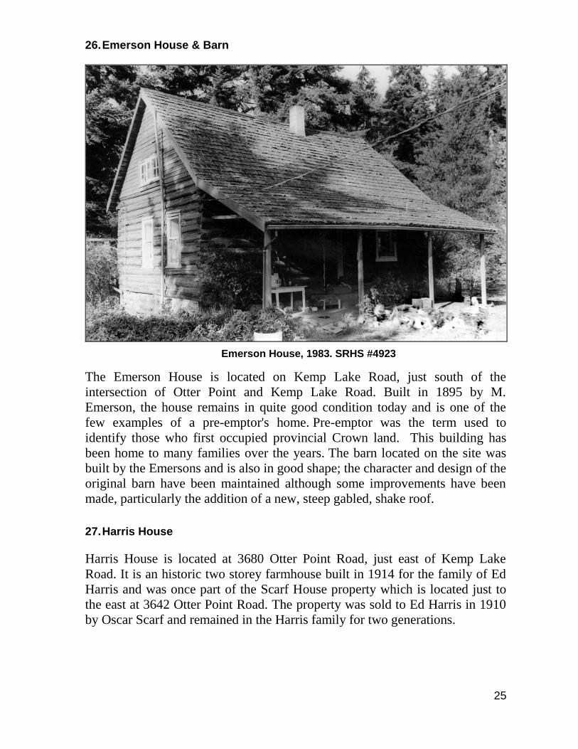
26. Emerson House & Barn 24
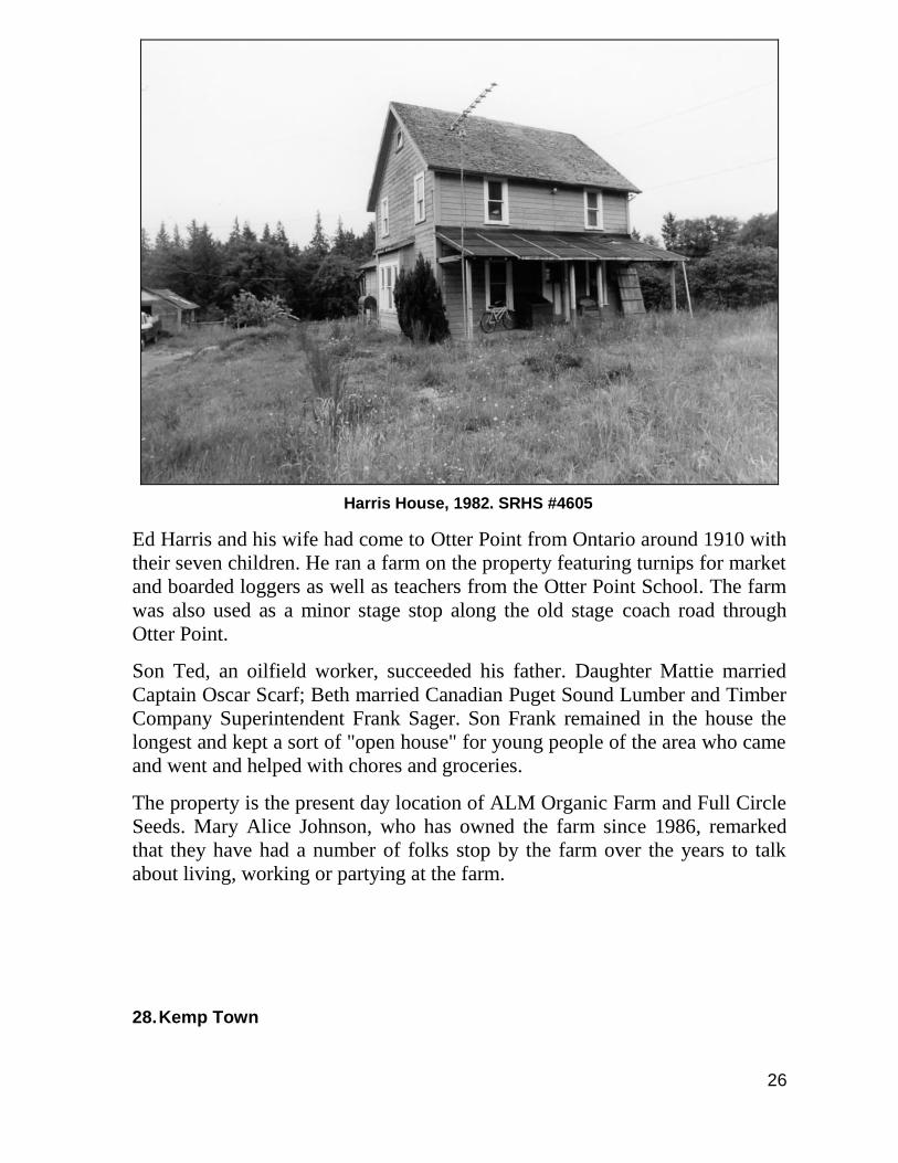
27. Harris House 24
3
28. Kemp Town 26
29. Kemp Lake 26
30. Kemp Lake Waterworks 28
31. Milligan’s Logging 32
32. Poirier House 33
33. Indian Race Course, Relief Camp, Army Camp & Auto Court 34
34. Scarf House 38
35. Scarf Post Office & Store 38
36. Berger Cabin 39
37. Poirier Lake 40
38. Sylvania/Panama Logging Railway 41
39. Old Stage Coach Road 43
40. DeMamiel Stream 44
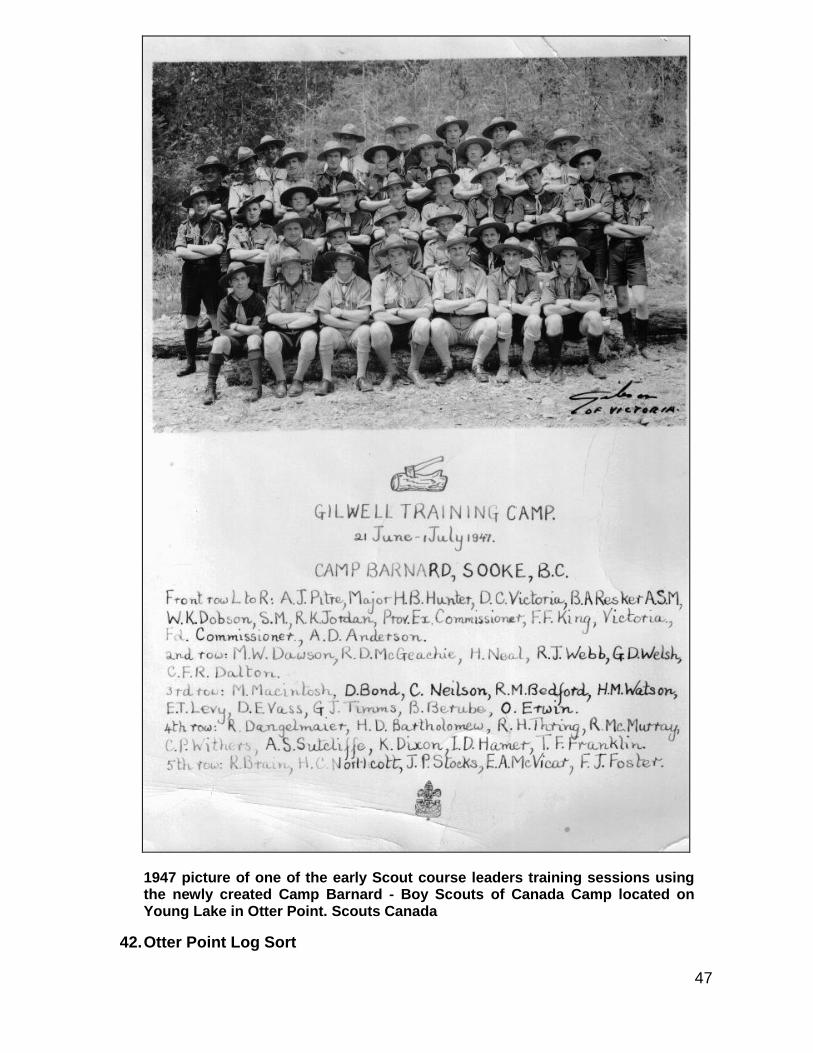
41. Scouts Canada – Camp Barnard 44
42. Otter Point Log Sort 47
43. Butler Brothers Saga 48
44. Jack Brooks Hatchery 49
45. B.C. Electric Company Power Line & Right-of-Way 49
46. West Coast Lifesaving Trail & Telegraph Line 50
Acknowledgements 52
Appendix A - Map showing the location of historic sites in 54 Otter Point
Appendix B - An account of living on Seaside Farm from 55 1951-1962 by Jerry Filippo
Appendix C – Maps drawn by Jerry Filippo showing Seaside 58 Farm and area in the 1950s
Introduction:
This overview of heritage sites and areas of historical interest is an addendum
to the Otter Point Official Community Plan (OCP). It was compiled by Arnie
Campbell with the assistance of Elida Peers, Historian with the Sooke Region
Museum and the support and encouragement of June Klassen, Manager of
Planning Services for the Juan de Fuca Electoral Area. The information used
came from a variety of sources identified under Acknowledgements.
2
The assembled history covers a century of European settlement in Otter Point
from the 1860s to the 1970s. Much of the information is based upon the
archival collection and publications of the Sooke Region Museum. Some of the
information is anecdotal, based upon stories and recollections from present and
former residents of Otter Point. While considerable effort was made to verify
the information presented, errors are inevitable; as new information comes
forward corrections and updates will be made. Contact Arnie Campbell c/o the
Juan de Fuca Electoral Area Planning Services office if you have questions
concerning this document or wish to contribute new information.
Printing of this publication was done by the Sooke Region Historical Society
in January 2014.
The source of each photograph used in this history is identified by the
following: SRHS – Sooke Region Historical Society; PA – BC Provincial
Archives; SC – Scouts Canada; Otter Point Fire Department
This report is also available on the Juan de Fuca Electoral Area website.
1. Muir Creek Watershed
Gigantic trees of the rainforest were quickly recognized as a feature of the
watershed that was given the name Muir for the Scottish pioneering family. In
1855 the Muirs established the first successfully operated steam sawmill in the
new colony of Vancouver’s Island. Their mill was at Sooke Harbour and while
harvesting the upland around the harbour, they harvested from the Muir
watershed and kept teams of oxen housed near Muir Creek.
While it was the towering Douglas-fir that drew the Muirs’ interest, and also
the interest of the Royal Navy when they needed to replace spars for their
sailing ships, it was the Western red cedar that attracted the First Nation
carvers.
Over time, the watershed supplied timber to the sawmills of the west coast
where it was cut into lumber to build millions of homes. The watershed was
also the source for the world’s tallest totem pole which now resides in Beacon
Hill Park in Victoria. Harvesting in the watershed began with oxen, then steam
and “high-lead” logging. Later, gasoline powered engines and specialized
diesel equipment were used.
2. Muir Creek
Muir Creek takes its name from the pioneer Muir family who first came to this
area in 1851 and within 25 years had built a thriving logging, sawmill and
3
shipping business in the Sooke area. Muir Creek is about 15 kilometres long
with its headwaters near Mount Muir and has a watershed of approximately 74
square kilometres. It flows into the Strait of Juan de Fuca at Orveas Bay, west
of Gordon’s Beach. Orveas Bay was first named Orbea Bay by Manuel
Quimper in 1790. Both the bay, which stretches from Gordon’s Beach to
Sheringham Point, in Shirley, as well as Orveas stream which empties into
the bay at the west end of the beach can trace their name to this era of Spanish
exploration in our area.
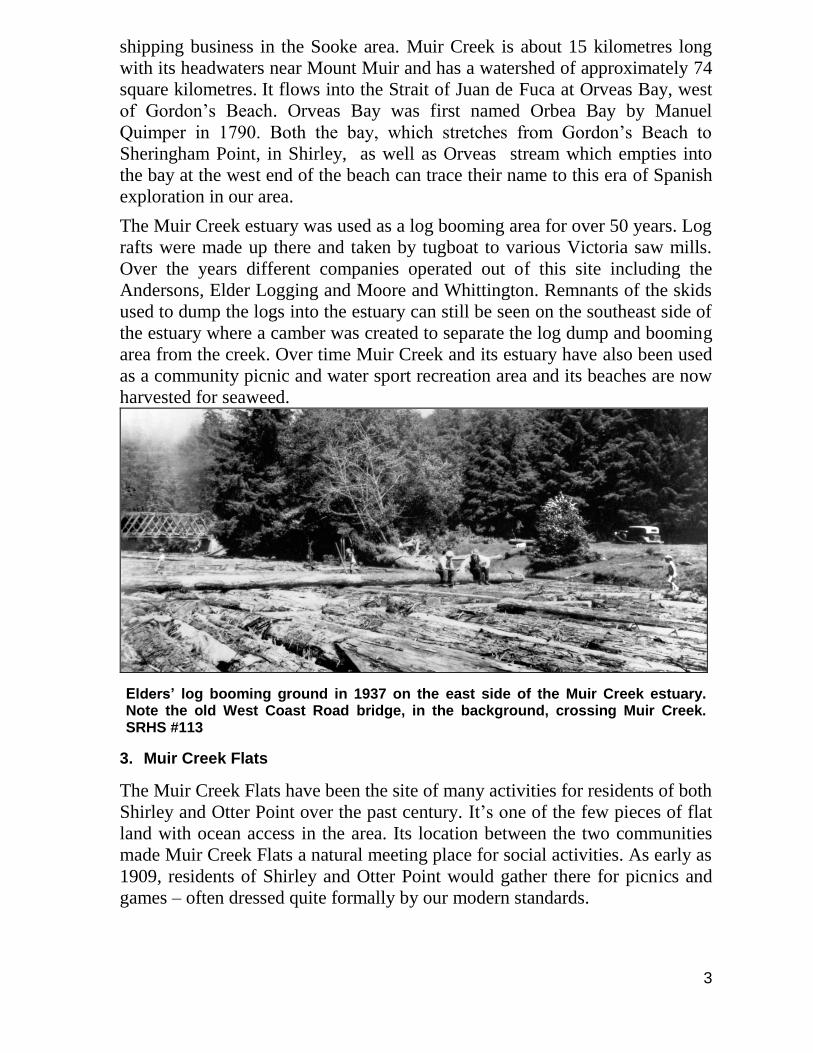
The Muir Creek estuary was used as a log booming area for over 50 years. Log
rafts were made up there and taken by tugboat to various Victoria saw mills.
Over the years different companies operated out of this site including the
Andersons, Elder Logging and Moore and Whittington. Remnants of the skids
used to dump the logs into the estuary can still be seen on the southeast side of
the estuary where a camber was created to separate the log dump and booming
area from the creek. Over time Muir Creek and its estuary have also been used
as a community picnic and water sport recreation area and its beaches are now
harvested for seaweed.
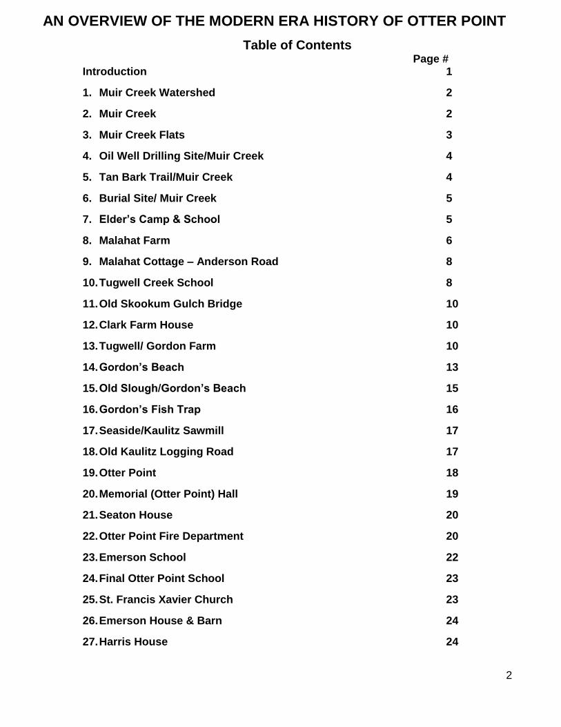
Elders’ log booming ground in 1937 on the east side of the Muir Creek estuary. Note the old West Coast Road bridge, in the background, crossing Muir Creek. SRHS #113
3. Muir Creek Flats
The Muir Creek Flats have been the site of many activities for residents of both
Shirley and Otter Point over the past century. It’s one of the few pieces of flat
land with ocean access in the area. Its location between the two communities
made Muir Creek Flats a natural meeting place for social activities. As early as
1909, residents of Shirley and Otter Point would gather there for picnics and
games – often dressed quite formally by our modern standards.
4
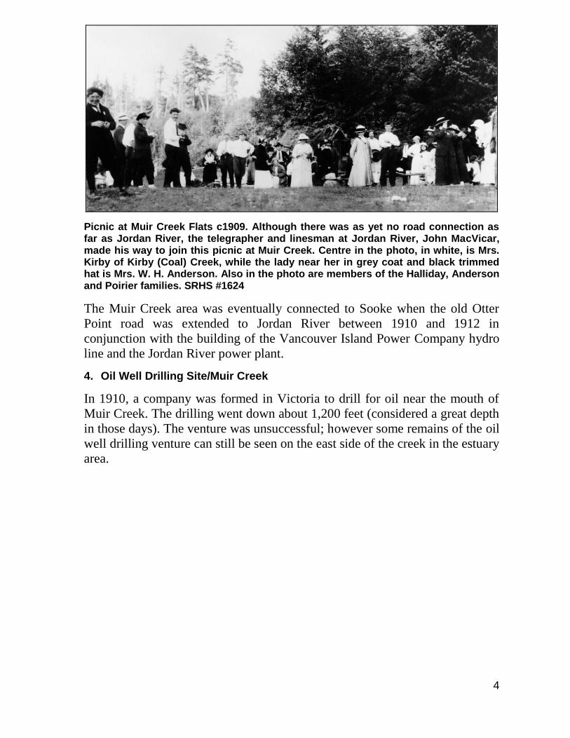
Picnic at Muir Creek Flats c1909. Although there was as yet no road connection as far as Jordan River, the telegrapher and linesman at Jordan River, John MacVicar, made his way to join this picnic at Muir Creek. Centre in the photo, in white, is Mrs. Kirby of Kirby (Coal) Creek, while the lady near her in grey coat and black trimmed hat is Mrs. W. H. Anderson. Also in the photo are members of the Halliday, Anderson and Poirier families. SRHS #1624
The Muir Creek area was eventually connected to Sooke when the old Otter
Point road was extended to Jordan River between 1910 and 1912 in
conjunction with the building of the Vancouver Island Power Company hydro
line and the Jordan River power plant.
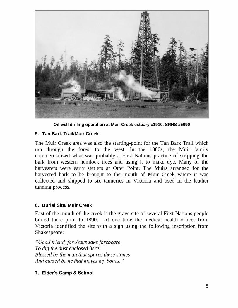
4. Oil Well Drilling Site/Muir Creek
In 1910, a company was formed in Victoria to drill for oil near the mouth of
Muir Creek. The drilling went down about 1,200 feet (considered a great depth
in those days). The venture was unsuccessful; however some remains of the oil
well drilling venture can still be seen on the east side of the creek in the estuary
area.
5
Oil well drilling operation at Muir Creek estuary c1910. SRHS #5090
5. Tan Bark Trail/Muir Creek
The Muir Creek area was also the starting-point for the Tan Bark Trail which
ran through the forest to the west. In the 1880s, the Muir family
commercialized what was probably a First Nations practice of stripping the
bark from western hemlock trees and using it to make dye. Many of the
harvesters were early settlers at Otter Point. The Muirs arranged for the
harvested bark to be brought to the mouth of Muir Creek where it was
collected and shipped to six tanneries in Victoria and used in the leather
tanning process.
6. Burial Site/ Muir Creek
East of the mouth of the creek is the grave site of several First Nations people
buried there prior to 1890. At one time the medical health officer from
Victoria identified the site with a sign using the following inscription from
Shakespeare:
“Good friend, for Jesus sake forebeare
To dig the dust enclosed here
Blessed be the man that spares these stones
And cursed be he that moves my bones.”
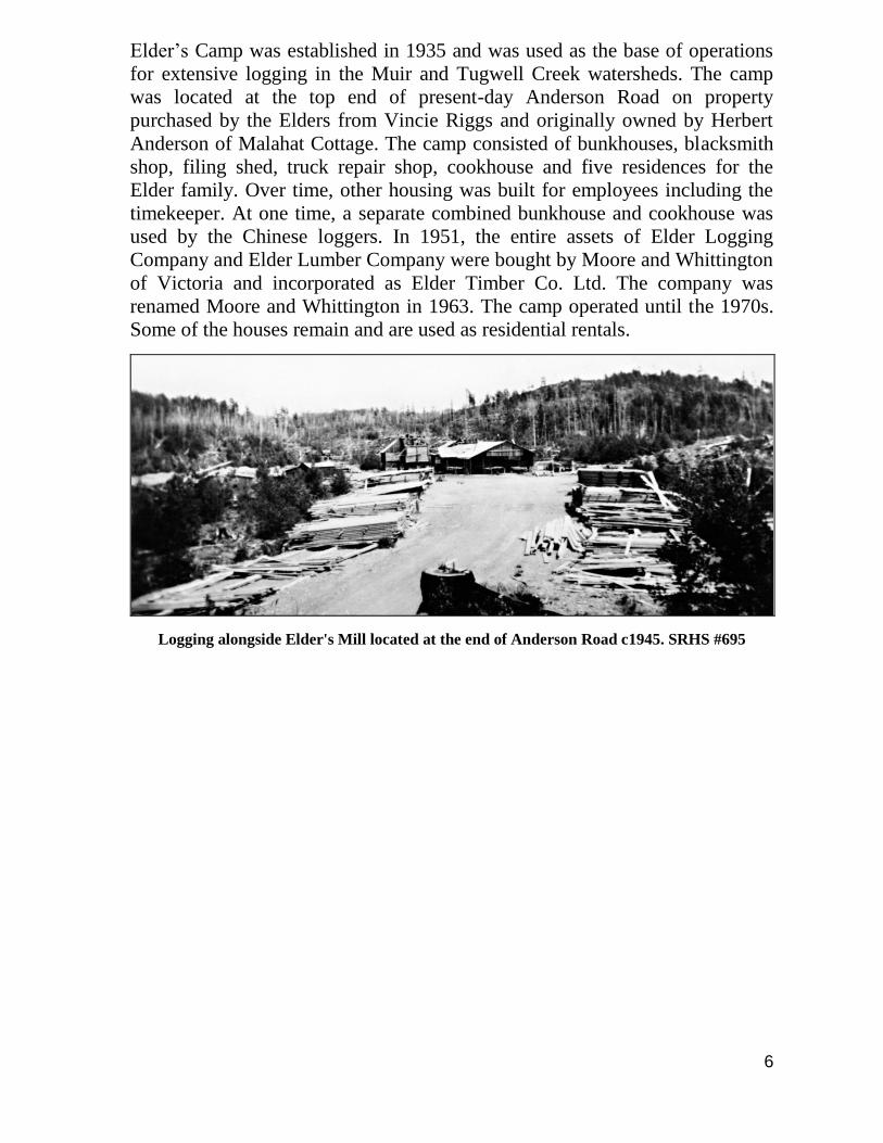
7. Elder’s Camp & School
6
Elder’s Camp was established in 1935 and was used as the base of operations
for extensive logging in the Muir and Tugwell Creek watersheds. The camp
was located at the top end of present-day Anderson Road on property
purchased by the Elders from Vincie Riggs and originally owned by Herbert
Anderson of Malahat Cottage. The camp consisted of bunkhouses, blacksmith
shop, filing shed, truck repair shop, cookhouse and five residences for the
Elder family. Over time, other housing was built for employees including the
timekeeper. At one time, a separate combined bunkhouse and cookhouse was
used by the Chinese loggers. In 1951, the entire assets of Elder Logging
Company and Elder Lumber Company were bought by Moore and Whittington
of Victoria and incorporated as Elder Timber Co. Ltd. The company was
renamed Moore and Whittington in 1963. The camp operated until the 1970s.
Some of the houses remain and are used as residential rentals.
Logging alongside Elder's Mill located at the end of Anderson Road c1945. SRHS #695
7
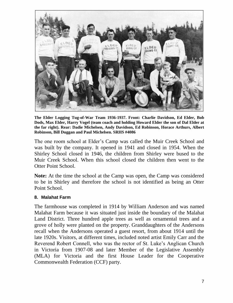
The Elder Logging Tug-of-War Team 1936-1937. Front: Charlie Davidson, Ed Elder, Bob
Dods, Max Elder, Harry Vogel (team coach and holding Howard Elder the son of Dal Elder at
the far right). Rear: Dadie Michelsen, Andy Davidson, Ed Robinson, Horace Arthurs, Albert
Robinson, Bill Duggan and Paul Michelsen. SRHS #4086
The one room school at Elder’s Camp was called the Muir Creek School and
was built by the company. It opened in 1941 and closed in 1954. When the
Shirley School closed in 1946, the children from Shirley were bused to the
Muir Creek School. When this school closed the children then went to the
Otter Point School.
Note: At the time the school at the Camp was open, the Camp was considered
to be in Shirley and therefore the school is not identified as being an Otter
Point School.
8. Malahat Farm
The farmhouse was completed in 1914 by William Anderson and was named
Malahat Farm because it was situated just inside the boundary of the Malahat
Land District. Three hundred apple trees as well as ornamental trees and a
grove of holly were planted on the property. Granddaughters of the Andersons
recall when the Andersons operated a guest resort, from about 1914 until the
late 1920s. Visitors, at different times, included noted artist Emily Carr and the
Reverend Robert Connell, who was the rector of St. Luke’s Anglican Church
in Victoria from 1907-08 and later Member of the Legislative Assembly
(MLA) for Victoria and the first House Leader for the Cooperative
Commonwealth Federation (CCF) party.
8
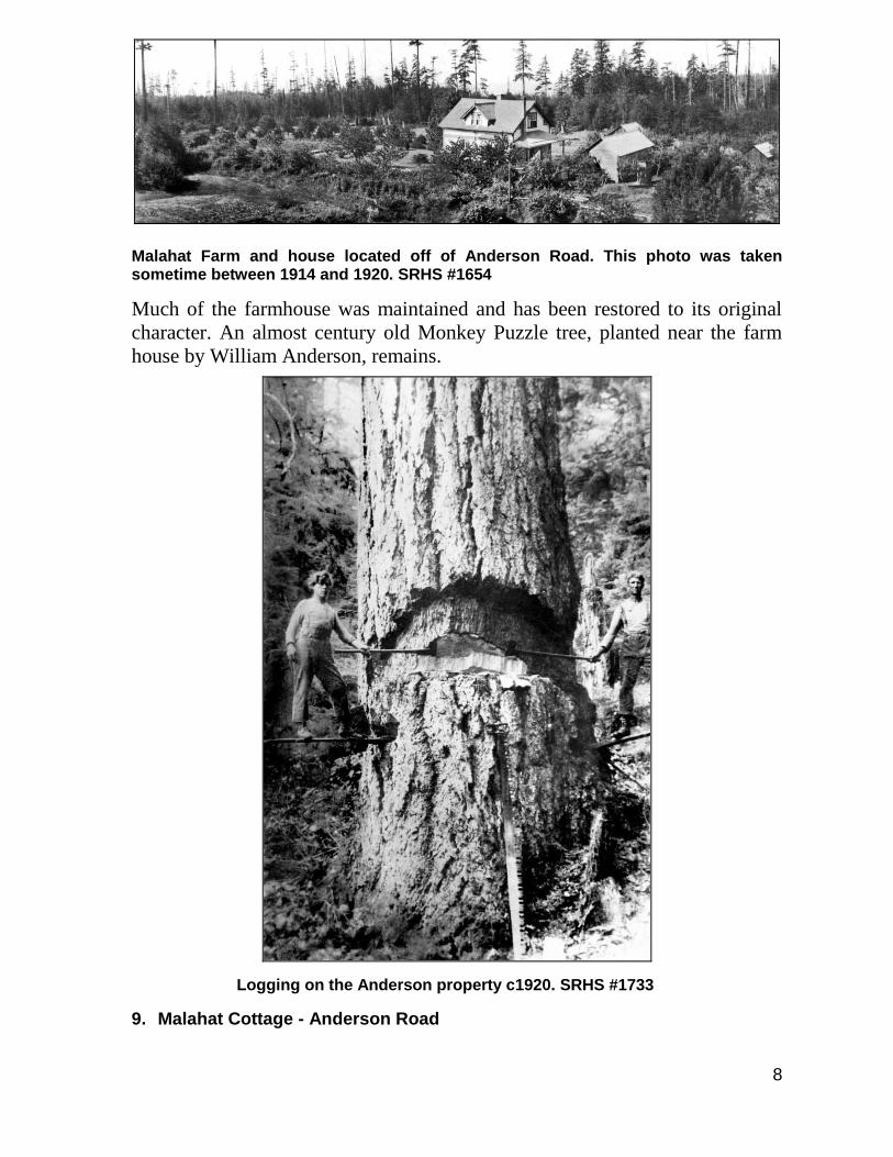
Malahat Farm and house located off of Anderson Road. This photo was taken sometime between 1914 and 1920. SRHS #1654
Much of the farmhouse was maintained and has been restored to its original
character. An almost century old Monkey Puzzle tree, planted near the farm
house by William Anderson, remains.
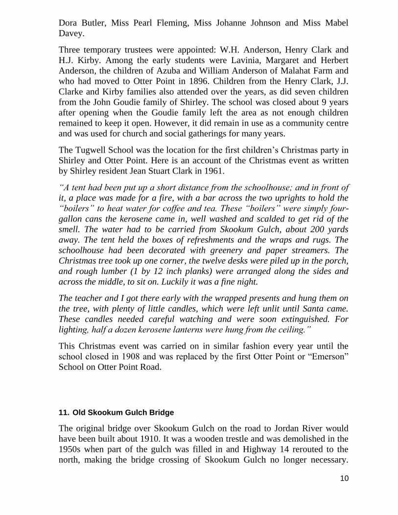
Logging on the Anderson property c1920. SRHS #1733
9. Malahat Cottage - Anderson Road

9
Located near Muir Creek on the property of the Malahat Farm, this residence
was built by Herbert Anderson in 1919 for his new bride, Margaret. Many
features of the cottage are similar to the Malahat Farmhouse and have not been
altered much over the years. The cottage housed family members and later was
rented to men working in logging camps. In recent years, it has been used by
the owners of Malahat Farm as a vacation rental.
10. Tugwell Creek School
The Tugwell Creek School was the first of three pioneer schools built in Otter
Point. It was located a quarter mile west of Tugwell Creek and about 200 yards
north of Skookum Gulch. Residents living in the area in the 1950s recall seeing
the remains of the log structure. Removal of the old Skookum Gulch Bridge
and re-alignment of the new road, Highway 14, has made it difficult to trace
the school’s exact location.
This photo of Tugwell Creek School was taken in 1901. In the photo are Mrs. W. H. (Azuba) Anderson, her daughters Vinnie and Margaret and Ernest and Olive Firth and Richard Clarke. SRHS #959
The school opened in September, 1899 and was built by local residents on the
property of the 600 acre Ted Gordon Farm and shared by children from Shirley
and Otter Point. The parents provided upkeep while the province paid the
teacher’s salary. Miss Bessie Lucas was the first teacher, followed by Miss
10
Dora Butler, Miss Pearl Fleming, Miss Johanne Johnson and Miss Mabel
Davey.
Three temporary trustees were appointed: W.H. Anderson, Henry Clark and
H.J. Kirby. Among the early students were Lavinia, Margaret and Herbert
Anderson, the children of Azuba and William Anderson of Malahat Farm and
who had moved to Otter Point in 1896. Children from the Henry Clark, J.J.
Clarke and Kirby families also attended over the years, as did seven children
from the John Goudie family of Shirley. The school was closed about 9 years
after opening when the Goudie family left the area as not enough children
remained to keep it open. However, it did remain in use as a community centre
and was used for church and social gatherings for many years.
The Tugwell School was the location for the first children’s Christmas party in
Shirley and Otter Point. Here is an account of the Christmas event as written
by Shirley resident Jean Stuart Clark in 1961.
“A tent had been put up a short distance from the schoolhouse; and in front of
it, a place was made for a fire, with a bar across the two uprights to hold the
“boilers” to heat water for coffee and tea. These “boilers” were simply four-
gallon cans the kerosene came in, well washed and scalded to get rid of the
smell. The water had to be carried from Skookum Gulch, about 200 yards
away. The tent held the boxes of refreshments and the wraps and rugs. The
schoolhouse had been decorated with greenery and paper streamers. The
Christmas tree took up one corner, the twelve desks were piled up in the porch,
and rough lumber (1 by 12 inch planks) were arranged along the sides and
across the middle, to sit on. Luckily it was a fine night.
The teacher and I got there early with the wrapped presents and hung them on
the tree, with plenty of little candles, which were left unlit until Santa came.
These candles needed careful watching and were soon extinguished. For
lighting, half a dozen kerosene lanterns were hung from the ceiling.”
This Christmas event was carried on in similar fashion every year until the
school closed in 1908 and was replaced by the first Otter Point or “Emerson”
School on Otter Point Road.
11. Old Skookum Gulch Bridge
The original bridge over Skookum Gulch on the road to Jordan River would
have been built about 1910. It was a wooden trestle and was demolished in the
1950s when part of the gulch was filled in and Highway 14 rerouted to the
north, making the bridge crossing of Skookum Gulch no longer necessary.
11
Skookum Gulch is located west of Tugwell Creek and present-day Blackfish
Road. The bridge was nearer to the mouth of the gulch than the present
crossing. Because the top end of the gulch was filled and a culvert placed,
drivers are hardly aware it is there. The gulch can be seen by travelling to the
end of Blackfish Road.
12. Clark Farm House
Recently arrived from England in 1886, Henry Clark pre-empted Section 75 in
Otter Point. Construction of a house commenced in 1912 and was completed in
1914; lumber for the home was bought from William Anderson of Malahat
Farm and the house is quite typical of early housing in the region. This
property is likely one of a very few in the region that has not been subdivided
and in 2013 is still owned by the members of the original family.
Henry and wife Bessie resided in the house and raised Lena (married Henry
Dods), Lil (married George Davies) and Reginald (married Flo Blakeney). In
1898, Henry was awarded a contract to carry mail between Otter Point and
Victoria. Once a week, he drove his four-horse team and stage to Victoria with
passengers, freight and mail, announcing his approach with a bugle. He retired
as the mail carrier in 1914 but continued to farm and worked with Harry Vogel
to haul logs from the property to the slough west of Gordon’s Beach. Henry
and Bessie’s son Reginald carried on the farm and also became a teamster.
13. Tugwell/ Gordon Farm
Thomas Tugwell originally came to Fort Victoria in the 1850s as a
midshipman with the Royal Navy and returned as a civilian in the 1860s. By
1870, he was homesteading east of Tugwell Creek which was named after him.
His farm was originally known as Sea View Farm and was operated as a cereal
and tree seed farm that shipped seeds to parts of North America and Great
Britain. He was also the area’s census taker and there is also a record of him
being paid $51.00 for blazing-out “Otter Point Trail”.
The Tugwell farm was bought by Ted Gordon in the 1880s and it became both
home and business for him. He later travelled to England to marry Kathleen
(Kitty) Jalland and they returned to the farm in 1889. Both were former
socialite Londoners who became well-known in the local area for the
hospitality at their new home at Gordon’s farm.
12
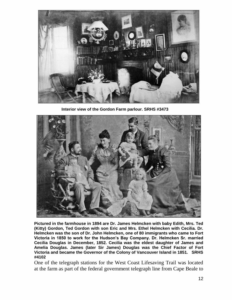
Interior view of the Gordon Farm parlour. SRHS #3473
Pictured in the farmhouse in 1894 are Dr. James Helmcken with baby Edith, Mrs. Ted (Kitty) Gordon, Ted Gordon with son Eric and Mrs. Ethel Helmcken with Cecilia. Dr. Helmcken was the son of Dr. John Helmcken, one of 80 immigrants who came to Fort Victoria in 1850 to work for the Hudson’s Bay Company. Dr. Helmcken Sr. married Cecilia Douglas in December, 1852. Cecilia was the eldest daughter of James and Amelia Douglas. James (later Sir James) Douglas was the Chief Factor of Fort Victoria and became the Governor of the Colony of Vancouver Island in 1851. SRHS #4102
One of the telegraph stations for the West Coast Lifesaving Trail was located
at the farm as part of the federal government telegraph line from Cape Beale to
13
Victoria. Otter Point’s first post office was also located at the farm house in
1895.
With Ted Gordon’s passing in 1912, the farm was operated by teamster Harry
Vogel, who married Mrs. Gordon in 1919. They set up a fine home on the
upper/western reaches of the farm. In time, lots were parceled off on the upper
side of the Old Otter Point Road. During the Great Depression it became
difficult to pay the feed bills owed to the Victoria feed supply firm of Scott &
Peden Ltd. When the Company eventually gained possession of the farm it was
renamed Scott & Peden Farm and was operated under that name during the late
1930s and through the 1940s. A Gordon Gilroy was one of the men farming
there during that period. In 1951, it was purchased by Pete Filippo, a Hollander
who farmed the land until 1962. After Filippo’s ownership, the land was
apparently held by an investment firm, and a number of arrangements were
made where several local individuals were able to rent the land to graze their
cattle, sometimes several different cattle owners at the same time. A person
named Rogerson grazed long horned cattle there. By the late 1970s, the land
was being subdivided by developer Ole Anderson and only portions of the
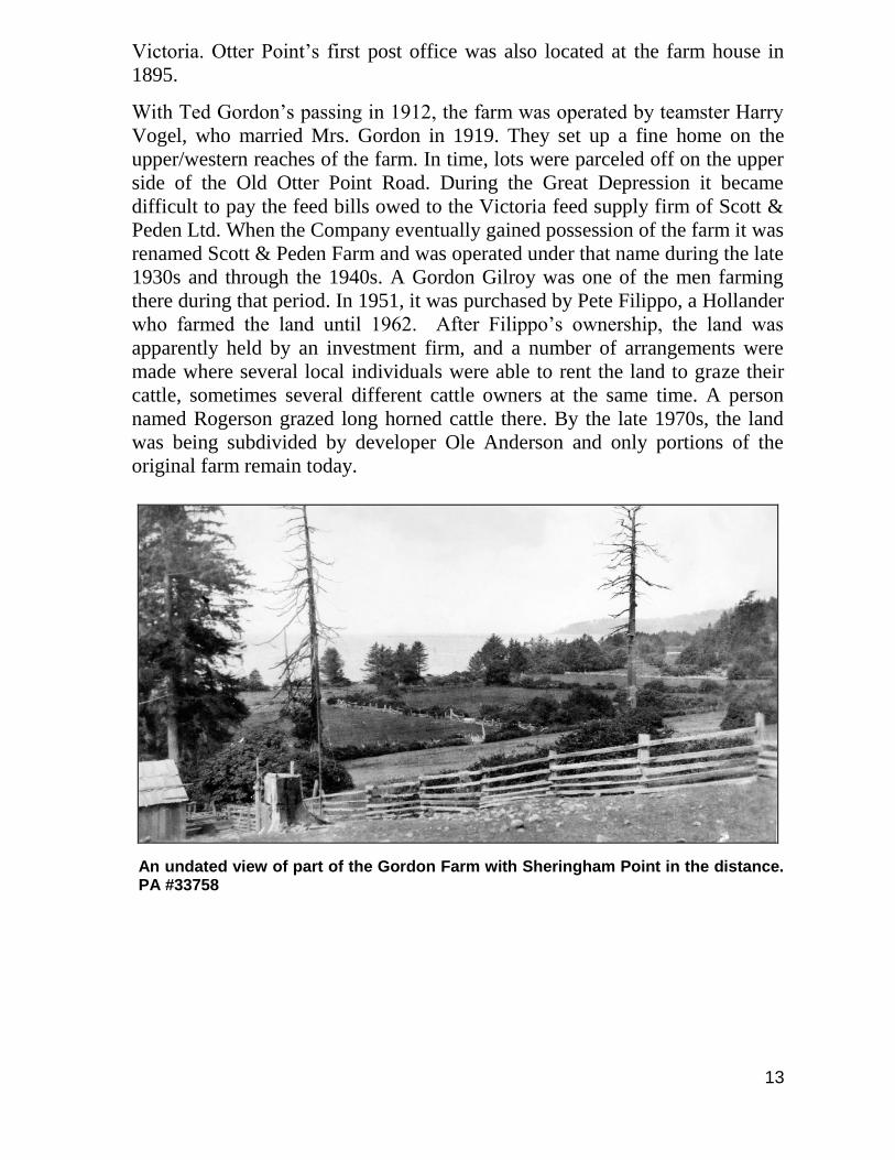
original farm remain today.
An undated view of part of the Gordon Farm with Sheringham Point in the distance. PA #33758
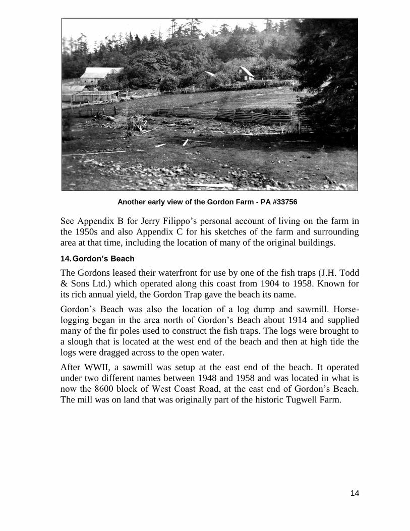
14
Another early view of the Gordon Farm - PA #33756
See Appendix B for Jerry Filippo’s personal account of living on the farm in
the 1950s and also Appendix C for his sketches of the farm and surrounding
area at that time, including the location of many of the original buildings.
14. Gordon’s Beach
The Gordons leased their waterfront for use by one of the fish traps (J.H. Todd
& Sons Ltd.) which operated along this coast from 1904 to 1958. Known for
its rich annual yield, the Gordon Trap gave the beach its name.
Gordon’s Beach was also the location of a log dump and sawmill. Horse-
logging began in the area north of Gordon’s Beach about 1914 and supplied
many of the fir poles used to construct the fish traps. The logs were brought to
a slough that is located at the west end of the beach and then at high tide the
logs were dragged across to the open water.
After WWII, a sawmill was setup at the east end of the beach. It operated
under two different names between 1948 and 1958 and was located in what is
now the 8600 block of West Coast Road, at the east end of Gordon’s Beach.
The mill was on land that was originally part of the historic Tugwell Farm.
15
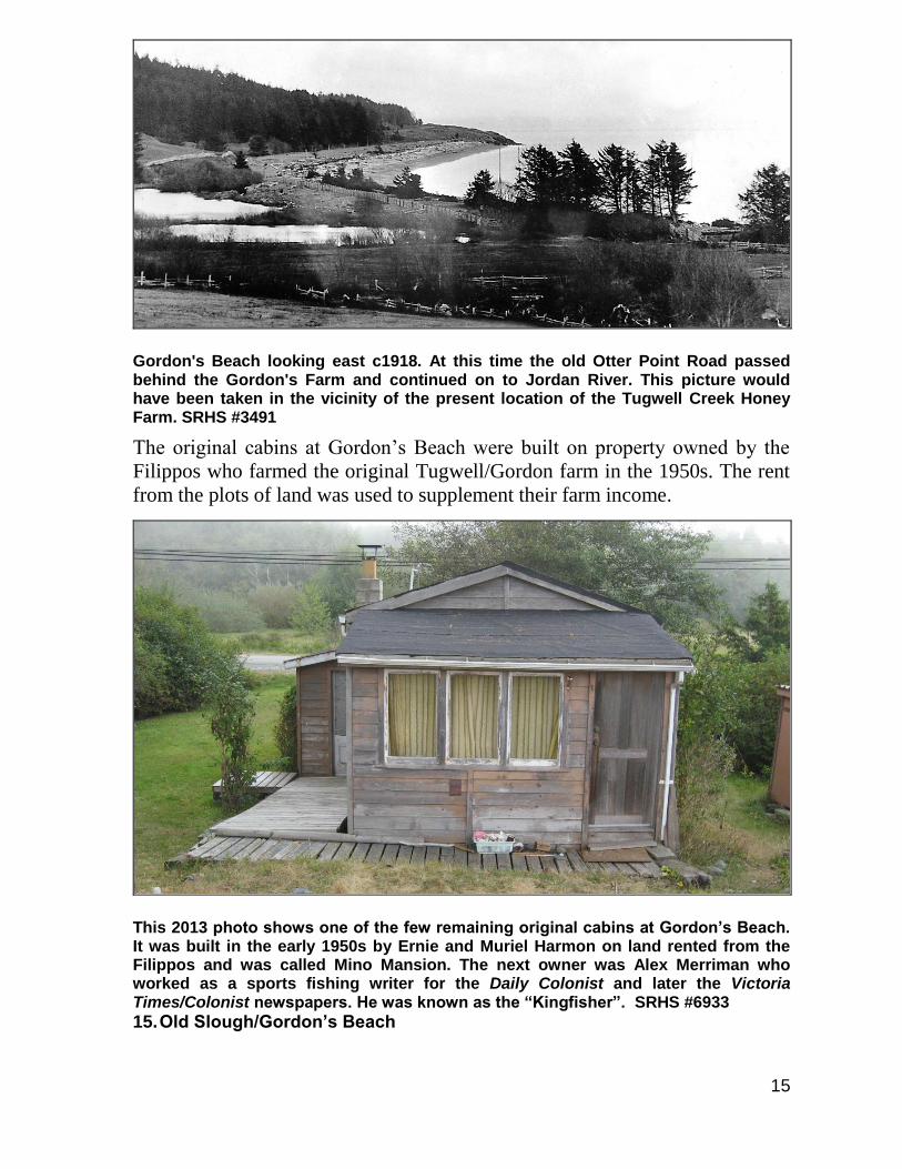
Gordon's Beach looking east c1918. At this time the old Otter Point Road passed behind the Gordon's Farm and continued on to Jordan River. This picture would have been taken in the vicinity of the present location of the Tugwell Creek Honey Farm. SRHS #3491
The original cabins at Gordon’s Beach were built on property owned by the
Filippos who farmed the original Tugwell/Gordon farm in the 1950s. The rent
from the plots of land was used to supplement their farm income.
This 2013 photo shows one of the few remaining original cabins at Gordon’s Beach. It was built in the early 1950s by Ernie and Muriel Harmon on land rented from the Filippos and was called Mino Mansion. The next owner was Alex Merriman who worked as a sports fishing writer for the Daily Colonist and later the Victoria Times/Colonist newspapers. He was known as the “Kingfisher”. SRHS #6933
15. Old Slough/Gordon’s Beach
16
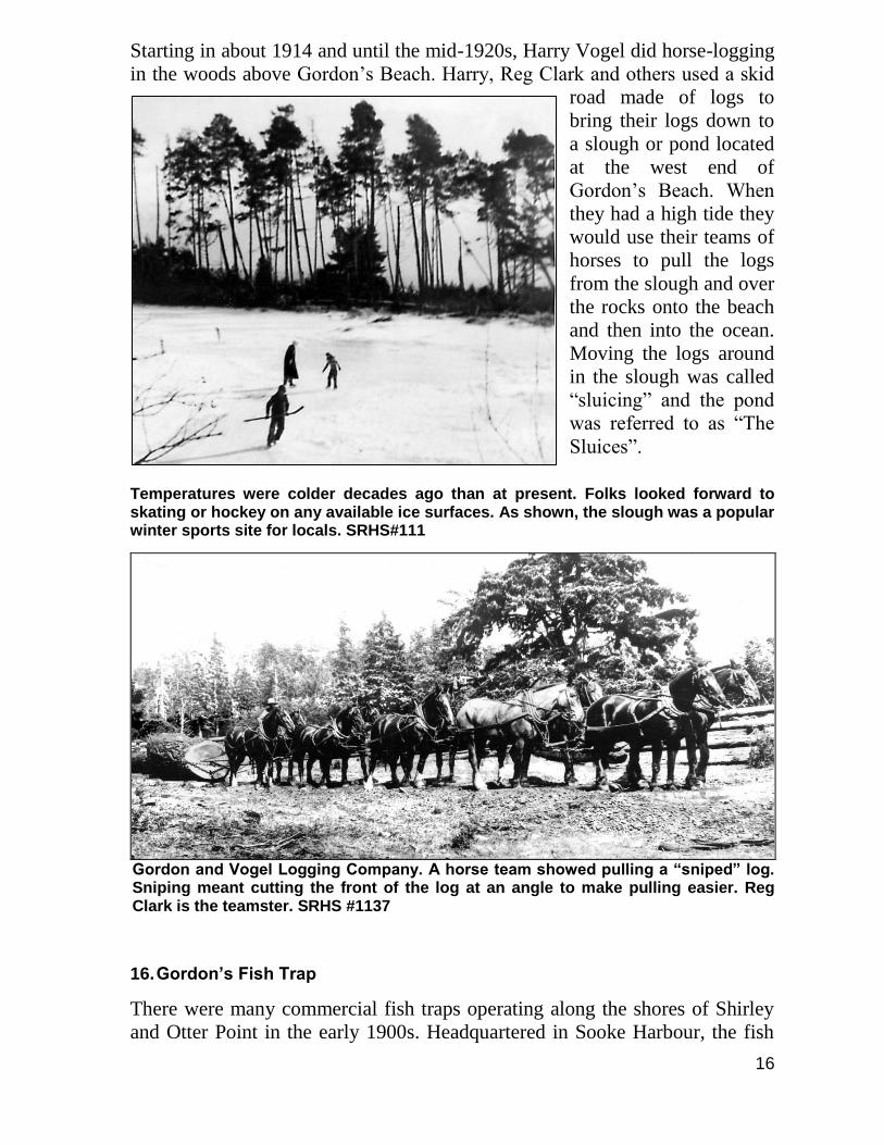
Starting in about 1914 and until the mid-1920s, Harry Vogel did horse-logging
in the woods above Gordon’s Beach. Harry, Reg Clark and others used a skid
road made of logs to
bring their logs down to
a slough or pond located
at the west end of
Gordon’s Beach. When
they had a high tide they
would use their teams of
horses to pull the logs
from the slough and over
the rocks onto the beach
and then into the ocean.
Moving the logs around
in the slough was called
“sluicing” and the pond
was referred to as “The
Sluices”.
Temperatures were colder decades ago than at present. Folks looked forward to skating or hockey on any available ice surfaces. As shown, the slough was a popular winter sports site for locals. SRHS#111
Gordon and Vogel Logging Company. A horse team showed pulling a “sniped” log. Sniping meant cutting the front of the log at an angle to make pulling easier. Reg Clark is the teamster. SRHS #1137
16. Gordon’s Fish Trap
There were many commercial fish traps operating along the shores of Shirley
and Otter Point in the early 1900s. Headquartered in Sooke Harbour, the fish
17
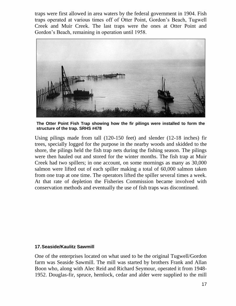
traps were first allowed in area waters by the federal government in 1904. Fish
traps operated at various times off of Otter Point, Gordon’s Beach, Tugwell
Creek and Muir Creek. The last traps were the ones at Otter Point and
Gordon’s Beach, remaining in operation until 1958.
The Otter Point Fish Trap showing how the fir pilings were installed to form the structure of the trap. SRHS #478
Using pilings made from tall (120-150 feet) and slender (12-18 inches) fir
trees, specially logged for the purpose in the nearby woods and skidded to the
shore, the pilings held the fish trap nets during the fishing season. The pilings
were then hauled out and stored for the winter months. The fish trap at Muir
Creek had two spillers; in one account, on some mornings as many as 30,000
salmon were lifted out of each spiller making a total of 60,000 salmon taken
from one trap at one time. The operators lifted the spiller several times a week.
At that rate of depletion the Fisheries Commission became involved with
conservation methods and eventually the use of fish traps was discontinued.
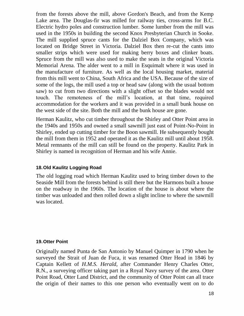
17. Seaside/Kaulitz Sawmill
One of the enterprises located on what used to be the original Tugwell/Gordon
farm was Seaside Sawmill. The mill was started by brothers Frank and Allan
Boon who, along with Alec Reid and Richard Seymour, operated it from 1948-
1952. Douglas-fir, spruce, hemlock, cedar and alder were supplied to the mill
18
from the forests above the mill, above Gordon's Beach, and from the Kemp
Lake area. The Douglas-fir was milled for railway ties, cross-arms for B.C.
Electric hydro poles and construction lumber. Some lumber from the mill was
used in the 1950s in building the second Knox Presbyterian Church in Sooke.
The mill supplied spruce cants for the Dalziel Box Company, which was
located on Bridge Street in Victoria. Dalziel Box then re-cut the cants into
smaller strips which were used for making berry boxes and clinker boats.
Spruce from the mill was also used to make the seats in the original Victoria
Memorial Arena. The alder went to a mill in Esquimalt where it was used in
the manufacture of furniture. As well as the local housing market, material
from this mill went to China, South Africa and the USA. Because of the size of
some of the logs, the mill used a top or head saw (along with the usual bottom
saw) to cut from two directions with a slight offset so the blades would not
touch. The remoteness of the mill’s location, at that time, required
accommodation for the workers and it was provided in a small bunk house on
the west side of the site. Both the mill and the bunk house are gone.
Herman Kaulitz, who cut timber throughout the Shirley and Otter Point area in
the 1940s and 1950s and owned a small sawmill just east of Point-No-Point in
Shirley, ended up cutting timber for the Boon sawmill. He subsequently bought
the mill from them in 1952 and operated it as the Kaulitz mill until about 1958.
Metal remnants of the mill can still be found on the property. Kaulitz Park in
Shirley is named in recognition of Herman and his wife Annie.
18. Old Kaulitz Logging Road
The old logging road which Herman Kaulitz used to bring timber down to the
Seaside Mill from the forests behind is still there but the Harmons built a house
on the roadway in the 1960s. The location of the house is about where the
timber was unloaded and then rolled down a slight incline to where the sawmill
was located.
19. Otter Point
Originally named Punta de San Antonio by Manuel Quimper in 1790 when he
surveyed the Strait of Juan de Fuca, it was renamed Otter Head in 1846 by
Captain Kellett of H.M.S. Herald, after Commander Henry Charles Otter,
R.N., a surveying officer taking part in a Royal Navy survey of the area. Otter
Point Road, Otter Land District, and the community of Otter Point can all trace
the origin of their names to this one person who eventually went on to do
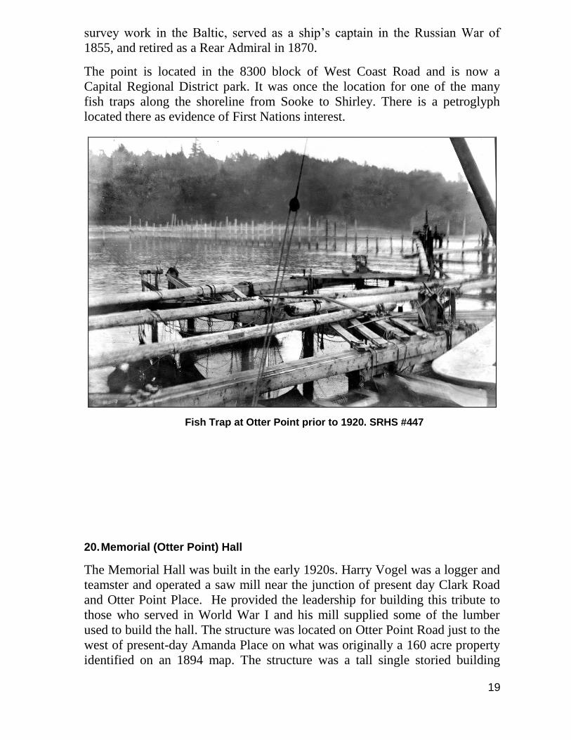
19
survey work in the Baltic, served as a ship’s captain in the Russian War of
1855, and retired as a Rear Admiral in 1870.
The point is located in the 8300 block of West Coast Road and is now a
Capital Regional District park. It was once the location for one of the many
fish traps along the shoreline from Sooke to Shirley. There is a petroglyph
located there as evidence of First Nations interest.
Fish Trap at Otter Point prior to 1920. SRHS #447
20. Memorial (Otter Point) Hall
The Memorial Hall was built in the early 1920s. Harry Vogel was a logger and
teamster and operated a saw mill near the junction of present day Clark Road
and Otter Point Place. He provided the leadership for building this tribute to
those who served in World War I and his mill supplied some of the lumber
used to build the hall. The structure was located on Otter Point Road just to the
west of present-day Amanda Place on what was originally a 160 acre property
identified on an 1894 map. The structure was a tall single storied building
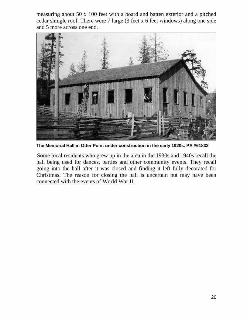
20
measuring about 50 x 100 feet with a board and batten exterior and a pitched
cedar shingle roof. There were 7 large (3 feet x 6 feet windows) along one side
and 5 more across one end.
The Memorial Hall in Otter Point under construction in the early 1920s. PA #61832
Some local residents who grew up in the area in the 1930s and 1940s recall the
hall being used for dances, parties and other community events. They recall
going into the hall after it was closed and finding it left fully decorated for
Christmas. The reason for closing the hall is uncertain but may have been
connected with the events of World War II.
21
21. Seaton House
Seaton House, 1984. SRHS #4958
Located in the 4000 block of Otter Point Road, this house was built in 1913 for
the Henry Seaton family. The Seatons had seven children. Harry Seaton was a
steam engineer who immigrated to Victoria from England in 1911 and moved
to Otter Point in 1913. He worked for various local logging operators,
including Joseph Poirier and Harry Vogel, running the steam donkeys that
were used to haul logs out of the woods. Mrs. Seaton died one year after the
house was built and it was sold by the eldest son in 1922. While the house has
seen a century of living, its appearance remains the same.
22. Otter Point Fire Department
Prior to the formation of the Otter Point Fire Department in 1980, fire
protection was provided to a portion of Otter Point by the Otter District Home
Fire Protection Society (OPHFPS). The society was formed in 1976 with Cliff
Beange elected Fire Chief, Al Ruttan as Deputy Chief and Barry Murphy,
Mable Beange and Joe Zigay as directors. The area covered by the Kemp Lake
Waterworks District (KLWD) was excluded. Meanwhile the KLWD
considered setting-up its own fire department but some ratepayers were not in
agreement.
In 1979 the KLWD agreed to partner with the OPHFP society to form a fire
protection local improvement district with expanded boundaries to include the
22
KLWD. The new trustees were, John Farmer (Chair) and Terry Kuiack, Jim
McCormick, Roy Kennedy, Cliff Beange, and Jack Hawes as directors. The
Otter Point Fire District officially came into existence on January 1st, 1980 and
the commission applied to the Capital Regional District for an $80,000 loan to
pay for a new fire hall at Kemp Lake and Otter Point Roads. The official
opening of the fire hall was held in May 1981.
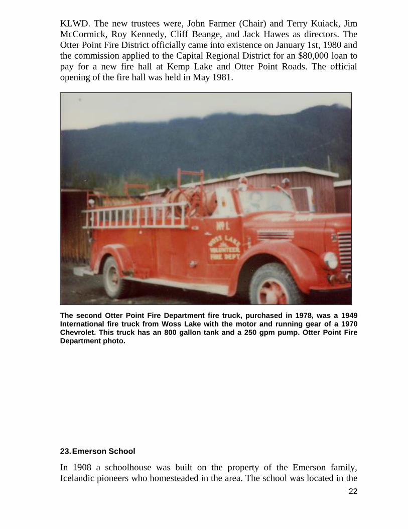
The second Otter Point Fire Department fire truck, purchased in 1978, was a 1949 International fire truck from Woss Lake with the motor and running gear of a 1970 Chevrolet. This truck has an 800 gallon tank and a 250 gpm pump. Otter Point Fire Department photo.
23. Emerson School
In 1908 a schoolhouse was built on the property of the Emerson family,
Icelandic pioneers who homesteaded in the area. The school was located in the
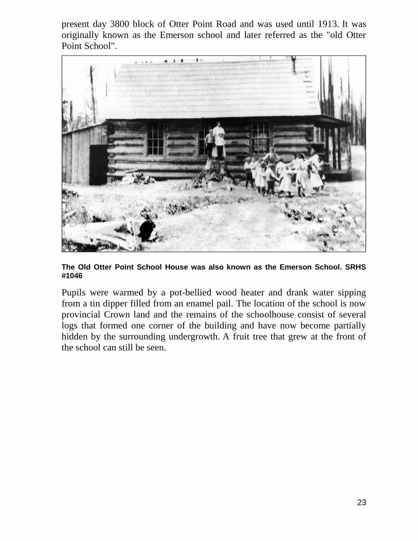
23
present day 3800 block of Otter Point Road and was used until 1913. It was
originally known as the Emerson school and later referred as the "old Otter
Point School".
The Old Otter Point School House was also known as the Emerson School. SRHS #1046
Pupils were warmed by a pot-bellied wood heater and drank water sipping
from a tin dipper filled from an enamel pail. The location of the school is now
provincial Crown land and the remains of the schoolhouse consist of several
logs that formed one corner of the building and have now become partially
hidden by the surrounding undergrowth. A fruit tree that grew at the front of
the school can still be seen.

24
24. Final Otter Point School
When the third and final Otter Point School was built in 1913, the log building,
(Emerson School) was no longer needed as a school but continued to host
social events for another decade. The new wood frame Otter Point School was
located on the north side of Otter Point Road at the junction with Kemp Lake
Road. It was closed in the early 1950s. However, the girls’ four-holer outhouse
was saved and is now located behind the Sooke Region Museum.
Miss Jennifer Wells taught at the Otter Point School from 1944 to 1948 and
lived in a house located near the school.
25. St. Francis Xavier Church
In October of 1923, according to a 1973 feature story in a Daily Colonist
newspaper article written by Grace Horgan, Msgr. Leterne offered the first
Mass in the new St. Francis Xavier Church at Otter Point. In her story Sooke:
Cradle of Christianity in British Columbia, Grace Horgan explained that the
Otter Point Church was built to provide religious services to the loggers and
their families who had settled in the area. After a number of years the loggers
moved on, the church closed and the building was converted to a private
residence.
The building was located at the intersection of Otter Point Road and Kemp
Lake Road and was torn down in the 1960s.
A visitor to the house in the 1940s describes the dwelling as still having a
small cross at the peak. The building measured about 12 feet wide and perhaps
20 feet long with the front door facing east onto Kemp Lake Road. The interior
consisted of three rooms with a living area at the front, bedroom in the middle
and kitchen at the rear. It had a shiplap exterior and a white picket fence
around it.
Residents of the former church included:
Mrs. Middleton (Carey) who lived there in the 1930s and married “Yorkie”
Middleton, from the Depression era Work Camp, in the early 1940s. Mrs.
Middleton was a hairdresser and cut the hair of many of the locals.
The Ray Shambrook family resided in the building from the late 1940s through
the 1950s.
25
26. Emerson House & Barn
Emerson House, 1983. SRHS #4923
The Emerson House is located on Kemp Lake Road, just south of the
intersection of Otter Point and Kemp Lake Road. Built in 1895 by M.
Emerson, the house remains in quite good condition today and is one of the
few examples of a pre-emptor's home. Pre-emptor was the term used to
identify those who first occupied provincial Crown land. This building has
been home to many families over the years. The barn located on the site was
built by the Emersons and is also in good shape; the character and design of the
original barn have been maintained although some improvements have been
made, particularly the addition of a new, steep gabled, shake roof.
27. Harris House
Harris House is located at 3680 Otter Point Road, just east of Kemp Lake
Road. It is an historic two storey farmhouse built in 1914 for the family of Ed
Harris and was once part of the Scarf House property which is located just to
the east at 3642 Otter Point Road. The property was sold to Ed Harris in 1910
by Oscar Scarf and remained in the Harris family for two generations.
26
Harris House, 1982. SRHS #4605
Ed Harris and his wife had come to Otter Point from Ontario around 1910 with
their seven children. He ran a farm on the property featuring turnips for market
and boarded loggers as well as teachers from the Otter Point School. The farm
was also used as a minor stage stop along the old stage coach road through
Otter Point.
Son Ted, an oilfield worker, succeeded his father. Daughter Mattie married
Captain Oscar Scarf; Beth married Canadian Puget Sound Lumber and Timber
Company Superintendent Frank Sager. Son Frank remained in the house the
longest and kept a sort of "open house" for young people of the area who came
and went and helped with chores and groceries.
The property is the present day location of ALM Organic Farm and Full Circle
Seeds. Mary Alice Johnson, who has owned the farm since 1986, remarked
that they have had a number of folks stop by the farm over the years to talk
about living, working or partying at the farm. 28. Kemp Town
27
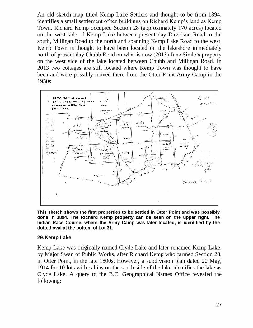
An old sketch map titled Kemp Lake Settlers and thought to be from 1894,
identifies a small settlement of ten buildings on Richard Kemp’s land as Kemp
Town. Richard Kemp occupied Section 28 (approximately 170 acres) located
on the west side of Kemp Lake between present day Davidson Road to the
south, Milligan Road to the north and spanning Kemp Lake Road to the west.
Kemp Town is thought to have been located on the lakeshore immediately
north of present day Chubb Road on what is now (2013) June Simle’s property
on the west side of the lake located between Chubb and Milligan Road. In
2013 two cottages are still located where Kemp Town was thought to have
been and were possibly moved there from the Otter Point Army Camp in the
1950s.
This sketch shows the first properties to be settled in Otter Point and was possibly done in 1894. The Richard Kemp property can be seen on the upper right. The Indian Race Course, where the Army Camp was later located, is identified by the dotted oval at the bottom of Lot 31.
29. Kemp Lake
Kemp Lake was originally named Clyde Lake and later renamed Kemp Lake,
by Major Swan of Public Works, after Richard Kemp who farmed Section 28,
in Otter Point, in the late 1800s. However, a subdivision plan dated 20 May,
1914 for 10 lots with cabins on the south side of the lake identifies the lake as
Clyde Lake. A query to the B.C. Geographical Names Office revealed the
following:
28
“This lake was first labeled Kemp Lake on the B.C. Lands map of South-
eastern Districts of Vancouver Island in 1895. It was described as a small lake
just to the northeast (in Lots 41 & 42, Sooke Land District). It was then
mislabeled “Clyde Lake” on the 1911 edition of the B.C. Lands map and again
in 1929 on the T.N. Hibben & Company map of South-eastern Districts of
Vancouver Island.”
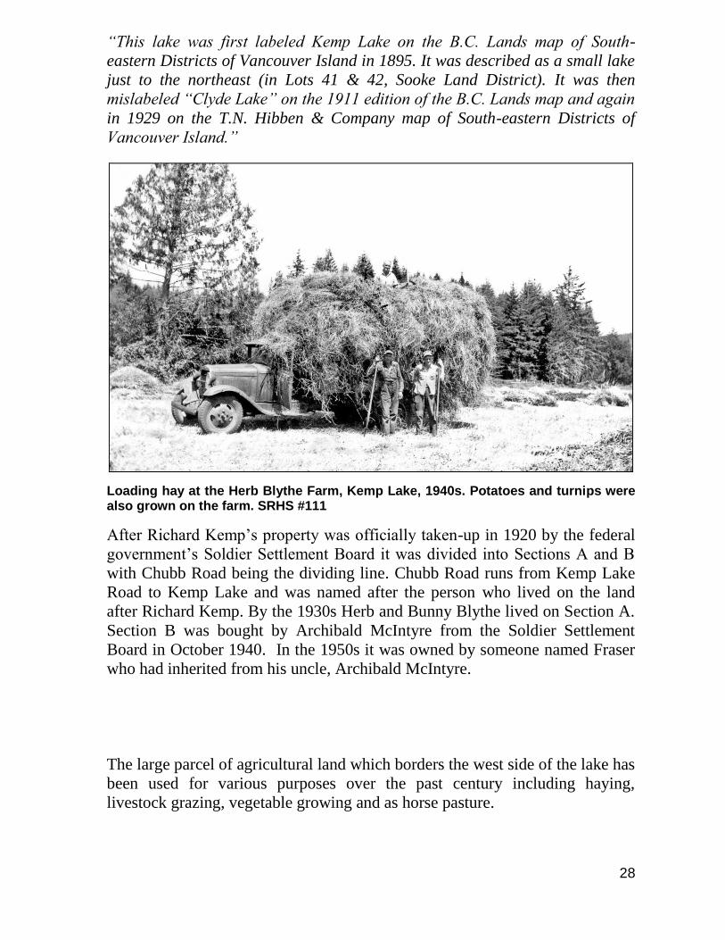
Loading hay at the Herb Blythe Farm, Kemp Lake, 1940s. Potatoes and turnips were also grown on the farm. SRHS #111
After Richard Kemp’s property was officially taken-up in 1920 by the federal
government’s Soldier Settlement Board it was divided into Sections A and B
with Chubb Road being the dividing line. Chubb Road runs from Kemp Lake
Road to Kemp Lake and was named after the person who lived on the land
after Richard Kemp. By the 1930s Herb and Bunny Blythe lived on Section A.
Section B was bought by Archibald McIntyre from the Soldier Settlement
Board in October 1940. In the 1950s it was owned by someone named Fraser
who had inherited from his uncle, Archibald McIntyre.
The large parcel of agricultural land which borders the west side of the lake has
been used for various purposes over the past century including haying,
livestock grazing, vegetable growing and as horse pasture.
29
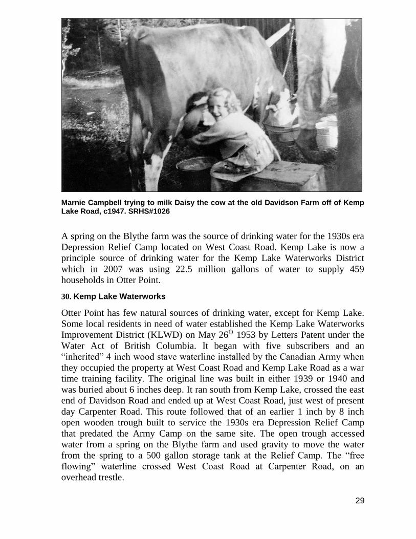
Marnie Campbell trying to milk Daisy the cow at the old Davidson Farm off of Kemp Lake Road, c1947. SRHS#1026
A spring on the Blythe farm was the source of drinking water for the 1930s era
Depression Relief Camp located on West Coast Road. Kemp Lake is now a
principle source of drinking water for the Kemp Lake Waterworks District
which in 2007 was using 22.5 million gallons of water to supply 459
households in Otter Point.
30. Kemp Lake Waterworks
Otter Point has few natural sources of drinking water, except for Kemp Lake.
Some local residents in need of water established the Kemp Lake Waterworks
Improvement District (KLWD) on May 26th
1953 by Letters Patent under the
Water Act of British Columbia. It began with five subscribers and an
“inherited” 4 inch wood stave waterline installed by the Canadian Army when
they occupied the property at West Coast Road and Kemp Lake Road as a war
time training facility. The original line was built in either 1939 or 1940 and
was buried about 6 inches deep. It ran south from Kemp Lake, crossed the east
end of Davidson Road and ended up at West Coast Road, just west of present
day Carpenter Road. This route followed that of an earlier 1 inch by 8 inch
open wooden trough built to service the 1930s era Depression Relief Camp
that predated the Army Camp on the same site. The open trough accessed
water from a spring on the Blythe farm and used gravity to move the water
from the spring to a 500 gallon storage tank at the Relief Camp. The “free
flowing” waterline crossed West Coast Road at Carpenter Road, on an
overhead trestle.
30
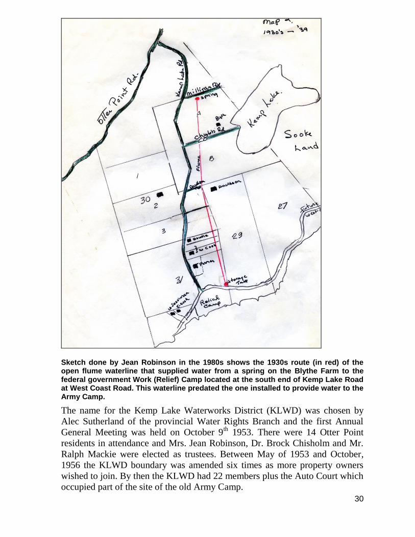
Sketch done by Jean Robinson in the 1980s shows the 1930s route (in red) of the open flume waterline that supplied water from a spring on the Blythe Farm to the federal government Work (Relief) Camp located at the south end of Kemp Lake Road at West Coast Road. This waterline predated the one installed to provide water to the Army Camp.
The name for the Kemp Lake Waterworks District (KLWD) was chosen by
Alec Sutherland of the provincial Water Rights Branch and the first Annual
General Meeting was held on October 9th 1953. There were 14 Otter Point
residents in attendance and Mrs. Jean Robinson, Dr. Brock Chisholm and Mr.
Ralph Mackie were elected as trustees. Between May of 1953 and October,
1956 the KLWD boundary was amended six times as more property owners
wished to join. By then the KLWD had 22 members plus the Auto Court which
occupied part of the site of the old Army Camp.
31
The original KLWD water system consisted of a pump house (located on the
shore of Kemp Lake, at the end of Chubb Road), 750 feet of 2 inch diameter
galvanized pipe that pumped water to 3 elevated wood stave reservoir tanks
(which collectively held approximately 10,500 Imperial gallons of water) and a
4 inch diameter, 4,200 foot long wood stave pipe that delivered the water.
After years of coping with leaks, work began in 1960 on the replacement and
relocation of the waterline route from the backyards of properties between
Kemp Lake and the old Army Camp to a new route which followed Chubb and
Kemp Lake Roads.
Two 6,000 gallon wood stave reservoir/pressure tanks (purchased used from
the B.C. Power Commission) were set up on the north side of the 2500 block
of Kemp Lake Road about 400 feet south of Chubb Road. From there a 4 inch
asbestos-cement pipe was installed. At first, this new line only went as far as
Davidson Road, where it then reconnected with the original wood stave line. In
1962, the line was eventually continued down Kemp Lake Road to West Coast
Road and the wood stave line was abandoned. The 1960s line was replaced by
a 6 inch plastic (PVC) line in the 1970s. Upgrades and expansion of the
waterline continue. By 2007 the KLWD was providing 459 Otter Point
residences with an estimated 22.5 million gallons per year of water from Kemp
Lake.
32
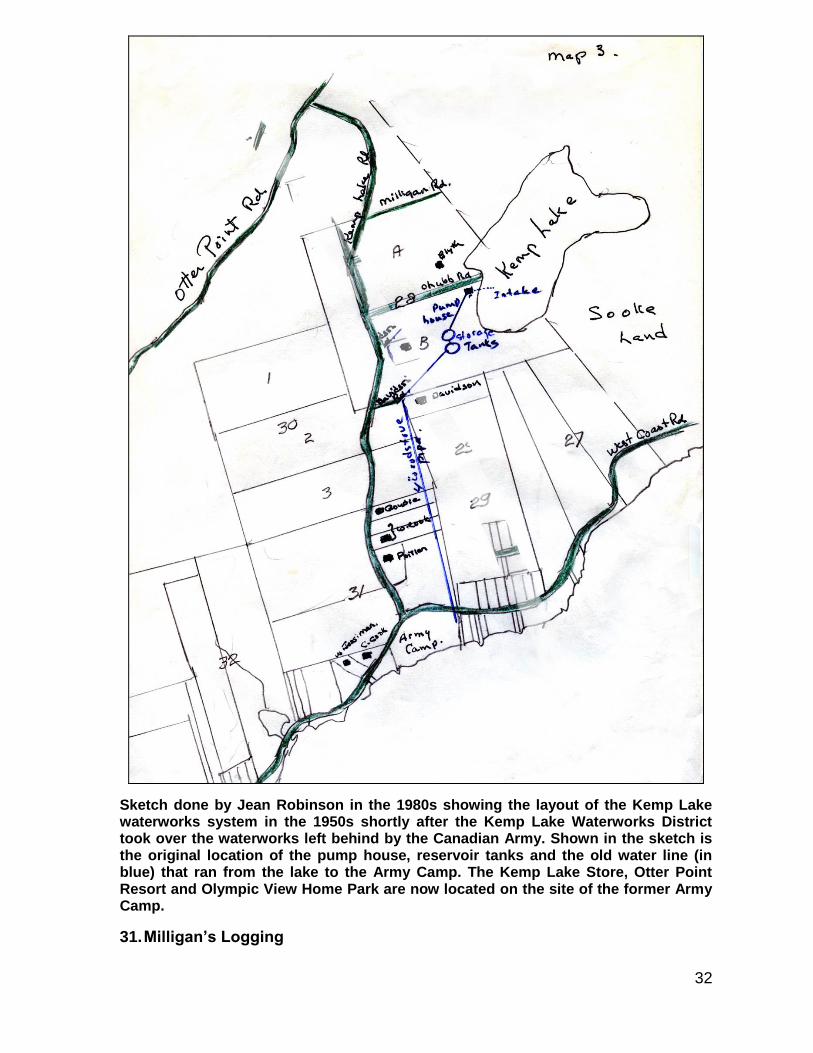
Sketch done by Jean Robinson in the 1980s showing the layout of the Kemp Lake waterworks system in the 1950s shortly after the Kemp Lake Waterworks District took over the waterworks left behind by the Canadian Army. Shown in the sketch is the original location of the pump house, reservoir tanks and the old water line (in blue) that ran from the lake to the Army Camp. The Kemp Lake Store, Otter Point Resort and Olympic View Home Park are now located on the site of the former Army Camp.
31. Milligan’s Logging
33
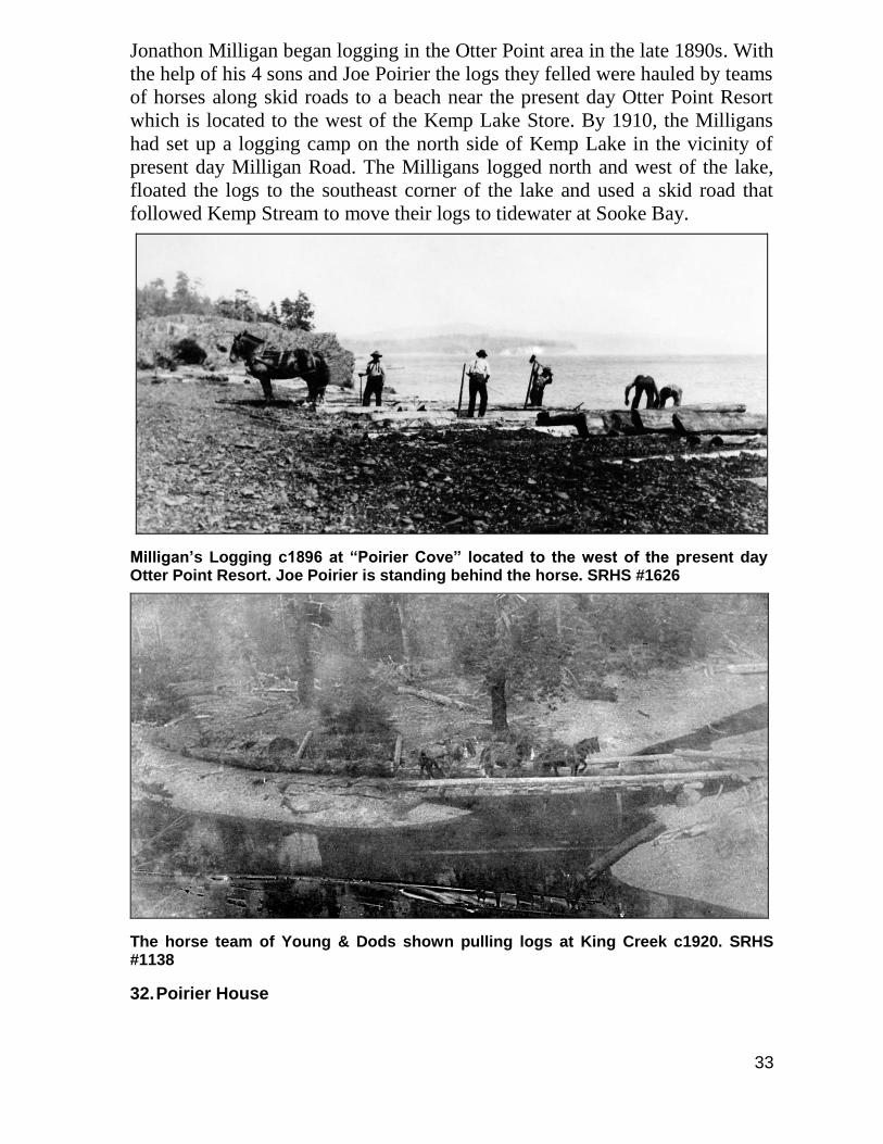
Jonathon Milligan began logging in the Otter Point area in the late 1890s. With
the help of his 4 sons and Joe Poirier the logs they felled were hauled by teams
of horses along skid roads to a beach near the present day Otter Point Resort
which is located to the west of the Kemp Lake Store. By 1910, the Milligans
had set up a logging camp on the north side of Kemp Lake in the vicinity of
present day Milligan Road. The Milligans logged north and west of the lake,
floated the logs to the southeast corner of the lake and used a skid road that
followed Kemp Stream to move their logs to tidewater at Sooke Bay.
Milligan’s Logging c1896 at “Poirier Cove” located to the west of the present day Otter Point Resort. Joe Poirier is standing behind the horse. SRHS #1626
The horse team of Young & Dods shown pulling logs at King Creek c1920. SRHS #1138
32. Poirier House
34
Joseph Poirier Sr. first settled by the Sooke River around 1850 with his wife
Ellen Brule. His eldest son, Joseph Jr., purchased land at Otter Point, (possibly
from Edward Sheilds) establishing a home there in 1902 with wife Mary
White. The Poirier house is located in the 2200 block of Kemp Lake Road and
is believed to have been built in 1895 in Sooke. It was floated in sections out
along the coast from Sooke Village and put together in two days at the current
location. In his youth, Joseph Jr. joined the annual seal hunt and later worked
as a steam engineer and logger. He then farmed the property into the 1940s
when the land was subdivided and a portion of the property was given to each
of his six children.
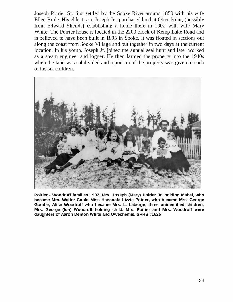
Poirier - Woodruff families 1907. Mrs. Joseph (Mary) Poirier Jr. holding Mabel, who became Mrs. Walter Cook; Miss Hancock; Lizzie Poirier, who became Mrs. George Goudie; Alice Woodruff who became Mrs. L. Laberge; three unidentified children; Mrs. George (Ida) Woodruff holding child. Mrs. Poirier and Mrs. Woodruff were daughters of Aaron Denton White and Owechemis. SRHS #1625
35
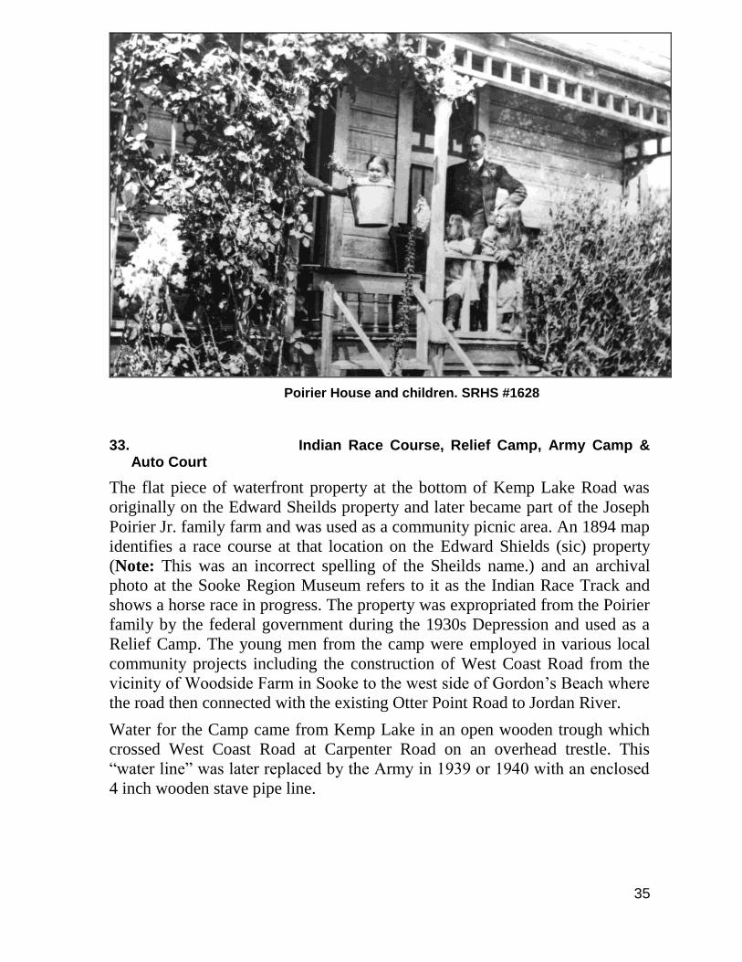
Poirier House and children. SRHS #1628
33. Indian Race Course, Relief Camp, Army Camp & Auto Court
The flat piece of waterfront property at the bottom of Kemp Lake Road was
originally on the Edward Sheilds property and later became part of the Joseph
Poirier Jr. family farm and was used as a community picnic area. An 1894 map
identifies a race course at that location on the Edward Shields (sic) property
(Note: This was an incorrect spelling of the Sheilds name.) and an archival
photo at the Sooke Region Museum refers to it as the Indian Race Track and
shows a horse race in progress. The property was expropriated from the Poirier
family by the federal government during the 1930s Depression and used as a
Relief Camp. The young men from the camp were employed in various local
community projects including the construction of West Coast Road from the
vicinity of Woodside Farm in Sooke to the west side of Gordon’s Beach where
the road then connected with the existing Otter Point Road to Jordan River.
Water for the Camp came from Kemp Lake in an open wooden trough which
crossed West Coast Road at Carpenter Road on an overhead trestle. This
“water line” was later replaced by the Army in 1939 or 1940 with an enclosed
4 inch wooden stave pipe line.
36
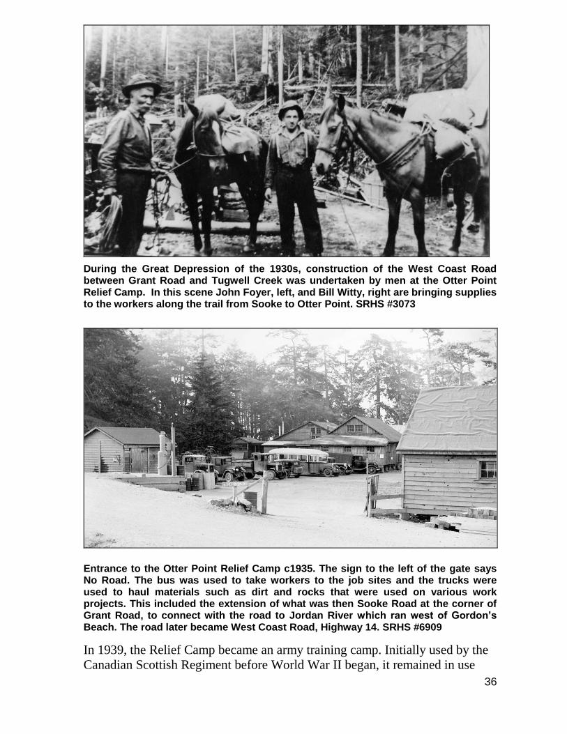
During the Great Depression of the 1930s, construction of the West Coast Road between Grant Road and Tugwell Creek was undertaken by men at the Otter Point Relief Camp. In this scene John Foyer, left, and Bill Witty, right are bringing supplies to the workers along the trail from Sooke to Otter Point. SRHS #3073
Entrance to the Otter Point Relief Camp c1935. The sign to the left of the gate says No Road. The bus was used to take workers to the job sites and the trucks were used to haul materials such as dirt and rocks that were used on various work projects. This included the extension of what was then Sooke Road at the corner of Grant Road, to connect with the road to Jordan River which ran west of Gordon’s Beach. The road later became West Coast Road, Highway 14. SRHS #6909
In 1939, the Relief Camp became an army training camp. Initially used by the
Canadian Scottish Regiment before World War II began, it remained in use
37
throughout the war as a training camp for local regiments as well as for
soldiers from other parts of Canada, particularly Ontario. During this time, the
area on the west side of the site was partially filled in; a process which was
continued after the War to extend the area where the Otter Point Resort is
presently located.
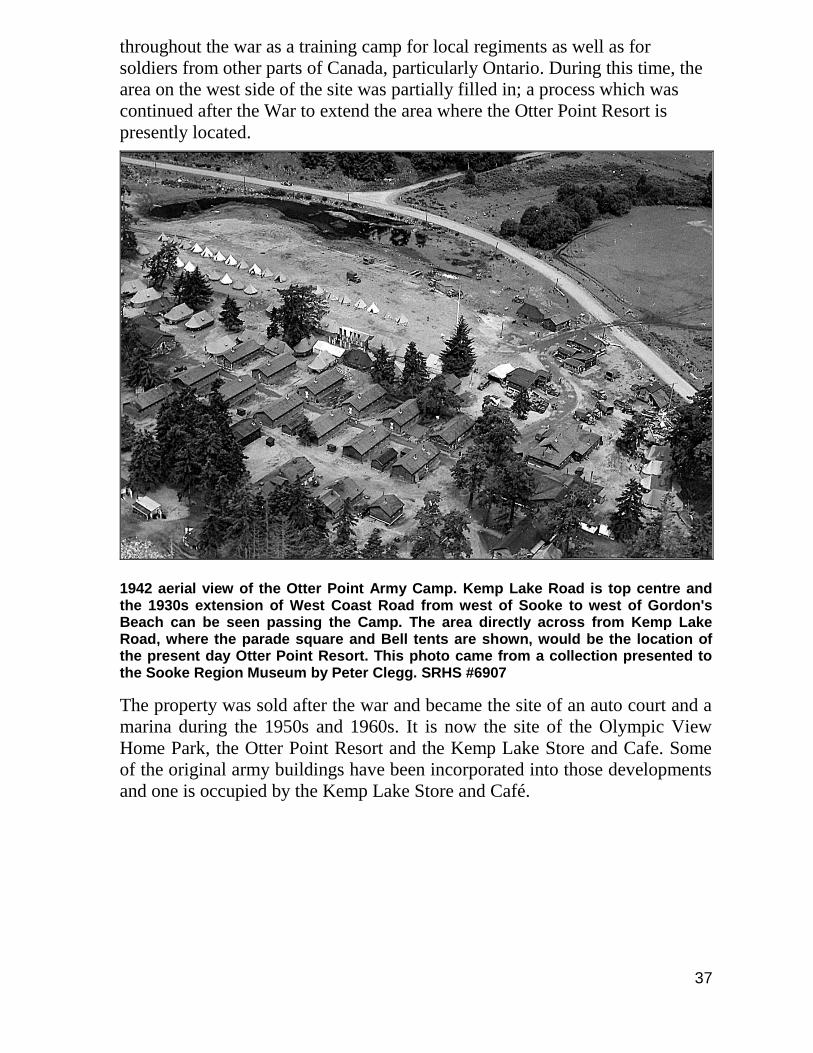
1942 aerial view of the Otter Point Army Camp. Kemp Lake Road is top centre and the 1930s extension of West Coast Road from west of Sooke to west of Gordon's Beach can be seen passing the Camp. The area directly across from Kemp Lake Road, where the parade square and Bell tents are shown, would be the location of the present day Otter Point Resort. This photo came from a collection presented to the Sooke Region Museum by Peter Clegg. SRHS #6907
The property was sold after the war and became the site of an auto court and a
marina during the 1950s and 1960s. It is now the site of the Olympic View
Home Park, the Otter Point Resort and the Kemp Lake Store and Cafe. Some
of the original army buildings have been incorporated into those developments
and one is occupied by the Kemp Lake Store and Café.

38
1942 aerial view of the Otter Point Army Camp looking east. The cedar fence at top left was built by Joe Poirier. Present day Carpenter Road is located at the top left and the Olympic View Home Park occupies much of the area in the centre of the picture. This photo came from a collection presented to the Sooke Region Museum by Peter Clegg. SRHS #6908
During the time that the Army occupied the property there were often training
exercises happening in Otter Point. Route marches would take place up Kemp
Lake Road and along Otter Point Road. There was an infantry training area on
the north side of Tugwell Road near Goudie Road and evidence of old trenches
and tank traps were seen in that area as late as the 1970s. Practice aerial
“bombing” runs during WWII using sacks of flour happened in the Tugwell
Road area, at Gordon’s Beach and on bridges crossing Tugwell and Muir
Creeks.
39
34. Scarf House
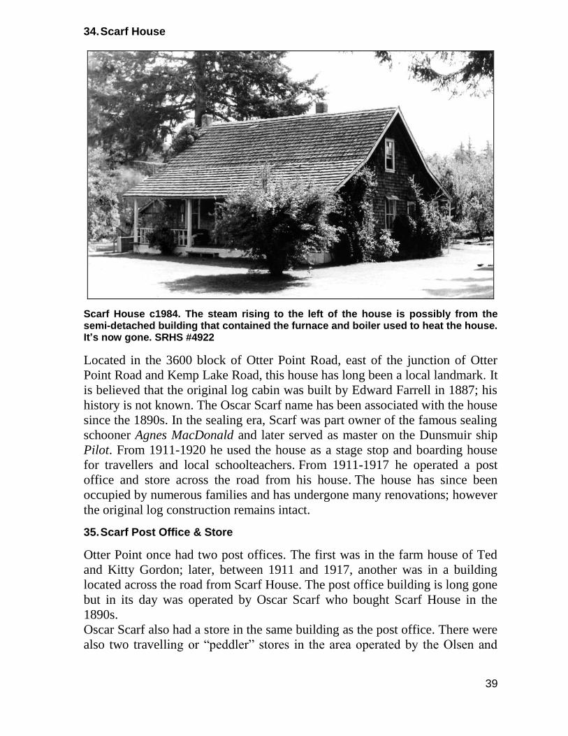
Scarf House c1984. The steam rising to the left of the house is possibly from the semi-detached building that contained the furnace and boiler used to heat the house. It’s now gone. SRHS #4922
Located in the 3600 block of Otter Point Road, east of the junction of Otter
Point Road and Kemp Lake Road, this house has long been a local landmark. It
is believed that the original log cabin was built by Edward Farrell in 1887; his
history is not known. The Oscar Scarf name has been associated with the house
since the 1890s. In the sealing era, Scarf was part owner of the famous sealing
schooner Agnes MacDonald and later served as master on the Dunsmuir ship
Pilot. From 1911-1920 he used the house as a stage stop and boarding house
for travellers and local schoolteachers. From 1911-1917 he operated a post
office and store across the road from his house. The house has since been
occupied by numerous families and has undergone many renovations; however
the original log construction remains intact.
35. Scarf Post Office & Store
Otter Point once had two post offices. The first was in the farm house of Ted
and Kitty Gordon; later, between 1911 and 1917, another was in a building
located across the road from Scarf House. The post office building is long gone
but in its day was operated by Oscar Scarf who bought Scarf House in the
1890s.
Oscar Scarf also had a store in the same building as the post office. There were
also two travelling or “peddler” stores in the area operated by the Olsen and
40
the Ness families. These were covered wagon affairs with a canvas top and
supplied dry goods and trinkets to the local homesteads.
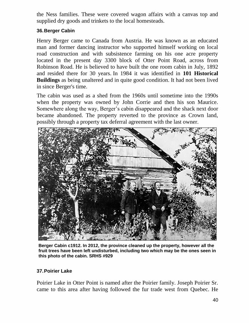
36. Berger Cabin
Henry Berger came to Canada from Austria. He was known as an educated
man and former dancing instructor who supported himself working on local
road construction and with subsistence farming on his one acre property
located in the present day 3300 block of Otter Point Road, across from
Robinson Road. He is believed to have built the one room cabin in July, 1892
and resided there for 30 years. In 1984 it was identified in 101 Historical
Buildings as being unaltered and in quite good condition. It had not been lived
in since Berger's time.
The cabin was used as a shed from the 1960s until sometime into the 1990s
when the property was owned by John Corrie and then his son Maurice.
Somewhere along the way, Berger’s cabin disappeared and the shack next door
became abandoned. The property reverted to the province as Crown land,
possibly through a property tax deferral agreement with the last owner.
Berger Cabin c1912. In 2012, the province cleaned up the property, however all the fruit trees have been left undisturbed, including two which may be the ones seen in this photo of the cabin. SRHS #929
37. Poirier Lake
Poirier Lake in Otter Point is named after the Poirier family. Joseph Poirier Sr.
came to this area after having followed the fur trade west from Quebec. He
41
originally worked for Captain Grant at his Veitch Creek sawmill and later as a
faller, along with his cousin John Goudie, supplying logs to the Muir family
sawmill in Sooke. His son Joseph Jr. was born in Sooke in 1868 and later
purchased land in the Kemp Lake area.
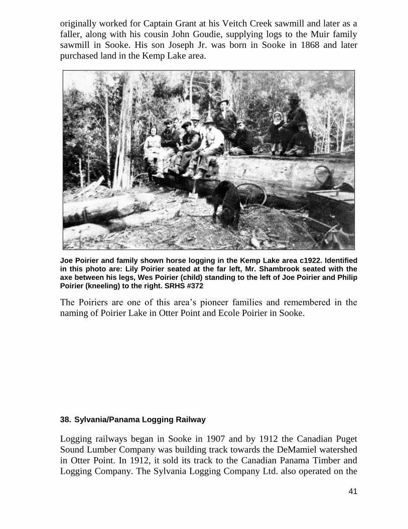
Joe Poirier and family shown horse logging in the Kemp Lake area c1922. Identified in this photo are: Lily Poirier seated at the far left, Mr. Shambrook seated with the axe between his legs, Wes Poirier (child) standing to the left of Joe Poirier and Philip Poirier (kneeling) to the right. SRHS #372
The Poiriers are one of this area’s pioneer families and remembered in the
naming of Poirier Lake in Otter Point and Ecole Poirier in Sooke.
38. Sylvania/Panama Logging Railway
Logging railways began in Sooke in 1907 and by 1912 the Canadian Puget
Sound Lumber Company was building track towards the DeMamiel watershed
in Otter Point. In 1912, it sold its track to the Canadian Panama Timber and
Logging Company. The Sylvania Logging Company Ltd. also operated on the
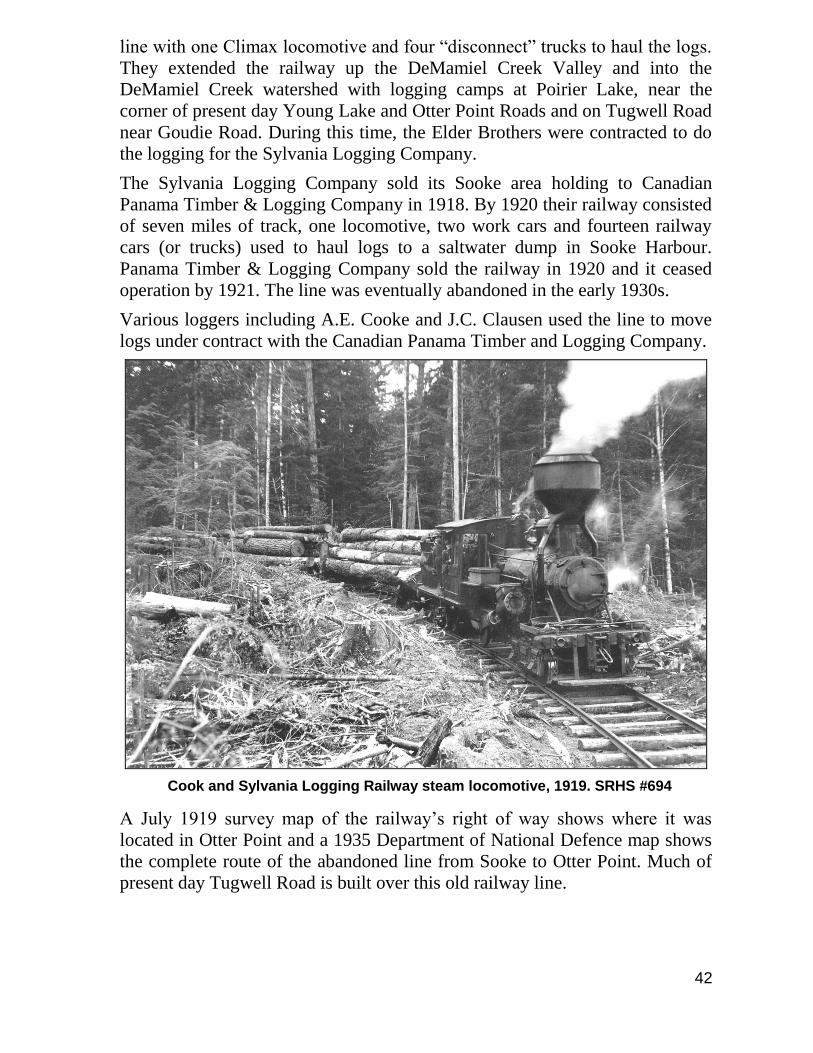
42
line with one Climax locomotive and four “disconnect” trucks to haul the logs.
They extended the railway up the DeMamiel Creek Valley and into the
DeMamiel Creek watershed with logging camps at Poirier Lake, near the
corner of present day Young Lake and Otter Point Roads and on Tugwell Road
near Goudie Road. During this time, the Elder Brothers were contracted to do
the logging for the Sylvania Logging Company.
The Sylvania Logging Company sold its Sooke area holding to Canadian
Panama Timber & Logging Company in 1918. By 1920 their railway consisted
of seven miles of track, one locomotive, two work cars and fourteen railway
cars (or trucks) used to haul logs to a saltwater dump in Sooke Harbour.
Panama Timber & Logging Company sold the railway in 1920 and it ceased
operation by 1921. The line was eventually abandoned in the early 1930s.
Various loggers including A.E. Cooke and J.C. Clausen used the line to move
logs under contract with the Canadian Panama Timber and Logging Company.
Cook and Sylvania Logging Railway steam locomotive, 1919. SRHS #694
A July 1919 survey map of the railway’s right of way shows where it was
located in Otter Point and a 1935 Department of National Defence map shows
the complete route of the abandoned line from Sooke to Otter Point. Much of
present day Tugwell Road is built over this old railway line.
43
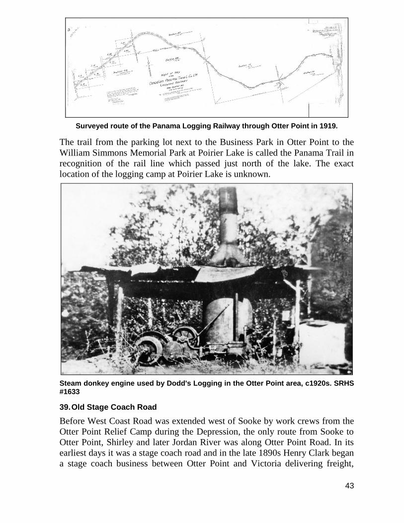
Surveyed route of the Panama Logging Railway through Otter Point in 1919.
The trail from the parking lot next to the Business Park in Otter Point to the
William Simmons Memorial Park at Poirier Lake is called the Panama Trail in
recognition of the rail line which passed just north of the lake. The exact
location of the logging camp at Poirier Lake is unknown.
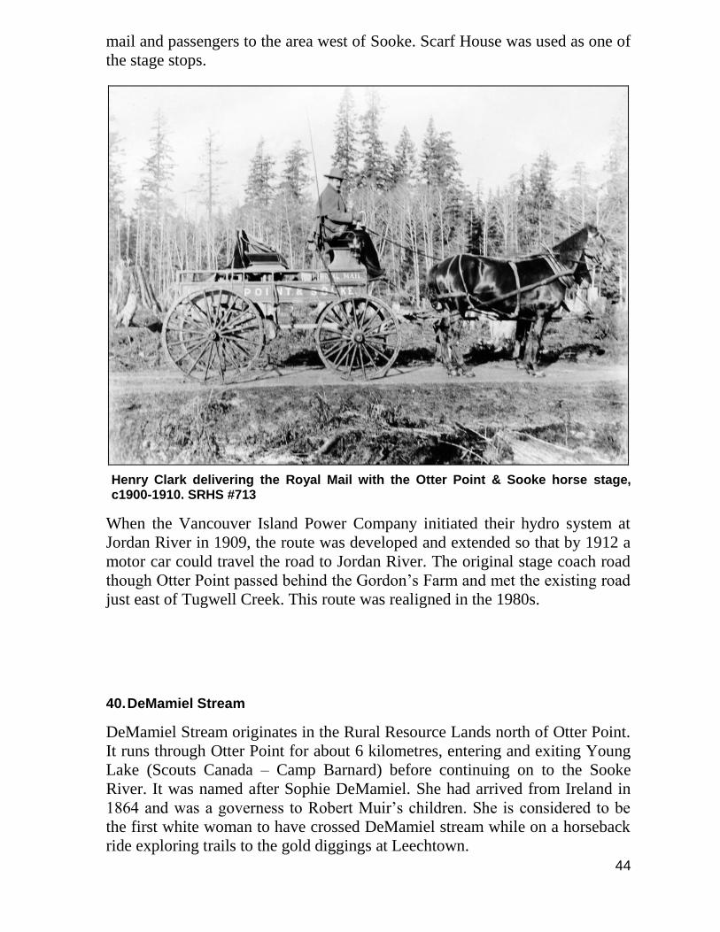
Steam donkey engine used by Dodd's Logging in the Otter Point area, c1920s. SRHS #1633
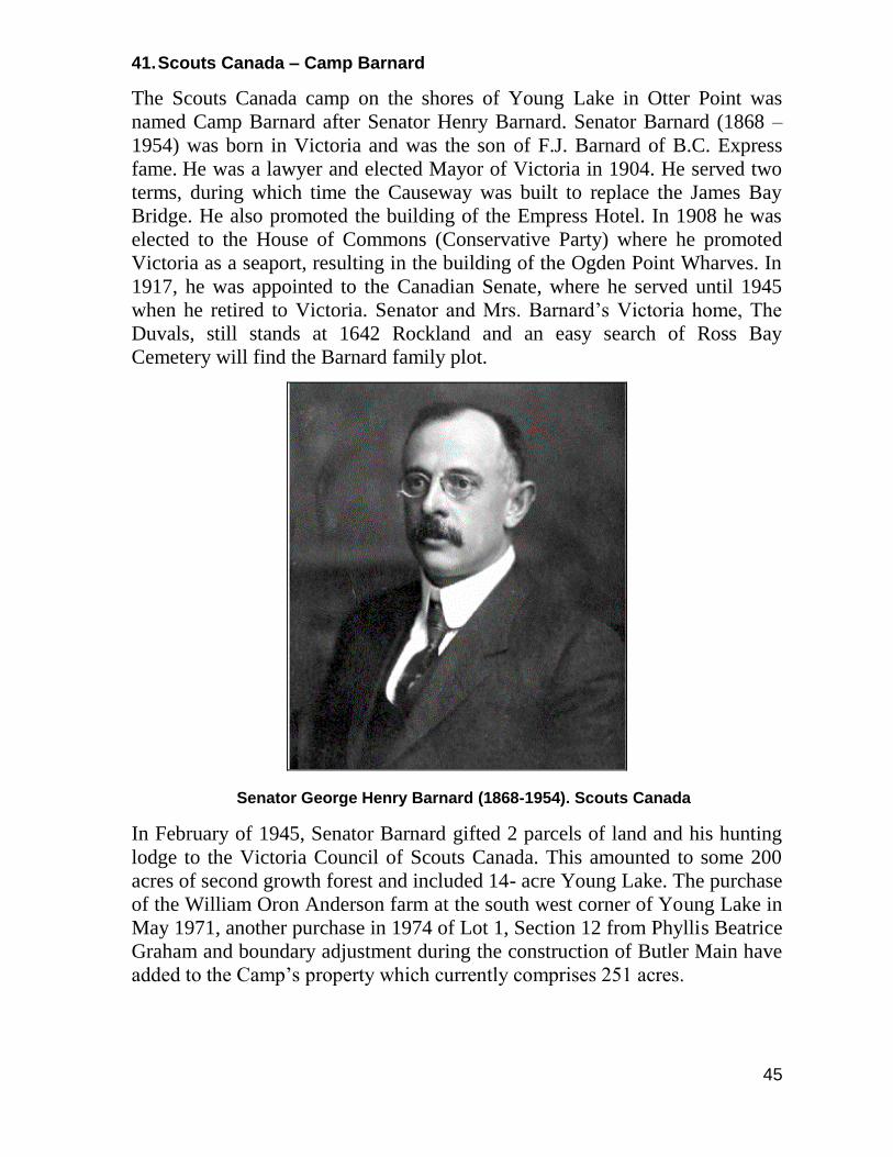
39. Old Stage Coach Road
Before West Coast Road was extended west of Sooke by work crews from the
Otter Point Relief Camp during the Depression, the only route from Sooke to
Otter Point, Shirley and later Jordan River was along Otter Point Road. In its
earliest days it was a stage coach road and in the late 1890s Henry Clark began
a stage coach business between Otter Point and Victoria delivering freight,
44
mail and passengers to the area west of Sooke. Scarf House was used as one of
the stage stops.
Henry Clark delivering the Royal Mail with the Otter Point & Sooke horse stage, c1900-1910. SRHS #713
When the Vancouver Island Power Company initiated their hydro system at
Jordan River in 1909, the route was developed and extended so that by 1912 a
motor car could travel the road to Jordan River. The original stage coach road
though Otter Point passed behind the Gordon’s Farm and met the existing road
just east of Tugwell Creek. This route was realigned in the 1980s.
40. DeMamiel Stream
DeMamiel Stream originates in the Rural Resource Lands north of Otter Point.
It runs through Otter Point for about 6 kilometres, entering and exiting Young
Lake (Scouts Canada – Camp Barnard) before continuing on to the Sooke
River. It was named after Sophie DeMamiel. She had arrived from Ireland in
1864 and was a governess to Robert Muir’s children. She is considered to be
the first white woman to have crossed DeMamiel stream while on a horseback
ride exploring trails to the gold diggings at Leechtown.
45
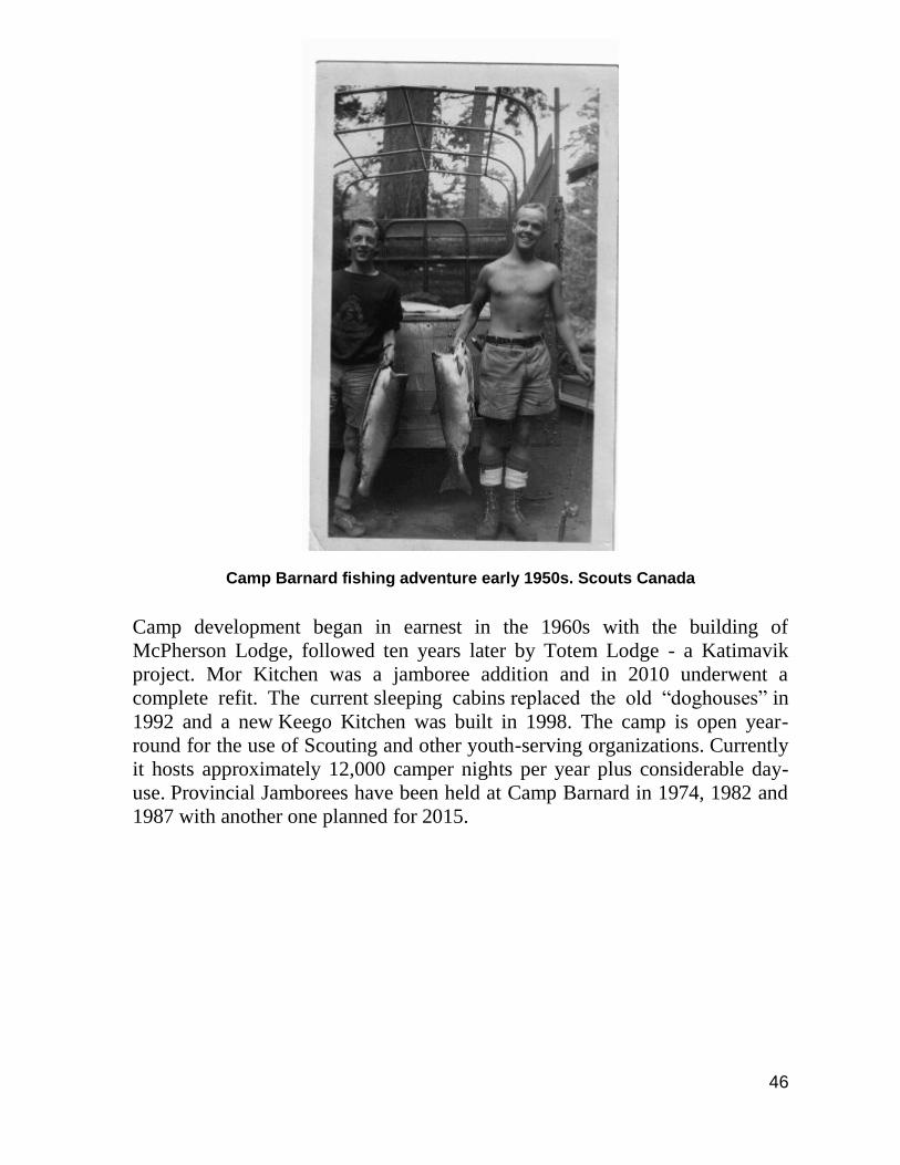
41. Scouts Canada – Camp Barnard
The Scouts Canada camp on the shores of Young Lake in Otter Point was
named Camp Barnard after Senator Henry Barnard. Senator Barnard (1868 –
1954) was born in Victoria and was the son of F.J. Barnard of B.C. Express
fame. He was a lawyer and elected Mayor of Victoria in 1904. He served two
terms, during which time the Causeway was built to replace the James Bay
Bridge. He also promoted the building of the Empress Hotel. In 1908 he was
elected to the House of Commons (Conservative Party) where he promoted
Victoria as a seaport, resulting in the building of the Ogden Point Wharves. In
1917, he was appointed to the Canadian Senate, where he served until 1945
when he retired to Victoria. Senator and Mrs. Barnard’s Victoria home, The
Duvals, still stands at 1642 Rockland and an easy search of Ross Bay
Cemetery will find the Barnard family plot.
Senator George Henry Barnard (1868-1954). Scouts Canada
In February of 1945, Senator Barnard gifted 2 parcels of land and his hunting
lodge to the Victoria Council of Scouts Canada. This amounted to some 200
acres of second growth forest and included 14- acre Young Lake. The purchase
of the William Oron Anderson farm at the south west corner of Young Lake in
May 1971, another purchase in 1974 of Lot 1, Section 12 from Phyllis Beatrice
Graham and boundary adjustment during the construction of Butler Main have
added to the Camp’s property which currently comprises 251 acres.
46
Camp Barnard fishing adventure early 1950s. Scouts Canada
Camp development began in earnest in the 1960s with the building of
McPherson Lodge, followed ten years later by Totem Lodge - a Katimavik
project. Mor Kitchen was a jamboree addition and in 2010 underwent a
complete refit. The current sleeping cabins replaced the old “doghouses” in
1992 and a new Keego Kitchen was built in 1998. The camp is open year-
round for the use of Scouting and other youth-serving organizations. Currently
it hosts approximately 12,000 camper nights per year plus considerable day-
use. Provincial Jamborees have been held at Camp Barnard in 1974, 1982 and
1987 with another one planned for 2015.
47
1947 picture of one of the early Scout course leaders training sessions using the newly created Camp Barnard - Boy Scouts of Canada Camp located on Young Lake in Otter Point. Scouts Canada
42. Otter Point Log Sort
48
The Sooke Business Park, next to Poirier Lake in Otter Point, was previously a
dry-land log sort. This 40 acre site was originally developed as a dry-land log
sort by T.W. MacKenzie Logging (operating as a subsidiary of Canadian
Pacific Railway’s Pacific Logging Company) in the late 1970s. In 1977,
MacKenzie Logging and other Pacific Logging subsidiaries amalgamated to
form Pacific Forest Products (PFP) Limited. In 1985, PFP amalgamated with
the Tahsis Company to become CIP Forest Products. The log sort experienced
numerous shutdowns in the 1990s, eventually ended-up being owned by
TimberWest and was rented out to a private contractor between 1999 and 2002
for use as an inspection and sorting station for logs that were suspected of
being contaminated by the Gypsy Moth.
A spectacular fire occurred in the wood waste pile in the early morning hours
of November 1st 2002. A quick response from the Otter Point Volunteer Fire
Department prevented the fire from spreading. The initial response involved
the help of the Shirley, East Sooke and Sooke Fire Departments who provided
tankers to haul water to the site. The fire continued to burn for several days and
required 24 hour fire suppression and monitoring by the Otter Point
Department. The property was sold to the current owners in 2006 and is now
operated as a business park.
In 2013 the Juan de Fuca Electoral Area Local Services Building relocated
from the District of Sooke to the Business Park. The Electoral Area
Administration Building is located adjacent to the William Simmons Memorial
Park.
43. Butler Brothers Saga
Soon after the close of World War II, the Butlers of Saanich, brothers Claude,
Tom, Wally and Eric, bought a timber sale on section 55 of the Otter District
49
and began three decades of logging. They logged extensively throughout the
Otter Point and DeMamiel area as far north as Jordan Meadows and east to the
Golledge and the Leech, hauling and dumping in Sooke Bay. While
headquartered at the bay, with Wally and Eric heading operations, the
company employed one hundred and twenty men. In 1974, Butlers sold to
T.W. MacKenzie Logging, a subsidiary of Pacific Logging.
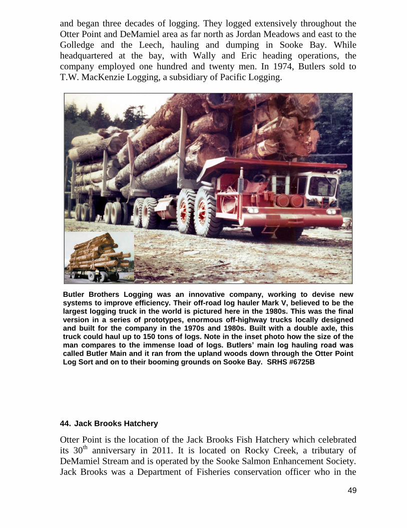
Butler Brothers Logging was an innovative company, working to devise new systems to improve efficiency. Their off-road log hauler Mark V, believed to be the largest logging truck in the world is pictured here in the 1980s. This was the final version in a series of prototypes, enormous off-highway trucks locally designed and built for the company in the 1970s and 1980s. Built with a double axle, this truck could haul up to 150 tons of logs. Note in the inset photo how the size of the man compares to the immense load of logs. Butlers’ main log hauling road was called Butler Main and it ran from the upland woods down through the Otter Point Log Sort and on to their booming grounds on Sooke Bay. SRHS #6725B
44. Jack Brooks Hatchery
Otter Point is the location of the Jack Brooks Fish Hatchery which celebrated
its 30th anniversary in 2011. It is located on Rocky Creek, a tributary of
DeMamiel Stream and is operated by the Sooke Salmon Enhancement Society.
Jack Brooks was a Department of Fisheries conservation officer who in the
50
1970s started placing salmon incubator boxes in a tributary of the Sooke River.
His early fish conservation and stream rehabilitation efforts were appreciated
by local fishermen and contributed to the formation of the Sooke Conservation
Society, a group of volunteers who collected salmon eggs in the fall and then
cared for them as they grew into salmon fry that were placed in pens in Young
Lake and Sooke Harbour before being released into the Strait of Juan de Fuca
the next summer. When the Sooke Lions Club decided to help build a fish
hatchery with incubation trays and rearing pens on Rocky Creek in 1981 it was
named after Jack Brooks. In 2013 the Sooke Salmon Enhancement Society, in
conjunction with the Jack Brooks Hatchery, produced 276,054 Chinook
salmon with a final release average weight of 5.71 grams and 110,951 Coho
salmon with a final average release weight of 3.96 grams.
The contribution of Bill James, who helped Jack Brooks and others establish
the hatchery, is commemorated by the Bill James Dam located north of
Bradford Swamp on DeMamiel Stream. In 2012 the federal Department of
Fisheries decreed that the Bill James Dam be decommissioned.
45. B.C. Electric Company Power Line & Right-of-Way
The power line was installed between 1909 and 1911 by the Vancouver Island
Power Company for the B.C. Electric Company to provide electricity to the
growing City of Victoria. The original Jordan River Powerhouse, on the east
side of the river, was eventually closed and a new facility was built in 1971 on
the west side of the river. In later years, as power was brought to the Island
from other sources on the Mainland, the Jordan River Generating Station grid
was linked to a 138kV grid that connects the Victoria, Colwood and Sooke
substations. Power from the Jordan River station continues to supply 170
Megawatts of electricity to the Greater Victoria Area. It also is capable of
providing electricity to the Sooke and Colwood substations in the event of a
power outage on the main grid.
Before the construction of Diversion Dam and the Jordan River Powerhouse
began in 1909, the only way to get to Jordan River was by boat. With the
advent of the power station and the bustling camp community that developed,
there was pressure for the existing gravel road through Otter Point to be
extended, and this was completed by 1912. The first vehicles were then able to
make the trip from Sooke along Otter Point Road and on to Jordan River. The
newly installed power lines from Jordan River were visible from the road and
were a landmark which ran through back yards and farmers’ fields in Otter
Point. Built on cedar poles, the power lines were located in a right-of-way
which followed the northern edge of West Coast Road from Jordan River to
Gordon's Beach and then followed the northwest side of Otter Point Road
through to Sooke. Remnants of that route can still be seen on maps as long
streaks through properties where the right-of-way previously existed.
51
The new B.C. Hydro right-of-way was built in the 1970s and is situated north
of the original route. It is no longer visible from Highway 14 but still passes
through residential communities in Otter Point. 46. West Coast Lifesaving Trail & Telegraph Line
During the early days of European colonization along the coast of the Pacific
Northwest the most efficient and sometimes only way to move people and
goods was by ship. At first using sail and later steam, marine traffic steadily
increased from the 1850s and much of it needed to pass through the Strait of
Juan de Fuca; an area known for some of the worst hazards associated with
coastal navigation. Although the establishment of lighthouses helped with
inshore navigation they couldn’t totally compensate for the foul weather, fog,
tides, strong currents and the navigation mistakes that sometimes wrecked
ships; casting their crews and passengers onto the unforgiving and almost
deserted shoreline of western Vancouver Island.
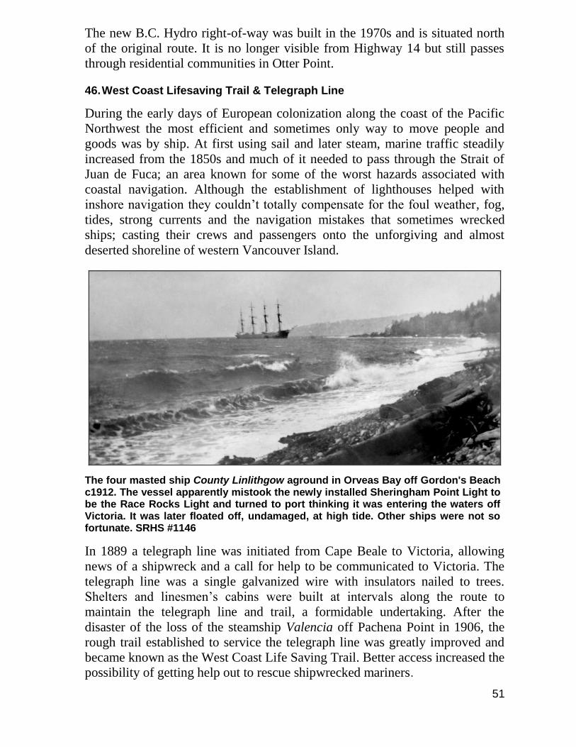
The four masted ship County Linlithgow aground in Orveas Bay off Gordon's Beach c1912. The vessel apparently mistook the newly installed Sheringham Point Light to be the Race Rocks Light and turned to port thinking it was entering the waters off Victoria. It was later floated off, undamaged, at high tide. Other ships were not so fortunate. SRHS #1146
In 1889 a telegraph line was initiated from Cape Beale to Victoria, allowing
news of a shipwreck and a call for help to be communicated to Victoria. The
telegraph line was a single galvanized wire with insulators nailed to trees.
Shelters and linesmen’s cabins were built at intervals along the route to
maintain the telegraph line and trail, a formidable undertaking. After the
disaster of the loss of the steamship Valencia off Pachena Point in 1906, the
rough trail established to service the telegraph line was greatly improved and
became known as the West Coast Life Saving Trail. Better access increased the
possibility of getting help out to rescue shipwrecked mariners.
52
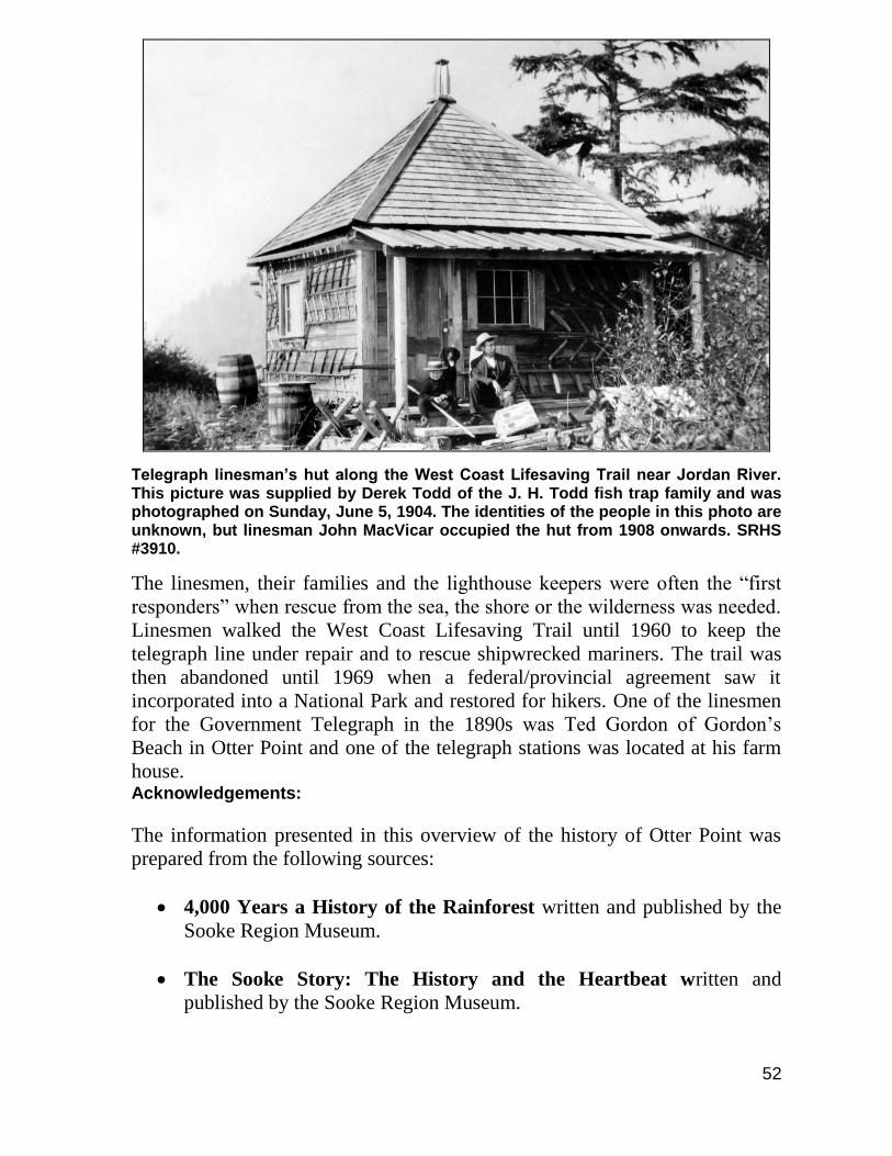
Telegraph linesman’s hut along the West Coast Lifesaving Trail near Jordan River. This picture was supplied by Derek Todd of the J. H. Todd fish trap family and was photographed on Sunday, June 5, 1904. The identities of the people in this photo are unknown, but linesman John MacVicar occupied the hut from 1908 onwards. SRHS #3910.
The linesmen, their families and the lighthouse keepers were often the “first
responders” when rescue from the sea, the shore or the wilderness was needed.
Linesmen walked the West Coast Lifesaving Trail until 1960 to keep the
telegraph line under repair and to rescue shipwrecked mariners. The trail was
then abandoned until 1969 when a federal/provincial agreement saw it
incorporated into a National Park and restored for hikers. One of the linesmen
for the Government Telegraph in the 1890s was Ted Gordon of Gordon’s
Beach in Otter Point and one of the telegraph stations was located at his farm
house. Acknowledgements:
The information presented in this overview of the history of Otter Point was
prepared from the following sources:
4,000 Years a History of the Rainforest written and published by the
Sooke Region Museum.
The Sooke Story: The History and the Heartbeat written and
published by the Sooke Region Museum.
53
101 Historical Buildings written and published by the Sooke Region
Museum.
Profiles of a Community written and published by the District of Sooke
and the Sooke Region Museum.
This Really Happened written by Jean Stuart Clark.
Memories of my First 90 years written by Lillian Elsie (Clark) Davies.
The Pot & Spiller published by the Sooke Region Museum.
Did You Know That? From the Otter Point, Shirley & Jordan River
Residents & Ratepayers Association Newsletter.
The Kemp Lake Waterworks accumulated records held in the archives
of the Sooke Region Museum.
The Kemp Lake Waterworks Website:
http://www.kemplakewaterworks.bc.ca/ .
A Personal Account of Living at Seaside Farm in the 1950s written
by Jerry Filippo.
Otter Point School at Tugwell Creek written by Marjory (Anderson)
Perron.
A Bit of Goudie Family History written by Elida Peers.
The History of Camp Barnard (Scouts Canada).
Sooke: Cradle of Christianity in British Columbia written by Grace
Horgan.
Barkley Sound – A History of the Pacific Rim National Park Area
By R. Bruce Scott.
Seven Shillings a Year – The History of Vancouver Island by Charles
Lillard.
Muir Creek Protection Society Prospectus, March 2007.
54
Notes written by Jean Robinson for an unpublished history of the Kemp
Lake Waterworks.
Otter Point Fire Department Website: http://www.otterpointfire.bc.ca/ .
The archives of the Sooke Region Museum.
Stories and memories of Otter Point by:
Ed Banner, Cliff Banner, Cliff Beange, David Boon, Sally Bullen, Bruce
Butler, Reg Clark & Reg Jr., Harry Crooks, Bertha Davies, Gerry & Roberta
Davies, Joan Davy, Ron Dumont, Melvin Elrose, Gladys Engebretson, Les
Eve, John & Cecile Farmer, Jerry & Anne Filippo, Mark Grant Sr., Gail Hall,
Louise Heywood, Velma Jessiman, Rosemary Jorna, Danny Lajeunesse, Elinor
McClimon, Doug MacFarlane, Wayne McFarlane, Frank Mitchell, Doug
Munroe, Beverley Myers, George Pedneault, Heather Phillips, Donald
Robinson, Grace Seabrook, Fred Shambrook, Ray Vowles, Wally Vowles,
Anna West, Jack & Lynne Wormald, Joe Zigay.
Appreciation is expressed to Joan O’Donnell, volunteer technician at the Sooke
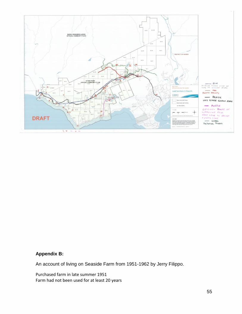
Region Museum, for photo reproduction work. Appendix A:
Locations of historic sites identified in the accompanying history of Otter
Point.
55
Appendix B:
An account of living on Seaside Farm from 1951-1962 by Jerry Filippo.
Purchased farm in late summer 1951 Farm had not been used for at least 20 years
56
No electricity No water No toilet or bathroom Roof leaked Windows in house all broken Blackberries growing through the house in one window and out the opposite window First things bought where coal oil lamps and wood burning kitchen stove First thing built was an outhouse First week or so we had to get water in pails from the creek that runs through the farm at the lower field, in the lower field next to the creek was a 60 foot windmill that was a water pump, we knew nothing about making it pump water. I was 14 at the time and dad and I figured out that the tail on windmill had to be at 90 degrees to the vanes for the mill to work. Then we found that the shaft was broken, Dad was scared of height so I had to climb up and fix the shaft. There was a concrete tank up the hill close to the house so we figured there must be a water line going up there, after about 2 weeks of working on the windmill pump and running a water line from the tank to the house we had running water. In the spring of 1952 dad got a job at Goodridge’s sawmill (later Sooke Forest Prod.) and Mom started doing housework for Dr. Brock Chisholm and Edith McLeod. I was still in school; we had to have money coming in to pay the bills. Later that year Dad bought a tractor, plow and harrows from Stan Tyreman in the Cobble Hill area who also bought a farm from Johnny Peden. 1952 Mom and Dad decided to rent out small lots on the beach to the fishermen who wanted to come out from Victoria and stay for the weekends, rent was $25 a year, Johnny Peden as the mortgage holder was against this idea. Mom and Dad got the feeling that Peden was against this because he didn't want us to succeed on the farm so that he could get it back and resell to someone else. After a month of negotiations with him he finally gave in. That same year we bought 2 or 3 cows and 250 chickens, we kept the cows in the lower barn, the upper barn was in terrible shape and full of bugs (we torched it in 1953 to get rid of it). There were also 2 other houses with a small building in between them, the house on the far side became the chicken house, the smaller building the grainery (this building used to be the Otter Point Post Office) the house next to that later became my grandparent’s house (Gerrit and Eva Filippo). The 60 tree orchard was next to these buildings and became the free range area for the chickens. Two holly trees in front of above grandparent’s house are still there (2010). That fall we started selling milk and eggs to the owners of the cabins on the beach and to people in Sooke, Dad would deliver them in Sooke on his way to work. 1953 we started growing potatoes on the upper field along Otter Point Road, about 10 acres; also on the lower field by the creek we started beans, carrots, corn, cabbage, and lettuce, about 3 acres, being next to the creek we had lots of water through a gas powered pump. All our veggies were organic no chemical fertilizers were used, only cow residue. The cows ate only grass and hay, later on silage, which is made by compacting green grass, the cows loved it. Every day at milking time they would get a shovel full of cow mash, in those days no chemicals were added to feed.
57
Dad and I built a small building on the beach across from our driveway which became a vegetable and fruit stand. We sold veggies and fall fruit, eggs, milk, candies and chocolate bars and flowers, (Mom and Dad loved growing flowers) to the locals and all the fishermen. At one time I counted 87 boats pulled up on the beach. We also sold veggies, eggs and flowers to Bob Gibson of Gibson’s Store. I would come home from school and candle eggs for 2 or 4 hours looking for blood spots inside the eggs, by this time we had over 1000 chickens and 6 or 7 milk cows, we later had a few beef cows and some pigs, which were sold to Jack Keating the butcher who owned Sooke Lockers. I remember that same year we finally got electricity and phone and we built a proper bathroom in an addition to the house. One of the first phone calls we got was from people in Sooke saying that that day’s milk tasted like onions, we had a problem, two days before that the cows had broken out of the pasture and I found them on the beach. I had a heck of a time getting them back in the field and then mending the fence. After the phone call I checked where the cows had been on the beach and I realized that wild onions grew there. We had to throw out all our milk and butter. The second time this happened we caught it in time, I guess cows like onions. 1954, around this time 53-54 my grandparents Herman and Gertrude Hyzelendoorn (Mom’s side) came to live with us, we built them a small house. Also around this time my Dad started to get sick, he was diagnosed with a negative? Virus that he got in Germany when the Nazis shipped him to Germany during the war. Dad would be in the hospital two or three times a year and running the farm became a real problem. When he was in hospital Mom and I had to do the milking, look after the chickens, the garden and making hay. Finally in September 1954 I quit school and went to work at Goodrich Sawmill to help support the family. That summer during school holidays I worked with Harry Way on his troller. In October I got a job on the tugs with Island Tug & Barge. Around that time Dad started work at Sooke Building Supplies which was much easier for him. Sometime in 1955 the Health Department shut down our selling of milk and butter, not for sanitary reasons but for selling unpasteurized milk. Mom and Dad sold our cows keeping one for our own use. Between Dad still working a bit, Mom doing housework still and me working we managed to keep Johnny Peden off our backs. Around 1956 Peden realized he wasn't getting the farm back, Dad still getting sick, they sold all the chickens except for a couple dozen, our veggie garden became smaller and Mom and Dad decided to sell some property to pay off the mortgage. In 1959 I got married and started a family, Dad's health got worse, and I built a house next to the fish trap shack. With Dad sick more often, me away from home on the tugs, my Mom alone on the farm, grandparents had already moved to Sooke and Victoria, my wife and baby alone, Mom and Dad decided to sell, wife and I decided to sell. In 1962 the Seaside Farm was sold. Jerry Filippo - 2012
58
Appendix C:
Maps drawn by Jerry Filippo showing Seaside Farm and area in the 1950s
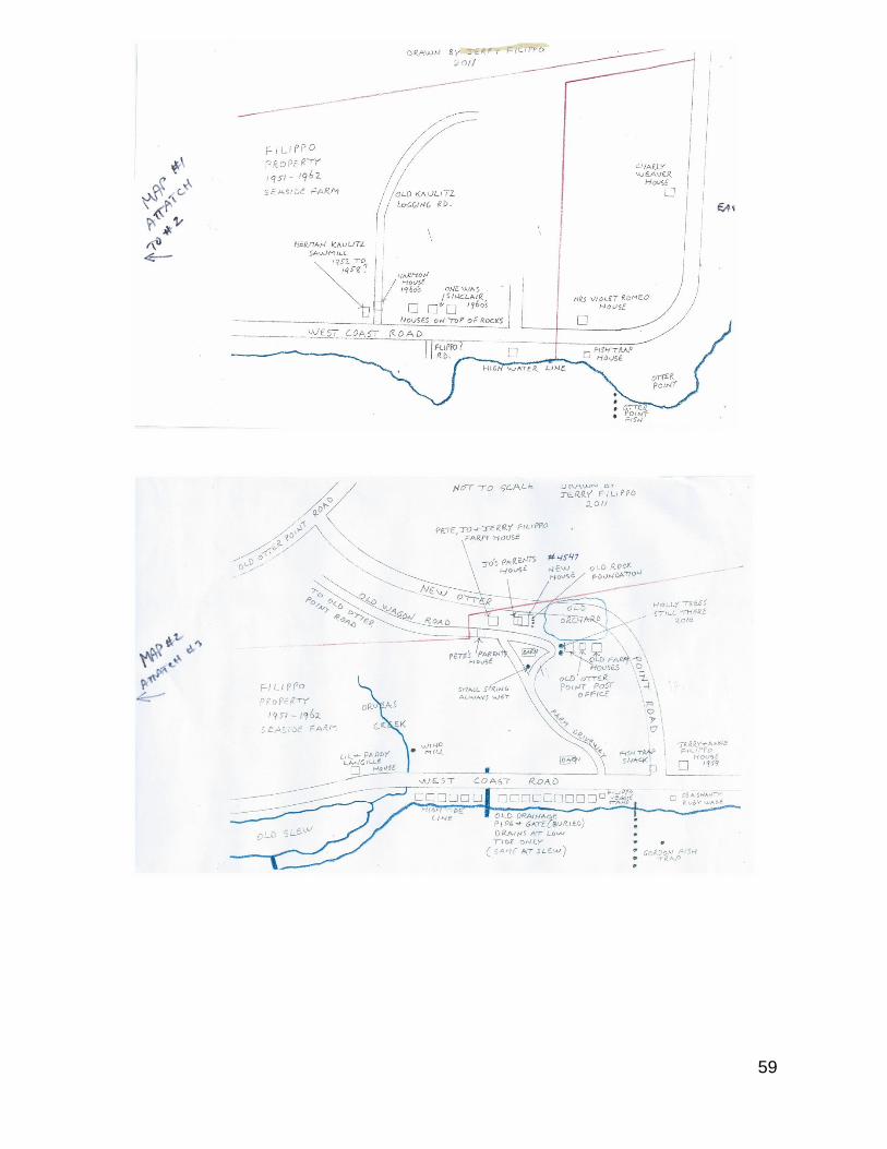
59
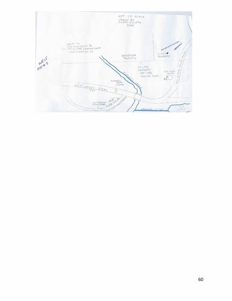
60

61