Embed Size (px)
Citation preview
May 2006, Volume 28, Number 2 NEW MEXICO GEOLOGY 43May 2006, Volume 28, Number 2 NEW MEXICO GEOLOGY 43May 2006, Volume 28, Number 2 NEW MEXICO GEOLOGY 43
IntroductionOur Lady of Magdalena still keeps up hersilent watch on the mountains and is thewonder of all passers-by. Bullion, 25 Decem-ber 1886, p. 1
Today, 120 yrs after the editor of the Bullionwaxed so eloquently, the Lady continues tokeep up her silent watch. Her regal gazehas overseen the arrival and departure ofcountless centuries, the seemingly endlessactivities of humankind, the comings andgoings of their enterprises and develop-ments. She has observed much: the wan-derings of the Native American PuebloIndians and their Paleo-Indian ancestorsbefore them; the arrival of the Spanishsoon after 1540; the American prospectorsand miners during and immediately afterthe Civil War; and the birth and death ofNorth, Middle (Kelly), and South Campsat the foot of their mines.
The mills, smelters, railroads, and townsbuilt to serve the Kelly, Graphic, Waldo,and other prominent mines in the Mag-dalena mining district are gone now; theylived and died in little more than a centu-
the northern Magdalena Range are the350–310-m.y.-old marine strata lyingunconformably upon 1.6-b.y.-old graniticbasement rocks, most of which are hiddenfrom view in the Kelly area. The sedimentsare composed of limestones of Mississippi-an and Pennsylvanian age, followed upthe stratigraphic sequence by several hun-dred feet of Madera Limestone, as well assome more recent shales and sandstones(Loughlin and Koschmann 1942, pl. 2).White rhyolite dikes and monzonite stocksof middle Tertiary age (~ 28 m.y. old) local-ly intrude the limestones and may havebeen the source of metal-saturatedhydrothermal solutions that penetratedand reacted with the limestones, resultingin the various ore deposits in the district.These intrusions represent the deeplyeroded roots of a large cluster of supervol-canoes (calderas) that produced at leastfive catastrophic ash-flow eruptionsbetween 32 and 24 m.y. ago (McIntosh etal. 1991; Chamberlin et al. 2004).
Magdalena Peak, however, is different—much different. This rhyolitic lava dome isa remnant of a cluster of lava domes that
ry, leaving behind faded memories and asmall settlement still bearing the lady’sname near the ruined pueblo where per-haps it all started. Industry has departed,replaced by homesteaders desiring to getaway from the hustle and bustle of city life,but the Lady still watches (Fig. 1). Whatchain of events created her, and how longhas she been there? Who named her, andhow long will she remain? And whateffect, if any, did her ethereal presencehave on the local inhabitants?
The folklore surrounding the naming ofMagdalena Peak and the MagdalenaMountains has inspired a wealth of print-ed accounts, ranging from curious obser-vations, oral histories, and unsubstantiat-ed stories to more scholarly documents bysouthwestern historians. Individually thestories may be of doubtful authority, butcollectively they become a significant bodyof written documentation that is now morethan 300 years old.
Geology and the imageThe most significant sedimentary rocks of
Our Lady on the mountain—history, folklore, and geology of Magdalena Peak
Robert W. Eveleth, New Mexico Bureau of Geology and Mineral Resources, Socorro, New Mexico
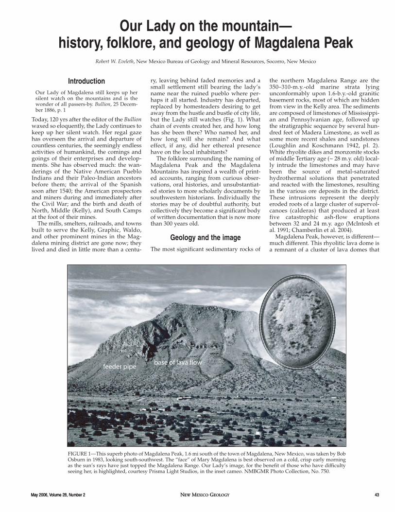
FIGURE 1—This superb photo of Magdalena Peak, 1.6 mi south of the town of Magdalena, New Mexico, was taken by BobOsburn in 1983, looking south-southwest. The “face” of Mary Magdalena is best observed on a cold, crisp early morningas the sun’s rays have just topped the Magdalena Range. Our Lady’s image, for the benefit of those who have difficultyseeing her, is highlighted, courtesy Prisma Light Studios, in the inset cameo. NMBGMR Photo Collection, No. 750.

44 NEW MEXICO GEOLOGY May 2006, Volume 28, Number 244 NEW MEXICO GEOLOGY May 2006, Volume 28, Number 244 NEW MEXICO GEOLOGY May 2006, Volume 28, Number 2
erupted between 18 and 11 m.y. ago. Mag-dalena Peak formed 13.1 m.y. ago1 by aninitially explosive eruption of ash followedby a slow effusion of pasty rhyolite lava.Just how violent? Identical “fingerprints”are almost as rare in nature as they are inhuman forensics. Only when geologistsdetermined that indivitual ash beds in theSilver Creek and San Lorenzo Canyonareas some 15–25 mi to the northeast areanalytically the same age as the lavadomes at Magdalena did the relative vio-lence of the formation of our Lady’s“palette” become apparent (R. Chamber-lin, pers. comm. 2006; Newell 1997). Thir-teen million years of uplift and erosionhave carried away some three-fourths ofthe original volcano leaving the remnantvisible today. The feeder pipe (pluggedvent) is partially exposed near the southend of the peak, and the ledge-formingbase of the lava flow can be seen towardthe middle slope on the right (Eveleth andOsburn 1983, p. 44; Fig. 1). Erosion has alsodone something else: The rhyolite has bro-ken up into angular blocks that haveformed rugged talus slopes on the moun-tain’s steeper flanks.
Because of a most curious happenstanceof nature, the loose talus, most particularlyin the center of the east-facing slope, isheld in its current configuration by fortu-itously positioned rock outcrops and vege-tation. Fortuitous also is the slope of themountain: sufficiently steep to have per-mitted some movement in the past andalso sufficiently below the angle of reposeto allow some stability in the present. Thisentire assemblage, sculpted solely by thehand of nature, has assumed a most star-tling and clear impression of a woman’sface in profile. It is this “petrifact”—theapparent image of a woman’s face—thathas instilled superstitions within, and socompletely captured the imaginations of,
some of their lead-copper glazes from theMagdalena mineral deposits (Huntley2004).3
Magdalena was apparently too far offthe beaten track for the Spanish to haveaccomplished much in the way of mineralexploration, and the territorial press is sur-prisingly silent in that regard. This is indirect contrast to uncounted references toalleged Spanish-era prospecting at otherplaces such as Sierra Oscura, San Andres,Sierra Ladrones, etc. (To the early Ameri-can prospectors the presence of an oldSpanish working was an obvious indica-tion of nearby mineral wealth.) Regardless,slight traces of Spanish-era prospectingcould be found in the early days if onelooked closely. One such indication was anold prospect pit some 300 yards northwestof the Ace of Spades mine in the Pueblodistrict (“Corona del Pueblo” in the 1860s)that was visible when American prospec-tors first arrived and was assumed to beSpanish in origin (Jones 1904, p. 123).Vivian V. Clark who grew up in the miningcamp of Kelly in the 1880s repeated a storyin vogue during his childhood to the effectthat [what would later be known as] “theGraphic mine was discovered and workedby the Spaniards in about 1760 (Clark1942).” Lead deposits in the Kelly areawere so obvious that it is hard to imaginethe Spanish not taking note of them (R.Weber, pers. comm. 2002). Physical evi-dence, however, is sparse indeed, and weare forced to conclude the remoteness ofthe deposits at that time permitted very lit-tle attention on the part of the otherwisevery observant Spanish explorers. Never-theless the “legend” of Magdalena Peakderives directly from them and their cul-ture.
Sometime after the year 1540 a smallparty of Spanish explorers separated them-selves from the main body of the SpanishConquistadores, proceeded up the RioGrande valley, and ventured west. Indiansharassed the group until, out of provisions,suffering from the heat of day and cold ofnight, and seeking refuge from the ele-ments, they suddenly discovered and werequite startled to observe the image of a“beautiful face hewn by the caprice ofnature on the mountain” (Jones 1904;
human observers for time immemorial(Fig. 2).
Legends and historyThe origins of the name “Magdalena” andthe legends surrounding it are somewhat,but not entirely, engulfed by the mists oftime. Leading up to the Spanish “entrada,”the first humans known to have visited theMagdalena area, based upon archaeologi-cal evidence, were the Native Americans.Paleo-Indians, such as the Folsom bisonhunters, are known to have camped alongLa Jencia Creek ca. 12,000 yrs ago (R.Weber, pers. comm. 2004), and in morerecent times the local Piros and possiblyother Pueblos, Navajos, Mogollons,Apaches, and Comanches as well. One ofthese latter peoples, doubtless the Piros,built a notable pueblo near present-dayPueblo Spring (Ojo del Pueblo) 1.5 minorthwest of Magdalena, a pueblo thatwas in ruins and assumed to be ancienteven when visited by Diego de Vargas in1692 (Marshall and Walt 1984, p. 256).Moreover, recent discoveries coupled withscholarly archaeological research indicatethat the Native Americans knew of andexploited the mineral deposits at Magdale-na hundreds of years before the arrival ofthe Spanish. For example, keen observersin the Magdalena area have long notedworked lithic fragments of the sky-bluemineral smithsonite (zinc carbonate,ZnCO3), a mineral found locally in theKelly area deposits, the only regionalsource. The fragments have been groundflat and many of them drilled, obviouslyfor decorative purposes. One specimen is abeautifully wrought and complete smith-sonite bead.2 More recently archaeologicalstudies using “isotopic fingerprinting”(coupled plasma mass spectrometry) indi-cate the Zuni Pueblos obtained at least
FIGURE 2—First known photograph of “Mary Magdalena.” Image by E. A. Bass, Socorro, New Mex-ico, ca. 1885. Author’s collection, enlarged approximately 75%.
1Precise age based upon modern argon-argondating technique (± 0.5% analytical error).
2NMBGMR Collection. The local Piros wereobviously aware of and were exploiting thesky-blue smithsonite locally abundant in theKelly area. The presence of such material hasfor years been noted near the Magdalena pueb-los, particularly the large ruin near PuebloSpring but has only recently generated consid-erable excitement within the archaeologicalcommunity.
3Similar ongoing studies could indicate that theso-called “Salinas” Pueblos used both theHansonburg and Magdalena lead ores for theirglazes (H. Milford, pers. comm. 2002).
May 2006, Volume 28, Number 2 NEW MEXICO GEOLOGY 45May 2006, Volume 28, Number 2 NEW MEXICO GEOLOGY 45May 2006, Volume 28, Number 2 NEW MEXICO GEOLOGY 45
W.P.A. files; Blackburn 1924; MagdalenaMountain Mail 1984; Fig. 3).
The daring explorers retained memoriesof a similar legend in their culture datingback to the early days in Spain as per thefollowing narrative in the W.P.A. files(“Magdalena”):
According to a tradition still in vogue in OldSpain, St. Mary Magdalene, after Our Lord’sdeath, had followed the apostle St. James toSpain. Here she is said to have spent her lastdays in penance and prayer on a mountain.After her death the pious natives of the sur-rounding country claimed that the image ofa beautiful woman’s face had suddenlyappeared in the mountainside, hewn byunknown hands. So, in memory of MaryMagdalena, the Spanish mountain wascalled “La Sierra de Maria Magdalena.”
Our group of Spanish explorers, recallingthis legend, were so struck by the similari-ties of this apparition to the one in theirnative country that they immediatelychristened the mountain “La Sierra deMagdalena.” There was nothing unusualin this practice; in fact it seems the Spanishroutinely saw faces and profiles in cliffsand rock formations wherever they wentin the New World.4 The Apaches and otherwar-like Indians noticed them too and,being a superstitious lot, were said toavoid the Magdalena Peak area entirely orif nearby, to refrain from molesting travel-ers “whether white or red” (Twitchell 1917,p. 288–289) within sight of the Lady’swatchful gaze.
This spot became a place of refuge and thesavage Indian would forego his bloodydeeds under the shadow of the holy mount.Those in danger would flee to this enchantedspot and thus become invulnerable from theonslaught of their pursuers (Jones 1904, p.119).
Only thus did our group of hardy Spanishexplorers live to tell the tale, but historyhas thus far deprived us not only of theiridentities but of the location of their “LaSierra de Maria Magdalena” as well. Nine-ty years, in fact, have passed since Allen(1916, p. 26) reported, “There is no dataobtainable as to when or by whom of theearly Spanish explorers ‘Our Lady Mag-dalena’ was discovered or named…” andthe situation remains unchanged today.5
The Indians, without question, wereaware of her presence long before theSpaniards and certainly possessed theirown body of folklore. So superstitiouswere the Native Americans that ”…nocrime or murder could be or ever would becommitted within view of the profile…”(Allen 1916, p. 26). The few early Americanprospectors who took the trouble toacquaint themselves with the local Indiansand their customs spoke—only toobriefly—about these beliefs. One writerreported that there were “some curiousIndian traditions about these mountains[Magdalenas and the San Mateos] that Imay give you in your columns at somefuture date (“RHS” in Santa Fe Daily New
Mexican, 1 June 1881, p 2).”6 Alas no fol-low-up article was found, and whateverfolklore the writer possessed remains lostto us.
Of greatest importance, though, is theknowledge that the Indians did have theirsuperstitions, and it follows that the Ladyhad been around long enough for them toform a well-established body of folklore.“No crime or murder could be...would becommitted,” suggests some mighty pow-erful “medicine” at work here.7 Very likelythey had their own name for the image,but it too is lost to history. Many of theearly explorers and trailblazers did makean effort to determine Indian names, butoften found them to be hopelessly indeci-pherable. For example, John Lambert, oneof the topographers for the great 1853–1854railroad surveys from the MississippiRiver to the Pacific Ocean stated that noeffort was spared in this regard but thenames recovered were often just “thebeginning…of a hopelessly unpronounce-able...Indian name, which extends to ten ortwelve guttural sounds (Lambert 1854, p.160).” The author’s efforts to unearth alocal Indian name for the Lady on theMountain have thus far been unsuccessful.
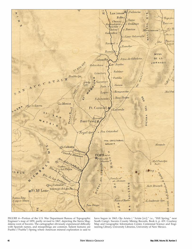
Regardless, the current name and per-haps the legend of Magdalena Peak havebeen handed down for more than 300 yrs.Of this we are absolutely certain becausethe names “Sierra Magdalena” and “Sierrade la Magdalena” are well establishedwithin hundreds of years of both writtenand cartographic history. The former, forexample, appears on a U.S. War Depart-ment Bureau of Topographic Engineer’smap of 1859 (Fig. 4), and the latter can betraced at least as far back as Bernardo deMiera y Pacheco’s map of ca. 1770 (Fig. 5).And finally, Bandelier (1892, footnote 1, p.250) refers to the murder of the alcalde
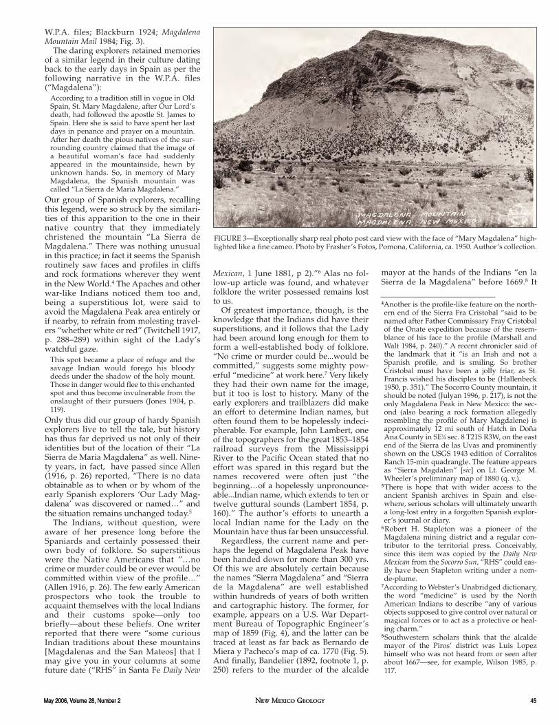
FIGURE 3—Exceptionally sharp real photo post card view with the face of “Mary Magdalena” high-lighted like a fine cameo. Photo by Frasher’s Fotos, Pomona, California, ca. 1950. Author’s collection.
4Another is the profile-like feature on the north-ern end of the Sierra Fra Cristobal “said to benamed after Father Commissary Fray Cristobalof the Onate expedition because of the resem-blance of his face to the profile (Marshall andWalt 1984, p. 240).” A recent chronicler said ofthe landmark that it “is an Irish and not aSpanish profile, and is smiling. So brotherCristobal must have been a jolly friar, as St.Francis wished his disciples to be (Hallenbeck1950, p. 351).” The Socorro County mountain, itshould be noted (Julyan 1996, p. 217), is not theonly Magdalena Peak in New Mexico: the sec-ond (also bearing a rock formation allegedlyresembling the profile of Mary Magdalene) isapproximately 12 mi south of Hatch in DoñaAna County in SE1⁄4 sec. 8 T21S R3W, on the eastend of the Sierra de las Uvas and prominentlyshown on the USGS 1943 edition of CorralitosRanch 15-min quadrangle. The feature appearsas “Sierra Magdalen” [sic] on Lt. George M.Wheeler’s preliminary map of 1880 (q. v.).
5There is hope that with wider access to theancient Spanish archives in Spain and else-where, serious scholars will ultimately uneartha long-lost entry in a forgotten Spanish explor-er’s journal or diary.
6 Robert H. Stapleton was a pioneer of theMagdalena mining district and a regular con-tributor to the territorial press. Conceivably,since this item was copied by the Daily NewMexican from the Socorro Sun, “RHS” could eas-ily have been Stapleton writing under a nom-de-plume.
7According to Webster’s Unabridged dictionary,the word “medicine” is used by the NorthAmerican Indians to describe “any of variousobjects supposed to give control over natural ormagical forces or to act as a protective or heal-ing charm.”
8Southwestern scholars think that the alcaldemayor of the Piros’ district was Luis Lopezhimself who was not heard from or seen afterabout 1667—see, for example, Wilson 1985, p.117.
mayor at the hands of the Indians “en laSierra de la Magdalena” before 1669.8 It
46 NEW MEXICO GEOLOGY May 2006, Volume 28, Number 246 NEW MEXICO GEOLOGY May 2006, Volume 28, Number 246 NEW MEXICO GEOLOGY May 2006, Volume 28, Number 2
FIGURE 4—Portion of the U.S. War Department Bureau of TopographicEngineer’s map of 1859, partly revised to 1867, depicting the Sierra Mag-dalena west of Socorro. The cartographer obviously experienced difficultywith Spanish names, and misspellings are common. Salient features arePueblo (“Puebla”) Spring where American mineral exploration is said to
have begun in 1863; Ojo Arieta ( “Ariste [sic],” i.e., “Hill Spring,” nearSouth Camp). Socorro County Mining Records, Book 6, p. 419. CourtesyMap and Geographic Information Center, Centennial Science and Engi-neering Library, University Libraries, University of New Mexico.

May 2006, Volume 28, Number 2 NEW MEXICO GEOLOGY 47May 2006, Volume 28, Number 2 NEW MEXICO GEOLOGY 47
FIGURE 5—Bernardo de Miera y Pacheco’s map of the Rio del Norte fromEl Paso to San Pascual (north of Socorro), ca. 1770, is the oldest carto-graphic document known to depict the “Sierra de la Magdalena” (near top
margin just west of the Rio Grande). Courtesy Map and Geographic Infor-mation Center, Centennial Science and Engineering Library, UniversityLibraries, University of New Mexico.
48 NEW MEXICO GEOLOGY May 2006, Volume 28, Number 248 NEW MEXICO GEOLOGY May 2006, Volume 28, Number 248 NEW MEXICO GEOLOGY May 2006, Volume 28, Number 2
should be noted that the local Piros ofSenecu, and not the Apaches as originallythought, committed and were executed forthis murder (J. Wilson, pers. comm. 2002;Wilson 1985), and it is therefore likely themurder took place in the eastern foothillsof the Magdalenas well out of sight ofMary Magdalene. Our Lady’s reputationthus appears to have survived unsullied.
The above exercise serves to demon-strate the name “La Sierra de Magdalena”was established sometime between 1540and 1669, long before the first English-man’s boot is known to have trod south-western soil, and essentially proves that aSpaniard named it and did so because ofthe remarkable cameo-like image on itsflanks, which, in turn, remindedhim/them of the “La Sierra de Maria Mag-dalena” in their native country.9
The alleged Spanish connection:fact or fiction?
At what point does a legend emerge fromthe shadows of a myth and into the light ofhistory? Is the “legend” truly based uponhistorical precedents or is it nothing morethan the brainchild of a few over-imagina-tive, home-sick Spanish explorers? The“Legend of Magdalena Peak” would gainmuch credibility if there were a “sister”mountain in Spain bearing salient featuresmatching the above story. The fact that noknown previous chronicler has undertakento locate such a mountain strongly sug-gests the whole story is, well, a story. Butdogged persistence occasionally pays off.
Are clues to be found within the W.P.A.narrative? Consider: “after her death thepious natives of the surrounding countryclaimed that the image of a beautifulwoman’s face had suddenly appeared inthe mountainside, hewn by unknownhands.” “In the mountainside?” This sug-gests that the image, if it exists, might besomewhat different than the profile in theMagdalena talus—more of a silhouette oran outcrop on a rock cliff (like the once-famous Old Man of the Mountains in NewHampshire).
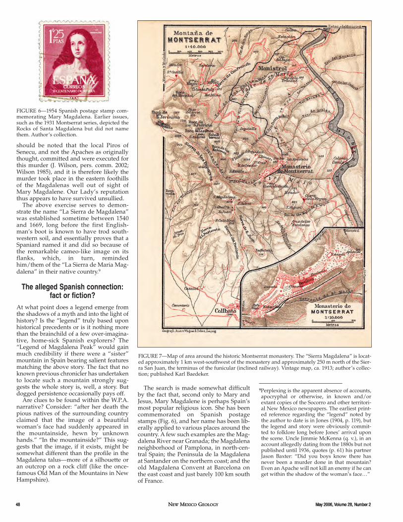
The search is made somewhat difficultby the fact that, second only to Mary andJesus, Mary Magdalene is perhaps Spain’smost popular religious icon. She has beencommemorated on Spanish postagestamps (Fig. 6), and her name has been lib-erally applied to various places around thecountry. A few such examples are the Mag-dalena River near Granada; the Magdalenaneighborhood of Pamplona, in north-cen-tral Spain; the Peninsula de la Magdalenaat Santander on the northern coast; and theold Magdalena Convent at Barcelona onthe east coast and just barely 100 km southof France.
FIGURE 6—1954 Spanish postage stamp com-memorating Mary Magdalena. Earlier issues,such as the 1931 Montserrat series, depicted theRocks of Santa Magdalena but did not namethem. Author’s collection.
FIGURE 7—Map of area around the historic Montserrat monastery. The “Sierra Magdalena” is locat-ed approximately 1 km west-southwest of the monastery and approximately 250 m north of the Sier-ra San Juan, the terminus of the funicular (inclined railway). Vintage map, ca. 1913; author’s collec-tion; published Karl Baedeker.
9Perplexing is the apparent absence of accounts,apocryphal or otherwise, in known and/orextant copies of the Socorro and other territori-al New Mexico newspapers. The earliest print-ed reference regarding the “legend” noted bythe author to date is in Jones (1904, p. 119), butthe legend and story were obviously commit-ted to folklore long before Jones’ arrival uponthe scene. Uncle Jimmie McKenna (q. v.), in anaccount allegedly dating from the 1880s but notpublished until 1936, quotes (p. 61) his partnerJason Baxter: “Did you boys know there hasnever been a murder done in that mountain?Even an Apache will not kill an enemy if he canget within the shadow of the woman’s face…”

May 2006, Volume 28, Number 2 NEW MEXICO GEOLOGY 49May 2006, Volume 28, Number 2 NEW MEXICO GEOLOGY 49
to us. Keep in mind the author is not claim-ing that the Rocks of Santa Magdalena atMontserrat are without question the fea-ture for which our mountain was named—that will have to await future confirmation.But the Santa Magdalena pinnacles, subse-quent to a 20-yr search, are the best (in factthe only) candidate to appear thus far.
FIGURE 8—Vintage post card view, ca. 1910, of the upper station of the San Juan Funicular showingthe “Rocks of Santa Magdalena” above the station and the well-worn pilgrimage trail between thetwo.
FIGURE 9—Vintage post card view, ca. 1910, of the "Rocks of Santa Magdalena." The reader is direct-ed to the upper portion of the center pinnacle where, with but little imagination, one can visualizethe face of St. Mary Magdalene. Given the fact that no life portrait of Mary Magdalene is known toexist, is it mere coincidence that the postage stamp image bears remarkable similarities to the "sculp-ture" on the mount? Both post card views are in the author's collection (Zerkowitz 1910).
Montserrat region. In fact, an individual fromthe Montserrat region is said to have accompa-nied Columbus as the pontifical representative(Escudo de Oro 1996, p. 10) and another to haveembarked upon expeditions to the Americas inthe 1500s–1600s (L. Zeising, pers. comm. 2006).
11Other claimants appearing on the first loca-tions were H. M. Enos, W. F. Strachan, H.Carpenter, Lorenzo Montoya, Major T.Brotherton, J. Springer, and J. Parsons (SocorroCounty Mining Records, Book U, p. 115). Theminers originally called their new discoverythe “Spring Hill mining district” because of the(then) permanent “Arieta” or “Hill” springnearby.
The legend further states that MaryMagdalene followed the apostle St. Jamesto Spain. Is it thus possible her mountainmight be located in the vicinity of Santiagode Compostela, the alleged final restingplace of St. James the Apostle in Galiciaprovince on the northwest coast? Here themystery only deepens because there is amountain known as the “Monte de la Mag-dalena” approximately 30 km east of Santi-ago de Compostela. Neither this peak norany of the other places mentioned aboveare known to possess a rock edifice, cliff, ora natural “sculpture” resembling awoman’s face.
End of story? Not quite! Let us revisitBarcelona, or more specifically, nearbyMontserrat in the province of Cataloniaapproximately 38 km to the northwest ofthe eastern Spanish metropolis. The coun-tryside around Montserrat is breathtakingto say the least, and the place has experi-enced miracles sufficient to gladden thehearts of the Benedictine brotherhood’smost devout dating back to at least A.D.880. Could the latter be the “pious natives”referenced in the narrative? The monasteryat Montserrat, surrounded by the Moun-tain of 100 Peaks, is a major attraction. Andless than 1 km west-southwest of themonastery there is a feature named “SierraMagdalena” (Fig. 7).
The pinnacles are plainly visible fromboth the monastery and the upper stationof the San Juan Funicular (Fig. 8), but isthis truly the sister of our Sierra Magdale-na? A photograph of this mountain, takenfrom the proper angle, reveals what is verypossibly Magdalena, New Mexico’s name-sake at last! Locally this group of pinnaclesis called the “Peñas de Santa Magdalena”(or the more French/Basque influenced“Les Roques de Santa Magdalena”) bothmeaning “Rocks of Santa Magdalena” (Fig.9). Note especially the center of the fivespires. The upper portion, with but littleimagination, bears an uncanny resem-blance to a woman’s face. She appears tobe lying on a pillow (as in death, perhaps?)with her forehead at the top, at least oneeye and nose below, and mouth at the bot-tom. We can easily imagine the piousnatives’ surprise when they first noted“that the image of a beautiful woman’sface had suddenly appeared in the moun-tainside.” According to one local source:“These fantastic shapes of the rocks andthe Montserrat needles have invited theinhabitants of the region, from ancienttimes, to give [them] meaningful or appro-priate names…and they have inventedmarvelous legends about [them]” (Escudode Oro 1996, pp. 28, 31)—the Rocks ofSaint Magdalena among them.10 Are themarvelous legends based, at least in part,upon historical precedents? Does it reallymatter? The fact is no one knows, but thisis immaterial because the Spanish explor-ers obviously believed their own legendwell enough to pass the place name along
10This suggests that at least one of our intrepidSpanish explorers hailed from the Barcelona–
50 NEW MEXICO GEOLOGY May 2006, Volume 28, Number 250 NEW MEXICO GEOLOGY May 2006, Volume 28, Number 250 NEW MEXICO GEOLOGY May 2006, Volume 28, Number 2
Native Americans and theMagdalena mining district
The district receives its name from the gigan-tic face of a woman roughly hewn out of themountain side by the hand of nature …E. A.Klauser 1888 (Santa Fe Daily New Mexican, 7April 1888, p. 4: Originally published in theKansas City Record).
Although not known as such until the mid-1870s, the Magdalena mining district wasborn in 1866–1867 when Americanprospectors “Col.” John Samuel Hutcha-son, popularly called “Old Hutch,” Berar-do Fraire, and doubtless several others11
first rode into the area on a prospectingcampaign. We can only surmise theirthoughts at their first encounter with MaryMagdalene because they left no knownwritten account. It is no surprise thatHutch and Fraire named one of their firstthree mining locations the “MagdalenaLode” (Socorro County Mining Records,Book U, p. 115). Miraculously—dare wesay predictably—Hutch and Fraire experi-enced no difficulties with Indians. In fact,from the time of discovery until the end ofthe so-called Indian wars, the author hasunearthed no record of Indian attacks inthe Magdalena or the Kelly area miningcamps. The newspapers are loaded withaccounts of Indian depredations, plunder,and murder throughout the territory, evenjust outside of Socorro (Bullion, 1 October1883, p. 3; 1 June 1884, p. 7) but not inKelly, Pueblo Springs, or Magdalena. Pil-fering and “borrowing” of livestock cer-tainly, but no scalping and no Indians onthe warpath. Nevertheless the pioneerprospectors took no chances and pointedlyavoided the use of camp fires and evenshunned the otherwise indispensable butway too vocal “desert canary”—both ofwhich could have revealed their location tothe ever-observant Indians (Bippus 1884).12
A typical pilfering raid was reported asfollows: “a party of Indians, supposed tobe Navajos, made a raid on the miningcamps in the Magdalena mountains lastweek, and ran off a lot of stock, includingthree horses belonging to Mr. Hutcha-son…” This was certainly not an unusualoccurrence as a similar raid was made “lastyear about this time…” (Santa Fe DailyNew Mexican, 26 June 1873, p. 1). Hutchlater wrote to the same paper: “It hasbecome [the Navajos] habit heretofore tolay ‘round a few days to disarm us of sus-picion, then steal all our stock and makeoff to parts unknown. I fear if our minersshould trap them stealing stock that someof them would get hurt…” (Santa Fe DailyNew Mexican, 14 April 1874, p. 1). It shouldbe noted that the Navajos referred to here-in were not the Alamo band near Magdale-na but a nomadic group located well to thenorth “near Cebolleta.” The Bullion in facthad nothing but praise for the local Nava-jos: “The occupation of [these] people con-sists in hunting mainly, though they are
security of their homes and protection oftheir well-armed neighbors.14 Crosson wascorrect in his surmise: Regardless of theunderlying reasons, whether chance, fate,or superstition, Geronimo and his bandavoided the area once again and insteadturned south to Mexico where, in SkeletonCanyon during September 1886, they werefinally induced by General Miles to surren-der.
“Throughout the Indian wars anddepredations covering a century of time inthe history of New Mexico, the Apaches,Navajos and other tribes avoided the[Magdalena] mountain, and this was espe-cially true during the raids of Victorio andGeronimo in the present generation. Thesechieftains never molested the early settlersand prospectors” (Allen 1916, p. 26). With-out doubt something quite extraordinarywas going on here.
The image of Mary Magdalena came toassume the role of official “mascot” of theMagdalena district, always there castingher benevolent countenance over themines and miners. She entered the inhabi-tants’ oral traditions, and the townspeopleinvoked her name in casual conversation.Passers-by often paused on their journeyto or from Kelly to have their photographstaken with Mary Magdalene looking overtheir shoulders. When Asa B. Fitch, man-ager and lessee of the famed Graphic minefor the decade beginning 1893, selected aspot to build the family residence, the com-pany “purchased the K. Foley tract of 160acres…” and the Fitch hacienda was built“…at the foot of the Magdalena head…”(Chieftain 10 April 1896, p. 1).” Based uponthe number of articles to appear in the localand regional press over the past decade ortwo, the fascination continues unabated.
now devoting themselves…to agricultureand the raising of cattle and horses. Thewomen are principally engaged in themanufacture of the celebrated Navajoe[sic] blanket which is woven so tightly thatwater will not penetrate…they are soberand industrious and entirely self-support-ing” (28 April 1885, p. 6).
The same could not be said for Victorio,Nana, Geronimo, Loco, and others whoregularly wrought havoc and terror in thenearby mining camps and settlements ofMogollon, Cooney, and Alma and whosemurderous deeds were well recorded inthe annals of New Mexico’s territorial his-tory. All engaged in forays well up into thenorthern Black Range and San AugustinPlains area (Allen 1916, p. 42). WhenGeronimo made his last great outbreak inmid-May 1885 (Bullion, 26 May 1885, p. 5)and vowed to kill every white man in NewMexico (as had Victorio before him) theminers and townspeople in Magdalena,Kelly, and Pueblo fortified themselves asbest they could and prepared for the worst.E. Crosson of Magdalena tried to instillsome calm by declaring that there had “notbeen a hostile Indian within a hundredmiles of Magdalena this year,” but thelocals decided it was far better to be safethan sorry. Special fortifications wereestablished at the mining camps in prepa-ration for the impending danger. “TheKelly mine received a large amount offixed ammunition last week, and if anyIndians had shown themselves, the minerswould have made short work of them”(Bullion, 2 June 1885, p. 5). Hutch’s brother,T. S. Hutchason at Pueblo Springs, likewisereported, “the boys [here] will hold the fortagainst the Indians if all hell turns looseagainst them,” then dryly noted that theboys could use “a consignment of car-tridges (Bullion, 2 June 1885, p. 6).13
Vivian V. Clark, who grew up in theyoung and booming mining camp of Kelly(a.k.a. “Middle Camp”) was a teenager atthe time of Geronimo’s last campaign.Clark’s father, C. C., ran the first-classClark House hotel. His mother was thefirst schoolmarm of the Kelly PublicSchool, and he would later attend theopening classes at the fledgling New Mex-ico School of Mines in 1893. Clark, in hisfirst-hand account of that event (1937, p. 2),tells us that many of the townspeople tookno chances: when
Geronimo went out on the warpath… hun-dreds of settlers camped under the face ofMary Magdalena, just below Kelly, for pro-tection. It was believed by them that theIndians worshipped that face and that theyhad never scalped a pale face within some 20miles of Mary Magdalena. (See also Anon.1902, p. 9).Their belief in the protective powers of
Mary Magdalene—or at least their beliefthat the Indians believed—was so deeplyingrained that they preferred camping atthe foot of the mountain to the relative
12 “Desert canary” was the term universallyapplied by the miners to their pack burros, thelatter of which unabashedly announced theirpresence regardless of time or place.
13This clip identifies T. S. as Hutch’s cousin,whereas he is clearly identified elsewhere ashis older brother. See, for example, his obituarynotice in the Albuquerque Daily Citizen, 6September 1893, p. 4.
14Why did the Piros select the Magdalena sitefor their Pueblo? Certainly there were manyother superb localities for them to have settled.Water Canyon, for example, offered an abun-dance of water, protection from the elements,and perhaps even high cliffs and natural cavesfor personal protection. Could they too havebeen more comfortable under the watchfulgaze of Lady Magdalena?
15Greer Price, the bureau’s eloquent and all-observing geological editor, upon first viewingthe Lady’s image in the Osburn photograph,exclaimed, “She looks just like MarieAntoinette!”

May 2006, Volume 28, Number 2 NEW MEXICO GEOLOGY 51May 2006, Volume 28, Number 2 NEW MEXICO GEOLOGY 51
Down through the ages:that old outlaw time
A lady called our attention the other day tothe fact that the face on the Magdalenamountain bears a close resemblance to thatof the unfortunate Marie Antoinette (Bullion,1 August 1885, p. 3).15
There is nothing that delights me more thandriving into Magdalena and contemplatingthis image all the while, for one sees the facelong before he does the town. It seems tobeckon and say, “Welcome, welcome; comeagain.” (Carey Enloe, Chieftain, 28 December1929, p. 4).
Many observers see Mary Magdalena dif-ferently. Some claim they don’t see her atall, or what they do see bears little resem-blance to the generally accepted profile(Magdalena Mountain Mail 1983). There arethose who insist that the image haschanged so much over the years that she isno longer recognizable (Ross 1983). Theauthor regrets he must respectfully dis-agree with the above: To his eye, the imagestands out clearly in profile like the lady’sface on a fine cameo ring as so vividly por-trayed in Figure 1. Whether she looks thesame to us today as she did to the earlyIndians and Spanish we cannot say, butbased upon actual photographs datingfrom the late 19th century we can state thatshe has changed but little since at least ca.1885. Intuitively, however, we know the“old outlaw time” has and will continue tosubtly change her appearance. Closescrutiny in fact suggests that the locks ofher hair have grown somewhat or at leastare more pronounced, perhaps due to thedislodging of a single large boulder: Com-pare for example, her hair in the Osburnview (Fig. 1) to that in the post card view(Fig. 3).
Weather conditions and the time of day,it should be noted, have a profound effecton the appearance: The best viewing timeis on a cold crisp day when the polarizedlight of the early morning sun is just risingover the Magdalenas. So sharp and star-tling is the view at that time the image hasbeen likened by various observers to theface of Mercury on an old U.S. silver dime,or to the well-known and long-used bustof Queen Elizabeth II on stamps and coinsof the British Commonwealth, or even, aspreviously noted, to a famous portrait ofMarie Antoinette!
It has often been said that it is improperto ask a lady her age, but in the case of theface of Mary Magdalene the question isentirely appropriate. This lady’s age is ofgreat geologic interest for her image hashad a profound effect upon the folklore,beliefs, and behavior of the local inhabi-tants for hundreds—if not thousands—ofyears.
Most would conclude that such anephemeral work of nature, subject to thepowerful forces of freeze and thaw, sunand wind, and the occasional torrential
1884, p. 5. A contemporary look at the ‘good olddays’ in Socorro and the Magdalenas, written byone of the pioneers speaking (somewhat humor-ously) at length about the pioneer prospectors’efforts to avoid Indians.
Blackburn, L., ed., 1924, Magdalena, queen of themountains: Single-issue tourist-oriented maga-zine, Magdalena, New Mexico, July 1924, 20 pp.
Bullion, territorial newspaper originally publishedin Socorro, New Mexico.
Chamberlin, R. M., McIntosh, W. C., and Eggleston,T. L., 2004, 40Ar/39Ar geochronology and eruptivehistory of the eastern sector of the OligoceneSocorro caldera, central Rio Grande rift, NewMexico; in Cather, S. M., McIntosh, W. C., andKelly, S. A. (eds.), Tectonics, geochronology, andvolcanism in the Southern Rocky Mountains andRio Grande rift: New Mexico Bureau of Geologyand Mineral Resources, Bulletin 160, pp. 251–279.
Chieftain, a.k.a. El Defensor Chieftain, newspaperpublished in Socorro, New Mexico.
Clark, V. V., 1937, Mining engineering is not allengineering: New Mexico School of Mines, GoldPan, 8 November 1937, p. 2.
Clark, V. V., 1942, Half a century of progress in min-ing and metallurgy in the United States: Unpub-lished manuscript drawn from a series of lecturesdelivered before the Mining Group at SantoTomas, Manila, by Professor Clark, Head andProfessor, Department of Mining Engineering,University of the Philippines, Manila, 140 pp.;author’s collection.
Enloe, C., 1929, Chieftain, 28 December 1929, p. 4.Escudo de Oro, 1996, All Montserrat, by the editors,
Escudo de Oro, S. A., 11th ed., 96 pp.Espinosa, J. M., 1940, First expedition of Vargas into
New Mexico, 1692: University of New MexicoPress, Albuquerque, 319 pp.
Eveleth, R. W., and Osburn, G. R., 1983, Gallery ofGeology—Magdalena Peak: New Mexico Geolo-gy, v. 5, no. 3, p. 44.
Hallenbeck, C., 1950, Land of the conquistadores:Claxton Printers, Caldwell, Idaho, 375 pp.
Huntley, D., 2004, Interaction, boundaries and iden-tities—a multiscalar approach to the organiza-tional scale of Pueblo IV and Zuni society:Unpublished Ph.D. dissertation, Arizona StateUniversity, 275 pp.
Jones, F. A., 1904, New Mexico mines and minerals:World’s Fair Edition, Santa Fe, 1904, 349 pp. +biographical appendix.
Julyan, R., 1996, The place names of New Mexico:University of New Mexico Press, Albuquerque,385 pp.
Lambert, J. 1854, Report of the topography of theroute from the Mississippi River to the Columbia,June 1, 1854: Reports of explorations and sur-veys…etc., Senate Ex. Doc. No 78, 33d Congress,2d Session, vol. 1, Washington, D.C., BeverleyTucker, printer, 1855.
Loughlin, G. F., and Koschmann, A. H., 1942, Geol-ogy and ore deposits of the Magdalena miningdistrict, New Mexico: U.S. Geological Survey,Professional Paper 200, 168 pp.
Magdalena Mountain Mail, 1983, The face on themountain at Magdalena, N.M.: Magdalena Moun-tain Mail, 2 July 1983, p. 8.
Magdalena Mountain Mail, 1984, Centennial Mag-dalena: Special insert to accompany the 31 March1984 issue, n. p.
Marshall, M. P., and Walt, H. J., 1984, Rio Abajo—prehistory and history of a Rio Grande province:New Mexico Historic Preservation Division,Santa Fe, New Mexico, 346 pp.
McIntosh, W. C., Kedzie, L. L., and Sutter, J. F., 1991,Paleomagnetism and 40Ar/39Ar ages of ign-imbrites, Mogollon–Datil volcanic field, south-western New Mexico: New Mexico Bureau ofMines and Mineral Resources, Bulletin 135, 79pp.
downpour, must be a very short lived phe-nomenon. Short lived in terms of geologictime certainly but not in terms of humanhistory. We have demonstrated, for exam-ple, that Lady Magdalena has been aroundat least since the arrival of the early Span-ish and very probably long before. Exactlyhow long we cannot say with any certain-ty, but we should note that the vegetationresponsible, in part, for maintaining theLady’s position on the mountainside is oflate Holocene age and thus evolved sincethe last 1,000 yrs (R. Chamberlin, pers.comm. 2004). The Lady’s age, therefore, ismore properly reckoned in terms of hun-dreds of years.
Regardless of her age or whether theLady conjures up feelings of fear in timesof misdeed, succor in times of danger, orsimply beckons one to return another day,she will doubtless, barring some unfore-seen geological mishap or human malevo-lence, remain with us long into the future.
AcknowledgmentsThe author is indebted to the following fortheir valuable counsel and input over theyears: Dr. Robert Weber for his long-termobservations relative to the Piros andPaleo-Indians in the San Augustin Plainsarea; Dr. Richard Chamberlin for his obser-vations and meticulous guidance on theages of geologic features; Dr. John Wilsonfor sleuthing out deeply buried historicalfacts; Mark Mansell and Richard A. Bell fortheir keen observations and data sharing;Rebecca Titus Taylor, Prisma Light Stu-dios, for her artistic touches on Figure 1;Lucinda Zeising who graciouslyresearched the legends of Montserrat andthe Rocks of Santa Magdalena while con-ducting scholarly studies in Barcelona,Spain; and Homer Milford for providinginsight into the various Spanish expedi-tions and critiquing the manuscript. Spe-cial thanks to Gary Stendel for carefullypreserving and sharing his copy of theultra-rare magazine “Magdalena, Queenof the Mountains” and Bob Julyan for hiscritical review.
ReferencesAllen, R. S., ed., 1916, Magdalena: The Mogollon
mines, 7th ann. ed., Silver City, New Mexico, 48pp.
Anon., 1902, Magdalena: Miner & Manufacturer, ElPaso, Texas, October 1902, p. 9. Anon. stated:“…high on a mountain side is almost a perfectface of a woman. This was called Lady Magdale-na and worshipped by the Indians…”
Baedeker, K., 1913, Monasterio de Montserrat, vin-tage map of area surrounding the historicmonastery at Montserrat, Spain: Handbook fortravelers, 4th ed., Leipzig, Germany, 594 pp.
Bandelier, A. F., 1892, Final report of investigationsamong the Indians of the southwestern UnitedStates, Part II: Papers of the Archaeological Insti-tute of America, American Series, IV, John Wilson& Son, Cambridge, Massachusetts, 591 pp.
Bippus, J. J., 1884, Then and now: Bullion, 1 August References continued on page 53.

May 2006, Volume 28, Number 2 NEW MEXICO GEOLOGY 53
To accomplish this, data of various majorand minor constituents at 16 wells (each inthe alluvial aquifer southwest of the tailingspile) over a 9 year period were collectedfrom Homestake Mining Company records.The concentrations of uranium, selenium,
Contamination migrationby Tara J. Elkins
Grants High School, GrantsWinner, Senior Division
Hype rages from all sides of the debate con-cerning contamination and the HomestakeMilan uranium mill/tailings ponds, not justin reference to the actual contamination lev-els, where and how fast the contamination ismoving, but in who is to blame, what ishappening, and what should be happeningto remediate the issue. Every family thatlives or raises livestock in that area has a dif-ferent fear, a different complaint, and a dif-ferent statistic of the “polluted” water just afew hundred feet below them, but only asmall few have a fact-based, strong under-standing of the issue. The purpose of thisinvestigation is to determine if there is anapparent trend in the migration of contam-inants in the alluvial aquifer southwest ofHomestake’s Milan tailings pile. Because ofthe gradient of the base of the alluvium, it isspeculated that if contaminants in theaquifer are flowing, then they are flowing ina general southwest direction.
total dissolved solids (TDS), and sulfatewere analyzed, and their average yearlychange in concentration was calculated.Once the average amount of change at eachsite was established, the results were plottedon maps of the site, which were thenobserved in search of a general trend in con-tamination flow. To better understandHomestake’s data sources, water sampleswere collected from four of the analyzedplots. Following the state’s and Homestake’sprocedures, these samples were filtered, pre-served, and tested for concentrations of thefour constituents at hand. After all of thedata were analyzed and plotted, small corre-lations hinting toward a southwesterly rout-ed contamination flow, but no overall trendin migration of uranium, selenium, TDS, orsulfate, were observed.
Because it is possible that plotting moredata points and further research of the ideacould possibly present a more apparenttrend, this investigation will remain incon-clusive. It’s believed that the data observed atthe present time are not sufficient to deter-mine the authenticity of the hypothesis.
McKenna, J. A., 1936, Black Range tales—chroni-cling sixty years of life and adventure in theSouthwest: Wilson-Erickson, New York, 300 pp.
Newell, H, 1997, 40Ar/39Ar Geochronology ofMiocene silicic lavas of the Socorro–Magdalenaarea, New Mexico, USA: Unpublished M.S. the-sis, New Mexico Institute of Mining and Technol-ogy, Socorro, 190 pp.
Ross, D., 1983, Magdalena—years of weatheringtake toll on Lady of Magdalena’s face: Santa FeNew Mexican, 24 June 1983.
Santa Fe Daily New Mexican, territorial newspaper
Continued from page 51.
published in Santa Fe, New Mexico. Socorro County Mining Records books, Socorro
County Courthouse, Socorro, New Mexico. Twitchell, R. E., 1917, The leading facts of New
Mexican history, vol. IV: The Torch Press, CedarRapids, Iowa, 567 pp.
Wheeler, Lt. G. M., 1880, Outline map of part ofsouthwestern New Mexico, provisional map foruse in advance of final publication, engraved byLouis Nell, Delaware, December 1880;NMBGMR archives, copy courtesy William T.Worthington.
Wilson, J. W., 1985, Before the pueblo revolt—pop-ulation trends, Apache relations and puebloabandonments in seventeenth century New Mex-ico; in Fox, N. L. (ed.), Prehistory and history inthe Southwest: Archaeological Society of NewMexico, Santa Fe, Vol. 11, pp. 113–120.
W.P.A. (Works Progress Administration) files, Mag-dalena: New Mexico State Records Center andArchives, Santa Fe, New Mexico, n.d., n. p.
Zerkowitz, A., ca. 1910, Rocks of Santa Magdalena,Montserrat: Adolfo Zerkowitz, Barcelona, Spain,photographer and publisher.
Photographs by Maureen Wilks.