Embed Size (px)
Citation preview
Outdoor Club Guide 2009/10 1
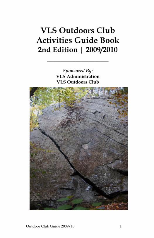
VLS Outdoors Club Activities Guide Book 2nd Edition | 2009/2010
_____________________________________
Sponsored By: VLS Administration VLS Outdoors Club
Outdoor Club Guide 2009/10 1
CREDITS Edited By: Briana Collier, ‘11 Sponsored By: VLS Administration
VLS Outdoors Club Special Thanks To: Dean Shirley Jefferson
VLS Community
Photographs By: VLS Outdoors Club Members 2009/2010 VLS Outdoors Club Executive Board: Lisa Campion Jordanna Jusidman Petra Halsema Briana Collier Jay Buckey Aaron Kisicki Vermont Law School Chelsea Street, South Royalton VT Tel: 802-831-1000 Tel: 800-227-1395
Outdoor Club Guide 2009/10 2
NOTE FROM THE EDITOR Vermont and greater northern New England have incredible offerings for outdoor enthusiasts. The VLS Outdoors Club (formerly the Mountaineers) created this guide because we saw a need for the VLS community to have access to an organized handbook of places to go and things to see within a short walk, hike, run, bike, or car ride from South Royalton. The VLS Outdoors Club also understands that incoming students might not be familiar with the area or have access to local information. We wanted to provide incoming students with some things to do. The 2007/2008 Mountaineers Club started this guide, and now, as the Outdoors Club, we are still exploring and searching for more activities and things to do in the New England area to supplement it. Please contact us if you have anything you would like to see in this guide in future publications. We hope this booklet will provide some help and encouragement to students to get out there and start enjoying New England! Thanks for your participation and happy exploring! Briana Collier, [email protected] VLS Outdoors Club Website: http://www.vermontlaw.edu/students/x8033.xml VLS Outdoors Club Listserve: [email protected]
Outdoor Club Guide 2009/10 3
TABLE OF CONTENTS Important Contacts……………………………………………….…… 4 Where to Find Information………………………………………...… 6 Biking…………………………………………………………………… 8 Mountain Biking…………………………………………………9 Camping……………………………………………………………….. 11 Climbing…………………………………………………………….… 13 Ice Climbing………………….………………………………… 13 Rock Climbing……………………………………….………… 15 Rock Climbing Gyms…………………………………………. 26 Fishing……………………………………….....………………….…… 27 Golfing…………………………………………………………….…… 28 Disk Golf…………………………………………….….….…… 28 Hiking/Snowshoeing…………………………………………….…… 29 Running………………………………………………………………… 31 Tracks…………………………………………………………….. 36 Trails……………………………………………………….……… 37 Skiing…………………………………………………………………… 39 Backcountry Downhill…………………………………….…… 39 Cross-Country…………………………………………………… 44 Downhill………………………………………………………..… 46 Swimming Holes…………………………………………………..…... 50 . Tennis Courts and Pools……………………………………………… 51 Museums……………………………………….…………………..…… 52 VT State Historical Sites……………………………………………… 54 Coops………………………………………………….………………… 56 Drinking……………………………………………………….…...…… 59 Wineries & Cideries…………………………………………………… 63
Outdoor Club Guide 2009/10 4
IMPORTANT CONTACTS HOSPITALS Alice Peck Day Memorial, Lebanon, NH Tel: 603-448-3121 Gifford Medical Center, Randolph, VT Tel: 802-728-7000 Dartmouth Hitchcock Medical Center, Lebanon, NH Tel: 603-650-5000 Veterans Administration Hospital, White River Jct., VT Tel: 802-295-9363 POISON CONTROL Northern New England Poison Center Tel: 800-222-1222 EMERGENCY Tel: 911 SCHOOL-OWNED SPORTS EQUIPMENT 2009/2010 Ice Hockey: Falko Schilling [email protected]
Faculty Advisor–Clarke Collins [email protected]
Martial Arts: Del Greer [email protected]
Faculty Advisor – Paul Ferber [email protected] Outdoors Club: Briana Collier [email protected] and Jay Buckey, [email protected]
Faculty Advisor – Dorothy Heinrichs [email protected]
Men's Rugby: Albert Vanderlaan [email protected]
Faculty Advisor – Matt Houde [email protected]

Outdoor Club Guide 2009/10 5
Women’s Rugby: Melissa Erickson [email protected]
Faculty Advisor – Matt Houde [email protected] Soccer: Daniel Stevens [email protected] Faculty Advisor - N/A Softball: Daniel Van Orman [email protected]
Faculty Advisor - Mark Latham [email protected]
Ultimate Justice Frisbee: Nate Jenkins [email protected]
Faculty Advisor – David Mears [email protected]
Outdoor Club Guide 2009/10 6
WHERE TO FIND INFORMATION If you haven’t stopped at a Vermont Welcome Center off Routes 91 or 89, do it! All of them carry a wide variety of maps and pamphlets with information about Vermont attractions. Some of the larger centers (especially one mile before the South Royalton exit and the Quechee Gorge Visitors’ Center) have an extensive collection. The State publishes maps and guides for fishing, camping, shopping, and much more all for free! Most Welcome Centers also offer free coffee and tea. While you’re in the Co-Op (South Royalton Market), take the time to read the flyers posted in the windows of the storefront. Local community groups often post information about events like farmers’ markets, ice cream socials, pancake breakfasts, and local concerts. Vermont life thrives beyond the law school community! Barrister’s Books carries a collection of hiking books and trail maps. Additionally, Borders Books is located in West Lebanon, New Hampshire. Multiple bookstores can also be found in Burlington (there are four on Church Street alone!) including Crow Bookshop, North Country Books, and Peace & Justice. The Vermont Outdoor Guide Association hosts an excellent web site with a calendar of events, listings of outdoor skills workshops and classes, and an adventure directory. http://www.voga.org/ Bookstore Websites: http://crowbooks.com/ http://www.pjcvt.org/store.htm
Outdoor Club Guide 2009/10 7
HELPFUL BOOKS Outdoor Guides The Dartmouth College Outing Club regularly publishes an outdoor guide. Included in the collection are descriptions and maps for local hikes, paddling, mountain and road biking, fishing, rock climbing, and backcountry skiing. Most entries include sufficient directions to trail heads and detailed descriptions of the trails. This book is recommended for anyone interested in a wide variety of outdoor adventure! Website: http://www.dartmouth.edu/~doc/ The Green Mountain recently published a new edition of their Day Hiker’s Guide to Vermont. Since the editors have divided Vermont into six regions, it is easy to find hikes near SoRo and estimate the time you’ll have to spend in transit. Most of the descriptions are for hikes in the range of one to four hours. The East Central Region includes nine hiking areas with a variety of trail options in each area. This book is perfect for spur of the moment trips requiring little planning. The trail maps and descriptions are excellent, but it’s always a good idea to double check the driving directions. 50 Hikes in the White Mountains by Daniel Doan and Ruth Doan MacDougall is an easy to read guide with trail maps for every hike. The front of the guide has a quick reference chart with distance, rise in feet, and other notes listed. Some VLS students set a goal of hiking all the White Mountains' over 2,000 feet; a formidable and fun goal for the weekends! The same publisher also prints 50 Hikes in Vermont.
Outdoor Club Guide 2009/10 8
BIKING
There does not seem to be a better way to view the Vermont Country side than by biking on the beautiful backcountry roads that surround South Royalton. Try a few loops listed in the RUNNING section. Also, try out the Silver Lake Loop listed below.
Submitted by: Jerry Magee, MSEL 09’ Silver Lake Loop
At the intersection of Stafford and Railroad Street in South Royalton, go under the railroad overpass and head south on S. Pleasant Street, which becomes Oxbow Road after South Street. Follow Oxbow Rd for approx 2-1/2 miles (counting S. Pleasant St.) over the freeway (after which it becomes a dirt road) up over the hill and down to its intersection with Harlow and( almost immediately) Broad Brook Rd. Go south on Broad Brook Rd. for approximately 3 miles to East Barnard. Then go west on East Barnard Rd. approximately 2-1/2 miles to Royalton Turnpike, which you (barely) follow south before turning right onto Bowman Rd. In about 1/3-mile, turn left (south) onto Tower Rd, and follow it about 2 miles over the hill and down into Barnard. Silver Lake begins on your left and the Barnard General Store in town is a treat (complete with ice cream cones and handmade milkshakes -- I had a Cookies-n-Cream and Hot Fudge milkshake served [on request] in a glass with the mixing canister for refills -- $3.25). The general store may rent canoes/kayaks at the small park across the street, while Silver Lake State Park (about a 1/4-mile back up Tower Rd.) rents canoes, single and double kayaks, and paddleboats (State Park entry fee is $4.00 per adult).
For the return trip, retrace the route up Tower Rd. for 2-1/2 miles, turning right onto Bowman Rd. for 1/3-mile, then left (north) on Royalton Turnpike. Instead of turning right onto E. Barnard Rd., stay on Royalton Turnpike for a mostly downhill distance of approx 4-1/2 miles. (Watch for washboard road conditions near the bottom of your downhill run!!) Turn right (east) onto Back River Rd. and follow it for about 2 miles where it passes under I-89 near the Royalton Bridge, then for another 2 miles back into South Royalton.
Total distance is approximately 10-1/2 miles to Silver Lake and another 11-1/2 miles return to South Royalton, for a total of 22 miles (which roughly equals the calories in a Cookies-n-Cream & Hot Fudge milkshake that fills a tall glass 2-1/2 times). Swimming, canoeing, and/or kayaking are an added bonus.
Outdoor Club Guide 2009/10 9
MOUNTAIN BIKING Otto Merrill Loop from town Submitted by Jordana Jusidman, ‘11
Directions: North Windsor to Back River to Otto Merrill (at the roads end, turn left onto middle trail) to Oxbow (left to go back into town or go right for a longer loop (Harlow to left at Broadbrook to left at river road into South Windsor).
Skill Level: Beginners to intermediate Trail Description: Hard climb followed by a nice downhill reward. Dirt road and single track. Distance: Long loop is 10.7 miles.
Season: Spring-Fall. Can get pretty wet and muddy with rain and snow melt. Catamount Outdoor Family Center
Location: 592 Governor Chittenden Rd., Williston VT 05495
Distance from VLS: about 65 miles, drive time about 1hr 15 min
Website: http://www.catamountoutdoor.com
Description: The Catamount Outdoor Family Center is a nonprofit group that offers mountain biking, hiking, walking, cross country skiing, and snow shoeing trails. They also offer a variety of clinic, camps and lessons. Check out their website to see all the offerings. Craftsbury Outdoor Center
Location: 535 Lost Nation Rd., Craftsbury Common, VT, 05827
Distance from VLS: about 72 miles, drive time about 1hr 45 min
Website: http://www.craftsbury.com/general/stay/biking.htm
Description: Offering mountain biking, skiing, hiking, sculling, lodging, and more. Fellowship of the Wheel
This group is a non-profit biking club that encourages new members to join. On their website you can find a listing of trails in Chittenden County.
Website: http://www.fotwheel.org/index.php
Outdoor Club Guide 2009/10 10
New England Mountain Biking Association On their web site, go to riding zone link in the left, choose places to ride and search for trails in Vermont and New Hampshire. As always, consider supporting the group for these resources through your membership.
Website: http://www.nemba.org/ Vermont Mountain Bike Association
Website: http://www.vmba.org/ Downhill ski resorts: Most downhill ski areas also offer mountain biking in the summer. Check you favorite peak for details. Helpful Books Mountain Bike America, Vermont, by Jen Mynter: Over forty off road rides across Vermont are well described. 3D topo maps are also a nice addition. About 15 of the rides are within a 50-mile drive from SoRo.
Outdoor Club Guide 2009/10 11
CAMPING
General information
The Vermont Campground association publishes a campground guide that is available at Vermont Welcome Centers or can be requested at their web site. The guide contains descriptions and locations of 71 private campgrounds and Vermont’s 40 state campgrounds. By following the website’s "Maps" link you can search for campgrounds by region and then click on any specific campgrounds you wish to learn more about. Prices and phone numbers are listed for each campground.
Check out Thetford Hill State Park and Silver Lake State Park, located less than half an hour from South Royalton.
Website: http://www.campvermont.com Primitive Camping
Most Vermont State Parks allow primitive camping as long as "leave no trace" practices are observed. For more information visit the Vermont State Park website and follow the link for the district you wish to stay in.
Website: http://www.vtstateparks.com/htm/primtv.cfm Amity Pond Natural Area
Amity Pond Natural Area Recreation Area is located in the northwest corner of Pomfret, VT. Two lean-tos are located in the natural area. One is very close to the trailhead and another is about one mile flat hike through a beautiful meadow away. A few miles of walking trails loop through the area with inconsistent orange and blue blazes marking the trails. The trailhead is found on Allen Hill Road, reached from South Windsor Street to Howe Hill Road. AT Shelters
150 miles of the Appalachian Trail merges with the Vermont Long Trail. Designated campsites are located in several spots along the trail and can be found in any good AT map or guide. Website: http://www.appalachiantrail.org (click on hike the trail, and search state by state)
Outdoor Club Guide 2009/10 12
Camel’s Hump State Park
Primitive camping is allowed in lower elevations and several shelters and lodges are maintained by the Green Mountain Club. There are also several designated tenting areas, including Little River State Park.
Website: http://www.vtstateparks.com/htm/camels Dartmouth College Outing Club Cabins
Dartmouth College maintains 7 cabins that can be used by anyone. Several other cabins are only available for those affiliated with Dartmouth. Advance recommendations are recommended. For more information visit their website.
Website: http://www.dartmouth.edu/~doc/cabins/descriptions/#doc GMC Wheeler Pond Camps
These two cabins, rented by the Green Mountain Club, while a long drive away are an amazingly beautiful Northeast Kingdom retreat. They are open for rent all year, with reduced rates for Green Mountain Club members. If you are planning a trip in the summer, call well in advance for reservations.
Web site: http://www.greenmountainclub.org/page.php?id=7 The White Mountains
The Whites in NH offer amazing hiking with campgrounds all around the southern base, like Crawford Notch (http://www.crawfordnotchcamping.com), and lean-tos and huts on the trails. Lean-to: Hermit’s Lake, http://www.timefortuckerman.com/hermitlake.html Hut: Lakes of the Clouds, (http://www.outdoors.org/lodging/huts/huts-lakes.cfm) These book way in advance during the summer. See the hiking section for more.
Outdoor Club Guide 2009/10 13
CLIMBING ICE CLIMBING Holts Ledge
Description: Several good ice climbs exist here, most top rope-able.
Directions: Get on 89 South. Take it to 91, and go North on 91. Take exit 14 to Lyme, NH. Make a right off the highway on Rte. 113 and follow it into Lyme (the road makes a right then a left). Veer left onto Rte. 10 once in Lyme. Within a 1/2 Mile veer right when the road bends left (onto Dorchester Rd.). Follow this to the Dartmouth Skyway and park there. Walk up the left side of the leftmost ski run on the south of the road. At the top of the second rise, turn left into the woods and follow it along the broken cliff until you reach the ice. When you reach the ice flows there is a fairly obvious low angle gully that is solo-able to reach the top if you’re top roping. Smuggler’s Notch
Description: A premiere ice-climbing mecca of New England, with climbs of all difficulties and lengths. There are top rope and multi pitch climbs here and it is beautiful!
Directions: Drive North on 89 and take Exit 10 (Stowe-Waterbury exit). Take a right off the highway and follow the road to the Stowe Ski Resort. Park where road dead ends (Notch Road is closed to automobiles in the winter). The hike in takes 40 min. to 1 hour +, depending on the climb you choose. The Notch has good winter camping spots, too. Bolton Quarry Information contributed by Aaron Kisicki, ‘11
Description: Steep top rope-able lines with no approach.
Directions: 89 N to exit 10, left onto VT-100, right at Rt. 2. Stay on Rt. 2 for 6 miles, then turn right on Green Mountain Road. The quarry is at the end of Green Mountain Road just past the electrical station (about a quarter-mile from Route 2). This road isn't plowed in the winter. You need to drive past Green Mountain Road, and park your car in the elementary school parking lot at the intersection of Rt. 2 and the Bolton Valley Ski Area Access Road. You have to hoof it in from there.
Outdoor Club Guide 2009/10 14
Speq
Description: A cool little quarry with a couple of VERY steep lines that is easily top rope-able by walking around the right side of the quarry.
Directions: Take 89 South into New Hampshire. Get off at Exit 15. Take a right and then immediate left on the frontage road. Follow this to the end and park (you’ll see the Upper Valley Human Society on right). Hike up the hill until you see the quarry on the right (about 2 minutes).
Outdoor Club Guide 2009/10 15
ROCK CLIMBING Guy’s Spot / Riverside Walls
Guy Alsentzer ‘09 scouted a great climbing area on Route 14, just one mile from campus and developed it with love. He scrubbed lines and bolted new routes for us all to enjoy. I think I speak for all us climbers when I say we owe him a huge debt of gratitude. Thanks, Guy! Below is his detailed write-up of the area.
LAND: VT common law states that a citizen may cross and generally recreate upon private land without an easement or official permission so long as the owner has not posted public notice of “no trespassing.” Please stay on the trails, control your dogs and respect the woods surrounding the crags. Do not cut down trees or alter the character of the land; lack of respect for the land and the adjacent private properties may jeopardize our use of the area.
ROCK: The rock is a conglomerate schist. Often chossy, there are still hidden gems of crags and boulders. When developing a new problem or route carefully inspect the rock quality. Roped routes in this area have been created with a ground-up minimalist ethic, including bolting only when natural protection is not available. Please respect this tradition and exercise discretion by only placing bolts when no natural protection is available.
Directions: Park in the 2nd pull-off on your left, adjacent to river, as you drive north on rte 14 from the S. Royalton Chelsea St. Bridge. Cross road and enter woods by 1 of the 2 trailheads. For trad wall, hike in about 15 yards to an old-growth maple; turn right and follow foot path southbound, keeping chossy crags to your left and the road to your right. You will notice boulder problems on the overhanging edge/arête of the Tips Boulder to your left, approximately 1 minute walking down the footpath. To find the trad walls follow path another minute, hike to a small glen with cleaner walls on your left, ending at the end of the glen. (about a 3 minute hike). Trad Wall
Climbs listed Left to Right: (‘Roofy Business’ & ‘Dirt Crack’ L-R pictured below)
(1) Beginner’s Slab 5.6+ **– Route begins on rock face to the right of a left-facing corner. A gully leads abruptly uphill to your left too. Climb cool face moves to the mini-roof/hole, clip the single bolt, finish two bolt anchor. PG protection: standard rack with small pieces.
Outdoor Club Guide 2009/10 16
(2) Roofy Business 5.7+ *** – Begin at right-facing blocky jugs directly below diagonal crack approximately 15’ off the deck. To right of Beginner’s Slab. Climb jugs to diagonal crack leading to roof. Make awkward mantle under roof, being careful to protect the roof moves via mini dihedral crack off left-facing corner of roof. Pull cool moves through roof and follow diagonal incipient crack left, then face moves and horizontal cracks to two-bolt anchors. PG 13 protection: standard rack with small pieces
(3) Dirt Crack 5.7+ ** – Begin on right facing vertical features to right of Roofy Business and beneath vertical crack 20+ feet up. V0 boulder problem leads to one bolt and a piton ~15’ off deck below vertical crack. Move up to vertical crack, protecting crack. Climb to 2-bolt anchors. PG protection.
Tips Boulder
Located on the left about 45 seconds hiking right from century maple tree towards the Trad Wall. An overhanging arête/roof.
(4) Easy as Pie V1+ - Start on far right of under hang with two hands on ledge nearest floor. Strong move to higher ledge, then traverse along ledges to left end of the arête, then up and over lip to a vegetated walk-off.
(5) Strong Like Bull V3 *** - Start at bottom corner of arête with two hands on flat ledges. Throw to finger pocket up and left, match, then follow crimps up to highest ledge. Traverse left on ledge to same top-out over far left-edge of arête like Easy as Pie.
(6) Flash This V4 ** - Start hands matched on the far left sloping slab hold at bottom corner of arête overhang like Strong Like Bull. Throw right hand up to small crimp, left to small pocket, then right up to finger crimps on edge of arête. Find crucial pinch on your right and pocket for left, then dyno to lip from precarious pinches and crimps. Top-out like Strong Like Bull.
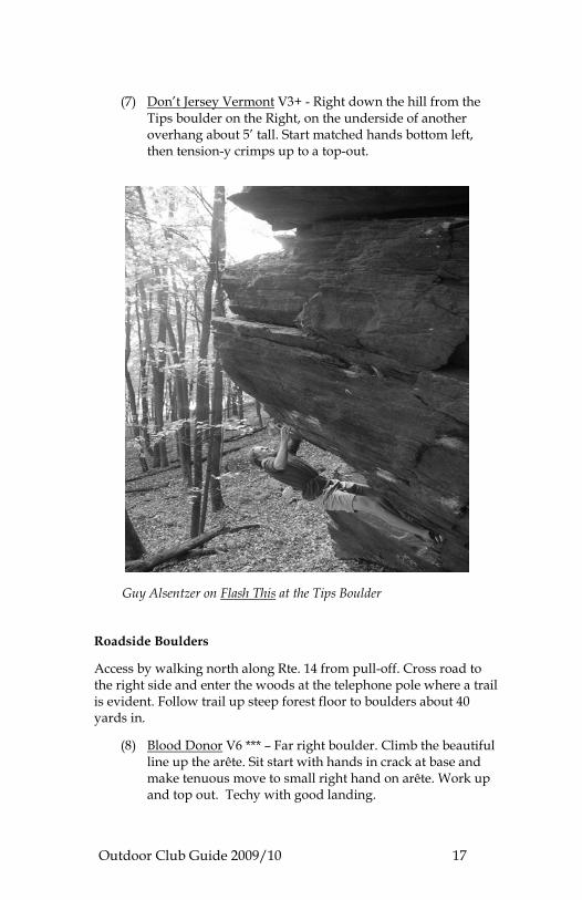
Outdoor Club Guide 2009/10 17
(7) Don’t Jersey Vermont V3+ - Right down the hill from the Tips boulder on the Right, on the underside of another overhang about 5’ tall. Start matched hands bottom left, then tension-y crimps up to a top-out.
Guy Alsentzer on Flash This at the Tips Boulder Roadside Boulders
Access by walking north along Rte. 14 from pull-off. Cross road to the right side and enter the woods at the telephone pole where a trail is evident. Follow trail up steep forest floor to boulders about 40 yards in.
(8) Blood Donor V6 *** – Far right boulder. Climb the beautiful line up the arête. Sit start with hands in crack at base and make tenuous move to small right hand on arête. Work up and top out. Techy with good landing.
Outdoor Club Guide 2009/10 18
(9) Lean Cuisine V3+ – Climb the inside face of the boulder to the left of Blood Donor. Start with hands and feet on bulge below crack and work up layback moves to top out. Awkward.
(10) Jugline V1* - Walk left of Blood Donor to slab face with diagonal finger crack at waist on your left. Stand and find right hand crimp and left hand undercling. Pull up to left and right hand crimps and up obvious jugs to a high top-out. Walk through top to trail down side, using Sport Wall trail. Highball with awkward mantle and 18’+
Sit Start: Optional sit-start matched hands on slopey ledge with feet to left on features under lip. Throw to crimp then undercling; then follow route above. V3+. Variation: Use small crimps to throw to small tips crack under jug line. Move up and left to finish regular route. Better for shorter climbers. V1+
(11) Tense Times V1+ - Start on same crimps as Jugline variation. Climb onto ledge to right, then up slab face using obvious cleaned crimps and cracks. Top out on Jugline.
(12) Sunday Brunch V1 ***– Sit start at the bottom right of the obvious finger traverse. With feet on features below pull up and traverse left to end at the block ending the crack.
(13) Trust V3+ ***- Do Sunday Bunch, then move up right to match on small crimp ledge below the roof lip, then over the lip to blind match on an incipient crack. Faith moves to top-out, walk down trail from Sport Wall. Stack your pads - Really fun.
Sit-start: Halfway up Sunday Bunch see right facing layback crimps below crack. Sit-start and pull through crimps to crack, then follow route to top out. V5
(14) Jeremy’s Traverse V5 – Start on Slopetaculous. Throw high right to dual crimps, then move right across crimps avoiding jugs atop in vegetated corner to a huge throw right onto small crimps. Finish up right facing corner onto Trust. Bring your steel tendons.
(15) Slopetaculous V3+ ***– Line following the left corner of the left boulder’s arête. Walk past Sunday Brunch and vegetated corner to far left arête. Sit-start hands matched on small flake directly under arête. Big moves left to a jug, then
Outdoor Club Guide 2009/10 19
sloper holds to moves up arête. Top out, then skinny down the tree alongside. Great problem solving!
Sport Wall
To reach the Sport Wall hike to Riverside Boulders, then follow footpath to left of Slopetaculous up and around boulders to a 50’ wall directly behind. Routes listed Left to Right. Ambidexterous pictured below.
(16) Ambidexterous 5.10d *** – Mixed route. Start at bottom of awesome left-running off-width crack. Trad climb diagonal crack up left to a stance. Next climb arête placing pro and clipping 3 bolts until reaching top ledge. Stay on far left on the arête (face climbing off right of the arête is easier). 2-bolt anchors. PG protection. Long and sustained with heady crux.
(17) High Times 5.10 ** – Mixed route. Start boulder problem about 8’ right of Ambidexterous crack on small crimps. Make awkward moves to small ledge, clip bolt left, then make tension layback moves to second bolt. Mantle and optionally place micro-cams 00 or 01 or Ballnutz from a good stance in small diagonal crack above second bolt. Clip third bolt on top of right facing features, then run-out 5.8 moves for 10’ to 2-bolt rappel rings. Variation: Start on Ambidexterous crack, optionally place pro, then make crimp moves up face to the right and clip 2nd bolt 20 feet up. 5.10. Really fun.
(18) Shiester 5.10c ** – Mixed route. Start hands on large flake beneath gold colored bolt. Make moves up left to first bolt. Techy moves to jug ledge and bolt then awkward mantle. Move through sloper holds (the physical crux) to place pro in crack system above. Climb straight up past small pro to small crimp sequence and the psychological 8’ run-out crux to two bolt rappel anchors. Techy and sequenced. Exciting!
(19) Primal Urge 5.10a **– Mixed route. Start right of Shiester behind large tree under steel bolt and crack going diagonally left. Climb the left traversing crack to 2 bolts, then trad following incipient cracks diagonally left until reaching the High Times anchors. Sustained.
Outdoor Club Guide 2009/10 20
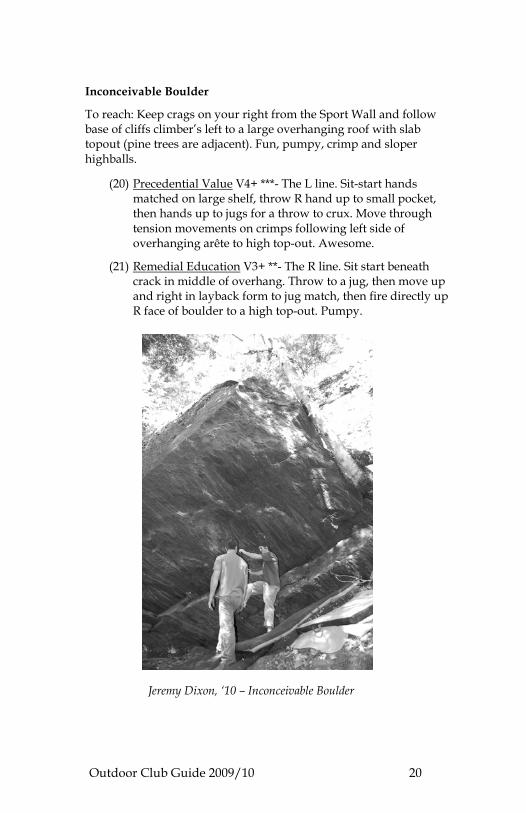
Inconceivable Boulder
To reach: Keep crags on your right from the Sport Wall and follow base of cliffs climber’s left to a large overhanging roof with slab topout (pine trees are adjacent). Fun, pumpy, crimp and sloper highballs.
(20) Precedential Value V4+ ***- The L line. Sit-start hands matched on large shelf, throw R hand up to small pocket, then hands up to jugs for a throw to crux. Move through tension movements on crimps following left side of overhanging arête to high top-out. Awesome.
(21) Remedial Education V3+ **- The R line. Sit start beneath crack in middle of overhang. Throw to a jug, then move up and right in layback form to jug match, then fire directly up R face of boulder to a high top-out. Pumpy.
Jeremy Dixon, ‘10 – Inconceivable Boulder
Outdoor Club Guide 2009/10 21
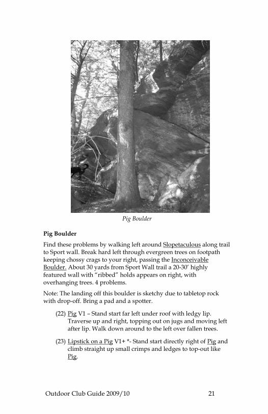
Pig Boulder Pig Boulder
Find these problems by walking left around Slopetaculous along trail to Sport wall. Break hard left through evergreen trees on footpath keeping chossy crags to your right, passing the Inconceivable Boulder. About 30 yards from Sport Wall trail a 20-30’ highly featured wall with “ribbed” holds appears on right, with overhanging trees. 4 problems.
Note: The landing off this boulder is sketchy due to tabletop rock with drop-off. Bring a pad and a spotter.
(22) Pig V1 – Stand start far left under roof with ledgy lip. Traverse up and right, topping out on jugs and moving left after lip. Walk down around to the left over fallen trees.
(23) Lipstick on a Pig V1+ *- Stand start directly right of Pig and climb straight up small crimps and ledges to top-out like Pig.
Outdoor Club Guide 2009/10 22
(24) Flying Pig V3 *– Sit start on corner down and right of Lipstick on a Pig. Sitting feet left with hands on small crimps, climb up and left on small features, to top out following Pig out and down.
(25) Project V3+? – Highball. Climb crack to right of Flying Pig up right facing corner to tall top-out by overhanging tree and roots.
Bolton
Description: Several cliffs with a good variety of climbs. Some are easier to locate than others, with the lower cliff being the easiest to find.
Details of Bolton’s areas provided by Zach Friedman, ’10. Lower West Bolton: Directions: To get to lower cliff, go on 89 North to exit 10 (Stowe-Waterbury exit). Get off and take left at stop. Take right at next stop on Rte. 2. Follow Rte. 2 for several miles, past the Bolton Ski Valley turn off (you will be traveling on left side of highway). Take a right on Bolton Notch Rd. and park all the way off the road on the right about one half mile up. Follow the obvious trail for 2 minutes to cliff. To get to upper cliff, drive past lower cliff and go another 1 mile or so up the road. Park on the right side of road at Long Trail trailhead (white blazes on trees in wood on left of road). Be sure to pull all the way off the road here – not much parking. Follow trail down hill and over the creek and look for cutoff right within a quarter mile. Follow cutoff until you get to cliff. Best to go here with someone who has already been there, or be ready for a bit of exploring! (www.cragvt.com has a topo with grades and route names in the forums).
Bolton Quarry: To get to the Quarry, follow the same directions as above but turn onto Green Mountain Drive before the Bolton Valley Ski Resort Access Road. Follow this road all the way until you are in a small amphitheater with a parking lot and a Crag-VT message board. (Go to www.cragvt.com and search the forums for topo with all the grades and a map of the quarry. Also gets some reliable ice in the winters that is easily toproped with static line.)
Outdoor Club Guide 2009/10 23
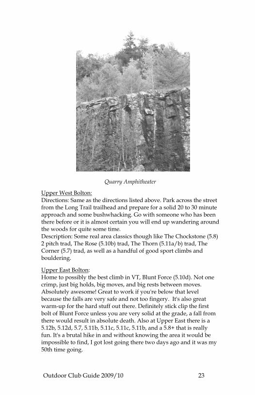
Quarry Amphitheater
Upper West Bolton: Directions: Same as the directions listed above. Park across the street from the Long Trail trailhead and prepare for a solid 20 to 30 minute approach and some bushwhacking. Go with someone who has been there before or it is almost certain you will end up wandering around the woods for quite some time. Description: Some real area classics though like The Chockstone (5.8) 2 pitch trad, The Rose (5.10b) trad, The Thorn (5.11a/b) trad, The Corner (5.7) trad, as well as a handful of good sport climbs and bouldering.
Upper East Bolton: Home to possibly the best climb in VT, Blunt Force (5.10d). Not one crimp, just big holds, big moves, and big rests between moves. Absolutely awesome! Great to work if you're below that level because the falls are very safe and not too fingery. It's also great warm-up for the hard stuff out there. Definitely stick clip the first bolt of Blunt Force unless you are very solid at the grade, a fall from there would result in absolute death. Also at Upper East there is a 5.12b, 5.12d, 5.7, 5.11b, 5.11c, 5.11c, 5.11b, and a 5.8+ that is really fun. It's a brutal hike in and without knowing the area it would be impossible to find, I got lost going there two days ago and it was my 50th time going.
Outdoor Club Guide 2009/10 24
Lower East Bolton: Directions: On the way to Upper East. Climbing is mostly a mix of trad and sport with no real great climbs - plus it requires rappelling in.
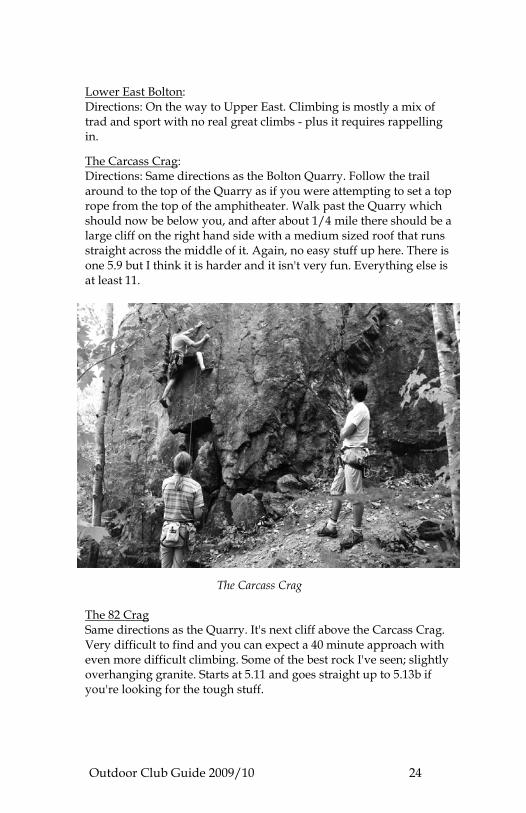
The Carcass Crag: Directions: Same directions as the Bolton Quarry. Follow the trail around to the top of the Quarry as if you were attempting to set a top rope from the top of the amphitheater. Walk past the Quarry which should now be below you, and after about 1/4 mile there should be a large cliff on the right hand side with a medium sized roof that runs straight across the middle of it. Again, no easy stuff up here. There is one 5.9 but I think it is harder and it isn't very fun. Everything else is at least 11.
The Carcass Crag
The 82 Crag Same directions as the Quarry. It's next cliff above the Carcass Crag. Very difficult to find and you can expect a 40 minute approach with even more difficult climbing. Some of the best rock I've seen; slightly overhanging granite. Starts at 5.11 and goes straight up to 5.13b if you're looking for the tough stuff.
Outdoor Club Guide 2009/10 25
Deer Leap
Description: Deer Leap is a smaller crag with both trad and sport routes. More trad than sport, but some really fun lines with great exposure.
Directions: Deer Leap is located in Central Vermont on the North side of Rte. 4 (between Killington and Mendon) on top of the Killington/Pico pass behind the famous Inn at the Long Trail. Park across the street from the Inn at the Long Trail in the big parking lot. Climber’s trail heads up the hill to the right of the Inn.
Website: http://www.deersleapvt.com Smugglers Notch
Directions: Get off at the Stowe exit. Turn right onto route 100. Follow 100 until a three way stop sign. Turn left onto Vt 108 and follow that road until you are sitting in the high notch parking lot. Description: Tons of boulder problems. Some truly impressive ones include The Moontower (V9) Nemesis (V5) The Green Egg (V6) The Roots Boulder (V1) The Impossible Problem (V7), and the King Boulder (numerous problems). As far as climbing goes, there are some serious trad lines for crazy people. As for sport climbing there are three routes worth mentioning because although the Notch is not a sport climbing area, I hear these climbs are fantastic, and they are pictured in Rock and Ice in the VT article. If you are standing in the high Notch parking lot facing Mt. Mansfield head right into the woods for a couple 100 yards. Travel behind the stone hut where the bathrooms are and keep an eye out left for a steep gully that heads up to a cliff. This is the ENT gully. Once you scramble up the steep slope, there are three STEEP sport routes on the left wall, going 5.11c, 5.11d, and 5.12a. There is a slabby sport climb that goes around 5.6 or 5.7 on the opposite side of the wall.
Outdoor Club Guide 2009/10 26
ROCK CLIMING GYMS Green Mountain Rock Climbing Center
Directions: 89 South to exit 1, Route 4 West or Route 14 East to Howe Hill Road south to Pomfret Road South to Route 4 East.
Description: Closest gym to school. Five walls, one partially overhung with lead routes. A few bouldering lines from the mats up 10-15 ft. No bouldering cave. $15 day pass. Hours: M-F, 3pm to 8pm, Saturdays 11-6, closed Sundays
Tel: 802 457-2221
Website: http://www.vermontclimbing.com
Website: http://www.indoorclimbing.com/vermont.html This website really has all you need to know about rock climbing gyms in Vermont, including description, location, phone numbers and web site listings.
Outdoor Club Guide 2009/10 27
FISHING Of course, we all live next to the beautiful White River. Multiple road pull offs along Rt. 14 usually indicate a trail down to a popular fishing spot. You might even try standing beneath the bridge for a quick break between classes. The Outdoors Club has three fly rods to loan out.
Licenses: Vermont hunting or fishing licenses can be purchased online from the Vermont Fish and Wildlife Department.
Website: http://www.vtfishandwildlife.com/buylicense.cfm Useful Publication: the Vermont Fish and Wildlife Department also publishes a detail map/brochure that indicates fishing lakes, ponds, river, and streams and the types of fish usually found in these particular waters. The brochure can be found in most Vermont Rest Areas. The Department’s website is also very useful, with links to maps, pond and length depth charts, and fishing access points. Follow the rules: A complete description of Vermont’s fishing seasons and regulations are found in the Vermont Guide to Hunting, Fishing, and Trapping Laws. This publication can be found at any licensing agent, upon request to the Vermont Fish and Wildlife Department, or click on the law enforcement link on their website.
Outdoor Club Guide 2009/10 28
GOLFING Randolph Driving Range
Located off exit 89N. Take exit 3, and turn left. Driving range will be located on your left across the street from McDonalds. DISC GOLF
There is a Disc Golf course behind the municipal pool in Randolph. A larger course is located in the town of Waterbury but it is not open until May 1, due to mud. Other courses in the area can be found by visiting the web site bellow. Website: http://www.pdga.com/ Go to course directory link and type in South Royalton zip code. Descriptions of courses, distance from South Royalton and directions are listed.
Outdoor Club Guide 2009/10 29
HIKING / SNOWSHOEING
3 Stallion Inn, Randolph
Submitted by Jordanna Jusidman ‘11
Description: The Three Stallion Inn is a mini resort consisting of 1,300 acres in the foothills of the Green Mountains with a wealth of recreational opportunities for every season. The Inn has 35km of mapped trails with great views. The trails offer hiking, mountain biking, running, cross-country skiing, snowshoeing and walking. An important point of interest is that it’s free if you have your own gear, and the trails are groomed in winter. Directions: Take exit 4 of 89 and head towards the town of Randolph. Make a left at Stock Farm Rd. End at the Three Stallion Inn, 665 Stock Farm Rd, Randolph, VT 05060-9055
Mt. Tom, Woodstock
Activities and Points of Interest: Hiking around (off season), Cross Country Skiing; Excellent example of Vermont natural history
Address: Marsh-Billings-Rockefeller Nat Historical Park, 54 Elm Street, Woodstock, VT 05091 Mt. Mansfield, Hellsbrook Trail
When to go: Spring through Fall
Description: Hike/Scramble. Steep climb up to the top of Mount Mansfield. Lots of scrambling, but worth the view from the top. Use an alternate route to descend.
Directions: 89N to exit 10, 100N to Stowe, 108 NW 9 miles. 65 miles, about 2 hours. Camel’s Hump
Number of trails from 5 to 12 miles to summit and back down.
Directions: 89N to exit 10. Turn right at 100 and left on Rt. 2. Turn left at Cochran Rd., 0.5 mi. Turn left at Dugway Rd., 3.2 mi. Turn left at Huntington Rd, 0.5 mi. Slight right at Main Rd, 2.4 mi. Slight right to stay on Main Rd, 2.5 mi. Turn left at Camels Hump Rd., 0.6 mi. Turn right to stay on Camels Hump Rd, 1.3 mi. Turn right and then slight left to stay on Camels Hump Rd, 0.1 mi. Website: http://www.central-vt.com/web/camel
Outdoor Club Guide 2009/10 30
Pico
A number of trails head up this ski mountain from Route 4. They range in length. The Appalachian Trail runs through here. There is also a climbing wall, alpine slides, and guided horseback rides. Directions: Take Rt. 14 N to 107 W to 100 S. Go right onto Rt. 4 heading west to Rutland. After 2 miles, turn left onto Alpine Drive and park across from the Inn.
Website: http://picomountain.com/summer/index.html Kent’s Ledge Trails
Lots of nice short trails lace the hillsides around and below Kent’s Ledge. Access via the road behind Crossroads, through an intimidating gate, then under the highway at the fenced underpass. Trails are mostly off to the left and end on Pleasant St./Oxbow. There is some logging activity up there at times, so keep your ears open.
Outdoor Club Guide 2009/10 31
RUNNING
The following runs were compiled by Jake Marren ’09. The Ferret Loop
Distance: 6.5 miles of hill-acious fun.
Directions: Start at the green, run down Railroad St. and go under the train tracks. Make a left onto Pleasant St. and continue for over half a mile across the overpass. Once over the overpass, follow the dirt road for over a mile up the hill. Take a right on Otto Merrill Rd. It will be a little hard to spot because it is usually in rough shape. Yes it is a road, not someone's ATV trail. Follow Otto Merrill for over a mile, you will eventually go down the hill and past some houses. Take a right on Back River Road, it is about two miles back to South Royalton from the underpass. Enjoy, and don't wear your favorite shoes! The Deceptagon's Wrath
Distance: Two mile feat of strength (that is just a one way trip), used as a hill interval.
Directions: Happy Hollow road is located a half mile north of South Royalton, on the right hand side of Highway 14. Start at the beginning of the road and run to the top! You never know what is around the corner, usually a barking dog and a nice 12% incline. Testiclees Tears
Distance: 9 miles, very easy to add on and make into a proper distance outing.
Directions: Start at the Green. Run across the river and out of town on VT 110. After about a mile take the only left available and run across the river, this is Mill Rd. Follow Mill Rd for a mile and take a left on Rix Rd. Go up the hill for about two miles and take a left of Clarksville Rd. Clarksville Rd will become Ward Rd. soon and a while later you will take a right on Russell Rd. Russell will take you all the way back to Mill Rd and VT 110. Very nice run, avoid in mud season.
Please Note: No dogs allowed per town ordinance.

Outdoor Club Guide 2009/10 32
Eeyore's Ecstasy
Distance: Five miles
Directions: From the Green, run across the White River. Cross 14, and take the first right behind the Exxon, at the top of the hill, run straight to the end of Elephant Lane. Hop on the trail at the end of the road and go on up. At the top of the hill, there are many trails to explore. One trail will lead you down to a gravel road. Follow Robert's Way back to Rte. 14. It is about one mile back to town.
Gavin Boyles ‘06 prepared the following running information.
Some loops were described in the above section, but are included here for additional explanation. These are just a few of the possible runs here in town. Don’t be afraid to explore! Hopefully this will provide a good jumping off place for further explorations. South Royalton is at an elevation of about 500’. The hills around town reach almost 2,000’ and the Green Mountains nearby reach 4,000’. Many of the runs here are hilly. Embrace this fact, and the running here is phenomenal. Resist it, and you may find yourself slogging through the same runs day after day. The roads and trails within running distance of town don’t go much above 1,500’. I’ve made some estimates of elevation gain for each run, based on the USGS topo maps for the area. Basically I’m just counting the big hills. So the Otto Merril/Oxbow loop has a figure of 600’, which is just the high point (1,100’) minus the low point (500’). Most of the runs have one major uphill followed by one major downhill, so this is a pretty decent gauge. Most of the distances are based on my Honda’s odometer, and aren’t totally precise, but are within a couple tenths. Happy trails! The Royalton Bridge 3.9 miles
The default run for a lot of SoRo dwellers. Pretty much flat, half paved, half dirt. North Windsor St. follows the river for two miles (1 paved, 1 dirt) and then crosses at the Royalton Bridge. Turn around at the bridge and it’s just under 4 miles round-trip. Flat. 40’ gain. Otto Merrill/Oxbow Loop 6.5 – 7
Follow North Windsor St. to the Royalton Bridge and keep going under the interstate. Up a steep, short hill, then left on Otto Merrill Rd. Up a series of hills for about a mile, and when road ends make a left on an old jeep road. Follow this uphill and through a clearing (nice trails off to the right if you’re interested). It flattens for a bit
Outdoor Club Guide 2009/10 33
then drops back down to the Oxbow Rd./Pleasant St. When you hit the improved dirt road, make a left and it’s about 2.5 miles back to town. Hilly. 600’ gain. Oxbow – Broad Brook – S. Windsor 9
From the green, run past the South Royalton House to the railroad underpass. Go under the tracks, make a left (Pleasant St. – a.k.a. the Oxbow). Follow Pleasant St. up to and over the interstate (steep hill) and then another 2 miles (also uphill) to a three way intersection (unimproved dirt road to the right, improved dirt road to the left). The right turn is the Otto Merrill Rd. You want the left. Follow it downhill to a T. Left again, along rolling downhills until this merges with Broad Brook Rd. Follow Broad Brook downhill along the brook until it comes to a T with South Windsor after railroad underpass. Left on S. Windsor, and it’s 3.8 miles back to town. Hilly. 500’gain. Back River – Fox Stand 8.5
Start on N. Windsor, go past Royalton Bridge and under highway. Up hill, past Otto Merrill Rd. on left. Continue straight to fork at Standing Stone herb farm (2.5 miles from town). At Standing Stone, take the fork to the right (Back River Rd.). Follow for 1.5 miles to T with Royalton Turnpike. Go right, and downhill. Under highway, follow paved road to bridge near Fox Stand Inn. Cross bridge to Rt. 14. Right turn and it’s 1.5 miles to Royalton, where you can make a right on Bridge St. to cross over to N. Windsor St. Moderate 200’ gain. Johnson Hill 12.5
If you like hills, this is the run for you! Head out on N. Windsor, past the bridge, under the interstate, to Standing Stone herb farm. Left on Johnson Hill Rd. (aptly named, as you’ll soon find out). Follow Johnson Hill up for a couple of miles to a beautiful sheep farm. A short downhill, curving right, then continue to follow Johnson Hill up some rolling hills. Stay on Johnson Hill until a four-way intersection with Royalton Turnpike. Go right. Long downhill, then make a right on Back River Rd. Follow Back River for 2.0 miles, back to Royalton Bridge, then follow N. Windsor back to SoRo. Very hilly. 900’ gain.
Outdoor Club Guide 2009/10 34
East Barnard 17
If you really like hills, this is your run! Same as Johnson Hill, but at 4-way with Royalton Turnpike go left (uphill) toward Barnard. Go about 2 miles on Turnpike, then make left on East Barnard Rd. and follow into village of East Barnard. Go left on Broad Brook Rd. and follow downhill for a few miles. At Y, go left on Harlow Rd., then left again after 1/8 mile. Uphill about a half-mile, then right at Y (Pleasant St. a.k.a. the Oxbow). Follow Pleasant St. back into SoRo. Very hilly. 1,000’ gain. Ward Hill 8 - 9
Very nice, primarily dirt roads. Cross granite bridge in SoRo, go north on 110 about 1/3 mile, then left on Mill Rd. Cross bridge, continue past trailer park and rabbit farm. Follow to Y with Rix Rd. Go right, and uphill for a mile or so to sharp left on Ward Hill Rd. Straight on Ward Hill up another small hill, and then down and left to intersection with Happy Hollow/Rix Rd. Go left and follow downhill back to Mill Rd., or go right on Happy Hollow and down to Rt. 14. Hilly. 600’ gain. Happy Hollow 7
Nice, primarily dirt roads. Cross granite bridge in SoRo, go north on 110 about 1/3 mile, then left on Mill Rd. Cross bridge and continue past trailer park and rabbit farm. Follow to Y with Rix Rd. Go left on Rix Rd. and continue uphill to large clearing and intersection with Happy Hollow Rd. on left. Go left and follow Happy Hollow Rd. uphill, then downhill to Rt. 14. Left on 14 brings you back to SoRo bridge. Hilly. 500’ gain. Happy Hollow – Gee Hill 11.5
Cross bridge in SoRo, left on 14, then first right on Happy Hollow Rd. Follow Happy Hollow uphill, then down to T. Go left. Continue uphill on this road (various names – Rix or Happy Hollow depending who you ask) for a couple miles until intersection with Gee Hill. Go left and follow Gee Hill all the way back to Rt. 14. At 14, go right a couple hundred yards to cross Royalton Bridge and take N. Windsor back to town. Orrun for your life across the railroad trestle. Very hilly. 800’ gain.
Outdoor Club Guide 2009/10 35
Sharon Bridge 10
S. Windsor St. to bridge in Sharon. Return either on S. Windsor or on Rt. 14. Flat, but this section of Rt. 14 has narrow shoulders and tight turns. Flat. 60’ gain. MOUNTAIN RUNS Pico- Killington – Shrewsbury 15 or so
Epic! Starting on VT Rt. 4 at Pico Pass, this run follows the Long Trail up and over Pico Peak, then drops into a saddle before following the LT up Killington Peak. From the summit of Killington, a marked trail (Blue Blazes) goes south to Shrewsbury Peak, which is undeveloped and has spectacular views. Down from the summit of Shrewsbury to the CCC road. Left on CCC road for loooong descent to Rt. 100. You’ll need to stash a car at one end or the other for this one. Study a topo map first, too. Extremely hilly/mountainous. 2,400’+ gain.
Outdoor Club Guide 2009/10 36
TRACKS Dartmouth
Indoor and outdoor. May have to pay to use indoor. Both good quality tartan tracks. 30 minute drive to Hanover. 14 South to 89 South to 91 North to Hanover/Norwich exit. Tunbridge
Dirt horse track at fairgrounds. Approximately 800 meters. Fun workout spot. North about 4 miles on 110. Burlington
UVM has a decent outdoor track. 89 North to Burlington/University of Vermont exit.
Outdoor Club Guide 2009/10 37
TRAIL SYSTEMS McIntosh Pond
Go south on Rt. 14 about a mile, then left on Dairy Hill Rd. Up huge hill, go until you see Joseph Smith Memorial on your right. Go left on dirt rd. for about 1/3 mile. Parking area on left at pond. Trails are all over ridge on other side of pond, and run north to Tunbridge. You can also run down to 110 just north of SoRo. Mostly snowmobile trails, some fun single track too. Can easily link to Joseph Smith trails. Joseph Smith Memorial Trails
Go as if to McIntosh Pond, but go right into Joseph Smith memorial and park at far back end of paved road. Most extensive trails are ahead of you and to your left as you’re driving in. Some carriage road type things, and some awesome hilly single track trails with good views. Maps are posted on carriage roads. Listen for the heavenly choir! (This place gets all done up with lights for Christmas, complete with its own short-wave radio station playing carols.) Broad Brook Mountain Trails
Out Back River Rd. to Standing Stone Herb Farm (intersection w/ Johnson Hill Rd.). Just past herb farm on left side of Back River is the start of an extensive network of snowmobile trails and old logging roads. Hilly but worth the work. The trails fill the area between Back River Rd., Johnson Hill Rd., and Royalton Hill Rd. There are also more trails off the top of Johnson Hill Rd. if you duck into the woods on the left. These fill the area between the Otto Merrill Rd., Broad Brook Rd., and East Barnard Rd. They are endless. Kent’s Ledge Trails
Lots of nice short trails lace the hillsides below and around Kent’s Ledge. Access via road behind Crossroads, through intimidating gate, then under highway at fenced underpass. Trails are mostly off to left and end on Pleasant St./Oxbow. Some logging activity up here at times, so keep your ears open.
Please Note: NO dogs allowed per town ordinance.
Outdoor Club Guide 2009/10 38
Three Stallion Inn
Description (from website): The Three Stallion Inn is a mini resort consisting of 1,300 acres in the foothills of the Green Mountains with a wealth of recreational opportunities for every season. The Inn has 35km of mapped trails on 1,300 acres with great views. The trails offer mountain biking, running, cross-country skiing, snowshoeing and walking. Non-guest use is uncertain.
Directions: The Inn is located in Randolph at 665 Stock Farm Road. Phone: Green Mountain Sports Center - 802-728-5575
Hours: Monday-Friday 10:00a.m.-4:00 p.m. Saturday & Sunday 9:00a.m.-4:00p.m.
Outdoor Club Guide 2009/10 39
SKIING – BACKCOUNTRY DOWNHILL SKIING
This section below was put together by Ben Leoni, ’10, contributed to by Briana Collier.
Backcountry skiing is an excellent way to ensure fresh tracks, visit new places, and save a little money you would have to spend on a ticket. Vermont and other parts of New England offer some spectacular backcountry skiing opportunities. Whether it be a gentle old logging road, a classic CCC ski trail, or an above tree line experience, New England offers diverse terrain for any backcountry skier. This guide will hopefully get you up and running and provide advice on the best spots and practices. Remember that backcountry skiing is pretty challenging and even on “less challenging” terrain, a skier/boarder/telemark hippy should be comfortable skiing in moguls and glades at the resort. Less Challenging Our Backyard
I spent lots of time exploring the hills and woods around Vermont Law school last winter. There are many old logging roads through the woods that offer great mellow skiing.
Kent’s Ledge: Snowshoe up the trails and ski or board down through the trees on the North face. Watch out for downed trees and dips from stream beds. Directions: Instead of turning into the Crossroads parking lot, continue up hill on road, turn left at stop sign and walk up Rainbow Rd, past the water plant, squeeze through the gate and follow the trail. Both the straight away and the turn off to the left access the top of the ridge.
Elephant Hill: Some are located across Route 14 on Elephant Hill on both the southwest and northwest aspects. Northwest aspects hold snow better. I’m keeping some of the other gems to myself, but Elephant hill is pretty fun and will get you started. Over half my ski days last year were in SoRo. It’s a great place to start. Directions: Elephant Hill is the hill behind the Shell Station. Access trails from the end of Elephant Road, behind the Shell Station. Access roads from Route 110 North, turning right ~ 2 miles from school.
Outdoor Club Guide 2009/10 40
Mt. Cardigan – Mount Cardigan is located about 1 hour away from VLS in Orange, NH. It offers a few great backcountry ski trails, originally cut by the Civilian Conservation Corps in the 1930’s. Both have the average grade of blue square. At the top of Duke’s ski trail, you can access the summit slabs of Cardigan for some more open, above treeline skiing. Below treeline the trail is narrower than your average ski trail, which protects the snow conditions from wind. There are some great glades adjacent to the trail. Don’t get lost.
Directions: To get there, mapquest it. You want to end up at the AMC’s Cardigan Lodge (find it at www.outdoors.org). At the Cardigan lodge, you can get maps and info on trial conditions. Sherburn Trail – Descending from Tuckerman Ravine in Pinkham Notch, NH (Mt. Washington). This old CCC trail has no avalanche danger and is about 3 miles long, providing a long quad-burning run. It is about a 2.5 hour drive, but a great place to go for some good backcountry turns. Right next to the Sherburn Trail is the Gulf of Slides Trail – another CCC trail with similar pitch. Both are pretty mellow and take you from Hermit Lake Shelter through the Boreal Forest and into the Northern Hardwood forest. This trail is maintained by the Forest Service and the Appalachian Mountain Club but is still genuine backcountry. More Challenging Smugglers Notch – (Not the Ski Area, the State Park). Drive up to Stowe, but instead of going to the chairlift parking lot, park at the lot where the road ends (closed) in the winter. Skin or walk up the closed road for about half a mile to a mile and start looking up to your right and left. Endless amounts of great tree chutes in a spot that gets over 300 inches of snow a year. Depending on what you are skiing, pitch varies from 30 degrees to 40 degrees on average. The bottoms of the chutes are more mellow. These pitches can avalanche right after a storm, so if you don’t have avy experience, wait a few days for the snow to settle. I bring a shovel, probe, and beacon on every trip. That said, they probably only slide a few times a year and it is usually after a very significant snowfall. These are extremely rewarding tree chutes. Some of the best runs of my year. I hope the picture entices you to check it out. If anyone asks how you found out about this place, don’t tell them I told you.
Outdoor Club Guide 2009/10 41
Most Challenging
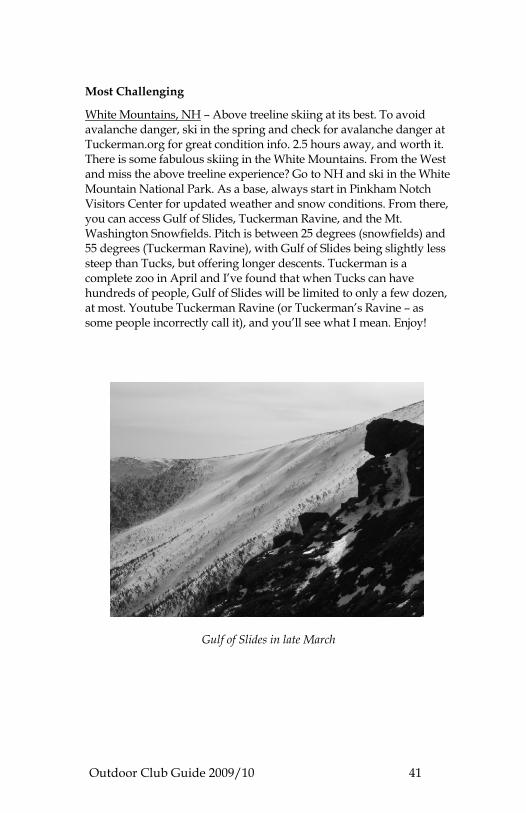
White Mountains, NH – Above treeline skiing at its best. To avoid avalanche danger, ski in the spring and check for avalanche danger at Tuckerman.org for great condition info. 2.5 hours away, and worth it. There is some fabulous skiing in the White Mountains. From the West and miss the above treeline experience? Go to NH and ski in the White Mountain National Park. As a base, always start in Pinkham Notch Visitors Center for updated weather and snow conditions. From there, you can access Gulf of Slides, Tuckerman Ravine, and the Mt. Washington Snowfields. Pitch is between 25 degrees (snowfields) and 55 degrees (Tuckerman Ravine), with Gulf of Slides being slightly less steep than Tucks, but offering longer descents. Tuckerman is a complete zoo in April and I’ve found that when Tucks can have hundreds of people, Gulf of Slides will be limited to only a few dozen, at most. Youtube Tuckerman Ravine (or Tuckerman’s Ravine – as some people incorrectly call it), and you’ll see what I mean. Enjoy!
Gulf of Slides in late March
Outdoor Club Guide 2009/10 42
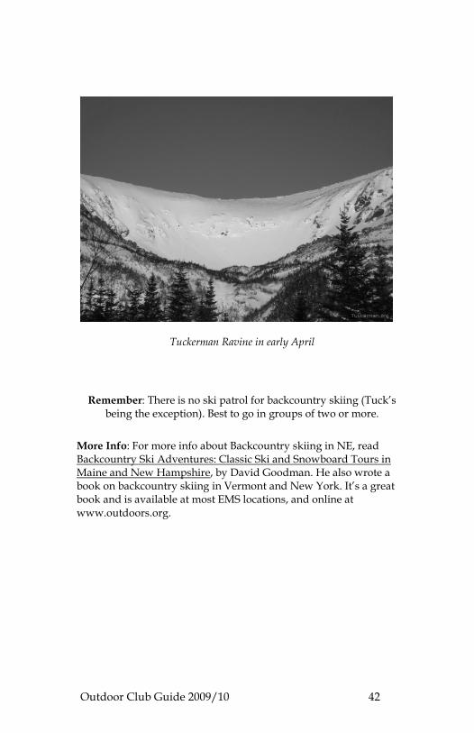
Tuckerman Ravine in early April
Remember: There is no ski patrol for backcountry skiing (Tuck’s being the exception). Best to go in groups of two or more.
More Info: For more info about Backcountry skiing in NE, read Backcountry Ski Adventures: Classic Ski and Snowboard Tours in Maine and New Hampshire, by David Goodman. He also wrote a book on backcountry skiing in Vermont and New York. It’s a great book and is available at most EMS locations, and online at www.outdoors.org.
Outdoor Club Guide 2009/10 43
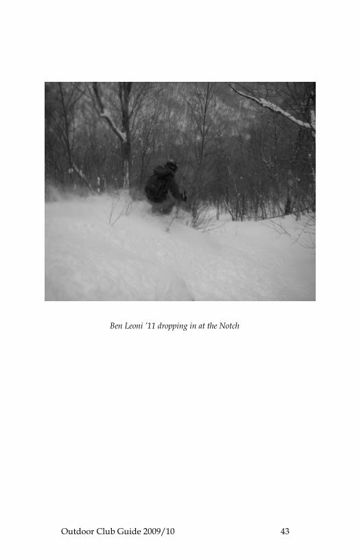
Ben Leoni ’11 dropping in at the Notch
Outdoor Club Guide 2009/10 44
CROSS COUNRTY SKIING General info: Most down hill skiing resorts also offer cross-country trails. Call or visit their website for cost information and availability. Some websites offer general information about trail conditions and descriptions. Try searching by region at: http://www.vtliving.com/xcountry Here are some local spots: 3 Stallion Inn, Randolph
Submitted by Jordanna Jusidman ‘11
Directions: Take exit 4 from 89 and head towards the town of Randolph. Left at Stock Farm Rd. End at: Three Stallion Inn, 665 Stock Farm Rd, Randolph, VT 05060-9055
Point of Interest: It's FREE if you have your own gear, and the trails are groomed. Catamount Outdoor Family Center
Location: 592 Governor Chittenden Road, Williston, VT 05495
Distance from VLS: about 65 miles, drive time about 1hr 15 min
Website: http://www.catamountoutdoor.com
Description: The Catamount Outdoor Family Center is a nonprofit group that offers mountain biking, hiking, walking, cross country skiing, and snow shoeing trails. The also offer a variety of clinic, camps and lessons. Check out their website to see all the offerings. The Woodstock Inn Trails
Distance from VLS: about 18 miles
Description: The Woodstock Inn is located in downtown Woodstock, Vermont. There are cross country skiing trails at the Woodstock Ski Touring Center behind the Inn. The town of Woodstock also has multiple shops and restaurants to explore while you are in the area.
Website: http://www.woodstockinn.com/vermont-ski.php
Outdoor Club Guide 2009/10 45
Quechee Trails
Distance from VLS: about 15 miles
Description: These trails are free to the public and groomed for classical style. Helpful trail maps are posted on trees wherever trails intersect. Although the trails are groomed, they are also used for snowshoeing and some sections are used for snowmobiles. Conditions may not be ideal, but the trails are free and the surrounding woods are beautiful!
Directions: Travel towards Woodstock and Quechee on Quechee-West Hartford Road. Take a left onto Willard Road before the Quechee library (if you reach Simon Pierce Restaurant / Studio you’ve gone too far). Take a right onto Bentley Road and travel until the parking lot at the end.
Outdoor Club Guide 2009/10 46
DOWNHILL SKIING NORTHERN VERMONT Bolton Valley Ski Resort
Location: 4302 Bolton Access Rd, Bolton Valley, VT
Distance from VLS: about 58 miles, drive time about 1 hr 10 min
Description: Three main lifts, Burton-sponsored park, fun variety of steep, meandering, bare, and gladed trails. Visit the website to find when the $29 student lift tickets are offered. Best deal in the area without a pass.
Tel: 877-9BOLTON Website: http://www.boltonvalley.com/winter_index.php
Burke Mountain
Location: 223 Sherburne Lodge Road, East Burke, VT
Distance from VLS: about 95 miles, drive time about 1 hr 45 min
Tel: 802-626-7300 or 888-BURKEVT Website: http://www.skiburke.com Cochran Ski Area
Location: Cochran Road, Richmond, VT
Distance from VLS: about 65 miles, drive time about 1 hr, 10 min
Website: http://www.cochranskiarea.com
Jay Peak Resort
Location: 4850 VT Route 242, Jay, VT
Distance from VLS: about 98 miles, drive time about 2 hr 15 min
Tel: 802-988-2611 Website: http://www.skivermont.com/alpine/resort/jaypeak
Outdoor Club Guide 2009/10 47
Mad River Glen
Location: Waitsfield, VT
Distance from VLS: about 54 miles, drive time about 1 hr 10 min
Description: If you dislike getting buzzed by boarders on the slopes, then these hills are for you skiers only. Has some great discount days for cheap lift tickets.
Website: http://www.madriverglen.com Smuggler’s Notch Resort
Location: 4323 Vermont Route 108 South, Smugglers' Notch, VT
Distance from VLS: about 120 miles, drive time about 2 hr 15 min
Description: You can also snowshoe up closed roads and ice climb at Smuggs. In summer, it’s a boulder-er’s (and mountain biker’s) paradise.
Tel: 800-419-4615 Website: http://www.smuggs.com Stowe Mountain Resort
Location: 5781 Mountain Road, Stowe, VT Distance from VLS: about 60 miles, drive time about 1 hr 15 min
Tel: 800-253-4754 or 802-253-3000 Website: http://www.stowe.com/winter.php Sugar Bush Resort
Location: 1840 Sugarbush Access Rd., Warren, VT
Distance from VLS: about 43 miles, drive time about 1 hr 15 min
Tel: 800-53-SUGAR Website: http://www.sugarbush.com
Outdoor Club Guide 2009/10 48
CENTRAL VERMONT Killington Mountain Resort
Location: 4763 Killington Road, Killington, VT
Distance from VLS: about 32 miles, drive time about 54 minutes
Tel: 800-621-MTNS Website: http://www.killington.com Okemo Mountain Resort
Location: 77 Okemo Ridge Road, Ludlow, VT
Distance from VLS: about 43 miles, drive time about 1 hr 15 min
Tel: 800-78-OKEMO Website: http://okemo.com/okemowinter Pico Ski Area
Location: 4763 Killington Rd., Killington, VT
Distance from VLS: about 33 miles, drive time about 50 minutes
Tel: 866-667-PICO Website: http://www.picomountain.com/index.html Suicide Six Ski Area
Location: Woodstock, VT
Distance from VLS: about 17 miles, drive time about 30 min
Description: Smaller resort, named for its six trails. Close and cheap when you've got to get it done quick.
Tel: 802-457-6661 Website: http://www.woodstockinn.com/vermont-skiresort.php SOUTHERN VERMONT
Ascutney Mountain Resort
Location: 6 miles off I-91 in Brownsville, Vermont,
Distance from VLS: about 40 miles, drive time about 50 minutes
Tel: 800-243-0011 Website: http://www.ascutney.com/winter/
Outdoor Club Guide 2009/10 49
Bromley Mountain
Location: Manchester Center, Vermont Bromley is 7 miles from Manchester on Route 11.
Distance from VLS: about 70 miles, drive time about 1 hr 45 min
Tel: 802-824-5522 Website: http://www.bromley.com/winter.php Magic Mountain
Location: Londonderry, VT
Distance from VLS: about 77 miles, drive time about 1 hr 35 min
Tel: 802-824-5645 Website: http://www.magicmtn.com Mount Snow Resort
Location: Mount Snow Road, West Dover, VT Distance from VLS: about 92 miles, drive time about 2 hrs
Tel: 800-245-SNOW Website: http://www.mountsnow.com/index.html Stratton Mountain Resort
Location: Stratton, VT
Distance from VLS: about 92 miles drive time about 2 hr 10 min
Tel: 800-STRATTON Website: http://www.stratton.com/index.htm
Outdoor Club Guide 2009/10 50
SWIMMING HOLES See generally: http://swimmingholes.info/vt.html. Eighty different swimming holes and locations are listed. Here are two stops submitted by a VLSer. Bolton Potholes
Description: A really sweet swimming hold that sometimes gets crowded (but for good reason!). Swimming and cliff jumps from 5-40 feet and cool geological features make this the place to be on a warm sunny summer day.
Directions: Get on 89 going north. Go past Montpelier and take the Stowe-Waterbury exit (exit 10). Take a left once you get off highway. At stop, take a right on Rte. 2. Follow this for several miles until you reach the turn for the Bolton Valley Ski Area (right). Take this right and follow the road for less than a mile. Park on either side of the road where you will probably see a lot of cars.
White River Near Barnard
Directions: Go towards Killington on RT 107 from Bethel. Go 3.6 miles past the "White River Fish Hatchery" sign on the right then turn right off of RT 107 onto Bridge Street (there is a street sign). The swimming place is next to the post office on the large sloping rocks on the left before you get to the steel trestle bridge. Good jumping and swimming place (check depth before jumping). 41 Activities Guide Book 2007/08
Outdoor Club Guide 2009/10 51
TENNIS COURTS AND POOLS Bethel
Follow Rt 14 North to Bethel. Continue over the bridge on Rt 14 in Bethel, you will pass through a Y intersection, immediately on your right will be the Bethel public pool and tennis courts. Dartmouth College
The college has six outdoor courts and six indoor courts, located in Alexis Boss Tennis Center & Allan Gordon Pavilion.
Directions: Take 89S to 91N, get off at exit 13 toward Hanover. Go right on Main St and continue on to 10-A. Turn right at Crosby St. and left on Lebanon St. Address is 2 Summer Street in Hanover, NH. Vermont Technical College
Take exit 3 off 89N, turn right and follow the road to the T intersection. Take a right and follow the road until you get to Vermont Technical College on the left. Tennis courts are located outdoors near the front drop-off area. Pool facilities are located at the SHAPE fitness center. This is a nice large pool with three laps lanes. Day pass for pool is $5 and for whole facility is $10. Discount memberships are available to students; bring your VLS ID to sign up.
Outdoor Club Guide 2009/10 52
MUESEUMS Montshire Museum of Science
Location: Norwich, VT Distance from VLS: about 25 miles, drive time about 30min
Website: http://www.montshire.org
Description: The museum is geared towards children, but the many interactive exhibits are fun (really fun) for adults too. During the summer months, interactive exhibits are also set up outdoors. The museum is surrounds by over 100 acres with a walking train network that connects to the Appalachian Trail. Short loops near the museum are dotted with interactive exhibits. Shelburne Museum
Location: Shelburne, VT Distance from VLS: about 76 miles, drive time about an 1hr 30 min
Web: http://www.shelburnemuseum.org/about_us/visiting_museum.php
Description: (copied from museum website) Located in Vermont's scenic Lake Champlain valley, Shelburne Museum is one of the nation's finest, most diverse, and unconventional museums of art and Americana. Over 150,000 works are exhibited in a remarkable setting of 39 exhibition buildings, 25 of which are historic and were relocated to the Museum grounds. Impressionist paintings, folk art, quilts and textiles, decorative arts, furniture, American paintings, and a dazzling array of 17th-to 20th-century artifacts are on view. Shelburne is home to the finest museum collections of 19th-century American folk art, quilts, 19th- and 20th-century decoys, and carriages. Fairbanks Museum and Planetarium
Location: 1302 Main Street St., Johnsbury, VT Distance from VLS: about 78 miles, drive time about 1 hr 30 min
Website: http://www.fairbanksmuseum.org
Description: For VPR fans, you probably already know that the “Eye on the Sky” forecast is broadcasted from the Fairbanks museum daily. Check the website for special exhibits and planetarium show times.
Outdoor Club Guide 2009/10 53
ECHO Lake Aquarium and Science Center
Location: 1 College St., Burlington, VT Distance from VLS: about 74 miles, drive time about 1 hr 20 min
Website: http://www.echovermont.org Vermont Institute of Natural Science (VINS)
Location: Quechee Gorge Village: 1/4 mile west of the Quechee Gorge on Route 4. From I-89, take Exit 1 to Route 4 West or Route 14 East to Howe Hill Road south to Pomfret Road South to Route 4 East. Distance from VLS: about 18 miles, drive time about 25 minutes
Website: http://www.vinsweb.org/nature-center/index.html
Outdoor Club Guide 2009/10 54
VERMONT STATE HISTORIC SITES
Submitted by John P. Dumville, Historic Sites Operations Chief, Vermont Division for Historic Preservation
Web: www.HistoricVermont.org/sites
A number of the Vermont’s State-owned Historic Sites are within an easy distance from South Royalton. Justin Morrill National Historic Landmark
Address: 214 Justin Morrill Highway in Strafford.
Description: The Morrill Homestead was built in 1849 and is a furnished 17 room Gothic Revival cottage, with intricate carved wooden detaining painted a rosy pink to resemble freshly cut stone. As U.S. Congressman and later Senator, Morrill was responsible for the acts establishing the Land Brant College system, opening the door to higher education for millions of Americans. The site is open Saturdays and Sundays, 11:00 – 5:00 through October 12.
For more information go to: www.HistoricVermont.org/morrill President Calvin Coolidge National Historic Landmark
Address: 3780 Rte. 100A in Plymouth Notch.
Description: The birthplace and boyhood home of our 30th President, the village of Plymouth Notch is unchanged since the early 20th century. Eleven buildings are open including the birthplace, general store, church, cheese factory, 1924 Summer White House office, and the family homestead where Calvin was sworn in as president by his father. The site is open daily, 9:30 – 5:00 through October 18.
For more information go to: www.HistoricVermont.org/coolidge The Old Constitution House
Address: 16 North Main Street in Windsor.
Description: This eighteenth century tavern is where representatives of the New Hampshire Grants met to adopt the first constitution of the “Free and Independent State of Vermont.” Exhibits in this furnished house focus on the state’s unique constitution, which was the first in America to prohibit slavery, establish a public school system, and to not require property ownership for voters. The site is open Saturdays and Sundays 11:00 – 5:00 through October 12.
For more information go to: www.HistoricVermont.org/constitution
Outdoor Club Guide 2009/10 55
Mount Independence National Historic Landmark
Address: 497 Mount Independence Road in Orwell.
Description: This is the largest fortification built by the American colonial forces during the Revolutionary War and features a state-of-the-art interpretive center. Extensive trails, including the new Baldwin Trail designed to meet the Americans with Disabilities Act, will entice “soft adventures along the shores of Lake Champlain.” Mount Independence can also be viewed from Lake Champlain by taking the Carillon boar cruise. The site is open daily from 9:30 – 5:00 through October 12.
For more information go to: www.HistoricVermont.org/independence Hubbardton Battlefield National Historic Landmark
Address: 5696 Monument Hill Road in Hubbardton.
Description: This is the site of the only Revolutionary War battle fought in Vermont, new exhibits examine the significance of this 1777 military action against British General John Burgoyne. Interpreted walking trails lead through the surrounding hillsides. The site is open Thursday – Sundays, 11:00 – 5:00 through Oct. 12.
For more information go to: www.HistoricVermont.org/hubbardton
Outdoor Club Guide 2009/10 56
SUPERMARKET ALTERNATIVES
Community Supported Agriculture (CSA)
Enjoy fresh produce from mid May to late September at a reasonable price and support a local farming family. By participating in a CSA program, you pay a fee (dependant on size of share and variety of products offered) at the beginning of the growing season and receive a package of fresh produce each week. Most farms ask that you pick up your share on site, but many may be flexible in arranging a drop-off/pick-up spot. Some farmers also offer an early payment plan. Start keeping an eye out for flyers from various farms beginning in late March and into April. The following list includes CSAs in Windsor county.
Website: http://www.nofavt.org/csa-list.php (Check this link from the Northeast Organic Farming Association of Vermont for a list of all Vermont CSAs.)
Cedar Mountain Farm
Gawalt, Kerry & Leslie, Steven Hartland 4 Corners Tel: 802-436-1448 [email protected] Fat Rooster Farm
Megyesi, Jennifer & Jones, Kyle S Royalton, VT Tel: 802-763-5282
Website: www.fatroosterfarm.com Four Springs Farm
Hardy Cleland, Jinny Royalton, VT Tel: 802-763-7296 [email protected]
Website: www.fourspringsfarm.com Killdeer Farm
Guest, Jake and Liz Norwich, VT Tel: 802-649-2916 [email protected] Website: www.killdeerfarm.com
Outdoor Club Guide 2009/10 57
Luna Bleu Farm
Sanford, Tim & Long, Suzanne S Royalton, VT Tel: 802-763-7981 [email protected] Sunrise Farm
Wooster, Chuck White River Jct., VT Tel: 802-295-1456 South Royalton Market Food Cooperative
Located right across from the green in downtown South Royalton, the South Royalton Market is a full service grocery store with an extensive produce section, homemade baked goods, soups (seasonal), hot coffee, and more. The staff also makes an effort to buy as much local produce and product as possible. Some dry goods may be a little more expensive than the super market, but prices are generally very reasonable.
Some students get by only shopping at the Co-Op. You may want to consider applying to be a super worker who volunteers for two hours a week in exchange for a 10% discount. Hours: Mon-Fri 7:30am-7pm; Sat 8am-5pm; Sun 9am-5pm
Visit South Royalton Market on Facebook and become a fan! Co-Op Food Stores
Co-Op food stores are located in Hanover and Lebanon, New Hampshire. The Hanover Co-Op has a larger selection than the South Royalton Market, but the prices on some items (like wine) are a bit higher. The Lebanon Co-Op has a large beauty and health care section and carries grains and other beer brewing supplies. The produce and grocery sections are not as large, however.
Hours at Hanover: Daily 8am-8pm Hours at Lebanon: Daily 7an-9pm
Distance from VLS: About 30 miles and 25 minutes to Hanover, and about 25 miles and 30 minutes to Lebanon
Website: http://www.coopfoodstore.com/about.html
Outdoor Club Guide 2009/10 58
Hunger Mountain Food Co-Op
Located on Stone Cutters Way in Montpelier, VT. Hours: Daily 8am-8pm; café/deli 8am-7:30
Website: http://www.hungermountain.com/index.cfm The Upper Valley Food Co-Op
Located in White River Junction, VT. Hours: Mon-Sa 9am-8pm; Sun 11am-5pm Distance for VLS: about 60 miles and 1 hour
Website: http://www.uppervalleyfood.coop/
Regional listing: for a regional listing of food cooperative, check out: http://find.coop/where.pl?org=UpperValleyFoodCoop
Outdoor Club Guide 2009/10 59
DRINKING
BREWERIES, WINERIES, AND CIDERIES
For a small state, Vermont has a fabulous selection of micro- breweries, wineries and cideries. Get a map (even better – get a map from the Vermont Brewers Association) and plot out a brewery tour of your own.
The following information is taken with permission from a brochure produced by the Vermont Brewers Association.
Website: http://www.vermontbrewers.com
At the website, you can download a PDF map of all of Vermont’s breweries, brewpubs, wineries and cideries. Also note Vermont Brewers festival held in Burlington in late July. BREWERIES
The Alchemist Pub & Brewery
Location: 23 South Main Street, Waterbury, VT Distance from VLS: about 47 miles; drive time about 45 min-1 hr
Tel: 802-244-4120 Website: http://www.alchemistbeer.com Hours: Mon-Thurs 4pm-midnight; Fri, Sat, Sun 3pm-midnight
Description: Food served daily until 10pm. There isn’t too much seating, so be prepared to wait on a Friday or Saturday night (but waiting is really not a problem when you have the company of a wonderful draft selection). Funky décor, pool tables and sports on TV, small yet satisfying menu. American Flatbread Burlington Hearth/Zero Gravity Brewery
Location: 115 St. Paul St., Burlington VT Distance from VLS: about 72 miles, drive time about 1hr 15min
Tel: 802-861-2999 Website: http://www.flatbreadhearth.com Hours: Lunch: Fri, Sat, Sun 11:30-2:30; Dinner: Sun-Thurs 5-10, Fri and Sat 5-11; The Taproom is open 2 hours after service daily.
Description: Amazing stone hearth, wood-fired pizza. Menu only consists of pizza (with daily specials), salads, and beer (a huge list). High ceilings, warm atmosphere, nice for families, but also large enough for people who don’t want to sit next to kids. Reservations are only taken for parties over twelve.
Outdoor Club Guide 2009/10 60
The Bob Café & Brewery Location: 5 Main St., Bristol, VT Distance from VLS: about 54 miles, drive time about 1hr 30min
Tel: 802-453-3311 Website: http://www.bobcatcafe.com Hours: Daily, Bar opens at 4:30pm, dining room opens at 5pm
Description: Has not yet been visited by editors. Website indicates and full and diverse menu, a wide selection of house brewed beers and a full bar menu. Reservations are recommended. Harpoon Brewery Location: 336 Ruth Carney Drive, Windsor, VT Distance from VLS: about 30 miles, drive time about 35 minutes
Tel: 802-674-5491 Website: http://www.harpoonbrewery.com Hours: Summer (May-Aug) Sun-Wed 10-6; Thurs-Sat 10-8; Fall (Sept-Oct) Tues-Sun 10-6; Closed Mon; Winter/ Spring (Nov-April) Tues-Sat 10-6, Closed Sun, Mon.
Description: Free Tasting during Beer Garden/Brewery Store days of operation, Guided tours Friday & Saturday at 3pm. Hornpout Brewing
Location: 1713 Industrial Pkwy, Suite 108, Lyndonville, VT Distance from VLS: about 87 miles, drive time about 1hr 30min
Tel: 802-748-2198 Long Trail Brewing Co.
Location: Jct. Route 4 and 100A, Bridgewater Corners, VT Distance from VLS: about 34 miles, drive time about 50 min
Tel: 802-672-5011 Website: www.longtrail.com Hours: Pub menu served 7 days 11-5, retail open 10-6
Description: Great pub menu- burgers, sandwiches and salads, all beer in production on tap; self-guided brewery tours and retail store. Bar offers a wider variety of beers than pub menu. Visit on a summer day and enjoy your lunch on the deck.
Outdoor Club Guide 2009/10 61
Magic Hat Brewing Co.
Location: 5 Bartlett Bay Road, South Burlington, VT Distance from VLS: about 73 miles, drive time about 1hr 20 min
Tel: 802- 658-BREW Website: http://www.magichat.net Hours: Mon –Sat 10-6; Sun 12-5
Winter Tours: (Superbowl-Memorial Day) Thurs-Fri: 3:30pm, 4:30pm; Sat: Noon, 1pm, 2pm, 3pm Summer Tours: (Memorial Day –Superbowl) Thurs-Fri: 3pm, 4pm, 5pm; Sat: Noon, 1pm, 2pm, 3pm The Norwich Inn
Location: 325 Main St., Norwich, VT Distance from VLS: about 25 miles, drive time about 30 minutes
Tel: 802-649-1143 Website: http://www.norwichinn.com Hours: 7:30am-9:00pm; Pub open from 11:30am; Closed Mondays
Description: Offers breakfast, lunch, pub food, and dinner. Dining room is slightly upscale, but pub offers a more limited but reasonably priced menu. Otter Creek Brewing, Inc.
Location: 793 Exchange St., Middlebury, VT Distance from VLS: about 75 miles, drive time about 1hr 30min
Tel: 800-473-0727 Website: http://www.ottercreekbrewing.com and http://www.wolavers.com Hours: Brewery store open 10-6 Mon-Sat; open Sun seasonally; please call ahead; Free sample tours at 1pm, 3:00pm, and 5pm Rock Art Brewery
Location: 254 Wilkins St., Morrisville, VT Distance from VLS: about 65 miles, drive time about 1hr 20 min
Tel: 802-888-9400 Website: http://www.rockartbrewery.com
Hours: Brewery and store open Mon-Fri 7am-5:30pm (Brewers will take a break from work and show you around)
Outdoor Club Guide 2009/10 62
The Shed Restaurant & Brewery
Location: 1859 Mountain Rd., Stowe, VT Distance from VLS: about 58 miles, drive time about 1hr 10min
Tel: 802-253-4364 Hours: Open 7 days, lunch, dinner and late night
Description: Fireside, garden room, greenhouse, patio, and pub. Pub specials, Mon-Fri. Entertainment on Wednesday nights. Switchback Brewing Co.
Location: 160 Flynn Ave., Burlington, VT Distance from VLS: about 73 miles, drive time about 1 hr 15 min
Tel: 802-651-4114 Hours: Brewery tours on Sat at 1pm. Tour size is limited so please call ahead. Three Needs
Location: 207 College St., Burlington, VT Distance from VLS: about 74 miles, drive time about 1 hr 18 min
Tel: 802-658-0889 Hours: Taproom open nightly, 4pm-2:30am Trout River Brewing Co.
Location: Route 5, Lyndonville, VT Distance from VLS: about 90 miles, drive time about 1 hr 30min
Tel: 802-626-9396, or toll free 888-BYO-BREW Website: http://www.troutriverbrewing.com Hours: Fri and Sat from 11-9. Serving sourdough hand tossed pizzas in the pub from 4:30-8:30 on Fri and Sat. The Vermont Pub & Brewery
Location: 144 College St., Burlington, VT Distance from VLS: about 74 miles, drive time about 1 hr 18 min
Tel: 802-865-0500 Website: http://www.vermontbrewery.com Hours: Serving beer 11:30am-2am everyday except Thanksgiving, Christmas, and New Years Day. Lunch and dinner served 11:30am-10pm. Late night menu served 10pm until midnight.
Outdoor Club Guide 2009/10 63
WINERIES AND CIDERIES Boyden Valley Winery
Location: 64 VT RT 104, Cambridge, VT Distance from VLS: about 80 miles, drive time about 1 hr 30 min
Tel: 802-644-8151 Website: http://www.boydenvalley.com Hours: June 1- Dec. 31 Daily 10am-5pm; Jan 1- May 31 Fri, Sat., Sun. tours at 11:30 and 1:00 Flag Hill Farm Location: 135 Ewing Rd., Vershire, VT Distance from VLS: about 16 miles, drive time about 35 minutes
Tel: 802-685-7724 Website: http://www.flaghillsfarm.com Hours: Purchase by appointment only Grand View Winery
Location: Tasting room: RT 100, Waterbury Center, VT Distance from VLS: about 50 miles, drive time about 50 min
Tel: 802-456-7012 Website: http://www.grandviewwinery.com Hours: 11-5 daily, year round North River Winery
Location: 201 VT RT 112, River Rd. Jacksonville, VT Distance from VLS: about 100 miles, drive time about 2 hours
Tel: 802-368-7557 Website: http://www.northriverwinery.com Hours: Daily 10-5, year round for tours and tastings Ottauquechee Valley Winery
Location: 5573 Woodstock Rd., Quechee Gorge Village, Quechee, VT Distance from VLS: about 18 miles, drive time about 25 minutes
Tel: 802-295-WINE Website: http://www.northriverwinery.com Hours: Daily 9:30-5, year round for free tasting. Other hours by appointment
Outdoor Club Guide 2009/10 64
Snow Farm Vineyard
Location: 190 West Shore Rd., South Hero, VT Distance from VLS: about 90 miles, drive time about 1 hr 40 min
Tel: 802-372-9463 Website: http://www.snowfarm.com Hours: 10-5 daily May 1-Dec 31. Open until 8:30 on Thurs. June 15-Aug 31 for summer music series in the vineyard Shelburne Vineyard
Location: 310 Beach Rd., Shelburne, VT Distance from VLS: about 76 miles, drive time about 1 hr 25 min
Tel: 802-734-1386 Website: http://www.shelburnevineyard.com
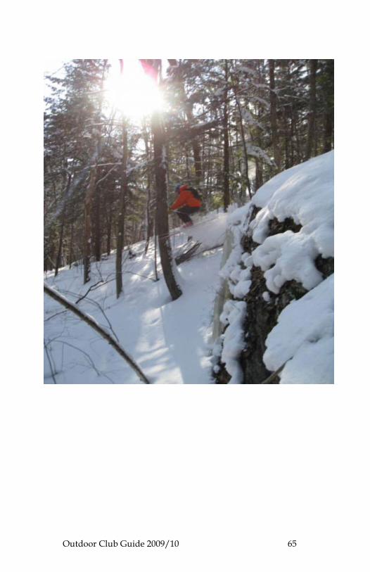
Outdoor Club Guide 2009/10 65