Embed Size (px)
Citation preview
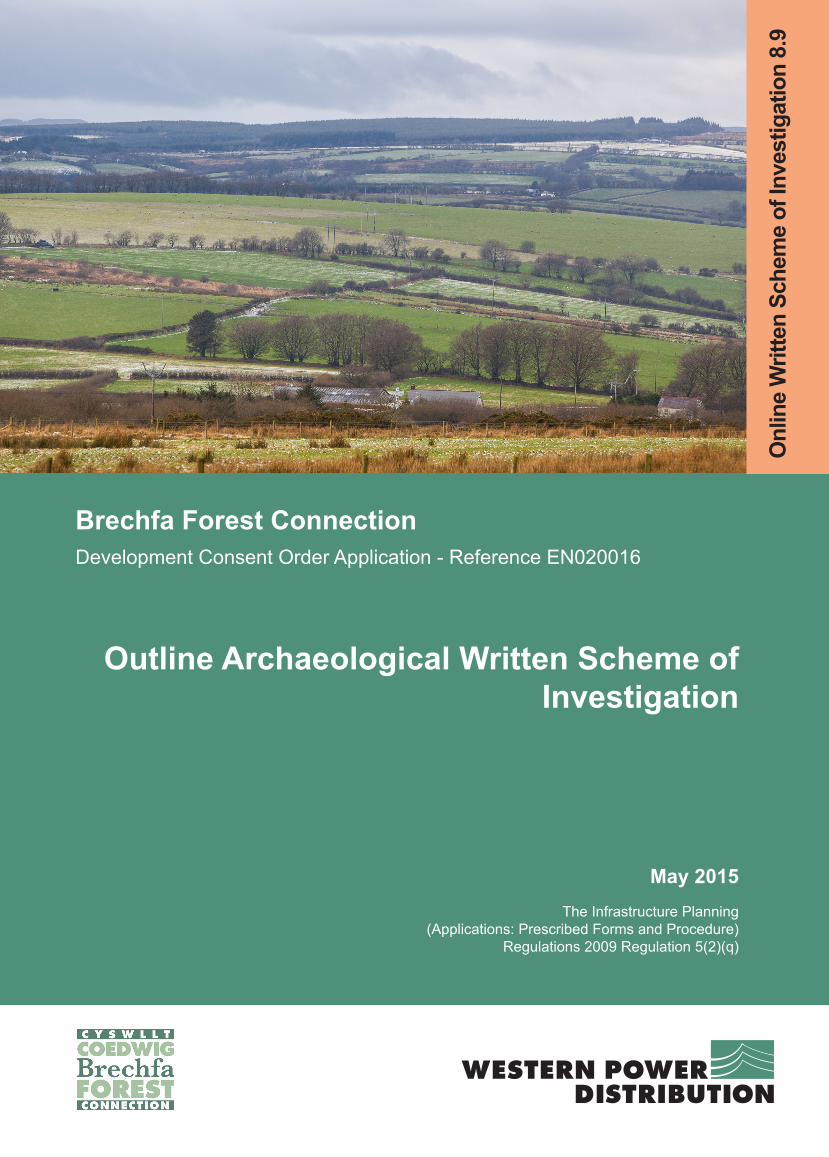
Brechfa Forest ConnectionDevelopment Consent Order Application - Reference EN020016
Outline Archaeological Written Scheme of Investigation
May 2015The Infrastructure Planning
(Applications: Prescribed Forms and Procedure) Regulations 2009 Regulation 5(2)(q)
Onl
ine
Writ
ten
Sche
me
of In
vest
igat
ion
8.9

Outline Archaeological Written Scheme of Investigation – Volume 8.9
1
Contents
1.1 Executive summary 3
1.2 Roles and responsibilities 4
1.3 Introduction 5
1.4 Relevant legislation, policy, guidance, and technical advice 7
1.6 Research objectives 11
1.7 Project management 12
1.8 Archaeological Contractor’s Risk Assessment and Method Statement (RAMS) 13
1.9 Method for archaeological watching brief 14
1.10 Unexpected, highly significant remains 19
1.11 Method for preservation in situ of archaeological remains 21
1.12 Site monitoring and progress reports 22
1.13 Method for assessment, reporting and publication 23
1.14 Safety, health and environment 26
Tables
Table 1 – Proposals for construction phase mitigation of physical effects on assets within
the works boundary and Order Limits
Table 2 – Summary of construction phase mitigation by proposed development component
Table 3 – Assets within the works boundary
Appendices
Appendix 1: Summary of proposals for construction phase mitigation
Appendix 2: References
Outline Archaeological Written Scheme of Investigation – Volume 8.9
2
Figure
Figure 1.1 Archaeological Mitigation Location Plan
Outline Archaeological Written Scheme of Investigation – Volume 8.9
3
1.1 Executive summary
1.1.1 This document provides an Outline Written Scheme of Investigation (WSI) for
mitigation of predicted physical effects of the Brechfa Forest Connection
(hereafter: ‘Proposed Development’) on ‘heritage assets with archaeological
interest’ (DECC 2011a). Physical effects that would require mitigation are
predicted in relation to archaeological remains and historic hedgerows.
1.1.2 This WSI provides the framework through which archaeological mitigation would
be managed and monitored. The legislative and policy requirement, and the
objectives of the proposed mitigation, are described.
1.1.3 This document provides the locations of all known historic assets that would be
affected by the Proposed Development, as well as the potential for as-yet
unknown assets to be impacted.
1.1.4 Methods for investigation and recording of known and as-yet undiscovered
archaeological remains are provided. The detailed design of mitigation works
would be outlined in a Risk Assessment and Method Statement produced by an
Archaeological Contractor engaged to carry out the mitigation works.

Outline Archaeological Written Scheme of Investigation – Volume 8.9
4
1.2 Roles and responsibilities
1.2.1 The following roles are identified in this document:
Western Power Distribution (WPD): the Applicant;
Statutory Consultee: the organisation appointed by the Welsh Government to
provide advice on all aspects of the Secretary of State's responsibilities
affecting the historic environment (i.e. Cadw);
Local Authority’s Archaeologist: any individual or body appointed by a local
authority to serve as a consultee for archaeological works and to provide
advice concerning archaeological matters (i.e. Dyfed Archaeological Trust);
Main Contractor: any organisation appointed by WPD as their main works
contractors to carry out the construction required to install the new 132kV
connection to Brechfa East;
Archaeological Contractor: any individuals or organisations appointed by WPD
to carry out any works related to archaeological field assessment, mitigation
and post-excavation assessment, analysis and archiving. The Archaeological
Contractor’s project manager would be a named full Member of the Chartered
Institute for Archaeologists (CIfA) who is qualified to manage the required
archaeological work in line with the CIfA Code of Conduct (2014a); and
WPD’s Archaeologist: any individual or organisation appointed by WPD to
represent them in negotiations with other archaeological parties (including
Archaeological Contractor, Local Authority’s Archaeologist and Statutory
Consultee), and to oversee works carried out by the Archaeological
Contractor. WPD’s Archaeologist would be a full member of the Chartered
Institute for Archaeologists with over ten years of relevant professional
experience.
Outline Archaeological Written Scheme of Investigation – Volume 8.9
5
1.3 Introduction
Context and requirements
1.3.1 This document provides an Outline Written Scheme of Investigation (WSI) for
mitigation of predicted physical effects of the Brechfa Forest Connection
(hereafter: ‘Proposed Development’) on the historic environment.
1.3.2 Physical effects that would require mitigation are predicted in relation to ‘historic
assets’. These assets include archaeological remains, as well as historic
hedgerows that are ‘important’ (i.e. that meet the ‘Archaeology and history’ criteria
in the Hedgerow Regulations: Statutory Instrument 1997/1160). The effects relate
to the predicted whole or partial loss of their ‘evidential value’ (cf. Cadw 2011).
1.3.3 This WSI proposes methods for investigation and recording to provide additional
information about the historic assets, thereby mitigating any loss of their evidential
value. The WSI also provides an appropriate procedure for the identification and
treatment of any significant archaeological remains that may be discovered during
construction, as part of an iterative process of identifying and mitigating effects on
as-yet undiscovered assets.
1.3.4 The Development Consent Order includes a requirement that secures the
implementation of this WSI. The procedures outlined in this WSI comply with the
provisions of paragraphs 5.8.19 – 5.8.22 of the Overarching National Policy
Statement for Energy (EN-1: DECC 2011a). The Construction Environmental
Management Plan (CEMP) (Volume 8.6) and this WSI are consistent with each
other in terms of commitments to mitigating the predicted adverse effects of the
Proposed Development on archaeological remains and historic landscape assets.
WPD would be responsible for ensuring that the procedures are implemented.
1.3.5 The procedures for archaeological mitigation provided in this WSI have been
developed with reference to best practice standards and guidance documents
produced by the Chartered Institute for Archaeologists (CIfA 2014a-i), and national
and regional archaeological research frameworks (WAT 2011-14), in order to

Outline Archaeological Written Scheme of Investigation – Volume 8.9
6
ensure that the proposals are reasonable and proportionate.
Location of effects requiring mitigation
1.3.6 A summary of the known assets that may be affected by the Proposed
Development is provided in Table 1 of Appendix 1 of this document. This table
also identifies, where necessary, the procedures proposed to mitigate the effect of
the Proposed Development on those assets.
1.3.7 This WSI also provides a summary of the mitigation measures proposed in each
area of the Proposed Development (see Table 2 of Appendix 1 of this document).
1.3.8 This WSI also lists in Table 3 of Appendix 1 all known assets within the works
boundary. These assets would be notified to the Main Contractor to ensure
avoidance during construction.
1.3.9 A figure has been prepared indicating areas identified for archaeological
mitigation; this is attached to this WSI as Figure 1.1.
1.3.10 Effects that relate to changes within the settings of assets are not referenced in
this WSI; rather, these are described in the Environmental Statement (ES) Volume
6.4, Appendix 11.1.
Summary of proposals
1.3.11 This WSI provides the outline method of approach during the construction phase,
which involves:
identification of archaeological remains through archaeological watching brief;
if required, mitigation of effects on archaeological remains through
archaeological excavation;
if required, mitigation of effects on archaeological remains through
preservation in situ;
mitigation of effects on palaeo-environmental and geo-archaeological

Outline Archaeological Written Scheme of Investigation – Volume 8.9
7
evidence that would be disturbed during construction; and
mitigation of effects on ‘important’ historic hedgerows and the historic
landscape character through reinstatement of boundaries, trackways,
earthworks and other physical elements of the historic environment.
1.3.12 This WSI also provides the approach to post-construction phase assessment,
analysis, and public dissemination of the results of the programme of
archaeological work.
1.3.13 Outline methods for the above procedures are provided. Detailed method
statements for the required works would be provided by the Archaeological
Contractor. These would be produced in consultation with WPD’s Archaeologist,
the Local Authority’s Archaeologist and Statutory Consultee.
1.4 Relevant legislation, policy, guidance, and technical advice
Relevant legislation
1.4.1 Legislation relevant to any archaeological programme of work of this nature can be
found in:
Burial Act 1857
1.4.2 Section 25 of the Burial Act states that it is a criminal offence to remove human
remains from any place of burial without a Home Office license.
Treasure Act 1996
1.4.3 The Treasure Act defines what constitutes ‘treasure’ and states that any finds of
treasure and objects found in association with ‘treasure’ must be reported to the
local Coroner.

Outline Archaeological Written Scheme of Investigation – Volume 8.9
8
Policy context
1.4.4 Paragraphs 5.8.19 to 5.8.22 of the Overarching National Policy Statement for
Energy (EN-1: DECC 2011a) relate to securing a proportionate record of the
heritage significance of any assets affected by the Proposed Development, before
that significance is lost as a result of consented development.
1.4.5 Paragraph 5.8.20 of EN-1 states that, “Where the loss of the whole or a material
part of a heritage asset’s significance is justified [PINS] should require the
developer to record and advance understanding of the significance of the asset
before it is lost. The extent of the requirement should be proportionate to the
nature and level of the asset’s significance. Developers should be required to
publish this evidence and deposit copies of the reports with the relevant Historic
Environment Record”.
1.4.6 Paragraph 5.8.21 of EN-1 directs that PINS, “should impose conditions on a
consent that such work is carried out in a timely manner in accordance with a
written scheme of investigation”.
1.4.7 Paragraph 5.8.22 of EN-1 directs that where PINS, “considers there to be a high
probability that a development site may include as yet undiscovered assets with
archaeological interest [they] should consider conditions to ensure that appropriate
procedures are in place for the identification and treatment of such assets
discovered during construction”.
Relevant guidance and technical advice
1.4.8 This WSI has been prepared in accordance with relevant guidance and technical
advice documents, including:
Cadw, 2011, Conservation Principles for the sustainable management of the
historic environment in Wales;
English Heritage (EH), 2007, Geoarchaeology: using earth sciences to
understand the archaeological record;
Outline Archaeological Written Scheme of Investigation – Volume 8.9
9
English Heritage (EH), 2011a, Environmental Archaeology;
Chartered Institute for Archaeologists (CIfA), 2014c, Standard and Guidance
for an archaeological watching brief; and
Chartered Institute for Archaeologists (CIfA), 2014e, Standard and Guidance
for archaeological excavation.
1.5 Background
Project description
1.5.1 A full description of the Proposed Development is provided in the Volume 6.2,
Chapter 2.
Historic environment background
1.5.2 The historic background, known and predicted archaeological, palaeo-
environmental/geo-archaeological and historic landscape features are all
described in the ES (Volume 6.2), Chapter 11, and associated Volume 6.4,
Appendix 11.1.
1.5.3 The results of the assessment carried out during production of the ES, including
details of the known historic environment baseline, are described in the ES
(Volume 6.4), Appendix 11.1, Sections 1.6-1.8.
1.5.4 Figures 11.1 and 11.2 in Volume 6.3 provide details of the location of the known
assets. The locations of proposed mitigation works are provided on Figure 1.1
accompanying this Outline WSI.
Archaeological potential within the Order Limits
1.5.5 This section summarises the expected potential for as-yet unidentified
archaeological remains to be present within the Order Limits. Further details of
the historic background and archaeological potential are provided in Volume 6.4,
Appendix 11.1, Section 1.9.

Outline Archaeological Written Scheme of Investigation – Volume 8.9
10
1.5.6 There is very high potential for the remains of landscape features such as tracks
and historic hedgerows, which may date from the Medieval to Modern periods, and
palaeochannels of unknown date, to be present within the Order Limits.
1.5.7 There is high potential for the remains of Roman roads to be present within the
Order Limits.
1.5.8 There is moderate potential for the presence within the Order Limits of buried
remains of isolated dwellings or agricultural buildings dating from the Post-
medieval or Industrial period.
1.5.9 There is low potential for Bronze Age buried archaeological remains to be present
within the Order Limits, either in the context of upland funerary deposits or within
fluvial deposits in valley bottoms. There is also low potential for the presence
within the Order Limits of Early Medieval, Medieval or Post-medieval settlements,
or Roman remains in the form of settlement or industrial activity alongside the
roads leading from Carmarthen.
1.5.10 There is very low potential for Palaeolithic or Mesolithic artefacts, Neolithic
remains, Iron Age settlements, or remains dating to the Second World War, and
extremely low potential for the remains of crannogs or boats from the prehistoric
periods onwards, to be present within the Order Limits.
1.5.11 Early prehistoric artefacts, boats or crannogs are likely to be of high heritage
significance. Any late prehistoric remains, or remains of Roman or Medieval
settlement, are likely to be of medium heritage significance. All other types of
archaeological remains described above would be of low heritage significance.
1.5.12 The Proposed Development would cross areas of known palaeo-environmental
importance. The Towy Valley contains sequences of river development and
alluviation that are likely to include preserved botanical remains, which can be
used to reconstruct past landscapes.

Outline Archaeological Written Scheme of Investigation – Volume 8.9
11
1.6 Research objectives
1.6.1 Ongoing environmental assessment leading to production of the ES was informed
by the research aims identified at a national and regional level as part of the
research framework for the archaeology of Wales (WAT 2011-14). The following
research aims have been identified that may be advanced as a result of the
investigation required as part of the Proposed Development:
National research aims
What were the environmental conditions associated with wetland sites?
What was the economy of medieval and post-medieval farms in the uplands and to
what extent did climatic and other environmental changes contribute to farm
abandonment and changes of agricultural regime?
What was the relationship between climate change and successive human
communities?
What has been the influence of river channel and floodplain development on the
archaeological record, i.e. settlement, land-use, ritual practices and landscape, from
the Palaeolithic to the present?
What was the role of hunting, fishing and wildfowling in agricultural societies in
Wales?
The wider setting of Medieval settlements within their agrarian landscapes
Understanding the road network (Medieval, but also later)
Regional research aims
What were the environmental conditions associated with wetland sites?
What impact did post-medieval industrialisation have on the surrounding
environment and what is the longevity of its environmental signature?
What was the relationship between climate change and successive human

Outline Archaeological Written Scheme of Investigation – Volume 8.9
12
communities?
How far has river channel and floodplain development influenced the archaeological
record from the Palaeolithic to the present?
1.6.2 Prior to works commencing, the Archaeological Contactor would formulate further
research aims specific to the assets and locations affected by the Proposed
Development. Identification of these aims would be informed by discussions with
the Local Authority’s Archaeologist and/or Statutory Consultee, and would be set
out in the Archaeological Contractor’s Method Statement.
1.7 Project management
1.7.1 Archaeological works would be carried out by the Archaeological Contractor, who
would be engaged by WPD and managed by WPD’s Archaeologist.
1.7.2 WPD would provide the Main Contractor with locations and descriptions of all
known assets within and adjacent to construction works, including any restrictions
to construction methods to protect assets, where these have been identified in the
ES and WSI.
1.7.3 WPD’s Archaeologist and the Archaeological Contractor would be notified of the
Main Contractor’s programme in advance of the works. WPD and the Main
Contractor would then agree a programme detailing the implementation of
archaeological works, addressing the measures set out in the ES and WSI.
1.7.4 The Main Contractor would direct any sub-contractors to facilitate the
Archaeological Contractor undertaking the works specified as an appropriate
mitigation measure.
1.7.5 The Archaeological Contractor would provide a risk assessment and method
statement (RAMS) for the works they undertake.
1.7.6 The Archaeological Contractor would appoint a named individual to liaise with the
Main Contractor regarding programme and progress, and notify WPD’s
Outline Archaeological Written Scheme of Investigation – Volume 8.9
13
Archaeologist regarding any significant archaeological finds. This individual would
also ensure that a log is maintained of the mitigation works undertaken and results
obtained, and on a regular (e.g. weekly) basis would update the historic
environment data held by the Main Contractor.
1.7.7 WPD’s Archaeologist would undertake appropriate monitoring of the mitigation
measures implemented and the effectiveness of the measures to ensure
compliance with the archaeological RAMS.
1.7.8 All archaeological mitigation works would also be monitored by the Local
Authority’s Archaeologist. If the works are in relation to a designated asset or an
asset demonstrably of equivalent heritage significance to a designated asset, that
role may defer to the Statutory Consultee.
1.8 Archaeological Contractor’s Risk Assessment and Method
Statement (RAMS)
1.8.1 The Archaeological Contractor would provide a detailed Risk Assessment and
Method Statement (RAMS) for the works, which would be approved by WPD’s
Archaeologist. The RAMS would be prepared in association with the Main
Contractor, taking account of the Environmental Management Plan. As a
minimum, the RAMS would include:
resource plan and programme;
CVs of managers and supervisors;
Health and Safety Plan and Site-Specific Risk Assessments;
Site management plan (including details of the method for preparing safe access
route to the working areas, proposed site accommodation, services and welfare) to
be agreed with the Main Contractor where appropriate;
methods to address the specific works required;
methods for survey and setting out works;

Outline Archaeological Written Scheme of Investigation – Volume 8.9
14
recovery policy for archaeological material (artefactual and ecofactual), including
sampling strategies and methodologies;
methods for dealing with human remains, treasure, and potentially nationally
significant discoveries;
retention and disposal policies for samples and artefacts recovered;
method for preparation of reports, archive and all associated deliverables;
procedures for post-excavation assessment of potential (if required), analysis and
publication; and
method for preparation of the digital dataset, drawings, reporting and archive.
1.8.2 During production of the RAMS, the Archaeological Contactor would also
formulate further research aims specific to the assets and locations affected by the
Proposed Development. Identification of these aims would be informed by
discussions with WPD’s Archaeologist and the Local Authority’s Archaeologist
and/or Statutory Consultee, and would be set out in the RAMS.
1.9 Method for archaeological watching brief
Definition and purpose of watching brief
1.9.1 An archaeological watching brief is defined as, “a formal programme of
observation and investigation conducted during any operation carried out for non-
archaeological reasons” (CIfA 2014c). The CIfA (op cit) defines the purpose of a
watching brief as:
“a. to allow, within the resources available, the preservation by record of
archaeological deposits, the presence and nature of which could not be
established (or established with sufficient accuracy) in advance of
development or other potentially disruptive works
b. to provide an opportunity, if needed, for the watching archaeologist to
signal to all interested parties, before the destruction of the material in

Outline Archaeological Written Scheme of Investigation – Volume 8.9
15
question, that an archaeological find has been made for which the resources
allocated to the watching brief itself are not sufficient to support treatment to
a satisfactory and proper standard”
Summary method
1.9.2 A summary of the method for archaeological watching brief is as follows:
construction works (topsoil stripping or ‘important’ historic hedgerow breaches)
would be monitored by the Archaeological Contractor;
if potential archaeological remains are encountered, the machine driver would be
required to pause works;
the area would be hand-cleaned in order to assess the complexity and quantity of
remains:
if simple remains (i.e. that which can be investigated and recorded rapidly) are
present, these would be recorded and construction works would continue;
if complex remains are present, these would be fenced off and the Main Contractor
and WPD’s Archaeologist notified;
WPD’s Archaeologist would determine whether to excavate or preserve in situ, in
consultation with the Local Authority’s Archaeologist and/or Statutory Consultee if
necessary;
the Main Contractor and WPD’s Archaeologist would determine whether a variation
in the works programme should be made; and
WPD’s Archaeologist would determine whether additional staffing or other
resources are necessary to carry out mitigation work, following discussion with the
Archaeological Contractor.
Outline Archaeological Written Scheme of Investigation – Volume 8.9
16
Construction works that would be subject to watching brief
1.9.3 All construction activities that may result in a significant impact on an intact
archaeological horizon below ground, or features surviving above ground, would
be monitored. These include, but are not limited to:
topsoil stripping of the underground cable section working width;
excavation of launch and reception pits for non-open cut horizontal directional
drilling (HDD) sections;
excavation of pits as part of pole erection, where these are within archaeologically
sensitive areas;
any significant drainage excavations within archaeologically sensitive areas;
breaches through ‘important’ historic hedgerows; and
where necessary, reinstatement within archaeologically or historically sensitive
areas.
Location of proposed watching brief areas
1.9.4 Locations where watching briefs would be maintained during construction are
shown on Figure 1. These are also summarised in Table 2 of Appendix 1 of this
WSI.
1.9.5 Watching brief is proposed in all areas where there is a potential for as-yet
undiscovered significant archaeological remains to be identified, and also areas of
known assets where the significance of effect of the Proposed Development is
predicted to be minor or negligible.
Programme
1.9.6 Works would be carried out to the Proposed Development specification and as
such, the archaeologist cannot define the depth of excavation, but would observe
works as they progress.

Outline Archaeological Written Scheme of Investigation – Volume 8.9
17
1.9.7 Where possible, archaeological works necessary to mitigate the effect of the
Proposed Development would be carried out within the existing construction
programme. If there is insufficient time to carry out archaeological works in the
existing programme, it may be possible to relocate construction works to another
section of the route until the archaeological works have been completed. (This is
achievable because the construction works would lay a duct through which a cable
would subsequently be pulled, and the duct can be laid and buried in non-
sequential stages).
Staffing
1.9.8 The watching brief would be undertaken by appropriately qualified professional
archaeologists. At least one supervising archaeologist would be appropriately
experienced in working with geoarchaeological/palaeoenvironmental remains of
the type expected to be encountered in the Towy Valley during the watching brief.
1.9.9 Resourcing would be commensurate to the volume of work taking place
concurrently. If more than one team of archaeologists is required, each would
include at least one member of staff of supervisor level or above. Should multiple
machines be excavating at the same time, more than one watching brief
archaeologist may be required to their monitor progress.
Determining the appropriate response to discovered archaeological remains
1.9.10 If archaeological remains of moderate or high heritage significance are identified
during the watching brief, a suitable programme of mitigation would be agreed with
Local Authority’s Archaeologist and/or Statutory Consultee.
1.9.11 If identified assets with archaeological interest of high or moderate heritage
significance cannot be recorded by the monitoring archaeologists in tandem with
the construction programme, the area would be fenced off, and below ground
works within the fenced area would be suspended until a strategy has been
agreed between the Archaeological Contractor, WPD’s Archaeologist and the
Local Authority’s Archaeologist and/or Statutory Consultee.

Outline Archaeological Written Scheme of Investigation – Volume 8.9
18
1.9.12 In the case of significant archaeological remains (i.e. with high evidential value),
once the site is secure and construction staff are aware of the importance of
avoiding impacts to the area, a decision would be taken, with regard to the
approach to the archaeology. The decision would be taken in consultation with
WPD, their environmental advisors, and the Statutory Consultee, while maintaining
the work programme as far as reasonably possible.
1.9.13 Assets with archaeological interest of high heritage significance may be preserved
in situ by means of a local variation in the main line works or, in extemis, by using
non-open cut horizontal directional drilling (HDD). Archaeological remains that
cannot be preserved in situ would be archaeologically excavated and recorded in
accordance with the Archaeological Contractor’s RAMS, supplemented by
additional Method Statements if necessary.
Palaeoenvironmental sampling
1.9.14 Appropriate features and deposits would be sampled to effect the retrieval of
palaeoenvironmental and economic data. The Archaeological Contractor would
make provision for the sampling of a wide range of contexts for potential
assessment and analysis for plant and animal micro/macro fossils and
soils/sediments in order to fulfil the research aims set out in the WSI and RAMS.
1.9.15 The selection, preparation for and methods of taking samples together with their
size, presentation and processing would be in accordance with current best
practice (e.g. English Heritage 2007, 2011a; CIfA 2014g).
1.9.16 The Archaeological Contractor would be responsible for the protection of all
samples and finds and for their transport (including loading and unloading) from
the Proposed Development site(s). Samples would be protected at all times from
temperatures below 5 and above 25 degrees Celsius and from wetting and drying
out due to weather exposure.
Outline Archaeological Written Scheme of Investigation – Volume 8.9
19
Recording ‘important’ historic hedgerow breaches
1.9.17 Hedgerows that meet the ‘Archaeology and history’ criteria in the Hedgerow
Regulations are identified in the historic environment baseline data. The location
of these ‘important’ historic hedgerows would be provided to the Main Contractor.
1.9.18 During construction works, archaeological recording would be undertaken of all
breaches through ‘important’ historic hedgerows, to record in section the
hedgerow profile and record any associated structures, archaeological features
such as earthworks and ditches, or dating evidence.
1.10 Unexpected, highly significant remains
1.10.1 In the event that human remains, treasure, or potentially nationally significant
archaeological remains are encountered, the Main Contractor and any sub-
contractors would be required to cease all works at that location until further
instruction is provided by WPD’s Archaeologist. The Archaeological Contractor
would inform WPD’s Archaeologist and the Main Contractor immediately by
telephone or in person. The Archaeological Contractor would also confirm the
circumstances of the discovery in writing within 24 hours, providing digital
photographs and as much information as is available that would assist in
determining the heritage significance of the discovery.
1.10.2 Where recording and removal of grave goods, ‘treasure’, or highly significant
archaeological remains deemed to be at risk of theft is not feasible or appropriate
on the day of discovery, the Main Contractor would ensure that adequate site
security is provided.
Human remains
1.10.3 Any discovered human remains would in the first instance be left in situ, covered
and protected. WPD’s Archaeologist may inform the local Coroner as appropriate.
Advice would be sought by WPD’s Archaeologist from the Ministry of Justice as to
whether a licence may be required to exhume any or all remains. Where possible,
preservation in situ would be preferred to exhumation.

Outline Archaeological Written Scheme of Investigation – Volume 8.9
20
1.10.4 Where possible, visible grave goods and other obvious artefacts would be
recorded and removed before the end of the day of discovery, to avoid the risk of
vandalism or theft.
1.10.5 All treatment of human remains would follow best practice guidance (McKinley &
Roberts, 1993).
Treasure
1.10.6 Under the 1996 Treasure Act, “treasure” can be summarised as: objects other
than coins containing at least 10% gold or silver and at least 300 years old, coins
found together (but not single coins) that contain at least 10% gold or silver,
groups of 10 or more coins of other metals that are at least 300 years old, any
object found associated with treasure except unworked natural objects, and any
other object that would have been Treasure Trove before the 1996 Act. Subject to
the Provisions of the Treasure Act, all material that is defined as Treasure is
vested in the franchisee or, if none, the Crown.
1.10.7 Any finds made that are identified under this Act would be reported to WPD’s
Archaeologist, who would inform the local Coroner.
1.10.8 To protect the finds from theft, where possible, the Archaeological Contractor
would record the finds and remove them to a safe place on the day of discovery.
Potentially nationally significant archaeological remains
1.10.9 Potentially nationally significant archaeological remains are defined as any that
may meet the criteria for designation as Scheduled Monuments (Cadw 2002,
Annex 1), or those that do not meet these criteria but are demonstrably of
equivalent heritage significance to Scheduled Monuments by virtue of their
‘archaeological interest’ (referenced in EN-1 (DECC 2011a) and defined in DCLG
2010) or ‘evidential value’ (Cadw 2011).
1.10.10 In the event that unexpected, potentially nationally significant archaeological
remains are identified during the construction phase, WPD’s Archaeologist would

Outline Archaeological Written Scheme of Investigation – Volume 8.9
21
immediately inform the Statutory Consultee, as well as the Local Authority’s
Archaeologist. WPD’s Archaeologist would investigate, with the consultees
whether preservation in situ is feasible within the Order Limits and any other
constraints.
1.10.11 If preservation in situ is not feasible, the Archaeological Contractor would produce
an updated RAMS to include works appropriate to conduct an archaeological
excavation on the site and achieve preservation by record. The Main Contractor
would allow a time period for archaeological recording and excavation, which
would be determined in consultation with the Statutory Consultee, but shall not be
less than 14 days.
1.10.12 In the event that well-preserved, waterlogged remains are located (e.g. preserved
boats), consideration would be given, in consultation with the Statutory Consultee,
for the appropriateness (or otherwise) and feasibility of their removal and
conservation.
1.11 Method for preservation in situ of archaeological remains
Preservation in situ of remains that would be physically impacted
1.11.1 Where the conservation of all or part of an asset’s heritage significance is justified
(e.g. for assets of demonstrably equivalent significance to a designated asset),
and where preservation in situ is achievable, the following techniques would be
considered:
avoidance of the asset through a minor variation (within the Limits of Deviation) in
the proposed working area;
use of non-open cut techniques, where available; and
protection of subsoil within the working area (e.g. through the use of floating
trackway panels, topsoil retention, or any other suitable technique).
1.11.2 The implementation of any of the above techniques would be subject to review by

Outline Archaeological Written Scheme of Investigation – Volume 8.9
22
the Main Contractor and other environmental constraints.
1.11.3 Implementing the above techniques would be undertaken by the Main Contractor
in consultation with WPD’s Archaeologist, the Archaeological Contractor and the
relevant consultees.
1.11.4 Any areas identified for preservation in situ that are identified during the watching
brief would first be recorded as found.
1.11.5 Any area identified for preservation in situ would be identified by signage and if
necessary fencing, within the order limits. These ‘exclusion zones’ would be
notified to on-site managers and monitored throughout construction and re-
instatement activities. Re-instatement methods would be reviewed and monitored
by WPD’s Archaeologist to ensure that the preservation in situ is taken into
account after construction.
Ensuring avoidance of remains for which physical impacts are not predicted
1.11.6 The Main Contractor would be provided with the locations and descriptions of all
known assets within and adjacent to construction works, including restrictions to
construction methods to protect assets. The Main Contractor would disseminate
this information to all sub-contractors.
1.11.7 Any assets that cannot be avoided because of variations within the Limits of
Deviation would be identified in a review and update of this WSI undertaken by
WPD’s Archaeologist, and included in the scope of works undertaken by the
Archaeological Contractor, as detailed in the RAMS.
1.12 Site monitoring and progress reports
Monitoring
1.12.1 WPD’s Archaeologist would be responsible for all liaisons with the Local
Authority’s Archaeologist and Statutory Consultee. The Archaeological Contractor
would not communicate information regarding the Proposed Development to
Outline Archaeological Written Scheme of Investigation – Volume 8.9
23
consultees unless directed to do so by WPD’s Archaeologist.
1.12.2 WPD’s Archaeologist would notify the Local Authority’s Archaeologist that
fieldwork is due to commence at least two weeks in advance.
1.12.3 WPD’s Archaeologist would arrange and convene monitoring site visits by the
Local Authority’s Archaeologist and/or Statutory Consultee, as appropriate. Any
visits to the works would be in accordance with the Main Contractor’s health and
safety, site access and security requirements. There would be no unauthorised
access to the works in other circumstances.
Progress reports
1.12.4 During the construction phase, the Archaeological Contractor would provide
weekly reports to WPD’s Archaeologist, summarising progress, any discoveries,
and the forthcoming programme and resourcing.
1.12.5 The Archaeological Contractor’s weekly reports, supplemented where necessary
with plans or digital spatial data, would also be used to keep the Main Contractor
informed of changes to the known historic environment data.
1.13 Method for assessment, reporting and publication
1.13.1 A staged programme of post-excavation assessment and reporting would be
undertaken, to commence on completion of archaeological mitigation fieldwork.
Review of archaeological fieldwork results
1.13.2 The Archaeological Contractor would produce a database for all sites, finds and
archive material recovered during the pre-construction and construction phase of
the Proposed Development. The material archive would be ordered, and initial
finds processing would take place to better understand the nature and importance
of the records.
1.13.3 At this point, WPD’s Archaeologist would determine in consultation with the Local
Authority’s Archaeologist and/or Statutory Archaeologist, whether or not a stage of
Outline Archaeological Written Scheme of Investigation – Volume 8.9
24
assessment is required prior to analysis and reporting.
1.13.4 In the event that archaeological remains discovered during the construction phase
are limited in quantity or heritage significance, a programme and strategy for
reporting and public dissemination of the results would be produced on the basis
of the work carried out thus far. The work would then proceed to the reporting
stage without the requirement for an interim assessment stage.
1.13.5 In the event that widespread or complex archaeological remains have been
recorded, those remains may not be sufficiently understood to create an
appropriate project design for reporting and dissemination. In this case, an interim
assessment stage would be required.
Post-excavation assessment
1.13.6 If an interim assessment stage is required, the Archaeological Contractor would
produce a ‘post-excavation assessment’, which would provide an overview of the
results of the archaeological mitigation and outline methods for assessment,
potential for analysis and reporting. The regional research aims would be
addressed in determining the scope of for specialist analysis. This would also
include a project design, describing the programme and methodology for
undertaking that assessment, with recommendations (based on specialist input
where needed) for the method for processing, sampling and the analysis of all
artefacts and ecofacts recovered.
1.13.7 The ‘Post-Excavation Assessment and Project Design’ would be produced by the
Archaeological Contractor and provided to WPD’s Archaeologist, for discussion
with the relevant consultees. The programme would identify quantified stages to
ensure a reasonable and timely programme for the final publication and public
dissemination of the results.

Outline Archaeological Written Scheme of Investigation – Volume 8.9
25
Reporting
1.13.8 The proposals for publication would be commensurate to the findings.
1.13.9 As a minimum, ‘grey literature’ reports would be produced and deposited with the
Historic Environment Record within a reasonable and agreed timescale from
completion of fieldwork.
1.13.10 In the event that complex, highly significant or widespread remains are discovered,
the Proposed Development may require additional and more complex reporting,
through for example period or regional journal, stand-alone ‘monograph’
publication and/ or popular publication.
Archiving
1.13.11 Before any fieldwork commences, all reasonable steps would be taken by the
Archaeological Contractor to obtain the agreement of the landowner(s) to the
deposition of the full site archive, and transfer of title to the relevant repository.
1.13.12 The Archaeological Contractor would consult with the intended depository before
fieldwork commences regarding specific requirements for archive deposition and
curation, and regarding any specific cost implications of deposition.
1.13.13 Archives would be prepared to conform to current best practice (CIfA 2014i). The
archive would cover all finds, samples and records (drawn, written, photographic
and electronic) collected and produced during the works. The archive would be
indexed and internally consistent.
1.13.14 In addition to the deposition of project reports and archive with the relevant local
and national curators, an electronic record of the project details would be created
through OASIS (http://oasis.ac.uk/). Subject to any contractual requirements on
confidentiality, copies of the OASIS record would be integrated into the relevant
local and/or national records and published through the Archaeology Data Service
ArchSearch catalogue.
Outline Archaeological Written Scheme of Investigation – Volume 8.9
26
1.14 Safety, health and environment
1.14.1 All companies working on the project would adhere to WPD’s required quality,
health, safety and environment controls. All work on site would be undertaken
strictly in accordance with the Main Contractor’s health and safety plan and task-
specific risk assessments. Where specific health and safety constraints or
requirements for the Archaeological Contractor’s method of work are required,
these would be addressed in the Archaeological Contractor’s RAMS.
1.14.2 No ground intervention or other survey would be made prior to approval of the
Archaeological Contractor’s Health and Safety Plan and RAMS by the Main
Contractor.
1.14.3 Access routes to working areas would be specified by WPD and access would
only be permitted to those routes and the area of the fieldwork.
1.14.4 All intrusive works would be subject to screening against other environmental
constraints (primarily ecological sensitivity).
1.14.5 All site staff, including subcontractors, machine operators and visitors, would prove
that they have attended a site induction and have the necessary competencies
(e.g. Construction Industry Training Board (CITB) training for machine operators)
and any other necessary health and safety qualifications.

Outline Archaeological Written Scheme of Investigation – Volume 8.9
27
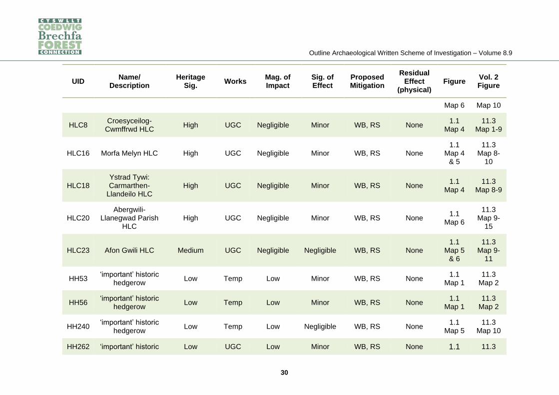
Appendix 1: Summary of proposals for construction phase mitigation
1.14.6 In Table 1 below, the mitigation measures proposed for specific assets are
described. In Table 2, proposed mitigation measures that would take place in
specific areas of the Proposed Development are summarised. Table 3 provides
details of all known assets within the works boundary, irrespective of whether
adverse effects are predicted, concerning which the Main Contractor should be
notified.
1.14.7 Assets are identified below by their unique identification reference (UID) and
name; further details are presented in a gazetteer in Volume 6.4, Appendix, 11.1,
Tables 1.17-1.22. Designated assets are indicated as such by the use of bold
type. Heritage significance, magnitude of impact, significance of effect before
mitigation and residual effect are determined using the methodology described in
the Volume 6.2, Chapter 11, Tables 11.2-4.
1.14.8 The column ‘Works’ indicates area of the Proposed Development in which the
identified effect would occur. These are:
OHL(s): Construction of a 132kV overhead line from near Llandyfaelog to near
Llangunnor;
UGC: Installation of a 132kV underground cable though the Towy Valley;
OHL(n): Construction of a 132kV overhead line from near Peniel to Brechfa East;
Temp: Temporary works associated with the construction phase, including
compounds and access; and
UGC (local): undergrounding of certain local electricity connections.
1.14.9 The ‘Mitigation’ column indicates the type of mitigation work that is proposed. The
acronyms used refer to:
WB: Watching brief during overburden strip and trenching;
PE: Provision for palaeo-environmental sampling; and

Outline Archaeological Written Scheme of Investigation – Volume 8.9
28
RS: Reinstatement of boundaries, trackways, earthworks and other physical
elements of the historic environment.
1.14.10 Note that for some assets described below, effects related to changes within
setting are also predicted. These assets are RHL2, ND173, ND174, HLC8 and
HLC20. Further details are provided on Table 11.8 of the Volume 6.2, Chapter 11.

Outline Archaeological Written Scheme of Investigation – Volume 8.9
29
Table 1 – Proposals for construction phase mitigation of physical effects on assets within the works boundary and
Order Limits
UID Name/
Description Heritage
Sig. Works
Mag. of Impact
Sig. of Effect
Proposed Mitigation
Residual Effect
(physical) Figure
Vol. 2 Figure
RHL2
Towy Valley Registered
Historic Landscape
High OHL(s),
UGC Negligible Minor WB, RS None
1.1 Map 4
& 5
11.2 Map 1-4
ND57 Site of earthworks/
palaeochannels Negligible Temp Low Negligible WB None
1.1 Map 6
11.1 Map 10
ND166 Palaeochannels Low UGC Low Minor WB, PE None 1.1
Map 4 & 5
11.1 Map 9 &
10
ND171 Possible quarry Negligible OHL(s) Low Negligible WB None 1.1
Map 3 11.1
Map 5
ND173 Former track Low OHL(s) Negligible Negligible WB, RS None 1.1
Map 3 11.1
Map 6
ND174 Earthworks Low OHL(s),
UGC (local)
Negligible Negligible WB, RS None 1.1
Map 3 11.1
Map 6
ND178 Possible Roman
road Low OHL(s) Negligible Negligible WB None
1.1 Map 2
11.1 Map 3
ND186 Roman road Low UGC Negligible Negligible WB None 1.1 11.1
Outline Archaeological Written Scheme of Investigation – Volume 8.9
30
UID Name/
Description Heritage
Sig. Works
Mag. of Impact
Sig. of Effect
Proposed Mitigation
Residual Effect
(physical) Figure
Vol. 2 Figure
Map 6 Map 10
HLC8 Croesyceilog-
Cwmffrwd HLC High UGC Negligible Minor WB, RS None
1.1 Map 4
11.3 Map 1-9
HLC16 Morfa Melyn HLC High UGC Negligible Minor WB, RS None 1.1
Map 4 & 5
11.3 Map 8-
10
HLC18 Ystrad Tywi: Carmarthen-
Llandeilo HLC High UGC Negligible Minor WB, RS None
1.1 Map 4
11.3 Map 8-9
HLC20 Abergwili-
Llanegwad Parish HLC
High UGC Negligible Minor WB, RS None 1.1
Map 6
11.3 Map 9-
15
HLC23 Afon Gwili HLC Medium UGC Negligible Negligible WB, RS None 1.1
Map 5 & 6
11.3 Map 9-
11
HH53 ‘important’ historic
hedgerow Low Temp Low Minor WB, RS None
1.1 Map 1
11.3 Map 2
HH56 ‘important’ historic
hedgerow Low Temp Low Minor WB, RS None
1.1 Map 1
11.3 Map 2
HH240 ‘important’ historic
hedgerow Low Temp Low Negligible WB, RS None
1.1 Map 5
11.3 Map 10
HH262 ‘important’ historic Low UGC Low Minor WB, RS None 1.1 11.3

Outline Archaeological Written Scheme of Investigation – Volume 8.9
31
UID Name/
Description Heritage
Sig. Works
Mag. of Impact
Sig. of Effect
Proposed Mitigation
Residual Effect
(physical) Figure
Vol. 2 Figure
hedgerow Map 6 Map 10
HH264 ‘important’ historic
hedgerow Low UGC Low Minor WB, RS None
1.1 Map 6
11.3 Map 10
HH434 ‘important’ historic
hedgerow Low Temp Low Negligible WB, RS None
1.1 Map 8
11.3 Map 14
Outline Archaeological Written Scheme of Investigation – Volume 8.9
32
Table 2 – Summary of construction phase mitigation by proposed development component
Proposed Development Component
Description Archaeological
Potential Summary of Impact Mitigation Measures Figure
OHL(s)
Construction of a 132kV overhead line and
associated poles from near Llandyfaelog to near
Llangunnor
Areas of high - low potential
Negligible/None: limited pitting at pole locations
Watching brief at locations where there is known
potential for archaeological impacts, i.e. at the following poles only: 34, 50, 54, 55 &
59
1.1 Map 2 & 3
UGC Installation of a 132kV
underground cable though the Towy Valley
Areas of moderate and low potential
Low - High: stripping of topsoil across working width, HDD pits, cable
trench
Watching brief of all works; reinstatement of any earthworks; palaeo-
environmental sampling where appropriate
1.1 Map 4-6
OHL(n)
Construction of a 132kV overhead line and
associated poles from near Peniel to Brechfa
East
Areas of high - low potential
Negligible/None: limited pitting at pole locations
None n/a
Bury Port
Alteration/ undergrounding of
existing 132kV overhead lines at Burry Port
substation
Negligible/None
Negligible/None: limited trenching through
previously disturbed ground
None n/a
Showground Construction and use of a Low Low: topsoil stripping Watching brief 1.1 Map
Outline Archaeological Written Scheme of Investigation – Volume 8.9
33
Proposed Development Component
Description Archaeological
Potential Summary of Impact Mitigation Measures Figure
Compound compound site at Carmarthen Showground
9
Towy Compound
Construction and use of a compound site in the
Towy Valley
Areas of moderate and low potential
Low Watching brief 1.1 Map
6
Forest Compound
Construction and use of a compound site near the
north terminus of the Proposed Development
Low/Negligible None: no stripping None n/a
UGC(local) Underground cabling of
local connections
Areas of low and negligible potential (i.e. near earthworks ND174 & Roman road ND75)
Low
Watching brief in areas of archaeological potential, i.e. between the following poles
only: 53 & 54 143 & 144 147 148 & 149
1.1 Map 3 & 7
Temp
Temporary works associated with the construction phase,
including access
Low/Negligible
Negligible: no stripping; cut-back/breaches
through six ‘important’ historic hedgerows for
access
Watching brief and reinstatement at six
hedgerows (HH53, HH56, HH240, HH262, HH264 &
HH434)
1.1 Map 1, 5, 6,
& 8

Outline Archaeological Written Scheme of Investigation – Volume 8.9
34
Table 3 – Assets within the works boundary
UID Name/Description Heritage Significance Vol. 2 Figure
RHL2 Towy Valley Registered Historic Landscape High 11.2 Map 1-4
ND1 Church land Negligible 11.1 Map 1
ND25 Church land Negligible 11.1 Map 5
ND28 Possible site of a former standing stone Low 11.1 Map 5
ND44 Canal (“Bishop's Palace Canal”) Low 11.1 Map 9
ND48 Possible site of a water mill in Abergwili Medium 11.1 Map 9
ND52 Leat to 'Bishops Mill' Low 11.1 Map 9
ND55 Earthworks near Glangwili Bridge (date and purpose unknown) Low 11.1 Map 10
ND57 Site of earthworks/palaeochannels Negligible 11.1 Map 10
ND60 Trial mine/quarry Negligible 11.1 Map 10
ND69 Quarry Negligible 11.1 Map 14
ND104 Former road running north from Capel Farm Low 11.1 Map 4
ND114 Site of a farmhouse or cottage Low 11.1 Map 6
ND121 Roman road ('Via Julia') between Carmarthen and Abergwili Low 11.1 Map 9
ND122 Site of a building Low 11.1 Map 10

Outline Archaeological Written Scheme of Investigation – Volume 8.9
35
UID Name/Description Heritage Significance Vol. 2 Figure
ND166 Series of palaeochannels along the eastern side of the River Gwili Low 11.1 Map 9 & 10
ND167 Possible settlement plots Low 11.1 Map 4
ND171 Quarry Negligible 11.1 Map 5
ND172 Former track Low 11.1 Map 6
ND173 Former track Low 11.1 Map 6
ND174 Earthworks Low 11.1 Map 6
ND175 Trackway Low 11.1 Map 18
ND178 Section of road, possibly Roman Low 11.1 Map 3
ND186 Roman road Low 11.1 Map 10
ND193 Field boundary (same as HH68) Low 11.1 Map 3
ND194 Former field boundary Negligible 11.1 Map 3
ND195 Field boundary (same as HH72) Low 11.1 Map 3
ND206 Site of New Lodge Brickworks Negligible 11.1 Map 23
ND208 Site of a relict drainage system Negligible 11.1 Map 23
HLC6 Morlais Valley Medium 11.3 Map 1
HLC8 Croesyceilog-Cwmffrwd High 11.3 Map 1
HLC10 Llandyfaelog, Llangyndeyrn High 11.3 Map 1-5

Outline Archaeological Written Scheme of Investigation – Volume 8.9
36
UID Name/Description Heritage Significance Vol. 2 Figure
HLC14 Mynydd Cyfor, Pant-Y-Parchell Moderate 11.3 Map 4-6
HLC16 Morfa Melyn High 11.3 Map 8-10
HLC17 Carmarthen High 11.3 Map 22
HLC18 Ystrad Tywi: Carmarthen-Llandeilo High 11.3 Map 8-9
HLC20 Abergwili-Llanegwad Parish High 11.3 Map 9-15
HLC23 Afon Gwili Moderate 11.3 Map 9-11
HLC24 Trelech High 11.3 Map 12-19
HLC32 Mynydd Tre-Beddau Negligible 11.3 Map 16, 18
& 20
HLC47 Dyffryn Cywyn High 11.3 Map 22
HLC48 Sarnau Mansion, Trebersed Medium 11.3 Map 22
HLC50 Tywyn Bach, Cefn Padrig Medium 11.3 Map 23
HH2 ‘important’ historic hedgerow Low 11.3 Map 1
HH5 ‘important’ historic hedgerow Low 11.3 Map 1
HH7 ‘important’ historic hedgerow Low 11.3 Map 1
HH8 ‘important’ historic hedgerow Low 11.3 Map 1
HH9 ‘important’ historic hedgerow Low 11.3 Map 1
HH10 ‘important’ historic hedgerow Low 11.3 Map 1
HH11 ‘important’ historic hedgerow Low 11.3 Map 1
HH12 ‘important’ historic hedgerow Low 11.3 Map 1
HH13 ‘important’ historic hedgerow Low 11.3 Map 1

Outline Archaeological Written Scheme of Investigation – Volume 8.9
37
UID Name/Description Heritage Significance Vol. 2 Figure
HH14 ‘important’ historic hedgerow Low 11.3 Map 1
HH15 ‘important’ historic hedgerow Low 11.3 Map 1
HH16 ‘important’ historic hedgerow Low 11.3 Map 1
HH17 ‘important’ historic hedgerow Low 11.3 Map 1
HH18 ‘important’ historic hedgerow Low 11.3 Map 1
HH19 ‘important’ historic hedgerow Low 11.3 Map 1
HH22 ‘important’ historic hedgerow Low 11.3 Map 1
HH23 ‘important’ historic hedgerow Low 11.3 Map 1
HH24 ‘important’ historic hedgerow Low 11.3 Map 1
HH26 ‘important’ historic hedgerow Low 11.3 Map 2
HH27 ‘important’ historic hedgerow Low 11.3 Map 2
HH31 ‘important’ historic hedgerow Low 11.3 Map 2
HH32 ‘important’ historic hedgerow Low 11.3 Map 2
HH35 ‘important’ historic hedgerow Low 11.3 Map 2
HH37 ‘important’ historic hedgerow Low 11.3 Map 2
HH39 ‘important’ historic hedgerow Low 11.3 Map 2
HH40 ‘important’ historic hedgerow Low 11.3 Map 2
HH41 ‘important’ historic hedgerow Low 11.3 Map 2
HH42 ‘important’ historic hedgerow Low 11.3 Map 2
HH44 ‘important’ historic hedgerow Low 11.3 Map 2
HH48 ‘important’ historic hedgerow Low 11.3 Map 2
HH53 ‘important’ historic hedgerow Low 11.3 Map 2
HH54 ‘important’ historic hedgerow Low 11.3 Map 2
HH56 ‘important’ historic hedgerow Low 11.3 Map 3
HH59 ‘important’ historic hedgerow Low 11.3 Map 3
HH61 ‘important’ historic hedgerow Low 11.3 Map 3
HH62 ‘important’ historic hedgerow Low 11.3 Map 3

Outline Archaeological Written Scheme of Investigation – Volume 8.9
38
UID Name/Description Heritage Significance Vol. 2 Figure
HH63 ‘important’ historic hedgerow Low 11.3 Map 3
HH64 ‘important’ historic hedgerow Low 11.3 Map 3
HH65 ‘important’ historic hedgerow Low 11.3 Map 3
HH66 ‘important’ historic hedgerow Low 11.3 Map 3
HH68 ‘important’ historic hedgerow Low 11.3 Map 3
HH72 ‘important’ historic hedgerow Low 11.3 Map 3
HH75 ‘important’ historic hedgerow Low 11.3 Map 3
HH77 ‘important’ historic hedgerow Low 11.3 Map 3
HH84 ‘important’ historic hedgerow Low 11.3 Map 3
HH89 ‘important’ historic hedgerow Low 11.3 Map 3
HH90 ‘important’ historic hedgerow Low 11.3 Map 3
HH91 ‘important’ historic hedgerow Low 11.3 Map 3
HH92 ‘important’ historic hedgerow Low 11.3 Map 3
HH93 ‘important’ historic hedgerow Low 11.3 Map 3
HH94 ‘important’ historic hedgerow Low 11.3 Map 4
HH95 ‘important’ historic hedgerow Low 11.3 Map 4
HH96 ‘important’ historic hedgerow Low 11.3 Map 4
HH100 ‘important’ historic hedgerow Low 11.3 Map 4
HH101 ‘important’ historic hedgerow Low 11.3 Map 4
HH103 ‘important’ historic hedgerow Low 11.3 Map 4
HH104 ‘important’ historic hedgerow Low 11.3 Map 4
HH105 ‘important’ historic hedgerow Low 11.3 Map 4
HH106 ‘important’ historic hedgerow Low 11.3 Map 4
HH107 ‘important’ historic hedgerow Low 11.3 Map 4
HH109 ‘important’ historic hedgerow Low 11.3 Map 4
HH110 ‘important’ historic hedgerow Low 11.3 Map 4
HH111 ‘important’ historic hedgerow Low 11.3 Map 4
Outline Archaeological Written Scheme of Investigation – Volume 8.9
39
UID Name/Description Heritage Significance Vol. 2 Figure
HH112 ‘important’ historic hedgerow Low 11.3 Map 5
HH114 ‘important’ historic hedgerow Low 11.3 Map 5
HH115 ‘important’ historic hedgerow Low 11.3 Map 5
HH116 ‘important’ historic hedgerow Low 11.3 Map 5
HH117 ‘important’ historic hedgerow Low 11.3 Map 5
HH118 ‘important’ historic hedgerow Low 11.3 Map 5
HH121 ‘important’ historic hedgerow Low 11.3 Map 5
HH123 ‘important’ historic hedgerow Low 11.3 Map 5
HH124 ‘important’ historic hedgerow Low 11.3 Map 5
HH126 ‘important’ historic hedgerow Low 11.3 Map 5
HH129 ‘important’ historic hedgerow Low 11.3 Map 5
HH131 ‘important’ historic hedgerow Low 11.3 Map 5
HH132 ‘important’ historic hedgerow Low 11.3 Map 5
HH133 ‘important’ historic hedgerow Low 11.3 Map 5
HH134 ‘important’ historic hedgerow Low 11.3 Map 5
HH135 ‘important’ historic hedgerow Low 11.3 Map 5
HH136 ‘important’ historic hedgerow Low 11.3 Map 5
HH137 ‘important’ historic hedgerow Low 11.3 Map 5
HH139 ‘important’ historic hedgerow Low 11.3 Map 5
HH142 ‘important’ historic hedgerow Low 11.3 Map 6
HH143 ‘important’ historic hedgerow Low 11.3 Map 6
HH144 ‘important’ historic hedgerow Low 11.3 Map 6
HH145 ‘important’ historic hedgerow Low 11.3 Map 6
HH146 ‘important’ historic hedgerow Low 11.3 Map 6
HH147 ‘important’ historic hedgerow Low 11.3 Map 6
HH148 ‘important’ historic hedgerow Low 11.3 Map 6
HH149 ‘important’ historic hedgerow Low 11.3 Map 6
Outline Archaeological Written Scheme of Investigation – Volume 8.9
40
UID Name/Description Heritage Significance Vol. 2 Figure
HH150 ‘important’ historic hedgerow Low 11.3 Map 6
HH152 ‘important’ historic hedgerow Low 11.3 Map 6
HH153 ‘important’ historic hedgerow Low 11.3 Map 6
HH154 ‘important’ historic hedgerow Low 11.3 Map 6
HH155 ‘important’ historic hedgerow Low 11.3 Map 6
HH159 ‘important’ historic hedgerow Low 11.3 Map 6
HH161 ‘important’ historic hedgerow Low 11.3 Map 6
HH164 ‘important’ historic hedgerow Low 11.3 Map 6
HH166 ‘important’ historic hedgerow Low 11.3 Map 6
HH168 ‘important’ historic hedgerow Low 11.3 Map 6
HH169 ‘important’ historic hedgerow Low 11.3 Map 7
HH171 ‘important’ historic hedgerow Low 11.3 Map 7
HH173 ‘important’ historic hedgerow Low 11.3 Map 7
HH177 ‘important’ historic hedgerow Low 11.3 Map 7
HH178 ‘important’ historic hedgerow Low 11.3 Map 7
HH184 ‘important’ historic hedgerow Low 11.3 Map 7
HH188 ‘important’ historic hedgerow Low 11.3 Map 7
HH189 ‘important’ historic hedgerow Low 11.3 Map 7
HH191 ‘important’ historic hedgerow Low 11.3 Map 7
HH192 ‘important’ historic hedgerow Low 11.3 Map 7
HH193 ‘important’ historic hedgerow Low 11.3 Map 7
HH194 ‘important’ historic hedgerow Low 11.3 Map 8
HH195 ‘important’ historic hedgerow Low 11.3 Map 8
HH196 ‘important’ historic hedgerow Low 11.3 Map 8
HH197 ‘important’ historic hedgerow Low 11.3 Map 8
HH199 ‘important’ historic hedgerow Low 11.3 Map 8
HH202 ‘important’ historic hedgerow Low 11.3 Map 8

Outline Archaeological Written Scheme of Investigation – Volume 8.9
41
UID Name/Description Heritage Significance Vol. 2 Figure
HH207 ‘important’ historic hedgerow Low 11.3 Map 8
HH209 ‘important’ historic hedgerow Low 11.3 Map 8
HH210 ‘important’ historic hedgerow Low 11.3 Map 8
HH211 ‘important’ historic hedgerow Low 11.3 Map 8
HH212 ‘important’ historic hedgerow Low 11.3 Map 8
HH214 ‘important’ historic hedgerow Low 11.3 Map 8
HH215 ‘important’ historic hedgerow Low 11.3 Map 8
HH217 ‘important’ historic hedgerow Low 11.3 Map 8
HH218 ‘important’ historic hedgerow Low 11.3 Map 8
HH219 ‘important’ historic hedgerow Low 11.3 Map 8
HH231 ‘important’ historic hedgerow Low 11.3 Map 9
HH239 ‘important’ historic hedgerow Low 11.3 Map 10
HH240 ‘important’ historic hedgerow Low 11.3 Map 10
HH242 ‘important’ historic hedgerow Low 11.3 Map 10
HH243 ‘important’ historic hedgerow Low 11.3 Map 10
HH244 ‘important’ historic hedgerow Low 11.3 Map 10
HH247 ‘important’ historic hedgerow Low 11.3 Map 10
HH251 ‘important’ historic hedgerow Low 11.3 Map 10
HH253 ‘important’ historic hedgerow Low 11.3 Map 10
HH255 ‘important’ historic hedgerow Low 11.3 Map 10
HH256 ‘important’ historic hedgerow Low 11.3 Map 10
HH257 ‘important’ historic hedgerow Low 11.3 Map 10
HH258 ‘important’ historic hedgerow Low 11.3 Map 10
HH260 ‘important’ historic hedgerow Low 11.3 Map 10
HH261 ‘important’ historic hedgerow Low 11.3 Map 10
HH262 ‘important’ historic hedgerow Low 11.3 Map 10
HH264 ‘important’ historic hedgerow Low 11.3 Map 10

Outline Archaeological Written Scheme of Investigation – Volume 8.9
42
UID Name/Description Heritage Significance Vol. 2 Figure
HH266 ‘important’ historic hedgerow Low 11.3 Map 11
HH269 ‘important’ historic hedgerow Low 11.3 Map 11
HH271 ‘important’ historic hedgerow Low 11.3 Map 11
HH273 ‘important’ historic hedgerow Low 11.3 Map 11
HH274 ‘important’ historic hedgerow Low 11.3 Map 11
HH276 ‘important’ historic hedgerow Low 11.3 Map 11
HH280 ‘important’ historic hedgerow Low 11.3 Map 11
HH282 ‘important’ historic hedgerow Low 11.3 Map 11
HH284 ‘important’ historic hedgerow Low 11.3 Map 11
HH285 ‘important’ historic hedgerow Low 11.3 Map 11
HH286 ‘important’ historic hedgerow Low 11.3 Map 11
HH287 ‘important’ historic hedgerow Low 11.3 Map 11
HH288 ‘important’ historic hedgerow Low 11.3 Map 11
HH292 ‘important’ historic hedgerow Low 11.3 Map 12
HH297 ‘important’ historic hedgerow Low 11.3 Map 12
HH298 ‘important’ historic hedgerow Low 11.3 Map 12
HH299 ‘important’ historic hedgerow Low 11.3 Map 12
HH300 ‘important’ historic hedgerow Low 11.3 Map 12
HH301 ‘important’ historic hedgerow Low 11.3 Map 12
HH305 ‘important’ historic hedgerow Low 11.3 Map 13
HH306 ‘important’ historic hedgerow Low 11.3 Map 13
HH307 ‘important’ historic hedgerow Low 11.3 Map 13
HH311 ‘important’ historic hedgerow Low 11.3 Map 13
HH314 ‘important’ historic hedgerow Low 11.3 Map 13
HH315 ‘important’ historic hedgerow Low 11.3 Map 13
HH316 ‘important’ historic hedgerow Low 11.3 Map 13
HH319 ‘important’ historic hedgerow Low 11.3 Map 13
Outline Archaeological Written Scheme of Investigation – Volume 8.9
43
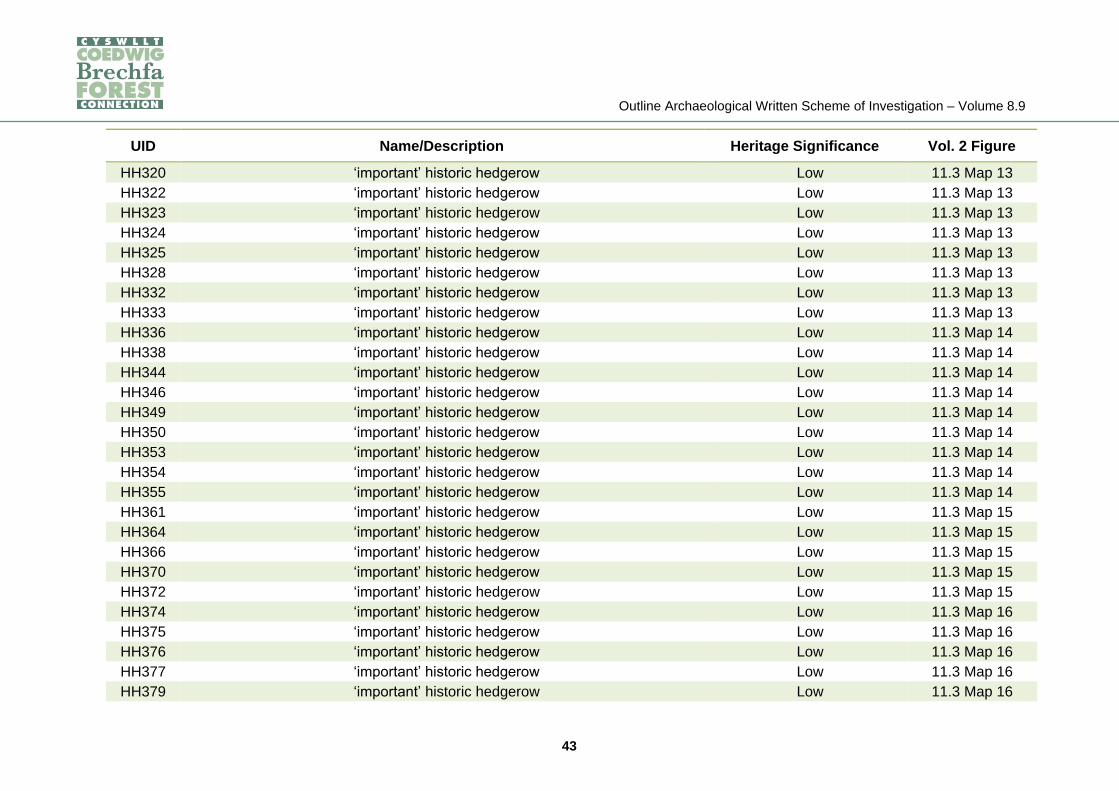
UID Name/Description Heritage Significance Vol. 2 Figure
HH320 ‘important’ historic hedgerow Low 11.3 Map 13
HH322 ‘important’ historic hedgerow Low 11.3 Map 13
HH323 ‘important’ historic hedgerow Low 11.3 Map 13
HH324 ‘important’ historic hedgerow Low 11.3 Map 13
HH325 ‘important’ historic hedgerow Low 11.3 Map 13
HH328 ‘important’ historic hedgerow Low 11.3 Map 13
HH332 ‘important’ historic hedgerow Low 11.3 Map 13
HH333 ‘important’ historic hedgerow Low 11.3 Map 13
HH336 ‘important’ historic hedgerow Low 11.3 Map 14
HH338 ‘important’ historic hedgerow Low 11.3 Map 14
HH344 ‘important’ historic hedgerow Low 11.3 Map 14
HH346 ‘important’ historic hedgerow Low 11.3 Map 14
HH349 ‘important’ historic hedgerow Low 11.3 Map 14
HH350 ‘important’ historic hedgerow Low 11.3 Map 14
HH353 ‘important’ historic hedgerow Low 11.3 Map 14
HH354 ‘important’ historic hedgerow Low 11.3 Map 14
HH355 ‘important’ historic hedgerow Low 11.3 Map 14
HH361 ‘important’ historic hedgerow Low 11.3 Map 15
HH364 ‘important’ historic hedgerow Low 11.3 Map 15
HH366 ‘important’ historic hedgerow Low 11.3 Map 15
HH370 ‘important’ historic hedgerow Low 11.3 Map 15
HH372 ‘important’ historic hedgerow Low 11.3 Map 15
HH374 ‘important’ historic hedgerow Low 11.3 Map 16
HH375 ‘important’ historic hedgerow Low 11.3 Map 16
HH376 ‘important’ historic hedgerow Low 11.3 Map 16
HH377 ‘important’ historic hedgerow Low 11.3 Map 16
HH379 ‘important’ historic hedgerow Low 11.3 Map 16
Outline Archaeological Written Scheme of Investigation – Volume 8.9
44
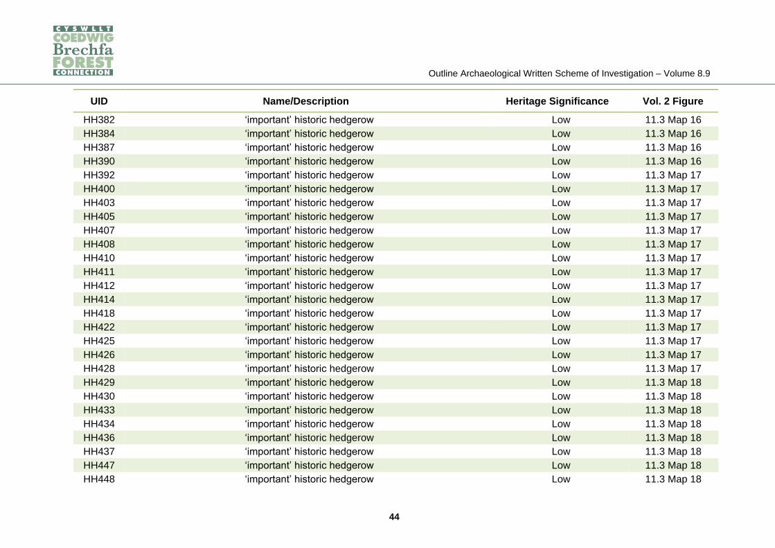
UID Name/Description Heritage Significance Vol. 2 Figure
HH382 ‘important’ historic hedgerow Low 11.3 Map 16
HH384 ‘important’ historic hedgerow Low 11.3 Map 16
HH387 ‘important’ historic hedgerow Low 11.3 Map 16
HH390 ‘important’ historic hedgerow Low 11.3 Map 16
HH392 ‘important’ historic hedgerow Low 11.3 Map 17
HH400 ‘important’ historic hedgerow Low 11.3 Map 17
HH403 ‘important’ historic hedgerow Low 11.3 Map 17
HH405 ‘important’ historic hedgerow Low 11.3 Map 17
HH407 ‘important’ historic hedgerow Low 11.3 Map 17
HH408 ‘important’ historic hedgerow Low 11.3 Map 17
HH410 ‘important’ historic hedgerow Low 11.3 Map 17
HH411 ‘important’ historic hedgerow Low 11.3 Map 17
HH412 ‘important’ historic hedgerow Low 11.3 Map 17
HH414 ‘important’ historic hedgerow Low 11.3 Map 17
HH418 ‘important’ historic hedgerow Low 11.3 Map 17
HH422 ‘important’ historic hedgerow Low 11.3 Map 17
HH425 ‘important’ historic hedgerow Low 11.3 Map 17
HH426 ‘important’ historic hedgerow Low 11.3 Map 17
HH428 ‘important’ historic hedgerow Low 11.3 Map 17
HH429 ‘important’ historic hedgerow Low 11.3 Map 18
HH430 ‘important’ historic hedgerow Low 11.3 Map 18
HH433 ‘important’ historic hedgerow Low 11.3 Map 18
HH434 ‘important’ historic hedgerow Low 11.3 Map 18
HH436 ‘important’ historic hedgerow Low 11.3 Map 18
HH437 ‘important’ historic hedgerow Low 11.3 Map 18
HH447 ‘important’ historic hedgerow Low 11.3 Map 18
HH448 ‘important’ historic hedgerow Low 11.3 Map 18

Outline Archaeological Written Scheme of Investigation – Volume 8.9
45
UID Name/Description Heritage Significance Vol. 2 Figure
HH449 ‘important’ historic hedgerow Low 11.3 Map 18
HH450 ‘important’ historic hedgerow Low 11.3 Map 18
HH451 ‘important’ historic hedgerow Low 11.3 Map 18
HH452 ‘important’ historic hedgerow Low 11.3 Map 18

Outline Archaeological Written Scheme of Investigation – Volume 8.9
46
Appendix 2: References
The list below is taken from a full bibliography of sources utilised, which is
provided in Volume 6.4, Appendix 11.1.
Burial Act, 1857
Cadw, 2002, Ancient Monuments in Wales: What is Scheduling?
Cadw, 2011, Conservation Principles for the sustainable management of the historic
environment in Wales
Chartered Institute for Archaeologists (CIfA), 2014a, Code of Conduct (revised)
Chartered Institute for Archaeologists (CIfA), 2014b, Standard and Guidance for
commissioning work on, or providing consultancy advice on, archaeology and the historic
environment
Chartered Institute for Archaeologists (CIfA), 2014c, Standard and Guidance for an
archaeological watching brief (revised)
Chartered Institute for Archaeologists (CIfA), 2014d, Standard and Guidance for
archaeological field evaluation (revised)
Chartered Institute for Archaeologists (CIfA), 2014e, Standard and Guidance for
archaeological excavation (revised)
Chartered Institute for Archaeologists (CIfA), 2014f, Standard and Guidance for
archaeological geophysical survey (revised)
Chartered Institute for Archaeologists (CIfA), 2014g, Standard and Guidance for the
collection, documentation, conservation and research of archaeological materials (revised)
Chartered Institute for Archaeologists (CIfA), 2014h, Standard and Guidance for Historic
Outline Archaeological Written Scheme of Investigation – Volume 8.9
47
Environment Desk-Based Assessment (revised)
Chartered Institute for Archaeologists (CIfA), 2014i, Standard and guidance for the
creation, compilation, transfer and deposition of archaeological archives (revised)
Department for Communities and Local Government (DCLG), 2010, Planning Policy
Statement 5: Planning for the Historic Environment (PPS5)
Department for Energy and Climate Change (DECC), 2011a, National Policy Statement for
Energy (EN-1)
English Heritage (EH), 2007, Geoarchaeology: using earth sciences to understand the
archaeological record
English Heritage (EH), 2011a, Environmental Archaeology
McKinley, J.I. & Roberts, C, 1993, Excavation and post-excavation treatment of cremated
and inhumed human remains, Institute of Field Archaeologists Technical Paper, 13
Statutory Instrument 1997/1160 ‘The Hedgerow Regulations’ (Schedule 1, Part 2)
Treasure Act, 1996
Welsh Archaeological Trusts (WAT), 2011-14, A Research Framework for the Archaeology
of Wales (available at: http://www.archaeoleg.org.uk/documents2011.html#content
accessed 24/06/2014)