Embed Size (px)
Citation preview

OWWRW A center of excellence in earth sciences and engineering
A Division of Southwest Research Institute-M 6220 Culebra Road • San Antonio, Texas, U.S.A. 78228-5166 (210) 522-5160 ° Fax (210) 522-5155 August 7, 2002
Contract No. NRC-02-97-009 Account No. 20.01402.471
U.S. Nuclear Regulatory Commission ATTN: Dr. Philip S. Justus Office of Nuclear Material Safety and Safeguards TWFN Mail Stop 7 C6 Washington, DC 20555
Subject: Programmatic Review of Journal Article
Dear Dr. Justus:
Attached is Intermediate Milestone 01402.471.230, Fault displacement gradients at Yucca Mountain, Nevada-Journal Article. This paper is being sent to NRC for programmatic review.
This deliverable describes and applies a technique to provide a qualitative assessment of distributive deformation (i.e., fracture and small scale faulting) associated with faulting. Two aspects of distributed displacement are investigated, deformation that forms parallel to a fault as a result of the displacement gradient along a fault and deformation that develops perpendicular to a fault as a result of displacement on overlapping adjacent faults. As a demonstration, this technique is applied to the displacement gradients on the Ghost Dance and Abandoned Wash faults. Increased distributed deformation occurs where the deformation gradients are high between both faults. As a result of this assessment, the paper concludes that distributed deformation is variable in the Yucca Mountain area. Therefore, if DOE expands the repository area the characteristics of deformation cannot, a priori, be extrapolated into the expansion blocks without some additional examination of fractures and small faults in those new areas.
After NRC acceptance, this paper will be submitted to the Journal of Geophysical Research. If you have any questions, please contact Dr. David Ferrill at 210-522-6082 or me at 210-522-5183.
Sincerely,
H. Lawrence McKague GLGP Element Manager
rae Attachment
cc: J. Unehan B. Meehan S Wastler W. Patrick D. Sims W. Reamer L. Campbell T. Essig B. Sagar N. Franklin D. DeMarco J. Greeves K. Stablein CNWRA Dirs (Itr only) D. Waiting D. Riffle J. Schlueter CNWRA EMs (Itr only) T. Nagy (SwRI Contracts)
D Ferrill A. Morris
D.\GLGP Group\letters\sds\Cy-2002\paperO8-07-2002hlm.wpd
Washington Office ° Twinbrook Metro Plaza #210 1 12300 Twinbrook Parkway - Rockville, Maryland 20852-1606

I
Fault displacement gradients at Yucca Mountain, Nevada
Alan P. Morris', David A. Ferrill2 , Darrell W. Sims 2, Nathan Franklin 2, Deborah J.
Waiting2
'Department of Earth and Environmental Science, University of Texas at San Antonio,
San Antonio, TX 78249, USA
'CNWRA, Southwest Research Institute, San Antonio, 7X 78238-5166, USA
For submission to the Journal of Geophysical Research
August 2002
Abstract. Yucca Mountain, Nevada, is the sole candidate site for underground disposal of
high-level radioactive waste in the United States. The mountain is composed of Tertiary (12.8
Ma to 10 Ma) volcanic tuff, cut by west-dipping normal faults that divide the mountain into
north-trending, east-dipping cuestas. Characterization by the U.S. Department of Energy (DOE)
has mostly focused on mapping lithostratigraphic units, faults, and fractures in the main
repository block. DOE is considering expanding the potential repository into other fault blocks,
which have not been studied in detail. Faults and fractures are important to repository design
because they affect seismic hazard, rockfall, and fluid transmissivity in the surrounding rock
mass. Geologic maps and detailed studies of rock pavements and tunnel walls reveal that faults
and fractures within Yucca Mountain are not uniform in orientation or intensity. We investigate

2
two aspects of distributed deformation arising from fault displacement gradients at Yucca
Mountain. First, fault-parallel strains (elongation parallel to cutoff lines where stratigraphic
horizons intersect fault planes) develop as a result of fault displacement gradients. Using existing
data, we analyze the likely state of strain in fault blocks at Yucca Mountain. Second,
fault-strike-perpendicular strains can develop where two normal faults propagate past each other.
A component of total displacement is distributed into the surrounding rock to produce synthetic
layer dip or a network of smaller faults and fractures. There is a demonstrable relationship
between displacement gradients on the Ghost Dance and Abandoned Wash faults and fault and
fracture intensity at smaller scales. We find that small-scale faulting and fracturing at Yucca
Mountain is variable and is strongly controlled by larger scale fault system architecture.
1. Introduction
Yucca Mountain, Nevada is located within the southwestern part of the Basin and Range
physiographic province, on the margin of the Walker Lane (Fig. 1). It is the proposed site for the
permanent disposal of high-level radioactive waste in the United States. The region is
characterized by strike-slip and extensional deformation that has been active since the beginning
of the Cenozoic (65 Ma) [see for example Snow and Wernicke, 2000]. The region remains
tectonically active as indicated by evidence for Quaternary (including Holocene) to present-day
faulting [Harmsen, 1994; Simonds et al., 1995; Ferrill et al., 1996a,b], and Quaternary volcanism
[Connor and Hill, 1995; Connor et al., 2000]. Yucca Mountain itself is composed of faulted and
fractured Miocene volcanic tuffs erupted from calderas in the Southwest Nevada Volcanic Field

3
15 to 9 million years ago [Sawyer et al., 1994]. The Tiva Canyon Tuff (12.7 Ma) of the
Paintbrush Group makes up the main surface exposures of Yucca Mountain. The proposed
repository would be hosted within the Topopah Spring Tuff (12.8 Ma), also of the Paintbrush
Group. Angular unconformities and fault-related depocenters within the tuff sequence indicate
that faulting and tuff deposition were synchronous at Yucca Mountain [e.g., Carr, 1990; Day et
al., 1998b; Fridrich, 1999]. Most faults at Yucca Mountain are either north-trending normal
faults or northwest-trending, dextral strike-slip faults. The larger faults in these two orientations
bound the fault blocks of Yucca Mountain (Fig. 1). Some northwest-trending faults are
dominantly normal faults, accommodating extension in relay ramps between overlapping normal
faults [Ferrill et al., 1999a].
The fault and fracture framework of Yucca Mountain and its environs are important to
technical considerations with respect to the location, design, and long term performance of the
proposed waste repository. DOE has responsibility for characterizing Yucca Mountain as a
proposed high level radioactive waste repository site, and the design of the proposed repository.
Faults and fractures provide potential pathways for fluid movement, and bound blocks of rocks
that may fall from the walls and ceiling of excavated drifts. Therefore, the fault and fracture
framework is a key factor in repository design and performance. Thus far, detailed fault and
fracture characterization at Yucca Mountain has concentrated on an area between the Solitario
Canyon and Bow Ridge faults (Fig. lb), which contains the area referred to as the main
repository (upper block) and the lower block [CRWMS M&O, 2001]. These two faults have
maximum throws of 450 m and 150 m respectively, and are two of the largest faults that cut
Yucca Mountain. DOE is now considering expanding the repository area beyond the main

4
repository block in order to reduce the thermal load likely to be experienced by the host rock
[see for example CRWMS M&O, 2001]. However, fault and fracture characteristics of the host
blocks in the various proposed designs for an expanded repository have not been characterized.
Two tunnels, the Exploratory Studies Facility (ESF) and Enhanced Characterization of the
Repository Block (ECRB) have been excavated in order to aid the characterization of the main
repository block with respect to rock type, faults, and fractures [Mongano et al., 1999; CRWMS
M&O, 2000] (Fig. 1b). A wealth of information has been obtained to that end. However, the
detailed data have not been linked to the larger structural elements of Yucca Mountain, and no
models exist that will assist in the prediction of small faults and fractures in areas where no
tunnels have been excavated. In this paper, we use existing data, including that acquired by
DOE, to evaluate displacement patterns on mapped faults at Yucca Mountain in order to
understand structural controls on small-scale faulting and fracturing at Yucca Mountain. Based
on this analysis, we find that in areas where detailed studies have been conducted, displacement
gradients on mapped faults can be used as indicators of distributed deformation at smaller scales
within the adjacent rock. In addition, the potential expanded waste emplacement areas occupy
structural positions in which the characteristics of faults and fractures may differ from those in
the main repository block. Because fault displacement gradients strongly influence deformation
in adjacent fault blocks, the potential repository expansion areas require further analysis.
2. Background

5
Surface exposures at Yucca Mountain consist of faulted and fractured Miocene silicic
volcanic rocks, primarily the Tiva Canyon Tuff of the Paintbrush Group [Sawyer et al., 1994].
Also part of the Paintbrush Group, but less well-exposed than and stratigraphically below the
Tiva Canyon Tuff, is the Topopah Spring Tuff. DOE has designated a series of welded units
within the Topopah Spring Tuff as the proposed repository host horizon (RHH). Specifically, the
RHH consists of the lower third of the upper lithophysal zone, and the middle nonlithophysal,
lower lithophysal, and lower nonlithophysal zones of the crystal-poor member of the Topopah
Spring Tuff [CRWMS M&O, 2001]. The top of the RHH is represented as a horizon within the
DOE Geologic Framework Model version 3.1 [CRWMS M&O, 2000], which is a
three-dimensional interpretation of the structure and stratigraphy at Yucca Mountain (Fig. 2a,b).
The structural geology of Yucca Mountain is dominated by west-dipping, extensional
faults with strike trends between 0000 and 0300 (Fig. 2). Faulting developed in the Paintbrush
Group tuffs at Yucca Mountain over the last 13 million years in a stress system with a vertical
al, initially with Y3 directed EW then evolving to the current situation with a3 directed toward
3000 [Zoback et al., 1981; Morris et al., 1996]. In addition to the dominant normal faults, small
numbers of strike-slip and reverse faults have been mapped [Day et al., 1998a,b; Mongano et al.,
1999]. West-dipping, normal faults define the primary fault architecture of western Yucca
Mountain [Ferrill et al., 1999a]. Slip on these faults has generated the eastward-dipping fault
blocks that characterize the area.
Thus far, fault characterization at Yucca Mountain has progressed along three tracks.
First, the area has been mapped by traditional field geological methods at a variety of scales
[Scott and Bonk, 1984; Simonds et al., 1995; Day et al., 1998a,b]. Second, fault and fracture data

6
has been collected from detailed pavement mapping at the surface of Yucca Mountain [e.g.,
Barton and Hsieh, 1989; Barton and Larsen, 1995; Barton et al., 1993; Sweetkind et al., 1997]
with the goal of determining the influence of these structures on the infiltration of surface water
into the main repository block, and as analogs for fracturing within the main repository block.
Third, the walls of the ESF and ECRB have provided a wealth of detailed fault and fracture data
from mapping and detailed line surveys conducted during the active tunneling phase [Mongano
et al., 1999; CRWMS M&O, 2000]. Traditional geological mapping is capable of detecting and
representing faults with displacements greater than about 1.5 m under favorable circumstances or
greater than 5 m elsewhere [Day et al. 1998a,b], whereas mapping of tunnel walls, where
colluvium and vegetation do not obscure the rock, recorded faults with displacements as small as
0.02 m [Mongano et al., 1999; CRWMS M&O, 2000].
Larger (field-mappable) faults are important indicators of the overall structure and fault
block deformation at Yucca Mountain [e.g., Young et al., 1992a,b; Ferrill and Morris, 2001].
Smaller faults are more difficult to detect using surface geological mapping techniques but are
more numerous than larger faults. For example, the North Ramp of the ESF traverses the mapped
traces of 14 faults with displacements of 5 m to 50 m [Day et al., 1998a,b], whereas mapping of
the tunnel walls (Appendix 1) of the North Ramp identified 262 faults with displacements as
small as 0.02 m. Small faults do not accommodate a major component of regional-scale
deformation, however, permeability architecture, rockfall potential, failure strength and fracture
characteristics are all strongly influenced by small faults and fractures [U.S. Department of
Energy, 1998].

7
3. Fault displacement gradients, faults and fractures
Wherever faults exhibit displacement gradients, strain is transferred into adjacent fault
blocks and the intensity of the resultant deformation is commensurate with the steepness of the
displacement gradient. Two primary manifestations of this strain transfer in the case of
extensional normal faults are: (i) cutoff parallel elongation [Ferrill and Morris, 2001] (Fig. 3a),
and (ii) strike-perpendicular distributed deformation in zones of displacement deficit, which has
been recognized in the Canyonlands (Utah) [Trudgill and Cartwright, 1994] and the English
Midlands Coalfield [Peacock and Sanderson, 1994; Huggins et al., 1995; Childs et al., 1995]
(Fig. 3b). Both of these strain transfer mechanisms can be recognized in the Ghost
Dance-Abandoned Wash fault system at Yucca Mountain (Fig. 2b).
3.1. Cutoff-parallel elongation
Fault-parallel elongations experienced by rock adjacent to faults are determined by fault
displacement gradients, fault slip vectors, and initial stratal orientations [Ferrill and Morris,
2001]. Elongation parallel to the stratal cutoff line (line of intersection between rock strata and
fault plane) can be positive (length increase) or negative (length decrease) and depends only on
angular relationships [Ferrill and Morris, 2001]. Therefore, the elongation can be calculated for
sections of a fault between cutoff line data points. Details of stratal cutoff lines for all principal
geologic strata (horizons) at Yucca Mountain can be extracted from the DOE Geologic
Framework Model [CRWMS M&O, 2000] (Fig. 2a). The resulting data can be assembled into a
3D fault gap model for any given horizon. In this paper we use a fault gap model for the top of

8
the RHH generated from data within the DOE Geologic Framework Model [CRWMS M&O,
2000] (Fig. 2b) because it is the top of the lithologic package that DOE has selected to host the
proposed repository.
3.1.1. Fault slip vectors
Fault slip vectors are required for our analysis. Using the 3D fault gap model, detailed
geometry of the fault surfaces between offset cutoff lines can be generated (Fig. 2b). These
surfaces can then be used to determine the slip vector field throughout the study area. This is
done by using slip tendency analysis [Morris et al., 1996] to investigate a range of stress systems
likely to have been extant at the time of faulting. In computing slip tendency, the directions of
maximum resolved shear stress within a fault surface are computed. For any portion of the fault
surface,the direction of maximum resolved shear stress is the likely slip direction [e.g., Bott,
1959; Morris et al., 1996]. Each stress system will yield a unique slip vector field. By using a
range of stress systems likely to have been operating during faulting, a range of likely slip vector
fields can be computed, and their effects on cutoff elongation can be examined.
The period of most active faulting at Yucca Mountain is generally thought to have been
during the Miocene (13 to 10 Ma) [Sawyer et al., 1994; Morris et al., 1996; Snow and Wernicke,
2000]. At that time, the orientation of extension (i.e., minimum principal stress) was between
WSW (2600) and NW - SE (3000) [Zoback et al., 1981; Morris et al., 1996]. Vertical principal
stress was determined primarily by lithostatic pressure, which is approximately 21 MPa at a
depth of about 1 km for rocks with densities similar to those at Yucca Mountain [Ferrill et al.,
1999b]. In order for the rocks to have been close to failure, and thus to have experienced active

9
faulting, the differential stress (a, - a3) must have been approximately 15MPa [Hoek and Brown,
1988; Mandl, 1988], therefore the minimum stress (a3) would have been on the order of 6 MPa.
Given these two constraints, 02 could have varied within these limits. High values of a2 [low
values of R, where R = (a, - a2)/(al - a3)] give rise to conditions conducive to both normal and
strike-slip faulting [Morris et al., 1996], and to a large number of mapped fault traces at Yucca
Mountain that would have experienced cutoff-parallel elongation (Appendix 2). Lower a2 (and
higher R) values would give rise to less strike-slip faulting and a smaller number of fault traces
that would have experienced cut-off parallel elongation (Appendix 2).
Data from borehole breakouts, active faulting, earthquake nodal planes, and fault
orientation indicate that Yucca Mountain currently experiences a normal faulting regional stress
system with a3 oriented approximately WNW (300' azimuth), and a 02 value close to that of a,
[Stock et al., 1985; Stock and Healy, 1988; Harmsen, 1994; Morris et al., 1996; Ferrill et al.,
1999b]. This stress system accounts for the dominance of normal faulting in the area and the
synchronous oblique-slip to strike-slip activity on many NW-striking faults. It is also consistent
with interpretations of the slip events associated with the 1992 Little Skull Mountain earthquake
[Stock and Healy, 1988; Harmsen, 1994; Morris et al., 1996] which occurred at a depth of about
8 kin, 16 km ESE of Yucca Mountain.
Models of the tectonic evolution of North America during the Cenozoic in which the
Juan de Fuca Ridge was subducted beneath North America creating the San Andreas fault
system [Atwater, 1970] explain the transition of the Great Basin from compressional to
extensional tectonics. Within this context, extension at Yucca Mountain has reached its current
orientation by clockwise rotation of the stress field since about 20 Ma [Zoback et al., 1981;

10
Morris et al., 1996]. Zoback et al. [1981] show an orientation of approximately WSW for
horizontal extension during the time period 20 Ma to 10 Ma and an extension direction of WNW
from 1OMa to the present [Zoback et al., 1981]. Strikes of normal faults that cut the 12.8 Ma and
younger volcanic rocks at Yucca Mountain show a pronounced maximum from 0050 to 015' as
seen in a length-weighted circular histogram (Fig. 4a). A heave-weighted circular histogram of
normal fault strike directions (Fig. 4b) exhibits a similar, but broader maximum (from 3550 to
0150). Variability in the orientations of normal faults could indicate rotation of extension
direction with time, however, the great preponderance of data indicating an approximately
west-directed extension direction (azimuth of 2650 to 2850; Fig. 4a,b,c,d) suggests that most
deformation occurred or at least initiated early in the rotation history. In the context of the
analysis presented in this paper, stress rotation during the last 12.8 Ma modifies the detailed
character and distribution of cutoff elongation, but does not increase or decrease the length of
mapped fault traces (Appendix 2 F through J).
3.1.2. Initial stratal orientation
The orientation of a stratal cutoff line with respect to the slip vector influences the nature
and magnitude of the elongation experienced by that cutoff line [Ferrill and Morris, 2001]. In the
case of the volcanic tuffs at Yucca Mountain, strata were probably horizontal prior to faulting.
However, as faulting progressed, an east dip would have developed in fault blocks. Increasing
east dip of strata modifies the detailed character and distribution of cutoff elongation (illustrated
by parts K through 0 in Appendix 2). In addition, the rotation of the regional extension direction

11
from 2650 to 3000 would have progressively rotated the average stratal dip direction towards
ESE.
3.2. Progressive deformation at Yucca Mountain
Deformation in fault blocks starts with the initiation of fault displacement and continues
to accumulate over time with each increment of fault slip. This progressive deformation of fault
blocks is in accord with changing stress state, fault geometry, and stratal orientation. The
deformation state at any given time is the result of this accumulated deformation. Single maps of
fault cutoff elongation of the form illustrated in each element of Appendix 2 cannot capture the
full deformation history. For example, early in the history of faulting, when the regional
extension direction was approximately 265 *, there would have been fewer, shorter, and smaller
(in terms of displacement) faults at Yucca Mountain than are currently present. Extension
direction has rotated over time, and as faults grew the slip vectors on those faults would have
changed concomitantly with the changing stress conditions and fault orientations. Fault growth
would also have controlled stratal dip in fault blocks and, consequently, cutoff line orientations
would have evolved through time.
Many faults in Appendix 2, especially those with NW-SE strikes are modeled to have
experienced significant negative cutoff elongations (shortening parallel to cutoff lines). The
maps in Appendix 2 are constructed using all the present-day faults represented in the DOE
Geologic Framework Model [CRWMS M&O, 2000], and, for each case, all faults are subjected
to the same regional stress system and conditions of initial stratal orientation. Faults with
orientations that deviate markedly from the regional average probably initiated in response to

12
local variations in the regional stress system (the result of displacement gradients on the larger
faults), and therefore the cutoff elongations modeled here would only apply when the local
perturbation has been relieved by slip on that fault or faults. Once the local perturbation has been
relieved and the fault responds to the full regional stress field, the modeled elongations of
Appendix 2 would become relevant, and in appropriate conditions might represent the current
situation on such a fault.
Complex though this evolution appears, it is possible to place reasonable bounds on some
of the major determining conditions. The earliest extension direction experienced by the volcanic
rocks at Yucca Mountain was probably 2650 (Zoback et al., 1981). At that time, the newly
erupted rocks were probably close to horizontal in orientation. The strong preferred orientation
of all faults (Fig. 4) and the common occurrence of near strike-slip motion on NW-SE trending
faults indicates a stress magnitude ratio R that is low, approximately 0.25 to 0.3 [Morris et al.,
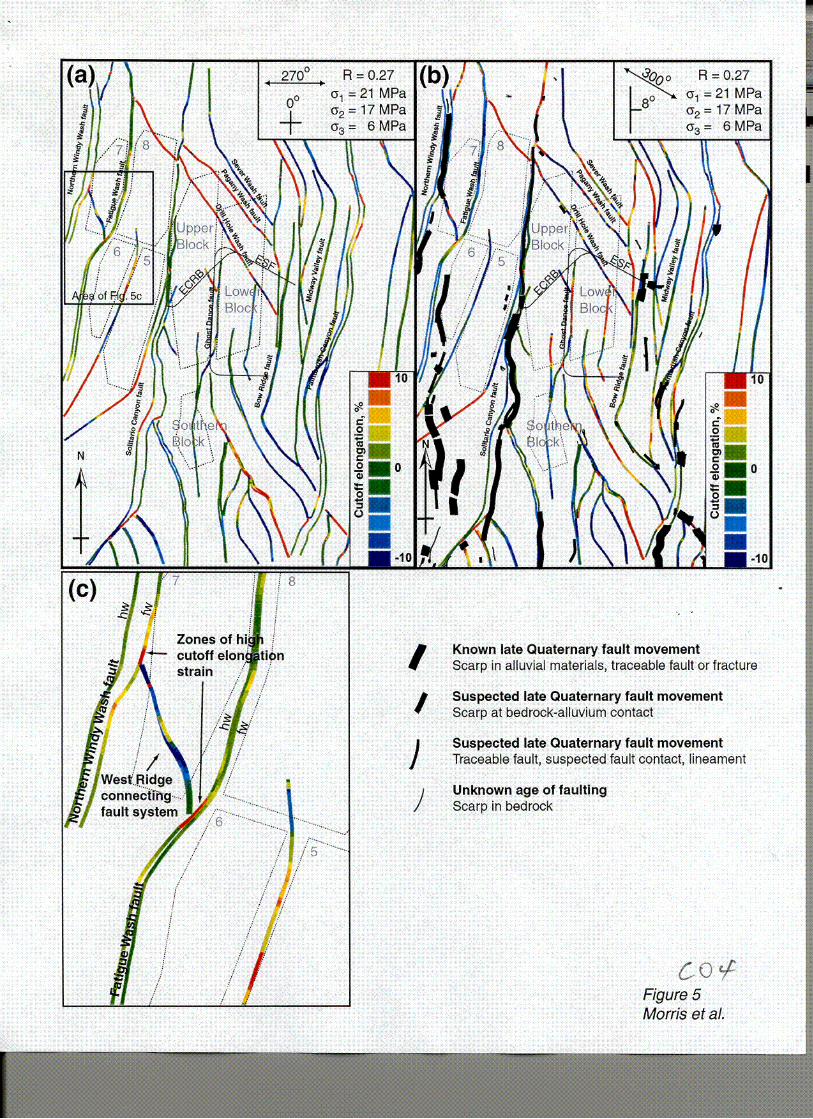
1996]. Therefore, at about 13 Ma the cutoff elongation strains at Yucca Mountain could be
portrayed by Fig. 5a. The principal source of uncertainty in Fig. 5a is the number of faults
represented; it is likely that many of the faults shown would not have existed and those that did
were shorter and accommodated less displacement than those in Fig. 5a. Currently, the regional
extension direction is 3000, the stress magnitude ratio R remains low at approximately 0.25 to
0.3 [Morris et al., 1996), and the stratal dip is approximately 80 E tan average based on data
from the DOE Geologic Framework Model [CRWMS M&O, 2000]). Thus, Fig. 5b represents
the cutoff elongation strain resulting from the latest increment of fault slip at Yucca Mountain.
Constraints on young faulting activity are provided by the mapping of Simonds et al. [1995].
Their results show that the western Yucca Mountain fault system (especially the Windy Wash

13
fault) has been active in the late Quaternary (Fig. 5b). Their mapping provides only a minimum
estimate of Quaternary fault activity, however, because bedrock against bedrock fault slip is
difficult to date [Simonds et al., 1995]. Figs. 5a and 5b, therefore, place reasonable bounds on
the earliest and latest increments of cutoff elongation strain at Yucca Mountain.
3.3. Strike-perpendicular distributed deformation
Displacement patterns on the four dominant faults at Yucca Mountain (Fig. 6) indicate
that they have operated as part of a segmented fault system in which the collective assemblage of
faults have a coherent cumulative displacement [e.g., Peacock and Sanderson, 1994; Huggins et
al., 1995; Dawers and Anders, 1995], and therefore have the potential to rupture in concert in the
event of a major earthquake [Ferrill et al., 1999a]. The Paintbrush Canyon and Solitario Canyon
faults, for example, have an antipathetic displacement relationship south of 4076000 (UTM
northing in meters) whereas the cumulative (combined) heave across the two faults varies
smoothly (Fig.6); north of 4076000 the antipathetic relationship continues, although the
cumulative heave of these faults decreases. This local decrease (deficit) in cumulative heave is in
part compensated for by the presence of both the Windy Wash and Fatigue Wash faults. Further
apparent heave deficit in the cumulative heave profile is not real, but rather is the result of data
truncation on the Northern Windy Wash and Fatigue faults at the western edge of the DOE
Geologic Framework Model [CRWMS M&O, 2000] volume. Transfer of displacement between
two overlapping extensional faults can be accomplished in a number of ways, for example
increased stratal dip in the area of interaction is commonly observed [Huggins et al., 1995]. Less
commonly reported is an increase in the number of smaller faults and fractures contributing to

14
the regional extension. Such an increase, however, is an important component of fault block
deformation in at least one location at Yucca Mountain.
4. Ghost Dance-Abandoned Wash fault system
Using a combination of geologic maps and data from the DOE Geologic Framework
Model [CRWMS M&O, 2000], we have identified an area of interaction between the Ghost
Dance and Abandoned Wash faults [Area 4 in figure 9a of Ferrill and Morris, 2001]. This area is
of especial interest because the Ghost Dance fault lies between the two fault blocks now
designated as the "Upper" and "Lower" blocks that originally constituted the proposed
repository site [Scott and Bonk, 1984], and is now pierced by the ESF (Fig. 7a). This area
represents one of the few opportunities to evaluate extremely detailed fault and fracture data in
the context of larger faults mapped by traditional field geological methods. Mapping of the ESF
Main Drift (approximately NS section) identified a 750 to 800 m long zone within the Topopah
Spring Tuff in which fracture frequency averages 4.2 fractures per meter (21 fractures per 5
meter interval) [Mongano et al., 1999; CRWMS M&O, 2000]. This zone is referred to as the
Intensely Fractured Zone (IFZ), and is dominated by fractures and faults that have strikes
between 1150 (at the north end) and 150° (at the south end) [Mongano et al., 1999; CRWMS
M&O, 2000] (Fig. 7c). The Main Drift of the ESF runs parallel to, and less than 250 m west of,
the Ghost Dance fault within its hanging wall. The IFZ is associated with the segment of highest
displacement on the Ghost Dance fault [Mongano et al., 1999; CRWMS M&O, 2000] (Fig. 7b).
Also plotted in Fig. 7c is a 5 meter running average of fracture frequencies along the ESF Main

15
Drift wherever this running average exceeds 20 fractures per 5-meter interval. Black lines at an
angle to the Main Drift indicate the dominant fracture orientation for each 500 meter segment of
the Drift [Mongano et al., 1999]. Orientation of the dominant fracture trends (strikes) along the
Main Drift contrast sharply with the NS strikes of the bounding faults. In fact, the NW-SE
dominant fracture trend seen in the Main Drift contrasts with the dominant fault trends at Yucca
Mountain in general (compare dominant fracture trends in Fig. 7c with Fig. 4a through c).
Most fractures within the IFZ are thought to be cooling joints influenced by extension
shortly after eruption of the tuffs [Buesch and Spengler, 1998]. Cutoff elongation caused by slip
on the Ghost Dance fault would have been appropriately oriented (sub-parallel to the strike of
the fault) to generate these local fracture orientations. We interpret the IFZ as the result of cutoff
elongation strains generated by displacement gradients developed on the Ghost Dance fault (e.g.,
Fig. 3a). If fractures in the IFZ are indeed related to both tuff cooling and fault displacement, the
Ghost Dance fault is at least as old as the Topopah Spring Tuff. Early activity on the Ghost
Dance fault, or a west-dipping, normal fault very close to the position of the Ghost Dance fault,
is also supported by a 1 km offset of the base Tertiary unconformity, interpreted from a seismic
line across Yucca Mountain that was acquired in 1994 [Brocher et al., 1998].
The broader history of development of the Ghost Dance and Abandoned Wash faults is
also illuminated by the displacement patterns illustrated in Fig. 7a,b. Displacement gradients
along a fault result from the cumulative slip history and reflect fault growth and linkage [e.g.,
Childs et al., 1995; Ferrill et al., 1999a]. For example, displacement maxima and minima can be
used to identify fault segments and provide insight into how small faults grow into larger faults
[e.g., Ferrill et al., 1999a]. An individual fault segment is defined as a portion of a fault between

16
two displacement minima and that exhibits a simple displacement maximum [Childs et al., 1995]
(Fig. 7a,b). At the stratigraphic level being investigated, each fault segment would have
propagated along strike from its initiation point, which now appears as the displacement
maximum near the center of the segment [Childs et al., 1995]. Displacement patterns on the
Ghost Dance and Abandoned Wash faults are consistent with the faults having propagated
southward and northward respectively and established an overlap zone - an extensional fault
relay ramp [e.g., Childs et al., 1995; Ferrill and Morris, 2001]. A connecting fault has been
mapped [Day et al., 1995, 1998a] that breaches the ramp and connects the Ghost Dance and
Abandoned Wash faults (Figs. 7 and 8). In common with many relay ramps, summing
displacement on the Ghost Dance and Abandoned Wash faults reveals local decrease or deficit
in the cumulative displacement in the area of overlap between the bounding faults [Childs et al.,
1995; Ferrill and Morris, 2001] (Fig. 7b). Such displacement deficits are compensated for by
deformation processes other than slip on the principal bounding faults. Common modes of
displacement compensation are increased synthetic bed dip in the relay ramp [e.g., Peacock and
Sanderson, 1994; Huggins et al., 1995] or, as here, increased density of faulting and fracturing
(Fig. 8). The area of overlap between the Ghost Dance and Abandoned Wash faults is one of
general displacement deficit (Fig. 7b) and contains numerous small faults (Fig. 7a). Fault density
(trace length per square km) is high in the general area of overlap (5.2 km / km2, see northern 1
km square in Fig. 8) and extremely high adjacent to the greatest displacement deficit (10.1
km'km2, see southern 1 km square in Fig. 8). The West Ridge connecting fault system is another
example at Yucca Mountain where local fault density is associated with displacement gradients
on larger scale faults (see analysis in Ferrill and Morris, 2001). As in the case of the IFZ, faults

17
in the West Ridge connecting fault system have NW-SE trends and are not consistent with the
dominant fault pattern. Instead, they represent local variability in smaller-scale fault block
deformation. The southern part of potential expanded repository Block 7 is within the West
Ridge connecting fault system (Fig. 5c). Based on this investigation, we conclude that
expansion of the proposed repository into other fault blocks would encounter areas with
significant variability in the fault and fracture network characteristics. This variability is, in part,
controlled by displacement patterns on block bounding faults.
5. Conclusions
Detailed analyses of the data available for the main repository block at Yucca Mountain
reveals that relationships exist between smaller faults and fractures and the larger faults. In
particular, displacement gradients on the larger faults have a strong influence on the orientation
and distribution of smaller faults and fractures. Two aspects of displacement gradient-driven
deformation are cutoff elongation and displacement deficit compensation.
Cutoff elongation and the resulting distribution and orientation of fractures within fault
blocks are sensitive to stress system and resulting slip directions at the time of faulting and initial
bed orientation. Analyses of strains generated by fault displacement gradients indicate that many
parts of Yucca Mountain may have experienced both extensional and contractional strains
greater than 2 or 3 %, sufficient to generate fractures. The variable extension direction at Yucca
Mountain since the inception of faulting (about 13 Ma) suggests that cumulative strain patterns
are likely complex and strains generated by fault displacement are more pervasive than a single
stress state "snapshot" would suggest. We have previously identified an area of interaction at

18
Yucca Mountain between the Northern Windy Wash and Fatigue Wash faults [area 1 in Ferrill
and Morris, 2001] (Fig. 1). This area, the West Ridge connecting fault system, has experienced
high cutoff elongation clearly manifest as a zone of steeply southwest dipping strata containing a
high concentration of mapped normal faults [Day et al., 1998a,b]. Both the Northern Windy
Wash and Fatigue Wash faults, in the area of the West Ridge connecting fault system, exhibit
high cutoff elongations (Fig. 5, Appendix 2).
Displacement deficit compensation is illustrated by the example of the Ghost
Dance-Abandoned Wash fault system. The area of overlap between these two faults exhibits a
marked cumulative displacement deficit. In addition, this area contains a large number of small
faults oriented sub-parallel to the larger faults and contributing to the overall extension. The fault
density in this locality is anomalously high, approximately twice that of surrounding areas
outside the influence of the displacement deficit zone.
We have shown that there is considerable variability (in terms of orientation and
intensity) in the fault and fracture framework of Yucca Mountain. As DOE considers expanding
the proposed repository area beyond the volume of rock between the Bow Ridge and Solitario
Canyon faults, it should be recognized that different fault blocks have experienced different
deformation histories, producing different strain states. Expansion to other fault blocks would
require analysis of each fault block with respect to fault and fracture populations. In order to
understand the fault and fracture framework of other fault blocks in relation to structural position
within the fault network, it is necessary to investigate the possibility that fault displacement
gradients have influenced strain intensity and caused variability in orientation and intensity of
small-scale faulting and fracturing in the fault blocks.

19
Appendices
Appendix 1. Fault and fracture data from the Exploratory Studies Facility are available in
electronic format from http://m-oext.ymp.gov/html/prod/db-tdp/sep/intemet/default.htm. Data
from the following files were used in this paper:
9606006A, 9606006B, 9609018, 9609020, 9708014A, 9708014B, 9711020, 9711021,
9711022, 9711023, 9711024, 9711025, 9711027.
Appendix 2. A series of 15 cutoff elongation maps were generated to illustrate the influence of
stress tensor R value (see equation in Section 3.1.1), direction of extension (a3), and stratal
orientation (dip) at the time of fault initiation. These cutoff elongation maps are illustrated in
Fig. Al, and controlling parameters are provided in Table Al.

20
Table Al. Magnitudes of maximum (or), intermediate (c2), and minimum (03) principal
compressive stresses, R values, extension directions, and original bed dips used for cutoff
elongation analyses are shown in maps A through 0 in Appendix 2
Map in Extension Original
Appendix 2 o• 02 03 R Direction Bed Dip
A 21 19 6 0.13 270 0
B 21 17 6 0.27 270 0
C 21 15 6 0.40 270 0
D 21 13 6 0.53 270 0
E 21 11 6 0.67 270 0
F 21 17 6 0.27 260 0
G 21 17 6 0.27 270 0
H 21 17 6 0.27 280 0
I 21 17 6 0.27 290 0
J 21 17 6 0.27 300 0
K 21 17 6 0.27 270 0
L 21 17 6 0.27 270 2
M 21 17 6 0.27 270 4
N 21 17 6 0.27 270 6
0 21 17 6 0.27 270 8

21
Acknowledgments
This paper was prepared to document work performed by the Center for Nuclear Waste
Regulatory Analyses (CNWRA) for the U.S. Nuclear Regulatory Commission (NRC) under
contract No. NRC-02-97-009. The activities reported here were performed on behalf of the NRC
Office of Nuclear Material Safety and Safeguards, Division of Waste Management. This paper is
an independent product of the CNWRA and does not necessarily reflect the views or regulatory
position of the NRC. We thank Philip Justus for many discussions regarding faults and fractures
at Yucca Mountain. Reviews by H. Larry McKague, John Stamatakos and Wesley Patrick
significantly improved earlier versions of this paper. We also thank Rebecca Emmot for her
assistance with manuscript preparation.
References
Atwater, T. Implications of plate tectonics for the Cenozoic tectonic evolution of western North
America. Geol. Soc. Am. Bull., 81. 3513-3536, 1970.
Barton, C. C., and P. A. Hsieh, Physical and hydrologic-flow properties of fractures.
Washington, DC: Am. Geophys. Union, 1989.

22
Barton, C. C., and E. Larsen, Fractal Geometry of Two-Dimension Fracture Networks at Yucca
Mountain. Fundamentals of Rock Joints: Proc. of the International Symp. on
Fundamentals of Rock Joints. 0. Stephanson, ed. Sweden, Bjorkliden, pp. 77-84, 1985.
Barton, C. C., E. Larsen, W. R. Page, T. M. Howard, Characterizing Fractured Rock for
Fluid-Flow, Geomechanical, and Paleostress Modeling: Methods and Preliminary Results
from Yucca Mountain, Nevada. U.S. Geol. Surv. Open-File Rpt. 93-269, 1993.
Bott, M. H. P., The mechanics of oblique slip faulting. Geological Magazine, 96, 109-117, 1959.
Buesch, D. C., and R. W. Spengler, Character of the middle nonlithophysal zone of the Topopah
Spring Tuff at Yucca Mountain. Proc. of the 8th International Conf. on High Level
Radioactive Waste Management, 16-23, 1998.
Brocher, T. M., W. C. Hunter, and V. E. Langenheim, Implications of Seismic Reflection and
Potential Field Geophysical Data on the Structure Frame Work of Yucca
Mountain-Crater Flat Region, Nevada. Geol. Soc. Am. Bull., 110. 947-971, 1998.
Carr, W. J., Styles of Extension in the Nevada Test Site Region, Southern Walker Lane Belt; An
Integrated Volcano-Tectonic and Detachment Fault Model. Geol. Soc. Am. Memoir 176,
283-303, 1990.

23
CRWMS M&O, Geologic Framework Model (GFM 3.1) Analysis model report.
MDL-NBS-GS-000002 Rev 00 ICN 01. Las Vegas, Nevada: CRWMS M&O,
ACC: MOL. 20000121.0115, 2000.
CRWMS M&O, Yucca Mountain Science and Engineering Report. DOE/RW-0539. Las Vegas,
Nevada: DOE, Office of Civilian Radioactive Waste Management, Yucca Mountain Site
Characterization Office, 2001.
Childs, C., J. Watterson, J. J. Walsh, Fault overlap zones within developing normal fault
systems. J. Geol. Soc., London 152, 535-549, 1995.
Connor, C. B., and B. E. Hill, Three nonhomogeneous Poisson models for the probability of
basaltic volcanism: Application to the Yucca Mountain region, Nevada. J. Geophys. Res.,
94, 10,107-10,125, 1995.
Connor, C. B., J. A. Stamatakos, D. A. Ferrill, B. E. Hill, G. I. Ofoegbu, F. M. Conway, B.
Sagar, and J. Trapp, Geologic Factors Controlling Patterns of Small-Volume Basaltic
Volcanism: Application to a Volcanic Hazard Assessment at Yucca Mountain, Nevada. J.
Geophys. Res., 105, 407-432, 2000.
Dawers, N. H., and M. H. Anders, Displacement-Length Scaling and Fault Linkage. J. Struct.
Geol., 17, 607-614, 1995.

24
Day, W. C., R. P. Dickerson, C. J. Potter, D. S. Sweetkind, C. A. San Juan, R. M. Drake, II,
C. J. Fridrich, Bedrock geologic map of the Yucca Mountain area, Nye County, Nevada,
U.S. Geol. Surv. Misc. Invest. Ser. Map, 1-2627, 1998a.
Day, W. C., C. J. Potter, D. S. Sweetkind, R. P. Dickerson, and C. A. San Juan. Bedrock
Geologic Map of the Central Block Area, Yucca Mountain, Nye County, Nevada, U.S.
Geol. Surv. Misc. Invest. Ser. Map, 1-2601, 1998b.
Ferrill, D. A., Morris, A. P., Displacement gradient and deformation in normal fault systems. J.
Struct. Geol., 23, 619-638, 2001.
Ferrill, D. A., J. A. Stamatakos, and D. Sims. Normal Fault Corrugation: Implications for
Growth and Seismicity of Active Normal Faults. J. Struct. Geol., 21, 1,027-1,038, 1999a.
Ferrill, D. A., J. Winterle, G. Wittmeyer, D. Sims, S. Colton, A. Armstrong, A. P. Morris,
Stressed rock strains groundwater at Yucca Mountain, Nevada. GSA Today, 9(5), 1-8,
1999b.
Ferrill, D. A., J. A. Stamatakos, S. M. Jones, B. Rahe, H. L. McKague, R. H. Martin, and
A. P. Morris, Quaternary Slip History of the Bare Mountain Fault (Nevada) from the
Morphology and Distribution of Alluvial Fan Deposits. Geology, 24, 559-562, 1996a.

25
Ferrill, D. A., G. L. Stirewalt, D. B. Henderson, J. A. Stamatakos, K. H. Spivey, and
B. P. Wernicke, Faulting in the Yucca Mountain Region, Critical Review and Analyses
of Tectonic Data from the Central Basin and Range. NUREG/CR-6401. Washington,
DC: NRC, 1996b.
Fridrich, C. J., Tectonic Evolution of the Crater Flat Basin, Yucca Mountain Region, Nevada, in
Cenozoic Basins of the Death Valley Region. L. Wright and B. Troxel, eds. Geol. Soc.
Am. Special Paper 333, 169-196, 1999.
Harmsen, S. C. The Little Skull Mountain, Nevada, Earthquake of 29 June 1992: Aftershock
Focal Mechanisms and Tectonic Stress Field Implications. Bull. Seismol. Soc. Am., 84,
1,484-1,505, 1994.
Hoek, E. and E.T. Brown, The Hock-Brown Failure Criterion-A 1988 Update. 15 'h Canadian
Rock Mechanics Symp., 31-38, 1988.
Huggins, P., J. Watterson, J. J. Walsh, and C. Childs. Relay Zone Geometry and Displacement
Transfer Between Normal Faults Recorded in Coal-Mine Plans. J. Struct. Geol., 17,
1,741-1,755, 1995.
Mandl, G., Mechanics of Tectonic Faulting, Elsevier, New York, 1988.

26
Mongano, G. S., W. L. Singleton, T. C. Moyer, S. C. Beason, G. L. W. Eatman, A. L. Albin, and
R. C. Lung, Geology of the Enhanced Characterization of the Repository Block Cross
Drift - Exploratory Studies Facility, Yucca Mountain Project, Yucca Mountain, Nevada.
Denver, CO: Bureau of Reclamation and U.S. Geol. Surv., 1999.
Morris, A. P., D. A. Ferrill, and D. B. Henderson, Slip tendency analysis and fault reactivation.
Geology, 24, 275-278, 1996.
Oldow, J.S., Late Cenozoic Displacement Partitioning in the Northwestern Great Basin.
Geological Society of Nevada, Proceedings Volume, Walker Lane Symposium,
Structure, Tectonics & Mineralization of the Walker Lane, 17-52, 1992.
Peacock, D. C. P., and D. J. Sanderson, Geometry and Development of Relay Ramps in Normal
Fault Systems. Am. Assoc. Petrol. Geol. Bull., 78, 147-165, 1994.
Sawyer, D. R., R. J. Fleck, M. A. Lanphere, R. G. Warren, D. E. Broxton, and M. R. Hudson.
Episodic Caldera Volcanism in the Miocene Southwestern Nevada Volcanic Field:
Revised Stratigraphic Framework, 40 Ar/ 39 Ar Geochronology, and Implications for
Magmatism and Extension. Geol. Soc. Am. Bull., 106, 1,304-1,318, 1994.

27
Scott, R. B. and J. Bonk. Preliminary Geologic Map of Yucca Mountain, Nye County, Nevada
with Geologics. U.S. Geological Survey Open-File Report 84-494, U.S. Geol. Surv.,
1984.
Simonds, W. F., J. W. Whitney, K. Fox, A. Ramelli, J. C. Yount, M. D. Carr, C. D. Menges, R.
Dickerson, and R. B. Scott. Map of Fault Activity of the Yucca Mountain Area, Nye
County, Nevada. U.S. Geol. Surv. Misc. Invest. Ser. Map, 1-2520, 1995.
Snow, J. K. and B. P. Wernicke. Cenozoic Tectonism in the Central Basin and Range:
Magnitude, Rate, and Distribution of Upper Crustal Strain. Am. J. Sci., 300, 659-719,
2000.
Stock, J. M. and J. H. Healy. Stress Field at Yucca Mountain, Nevada, Geologic and Hydrologic
Investigations of a Potential Nuclear Waste Disposal Site at Yucca Mountain, Southern
Nevada. U.S. Geol. Surv. Bull. M. D. Carr and J. C. Yount, eds. 1790, 87-94, 1988.
Sweetkind, D. S., L. 0. Anna, S. C. Williams-Stroud, and J. A. Coe, Characterizing the Fracture
Network at Yucca Mountain, Nevada, Part 1: Integration of Field Data for Numerical
Simulations, Fractured Reservoirs. Characterization and Modeling Guidebook-1997.
T. E. Hoak, P. K. Blomquist, and A. Klawitter, eds. Denver, Colorado: Rocky Mountain
Assoc. Geol., 185-196, 1997.

28
Trudgill, B., and J. Cartwright, Relay-Ramp Forms and Normal-Fault Linkages, Canyonlands
National Park, Utah. Geol. Soc. Amer. Bull., 106, 1,143-1,157, 1994.
Twiss, R. J., and E. M. Moores. Structural Geology. New York, New York: W.H. Freeman and
Company, 1992.
U.S. Department of Energy, Viability Assessment of a Repository at Yucca Mountain, Volume
3: Total System Performance Assessment, DOE/RW-0508/V3. U.S. Dept. Energy,
Office of Civilian Radioactive Waste Management, Yucca Mountain Site
Characterization Office, Las Vegas, NV, 1998.
U.S. Geological Survey, North America Shaded Relief Map, Editorial. U.S. Geol. Surv., EROS
Data Center, Reston, Virginia. <http:H/nationalatlas.gov/atlasftp.html>, 1999.
Young, S. R., A. P. Morris, and G. L Stirewalt, Preliminary Structural Interpretation of
Reflection Seismic Line AV-1. CNWITRA 92-024. San Antonio, Texas: CNWRA, 1992a.
Young, S. R., G. L. Stirewalt, and A. P. Morris, Geometric Models of Faulting at Yucca
Mountain. CNWRA 92-008. San Antonio, Texas: CNWRA, 1992b.
Zoback, M. L., R. E. Anderson, and G. A. Thompson, Cainozoic Evolution of the State of Stress
and Style of Tectonism of the Basin and Range Province of the Western United States.

29
Philosophical Transactions of the Royal Society of London, Royal Soc. of London, A300,
407-434, 1981.

30
Figure captions
Figure 1. (a) Shaded relief map (from U.S. Geological Survey, 1999) showing location of Yucca
Mountain within Walker Lane and Basin and Range physiographic province (after Twiss and
Moores; Fig. 1 in Oldow, 1992). (b) Location map of Yucca Mountain illustrating potential
repository emplacement areas (yellow outlines) [CRWMS M&O, 2001], principal faults (red
lines) [Day et al., 1998a], and the surface projections of the two tunnels (blue lines): Exploratory
Studies Facility (ESF), and the Enhanced Characterization of the Repository block (ECRB).
Background is a Landsat Thematic Mapper image.
Figure 2. Views of the Geologic Framework Model version 3.1 [CRWMS M&O, 2000].
(a) View of the model from the ground surface down to the top of the Repository Host Horizon
(RHH). (b) View of the model showing the top of the RHH and underlying stratigraphy to
illustrate the fault gaps. The ESF is displayed as a solid yellow line where it lies above the RHH
and a dashed yellow line where it lies within it. The Ghost Dance-Abandoned Wash fault
system is highlighted by a gray rectangle. (c) View of the RHH cutoff lines against faults
modeled within the Geologic Framework Model. The cutoff lines are used to construct fault
surfaces between the hanging wall and footwall cutoff lines, the model is then placed in a stress
tensor field - in this case ("1 = vertical, 21 MPa, Y2 = horizontal, azimuth 0000, 17 MPa, and Y3 =
horizontal, azimuth 2700, 6 MPa. Here bedding is assumed to have been horizontal prior to fault
motion. Cutoff elongations are calculated for each segment of each cutoff line and displayed
color-coded according to the scale.

31
Figure 3. Displacement gradients and distributed deformation. (a) Cutoff elongation strain
developed as a result of a propagating normal fault. Deformation is depicted as being
preferentially partitioned into the hanging wall because this is likely common at Yucca Mountain
[Ferrill and Morris, 2001]. (b) Displacement deficit compensation and cutoff elongation within
an extensional relay ramp combine to develop a network of small faults sub-parallel to, and a
connecting fault oblique to the regional trend respectively.
Figure 4. Circular histograms of features indicating fault strikes at Yucca Mountain.
(a) Cumulative fault trace length I data from Geologic Framework Model version 3.1 [CRWMS
M&O, 2000] 1, (b) Fault segment length weighted by cumulative EW heave I data from Geologic
Framework Model version 3.1 [CRWMS M&O, 2000]), (c) Scarps and lineaments in alluvium
indicating probable late Quaternary fault motion (data from Simonds et al., 1995), (d) Fault
traces, bedrock-alluvium contacts and other features indicating possible late Quaternary fault
motion (data from Simonds et al., 1995).
Figure 5a,b. Maps of traces of faults at Yucca Mountain where they intersect with the RHH
I data extracted from the DOE Geologic Framework Model version 3.1 [CRWMS M&O, 2000]).
The cutoff elongation for each segment of the cutoff lines is displayed color-coded according to
the scale in 2 % increments. All cutoff lines in each map are modeled as subject to the same
stress tensor throughout the map and assuming the same initial (pre-faulting) bedding
orientation, different maps illustrate different conditions of stress and initial bedding orientation
and these conditions are shown in the inset at top right of each map. (a) Likely stress conditions
32
at Yucca Mountain 12.8 million years ago. (b) Likely stress conditions at Yucca Mountain now.
Also shown are the locations of evidence for late Quaternary age faulting [Simonds et al., 1995].
(c) Detail of the West Ridge connecting fault system under conditions existing at 12.8 Ma. The
high positive extensions on the sections of the Northern Windy Wash and Fatigue Wash faults
correspond to the location of the connecting fault system that has developed to accommodate
these strains. The actual geometry of the connecting fault system is more complicated than
modeled by the DOE Geologic Framework Model [Day et al., 1998a; Ferrill and Morris, 2001].
Figure 6. East-west component of horizontal displacement (heave) on the major faults at Yucca
Mountain. Plotted here are the heave profiles for the Solitario Canyon, Paintbrush Canyon,
Northern Windy Wash, and Fatigue Wash faults. In addition, the cumulative (combined) heave
of these four faults is shown together with the cumulative heave of all faults within the DOE
Geologic Framework Model. Bold vertical lines at the ends of lines indicate the points at which
the faults are truncated by the edges of the model.
Figure 7. The Ghost Dance-Abandoned Wash fault system. (a) Map from Day et al. [1998a]
with the Ghost Dance and Abandoned Wash faults highlighted together with the connecting fault
that breaches the extensional relay ramp between the two faults (see Fig. 8 for key). (b) Throw
profiles of the Ghost Dance-Abandoned Wash fault system using data from the DOE Geologic
Framework Model [CRWMS M&O, 2000]. (c) Outline map illustrating segment analysis of the
Ghost Dance-Abandoned Wash fault system. Also shown are the predominant fault and

33
fracture orientations for each 500 m section of the ESF Main Drift, and the fracture frequency
(f/5 m) profile (calculated at 5 meter intervals) along the Main Drift of the ESF [Mongano et al.,
1999].
Figure 8. Detail from geological map by Day et al. [1998a]. The two, one kilometer square areas
used to calculate the fault densities are outlined. Fault density for the southern area, which
contains the fault network developed as a result of displacement deficit in the linked Ghost
Dance-Abandoned Wash fault system, is approximately 10.1 km/km2 . Fault density in the
northern area is approximately 5.2 km/km2.
Figure Al. Cutoff elongation maps of Yucca Mountain faults based on data extracted from the
DOE Geologic Framework Model [CRWMS M&O, 2000], cutoff lines are color-coded
according to the scale from -10 % to +10 % in 2 % increments. Values and orientations of the
principal stresses and initial stratal orientations for each map are given in Table Al.

-120' -100o
jC
.12Oo -10o°
Figure Ia Morris at at. C

UJU
Figure lb Moris et al.
£02-4

(a)
(b) Area of Ghdst Dance Figure 8
West Ridge fault 'fault
Northern Windy Wash fault
FatigueWash fault
Solitario Canyon fault
Iron Ridge fault
ESF North Ramnp
Abandoned Wash fault intbrush Canyon fault
Bow Ridge fault
0
(c)
01
I~
1
Cutoff elongation
Figure 2 Morris et al.
V-6O0m
-0

(b)
connecting
network of small faults sub-parallel to the regional trend
Figure 3 Morris et aL
(a)

(a)
- domina extensi4
W-v directio
,nt on j n
I, #
dominant / extension direction
NI
500 m -E
- dominant "extension
W - direction
SI t
S
Figure 4 Morris et aL
(b)
/
NNI
5000 m -Edominant extension direction 2500 m
It / I#
-E
/
(c)
S
(d)N
1rI
If
500 m-E
If
S
I
I
I
I
I I
Known late Quaternary fault movement Scarp in alluvial materials, traceable fault or fracture
Suspected late Quaternary fault movement Scarp at bedrock-alluvium contact
Suspected late Quaternary fault movement Traceable fault, suspected fault contact, lineament
Unknown age of faulting Scarp in bedrock
Figure 5 Morris et al.
//
I
'I

1D
C) (U
(Il
800
700
600
500
400
300
200
100
0 407
N~nrfh
4082000
Northing, UTM zone 11
Figure 6 Morris et al.
South
40780004074000
Cumulat ve heave, all fat Its
- - -umulative Hea6Ve-Fatigue -Paintbrush+Sditario+Windy
Sclitaria Canyon Frult -{WnYWs
a ntbrusl Canyon-Fault
/Fatigue Wash Fault
Limit of model data ----------
O0000

000 L99
it6t w
C 0 0 0 0 0O
t 22
E C5
......... . . . .. .
oo L U

Fault density = 5.2 km/km2
NMW ýU
Fault density = 10.1 km/km 2 __j
Map Legend
1tI Finult - Ball and Mar on
owthrowT sie no-n kninndMing. ak~ i'o'diotos reoandf.
Doubleibartod a'.o indiates dip of faukt planoe
SR..er. Fault
Bad. Skkand dip of badding
12 It StrIk~ and! cp of bedding
calculated from ffiappý contacts
,a Bad atiknd dip of conipootiot foliatifon
UnImproend road
ono o-Mrnr atojnAnd'a ui
IcOa-~~ cOa
To~tn,.A~,.~~ati.~CZf~c
yr ~ ~ ~ Fg r 8,t~,NowY~~~cmi~
btO ~ ~ ~ ori etty Mko.Paivft~f.h& o

I.
rL Z
C07