Embed Size (px)
Citation preview
1
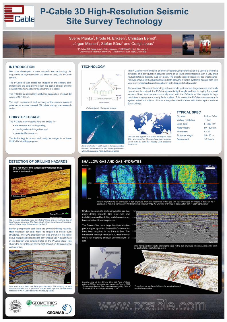
P-CABLE 3D HIGH-RESOLUTION SEISMIC SITE SURVEY TECHNOLOGY Sverre Planke1, Frode N. Eriksen1, Christian Berndt2, Jürgen Mienert3, Stefan Bünz3, and Craig Lippus4 1P-Cable 3D Seismic AS, Oslo Innovation Park, 0349 Oslo, Norway; 2GEOMAR, 24148 Kiel, Germany; 3University of Tromsø, 9037 Tromsø, Norway; and 4Geometrics, San Jose, California
Seismic acquisition, site surveys, drilling safety, core-log-seismic integration, CHIKYU+10
SUMMARY Three-dimensional (3D) seismic data provide unique images of the sub-surface, and is routinely acquired by the industry prior to drilling. However, 3D seismic data are not commonly available for scientific boreholes. This is mainly due to the high acquisition cost of conventional 3D surveys. We have developed a new cost-efficient technology for acquisition of high-resolution 3D seismic data, the P-Cable system. The technology is very well suited for imaging of the sub-surface around scientific boreholes. Small cubes (10 to 50 km2) with high-resolution (50-250 Hz) seismic data can be acquired in 3 to 10 days using existing research vessels. Currently, five P-Cable3 systems are available by academic and commercial operators.
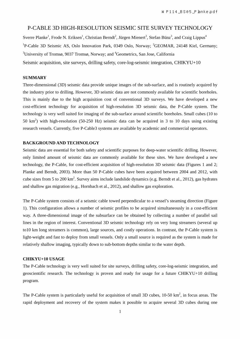
BACKGROUND AND TECHNOLOGY Seismic data are essential for both safety and scientific purposes for deep-water scientific drilling. However, only limited amount of seismic data are commonly available for these sites. We have developed a new technology, the P-Cable, for cost-efficient acquisition of high-resolution 3D seismic data (Figures 1 and 2; Planke and Berndt, 2003). More than 50 P-Cable cubes have been acquired between 2004 and 2012, with cube sizes from 5 to 200 km2. Survey aims include landslide dynamics (e.g. Berndt et al., 2012), gas hydrates and shallow gas migration (e.g., Hornbach et al., 2012), and shallow gas exploration. The P-Cable system consists of a seismic cable towed perpendicular to a vessel’s steaming direction (Figure 1). This configuration allows a number of seismic profiles to be acquired simultaneously in a cost-efficient way. A three-dimensional image of the subsurface can be obtained by collecting a number of parallel sail lines in the region of interest. Conventional 3D seismic technology rely on very long streamers (several up to10 km long streamers is common), large sources, and costly operations. In contrast, the P-Cable system is light-weight and fast to deploy from small vessels. Only a small source is required as the system is made for relatively shallow imaging, typically down to sub-bottom depths similar to the water depth.
CHIKYU+10 USAGE The P-Cable technology is very well suited for site surveys, drilling safety, core-log-seismic integration, and geoscientific research. The technology is proven and ready for usage for a future CHIKYU+10 drilling program. The P-Cable system is particularly useful for acquisition of small 3D cubes, 10-50 km2, in focus areas. The rapid deployment and recovery of the system makes it possible to acquire several 3D cubes during one
WP114_BS05_Planke.pdf
2
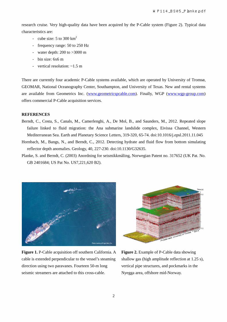
research cruise. Very high-quality data have been acquired by the P-Cable system (Figure 2). Typical data characteristics are:
- cube size: 5 to 300 km2 - frequency range: 50 to 250 Hz - water depth: 200 to >3000 m - bin size: 6x6 m - vertical resolution: ~1.5 m
There are currently four academic P-Cable systems available, which are operated by University of Tromsø, GEOMAR, National Oceanography Center, Southampton, and University of Texas. New and rental systems are available from Geometrics Inc. (www.geometricspcable.com). Finally, WGP (www.wgp-group.com) offers commercial P-Cable acquisition services.
REFERENCES Berndt, C., Costa, S., Canals, M., Camerlenghi, A., De Mol, B., and Saunders, M., 2012. Repeated slope
failure linked to fluid migration: the Ana submarine landslide complex, Eivissa Channel, Western Mediterranean Sea. Earth and Planetary Science Letters, 319-320, 65-74. doi:10.1016/j.epsl.2011.11.045
Hornbach, M., Bangs, N., and Berndt, C., 2012. Detecting hydrate and fluid flow from bottom simulating reflector depth anomalies. Geology, 40, 227-230. doi:10.1130/G32635.
Planke, S. and Berndt, C. (2003) Anordning for seismikkmåling, Norwegian Patent no. 317652 (UK Pat. No. GB 2401684; US Pat No. US7,221,620 B2).
Figure 1. P-Cable acquisition off southern California. A cable is extended perpendicular to the vessel’s steaming direction using two paravanes. Fourteen 50-m long seismic streamers are attached to this cross-cable.
Figure 2. Example of P-Cable data showing shallow gas (high amplitude reflection at 1.25 s), vertical pipe structures, and pockmarks in the Nyegga area, offshore mid-Norway.
WP114_BS05_Planke.pdf
Selected P-Cable References
P-Cable, 2013
www.pcable.com
2013
Planke, S., Bünz, S., Berndt, C., Eriksen, O.K., Eriksen, F.N., and Lie, J.E., 2013. P-Cable high-resolution 3D seismic imaging of gas hydrates and shallow gas. EAGE Conference and Exhibition, London, UK, 9-13.6.13
2012
Berndt, C., Costa, S., Canals, M., Camerlenghi, A., De Mol, B., and Saunders, M., 2012. Repeated slope failure linked to fluid migration: the Ana submarine landslide complex, Eivissa Channel, Western Mediterranean Sea. Earth and Planetary Science Letters, 319-320, 65-74.
Eriksen, O.K., Berndt, C., Buenz, S., Eriksen, F.N., and Planke, S., 2012. Seismic characteristics of gas migration structures on the North Atlantic Margin imaged by high-resolution 3D seismic. EAGE Conference and Exhibition, Copenhagen, Denmark, 4-7.6.12.
Hornbach, M., Bangs, N., and Berndt, C., 2012. Detecting hydrate and fluid flow from bottom simulating reflector depth anomalies. Geology, 40, 227-230.
2011
Bangs, N., Hornbach, M., and Berndt, C., 2011. The mechanics of intermittent methane venting at South Hydrate Ridge inferred from 4D seismic surveying. Earth and Planetary Science Letters, 310, 105-112.
Crutchley, G., Berndt, C., Klaeschen, D., and Masson, D.G., 2011. Insights into active deformation in the Gulf of Cadiz from new 3D seismic and high-resolution bathymetry data. Geochemistry, Geophysics, Geosystems, 12, Q07016.
Eriksen, O., Berndt, C., Bünz, S., Eriksen, F.N., and Planke, S., 2011. Styles of shallow gas migration and accumulation on the Norwegian continental margin (expanded abstract). EAGE Conference and Exhibition, Vienna, Austria, 23-26.05.11.
Karstens, J., 2011. 3D seismic interpretation of volcanic mass wasting deposits offshore Montserrat. Master thesis, IFM-Geomar, 68 pp.
Perez-Garcia, C., Berndt, C., Klaeschen, D., Mienert, J., Haffert, L., Depreiter, D., and Haeckel, M., 2011. Linked halokinesis and mud volcanism at the Mercator Mud Volcano, Gulf of Cadiz. Journal of Geophysical Research, 116, B05101.
Plaza-Faverola, A., Bunz, S., and Mienert, J., 2011. Repeated fluid expulsion through sub-seabed chimneys offshore Norway in response to glacial cycles. Earth and Planetary Science Letters, 305, 297-308.
Wrona, T., 2011. Analysis of the comparability of two 3D seismic data sets of Hydrate Ridge. Diploma thesis, IFM-Geomar, 70 pp.
2010
Petersen, C.J., Bünz, S., Hustoft, S., Mienert, J., and Klaeschen, D., 2010. High-resolution P-Cable 3D seismic imaging of gas chimney structures in gas hydrated sediments of an Arctic sediment drift. Marine and Petroleum Geology, 27, 1981-1994.
Planke, S., Eriksen, O.K., Mienert, J., Buenz, S., Berndt, C., Lie, J.E., and Eriksen, F.N, 2010. P–Cable high-resolution seismic imaging of shallow gas in the Barents Sea. EAGE conference, Barcelona, 14 -17.6.10.
Pre-2010
Planke, S., Eriksen, F.N., Berndt, C., Mienert, J., and Masson, D.G., 2009. P-Cable high-resolution 3D seismic. Oceanography, 22, 81.
Planke, S., and Berndt, C., 2007. Apparatus for seismic measurements. US Pat. No. US 7,221,620 B2.
Vanneste, M., Berndt, C., Laberg, J.S., and Mienert, J., 2007. On the origin of large shelf embayments on glaciated margins—effects of lateral ice flux variations and glacio-dynamics west of Svalbard. Quaternary Science Reviews, 26, 2406–2419.
Berndt, C., Perez-Garcia, C., Planke, S. Mienert, J., and Bünz, S., 2006. The plumbing system of the Håkon Mosby Mud Volcano - New insights from high-resolution 3D seismic data. AAPG/GSTT Hedberg Conference. Port-of-Spain, Trinidad and Tobago, 5-7.6.06.
Mienert, J., Bünz, S., Planke, S., and Berndt, C., 2005. Forskningstokt til en leirevulkan. Geo, 8 (6), 34-35.
Planke, S., and Berndt, C., 2004. Apparatus for seismic measurements. UK Pat. No. GB 2401684.
Planke, S., Mienert, J., Berndt, C., and Åsheim, S., 2004. Ny metode for innsamling av høyoppløselig 3D seismikk. Geo 7, (6), 24-25.
Planke, S., and Berndt, C., 2003. Anordning for seismikkmåling, Norwegian Patent no. 317652 (UK Pat. No. GB 2401684; US Pat. No. US7,221,620 B2).