Embed Size (px)
Citation preview

An intelligent framework of Automatic Weather Station
Jun Liu, Binbin Zhang, Baolei Lv
Huayun Sounding (Beijing) Meteorological Technology Co., Ltd.
No.46 Zhongguancun South Street Beijing China (100081)
ABSTRACT
The traditional Automatic Weather Station (AWS) framework is generally composed of datalogger
and sensors. A new framework based on Wireless Sensor Network (WSN) is proposed in this
paper. There are two layers we called device layer and application layer respectively in the new
intelligent framework. Analog signal acquisition, meteorological factor calculation and formatted
output are assembled at the device frontend (or layer). The application layer is formed by at least
one embedded system, which can be used for real time data collection, data quality control,
extreme value statistic, information dispatch and other complex functions as well. We design and
produce a comprehensive weather station named CAWSmart under the new framework. The
CAWSmart has recognition intelligence, networking intelligence and diagnosis intelligence. With
the metrological system, the CAWSmart can archive calibration intelligence. This novel structure
has clearer layers, and better extensibility. Each observed factor will be more independent,
flexible and anti-destroyed. The device layer focus on observing stability, meanwhile the
application layer focus on functional extension. The observing system will be smarter with the
increment of different embedded software.
KEYWORDS
Automatic Weather Station (AWS), System Integration, Smart Sensor, Wireless Sensor Network
(WSN), Intelligent Framework
1 INTRODUCTION
The comprehensive observation plays a very important role in the meteorological modernization
procedure, of which the meteorological surface observation is the fundamental and essential
component. After about 20 years of rapid development, China has built a large-scale
meteorological observation network with tens of thousands of AWSs. In this magical
development process, we have the honor of taking part into, witnessing and contributing to the
construction of the automatic meteorological station network from the very beginning.
We have successfully developed two generations of AWSs, and the third generation R&D is
undergoing. In the 1990s, the first generation of AWS, named CAWS600, focused on system
integration techniques. Electronic signals of temperature, humidity, air pressure, precipitation,
wind direction, wind speed and other variables were converted to standard observation values
using industrial dataloggers, as shown in Figure 1. Based on these observational values, the PC
software generated a variety of weather messages and reports. The shortcoming of this kind of
station is its inextensibility.

Figure 1: CAWS600 Weather Station
The second-generation AWS, named CAWS3000, started its implementation in 2008. It applied
CAN (Controller Area Network) bus connection method and used a master datalogger to connect
multiple sub-dataloggers. Because of the application of CAN bus, the flexibility of sensor access
was greatly enhanced. It also had data quality control function. The CAWS3000 framework was
shown in Figure 2. This kind of station was widely used in meteorological observations. But it also
had its disadvantages, such as inconvenience of installation and maintenance and high use-cost.
Figure 2: Framework of CAWS3000 based on CAN bus
With the rapid progress of electronic and information technology, especially the IoT (Internet of
Things) technology, meteorological sensors are evolving towards high-precision, digitalization,
energy-efficiency and miniaturization. All those provide a precondition for a new generation of
AWS. In this paper, we propose a general idea of building the surface observation system based
on WSN. Guided by this idea we make a weather station with intelligent comprehensive

observation model. This smart weather stations can respond to equipment diagnosis and
numerical forecasting requirement.
2 INTELLIGENT AWS FRAMEWORK
Figure 3 shows the framework of intelligent meteorological station proposed in this paper. The
functional areas are well connected. Various users with different roles operate at different
specified layers. Under this framework, the system is divided into upper application layer and
lower device layer by gateways. The functions of analog signal acquisition, meteorological
element calculation and data output production are located in the device layer at the front end of
the equipment. The application layer consists of at least one embedded system, which can
operate data collection, data quality control, extreme statistics, information release and other
functions. The gateway is a very important device for its function of enabling communications
between two layers under communication protocols. The proper configuration of the gateway is
a key part of the whole system.
Figure 3: Intelligent framework of the new-generation AWS
2.1 DEVICE LAYER
The device layer is centered on the embedded system, with intelligent and networked sensor
units being assembled around. An embedded system is a dedicated computer system for specific
intelligent tasks, such as controlling, monitoring and assisting etc. Device layer contains a large
number of intelligent networked sensor units. Each sensor unit was composed of the acquisition
module, processing module, communication module and power module etc.
The acquisition module is the core part of the sensor unit by converting analog signal to digital

signal. The processing module consists of processor, memory, storage, interface and system
software. It generally uses low-power chip for energy efficiency. The communication module
includes radio-frequency circuits and wireless antennas to receive and transmit data. The power
module provides power to the system. To save energy and prolong battery life, a power
management software is installed in the processing module for dynamic power management.
With the interactive cooperation of the four modules, intelligent networked sensors are capable
of self-detection, self-correction and self-protection. Besides, it also has the capability of data
judgment, decision and formatting output in terms of calculation and duplex digital
communication.
2.2 APPLICATION LAYER
The application layer is the interface between application software and network to enable users
to interact with the device. The layer is composed of many job-specified applications and
software services. By all these application units, users can easily complete various interactions
with device layers about data, information and configuration.
Data service is the fundamental function in the application layer, as the high-quality data is
essentially what users want from the observation system. In a narrow sense, the data service
refers to sending the observational data to users through the network access port. In a broad
sense, the data service is able to integrate the weather station network into a comprehensive
observation network to complete the migration of bulk data from the observation system to the
meteorological service system. With big-data management and cloud computation technique,
the data could be well managed, while providing diverse user-friendly services.
Identification and network services are mainly used to improve the efficiency of building and
maintaining AWSs. Stringent security policy of WSN is adopted to inhibit illegal access. Under
these security protocols, the operational meteorological sensor need to be authorized before
connecting to intelligent weather station. The unauthorized sensors would be discerned and
eliminated automatically from the system. At the same time, using multi-gateway technology and
dual hot backup controller, sensors and terminal equipment can automatically choose secure
routes to build reliable links for real-time data synchronization.
It is important to know the system status for timely responses to potential device and service
failures. Such a function was achieved through status and diagnostic services. Specifically, the
service interface displays real-time system status information and fault alarm report that weather
stations generate automatically. Status information is important for data quality control and
information push. As to the diagnosis service, users can interact with the device in depth to
facilitate on-site debugging and maintenance by running a diagnostic program on intelligent
terminals.
Metering calibration service includes built-in calibration parameter configuration modules, which
work closely with automatic verification devices. Thanks to the service, it is convenient and
efficient to complete the site and further laboratory calibration process for each element sensor.
Under this novel framework, additional new service interfaces can be easily developed and
implemented in the application layer, which makes this new framework attractive.
3 THE KEY TECHNIQUES AND STANDARDS
3.1 THE USE OF WSN TECHNOLOGY

WSN is a kind of distributed sensor network, which combines sensor technology, embedded
processor technology, distributed information integration technology and communication
technology. It enables remote real-time monitoring, gathering and analyzing the data and
information by connecting to the internet. Since the WSN sensors communicating wirelessly, the
network is flexible and scalable. Meanwhile, the device installation, replacement and usage can
be very convenient by eliminating the limit on communications. From the aspects of transmission
characteristics, QoS (Quality of Service) requirements and mobility, the WSN structure design
should ensure the fairness of the nodes in the network and energy distribution balance in order
that WSN can work continuously and efficiently.
IoT employs technologies such as RFID (Radio Frequency Identification), WSN and wireless data
communication to construct a vast network of information that could theoretically identify
everything in the world. Therefore, the IoT technology can flexibly support WSN networks in
different sizes. WSN nodes can be merged into a certain size WSN network and then access to the
mobile communication system. These WSN nodes can be also directly connected to sensors with
a mobile terminal function through a mobile base station. Under this circumstance, these sensors
are both WSN nodes and WSN gateways.
Wireless communication technology is the foundation of WSN technology. In this section, we will
discuss the details of the wireless communication technologies and the standards used in
meteorological applications.
These communication technologies include ZigBee, WiFi, GPRS/3G/4G in Wireless
Communication as follows [1]-[11]
:
(1) ZigBee: ZigBee technology defines the network and application layer protocols based on the
IEEE 802.15.4 standard physical and MAC layer definitions. The definition is used to meet the
requirements to design a wireless personal area network (WPAN) using low power radio-enabled
devices. Due to its energy efficiency, low cost, and high reliability, the ZigBee technology is widely
preferred for WSN-based applications in the agricultural and farming sectors. ZigBee also
supports short-distance (10-20 m) data communication over multi-tier, decentralized, ad-hoc and
mesh networks. The ZigBee-enabled devices have a low-duty cycle, which makes it suitable for
the applications where periodic information update is required. For example, it is broadly used in
agricultural applications like irrigation management, pesticide and fertilizer control, water quality
management. Furthermore, it has other advantages such as requiring low specification hardware
(such as microprocessor with 50-60 kb memory) and including security encryption techniques.
However, ZigBee applications only support low data transmission rates of 20-40 kbps and 250
kbps at respectively 868/915 MHz and 2.4 GHz frequencies of ISM band.
(2) WiFi: WiFi is a wireless local area network (WLAN) standard for information exchange. It also
enables Internet connection wirelessly based on the IEEE 802.11 standards family (IEEE 802.11,
802.11a/b/g/n). Currently, it is the most widely used wireless technology in devices ranging from
smart phones and tablets to desktops and laptops. WiFi provides a decent communication range
in the order of ~20 m (indoor) to ~100 m (outdoor) with data transmission rate in the order of
2-54 Mbps at 2.4 GHz frequency of ISM band. In agricultural applications, WiFi broadens the use
of heterogeneous architectures by connecting multiple type of devices over an ad-hoc network.
(3) GPRS/3G/4G: GPRS is a packet data service for GSM based cellular phones. A data rate of
50-100 kbps is achieved in the 2G systems. However, in GPRS, throughput and delay are variable,
which depend on the number of users sharing the same resource. The biggest advantage of GPRS
is to relieve the communication range limitation of wireless devices. Any two devices can
communicate as long as they are within the GSM service area. It worth noting that it is better
suited for the periodic monitoring applications than the real-time tracking-type applications. The
advanced version of GPRS is Enhanced Data rates for Global Evolution (EDGE), which offers
increased data transmit rate with no hardware/software modifications in the GSM core networks.
3G and 4G are the third and fourth generations of mobile communication technology. The
corresponding data transmit rate achieved in these technologies are 200 kbps and 100 Mbps-1
Gbps in respectively 3G and 4G.
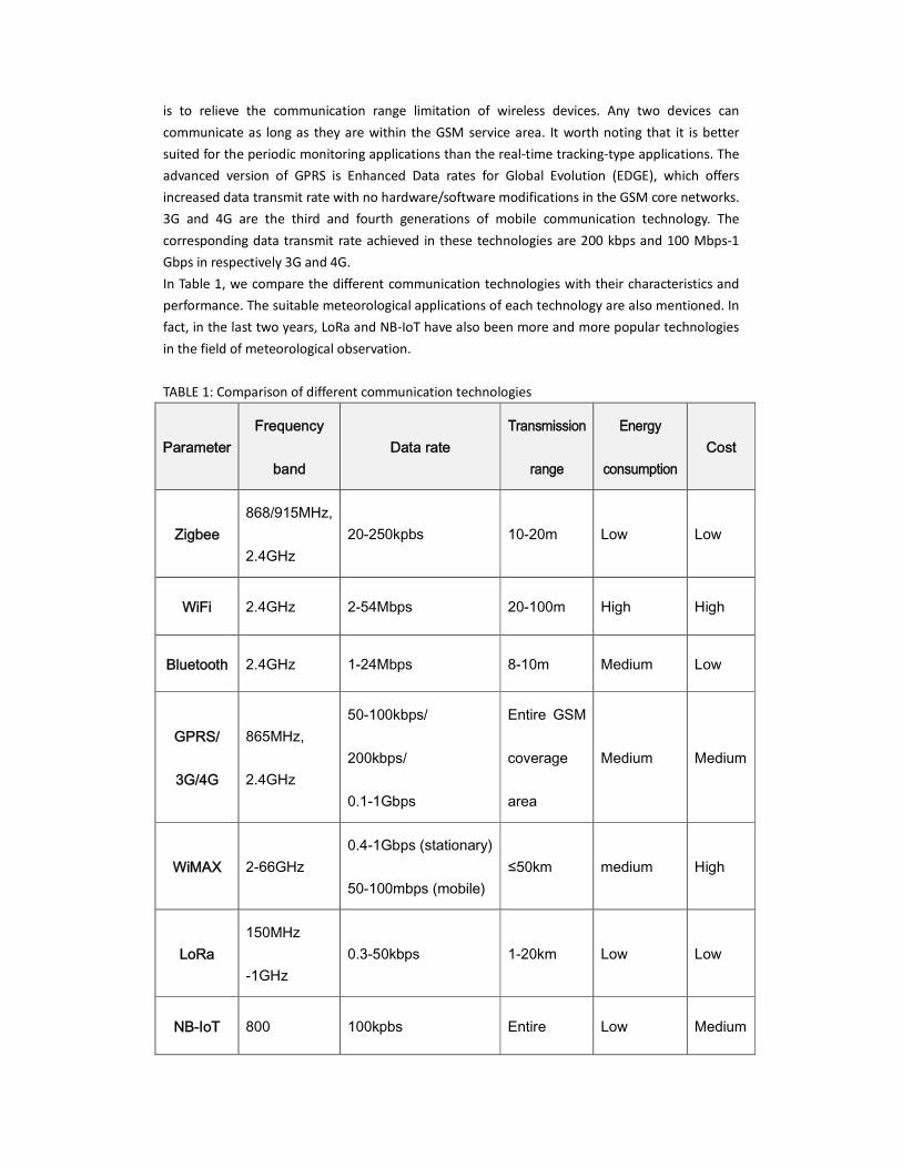
In Table 1, we compare the different communication technologies with their characteristics and
performance. The suitable meteorological applications of each technology are also mentioned. In
fact, in the last two years, LoRa and NB-IoT have also been more and more popular technologies
in the field of meteorological observation.
TABLE 1: Comparison of different communication technologies
Parameter Frequency
band Data rate
Transmission
range
Energy
consumption Cost
Zigbee 868/915MHz,
2.4GHz 20-250kpbs 10-20m Low Low
WiFi 2.4GHz 2-54Mbps 20-100m High High
Bluetooth 2.4GHz 1-24Mbps 8-10m Medium Low
GPRS/
3G/4G
865MHz,
2.4GHz
50-100kbps/
200kbps/
0.1-1Gbps
Entire GSM
coverage
area
Medium Medium
WiMAX 2-66GHz 0.4-1Gbps (stationary)
50-100mbps (mobile) ≤50km medium High
LoRa 150MHz
-1GHz 0.3-50kbps 1-20km Low Low
NB-IoT 800 100kpbs Entire Low Medium

-2100MHz Signal
coverage
area
The factors associated with WSNs that need further attention are listed as follows.
Cost
A low-cost solution is always in need for increasing the applicable scope and outreach of WSNs.
Autonomous Operation
The future solutions should include the provision for autonomous operations surviving for a long
time.
Intelligence
An inherent intelligence will enable the futuristic solutions to dynamically react to multiple
challenges, from conserving energy to real-time response.
Portability
For easy use of an application, portability is essentially required. Recent advances in embedded
systems, such as System in package (SiP) and SoC technologies will definitely help in this regard.
Low Maintenance
It is important to design a system which would operate with minimum maintenance effort. Low
maintenance will certainly minimize the average cost in the long run.
Energy-efficiency
To extend the system lifetime of autonomous operation, the solutions need to be more
energy-efficient by incorporating low-power chips and intelligent algorithms.
Robust Architecture
A robust and fault-tolerant architecture for the emerging applications is required to ensure
sustained operation and low maintenance effort.
Ease of Operation
Typically, the end users of these applications are non-technical persons, whose might not fully
understand underlying structures and theories. Therefore, applications need to be user-friendly
with low learning curve.
Interoperability
Interoperability between different components and different communication technologies will
enhance the overall functionality of the system. [11]
3.2 THE USE OF IEEE1451 STANDARD
IEEE1451 standard series, launched by IEEE and NIST, set up a general framework of the
intelligent networked sensor to solve the interoperability between different smart sensors and
interchangeability. The IEEE1451 specifies the sensor, converter, machinery and network to build
a common interface between compatible and interchangeable converter. Such a structure can
ease the sensor manufacturers in designing the interface and enable them focus on the
development of sensor itself. The standard has greatly promoted the development of networked
intelligent sensor technology. Based on IEEE1451 standard, the IP sensor has developed the
intelligent sensor information model. The IP sensor has retained the smart transducer interface
module (STIM) structure and function of the IEEE1451 standard. Instead, they extended the TEDS
to communicate with TCP/IP network protocol, which lowered the use threshold and cost. [12]-[13]
Under IEEE 1451, a sensor/actuator system is divided into two parts, a Transducer Interface
Module (TIM) and a Transducer Electronic Data Sheet(TEDS). The TIM contains the sensing,
actuating element and signal-conditioning circuits. Each TIM is connected to a network-capable
applications processor(NCAP), which provides an interface to any network by a subset of the IEEE
1451 standard. The TEDS digital data identifies the type of sensor, its calibration information, and
scale factor etc.
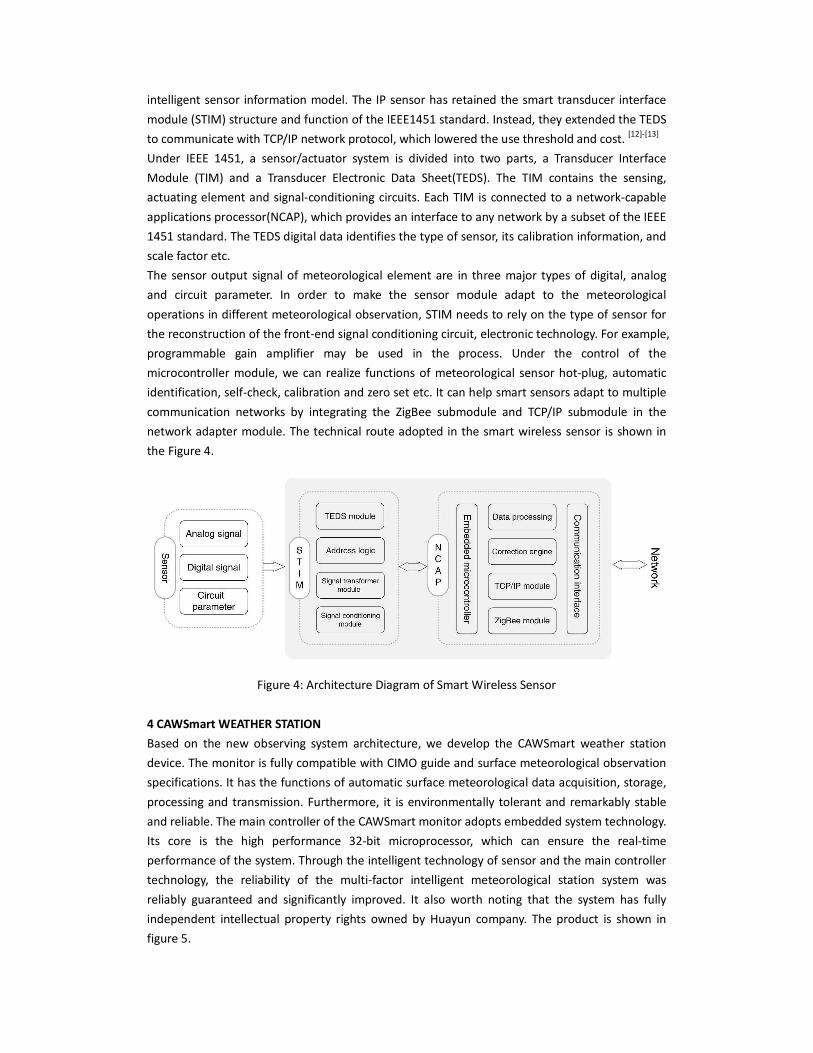
The sensor output signal of meteorological element are in three major types of digital, analog
and circuit parameter. In order to make the sensor module adapt to the meteorological
operations in different meteorological observation, STIM needs to rely on the type of sensor for
the reconstruction of the front-end signal conditioning circuit, electronic technology. For example,
programmable gain amplifier may be used in the process. Under the control of the
microcontroller module, we can realize functions of meteorological sensor hot-plug, automatic
identification, self-check, calibration and zero set etc. It can help smart sensors adapt to multiple
communication networks by integrating the ZigBee submodule and TCP/IP submodule in the
network adapter module. The technical route adopted in the smart wireless sensor is shown in
the Figure 4.
Figure 4: Architecture Diagram of Smart Wireless Sensor
4 CAWSmart WEATHER STATION
Based on the new observing system architecture, we develop the CAWSmart weather station
device. The monitor is fully compatible with CIMO guide and surface meteorological observation
specifications. It has the functions of automatic surface meteorological data acquisition, storage,
processing and transmission. Furthermore, it is environmentally tolerant and remarkably stable
and reliable. The main controller of the CAWSmart monitor adopts embedded system technology.
Its core is the high performance 32-bit microprocessor, which can ensure the real-time
performance of the system. Through the intelligent technology of sensor and the main controller
technology, the reliability of the multi-factor intelligent meteorological station system was
reliably guaranteed and significantly improved. It also worth noting that the system has fully
independent intellectual property rights owned by Huayun company. The product is shown in
figure 5.

Figure 5: CAWSmart weather station, Data Collection Center software and applications
The system can meet the needs of both weather and climate observations. It is able to observe
the following meteorological elements as wind direction, wind speed, temperature, humidity,
precipitation, air pressure, ground temperature, soil moisture, frozen soil, evaporation, snow
depth, total radiation and net radiation, reflected radiation, diffuse radiation, direct radiation,
sunshine, cloud cover, cloud height, visibility, freezing rain and weather phenomenon. Specifically,
the weather phenomena of precipitation and ground coagulation can also be directly given by
the sensor. Other types of weather phenomena can be given by the comprehensive discriminant
algorithm embedded in the system. The system adopted the modular design. The sensors can
automatically identify and access the wireless sensor network to realize the adaptive intelligent
network. The users can select the sensor and auxiliary equipment of relevant elements according
their observation needs. These sensors and equipment can be easily assembled into a
professional observation station suitable for different station types. The sensor intelligent
technology has the functions of automatic zero adjustment, compensation, calibration, quality
control, equipment status report and self-diagnosis. The system uses low power consumption,
high accuracy, high stability measurement technology and short distance wireless communication
technology. These technological features lay a solid foundation for the intelligence and reliability
of the surface observations. [14]
Product measurement performances are as follows in Table 2.
Table 2: Sensor measurement specification
Measure
elements Measurement range Resolution Maximum permissible errors
Temperature -60~60℃ 0.1℃ ±0.1℃
Humidity 5~100%RH 1%RH ±3%RH (≤80%)
±5%RH (>80%)
Air pressure 450~1100hPa 0.1hPa ±0.25hPa
Precipitation Tipping bucket:
0~4mm/min 0.1mm
±0.4mm (≤10mm)
±4% (>10mm)

Weighting:0~400mm 0.1mm ±0.1%FS
Wind speed 0~75m/s 0.1m/s ±0.5m/s (≤5m/s)
±10% (>5m/s)
Wind direction 0~360° 3° ±5°
Ground
temperature -50~80℃ 0.1℃ ±0.5℃
Soil temperature -50~80℃ 0.1℃ ±0.3℃
Soil moisture 0~100%RH 1%RH ±5% (in field)
Evaporation 0~100mm 0.1mm ±0.2mm (≤10mm)
±2% (>10mm)
Snow depth 0~150cm 0.1cm ±1cm
Cloud cover 0~100% 1% ±5%
Cloud height 0~15km 10m ±10m (≤100m)
±10% (>100m)
Visibility 10m~35km 1m ±10% (10m~10km)
±15% (10km~35km)
Sunshine duration 0~24h 1min ±0.1h
Radiation 0~2000W/m2 5W/m
2 ±5%
The characteristics of the product are:
(1) Data acquisition unit and sensor processing unit are intelligently packaged. Data acquisition
unit and sensor processing unit fulfill automatic identification, automatic access and automatic
inspection.
(2) The unity and security of data processing are further improved by using standard
communication protocol stack technology and microelectronic chip technology to solidify
standard communication protocol stack.
(3) Self-detection, self-diagnosis and self-calibration techniques are employed, increasing the
monitoring function of intelligent data collector and intelligent sensor.
(4) Dedicated embedded operating system and data transmission protocol are used to achieve
flexible networking.
(5) Low power consumption, high accuracy and high stability. Meteorological sensor network is
effectively managed. The product adapts to extreme environment conditions, and is convenient
to install and deploy.
5 CONCLUSIONS
Intelligent observation technology is likely to change the management mode and business layout
of the automatic weather observation system operation. Qualitative leap could happen especially
in the areas of automation, unattended, and metrological verification. These changes can
significantly improve the effectiveness and accuracy of meteorological observations, and
meanwhile dramatically reduce labor intensity. The study on new observational methods and
new technology products are very important in the development of the fully automation of the
surface meteorological observation.
Based on WSN, the surface comprehensive observation system has features of high reliability, low

power consumption, improved expansibility and controllable cost. With such a system, various
observational data of surface meteorological elements could be obtained and stored in nearly
real time. By integrating a large number of such observational systems, we could have a new
technical solution for the construction of massive earth observation system. Thanks to its
superior augmentability, the system has a strong potential for further development. Considering
all of its advantages, we could well expect the system to create fruitful social and economic
benefits and broad application prospects.
ACKNOWLEDGMENT
This work was supported by funded by Ministry of Science and Technology of the P.R.C (Grant No.
2012YQ110205). Thanks to China Meteorological Administration for the advancement of
intelligent meteorological observation technology. Thanks to Ms. Pei Chong of CBS for
encouraging me to attend ICAWS-2017 meeting.
REFERENCES
[1] Jorge Higuera, Jose Polo, Manel Gasulla, “A ZigBee wireless sensor network compliant
with the IEEE1451 standard”, SAS 2009 – IEEE Sensors Applications Symposium New
Orleans, LA, USA - February 17-19, 2009
[2] ZigBee Specifications, ZigBee Alliance Std. [Online]. Available: http://www.zigbee.org/
[3] P. Baronti, P. Pillai, V. W. Chook, S. Chessa, A. Gotta, and Y. F. Hu, “Wireless sensor
networks: A survey on the state of the art and the 802.15.4 and ZigBee standards,”
Computer Communications, vol. 30, no. 7, pp. 1655–1695, 2007
[4] W. Guo, W. M. Healy, and M. Zhou, “Impacts of 2.4-GHz ISM band interference on IEEE
802.15.4 wireless sensor network reliability in buildings,” IEEE Transactions on
Instrumentation and Measurement, vol. 61, no. 9, pp. 2533–2544, 2012.
[5] IEEE Standard for Information technology-T 869 elecomunications and information
exchange between systems - Local and metropolitan area networks - Specific
requirements Part 15.4: Wireless Medium Access Control (MAC) and Physical Layer (PHY)
Specifications for Low-Rate Wireless Personal Area Networks (WPANs), Institute of
Electrical and Electronics Engineers Std., 2006.
[6] IEEE Standard for Information technology–Local and metropolitan area networks–
Specific requirements–Part 11: Wireless LAN Medium Access Control (MAC) and Physical
Layer (PHY) Specifications - Amendment 8: Medium Access Control (MAC) Quality of
Service Enhancements, Std., Nov 2005.
[7] IEEE Standard for Information technology–Telecommunications and information
exchange between systems Local and metropolitan area networks– Specific
requirements Part 11: Wireless LAN Medium Access Control (MAC) and Physical Layer
(PHY) Specifications, Institute of Electrical and Electronics Engineers Std., 2012.
[8] “General Packet Radio Service.” [Online]. Available: http://www.3gpp.org/
[9] D. J. Goodman and R. A. Myers, “3G cellular standards and patents,” in Proceedings of
International Conference on Wireless Networks, Communications and Mobile Computing,
2005, pp. 415–420.
[10] S. Parkvall, E. Dahlman, A. Furuskar, Y. Jading, M. Olsson, S. Wanstedt, and K. Zangi,
“LTE-Advanced - Evolving LTE towards IMT-Advanced,” in Proceedings of Vehicular

Technology Conference (VTC-Fall), Calgary, BC, 2008, pp. 1–5.
[11] Tamoghna Ojha, Sudip Misra, N. Raghuwanshi,"Wireless Sensor Networks for Agriculture:
The State-of-the-Art in Practice and Future Challenges", Computers and Electronics in
Agriculture, October 2015
[12] ISBN 1-55937-963-4, IEEE Standard for a Smart Transducer Interface for Sensors and
Actuators-Transducer to Microprocessor Communication Protocols and Transducer
Electronic Data Sheet (TEDS) Formats [S].
[13] Wilfried Elmenreich, Stefan Pitzek. Smart Transducers-Principles, Communications, and
Configuration [J]. Proceedings of the 7th IEEE International Conference on Intelligent
Engineering Systems, 2003, (3):510-515.
[14] WMO GUIDE TO METEOROLOGICAL INSTRUMENTS AND METHODS OF OBSERVATION,
WMO-No.8 (2014 edition)