Embed Size (px)
Citation preview
Painted Rocks Dam Toe Access Road Maintenance Project Montana Department of Natural Resources and Conservation
Ravalli County, Montana
Environmental Assessment
Prepared for: State Water Projects Bureau Water Resources Division Montana Department of Natural Resources and Conservation 1424 9th Avenue Helena, MT 59601 Prepared by
April 29, 2020
PAINTED ROCKS DAM TOE ACCESS ROAD DRAFT ENVIRONMENTAL ASSESSMENT
1
Table of Contents
1.0 PURPOSE AND NEED FOR ACTION ................................................................................. 4
1.1 Project Goal .........................................................................................................................................5
1.2 Project Location / Property Ownership ................................................................................................5
1.3 Scope of Environmental Analysis ........................................................................................................5
1.4 Applicable Regulatory Requirements ..................................................................................................6
2.0 ALTERNATIVES INCLUDING THE PROPOSED ACTION .......................................... 8
2.1 Development of Alternatives ...............................................................................................................8
2.2 Description of Alternatives ..................................................................................................................9
3.0 AFFECTED ENVIRONMENT .............................................................................................. 9
3.1 Landform, Soils and Geologic Resources ............................................................................................9
3.2 Water Resources ................................................................................................................................ 10
3.3 Vegetation .......................................................................................................................................... 10
3.4 Wildlife .............................................................................................................................................. 11
3.5 Fisheries ............................................................................................................................................. 14
3.6 Ownership and Land Use ................................................................................................................... 14
3.7 Cultural Resources ............................................................................................................................. 14
3.8 Noise .................................................................................................................................................. 15
3.9 Air Quality ......................................................................................................................................... 15
3.10 Transportation .................................................................................................................................... 15
3.11 Socioeconomic Resources .................................................................................................................. 15
4.0 ENVIRONMENTAL CONSEQUENCES ........................................................................... 15
4.1 Landform, Soils and Geologic Resources .......................................................................................... 16
4.2 Water Resources ................................................................................................................................ 16
4.3 Vegetation .......................................................................................................................................... 18
4.4 Wildlife .............................................................................................................................................. 18
4.5 Fisheries ............................................................................................................................................. 19
4.6 Ownership and Land Use ................................................................................................................... 20
4.7 Cultural Resources ............................................................................................................................. 20
4.8 Noise .................................................................................................................................................. 20
4.9 Air Quality ......................................................................................................................................... 21
4.10 Transportation .................................................................................................................................... 21
4.11 Socioeconomic Resources .................................................................................................................. 21
PAINTED ROCKS DAM TOE ACCESS ROAD DRAFT ENVIRONMENTAL ASSESSMENT
2
5.0 CUMULATIVE EFFECTS ................................................................................................... 22
6.0 PREFERRED ALTERNATIVE ........................................................................................... 22
6.1 Preferred Alternative .......................................................................................................................... 22
6.2 Proposed Actions to Offset Adverse Impacts .................................................................................... 22
6.3 Need for an EIS .................................................................................................................................. 23
6.4 Alternative Comparison Table ........................................................................................................... 23
6.5 Project Implementation ...................................................................................................................... 26
6.6 Monitoring ......................................................................................................................................... 26
7.0 GLOSSERY OF TERMS ...................................................................................................... 26
8.0 REFERENCES ....................................................................................................................... 27
9.0 LIST OF PREPARERS ......................................................................................................... 28
PAINTED ROCKS DAM TOE ACCESS ROAD DRAFT ENVIRONMENTAL ASSESSMENT
3
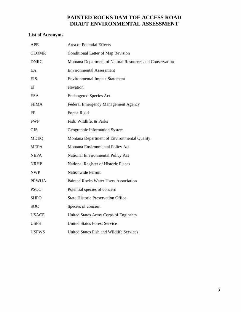
List of Acronyms
APE Area of Potential Effects
CLOMR Conditional Letter of Map Revision
DNRC Montana Department of Natural Resources and Conservation
EA Environmental Assessment
EIS Environmental Impact Statement
El. elevation
ESA Endangered Species Act
FEMA Federal Emergency Management Agency
FR Forest Road
FWP Fish, Wildlife, & Parks
GIS Geographic Information System
MDEQ Montana Department of Environmental Quality
MEPA Montana Environmental Policy Act
NEPA National Environmental Policy Act
NRHP National Register of Historic Places
NWP Nationwide Permit
PRWUA Painted Rocks Water Users Association
PSOC Potential species of concern
SHPO State Historic Preservation Office
SOC Species of concern
USACE United States Army Corps of Engineers
USFS United States Forest Service
USFWS United States Fish and Wildlife Services
PAINTED ROCKS DAM TOE ACCESS ROAD DRAFT ENVIRONMENTAL ASSESSMENT
4
1.0 PURPOSE AND NEED FOR ACTION
Painted Rocks Dam was constructed between 1938 and 1940 and is classified as a high hazard structure by the Montana Department of Natural Resources and Conservation (DNRC) due to the potential for loss of life in the event of a dam failure. The dam impounds approximately 32,360 acre-feet of water at the maximum normal reservoir elevation (El.) of 4,729.5 feet, which corresponds to the spillway crest elevation. Painted Rocks Reservoir provides water storage and supply for irrigation and fisheries. The reservoir also provides regulation of instream flow rates and recreational opportunities for the local area. The primary features associated with Painted Rocks Dam include the embankment dam, spillway, and outlet works.
There are currently two access roads to the dam: 1. Blue Joint Road (Forest Road [FR] 362) – A Ravalli County road that crosses the top of the
spillway and crest of the dam and serves as an access road for the United States Forest Service (USFS). The road is a two-lane gravel road.
2. West Side Primitive Road – A primitive road that runs along the west side of the West Fork Bitterroot River below the dam. The road is accessed by fording the West Fork Bitterroot River approximately 1,500 feet downstream of the dam. Portions of the primitive road are overgrown with vegetation and blocked by downed trees.
Blue Joint Road provides access to the top of the dam year-round. The West Side Primitive Road is typically only accessible by vehicle during low flow periods in the West Fork Bitterroot River, thus requiring notification to the Montana Department of Fish, Wildlife & Parks (FWP) prior to crossing. This road is also accessible by foot on a trail from the top of Painted Rocks Dam.
The purpose of this project is to provide permanent vehicular access to the toe of Painted Rocks Dam. A permanent access road is proposed to be constructed in the same relative alignment as the existing primitive road. The need for a new bridge has also been identified to avoid fording the West Fork Bitterroot River thus minimizing impacts to aquatic resources. Permanent access to the toe of the dam is needed for any future rehabilitation work to the dam’s spillway and outlet works. The access road and bridge will also be used to support future operations and maintenance activities for the spillway and outlet works and construction of interim repairs to the spillway chute and outlet works.
Fording the river can only be accomplished during limited periods of time when flows are low and requires both environmental permitting and preparatory work with an excavator to slope the streambanks. The required permitting includes both a 124 Permit (Montana Stream Protection Act) and a 318 Authorization (Short‐Term Water Quality Standard for Turbidity). Heavy construction equipment can only access the dam’s toe during periods of low flow when the river can be forded, at a location about ¼ mile downstream of the dam, and then follow the existing 2-track road to the dam.
Currently, routine access to the downstream toe of the dam must be made from the dam crest, a route that is too steep for vehicles, thus limiting the ability to conduct repair, maintenance and inspection actions at the toe of the dam, outlet works, and stilling basin. DNRC staff, consultants and contractors must carry or skid all required supplies, materials, tools and equipment from the crest to the toe and then back up to the crest. During periodic dive and sonar investigations, boats and rafts must also be skidded down and up the downstream face of the dam. Toe access is required for
PAINTED ROCKS DAM TOE ACCESS ROAD DRAFT ENVIRONMENTAL ASSESSMENT
5
annual dam safety inspections, monthly monitoring, and periodic investigations, maintenance and repairs of the outlet conduit, control gates and stilling basin. The need for repair actions in these areas is increasing due to deterioration and damage that is accumulating on the structural elements of the dam. The proposed access roads improvements will also provide reliable all-weather access for heavy equipment that is required for any anticipated or unplanned repairs to the 80-year-old dam structure.
1.1 Project Goal
The goal of the proposed improvements to the dam toe access road is as follows:
Permanent, reliable, all-weather vehicular access to the toe of Painted Rocks Dam, including a bridge to avoid fording across the West Fork Bitterroot River.
1.2 Project Location / Property Ownership
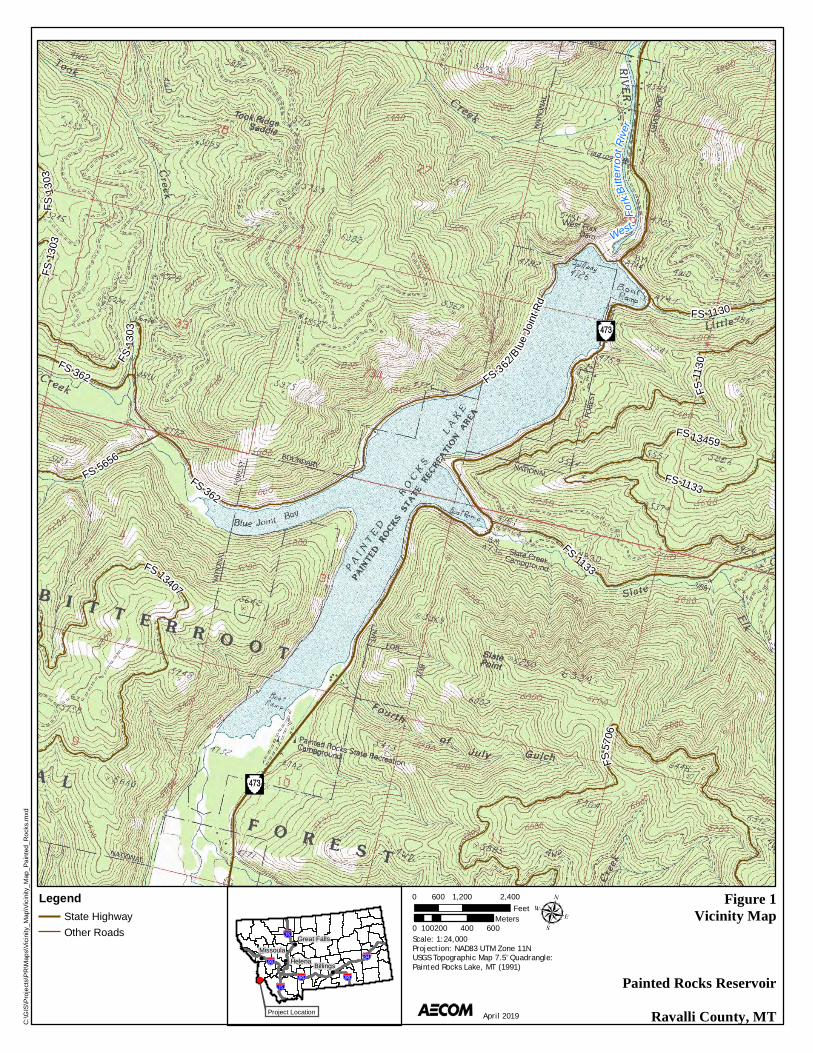
A vicinity map is provided on Figure 1 in Appendix A. DNRC property ownership is shown on Figure 2 in Appendix B.
1.3 Scope of Environmental Analysis
Public and Agency Involvement Because portions of the access road improvements would occur on National Forest lands, the DNRC held an informational meeting on October 2, 2018, from 2:00-3:00 pm with USFS representatives at the Bitterroot National Forest Service Supervisors Office in Hamilton, Montana. A follow-up meeting was held on the same date from 3:00-4:00 pm with representatives from the Painted Rocks Water Users Association (PRWUA), Montana FWP, and Ravalli County.
No public meetings will be held coincident with the comment period for the Draft Environmental Assessment (EA). Rather, public communication and project updates will be provided via email to the distribution list identified by DNRC for the EA including the Governor's Office, federal and state environmental agencies, Ravalli County, Trout Unlimited and the Painted Rocks Water Users Association.
Issues Studied in Detail Field surveys and associated analyses were conducted for various resources and summarized in this Draft EA. The issues examined were identified by DNRC and through communications with the USFS, the United States Fish and Wildlife Service (USFWS) Montana FWP, and the Montana State Historic Preservation Office (SHPO). Issues identified through the public comment period will be addressed in the Final EA and Notice of Decision. Listed below are the potential project-related impacts that were examined in detail:
Access Road Alternatives – alternative screening and development that compared numerous access road maintenance options was conducted by DNRC (2015) and further refined by AECOM (2018a).
Landform, Soils, and Geological Resources – Geotechnical evaluation and test pits were documented in October 2018 (AECOM 2018b).
Wetlands – A site visit was conducted in August 2018 (AECOM 2018c; Appendix B) to document wetlands and other surface water features in the project area.
PAINTED ROCKS DAM TOE ACCESS ROAD DRAFT ENVIRONMENTAL ASSESSMENT
6
Floodplains – Proposed and existing conditions of the floodplain were analyzed utilizing HEC-RAS 4.1.0 (U.S. Army Corps of Engineers [USACE] 2010) and utilizing surveyed cross sections of the West Fork Bitterroot River in 2018 and 2019 (Geomatics Data Solutions 2017).
Wildlife, including sensitive species – A site visit was conducted in September 2018 (AECOM 2018c) to document habitat.
Fisheries, including bull trout (Salvelinus confluentus) – A site visit was conducted in September 2018 to assess habitat (MEC 2018); coordination with Montana FWP and a site visit were completed in February 2019 (Clancy 2019). Endangered Species Act (ESA) Section 7 consultation is in process for federally listed threatened and aquatic species.
Cultural Resources – An intensive survey was conducted in August 2018 (AECOM 2019a) and coordination with the Montana SHPO was completed in August 2018 (Appendix C).
Recreation – Designed the proposed bridge clearance to accommodate current boating activities on the West Fork Bitterroot River (similar clearance as the existing bridge located one half-mile downstream).
Issues Eliminated from Further Study The following resource issues were considered and eliminated from further analysis because they would not be impacted by the Proposed Action:
Water Rights – The proposed access road improvements would not affect existing water rights held by DNRC.
Public Services, Taxes, and Utilities – The proposed access road improvements would not provide a public service or utility and would not contribute to the local tax base.
1.4 Applicable Regulatory Requirements
Table 1 presents the anticipated federal and state permits and other regulatory approvals that will be required to construct and operate the improved access road and new bridge.
PAINTED ROCKS DAM TOE ACCESS ROAD DRAFT ENVIRONMENTAL ASSESSMENT
7
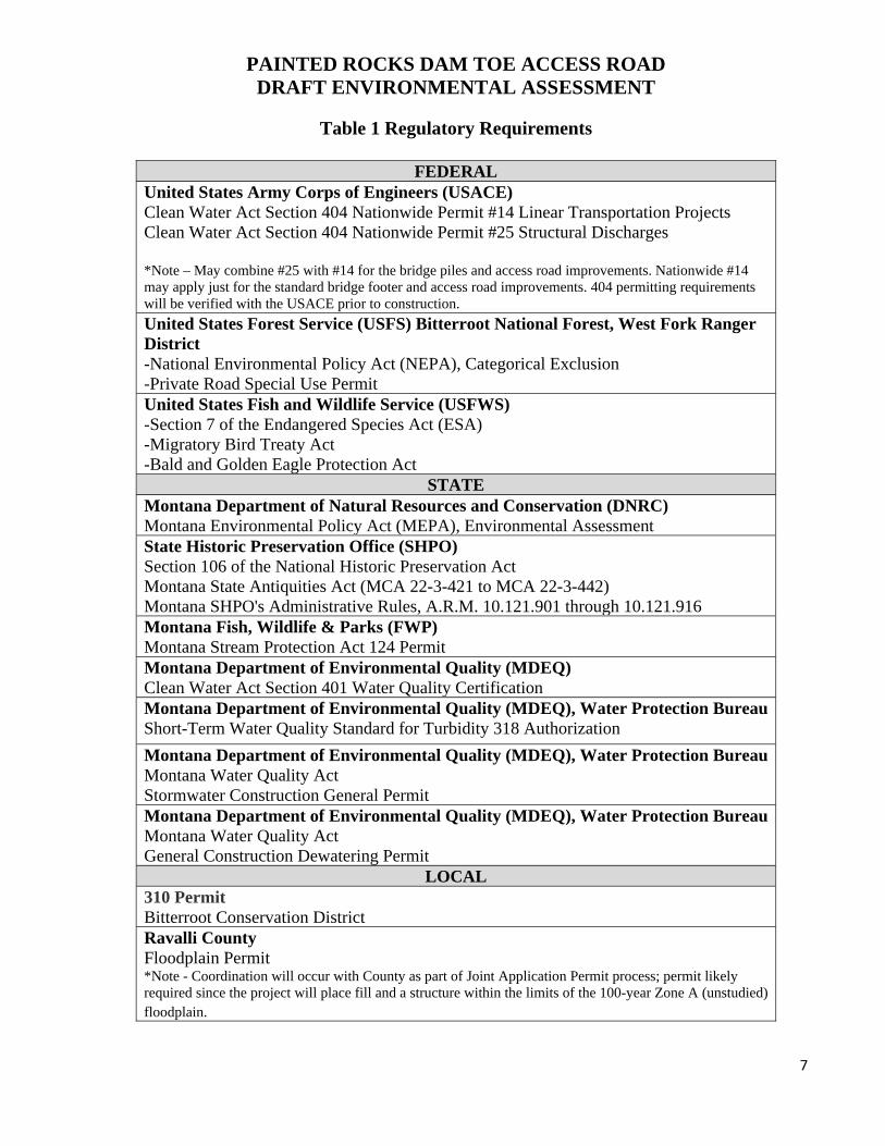
Table 1 Regulatory Requirements
FEDERAL United States Army Corps of Engineers (USACE) Clean Water Act Section 404 Nationwide Permit #14 Linear Transportation Projects Clean Water Act Section 404 Nationwide Permit #25 Structural Discharges *Note – May combine #25 with #14 for the bridge piles and access road improvements. Nationwide #14 may apply just for the standard bridge footer and access road improvements. 404 permitting requirements will be verified with the USACE prior to construction.
United States Forest Service (USFS) Bitterroot National Forest, West Fork Ranger District -National Environmental Policy Act (NEPA), Categorical Exclusion -Private Road Special Use Permit United States Fish and Wildlife Service (USFWS) -Section 7 of the Endangered Species Act (ESA) -Migratory Bird Treaty Act -Bald and Golden Eagle Protection Act
STATE Montana Department of Natural Resources and Conservation (DNRC) Montana Environmental Policy Act (MEPA), Environmental Assessment State Historic Preservation Office (SHPO) Section 106 of the National Historic Preservation Act Montana State Antiquities Act (MCA 22-3-421 to MCA 22-3-442) Montana SHPO's Administrative Rules, A.R.M. 10.121.901 through 10.121.916 Montana Fish, Wildlife & Parks (FWP) Montana Stream Protection Act 124 Permit Montana Department of Environmental Quality (MDEQ) Clean Water Act Section 401 Water Quality Certification Montana Department of Environmental Quality (MDEQ), Water Protection Bureau Short-Term Water Quality Standard for Turbidity 318 Authorization
Montana Department of Environmental Quality (MDEQ), Water Protection Bureau Montana Water Quality Act Stormwater Construction General Permit Montana Department of Environmental Quality (MDEQ), Water Protection Bureau Montana Water Quality Act General Construction Dewatering Permit
LOCAL 310 Permit Bitterroot Conservation District Ravalli County Floodplain Permit *Note - Coordination will occur with County as part of Joint Application Permit process; permit likely required since the project will place fill and a structure within the limits of the 100-year Zone A (unstudied) floodplain.
PAINTED ROCKS DAM TOE ACCESS ROAD DRAFT ENVIRONMENTAL ASSESSMENT
8
2.0 ALTERNATIVES INCLUDING THE PROPOSED ACTION
Section 2 describes the alternatives that were evaluated in this Draft EA as well as the other alternatives that were considered prior to selecting the Proposed Action.
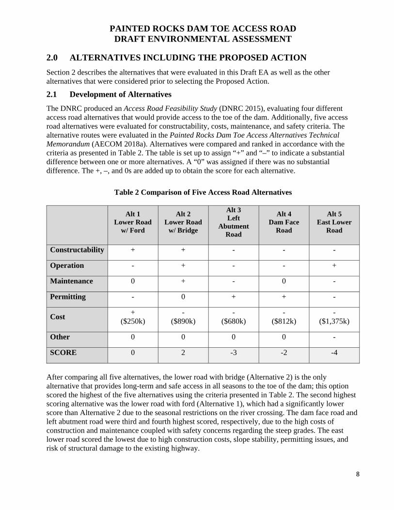
2.1 Development of Alternatives
The DNRC produced an Access Road Feasibility Study (DNRC 2015), evaluating four different access road alternatives that would provide access to the toe of the dam. Additionally, five access road alternatives were evaluated for constructability, costs, maintenance, and safety criteria. The alternative routes were evaluated in the Painted Rocks Dam Toe Access Alternatives Technical Memorandum (AECOM 2018a). Alternatives were compared and ranked in accordance with the criteria as presented in Table 2. The table is set up to assign “+” and “–” to indicate a substantial difference between one or more alternatives. A “0” was assigned if there was no substantial difference. The +, –, and 0s are added up to obtain the score for each alternative.
Table 2 Comparison of Five Access Road Alternatives
Alt 1 Lower Road
w/ Ford
Alt 2 Lower Road
w/ Bridge
Alt 3 Left
Abutment Road
Alt 4 Dam Face
Road
Alt 5 East Lower
Road
Constructability + + - - -
Operation - + - - +
Maintenance 0 + - 0 -
Permitting - 0 + + -
Cost +
($250k) -
($890k) -
($680k) -
($812k) -
($1,375k)
Other 0 0 0 0 -
SCORE 0 2 -3 -2 -4
After comparing all five alternatives, the lower road with bridge (Alternative 2) is the only alternative that provides long-term and safe access in all seasons to the toe of the dam; this option scored the highest of the five alternatives using the criteria presented in Table 2. The second highest scoring alternative was the lower road with ford (Alternative 1), which had a significantly lower score than Alternative 2 due to the seasonal restrictions on the river crossing. The dam face road and left abutment road were third and fourth highest scored, respectively, due to the high costs of construction and maintenance coupled with safety concerns regarding the steep grades. The east lower road scored the lowest due to high construction costs, slope stability, permitting issues, and risk of structural damage to the existing highway.
PAINTED ROCKS DAM TOE ACCESS ROAD DRAFT ENVIRONMENTAL ASSESSMENT
9
2.2 Description of Alternatives
Proposed Action The proposed permanent road alignment (Alternative 2) provides access to the toe of the dam from an approach road off of Montana State Highway 473 (West Fork Road) on the downstream side of the dam and will use a bridge to cross the West Fork Bitterroot River (Appendix B, Figure 2).
Construction of the improved access road and bridge is anticipated to occur in Fall 2021. The bridge would likely consist of a pre-manufactured bridge (i.e. pre-stressed concrete, steel truss, etc.) and would span the width of the river. The surface of the bridge may be asphalt or concrete. The bridge is anticipated to provide a minimum of two foot of freeboard between the water surface for the 100-year recurrence interval flood event and the low cord of the bridge. The bridge abutments will be founded using either a spread footings or piles.
Construction may occur during low river flows and the abutment excavation would mostly occur outside of the wetted channel. The stream bank excavation would extend below anticipated groundwater levels, so dewatering would be necessary during construction. A cofferdam structure constructed from concrete blocks, earth-filled bulk bags, sheet pile, or other materials to reduce the amount of water flowing into the excavation will be deployed. Both abutments will be dewatered using pumps, if required.
No Action Alternative If a new permanent access road is not constructed by the DNRC, Painted Rocks Dam would continue to be accessed by using either Blue Joint Road or the West Side Primitive Road. Blue Joint Road only provides vehicular access to the top of the dam, not the toe of the dam. In its current condition, the West Side Primitive Road only provides DNRC with pedestrian access to the dam toe, with occasional vehicle access by fording the river.
3.0 AFFECTED ENVIRONMENT
3.1 Landform, Soils and Geologic Resources
Painted Rocks Dam and Reservoir are located in the south-central Bitterroot Mountain Range at approximately El. 4,600 to El. 4,750. The topography at the site ranges from the relatively narrow valley and overbank terraces of the West Fork Bitterroot River and major tributaries to relatively steep to locally near-vertical valley walls with numerous smaller tributary drainages.
The alignment of the proposed toe access road is underlain by recent alluvium in the West Fork Bitterroot River channel, older alluvium in the valley bottom, and locally colluvium and talus at the base of the adjacent hillside. The recent and older alluvium are predominantly rounded to sub-rounded gravel and cobbles with varying but relatively minor amounts of typically coarse sand matrix. The colluvium/talus is typically variably graded sandy gravel with widely varying amounts of mostly angular to sub-angular gravel, cobbles, and occasional boulder-sized rock fragments. The depth of alluvial deposits is estimated to be as great as 25-30 feet; colluvial/talus deposits are estimated to range from as little as about 10 feet to locally greater than 30 feet (AECOM 2018b).
PAINTED ROCKS DAM TOE ACCESS ROAD DRAFT ENVIRONMENTAL ASSESSMENT
10
3.2 Water Resources
Painted Rocks Reservoir is a long, relatively narrow reservoir with two main inflows: Blue Joint Creek and the West Fork Bitterroot River. Slate Creek and Little Boulder Creek are two small tributary streams that also flow directly into Painted Rocks Reservoir. Water is released from the outlet tunnel and spillway to the West Fork Bitterroot River. Approximately 1,800 feet of proposed access road alignment parallels the west side of the West Fork Bitterroot River; the proposed bridge would cross the river and about 1,400 feet of access road would continue along the east side of the river.
There is a shallow pond located on the west side floodplain downstream of the dam. There is a constructed berm on the west side of the pond between the pond and the river. The pond has an inlet/outlet that connects to the river on west river bank at the downstream end of the constructed berm. The pond appears to be of uniform shallow depth with little vegetation or other aquatic cover. The pond may have been the result of excavation for borrow material for the dam or the constructed berm.
Wetlands A site visit was conducted on August 15-17, 2018, to assess the existing jurisdictional wetlands and waters of the U.S. Five wetlands were delineated, including four on the west side of the river and one on the east side (see maps in Appendix B). All of the wetlands observed were dominated by palustrine emergent vegetation, although some shrubs were also present (see photos and data sheets in Appendix B). All of the wetlands on the west side of the river are hydrologically connected to the river. Wetland 1 is the largest and occurs around the perimeter of a pond on the west side of the river. Wetlands 2, 3, and 5 are located in depressions on the floodplain on the west side of the river. Wetland 4 is on a terrace on the east side of the river and appears to be supported by groundwater discharge. Wetland 1 covers 0.18 acre, and the other four wetlands combined occupy 0.14 acre. Other aquatic features in the project area include the West Fork Bitterroot River and a pond on the floodplain on the north side of the river. All wetlands and other aquatic features are assumed to be jurisdictional under the Clean Water Act because they are connected to perennial waters. The wetlands are classified as Category III wetlands under the Montana Wetland Assessment Method (Berglund and McEldowney 2008). The most important wetland functions shared by all of the wetlands are sensitive species habitat, general wildlife habitat, sediment/shoreline stabilization. Wetland 4 also consists of a groundwater discharge function.
Floodplains The proposed access road and associated bridge will cross the West Fork Bitterroot River in an unstudied (Zone A) portion of the floodplain per Federal Emergency Management Agency (FEMA) Flood Insurance Rate Map 30081 C1475D (FEMA 2015). The floodplain in the area does not have an established floodway or established based flood elevations. The floodplain in the vicinity of the proposed bridge, as well as the adjacent floodplain between the access road bridge and Painted Rocks Dam, does not impact any existing insurable structures.
3.3 Vegetation
Vegetation/cover types present in the project area include Rocky Mountain dry-mesic mixed conifer forest; northern Rocky Mountain lower montane riparian woodland shrubland; Rocky Mountain cliff, canyon, and massive bedrock; and open water.
PAINTED ROCKS DAM TOE ACCESS ROAD DRAFT ENVIRONMENTAL ASSESSMENT
11
Rocky Mountain dry-mesic mixed conifer forest occurs on the valley floor and lower valley slopes. Common species include Douglas-fir (Pseudotsuga menziesii), lodgepole pine (Pinus contorta), ponderosa pine (Pinus ponderosa), kinnikinnick (Arctostaphylos uva-ursi), common snowberry (Symphoricarpos albus), and white spiraea (Spiraea betulifolia), Geyer’s sedge (Carex geyeri), strawberry (Fragaria vesca and F. virginiana).
Northern Rocky Mountain lower montane riparian woodland and shrubland occurs on the valley floor and includes areas dominated by woody vegetation and areas that are mostly herbaceous meadow. Common tree species include black cottonwood (Populus balsamifera), speckled alder (Alnus incana), Pacific willow (Salix lasiandra), Booth’s willow (Salix boothii), Geyer’s willow (Salix geyeriana), common snowberry (Symphoricarpos albus), twinberry honeysuckle (Lonicera involucrata), kinnikinnick, Canada goldenrod (Solidago canadensis), Eaton’s aster (Symphyotrichum eatonii), creeping bentgrass (Agrostis stonlifera), bluejoint reedgrass (Calamagrostis canadensis), and meadow timothy (Phleum pretense). Wetter portions were delineated as wetlands and are dominated by speckled alder, various willow species, creeping bentgrass, woolly sedge (Carex pellita), and field horsetail (Equisetum arvense).
Rocky Mountain cliff, canyon, and massive bedrock occurs on some parts of the valley slopes. Vegetated parts have species such as Douglas-fir, ponderosa pine, white-stem gooseberry (Ribes inerme), and bluebunch wheatgrass (Elymus spicatus). The dam face is a grassland dominated by species such as bluebunch wheatgrass, smooth brome (Bromus inermis), bluegrass (Poa sp.), sedge, and common mullein (Verbascum thapsus).
Open water includes the West Fork Bitterroot River and a 0.5-acre pond that is hydrologically connected to the river. The pond is shallow and mostly unvegetated, with pondweed (Potamogeton) present in a small area.
Two state-listed noxious weed species were observed: spotted knapweed (Centaurea maculosa, also known as C. stoebe), and oxeye daisy (Chrysanthemum leucanthemum). Both are weed category 2B, which is defined as “abundant in Montana and widespread in many counties. Management criteria will require eradication or containment where abundant” (Ravalli County 2019). Both species were common but not abundant in the project area, occurring mostly in mesic meadows in the riparian zone. Neither species is classified as a Ravalli County priority weed species.
3.4 Wildlife
The vegetation described in Section 3.3. provides habitat for a diverse assemblage of fauna, including mule deer (Odocoileus hemionus), whitetail deer (Odocoileus virginianus), elk (Cervus canadensis), bighorn sheep (Ovis canadensis), mountain goat (Oreamnos americanus), black bear (Ursus americanus), mountain lion (Puma concolor), and moose (Alces americanus), as well as many varieties of smaller animals and birds (USFS 2018). Use by some species may be limited due to the combination of narrow valley, steep valley slopes, and the dam immediately upstream.
Species observed during the August 2018 field survey included common gartersnake (Thamnophis sirtalis), terrestrial gartersnake (Thomnophis elegans), western toad (Anaxyrus boreas), Columbia spotted frog (Rana luteiventris), silver-haired bat (Lasionycteris noctivagans), common merganser (Mergus merganser), rock pigeon (Columba livia), turkey vulture (Cathartes aura), red-tailed hawk (Buteo jamaicensis), common raven (Corvus corax), warbling vireo (Vireo gilvus), red-breasted nuthatch (Sitta canadensis), American robin (Turdus migratorius), dark-eyed junco (Junco
PAINTED ROCKS DAM TOE ACCESS ROAD DRAFT ENVIRONMENTAL ASSESSMENT
12
hyemalis), chipping sparrow (Spizella passerina), yellow-rumped warbler (Steophaga coronata), yellow warbler (Setophaga petechia), and western tanager (Piranga ludoviciana).
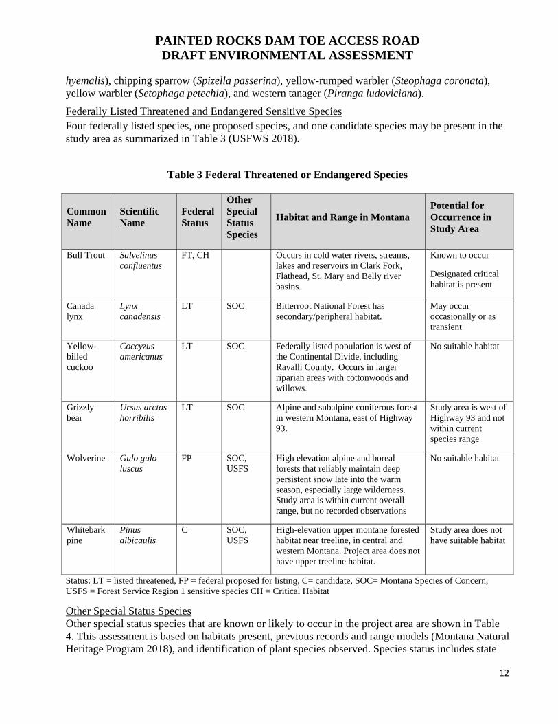
Federally Listed Threatened and Endangered Sensitive Species Four federally listed species, one proposed species, and one candidate species may be present in the study area as summarized in Table 3 (USFWS 2018).
Table 3 Federal Threatened or Endangered Species
Common Name
Scientific Name
Federal Status
Other Special Status Species
Habitat and Range in Montana Potential for Occurrence in Study Area
Bull Trout Salvelinus confluentus
FT, CH Occurs in cold water rivers, streams, lakes and reservoirs in Clark Fork, Flathead, St. Mary and Belly river basins.
Known to occur
Designated critical habitat is present
Canada lynx
Lynx canadensis
LT SOC Bitterroot National Forest has secondary/peripheral habitat.
May occur occasionally or as transient
Yellow-billed cuckoo
Coccyzus americanus
LT SOC Federally listed population is west of the Continental Divide, including Ravalli County. Occurs in larger riparian areas with cottonwoods and willows.
No suitable habitat
Grizzly bear
Ursus arctos horribilis
LT SOC Alpine and subalpine coniferous forest in western Montana, east of Highway 93.
Study area is west of Highway 93 and not within current species range
Wolverine Gulo gulo luscus
FP SOC, USFS
High elevation alpine and boreal forests that reliably maintain deep persistent snow late into the warm season, especially large wilderness. Study area is within current overall range, but no recorded observations
No suitable habitat
Whitebark pine
Pinus albicaulis
C SOC, USFS
High-elevation upper montane forested habitat near treeline, in central and western Montana. Project area does not have upper treeline habitat.
Study area does not have suitable habitat
Status: LT = listed threatened, FP = federal proposed for listing, C= candidate, SOC= Montana Species of Concern, USFS = Forest Service Region 1 sensitive species CH = Critical Habitat
Other Special Status Species Other special status species that are known or likely to occur in the project area are shown in Table 4. This assessment is based on habitats present, previous records and range models (Montana Natural Heritage Program 2018), and identification of plant species observed. Species status includes state

PAINTED ROCKS DAM TOE ACCESS ROAD DRAFT ENVIRONMENTAL ASSESSMENT
13
species of concern (SOC) and potential species of concern (PSOC) and USFS Region 1 sensitive species (USFS 2011a, b, c). Several special status wildlife species were observed during field surveys in August 2018. No special status plant species were observed, and none are likely to occur.
Table 4 Other Special Status Species Known or Likely to Occur
Name Species Status Comment
Mammals
Fringed myotis Myotis thysanodes SOC, Likely to occur
Hoary bat Lasiurus cinereus SOC Likely to occur
Little brown myotis Myotis lucifugus SOC Likely to occur
Silver-hair bat Lasionycteris noctivagans PSOC Observed in study area near pond
Birds
Bald eagle Haliaeetus leucocephalus SSS, USFS Observed nearby at Painted Rocks Lake
No nests were observed in or near project area
Brown creeper Certhia Americana SOC Likely to occur
Cassin’s finch Haemorhous cassinii SOC Observed nearby at upper end of Painted Rocks Lake
Clark’s nutcracker Nucifraga Columbiana SOC Likely to occur
Evening grosbeak Coccothraustes vespertinus SOC Likely to occur
Great blue heron Ardea herodias SOC Observed nearby at Painted Rocks Lake
Harlequin duck Histrionicus histrionicus SOC, USFS Likely to occur
Olive-sided flycatcher Contopus cooperi BCC Likely to occur
Pacific wren Troglodytes pacificus SOC Likely to occur
Peregrine falcon Falco peregrinus SOC, USFS Likely to occur
Pileated woodpecker Dryocopus pileatus SOC Likely to occur
Amphibians
Western toad Anaxyrus boreas SOC, USFS Observed in study area at pond
Fish
Westslope cutthroat trout
Oncorhychus clarkia lewisi SOC, USFS Known to occur, observed in West Fork Bitterroot River below dam
Status: SOC= Montana Species of Concern, PSOC= Montana Potential Species of Concern USFS = Forest Service Region 1 sensitive species, SSS = Bald and Golden Eagle Protection Act
PAINTED ROCKS DAM TOE ACCESS ROAD DRAFT ENVIRONMENTAL ASSESSMENT
14
3.5 Fisheries
The instream habitat downstream of Painted Rocks Dam is a mix of deep pools, relatively fast riffles, and some areas of run habitat. The bottom substrate ranges from larger, coarser material to more natural cobble/gravel substrate. Small benthic macroinvertebrates, such as mayflies (Baetis sp.) and caddis flies (Tricoptera sp), also occur in the project area (MEC 2018). This reach of the West Fork Bitterroot River supports bull trout (Salvelinus confluentus), brown trout (Salmo trutta), and mountain whitefish (Prosopium williamsoni), and is heavily used by anglers between May and September. The aforementioned trout species spawn between September and November. Other fish species collected in past surveys near the project location in 1998 and 2013 include the following: Westslope cutthroat trout (Oncorhynchus clarkii lewisi), brook trout (Salvelinus fontinalis), rainbow trout (Oncorhynchus mykiss), longnose sucker (Catostomus catostomus), longnose dace (Rhinichthys cataractae), and slimy sculpin (Cottus cognatus) (Jakober 2019).
The West Fork Bitterroot River is critical habitat for bull trout, listed as a USFWS threatened species and a Montana SOC. The bull trout habitat near the proposed access bridge is a migratory corridor and juvenile rearing habitat (cobble/boulder substrate); spawning habitat is believed to be absent for bull trout (Clancy 2019).
3.6 Ownership and Land Use
Land Ownership Painted Rocks Dam and Reservoir is located on the West Fork Bitterroot River approximately 22 miles southwest of Darby, in Ravalli County, Montana (Appendix A, Figure 1). As presented in Figure 2 in Appendix B, the proposed access road leading to the toe of the dam would occur primarily on land owned by the DNRC. A portion of the access road would cross Bitterroot National Forest lands.
Land Use The primary land uses in the area are related to recreational activities (boating, angling, camping, etc.) associated with Painted Rocks State Park, National Forest land, and the West Fork Bitterroot River.
Wilderness No designated wilderness or wilderness study areas exist in the project area.
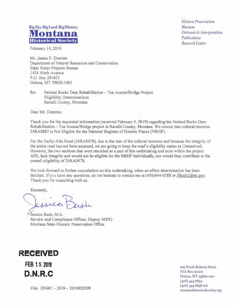
3.7 Cultural Resources
An intensive pedestrian cultural resources survey of the project area was conducted on August 13-17, 2018 (AECOM 2019a). The Area of Potential Effects (APE) for the proposed access road consisted of the proposed alignment with a 50-foot buffer on either side for a total width of 100 feet. One cultural resource, the Darby-Alta Road (24RA0478), was documented within the access road APE. The Darby-Alta Road occurs parallel to and just west of Montana Highway 473 (West Fork Road). The road linked the Bitterroot Valley with the West Fork Bitterroot Valley and the Mineral Hills mining district along the headwaters of the West Fork Bitterroot River. The Darby-Alta Road was previously determined not eligible for listing in the National Register of Historic Places (NRHP), and this status was affirmed during the August 2018 survey.
PAINTED ROCKS DAM TOE ACCESS ROAD DRAFT ENVIRONMENTAL ASSESSMENT
15
3.8 Noise
Existing noise sources in the project area are associated with recreational activities, including motorized boats, birds, and wildlife.
3.9 Air Quality
The air quality in the project area is generally good. Periodic reductions in visibility from regional haze are weather-related (e.g. localized wildfire smoke) (MDEQ 2018).
3.10 Transportation
The primary roads leading to Painted Rocks Reservoir and Dam are Montana State Highway 473/ West Fork Road, FR 362/Blue Joint Road, and Little Boulder Bay Campground Road. There are currently two access roads that lead to the to the dam: 1) Blue Joint Road is a two-lane gravel county road that crosses the top of the spillway and crest of the dam and serves as an access road for the USFS; and 2) West Side Primitive Road (FR 362) that runs along the west side of the West Fork Bitterroot River below the dam provides limited vehicular access.
3.11 Socioeconomic Resources
Economic Activity / Employment / Recreation Economic activities in the project vicinity primarily pertain to recreational activities associated with West Fork Bitterroot River and the surrounding Bitterroot National Forest. State (DNRC) and Federal (USFS) agencies employ technical staff that manages lands in the project area. Additionally, recreation-related businesses account for a portion of the employment in nearby towns.
Recreational activities occurring in the surrounding Bitterroot National Forest include camping (tent and RV), fishing, boating/canoeing, hiking, and wildlife viewing. Access is provided by Montana State Highway 473/ West Fork Road, FR 362/Blue Joint Road, and Little Boulder Bay Campground Road. West Side Primitive Road is located on the west side of the West Fork Bitterroot River.
Communities Darby, Montana (population 779) is located approximately 30 miles north of the reservoir (United States Census Bureau 2017a). Hamilton, Montana (population 4,728) is located approximately 45 miles north of the reservoir (United States Census Bureau 2017b).
Risk and Health Hazards / Emergency Response Painted Rocks Dam is classified as a High Hazard Dam built more than 80 years ago that requires reliable access for operations and maintenance. Currently, there is limited vehicular access to the dam toe.
4.0 ENVIRONMENTAL CONSEQUENCES
This chapter is organized in the same order as Chapter 3.0, along with a comparison of the potential direct and/or indirect consequences of the Proposed Action and No Action Alternative. Potential environmental consequences are based on surveys conducted in August 2018, Geographic Information System (GIS) overlays of the access road disturbance footprint with sensitive resource areas (e.g. wetlands), and guidance from the USFS and Montana FWP.
PAINTED ROCKS DAM TOE ACCESS ROAD DRAFT ENVIRONMENTAL ASSESSMENT
16
4.1 Landform, Soils and Geologic Resources
Effects of No Action There are no ground-disturbing activities associated with the No Action Alternative; therefore, no direct impacts to landforms or soils would occur. No anticipated indirect impacts would result from the No Action Alternative.
Effects of the Proposed Action The proposed access road improvements will consist of a coarse aggregate base, thereby permanently impacting approximately two acres of soils within the project corridor.
4.2 Water Resources
Wetlands Effects of No Action Although there would be no construction activities associated with the No Action Alternative, direct impacts to wetlands and water quality may occur from recreational traffic using the existing access road and crossing (fording) the river. No anticipated indirect impacts would result from the No Action Alternative.
Effects of the Proposed Action Quantity The proposed access road route primarily follows an historical road, part of which passes through the edge of a wetland. Impacts to wetlands in the project area have been minimized to the extent possible, but the proposed roadway location is constrained by steep slopes and some impacts to wetlands are unavoidable. The proposed roadway location and cut-and-fill lines for this alternative alignment were developed using the results of the wetland survey to minimize impacts to wetlands.
The proposed access road involves a crossing of approximately 120 feet of wetland on the edge of a pond on the north side of the river, which would permanently impact approximately 0.065 acre of wetland from placement of the road and fill (Table 5). Temporary impacts (0.025 acre) would also occur in Wetlands 1, 2 and 5. The other two wetlands would not be affected by road or bridge construction. A summary of potential impacts to jurisdictional waters of the U.S. including wetlands, are presented in Table 5. Impacts to the pond will be very minimal.
In-stream construction impacts will be minimized by use of a premanufactured bridge. Placement of the bridge would directly affect a footprint of 0.053 acre. Although these are identified as permanent impacts in Table 5, the only permanent impacts are likely to be shading of the river from the bridge span and small areas of cut and fill on the banks for installation of bridge abutment foundations and bank stabilization. Additionally, impact quantities may vary slightly depending on the abutment design (spread footer vs. pile) but will be relatively approximately the same.
For Clean Water Act Section 404 permitting, this project meets the requirements for Nationwide Permit (NWP) #14 - Linear Transportation Projects. Permanent wetland impacts will be less than 0.1 acre, and compensatory mitigation will not be required by the USACE. Impacts have been avoided and minimized during project design. It is possible that the USACE may require a combination of NWP #25 Structural Discharges with NWP #14 for the bridge piles and access road improvements. Nationwide #14 may apply just for the standard bridge footer and access road improvements. Clean Water Act 404 permitting requirements will be verified with the USACE prior to construction.
PAINTED ROCKS DAM TOE ACCESS ROAD DRAFT ENVIRONMENTAL ASSESSMENT
17
Table 5 Impacts to Jurisdictional Waters of the U.S. from the Access Road and Bridge
Total Area Within Study Area (Acres)
Permanent Impacts from Cut/fill and Roadway (Acres)
Temporary Impacts (Acres)
Total Impacts (Acres)
Wetland 1 0.184 0.065 0.021 0.086 Wetland 2 0.031 0 0.001 0.001
Wetland 3 0.027 0 0 0 Wetland 4 0.047 0 0 0 Wetland 5 0.037 0 0.003 0.003 Total Wetlands 0.326 0.065 0.025 0.090 Pond 1 0.456 0.001 0.015 0.016 West Fork Bitterroot River
7.306 0.053 0.002 0.055
Total Other Waters
7.762 0.054 0.017 0.071
Wetlands Quality – The affected wetlands are rated as Category III wetlands using the Montana Wetland Assessment Method (Berglund and McEldowney 2008); this is the most common category and is less diverse and high functioning than Category I and II wetlands. Water Quality – Overall, construction-related water quality impacts from sediment runoff are anticipated to be direct and short-term and will be minimized to the extent possible. The bridge surface will likely be comprised of concrete or asphalt, so no gravel or similar materials are anticipated to settle into the river. Additionally, minimal to no sand/gravel or deicers are anticipated to be used on the bridge surface given the limited use of the bridge during the winter months. Since construction disturbance resulting from the access roads improvements and the new bridge will exceed one acre, a MDEQ Storm Water Permit will be required for the project. Permit conditions associated with applicable storm water management will be implemented by the construction contractor to minimize impacts to wetlands and other water bodies in the project area. Additionally, an MDEQ Short-Term Exemption from Surface Water Quality Standards (i.e., 318 Authorization) will be obtained by the DNRC prior to construction to cover potential temporary water quality impacts.
Floodplains Effects of No Action There are no ground disturbing activities associated with the No Action Alternative; therefore, no direct impacts to floodplains should occur. No anticipated indirect impacts would result from the No Action Alternative.
Effects of the Proposed Action The proposed access road and associated bridge will cross the West Fork Bitterroot River in an unstudied (Zone A) portion of the floodplain per Federal Emergency Management Agency (FEMA) Flood Insurance Rate Map 30081 C1475D (FEMA 2015). The proposed bridge will cause less than
PAINTED ROCKS DAM TOE ACCESS ROAD DRAFT ENVIRONMENTAL ASSESSMENT
18
0.5 feet of rise in the unstudied Zone A floodplain and will not require a FEMA Conditional Letter of Map Revision (CLOMR) in accordance with Ravalli County Floodplain Hazard Management Regulation, Part 4.3.4 and 8.4.2 (Ravalli County 2015). The proposed rise will impact no insurable structures, as the proposed bridge is located only 1,700 feet downstream of the Painted Rocks dam. Because construction activities would occur within 100-year floodplain, a Ravalli County Floodplain Development Permit is required.
4.3 Vegetation
Effects of No Action There would be no ground-disturbing or vegetation removal activities associated with the No Action Alternative; therefore, no direct impacts to vegetation would occur. No anticipated indirect impacts would result from the No Action Alternative.
Effects of the Proposed Action Construction will require removal or disturbance of approximately two acres of native vegetation along an approximate 0.5 mile of roadway. Approximately 700-800 feet on the east side of the river is an existing dirt road that will be improved, and about 450 feet is a new road alignment. The west side of the river will involve clearing along about 1,200 feet of existing two-track, and removal of vegetation in the turn-round area. Impacts will primarily occur in mixed conifer forest and lower montane riparian woodland and shrub. About half of the affected mixed conifer forest and lower montane riparian woodland and shrub area will be within the roadway footprint and will be permanently lost, and about half of the affected mixed conifer forest and lower montane riparian woodland and shrub area will be temporarily impacted and will be restored after construction. Affected vegetation types are common in the region and in the surrounding Bitterroot National Forest. The two noxious weed species present in the project area are common in some areas, but not abundant. Standard weed control methods may be used to prevent their spread in the disturbance area after construction.
4.4 Wildlife
Effects of No Action There are no construction activities associated with the No Action Alternative; therefore, no direct impacts to wildlife would occur. No anticipated indirect impacts would result from the No Action Alternative.
Effects of the Proposed Action Construction activities will include excavation and grading for the road improvements on the east and west sides of the river, excavation and construction of bridge abutments, and river crossings by construction equipment during bridge construction. Construction is anticipated to take place in late summer and fall of 2021. Approximately two acres of terrestrial wildlife habitat will be affected, with about half of the disturbed area revegetated after construction. Indirect impacts consist of temporary displacement of wildlife due to noise and disturbance resulting from on-site construction in the project vicinity. Construction would occur in late summer or fall after the bird nesting season, so that nesting migratory birds are not likely to be adversely affected.
The USFS is the lead federal agency for the project and authorized the DNRC to conduct Section 7 ESA consultation with the USFWS. The USFS reviewed a preliminary version of the Draft BA on August 26, 2019 and concurred with the effects analysis for bull trout (AECOM 2019b). Additionally, on September 5, 2019 the USFS concurred with the effects analysis for terrestrial
PAINTED ROCKS DAM TOE ACCESS ROAD DRAFT ENVIRONMENTAL ASSESSMENT
19
species including a No Effect determination for Grizzly bear (Ursus arctos horribilis), Yellow-billed cuckoo (Coccyzus americanus), Wolverine (Gulo gulo luscus), Whitebark pine (Pinus albicaulis), and Canada lynx (Lynx canadensis). Per the request of USFS-USFWS Liaison, the Draft BA does not include species with a No Effect determination. Endangered Species Act Section 7 consultation with the USFWS is in progress.
The action area does not have primary habitat for Canada lynx, and Canada lynx are not likely to be present in the action area at the time of construction. If present, individuals are likely to avoid areas of active construction and are unlikely to be injured or killed as a result of construction activities. Loss of habitat would be minimal and temporary and would only involve secondary/peripheral habitat. Impacts to other special status species is expected to be minor or negligible. Individual western toads may be killed or injured during construction near the pond, but the majority of the habitat would not be affected. There will be a permanent loss of about 0.065 acre of wetland where this species was observed.
4.5 Fisheries
Effects of No Action Without the development of the improved access road and bridge, access to the dam would require fording the West Fork Bitterroot River potentially directly impacting sensitive fish habitat. No anticipated indirect impacts would result from the No Action Alternative. Effects of the Proposed Action Fording the West Fork Bitterroot River would be required during construction activities. A cofferdam will be temporarily established to minimize flows from directly entering excavation areas. Cobble/boulder substrate exists in the West Fork Bitterroot River that supports migration and juvenile rearing habitat for bull trout occurring in the vicinity of the proposed bridge crossing; spawning habitat does not appear to be present in this area (Clancy 2019). Overall, long-term positive impacts to fisheries will result from the project, as the new access bridge will allow trucks to cross over the West Fork Bitterroot River instead of fording across it as is currently required to access the dam toe.
There will be no changes to river flows or temperature as a result of the project. Construction will take place at low flow, and there will be no construction activity in the wetted channel. The abutment construction and riprap protection placement would alter approximately 2,000 square feet of stream bank on the east and west sides of the river. Since riprap can be used as rearing habitat when flows are high enough to cover it, there will be a change in substrate but no loss of rearing habitat for bull trout. Fine sediment could be mobilized during rain events on excavated areas. Sediment retainment measures will be implemented during construction to retain fine sediment on-site and prevent fine sediment from entering the river. The amount of fine sediment that may enter the river would be extremely small (i.e., change in water color) and of short duration (i.e., hours) with the sediment retention measures used during construction. These levels of sediment would not adversely affect bull trout. Additionally, the bridge surface will likely be comprised of concrete or asphalt, so no gravel or similar materials are anticipated to settle into the river. Additionally, minimal to no sand/gravel or deicers are anticipated to be used on the bridge surface given the limited use of the bridge during the winter months. Because the bridge will have restricted use, impacts are expected to be negligible to minor to fisheries.
PAINTED ROCKS DAM TOE ACCESS ROAD DRAFT ENVIRONMENTAL ASSESSMENT
20
The DNRC will obtain a Montana Stream Protection Act 124 permit from the Montana FWP prior to construction. Additionally, 124 permit conditions and applicable USFWS requirements will be abided by during construction activities to minimize impacts to bull trout and other fish species. Endangered Species Act Section 7 consultation with the USFWS is in progress and DNRC will abide by requested mitigation measures to minimize impacts to bull trout.
4.6 Ownership and Land Use
Effects of No Action There are no ground-disturbing activities associated with the No Action Alternative; thus, no direct impacts or changes to land use or ownership would occur. No anticipated indirect impacts would result from the No Action Alternative.
Effects of the Proposed Action Because the access road improvements will occur within the existing road corridor, long-term direct impacts to land use or ownership are not anticipated. A portion of the access road occurs on National Forest land that will be temporarily disturbed during construction, thus requiring a Private Road Special Use Permit.
4.7 Cultural Resources
Effects of No Action There are no construction activities associated with the No Action Alternative; therefore, no direct impacts to cultural resources would occur. No anticipated indirect impacts would result from the No Action Alternative.
Effects of the Proposed Action In a letter dated February 14, 2019 (Appendix C), the Montana Historical Society, SHPO concluded the NRHP eligibility status of the historic Darby-Alta Road as Unresolved, because most of the road lies outside the APE. However, they concurred that the two segments of the road recorded within the APE in August 2018 lack integrity and are not eligible for the NRHP. Direct impacts from construction activities associated with access road improvements are not anticipated to adversely affect historical Darby-Alta Road because the segments in the project vicinity lack integrity to be eligible for listing in the NRHP.
4.8 Noise
Effects of No Action There are no construction activities associated with the No Action Alternative; thus, no noise-related direct impacts would occur. No anticipated indirect impacts would result from the No Action Alternative. Noise generated from recreational activities, including motor boating, would continue to occur in the vicinity of the project area.
Effects of the Proposed Action The Proposed Action requires construction activities associated with the access road improvements and the new access bridge. Project-related impacts from noise are anticipated to be temporary and direct resulting from on-site construction equipment and truck traffic associated with material deliveries and commuting workers.
PAINTED ROCKS DAM TOE ACCESS ROAD DRAFT ENVIRONMENTAL ASSESSMENT
21
4.9 Air Quality
Effects of No Action There are no ground-disturbing or other dust/pollutant emitting activities associated with the No Action Alternative; thus, no air-related direct impacts would occur. No anticipated indirect impacts would result from the No Action Alternative.
Effects of the Proposed Action Potential short-term impacts to air quality may occur during construction of the access road improvements and new bridge.
4.10 Transportation
Effects of No Action There are no construction activities or commuting construction vehicles associated with the No Action Alternative; thus, no direct impacts would occur to transportation facilities in the Project area. No anticipated indirect impacts would result from the No Action Alternative.
Effects of the Proposed Action Temporary increases in traffic to the project site associated with supporting construction activities (e.g. mobilization of construction equipment, daily commuters and material deliveries). A minimum amount of additional traffic, associated with dam operations, maintenance and rehabilitation construction efforts, are anticipated.
4.11 Socioeconomic Resources
Economic Activity / Employment / Recreation Effects of No Action There are no construction activities associated with the No Action Alternative; therefore, no direct impacts would occur due to economic activity, employment or recreation in the project area. No anticipated indirect impacts would result from the No Action Alternative.
Effects of the Proposed Action Temporary increases in economic activity and employment may occur from hiring local construction contractors, non-local contractors that may in turn support local businesses, and using products produced by local vendors and suppliers.
Since construction would occur in Fall/Winter seasons, limited impacts to recreational activities (i.e. fishing and boating) are anticipated. Surrounding Forest Service lands not within the project corridor would not be impacted and will provide continued support for recreational activities.
The current site security measures include a gate at the bridge to limit vehicular access to the bridge; however, this gate may be moved closer to the dam to allow public vehicular access to the bridge at some point in the future. Pedestrian access to the bridge is currently planned with either location but this may also be revised in the future depending on future site security needs. The new bridge may result in increased recreational use of the west side of the river. Additional recreational use would not be a significant indirect effect.
PAINTED ROCKS DAM TOE ACCESS ROAD DRAFT ENVIRONMENTAL ASSESSMENT
22
Communities Effects of No Action There are no construction activities associated with the No Action Alternative; therefore, no direct impacts would occur to communities in the project area. No anticipated indirect impacts would result from the No Action Alternative.
Effects of the Proposed Action The Proposed Action is not anticipated to impact the nearby communities of Darby and Hamilton, Montana.
Risk and Health Hazards / Emergency Response Effects of No Action Under the No Action Alternative, no access road improvements would be developed. Therefore, emergency response and evacuation would continue to be limited.
Effects of the Proposed Action The proposed access road improvements and bridge crossing would provide a reliable access road for vehicles to the Painted Rocks Dam toe area and outlets.
5.0 CUMULATIVE EFFECTS
Cumulative effects are the combined effects of similar water or land-based actions that have or will occur within the same time or general geographic area where effects from a proposed project will occur. Assessment of cumulative effects considers the total incremental effects of past, present, and reasonably foreseeable future actions.
Effects of No Action There are no construction activities associated with the No Action Alternative; therefore, no incremental contributions to cumulative impacts would occur.
Effects of the Proposed Action The proposed project would be constructed on land primarily owned by the DNRC that is currently used for a similar purpose. The surrounding area primarily consists of Forest Service lands that are undeveloped and support various recreational activities. No development or other activities are anticipated on Forest Service lands that would overlap with the construction of the proposed access road improvements and new bridge. Additionally, no significant impacts resulting from the Proposed Action were identified in Section 4.0. Therefore, no significant cumulative effects from the Proposed Action are anticipated.
6.0 PREFERRED ALTERNATIVE
6.1 Preferred Alternative
The Preferred Alternative is the same as the Proposed Action as described in Section 2.2.
6.2 Proposed Actions to Offset Adverse Impacts
A majority of impacts resulting from the Proposed Action would be associated with short-term construction activities and do not require mitigation.
PAINTED ROCKS DAM TOE ACCESS ROAD DRAFT ENVIRONMENTAL ASSESSMENT
23
6.3 Need for an EIS
Because no significant impacts were identified with the development of the dam toe access road, the DNRC considers this Draft EA is sufficient to comply with the MEPA and that an Environmental Impact Statement (EIS) will not be required. A comparison table for the Proposed Action and the No Action Alternative is provided in Section 6.4.
6.4 Alternative Comparison Table
If applicable federal and state permits are not obtained for the proposed access road improvements and new bridge (i.e., No Action Alternative), the DNRC would not have reliable access to the toe of Painted Rocks Dam and would continue fording the West Fork Bitterroot River, as applicable. Although the Proposed Action would create temporary impacts during construction, it would result in a reliable permanent access and bridge to Painted Rocks Dam. Table 6 presents a summary of the potential land and water-based impacts for the No Action Alternative and Proposed Action as described in Section 4.0.
PAINTED ROCKS DAM TOE ACCESS ROAD DRAFT ENVIRONMENTAL ASSESSMENT
24
Table 6 Alternative Comparison Table
Resource No Action Proposed Action
Geology, Landform and Soils No Effects Permanent loss of approximately two acres of soils within the project corridor from installation of a coarse aggregate base to the access road
Water Resources Direct impacts to wetlands and water quality may occur from recreational traffic using the existing access road and crossing (fording) the river.
Permanent impacts to 0.065 acres of wetlands and 0.054 acres of other waters of the U.S. Temporary impacts to 0.025 acres of wetlands and 0.017 acres of other waters of the U.S. Negligible to minor impacts to water quality Bridge will create less than 0.5 feet rise in the floodplain and no impacts to insurable structures is anticipated
Vegetation No Effects Loss of about two acres of native vegetation including mixed conifer forest and riparian woodland and shrub
Wildlife No Effects About two acres of terrestrial wildlife habitat will be affected, with about half of the disturbed area revegetated after construction
Temporary displacement of wildlife by noise and disturbance during on-site construction
No effect on migratory birds
No Effect to federally listed threatened and endangered terrestrial species
Impacts to other special status species is expected to be minor or negligible
Fisheries Fording the West Fork Bitterroot River would continue to impact fisheries without improving access with a new bridge.
Long-term positive impacts to fisheries the new access bridge will allow trucks to cross over the West Fork Bitterroot River instead of fording across it Negligible to minor temporary impacts may occur from fording the river while the bridge is being constructed Endangered Species Act Section 7 consultation with the USFWS is in progress.
Ownership/Land Use No Effects Because the access road improvements will occur within the existing road corridor, long-term direct impacts to land use or ownership is not anticipated A portion of the access road occurs on National Forest land that will be temporarily disturbed during construction, thereby requiring a Private Road Special Use Permit
Cultural Resources No Effects Direct impacts from construction activities associated with access road improvements are not anticipated to adversely affect historical Darby-Alta Road because the segments in the project vicinity lack integrity to be eligible for listing in the NRHP
Noise No Effects Project-related impacts from noise are anticipated to be temporary and direct resulting from on-site construction equipment and truck traffic associated with material deliveries and commuting workers
Air Quality No Effects Short-term, temporary effects during construction
Transportation No Effects Short-term, temporary effects during construction due to increases in traffic to the project site associated with supporting construction activities (e.g. mobilization of construction equipment, daily commuters, and material deliveries)
PAINTED ROCKS DAM TOE ACCESS ROAD DRAFT ENVIRONMENTAL ASSESSMENT
25
Resource No Action Proposed Action
Economic Activity / Employment /Recreation
No Effects Short-term, temporary effects during construction Temporary increases in economic activity and employment may occur from hiring local construction contractors, non-local contractors that may in turn support local businesses, and using products produced by local vendors and suppliers Limited impacts to recreational activities since construction would occur in Fall/Winter 2021 Surrounding Forest Service lands not within the project corridor would not be impacted
Communities No Effects No anticipated impacts to the nearby communities of Darby and Hamilton, Montana
Emergency Response No Effects Access road improvements and bridge crossing would provide a reliable access road for vehicles to the Painted Rocks Dam toe area and outlets
Cumulative Impacts No Effects No significant impacts would result from the project; therefore, no significant cumulative effects from the project are anticipated
PAINTED ROCKS DAM TOE ACCESS ROAD DRAFT ENVIRONMENTAL ASSESSMENT
26
6.5 Project Implementation
The project is anticipated to be implemented during Fall/Winter of 2021. The Project will be implemented in accordance with the DNRC’s Notice of Decision and applicable regulatory approvals presented in Table 1.
6.6 Monitoring
Impacts to resources have been avoided and minimized through project design to the extent possible. Permanent wetland impacts will be less than 0.1 acre, and compensatory mitigation will not be required by the USACE; therefore, it is not anticipated that monitoring will be required.
7.0 GLOSSERY OF TERMS
Alluvium – Unconsolidated material, such as gravel, sand, silt, clay that is deposited on land by flowing water (riverbed, floodplain, etc.)
Area of Potential Effects (APE) - the geographic area or areas within which an undertaking may directly or indirectly cause alterations in the character or use of historic properties, if any such properties exist. The area of potential effects is influenced by the scale and nature of an undertaking and may be different for different kinds of effects caused by the undertaking (36 CFR 800.16(d).
cfs – Measure of flow in cubic feet per second. One cfs equals about 450 gallons per minute.
Colluvium – Loose, unconsolidated sediment material that accumulates at base of slopes.
Cumulative effect - A general estimation of the effects of project impacts in combination with other past, present, and reasonably foreseeable future developments.
Direct effect – A direct impact is a direct result of a project (e.g. ground disturbance from construction activities).
Indirect effect – An indirect impact is a secondary or subsequent impact of a project and occurs later in time or at a distance from the action.
Mitigation - Measure taken to lessen an impact to a resource.
Permanent effect - Permanent impacts are created by construction or operational changes and are considered long-term, sometimes remaining for the life of a project.
Talus – Rocky material that accumulates at the base of a cliff or sloped landform.
Temporary effect –Temporary impacts generally occur during construction activities and are considered short-term disturbances that can be reclaimed (e.g., construction and placement of a cofferdam) or would cease upon completion of construction activities (e.g., construction noise).
PAINTED ROCKS DAM TOE ACCESS ROAD DRAFT ENVIRONMENTAL ASSESSMENT
27
8.0 REFERENCES
AECOM 2018a. Painted Rocks Dam Toe Access Alternatives Technical Memorandum. September.
AECOM 2018b. Painted Rocks Dam Geotechnical Investigation and Analyses Technical Memorandum. October.
AECOM 2019a. Painted Rocks Dam and Reservoir Project, Ravalli County, Montana: Results of Intensive and Reconnaissance Cultural Resources Surveys. January.
AECOM 2019b. Painted Rocks Dam Toe Access Road Maintenance Project Biological Assessment. September. Berglund, J., and R. McEldowney. 2008. MDT Montana Wetland Assessment Method. Prepared for Montana Department of Transportation. Post, Buckley, Schuh, and Jerigan (PBSJ), Helena, Montana.
Clancy, Chris. 2019. Personal communication with Chris Clancy, Montana Fish Wildlife and Parks, Fisheries Division. February 21.
Domino, J. and P. Rennie. 2004. Historic Cultural Resource Site Form Update for Painted Rocks Dam & Reservoir (24RA456). Form on file at the Montana Historical Society, Helena.
Federal Insurance Management Agency (FEMA). 2015. Flood Insurance Rate Map 30018C1475D. Effective 01-16/2015.
Geomatics Data Solutions. 2017. LIDAR and Multibeam Survey Report for East Fork of Rock Creek and Painted Rocks Reservoirs. October.
Jakober, Mike. 2019. Fish and aquatic habitat data - email to Andrea Parker, AECOM, April 9. South Zone Fish Biologist, Bitterroot National Forest
Miller Ecological Consultants (MEC). 2018. Aquatic Resource Field Reconnaissance Technical Memorandum, Painted Rocks Reservoir. September.
Montana Department of Environmental Quality (MDEQ) 2018. Montana Air Quality. http://deq.mt.gov/Air
Montana Department of Natural Resources and Conservation (DNRC) 2015. Access Road Feasibility Study.
Montana Natural Heritage Program and Montana Fish, Wildlife and Parks. 2018 Montana Plant and Animal Species of Concern Reports for Painted Rocks area and Ravalli County. http://mtnhp.org/SpeciesOfConcern/?AorP=a and http://mtnhp.org/SpeciesofConcern?AorP=p
Ravalli County. 2018. Ravalli County Montana Air Quality. https://ravalli.us/160/Air-Quality
Ravalli County. 2015. Ravalli County Floodplain Hazard Management Regulations.
Ravalli County. 2019. Noxious Weed District. https://ravalli.us/223/Weed-District
U.S. Census Bureau. 2017a. Darby, Montana 2017 Population Estimates (5-year estimates). https://www.census.gov
U.S. Census Bureau. 2017b. Hamilton, Montana 2017 Population Estimates (5-year estimates). https://www.census.gov
U.S. Army Corps of Engineers (USACE 2010). HEC-RAS River Analysis System Version 4.1.0.
PAINTED ROCKS DAM TOE ACCESS ROAD DRAFT ENVIRONMENTAL ASSESSMENT
28
U.S. Fish and Wildlife Service (USFWS). 2018. Threatened, Endangered and Candidate Species for the Bitterroot National Forest. 7/16/2018. Ecological Services, Montana Field Office.
U.S. Forest Service (USFS). 2018. Bitterroot National Forest: About the Forest. https://www.fs.usda.gov/main/bitterroot/about-forest
U.S. Forest Service. 2011a. Wildlife Sensitive Species List. Forest Service – Region 1, February 2011. https://www.fs.usda.gov/detail/r1/plants-animals/?cid=stelprdb5130525
U.S. Forest Service. 2011b. Aquatics Sensitive Species List. Forest Service – Region 1, February 2011. https://www.fs.usda.gov/detail/r1/plants-animals/?cid=stelprdb5130525
U.S. Forest Service. 2011c. Montana Sensitive Species List - Plants. Forest Service – Region 1, February 2011. https://www.fs.usda.gov/detail/r1/plants-animals/?cid=stelprdb5130525
9.0 LIST OF PREPARERS
The following individuals (listed in alphabetical order) contributed to the analysis documented in the EA:
Jacob Conver P.E. – AECOM, Alternatives
Jeff Dawson – AECOM, Water Resource; Vegetation; Wildlife
Chuck Kennedy P.E., CFM – AECOM, Water Resources
Andrea Parker – AECOM, Purpose and Need; Alternatives; Fisheries; Ownership and Land Use; Noise; Air Quality; Transportation; Socio-Economic Resources; Cumulative Effects
Gordon Tucker Ph.D. – AECOM, Cultural Resources
Doug Yadon P.E., PG – AECOM, Landform/Soils/Geology
Sanna Yost P.E., DNRC – Project schedule and administrative oversight
PAINTED ROCKS DAM TOE ACCESS ROAD DRAFT ENVIRONMENTAL ASSESSMENT
Appendix A Vicinity Map
MÊ
MÊ
West
Fork
Bitter
root R
iver
FS362
/Blu
eJo
int R
d
FS
1133
FS 1130
FS
1303
FS 1133FS 362
FS 5656
FS13459
FS13
03
FS
1130
FS 13407
FS
5706
FS
130
3
FS 362
0 1,200 2,400600
FeetµScale: 1:24,000Projection: NAD83 UTM Zone 11NUSGS Topographic Map 7.5' Quadrangle:Painted Rocks Lake, MT (1991)
April 2019
Figure 1Vicinity Map
Painted Rocks Reservoir
Ravalli County, MT
!"a$
!"b$
!"a$!"̀$
!"a$
!"̀$
Helena
Missoula
Great Falls
Billings
Project Location
0 200 400 600100Meters
LegendState Highway
Other Roads
C:\G
IS\P
roje
cts\
PR
\Map
s\V
icin
ity_
Map
\Vic
inity
_M
ap_
Pa
inte
d_R
ock
s.m
xd

PAINTED ROCKS DAM TOE ACCESS ROAD DRAFT ENVIRONMENTAL ASSESSMENT
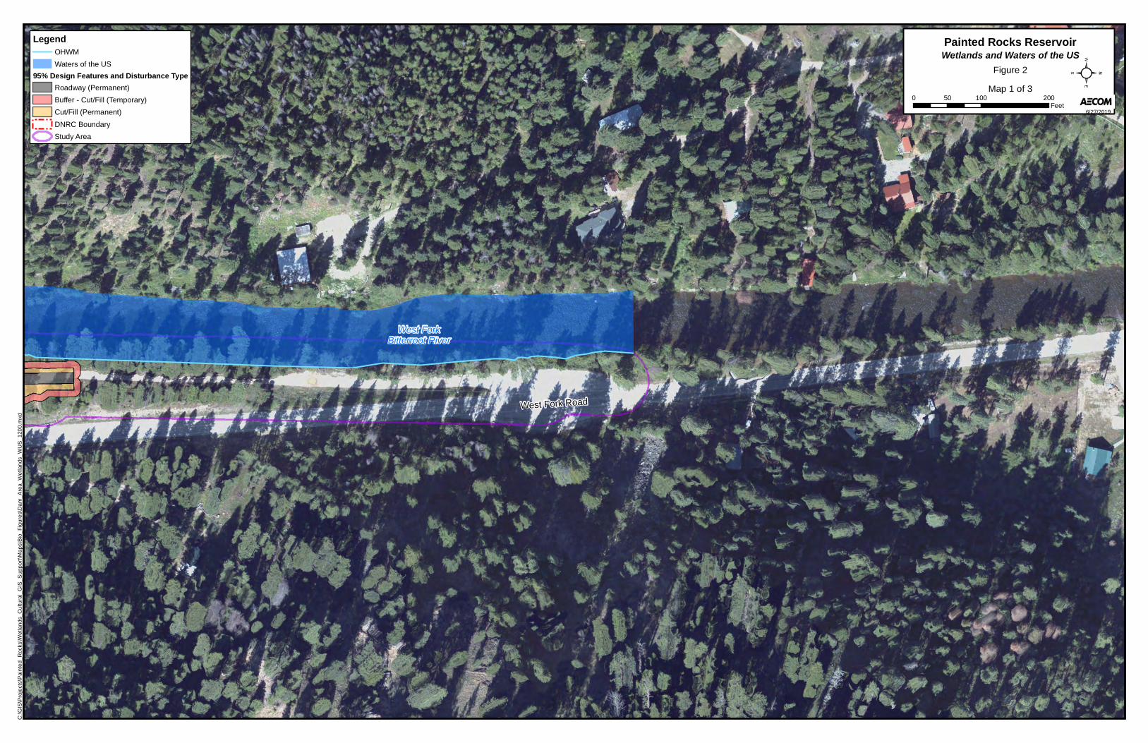
Appendix B Wetlands and Waters of the U.S.

Figures
West ForkBitterroot River
West Fork Road
0 100 20050Feet
Painted Rocks ReservoirLegendOHWM
Waters of the US
95% Design Features and Disturbance Type
Roadway (Permanent)
Buffer - Cut/Fill (Temporary)
Cut/Fill (Permanent)
DNRC Boundary
Study Area
Wetlands and Waters of the US
6/27/2019
C:\G
IS\P
roje
cts\
Pa
inte
d_
Roc
ks\W
etla
nd
s_C
ultu
ral_
GIS
_S
up
po
rt\M
ap
s\B
io_
Fig
ure
s\D
am
_A
rea
_We
tlan
ds_
WU
S_
120
0.m
xd
Figure 2
Map 1 of 3
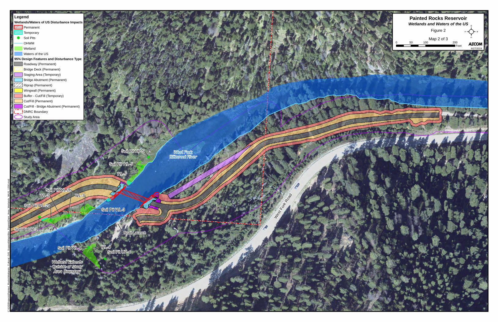
Soil Pit WL-2a
Soil Pit WL-2b
Soil Pit UP-2
Soil Pit WL-3
Soil Pit WL-4Soil Pit UP-4
Soil Pit WL-5
Soil Pit UP-5
WL-4
WL-3WL-2
WL-5
West ForkBitterroot River
Wetland ExtendsOutside of StudyArea Boundary
Boat Launch
Wes
t For
k R
oad
0 100 20050Feet
Painted Rocks ReservoirLegendWetlands/Waters of US Disturbance Impacts
Permanent
Temporary
Soil Pits
OHWM
Wetland
Waters of the US
95% Design Features and Disturbance Type
Roadway (Permanent)
Bridge Deck (Permanent)
Staging Area (Temporary)
Bridge Abutment (Permanent)
Riprap (Permanent)
Wingwall (Permanent)
Buffer - Cut/Fill (Temporary)
Cut/Fill (Permanent)
Cut/Fill - Bridge Abutment (Permanent)
DNRC Boundary
Study Area
Wetlands and Waters of the US
6/27/2019
C:\G
IS\P
roje
cts\
Pa
inte
d_
Roc
ks\W
etla
nd
s_C
ultu
ral_
GIS
_S
up
po
rt\M
ap
s\B
io_
Fig
ure
s\D
am
_A
rea
_We
tlan
ds_
WU
S_
120
0.m
xd
Figure 2
Map 2 of 3
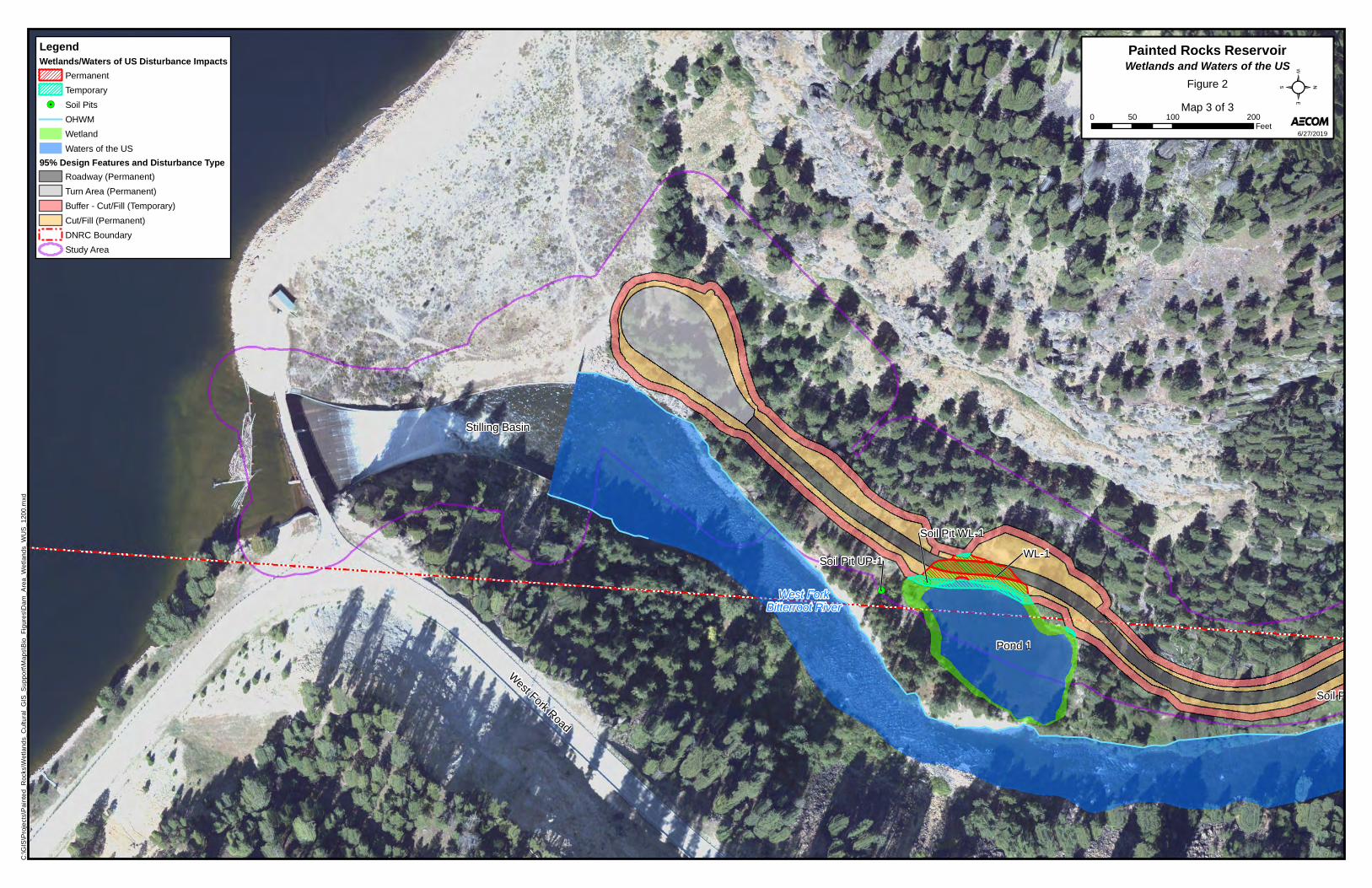
Soil Pit WL-1
Soil Pit UP-1
S
Soil P
WL-1
Pond 1
West ForkBitterroot River
Stilling Basin
West Fork Road
0 100 20050Feet
Painted Rocks ReservoirLegendWetlands/Waters of US Disturbance Impacts
Permanent
Temporary
Soil Pits
OHWM
Wetland
Waters of the US
95% Design Features and Disturbance Type
Roadway (Permanent)
Turn Area (Permanent)
Buffer - Cut/Fill (Temporary)
Cut/Fill (Permanent)
DNRC Boundary
Study Area
Wetlands and Waters of the US
6/27/2019
C:\G
IS\P
roje
cts\
Pa
inte
d_
Roc
ks\W
etla
nd
s_C
ultu
ral_
GIS
_S
up
po
rt\M
ap
s\B
io_
Fig
ure
s\D
am
_A
rea
_We
tlan
ds_
WU
S_
120
0.m
xd
Figure 2
Map 3 of 3

Photo Log
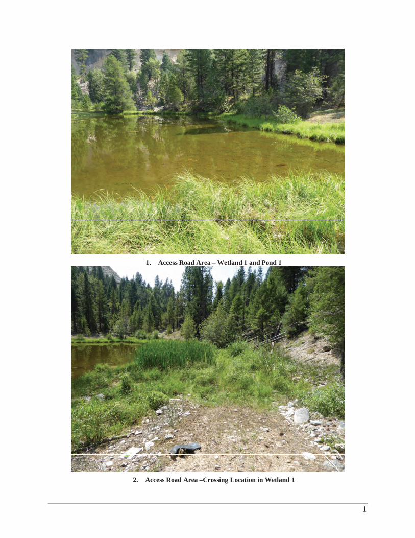
1
1. Access Road Area – Wetland 1 and Pond 1
2. Access Road Area –Crossing Location in Wetland 1
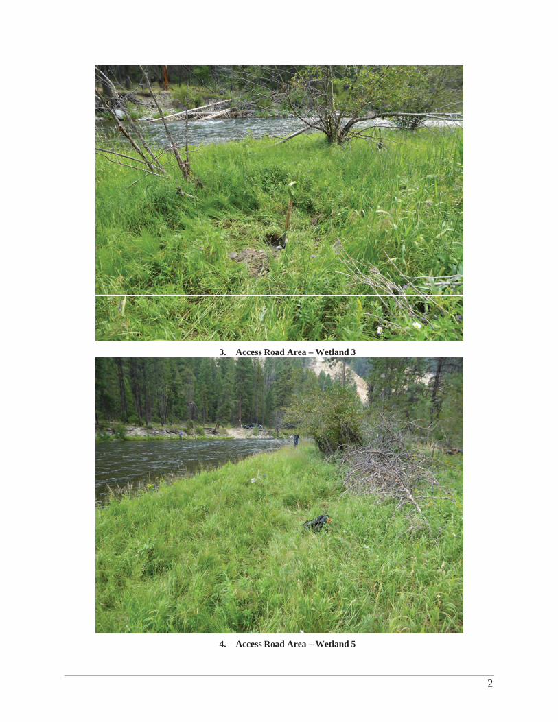
2
3. Access Road Area – Wetland 3
4. Access Road Area – Wetland 5
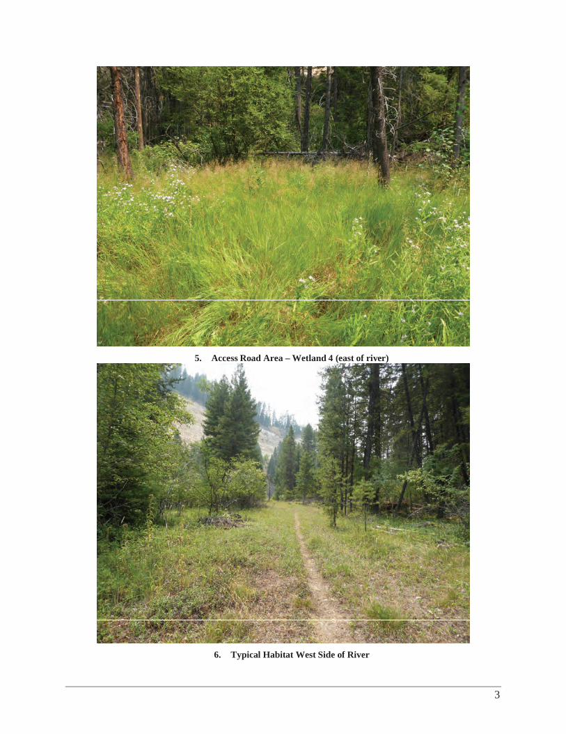
3
5. Access Road Area – Wetland 4 (east of river)
6. Typical Habitat West Side of River
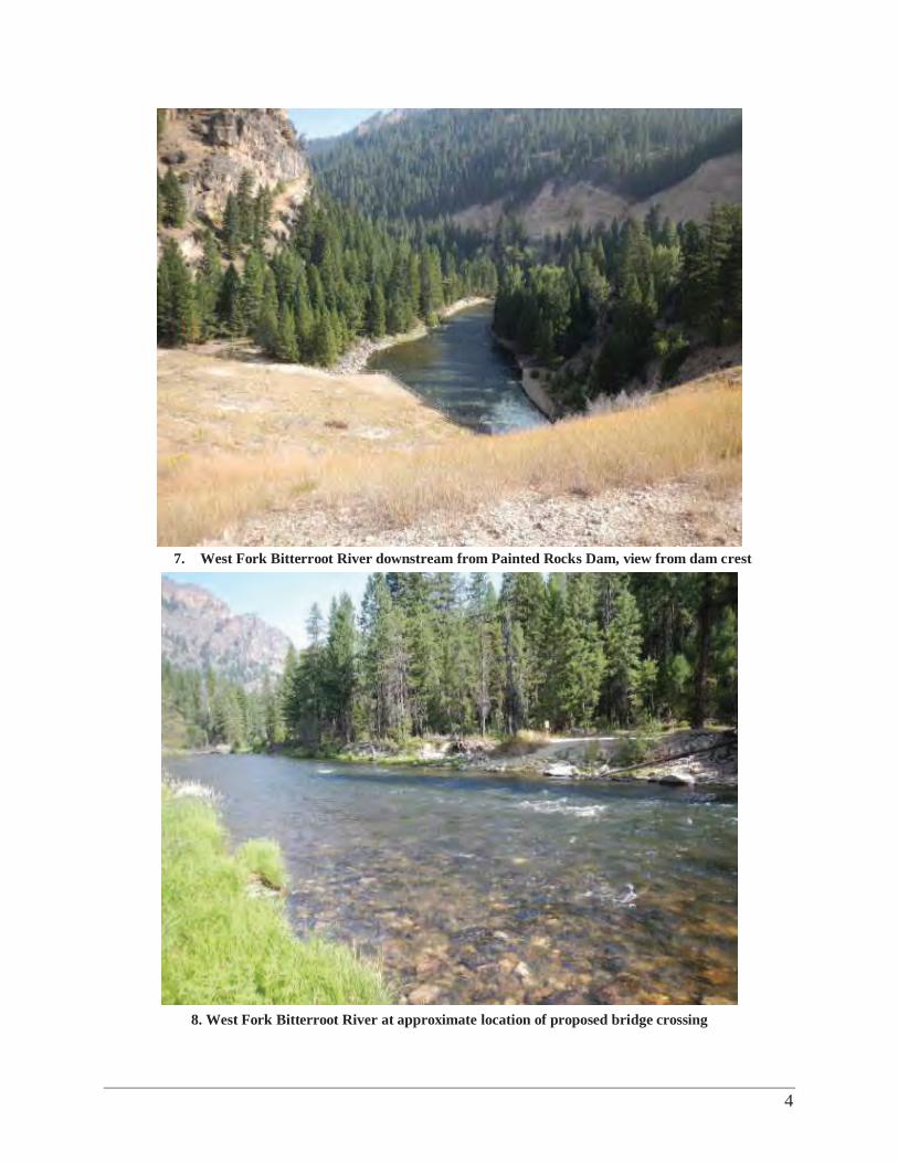
4
7. West Fork Bitterroot River downstream from Painted Rocks Dam, view from dam crest
8. West Fork Bitterroot River at approximate location of proposed bridge crossing

Data Forms
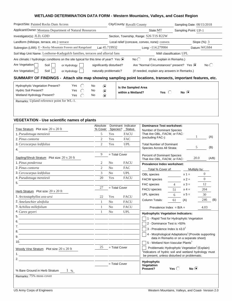
US Army Corps of Engineers Western Mountains, Valleys, and Coast- Version 2.0
WETLAND DETERMINATION DATA FORM - Western Mountains, Valleys, and Coast Region
Project/Site: City/County: Sampling Date:
Applicant/Owner: State: Sampling Point:
Investigator(s): Section, Township, Range:
Landform (hillslope, terrace, etc.): Local relief (concave, convex, none): Slope (%):
Subregion (LRR): Lat: Long: Datum:
Soil Map Unit Name: NWI classification:
Are climatic / hydrologic conditions on the site typical for this time of year? Yes No (If no, explain in Remarks.)
Are Vegetation Soil or Hydrology significantly disturbed? Are "Normal Circumstances" present? Yes No
Are Vegetation Soil or Hydrology naturally problematic? (If needed, explain any answers in Remarks.)
SUMMARY OF FINDINGS - Attach site map showing sampling point locations, transects, important features, etc.
Hydrophytic Vegetation Present? Yes No
Hydric Soil Present? Yes No
Wetland Hydrology Present? Yes No
Is the Sampled Area
within a Wetland? Yes No
Remarks:
VEGETATION - Use scientific names of plants
Dominance Test worksheet:
Number of Dominant Species That Are OBL, FACW, or FAC: (excluding FAC-): (A)
Total Number of Dominant Species Across All Strata: (B)
Percent of Dominant Species That Are OBL, FACW, or FAC: (A/B)
Prevalence Index worksheet:
Total % Cover of: Multiply by:
OBL species x 1 =
FACW species x 2 =
FAC species x 3 =
FACU species x 4 =
UPL species x 5 =
Column Totals: (A) (B)
Prevalence Index = B/A =
Hydrophytic Vegetation Indicators:
3 - Prevalence Index is 3.0 1
4 - Morphological Adaptations1 (Provide supporting data in Remarks or on a separate sheet)
Problematic Hydrophytic Vegetation1 (Explain)
1Indicators of hydric soil and wetland hydrology must be present, unless disturbed or problematic.
Absolute Dominant Indicator Tree Stratum Plot size: % Cover Species? Status
1.
2.
3.
4.
Sapling/Shrub Stratum Plot size:
1.
2.
3.
4.
5.
Herb Stratum Plot size:
1.
2.
3.
4.
5.
6.
7.
8.
Woody Vine Stratum Plot size:
1.
2.
% Bare Ground in Herb Stratum
HydrophyticVegetationPresent? Yes No
Remarks:
2 - Dominance Test is >50%
1 - Rapid Test for Hydrophytic Vegetation
5 - Wetland Non-Vascular Plants 1
= Total Cover
9.
10.
= Total Cover
= Total Cover
%
= Total Cover
Painted Rocks Dam Access Ravalli County 08/15/2018
Montana Department of Natural Resources UP-1
JLD, GDD S26 T1S R22W
terrace convex 3
MT
E - Rocky Mountain Forests and Rangeland 45.719932 -114.279984 WGS84
Losthorse-Kadygulch families, terraces and alluvial fans UPL
1
5
20.0
6
51
4
Upland reference point for WL-1.
Pseudotsuga menziesii 5 Yes FACU
Pinus contorta Yes2
Cercocarpus ledifolius Yes2
9
FAC
UPL
Pinus ponderosa
20
3
2
2
Pseudotsuga menziesii
Cercocarpus ledifolius
Pinus contorta
2720 x 20 ft
No
No
Yes
No
FACU
FAC
UPL
FACU
Yes
No
No
No1
1
1
22
Carex geyeri
Achillea millefolium
Amelanchier alnifolia
Arctostaphyllos uva-ursi
2520 x 20 ft
FACU
FACU
FACU
UPL
1
75% moss cover
61 246
30
204
12
0
0
4.03
20 x 20 ft
20 x 20 ft
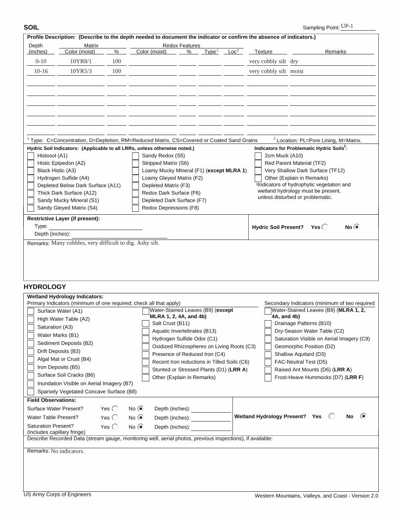
Western Mountains, Valleys, and Coast - Version 2.0
SOIL Sampling Point:
Profile Description: (Describe to the depth needed to document the indicator or confirm the absence of indicators.)
Depth Matrix Redox Features (inches) Color (moist) % Color (moist) % Type1 Loc2 Texture Remarks
1 Type: C=Concentration, D=Depletion, RM=Reduced Matrix, CS=Covered or Coated Sand Grains 2 Location: PL=Pore Lining, M=Matrix.
Hydric Soil Indicators: (Applicable to all LRRs, unless otherwise noted.) Indicators for Problematic Hydric Soils :3
Histosol (A1) Sandy Redox (S5)
Histic Epipedon (A2) Stripped Matrix (S6)
Black Histic (A3) Loamy Mucky Mineral (F1) (except MLRA 1)
Hydrogen Sulfide (A4) Loamy Gleyed Matrix (F2)
Depleted Matrix (F3)
Redox Dark Surface (F6)
Depleted Below Dark Surface (A11)
Depleted Dark Surface (F7)
Thick Dark Surface (A12)
Redox Depressions (F8)
Sandy Mucky Mineral (S1)
3Indicators of hydrophytic vegetation and wetland hydrology must be present, unless disturbed or problematic.
Restrictive Layer (if present):
Type:
Depth (inches): Hydric Soil Present? Yes No
Remarks:
HYDROLOGY
Wetland Hydrology Indicators: Secondary Indicators (minimum of two requiredPrimary Indicators (minimum of one required; check all that apply)
Surface Water (A1)
Salt Crust (B11)
Surface Soil Cracks (B6)
High Water Table (A2)
Aquatic Invertebrates (B13)
Sparsely Vegetated Concave Surface (B8)
Saturation (A3)
Hydrogen Sulfide Odor (C1)
Drainage Patterns (B10)
Water Marks (B1)
Sediment Deposits (B2) Oxidized Rhizospheres on Living Roots (C3)
Drift Deposits (B3) Presence of Reduced Iron (C4)
Saturation Visible on Aerial Imagery (C9)
Algal Mat or Crust (B4)
Geomorphic Position (D2)
Iron Deposits (B5)
Other (Explain in Remarks)
FAC-Neutral Test (D5)
Inundation Visible on Aerial Imagery (B7) Frost-Heave Hummocks (D7) (LRR F)
Field Observations:
Surface Water Present? Yes No Depth (inches):
Water Table Present? Yes No Depth (inches):
Saturation Present? Yes No Depth (inches): (includes capillary fringe)
Wetland Hydrology Present? Yes No
Describe Recorded Data (stream gauge, monitoring well, aerial photos, previous inspections), if available:
Remarks:
US Army Corps of Engineers
Sandy Gleyed Matrix (S4)
Red Parent Material (TF2)
Very Shallow Dark Surface (TF12)
Other (Explain in Remarks)
2cm Muck (A10)
Water-Stained Leaves (B9) (except MLRA 1, 2, 4A, and 4b)
Stunted or Stressed Plants (D1) (LRR A)
Recent Iron reductions in Tilled Soils (C6)
Water-Stained Leaves (B9) (MLRA 1, 2, 4A, and 4b)
Dry-Season Water Table (C2)
Shallow Aquitard (D3)
Raised Ant Mounts (D6) (LRR A)
UP-1
0-10 10YR8/1 100 very cobbly silt dry
moistvery cobbly silt10010YR5/310-16
Many cobbles, very difficult to dig. Ashy silt.
No indicators.
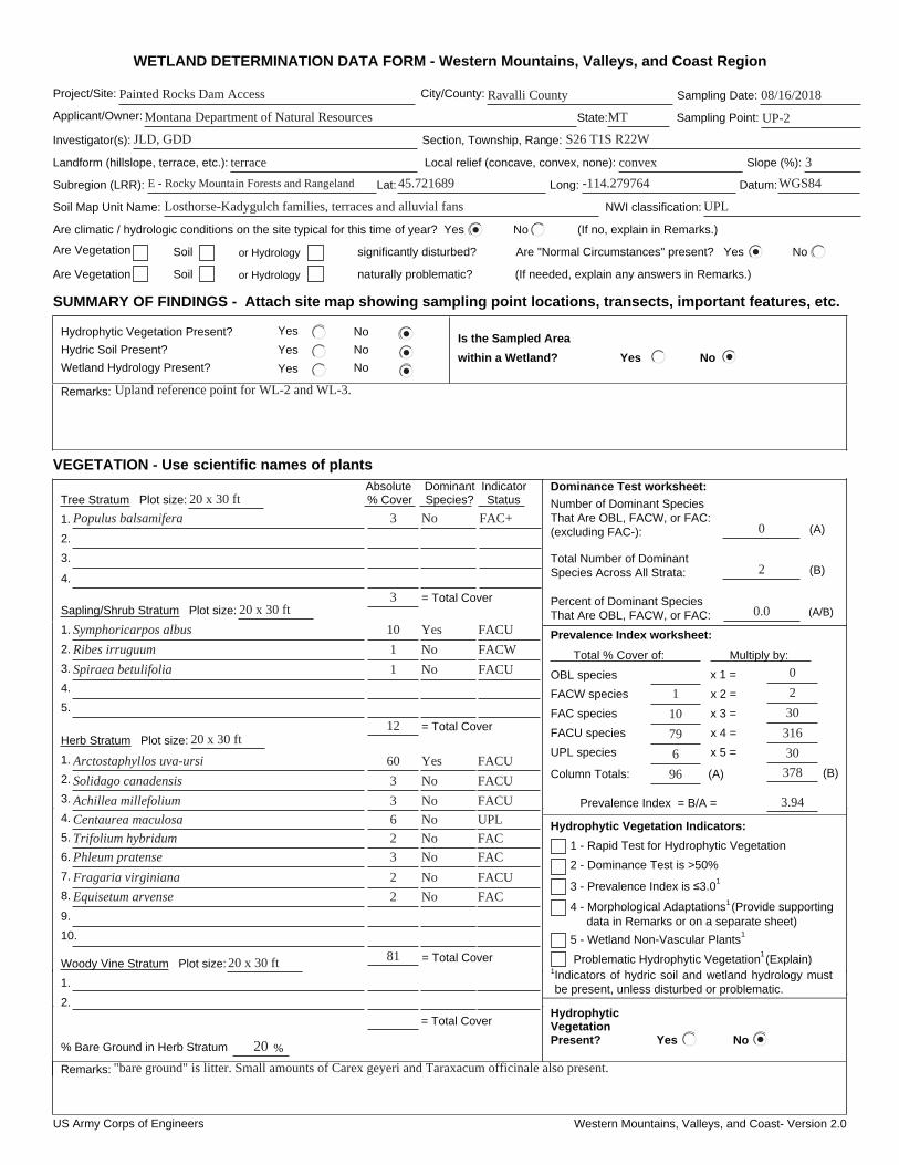
US Army Corps of Engineers Western Mountains, Valleys, and Coast- Version 2.0
WETLAND DETERMINATION DATA FORM - Western Mountains, Valleys, and Coast Region
Project/Site: City/County: Sampling Date:
Applicant/Owner: State: Sampling Point:
Investigator(s): Section, Township, Range:
Landform (hillslope, terrace, etc.): Local relief (concave, convex, none): Slope (%):
Subregion (LRR): Lat: Long: Datum:
Soil Map Unit Name: NWI classification:
Are climatic / hydrologic conditions on the site typical for this time of year? Yes No (If no, explain in Remarks.)
Are Vegetation Soil or Hydrology significantly disturbed? Are "Normal Circumstances" present? Yes No
Are Vegetation Soil or Hydrology naturally problematic? (If needed, explain any answers in Remarks.)
SUMMARY OF FINDINGS - Attach site map showing sampling point locations, transects, important features, etc.
Hydrophytic Vegetation Present? Yes No
Hydric Soil Present? Yes No
Wetland Hydrology Present? Yes No
Is the Sampled Area
within a Wetland? Yes No
Remarks:
VEGETATION - Use scientific names of plants
Dominance Test worksheet:
Number of Dominant Species That Are OBL, FACW, or FAC: (excluding FAC-): (A)
Total Number of Dominant Species Across All Strata: (B)
Percent of Dominant Species That Are OBL, FACW, or FAC: (A/B)
Prevalence Index worksheet:
Total % Cover of: Multiply by:
OBL species x 1 =
FACW species x 2 =
FAC species x 3 =
FACU species x 4 =
UPL species x 5 =
Column Totals: (A) (B)
Prevalence Index = B/A =
Hydrophytic Vegetation Indicators:
3 - Prevalence Index is 3.0 1
4 - Morphological Adaptations1 (Provide supporting data in Remarks or on a separate sheet)
Problematic Hydrophytic Vegetation1 (Explain)
1Indicators of hydric soil and wetland hydrology must be present, unless disturbed or problematic.
Absolute Dominant Indicator Tree Stratum Plot size: % Cover Species? Status
1.
2.
3.
4.
Sapling/Shrub Stratum Plot size:
1.
2.
3.
4.
5.
Herb Stratum Plot size:
1.
2.
3.
4.
5.
6.
7.
8.
Woody Vine Stratum Plot size:
1.
2.
% Bare Ground in Herb Stratum
HydrophyticVegetationPresent? Yes No
Remarks:
2 - Dominance Test is >50%
1 - Rapid Test for Hydrophytic Vegetation
5 - Wetland Non-Vascular Plants 1
= Total Cover
9.
10.
= Total Cover
= Total Cover
%
= Total Cover
Painted Rocks Dam Access Ravalli County 08/16/2018
Montana Department of Natural Resources UP-2
JLD, GDD S26 T1S R22W
terrace convex 3
MT
E - Rocky Mountain Forests and Rangeland 45.721689 -114.279764 WGS84
Losthorse-Kadygulch families, terraces and alluvial fans UPL
0
2
0.0
1
6
79
10
Upland reference point for WL-2 and WL-3.
Populus balsamifera 3 No FAC+
3
Symphoricarpos albus
1
1
10
Spiraea betulifolia
Ribes irruguum
1220 x 30 ft
Yes
No
No
FACU
FACW
FACU
Yes
No
No
No
No
No
No
No
2
6
3
3
60
Trifolium hybridum
Centaurea maculosa
Achillea millefolium
Solidago canadensis
Arctostaphyllos uva-ursi
2
2
3
Equisetum arvense
Fragaria virginiana
Phleum pratense
8120 x 30 ft
FACU
FACU
FACU
UPL
FAC
FAC
FACU
FAC
20
"bare ground" is litter. Small amounts of Carex geyeri and Taraxacum officinale also present.
96 378
30
316
30
2
0
3.94
20 x 30 ft
20 x 30 ft
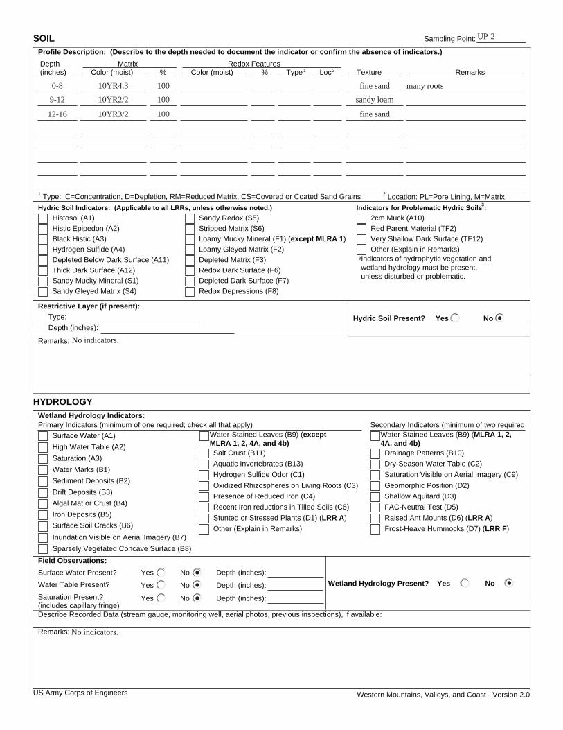
Western Mountains, Valleys, and Coast - Version 2.0
SOIL Sampling Point:
Profile Description: (Describe to the depth needed to document the indicator or confirm the absence of indicators.)
Depth Matrix Redox Features (inches) Color (moist) % Color (moist) % Type1 Loc2 Texture Remarks
1 Type: C=Concentration, D=Depletion, RM=Reduced Matrix, CS=Covered or Coated Sand Grains 2 Location: PL=Pore Lining, M=Matrix.
Hydric Soil Indicators: (Applicable to all LRRs, unless otherwise noted.) Indicators for Problematic Hydric Soils :3
Histosol (A1) Sandy Redox (S5)
Histic Epipedon (A2) Stripped Matrix (S6)
Black Histic (A3) Loamy Mucky Mineral (F1) (except MLRA 1)
Hydrogen Sulfide (A4) Loamy Gleyed Matrix (F2)
Depleted Matrix (F3)
Redox Dark Surface (F6)
Depleted Below Dark Surface (A11)
Depleted Dark Surface (F7)
Thick Dark Surface (A12)
Redox Depressions (F8)
Sandy Mucky Mineral (S1)
3Indicators of hydrophytic vegetation and wetland hydrology must be present, unless disturbed or problematic.
Restrictive Layer (if present):
Type:
Depth (inches): Hydric Soil Present? Yes No
Remarks:
HYDROLOGY
Wetland Hydrology Indicators: Secondary Indicators (minimum of two requiredPrimary Indicators (minimum of one required; check all that apply)
Surface Water (A1)
Salt Crust (B11)
Surface Soil Cracks (B6)
High Water Table (A2)
Aquatic Invertebrates (B13)
Sparsely Vegetated Concave Surface (B8)
Saturation (A3)
Hydrogen Sulfide Odor (C1)
Drainage Patterns (B10)
Water Marks (B1)
Sediment Deposits (B2) Oxidized Rhizospheres on Living Roots (C3)
Drift Deposits (B3) Presence of Reduced Iron (C4)
Saturation Visible on Aerial Imagery (C9)
Algal Mat or Crust (B4)
Geomorphic Position (D2)
Iron Deposits (B5)
Other (Explain in Remarks)
FAC-Neutral Test (D5)
Inundation Visible on Aerial Imagery (B7) Frost-Heave Hummocks (D7) (LRR F)
Field Observations:
Surface Water Present? Yes No Depth (inches):
Water Table Present? Yes No Depth (inches):
Saturation Present? Yes No Depth (inches): (includes capillary fringe)
Wetland Hydrology Present? Yes No
Describe Recorded Data (stream gauge, monitoring well, aerial photos, previous inspections), if available:
Remarks:
US Army Corps of Engineers
Sandy Gleyed Matrix (S4)
Red Parent Material (TF2)
Very Shallow Dark Surface (TF12)
Other (Explain in Remarks)
2cm Muck (A10)
Water-Stained Leaves (B9) (except MLRA 1, 2, 4A, and 4b)
Stunted or Stressed Plants (D1) (LRR A)
Recent Iron reductions in Tilled Soils (C6)
Water-Stained Leaves (B9) (MLRA 1, 2, 4A, and 4b)
Dry-Season Water Table (C2)
Shallow Aquitard (D3)
Raised Ant Mounts (D6) (LRR A)
UP-2
0-8 10YR4.3 100 fine sand many roots
sandy loam10010YR2/29-12
fine sand10010YR3/212-16
No indicators.
No indicators.
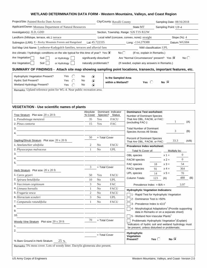
US Army Corps of Engineers Western Mountains, Valleys, and Coast- Version 2.0
WETLAND DETERMINATION DATA FORM - Western Mountains, Valleys, and Coast Region
Project/Site: City/County: Sampling Date:
Applicant/Owner: State: Sampling Point:
Investigator(s): Section, Township, Range:
Landform (hillslope, terrace, etc.): Local relief (concave, convex, none): Slope (%):
Subregion (LRR): Lat: Long: Datum:
Soil Map Unit Name: NWI classification:
Are climatic / hydrologic conditions on the site typical for this time of year? Yes No (If no, explain in Remarks.)
Are Vegetation Soil or Hydrology significantly disturbed? Are "Normal Circumstances" present? Yes No
Are Vegetation Soil or Hydrology naturally problematic? (If needed, explain any answers in Remarks.)
SUMMARY OF FINDINGS - Attach site map showing sampling point locations, transects, important features, etc.
Hydrophytic Vegetation Present? Yes No
Hydric Soil Present? Yes No
Wetland Hydrology Present? Yes No
Is the Sampled Area
within a Wetland? Yes No
Remarks:
VEGETATION - Use scientific names of plants
Dominance Test worksheet:
Number of Dominant Species That Are OBL, FACW, or FAC: (excluding FAC-): (A)
Total Number of Dominant Species Across All Strata: (B)
Percent of Dominant Species That Are OBL, FACW, or FAC: (A/B)
Prevalence Index worksheet:
Total % Cover of: Multiply by:
OBL species x 1 =
FACW species x 2 =
FAC species x 3 =
FACU species x 4 =
UPL species x 5 =
Column Totals: (A) (B)
Prevalence Index = B/A =
Hydrophytic Vegetation Indicators:
3 - Prevalence Index is 3.0 1
4 - Morphological Adaptations1 (Provide supporting data in Remarks or on a separate sheet)
Problematic Hydrophytic Vegetation1 (Explain)
1Indicators of hydric soil and wetland hydrology must be present, unless disturbed or problematic.
Absolute Dominant Indicator Tree Stratum Plot size: % Cover Species? Status
1.
2.
3.
4.
Sapling/Shrub Stratum Plot size:
1.
2.
3.
4.
5.
Herb Stratum Plot size:
1.
2.
3.
4.
5.
6.
7.
8.
Woody Vine Stratum Plot size:
1.
2.
% Bare Ground in Herb Stratum
HydrophyticVegetationPresent? Yes No
Remarks:
2 - Dominance Test is >50%
1 - Rapid Test for Hydrophytic Vegetation
5 - Wetland Non-Vascular Plants 1
= Total Cover
9.
10.
= Total Cover
= Total Cover
%
= Total Cover
Painted Rocks Dam Access Ravalli County 08/16/2018
Montana Department of Natural Resources UP-4
JLD, GDD S26 T1S R22W
terrace straight 4
MT
E - Rocky Mountain Forests and Rangeland 45.722335 -114.279388 WGS84
Losthorse-Kadygulch families, terraces and alluvial fans UPL
1
3
33.3
14
91
18
Upland reference point for WL-4. Near public recreation area.
Pseudotsuga menziesii 35 Yes FACU
Pinus contorta Yes15
50
FAC
Amelanchier alnifolia
1
2
Physocarpus malvaceus
320 x 20 ft
No
No
FACU
UPL
Yes
No
No
No
No
No
No
2
1
3
10
50
Fragaria vesca
Linnaea borealis
Vaccinium cespitosum
Spiraea betulifolia
Carex geyeri
1
3
Campanula rotundifolia
Hieracium scouleri
7020 x 20 ft
FACU
UPL
FAC
FACU
FACU
UPL
FACU
25
5% moss cover. Lots of woody litter. Dactylis glomerata also present.
123 488
70
364
54
0
0
3.97
20 x 20 ft
20 x 20 ft

Western Mountains, Valleys, and Coast - Version 2.0
SOIL Sampling Point:
Profile Description: (Describe to the depth needed to document the indicator or confirm the absence of indicators.)
Depth Matrix Redox Features (inches) Color (moist) % Color (moist) % Type1 Loc2 Texture Remarks
1 Type: C=Concentration, D=Depletion, RM=Reduced Matrix, CS=Covered or Coated Sand Grains 2 Location: PL=Pore Lining, M=Matrix.
Hydric Soil Indicators: (Applicable to all LRRs, unless otherwise noted.) Indicators for Problematic Hydric Soils :3
Histosol (A1) Sandy Redox (S5)
Histic Epipedon (A2) Stripped Matrix (S6)
Black Histic (A3) Loamy Mucky Mineral (F1) (except MLRA 1)
Hydrogen Sulfide (A4) Loamy Gleyed Matrix (F2)
Depleted Matrix (F3)
Redox Dark Surface (F6)
Depleted Below Dark Surface (A11)
Depleted Dark Surface (F7)
Thick Dark Surface (A12)
Redox Depressions (F8)
Sandy Mucky Mineral (S1)
3Indicators of hydrophytic vegetation and wetland hydrology must be present, unless disturbed or problematic.
Restrictive Layer (if present):
Type:
Depth (inches): Hydric Soil Present? Yes No
Remarks:
HYDROLOGY
Wetland Hydrology Indicators: Secondary Indicators (minimum of two requiredPrimary Indicators (minimum of one required; check all that apply)
Surface Water (A1)
Salt Crust (B11)
Surface Soil Cracks (B6)
High Water Table (A2)
Aquatic Invertebrates (B13)
Sparsely Vegetated Concave Surface (B8)
Saturation (A3)
Hydrogen Sulfide Odor (C1)
Drainage Patterns (B10)
Water Marks (B1)
Sediment Deposits (B2) Oxidized Rhizospheres on Living Roots (C3)
Drift Deposits (B3) Presence of Reduced Iron (C4)
Saturation Visible on Aerial Imagery (C9)
Algal Mat or Crust (B4)
Geomorphic Position (D2)
Iron Deposits (B5)
Other (Explain in Remarks)
FAC-Neutral Test (D5)
Inundation Visible on Aerial Imagery (B7) Frost-Heave Hummocks (D7) (LRR F)
Field Observations:
Surface Water Present? Yes No Depth (inches):
Water Table Present? Yes No Depth (inches):
Saturation Present? Yes No Depth (inches): (includes capillary fringe)
Wetland Hydrology Present? Yes No
Describe Recorded Data (stream gauge, monitoring well, aerial photos, previous inspections), if available:
Remarks:
US Army Corps of Engineers
Sandy Gleyed Matrix (S4)
Red Parent Material (TF2)
Very Shallow Dark Surface (TF12)
Other (Explain in Remarks)
2cm Muck (A10)
Water-Stained Leaves (B9) (except MLRA 1, 2, 4A, and 4b)
Stunted or Stressed Plants (D1) (LRR A)
Recent Iron reductions in Tilled Soils (C6)
Water-Stained Leaves (B9) (MLRA 1, 2, 4A, and 4b)
Dry-Season Water Table (C2)
Shallow Aquitard (D3)
Raised Ant Mounts (D6) (LRR A)
UP-4
0-2 leaf litter
Loam10010YR4/32-9
clay loam10010YR3/39-16+
No indicators
No indicators.
US Army Corps of Engineers Western Mountains, Valleys, and Coast- Version 2.0
WETLAND DETERMINATION DATA FORM - Western Mountains, Valleys, and Coast Region
Project/Site: City/County: Sampling Date:
Applicant/Owner: State: Sampling Point:
Investigator(s): Section, Township, Range:
Landform (hillslope, terrace, etc.): Local relief (concave, convex, none): Slope (%):
Subregion (LRR): Lat: Long: Datum:
Soil Map Unit Name: NWI classification:
Are climatic / hydrologic conditions on the site typical for this time of year? Yes No (If no, explain in Remarks.)
Are Vegetation Soil or Hydrology significantly disturbed? Are "Normal Circumstances" present? Yes No
Are Vegetation Soil or Hydrology naturally problematic? (If needed, explain any answers in Remarks.)
SUMMARY OF FINDINGS - Attach site map showing sampling point locations, transects, important features, etc.
Hydrophytic Vegetation Present? Yes No
Hydric Soil Present? Yes No
Wetland Hydrology Present? Yes No
Is the Sampled Area
within a Wetland? Yes No
Remarks:
VEGETATION - Use scientific names of plants
Dominance Test worksheet:
Number of Dominant Species That Are OBL, FACW, or FAC: (excluding FAC-): (A)
Total Number of Dominant Species Across All Strata: (B)
Percent of Dominant Species That Are OBL, FACW, or FAC: (A/B)
Prevalence Index worksheet:
Total % Cover of: Multiply by:
OBL species x 1 =
FACW species x 2 =
FAC species x 3 =
FACU species x 4 =
UPL species x 5 =
Column Totals: (A) (B)
Prevalence Index = B/A =
Hydrophytic Vegetation Indicators:
3 - Prevalence Index is 3.0 1
4 - Morphological Adaptations1 (Provide supporting data in Remarks or on a separate sheet)
Problematic Hydrophytic Vegetation1 (Explain)
1Indicators of hydric soil and wetland hydrology must be present, unless disturbed or problematic.
Absolute Dominant Indicator Tree Stratum Plot size: % Cover Species? Status
1.
2.
3.
4.
Sapling/Shrub Stratum Plot size:
1.
2.
3.
4.
5.
Herb Stratum Plot size:
1.
2.
3.
4.
5.
6.
7.
8.
Woody Vine Stratum Plot size:
1.
2.
% Bare Ground in Herb Stratum
HydrophyticVegetationPresent? Yes No
Remarks:
2 - Dominance Test is >50%
1 - Rapid Test for Hydrophytic Vegetation
5 - Wetland Non-Vascular Plants 1
= Total Cover
9.
10.
= Total Cover
= Total Cover
%
= Total Cover
Painted Rocks Dam Access Ravalli County 08/17/2018
Montana Department of Natural Resources UP-5
JLD, GDD S26 T1S R22W
terrace none 1
MT
E - Rocky Mountain Forests and Rangeland 45.722634 -114.280696 WGS84
Losthorse-Kadygulch families, terraces and alluvial fans UPL
0
3
0.0
5
5
83
4
Upland reference point for WL-5.
Symphoricarpos albus
1
1
3
15
Pseudotsuga menziesii
Pinus contorta
Lonicera involucrata
2020 x 20 ft
Yes
No
No
No
FACU
FAC
FAC
FACU
No
Yes
Yes
No
No
No
No
5
5
25
20
15
Leucanthemum vulgare
Centaurea maculosa
Arctostaphylos uva-ursi
Solidago canadensis
Phleum pratense
2
5
Achillea millefolium
Agrostis stolonifera
7720 x 20 ft
FACU
FACU
FACU
UPL
FACU
FACW
FACU
20
97 379
25
332
12
10
0
3.91
20 x 20 ft
20 x 20 ft

Western Mountains, Valleys, and Coast - Version 2.0
SOIL Sampling Point:
Profile Description: (Describe to the depth needed to document the indicator or confirm the absence of indicators.)
Depth Matrix Redox Features (inches) Color (moist) % Color (moist) % Type1 Loc2 Texture Remarks
1 Type: C=Concentration, D=Depletion, RM=Reduced Matrix, CS=Covered or Coated Sand Grains 2 Location: PL=Pore Lining, M=Matrix.
Hydric Soil Indicators: (Applicable to all LRRs, unless otherwise noted.) Indicators for Problematic Hydric Soils :3
Histosol (A1) Sandy Redox (S5)
Histic Epipedon (A2) Stripped Matrix (S6)
Black Histic (A3) Loamy Mucky Mineral (F1) (except MLRA 1)
Hydrogen Sulfide (A4) Loamy Gleyed Matrix (F2)
Depleted Matrix (F3)
Redox Dark Surface (F6)
Depleted Below Dark Surface (A11)
Depleted Dark Surface (F7)
Thick Dark Surface (A12)
Redox Depressions (F8)
Sandy Mucky Mineral (S1)
3Indicators of hydrophytic vegetation and wetland hydrology must be present, unless disturbed or problematic.
Restrictive Layer (if present):
Type:
Depth (inches): Hydric Soil Present? Yes No
Remarks:
HYDROLOGY
Wetland Hydrology Indicators: Secondary Indicators (minimum of two requiredPrimary Indicators (minimum of one required; check all that apply)
Surface Water (A1)
Salt Crust (B11)
Surface Soil Cracks (B6)
High Water Table (A2)
Aquatic Invertebrates (B13)
Sparsely Vegetated Concave Surface (B8)
Saturation (A3)
Hydrogen Sulfide Odor (C1)
Drainage Patterns (B10)
Water Marks (B1)
Sediment Deposits (B2) Oxidized Rhizospheres on Living Roots (C3)
Drift Deposits (B3) Presence of Reduced Iron (C4)
Saturation Visible on Aerial Imagery (C9)
Algal Mat or Crust (B4)
Geomorphic Position (D2)
Iron Deposits (B5)
Other (Explain in Remarks)
FAC-Neutral Test (D5)
Inundation Visible on Aerial Imagery (B7) Frost-Heave Hummocks (D7) (LRR F)
Field Observations:
Surface Water Present? Yes No Depth (inches):
Water Table Present? Yes No Depth (inches):
Saturation Present? Yes No Depth (inches): (includes capillary fringe)
Wetland Hydrology Present? Yes No
Describe Recorded Data (stream gauge, monitoring well, aerial photos, previous inspections), if available:
Remarks:
US Army Corps of Engineers
Sandy Gleyed Matrix (S4)
Red Parent Material (TF2)
Very Shallow Dark Surface (TF12)
Other (Explain in Remarks)
2cm Muck (A10)
Water-Stained Leaves (B9) (except MLRA 1, 2, 4A, and 4b)
Stunted or Stressed Plants (D1) (LRR A)
Recent Iron reductions in Tilled Soils (C6)
Water-Stained Leaves (B9) (MLRA 1, 2, 4A, and 4b)
Dry-Season Water Table (C2)
Shallow Aquitard (D3)
Raised Ant Mounts (D6) (LRR A)
UP-5
0-1 10YR2/2 100 loam
coarse gravelly10010YR4/21-15
sand
Soil very rocky.
15
15
No indicators.
US Army Corps of Engineers Western Mountains, Valleys, and Coast- Version 2.0
WETLAND DETERMINATION DATA FORM - Western Mountains, Valleys, and Coast Region
Project/Site: City/County: Sampling Date:
Applicant/Owner: State: Sampling Point:
Investigator(s): Section, Township, Range:
Landform (hillslope, terrace, etc.): Local relief (concave, convex, none): Slope (%):
Subregion (LRR): Lat: Long: Datum:
Soil Map Unit Name: NWI classification:
Are climatic / hydrologic conditions on the site typical for this time of year? Yes No (If no, explain in Remarks.)
Are Vegetation Soil or Hydrology significantly disturbed? Are "Normal Circumstances" present? Yes No
Are Vegetation Soil or Hydrology naturally problematic? (If needed, explain any answers in Remarks.)
SUMMARY OF FINDINGS - Attach site map showing sampling point locations, transects, important features, etc.
Hydrophytic Vegetation Present? Yes No
Hydric Soil Present? Yes No
Wetland Hydrology Present? Yes No
Is the Sampled Area
within a Wetland? Yes No
Remarks:
VEGETATION - Use scientific names of plants
Dominance Test worksheet:
Number of Dominant Species That Are OBL, FACW, or FAC: (excluding FAC-): (A)
Total Number of Dominant Species Across All Strata: (B)
Percent of Dominant Species That Are OBL, FACW, or FAC: (A/B)
Prevalence Index worksheet:
Total % Cover of: Multiply by:
OBL species x 1 =
FACW species x 2 =
FAC species x 3 =
FACU species x 4 =
UPL species x 5 =
Column Totals: (A) (B)
Prevalence Index = B/A =
Hydrophytic Vegetation Indicators:
3 - Prevalence Index is 3.0 1
4 - Morphological Adaptations1 (Provide supporting data in Remarks or on a separate sheet)
Problematic Hydrophytic Vegetation1 (Explain)
1Indicators of hydric soil and wetland hydrology must be present, unless disturbed or problematic.
Absolute Dominant Indicator Tree Stratum Plot size: % Cover Species? Status
1.
2.
3.
4.
Sapling/Shrub Stratum Plot size:
1.
2.
3.
4.
5.
Herb Stratum Plot size:
1.
2.
3.
4.
5.
6.
7.
8.
Woody Vine Stratum Plot size:
1.
2.
% Bare Ground in Herb Stratum
HydrophyticVegetationPresent? Yes No
Remarks:
2 - Dominance Test is >50%
1 - Rapid Test for Hydrophytic Vegetation
5 - Wetland Non-Vascular Plants 1
= Total Cover
9.
10.
= Total Cover
= Total Cover
%
= Total Cover
Painted Rocks Dam Access Ravalli County 08/15/2018
Montana Department of Natural Resources WL-1
JLD, GDD S26 T1S R22W
terrace none 1
MT
E - Rocky Mountain Forests and Rangeland 45.720018 -114.280057 WGS84
Losthorse-Kadygulch families, terraces and alluvial fans PEM
2
2
100.0
17
86
Wetland surrounding floodplain pond. Pond likely created when river was straightened during dam construction. Western toad observed.
Alnus incana
1
1
2
12
Salix boothii
Salix lutea
Salix lasiandra
1620 x 20 ft
Yes
No
No
No
FACW
FACW
OBL
FACW
Yes
No
No1
1
85
Carex praegracilis
Mentha arvensis
Carex pellita
8720 x 20 ft
OBL
FACW
FACW
1
Dense mosses in places. Other species observed in other portions of this wetland were Equisetum hyemale, Eleocharis palustris, Phalarisarundinacea, Carex umbellata, Typha latifolia, Calamagrostis canadensis,
103 120
0
0
0
34
86
1.17
20 x 20 ft
20 x 20 ft
Western Mountains, Valleys, and Coast - Version 2.0
SOIL Sampling Point:
Profile Description: (Describe to the depth needed to document the indicator or confirm the absence of indicators.)
Depth Matrix Redox Features (inches) Color (moist) % Color (moist) % Type1 Loc2 Texture Remarks
1 Type: C=Concentration, D=Depletion, RM=Reduced Matrix, CS=Covered or Coated Sand Grains 2 Location: PL=Pore Lining, M=Matrix.
Hydric Soil Indicators: (Applicable to all LRRs, unless otherwise noted.) Indicators for Problematic Hydric Soils :3
Histosol (A1) Sandy Redox (S5)
Histic Epipedon (A2) Stripped Matrix (S6)
Black Histic (A3) Loamy Mucky Mineral (F1) (except MLRA 1)
Hydrogen Sulfide (A4) Loamy Gleyed Matrix (F2)
Depleted Matrix (F3)
Redox Dark Surface (F6)
Depleted Below Dark Surface (A11)
Depleted Dark Surface (F7)
Thick Dark Surface (A12)
Redox Depressions (F8)
Sandy Mucky Mineral (S1)
3Indicators of hydrophytic vegetation and wetland hydrology must be present, unless disturbed or problematic.
Restrictive Layer (if present):
Type:
Depth (inches): Hydric Soil Present? Yes No
Remarks:
HYDROLOGY
Wetland Hydrology Indicators: Secondary Indicators (minimum of two requiredPrimary Indicators (minimum of one required; check all that apply)
Surface Water (A1)
Salt Crust (B11)
Surface Soil Cracks (B6)
High Water Table (A2)
Aquatic Invertebrates (B13)
Sparsely Vegetated Concave Surface (B8)
Saturation (A3)
Hydrogen Sulfide Odor (C1)
Drainage Patterns (B10)
Water Marks (B1)
Sediment Deposits (B2) Oxidized Rhizospheres on Living Roots (C3)
Drift Deposits (B3) Presence of Reduced Iron (C4)
Saturation Visible on Aerial Imagery (C9)
Algal Mat or Crust (B4)
Geomorphic Position (D2)
Iron Deposits (B5)
Other (Explain in Remarks)
FAC-Neutral Test (D5)
Inundation Visible on Aerial Imagery (B7) Frost-Heave Hummocks (D7) (LRR F)
Field Observations:
Surface Water Present? Yes No Depth (inches):
Water Table Present? Yes No Depth (inches):
Saturation Present? Yes No Depth (inches): (includes capillary fringe)
Wetland Hydrology Present? Yes No
Describe Recorded Data (stream gauge, monitoring well, aerial photos, previous inspections), if available:
Remarks:
US Army Corps of Engineers
Sandy Gleyed Matrix (S4)
Red Parent Material (TF2)
Very Shallow Dark Surface (TF12)
Other (Explain in Remarks)
2cm Muck (A10)
Water-Stained Leaves (B9) (except MLRA 1, 2, 4A, and 4b)
Stunted or Stressed Plants (D1) (LRR A)
Recent Iron reductions in Tilled Soils (C6)
Water-Stained Leaves (B9) (MLRA 1, 2, 4A, and 4b)
Dry-Season Water Table (C2)
Shallow Aquitard (D3)
Raised Ant Mounts (D6) (LRR A)
WL-1
0-3 10YR3/3 100 fiborus roots
half coarse gravelly loamhalf fibrous roots10010YR3/33-5
some silt
coarse gravelly loamMC17.5YR4/69910YR5/25-9
sandy gravelMC2010YR5/28010YR6/19-13
Many river cobbles, difficult to dig. Soil pit located in sedges, about 10 feet from open water.
9
0
Pond is connected to the river at one point on downstream side, but there was no flow in either direction at the time of survey. Main source of hydrology for pond and its surrounding wetland appears to be alluvial groundwater.
US Army Corps of Engineers Western Mountains, Valleys, and Coast- Version 2.0
WETLAND DETERMINATION DATA FORM - Western Mountains, Valleys, and Coast Region
Project/Site: City/County: Sampling Date:
Applicant/Owner: State: Sampling Point:
Investigator(s): Section, Township, Range:
Landform (hillslope, terrace, etc.): Local relief (concave, convex, none): Slope (%):
Subregion (LRR): Lat: Long: Datum:
Soil Map Unit Name: NWI classification:
Are climatic / hydrologic conditions on the site typical for this time of year? Yes No (If no, explain in Remarks.)
Are Vegetation Soil or Hydrology significantly disturbed? Are "Normal Circumstances" present? Yes No
Are Vegetation Soil or Hydrology naturally problematic? (If needed, explain any answers in Remarks.)
SUMMARY OF FINDINGS - Attach site map showing sampling point locations, transects, important features, etc.
Hydrophytic Vegetation Present? Yes No
Hydric Soil Present? Yes No
Wetland Hydrology Present? Yes No
Is the Sampled Area
within a Wetland? Yes No
Remarks:
VEGETATION - Use scientific names of plants
Dominance Test worksheet:
Number of Dominant Species That Are OBL, FACW, or FAC: (excluding FAC-): (A)
Total Number of Dominant Species Across All Strata: (B)
Percent of Dominant Species That Are OBL, FACW, or FAC: (A/B)
Prevalence Index worksheet:
Total % Cover of: Multiply by:
OBL species x 1 =
FACW species x 2 =
FAC species x 3 =
FACU species x 4 =
UPL species x 5 =
Column Totals: (A) (B)
Prevalence Index = B/A =
Hydrophytic Vegetation Indicators:
3 - Prevalence Index is 3.0 1
4 - Morphological Adaptations1 (Provide supporting data in Remarks or on a separate sheet)
Problematic Hydrophytic Vegetation1 (Explain)
1Indicators of hydric soil and wetland hydrology must be present, unless disturbed or problematic.
Absolute Dominant Indicator Tree Stratum Plot size: % Cover Species? Status
1.
2.
3.
4.
Sapling/Shrub Stratum Plot size:
1.
2.
3.
4.
5.
Herb Stratum Plot size:
1.
2.
3.
4.
5.
6.
7.
8.
Woody Vine Stratum Plot size:
1.
2.
% Bare Ground in Herb Stratum
HydrophyticVegetationPresent? Yes No
Remarks:
2 - Dominance Test is >50%
1 - Rapid Test for Hydrophytic Vegetation
5 - Wetland Non-Vascular Plants 1
= Total Cover
9.
10.
= Total Cover
= Total Cover
%
= Total Cover
Painted Rocks Dam Access Ravalli County 08/16/2018
Montana Department of Natural Resources WL-2
JLD, GDD S26 T1S R22W
terrace concave 1-5
MT
E - Rocky Mountain Forests and Rangeland 45.721782 -114.279754 WGS84
Losthorse-Kadygulch families, terraces and alluvial fans PEM
4
5
80.0
55
15
11
20
Linear depression on floodplain. Some parts have surface water or are saturated to the surface.
Alnus incana
1
1
10
2
Salix boothii
Salix lasiandra
Salix geyeriana
2Cornus sericea
1615 x 30 ft
No
Yes
No
No
No
FACW+
FACW+
FACW+
FACW+
FACW+
No
Yes
Yes
Yes
Yes
No
No
No
15
20
15
15
5
Solidago canadensis
Agrostis stolonifera
Calamagrostis canadensis
Carex utriculata
Carex pellita
1
4
10
Rumex crispus
Mentha arvensis
Equisetum arvense
8515 x 30 ft
No1Deschampsia cespitosa
OBL
OBL
FACW+
FACW+
FACU+
FAC+
FACW+
FAC+
FACW+
0
Willows are small.
101 223
0
60
33
110
20
2.21
15 x 30 ft
15 x 30 ft
Western Mountains, Valleys, and Coast - Version 2.0
SOIL Sampling Point:
Profile Description: (Describe to the depth needed to document the indicator or confirm the absence of indicators.)
Depth Matrix Redox Features (inches) Color (moist) % Color (moist) % Type1 Loc2 Texture Remarks
1 Type: C=Concentration, D=Depletion, RM=Reduced Matrix, CS=Covered or Coated Sand Grains 2 Location: PL=Pore Lining, M=Matrix.
Hydric Soil Indicators: (Applicable to all LRRs, unless otherwise noted.) Indicators for Problematic Hydric Soils :3
Histosol (A1) Sandy Redox (S5)
Histic Epipedon (A2) Stripped Matrix (S6)
Black Histic (A3) Loamy Mucky Mineral (F1) (except MLRA 1)
Hydrogen Sulfide (A4) Loamy Gleyed Matrix (F2)
Depleted Matrix (F3)
Redox Dark Surface (F6)
Depleted Below Dark Surface (A11)
Depleted Dark Surface (F7)
Thick Dark Surface (A12)
Redox Depressions (F8)
Sandy Mucky Mineral (S1)
3Indicators of hydrophytic vegetation and wetland hydrology must be present, unless disturbed or problematic.
Restrictive Layer (if present):
Type:
Depth (inches): Hydric Soil Present? Yes No
Remarks:
HYDROLOGY
Wetland Hydrology Indicators: Secondary Indicators (minimum of two requiredPrimary Indicators (minimum of one required; check all that apply)
Surface Water (A1)
Salt Crust (B11)
Surface Soil Cracks (B6)
High Water Table (A2)
Aquatic Invertebrates (B13)
Sparsely Vegetated Concave Surface (B8)
Saturation (A3)
Hydrogen Sulfide Odor (C1)
Drainage Patterns (B10)
Water Marks (B1)
Sediment Deposits (B2) Oxidized Rhizospheres on Living Roots (C3)
Drift Deposits (B3) Presence of Reduced Iron (C4)
Saturation Visible on Aerial Imagery (C9)
Algal Mat or Crust (B4)
Geomorphic Position (D2)
Iron Deposits (B5)
Other (Explain in Remarks)
FAC-Neutral Test (D5)
Inundation Visible on Aerial Imagery (B7) Frost-Heave Hummocks (D7) (LRR F)
Field Observations:
Surface Water Present? Yes No Depth (inches):
Water Table Present? Yes No Depth (inches):
Saturation Present? Yes No Depth (inches): (includes capillary fringe)
Wetland Hydrology Present? Yes No
Describe Recorded Data (stream gauge, monitoring well, aerial photos, previous inspections), if available:
Remarks:
US Army Corps of Engineers
Sandy Gleyed Matrix (S4)
Red Parent Material (TF2)
Very Shallow Dark Surface (TF12)
Other (Explain in Remarks)
2cm Muck (A10)
Water-Stained Leaves (B9) (except MLRA 1, 2, 4A, and 4b)
Stunted or Stressed Plants (D1) (LRR A)
Recent Iron reductions in Tilled Soils (C6)
Water-Stained Leaves (B9) (MLRA 1, 2, 4A, and 4b)
Dry-Season Water Table (C2)
Shallow Aquitard (D3)
Raised Ant Mounts (D6) (LRR A)
WL-2
0-6 10YR32/2 100 loam saturated at 2-3 inches
saturatedgravelly sand10010YR5/16-15
soil pit 2b
loam10010YR2/20-6
saturatedgravelly sand10010YR4/26-23+
Very cobbly soil profiles. Holes quickly filled with water. Mottles not observed but soils were saturated. Vegetation at soil pit 2a is Carex pellita, at soil pit 2b is Agrostis stolonifera.
6
3
About 2% of wetland has surface water and about 35% has saturation to the surface. Soils pits were located in areas that were notsaturated to the surface. Drift deposits are about 2 feet above surface of wetland and appear to be from river floods. Main source of hydrology at this season appears to be alluvial groundwater.
US Army Corps of Engineers Western Mountains, Valleys, and Coast- Version 2.0
WETLAND DETERMINATION DATA FORM - Western Mountains, Valleys, and Coast Region
Project/Site: City/County: Sampling Date:
Applicant/Owner: State: Sampling Point:
Investigator(s): Section, Township, Range:
Landform (hillslope, terrace, etc.): Local relief (concave, convex, none): Slope (%):
Subregion (LRR): Lat: Long: Datum:
Soil Map Unit Name: NWI classification:
Are climatic / hydrologic conditions on the site typical for this time of year? Yes No (If no, explain in Remarks.)
Are Vegetation Soil or Hydrology significantly disturbed? Are "Normal Circumstances" present? Yes No
Are Vegetation Soil or Hydrology naturally problematic? (If needed, explain any answers in Remarks.)
SUMMARY OF FINDINGS - Attach site map showing sampling point locations, transects, important features, etc.
Hydrophytic Vegetation Present? Yes No
Hydric Soil Present? Yes No
Wetland Hydrology Present? Yes No
Is the Sampled Area
within a Wetland? Yes No
Remarks:
VEGETATION - Use scientific names of plants
Dominance Test worksheet:
Number of Dominant Species That Are OBL, FACW, or FAC: (excluding FAC-): (A)
Total Number of Dominant Species Across All Strata: (B)
Percent of Dominant Species That Are OBL, FACW, or FAC: (A/B)
Prevalence Index worksheet:
Total % Cover of: Multiply by:
OBL species x 1 =
FACW species x 2 =
FAC species x 3 =
FACU species x 4 =
UPL species x 5 =
Column Totals: (A) (B)
Prevalence Index = B/A =
Hydrophytic Vegetation Indicators:
3 - Prevalence Index is 3.0 1
4 - Morphological Adaptations1 (Provide supporting data in Remarks or on a separate sheet)
Problematic Hydrophytic Vegetation1 (Explain)
1Indicators of hydric soil and wetland hydrology must be present, unless disturbed or problematic.
Absolute Dominant Indicator Tree Stratum Plot size: % Cover Species? Status
1.
2.
3.
4.
Sapling/Shrub Stratum Plot size:
1.
2.
3.
4.
5.
Herb Stratum Plot size:
1.
2.
3.
4.
5.
6.
7.
8.
Woody Vine Stratum Plot size:
1.
2.
% Bare Ground in Herb Stratum
HydrophyticVegetationPresent? Yes No
Remarks:
2 - Dominance Test is >50%
1 - Rapid Test for Hydrophytic Vegetation
5 - Wetland Non-Vascular Plants 1
= Total Cover
9.
10.
= Total Cover
= Total Cover
%
= Total Cover
Painted Rocks Dam Access Ravalli County 08/16/2018
Montana Department of Natural Resources WL-3
JLD, GDD S26 T1S R22W
terrace concave 3
MT
E - Rocky Mountain Forests and Rangeland 45.722125 -114.279927 WGS84
Losthorse-Kadygulch families, terraces and alluvial fans PEM
5
6
83.3
56
10
51
5
Low terrace along edge river. May be within river OHWM. Lowest areas have shallow surface water or are saturated to the surface.
Alnus incana 10 Yes FACW+
10
Alnus incana
1
5
1
3
Salix boothii
Cornus sericea
Salix geyeriana
1020 x 20 ft
Yes
No
No
Yes
FACW+
FACW+
FACW+
FACW+
Yes
No
Yes
Yes
No
No
No
5
21
30
15
20
Carex pellita
Symphyotrichum bracetolatum
Equisteum arvense
Agrostis stolonifera
Phalaris arunidinacea
10
1
Solidago canadensis
Juncus ensifolius
10220 x 20 ft
FACW+
FACW+
FAC+
FAC+
OBL
FACW+
FACU+
0
122 310
0
40
153
112
5
2.54
20 x 20 ft
20 x 20 ft
Western Mountains, Valleys, and Coast - Version 2.0
SOIL Sampling Point:
Profile Description: (Describe to the depth needed to document the indicator or confirm the absence of indicators.)
Depth Matrix Redox Features (inches) Color (moist) % Color (moist) % Type1 Loc2 Texture Remarks
1 Type: C=Concentration, D=Depletion, RM=Reduced Matrix, CS=Covered or Coated Sand Grains 2 Location: PL=Pore Lining, M=Matrix.
Hydric Soil Indicators: (Applicable to all LRRs, unless otherwise noted.) Indicators for Problematic Hydric Soils :3
Histosol (A1) Sandy Redox (S5)
Histic Epipedon (A2) Stripped Matrix (S6)
Black Histic (A3) Loamy Mucky Mineral (F1) (except MLRA 1)
Hydrogen Sulfide (A4) Loamy Gleyed Matrix (F2)
Depleted Matrix (F3)
Redox Dark Surface (F6)
Depleted Below Dark Surface (A11)
Depleted Dark Surface (F7)
Thick Dark Surface (A12)
Redox Depressions (F8)
Sandy Mucky Mineral (S1)
3Indicators of hydrophytic vegetation and wetland hydrology must be present, unless disturbed or problematic.
Restrictive Layer (if present):
Type:
Depth (inches): Hydric Soil Present? Yes No
Remarks:
HYDROLOGY
Wetland Hydrology Indicators: Secondary Indicators (minimum of two requiredPrimary Indicators (minimum of one required; check all that apply)
Surface Water (A1)
Salt Crust (B11)
Surface Soil Cracks (B6)
High Water Table (A2)
Aquatic Invertebrates (B13)
Sparsely Vegetated Concave Surface (B8)
Saturation (A3)
Hydrogen Sulfide Odor (C1)
Drainage Patterns (B10)
Water Marks (B1)
Sediment Deposits (B2) Oxidized Rhizospheres on Living Roots (C3)
Drift Deposits (B3) Presence of Reduced Iron (C4)
Saturation Visible on Aerial Imagery (C9)
Algal Mat or Crust (B4)
Geomorphic Position (D2)
Iron Deposits (B5)
Other (Explain in Remarks)
FAC-Neutral Test (D5)
Inundation Visible on Aerial Imagery (B7) Frost-Heave Hummocks (D7) (LRR F)
Field Observations:
Surface Water Present? Yes No Depth (inches):
Water Table Present? Yes No Depth (inches):
Saturation Present? Yes No Depth (inches): (includes capillary fringe)
Wetland Hydrology Present? Yes No
Describe Recorded Data (stream gauge, monitoring well, aerial photos, previous inspections), if available:
Remarks:
US Army Corps of Engineers
Sandy Gleyed Matrix (S4)
Red Parent Material (TF2)
Very Shallow Dark Surface (TF12)
Other (Explain in Remarks)
2cm Muck (A10)
Water-Stained Leaves (B9) (except MLRA 1, 2, 4A, and 4b)
Stunted or Stressed Plants (D1) (LRR A)
Recent Iron reductions in Tilled Soils (C6)
Water-Stained Leaves (B9) (MLRA 1, 2, 4A, and 4b)
Dry-Season Water Table (C2)
Shallow Aquitard (D3)
Raised Ant Mounts (D6) (LRR A)
WL-3
0-5 10YR2/1 100 silty loam saturated
saturatedsandy gravel10010YR5/15-16
Many river cobbles. Redox concentrations not observed but soils saturated at time of sampling.
5
6
River OHWM has indefinite boundary within wetland. Drift deposits are 18 inches above wetland surface, from river floods. Sedimentdeposits at upper end of wetland. About 1% of wetland has surface water. Saturation in wetland appears to be higher in elevation than current water levels in river.
US Army Corps of Engineers Western Mountains, Valleys, and Coast- Version 2.0
WETLAND DETERMINATION DATA FORM - Western Mountains, Valleys, and Coast Region
Project/Site: City/County: Sampling Date:
Applicant/Owner: State: Sampling Point:
Investigator(s): Section, Township, Range:
Landform (hillslope, terrace, etc.): Local relief (concave, convex, none): Slope (%):
Subregion (LRR): Lat: Long: Datum:
Soil Map Unit Name: NWI classification:
Are climatic / hydrologic conditions on the site typical for this time of year? Yes No (If no, explain in Remarks.)
Are Vegetation Soil or Hydrology significantly disturbed? Are "Normal Circumstances" present? Yes No
Are Vegetation Soil or Hydrology naturally problematic? (If needed, explain any answers in Remarks.)
SUMMARY OF FINDINGS - Attach site map showing sampling point locations, transects, important features, etc.
Hydrophytic Vegetation Present? Yes No
Hydric Soil Present? Yes No
Wetland Hydrology Present? Yes No
Is the Sampled Area
within a Wetland? Yes No
Remarks:
VEGETATION - Use scientific names of plants
Dominance Test worksheet:
Number of Dominant Species That Are OBL, FACW, or FAC: (excluding FAC-): (A)
Total Number of Dominant Species Across All Strata: (B)
Percent of Dominant Species That Are OBL, FACW, or FAC: (A/B)
Prevalence Index worksheet:
Total % Cover of: Multiply by:
OBL species x 1 =
FACW species x 2 =
FAC species x 3 =
FACU species x 4 =
UPL species x 5 =
Column Totals: (A) (B)
Prevalence Index = B/A =
Hydrophytic Vegetation Indicators:
3 - Prevalence Index is 3.0 1
4 - Morphological Adaptations1 (Provide supporting data in Remarks or on a separate sheet)
Problematic Hydrophytic Vegetation1 (Explain)
1Indicators of hydric soil and wetland hydrology must be present, unless disturbed or problematic.
Absolute Dominant Indicator Tree Stratum Plot size: % Cover Species? Status
1.
2.
3.
4.
Sapling/Shrub Stratum Plot size:
1.
2.
3.
4.
5.
Herb Stratum Plot size:
1.
2.
3.
4.
5.
6.
7.
8.
Woody Vine Stratum Plot size:
1.
2.
% Bare Ground in Herb Stratum
HydrophyticVegetationPresent? Yes No
Remarks:
2 - Dominance Test is >50%
1 - Rapid Test for Hydrophytic Vegetation
5 - Wetland Non-Vascular Plants 1
= Total Cover
9.
10.
= Total Cover
= Total Cover
%
= Total Cover
Painted Rocks Dam Access Ravalli County 08/16/2018
Montana Department of Natural Resources WL-4
JLD, GDD S26 T1S R22W
terrace concave 3
MT
E - Rocky Mountain Forests and Rangeland 45.722117 -114.279843 WGS84
Losthorse-Kadygulch families, terraces and alluvial fans PEM
3
3
100.0
78
1
8
East side of river. Seepage area well above river. Western toad observed.
Alnus incana
1
2
5
Symphoricarpos albus
Ribes hudsonianum
820 x 20 ft
Yes
Yes
No
FACW
FACW
FACU
Yes
No
No
No
No
No
1
1
5
1
70
Athyrium felix-femina
Piperia dilatata
Symphyotrichum bracteolatum
Phleum pratense
Agrostis stolonifera
1Luzula parviflora
7920 x 20 ft
FACW
FAC
FAC
FACW
FAC
FAC
5
about 80% cover of mosses and liverwort on ground. Part of wetland east of study area boundary has a much higher proportion of shrubcover, including Ribes hudsonianum, Ribes lacustre, Lonicera involucrata, Cornus sericea. Some Typha latifolia.
87 184
0
4
24
156
0
2.11
20 x 20 ft
20 x 20 ft
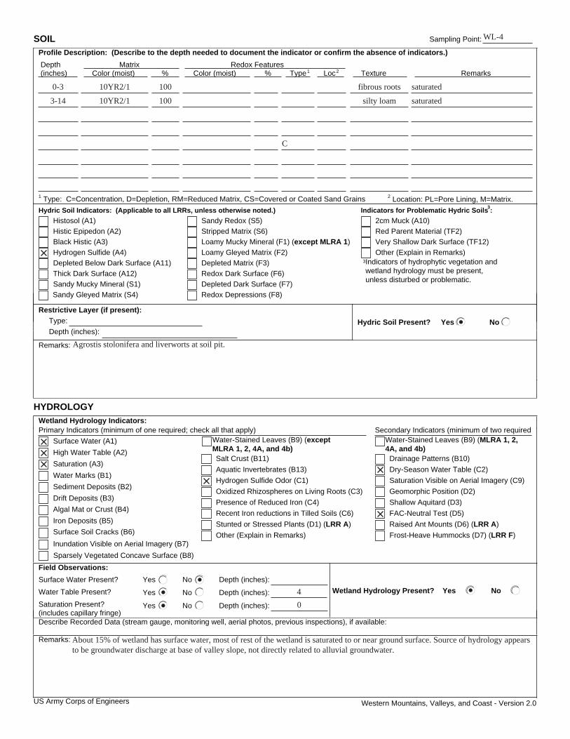
Western Mountains, Valleys, and Coast - Version 2.0
SOIL Sampling Point:
Profile Description: (Describe to the depth needed to document the indicator or confirm the absence of indicators.)
Depth Matrix Redox Features (inches) Color (moist) % Color (moist) % Type1 Loc2 Texture Remarks
1 Type: C=Concentration, D=Depletion, RM=Reduced Matrix, CS=Covered or Coated Sand Grains 2 Location: PL=Pore Lining, M=Matrix.
Hydric Soil Indicators: (Applicable to all LRRs, unless otherwise noted.) Indicators for Problematic Hydric Soils :3
Histosol (A1) Sandy Redox (S5)
Histic Epipedon (A2) Stripped Matrix (S6)
Black Histic (A3) Loamy Mucky Mineral (F1) (except MLRA 1)
Hydrogen Sulfide (A4) Loamy Gleyed Matrix (F2)
Depleted Matrix (F3)
Redox Dark Surface (F6)
Depleted Below Dark Surface (A11)
Depleted Dark Surface (F7)
Thick Dark Surface (A12)
Redox Depressions (F8)
Sandy Mucky Mineral (S1)
3Indicators of hydrophytic vegetation and wetland hydrology must be present, unless disturbed or problematic.
Restrictive Layer (if present):
Type:
Depth (inches): Hydric Soil Present? Yes No
Remarks:
HYDROLOGY
Wetland Hydrology Indicators: Secondary Indicators (minimum of two requiredPrimary Indicators (minimum of one required; check all that apply)
Surface Water (A1)
Salt Crust (B11)
Surface Soil Cracks (B6)
High Water Table (A2)
Aquatic Invertebrates (B13)
Sparsely Vegetated Concave Surface (B8)
Saturation (A3)
Hydrogen Sulfide Odor (C1)
Drainage Patterns (B10)
Water Marks (B1)
Sediment Deposits (B2) Oxidized Rhizospheres on Living Roots (C3)
Drift Deposits (B3) Presence of Reduced Iron (C4)
Saturation Visible on Aerial Imagery (C9)
Algal Mat or Crust (B4)
Geomorphic Position (D2)
Iron Deposits (B5)
Other (Explain in Remarks)
FAC-Neutral Test (D5)
Inundation Visible on Aerial Imagery (B7) Frost-Heave Hummocks (D7) (LRR F)
Field Observations:
Surface Water Present? Yes No Depth (inches):
Water Table Present? Yes No Depth (inches):
Saturation Present? Yes No Depth (inches): (includes capillary fringe)
Wetland Hydrology Present? Yes No
Describe Recorded Data (stream gauge, monitoring well, aerial photos, previous inspections), if available:
Remarks:
US Army Corps of Engineers
Sandy Gleyed Matrix (S4)
Red Parent Material (TF2)
Very Shallow Dark Surface (TF12)
Other (Explain in Remarks)
2cm Muck (A10)
Water-Stained Leaves (B9) (except MLRA 1, 2, 4A, and 4b)
Stunted or Stressed Plants (D1) (LRR A)
Recent Iron reductions in Tilled Soils (C6)
Water-Stained Leaves (B9) (MLRA 1, 2, 4A, and 4b)
Dry-Season Water Table (C2)
Shallow Aquitard (D3)
Raised Ant Mounts (D6) (LRR A)
WL-4
0-3 10YR2/1 100 fibrous roots saturated
saturatedsilty loam10010YR2/13-14
C
Agrostis stolonifera and liverworts at soil pit.
4
0
About 15% of wetland has surface water, most of rest of the wetland is saturated to or near ground surface. Source of hydrology appears to be groundwater discharge at base of valley slope, not directly related to alluvial groundwater.
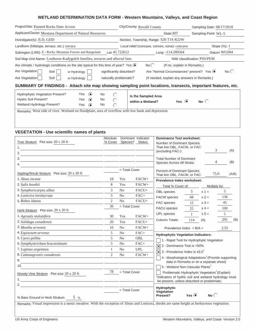
US Army Corps of Engineers Western Mountains, Valleys, and Coast- Version 2.0
WETLAND DETERMINATION DATA FORM - Western Mountains, Valleys, and Coast Region
Project/Site: City/County: Sampling Date:
Applicant/Owner: State: Sampling Point:
Investigator(s): Section, Township, Range:
Landform (hillslope, terrace, etc.): Local relief (concave, convex, none): Slope (%):
Subregion (LRR): Lat: Long: Datum:
Soil Map Unit Name: NWI classification:
Are climatic / hydrologic conditions on the site typical for this time of year? Yes No (If no, explain in Remarks.)
Are Vegetation Soil or Hydrology significantly disturbed? Are "Normal Circumstances" present? Yes No
Are Vegetation Soil or Hydrology naturally problematic? (If needed, explain any answers in Remarks.)
SUMMARY OF FINDINGS - Attach site map showing sampling point locations, transects, important features, etc.
Hydrophytic Vegetation Present? Yes No
Hydric Soil Present? Yes No
Wetland Hydrology Present? Yes No
Is the Sampled Area
within a Wetland? Yes No
Remarks:
VEGETATION - Use scientific names of plants
Dominance Test worksheet:
Number of Dominant Species That Are OBL, FACW, or FAC: (excluding FAC-): (A)
Total Number of Dominant Species Across All Strata: (B)
Percent of Dominant Species That Are OBL, FACW, or FAC: (A/B)
Prevalence Index worksheet:
Total % Cover of: Multiply by:
OBL species x 1 =
FACW species x 2 =
FAC species x 3 =
FACU species x 4 =
UPL species x 5 =
Column Totals: (A) (B)
Prevalence Index = B/A =
Hydrophytic Vegetation Indicators:
3 - Prevalence Index is 3.0 1
4 - Morphological Adaptations1 (Provide supporting data in Remarks or on a separate sheet)
Problematic Hydrophytic Vegetation1 (Explain)
1Indicators of hydric soil and wetland hydrology must be present, unless disturbed or problematic.
Absolute Dominant Indicator Tree Stratum Plot size: % Cover Species? Status
1.
2.
3.
4.
Sapling/Shrub Stratum Plot size:
1.
2.
3.
4.
5.
Herb Stratum Plot size:
1.
2.
3.
4.
5.
6.
7.
8.
Woody Vine Stratum Plot size:
1.
2.
% Bare Ground in Herb Stratum
HydrophyticVegetationPresent? Yes No
Remarks:
2 - Dominance Test is >50%
1 - Rapid Test for Hydrophytic Vegetation
5 - Wetland Non-Vascular Plants 1
= Total Cover
9.
10.
= Total Cover
= Total Cover
%
= Total Cover
Painted Rocks Dam Access Ravalli County 08/17/2018
Montana Department of Natural Resources WL-5
JLD, GDD S26 T1S R22W
terrace concave 1
MT
E - Rocky Mountain Forests and Rangeland 45.722612 -114.280564 WGS84
Losthorse-Kadygulch families, terraces and alluvial fans PSS/PEM
3
4
75.0
68
1
25
15
5
West side of river. Wetland on floodplain, area of overflow with low bank and depression.
Alnus incana
5
3
8
18
Lonicera involucrata
Symphoricarpos albus
Salix boothii
2Rubus idaeus
3620 x 20 ft
Yes
Yes
No
No
No
FACW+
FACW+
FACU+
FAC+
FACU+
Yes
Yes
No
No
No
No
No
No
5
5
10
20
30
Carex pellita
Equisetum arvense
Mentha arvensis
Solidago canadensis
Agrostis stolonifera
2
1
5
Calamagrostis canadensis
Lupinus argenteus
Symphyotrichum bracteolatum
7820 x 20 ft
FACW+
FACU+
FACW+
FAC+
OBL
FAC+
UPL
FACW+
5
Visual impression is a mesic meadow. With the exception of Alnus and Lonicera, shrubs are same height as herbaceous vegetation.
114 291
5
100
45
136
5
2.55
20 x 20 ft
20 x 20 ft

Western Mountains, Valleys, and Coast - Version 2.0
SOIL Sampling Point:
Profile Description: (Describe to the depth needed to document the indicator or confirm the absence of indicators.)
Depth Matrix Redox Features (inches) Color (moist) % Color (moist) % Type1 Loc2 Texture Remarks
1 Type: C=Concentration, D=Depletion, RM=Reduced Matrix, CS=Covered or Coated Sand Grains 2 Location: PL=Pore Lining, M=Matrix.
Hydric Soil Indicators: (Applicable to all LRRs, unless otherwise noted.) Indicators for Problematic Hydric Soils :3
Histosol (A1) Sandy Redox (S5)
Histic Epipedon (A2) Stripped Matrix (S6)
Black Histic (A3) Loamy Mucky Mineral (F1) (except MLRA 1)
Hydrogen Sulfide (A4) Loamy Gleyed Matrix (F2)
Depleted Matrix (F3)
Redox Dark Surface (F6)
Depleted Below Dark Surface (A11)
Depleted Dark Surface (F7)
Thick Dark Surface (A12)
Redox Depressions (F8)
Sandy Mucky Mineral (S1)
3Indicators of hydrophytic vegetation and wetland hydrology must be present, unless disturbed or problematic.
Restrictive Layer (if present):
Type:
Depth (inches): Hydric Soil Present? Yes No
Remarks:
HYDROLOGY
Wetland Hydrology Indicators: Secondary Indicators (minimum of two requiredPrimary Indicators (minimum of one required; check all that apply)
Surface Water (A1)
Salt Crust (B11)
Surface Soil Cracks (B6)
High Water Table (A2)
Aquatic Invertebrates (B13)
Sparsely Vegetated Concave Surface (B8)
Saturation (A3)
Hydrogen Sulfide Odor (C1)
Drainage Patterns (B10)
Water Marks (B1)
Sediment Deposits (B2) Oxidized Rhizospheres on Living Roots (C3)
Drift Deposits (B3) Presence of Reduced Iron (C4)
Saturation Visible on Aerial Imagery (C9)
Algal Mat or Crust (B4)
Geomorphic Position (D2)
Iron Deposits (B5)
Other (Explain in Remarks)
FAC-Neutral Test (D5)
Inundation Visible on Aerial Imagery (B7) Frost-Heave Hummocks (D7) (LRR F)
Field Observations:
Surface Water Present? Yes No Depth (inches):
Water Table Present? Yes No Depth (inches):
Saturation Present? Yes No Depth (inches): (includes capillary fringe)
Wetland Hydrology Present? Yes No
Describe Recorded Data (stream gauge, monitoring well, aerial photos, previous inspections), if available:
Remarks:
US Army Corps of Engineers
Sandy Gleyed Matrix (S4)
Red Parent Material (TF2)
Very Shallow Dark Surface (TF12)
Other (Explain in Remarks)
2cm Muck (A10)
Water-Stained Leaves (B9) (except MLRA 1, 2, 4A, and 4b)
Stunted or Stressed Plants (D1) (LRR A)
Recent Iron reductions in Tilled Soils (C6)
Water-Stained Leaves (B9) (MLRA 1, 2, 4A, and 4b)
Dry-Season Water Table (C2)
Shallow Aquitard (D3)
Raised Ant Mounts (D6) (LRR A)
WL-5
0-2 10YR2/2 100 Fibrous root mat
saturatedsilty loam10010YR3/32-6
saturatedcoarse gravelly10010YR5/16-15+
sand
Many river cobbles.
2
2
PAINTED ROCKS DAM TOE ACCESS ROAD DRAFT ENVIRONMENTAL ASSESSMENT
Appendix C SHPO Coordination