Embed Size (px)
Citation preview

Catena 83 (2010) 7–22
Contents lists available at ScienceDirect
Catena
j ourna l homepage: www.e lsev ie r.com/ locate /catena
Paleolandscape and paleoenvironmental interpretation of spring-depositedsediments in Dakhleh Oasis, Western Desert of Egypt
Katherine A. Adelsberger ⁎, Jennifer R. SmithDepartment of Earth and Planetary Sciences, Washington University in St. Louis, One Brookings Dr., St. Louis, MO 63130, United States
⁎ Corresponding author. Current Address: DepartmeKnox College, 2 East South St. Galesburg, IL 61401, Un7274; fax: +1 309 341 7034.
E-mail address: [email protected] (K.A. Adelsberg
0341-8162/$ – see front matter © 2010 Elsevier B.V. Aldoi:10.1016/j.catena.2010.06.009
a b s t r a c t
a r t i c l e i n f oArticle history:Received 20 August 2008Received in revised form 17 March 2010Accepted 23 June 2010
Keywords:Spring moundBog ironPluvial depositsGroundwaterPaleolithicEgypt
Iron-rich sediments in Dakhleh Oasis, Western Desert of Egypt, have been recognized as spring mounds andas archaeological sites where Paleolithic materials have been recovered. Detailed sedimentologicinvestigation and mapping of these features reveal that spring mound sediments were deposited in ashallow vegetated wetland formed by the discharge of iron-rich Nubian Aquifer waters along the southernmargin of the oasis, controlled largely by localized faulting and the variable paleotopography of the basinfloor. The spring sediments represent peri-lacustrine or lake independent features and can be differentiatedfrom fully lacustrine deposits on the basis of their sedimentary characteristics as well as the presence ofgoethite and jarosite in a region where authigenic deposition during Pleistocene pluvial activity principallyresulted in tufas and lacustrine marls. Spring mound formation incorporated sediment through the pondingof surface water, aeolian entrapment by local vegetation, and the formation of iron precipitates in a low-energy, oxidative and acidic environment that was not dependent upon surface water inputs into theDakhleh basin. The potentially interpluvial nature of this water resource makes it an important sedimentaryarchive for archaeological investigations in the basin. The Dakhleh spring mounds record a uniquegroundwater controlled paleoenvironment, providing the first evidence of a bog iron in Egypt and one of thefew occurrences of iron-rich wetland remnants in the modern Sahara.
nt of Environmental Studies,ited States. Tel.: +1 309 341
er).
l rights reserved.
© 2010 Elsevier B.V. All rights reserved.
1. Introduction
The modern Western Desert of Egypt is a hyperarid environment,receiving a mean annual rainfall of 0.7 mm (Shahin, 1985). However,climatic conditions across northern Africa have oscillated betweenarid and humid (or pluvial) during the Quaternary, as indicated bylacustrine, fluvial and spring-deposited sediments preserved in themodern Sahara (e.g., Gaven et al., 1981; McHugh et al., 1988; Szaboet al., 1995; Crombie et al., 1997; Swezey et al., 1999; Brook et al.,2003; Smith et al., 2004a). The association of archaeological materialswith many of these pluvial deposits indicates hominin occupation ofthe Sahara during humid periods (e.g., Caton-Thompson, 1952;Wendorf et al., 1991; Wendorf et al., 1993; Hill, 2001; Hoelzmannet al., 2001; Kleindienst, 2003; Smith et al., 2004b).
Egypt straddles one of the four likely migration routes, and theonly fully terrestrial route, out of the African continent for all majorhominin migrations (Derricourt, 2005), making the identification ofhabitable hominin environments important for the recognition ofpotential migration corridors. The Western Desert oases provided theresources necessary for early human habitation during humid periods,
as indicated by spring and lacustrine deposits found in oasisdepressions. These deposits also record a localized climatic signal(e.g., Smith et al., 2004a, 2004b), in contrast to the more regionalrecords, encompassing changes within several climate zones, provid-ed by Nile Valley sediments (Shahin, 1985). Associations of Paleolithicartifacts with water-lain deposits in Dakhleh Oasis therefore providean opportunity to characterize hominin paleoenvironments in theWestern Desert (Kleindienst, 1999), which may have served as awaypoint for early human migration as an alternative to thepotentially more dangerous and crowded Nile Valley (e.g., Klein-dienst, 2000). Although the timing of enhanced rainfall relative totoday was likely a significant control on when desert regions could beused by early human groups (Chiotti et al., 2007), the specificchronology of water resource availability at any particular localitywould have been dependent upon hydrologic and geomorphic factors.Detailed examinations of pluvial deposits can clarify the sequence ofhydrologic events that occurred in Dakhleh following the onset ofpluvial conditions, thereby constraining the extent to which the oasismay have supported hominin survival and migration.
Dakhleh Oasis is one of a series of structural depressions in theWestern Desert (Fig. 1), where Pleistocene pluvial sediments occur asiron-rich spring deposits as well as carbonate spring and lacustrinesediments (Brookes, 1993a; Brookes, 1993b; Churcher et al., 1999).Dates obtained from lacustrine deposits in Dakhleh indicate pluvialconditions between 100 and 200 ka (Osinski et al., 2007). However,
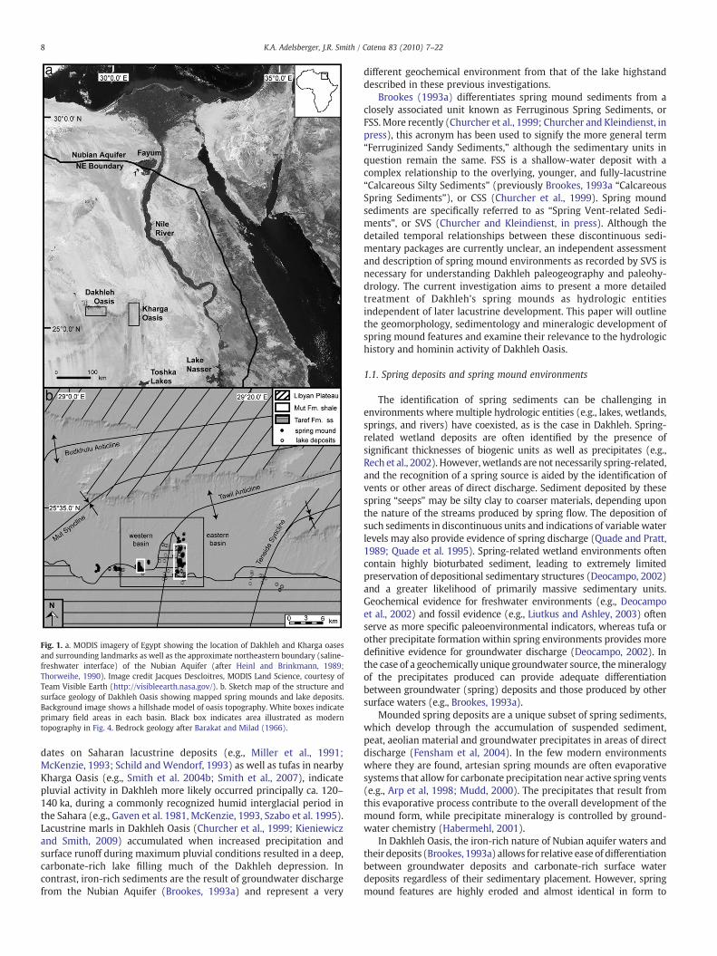
Fig. 1. a. MODIS imagery of Egypt showing the location of Dakhleh and Kharga oasesand surrounding landmarks as well as the approximate northeastern boundary (saline-freshwater interface) of the Nubian Aquifer (after Heinl and Brinkmann, 1989;Thorweihe, 1990). Image credit Jacques Descloitres, MODIS Land Science, courtesy ofTeam Visible Earth (http://visibleearth.nasa.gov/). b. Sketch map of the structure andsurface geology of Dakhleh Oasis showing mapped spring mounds and lake deposits.Background image shows a hillshade model of oasis topography. White boxes indicateprimary field areas in each basin. Black box indicates area illustrated as moderntopography in Fig. 4. Bedrock geology after Barakat and Milad (1966).
8 K.A. Adelsberger, J.R. Smith / Catena 83 (2010) 7–22
dates on Saharan lacustrine deposits (e.g., Miller et al., 1991;McKenzie, 1993; Schild andWendorf, 1993) as well as tufas in nearbyKharga Oasis (e.g., Smith et al. 2004b; Smith et al., 2007), indicatepluvial activity in Dakhleh more likely occurred principally ca. 120–140 ka, during a commonly recognized humid interglacial period inthe Sahara (e.g., Gaven et al. 1981, McKenzie, 1993, Szabo et al. 1995).Lacustrine marls in Dakhleh Oasis (Churcher et al., 1999; Kieniewiczand Smith, 2009) accumulated when increased precipitation andsurface runoff during maximum pluvial conditions resulted in a deep,carbonate-rich lake filling much of the Dakhleh depression. Incontrast, iron-rich sediments are the result of groundwater dischargefrom the Nubian Aquifer (Brookes, 1993a) and represent a very
different geochemical environment from that of the lake highstanddescribed in these previous investigations.
Brookes (1993a) differentiates spring mound sediments from aclosely associated unit known as Ferruginous Spring Sediments, orFSS. More recently (Churcher et al., 1999; Churcher and Kleindienst, inpress), this acronym has been used to signify the more general term“Ferruginized Sandy Sediments,” although the sedimentary units inquestion remain the same. FSS is a shallow-water deposit with acomplex relationship to the overlying, younger, and fully-lacustrine“Calcareous Silty Sediments” (previously Brookes, 1993a “CalcareousSpring Sediments”), or CSS (Churcher et al., 1999). Spring moundsediments are specifically referred to as “Spring Vent-related Sedi-ments”, or SVS (Churcher and Kleindienst, in press). Although thedetailed temporal relationships between these discontinuous sedi-mentary packages are currently unclear, an independent assessmentand description of spring mound environments as recorded by SVS isnecessary for understanding Dakhleh paleogeography and paleohy-drology. The current investigation aims to present a more detailedtreatment of Dakhleh's spring mounds as hydrologic entitiesindependent of later lacustrine development. This paper will outlinethe geomorphology, sedimentology and mineralogic development ofspring mound features and examine their relevance to the hydrologichistory and hominin activity of Dakhleh Oasis.
1.1. Spring deposits and spring mound environments
The identification of spring sediments can be challenging inenvironments where multiple hydrologic entities (e.g., lakes, wetlands,springs, and rivers) have coexisted, as is the case in Dakhleh. Spring-related wetland deposits are often identified by the presence ofsignificant thicknesses of biogenic units as well as precipitates (e.g.,Rech et al., 2002). However,wetlands are not necessarily spring-related,and the recognition of a spring source is aided by the identification ofvents or other areas of direct discharge. Sediment deposited by thesespring “seeps” may be silty clay to coarser materials, depending uponthe nature of the streams produced by spring flow. The deposition ofsuch sediments in discontinuous units and indications of variable waterlevels may also provide evidence of spring discharge (Quade and Pratt,1989; Quade et al. 1995). Spring-related wetland environments oftencontain highly bioturbated sediment, leading to extremely limitedpreservation of depositional sedimentary structures (Deocampo, 2002)and a greater likelihood of primarily massive sedimentary units.Geochemical evidence for freshwater environments (e.g., Deocampoet al., 2002) and fossil evidence (e.g., Liutkus and Ashley, 2003) oftenserve as more specific paleoenvironmental indicators, whereas tufa orother precipitate formation within spring environments provides moredefinitive evidence for groundwater discharge (Deocampo, 2002). Inthe case of a geochemically unique groundwater source, themineralogyof the precipitates produced can provide adequate differentiationbetween groundwater (spring) deposits and those produced by othersurface waters (e.g., Brookes, 1993a).
Mounded spring deposits are a unique subset of spring sediments,which develop through the accumulation of suspended sediment,peat, aeolian material and groundwater precipitates in areas of directdischarge (Fensham et al, 2004). In the few modern environmentswhere they are found, artesian spring mounds are often evaporativesystems that allow for carbonate precipitation near active spring vents(e.g., Arp et al, 1998; Mudd, 2000). The precipitates that result fromthis evaporative process contribute to the overall development of themound form, while precipitate mineralogy is controlled by ground-water chemistry (Habermehl, 2001).
In Dakhleh Oasis, the iron-rich nature of Nubian aquifer waters andtheir deposits (Brookes, 1993a) allows for relative ease of differentiationbetween groundwater deposits and carbonate-rich surface waterdeposits regardless of their sedimentary placement. However, springmound features are highly eroded and almost identical in form to

9K.A. Adelsberger, J.R. Smith / Catena 83 (2010) 7–22
remnant lacustrine sediments, due to the yardanged and eroded natureof local bedrock and Quaternary deposits (Brookes, 1993a). This makesit difficult to distinguish between these deposits in the absence ofdetailed field investigations. Such detailed investigations in Dakhlehprovide a starting point for understanding the original extent ofgroundwater-related deposition in Dakhleh as well as examining thesedimentology and geomorphology of the spring mounds themselves.
1.2. Geologic setting
Dakhleh Oasis (latitude 25.5°N, longitude 29.0°E) stretches 70 kmfrom SE to NW, with maximum north–south dimensions of approx-imately 20 km (Fig. 1) (Brookes, 1989). The oasis is bounded to thenorth by the limestone-capped Libyan Plateau (Fig. 1b). Bedrock inthe lowland portion of the basin consists of Cretaceous-age TarefFormation sandstone, which unconformably underlies Cretaceous-ageMut (Quseir) Formation shales (Hermina, 1990). Quaternary sedi-ments are found primarily in southern Dakhleh on eroded bedrocksurfaces (El-Hinnawi et al., 1975; Hermina, 1990), where springmounds occur in the vicinity of the contact between the Taref and theMut Formations (Fig. 1b). Bedrock units dip slightly (b5°) to the northforming gently undulating, NE-plunging synclinal and anticlinal foldswithin the larger context of the regional Dakhla Syncline (Barakat andMilad, 1966).
The Taref Formation, the local member of the Nubian Aquifersandstone (Brookes, 1993a), is one of a series of sandstone units thatmake up the Nubian Aquifer System, which extends through portionsof Egypt, Libya, Chad, and Sudan (Fig. 1a) (Thorweihe, 1990). Thesesandstone units have good hydraulic conductivities and provide areservoir of “fossil” groundwater recharged during pluvial events ofthe geologic past (Thorweihe, 1986). Recent 81Kr dating indicates‘deep’ fossil groundwater ages of 2×10⁵ to 1×10⁶ years (Sturchioet al., 2004); this deep groundwater was most likely recharged insouthwestern Egypt from an Atlantic Ocean source (Sonntag et al.,1979, 1980). In contrast, shallow and locally unconfined sandstonehorizons may have been recharged by younger, more localized pluvialevents during the Holocene (Brinkmann and Heinl, 1986; Hesse et al.,1987; Heinl and Brinkmann, 1989; Patterson et al., 2005). In theWestern Desert, Nubian sandstones comprise multiple layers ofisolated and perched aquifers (Shata, 1982), and local groundwateris most likely a mixture of deep water and younger, locally rechargedwater (Dabous and Osmond, 2001). The groundwater head gradientin Egypt indicates flow from south to north; as a result Dakhleh is thefirst of the oases to receive groundwater input from its southwesternsource (Thorweihe, 1986; Patterson et al., 2005).
Dakhleh Oasis contains two significant depressions separated byan uplifted sandstone ridge, or dividing ridge, associated with thenorthward-plunging Tawil Anticline (Fig. 1b). Thewestern depressioncorresponds with the axis of the Mut Syncline; the eastern lowlandportion of the basin is also known as the Teneida Syncline (Barakatand Milad, 1966). Lacustrine deposits have been identified in both theeastern and western depressions (Kleindienst et al., 1999; Kieniewiczand Smith, 2009), as have Pleistocene spring mounds (Schild andWendorf, 1981; Brookes, 1993a). The spring mounds occur primarilyalong the dividing ridge in the southern portion of the oasis. Similarmounds have also been identified in Kharga Oasis (Fig. 1a), 140 kmeast of Dakhleh, where they occur along bedrock fractures and faults(Caton-Thompson, 1952; Brookes, 1993a). The lack of such structuralfeatures may account for the absence of spring mounds in the regionbetween Dakhleh and Kharga (Brookes, 1993a).
The Dakhleh spring mounds have been described in some detail inprevious investigations, most notably by Brookes (1993a), Frizano(1996), and Kleindienst et al. (1999). Spring mound features provide ageologic context for the recovery of archaeologicalmaterials, represent-ing environments occupied or utilized by Pleistocene hominins in anumber of locations in theWestern Desert. Acheulian andMiddle Stone
Age (MSA) artifacts have been found in association with springenvironments at Bir Tarfawi in southern Egypt (Wendorf et al., 1976;Wendorf et al., 1991; Hill, 2001), and Dakhleh springmound sedimentscontain both Upper Acheulian and Middle Paleolithic assemblages(Wendorf et al., 1976; Schild and Wendorf, 1977; Brookes, 1993a;Kleindienst, 1999). Understanding the role of spring mounds as localhydrologic features will contribute to models of lake formation andpluvial activity during the Pleistocene while aiding in the identificationof habitable paleoenvironments in Dakhleh Oasis.
2. Methods
Fieldwork included survey of a significant portion of Dakhleh Oasis,but detailed sedimentary description focused on spring mounds in twomain study areas in the eastern and western basins (Fig. 1b).Stratigraphic sections of 58 spring mounds were described in detailand measured using a Jacob staff and Abney level. An additional 72mounds were described without measurement. All mounds weredigitally photographed and mapped using differential GPS (≤0.5 mvertical, ≤0.2 m horizontal error) and ArcGIS 9.0 software. Ironstoneelevations, local high points, and contacts between Quaternarysediment and pre-Quaternary bedrock were mapped on all moundswhere applicable. Sediment colors were recorded as dry Munsell soilcolors. Grain size determinations of silt- and sand-size fractions weremade using pipette analysis (after Gee and Bauder, 1986) followingdigestionwith H2O2 and dispersionwith sodiummetaphosphate. Sand-fraction weight percents were obtained after wet-sieving of sediment.
Texture and identifiable mineralogy of ironstone samples weredescribed in thin section. Additional mineralogical identificationswere made by qualitative XRD analysis on a Rigaku D-MAX/Adiffractometer using Cu–Kα radiation (35 kV, 35 mA) followingcalibration using a powdered silica standard. Samples were analyzedas backfilled powder mounts, or where necessary as orientedevaporation mounts, of both whole-sediment and clay-fractioncomponents (Whittig and Allardice, 1986). Samples were step-scanned from 2.0–70.0 2θ at 0.02° step intervals and analyzed usingMaterials Data, Inc. Jade software. For the purposes of this paper,ironstone refers to indurated iron precipitate-rich units in general,whereas ferricrete refers specifically to iron-cemented sandstones(Bourman, 1993) as a subset of ironstones. Non-ferricrete ironstonesdescribed in this study are referred to as iron precipitates.
Mineralogical identifications were made by qualitative X-raydiffraction (XRD) analysis on a Rigaku D-MAX/A diffractometer usingCu–Kα radiation (35 kV, 35 mA) following calibrationusing apowderedsilica standard. XRD samples were analyzed as backfilled powdermounts, or where necessary as oriented evaporation mounts, of bothbulk-sediment and clay-fraction components (Whittig and Allardice,1986). Samples were step-scanned from 2.0–70.0 2θ at 0.04˚ stepintervals and analyzed using Materials Data, Inc. Jade software. X-rayfluorescence (XRF) analyses were obtained for both major (Si, Ti, Al, Fe,Mn, Mg, Ca, Na, K, and P) and minor (Pb, Nb, Zr, Y, Sr, Rb, Ga, Zn, Ni, Ba,Co, V, Ce) elements using a Siemens SRS-200 sequential spectrometer.Errors for all XRF measurements are equal to or better than±0.25 (onesigma). Elemental distributions of several polished thin sections weremapped through wavelength dispersive and silicon drift energydispersive X-ray spectroscopy using a JEOL 733 electron microprobe.
3. Results
3.1. Spring mound morphology
Springmounds throughout Dakhleh occur as erosional remnantswithvariable thicknesses of Quaternary sediments; up to six meters of springsediments may be preserved, but most mounds consist of only remnantsilts overlying an erosional “mound” of Mut Formation bedrock shales.Identifiable spring vents are often present, preserved by iron oxide-
10 K.A. Adelsberger, J.R. Smith / Catena 83 (2010) 7–22
stained silts and sands (Fig. 2a). The elevations of contacts betweenbedrock and spring sediments indicate the modern surface has beendeflated between four and seven meters below the pre-dischargepaleosurface, although the degree of erosion varies significantly frommound tomound (Fig. 3). Themounds found farthest north are generallymore eroded (Fig. 2b, c), possibly due to the prevailing northerlywinds inthis region, but additional erosional variation across the study areasuggests that preferential preservation of mounds capped by hardironstone deposits as well as the presence of an irregular paleosurfacealso played a role in landscape formation during the late Quaternary.
Springmounds in both the eastern andwestern basins exhibit similarerosional forms and stratigraphies,with iron-richdeposits present in bothbasins. Ironstones commonly occur as caps on poorly-consolidated, siltysediments (Fig. 3); iron oxides are also found as thin lenses of precipitate
Fig. 2. Field photos from southern Dakhleh Oasis: a) spring vent remnant in Mut Fm. shalesouthernmargin of the eastern study area, field pack and Jacob Staff (length 1.5 m) for scale, cbackground (looking southwest), field pack and Jacob Staff for scale d) large iron-capped spsilts atop Mut Formation shale, Land Cruiser for scale, f) root mats preserved as iron casts w
andas cementwithin spring-deposited silts. Throughoutboth studyareas,sedimentary units are similar in terms of elevation, texture, mineralogyand erosional form, suggesting themound sediments in these two basinswere deposited by the same processes and likely during the same timeperiod or periods. However, the stratigraphy of the springmounds in bothbasins is often laterally discontinuous over tens or hundreds of meters.The lack of stratigraphic correlation between even adjacent springmounds suggests isolated deposition of similar units (Fig. 3), althoughtheir erosional expression is identical to that of previously continuouspaleolacustrine landscapes. Bedrock contacts indicate a paleosurface thatdipped away from the Tawil uplift in both basins (Fig. 4). At higherelevations root casts, root traces and blocky peds indicate weak paleosolformation in basal silts. In many cases only remnant silts are present on alow mound of Mut shales, due to the significant deflation of this area.
, rock hammer (arrow, length 28 cm) for scale, b) circular ironstone deposit along the) remnant spring deposit at modern ground level with larger mound forms visible in thering mound, field pack for scale, e) average erosional mound form consisting of springith rock hammer for scale.

Fig. 3. Schematic view of basin topography with representative spring mound stratigraphy in both the eastern (a) and western (b) basins represented as generalized geomorphicsketches (~35× vertical exaggeration) and detailed stratigraphic sketches of the illustrated mounds with grain size curves where grain size data are available. Elevations of moundsections are based on DGPS data for the tops of mound features. DGPS elevations of mound tops (in meters above mean sea level) are listed on the left, whereas the scale for thesedimentary units depicted in the stratigraphic sections (in meters) is on the right. Horizontal scale is approximate to mound positions indicated by dashes along section linesillustrated in Fig. 4. For additional description of the relationship between spring mound sediments and lacustrine sediments or bedrock deposits please see Brookes (1993a),Churcher et al. (1999), or Churcher and Kleindienst (in press).
11K.A. Adelsberger, J.R. Smith / Catena 83 (2010) 7–22
3.2. Spring mound sedimentology
Spring-deposited sediments foundwithin the Dakhlehmounds takea number of forms. The contact betweenMut bedrock shales and springmound sediments in both study areas is most often defined by the
presence of bioturbated and well-sorted, jarosite (KFe3(OH)6(SO4)2)and goethite (FeOOH)-stained quartz silts (Figs. 3 and 5). These siltsvary from massive to weakly bedded quartz, defined in part by jarosite(2.5Y8/4, pale yellow) and goethite (10YR5/8, yellowish brown)staining in otherwise pale (2.5Y8/2, pale yellow) quartz silts. Limited
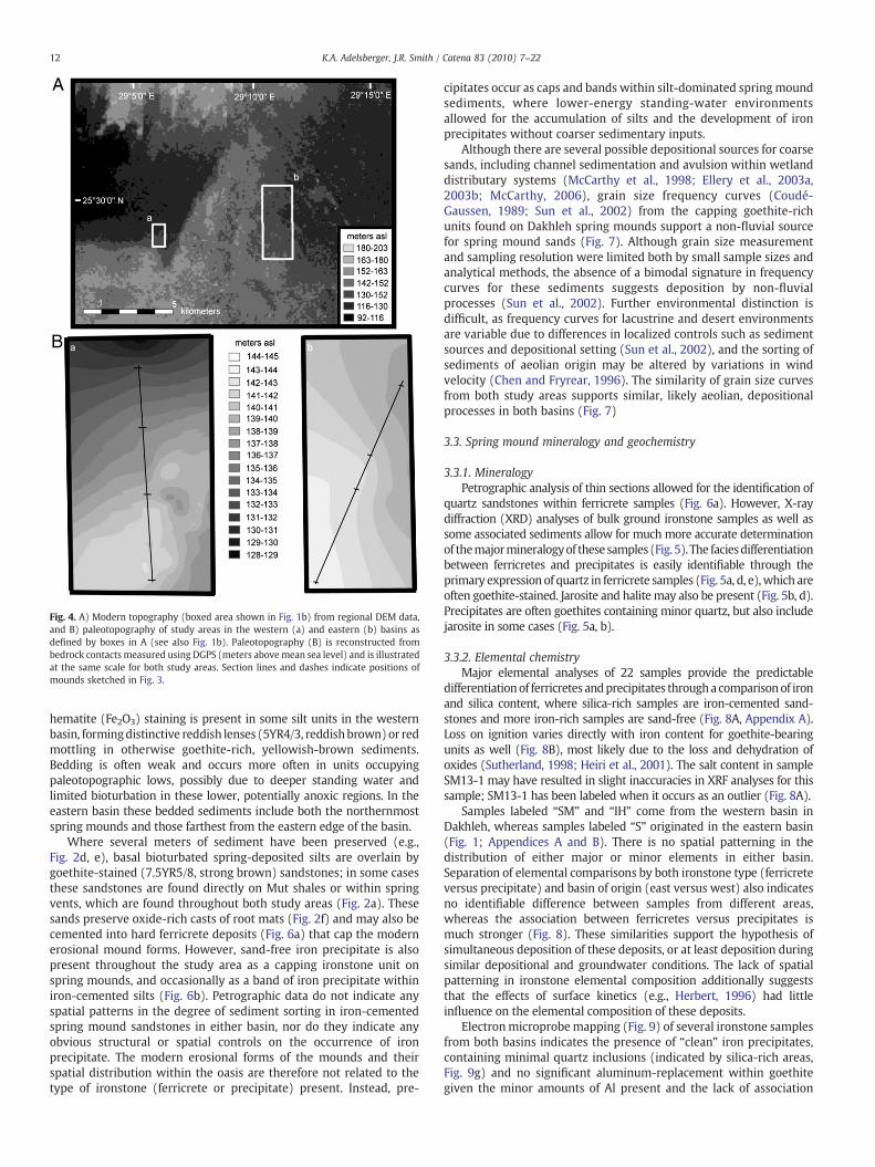
Fig. 4. A) Modern topography (boxed area shown in Fig. 1b) from regional DEM data,and B) paleotopography of study areas in the western (a) and eastern (b) basins asdefined by boxes in A (see also Fig. 1b). Paleotopography (B) is reconstructed frombedrock contacts measured using DGPS (meters abovemean sea level) and is illustratedat the same scale for both study areas. Section lines and dashes indicate positions ofmounds sketched in Fig. 3.
12 K.A. Adelsberger, J.R. Smith / Catena 83 (2010) 7–22
hematite (Fe2O3) staining is present in some silt units in the westernbasin, formingdistinctive reddish lenses (5YR4/3, reddishbrown)or redmottling in otherwise goethite-rich, yellowish-brown sediments.Bedding is often weak and occurs more often in units occupyingpaleotopographic lows, possibly due to deeper standing water andlimited bioturbation in these lower, potentially anoxic regions. In theeastern basin these bedded sediments include both the northernmostspring mounds and those farthest from the eastern edge of the basin.
Where several meters of sediment have been preserved (e.g.,Fig. 2d, e), basal bioturbated spring-deposited silts are overlain bygoethite-stained (7.5YR5/8, strong brown) sandstones; in some casesthese sandstones are found directly on Mut shales or within springvents, which are found throughout both study areas (Fig. 2a). Thesesands preserve oxide-rich casts of root mats (Fig. 2f) and may also becemented into hard ferricrete deposits (Fig. 6a) that cap the modernerosional mound forms. However, sand-free iron precipitate is alsopresent throughout the study area as a capping ironstone unit onspring mounds, and occasionally as a band of iron precipitate withiniron-cemented silts (Fig. 6b). Petrographic data do not indicate anyspatial patterns in the degree of sediment sorting in iron-cementedspring mound sandstones in either basin, nor do they indicate anyobvious structural or spatial controls on the occurrence of ironprecipitate. The modern erosional forms of the mounds and theirspatial distribution within the oasis are therefore not related to thetype of ironstone (ferricrete or precipitate) present. Instead, pre-
cipitates occur as caps and bands within silt-dominated spring moundsediments, where lower-energy standing-water environmentsallowed for the accumulation of silts and the development of ironprecipitates without coarser sedimentary inputs.
Although there are several possible depositional sources for coarsesands, including channel sedimentation and avulsion within wetlanddistributary systems (McCarthy et al., 1998; Ellery et al., 2003a,2003b; McCarthy, 2006), grain size frequency curves (Coudé-Gaussen, 1989; Sun et al., 2002) from the capping goethite-richunits found on Dakhleh spring mounds support a non-fluvial sourcefor spring mound sands (Fig. 7). Although grain size measurementand sampling resolution were limited both by small sample sizes andanalytical methods, the absence of a bimodal signature in frequencycurves for these sediments suggests deposition by non-fluvialprocesses (Sun et al., 2002). Further environmental distinction isdifficult, as frequency curves for lacustrine and desert environmentsare variable due to differences in localized controls such as sedimentsources and depositional setting (Sun et al., 2002), and the sorting ofsediments of aeolian origin may be altered by variations in windvelocity (Chen and Fryrear, 1996). The similarity of grain size curvesfrom both study areas supports similar, likely aeolian, depositionalprocesses in both basins (Fig. 7)
3.3. Spring mound mineralogy and geochemistry
3.3.1. MineralogyPetrographic analysis of thin sections allowed for the identification of
quartz sandstones within ferricrete samples (Fig. 6a). However, X-raydiffraction (XRD) analyses of bulk ground ironstone samples as well assome associated sediments allow for much more accurate determinationof themajormineralogyof these samples (Fig. 5). The faciesdifferentiationbetween ferricretes and precipitates is easily identifiable through theprimary expressionof quartz in ferricrete samples (Fig. 5a, d, e),which areoften goethite-stained. Jarosite and halitemay also be present (Fig. 5b, d).Precipitates are often goethites containing minor quartz, but also includejarosite in some cases (Fig. 5a, b).
3.3.2. Elemental chemistryMajor elemental analyses of 22 samples provide the predictable
differentiationof ferricretes andprecipitates throughacomparisonof ironand silica content, where silica-rich samples are iron-cemented sand-stones and more iron-rich samples are sand-free (Fig. 8A, Appendix A).Loss on ignition varies directly with iron content for goethite-bearingunits as well (Fig. 8B), most likely due to the loss and dehydration ofoxides (Sutherland, 1998; Heiri et al., 2001). The salt content in sampleSM13-1 may have resulted in slight inaccuracies in XRF analyses for thissample; SM13-1 has been labeled when it occurs as an outlier (Fig. 8A).
Samples labeled “SM” and “IH” come from the western basin inDakhleh, whereas samples labeled “S” originated in the eastern basin(Fig. 1; Appendices A and B). There is no spatial patterning in thedistribution of either major or minor elements in either basin.Separation of elemental comparisons by both ironstone type (ferricreteversus precipitate) and basin of origin (east versus west) also indicatesno identifiable difference between samples from different areas,whereas the association between ferricretes versus precipitates ismuch stronger (Fig. 8). These similarities support the hypothesis ofsimultaneous deposition of these deposits, or at least deposition duringsimilar depositional and groundwater conditions. The lack of spatialpatterning in ironstone elemental composition additionally suggeststhat the effects of surface kinetics (e.g., Herbert, 1996) had littleinfluence on the elemental composition of these deposits.
Electronmicroprobemapping (Fig. 9) of several ironstone samplesfrom both basins indicates the presence of “clean” iron precipitates,containing minimal quartz inclusions (indicated by silica-rich areas,Fig. 9g) and no significant aluminum-replacement within goethitegiven the minor amounts of Al present and the lack of association
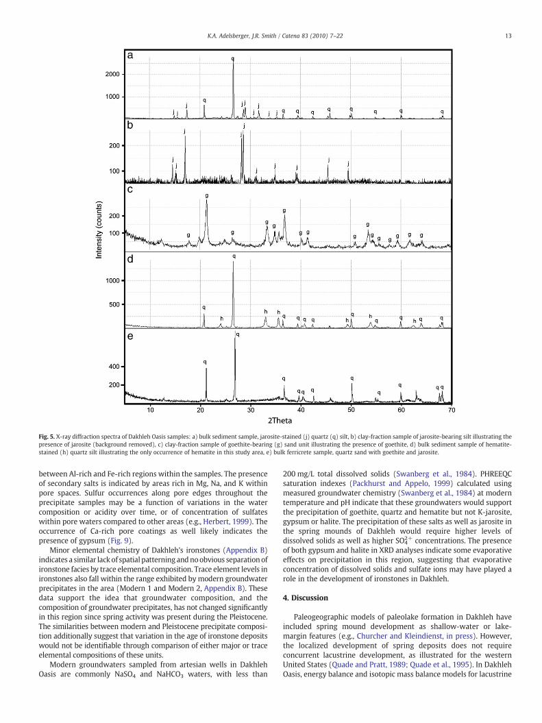
Fig. 5. X-ray diffraction spectra of Dakhleh Oasis samples: a) bulk sediment sample, jarosite-stained (j) quartz (q) silt, b) clay-fraction sample of jarosite-bearing silt illustrating thepresence of jarosite (background removed), c) clay-fraction sample of goethite-bearing (g) sand unit illustrating the presence of goethite, d) bulk sediment sample of hematite-stained (h) quartz silt illustrating the only occurrence of hematite in this study area, e) bulk ferricrete sample, quartz sand with goethite and jarosite.
13K.A. Adelsberger, J.R. Smith / Catena 83 (2010) 7–22
between Al-rich and Fe-rich regions within the samples. The presenceof secondary salts is indicated by areas rich in Mg, Na, and K withinpore spaces. Sulfur occurrences along pore edges throughout theprecipitate samples may be a function of variations in the watercomposition or acidity over time, or of concentration of sulfateswithin pore waters compared to other areas (e.g., Herbert, 1999). Theoccurrence of Ca-rich pore coatings as well likely indicates thepresence of gypsum (Fig. 9).
Minor elemental chemistry of Dakhleh's ironstones (Appendix B)indicates a similar lackof spatial patterningandnoobvious separation ofironstone facies by trace elemental composition. Trace element levels inironstones also fall within the range exhibited bymodern groundwaterprecipitates in the area (Modern 1 and Modern 2, Appendix B). Thesedata support the idea that groundwater composition, and thecomposition of groundwater precipitates, has not changed significantlyin this region since spring activity was present during the Pleistocene.The similarities between modern and Pleistocene precipitate composi-tion additionally suggest that variation in the age of ironstone depositswould not be identifiable through comparison of either major or traceelemental compositions of these units.
Modern groundwaters sampled from artesian wells in DakhlehOasis are commonly NaSO4 and NaHCO3 waters, with less than
200 mg/L total dissolved solids (Swanberg et al., 1984). PHREEQCsaturation indexes (Packhurst and Appelo, 1999) calculated usingmeasured groundwater chemistry (Swanberg et al., 1984) at moderntemperature and pH indicate that these groundwaters would supportthe precipitation of goethite, quartz and hematite but not K-jarosite,gypsum or halite. The precipitation of these salts as well as jarosite inthe spring mounds of Dakhleh would require higher levels ofdissolved solids as well as higher SO4
2+ concentrations. The presenceof both gypsum and halite in XRD analyses indicate some evaporativeeffects on precipitation in this region, suggesting that evaporativeconcentration of dissolved solids and sulfate ions may have played arole in the development of ironstones in Dakhleh.
4. Discussion
Paleogeographic models of paleolake formation in Dakhleh haveincluded spring mound development as shallow-water or lake-margin features (e.g., Churcher and Kleindienst, in press). However,the localized development of spring deposits does not requireconcurrent lacustrine development, as illustrated for the westernUnited States (Quade and Pratt, 1989; Quade et al., 1995). In DakhlehOasis, energy balance and isotopic mass balance models for lacustrine
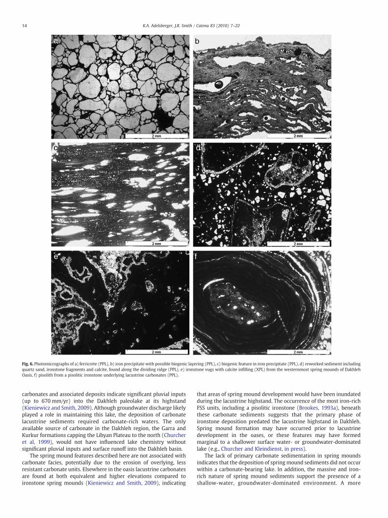
Fig. 6. Photomicrographs of a) ferricrete (PPL), b) iron precipitate with possible biogenic layering (PPL), c) biogenic feature in iron precipitate (PPL), d) reworked sediment includingquartz sand, ironstone fragments and calcite, found along the dividing ridge (PPL), e) ironstone vugs with calcite infilling (XPL) from the westernmost spring mounds of DakhlehOasis, f) pisolith from a pisolitic ironstone underlying lacustrine carbonates (PPL).
14 K.A. Adelsberger, J.R. Smith / Catena 83 (2010) 7–22
carbonates and associated deposits indicate significant pluvial inputs(up to 670 mm/yr) into the Dakhleh paleolake at its highstand(Kieniewicz and Smith, 2009). Although groundwater discharge likelyplayed a role in maintaining this lake, the deposition of carbonatelacustrine sediments required carbonate-rich waters. The onlyavailable source of carbonate in the Dakhleh region, the Garra andKurkur formations capping the Libyan Plateau to the north (Churcheret al, 1999), would not have influenced lake chemistry withoutsignificant pluvial inputs and surface runoff into the Dakhleh basin.
The spring mound features described here are not associated withcarbonate facies, potentially due to the erosion of overlying, lessresistant carbonate units. Elsewhere in the oasis lacustrine carbonatesare found at both equivalent and higher elevations compared toironstone spring mounds (Kieniewicz and Smith, 2009), indicating
that areas of spring mound development would have been inundatedduring the lacustrine highstand. The occurrence of the most iron-richFSS units, including a pisolitic ironstone (Brookes, 1993a), beneaththese carbonate sediments suggests that the primary phase ofironstone deposition predated the lacustrine highstand in Dakhleh.Spring mound formation may have occurred prior to lacustrinedevelopment in the oases, or these features may have formedmarginal to a shallower surface water- or groundwater-dominatedlake (e.g., Churcher and Kleindienst, in press).
The lack of primary carbonate sedimentation in spring moundsindicates that the deposition of springmound sediments did not occurwithin a carbonate-bearing lake. In addition, the massive and iron-rich nature of spring mound sediments support the presence of ashallow-water, groundwater-dominated environment. A more
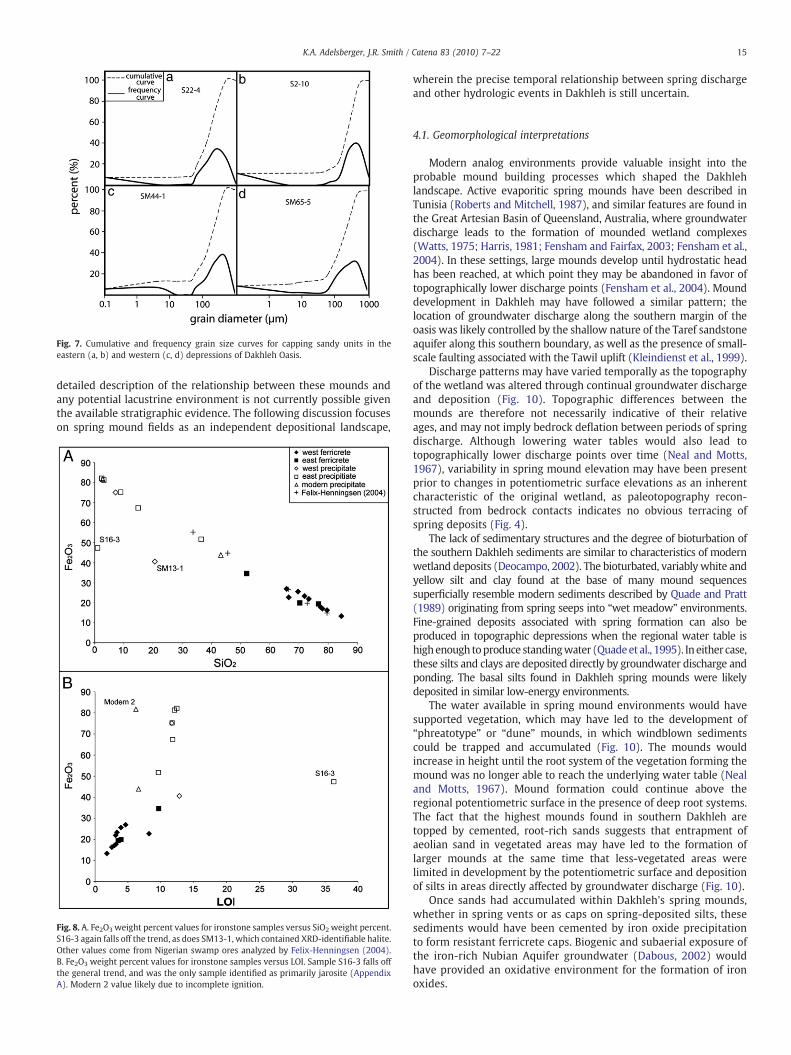
Fig. 7. Cumulative and frequency grain size curves for capping sandy units in theeastern (a, b) and western (c, d) depressions of Dakhleh Oasis.
15K.A. Adelsberger, J.R. Smith / Catena 83 (2010) 7–22
detailed description of the relationship between these mounds andany potential lacustrine environment is not currently possible giventhe available stratigraphic evidence. The following discussion focuseson spring mound fields as an independent depositional landscape,
Fig. 8. A. Fe2O3 weight percent values for ironstone samples versus SiO2 weight percent.S16-3 again falls off the trend, as does SM13-1, which contained XRD-identifiable halite.Other values come from Nigerian swamp ores analyzed by Felix-Henningsen (2004).B. Fe2O3 weight percent values for ironstone samples versus LOI. Sample S16-3 falls offthe general trend, and was the only sample identified as primarily jarosite (AppendixA). Modern 2 value likely due to incomplete ignition.
wherein the precise temporal relationship between spring dischargeand other hydrologic events in Dakhleh is still uncertain.
4.1. Geomorphological interpretations
Modern analog environments provide valuable insight into theprobable mound building processes which shaped the Dakhlehlandscape. Active evaporitic spring mounds have been described inTunisia (Roberts and Mitchell, 1987), and similar features are found inthe Great Artesian Basin of Queensland, Australia, where groundwaterdischarge leads to the formation of mounded wetland complexes(Watts, 1975; Harris, 1981; Fensham and Fairfax, 2003; Fensham et al.,2004). In these settings, large mounds develop until hydrostatic headhas been reached, at which point they may be abandoned in favor oftopographically lower discharge points (Fensham et al., 2004). Mounddevelopment in Dakhleh may have followed a similar pattern; thelocation of groundwater discharge along the southern margin of theoasis was likely controlled by the shallow nature of the Taref sandstoneaquifer along this southern boundary, as well as the presence of small-scale faulting associated with the Tawil uplift (Kleindienst et al., 1999).
Discharge patterns may have varied temporally as the topographyof the wetland was altered through continual groundwater dischargeand deposition (Fig. 10). Topographic differences between themounds are therefore not necessarily indicative of their relativeages, and may not imply bedrock deflation between periods of springdischarge. Although lowering water tables would also lead totopographically lower discharge points over time (Neal and Motts,1967), variability in spring mound elevation may have been presentprior to changes in potentiometric surface elevations as an inherentcharacteristic of the original wetland, as paleotopography recon-structed from bedrock contacts indicates no obvious terracing ofspring deposits (Fig. 4).
The lack of sedimentary structures and the degree of bioturbation ofthe southern Dakhleh sediments are similar to characteristics of modernwetland deposits (Deocampo, 2002). The bioturbated, variably white andyellow silt and clay found at the base of many mound sequencessuperficially resemble modern sediments described by Quade and Pratt(1989) originating from spring seeps into “wet meadow” environments.Fine-grained deposits associated with spring formation can also beproduced in topographic depressions when the regional water table ishighenough toproduce standingwater (Quadeet al., 1995). In either case,these silts and clays are deposited directly by groundwater discharge andponding. The basal silts found in Dakhleh spring mounds were likelydeposited in similar low-energy environments.
The water available in spring mound environments would havesupported vegetation, which may have led to the development of“phreatotype” or “dune” mounds, in which windblown sedimentscould be trapped and accumulated (Fig. 10). The mounds wouldincrease in height until the root system of the vegetation forming themound was no longer able to reach the underlying water table (Nealand Motts, 1967). Mound formation could continue above theregional potentiometric surface in the presence of deep root systems.The fact that the highest mounds found in southern Dakhleh aretopped by cemented, root-rich sands suggests that entrapment ofaeolian sand in vegetated areas may have led to the formation oflarger mounds at the same time that less-vegetated areas werelimited in development by the potentiometric surface and depositionof silts in areas directly affected by groundwater discharge (Fig. 10).
Once sands had accumulated within Dakhleh's spring mounds,whether in spring vents or as caps on spring-deposited silts, thesesediments would have been cemented by iron oxide precipitationto form resistant ferricrete caps. Biogenic and subaerial exposure ofthe iron-rich Nubian Aquifer groundwater (Dabous, 2002) wouldhave provided an oxidative environment for the formation of ironoxides.
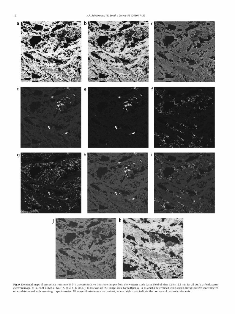
Fig. 9. Elemental maps of precipitate ironstone IH 3-1, a representative ironstone sample from the western study basin. Field of view 12.8×12.8 mm for all but k. a) backscatterelectron image, b) Fe, c) Al, d) Mg, e) Na, f) S, g) Si, h) K, i) Ca, j) Ti, k) close-up BSE image, scale bar 600 μm. Al, Si, Ti, and Ca determined using silicon drift dispersive spectrometer,others determined with wavelength spectrometer. All images illustrate relative contrast, where bright spots indicate the presence of particular elements.
16 K.A. Adelsberger, J.R. Smith / Catena 83 (2010) 7–22

Fig. 10. Model of spring mound formation; a) spring discharge leads to silt deposition and encourages the growth of vegetation, b) aeolian sands are trapped by densely vegetatedareas, leading to localized buildup of sand, c) vegetated mounds build above local potentiometric surfaces. The elevations of root systems are constrained by groundwateravailability, allowing for vegetation and sand entrapment above the potentiometric surface. In contrast, silt deposition in non-vegetated areas is constrained by direct discharge.Jarosite deposition would be concentrated in silty units, though not universally present. All sandy units are goethite-rich.
17K.A. Adelsberger, J.R. Smith / Catena 83 (2010) 7–22
4.2. Mineral phase stability and biogenic influences
The modern, pumped Nubian Aquifer waters in Dakhleh are onlymildly acidic (pH ~6.3), making the development of acidic deposits inspring mound environments difficult to reproduce given minimalchanges in groundwater composition, as would be likely in this fossilgroundwater setting. This presents a problem for the formation ofjarosite, which is stable in acidic, oxidizing environments, generally as aproduct of pyrite oxidation or goethite formation (Brown, 1971; Nickel,1984; Arslan and Arslan, 2003). Jarosite formation is common inmodernacidmine drainage environments,where the conversionof goethite fromprecursors such as schwertmannite releases sulfate and iron (Bigham etal., 1996; Gagliano et al., 2004). However, jarositemay also precipitate asa result of evaporitic processes in waters containing K, SO4 and Fe3+
(Long et al., 1992). Even if jarosite is undersaturated in the groundwateritself, it may form in pore spaces if acidic conditions and high sulfateconcentrationsdevelopwithin thesemicroenvironments (Herbert, 1996,1999; Wallace et al. 2008). Jarosite formation may therefore haveoccurred within the pore spaces of spring-deposited silts in Dakhleh dueto the presence of evaporitic conditions, removing the requirement of anextensive acidic wetland environment (e.g., Benison et al., 2007) duringjarosite formation. The presence of jarosite only in fine-grained siltydeposits in Dakhleh, as opposed to coarser sands, may indicate that poreacidity could not be maintained within larger pore environments.
Microbial metabolic processes may also have played a significant rolein the oxidation of iron (e.g., Noike et al., 1983; Bigham et al., 1990) andsilicates in this iron-rich freshwater environment (e.g., Tazaki, 1997).Biogenic mediation of iron deposits in modern acid mine-drainageenvironments (e.g., Crerar et al., 1979; Nordstrom, 1982; Singh et al.,1999) indicates that bacterial activity may promote iron deposition evenin very acidic environments; a potentially acidic macro- or micro-environment present during jarosite and goethite deposition in Dakhlehwould therefore not preclude a microbial role in the development ofironstones. Jarosite precipitation in particular may be mediated bybacterial oxidation of iron under acidic, high-sulfate conditions (Bighamet al., 1992). In such acidic conditions bacterial oxidation of iron can
increase oxidation rates more than 106 times the abiotic rate (Singer andStumm, 1970), leading tomuch faster precipitation of iron oxyhydroxidesand formation of iron deposits.
The coexistence of jarosite and goethite is possible over a very smallrange of Eh-pH values (Arslan and Arslan, 2003). However, jarosite maypersist despite a change in environmental conditions (e.g., increasing pH)due to the presence of arid conditions, or it may remain due to the slowrate of transformation from jarosite to goethite (Brown, 1971). Goethite,in contrast, is a very stable iron oxide and a commoncrystalline product ofboth schwertmannite and ferrihydrite, or even of jarosite, and may bepresent across a wide range of pH values (Brown, 1971; Chukhrov, 1977;Bigham et al., 1996). Goethite is sometimes preserved as a resultantmineral phase in older acid-mine drainage environments (Singh et al.,1999), suggesting that similarly acidic environments couldbe representedas goethite-rich deposits in the geologic record. These characteristics ofjarosite and goethite preservation indicate that initially jarosite-richdepositsmay be represented bymodern goethite-rich sediments, makingthe determination of original geochemical environments difficult.However, the presence of goethite is not necessarily tied to a jarositeprecursor.
The abundance of vegetation present in Dakhleh's spring moundsmay have provided a medium for biogenic precipitation of goethiteduring periods of wetland formation. In wetland plants the rhizo-sphere is often characterized by significant microbial activity, as therelease of organic compounds and oxygen by root systems provides anoxidizing environment and a region of stimulated microbial growth(Armstrong, 1967; Grayston et al., 1996; Küsel et al., 2003). Underacidic conditions, acidophilic bacteria can form goethite-rich coatingsalong root surfaces through oxidation of available Fe(II) (Küsel et al.,2003; Neubauer et al., 2007), whichwould be soluble in environmentsof low pH but may remain stable for up to a year even in acidicconditions after the death of the plant (Wang and Peverly, 1996). Ironoxidizing bacteria are abundant inmodernwetlands, andmay providefor more active cycling and precipitation of iron in these environ-ments than would be present in an adjacent soil (Weiss et al., 2003).Vegetation in flooded soils also decrease local pH values through
18 K.A. Adelsberger, J.R. Smith / Catena 83 (2010) 7–22
carbon dioxide transfer, iron oxidation, cation exchange processes andby providing organic matter for decomposition (Halbach, 1975;Higuchi, 1982; Ahmad and Nye, 1990; Begg et al., 1994), which mayhave provided localized low-pH conditions within the surface watersin Dakhleh during ironstone formation.
The presence of microlaminations within the iron precipitates ofDakhleh suggests microbial activity as a potential source of precip-itation of goethite or its precursor (Fig. 6b, c), although there is noobserved concentration of trace elements along any physical surfaceor lamination that would indicate the presence of bacterial surfacesduring oxide formation (Fig. 9, Casanova et al., 1999). Some voidsfound within goethite precipitates are similar in form to shrinkagevoids that result from the decay of cyanobacterial mounds (Arp et al.,1998), supporting the hypothesis of a microbial presence (Fig. 6b). Inaddition, many of the structures present at the macroscopic (Fig. 2f)scale within ironstones indicate the presence of vegetation, andtherefore potential associated microbial activity, during iron precip-itation. Microbial mats can serve as stabilizing structures for springmound sediments (e.g., Dahanayake and Krumbein, 1986); amicrobial presence in Dakhleh's ironstones may have aided in theformation of the mound forms preserved in this region today.
The remnant iron deposits of Dakhleh Oasis resemble swamp oredeposits described from Niger (Felix-Henningsen, 2004), and are alsotexturally and mineralogically similar to bog iron deposits describedfrom the Holocene around the world (Moore, 1910; Starkey, 1962; DeGeyter et al., 1985; Breuning-Madsen et al., 2000; Kaczorek andSommer, 2003; Bricker et al., 2004). Bog irons are commonlycomposed of oxyhydroxide minerals including goethite and ferrihy-drite (Bricker et al., 2004; Kaczorek et al., 2004), which may beprecipitated by microbial activity (e.g., Madsen et al., 1986).Ferrihydrite precipitation by geothermal waters, which are commonlyfound in the Western Desert (Swanberg et al., 1976), may have beenmediated by the presence of iron-depositing bacteria (e.g., Casanovaet al., 1999). Further mineralogical and geochemical work will benecessary to identify the level of biogenic mediation of ironprecipitation in spring mound environments and to determinewhether these mineral phases accurately document the paleoenvir-onmental conditions present during the Pleistocene.
4.3. Groundwater discharge in the hydrologic history of Dakhleh Oasis
The groundwater necessary for the development of wetlandenvironments in the southern Dakhleh basin may have originatedfrom locally recharged shallow Nubian Aquifer waters, from deeperand older waters recharged in southwestern Egypt and Sudan, or froma mixture of the two (Dabous and Osmond, 2001). Initial dischargelikely occurred due to an increase in hydraulic head followingrecharge of shallow, localized aquifer units. Recharge may haveoccurred southwest of the oasis proper, providing groundwater inputswithout significant local rainfall. Historic discharge rates for theWestern Desert measured 3×10⁸ m3/yr (Thorweihe, 1986), illustrat-ing that active pluvial inputs and associated groundwater recharge arenot necessary for groundwater discharge in the oasis. Discharge rateswould have increased during pluvial periods, but spring dischargewould have continued despite a decrease or cessation of recharge(Heinl and Brinkmann, 1989). Ironstone deposition could haveoccurred whenever spring discharge served as the primary watersource in the southern portion of the oasis, whereas the overlyingauthigenic carbonate sediments would have been deposited onlywhen surface waters were dominated by local carbonate-rich surfacewater inputs rather than Nubian Aquifer discharge.
The iron content of sediments (FSS) found outside of springmound settings increases visibly with proximity to localized springvents and ironstone deposits, indicating localized groundwater flowinto an otherwise shallow or marginal lacustrine environment. Themost iron-rich sands include reworked ironstone fragments (Fig. 6d),
indicating that at least some of the iron-rich units in Dakhleh werereworked during shallow lacustrine development in the southernportion of the oasis. Although groundwater contributions to early lakeformation may have been significant, the formation of ironstonedeposits within spring mound environments appears to havepreceded the onset of fully lacustrine conditions.
There has been no identifiable replacement of either iron or calciteminerals in any iron-rich units, although minor sparry calcite has beenobserved in the pore spaces of some ironstone samples (Fig. 6e). Iron-bearing groundwater may have contributed to the development of iron-rich sediments near wetland environments during initial stages oflacustrine development. The occurrence of reworked ironstone and ironpisoliths (Fig. 6f) along the dividing ridge suggest that a standing-waterenvironment larger than that indicated by springmound formation alone,yet significantly shallower than the lake highstand, preceded carbonatesedimentation. Groundwater discharge likely played a role in thedevelopment of shallow wetland environments and possibly a smaller,iron-rich lake prior to lake-level increases following increased pluvialactivity. Some of the uncertainty in the precise sequence of hydrologicevents occurring in Dakhleh Oasis is due to the possibility of repeatedepisodes of spring discharge into the southern portion of the oasis. Directdates on spring deposits from different geomorphic contexts will benecessary to determine whether iron deposition resumed in southernDakhleh once pluvial, surface-water inputs had decreased.
4.4. Dakhleh as an archaeological landscape
The spring mounds of Dakhleh Oasis represent a shallow-water,bog-like environment that existed prior to lacustrine development inthe oasis. This landscape was utilized in some manner by Paleolithicgroups, as indicated by the recovery of artifacts from spring moundvents and sediments. In the eastern basin Acheulian and MiddlePaleolithic materials have been found within spring sediments atseveral different vents (Wendorf and Schild, 1980), whereas in thewestern basin artifacts belonging to several different Middle Paleo-lithic phases have been excavated from a single vent (Dakhleh OasisProject, 2000/2001). These artifacts are described as “fresh” (un-weathered) with potential spring polish, suggesting deposition duringactive spring discharge (M. Wiseman, 2007, personal communica-tion). Recent field observations also indicate the presence of MSAmaterials within ironstone units and Later Stone Age (LSA) materialsdeposited on top of, if not within, spring-deposited sediments (M.Kleindienst, 2007, personal communication).
These archaeological data indicate the exploitation of Dakhleh'sspring-dominated environments by both Acheulian and MSA groups,and potentially by LSA peoples as well. In addition, the presence ofthese archaeological materials suggests that a spring-dominated, pre-lacustrine habitable landscape must have been present in Dakhlehduring the Pleistocene. The presence of several technological typeswithin a single spring vent suggests long-term spring activity, orrepeated reactivation of spring vents, and potential averaging ofarchaeological assemblages deposited in these environments overtime. Human use of Dakhleh Oasis in the middle Pleistocene betweenpluvial maxima was likely controlled by the availability of ground-water, making spring mounds an important source of archaeologicaldata for interpluvial hominin land use.
Groundwater-dominated, closed-basin wetlands have been de-scribed as important hydrologic and archaeological settings in theEast African Rift (Deocampo, 2002), where they are most oftenpreserved adjacent to faults (Ashley et al., 2004). These fault-controlled wetland environments were important as perennialwater sources (Ashley et al., 2002), in which the value of the watersource as a resource and the potential for artifact concentration havebeen linked directly to water quality (Deocampo et al., 2002). Thesestudies suggest that fault-controlled groundwater discharge produceswetland deposits with high preservation potential, likely providing
19K.A. Adelsberger, J.R. Smith / Catena 83 (2010) 7–22
equally high preservation potential for associated archaeologicalmaterials. In Dakhleh, the potential for isolated areas of jarositeformation, as well as evidence for significant similarities betweenmodern and paleo-groundwater precipitates, indicate that ground-water sources were likely as potable during the Pleistocene as they aretoday, and would have served as an available resource for any earlyhuman groups moving through the Western Desert. Age constraintson spring mound formation and reactivation in Dakhleh Oasis will benecessary to determine the timing of potential resource utilization inthis region, but the spring mounds of Dakhleh may have beenimportant water sources for early human inhabitants of the WesternDesert, particularly between pluvial periods when lakes wereminimalor non-existent.
5. Conclusions
The limited preservation and significant deflation of thePleistocene deposits of Dakhleh Oasis makes the interpretationand reconstruction of this paleolandscape difficult at best. However,basic sedimentary description and stratigraphy of the paleolakebasins of Dakhleh have provided some insights into the sequence ofhydrologic events occurring in the Western Desert during thePleistocene. Initial recharge of the Nubian Aquifer allowed for theformation of wetlands along the southern margin of Dakhleh Oasis,where iron-rich groundwater discharged into the basin throughspring vents associated with localized bedrock contacts andstructural variations. Restricted discharge in an area of variabletopography led to the development of standing water and thegrowth of vegetation. Mound formation through sediment accu-mulation and iron precipitate formation in standing water resultedin additional topographic variations, which were subsequentlyenhanced by the accumulation of aeolian material in vegetatedmounds.
Carbonate deposition elsewhere in the oasis seems to be largelyunrelated to this wetland, representing a later stage of lacustrine
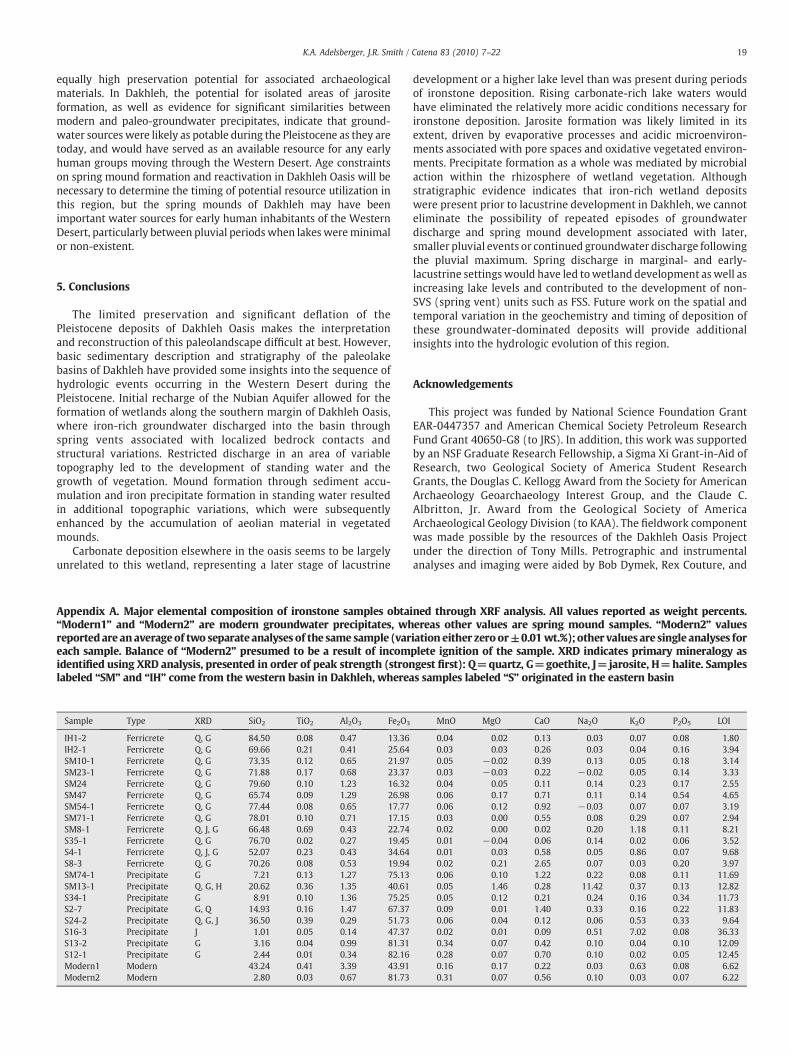
Sample Type XRD SiO2 TiO2 Al2O3 Fe2O3
IH1-2 Ferricrete Q, G 84.50 0.08 0.47 13.36IH2-1 Ferricrete Q, G 69.66 0.21 0.41 25.64SM10-1 Ferricrete Q, G 73.35 0.12 0.65 21.97SM23-1 Ferricrete Q, G 71.88 0.17 0.68 23.37SM24 Ferricrete Q, G 79.60 0.10 1.23 16.32SM47 Ferricrete Q, G 65.74 0.09 1.29 26.98SM54-1 Ferricrete Q, G 77.44 0.08 0.65 17.77SM71-1 Ferricrete Q, G 78.01 0.10 0.71 17.15SM8-1 Ferricrete Q, J, G 66.48 0.69 0.43 22.74S35-1 Ferricrete Q, G 76.70 0.02 0.27 19.45S4-1 Ferricrete Q, J, G 52.07 0.23 0.43 34.64S8-3 Ferricrete Q, G 70.26 0.08 0.53 19.94SM74-1 Precipitate G 7.21 0.13 1.27 75.13SM13-1 Precipitate Q, G, H 20.62 0.36 1.35 40.61S34-1 Precipitate G 8.91 0.10 1.36 75.25S2-7 Precipitate G, Q 14.93 0.16 1.47 67.37S24-2 Precipitate Q, G, J 36.50 0.39 0.29 51.73S16-3 Precipitate J 1.01 0.05 0.14 47.37S13-2 Precipitate G 3.16 0.04 0.99 81.31S12-1 Precipitate G 2.44 0.01 0.34 82.16Modern1 Modern 43.24 0.41 3.39 43.91Modern2 Modern 2.80 0.03 0.67 81.73
Appendix A. Major elemental composition of ironstone samples obtai“Modern1” and “Modern2” are modern groundwater precipitates, whreportedare anaverageof two separate analyses of the same sample (vareach sample. Balance of “Modern2” presumed to be a result of incomidentified using XRD analysis, presented in order of peak strength (stronlabeled “SM” and “IH” come from the western basin in Dakhleh, wherea
development or a higher lake level than was present during periodsof ironstone deposition. Rising carbonate-rich lake waters wouldhave eliminated the relatively more acidic conditions necessary forironstone deposition. Jarosite formation was likely limited in itsextent, driven by evaporative processes and acidic microenviron-ments associated with pore spaces and oxidative vegetated environ-ments. Precipitate formation as a whole was mediated by microbialaction within the rhizosphere of wetland vegetation. Althoughstratigraphic evidence indicates that iron-rich wetland depositswere present prior to lacustrine development in Dakhleh, we cannoteliminate the possibility of repeated episodes of groundwaterdischarge and spring mound development associated with later,smaller pluvial events or continued groundwater discharge followingthe pluvial maximum. Spring discharge in marginal- and early-lacustrine settings would have led towetland development aswell asincreasing lake levels and contributed to the development of non-SVS (spring vent) units such as FSS. Future work on the spatial andtemporal variation in the geochemistry and timing of deposition ofthese groundwater-dominated deposits will provide additionalinsights into the hydrologic evolution of this region.
Acknowledgements
This project was funded by National Science Foundation GrantEAR-0447357 and American Chemical Society Petroleum ResearchFund Grant 40650-G8 (to JRS). In addition, this work was supportedby an NSF Graduate Research Fellowship, a Sigma Xi Grant-in-Aid ofResearch, two Geological Society of America Student ResearchGrants, the Douglas C. Kellogg Award from the Society for AmericanArchaeology Geoarchaeology Interest Group, and the Claude C.Albritton, Jr. Award from the Geological Society of AmericaArchaeological Geology Division (to KAA). The fieldwork componentwas made possible by the resources of the Dakhleh Oasis Projectunder the direction of Tony Mills. Petrographic and instrumentalanalyses and imaging were aided by Bob Dymek, Rex Couture, and
MnO MgO CaO Na2O K2O P2O5 LOI
0.04 0.02 0.13 0.03 0.07 0.08 1.800.03 0.03 0.26 0.03 0.04 0.16 3.940.05 −0.02 0.39 0.13 0.05 0.18 3.140.03 −0.03 0.22 −0.02 0.05 0.14 3.330.04 0.05 0.11 0.14 0.23 0.17 2.550.06 0.17 0.71 0.11 0.14 0.54 4.650.06 0.12 0.92 −0.03 0.07 0.07 3.190.03 0.00 0.55 0.08 0.29 0.07 2.940.02 0.00 0.02 0.20 1.18 0.11 8.210.01 −0.04 0.06 0.14 0.02 0.06 3.520.01 0.03 0.58 0.05 0.86 0.07 9.680.02 0.21 2.65 0.07 0.03 0.20 3.970.06 0.10 1.22 0.22 0.08 0.11 11.690.05 1.46 0.28 11.42 0.37 0.13 12.820.05 0.12 0.21 0.24 0.16 0.34 11.730.09 0.01 1.40 0.33 0.16 0.22 11.830.06 0.04 0.12 0.06 0.53 0.33 9.640.02 0.01 0.09 0.51 7.02 0.08 36.330.34 0.07 0.42 0.10 0.04 0.10 12.090.28 0.07 0.70 0.10 0.02 0.05 12.450.16 0.17 0.22 0.03 0.63 0.08 6.620.31 0.07 0.56 0.10 0.03 0.07 6.22
ned through XRF analysis. All values reported as weight percents.ereas other values are spring mound samples. “Modern2” valuesiation either zeroor±0.01 wt.%); other values are single analyses forplete ignition of the sample. XRD indicates primary mineralogy asgest first): Q=quartz, G=goethite, J=jarosite, H=halite. Sampless samples labeled “S” originated in the eastern basin
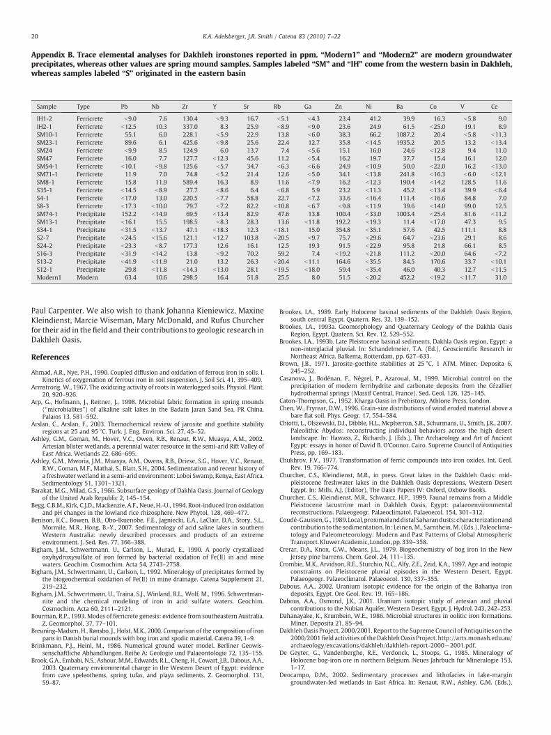
Sample Type Pb Nb Zr Y Sr Rb Ga Zn Ni Ba Co V Ce
IH1-2 Ferricrete b9.0 7.6 130.4 b9.3 16.7 b5.1 b4.3 23.4 41.2 39.9 16.3 b5.8 9.0IH2-1 Ferricrete b12.5 10.3 337.0 8.3 25.9 b8.9 b9.0 23.6 24.9 61.5 b25.0 19.1 8.9SM10-1 Ferricrete 55.1 6.0 228.1 b5.9 22.9 13.8 b6.0 38.3 66.2 1087.2 20.4 b5.8 b11.3SM23-1 Ferricrete 89.6 6.1 425.6 b9.8 25.6 22.4 12.7 35.8 b14.5 1935.2 20.5 13.2 b13.4SM24 Ferricrete b9.9 8.5 124.9 6.0 13.7 7.4 b5.6 15.1 16.0 24.6 b12.8 9.4 11.0SM47 Ferricrete 16.0 7.7 127.7 b12.3 45.6 11.2 b5.4 16.2 19.7 37.7 15.4 16.1 12.0SM54-1 Ferricrete b10.1 b9.8 125.6 b5.7 34.7 b6.3 b6.6 24.9 b10.9 50.0 b22.0 16.2 b13.0SM71-1 Ferricrete 11.9 7.0 74.8 b5.2 21.4 12.6 b5.0 34.1 b13.8 241.8 b16.3 b6.0 b12.1SM8-1 Ferricrete 15.8 11.9 589.4 16.3 8.9 11.6 b7.9 16.2 b12.3 190.4 b14.2 128.5 11.6S35-1 Ferricrete b14.5 b8.9 27.7 b8.6 6.4 b6.8 5.9 23.2 b11.3 45.2 b13.4 39.9 b6.4S4-1 Ferricrete b17.0 13.0 220.5 b7.7 58.8 22.7 b7.2 33.6 b16.4 111.4 b16.6 84.8 7.0S8-3 Ferricrete b17.3 b10.0 79.7 b7.2 82.2 b10.8 b6.7 b9.8 b11.9 39.6 b14.0 99.0 12.5SM74-1 Precipitate 152.2 b14.9 69.5 b13.4 82.9 47.6 13.8 100.4 b33.0 1003.4 b25.4 81.6 b11.2SM13-1 Precipitate b16.1 15.5 198.5 b8.3 28.3 13.6 b11.8 192.2 b19.3 11.4 b17.0 47.3 9.5S34-1 Precipitate b31.5 b13.7 47.1 b18.3 12.3 b18.1 15.0 354.8 b35.1 57.6 42.5 111.1 8.8S2-7 Precipitate b24.5 b15.6 121.1 b12.7 103.8 b20.5 b9.7 75.7 b29.6 64.7 b23.6 29.1 8.6S24-2 Precipitate b23.3 b8.7 177.3 12.6 16.1 12.5 19.3 91.5 b22.9 95.8 21.8 66.1 8.5S16-3 Precipitate b31.9 b14.2 13.8 b9.2 70.2 59.2 7.4 b19.2 b21.8 111.2 b20.0 64.6 b7.2S13-2 Precipitate b41.9 b11.9 21.0 13.2 26.3 b20.4 b11.1 164.6 b35.5 84.5 170.6 33.7 b10.1S12-1 Precipitate 29.8 b11.8 b14.3 b13.0 28.1 b19.5 b18.0 59.4 b35.4 46.0 40.3 12.7 b11.5Modern1 Modern 63.4 10.6 298.5 16.4 51.8 25.5 8.0 51.5 b20.2 452.2 b19.2 b11.7 31.0
Appendix B. Trace elemental analyses for Dakhleh ironstones reported in ppm. “Modern1” and “Modern2” are modern groundwaterprecipitates, whereas other values are spring mound samples. Samples labeled “SM” and “IH” come from the western basin in Dakhleh,whereas samples labeled “S” originated in the eastern basin
20 K.A. Adelsberger, J.R. Smith / Catena 83 (2010) 7–22
Paul Carpenter. We also wish to thank Johanna Kieniewicz, MaxineKleindienst, Marcie Wiseman, Mary McDonald, and Rufus Churcherfor their aid in the field and their contributions to geologic research inDakhleh Oasis.
References
Ahmad, A.R., Nye, P.H., 1990. Coupled diffusion and oxidation of ferrous iron in soils. I.Kinetics of oxygenation of ferrous iron in soil suspension. J. Soil Sci. 41, 395–409.
Armstrong, W., 1967. The oxidizing activity of roots in waterlogged soils. Physiol. Plant.20, 920–926.
Arp, G., Hofmann, J., Reitner, J., 1998. Microbial fabric formation in spring mounds(“microbialites”) of alkaline salt lakes in the Badain Jaran Sand Sea, PR China.Palaios 13, 581–592.
Arslan, C., Arslan, F., 2003. Themochemical review of jarosite and goethite stabilityregions at 25 and 95 °C. Turk. J. Eng. Environ. Sci. 27, 45–52.
Ashley, G.M., Goman, M., Hover, V.C., Owen, R.B., Renaut, R.W., Muasya, A.M., 2002.Artesian blister wetlands, a perennial water resource in the semi-arid Rift Valley ofEast Africa. Wetlands 22, 686–695.
Ashley, G.M., Mworia, J.M., Muasya, A.M., Owens, R.B., Driese, S.G., Hover, V.C., Renaut,R.W., Goman, M.F., Mathai, S., Blatt, S.H., 2004. Sedimentation and recent history ofa freshwater wetland in a semi-arid environment: Loboi Swamp, Kenya, East Africa.Sedimentology 51, 1301–1321.
Barakat, M.G., Milad, G.S., 1966. Subsurface geology of Dakhla Oasis. Journal of Geologyof the United Arab Republic 2, 145–154.
Begg, C.B.M., Kirk, C.J.D., Mackenzie, A.F., Neue, H.-U., 1994. Root-induced iron oxidationand pH changes in the lowland rice rhizosphere. New Phytol. 128, 469–477.
Benison, K.C., Bowen, B.B., Obo-Ikuenobe, F.E., Jagniecki, E.A., LaClair, D.A., Story, S.L.,Mormile, M.R., Hong, B.-Y., 2007. Sedimentology of acid saline lakes in southernWestern Australia: newly described processes and products of an extremeenvironment. J. Sed. Res. 77, 366–388.
Bigham, J.M., Schwertmann, U., Carlson, L., Murad, E., 1990. A poorly crystallizedoxyhydroxysulfate of iron formed by bacterial oxidation of Fe(II) in acid minewaters. Geochim. Cosmochim. Acta 54, 2743–2758.
Bigham, J.M., Schwertmann, U., Carlson, L., 1992. Mineralogy of precipitates formed bythe biogeochemical oxidation of Fe(II) in mine drainage. Catena Supplement 21,219–232.
Bigham, J.M., Schwertmann, U., Traina, S.J., Winland, R.L., Wolf, M., 1996. Schwertman-nite and the chemical modeling of iron in acid sulfate waters. Geochim.Cosmochim. Acta 60, 2111–2121.
Bourman, R.P., 1993. Modes of ferricrete genesis: evidence from southeastern Australia.Z. Geomorphol. 37, 77–101.
Breuning-Madsen, H., Rønsbo, J., Holst, M.K., 2000. Comparison of the composition of ironpans in Danish burial mounds with bog iron and spodic material. Catena 39, 1–9.
Brinkmann, P.J., Heinl, M., 1986. Numerical ground water model. Berliner Geowis-senschaftliche Abhandlungen. Reihe A: Geologie und Palaeontologie 72, 135–155.
Brook, G.A., Embabi, N.S., Ashour, M.M., Edwards, R.L., Cheng, H., Cowart, J.B., Dabous, A.A.,2003. Quaternary environmental change in the Western Desert of Egypt: evidencefrom cave speleothems, spring tufas, and playa sediments. Z. Geomorphol. 131,59–87.
Brookes, I.A., 1989. Early Holocene basinal sediments of the Dakhleh Oasis Region,south central Egypt. Quatern. Res. 32, 139–152.
Brookes, I.A., 1993a. Geomorphology and Quaternary Geology of the Dakhla OasisRegion, Egypt. Quatern. Sci. Rev. 12, 529–552.
Brookes, I.A., 1993b. Late Pleistocene basinal sediments, Dakhla Oasis region, Egypt: anon-interglacial pluvial. In: Schandelmeier, T.A. (Ed.), Geoscientific Research inNortheast Africa. Balkema, Rotterdam, pp. 627–633.
Brown, J.B., 1971. Jarosite-goethite stabilities at 25 °C, 1 ATM. Miner. Deposita 6,245–252.
Casanova, J., Bodénan, F., Négrel, P., Azaroual, M., 1999. Microbial control on theprecipitation of modern ferrihydrite and carbonate deposits from the Cézallierhydrothermal springs (Massif Central, France). Sed. Geol. 126, 125–145.
Caton-Thompson, G., 1952. Kharga Oasis in Prehistory. Athlone Press, London.Chen, W., Fryrear, D.W., 1996. Grain-size distributions of wind eroded material above a
bare flat soil. Phys. Geogr. 17, 554–584.Chiotti, L., Olszewski, D.I., Dibble, H.L., Mcpherron, S.R., Schurmans, U., Smith, J.R., 2007.
Paleolithic Abydos: reconstructing individual behaviors across the high desertlandscape. In: Hawass, Z., Richards, J. (Eds.), The Archaeology and Art of AncientEgypt: essays in honor of David B. O'Connor. Cairo. Supreme Council of AntiquitiesPress, pp. 169–183.
Chukhrov, F.V., 1977. Transformation of ferric compounds into iron oxides. Int. Geol.Rev. 19, 766–774.
Churcher, C.S., Kleindienst, M.R., in press. Great lakes in the Dakhleh Oasis: mid-pleistocene freshwater lakes in the Dakhleh Oasis depressions, Western DesertEgypt. In: Mills, A.J. (Editor), The Oasis Papers IV: Oxford, Oxbow Books.
Churcher, C.S., Kleindienst, M.R., Schwarcz, H.P., 1999. Faunal remains from a MiddlePleistocene lacustrine marl in Dakhleh Oasis, Egypt: palaeoenvironmentalreconstructions. Palaeogeogr. Palaeoclimatol. Palaeoecol. 154, 301–312.
Coudé-Gaussen,G.,1989.Local,proximalanddistalSaharandusts:characterizationandcontribution to the sedimentation. In: Leinen,M., Sarnthein,M. (Eds.), Paleoclima-tology and Paleometeorology: Modern and Past Patterns of Global AtmosphericTransport. KluwerAcademic, London,pp. 339–358.
Crerar, D.A., Knox, G.W., Means, J.L., 1979. Biogeochemistry of bog iron in the NewJersey pine barrens. Chem. Geol. 24, 111–135.
Crombie, M.K., Arvidson, R.E., Sturchio, N.C., Alfy, Z.E., Zeid, K.A., 1997. Age and isotopicconstraints on Pleistocene pluvial episodes in the Western Desert, Egypt.Palaeogeogr. Palaeoclimatol. Palaeoecol. 130, 337–355.
Dabous, A.A., 2002. Uranium isotopic evidence for the origin of the Bahariya irondeposits, Egypt. Ore Geol. Rev. 19, 165–186.
Dabous, A.A., Osmond, J.K., 2001. Uranium isotopic study of artesian and pluvialcontributions to the Nubian Aquifer, Western Desert, Egypt. J. Hydrol. 243, 242–253.
Dahanayake, K., Krumbein, W.E., 1986. Microbial structures in oolitic iron formations.Miner. Deposita 21, 85–94.
Dakhleh Oasis Project, 2000/2001. Report to the Supreme Council of Antiquities on the2000/2001field activities of theDakhlehOasis Project. http://arts.monash.edu.au/archaeology/excavations/dakhleh/dakhleh-report-2000−2001.pdf.
De Geyter, G., Vandenberghe, R.E., Verdonck, L., Stoops, G., 1985. Mineralogy ofHolocene bog-iron ore in northern Belgium. Neues Jahrbuch fur Mineralogie 153,1–17.
Deocampo, D.M., 2002. Sedimentary processes and lithofacies in lake-margingroundwater-fed wetlands in East Africa. In: Renaut, R.W., Ashley, G.M. (Eds.),

21K.A. Adelsberger, J.R. Smith / Catena 83 (2010) 7–22
Sedimentation in Continental Rifts. Society for Sedimentary Geology, Tulsa, pp.295–308.
Deocampo, D.M., Blumenschine, R.J., Ashley, G.M., 2002. Wetland diagenesis and tracesof early hominids, Olduvai Gorge, Tanzania. Quatern. Res. 57, 271–281.
Derricourt, R., 2005. Getting “out of Africa”: sea crossings, land crossings and culture inthe hominin migrations. Journal of World Prehistory 19, 119–132.
El-Hinnawi, E.E., Hilmy, M.E., Hussein, S.A., 1975. Contributions to the mineralogy ofNubian Sandstones and associated mineralizations from Kharga−Dakhla oases,Egypt. J. Geol. Soc. Iraq 117–134.
Ellery, W.N., McCarthy, T.S., Smith, N.D., 2003a. Vegetation, hydrology, and sedimen-tation patterns on the major distributary system of the Okavango Fan, Botswana.Wetlands 23, 357–375.
Ellery, W.N., Dahlberg, A.C., Strydom, R., Neal, M.J., Jackson, J., 2003b. Diversion of waterflow from a floodplain wetland stream: an analysis of geomorphological settingand hydrological and ecological consequences. J. Environ. Manage. 68, 51–71.
Felix-Henningsen, P., 2004. Genesis and paleo-ecological interpretation of swamp oredeposits at Sahara paleo-lakes of East Niger. In: Smykatz-Kloss, W., Felix-Henningsen, P. (Eds.), Palaeoecology of Quaternary Drylands. Lecture Notes inEarth Sciences Springer Verlag, pp. 47–72.
Fensham, R.J., Fairfax, R.J., 2003. Spring wetlands of the Great Artesian Basin,Queensland, Australia. Wetlands Ecol. Manage. 11, 343–362.
Fensham, R.J., Fairfax, F.J., Pocknee, D., Kelley, J., 2004. Vegetation patterns of permanentspring wetlands of arid Australia. Aust. J. Bot. 52, 719–728.
Frizano, J., 1996. Field Character and Petrography of Sediments of Ancient Lake Balat,Dakhla Oasis, Egypt. Unpublished M.Sc. thesis, University of Pennsylvania.
Gagliano, W.B., Brill, M.R., Bigham, J.M., Jones, F.S., Traina, S.J., 2004. Chemistry andmineralogy of ochreous sediments in a constructed mine drainage wetland.Geochim. Cosmochim. Acta 68, 2119–2128.
Gaven, C., Hillaire-Marcel, C., Petit-Maire, N., 1981. A Pleistocene lacustrine episode insoutheastern Libya. Nature 290, 131–133.
Gee, G.W., Bauder, J.W., 1986. Particle-size analysis. In: Klute, A. (Ed.), Methods of SoilAnalysis, Part 1. Physical and Mineralogical Methods. American Society ofAgronomy-Soil Science Society of America, Madison, pp. 383–411.
Grayston, S.J., Vaughan, D., Jones, D., 1996. Rhizosphere carbon flow in trees, incomparison with annual plants: the importance of root exudation and its impact onmicrobial activity and nutrient availability. Applied Soil Ecology 5, 29–56.
Habermehl, M.A., 2001. Chapter 11 — Hydrogeology and environmental geology of theGreat Artesian Basin, Australia. In: Gostin, V.A. (Ed.), Gondwana to Greenhouse:Australian Environmental Geoscience, 21. Geological Society of Australia SpecialPublication, pp. 127–143.
Halbach, P., 1975. Mineralogical and geochemical investigations of Finnish lake ores.Bulletin of the Geological Society of Finland 48, 33–42.
Harris, C.R., 1981. Oases in the desert: the mound springs of northern South Australia.Proceedings of the Royal Geographical Society of Australia (South AustraliaBranch), 81, pp. 26–39.
Heinl, M., Brinkmann, P.J., 1989. A groundwater model of the Nubian aquifer system.Hydrol. Sci. J. 34, 425–447.
Heiri, O., Lotter, A.F., Lemcke, G., 2001. Loss on ignition as a method for estimatingorganic and carbonate content in sediments: reproducibility and comparability ofresults. J. Paleolimnol. 25, 101–110.
Herbert Jr., R.B., 1996. Metal retention by iron oxide precipitation from acidic groundwater in Dalarna, Sweden. Appl. Geochem. 11, 229–235.
Herbert Jr., R.B., 1999. Compositional zoning in Fe oxyhydroxides: an electronmicroprobe study. GFF 121, 221–226.
Hermina, M., 1990. The surroundings of Kharga, Dakhla and Farafra oases. In: Said, R.(Ed.), The Geology of Egypt. A.A. Balkema, Rotterdam, pp. 259–292.
Hesse, K.-H., Hissene, A., Kheir, O., Schnäcker, E., Schneider, M., Thorweihe, U., 1987.Hydrological investigations in the Nubian Aquifer System, Eastern Sahara. BerlinerGeowissenschaftliche Abhandlungen. Reihe A: Geologie und Palaeontologie 75,397–464.
Higuchi, T., 1982. Gaseous CO2 transport through the aerenchyma and intercellularspace in relation to the uptake of CO2 by rice roots. Soil Science and Plant Nutrition28, 491–497.
Hill, C.L., 2001. Geologic contexts of the Acheulian (Middle Pleistocene) in the EasternSahara. Geoarchaeology: An International Journal 16, 65–94.
Hoelzmann, P., Keding, B., Berke, H., Kröpelin, S., Kruse, H.-J., 2001. Environmental changeand archaeology: lake evolution and human occupation in the Eastern Sahara duringthe Holocene. Palaeogeogr. Palaeoclimatol. Palaeoecol. 169, 193–217.
Kaczorek, D., Sommer, M., 2003. Micromorphology, chemistry, and mineralogy of bogiron ores from Poland. Catena 54, 393–402.
Kaczorek, D., Sommer, M., Andruschkewitsch, I., Oktaba, L., Czerwinski, Z., Stahr, K.,2004. A comparative micromorphological and chemical study of “Raseneisenstein”(bog iron ore) and “Ortstein”. Geoderma 121, 83–94.
Kieniewicz, J.M., Smith, J.R., 2009. Paleoenvironmental reconstruction and waterbalance of a mid-Pleistocene pluvial lake, Dakhleh Oasis, Egypt. Geol. Soc. Am. Bull.121, 1154–1171.
Kleindienst, M.R., 1999. Pleistocene archaeology and geoarchaeology of the DakhlehOasis: a status report. In: Churcher, C.S., Mills, A.J. (Eds.), Reports from the Survey ofDakhleh Oasis, Western Desert of Egypt, 1977–1987. Oxbow Monograph 99, pp.83–108.
Kleindienst, M.R., 2000. On the Nile corridor and the out-of-Africa model. Curr.Anthropol. 41, 107–109.
Kleindienst, M.R., 2003. Strategies for studying Pleistocene archaeology based uponsurface evidence: first characterization of an Older Middle Stone Age unit, DakhlehOasis, Western Desert, Egypt. In: Hope, C.H. (Ed.), The Oasis Papers 3. Oxbow Books,Oxford.
Kleindienst, M.R., Churcher, C.S., McDonald, M.M.A., Schwarcz, H.P., 1999. Geography,geology, geochronology and geoarchaeology of the Dakhleh Oasis region: aninterim report. In: Churcher, C.S., Mills, A.J. (Eds.), Reports from the Survey ofDakhleh Oasis, Western Desert of Egypt, 1977–1987. Oxbow Monograph 99, pp.1–54.
Küsel, K., Chabbi, A., Trinkwalter, T., 2003. Microbial processes associated with roots ofbulbous rush coated with iron plaques. Microb. Ecol. 46, 302–311.
Liutkus, C.M., Ashley, G.M., 2003. Facies model of a semiarid freshwater wetland,Olduvai Gorge, Tanzania. J. Sed. Res. 73, 691–705.
Long, D.T., Fegan, N.E., McKee, J.D., Lyons, W.B., Hines, M.E., Macumber, P.G., 1992.Formation of alunite, jarosite and hydrous iron oxides in a hypersaline system. LakeTyrrell, Victoria, Australia. Chem. Geol. 96, 183–202.
Madsen, E.L., Morgan, M.D., Good, R.E., 1986. Simultaneous photoreduction andmicrobial oxidation of iron in a stream in the New Jersey Pinelands. Limnol.Oceanogr. 31, 832–838.
Bricker, O.P., Newell, W.L., Simon, N.S., 2004. Bog iron formation in the NassawangoCreek watershed, Maryland, USA. In: Martin-Duque, J.F., Brebbia, C.A., Godfrey, A.E.(Eds.), In: Diaz de,Teran, J.R. (Ed.), Geo-Environment. WIT Press, Boston, pp. 13–23.
McCarthy, T.S., 2006. Groundwater in the wetlands of the Okavango Delta, Botswana,and its contribution to the structure and function of the ecosystem. J. Hydrol. 320,264–282.
McCarthy, T.S., Ellery, W.N., Bloem, A., 1998. Some observations on the geomorpho-logical impact of hippopotamus (Hippopotamus amphibius L.) in the OkavangoDelta, Botswana:. Afr. J. Ecol. 36, 44–56.
McHugh, W.P., McCauley, J.F., Haynes, C.V., Breed, C.S., Schaber, G.G., 1988. Paleoriversand geoarchaeology in the southern Egyptian Sahara. Geoarchaeology: AnInternational Journal 3, 1–40.
McKenzie, J.A., 1993. Pluvial conditions in the eastern Sahara following the penultimatedeglaciation: implications for changes in atmospheric circulation patterns withglobal warming. Palaeogeogr. Palaeoclimatol. Palaeoecol. 103, 95–105.
Miller, G.H., Wendorf, F., Ernst, R., Schild, R., Close, A.E., Friedman, I., Schwarcz, H.P.,1991. Dating lacustrine episodes in the eastern Sahara by the epimerization ofisoleucine in ostrich eggshells. Palaeogeogr. Palaeoclimatol. Palaeoecol. 84,175–189.
Moore, E.J., 1910. The occurrence and origin of some bog iron deposits in the district ofThunder Bay, Ontario. Econ. Geol. 5, 528–537.
Mudd, G.M., 2000. Mound springs of the Great Artesian Basin in South Australia: a casestudy from Olympic Dam. Environ. Geol. 39, 463–476.
Neal, J.T., Motts, W.S., 1967. Recent geomorphic changes in playas of Western UnitedStates. J. Geol. 75, 511–525.
Neubauer, S.C., Toldeo-Durán, G.E., Emerson, D., Megonigal, J.P., 2007. Returning to theirroots: iron-oxidizing bacteria enhance short-term plaque formation in thewetland-plant rhizosphere. Geomicrobiol. J. 24, 65–73.
Nickel, E.H., 1984. An unusual pyrite-sulphur-jarosite assemblage from Arkaroola,South Australia. Mineralog. Mag. 48, 139–142.
Noike, T., Nakamura, K., Matsumoto, J.i., 1983. Oxidation of ferrous iron by acidophiliciron-oxidizing bacteria from a stream receiving acid mine drainage. Water Res. 17,21–27.
Nordstrom, D.K., 1982. Aqueous pyrite oxidation and the consequent formation ofsecondary iron minerals. In: Kittrick, J.A., Fanning, D.S., Hossner, L.R. (Eds.), AcidSulfate Weathering. Soil Science Society of America, Madison, pp. 37–56.
Osinski, G.R., Schwarcz, H.P., Smith, J.R., Kleindienst, M.R., Haldemann, A.F.C., Churcher,C.S., 2007. Evidence for a 200–100 ka meteorite impact in the Western Desert ofEgypt. Earth Planet. Sci. Lett. 253, 378–388.
Packhurst, D.L., Appelo, C.A.J., 1999. User's guide to PHREEQC (Version 2)— A computerprogram for speciation, batch-reaction, one-dimensional transport, and inversegeochemical calculations: U.S. Geological Survey Water Resources InvestigationsReport 99-4259. 312 p.
Patterson, L.J., Sturchio, N.C., Kennedy, B.M., van Soest, M.C., Sultan, M., Lu, Z.-T., Lehmann,B., Purtschert, R., Alfy, Z.E., Kaliouby, B.E., Dawood, Y., Abdallah, A., 2005. Cosmogenic,radiogenic, and stable isotopic constraints on groundwater residence time in theNubian Aquifer, Western Desert of Egypt. Geochem. Geophys. Geosyst. 6.
Quade, J., Pratt, W.L., 1989. Late Wisconsin groundwater discharge environments of thesouthwestern Indian Springs Valley, southern Nevada. Quatern. Res. 31, 351–370.
Quade, J., Mifflin, M.D., Pratt, W.L., McCoy, W., Burckle, L., 1995. Fossil spring deposits inthe southern Great Basin and their implications for changes in water-table levelsnear Yucca Mountain, Nevada, during Quaternary time. GSA Bulletin 107, 213–230.
Rech, J.A., Quade, J., Betancourt, J.L., 2002. Late Quaternary paleohydrology of the centralAtacama Desert (lat 22°–24°S), Chile. GSA Bulletin 114, 334–348.
Roberts, C.R., Mitchell, C.W., 1987. Spring mounds in southern Tunisia. In: Frostick, L.,Reid, I. (Eds.), Desert Sediments: Ancient and Modern: Geological Society ofAmerica Special Publication, 35, pp. 321–334.
Schild, R., Wendorf, F., 1977. The Prehistory of Dakhla Oasis and Adjacent Desert. PolskaAkademia Nauk, Wroclaw, Poland.
Schild, R., Wendorf, F., 1981. The prehistory of an Egyptian oasis: a report of theCombined Prehistoric Expedition to Bir Sahara, Western Desert, Egypt. ZakladNarodowy im. Ossolinskich, Wroclaw, Poland.
Schild, R., Wendorf, F., 1993. Middle Paleolithic lakes in the Southwestern Desert ofEgypt. In: Wendorf, F., Schild, R., Close, A.E. (Eds.), Egypt During the LastInterglacial: The Middle Paleolithic of Bir Tarfawi and Bir Sahara East. PlenumPress, New York, pp. 15–65.
Shahin, M., 1985. Hydrology of the Nile Basin. Elsevier, Amsterdam.Shata, A.A., 1982. Hydrogeology of the Great Nubian Sandstone basin, Egypt. Q. J. Eng.
Geol. 15, 127–133.Singer, P.C., Stumm,W., 1970. Acidic mine drainage: the rate-determining step. Science
167, 1121–1123.

22 K.A. Adelsberger, J.R. Smith / Catena 83 (2010) 7–22
Singh, B., Wilson, M.J., McHardy, W.J., Fraser, A.R., Merrington, G., 1999. Mineralogy andchemistry of ochre sediments from an acid mine drainage near a disused mine inCornwall. UK: Clay Minerals 34, 301–317.
Smith, J.R., Giegengack, R., Schwarcz, H.P., 2004a. Constraints on Pleistocene pluvialclimates through stable-isotope analysis of fossil-spring tufas and associatedgastropods, Kharga Oasis, Egypt. Palaeogeogr. Palaeoclimatol. Palaeoecol. 206,157–175.
Smith, J.R., Giegengack, R., Schwarcz, H.P., McDonald, M.M.A., Kleindienst, M.R.,Hawkins, A.L., Churcher, C.S., 2004b. A reconstruction of Quaternary pluvialenvironments and human occupations using stratigraphy and geochronology offossil-spring tufas, Kharga Oasis, Egypt. Geoarchaeology: An International Journal19, 407–439.
Smith, J.R., Hawkins, A.L., Asmerom, Y., Polyak, V., Giegengack, R., 2007. New ageconstraints on the Middle Stone Age occupations of Kharga Oasis, Western Desert,Egypt. J. Hum. Evol. 52, 690–701.
Sonntag, C., Klitzsch, E., Löhnert, E.P., El-Shazly, E.M., Münnich, K.O., Junghands, C.,Thorweihe, U., Weistroffer, K., Swailem, F.M., 1979. Paleoclimatic information fromdeuterium and oxygen-18 in carbon-14-dated North Saharan groundwaters. IsotopeHydrology 1978. International Atomic Energy Agency, Neuherberg, pp. 569–581.
Sonntag, C., Thorweihe, U., Rudolph, J., Löhnert, E.P., Junghans, C., Münnich, K.O.,Klitzsch, E., El Shazly, E.M., Swailem, F.M., 1980. Isotopic identification of Sahariangroundwaters, groundwater formation in the past. In: Van Zinderen Bakker Sr., E.M., Coetzee, J.A. (Eds.), Palaeoecology of Africa and the Surrounding Islands. A.A.Balkema, Rotterdam, pp. 159–171.
Starkey Jr., J.A., 1962. The bog ore and bog iron industry of south New Jersey. Bulletin ofthe New Jersey Academy of Science 7, 5–8.
Sturchio, N.C., Du, X., Purtschert, R., Lehmann, B.E., Sultan, M., Patterson, L.J., Lu, Z.-T.,Müller, P., Bigler, T., Bailey, K., O'Connor, T.P., Young, L., Lorenzo, R., Becker, R., Alfy, Z.E.,Kaliouby, B.E., Dawood, Y., Abdallah, A.M.A., 2004. One million year old groundwaterin the Sahara revealed by krypton-81 and chlorine-36. Geophys. Res. Lett. 31.
Sun, D., Bloemendal, J., Rea, D.K., Vandenberghe, J., Jiang, F., An, Z., Su, R., 2002. Grain-size distribution function of polymodal sediments in hydraulic and aeolianenvironments, and numerical partitioning of the sedimentary components. Sed.Geol. 152, 263–277.
Sutherland, R.A., 1998. Loss-on-ignition estimates of organic matter and relationshipsto organic carbon in fluvial bed sediments. Hydrobiologia 389, 153–167.
Swanberg, C.A., Morgan, P., Daggett, P., 1976. Preliminary report on the thermal springsof Egypt. International Congress on Thermal Waters, Geothermal Energy andVulcanism of the Mediterranean Area. National Technical University, Athens, pp.540–554.
Swanberg, C.A., Morgan, P., Boulos, F.K., 1984. Geochemistry of the groundwaters ofEgypt. Ann. Geol. Surv. Egypt 14, 127–150.
Swezey, C., Lancaster, N., Kocurek, G., Deynoux, M., Blum, M., Price, D., Pion, J.-C., 1999.Response of aeolian systems to Holocene climatic and hydrologic changes on thenorthern margin of the Sahara: a high-resolution record from the Chott Rharsabasin, Tunisia. Holocene 9, 141–147.
Szabo, B.J., Haynes Jr., C.V., Maxwell, T.A., 1995. Ages of Quaternary pluvial episodesdetermined by uranium-series and radiocarbon dating of lacustrine deposits ofEastern Sahara. Palaeogeogr. Palaeoclimatol. Palaeoecol. 113, 227–242.
Tazaki, K., 1997. Biomineralization of layer silicates and hydrated Fe/Mn oxides inmicrobial mats: an electron microscopical study. Clays Clay Miner. 45, 203–212.
Thorweihe, U., 1986. Isotopic identification and mass balance of the Nubian aquifersystem in Egypt. Berliner Geowissenschaftliche Abhandlungen, Reihe A: Geologieund Palaeontologie, 72, pp. 87–97.
Thorweihe, U., 1990. Hydraulic characteristics in the Nubian Aquifer system of theeastern Sahara. International Conference on Groundwater in Large SedimentaryBasins. Australian Water Resources Council, Perth, pp. 278–287.
Wallace, L.J., Durr, M., Wakelin, S., Webb, D., Mcphail, D.C., Welch, S., 2008. Formation ofacidic micro-environments during pyrite framboid oxidation in pH-neutralsediments. Geochim. Cosmochim. Acta 72, A992.
Wang, T., Peverly, J.H., 1996. Oxidation states and fractionating of plaque iron on rootsof common reeds. Soil Sci. Soc. Am. J. 60, 323–329.
Watts, S.H., 1975. Mound springs. Aust. Geogr. 13, 52–53.Weiss, J.V., Emerson, D., Backer, S.M., Megonigal, J.P., 2003. Enumeration of Fe(II)-
oxidizing and Fe(III)-reducing bacteria in the root zone of wetland plants:implications for a rhizosphere iron cycle. Biogeochemistry 64, 77–96.
Wendorf, F., Schild, R., Close, A. E., and associates, 1993. Egypt During the LastInterglacial: TheMiddle Paleolithic of Bir Tarfawi and Bir Sahara East. Plenum Press,New York.
Wendorf, F., Schild, R., 1980. Prehistory of the Eastern Sahara. Academic Press, NewYork.
Wendorf, F., Schild, R., Said, R., Haynes, C.V., Gautier, A., Kobusiewicz, M., 1976. Theprehistory of the Egyptian Sahara. Science 193, 103–114.
Wendorf, F., Close, A.E., Schild, R., Gautier, A., Schwarcz, H.P., Miller, G.H., Kowalski, K.,Królik, H., Bluszcz, A., Robins, D., Grün, R., McKinney, C., 1991. Chronology andstratigraphy of the Middle Paleolithic at Bir Tarfawi, Egypt. In: Clark, J.D. (Ed.),Cultural Beginnings. Dr. Rudolf Habelt GMBH, Bonn, pp. 197–208.
Whittig, L.D., Allardice, W.R., 1986. X-ray diffraction techniques. In: Klute, A. (Ed.),Methods of Soil Analysis, Part 1. Physical and Mineralogical Methods. AmericanSociety of Agronomy-Soil Science Society of America, Madison, pp. 331–361.