Embed Size (px)
Citation preview
2922'
341 0'3468'
3462'
3469'3445'
3462'
3391 '
3456'
3356'
3308'
331 5' 3285'
3269'
2841 '
3295'
3371 '
2842'
31 63'331 9'
3403'3474'
2880'
2830'
3422'
2889'
31 58'
2871 '
3209'3452'
2950'
3265'
3283'
3394'
2890'
2941 '
3385'
2991 '
341 1 '
3200
2900
310
0
3000
3400
3300
2800
3000
31 00
3400
2800
3300
3200
330
00
0
300
0
3100
3200
3400
3000
3200
3300
31 00
3300
3300
300
0
3200
300
0
3400
2800
3200
2900
2900
3100
3000
31 00
31 00
3300
3200
3200
290
0
2900
320
0
2900
2900
3200
3200
3200
340
0
3100
3000
340
0
3300
3400
3000
00
2900
290
0
3400
3000
3200
2900
3100
2900
3200
3300
3200
3200
3400
3400
3200
2900
3300
3400
31 00
340
0
3400
280
0
2800
3000
3400
340
0
300
0
300
0
3200
3200
3200
3300
3400
3200
2900
31 00
310
0
290
0
3200
280
0
3400
3000
3300
3300
2900
3200
3200
3300
320
0
3400
320
0
3200
31 00
3200
3200
29003400
3000
340
0
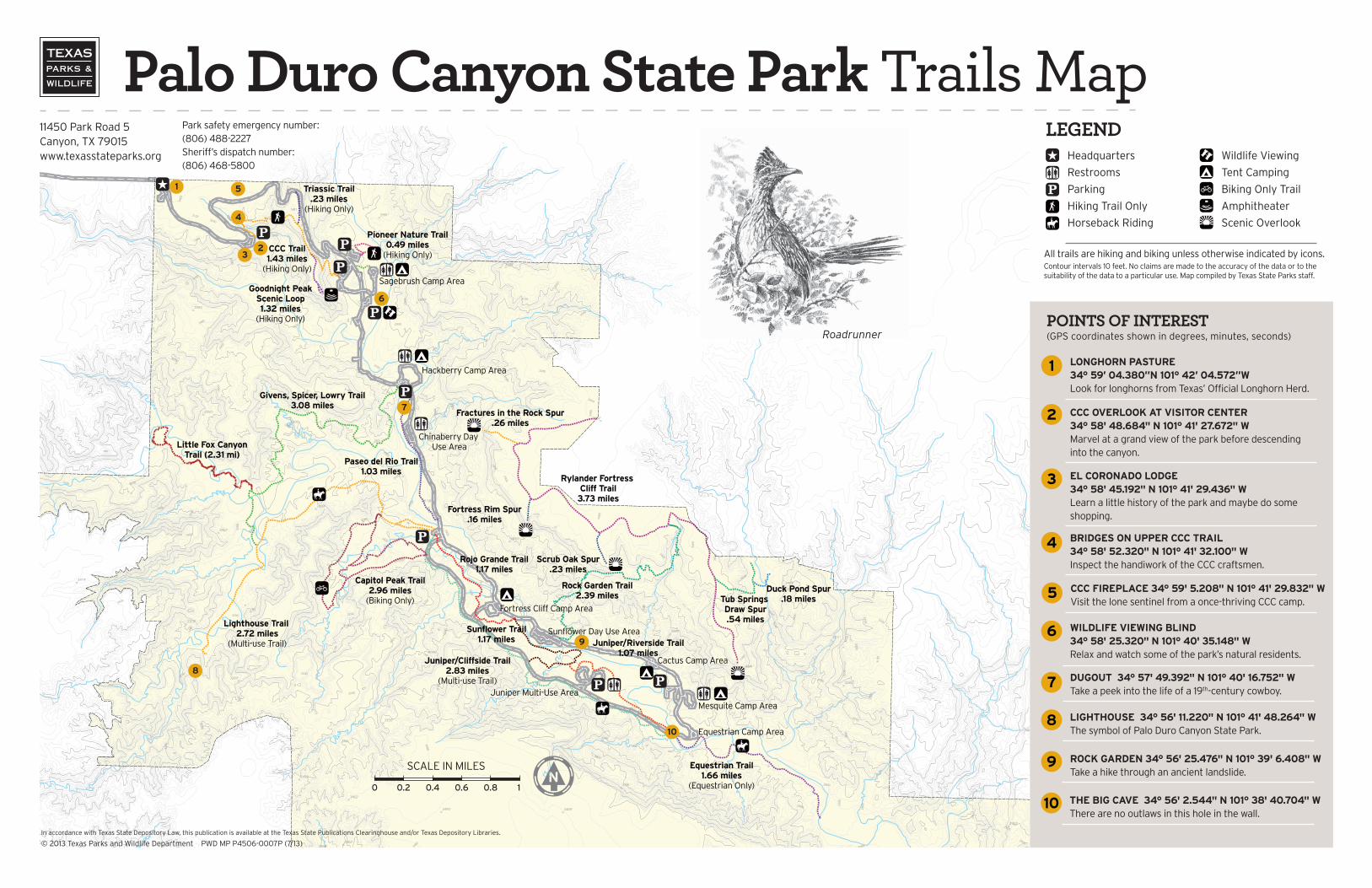
0Pioneer Nature Trail
0.49 miles(Hiking Only)
Paseo del Rio Trail1.03 miles
Sunflower Trail1.17 miles Juniper/Riverside Trail
1.07 milesJuniper/Cliffside Trail
2.83 miles(Multi-use Trail)
Lighthouse Trail 2.72 miles
(Multi-use Trail)
Equestrian Trail1.66 miles
(Equestrian Only)
Rock Garden Trail2.39 miles
Rylander Fortress Cliff Trail
3.73 miles
Capitol Peak Trail2.96 miles
(Biking Only)
Rojo Grande Trail1.17 miles
CCC Trail1.43 miles
(Hiking Only)
Givens, Spicer, Lowry Trail3.08 miles
Fractures in the Rock Spur.26 miles
Fortress Rim Spur.16 miles
Scrub Oak Spur.23 miles
Tub Springs Draw Spur.54 miles
Duck Pond Spur.18 miles
Sagebrush Camp Area
Hackberry Camp Area
Chinaberry Day Use Area
Fortress Cliff Camp Area
Sunflower Day Use Area
Cactus Camp Area
Juniper Multi-Use Area
Mesquite Camp Area
Equestrian Camp Area
Little Fox Canyon Trail (2.31 mi)
Goodnight PeakScenic Loop1.32 miles
(Hiking Only)
Triassic Trail.23 miles
(Hiking Only)
0.2 0.4 0.6 0.8 10
RoadrunnerPOINTS OF INTEREST(GPS coordinates shown in degrees, minutes, seconds)
1 LONGHORN PASTURE 34° 59’ 04.380”N 101° 42’ 04.572”WLook for longhorns from Texas’ Official Longhorn Herd.
2 CCC OVERLOOK AT VISITOR CENTER 34° 58' 48.684" N 101° 41' 27.672" WMarvel at a grand view of the park before descending into the canyon.
3 EL CORONADO LODGE 34° 58' 45.192" N 101° 41' 29.436" WLearn a little history of the park and maybe do some shopping.
4 BRIDGES ON UPPER CCC TRAIL 34° 58' 52.320" N 101° 41' 32.100" WInspect the handiwork of the CCC craftsmen.
5 CCC FIREPLACE 34° 59' 5.208" N 101° 41' 29.832" WVisit the lone sentinel from a once-thriving CCC camp.
6 WILDLIFE VIEWING BLIND 34° 58' 25.320" N 101° 40' 35.148" WRelax and watch some of the park’s natural residents.
7 DUGOUT 34° 57' 49.392" N 101° 40' 16.752" WTake a peek into the life of a 19th-century cowboy.
10 THE BIG CAVE 34° 56' 2.544" N 101° 38' 40.704" WThere are no outlaws in this hole in the wall.
9 ROCK GARDEN 34° 56' 25.476" N 101° 39' 6.408" WTake a hike through an ancient landslide.
8 LIGHTHOUSE 34° 56' 11.220" N 101° 41' 48.264" WThe symbol of Palo Duro Canyon State Park.
1
23
4
5
6
7
8
9
10
LEGENDHeadquarters
Restrooms
Parking
Hiking Trail Only
Horseback Riding
Wildlife Viewing
Tent Camping
Biking Only Trail
Amphitheater
Scenic Overlook
All trails are hiking and biking unless otherwise indicated by icons. Contour intervals 10 feet. No claims are made to the accuracy of the data or to the suitability of the data to a particular use. Map compiled by Texas State Parks staff.
Park safety emergency number:(806) 488-2227Sheriff’s dispatch number:(806) 468-5800
11450 Park Road 5Canyon, TX 79015www.texasstateparks.org
In accordance with Texas State Depository Law, this publication is available at the Texas State Publications Clearinghouse and/or Texas Depository Libraries.
© 2013 Texas Parks and Wildlife Department PWD MP P4506-0007P (7/13)
Palo Duro Canyon State Park Trails Map
Palo Duro Canyon State Park
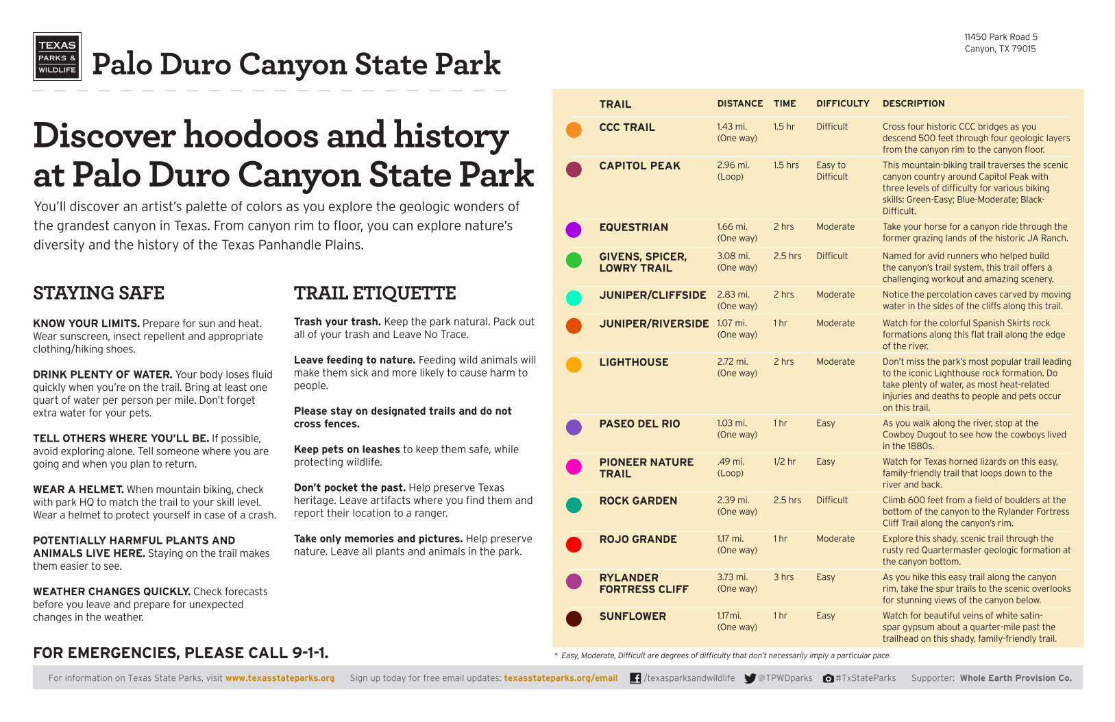
Discover hoodoos and history at Palo Duro Canyon State Park You’ll discover an artist’s palette of colors as you explore the geologic wonders of
the grandest canyon in Texas. From canyon rim to floor, you can explore nature’s
diversity and the history of the Texas Panhandle Plains.
STAYING SAFEKNOW YOUR LIMITS. Prepare for sun and heat. Wear sunscreen, insect repellent and appropriate clothing/hiking shoes.
DRINK PLENTY OF WATER. Your body loses fluid quickly when you’re on the trail. Bring at least one quart of water per person per mile. Don’t forget extra water for your pets.
TELL OTHERS WHERE YOU’LL BE. If possible, avoid exploring alone. Tell someone where you are going and when you plan to return.
WEAR A HELMET. When mountain biking, check with park HQ to match the trail to your skill level. Wear a helmet to protect yourself in case of a crash.
POTENTIALLY HARMFUL PLANTS AND ANIMALS LIVE HERE. Staying on the trail makes them easier to see.
WEATHER CHANGES QUICKLY. Check forecasts before you leave and prepare for unexpected changes in the weather.
TRAIL ETIQUETTETrash your trash. Keep the park natural. Pack out all of your trash and Leave No Trace.
Leave feeding to nature. Feeding wild animals will make them sick and more likely to cause harm to people.
Please stay on designated trails and do not cross fences.
Keep pets on leashes to keep them safe, while protecting wildlife.
Don’t pocket the past. Help preserve Texas heritage. Leave artifacts where you find them and report their location to a ranger.
Take only memories and pictures. Help preserve nature. Leave all plants and animals in the park.
11450 Park Road 5Canyon, TX 79015
FOR EMERGENCIES, PLEASE CALL 9-1-1. * Easy, Moderate, Difficult are degrees of difficulty that don’t necessarily imply a particular pace.
For information on Texas State Parks, visit www.texasstateparks.org Sign up today for free email updates: www.tpwd.state.tx.us/email /texasparksandwildlife @TPWDparks #TxStateParks For information on Texas State Parks, visit www.texasstateparks.org Sign up today for free email updates: texasstateparks.org/email /texasparksandwildlife @TPWDparks #TxStateParks Supporter: Whole Earth Provision Co.
TRAIL
CCC TRAIL
DISTANCE
1.43 mi.(One way)
TIME
1.5 hr
DIFFICULTY
Difficult
DESCRIPTION
Cross four historic CCC bridges as you descend 500 feet through four geologic layers from the canyon rim to the canyon floor.
CAPITOL PEAK 2.96 mi.(Loop)
1.5 hrs Easy to Difficult
This mountain-biking trail traverses the scenic canyon country around Capitol Peak with three levels of difficulty for various biking skills: Green-Easy; Blue-Moderate; Black-Difficult.
EQUESTRIAN 1.66 mi.(One way)
2 hrs Moderate Take your horse for a canyon ride through the former grazing lands of the historic JA Ranch.
GIVENS, SPICER, LOWRY TRAIL
3.08 mi.(One way)
2.5 hrs Difficult Named for avid runners who helped build the canyon’s trail system, this trail offers a challenging workout and amazing scenery.
JUNIPER/CLIFFSIDE 2.83 mi.(One way)
2 hrs Moderate Notice the percolation caves carved by moving water in the sides of the cliffs along this trail.
JUNIPER/RIVERSIDE 1.07 mi.(One way)
1 hr Moderate Watch for the colorful Spanish Skirts rock formations along this flat trail along the edge of the river.
LIGHTHOUSE 2.72 mi.(One way)
2 hrs Moderate Don’t miss the park’s most popular trail leading to the iconic Lighthouse rock formation. Do take plenty of water, as most heat-related injuries and deaths to people and pets occur on this trail.
PASEO DEL RIO 1.03 mi.(One way)
1 hr Easy As you walk along the river, stop at the Cowboy Dugout to see how the cowboys lived in the 1880s.
PIONEER NATURE TRAIL
.49 mi.(Loop)
1/2 hr Easy Watch for Texas horned lizards on this easy, family-friendly trail that loops down to the river and back.
ROCK GARDEN 2.39 mi.(One way)
2.5 hrs Difficult Climb 600 feet from a field of boulders at the bottom of the canyon to the Rylander Fortress Cliff Trail along the canyon’s rim.
ROJO GRANDE 1.17 mi.(One way)
1 hr Moderate Explore this shady, scenic trail through the rusty red Quartermaster geologic formation at the canyon bottom.
RYLANDERFORTRESS CLIFF
3.73 mi.(One way)
3 hrs Easy As you hike this easy trail along the canyon rim, take the spur trails to the scenic overlooks for stunning views of the canyon below.
SUNFLOWER 1.17mi.(One way)
1 hr Easy Watch for beautiful veins of white satin-spar gypsum about a quarter-mile past the trailhead on this shady, family-friendly trail.