Embed Size (px)
Citation preview
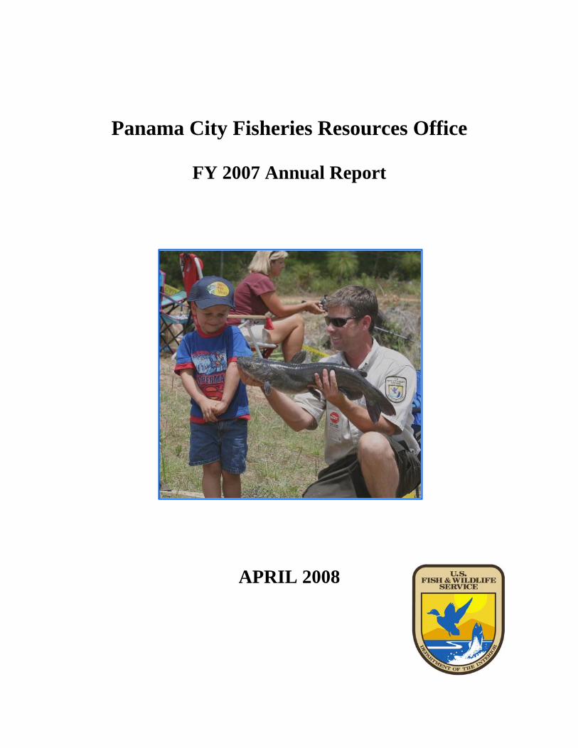
Panama City Fisheries Resources Office
FY 2007 Annual Report
APRIL 2008
ANNUAL REPORT
FISCAL YEAR 2007
U.S. FISH AND WILDLIFE SERVICE FISHERIES RESOURCES
PANAMA CITY FIELD OFFICE PANAMA CITY, FLORIDA
Organization Code: 41310
TABLE OF CONTENTS
LIST OF FIGURES ..................................................................................................................... iii
INTRODUCTION......................................................................................................................... 1
HIGHLIGHTS FOR FY 2007...................................................................................................... 2
PROGRAMMATIC OPERATIONS .......................................................................................... 3
I. Gulf Sturgeon Recovery....................................................................................................... 3 Gulf Sturgeon Population Survey in the Escambia River, Florida ......................................... 3 Gulf Sturgeon Investigations in other River Systems............................................................. 4 Assessment of Impacts to Gulf Sturgeon Critical Foraging Habitat....................................... 4 Gulf Sturgeon Restoration and Recovery Coordination ......................................................... 5 Environmental Threats to Gulf Sturgeon Spawning Habitat .................................................. 5 Alabama Sturgeon Investigations ........................................................................................... 5
II. Striped Bass Restoration .................................................................................................... 6 Apalachicola-Chattahoochee-Flint River System Striped Bass Restoration .......................... 6 Hatchery Product Evaluation of Phase II Gulf Striped Bass Stocked in the Apalachicola River, Florida .......................................................................................................................... 6
III. Fishery Assistance on Federal Lands – Department of Defense ................................... 7 Tyndall Air Force Base, Florida ............................................................................................. 7 Fort Benning, Georgia ............................................................................................................ 7 Aquatic Resources and Recreational Survey .......................................................................... 8 Identify and Prioritize Road Crossing Structures that Impact Streams on Eglin Air Force Base......................................................................................................................................... 9 Aquatic Resource Monitoring on Eglin Air Force Base......................................................... 9 Aquatic Ecosystem Adaptive Management Plan for Eglin Air Force Base ......................... 10 Aquatic Invertebrate Monitoring on Eglin Air Force Base .................................................. 10 Okaloosa Darter Recovery.................................................................................................... 11 Okaloosa Darter Status Review ............................................................................................ 12 Population Genetics Assessment of the Okaloosa and Brown Darters................................. 13 Evaluation of Wastewater Treatment Sprayfields as Potential Sources of Habitat Degradation for Okaloosa darters in East Turkey Creek ...................................................... 13
IV. Fishery Assistance on Federal Lands – National Wildlife Refuges ............................ 13 Banks Lake National Wildlife Refuges, Georgia ................................................................. 13 St. Vincent National Wildlife Refuge, Florida ..................................................................... 14
V. Native Freshwater Mussel Recovery and Restoration................................................... 14 GIS Database for Freshwater Mussel Sampling Sites .......................................................... 14 Recovery Planning: Endangered, Threatened, and Imperiled Northeast Gulf Freshwater Mussels ................................................................................................................................. 15 Response of Listed Freshwater Mussel Species to a Basin-Wide Drought .......................... 16 Ochlockonee Moccasinshell Status Survey .......................................................................... 16 Five-Year Status Review for Seven Listed Freshwater Mussels .......................................... 17
VI. Partners for Fish and Wildlife ....................................................................................... 17 Restoration of Mill Creek to Improve Habitat for the Okaloosa Darter ............................... 17
i
Mill Creek Restoration Monitoring ...................................................................................... 20 Fish Passage Project for Okaloosa Darter at Railroad Crossing on Eglin Air Force Base... 21 Eglin Air Force Base Fish Passage Projects in Okaloosa Darter Streams............................ 22 Riparian Habitat Restoration for Listed Freshwater Mussels in the Ochlockonee River Basin ..................................................................................................................................... 23 Unpaved Road Interagency Team......................................................................................... 23 Chipola River Threats Analysis Using Aerial Imagery and Land Cover Data..................... 25 Assessment of Sedimentation Risk to Streams from Unpaved Road Crossings in Spring Creek, Georgia ...................................................................................................................... 25 East Fork Magnolia Creek Dam Removal Post Restoration Monitoring ............................. 26 Ochlockonee River Watershed Threats Assessment............................................................. 27 Sheffield Mill Creek Stream Restoration Project ................................................................. 27 Oyster Lake Restoration Project ........................................................................................... 28 Oyster Lake Fish Community Analysis Before and After Restoration ................................ 29 Identification and Removal of Barriers to Fish Passage within the Northeast Gulf Ecoregion .............................................................................................................................. 30 Sedimentation Assessment for Unpaved Road Stream Crossings in the Choctawhatchee Watershed, Alabama ............................................................................................................. 30 Technical Assistance and Outreach for the Partners for Fish and Wildlife Program ........... 31
OTHER PARTNERSHIPS ........................................................................................................ 31
Alabama Shad Restoration and Recovery............................................................................. 31 Aquatic Nuisance Management in the Northeast Gulf of Mexico Drainages ...................... 32 Improved Fish Passage of Jim Woodruff Lock and Dam..................................................... 32
PUBLIC OUTREACH ............................................................................................................... 33
1st Annual Eglin AFB Youth Fishing Derby ........................................................................ 34
MEETINGS AND PRESENTATIONS..................................................................................... 35
REPORTS AND PUBLICATIONS .......................................................................................... 35
TRAINING .................................................................................................................................. 36
VOLUNTEEER ACTIVITIES .................................................................................................. 36
PRIMARY ACTIVITIES FOR FY 2008 .................................................................................. 37
ii
LIST OF FIGURES
Figure 1. The houseboat “Bluegill” served as living quarters and base of operations ...................3 Figure 2. Karen Herrington with the “Catch-of-the-Day” ..............................................................3 Figure 3. Site on the Choctawhatchee River scheduled for restoration in FY 2008.......................5 Figure 4. Rick Long from the Florida Fish and Wildlife Conservation Commission assists with striped bass broodfish collections ....................................................................................................6 Figure 5. Trophy largemouth bass collected during the survey......................................................7 Figure 6. Department of Defense facilities indicating a need for fishery technical assistance ......8 Figure 7. Michelle Tongue, USFWS STEP at Eglin AFB, taking water quality measurements as part of the ongoing road-stream crossing inventory, prioritization and rehabilitation program.....9 Figure 8. Seton Bonney, USFWS Fishery Biologist at Eglin AFB, collecting and sorting aquatic macroinvertebrate samples.............................................................................................................10 Figure 9. Okaloosa darter monitoring sites for FY 2007 ..............................................................12 Figure 10. Josiah Olsen (SCA) and Thom Lewis (St. Vincent NWR) with trophy red drum .......14 Figure 11. Data from the PCFO mussel survey database displaying locations in the Northeast Gulf of Mexico drainages that have been sampled for freshwater mussels since the 1800s .........15 Figure 12. A small young-of-year fat threeridge (Amblema neislerii) found during summer sampling on the Apalachicola River ..............................................................................................15 Figure 13. A stranded endangered fat threeridge (Amblema neislerii) at the sand’s surface amidst dead shells of other mussels ...............................................................................................16 Figure 14. Biologists grub for mussels in the Apalachicola River during fall surveys ................16 Figure 15. An Ochlockonee moccasinshell (Medionidus simpsonianus) found in the fall of 2007 and tagged by USFWS biologists ..................................................................................................17 Figure 16. Mill Creek Restoration Project. Colored stream segments indicate the work accomplished: blue – existing stream where Okaloosa darters are present; green – ponded or wetland areas left to regenerate; and white – constructed stream channel ....................................18 Figure 17. Progression of the restoration project from impoundment to stream..........................19 Figure 18. Skylighted culvert installation during construction and after restoration ...................19
iii
Figure 19. Seton Bonney, USFWS Fishery Biologist, conducting habitat monitoring at the Mill Creek restoration project................................................................................................................20 Figure 20. Howard Jelks, U.S. Geological Survey, conducting visual survey monitoring of the Okaloosa darter in Mill Creek........................................................................................................20 Figure 21. Fish passage barrier on Little Rocky Creek, Eglin AFB.............................................21 Figure 22. Removal of fish passage barrier with natural channel design on Little Rocky Creek.21 Figure 23. Upstream view of ponded area caused by barrier on Little Rocky Creek...................22 Figure 24. Upstream view after barrier removal restoring the natural channel on Little Rocky Creek ..............................................................................................................................................22 Figure 25. Inventory sites in Walton County, Florida ..................................................................24 Figure 26. Chipola subwatershed ranked by total threatened stream miles..................................25 Figure 27. A map showing results of an unpaved road-stream crossing sediment risk survey in the Spring Creek, GA watershed ...................................................................................................26 Figure 28. Dan Scollan (SCA) and Karen Herrington (PCFRO) conduct post-restoration electrofishing survey to assess fish community.............................................................................27 Figure 29. Unpaved road sedimentation into Ochlockonee River................................................27 Figure 30. Ditch runoff from Sowhatchee Road into Sheffield Mill Creek .................................28 Figure 31. Oyster Lake causeway before construction.................................................................28 Figure 32. Oyster Lake causeway after construction....................................................................29 Figure 33. Electroshocking on Oyster Lake .................................................................................29 Figure 34. Fish passage barrier in the Choctawhatchee River Basin............................................30 Figure 35. Unpaved road impact from sediment runoff in the Choctawhatchee River Basin ......30 Figure 36. Biologist Steve Herrington, TNC, displays an Alabama shad captured in the Apalachicola River at Jim Woodruff Lock and Dam ....................................................................31 Figure 37. Grass carp collected on the Apalachicola River during Aquatic Nuisance Species Monitoring .....................................................................................................................................32
iv
Figure 38. Peter Durkee (SCA), mounting Gulf sturgeon warning sign at Brothers River boat ramp ...............................................................................................................................................33 Figure 39. Cub scouts learning the ways of the sturgeon .............................................................33 Figure 40. Bill Tate giving a tour to Air Force 96 CEG/CC Col. Yates at the Mill creek stream restoration project on Eglin’s Falcon Golf Course ........................................................................34 Figure 41. Bill Tate with participants of the 1st annual Kids Fishing Rodeo at Eglin Air Force Base................................................................................................................................................34 Figure 42. New Okaloosa darter outreach materials.....................................................................34 Figure 43. Volunteers assisting with Okaloosa darter habitat restoration ....................................37
v
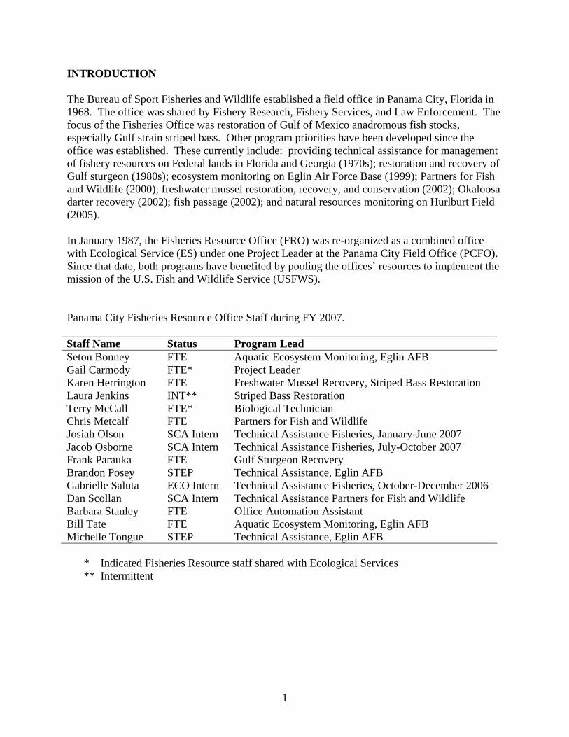
INTRODUCTION The Bureau of Sport Fisheries and Wildlife established a field office in Panama City, Florida in 1968. The office was shared by Fishery Research, Fishery Services, and Law Enforcement. The focus of the Fisheries Office was restoration of Gulf of Mexico anadromous fish stocks, especially Gulf strain striped bass. Other program priorities have been developed since the office was established. These currently include: providing technical assistance for management of fishery resources on Federal lands in Florida and Georgia (1970s); restoration and recovery of Gulf sturgeon (1980s); ecosystem monitoring on Eglin Air Force Base (1999); Partners for Fish and Wildlife (2000); freshwater mussel restoration, recovery, and conservation (2002); Okaloosa darter recovery (2002); fish passage (2002); and natural resources monitoring on Hurlburt Field (2005). In January 1987, the Fisheries Resource Office (FRO) was re-organized as a combined office with Ecological Service (ES) under one Project Leader at the Panama City Field Office (PCFO). Since that date, both programs have benefited by pooling the offices’ resources to implement the mission of the U.S. Fish and Wildlife Service (USFWS). Panama City Fisheries Resource Office Staff during FY 2007. Staff Name Status Program Lead Seton Bonney FTE Aquatic Ecosystem Monitoring, Eglin AFB Gail Carmody FTE* Project Leader Karen Herrington FTE Freshwater Mussel Recovery, Striped Bass Restoration Laura Jenkins INT** Striped Bass Restoration Terry McCall FTE* Biological Technician Chris Metcalf FTE Partners for Fish and Wildlife Josiah Olson SCA Intern Technical Assistance Fisheries, January-June 2007 Jacob Osborne SCA Intern Technical Assistance Fisheries, July-October 2007 Frank Parauka FTE Gulf Sturgeon Recovery Brandon Posey STEP Technical Assistance, Eglin AFB Gabrielle Saluta ECO Intern Technical Assistance Fisheries, October-December 2006 Dan Scollan SCA Intern Technical Assistance Partners for Fish and Wildlife Barbara Stanley FTE Office Automation Assistant Bill Tate FTE Aquatic Ecosystem Monitoring, Eglin AFB Michelle Tongue STEP Technical Assistance, Eglin AFB
* Indicated Fisheries Resource staff shared with Ecological Services ** Intermittent
1
HIGHLIGHTS FOR FY 2007 1. Completed a three-year Gulf sturgeon population study on the Escambia River, Florida.
The population was estimated at 451 fish. 2. Implemented the Gulf Striped Bass Restoration Plan by coordinating the 24th Annual
Morone Workshop, leading the technical committee, transporting broodfish, coordinating stocking on the Apalachicola-Chattahoochee-Flint (ACF) river system, and evaluating post-stocking success.
3. Completed a survey to document the extent of aquatic resources, recreational fishing
opportunities, and fishery management needs on Department of Defense (DoD) facilities located in Region 4.
4. Continued a project in the Apalachicola River to describe the effects of exceptional
drought conditions on freshwater mussel recovery. 5. Initiated a study to locate extant populations of the federally endangered Ochlockonee
moccasinshell in the Ochlockonee River Basin. We documented the first live individuals in 14 years.
6. Completed a five-year status review for seven threatened and endangered freshwater
mussels in the NEG drainages. 7. Restored Mill Creek to improve habitat for the endangered Okaloosa darter by removing
six fish passage barriers and creating approximately 3,000 linear feet of new and regenerated stream channel with floodplain and native vegetation.
8. Completed a fish passage project that connected about 5 miles of habitat in Little Rocky
Creek, Eglin Air Force Base, to benefit the Okaloosa darter. 9. Completed a threats analysis to aquatic species in the Chipola River watershed using GIS
stream data, aerial imagery, and land cover data. 10. Multiple outreach projects were completed to detail aquatic resource conservation needs
and opportunities, including National Fishing Week, Earth Day, several festivals, and school outreach.
2
PROGRAMMATIC OPERATIONS I. Gulf Sturgeon Recovery Gulf Sturgeon Population Survey in the Escambia River, Florida
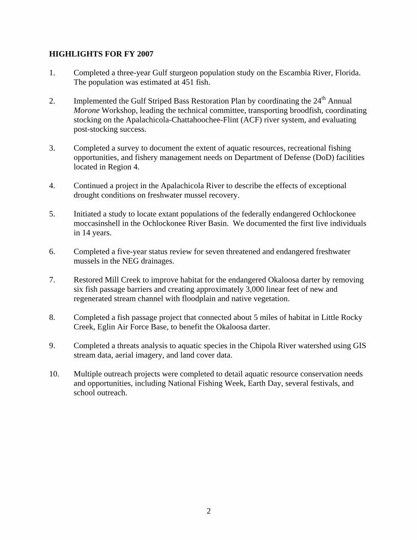
Figure 1. The houseboat “Bluegill” served as living quarters and base of operations.
The Gulf Sturgeon Recovery/Management (GSRM) Plan emphasizes that the knowledge of Gulf sturgeon distribution and relative abundance are important components in evaluating the success of Gulf sturgeon recovery and management programs. The final year in a three-year Gulf sturgeon population survey was conducted in the Escambia River from October 10 through November 5, 2006, to coincide with the species’ fall migration from the freshwater to the marine environment. Gulf sturgeon were captured from dawn to dusk using four sinking gill nets (8 ft to 20 ft deep; 150 ft to 250 ft long; 5 in to 14 in stretch mesh) set perpendicular to the river bank, covering about 75% of the river. The nets were inspected every two hours for captured sturgeon. All sturgeon collected were weighed and measured (fork length and total length). In addition, each fish was tagged with a Passive Integrated Transponder tag (PIT) injected into the tissue at the base of the dorsal fin and T-bar anchor tags attached to both pectoral fins. A houseboat anchored at the netting site provided a base of operations and living quarters for personnel conducting the survey (Figure 1).
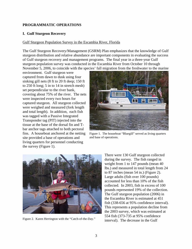
There were 130 Gulf sturgeon collected during the survey. The fish ranged in weight from 1 to 147 pounds (mean 40 lbs.) and measured in total length from 24 to 87 inches (mean 54 in.) (Figure 2). Large adults (fish over 100 pounds) accounted for less than 10% of the fish collected. In 2003, fish in excess of 100 pounds represented 19% of the collection. The Gulf sturgeon population (2006) in the Escambia River is estimated at 451 fish (338-656 at 95% confidence interval). This represents a population decline from the 2003 survey, which was estimated at 554 fish (373-735 at 95% confidence interval). The decrease in the Gulf Figure 2. Karen Herrington with the “Catch-of-the-Day.”
3
sturgeon population and lack of larger fish collected during the 2006 survey is thought to be the result of degraded water quality caused by Hurricane Ivan in 2004, which made landfall during the Gulf sturgeon fall migration and generated massive fish kills in the lower Escambia River. Gulf Sturgeon Investigations in other River Systems Two hundred and twenty-five Gulf sturgeon were collected from three additional river systems during FY 2007. One hundred and sixty-four fish were collected and tagged in the Choctawhatchee River, Florida/Alabama, in order to provide a database for a capture/recapture study to be conducted in that river system during FY 2008. Fifty-one fish were collected in the Brothers River, 8 of which received surgically implanted sonic tags for a movement and habitat use study being conducted in the Apalachicola River system by Clemson University, South Carolina. Also, 10 fish were collected and tagged in the Blackwater River. The fish weighed from 1 to 151 pounds. Gulf sturgeon investigations were conducted in the Alabama and Perdido rivers and Mobile and Perdido bays; however, no Gulf sturgeon were collected in these systems. Assessment of Impacts to Gulf Sturgeon Critical Foraging Habitat A priority action item identified in the GSRM Plan is to identify the marine habitat used by Gulf sturgeon. Most of the growth and feeding for Gulf sturgeon occurs during winter in the marine environment. Hurricane Ivan impacted much of the critical foraging habitat in 2004. Therefore, NOAA initiated a study to examine movement patterns, home ranges, activity space, and length of residence of Gulf sturgeon in Pensacola and Choctawhatchee bays to determine if habitat selected by Gulf sturgeons changed based on differences in habitat type due to hurricane alteration. Panama City biologists assisted NOAA researchers with the collection of Gulf sturgeon, implantation of acoustic tags, and monitoring tagged fish. Fifty-eight juvenile, sub-adult, and adult Gulf sturgeons from four rivers (Escambia - N=26; Blackwater - N=12; Yellow - N=8; Choctawhatchee - N=12) were surgically implanted with acoustic coded transmitters. The fish weighed from 7 to 158 pounds and measured from 35 to 84 inches in total length. Fifty-seven underwater fixed acoustic monitoring stations were deployed in Pensacola (N=47) and Choctawhatchee (N=10) bays in a fashion that would allow overlapping detection ranges between receivers and provide continuous data concerning the movement of individuals throughout the study site. In addition, manual tracking equipment was also used to monitor fish movement and habitat use. Preliminary information obtained from the fixed monitoring stations located in Pensacola Bay indicate that Gulf sturgeon residency during the overwintering period was much longer than originally thought with fish being located in the upper portion of the bay during mid-summer. In addition, more than a dozen sturgeon were recorded off and on throughout the western portion of Santa Rosa Sound. The information received from the fixed stations set in Choctawhatchee Bay was similar to previous studies indicating that Gulf sturgeon overwintered in the shallow, nearshore areas of the bay. A number of the fixed monitoring stations were vandalized or lost during the study. The project is scheduled for completion in FY 2008.
4
Gulf Sturgeon Restoration and Recovery Coordination Panama City Field Office biologists participated in the 8th Annual Gulf Sturgeon Workshop by NOAA. The workshop provides a forum and communication network for Federal, State, and university researchers to obtain and present technical and scientific information regarding current Gulf sturgeon studies, as well as address priority action items addressed in the GSRM Plan needed to achieve successful recovery of the species. In addition, grant opportunities are investigated and cooperative studies to address specific research needs are encouraged. PCFO biologists provided technical assistance related to Gulf sturgeon recovery to numerous Federal and State agencies, education institutions, and non-government organizations and individuals during FY 2007. Environmental Threats to Gulf Sturgeon Spawning Habitat
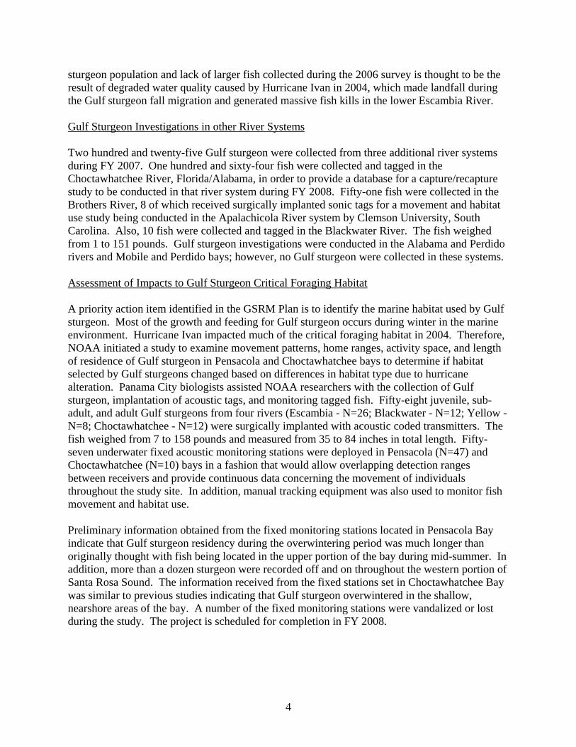
Figure 3. Site on the Choctawhatchee River scheduled for restoration in FY 2008.
The GSRM Plan states the need to identify, restore, and protect habitats essential for various life stages of the Gulf sturgeon. Forty miles of the Choctawhatchee River were floated with the purpose of identifying environmental disturbances that may threaten Gulf sturgeon spawning habitat. A report was completed that documented the various habitat threats which included sediment runoff from bridge crossings, boat ramps, dirt roads, uncontrolled range land and
pastures, eroded river banks, and point and non-point discharges. Landowner lists associated with the environmental disturbances were developed and government and non-government agencies, groups and individuals were contacted to work with landowners to undertake habitat conservation practices and minimize the number of environmental threats to Gulf sturgeon spawning habitat. Two landowners with property posing the highest threat to Gulf sturgeon spawning habitat in the Choctawhatchee River are being provided partner incentives for habitat restoration in FY 2008 (Figure 3).
Alabama Sturgeon Investigations Alabama Wildlife and Freshwater Fisheries biologists captured an endangered Alabama sturgeon in the Alabama River during the spring of 2007. The fish was transported to the Marion State Fish Hatchery for evaluation and possible propagation if a mate could be collected. As a result of the rare collection, PCFO biologists participated in an intense cooperative effort with State and Federal biologists to capture an additional Alabama sturgeon to be used as a mate. No Alabama sturgeon were collected during the investigation which amounted to over 400 hours of effort expended using sinking gill nets and baited trot lines. Consequently, a decision was made
5
to equip the hatchery-held fish with a telemetry tag, release it at the point of capture and monitor its movement and habitat use. PCFO biologists assisted in manually tracking the fish, as well as providing the State with remote recording telemetry equipment for placement in several locations in the river to aid in relocating the fish in the event it was not detected during manual monitoring. II. Striped Bass Restoration Apalachicola-Chattahoochee-Flint River System Striped Bass Restoration
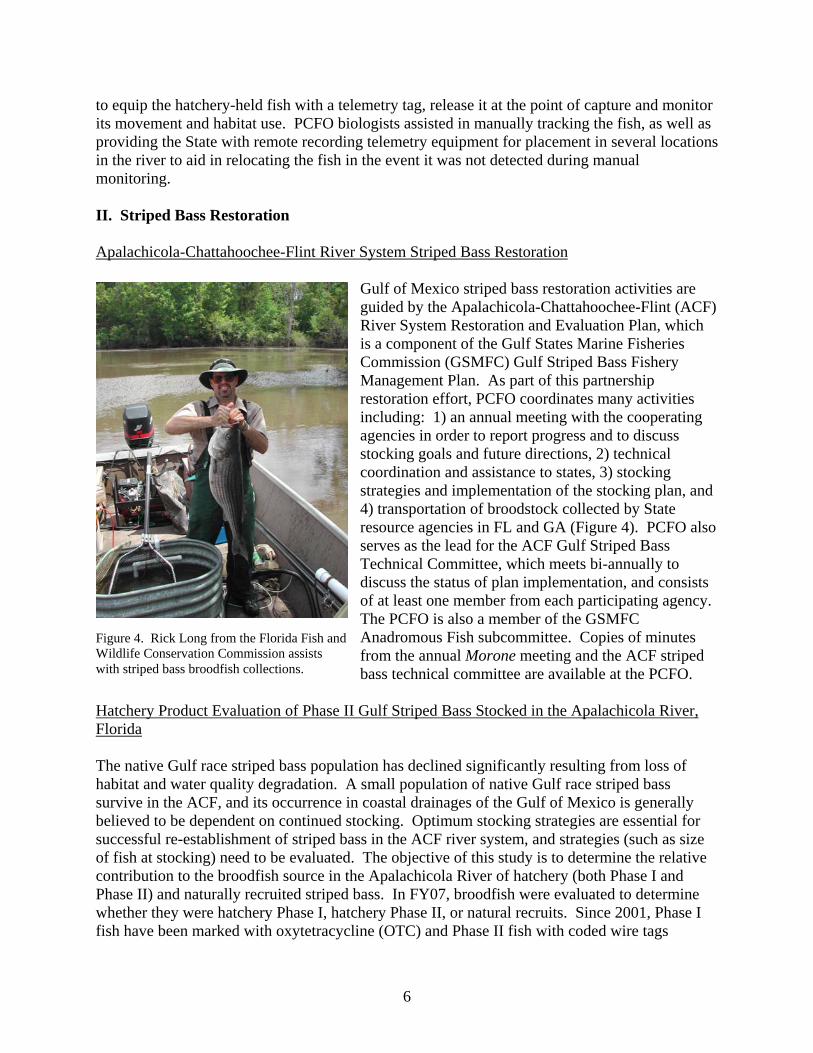
Gulf of Mexico striped bass restoration activities are guided by the Apalachicola-Chattahoochee-Flint (ACF) River System Restoration and Evaluation Plan, which is a component of the Gulf States Marine Fisheries Commission (GSMFC) Gulf Striped Bass Fishery Management Plan. As part of this partnership restoration effort, PCFO coordinates many activities including: 1) an annual meeting with the cooperating agencies in order to report progress and to discuss stocking goals and future directions, 2) technical coordination and assistance to states, 3) stocking strategies and implementation of the stocking plan, and 4) transportation of broodstock collected by State resource agencies in FL and GA (Figure 4). PCFO also serves as the lead for the ACF Gulf Striped Bass Technical Committee, which meets bi-annually to discuss the status of plan implementation, and consists of at least one member from each participating agency. The PCFO is also a member of the GSMFC Anadromous Fish subcommittee. Copies of minutes from the annual Morone meeting and the ACF striped bass technical committee are available at the PCFO.
Figure 4. Rick Long from the Florida Fish and Wildlife Conservation Commission assists with striped bass broodfish collections.
Hatchery Product Evaluation of Phase II Gulf Striped Bass Stocked in the Apalachicola River, Florida The native Gulf race striped bass population has declined significantly resulting from loss of habitat and water quality degradation. A small population of native Gulf race striped bass survive in the ACF, and its occurrence in coastal drainages of the Gulf of Mexico is generally believed to be dependent on continued stocking. Optimum stocking strategies are essential for successful re-establishment of striped bass in the ACF river system, and strategies (such as size of fish at stocking) need to be evaluated. The objective of this study is to determine the relative contribution to the broodfish source in the Apalachicola River of hatchery (both Phase I and Phase II) and naturally recruited striped bass. In FY07, broodfish were evaluated to determine whether they were hatchery Phase I, hatchery Phase II, or natural recruits. Since 2001, Phase I fish have been marked with oxytetracycline (OTC) and Phase II fish with coded wire tags
6
(CWT) or double OTC marks, while natural recruits have no marks or tags. Of the 9 broodfish sent to hatcheries, 2 were Phase II fish. The other 7 fish were not Phase II (no CWT), but their otoliths have not yet been evaluated for OTC marks that would indicate whether they are natural recruits or Phase I fish. In addition, in winter FY07 we monitored striped bass at 26 fixed stations for a total of 8 hours of electrofishing pedal time; however, this effort yielded no striped bass. This study will continue through FY 2009, and a final report will include stocking recommendations. III. Fishery Assistance on Federal Lands – Department of Defense Tyndall Air Force Base, Florida PCFO biologists conducted fishery survey in three recreational fishing ponds to determine the fish species structure in the ponds and provide recommendations to help manage the recreational fishery. With the exception of one pond that had experienced a previous fish kill and had not completely recovered, the overall balance of the fishery in the remaining ponds was good, and water quality was adequate for maintaining a healthy fishery. A report of the survey and recommendations were provided to the Tyndall Natural Resource officer. Fort Benning, Georgia
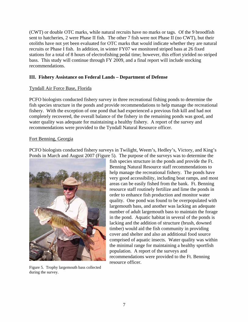
Figure 5. Trophy largemouth bass collected during the survey.
PCFO biologists conducted fishery surveys in Twilight, Weem’s, Hedley’s, Victory, and King’s Ponds in March and August 2007 (Figure 5). The purpose of the surveys was to determine the
fish species structure in the ponds and provide the Ft. Benning Natural Resource staff recommendations to help manage the recreational fishery. The ponds have very good accessibility, including boat ramps, and most areas can be easily fished from the bank. Ft. Benning resource staff routinely fertilize and lime the ponds in order to enhance fish production and monitor water quality. One pond was found to be overpopulated with largemouth bass, and another was lacking an adequate number of adult largemouth bass to maintain the forage in the pond. Aquatic habitat in several of the ponds is lacking and the addition of structure (brush, downed timber) would aid the fish community in providing cover and shelter and also an additional food source comprised of aquatic insects. Water quality was within the minimal range for maintaining a healthy sportfish population. A report of the surveys and recommendations were provided to the Ft. Benning resource officer.
7
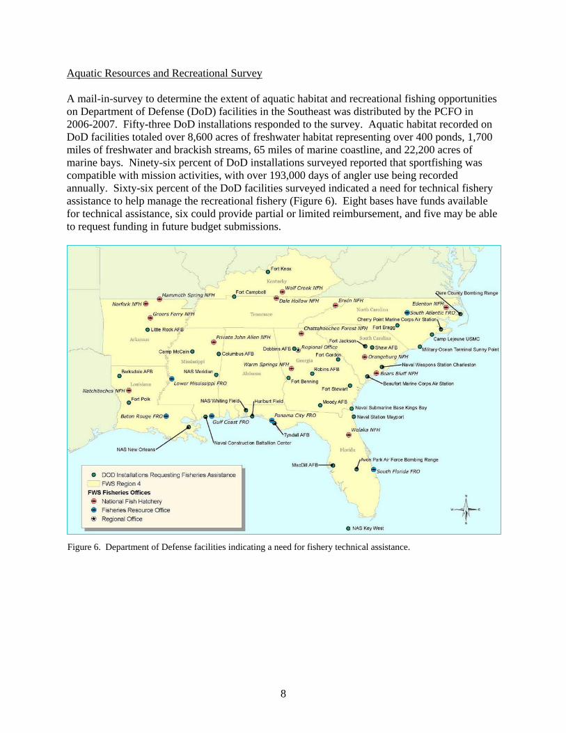
Aquatic Resources and Recreational Survey A mail-in-survey to determine the extent of aquatic habitat and recreational fishing opportunities on Department of Defense (DoD) facilities in the Southeast was distributed by the PCFO in 2006-2007. Fifty-three DoD installations responded to the survey. Aquatic habitat recorded on DoD facilities totaled over 8,600 acres of freshwater habitat representing over 400 ponds, 1,700 miles of freshwater and brackish streams, 65 miles of marine coastline, and 22,200 acres of marine bays. Ninety-six percent of DoD installations surveyed reported that sportfishing was compatible with mission activities, with over 193,000 days of angler use being recorded annually. Sixty-six percent of the DoD facilities surveyed indicated a need for technical fishery assistance to help manage the recreational fishery (Figure 6). Eight bases have funds available for technical assistance, six could provide partial or limited reimbursement, and five may be able to request funding in future budget submissions.
Figure 6. Department of Defense facilities indicating a need for fishery technical assistance.
8
Identify and Prioritize Road Crossing Structures that Impact Streams on Eglin Air Force Base
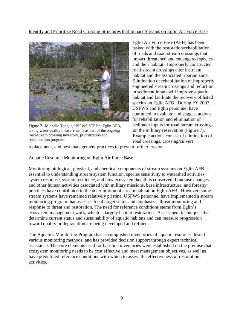
Figure 7. Michelle Tongue, USFWS STEP at Eglin AFB, taking water quality measurements as part of the ongoing road-stream crossing inventory, prioritization and rehabilitation program.
Eglin Air Force Base (AFB) has been tasked with the restoration/rehabilitation of roads and road-stream crossings that impact threatened and endangered species and their habitat. Improperly constructed road-stream crossings alter instream habitat and the associated riparian zone. Elimination or rehabilitation of improperly engineered stream crossings and reduction in sediment inputs will improve aquatic habitat and facilitate the recovery of listed species on Eglin AFB. During FY 2007, USFWS and Eglin personnel have continued to evaluate and suggest actions for rehabilitation and elimination of sediment inputs for road-stream crossings on the military reservation (Figure 7). Example actions consist of elimination of road crossings, crossing/culvert
replacement, and best management practices to prevent further erosion. Aquatic Resource Monitoring on Eglin Air Force Base Monitoring biological, physical, and chemical components of stream systems on Eglin AFB is essential to understanding stream system function, species sensitivity to watershed activities, system response, system resilience, and how ecosystem health is conserved. Land use changes and other human activities associated with military missions, base infrastructure, and forestry practices have contributed to the deterioration of stream habitat on Eglin AFB. However, some stream systems have remained relatively pristine. USFWS personnel have implemented a stream monitoring program that assesses focal target status and emphasizes threat monitoring and response to threat and restoration. The need for reference conditions stems from Eglin’s ecosystem management work, which is largely habitat restoration. Assessment techniques that determine current status and sustainability of aquatic habitats and can measure progression toward quality or degradation are being developed and refined. The Aquatics Monitoring Program has accomplished inventories of aquatic resources, tested various monitoring methods, and has provided decision support through expert technical assistance. The core elements used for baseline inventories were established on the premise that ecosystem monitoring needs to be cost effective and meet management objectives, as well as have predefined reference conditions with which to assess the effectiveness of restoration activities.
9
Aquatic Ecosystem Adaptive Management Plan for Eglin Air Force Base Development of realistic adaptive management plans is paramount to stewardship of natural resources. The Integrated Natural Resource Management Plan (INRMP) and its associated component plans (T&E management and aquatics monitoring) for Eglin AFB were due for 5-year revision. Our objective was to assist in the revision process, suggest management objectives, and work with the military to restore and conserve aquatic habitats. During the revision process, we worked closely with Eglin natural resources managers, consulting on key aspects of aquatic management and suggesting revisions to management programs that benefit aquatic species and stream habitats. USFWS personnel were also tasked with complete revision of the aquatic monitoring component plan. Aquatic Invertebrate Monitoring on Eglin Air Force Base
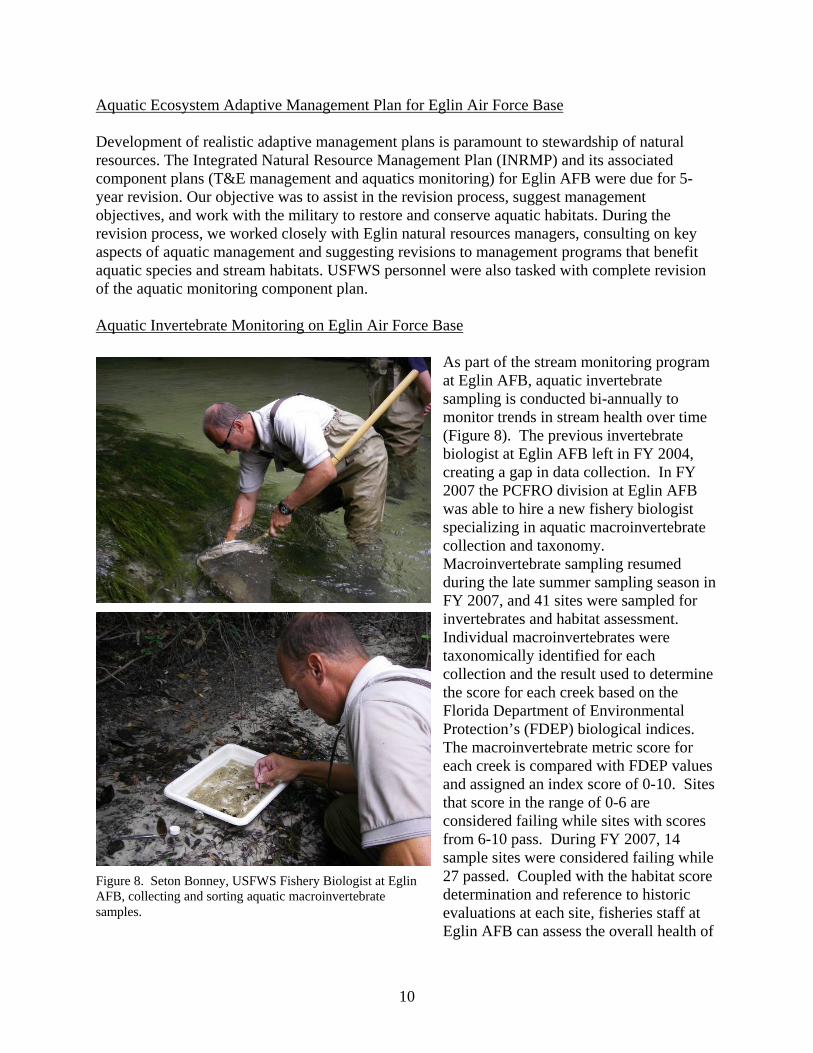
As part of the stream monitoring program at Eglin AFB, aquatic invertebrate sampling is conducted bi-annually to monitor trends in stream health over time (Figure 8). The previous invertebrate biologist at Eglin AFB left in FY 2004, creating a gap in data collection. In FY 2007 the PCFRO division at Eglin AFB was able to hire a new fishery biologist specializing in aquatic macroinvertebrate collection and taxonomy. Macroinvertebrate sampling resumed during the late summer sampling season in FY 2007, and 41 sites were sampled for invertebrates and habitat assessment. Individual macroinvertebrates were taxonomically identified for each collection and the result used to determine the score for each creek based on the Florida Department of Environmental Protection’s (FDEP) biological indices. The macroinvertebrate metric score for each creek is compared with FDEP values and assigned an index score of 0-10. Sites that score in the range of 0-6 are considered failing while sites with scores from 6-10 pass. During FY 2007, 14 sample sites were considered failing while 27 passed. Coupled with the habitat score determination and reference to historic evaluations at each site, fisheries staff at Eglin AFB can assess the overall health of
Figure 8. Seton Bonney, USFWS Fishery Biologist at Eglin AFB, collecting and sorting aquatic macroinvertebrate samples.
10
the creeks and use that information to make decisions about how best to manage aquatic resources on the military reservation. Okaloosa Darter Recovery Recovery actions, in the form of habitat restoration, population status and life history surveys, genetic analysis, and public outreach, are necessary for the effective recovery of the Okaloosa darter. Much has been accomplished towards recovery of the Okaloosa darter; however, challenges and barriers to recovery remain on Eglin AFB and in the urbanized areas of Niceville and Valparaiso, FL. The long-term objective is to recover Okaloosa darter and ultimately facilitate removal of the species from the list of federally endangered and threatened species. Coordination of this program is the responsibility of USFWS-FR personnel located at Eglin AFB. The biologists and technicians on Eglin conducted and coordinated recovery efforts for the Okaloosa darter including population/life history surveys, stream restoration, and outreach activities; developing new techniques for conservation planning; and coordinating other recovery actions. The vast majority of the range of the endangered Okaloosa darter is on Eglin AFB. Eglin managers requested a review of stream restoration needs, and a discussion was initiated about potential restoration sites, prioritization of tasks, and ground-truthing needs. Active coordination has led to restoration of numerous highly erodible sites and the acknowledgment of the need to restore hydrology and minimize erosion at road crossings. Technical assistance was also provided on techniques and design alternatives. USFWS personnel are working to incorporate landscape variables into a predictive GIS model that relates land use to Okaloosa darter abundance. This technical tool will provide means to set restoration priorities for Eglin AFB and the cities of Niceville and Valparaiso. We also worked with partners to determine the status of Okaloosa darter populations by visually surveying Okaloosa darters on Eglin AFB and areas near the reservation. Information regarding habitat and water chemistry was reported for these sites. A greatly expanded monitoring program will be adapted from this work for FY 2007 to FY 2012 (Figure 9).
11
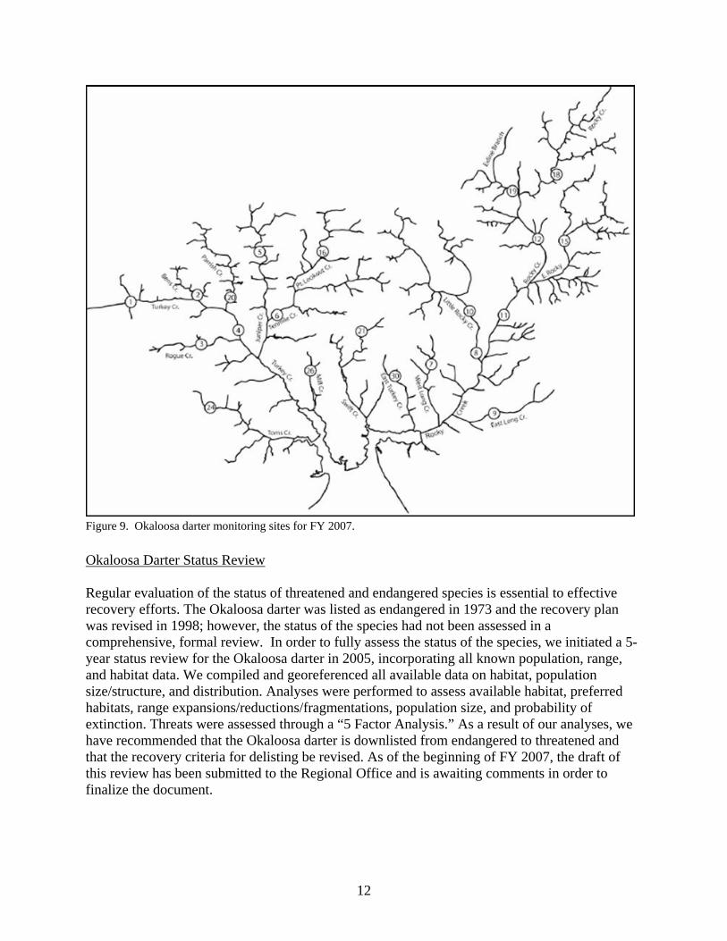
Figure 9. Okaloosa darter monitoring sites for FY 2007.
Okaloosa Darter Status Review Regular evaluation of the status of threatened and endangered species is essential to effective recovery efforts. The Okaloosa darter was listed as endangered in 1973 and the recovery plan was revised in 1998; however, the status of the species had not been assessed in a comprehensive, formal review. In order to fully assess the status of the species, we initiated a 5-year status review for the Okaloosa darter in 2005, incorporating all known population, range, and habitat data. We compiled and georeferenced all available data on habitat, population size/structure, and distribution. Analyses were performed to assess available habitat, preferred habitats, range expansions/reductions/fragmentations, population size, and probability of extinction. Threats were assessed through a “5 Factor Analysis.” As a result of our analyses, we have recommended that the Okaloosa darter is downlisted from endangered to threatened and that the recovery criteria for delisting be revised. As of the beginning of FY 2007, the draft of this review has been submitted to the Regional Office and is awaiting comments in order to finalize the document.
12
Population Genetics Assessment of the Okaloosa and Brown Darters The Okaloosa Darter Recovery Plan emphasizes the need for population genetics for the Okaloosa darter and identifies the brown darter as an introduced competitor. Prior to this study, no genetic analysis has been conducted for either species. Working with our partners at the University of Florida and the U.S. Geological Survey, we secured funding for an intensive population genetic analysis of the Okaloosa darter throughout its range. As part of this project, we collected tissue from over 200 Okaloosa darters at all of the 2005 Jordan and Jelks monitoring sites as well as other sites needed for complete coverage of the known range. Analysis of mtDNA indicated three distinct haplotype lineages: Rocky Bayou, Boggy Bayou, and Toms Bayou. Matrilineal population sizes in Rocky and Boggy bayous were relatively large, but low in the Toms Bayou lineage. In addition to Okaloosa darter population genetics, we included an analysis of the brown darter (Etheostoma edwini) in this study, finding that the brown darters in the Rocky and Boggy bayou watersheds are most closely related to brown darters in the Choctawhatchee River and Bay drainages. Evaluation of Wastewater Treatment Sprayfields as Potential Sources of Habitat Degradation for Okaloosa darters in East Turkey Creek Monitoring data have indicated that Okaloosa darter populations in East Turkey Creek and Swift Creek are declining. Water quality in East Turkey Creek and tributaries to Swift Creek is thought to be degraded as a result of surface water runoff and groundwater connections to sewage treatment sprayfields within these watersheds. Comprehensive water quality analyses have not been performed for either of these streams; however, preliminary samples reflect unusually high conductivity and salinity - an indication of wastewater introduction. Water quality data will be compared to darter population status and trends information. This will enable us to identify the problems and recommend corrective actions that will prevent future declines in Okaloosa darter populations. The Okaloosa darter recovery plan identifies wastewater treatment sprayfields as potential sources of habitat degradation. Elimination of stressors originating from these sprayfields will prevent continued declines in Okaloosa darter population, achieve recovery objectives outlined in the recovery plan, and meet a critical delisting criterion. This project was initiated in FY 2007 and will continue in FY 2008 when the influence of the chemical degradation will be evaluated via physiologically conservative responses in sentinel fish using microarray analysis. Fish exposures and water quality monitoring will be conducted within the impaired watershed (East Turkey Creek) and analogous locations in a reference stream (West Long Creek). IV. Fishery Assistance on Federal Lands – National Wildlife Refuges Banks Lake National Wildlife Refuges, Georgia PCFO biologists conducted a fishery survey in cooperation with the Georgia Department of Natural Resources to assess the sportfish population in the 1,000-acre open water area on Banks Lake National Wildlife Refuge (NWR). Survey results indicated that sportfish (i.e., largemouth
13
bass, bluegill and black crappie) had decreased in numbers from the previous survey. However, the percent of non-sportfish collected (i.e., Florida gar and lake chubsucker) increased from the previous year. In addition, 75% of the lake was covered with aquatic vegetation. When aquatic vegetation cover is in excess of 40%, the fishery community is impacted with changes in prey assemblages, reduced growth rates, altering foraging behavior, shifts in populations size-structure, and reduced relative condition of the fish. A winter drawdown of Banks Lake is scheduled for 2007-2008. It is anticipated that the drawdown would reduce the amount of aquatic vegetation, consolidate some types of lake sediments, control the density of forage fish, enhance the growth of predatory fish, and stimulate fish productivity. The last drawdown on Banks Lake was in 2001, which resulted in improved fish habitat and fish size structure. St. Vincent National Wildlife Refuge, Florida PCFO biologists conducted a fishery survey in Lakes 1, 2, 3, 4, 5 and Oyster Pond on St. Vincent NWR during FY 2007. The purpose of the investigation was to determine the structure of the fish community remaining in the lakes and pond following recent fish kills related to drought conditions and degraded water quality. Only a very small number of bluegill were collected
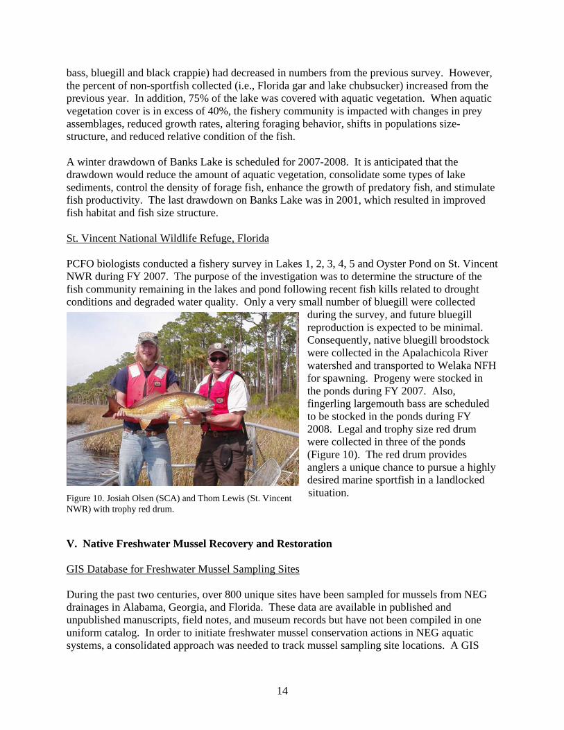
during the survey, and future bluegill reproduction is expected to be minimal. Consequently, native bluegill broodstock were collected in the Apalachicola River watershed and transported to Welaka NFH for spawning. Progeny were stocked in the ponds during FY 2007. Also, fingerling largemouth bass are scheduled to be stocked in the ponds during FY 2008. Legal and trophy size red drum were collected in three of the ponds (Figure 10). The red drum provides anglers a unique chance to pursue a highly desired marine sportfish in a landlocked situation. Figure 10. Josiah Olsen (SCA) and Thom Lewis (St. Vincent
NWR) with trophy red drum.
V. Native Freshwater Mussel Recovery and Restoration GIS Database for Freshwater Mussel Sampling Sites During the past two centuries, over 800 unique sites have been sampled for mussels from NEG drainages in Alabama, Georgia, and Florida. These data are available in published and unpublished manuscripts, field notes, and museum records but have not been compiled in one uniform catalog. In order to initiate freshwater mussel conservation actions in NEG aquatic systems, a consolidated approach was needed to track mussel sampling site locations. A GIS
14
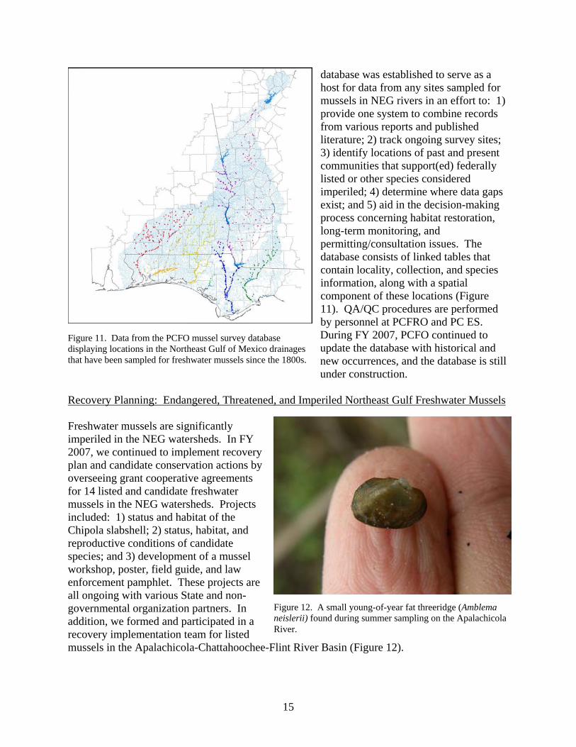
database was established to serve as a host for data from any sites sampled for mussels in NEG rivers in an effort to: 1) provide one system to combine records from various reports and published literature; 2) track ongoing survey sites; 3) identify locations of past and present communities that support(ed) federally listed or other species considered imperiled; 4) determine where data gaps exist; and 5) aid in the decision-making process concerning habitat restoration, long-term monitoring, and permitting/consultation issues. The database consists of linked tables that contain locality, collection, and species information, along with a spatial component of these locations (Figure 11). QA/QC procedures are performed by personnel at PCFRO and PC ES. During FY 2007, PCFO continued to update the database with historical and new occurrences, and the database is still under construction.
Figure 11. Data from the PCFO mussel survey database displaying locations in the Northeast Gulf of Mexico drainages that have been sampled for freshwater mussels since the 1800s.
Recovery Planning: Endangered, Threatened, and Imperiled Northeast Gulf Freshwater Mussels Freshwater mussels are significantly imperiled in the NEG watersheds. In FY 2007, we continued to implement recovery plan and candidate conservation actions by overseeing grant cooperative agreements for 14 listed and candidate freshwater mussels in the NEG watersheds. Projects included: 1) status and habitat of the Chipola slabshell; 2) status, habitat, and reproductive conditions of candidate species; and 3) development of a mussel workshop, poster, field guide, and law enforcement pamphlet. These projects are all ongoing with various State and non-governmental organization partners. In addition, we formed and participated in a recovery implementation team for listed mussels in the Apalachicola-Chattahoochee-Flint River Basin (Figure 12).
Figure 12. A small young-of-year fat threeridge (Amblema neislerii) found during summer sampling on the Apalachicola River.
15
Response of Listed Freshwater Mussel Species to a Basin-Wide Drought
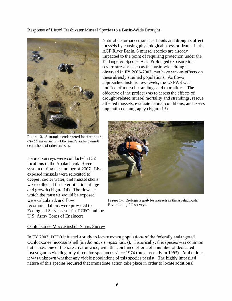
Natural disturbances such as floods and droughts affect mussels by causing physiological stress or death. In the ACF River Basin, 6 mussel species are already impacted to the point of requiring protection under the Endangered Species Act. Prolonged exposure to a severe stressor, such as the basin-wide drought observed in FY 2006-2007, can have serious effects on these already strained populations. As flows approached historic low levels, the USFWS was notified of mussel strandings and mortalities. The objective of the project was to assess the effects of drought-related mussel mortality and strandings, rescue affected mussels, evaluate habitat conditions, and assess population demography (Figure 13).
Figure 13. A stranded endangered fat threeridge (Amblema neislerii) at the sand’s surface amidst dead shells of other mussels.
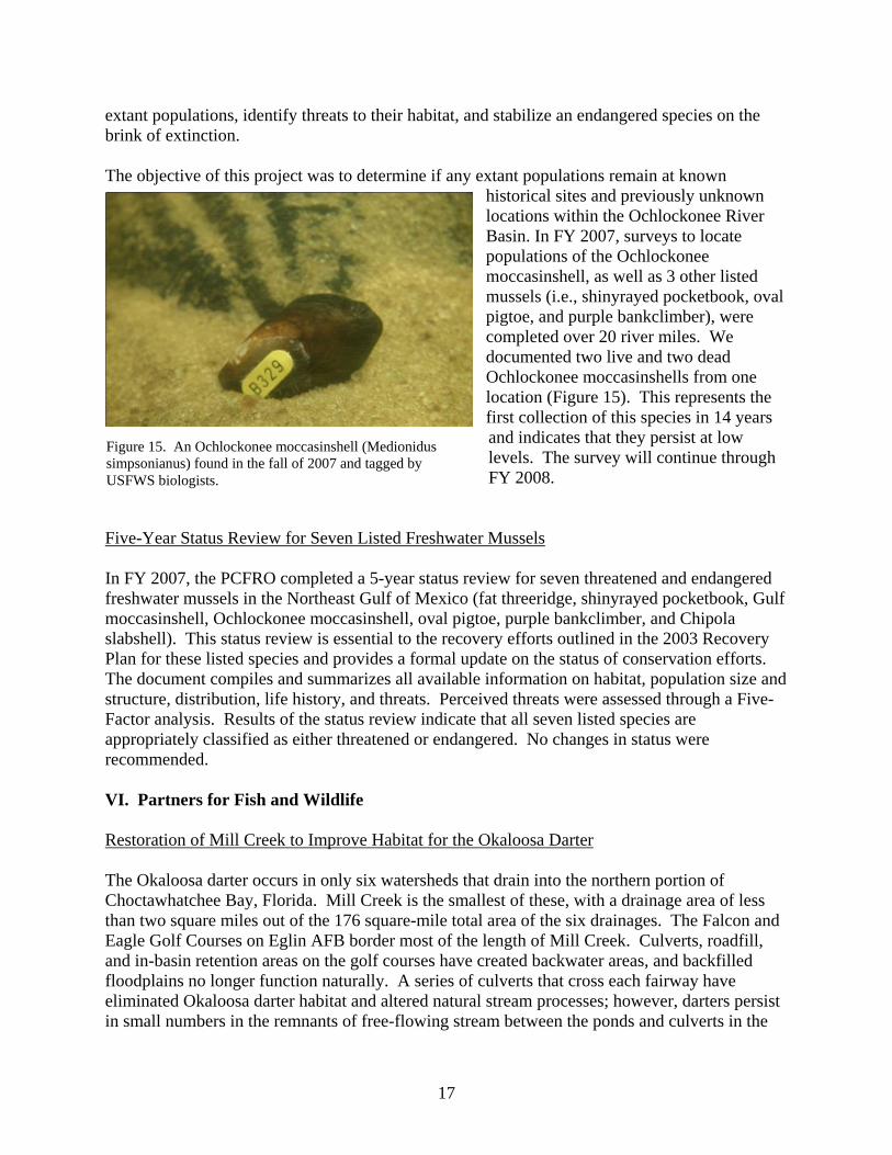
Habitat surveys were conducted at 32 locations in the Apalachicola River system during the summer of 2007. Live exposed mussels were relocated to deeper, cooler water, and mussel shells were collected for determination of age and growth (Figure 14). The flows at which the mussels would be exposed were calculated, and flow recommendations were provided to Ecological Services staff at PCFO and the U.S. Army Corps of Engineers.
Figure 14. Biologists grub for mussels in the Apalachicola River during fall surveys.
Ochlockonee Moccasinshell Status Survey In FY 2007, PCFO initiated a study to locate extant populations of the federally endangered Ochlockonee moccasinshell (Medionidus simpsonianus). Historically, this species was common but is now one of the rarest nationwide, with the combined efforts of a number of dedicated investigators yielding only three live specimens since 1974 (most recently in 1993). At the time, it was unknown whether any viable populations of this species persist. The highly imperiled nature of this species required that immediate action take place in order to locate additional
16
extant populations, identify threats to their habitat, and stabilize an endangered species on the brink of extinction. The objective of this project was to determine if any extant populations remain at known
historical sites and previously unknown locations within the Ochlockonee River Basin. In FY 2007, surveys to locate populations of the Ochlockonee moccasinshell, as well as 3 other listed mussels (i.e., shinyrayed pocketbook, oval pigtoe, and purple bankclimber), were completed over 20 river miles. We documented two live and two dead Ochlockonee moccasinshells from one location (Figure 15). This represents the first collection of this species in 14 years and indicates that they persist at low levels. The survey will continue through FY 2008.
Figure 15. An Ochlockonee moccasinshell (Medionidus simpsonianus) found in the fall of 2007 and tagged by USFWS biologists.
Five-Year Status Review for Seven Listed Freshwater Mussels In FY 2007, the PCFRO completed a 5-year status review for seven threatened and endangered freshwater mussels in the Northeast Gulf of Mexico (fat threeridge, shinyrayed pocketbook, Gulf moccasinshell, Ochlockonee moccasinshell, oval pigtoe, purple bankclimber, and Chipola slabshell). This status review is essential to the recovery efforts outlined in the 2003 Recovery Plan for these listed species and provides a formal update on the status of conservation efforts. The document compiles and summarizes all available information on habitat, population size and structure, distribution, life history, and threats. Perceived threats were assessed through a Five-Factor analysis. Results of the status review indicate that all seven listed species are appropriately classified as either threatened or endangered. No changes in status were recommended. VI. Partners for Fish and Wildlife Restoration of Mill Creek to Improve Habitat for the Okaloosa Darter The Okaloosa darter occurs in only six watersheds that drain into the northern portion of Choctawhatchee Bay, Florida. Mill Creek is the smallest of these, with a drainage area of less than two square miles out of the 176 square-mile total area of the six drainages. The Falcon and Eagle Golf Courses on Eglin AFB border most of the length of Mill Creek. Culverts, roadfill, and in-basin retention areas on the golf courses have created backwater areas, and backfilled floodplains no longer function naturally. A series of culverts that cross each fairway have eliminated Okaloosa darter habitat and altered natural stream processes; however, darters persist in small numbers in the remnants of free-flowing stream between the ponds and culverts in the
17
golf courses. The Okaloosa Darter Recovery Plan identified the Mill Creek darter subpopulation as the most imperiled and improvement of conditions in Mill Creek is considered a vital step to
downlisting and delisting this species. This project should provide an increase of about 1,000 Okaloosa darters to the overall population, leading to downlisting of the species. The objective of this project was to create a stable stream configuration in Mill Creek, re-establish and protect riparian buffers, re-establish floodplains for flood control, and remove impounded stream reaches (Figure 16). The restoration project included the application of natural channel design principles to restore and maintain stable stream geometry relationships and used bioengineering techniques for areas where floodplains needed to be established (Figure 17). In FY 2007, we completed the following actions: 1) removed six fish passage barriers, which included four culverts and two impoundments; 2) constructed a bottomless bankfull culvert structure that facilitates fish passage underneath the fairway by using skylights to provide light to the stream (Figure 18); 3) created approximately 3,000 linear feet of new and regenerated stream channel with floodplain and native vegetation; and 4) constructed three wooden bridges for fairway access across new stream channel.
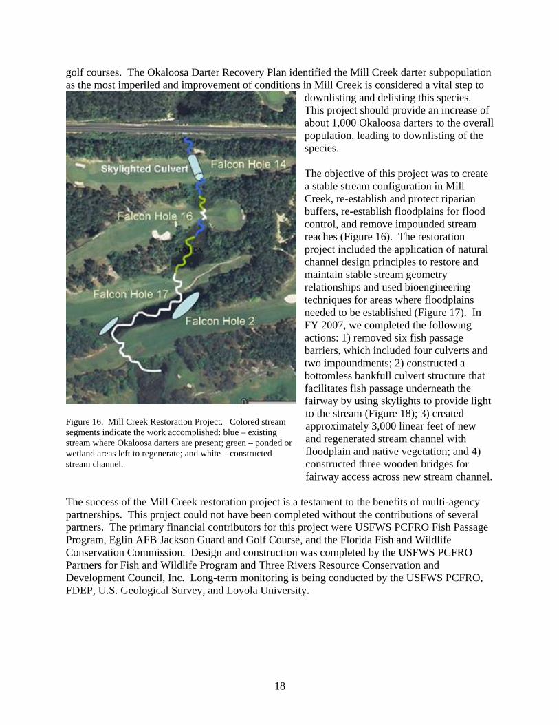
Figure 16. Mill Creek Restoration Project. Colored stream segments indicate the work accomplished: blue – existing stream where Okaloosa darters are present; green – ponded or wetland areas left to regenerate; and white – constructed stream channel.
The success of the Mill Creek restoration project is a testament to the benefits of multi-agency partnerships. This project could not have been completed without the contributions of several partners. The primary financial contributors for this project were USFWS PCFRO Fish Passage Program, Eglin AFB Jackson Guard and Golf Course, and the Florida Fish and Wildlife Conservation Commission. Design and construction was completed by the USFWS PCFRO Partners for Fish and Wildlife Program and Three Rivers Resource Conservation and Development Council, Inc. Long-term monitoring is being conducted by the USFWS PCFRO, FDEP, U.S. Geological Survey, and Loyola University.
18
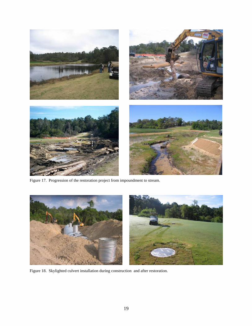
Figure 17. Progression of the restoration project from impoundment to stream.
Figure 18. Skylighted culvert installation during construction and after restoration.
19
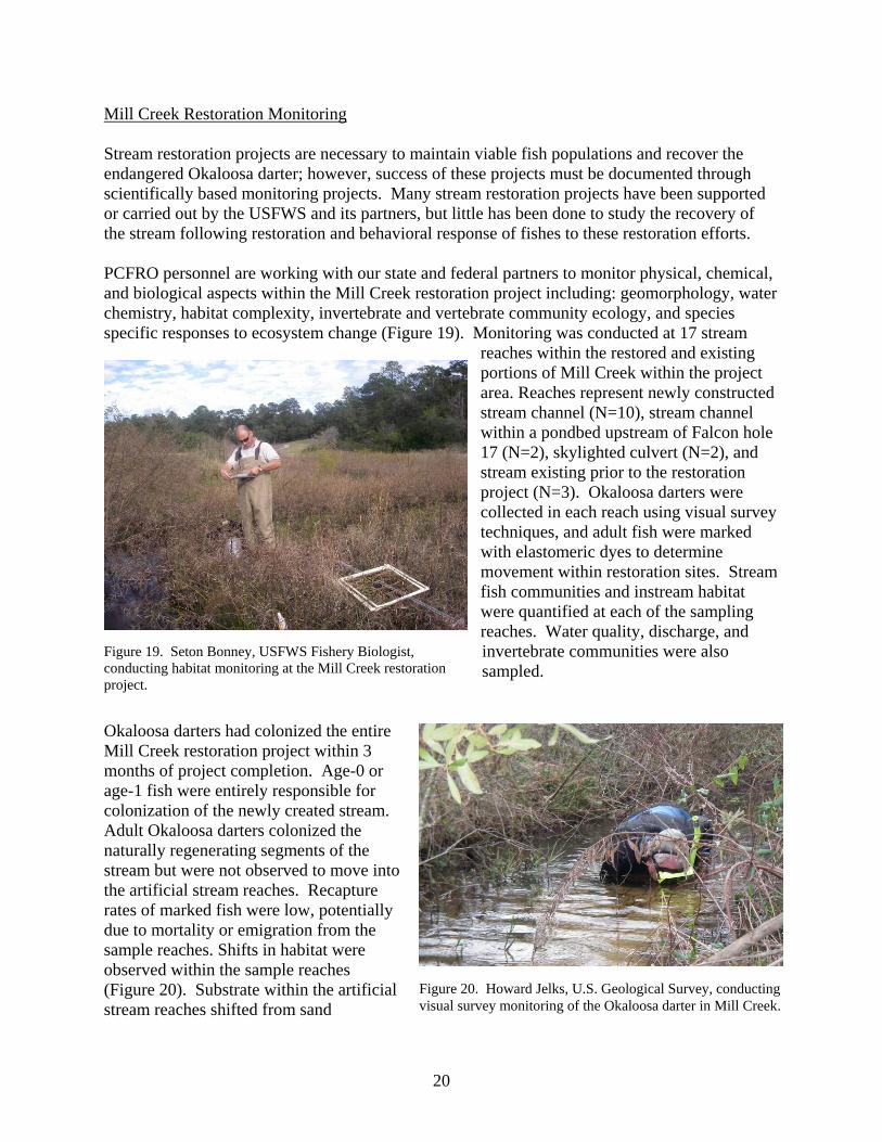
Mill Creek Restoration Monitoring Stream restoration projects are necessary to maintain viable fish populations and recover the endangered Okaloosa darter; however, success of these projects must be documented through scientifically based monitoring projects. Many stream restoration projects have been supported or carried out by the USFWS and its partners, but little has been done to study the recovery of the stream following restoration and behavioral response of fishes to these restoration efforts. PCFRO personnel are working with our state and federal partners to monitor physical, chemical, and biological aspects within the Mill Creek restoration project including: geomorphology, water chemistry, habitat complexity, invertebrate and vertebrate community ecology, and species specific responses to ecosystem change (Figure 19). Monitoring was conducted at 17 stream
reaches within the restored and existing portions of Mill Creek within the project area. Reaches represent newly constructed stream channel (N=10), stream channel within a pondbed upstream of Falcon hole 17 (N=2), skylighted culvert (N=2), and stream existing prior to the restoration project (N=3). Okaloosa darters were collected in each reach using visual survey techniques, and adult fish were marked with elastomeric dyes to determine movement within restoration sites. Stream fish communities and instream habitat were quantified at each of the sampling reaches. Water quality, discharge, and invertebrate communities were also sampled.
Figure 19. Seton Bonney, USFWS Fishery Biologist, conducting habitat monitoring at the Mill Creek restoration project. Okaloosa darters had colonized the entire Mill Creek restoration project within 3 months of project completion. Age-0 or age-1 fish were entirely responsible for colonization of the newly created stream. Adult Okaloosa darters colonized the naturally regenerating segments of the stream but were not observed to move into the artificial stream reaches. Recapture rates of marked fish were low, potentially due to mortality or emigration from the sample reaches. Shifts in habitat were observed within the sample reaches (Figure 20). Substrate within the artificial stream reaches shifted from sand
Figure 20. Howard Jelks, U.S. Geological Survey, conducting visual survey monitoring of the Okaloosa darter in Mill Creek.
20
dominated to macrophytes and roots. Trends in habitat change in the artificial stream differed from those in the other stream types within the project area. Water quality and discharge were relatively consistent through time. Fish Passage Project for Okaloosa Darter at Railroad Crossing on Eglin Air Force Base
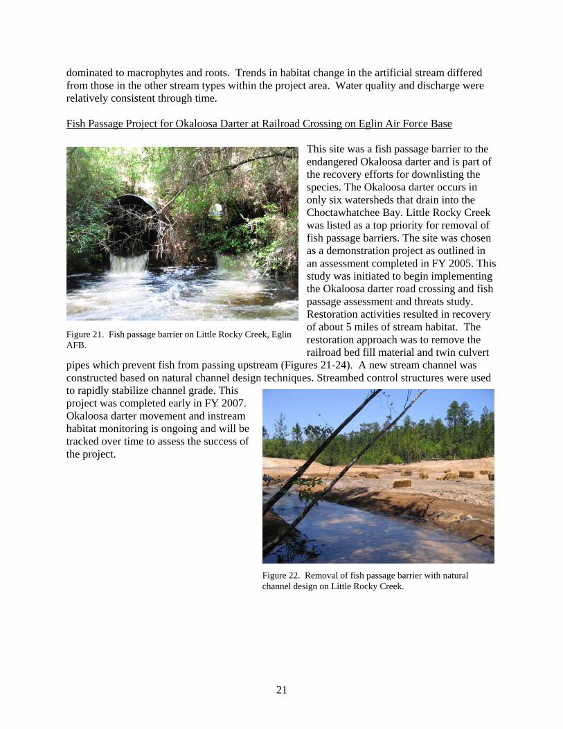
This site was a fish passage barrier to the endangered Okaloosa darter and is part of the recovery efforts for downlisting the species. The Okaloosa darter occurs in only six watersheds that drain into the Choctawhatchee Bay. Little Rocky Creek was listed as a top priority for removal of fish passage barriers. The site was chosen as a demonstration project as outlined in an assessment completed in FY 2005. This study was initiated to begin implementing the Okaloosa darter road crossing and fish passage assessment and threats study. Restoration activities resulted in recovery of about 5 miles of stream habitat. The restoration approach was to remove the railroad bed fill material and twin culvert
pipes which prevent fish from passing upstream (Figures 21-24). A new stream channel was constructed based on natural channel design techniques. Streambed control structures were used to rapidly stabilize channel grade. This project was completed early in FY 2007. Okaloosa darter movement and instream habitat monitoring is ongoing and will be tracked over time to assess the success of the project.
Figure 21. Fish passage barrier on Little Rocky Creek, Eglin AFB.
Figure 22. Removal of fish passage barrier with natural channel design on Little Rocky Creek.
21
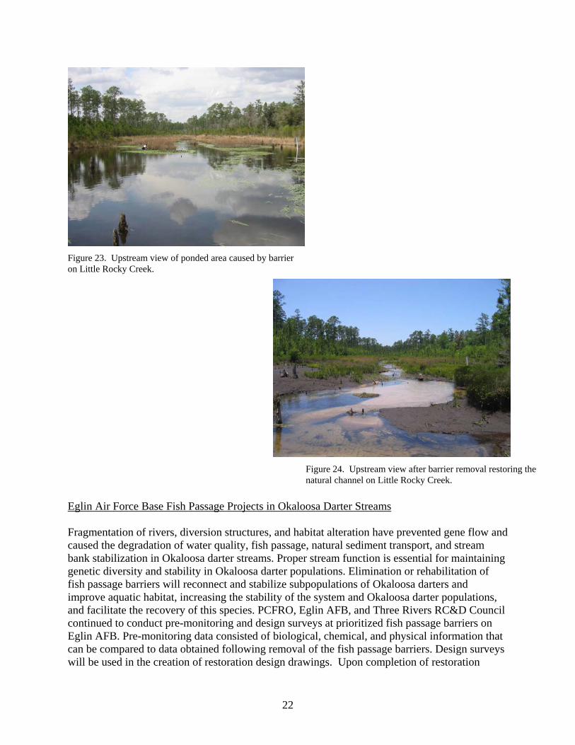
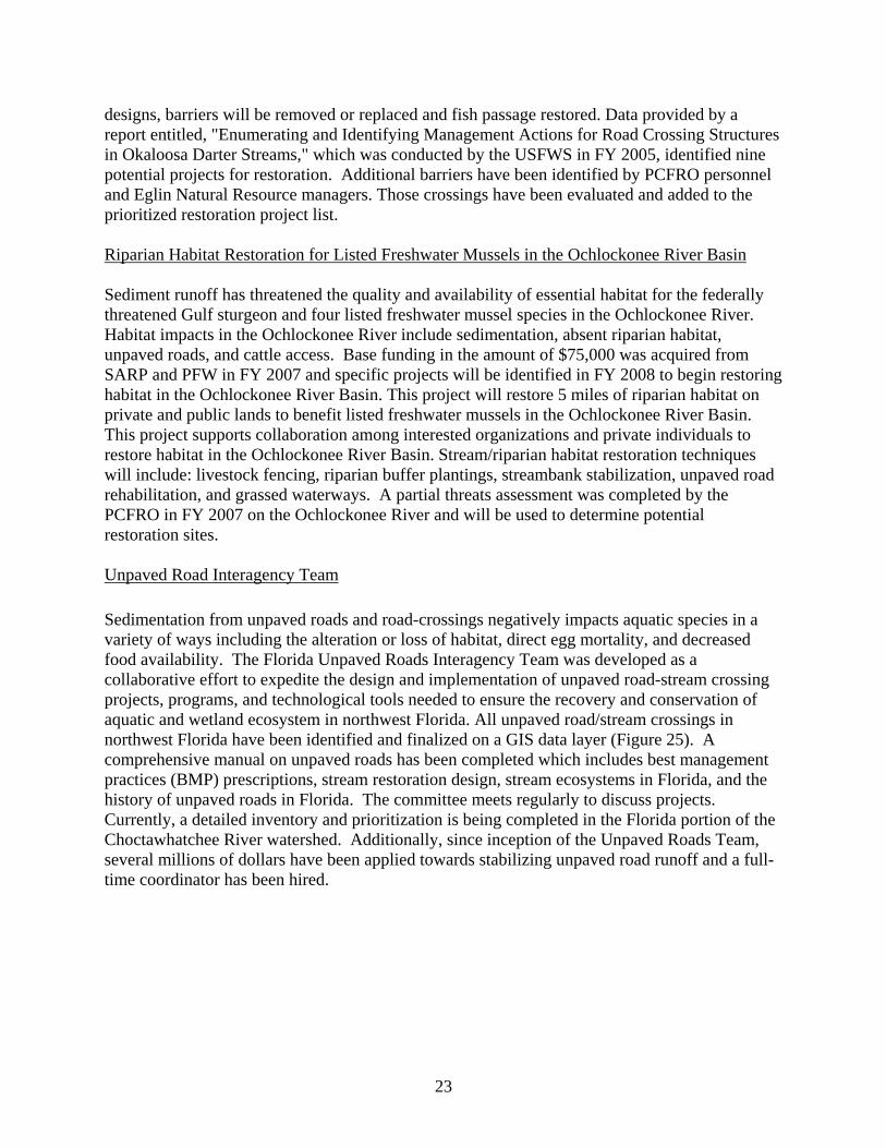
Figure 23. Upstream view of ponded area caused by barrier
on Little Rocky Creek. Figure 24. Upstream view after barrier removal restoring the
natural channel on Little Rocky Creek. Eglin Air Force Base Fish Passage Projects in Okaloosa Darter Streams Fragmentation of rivers, diversion structures, and habitat alteration have prevented gene flow and caused the degradation of water quality, fish passage, natural sediment transport, and stream bank stabilization in Okaloosa darter streams. Proper stream function is essential for maintaining genetic diversity and stability in Okaloosa darter populations. Elimination or rehabilitation of fish passage barriers will reconnect and stabilize subpopulations of Okaloosa darters and improve aquatic habitat, increasing the stability of the system and Okaloosa darter populations, and facilitate the recovery of this species. PCFRO, Eglin AFB, and Three Rivers RC&D Council continued to conduct pre-monitoring and design surveys at prioritized fish passage barriers on Eglin AFB. Pre-monitoring data consisted of biological, chemical, and physical information that can be compared to data obtained following removal of the fish passage barriers. Design surveys will be used in the creation of restoration design drawings. Upon completion of restoration
22
designs, barriers will be removed or replaced and fish passage restored. Data provided by a report entitled, "Enumerating and Identifying Management Actions for Road Crossing Structures in Okaloosa Darter Streams," which was conducted by the USFWS in FY 2005, identified nine potential projects for restoration. Additional barriers have been identified by PCFRO personnel and Eglin Natural Resource managers. Those crossings have been evaluated and added to the prioritized restoration project list. Riparian Habitat Restoration for Listed Freshwater Mussels in the Ochlockonee River Basin Sediment runoff has threatened the quality and availability of essential habitat for the federally threatened Gulf sturgeon and four listed freshwater mussel species in the Ochlockonee River. Habitat impacts in the Ochlockonee River include sedimentation, absent riparian habitat, unpaved roads, and cattle access. Base funding in the amount of $75,000 was acquired from SARP and PFW in FY 2007 and specific projects will be identified in FY 2008 to begin restoring habitat in the Ochlockonee River Basin. This project will restore 5 miles of riparian habitat on private and public lands to benefit listed freshwater mussels in the Ochlockonee River Basin. This project supports collaboration among interested organizations and private individuals to restore habitat in the Ochlockonee River Basin. Stream/riparian habitat restoration techniques will include: livestock fencing, riparian buffer plantings, streambank stabilization, unpaved road rehabilitation, and grassed waterways. A partial threats assessment was completed by the PCFRO in FY 2007 on the Ochlockonee River and will be used to determine potential restoration sites. Unpaved Road Interagency Team Sedimentation from unpaved roads and road-crossings negatively impacts aquatic species in a variety of ways including the alteration or loss of habitat, direct egg mortality, and decreased food availability. The Florida Unpaved Roads Interagency Team was developed as a collaborative effort to expedite the design and implementation of unpaved road-stream crossing projects, programs, and technological tools needed to ensure the recovery and conservation of aquatic and wetland ecosystem in northwest Florida. All unpaved road/stream crossings in northwest Florida have been identified and finalized on a GIS data layer (Figure 25). A comprehensive manual on unpaved roads has been completed which includes best management practices (BMP) prescriptions, stream restoration design, stream ecosystems in Florida, and the history of unpaved roads in Florida. The committee meets regularly to discuss projects. Currently, a detailed inventory and prioritization is being completed in the Florida portion of the Choctawhatchee River watershed. Additionally, since inception of the Unpaved Roads Team, several millions of dollars have been applied towards stabilizing unpaved road runoff and a full-time coordinator has been hired.
23
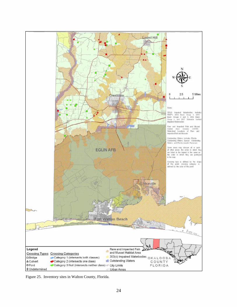
Figure 25. Inventory sites in Walton County, Florida.
24
Chipola River Threats Analysis Using Aerial Imagery and Land Cover Data
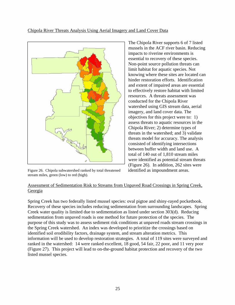
The Chipola River supports 6 of 7 listed mussels in the ACF river basin. Reducing impacts to riverine environments is essential to recovery of these species. Non-point source pollution threats can limit habitat for aquatic species. Not knowing where these sites are located can hinder restoration efforts. Identification and extent of impaired areas are essential to effectively restore habitat with limited resources. A threats assessment was conducted for the Chipola River watershed using GIS stream data, aerial imagery, and land cover data. The objectives for this project were to: 1) assess threats to aquatic resources in the Chipola River; 2) determine types of threats in the watershed; and 3) validate threats model for accuracy. The analysis consisted of identifying intersections between buffer width and land use. A total of 140 out of 1,810 stream miles were identified as potential stream threats (Figure 26). In addition, 262 sites were identified as impoundment areas. Figure 26. Chipola subwatershed ranked by total threatened
stream miles, green (low) to red (high).
Assessment of Sedimentation Risk to Streams from Unpaved Road Crossings in Spring Creek, Georgia Spring Creek has two federally listed mussel species: oval pigtoe and shiny-rayed pocketbook. Recovery of these species includes reducing sedimentation from surrounding landscapes. Spring Creek water quality is limited due to sedimentation as listed under section 303(d). Reducing sedimentation from unpaved roads is one method for future protection of the species. The purpose of this study was to assess sediment risk conditions at unpaved roads stream crossings in the Spring Creek watershed. An index was developed to prioritize the crossings based on identified soil erodibility factors, drainage system, and stream alteration metrics. This information will be used to develop restoration strategies. A total of 119 sites were surveyed and ranked in the watershed: 14 were ranked excellent, 18 good, 54 fair, 22 poor, and 11 very poor (Figure 27). This project will lead to on-the-ground habitat protection and recovery of the two listed mussel species.
25
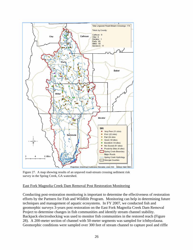
Figure 27. A map showing results of an unpaved road-stream crossing sediment risk survey in the Spring Creek, GA watershed.
East Fork Magnolia Creek Dam Removal Post Restoration Monitoring Conducting post-restoration monitoring is important to determine the effectiveness of restoration efforts by the Partners for Fish and Wildlife Program. Monitoring can help in determining future techniques and management of aquatic ecosystems. In FY 2007, we conducted fish and geomorphic surveys 3-years post restoration on the East Fork Magnolia Creek Dam Removal Project to determine changes in fish communities and identify stream channel stability. Backpack electroshocking was used to monitor fish communities in the restored reach (Figure 28). A 200-meter section of channel with 50-meter segments was sampled for ichthyofauna. Geomorphic conditions were sampled over 300 feet of stream channel to capture pool and riffle
26
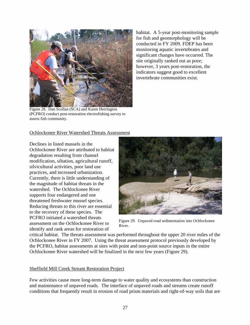
habitat. A 5-year post-monitoring sample for fish and geomorphology will be conducted in FY 2009. FDEP has been monitoring aquatic invertebrates and significant changes have occurred. The site originally ranked out as poor; however, 3 years post-restoration, the indicators suggest good to excellent invertebrate communities exist.
Figure 28. Dan Scollan (SCA) and Karen Herrington (PCFRO) conduct post-restoration electrofishing survey to assess fish community.
Ochlockonee River Watershed Threats Assessment Declines in listed mussels in the Ochlockonee River are attributed to habitat degradation resulting from channel modification, siltation, agricultural runoff, silvicultural activities, poor land use practices, and increased urbanization. Currently, there is little understanding of the magnitude of habitat threats in the watershed. The Ochlockonee River supports four endangered and one threatened freshwater mussel species. Reducing threats to this river are essential to the recovery of these species. The PCFRO initiated a watershed threats assessment on the Ochlockonee River to identify and rank areas for restoration of critical habitat. The threats assessment was performed throughout the upper 20 river miles of the Ochlockonee River in FY 2007. Using the threat assessment protocol previously developed by the PCFRO, habitat assessments at sites with point and non-point source inputs in the entire Ochlockonee River watershed will be finalized in the next few years (Figure 29).
Figure 29. Unpaved road sedimentation into Ochlockonee River.
Sheffield Mill Creek Stream Restoration Project Few activities cause more long-term damage to water quality and ecosystems than construction and maintenance of unpaved roads. The interface of unpaved roads and streams create runoff conditions that frequently result in erosion of road prism materials and right-of-way soils that are
27
conveyed directly to receiving streams as sediment. Sowhatchee Road, which generates several hundred cubic feet of sediment runoff annually, crosses Sheffield Mill Creek (Figure 30). Stabilization of unpaved road materials from entering Sheffield Mill Creek will prevent further sedimentation of the creek and restore habitat for several federally listed mussel species. The PCFRO has been coordinating this project with Early County, Georgia, and Golden Triangle RC&D to abate unpaved road soil materials from entering Sheffield Mill Creek. In FY 2008, the PCFRO will continue coordination with County maintenance departments to stabilize the
Figure 30. Ditch runoff from Sowhatchee Road into Sheffield Mill Creek.
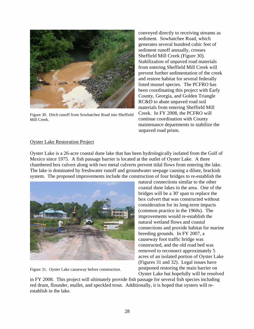
unpaved road prism. Oyster Lake Restoration Project Oyster Lake is a 26-acre coastal dune lake that has been hydrologically isolated from the Gulf of Mexico since 1975. A fish passage barrier is located at the outlet of Oyster Lake. A three chambered box culvert along with two metal culverts prevent tidal flows from entering the lake. The lake is dominated by freshwater runoff and groundwater seepage causing a dilute, brackish system. The proposed improvements include the construction of four bridges to re-establish the
natural connections similar to the other coastal dune lakes in the area. One of the bridges will be a 30' span to replace the box culvert that was constructed without consideration for its long-term impacts (common practice in the 1960s). The improvements would re-establish the natural wetland flows and coastal connections and provide habitat for marine breeding grounds. In FY 2007, a causeway foot traffic bridge was constructed, and the old road bed was removed to reconnect approximately 5 acres of an isolated portion of Oyster Lake (Figures 31 and 32). Legal issues have postponed restoring the main barrier on Oyster Lake but hopefully will be resolved
in FY 2008. This project will ultimately provide fish passage for several fish species including red drum, flounder, mullet, and speckled trout. Additionally, it is hoped that oysters will re-establish in the lake.
Figure 31. Oyster Lake causeway before construction.
28
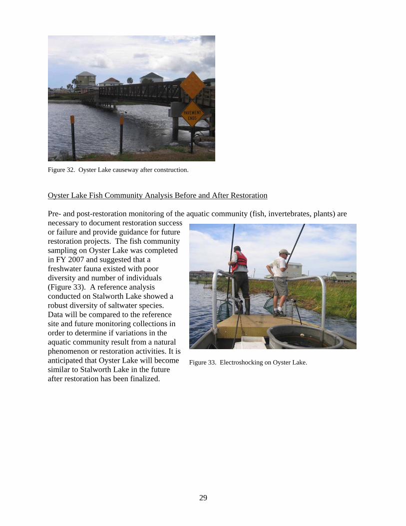
Figure 32. Oyster Lake causeway after construction.
Oyster Lake Fish Community Analysis Before and After Restoration Pre- and post-restoration monitoring of the aquatic community (fish, invertebrates, plants) are necessary to document restoration success or failure and provide guidance for future restoration projects. The fish community sampling on Oyster Lake was completed in FY 2007 and suggested that a freshwater fauna existed with poor diversity and number of individuals (Figure 33). A reference analysis conducted on Stalworth Lake showed a robust diversity of saltwater species. Data will be compared to the reference site and future monitoring collections in order to determine if variations in the aquatic community result from a natural phenomenon or restoration activities. It is anticipated that Oyster Lake will become similar to Stalworth Lake in the future after restoration has been finalized.
Figure 33. Electroshocking on Oyster Lake.
29
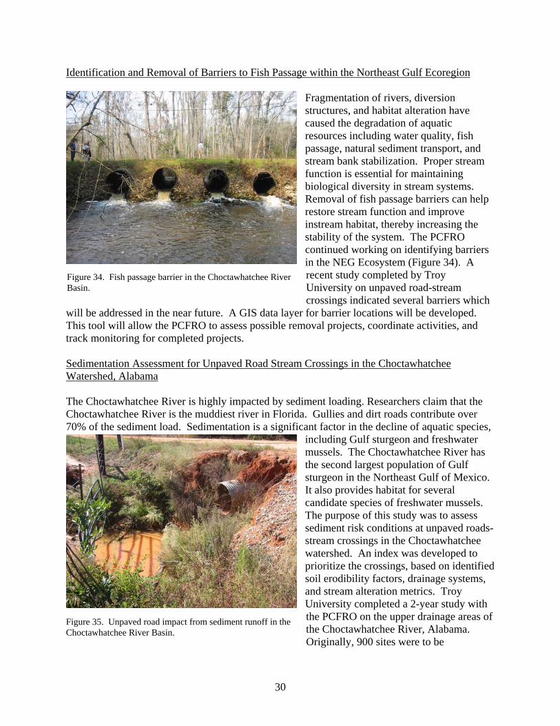
Identification and Removal of Barriers to Fish Passage within the Northeast Gulf Ecoregion
Fragmentation of rivers, diversion structures, and habitat alteration have caused the degradation of aquatic resources including water quality, fish passage, natural sediment transport, and stream bank stabilization. Proper stream function is essential for maintaining biological diversity in stream systems. Removal of fish passage barriers can help restore stream function and improve instream habitat, thereby increasing the stability of the system. The PCFRO continued working on identifying barriers in the NEG Ecosystem (Figure 34). A recent study completed by Troy University on unpaved road-stream crossings indicated several barriers which
will be addressed in the near future. A GIS data layer for barrier locations will be developed. This tool will allow the PCFRO to assess possible removal projects, coordinate activities, and track monitoring for completed projects.
Figure 34. Fish passage barrier in the Choctawhatchee River Basin.
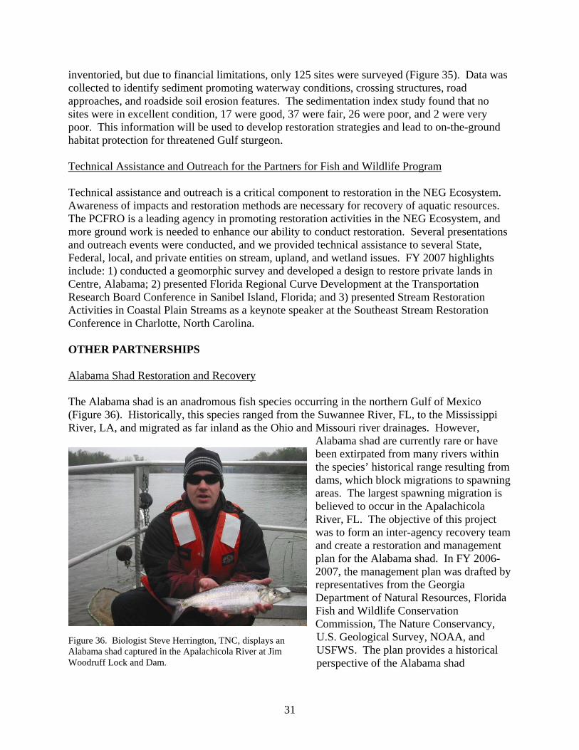
Sedimentation Assessment for Unpaved Road Stream Crossings in the Choctawhatchee Watershed, Alabama The Choctawhatchee River is highly impacted by sediment loading. Researchers claim that the Choctawhatchee River is the muddiest river in Florida. Gullies and dirt roads contribute over 70% of the sediment load. Sedimentation is a significant factor in the decline of aquatic species,
including Gulf sturgeon and freshwater mussels. The Choctawhatchee River has the second largest population of Gulf sturgeon in the Northeast Gulf of Mexico. It also provides habitat for several candidate species of freshwater mussels. The purpose of this study was to assess sediment risk conditions at unpaved roads-stream crossings in the Choctawhatchee watershed. An index was developed to prioritize the crossings, based on identified soil erodibility factors, drainage systems, and stream alteration metrics. Troy University completed a 2-year study with the PCFRO on the upper drainage areas of the Choctawhatchee River, Alabama. Originally, 900 sites were to be
Figure 35. Unpaved road impact from sediment runoff in the Choctawhatchee River Basin.
30
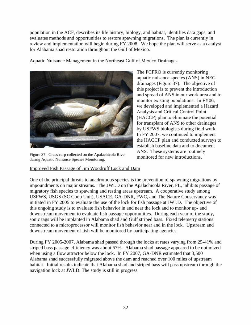
inventoried, but due to financial limitations, only 125 sites were surveyed (Figure 35). Data was collected to identify sediment promoting waterway conditions, crossing structures, road approaches, and roadside soil erosion features. The sedimentation index study found that no sites were in excellent condition, 17 were good, 37 were fair, 26 were poor, and 2 were very poor. This information will be used to develop restoration strategies and lead to on-the-ground habitat protection for threatened Gulf sturgeon. Technical Assistance and Outreach for the Partners for Fish and Wildlife Program Technical assistance and outreach is a critical component to restoration in the NEG Ecosystem. Awareness of impacts and restoration methods are necessary for recovery of aquatic resources. The PCFRO is a leading agency in promoting restoration activities in the NEG Ecosystem, and more ground work is needed to enhance our ability to conduct restoration. Several presentations and outreach events were conducted, and we provided technical assistance to several State, Federal, local, and private entities on stream, upland, and wetland issues. FY 2007 highlights include: 1) conducted a geomorphic survey and developed a design to restore private lands in Centre, Alabama; 2) presented Florida Regional Curve Development at the Transportation Research Board Conference in Sanibel Island, Florida; and 3) presented Stream Restoration Activities in Coastal Plain Streams as a keynote speaker at the Southeast Stream Restoration Conference in Charlotte, North Carolina. OTHER PARTNERSHIPS Alabama Shad Restoration and Recovery The Alabama shad is an anadromous fish species occurring in the northern Gulf of Mexico (Figure 36). Historically, this species ranged from the Suwannee River, FL, to the Mississippi River, LA, and migrated as far inland as the Ohio and Missouri river drainages. However,
Alabama shad are currently rare or have been extirpated from many rivers within the species’ historical range resulting from dams, which block migrations to spawning areas. The largest spawning migration is believed to occur in the Apalachicola River, FL. The objective of this project was to form an inter-agency recovery team and create a restoration and management plan for the Alabama shad. In FY 2006-2007, the management plan was drafted by representatives from the Georgia Department of Natural Resources, Florida Fish and Wildlife Conservation Commission, The Nature Conservancy, U.S. Geological Survey, NOAA, and USFWS. The plan provides a historical perspective of the Alabama shad
Figure 36. Biologist Steve Herrington, TNC, displays an Alabama shad captured in the Apalachicola River at Jim Woodruff Lock and Dam.
31
population in the ACF, describes its life history, biology, and habitat, identifies data gaps, and evaluates methods and opportunities to restore spawning migrations. The plan is currently in review and implementation will begin during FY 2008. We hope the plan will serve as a catalyst for Alabama shad restoration throughout the Gulf of Mexico. Aquatic Nuisance Management in the Northeast Gulf of Mexico Drainages
The PCFRO is currently monitoring aquatic nuisance species (ANS) in NEG drainages (Figure 37). The objective of this project is to prevent the introduction and spread of ANS in our work area and to monitor existing populations. In FY06, we developed and implemented a Hazard Analysis and Critical Control Point (HACCP) plan to eliminate the potential for transplant of ANS to other drainages by USFWS biologists during field work. In FY 2007. we continued to implement the HACCP plan and conducted surveys to establish baseline data and to document ANS. These systems are routinely monitored for new introductions. Figure 37. Grass carp collected on the Apalachicola River
during Aquatic Nuisance Species Monitoring.
Improved Fish Passage of Jim Woodruff Lock and Dam One of the principal threats to anadromous species is the prevention of spawning migrations by impoundments on major streams. The JWLD on the Apalachicola River, FL, inhibits passage of migratory fish species to spawning and resting areas upstream. A cooperative study among USFWS, USGS (SC Coop Unit), USACE, GA-DNR, FWC, and The Nature Conservancy was initiated in FY 2005 to evaluate the use of the lock for fish passage at JWLD. The objective of this ongoing study is to evaluate fish behavior in and near the lock and to monitor up- and downstream movement to evaluate fish passage opportunities. During each year of the study, sonic tags will be implanted in Alabama shad and Gulf striped bass. Fixed telemetry stations connected to a microprocessor will monitor fish behavior near and in the lock. Upstream and downstream movement of fish will be monitored by participating agencies. During FY 2005-2007, Alabama shad passed through the locks at rates varying from 25-41% and striped bass passage efficiency was about 67%. Alabama shad passage appeared to be optimized when using a flow attractor below the lock. In FY 2007, GA-DNR estimated that 3,500 Alabama shad successfully migrated above the dam and reached over 100 miles of upstream habitat. Initial results indicate that Alabama shad and striped bass will pass upstream through the navigation lock at JWLD. The study is still in progress.
32
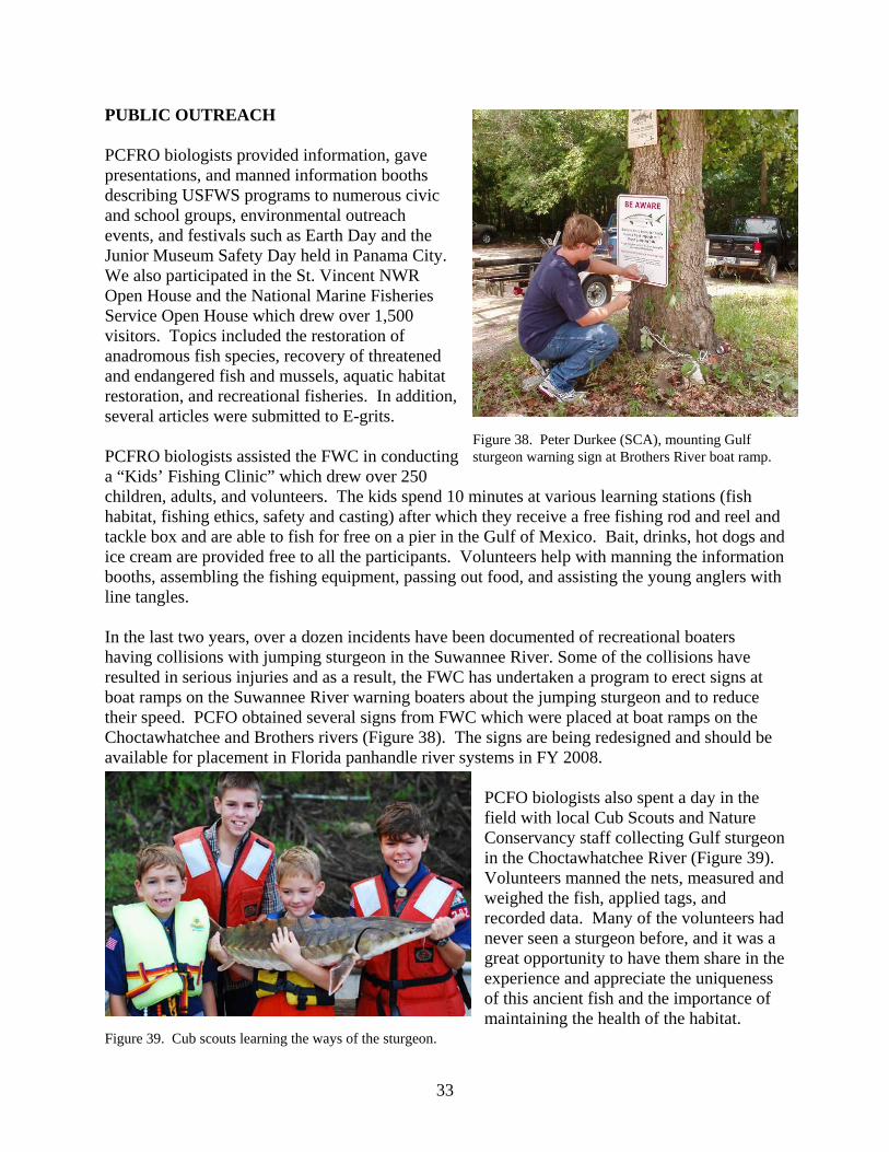
PUBLIC OUTREACH PCFRO biologists provided information, gave presentations, and manned information booths describing USFWS programs to numerous civic and school groups, environmental outreach events, and festivals such as Earth Day and the Junior Museum Safety Day held in Panama City. We also participated in the St. Vincent NWR Open House and the National Marine Fisheries Service Open House which drew over 1,500 visitors. Topics included the restoration of anadromous fish species, recovery of threatened and endangered fish and mussels, aquatic habitat restoration, and recreational fisheries. In addition, several articles were submitted to E-grits. PCFRO biologists assisted the FWC in conducting a “Kids’ Fishing Clinic” which drew over 250 children, adults, and volunteers. The kids spend 10 minutes at various learning stations (fish habitat, fishing ethics, safety and casting) after which they receive a free fishing rod and reel and tackle box and are able to fish for free on a pier in the Gulf of Mexico. Bait, drinks, hot dogs and ice cream are provided free to all the participants. Volunteers help with manning the information booths, assembling the fishing equipment, passing out food, and assisting the young anglers with line tangles.
Figure 38. Peter Durkee (SCA), mounting Gulf sturgeon warning sign at Brothers River boat ramp.
In the last two years, over a dozen incidents have been documented of recreational boaters having collisions with jumping sturgeon in the Suwannee River. Some of the collisions have resulted in serious injuries and as a result, the FWC has undertaken a program to erect signs at boat ramps on the Suwannee River warning boaters about the jumping sturgeon and to reduce their speed. PCFO obtained several signs from FWC which were placed at boat ramps on the Choctawhatchee and Brothers rivers (Figure 38). The signs are being redesigned and should be available for placement in Florida panhandle river systems in FY 2008.
PCFO biologists also spent a day in the field with local Cub Scouts and Nature Conservancy staff collecting Gulf sturgeon in the Choctawhatchee River (Figure 39). Volunteers manned the nets, measured and weighed the fish, applied tags, and recorded data. Many of the volunteers had never seen a sturgeon before, and it was a great opportunity to have them share in the experience and appreciate the uniqueness of this ancient fish and the importance of maintaining the health of the habitat.
Figure 39. Cub scouts learning the ways of the sturgeon.
33
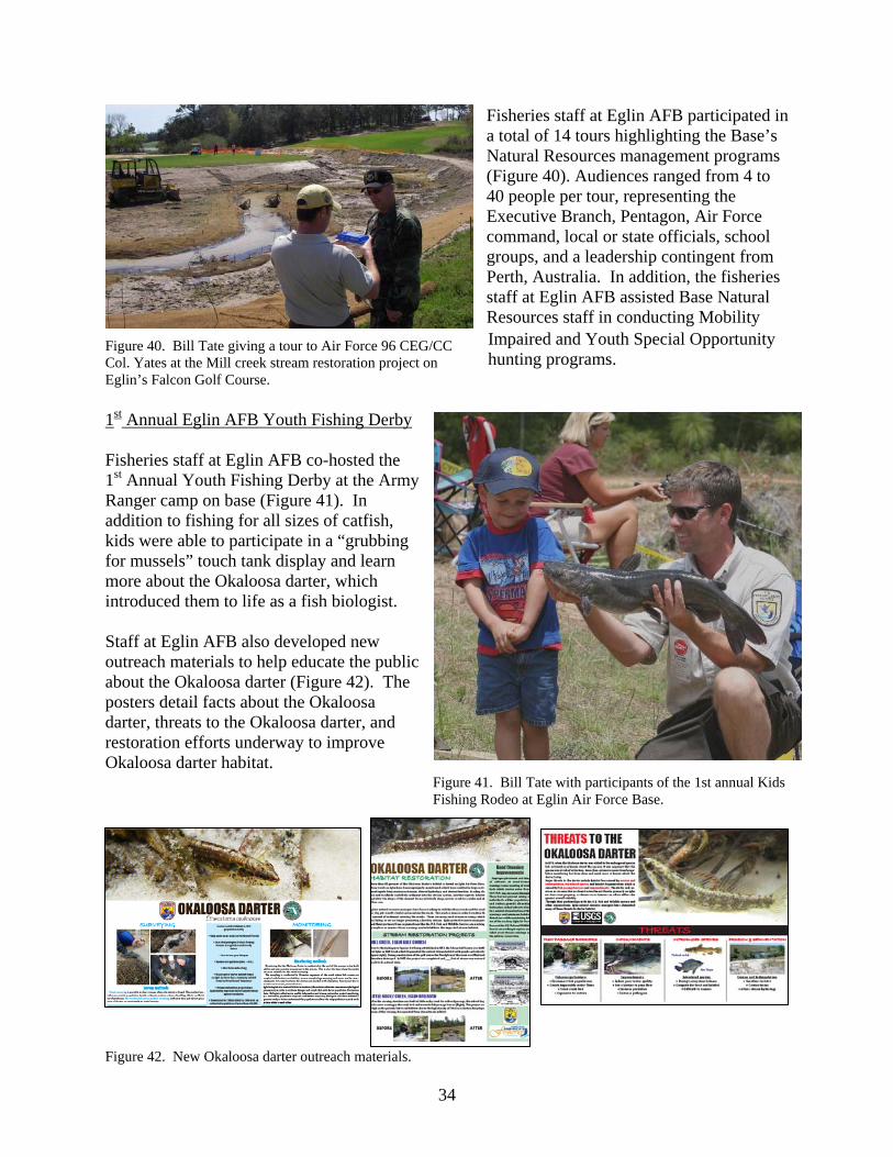
Fisheries staff at Eglin AFB participated in a total of 14 tours highlighting the Base’s Natural Resources management programs (Figure 40). Audiences ranged from 4 to 40 people per tour, representing the Executive Branch, Pentagon, Air Force command, local or state officials, school groups, and a leadership contingent from Perth, Australia. In addition, the fisheries staff at Eglin AFB assisted Base Natural Resources staff in conducting Mobility Impaired and Youth Special Opportunity hunting programs.
Figure 40. Bill Tate giving a tour to Air Force 96 CEG/CC Col. Yates at the Mill creek stream restoration project on Eglin’s Falcon Golf Course.
1st Annual Eglin AFB Youth Fishing Derby Fisheries staff at Eglin AFB co-hosted the 1st Annual Youth Fishing Derby at the Army Ranger camp on base (Figure 41). In addition to fishing for all sizes of catfish, kids were able to participate in a “grubbing for mussels” touch tank display and learn more about the Okaloosa darter, which introduced them to life as a fish biologist. Staff at Eglin AFB also developed new outreach materials to help educate the public about the Okaloosa darter (Figure 42). The posters detail facts about the Okaloosa darter, threats to the Okaloosa darter, and restoration efforts underway to improve Okaloosa darter habitat. Figure 41. Bill Tate with participants of the 1st annual Kids
Fishing Rodeo at Eglin Air Force Base.
Figure 42. New Okaloosa darter outreach materials.
34

MEETINGS AND PRESENTATIONS Bolden, Stephania and Frank Parauka. 2007. Sturgeon relocation trawling. 8th Annual Gulf Sturgeon Workshop. White Springs, Florida. Herrington, Karen, J. Ziewitz, and S. Herrington. 2007. A fisheries-based approach to
population demography of an endangered freshwater mussel. Biannual meeting of the Freshwater Mollusk Conservation Society, March 13-15, 2007. Little Rock, Arkansas.
Parauka, Frank. 2007. Moderator for the Marine/Coastal Session for the 24th Annual Meeting of the Alabama Fisheries Association, Orange Beach, Alabama Parauka, Frank. 2007. Gulf sturgeon investigations in the northeastern Gulf of Mexico.
24th Annual Meeting of the Alabama Fisheries Association. Orange Beach, Alabama.
Parauka, Frank. 2007. Panama City Sturgeon Activities. 8th Annual Gulf Sturgeon Workshop.White Springs, Florida. Tate, W.B. 2007. The Mill Creek stream restoration project: Background, status, and future
work. Eglin Natural Resources Branch. Eglin AFB. Tate, W.B. 2007. Recreational Opportunities in Eglin Streams: Why not go fishwatching?
Florida Trails Association, Pensacola, FL. Tate, W.B. 2007. Aquatics monitoring on Eglin AFB. Eglin Working Group for Environmental
Management (EWGEM). Eglin AFB. Tate, WB. 2007. Stream restoration monitoring and the use of ecological indicators. Eglin
Working Group for Environmental Management (EWGEM). Eglin AFB. Tongue, M.L. 2007. Road Crossings and the Okaloosa Darter. Eglin Working Group for
Environmental Management (EWGEM). Eglin AFB. Sulak, Kenneth, Randy Edwards, Mike Randall, Tammy Summers, Kristen Luke, Travis Smith, April Norem, William Harden, Frank Parauka, and Richard Lehnert. Defining winter trophic habitat of juvenile Gulf sturgeon in the Suwannee and
Apalachicola estuaries. 2007. American Fisheries Society 137th Annual Meeting, San Francisco, California.
REPORTS AND PUBLICATIONS Edwards, Randy E., Frank M. Parauka and Kenneth J. Sulak. 2007. New insights into
marine migration and winter habitat of Gulf sturgeon. Pages 183-196 in Jean Munro, editor. Anadromous sturgeons: habitats, threats, and management. American Fisheries Society Symposium 56. Bethesda, Maryland.
35
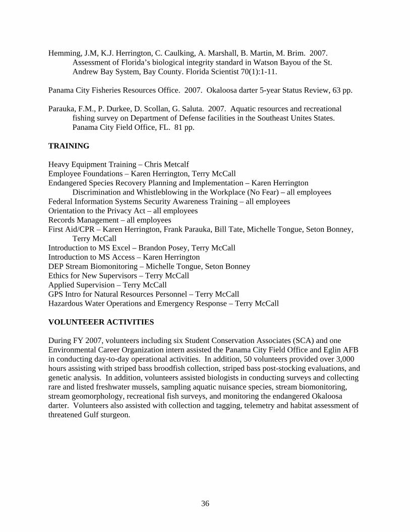
Hemming, J.M, K.J. Herrington, C. Caulking, A. Marshall, B. Martin, M. Brim. 2007. Assessment of Florida’s biological integrity standard in Watson Bayou of the St. Andrew Bay System, Bay County. Florida Scientist 70(1):1-11.
Panama City Fisheries Resources Office. 2007. Okaloosa darter 5-year Status Review, 63 pp. Parauka, F.M., P. Durkee, D. Scollan, G. Saluta. 2007. Aquatic resources and recreational
fishing survey on Department of Defense facilities in the Southeast Unites States. Panama City Field Office, FL. 81 pp.
TRAINING Heavy Equipment Training – Chris Metcalf Employee Foundations – Karen Herrington, Terry McCall Endangered Species Recovery Planning and Implementation – Karen Herrington
Discrimination and Whistleblowing in the Workplace (No Fear) – all employees Federal Information Systems Security Awareness Training – all employees Orientation to the Privacy Act – all employees Records Management – all employees First Aid/CPR – Karen Herrington, Frank Parauka, Bill Tate, Michelle Tongue, Seton Bonney,
Terry McCall Introduction to MS Excel – Brandon Posey, Terry McCall Introduction to MS Access – Karen Herrington DEP Stream Biomonitoring – Michelle Tongue, Seton Bonney Ethics for New Supervisors – Terry McCall Applied Supervision – Terry McCall GPS Intro for Natural Resources Personnel – Terry McCall Hazardous Water Operations and Emergency Response – Terry McCall VOLUNTEEER ACTIVITIES During FY 2007, volunteers including six Student Conservation Associates (SCA) and one Environmental Career Organization intern assisted the Panama City Field Office and Eglin AFB in conducting day-to-day operational activities. In addition, 50 volunteers provided over 3,000 hours assisting with striped bass broodfish collection, striped bass post-stocking evaluations, and genetic analysis. In addition, volunteers assisted biologists in conducting surveys and collecting rare and listed freshwater mussels, sampling aquatic nuisance species, stream biomonitoring, stream geomorphology, recreational fish surveys, and monitoring the endangered Okaloosa darter. Volunteers also assisted with collection and tagging, telemetry and habitat assessment of threatened Gulf sturgeon.
36
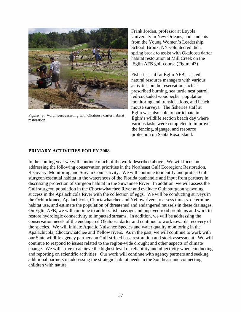
Frank Jordan, professor at Loyola University in New Orleans, and students from the Young Women’s Leadership School, Bronx, NY volunteered their spring break to assist with Okaloosa darter habitat restoration at Mill Creek on the Eglin AFB golf course (Figure 43). Fisheries staff at Eglin AFB assisted natural resource managers with various activities on the reservation such as prescribed burning, sea turtle nest patrol, red-cockaded woodpecker population monitoring and translocations, and beach mouse surveys. The fisheries staff at Eglin was also able to participate in Eglin’s wildlife section beach day where various tasks were completed to improve
Figure 43. Volunteers assisting with Okaloosa darter habitat restoration.
the fencing, signage, and resource protection on Santa Rosa Island.
PRIMARY ACTIVITIES FOR FY 2008 In the coming year we will continue much of the work described above. We will focus on addressing the following conservation priorities in the Northeast Gulf Ecoregion: Restoration, Recovery, Monitoring and Stream Connectivity. We will continue to identify and protect Gulf sturgeon essential habitat in the watersheds of the Florida panhandle and input from partners in discussing protection of sturgeon habitat in the Suwannee River. In addition, we will assess the Gulf sturgeon population in the Choctawhatchee River and evaluate Gulf sturgeon spawning success in the Apalachicola River with the collection of eggs. We will be conducting surveys in the Ochlockonee, Apalachicola, Choctawhatchee and Yellow rivers to assess threats. determine habitat use, and estimate the population of threatened and endangered mussels in these drainages. On Eglin AFB, we will continue to address fish passage and unpaved road problems and work to restore hydrologic connectivity to impacted streams. In addition, we will be addressing the conservation needs of the endangered Okaloosa darter and continue to work towards recovery of the species. We will initiate Aquatic Nuisance Species and water quality monitoring in the Apalachicola, Choctawhatchee and Yellow rivers. As in the past, we will continue to work with our State wildlife agency partners on Gulf striped bass restoration and stock assessment. We will continue to respond to issues related to the region-wide drought and other aspects of climate change. We will strive to achieve the highest level of reliability and objectivity when conducting and reporting on scientific activities. Our work will continue with agency partners and seeking additional partners in addressing the strategic habitat needs in the Southeast and connecting children with nature.
37

FP/CM/KH/BT/LJ/kah/public server/fisheries/fisheries annual reports/FY 2007 fisheries annual report final.doc
38