Embed Size (px)
Citation preview
Sensitivity: General
Creative people together transforming our world
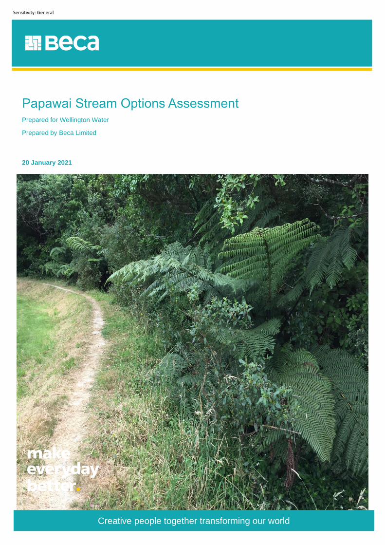
Papawai Stream Options Assessment Prepared for Wellington Water
Prepared by Beca Limited
20 January 2021

| Introduction |
Papawai Stream Options Assessment | 3262332 | 20 January 2021 | i
Sensitivity: General Sensitivity: General
Contents
1 Introduction ........................................................................................................ 3
1.1 Papawai Stream Existing Condition ................................................................................................ 3
1.2 Current Flood Mapping .................................................................................................................... 6
2 Methodology .................................................................................................... 10
3 Options Assessment ....................................................................................... 11
4 Multi-Criteria Analysis ..................................................................................... 16
4.1 Ranking System ............................................................................................................................. 18
5 Further Assessment of Top Three Options .................................................. 19
5.1 Refining Options ............................................................................................................................ 19
5.2 Maintenance Requirements ........................................................................................................... 20
5.3 Cost Assessment ........................................................................................................................... 21
5.4 Planning Considerations ................................................................................................................ 21
6 Preferred Option – Option 6 ............................................................................ 26
| Introduction |
Papawai Stream Options Assessment | 3262332 | 20 January 2021 | ii
Sensitivity: General
Revision History
Revision Nº Prepared By Description Date
1 Justine Jones and Stephen Fuller
Draft for client approval 20/08/2020
2 Justine Jones and Stephen Fuller
Draft issue for WCC approval 25/08/2020
3 Justine Jones, Stephen Fuller, Dirk Jansen van Vuuren and Mhairi Rademaker
Updated to include further detail on Options 6, 7 and 8 as requested by WCC
18/12/2020
4 Justine Jones, Stephen Fuller, Dirk Jansen van Vuuren and Mhairi Rademaker
Updated to address WWL comments 20/01/2021
Document Acceptance
Action Name Signed Date
Prepared by Justine Jones and Stephen Fuller
20/01/2021
Reviewed by Richard Hickman
20/01/2021
Approved by Richard Hickman
20/01/2021
on behalf of Beca Limited and Boffa Miskell
© Beca Limited 2021 (unless Beca has expressly agreed otherwise with the Client in writing).
This report has been prepared by Beca on the specific instructions of our Client. It is solely for our Client’s use for the purpose for which it is intended in accordance
with the agreed scope of work. Any use or reliance by any person contrary to the above, to which Beca has not given its prior written consent, is at that person's own
risk.
| Introduction |
Papawai Stream Options Assessment | 3262332 | 20 January 2021 | 3
Sensitivity: General Sensitivity: General Sensitivity: General
1 Introduction
Beca has been commissioned to undertake a study to address Wellington City Council (WCC) license
condition LC 62. This requires that prior to construction an investigation into opportunities to improve
flood management of the Papawai Stream around the Lower Sports Field associated with the Prince of
Wales Park, is undertaken to determine if any mitigating solution exists that can feasibly be
implemented in conjunction with the Omāroro Reservoir project.
This condition requires the study to consider:
i. Flood management: Any feasible options that may exist to improve the management of flood
events in the Papawai Stream that could avoid or reduce the flow of stormwater over the
stream’s bund edge onto the field and general seepage through the bund into the field
ii. Papawai Stream ecological enhancement: Any feasible options that may exist to enhance the
ecological function of the stream in conjunction with any flood management enhancements
iii. Stream enhancement incorporation in lower playing field reinstatement: Any design solutions
arising from (i) and/or (ii) that could be practically incorporated into works associated with
reinstating the lower playing field following the completion of reservoir backfilling.
1.1 Papawai Stream Existing Condition
Papawai Stream was realigned to its current course to allow sufficient flat ground to develop the lower
sports field. Since this major work, a number of additional flood mitigation measures have also been
completed. These include:
● circa. 2006 – Papawai Terrace scruffy dome was installed.
● circa. 2011 – Culvert replacement under sports field access road upgraded (Consent Ref 30727)
● circa. 2011 – Sediment and vegetation removal from the bed of the Papawai Stream (Consent No.
WGN110123 [30728]).
● 2013 – Bund constructed parallel to stream between the stream and lower sports field
● 2017 – Salisbury Terrace Flood Protection upgrade (Consent WGN170333 [34789] and [34830])
● 2018-2019 – Armouring of Papawai Stream adjacent to sports pavilion (Consent No. WGN34467
and WGN34473)
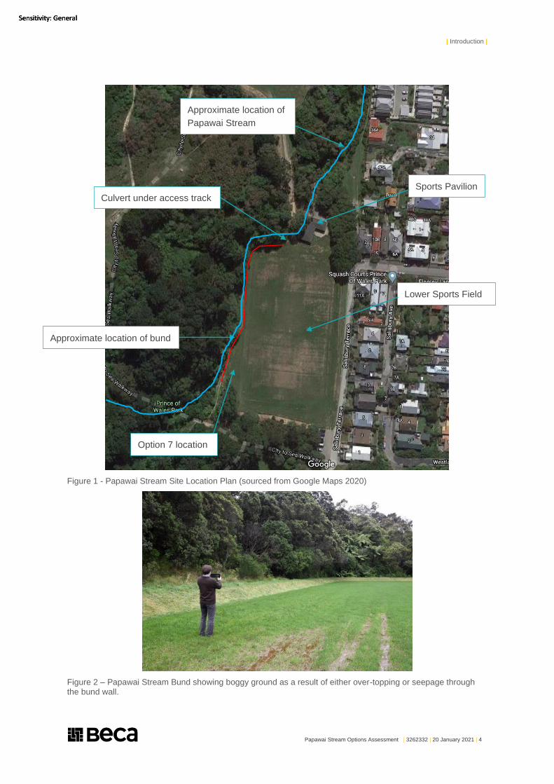
Figure 1 is a site plan which identifies the key features of the site. Figure 2 is a photo showing the bund,
and the saturated area of playing field which requires rectification.
| Introduction |
Papawai Stream Options Assessment | 3262332 | 20 January 2021 | 4
Sensitivity: General Sensitivity: General Sensitivity: General
Figure 1 - Papawai Stream Site Location Plan (sourced from Google Maps 2020)
Figure 2 – Papawai Stream Bund showing boggy ground as a result of either over-topping or seepage through the bund wall.
Lower Sports Field
Sports Pavilion
Approximate location of bund
Option 7 location
Approximate location of
Papawai Stream
Culvert under access track
| Introduction |
Papawai Stream Options Assessment | 3262332 | 20 January 2021 | 5
Sensitivity: General Sensitivity: General Sensitivity: General
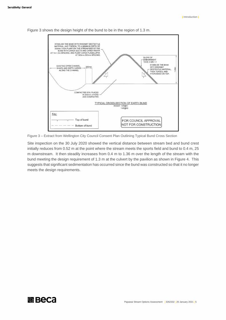
Figure 3 shows the design height of the bund to be in the region of 1.3 m.
Figure 3 – Extract from Wellington City Council Consent Plan Outlining Typical Bund Cross Section
Site inspection on the 30 July 2020 showed the vertical distance between stream bed and bund crest
initially reduces from 0.52 m at the point where the stream meets the sports field and bund to 0.4 m, 25
m downstream. It then steadily increases from 0.4 m to 1.36 m over the length of the stream with the
bund meeting the design requirement of 1.3 m at the culvert by the pavilion as shown in Figure 4. This
suggests that significant sedimentation has occurred since the bund was constructed so that it no longer
meets the design requirements.
| Introduction |
Papawai Stream Options Assessment | 3262332 | 20 January 2021 | 6
Sensitivity: General Sensitivity: General Sensitivity: General
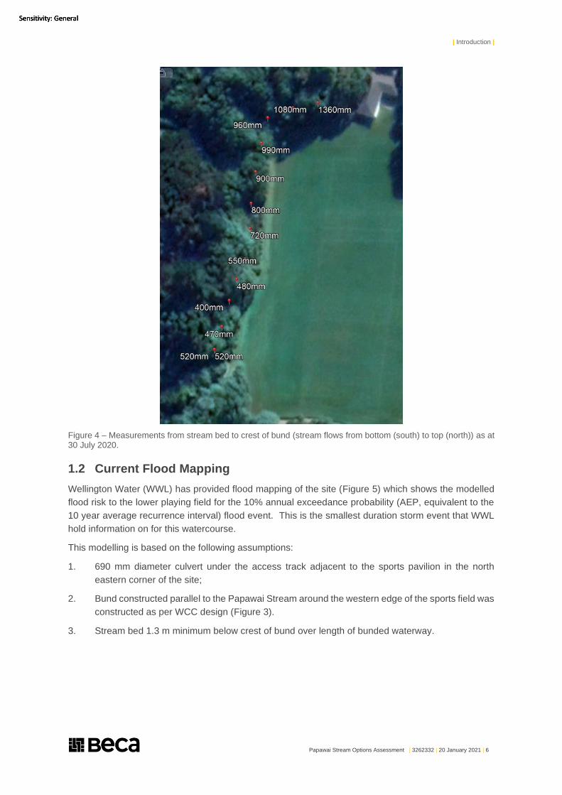
Figure 4 – Measurements from stream bed to crest of bund (stream flows from bottom (south) to top (north)) as at 30 July 2020.
1.2 Current Flood Mapping
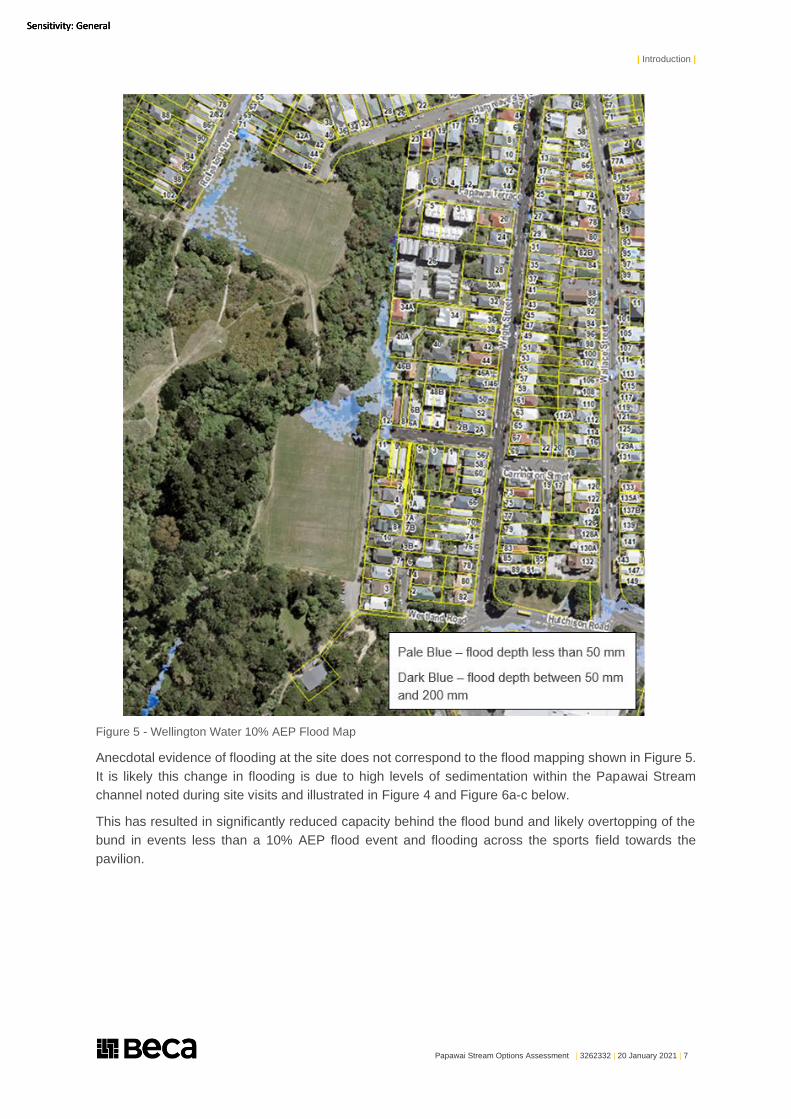
Wellington Water (WWL) has provided flood mapping of the site (Figure 5) which shows the modelled
flood risk to the lower playing field for the 10% annual exceedance probability (AEP, equivalent to the
10 year average recurrence interval) flood event. This is the smallest duration storm event that WWL
hold information on for this watercourse.
This modelling is based on the following assumptions:
1. 690 mm diameter culvert under the access track adjacent to the sports pavilion in the north
eastern corner of the site;
2. Bund constructed parallel to the Papawai Stream around the western edge of the sports field was
constructed as per WCC design (Figure 3).
3. Stream bed 1.3 m minimum below crest of bund over length of bunded waterway.
| Introduction |
Papawai Stream Options Assessment | 3262332 | 20 January 2021 | 7
Sensitivity: General Sensitivity: General Sensitivity: General
Figure 5 - Wellington Water 10% AEP Flood Map
Anecdotal evidence of flooding at the site does not correspond to the flood mapping shown in Figure 5.
It is likely this change in flooding is due to high levels of sedimentation within the Papawai Stream
channel noted during site visits and illustrated in Figure 4 and Figure 6a-c below.
This has resulted in significantly reduced capacity behind the flood bund and likely overtopping of the
bund in events less than a 10% AEP flood event and flooding across the sports field towards the
pavilion.
| Introduction |
Papawai Stream Options Assessment | 3262332 | 20 January 2021 | 8
Sensitivity: General Sensitivity: General Sensitivity: General
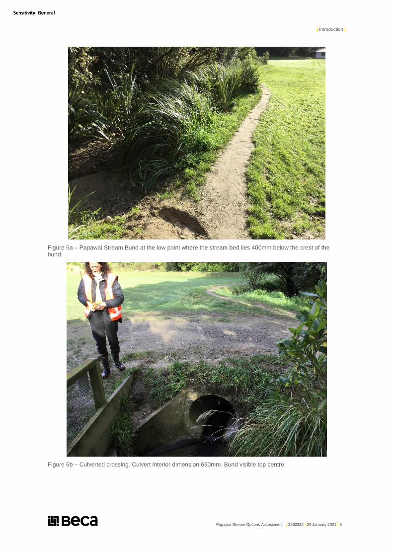
Figure 6a – Papawai Stream Bund at the low point where the stream bed lies 400mm below the crest of the bund.
Figure 6b – Culverted crossing. Culvert interior dimension 690mm. Bund visible top centre.
| Introduction |
Papawai Stream Options Assessment | 3262332 | 20 January 2021 | 9
Sensitivity: General Sensitivity: General Sensitivity: General
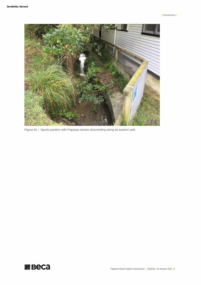
Figure 6c – Sports pavilion with Papawai stream descending along its eastern wall.
| Methodology |
Papawai Stream Options Assessment | 3262332 | 20 January 2021 | 10
Sensitivity: General Sensitivity: General Sensitivity: General
2 Methodology
The assessment outlined in this report has been undertaken following the methodology outlined below:
● Confirm with WCC the current level of protection (10% AEP) and the options assessed are
acceptable.
● Undertake a site visit and walkover of the immediate catchment and upstream of the site.
● Review available reporting from previous assessments and stream modification works. This
included information on the existing Papawai Stream realignment, sports field bunding and Papawai
Terrace drainage upgrade.
● Develop a matrix to assess options outlined above against the requirements of the consent condition
and feasibility of the options in relation to the Omāroro Reservoir project.
After review of the options assessment provided by WCC further work was undertaken as outlined
below:
● Update the report to include further detail on likely maintenance requirements for options 6, 7 and 8
(top three options).
● Undertake high level capital expenditure (CAPEX) and operational expenditure (OPEX) costings for
the top three options identified.
● Undertake high level planning review for the top three options identified.
This options assessment has not considered any upstream options for management of the Papawai
Stream flow as these are considered to be infeasible for implementation in conjunction with the reservoir
project.
| Options Assessment |
Papawai Stream Options Assessment | 3262332 | 20 January 2021 | 11
Sensitivity: General Sensitivity: General Sensitivity: General
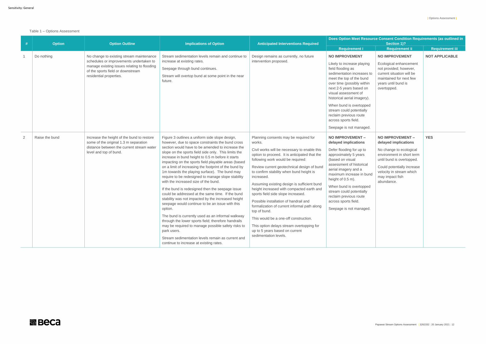
3 Options Assessment
Beca and Boffa Miskell have collaborated to develop a list of options for assessment to address
condition LC 62. These options do not reconsider the works previously undertaken as outlined in bullet
points 3 and 4 of Section 1.1.
The options considered further in this study are outlined below:
1. Do nothing
2. Raise the bund
3. Return stream to 2013 design and upgrade culvert under sports field access track
4. Stop seepage through bund
5. Stop seepage through bund, return stream to 2013 design and increase culvert size under
access track
6. Increase width of Papawai Stream channel at southern entry to sports field, stop seepage
through southern portion of bund, return stream to 2013 design and increase culvert size under
access track
7. Install sediment trap designed for 10% AEP at southern entry to the sports field diverting flows
back into stream coupled with stopping seepage through southern portion of bund, returning
stream to 2013 design and increase culvert size under access track
8. Install sediment trap designed for 10% AEP at southern entry to the sports field piping flows
under the sports field and discharging back into the stream downstream of the access track
culvert coupled with stopping seepage through southern portion of bund and returning stream
to 2013 design
9. Increase stream basal gradient through the site
10. Replace the lower sports field with a constructed wetland habitat
Each of the options presented has been assessed against the condition criteria. The results of the
assessment are outlined in Table 1 below.
| Options Assessment |
Papawai Stream Options Assessment | 3262332 | 20 January 2021 | 12
Sensitivity: General
Table 1 – Options Assessment
# Option Option Outline Implications of Option Anticipated Interventions Required
Does Option Meet Resource Consent Condition Requirements (as outlined in
Section 1)?
Requirement i Requirement ii Requirement iii
1 Do nothing No change to existing stream maintenance
schedules or improvements undertaken to
manage existing issues relating to flooding
of the sports field or downstream
residential properties.
Stream sedimentation levels remain and continue to
increase at existing rates.
Seepage through bund continues.
Stream will overtop bund at some point in the near
future.
Design remains as currently, no future
intervention proposed.
NO IMPROVEMENT
Likely to increase playing
field flooding as
sedimentation increases to
meet the top of the bund
over time (possibly within
next 2-5 years based on
visual assessment of
historical aerial imagery).
When bund is overtopped
stream could potentially
reclaim previous route
across sports field.
Seepage is not managed.
NO IMPROVEMENT
Ecological enhancement
not provided; however,
current situation will be
maintained for next few
years until bund is
overtopped.
NOT APPLICABLE
2 Raise the bund Increase the height of the bund to restore
some of the original 1.3 m separation
distance between the current stream water
level and top of bund.
Figure 3 outlines a uniform side slope design,
however, due to space constraints the bund cross
section would have to be amended to increase the
slope on the sports field side only. This limits the
increase in bund height to 0.5 m before it starts
impacting on the sports field playable areas (based
on a limit of increasing the footprint of the bund by
1m towards the playing surface). The bund may
require to be redesigned to manage slope stability
with the increased size of the bund.
If the bund is redesigned then the seepage issue
could be addressed at the same time. If the bund
stability was not impacted by the increased height
seepage would continue to be an issue with this
option.
The bund is currently used as an informal walkway
through the lower sports field; therefore handrails
may be required to manage possible safety risks to
park users.
Stream sedimentation levels remain as current and
continue to increase at existing rates.
Planning consents may be required for
works.
Civil works will be necessary to enable this
option to proceed. It is anticipated that the
following work would be required:
Review current geotechnical design of bund
to confirm stability when bund height is
increased.
Assuming existing design is sufficient bund
height increased with compacted earth and
sports field side slope increased.
Possible installation of handrail and
formalization of current informal path along
top of bund.
This would be a one-off construction.
This option delays stream overtopping for
up to 5 years based on current
sedimentation levels.
NO IMPROVEMENT –
delayed implications
Defer flooding for up to
approximately 5 years
(based on visual
assessment of historical
aerial imagery and a
maximum increase in bund
height of 0.5 m).
When bund is overtopped
stream could potentially
reclaim previous route
across sports field.
Seepage is not managed.
NO IMPROVEMENT –
delayed implications
No change to ecological
environment in short term
until bund is overtopped.
Could potentially increase
velocity in stream which
may impact fish
abundance.
YES
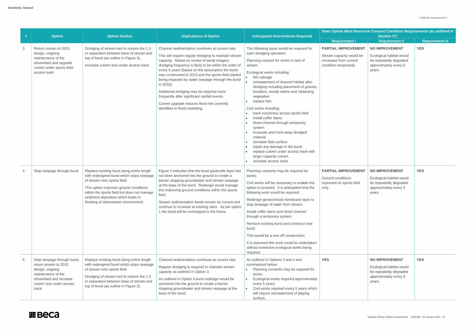
| Options Assessment |
Papawai Stream Options Assessment | 3262332 | 20 January 2021 | 13
Sensitivity: General
# Option Option Outline Implications of Option Anticipated Interventions Required
Does Option Meet Resource Consent Condition Requirements (as outlined in
Section 1)?
Requirement i Requirement ii Requirement iii
3 Return stream to 2013
design, ongoing
maintenance of the
streambed and upgrade
culvert under sports field
access track
Dredging of stream bed to restore the 1.3
m separation between base of stream and
top of bund (as outline in Figure 3).
Increase culvert size under access track.
Channel sedimentation continues at current rate.
This will require regular dredging to maintain stream
capacity. Based on review of aerial imagery
dredging frequency is likely to be within the order of
every 5 years (based on the assumption the bund
was constructed in 2013 and the sports field started
being impacted by water seepage through the bund
in 2018).
Additional dredging may be required more
frequently after significant rainfall events.
Culvert upgrade reduces flood risk currently
identified in flood modelling.
The following steps would be required for
each dredging operation:
Planning consent for works in bed of
stream.
Ecological works including:
• fish salvage
• reinstatement of channel habitat after
dredging including placement of gravels,
boulders, woody debris and replanting
vegetation
• replace fish
Civil works including:
• track machinery across sports field
• install coffer dams
• divert channel through temporary
system
• excavate and truck away dredged
material
• reinstate field surface
• repair any damage to the bund
• replace culvert under access track with
larger capacity culvert.
• reinstate access track
PARTIAL IMPROVEMENT
Stream capacity would be
increased from current
condition temporarily.
NO IMPROVEMENT
Ecological habitat would
be repeatedly degraded
approximately every 5
years.
YES
4 Stop seepage through bund Replace existing bund along entire length
with redesigned bund which stops seepage
of stream onto sports field.
This option improves ground conditions
within the sports field but does not manage
sediment deposition which leads to
flooding of downstream environment.
Figure 3 indicates that the bund geotextile layer has
not been anchored into the ground to create a
barrier stopping groundwater and stream seepage
at the base of the bund. Redesign would manage
this improving ground conditions within the sports
field.
Stream sedimentation levels remain as current and
continue to increase at existing rates. As per option
1 the bund will be overtopped in the future.
Planning consents may be required for
works.
Civil works will be necessary to enable this
option to proceed. It is anticipated that the
following work would be required:
Redesign geotechnical membrane layer to
stop seepage of water from stream.
Install coffer dams and divert channel
through a temporary system.
Remove existing bund and construct new
bund.
This would be a one-off construction.
It is assumed this work could be undertaken
without extensive ecological works being
required.
PARTIAL IMPROVEMENT
Ground conditions
improved on sports field
only.
NO IMPROVEMENT
Ecological habitat would
be repeatedly degraded
approximately every 5
years
YES
5 Stop seepage through bund,
return stream to 2013
design, ongoing
maintenance of the
streambed and increase
culvert size under access
track
Replace existing bund along entire length
with redesigned bund which stops seepage
of stream onto sports field.
Dredging of stream bed to restore the 1.3
m separation between base of stream and
top of bund (as outline in Figure 3).
Channel sedimentation continues at current rate.
Regular dredging is required to maintain stream
capacity as outlined in Option 3.
As outlined in Option 4 bund redesign would be
anchored into the ground to create a barrier
stopping groundwater and stream seepage at the
base of the bund.
As outlined in Options 3 and 4 and
summarized below:
• Planning consents may be required for
works.
• Ecological works required approximately
every 5 years.
• Civil works required every 5 years which
will require reinstatement of playing
surface.
YES
NO IMPROVEMENT
Ecological habitat would
be repeatedly degraded
approximately every 5
years.
YES
| Options Assessment |
Papawai Stream Options Assessment | 3262332 | 20 January 2021 | 14
Sensitivity: General
# Option Option Outline Implications of Option Anticipated Interventions Required
Does Option Meet Resource Consent Condition Requirements (as outlined in
Section 1)?
Requirement i Requirement ii Requirement iii
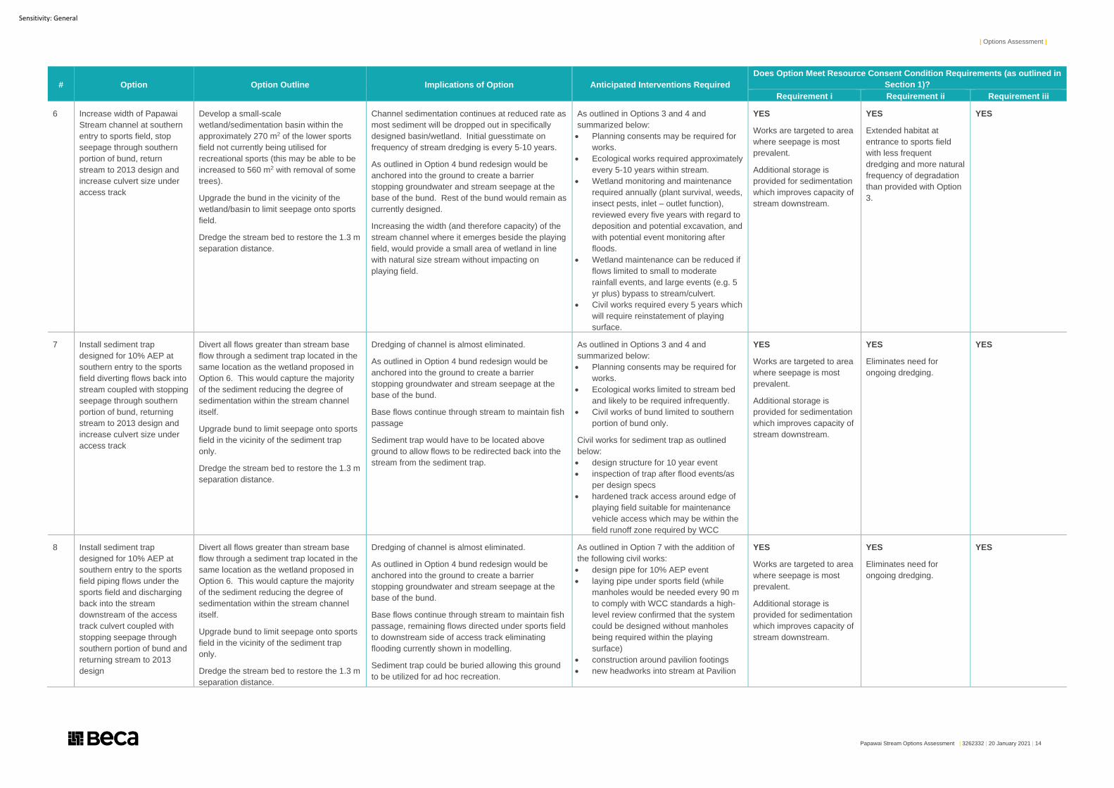
6 Increase width of Papawai
Stream channel at southern
entry to sports field, stop
seepage through southern
portion of bund, return
stream to 2013 design and
increase culvert size under
access track
Develop a small-scale
wetland/sedimentation basin within the
approximately 270 m2 of the lower sports
field not currently being utilised for
recreational sports (this may be able to be
increased to 560 m2 with removal of some
trees).
Upgrade the bund in the vicinity of the
wetland/basin to limit seepage onto sports
field.
Dredge the stream bed to restore the 1.3 m
separation distance.
Channel sedimentation continues at reduced rate as
most sediment will be dropped out in specifically
designed basin/wetland. Initial guesstimate on
frequency of stream dredging is every 5-10 years.
As outlined in Option 4 bund redesign would be
anchored into the ground to create a barrier
stopping groundwater and stream seepage at the
base of the bund. Rest of the bund would remain as
currently designed.
Increasing the width (and therefore capacity) of the
stream channel where it emerges beside the playing
field, would provide a small area of wetland in line
with natural size stream without impacting on
playing field.
As outlined in Options 3 and 4 and
summarized below:
• Planning consents may be required for
works.
• Ecological works required approximately
every 5-10 years within stream.
• Wetland monitoring and maintenance
required annually (plant survival, weeds,
insect pests, inlet – outlet function),
reviewed every five years with regard to
deposition and potential excavation, and
with potential event monitoring after
floods.
• Wetland maintenance can be reduced if
flows limited to small to moderate
rainfall events, and large events (e.g. 5
yr plus) bypass to stream/culvert.
• Civil works required every 5 years which
will require reinstatement of playing
surface.
YES
Works are targeted to area
where seepage is most
prevalent.
Additional storage is
provided for sedimentation
which improves capacity of
stream downstream.
YES
Extended habitat at
entrance to sports field
with less frequent
dredging and more natural
frequency of degradation
than provided with Option
3.
YES
7 Install sediment trap
designed for 10% AEP at
southern entry to the sports
field diverting flows back into
stream coupled with stopping
seepage through southern
portion of bund, returning
stream to 2013 design and
increase culvert size under
access track
Divert all flows greater than stream base
flow through a sediment trap located in the
same location as the wetland proposed in
Option 6. This would capture the majority
of the sediment reducing the degree of
sedimentation within the stream channel
itself.
Upgrade bund to limit seepage onto sports
field in the vicinity of the sediment trap
only.
Dredge the stream bed to restore the 1.3 m
separation distance.
Dredging of channel is almost eliminated.
As outlined in Option 4 bund redesign would be
anchored into the ground to create a barrier
stopping groundwater and stream seepage at the
base of the bund.
Base flows continue through stream to maintain fish
passage
Sediment trap would have to be located above
ground to allow flows to be redirected back into the
stream from the sediment trap.
As outlined in Options 3 and 4 and
summarized below:
• Planning consents may be required for
works.
• Ecological works limited to stream bed
and likely to be required infrequently.
• Civil works of bund limited to southern
portion of bund only.
Civil works for sediment trap as outlined
below:
• design structure for 10 year event
• inspection of trap after flood events/as
per design specs
• hardened track access around edge of
playing field suitable for maintenance
vehicle access which may be within the
field runoff zone required by WCC
YES
Works are targeted to area
where seepage is most
prevalent.
Additional storage is
provided for sedimentation
which improves capacity of
stream downstream.
YES
Eliminates need for
ongoing dredging.
YES
8 Install sediment trap
designed for 10% AEP at
southern entry to the sports
field piping flows under the
sports field and discharging
back into the stream
downstream of the access
track culvert coupled with
stopping seepage through
southern portion of bund and
returning stream to 2013
design
Divert all flows greater than stream base
flow through a sediment trap located in the
same location as the wetland proposed in
Option 6. This would capture the majority
of the sediment reducing the degree of
sedimentation within the stream channel
itself.
Upgrade bund to limit seepage onto sports
field in the vicinity of the sediment trap
only.
Dredge the stream bed to restore the 1.3 m
separation distance.
Dredging of channel is almost eliminated.
As outlined in Option 4 bund redesign would be
anchored into the ground to create a barrier
stopping groundwater and stream seepage at the
base of the bund.
Base flows continue through stream to maintain fish
passage, remaining flows directed under sports field
to downstream side of access track eliminating
flooding currently shown in modelling.
Sediment trap could be buried allowing this ground
to be utilized for ad hoc recreation.
As outlined in Option 7 with the addition of
the following civil works:
• design pipe for 10% AEP event
• laying pipe under sports field (while
manholes would be needed every 90 m
to comply with WCC standards a high-
level review confirmed that the system
could be designed without manholes
being required within the playing
surface)
• construction around pavilion footings
• new headworks into stream at Pavilion
YES
Works are targeted to area
where seepage is most
prevalent.
Additional storage is
provided for sedimentation
which improves capacity of
stream downstream.
YES
Eliminates need for
ongoing dredging.
YES
| Options Assessment |
Papawai Stream Options Assessment | 3262332 | 20 January 2021 | 15
Sensitivity: General
# Option Option Outline Implications of Option Anticipated Interventions Required
Does Option Meet Resource Consent Condition Requirements (as outlined in
Section 1)?
Requirement i Requirement ii Requirement iii
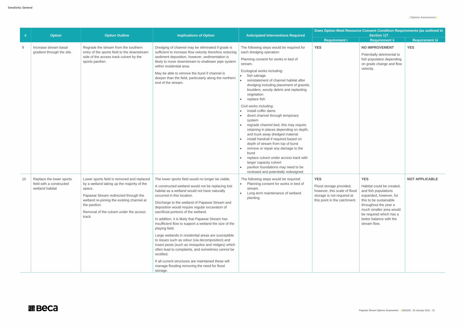
9 Increase stream basal
gradient through the site.
Regrade the stream from the southern
entry of the sports field to the downstream
side of the access track culvert by the
sports pavilion.
Dredging of channel may be eliminated if grade is
sufficient to increase flow velocity therefore reducing
sediment deposition, however, sedimentation is
likely to move downstream to shallower pipe system
within residential area.
May be able to remove the bund if channel is
deeper than the field, particularly along the northern
end of the stream.
The following steps would be required for
each dredging operation:
Planning consent for works in bed of
stream.
Ecological works including:
• fish salvage
• reinstatement of channel habitat after
dredging including placement of gravels,
boulders, woody debris and replanting
vegetation
• replace fish
Civil works including:
• install coffer dams
• divert channel through temporary
system
• regrade channel bed, this may require
retaining in places depending on depth,
and truck away dredged material
• install handrail if required based on
depth of stream from top of bund
• remove or repair any damage to the
bund
• replace culvert under access track with
larger capacity culvert
• pavilion foundations may need to be
reviewed and potentially redesigned
YES
NO IMPROVEMENT
Potentially detrimental to
fish population depending
on grade change and flow
velocity.
YES
10 Replace the lower sports
field with a constructed
wetland habitat
Lower sports field is removed and replaced
by a wetland taking up the majority of the
space.
Papawai Stream redirected through the
wetland re-joining the existing channel at
the pavilion.
Removal of the culvert under the access
track.
The lower sports field would no longer be viable.
A constructed wetland would not be replacing lost
habitat as a wetland would not have naturally
occurred in this location.
Discharge to the wetland of Papawai Stream and
deposition would require regular excavation of
sacrificial portions of the wetland.
In addition, it is likely that Papawai Stream has
insufficient flow to support a wetland the size of the
playing field.
Large wetlands in residential areas are susceptible
to issues such as odour (via decomposition) and
insect pests (such as mosquitos and midges) which
often lead to complaints, and sometimes cannot be
rectified.
If all current structures are maintained these will
manage flooding removing the need for flood
storage.
The following steps would be required:
• Planning consent for works in bed of
stream.
• Long term maintenance of wetland
planting.
YES
Flood storage provided;
however, this scale of flood
storage is not required at
this point in the catchment.
YES
Habitat could be created,
and fish populations
expanded, however, for
this to be sustainable
throughout the year a
much smaller area would
be required which has a
better balance with the
stream flow.
NOT APPLICABLE
| Multi-Criteria Analysis |
Papawai Stream Options Assessment | 3262332 | 20 January 2021 | 16
Sensitivity: General
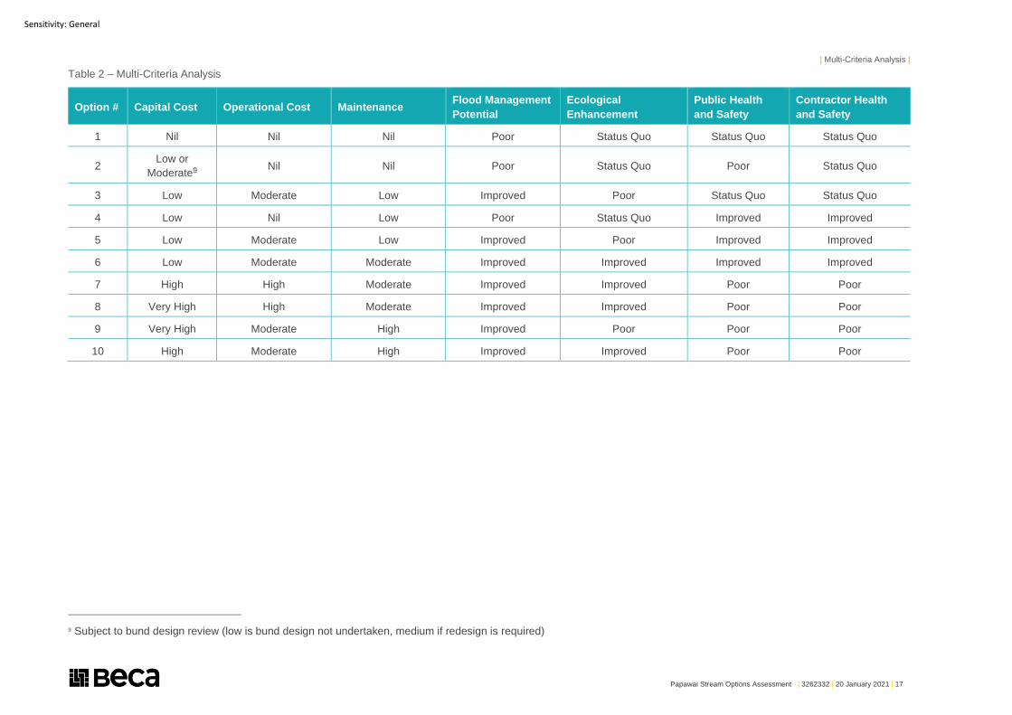
4 Multi-Criteria Analysis
Each of the options outlined in Table 1 were then assessed as part of a multi-criteria analysis. This assessed
the following criteria:
● Capital Cost (not including consenting or design) – Nil1, Low2, Moderate3, High4, Very High5
● Operational Cost – Nil, Low, Moderate, High
● Maintenance – Nil, Low, Moderate, High
● Flood Management Potential – Poor6, Status Quo7, Improved8
● Ecological value – Poor, Status Quo, Improved
● General Public Health and Safety – Poor, Status Quo, Improved
● Operator/Contractor Public Health and Safety – Poor, Status Quo, Improved
Table 2 outlines the results of each option against the multi-criteria analysis.
1 No cost implication or maintenance required 2 Cost less than $250,000 or infrequent maintenance which does not require specific technical skills 3 Cost between $250,000 and $750,000 or regular maintenance 4 Cost between $750,000 and $1,000,000 or frequent maintenance which may require specialist knowledge or equipment 5 Cost exceeds $1,000,000 6 Increases risk 7 Risk remains as currently 8 Risk is reduced
| Multi-Criteria Analysis |
Papawai Stream Options Assessment | 3262332 | 20 January 2021 | 17
Sensitivity: General
Table 2 – Multi-Criteria Analysis
Option # Capital Cost Operational Cost Maintenance Flood Management
Potential
Ecological
Enhancement
Public Health
and Safety
Contractor Health
and Safety
1 Nil Nil Nil Poor Status Quo Status Quo Status Quo
2 Low or
Moderate9 Nil Nil Poor Status Quo Poor Status Quo
3 Low Moderate Low Improved Poor Status Quo Status Quo
4 Low Nil Low Poor Status Quo Improved Improved
5 Low Moderate Low Improved Poor Improved Improved
6 Low Moderate Moderate Improved Improved Improved Improved
7 High High Moderate Improved Improved Poor Poor
8 Very High High Moderate Improved Improved Poor Poor
9 Very High Moderate High Improved Poor Poor Poor
10 High Moderate High Improved Improved Poor Poor
9 Subject to bund design review (low is bund design not undertaken, medium if redesign is required)
| Multi-Criteria Analysis |
Papawai Stream Options Assessment | 3262332 | 20 January 2021 | 18
Sensitivity: General
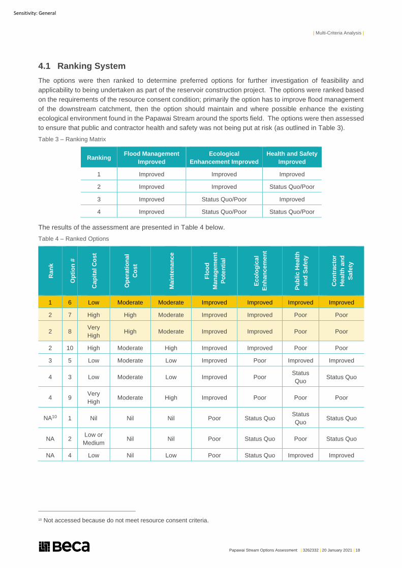
4.1 Ranking System
The options were then ranked to determine preferred options for further investigation of feasibility and
applicability to being undertaken as part of the reservoir construction project. The options were ranked based
on the requirements of the resource consent condition; primarily the option has to improve flood management
of the downstream catchment, then the option should maintain and where possible enhance the existing
ecological environment found in the Papawai Stream around the sports field. The options were then assessed
to ensure that public and contractor health and safety was not being put at risk (as outlined in Table 3).
Table 3 – Ranking Matrix
Ranking Flood Management
Improved
Ecological
Enhancement Improved
Health and Safety
Improved
1 Improved Improved Improved
2 Improved Improved Status Quo/Poor
3 Improved Status Quo/Poor Improved
4 Improved Status Quo/Poor Status Quo/Poor
The results of the assessment are presented in Table 4 below.
Table 4 – Ranked Options
Ran
k
Op
tio
n #
Cap
ita
l C
os
t
Op
era
tio
na
l
Co
st
Ma
inte
na
nce
Flo
od
Ma
na
ge
men
t
Po
ten
tia
l
Ec
olo
gic
al
En
ha
nc
em
en
t
Pu
bli
c H
ea
lth
an
d S
afe
ty
Co
ntr
ac
tor
Hea
lth
an
d
Sa
fety
1 6 Low Moderate Moderate Improved Improved Improved Improved
2 7 High High Moderate Improved Improved Poor Poor
2 8 Very
High High Moderate Improved Improved Poor Poor
2 10 High Moderate High Improved Improved Poor Poor
3 5 Low Moderate Low Improved Poor Improved Improved
4 3 Low Moderate Low Improved Poor Status
Quo Status Quo
4 9 Very
High Moderate High Improved Poor Poor Poor
NA10 1 Nil Nil Nil Poor Status Quo Status
Quo Status Quo
NA 2 Low or
Medium Nil Nil Poor Status Quo Poor Status Quo
NA 4 Low Nil Low Poor Status Quo Improved Improved
10 Not accessed because do not meet resource consent criteria.
| Further Assessment of Top Three Options |
Papawai Stream Options Assessment | 3262332 | 20 January 2021 | 19
Sensitivity: General
5 Further Assessment of Top Three Options
Table 4 identified the top three options as:
1. Option 6 - Increase width of Papawai Stream channel at southern entry to sports field, stop seepage
through southern portion of bund, return stream to 2013 design and increase culvert size under access
track
2. Option 7 - Install sediment trap designed for 10% AEP at southern entry to the sports field diverting
flows back into stream coupled with stopping seepage through southern portion of bund, returning
stream to 2013 design and increase culvert size under access track
3. Option 8 - Install sediment trap designed for 10% AEP at southern entry to the sports field piping flows
under the sports field and discharging back into the stream downstream of the access track culvert
coupled with stopping seepage through southern portion of bund and returning stream to 2013 design
On review of this options assessment WCC requested the following additional analysis be undertaken to allow
a decision to be made regarding which options to be progressed:
● Update the report to include further detail on likely maintenance requirements for options 6, 7 and 8 (top
three options).
● Undertake high level CAPEX and OPEX costings for the top three options identified.
● Undertake high level planning review for the top three options identified.
5.1 Refining Options
Drawing numbers 3262332-CE-T006, T007 and T008 (Appendix A) outline in a little more detail the proposed
options to manage stormwater in the Papawai Stream, providing cross sections of the anticipated final system
and indicative locations of devices proposed.
The further work undertaken identified a number of additional constraints in the applicability of some of the
options. These are outlined below.
5.1.1 Option 7
The design requires the sediment trap to be placed above ground and at a higher elevation that the
downstream discharge point to allow the system to work via gravity. Review of levels outside the Town Belt
and within the remit of the Omāroro Reservoir project indicated that it would be very difficult to design such a
system within the constraints of the site. The sediment trap would need to be located upstream of the site to
allow flow from the Papawai Stream into and out of the system and back into the stream without mechanical
assistance.
5.1.2 Option 8
The proposed option requires the sediment trap to be buried underground and the discharge pipe from the
sediment trap to outlet by the Sports Pavilion. Review of the depth of the irrigation system under the lower
sports field and the depth of the Papawai Stream at the Sports Pavilion make getting a suitable grade on the
discharge pipe system for the pipe to be self-cleaning very unlikely. It is not recommended that this option is
progressed further given these constraints to the design.
| Further Assessment of Top Three Options |
Papawai Stream Options Assessment | 3262332 | 20 January 2021 | 20
Sensitivity: General
5.2 Maintenance Requirements
All maintenance operations would be accessed via a reinforced grassed maintenance road which is shown in
Drawings 3262332-CE-T006, T077 and T008. This access road shown on the plans is for illustration purposes
only (with no design work having been undertaken to date) but shows that it is likely there is sufficient space
available to design a access track wide enough to allow appropriate maintenance vehicles to the stream. It is
proposed the access road is formed using a grasscrete or similar system which provides structural support
while allowing grass to grow through the system. This will allow maintenance of this road to be undertaken at
the same time as the sports field maintenance.
5.2.1 Option 6
Maintenance for Option 6 can be summarised as follows:
● Assessment of performance of the system after all major storms to confirm whether ad hoc maintenance
work is needed to ensure system works as designed.
● Monitoring of the sediment basin/wetland vegetation following any rainfall event greater than a 5 year
average recurrence interval storm event, and one-off repairs as required.
● General review and necessary maintenance (vegetation repair, armouring, channel repair) of the sediment
basin/wetland vegetation every 2 years.
● Removal of sediment from the sediment basin/wetland approximately every 5 years.
● Replanting of basin after sediment removal.
● Dredge stream approximately every 10+ years to maintain capacity for larger storm events.
Based on the information available at this stage it is estimated that construction could be undertaken during a
period of 6 weeks with stream diversion, where needed, for half of this time.
5.2.2 Option 7
Maintenance for Option 7 can be summarised as follows:
● Assessment of performance of the system after all major storms to confirm whether ad hoc maintenance
work is needed to ensure system works as designed.
● Removal of sediment from the gravel trap annually using a street sweeper vacuum truck or similar.
● Dredge stream approximately every 10 years to maintain capacity for larger storm events.
Based on the information available at this stage it is estimated that construction could be undertaken during a
period of 6 weeks with stream diversion, where needed, for half of this time.
5.2.3 Option 8
Maintenance for Option 8 can be summarised as follows:
● Assessment of performance of the system after all major storms to confirm whether ad hoc maintenance
work is needed to ensure system works as designed.
● Investigation and potential removal of any debris build up behind the screens for discharge pipe from the
gravel trap twice a year (around autumn and winter).
● Removal of sediment from the gravel trap annually using a street sweeper vacuum truck or similar.
● Flushing out of the discharge pipe of sediment build up every 5 years.
Based on the information available at this stage it is estimated that construction could be undertaken during a
period of 6 weeks with stream diversion.
| Further Assessment of Top Three Options |
Papawai Stream Options Assessment | 3262332 | 20 January 2021 | 21
Sensitivity: General
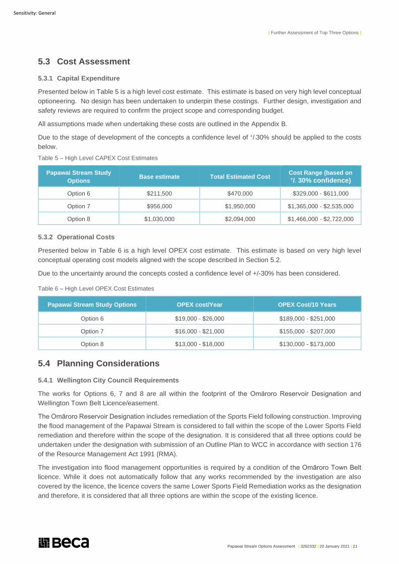
5.3 Cost Assessment
5.3.1 Capital Expenditure
Presented below in Table 5 is a high level cost estimate. This estimate is based on very high level conceptual
optioneering. No design has been undertaken to underpin these costings. Further design, investigation and
safety reviews are required to confirm the project scope and corresponding budget.
All assumptions made when undertaking these costs are outlined in the Appendix B.
Due to the stage of development of the concepts a confidence level of +/-30% should be applied to the costs
below.
Table 5 – High Level CAPEX Cost Estimates
Papawai Stream Study
Options Base estimate Total Estimated Cost
Cost Range (based on +/- 30% confidence)
Option 6 $211,500 $470,000 $329,000 - $611,000
Option 7 $956,000 $1,950,000 $1,365,000 - $2,535,000
Option 8 $1,030,000 $2,094,000 $1,466,000 - $2,722,000
5.3.2 Operational Costs
Presented below in Table 6 is a high level OPEX cost estimate. This estimate is based on very high level
conceptual operating cost models aligned with the scope described in Section 5.2.
Due to the uncertainty around the concepts costed a confidence level of +/-30% has been considered.
Table 6 – High Level OPEX Cost Estimates
Papawai Stream Study Options OPEX cost/Year OPEX Cost/10 Years
Option 6 $19,000 - $26,000 $189,000 - $251,000
Option 7 $16,000 - $21,000 $155,000 - $207,000
Option 8 $13,000 - $18,000 $130,000 - $173,000
5.4 Planning Considerations
5.4.1 Wellington City Council Requirements
The works for Options 6, 7 and 8 are all within the footprint of the Omāroro Reservoir Designation and
Wellington Town Belt Licence/easement.
The Omāroro Reservoir Designation includes remediation of the Sports Field following construction. Improving
the flood management of the Papawai Stream is considered to fall within the scope of the Lower Sports Field
remediation and therefore within the scope of the designation. It is considered that all three options could be
undertaken under the designation with submission of an Outline Plan to WCC in accordance with section 176
of the Resource Management Act 1991 (RMA).
The investigation into flood management opportunities is required by a condition of the Omāroro Town Belt
licence. While it does not automatically follow that any works recommended by the investigation are also
covered by the licence, the licence covers the same Lower Sports Field Remediation works as the designation
and therefore, it is considered that all three options are within the scope of the existing licence.
| Further Assessment of Top Three Options |
Papawai Stream Options Assessment | 3262332 | 20 January 2021 | 22
Sensitivity: General
5.4.2 Greater Wellington Regional Council requirements
There are a number of aspects common to all three options; including:
● Returning the stream to the 2013 design which is assumed to include removal of accumulated bed.
● Sediment in the first instance and then (more importantly) ongoing maintenance of the stream and any new
structures.
● Stopping seepage through the southern portion of the bund through reconstruction of that section of bund.
● Increasing the size of the culvert under the access track.
The planning implications of these activities are considered below.
● Maintenance of the Papawai Stream including sediment removal (e.g. dredging)
– Discretionary activity under PNRP Rule R129 (All other uses of river and lake beds): Rule R121
(Maintenance of drains and highly modified rivers or streams) provides for the removal of bed material
and associated sediment from highly modified streams. While the Papawai Stream may fall within the
definition of highly modified stream, it is arguably managed by WWL as part of the stormwater network
making its classification uncertain. Regardless, ongoing maintenance of the Papawai Stream (and any
of the structures included in options 6, 7, and 8) will be a key part of the flood management strategy and
to provide future certainty, it is recommended that an ongoing maintenance consent is obtained that
covers all anticipated maintenance activities for the reach (including for any new structures). This would
require consent as a Discretionary Activity under the catch-all rule R129.
– Discretionary activity under PNRP Rule R131 (Damming or diverting water within or from rivers):
Ongoing sediment removal is assumed to require periodic diversion (for example by way of over-
pumping or diversion channel) of flows from the stream for a period of 2-3 days every 5-10 years.
Temporary diversion is not provided for by a specific rule and therefore would require consent as a
Discretionary Activity under catch-all rule R131
– Key considerations: Type and frequency of anticipated maintenance activities, fish rescue/relocation,
sediment management, remediation post-dredging, consistency with the National Policy Statement for
Freshwater Management 2020 (NPSFM) which requires (among other things) avoidance of the loss of
stream extent and value (unless functional need is demonstrated), the protection of habitats of
indigenous freshwater species, and management of streams firstly for the health and well-being of water
bodies and freshwater ecosystems, then for the health needs of people, and finally for the social,
economic and cultural well-being of people and communities.
● Reconstruction of the southern portion of the bund
– Permitted activity (in part) under PNRP Rule R113 (diversion of flood water by existing structures): Rule
R113 provides for diversion of flood waters by existing structures provided that the size of the stopbank
or structure shall not increase by more than 5% of the plan or cross-sectional area from 31 July 2015. It
is expected that the majority of the bund can comply with this rule.
– Discretionary activity (in part) under PNRP Rule R135 (general rule for damming and diverting water):
Where the requirements of Rule R113 cannot be met or where relocation of the bund is required under
Options 6 and 7, Discretionary Activity Rule R135 would apply.
– Key considerations: Upstream and downstream flood impacts, erosion and scour/deposition effects.
● New (larger) culvert under the access track
– Discretionary activity under PNRP Rule R129 (All other uses of river and lake beds): Rule R115
(Culverts) allows for new culverts as a permitted activity subject to a number of conditions including a
maximum culvert length of 20m and maximum width of 1.2m. Assuming that the culvert replacement will
be larger than this, consent would be required as a Discretionary Activity under the catch-all rule R129.
– NESFW Regulation 71 (Culverts - Discretionary Activities): NESFW Regulation 70 (Permitted Activities)
sets out the requirements for culverts to be allowed as a permitted activity including: water velocity shall
be no greater than adjoining reaches, culvert to be embedded 25%, substrate must be present and
| Further Assessment of Top Three Options |
Papawai Stream Options Assessment | 3262332 | 20 January 2021 | 23
Sensitivity: General
stable below 80% flows. These conditions are intended to provide for fish passage and may be
achievable; however, meeting these conditions should not be given priority over a robust hydraulic
design where fish passage can be otherwise demonstrated. Where the conditions are not met, consent
would be required as a Discretionary Activity under Regulation 71.
– NESFW Regulation 62 (Requirement for all activities: information about structures and passage of fish)
and 63 (Requirement for culvert activities: information about culverts): Whether Regulation 70 or 71
applies to the culvert, the information specified in NESFW Regulations 62 and 63 must be provided to
GWRC post-construction.
– Key considerations: Fish passage, hydraulic design, erosion and scour.
Option 6 includes a diversion of the stream at the southern end of the field to create a small flood terrace. The
planning implications of these activities are considered below:
● Discretionary activity under PNRP Rule R131 (Damming or diverting water within or from rivers):
The permanent diversion that would be required is not provided for by a specific rule and therefore would
require consent as a Discretionary Activity under catch-all rule R131.
● Key considerations: Fish passage / exclusion, erosion and scour, consistency with the NPSFM which
requires (among other things) avoidance of the loss of stream extent and value (unless functional need can
be demonstrated), the protection of habitats of indigenous freshwater species, and management of streams
firstly for the health and well-being of water bodies and freshwater ecosystems, then for the health needs
of people, and finally for the social, economic and cultural well-being of people and communities. It should
also be made clear in any consent application that the flood terrace area is being constructed for stormwater
management purposes (and not ecological purposes) to ensure that it is not inadvertently captured by the
definition of natural wetland.
Option 7 includes the installation of a sediment trap in or adjacent the stream upstream of the field which
discharges back into the existing stream alignment. The planning implications of these activities are considered
below:
● Discretionary activity under PNRP Rule R129 (All other uses of river and lake beds): Rule R117 (New
Structures – Permitted Activity) provides for new structures as a permitted activity subject to conditions
including a requirement that the structure “shall not alter the natural course of the river, including any
diversion of water from the natural course during floods”. The proposed sediment trap would include a
diversion and is unlikely to comply with Rule R117 as a permitted activity; therefore, consent would be
required as a Discretionary Activity under the catch-all rule R129.
● Discretionary activity under PNRP Rule R131 (Damming or diverting water within or from rivers):
The diversion of flows through the sediment trap is not provided for by a specific rule and therefore would
require consent as a Discretionary Activity under catch-all rule R131.
● Discretionary activity under NESFW Regulation 73 (Weirs - Discretionary Activities): It is unlikely that
all conditions of Regulation 73 (Permitted Activities) will be met and therefore consent would be required
as a Discretionary Activity.
● NESFW Regulation 62 (Requirement for all activities: information about structures and passage of
fish) and 64 (Requirement for weir activities: information about weirs): Whether Regulation 72 or 73
applies to the weir structure, the information specified in NESFW Regulations 62 and 64 must be provided
to GWRC post-construction.
● Key considerations: Fish passage / exclusion, erosion and scour, consistency with the NPSFM which
requires (among other things) avoidance of the loss of stream extent and value, the protection of habitats
of indigenous freshwater species, and management of streams firstly for the health and well-being of water
bodies and freshwater ecosystems, then for the health needs of people, and finally for the social, economic
and cultural well-being of people and communities.
| Further Assessment of Top Three Options |
Papawai Stream Options Assessment | 3262332 | 20 January 2021 | 24
Sensitivity: General
Option 8 includes installation of two weirs in the stream (design to be confirmed) to divert flood flows (>10%
AEP) to a sediment trap/sump and piped diversion under the sports field. Base flows would remain in the
existing channel. The planning implications of these activities are considered below:
● Discretionary activity under PNRP Rule R129 (All other uses of river and lake beds): Rule R117 (New
Structures – Permitted Activity) provides for new weirs as a permitted activity subject to conditions;
however, this includes a requirement that the structure “shall not alter the natural course of the river,
including any diversion of water from the natural course during floods”. Therefore, consent would be
required as a Discretionary Activity under the catch-all rule R129.
● Discretionary activity under PNRP Rule R131 (Damming or diverting water within or from rivers):
The diversion of flood flows through a pipe is not provided for by a specific rule and therefore would require
consent as a Discretionary Activity under catch-all rule R131.
● Discretionary activity under NESFW Regulation 73 (Weirs - Discretionary Activities): It is unlikely that
all conditions of Regulation 73 (Permitted Activities) will be met and therefore consent would be required
as a Discretionary Activity.
● NESFW Regulation 62 (Requirement for all activities: information about structures and passage of
fish) and 64 (Requirement for weir activities: information about weirs): Whether Regulation 72 or 73
applies to the weir structure, the information specified in NESFW Regulations 62 and 64 must be provided
to GWRC post-construction.
● Key considerations: Fish passage / exclusion (assuming fish passage excluded over the diversion weir),
maintenance of base flows including regular maintenance of stream channel to maintain capacity (and
ensure that diversion only occurs above 10% AEP), erosion and scour at pipe outlet, consistency with the
NPSFM which requires (among other things) avoidance of the loss of stream extent and value, the
protection of habitats of indigenous freshwater species, and management of streams firstly for the health
and well-being of water bodies and freshwater ecosystems, then for the health needs of people, and finally
for the social, economic and cultural well-being of people and communities.
5.4.3 Summary of Planning Considerations
While the consent status for all options is likely to be the same (ie a Discretionary Activity), there is likely to be
variation in the consistency of the options with the regional plan, regional policy statement, and the NPSFM.
The NPSFM and associated National Environmental Standards for Freshwater are both recent documents and
variations in interpretation across the country are causing challenges for works involving waterbodies,
particularly where diversions are concerned.
Option 8 involves a permanent diversion of flood flows through a pipe. While this may have “stormwater
management” advantages it requires additional hard infrastructure. As one of the last remaining sections of
“daylighted” stream within the central city, maintain the natural processes of the Papawai Stream to the extent
practicable is seen as important. Similarly, the weir structure in Option 7 does not appear consistent with the
desired maintenance of the stream in a natural state to the extent practicable.
Option 6 appears to be best balance the desire to maintain a natural stream environment with stormwater and
flood management requirements.
Further, where there may be any loss of stream extent or value, the NPSFM requires demonstration of
functional need for the works. As the Papawai Stream is managed, at least in part, for stormwater management
purposes, there is a functional need to undertake stormwater management within the stream. However, even
where a functional need exists, the expectation of the mitigation hierarchy is that effects are first avoided before
being remedied, mitigated, or offset. Where a viable option exists that avoids construction of weir structures,
it will be difficult to argue consistency with the mitigation hierarchy unless there are other matters that outweigh
the effects of the structures (for instance long-term maintenance requirements).

| Further Assessment of Top Three Options |
Papawai Stream Options Assessment | 3262332 | 20 January 2021 | 25
Sensitivity: General
From a maintenance perspective, Option 8 provides a significant advantage in that the pipe can be used as a
full temporary diversion during periodic clearing of the stream. This would avoid requiring temporary works
such as overpumping. However, on the basis that each maintenance round would be in the order of 2-3 days,
the need to temporarily overpump is not seen as a significant flaw in Options 6 or 7.
Overall, Option 6 is considered most consistent with the regulatory requirements and national policy.
Whichever option is selected, developing a robust plan for management of ongoing stream maintenance, in
particular ecological remediation post-dredging, will be critical to demonstrate consistency with the NPSFM
stream management hierarchy (management of streams firstly for the health and well-being of water bodies
and freshwater ecosystems, then for the health needs of people, and finally for the social, economic and
cultural well-being of people and communities).

| Preferred Option – Option 6 |
Papawai Stream Options Assessment | 3262332 | 20 January 2021 | 26
Sensitivity: General
6 Preferred Option – Option 6
Using the assessment matrix outlined in Table 3 the ten options were reviewed and ranked as detailed below
in Table 4. This identified the top three options for management of the 10 year stormwater flows through the
site to be Options 6, 7 and 8. Further analysis was undertaken on the practicality, cost and planning
implications of these options. All this worked identified that Option 6 was the preferred option; practically it is
the easiest option to design and install, the CAPEX cost of the option is the lowest (of the top three options
identified), while the OPEX cost is slightly higher over a 10 year period the system is still cheaper than other
options reviewed and the planning implications are the most straight forward given this option is the most
‘natural’ of those reviewed.

| Preferred Option – Option 6 |
Papawai Stream Options Assessment | 3262332 | 20 January 2021 | 27
Sensitivity: General
Appendix A – Drawings
A
1 -
EXISTINGBUND
PROPOSEDBUND
1m
1.30m
BUND APPROX. 3.5m SET BACK TO FIELDAPPROX 2m
FLOOD TERRACEVARIES - MAX. 8m
PLAYING FIELD
11
0.15m
0.55m
A-
CUT BANK TOPSOIL OVERENKAMAT 300mm
0.3m
COMPACTED FILL
ENKAMAT WEAVEGEOTEXTILE
(STREAM SIDE ONLY)
GRASS
3262332-CE-T0006 A
OPTION 6LAYOUT PLAN
CIVILOMĀRORO RESERVOIR
1:125
1:250
J.JONES 17-12-20T. WICKENS 17-12-20J. JONES 17-12-20
ORIGINAL DRAWINGIN COLOUR
FOR INFORMATIONNOT FOR CONSTRUCTION
WALKING TRACK(WIDTH TO BE CONFIRMED)
ENKAMAT
BASE FLOW CHANNELSHAPE AND DEPTH VARIES
1-
CROSS SECTION DETAILSCALE 1:40 (A1)
A-
GRASSED BANK AREASCALE 1:10 (A1)
ARMOURING FORNEW SECTION
GEOTEXTILE LININGTO PREVENT SEEPAGE
PROPOSED FLOOD TERRACEAREA TO BE PLANTED
PROPOSED MAINTENANCEVEHICLE ACCESS TRACK
PAPAWAI STREAM
EXISTING TOE OF BUND
EXISTING WALKINGACCESS TRACK
NOTES:1. VEHICLE TRACKING HAS NOT BEEN
UNDERTAKEN.2. NO DESIGN HAS BEEN UNDERTAKEN OF THE
OPTION PROPOSED
PROVISIONAL QUANTITIES:NEW BUND = 62mROCK ARMOUR = 24mFLOOD TERRACE = 1m DEEPACCESS ROAD = 100m LONG x 4m WIDESTREAM = 195m
PROPOSED TOE OF BUNDPROPOSED WALKINGACCESS TRACK
ROCK ARMOUR ATTOE OF BUND
No. AppdRevision By Chk Date
Drawing Originator:
DO NOT SCALE
* Refer to Revision 1 for Original Signature
Scale (A1)
Scale (A3)Reduced
Dwg Check
Verifier
Drawn
Original DesignConstruction*
Date
Approved For Client: Project:
IF IN DOUBT ASK.
Drawing No.
Discipline
Docu
ment
No.
Rev.
Drawing Plotted: 17 Dec 2020 1:35 pm
P:\32
6\326
2332
\CAD
\3262
332-
CE-T
0006
.DW
Gwww.beca.com
www.beca.com
A FOR INFORMATION TW JJ JJ 17-12-20
EXISTINGBUND
PROPOSEDBUND
1-
3262332-CE-T007 A
OPTION 7LAYOUT PLAN
CIVILOMĀRORO RESERVOIR
1:125
1:250
J. JONES 18-12-20T. WICKENS 18-12-20J. JONES 18-12-20
ORIGINAL DRAWINGIN COLOUR
FOR INFORMATIONNOT FOR CONSTRUCTION
ROCK ARMOUR ATTOE OF BUND
PROPOSED MAINTENANCEVEHICLE ACCESS TRACK
PAPAWAI STREAM
PROPOSED TOE OF BUND
PROPOSED WALKING ACCESSTRACK (WIDTH TO BE CONFIRMED)
NOTES:1. VEHICLE TRACKING HAS NOT BEEN
UNDERTAKEN.2. NO DESIGN HAS BEEN UNDERTAKEN OF
THE OPTION PROPOSED
PROVISIONAL QUANTITIES:NEW BUND = 62mROCK ARMOUR = 24mACCESS ROAD = 100m LONG x 4m WIDESTREAM = 195mSEDIMENT TRAP = 500m³WEIR (x2) = 500m³ EACH
PROPOSED WEIRS (SEE DETAIL 'A' FORINFORMATION ON POTENTIAL CONCEPT)
EXISTING TOE OF BUND
EXISTING WALKINGACCESS TRACK
No. AppdRevision By Chk Date
Drawing Originator:
DO NOT SCALE
* Refer to Revision 1 for Original Signature
Scale (A1)
Scale (A3)Reduced
Dwg Check
Verifier
Drawn
Original DesignConstruction*
Date
Approved For Client: Project:
IF IN DOUBT ASK.
Drawing No.
Discipline
Docu
ment
No.
Rev.
Drawing Plotted: 18 Dec 2020 9:35 am
P:\32
6\326
2332
\CAD
\3262
332-
CE-T
0007
REC
OVER
ED.D
WG
www.beca.com
www.beca.com
A FOR INFORMATION TW JJ JJ 18-12-20
PROPOSEDSEDIMENT TRAP
PIPE OR CHANNELTO SEDIMENT TRAP
1-
CROSS SECTION DETAILSCALE 1:40 (A1)
PARTIALLY BURIEDSEDIMENT TRAP(TO BE DESIGNED)
SEDIMENT TRAPACCESS
CONSTRUCT FISH-FRIENDLYWEIR (TO BE DESIGNED) TO
PASS BASE FLOW AND DIVERTFLOOD FLOWS TO SUMP
A-
SCHEMATIC EXAMPLE OF DIVERSION WEIR CONCEPTNOT TO SCALE
PAPAWAI STREAM
DIVERSION CHANNEL ANDWEIR TO REINTRODUCEFLOOD WATER INTOPAPAWAI STREAM
1 -
EXISTINGBUND
PROPOSEDBUND
1m
1.30m
RECONSTRUCTED BUNDINCLUDING LINING. APPROX. 3.5m
DEAD SPACE TO BE USEDFOR SEDIMENT TRAP
WIDTH VARIES
EXCAVATED STREAMTO DESIGN PLAYING FIELD
11
3262332-CE-T008 A
OPTION 8LAYOUT PLAN
CIVILOMĀRORO RESERVOIR
1:125
1:250
J. JONES 18-12-20T. WICKENS 18-12-20J. JONES 18-12-20
ORIGINAL DRAWINGIN COLOUR
FOR INFORMATIONNOT FOR CONSTRUCTION
WALKING TRACK(WIDTH TO BE CONFIRMED)
ENKAMAT
PIPE TOSEDIMENT TRAP
1-
CROSS SECTION DETAILSCALE 1:40 (A1)
GEOTEXTILE LININGTO PREVENT SEEPAGE
SEDIMENT TRAP (TO BE DESIGNED) PROPOSED MAINTENANCEVEHICLE ACCESS TRACK
PAPAWAI STREAM
PROPOSED TOE OF BUND
PROPOSED WALKINGACCESS TRACK
PIPE FROM SEDIMENT TRAP TOPAPAWAI STREAM DISCHARGEPOINT ADJACENT TO PAVILLION
BURIED SEDIMENT TRAP(TO BE DESIGNED)
MANHOLE
CONSTRUCT FISH-FRIENDLY WEIR (TOBE DESIGNED) TO PASS BASE FLOW
AND DIVERT FLOOD FLOWS TOSEDIMENT TRAP
NOTES:1. VEHICLE TRACKING HAS NOT BEEN
UNDERTAKEN.2. NO DESIGN HAS BEEN UNDERTAKEN OF
THE OPTION PROPOSED
PROVISIONAL QUANTITIES:NEW BUND = 57mPIPING = 115mACCESS ROAD = 100m LONG x 4m WIDESTREAM = 195mSEDIMENT TRAP = 500m³WEIR = 500m³
PROPOSED WEIR
EXISTING TOE OF BUND
EXISTING WALKINGACCESS TRACK
A-
SCHEMATIC EXAMPLE OF DIVERSION WEIR CONCEPTNOT TO SCALE
No. AppdRevision By Chk Date
Drawing Originator:
DO NOT SCALE
* Refer to Revision 1 for Original Signature
Scale (A1)
Scale (A3)Reduced
Dwg Check
Verifier
Drawn
Original DesignConstruction*
Date
Approved For Client: Project:
IF IN DOUBT ASK.
Drawing No.
Discipline
Docu
ment
No.
Rev.
Drawing Plotted: 18 Dec 2020 9:34 am
P:\32
6\326
2332
\CAD
\3262
332-
CE-T
0008
.DW
Gwww.beca.com
www.beca.com
A FOR INFORMATION TW JJ JJ 18-12-20
REFER TO DETAIL 'A' FORFURTHER INFORMATION
ON WEIR CONCEPT
PIPE OR CHANNEL FROMDIVERSION WEIR TO TAKE FLOODWATER TO SEDIMENT TRAP

| Preferred Option – Option 6 |
Papawai Stream Options Assessment | 3262332 | 20 January 2021 | 29
Sensitivity: General
Appendix B – Cost Estimates
B
HIGH LEVEL COST ESTIMATE
Papawai stream Study
Code Description Quantity Unit Rate Total
HIGH LEVEL COST ESTIMATE - OPTION 6
Project No: 3262332
Estimate prepared by: Dirk Jv Vuuren
Estimate Verified by: Barry Wallace 15/12/2020
Date of Estimate: 8/12/2020
Exclusions and Clarifications
Excludes GST
It is assumed that a robust tendering process will be followed and that aminimum of 3 sub-contractor tenders (where possible) are received for theproject as part of the agreed procurement process.
It is assumed that all of the work will be carried out in a single phase.
No allowance to test or removal of hazardous material
No allowance for escalation beyond the date of this estimate
No allowance for admin, legal or financing costs
Provisional allowance for Building and Resource consent fees and chargeshas been included
No allowance to remove, extend or relocated general services
No allowance for risk analysis and associated costs
No allowance for removal of haul road
No allowance for abnormal ground conditions (contamination, rock breaking,obstructions encountered).
No allowance for OPEX costs, i.e. sediment removal, general servicesmaintenance, etc
Assume imported fill for buildup of new bund
Assume 30 days of traffic management
Assume a construction period of 6 weeks
Assume a 3 week stream diversion period
Achieved cost confidence of +-30%
Papawai Stream Study
1 Option 6 1 LS 470,000
Beca Ref 6513361 Omaroro ReservoirLevel 1, Page 1 of 1
15/01/202111:36:37 am
HIGH LEVEL COST ESTIMATE
Papawai stream Study
Code Description Quantity Unit Rate Factor Total
Option 6
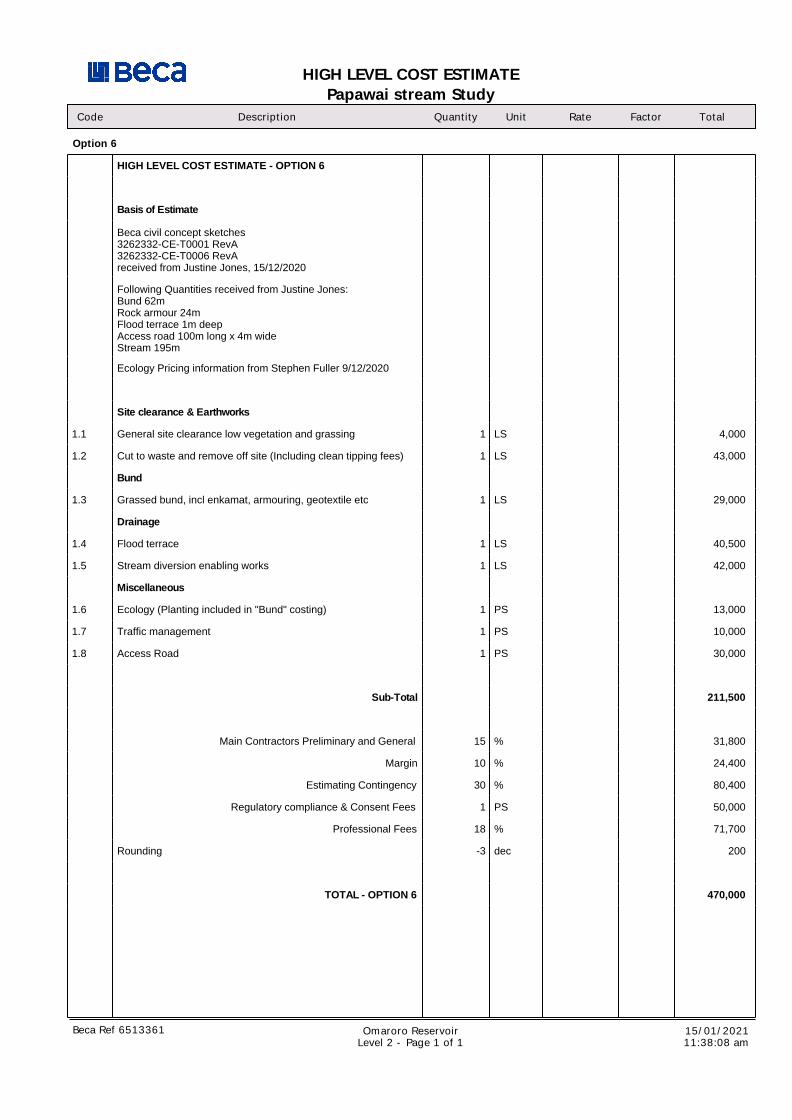
HIGH LEVEL COST ESTIMATE - OPTION 6
Basis of Estimate
Beca civil concept sketches3262332-CE-T0001 RevA3262332-CE-T0006 RevAreceived from Justine Jones, 15/12/2020
Following Quantities received from Justine Jones:Bund 62mRock armour 24mFlood terrace 1m deepAccess road 100m long x 4m wideStream 195m
Ecology Pricing information from Stephen Fuller 9/12/2020
Site clearance & Earthworks
1.1 General site clearance low vegetation and grassing 1 LS 4,000
1.2 Cut to waste and remove off site (Including clean tipping fees) 1 LS 43,000
Bund
1.3 Grassed bund, incl enkamat, armouring, geotextile etc 1 LS 29,000
Drainage
1.4 Flood terrace 1 LS 40,500
1.5 Stream diversion enabling works 1 LS 42,000
Miscellaneous
1.6 Ecology (Planting included in "Bund" costing) 1 PS 13,000
1.7 Traffic management 1 PS 10,000
1.8 Access Road 1 PS 30,000
Sub-Total 211,500
Main Contractors Preliminary and General 15 % 31,800
Margin 10 % 24,400
Estimating Contingency 30 % 80,400
Regulatory compliance & Consent Fees 1 PS 50,000
Professional Fees 18 % 71,700
Rounding -3 dec 200
TOTAL - OPTION 6 470,000
Beca Ref 6513361 Omaroro ReservoirLevel 2 - Page 1 of 1
15/01/202111:38:08 am
HIGH LEVEL COST ESTIMATE
Papawai stream Study
Code Description Quantity Unit Rate Total
HIGH LEVEL COST ESTIMATE - OPTION 7
Project No: 3262332
Estimate prepared by: Dirk Jv Vuuren
Estimate Verified by: Barry Wallace 15/12/2020
Date of Estimate: 8/12/2020
Exclusions and Clarifications
Excludes GST
It is assumed that a robust tendering process will be followed and that aminimum of 3 sub-contractor tenders (where possible) are received for theproject as part of the agreed procurement process.
It is assumed that all of the work will be carried out in a single phase.
No allowance to test or removal of hazardous material
No allowance for escalation beyond the date of this estimate
No allowance for admin, legal or financing costs
Provisional allowance for Building and Resource consent fees and chargeshas been included
No allowance to remove, extend or relocated general services
No allowance for risk analysis and associated costs
No allowance for abnormal ground conditions (contamination, rock breaking,obstructions encountered).
No allowance for OPEX costs, i.e. sediment removal, general servicesmaintenance, etc
Assume imported fill for buildup of new bund
Assume 30 days of traffic management
Assume a construction period of 6 weeks
Assume a 3 week stream diversion period
Achieved cost certainty of +-30%
Papawai Stream Study
1 Option 7 1 LS 1,950,000
Beca Ref 6513361 Omaroro ReservoirLevel 1, Page 1 of 1
15/01/202111:39:03 am
HIGH LEVEL COST ESTIMATE
Papawai stream Study
Code Description Quantity Unit Rate Factor Total
Option 7
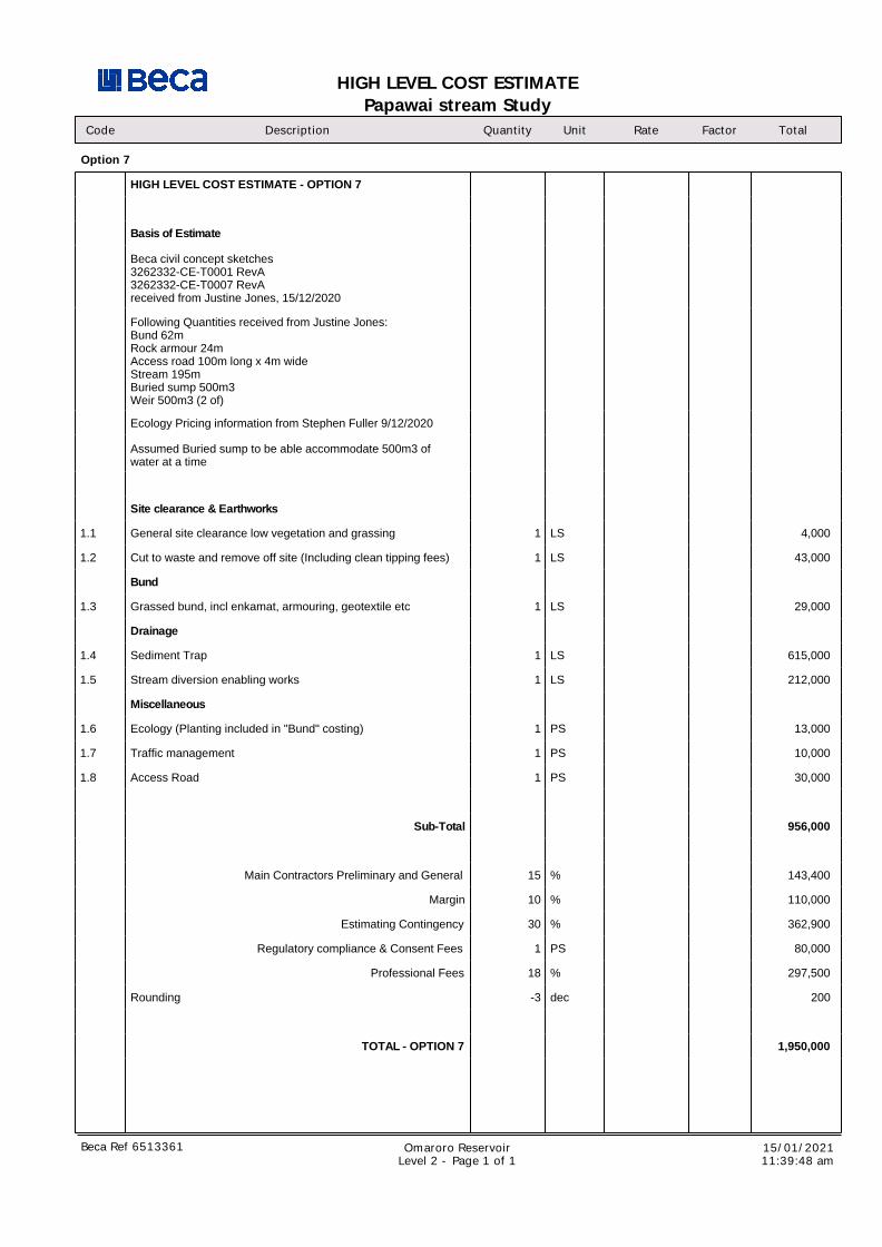
HIGH LEVEL COST ESTIMATE - OPTION 7
Basis of Estimate
Beca civil concept sketches3262332-CE-T0001 RevA3262332-CE-T0007 RevAreceived from Justine Jones, 15/12/2020
Following Quantities received from Justine Jones:Bund 62mRock armour 24mAccess road 100m long x 4m wideStream 195mBuried sump 500m3Weir 500m3 (2 of)
Ecology Pricing information from Stephen Fuller 9/12/2020
Assumed Buried sump to be able accommodate 500m3 ofwater at a time
Site clearance & Earthworks
1.1 General site clearance low vegetation and grassing 1 LS 4,000
1.2 Cut to waste and remove off site (Including clean tipping fees) 1 LS 43,000
Bund
1.3 Grassed bund, incl enkamat, armouring, geotextile etc 1 LS 29,000
Drainage
1.4 Sediment Trap 1 LS 615,000
1.5 Stream diversion enabling works 1 LS 212,000
Miscellaneous
1.6 Ecology (Planting included in "Bund" costing) 1 PS 13,000
1.7 Traffic management 1 PS 10,000
1.8 Access Road 1 PS 30,000
Sub-Total 956,000
Main Contractors Preliminary and General 15 % 143,400
Margin 10 % 110,000
Estimating Contingency 30 % 362,900
Regulatory compliance & Consent Fees 1 PS 80,000
Professional Fees 18 % 297,500
Rounding -3 dec 200
TOTAL - OPTION 7 1,950,000
Beca Ref 6513361 Omaroro ReservoirLevel 2 - Page 1 of 1
15/01/202111:39:48 am
ROUGH ORDER COST ESTIMATE
Papawai stream Study
Code Description Quantity Unit Rate Total
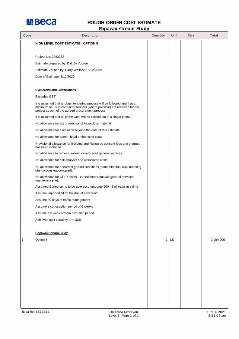
HIGH LEVEL COST ESTIMATE - OPTION 8
Project No: 3262332
Estimate prepared by: Dirk Jv Vuuren
Estimate Verified by: Barry Wallace 15/12/2020
Date of Estimate: 8/12/2020
Exclusions and Clarifications
Excludes GST
It is assumed that a robust tendering process will be followed and that aminimum of 3 sub-contractor tenders (where possible) are received for theproject as part of the agreed procurement process.
It is assumed that all of the work will be carried out in a single phase.
No allowance to test or removal of hazardous material
No allowance for escalation beyond the date of this estimate
No allowance for admin, legal or financing costs
Provisional allowance for Building and Resource consent fees and chargeshas been included
No allowance to remove, extend or relocated general services
No allowance for risk analysis and associated costs
No allowance for abnormal ground conditions (contamination, rock breaking,obstructions encountered).
No allowance for OPEX costs, i.e. sediment removal, general servicesmaintenance, etc
Assumed Buried sump to be able accommodate 500m3 of water at a time
Assume imported fill for buildup of new bund
Assume 30 days of traffic management
Assume a construction period of 6 weeks
Assume a 3 week stream diversion period
Achieved cost certainty of +-30%
Papawai Stream Study
1 Option 8 1 LS 2,094,000
Beca Ref 6513361 Omaroro ReservoirLevel 1, Page 1 of 1
19/01/20218:51:04 am
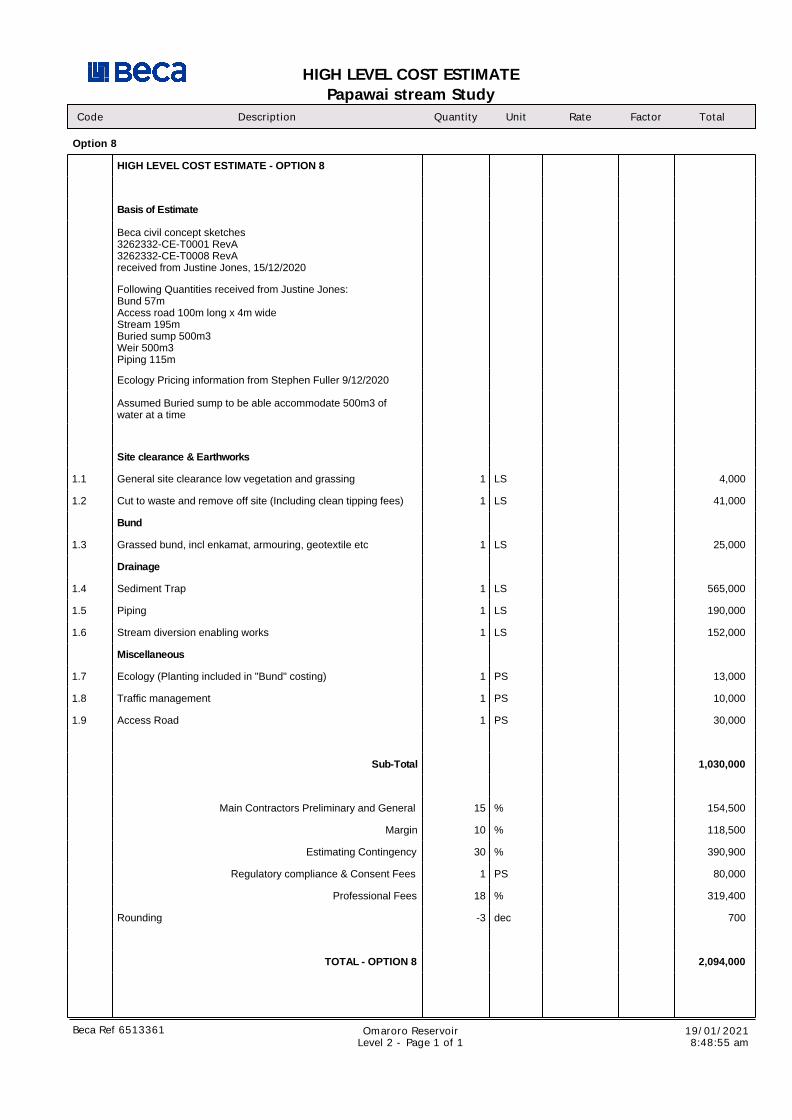
HIGH LEVEL COST ESTIMATE
Papawai stream Study
Code Description Quantity Unit Rate Factor Total
Option 8
HIGH LEVEL COST ESTIMATE - OPTION 8
Basis of Estimate
Beca civil concept sketches3262332-CE-T0001 RevA3262332-CE-T0008 RevAreceived from Justine Jones, 15/12/2020
Following Quantities received from Justine Jones:Bund 57mAccess road 100m long x 4m wideStream 195mBuried sump 500m3Weir 500m3 Piping 115m
Ecology Pricing information from Stephen Fuller 9/12/2020
Assumed Buried sump to be able accommodate 500m3 ofwater at a time
Site clearance & Earthworks
1.1 General site clearance low vegetation and grassing 1 LS 4,000
1.2 Cut to waste and remove off site (Including clean tipping fees) 1 LS 41,000
Bund
1.3 Grassed bund, incl enkamat, armouring, geotextile etc 1 LS 25,000
Drainage
1.4 Sediment Trap 1 LS 565,000
1.5 Piping 1 LS 190,000
1.6 Stream diversion enabling works 1 LS 152,000
Miscellaneous
1.7 Ecology (Planting included in "Bund" costing) 1 PS 13,000
1.8 Traffic management 1 PS 10,000
1.9 Access Road 1 PS 30,000
Sub-Total 1,030,000
Main Contractors Preliminary and General 15 % 154,500
Margin 10 % 118,500
Estimating Contingency 30 % 390,900
Regulatory compliance & Consent Fees 1 PS 80,000
Professional Fees 18 % 319,400
Rounding -3 dec 700
TOTAL - OPTION 8 2,094,000
Beca Ref 6513361 Omaroro ReservoirLevel 2 - Page 1 of 1
19/01/20218:48:55 am

| Preferred Option – Option 6 |
Papawai Stream Options Assessment | 3262332 | 20 January 2021 | 1
Sensitivity: General
www.beca.com
linkedin.com/company/beca
twitter.com/becagroup
facebook.com/BecaGroup