Embed Size (px)
Citation preview

Mata 1
Table of Contents Executive Summary Page 2 1. Introduction Page 3 2. Public Health and the Built Environment Page 6 2.1 Sanitation Reform Movement 2.2 Housing Reform of the Progressive Era Page 10 2.3 Zoning as a Tool for Public Health Page 14 3. Urban Form and Its Effects on Health and Safety Page 18 3.1 Physical Activity Levels 3.2 Pollution Page 19 3.3 Mental Health Page 20 3.4 Safety 4. We Can Do Better: What a Livable Built Environment Looks Like Page 21 4.1 Nonmotorized Travel and Outdoor Physical Activity 4.2 Crime Prevention Through Environmental Design (CPTED) Page 23 5. Case Study: Baldwin Park, CA Page 26 5.1 Community Profile Page 27 5.2 Built Environment in Baldwin Park 5.3 Obesity in Baldwin Park 5.4 Crime Concerns Page 28 6. Findings and Conclusion Page 29 7. Works Cited Page 33
Mata 2
Executive Summary
History has shown examples of different groups intervening in the design of the built
environment for the good of public health (examples such as the sanitation reformers of the 19th
century, housing reformers of the Progressive Era, and zoning advocates of the earlier 20th
century). Unfortunately, misguided fears and special interests have left us with an urban form
that is damaging to our generation’s health. The dispersed and decentralized form of the modern
city has created an environment that increases the likelihood of crime and/or perception of crime
and, in turn, discourages outdoor physical activity. This study seeks to reveal the design
strategies that would make people feel safer and more willing to walk, bike, or exercise outdoors
through a case study of the San Gabriel Valley city of Baldwin Park.
Surveys were conducted with a group of Baldwin Park senior citizens and a group of
Baldwin Park youth, asking them for input on different design strategies that would lessen their
fear of crime and encourage outdoor physical activity. The survey was applied to Baldwin
Park’s downtown area so that the study’s recommendations can be taken into consideration
during the initial phases of the city’s current downtown renewal plan. Traffic, insufficient
lighting, scarcity of bicycle lanes, and lack of diversity in business establishments were found as
significant to the perception of fear in downtown. Both groups also stated that they would feel
safer if there were more surveillance cameras, artwork, plants and gardens. Design
recommendations for the new downtown renewal were split into two categories: development
and streetscape.
• Development o Diversity of businesses
• Streetscape o Bicycle lanes o Traffic calming o Beautification
Mata 3
1. Introduction
History has shown examples of different groups intervening in the design of the built
environment for the good of public health (examples such as the sanitation reformers of the 19th
century, housing reformers of the Progressive Era, and zoning advocates of the earlier 20th
century). Unfortunately, misguided fears and special interests have left us with an urban form
that is damaging to our generation’s health. The dispersed and decentralized form of the modern
city has created an environment that increases the likelihood of crime and/or perception of crime
and, in turn, discourages outdoor physical activity. This study seeks to reveal the design
strategies that would make people feel safer and more willing to walk, bike, or exercise outdoors
through a case study of the San Gabriel Valley city of Baldwin Park.
Baldwin Park has been my home for my entire life. When speaking to residents from
other Los Angeles County neighborhoods, I often hear it confused for Baldwin Hills, Buena
Park, or Boyle Heights. When this occurs, the following exchange usually ensues with very little
variation:
Me: No, Baldwin Park, it’s where the 10 and 605 freeways meet. It’s next to West Covina.
Other: Oh yeah! I’ve driven by that area before.
Although it has always annoyed me that other LA residents are usually not familiar with my
hometown, it’s hard to blame them. Baldwin Park is designed to keep drivers moving through it
or past it. Most of the Baldwin Park residents I know would not consider walking or bicycling
anywhere. The typical afternoon activity for me and my friends in high school was to drive over
to any of the five fast-food outlets down the block to grab a bite to eat.
When I moved to Eagle Rock, Los Angeles to attend college, I realized how much
unhealthier of a place Baldwin Park is. Not only did my urban and environmental classes
introduce me to the concept of environmental justice, but I also began to notice a difference in
Mata 4
my physical state. Having healthy food options and more opportunities to stay physically active
actually made me feel better physically and mentally.
Many of today’s youth are working against the odds to stay healthy and fit. Communities
all over Los Angeles have been unable to stop fast-food outlets from clumping together in their
neighborhoods, leaving them with little to no options when it comes to healthy food. Also,
children are not as active as they once were (CCPHA 2). Many public areas have become too
dangerous for children to play in, and addictive video games and television shows are giving
them more reasons to stay inside. Because of this, today’s youth are threatened with poor health
and a list of preventable diseases to take into their adulthood (CCPHA 2).
In a rapidly growing field of study, experts have begun to investigate the physical
implications of this autocentric design of the built environment. Researchers have shown that
transportation policy influences one’s health by connecting them to or failing to connect them to
jobs, medical care, healthy food outlets, and other basic necessities (PolicyLink 22). The
National Surface Transportation Policy and Revenue Study Commission, created by Congress in
2005 to investigate the condition and future necessities of the nation's network of roads, ports,
freight and passenger railroads, and public transportation systems declared that “the nation's
surface transportation network regrettably exacts a terrible toll in lost lives and damaged health"
(22).
Studies have found that the more time someone spends in a car; the more likely they are
to be overweight (24). And, conversely, a longer time spent walking or biking is associated with
lower rates of obesity (24). In a 2004 study, researchers found that every hour in a car is equal to
a six percent increase in the likelihood of obesity, and every additional kilometer walked equated
a 4.8 percent reduction (24).
Mata 5
Unsurprisingly, people of color and low-income pay the biggest toll (22). Working out
everyday requires the money, time, motivation, and skills that many people do not have. For
people who cannot afford gym memberships, having a compact design and usable public
transportation are good ways to help people incorporate walking and/or cycling into their daily
lives. (24). But, how can people perform these simple forms of physical activity if streets and
parks in their neighborhoods are not safe enough to walk through?
By reviewing walkability/bikeability literature alongside Crime Prevention Through
Environmental Design (CPTED) literature, this paper seeks to create a discussion among
planners, law enforcement officials, developers, architects and anyone else involved in the
design of the built environment. More specifically, through a case study of Baldwin Park, this
study aims to answer the following: What are the design strategies that would make people feel
safe enough to spend more time outdoors (either for exercise or transportation)?
The following section, “Public Health and the Built Environment”, explains the history
behind the sprawled, horizontal form of today’s cities. It describes the way public health
concerns have influenced urban form by outlining the Sanitation Reform Movement of the 19th
century, housing reform in the Progressive Era, and the implementation of zoning as a planning
tool. The third section, “Urban Form and Its Effects on Health and Safety,” describes all the
negative health outcomes brought on by the modern city. Section 4, “We Can Do Better: What a
Livable Built Environment Looks Like,” creates a dialogue between walkability/bikeability
literature and Crime Prevention Through Environmental Design (CPTED) literature to provide
design standards for today’s communities. Section 5 presents the case study of Baldwin Park.
And, finally, Section 6 contains findings and recommendations of the community’s input on how
the Baldwin Park can design a downtown that is more conducive to public health and safety.
Mata 6
2. Public Health and the Built Environment
The modern city is known as a horizontally dispersed, decentralized place with separate
land uses, and it came about through an attempt to reshape America from the middle of the 19th
century to the middle of the 20th (Frank et al. 11). The intent was to ensure our cities were
efficient, orderly, and safe as we moved out of the industrial era. During the 19th century, cities
were characterized as the very opposite. They were noisy, smelly, polluted, crowded, and
dangerous (11). The concern for public health influenced the shift to a more horizontal urban
form and it seemed as if public policy was aimed and supporting and protecting the houses in the
suburbs (11). The sanitation reform movement (nineteenth century), the tenement housing
reform movement (turn of the century), and the creation of zoning as a planning tool are three
periods in history that addressed the public’s concern for health through the built environment.
2.1 Sanitation Reform Movement, 19th Century
From about 1820 to the end of the century, cities around the world were dramatically
changing in terms of size, form, and demographic composition due to the nascent
industrialization, trade, and immigration trends of the time (Frank et al 12). These trends
occurred first in England and then in the rest of continental Europe and the United States (12).
The US saw its urban population grow from 200,000 in the year 1800 to 6.2 million in 1860
(12). By 1920, that number reached 54 million (12). In that 120 year span, the percentage of
people living in urban areas went from 6 percent to 51 percent (12). Immigration was a major
contributor to this drastic growth. Cities attracted people from foreign countries as well as rural
areas within the US (12). An estimated 35 million immigrants came to the United States during
the nineteenth century, most of them deciding to settle in booming industrial cities (such as New
Mata 7
York, Chicago, etc.) (12). By 1910, 41 percent of all city dwellers were first-generation
immigrants (12).
Along with the great concentration of people in cities came widespread poverty and
unsanitary living conditions (13). People started to fear that dense urban centers could possibly
threaten the stability and order of American society (13). Elites in Europe and the US viewed
this large, unstable underclass created by mass industrialization and immigration as a
“potentially revolutionary and even violent force” (13). This was an understandable fear for
social elites since the urban populations had proven their strong ability to organize in the
industrial labor movement as well as their explosive nature with numerous riots (13).
The heavy concentration of people during the early industrial era also brought along
health problems that were centuries-old such as yellow fever, smallpox, cholera, and typhus (13).
In the late 18th and early 19th centuries, physicians started to associate the incidence of disease
with the specifics of the urban environment. Researchers saw that disease often originated and
spread out most rapidly in the poorest neighborhoods of the industrial cities, which were usually
the places with the most unsanitary conditions (13). As early as 1790, physicians contributed the
outbreak of a typhus epidemic in Manchester, England (one of the world’s first industrialized
cities) to the working conditions in the city’s cotton mills (13). And, in 1837, Dr. Benjamin
McCready associated the bad health of New York’s poor with the horrible conditions of the
city’s tenement housing. (13)
In noticing the trend of disease epidemics in the densest and dirtiest communities, many
physicians sought out to explain it with evidence in support of the theory of miasma, a theory
that has been prominent in the medicinal field since the classical antiquity (13). Miasma was
thought to be a mixture of noxious gases that formed in unsanitary environments and, if inhaled,
Mata 8
caused serious disease (13). The newly presented evidence of the miasmatic theory caused a
new interest in sanitation reform in the United States and Europe (13). Sanitation reformers
blamed the unsanitary living conditions on the city (particularly in poor communities) and were
essential to the creation of the basic health institutions like public health organizations in the
medical field and state boards of health in the United States during the middle of the century
(13).
The most famous example of these health boards came in 1864, when some of the most
prominent physicians in New York City came together to create the Council of Hygiene and
Public Health (14). The group issued a report stating that the highest rates of illness were found
in the most crowded communities where the least sanitation infrastructure was put in place. The
report would later go on to influence the passage of the New York Metropolitan Health Bill of
1866, a landmark bill that established a Board of Health responsible for overseeing sanitation in
the entire city (14). This was a big moment in history for the public health of cities as it created
the first professional health administration with the knowledge, resources, and statutory guidance
needed to combat poor sanitation conditions (14). Many cities used the health bill as a
foundation in their own similar efforts (14).
Medicine was not the only field that was impacted by the sanitation reform movement
(14). Much literature was written to define the relationship between sanitation and the
architecture of buildings and landscapes (14). One of the leading voices of this discussion was
Frederick Law Olmstead. Most famously known as the designer of New York’s Central Park, he
was also the designer and planner behind many suburbs, leader in the urban parks movement,
and a widely-published journalist and landscape architect (14). Olmstead’s work had a
Mata 9
tremendous influence on the way the United States approached sanitation and public health
issues through the built environment.
During the Civil War, he served as the Secretary of the US Sanitary Commission, a group
charged with distributing medical advice to field hospitals (14). By this time, at least, Olmstead
was familiar with the theory of miasma (14). The members of his commission issued reports that
supported its basic principles, one of them recommending that camps should be located far away
from swamps and other “malarious areas” (14). Olmstead’s postwar essays strongly demonstrate
that his belief that dense cities created a toxic air informed his work in urban design (14). In an
essay with long-time business partner Calvert Vaux, Olmstead linked the poor health of the city
to urban designers’ failures to create an environment in which toxic, death-causing gases could
be eliminated (15). To improve the public health in the urban setting, it would require
“abandonment of the old-fashioned compact way of building towns, and the gradual adoption of
a custom of laying them out with much larger spaces open to the sun-light and fresh air” (15).
He blamed overcrowding and narrow streets for providing the conditions that allow disease to
fester and spread more easily (15). Evidence for this was “found in the fact that differing
proportions between the dying and the living, the sick and the well, which are found to exist
between towns where most of the people still live on narrow streets…and between parts of the
same town which are most crowded and those are more open” (15).
Olmstead had serious doubts of whether or not the city could actually become a healthy
place to live with the high concentration of people and buildings (15). He argued that greenery
and sunshine can help sanitize their immediate environment, labeling them “the two great natural
agents of disinfection” (15). Cities, according to Olmstead, could not support healthy living
because of the inability for sunshine and greenery to reach every house caused by high density

Mata 10
(15). He endorsed the construction of parks and wide boulevards as a way to provide people
with an escape from the camped feeling of being in the city (15). These wide boulevards would
eventually connect to the suburbs, increasing their accessibility and appeal to those looking for
the “special charms and substantial advantages of rural conditions of life” (15). Olmstead’s
work was an enormous contribution to the position that the low-density city with wide
boulevards and park and surrounding rings of suburbs was the ideal urban form.
2.2 Housing Reform in the Progressive Era, 1900-1914
By the time the Progressive housing reform movement was in full swing around the turn
of the century, the public health approach to reform had been changed by a breakthrough in
scientific study (16). Medical research found that the worst epidemic diseases were not caused
by gases or atmospheres but by contagia (16). The theory was articulated by an Italian scientist
in the sixteenth century but was not largely accepted until the scientific breakthroughs of the late
nineteenth century had proved its basic principles (16). Experts united around the new found
knowledge that disease was spread from one person to another through personal contact or a
medium (like a shared water supply or a mosquito) (17).
Housing reformers before the Progressive era argued for better municipal sanitation on
the grounds that it would clean the local atmosphere (17). However, the advances in
bacteriology showed the potential to weaken the argument that public health was tied to the
urban form (17). This breakthrough made it seem as if the lack of municipal sanitation was not
to blame for the spread of disease, and physicians started to emphasize personal sanitation
instead of municipal reform (17).

Mata 11
However, this did not stop the persistent housing reformers of the Progressive era from
showing the negative impact that housing conditions had on public health (17). They
reformulated their argument around tuberculosis, on the grounds that tenement housing at the
time was providing the tuberculosis bacteria with the conditions it needed to survive (17).
Physicians at the time believed that air and sunlight would kill the tuberculosis bacteria, which
needed dark and poorly ventilated conditions to survive (17). Since New York’s tenements
provided these dark, poorly ventilated conditions, the Progressive era housing reformers found
that their interests conveniently aligned with those of the anti-tuberculosis movement (started in
the 1890’s by physicians in Philadelphia and New York) (17). The work of both organizations
often converged (17). This newly found link between the urban poverty and tuberculosis
provided progressive reformers the public health foundation needed to influence the reshaping of
urban space (17).
The most famous housing reformer of the Progressive era is Jacob Riis, the author of
How the Other Half Lives (1890), in which he vividly describes the horrible living conditions of
New York’s tenements (18). However, Lawrence Veiller is arguably the most important figure
of Progressive era housing reform with regards to his advocacy and activism. He served on
numerous critical boards and commissions and left behind a significant amount of written work
on the topic of urban housing (18). Veiller centered his critique of the overly-dense housing
tenements around the light-and-air theme, seeing as how the tenements provided so little of each
(18).
Just as they do today, property owners at the time wanted to maximize the return from
their properties by constructing buildings that took up as much of the lot as possible (18). This
approach made it very difficult for sunlight and fresh air to reach most of the units (18). The
Mata 12
only sources of light in many of these structures were narrow light shafts that would run from the
ground through the ceiling, which would not have even existed if not for earlier tenement
legislation that required their installation (19). The New York Tenement House Commission
(chaired by Veiller and his colleague, Robert DeFrost) published a two-volume report in 1903
which labeled the tenements’ lack of light and air as “the greatest evil of the present day” (18).
They found that pulmonary tuberculosis had practically become an epidemic due to these
conditions (18). The commission recommended that the city increase the amount of light and air
in these tenements as its first plan of action (18).
Like many of his contemporaries, Veiller also believed that the conditions of the
tenement houses caused moral illness (20). In Health and Community Design, Frank et al.
quotes Veiller in describing the negative impacts that the horrible living conditions had on the
individual:
[T]he tenement “leaves its ineffaceable records on the souls, minds and bodies of
men, there to be read by all to understand.” A child growing up in the tenements
“does not grow up to be a normal person” and “is handicapped in his school life;
his earning capacity is diminished and his resisting power weakened.” Of the
social dangers, he stated flatly: “it is not of such material that strong nations are
made. …Democracy was not predicated upon a country made up of tenement
dwellers, nor can it so survive.” (20)
Veiller wanted to build the housing reform debate around the issue of improving all dimensions
of health—physical, psychological, and moral (20).
He first attempted to address the problem through legislation, advocating limits on block
sizes, lot depth, and building size (and would later move on to issues regarding the zoning of the
Mata 13
entire city) (20). Veiller found two ways to make sure the inhabitants of the housing buildings
would get sufficient light and fresh air. The first was to force lot size guidelines upon developers
who wanted to construct a building (20). This meant limits on the height of buildings and the
introduction of setback requirements to the front, back, and side of all buildings—the result
would be shorter buildings placed farther apart from one another (20). The second way was to
redesign the entire city block to eliminate the option of lot designs that provide little light and air
to occupants (20). Specifically, this prohibited the tenement housing in deep and narrow lots, a
design that makes it difficult to get light and air to the sides and rear of the building (20). Veiller
articulately explained how the design of the entire street influences the shape and size of the
block, which then determines the possible size and dimensions of a given lot (20). As a way to
keep tenements from being too deep front-to-back, city blocks needed to be redesigned so that
they were wide from left to right but shallow from front to back (20).
Veiller’s career-long work on links between building and lot design and the tenement
housing problem contributed greatly to the concept of the ideal city, which was starting to fuse
with the field of city planning at the time (20). According to Veiller’s codes, proper housing
design requires that buildings are separated from one other and from the streets they face (21).
Veiller’s codes were prototypes in New York’s first zoning ordinance in 1916 and became the
basis for housing codes in states and municipalities across the nation (21). Veiller’s work also
contributed greatly to the belief that density could not go hand in hand with healthy living.
Many planners and public health officials of future generations would go on to believe that this
was the self-evident truth. After Veiller, the nation was left with new dominating housing and
health beliefs: 1) structures must stand alone and 2) lots must be designed in a way that
maximizes its exposure to sunlight (21). These principles were institutionalized during WWII as
Mata 14
model subdivision and health codes that were issued by the Federal Housing Administration
(FHA) included such recommendations (21).
2.3 Zoning as a Tool for Improving Public Health
Zoning is a tool used by local governments to designate purposes to certain sections of
the city. It involves assigning different rules and guidelines for buildings to be constructed in
terms of height, width, density, lot size, etc. Zoning has played a huge role in forming the
twentieth century American city (21). Advocates sold zoning as a way to improve public health
since the idea arrived in the US at the turn of the century, and it is still grounded on health,
safety, and welfare considerations today (21). Like the previously mentioned housing reformers,
zoning proponents of the twentieth century built their argument around the improvement of
urban health (21). However, they differ in the fact that zoning proponents' main goal was the
protection of the health and financial well-being of the upper class (and later on the middle
class), not the poor (21). Its purpose was to create and protect their suburban environments (like
the ones Olmstead foretold) from the congestion and poor housing conditions that haunted the
inner city (22). Advocates supported the implementation of codes that would keep out undesired
buildings and organizations like industrial operations and factories as well as much less offensive
buildings like apartments and shops (22).
Modern zoning was started by German municipal bureaucrats and academics as a
response to the rapid urban growth and development in Germany at the end of the nineteenth
century (22). They adopted a districting theme that split cities up into different sections with
different land uses and building types as a way to address the pollution, overcrowding, and
sanitation problems brought on by industrialization (22). Advocates of the zoning idea in the
United States took the German model and reformed it to more appropriately fit the American
Mata 15
context (22). The main difference: Germany’s separation of land uses was not as rigid as the one
adopted in the US (22). The Germans utilized certain mixed land use strategies such as placing
apartments above shops and restaurants (22). American planners at the time saw this type of
mixed land use as a potential threat to public health and civil order (22). In 1916, Veiller
declared that retail stores (including establishments such as stationary shops) brought down the
level of enjoyment in a neighborhood and should be completely stricken from zoning ordinances
(22).
Zoning proponents pushed not only for the separation of land uses into districts but also
the separation of housing types within those districts (22). Their goal was to keep multi-family
housing developments away from single-family home neighborhoods because they brought along
such different types of buildings and residents (22). Leaders of the real estate industry supported
this stance of publically regulating residential development as a way to stabilize the housing
market (23). In Los Angeles (the first major city in the US to pass a zoning statute), people in
the real estate and related industries saw zoning as a way to tone down the fears of potential
upper-class homebuyers that the construction of multifamily housing would hurt their investment
(23). Zoning proponents were blatant with their classist approach (23). The New York Heights
of Building Commission of 1913 (which consisted of prominent planning, law, housing, and
commerce minds) focused most of their work on building heights in Manhattan but it also sought
to protect the outer boroughs from the inner city’s “ravages”—or unwanted structures and people
(23).
To keep inhabitants of the inner city as far away as possible, residents of single-family
home communities used the same argument that housing reformers used to improve conditions in
the tenements (23). As Lawrence et al puts it, zoning proponents “consistently defended the

Mata 16
neighborhood of single-family homes against encroachment by structure (and, by inference, of
the people who inhabited these structures) deemed unacceptable by middle and upper-class
residents (23). They reasoned that single-family homes needed protection from multifamily
housing just as tenement housing needed more exposure to sunlight and fresh air (23). This view
portrayed apartment buildings and tenement housing (as well as the people who occupied them)
as unworthy of middle and upper class residents (23). The belief was that renters were less
sanitary, and keeping them out of single family neighborhoods was conducive to the health,
happiness, and security of one’s family and children. Landscape architect and planner Henry
Wright elaborated on this negative portrayal of residents in the inner city, proclaiming that
renting class families seldom interact with one another and are incapable of becoming good
citizens in such crowded living conditions (24). These sentiments would later on lead to calls for
the prohibition of apartments in singe-family housing developments and, subsequently, further
concentration of these types of buildings in already highly-dense apartment districts (24).
Single-use, segregated zoning was gaining much popularity in the planning community and it
found few obstacles in implementing these zoning codes around the country (24). However,
advocates soon realized that the constitutionality of zoning was based on whether the city could
place restriction on private property without compensation and whether zoning violated certain
equal protection rights (24). Therefore, as Lawrence et al. argues, zoning “amounted to a de
facto segregation of cities into class- and race- based neighborhoods” (24).
The zoning issue reached its most definitive point in 1926 when Justice George
Sutherland issued the majority opinion for the US Supreme Court case of Euclid v. Amber Realty
Company (24). Euclid, a suburban village community in Ohio, passed a zoning ordinance that
(like many zoning ordinances around the country at the time) imposed height and bulk

Mata 17
restrictions on buildings constructed in residential and industrial districts (24). Amber Realty
Company sued the city on the grounds that the ordinance reduced the value of the undeveloped
property it intended to sell for industrial purposes (24). The case called the constitutionality of
the city’s decision to impose guidelines on developers for the benefit of the public’s health and
safety into question (24).
The city built its case for zoning by illustrating it as a tool to keep their suburban
community healthier than the crowded, polluted, and dangerous conditions of the city; labeling
suburbs as places where people can get a lot of fresh air and sunlight, and one’s kids can play in
the yard. The Supreme Court supported the Euclid’s zoning ordinance, confirming the
constitutionality of city’s decision to use its police power for the public welfare and the
effectiveness of zoning as a tool to accomplish it (24). The court credited zoning as a useful
device in preventing traffic accidents in residential neighborhoods, decreasing noise pollution,
and in maintaining a safe environment in which to raise children (25). It also commented on
how height and bulk restrictions for buildings were good because it gave the community more
exposure to the natural sunlight and fresh air (25).
Although zoning was successful in gaining wins for single family home communities, it
still did not address the concern of whether or not people who lived in non-single-family home
communities would be subjected to lower guidelines of public health and safety (26). The
Supreme Court decision displayed the growing perception of cities as unhealthy, unsafe places.
Zoning became institutionalized in the 20s and the dominance of the single-use development,
low-density, and economic segregation took its toll on cities all over the country (26).
3. Urban Form and Its Effects on Health and Safety
Mata 18
Now that we are left with this dispersed, autocentric urban form, we must accept certain
negative outcomes. This section outlines the different effects that our obsession with the
automobile has had on public health and safety.
3.1 Physical Activity Levels
The new urban form has contributed to America’s title as the fattest nation in the world.
60 percent of adults do not meet recommended levels of physical activity and 25 percent are
completely sedentary (sedentary lifestyles contribute to the death of an estimated 255,000 people
a year) (PolicyLink 24). And, data has shown that blacks and Latinos are less likely to meet the
standards than whites. This lack of physical activity is a significant factor in the growing rates of
obesity and chronic disease (24). And, it has also brought heart disease and type 2 diabetes upon
several children throughout the country (24). These serious diseases, once considered to be
ailments only for adults, threaten to make this generation the first to live a shorter life than its
parents (24).
3.2 Pollution
Pollutants from vehicles are associated with impaired lung development and function,
lung cancer, heart disease, respiratory illness, and premature death for infants and children
(PolicyLink 22). Long-term exposure to pollution contributes just as much to premature deaths
as traffic crashes and obesity (22).
Pollution is caused by fine particulate matter (diesel exhaust particles); ground-level
ozone (a toxic component of smog resulting from the mixture of vehicle emissions with sunlight
and oxygen); and nitrogen oxide (which contributes to the formation of ozone and smog) (22).
Ground-level ozone has the chemical capacity to burn the lining of one’s respiratory tract (22).
Mata 19
These negative impacts of pollution on one’s health are made worse by the high concentration of
traffic and diesel-emitting facilities in communities of color and low-income (22). The
American Lung Association found that 61.3 percent of African American children, 67.7 percent
Asian-American children, and 69.2 percent of Latino children live in areas that exceed ozone air-
quality standards; compared to the 50.8 percent of white children (22).
The Centers for Disease Control and Prevention (CDC) call air pollution "one of the most
underappreciated" triggers of asthma attacks (22). Over 20 million Americans have asthma (7
percent of adults, 9 percent of children) and the rates are considerably higher in communities of
color and low-income (22). One out of every four children has the disease in black and Latino
communities like Harlem and Washington Heights in Manhattan (22). And, according to a study
held in 10 Southern California cities, close proximity to freeways has shown to increase the
chances of having asthma (23).
3.3 Mental Health
Driving in heavy traffic or having to put up with an inefficient public transportation
system can be extremely stressful for the passenger. They take much needed time away from
family, friends, and any activities that provide emotional fulfillment like hobbies, religion,
sports, clubs, civic engagement, and volunteer commitments (24). Also the financial stress of
being late to work and other commitments due to traffic can take a larger toll on low-income
families. Traveling to work is far less stressful for those who have access to an efficient public
transit system. They avoid the stressful situation of traffic as well as afford themselves the
opportunity to read or take a short nap on the way to and from work.
Mata 20
3.4 Safety
Traffic accidents are the leading cause of death for Americans in the prime ages of their
lives (25). The medical costs, property damages, lost worker productivity, travel delays, and
other expenses from motor vehicle crashes added up to $230.6 billion in 2000, equivalent to half
the total amount we spend on K-12 public education (25).
Walking and other nonmotorized forms of transportation in communities of color and
low-income are more dangerous due to their "poorly designed streets, neglected road
maintenance, inadequate lighting, limited sidewalks and minimal traffic enforcements" (25).
Native Americans die from traffic accidents more than 1.5 times any other race. African
Americans drive less than white people but die from accidents at a significantly higher rate (25).
They make up only 12 percent of entire population but 20 percent of pedestrian deaths (25).
Older adults (the most rapidly-growing age group of the population) and rural residents
are also a traffic safety concern. As people grow older, their vision and driving skills worsen,
making them more of a liability on the road. The fragility of their body makes them more
susceptible than any other age group to death and injury (25). And, their inability to walk as fast
as younger adults makes them more vulnerable to pedestrian accidents (25). Residents of rural
areas are also at a higher risk. Less than 25 percent of driving happens in rural areas, but more
than half of all accidents occur there (25).
The transportation studies have shown the strong positive relationship between per capita
vehicle miles traveled and traffic casualty rates (25). Communities with the higher annual
mileage have the tendency to have higher traffic death rates than the communities that drive less
(25). Public transportation passengers have one-tenth the traffic death rate of people who drive a

Mata 21
vehicle (25). This is an obvious indication of the country’s need for more public transit, walking
and biking infrastructure to decrease the riskiness of using the streets (25).
4. We Can Do Better: What a Livable Built Environment Looks Like
“We ought to plan the ideal of our city with an eye to four considerations. The first, as being the
most indispensable, is health.” –Aristotle, Politics
A livable built environment, at the very least, should be designed to promote one’s health
and well-being. As obvious as this seems, too many development strategies have been aimed
either towards monetary profit or economic/racial segregation. The following section will
outline design strategies at the neighborhood and street level that are conducive to non-motorized
travel and physical activity. It will also outline the design principles that should be implemented
at the project site level in order to create an environment that is less conducive to crime and fear
of crime.
4.1 Non-motorized Travel and Outdoor Physical Activity
The public health design strategies are based on the findings of the Transportation
Research Board, a panel of experts on transportation behavior and physical activity. The board
presented an increasing amount of evidence that there is an association between the built
environment and physical activity. Findings were categorized into four categories: (1) land use,
(2) accessibility, (3) design, and (4) transportation infrastructure.
Land Use. The examined transportation literature found that density and diversity in land
use (as well as in population and employment) are positively correlated with walking
(Transportation Research Board 156). Another study found that density of pay and free facilities
was positively correlated with total physical activity levels (156). Several studies found transit
Mata 22
use would rise and automobile use would decline as density at both the trip origin and destination
increased (156).
Accessibility. Accessibility is correlated with physical activity in both sets of literature
(157). In the travel behavior literature, the Transportation Research Board found that longer
distances discourage all kinds of travel but especially nonmotorized travel, particularly during
shopping and school trips (157). Findings from the physical activity literature showed that
perceived and objective measures of proximity and convenience have a positive correlation with
walking and total physical activity (157). This includes exercise with equipment at home, on
bike paths, parks, and local shopping and transit stops (157). The board concluded that
decreasing the cost of the desired behavior (physical activity) is an effective way to encourage it
(157).
Design. Design variables are discussed more in the physical activity literature as positive
correlates to walking in particular (158). In the travel behavior literature, the only significant
result was the positive correlation of design variables with walking trips to go shopping (158).
Studies found that perceptions about scenery, shade, traffic, safety, people, and walkability were
positively correlated with walking trips to commercial areas (158). Researchers suggest that
design measures may have a more significant impact on walking for recreation and exercise than
on walking to a given destination (158). However, they also claim that more research is needed
to discover which aspects of design may be significant and how they are linked to different types
of physical activity (158).
Transportation Infrastructure. Presence of sidewalks is a significant correlate to walking
and nonmotorized travel in both sets of literature (158). Proportion of streets with sidewalks and
the percentage of the road network having a grid pattern are also correlated transportation

Mata 23
infrastructure measures (158). Also, some evidence suggests that the conditions of sidewalks are
also significant to physical activity (158). Poorly-maintained sidewalks may discourage elderly
people, in particular, from walking due to the risk of falling down (158).
4.2 Crime Prevention Through Environmental Design (CPTED)
CPTED is the philosophy that certain built environment strategies can reduce criminal
activity, lessen the fear of crime, and improve quality of life within a given project site or
development (HEAC). The phrase was coined by C. Ray Jeffrey during the 1970’s after he
published a book of the same name (HEAC). However, 1960’s thinkers such as Elizabeth Wood
and Jane Jacobs are responsible for some of the ideas that would later become essential concepts
in the CPTED philosophy (HEAC).
Public safety design strategies are based on the first and second Generation CPTED
concepts. The concept is broken down into three overlapping elements: (1) natural surveillance,
(2) natural access control, and (3) territoriality. These three elements create a built environment
that is most conducive to public safety.
Why the focus on natural? Crime prevention measures are broken up into three types:
organized (security patrols, law enforcement, etc.), mechanical (locks, security systems, alarms,
monitoring equipment, etc.), and natural. Security and design authorities have historically taken
a hardened approach to crime prevention, relying on organized and mechanical strategies (City
of Mesa). However, experience has shown that these strategies can create a “fortress effect” and
make a place feel more dangerous than it actually is (City of Mesa). The CPTED philosophy
advocates that all opportunity for natural crime prevention strategy be exhausted before utilizing
any mechanical or organized strategies (City of Mesa).
Mata 24
The first design element that would make a community feel safer is natural surveillance.
By maximizing visibility for everyone within a given area, it is more likely that a criminal or
intruder will be caught or seen in the act. Also, natural design strategies can also create a higher
perceived risk for criminals and intruders, thereby preventing the devious act in the first place.
The natural surveillance element of CPTED is characterized by providing a “visual
connection” between residential/commercial units and public spaces such as alleys, parking lots,
common areas, sidewalks, parks, and streets (City of Los Angeles 8). The presence of big, clear
windows allows people inside a building to see out and people outside to see in (8). The absence
of columns and oversized signage minimize potential hiding places for intruders. Mixed land
use development can be very advantageous in terms of crime prevention and natural surveillance
(8). Placing residential units above commercial establishments allows residents to keep an eye
on the empty shops during the night time while shoppers and pedestrians keep an eye on vacant
homes during the day time (8).
Natural access control is the next overlapping element of the CPTED philosophy. It aims
to control the flow of access and limit access points as most intruders attempt to infiltrate an area
where they will not be easily spotted (City of Mesa). Implementing the natural access principle
would make it more likely for onlookers to spot suspicious-looking people and mark them as
intruders (City of Mesa). Level of perceived risk also increases as a result (City of Los Angeles
4).
The natural access principle depends on spatial definition. This is achieved with
strategically placed entrances and exits, barriers, lighting and landscape (City of Mesa).
Walkways from the street to the development as well as within the development should be wide,
Mata 25
adequately lit, and clearly defined to enable pedestrians the ability to see their destination as
well as any people or objects in between (City of Los Angeles 9).
The last overlapping element of the CPTED concept is natural territoriality. This
involves clearing defining the confines of a given space and fostering a sense of ownership
among members of that space (City of Mesa). People will be more willing to protect something
they feel they are intrinsically involved in (City of Los Angeles 10). Creating this sense of
ownership will enable residents and pedestrians to challenge any vandalism or unwanted acts
(10). Owners and stakeholders are more likely to defy intruders and report crimes to the police
(10).
Territoriality can be accomplished with the establishment of real amenities. Swimming
pools, workout facilities, barbeque pits, etc. will encourage people to use common areas and
keep them well-kept and maintained (10). Designers can also consider creating “sub-
developments” where people can share grouped parking, entryways, and other common areas
(10). “No man’s land” areas that are shared by everyone but owned by no one are discouraged.
These include areas like isolated parking lots and long corridors (10).
It may be appropriate to give residents certain autonomy over landscape and design in
certain developments (10). This includes assigning landscape space to tenant use and
maintenance. Occupants can determine the color, layout, and other design qualities of the area.
Community gardens are a good example of this territoriality strategy.
5. Case Study: Baldwin Park, CA
Through the following case study of the City of Baldwin Park, we will explore the
different ways that cities can use the built environment to alleviate the fear of crime as a means
Mata 26
to increase outdoor physical activity levels. Research tools for the study include both qualitative
(interviews) and quantitative (surveys) methods. Formal and informal interviews were
conducted with city officials, advocates, and professionals in the non-profit sector to gain a
historical perspective of the built environment, physical activity, and crime in Baldwin Park.
Eight seniors and eight youth (18-19 year olds) filled out a survey explaining the cause of their
fear to be outdoors in the downtown area and the design strategies that would help alleviate that
fear. Seniors citizens and youth are the age groups that are most likely to have fixed
transportation options. Also, transportation literature shows that seniors over 65 years of age are
at the most risk traveling outdoors. As for children, planning literature recognized them as
underrepresented in the planning process (Frank 351). These two groups were essential in telling
the story of walkability and perceived danger in Baldwin Park. The survey is framed around the
downtown Baldwin Park area to ground the recommendations in the current downtown renewal
project which is still in its planning stages.
5.1 Community Profile
Baldwin Park, nicknamed “The Hub of the San Gabriel Valley”, is a small city of about
20 miles northeast of Los Angeles. Census figures for the year 2000 have Baldwin Park’s
population at around 75,837 (78 percent Latino, 12 percent Asian, and 7 percent White)
(CCPHA). The community is also relatively young with a median age of 26.9 years, which is
lower than both the national and Los Angeles country figures. 34 percent of the population is
under the age of 19, and 70 percent is under the age of 34. 15 percent of families and 18 percent
of individuals in Baldwin Park are below the poverty line.
5.2 Built Environment in Baldwin Park
Mata 27
In-N-Out, the first drive-through restaurant in Southern California, was established in the
city of Baldwin Park. This interesting fact is very symbolic to the autocentric, "just give me my
food" mentality that has been emerging in Baldwin Park over the past few years. As is the trend
in many of the San Gabriel Valley communities, drive-through restaurants are spreading over the
city. Baldwin Park currently has two In-N-Outs, three McDonald's, two Burger Kings, two Jack-
in-the-Boxes, a Carl's Jr., and a Pizza Hut/Taco Bell combination (not including the several
Starbucks coffee shops, pharmacies, and small chain restaurants), all of which have drive-
through service. The city is designed to keep people moving as fast as possible and to stay in
their vehicles as long as possible, killing the sense of community.
5.3 Obesity in Baldwin Park
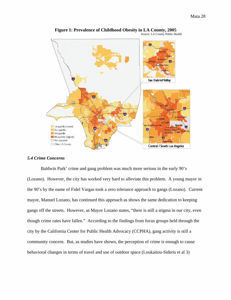
Almost a third of children in grades 5, 7, and 9 were overweight during yearly height,
weight, and body mass index testing in 2009 (CCPHA). According to LA County Public Health
figures, Baldwin Park and five of its San Gabriel Valley neighbors are some of the most obese
communities in the Los Angeles County area (See maps below).
Mata 28
Figure 1: Prevalence of Childhood Obesity in LA County, 2005
5.4 Crime Concerns
Baldwin Park’ crime and gang problem was much more serious in the early 90’s
(Lozano). However, the city has worked very hard to alleviate this problem. A young mayor in
the 90’s by the name of Fidel Vargas took a zero tolerance approach to gangs (Lozano). Current
mayor, Manuel Lozano, has continued this approach as shows the same dedication to keeping
gangs off the streets. However, as Mayor Lozano states, “there is still a stigma in our city, even
though crime rates have fallen.” According to the findings from focus groups held through the
city by the California Center for Public Health Advocacy (CCPHA), gang activity is still a
community concern. But, as studies have shown, the perception of crime is enough to cause
behavioral changes in terms of travel and use of outdoor space (Loukaitou-Sideris et al 3)
Source: LA County Public Health

Mata 29
6. Findings and Conclusion
Key Built Environment Concerns. Traffic, insufficient lighting, scarcity of bicycle lanes,
and lack of diversity in business establishments were found as significant to the perception of
fear in downtown. Both groups also stated that they would feel safer if there were more
surveillance cameras, artwork, plants and gardens.
Input from the Members of the Julia McNeill Senior Center. The eight senior citizens I
surveyed were members of the Julia McNeill Senior Center located in downtown Baldwin Park.
Their ages ranged from 58 – 75. The group was composed of Latinos with the exception of one
white and Asian person. The Julia McNeill Senior Center is a very essential resource for the
elderly population of Baldwin Park. The center creates a number of opportunities for seniors to
participate in hobbies and stay physically active.
In terms of transportation, nearly every senior I surveyed is dropped off at the Senior
Center almost everyday by a city-run service called Dial-a-Ride. The service is only provided to
Baldwin Park residents who are disabled or are over the age of 65. It became obvious to me that
seniors in the community are not as inhibited by the autocentric nature of the built environment.
However, findings from their surveys still showed a concern for the safety of the downtown area
in terms of traffic and crime. Seniors expressed their desire to see more security guards and
policemen on patrol. Also, seniors responded that they would like to see more bicycle lanes and
lighting.
Input from Healthy Teens on the Move. The group of youth participants were recruited
from a teen advocacy grouped named Healthy Teens on the Move. The group is involved in
educating the community of the ways to fight obesity. Through the use of a social
Mata 30
networking/blog website, teens from South Los Angeles and Baldwin Park raise awareness of the
unhealthy foods, drinks, and conditions that contribute to obesity.
The youth did not express the same desire to see more policemen and security guards on
patrol. Youth obstacles to walkability and bikeability are centered on the unavailability of
businesses within walking distance. The shopping mall in the neighboring city of West Covina,
WalMart, and Target were mentioned as common shopping establishments for the youth, none of
which are in downtown. Youth need places in downtown that cater to their interests and
preferences. One 18 year old youth stated, “I don’t feel scared to walk around at night. That’s
when less cars are on the road.” Youth would be more willing to be physically active in
downtown if traffic was calmer and more attractive businesses were available.
Recommendations
Design recommendations for the downtown area of Baldwin Park were created with
physical activity, travel behavior, crime prevention, and community input in mind. They are
broken up into two categories: development and streetscape.
Development
Diversity. Survey findings show a need for more diversity in the types of businesses in
Baldwin Park. Pedestrians need a destination to walk to. Only a few of the places where survey
participants said they shopped are located in downtown. The city should try to attract businesses
that provide stray from the typical burger joint or taco spot.
Businesses that operate during the night hours would be very helpful in decreasing the
fear of crime. Open businesses light the streets and provide more spectators to witness and
report crimes.
Mata 31
Streetscape
Bicycle Lanes. The need for bicycle lanes in downtown Baldwin Park is urgent.
Sidewalks are almost too small for pedestrians alone. If the city is serious about combating
obesity in the community, infrastructure for non-motorized travel must be provided. Planners
should keep in mind, however, of the manner in which the bicycle lanes are implemented.
Studies show that bicycle lanes do not contribute without a protective barrier to clearly
distinguish the car lane.
Traffic calming. The abundance of cars on the street creates a dangerous environment for
pedestrians, skateboarders, and bicyclists. The city should explore the different techniques used
to divert traffic from the downtown area, such as lit lane dividers and crosswalks or raised
intersections.
Beautification. The community has clearly expressed a desire to see more greenery and
artwork in the downtown area. Beautification efforts should be heightened to create a more
appealing scenery for pedestrian, skateboarders, and bicyclists. Drivers would also be more
willing to slow down if they had a beautiful scenery to look at.
Permitting graffiti in certain public spaces may be suitable for a community like Baldwin
Park. Not only would it create an opportunity for members of the community to express
themselves artistically, but it would provide a legal alternative for artists to practice in a
controlled environment. It would foster a sense of ownership among artists who use the space.
A community garden is another beautification technique that would foster a sense of ownership
among participants. Tapping into residents’ personal interests would be an efficient way to
develop territoriality throughout the community.
Mata 32
Conclusion
In City of Quartz, Mike Davis points out that a new war between classes exists
(sometimes seen as an extension of the race war of the 60's) that is manifested through the built
environment (228). "[O]bsession with physical security systems, and, collaterally, with the
architectural policing of social boundaries, has become a zeitgeist of urban restructuring, a
master narrative in the emerging built environment of the 1990's" (223). In order for the elite to
feel safe, we have formed our once pedestrian-friendly streets into traffic congested pipelines
(226). Davis states that the recreational spaces for the affluent of Los Angeles are “reciprocally
dependent upon the social imprisonment of the third-world service proletariat who live in
increasingly repressive ghettos and barrios” (227). Public space is rapidly decreasing in a city
full of immigrants who are already in great need for resources like playgrounds, libraries,
beaches, and parks (227). The feeling of desolation and lack of pedestrians contribute to the
anxiety and fear in our cities (Loukaitou-Sideris et al 7). Now that more troubled kids are on the
streets, it is no surprise that they have become more dangerous. The answer to the fear of crime
does not lie in hardened security measures and heighted police patrol but in fostering a sense of
community among residents.
Mata 33
Works Cited
10 Years of Leadership for a Healthy California. Rep. California Center for Public Health
Advocacy, 2009. Print.
"Crime Prevention Through Environmental Design." City of Mesa, Arizona - Official Web Site.
Web. 16 May 2010. <http://www.mesaaz.gov/police/literature/cpted.aspx>.
Crowe, Timothy D. "CPTED Concepts and Strategies." Crime Prevention Through
Environmental Design: Applications of Architectural Design and Space Management
Concepts. Boston: Butterworth-Heinemann, 1991. 30-32. Print.
Davis, Mike. "Fortress L.A." City of Quartz: Excavating the Future in Los Angeles. London:
Verso, 1990. 221-28. Print.
“Design Out Crime.” Guidelines. Los Angeles: Crime Prevention Through Environmental
Design Task Force, 1997. Print.
Does the Built Environment Influence Physical Activity?: Examining the Evidence. Washington,
D.C.: Transportation Research Board, 2005. Print.
Frank, Kathryn I. "The Pontential of Youth Participation in Planning." Journal of Planning
Literature 20.351 (2006): 351-71. Web
Frank, Lawrence D., Peter O. Engelke, and Thomas L. Schmid. Health and Community Design:
the Impact of the Built Environment on Physical Activity. Washington, DC: Island, 2003.
Print.
Handy, Susan L. "Walking, Bicycling, and Health." Healthy, Equitable Transportation Policy:
Recommendations and Research. Policy Link, Prevention Institute, Convergence
Partnership., 2009. 63-77. Print.
Mata 34
Healthy Eating, Active Communities. "Crime Prevention Through Environmental Design
(CPTED)." HEAC Workshop & Training. Chula Vista. 15 Sept. 2009.
"Interview with Mayor Lozano." Personal interview. 20 Mar. 2010.
Loukaitou-Sideris, Anastasia, Amanda Bornstein, Camille Frank, Linda Samuels, and Shahin
Gerami. How to Ease Women's Fear of Transportation Environments: Case Studies and
Best Practices. Rep. no. 09-01. San Jose: Mineta Transportation Institute, 2009. Print.
Nivola, Pietro S. Laws of the Landscape: How Policies Shape Cities in Europe and America.
New York: Brookings Institution, 1999. Print.
Office of Health Assessment and Epidemiology. Preventing Childhood Obesity: the Need to
Create Healthy Places. Rep. Los Angeles County Public Health, 2007. Print.
Pitt, Leonard, and Dale Pitt. "Baldwin Park." Los Angeles A to Z: An Encyclopedia of the City
and County. Berkeley and Los Angeles: University of California, 1997. 36. Print.