Embed Size (px)
Citation preview
2
web: www.imiparalianature.orginfo: [email protected]
July 2005
INSTITUTE FOR INFRASTRUCTURE, ENVIRONMENT AND INNOVATION
Report nr.
3
Colophon
Contributions:
Taru Halla (Ecobio Oy, Finland)Riitta Kajatkari (Port of Kotka, Finland)Francois Lerat (Ministry of Ecology, France)Doris Müller (Hamburg Port Authority, Germany)Frank Neumann (Institute for Infrastructure, Environment and Innovation)Pim de Wit (Port of Rotterdam, the Netherlands)Thomas Vanoutrive (Port of Antwerp, Belgium)
Editing: Frank Neumann, Hasse Petersen, Christine Kögler, Herwig Ranner(Institute for Infrastructure, Environment and Innovation, Belgium)
Partners and supporting organisations:
DIREN-Haute NormandiePort of Antwerp Port of Hamburg Port of RotterdamDutch Ministry of Transport and Public Works, Zealand Directorate
4
Table of Contents
0. Executive SummaryExecutive Summary 5Zusammenfassung 6Samenvatting Sommaire Exécutif
1. Introduction and Background1.1 Background of Paralia Nature 81.2 Objective of Phase II 81.3 Partners and supporting organisations 91.4 Report Structure 9
2. Case Studies2.1 Mühlenberger Loch, Hamburg 102.2 Maasvlakte II, Rotterdam 122.3 Deurganck Dock 172.4 Le Havre 232.5 Port of Kotka 262.6 Overview of Compensation in the Case Studies 30
2.6.1 Conclusions of the Alterra Report and compensation 30 2.6.2 Results 32
2.6.3 Conclusions and Advice 323. Approach – Working groups
3.1 Species Protection 333.2 Species Protection Conclusions 363.3 Marine Protected Areas 373.4 Marine Protected Areas Conclusions 393.5 Management Plans – Compensatory measures and monitoring 403.6 Management Plans Conclusions 42
4. Demonstration Project NEW Delta 435. Dissemination 446. General Conclusions: Looking back and looking ahead 457. Follow-up 46
Annex 1 List of Workshop and Partner Meeting Reports

5
Report of Paralia Nature Phase II
0. Executive summaries in English, French, German and Dutch (to be completed)
The Paralia Nature project was initiated in 19991.
The project responds to a request for improvement of the implementation of Article 6.3 and 6.4 under the Habitats Directive for plans and projects related to port extensions within estuaries protected under European or national schemes.
Paralia Nature Phase II was implemented throughout the period of May 2002 to June 2004, informally uniting European governments, NGOs, ports, industry, expert and academic organisations.
Project and financing partners included the Dutch Ministry of Transport – Zeeland Directorate, and the port authorities of Antwerp, Hamburg and Rotterdam and DIREN-Haute Normandie (regional delegation of the French Ministry for the Environment),
Three horizontal working groups were appointed to elaborate on the following themes which had been identified throughout Phase I:
Species Protection Marine Protected Areas Management Plans, Compensatory Measures, Monitoring and Evaluation
In addition the case studies on port extensions, mainly similar cases to Phase I, were used in the general meetings to exchange information on problems and solutions.
Overall one of the most important conclusions is that a considerable progress has been made by port and governmental organisations in terms of co-operation with other stakeholders such as nature protection NGOs and local actors in the area of integration of nature protection in decision-making and implementation of port extension projects. It is also noticeable that projects starting post 2000 begin to include nature protection aspects at an earlier stage in the planning than their predecessors.
The fact that compensatory measures need to be developed is not a point of discussion and in projects, started after 2000, clearly an earlier integration of nature protection aspects can be noted. The implementation of compensatory measures however, is not an easy task. On that point a more advanced planning of nature compensation appears to be necessary.
Other important issues identified in Phase II include:
The factors that delay or facilitate the development of mitigation measures. Mitigation has already been given much attention in the cases, but as the implementation of compensatory measures is a lengthy and often complex task, it seems worthwhile to look at methodologies or strategies that encourage and facilitate further mitigation.
The factors that delay or facilitate the implementation of compensation measures. Particularly from the case studies it becomes apparent that the implementation of compensation measures is often stopped or slowed down by local interests,
1 For further information about the initiation of Paralia Nature as well as Phase I please visit www.imiparalianature.org where the Phase I report is accessible.
6
physical planning procedures, or resistance interest groups e.g. farmers or the local population. This may not only endanger the condition of a protected site, but in the end can also stop or slow down project implementation. Furthermore, compensation must be available and in operation before projects can be implemented. This topic needs further attention. In 3 out of 5 cases compensatory measures including comparable nature are slowed down. Notably, contrary to popular belief it is not the European Commission procedures that cause delay in the finding of solutions, but particularly procedures in Member States and local circumstances. It seems useful to explore a more advanced and developed planning of compensation.
The cross-border aspect. As designation of sites and the application of Article 6.3 and 6.4 is particularly a national matter - in more federally organised states a regional matter- the implementation of site protection in border zones, where the regimes are different on each side of the border, usually gives rise to problems. This aspect needs further attention, as it can lead to situations of stagnation when on one side of the border measures are taken that counter the effect on protected nature of measures taken on the other side. Or, for example when the conservation objectives on one side of the border mean that effects of a project are not considered as significant, while on the other side more strict conservation objectives would conclude that the effects are significant. Current formal mechanisms within federally organised Member Sates and formal mechanisms between EU countries do not seem sufficient to deal with such issues within short time-frames. Currently the only way to address this issue is for Member States to start a joint initiative on their own incentive, but such agreements can only take place where both sides have the willingness to co-operate.
The further development of management plans. In some Member States, more than others, advances have already been made with the development of management plans for protected sites. Now the list of EU sites is designated, the practicalities and contents of these systems become more important, as for example issues relating to conservation objectives and the actual experiences with systems of monitoring and evaluation to control the performance of these management schemes. Various sources have stated the importance of regularly evaluating the performance of these management systems that are for a large part based on voluntary regulation. Now that some management plans have already been in place for a couple of years and must have more tangible results it may be of interest for new plans to take on board lessons learned from experience.
In addition to the management plans for the HD, for some sites an extra effort is needed: the management plans and protective measures need to be set up in line with the requirements of the Water Framework Directive. Although this issue did not come out of the case studies, it was a relevant issue coming out of the working group on Management Plans. Clarification of the links between the HD and WFD may become more important in the near future, when progress has been made with implementing the requirements of the WFD.
Finally, one of the challenges undertaken by the Paralia Nature partnership during Phase II was to foster the development and implementation of demonstration projects such asa restoration project. In support of this Paralia Nature initiated and greatly assisted the creation of a new partnership and project design: the Interreg IIIB project ‘NWE Delta’ which took off in August 2004. The NWE Delta project proposes a combination of transnational actions to be developed under six interdependent themes. Each of these themes relates to different requirements of Article 6 of the Habitats Directive.
7
0. Zusammenfassung –this summary needs to be completed.
Das Paralia Nature Projekt wurde am Ende der neunziger Jahre initiert. Das Projekt reagiert auf Verbesserungsvorschläge zur Umsetzung der Artikel 6.3 und 6.4 der FFH-Richtlinie hinsichtlich Pläne und Projekte zum Ausbau von Häfen. Insbesondere bezieht es sich auf solche Projekte, welche innerhalb von durch den europäischen oder nationalen Gesetzlichenrahmen geschützten Flussmündungen durchgeführt werden sollen.
Paralia Nature-Phase II wurde zwischen Mai 2002 und Juni 2004 von europäischen Regierungen, von Vertretern der Industrie, Sachverständigen, Wissenschaftlern und nichtstaatlichen Organisationen, sowie den von den Häfen selbst durchgeführt. Projekt- und Finanzierungspartner schlossen das holländisches Transportministerium- die Verwaltung von Zeeland und die Hafenbehörden von Antwerpen, Hamburg und Rotterdam und DIREN-Haute Normandie (regionale Delegation des französischen Ministeriums für das Klima) ein.
Drei horizontale Arbeitsgruppen arbeiteten folgenden Themen aus, die bereits während der ersten Projektphase identifiziert wurden:
Artenschutz Geschützte Meeresbereiche Management-Pläne, Ausgleichsmaßnahmen, Überprüfung und Auswertung
Es gab viele Überschneidungspunkte und Ähnlichkeiten zwischen den identifizierten Problemen. Abgesehn von komplexen Detailfragen war die Ursache der meisten allgemeinen Probleme eine fehlende Aufmerksamkeit oder Kommunikationsdefizite,hinsichtlich der praktischen Konsequenzen der FFH-Richtlinie, auf den nationalen, regionalen und lokalen Ebenen,
Das Projekt hob jedoch den Nutzen einer Verbesserung dieser Art der Kommunikation hervor, insbesondere da für einzelne Projektmitglieder des öftern Probleme auftreten mit der Europäische Kommission auf unoffizieller Ebene zu kommunizieren. Interessanter Weise brachte eben dieser Informationsmangel oder die Probleme mit dem Verständnis der FFH –Richtlinie ansonstige Konkurrenten dazu, effektiv zusammenzuarbeit.
Das Project hatte direkt anwendbare Ergebnisse, wie zum Beispiel mehr Klarheit gegenüber den praktischen Implikationen der FFH-Richtlinie sowie die Möglichkeit eines unoffiziellen Dialogs mit der Europäischen Kommission zu Fragen in Bezug auf EU-Richtlinien.
Weitere wichtige Erkenntnisse,der zweiten Phase waren:
die Faktoren die zur Verzögerung oder Förderung der Entwickelung von Kompensationsmaßnahmen führen. Kompensation wurde bereits ausführlich in den Beispielfällen behandelt, aber da sich die Ausführung von Kompensationsmassnahmen oftmals als langwierig und komplex erweist, scheint es sich zulohnen, Methoden oder Strategien die Linderungsmaßnahmen fördern und erleichtern näher zu betrachten.
die Faktoren die zu einer Verzögerung oder Förderung der Ausführung von Kompensationsmaßnahmen führen. Anhand der Fallbeispeiele wurde deutlich,daß die Ausführung von Kompensationsmaßnahmen oftmals durch regionale Intressen, physische Planungsprozesse oder Interessen der Bevölkerung wie z.B. Landwirtschaft,verlangsamt oder gestoppt wird. Das führt nicht nur zu einer Gefährdung des Zustandes eines geschützten Gebietes, sondern kannschlussendlich auch die Ausführung des Projektes verlangsamen oder gänzlich aufhalten. Ausserdem, muss Kompensation vor der Ausführung des Projektes
8
stattfinden. Dieses Thema benötigt weitere Aufmerksamkeit. In 3 aus 5 Fällen werden Kompensationsmaßnahmen, die vergleichbare Natur einschliessen,von Hindernissen aufgehalten. Allerdings, im Gegensatz zur allgemeinen Meinung, sind es nicht die Entscheidungsprozesse der Europäischen Kommission die zu den Verzögerungen führen sondern insbesondere die Entscheidunsprozesse der Mitgliedsstaten und lokale Umstände. Es scheint sinnvoll Wege zu suchen, die zu einer besseren und weiter entwickelten Planung von Kompensation führen könnten.
der grenzüberschreitende Aspekt der Naturschutzgebiete. Da die Benennung von Gebieten und die Anwendung von Artikel 6.3 und 6.4 insbesondere eine staatliche Angelegenheit ist – in föderal orientierten Staaten ist dies eine Angelegenheit der Bundesländer und Regionen- kommt es oftmals zu Problemen hinsichtlich der verschiedenen Formen von Naturschutz die von denbetroffenen Staaten des Naturschutzgebietes angewandt werden. Dieses Problem verdient stärkere Beachtung, da es zu einer Situation führen kann in der entweder die verschiedenen staatlichen Massnahmen gegen einander arbeiten, oder zum Beispiel die Naturschutzziele eines Staates dazu führen,daß die Effekte nicht als bedeutend negatif, jedoch in der anderen Hälfte als wesentlich signifikanter angesehen werden. Gegenwärtige Entscheidunsprozesse in den Bundesstaaten und zwischen Mitgliedsstaaten sind nicht in der Lage, solche Probleme in einem kurzen Zeitraum zu lösen. Zurzeit gibt es nur Möglichkeit, daß Mitgliedsstaaten eine gemeinsame Initiative beginnen, was aber nur dann funktioniert, wenn auf beiden Seiten Wille zur Zusammenarbeit besteht.
die Weiterentwicklung von Bewirtschaftungsplänen. In manchen Mitgliedsstaaten hat es bereits wesentliche Fortschritte in der Weiterentwicklung von Bewirtschaftungsplänen für geschützte Gebietegegeben. Nun, da die Liste der schützenswerten EU Gebiete bekannt ist, werden die praktischen Aspekte und Inhalte der Systeme wichtiger, wie zum Beispiel die Erhaltungsziele und die gegenwärtigen Erfahrungen mit Monitoring und Evaluierung die nun dazu beitragen sollten, eine Kontrolle über die Bewirtschaftungspläne auszuüben. Verschiedene Quellen haben bereits die Wichtigkeit einer regelmässigen Evaluierung der Durchführung der Bewirtschaftungssysteme bestätigt die allerdings fast gänzlich auf einer freiwilligen Basis durchgeführt wird. Da nun manche Bewirtschaftungspläne schon ein Paar Jahre laufen, währe es an der Zeit sich mit den Erfahrungen,die hier gesammelt worden sind, auseinander zu setzen.
Zusätzlich zu den Bewirtschaftungsplänen für die Habitatrichtlinie sind für manche Gebiete zusätzliche Anstrengungen nötig, da sie auch der Wasserrahmenrichtlinie entsprechen müssen. Obwohl dieses Erkenntnis nicht ein Resultat der Fallbeispiele ist, war es ein relevantes Thema der Diskussionen der Gruppe die sich mit Bewirtschaftungsplänen befasste. Erläuterungen der Zusammenhänge zwischen der Habitatrichtlinie und der Wasserrahmenrichtlinie könnten möglicherweise in der nahen Zukunft wichtiger werden, wenn Fortschritte bei der Ausführung der Wasserrahmenrichtlinie gemacht worden sind.
Letztendlich stellten sich die Projektteilnehmer den Herausforderungen, die während Phase II durch die Paralia Nature Partnerschaft aufgenommen wurden: die Entwicklung und Implementierung von Demonstrationsprojekten zufördern, wie zum Beispiel Renaturierungsprojekte. Dem entsprechend, unterstützte Paralia Nature die Entwicklung und das Design eines neuen Partnerschaftsprojektes: das Interreg IIIB Projekt NEW Delta, welches im August 2004 startete. Das NEW Delta Projekt schlägt eine Brücke zwischen den internationalen Aktivitäten nach sechs unabhängigen Themen. Jedes
9
einzelne Thema erarbeitet unterschiedliche Anforderungen des Artikel 6 der FFH-Richtlinie.
0. Résumé
Le projet Paralia Nature a été initié en 19992.
C’est un projet qui vise à améliorer la mise en œuvre des articles 6.3 et 6.4 de la directive « habitats ». Ces articles concernent les plans et les projets relatifs aux extensions portuaires réalisés dans des estuaires protégés par la législation européenne ou nationale.
La deuxième phase du projet Paralia Nature a été lancée pour la période de mai 2002 à juin 2004. Elle a crée un réseau informel de gouvernements européens, d’ONG, d’autorités portuaires, d'industries, d’organismes experts et d’organisations académiques.
Les partenaires du projet et les partenaires financiers sont le ministère néerlandais des Transports – Direction Zeeland, les autorités portuaires d’Anvers, de Hambourg et de Rotterdam, et la DIREN - Haute Normandie (Direction Régionale de l'Environnement, service déconcentré du Ministère français de l'Ecologie et du Développement Durable).
Trois groupes de travail horizontaux ont été nommés pour traiter des thèmes identifiés lors de la première phase du projet :
protection des espèces zones marines protégées plans de gestion, mesures compensatoires, suivi et évaluation.
En outre, les études de cas portant sur des extensions portuaires ont été discutées lors des réunions générales pour échanger l’information sur les problèmes et leurs solutions.Il s’agissait essentiellement des cas similaires à ceux de la première phase.
Une des conclusions les plus importantes de la deuxième phase du projet est que les organisations portuaires et gouvernementales ont fait un progrès considérable dans la coopération avec d’autres parties intéressées, tels que les ONG de protection de la nature et les acteurs locaux. Des progrès ont été faits dans l’intégration de la protection de la nature aux processus décisionnels et dans la mise en œuvre des projets d’extensions portuaires. De plus, à partir de l’an 2000, les aspects liés à la protection de la nature sont pris en compte dans la planification de projets à des stades clairement plus précoces qu’avant cette date.
Le développement des mesures compensatoires n’était pas à l’ordre du jour de ces discussions. En effet, une planification plus avancée et développée est nécessaire avant leur mise en œuvre qui n’est pas une tâche aisée.
D'autres aspects importants identifiés pendant la deuxième phase du projet sont :
Facteurs retardant ou favorisant le développement de mesures d'atténuation. Dans les études de cas, une grande attention a été accordée aux mesures d'atténuation. En effet, l’application des mesures compensatoires étant souvent une tâche complexe, il serait utile d'examiner les stratégies visant à favoriser le développement ultérieur de mesures d'atténuation.
2 Pour de plus amples informations sur l'initiation du projet Paralia Nature et sur sa première phase, veuillez visiter le site www.imiparalianature.org où le rapport de la première phase du projet est accessible.
10
Facteurs retardant ou favorisant la mise en œuvre des mesures compensatoires. En particulier les études de cas démontrent que la mise en œuvre des mesures compensatoires est souvent arrêtée ou retardée par des intérêts locaux, par des procédures de planification ou par la résistance de groupes d’intérêt, notamment les agriculteurs et la population locale. Ceci menace également l’état du site protégé. Dans trois cas sur cinq, les mesures compensatoires sont retardées. Contrairement à une idée reçue, ce ne sont pas les procédures de la Commission européenne qui les retardent, mais en particulier les procédures des États membres de l’UE et les circonstances locales. En outre, les mesures compensatoires devraient être disponibles et opérationnelles avant que les projets soient mis en œuvre, d’où la nécessité de les planifier de manière plus avancée.Ce thème doit faire l'objet d'une attention supplémentaire.
Aspect transfrontalier. La désignation des sites et l’application des articles 6.3 et 6.4 sont de compétence nationale, dans des États fédéraux elles sont de compétence régionale. Les régimes réglementaires étant différents de chaque coté de la frontière, la mise en œuvre des dispositions relatives à la protection des sites pose souvent des problèmes dans des zones frontalières. Cet aspect doit faire l'objet d'une attention supplémentaire, car il est susceptible de conduire à une situation où les effets des mesures prises de part et d’autre de la frontières’annulent. En outre, il se peut que les objectifs de conservation d’un côté de la frontière soient tels que les incidences d’un projet sur l'environnement ne sont pas considérées comme notables, alors que de l’autre côté de la frontière ces objectifs sont plus stricts et les mêmes incidences sur l'environnement considérées comme notables. Actuellement, les mécanismes officiels dans l’UE entre les différents États membres – et dans les États fédéraux entre les différentes régions – ne sont pas adéquats pour faire rapidement face à ce problème transfrontalier. La seule façon d’aborder la question est de prendre une initiative commune. Pour ce faire, les États membres doivent avoir la volonté de coopérer.
Développement ultérieur des plans de gestion. Dans certains États membres, plus que dans d’autres, des progrès ont déjà été faits dans le développement de plans de gestion pour les sites protégés. Maintenant que la liste de l'UE de ces sites est désignée, le contenu de ces plans de gestion devient plus important, par exemple quant aux objectifs de conservation et aux expériences de systèmes de suivi et d’évaluation. En effet, plusieurs sources ont souligné l’importance d’évaluer de façon régulière la performance de ces plans qui font pour la plupart l’objet d’une réglementation volontaire. Maintenant que des plans de gestion ont déjà été mis en place depuis quelques années avec l’obligation de parvenir à des résultats plus tangibles, les projets plus récents peuvent en tirer des leçons.
Pour certains sites un effort supplémentaire est requis en plus des plans de gestion relatifs à la directive « habitats ». C’est-à-dire que les plans de gestion et les mesures de protection doivent se conformer aux dispositions de la directive-cadre sur l'eau. Même si cette question ne provient pas des études de cas, ellerésulte du groupe de travail consacré aux plans de gestion et est pour cela importante. La clarification des liens entre la directive « habitats » et la directive-cadre sur l'eau pourrait s’avérer plus importante dans un futur proche, lorsque des progrès dans l’application des dispositions de cette dernière auront été faits.
Enfin, un des défis à relever par le partenariat Paralia Nature pendant la deuxième phase du projet est d’encourager le développement et la mise en pratique des projets de démonstration, tel que le projet de restauration. Pour soutenir ceci, Paralia Nature a, en août 2004, initié et facilité la création de NWE Delta qui est un nouveau partenariat et une nouvelle conception du projet dans le cadre du Interreg III. Ce projet propose une
11
combinaison des actions transnationales selon six thèmes interdépendants. Chacun de ces thèmes concerne différentes dispositions de l'article 6 de la directive « habitats ».
Preface
In this report you will find the stories and experiences of the updated Paralia Nature Habitats Directive Case studies from Phase I as well as the results of the specialised working groups that did considerable work in Phase II. These specialised working groups included issues such as species protection, marine protected areas and monitoring and evaluation of management plans. This report was also accomplished thanks to input from port and government partners in Belgium (the case of Antwerp), Germany (case Hamburg), the Netherlands (cases Scheld Estuary and in Rotterdam the Maasvlakte extension), France (case of the Seine Estuary) and for Finland the (Port of Kotka).
Thanks to the valuable input from the project partners the case studies and other material presented here have great practical value and consider the issues from a truly multi-disciplinary perspective. For these reasons it may be of interest to legal, ecological, and engineering specialists and will hopefully provide inspiration on how to find solutions, prevent common mistakes in the decision-making process for port and other infrastructure projects. The report also explains the approaches developed that are ‘European-proof’ regarding the Birds and Habitats Directives.
Also in Phase II, particularly the informal participation and support of the European Commission in terms of expertise was of great help thanks to Nicolas Hanley and Michael O’Briain. Apart from to the Nature Protection Unit from the European Commission, thanks go to other participants in the workshops who contributed their expertise and experience. These included representatives from English Nature; Roger Morris and Ian Reach, Natuurpunt; Peter Symens, European and Dutch Birdlife; Ellen Ninaber, the Flemish Institure for Nature Protection; Erika van Den Berg, the University of Ghent; An Cliquet, Seine-Aval; Regis Hocde, Aminal/Ministry of the Flemish Community; Els Martens and from the Leibnitz Institute for Environmental Studies; Gerold Jansen.
Hopefully in reading this report and its case studies, you will be able to gain a comprehensive overview of the developments at project level on Natura 2000, ports and estuaries, and obtain creative input for your own stakes and solutions relating to the problems and issues of port and nature protection projects.
12
1. Introduction
1.1 Background of Paralia Nature
Phase I of Paralia Nature was initiated in 1999 by the Institute for Infrastructure, Environment and Innovation. The project idea was initiated when it turned out from a comparative study that in Belgium, France and the Netherlands, similar problems had arisen regarding the sustainability dimension of projects in the sector of maritime transport. It became apparent that many large infrastructure projects, particularly port projects, had problems with the implementation of the Habitats Directive. Its requirements were not always clear and in many cases there was no societal consensus on the design and scope of compensation measures. After about a year, a number of government and industry stakeholders supported the project also financially or in human resources for a more long-term exploration. These included the port of Bremen, the port of Rotterdam, the port of Antwerp, the Dutch Ministry of Agriculture’s Expertise Centreand the International Navigation Association (PIANC) represented by the UK Major Ports Group (UKMPG).
In Paralia Nature Phase II (May 2002 to June 2004) the focal points were on three thematic areas in relation to activities of large ports in NW Europe and Natura 2000. The selection of these themes was based upon topics that were scrutinised throughout Paralia Nature Phase I.
1.2 Objective of Phase II
The objective was to find practical solutions to problems and queries regarding the application of the EC Birds Directive3 and Habitats Directive4 (and other relevant EC legislation) in relation to port and other infrastructure development in coastal zones and estuaries within or in proximity of designated areas.
The starting point of Paralia Nature is the Birds and Habitats Directives. However, the intention of the project is not to change or reduce the requirements of the Directives. Instead, ways are sought to better and more efficiently meet their requirements and where possible, to establish more clarity on their interpretation, where European requirements are not sufficiently clear. The wide spectrum of project partners, including representatives from government, industry and academia, helps to ensure that the project is neutral. This approach is further strengthened by co-operation between the project partners and NGOs.
More precisely Phase II of Paralia Nature sought to:
Exchange information for solutions to problems pertaining to the implementation of articles 6.3 and 6.4 relating to port projects in estuaries in NWE.
Explore the implications of the European framework of fishery (EU fisheries policy) and nature protection policy (Natura 2000, Birds and Habitats Directives) for large coastal zone infrastructure projects and their compensation.
Establish more structured cooperation on Natura 2000 and estuaries.
3 Council Directive 79/409/EEC of 2 April 1979 on the conservation of wild birds, OJ L 103 /14 Council Directive 92/43/EEC of 21 May 1992 on the conservation of natural habitats and of wild fauna and flora OJ L 206 /7
13
Explore the different approaches to management plans and their monitoring and evaluation.
Explore and compare approaches to species protection issues in ports in NW Europe.
1.3 Partners and supporting organisations
Financing partners included the Port of Antwerp, the Port of Rotterdam, the Port of Hamburg, the Dutch Ministry of Transport and Public Works Zealand Directorate, and DIREN-Haute Normandie, the regional site of the French Ministry for the Environment. In addition support was lent by ports and governmental authorities (national, regional, and local), national and international NGOs, sector organisations and experts (ecologists, lawyers etc.) Regular participation of the following groups was appreciated in the programme of the project (English Nature, the Flemish Institute of Nature Conservation, the Expertise Centre Mainport Rotterdam, Erasmus University Rotterdam, Utrecht University, the Netherlands Economic Institute - Ecorys, IUCN, Natuurpunt).
1.4 Structure of the report
As with the programme for Phase III this report is structured around the case studies and the three specialised working groups, relating to topics selected in Phase I:
- Species Protection- Management Plans and Monitoring and Evaluation of Compensation- Marine Protected Areas
These working groups met on six occasions: once in Antwerp (B), Kiel (G), Flushing (NL) and three times in Brussels (B). In Antwerp and Flushing, excursions were held at compensation sites. In these workshops, the cases of the partners of the project were used as illustration and in discussion. These cases were also deliberated in the partner meetings.
In this report, the updated cases are explained, followed by the results of the working groups.
A further activity of Phase II was the development of a demonstration project for habitat restoration. To this extent an Interreg IIIB project was initiated as is briefly described at the end of this report.
This report draws conclusions for Phase II and gives a brief description of the follow-up actions. For detailed reports on the individual workshops see the list in Annex 1 which also includes a list of externally available memos.
14
2. Case studies
As in the Phase I report, several case studies are included to best illustrate the problems frequently faced by ports. To provide continuity most of these are updates of the port development projects previously encountered. These updates serve to determine the issues with respect to protected nature in the port area but also to describe how these were overcome, their successes, failures and future plans.
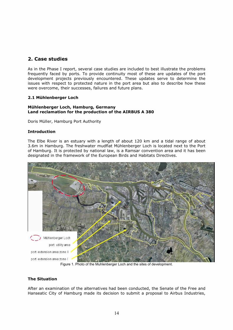
2.1 Mühlenberger Loch
Mühlenberger Loch, Hamburg, GermanyLand reclamation for the production of the AIRBUS A 380
Doris Müller, Hamburg Port Authority
Introduction
The Elbe River is an estuary with a length of about 120 km and a tidal range of about 3.6m in Hamburg. The freshwater mudflat Mühlenberger Loch is located next to the Port of Hamburg. It is protected by national law, is a Ramsar convention area and it has been designated in the framework of the European Birds and Habitats Directives.
Figure 1. Photo of the Muhlenberger Loch and the sites of development.
The Situation
After an examination of the alternatives had been conducted, the Senate of the Free and Hanseatic City of Hamburg made its decision to submit a proposal to Airbus Industries,
15
specifying a part of the Mühlenberger Loch as the building site for the production of the Airbus A 380.
The Intervention
The Mühlenberger Loch spans across approximately 675 ha. For the land reclamation about 171 ha of mud flat will be required, about 500 ha will be conserved.
The eastern part of the Mühlenberger Loch is a young ecosystem constantly under high disturbance. This part was deepened before WWII to create a harbour for seaplanes. After the flood catastrophe of 1962 the former tributary of the Elbe, the “Alte Süderelbe” which flowed into the Mühlenberger Loch was cut off by a dyke. The Mühlenberger Loch developed into a shallow bay of the Elbe River in which at first dredging spoil from the Port of Hamburg was deposited. Due to the constant high level of anthropogenic influences the ecosystem of the Mühlenberger Loch is very stress tolerant. Most of the species will spread into new parts of the estuary very quickly if these are in direct contact with the tidal river.
Within one year of the end of the disturbance resulting from the construction of buildings on the extension areas, the functions of the remaining part of the SPA will be restored.
The Effects of the Intervention
The land reclamation in the Mühlenberger Loch is linked with impacts on the ecosystem:Loss of
151 ha freshwater mudflats, 18 ha of shallow waters, 0.8 ha of alluvial forest, 169 ha of breeding area for fish in shallow waters and on tidal flats, seedbank of Oenanthe conioides (endemic plant), resting place for migratory birds
The Mitigation Measures
For the purpose of mitigation a hydronumerical mathematical model was created. The model was able to calculate the most efficient shape of the extension area of the Mühlenberger Loch. The shape and border line of the reclamation area was of great significance for ecology. Different shapes would have different impacts and therefore it was possible to mitigate the project impact by rearranging the area’s shape.
The Compensation Measures
The impacts of all components of the project were analysed and assessed in conjunction with the expert reports under the Environmental Impact Assessment (EIA) and the compensation plan. The compensation measures are:
1. Restoring of tidal areas of a former tributary of the Elbe (Haseldorfer Marsh). Existing drainage facilities at Twielenflether Sand will be moved to permit unhindered tidal influence. These measures will enlarge the estuarine habitat areas by about 220 ha.
2. The Hörner Au with currently no significant breeding or resting population will be developed into a wetland through compensatory measures to provide a resting place for regular migratory bird populations (100 ha).
3. Creation of 99 ha freshwater mudflats by taking back the main flood protection line and by removing topsoil at the Elbe island of Hahnöversand. This measure is the
16
compensation for the loss of resting and feeding functions for migratory water birds. At the same time, it will provide new habitats for hemlock waterdropwort (Oenanthe conioides) in the river bank areas.
Main Issues in the Stakeholder Debate
There was no acceptance of the new biotopes as it was not certain that new areas are capable of replacing the functions of the destroyed areas. The main cause for disagreement from the nature conservationists’ point of view is the unique quality of the Mühlenberger Loch. There was serious doubt as to the replacability of the ecosystem and the presence of resting birds in the Protected Birds Area. The annual reports to the European commission counter these arguments with acceptable bird numbers being reached, even during the development phase, for both the Spoonbill (Northern Shoveler) and the Teal under Ramsar criteria. The European Commission sees the land-reclamation for Airbus A380 as a positive example for consistence in terms of conversion and documentation.
Problems and Solutions
NGOs went to court and stopped the compensation measure at Haseldorfer Marsch. Several environmental groups were in disbelief as to the possibility for improvement of an already highly protected area. In parallel to the court case of the EU these groups also sent in a complaint to reinforce their concern. The EU is currently engaged in both the court case and complaint procedures. The Free and Hanseatic City of Hamburg is still working on finding compromises for this problem.
Strengths and Weaknesses
The good cooperation between the neighbour states was necessary in order to find suitable compensation sites. Without such a good cooperation it is more or less impossible to find solutions in a highly populated area.
Contracts were signed between the neighbouring Member States about the compensation measures to be taken. The reason for compensation was the impossibility to develop a replacement estuary on such a scale in the area. Besides this, the competent authorities co-operated in a very effective manner. The high level of co-operation that ensued was the most important factor in reducing hurdles for this project.
Conclusion and Future plans
The measure was planed under high pressure from the outside which originated from the application procedure deadline for the production of the new Airbus A380. The applications from several cities for the tender were kept secret in order to maintain a fair competition. For this reason it was only possible to include stakeholders at the point of the permission procedure. However, the port does recognise that only with a good cooperation with all stakeholders it is possible be successful. The early involvement of the EU Commission is also necessary.
2.2 Maasvlakte II
Port of Rotterdam, NetherlandsProject Main Port Development Rotterdam: Update on the 2nd Maasvlakte1998 onwards
Mr. Pim de Wit, Port of Rotterdam
17
Introduction
The Project Mainport Development Rotterdam (PMR) was set up to investigate the further development of the Rotterdam port. Within the framework of this development the aim of project was to improve the quality of the living environment in the Rijnmond region, the Delta of the Maas River. Not only it is one of the largest, best equipped ports in the world, but the Dutch government wants it to be one of the cleanest and best organised as well. The objective is to ensure that, as a port, it takes meticulous care in dealing with materials, energy, water, biodiversity, mobility and space.
As the main result of the various PMR activities, the Dutch government would like to see the port and industry grow, while at the same time improving and balancing the quality of life and the opportunities for recreation in the surrounding area. The most important task is the timely creation of sufficient space in the port to enable the growth of the container, distribution and petrochemical sectors in Rotterdam and to meet future industrial housing requirements.
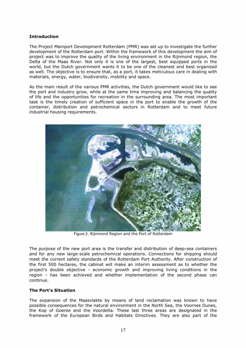
Figure 2. Rijnmond Region and the Port of Rotterdam
The purpose of the new port area is the transfer and distribution of deep-sea containers and for any new large-scale petrochemical operations. Connections for shipping should meet the current safety standards of the Rotterdam Port Authority. After construction of the first 500 hectares, the cabinet will make an interim assessment as to whether the project’s double objective - economic growth and improving living conditions in the region - has been achieved and whether implementation of the second phase can continue.
The Port's Situation
The expansion of the Maasvlakte by means of land reclamation was known to have possible consequences for the natural environment in the North Sea, the Voornes Dunes, the Kop of Goeree and the Voordelta. These last three areas are designated in the framework of the European Birds and Habitats Directives. They are also part of the
18
national ‘Ecological Main Structure’ of the Netherlands, as set forth in the Green Space Structural Plan. Intervention in these locations is only permitted once the initiator candemonstrate that intervention must take place in a particular location, due to important social interests. In such cases, any significant negative effects for the natural environment required compensated.
The Port’s Intervention
In May 1998, in the decision-making process for the plan for the port extension, a key planning decision (PKB+) was started. An important component of this procedure was an environmental effect report or Environmental Impact Statement (EIA). Both procedures were subject to specific (public) participation and appeal. The first public participation round, based on the publication of the initial PKB+/Environmental Impact Assessment (EIA) memorandum of the Rotterdam Mainport Development Project, was completed in July 1998.
The results were processed in the draft guidelines in order to study the impact of the proposed project activities.
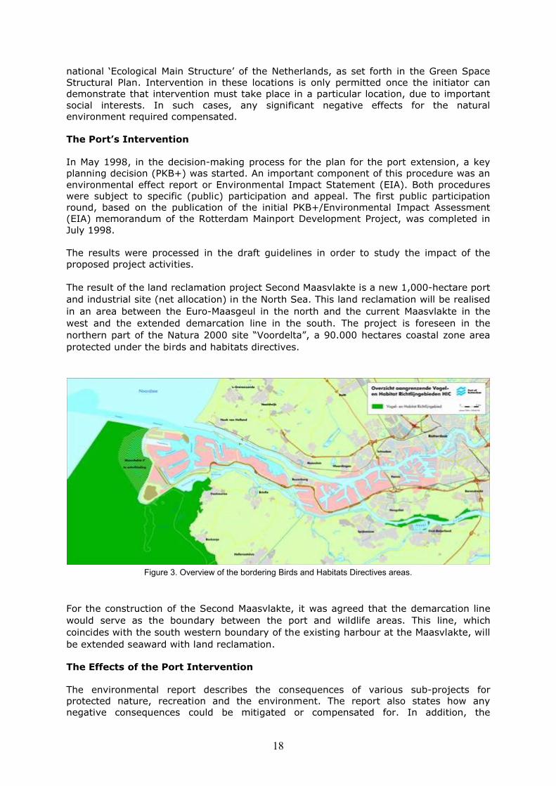
The result of the land reclamation project Second Maasvlakte is a new 1,000-hectare port and industrial site (net allocation) in the North Sea. This land reclamation will be realised in an area between the Euro-Maasgeul in the north and the current Maasvlakte in the west and the extended demarcation line in the south. The project is foreseen in the northern part of the Natura 2000 site “Voordelta”, a 90.000 hectares coastal zone area protected under the birds and habitats directives.
Figure 3. Overview of the bordering Birds and Habitats Directives areas.
For the construction of the Second Maasvlakte, it was agreed that the demarcation line would serve as the boundary between the port and wildlife areas. This line, which coincides with the south western boundary of the existing harbour at the Maasvlakte, will be extended seaward with land reclamation.
The Effects of the Port Intervention
The environmental report describes the consequences of various sub-projects for protected nature, recreation and the environment. The report also states how any negative consequences could be mitigated or compensated for. In addition, the
19
environmental effect report contains the ‘most environmentally-friendly alternative’, an approach designed to reduce potential damage to protected nature, the environment and recreation to a minimum. The EIA and the key planning decision (PKB+) allows for the possibility for the public to participate in, and to appeal against, the final government decision.
The cabinet had an environmental effect report drawn up to assess the Rotterdam Mainport Development Project’s impact on wildlife, the natural environment and recreation. To calculate the impact, the environmental effect report researched two reference designs for land reclamations showing that there will be a loss of marine life and habitat. The negative effects on wildlife such as birds and areas protected under the habitats directive will be, based on the worst-case scenario, significant.
Possible negative effects are: a reduction of the unique natural qualities of the Voorne and Goeree dunes due to a possible reduction of the effect of salt spray from the sea. Loss of habitat type 1110 (shallow coastal area) of the Natura 2000 site “ Voordelta” the coastal zone area.
On the other hand a positive effect will occur in an area with shallows and salt marshes in the Haringvliet Estuary. An area with unique new fauna and flora will be expanded as a result of to the land reclamation project.
Besides the two reference designs, on which the cabinet’s proposals are based, research was also done for the environmental effect report to determine the most “environmentally-friendly alternative”. The main differences from the reference designs were that land reclamation in this alternative is smaller and realised more to the north.
Land reclamation could also affect the transport of sand and silt and larvae along the coast. This would not affect safety although, depending on the design, it could entail additional research.
According to the environmental effect report, utilisation of the new port area will lead to noise increase, especially due to (rail) traffic. It will also produce more CO2 emissions. Finally, according to the report, land reclamation could improve the quality of the living environment by providing space for relocating companies from the existing port area more westward, further away from the city of Rotterdam. This will create a significant improvement of the living conditions for the inhabitants of the region.
The Mitigation Measures
The new port was to be constructed as a large sand body in the North Sea, situated as far as possible north of the demarcation line (the green dotted line figure 2.2 above) to minimise the effects on the dune reserves such as the loss of 0 to 16 hectares surface area of the priority habitat (2130, fixed coastal dunes with herbaceous vegetation).
Construction of a new section of land at sea will damage protected natural resources. The following mitigating measures are necessary to limit this damage:
- Losses of shallow coastal sea must be limited by constructing a minimum corresponding length of soft sea wall, including underwater shore, at the reclaimed land.
- The ultimate design of the reclaimed land should not have any additional negative effects on natural resources and not cause any additional damage to the Voorne and Goeree dunes, than the two northerly variants of the study designs.
20
- For the operational design of the reclaimed land every effort must be made within the preconditions mentioned to take extensive mitigating measures, provided that such measures would not affect other strict preconditions such as coastal safety, marine aspects and the environment.
The Compensation Measures
Despite these restricting measures, land reclamation would cause a loss of marine life and, possibly, a reduction of the quality of the Voorne and Goeree dunes. As a condition for compensating the loss of marine life, the cabinet has proposed the establishment of a marine conservation reserve of approximately 31,250 hectares in the Voordelta. Damage to the dune landscape of Voorne and Goeree should be compensated by constructing a 100-hectare dune area on the seaside of the coast between Hoek van Holland and Ter Heijde, with the construction of a 15-hectare strip of sea at Brouwersdam and an 8-hectare strip of sea on the land reclamation.
Main Issues in the Stakeholder Debate
The intentions of the PMR organisation and the Port of Rotterdam were to manage a transparent process involving all interested parties. The aim was to avoid lengthy administrative or appeal procedures. The outcome was the publication of the document ‘Vision and Courage’. A mutual agreement with the stakeholders which included the establishment of a marine reserve and the creation of dunes and wetlands as measures to compensate for the loss of habitat due to the land reclamation process was established. In this agreement, the City of Rotterdam is committed to a maximum level of mitigation and the improvement of the city’s built environment including living conditions and nature development.
Government ministers are taking part in the Rotterdam Mainport Development Project through the societal and NGO deliberation in process. They consult several social organisations as well as local and regional authorities involved in the project, prior to the political decision process. In addition the partners issued recommendations to the Cabinet. As effects on a priority habitat (grey dunes) are also expected, the European Commission has been asked for advise on this matter with respect to Article 6.4.
As not much was known about the requirements for this procedure, informal meetings with the European Commission took place at an early stage. This helped to ensure that, within the development of the plan, steps were taken and studies made in accordance with the requirements of the Directive.
The European Commission issued a positive opinion about the project in 2003. In principle it was a go-ahead for the project, taking into account required monitoring and the timely implementation of the mitigation and compensation promised. Yearly the Dutch government needs to report about their progress.
According to the port and governmental authorities, the first compensation schemes where based on worst-case scenarios. The government and the port are now in the process of looking at more opportunities for mitigation, also in order to bring down the surface damaged and reduce the compensation task. The compensation schemes will be tailor made and take into account the different phases as much as possible. Currently the government and the port are in the process of setting up a monitoring system, together with the main stakeholders.
Regarding the roles of the different parties in this process, the port is responsible for the land reclamation. The national government is responsible for the development of the
21
Marine Protected area. The Dune compensation project is the responsibility of the Port. The 750 hectares of nature is the responsibility of the Province of South Holland.
Problems and Solutions
On 26 January 2005, the Dutch High Court caused an unexpected delay in the project, as it judged in its decision, that the appeal of the National Fishers Product Organisation’ (Produktschap Vis) was correct in that the effects on the Fish larvae transport to the Wadden Sea was not satisfactory. The outcome of this decision was that more research should be done on the link between the land reclamation and the effect on the Wadden Sea. Through this decision it is likely that the construction of the Second Maasvlakte will have a delay of one-and-a half years. An additional research exercise is underway, being jointly carried out by port and governmental authorities.
Due to the appeal, the court also evaluated other aspects of the project. Another important item in the decision was the need for more legislative guarantees to establish a near coast Marine Protected Area. Finally the decision was that planning procedures for securing the 750 hectares of nature as part of the double objectives of PMR, were inadequate. A new key planning (PKB) procedure will repair omissions in the old PKB. This will probably cost more time.
Conclusion and Future Plans
The consultation of stakeholders and participants at an early stage of the decision making process has played a major role in developing the compensatory measures. It serves the best interests of the port, the city, the economy and the environment. The agreements provided a clear framework for the different stages of the project, and due to the early public involvement the chance of delays during the project at a later stage was reduced to a minimum. This has not only saved time and money, but also, because of the efficient procedure, the outcome improved as well. Finally, the informal interaction with the European Commission at an early stage has also helped to determine correctimplementation of the steps required in Articles 6.3 and 6.4.
The port will also carry out an SEA. This will include the construction of the land extension as well as all new industries such as container terminals and chemical plants foreseen in the near and far future.
The monitoring system, which is in the process of being set up, should allow adaptive measures if effects different than expected.
2.3 Deurganckdok
Port of Antwerp, BelgiumDevelopment of the Deurganckdock1990 – 2007/10
Mr. Thomas Vanoutrive, Port of Antwerp
Introduction
Antwerp is one of the main ports of Europe. During the past few years the volume of container freight in the port has grown with the result that the existing container terminals on the right bank of the Scheldt have now reached their maximum capacity (6 million TEU). To cope with this Antwerp is building a new tidal container dock, the Deurganck dock, on the left bank of the Scheldt.
22
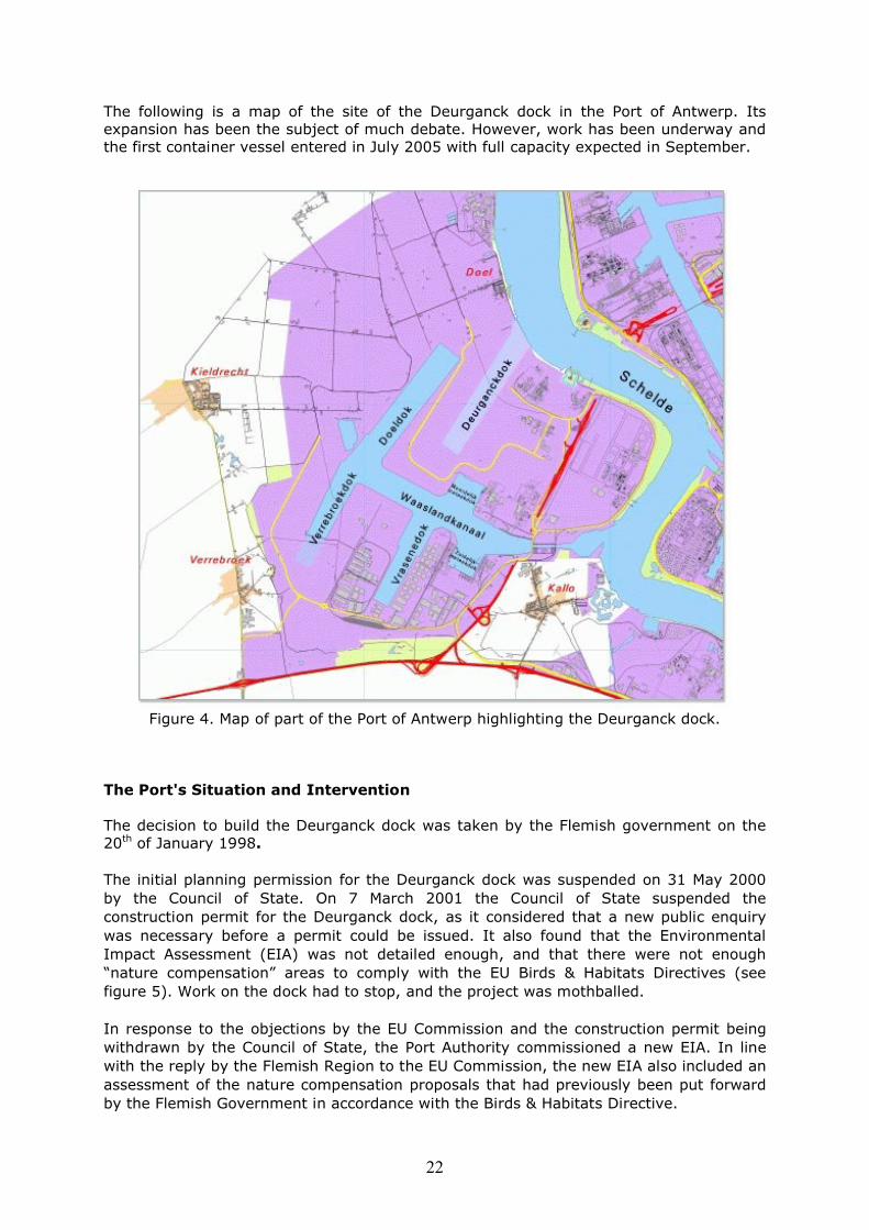
The following is a map of the site of the Deurganck dock in the Port of Antwerp. Its expansion has been the subject of much debate. However, work has been underway and the first container vessel entered in July 2005 with full capacity expected in September.
Figure 4. Map of part of the Port of Antwerp highlighting the Deurganck dock.
The Port's Situation and Intervention
The decision to build the Deurganck dock was taken by the Flemish government on the 20th of January 1998.
The initial planning permission for the Deurganck dock was suspended on 31 May 2000 by the Council of State. On 7 March 2001 the Council of State suspended the construction permit for the Deurganck dock, as it considered that a new public enquiry was necessary before a permit could be issued. It also found that the Environmental Impact Assessment (EIA) was not detailed enough, and that there were not enough “nature compensation” areas to comply with the EU Birds & Habitats Directives (seefigure 5). Work on the dock had to stop, and the project was mothballed.
In response to the objections by the EU Commission and the construction permit being withdrawn by the Council of State, the Port Authority commissioned a new EIA. In line with the reply by the Flemish Region to the EU Commission, the new EIA also included an assessment of the nature compensation proposals that had previously been put forward by the Flemish Government in accordance with the Birds & Habitats Directive.
23
The new EIA looked at the usefulness of the project and the need for such a dock, the impact on people and the environment, the most environmentally friendly alternative and possible mitigating measures. A detailed compensation plan was also drawn up for the loss of flora and fauna, in particular the loss of bird habitat and interference with birdlife in the area.
A study carried out by Ocean Shipping Consultants (May 2001) also looked in detail at the usefulness and necessity of the dock. In accordance with the procedures laid down in the Birds & Habitats Directives, the study also considered whether there were any realistic alternatives for the necessary expansion of capacity, either in the port of Antwerp or in other ports in the region (Flushing, Rotterdam or Zeebrugge). The economic analyses led to the conclusion that the usefulness and necessity of an additional dock in Antwerp were indeed very well founded. The dock fully corresponds to the need for extra capacity in Antwerp. Furthermore, the study found that neighbouring ports did not offer any locations that could provide a solution to the urgent problem of lack of capacity in the region.
On the 8th of August 2002 the Council of State suspended the revised version of the regional plan for Sint-Niklaas-Lokeren. This meant that the 1978 regional plan applied once more, at least for those areas that did not fall under the Validation Decree. This in turn meant that firstly the village of Doel was once again classified as a residential area under the regional plan, and secondly planning permission could not be granted for part of the terminal expansion on the western wharf. However, construction work on the dock was able to carry on as normal, on the basis of the Validation Decree.
All in all, construction work on the Deurganck dock was held up for more than one year. The direct losses are estimated at € 40,000,000, on the basis of the claims put forward by the construction consortium. To these must be added the commercial losses caused by the fact that current commitments could not be met. The Port Authority for its part was unable to honour contracts already made for the terminal concessions. The loss of economic opportunities also has to be taken into account, as the delays and work stoppages meant that short-term growth could not be accommodated, and service at the existing container terminals has suffered due to congestion.
The Effects of the Port Intervention
The new EIA additionally looked at the cumulative consequences of construction and operation of the Deurganck dock for nature, people and the environment, combined with the effects of construction and operation of the Verrebroek dock. The associated infrastructure on the left bank of the Scheldt was also taken into consideration, as was the raising and use of dumping areas for dredge spoil. The effects were studied individually for each discipline: the consequences for soil, groundwater, surface water, noise nuisance, air, light, safety, flora and fauna, landscape, transport and mobility, social and organisational aspects, and cross-border effects were all looked at in detail. For each of these aspects, the report makes recommendations for mitigating or nature compensation measures.
A comprehensive inventory was made of compensation measures for nature resources. In addition to the project already proposed by the Flemish Government for creating a nature-orientated, controlled flooding basin in the Kruibeke-Bazel-Rupelmonde area, this inventory included creation of the Drydijck nature-oriented area, creation of freshwater and saltwater creeks in the volume buffer, excavation of the Paardenshor saltmarsh and a number of ecological management measures within the left bank area.
The report concluded that the options put forward would cause the least offence to

24
people and the environment, and that the “status quo” and “maintenance” principles of the EU Birds & Habitats Directives were complied with. In drawing up the EIA, great attention was paid to input from other stakeholders, according to the principle of “active openness” in development of the left bank area.
On the 14th of December 2001 the Flemish Parliament approved a Validation Decreeenabling work on the Deurganck dock to resume, based on the great and pressing importance of the dock for Flanders, both generally and strategically. The decree also specified the nature compensation measures to be taken for extension of the port facilities on the left bank.
Seven applications for planning permission were submitted on the 20th of December 2001: four by the Port Authority and three by the Flemish Region. The public enquiry for the planning permissions was held from the 3rd of January to the 4th of February.Another two planning permission applications were submitted to the Standing Deputation of the Province of East Flanders at the end of December 2001. The decree of the 29th of March 2002, confirming the planning permissions issued by the Flemish Government on the 18th of March 2002, was published in the Government Gazette of 30th March 2002. Work resumed on the 13th of April 2002, and the Standing Deputation issued the two planning permissions on the 25th of April.
The Mitigation Measures
The most important mitigation measures are:- The creation of a dyke of 25m between the new dock and the village of Doel.- The filling up of half of the Doel dock to reduce the hydraulic fill of Polder land (from 450 ha to 45 ha).
The Compensation Measures
The new compensation plan in the new EIA was more detailed. The following habitats were chosen for creation/restoration.
Paardenschor (Intertidal mudflats and marshes) Drijdijck (Ecologically valuable inundated area with broad borders) KBR (Longterm extensive management grassland) Steenlandpolder (reed and water) Zoetwaterkreek-Putten West (Fresh water creek with broad borders and
reedbeds; longterm extensive management of grassland) Vlakte van Zwijndrecht (Beach and area for seabirds and colonial breeders) Doelpolder Noord (Long term extensive management grassland & tidal
Creek)
Finished Works (situation 31/12/2004)
Paardenschor Steenlandpolder Vlakte van Zwijndrecht Verrebroekse Plassen (no building permit needed) Well-managed grasslands (Disparate percelen Vlaams Gewest-Ecologically
valuable polder)
The goal is to finish the majority of the compensation works by 2006. As the habitat types for the compensations are dynamic in nature, they will be able to achieve good ecological quality already at an early stage.
25
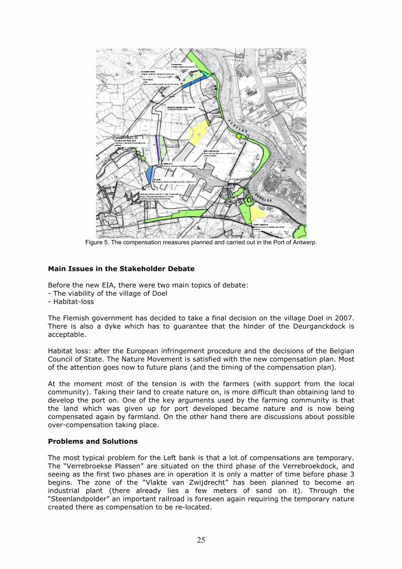
Figure 5. The compensation measures planned and carried out in the Port of Antwerp.
Main Issues in the Stakeholder Debate
Before the new EIA, there were two main topics of debate:- The viability of the village of Doel- Habitat-loss
The Flemish government has decided to take a final decision on the village Doel in 2007. There is also a dyke which has to guarantee that the hinder of the Deurganckdock is acceptable.
Habitat loss: after the European infringement procedure and the decisions of the Belgian Council of State. The Nature Movement is satisfied with the new compensation plan. Most of the attention goes now to future plans (and the timing of the compensation plan).
At the moment most of the tension is with the farmers (with support from the local community). Taking their land to create nature on, is more difficult than obtaining land to develop the port on. One of the key arguments used by the farming community is that the land which was given up for port developed became nature and is now being compensated again by farmland. On the other hand there are discussions about possible over-compensation taking place.
Problems and Solutions
The most typical problem for the Left bank is that a lot of compensations are temporary. The “Verrebroekse Plassen” are situated on the third phase of the Verrebroekdock, and seeing as the first two phases are in operation it is only a matter of time before phase 3 begins. The zone of the “Vlakte van Zwijdrecht” has been planned to become an industrial plant (there already lies a few meters of sand on it). Through the “Steenlandpolder” an important railroad is foreseen again requiring the temporary nature created there as compensation to be re-located.
26
Strengths and Weaknesses
The strength is that there is legally a strong link between the infrastructure project and the compensations (in the validation decree and the building permits). Also very important is the detailed “compensation matrix”. This is a protocol between the institutions responsible for the compensations with a strict and detailed division of responsibilities. For every compensation area the matrix states who is responsible for obtaining building permission, who takes the land, who does the designing work and who is responsible for the management.
The key weaknesses are the temporary compensation areas which rarely survive due to economic pressure and often preference for the land.
Conclusion and Future Plans
There is monitoring being carried out by the Institute for Nature Conservation and a management committee for the follow-up of the compensations.
The future framework: Strategic Planning Process
It is not the aim to plan every project in the future individually, with particular compensation for each particular project. In the Strategic Planning Process there is thewill to look at future port development on a more planned basis. Of course there are still ongoing public discussions. However, the following guidelines for the nature aspect are clear.
The first step for the topic Nature in the strategic planning process is identifying the conservation objectives. In February 2004 a document was made by the University of Antwerp. The next step was the “spatial translation” of the conservation objectives. “Spatial translation” means that the conservation objectives are expressed in surfaces of different habitats on the basis of densities of birds. For example the conservation objective for a particular duck species can be 100 breeding pairs. Reports state densities of 50 breeding pairs over 100ha of reed and water with a good structural quality, as an acceptable figure. Therefore, the compensation area needed to allow 100 pairs to establish is 200ha of reed and water.
After this calculation spatial scenarios are made. It must be clear that not only the numbers are taken into account, also factors such as noise disturbance, the shape of a nature area, abiotic situation of the area and other variables. It must be clear that the ecological research is more than only those simple calculations. The spatial scenarios place all the necessary habitats on a map. Of course there are different possibilities but there are also restrictions, for instance it is not possible to create intertidal salt marshes far away from the Scheldt. In addition particular attention was paid to the compliance of the scenarios to the obligations of the Birds and Habitats Directives. We believe that the active implementation of these scenarios by active nature development, will lead to the fulfilment of conservation objectives. This is a more pro-active way than the approach where every project is separately assessed. We believe that a non-planned way is not anoption because the Commission prefers a plan-like approach and other directives ask for research on cumulative effects.
At the moment an SEA is in preparation for the Strategic Planning Process. This has to be the basis of a new zoning plan for the area in and around the Port of Antwerp. In the planning process amenity, mobility and other factors are also taken into account. The aim is that the new zoning plan, together with other agreements if necessary, can guarantee a World-Port living together with its environment in a sustainable way.
27
References: www.portofantwerp.bewww.deurganckdok.be
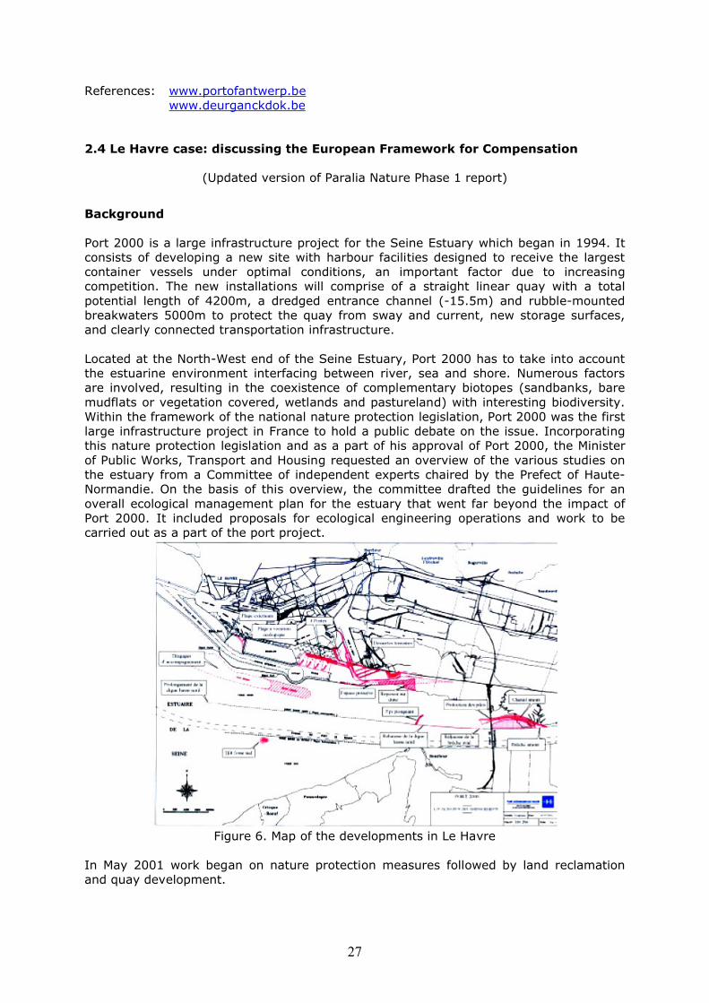
2.4 Le Havre case: discussing the European Framework for Compensation
(Updated version of Paralia Nature Phase 1 report)
Background
Port 2000 is a large infrastructure project for the Seine Estuary which began in 1994. It consists of developing a new site with harbour facilities designed to receive the largest container vessels under optimal conditions, an important factor due to increasing competition. The new installations will comprise of a straight linear quay with a total potential length of 4200m, a dredged entrance channel (-15.5m) and rubble-mounted breakwaters 5000m to protect the quay from sway and current, new storage surfaces, and clearly connected transportation infrastructure.
Located at the North-West end of the Seine Estuary, Port 2000 has to take into account the estuarine environment interfacing between river, sea and shore. Numerous factors are involved, resulting in the coexistence of complementary biotopes (sandbanks, bare mudflats or vegetation covered, wetlands and pastureland) with interesting biodiversity. Within the framework of the national nature protection legislation, Port 2000 was the first large infrastructure project in France to hold a public debate on the issue. Incorporating this nature protection legislation and as a part of his approval of Port 2000, the Minister of Public Works, Transport and Housing requested an overview of the various studies on the estuary from a Committee of independent experts chaired by the Prefect of Haute-Normandie. On the basis of this overview, the committee drafted the guidelines for an overall ecological management plan for the estuary that went far beyond the impact of Port 2000. It included proposals for ecological engineering operations and work to be carried out as a part of the port project.
Figure 6. Map of the developments in Le Havre
In May 2001 work began on nature protection measures followed by land reclamation and quay development.
28
By 2005 the large part of the quay had been completed. At the same time a number of compensation measures had been fulfilled such as the creation of an artificial island and a bird nesting area. These were achieved by the breaching of a dyke. The most important compensation measures are described in further detail below.
Ecological engineering operations / Compensation development
Mudflat restorationThe dissymmetry of the tidal currents and the action of the swell means that the estuary tends to fill with sediment (mud and sand), essentially marine in origin. These deposits of sediment are currently estimated at about 3 million cubic metres per year (those of a river origin amount to about 0.6 million cubic metres per year on average). Their main effect is that they shift the whole mouth of the estuary downstream at a speed estimated at 50 metres per year for the last 20 years, and they also cause the sedimentation of the mudflats. Additionally, the kinetic energy generated by swells and currents prevents the mud from settling. As a result, the remaining surface of the mudflats is no more than some 300ha and decreases by about 25ha each year. Dykes were created to help regulate the tides and their height was determined for this purpose.
The criteria taken into account for the selection of the most favourable potential sites for the creation of intertidal mudflats are: the abundant production of benthic fauna and flora accessible to birds and fish; the speed of succession to land because of vegetation growth, the position and function of the mudflat in an ecosystem; and the cohesion of their management with other types of environment. Several studies, including a model 1/100 horizontal and 1/100 vertical, made to model sediment motion, as well as the converging opinions of various experts, resulted in works being carried out on an area located on both sides of the Normandy Bridge.
New resting areas for birdsThe creation of a swinging area as part of the quay meant that about 30ha of Special Protection area was destroyed. In order to compensate for this resting place for birds, four hunting pools have been changed into a large resting area (around 40ha) with a nesting island in the middle.
In addition three artificial islands will also be built in the mouth of the River Seine. As shown by experiments with natural and artificial islands in other parts of the world, this small island will provide a particularly suitable site for sea birds and possibly marine mammals.
One such island was completed in 2004 and cost €10 million to construct and is intended for marine birds to rest on. It has since been effective in attracting a range of bird species and ornithologists are confident of progression in the future.
The creation of a 70 hectare conservation areaNumerous amphibians and birds along with various species of protected orchids, including the very rare Liparis Loeselii, were spared as the planned roads were moved considerably further northwards. The area became classified as a ‘voluntary nature reserve’.
Strengthening the quality and the ecological interest of the nature reservePort 2000 will help the environmental quality of the Nature Reserve of the Seine by focussing on hydraulic works and on the adaptation and sustainable integration of agriculture and hunting activities with the interests of the Nature Reserve.
Creation of a fishing observatoryA fishing observatory has been set up in order to collect data about the socio-economic aspects of fishing and to asses the impact of Port2000 both in the short and long term
29
(10 years) on fishing resources and their exploitation. Fishermen and scientists are fully involved in this initiative which is overseen by the Prefect and the Port Autonome du Havre.
Environmental follow-up of the Port2000 projectThe results of the works mentioned in the previous section on the diversity and density of the different species will be evaluated in a twice-yearly review document. These results will be presented regularly to the scientific and technical council, to the Estuary Council and to the Follow-up Committee, which as a part of the Global Management Plan for the Estuary, combines all the actors involved.
Interaction with the ECThe discussion between the Commission and France regarded the designation of an SPA of 2750 hectares in the Centre of the Seine Estuary in 1990. The Commission considered that the industry plans in the Estuary were not accompanied by sufficient protection measures and that the area was insufficiently managed.
Notwithstanding a significant extension of the SPA of 17320 hectares in 1997, France was condemned by the Court of Justice to present better propositions in March 1999. The court judged that, in particular with respect to the extension of the Le Havre port, France took the economic aspects too much into account and did not give enough weight to the scientific considerations.
A more integrated approach was developed in December 2000 for the area that resulted in the development of compensatory measures in the perspective of Article 6.4 of the Habitats Directive for the port extension. An agreement was concluded with the European Commission on the ideal site for the birds, its preservation and protection through legal measures. Furthermore, the restoration measures for the estuary are now placed under the control of the Scientific Committee. These measures are agreed upon in cooperation with NGOs.
Twice annually the progress of the compensation measures is evaluated in cooperation with the European Commission and the main stakeholders. A report of the success of implementation is also compiled for the Commission on a half-yearly basis.
The evaluation of the compensatory measures is ongoing. In the past year the designation of the navigation channels in the Seine Estuary has been drawn in to discussions. Action against the port is pending as the European Court of Justice will be taking up the case by the end of the year. In the mean time great efforts are made to establish a solid implementation and management plan for the Seine Estuary. The port hopes that this will allow it to pre-empt the queries of the court and thus permit a high degree of preparation. In a broader sense this preparation will also serve to reinstate some of the trust between the European Commission and the Port authority avoiding future incidents with respect to the dredging of the channels.
Conclusions and lessons learned
One of the most important lessons learned is the importance of having an early public debate and multidisciplinary scientific studies. This resulted in the setting up of a general coordinating body for the estuary called the Council of the Seine Estuary, and in an elaborate scientific follow-up programme, which the Port authority will finance for ten years after which the government will take over. Thanks to all these measures and decisions, all is provided so that human-induced nature development can at the same time provide port development and the rehabilitation of the Seine Estuary.
Sites are under debate with respect to the Habitats and Birds Directives as well as the Water Framework Directive. This is most likely to result in the need for compensation
30
sites for birds but also financial compensation. The current discussions about the designation of the Seine Estuary have mainly arisen from a lack of knowledge of the functions of the Estuary. Ideally, a framework should be set up for management plans to be constructed.
2.5 Port of Kotka
Port of Kotka, FinlandFuture Plans for Port Expansions2005 – 2009
Ms. Riitta Kajatkari, Technical Director, Port of Kotka
Introduction
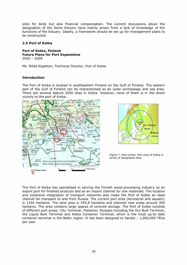
The Port of Kotka is located in southeastern Finland on the Gulf of Finland. The eastern part of the Gulf of Finland can be characterised as an outer archipelago and sea area. There are several Natura 2000 sites in Kotka. However, none of them is in the direct vicinity to the port of Kotka.
The Port of Kotka has specialised in serving the Finnish wood-processing industry as an export port for finished products and as an import channel for raw materials. The location and extensive integration of transport networks also make the Port of Kotka an ideal channel for transport to and from Russia. The current port area (terrestrial and aquatic) is 1334 hectares. The land area is 455,8 hectares and planned new areas around 300 hectares. The area contains large spaces of covered storage. The Port of Kotka consists of different port areas: City Terminal, Hietanen, Mussalo including the Dry Bulk Terminal, the Liquid Bulk Terminal and Kotka Container Terminal, which is the most up-to date container terminal in the Baltic region. It has been designed to handle 1,000,000 TEUs per year.
Figure 7. Red circles: Port area of Kotka in terms of designated sites.
31
The Port's Situation
Container traffic through the Port of Kotka is growing heavily. Also demand for car transport and storage areas is growing. Furthermore, companies linked to port operations (e.g. warehouses, logistic centres) are interested in new areas near the port. This has created pressure for the City of Kotka to plan new areas by the port for industrial use. Therefore, it is essential for the Port of Kotka and the City of Kotka to have possibilities for future expansions on port areas.
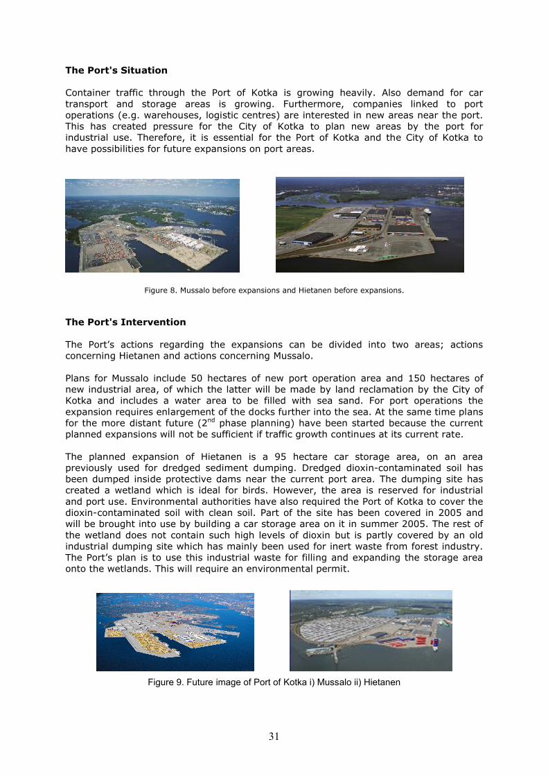
Figure 8. Mussalo before expansions and Hietanen before expansions.
The Port's Intervention
The Port’s actions regarding the expansions can be divided into two areas; actions concerning Hietanen and actions concerning Mussalo.
Plans for Mussalo include 50 hectares of new port operation area and 150 hectares of new industrial area, of which the latter will be made by land reclamation by the City of Kotka and includes a water area to be filled with sea sand. For port operations the expansion requires enlargement of the docks further into the sea. At the same time plans for the more distant future (2nd phase planning) have been started because the current planned expansions will not be sufficient if traffic growth continues at its current rate.
The planned expansion of Hietanen is a 95 hectare car storage area, on an area previously used for dredged sediment dumping. Dredged dioxin-contaminated soil has been dumped inside protective dams near the current port area. The dumping site has created a wetland which is ideal for birds. However, the area is reserved for industrial and port use. Environmental authorities have also required the Port of Kotka to cover the dioxin-contaminated soil with clean soil. Part of the site has been covered in 2005 and will be brought into use by building a car storage area on it in summer 2005. The rest of the wetland does not contain such high levels of dioxin but is partly covered by an old industrial dumping site which has mainly been used for inert waste from forest industry. The Port’s plan is to use this industrial waste for filling and expanding the storage area onto the wetlands. This will require an environmental permit.
Figure 9. Future image of Port of Kotka i) Mussalo ii) Hietanen
32
The Effects of the Port Intervention
Planned expansions in Mussalo will improve the handling of 1,000,000 TEUs per year. In Hietanen the expansion enables transport of 300 000 cars per year. These expansions also have impacts on the environment.
Mussalo
The land reclamation for industrial use managed by the City of Kotka has required a lot of environmental data and affects about a dozen households which have to move from the area. The Port of Kotka is responsible for new port operation areas. The expansion is large enough to require an Environmental Impact Assessment (EIA) and the environmental authorities have required the operations planned by the City of Kotka to be included in the EIA. The EIA will begin in 2005. Fortunately, there are no Natura 2000 sites near enough for the expansion to affect them.
Hietanen
It has been acknowledged that the site provides a welcome rest place for birds. However, permanent species have not been recorded. The covering of the wetland will destroy the birds’ habitat. As the wetland is a man-made temporary sediment dumping area and has always been assigned as development land, it will not require compensation. There are also some rare beetles on the old industrial waste-dumping site. However, they have not been designated and their habitat too will be disrupted. On the other hand, covering the dioxin-contaminated land will decrease the harm for the environment. Using the old industrial waste-dumping site as a base for the car storage requires an environmental permit which Kotka are hoping to receive this year.
The Mitigation Measures
Mussalo
The mitigation measures have been mainly managed by the City of Kotka concerning mitigations for households on the area that is taken into industrial use.
Hietanen
The requirement to cover the dioxin-contaminated land was to mitigate the impacts that dioxin-contaminated land could have, mainly for birds in this case. As the soil had high concentrations of dioxin the dumping site had to be covered. This stimulated the solution of making use of the site by transforming it to a car storage area. There is also a follow-up for post-dredge monitoring. So far it is not yet known what types of requirements areset for using the old industrial waste material for the car storage base.
The construction work is carried out with minimal harm to birds. Work is mainly done outside the birds’ nesting period and in a way that will not affect the nesting. During the construction the local bird NGO (BirdLife) was consulted. As the construction had to be made during the nesting period it was required that the water level on the areas would be increased to prevent nesting. This was unsuccessful however as nesting still took place and water levels were allowed to sink again. However, there was no damage to the birds. BirdLife carried out the monitoring of the nests during construction. There are sufficient other sites for the birds to relocate to.
33
The Compensation Measures
There are no real compensation measures. For Hietanen there are no means to compensate the wetland due to its characteristics and the fact that it was originally created by port operations.
Main Issues in the Stakeholder Debate
The issues that have already been seen or have arisen are:
Mussalo
Use of an inhabited area for industry is naturally an issue but has been taken care of the City of Kotka. It is not likely that the Port docks expansions will create debate. In case 2nd phase planning includes expansions into inhabited areas there might be debate in the future.
Hietanen
Destroying birds’ habitat is never a positive issue. However, as the wetland was a temporary area, originally created by port operations, it is not really a strong issue here. Co-operation is used when optimising the timing for constructions (to minimize the harm to birds) and when needed decreasing the water level step by step so that it will not harm the birds’ nesting.
Problems and Solutions
Hietanen
The river Kymi transports sediment, containing historical industrial pollutants e.g. dioxin, into the estuary. As the estuary tends to fill with sediment, regular dredging is required in order to keep the necessary depth of the port. As the soil has high concentrations of dioxin the dumping site has strict limitations and requirements, e.g. that it has to be covered. This stimulated a solution of making use of the site by transforming it into a car storage area. Due to the wetland the covering has to be performed during the winterusing a special technique.
Legislation for using industrial waste material (though inert) as a base for the storage area may vary from case to case. Therefore, environmental authorities have been careful with permitting the operation. With good co-operation the permit seems possible.
Strengths and Weaknesses
Strengths
Innovations made during the planning enabled reclaimation new areas and with decent costs, e.g. the use of the dredged sediment dumping site for expansion of the port. Innovations came partly through good co-operation with authorities.
Weaknesses
The expansion in Hietanen destroyed the bird habitat. Although, the wetland was originally created by port operations this might have a negative impact on the Port’s image.
34
Conclusion and Future Plans
These expansion plans for the near future, until 2009, won’t be sufficient if traffic continues to grow at the current rate. Both areas (Mussalo and Hietanen) require more port operations area. Planning of the 2nd phase has already started and most likely requires EIA for both areas. In Mussalo the planning will mean land reclamation of several hundred hectares.
Also, the River Kymi continues to bring contaminated sediment into the port, which requires constant dredging. Now that the areas previously used will be covered and transformed into a storage area, new places for dumping have to be found. If any dumping of sediment is done it will require a permit (according to the Finnish Water Act).
2.6 Conclusions with respect to the cases
The interventions are quite similar in nature across the cases examined, as well as to some extent, the ecological systems. It seems therefore, that it should be possible to draw some general conclusions of stakeholder and EU involvement as well as compensation undertaken. These conclusions can naturally not be generally applied to a larger number of cases, but characterise to a great extent the developments in other NWE coastal zones. Particularly the conclusions regarding compensation are also confirmed by other studies that did involve larger numbers of cases such as for examplethe Alterra report that studied compensation on land (2003).
Compared to the case studies of Paralia Phase I much progress can be seen with respect to the research carried out on the environmental effects of the project interventions, the integration of nature protection in decision-making, the involvement of stakeholders and the development of mitigation and compensation measures.
Table 1 display the key features of intervention in the case studies and the extent of their mitigation and compensation measures as well as the main contributing factors to promoting or hindering compensation.
Compared with Phase I there are fewer questions of uncertainty as to how to carry out an appropriate assessment than there was in the earlier report. The integration of nature protection into decision-making in a project has become common place in the Paralia cases. In all the examples mentioned nature protection is seriously considered in all steps of the project.
Furthermore, in most cases, environmental NGOs have become an important ally in developing solutions. For example in Antwerp and in Rotterdam they have clearly steered the compensation package. In the case of Le Havre NGOs are structurally involved in the monitoring of the effects.
It is interesting to note that in nearly all cases the most important driving factor is the EU or threat of EU procedures, following questions or complaints of NGOs or other parties to the European Commission. The EU as an actor is also important in the formation of compensation packages.
An item to watch for in most cases is the implementation of compensation measures. The attitude towards compensation has visibly improved as they are no longer questioned but accepted as a matter of necessity and urgency.
In all cases compensation is being carried out to some extent. This is a great improvement on the situation in Phase I and serious efforts and progress have been
35
made. Ports now recognise compensation as a requirement and work with it in mind from the outset. Restoration and creation as well as nature protection in new areas seem to be the most common methods. The factor to improve here is the instruments to facilitate their implementation.
The cases show that where grand schemes of compensation concluded by stakeholders meet local planning procedures and local resistance, the implementation of these schemes is hindered and delayed. This can be seen in nearly all cases. Particularly sectoral resistance and the objections of the local population are important. Considering this item, it seems a more advanced planning and instruments package for compensation is necessary. Compensation is a difficult matter.
First of all, finding sites is complex mainly due to the fact that compensation land must be expropriated, rented or bought by the developer or the authority responsible for compensation. This is usually a difficult task with ground already under some form of nature protection. Secondly, the regional and local planning procedures to change functions of sites or uses of space is usually a lengthy process during which there are numerous opportunities for appeal
None of the case studies thus far reached complete implementation. Therefore, this is a problem of great interest to watch. In particular with respect to methods of follow-up and monitoring.
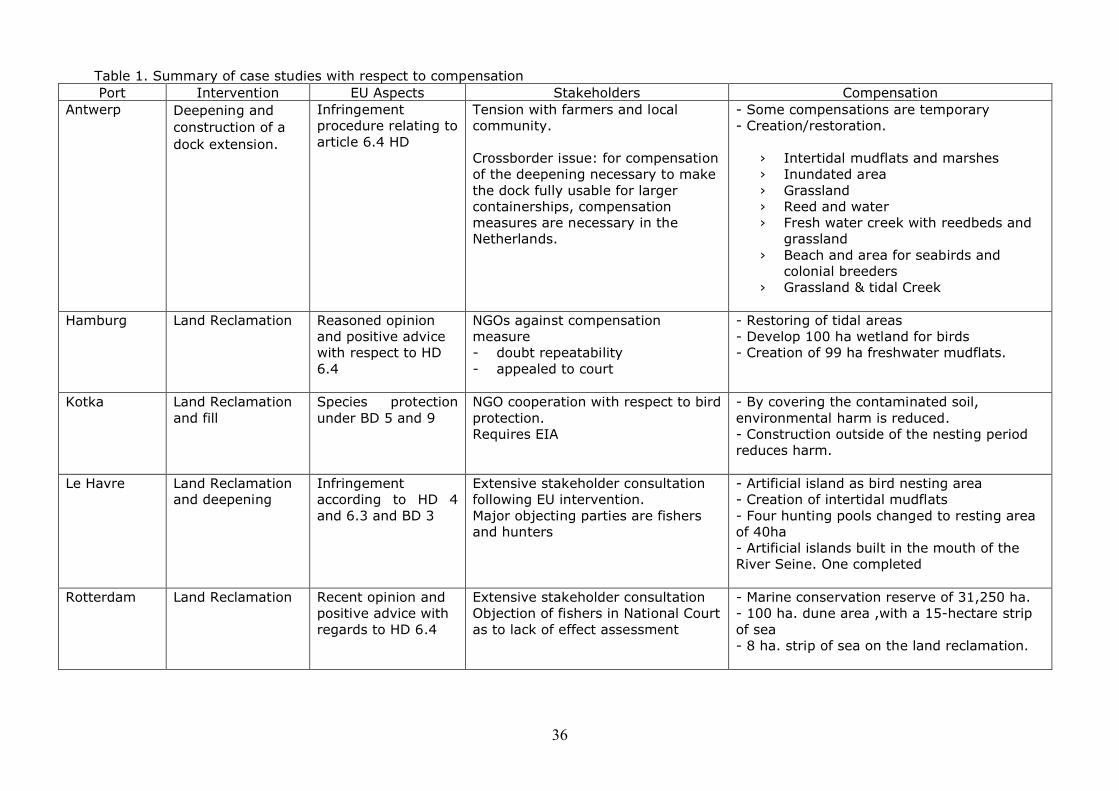
36
Table 1. Summary of case studies with respect to compensation Port Intervention EU Aspects Stakeholders Compensation
Antwerp Deepening and construction of a dock extension.
Infringement procedure relating to article 6.4 HD
Tension with farmers and local community.
Crossborder issue: for compensation of the deepening necessary to make the dock fully usable for larger containerships, compensation measures are necessary in the Netherlands.
- Some compensations are temporary- Creation/restoration.
› Intertidal mudflats and marshes› Inundated area› Grassland› Reed and water› Fresh water creek with reedbeds and
grassland› Beach and area for seabirds and
colonial breeders› Grassland & tidal Creek
Hamburg Land Reclamation Reasoned opinion and positive advice with respect to HD 6.4
NGOs against compensation measure- doubt repeatability - appealed to court
- Restoring of tidal areas - Develop 100 ha wetland for birds- Creation of 99 ha freshwater mudflats.
Kotka Land Reclamation and fill
Species protection under BD 5 and 9
NGO cooperation with respect to bird protection.Requires EIA
- By covering the contaminated soil, environmental harm is reduced.- Construction outside of the nesting period reduces harm.
Le Havre Land Reclamation and deepening
Infringement according to HD 4 and 6.3 and BD 3
Extensive stakeholder consultation following EU intervention.Major objecting parties are fishers and hunters
- Artificial island as bird nesting area- Creation of intertidal mudflats- Four hunting pools changed to resting area of 40ha- Artificial islands built in the mouth of the River Seine. One completed
Rotterdam Land Reclamation Recent opinion and positive advice with regards to HD 6.4
Extensive stakeholder consultationObjection of fishers in National Court as to lack of effect assessment
- Marine conservation reserve of 31,250 ha.- 100 ha. dune area ,with a 15-hectare strip of sea - 8 ha. strip of sea on the land reclamation.
3. Approach - Working Groups
In this section focus moves from the project specific aspects described in the case studies to the common themes as they were addressed by the working groups.
The Working Groups have met regularly in the period of 2002-2004, and the meetings included attendance of experts from NGOs, research institutes, ports, national and regional authorities, and the European Commission.
3.1 Species Protection
The main focus and deliverable of the working group on species protection was a comparative study on “Species Protection in North Western Europe within the framework of port developments”. Furthermore, this group’s attention was given to research on the relevant existing legislative provisions at the European Community and national levels (Belgium, France, Germany, the Netherlands, the UK and Switzerland). The WG elaborated and discussed on the implementation of these provisions, laying particular emphasis on practical examples and cases from port areas. The comparison revealed similarities but also large differences in approaches towards species protection in Europe, especially amongst the ports in the geographical range from Hamburg to Le Havre.
More specifically, the study describes clearly the existing legal framework at international and Community levels. This includes the Habitats and Birds Directives as well as aspects under the Environmental Impact Assessment Directive5, Strategic Environmental Assessment Directive6 and the recently adopted Environmental Liability Directive7. Consequently the study examined the legal transposition and implementation of the provisions relating to species protection in five Member States (Belgium, France, Germany, the Netherlands, the UK) and the respective situation in a non-Member State Switzerland. However, the study did not intend to check the conformity of national situations and practices against Community law.
Consequently, the study shows that the following situations currently exist in the respective countries:
o Belgium is preparing a new legal instrument on species protection for the transposition of the Community legislation in question, also in order to comply with the recent decision of the Court of Justice (C-324/01 Commission v. Belgium). In addition, a species protection plan is being set up in the estuary and port area of Antwerp with the cooperation of different actors. The ecological network that is being created will allow the management of populations according to ecological objectives and species conservation goals to be set, so as to buffer the conservation status of these species in the whole port area against partial negative impacts of maintenance and development work.
o In France, a special law provides for the management of coasts and river banks and the confiscation of land in natural areas of significant importance. There are national lists of protected species and also special regional lists for protected flora.
5 Directive 85/337/EEC of 27 June 1985 on the assessment of the effects of certain public and private projects on the environment, OJ L 175/406 Directive 2001/42/EC of the European Parliament and of the Council of 27 June 2001 on the assessment of the effects of certain plans and programmes on the environment, OJ L197/307 Directive 2004/35/CE of the European Parliament and of the Council of 21 April 2004 on environmental liability with regard to the prevention and remedying of environmental damage
38
Whenever a development affects a protected species, the competent prefecture can grant derogation. The National Council for nature protection (Conseil national pour la protection de la nature) issues an opinion, taking into account the rarity of the species and the importance of the population in question on a national scale. Accordingly, the permit will be issued conditionally either upon translocation measures, whenever the above-mentioned indicators are high, or upon different forms of compensation.
o In Germany - with respect to species protection - the Federal Nature Protection Law does not give an absolute priority to nature protection interests against other social interests. The federal states may regulate at state level that financial compensation is possible wherever Overriding Public Interests are at stake and no (other) compensation is possible. The legal regime is more developed in the case of site protection, i.e. SACs, and the Federal Administrative Court has exercised rigorous control of the alternatives considered in a case related to road construction.
o In the Netherlands, the species protection provisions have been adequately implemented, and in the Hamster case, the Council of State interpreted in an exact and strict way the provisions of Article 16 of the Habitats Directive, requiring a thorough assessment of the alternatives and a sound justification of the Imperative Reasons of Overriding Public Interest (IROPI).
o In the United Kingdom, and more particularly in England, there are two different legal instruments transposing the Birds Directive and the Habitats Directive into national law and national lists completing the Community ones. English Nature issues an opinion whenever an operation affects a protected species. Should the plan or project affect a “Community”, the developer has to ask for a specific permit. There are also practical guidelines for compensation measures issued by English Nature.
o In Switzerland, a new method of assessing nature conservation techniques has been developed, which shows the positive or stabilising trends of Red List species (Blue Lists), therefore encouraging efforts for conservation.
In addition, each Member State offers a case study on compensatory measures:
the port of Antwerp gives a pioneer example of how to take positive measures as a port authority, namely to cooperate with an NGO for the establishment of an ecological network in the port area and an overall management scheme;
France presents how the natterjack toad translocation measures have taken place in the past;
the Port of Rotterdam presents an assessment undertaken with respect to the impact of the construction of a new terminal on a natterjack toad population, latter discovered in the barren port area that was destined for the operation;
English Nature demonstrates as an example, mitigation guidelines which have been produced for the great crested newt
Switzerland presents a new method of assessing conservation techniques: Blue Lists, a new instrument which acts as a complement to the Red Lists, tracking the positive or stabilising trends of endangered or vulnerable species.
Aside from the above-mentioned study, another paper has also been produced on the legal requirements, including obligations and derogations under the Birds and Habitats Directives. This paper gives a general legal outline of Articles 12, 13 and 16 of the Habitats Directive and Articles 5 and 9 of the Birds Directive, which are the core provisions of the species protection in Community law. Moreover, the paper gives an
39
overview of international legislation concerning species protection, as well as discussing the few existing decisions of the European Court of Justice (CoJ) on species protection, in particular the Greek Sea Turtle case and the Irish Red Grouse case.
Several meetings and workshops have taken place within this group, gathering partner organisations and other experts who extensively discussed and exchanged information on the topic: On the 17th of May 2002 in Antwerp, on the 2nd and 3rd September 2002 in Zealand, on the 25th July 2003 in Brussels.
In addition, good contacts have been established with the European Commission (DG Environment – Unit on Nature and Biodiversity). On the one hand, officials of DG Environment have been regularly involved throughout the implementation of Phase II, by attending in workshops and consulting on Paralia Nature papers. On the other hand, and in view of the upcoming European Commission guidelines on species protection, Paralia Nature also proposed some recommendations for the future.
Table 1: Case study of species protection from the Port of Antwerp, BelgiumIn Antwerp a species protection plan is being set up with cooperation between the port and the NGO ‘Natuurpunt’ in the framework of a more general management plan. This management plan comprises also other objectives such as sustainable agriculture. Other actors, such as the Flemish Institute and the Flemish Administration for Nature Conservation as well as the industry and local communities are involved as consulting partners.
Due to the fact that Natuurpunt had owned or was responsible for the management of some areas of land around the port, it used to be regularly opposed to development plans of the port authorities. However, the plan for the creation of an ecological network in the port of Antwerp has brought together the port authorities and Natuurpunt. The ecological network that is being created will allow the management of the populations according to ecological objectives and species conservation goals that are to be set and it is hoped that this collective network will sufficiently buffer the conservation status of these species in the whole port area against the negative impacts of local infrastructure and development works. For this purpose, all the protected species under Community legislation or under the Red Lists have been screened in the area and the maximum number observed in the last more or less 10 years is set as conservation objective.
For the moment the compensation for developments is still conducted on a case-by-case basis, on a temporary scale, in areas that do not have a high ecological value. In the future, there will be areas for temporary and permanent compensation, on land that belongs either to the port or to Natuurpunt. This approach could relieve not only the port but also private companies from the obligation of compensating every time a few individuals of a protected species are affected by local development plan or project. The strategic environmental assessment that will be carried out will take into account the ecological objectives, emissions and mobility. This project is expected to constitute a pilot plan for other Flemish ports too.
3.1.1 Conclusions of the Species Protection Working Group
From the case studies and workshops described above conclusions and recommendations under the Species Protection Group have been summarised:
An initial conclusion of the WG was that the species protection provisions of the Birds Directive as well as the Habitats Directive are not very clear on some important points. An explanatory document similar to the EC Guidance on site protection (Article 6 of the Habitats Directive) is considered to be very useful. Therefore, Paralia Nature very much welcomes the recent initiative of the European Commission to provide more clarification through the issue of guidelines.
40
Although environmental considerations always enter into planning procedures, issues of species protection have until recently been overlooked for in most cases.
Despite the existence of Community legislation, there is little guidance and, in most cases, a corresponding interpretation of Articles 6(3) and 6(4) of the Habitats Directive has been followed, although no specific provision of neither the Birds Directive nor the Habitats Directive expressively demand so. In practice, often the approach of the Article 6 assessments of the Habitats Directive (site protection requirements) has been followed also in relation to assessments in view of species protection, in cases where protected species were affected.
As a general observation, the Birds Directive contains provisions that are in general stricter than the provisions of the Habitats Directive. National legislations vary greatly, mainly where these were established before Community legislation. This has caused unequal situations for ports of different Member States.
The case studies on translocation measures show that there is not yet sufficient knowledge of the risks of all the aspects of such operations. Further knowledge is expected to come later through the monitoring of relative operations.
The general trend seems to be the adoption of a more long-term perspective with respect to species protection planning in order to avoid lengthy procedures on a case-by-case basis. Favourable conservation status is rather to be achieved through management schemes with clear objectives and safeguarded through monitoring, a situation which shall enable development without compensation on a one-by-one basis.
The preventative approach to the issues of species protection is also in harmony with the “preventative” spirit of the new EC Directive on Environmental Liability.
NGO participation has usually been constructive and should be encouraged both at the stage of the planning and at the stage of the realisation of the development. In view of the new developments regarding environmental rights in Europe (Aarhus Convention, Directives 2003/35 and 2003/4, Directive on Environmental Liability), such engagement of NGOs will soon be not just advantageous but rather compulsory.
The challenge presented by the Habitats Directive appears to be the following: extend the scope of nature conservation and thus its management, by increasingly integrating the needs thereof within social and economic activities.
3.2 Marine Protected Areas
The relationship between management plans in the perspective of the Habitats Directive and measures to manage fisheries was explored throughout workshops in Brussels and Kiel, using examples from the Netherlands and Germany - marine protected areas (from now on MPAs) situated near the islands ‘Sylt’ and ‘Amrum’. An exploration was made of recent developments in EU Fishery policy and an informative document for European aspects was made. On the 7th of January 2004 a workshop took place in Brussels, including presentations regarding marine protected areas in France and Germany and a presentation from the European Commission on the European Marine Strategy.
The obligation to carry out protective measures for the loss of protected habitats or species at sea has given rise to proposals of MPAs, where fishing is restricted. In some cases, such areas are also meant as compensatory measures for infrastructure projects.
The implementation of MPAs, however, opens several questions of both legal and ecological nature. These questions need to be answered carefully in order to understand
41
how MPAs can be set up. Throughout discussions and analysis it is particularly important to focus not only on the EC Habitats Directive and Birds Directive, but also to focus on the implications arising from the ongoing reform of the Common Fishery Policy, as well as the current international debate on MPAs.
In the framework of the Paralia Nature project it was decided to establish a WG on MPAs. The goal of the WG was to clarify further; how and under which conditions MPAs can be established, restricting fishery or other activities, in order to provide necessary information supporting the development of MPA projects.
In order to assess if MPAs can be set up, the WG had to take into account several aspects. First of all, it was necessary to understand to what extent MPAs are compatible with the measures regulating the Common Fishery Policy (CFP) of the EU.
To some extent the creation of MPAs seems to harmonise with the fishery context of the EU. Notably, the CFP allows for a framework aiming at conservation and protection of marine resources, as stated in the Council Regulation establishing a Community System for Fisheries and Aquaculture8 (art. 2). The protection of the marine ecosystem is also necessary in order to comply with the EC Treaty obligation of integrating environmental considerations into other Community policies (art. 6 EC Treaty). Furthermore, in its Green Paper on the Future of the Common Fishery Policy9, the European Commission put great emphasis on the importance of conservation measures, partly due to the recognition of the growing threats to the sustainability of fish stocks, as a consequence, inter alia, of the over-exploitation of the marine resources.
A task of the WG was to define the conditions for the creation of MPAs, taking into account the provisions regulating the CFP and the new legal setting arising from the expected reform of the CFP. The following issues are recognised as particularly relevant:
Identification of competent authorities for the designation of the MPAs Problems of enforcement of the regulations establishing these areas Mechanisms for the economic compensation of fishermen
A second essential task of the WG was to find a way to overcome the problems associated with the existing ecological uncertainty about MPAs. This means it was necessary to demonstrate if MPAs can compensate for losses of natural habitats or species and thus ensure effective compliance with the Birds and Habitats Directives.
The evaluation of existing studies of MPAs (the report “Fully Protected Marine Reserves -a Guide” by WWF) as well as the analysis of protection measures already in place in the Wadden Sea (Wadden Sea Trilateral Co-operation) provided a useful support to the activities of the WG.
Table 2: Case study of a MPA from the National Park of Port-Cros, FranceThe Port-Cros and Porquerolles islands belong to the 37 Natura 2000 pilot sites in France. A first document has been drafted for these sites for the period 1999-2001. In 2002 a new consultation was organised by France for the presentation of Community Interest Sites, which resulted in a modification of the protected perimeter at sea. This concerns Port-Cros and Porquerolles, which are designated as Special Protected Areas under the Birds Directive.
The site managers are faced with the difficulty of dealing with the marine environment, where there is no property law. France chose the contractual option for dealing with the rural users and stakeholders, such as fishery and yachting.
8 Council Regulation (EEC) No 3760/92.
9 European Commission, COM (2001) 135 final, 20th March 2001.
42
In the Mediterranean the concerned marine habitat is the posidonia bed (grassland): aprotected species. It is a common species. However, it is threatened by the different coastal and offshore activities, such as port constructions, dike extensions, works at sea, trailing fishing nets etc.
How to organise the protection of the posidonia bed marine habitat?The protection of the posidonia bed implies the control of destructive activities:
Construction at sea regards all dike and port schemes as well as other protection systems. Since it is a protected species, all these works are subject to authorisations and impact studies. On the other hand, discharge of rubble, diverse materials or other kinds of pollution are not subject to specific permits, even though they seem more dangerous.
The posidonia bed is particularly threatened by trawl fishing, what is called ‘gangui’ in the Mediterranean Sea. Nevertheless, this traditional fishing method is in danger of disappearing and is subject to negotiations at EU level with regard to its existence and conditions of use.
Yachting is in the Western Mediterranean one of the most important activities, and the strong summer flows and activities seriously threaten the marine beds. Furthermore, the use of electric systems to lift up the anchors damages the posidonia bed. The strong recommendation, or even obligation, to use buoys in order to set upright the anchors before they are being lifted up would limit the grassland destruction. This is part of the solutions for this fishery within protected areas.
NATURA 2000 at Port-Cros and Porquerolles IslandsThe Port-Cros islands and the surrounding small islands have had the National Park status since 1963. The protected perimeter concerns 600 meters of surrounding water, making it the first European marine park. Fishery with trawl nets, as well as underwater fishing is forbidden.
The Porquerolles island has a marine zone of 500 meter, which allows the planning of protection measures for the grass bed. Thus the Port-Cros islands and the Porquerolles island are two different kinds of marine areas:
The Port-Cros has all the legitimacy to make the marine authorities adopt strong protective and user measures, e.g. they plan throughout the next three years to forbid access of boats that are not equipped with storage tanks for used water
At the Porquerolles island the legitimacy of the park, including the marine zone, is purely based on its mission determined by the site manager
3.2.1 Conclusions Marine Protected Areas
The following conclusions from the two workshops have been considered to be the most important for issues relating to MPA’s:
EC guidance on the implementation of the Habitats and Birds DirectivesThe European Commission has created a marine WG (MEG) under the Habitats Committee of November 2002. The target of the MEG is to prepare a guidance document on the implementation of the Habitats Directive and the Birds Directive in the marine environment and furthermore, to develop a more long-term perspective of reviewing the marine interests of the annexes of the Birds and Habitats Directives. Three sub-WGs have been established under the MEG. The first WG will propose new habitat types and species as well as precise definitions of existing marine habitats. The second WG will propose means to locate and assess the habitat types and
43
species. The third WG will consider management measures for site protection and alternative/complementary conservation measures for wide ranging species.
Designation of a marine protected area in accordance to the German lawThe German federal state Schleswig-Holstein issued a law for the North Sea in order to protect further marine sites, and two protection zones have been designated in accordance to the regulation. This German example of designating a MPA in accordance to the German law - next to the National Park Wadden Sea Schleswig-Holstein - shows it is possible in practise to carry out a zero-use zone in the marine environment. Furthermore, European procedures have been prepared in Schleswig-Holstein, which will start at the end of 2004 with the purpose of restricting fishermen from other Member States, especially fishermen from Denmark and the Netherlands, with regards to the designated MPA.
One of the possibilities to take measures preventing fishery within the German designated MPA is the ‘Council Regulation (EC) No 2371/2002 on the conservation and sustainable exploitation of fisheries resources under the Common Fisheries Policy’. However, there seem to be lack of experience with this regulation. Concrete measures have been planned to prevent fishery within MPAs, and it seems useful to follow-up and exchange further experiences with prospective to implementation of the measures.
Valuable experiences with management plans of marine areas in the UKThe UK in particular has put a great effort into the development of management plans for the marine environment, e.g. the development of the Coastal Habitat Management Plans (CHaMP). CHaMPs are approaches to strategically manage coastal habitats and wildlife. They identify and predict habitats’ losses and gains, and come up with measures of how to mitigate and compensate for prospective habitat losses. These measures include modifications of existing flood and coastal defences in order to keep pace with rising sea levels.
A Belgian federal law for the North SeaBelgium has a Federal law for protection of the marine environment in the North Sea. So far designation of MPAs has not been carried out in the Belgian part of the North Sea. However, proposals for SPAs have been submitted by MUMM and some scientific institutions, and the ‘new’ Belgian Minister competent for the North Sea intends to apply the law to designate SPAs in near future.
Management plans contra designation of marine protected areasDiscussions have taken place in view of whether to designate MPAs prior to the development of management plans for the MPAs or the other way around. It was stated that designation of MPAs should not happen at least until it is clear what the management plans will contain. However, considerable opposition stated that currently it is urgent to designate MPAs, this cannot wait until the management plans have been carried out in practise. Thus it can be concluded that it seems better to designate prior to the management plans. In view of management plans for MPAs there is a considerable interest in sharing further knowledge and information.
Experiences with management plans in the Mediterranean countriesIn some Mediterranean countries there are advanced experiences with development of management plans for designated areas in the marine environment, such as the Port-Cros and Porquerolles islands. The scale of projects seems to be smaller compared to scale of projects in North West Europe. Nevertheless, it could be valuable to compare further MPAs in Northern and Southern Europe as well as stakeholder participation in the development processes in order to obtain agreement on management measures.
44
3.3 Management Plans - Compensatory Measures and Monitoring
Several WG meetings were held, the larger being the one organised in Zealand (the Netherlands) in September 2002. With respect to development of management plans, following issues have been identified as key issues: scope, objectives, organisation structure, financing, monitoring, reporting, and evaluation. More specifically, with respect to monitoring and evaluation the WG set two main goals which were to be pursued throughout Phase II: to gather material on country initiatives and to explore possibilities for developing guidelines on monitoring and evaluation at project level.
Within this framework, an overview was given of possibilities for discussing with the European Commission and availability of European information. In addition, two documents were produced with regard to the financial aspects of compensatory measures and furthermore, the dynamics of Natura 2000. From these studies it appears that political considerations play an important role in the decision-making processes of the port projects and have considerable impact on the compensatory measures. The cost of the compensatory measures related to the total costs of the projects can be relatively high. But again, financial sources used in the port projects vary widely.
The latest workshop of the WG was organised in December 2003 in Brussels and dealt with ecological objectives and indicators of Natura 2000 areas. The organisation of such a topical workshop was seen as a necessity, as it derived from past discussions that:- firstly, these objectives and indicators form an important prerequisite for all three actions: management plans, compensatory measures, monitoring;- secondly, a number of questions with respect to the development of ecological objectives and indicators concern many European actors, and various approaches exist across Europe.
The workshop sought primarily to give a clear picture of the existing requirements for developing such objectives and indicators at EC level, in particular in view of the requirements under the Birds and Habitats Directives - and by extension of the Water Framework Directive. In addition, the workshop sought through presentations of the different situations in the UK, the Netherlands and Belgium to contribute to the exchange of experience with practical solutions.
The European Commission’s composite report on the implementation of the Habitats Directive shall show the progress achieved to date, including the efficiency of the Directive and in particular of the Natura 2000 network. The 1st report covers the period 1994-2000. However, it is the 2nd report for the period 2001-2006 which shall enable a first assessment of the conservation status in the Member States (expected in 2007). The European Commission is currently working on the establishment of a common framework for monitoring, by seeking an agreement on information requirements, common approaches and standards for gathered information, data management and reporting structures. An important tool for undertaking work on monitoring is the Internet-based discussion forum CIRCA, dealing with data management and reporting, sampling, definition and interpretation of key terms etc. The end goals are amongst others, to obtain a clear picture of conservation status across the EU and of trends in conservation status and acquire clear indications of where resources are required to solve problems. Although not obligatory, the European Commission encourages the establishment of management plans. LIFE-Nature - the funding program within DG Environment - has proved to be a valuable tool for developing such management plans in several countries and cases (a “pool” of good examples can be found at the website of DG Environment: http://www.europa.eu.int/comm/environment/life/project/index.htm).
45
Table 3: Development of management plans in the Netherlands, Flanders and the UK In the Netherlands the competent authorities responsible for the implementation of
the Birds and Habitats Directives in national waters are the Ministry for Agriculture, nature and Food Quality (LNV) and the Ministry for Transport
The Netherlands are currently in the process of developing management plans for protected areas under the EC nature conservation legislation. In view of imminent amendments to the Dutch Nature Conservation Act, it is currently being discussed whether management plans should become mandatory.
In order to implement Natura 2000 requirements, a national project also called “Natura 2000” has been set up by several Ministries in order to develop the conservation objectives; to provide guidance for management plans; to provide guidance for “designation documents” and to facilitate by providing specific input other policy processes, e.g. the Water Framework Directive. There are currently a number of pilot projects taking place in nine different European sites, e.g. estuary, coastal area with freshwater, lakes, forest, etc. The objective is to learn from all these pilots while developing the conservation objectives and/or management plans for these sites.
In Flanders (Belgium) the 1997 Decree on Nature Conservation provides for setting up management plans, including conservation objectives and indicators for Natura 2000 sites. In addition, it is obvious that in cases of port developments conservation objectives are urgently needed. The definition of conservation objectives and the identification of indicators in Flanders were the subjects of three different studies. Different strategies, approaches and methodologies were adopted in each of the studies, partly because the managerial, administrative, juridical and ecological level differed.
In the first study objectives and indicators are set for each individual protection area based on expert judgement - starting from the Annexes of the European Directives, in terms of habitat types and quality. The second study attempts to set conservation objectives for the integrity of the Natura 2000 network in the port areas, by the use of a combination of a qualitative and quantitative analysis. The third study follows the ‘ecosystem health’ approach for the whole estuary, and as such considers the functionality of the estuary in all its functions, including its habitat function for populations.
The Habitats Directive was transposed into UK national law in the Conservation Regulations of 1994. These make English Nature and Countryside Council for Wales responsible for advising relevant authorities on the conservation objectives for European marine sites in England and Wales. Furthermore, they advice on any operations which may cause deterioration of the natural habitats or disturbance of species for which the sites have been designated, or cause the deterioration of habitats of designated species.
The advice is used by the competent authorities to develop management plans for the sites and furthermore, to define the scope and nature of “appropriate assessment” of plans and projects that might have adverse impacts on the sites -corresponding to the requirements of Article 6(3) and (4) of the Habitats Directive. This assessment of plans and projects is known in the UK as “review of consents”. It is carried out in a three steps process involving: 1) an assessment of the sensitivity, 2) an assessment of the exposure, and 3) a final assessment of current vulnerability of the features of interest (species or habitat) or their component sub-features to operations.
46
Another interesting topic explored was the new Water Framework Directive, adopted in 2000, and the links to the Habitats Directive. The recently adopted Directive seeks to achieve environmental objectives for water bodies (Article 4) mainly through the identification of a programme of measures (Article 11) and River Basin Management Plans (Article 13), and provides for various types of monitoring (Article 8) in order to measure success or investigate causes of failure. The Water Framework Directive makes a number of references to the Birds and Habitats Directives. In particular:
Article 6 requires a “register of… areas… designated as requiring special protection under specific Community legislation for…the conservation of habitats and species directly depending on water”, including relevant Natura 2000 sites and in particular, as provided under Annex IV, “areas designated for the protection of habitats and species where the maintenance or improvement in the status of water is an important factor in their protection…”.
The list of measures under Annex VI which should be part of the programme of measures (Article 11) includes the Birds Directive 79/409/EEC and the Habitats Directive 92/43/EEC.
The required information to be included in the River Management Plans (Article 13 and Annex VII) shall provide amongst others for identification and mapping of, and results of carried out monitoring programmes for protected areas.
Since conservation objectives have now largely been or are planned to be drawn up for many sites under the Habitats Directive, the critical question is to what extent they will influence standards and objectives under Article 4(1c) of the Water Framework Directive, noting that Article 4(2) of the Water Framework Directive requires the Member States to use whichever objective is most stringent. Another issue is the management plans. These must compare and reconcile different objectives and measures for all features noted under different legislation. If this is not done in a single plan, the various competent authorities will be left with the much less workable solution of having to reconcile features at different levels with two sets of objectives and in two sets of plans.
3.3.1 Conclusions Management Plans - Compensatory Measures and Monitoring The main conclusions under these working groups are as follows:
Regarding the availability of existing data, it seems that the information produced by the NGOs for monitoring at project level is not always readily available and uniform. In addition, condition monitoring is often limited to species indicators and not focused on the entire project
Although the concept of Favourable Conservation Status (defined in the Habitats Directive) is not provided in the Birds Directive, the European Commission sees this as applying to both the Birds Directive and the Habitats Directive. This approach corresponds to the European Commission’s viewpoint that the two Directives should be looked at and implemented in a coherent way and should build together a common instrument for protecting nature
More guidance (at EU level) is deemed to be necessary with respect to development of ecological goals for bio-geographical regions as well as for individual sites; more guidance (at EU level) is also needed on how the set of conservation objectives will be translated into management plans
There are quite a number of issues of interpretation and consideration of both the Habitats Directive and the Water Framework Directive in relation to management plans, e.g. Article 4(2) of the Water Framework Directive requires the Member States to use whichever objective is most stringent. However, determining which is the most stringent is likely to be quite difficult
An initial comprehensive evaluation / assessment of the conservation status in the Member States is only expected in 2007 upon submission of the 2nd report of the Member States for period 2001-2006
47
In addition, one could summarize following recommendations:
Surveys carried out in the context of an environmental impact assessment (from now on EIA) could be used for monitoring of zero measurement
The frequency of monitoring should be flexible, i.e. adapted to the effective needs. In particular, it appears that it is wiser to monitor more frequently during the first years and decrease afterwards
Following the above, the Favourable Conservation Status should be a target not only for Natura 2000 habitats and species, but also for the species of Annexes IV and V of the Habitats Directive, and all bird species. In other words, Favourable Conservation Status should be a general goal within as well as outside of the protected areas
The definition of Favourable Conservation Status proves to be broad as stated in the Directive; further specification would facilitate implementation in practice.
Although management plans are not obligatory but only optional under the Habitats Directive, it is strongly recommended – also by the European Commission – that Member States introduce such schemes for the better management of the protected areas
Member States should produce adaptive management plans which make it possible to integrate other requirements, such as the Water Framework Directive, in the future
Attention should be drawn to developing conservation objectives which are manageable and moreover, feasible to monitor and evaluate
In some countries, e.g. the Netherlands, it is the intention to avoid a complex situation with multiple management plans for a specific area. In case management plans for SPAs/SACs become mandatory, the responsible authorities should try to integrate those management plans in other management plans, e.g. a management plan in view of the Water Framework Directive
4. Demonstration project NEW Delta
One of the challenges undertaken by the Paralia Nature partnership during Phase II was to foster the development and implementation of demonstration projects, such asrestoration projects. To this extent, Paralia Nature initiated and greatly supported the creation of a new partnership and the design of a new project: NWE Delta. In order to financially support implementation of this idea and the costly demonstration projects, a project proposal was developed and submitted to the Interreg IIIB North-West Europe Programme.
The NWE Delta project proposes a combination of transnational actions to be developed under six interdependent themes. Each of these themes relates to different requirements of Article 6 of the Habitats Directive, namely:
Three themes relating to management activities and exploration of proactive interventions: establishment of ecological goals and indicators, creation and restoration of coastal and estuarine habitats, and long-term cross-sectoral port and estuary visions.
The other three themes place emphasis on setting requirements and substantiating existing safeguards under Article 6 - for cases where plans and projects may have adverse impacts on Natura 2000 sites: effect relationship methodologies, sustainable dredging strategies, coastal morphology and coastal defences in the vicinity of ports.
The project enables implementation of two large investments, i.e. physical constructions, which demonstrate how creation and restoration of habitats can ideally be combined with port related activities that initially conflicted with nature conservation objectives. One investment, to be undertaken in the areas of De Zilk dunes (in the Netherlands), shall
48
demonstrate the beneficial links between natural habitats and nature of industrialised port areas in close proximity. It displays how restoration of habitats within a dune area can achieve a range of benefits via a construction project, i.e. enhancement of nature resources, flood protection, recreational functions, agricultural benefits etc. The second investment - to be implemented within the port area of Antwerp - shall build a network of ecological infrastructure, so natural habitats and species ‘cohabit’ with maritime, industrial and other harbour activities.
Partners include port organisations (ports of Antwerp, Rotterdam, Rouen, ABPmer) as well as regulators and licensing authorities (The Regional Directorate of Haute Normandie of the French Ministry of Environment, Agence de l’Eau, Province of South Holland (project lead partner) and The Ministry of the Flemish Community). Academic and research institutes (Technical University of Delft, Alterra, IMI) bring in their expertise which they expect to enrich throughout the project implementation. Four countries are represented in the partnership: Belgium, France, the Netherlands, and the UK. Observers represent other countries, such as Germany.
The Interreg III Programme secretariat approved the NWE Delta project in June 2004; the project implementation formally started in July 2004 and shall be completed within the coming three years.
5. Dissemination
Both Paralia Nature as a partnership and each partner individually made efforts and will continue to foster dissemination of the projects results. Target-groups included other national, regional or local authorities, ports and NGOs.
Some of the Paralia Nature documentation shall be introduced in the CIRCA information platform under the Groups of “Monitoring and Nature Directive” and/or “Article 12/ Species Protection”. The platform is a communication tool of the European Commission (DG Environment) on environmental legislation and policy, so far used with restrictive access and aiming at exchange of information among stakeholders. Recently it has become publicly accessible.
In 2003, a joint conference was organised with a number of other sectoral organisations: the European Sea Port Organisation (ESPO), EUDA (the European Dredging Organisation) and PIANC (Port International Navigation Association). This conference was visited by a broad collection of stakeholders from academia, NGOs, governmental and port representatives from European, National and local authorities.
In addition bi-lateral meetings with sector organisations and NGOs were organised. Furthermore, from all the workshops and meetings reports were made for external dissemination which are available on the website. For a list of these products, see Annex 1 of this report.
Finally, in the course of 2003 a website that includes an open discussion platform was established: www.imiparalianature.org
6. General conclusions: Looking back and looking ahead
The updated case studies as well as the material of the workshops show that increasingly, stakeholders and ports are learning, sometimes by `muddling through’ how to incorporate and deal with the aspect of nature protection in the decision-making process of extensions and in the development of protective measures.
In comparison to Phase I there are much fewer problems with the effect studies than in the preceding years. Now that the methodology of the research and the steps of 6.3 and
49
6.4 are familiar topics, the issues relating to the effect studies particularly relate to methodologies for the identification of significance and the way in which gaps in the research are dealt. This has taken over from concerns relating to obvious omissions or misunderstanding of the basic requirements.
The issues identified now that need further work relate particularly to the implementation of compensatory measures and the development of management plans.
From the case studies and the material of the working groups the following findings can be reported that also need further exploration:
The factors that delay or facilitate the development of mitigation measures. Mitigation has already been given much attention in the cases, but as the implementation of compensatory measures is a lengthy and often complex task, it seems worthwhile to look at methodologies or strategies that would look at how to further mitigate.
The factors that delay or facilitate the implementation of compensation measures. Particularly from the case studies it turns out that the implementation of compensation measures is often stopped or slowed down by local interests, physical planning procedures, or resistance interest groups such as farmers or the local community. This eventually may not only endanger the condition of a protected site, but in the end can also stop or slow down project implementation. Furthermore, compensation must be available and in operation before projects can be implemented. This topic needs further attention. In 3 out of 5 cases compensatory measures including comparable nature are slowed down. Notably, contrary to popular belief, it is not the European Commission procedures that cause delay in the finding of solutions, but particularly procedures in Member States and local circumstances. It seems useful to explore a more advanced and developed planning of compensation.
The cross-border aspect. As designation of sites and the application of Article 6.3 and 6.4 is particularly a national matter (in more federally organised states a regional matter) the implementation of site protection in border zones, where the regimes are different on each side of the border, usually gives rise to problems. This aspect needs further attention, as it can lead to situations of stagnation when on one side of the border measures are taken that counter the effect on protected nature of measures taken on the other side. Or, for example when the conservation objectives on one side of the border mean that effects of a project are not considered as significant, while on the other side more strict conservation objectives would conclude that the effects are significant. Current formal mechanisms within federally organised Member Sates and formal mechanisms between EU countries do not seem sufficient to deal with such issues within short time-frames. Currently the only way to address this issue is for Member States to start a bi-lateral initiative, but this can only take place where both sides have the willingness to co-operate.
The further development of management plans. In some Member States, more than others, advances have already been made with the development of management plans for protected sites. Now the list of EU sites is designated, the practicalities and contents of these systems become more important, as for example issues relating to conservation objectives and the actual experiences with systems of monitoring and evaluation to control the performance of these management schemes. Various sources have stated the importance of a regularly evaluating the performance of these management systems, that are for a large part based on voluntary regulation. Now that some management plans havealready been in place for a couple of years and must have more tangible results it
50
may be of interest for new plans that are being developed to learn from those experiences.
In addition to the management plans for the HD, for some sites an extra effort is needed. The management plans and protective measures need to be set up in line with the requirements of the Water Framework Directive. Although this issue did not come out of the case studies, it was a relevant issue coming out of the working group on Management Plans. Clarification of the links between the HD and WFD may become more important in the near future, when progress has been made with implementing the requirements of the WFD.
These findings and recommendations have been used as a direction for development of the upcoming Paralia Nature Phase III. Some of these, in particular for compensation,were also confirmed by studies carried out in perspective of comparative studies relating to HD an BD requirements in for example The Netherlands (Alterra, 2003), France, (.) and the comparative evaluation study on Natura 2000 and the BD and HD done by the European Union in 2003.
7. Follow-up
Plans for Phase III were developed in 2004 following up on the general conclusions of the case studies and working groups of the prior phase, and included the following attention points for its programming:
Solve legal and organisational problems related to the development of management plans under the Habitats Directive and the corresponding requirements under the Water Framework Directive
Deal with the implementation of compensatory measures and resolve imminent legal and administrative issues
Provide an insight of what “EU proof” solutions could be by involvement of top ecological and legal experts
Present to EU policy developers the practical result of EU policies locally and regionally implemented within port areas and coastal zones and thus to convey more directly the consequences of EU policy in practice
Establish a level playing field between ports in North West Europe regarding solutions for implementation of the Birds and Habitats Directives and other related EC requirements
Eventually develop contacts and exchange experience and knowledge with organisations in other areas of Europe.
Issues already worked out further, that are of importance for the next phase include:
Temporary Nature Management Plans EU court decision Natural Asset Creation
Paralia Nature Phase III started in July 2004 and will last until June 2007.
51
ANNEX 1
The direct output of the phase was as follows:
Workshops- Report on Ecological Goals and Indicators workshop, 1st December
2003- Report on MPA Workshop, Brussels 7th January 2004
Memos- Financial aspects of compensation and mitigation, Balasz Meller and
Frank Neumann, briefing memo 2003- Decision-making on compensatory measures, Hasse Petersen, 2003
Reports- Public access to EU documents (in Dutch), H. Woldendorp, 2002- The European Complaint Procedure (in English), H. Woldendorp,
2002- Species protection in ports - comparison of practices in Flanders,
Germany, the UK and the Netherlands (in English, French summary), D. Papadopoulou, 2003
Website, including discussion platform- www.imiparalianature.org