Embed Size (px)
Citation preview
p a
r k n
o
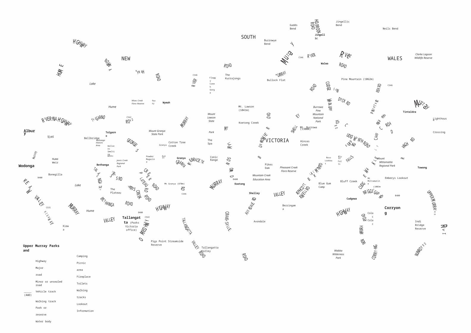
Upper Murray Parks & Reserves
Visitor GuideLocated in the northeast of Victoria, toward the upper reaches of the Murray River, are a
number of spectacular parks and reserves. These natural attractions contain rugged
mountain peaks, rocky outcrops and waterfalls and offer spectacular views over the
surrounding countryside. The varied terrain is home to numerous rare species of flora
and fauna and provides for a range of recreational activity.
Burrowa-Pine Mountain National ParkBurrowa-Pine Mountain National Park (18,400 ha) consists of two rugged and contrasting mountains. The park boasts impressive scenery, diverse habitats and significant flora conservation values.
Bluff Falls - a spectacular set of waterfalls exist where water cascades off the park plateau, over Cudgewa Bluff and into a tranquil grotto below.
Bluff Creek Nature Trail - this short walk (4 km return) meanders through moist ferny gullies and tall stands of Blue Gum trees as it links the Bluff Creek visitor area with Bluff Falls.
Mt Burrowa – this remote peak, the highest in the park (1,300 m), is often snow covered in winter. It can be reached by a number of walking tracks, all of which are long and strenuous.
Pine Mountain - is a gigantic rock monolith reputedly one and a half times as large as Uluru (Ayers Rock). The walk to the top over imposing rock outcrops (12 km return) is difficult, but good views are available from Rocky Knob after 1 km.
The Lookouts Walking Track - a steep walk from Bluff Falls that climbs past Campbells Lookout (700 m) to Ross Lookout (6 km return). It offers excellent views of the park and surrounding countryside from vantage points along the way.
Picnicking and camping - basic visitor facilities are provided at Bluff Creek visitor area, Blue Gum Camp, Hinces Creek and Pine Mountain.
Mount Lawson State ParkMount Lawson State Park (13,150 ha) is known for its steep slopes and prominent rocky bluffs.The park contains a range of natural environments with significant conservation values
Mt Lawson summit - the highest point (1,041 m) in the park provides outstanding views north over the Murray River and south to the Victorian Alps.
Summit Loop Nature Trail - a short circuit walk (1 km) that meanders over and around the interesting rock outcrops on Mt Lawson summit.
Conic Range Walking Track - this short walk(1.5 km return) from Firebrace Track provides spectacular views over the northern sections of the park from amongst giant granite boulders.
Flaggy Creek Gorge Walking Track - a rugged walk (14 km return) to the waterfalls and rock pools within Flaggy Creek Gorge. Panoramic views are available from Valley View after 1.5 km.
Koetong Creek Walking Track – this walk leads to The Spa (4 km return), an interesting rock chute and swimming hole within Koetong Creek.
Picnicking and camping – basic visitor facilities are provided at Koetong Creek, Mt Lawson summit, The Kurrajongs and Conic Range.
Mount Granya State ParkMount Granya State Park (6,140 ha) has steep, forested slopes that rise dramatically above Lake Hume and surrounding valleys. The park features diverse vegetation and wildflower displays.
Mt Granya summit - the highest point in the park (870 m) contains a communications and fire spotting tower. Impressive views are available, particularly from the Georges Creek lookout.
Lyrebird Loop Nature Trail - this short walk (400 m return) wanders around the summit of Mt Granya. Lyrebirds can often be seen or heard.
Granya Falls - this seasonal waterfall can be reached after a short walk (1.4 kms return) from the nearby Cotton Tree Creek visitor area.
For more information call the Parks Victoria Information Centre on 13 1963 or visit our website at www.parks.vic.gov.au

For further informationParks Victoria
Information CentreCall 13 1963
or visit the Parks Victoria website
www.parks.vic.gov.au
Parks Victoria Tallangatta Office
34 Towong StTallangatta VIC 3700
Phone: (02) 6071 5301
Tourist informationCorryong
Visitor Information Centre50 Hanson St
Corryong VIC 3707Phone: (02) 6076 2277
Victorian Bushfire
Information Line
Phone 1800 240 667
This park is in the North- East Total Fire Ban
District
ABC Radio
Tallangatta area106.5 FM
Corryong Area99.7 FM
Rubbish and recyclingCorryong Landfill
Sugarloaf RoadTues & Thurs 4pm – 6pm
Sat 8am – 12pm Sun 12pm
– 4pm
Tallangatta Transfer StationMV Highway 1 km west of
townTues & Thurs 10am – 12pm
Sat 8am – 12pm Sun 12pm
– 4pm
Please don’t throw this park note away. Keep it, return it for others to use, or recycle
it
Healthy Parks Healthy People
Visiting a park can improve your health, mind,
body and soul. So, with over four million hectares of
parkland available to Victorians, why not escapeto a park today! Mount Granya State Park (cont’d)
Scout Hut - a log hut, built by the Granya Scout Group c1937, is located on the walking track between Cotton Tree Creek and Granya Falls.
Georges Creek Powder Magazine – built c1960, this concrete structure once stored explosives used to construct roads in local forests.
Mt Granya Walking Track – this walk (10.4 km return) through open forest links Cotton Tree Creek with Mt Granya summit via Granya Falls.
Picnicking and camping - basic visitor facilities exist at Mt Granya summit and Cotton Tree Creek.
Jarvis Creek Regional ParkJarvis Creek Regional park (2,510 ha) consists of two major ridges that join to form a broad plateau. The park contains a diverse range of wildlife.
Plateau Road Scenic Drive - this 2WD, fine weather, gravel road (14 km) offers a pleasant forest drive through the park between Jarvis Creek Road and Georges Creek Road.
Picnicking - basic visitor facilities are located at The Plateau picnic area on Plateau Road.
Mount Mittamatite Regional Park Mount Mittamatite Regional Park (4,280 ha) is a striking feature in the landscape; its rocky slopes rise sharply from the surrounding plains and provide shelter for numerous rare plants.
Mt Mittamatite summit - located on the highest point in the park (1,003 m) are radio and aviation communication facilities and a fire spotting tower. Rock climbing and abseiling often occur nearby.
Emberys Lookout - provides spectacular views of the Kosciusko Main Range (NSW) in winter.
Picnicking - basic visitor facilities are provided at Emberys Lookout and at Mt Mittamatite summit.
Bethanga Historic AreaThe Bethanga Historic Area (230 ha) protects sites of historical significance associated with gold and copper mining activity in the area during the late 1800’s. This reserve includes the remains of Wallace’s Smelting Works, constructed to treat local gold and copper bearing ore.
Wabba Wilderness ParkWabba Wilderness Park (20,100 ha) is important for its high nature conservation values and essentially natural water catchment.
Visitors can enjoy solitude, and appropriate self- reliant recreation. No public vehicles or domestic animals are permitted.
Mountain Creek Education Area Mountain Creek Education Area (770 ha) provides opportunities for studies that promote an understanding of the natural environment.
Mountain Creek Nature Trail - this short circuit walk (2 km) has numerous natural and historic features of interest along the way.
Pheasant Creek Flora Reserve Pheasant Creek Flora Reserve (200 ha) contains a number of sub-alpine, wet health vegetation species
unique to the district. Pikes Dam is a popular swimming and picnic location.
Murray River ReserveA number of sites along the Murray River provide opportunities for camping swimming, fishing, canoeing, bird watching and other passive recreational pursuits. These include:
• Burrowye Bend Gadds Bend• Jingellic Bend Neils Bend• Lighthouse Crossing Indi Bridge• Bullock Flat• Clarke Lagoon Wildlife Reserve• Pigs Point Streamside Reserve (located
on the Mitta River)
Please take care!• Trees, particularly River Red gums, may fall
or drop limbs at any time - avoid camping, parking or picnicking beneath them.
• Weather conditions can change rapidly at any time - be prepared with warm and
waterproof clothing and high energy food supplies.
• Cold water, fast currents and submerged hazards in the Murray River can be dangerous- avoid diving into rivers or using tree swings.
• Walking conditions can be rough, and rocky areas slippery when wet - wear sturdy footwear.
• Many parks have limited permanent water - carry adequate drinking water when walking.
• Remote walking tracks may be poorly defined– carry a detailed map and compass or GPS.
• Abandoned mine shafts may exist in some areas - take care if walking off track.
• Cliffs and rocky bluffs occur in some areas - be alert near the edge and look out for falling rocks.
August 2012 Printed on Australian-made 100% recycled paper
M
toK
hancoban
i v e
R D
N
T
F
O
Trees, particularly River Red Gums, may fall or drop limbs at
any time. Avoid camping, parking or picnicking beneath
them.
SOUTHBurrowye Bend
Gadds Bend
Jingellic
Jingellic Bend
Neils Bend
NEW C546
Walwa
WALESClarke Lagoon
Wildlife Reserve
W
Lake
C546Flaggy Creek Gorge
The Kurrajongs
Bullock Flat Pine Mountain (1062m)
C546
Hume
I C542
Wises Creek Flora Reserve
ferryWymah
Mount Lawson State
Mt. Lawson (1041m)
Koetong Creek
Burrowa Pine
Mountain National
Park
Mt. Burrowa (1300m)
Tintaldra
Lighthouse
Albury
BellbridgeBethangaHistoric Area
Talgarno
Wallaces Smelting
Mount GranyaState Park
GranyaCotton Tree Creek
Park
The Spa VICTORIA Hinces
Creek
Crossing
Wodonga
Hume Weir
Bonegilla
Works
BethangaJarvis Creek Regional Park
PowderMagazine
Falls Granya Conic Range
Pikes Dam
Mountain Creek
Pheasant Creek Flora Reserve
Ross Lookout
BluffFalls Mount
Mittamatite Regional Park
Towong
B400
LakeThe Plateau
Mt Granya (870m)
C546
B400
KoetongEducation Area
Shelley
Blue Gum Camp
Bluff Creek
Cudgewa
Mt Mittamatite(1003m)
Emberys Lookout
B400
C531
Kiewa
HumeB400
Tallangatta (Parks Victoria
office)
C543
Avondale
Berringama
Colac Colac
Corryong
Indi Bridge Reserve
Upper Murray Parks and
Highway
Major road
Minor or unsealed road
Vehicle track (4WD)
Walking track
Park or reserve
Water body
Camping
Picnic area
Fireplace
Toilets
Walking
tracks Lookout
Information
Pigs Point Streamside Reserve
Tallangatta Valley Wabba
Wilderness Park
N0 2 4
K I L O M E T R E S
MELBOURNE
Cartography by Charles Walsh Nature Tourism Services 09/11