Embed Size (px)
Citation preview
Parks Master Plan Phase II - December 2015 | 305
PARK SECTOR
14
306 | Parks Master Plan Phase II - December 2015
PARK SECTOR 14 PRIORITIES
RECOMMENDATIONS
PARK SECTOR 14 SUMMARY
These priorities were developed by using condition assessment information from site visits, standard-based needs analysis (NRPA standards and data provided by the Trust for Public Land ParkScore™ Project), and public input via an online survey, park user interviews, community events and Capital Improvement Plan (CIP) meetings.
1. Acquire new parkland2. Revitalize existing parks3. Develop Neighborhood connections to parks and trails4. Develop partnerships with the school system and other entities5. Preserve environmentally sensitive areas6. Develop new park facilities
The parks in Park Sector 14 that have the highest need for redevelopment are listed from greatest need to least need: Live Oak Park, Dow Elementary Park and Cleveland Park.
Thirty-seven (37) acres of parkland are needed in this Park Sector. While the majority of the Park Sector is served by parks within half a mile, there are some areas of need in the southern portions of the Park Sector. Higher density residential development has increased throughout most of this Park Sector. Schools not participating in the SPARK School Park Program (Non-SPARK schools) should be explored as potential future partnerships for park space. Buffalo Bayou Park, as part of a very successful private-public partnership, is being redeveloped and it will be a tremendous asset not only to the residents in this immediate area but as a regional asset. Additional connections from the south and west into Buffalo Bayou trail system should be explored. There is a north-south utility corridor, between US-59 and Memorial Park, which runs through the middle of the largest area in this Park Sector that has been identified as needing park and open space access. Trail development should be explored in this corridor to increase connectivity.
The Management Districts and non-profits in the area have actively engaged in acquisition, redevelopment and or maintenance of parks. This is an ongoing effort that should continue in order to keep up with the demands of a fast growing population in this area of the city.
This Park Sector is deficient in playgrounds and soccer fields. In the 2014 survey, the top three priorities of residents in Park Sector 14 when asked what recreational needs existed in their Neighborhood were: hike, bike and walk trails, open space and natural areas, and upgraded recreation centers. Other services and amenities that residents asked for in the write-in portion of the survey were: fitness programs, dance or theater programs, arts and crafts programs, adult tennis programs, outdoor environmental education and camping, yoga and tai chi, community gardens, and adult sand volleyball.
Sources: 2010 Census, 2010 Health of Houston Survey, American Community Survey 2013, Houston Parks Board, HPARD 2014 Online Survey, Trust for Public Land ParkScore™ Project, 2040 H-GAC population projections by Park Sector
Parks Master Plan Phase II - December 2015 | 307
308 | Parks Master Plan Phase II - December 2015
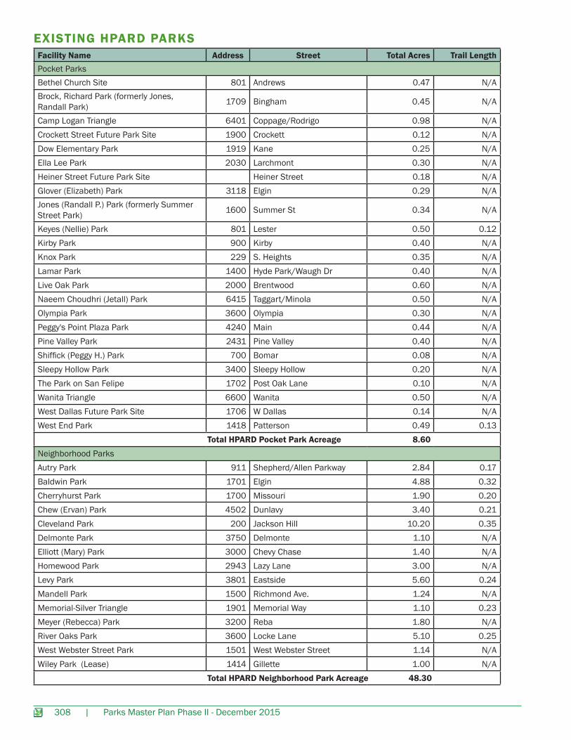
EXISTING HPARD PARKSFacility Name Address Street Total Acres Trail LengthPocket ParksBethel Church Site 801 Andrews 0.47 N/ABrock, Richard Park (formerly Jones, Randall Park) 1709 Bingham 0.45 N/A
Camp Logan Triangle 6401 Coppage/Rodrigo 0.98 N/ACrockett Street Future Park Site 1900 Crockett 0.12 N/ADow Elementary Park 1919 Kane 0.25 N/AElla Lee Park 2030 Larchmont 0.30 N/AHeiner Street Future Park Site Heiner Street 0.18 N/AGlover (Elizabeth) Park 3118 Elgin 0.29 N/AJones (Randall P.) Park (formerly Summer Street Park) 1600 Summer St 0.34 N/A
Keyes (Nellie) Park 801 Lester 0.50 0.12Kirby Park 900 Kirby 0.40 N/AKnox Park 229 S. Heights 0.35 N/ALamar Park 1400 Hyde Park/Waugh Dr 0.40 N/ALive Oak Park 2000 Brentwood 0.60 N/ANaeem Choudhri (Jetall) Park 6415 Taggart/Minola 0.50 N/AOlympia Park 3600 Olympia 0.30 N/APeggy's Point Plaza Park 4240 Main 0.44 N/APine Valley Park 2431 Pine Valley 0.40 N/AShiffick (Peggy H.) Park 700 Bomar 0.08 N/ASleepy Hollow Park 3400 Sleepy Hollow 0.20 N/AThe Park on San Felipe 1702 Post Oak Lane 0.10 N/AWanita Triangle 6600 Wanita 0.50 N/AWest Dallas Future Park Site 1706 W Dallas 0.14 N/AWest End Park 1418 Patterson 0.49 0.13 Total HPARD Pocket Park Acreage 8.60Neighborhood ParksAutry Park 911 Shepherd/Allen Parkway 2.84 0.17Baldwin Park 1701 Elgin 4.88 0.32Cherryhurst Park 1700 Missouri 1.90 0.20Chew (Ervan) Park 4502 Dunlavy 3.40 0.21Cleveland Park 200 Jackson Hill 10.20 0.35Delmonte Park 3750 Delmonte 1.10 N/AElliott (Mary) Park 3000 Chevy Chase 1.40 N/AHomewood Park 2943 Lazy Lane 3.00 N/ALevy Park 3801 Eastside 5.60 0.24Mandell Park 1500 Richmond Ave. 1.24 N/AMemorial-Silver Triangle 1901 Memorial Way 1.10 0.23Meyer (Rebecca) Park 3200 Reba 1.80 N/ARiver Oaks Park 3600 Locke Lane 5.10 0.25West Webster Street Park 1501 West Webster Street 1.14 N/AWiley Park (Lease) 1414 Gillette 1.00 N/A Total HPARD Neighborhood Park Acreage 48.30
Parks Master Plan Phase II - December 2015 | 309
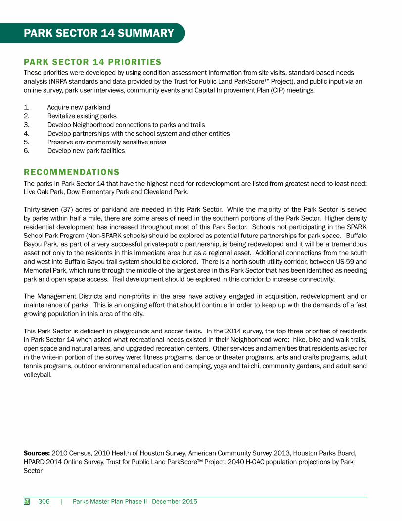
PARK SERVICE AREASThe Park Service Area map was produced using data provided by the Trust for Public Land ParkScore™ Project to show areas of park need. The green areas represent a ½ mile service area of public parks (city or county) and SPARK Parks (school parks open to the public after school) or other publicly accessible non-HPARD Parks.
The orange and red represent areas where there is not access to a park within a ½ mile. The degree of need (red is very high need and orange is high need) is based on population density, household income (less than $35,000), and presence of youth (19 yrs or younger).The office and industrial land uses are represented in gray, to specifically highlight residential and commercial areas of need. Approximately 18% of the area in this Park Sector is in need of parkland accessible within a ½ mile, as compared to the 55% of the population of the City of Houston who need park access. Non-SPARK schools are indicated on the map as black flags to explore as potential future partnerships for park space.
EXISTING COMMUNIT Y CENTERS AND POOLSCommunity Centers and Pool Facilities Address Zip Code Agency ResponsibleCherryhurst Community Center 1700 Missouri 77006 HPARDMemorial Park Pool 6501 Memorial Drive 77007 HPARDMetropolitan Multi-Service Center Community Center and Pool
1475 West Gray 77019 HPARD
River Oaks Community Center 3600 Locke Lane 77027 HPARD
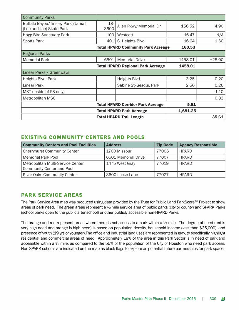
Community ParksBuffalo Bayou/Tinsley Park /Jamail (Lee and Joe) Skate Park
18-3600 Allen Pkwy/Memorial Dr 156.52 4.90
Hogg Bird Sanctuary Park 100 Westcott 16.47 N/ASpotts Park 401 S. Heights Blvd 16.24 1.60 Total HPARD Community Park Acreage 160.53Regional ParksMemorial Park 6501 Memorial Drive 1458.01 *25.00 Total HPARD Regional Park Acreage 1458.01Linear Parks / GreenwaysHeights Blvd. Park Heights Blvd. 3.25 0.20Linear Park Sabine St/Sesqui. Park 2.56 0.26MKT (Inside of PS only) 1.10Metropolitan MSC 0.33 Total HPARD Corridor Park Acreage 5.81 Total HPARD Park Acreage 1,681.25 Total HPARD Trail Length 35.61
310 | Parks Master Plan Phase II - December 2015
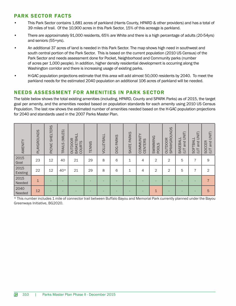
NEEDS ASSESSMENT FOR AMENITIES IN PARK SECTOR
PARK SECTOR FACTS
The table below shows the total existing amenities (including, HPARD, County and SPARK Parks) as of 2015, the target goal per amenity, and the amenities needed based on population standards for each amenity using 2010 US Census Population. The last row shows the estimated number of amenities needed based on the H-GAC population projections for 2040 and standards used in the 2007 Parks Master Plan.
• This Park Sector contains 1,681 acres of parkland (Harris County, HPARD & other providers) and has a total of 39 miles of trail. Of the 10,900 acres in this Park Sector, 15% of this acreage is parkland.
• There are approximately 91,000 residents, 65% are White and there is a high percentage of adults (20-54yrs) and seniors (55+yrs).
• An additional 37 acres of land is needed in this Park Sector. The map shows high need in southwest and south central portion of the Park Sector. This is based on the current population (2010 US Census) of the Park Sector and needs assessment done for Pocket, Neighborhood and Community parks (number of acres per 1,000 people). In addition, higher density residential development is occurring along the Washington corridor and there is increasing usage of existing parks.
• H-GAC population projections estimate that this area will add almost 50,000 residents by 2040. To meet the parkland needs for the estimated 2040 population an additional 106 acres of parkland will be needed.
2015 Goal 23 12 40 21 29 8 6 1 4 2 2 5 7 9
2015 Existing 22 12 40* 21 29 8 6 1 4 2 2 5 7 2
2015 Needed 1 - - - - - - - - - - - - 7
2040 Needed 12 - - - - - - - - 1 - - - 5
AMEN
ITY
PLAY
GRO
UND
S
PICN
IC S
HEL
TERS
TRAI
LS (M
ILES
)
TEN
NIS
VOLL
EYBA
LL
DOG
PAR
KS
SKAT
E PA
RKS
SWIM
MIN
GPO
OLS
OUTD
OOR
SPRA
YGRO
UND
S
BASE
BALL
(L
IT a
nd U
NIT
)
SOFT
BALL
(L
IT a
nd U
NIT
)
SOCC
ER(L
IT a
nd U
NIT
)
COM
MUN
ITY
CEN
TERS
OUTD
OOR
BASK
ETBA
LL
COUR
TS
* This number includes 1 mile of connector trail between Buffalo Bayou and Memorial Park currently planned under the Bayou Greenways Initiative, BG2020.
Parks Master Plan Phase II - December 2015 | 311
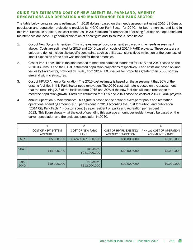
GUIDE FOR ESTIMATED COST OF NEW AMENITIES, PARKLAND, AMENIT Y RENOVATIONS AND OPERATION AND MAINTENANCE FOR PARK SECTOR
The table below contains costs estimates (in 2015 dollars) based on the needs assessment using 2010 US Census population and population projections provided by H-GAC per Park Sector for 2040, for both amenities and land in this Park Sector. In addition, the cost estimates (in 2015 dollars) for renovation of existing facilities and operation and maintenance are listed. A general explanation of each figure and its source is listed below:
1. Cost of New System Amenities: This is the estimated cost for amenities based on the needs assessment above. Costs are estimated for 2015 and 2040 based on costs of 2014 HPARD projects. These costs are a guide and do not include site specific constraints such as utility extensions, flood mitigation or the purchase of land if expansion of the park was needed for these amenities.
2. Cost of Park Land: This is the land needed to meet the parkland standards for 2015 and 2040 based on the 2010 US Census and the H-GAC estimated population projections respectively. Land costs are based on land values by Park Sector, provided by H-GAC, from 2014 HCAD values for properties greater than 5,000 sq ft in size and with no structures.
3. Cost of HPARD Amenity Renovation: The 2015 cost estimate is based on the assessment that 30% of the existing facilities in this Park Sector need renovation. The 2040 cost estimate is based on the assessment that the remaining 2/3 of the facilities from 2015 and 30% of the new facilities will need renovation to meet the population growth. Costs are estimated for 2015 and 2040 based on costs of 2014 HPARD projects.
4. Annual Operation & Maintenance: This figure is based on the national average for parks and recreation operational spending amount ($63) per resident in 2013 according the Trust for Public Land publication “2014 City Park Facts.” Houston spent $29 per resident on parks and recreation per resident in 2013. This figure shows what the cost of spending this average amount per resident would be based on the current population and the projected population in 2040.
1 2 3 4COST OF NEW SYSTEM
AMENITIES COST OF NEW PARK
LAND COST OF HPARD EXISTING
AMENITY RENOVATIONANNUAL COST OF OPERATION
AND MAINTENANCE2015 $5,000,000 37 Acres- $81,000,000 $31,000,000 $6,000,000
2040 $14,000,000 106 Acres- $231,000,000 $68,000,000 $3,000,000
TOTAL 2040 $19,000,000 143 Acres-
$312,000,000 $99,000,000 $9,000,000
312 | Parks Master Plan Phase II - December 2015
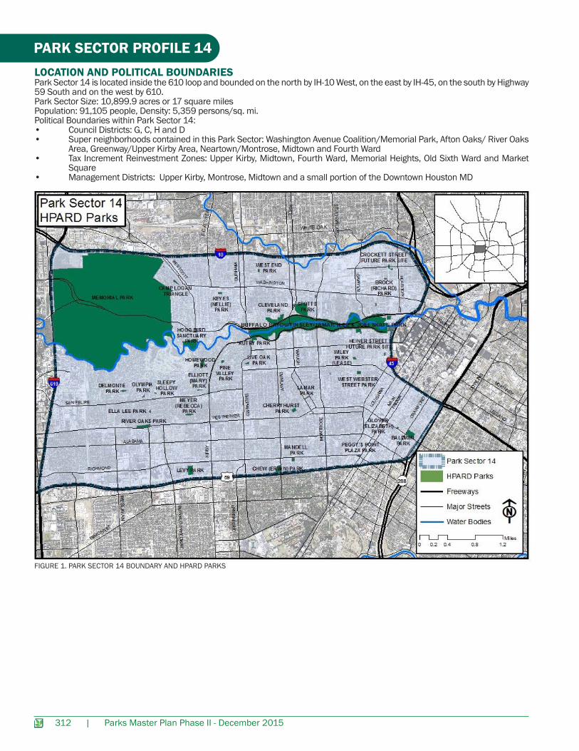
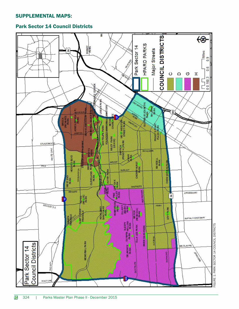
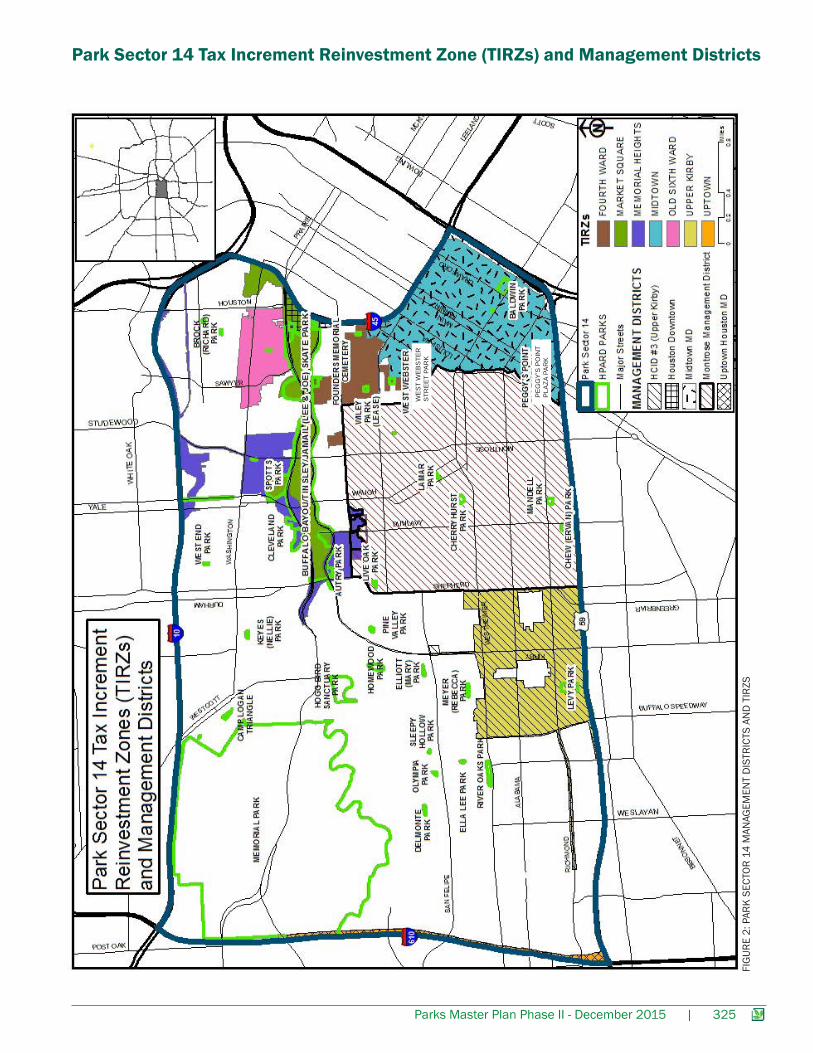
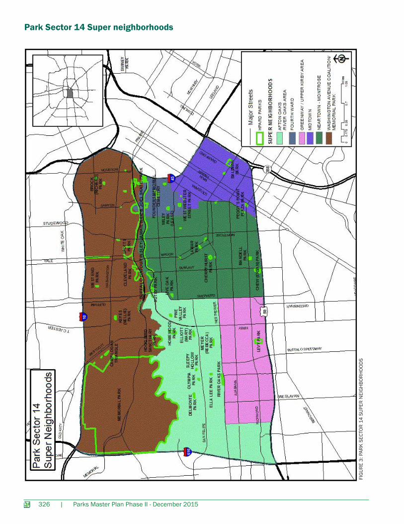
PARK SECTOR PROFILE 14LOCATION AND POLITICAL BOUNDARIESPark Sector 14 is located inside the 610 loop and bounded on the north by IH-10 West, on the east by IH-45, on the south by Highway59 South and on the west by 610. Park Sector Size: 10,899.9 acres or 17 square milesPopulation: 91,105 people, Density: 5,359 persons/sq. mi. Political Boundaries within Park Sector 14:• Council Districts: G, C, H and D• Super neighborhoods contained in this Park Sector: Washington Avenue Coalition/Memorial Park, Afton Oaks/ River Oaks
Area, Greenway/Upper Kirby Area, Neartown/Montrose, Midtown and Fourth Ward• Tax Increment Reinvestment Zones: Upper Kirby, Midtown, Fourth Ward, Memorial Heights, Old Sixth Ward and Market
Square• Management Districts: Upper Kirby, Montrose, Midtown and a small portion of the Downtown Houston MD
FIGURE 1. PARK SECTOR 14 BOUNDARY AND HPARD PARKS
Parks Master Plan Phase II - December 2015 | 313
DEMOGRAPHIC PROFILE
Park Sector 14
Population
Park Sector 14 Percent of
TotalHouston
PopulationHouston
Percent of Total
Total Population 91,105 - 2,119,831 -
Hispanic or Latino 16,741 18.4% 919,668 43.8%
Non-Hispanic White 59,876 65.7% 537,901 25.6%
Non-Hispanic Black 6,642 7.3% 485,956 23.1%
Non-Hispanic American-Indian 183 0.2%
126,098 6.1%Non-Hispanic Asian 6,008 6.6%
Non-Hispanic Hawaiian or Pacific Islander 42 0.0%
Non-Hispanic Some Other Race 1,613 1.8% 26,828 1.3%TABLE 1. PARK SECTOR 14 ETHNICITY (2010 CENSUS & CITY OF HOUSTON PLANNING AND DEVELOPMENT DEMOGRAPHIC DATA)
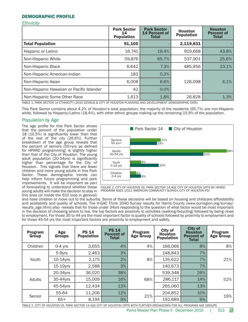
This Park Sector contains about 4.2% of Houston’s total population; the majority of the residents (65.7%) are non-Hispanic white, followed by Hispanic/Latino (18.4%), with other ethnic groups making up the remaining 15.9% of the population.
The age profile for this Park Sector shows that the percent of the population under 18 (10.5%) is significantly lower than that of the rest of the city (26.6%). Further breakdown of the age group reveals that the percent of seniors (55+yrs as defined for HPARD programming) is slightly higher than that of the City of Houston. The young adult population (20-34yrs) is significantly higher than percentage for the City of Houston. This signals that there are fewer children and more young adults in this Park Sector. These demographic trends can help inform future programming and park improvements. It will be important as part of forecasting to understand whether these young adults will make the decision to stay in this area (or inside the 610 loop in general) and have children or move out to the suburbs. Some of these decisions will be based on housing and childcare affordability and availability and quality of schools. The H-GAC Think 2040 Survey results for Harris County (www.ourregion.org/survey/results_age.html) also reveals that for those under 34yrs responding to the question of what factor would be most important in the decision of choosing where to live, the top factors are proximity to activities (walking/bicycling) followed by being close to employment. For those 35 to 44 yrs the most important factor is quality of schools followed by proximity to employment and for those 45-54 yrs the most important factors are proximity to employment and safety.
ProgramGroup
Age Groups
PS 14Population
PS 14 Percent of
TotalProgram
Age GroupCity of
Houston Population
City of Houston
Percent of Total
Program Age Group
Children 0-4 yrs 3,655 4% 4% 166,066 8% 8%
Youth5-9yrs 2,463 3%
8%148,843 7%
21%10-14yrs 2,175 2% 135,622 7%15-19yrs 2,588 3% 140,673 7%
Adults20-34yrs 36,020 38%
68%539,348 26%
52%35-44yrs 15,009 16% 286,117 14%45-54yrs 12,434 13% 265,060 13%
Senior55-64 11,206 12%
21%204,852 10%
19%65+ 8,194 9% 192,689 9%
TABLE 2. CITY OF HOUSTON VS. PARK SECTOR 14 AGE CITY OF HOUSTON ORTS WITH FURTHER BREAKDOWN FOR ALL PROGRAM AGE GROUPS
Ethnicity
Population by Age
8%
City of HoustonPark Sector 14
Seniors 55 yrs+ 19%
21%
52%68%
20%8%
4%
Adults20-54 yrs
Youth5-19 yrs
Children0-4 yrs
FIGURE 2. CITY OF HOUSTON VS. PARK SECTOR 14 AGE CITY OF HOUSTON ORTS BY HPARD PROGRAM AGES (2011 AMERICAN COMMUNITY SURVEY, CITY OF HOUSTON PD)
314 | Parks Master Plan Phase II - December 2015
Housing
Income
Educational Attainment
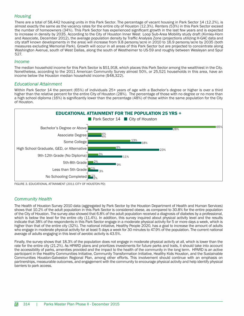
There are a total of 58,442 housing units in this Park Sector. The percentage of vacant housing in Park Sector 14 (12.2%), is almost exactly the same as the vacancy rates for the entire city of Houston (12.3%). Renters (53%) in this Park Sector exceed the number of homeowners (34%). This Park Sector has experienced significant growth in the last few years and is expected to increase in density by 2035. According to the City of Houston Inner West Loop Sub-Area Mobility study draft (Kimley-Horn and Associate, December 2012), the average population density by Traffic Analysis Zone (projections utilizing H-GAC data and city staff known developments in the area) will increase from 9.8 persons/acre in 2010 to 16.9 persons/acre by 2035 (both measures excluding Memorial Park). Growth will occur in all areas of this Park Sector but are projected to concentrate along Washington Avenue, south of West Dallas, along the south of Westheimer to US-59 and roughly between Wesleyan and Spur 527.
The median household income for this Park Sector is $51,918, which places this Park Sector among the wealthiest in the City. Nonetheless, according to the 2011 American Community Survey almost 50%, or 25,521 households in this area, have an income below the Houston median household income ($48,322).
Within Park Sector 14 the percent (65%) of individuals 25+ years of age with a Bachelor’s degree or higher is over a third higher than the relative percent for the entire City of Houston (28%). The percentage of those with no degree or no more than a high school diploma (16%) is significantly lower than the percentage (48%) of those within the same population for the City of Houston.
EDUCATIONAL ATTAINMENT FOR THE POPULATION 25 YRS +City of HoustonPark Sector 14
Bachelor’s Degree or Above 28%65%
4%4%
18%13%
23%9%
11%3%
9%2%
3%1%
2%1%
Associate Degree
Some College
High School Graduate, GED, or Alternative
9th-12th Grade (No Diploma)
5th-8th Grade
Less than 5th Grade
No Schooling Completed
FIGURE 3. EDUCATIONAL ATTAINMENT (2011 CITY OF HOUSTON PD)
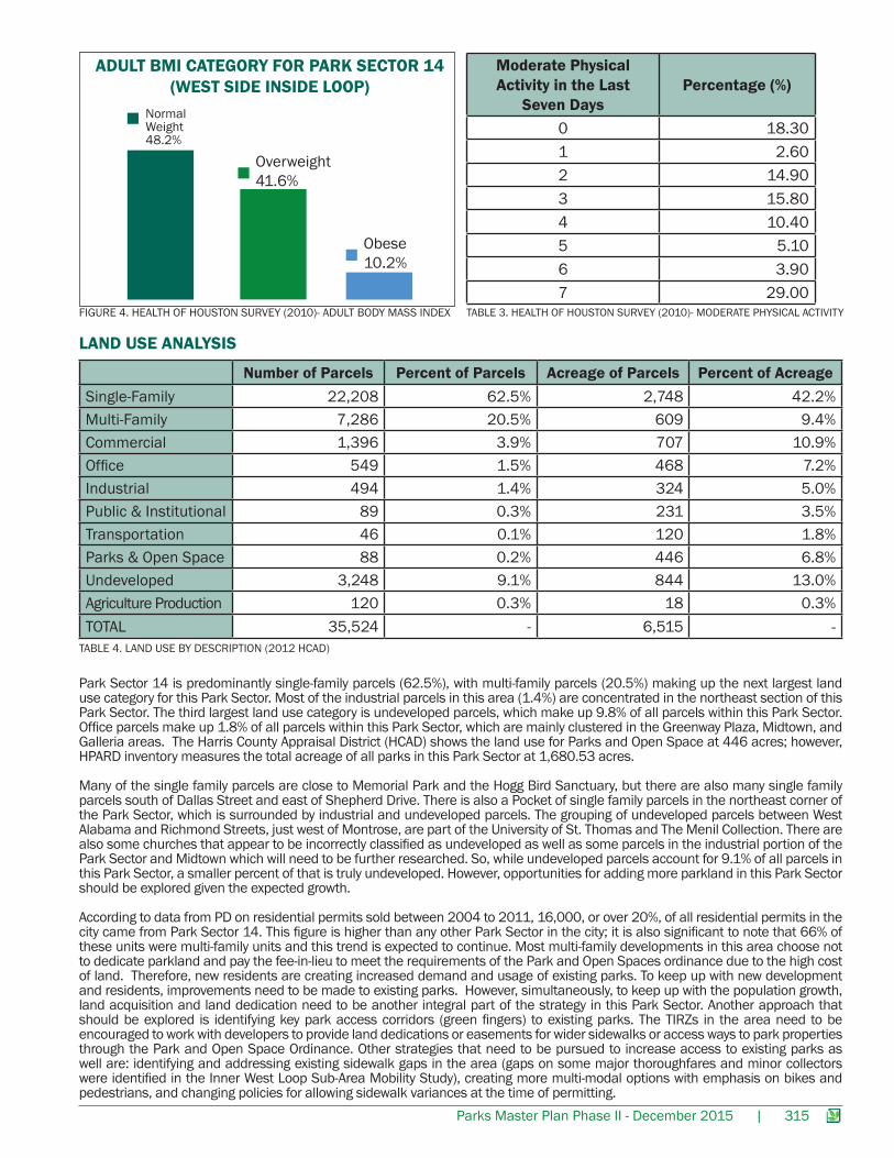
Community HealthThe Health of Houston Survey 2010 data (aggregated by Park Sector by the Houston Department of Health and Human Services) shows that 10.2% of the adult population in this Park Sector is considered obese, as compared to 30.8% for the entire population of the City of Houston. The survey also showed that 6.8% of the adult population received a diagnosis of diabetes by a professional, which is below the level for the entire city (11.4%). In addition, this survey inquired about physical activity level and the results indicate that 38% of the respondents in this Park Sector engage in a moderate physical activity for 5 or more days a week, which is higher than that of the entire city (32%). The national initiative, Healthy People 2020, has a goal to increase the amount of adults who engage in moderate physical activity for at least 5 days a week for 30 minutes to 47.9% of the population. The current national average of adults engaging in this level of aerobic activity is 43.5%.
Finally, the survey shows that 18.3% of the population does not engage in moderate physical activity at all, which is lower than the rate for the entire city (21.2%). As HPARD plans and prioritizes investments for future parks and trails, it should take into account the accessibility of parks, amenities provided and the impact to the health of the community in the long term. HPARD is an active participant in the Healthy Communities Initiative, Community Transformation Initiative, Healthy Kids Houston, and the Sustainable Communities Houston-Galveston Regional Plan, among other efforts. This involvement should continue with an emphasis on partnerships, measurable outcomes, and engagement with the community to encourage physical activity and help identify physical barriers to park access.
Parks Master Plan Phase II - December 2015 | 315
LAND USE ANALYSIS
TABLE 4. LAND USE BY DESCRIPTION (2012 HCAD)
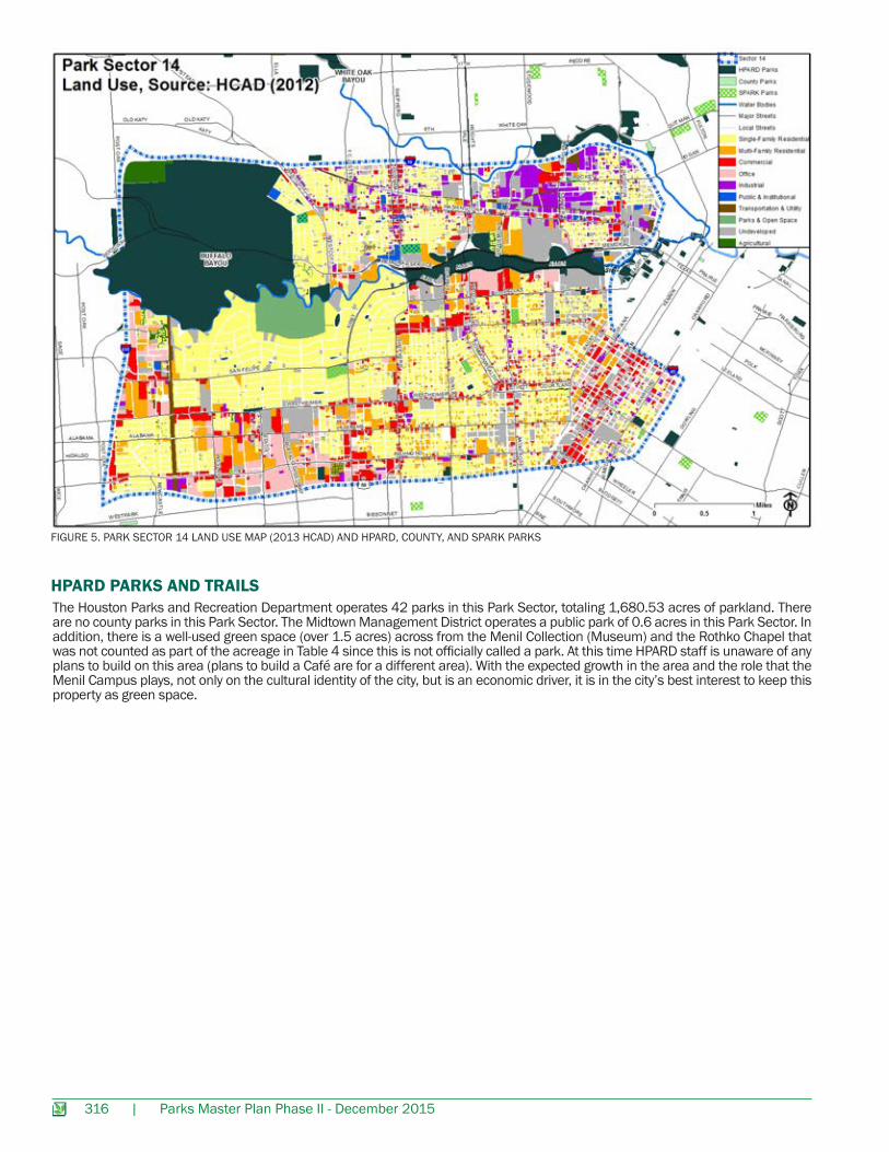
Park Sector 14 is predominantly single-family parcels (62.5%), with multi-family parcels (20.5%) making up the next largest land use category for this Park Sector. Most of the industrial parcels in this area (1.4%) are concentrated in the northeast section of this Park Sector. The third largest land use category is undeveloped parcels, which make up 9.8% of all parcels within this Park Sector. Office parcels make up 1.8% of all parcels within this Park Sector, which are mainly clustered in the Greenway Plaza, Midtown, and Galleria areas. The Harris County Appraisal District (HCAD) shows the land use for Parks and Open Space at 446 acres; however, HPARD inventory measures the total acreage of all parks in this Park Sector at 1,680.53 acres.
Many of the single family parcels are close to Memorial Park and the Hogg Bird Sanctuary, but there are also many single family parcels south of Dallas Street and east of Shepherd Drive. There is also a Pocket of single family parcels in the northeast corner of the Park Sector, which is surrounded by industrial and undeveloped parcels. The grouping of undeveloped parcels between West Alabama and Richmond Streets, just west of Montrose, are part of the University of St. Thomas and The Menil Collection. There are also some churches that appear to be incorrectly classified as undeveloped as well as some parcels in the industrial portion of the Park Sector and Midtown which will need to be further researched. So, while undeveloped parcels account for 9.1% of all parcels in this Park Sector, a smaller percent of that is truly undeveloped. However, opportunities for adding more parkland in this Park Sector should be explored given the expected growth.
According to data from PD on residential permits sold between 2004 to 2011, 16,000, or over 20%, of all residential permits in the city came from Park Sector 14. This figure is higher than any other Park Sector in the city; it is also significant to note that 66% of these units were multi-family units and this trend is expected to continue. Most multi-family developments in this area choose not to dedicate parkland and pay the fee-in-lieu to meet the requirements of the Park and Open Spaces ordinance due to the high cost of land. Therefore, new residents are creating increased demand and usage of existing parks. To keep up with new development and residents, improvements need to be made to existing parks. However, simultaneously, to keep up with the population growth, land acquisition and land dedication need to be another integral part of the strategy in this Park Sector. Another approach that should be explored is identifying key park access corridors (green fingers) to existing parks. The TIRZs in the area need to be encouraged to work with developers to provide land dedications or easements for wider sidewalks or access ways to park properties through the Park and Open Space Ordinance. Other strategies that need to be pursued to increase access to existing parks as well are: identifying and addressing existing sidewalk gaps in the area (gaps on some major thoroughfares and minor collectors were identified in the Inner West Loop Sub-Area Mobility Study), creating more multi-modal options with emphasis on bikes and pedestrians, and changing policies for allowing sidewalk variances at the time of permitting.
Number of Parcels Percent of Parcels Acreage of Parcels Percent of AcreageSingle-Family 22,208 62.5% 2,748 42.2%Multi-Family 7,286 20.5% 609 9.4%Commercial 1,396 3.9% 707 10.9%Office 549 1.5% 468 7.2%Industrial 494 1.4% 324 5.0%Public & Institutional 89 0.3% 231 3.5%Transportation 46 0.1% 120 1.8%Parks & Open Space 88 0.2% 446 6.8%Undeveloped 3,248 9.1% 844 13.0%Agriculture Production 120 0.3% 18 0.3%TOTAL 35,524 - 6,515 -
Normal Weight48.2%
Overweight41.6%
Obese10.2%
ADULT BMI CATEGORY FOR PARK SECTOR 14(WEST SIDE INSIDE LOOP)
Moderate Physical Activity in the Last
Seven DaysPercentage (%)
0 18.301 2.602 14.903 15.804 10.405 5.106 3.907 29.00
FIGURE 4. HEALTH OF HOUSTON SURVEY (2010)- ADULT BODY MASS INDEX TABLE 3. HEALTH OF HOUSTON SURVEY (2010)- MODERATE PHYSICAL ACTIVITY
316 | Parks Master Plan Phase II - December 2015
FIGURE 5. PARK SECTOR 14 LAND USE MAP (2013 HCAD) AND HPARD, COUNTY, AND SPARK PARKS
HPARD PARKS AND TRAILSThe Houston Parks and Recreation Department operates 42 parks in this Park Sector, totaling 1,680.53 acres of parkland. There are no county parks in this Park Sector. The Midtown Management District operates a public park of 0.6 acres in this Park Sector. In addition, there is a well-used green space (over 1.5 acres) across from the Menil Collection (Museum) and the Rothko Chapel that was not counted as part of the acreage in Table 4 since this is not officially called a park. At this time HPARD staff is unaware of any plans to build on this area (plans to build a Café are for a different area). With the expected growth in the area and the role that the Menil Campus plays, not only on the cultural identity of the city, but is an economic driver, it is in the city’s best interest to keep this property as green space.
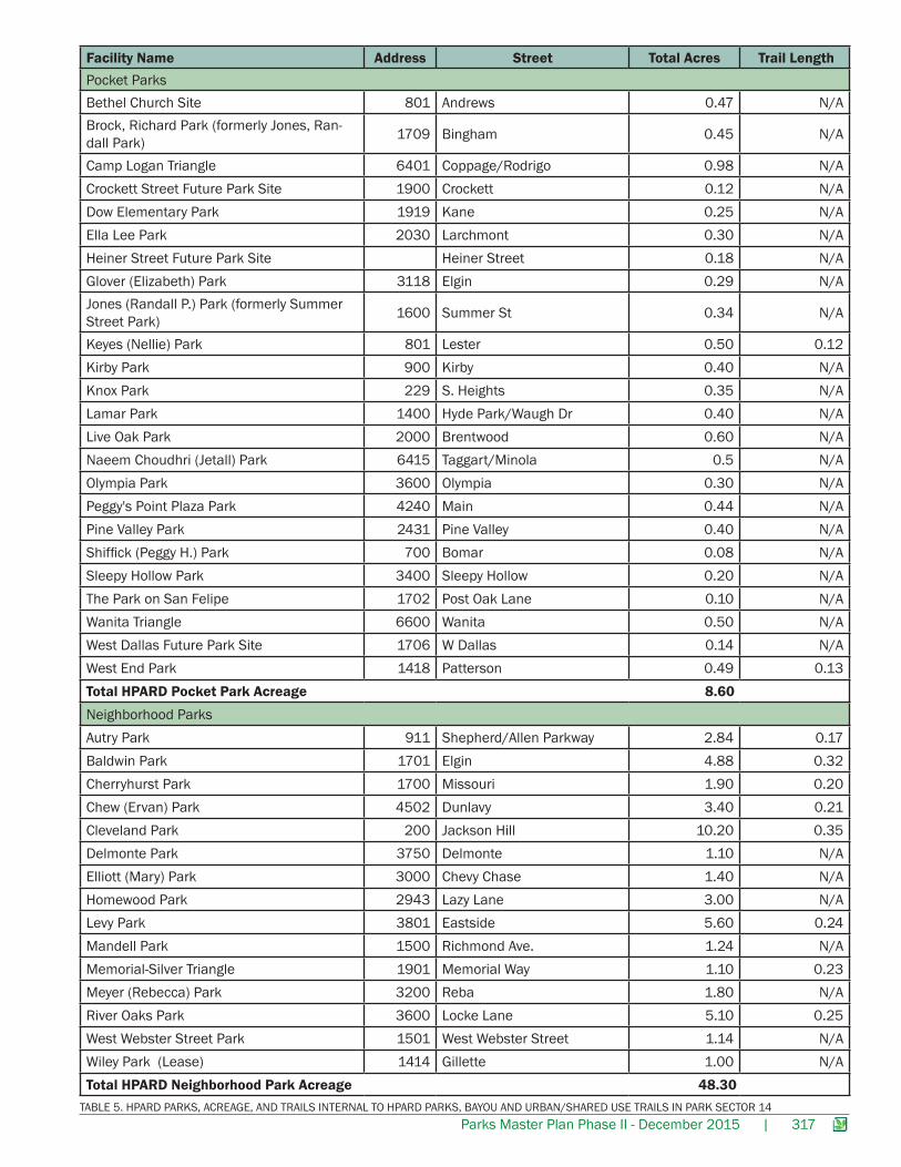
Parks Master Plan Phase II - December 2015 | 317
Facility Name Address Street Total Acres Trail LengthPocket ParksBethel Church Site 801 Andrews 0.47 N/ABrock, Richard Park (formerly Jones, Ran-dall Park) 1709 Bingham 0.45 N/A
Camp Logan Triangle 6401 Coppage/Rodrigo 0.98 N/ACrockett Street Future Park Site 1900 Crockett 0.12 N/ADow Elementary Park 1919 Kane 0.25 N/AElla Lee Park 2030 Larchmont 0.30 N/AHeiner Street Future Park Site Heiner Street 0.18 N/AGlover (Elizabeth) Park 3118 Elgin 0.29 N/AJones (Randall P.) Park (formerly Summer Street Park) 1600 Summer St 0.34 N/A
Keyes (Nellie) Park 801 Lester 0.50 0.12Kirby Park 900 Kirby 0.40 N/AKnox Park 229 S. Heights 0.35 N/ALamar Park 1400 Hyde Park/Waugh Dr 0.40 N/ALive Oak Park 2000 Brentwood 0.60 N/ANaeem Choudhri (Jetall) Park 6415 Taggart/Minola 0.5 N/AOlympia Park 3600 Olympia 0.30 N/APeggy's Point Plaza Park 4240 Main 0.44 N/APine Valley Park 2431 Pine Valley 0.40 N/AShiffick (Peggy H.) Park 700 Bomar 0.08 N/ASleepy Hollow Park 3400 Sleepy Hollow 0.20 N/AThe Park on San Felipe 1702 Post Oak Lane 0.10 N/AWanita Triangle 6600 Wanita 0.50 N/AWest Dallas Future Park Site 1706 W Dallas 0.14 N/AWest End Park 1418 Patterson 0.49 0.13Total HPARD Pocket Park Acreage 8.60Neighborhood ParksAutry Park 911 Shepherd/Allen Parkway 2.84 0.17Baldwin Park 1701 Elgin 4.88 0.32Cherryhurst Park 1700 Missouri 1.90 0.20Chew (Ervan) Park 4502 Dunlavy 3.40 0.21Cleveland Park 200 Jackson Hill 10.20 0.35Delmonte Park 3750 Delmonte 1.10 N/AElliott (Mary) Park 3000 Chevy Chase 1.40 N/AHomewood Park 2943 Lazy Lane 3.00 N/ALevy Park 3801 Eastside 5.60 0.24Mandell Park 1500 Richmond Ave. 1.24 N/AMemorial-Silver Triangle 1901 Memorial Way 1.10 0.23Meyer (Rebecca) Park 3200 Reba 1.80 N/ARiver Oaks Park 3600 Locke Lane 5.10 0.25West Webster Street Park 1501 West Webster Street 1.14 N/AWiley Park (Lease) 1414 Gillette 1.00 N/ATotal HPARD Neighborhood Park Acreage 48.30
TABLE 5. HPARD PARKS, ACREAGE, AND TRAILS INTERNAL TO HPARD PARKS, BAYOU AND URBAN/SHARED USE TRAILS IN PARK SECTOR 14
318 | Parks Master Plan Phase II - December 2015
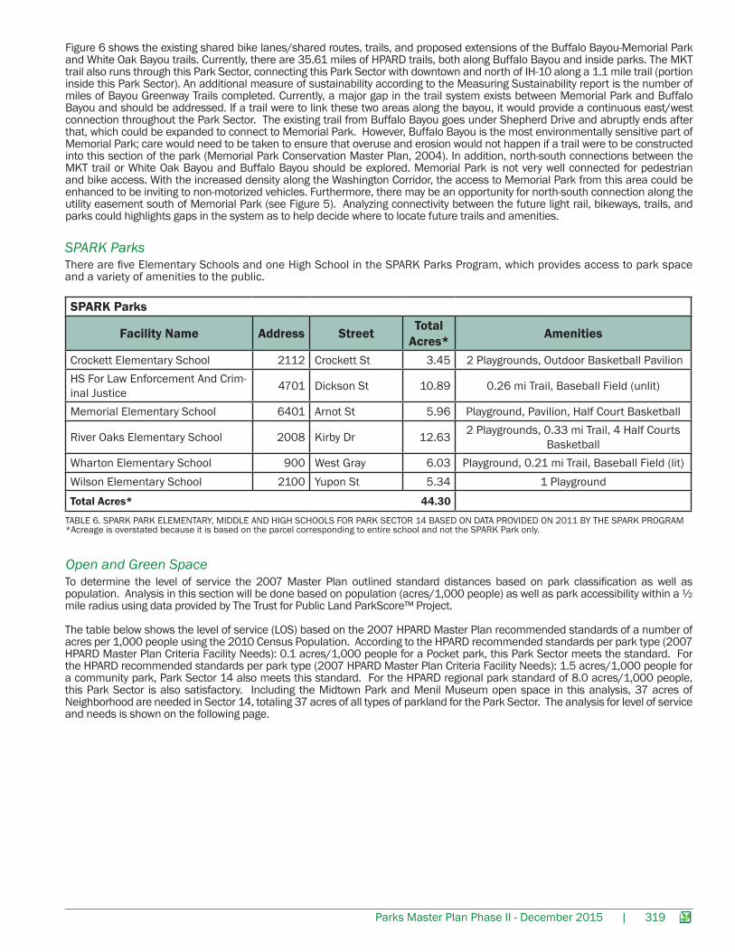
FIGURE 6. PARK SECTOR 14 BAYOU TRAILS, ON- AND OFF-STREET BIKEWAY SYSTEM (PWE), HPARD, COUNTY, SPARK, PRIVATE PARKS, BIKE/PED BRIDGES AND LIGHT RAIL
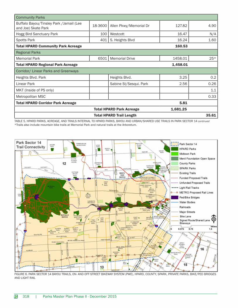
Community ParksBuffalo Bayou/Tinsley Park /Jamail (Lee and Joe) Skate Park 18-3600 Allen Pkwy/Memorial Dr 127.82 4.90
Hogg Bird Sanctuary Park 100 Westcott 16.47 N/ASpotts Park 401 S. Heights Blvd 16.24 1.60Total HPARD Community Park Acreage 160.53
Regional ParksMemorial Park 6501 Memorial Drive 1458.01 25*Total HPARD Regional Park Acreage 1,458.01
Corridor/ Linear Parks and Greenways
Heights Blvd. Park Heights Blvd. 3.25 0.2
Linear Park Sabine St/Sesqui. Park 2.56 0.26
MKT (Inside of PS only) 1.1
Metropolitan MSC 0.33
Total HPARD Corridor Park Acreage 5.81
Total HPARD Park Acreage 1,681.25 Total HPARD Trail Length 35.61
TABLE 5. HPARD PARKS, ACREAGE, AND TRAILS INTERNAL TO HPARD PARKS, BAYOU AND URBAN/SHARED USE TRAILS IN PARK SECTOR 14 continued*Trails also include mountain bike trails at Memorial Park and natural trails at the Arboretum.
Parks Master Plan Phase II - December 2015 | 319
There are five Elementary Schools and one High School in the SPARK Parks Program, which provides access to park space and a variety of amenities to the public.
SPARK Parks
SPARK Parks
Facility Name Address Street Total Acres* Amenities
Crockett Elementary School 2112 Crockett St 3.45 2 Playgrounds, Outdoor Basketball PavilionHS For Law Enforcement And Crim-inal Justice 4701 Dickson St 10.89 0.26 mi Trail, Baseball Field (unlit)
Memorial Elementary School 6401 Arnot St 5.96 Playground, Pavilion, Half Court Basketball
River Oaks Elementary School 2008 Kirby Dr 12.63 2 Playgrounds, 0.33 mi Trail, 4 Half Courts Basketball
Wharton Elementary School 900 West Gray 6.03 Playground, 0.21 mi Trail, Baseball Field (lit)Wilson Elementary School 2100 Yupon St 5.34 1 PlaygroundTotal Acres* 44.30
TABLE 6. SPARK PARK ELEMENTARY, MIDDLE AND HIGH SCHOOLS FOR PARK SECTOR 14 BASED ON DATA PROVIDED ON 2011 BY THE SPARK PROGRAM*Acreage is overstated because it is based on the parcel corresponding to entire school and not the SPARK Park only.
Figure 6 shows the existing shared bike lanes/shared routes, trails, and proposed extensions of the Buffalo Bayou-Memorial Park and White Oak Bayou trails. Currently, there are 35.61 miles of HPARD trails, both along Buffalo Bayou and inside parks. The MKT trail also runs through this Park Sector, connecting this Park Sector with downtown and north of IH-10 along a 1.1 mile trail (portion inside this Park Sector). An additional measure of sustainability according to the Measuring Sustainability report is the number of miles of Bayou Greenway Trails completed. Currently, a major gap in the trail system exists between Memorial Park and Buffalo Bayou and should be addressed. If a trail were to link these two areas along the bayou, it would provide a continuous east/west connection throughout the Park Sector. The existing trail from Buffalo Bayou goes under Shepherd Drive and abruptly ends after that, which could be expanded to connect to Memorial Park. However, Buffalo Bayou is the most environmentally sensitive part of Memorial Park; care would need to be taken to ensure that overuse and erosion would not happen if a trail were to be constructed into this section of the park (Memorial Park Conservation Master Plan, 2004). In addition, north-south connections between the MKT trail or White Oak Bayou and Buffalo Bayou should be explored. Memorial Park is not very well connected for pedestrian and bike access. With the increased density along the Washington Corridor, the access to Memorial Park from this area could be enhanced to be inviting to non-motorized vehicles. Furthermore, there may be an opportunity for north-south connection along the utility easement south of Memorial Park (see Figure 5). Analyzing connectivity between the future light rail, bikeways, trails, and parks could highlights gaps in the system as to help decide where to locate future trails and amenities.
Open and Green SpaceTo determine the level of service the 2007 Master Plan outlined standard distances based on park classification as well as population. Analysis in this section will be done based on population (acres/1,000 people) as well as park accessibility within a ½ mile radius using data provided by The Trust for Public Land ParkScore™ Project.
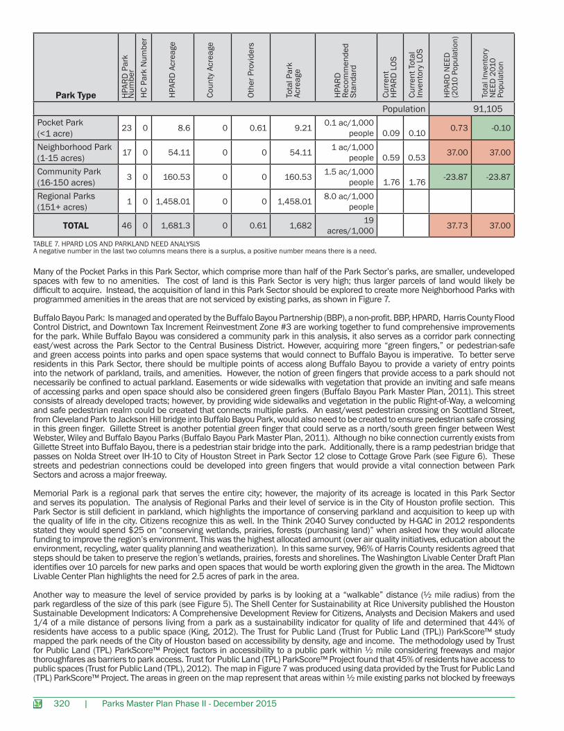
The table below shows the level of service (LOS) based on the 2007 HPARD Master Plan recommended standards of a number of acres per 1,000 people using the 2010 Census Population. According to the HPARD recommended standards per park type (2007 HPARD Master Plan Criteria Facility Needs): 0.1 acres/1,000 people for a Pocket park, this Park Sector meets the standard. For the HPARD recommended standards per park type (2007 HPARD Master Plan Criteria Facility Needs): 1.5 acres/1,000 people for a community park, Park Sector 14 also meets this standard. For the HPARD regional park standard of 8.0 acres/1,000 people, this Park Sector is also satisfactory. Including the Midtown Park and Menil Museum open space in this analysis, 37 acres of Neighborhood are needed in Sector 14, totaling 37 acres of all types of parkland for the Park Sector. The analysis for level of service and needs is shown on the following page.
320 | Parks Master Plan Phase II - December 2015
Many of the Pocket Parks in this Park Sector, which comprise more than half of the Park Sector’s parks, are smaller, undeveloped spaces with few to no amenities. The cost of land is this Park Sector is very high; thus larger parcels of land would likely be difficult to acquire. Instead, the acquisition of land in this Park Sector should be explored to create more Neighborhood Parks with programmed amenities in the areas that are not serviced by existing parks, as shown in Figure 7.
Buffalo Bayou Park: Is managed and operated by the Buffalo Bayou Partnership (BBP), a non-profit. BBP, HPARD, Harris County Flood Control District, and Downtown Tax Increment Reinvestment Zone #3 are working together to fund comprehensive improvements for the park. While Buffalo Bayou was considered a community park in this analysis, it also serves as a corridor park connecting east/west across the Park Sector to the Central Business District. However, acquiring more “green fingers,” or pedestrian-safe and green access points into parks and open space systems that would connect to Buffalo Bayou is imperative. To better serve residents in this Park Sector, there should be multiple points of access along Buffalo Bayou to provide a variety of entry points into the network of parkland, trails, and amenities. However, the notion of green fingers that provide access to a park should not necessarily be confined to actual parkland. Easements or wide sidewalks with vegetation that provide an inviting and safe means of accessing parks and open space should also be considered green fingers (Buffalo Bayou Park Master Plan, 2011). This street consists of already developed tracts; however, by providing wide sidewalks and vegetation in the public Right-of-Way, a welcoming and safe pedestrian realm could be created that connects multiple parks. An east/west pedestrian crossing on Scottland Street, from Cleveland Park to Jackson Hill bridge into Buffalo Bayou Park, would also need to be created to ensure pedestrian safe crossing in this green finger. Gillette Street is another potential green finger that could serve as a north/south green finger between West Webster, Wiley and Buffalo Bayou Parks (Buffalo Bayou Park Master Plan, 2011). Although no bike connection currently exists from Gillette Street into Buffalo Bayou, there is a pedestrian stair bridge into the park. Additionally, there is a ramp pedestrian bridge that passes on Nolda Street over IH-10 to City of Houston Street in Park Sector 12 close to Cottage Grove Park (see Figure 6). These streets and pedestrian connections could be developed into green fingers that would provide a vital connection between Park Sectors and across a major freeway.
Memorial Park is a regional park that serves the entire city; however, the majority of its acreage is located in this Park Sector and serves its population. The analysis of Regional Parks and their level of service is in the City of Houston profile section. This Park Sector is still deficient in parkland, which highlights the importance of conserving parkland and acquisition to keep up with the quality of life in the city. Citizens recognize this as well. In the Think 2040 Survey conducted by H-GAC in 2012 respondents stated they would spend $25 on “conserving wetlands, prairies, forests (purchasing land)” when asked how they would allocate funding to improve the region’s environment. This was the highest allocated amount (over air quality initiatives, education about the environment, recycling, water quality planning and weatherization). In this same survey, 96% of Harris County residents agreed that steps should be taken to preserve the region’s wetlands, prairies, forests and shorelines. The Washington Livable Center Draft Plan identifies over 10 parcels for new parks and open spaces that would be worth exploring given the growth in the area. The Midtown Livable Center Plan highlights the need for 2.5 acres of park in the area.
Another way to measure the level of service provided by parks is by looking at a “walkable” distance (½ mile radius) from the park regardless of the size of this park (see Figure 5). The Shell Center for Sustainability at Rice University published the Houston Sustainable Development Indicators: A Comprehensive Development Review for Citizens, Analysts and Decision Makers and used 1/4 of a mile distance of persons living from a park as a sustainability indicator for quality of life and determined that 44% of residents have access to a public space (King, 2012). The Trust for Public Land (Trust for Public Land (TPL)) ParkScore™ study mapped the park needs of the City of Houston based on accessibility by density, age and income. The methodology used by Trust for Public Land (TPL) ParkScore™ Project factors in accessibility to a public park within ½ mile considering freeways and major thoroughfares as barriers to park access. Trust for Public Land (TPL) ParkScore™ Project found that 45% of residents have access to public spaces (Trust for Public Land (TPL), 2012). The map in Figure 7 was produced using data provided by the Trust for Public Land (TPL) ParkScore™ Project. The areas in green on the map represent that areas within ½ mile existing parks not blocked by freeways
TABLE 7. HPARD LOS AND PARKLAND NEED ANALYSISA negative number in the last two columns means there is a surplus, a positive number means there is a need.
Park Type
Population 91,105Pocket Park (<1 acre) 23 0 8.6 0 0.61 9.21 0.1 ac/1,000
people 0.09
0.10 0.73 -0.10
Neighborhood Park (1-15 acres) 17 0 54.11 0 0 54.11 1 ac/1,000
people 0.59
0.53 37.00 37.00
Community Park (16-150 acres) 3 0 160.53 0 0 160.53 1.5 ac/1,000
people 1.76
1.76 -23.87 -23.87
Regional Parks (151+ acres) 1 0 1,458.01 0 0 1,458.01 8.0 ac/1,000
people
TOTAL 46 0 1,681.3 0 0.61 1,682 19 acres/1,000 37.73 37.00
HPA
RD P
ark
Num
ber
HC
Park
Num
ber
HPA
RD A
crea
ge
Coun
ty A
crea
ge
Othe
r Pro
vide
rs
Tota
l Par
k Ac
reag
e
Curr
ent
HPA
RD L
OS
Curr
ent T
otal
Inve
ntor
y LO
S
Tota
l Inv
ento
ry
NEE
D 2
010
Po
pula
tion
HPA
RD N
EED
(2
010
Popu
latio
n)
HPA
RD
Reco
mm
ende
d
Stan
dard
Parks Master Plan Phase II - December 2015 | 321
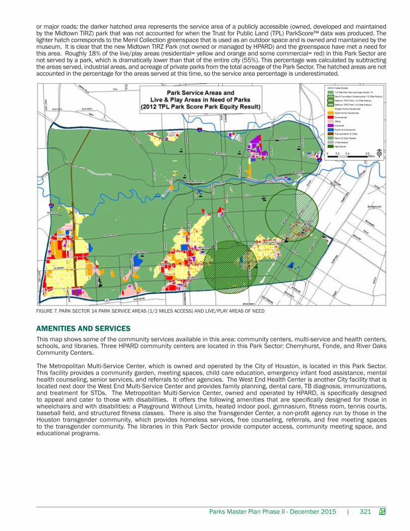
FIGURE 7. PARK SECTOR 14 PARK SERVICE AREAS (1/2 MILES ACCESS) AND LIVE/PLAY AREAS OF NEED
This map shows some of the community services available in this area: community centers, multi-service and health centers, schools, and libraries. Three HPARD community centers are located in this Park Sector: Cherryhurst, Fonde, and River Oaks Community Centers.
The Metropolitan Multi-Service Center, which is owned and operated by the City of Houston, is located in this Park Sector. This facility provides a community garden, meeting spaces, child care education, emergency infant food assistance, mental health counseling, senior services, and referrals to other agencies. The West End Health Center is another City facility that is located next door the West End Multi-Service Center and provides family planning, dental care, TB diagnosis, immunizations, and treatment for STDs. The Metropolitan Multi-Service Center, owned and operated by HPARD, is specifically designed to appeal and cater to those with disabilities. It offers the following amenities that are specifically designed for those in wheelchairs and with disabilities: a Playground Without Limits, heated indoor pool, gymnasium, fitness room, tennis courts, baseball field, and structured fitness classes. There is also the Transgender Center, a non-profit agency run by those in the Houston transgender community, which provides homeless services, free counseling, referrals, and free meeting spaces to the transgender community. The libraries in this Park Sector provide computer access, community meeting space, and educational programs.
AMENITIES AND SERVICES
or major roads; the darker hatched area represents the service area of a publicly accessible (owned, developed and maintained by the Midtown TIRZ) park that was not accounted for when the Trust for Public Land (TPL) ParkScore™ data was produced. The lighter hatch corresponds to the Menil Collection greenspace that is used as an outdoor space and is owned and maintained by the museum. It is clear that the new Midtown TIRZ Park (not owned or managed by HPARD) and the greenspace have met a need for this area. Roughly 18% of the live/play areas (residential= yellow and orange and some commercial= red) in this Park Sector are not served by a park, which is dramatically lower than that of the entire city (55%). This percentage was calculated by subtracting the areas served, industrial areas, and acreage of private parks from the total acreage of the Park Sector. The hatched areas are not accounted in the percentage for the areas served at this time, so the service area percentage is underestimated.
322 | Parks Master Plan Phase II - December 2015
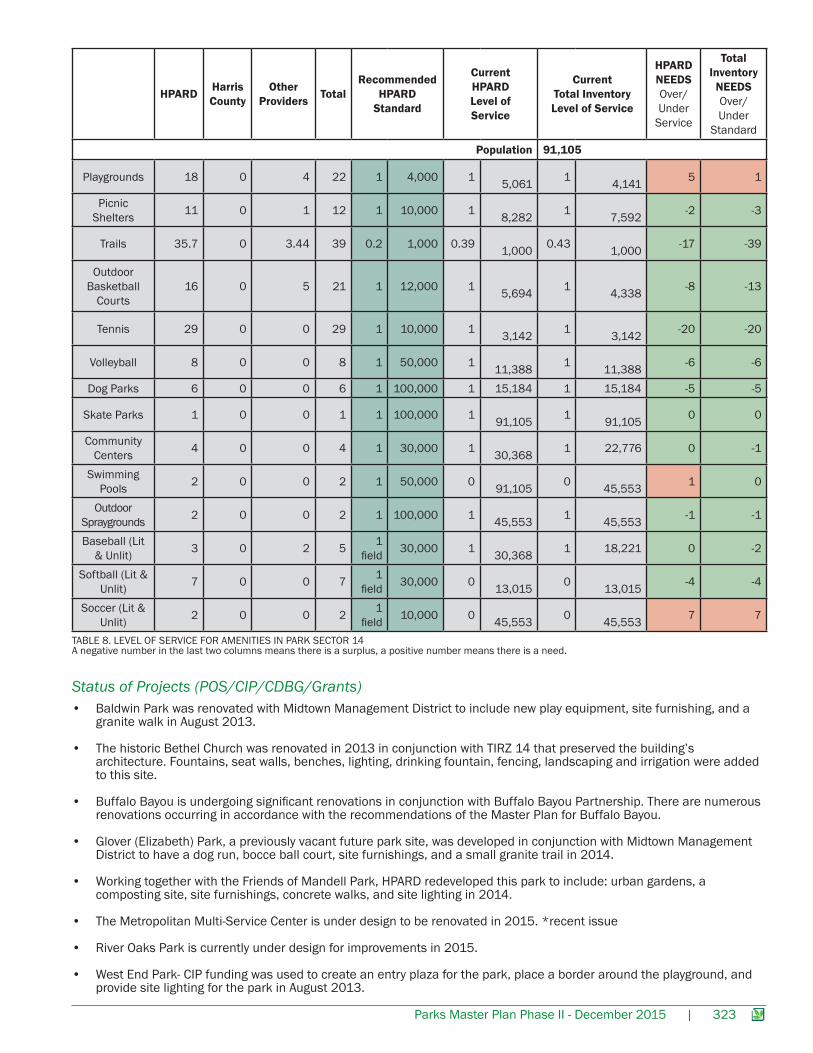
The 2007 HPARD Master Plan standards by amenity have been applied to the amenities in Park Sector 14. The standard for each amenity is compared to the 2010 Census population data for this Park Sector to determine if the standard has been met or if more amenities are needed. The last two columns show the number of facilities needed to meet the standard using HPARD inventory only and using all providers in the Park Sector. According to the recommended HPARD standards, Harris County and other providers are meeting the needs of the residents for the following facilities: picnic shelters, trails, basketball, tennis and volleyball courts, dog parks, skate parks, community centers, swimming pools, outdoor spray grounds, and baseball and softball fields. This Park Sector is deficient in playgrounds (1) and soccer fields (7).
There is a very obvious need for ball fields and soccer fields throughout the entire city. The Fourth Ward Livable Center Plan assessed that there are no ball fields available for non-league play. There are insufficient fields in Neighborhood Parks and the few fields in the system are monopolized by a few leagues.
Amenities - Level of Service
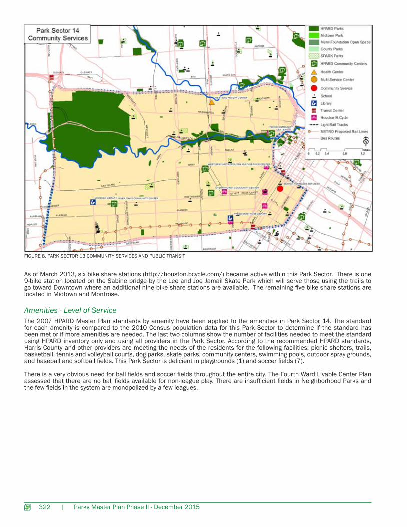
FIGURE 8. PARK SECTOR 13 COMMUNITY SERVICES AND PUBLIC TRANSIT
As of March 2013, six bike share stations (http://houston.bcycle.com/) became active within this Park Sector. There is one 9-bike station located on the Sabine bridge by the Lee and Joe Jamail Skate Park which will serve those using the trails to go toward Downtown where an additional nine bike share stations are available. The remaining five bike share stations are located in Midtown and Montrose.
Parks Master Plan Phase II - December 2015 | 323
TABLE 8. LEVEL OF SERVICE FOR AMENITIES IN PARK SECTOR 14A negative number in the last two columns means there is a surplus, a positive number means there is a need.
HPARD Harris County
Other Providers Total
Recommended HPARD
Standard
Current HPARD Level of Service
Current Total Inventory Level of Service
HPARD NEEDS Over/Under
Service
Total Inventory
NEEDS Over/Under
Standard
Population 91,105
Playgrounds 18 0 4 22 1 4,000 1 5,061 1
4,141 5 1
Picnic Shelters 11 0 1 12 1 10,000 1
8,282 1 7,592 -2 -3
Trails 35.7 0 3.44 39 0.2 1,000 0.39 1,000 0.43
1,000 -17 -39
Outdoor Basketball
Courts16 0 5 21 1 12,000 1
5,694 1 4,338 -8 -13
Tennis 29 0 0 29 1 10,000 1 3,142 1
3,142 -20 -20
Volleyball 8 0 0 8 1 50,000 1 11,388 1
11,388 -6 -6
Dog Parks 6 0 0 6 1 100,000 1 15,184 1 15,184 -5 -5
Skate Parks 1 0 0 1 1 100,000 1 91,105 1
91,105 0 0
Community Centers 4 0 0 4 1 30,000 1
30,368 1 22,776 0 -1
Swimming Pools 2 0 0 2 1 50,000 0
91,105 0 45,553 1 0
Outdoor Spraygrounds 2 0 0 2 1 100,000 1
45,553 1 45,553 -1 -1
Baseball (Lit & Unlit) 3 0 2 5 1
field 30,000 1 30,368 1 18,221 0 -2
Softball (Lit & Unlit) 7 0 0 7 1
field 30,000 0 13,015 0
13,015 -4 -4
Soccer (Lit & Unlit) 2 0 0 2 1
field 10,000 0 45,553 0
45,553 7 7
• Baldwin Park was renovated with Midtown Management District to include new play equipment, site furnishing, and a granite walk in August 2013.
• The historic Bethel Church was renovated in 2013 in conjunction with TIRZ 14 that preserved the building’s architecture. Fountains, seat walls, benches, lighting, drinking fountain, fencing, landscaping and irrigation were added to this site.
• Buffalo Bayou is undergoing significant renovations in conjunction with Buffalo Bayou Partnership. There are numerous renovations occurring in accordance with the recommendations of the Master Plan for Buffalo Bayou.
• Glover (Elizabeth) Park, a previously vacant future park site, was developed in conjunction with Midtown Management District to have a dog run, bocce ball court, site furnishings, and a small granite trail in 2014.
• Working together with the Friends of Mandell Park, HPARD redeveloped this park to include: urban gardens, a composting site, site furnishings, concrete walks, and site lighting in 2014.
• The Metropolitan Multi-Service Center is under design to be renovated in 2015. *recent issue
• River Oaks Park is currently under design for improvements in 2015.
• West End Park- CIP funding was used to create an entry plaza for the park, place a border around the playground, and provide site lighting for the park in August 2013.
Status of Projects (POS/CIP/CDBG/Grants)
324 | Parks Master Plan Phase II - December 2015
SUPPLEMENTAL MAPS:
Park Sector 14 Council Districts
FIG
URE
1: P
ARK
SECT
OR 1
4 CO
UNCI
L D
ISTR
ICTS
Parks Master Plan Phase II - December 2015 | 325
Park Sector 14 Tax Increment Reinvestment Zone (TIRZs) and Management Districts
FIG
URE
2: P
ARK
SECT
OR 1
4 M
ANAG
EMEN
T D
ISTR
ICTS
AN
D T
IRZS
WE
ST
WE
BS
TER
STR
EE
T PA
RK
PE
GG
Y’S
PO
INT
PLA
ZA P
AR
K
326 | Parks Master Plan Phase II - December 2015
FIG
URE
3: P
ARK
SECT
OR 1
4 SU
PER
NEI
GH
BORH
OOD
S
Park Sector 14 Super neighborhoods
Parks Master Plan Phase II - December 2015 | 327
FIG
URE
4: P
ARK
SECT
OR 1
4 FL
OOD
PLAI
N A
REAS
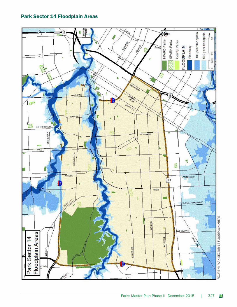
Park Sector 14 Floodplain Areas