Embed Size (px)
Citation preview
PERMIT COUNTER INFORMATION
Submit your plans and applications at the Permit Counter.
Permit Counter
Department of Planning and Community and Economic Development
126 S. Hamilton St.
Madison, WI 53703
Phone Number: 266-4551
NOTES
Department of Planning and Community and Economic Development
Department of Planning and Community and Economic Development
126 S. Hamilton St.
Madison, WI 53701
266-4551
Getting Your Parking Lot/Site Plan Approved
In this packet, you’ll find:
Parking Lot/Site Plan Approval Application and Checklist
Plan Approval Procedures and Instructions
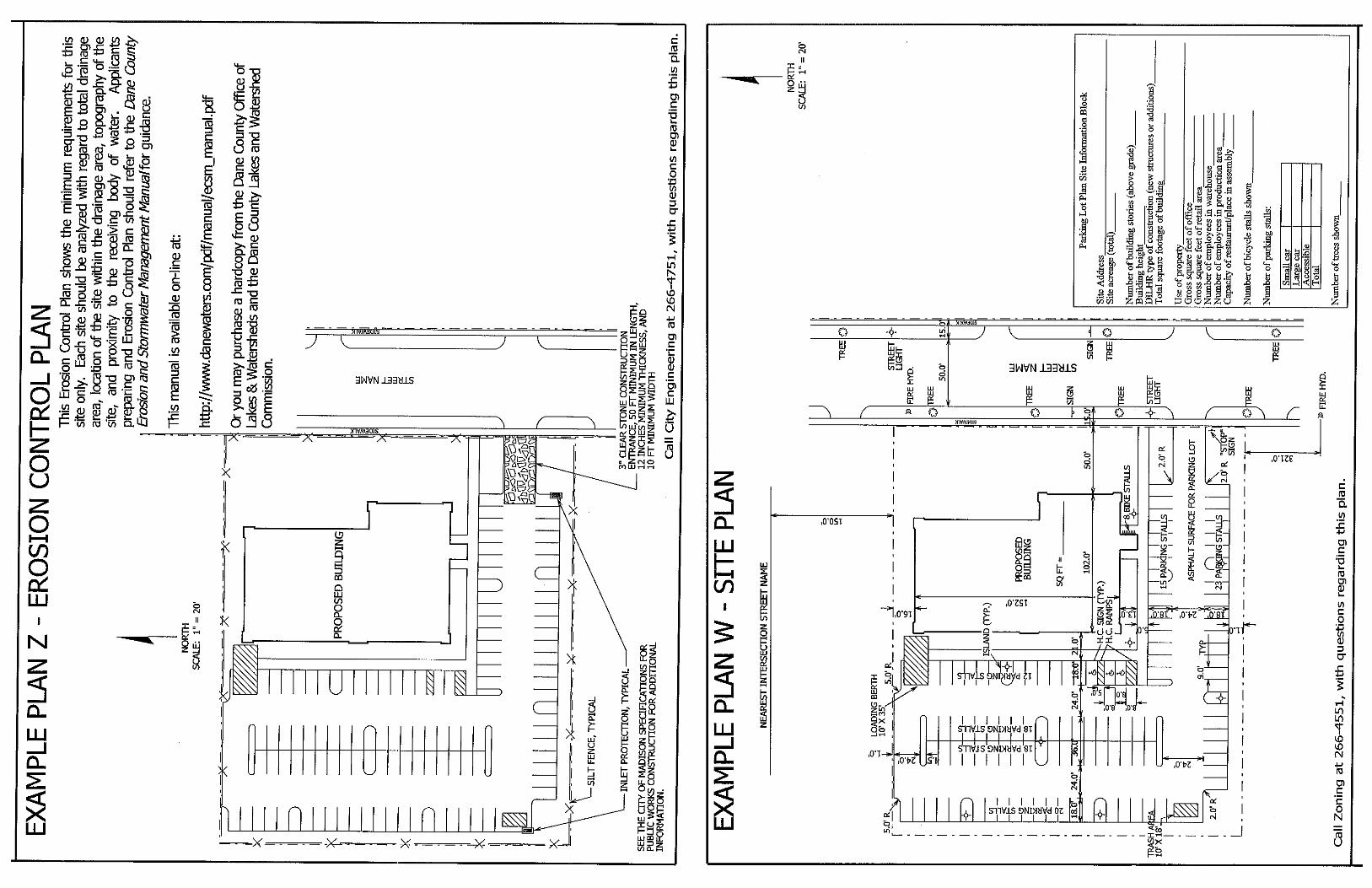
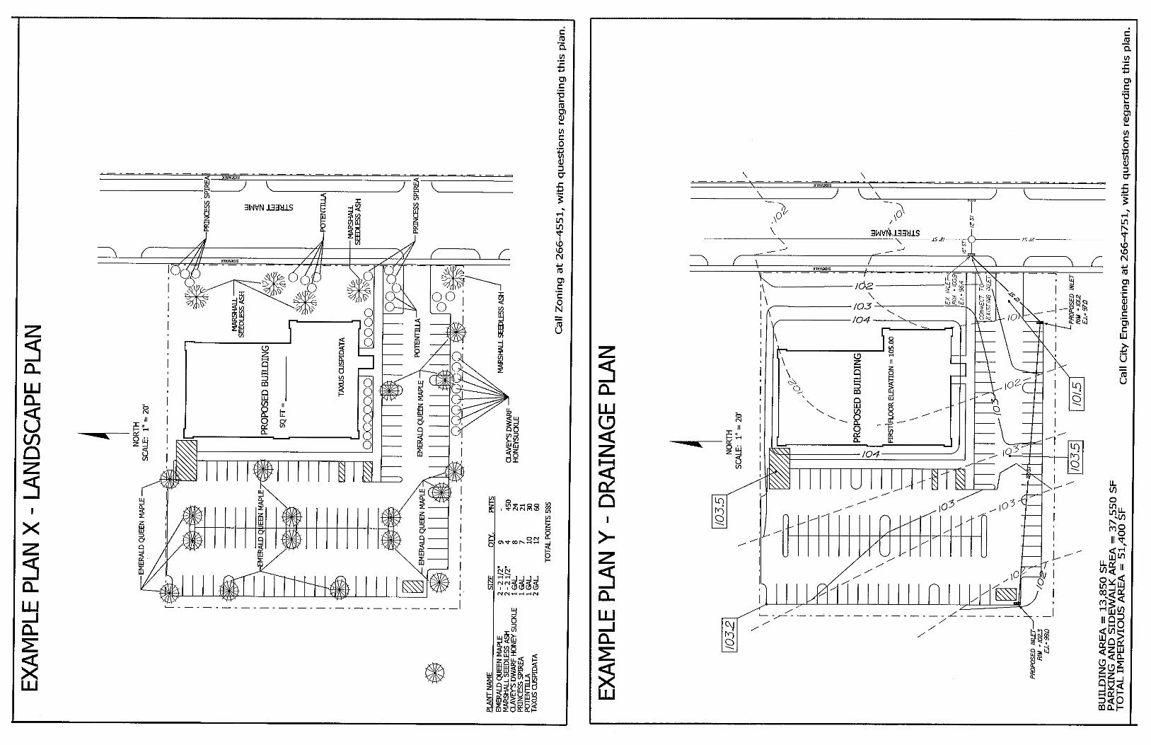
Example plans for parking lot layout, drainage, landscaping anderosion control
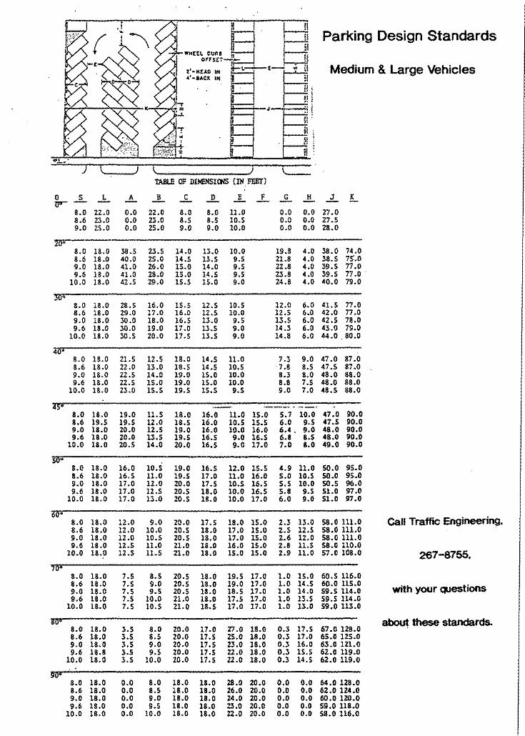
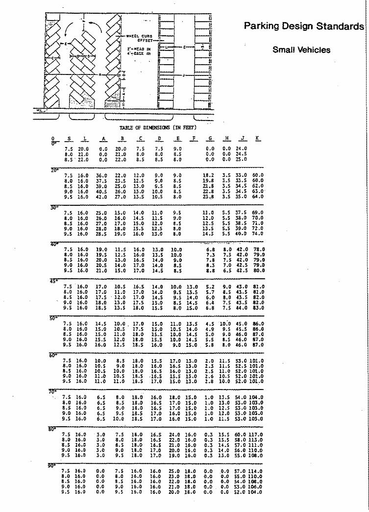
Parking Lot Design Standards
Landscape Worksheet
Outdoor Lighting Standards
Street Terrace Permit Application
Erosion Control Permit Application
Storm Water Management Permit Application
Application to Excavate in Public Right-of-Way
Fire Apparatus Access and Fire Hydrant Worksheet
APPLICATION INSTRUCTIONS – PARKING LOT/SITE PLAN APPROVAL PROCESS Our process and forms were designed with input from customers and City staff who provided tips on how to prevent errors and reduce time. Our process works best if we receive complete, accurate and legible information.
1 Before you submit our plans and required information, discuss your proposal with City staff. At this time you can discuss the City’s standards for site design. See the Parking Lot/Site Plan Approval Application Checklist, Section G, for staff phone numbers.
2 Determine the items you need to include in your application. At a minimum, you need: • The Parking Lot/Site Plan Approval Application Checklist• Seven sets of scaled (1” = 20’ or similar) drawings
To determine the other items you need to include, answer these questions.
1. Is this parking lot an approved Conditional Use, Demolition or PD?No Yes Attach signed copy of Letter of Conditions
2. Is this parking lot new construction?No Yes Attach street terrace permit
3. Is the site one acre or more?No Yes Attach Land Disturbing Activity application and five sets of Erosion Control Plan
4. Does this parking lot have a joint driveway or joined parking lots on separate parcels?No Yes Attach easement agreements
5. Will this parking lot have outdoor lighting?No Yes Attach lighting plan and manufacturers specs & plan
6. Does the site meet the applicability standards of Sec. 28.142(2) or it the approved landscape plan changing?No Yes Attach Landscape Worksheet & plan
3 Prepare your plans. Use the application checklist to be sure you show all the information that is needed for review of your plans/project.
4 Submit Checklist, plans and all attachments at the Permit Counter in the Department of Planning & Community & Economic Development in the Madison Municipal Building. A zoning staff person will review your application to see if it is complete. If it is not complete, the staff person will return your plans to you and explain what other items you need to submit. If it is complete, a zoning staff person will accept the application for review.
5 Pay fees. A site plan review fee is due when plans and attachments are submitted for staff review. The fee is $100 plus $50 for each acre of land in excess of one acre, or fraction thereof, up to a maximum of 5 acres or $300. $50 fee for Government agencies, schools, NGO’s non-profits. You can consult with zoning staff prior to submitting plans to calculate the fee.
6 Track site plan review. You can track the progress of the City agencies’ reviews on the City of Madison Site Plan Verification website. If an agency requests additional information, submit the materials or information directly to that agency. If a plan is rejected by an agency, revised plans will need to be resubmitted for a new review along with an additional site plan review fee.
7 Return to pick up your plans. Usually the parking lot/ site plan review process takes about 7- 14 days. It can take longer if an agency requests additional information or if the plans need to be revised and resubmitted. You will receive an email notification alerting you when the plans have been approved. You can then return to the Zoning Counter to pick up the approved plans.
8 Pay all permit fees at the Permit Counter and get your permit(s) and a signed, approved copy of your plan.
WHO TO CALL FOR HELP As you look over the application and checklist you may be confused about what you need to submit or show on your plans. City staff can advise you. Give them a call before you draw your plans or submit your application.
TOPIC CITY AGENCY PHONE NUMBER Building use
Setbacks
Landscaping
Occupancy
Zoning (608) 266-4551
Parking lot geometrics Traffic Engineering (608) 266-4761
Drainage
Land disturbing activity
Soil erosion
Engineering (608) 266-4751
Fire hydrants/access Fire (608) 266-4484
Outdoor lighting Building Inspection (608) 266-4551
Why the City Needs So Much Information The City of Madison reviews and approves parking lot plans to answer these questions:
• Will there be the required number of car/bike spaces for visitors, customers and employees?
• Will drivers of different-sized vehicles be able to get in and out of the spaces safely?
• Will customers and employees with disabilities be able to park and have easy access to the building?
• Can drivers enter and exit the lot safely?
• Will parking lot lighting help keep customers, employees and property safe, while not disturbing adjacentproperty owners?
• Will the lot’s construction and use cause minimal soil erosion and runoff?
• Will the lot drain properly?
• Will fire trucks be able to get in and have adequate water supply to put out a fire?
• Will the development meet city aesthetic design requirements?
There is a lot to consider, but understanding why the City reviews parking lot plans will help you understand the information you need to provide for review and approval of your plans.
F:\Plcommon\ZONING\Zoning Document Warehouse\Parking Lot Site Plan Packet\Pkg Lot_Site Plan Checklist 8-18-15.doc
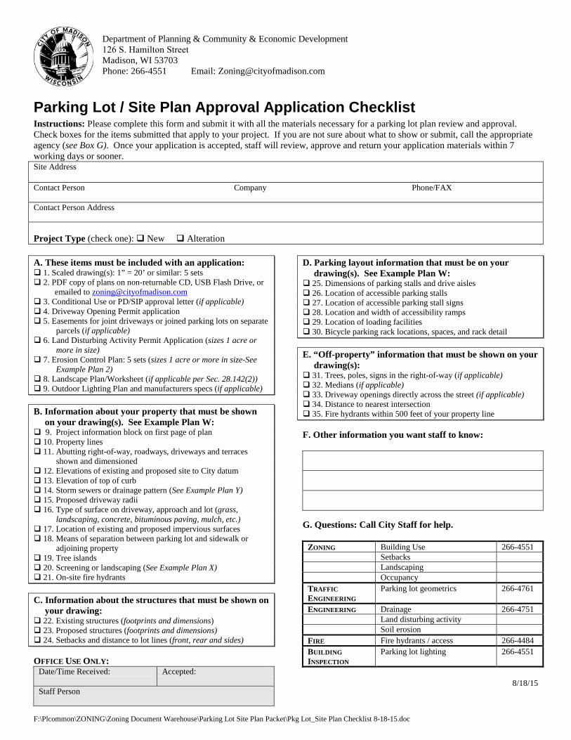
Department of Planning & Community & Economic Development 126 S. Hamilton Street Madison, WI 53703 Phone: 266-4551 Email: [email protected]
Parking Lot / Site Plan Approval Application Checklist Instructions: Please complete this form and submit it with all the materials necessary for a parking lot plan review and approval. Check boxes for the items submitted that apply to your project. If you are not sure about what to show or submit, call the appropriate agency (see Box G). Once your application is accepted, staff will review, approve and return your application materials within 7 working days or sooner. Site Address
Contact Person Company Phone/FAX
Contact Person Address
Project Type (check one): New Alteration
A. These items must be included with an application: 1. Scaled drawing(s): 1” = 20’ or similar: 5 sets 2. PDF copy of plans on non-returnable CD, USB Flash Drive, or
emailed to [email protected] 3. Conditional Use or PD/SIP approval letter (if applicable) 4. Driveway Opening Permit application 5. Easements for joint driveways or joined parking lots on separate
parcels (if applicable) 6. Land Disturbing Activity Permit Application (sizes 1 acre or
more in size) 7. Erosion Control Plan: 5 sets (sizes 1 acre or more in size-See
Example Plan 2) 8. Landscape Plan/Worksheet (if applicable per Sec. 28.142(2)) 9. Outdoor Lighting Plan and manufacturers specs (if applicable)
B. Information about your property that must be shown on your drawing(s). See Example Plan W:
9. Project information block on first page of plan 10. Property lines 11. Abutting right-of-way, roadways, driveways and terraces
shown and dimensioned 12. Elevations of existing and proposed site to City datum 13. Elevation of top of curb 14. Storm sewers or drainage pattern (See Example Plan Y) 15. Proposed driveway radii 16. Type of surface on driveway, approach and lot (grass,
landscaping, concrete, bituminous paving, mulch, etc.) 17. Location of existing and proposed impervious surfaces 18. Means of separation between parking lot and sidewalk or
adjoining property 19. Tree islands 20. Screening or landscaping (See Example Plan X) 21. On-site fire hydrants
C. Information about the structures that must be shown on your drawing:
22. Existing structures (footprints and dimensions) 23. Proposed structures (footprints and dimensions) 24. Setbacks and distance to lot lines (front, rear and sides)
OFFICE USE ONLY: Date/Time Received: Accepted:
Staff Person
D. Parking layout information that must be on your drawing(s). See Example Plan W:
25. Dimensions of parking stalls and drive aisles 26. Location of accessible parking stalls 27. Location of accessible parking stall signs 28. Location and width of accessibility ramps 29. Location of loading facilities 30. Bicycle parking rack locations, spaces, and rack detail
E. “Off-property” information that must be shown on your drawing(s):
31. Trees, poles, signs in the right-of-way (if applicable) 32. Medians (if applicable) 33. Driveway openings directly across the street (if applicable) 34. Distance to nearest intersection 35. Fire hydrants within 500 feet of your property line
F. Other information you want staff to know:
G. Questions: Call City Staff for help.
ZONING Building Use 266-4551 Setbacks Landscaping Occupancy
TRAFFIC ENGINEERING
Parking lot geometrics 266-4761
ENGINEERING Drainage 266-4751 Land disturbing activity Soil erosion
FIRE Fire hydrants / access 266-4484 BUILDING INSPECTION
Parking lot lighting 266-4551
8/18/15
10/2013 1
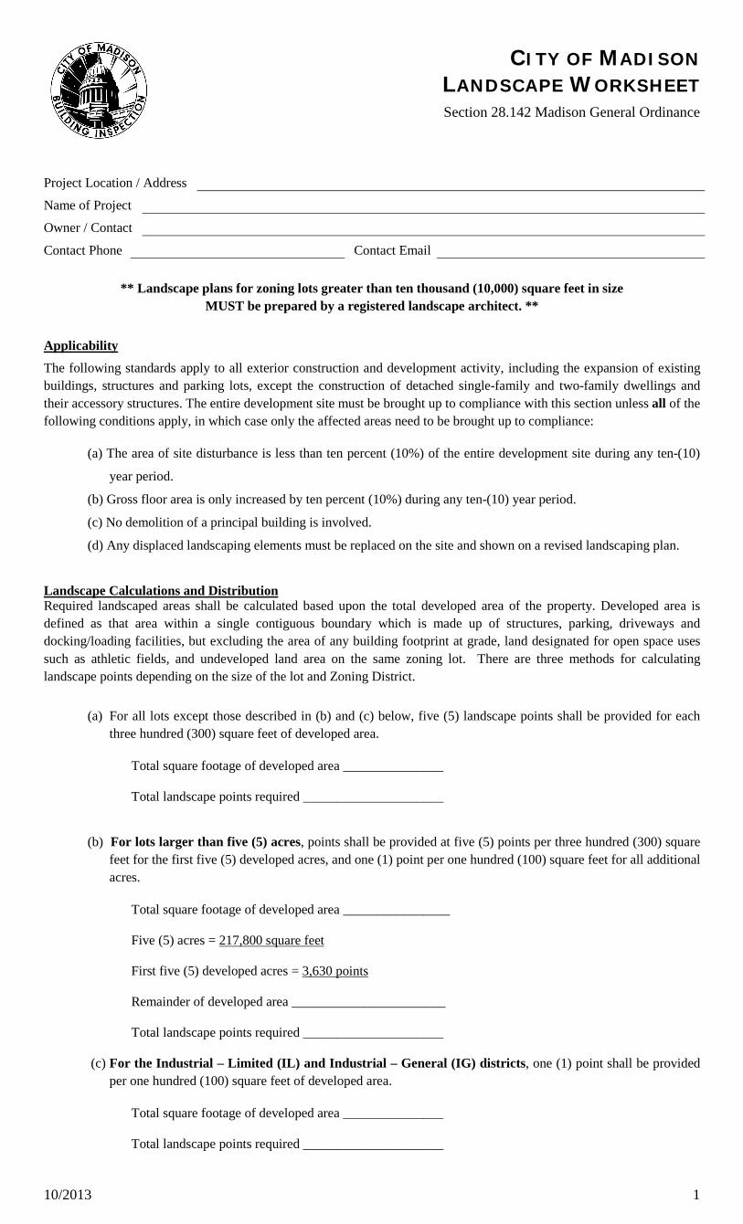
CITY OF MADISON LANDSCAPE WORKSHEET Section 28.142 Madison General Ordinance
Project Location / Address
Name of Project
Owner / Contact
Contact Phone Contact Email
** Landscape plans for zoning lots greater than ten thousand (10,000) square feet in size MUST be prepared by a registered landscape architect. **
Applicability
The following standards apply to all exterior construction and development activity, including the expansion of existing buildings, structures and parking lots, except the construction of detached single-family and two-family dwellings and their accessory structures. The entire development site must be brought up to compliance with this section unless all of the following conditions apply, in which case only the affected areas need to be brought up to compliance:
(a) The area of site disturbance is less than ten percent (10%) of the entire development site during any ten-(10)
year period.
(b) Gross floor area is only increased by ten percent (10%) during any ten-(10) year period.
(c) No demolition of a principal building is involved.
(d) Any displaced landscaping elements must be replaced on the site and shown on a revised landscaping plan.
Landscape Calculations and Distribution Required landscaped areas shall be calculated based upon the total developed area of the property. Developed area is defined as that area within a single contiguous boundary which is made up of structures, parking, driveways and docking/loading facilities, but excluding the area of any building footprint at grade, land designated for open space uses such as athletic fields, and undeveloped land area on the same zoning lot. There are three methods for calculating landscape points depending on the size of the lot and Zoning District.
(a) For all lots except those described in (b) and (c) below, five (5) landscape points shall be provided for each three hundred (300) square feet of developed area.
Total square footage of developed area _______________
Total landscape points required _____________________
(b) For lots larger than five (5) acres, points shall be provided at five (5) points per three hundred (300) square feet for the first five (5) developed acres, and one (1) point per one hundred (100) square feet for all additional acres.
Total square footage of developed area ________________
Five (5) acres =
First five (5) developed acres =
217,800 square feet
Remainder of developed area _______________________
3,630 points
Total landscape points required _____________________
(c) For the Industrial – Limited (IL) and Industrial – General (IG) districts, one (1) point shall be provided per one hundred (100) square feet of developed area.
Total square footage of developed area _______________
Total landscape points required _____________________
10/2013 2
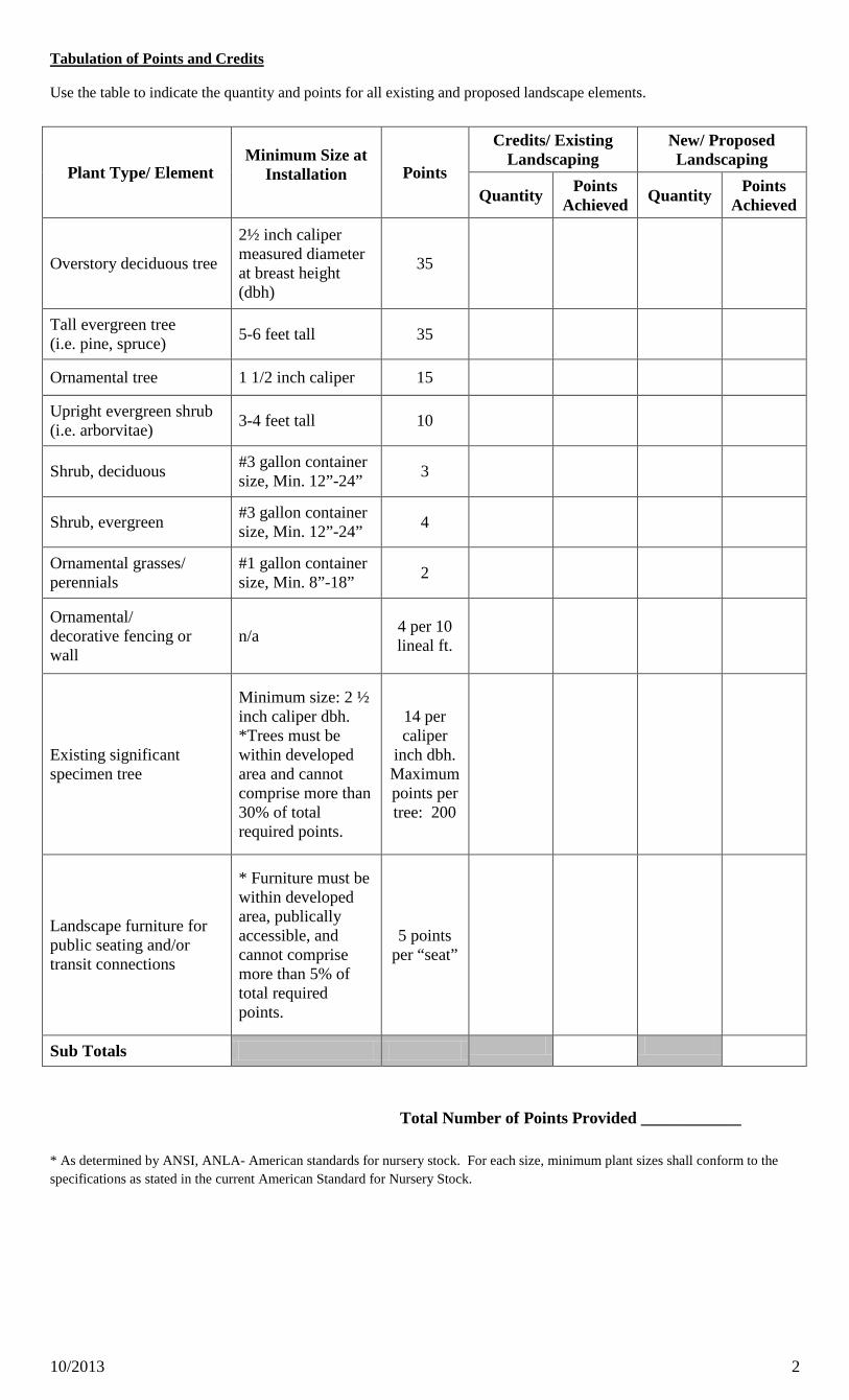
Tabulation of Points and Credits
Use the table to indicate the quantity and points for all existing and proposed landscape elements.
Plant Type/ Element Minimum Size at
Installation Points
Credits/ Existing Landscaping
New/ Proposed Landscaping
Quantity Points Achieved Quantity Points
Achieved
Overstory deciduous tree
2½ inch caliper measured diameter at breast height (dbh)
35
Tall evergreen tree (i.e. pine, spruce) 5-6 feet tall 35
Ornamental tree 1 1/2 inch caliper 15
Upright evergreen shrub (i.e. arborvitae) 3-4 feet tall 10
Shrub, deciduous #3 gallon container size, Min. 12”-24” 3
Shrub, evergreen #3 gallon container size, Min. 12”-24” 4
Ornamental grasses/ perennials
#1 gallon container size, Min. 8”-18” 2
Ornamental/ decorative fencing or wall
n/a 4 per 10 lineal ft.
Existing significant specimen tree
Minimum size: 2 ½ inch caliper dbh. *Trees must bewithin developed area and cannot comprise more than 30% of total required points.
14 per caliper
inch dbh. Maximum points per tree: 200
Landscape furniture for public seating and/or transit connections
* Furniture must bewithin developed area, publically accessible, and cannot comprise more than 5% of total required points.
5 points per “seat”
Sub Totals
Total Number of Points Provided ____________
* As determined by ANSI, ANLA- American standards for nursery stock. For each size, minimum plant sizes shall conform to thespecifications as stated in the current American Standard for Nursery Stock.
10/2013 3
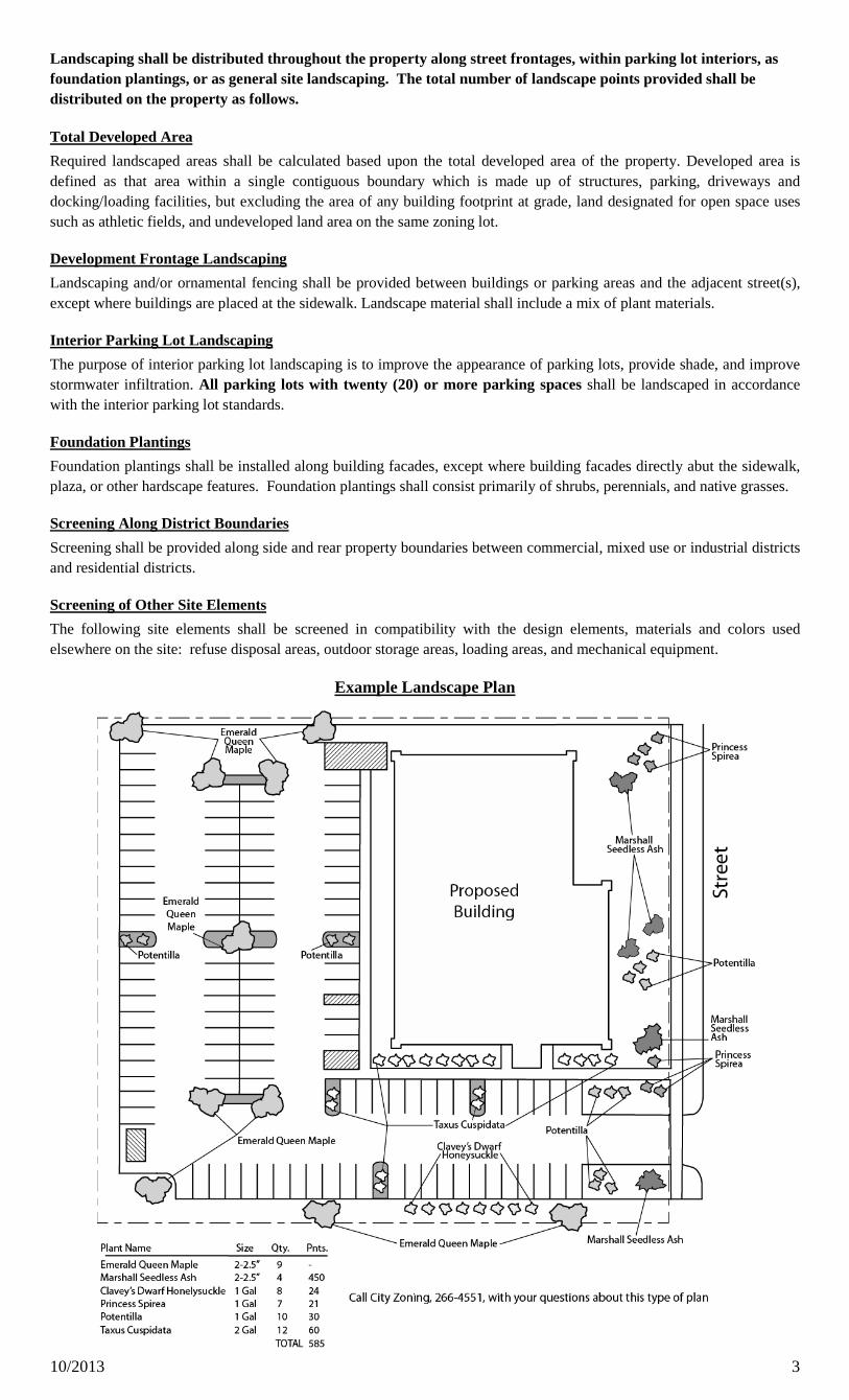
Landscaping shall be distributed throughout the property along street frontages, within parking lot interiors, as foundation plantings, or as general site landscaping. The total number of landscape points provided shall be distributed on the property as follows.
Required landscaped areas shall be calculated based upon the total developed area of the property. Developed area is defined as that area within a single contiguous boundary which is made up of structures, parking, driveways and docking/loading facilities, but excluding the area of any building footprint at grade, land designated for open space uses such as athletic fields, and undeveloped land area on the same zoning lot.
Total Developed Area
Landscaping and/or ornamental fencing shall be provided between buildings or parking areas and the adjacent street(s), except where buildings are placed at the sidewalk. Landscape material shall include a mix of plant materials.
Development Frontage Landscaping
The purpose of interior parking lot landscaping is to improve the appearance of parking lots, provide shade, and improve stormwater infiltration. All parking lots with twenty (20) or more parking spaces shall be landscaped in accordance with the interior parking lot standards.
Interior Parking Lot Landscaping
Foundation plantings shall be installed along building facades, except where building facades directly abut the sidewalk, plaza, or other hardscape features. Foundation plantings shall consist primarily of shrubs, perennials, and native grasses.
Foundation Plantings
Screening shall be provided along side and rear property boundaries between commercial, mixed use or industrial districts and residential districts.
Screening Along District Boundaries
The following site elements shall be screened in compatibility with the design elements, materials and colors used elsewhere on the site: refuse disposal areas, outdoor storage areas, loading areas, and mechanical equipment.
Screening of Other Site Elements
Example Landscape Plan
10/2013 4
LANDSCAPE PLAN AND LANDSCAPE WORKSHEET INSTRUCTIONS
Refer to Zoning Code Section 28.142 LANDSCAPING AND SCREENING REQUIREMENTS for the complete requirements for preparing and submitting a Landscape Plan and Landscape Worksheet.
ApplicabilityThe following standards apply to all exterior construction and development activity, including the expansion of existing buildings, structures and parking lots, except the construction of detached single-family and two-family dwellings and their accessory structures. The entire development site must be brought up to compliance with this section unless all of the following conditions apply, in which case only the affected areas need to be brought up to compliance:
.
(a) The area of site disturbance is less than ten percent (10%) of the entire development site during any ten-(10) year period.
(b) Gross floor area is only increased by ten percent (10%) during any ten-(10) year period.
(c) No demolition of a principal building is involved.
(d) Any displaced landscaping elements must be replaced on the site and shown on a revised landscaping plan.
Landscape Plan and Design StandardsLandscape plans shall be submitted as a component of a site plan, where required, or as a component of applications for other actions, including zoning permits, where applicable. Landscape plans for zoning lots greater than ten thousand (10,000) square feet in size must be prepared by a registered landscape architect.
.
(a) Elements of the landscape plan shall include the following:
1. Plant list including common and Latin names, size and root condition (i.e. container or ball & burlap).
2. Site amenities, including bike racks, benches, trash receptacles, etc.
3. Storage areas including trash and loading.
4. Lighting (landscape, pedestrian or parking area).
5. Irrigation.
6. Hard surface materials.
7. Labeling of mulching, edging and curbing.
8. Areas of seeding or sodding.
9. Areas to remain undisturbed and limits of land disturbance.
10. Plants shall be depicted at their size at sixty percent (60%) of growth.
11. Existing trees eight (8) inches or more in diameter.
12. Site grading plan, including stormwater management, if applicable.
(b) Plant Selection. Plant materials provided in conformance with the provisions of this section shall be nursery quality and tolerant of individual site microclimates.
(c) Mulch shall consist of shredded bark, chipped wood or other organic material installed at a minimum depth of two (2) inches.
Landscape Calculations and DistributionRequired landscaped areas shall be calculated based upon the total developed area of the property. Developed area, for the purpose of this requirement, is defined as that area within a single contiguous boundary which is made up of structures, parking driveways and docking/loading facilities, but excluding the area of any building footprint at grade, land designated for open space uses such as athletic fields, and undeveloped land area on the same zoning lot.
.
(a) Landscaping shall be distributed throughout the property along street frontages, within parking lot interiors, and as foundation plantings, or as general site landscaping.
(b) Planting beds or planted areas must have at least seventy-five percent (75%) vegetative cover.
(c) Canopy tree diversity requirements for new trees:
1. If the development site has fewer than 5 canopy trees, no tree diversity is required.
2. If the development site has between 5 and 50 canopy trees, no single species may comprise morethan 33% of trees.
3. If the development site has more than 50 canopy trees, no single species may comprise morethan 20% of trees.
Landscaping and/or ornamental fencing shall be provided between buildings or parking areas and the adjacent street(s), except where buildings are placed at the sidewalk. Landscape material shall include a mix of plant material meeting the following minimum requirements:
Development Frontage Landscaping.
10/2013 5
(a) One (1) overstory deciduous tree and five (5) shrubs shall be planted for each thirty (30) lineal feet of lot frontage. Two (2) ornamental trees or two (2) evergreen trees may be used in place of one (1) overstory deciduous tree.
(b) In cases where building facades directly abut the sidewalk, required frontage landscaping shall be deducted from the required point total.
(c) In cases where development frontage landscaping cannot be provided due to site constraints, the zoning administrator may waive the requirement or substitute alternative screening methods for the required landscaping.
(d) Fencing shall be a minimum of three (3) feet in height, and shall be constructed of metal, masonry, stone or equivalent material. Chain link or temporary fencing is prohibited.
The purpose of interior parking lot landscaping is to improve the appearance of parking lots, provide shade, and improve stormwater infiltration. All parking lots with twenty (20) or more parking spaces shall be landscaped in accordance with the following interior parking lot standards.
Interior Parking Lot Landscaping.
(a) For new development on sites previously undeveloped or where all improvements have been removed, a minimum of eight percent (8%) of the asphalt or concrete area of the parking lot shall be devoted to interior planting islands, peninsulas, or landscaped strips. For changes to a developed site, a minimum of five percent (5%) of the asphalt or concrete area shall be interior planting islands, peninsulas, or landscaped strips. A planting island shall be located at least every twelve (12) contiguous stalls with no break or alternatively, landscaped strips at least seven (7) feet wide between parking bays.
(b) The primary plant materials shall be shade trees with at least one (1) deciduous canopy tree for every one hundred sixty (160) square feet of required landscaped area. Two (2) ornamental deciduous trees may be substituted for one (1) canopy tree, but ornamental trees shall constitute no more than twenty-five percent (25%) of the required trees. No light poles shall be located within the area of sixty percent (60%) of mature growth from the center of any tree.
(c) Islands may be curbed or may be designed as uncurbed bio-retention areas as part of an approved low impact stormwater management design approved by the Director of Public Works. The ability to maintain these areas over time must be demonstrated. (See Chapter 37, Madison General Ordinances, Erosion and Stormwater Runoff Control.)
Foundation PlantingsFoundation plantings shall be installed along building facades, except where building facades directly abut the sidewalk, plaza, or other hardscape features. Foundation plantings shall consist primarily of shrubs, perennials, and native grasses. The Zoning Administrator may modify this requirement for development existing prior to the effective date of this ordinance, as long as improvements achieve an equivalent or greater level of landscaping for the site.
.
Screening Along District BoundariesScreening shall be provided along side and rear property boundaries between commercial, mixed use or industrial districts and residential districts. Screening shall consist of a solid wall, solid fence, or hedge with year-round foliage, between six (6) and eight (8) feet in height, except that within the front yard setback area, screening shall not exceed four (4) feet in height. Height of screening shall be measured from natural or approved grade. Berms and retaining walls shall not be used to increase grade relative to screening height.
.
Screening of Other Site ElementsThe following site elements shall be screened in compatibility with the design elements, materials and colors used elsewhere on the site, as follows:
.
(a) Refuse Disposal Areas.
(b)
All developments, except single family and two family developments, shall provide a refuse disposal area. Such area shall be screened on four (4) sides (including a gate for access) by a solid, commercial-grade wood fence, wall, or equivalent material with a minimum height of six (6) feet and not greater than seven (7) feet.
Outdoor Storage Areas.
(c) Loading Areas. Loading areas shall be screened from abutting residential uses and from street view to the extent feasible by a building wall or solid, commercial-grade wood fence, or equivalent material, with a minimum height of six (6) feet and not greater than seven (7) feet. Screening along district boundaries, where present, may provide all or part of the required screening.
Outdoor storage areas shall be screened from abutting residential uses with a by a building wall or solid, commercial-grade wood fence, wall, year-round hedge, or equivalent material, with a minimum height of six (6) feet and not greater than seven (7) feet. Screening along district boundaries, where present, may provide all or part of the required screening.
(d) Mechanical Equipment. All rooftop and ground level mechanical equipment and utilities shall be fully screened from view from any street or residential district, as viewed from six (6) feet above ground level. Screening may consist of a building wall or fence and/or landscaping as approved by the Zoning Administrator.
MaintenanceThe owner of the premises is responsible for the watering, maintenance, repair and replacement of all landscaping, fences, and other landscape architectural features on the site. All planting beds shall be kept weed free. Plant material that has died shall be replaced no later than the upcoming June 1.
.
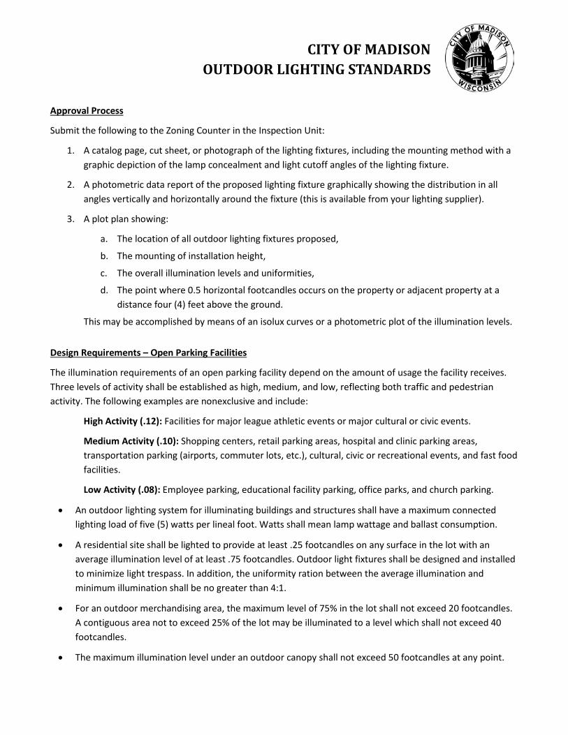
CITY OF MADISON OUTDOOR LIGHTING STANDARDS
Approval Process
Submit the following to the Zoning Counter in the Inspection Unit:
1. A catalog page, cut sheet, or photograph of the lighting fixtures, including the mounting method with agraphic depiction of the lamp concealment and light cutoff angles of the lighting fixture.
2. A photometric data report of the proposed lighting fixture graphically showing the distribution in allangles vertically and horizontally around the fixture (this is available from your lighting supplier).
3. A plot plan showing:
a. The location of all outdoor lighting fixtures proposed,
b. The mounting of installation height,
c. The overall illumination levels and uniformities,
d. The point where 0.5 horizontal footcandles occurs on the property or adjacent property at adistance four (4) feet above the ground.
This may be accomplished by means of an isolux curves or a photometric plot of the illumination levels.
Design Requirements – Open Parking Facilities
The illumination requirements of an open parking facility depend on the amount of usage the facility receives. Three levels of activity shall be established as high, medium, and low, reflecting both traffic and pedestrian activity. The following examples are nonexclusive and include:
High Activity (.12): Facilities for major league athletic events or major cultural or civic events.
Medium Activity (.10): Shopping centers, retail parking areas, hospital and clinic parking areas, transportation parking (airports, commuter lots, etc.), cultural, civic or recreational events, and fast food facilities.
Low Activity (.08): Employee parking, educational facility parking, office parks, and church parking.
• An outdoor lighting system for illuminating buildings and structures shall have a maximum connectedlighting load of five (5) watts per lineal foot. Watts shall mean lamp wattage and ballast consumption.
• A residential site shall be lighted to provide at least .25 footcandles on any surface in the lot with anaverage illumination level of at least .75 footcandles. Outdoor light fixtures shall be designed and installedto minimize light trespass. In addition, the uniformity ration between the average illumination andminimum illumination shall be no greater than 4:1.
• For an outdoor merchandising area, the maximum level of 75% in the lot shall not exceed 20 footcandles.A contiguous area not to exceed 25% of the lot may be illuminated to a level which shall not exceed 40footcandles.
• The maximum illumination level under an outdoor canopy shall not exceed 50 footcandles at any point.
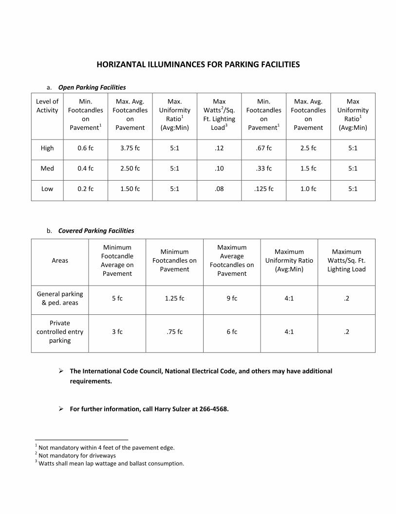
HORIZANTAL ILLUMINANCES FOR PARKING FACILITIES
a. Open Parking Facilities
Level of Activity
Min. Footcandles
on Pavement1
Max. Avg. Footcandles
on Pavement
Max. Uniformity
Ratio1 (Avg:Min)
Max Watts2/Sq. Ft. Lighting
Load3
Min. Footcandles
on Pavement1
Max. Avg. Footcandles
on Pavement
Max Uniformity
Ratio1 (Avg:Min)
High 0.6 fc 3.75 fc 5:1 .12 .67 fc 2.5 fc 5:1
Med 0.4 fc 2.50 fc 5:1 .10 .33 fc 1.5 fc 5:1
Low 0.2 fc 1.50 fc 5:1 .08 .125 fc 1.0 fc 5:1
b. Covered Parking Facilities
Areas
Minimum Footcandle Average on Pavement
Minimum Footcandles on
Pavement
Maximum Average
Footcandles on Pavement
Maximum Uniformity Ratio
(Avg:Min)
Maximum Watts/Sq. Ft. Lighting Load
General parking & ped. areas 5 fc 1.25 fc 9 fc 4:1 .2
Private controlled entry
parking 3 fc .75 fc 6 fc 4:1 .2
The International Code Council, National Electrical Code, and others may have additionalrequirements.
For further information, call Harry Sulzer at 266-4568.
1 Not mandatory within 4 feet of the pavement edge. 2 Not mandatory for driveways 3 Watts shall mean lap wattage and ballast consumption.
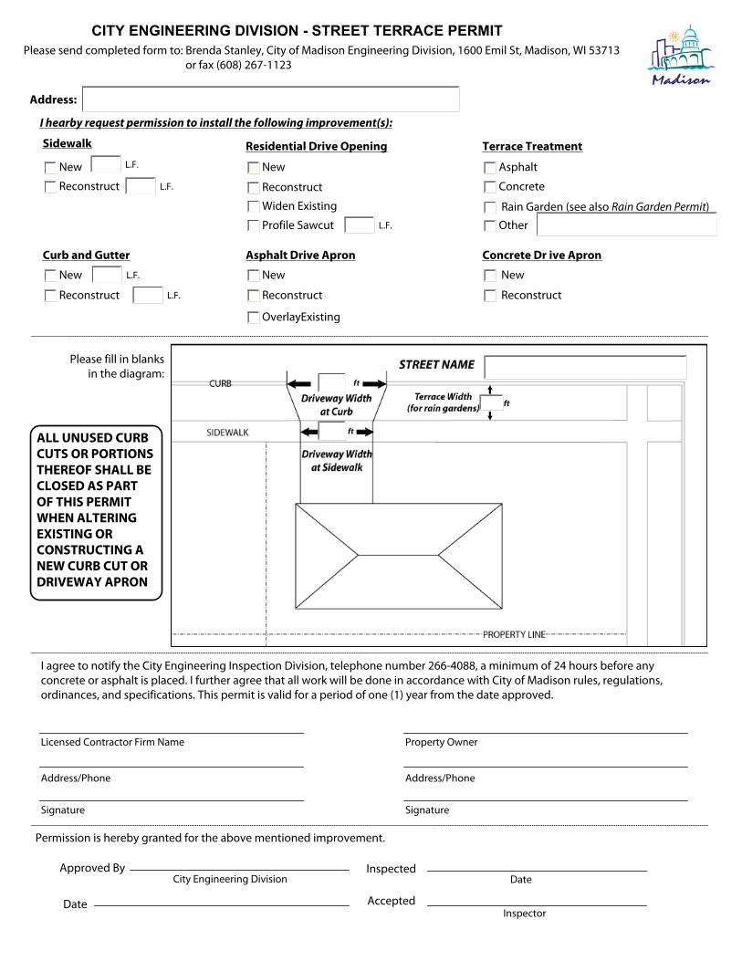
CITY ENGINEERING DIVISION - STREET TERRACE PERMIT
Address:
I hearby request permission to install the following improvement(s):
New
Reconstruct
Sidewalk
Curb and Gutter
New
Reconstruct
L.F.
L.F.
L.F.
L.F.
Concrete Dr ive Apron
New
Reconstruct
Residential Drive Opening
New
Reconstruct
Widen Existing
Profile Sawcut L.F.
Terrace Treatment
Asphalt
Concrete
Other
Asphalt Drive Apron
New
Reconstruct
OverlayExisting
Rain Garden (see also Rain Garden Permit)
Permission is hereby granted for the above mentioned improvement.
Approved By
Date
Inspected
Accepted
City Engineering Division
Inspector
Date
I agree to notify the City Engineering Inspection Division, telephone number 266-4088, a minimum of 24 hours before any concrete or asphalt is placed. I further agree that all work will be done in accordance with City of Madison rules, regulations, ordinances, and specifications. This permit is valid for a period of one (1) year from the date approved.
Licensed Contractor Firm Name
Address/Phone
Signature
Property Owner
Address/Phone
Signature
Please fill in blanks in the diagram:
ALL UNUSED CURB
CUTS OR PORTIONS
THEREOF SHALL BE
CLOSED AS PART
OF THIS PERMIT
WHEN ALTERING
EXISTING OR
CONSTRUCTING A
NEW CURB CUT OR
DRIVEWAY APRON
Please send completed form to: Brenda Stanley, City of Madison Engineering Division, 1600 Emil St, Madison, WI 53713 or fax (608) 267-1123
Page 1 of 3
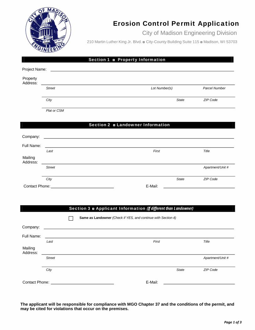
Erosion Control Permit Application City of Madison Engineering Division
210 Martin Luther King Jr. Blvd. ◘ City-County Building Suite 115 ◘ Madison, W I 53703
Section 1 ◘ Property Information
Project Name:
Property Address:
Street Lot Number(s) Parcel Number
City State ZIP Code
Plat or CSM
Section 2 ◘ Landowner Information
Company:
Full Name: Last First Title
Mailing Address:
Street Apartment/Unit #
City State ZIP Code
Contact Phone: E-Mail:
Section 3 ◘ Applicant Information (If different than Landowner)
Same as Landowner (Check if YES, and continue with Section 4)
Company:
Full Name: Last First Title
Mailing Address:
Street Apartment/Unit #
City State ZIP Code
Contact Phone: E-Mail:
The applicant will be responsible for compliance with MGO Chapter 37 and the conditions of the permit, and may be cited for violations that occur on the premises.
Page 2 of 3
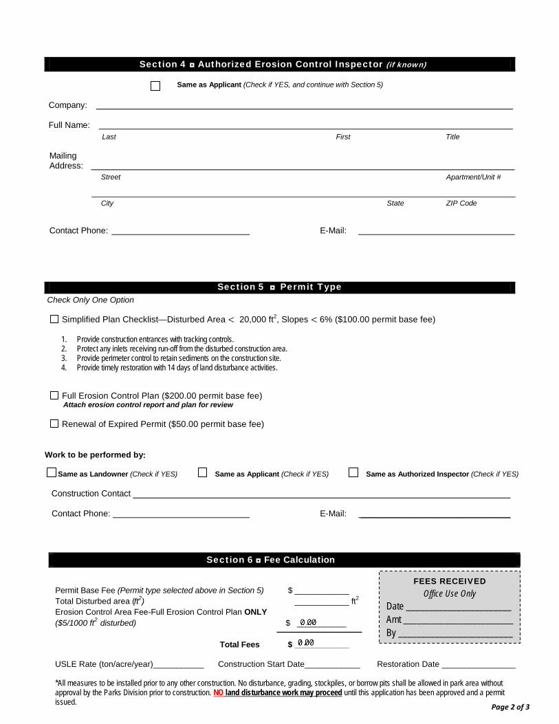
Section 4 ◘ Authorized Erosion Control Inspector (if known)
Same as Applicant (Check if YES, and continue with Section 5) Company: Full Name:
Last First Title Mailing Address:
Street Apartment/Unit #
City State ZIP Code
Contact Phone: E-Mail:
Section 5 ◘ Permit Type Check Only One Option
Simplified Plan Checklist—Disturbed Area < 20,000 ft2, Slopes < 6% ($100.00 permit base fee)
1. Provide construction entrances with tracking controls. 2. Protect any inlets receiving run-off from the disturbed construction area. 3. Provide perimeter control to retain sediments on the construction site. 4. Provide timely restoration with 14 days of land disturbance activities.
Full Erosion Control Plan ($200.00 permit base fee) Attach erosion control report and plan for review
Renewal of Expired Permit ($50.00 permit base fee) Work to be performed by: Same as Landowner (Check if YES) Same as Applicant (Check if YES) Same as Authorized Inspector (Check if YES) Construction Contact Contact Phone: E-Mail: _______________________________
Section 6 ◘ Fee Calculation
USLE Rate (ton/acre/year)___________ Construction Start Date____________ Restoration Date ________________ *All measures to be installed prior to any other construction. No disturbance, grading, stockpiles, or borrow pits shall be allowed in park area without approval by the Parks Division prior to construction. NO land disturbance work may proceed until this application has been approved and a permit issued.
Permit Base Fee (Permit type selected above in Section 5) $ ____________ Total Disturbed area (ft2) ____________ ft2 Erosion Control Area Fee-Full Erosion Control Plan ONLY ($5/1000 ft2 disturbed) $ ___________
Total Fees $ ____________
FEES RECEIVED Office Use Only
Date _______________________ Amt ________________________ By _________________________
Page 3 of 3
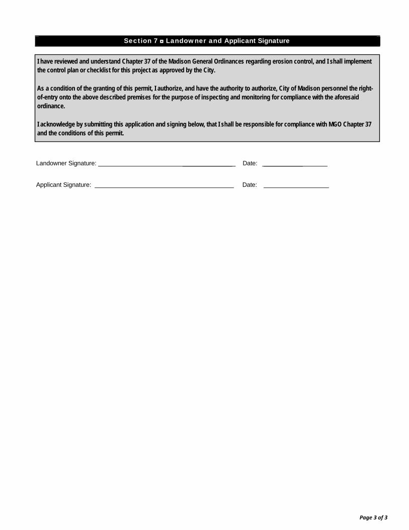
1. Section 7 ◘ Landowner and Applicant Signature
Landowner Signature: ______________ Date: ___________
Applicant Signature: Date:
I have reviewed and understand Chapter 37 of the Madison General Ordinances regarding erosion control, and I shall implement the control plan or checklist for this project as approved by the City.
As a condition of the granting of this permit, I authorize, and have the authority to authorize, City of Madison personnel the right-of-entry onto the above described premises for the purpose of inspecting and monitoring for compliance with the aforesaid ordinance.
I acknowledge by submitting this application and signing below, that I shall be responsible for compliance with MGO Chapter 37 and the conditions of this permit.
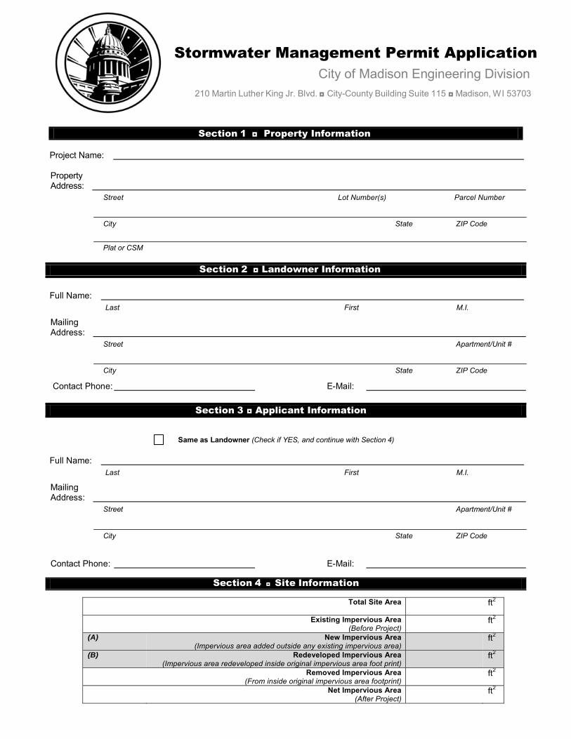
Stormwater Management Permit Application City of Madison Engineering Division
210 Martin Luther King Jr. Blvd. ◘ City-County Building Suite 115 ◘ Madison, W I 53703
Section 1 ◘ Property Information
Project Name:
Property Address:
Street Lot Number(s) Parcel Number
City State ZIP Code
Plat or CSM
Section 2 ◘ Landowner Information
Full Name: Last First M.I.
Mailing Address:
Street Apartment/Unit #
City State ZIP Code
Contact Phone: E-Mail:
Section 3 ◘ Applicant Information
Same as Landowner (Check if YES, and continue with Section 4)
Full Name: Last First M.I.
Mailing Address:
Street Apartment/Unit #
City State ZIP Code
Contact Phone: E-Mail:
Section 4 ◘ Site Information
Total Site Area ft2
Existing Impervious Area (Before Project)
ft2
(A) New Impervious Area (Impervious area added outside any existing impervious area)
ft2
(B) Redeveloped Impervious Area (Impervious area redeveloped inside original impervious area foot print)
ft2
Removed Impervious Area (From inside original impervious area footprint)
ft2
Net Impervious Area (After Project)
ft2
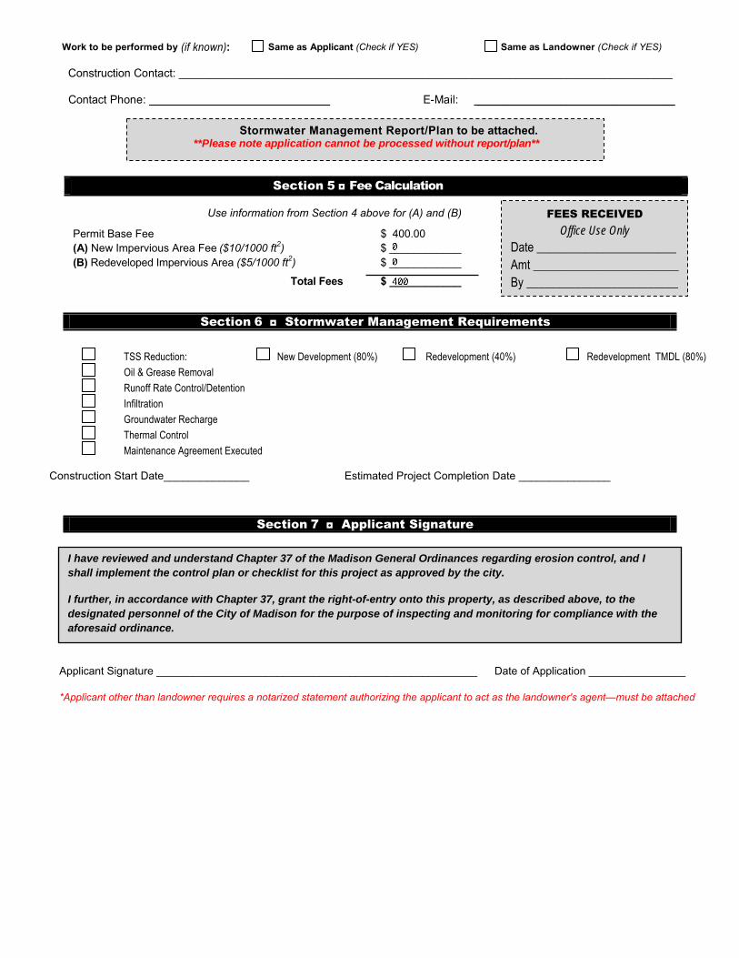
Work to be performed by (if known): Same as Applicant (Check if YES) Same as Landowner (Check if YES)
Construction Contact: _______________________________________________________________________________
Contact Phone: E-Mail: _______________________________
Section 5 ◘ Fee Calculation
Use information from Section 4 above for (A) and (B)
Section 6 ◘ Stormwater Management Requirements
Section 7 ◘ Applicant Signature
Applicant Signature _____________________________________________________ Date of Application ________________
*Applicant other than landowner requires a notarized statement authorizing the applicant to act as the landowner's agent—must be attached
TSS Reduction: New Development (80%) Redevelopment (40%) Redevelopment TMDL (80%)
Oil & Grease Removal
Runoff Rate Control/Detention
Infiltration
Groundwater Recharge
Thermal Control
Maintenance Agreement Executed
Construction Start Date______________ Estimated Project Completion Date _______________
Stormwater Management Report/Plan to be attached. **Please note application cannot be processed without report/plan**
Permit Base Fee $ 400.00 (A) New Impervious Area Fee ($10/1000 ft2) $ ____________ (B) Redeveloped Impervious Area ($5/1000 ft2) $ ____________
Total Fees $ ____________
FEES RECEIVED Office Use Only
Date _______________________ Amt ________________________ By _________________________
I have reviewed and understand Chapter 37 of the Madison General Ordinances regarding erosion control, and I shall implement the control plan or checklist for this project as approved by the city.
I further, in accordance with Chapter 37, grant the right-of-entry onto this property, as described above, to the designated personnel of the City of Madison for the purpose of inspecting and monitoring for compliance with the aforesaid ordinance.
12/10/2014-Excavate in the right of way application.doc
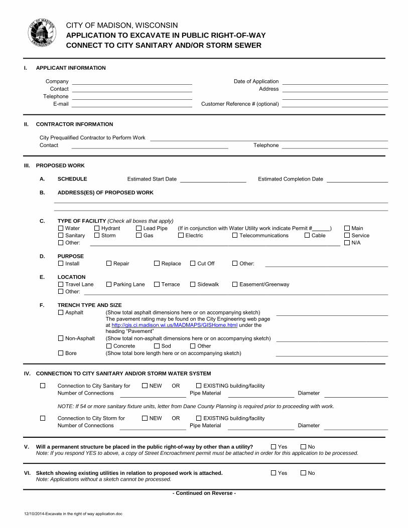
CITY OF MADISON, WISCONSIN APPLICATION TO EXCAVATE IN PUBLIC RIGHT-OF-WAY CONNECT TO CITY SANITARY AND/OR STORM SEWER
I. APPLICANT INFORMATION
Company Date of Application Contact Address
Telephone E-mail Customer Reference # (optional)
II. CONTRACTOR INFORMATION
City Prequalified Contractor to Perform Work Contact Telephone
III. PROPOSED WORK
A. SCHEDULE Estimated Start Date Estimated Completion Date
B. ADDRESS(ES) OF PROPOSED WORK
C. TYPE OF FACILITY (Check all boxes that apply) Water Hydrant Lead Pipe (If in conjunction with Water Utility work indicate Permit # ) Main Sanitary Storm Gas Electric Telecommunications Cable Service Other: N/A
D. PURPOSE Install Repair Replace Cut Off Other:
E. LOCATION Travel Lane Parking Lane Terrace Sidewalk Easement/Greenway Other:
F. TRENCH TYPE AND SIZE Asphalt (Show total asphalt dimensions here or on accompanying sketch)
The pavement rating may be found on the City Engineering web page at http://gis.ci.madison.wi.us/MADMAPS/GISHome.html under the heading “Pavement”
Non-Asphalt (Show total non-asphalt dimensions here or on accompanying sketch) Concrete Sod Other
Bore (Show total bore length here or on accompanying sketch)
IV. CONNECTION TO CITY SANITARY AND/OR STORM WATER SYSTEM
Connection to City Sanitary for NEW OR EXISTING building/facility Number of Connections Pipe Material Diameter
NOTE: If 54 or more sanitary fixture units, letter from Dane County Planning is required prior to proceeding with work.
Connection to City Storm for NEW OR EXISTING building/facility Number of Connections Pipe Material Diameter
V. Will a permanent structure be placed in the public right-of-way by other than a utility? Yes No Note: If you respond YES to above, a copy of Street Encroachment permit must be attached in order for this application to be processed.
VI. Sketch showing existing utilities in relation to proposed work is attached. Yes No Note: Applications without a sketch cannot be processed.
- Continued on Reverse -
12/10/2014-Excavate in the right of way application.doc
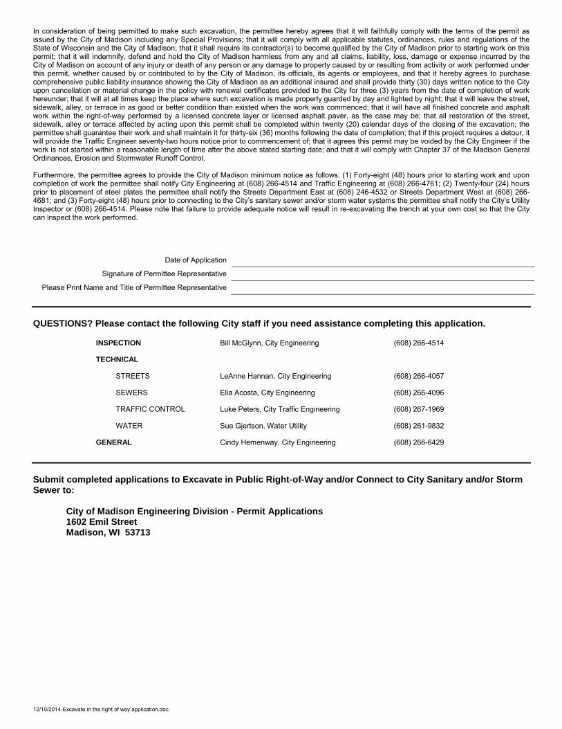
In consideration of being permitted to make such excavation, the permittee hereby agrees that it will faithfully comply with the terms of the permit as issued by the City of Madison including any Special Provisions; that it will comply with all applicable statutes, ordinances, rules and regulations of the State of Wisconsin and the City of Madison; that it shall require its contractor(s) to become qualified by the City of Madison prior to starting work on this permit; that it will indemnify, defend and hold the City of Madison harmless from any and all claims, liability, loss, damage or expense incurred by the City of Madison on account of any injury or death of any person or any damage to property caused by or resulting from activity or work performed under this permit, whether caused by or contributed to by the City of Madison, its officials, its agents or employees, and that it hereby agrees to purchase comprehensive public liability insurance showing the City of Madison as an additional insured and shall provide thirty (30) days written notice to the City upon cancellation or material change in the policy with renewal certificates provided to the City for three (3) years from the date of completion of work hereunder; that it will at all times keep the place where such excavation is made properly guarded by day and lighted by night; that it will leave the street, sidewalk, alley, or terrace in as good or better condition than existed when the work was commenced; that it will have all finished concrete and asphalt work within the right-of-way performed by a licensed concrete layer or licensed asphalt paver, as the case may be; that all restoration of the street, sidewalk, alley or terrace affected by acting upon this permit shall be completed within twenty (20) calendar days of the closing of the excavation; the permittee shall guarantee their work and shall maintain it for thirty-six (36) months following the date of completion; that if this project requires a detour, it will provide the Traffic Engineer seventy-two hours notice prior to commencement of; that it agrees this permit may be voided by the City Engineer if the work is not started within a reasonable length of time after the above stated starting date; and that it will comply with Chapter 37 of the Madison General Ordinances, Erosion and Stormwater Runoff Control. Furthermore, the permittee agrees to provide the City of Madison minimum notice as follows: (1) Forty-eight (48) hours prior to starting work and upon completion of work the permittee shall notify City Engineering at (608) 266-4514 and Traffic Engineering at (608) 266-4761; (2) Twenty-four (24) hours prior to placement of steel plates the permittee shall notify the Streets Department East at (608) 246-4532 or Streets Department West at (608) 266-4681; and (3) Forty-eight (48) hours prior to connecting to the City’s sanitary sewer and/or storm water systems the permittee shall notify the City’s Utility Inspector or (608) 266-4514. Please note that failure to provide adequate notice will result in re-excavating the trench at your own cost so that the City can inspect the work performed.
Date of Application Signature of Permittee Representative
Please Print Name and Title of Permittee Representative QUESTIONS? Please contact the following City staff if you need assistance completing this application.
INSPECTION Bill McGlynn, City Engineering (608) 266-4514
TECHNICAL
STREETS LeAnne Hannan, City Engineering (608) 266-4057
SEWERS Elia Acosta, City Engineering (608) 266-4096
TRAFFIC CONTROL Luke Peters, City Traffic Engineering (608) 267-1969
WATER Sue Gjertson, Water Utility (608) 261-9832
GENERAL Cindy Hemenway, City Engineering (608) 266-6429
Submit completed applications to Excavate in Public Right-of-Way and/or Connect to City Sanitary and/or Storm Sewer to:
City of Madison Engineering Division - Permit Applications 1602 Emil Street Madison, WI 53713
Revised 12/5/2014
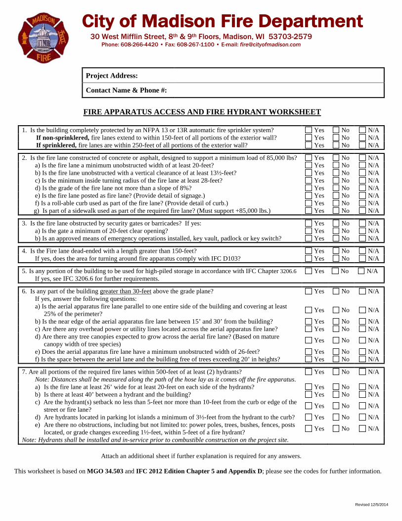
City of Madison Fire Department 30 West Mifflin Street, 8th & 9th Floors, Madison, WI 53703-2579
Phone: 608-266-4420 • Fax: 608-267-1100 • E-mail: [email protected]
Project Address:
Contact Name & Phone #:
FIRE APPARATUS ACCESS AND FIRE HYDRANT WORKSHEET
1. Is the building completely protected by an NFPA 13 or 13R automatic fire sprinkler system? Yes No N/A If non-sprinklered, fire lanes extend to within 150-feet of all portions of the exterior wall? Yes No N/A If sprinklered, fire lanes are within 250-feet of all portions of the exterior wall? Yes No N/A
2. Is the fire lane constructed of concrete or asphalt, designed to support a minimum load of 85,000 lbs? Yes No N/A a) Is the fire lane a minimum unobstructed width of at least 20-feet? Yes No N/A b) Is the fire lane unobstructed with a vertical clearance of at least 13½-feet? Yes No N/A c) Is the minimum inside turning radius of the fire lane at least 28-feet? Yes No N/A d) Is the grade of the fire lane not more than a slope of 8%? Yes No N/A e) Is the fire lane posted as fire lane? (Provide detail of signage.) Yes No N/A f) Is a roll-able curb used as part of the fire lane? (Provide detail of curb.) Yes No N/A g) Is part of a sidewalk used as part of the required fire lane? (Must support +85,000 lbs.) Yes No N/A
3. Is the fire lane obstructed by security gates or barricades? If yes: Yes No N/A a) Is the gate a minimum of 20-feet clear opening? Yes No N/A b) Is an approved means of emergency operations installed, key vault, padlock or key switch? Yes No N/A
4. Is the Fire lane dead-ended with a length greater than 150-feet? Yes No N/A If yes, does the area for turning around fire apparatus comply with IFC D103? Yes No N/A
5. Is any portion of the building to be used for high-piled storage in accordance with IFC Chapter 3206.6 If yes, see IFC 3206.6 for further requirements.
Yes No N/A
6. Is any part of the building greater than 30-feet above the grade plane? Yes No N/A If yes, answer the following questions: a) Is the aerial apparatus fire lane parallel to one entire side of the building and covering at least
25% of the perimeter? Yes No N/A
b) Is the near edge of the aerial apparatus fire lane between 15’ and 30’ from the building? Yes No N/A c) Are there any overhead power or utility lines located across the aerial apparatus fire lane? Yes No N/A d) Are there any tree canopies expected to grow across the aerial fire lane? (Based on mature
canopy width of tree species) Yes No N/A
e) Does the aerial apparatus fire lane have a minimum unobstructed width of 26-feet? Yes No N/A f) Is the space between the aerial lane and the building free of trees exceeding 20’ in heights? Yes No N/A
7. Are all portions of the required fire lanes within 500-feet of at least (2) hydrants? Yes No N/A Note: Distances shall be measured along the path of the hose lay as it comes off the fire apparatus. a) Is the fire lane at least 26’ wide for at least 20-feet on each side of the hydrants? Yes No N/A b) Is there at least 40’ between a hydrant and the building? Yes No N/A c) Are the hydrant(s) setback no less than 5-feet nor more than 10-feet from the curb or edge of the
street or fire lane? Yes No N/A
d) Are hydrants located in parking lot islands a minimum of 3½-feet from the hydrant to the curb? Yes No N/A e) Are there no obstructions, including but not limited to: power poles, trees, bushes, fences, posts
located, or grade changes exceeding 1½-feet, within 5-feet of a fire hydrant? Yes No N/A
Note: Hydrants shall be installed and in-service prior to combustible construction on the project site.
Attach an additional sheet if further explanation is required for any answers.
This worksheet is based on MGO 34.503 and IFC 2012 Edition Chapter 5 and Appendix D; please see the codes for further information.