Embed Size (px)
Citation preview
Town of Northlake Parks, Recreation and Open Space
Master Plan
Prepared By: DUNKIN SIMS STOFFELS, INC.
LANDSCAPE ARCHITECTS/PLANNERS
December 2012
Town of Northlake, Texas Parks, Recreation, and Open Space Master Plan
Acknowledgments Mayor
Peter Dewing Town Council
Jean Young (Mayor Pro Tem) Rena Hardeman Michael Ganz Roger Sessions Danny Simpson Community Development Corporation
Gary Baxter – President Jeff Mewhirter – Vice President Hillary Simpson – Secretary/Treasurer Rick Kastner – Director Roger Sessions – Director James Manuel – Director Katherine McBride - Director Parks, Recreation, and Open Space Master Plan Advisory Committee
Tammy Wright Amanda Merchant Wesley Lincoln Jerry Amarante Rose Sirois Jamie Woodward Sherri Steward-Ganz Staff Members
Drew Corn – Town Administrator Nathan Reddin – Development Director Shirley Rogers – Town Secretary
Town of Northlake, Texas Parks, Recreation, and Open Space Master Plan
Page i
Table of Contents I. INTRODUCTION .......................................................................................................... 1
HISTORICAL BACKGROUND ........................................................................................................... 1 PREVIOUS PARK PLANNING STUDIES .............................................................................................. 1 GOALS & OBJECTIVES ................................................................................................................. 1 POLICIES & ORDINANCES ............................................................................................................ 3 PLAN DEVELOPMENT PROCESS ...................................................................................................... 4
II. INVENTORY OF AREAS AND FACILITIES ................................................................... 5
III. FACTORS INFLUENCING PLANNING FOR PARKS ...................................................... 6
TRANSPORTATION ROUTES & THOROUGHFARES ................................................................................ 6 DEMOGRAPHIC PROFILE .............................................................................................................. 6
Race & Ethnicity Composition .............................................................................................. 6 Age Comparison & Distribution ............................................................................................ 7 Income Distribution ............................................................................................................. 7
PARKS, RECREATION & OPEN SPACE CLASSIFICATION ........................................................................ 8 Neighborhood Park ............................................................................................................. 8 Community Park ................................................................................................................. 9 Greenways / Open Space .................................................................................................. 11 Special Use Park ............................................................................................................... 11
IV. NEEDS ASSESSMENT AND IDENTIFICATION .......................................................... 12
GENERAL ASSESSMENT .............................................................................................................. 12 PUBLIC INPUT MEETINGS ........................................................................................................... 12 STANDARD-BASED ANALYSIS ...................................................................................................... 13
Facility-Recreation Standard .............................................................................................. 13 Park Land Analysis ............................................................................................................ 16
V. FUTURE PARK RECOMMENDATIONS ......................................................................... 17
FUTURE NEIGHBORHOOD PARK ACQUISITION ................................................................................. 17 NEIGHBORHOOD PARK/PUBLIC SCHOOL SITE ................................................................................. 17 RURAL RESIDENTIAL DISTRICT ................................................................................................... 17 HOMEOWNER ASSOCIATION (HOA) PARKS AND RESIDENTIAL COMMUNITIES .......................................... 18 FUTURE COMMUNITY PARKS, GREENBELTS & SPECIAL USE PARKS ....................................................... 19
Community Parks .............................................................................................................. 19 Indoor Recreation Center .................................................................................................. 19 Aquatic Facilities ............................................................................................................... 19 Greenbelts and Presentation of Open Space ....................................................................... 20 Pedestrian Trail ................................................................................................................. 20 Equestrian Trails ............................................................................................................... 20 Floodplain Acquisition ........................................................................................................ 20 Special Use Parks .............................................................................................................. 21
Town of Northlake, Texas Parks, Recreation, and Open Space Master Plan
Page ii
VI. TEN YEAR TOWN PRIORITY LIST ............................................................................ 22
Plate 2: Future Park Plan ............................................................................................... 24
VII. TOWN-WIDE TRAIL SYSTEM STANDARDS .............................................................. 25
Purpose of the Trail System Plan ........................................................................................ 25 Design Considerations ....................................................................................................... 25 Types of Trails .................................................................................................................. 25 Trail Surfaces ................................................................................................................... 25 Multi-Use Trail Width ......................................................................................................... 27 Vertical Clearance ............................................................................................................. 28 Longitudinal Slope (Grade) ................................................................................................ 28 Signs ................................................................................................................................ 28 Access Points .................................................................................................................... 28 Lighting ............................................................................................................................ 28 Traffic Control Devices ...................................................................................................... 29
TOWN OF NORTHLAKE TRAIL RECOMMENDATION............................................................................. 29 Off-Street Trail Width ........................................................................................................ 29 On-Street Trail Width ........................................................................................................ 29 Trail Surface ..................................................................................................................... 29 Access Points/ Trail Heads ................................................................................................. 30 Trail Signs ........................................................................................................................ 30
Plate 3: Future Trail Plan ............................................................................................... 31
VIII. PLAN SUMMARY .................................................................................................... 32
IMPLEMENTATION .................................................................................................................... 32 Policies and Ordinances ..................................................................................................... 32 Watershed Management & Drainageway Ordinances ........................................................... 33 Funding Sources ............................................................................................................... 33
General Fund ............................................................................................................. 33 Bonds ....................................................................................................................... 33 General Obligation Bond ............................................................................................. 33 Revenue Bonds ......................................................................................................... 34 Private Donations ...................................................................................................... 34 Northlake Economic Development Corporation (EDC) and the Northlake Community Development Corporation (CDC) ................................................................................. 34 Texas Recreation and Parks Account (TRPA) Program .................................................. 34 Safe Routes to School Program ................................................................................... 35 Recreation Trails Program (RTP) ................................................................................. 35 Public Improvements District (P.I.D.) .......................................................................... 35 Tax Increment Financing District (T.I.F.) ..................................................................... 35
APPENDIX ‘A’ .................................................................................................................. 36
Typical Neighborhood Park Land Acquisition and Development Cost .............................. 36

Introduction
Town of Northlake, Texas Parks, Recreation, and Open Space Master Plan
Page 1
I. Introduction
HISTORICAL BACKGROUND Northlake is a growing community of 2,110 residents located in the southwest corner of Denton County, Texas, along Interstate Highway 35W and State Highway 114, between Fort Worth and Denton and just 15 miles from the Dallas/Fort Worth International Airport. On December 28, 1960, the Town of Northlake was incorporated. At that time, Northlake was a rural community consisting of ranches and agricultural use. In fact, after existing nearly ten years as a town, the 1970 census recorded the population of Northlake had only grown by 20 people. The motivation to incorporate was to preserve the ranches and rural character of the community by keeping nearby cities from annexing the land. Although the town has grown considerably since its inception and more growth is sure to come, Northlake continues to value its rural character as it grows as part of North Central Texas, one of the fastest growing regions in the United States.
PREVIOUS PARK PLANNING STUDIES There have been no specific Park Master Plans prepared for the Town of Northlake. A Comprehensive Plan was adopted in 2002 and the Comprehensive Plan was updated April of 2009. Both plans had a section outlining Parks, Open Space and Trails. One recommendation from the Comprehensive Plans was to prepare a Town Park, Recreation and Open Space Plan. Northlake is largely undeveloped and rural in nature and the Town does not have public park land or recreational facilities. Based on this, and the Comprehensive Plan, the Town Council decided to prepare a Park and Recreation Master Plan to guide park and recreation planning and development, leading to the creation of this Parks, Recreation, and Open Space Master Plan.
GOALS & OBJECTIVES As Northlake continues to grow and develop, the need to provide its citizens with a place to encounter nature within a suburban setting along with recreational facilities becomes more important. It is with this in mind that the Town of Northlake is taking time to address citizen concerns and provide short term and long term recommendations for the park system, recreation facilities, and Town trail networks, in the form of a Parks, Recreation, and Open Space Master Plan. This Plan will provide design concepts, program development, cost opinions, funding alternatives and recommendations for future park development. It will provide the town with detailed information gathered from the community, Town Staff, and an analysis of what recreational facilities and land uses are needed that would offer a useful resource to the Town of Northlake as it continues to grow.
Goals provide a statement for achievement or accomplishment. Objectives are a perceived means through which the goal(s) can be partially or fully attained. Identified within this section are the ways and methods of
Town of Northlake, Texas Parks, Recreation, and Open Space Master Plan
Page 2
implementing the Parks, Recreation, and Open Space Master Plan recommendations. Critical to the implementation of these goals and objectives is the Ten-Year Action Plan (refer to Section VI), which should be updated annually by Town Staff and the Town Council.
The following are the goals and objectives for the Northlake Park System:
Goal:
To enhance the quality of life for a growing community by providing places and opportunities for people to recreate and be active, in a way that is sensitive to the conservation of natural resources.
Objectives:
To preserve open space for passive recreation needs.
To increase quality recreational opportunities for Northlake citizens.
To value the rights of property owners by acquiring land for parks, open space, trail corridors and floodplain land through dedication, donation, or purchase of property thereby avoiding the use of condemnation or eminent domain.
To administer development and construction guidelines which result in minimal destruction of native and wildlife habitat and creek corridors.
Goal:
Plan and develop an extensive multi-use trail system
Objectives:
Acquire property in the Denton Creek Floodplain for a trail corridor.
Obtain Right-of-Way of thoroughfare for bike and walking opportunities.
Provides nature and soft surface trail opportunities.
Connect retail, residential and future parks with a trail system.
Goal:
To provide an array of facilities, programs and park areas to meet the recreational needs of a diverse population with various levels of ability and skill.
Objective:
To recognize the special needs of youth, teens, adults, the elderly and handicapped when designating and providing recreational facilities.
Town of Northlake, Texas Parks, Recreation, and Open Space Master Plan
Page 3
Goal:
Provide all citizens reasonable access to parks and recreation facilities within the town.
Objective:
To acquire necessary parkland and open space at the time of development review in accordance with the classification of parks identified by the Parks, Recreation, and Open Space Master Plan.
Goal:
Develop a new Community Park to serve the citizens of Northlake.
Objectives:
To provide a variety of recreational facilities to serve all citizens of Northlake.
To provide organized league fields in order to consolidate competitive game fields within the Town.
Goal:
To provide cost-effective services and optimize benefits to citizens through cooperation within the community, as well as the county and other agencies.
Objectives:
To coordinate with land developers on providing public or semi-public or Homeowner Association recreational facilities.
To encourage joint development of property and land acquisition for park, recreation, and open space purposes with other public entities, educational entities, and Denton County.
POLICIES & ORDINANCES The effectiveness of these implementation mechanisms is dependent upon the proper coordination of input from contributing bodies or groups including elected Town officials - appointed boards and commissions - Town staff, sports groups, and most importantly the citizens of Northlake. All parties must communicate and work collectively toward common goals. Only this sort of communication and coordination will ensure successful development of the park system. An example of this communication, at the staff level, would be the incorporation of the Parks, Recreation, and Open Space Master Plan during review of proposed development plans by the Town. The Town has a park dedication ordinance for dedication of land and fees for park development.
Town of Northlake, Texas Parks, Recreation, and Open Space Master Plan
Page 4
PLAN DEVELOPMENT PROCESS The Town Council recognized the need for a comprehensive analysis of the park system in Northlake. In July of 2011 the Town employed a private consulting firm (Dunkin Sims Stoffels, Inc.) to prepare the Parks, Recreation, and Open Space Master Plan. The consultant worked with the Town of Northlake staff and an advisory committee composed of residents to develop this Master Plan. Meetings were held with Northlake Staff and the Advisory Committee to examine collected needs, findings and preliminary recommendations. To obtain a comprehensive and complete analysis of the Town’s park and recreation needs, and park system, three (3) methodologies were used for this evaluation: public hearings, standards-based analysis, and demand-based recreation analysis. The time period of the financial plan, as set forth in Section VI of this Master Plan (specifically within the Implementation sub-section), is ten (10) years. The prioritization listing contained in Section VI identifies certain projections as high priorities for development with the priorities based on satisfying a stipulated/recognized need. The Master Plan provides the Town both short-range implementation scheduling and long-range planning for future areas of urbanization. The service area studied for the Parks, Recreation, and Open Space Master Plan includes the area within the ultimate Town limits of Northlake including all the area in Northlake's extra-territorial jurisdiction (ETJ) in addition to the current Town limits of Northlake.

Inventory of Areas and Facilities
Town of Northlake, Texas Parks, Recreation, and Open Space Master Plan
Page 5
II. Inventory of Areas and Facilities The Town of Northlake does not have public park land or any park facilities at the present time. Any acreage purchased or dedicated will provide land for first time recreation opportunities in the Town of Northlake.

Factors Influencing Planning for Parks

Town of Northlake, Texas Parks, Recreation, and Open Space Master Plan
Page 6
III. Factors Influencing Planning for Parks
TRANSPORTATION ROUTES & THOROUGHFARES The Fort Worth Alliance Airport, a major air cargo and corporate airport, is approximately 8 miles from the Northlake Town Hall. The Texas Motor Speedway is adjacent to the South Town limit of Northlake. These developments are indicators that Northlake is poised for future growth and development. Park land acquisition is critical to development of the park system. The Town is in a unique position to acquire this property because it’s rural and undeveloped. Northlake is fortunate to have several major thoroughfares that provide opportunities for the development of property within the Town Limits and ETJ. Specifically, Interstate Highway 35 West on the east boundary provides regional mobility and access to Northlake. Future commercial and retail will occur along Interstate 35W. These retail sales tax dollars represent an opportunity for funding for the park and recreation services that Northlake will need to support its growing number of citizens.
DEMOGRAPHIC PROFILE The 2010 U.S. Census documented the population of the Town of Northlake to be 1,724. The 2012 population, based on North Central Texas Council of Governments, is 2,110. Because of the geographical location in the Dallas/Ft. Worth Metroplex, Northlake is anticipated to continue experiencing rapid growth, making the provision of park and recreational services even more important to address in the short and long terms.
Race & Ethnicity Composition Table 1 illustrates the race and ethnic composition of the Town of Northlake according to the U.S. Census Bureau. The table also illustrates the diversity of the local population. The White/Caucasian group comprises the largest percentage at 84.5 percent, with the Other Races and African American category representing the second largest 4.9 percent each.
Table 1 Race/Ethnicity Distribution – 2010
Town of Northlake, Texas
Number Percent
White/Caucasian 1,783 84.5%
African American 104 4.9%
Native American 25 1.2%
Asian 44 2.1%
Other Races 103 4.9%
Native Hawaiian/Other Pacific 4 0.2%
Two Races 47 2.2%
Total: 2,110 100%
Hispanic Origin (2) 49 2.3%
Source: 2010 U.S. Census (2) Hispanic/Spanish Origin may be of any race and may be
included in any category. It is therefore not included in the total, but is separately included.
Town of Northlake, Texas Parks, Recreation, and Open Space Master Plan
Page 7
Age Comparison & Distribution The age composition of the population within a Town can also provide insight into the types of park and recreation facilities and services the Town may need to provide. As reflected in Table 2, the largest age group is the Prime Labor Force (25-44 years old). Many in this group are families with children in sports and recreation programs. Young adults in this group may also play organized adult sports. Northlake also has a high percentage of people in the School Age Children & Young Adults (0-19 years); this age group generally represents a large number of people that use a community’s park facilities because of league sports and other organized play activities. The Older Labor Force and the Elderly groups also together comprise a significant percentage of the Town’s population at 27.8 percent; these groups tend to utilize hike-and bike trails and passive open space areas. Clearly, groups of all of ages have recreational needs.
Income Distribution Household income for Northlake according to the 2010 U.S. Census 2006-2010 American Community Survey is shown in Table 3. Approximately 29 percent of the households in Northlake were in the range of $100,000 and above. However, the highest percentage of households in Northlake in 2010 was within the $50,000 to $74,999 income category. The lowest percentages were in the range of $24,999 and less.
Table 2 Age Comparison & Distribution
Town of Northlake, Texas
Age Groups Number Percent
School Age Children & Young Adults (0-19 years) 572 27.1%
College/New Family (20-24 years old) 203 9.6%
Prime Labor Force (25-44 years old) 749 35.5%
Older Labor Force (45-64 years old) 489 23.2%
Elderly (65+ years old) 97 4.6%
Total: 2,110 100.0%
Source: U.S. Census 2010
Table 3 Income Distribution
Town of Northlake, Texas
Income Level Number Percent
Less than $14,999 31 5.5%
$15,000 to $24,999 26 4.7%
$25,000 to $34,999 48 8.6%
$35,000 to $49,999 84 15.0%
$50,000 to $74,999 190 34.0%
$75,000 to $99,000 74 13.2%
$100,000 to $149,999 32 5.7%
$150,000 to $199,999 53 9.5%
$200,000 or more 21 13.8%
Total 559 100.0%
Source: U.S. Census 2006-2010 American Community Survey
Town of Northlake, Texas Parks, Recreation, and Open Space Master Plan
Page 8
PARKS, RECREATION & OPEN SPACE CLASSIFICATION
To deliver a variety of recreational features in an efficient manner, some type of relationship defining system must be established among those facilities used for recreation. Guidelines and standards recommended by the National Recreation and Park Association (NRPA) have been followed by cities for many years to define a hierarchy for their park systems. The NRPA made major revisions to their recommendations for delivering park and recreation services in the publication, Parks, Recreation, Open Space and Greenway Guidelines, published in December 1995. The classification system has been changed slightly to more closely define a park space in relationship to its proposed use. The following analysis identifies the NRPA classification of parks, their description, location criteria within the community and criteria for size. Only the park classifications selected specifically for Northlake are defined in this section. Once established, these guidelines are then applicable for structuring the Northlake park system in an orderly manner responsive to the recreational demands being generated by the present and future population.
Neighborhood Park The neighborhood park is considered to be the most important feature of a park system and is one of the major cohesive elements in neighborhood design. Its primary function is the provision of recreational space for the entire neighborhood which surrounds it. Space in the neighborhood park should be distributed between active and passive uses.
(a). The neighborhood park should be located near the center of a neighborhood area/park planning area and have a service area of approximately one-half mile to one-quarter mile.
(b). The size should be related to the service area population and the menu of activities chosen for placement in the park. Five (5) to ten (10) acres is the optimal size for this park.
(c). Safe and convenient pedestrian access is considered important to a neighborhood park location.
(d). Generally, the location should not be adjacent to a heavily traveled major or minor thoroughfare.
(e). When it is possible to combine an elementary or middle school with this type of park, the two features further enhance the identity of the neighborhood by providing a central location for recreation and education and a significant open space feature within the neighborhood.
EXAMPLE OF A NEIGHBORHOOD PARK AND ITS RECOMMENDED
RELATIONSHIP TO THE SURROUNDING NEIGHBORHOOD
NEIGHBORHOOD
PARK
EXAMPLE O A NEIGHBORHOOD PARK AND ITS RECOMMENDED RELATIONSHIP TO THE SURROUNDING NEIGHBORHOOD
Town of Northlake, Texas Parks, Recreation, and Open Space Master Plan
Page 9
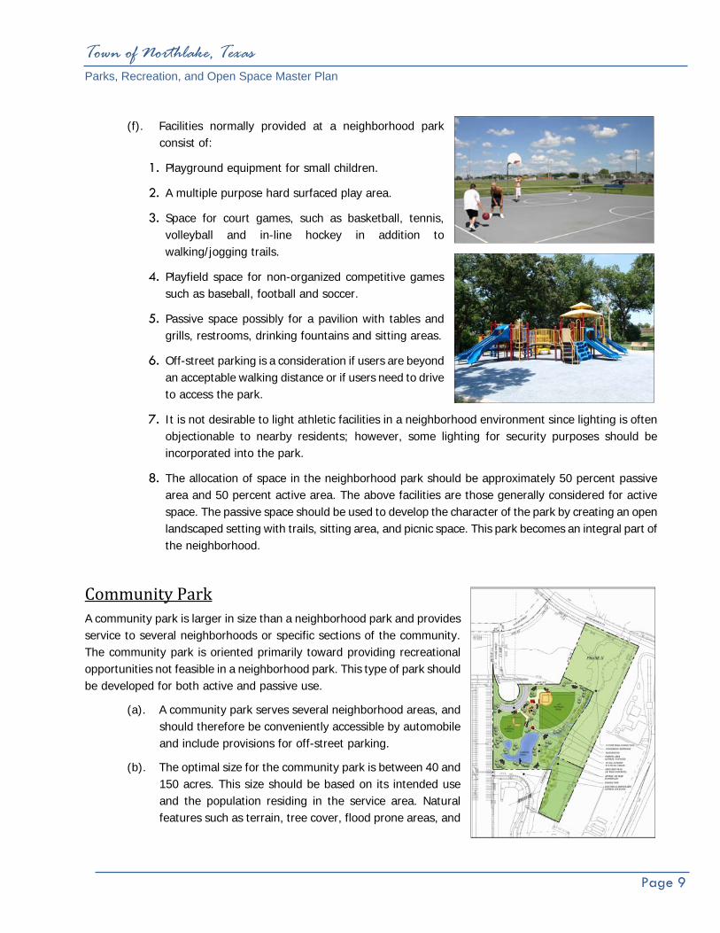
(f). Facilities normally provided at a neighborhood park consist of:
1. Playground equipment for small children.
2. A multiple purpose hard surfaced play area.
3. Space for court games, such as basketball, tennis, volleyball and in-line hockey in addition to walking/jogging trails.
4. Playfield space for non-organized competitive games such as baseball, football and soccer.
5. Passive space possibly for a pavilion with tables and grills, restrooms, drinking fountains and sitting areas.
6. Off-street parking is a consideration if users are beyond an acceptable walking distance or if users need to drive to access the park.
7. It is not desirable to light athletic facilities in a neighborhood environment since lighting is often objectionable to nearby residents; however, some lighting for security purposes should be incorporated into the park.
8. The allocation of space in the neighborhood park should be approximately 50 percent passive area and 50 percent active area. The above facilities are those generally considered for active space. The passive space should be used to develop the character of the park by creating an open landscaped setting with trails, sitting area, and picnic space. This park becomes an integral part of the neighborhood.
Community Park A community park is larger in size than a neighborhood park and provides service to several neighborhoods or specific sections of the community. The community park is oriented primarily toward providing recreational opportunities not feasible in a neighborhood park. This type of park should be developed for both active and passive use.
(a). A community park serves several neighborhood areas, and should therefore be conveniently accessible by automobile and include provisions for off-street parking.
(b). The optimal size for the community park is between 40 and 150 acres. This size should be based on its intended use and the population residing in the service area. Natural features such as terrain, tree cover, flood prone areas, and

Town of Northlake, Texas Parks, Recreation, and Open Space Master Plan
Page 10
water features are all factors to be used in selecting and sizing this type of park.
(c). Activities provided should include both active and passive space.
(d). Space for active uses associated with neighborhood parks including field and court games.
(e). Passive spaces more extensive than the neighborhood park for trails, natural areas, picnicking, and ornamental or natural landscape areas.
(f). Facilities for cultural activities such as plays or concerts; possibly provide an amphitheater.
(g). Lighted or unlighted athletic fields or facilities may be placed in community parks provided careful thought is given to their design and location.
(h). A community park should be well removed from the residential environment due to the traffic, noise, and lights associated with the sports complex.
(i). Based on use, accessibility and other requirements, the community park should be located in a non-residential area served by major thoroughfares.
(j). Sites are not recommended to be less than 40 acres with the optimal site ranging upward to 80-150 acres, if demand is present.
(k). Although community parks are designed primarily for competitive play by both young people and adults, other features should be included in the complex. Among these are play apparatus, court game space, picnicking facilities, and trails.
(l). Support facilities in a sports complex include restrooms, concessions, multi-purpose building(s), and maintenance facilities.
(m). Parking is a major consideration for the sports complex. Spaces should be allocated to accommodate those currently participating, those lingering following the previous games and those arriving to participate in the next scheduled game.
Town of Northlake, Texas Parks, Recreation, and Open Space Master Plan
Page 11
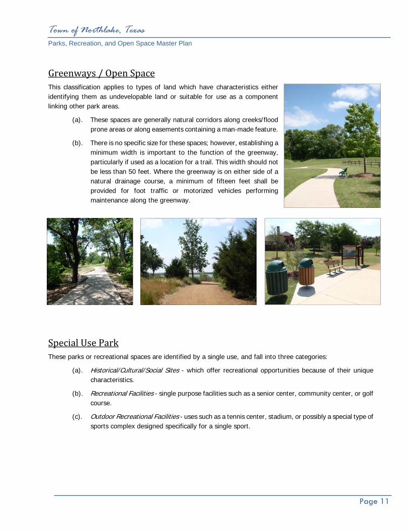
Greenways / Open Space This classification applies to types of land which have characteristics either identifying them as undevelopable land or suitable for use as a component linking other park areas.
(a). These spaces are generally natural corridors along creeks/flood prone areas or along easements containing a man-made feature.
(b). There is no specific size for these spaces; however, establishing a minimum width is important to the function of the greenway, particularly if used as a location for a trail. This width should not be less than 50 feet. Where the greenway is on either side of a natural drainage course, a minimum of fifteen feet shall be provided for foot traffic or motorized vehicles performing maintenance along the greenway.
Special Use Park These parks or recreational spaces are identified by a single use, and fall into three categories:
(a). Historical/Cultural/Social Sites - which offer recreational opportunities because of their unique characteristics.
(b). Recreational Facilities - single purpose facilities such as a senior center, community center, or golf course.
(c). Outdoor Recreational Facilities - uses such as a tennis center, stadium, or possibly a special type of sports complex designed specifically for a single sport.
Needs Assessment and Identification
Town of Northlake, Texas Parks, Recreation, and Open Space Master Plan
Page 12
IV. Needs Assessment and Identification GENERAL ASSESSMENT The Town of Northlake currently does not have park land or recreational facilities available for the citizens. Northlake citizens travel to adjacent municipalities and cities in the North Texas region for recreation opportunities. The fact that the Town does not have any public park land or recreational facilities available to Northlake citizens is unique. Although there are no park lands or facilities available the positive aspect is Northlake can develop a park system based on public comment, and one which is tailored specifically to meet the Town’s needs and would greatly benefit the Town and its citizens.
PUBLIC INPUT MEETINGS The Town of Northlake held two public input meetings to receive citizens’ comments on the park and recreational needs within the Town. One meeting was a regular scheduled Council meeting and the other was a Northlake Community Development Corporation (CDC) meeting, Northlake's Type B economic development corporation. The Council meeting was well attended with approximately 25-27 people in attendance and the CDC meeting was attended by 10-12 people. Comments from the public varied and addressed a wide range of park facilities. Several of the comments addressed the lack of park facilities in Northlake such as trails, parks, and nature or open space opportunities. Many of the comments focused on parks and recreation facilities in adjacent cities. People expressed their desires to have those same types of facilities in Northlake to avoid traveling and to improve the quality of life in Northlake. Trails were requested and ranked number one on the priority listing of recreational amenities desired. The Table above illustrates the priority of recreational needs identified by the public.
Table 4 Public Input Meetings
Priority Listing Town of Northlake, Texas
1. Trail 16. Tennis 2. Playgrounds 17. Skateboard Park 3. Equestrian Trail 18. Rubber Matte Playground 4. Take Advantage of Speedway 19. Preservation of Open Space 5. Trail/Trail Heads/Separate Roads 20. No Organized Park 6. Light Trails 21. Parks/Common Property 7. Parks/Water Park 22. Sense of Community 8. No Dog Park 23. Like Passive Parks 9. Picnic Tables & Pavilion 24. Trail Separate Surface
10. Amphitheater 25. Specific Use Parks/No Open Space Parks
11. Baseball 26. Variety of Parks and Uses in Parks
12. Soccer Field 27. North Texas Trails Plan/COG? 13. Water Pond 28. Protecting Private Rights 14. Fishing Pier 29. Walking Trails 15. Basketball/Multi-Purpose Courts 30. Trail Safety
Town of Northlake, Texas Parks, Recreation, and Open Space Master Plan
Page 13
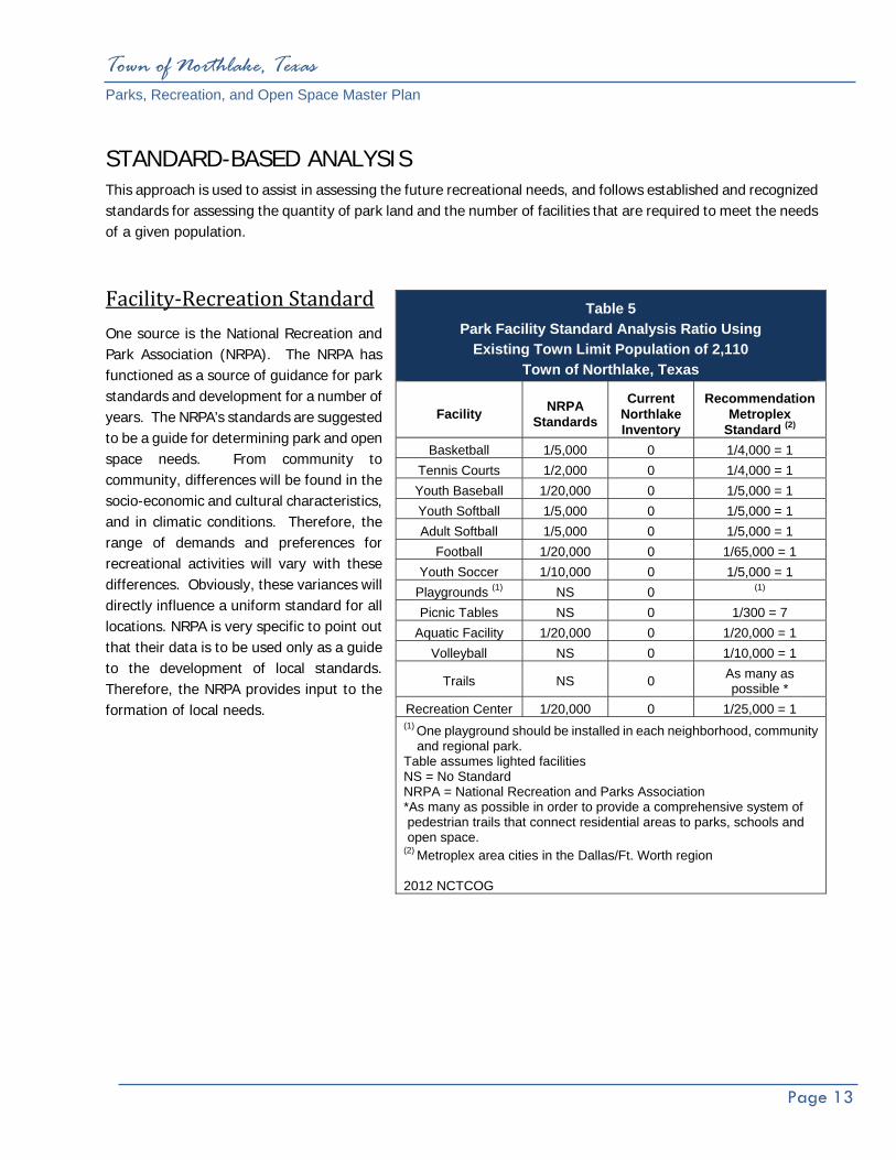
STANDARD-BASED ANALYSIS This approach is used to assist in assessing the future recreational needs, and follows established and recognized standards for assessing the quantity of park land and the number of facilities that are required to meet the needs of a given population.
Facility‐Recreation Standard One source is the National Recreation and Park Association (NRPA). The NRPA has functioned as a source of guidance for park standards and development for a number of years. The NRPA’s standards are suggested to be a guide for determining park and open space needs. From community to community, differences will be found in the socio-economic and cultural characteristics, and in climatic conditions. Therefore, the range of demands and preferences for recreational activities will vary with these differences. Obviously, these variances will directly influence a uniform standard for all locations. NRPA is very specific to point out that their data is to be used only as a guide to the development of local standards. Therefore, the NRPA provides input to the formation of local needs.
Table 5 Park Facility Standard Analysis Ratio Using
Existing Town Limit Population of 2,110 Town of Northlake, Texas
Facility NRPA Standards
Current Northlake Inventory
Recommendation Metroplex
Standard (2)
Basketball 1/5,000 0 1/4,000 = 1 Tennis Courts 1/2,000 0 1/4,000 = 1 Youth Baseball 1/20,000 0 1/5,000 = 1 Youth Softball 1/5,000 0 1/5,000 = 1 Adult Softball 1/5,000 0 1/5,000 = 1
Football 1/20,000 0 1/65,000 = 1 Youth Soccer 1/10,000 0 1/5,000 = 1
Playgrounds (1) NS 0 (1)
Picnic Tables NS 0 1/300 = 7 Aquatic Facility 1/20,000 0 1/20,000 = 1
Volleyball NS 0 1/10,000 = 1
Trails NS 0 As many as possible *
Recreation Center 1/20,000 0 1/25,000 = 1 (1) One playground should be installed in each neighborhood, community
and regional park. Table assumes lighted facilities NS = No Standard NRPA = National Recreation and Parks Association *As many as possible in order to provide a comprehensive system of pedestrian trails that connect residential areas to parks, schools and open space. (2) Metroplex area cities in the Dallas/Ft. Worth region 2012 NCTCOG

Town of Northlake, Texas Parks, Recreation, and Open Space Master Plan
Page 14
The standard analysis has been prepared for the current Town population of approximately 2,110 within Table 5 on the previous page, and for the future projected populations of 17,310 in the year 2021 (Table 6 below), and shown in Table 7 (on the following page) is an analysis for the projected build-out population of 55,000 for the Town and ETJ. This is a standard comparison which illustrates the level of services provided at each population and what the projected facilities need would be for these various anticipated population levels. Again, it is important to note that these are national standards and the comparison will vary from Town-to-Town. It is common for larger cities to provide recreational facilities for smaller communities nearby. Often, smaller communities do not have recreational facilities and depend on larger area cities for these resources.
Table 6 Park Facility Standard Analysis Ratio Using
Projected Population of 17,310 in 2021 Town of Northlake, Texas
Facility NRPA Standards
Current Northlake Inventory
Recommendation
Basketball 1/5,000 0 1/4,000 = 5 Tennis Courts 1/2,000 0 1/4,000 = 5
Baseball 1/20,000 0 1/5,000 = 4 Softball 1/5,000 0 1/5,000 = 4
Adult Softball 1/5,000 0 1/5,000 = 4 Football 1/20,000 0 1/65,000 = 1
Youth Soccer 1/10,000 0 1/5,000 = 4 Playgrounds (1) NS 0 (1)
Picnic Tables NS 0 1/300 = 58 Aquatic Facility 1/20,000 0 1/20,000 = 1
Volleyball NS 0 1/10,000 = 2 Trails NS 0 As many as possible *
Recreation Center 1/20,000 0 1/25,000 = 1 (1) One playground should be installed in each neighborhood, community and regional park. Table assumes lighted facilities NS = No Standard NRPA = National Recreation and Parks Association *As many as possible in order to provide a comprehensive system of pedestrian trails that connect residential areas to parks, schools and open space. Source: Impact Fee Study Prepared by Halff Associates, Inc.
The 17,310 Population includes ETJ Limits.

Town of Northlake, Texas Parks, Recreation, and Open Space Master Plan
Page 15
Table 7 Park Facility Standard Analysis Ratio Using Build-Out Population of 55,000
Town of Northlake, Texas
Facility NRPA Standards
Current Northlake Inventory
Recommendation
Basketball 1/5,000 0 1/4,000 = 14
Tennis Courts 1/2,000 0 1/4,000 = 14
Youth Baseball 1/20,000 0 1/5,000 = 11
Youth Softball 1/5,000 0 1/5,000 = 11
Adult Softball 1/5,000 0 1/5,000 = 11
Football 1/20,000 0 1/65,000 = 1
Youth Soccer 1/10,000 0 1/5,000 = 11
Playgrounds (1) NS 0 (1)
Picnic Tables NS 0 1/300 = 183
Aquatic Facility 1/20,000 0 1/30,000 = 2
Volleyball NS 0 1/10,000 = 4
Trails NS 0 As many as possible *
Recreation Center 1/20,000 0 1/25,000 = 1
(1) One playground should be installed in each neighborhood, community and regional park. Table assumes lighted facilities NS = No Standard NRPA = National Recreation and Parks Association *As many as possible in order to provide a comprehensive system of pedestrian trails that connect residential areas to parks, schools and open space. Northlake Comprehensive Plan
The 55,000 Population includes ETJ Limits.
Town of Northlake, Texas Parks, Recreation, and Open Space Master Plan
Page 16
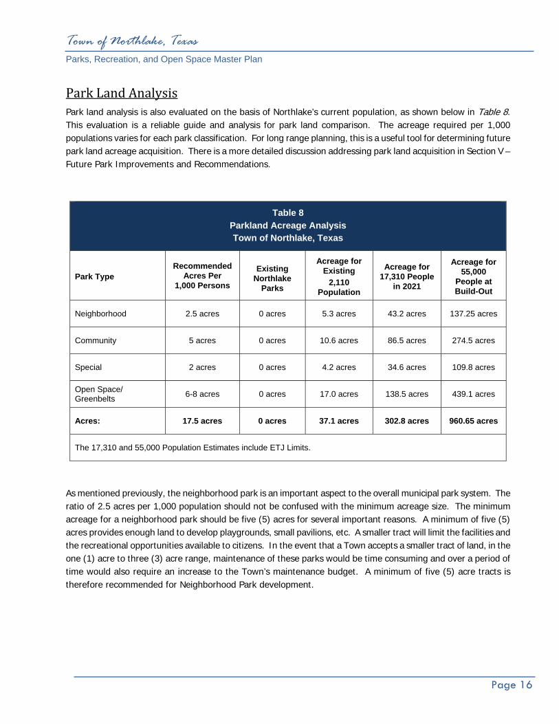
Park Land Analysis Park land analysis is also evaluated on the basis of Northlake’s current population, as shown below in Table 8. This evaluation is a reliable guide and analysis for park land comparison. The acreage required per 1,000 populations varies for each park classification. For long range planning, this is a useful tool for determining future park land acreage acquisition. There is a more detailed discussion addressing park land acquisition in Section V – Future Park Improvements and Recommendations.
As mentioned previously, the neighborhood park is an important aspect to the overall municipal park system. The ratio of 2.5 acres per 1,000 population should not be confused with the minimum acreage size. The minimum acreage for a neighborhood park should be five (5) acres for several important reasons. A minimum of five (5) acres provides enough land to develop playgrounds, small pavilions, etc. A smaller tract will limit the facilities and the recreational opportunities available to citizens. In the event that a Town accepts a smaller tract of land, in the one (1) acre to three (3) acre range, maintenance of these parks would be time consuming and over a period of time would also require an increase to the Town’s maintenance budget. A minimum of five (5) acre tracts is therefore recommended for Neighborhood Park development.
Table 8 Parkland Acreage Analysis Town of Northlake, Texas
Park Type Recommended
Acres Per 1,000 Persons
Existing Northlake
Parks
Acreage for Existing
2,110 Population
Acreage for 17,310 People
in 2021
Acreage for 55,000
People at Build-Out
Neighborhood 2.5 acres 0 acres 5.3 acres 43.2 acres 137.25 acres
Community 5 acres 0 acres 10.6 acres 86.5 acres 274.5 acres
Special 2 acres 0 acres 4.2 acres 34.6 acres 109.8 acres
Open Space/ Greenbelts 6-8 acres 0 acres 17.0 acres 138.5 acres 439.1 acres
Acres: 17.5 acres 0 acres 37.1 acres 302.8 acres 960.65 acres
The 17,310 and 55,000 Population Estimates include ETJ Limits.

Future Park Recommendations
Town of Northlake, Texas Parks, Recreation, and Open Space Master Plan
Page 17
V. Future Park Recommendations FUTURE NEIGHBORHOOD PARK ACQUISITION
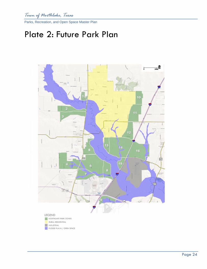
The neighborhood park is considered to be the core unit in a municipal park system because it provides recreation opportunities within walking distance in a neighborhood. The Town of Northlake currently has no distribution of neighborhood parks or community parks within the Town Limits. Both park classifications can provide recreational opportunities which are typical to neighborhood areas and can serve neighborhood areas. The Town is projecting to increase its existing population from 2,110 in 2012 to 17,310 by the year 2021. This creates a challenge for Northlake to acquire adequate park and recreational facilities. The Town will have to adjust to the growing population as the Northlake Town Limits expand by acquiring park land as the Town develops; once land is developed for residential and commercial uses, the best opportunity for park land acquisition is lost unless park land is acquired concurrently with the new development. The Town will need to acquire approximately 160 acres of neighborhood park land in order to meet the projected built out population of 55,000. The future park plan illustrates an additional need of 16 total neighborhood parks. This includes parks in the current Town limit and the ETJ. The location of neighborhood park service areas are illustrated on the Future Park Plan, which indicates the need for one Neighborhood Park to be acquired within that service area.
NEIGHBORHOOD PARK/PUBLIC SCHOOL SITE
When possible the best use of park land acquisition and park development is to share a site with an elementary school site. Basically, the Town would agree to purchase additional acreage with the elementary campus. Depending on each site, the average acreage is five (5) acres in conjunction with the campus. The infrastructure is in place because of the school development and often parking is available for both the school and park needs. The park is also available to the school for recreation use and education purposes.
RURAL RESIDENTIAL DISTRICT
Based on the Comprehensive Plan, the density of rural residential is one unit per five (5) acres. Traditional park acquisition would not be required due to the low residential density in this area. However, efforts should be made to allow trail linkage to the rural residential district to provide citizens access to the Town’s trail system.
Town of Northlake, Texas Parks, Recreation, and Open Space Master Plan
Page 18
HOMEOWNER ASSOCIATION (HOA) PARKS AND RESIDENTIAL COMMUNITIES Many cities allow Homeowner Association (HOA) Parks within a specific community or development. The parks are typically designed and built by the developer to serve a specific development. Often times these parks are considered to be private and to be used by residents in a specific development and are not open to the general public. Given that they are private they do provide recreational opportunities to Northlake citizens and can be a benefit to the developer and Town. The HOA Parks are typically classified as a Neighborhood Park and can serve a service zone as identified in the Future Park Plan. The adopted Town of Northlake’s Park, Recreation and Open Space Plan should be followed when allowing a HOA park to be built within a service zone. Guidelines for minimum park size and recreation amenities in a neighborhood park should be followed. The Town’s Park Dedication Ordinance should also be followed in terms of park land and suitability of land. Once it is determined that a HOA park is requested by a developer, the Town and developer should work together to ensure the park addresses the criteria and develop standards identified in this Park Master Plan.
Town of Northlake, Texas Parks, Recreation, and Open Space Master Plan
Page 19
FUTURE COMMUNITY PARKS, GREENBELTS & SPECIAL USE PARKS
Community Parks Community parks typically provide organized athletic fields and other associated park facilities such as organized athletic fields, playgrounds, pavilions, splash pads, trails, etc. Currently, Northlake citizens utilize all park facilities outside the Town Limits, in Denton County and throughout the metroplex and North Texas, which demonstrates a need for more park facilities within the Town. The Town should anticipate the need for a total of three (3) Community Parks within the future Town limits. Because of the geographical size of Northlake the parks may be acquired anywhere in the Town limits or ETJ. The approximate acreage should be 50 to 100 acres per park.
Indoor Recreation Center The Town of Northlake has several needs at this time in terms of its parks system. As the Town grows, an indoor recreation center is one of these needs. Typically, cities provide indoor recreational opportunities in the form of a recreation center. These facilities provide for organized work out programs such as aerobic exercise, weight lifting, and stationary low-impact bikes and treadmills. Basketball and racquetball also cultivate recreation opportunities. Typically, recreation centers are approximately 20,000 to 35,000 square feet. These facilities range in cost between $2,000,000 to $14,000,000 dollars. This cost is based on the final square footage and the amenities in the center.
The Recreation Center may also be used as a community center with meeting rooms for community oriented uses. The City of Roanoke’s Recreation Center is a good example for Northlake in terms of size and use.
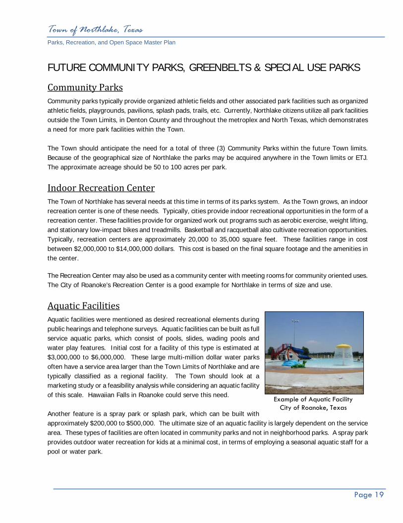
Aquatic Facilities Aquatic facilities were mentioned as desired recreational elements during public hearings and telephone surveys. Aquatic facilities can be built as full service aquatic parks, which consist of pools, slides, wading pools and water play features. Initial cost for a facility of this type is estimated at $3,000,000 to $6,000,000. These large multi-million dollar water parks often have a service area larger than the Town Limits of Northlake and are typically classified as a regional facility. The Town should look at a marketing study or a feasibility analysis while considering an aquatic facility of this scale. Hawaiian Falls in Roanoke could serve this need. Another feature is a spray park or splash park, which can be built with approximately $200,000 to $500,000. The ultimate size of an aquatic facility is largely dependent on the service area. These types of facilities are often located in community parks and not in neighborhood parks. A spray park provides outdoor water recreation for kids at a minimal cost, in terms of employing a seasonal aquatic staff for a pool or water park.
Example of Aquatic Facility City of Roanoke, Texas
Town of Northlake, Texas Parks, Recreation, and Open Space Master Plan
Page 20
Greenbelts and Presentation of Open Space According to the Comprehensive Plan, there is approximately 2,617 acres of land within the floodplains in Northlake. A majority of this floodplain is in the Denton Creek corridor. The Town is fortunate to have this major natural reserve for open space and the ability to preserve the floodplain.
Because of limited development permitted in the floodplain, the primary and best use of floodplains is for open space preservation and hike and bike trail corridors. Based on the park public meetings and input from the Comprehensive Plan, hike and bike trails or multi-use trails have been identified as the number one requested recreational element in Northlake. Although trails are developed in neighborhood and community parks, the most optimal location is in the greenbelts and open spaces in the creek corridors of Denton Creek.
Pedestrian Trail The Trail Plan illustrates possible trail connections to adjacent cities trail systems. There is an opportunity to connect to the Town of Flower Mound trail system. This connection point is north of FM 1171 and east of 35W.
Although not in the future Town limits, Northlake could work with the City of Roanoke to connect a trail through the Denton Creek Corridor and into a future park in the Briarwick Development.
These trails can become destination trails to adjacent cities and internal to Northlake providing pedestrian trails to retail areas, and to connect to other parks and public areas.
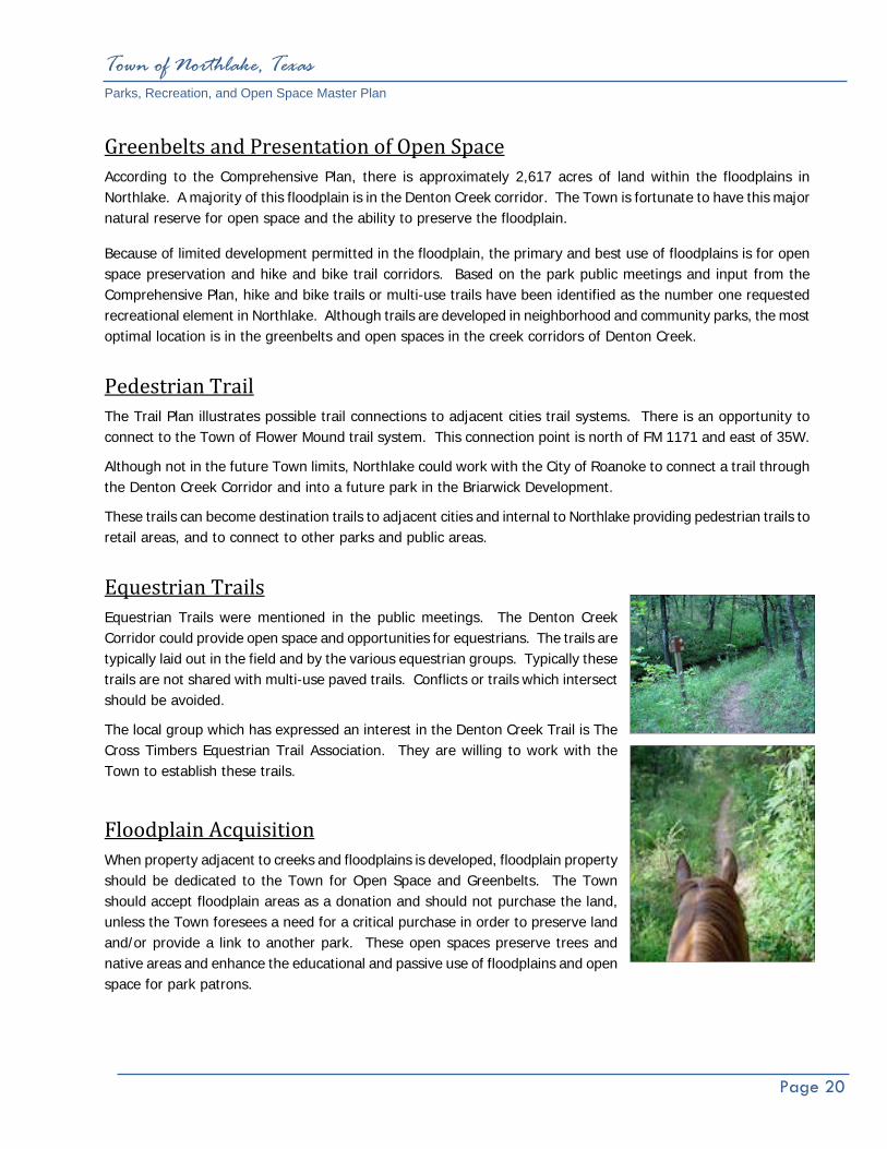
Equestrian Trails Equestrian Trails were mentioned in the public meetings. The Denton Creek Corridor could provide open space and opportunities for equestrians. The trails are typically laid out in the field and by the various equestrian groups. Typically these trails are not shared with multi-use paved trails. Conflicts or trails which intersect should be avoided.
The local group which has expressed an interest in the Denton Creek Trail is The Cross Timbers Equestrian Trail Association. They are willing to work with the Town to establish these trails.
Floodplain Acquisition When property adjacent to creeks and floodplains is developed, floodplain property should be dedicated to the Town for Open Space and Greenbelts. The Town should accept floodplain areas as a donation and should not purchase the land, unless the Town foresees a need for a critical purchase in order to preserve land and/or provide a link to another park. These open spaces preserve trees and native areas and enhance the educational and passive use of floodplains and open space for park patrons.
Town of Northlake, Texas Parks, Recreation, and Open Space Master Plan
Page 21
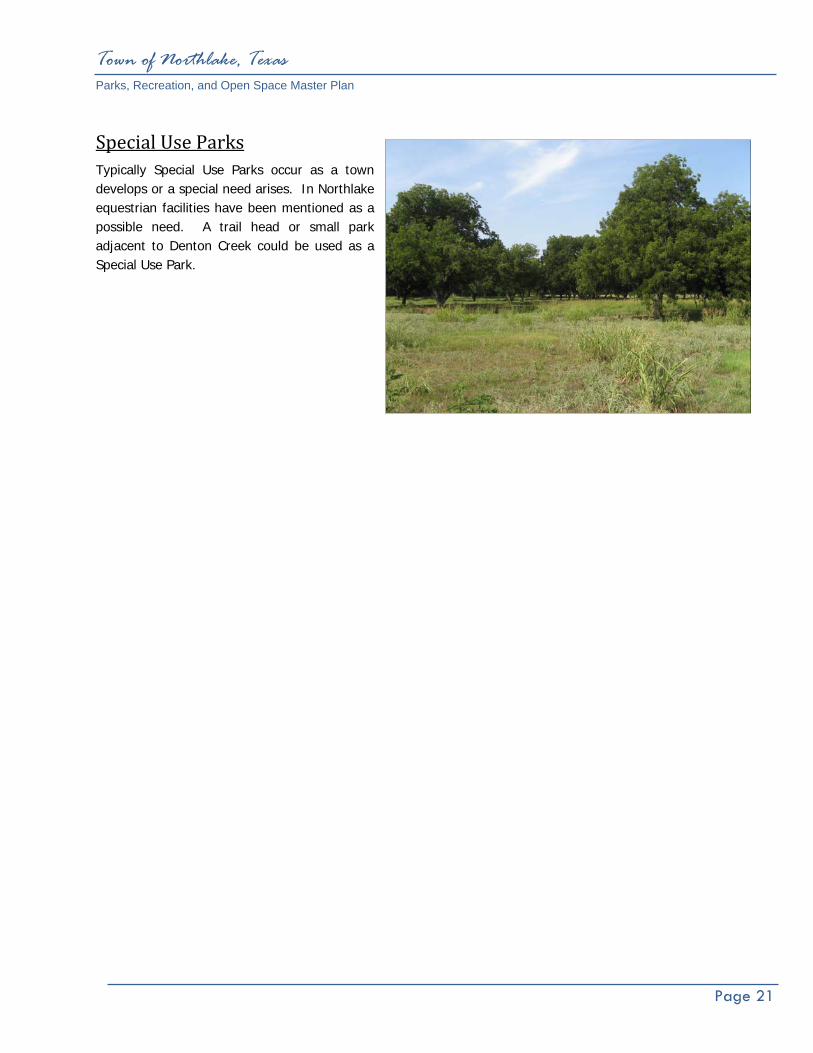
Special Use Parks Typically Special Use Parks occur as a town develops or a special need arises. In Northlake equestrian facilities have been mentioned as a possible need. A trail head or small park adjacent to Denton Creek could be used as a Special Use Park.
Ten Year Priority List
Town of Northlake, Texas Parks, Recreation, and Open Space Master Plan
Page 22
VI. Ten Year Town Priority List The Ten-Year Action Plan/Priority List as outlined in Table 9 on the following page represents the culmination of the Parks, Recreation, and Open Space Master Plan. It is the synoptic conclusion of the park master planning process. Annual review of the action plan by the Town Staff, Town Council members, Northlake Board members and citizens will allow analysis of action item recommendations for acquisition, improvements and new facilities to enhance the quality of Northlake Parks and Recreation System to maximum effect.

Town of Northlake, Texas Parks, Recreation, and Open Space Master Plan
Page 23
Town of Northlake, Texas Parks, Recreation, and Open Space Master Plan
Page 24
Plate 2: Future Park Plan

Town-Wide Trail System Standards

Town of Northlake, Texas Parks, Recreation, and Open Space Master Plan
Page 25
VII. Town-Wide Trail System Standards Trails are an important component of the future park system, as they serve recreational, transportation and linkage purposes. In Northlake the transportation and linkage aspects of a Town-wide trail system will serve a local and regional purpose.
Purpose of the Trail System Plan First and foremost, the Town-wide Trail System Plan will serve as a planning tool for Town Staff and Town Council. It will also serve to create a vision for a Town-wide trails and greenway network and assist public and private entities who wish to contribute funds or resources to the development of the system. Another key purpose of the trail plan is to serve as a basis for coordinating with other Town departments, to reduce conflicts with their development activities including utility installation, transportation, water quality, storm water runoff, planning services and other activities.
Design Considerations The following is a general discussion of the parameters associated with trail design and construction. The conclusion of this section contains recommendations for the design and construction of the Northlake Trail System.
Types of Trails
Separated Trails – Separate trails and trail systems are provided for each type of trail user, e.g. bicyclist, pedestrian, skaters.
Shared Trails – Trails are shared by two or more user groups but design parameters restrict the use of
the trail by some groups. Multi-Use Trails – All trail user groups occupy the same trail or trail corridor. The physical design of the
trail must be modified accordingly, to accommodate the demands of the expected user groups.
Trail Surfaces
Natural Surface – Side slopes on natural surface trails should be stabilized to avoid being washed onto the trail during heavy rain. Drainage is key to trail corridor safety and maintenance. Use appropriate grading techniques and soil stabilization, such as, grass seeding, plantings, erosion control blankets or rock rip-rap to minimize hazards to users. Natural surface trails should not be used during periods of wet weather to prevent surface damage and should be so signed at trailheads.
Town of Northlake, Texas Parks, Recreation, and Open Space Master Plan
Page 26
Mulch – Mulching a trail can be an effective treatment for trails in clay soil areas. To avoid washouts and watershed deposits, mulching should be avoided in areas of steep terrain. Many types of mulch can work, but one of the most effective and least expensive, long-lasting treatments is hardwood mulch.
Board Walk – Trails should avoid sensitive environmental areas, low areas, wetlands or flood plains. However, trails in wetlands can be useful as educational corridors. Board walks allow existing drainage patterns and a site’s hydrologic conditions to be preserved while providing access to areas of interest. Board walks minimize construction damage and prevent user disruption to fragile ecosystems. Areas for which boardwalks should be built include marshy or wet sites in the immediate vicinity.
Gravel – Gravel is a granular rock material used in non-rigid paved surfaces and generally defined as having a particle size between 2mm (fine gravel) and 20mm (medium to coarse gravel). When considered as a paving material, gravel has several desirable characteristics. Gravel drains well and is a pervious material, and the coarser the material the less the likelihood that it will be washed away by rainfall or flooding.
Its usefulness as a trail paving material is limited. Gravel is a non-compacting material that is loose and inhibitive to all forms of trail use other than casual foot traffic. Roller blades, bicycles and wheelchairs alike will not perform adequately on a gravel surface and are subject to skidding and a general lack of traction. Pedestrians tend to collect irritating gravel particles in their shoes, rendering the trail more or less a nuisance than an enjoyable outdoor amenity.
When mixed with other material such as clay/silt particles, or other cement type material, gravel can be stabilized as a semi-rigid to rigid paved surface. Such a surface would be more accepting of wheeled and foot traffic.
When adding gravel or mulch to a trail, care should be taken to avoid excessive material depth, as this can impair even the hardiest pedestrian. Of the many different types of gravel treatments available, some are much more conducive to trail use. Avoid pea-gravel for use on trail construction. Aggregate, crushed or decomposed granite is a very effective trail surface and can easily be upgraded to hard surface. Although off road bicyclists can negotiate most well compacted gravel trails, access can be difficult for disabled users.
Asphalt – Hot mix asphalt can be cost effective to install, but in areas of full sun, decomposition is accelerated by maintenance vehicle traffic. Edges require containment for stability and long term viability. Surface is softer for walking or jogging. Cold-mix asphalt is suitable for patching but is labor intensive. Asphalt is easy to patch or expand, but care should be taken to ensure an even surface for road bicyclists and wheelchair users. Asphalt trail surfaces are not recommended as a surface.
Town of Northlake, Texas Parks, Recreation, and Open Space Master Plan
Page 27
Concrete – While initially more expensive than other material choices, concrete is the longest lasting
trail surface with an expected life span of 25 years or more. It requires the least maintenance of any trail surface material. Only saw cut expansion joints should be used to avoid differential settling due to freeze/thaw and wet/dry cycles. Concrete is suitable for poor sub-soil conditions, but is more expensive to repair. Non-skid medium broom finish is ideal for bicycle traffic. Concrete is less desirable for jogging paths.
Multi‐Use Trail Width The most appropriate width for multi-use trails has been one of the most discussed topics of parks and recreation construction. The following are the widths required for several different scenarios of common trail usage.
♦ The minimum width to meet ADA (American Disability Act) guidelines is thirty-six inches (36”); however, this width does not allow traffic flow in both directions and therefore should not be considered.
♦ A six-foot width is the minimum width to allow wheelchairs traveling in opposite directions to pass unimpeded, even so, at this width the occupants must maneuver to the very edge of the trail.
♦ Two people walking side by side meeting a bicycle from the opposite direction would require a minimum width of eight feet (8’) and comfortable width of ten feet (10’). However, two people walking side by side would require a comfortable width of twelve feet (12’) because the bicycle passing them on the narrower width will result in the pedestrians being startled or require the bicyclist to slow excessively.
♦ Two bicyclists pedaling side by side require a minimum width of 5.3 feet and a comfortable width of eight feet (8’).
♦ Two bicyclists traveling in opposite directions require a minimum of 6.5 feet to pass and a comfort width of 10.9 feet.
♦ Two bicyclists traveling side by side, meeting a bicyclist from the opposite direction or another bicycle passing them requires a minimum width of nine feet (9’) and a comfort width of twelve feet (12’).
The North Central Texas Council of Governments’ “Bicycle and Pedestrian Facilities Planning and Design Guidelines” states “The minimum width required for two opposing bicyclists to pass and share the path with a pedestrian is 12.5 feet. The NCTCOG guidelines do stipulate that widths less than 12.5 feet may be acceptable given the following circumstances: (1) bicycle traffic is expected to be low, even on peak days or during peak hours; (2) pedestrian use of the facility is not expected to be more than occasional; (3) there will be good horizontal and vertical alignment, providing safe and frequent passing opportunities; (4) the path will not be subjected to maintenance vehicle loading conditions that would cause pavement edge damage and (5) access maintenance or emergency vehicles are not needed. A multi-use pathway should never be less than eight feet (8’) wide.
Town of Northlake, Texas Parks, Recreation, and Open Space Master Plan
Page 28
Vertical Clearance The absolute minimum vertical clearance for multi-use trails is 8.2 feet, 9.5 feet is the minimum comfortable height. The vertical clearance may need to be greater to permit passage of maintenance vehicles. Clearance under crossings and tunnels should be ten feet (10’) for adequate vertical shy distance.
Longitudinal Slope (Grade) Grades on off-street paths should be kept to a minimum, especially on long inclines. Grades greater than five (5) percent are undesirable because the ascents are difficult for many bicyclists and the descents cause some bicyclists to exceed the speeds at which they are competent. ADA guidelines stipulate that anything exceeding five percent (1 foot rise in 20 horizontal feet) is a ramp and must be constructed with handrails, a maximum rise of thirty inches (30”) in a maximum length of thirty feet (30’) and must have a 60” x 60” landing at the base and the top. Therefore to be in compliance with ADA guidelines trail ramps cannot exceed an 8.33% slope (1 foot rise in twelve horizontal feet).
Signs Adequate signs and markings are essential on multi-use trails, especially to alert users to potential conflicts and to convey regulatory messages to both users and motorist at street intersections. In addition, guide signs, such as those indicating destination, direction, distance, route numbers and names of cross streets, should be used in the same manner as they are on highways.
Access Points Although access to the trail will usually be available at every road crossing, the users of the trail should be encouraged to enter the trail at specific access points. By designating specific points of access, there may be an elimination of possible encroachment on private property, as well as, preventing possible congestion at busy road crossings.
Lighting Lighting of the multi-use trail should be considered, especially if the off-street routes are intended for transportation purposes, many trail commuters may need to travel during poorly lit morning and evening hours. Fixed source lighting reduces conflicts along paths and at intersections. In addition, lighting allows the trail user to see the path direction, surface conditions and obstacles. Lighting should be considered through underpasses or tunnels and when night time security could be a problem. The standard horizontal illumination level is 5 lux (0.5 foot candle) to 22 lux (2 foot candles). Where special security problems exist, height illumination levels may be considered. Most of the lighting systems for trails are down lighting and avoids glare and light spillage into the dark sky.

Town of Northlake, Texas Parks, Recreation, and Open Space Master Plan
Page 29
Traffic Control Devices Pedestrian signals designed to accommodate a one meter (3.2 feet) per second walking speed, should be provided at major streets where traffic volume and speed is high. ADA stipulates that where provided, buttons shall be raised or flush and a minimum of 1.9 centimeters (3/4 inch) in the smallest dimension. The force required to activate controls shall be no greater than 22.2 N (5 lbs). Additionally, controls shall be located as close as possible to the curb ramp and, to the maximum extent feasible, shall permit operation from a level area immediately adjacent to the controls and a maximum of 122.7 centimeters (48.3 inches) high.
To provide clear visibility of pedestrians approaching intersection crosswalks at night, the approaches and all street corners should be well illuminated. All intersection lighting should illuminate the crossing and waiting areas and/or create backlighting to make the pedestrian silhouette clearly visible on approach. All commercial, entertainment, school and other pedestrian traffic generating corridors and spaces should be well illuminated. Raised islands in crossings should be cut through level with the street or have curb ramps or other sloped area at both sides. There should be a level area 121.9cm (48 in) long minimum and a minimum of 91.4cm (36 in) wide in the part of the island intersected by the crossings.
TOWN OF NORTHLAKE TRAIL RECOMMENDATION
Off‐Street Trail Width In off-street applications the trails shall be a minimum of ten feet (10’) wide; where feasible the more comfortable 12 foot width shall be used.
On‐Street Trail Width In on-street applications the ten-foot width will not be feasible due to the limited width of the parkway (street side right-of-way). A minimum width of six feet (6’) shall be maintained for all on-street trails, where the locale allows trail width shall be expanded to eight feet (8’) (ten feet (10’) adjacent to large lot residential development). In most residential areas an eight-foot (8’) maximum width should be maintained as it is felt this will tend to reduce the velocity of bicycle traffic.
Trail Surface All multi-use trails within the Northlake trail system shall be constructed of concrete.
Decomposed Granite may be used in specific applications within a park or special use park area. Decomposed Granite is not recommended for the flood plain or high use trail areas.
Town of Northlake, Texas Parks, Recreation, and Open Space Master Plan
Page 30
Access Points/ Trail Heads Trail heads shall be served by parking lots accommodating ten to twenty parking spaces. Trail heads should be located adjacent or a short distance from main trail corridors and located at each main trail terminus. Design elements of trail heads should include a drinking fountain, benches, stretch post or other equipment to encourage and facilitate stretching exercises and a mounted map of the trail system with their present location indicated.
Trail Signs Warning signs shall consist of the traffic control signage and devices indicated in the design guidelines. Directional signs are imperative to facilitate user comfort and confidence, thereby ensuring optimal use of the trail from the standpoint of participation/occupancy levels and enjoyment level of the participants. At trail intersections signs should be provided that indicate destinations; of the various trail branches and a distance to each destination, the cardinal directions should also be indicated. Consideration should be given to providing a map of the trail system at each intersection of major trail branches. Within residential neighborhoods, in addition to the aforementioned signage, the pavement surface shall be demarked in such a manner that trail users will be able to follow the trail routing through the neighborhood without becoming confused and possibly taking a wrong turn. Spur trails linking neighborhoods to parks and schools shall have a definite indication at the trail terminus so trail users unsuspectingly traveling into the neighborhood are made aware that the trail system ends at that location. Provision of a map indicating the direction to the main branch of the trail would be beneficial at these locations.

Town of Northlake, Texas Parks, Recreation, and Open Space Master Plan
Page 31
Plate 3: Future Trail Plan

Plan Summary

Town of Northlake, Texas Parks, Recreation, and Open Space Master Plan
Page 32
VIII. Plan Summary This Parks, Recreation, and Open Space Master Plan is a fluid planning tool which will guide the development and acquisition of new park land and recreational facilities. This Master Plan has updated the demographic of the Town and prepared a new needs assessment identifying the need for parks, recreational athletic fields, and facilities. As with any public or municipal project, the amount of available funding or the potential to retire debt is the controlling factor in deciding which project or projects should be completed first. The Parks, Recreation, and Open Space Master Plan recommends park land acquisition, a new park, and recreation facility development improvements for the next ten years. The Ten-Year Priority List was established with citizen input, needed park improvement and specific requests. The priority list is a guide the Town should follow to assist in the decision making process regarding park development and park land acquisition. The current economy and future economic trends always effect the decision making process regarding all types of municipal infrastructure. This Master Plan should be reviewed every year by staff and an annual report prepared and presented to the Northlake Economic Development Corporation, Northlake Community Development Corporation and Town Council outlining accomplishments during that fiscal year.
IMPLEMENTATION Identified within this section are the ways and methods of implementing the recommendations within this Parks, Recreation, and Open Space Master Plan. Critical to its implementation is the action plan, which should be developed annually by the Town of Northlake.
Policies and Ordinances The accuracy of these implementation mechanisms is dependent upon the proper coordination of input from contributing bodies including Town officials, elected and appointed, Town Staff and most importantly the citizens of Northlake. All parties must communicate and work collectively toward common goals, only this will ensure the successful development of the park system. An example of this communication, at the staff level, would be the incorporation of the Parks, Recreation, and Open Space Master Plan during review of proposed development plans with various entities involved. Ordinances provide the legal framework for implementation of this Master Plan, and therefore, aid in park system development and protection. Outlined below are several ordinances directly related to park land acquisition and development.

Town of Northlake, Texas Parks, Recreation, and Open Space Master Plan
Page 33
Watershed Management & Drainageway Ordinances These ordinances protect and preserve greenbelts and floodplains. They provide a tool to manage the drainage and floodplains within Northlake. The ordinances respond to Federal Emergency Management Agency (FEMA) and National Pollutant Discharge Elimination System (NPDES) mandates for cities. These tools may be drafted in a format as restrictive as the Town wishes. A reciprocal benefit of the preservation of these areas would be their use as linear greenbelts and connections to destinations throughout the Town.
Funding Sources This Parks, Recreation, and Open Space Master Plan recommends the development of a number of new parks, and further development in some existing parks. Once completed, these recommended improvements represent a substantial public investment in parks and open space as the Town grows and develops. The various sources of funds for these improvements are as important as the diversity of those sources. When there are several sources of funds for implementing this Master Plan, then no one source is over-burdened and the Master Plan has a better probability of being successfully implemented. The sources discussed below relate to the purchase and development of park land and facilities.
General Fund This source of funding is supported by ad valorem tax revenues and is generally the primary source of funds for maintenance and operation of the existing park system. The general fund is also the source for projects requiring smaller amounts of capital investment. Although projects funded by this source make a small annual contribution to the expansion of the park system, analysis over a number of years usually reflects a major accomplishment in improvements to the park system. It is important to include funding for on-going maintenance and staff requirements for new developments and improvements.
Bonds Bonds are generally the most common source used by cities for the purchase of land and for providing development monies. There are two types of bonds which are used for parks, both of which must be approved by referendum.
General Obligation Bond The General Obligation Bond is amortized using ad valorem taxes and is used for the funding of capital projects which are not supported by a revenue source. These projects include water service, sanitary sewer service, and park acquisition and development. The availability of bonding for parks is often dependent upon the overall municipal needs financed by this source. Capital items such as purchase of land and physical improvements with a useable life expectancy of 15 to 20 years can be funded with general obligation bonds.

Town of Northlake, Texas Parks, Recreation, and Open Space Master Plan
Page 34
Revenue Bonds Revenue bonds finance projects which produce enough revenue to retire their debt, such as, golf course, batting cages and enterprise oriented park projects.
Private Donations This source of financial assistance would usually come from a citizen, organization, or business which has an interest in assisting with the development of the park system. Land dedication is not an uncommon occurrence when property is being developed. The location of a neighborhood park within a residential development offers additional value to residential units within that neighborhood, especially if the residential development is occupied by younger families with children. Although the future dedication of neighborhood park land is considered a limited resource in central Northlake due to the extent that development has occurred and the small size and configuration of remaining parcels within most areas of Northlake, it nevertheless remains a viable means of acquiring land. Once property is acquired through this method, the Town should be prepared to improve the facility for use within a reasonable length of time.
Private donations may also be received in the form of funds, facilities, recreation equipment, art or in-kind services. Donations from local and regional businesses as sponsors for events or facilities should be pursued. A Parks Improvement Trust Fund may be set up to manage donations by service organizations, benevolent citizens, willed estates and other donated sources. The purpose of this trust is to establish a permanent source of principle value that will increase as donations occur. The principal cannot be decreased; however, the annual interest can be used for park development.
Northlake Economic Development Corporation (EDC) and the Northlake Community Development Corporation (CDC)
The Northlake EDC and Northlake CDC each administer a half-cent sales tax. These funds can be dedicated for park land acquisition and park facility development. This is one of the primary funding sources municipalities use for funding parks and park development.
Texas Recreation and Parks Account (TRPA) Program Texas Local Parks, Recreation and Open Space Fund is administered by the Texas Parks and Wildlife Department (TPWD). The TPWD program allows a town to request matching funds for both the acquisition and construction of park facilities. Currently, funds are available on a fifty percent (50%) cost share basis; the maximum funding varies from year to year and is established by the Texas Parks and Wildlife Department. The grant is secured through submission of an application which follows a standard format for applicants. All applications received are ranked on a point system which is designed to evaluate the need for the purchase or construction being requested. Funds are distributed among the applicants having the greater number of points until all allocated funds are expended.
Applications to TPWD can be made annually with a six-month waiting period following the submission date before the successful applications are notified. The number of applications a Town may submit at any given

Town of Northlake, Texas Parks, Recreation, and Open Space Master Plan
Page 35
time is based on past performance on grants and TPWD evaluation criteria. This funding source is used by many communities. The competitiveness of the program generally allows cities having bona fide park needs to prevail in obtaining funds.
Safe Routes to School Program This funding source provides funding for programs and projects that enhance non-vehicular mobility between schools and neighborhoods. The cost of reimbursement program funds at 100% and is also managed by TXDOT.
Recreation Trails Program (RTP) These funds can be spent to construct new recreational trails, improve/maintain existing trails, develop/improve trailheads or trailside facilities, and acquire trail corridors/easements. It is also a cost reimbursement program.
Public Improvements District (P.I.D.) When authorized by Town Council in compliance with state laws, new developments can establish a Public Improvement District (P.I.D.). As a taxing district, the P.I.D. provides funds specifically for the operation and maintenance of public facilities such as parks and major boulevards.
Tax Increment Financing District (T.I.F.) A T.I.F. is a tool used by local government to finance public improvements in a defined area as approved by the Town Council. When an area is designated a T.I.F. district the tax base is frozen at the current level. As development occurs within the T.I.F., the increased value of property, the tax increment is captured. The tax increments are posted to a separate fund to finance public improvements within the district.

Appendix
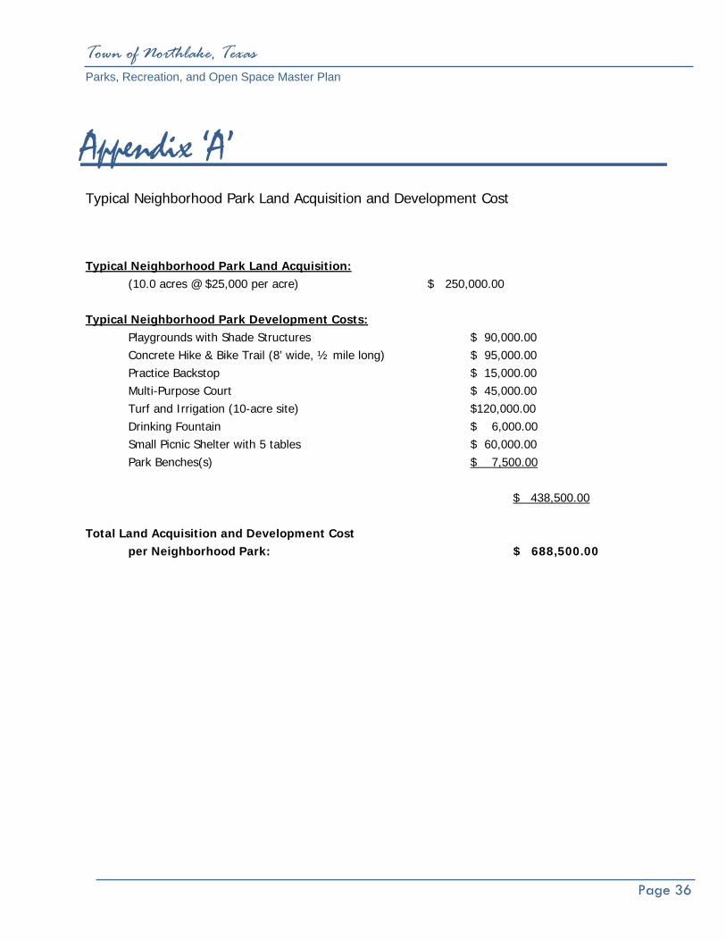
Town of Northlake, Texas Parks, Recreation, and Open Space Master Plan
Page 36
Appendix ‘A’ Typical Neighborhood Park Land Acquisition and Development Cost
Typical Neighborhood Park Land Acquisition: (10.0 acres @ $25,000 per acre) $ 250,000.00 Typical Neighborhood Park Development Costs: Playgrounds with Shade Structures $ 90,000.00 Concrete Hike & Bike Trail (8’ wide, ½ mile long) $ 95,000.00 Practice Backstop $ 15,000.00 Multi-Purpose Court $ 45,000.00 Turf and Irrigation (10-acre site) $120,000.00 Drinking Fountain $ 6,000.00 Small Picnic Shelter with 5 tables $ 60,000.00 Park Benches(s) $ 7,500.00 $ 438,500.00 Total Land Acquisition and Development Cost per Neighborhood Park: $ 688,500.00
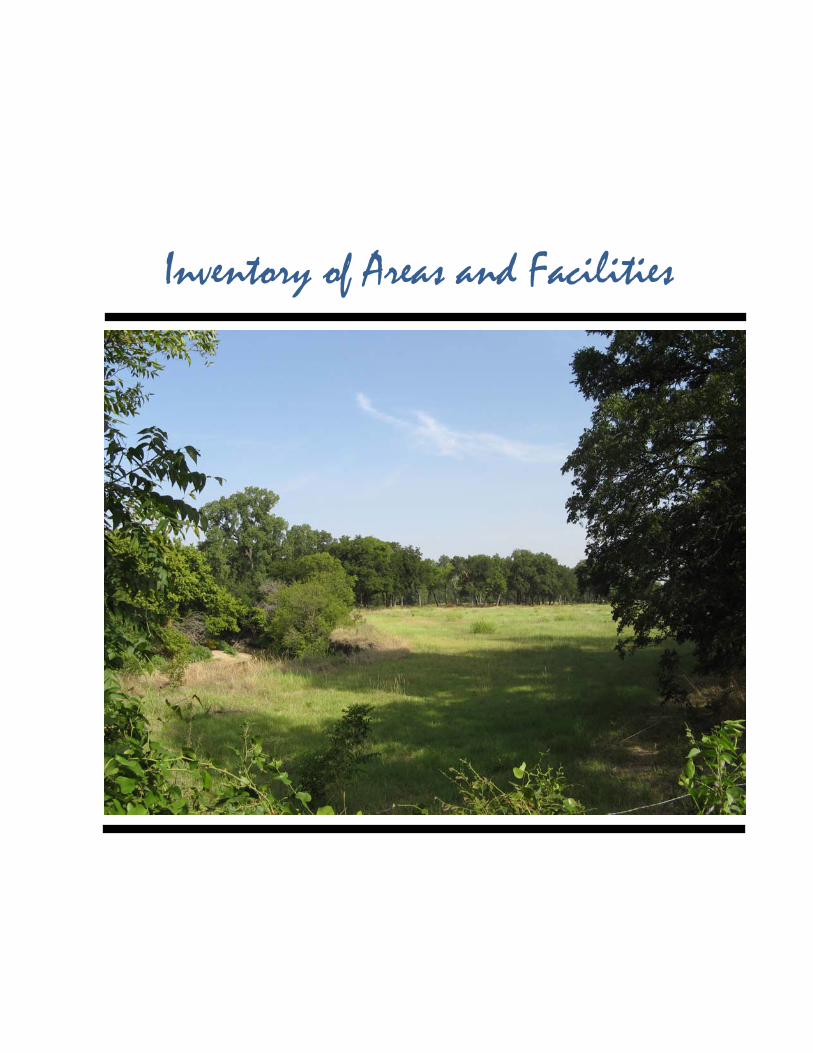
Inventory of Areas and Facilities

Town of Northlake, Texas Parks, Recreation, and Open Space Master Plan
Page 5
II. Inventory of Areas and Facilities The Town of Northlake does not have public park land or any park facilities at the present time. Any acreage purchased or dedicated will provide land for first time recreation opportunities in the Town of Northlake.
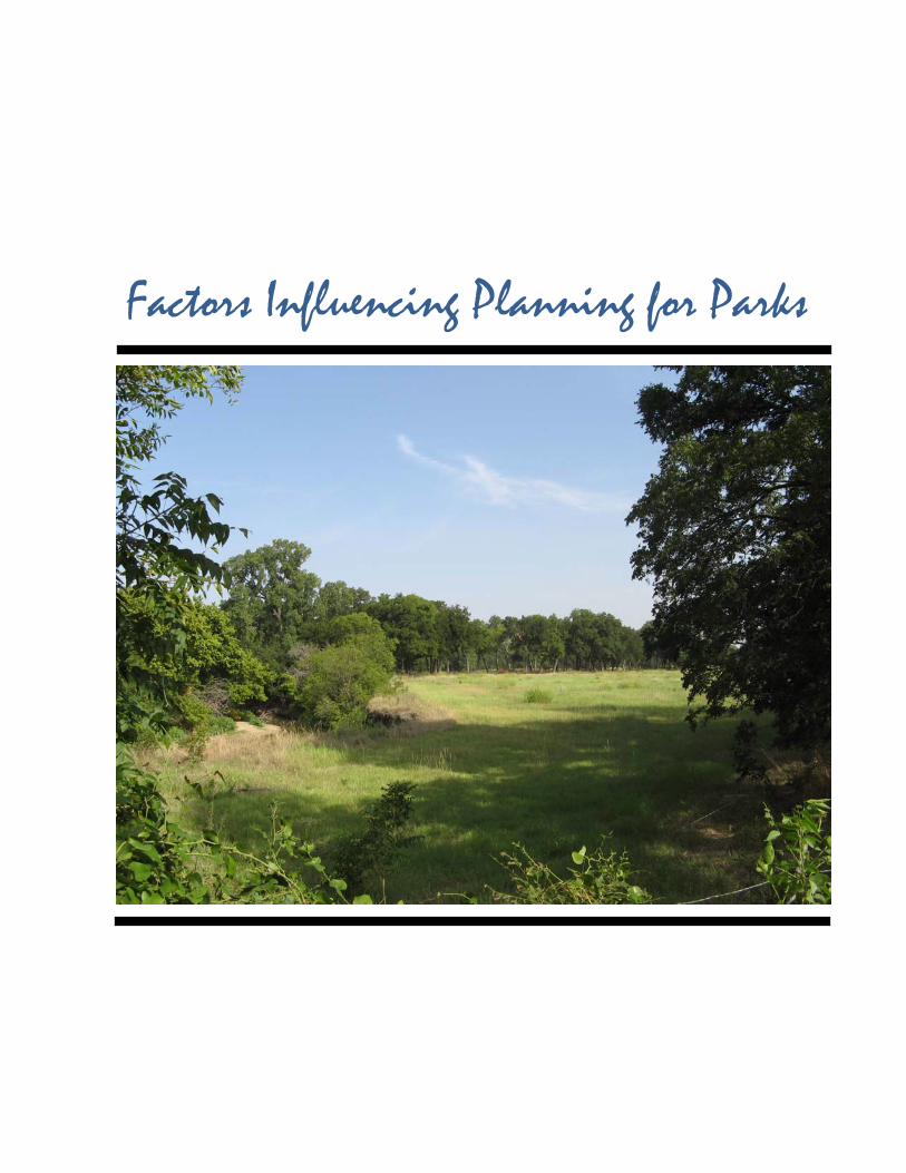
Factors Influencing Planning for Parks
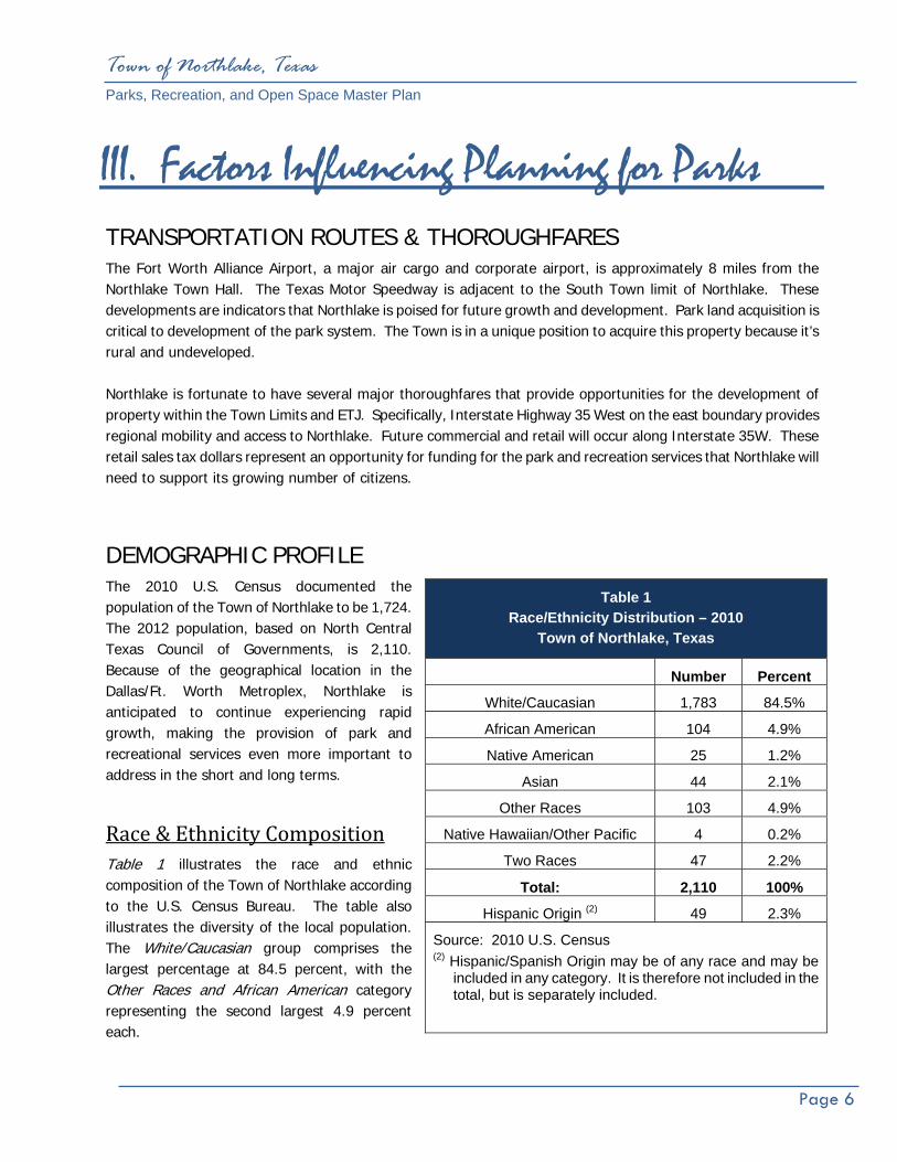
Town of Northlake, Texas Parks, Recreation, and Open Space Master Plan
Page 6
III. Factors Influencing Planning for Parks
TRANSPORTATION ROUTES & THOROUGHFARES The Fort Worth Alliance Airport, a major air cargo and corporate airport, is approximately 8 miles from the Northlake Town Hall. The Texas Motor Speedway is adjacent to the South Town limit of Northlake. These developments are indicators that Northlake is poised for future growth and development. Park land acquisition is critical to development of the park system. The Town is in a unique position to acquire this property because it’s rural and undeveloped. Northlake is fortunate to have several major thoroughfares that provide opportunities for the development of property within the Town Limits and ETJ. Specifically, Interstate Highway 35 West on the east boundary provides regional mobility and access to Northlake. Future commercial and retail will occur along Interstate 35W. These retail sales tax dollars represent an opportunity for funding for the park and recreation services that Northlake will need to support its growing number of citizens.
DEMOGRAPHIC PROFILE The 2010 U.S. Census documented the population of the Town of Northlake to be 1,724. The 2012 population, based on North Central Texas Council of Governments, is 2,110. Because of the geographical location in the Dallas/Ft. Worth Metroplex, Northlake is anticipated to continue experiencing rapid growth, making the provision of park and recreational services even more important to address in the short and long terms.
Race & Ethnicity Composition Table 1 illustrates the race and ethnic composition of the Town of Northlake according to the U.S. Census Bureau. The table also illustrates the diversity of the local population. The White/Caucasian group comprises the largest percentage at 84.5 percent, with the Other Races and African American category representing the second largest 4.9 percent each.
Table 1 Race/Ethnicity Distribution – 2010
Town of Northlake, Texas
Number Percent
White/Caucasian 1,783 84.5%
African American 104 4.9%
Native American 25 1.2%
Asian 44 2.1%
Other Races 103 4.9%
Native Hawaiian/Other Pacific 4 0.2%
Two Races 47 2.2%
Total: 2,110 100%
Hispanic Origin (2) 49 2.3%
Source: 2010 U.S. Census (2) Hispanic/Spanish Origin may be of any race and may be
included in any category. It is therefore not included in the total, but is separately included.

Town of Northlake, Texas Parks, Recreation, and Open Space Master Plan
Page 7
Age Comparison & Distribution The age composition of the population within a Town can also provide insight into the types of park and recreation facilities and services the Town may need to provide. As reflected in Table 2, the largest age group is the Prime Labor Force (25-44 years old). Many in this group are families with children in sports and recreation programs. Young adults in this group may also play organized adult sports. Northlake also has a high percentage of people in the School Age Children & Young Adults (0-19 years); this age group generally represents a large number of people that use a community’s park facilities because of league sports and other organized play activities. The Older Labor Force and the Elderly groups also together comprise a significant percentage of the Town’s population at 27.8 percent; these groups tend to utilize hike-and bike trails and passive open space areas. Clearly, groups of all of ages have recreational needs.
Income Distribution Household income for Northlake according to the 2010 U.S. Census 2006-2010 American Community Survey is shown in Table 3. Approximately 29 percent of the households in Northlake were in the range of $100,000 and above. However, the highest percentage of households in Northlake in 2010 was within the $50,000 to $74,999 income category. The lowest percentages were in the range of $24,999 and less.
Table 2 Age Comparison & Distribution
Town of Northlake, Texas
Age Groups Number Percent
School Age Children & Young Adults (0-19 years) 572 27.1%
College/New Family (20-24 years old) 203 9.6%
Prime Labor Force (25-44 years old) 749 35.5%
Older Labor Force (45-64 years old) 489 23.2%
Elderly (65+ years old) 97 4.6%
Total: 2,110 100.0%
Source: U.S. Census 2010
Table 3 Income Distribution
Town of Northlake, Texas
Income Level Number Percent
Less than $14,999 31 5.5%
$15,000 to $24,999 26 4.7%
$25,000 to $34,999 48 8.6%
$35,000 to $49,999 84 15.0%
$50,000 to $74,999 190 34.0%
$75,000 to $99,000 74 13.2%
$100,000 to $149,999 32 5.7%
$150,000 to $199,999 53 9.5%
$200,000 or more 21 13.8%
Total 559 100.0%
Source: U.S. Census 2006-2010 American Community Survey

Town of Northlake, Texas Parks, Recreation, and Open Space Master Plan
Page 8
PARKS, RECREATION & OPEN SPACE CLASSIFICATION
To deliver a variety of recreational features in an efficient manner, some type of relationship defining system must be established among those facilities used for recreation. Guidelines and standards recommended by the National Recreation and Park Association (NRPA) have been followed by cities for many years to define a hierarchy for their park systems. The NRPA made major revisions to their recommendations for delivering park and recreation services in the publication, Parks, Recreation, Open Space and Greenway Guidelines, published in December 1995. The classification system has been changed slightly to more closely define a park space in relationship to its proposed use. The following analysis identifies the NRPA classification of parks, their description, location criteria within the community and criteria for size. Only the park classifications selected specifically for Northlake are defined in this section. Once established, these guidelines are then applicable for structuring the Northlake park system in an orderly manner responsive to the recreational demands being generated by the present and future population.
Neighborhood Park The neighborhood park is considered to be the most important feature of a park system and is one of the major cohesive elements in neighborhood design. Its primary function is the provision of recreational space for the entire neighborhood which surrounds it. Space in the neighborhood park should be distributed between active and passive uses.
(a). The neighborhood park should be located near the center of a neighborhood area/park planning area and have a service area of approximately one-half mile to one-quarter mile.
(b). The size should be related to the service area population and the menu of activities chosen for placement in the park. Five (5) to ten (10) acres is the optimal size for this park.
(c). Safe and convenient pedestrian access is considered important to a neighborhood park location.
(d). Generally, the location should not be adjacent to a heavily traveled major or minor thoroughfare.
(e). When it is possible to combine an elementary or middle school with this type of park, the two features further enhance the identity of the neighborhood by providing a central location for recreation and education and a significant open space feature within the neighborhood.
EXAMPLE OF A NEIGHBORHOOD PARK AND ITS RECOMMENDED
RELATIONSHIP TO THE SURROUNDING NEIGHBORHOOD
NEIGHBORHOOD
PARK
EXAMPLE O A NEIGHBORHOOD PARK AND ITS RECOMMENDED RELATIONSHIP TO THE SURROUNDING NEIGHBORHOOD

Town of Northlake, Texas Parks, Recreation, and Open Space Master Plan
Page 9
(f). Facilities normally provided at a neighborhood park consist of:
1. Playground equipment for small children.
2. A multiple purpose hard surfaced play area.
3. Space for court games, such as basketball, tennis, volleyball and in-line hockey in addition to walking/jogging trails.
4. Playfield space for non-organized competitive games such as baseball, football and soccer.
5. Passive space possibly for a pavilion with tables and grills, restrooms, drinking fountains and sitting areas.
6. Off-street parking is a consideration if users are beyond an acceptable walking distance or if users need to drive to access the park.
7. It is not desirable to light athletic facilities in a neighborhood environment since lighting is often objectionable to nearby residents; however, some lighting for security purposes should be incorporated into the park.
8. The allocation of space in the neighborhood park should be approximately 50 percent passive area and 50 percent active area. The above facilities are those generally considered for active space. The passive space should be used to develop the character of the park by creating an open landscaped setting with trails, sitting area, and picnic space. This park becomes an integral part of the neighborhood.
Community Park A community park is larger in size than a neighborhood park and provides service to several neighborhoods or specific sections of the community. The community park is oriented primarily toward providing recreational opportunities not feasible in a neighborhood park. This type of park should be developed for both active and passive use.
(a). A community park serves several neighborhood areas, and should therefore be conveniently accessible by automobile and include provisions for off-street parking.
(b). The optimal size for the community park is between 40 and 150 acres. This size should be based on its intended use and the population residing in the service area. Natural features such as terrain, tree cover, flood prone areas, and
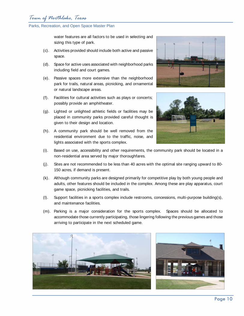
Town of Northlake, Texas Parks, Recreation, and Open Space Master Plan
Page 10
water features are all factors to be used in selecting and sizing this type of park.
(c). Activities provided should include both active and passive space.
(d). Space for active uses associated with neighborhood parks including field and court games.
(e). Passive spaces more extensive than the neighborhood park for trails, natural areas, picnicking, and ornamental or natural landscape areas.
(f). Facilities for cultural activities such as plays or concerts; possibly provide an amphitheater.
(g). Lighted or unlighted athletic fields or facilities may be placed in community parks provided careful thought is given to their design and location.
(h). A community park should be well removed from the residential environment due to the traffic, noise, and lights associated with the sports complex.
(i). Based on use, accessibility and other requirements, the community park should be located in a non-residential area served by major thoroughfares.
(j). Sites are not recommended to be less than 40 acres with the optimal site ranging upward to 80-150 acres, if demand is present.
(k). Although community parks are designed primarily for competitive play by both young people and adults, other features should be included in the complex. Among these are play apparatus, court game space, picnicking facilities, and trails.
(l). Support facilities in a sports complex include restrooms, concessions, multi-purpose building(s), and maintenance facilities.
(m). Parking is a major consideration for the sports complex. Spaces should be allocated to accommodate those currently participating, those lingering following the previous games and those arriving to participate in the next scheduled game.

Town of Northlake, Texas Parks, Recreation, and Open Space Master Plan
Page 11
Greenways / Open Space This classification applies to types of land which have characteristics either identifying them as undevelopable land or suitable for use as a component linking other park areas.
(a). These spaces are generally natural corridors along creeks/flood prone areas or along easements containing a man-made feature.
(b). There is no specific size for these spaces; however, establishing a minimum width is important to the function of the greenway, particularly if used as a location for a trail. This width should not be less than 50 feet. Where the greenway is on either side of a natural drainage course, a minimum of fifteen feet shall be provided for foot traffic or motorized vehicles performing maintenance along the greenway.
Special Use Park These parks or recreational spaces are identified by a single use, and fall into three categories:
(a). Historical/Cultural/Social Sites - which offer recreational opportunities because of their unique characteristics.
(b). Recreational Facilities - single purpose facilities such as a senior center, community center, or golf course.
(c). Outdoor Recreational Facilities - uses such as a tennis center, stadium, or possibly a special type of sports complex designed specifically for a single sport.

Needs Assessment and Identification

Town of Northlake, Texas Parks, Recreation, and Open Space Master Plan
Page 12
IV. Needs Assessment and Identification GENERAL ASSESSMENT The Town of Northlake currently does not have park land or recreational facilities available for the citizens. Northlake citizens travel to adjacent municipalities and cities in the North Texas region for recreation opportunities. The fact that the Town does not have any public park land or recreational facilities available to Northlake citizens is unique. Although there are no park lands or facilities available the positive aspect is Northlake can develop a park system based on public comment, and one which is tailored specifically to meet the Town’s needs and would greatly benefit the Town and its citizens.
PUBLIC INPUT MEETINGS The Town of Northlake held two public input meetings to receive citizens’ comments on the park and recreational needs within the Town. One meeting was a regular scheduled Council meeting and the other was a Northlake Community Development Corporation (CDC) meeting, Northlake's Type B economic development corporation. The Council meeting was well attended with approximately 25-27 people in attendance and the CDC meeting was attended by 10-12 people. Comments from the public varied and addressed a wide range of park facilities. Several of the comments addressed the lack of park facilities in Northlake such as trails, parks, and nature or open space opportunities. Many of the comments focused on parks and recreation facilities in adjacent cities. People expressed their desires to have those same types of facilities in Northlake to avoid traveling and to improve the quality of life in Northlake. Trails were requested and ranked number one on the priority listing of recreational amenities desired. The Table above illustrates the priority of recreational needs identified by the public.
Table 4 Public Input Meetings
Priority Listing Town of Northlake, Texas
1. Trail 16. Tennis 2. Playgrounds 17. Skateboard Park 3. Equestrian Trail 18. Rubber Matte Playground 4. Take Advantage of Speedway 19. Preservation of Open Space 5. Trail/Trail Heads/Separate Roads 20. No Organized Park 6. Light Trails 21. Parks/Common Property 7. Parks/Water Park 22. Sense of Community 8. No Dog Park 23. Like Passive Parks 9. Picnic Tables & Pavilion 24. Trail Separate Surface
10. Amphitheater 25. Specific Use Parks/No Open Space Parks
11. Baseball 26. Variety of Parks and Uses in Parks
12. Soccer Field 27. North Texas Trails Plan/COG? 13. Water Pond 28. Protecting Private Rights 14. Fishing Pier 29. Walking Trails 15. Basketball/Multi-Purpose Courts 30. Trail Safety

Town of Northlake, Texas Parks, Recreation, and Open Space Master Plan
Page 13
STANDARD-BASED ANALYSIS This approach is used to assist in assessing the future recreational needs, and follows established and recognized standards for assessing the quantity of park land and the number of facilities that are required to meet the needs of a given population.
Facility‐Recreation Standard One source is the National Recreation and Park Association (NRPA). The NRPA has functioned as a source of guidance for park standards and development for a number of years. The NRPA’s standards are suggested to be a guide for determining park and open space needs. From community to community, differences will be found in the socio-economic and cultural characteristics, and in climatic conditions. Therefore, the range of demands and preferences for recreational activities will vary with these differences. Obviously, these variances will directly influence a uniform standard for all locations. NRPA is very specific to point out that their data is to be used only as a guide to the development of local standards. Therefore, the NRPA provides input to the formation of local needs.
Table 5 Park Facility Standard Analysis Ratio Using
Existing Town Limit Population of 2,110 Town of Northlake, Texas
Facility NRPA Standards
Current Northlake Inventory
Recommendation Metroplex
Standard (2)
Basketball 1/5,000 0 1/4,000 = 1 Tennis Courts 1/2,000 0 1/4,000 = 1 Youth Baseball 1/20,000 0 1/5,000 = 1 Youth Softball 1/5,000 0 1/5,000 = 1 Adult Softball 1/5,000 0 1/5,000 = 1
Football 1/20,000 0 1/65,000 = 1 Youth Soccer 1/10,000 0 1/5,000 = 1
Playgrounds (1) NS 0 (1)
Picnic Tables NS 0 1/300 = 7 Aquatic Facility 1/20,000 0 1/20,000 = 1
Volleyball NS 0 1/10,000 = 1
Trails NS 0 As many as possible *
Recreation Center 1/20,000 0 1/25,000 = 1 (1) One playground should be installed in each neighborhood, community
and regional park. Table assumes lighted facilities NS = No Standard NRPA = National Recreation and Parks Association *As many as possible in order to provide a comprehensive system of pedestrian trails that connect residential areas to parks, schools and open space. (2) Metroplex area cities in the Dallas/Ft. Worth region 2012 NCTCOG
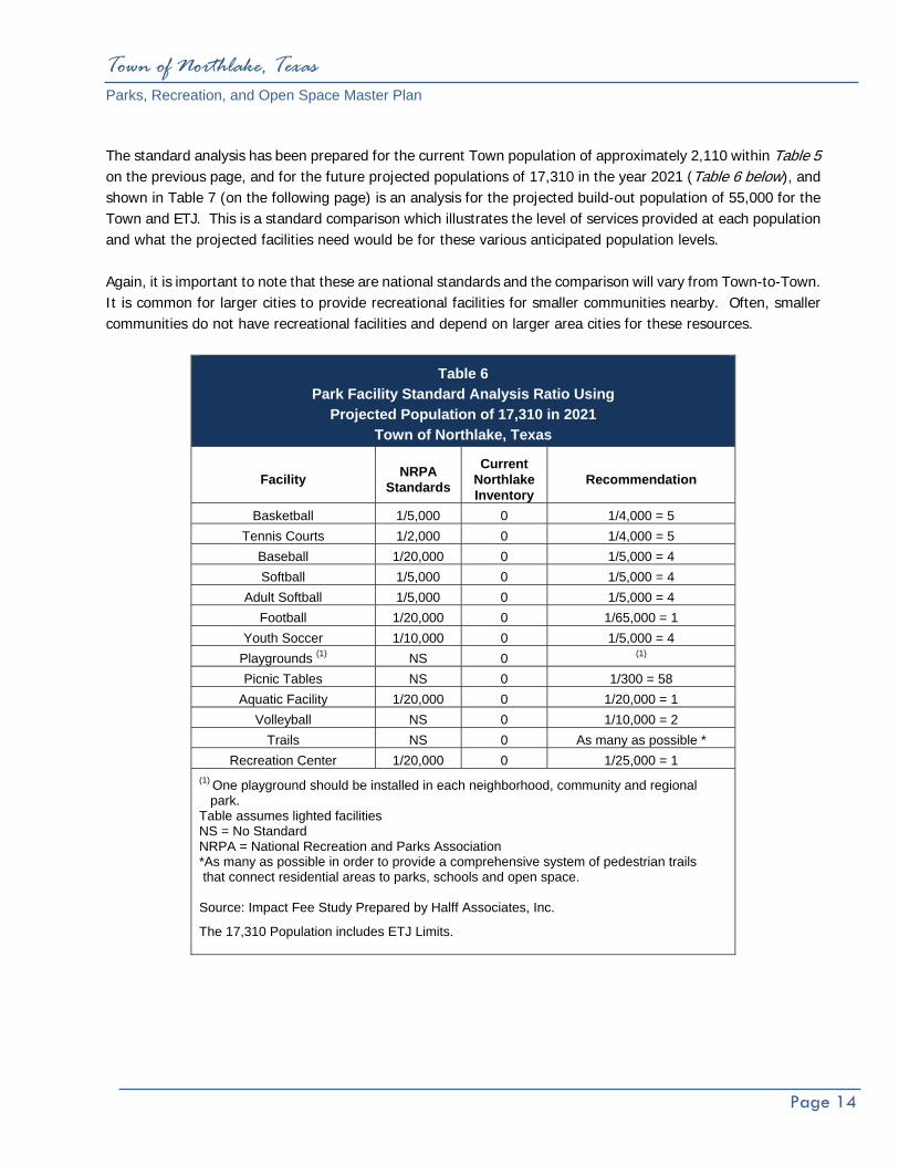
Town of Northlake, Texas Parks, Recreation, and Open Space Master Plan
Page 14
The standard analysis has been prepared for the current Town population of approximately 2,110 within Table 5 on the previous page, and for the future projected populations of 17,310 in the year 2021 (Table 6 below), and shown in Table 7 (on the following page) is an analysis for the projected build-out population of 55,000 for the Town and ETJ. This is a standard comparison which illustrates the level of services provided at each population and what the projected facilities need would be for these various anticipated population levels. Again, it is important to note that these are national standards and the comparison will vary from Town-to-Town. It is common for larger cities to provide recreational facilities for smaller communities nearby. Often, smaller communities do not have recreational facilities and depend on larger area cities for these resources.
Table 6 Park Facility Standard Analysis Ratio Using
Projected Population of 17,310 in 2021 Town of Northlake, Texas
Facility NRPA Standards
Current Northlake Inventory
Recommendation
Basketball 1/5,000 0 1/4,000 = 5 Tennis Courts 1/2,000 0 1/4,000 = 5
Baseball 1/20,000 0 1/5,000 = 4 Softball 1/5,000 0 1/5,000 = 4
Adult Softball 1/5,000 0 1/5,000 = 4 Football 1/20,000 0 1/65,000 = 1
Youth Soccer 1/10,000 0 1/5,000 = 4 Playgrounds (1) NS 0 (1)
Picnic Tables NS 0 1/300 = 58 Aquatic Facility 1/20,000 0 1/20,000 = 1
Volleyball NS 0 1/10,000 = 2 Trails NS 0 As many as possible *
Recreation Center 1/20,000 0 1/25,000 = 1 (1) One playground should be installed in each neighborhood, community and regional park. Table assumes lighted facilities NS = No Standard NRPA = National Recreation and Parks Association *As many as possible in order to provide a comprehensive system of pedestrian trails that connect residential areas to parks, schools and open space. Source: Impact Fee Study Prepared by Halff Associates, Inc.
The 17,310 Population includes ETJ Limits.
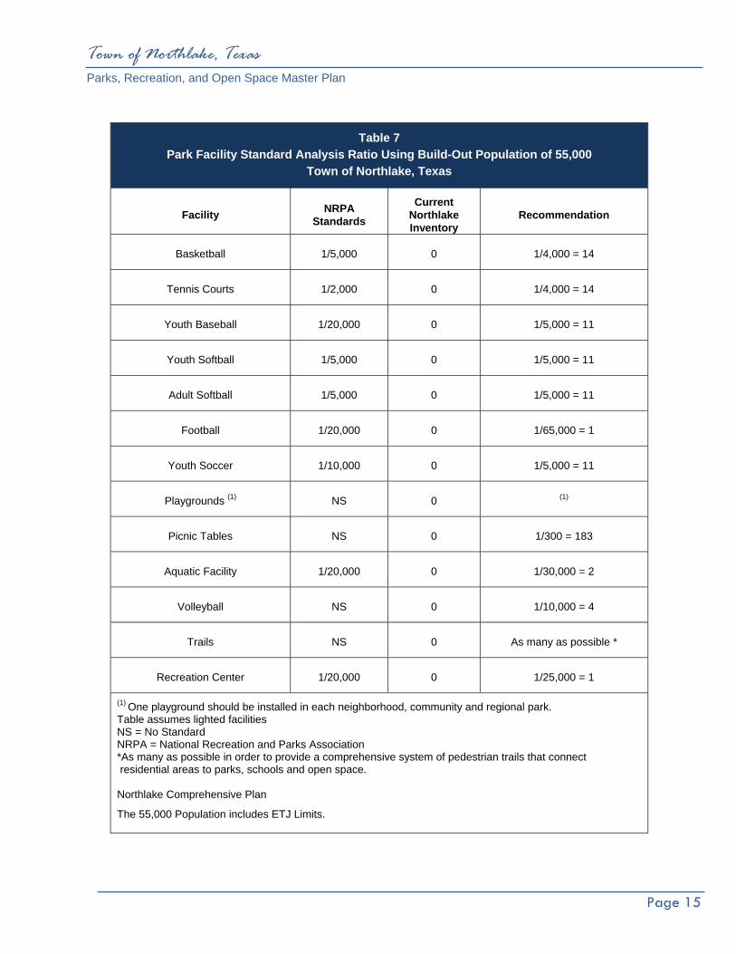
Town of Northlake, Texas Parks, Recreation, and Open Space Master Plan
Page 15
Table 7 Park Facility Standard Analysis Ratio Using Build-Out Population of 55,000
Town of Northlake, Texas
Facility NRPA Standards
Current Northlake Inventory
Recommendation
Basketball 1/5,000 0 1/4,000 = 14
Tennis Courts 1/2,000 0 1/4,000 = 14
Youth Baseball 1/20,000 0 1/5,000 = 11
Youth Softball 1/5,000 0 1/5,000 = 11
Adult Softball 1/5,000 0 1/5,000 = 11
Football 1/20,000 0 1/65,000 = 1
Youth Soccer 1/10,000 0 1/5,000 = 11
Playgrounds (1) NS 0 (1)
Picnic Tables NS 0 1/300 = 183
Aquatic Facility 1/20,000 0 1/30,000 = 2
Volleyball NS 0 1/10,000 = 4
Trails NS 0 As many as possible *
Recreation Center 1/20,000 0 1/25,000 = 1
(1) One playground should be installed in each neighborhood, community and regional park. Table assumes lighted facilities NS = No Standard NRPA = National Recreation and Parks Association *As many as possible in order to provide a comprehensive system of pedestrian trails that connect residential areas to parks, schools and open space. Northlake Comprehensive Plan
The 55,000 Population includes ETJ Limits.

Town of Northlake, Texas Parks, Recreation, and Open Space Master Plan
Page 16
Park Land Analysis Park land analysis is also evaluated on the basis of Northlake’s current population, as shown below in Table 8. This evaluation is a reliable guide and analysis for park land comparison. The acreage required per 1,000 populations varies for each park classification. For long range planning, this is a useful tool for determining future park land acreage acquisition. There is a more detailed discussion addressing park land acquisition in Section V – Future Park Improvements and Recommendations.
As mentioned previously, the neighborhood park is an important aspect to the overall municipal park system. The ratio of 2.5 acres per 1,000 population should not be confused with the minimum acreage size. The minimum acreage for a neighborhood park should be five (5) acres for several important reasons. A minimum of five (5) acres provides enough land to develop playgrounds, small pavilions, etc. A smaller tract will limit the facilities and the recreational opportunities available to citizens. In the event that a Town accepts a smaller tract of land, in the one (1) acre to three (3) acre range, maintenance of these parks would be time consuming and over a period of time would also require an increase to the Town’s maintenance budget. A minimum of five (5) acre tracts is therefore recommended for Neighborhood Park development.
Table 8 Parkland Acreage Analysis Town of Northlake, Texas
Park Type Recommended
Acres Per 1,000 Persons
Existing Northlake
Parks
Acreage for Existing
2,110 Population
Acreage for 17,310 People
in 2021
Acreage for 55,000
People at Build-Out
Neighborhood 2.5 acres 0 acres 5.3 acres 43.2 acres 137.25 acres
Community 5 acres 0 acres 10.6 acres 86.5 acres 274.5 acres
Special 2 acres 0 acres 4.2 acres 34.6 acres 109.8 acres
Open Space/ Greenbelts 6-8 acres 0 acres 17.0 acres 138.5 acres 439.1 acres
Acres: 17.5 acres 0 acres 37.1 acres 302.8 acres 960.65 acres
The 17,310 and 55,000 Population Estimates include ETJ Limits.

Future Park Recommendations

Town of Northlake, Texas Parks, Recreation, and Open Space Master Plan
Page 17
V. Future Park Recommendations FUTURE NEIGHBORHOOD PARK ACQUISITION
The neighborhood park is considered to be the core unit in a municipal park system because it provides recreation opportunities within walking distance in a neighborhood. The Town of Northlake currently has no distribution of neighborhood parks or community parks within the Town Limits. Both park classifications can provide recreational opportunities which are typical to neighborhood areas and can serve neighborhood areas. The Town is projecting to increase its existing population from 2,110 in 2012 to 17,310 by the year 2021. This creates a challenge for Northlake to acquire adequate park and recreational facilities. The Town will have to adjust to the growing population as the Northlake Town Limits expand by acquiring park land as the Town develops; once land is developed for residential and commercial uses, the best opportunity for park land acquisition is lost unless park land is acquired concurrently with the new development. The Town will need to acquire approximately 160 acres of neighborhood park land in order to meet the projected built out population of 55,000. The future park plan illustrates an additional need of 16 total neighborhood parks. This includes parks in the current Town limit and the ETJ. The location of neighborhood park service areas are illustrated on the Future Park Plan, which indicates the need for one Neighborhood Park to be acquired within that service area.
NEIGHBORHOOD PARK/PUBLIC SCHOOL SITE
When possible the best use of park land acquisition and park development is to share a site with an elementary school site. Basically, the Town would agree to purchase additional acreage with the elementary campus. Depending on each site, the average acreage is five (5) acres in conjunction with the campus. The infrastructure is in place because of the school development and often parking is available for both the school and park needs. The park is also available to the school for recreation use and education purposes.
RURAL RESIDENTIAL DISTRICT
Based on the Comprehensive Plan, the density of rural residential is one unit per five (5) acres. Traditional park acquisition would not be required due to the low residential density in this area. However, efforts should be made to allow trail linkage to the rural residential district to provide citizens access to the Town’s trail system.

Town of Northlake, Texas Parks, Recreation, and Open Space Master Plan
Page 18
HOMEOWNER ASSOCIATION (HOA) PARKS AND RESIDENTIAL COMMUNITIES Many cities allow Homeowner Association (HOA) Parks within a specific community or development. The parks are typically designed and built by the developer to serve a specific development. Often times these parks are considered to be private and to be used by residents in a specific development and are not open to the general public. Given that they are private they do provide recreational opportunities to Northlake citizens and can be a benefit to the developer and Town. The HOA Parks are typically classified as a Neighborhood Park and can serve a service zone as identified in the Future Park Plan. The adopted Town of Northlake’s Park, Recreation and Open Space Plan should be followed when allowing a HOA park to be built within a service zone. Guidelines for minimum park size and recreation amenities in a neighborhood park should be followed. The Town’s Park Dedication Ordinance should also be followed in terms of park land and suitability of land. Once it is determined that a HOA park is requested by a developer, the Town and developer should work together to ensure the park addresses the criteria and develop standards identified in this Park Master Plan.

Town of Northlake, Texas Parks, Recreation, and Open Space Master Plan
Page 19
FUTURE COMMUNITY PARKS, GREENBELTS & SPECIAL USE PARKS
Community Parks Community parks typically provide organized athletic fields and other associated park facilities such as organized athletic fields, playgrounds, pavilions, splash pads, trails, etc. Currently, Northlake citizens utilize all park facilities outside the Town Limits, in Denton County and throughout the metroplex and North Texas, which demonstrates a need for more park facilities within the Town. The Town should anticipate the need for a total of three (3) Community Parks within the future Town limits. Because of the geographical size of Northlake the parks may be acquired anywhere in the Town limits or ETJ. The approximate acreage should be 50 to 100 acres per park.
Indoor Recreation Center The Town of Northlake has several needs at this time in terms of its parks system. As the Town grows, an indoor recreation center is one of these needs. Typically, cities provide indoor recreational opportunities in the form of a recreation center. These facilities provide for organized work out programs such as aerobic exercise, weight lifting, and stationary low-impact bikes and treadmills. Basketball and racquetball also cultivate recreation opportunities. Typically, recreation centers are approximately 20,000 to 35,000 square feet. These facilities range in cost between $2,000,000 to $14,000,000 dollars. This cost is based on the final square footage and the amenities in the center.
The Recreation Center may also be used as a community center with meeting rooms for community oriented uses. The City of Roanoke’s Recreation Center is a good example for Northlake in terms of size and use.
Aquatic Facilities Aquatic facilities were mentioned as desired recreational elements during public hearings and telephone surveys. Aquatic facilities can be built as full service aquatic parks, which consist of pools, slides, wading pools and water play features. Initial cost for a facility of this type is estimated at $3,000,000 to $6,000,000. These large multi-million dollar water parks often have a service area larger than the Town Limits of Northlake and are typically classified as a regional facility. The Town should look at a marketing study or a feasibility analysis while considering an aquatic facility of this scale. Hawaiian Falls in Roanoke could serve this need. Another feature is a spray park or splash park, which can be built with approximately $200,000 to $500,000. The ultimate size of an aquatic facility is largely dependent on the service area. These types of facilities are often located in community parks and not in neighborhood parks. A spray park provides outdoor water recreation for kids at a minimal cost, in terms of employing a seasonal aquatic staff for a pool or water park.
Example of Aquatic Facility City of Roanoke, Texas

Town of Northlake, Texas Parks, Recreation, and Open Space Master Plan
Page 20
Greenbelts and Presentation of Open Space According to the Comprehensive Plan, there is approximately 2,617 acres of land within the floodplains in Northlake. A majority of this floodplain is in the Denton Creek corridor. The Town is fortunate to have this major natural reserve for open space and the ability to preserve the floodplain.
Because of limited development permitted in the floodplain, the primary and best use of floodplains is for open space preservation and hike and bike trail corridors. Based on the park public meetings and input from the Comprehensive Plan, hike and bike trails or multi-use trails have been identified as the number one requested recreational element in Northlake. Although trails are developed in neighborhood and community parks, the most optimal location is in the greenbelts and open spaces in the creek corridors of Denton Creek.
Pedestrian Trail The Trail Plan illustrates possible trail connections to adjacent cities trail systems. There is an opportunity to connect to the Town of Flower Mound trail system. This connection point is north of FM 1171 and east of 35W.
Although not in the future Town limits, Northlake could work with the City of Roanoke to connect a trail through the Denton Creek Corridor and into a future park in the Briarwick Development.
These trails can become destination trails to adjacent cities and internal to Northlake providing pedestrian trails to retail areas, and to connect to other parks and public areas.
Equestrian Trails Equestrian Trails were mentioned in the public meetings. The Denton Creek Corridor could provide open space and opportunities for equestrians. The trails are typically laid out in the field and by the various equestrian groups. Typically these trails are not shared with multi-use paved trails. Conflicts or trails which intersect should be avoided.
The local group which has expressed an interest in the Denton Creek Trail is The Cross Timbers Equestrian Trail Association. They are willing to work with the Town to establish these trails.
Floodplain Acquisition When property adjacent to creeks and floodplains is developed, floodplain property should be dedicated to the Town for Open Space and Greenbelts. The Town should accept floodplain areas as a donation and should not purchase the land, unless the Town foresees a need for a critical purchase in order to preserve land and/or provide a link to another park. These open spaces preserve trees and native areas and enhance the educational and passive use of floodplains and open space for park patrons.

Town of Northlake, Texas Parks, Recreation, and Open Space Master Plan
Page 21
Special Use Parks Typically Special Use Parks occur as a town develops or a special need arises. In Northlake equestrian facilities have been mentioned as a possible need. A trail head or small park adjacent to Denton Creek could be used as a Special Use Park.

Ten Year Priority List

Town of Northlake, Texas Parks, Recreation, and Open Space Master Plan
Page 22
VI. Ten Year Town Priority List The Ten-Year Action Plan/Priority List as outlined in Table 9 on the following page represents the culmination of the Parks, Recreation, and Open Space Master Plan. It is the synoptic conclusion of the park master planning process. Annual review of the action plan by the Town Staff, Town Council members, Northlake Board members and citizens will allow analysis of action item recommendations for acquisition, improvements and new facilities to enhance the quality of Northlake Parks and Recreation System to maximum effect.
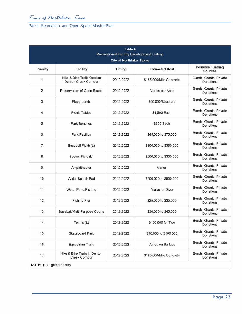
Town of Northlake, Texas Parks, Recreation, and Open Space Master Plan
Page 23

Town of Northlake, Texas Parks, Recreation, and Open Space Master Plan
Page 24
Plate 2: Future Park Plan
Town-Wide Trail System Standards
Town of Northlake, Texas Parks, Recreation, and Open Space Master Plan
Page 25
VII. Town-Wide Trail System Standards Trails are an important component of the future park system, as they serve recreational, transportation and linkage purposes. In Northlake the transportation and linkage aspects of a Town-wide trail system will serve a local and regional purpose.
Purpose of the Trail System Plan First and foremost, the Town-wide Trail System Plan will serve as a planning tool for Town Staff and Town Council. It will also serve to create a vision for a Town-wide trails and greenway network and assist public and private entities who wish to contribute funds or resources to the development of the system. Another key purpose of the trail plan is to serve as a basis for coordinating with other Town departments, to reduce conflicts with their development activities including utility installation, transportation, water quality, storm water runoff, planning services and other activities.
Design Considerations The following is a general discussion of the parameters associated with trail design and construction. The conclusion of this section contains recommendations for the design and construction of the Northlake Trail System.
Types of Trails
Separated Trails – Separate trails and trail systems are provided for each type of trail user, e.g. bicyclist, pedestrian, skaters.
Shared Trails – Trails are shared by two or more user groups but design parameters restrict the use of
the trail by some groups. Multi-Use Trails – All trail user groups occupy the same trail or trail corridor. The physical design of the
trail must be modified accordingly, to accommodate the demands of the expected user groups.
Trail Surfaces
Natural Surface – Side slopes on natural surface trails should be stabilized to avoid being washed onto the trail during heavy rain. Drainage is key to trail corridor safety and maintenance. Use appropriate grading techniques and soil stabilization, such as, grass seeding, plantings, erosion control blankets or rock rip-rap to minimize hazards to users. Natural surface trails should not be used during periods of wet weather to prevent surface damage and should be so signed at trailheads.

Town of Northlake, Texas Parks, Recreation, and Open Space Master Plan
Page 26
Mulch – Mulching a trail can be an effective treatment for trails in clay soil areas. To avoid washouts and watershed deposits, mulching should be avoided in areas of steep terrain. Many types of mulch can work, but one of the most effective and least expensive, long-lasting treatments is hardwood mulch.
Board Walk – Trails should avoid sensitive environmental areas, low areas, wetlands or flood plains. However, trails in wetlands can be useful as educational corridors. Board walks allow existing drainage patterns and a site’s hydrologic conditions to be preserved while providing access to areas of interest. Board walks minimize construction damage and prevent user disruption to fragile ecosystems. Areas for which boardwalks should be built include marshy or wet sites in the immediate vicinity.
Gravel – Gravel is a granular rock material used in non-rigid paved surfaces and generally defined as having a particle size between 2mm (fine gravel) and 20mm (medium to coarse gravel). When considered as a paving material, gravel has several desirable characteristics. Gravel drains well and is a pervious material, and the coarser the material the less the likelihood that it will be washed away by rainfall or flooding.
Its usefulness as a trail paving material is limited. Gravel is a non-compacting material that is loose and inhibitive to all forms of trail use other than casual foot traffic. Roller blades, bicycles and wheelchairs alike will not perform adequately on a gravel surface and are subject to skidding and a general lack of traction. Pedestrians tend to collect irritating gravel particles in their shoes, rendering the trail more or less a nuisance than an enjoyable outdoor amenity.
When mixed with other material such as clay/silt particles, or other cement type material, gravel can be stabilized as a semi-rigid to rigid paved surface. Such a surface would be more accepting of wheeled and foot traffic.
When adding gravel or mulch to a trail, care should be taken to avoid excessive material depth, as this can impair even the hardiest pedestrian. Of the many different types of gravel treatments available, some are much more conducive to trail use. Avoid pea-gravel for use on trail construction. Aggregate, crushed or decomposed granite is a very effective trail surface and can easily be upgraded to hard surface. Although off road bicyclists can negotiate most well compacted gravel trails, access can be difficult for disabled users.
Asphalt – Hot mix asphalt can be cost effective to install, but in areas of full sun, decomposition is accelerated by maintenance vehicle traffic. Edges require containment for stability and long term viability. Surface is softer for walking or jogging. Cold-mix asphalt is suitable for patching but is labor intensive. Asphalt is easy to patch or expand, but care should be taken to ensure an even surface for road bicyclists and wheelchair users. Asphalt trail surfaces are not recommended as a surface.

Town of Northlake, Texas Parks, Recreation, and Open Space Master Plan
Page 27
Concrete – While initially more expensive than other material choices, concrete is the longest lasting
trail surface with an expected life span of 25 years or more. It requires the least maintenance of any trail surface material. Only saw cut expansion joints should be used to avoid differential settling due to freeze/thaw and wet/dry cycles. Concrete is suitable for poor sub-soil conditions, but is more expensive to repair. Non-skid medium broom finish is ideal for bicycle traffic. Concrete is less desirable for jogging paths.
Multi‐Use Trail Width The most appropriate width for multi-use trails has been one of the most discussed topics of parks and recreation construction. The following are the widths required for several different scenarios of common trail usage.
♦ The minimum width to meet ADA (American Disability Act) guidelines is thirty-six inches (36”); however, this width does not allow traffic flow in both directions and therefore should not be considered.
♦ A six-foot width is the minimum width to allow wheelchairs traveling in opposite directions to pass unimpeded, even so, at this width the occupants must maneuver to the very edge of the trail.
♦ Two people walking side by side meeting a bicycle from the opposite direction would require a minimum width of eight feet (8’) and comfortable width of ten feet (10’). However, two people walking side by side would require a comfortable width of twelve feet (12’) because the bicycle passing them on the narrower width will result in the pedestrians being startled or require the bicyclist to slow excessively.
♦ Two bicyclists pedaling side by side require a minimum width of 5.3 feet and a comfortable width of eight feet (8’).
♦ Two bicyclists traveling in opposite directions require a minimum of 6.5 feet to pass and a comfort width of 10.9 feet.
♦ Two bicyclists traveling side by side, meeting a bicyclist from the opposite direction or another bicycle passing them requires a minimum width of nine feet (9’) and a comfort width of twelve feet (12’).
The North Central Texas Council of Governments’ “Bicycle and Pedestrian Facilities Planning and Design Guidelines” states “The minimum width required for two opposing bicyclists to pass and share the path with a pedestrian is 12.5 feet. The NCTCOG guidelines do stipulate that widths less than 12.5 feet may be acceptable given the following circumstances: (1) bicycle traffic is expected to be low, even on peak days or during peak hours; (2) pedestrian use of the facility is not expected to be more than occasional; (3) there will be good horizontal and vertical alignment, providing safe and frequent passing opportunities; (4) the path will not be subjected to maintenance vehicle loading conditions that would cause pavement edge damage and (5) access maintenance or emergency vehicles are not needed. A multi-use pathway should never be less than eight feet (8’) wide.

Town of Northlake, Texas Parks, Recreation, and Open Space Master Plan
Page 28
Vertical Clearance The absolute minimum vertical clearance for multi-use trails is 8.2 feet, 9.5 feet is the minimum comfortable height. The vertical clearance may need to be greater to permit passage of maintenance vehicles. Clearance under crossings and tunnels should be ten feet (10’) for adequate vertical shy distance.
Longitudinal Slope (Grade) Grades on off-street paths should be kept to a minimum, especially on long inclines. Grades greater than five (5) percent are undesirable because the ascents are difficult for many bicyclists and the descents cause some bicyclists to exceed the speeds at which they are competent. ADA guidelines stipulate that anything exceeding five percent (1 foot rise in 20 horizontal feet) is a ramp and must be constructed with handrails, a maximum rise of thirty inches (30”) in a maximum length of thirty feet (30’) and must have a 60” x 60” landing at the base and the top. Therefore to be in compliance with ADA guidelines trail ramps cannot exceed an 8.33% slope (1 foot rise in twelve horizontal feet).
Signs Adequate signs and markings are essential on multi-use trails, especially to alert users to potential conflicts and to convey regulatory messages to both users and motorist at street intersections. In addition, guide signs, such as those indicating destination, direction, distance, route numbers and names of cross streets, should be used in the same manner as they are on highways.
Access Points Although access to the trail will usually be available at every road crossing, the users of the trail should be encouraged to enter the trail at specific access points. By designating specific points of access, there may be an elimination of possible encroachment on private property, as well as, preventing possible congestion at busy road crossings.
Lighting Lighting of the multi-use trail should be considered, especially if the off-street routes are intended for transportation purposes, many trail commuters may need to travel during poorly lit morning and evening hours. Fixed source lighting reduces conflicts along paths and at intersections. In addition, lighting allows the trail user to see the path direction, surface conditions and obstacles. Lighting should be considered through underpasses or tunnels and when night time security could be a problem. The standard horizontal illumination level is 5 lux (0.5 foot candle) to 22 lux (2 foot candles). Where special security problems exist, height illumination levels may be considered. Most of the lighting systems for trails are down lighting and avoids glare and light spillage into the dark sky.

Town of Northlake, Texas Parks, Recreation, and Open Space Master Plan
Page 29
Traffic Control Devices Pedestrian signals designed to accommodate a one meter (3.2 feet) per second walking speed, should be provided at major streets where traffic volume and speed is high. ADA stipulates that where provided, buttons shall be raised or flush and a minimum of 1.9 centimeters (3/4 inch) in the smallest dimension. The force required to activate controls shall be no greater than 22.2 N (5 lbs). Additionally, controls shall be located as close as possible to the curb ramp and, to the maximum extent feasible, shall permit operation from a level area immediately adjacent to the controls and a maximum of 122.7 centimeters (48.3 inches) high.
To provide clear visibility of pedestrians approaching intersection crosswalks at night, the approaches and all street corners should be well illuminated. All intersection lighting should illuminate the crossing and waiting areas and/or create backlighting to make the pedestrian silhouette clearly visible on approach. All commercial, entertainment, school and other pedestrian traffic generating corridors and spaces should be well illuminated. Raised islands in crossings should be cut through level with the street or have curb ramps or other sloped area at both sides. There should be a level area 121.9cm (48 in) long minimum and a minimum of 91.4cm (36 in) wide in the part of the island intersected by the crossings.
TOWN OF NORTHLAKE TRAIL RECOMMENDATION
Off‐Street Trail Width In off-street applications the trails shall be a minimum of ten feet (10’) wide; where feasible the more comfortable 12 foot width shall be used.
On‐Street Trail Width In on-street applications the ten-foot width will not be feasible due to the limited width of the parkway (street side right-of-way). A minimum width of six feet (6’) shall be maintained for all on-street trails, where the locale allows trail width shall be expanded to eight feet (8’) (ten feet (10’) adjacent to large lot residential development). In most residential areas an eight-foot (8’) maximum width should be maintained as it is felt this will tend to reduce the velocity of bicycle traffic.
Trail Surface All multi-use trails within the Northlake trail system shall be constructed of concrete.
Decomposed Granite may be used in specific applications within a park or special use park area. Decomposed Granite is not recommended for the flood plain or high use trail areas.

Town of Northlake, Texas Parks, Recreation, and Open Space Master Plan
Page 30
Access Points/ Trail Heads Trail heads shall be served by parking lots accommodating ten to twenty parking spaces. Trail heads should be located adjacent or a short distance from main trail corridors and located at each main trail terminus. Design elements of trail heads should include a drinking fountain, benches, stretch post or other equipment to encourage and facilitate stretching exercises and a mounted map of the trail system with their present location indicated.
Trail Signs Warning signs shall consist of the traffic control signage and devices indicated in the design guidelines. Directional signs are imperative to facilitate user comfort and confidence, thereby ensuring optimal use of the trail from the standpoint of participation/occupancy levels and enjoyment level of the participants. At trail intersections signs should be provided that indicate destinations; of the various trail branches and a distance to each destination, the cardinal directions should also be indicated. Consideration should be given to providing a map of the trail system at each intersection of major trail branches. Within residential neighborhoods, in addition to the aforementioned signage, the pavement surface shall be demarked in such a manner that trail users will be able to follow the trail routing through the neighborhood without becoming confused and possibly taking a wrong turn. Spur trails linking neighborhoods to parks and schools shall have a definite indication at the trail terminus so trail users unsuspectingly traveling into the neighborhood are made aware that the trail system ends at that location. Provision of a map indicating the direction to the main branch of the trail would be beneficial at these locations.
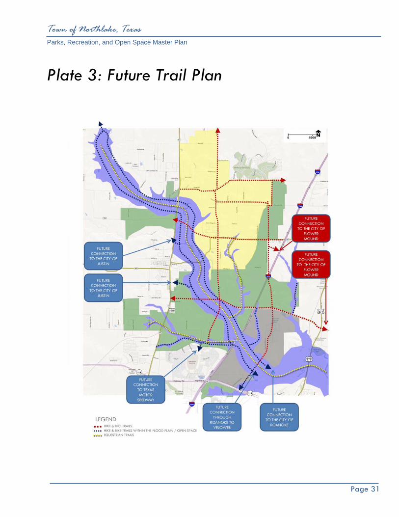
Town of Northlake, Texas Parks, Recreation, and Open Space Master Plan
Page 31
Plate 3: Future Trail Plan
Plan Summary
Town of Northlake, Texas Parks, Recreation, and Open Space Master Plan
Page 32
VIII. Plan Summary This Parks, Recreation, and Open Space Master Plan is a fluid planning tool which will guide the development and acquisition of new park land and recreational facilities. This Master Plan has updated the demographic of the Town and prepared a new needs assessment identifying the need for parks, recreational athletic fields, and facilities. As with any public or municipal project, the amount of available funding or the potential to retire debt is the controlling factor in deciding which project or projects should be completed first. The Parks, Recreation, and Open Space Master Plan recommends park land acquisition, a new park, and recreation facility development improvements for the next ten years. The Ten-Year Priority List was established with citizen input, needed park improvement and specific requests. The priority list is a guide the Town should follow to assist in the decision making process regarding park development and park land acquisition. The current economy and future economic trends always effect the decision making process regarding all types of municipal infrastructure. This Master Plan should be reviewed every year by staff and an annual report prepared and presented to the Northlake Economic Development Corporation, Northlake Community Development Corporation and Town Council outlining accomplishments during that fiscal year.
IMPLEMENTATION Identified within this section are the ways and methods of implementing the recommendations within this Parks, Recreation, and Open Space Master Plan. Critical to its implementation is the action plan, which should be developed annually by the Town of Northlake.
Policies and Ordinances The accuracy of these implementation mechanisms is dependent upon the proper coordination of input from contributing bodies including Town officials, elected and appointed, Town Staff and most importantly the citizens of Northlake. All parties must communicate and work collectively toward common goals, only this will ensure the successful development of the park system. An example of this communication, at the staff level, would be the incorporation of the Parks, Recreation, and Open Space Master Plan during review of proposed development plans with various entities involved. Ordinances provide the legal framework for implementation of this Master Plan, and therefore, aid in park system development and protection. Outlined below are several ordinances directly related to park land acquisition and development.
Town of Northlake, Texas Parks, Recreation, and Open Space Master Plan
Page 33
Watershed Management & Drainageway Ordinances These ordinances protect and preserve greenbelts and floodplains. They provide a tool to manage the drainage and floodplains within Northlake. The ordinances respond to Federal Emergency Management Agency (FEMA) and National Pollutant Discharge Elimination System (NPDES) mandates for cities. These tools may be drafted in a format as restrictive as the Town wishes. A reciprocal benefit of the preservation of these areas would be their use as linear greenbelts and connections to destinations throughout the Town.
Funding Sources This Parks, Recreation, and Open Space Master Plan recommends the development of a number of new parks, and further development in some existing parks. Once completed, these recommended improvements represent a substantial public investment in parks and open space as the Town grows and develops. The various sources of funds for these improvements are as important as the diversity of those sources. When there are several sources of funds for implementing this Master Plan, then no one source is over-burdened and the Master Plan has a better probability of being successfully implemented. The sources discussed below relate to the purchase and development of park land and facilities.
General Fund This source of funding is supported by ad valorem tax revenues and is generally the primary source of funds for maintenance and operation of the existing park system. The general fund is also the source for projects requiring smaller amounts of capital investment. Although projects funded by this source make a small annual contribution to the expansion of the park system, analysis over a number of years usually reflects a major accomplishment in improvements to the park system. It is important to include funding for on-going maintenance and staff requirements for new developments and improvements.
Bonds Bonds are generally the most common source used by cities for the purchase of land and for providing development monies. There are two types of bonds which are used for parks, both of which must be approved by referendum.
General Obligation Bond The General Obligation Bond is amortized using ad valorem taxes and is used for the funding of capital projects which are not supported by a revenue source. These projects include water service, sanitary sewer service, and park acquisition and development. The availability of bonding for parks is often dependent upon the overall municipal needs financed by this source. Capital items such as purchase of land and physical improvements with a useable life expectancy of 15 to 20 years can be funded with general obligation bonds.
Town of Northlake, Texas Parks, Recreation, and Open Space Master Plan
Page 34
Revenue Bonds Revenue bonds finance projects which produce enough revenue to retire their debt, such as, golf course, batting cages and enterprise oriented park projects.
Private Donations This source of financial assistance would usually come from a citizen, organization, or business which has an interest in assisting with the development of the park system. Land dedication is not an uncommon occurrence when property is being developed. The location of a neighborhood park within a residential development offers additional value to residential units within that neighborhood, especially if the residential development is occupied by younger families with children. Although the future dedication of neighborhood park land is considered a limited resource in central Northlake due to the extent that development has occurred and the small size and configuration of remaining parcels within most areas of Northlake, it nevertheless remains a viable means of acquiring land. Once property is acquired through this method, the Town should be prepared to improve the facility for use within a reasonable length of time.
Private donations may also be received in the form of funds, facilities, recreation equipment, art or in-kind services. Donations from local and regional businesses as sponsors for events or facilities should be pursued. A Parks Improvement Trust Fund may be set up to manage donations by service organizations, benevolent citizens, willed estates and other donated sources. The purpose of this trust is to establish a permanent source of principle value that will increase as donations occur. The principal cannot be decreased; however, the annual interest can be used for park development.
Northlake Economic Development Corporation (EDC) and the Northlake Community Development Corporation (CDC)
The Northlake EDC and Northlake CDC each administer a half-cent sales tax. These funds can be dedicated for park land acquisition and park facility development. This is one of the primary funding sources municipalities use for funding parks and park development.
Texas Recreation and Parks Account (TRPA) Program Texas Local Parks, Recreation and Open Space Fund is administered by the Texas Parks and Wildlife Department (TPWD). The TPWD program allows a town to request matching funds for both the acquisition and construction of park facilities. Currently, funds are available on a fifty percent (50%) cost share basis; the maximum funding varies from year to year and is established by the Texas Parks and Wildlife Department. The grant is secured through submission of an application which follows a standard format for applicants. All applications received are ranked on a point system which is designed to evaluate the need for the purchase or construction being requested. Funds are distributed among the applicants having the greater number of points until all allocated funds are expended.
Applications to TPWD can be made annually with a six-month waiting period following the submission date before the successful applications are notified. The number of applications a Town may submit at any given
Town of Northlake, Texas Parks, Recreation, and Open Space Master Plan
Page 35
time is based on past performance on grants and TPWD evaluation criteria. This funding source is used by many communities. The competitiveness of the program generally allows cities having bona fide park needs to prevail in obtaining funds.
Safe Routes to School Program This funding source provides funding for programs and projects that enhance non-vehicular mobility between schools and neighborhoods. The cost of reimbursement program funds at 100% and is also managed by TXDOT.
Recreation Trails Program (RTP) These funds can be spent to construct new recreational trails, improve/maintain existing trails, develop/improve trailheads or trailside facilities, and acquire trail corridors/easements. It is also a cost reimbursement program.
Public Improvements District (P.I.D.) When authorized by Town Council in compliance with state laws, new developments can establish a Public Improvement District (P.I.D.). As a taxing district, the P.I.D. provides funds specifically for the operation and maintenance of public facilities such as parks and major boulevards.
Tax Increment Financing District (T.I.F.) A T.I.F. is a tool used by local government to finance public improvements in a defined area as approved by the Town Council. When an area is designated a T.I.F. district the tax base is frozen at the current level. As development occurs within the T.I.F., the increased value of property, the tax increment is captured. The tax increments are posted to a separate fund to finance public improvements within the district.

Appendix

Town of Northlake, Texas Parks, Recreation, and Open Space Master Plan
Page 36
Appendix ‘A’ Typical Neighborhood Park Land Acquisition and Development Cost
Typical Neighborhood Park Land Acquisition: (10.0 acres @ $25,000 per acre) $ 250,000.00 Typical Neighborhood Park Development Costs: Playgrounds with Shade Structures $ 90,000.00 Concrete Hike & Bike Trail (8’ wide, ½ mile long) $ 95,000.00 Practice Backstop $ 15,000.00 Multi-Purpose Court $ 45,000.00 Turf and Irrigation (10-acre site) $120,000.00 Drinking Fountain $ 6,000.00 Small Picnic Shelter with 5 tables $ 60,000.00 Park Benches(s) $ 7,500.00 $ 438,500.00 Total Land Acquisition and Development Cost per Neighborhood Park: $ 688,500.00