Embed Size (px)
DESCRIPTION
Proposed Integrated MARINA Central Office and Training Complex
Citation preview
1
Part II. RESEARCH FOCUS
Chapter II.1 RATIONALE
The Earth Summit and the Kyoto Protocol are conferences held by the United Nations on 1992
and 1997 respectively. These are all environmental awareness regarding climate change and the
growing scarcity of potable water. Countries like Canada, USA, Japan, Philippines, and many more
have signed and agreed to comply with the advocacy of these programs. Canada, USA, Japan, and
even Singapore now design most of their buildings with a more sustainably inclined design, only
the Philippines is the country left that does not comply with their signed treaty or agreement since
1992. Sooner or later, the Philippines will be required to design its buildings accordingly; towards
a Green, Sustainable Design.
On the other hand, “MARINA 2016: A premiere maritime administration in Southeast Asia
propelling the Philippine maritime industry to global competitiveness.” This statement serves as the
vision of Maritime Industry Authority as published in their official website. It clearly states how
MARINA would likely to be in 2016 and also shows the improvements needed in the department to
fully accomplish their set mission. There are three descriptive words in their mission statement that
gives a glimpse of what the department wants namely, premiere, propelling and global
competitiveness. This three terms just shows that the department wants a boost in their system
and office.
It is therefore properly timed to produce MARINA their own structure that will improve the
working potential of the department and to accommodate the future authorities it shall serve.
MARINA located in Kalaw St. Manila serves as the main office which indicated the high rates of
clients it serves on a daily basis and the complex tasks it executes being the head of all MARINA,
the only government sector that certifies, accredits, awards and licences all that is under the
Philippine’s maritime industry. Aside from the proposed MARINA central office, additional spaces
and facilities will be added to the site which is in response to the mission held by the agency. These
spaces and facilities for maritime training will be leasable to any accredited manning agency or
training center, which can give them and their clients a more convenient, complete and accessible
training place.
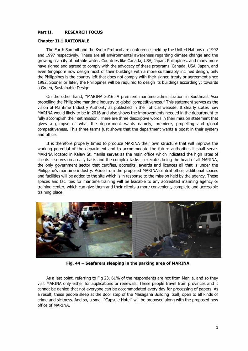
As a last point, referring to Fig 23, 61% of the respondents are not from Manila, and so they
visit MARINA only either for applications or renewals. These people travel from provinces and it
cannot be denied that not everyone can be accommodated every day for processing of papers. As
a result, these people sleep at the door step of the Masagana Building itself, open to all kinds of
crime and sickness. And so, a small “Capsule Hotel” will be proposed along with the proposed new
office of MARINA.
Fig. 44 – Seafarers sleeping in the parking area of MARINA
2
Chapter II.2 PRINCIPLES AND RELEVANCE TO THE PROJECT
According to Arch. Ken Yeang, Sustainability has many principles or strategies for a
green building. Some of these are eco-mimicry, seamless + benign bio-integration, green
certification, bio-simulation, urban biosphere reservation, retrofitting, and many more. Green
certification for example, is a program held by green advocates such as the Building for Ecologically
Responsive Design Excellence (BERDE). BERDE has guidelines for materials and building systems
and accredits a building if it is worthy of a green certification or not. It is checked annually if the
building still complies with the requirements and in failing so will cause the withdrawal of the green
certification.
Another principle would be retrofitting. It is the act of incorporating new, either simple or
sophisticated, technologies or systems into an existing, and at times, old buildings. Retrofitting
came about from environment awareness; the need for sustainable green structures in hopes of
countering the inevitable future of overloaded brownlands and lack of certain supplies. As an
example, retrofitting a structure can renew its water utilities, recycling grey water for a repeated
consumption, saving liters of potable water in the process. Yet, doing so would either nullify the
use of the already existing pipe lines of the structure, or would require the installation of complex
piping and addition of tanks or cisterns, or both. Obviously, it would be costly, but it is an investment
for the betterment of the environment and for the users of the structure. As the common advocacy
of green advocates go “The greenest building is the one already built” it would be much ideal to
retrofit the old building in Kalaw but since it is proven that there is a need to build a new facility,
the priorities must be weighed and so there is a more dire need to build a new facility than to
retrofit the old building in Kalaw, as justified before with supporting data.
Going back to MARINA matters, The Philippines is titled to be the first in line when
it comes to maritime manpower. Based from the data, 40 % of seafarers came from the Philippines,
giving the country 5.5 billion dollars of remittance, a strong proof that the maritime industry is
hands a big help in our economy. In response to it, this proposal seeks to find ways to improve the
Philippine’s standing in the maritime industry and our fellow countrymen who are our front liners
in the industry. The idea for this proposal is to produce a central office for The Maritime Industry
Authority and introduce an improved and global standard of training facility for the Filipino
seafarers. The main focus for the central office is to provide a systematic and scientific adjacency
of spaces as well as the enhancement of main public areas. As the agency operates at least 10
hours a day and five times a week, incorporating sustainable designs.
Moving on, capsule hotels as seen in Figure
45 originated in Japan in 1979 by Arch.
Kisho Kurokawa, according to gizmag.com.
These are usually two stacks of “capsules”
that are usually 1.00 x 2.00 x 1.25 meters
in dimension. Capsule hotels are solely for
sleeping only, other facilities such as
toiletries and locker rooms are common and
are separate. Since most hotels offer rates
based on square meter, quality, and
amenities, a capsule hotel would be much
more ideal for a sleeping quarter in the
proposed new MARINA building.
Fig. 45 – A capsule hotel in Osaka, Japan
3
Chapter II.3 APPLICATION TO THE PROJECT
As mentioned before, a green and sustainable design would sooner be a must here
in the Philippines, and so the project will adhere to the advocacy of green architecture. Since the
project is majorly a government office, it operates mostly at daytime and therefore shall be planned
accordingly so as to maximize daylight while not compromising circulation. The project shall be so
oriented with proper orientation to the sun path and prevailing winds to maximize natural energies
and forces. The project will also include the recycling of grey water since it is an office used by
thousands of people per day, doing so can save hundreds of liters of potable water from sanitation
purposes alone.
Also, since the main issue here is the overall system that is brought about by
inadvertent planning of the current office, another research focus would be a thorough study and
plan of the office spaces that can lead to a better system and flow of the users.
Lastly would be the incorporation of the capsule hotels in the proposal for the
seafarers especially those who are from provinces. A capsule hotel would be ideal since its only
function is for sleeping and resting purposes and no other. It would be cheaper than renting any
hotels in the vicinity.
Part III. SITE IDENTIFICATION AND ANALYSIS
Chapter III.1 SITE SELECTION PROCESS
Criteria for Site Selection
Site Selection is a critical aspect to be well thought-out when planning a
development for a government agency in view of the fact that it can greatly impact and affect its
users as well as the development itself.
Due to unavailability of established site selection criteria, the following are site
criteria based on the case studies conducted:
- The site should be near the capital city, Manila
- The site should be accessible to major roads
- The site should be easily accessed by public transportations
- The site should be owned by MARINA or by the Philippine government
- The site should be large enough to accommodate horizontal expansions
- The site should be relatively flat
- The site should be near a transport terminal that transports people from provinces to
the Manila
4
Site Option Description
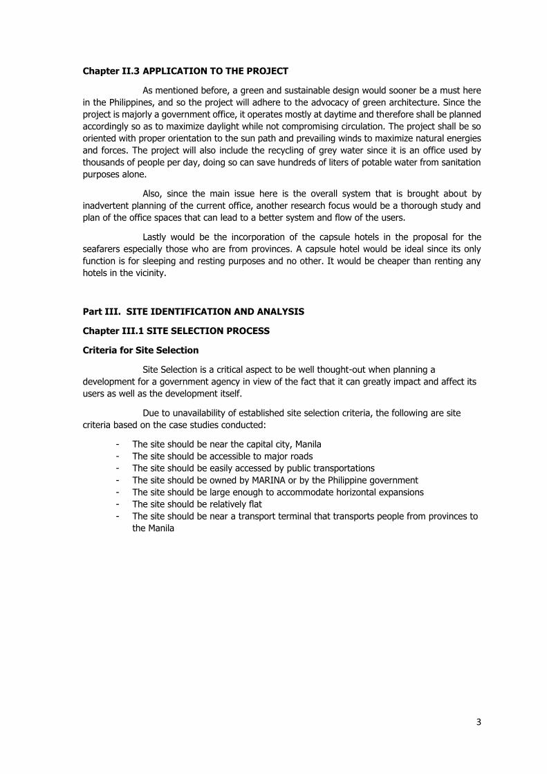
Site option no.1 is being bounded by the Manila Film Center on the north, Manila
bay on the west, J.W. Diokno Blvd on the east and a few vacant lots on its southern part. The lot
is named under the Republic of the Philippines and is considered to be vacant.
Strengths:
- The site has a total area of 10 hectares, making it a good option for horizontal
development and expansion
- The site’s adjacency to the sea can be used to expand and improve the training
facilities that will be developed in the proposal
- The site is near Manila and the location of previous office of MARINA
Weakeness:
- The site is quite far from Roxas Blvd., which is a known major road near the site
- There are no public vehicles that travels along the stretch of the site
Opportunities:
- The distance of the site from commercial developments is quite far, which can give
an opportunity for commercial spaces for the users’ convenience
- The proposed structure being located on the site can increase the number of people
who goes to the area, which can make the area bring back its life
-
Threats:
- The site is beside an abandoned building where dogs are put to guard it this makes it
dangerous for the people who will be staying near it
- The site is considered as a coastal area; high susceptibility in flooding
Fig. 46 – Site option no.1
5
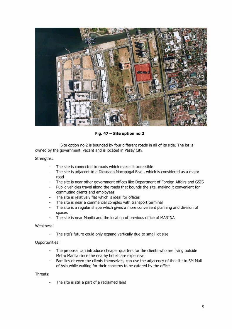
Site option no.2 is bounded by four different roads in all of its side. The lot is
owned by the government, vacant and is located in Pasay City.
Strengths:
- The site is connected to roads which makes it accessible
- The site is adjacent to a Diosdado Macapagal Blvd., which is considered as a major
road
- The site is near other government offices like Department of Foreign Affairs and GSIS
- Public vehicles travel along the roads that bounds the site, making it convenient for
commuting clients and employees
- The site is relatively flat which is ideal for offices
- The site is near a commercial complex with transport terminal
- The site is a regular shape which gives a more convenient planning and division of
spaces
- The site is near Manila and the location of previous office of MARINA
Weakness:
- The site’s future could only expand vertically due to small lot size
Opportunities:
- The proposal can introduce cheaper quarters for the clients who are living outside
Metro Manila since the nearby hotels are expensive
- Families or even the clients themselves, can use the adjacency of the site to SM Mall
of Asia while waiting for their concerns to be catered by the office
Threats:
- The site is still a part of a reclaimed land
Fig. 47 – Site option no.2
6
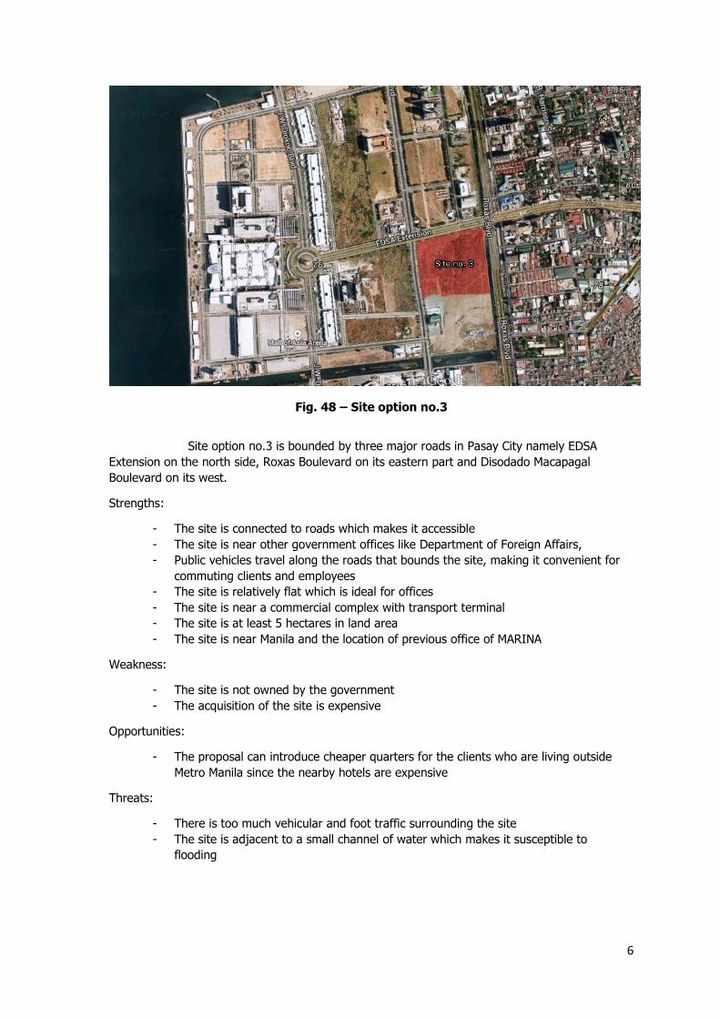
Site option no.3 is bounded by three major roads in Pasay City namely EDSA
Extension on the north side, Roxas Boulevard on its eastern part and Disodado Macapagal
Boulevard on its west.
Strengths:
- The site is connected to roads which makes it accessible
- The site is near other government offices like Department of Foreign Affairs,
- Public vehicles travel along the roads that bounds the site, making it convenient for
commuting clients and employees
- The site is relatively flat which is ideal for offices
- The site is near a commercial complex with transport terminal
- The site is at least 5 hectares in land area
- The site is near Manila and the location of previous office of MARINA
Weakness:
- The site is not owned by the government
- The acquisition of the site is expensive
Opportunities:
- The proposal can introduce cheaper quarters for the clients who are living outside
Metro Manila since the nearby hotels are expensive
Threats:
- There is too much vehicular and foot traffic surrounding the site
- The site is adjacent to a small channel of water which makes it susceptible to
flooding
Fig. 48 – Site option no.3
7
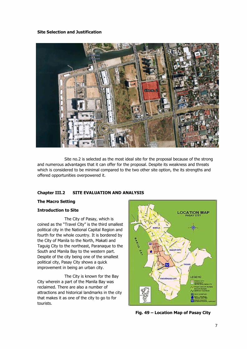
Site Selection and Justification
Site no.2 is selected as the most ideal site for the proposal because of the strong
and numerous advantages that it can offer for the proposal. Despite its weakness and threats
which is considered to be minimal compared to the two other site option, the its strengths and
offered opportunities overpowered it.
Chapter III.2 SITE EVALUATION AND ANALYSIS
The Macro Setting
Introduction to Site
The City of Pasay, which is
coined as the “Travel City” is the third smallest
political city in the National Capital Region and
fourth for the whole country. It is bordered by
the City of Manila to the North, Makati and
Taguig City to the northeast, Paranaque to the
South and Manila Bay to the western part.
Despite of the city being one of the smallest
political city, Pasay City shows a quick
improvement in being an urban city.
The City is known for the Bay
City wherein a part of the Manila Bay was
reclaimed. There are also a number of
attractions and historical landmarks in the city
that makes it as one of the city to go to for
tourists.
Fig. 49 – Location Map of Pasay City
8
Economy
After four decades of rapid urbanization, Pasay City is now transformed as one of
the important sector in the urban center. The city houses the headquarters of most of the leading
airlines and the main airport terminal of the country. There are also government offices that
resides in city namely Department of Foreign Affairs, Senate of the Philippines, Department of
Trade and Industry and other public agencies. Through the relatively flat terrain and strategic
location, the city has the capacity to absorb a large population and intense commercial
enterprises. A feature that could work along with the expansion of the city through the
reclamation of lands along Manila Bay wherein a part of the bay has already been reclaimed to
house large prominent landmarks and national government offices.
History
Pasay’s historical past can be traced back to 1863. It was first known as the town
of Pineda and was incorporated into the Province of Rizal at that time. Antonio Dancel was the
first appointed provincial governor while Pascual Villanueva stood as the City’s first president. On
August 4 1901, the town revert to its original name, Pasay, through a resolution. After two years,
the pueblo of Malibay was added to Pasay, with a population of 8,100, the city was placed under
the fourth-class category.
Through the offer of Pasay Real Estate Company, residential lots were made available for the
leasing of foreign investors as the friars landed in the city to make a subdivision. Through the
continuous progress, telephone lines, telegraphs and postals were installed as well as the
establishment of the Philippines Savings Bank.
It was in 1907 that a first-class road connecting Pasay to Camp Nichols was completed. It was
then followed by other road constructions including the old Avenida Mexico, now known as Taft
Avenue extension. Linking the city to Intramuros, Escolta, San Miguel, San Sebastian and San
Juan, so called tranvia or electric streetcars were launched by the city’s government.
Real estate in Pasay was cheap before. Much of the bayside area, now known as the bay city,
were swamps but the American soldiers were quick to seize the opportunity to develop it into
residential areas and by 1918, Pasay already had a population of 18,967.
World War II broke out on December 26, 2941 where MacArthur issued a proclamation declaring
Manila and its suburbs including Pasay an open city. Many residents of Pasay joined the
resistance during the Japanese occupation. There were people who were born and residing in
Pasay that stood up and helped the city to be exempted from the capture but in October 14,
1943, Japan proclaimed the Second Philippine Republic which was also the time when Pasay
residents started to leave the city because of the worsening food shortage.
After MacArthur fulfilled his promise to return and helped the Philippines, the Greater Manila Area
including Pasay city was recovered and rebuilt. Not long after the decree given by Ferdinand E.
Marcos, the Metropolitan Manila Commission and the Department of Local Government instructed
Pasay City to create its own barangays. Mayor Cuneta started the creation of 487 barangays and
was later trimmed down by Secretary Jose Rono of the Department of Local Government.
In the middle of 1997 Vice Mayor Wenceslao "Peewee" Trinidad took over the reins of
government from an ailing Mayor Pablo Cuneta. Mayor Cuneta was the Chief Executive of Pasay
City for thirty-seven years and served between the years 1949, when he was appointed city
mayor by President Elpidio Quirino, and 1997.
The onset of globalization in the 1990s has drastically changed the country’s economic landscape.
Amidst all these changes, the city of Pasay has the opportunity to become the country’s next
9
important center of business, trade, and commerce. This, however, must be achieved through the
effective management of its resources and with the improvement of the living standards of its
people.
Geography
The city of Pasay occupies 18.50 square kilometres (7.14 sq mi) of land which
marks it as the third smallest political city in the National Capital Region. It lies in the western
section of the Manila Bay and is divided into three main areas: the urban area of the city which is
composed of an area of 5.505 square kilometres (2.125 sq mi), the Civil Aeronautics
Administration Complex, including the Ninoy Aquino International Airport, Villamor Air Base, with
an area of 9.5 square kilometres (3.7 sq mi) and the reclaimed area of Manila Bay with an area of
4.00 square kilometres (1.54 sq mi).
Pasay is composed of seven districts that is partitioned into twenty zones, with a
sum of 201 barangays. The barangays in Pasay City are not designated with names instead,
numbers. Zone 1 shows to be the smallest zone with an area of 10 hectares (25 acres), which
covers Barangays 1 to 3 and as well as Barangay 14 to 17.
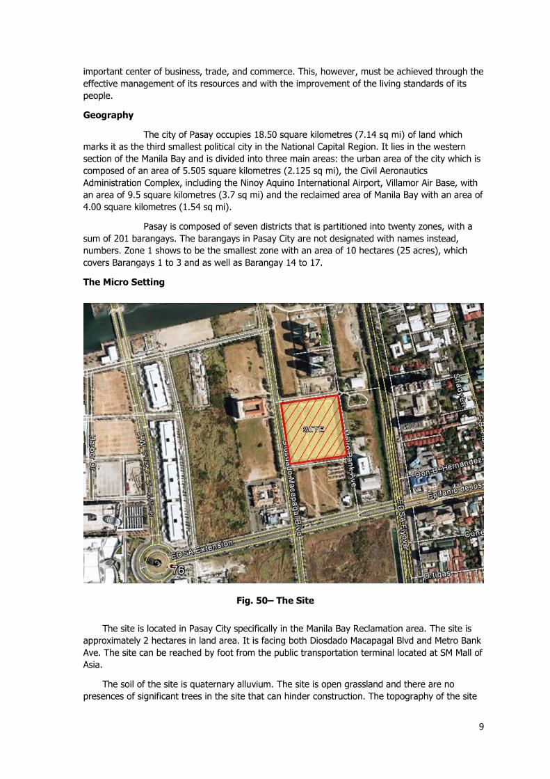
The Micro Setting
The site is located in Pasay City specifically in the Manila Bay Reclamation area. The site is
approximately 2 hectares in land area. It is facing both Diosdado Macapagal Blvd and Metro Bank
Ave. The site can be reached by foot from the public transportation terminal located at SM Mall of
Asia.
The soil of the site is quaternary alluvium. The site is open grassland and there are no
presences of significant trees in the site that can hinder construction. The topography of the site
Fig. 50– The Site
10
is relative flat. In terms of geo-hazard, the site is susceptible to floods since it is included in the
flood prone areas of Pasay City and is also located in the Manila Bay reclamation area, places that
are near the Manila Bay. It is also not in close proximity with any fault line and mountains that
can make it susceptible to landslides as well as big damages during earthquakes. The site is
considered as a planned unit development in terms of zoning.
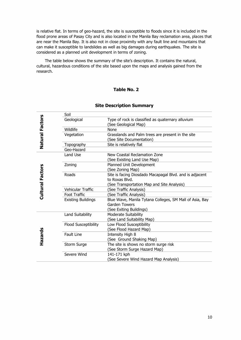
The table below shows the summary of the site’s description. It contains the natural,
cultural, hazardous conditions of the site based upon the maps and analysis gained from the
research.
Site Description Summary
Na
tura
l Fa
cto
rs Soil
Geological Type of rock is classified as quaternary alluvium
(See Geological Map)
Wildlife None
Vegetation Grasslands and Palm trees are present in the site
(See Site Documentation)
Topography Site is relatively flat
Geo-Hazard
Cu
ltu
ral Fa
cto
rs
Land Use New Coastal Reclamation Zone
(See Existing Land Use Map)
Zoning Planned Unit Development (See Zoning Map)
Roads Site is facing Diosdado Macapagal Blvd. and is adjacent
to Roxas Blvd. (See Transportation Map and Site Analysis)
Vehicular Traffic (See Traffic Analysis)
Foot Traffic (See Traffic Analysis)
Existing Buildings Blue Wave, Manila Tytana Colleges, SM Mall of Asia, Bay
Garden Towers
(See Exiting Buildings)
Ha
za
rds
Land Suitability Moderate Suitability
(See Land Suitability Map)
Flood Susceptibility Low Flood Susceptibility (See Flood Hazard Map)
Fault Line Intensity High 8
(See Ground Shaking Map)
Storm Surge The site is shows no storm surge risk
(See Storm Surge Hazard Map)
Severe Wind 141-171 kph (See Severe Wind Hazard Map Analysis)
Table No. 2
11
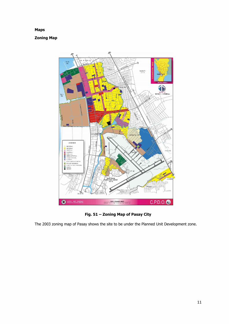
Maps
Zoning Map
The 2003 zoning map of Pasay shows the site to be under the Planned Unit Development zone.
Fig. 51 – Zoning Map of Pasay City

12
Geologic Map
The site is consist of quaternary alluvium which are loose soil sediments that undergone erosion
and later on formed and reshaped through some water elements, but is returned through a non-
marine locale. Quaternary alluvium is consist of variety of particles like clay, silt, sand and gravel.
Fig. 52 – Geologic Map of Pasay City
13
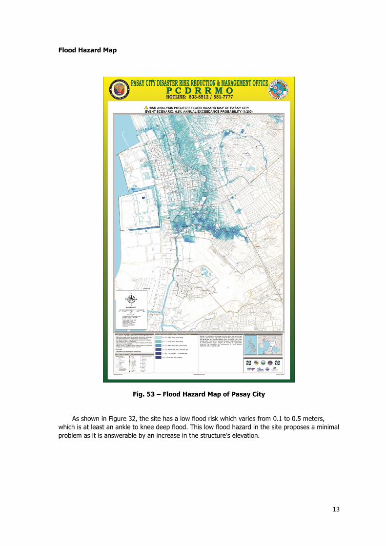
Flood Hazard Map
As shown in Figure 32, the site has a low flood risk which varies from 0.1 to 0.5 meters,
which is at least an ankle to knee deep flood. This low flood hazard in the site proposes a minimal
problem as it is answerable by an increase in the structure’s elevation.
Fig. 53 – Flood Hazard Map of Pasay City
14
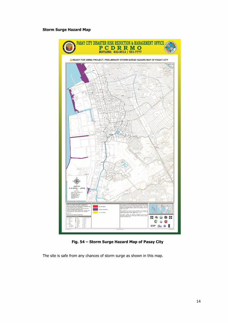
Storm Surge Hazard Map
The site is safe from any chances of storm surge as shown in this map.
Fig. 54 – Storm Surge Hazard Map of Pasay City
15
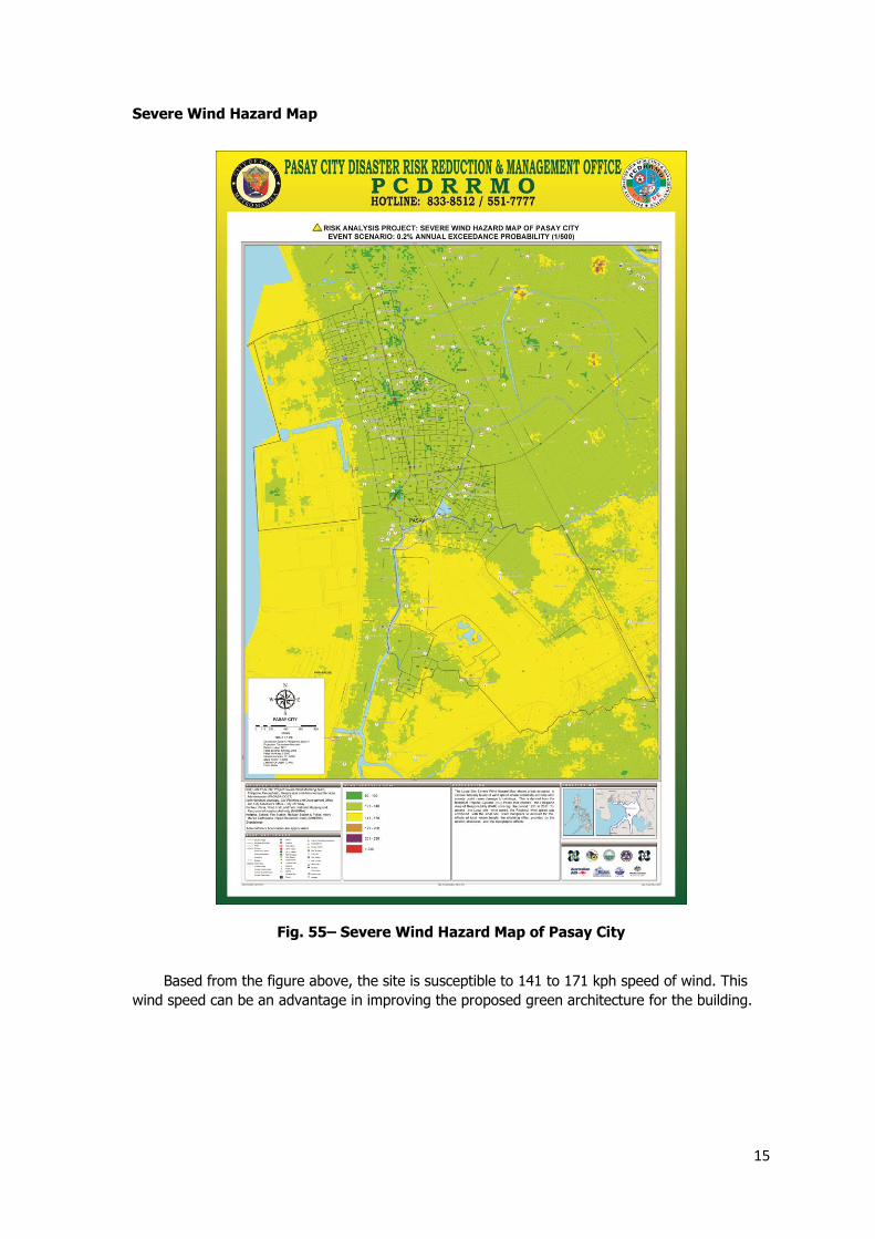
Severe Wind Hazard Map
Based from the figure above, the site is susceptible to 141 to 171 kph speed of wind. This
wind speed can be an advantage in improving the proposed green architecture for the building.
Fig. 55– Severe Wind Hazard Map of Pasay City
16
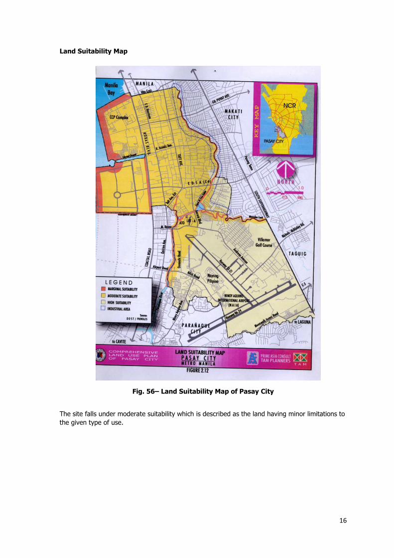
Land Suitability Map
The site falls under moderate suitability which is described as the land having minor limitations to
the given type of use.
Fig. 56– Land Suitability Map of Pasay City
17
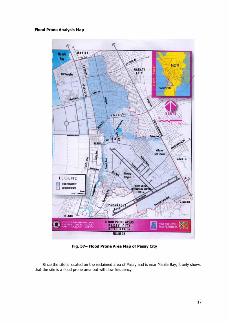
Flood Prone Analysis Map
Since the site is located on the reclaimed area of Pasay and is near Manila Bay, it only shows
that the site is a flood prone area but with low frequency.
Fig. 57– Flood Prone Area Map of Pasay City
18
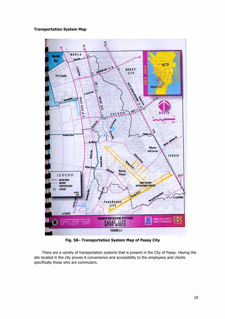
Transportation System Map
There are a variety of transportation systems that is present in the City of Pasay. Having the
site located in the city proves it convenience and accessibility to the employees and clients
specifically those who are commuters.
Fig. 58– Transportation System Map of Pasay City
19
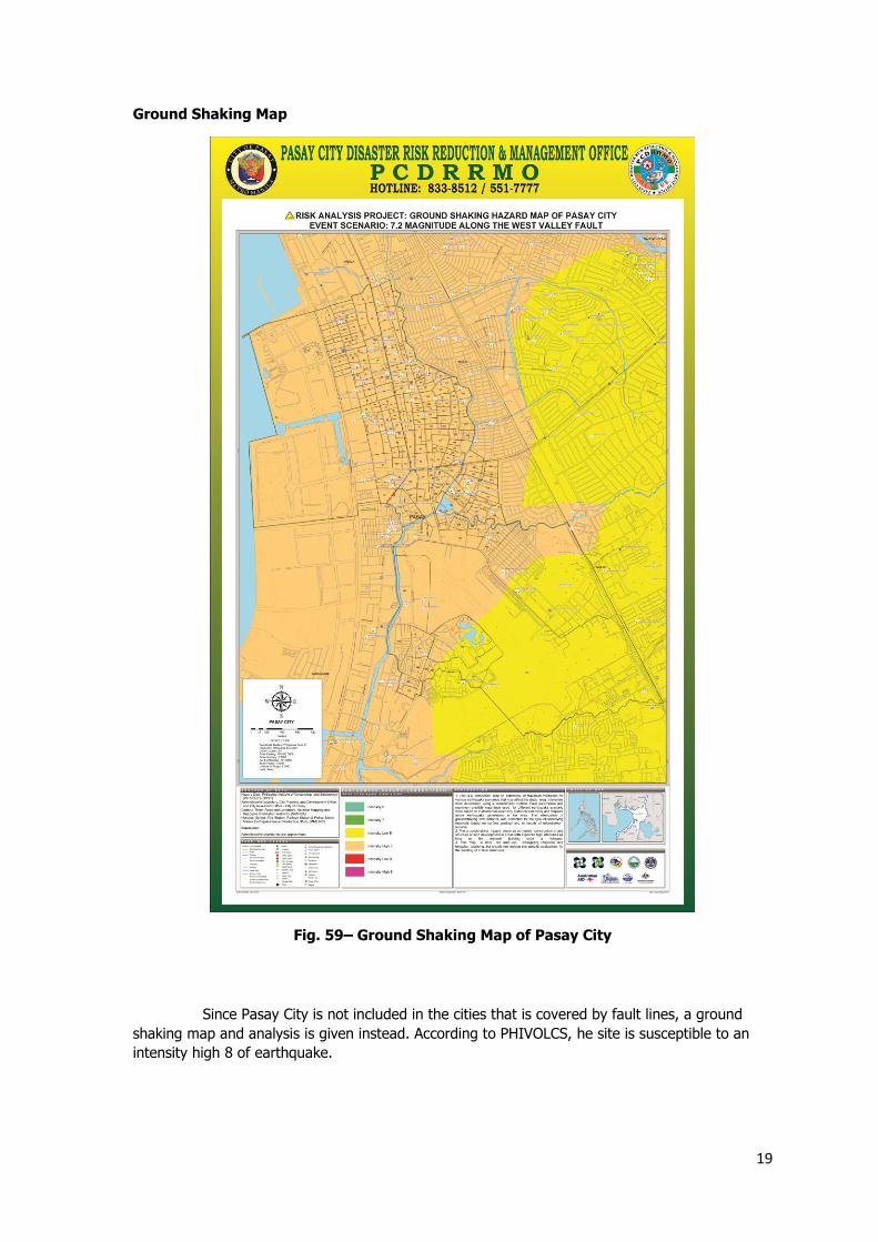
Ground Shaking Map
Since Pasay City is not included in the cities that is covered by fault lines, a ground
shaking map and analysis is given instead. According to PHIVOLCS, he site is susceptible to an
intensity high 8 of earthquake.
Fig. 59– Ground Shaking Map of Pasay City
20
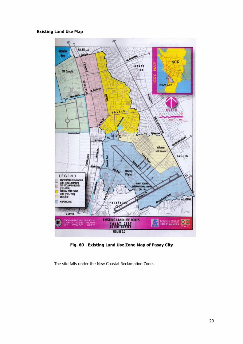
Existing Land Use Map
The site falls under the New Coastal Reclamation Zone.
Fig. 60– Existing Land Use Zone Map of Pasay City
21
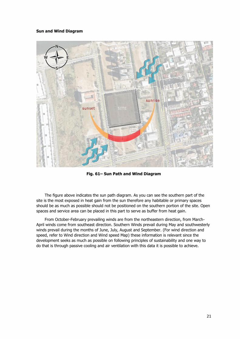
Sun and Wind Diagram
The figure above indicates the sun path diagram. As you can see the southern part of the
site is the most exposed in heat gain from the sun therefore any habitable or primary spaces
should be as much as possible should not be positioned on the southern portion of the site. Open
spaces and service area can be placed in this part to serve as buffer from heat gain.
From October-February prevailing winds are from the northeastern direction, from March-
April winds come from southeast direction. Southern Winds prevail during May and southwesterly
winds prevail during the months of June, July, August and September. (For wind direction and
speed, refer to Wind direction and Wind speed Map) these information is relevant since the
development seeks as much as possible on following principles of sustainability and one way to
do that is through passive cooling and air ventilation with this data it is possible to achieve.
Fig. 61– Sun Path and Wind Diagram
22
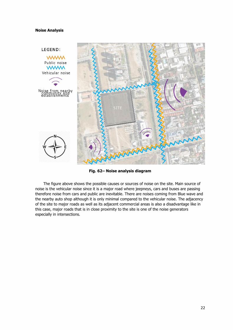
Noise Analysis
The figure above shows the possible causes or sources of noise on the site. Main source of
noise is the vehicular noise since it is a major road where jeepneys, cars and buses are passing
therefore noise from cars and public are inevitable. There are noises coming from Blue wave and
the nearby auto shop although it is only minimal compared to the vehicular noise. The adjacency
of the site to major roads as well as its adjacent commercial areas is also a disadvantage like in
this case, major roads that is in close proximity to the site is one of the noise generators
especially in intersections.
Fig. 62– Noise analysis diagram
23
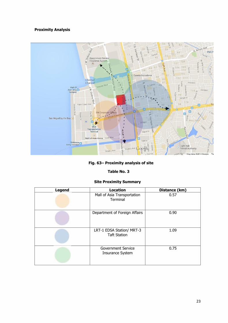
Proximity Analysis
Site Proximity Summary
Legend Location Distance (km)
Mall of Asia Transportation
Terminal
0.57
Department of Foreign Affairs 0.90
LRT-1 EDSA Station/ MRT-3
Taft Station
1.09
Government Service
Insurance System
0.75
Fig. 63– Proximity analysis of site
Table No. 3
24
Traffic Analysis
The following table show the data concluded through the researcher’s observation during
site visit.
Traffic Analysis
TRAFFIC TYPES REMARKS
Foot Traffic
Groups and individuals who visits Blue wave
Light to Moderate
Students and Employees from
Manila Tytana College
Moderate
People heading to SM Mall of
Asia and SM Transport Terminal
Moderate to High
People waiting for jeepneys
and buses to pass by
Moderate to High
Employees and residents from Bay Garden Towers
Light to Moderate
Vehicular Traffic
Private Cars Moderate to High
Public Vans/Buses/Jeepneys Moderate to High
Shuttle Service Light to Moderate
Construction
Equipment/Transports
Light to Moderate
The Light to Moderate traffic suggests that there are no signs of congestion in within the
site. Since the site is located in an area that is newly developed and is near a big commercial
complex, foot traffic can really be from a moderate to high risk.
The moderate vehicular traffic on the site is still desirable for the development since it
indicates that it is accessible to public transportation therefore it will not be a hindrance to the
accessibility of the development in terms of target population. Though there are times when the
vehicular traffic hits high especially during peak hours.
Table No. 4
25
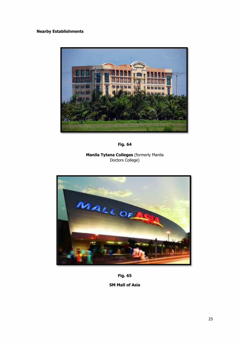
Nearby Establishments
Manila Tytana Colleges (formerly Manila
Doctors College)
SM Mall of Asia
Fig. 64
Fig. 65
26
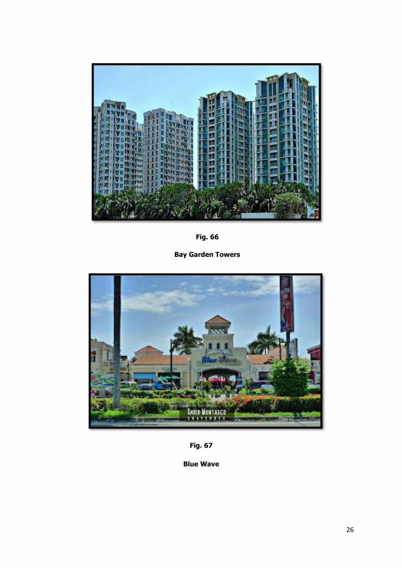
Bay Garden Towers
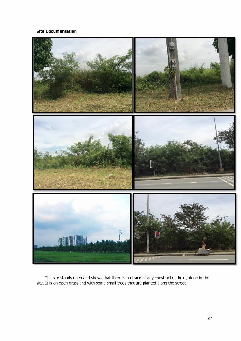
Blue Wave
Fig. 66
Fig. 67
27
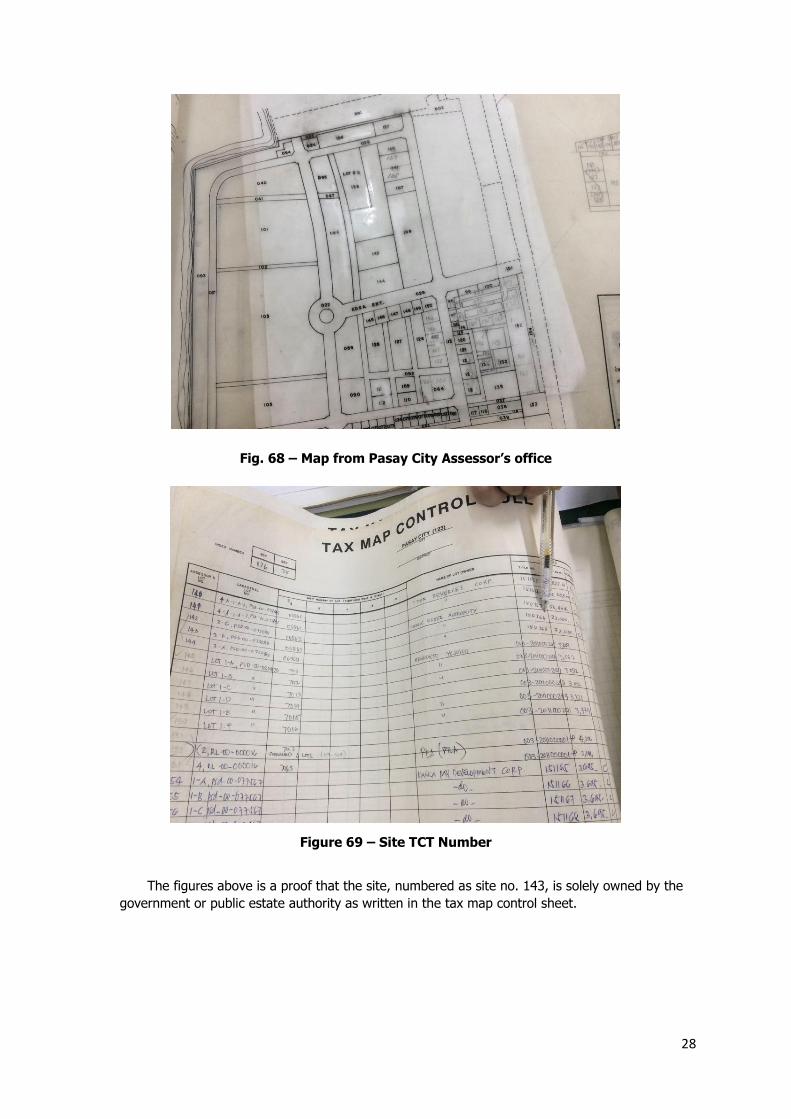
Site Documentation
The site stands open and shows that there is no trace of any construction being done in the
site. It is an open grassland with some small trees that are planted along the street.
28
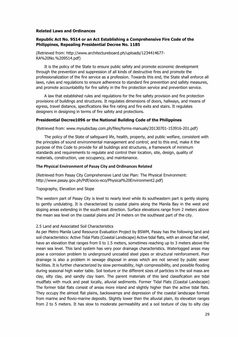
The figures above is a proof that the site, numbered as site no. 143, is solely owned by the
government or public estate authority as written in the tax map control sheet.
Fig. 68 – Map from Pasay City Assessor’s office
Figure 69 – Site TCT Number
29
Related Laws and Ordinances
Republic Act No. 9514 or an Act Establishing a Comprehensive Fire Code of the
Philippines, Repealing Presidential Decree No. 1185
(Retrieved from: http://www.architectureboard.ph/uploads/1234414677-
RA%20No.%209514.pdf)
It is the policy of the State to ensure public safety and promote economic development
through the prevention and suppression of all kinds of destructive fires and promote the
professionalization of the fire service as a profession. Towards this end, the State shall enforce all
laws, rules and regulations to ensure adherence to standard fire prevention and safety measures,
and promote accountability for fire safety in the fire protection service and prevention service.
A law that established rules and regulations for the fire safety provision and fire protection
provisions of buildings and structures. It regulates dimensions of doors, hallways, and means of
egress, travel distance, specifications like fire rating and fire exits and stairs. It regulates
designers in designing in terms of fire safety and protections.
Presidential Decree1096 or the National Building Code of the Philippines
(Retrieved from: www.mysubicbay.com.ph/files/forms-manuals/20130701-153916-201.pdf)
The policy of the State of safeguard life, health, property, and public welfare, consistent with
the principles of sound environmental management and control; and to this end, make it the
purpose of this Code to provide for all buildings and structures, a framework of minimum
standards and requirements to regulate and control their location, site, design, quality of
materials, construction, use occupancy, and maintenance.
The Physical Environment of Pasay City and Ordinances Related
(Retrieved from Pasay City Comprehensive Land Use Plan: The Physical Environment:
http://www.pasay.gov.ph/Pdf/socio-eco/Physical%20Environment2.pdf)
Topography, Elevation and Slope
The western part of Pasay City is level to nearly level while its southeastern part is gently sloping
to gently undulating. It is characterized by coastal plains along the Manila Bay in the west and
sloping areas extending in the south-east direction. Surface elevations range from 2 meters above
the mean sea level on the coastal plains and 24 meters on the southeast part of the city.
2.5 Land and Associated Soil Characteristics
As per Metro Manila Land Resource Evaluation Project by BSWM, Pasay has the following land and
soil characteristics: Active Tidal Flats (Coastal Landscape) Active tidal flats, with an almost flat relief,
have an elevation that ranges from 0 to 1.5 meters, sometimes reaching up to 3 meters above the
mean sea level. This land system has very poor drainage characteristics. Waterlogged areas may
pose a corrosion problem to underground uncoated steel pipes or structural reinforcement. Poor
drainage is also a problem in sewage disposal in areas which are not served by public sewer
facilities. It is further characterized by slow permeability, high compressibility, and possible flooding
during seasonal high water table. Soil texture or the different sizes of particles in the soil mass are
clay, silty clay, and sandly clay loam. The parent materials of this land classification are tidal
mudflats with muck and peat locally, alluvial sediments. Former Tidal Flats (Coastal Landscape)
The former tidal flats consist of areas more inland and slightly higher than the active tidal flats.
They occupy the almost flat plains, backswamps and depression of the coastal landscape formed
from marine and flovio-marine deposits. Slightly lower then the alluvial plain, its elevation ranges
from 2 to 5 meters. It has slow to moderate permeability and a soil texture of clay to silty clay
30
loam. Moreover, it is poorly drained, prone to moderate seasonal flooding, highly compressible,
and corrosive to uncoated steel. Its parent materials are alluvial
sediments, former tidal mudflats underlain with peaty and mucky materials.
2.6 Water Resources Characteristics
2.6.1 Surface Waters
Pasay City is bounded in the west by Manila Bay. It is traversed by two minor rivers that
feed the Paranaque River namely the Estero de Tripa de Gallina and Maricaban Creek. The
city lies within the Manila Bay Watershed area. The bay has a catchment area of about
17,000 square kilometers that is made up of about eight river basins, nearest of which to
the city is the Parañaque-Las Piñas river basin. This river basin is subsequently made up of
three major rivers, the Parañaque, Las Piñas and Zapote Rivers. These river systems
essentially serve about 1,500 hectares of low-lying areas along the Manila Bay and
functions as the principal drainage channel of the area. The geomorphic setting of these
lowlying areas and the hydraulic action of the Manila Bay basin and the South China Sea
make the area vulnerable to flooding, a condition aggravated by the inadequate capacity
and poor maintenance of the drainage facilities.
2.6.2 Groundwater
Pasay is situated on a delta which has produced locally-confined aquifers. Groundwater
utilization, however, has resulted in significant draw-down causing much land subsidence
and saline water intrusion particularly in the coastal areas. The groundwater basin contains
several connected and interrelated aquifers, composed of tuffaceous sandstone and
conglomerates belonging to the Guadalupe Formation. These facets of Guadalupe
Formation in the southeastern part of the city have thickness of approximately 1,300 to
1,200 meters. Recharge to the aquifers comes from rainfall and inflow from the extension
of these aquifers. However, these are already over exploited due to uncontrolled pumping
and excessive underwater withdrawal, a practice done principally by high-density
residential, commercial and industrial establishments. This situation leads to a partial
depletion of the aquifers resulting in the lowering of water levels and high pumping costs.
Almost 2000 wells have been drilled in the aquifers of the Guadalupe Formation for the
commercial and residential users. Some of these wells go as deep as 300 meters. In 1990,
total pumpage reached 339.6 million cubic meters.
2.6.3 Water Quality
Available data from government agencies such as the DENR-EMB have indicated that the
near-the-shore waters of Manila Bay, together with the major rivers in Metro Manila, are
considered biologically dead. The water quality in Manila Bay has progressively deteriorated
due to domestic, industrial and agricultural wastes being dumped uncontrollably in the
waterways. This present state is likewise being attributed to inadequate drainage facilities
and the discharge of untreated domestic and industrial wastewater due to inadequate
wastewater collection, treatment and disposal facilities.
Based on the sampling conducted by the Department of Environment and Natural
Resources (DENR) in each month of the year 2000, water quality as per dissolved oxygen,
Biological Oxygen Demand (BOD) and the total suspended solid level in various stations of
the Paranaque-Zapote River are shown in the following tables. Two stations were located
within Pasay City, Tramo and MIA Road.
31
2.7 Atmospheric Characteristic
From the nearest PAGASA station at Ninoy Aquino International Airport (NAIA), climatological data
from 1950-1995 were obtained. Tables 2.6 and 2.7 show some of the significant data.
2.7.1 Climate
The climate of Pasay is classified as Type 1 under the Corona classification used by
Philippine Atmospheric, Geophysical and Astronomical Services Administration (PAGASA)
depending on rainfall pattern. It is characterized by two pronounced seasons: rainy season
from May to October and dry season from January to April, when rainfall drops to 10-30-
mm/ month. In general, Metro Manila is directly influenced by an average of 2 to 3 tropical
cyclones per year.
2.7.2 Rainfall
The PAGASA station recorded an annual rainfall amount of 1,149.2 mm with a total of 113
rainy days between the years 1961-1995. The rainy months of May – October indicated
monthly rainy days of 7- 20 with the month of July recording the highest at 20. The highest
amount of rainfall for the period 1949-1995 was 427.4 mm recorded on February 1,1962.
2.7.3 Temperature
Pasay has an average normal annual temperature of 27.5 °C. The warmest months are
April, May and June while the coldest months are December, January and February with
the minimum temperature of 25-26°C. The highest temperature was recorded on May
18,1969 at 38.1°C while the lowest was recorded at 14.6°C on February 1, 1962.
2.7.4 Relative Humidity
Relative humidity or the percentages of water vapor in the air ranges, in monthly values,
from 66% to 81% with an annual average of 75%. These values indicate that Pasay is
relatively humid.
2.7.5 Wind Speed and Direction
The annual prevailing wind direction in the area is towards the east. The average annual
wind speed is 3.0 meters per second (mps). High wind speed occurs in March to April while
low wind speed happens in September to November. The highest wind speed of 56 mps
was recorded on November 14, 1977, going in a western direction.
2.9 Geologic and other Natural Hazards
No traced earthquake fault line traverses the city of Pasay. However, the city is not spared from
other related geologic hazards such as tsunamis, ground shaking, and liquefaction. Tsunamis are
giant sea waves generated by under the sea earthquakes and volcanic eruptions. Not all submarine
earthquakes, however, can cause the occurrence of tsunamis. Tsunamis can only occur when the
earthquake is shallow-seated and strong enough (M 7.0) to displace parts of the seabed and disturb
the water over it (PHIVOLCS). The coastal area of Pasay City is among the most hit by tsunamis
and have a high potential for future tsunamis.
Typhoons and their associated hazards, such as strong winds, storm surges, and floods, are among
the most recurrent and damaging calamities our country is prone to. Some 20 typhoons pass the
Philippine Area of Responsibility (PAR) every year. These are most frequent during the months of
32
May to December with peak occurrences in the month of November. Of the total 325 typhoons
recorded to have crossed the PAR from 1948 to 1978, about 20 passed through Metro
Manila. One of these, Typhoon Yoling, was the most severe, registering amaximum wind speed of
200 kph and bringing 24-hour rainfall on the Metropolis. Residential areas, infrastructure, power
systems, and other utility installations experienced heavy damages, some of which took months to
restore.
2.10 Environmental Management
2.10.1 Water Management To address the countrywide water crisis which adversely affects
the health and well-being of the population, food production and industrialization process,
the National Water Crisis Act of 1995 was enacted. Some of the issues related to the water
crises are: water supply, water distribution, financing aspects, privatization of state-run
water facilities, the protection and conservation of watersheds, and pilferage of water,
including the serious matter of graft and corruption in all the water agencies.
2.10.2 Air Quality Management
The Clean Air Act of 1999 recognizes that the responsibility of cleaning the habitat and
environment is primarily area-based, thus, a local government concern. In terms of air
quality management, it stipulates that: LGUs shall share the responsibility in the
management and maintenance of air quality within their territorial jurisdiction. LGUs shall
implement air quality
standards set by the Pollution Adjudication Board (PAB) in areas within their jurisdiction.
Provided, however, that in cases where the board has not been duly constituted and has
not promulgated its standards, the standards set forth in this Act shall apply. The
Department of Environment and Natural Resources shall provide the LGUs with technical
assistance, training and a continuing capabilitybuilding program to prepare them to
undertake full administration of the air quality management and regulation within their
territorial jurisdiction. The LGU, for one, is responsible for attaining and maintaining the
ambient air quality standards within their respective airsheds. The designation of airsheds
shall be on the basis of, but not limited to, areas with similar climate, meteorology and
topology which affect the interchange and diffusion of pollutants in the atmosphere, or
areas which share common interest or face similar development programs, prospects or
problems. The DENR bases such ambient air quality standards on World Health
Organization (WHO) standards, but shall not be limited to nor be less stringent than such
standards. The initial lists and values of the hazardous air pollutants are provided in the
DENR mandate.
2.10.3 Land Management
All the barangays of the city have Cadastral Maps which are being used for taxation and
other legal purposes. On the other hand, prior to this undertaking, a Zoning Ordinance in
1981 was being used to guide developments and land uses in the city.
2.10.4 Solid Waste Management (SWM)
At present, the city of Pasay disposes of its solid waste in the San Mateo Sanitary Landfill
and the Payatas dumpsite. As per a JICA study on Solid Waste Management for Metro
Manila involving government agencies such as DECS, DENR and MMDA, Pasay City along
with Taguig, Pateros and the city of Makati shall be accommodated in the proposed
Transfer Station within Fort Bonifacio and then dumped in an inland landfill site to be later
specified. (Figure 2.5 refers) All barangays are covered by solid waste collection, which is
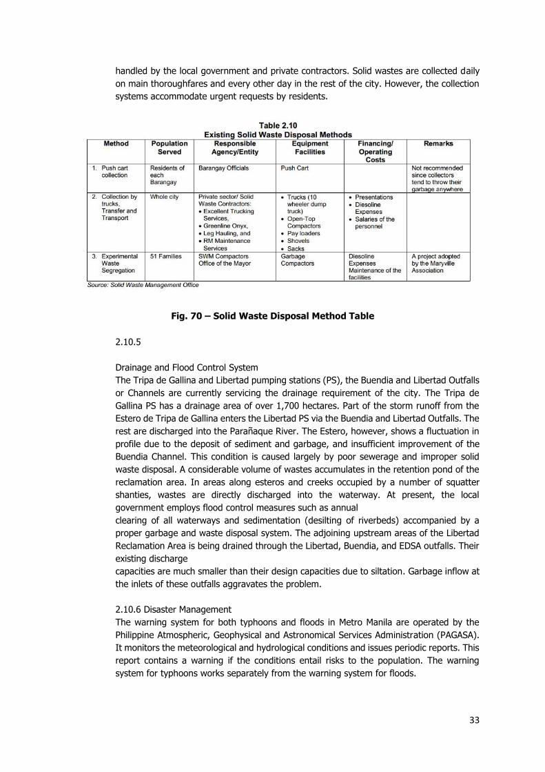
33
handled by the local government and private contractors. Solid wastes are collected daily
on main thoroughfares and every other day in the rest of the city. However, the collection
systems accommodate urgent requests by residents.
2.10.5
Drainage and Flood Control System
The Tripa de Gallina and Libertad pumping stations (PS), the Buendia and Libertad Outfalls
or Channels are currently servicing the drainage requirement of the city. The Tripa de
Gallina PS has a drainage area of over 1,700 hectares. Part of the storm runoff from the
Estero de Tripa de Gallina enters the Libertad PS via the Buendia and Libertad Outfalls. The
rest are discharged into the Parañaque River. The Estero, however, shows a fluctuation in
profile due to the deposit of sediment and garbage, and insufficient improvement of the
Buendia Channel. This condition is caused largely by poor sewerage and improper solid
waste disposal. A considerable volume of wastes accumulates in the retention pond of the
reclamation area. In areas along esteros and creeks occupied by a number of squatter
shanties, wastes are directly discharged into the waterway. At present, the local
government employs flood control measures such as annual
clearing of all waterways and sedimentation (desilting of riverbeds) accompanied by a
proper garbage and waste disposal system. The adjoining upstream areas of the Libertad
Reclamation Area is being drained through the Libertad, Buendia, and EDSA outfalls. Their
existing discharge
capacities are much smaller than their design capacities due to siltation. Garbage inflow at
the inlets of these outfalls aggravates the problem.
2.10.6 Disaster Management
The warning system for both typhoons and floods in Metro Manila are operated by the
Philippine Atmospheric, Geophysical and Astronomical Services Administration (PAGASA).
It monitors the meteorological and hydrological conditions and issues periodic reports. This
report contains a warning if the conditions entail risks to the population. The warning
system for typhoons works separately from the warning system for floods.
Fig. 70 – Solid Waste Disposal Method Table
34
2.11 Land Suitability Assessment
In coming up with an effective land utilization system, the physical and environmental attributes of
Pasay City must be considered. Areas of physical constraint for further developments in the city
should be delineated. Maps indicating the city's relevant physical and environmental attributes are
generated and translated into degrees of concern. References used for this purpose include
materials from the local government, BSWM, and PHIVOLCS. Some of the environmental concerns
such as flooding, drainage, river preservation, liquefaction hazard, and industrial zones were
reflected in maps and discussed briefly. These are subsequently used to delineate the areas of
various degrees of development suitability.
Flood Hazard Areas
Besides natural factors, other aspects that tend to aggravate flooding problems in Metro Manila
include the following:
Infrastructure development leading to the creation of more impervious areas, resulting to
higher peak run-offs that usually cause standing floods;
Inadequate or non-existent drainage system;
Improper solid waste disposal that leads to the clogging of drainage systems, further
lowering their water retaining capacity;
Heavy siltation of rivers due to previous floods, indiscriminate dumping of garbage,
encroachment of squatters and slum dwellers, and limited maintenance works; and
Institutional problems and financial constraints which delay implementation of proper flood
control measures.
Flooding within Pasay City are generally concentrated along Taft Avenue and the areas along the
Estero de Tripa de Gallina and Maricaban Creek (Figure 2.6). River and Coastal Preservation As
shown in Figure 2.7, the following are the river preservation zones of the city:
Rivers and streams – These critical areas consist of easements of about 3 to 20 meters
from both sides throughout the entire length of any river or stream. Areas within this range
are subject to easement of public use in the interest of recreation, fishing, floatage, etc.
Coastal Zone – This includes areas one kilometer from the coastline of the Manila Bay,
which is city waters, and 200 meters from the coastline inland.
Areas of no significance - Areas outside the range mentioned above are non-
environmentally-critical areas.
Liquefaction Hazard
Liquefaction is associated with the phenomenon of quick-condition failure which is generally
obtained when pore water in a liquefied layer rises into overlying near-surface sediments that
results in a condition resembling quicksand. Areas that are prone to liquefaction are those underlain
by water-saturated, thick fine to coarse sand layers such as those along the Pasig River Delta Plain,
lake shore areas of Laguna de Bay and the shorelines of Manila Bay. Figure 2.8 shows the city’s
Liquefaction Hazard Map with potential zones classified into high, moderate
and low based mainly on the presence of clay layers which help inhibit liquefaction.
Industrial and Airport Zones
35
The attribute features of this map are based on the constraints on acceptable noise and air pollution
levels for developments around existing industrial establishments. These noise and air pollution
levels conform with the DENR Guidelines (Figure 2.9).
• Development restriction guidelines for various noise zones are:
- from 45 to 55 dBA. Section of contiguous areas which are primarily used for
residential purposes.
- from 55 to 65 dBA. Primarily for commercial area
- from 60 to 70 dBA. Reserved as a light industrial area
- from 65 to 75 dBA. Primarily reserved as a heavy industrial area.
• Development restriction guidelines for various source-specific air pollutants, such as
emission of dust, dirt or fly ash based on DENR standards.
Resolution No. 2765, Series of 2011
(Retrieved from Pasay City Archives and Records:
http://www.pasay.gov.ph/images/Archives&Records/res-2765-001.html)
A RESOLUTION AUTHORIZING THE CITY MAYOR, HONORABLE ANTONINO G. CALIXTO TO ENTER
INTO A CONTRACT OF LOAN AND TO MORTGAGE OR ASSING OR OTHERWISE TO ENTER INTO A
COLLATERAL AGREEMENT TO SECURE THE PAYMENT OF THE LOAN APPLIED FOR WITH THE
PHILIPPINE NATIONAL BANK (PNB) IN THE AMOUNT OF TWO BILLION PESOS (Php
2,000,000,000.OO) FOR THE PURPOSE OF FINANCING THE CONSTRUCTUION OF THE CITY
GOVERNMENT'S VARIOUS PRIORITY INFRASTRUCTURE PROJECTS PROVIDED ALL APPLICABLE
LAWS, RULES AND REGULATIONS ON THE MATTER ARE COMPLIED.
WHEREAS, the records of the sanggunian show that the City Mayor was already authorized by the
Sangguniang Panlungsod to apply for a credit line with any banking or financial institution for the
amount of Two Billion Pesos (Php 2,000,000,000.00) to finance various priority infrastructure
projects.
WHEREAS, the Two Billion Pesos (Php 2,000,000,000.00) loan term facility in favor of the City
Government of Pasay has been approved by the Philippine National Bank
NOW, THEREFORE, BE RESOLVED AS IT IS HEREBY RESOLVED, by the Sangguniang Panlungsod
in session duly assembled, authorizing the City Mayor, Honorable Antionio G. Calixto to enter a
contract of loan and to mortgage or assign or otherwise to enter into a collateral agreement to
secure the payment of the loan applied for with the Philippine National Bank (PNB) in the amount
of Two Billion Pesos (Php 2,000,000,000.00) for the purpose of financing the construction of the
city government’s various priority infrastructure projects provided all applicable laws, rules, and
regulations on the matter are complied.
RESOLVED FURTHER, that the contract of loan deeds of mortgage and assignment and all
other documents hereto referred are subject to ratification by the Sangguniang Panlungsod.
ADOPTED in the City of Pasay, Metro Manila, Philippines, this 25th day of July, in the Year of
Our Lord, Two Thousand Eleven.
CERTIFIED APPROVED BY THE SANGGUNIANG PANLUNGSO
36
REFERENCES
Maritime Industry Authority. (n.d.). Retrieved December 9, 2014, from
http://www.marina.gov.ph/
Welcome to NMP | Home. (n.d.). Retrieved December 9, 2014, from http://www.nmp.gov.ph
Google Images. (n.d.). Retrieved December 9, 2014, from http://www.google.com/images
Pasay. (2014, August 12). Retrieved December 9, 2014, from http://en.wikipedia.org/wiki/Pasay
ABOUT PASAY. (n.d.). Retrieved December 9, 2014, from http://www.pasay.gov.ph/About.html
Memoirs Of A Filipino Sailor. (2014, May 30). Retrieved December 9, 2014, from
http://memoirsofafilipinosailor.blogspot.com/2014/05/meeting-old-folks.html
MARINA to conduct licensure exams for deck, engine officers. (2014, June 4). Retrieved
November 9, 2014, from https://ph.news.yahoo.com/marina-conduct-licensure-exams-deck-
engine-officers-162334368--sector.html
Remittances from Pinoy seamen to hit $5.5B. (2014, August 30). Retrieved December 9, 2014,
from http://www.philstar.com/business/2014/08/30/1363194/remittances-pinoy-seamen-hit-
5.5b
MAHABANG PILA SA MARINA SA MAYNILA,... - Pinoy Hot Line Riders Club (PHLRC) | Facebook.
(2014, March 4). Retrieved December 7, 2014, from
https://www.facebook.com/phlrcriders/posts/614210238667236
Facilities. (n.d.). Retrieved November 15, 2014, from http://www.sp.edu.sg/wps/portal/vp-
spws/!ut/p/a1/04_Sj9CPykssy0xPLMnMz0vMAfGjzOJDPUxdjdxMTQz8TS0sDDz9LbxNLELCjFxcjPQ
Lsh0VAS_E5WI!/?WCM_GLOBAL_CONTEXT=