Embed Size (px)
Citation preview

Biodiversity Development Assessment Report 457
Part B Stage 2: Impact Assessment

Biodiversity Development Assessment Report 458

Biodiversity Development Assessment Report 459
8 Impact assessment (biodiversity values)
8.1 Potential direct, indirect and prescribed impacts
8.1.1 Direct impacts
The main direct impacts of Main Works will be associated with impacts arising from the clearing works for construction of the project. Potential direct impacts that could arise from Main Works, prior to any measures to avoid, minimise or mitigate impacts, include:
• clearing of large areas of significant native vegetation
• clearing of high-quality threatened species habitat;
• clearing of threatened ecological communities (TECs); and
• disturbance of river/creek beds and banks.
In addition to the direct impacts arising from this process, clearing of native vegetation has several indirect impacts.
8.1.2 Indirect impacts
Indirect impacts that could occur as a result of Main Works, if unmitigated, include:
• drawdown of groundwater, resulting in impacts to GDEs (see Section 7);
• increased noise, vibration and dust levels resulting in disturbance of fauna species, and consequent abandonment of habitat, or changes in behaviour (including breeding behaviour);
• lighting for night works, resulting in disturbance to fauna species and changes in occupancy or behaviour;
• increase in weeds and pathogens, resulting in degradation of retained native vegetation and habitat; and
• increase in predatory and pest animal species, resulting in increased predation and competition and a consequent reduction in populations.
As outlined in Section 7, drawdown of groundwater by up to 50 m has the potential to result in impacts to a number of GDEs identified. The impact assessment outlined previously is based on the groundwater model, which adopted a conservative approach of simulating all excavations as non-mitigated/controlled and predicts a base case worst scenario. Construction methods to increase tunnel stability, such as pre/post-grouting and segmental lining, which can also have the added benefit of reducing tunnel inflows, were not considered because the location and extent of methods were not known at the time of modelling. In this respect, the impact assessment below represents an unrealistic worst-case scenario; impacts are likely to be much less significant than predicted.

Biodiversity Development Assessment Report 460
Construction activities may result in increased levels of noise and vibration, particularly as a result of blasting activities during construction of the tunnel, and as a result of general construction activities. Noise has been observed to modify animal behaviour, including calling behaviour in frog species (Hoskin and Goosem 2010) and bird species. These activities may also result in increased dust levels, covering adjacent vegetation and inhibiting growth. Lighting for night works also has the potential to result in light spill into adjacent habitat areas, and ongoing disturbance to fauna species, with the potential for species to abandon habitat due to these impacts (Davies et al. 2014, Schroer et al. 2016). Noise levels of over 65 dB are predicted to occur during construction immediately adjacent to key areas of activity such as Lobs Hole, Tantangara and Marica. However, these levels drop to below 60 dB (normal conversation levels) outside of these construction zones. Noise levels are expected to be transient, occurring during construction. Operational noise is expected to be minimal, below 45dB and restricted to immediately surrounding operational elements at Tantangara and Talbingo intakes, the MAT and ECVT and the ventilation shaft.
Increased movement of vehicles and people into the area has the potential to transport weeds and pathogens into the disturbance footprint. Weeds have the potential to result in degradation of retained vegetation and fauna habitat. Key weed species identified in DECC (2007) and recorded during flora surveys for Main Works include:
• African Lovegrass (Eragrostis curvula);
• Bird’s-foot Trefoil (Lotus spp.);
• Blackberry;
• Browntop Bent (Agrostis capillaries);
• Cat’s Ear/Flatweed (Hypochaeris spp.);
• Cocksfoot (Dactylis glomerata);
• Dandelion (Taraxacum officinale);
• Hawthorn (Crataegus monogyna);
• Mullein/Aarons Rod (Verbascum thapsus and V. virgatum).
• Musk Monkey Flower (Mimulus moschatus);
• Ox-eye Daisy (Leucanthemum vulgare);
• Patterson's Curse (Echium plantagineum);
• Sheep Sorrel;
• Spear Thistle;
• St John’s Wort;
• Sweet Briar;
• Sweet Vernal Grass;
Biodiversity Development Assessment Report 461
• Yarrow (Achillea millefolium); and
• Yorkshire Fog Grass.
Many of these species are prevalent in areas previously disturbed. Key weed species of concern, that currently do not occur or only occur in low numbers in KNP include African Lovegrass and Serrated Tussock (Nasella trichotoma). There is potential for these species to be transported into KNP during construction activities.
Infection of native plants by Phytophthora cinnamomi is listed as a key threatening process under the BC Act and EPBC Act. P.cinnamomi can lead to death of trees and shrubs, resulting in devastation of native ecosystems (DECC 2008). Infection of susceptible communities with P.cinnamomi leads to
• changes in the structure and composition of the native plant communities;
• a significant reduction in primary productivity and functionality; and
• habitat loss and degradation for dependent flora and fauna (DoE 2014b).
Impacts from P.cinnamomi has been identified as a key threat to the Smoky Mouse (DECC 2008, Menkhorst and Broome 2008a, 2008b).
Chytrid fungus (Batrachochytrium dendrobatidis) is known to cause Chytridiomycosis, an infectious disease that affects amphibians worldwide (DSEWPaC 2013). This disease has been linked to extinction and declines in several frog species across Australia, and is listed as a key threat to the Alpine Tree Frog (DoE 2014c) and Booroolong Frog (DEWHA 2007). The key risk is the spread of the fungus between infected and uninfected populations.
Increased human activity also has the potential to attract feral animals. Of key concern is an increase in feral Cat (Felis catus) and Red Fox (Vulpes vulpes) activity and consequent impacts on native animals. Predation by feral Cats and Red Foxes are listed as key threatening processes under the BC Act and EPBC Act (NPWS 2001, DEWHA 2008a, DoE 2015a) with impacts from feral Cats also listed as a key threat to the Smoky Mouse (Menkhorst and Broome 2008a, 2008b). Introduced predators are also considered a threat to the Eastern Pygmy-possum (NSWSC 2001).
Transportation of water between Talbingo Reservoir and Tantangara Reservoir also has the potential to result in translocation of predatory fish species, particularly Redfin Perch (Perca fluviatilis) and Eastern Gambusia (Gambusia holbrooki). These species are known to predate on a variety of frog species, freshwater fishes and other aquatic organisms such as macro-invertebrates (NSWSC 1999). Eastern Gambusia and Redfin have been linked to declines in frog species, including the Green and Golden Bell Frog (Litoria aurea) and Yellow-spotted Tree Frog (Litoria castanea) (NSWSC 1999) and Booroolong Frog (Hunter 2007). Impacts may be experienced within Tantangara Reservoir and within some sections of the upstream reaches of the catchment. The potential for downstream transfer into the Murrumbidgee River system, as well as the Snowy River catchment via transport to Lake Eucumbene is expected to be prevented by the installation of a fish screening system on these outlets. The impacts of predatory fish on freshwater fish and other aquatic organisms is discussed in Cardno (2019).

Biodiversity Development Assessment Report 462
8.1.3 Prescribed impacts
Main Works also has the potential to result in prescribed impacts. Prescribed impacts, as per Section 8.2.1.2 of the BAM (OEH 2017a), that could occur as a result of Main Works, include:
• impacts on connectivity of habitat, resulting in fragmentation of habitat or impacts to movement that maintains life-cycle stages;
• impacts to water quality and quantity, or hydrological processes, that sustain threatened species and TECs; and
• impacts of fauna vehicle strike through increased traffic.
Removal of native vegetation and threatened species habitat has the potential to result in fragmentation of fauna habitat, with resultant effects on fauna species movement, reproduction and gene flow (Bennett 1990, Keller and Largiadèr 2003, Dixo et al. 2009). Clearing can result in the inability of species to move between patches of suitable habitat and undertake important lifecycle processes, such as breeding. Ultimately, this can increase the vulnerability of flora and fauna populations to stochastic events and extinction (Bennett 1990, Smith and Hellmann 2002, Fischer and Lindenmayer 2007).
Construction activities have the potential to result in impacts to water quality in watercourses located adjacent to construction activities in the following ways:
• release of poor-quality water to watercourses. In particular, any sediment laden water that could arise on site following mobilisation of soils/sediments during inclement weather over disturbed soils and sediments in areas where vegetation has been cleared and/or soil and construction material has been stockpiled. If untreated surface water was released to watercourses it could be detrimental to aquatic habitat and biota;
• reduction in watercourse bank stability following any nearby construction and any clearing of riparian vegetation could also result in bank erosion and input of sediments into watercourses;
• increased release of water into watercourses, resulting in “flushing” of the systems and increased erosion due to increased flows;
• accidental release of chemicals and fuels (eg. oils, hydraulic fluids and fuel from construction equipment) could result in the input of hydrocarbon and metal contaminants into watercourses. The accidental release into watercourses of any pesticides, herbicides and sewage could also affect aquatic biota; and
• disturbance of riparian vegetation could have indirect impacts on aquatic habitat quality and influence abundance, distribution and health of aquatic biota.
Mobilisation of fine sediments into the watercourses located in the survey area is unlikely to result in long-term impacts to aquatic environments; these events will be pulse events and will be rapidly flushed out of the system resulting in negligible impacts to threatened species (Dave Hunter OEH pers. comm.). Likewise, short term reductions in water quality are unlikely to result in impacts to aquatic environments, as they will be rapidly flushed out of the system. The key mechanism for impacting on aquatic environments will be mobilisation of large amounts of sediment, which clog interstitial spaces providing key breeding habitat for the Booroolong Frog, or long-term negative changes to water quality.

Biodiversity Development Assessment Report 463
The construction of the tunnel transferring water between Tantangara reservoir and Talbingo Reservoir has the potential to result in drawdown of groundwater across the project area, with consequent reduction in the availability of groundwater and impacts to GDEs (see Section 7).
Increased vehicle movements associated with the Main Works have the potential to result in increased fauna vehicle strikes, and associated fauna mortality (Taylor and Goldingay 2010). Rare or low-density populations, such as the Smoky Mouse, may be at risk of significant impacts if this impact is not managed appropriately (Hoskin and Goosem 2010).
8.2 Measures to avoid, minimise and mitigate impacts
Snowy Hydro, in consultation with EMM and the design team, have undertaken significant steps to avoid, minimise and mitigate impacts arising from the Main Works project.
A key focus of project design has been to avoid and minimise impacts to biodiversity values identified during the field surveys. In recognition of the location of the Snowy 2.0 project in the KNP, and associated biodiversity and other values of the Park, the project has undergone significant steps to avoid, minimise and mitigate impacts. The process below has been followed to ensure impacts are avoided and minimised to the greatest extent possible, within the design and other limitations of Snowy 2.0:
• identification of biodiversity values through comprehensive, rigorous and thorough biodiversity surveys;
• communication of identified values to the project team, including Snowy Hydro and the design team;
• consultation between the design team and project ecologists on various elements to consider both direct and indirect impacts and work through an iterative design process, with multiple iterations of design elements to achieve best practice outcomes;
• consultation with key government stakeholders, including DPIE and DoEE, and species experts and accountable officers within these departments, to seek input and discuss measures proposed to avoid, minimise and mitigate impacts;
• feedback of consultation into the design process; and
• finalisation of measures to avoid, minimise and mitigate impacts.
Measures undertaken to avoid, minimise and mitigate impacts that have arisen during the process outlined above are discussed below for each project element.
8.2.1 Design and construction of Snowy 2.0
i Talbingo Reservoir
Talbingo Reservoir and immediate surrounds will be the location of the following infrastructure elements:
• tailrace tunnel (subsurface);
• intake gate structures and buildings;
• portal construction compound;
• reservoir emplacement area;

Biodiversity Development Assessment Report 464
• barge launch area; and
• associated access roads.
Opportunities to avoid and minimise impacts in this area are limited due to the need to site the intake gate and structures in a suitable location from an engineering and design perspective, related to the tunnel alignments.
a Tailrace tunnel (subsurface)
The tailrace tunnel will be located between the power station complex (below Marica) and Talbingo Reservoir. No impacts are predicted to arise from the tailrace tunnel, with limited drawdown of groundwater. No measures to avoid, minimise or mitigate impacts are recommended.
b Intake gate structures and buildings, barge launch area and portal construction compound
The intake gate structures and buildings, barge launch area and portal construction compound are located on the eastern shore of Talbingo Reservoir, north of where the Yarrangobilly River enters the Reservoir. Several alternatives were investigated for the location of the intake, with the location restricted by geotechnical and bathymetric engineering constraints, including the alignment of the tailrace tunnel, geological conditions to ensure constructability and deep water in Talbingo Reservoir to ensure sufficient water supply during pumping operations. The location of the portal construction compound is constrained by the location of the portal. As such, opportunities to avoid and minimise impacts are limited.
Impacts arising from the barge launch area were considered in Exploratory Works Modification 1. The impacts arising from this approved area are not considered in this report.
The intake gate structures and buildings, barge launch area and portal construction compound will remain as permanent infrastructure following completion of construction activities.
c Reservoir emplacement area
Approximately 9 million m3 (unbulked) of excavated material will be generated by Snowy 2.0 Main Works. The management of excavated material generation and disposal has been divided into two management systems based on the east (Tantangara) and west (Talbingo) sides of the Snowy 2.0 Main Works project area. Similarly, the predicted excavated material is categorised according to the main methods of tunnel excavation, TBM and drill and blast.
Several options for disposal of excavated material have been considered for Snowy 2.0 Main Works. Many of the options considered included on-land disposal of material in KNP, resulting in clearing of native vegetation and fauna habitat. These options would have resulted much larger disturbance to identified biodiversity values. The current proposed option for disposal of excavated rock has resulted in a significant reduction in impacts arising from Snowy 2.0 Main Works.
On the Talbingo side, excavated material will be stockpiled at several locations, and disposed of within Talbingo Reservoir at Middle Bay. It is expected that between 2.6 million m3 will be emplaced within Talbingo Reservoir. Placement of excavated material will be carried out 24 hours a day, seven days a week and 365 days a year. Emplacement within Talbingo Reservoir is proposed from the bed of the reservoir to just above FSL.

Biodiversity Development Assessment Report 465
Following completion of construction activities for Snowy 2.0 Main Works, these areas will be landformed, reshaped and rehabilitated, in line with the rehabilitation strategy (SLR 2019). The final elevation of the emplacement areas will be above FSL to allow for permanent rehabilitation of the landform (Plate 8.1 and Plate 8.2). This is to prevent inundation of the emplacement area when the reservoir is at capacity. Further engagement with NPWS will be carried out regarding the end use of these areas, such as recreational areas.
Plate 8.1 Artist impression of the Talbingo Reservoir emplacement area at FSL
Plate 8.2 Artist impression of the Talbingo Reservoir emplacement area at typical operating level

Biodiversity Development Assessment Report 466
d Access roads
A number of access roads will be constructed to provide access for construction traffic to the intake gate structures and buildings, barge launch area and portal construction compound as well as to permit access by truck and go to the proposed reservoir emplacement area for disposal for excavated material. In some areas these roads follow the existing Lobs Hole Ravine Road, while construction of a new road will be required to access the proposed reservoir emplacement area.
The design of these access roads has attempted to limit disturbance as far as practicable, largely through the use of the existing road network, resulting in upgrades to existing roads rather than construction of new roads. This has limited the extent of disturbance required for these sections. Construction of the new road to access the proposed reservoir emplacement area has considered biodiversity values present, in conjunction with engineering requirements, to minimise impacts where possible.
Following completion of construction activities for Snowy 2.0 Main Works, the access roads form the intake gate structures and buildings, barge launch area and portal construction compound to the proposed reservoir emplacement area will be landformed, reshaped and rehabilitated, in line with the rehabilitation strategy (SLR 2019). Access roads from Lobs Hole to the intake gate structures and buildings, barge launch area and portal construction compound will remain as permanent infrastructure following completion of construction activities.
ii Lobs Hole
Lobs Hole and surrounding areas are a key focus of activity for the project and will be used primarily for construction (including construction of the MAT and ECVT portals and tunnels to the underground power station and the headrace tunnel (and headrace tunnel surge shaft), and a temporary accommodation camp. The following project elements will be located in this area:
• Main Works camp;
• Exploratory Works camp (to be used during Main Works construction);
• Lobs Hole substation;
• Main Yard;
• excavated rock stockpiles;
• Main Access Tunnel (MAT) and portal building;
• Emergency Egress, Cable and Ventilation (ECVT) tunnel;
• cableyard; and
• access roads, including Lobs Hole Ravine Road and Mines Trail.
Much of the works associated with these project elements will have been completed as a part Exploratory Works. New elements have been sited to avoid and minimise impacts to biodiversity and other values as far as practicably possible.

Biodiversity Development Assessment Report 467
a Main Works and Exploratory Works camps
The Main Works camp will be used to supplement the Exploratory Works camp during construction. The Exploratory Works camp was approved as a part of the Exploratory Works project. The siting of the Main Works camp included consideration of the biodiversity values in the area, with several locations initially considered. These initial areas were likely to have a much greater impact on restricted PCTs, and in a location closer to sensitive habitat along the Yarrangobilly River. The original camp designs also had a much larger footprint than the current design. Overall impacts have been reduced and impacts have been restricted to more widespread and ubiquitous PCTs.
The Main Works camp has potential to result in minor indirect impacts, including changes to runoff regimes due to impervious areas and increased concentrations of suspended sediment and nutrients in runoff from roof and road pavement areas. However, given the location of the accommodation camp remote from the Yarrangobilly River, and outside the 50 m buffer, impacts are expected to be minor. A series of controls will be implemented for the Main Works and Exploratory Woks camps to ensure negligible impacts to water quality and quantity; these include:
• Extraction from from the Yarrangobilly River will be avoided for the Main Works. Where feasible, water will be sourced from Talbingo Reservoir.
• Where practical, the following source controls will be applied:
- the storage and handling of chemicals that have potential to contaminate the stormwater system will be undertaken in bunded areas. Any liquid waste stream will be disposed to an appropriate facility;
- pervious areas will be landscaped with endemic native vegetation;
- runoff from roof areas will be captured in rainwater tanks. Captured water will be used for toilet flushing and other non-potable uses; and
- runoff from road and other hardstand areas will be treated in vegetated swales.
• Runoff from accommodation camps will be managed by drainage systems that have a 20% AEP capacity. Overland flow paths will be provided as required.
• Runoff from accommodation camps will be treated in vegetated sedimentation or bioretention basins. The most appropriate control will be established at detailed design with consideration of topography, soil conditions and other relevant factors.
As a result of these controls being implemented, negligible impacts to water quantity or quality are expected to occur. A surface water monitoring program will be implemented to ensure run-off does not result in significant changes in water quality within the Yarrangobilly River.
There is potential for increased human activity associated with the camp to result in increased activity of predators, particularly feral Cats and Foxes, as these species are likely to be attracted to these areas for scavenging. To minimise the risk of increased predator activity, the controls outlined in Section vii will be implemented.

Biodiversity Development Assessment Report 468
Following completion of all works, the Main Works accommodation camp will be decommissioned and rehabilitated. Rehabilitation will be undertaken in accordance with the rehabilitation strategy (SLR 2019). It is proposed to retain the Exploratory Works accommodation camp as a remote camping area for recreational use. During detailed design a masterplan will be developed for recreational areas in consultation with NPWS (SLR 2019).
b Lobs Hole substation
The construction of the substation at Lobs Hole was included in the application for Exploratory Works Modification 1. The impacts arising from the substation are not considered in this report.
The Lobs Hole substation will remain as permanent infrastructure following completion of construction activities.
c Main Yard
The Main Yard will be located within the Exploratory Works boundary. The impacts arising from the Main Yard are not considered in this report.
Following completion of construction activities for Snowy 2.0 Main Works, these areas will be landformed, reshaped and rehabilitated, in line with the rehabilitation strategy (SLR 2019). An indication of the possible re-use of rehabilitated land in the area of the Main Yard is provided in Plate 8.3.
Plate 8.3 Artist impression of possible rehabilitation of the Main Yard optimised for recreational use

Biodiversity Development Assessment Report 469
d Excavated rock stockpiles
Approximately 9 million m3 (unbulked) of excavated material will be generated by Snowy 2.0 Main Works. The management of excavated material generation and disposal has been divided into two management systems based on the east (Tantangara) and west (Talbingo) sides of the Snowy 2.0 Main Works project area. Similarly, the predicted excavated material is categorised according to the main methods of tunnel excavation, TBM and drill and blast.
In the Talbingo side, excavated material will be stockpiled at several locations, including at a number of stockpile locations in Lobs Hole. Where feasible, excavated material will be re-used for purposes such as levelling of camps and construction pads, fill at various portal locations and for road works in the project area. There is also the possibility of NPWS using excavated material for road maintenance in KNP. Material to be re-used will be in a number of temporary stockpile locations around Lobs Hole.
During design, the location of the rock emplacement areas considered the biodiversity values of Lobs Hole. The rock emplacement areas have been sited in areas of low-quality vegetation. These areas have been partially cleared and consist largely of Low or Derived Grassland condition class vegetation, areas subject to significant weed invasion and assigned to Poor condition class as well as generating vegetation assigned to the Other condition class.
The excavated rock stockpiles are generally located outside of the 50 m buffer zone to the Yarrangobilly River; thus, direct impacts to the River and Booroolong Frog habitat will be minimised. There is potential for indirect impacts as a result of run-off through mobilisation of sediment and rock, and run-off containing acid and metals. Designs controls and mitigation measures to avoid and minimise the risk of these impacts occurring are outlined below:
• Excavated material will be characterised and identified contaminated soils or PAF material will be managed separately.
• An ESCP will be prepared for each stockpile.
• All large temporary stockpiles will be removed during the construction phase of the project and the disturbed area will be rehabilitated in accordance with the relevant rehabilitation strategy.
Further detail is provided in the Water Management Report, Annexure D to EMM (2019a) provided as an Appendix to the EIS. These controls are expected to provide a high factor of safety, resulting in negligible risk of impacts to water quality in the Yarrangobilly River.
Following completion of construction activities for Snowy 2.0 Main Works, these areas will be landformed, reshaped and rehabilitated, in line with the rehabilitation strategy (SLR 2019).
e Main Access Tunnel (MAT) and portal building
The MAT and portal building are almost entirely located with the Exploratory Works approval boundary. Only minor additional impacts will result from Snowy 2.0 Main Works. The impacts arising from the MAT are not considered in this report.
The MAT will remain as permanent infrastructure following completion of construction activities.

Biodiversity Development Assessment Report 470
f Emergency Egress, Cable and Ventilation tunnel (ECVT) and Cableyard
The ECVT and Cableyard compound will comprise the tunnel portal, lay down areas, stockpile areas, fuel storage areas, concrete batching plants, workshops, water management facilities, access roads and parking. The compound will be constructed within steep terrain north of Wallace’s Creek and east of the Yarrangobilly River, and will require substantial earthworks.
The ECVT and Cableyard has been sited to ensure sufficient slope to permit tunnelling. Several options for the portal were considered, including locations further east on Wallace’s and Stable Creeks. These alternative locations, in steeper terrain, more remote from existing infrastructure and roads and in previously undisturbed areas would have resulted in much greater clearing of native vegetation and fauna habitat due to both the steepness of the terrain and the need to construct access roads through previously undisturbed areas. The current location of the ECVT and Cableyard has resulted in a significant reduction in clearing compared to these alternative options.
The majority of the disturbance footprint for the ECVT and Cableyard is to be located outside the 50 m buffer zone to the Yarrangobilly River and Wallace’s Creek, minimising direct impacts to habitat for the Booroolong Frog. Some incursion into this buffer zone will occur around Wallace’s Creek, for construction of an offtake point in the Yarrangobilly River near the MAT portal and for construction of the ECVT. Potential impacts to threatened species are limited to construction related run-off, as for roads, and potential for contamination of receiving waters due to accidental leaks and spills or fire water discharge. Erosion and sediment controls would be implemented as for the project (see Section vii).
A surface water monitoring program will be implemented to ensure run-off does not result in changes in water quality within the Yarrangobilly River. The surface water monitoring program will be developed post-approval as a part of the biodiversity and surface water management plans (see Section vii).
The ECVT and Cableyard will remain as permanent infrastructure following completion of construction activities. Adjacent areas no longer required will be landformed, reshaped and rehabilitated, in line with the rehabilitation strategy (SLR 2019).
g Access roads, including Lobs Hole Ravine Road and Mines Trail
Road access is required from the Link Road to Lobs Hole via Lobs Hole Ravine Road. This road will provide the main access to construction areas in Lobs Hole and Talbingo Reservoir, and will require two-way access for construction vehicles, including access for the transportation of transformers to the MAT. Widening of the intersection at Link Road will also be required.
Since the initial identification of the Smoky Mouse along Lobs Hole Ravine Road (as well as a number of other threatened species), a number of options for the widening of Lobs Hole Ravine Road have been considered by the design team to avoid and minimise clearing in this area. These include:
• an alternative alignment along the upper sections of Lobs Hole Ravine Road, using Deadmans Firetrail, located to the west of Lobs Hole Ravine Road, allowing one-way movements in each direction. This would have limited upgrades to the upper sections of Lobs Hole Ravine Road;
• upgrade of the northern section of Lobs Hole Ravine Road, with construction access from the north (rather than from the south); and
• use of a barge, from Talbingo Reservoir dam wall to Lobs Hole, to bring in large and heavy construction equipment. This option limits the need to upgrade Lobs Hole Ravine Road to allow use by a truck and dog.

Biodiversity Development Assessment Report 471
The species was recorded in vegetated areas adjacent to Deadmans Firetrail, negating the benefits of access though this alternative. Large-scale regional surveys undertaken for the Smoky Mouse (see Section 6.3.3iic) recorded a significant regional population of the Smoky Mouse extending from Coppermine Firetrail in the north to Link Road in the south, and from Wallace’s Creek Firetrail in the east to near Goat Ridge Road in the west. These regional surveys placed the original finding of Smoky Mouse on Lobs Hole Ravine Road in a broader regional context. This has negated much of the benefit of alternative options to widening of Lobs Hole Ravine Road.
The construction and widening of roads has the potential to result in fragmentation of habitat and loss of connectivity, particularly for threatened species. Lobs Hole Ravine Road provides the main access into Lobs Hole for construction traffic, with traffic volumes predicted to peak at just over 300 vehicle movement a day (SCT Consulting 2019). Consideration was given to fencing of Lobs Hole Ravine Road in order to minimise impacts to fauna species such as Smoky Mouse and the Eastern Pygmy-possum, with provision of under-road crossing points via culvert. Concerns were raised that this measure may result in significant fragmentation and loss of connectivity, and thus alternative measures have been proposed.
Indirect impacts could occur due to fauna vehicle strike if vehicles are moving during the night time when the Smoky Mouse and Eastern Pygmy-possum is active, or through the introduction of weeds or pathogens such as P.cimmamomi. To prevent this occurring the following controls will be considered:
• a reduced speed limit will be imposed on Lobs Hole Ravine Road at night when fauna species are likely to be most active;
• fencing of these roads to prevent access to the road surface and construction of fauna underpasses;
• a weed and pathogen monitoring program will be implemented, with a weed control program to be implemented if weeds are identified along road verges; and
• wash-down stations will be constructed at a suitable location, with wash down for weeds as well as P.cimmamomi.
The adopted measures will be agreed in consultation with DPIE.
The current design for Lobs Hole Ravine Road includes a disturbance area that is much broader than is likely required to construct the project. It currently represents the maximum extent where construction works will be carried out. The disturbance area will be minimised as much as possible during detailed design.
Access roads, including Lobs Hole Ravine Road and Mines Trail, will remain as permanent infrastructure following completion of construction activities.
iii Marica
The Marica domain will support the following project elements:
• power station complex, pressure tunnels and draft tube and collector tunnels (subsurface)
• ventilation shaft;
• accommodation camp;
• surge shaft yard; and
• utilities and access roads.

Biodiversity Development Assessment Report 472
Significant effort has been expended on minimising impacts in the Marica area.
a Power station complex, pressure tunnels and draft tube and collector tunnels (subsurface)
The power station complex will be located approximately 5 km west of the Snowy Mountains Highway and approximately 3.8 km west of Wallace’s Creek Firetrail, deep underground. While the final location of the power station is to be the subject of further refinement as a result of the underground geotechnical drilling program (as described in the Exploratory Works EIS), the design and features of the power station are predominantly fixed.
Revisions to the design of the headrace tunnel and power station configuration and tunnel construction method have resulted in changes to the location of the power station complex, and associated surface infrastructure. Several options were considered during the feasibility assessment for the Snowy 2.0 project, including location of the power station complex in the plateau area, as well as location of the power station complex in the Marica area approximately 1.8 km further east.
The original plateau option for the power station complex included a launch site for a mid-shaft TBM, mid-race adit, ventilation shaft, surge shaft camp location and associated ancillary infrastructure. This design would have resulted in significant disturbance of sensitive habitats in the plateau area. Biodiversity surveys undertaken for Snowy 2.0 identified sub-alpine environment, particularly sub-alpine grassland and Alpine bogs and fens, as some of the most sensitive and restricted habitats in the project area, supporting a number of unique species including species endemic to these areas. The communication of this information to the project team has resulted in review of the location of the power station complex, and significant consideration of the impacts to these unique environments when weighing up options for construction. The choice to move the power station complex further west, to the Marica area, resulted in substantial and extremely significant reductions in impacts to biodiversity values.
The original design for the power station complex in the Marica area had the power station complex located approximately 1.8 km to the east of the current proposed location. This design included a launch site for a mid-shaft TBM, mid-race adit, ventilation shaft, surge shaft camp location and associated ancillary infrastructure. The footprint proposed for this option was much larger than the option currently being considered and would have resulted in much more significant clearing of native vegetation and fauna habitat. The proposal to shift the power station west, allowing use of a single TBM to construct an inclined (rather than vertical) shaft, has resulted in the ability to remove certain elements of the project from this area. This includes the mid-race adit and access for the TBM, as well as associated larger construction laydown area. The revised design significantly reduces the clearing required to construct in these areas.
b Ventilation shaft, surge shaft yard, accommodation camp and stockpile areas
The ventilation shaft, surge shaft yard and accommodation camp will be located in the Marica area immediately above and adjacent to the power station complex. As outlined above, a number of alternative options of the location of the power station complex would have resulted in more substantial disturbance in this area. Four key stockpile areas will also be constructed.
The ventilation shaft will be located largely within the disturbance area for a geotechnical investigation area approved under Exploratory Works Modification 1. Although some additional disturbance will be required to construct the ventilation shaft, siting of this infrastructure in disturbed areas will minimise impacts.

Biodiversity Development Assessment Report 473
The Marica area provides habitat for the Smoky Mouse. Large-scale regional surveys undertaken for the Smoky Mouse (see Section 6.3.3iic) recorded a significant regional population of the Smoky Mouse extending from Coppermine Firetrail in the north to Link Road in the south, and from Wallace’s Creek Firetrail in the east to near Goat Ridge Road in the west. These regional surveys place the finding of Smoky Mouse in the Marica area in a broader regional context. Habitat of the species is ubiquitous in this area, and there is very little undisturbed land. Opportunities to avoid impacts to habitat are limited.
There is potential for increased human activity associated with the camp to result in increased activity of predators, particularly feral Cats and Foxes. To minimise the risk of increased predator activity, the controls outlined in Section vii will be implemented.
Following completion of construction activities for Snowy 2.0 Main Works the accommodation camp and stockpile areas will be landformed, reshaped and rehabilitated, in line with the rehabilitation strategy (SLR 2019). The ventilation shaft and surge shaft will remain as permanent infrastructure following completion of construction activities.
c Utilities and access roads
A new access road will be constructed from the Snowy Mountains Highway to Lobs Hole, via the Marica area (Marica Trail). The main purpose of this road will be to allow direct access to construction areas for project-related traffic. However, extension of this road from the Marica area to Lobs Hole will permit direct access for light vehicles between Marica and Lobs Hole.
Consideration was given to utilising the Marica Trail between Marica and Lobs Hole for transportation of excavated material using truck and dog trailers. This would have required construction of a heavy haul road permitting two-wat traffic, resulting in substantial impacts given the steep terrain encountered. The current design for the western section of the Marica Trail is for light vehicle traffic only travelling in a single direction at any one time. As such, the road surface is limited to a width of approximately 4 m. This revision has resulted in a reduction in impacts in this area.
Indirect impacts could occur due to fauna vehicle strike if vehicles are moving during the night time when the Smoky Mouse and Eastern Pygmy-possum is active, or through the introduction of weeds or pathogens such as P.cimmamomi. To prevent this occurring the following controls will be implemented:
• a reduced speed limit will be imposed on Lobs Hole Ravine Road at night when fauna species are likely to be most active;
• fencing of these roads to prevent access to the road surface and construction of fauna underpasses;
• a weed and pathogen monitoring program will be implemented, with a weed control program to be implemented if weeds are identified along road verges; and
• wash-down stations will be constructed at a suitable location, with wash down for weeds as well as P.cimmamomi.
The adopted measures will be agreed in consultation with DPIE.
The current design for access roads in the Marica area includes a disturbance area that is much broader than is likely required to construct the project. It currently represents the maximum extent where construction works will be carried out. The disturbance area will be minimised as much as possible during detailed design.
Access roads in the Marica area will remain as permanent infrastructure following completion of construction activities.

Biodiversity Development Assessment Report 474
iv Plateau
The plateau area will support the following project elements:
• headrace tunnel (subsurface);
• northern communications cable; and
• southern communications cable.
As outlined above, the original designs for the project included construction of the power station complex in the plateau area, including a number of ancillary facilities and impacts. The plateau area supports some of the most sensitive biodiversity values identified as a part of surveys for Snowy 2.0, including sub-alpine grasslands, Alpine bogs and fens and associated threatened flora and fauna species. The identification of these values to the project team resulted in a strong focus on trying to relocate project elements wherever possible, to avoid impacts to these significant values. This has resulted in a significant reduction in impacts, with only the communication cables to be located in this area. All other project elements have been removed and associated impacts will be avoided.
a Headrace tunnel
The headrace tunnel links the intake at Tantangara Reservoir with the power station complex. For most of this tunnel, impacts to surface features are unlikely to occur. However, groundwater drawdown of up to 50 m has potential to impact a number of GDEs identified in Section 7. Construction methods to increase tunnel stability, such as pre/post-grouting and segmental lining, will also have the added benefit of reducing tunnel inflows and result in reduction in groundwater drawdown and associated surface impacts. However, the extent of this reduction is unknown.
b Communications cable
The routes for the communication cables have also been selected to avoid impacts. The two routes will both follow existing management tracks, apart from a small section on the southern route.
Initial route selection considered a number of alternative routes, including siting of the southern communications route adjacent to the Snowy Mountains Highway in uncleared land. This option would have resulted in clearing of native vegetation adjacent to the Highway, including habitat for a number of threatened species. This option would also have resulted in trenching or underboring across a number of creeks and waterways providing habitat for species such as the Alpine Tree Frog.
The southern communications cable follows Nungar Creek Firetrail from the Snowy Mountains Highway, before heading south on Alpine Creek Firetrail. At the southern end of Boggy Plain this communication cable route heads east under Boggy Plain. This section of the route was originally located further north, potentially impacting on Alpine bogs and fens, sub-alpine grasslands and associated habitat for threatened species. The proposed route was relocated further south to avoid these sensitive environments. This section will also be underbored to Wares Yards to minimise surface impacts. From here the route will head east on the access road to Wares Yards to Tantangara Road where it will be co-located in the proposed road footprint.

Biodiversity Development Assessment Report 475
The northern communications cable follows Gooandra Firetrail from the Snowy Mountains Highway. At the end of Gooandra Firetrail the communications cable route will follow a number of access tracks created for the existing Snowy 2.0 geotechnical program, providing a route from Gooandra Firetrail across Tantangara Creek to Bullocks Hill Firetrail. The communications cable follows Bullocks Hill Firetrail to Nungar Creek Firetrail and then to Tantangara Dam Firetrail. At Nungar Creek the Tantangara Dam Firetrail has become overgrown, and the proposed communications cable route will be underbored below Nungar Creek to the Tantagara Reservoir area (see below).
The communications cables will be installed entirely within the existing track surface, with cables buried at a depth that will allow ongoing maintenance of these firetrails. Impacts beyond the existing road surface will be minimised.
Following installation, the communications cable routes will be rehabilitated, in line with the rehabilitation strategy (SLR 2019).
v Tantangara Reservoir
Like Lobs Hole, Tantangara Reservoir and surrounding areas are a key focus of activity for the project and will be used primarily for construction. The following project elements will be located in this area:
• intake gate structures and building;
• water intake;
• portal and construction compound;
• barge launch area;
• Tantangara laydown area;
• accommodation camp;
• reservoir emplacement area;
• access roads and ancillary facilities for emplacement activities;
• utilities and access roads (Tantangara Road).
The area surrounding Tantangara Reservoir is significantly disturbed due to activities from the original Snowy Scheme, as well as recreational activities and impacts from weeds and feral Horse populations. This provided an opportunity for the project to maximise use of disturbed land for project purposes.

Biodiversity Development Assessment Report 476
a Intake gate structures and building, water intake, portal and construction compound and barge launch area
The intake gate structures and buildings, water intake, portal construction compound and barge launch area are located on the western shore of Tantangara Reservoir. Their position takes advantage of a prominent headland jutting out into Tantangara Reservoir. This location provides excellent siting for the intake structure due to bathymetric conditions. It also provides a good location for the TBM access portal. Several alternatives were investigated for the location of the intake and TBM access portal; however, all were in the vicinity of the current location. As outlined above, the Tantangara area has been impacted by construction activities for the original Snowy project, resulting in degradation of land. Ongoing impacts are occurring as a result of recreational activities and ongoing issues with weeds such as the Ox-eye Daisy infestation in Kelly’s Plain and feral Horse populations.
A large portion of the intake gate structures and buildings, water intake, portal construction compound and barge launch area are located within the existing FSL of Tantangara Reservoir. These areas are degraded due to fluctuating water levels in Tantangara Reservoir, with areas within FSL having lower vegetation integrity scores and lower species when compared to areas outside FSL (EMM 2019c).
The intake gate structures and buildings, water intake, portal construction compound and barge launch area will remain as permanent infrastructure following completion of construction activities.
b Tantangara laydown area
A laydown area will be constructed adjacent to Kelly’s Plain, on the southern shore of Tantangara Reservoir. The laydown area will provide construction support facilities, such as concrete batching plants, water and wastewater treatment facilities, material storage, material testing and laboratory facilities, lay down areas, stockpiles and hardstand areas. Construction will require the areas to be cleared of vegetation and earthworks involving cut and fill to ensure a level site area.
The laydown area requires a large, relatively flat area for construction. Such an area is limited at Tantangara. As such, there is limited opportunities to avoid impacts.
The Tantangara laydown area will have direct and indirect impacts on Clover Glycine, with one plant located within the footprint and one immediately adjacent (~25 m). It is recommended that an environmental protection zone be established on the eastern boundary of the laydown area, and the individual plant located outside the direct impact footprint be monitored to establish whether indirect impacts result in mortality of this plant. This will also provide an indication of how this species responds to disturbance.
Kelly’s Plain Creek and Tantangara Reservoir provide habitat for the Alpine Tree Frog. The species was recorded breeding between MOL and FSL within the Reservoir (Photograph 8.1) and is likely to utilise adjacent areas for refuge and foraging. Careful pre-clearing surveys will be required to ensure impacts from clearing are minimised. Ongoing controls will be required to ensure run-off from the laydown areas does not result in indirect impacts to water quality of Kelly’s Plain Creek and Tantangara Reservoir. Controls include:
• All aggregate stockpiles will be bunded to minimise stormwater ingress. Runoff from these stockpiles will be treated in sediment wedge pits or other sediment controls to remove all coarse material. Sediment wedge pits will overflow into the drainage system.
• Runoff from construction pads will be treated in vegetated sedimentation basins.
• The basins will be designed to discharge when the stormwater treatment volume is full. Discharge will be via a low flow pipe that can be manually shut-off when containment is required.

Biodiversity Development Assessment Report 477
Following completion of construction activities for Snowy 2.0 Main Works, the Tantangara laydown area will be landformed, reshaped and rehabilitated, in line with the rehabilitation strategy (SLR 2019).
Photograph 8.1 Alpine Tree Frog in breeding amplexus, Tantangara Reservoir
c Accommodation camp
The Tantangara accommodation camp will be constructed west of Tantangara Reservoir and north of Kelly’s Plain. A number of potential camp locations were considered, including locations remote from Tantangara Reservoir. These remote options were located in areas supporting sub-alpine grasslands and associated threatened species and would likely have resulted in impacts to highly sensitive environments. An alternative camp location was considered at Tantangara Reservoir, located to the west of the current camp location. This location was deemed high risk for bushfire impacts and was rejected.
The Tantangara camp has potential to result in indirect impacts to adjacent areas, particularly sensitive environments in Kelly’s Plain, including habitat of the Alpine Tree Frog Alpine bogs and fens. Controls, similar to that required for the camps at Lobs Hole, will be employed. These include:
• Extraction from from the Yarrangobilly River will be avoided for the Main Works. Where feasible, water will be sourced from Talbingo Reservoir.
• Where practical, the following source controls will be applied:

Biodiversity Development Assessment Report 478
- the storage and handling of chemicals that have potential to contaminate the stormwater system will be undertaken in bunded areas. Any liquid waste stream will be disposed to an appropriate facility;
- pervious areas will be landscaped with endemic native vegetation;
- runoff from roof areas will be captured in rainwater tanks. Captured water will be used for toilet flushing and other non-potable uses; and
- runoff from road and other hardstand areas will be treated in vegetated swales.
• Runoff from accommodation camps will be managed by drainage systems that have a 20% AEP capacity. Overland flow paths will be provided as required.
• Runoff from accommodation camps will be treated in vegetated sedimentation or bioretention basins. The most appropriate control will be established at detailed design with consideration of topography, soil conditions and other relevant factors.
As a result of these controls being implemented, negligible impacts to water quantity or quality are expected to occur. A surface water monitoring program will be implemented to ensure run-off does not result in significant changes in water quality within Kelly’s Plain Creek or Tantangara Reservoir.
There is potential for increased human activity associated with the camp to result in increased activity of predators, particularly feral Cats and Foxes. To minimise the risk of increased predator activity, the controls outlined in Section vii will be implemented.
It is proposed to retain the Tantangara accommodation camp as a remote camping area for recreational use. During detailed design a masterplan will be developed for recreational areas in consultation with NPWS (SLR 2019).
d Reservoir emplacement area, including access roads and ancillary facilities for emplacement activities
Approximately 9 million m3 (unbulked) of excavated material will be generated by Snowy 2.0 Main Works. The management of excavated material generation and disposal has been divided into two management systems based on the east (Tantangara) and west (Talbingo) sides of the Snowy 2.0 Main Works project area. Similarly, the predicted excavated material is categorised according to the main methods of tunnel excavation, TBM and drill and blast.
Several options for disposal of excavated material have been considered for Snowy 2.0 Main Works. Many of the options considered included on-land disposal of material in KNP, resulting in clearing of native vegetation and fauna habitat. These options would have resulted much larger disturbance to identified biodiversity values. The current proposed option for disposal of excavated rock has resulted in a significant reduction in impacts arising from Snowy 2.0 Main Works. An additional option for disposal off-park was considered of material generated from the Tantangara side. This included disposal on private property outside KNP, with the excavated material transported to this location via a Tantangara East road. Surveys of this option identified significant biodiversity values along this proposed route, including sub-alpine grasslands and Alpine bogs and fens, and associated threatened species. This included a population of over 600 Clover Glycine, representing approximately 65% of the known population of the species in NSW. The removal of this option has resulted in a substantial and significant reduction in impacts to the biodiversity values of KNP and the Clover Glycine in particular.
Biodiversity Development Assessment Report 479
On the Tantangara side, excavated material will be temporarily stockpiled where it is generated, or at the identified temporary stockpile area, and then transported for either beneficial re-use or placement within Tantangara Reservoir. It is expected that between 2.8 million m3 will be emplaced within Tantangara Reservoir. Placement of excavated material will be carried out 24 hours a day, seven days a week and 365 days a year. Placement of materials within Tantangara Reservoir utilises an area within the active storage of the reservoir, between MOL and FSL.
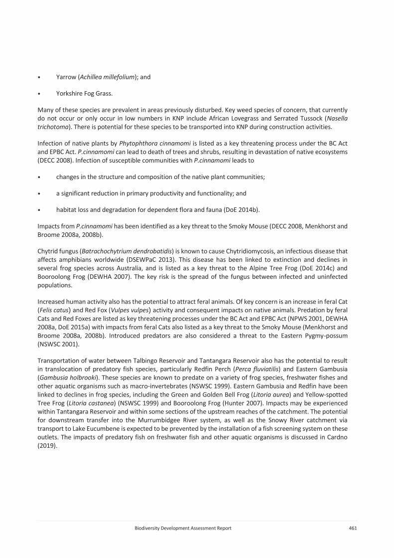
Following completion of construction activities for Snowy 2.0 Main Works, these areas will be landformed, reshaped and rehabilitated, in line with the rehabilitation strategy (SLR 2019). The final elevation of the emplacement area in Tantangara Reservoir will be to about 1 m above FSL to allow for revegetation (Plate 8.4). Further engagement with NPWS will be carried out regarding the end use of these areas, such as recreational areas.
Plate 8.4 Artist impression of the Tantangara Reservoir emplacement area at FSL
e Utilities and access roads (Tantangara Road)
Road access is required from the Snowy Mountains Highway to Tantangara Reservoir. This road will provide the main access to construction area at Tantangara and will require two-way access for construction vehicles. Improvements to the intersection of Tantangara Road and Snowy Mountains Highway, including widening of the intersection, will be undertaken to facilitate access for construction traffic. Utilities for works undertaken at Tantangara will be co-located within the disturbance area.
The alignment for the access road will follow the existing Tantangara Road alignment. Tantangara Road currently provides two-way traffic, and as such only minimal additional disturbance will be required to upgrade this road. Given this, limited consideration was given to alternative options.
Indirect impacts could occur due to fauna vehicle strike if vehicles are moving during the night time when fauna species active, or through the introduction of weeds, such as Ox-eye Daisy, or pathogens, such as P.cimmamomi. To prevent this occurring the following controls will be implemented:
Biodiversity Development Assessment Report 480
• a 40 km/h speed limit will be imposed on Tantangara Road at night when fauna species are likely to be most active;
• a weed and pathogen monitoring program will be implemented, with a weed control program to be implemented if weeds are identified along road verges; and
• wash-down stations will be constructed at a suitable location, with wash down for weeds as well as P.cimmamomi. An additional wash-down station will be established at a suitable location along Tantangara Road for vehicles exiting the Kelly’s Plain area to ensure suitable wash down to Ox-eye Daisy.
The current design for Tantangara Road includes a disturbance area that is much broader than is likely required to construct the project. It currently represents the maximum extent where construction works will be carried out. The disturbance area will be minimised as much as possible during detailed design.
Access roads, including Tantangara Road, will remain as permanent infrastructure following completion of construction activities.
vi Rock Forest
Rock Forest will consist of a logistics yard and access. The logistics yard will provide a laydown area, as well as a stockpile and staging area for materials and heavy vehicles. This is a private landholding under lease to Snowy Hydro.
Multiple locations have been considered for the siting of these handling facilities, including areas at the top of Lobs Hole Ravine Road, start of Tantangara Road and other areas within KNP. The siting of this infrastructure on private land, outside of KNP, that has been partially cleared will result in a reduction of impacts to native vegetation and threatened species habitat, as well as a reduction in impacts within KNP. Alternative locations for siting of infrastructure within Rock Forest were also considered, including a location to the south-east. The current location for siting of the logistics yard has taken into consideration advice on biodiversity and other values and minimises impacts to these values.
The current design for Rock Forest includes a disturbance area that is much larger than is required to support the logistics yard. It currently represents the maximum extent where construction works will be carried out and allows for placement of additional facilities in this area. The disturbance area will be minimised as much as possible during detailed design.
Following completion of construction activities for Snowy 2.0 Main Works, these areas will be landformed, reshaped and rehabilitated, in line with the rehabilitation strategy (SLR 2019).
vii All project elements
Several measures to avoid, minimise and mitigate impacts are relevant to all project elements.
a Detailed design
As outlined above, the current design for many elements includes a disturbance area that is much larger than is required to construct the project. The current disturbance footprint is likely to significantly overestimate the impacts arising from the project, and currently represents the maximum extent where construction works will be carried out.
The detailed design for the project is ongoing. In recognition of the biodiversity values of KNP, and the unique native species and communities that it supports, the disturbance area will be minimised as much as possible during detailed design.

Biodiversity Development Assessment Report 481
Native vegetation and fauna habitat will be retained wherever possible.
b Retention of vegetation, pre-clearing and clearing works
Site preparation works will require clearing of native vegetation and fauna habitat. These works have the potential to impact on fauna species, as well as have inadvertent impacts on retained vegetation and fauna habitat. To prevent this occurring, and minimise impacts to fauna species the following controls will be implemented:
• native vegetation and fauna habitat will be retained wherever possible, with clearing minimised to the extent required to construct and operate the project;
• exclusion zones around all areas of retained vegetation and fauna habitat will be set up. These areas will be fenced using appropriate fencing materials and designated and signed as ‘No-go Zones’ or ‘Environmentally Sensitive Areas’;
• where feasible, and required to protect significant vegetation, tree protection zones (TPZs) will be set up around all trees retained within and immediately adjacent to the disturbance footprint. If required, TPZs will be established in accordance with the Australian Standard AS 4970-2009 Protection of trees on development sites (Standards Australia Committee 2009);
• prior to undertaking vegetation clearing, pre-clearance inspections will be undertaken by appropriately qualified ecologists. The pre-clearing inspections will:
- confirm the biodiversity values identified in this report;
- check for the evidence of presence of flora and fauna species;
- flag key habitat features, including (but not limited to) nests, hollow bearing trees or large logs;
- identify nearby habitat suitable for the release of any that may be encountered during clearing works; and
- contact a wildlife carer or veterinarian to inform them of vegetation clearing works upcoming.
Vegetation clearing works are to follow a two-staged process, as outlined below:
• Stage 1 will include the removal of all non-habitat vegetation (eg shrubs, regrowth, ground cover and non-habitat trees). The groundcover will be scalped to topsoil where appropriate. A minimum of 24 hours will be allowed between Stage 1 and Stage 2.
• Stage 2 will include the removal of all habitat vegetation:
- nests and on-ground logs will be carefully inspected by an ecologist. Logs should be carefully rolled and inspection beneath the log undertaken;
- habitat trees (trees with hollows or nests) will be carefully lowered to the ground with minimal impact and nests and hollows inspected by the ecologist; and
- any fauna species are to be relocated to habitat identified during the pre-clearing process or, if injured, transported to a veterinarian or wildlife carer.

Biodiversity Development Assessment Report 482
Native vegetation cleared should be mulched and stockpiled for re-use during rehabilitation works. Large hollow-bearing trees and limbs should be retained as hollows for placement into rehabilitated areas or retained native vegetation.
Where works are to be undertaken within the 50 m buffer zone along the Yarrangobilly River or around areas supporting the Alpine Tree Frog, all vegetation, rocks, logs and other shelter are to be carefully inspected for frog species:
• where works are undertaken during the active period for the species (October to March) any frogs found should be relocated to the nearest area of retained riparian habitat; or
• where works are undertaken outside of the active period outlined above frogs should be taken into care. Agreement with an appropriately qualified and licensed carer will be required.
These measures will be incorporated into a Construction Environmental Management Plan (CEMP).
c Weed control
Indirect impacts could occur due to the introduction and/or spread of weeds, such as African Lovegrass or Ox-eye Daisy, or pathogens such as P.cimmamomi. African Lovegrass is known to occur in the segment factory located in Cooma, with potential for transportation of concrete segments to line the tunnel into KNP resulting in the spread of this weed into the Park. Ox-eye Daisy is known to occur in the Kelly’s Plain area near Tantangara Reservoir, and movement of vehicle sand machinery from this area into other areas has potential to result in spread of this species into other areas. These impacts could be significant for a number of flora and fauna species if they occur.
There is also potential for the spread of weeds already established in KNP to occur during construction activities, particularly clearing works, if weeds are not managed appropriately. Lobs Hole, given historical land use, is a key area for many weeds species, along with Kelly’s Plain.
To prevent this occurring the following controls will be implemented:
• undertaking of weed control in key areas prior to construction works, to minimize the impacts of weeds during construction and to minimise the requirements for disposal and management of weeds on-site;
• appropriate management and disposal of weed species during clearing works, in accordance with the biodiversity management plan;
• active and intensive weed control will be undertaken within 50 m of the disturbance footprint, in areas where significant weeds are known to occur (eg. Tantangara Reservoir) to reduce the cover of weeds adjacent to the construction activities, preventing the spread of weeds into other areas;
• wash-down stations will be constructed at a suitable location, with wash down for weeds as well as P.cimmamomi. An additional wash-down station will be established at a suitable location along Tantangara Road for vehicles exiting the Kelly’s Plain area to ensure suitable wash down to Ox-eye Daisy;
• a weed and pathogen monitoring program will be implemented, with a weed control program to be implemented if weeds are identified in the project area; and
• revegetation of cleared areas as quickly as possible following construction works in an area.

Biodiversity Development Assessment Report 483
d Predator control
There is potential for increased human activity to result in increased activity of predators, particularly feral Cats and Foxes, which will increase pressure on native fauna. This has the potential to result in significant impacts to some threatened species, particularly species such as the Smoky Mouse.
To minimise the risk of increased predator activity, the following controls will be implemented across the project:
• waste will be stored appropriately in inaccessible bins and disposed off-site. No waste will be left outside in open areas accessible to feral animals;
• a monitoring program will be implemented using remote cameras to monitor feral animal activity. Remote cameras will be placed along Lobs Hole Ravine Road (north and south) and Mines Trail to monitor feral animal movements; and
• a predator control program will be implemented, in conjunction with DPIE, to control feral animals.
Whilst these controls will be implemented broadly across the project area, key areas of focus will be where key activity is occurring, such as Lobs Hole, Marica, Tantangara Reservoir and Rock Forest. It is considered that these controls will avoid and minimise impacts from the project.
e Sediment control
Management of sedimentation will be a key measure to minimise and mitigate impacts. Road upgrades are expected to mobilise fine sediments, with potential for these to enter watercourses. Management measures will be put in place to control fine sediments. Following consultation with OEH, it was determined that the mobilisation of large amounts of coarse sediments into key habitat is the key impacts to frog species such as the Booroolong Frog that may arise during Snowy 2.0 Main Works. The key period for mobilisation of large amounts of coarse sediment will be during initial earthworks for the road upgrades. Key management measures to be implemented to manage this risk include:
• sediment controls will be put in place within the disturbance footprint, and shall be consistent with relevant standards, including:
- Managing Urban Stormwater: Soils and Construction – Volume 1 (Landcom 2004);
- Managing Urban Stormwater: Soils and Construction – Volume 2C – Unsealed roads (DECC 2008); and
- Managing Urban Stormwater: Soils and Construction – Volume 2D – Main road construction (DECC 2008).
• an erosion and sediment control plan (ESCP) will be prepared for each construction zone;
• where practical, clean water will be diverted around, rather than through, construction areas;
• consider local soil characteristics, topography and environmental constraints and proposed construction methods and identify risks associated with proposed activities;
• apply clean water management controls as per:
- WM 1.1 for clean water management during surface construction disturbance;

Biodiversity Development Assessment Report 484
- WM 2.1 for temporary watercourse diversions around temporary surface infrastructure; and
- WM 3.1 for permanent watercourse diversions.
• all temporary drainage and sediment control measures will be designed to have non-erosive hydraulic capacity and be structurally sound for the design events specified in Table 6-1 in Managing Urban Stormwater: Soils and construction – Volume 2D – Main road construction (DECC 2008);
• consider all practical erosion control and rehabilitation methods and apply the most appropriate method;
• consider all practical methods to stabilise small temporary stockpiles and apply the most appropriate method. Apply management controls as per WM 2.5 for the management of large temporary stockpiles;
• all temporary drainage, sediment control measures and spillways will be designed to have non-erosive hydraulic capacity and be structurally sound for the design events specified in Table 6-1 in Managing Urban Stormwater: Soils and construction – Volume 2D – Main road construction (DECC 2008);
• where practical, all runoff from disturbance areas will be reticulated to sedimentation basins designed to capture the 85th percentile 5-day rainfall event. Captured water will be either harvested and used for dust suppression or treated and discharged following each rainfall event. Only water treatment chemicals that have low eco-toxicological risks will be used. Water will be treated to have similar water quality characteristics to receiving water quality in terms of pH and turbidity;
• apply enhanced erosion controls where significant risks are identified;
• include measures to manage the storage and handling of hydrocarbons and other chemicals that have potential to pollute receiving waters;
• include measures to manage accidental leaks and spills; and
• be progressively amended as required during construction.
More natural erosion controls incorporating organic materials and contour shaping shall be used in preference to engineered materials and controls. This is consistent with practices currently being used elsewhere within KNP.
Controls will also be put in place during operation of roads, following construction. Management principles are outlined below:
• Any existing access tracks that will no longer be required following the construction of the new access roads will be rehabilitated.
• All cut and fill batters will be stabilised as soon as practical following construction.
• Roads surfaces will be constructed and maintained with aggregate material to reduce soil loss rates and water quality risks. The use of material that presents elevated water quality risks relative to other material available for road construction and maintenance will be avoided.
• Where practical access roads will grade to table drains that are designed and constructed to have non-erosive hydraulic capacity for the 10% AEP event. Transverse (or cross drainage) will be constructed to have the following non-erosive hydraulic capacities:
• Primary roads – 1% AEP event;

Biodiversity Development Assessment Report 485
• Maintenance roads – 2% AEP event; and
• Temporary access roads – 10% AEP event.
• Sediment traps or filters will be installed and maintained at all discharge locations to reduce coarse sediment in discharge.
If batters are at low risk of erosion, they will be left to regenerate naturally with the assistance of replacement organic matter where required. Batter stabilisation works will be undertaken where required, along with revegetation of cleared areas, construction of drainage swales and sedimentation control planting.
f Noise, vibration and lighting
Impacts from noise and vibration are expected to be limited to the construction period and will thus be transient. Noise levels of over 65 dB may be experience immediately adjacent to construction areas. Noise levels drop to below 60 dB (normal conversation) outside of these areas. Some impacts to fauna species may result but are expected to be limited. No impact mitigation measures are required.
Light spill from night works has the potential to reduce the suitability of retained habitat for some fauna species. To minimise this directional lighting will be used, minimising light spill as much as possible.
g Monitoring and adaptive management
A number of monitoring programs will be implemented to ensure Snowy 2.0 Main Works does not result in impacts greater than predicted in the EIS. While monitoring programs will be developed post-approval, as a part of the development of management plans of the project, the following monitoring is recommended:
• key threatened species, including:
- Clover Glycine;
- Alpine She-oak Skink;
- Booroolong Frog;
- Alpine Tree Frog;
- Smoky Mouse;
• weed and pathogen monitoring;
• feral species monitoring;
• water quality monitoring in the Yarrangobilly River, Tantangara Reservoir and key watercourses providing habitat for the Alpine Tree Frog;
• monitoring of groundwater and GDEs, including:
- monitoring of regional groundwater systems through a network of groundwater bores;
- monitoring of groundwater in Alpine bogs and fens through installation of drivepoint piezometers; and

Biodiversity Development Assessment Report 486
- monitoring of vegetation and threatened species in Alpine bogs and fens, if changes in groundwater occurs.
The development of these management plans and monitoring programs will include triggers for adaptive management measures.
8.2.2 Operation of Snowy 2.0
Following completion of construction, impacts arising from the operation of Snowy 2.0 will be limited to key areas of ongoing operation. Potential operational impacts are expected to include:
• indirect impacts from noise, vibration and lighting;
• indirect impacts to retained habitat due to weeds and pathogens;
• indirect impacts to fauna species as a result of predatory and pest animal species;
• prescribed impacts to threatened species and communities due to groundwater drawdown; and
• prescribed impacts to fauna species due to vehicle strike.
The monitoring program outlined above will be used to determine whether these impacts continue to occur post-construction and the need and scope of any management required.
8.2.3 Summary of measures to avoid, minimise and mitigate impacts
A summary of impacts arising from the Main Works, and measures outlined above to avoid, minimise and mitigate impacts, is provided in Table 8.1.

Biodiversity Development Assessment Report 487
Table 8.1 Summary of impacts, and measures to avoid, minimise and mitigate
Impact Impact avoidance Impact minimisation Impact mitigation
Removal of native vegetation and threatened species habitat.
Type: direct impact.
Frequency: once, during construction.
Intensity: removal of 1,053 ha of native vegetation including 4.09 ha of TECs and 992 ha of habitat for 14 threatened species.
Duration: initial stages of construction.
Consequence: permanent removal of native vegetation and threatened species habitat.
• Investigation of alternative locations for key infrastructure during design works.
• Siting of stockpiles for excavated materials in low-quality vegetation where possible.
• Siting of the Exploratory Works camp in partially cleared areas.
• Siting of the ECVT to minimise clearing due to terrain and access roads.
• Avoidance of on-land emplacement options, which would have resulted in clearing of large areas of native vegetation.
• Emplacement of excavated materials in Talbingo and Tantangara Reservoirs, minimising impacts to native vegetation and threatened species habitat.
• Removal of out of park emplacement, negating the requirement for construction of the Tantangara East Road and associated impacts to native vegetation and threatened species habitat, particularly Clover Glycine.
• Removal of plateau power station complex option, reducing impacts to sensitive habitats in the plateau area.
• Change in power station complex location in the Marica area, including construction method, resulting in removal of elements and reduction in impacts.
• Location of the Marica ventilation shaft in cleared areas.
• Investigation of alternative locations for the communications cable routes, including removal of the southern
• Siting of infrastructure in areas subject to existing disturbance.
• Siting of Tantangara intake on a disturbed headland and within FSL.
• Siting of infrastructure at Rock Forest in partially cleared areas.
• Use of the Marica to Lobs Hole road (Marica Trail) for light vehicle only, rather than construction traffic, resulting in a reduction in clearing in this area.
• Re-use of excavated materials wherever possible, minimising the extent of excavated materials to be stockpiled and disposed of, minimising clearing of native vegetation.
• Use of the existing road network to minimise requirement for removal of native vegetation.
• Use of the Marica to Lobs Hole road (Marica Trail) for light vehicle only, rather than construction traffic, resulting in a reduction in clearing in this area.
• Use of the existing road network to minimise requirement for removal of native vegetation.
• Use of the existing firetrail network for installation of communications cables, to minimise requirement for removal of native vegetation.
• Underboring, rather than open trenching, of the southern communication route beneath Boggy Plain.
• Detailed design of the project, resulting in further minimisation of impacts to native vegetation.
• Minimisation of clearing during construction, wherever possible.
• Establishment of exclusion zones around retained vegetation, including fencing and signage.
• Pre-clearing surveys conducted prior to clearing, including translocation of fauna into areas of retained vegetation.
• Vegetation clearing undertaken in accordance with the two-stage process.
• Mulching and stockpiling of cleared native vegetation for use during rehabilitation.
• Retention of hollows logs and limbs for placement within retained vegetation and reuse during rehabilitation.
• Rehabilitation of approximately 60% of the total area impacted.
• Landforming, reshaping and rehabilitation of all emplacement areas.
• Completion of rehabilitation in accordance with the rehabilitation strategy (SLR 2019).
• Regional surveys for the Smoky Mouse to demonstrate presence of a significant regional population.
• Collection of native seeds and alpine sod for propagation.
• Establishment of native plant nursery and propagation of endemic native species for use in rehabilitation works.
• Design and implementation of a threatened species monitoring program to ensure impacts arising from clearing are within prediction.

Biodiversity Development Assessment Report 488
Table 8.1 Summary of impacts, and measures to avoid, minimise and mitigate
Impact Impact avoidance Impact minimisation Impact mitigation
communication route adjacent to the Snowy Mountains Highway.
• Moving of the southern communications route south at Boggy Plain to avoid sensitive Alpine bogs and fens and sub-alpine grassland habitat.
• Installation of the communications cable in existing firetrails.
• Development of a 50 m buffer zone along the Yarrangobilly River and avoidance of works within this buffer.
• Detailed design of the project, resulting in further avoidance of impacts to native vegetation.
Increase in weeds and pathogens.
Type: indirect impact.
Frequency: ongoing during construction and operation.
Intensity: unknown.
Duration: ongoing through construction phase.
Consequence: potential to impact on threatened species habitat, resulting in decline in habitat quality.
• Not required • Weed control prior to construction works being undertaken, where possible.
• Appropriate disposal and management of weeds during clearing works;
• Active weed control within 50 m of key infrastructure in areas where significant weeds occur, such as Tantangara Reservoir.
• Construction of wash-down stations at a suitable location.
• Washdown required for weeds as well as P.cimmamomi.
• Re-vegetation of cleared areas as quickly as possible following construction.
• Collection of native seed and alpine sod for propagation.
• Design and implementation of a weed and pathogen monitoring program.
• Design and implementation of a threatened species monitoring program to ensure impacts arising from clearing are within prediction.
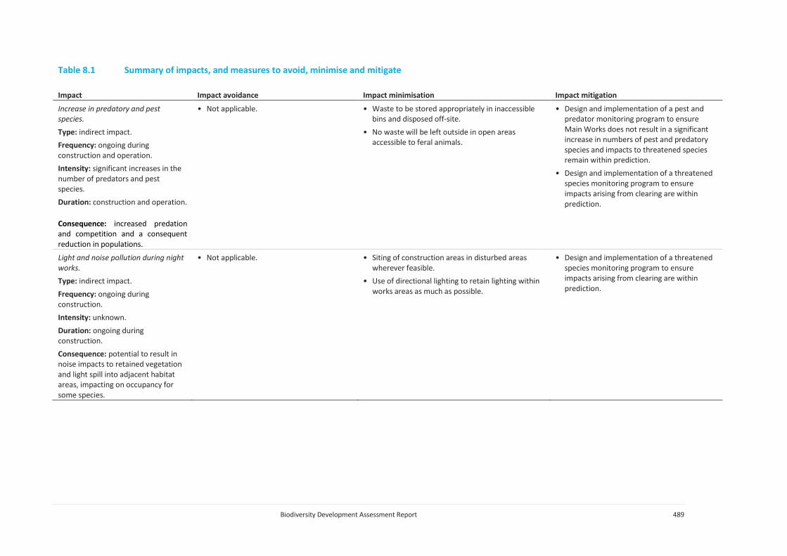
Biodiversity Development Assessment Report 489
Table 8.1 Summary of impacts, and measures to avoid, minimise and mitigate
Impact Impact avoidance Impact minimisation Impact mitigation
Increase in predatory and pest species.
Type: indirect impact.
Frequency: ongoing during construction and operation.
Intensity: significant increases in the number of predators and pest species.
Duration: construction and operation.
Consequence: increased predation and competition and a consequent reduction in populations.
• Not applicable. • Waste to be stored appropriately in inaccessible bins and disposed off-site.
• No waste will be left outside in open areas accessible to feral animals.
• Design and implementation of a pest and predator monitoring program to ensure Main Works does not result in a significant increase in numbers of pest and predatory species and impacts to threatened species remain within prediction.
• Design and implementation of a threatened species monitoring program to ensure impacts arising from clearing are within prediction.
Light and noise pollution during night works.
Type: indirect impact.
Frequency: ongoing during construction.
Intensity: unknown.
Duration: ongoing during construction.
Consequence: potential to result in noise impacts to retained vegetation and light spill into adjacent habitat areas, impacting on occupancy for some species.
• Not applicable. • Siting of construction areas in disturbed areas wherever feasible.
• Use of directional lighting to retain lighting within works areas as much as possible.
• Design and implementation of a threatened species monitoring program to ensure impacts arising from clearing are within prediction.

Biodiversity Development Assessment Report 490
Table 8.1 Summary of impacts, and measures to avoid, minimise and mitigate
Impact Impact avoidance Impact minimisation Impact mitigation
Changes to runoff regimes.
Type: prescribed impact.
Frequency: ongoing during construction and operation.
Intensity: potential to mobilise large amounts of sediment and significantly impact on breeding habitat for Alpine Tree Frog.
Duration: initial stages of construction.
Consequence: impact water quality, erosion and sedimentation in the area and breeding success.
• Development of a 50 m buffer zone along the Yarrangobilly River and avoidance of works within this buffer.
• Siting of key infrastructure away from sensitive receiving environments.
• Management of sedimentation via sediment and erosion control plans for each construction zone.
• Natural erosion controls incorporating organic materials, micro water capture and contour shaping.
• Diversion of clean water around construction areas, rather than through them.
• Stabilisation and rehabilitation of works areas as soon as practicable.
• Siting of sediment basins to manage run-off from construction areas and use of captured water for dust suppression.
• Siting of all camps distant from sensitive receiving environments in the Yarrangobilly River and Tantangara Reservoir.
• No extraction of water from the Yarrangobilly River or Kelly’s Plain Creek.
• Landscaping of pervious surfaces using endemic species.
• Collection of run-off from roof areas.
• Treatment of run-off from camps in a bio-filtration system.
• Separation of oil from water.
• Treatment of wastewater using membrane filtration prior to disposal into Reservoirs
• Design and implementation of a surface water monitoring program to ensure run-off does not impact on sensitive receiving environments.
• Design and implementation of a threatened species monitoring program to ensure impacts arising from clearing are within prediction.
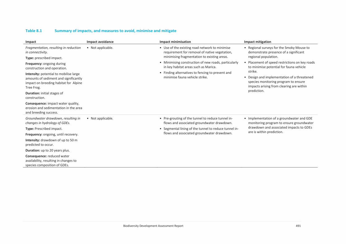
Biodiversity Development Assessment Report 491
Table 8.1 Summary of impacts, and measures to avoid, minimise and mitigate
Impact Impact avoidance Impact minimisation Impact mitigation
Fragmentation, resulting in reduction in connectivity.
Type: prescribed impact.
Frequency: ongoing during construction and operation.
Intensity: potential to mobilise large amounts of sediment and significantly impact on breeding habitat for Alpine Tree Frog.
Duration: initial stages of construction.
Consequence: impact water quality, erosion and sedimentation in the area and breeding success.
• Not applicable. • Use of the existing road network to minimise requirement for removal of native vegetation, minimising fragmentation to existing areas.
• Minimising construction of new roads, particularly in key habitat areas such as Marica.
• Finding alternatives to fencing to prevent and minimise fauna vehicle strike.
• Regional surveys for the Smoky Mouse to demonstrate presence of a significant regional population.
• Placement of speed restrictions on key roads to minimise potential for fauna vehicle strike.
• Design and implementation of a threatened species monitoring program to ensure impacts arising from clearing are within prediction.
Groundwater drawdown, resulting in changes in hydrology of GDEs.
Type: Prescribed impact.
Frequency: ongoing, until recovery.
Intensity: drawdown of up to 50 m predicted to occur.
Duration: up to 20 years plus.
Consequence: reduced water availability, resulting in changes to species composition of GDEs.
• Not applicable. • Pre-grouting of the tunnel to reduce tunnel in-flows and associated groundwater drawdown.
• Segmental lining of the tunnel to reduce tunnel in-flows and associated groundwater drawdown.
• Implementation of a groundwater and GDE monitoring program to ensure groundwater drawdown and associated impacts to GDEs are is within prediction.
Biodiversity Development Assessment Report 492
8.3 Impact summary
8.3.1 Serious and irreversible impacts (SAII)
Five species recorded within the Main Works project area are identified as candidate species for serious and irreversible impacts (SAII), as per Section 6.5 of the BC Act. These include:
• Clover Glycine;
• Kiandra Leek Orchid;
• Mauve Burr-daisy;
• Raleigh Sedge; and
• Smoky Mouse.
Information required by Section 10.2.3 of the BAM (OEH 2017a) is provided in Annexure G.
8.3.2 Impacts requiring offsets
This section provides an assessment of the impacts requiring offsetting in accordance with Section 10 of the BAM (OEH 2017a).
i Impacts on native vegetation
Impacts to native vegetation requiring offsets include:
• direct impacts on 6.99 ha of PCT 285 – Broad-leaved Sally grass – sedge woodland on valley flats and swamps in the NSW South Western Slopes Bioregion and adjoining South Eastern Highlands Bioregion;
• direct impacts on 29.97 ha of PCT 296 – Brittle Gum – Peppermint open forest of the Woomargama to Tumut region, NSW South Western Slopes Bioregion;
• direct impacts on 3.87 ha of PCT 299 – Riparian Ribbon Gum - Robertsons Peppermint - Apple Box riverine very tall open forest of the NSW South Western Slopes Bioregion and South Eastern Highlands;
• direct impacts on 69.62 ha of PCT 300 – Ribbon Gum - Narrow-leaved (Robertsons) Peppermint montane fern - grass tall open forest on deep clay loam soils in the upper NSW South Western Slopes Bioregion and western Kosciuszko escarpment;
• direct impacts on 8.45 ha of PCT 302 - Riparian Blakely's Red Gum - Broad-leaved Sally woodland - tea-tree - bottlebrush - wattle shrubland wetland of the NSW South Western Slopes Bioregion and South Eastern Highlands Bioregion;
• direct impacts on 78.44 ha of PCT 303 – Black Sally grassy low woodland in valleys in the upper slopes sub-region of the NSW South Western Slopes Bioregion and western South Eastern Highlands Bioregion;
• direct impacts on 37.05 ha of PCT 311 – Red Stringybark - Broad-leaved Peppermint - Nortons Box heath open forest of the upper slopes subregion in the NSW South Western Slopes Bioregion and adjoining South Eastern Highlands Bioregion;

Biodiversity Development Assessment Report 493
• direct impacts on 4.09 ha of PCT 637 – Alpine and sub-alpine peatlands, damp herbfields and fens, South Eastern Highlands Bioregion and Australian Alps Bioregion;
• direct impacts on 15.96 ha of PCT 638 - Alpine Ash - Mountain Gum moist shrubby tall open forest of montane areas, southern South Eastern Highlands Bioregion and Australian Alps Bioregion;
• direct impacts on 6.61 ha of PCT 639 – Alpine Ash - Snow Gum shrubby tall open forest of montane areas, South Eastern Highlands Bioregion and Australian Alps Bioregion;
• direct impacts on 116.22 ha of PCT 644 – Alpine Snow Gum - Snow Gum shrubby woodland at intermediate altitudes in northern Kosciuszko NP, South Eastern Highlands Bioregion and Australian Alps Bioregion;
• direct impacts on 0.26 ha of PCT 679 – Black Sallee - Snow Gum low woodland of montane valleys, South Eastern Highlands Bioregion and Australian Alps Bioregion;
• direct impacts on 81.09 ha of PCT 729 - Broad-leaved Peppermint - Candlebark shrubby open forest of montane areas, southern South Eastern Highlands Bioregion and South East Corner Bioregion;
• direct impacts on 0.12 ha of PCT 765 – Carex - Juncus sedgeland/wet grassland of the South Eastern Highlands Bioregion;
• direct impacts on 18.92 of PCT 952 - Mountain Gum - Narrow-leaved Peppermint - Snow Gum dry shrubby open forest on undulating tablelands, southern South Eastern Highlands Bioregion;
• direct impacts on 14.35 ha of PCT 953 – Mountain Gum - Snow Gum - Broad-leaved Peppermint shrubby open forest of montane ranges, South Eastern Highlands Bioregion and Australian Alps Bioregion;
• direct impacts on 43.37 ha of PCT 999 - Norton's Box - Broad-leaved Peppermint open forest on footslopes, central and southern South Eastern Highlands Bioregion;
• direct impacts on 26.05 ha of PCT 1191 – Snow Gum - Candle Bark woodland on broad valley flats of the tablelands and slopes, South Eastern Highlands Bioregion;
• direct impacts on 348.14 ha of PCT 1196 - Snow Gum - Mountain Gum shrubby open forest of montane areas, South Eastern Highlands Bioregion and Australian Alps Bioregion;
• direct impacts on 133.84 ha of PCT 1224 – Sub-alpine dry grasslands and heathlands of valley slopes, southern South Eastern Highlands Bioregion and Australian Alps Bioregion; and
• direct impacts on 9.00 ha of PCT 1225 – Sub-alpine grasslands of valley floors, southern South Eastern Highlands Bioregion and Australian Alps Bioregion.
A summary of ecosystem credits required for all vegetation zones, including changes in vegetation integrity score, are provided in Table 8.2. A total of 32,118 ecosystem credits are required to offset the residual impacts of Main Works. A credit report is provided in Annexure H.

Biodiversity Development Assessment Report 494
Table 8.2 Ecosystem credits required for impacts to all vegetation zones for the Main Works
Vegetation zone number
PCT Vegetation zone name
Area Vegetation integrity
score
Future vegetation
integrity score
Change in vegetation integrity
score
Credits required
2 PCT 285 – Broad-leaved Sally grass – sedge woodland on valley flats and swamps in the NSW South Western Slopes Bioregion and adjoining South Eastern Highlands Bioregion
285_High 0.14 56.7 0 -56.7 4
3 PCT 285 – Broad-leaved Sally grass – sedge woodland on valley flats and swamps in the NSW South Western Slopes Bioregion and adjoining South Eastern Highlands Bioregion
285_Medium 4.78 36.9 0 -36.9 88
4 PCT 285 – Broad-leaved Sally grass – sedge woodland on valley flats and swamps in the NSW South Western Slopes Bioregion and adjoining South Eastern Highlands Bioregion
285_Poor 0.56 56 0 -56 16
5 PCT 296 – Brittle Gum – Peppermint open forest of the Woomargama to Tumut region, NSW South Western Slopes Bioregion
296_DNG 0.68 57.9 0 -57.9 15
6 PCT 296 – Brittle Gum – Peppermint open forest of the Woomargama to Tumut region, NSW South Western Slopes Bioregion
296_High 8.64 54 0 -54 175
8 PCT 296 – Brittle Gum – Peppermint open forest of the Woomargama to Tumut region, NSW South Western Slopes Bioregion
296_Medium 19.49 70.4 0 -70.4 515
10 PCT 299 – Riparian Ribbon Gum - Robertsons Peppermint - Apple Box riverine very tall open forest of the NSW South Western Slopes Bioregion and South Eastern Highlands
299_High 1.96 73.8 0 -73.8 63
11 PCT 299 – Riparian Ribbon Gum - Robertsons Peppermint - Apple Box riverine very tall open forest of the NSW South Western Slopes Bioregion and South Eastern Highlands
299_Medium 1.91 65.4 0 -65.4 55

Biodiversity Development Assessment Report 495
Table 8.2 Ecosystem credits required for impacts to all vegetation zones for the Main Works
Vegetation zone number
PCT Vegetation zone name
Area Vegetation integrity
score
Future vegetation
integrity score
Change in vegetation integrity
score
Credits required
13 PCT 300 – Ribbon Gum - Narrow-leaved (Robertsons) Peppermint montane fern - grass tall open forest on deep clay loam soils in the upper NSW South Western Slopes Bioregion and western Kosciuszko escarpment
300_High 54.67 67.1 0 -67.1 1375
14 PCT 300 – Ribbon Gum - Narrow-leaved (Robertsons) Peppermint montane fern - grass tall open forest on deep clay loam soils in the upper NSW South Western Slopes Bioregion and western Kosciuszko escarpment
300_Medium 8.59 56.8 0 -56.8 183
15 PCT 300 – Ribbon Gum - Narrow-leaved (Robertsons) Peppermint montane fern - grass tall open forest on deep clay loam soils in the upper NSW South Western Slopes Bioregion and western Kosciuszko escarpment
300_Other 4.87 39.8 0 -39.8 73
16 PCT 302 - Riparian Blakely's Red Gum - Broad-leaved Sally woodland - tea-tree - bottlebrush - wattle shrubland wetland of the NSW South Western Slopes Bioregion and South Eastern Highlands Bioregion
302_High 0.82 93.6 0 -93.6 34
17 PCT 302 - Riparian Blakely's Red Gum - Broad-leaved Sally woodland - tea-tree - bottlebrush - wattle shrubland wetland of the NSW South Western Slopes Bioregion and South Eastern Highlands Bioregion
302_Low 2.71 19.2 0 -19.2 23
18 PCT 302 - Riparian Blakely's Red Gum - Broad-leaved Sally woodland - tea-tree - bottlebrush - wattle shrubland wetland of the NSW South Western Slopes Bioregion and South Eastern Highlands Bioregion
302_Medium 1.60 46.3 0 -46.3 32
19 PCT 302 - Riparian Blakely's Red Gum - Broad-leaved Sally woodland - tea-tree - bottlebrush - wattle shrubland wetland of the NSW South Western Slopes Bioregion and South Eastern Highlands Bioregion
302_Other 3.19 50.3 0 -50.3 70
21 PCT 303 – Black Sally grassy low woodland in valleys in the upper slopes sub-region of the NSW South Western Slopes Bioregion and western South Eastern Highlands Bioregion
303_DNG 17.06 29.6 0 -29.6 316
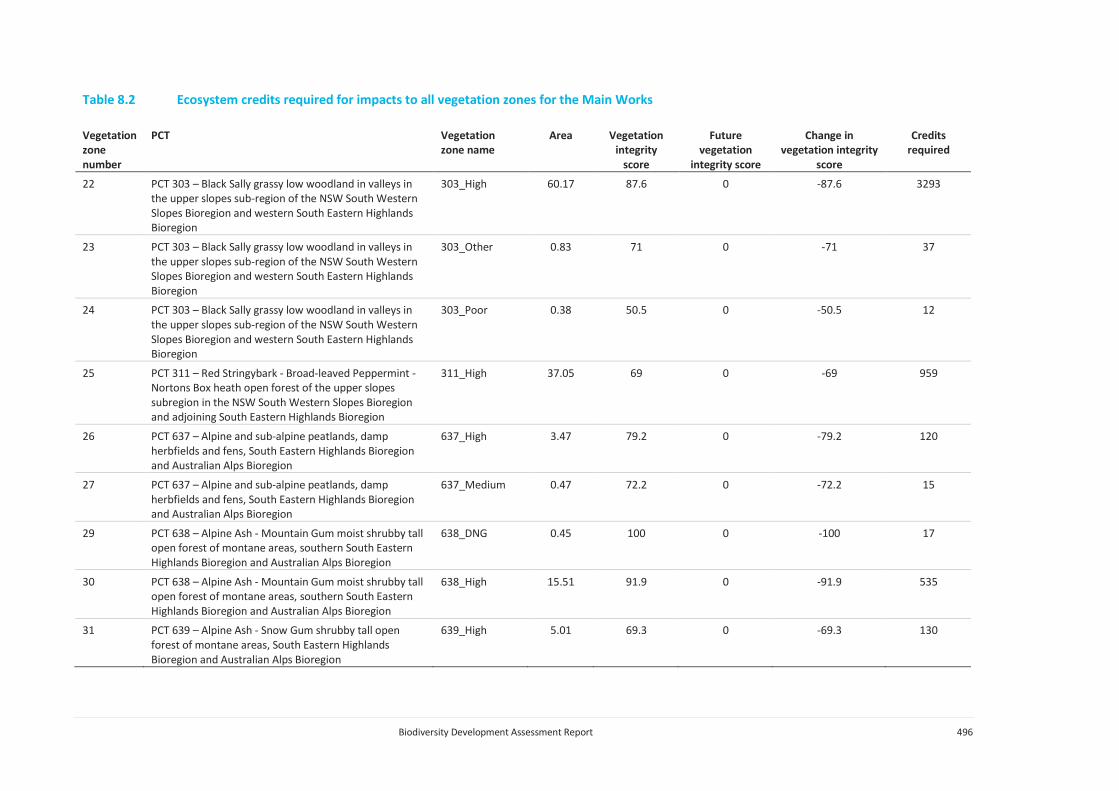
Biodiversity Development Assessment Report 496
Table 8.2 Ecosystem credits required for impacts to all vegetation zones for the Main Works
Vegetation zone number
PCT Vegetation zone name
Area Vegetation integrity
score
Future vegetation
integrity score
Change in vegetation integrity
score
Credits required
22 PCT 303 – Black Sally grassy low woodland in valleys in the upper slopes sub-region of the NSW South Western Slopes Bioregion and western South Eastern Highlands Bioregion
303_High 60.17 87.6 0 -87.6 3293
23 PCT 303 – Black Sally grassy low woodland in valleys in the upper slopes sub-region of the NSW South Western Slopes Bioregion and western South Eastern Highlands Bioregion
303_Other 0.83 71 0 -71 37
24 PCT 303 – Black Sally grassy low woodland in valleys in the upper slopes sub-region of the NSW South Western Slopes Bioregion and western South Eastern Highlands Bioregion
303_Poor 0.38 50.5 0 -50.5 12
25 PCT 311 – Red Stringybark - Broad-leaved Peppermint - Nortons Box heath open forest of the upper slopes subregion in the NSW South Western Slopes Bioregion and adjoining South Eastern Highlands Bioregion
311_High 37.05 69 0 -69 959
26 PCT 637 – Alpine and sub-alpine peatlands, damp herbfields and fens, South Eastern Highlands Bioregion and Australian Alps Bioregion
637_High 3.47 79.2 0 -79.2 120
27 PCT 637 – Alpine and sub-alpine peatlands, damp herbfields and fens, South Eastern Highlands Bioregion and Australian Alps Bioregion
637_Medium 0.47 72.2 0 -72.2 15
29 PCT 638 – Alpine Ash - Mountain Gum moist shrubby tall open forest of montane areas, southern South Eastern Highlands Bioregion and Australian Alps Bioregion
638_DNG 0.45 100 0 -100 17
30 PCT 638 – Alpine Ash - Mountain Gum moist shrubby tall open forest of montane areas, southern South Eastern Highlands Bioregion and Australian Alps Bioregion
638_High 15.51 91.9 0 -91.9 535
31 PCT 639 – Alpine Ash - Snow Gum shrubby tall open forest of montane areas, South Eastern Highlands Bioregion and Australian Alps Bioregion
639_High 5.01 69.3 0 -69.3 130

Biodiversity Development Assessment Report 497
Table 8.2 Ecosystem credits required for impacts to all vegetation zones for the Main Works
Vegetation zone number
PCT Vegetation zone name
Area Vegetation integrity
score
Future vegetation
integrity score
Change in vegetation integrity
score
Credits required
32 PCT 639 – Alpine Ash - Snow Gum shrubby tall open forest of montane areas, South Eastern Highlands Bioregion and Australian Alps Bioregion
639_Other 1.60 79.5 0 -79.5 48
34 PCT 644 – Alpine Snow Gum - Snow Gum shrubby woodland at intermediate altitudes in northern Kosciuszko NP, South Eastern Highlands Bioregion and Australian Alps Bioregion
644_DNG 2.61 60.5 0 -60.5 59
35 PCT 644 – Alpine Snow Gum - Snow Gum shrubby woodland at intermediate altitudes in northern Kosciuszko NP, South Eastern Highlands Bioregion and Australian Alps Bioregion
644_High 104.94 90.6 0 -90.6 3567
36 PCT 644 – Alpine Snow Gum - Snow Gum shrubby woodland at intermediate altitudes in northern Kosciuszko NP, South Eastern Highlands Bioregion and Australian Alps Bioregion
644_Medium 0.38 67.6 0 -67.6 10
37 PCT 644 – Alpine Snow Gum - Snow Gum shrubby woodland at intermediate altitudes in northern Kosciuszko NP, South Eastern Highlands Bioregion and Australian Alps Bioregion
644_Other 8.29 67.1 0 -67.1 208
38 PCT 679 – Black Sallee - Snow Gum low woodland of montane valleys, South Eastern Highlands Bioregion and Australian Alps Bioregion
679_High 0.25 51 0 -51 5
39 PCT 679 – Black Sallee - Snow Gum low woodland of montane valleys, South Eastern Highlands Bioregion and Australian Alps Bioregion
679_Other 0.01 81.1 0 -81.1 1
40 PCT 729 - Broad-leaved Peppermint - Candlebark shrubby open forest of montane areas, southern South Eastern Highlands Bioregion and South East Corner Bioregion
729_DNG 2.98 31.1 0 -31.1 35

Biodiversity Development Assessment Report 498
Table 8.2 Ecosystem credits required for impacts to all vegetation zones for the Main Works
Vegetation zone number
PCT Vegetation zone name
Area Vegetation integrity
score
Future vegetation
integrity score
Change in vegetation integrity
score
Credits required
41 PCT 729 - Broad-leaved Peppermint - Candlebark shrubby open forest of montane areas, southern South Eastern Highlands Bioregion and South East Corner Bioregion
729_High 66.55 77.6 0 -77.6 1936
43 PCT 729 - Broad-leaved Peppermint - Candlebark shrubby open forest of montane areas, southern South Eastern Highlands Bioregion and South East Corner Bioregion
729_Medium 11.41 78.2 0 -78.2 334
44 PCT 765 – Carex - Juncus sedgeland/wet grassland of the South Eastern Highlands Bioregion
765_High 0.12 75.5 0 -75.5 3
45 PCT 952 – Mountain Gum - Narrow-leaved Peppermint - Snow Gum dry shrubby open forest on undulating tablelands, southern South Eastern Highlands Bioregion
952_DNG 0.53 31.6 0 -31.6 7
46 PCT 952 – Mountain Gum - Narrow-leaved Peppermint - Snow Gum dry shrubby open forest on undulating tablelands, southern South Eastern Highlands Bioregion
952_High 3.64 100 0 -100 159
47 PCT 952 – Mountain Gum - Narrow-leaved Peppermint - Snow Gum dry shrubby open forest on undulating tablelands, southern South Eastern Highlands Bioregion
952_Medium 14.75 100 0 -100 645
48 PCT 953 – Mountain Gum - Snow Gum - Broad-leaved Peppermint shrubby open forest of montane ranges, South Eastern Highlands Bioregion and Australian Alps Bioregion
953_DNG 1.47 32 0 -32 18
49 PCT 953 – Mountain Gum - Snow Gum - Broad-leaved Peppermint shrubby open forest of montane ranges, South Eastern Highlands Bioregion and Australian Alps Bioregion
953_High 12.88 89.9 0 -89.9 434
50 PCT 999 - Norton's Box - Broad-leaved Peppermint open forest on footslopes, central and southern South Eastern Highlands Bioregion
999_DNG 1.24 38.3 0 -38.3 18

Biodiversity Development Assessment Report 499
Table 8.2 Ecosystem credits required for impacts to all vegetation zones for the Main Works
Vegetation zone number
PCT Vegetation zone name
Area Vegetation integrity
score
Future vegetation
integrity score
Change in vegetation integrity
score
Credits required
51 PCT 999 - Norton's Box - Broad-leaved Peppermint open forest on footslopes, central and southern South Eastern Highlands Bioregion
999_High 37.43 70.9 0 -70.9 995
52 PCT 999 - Norton's Box - Broad-leaved Peppermint open forest on footslopes, central and southern South Eastern Highlands Bioregion
999_Medium 4.70 48.6 0 -48.6 86
53 PCT 1191 – Snow Gum - Candle Bark woodland on broad valley flats of the tablelands and slopes, South Eastern Highlands Bioregion
1191_DNG 1.58 33.1 0 -33.1 33
54 PCT 1191 – Snow Gum - Candle Bark woodland on broad valley flats of the tablelands and slopes, South Eastern Highlands Bioregion
1191_High 23.32 66.4 0 -66.4 968
55 PCT 1191 – Snow Gum - Candle Bark woodland on broad valley flats of the tablelands and slopes, South Eastern Highlands Bioregion
1191_Medium 1.15 43.8 0 -43.8 31
56 PCT 1196 - Snow Gum - Mountain Gum shrubby open forest of montane areas, South Eastern Highlands Bioregion and Australian Alps Bioregion
1196_DNG 89.40 43.4 0 -43.4 1455
57 PCT 1196 - Snow Gum - Mountain Gum shrubby open forest of montane areas, South Eastern Highlands Bioregion and Australian Alps Bioregion
1196_High 214.81 92.3 0 -92.3 7433
58 PCT 1196 - Snow Gum - Mountain Gum shrubby open forest of montane areas, South Eastern Highlands Bioregion and Australian Alps Bioregion
1196_Medium 28.15 81.3 0 -81.3 858
59 PCT 1196 - Snow Gum - Mountain Gum shrubby open forest of montane areas, South Eastern Highlands Bioregion and Australian Alps Bioregion
1196_Other 14.42 44.2 0 -44.2 239
60 PCT 1196 - Snow Gum - Mountain Gum shrubby open forest of montane areas, South Eastern Highlands Bioregion and Australian Alps Bioregion
1196_Poor 1.36 100 0 -100 51

Biodiversity Development Assessment Report 500
Table 8.2 Ecosystem credits required for impacts to all vegetation zones for the Main Works
Vegetation zone number
PCT Vegetation zone name
Area Vegetation integrity
score
Future vegetation
integrity score
Change in vegetation integrity
score
Credits required
61 PCT 1224 – Sub-alpine dry grasslands and heathlands of valley slopes, southern South Eastern Highlands Bioregion and Australian Alps Bioregion
1224_High 117.19 85.6 0 -85.6 3760
62 PCT 1224 – Sub-alpine dry grasslands and heathlands of valley slopes, southern South Eastern Highlands Bioregion and Australian Alps Bioregion
1224_Low 0.01 31.7 0 -31.7 1
63 PCT 1224 – Sub-alpine dry grasslands and heathlands of valley slopes, southern South Eastern Highlands Bioregion and Australian Alps Bioregion
1224_Medium 15.91 49 0 -49 292
64 PCT 1224 – Sub-alpine dry grasslands and heathlands of valley slopes, southern South Eastern Highlands Bioregion and Australian Alps Bioregion
1224_Poor 0.73 49.7 0 -49.7 14
65 PCT 1225 – Sub-alpine grasslands of valley floors, southern South Eastern Highlands Bioregion and Australian Alps Bioregion
1225_High 8.61 94.7 0 -94.7 255
66 PCT 1225 – Sub-alpine grasslands of valley floors, southern South Eastern Highlands Bioregion and Australian Alps Bioregion
1225_Low 0.12 31.4 0 -31.4 1
67 PCT 1225 – Sub-alpine grasslands of valley floors, southern South Eastern Highlands Bioregion and Australian Alps Bioregion
1225_Medium 0.11 36.5 0 -36.5 1
68 PCT 1225 – Sub-alpine grasslands of valley floors, southern South Eastern Highlands Bioregion and Australian Alps Bioregion
1225_Poor 0.17 47.8 0 -47.8 3
TOTAL 32118

Biodiversity Development Assessment Report 501
Offsets will be provided in accordance with the Snowy 2.0 Main Works Offset Strategy (EMM 2019d) appended to the EIS.
ii Impacts on threatened species
Impacts to threatened species habitat requiring offsets include:
• direct impacts on 2.01 of habitat for Clover Glycine;
• direct impacts on 1.67 habitat for the Kiandra Leek Orchid;
• direct impacts on 17 individuals of the Leafy Anchor Plant;
• direct impacts on 16.55 ha of habitat for the Mauve Burr-daisy;
• direct impacts on 0.38 ha of habitat for the Raleigh Sedge;
• direct impacts on 0.18 ha of habitat for the Slender Greenhood; and
• direct impacts on 0.04 ha of habitat for Thelymitra alpicola.
• direct impacts on 5.42 ha of breeding habitat for the Gang-gang Cockatoo;
• direct impacts on 30.23 ha of habitat for the Broad-toothed rat;
• direct impacts on 552.94 ha of habitat for the Eastern Pygmy-possum;
• direct impacts on 174.63 ha of habitat for the Smoky Mouse;
• direct impacts on 9.85 ha of habitat for the Booroolong Frog;
• direct impacts on 48.87 ha of habitat for the Alpine Tree Frog; and
• direct impacts on 133.83 ha of habitat for the Alpine She-oak Skink.
A summary of the species credits required for all vegetation zones occupied by the threatened species, including changes in vegetation integrity score, are provided in Table 8.3. A total of 44,100 species credits are required to offset the residual impacts of Main Works. A credit report is provided in Annexure H.
Offsets will be provided in accordance with the Snowy 2.0 Main Works Offset Strategy (EMM 2019d) appended to the EIS.
Table 8.3 Threatened species credits required for Main Works
Species Vegetation zone name
Area (ha)/individual
(HL)
Habitat condition
Future habitat
condition
Loss of habitat
condition
Candidate SAII
Species credits
required
Gang-gang Cockatoo
296_High 0.14 54 0 -54 No 4
Gang-gang Cockatoo
296_Medium 0.68 70.4 0 -70.4 No 24

Biodiversity Development Assessment Report 502
Table 8.3 Threatened species credits required for Main Works
Species Vegetation zone name
Area (ha)/individual
(HL)
Habitat condition
Future habitat
condition
Loss of habitat
condition
Candidate SAII
Species credits
required
Gang-gang Cockatoo
300_High 0.39 67.1 0 -67.1 No 13
Gang-gang Cockatoo
729_High 1 77.6 0 -77.6 No 39
Gang-gang Cockatoo
953_High 1.06 89.9 0 -89.9 No 48
Gang-gang Cockatoo
1196_High 2.16 92.3 0 -92.3 No 100
Mauve Burr-daisy
303_DNG 0.06 29.6 0 -29.6 Yes 1
Mauve Burr-daisy
303_High 0.85 87.6 0 -87.6 Yes 56
Mauve Burr-daisy
303_Other 0.24 71 0 -71 Yes 13
Mauve Burr-daisy
637_High 0.18 79.2 0 -79.2 Yes 11
Mauve Burr-daisy
644_High 0.38 90.6 0 -90.6 Yes 26
Mauve Burr-daisy
644_Other 0.06 67.1 0 -67.1 Yes 3
Mauve Burr-daisy
1196_DNG 0.94 43.4 0 -43.4 Yes 31
Mauve Burr-daisy
1196_High 8.63 92.3 0 -92.3 Yes 597
Mauve Burr-daisy
1224_High 4.99 85.6 0 -85.6 Yes 320
Mauve Burr-daisy
1225_High 0.22 94.7 0 -94.7 Yes 16
Raleigh Sedge
644_High 0.22 90.6 0 -90.6 Yes 15
Raleigh Sedge
1224_High 0.15 85.6 0 -85.6 Yes 10
Raleigh Sedge
1225_High 0.01 94.7 0 -94.7 Yes 1
Eastern Pygmy-possum
296_High 8.64 54 0 -54 No 233
Eastern Pygmy-possum
296_Medium 19.49 70.4 0 -70.4 No 686
Eastern Pygmy-possum
300_High 54.67 67.1 0 -67.1 No 1834
Eastern Pygmy-possum
300_Medium 8.59 56.8 0 -56.8 No 244

Biodiversity Development Assessment Report 503
Table 8.3 Threatened species credits required for Main Works
Species Vegetation zone name
Area (ha)/individual
(HL)
Habitat condition
Future habitat
condition
Loss of habitat
condition
Candidate SAII
Species credits
required
Eastern Pygmy-possum
300_Other 4.87 39.8 0 -39.8 No 97
Eastern Pygmy-possum
302_High 0.82 93.6 0 -93.6 No 38
Eastern Pygmy-possum
302_Medium 1.6 46.3 0 -46.3 No 37
Eastern Pygmy-possum
302_Other 3.19 50.3 0 -50.3 No 80
Eastern Pygmy-possum
311_High 37.05 69 0 -69 No 1279
Eastern Pygmy-possum
638_High 15.51 92 0 -92 No 713
Eastern Pygmy-possum
639_High 5.01 69.3 0 -69.3 No 174
Eastern Pygmy-possum
639_Other 1.6 79.5 0 -79.5 No 64
Eastern Pygmy-possum
729_High 66.55 77.6 0 -77.6 No 2581
Eastern Pygmy-possum
729_Medium 11.41 78.2 0 -78.2 No 446
Eastern Pygmy-possum
953_High 12.88 89.9 0 -89.9 No 579
Eastern Pygmy-possum
999_High 37.43 70.9 0 -70.9 No 1326
Eastern Pygmy-possum
999_Medium 4.7 48.6 0 -48.6 No 114
Eastern Pygmy-possum
1196_High 214.81 92.3 0 -92.3 No 9911
Eastern Pygmy-possum
1196_Medium 28.15 81.3 0 -81.3 No 1144
Eastern Pygmy-possum
1196_Other 14.42 44.2 0 -44.2 No 319

Biodiversity Development Assessment Report 504
Table 8.3 Threatened species credits required for Main Works
Species Vegetation zone name
Area (ha)/individual
(HL)
Habitat condition
Future habitat
condition
Loss of habitat
condition
Candidate SAII
Species credits
required
Eastern Pygmy-possum
1196_Poor 1.36 100 0 -100 No 68
Alpine She-oak Skink
1224_High 117.19 85.6 0 -85.6 No 5014
Alpine She-oak Skink
1224_Medium 15.91 49 0 -49 No 390
Alpine She-oak Skink
1224_Poor 0.73 49.7 0 -49.7 No 18
Leafy Anchor Plant
1224_High 13 N/A N/A N/A No 26
Leafy Anchor Plant
1225_High 4 N/A N/A N/A No 8
Clover glycine
637_Medium 0.01 72.2 0 -72.2 Yes 1
Clover glycine
1196_High 0.24 92.3 0 -92.3 Yes 17
Clover glycine
1224_High 1.33 85.6 0 -85.6 Yes 85
Clover glycine
1224_Medium 0.43 49 0 -49 Yes 16
Booroolong Frog
296_High 0.07 54 0 -54 No 2
Booroolong Frog
296_Low 0.38 3.4 0 -3.4 No 1
Booroolong Frog
296_Medium 0.06 70.4 0 -70.4 No 2
Booroolong Frog
300_High 1.49 67.1 0 -67.1 No 50
Booroolong Frog
302_High 0.4 93.6 0 -93.6 No 19
Booroolong Frog
302_Low 2.19 19.2 0 -19.2 No 21
Booroolong Frog
302_Medium 0.61 46.3 0 -46.3 No 14
Booroolong Frog
302_Other 2.93 50.3 0 -50.3 No 74
Booroolong Frog
729_High 0.33 77.6 0 -77.6 No 13
Booroolong Frog
999_High 0.55 70.9 0 -70.9 No 19
Alpine Tree Frog
303_High 5.94 87.6 0 -87.6 No 260

Biodiversity Development Assessment Report 505
Table 8.3 Threatened species credits required for Main Works
Species Vegetation zone name
Area (ha)/individual
(HL)
Habitat condition
Future habitat
condition
Loss of habitat
condition
Candidate SAII
Species credits
required
Alpine Tree Frog
637_High 0.98 79.2 0 -79.2 No 39
Alpine Tree Frog
637_Medium 0.04 72.2 0 -72.2 No 1
Alpine Tree Frog
637_Poor 0.15 13.5 0 -13.5 No 1
Alpine Tree Frog
644_DNG 0.26 60.5 0 -60.5 No 8
Alpine Tree Frog
644_High 1.56 90.6 0 -90.6 No 71
Alpine Tree Frog
644_Other 0.35 67.1 0 -67.1 No 12
Alpine Tree Frog
1224_High 26.25 85.6 0 -85.6 No 1123
Alpine Tree Frog
1224_Medium 7.62 49 0 -49 No 187
Alpine Tree Frog
1224_Poor 0.54 49.7 0 -49.7 No 13
Alpine Tree Frog
1225_High 4.67 94.7 0 -94.7 No 221
Alpine Tree Frog
1225_Low 0.05 31.4 0 -31.4 No 1
Alpine Tree Frog
1225_Medium 0.04 36.5 0 -36.5 No 1
Alpine Tree Frog
1225_Poor 0.17 47.8 0 -47.8 No 4
Broad-toothed Rat
637_High 3.09 79.2 0 -79.2 No 122
Broad-toothed Rat
637_Medium 0.47 72.2 0 -72.2 No 17
Broad-toothed Rat
637_Poor 0.15 13.5 0 -13.5 No 1
Broad-toothed Rat
1224_High 17.29 85.6 0 -85.6 No 739
Broad-toothed Rat
1224_Medium 0.36 49.0 0 -49.0 No 9
Broad-toothed Rat
1225_High 8.61 94.7 0 -94.7 No 408
Broad-toothed Rat
1225_Medium 0.11 36.5 0 -36.5 No 2
Broad-toothed Rat
1225_Poor 0.17 47.8 0 -47.8 No 4
Kiandra Leek Orchid
303_High 0.03 87.6 0 -87.6 Yes 2

Biodiversity Development Assessment Report 506
Table 8.3 Threatened species credits required for Main Works
Species Vegetation zone name
Area (ha)/individual
(HL)
Habitat condition
Future habitat
condition
Loss of habitat
condition
Candidate SAII
Species credits
required
Kiandra Leek Orchid
1224_High 1.51 85.6 0 -85.6 Yes 97
Kiandra Leek Orchid
1225_High 0.13 94.7 0 -94.7 Yes 9
Smoky Mouse
300_High 15.03 67.1 0 -67.1 Yes 756
Smoky Mouse
638_High 15.51 91.9 0 -91.93 Yes 1069
Smoky Mouse
644_High 32.06 90.6 0 -90.64 Yes 2180
Smoky Mouse
729_High 7.37 77.6 0 -77.56 Yes 429
Smoky Mouse
953_High 12.88 89.9 0 -89.90 Yes 868
Smoky Mouse
1196_High 91.78 92.3 0 -92.27 Yes 6352
Slender Greenhood
1196_High 0.18 92.3 0 -92.3 No 8
Thelymitra alpicola
1224_High 0.03 85.6 0 -85.6 No 1
iii Offset summary
A summary of the ecosystem credits required to offset the impacts of Snowy 2.0 Main Works is provided in Table 8.4.
Table 8.4 Summary of ecosystems credits required to offsets Snowy 2.0 Main Works
PCT Sum of credits required
PCT 1191 – Snow Gum - Candle Bark woodland on broad valley flats of the tablelands and slopes, South Eastern Highlands Bioregion
1,032
PCT 1196 - Snow Gum - Mountain Gum shrubby open forest of montane areas, South Eastern Highlands Bioregion and Australian Alps Bioregion
10,036
PCT 1224 – Sub-alpine dry grasslands and heathlands of valley slopes, southern South Eastern Highlands Bioregion and Australian Alps Bioregion
4,067
PCT 1225 – Sub-alpine grasslands of valley floors, southern South Eastern Highlands Bioregion and Australian Alps Bioregion
260
PCT 285 – Broad-leaved Sally grass – sedge woodland on valley flats and swamps in the NSW South Western Slopes Bioregion and adjoining South Eastern Highlands Bioregion
108
PCT 296 – Brittle Gum – Peppermint open forest of the Woomargama to Tumut region, NSW South Western Slopes Bioregion
705
PCT 299 – Riparian Ribbon Gum - Robertsons Peppermint - Apple Box riverine very tall open forest of the NSW South Western Slopes Bioregion and South Eastern Highlands
118
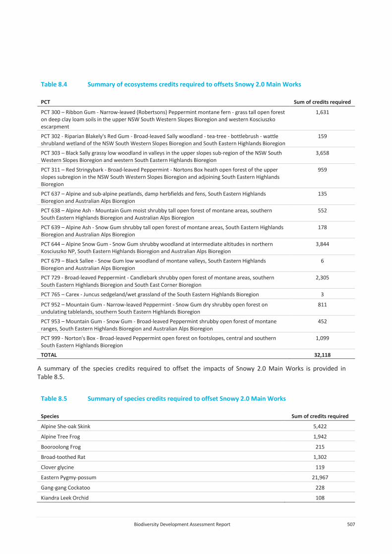
Biodiversity Development Assessment Report 507
Table 8.4 Summary of ecosystems credits required to offsets Snowy 2.0 Main Works
PCT Sum of credits required
PCT 300 – Ribbon Gum - Narrow-leaved (Robertsons) Peppermint montane fern - grass tall open forest on deep clay loam soils in the upper NSW South Western Slopes Bioregion and western Kosciuszko escarpment
1,631
PCT 302 - Riparian Blakely's Red Gum - Broad-leaved Sally woodland - tea-tree - bottlebrush - wattle shrubland wetland of the NSW South Western Slopes Bioregion and South Eastern Highlands Bioregion
159
PCT 303 – Black Sally grassy low woodland in valleys in the upper slopes sub-region of the NSW South Western Slopes Bioregion and western South Eastern Highlands Bioregion
3,658
PCT 311 – Red Stringybark - Broad-leaved Peppermint - Nortons Box heath open forest of the upper slopes subregion in the NSW South Western Slopes Bioregion and adjoining South Eastern Highlands Bioregion
959
PCT 637 – Alpine and sub-alpine peatlands, damp herbfields and fens, South Eastern Highlands Bioregion and Australian Alps Bioregion
135
PCT 638 – Alpine Ash - Mountain Gum moist shrubby tall open forest of montane areas, southern South Eastern Highlands Bioregion and Australian Alps Bioregion
552
PCT 639 – Alpine Ash - Snow Gum shrubby tall open forest of montane areas, South Eastern Highlands Bioregion and Australian Alps Bioregion
178
PCT 644 – Alpine Snow Gum - Snow Gum shrubby woodland at intermediate altitudes in northern Kosciuszko NP, South Eastern Highlands Bioregion and Australian Alps Bioregion
3,844
PCT 679 – Black Sallee - Snow Gum low woodland of montane valleys, South Eastern Highlands Bioregion and Australian Alps Bioregion
6
PCT 729 - Broad-leaved Peppermint - Candlebark shrubby open forest of montane areas, southern South Eastern Highlands Bioregion and South East Corner Bioregion
2,305
PCT 765 – Carex - Juncus sedgeland/wet grassland of the South Eastern Highlands Bioregion 3
PCT 952 – Mountain Gum - Narrow-leaved Peppermint - Snow Gum dry shrubby open forest on undulating tablelands, southern South Eastern Highlands Bioregion
811
PCT 953 – Mountain Gum - Snow Gum - Broad-leaved Peppermint shrubby open forest of montane ranges, South Eastern Highlands Bioregion and Australian Alps Bioregion
452
PCT 999 - Norton's Box - Broad-leaved Peppermint open forest on footslopes, central and southern South Eastern Highlands Bioregion
1,099
TOTAL 32,118
A summary of the species credits required to offset the impacts of Snowy 2.0 Main Works is provided in Table 8.5.
Table 8.5 Summary of species credits required to offset Snowy 2.0 Main Works
Species Sum of credits required
Alpine She-oak Skink 5,422
Alpine Tree Frog 1,942
Booroolong Frog 215
Broad-toothed Rat 1,302
Clover glycine 119
Eastern Pygmy-possum 21,967
Gang-gang Cockatoo 228
Kiandra Leek Orchid 108

Biodiversity Development Assessment Report 508
Table 8.5 Summary of species credits required to offset Snowy 2.0 Main Works
Species Sum of credits required
Leafy Anchor Plant 34
Mauve Burr-daisy 1,074
Raleigh Sedge 26
Slender Greenhood 8
Smoky Mouse 11,654
Thelymitra alpicola 1
TOTAL 44,100
8.3.3 Impacts not requiring offsets
A number of vegetation zones were found to be in degraded condition. In line with the requirements of Section 10.3 of the BAM (OEH 2017a) impacts to the vegetation zones and threatened species habitat in Table 8.6 and Table 8.7, and do not require offsets.
Additional areas not requiring assessment in accordance with Section 10.4 of the BAM (OEH 2017a) include:
• existing roads;
• cleared and highly disturbed land; and
• watercourses.
Table 8.6 Summary of impacts not requiring offsets – native vegetation
Vegetation zone number
PCT Vegetation zone name
Area Vegetation integrity
score
Future vegetation
integrity score
Change in vegetation
integrity score
Credits required
1 PCT 285 – Broad-leaved Sally grass – sedge woodland on valley flats and swamps in the NSW South Western Slopes Bioregion and adjoining South Eastern Highlands Bioregion
285_DNG 1.51 0.6 0 -0.6 0
7 PCT 296 – Brittle Gum – Peppermint open forest of the Woomargama to Tumut region, NSW South Western Slopes Bioregion
296_Low 1.11 3.4 0 -3.4 0
9 PCT 296 – Brittle Gum – Peppermint open forest of the Woomargama to Tumut region, NSW South Western Slopes Bioregion
296_Poor 0.05 4.2 0 -4.2 0
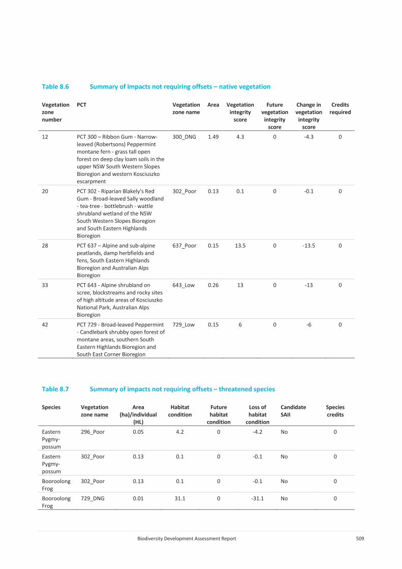
Biodiversity Development Assessment Report 509
Table 8.6 Summary of impacts not requiring offsets – native vegetation
Vegetation zone number
PCT Vegetation zone name
Area Vegetation integrity
score
Future vegetation
integrity score
Change in vegetation
integrity score
Credits required
12 PCT 300 – Ribbon Gum - Narrow-leaved (Robertsons) Peppermint montane fern - grass tall open forest on deep clay loam soils in the upper NSW South Western Slopes Bioregion and western Kosciuszko escarpment
300_DNG 1.49 4.3 0 -4.3 0
20 PCT 302 - Riparian Blakely's Red Gum - Broad-leaved Sally woodland - tea-tree - bottlebrush - wattle shrubland wetland of the NSW South Western Slopes Bioregion and South Eastern Highlands Bioregion
302_Poor 0.13 0.1 0 -0.1 0
28 PCT 637 – Alpine and sub-alpine peatlands, damp herbfields and fens, South Eastern Highlands Bioregion and Australian Alps Bioregion
637_Poor 0.15 13.5 0 -13.5 0
33 PCT 643 - Alpine shrubland on scree, blockstreams and rocky sites of high altitude areas of Kosciuszko National Park, Australian Alps Bioregion
643_Low 0.26 13 0 -13 0
42 PCT 729 - Broad-leaved Peppermint - Candlebark shrubby open forest of montane areas, southern South Eastern Highlands Bioregion and South East Corner Bioregion
729_Low 0.15 6 0 -6 0
Table 8.7 Summary of impacts not requiring offsets – threatened species
Species Vegetation zone name
Area (ha)/individual
(HL)
Habitat condition
Future habitat
condition
Loss of habitat
condition
Candidate SAII
Species credits
Eastern Pygmy-possum
296_Poor 0.05 4.2 0 -4.2 No 0
Eastern Pygmy-possum
302_Poor 0.13 0.1 0 -0.1 No 0
Booroolong Frog
302_Poor 0.13 0.1 0 -0.1 No 0
Booroolong Frog
729_DNG 0.01 31.1 0 -31.1 No 0

Biodiversity Development Assessment Report 510
Table 8.7 Summary of impacts not requiring offsets – threatened species
Species Vegetation zone name
Area (ha)/individual
(HL)
Habitat condition
Future habitat
condition
Loss of habitat
condition
Candidate SAII
Species credits
Alpine Tree Frog
1224_Low 0.01 31.7 0 -31.7 No 0
Thelymitra alpicola
637_High 0.01 79.2 0 -79.2 No 0
8.3.4 Cumulative impacts
As outlined in Section 1.5, there are three other projects related to Snowy 2.0 Main Works:
• Snowy 2.0 Exploratory Works (SSI-9208) – a Snowy Hydro project with Minister’s approval;
• Snowy 2.0 Transmission Connect Project (SSI-9717) – a project proposed by TransGrid; and
• Snowy 2.0 – Segment Factory (SSI-10034) – a project proposed by Snowy Hydro.
Table 8.8 provides a summary of the cumulative impacts arising from Exploratory Works, the Segment Factory and Main Works. The Transmission Grid Connection is not included in this cumulative impact assessment as detailed designs and associated impacts are not currently available.
Table 8.8 Cumulative impacts to native vegetation and threatened species
Plant Community Types (PCTs) Exploratory Works
(including MOD1)
Segment Factory
Main Works (ha)
Cumulative
PCT 285 – Broad-leaved Sally grass – sedge woodland on valley flats and swamps in the NSW South Western Slopes Bioregion and adjoining South Eastern Highlands Bioregion
5.41 6.99 12.4
PCT 296 – Brittle Gum – Peppermint open forest of the Woomargama to Tumut region, NSW South Western Slopes Bioregion
47.51 29.97 77.48
PCT 299 – Riparian Ribbon Gum - Robertsons Peppermint - Apple Box riverine very tall open forest of the NSW South Western Slopes Bioregion and South Eastern Highlands
3.87 3.87
PCT 300 – Ribbon Gum - Narrow-leaved (Robertsons) Peppermint montane fern - grass tall open forest on deep clay loam soils in the upper NSW South Western Slopes Bioregion and western Kosciuszko escarpment
10.36 69.62 79.98
PCT 302 - Riparian Blakely's Red Gum - Broad-leaved Sally woodland - tea-tree - bottlebrush - wattle shrubland wetland of the NSW South Western Slopes Bioregion and South Eastern Highlands Bioregion
12 8.45 20.45
PCT 303 – Black Sally grassy low woodland in valleys in the upper slopes sub-region of the NSW South Western Slopes Bioregion and western South Eastern Highlands Bioregion
0.31 78.44 78.75

Biodiversity Development Assessment Report 511
Table 8.8 Cumulative impacts to native vegetation and threatened species
Plant Community Types (PCTs) Exploratory Works
(including MOD1)
Segment Factory
Main Works (ha)
Cumulative
PCT 311 – Red Stringybark - Broad-leaved Peppermint - Nortons Box heath open forest of the upper slopes subregion in the NSW South Western Slopes Bioregion and adjoining South Eastern Highlands Bioregion
2.87 37.05 39.92
PCT 320 – Kangaroo Grass - Redleg Grass forb-rich temperate tussock grassland of the northern Monaro, ACT and upper Lachlan River regions of the NSW South Western Slopes Bioregion and South Eastern Highlands Bioregion
0.83 0.83
PCT 637 – Alpine and sub-alpine peatlands, damp herbfields and fens, South Eastern Highlands Bioregion and Australian Alps Bioregion
4.09 4.09
PCT 638 – Alpine Ash - Mountain Gum moist shrubby tall open forest of montane areas, southern South Eastern Highlands Bioregion and Australian Alps Bioregion
15.96 15.96
PCT 639 – Alpine Ash - Snow Gum shrubby tall open forest of montane areas, South Eastern Highlands Bioregion and Australian Alps Bioregion
6.61 6.61
PCT 643 - Alpine shrubland on scree, blockstreams and rocky sites of high altitude areas of Kosciuszko National Park, Australian Alps Bioregion
0.18 0.26 0.44
PCT 644 – Alpine Snow Gum - Snow Gum shrubby woodland at intermediate altitudes in northern Kosciuszko NP, South Eastern Highlands Bioregion and Australian Alps Bioregion
116.22 116.22
PCT 679 – Black Sallee - Snow Gum low woodland of montane valleys, South Eastern Highlands Bioregion and Australian Alps Bioregion
0.26 0.26
PCT 729 - Broad-leaved Peppermint - Candlebark shrubby open forest of montane areas, southern South Eastern Highlands Bioregion and South East Corner Bioregion
23.96 81.09 105.05
PCT 765 – Carex - Juncus sedgeland/wet grassland of the South Eastern Highlands Bioregion
0.12 0.12
PCT 952 – Mountain Gum - Narrow-leaved Peppermint - Snow Gum dry shrubby open forest on undulating tablelands, southern South Eastern Highlands Bioregion
18.92 18.92
PCT 953 – Mountain Gum - Snow Gum - Broad-leaved Peppermint shrubby open forest of montane ranges, South Eastern Highlands Bioregion and Australian Alps Bioregion
1.11 14.35 15.46
PCT 999 - Norton's Box - Broad-leaved Peppermint open forest on footslopes, central and southern South Eastern Highlands Bioregion
1.28 43.37 44.65
PCT 1191 – Snow Gum - Candle Bark woodland on broad valley flats of the tablelands and slopes, South Eastern Highlands Bioregion
0.47 26.05 26.52
PCT 1196 - Snow Gum - Mountain Gum shrubby open forest of montane areas, South Eastern Highlands Bioregion and Australian Alps Bioregion
4.57 348.14 352.71
PCT 1224 – Sub-alpine dry grasslands and heathlands of valley slopes, southern South Eastern Highlands Bioregion and Australian Alps Bioregion
0.15 133.84 133.99

Biodiversity Development Assessment Report 512
Table 8.8 Cumulative impacts to native vegetation and threatened species
Plant Community Types (PCTs) Exploratory Works
(including MOD1)
Segment Factory
Main Works (ha)
Cumulative
PCT 1225 – Sub-alpine grasslands of valley floors, southern South Eastern Highlands Bioregion and Australian Alps Bioregion
9.00 9.00
Alpine She-oak Skink 133.83 133.83
Alpine Tree Frog 0.03 48.87 48.9
Booroolong Frog 2.45 9.85 12.3
Broad-toothed rat 30.23 30.23
Clover Glycine 2.01 2.01
Creeping Hop-bush 0.83 0.83
Eastern Pygmy-possum 75.07 552.94 628.01
Gang-gang Cockatoo (breeding habitat only) 0.91 5.42 6.33
Grassland Earless Dragon 0.83 0.83
Kiandra Leek Orchid 1.67 1.67
Leafy Anchor Plant 17 individuals
17 individuals
Masked Owl 0.9 0.9
Mauve Burr-daisy 0.83 16.55 17.38
Monaro Golden Daisy 0.83 0.83
Raleigh Sedge 0.38 0.38
Slender Greenhood 0.28 0.18 0.46
Silky Swainson-pea 0.83 0.83
Smoky Mouse 1.77 174.63 176.4
Striped Legless Lizard 0.83 0.83
Thelymitra alpicola 0.04 0.04

Biodiversity Development Assessment Report 513
Part C EPBC Act Assessment

Biodiversity Development Assessment Report 514

Biodiversity Development Assessment Report 515
9 Impacts to MNES 9.1 Candidate species and communities assessment
9.1.1 Desktop assessment
A detailed desktop assessment was completed, evaluating a range of information sources, to gather information on the biodiversity values across the survey area and identify a list of candidate threatened species and ecological communities and migratory species for further consideration and assessment. The desktop assessment included a review of the following information:
• DoEE Protected Matter Search Tool (PMST, Annexure I);
• BioNet, held and maintained by DPIE to access the following:
- Atlas of NSW Wildlife;
- Threatened Biodiversity Data Collection;
- Threatened species profiles;
- BioNet Vegetation Classification database;
• South East Local Land Services Biometric vegetation map – VIS_ID 4211 (OEH 2015);
• State Vegetation Type Map: Riverina Region Version v1.2 - VIS_ID 4469 (OEH 2016a); and
• Interim Biographic Regionalisation for Australia (IBRA) version 7 (IBRA7) bioregions and subregions (DoEE 2017A).
9.1.2 Candidate species assessment
A list of species and communities with potential to occur within the study area was generated following the desktop assessment. Three TECs (Table 9.1), 12 threatened flora, 27 threatened fauna species and 12 migratory species (Table 9.2) were considered to have potential to occur within the project area based on the desktop assessment.
Table 9.1 Threatened communities with potential to occur in the study area
Threatened community EPBC Act status1 BC Act status2
Alpine Sphagnum Bogs and Associated Fens EN E3
Natural Temperate Grassland of the South Eastern Highlands CE -
White Box-Yellow Box-Blakely’s Red Gum Grassy Woodland and Derived Native Grassland
CE E3
Notes: 1. EPBC Act status: CE- critically endangered, EN – endangered, VU – vulnerable 2. BC Act status: E4B – critically endangered, E3 – endangered, V2 - vulnerable

Biodiversity Development Assessment Report 516
Table 9.2 Threatened and migratory species with potential to occur in the study area based on the desktop assessment
Scientific name Common name EPBC Act1 BC Act2/ FM Act3
Flora
Calotis glandulosa Mauve Burr-daisy VU -
Colobanthus curtisiae Curtis' Colobanth VU -
Glycine latrobeana Clover Glycine VU E4A
Leucochrysum albicans var. tricolor Hoary Sunray EN -
Prasophyllum bagoense Bago Leek-orchid CE E4A
Prasophyllum innubum Brandy Marys Leek-orchid CE E4A
Prasophyllum petilum Tarengo Leek Orchid EN E1
Pterostylis oreophila Blue-tongued Orchid CE E4A
Rutidosis leiolepis Monaro Golden Daisy VU V
Swainsona recta Small Purple-pea EN -
Thesium australe Austral Toadflax VU V
Xerochrysum palustre Swamp Everlasting VU -
Birds
Anthochaera phrygia Regent Honeyeater CE E4A
Calidris ferruginea Curlew Sandpiper CE E1
Grantiella picta Painted Honeyeater VU V
Hirundapus caudacutus White-throated Needletail VU -
Lathamus discolor Swift Parrot CE E1
Numenius madagascariensis Eastern Curlew CE -
Rostratula australis Australian Painted Snipe EN E1
Mammals
Burramys parvus Mountain Pygmy-possum EN E1
Dasyurus maculatus Spotted-tailed Quoll EN V
Mastacomys fuscus mordicus Broad-toothed Rat VU V, E2
Petauroides volans Greater Glider VU E2
Phascolarctos cinereus Koala VU V, E2
Pseudomys fumeus Smoky Mouse EN E4A
Bats
Pteropus poliocephalus Grey-headed Flying-fox VU V
Amphibians
Litoria booroolongensis Booroolong Frog EN E1
Litoria castanea Yellow-spotted Tree Frog EN E4A
Litoria raniformis Southern Bell Frog VU E1
Litoria spenceri Spotted Tree Frog EN E4A
Litoria verreauxii alpina Alpine Tree Frog VU E1
Pseudophryne corroboree Southern Corroboree Frog CE E4A
Pseudophryne pengilleyi Northern Corroboree Frog CE E4A
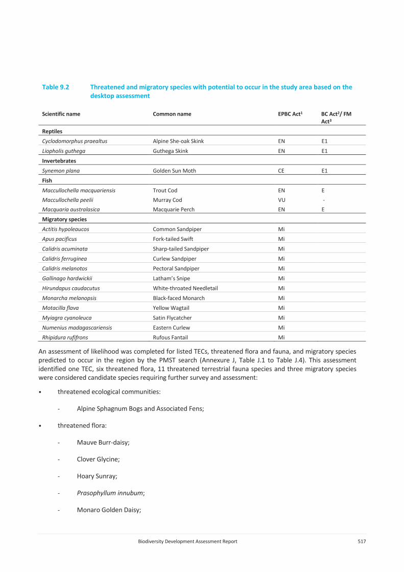
Biodiversity Development Assessment Report 517
Table 9.2 Threatened and migratory species with potential to occur in the study area based on the desktop assessment
Scientific name Common name EPBC Act1 BC Act2/ FM Act3
Reptiles
Cyclodomorphus praealtus Alpine She-oak Skink EN E1
Liopholis guthega Guthega Skink EN E1
Invertebrates
Synemon plana Golden Sun Moth CE E1
Fish
Maccullochella macquariensis Trout Cod EN E
Maccullochella peelii Murray Cod VU -
Macquaria australasica Macquarie Perch EN E
Migratory species
Actitis hypoleaucos Common Sandpiper Mi
Apus pacificus Fork-tailed Swift Mi
Calidris acuminata Sharp-tailed Sandpiper Mi
Calidris ferruginea Curlew Sandpiper Mi
Calidris melanotos Pectoral Sandpiper Mi
Gallinago hardwickii Latham’s Snipe Mi
Hirundapus caudacutus White-throated Needletail Mi
Monarcha melanopsis Black-faced Monarch Mi
Motacilla flava Yellow Wagtail Mi
Myiagra cyanoleuca Satin Flycatcher Mi
Numenius madagascariensis Eastern Curlew Mi
Rhipidura rufifrons Rufous Fantail Mi
An assessment of likelihood was completed for listed TECs, threatened flora and fauna, and migratory species predicted to occur in the region by the PMST search (Annexure J, Table J.1 to Table J.4). This assessment identified one TEC, six threatened flora, 11 threatened terrestrial fauna species and three migratory species were considered candidate species requiring further survey and assessment:
• threatened ecological communities:
- Alpine Sphagnum Bogs and Associated Fens;
• threatened flora:
- Mauve Burr-daisy;
- Clover Glycine;
- Hoary Sunray;
- Prasophyllum innubum;
- Monaro Golden Daisy;

Biodiversity Development Assessment Report 518
- Swamp Everlasting;
• threatened fauna:
- Mountain Pygmy-possum;
- Broad-toothed Rat;
- Smoky Mouse;
- Spotted-tailed Quoll;
- Greater Glider;
- Koala;
- Booroolong Frog;
- Alpine Tree Frog;
- Northern Corroboree Frog;
- Alpine She-oak Skink;
• migratory species:
- Satin Flycatcher;
- Rufous Fantail; and
- Latham’s Snipe.
9.2 Survey methods
Surveys methods undertaken for detailed vegetation assessment and consideration of TECs is provided in Section 5.2. Survey methods undertaken for threatened species are provided in Section 6.3.3.
9.3 Survey results
9.3.1 Threatened ecological communities
Following detailed vegetation mapping, one TEC was recorded within the survey area and disturbance footprint. A total of 70 ha of PCT 637 - Alpine and sub-alpine peatlands, damp herbfields and fens, South Eastern Highlands Bioregion and Australian Alps Bioregion, which is representative of the Alpine Sphagnum Bogs and Associated Fens, was recorded within the survey area.
Generally, the community is in high condition, with areas in poorer condition located adjacent to Tantangara Reservoir where impacts are occurring due to feral Horses and recreational users.

Biodiversity Development Assessment Report 519
9.3.2 Threatened flora species
Following targeted surveys, three threatened flora species listed under the EPBC Act were recorded within or adjacent to the disturbance footprint:
• Mauve Burr-daisy;
• Clover Glycine; and
• Prasophyllum innubum.
One further species, the Hoary Sunray, is considered a high likelihood of occurrence despite not being recorded during targeted surveys.
Mauve Burr-daisy was found to occur extensively across the survey area, with the species recorded colonising edges of management tracks within the surveys area. Over 20,000 individuals were estimated to occur within the survey area across 594 locations.
Prior to surveys for Snowy 2.0, Clover Glycine was known from just two locations in NSW; Tom Groggin and Kelly’s Plain. The Kelly’s Plain population was at severe threat due to Ox-eye Daisy. Surveys undertaken for Snowy 2.0 identified the species at a number of sites across the plateau area, with 892 records of the species across 418 locations. A large population was recorded on Gulf Plain, with over 600 individual plants recorded at this site.
Prasophyllum innubum was thought to be restricted to a 1.5 ha area in Bago State Forest, west of the Snowy 2.0 survey area (DoE 2014d). Following a request by Geoff Robertson (DPIE) to undertake surveys for various orchid species, the species was recorded at a single location west of Bullocks Hill Trail. Three individuals were recorded in Alpine bogs and fens/sub-alpine wet grasslands along a tributary of Tantangara Creek.
9.3.3 Threatened fauna species
Following targeted surveys, six threatened fauna species listed under the EPBC Act were recorded within or adjacent to the disturbance footprint:
• Broad-toothed Rat;
• Smoky Mouse;
• Spotted-tailed Quoll;
• Booroolong Frog;
• Alpine Tree Frog; and
• Alpine She-oak Skink.
The Broad-toothed Rat was recorded at a number of locations across the plateau area within or adjacent to the disturbance footprint; along Link Road, west of the Snowy Mountain Highway, and adjacent to Tantangara Reservoir. The species was found to occur in three PCTs with a dense and complex groundcover, likely to support a winter snow cover. Snowy 2.0 Main Works will impact on 30.23 ha of habitat for this species.

Biodiversity Development Assessment Report 520
Prior to surveys undertaken for Snowy 2.0 the Smoky Mouse was known from four extant sites across NSW, with populations at several of these sites in decline (Linda Broome, DPIE, pers. comm.). The Smoky Mouse was initially recorded along Lobs Hole Ravine Road, to around 1,100 m AHD as apart of surveys for Exploratory Works. Regional surveys undertaken across approximately 8,000 ha (see Section 6.3.3iic) resulted in the species being recorded at 71 locations across this area. The species distribution within the survey area is predominantly associated with tall forests dominated by Mountain Gum and Snow Gum, with a moderate to dense shrubby midstorey dominated by shrubs from the plant family Fabaceae (with some Epacridaceae and Mimosaceae), and dense groundcover with abundant sub-shrubs, logs and leaf litter along the upper reaches of Lobs Hole Ravine Road and in the Marica area, above 1,100 m. At around 1,100 m, vegetation transitions to drier communities dominated by Peppermint, Brittle Gum and Candlebark with a moderate to sparse midstorey and sparse grassy groundcover. Soils also become much rockier and may be less suitable for burrowing.
No Spotted-tail Quolls were recorded during targeted surveys within the disturbance footprint; however, an incidental record of a Quoll scat was recorded off Wallace’s Creek Firetrail. The Spotted-tail Quoll is known to have home ranges of several hundred to several thousand hectares and occurs at low densities (DELWP 2016, DEWHA 2009a, DSE 2011a). The species is primarily forest-dependent, and occupies a wide range of habitat types, including rainforest, wet and dry sclerophyll forest, coastal heathland, scrub and dunes, woodland, heathy woodland, swamp forest, mangroves, on beaches and sometimes in grassland or pastoral areas adjacent to forested areas. Given this, the species has potential to occupy the Main Works disturbance footprint at low densities, with large areas of suitable habitat present throughout the locality; the species is likely to be wide ranging. All areas of the survey area are deemed to provide suitable habitat, with suitable denning sites focused on boulderfields on Lobs Hole Ravine Road, and areas with a high density of hollow logs in sub-alpine areas at the top of Lobs Hole Ravine Road and along the Yarrangobilly River.
The Booroolong Frog was recorded within the survey area along the Yarrangobilly River, from the FSL of Talbingo Reservoir to the upper reaches of the Yarrangobilly River, as well as along Wallace’s Creek. It is likely that this population extends upstream to at least Blue Creek Firetrail (Dave Hunter, DPIE, pers. comm.). The Yarrangobilly River provides optimal breeding habitat for Booroolong Frog, with a series of cobble banks and bedrock structures along stream margins, with slow-flowing water. These areas are connected by larger, slow-flowing pools. Breeding habitat in Wallace’s Creek is much more limited, with small sections providing suitable breeding habitat. It is likely this area provides sub-optimal breeding habitat as well as connective and dispersal habitat. Areas within 50 m of this breeding habitat has been identified as potential dispersal and refuge habitat.
The Alpine Tree Frog was recorded in various locations within and adjacent to the disturbance footprint, including near Tantangara Reservoir and along Nungar Creek Fire Trail. They will utilise natural and artificial wetlands for breeding. Non-breeding habitat and overwintering refuges are poorly known but are likely to include flat rocks, fallen logs, leaf litter and other ground debris. The species was recorded breeding in Tantangara Reservoir between minimum operating level (MOL) and FSL on several occasions as well as Nungar Creek, Eucumbene River and Tantangara Creek and associated tributaries. Breeding habitat is identified as the areas listed above, while dispersal, foraging and refuge habitat is identified as areas within 50 m of breeding habitat. Snowy 2.0 Main Works will impact on 48.87 ha of habitat for this species.
The Alpine She-oak Skink was recorded within the Main Works disturbance footprint and adjacent areas. The species is known to occur in temperate montane grasslands, favouring tree-less or very lightly treed areas containing tussock grasses, low heath or a combination of both. Records were found within PCT 1224 – Sub alpine dry grasslands and heathlands of valley slopes, southern South Eastern Highlands Bioregion and Australian Alps Bioregion using tile grid and transect surveys, resulting in a range extension for this species.
9.3.4 Migratory species
Following targeted surveys, two migratory species listed under the EPBC Act were recorded within or adjacent to the disturbance footprint:

Biodiversity Development Assessment Report 521
• Satin Flycatcher; and
• Latham’s Snipe.
The Satin Flycatcher was recorded at three locations across the plateau area in tall montane forest (PCTs 953 and 1196) and grassy woodlands (PCT 644). These Eucalypt forest at high altitude are identified as important habitat for the species (DoE 2014e). The species was observed nesting at one location. Habitat for the species occurs over a large portion of the survey area and project area. Snowy 2.0 Main Works will impact on 478.71 ha of habitat for this species.
The Latham’s Snipe was observed foraging in a number of wetlands across the Snowy 2.0 survey area, with 41 records of the species during surveys for Snowy 2.0. This usually occurred as single or pairs, foraging in areas of PCT 637 - Alpine and sub-alpine peatlands, damp herbfields and fens, South Eastern Highlands Bioregion and Australian Alps Bioregion or PCT 1225 - Sub-alpine grasslands of valley floors, southern South Eastern Highlands Bioregion and Australian Alps Bioregion, as well as adjacent habitats. The species was found to be reasonably abundant within the survey area. Impacts to MNES
This chapter discusses the potential direct and indirect impacts on threatened species and communities identified as occurring or having potential to occur within the disturbance footprint based on the outcomes of the field surveys outlined above. The impact assessment has also considered the impacts over different project phases, including construction, operation and decommissioning.
Potential direct and indirect impacts arising from the project are outlined extensively in Section 8.1, while measures to avoid, minimise and mitigate impacts are outlined in Section 8.2.
9.3.5 Residual impacts to MNES
Residual impacts to threatened species and communities and migratory species listed under the EPBC Act are outlined for the one community, three threatened flora species, six threatened fauna species and two migratory species to occur within the Snowy 2.0 Main Works survey area and disturbance footprint below.
i Alpine Sphagnum Bogs and Associated Fens
As a result of the measures to avoid and minimise impacts, particularly removal of large sections of the project area across the plateau area, there has a been a significant reduction in impacts to this community. Snowy 2.0 Main Works will result in a residual impact to 4.09 ha of the community, representing 0.04% of the national extent of the community. A further 17.51 ha is mapped within the groundwater drawdown area (Section 7.2.2) and may be subject to impacts arising from changes in hydrology. The scale and extent of these impacts are unknown, and will be subject to ongoing monitoring.
ii Mauve Burr-daisy
The Mauve Burr-daisy was found to be ubiquitous throughout KNP, often growing on the margins of disturbed areas such as management tracks and firetrails. This has meant that measures to avoid and minimise impacts are challenging. The Snowy 2.0 Main Works project is expected to impact 3,686 individuals across 147 locations. This represents approximately 17% of the national population.

Biodiversity Development Assessment Report 522
iii Clover Glycine
Significant measures were put in place to avoid impacts to this species when a large population was recorded along a proposed Tantangara East Road to access private property along the eastern edge of KNP. Surveys of this option identified significant biodiversity values along this proposed route, including sub-alpine grasslands and Alpine bogs and fens, and associated threatened species. This included a population of over 600 Clover Glycine, representing approximately 65% of the known population of the species in NSW. The removal of this option has resulted in a substantial and significant reduction in impacts to Clover Glycine.
Twenty-six individuals will be impacted by Snowy 2.0, in the Tantangara Reservoir area. This represents 2.9% of the regional population of the species recorded during surveys undertaken for Snowy 2.0, and approximately 0.4% of the estimated national population (Carter and Sutter 2010), including records from Snowy 2.0 surveys.
iv Prasophyllum innubum
Avoidance of impacts to the plateau area have resulted in avoidance of impacts to this species. No impacts to these individuals will result from Snowy 2.0 Main Works.
v Broad-toothed Rat
This species is strongly associated with complex habitats in the plateau area. Removal of key construction elements from this area has resulted in a significant reduction in impacts to habitat for this species. Snowy 2.0 Main Works will impact on 30.23 ha of habitat for this species.
There is potential for indirect impacts from fauna vehicle collisions, weeds and pathogens and increased predation to further impact this species if unmitigated. Monitoring and management measures will be included within a biodiversity management plan.
vi Smoky Mouse
Regional surveys have contributed a significant amount of knowledge on the distribution of this species in northern KNP. These surveys recorded the species over a large area of suitable habitat. It is estimated that Snowy 2.0 Main Works will result in impacts to 174.63 ha of habitat for the species.
There is potential for indirect impacts from fragmentation, fauna vehicle collisions, weeds and pathogens and increased predation to further impact this species if unmitigated. Monitoring and management measures will be included within a biodiversity management plan.
vii Spotted-tailed Quoll
The Spotted-tail Quoll is predicted to occur within the project area at low densities, ranging over large areas. Snowy 2.0 Main Works will result in clearing of approximately 1,090 ha of habitat for the Spotted-tail Quoll. Many of these areas are already disturbed due to past land use and human activity. Large areas of suitable habitat will remain in the locality.
There may be some potential for residual, indirect impacts. This is likely to be associated with activities that are required to occur and may cause some disruption to wildlife. This is lighting around buildings and works areas used at night, noise associated with construction and operational activities, and vibration from blasting. These may result in short term avoidance by the species; however, no long term impacts are predicted.

Biodiversity Development Assessment Report 523
viii Booroolong Frog
Direct impacts to Booroolong Frog have been minimised through the avoidance of works within the 50 m buffer zone where possible. Notwithstanding this, minor direct impacts to Booroolong Frog habitat will result where there are incursions into this buffer zone. Residual direct impacts include impacts to of 0.9 ha of breeding habitat and 9.45 ha of foraging habitat Booroolong Frog. It should be noted that these areas are currently significantly disturbed as a result of past land use and human activity.
Indirect impacts will be avoided, minimised and managed through the implementation of appropriate sediment controls. While short term transportation of fine sediments into watercourses may occur, these will not result in impacts to the Booroolong Frog. The controls to be implemented are considered to provide a high degree of confidence that long term changes to water quality will be avoided.
Following the implementation of the controls outlined above, it is considered that the risk of mobilising large amounts of coarse sediments during road construction or from the stockpile landform is negligible. Controls to be implemented around the spoil stockpile are expected to provide a high factor of safety, resulting in negligible risk of impacts to water quality in the Yarrangobilly River. In addition, treatment of existing mine discharge could result in a net improvement in water quality in the river.
There is potential for indirect impacts to result from construction noise, with noise levels of >65 dB likely to be experienced along the Yarrangobilly River and Wallace’s Creek. This is equivalent to a normal conversation. These noise levels have the potential to impact on male calling behaviour and result in spatial displacement (Caorsi et al. 2018, Paris et al. 2009). These impacts will occur short-term, during construction only. Operational noise is expected to 29 dB (akin to a library or park) and be limited to immediately adjacent to the MAT and EVCT.
ix Alpine Tree Frog
Impacts to the Alpine Tree Frog have been reduced through removal of key project elements from the plateau area where the species occurs along a number of major and minor watercourses. The species was found to occur extensively over large areas of the plateau, occupying long stretches of watercourses such as Tantangara Creek, Nungar Creek and the Eucumbene River, as well as associated tributaries. Snowy 2.0 Main Works will impact on 48.87 ha of habitat for this species.
Unmitigated, indirect impacts may occur to this species through increased predation and changes in water quality. This will be avoided, minimised and managed through the implementation of appropriate sediment controls and implementation of a predator monitoring and control program, to be included in the biodiversity management plan.
x Alpine She-oak Skink
Reduction of impacts in the plateau area, where the species occurs over large areas of suitable sub-alpine grassland habitat, have resulted in significant reduction in impacts. Based on the above, Snowy 2.0 Main Works will result in impacts to 133.84 ha of habitat for this species, representing approximately 8% of the suitable habitat mapped as a part of surveys for Snowy 2.0 and a very minor component of suitable habitat in the region.
There is potential for indirect impacts from fauna vehicle collisions, weeds and pathogens and increased predation to further impact this species if unmitigated. Monitoring and management measures will be included within a biodiversity management plan.

Biodiversity Development Assessment Report 524
xi Satin Flycatcher
The Satin flycatcher was recorded at three locations across the survey area, in Ecualypt forest and woodlands at high altitude. These areas are identified as important habitat for the species (DoE 2014e). Snowy 2.0 Main Works will impact on 478.71 ha of habitat for this species, based on the PCTs in which the species was recorded.
xii Latham’s Snipe
The Latham’s Snipe was recorded over large areas of Alpine bogs and fens and sub-alpine wet grasslands across the plateau area. Removal of project elements from these areas has resulted in a significant reduction in impacts to this species. The observation of 41 records of the species during surveys undertaken for Snowy 2.0 indicates these sub-alpine areas may support important habitat for the species, as they may support at least 0.1 per cent of the flyway population of this migratory shorebird species (DoEE 2017b). It is noted that no population estimate was obtained, so this is a conservative level of assessment. Snowy 2.0 Main Works will impact on 12.95 ha of habitat for this species.
9.3.6 Significant impact assessments
To support a determination as to whether Main Works are likely to have a ‘significant impact’ on threatened species the Matters of National Environmental Significance – Significance Impact Guidelines 1.1 (DoE 2013b) have been applied.
A ‘significant impact’ is defined as “an impact which is important, notable, or of consequence, having regard to its context or intensity. Whether or not an action is likely to have a significant impact depends upon the sensitivity, value, and quality of the environment which is impacted, and upon the intensity, duration, magnitude and geographic extent of the impacts” (DoE 2013b).
Consideration has been given to all threatened species and communities and migratory species with potential to occur within the survey area, with reference to DoE (2013b). Significant impact assessments have been completed for one TEC, two threatened flora species and six threatened fauna species and two migratory species, considered to have potential to be impacted by the Main Works following the process outlined in this assessment report:
• Alpine Sphagnum Bogs and Associated Fens;
• Mauve Burr-daisy;
• Clover Glycine;
• Broad-toothed Rat;
• Smoky mouse;
• Spotted-tailed Quoll;
• Booroolong Frog;
• Alpine Tree Frog;
• Alpine She-oak Skink;
• Satin Flycatcher; and

Biodiversity Development Assessment Report 525
• Latham’s Snipe.
Significant impact assessments for the above community and species are provided in Annexure K.
These assessments concluded that a significant impact was likely to result to the Smoky Mouse. Impacts to all other species and the community were not considered significant in the context of the findings of Snowy 2.0 biodiversity assessment and the areas of high-quality habitat in the region.

Biodiversity Development Assessment Report 526

Biodiversity Development Assessment Report 527
References ABC News 2018, First koala spotted in 75 years in Kosciuszko National Park, http://www.abc.net.au/news/2016-12-06/first-koala-spotted-in-75-years-in-kosciuszko-national-park/8095178, accessed 16 May 2018.
Anstis M, Alford RA & Gillespie GR 1998, Breeding biology of Litoria booroolongensis, Transactions Of The Royal Society Of South Africa, 122, pp. 33-44.
Anstis M 2002, Tadpoles of South-eastern Australia: a Guide with Keys, Reed New Holland, Sydney.
Anstis M 2013, Tadpoles and frogs of Australia, New Holland, Sydney.
Bates R J 1994, Prasophyllum, In: Walsh, N.G.; Entwisle, T.J. (eds), Flora of Victoria Vol. 2, Ferns and Allied Plants, Conifers and Monocotyledons, Inkata Press, Melbourne.
Bennett AF 1990, Habitat corridors and the conservation of small mammals in a fragmented forest environment, Landscape Ecology, 4, pp. 109-122.
BirdLife 2019a, Satin Flycatcher – bird profile, BirdLife Australia, Carlton.
BirdLife 2019b, Latham’s Snipe – bird profile, BirdLife Australia, Carlton.
Biolink 2008, The utility of regularized, grid-based SAT (RGB-SAT) sampling for the purposes of identifying areas being utilized by koalas (Phascolarctos cinereus) in the South-east Forests of NSW – a Pilot Study. Report to NSW Department of the Environment & Climate Change, Biolink Ecological Consultants, Uki.
BOM 2019, Groundwater Dependent Ecosystems Atlas, viewed 29 August 2019, http://www.bom.gov.au/water/groundwater/gde/index.shtml.
Cardno 2019, Aquatic Ecology Assessment – Snowy 2.0 Main Works, Report prepared for Snowy Hydo Ltd and EMM Consulting Pty Limited by Cardno Pty Ltd, St Leonards.
Caorsi VZ, Both C, Cechin S, Antunes R, Borges-Martins M, 2018, Correction: Effects of traffic noise on the calling behavior of two Neotropical hylid frogs. PLOS ONE 13(5): e0197632. https://doi.org/10.1371/journal.pone.0197632.
Carter, O and Sutter, G 2010, National Recovery Plan for Clover Glycine Glycine latrobeana, Department of Sustainability and Environment, Melbourne.
Davies TW, Duffy J, Bennie J, Gaston KJ 2014, Marine light pollution: nature, extent and ecological implications, Frontiers Ecol Environ 12, pp.347–355.
DEC 2004, Threatened Biodiversity Survey and Assessment: Guidelines for Development and Activities, Department of the Environment and Conservation, Hurstville.
DEC 2006a, Kosciuszko National Park Plan of Management, Department of Environment and Conservation, Sydney.
DECC 2009, Threatened Species Survey and Assessment Guidelines: Field Survey Methods for Fauna Amphibians, Department of Environment and Climate Change, Sydney.
DoEE 2017a, Interim Biogeographic Regionalisation of Australia (IBRA) Version 7, Department of the Environment and Energy, Canberra.
DoEE 2017b, EPBC Act Policy Statement 3.21—Industry guidelines for avoiding, assessing and mitigating impacts on EPBC Act listed migratory shorebird species, Department of the Environment and Energy, Canberra.

Biodiversity Development Assessment Report 528
DoEE 2018a, Directory of important wetlands, Department of the Environment and Energy, Canberra.
DELWP 2016, National Recovery Plan for the Spotted-tailed Quoll Dasyurus maculatus, Australian Government, Canberra.
DEWHA 2007, Conservation Advice (Booroolong Frog), Department of the Environment, Water, Heritage and the Arts, Canberra.
DEWHA 2008a. Threat Abatement Plan for Predation by the European Red Fox. Department of the Environment, Water, Heritage and the Arts, Canberra.
DEWHA 2008b. Approved Conservation Advice for Alpine Sphagnum Bogs and Associated Fens ecological community. Department of the Environment, Water, Heritage and the Arts, Canberra.
DEWHA 2008c, Approved Conservation Advice for Calotis glandulosa (Mauve Burr-daisy), Department of the Environment, Water, Heritage and the Arts, Canberra.
DEWHA 2009a, Draft EPBC Act Policy Statement 3.4 - Significant impact guidelines for the endangered spot-tailed quoll Dasyurus maculatus maculatus (southeastern mainland population) and the use of 1080, Department of the Environment, Water, Heritage and the Arts, Canberra.
DEWHA 2009b, Approved Conservation Advice for Cylodomorphus praealtus (Alpine She-oak Skink), Department of the Environment, Water, Heritage and the Arts, Canberra.
Dixo M, Metzger JP, Morgante JS and Zamudio KR 2009, Habitat fragmentation reduces genetic diversity and connectivity among toad populations in the Brazilian Atlantic Coastal Forest, Biological Conservation, 142 (8), pp. 1560-1569.
DoE 2013a, Survey Guidelines for Australia’s Threatened Orchids. Guidelines for Detecting Orchids Listed As ‘Threatened’ Under the Environment Protection and Biodiversity Conservation Act 1999, Department of the Environment, Canberra.
DoE 2013b, Matter of National Environmental Significance. Significant Impact Guidelines 1.1, Department of the Environment, Canberra.
DoE 2014a, EPBC Act referral guidelines for the vulnerable Koala, Department of the Environment, Canberra.
DoE 2014b. Threat abatement plan for disease in natural ecosystems caused by Phytophthora cinnamomi. Department of the Environment, Canberra.
DoE 2014c, Approved Conservation Advice for Litoria verreauxii alpina (Alpine Tree Frog), Department of the Environment, Canberra.
DoE 2014d, Approved Conservation Advice for Prasophyllum innubum (Brandy Mary's leek-orchid), Department of the Environment, Canberra.
DoE 2014e, (Draft) Referral guideline for 14 birds listed as migratory species under the EPBC Act, Department of the Environment, Canberra.
DoE 2015a, Threat abatement plan for predation by feral cats, Department of the Environment, Canberra.
DoE 2015b, National Recovery Plan for the Alpine Sphagnum Bogs and Associated Fens ecological community, Department of the Environment, Canberra.
DoE 2019a, Glycine latrobeana in Species Profile and Threats Database, Department of the Environment, Canberra.

Biodiversity Development Assessment Report 529
DoE 2019b, Litoria booroolongensis in Species Profile and Threats Database, Department of the Environment, Canberra.
DoE 2019c, Cyclodomorphus praealtus in Species Profile and Threats Database, Department of the Environment, Canberra.
DoE 2019b, Myiagra cyanoleuca in Species Profile and Threats Database, Department of the Environment, Canberra.
DoE 2019c, Gallinago hardwickii in Species Profile and Threats Database, Department of the Environment, Canberra.
DPI 2013, Policy and Guidelines for Fish Habitat Conservation and Management (2013 update), NSW Department of Primary Industries, Sydney.
DPIE 2019, Water in NSW – Snowy, NSW Department of Planning, Industry and Environment, Sydney, https://www.industry.nsw.gov.au/water/basins-catchments/snapshots/snowy.
DSE 2011a, Survey Standards: Spot-tailed Quoll, Dasyurus maculatus maculatus, Department of Sustainability and Environment, Melbourne.
DSE 2011b. Survey Standards: Greater Glider, Petauroides volans. Department of Sustainability and Environment, Melbourne.
DSEWPaC 2010a, Survey Guidelines for Australia’s Threatened Birds, Department of Sustainability, Environment, Water, Population and Communities, Canberra.
DSEWPaC 2010b, Survey Guidelines for Australia’s Threatened Frogs, Department of Sustainability, Environment, Water, Population and Communities, Canberra.
DSEWPaC 2010c, Survey Guidelines for Australia’s Threatened Bats, Department of Sustainability, Environment, Water, Population and Communities, Canberra.
DSEWPaC 2011a, Survey Guidelines for Australia’s Threatened Mammals, Department of Sustainability, Environment, Water, Population and Communities, Canberra.
DSEWPaC 2011b, Survey Guidelines for Australia’s Threatened Reptiles, Department of Sustainability, Environment, Water, Population and Communities, Canberra.
DSEWPaC 2012, Approved Conservation Advice for Phascolarctos cinereus (combined populations in Queensland, New South Wales and the Australian Capital Territory), Department of Sustainability, Environment, Water, Population and Communities, Canberra.
DSEWPaC 2013, Chytridiomycosis (Amphibian chytrid fungus disease) - Fact sheet, Department of Sustainability, Environment, Water, Population and Communities, Canberra.
Eco Logical 2019, Snowy 2.0 Snowy 2.0 Bushfire Risk and Hazard Assessment - Main Works EIS, prepared for EMM Consulting Pty Ltd by Eco Logical Australia Pty Ltd.
EMM 2019a, Snowy 2.0 Main Works Water Assessment, prepared for Snowy Hydro Limited by EMM Consulting Pty Ltd.
EMM 2019b, Snowy 2.0 Main Works Noise Assessment, prepared for Snowy Hydro Limited by EMM Consulting Pty Ltd.
EMM 2019c, Changes in biodiversity values at Tantangara Reservoir as a result on the Snowy Scheme, Memorandum prepared for Snowy Hydro Ltd by EMM Consulting Pty Ltd.

Biodiversity Development Assessment Report 530
EMM 2019d, Snowy 2.0 Main Works Offset Strategy, prepared for Snowy Hydro Limited by EMM Consulting Pty Ltd.
Fischer J and Lindenmayer DB 2007, Landscape modification and habitat fragmentation: a synthesis, Global Ecology and Biogeography, 16, pp. 265–280.
Ford, F Cockburn, A & Broome, L 2003, Habitat preference, diet and demography of the smoky mouse, Pseudomys fumeus (Rodentia: Muridae), in south-eastern New South Wales, Wildlife Research, 30, pp. 89-101.
Geological Survey of New South Wales 1966, Wagga Wagga Sheets SI 55-15, Australian 1:250,000 Geological Sheet Series SI 55-15, Geological Surveys of NSW, Sydney.
Geoscience Australia 2019, Australian Stratigraphic Units Database: Lick Hole Formation, Geoscience Australia, Canberra, https://asud.ga.gov.au/search-stratigraphic-units/results/10376.
Good R 2006, Australian Alps National Parks Rehabilitation Manual, A Guide to Ecological Rehabilitation in the Australian Alps, Australian Alps Liaison Committee, July 2006.
Hoskin CJ & Goosem MW 2010, Road Impacts on Abundance, Call Traits, and Body Size of Rainforest Frogs in Northeast Australia, Ecology and Society, 15(3), pp. 15.
Hunter, D 2001, Surveys and monitoring of threatened frog species in South-eastern New South Wales between October, 2000 and March, 2001, Unpublished report to the NSW National Parks and Wildlife Service.
Hunter D 2007, Conservation management of two threatened frog species in south-eastern New South Wales, Australia, PhD thesis, University of Canberra.
Hyett, J and Shaw, N, 1980 Australian Mammals, a field guide for New South Wales, Victoria, South Australia & Tasmania, Thomas Nelson Australia, Melbourne, Vic.
Keller I & Largiadèr CR 2003, Recent habitat fragmentation caused by major roads leads to reduction of gene flow and loss of genetic variability in ground beetles, Proceedings of the Royal Society B, 270 (1513), http://rspb.royalsocietypublishing.org/content/270/1513/417.
Lawrence, J 1986, A survey of the Bulls Head area in the Australian Capital Territory, for Pseudomys fumeus, Unpublished report to Wildlife Research Unit, ACT Parks and Conservation Service, Canberra.
Lintermans, M 1988, A survey of Mt Kelly for Pseudomys fumeus, Unpublished report to Wildlife Research Unit, ACT Parks and Conservation Service, Canberra.
Lister K 2001, “The Snowy Mountains Scheme - More Than Engineering Heritage”, Eleventh National Conference on Engineering Heritage: Federation Engineering a Nation; Proceedings, Institution of Engineers, Australia, pp 245–252
Macquarie University 2019, Snowy 2.0 Project: Baseline Stygofauna Study. Report prepared for EMM Consulting Pty Ltd by Macquarie University.
Menkhorst P & Broome L 2006, National Recovery Plan for the Smoky Mouse Pseudomys fumeus, Department of Sustainability and Environment, Melbourne.
Menkhorst P & Broome L 2008a, National Recovery Plan for the Smoky Mouse Pseudomys fumeus, Department of Sustainability and Environment, Melbourne.
Menkhorst P & Broome L 2008b, Background and Implementation Information for the Smoky Mouse Pseudomys fumeus National Recovery Plan, Department of Sustainability and Environment, Melbourne.
NOW 2011, Water Resources and Management Overview: Murrumbidgee catchment, NSW Office of Water, Sydney.

Biodiversity Development Assessment Report 531
Nelson J, Menkhorst P, Howard K, Chick R & Lumsden L 2009, The status of Smoky Mouse populations at some historic sites in Victoria, and survey methods for their detection, Arthur Rylah Institute for Environmental Research Unpublished report number 2009/17. Department of Sustainability and Environment, Heidelberg, Victoria.
NPWS 2001. Approved NSW Threat Abatement Plan. Predation by the red fox (Vulpes vulpes). NSW National Parks and Wildlife Service, Hurstville.
NSWSC 2001, Eastern pygmy-possum - vulnerable species listing. NSW Scientific Committee - final determination, NSW Scientific Committee, Hurstville.
OEH 2010, NSW Wetlands spatial data, https://datasets.seed.nsw.gov.au/dataset/nsw-wetlands047c7 accessed 16 June 2018.
OEH 2011, Kosciuszko National Park Geodiversity Action Plan 2012-2017, Office of Environment and Heritage, Sydney
OEH 2012a, National Recovery Plan for Booroolong Frog (Litoria booroolongensis), NSW Office of Environment and Heritage, Sydney.
OEH 2012b, Peat forming bogs and fens of the Snowy Mountains of NSW, Office of Environment and Heritage, Sydney.
OEH 2015, South East Local Land Services Biometric vegetation map – VIS_ID 4211, NSW Office of Environment and Heritage, Sydney.
OEH 2016a, State Vegetation Type Map: Riverina Region Version v1.2 - VIS_ID 4469, NSW Office of Environment and Heritage, Sydney.
OEH 2016b, Mitchell Landscapes Version V3.1, NSW Office of Environment and Heritage, Sydney.
OEH 2016c, NSW Guide to Surveying Threatened Plants, NSW Office of Environment and Heritage, Sydney.
OEH 2017a, Biodiversity Assessment Method (BAM), NSW Office of Environment and Heritage, Sydney.
OEH 2017b, Broad-toothed Rat – profile, NSW Office of Environment and Heritage, Sydney.
OEH 2017c, Spotted-tailed Quoll – profile, NSW Office of Environment and Heritage, Sydney.
OEH 2017d, Alpine Tree Frog – profile, NSW Office of Environment and Heritage, Sydney.
OEH 2017e, Alpine She-oak Skink – profile, NSW Office of Environment and Heritage, Sydney.
OEH 2018a, ‘Species credit’ threatened bats and their habitats, NSW survey guide for the Biodiversity Assessment Method, NSW Office of Environment and Heritage, Sydney.
OEH 2018b, Mauve Burr-daisy – profile, NSW Office of Environment and Heritage, Sydney.
OEH 2018c, Clover Glycine – profile, NSW Office of Environment and Heritage, Sydney.
OEH 2018d, Smoky Mouse – profile, NSW Office of Environment and Heritage, Sydney.
Parris KM, Velik-Lord M and North JMA, 2009. Frogs call at a higher pitch in traffic noise, Ecology and Society 14(1): 25.
Pesce G L 2007, "Canthocamptidae Sars, 1906, emend. Monard, 1927, Lang, 1948".
Phillips S and Callaghan J 2011, The Spot Assessment Technique: a tool for determining localised levels of habitat use by Koalas Phascolarctos cinereus, Australian Zoologist 35 (3): 774-780.

Biodiversity Development Assessment Report 532
RLLS 2017, Riverina Regional Strategic Weed Management Plan 2017-2022, Riverina Local Land Services, Wagga Wagga.
Saunders D, Tzaros C, Webb M and Thurstans S 2010, Background Document - Swift Parrot Recovery Plan, Department of Environment, Climate Change and Water, Queanbeyan, and Birds Australia.
Schroer S & Hölker F 2016, Impact of Lighting on Flora and Fauna. In: Karlicek R, Sun CC, Zissis G & Ma R (eds), Handbook of Advanced Lighting Technology, Springer, Cham.
SCT Consulting 2019, Snowy 2.0 Main Works Traffic and Transport Assessment, Report prepared for EMM Consulting Pty Ltd by SCT Consulting Pty Ltd.
Serov P, Kuginis L, Williams JP, 2012, Risk Assessment Guidelines for Groundwater Dependent Ecosystems, Department of Primary Industries, Office of Water, NSW Government.
Snowy Scientific Committee 2010, The adequacy of environmental releases to the upper Murrumbidgee River, Prepared for the NSW Water Administration and Ministerial Corporation, Canberra.
Smith NM & Hellmann JJ 2002, Population persistence in fragmented landscapes, Trends in Ecology and Evolution, 17 (9), pp.397-399.
Taylor BD & Goldingay RL 2010, Roads and wildlife: impacts, mitigation and implications for wildlife management in Australia, Wildlife Research, 37(4), pp. 320-331.
TSSC 2006, Commonwealth Listing Advice on White Box-Yellow Box-Blakely's Red Gum Grassy Woodland and Derived Native Grassland, Department of the Environment and Heritage, Canberra.
TSSC 2009, Commonwealth Listing Advice on Alpine Sphagnum Bogs and Associated Fens. Department of the Environment, Water, Heritage and the Arts, Canberra.
TSSC 2012, Listing advice for Phascolarctos cinereus (Koala), Department of Sustainability, Environment, Water, Population and Communities, Canberra.
TSSC 2013, Commonwealth Listing Advice on Pseudophryne pengilleyi (Northern Corroboree Frog), Department of Sustainability, Environment, Water, Population and Communities, Canberra.
TSSC 2016a, Approved Conservation Advice (including listing advice) for Natural Temperate Grassland of the South Eastern Highlands, Department of the Environment, Canberra.
TSSC 2016b. Conservation Advice Mastacomys fuscus mordicus broad-toothed rat (mainland). Canberra: Department of the Environment.