Embed Size (px)
Citation preview

Part C – Detailed network strategies for 2031
netwotailed nes for 2031
48 Connecting SEQ 2031
Department of Transport and Main Roads, Connecting SEQ 2031 – An Integrated Regional Transport Plan for South East Queensland, 2011

5. Public transport network
Signature Projects – Rail Revolution
SP1 Rail network optimisation A package of initiatives to enhance the pre-Cross River Rail and post-Cross River Rail capacity and safety of the rail network, including new technologies to optimise the performance of the rail network and delivering new generation rollingstock.
SP2 Cross River Rail (planning near completion) A proposed new north–south rail line in Brisbane's inner city, including a new tunnel under the Brisbane River and new underground inner city stations.
SP3 Rail network sectorisation Modernise and restructure the region's rail network to provide three new tiers of service.
UrbanLink – high frequency, all stops services all day (6 am–9 pm), seven days a week.
ExpressLink – transform outer suburban express rail services to provide faster travel times with a consistent stopping pattern all day.
CoastLink – fast, express rail services will operate from Brisbane to the Gold Coast and Brisbane to the Sunshine Coast, with a travel time of about one hour.
SP4 Light rail (Gold Coast Rapid Transit) Complete the light rail corridor from Helensvale to Coolangatta, with a connection to the Gold Coast Airport, and identify possible east–west extensions inland from the coastal spine.
SP5 Brisbane subway Develop an entirely separate Brisbane subway system, with Toowong to Newstead/Bowen Hills via West End and the CBD as the first line. This will provide a high capacity, high frequency, distributor system connecting central Brisbane destinations and distributing passengers from the bus and rail network across the intensely developed core of inner Brisbane.
SP6 North-west rail line Construct a new rail line from the North Coast Line at Strathpine to Cross River Rail to service communities in Brisbane's north-west and supporting UrbanLink, ExpressLink and CoastLink services.
Signature Projects – Bus
SP7 Eastern and Northern Busways Construct the Eastern Busway to Carindale and the Northern Busway to Chermside and continue planning to extend busways
to Capalaba and Bracken Ridge respectively, with interim on-road bus priority treatments likely to be used beyond Carindale and Chermside.
SP8 UrbanLink bus services Develop a connected network of high frequency UrbanLink bus services across the region with the supporting local bus network redesigned to provide effective feeder services to UrbanLink public transport corridors.
SP9 TransitWay network Develop a network of on-road bus priority corridors across the region to support UrbanLink and local bus services, providing priority to buses and other multi-occupant vehicles, and ensuring more efficient use of existing road corridors.
SP10 CoastConnect Establish an UrbanLink bus service with on-road priority from Maroochydore to Caloundra via Mooloolaba and Kawana Town Centre.
Existing public transport projects
Significant investment is proposed under the Queensland Infrastructure
Plan and the Transport Plan for
Brisbane 2008–2026, including:
• additional trains
• expanding the bus fleet
• expanding the total CityCat fleet to 19 vessels by 2012.
In conjunction with these fleet upgrades, investment in fixed infrastructure includes:
• Moreton Bay Rail Link from Petrie to Kippa-Ring
• Gold Coast Rapid Transit Project to deliver light rail from Gold Coast Health and Knowledge Precinct to Broadbeach
• Northern Busway from Windsor to Kedron
• Eastern Busway from Buranda to Coorparoo
• bus lanes and bus access facilities on the road network across the region
• funding support to assist local governments to ensure 100% of bus stops comply with Disability
Discrimination Act 1992 standards by 2022.
Part C – Detailed network strategies for 2031 49
Department of Transport and Main Roads, Connecting SEQ 2031 – An Integrated Regional Transport Plan for South East Queensland, 2011
TransLink – a single network
The Integrated Regional Transport Plan
released in 1997 saw the establishment of the TransLink integrated public transport network with one ticket and no transfer penalties across all public transport modes.
The Queensland Government's TransLink Transit Authority provides a single authority for planning and managing services, providing passenger information and receiving feedback on urban public transport in the region. TransLink's network includes:
• rail services operated by Queensland Rail under contract to TransLink
• buses run by private sector contractors and Brisbane Transport under contract to TransLink
• ferries operated under a funding agreement by Brisbane City Council.
TransLink is working with state and local government partners and the private sector to ensure all the major urban areas of the region have an integrated network of public transport services that is easy for people to understand and use.
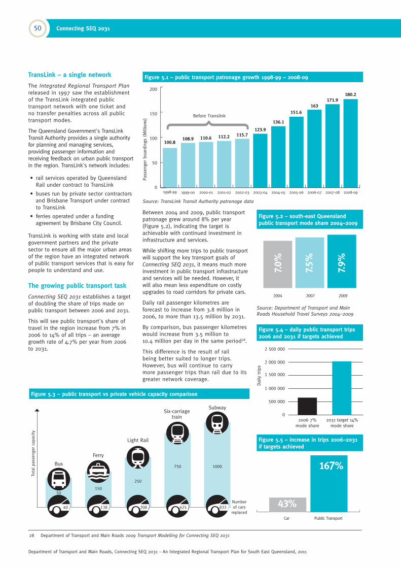
The growing public transport task
Connecting SEQ 2031 establishes a target of doubling the share of trips made on public transport between 2006 and 2031.
This will see public transport's share of travel in the region increase from 7% in 2006 to 14% of all trips – an average growth rate of 4.7% per year from 2006 to 2031.
28 Department of Transport and Main Roads 2009 Transport Modelling for Connecting SEQ 2031
Between 2004 and 2009, public transport patronage grew around 8% per year (Figure 5.2), indicating the target is achievable with continued investment in infrastructure and services.
While shifting more trips to public transport will support the key transport goals of Connecting SEQ 2031, it means much more investment in public transport infrastructure and services will be needed. However, it will also mean less expenditure on costly upgrades to road corridors for private cars.
Daily rail passenger kilometres are forecast to increase from 3.8 million in 2006, to more than 13.5 million by 2031.
By comparison, bus passenger kilometres would increase from 3.5 million to 10.4 million per day in the same period28.
This difference is the result of rail being better suited to longer trips. However, bus will continue to carry more passenger trips than rail due to its greater network coverage.
Figure 5.3 – public transport vs private vehicle capacity comparison
Tota
l pass
enger ca
paci
ty
Number of cars
replaced40
Bus
50
150
Ferry
138
750
Six-carriage train
625
1000
Subway
833
250
Light Rail
208
Figure 5.1 – public transport patronage growth 1998-99 – 2008-09
Source: TransLink Transit Authority patronage data
Figure 5.4 – daily public transport trips 2006 and 2031 if targets achieved
2 500 000
2 000 000
1 500 000
1 000 000
500 000
0
2006 7% mode share
2031 target 14% mode share
Daily
trip
s
Figure 5.5 – increase in trips 2006–2031 if targets achieved
Figure 5.2 – south-east Queensland public transport mode share 2004–2009
Source: Department of Transport and Main
Roads Household Travel Surveys 2004–2009
1998-99 1999-00 2000-01 2001-02 2002-03 2003-04 2004-05 2005-06 2006-07 2007-08 2008-09
50 Connecting SEQ 2031
Department of Transport and Main Roads, Connecting SEQ 2031 – An Integrated Regional Transport Plan for South East Queensland, 2011
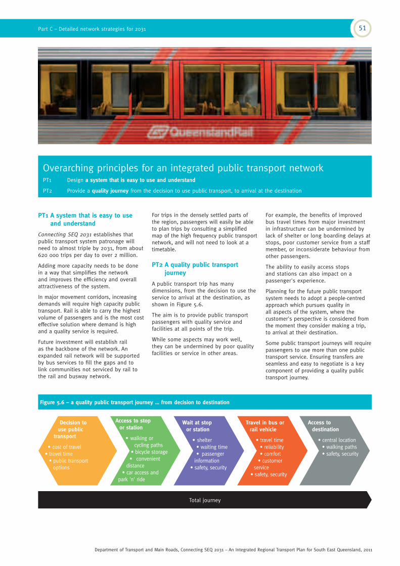
Overarching principles for an integrated public transport network PT1 Design a system that is easy to use and understand
PT2 Provide a quality journey from the decision to use public transport, to arrival at the destination
PT1 A system that is easy to use and understand
Connecting SEQ 2031 establishes that public transport system patronage will need to almost triple by 2031, from about 620 000 trips per day to over 2 million.
Adding more capacity needs to be done in a way that simplifies the network and improves the efficiency and overall attractiveness of the system.
In major movement corridors, increasing demands will require high capacity public transport. Rail is able to carry the highest volume of passengers and is the most cost effective solution where demand is high and a quality service is required.
Future investment will establish rail as the backbone of the network. An expanded rail network will be supported by bus services to fill the gaps and to link communities not serviced by rail to the rail and busway network.
For trips in the densely settled parts of the region, passengers will easily be able to plan trips by consulting a simplified map of the high frequency public transport network, and will not need to look at a timetable.
PT2 A quality public transport journey
A public transport trip has many dimensions, from the decision to use the service to arrival at the destination, as shown in Figure 5.6.
The aim is to provide public transport passengers with quality service and facilities at all points of the trip.
While some aspects may work well, they can be undermined by poor quality facilities or service in other areas.
Decision to use public
transport
• cost of travel• travel time
• public transportoptions
Access to stop or station
• walking or cycling paths
• bicycle storage• convenient
distance• car access and
park 'n' ride
Wait at stop or station
• shelter• waiting time• passenger
information• safety, security
Travel in bus or rail vehicle
• travel time• reliability• comfort
• customer service
• safety, security
Access to destination
• central location• walking paths• safety, security
Figure 5.6 – a quality public transport journey … from decision to destination
Total journey
For example, the benefits of improved bus travel times from major investment in infrastructure can be undermined by lack of shelter or long boarding delays at stops, poor customer service from a staff member, or inconsiderate behaviour from other passengers.
The ability to easily access stops and stations can also impact on a passenger's experience.
Planning for the future public transport system needs to adopt a people-centred approach which pursues quality in all aspects of the system, where the customer's perspective is considered from the moment they consider making a trip, to arrival at their destination.
Some public transport journeys will require passengers to use more than one public transport service. Ensuring transfers are seamless and easy to negotiate is a key component of providing a quality public transport journey.
Part C – Detailed network strategies for 2031 51
Department of Transport and Main Roads, Connecting SEQ 2031 – An Integrated Regional Transport Plan for South East Queensland, 2011

The UrbanLink network: 'turn up and go'
• a connected network of high frequency passenger rail, light rail and buses
• services run along major corridors to connect activity centres and residential communities
• frequency of 15 minutes or better off-peak, 10 minutes or better during peak periods
• high frequency, all day (at least 6 am–9 pm), seven days a week
• quality shelters and passenger information
• operate on rail, busways or the road network, with supporting bus priority measures to minimise impacts of traffic congestion
• passengers consult a simplified high frequency network map with no need for a timetable
• a doubling of the proportion of south-east Queensland residents within walking distance of 'turn up and go' services by 2031.
Faster running times
More passengers
Higher frequency public transport
services
Better bus and rail facilities
Figure 5.7 – UrbanLink services establish a self-reinforcing cycle that continually builds patronage
Supporting principles for an integrated public transport networkPT3 Develop a network that operates at a good level of service all day, with peak period supplementary services
PT4 Provide a clear network of high frequency UrbanLink bus, light rail and rail services where passengers can 'turn up and go'
PT5 Use 'trunk and feeder' design to enable local access to key destinations across the region
PT6 Encourage people to access public transport by walking and cycling, while recognising the need for car feeder roles in some markets
PT7 Use fare products to encourage people to shift from car transport, and to manage and direct passenger growth
PT3 An all day network
Traditional approaches to the delivery of public transport services focused on providing for weekday peak period journeys to and from work. Off-peak and weekend services were run at much lower frequencies, meaning the majority of the fleet and driver resources were utilised for only a few hours of the day.
Modern lifestyles require more diverse travel options, with work trips now comprising only one-fifth of all travel. To better service modern travel patterns and make public transport an attractive travel choice for different trip types, the future public transport network will be re-designed as an all day network (that is, 6 am–9 pm).
The majority of services will need to operate all day, seven days a week. During peak periods, higher-frequency trunk services and extra supplementary services like commuter 'rockets' will provide for the higher passenger volumes.
PT4 UrbanLink 'turn up and go' rail and bus network
TransLink will progressively roll out a network of high frequency UrbanLink services on strategic rail, light rail and bus routes. This UrbanLink 'trunk' network will operate at headways of 15 minutes or better, seven days a week. This will allow passengers to simply 'turn up and go', without needing to consult a timetable.
Delivery of the high frequency UrbanLink network establishes a self-reinforcing cycle whereby the attraction of more passengers allows a further increase in frequencies. Higher passenger volumes also make it viable to invest in infrastructure improvements to support faster travel times, which in turn also attracts more passengers.
The success of a high frequency network is already proven in Brisbane, with the BUZ (bus upgrade zone) routes, introduced by Brisbane Transport from 2002, resulting in increases in peak and off-peak passengers.
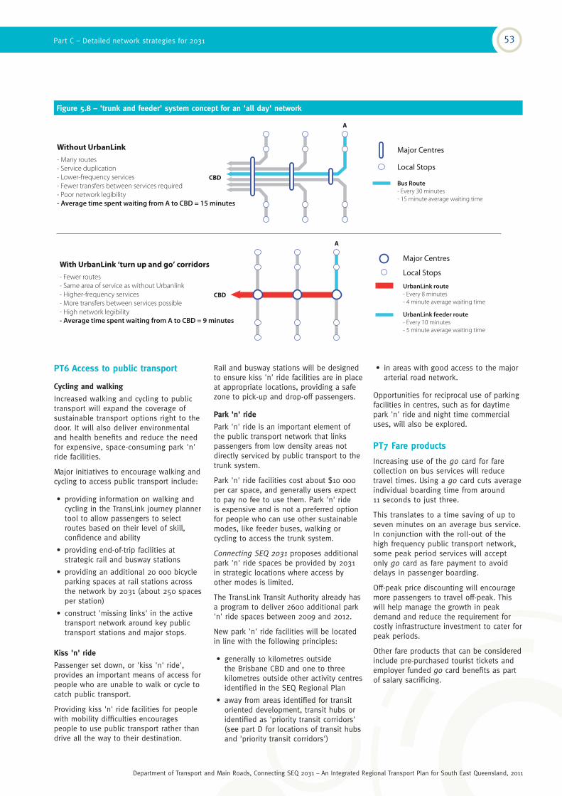
PT5 Trunk and feeder design
As the public transport system expands, moving to a 'trunk and feeder' design will improve services and make it easy to understand for passengers. Under a 'trunk and feeder' design, the trunk UrbanLink bus and rail routes are supported by local bus feeder services to provide easy connections to multiple destinations across the region's centres.
The alternative is the traditional 'single seat' bus planning approach, which attempts to provide a large range of services connecting all parts of the city to its centre. This approach results in a complicated service network with low frequencies on almost all routes.
Figure 5.8 (next page) illustrates how a 'trunk and feeder' network design allows demands to be consolidated, enabling high service frequencies on the trunk routes. This will support delivery of the UrbanLink 'turn up and go' services, with shorter wait times on trunk routes and a better level of service on feeder routes. Strategic transfer points will be located at transit hubs (see Part B, priority for action 1), allowing passengers to access destinations anywhere in the region.
'Trunk and feeder' services need peak period supplementary services to ensure a crowded feeder service does not meet a crowded trunk service. Principle PT3 discusses how the 'all day' network, operating on 'trunk and feeder' design, will be supplemented by specialised rocket or express services.
Existing 'single seat' services will be upgraded to improve efficiency and the 'trunk and feeder' design will be applied to new services and service upgrades as demand grows.
Establishing the 'centres access hierarchy' described in Chapter 4, and improving the quality and efficiency of key public transport stations will also support a move towards a 'trunk and feeder' network design. The TransLink Transit Authority has a program for the development and upgrade of stations, which includes identifying the role of stations in a formal hierarchy to inform the station design and facilities needed.
52 Connecting SEQ 2031
Department of Transport and Main Roads, Connecting SEQ 2031 – An Integrated Regional Transport Plan for South East Queensland, 2011
PT6 Access to public transport
Cycling and walking
Increased walking and cycling to public transport will expand the coverage of sustainable transport options right to the door. It will also deliver environmental and health benefits and reduce the need for expensive, space-consuming park 'n' ride facilities.
Major initiatives to encourage walking and cycling to access public transport include:
• providing information on walking and cycling in the TransLink journey planner tool to allow passengers to select routes based on their level of skill, confidence and ability
• providing end-of-trip facilities at strategic rail and busway stations
• providing an additional 20 000 bicycle parking spaces at rail stations across the network by 2031 (about 250 spaces per station)
• construct 'missing links' in the active transport network around key public transport stations and major stops.
Kiss 'n' ride
Passenger set down, or 'kiss 'n' ride', provides an important means of access for people who are unable to walk or cycle to catch public transport.
Providing kiss 'n' ride facilities for people with mobility difficulties encourages people to use public transport rather than drive all the way to their destination.
Rail and busway stations will be designed to ensure kiss 'n' ride facilities are in place at appropriate locations, providing a safe zone to pick-up and drop-off passengers.
Park 'n' ride
Park 'n' ride is an important element of the public transport network that links passengers from low density areas not directly serviced by public transport to the trunk system.
Park 'n' ride facilities cost about $10 000 per car space, and generally users expect to pay no fee to use them. Park 'n' ride is expensive and is not a preferred option for people who can use other sustainable modes, like feeder buses, walking or cycling to access the trunk system.
Connecting SEQ 2031 proposes additional park 'n' ride spaces be provided by 2031 in strategic locations where access by other modes is limited.
The TransLink Transit Authority already has a program to deliver 2600 additional park 'n' ride spaces between 2009 and 2012.
New park 'n' ride facilities will be located in line with the following principles:
• generally 10 kilometres outside the Brisbane CBD and one to three kilometres outside other activity centres identified in the SEQ Regional Plan
• away from areas identified for transit oriented development, transit hubs or identified as 'priority transit corridors' (see part D for locations of transit hubs and 'priority transit corridors')
Figure 5.8 – 'trunk and feeder' system concept for an 'all day' network
• in areas with good access to the major arterial road network.
Opportunities for reciprocal use of parking facilities in centres, such as for daytime park 'n' ride and night time commercial uses, will also be explored.
PT7 Fare products
Increasing use of the go card for fare collection on bus services will reduce travel times. Using a go card cuts average individual boarding time from around 11 seconds to just three.
This translates to a time saving of up to seven minutes on an average bus service. In conjunction with the roll-out of the high frequency public transport network, some peak period services will accept only go card as fare payment to avoid delays in passenger boarding.
Off-peak price discounting will encourage more passengers to travel off-peak. This will help manage the growth in peak demand and reduce the requirement for costly infrastructure investment to cater for peak periods.
Other fare products that can be considered include pre-purchased tourist tickets and employer funded go card benefits as part of salary sacrificing.
CBD
A
Bus Route
- Every 30 minutes
- 15 minute average waiting time
Local Stops
Major CentresWithout UrbanLink
- Many routes
- Service duplication
- Lower-frequency services
- Fewer transfers between services required
- Poor network legibility
- Average time spent waiting from A to CBD = 15 minutes
CBD
A
UrbanLink feeder route
- Every 10 minutes
- 5 minute average waiting time
UrbanLink route
- Every 8 minutes
- 4 minute average waiting time
Major Centres
Local StopsWith UrbanLink ‘turn up and go’ corridors
- Fewer routes
- Same area of service as without Urbanlink
- Higher-frequency services
- More transfers between services possible
- High network legibility
- Average time spent waiting from A to CBD = 9 minutes
Part C – Detailed network strategies for 2031 53
Department of Transport and Main Roads, Connecting SEQ 2031 – An Integrated Regional Transport Plan for South East Queensland, 2011

2031 rail network and services
Rail revolutionConnecting SEQ 2031 outlines the plan for a 'rail revolution'; a complete overhaul of the rail system to provide a modern, high capacity network that will mean, for most passengers, rail transport will be quicker and more reliable than driving a car.
This will be supported by a shift in public transport planning and investment to a greater focus on rail.
The capacity of the inner city rail network is constrained and is expected to reach capacity some time between 2016 and 2018, depending on growth.
With Cross River Rail not expected to be completed until 2020, the 'rail revolution' will begin immediately with a rail network optimisation plan targeting initiatives and supporting investment to increase capacity on the rail network before the construction of Cross River Rail.
The construction of Cross River Rail will enable the full benefits of the 'rail revolution' to be realised.
Together with strategic network upgrades and ongoing rail network optimisation initiatives, Cross River Rail will enable a transformation in the way train services operate, to an operating strategy based around three core service types:
• UrbanLink
• ExpressLink
• CoastLink.
The 'rail revolution' also covers continuing investment in future stages of the light rail network on the Gold Coast, and a new subway system for inner city Brisbane.
Rail network optimisation
A key component of the 'rail revolution' is to optimise the use of the existing rail infrastructure prior to Cross River Rail, and to support the future transformation of the rail network and services once Cross River Rail is in place.
Key initiatives to optimise existing capacity and maintain reliable services include:
• track capacity upgrades and stabling
• more trains to provide additional peak and shoulder peak services
• improved network sectorisation
• removal of operational crossing conflicts
• improved timetabling and service planning
• targeted inner city signalling upgrades.
Signalling upgrades
The existing rail network is equipped with a variety of signalling technologies that have been deployed since the mid-1970s. Improving the signalling system by modernising it and adding more circuitry and signals can allow for more trains per hour to utilise the broader network.
Advanced signalling technology would allow for communications based signalling, which will improve safety, and can also be configured to reduce headways substantially, and therefore increase line capacity.
Investigations as part of the rail network optimisation plan will confirm the best signals upgrade strategy for the next 20 years.
54 Connecting SEQ 2031
Department of Transport and Main Roads, Connecting SEQ 2031 – An Integrated Regional Transport Plan for South East Queensland, 2011

29 Queensland Rail 2008 Passenger Load Survey
Cross River Rail – a catalyst for the rail revolution
Cross River Rail is a proposed new north–south rail line in Brisbane's inner city, including a new tunnel under the Brisbane River and four new underground inner city stations. This will mean more frequent trains and better services for all of south-east Queensland's rail users.
Cross River Rail will allow a transformation of the way rail services operate in south-east Queensland. Progress on Cross River Rail can be followed online at www.crossriverrail.qld.gov.au.
In 2008, the Inner City Rail Capacity
Study identified a need for Cross River Rail due to a bottleneck in the inner city through Central and Roma Street stations. This bottleneck restricts the number of additional rail services that could be added to meet growing passenger numbers.
More than 53 000 people per day currently travel into the inner city by train between 7 am and 9 am29.
Rail investigations conducted for Connecting SEQ 2031 estimated this number will increase to between 70 000 and 80 000 by 2016, and between 150 000 and 200 000 by 2031.
The peak period capacity of the rail system would need to expand to about four times its current capability by 2031 to meet this demand.
Delivery of Cross River Rail, combined with existing rail infrastructure and new service initiatives will make it possible to move up to 240 000 people by rail into the inner city during the two hour peak.
The benefits of Cross River Rail to the south-east Queensland rail network will include:
• significantly increasing the capacity of the inner city rail network
• making it possible to sectorise the rail network, meaning that all three types of services (UrbanLink, ExpressLink, CoastLink) can be operated across the region
• allowing for increased frequency of CoastLink services between Brisbane and the Sunshine Coast and Gold Coast
• providing additional freight rail capacity on the constrained sections of the network between Salisbury and the Port of Brisbane, allowing more freight to be carried on rail to and from the port
• enabling construction of a new rail line between Cross River Rail and Strathpine using the predominantly government-owned North West Transport Corridor
• enabling expansion of the reach of the rail network to Maroochydore, Coolangatta, Kippa-Ring (Moreton Bay Rail Link), Redbank Plains, Ripley and Flagstone.
Part C – Detailed network strategies for 2031 55
Department of Transport and Main Roads, Connecting SEQ 2031 – An Integrated Regional Transport Plan for South East Queensland, 2011

UrbanLink services
• no need to consult a timetable, with frequent 'turn up and go' services
• short distance, all stops service
• high capacity trains with more doors and standing areas.
CoastLink services
• express services from Brisbane to Gold Coast and Brisbane to Sunshine Coast (each in about one hour travel time)
• an attractive inter-city peak and off-peak service frequency
• inter-urban trains capable of higher speed operations (160 km/h), provided with on-board wireless internet and other business facilities.
ExpressLink services
• fast, express running services (competitive or faster than car) between outer suburbs and inner Brisbane
• easier for passengers to understand with the same stopping patterns on all services
• allows for transfers at key stations to access multiple destinations
• encourages people to travel off-peak.
Rail network sectorisation
The delivery of new infrastructure, including Cross River Rail, will enable a sectorisation of the entire south-east Queensland rail network. This will transform the way train services operate based around three core service types: UrbanLink, ExpressLink and CoastLink.
UrbanLink
UrbanLink services will start the transformation of the existing rail network and be a catalyst for major regeneration and higher density development along rail corridors.
UrbanLink services will operate at higher frequencies, boosting the capacity of the rail network in metropolitan Brisbane, including to the airport.
The delivery of UrbanLink services is underpinned by the construction of Cross River Rail and the acquisition of new rollingstock.
Commencing delivery of UrbanLink services on sectors of the existing rail network in metropolitan Brisbane is a high priority for passenger rail, with many parts of the network already close to capacity. In the longer term, local UrbanLink services could also operate on the Gold Coast rail line between Helensvale and the Gold Coast Airport and the new Sunshine Coast rail line from Beerwah to Maroochydore.
ExpressLink
The outer sections of the greater Brisbane metropolitan rail network will be operated as ExpressLink services. These services will use existing trains and will start at the end points of the greater Brisbane rail network, which, in 2031, are expected to be Ripley and Rosewood (via Ipswich), Kippa-Ring (via Petrie), Flagstone (via Salisbury), Helensvale and Caboolture North.
The ExpressLink network will operate much the same as express services operate today, running all stops to a change point (where UrbanLink services terminate), then stopping only at major transfer locations and activity centres. They will provide express connections in both directions, all day (6 am–9 pm), which will provide a simplified, easy to understand network of express services.
Delivery of ExpressLink services will occur in parallel with delivery of UrbanLink services.
CoastLink
The proposed 2031 rail network includes CoastLink services to connect the Gold Coast and Sunshine Coast to central Brisbane in about one hour, stopping only at major stations. A reliable, one hour inter-city travel time to the growing coastal centres will:
• reinforce the SEQ Regional Plan principal activity centres as key locations for business with high quality connections to the Brisbane CBD, supporting business growth at these centres
• reduce long distance private vehicle travel due to increased public transport patronage achieved by the new services.
This approach is similar to the European model of smaller cities with their own commuter systems, with connections between each city. For south-east Queensland, rail investment must be strongly matched to economic development, land use and urban development policies to ensure that the necessary jobs are created in the growing coastal cities.
Providing CoastLink services also minimises the need for investment in motorway and highway upgrades to cater for regional movements.
The 2031 passenger rail network concept is illustrated in Map 5.1 (see page 58).
Under Connecting SEQ 2031 targets, by 2031 there will be:
190%increase in daily rail boardings
500 000additional daily rail boardings
265%increase in km travelled by rail
56 Connecting SEQ 2031
Department of Transport and Main Roads, Connecting SEQ 2031 – An Integrated Regional Transport Plan for South East Queensland, 2011

Brisbane subway features
• fully segregated operations, not impacted by incidents or congestion on the passenger rail network (or road network)
• lower infrastructure unit costs than suburban rail tunnels
• high capacity 20 000–40 000 passengers/hour/direction
• automatic train protection with high reliability and improved safety
• ultra high frequency (headway to 90 seconds)
• closely spaced stations for higher accessibility
• vertical integration with existing rail and bus stations.
Benefits of light rail
• can mix safely with pedestrians and general motor traffic
• able to carry 160–300 passengers per vehicle, safely and comfortably
• light and airy inside with space for luggage and wheelchairs
• light rail can carry up to 10 000 passengers per hour
• the length and capacity of light rail vehicles can be increased to meet the demands of the Gold Coast's fast growing population
• a fixed light rail route is simple to use for the high visitor population
• encourages urban renewal along the entire corridor.
Light rail on the Gold Coast (Gold Coast Rapid Transit)
The Gold Coast light rail project is being delivered by the Queensland Government in partnership with the Australian Government and the Gold Coast City Council.
The project will deliver a transport system that is accessible, frequent, reliable and integrated with the existing transport network to ensure it meets the needs of the Gold Coast community and visitors, now and into the future.
The first stage of the project will deliver light rail from the Gold Coast Health and Knowledge Precinct to Broadbeach by 2014. This first stage will involve:
• Early and Enabling Works have commenced to prepare the corridor for construction and includes road widening, the relocation of public utilities, accommodation works such as the reinstatement of driveways, fencing and car parks and the construction of a station shell at the Gold Coast University Hospital.
• The Operator Franchise will construct, operate and maintain the light rail system for 15 years. The Operator Franchise work will include stations, depots, bridges and the construction of the actual light rail system, including supply of vehicles. The preferred proponent to operate the light rail system was announced in May 2011.
Connecting SEQ 2031 enhances the role of light rail on the Gold Coast, and envisages a corridor extending from Helensvale to Coolangatta to serve the growing coastal corridor. It will intersect with the Gold Coast rail line at strategic locations, providing improved public transport connectivity to the rest of the region. Further east–west extensions of light rail or bus rapid transit on the Gold Coast will be investigated as passenger demand on buses grows.
New Brisbane subway
By 2031, there will be about 2.4 million trips per day in inner Brisbane (within about five kilometres of the CBD), up from about one million in 2006. A subway system for Brisbane will support the expected growth and expansion of the inner city.
This will be a new system in the transport network, with separate operations to existing rail infrastructure. The London underground and New York subway are well-known examples of this style of rail operation.
The Brisbane subway will provide a high capacity, high frequency distributor system connecting central city destinations and linking passengers from the bus and rail networks to destinations not within a comfortable walk of existing stations.
The priority corridor for delivery by 2031 will be from Toowong to Bowen Hills/Newstead via West End. This corridor would be under the CBD and intersect with existing rail and busway stations. Planning for this corridor will commence in 2015.
Longer term opportunities to expand the Brisbane subway could include:
• Bowen Hills/Newstead to Airport Village via Northshore Hamilton
• Newstead to Bulimba
• potential conversion of some sections of Brisbane's busway network to subway to increase public transport capacity.
Part C – Detailed network strategies for 2031 57
Department of Transport and Main Roads, Connecting SEQ 2031 – An Integrated Regional Transport Plan for South East Queensland, 2011
Maroochydore
Kawana
Caloundra
Caloundra
South
Beerwah
Kippa-Ring
Caboolture North
ShorncliffeStrathpine
Petrie
Ferny Grove
Airport Village
Airport International
Airport Domestic
Cleveland
Toowong
Springfield
RedbankPlains
Ripley
Ipswich
Indooroopilly
Buranda
Darra
Salisbury
Yeerongpilly
Loganlea
Flagstone
Helensvale
Beenleigh
Robina
Inner City Stations
Southport
Bowen Hills
Caboolture
Nambour
Gympie North
Rosewood
Elanora
CoolangattaGold Coast Airport
Park Road
Coomera
Beaudesert
Doomben
Northgate
Redbank
Ormeau
Sunshine Coast
Gold Coast
Greater Brisbane
New passenger rail lines
Cross River Rail
Sunshine Coast line from Beerwah to Maroochydore
Moreton Bay Rail Link – Petrie to Kippa-Ring
North West Transport Corridor – Cross River Rail
to Strathpine
Salisbury to Flagstone
Richlands to Springfield and Redbank Plains
Ipswich to Ripley
Extend Gold Coast line to Gold Coast Airport
Map not to scale
CoastLink – all stops – express (limited stops)
ExpressLink – all stops – express (limited stops)
UrbanLink – high frequency (all stops)
Light rail
Brisbane subway
Protect for long-term rail development
Key
Note: conceptual rail network map only, subject to detailed operational and infrastructure planning
Map 5.1 – indicative 2031 passenger rail network concept
58 Connecting SEQ 2031
Department of Transport and Main Roads, Connecting SEQ 2031 – An Integrated Regional Transport Plan for South East Queensland, 2011

Connecting SEQ 2031 plans to continue the transformation of the regional bus network by delivering UrbanLink bus services on strategic routes across the region, supported on some key corridors by bus priority infrastructure.
Buses will need to carry more than half of all passengers to achieve the 2031 target to almost double the share of trips by public transport.
Under Connecting SEQ 2031, daily bus passenger boardings will increase by 250% between 2006 and 2031, and the total number of kilometres travelled by bus passengers each day will increase by nearly 200%.
Most bus services in the region operate on roads, usually in the same lanes as general traffic. During peak times, congestion significantly impacts the travel times and reliability of these buses.
An important factor in ensuring the success of UrbanLink bus services will be providing priority for buses on congested roads. Connecting SEQ 2031 will support reliable and fast bus travel times on strategic corridors by:
• completing the Brisbane busway network
• delivering TransitWays to provide on-road priority for buses.
2031 UrbanLink bus network
The network planning principles identified in this chapter will underpin the design of new bus networks as service levels within existing urban areas are increased.
The 2031 UrbanLink bus network is a connected network of high frequency trunk bus routes that include quality passenger facilities and vehicles.
The UrbanLink bus network combines services operating on busways, dedicated 'green links' or green bridges, on-road bus priority and arterial roads.
The UrbanLink bus network will include more cross-town routes as centres across south-east Queensland develop.
This will provide for anywhere-to-anywhere travel in sub-regions. In Brisbane, this will reduce the need for all trips to travel through the CBD.
The early planning of the UrbanLink bus network will inform land use decisions, giving direction on locations where a high standard of public transport can support an increase in residential and employment density. The public transport hubs and 'priority transit corridors' identified through Connecting SEQ 2031 will provide the basis for this integrated transport and land use planning.
UrbanLink bus services on 'priority transit corridors' will be given priority for roll-out to support opportunities to increase residential and employment densities.
This concentration of passenger demands will support high frequency operations and investment in TransitWay facilities.
Map 5.2 (see page 62) illustrates a concept plan for the 2031 UrbanLink bus services network for south-east Queensland and associated infrastructure to provide bus priority on key corridors.
The UrbanLink bus network identified in Connecting SEQ 2031 will be subject to further evaluation through the TransLink Transit Authority's network planning to determine priority and timing.
Other bus services
While there is an emphasis on creating an UrbanLink bus network, local bus services will continue to provide the fine fabric of the public transport network.
This will include local bus services in urban areas.
Where rail services are not available in urban areas to fulfil long-haul transport demands, buses may also provide a similar function to ExpressLink rail services, bringing commuters from outer suburbs to major employment centres.
TransLink will continue to determine service standards based on local demands.
2031 bus network and services
UrbanLink bus services
• simplified network of trunk bus routes, providing improved cross-town connectivity
• no need to consult a timetable, with frequent 'turn up and go' services
• easier for passengers to understand with the same stopping patterns on all services
• all day (6 am–9 pm), seven days a week service
• supported with bus priority where needed.
Under Connecting SEQ 2031 targets, by 2031 there will be:
250%increase in daily bus boardings
940 000additional daily bus boardings
Part C – Detailed network strategies for 2031 59
Department of Transport and Main Roads, Connecting SEQ 2031 – An Integrated Regional Transport Plan for South East Queensland, 2011

2373
1759
614
333 1137
1388 1376
1200
42
Total
Bus and multi-occupant vehicle priority infrastructure
Providing priority for buses through congested parts of the road network makes journeys faster and travel times more reliable. As well as the obvious benefits to customers of more reliable services, productivity of bus and labour resources is improved, which reduces the number of additional buses needed to cater for passenger growth.
Bus lanes, T2 and T3 lanes, queue jumps at congested traffic signals, and indented bus bays help multi-occupant vehicles and buses avoid delays during peak periods, especially along the most congested routes or sections of roads.
These improvements provide more efficient and reliable travel times, encouraging more people to choose public transport.
Figure 5.9 shows travel time variability for travel from the CBD to the Gap via Waterworks/Musgrave Road, which has a number of transit lane treatments, including T2 lanes, compared to Moggill and Sandgate Roads, which do not have transit lanes.
This shows that bus travel time is more reliable on the corridor with transit lanes in place.
On major arterial roads, Connecting SEQ
2031 suggests there should be a general preference for providing additional capacity for buses and other multi- occupant vehicles, as opposed to taking away lanes previously used for general motor traffic capacity.
Brisbane busway network
The Integrated Regional Transport Plan for
South East Queensland released in 1997 ushered in Brisbane's busways, which are recognised internationally and across Australia as world's best practice in bus rapid transit systems.
Figure 5.10 – person and vehicle throughput in the AM peak (one hour)
Source: Department of Transport and Main Roads South East Queensland Travel Survey 2009
Source: Department of Transport and Main
Roads 2009 Survey of Vehicle and Person
throughout on Kelvin Grove Road
14
19
25
13
22
32
27
39
57
Avg Max Min Avg Max Min Avg MaxMin
Sandgate RoadMoggill RoadWaterworks / Musgrave
Road
47%41%
56%
Bus travel times and % variation
Figure 5.9 – variation in bus travel times (in minutes) in AM peak
The busways have proved extremely popular with the public, carrying more passengers each day than all the city's major motorways.
The busway system will be completed over the next 20 years. As the region enters its next phase of maturity and continues to grow in size, the focus will shift to modernising the rail system and expanding it to accommodate a much larger public transport task.
Significant sections of the busway network are now in place and busways have proven highly successful, supporting large increases in bus passengers since the opening of the South East Busway in 2001.
Connecting SEQ 2031 supports the continued transformation of bus travel through completing the Northern and Eastern Busways to provide high quality bus corridors to Brisbane's north and east.
Eastern Busway
The Eastern Busway is a city transforming project. It will act as a catalyst for the growth and development of the Eastern corridor in accordance with the goals set out in the South East Queensland Regional Plan 2009-2031.
The busway is the key to managing urban congestion in Brisbane’s eastern corridor. The long term vision of the Eastern Busway is to provide a 20 kilometre busway between the University of Queensland and Capalaba, to be implemented in stages. It will separate buses from general traffic to give bus passengers a congestion-free run on fast, frequent and reliable services.
The completed sections of the Eastern Busway have already reduced travel times for people travelling from the Eastern Suburbs of Capalaba, Chandler, Carindale, Carina, Camp Hill, Coorparoo, Stones Corner and Buranda.
The Queensland Government has funded the first two Stages of the Eastern Busway. Stage 1 is a dedicated busway between the Eleanor Schonell Bridge (at the University of Queensland) and the South East Busway at Buranda. It was completed in 2009. In August 2011, Stage 2a (a dedicated busway between Buranda and Main Avenue, Coorparoo) was completed.
Future Eastern Busway planning will focus on addressing where the problems of bus passenger travel times and reliability are the greatest.
The Northern Busway is planned to extend to Bracken Ridge. The Eastern Busway will extend to Capalaba, with interim on-road bus priority treatments likely to be used beyond Chermside.
60 Connecting SEQ 2031
Department of Transport and Main Roads, Connecting SEQ 2031 – An Integrated Regional Transport Plan for South East Queensland, 2011
TransitWay benefits
• improve public transport operational efficiency by reducing bus travel time and increasing reliability
• allow a corridor to handle significant growth in carrying capacity
• save travel time for people using TransitWay facilities
• improve satisfaction with public transport, supporting a shift towards the use of public transport over cars
• provide cost effective infrastructure solutions to road system efficiency and bus priority.
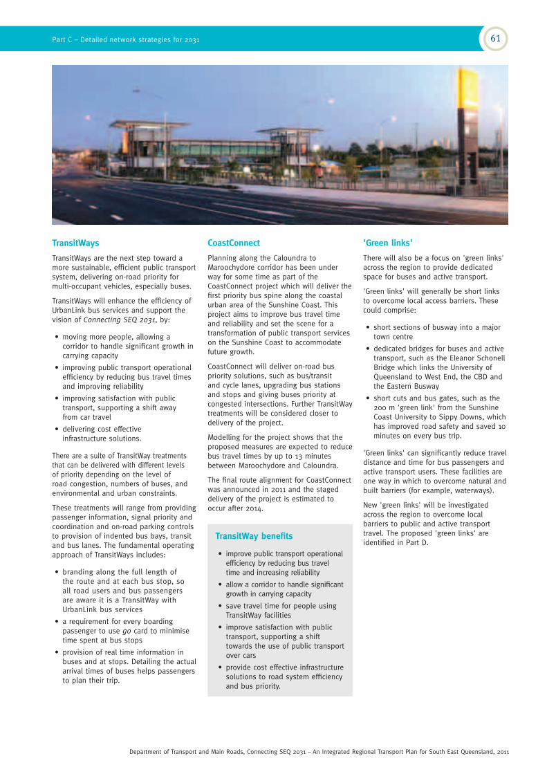
TransitWays
TransitWays are the next step toward a more sustainable, efficient public transport system, delivering on-road priority for multi-occupant vehicles, especially buses.
TransitWays will enhance the efficiency of UrbanLink bus services and support the vision of Connecting SEQ 2031, by:
• moving more people, allowing a corridor to handle significant growth in carrying capacity
• improving public transport operational efficiency by reducing bus travel times and improving reliability
• improving satisfaction with public transport, supporting a shift away from car travel
• delivering cost effective infrastructure solutions.
There are a suite of TransitWay treatments that can be delivered with different levels of priority depending on the level of road congestion, numbers of buses, and environmental and urban constraints.
These treatments will range from providing passenger information, signal priority and coordination and on-road parking controls to provision of indented bus bays, transit and bus lanes. The fundamental operating approach of TransitWays includes:
• branding along the full length of the route and at each bus stop, so all road users and bus passengers are aware it is a TransitWay with UrbanLink bus services
• a requirement for every boarding passenger to use go card to minimise time spent at bus stops
• provision of real time information in buses and at stops. Detailing the actual arrival times of buses helps passengers to plan their trip.
CoastConnect
Planning along the Caloundra to Maroochydore corridor has been under way for some time as part of the CoastConnect project which will deliver the first priority bus spine along the coastal urban area of the Sunshine Coast. This project aims to improve bus travel time and reliability and set the scene for a transformation of public transport services on the Sunshine Coast to accommodate future growth.
CoastConnect will deliver on-road bus priority solutions, such as bus/transit and cycle lanes, upgrading bus stations and stops and giving buses priority at congested intersections. Further TransitWay treatments will be considered closer to delivery of the project.
Modelling for the project shows that the proposed measures are expected to reduce bus travel times by up to 13 minutes between Maroochydore and Caloundra.
The final route alignment for CoastConnect was announced in 2011 and the staged delivery of the project is estimated to occur after 2014.
'Green links'
There will also be a focus on 'green links' across the region to provide dedicated space for buses and active transport.
'Green links' will generally be short links to overcome local access barriers. These could comprise:
• short sections of busway into a major town centre
• dedicated bridges for buses and active transport, such as the Eleanor Schonell Bridge which links the University of Queensland to West End, the CBD and the Eastern Busway
• short cuts and bus gates, such as the 200 m 'green link' from the Sunshine Coast University to Sippy Downs, which has improved road safety and saved 10 minutes on every bus trip.
'Green links' can significantly reduce travel distance and time for bus passengers and active transport users. These facilities are one way in which to overcome natural and built barriers (for example, waterways).
New 'green links' will be investigated across the region to overcome local barriers to public and active transport travel. The proposed 'green links' are identified in Part D.
Part C – Detailed network strategies for 2031 61
Department of Transport and Main Roads, Connecting SEQ 2031 – An Integrated Regional Transport Plan for South East Queensland, 2011

Moorooka
Carseldine
Chermside
KedronRBWH
Kelvin Grove
Indooroopilly
Woolloongabba
UQ St Lucia
Eight Mile Plains
Coorparoo
Springwood
LoganHyperdom
e
Beenleigh
LoganCentral
Carindale
Capalaba
Wyn
num
Cannon Hill
Cleve
land
Victo
ria
Point
Redland B
ay
Morn
ingsi
deBulimba
New Fa
rm
Mitchelton
Hamilt
on/
Northsh
ore
Bowen H
illsThe Gap
Ashgrove
Warner
Browns Plains
Airport Village
Domestic Airport
Brisbane
Ipsw
ich
Goodna
Riple
yAmberle
y
Caboolture AirportCaboolture West
Caboolture North
Brass
all
Fortitude Valley
Newstead
Albany Creek
Petrie
Darra
Wacol
Flagstone Yarrabilba
Kenmore
Moggill
Meadow
brook/
Loganle
a
Park R
idge/
Hillcr
est
Beerwah
AcaciaRidge
Springfield
Toowong
NorthLakes
Deception Bay
Redcliffe
Bracken Ridge
Griffith Uni
Buranda
Narangba
Strathpine
Caboolture
Ferny Grove
Alderley
Rosew
ood
CBD
Stafford
ToombulEagleJunction
Northgate
Yamanto
Caloundra
Maro
ochyd
ore
Moolo
olaba
Kawana
Sunshine
Coast A
irport
Nambour
Sippy Downs
CaloundraSouth
Shorncliffe
Noosa
Gold Coast
Health and
Knowledge
Precinct
Nerang
Robina
Burleigh Heads
Helensv
ale
Bond Uni
Broadbeach
SurfersParadise
Gold Coast Airport
Coolangatta
Varsity
Lakes
ParadisePoint
Coomera
Upper Coom
era
CulturalCentre
Southport
Sunshine Coast
Gold Coast
Greater Brisbane
Key
Map not to scale
UrbanLink bus service
Busway
TransitWay
CoastConnect
Passenger rail line
Light rail
Map 5.2 – indicative 2031 UrbanLink bus network concept
62 Connecting SEQ 2031
Department of Transport and Main Roads, Connecting SEQ 2031 – An Integrated Regional Transport Plan for South East Queensland, 2011

30 Queensland Government (Department of Local Government and Planning) 2006 Queensland Population Projections
31 Queensland Government (Queensland Transport) and Local Government Association of Queensland 2006 Community-based Transport Queensland Guidelines
A policy framework for developing low volume public transport should ensure services:
• are unrestricted in terms of who can use them and are able to service multiple travel needs
• make use of the latest technology to match passengers with rides to ensure vehicles are utilised efficiently
• leverage off existing transport services, assets and infrastructure (for example, by utilising spare capacity on existing services and/or idle vehicles)
• are supported by recurrent funding and promote cross program, cross government collaboration and partnerships
• are provided by professional transport operators (whether commercial or not-for-profit).
Flexible public transport
Many residents already live in low density areas that cannot be serviced by scheduled public transport services.
In areas with low population density (fewer than 10 dwellings per hectare), more flexible options than traditional public transport services are needed.
For some people, including the elderly and people with special needs, private motor vehicle and mainstream public transport services are not suitable travel options. A taxi may be the only real alternative, though it is too expensive for most people to use for all trips.
Queensland's population is ageing even more rapidly than it is growing, with residents aged over 65 forecast to increase from 327 000 in 2006 to about 854 000 in 2031, an increase of 161%, compared to a general population increase of only 57%30.
This will increase the proportion of the region's population over 65 from 12.5% to 22% in just 25 years.
The leading edge of the post-war baby boom will reach age 75 around 2020, meaning a large wave of people with high mobility expectations will reach a point where driving a car is increasingly less viable. This will exacerbate road safety challenges and increase demands for age-friendly public transport.
An important disincentive for frail aged drivers to voluntarily cease driving is the lack of any realistic alternative to private car transport. Mainstream public transport is not always an appropriate option, even though the system is being made accessible to people with mobility difficulties.
The important role of taxis
Taxis play an important role in supporting the overall transport task in Brisbane, providing a flexible door-to-door service, as well as 24-hour operations.
Taxi public transport services are provided on a commercial basis, with taxi licences administered by the Department of Transport and Main Roads.
Offering new options for providing more flexible taxi arrangements, such as multi-hire so the cost of the fare to an individual is reduced, can fulfil an important function in the overall transport network. More flexible arrangements can help fill the gap between private and public transport in low density parts of south-east Queensland and rural communities.
Service needs
With an ageing population and an increasing rural population, the region will need to develop other public transport models that cater for:
• low volumes of passengers
• multiple trip purposes to access centres for the daily business of shopping, appointments and social activities
• a wide range of target groups, if not the community at large.
These new models will need to ensure the ready availability of services with more flexibility to service areas of specialised or weak demand.
Council Cab services are being rolled out by many local governments in the region, though eligibility to use these services is usually somewhat restricted.
Department of Transport and Main Roads will work with TransLink, local governments and other service providers to address low volume needs on a local basis, consistent with an overall framework. Steps to support this will include:
• ensuring self-help tools are available for local groups (for example, the Community-based Transport
Queensland Guidelines)31
• ensuring an enabling regulatory framework
• developing a transport policy framework for low volume public transport, including guidelines and standards.
Principles for the provision of flexible public transport services to rural communities in the region are detailed in Chapter 10, Part D.
Part C – Detailed network strategies for 2031 63
Department of Transport and Main Roads, Connecting SEQ 2031 – An Integrated Regional Transport Plan for South East Queensland, 2011
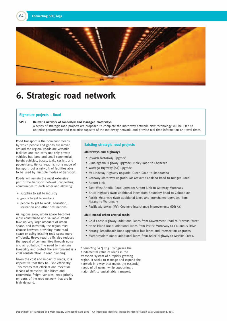
6. Strategic road network
Signature projects – Road
SP11 Deliver a network of connected and managed motorways A series of strategic road projects are proposed to complete the motorway network. New technology will be used to optimise performance and maximise capacity of the motorway network, and provide real time information on travel times.
Existing strategic road projects
Motorways and highways
• Ipswich Motorway upgrade
• Cunningham Highway upgrade: Ripley Road to Ebenezer
• Warrego Highway (A2) upgrade
• Mt Lindesay Highway upgrade: Green Road to Jimboomba
• Gateway Motorway upgrade: Mt Gravatt–Capalaba Road to Nudgee Road
• Airport Link
• East–West Arterial Road upgrade: Airport Link to Gateway Motorway
• Bruce Highway (M1): additional lanes from Boundary Road to Caboolture
• Pacific Motorway (M1): additional lanes and interchange upgrades from Nerang to Worongary
• Pacific Motorway (M1): Coomera interchange improvements (Exit 54).
Multi-modal urban arterial roads
• Gold Coast Highway: additional lanes from Government Road to Stevens Street
• Hope Island Road: additional lanes from Pacific Motorway to Columbus Drive
• Nerang–Broadbeach Road upgrades: bus lanes and intersection upgrades
• Maroochydore Road: additional lanes from Bruce Highway to Martins Creek.
Road transport is the dominant means by which people and goods are moved around the region. Roads are versatile facilities and can carry not only private vehicles but large and small commercial freight vehicles, buses, taxis, cyclists and pedestrians. Hence 'road' is not a mode of transport, but a network of facilities able to be used by multiple modes of transport.
Roads will remain the most extensive part of the transport network, connecting communities to each other and allowing:
• supplies to get to industry
• goods to get to markets
• people to get to work, education, recreation and other destinations.
As regions grow, urban space becomes more constrained and valuable. Roads take up very large amounts of urban space, and inevitably the region must choose between providing more road space or using existing road space more efficiently. Heavy road traffic also reduces the appeal of communities through noise and air pollution. The need to maintain liveability and protect the environment is a vital consideration in road planning.
Given the cost and impact of roads, it is imperative that they be used efficiently. This means that efficient and essential means of transport, like buses and commercial freight vehicles, need priority on parts of the road network that are in high demand.
Connecting SEQ 2031 recognises the fundamental value of roads in the transport system of a rapidly growing region. It seeks to manage and expand the network in a way that meets the essential needs of all users, while supporting a major shift to sustainable transport.
64 Connecting SEQ 2031
Department of Transport and Main Roads, Connecting SEQ 2031 – An Integrated Regional Transport Plan for South East Queensland, 2011
Overarching principles for developing the road networkR1 Plan and manage strategic roads as one network irrespective of jurisdiction
R2 Design and manage roads for all users, including active transport users
R1 Plan and manage strategic roads as one network
While an individual road may be the primary responsibility of state or local government, planning and managing the strategic road network as one network will maximise the efficiency and performance of the region's roads.
Connecting SEQ 2031 recommends a coordinated road management approach with local governments in Queensland. In the region, this approach will be adopted to ensure that the movement of traffic and the assignment of priority to certain users are planned and managed in a coordinated framework.
A particular need is to ensure new growth communities are provided with a network of local urban arterial roads, so they do not rely on a connection to the nearest motorway or highway for local road transport needs.
R2 Design and manage roads for all users
Recognising that roads need to cater for a broad range of users is central to the approach taken to developing the 2031 strategic road network in Connecting SEQ
2031. This can be achieved by planning and managing the strategic road network as multi-modal corridors, with priority given to supporting delivery of the key transport policy goals established in Chapter 3.
Managing congestion, which is primarily caused by private motor traffic, is an important goal.
However, protecting amenity and liveability, improving environmental performance and supporting economic prosperity are also essential.
Congestion management needs to be supported by policies which reduce the need to travel and provide quality alternatives to car travel, as well as supporting strategic road capacity improvements.
Managing the arterial road network in the region will consider the following:
• urban arterial roads are multi-modal corridors, with a high priority given to the needs of buses, cyclists and pedestrians
• ring roads and bypasses will be used to move local traffic around activity centres, so that centres become walkable and attractive
• arterial road improvements will include walking and cycling facilities (either on-road or off-road) or include walk and cycle friendly design
• appropriate interaction with adjoining land uses to promote a safe and amenable environment for all users, including pedestrians
• priority will be provided for freight traffic where needed and possible (for example, freight lanes and priority ramp signalling access at interchanges with the motorway network where there are high volumes of heavy vehicles).
Part C – Detailed network strategies for 2031 65
Department of Transport and Main Roads, Connecting SEQ 2031 – An Integrated Regional Transport Plan for South East Queensland, 2011

Supporting principles for developing the road networkR3 Provide a strategic road hierarchy, with a clear function for each road in the network
R4 Develop a completed, resilient network of strategic roads
R5 Protect urban amenity and quality of life when designing roads
R3 Strategic road hierarchy
Planning and managing roads in line with a functional road hierarchy allows the right type of traffic to be assigned to the right road. This ensures efficient movement of traffic and protects amenity in urban communities. Connecting SEQ 2031 adopts a functional hierarchy of strategic roads, which includes:
• high capacity, high speed motorways and highways to move large volumes of traffic, including freight traffic, over longer distances
• multi-modal urban arterial roads to provide connections within communities and cater for a range of road users, including pedestrians, cyclists, public transport, private vehicles, as well as commercial delivery vehicles ('first and last mile' freight)
• bypass and ring roads to remove traffic from activity centres
• community boulevards to provide amenity through activity and town centres, designed to cater for low volumes of traffic, with priority given to pedestrians, cyclists and public transport.
It is also vital to match the engineering design and physical access arrangements to the desired function of the road. Connecting SEQ 2031 establishes the following guidelines for planning and managing the functional road hierarchy.
Motorways and highways
Motorways and highways are the highest level in the road hierarchy, intended for major freight movements, interstate traffic and movement of regional traffic between major cities. They may be two to eight lanes wide and the posted speed limit is usually 100 km/h or 110 km/h, with access limited to widely spaced interchanges.
The speed and design of motorways and highways means they are not safe environments for pedestrians or cyclists and are generally unsuitable for public transport, except for long distance, express services.
Motorway and highway design standards should be used only where the road needs to carry high volumes of traffic, particularly freight, over longer distances.
If built in inappropriate locations where a lesser standard of road is required, motorway standard facilities can attract increased levels of local car traffic, which impacts on the road hierarchy functionality and works against the achievement of higher levels of public transport and cycling.
Planning for roads within new communities should generally avoid the creation of high standard motorway facilities within the urban fabric.
In some cases, motorway development may need to be undertaken through suburban areas. This should occur only when it forms part of an orbital motorway network or a bypass of an activity centre. In these cases, appropriate design features need to minimise visual and noise impacts.
In general, measures introduced on motorways to improve person-carrying capacity will focus on better management of all vehicle flows through improved incident detection and clearance, variable speed limits and ramp metering.
The region's rural highways provide vital connections between urban centres and the region's towns and villages. Though not built to motorway standard, these roads will be upgraded where required to improve safety and flood immunity, and reduce travel times.
Generally, the posted speed limit will be 100 km/hr, and provision will be made for safe operation of heavy vehicles. Cycling is allowed on highways that are not declared
a 'motorway', and safe provision for cyclists should be made on rural highways. As a minimum, this will usually be a wide shoulder surfaced with smooth asphalt concrete or similar.
Multi-modal urban arterial roads
Multi-modal urban arterial roads provide for high volumes of local traffic within cities and may include transit or bus lanes where there is high demand for public transport.
The posted speed limit will be 60–80 km/h and vehicle access is limited to well-spaced intersections, generally at-grade.
Multi-modal urban arterials will include bus priority measures where needed to ensure efficient and reliable public transport.
Active transport will be provided for, with quality footpaths for walking and either on or off-road facilities for cycling.
An arterial road should be developed as a multi-modal urban arterial road when it is primarily required to accommodate traffic for trips to and between activity centres, public transport and freight deliveries for local business. Most new arterial roads in the region will fall into this category.
Arterial road design must also recognise the existing and desired characteristics of the urban environment, with emphasis given to landscaping, vistas and surrounding land uses.
Planning for new multi-modal urban arterial roads will occur as part of local government town planning and structure planning processes for new communities. This will ensure a well designed road hierarchy is incorporated into the development of new growth areas.
The areas where new multi-modal urban arterials need to be investigated are shown on the local government maps in Part D.
66 Connecting SEQ 2031
Department of Transport and Main Roads, Connecting SEQ 2031 – An Integrated Regional Transport Plan for South East Queensland, 2011
Bypass roads
Ring roads and bypass roads are used to move through traffic around activity centres, to enable centres to become walkable and attractive. Car traffic inside the ring is given a low priority and walking, cycling and public transport are emphasised. There may be special priority arrangements for delivery vehicles either through kerb space allocation and/or special-purpose lanes or streets within the centre.
Ring roads and bypasses are generally created by upgrading existing roads or streets and may be two or four lanes. Bus priority may be appropriate on some sections, though it is more likely a bus 'green link' would be provided direct to the heart of the centre. Car parking can be located adjacent to the ring road to reduce traffic entering the town centre.
In some centres, finding an appropriate corridor to provide a bypass will be difficult and other innovative solutions may be needed.
Community boulevards
Community boulevards are low-speed, multi-modal roads in centres, providing priority for buses, cyclists and pedestrians32.
Cross-movement for pedestrians between land uses on either side of the road is an important factor in the design of community boulevards.
Community boulevards will place a higher emphasis on amenity, with quality landscaping, built form, seating, shading and lighting.
The design of the road creates legibility for users, and a slower speed environment supports surroundings and ensures the safe sharing of the space for all modes.
Where possible, car parking and access driveways are predominantly at the rear of sites fronting the boulevard to maximise access for pedestrians, cyclists and bus passengers.
Community boulevards will generally be developed along existing arterial or sub-arterial roads passing through activity centres, particularly at locations identified as hubs in the 'centres access hierarchy' (see Part D). They will support the creation of 'priority transit corridors'.
Where an existing arterial road currently carries high volumes of traffic through an activity centre or place of community significance, such as an entertainment precinct, restaurant 'eat street' or beachside suburb, it should be developed as a community boulevard.
Community boulevards may need to be supported by the development of parallel arterial roads or bypass roads around centres. Regional traffic and, in particular, non-essential heavy vehicle movements, will be encouraged to use alternative routes rather than community boulevards.
It is a priority of Connecting SEQ 2031 to develop a best practice guideline (as part of the State Planning Instruments program) with design tools for land use planners and road designers to consider the road and land use interface in activity centres in an integrated manner.
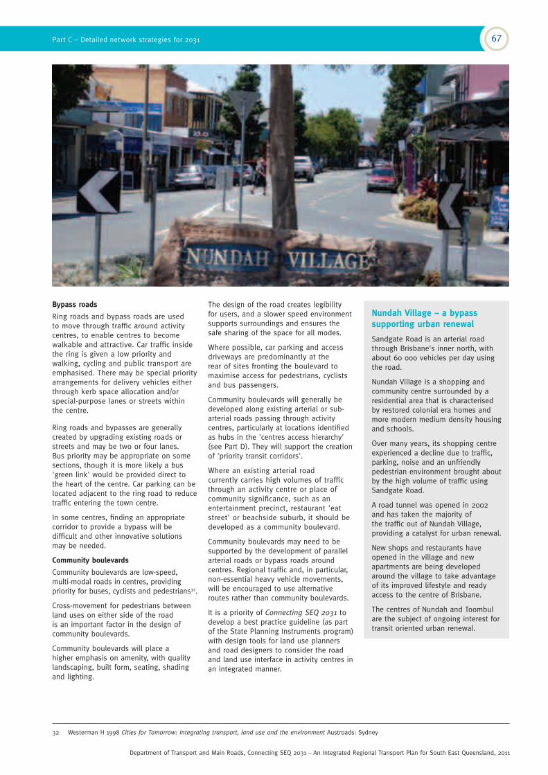
Nundah Village – a bypass supporting urban renewal
Sandgate Road is an arterial road through Brisbane's inner north, with about 60 000 vehicles per day using the road.
Nundah Village is a shopping and community centre surrounded by a residential area that is characterised by restored colonial era homes and more modern medium density housing and schools.
Over many years, its shopping centre experienced a decline due to traffic, parking, noise and an unfriendly pedestrian environment brought about by the high volume of traffic using Sandgate Road.
A road tunnel was opened in 2002 and has taken the majority of the traffic out of Nundah Village, providing a catalyst for urban renewal.
New shops and restaurants have opened in the village and new apartments are being developed around the village to take advantage of its improved lifestyle and ready access to the centre of Brisbane.
The centres of Nundah and Toombul are the subject of ongoing interest for transit oriented urban renewal.
32 Westerman H 1998 Cities for Tomorrow: Integrating transport, land use and the environment Austroads: Sydney
Part C – Detailed network strategies for 2031 67
Department of Transport and Main Roads, Connecting SEQ 2031 – An Integrated Regional Transport Plan for South East Queensland, 2011