Embed Size (px)
Citation preview

PART D
SPECIFIC DEVELOPMENT

PART D hawkesbury development control plan _______________________________________________________________________________________________
____________________________________________________________________________________________________________TABLE OF CONTENTS
i
CONTENTS Part D
RESIDENTIAL DEVELOPMENT .................................................................................................. 5
1.1 INTRODUCTION ........................................................................................................................... 1–1
1.2 AIMS .............................................................................................................................................. 1–1
1.3 HEIGHT ......................................................................................................................................... 1–1
1.4 SETBACKS ................................................................................................................................... 1–3
1.5 DEVELOPMENT FRONTING REAR LANES ................................................................................ 1–5
1.6 LANDSCAPED AREAS ................................................................................................................. 1–6
1.7 PRIVATE OPEN SPACE ............................................................................................................... 1–7
1.8 COMMON USE OPEN SPACE ..................................................................................................... 1–9
1.9 VEHICLE ACCESS AND CAR PARKING ................................................................................... 1–11
1.10 BASEMENT PARKING ................................................................................................................ 1–13
1.11 VISUAL PRIVACY ....................................................................................................................... 1–14
1.12 ACOUSTIC PRIVACY ................................................................................................................. 1–17
1.13 EXTERNAL NOISE AND VIBRATION ......................................................................................... 1–19
1.14 SAFETY AND SECURITY ........................................................................................................... 1–20
1.15 UTILITY AND SITE SERVICES ................................................................................................... 1–21
1.16 CABLES ...................................................................................................................................... 1–22
1.17 RECYCLING, GARBAGE AND MAIL COLLECTION AREAS ..................................................... 1–22
1.18 EFFLUENT DISPOSAL ............................................................................................................... 1–23
1.19 FENCING AND RETAINING WALLS .......................................................................................... 1–23
1.20 RURAL DUAL OCCUPANCIES ................................................................................................... 1–24
INDUSTRIAL DEVELOPMENT ................................................................................................. 2.1
2.1 GENERAL PRINCIPLES ............................................................................................................... 2–1
2.2 BUILDING SETBACKS .................................................................................................................. 2–1
2.3 RELATIONSHIP TO ADJACENT DEVELOPMENT....................................................................... 2–3
2.4 BUILDING DESIGN AND CONSTRUCTION ................................................................................. 2–3
2.5 FENCING ...................................................................................................................................... 2–5
2.6 OPEN STORAGE AREAS ............................................................................................................. 2–5
2.7 ENVIRONMENTAL ISSUES .......................................................................................................... 2–6
SUBDIVISION ............................................................................................................................ 3.1
3.1 GENERAL PRINCIPLES ............................................................................................................... 3–1
PART D _______________________________________________________________________________________________ hawkesbury development control plan
TABLE OF CONTENTS ___________________________________________________________________________________________________________
ii
3.2 FLORA AND FAUNA PROTECTION ............................................................................................. 3–1
3.3 VISUAL AMENITY ......................................................................................................................... 3–2
3.4 HERITAGE .................................................................................................................................... 3–3
3.5 UTILITY SERVICES ...................................................................................................................... 3–3
3.6 FLOODING, LANDSLIP & CONTAMINATED LAND ..................................................................... 3–5
3.7 RESIDENTIAL SUBDIVISION ....................................................................................................... 3–5 3.7.1 Residential Local Street Design ......................................................................................... 3–5 3.7.2 Residential Accessway Design ........................................................................................... 3–8 3.7.3 Planning for Pedestrians and Cyclists in Residential Areas ............................................. 3–10 3.7.4 Stormwater Management ................................................................................................. 3–11 3.7.5 Lot Size and Shape .......................................................................................................... 3–12 3.7.6 Solar Access and Lot Orientation ..................................................................................... 3–13 3.7.7 Torrens Title Subdivision of Existing Dwellings ................................................................ 3–14
3.8 RURAL AND RURAL–RESIDENTIAL SUBDIVISION ................................................................. 3–14 3.8.1 Rural Lot Size and Shape ................................................................................................. 3–14 3.8.2 Boundary Adjustment ....................................................................................................... 3–15 3.8.3 Rural Road and Accessway Design ................................................................................. 3–16 3.8.4 Effluent Disposal .............................................................................................................. 3–18
3.9 INDUSTRIAL ............................................................................................................................... 3–18 3.9.1 Industrial Lot Sizes and Shapes ....................................................................................... 3–18 3.9.2 Industrial Access and Road Layout .................................................................................. 3–19
BROTHELS ................................................................................................................................ 4.1
4.1 INTRODUCTION ........................................................................................................................... 4–1
4.2 OBJECTIVES ................................................................................................................................ 4–1
4.3 KEY ASSESSMENT ISSUES ........................................................................................................ 4–2 4.3.1 Locational Characteristics .................................................................................................. 4–2 4.3.2 Access ................................................................................................................................ 4–2 4.3.3 Design and Layout ............................................................................................................. 4–3 4.3.4 Parking ............................................................................................................................... 4–3 4.3.5 Hours of Operation ............................................................................................................. 4–3 4.3.6 Signage .............................................................................................................................. 4–4 4.3.7 Health and Safety Standards .............................................................................................. 4–4
TELECOMMUNICATIONS ........................................................................................................ 5.1
5.1 OBJECTIVES FOR TELECOMMUNICATIONS FACILITIES ........................................................ 5–1
5.2 KEY ASSESSMENT ISSUES ........................................................................................................ 5–2
5.3 MATTERS FOR CONSIDERATION .............................................................................................. 5–2
DAM CONSTRUCTION ............................................................................................................. 6.3
6.1 OBJECTIVES ................................................................................................................................ 6–1
6.2 LOCATIONAL PRINCIPLES .......................................................................................................... 6–1
6.3 DESIGN AND CONSTRUCTION REQUIREMENTS ..................................................................... 6–3 6.3.1 Crest ................................................................................................................................... 6–3 6.3.2 Freeboard ........................................................................................................................... 6–3 6.3.3 Embankments .................................................................................................................... 6–3 6.3.4 Spillway .............................................................................................................................. 6–4 6.3.5 Cut-Off Trench .................................................................................................................... 6–4 6.3.6 Vegetation Filters and Tree Planting .................................................................................. 6–5 6.3.7 Hydrological Aspects .......................................................................................................... 6–7 6.3.8 Dam Construction ............................................................................................................... 6–7

PART D hawkesbury development control plan _______________________________________________________________________________________________
____________________________________________________________________________________________________________TABLE OF CONTENTS
iii
LANDFILL .................................................................................................................................. 7.1
7.1 GENERAL PRINCIPLES ............................................................................................................... 7–1
7.2 TYPES OF LANDFILL ................................................................................................................... 7–1
7.3 GENERAL LANDFILL REQUIREMENTS ...................................................................................... 7–3 7.3.1 Council Consent ................................................................................................................. 7–3 7.3.2 Riverbank/Foreshore Reshaping, Regrading and Stabilisation .......................................... 7–4 7.3.3 Temporary Stockpiles ......................................................................................................... 7–4 7.3.4 Maintenance ....................................................................................................................... 7–5 7.3.5 Removal/Reinstatement or Removal/Rehabilitation ........................................................... 7–5 7.3.6 Aboriginal/Archaeological Sites .......................................................................................... 7–6 7.3.7 Limited Consent ................................................................................................................. 7–6

Chapter 1
RESIDENTIAL DEVELOPMENT

PART D hawkesbury development control plan _______________________________________________________________________________________________
_____________________________________________________________________________________________________RESIDENTIAL DEVELOPMENT
1–1
1.1 INTRODUCTION
This chapter of the DCP relates to single dwellings and multi unit housing. Other sections that
are relevant to residential development include car parking and access, energy efficiency,
subdivision and landscaping.
1.2 AIMS
The general aims for residential development in the Hawkesbury are to:
provide clear guidelines for residential development in the City;
ensure that all forms of residential development is designed to be compatible with the
built environment in which they are located in terms of height size, bulk scale setbacks,
materials and open space;
ensure that the building form, including alterations and additions, is sympathetic with the
existing surrounding neighbourhood;
ensure that all types of housing meet community expectations about health, safety and
amenity;
ensure that proposed development does not detract from the amenity of adjacent
residents or the quality of the environment;
encourage innovative housing which is pleasant to live in and is responsive to the site;
and
ensure that proposed development is sympathetic to items of environmental heritage.
1.3 HEIGHT
Aims
(a) To protect the privacy, use of private
open space and solar access within the
development and on adjoining land.
(b) To ensure that the bulk of the new
development is not excessive and
relates well to the local context.
(c) To allow adequate natural light and ventilation between dwellings with sufficient
separation for acoustic and visual privacy.
PART D _______________________________________________________________________________________________ hawkesbury development control plan
RESIDENTIAL DEVELOPMENT _____________________________________________________________________________________________________
1–2
Objectives
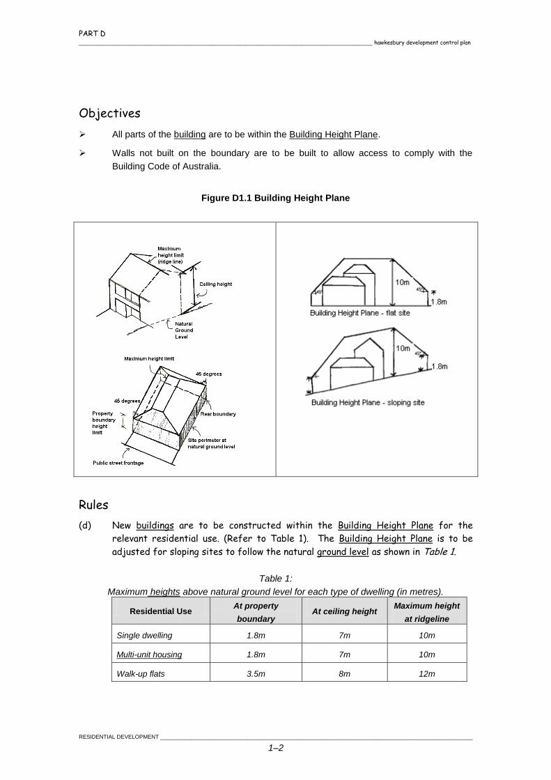
All parts of the building are to be within the Building Height Plane.
Walls not built on the boundary are to be built to allow access to comply with the
Building Code of Australia.
Figure D1.1 Building Height Plane
Rules
(d) New buildings are to be constructed within the Building Height Plane for the
relevant residential use. (Refer to Table 1). The Building Height Plane is to be
adjusted for sloping sites to follow the natural ground level as shown in Table 1.
Table 1:
Maximum heights above natural ground level for each type of dwelling (in metres).
Residential Use At property
boundary At ceiling height
Maximum height
at ridgeline
Single dwelling 1.8m 7m 10m
Multi-unit housing 1.8m 7m 10m
Walk-up flats 3.5m 8m 12m
PART D hawkesbury development control plan _______________________________________________________________________________________________
_____________________________________________________________________________________________________RESIDENTIAL DEVELOPMENT
1–3
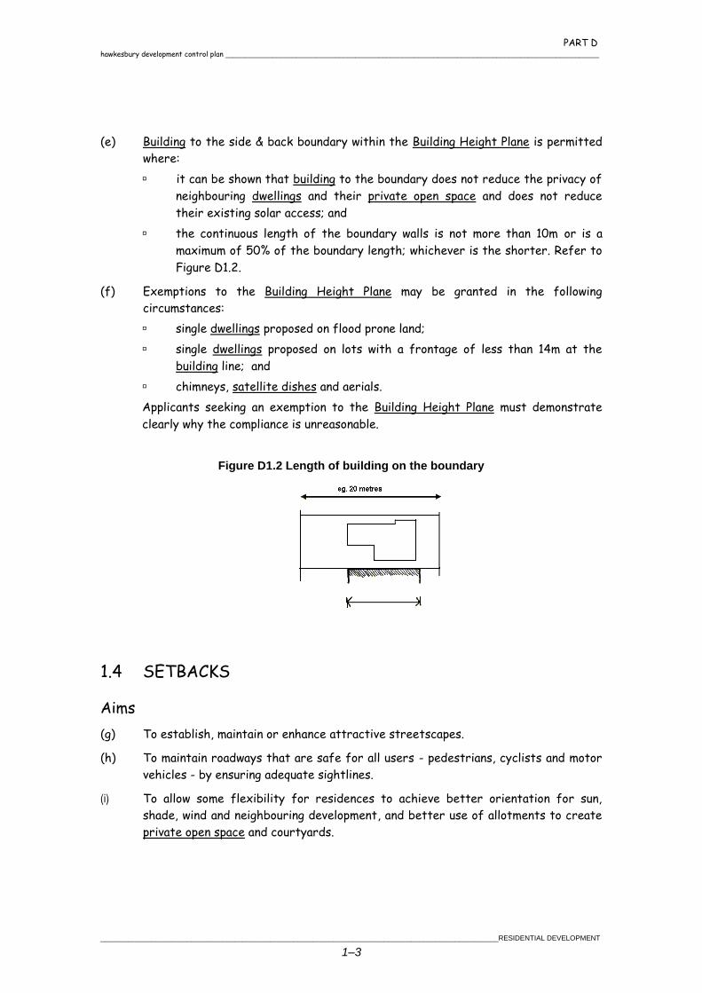
(e) Building to the side & back boundary within the Building Height Plane is permitted
where:
it can be shown that building to the boundary does not reduce the privacy of
neighbouring dwellings and their private open space and does not reduce
their existing solar access; and
the continuous length of the boundary walls is not more than 10m or is a
maximum of 50% of the boundary length; whichever is the shorter. Refer to
Figure D1.2.
(f) Exemptions to the Building Height Plane may be granted in the following
circumstances:
single dwellings proposed on flood prone land;
single dwellings proposed on lots with a frontage of less than 14m at the
building line; and
chimneys, satellite dishes and aerials.
Applicants seeking an exemption to the Building Height Plane must demonstrate
clearly why the compliance is unreasonable.
Figure D1.2 Length of building on the boundary
1.4 SETBACKS
Aims
(g) To establish, maintain or enhance attractive streetscapes.
(h) To maintain roadways that are safe for all users - pedestrians, cyclists and motor
vehicles - by ensuring adequate sightlines.
(i) To allow some flexibility for residences to achieve better orientation for sun,
shade, wind and neighbouring development, and better use of allotments to create
private open space and courtyards.
PART D _______________________________________________________________________________________________ hawkesbury development control plan
RESIDENTIAL DEVELOPMENT _____________________________________________________________________________________________________
1–4
Objectives
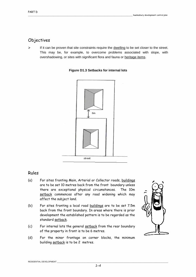
If it can be proven that site constraints require the dwelling to be set closer to the street.
This may be, for example, to overcome problems associated with slope, with
overshadowing, or sites with significant flora and fauna or heritage items.
Figure D1.3 Setbacks for internal lots
Rules
(a) For sites fronting Main, Arterial or Collector roads, buildings
are to be set 10 metres back from the front boundary unless
there are exceptional physical circumstances. The 10m
setback commences after any road widening which may
affect the subject land.
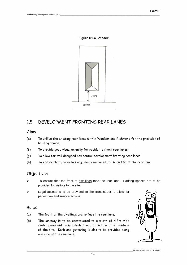
(b) For sites fronting a local road buildings are to be set 7.5m
back from the front boundary. In areas where there is prior
development the established pattern is to be regarded as the
standard setback.
(c) For internal lots the general setback from the rear boundary
of the property in front is to be 6 metres.
(d) For the minor frontage on corner blocks, the minimum
building setback is to be 2 metres.
PART D hawkesbury development control plan _______________________________________________________________________________________________
_____________________________________________________________________________________________________RESIDENTIAL DEVELOPMENT
1–5
Figure D1.4 Setback
1.5 DEVELOPMENT FRONTING REAR LANES
Aims
(e) To utilise the existing rear lanes within Windsor and Richmond for the provision of
housing choice.
(f) To provide good visual amenity for residents front rear lanes.
(g) To allow for well designed residential development fronting rear lanes.
(h) To ensure that properties adjoining rear lanes utilise and front the rear lane.
Objectives
To ensure that the front of dwellings face the rear lane. Parking spaces are to be
provided for visitors to the site.
Legal access is to be provided to the front street to allow for
pedestrian and service access.
Rules
(a) The front of the dwellings are to face the rear lane.
(b) The laneway is to be constructed to a width of 4.5m wide
sealed pavement from a sealed road to and over the frontage
of the site. Kerb and guttering is also to be provided along
one side of the rear lane.
PART D _______________________________________________________________________________________________ hawkesbury development control plan
RESIDENTIAL DEVELOPMENT _____________________________________________________________________________________________________
1–6
(c) Buildings are to front the rear lane and setback a minimum of 5.5m from the
boundary to the rear lane.
(d) Access to the site is to be widened to allow for satisfactory manoeuvring for
vehicles entering or leaving the site.
(e) Front fences are to be a maximum height of 1.2m to maximise site distances for
vehicles leaving the site.
(f) Visitor parking shall be provided at a rate of one per single dwellings and two per
each fire units or part thereof. Parking spaces shall be located clear of the access
to the garage/carports.
(g) A 1.2m wide legal pedestrian and service access is to be provided to the front
street.
1.6 LANDSCAPED AREAS
Aims
(h) To create a pleasant and safe living environment by enhancing the setting of
buildings and the environmental quality of the neighbourhood.
(i) To ensure that planting and building structures are compatible in protecting
existing landscape features.
(j) To provide for privacy and shade and to assist in microclimate management.
(k) To maximise absorptive landscaped areas for on-site infiltration of stormwater by
limiting the area of hard surfaces at ground level.
Objectives
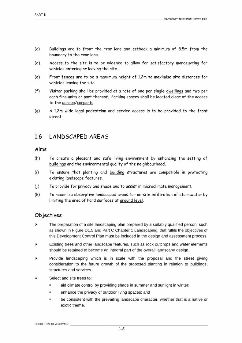
The preparation of a site landscaping plan prepared by a suitably qualified person, such
as shown in Figure D1.5 and Part C Chapter 1 Landscaping, that fulfils the objectives of
this Development Control Plan must be included in the design and assessment process.
Existing trees and other landscape features, such as rock outcrops and water elements
should be retained to become an integral part of the overall landscape design.
Provide landscaping which is in scale with the proposal and the street giving
consideration to the future growth of the proposed planting in relation to buildings,
structures and services.
Select and site trees to:
aid climate control by providing shade in summer and sunlight in winter;
enhance the privacy of outdoor living spaces; and
be consistent with the prevailing landscape character, whether that is a native or
exotic theme.
PART D hawkesbury development control plan _______________________________________________________________________________________________
_____________________________________________________________________________________________________RESIDENTIAL DEVELOPMENT
1–7
Rules
(a) All forms of residential development are to contain pervious
soft landscaped areas to a total of 30% of the total site
area. This may be calculated by adding together soft
landscaped areas of private and common open space.
Development proposals, where required, are to indicate the
proportion of the total site area that is:
total “soft” landscaped area;
total ground level private open space; and
total common open space.
Figure D1.5 Site landscaping
1.7 PRIVATE OPEN SPACE
Aims
(b) To provide dwellings with an open space area that is
private, accessible and provides for outdoor
recreational activities and landscaping.
(c) To provide for some utility functions.
(d) To allow for a minimum level of provision whilst leaving
opportunities for flexibility in use.
(e) To locate private open space by taking into account factors such as solar access,
outlook, streetscape, privacy and the location of adjoining dwellings.
PART D _______________________________________________________________________________________________ hawkesbury development control plan
RESIDENTIAL DEVELOPMENT _____________________________________________________________________________________________________
1–8
Objectives
Each private open space area must be on the same level and directly accessible from
the dwelling's main living area, such as that shown in Figure D1.5.
Private open space areas must be located to receive good solar access to provide for
maximum year round use.
Adequate screening of the private open space must be provided to protect the privacy
of the occupants and their neighbours.
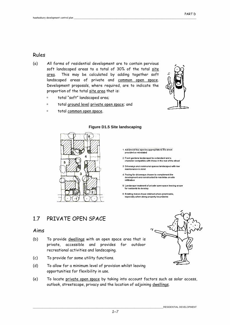
Figure D1.6 Private open space fulfils a number of functions
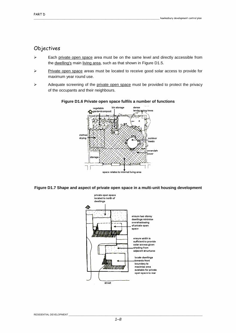
Figure D1.7 Shape and aspect of private open space in a multi-unit housing development
PART D hawkesbury development control plan _______________________________________________________________________________________________
_____________________________________________________________________________________________________RESIDENTIAL DEVELOPMENT
1–9
Rules
(a) Single dwelling houses and multi unit housing are to
provide at least one area of private open space for
each dwelling.
(b) The total of private open space at ground level must be
a minimum of 20% of the site area, regardless of
permeability of the surface. This space must:
be capable of containing a rectangle 5 metres x 6
metres per dwelling that has a slope less than
1:10;
not be comprised of any area with a dimension
less than 4 metres; and
be exclusive of clothes drying areas, driveways,
car parking and other utility areas.
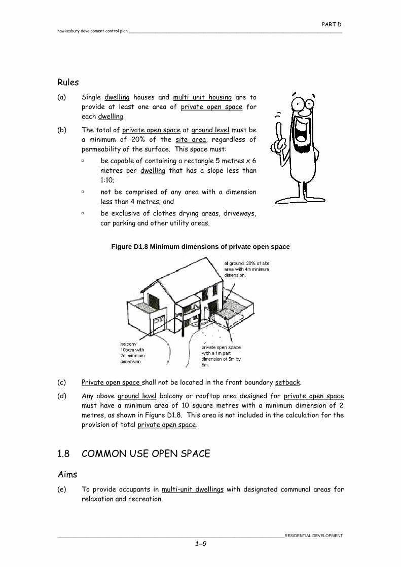
Figure D1.8 Minimum dimensions of private open space
(c) Private open space shall not be located in the front boundary setback.
(d) Any above ground level balcony or rooftop area designed for private open space
must have a minimum area of 10 square metres with a minimum dimension of 2
metres, as shown in Figure D1.8. This area is not included in the calculation for the
provision of total private open space.
1.8 COMMON USE OPEN SPACE
Aims
(e) To provide occupants in multi-unit dwellings with designated communal areas for
relaxation and recreation.
PART D _______________________________________________________________________________________________ hawkesbury development control plan
RESIDENTIAL DEVELOPMENT _____________________________________________________________________________________________________
1–10
(f) To provide facilities that are relevant to the projected needs of the occupants of
the development.
(g) To include retained and/or significant vegetation and other landscape features in
areas which can be maintained for the benefit of all occupants.
Objectives
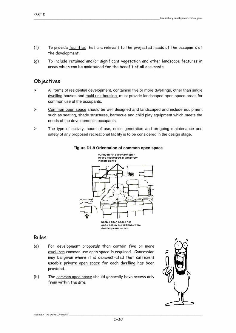
All forms of residential development, containing five or more dwellings, other than single
dwelling houses and multi unit housing, must provide landscaped open space areas for
common use of the occupants.
Common open space should be well designed and landscaped and include equipment
such as seating, shade structures, barbecue and child play equipment which meets the
needs of the development’s occupants.
The type of activity, hours of use, noise generation and on-going maintenance and
safety of any proposed recreational facility is to be considered in the design stage.
Figure D1.9 Orientation of common open space
Rules
(a) For development proposals than contain five or more
dwellings common use open space is required. Concession
may be given where it is demonstrated that sufficient
useable private open space for each dwelling has been
provided.
(b) The common open space should generally have access only
from within the site.
PART D hawkesbury development control plan _______________________________________________________________________________________________
_____________________________________________________________________________________________________RESIDENTIAL DEVELOPMENT
1–11
(c) Common open space for multi-unit housing developments should be accessible from
all dwellings within the development. Surveillance of this space should be possible
from at least two dwellings, as shown in Figure 9.
(d) Any proposed communal recreational facilities must be designed and located to
avoid nuisance or danger to neighbours, residents and visitors.
1.9 VEHICLE ACCESS AND CAR PARKING
Aims
(e) To integrate car parking and access as
unobtrusively as possible into the streetscape
and landscape.
(f) To ensure safe access, egress and passage
through a site for vehicles and pedestrians.
(g) To provide adequate off street parking for the
normal needs of occupants and visitors.
(h) To maintain the amenity of adjoining properties.
Objectives
Driveway access to the street should generally be confined to a single point, in order to
maintain street parking and landscaping opportunities
Vehicles are to be able to leave and enter the site in a forward direction.
Rules
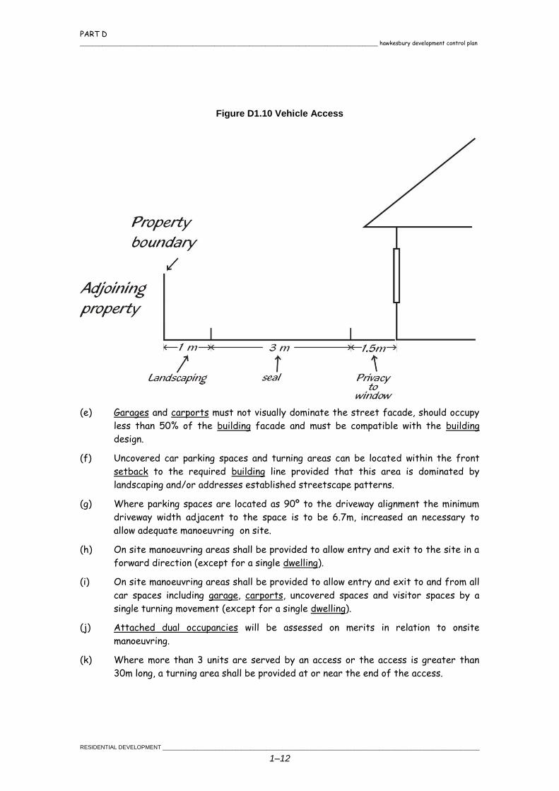
(a) Driveways next to any side or rear boundary must have a
landscape strip of at least 1 metre to separate them. See
Figure D1.10.
(b) Shared driveways, access lanes and car parks must be setback
a minimum of 1.5 metres from windows to main habitable rooms
of dwellings. This standard does not apply if the floor level of
the dwelling is at least 1 metre above the driveway.
(c) All driveways must have a minimum width of 3 metres and must
be sealed to prevent surface erosion.
(d) For development that contains more than 2 units driveways are
to have a minimum driveway width of 6m from the layback/kerb line to 6m inside
the property.
PART D _______________________________________________________________________________________________ hawkesbury development control plan
RESIDENTIAL DEVELOPMENT _____________________________________________________________________________________________________
1–12
Figure D1.10 Vehicle Access
(e) Garages and carports must not visually dominate the street facade, should occupy
less than 50% of the building facade and must be compatible with the building
design.
(f) Uncovered car parking spaces and turning areas can be located within the front
setback to the required building line provided that this area is dominated by
landscaping and/or addresses established streetscape patterns.
(g) Where parking spaces are located as 90º to the driveway alignment the minimum
driveway width adjacent to the space is to be 6.7m, increased an necessary to
allow adequate manoeuvring on site.
(h) On site manoeuvring areas shall be provided to allow entry and exit to the site in a
forward direction (except for a single dwelling).
(i) On site manoeuvring areas shall be provided to allow entry and exit to and from all
car spaces including garage, carports, uncovered spaces and visitor spaces by a
single turning movement (except for a single dwelling).
(j) Attached dual occupancies will be assessed on merits in relation to onsite
manoeuvring.
(k) Where more than 3 units are served by an access or the access is greater than
30m long, a turning area shall be provided at or near the end of the access.
PART D hawkesbury development control plan _______________________________________________________________________________________________
_____________________________________________________________________________________________________RESIDENTIAL DEVELOPMENT
1–13
(l) On site manoeuvring shall be based on the Ausroads Standard 5.0m design vehicle.
Templates for this standard are provided in the appendices. When using the
templates a minimum of 150mm shall be provided between any fixed object and the
extremities of the swept paths.
(m) All on site car spaces shall comply with the minimum dimensions set out in Part C
Chapter 2 (Car Parking and Access). Where a space adjoins a wall, fence or other
fixed structures, the width shall be increased as follows to allow adequate door
opening:
On one side only to 3.2m
On both sides to 3.8m.
(n) Refer to the following chapters for additional requirements:
Part C Chapter 2 - Carparking and Access
Part C Chapter 6 - Energy Efficiency
Part D Chapter 3 - Subdivision.
1.10 BASEMENT PARKING
Objectives
Where basement parking is proposed an assessment of the potential of the site to
contain archaeological significance shall be carried out by a suitably qualified
consultant.
Basement parking should be drained by gravity.
Rules
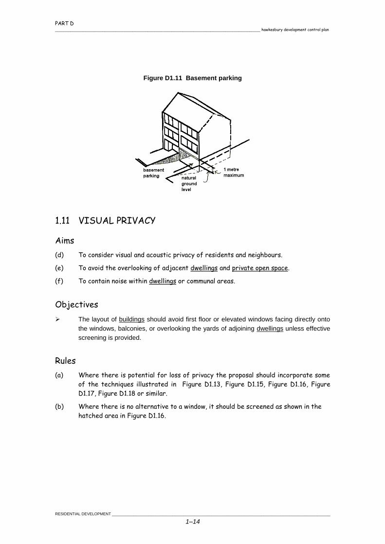
(a) Only the basement’s parking entry should be seen as a separate
level in a building. Large exposed foundations, voids and walls are
not to be used. Refer to Figure D1.11
(b) No part of a basement should extend more than 1 metre above
natural ground level so the height of the building is not excessive.
(c) Consideration may be given to a sump and pump where storm water
volumes are low based on merits of the site
Note: For additional requirements for the number of car parking spaces
required and their design and construction refer to the Part C
Chapter 2 Car Parking and Access.
PART D _______________________________________________________________________________________________ hawkesbury development control plan
RESIDENTIAL DEVELOPMENT _____________________________________________________________________________________________________
1–14
Figure D1.11 Basement parking
1.11 VISUAL PRIVACY
Aims
(d) To consider visual and acoustic privacy of residents and neighbours.
(e) To avoid the overlooking of adjacent dwellings and private open space.
(f) To contain noise within dwellings or communal areas.
Objectives
The layout of buildings should avoid first floor or elevated windows facing directly onto
the windows, balconies, or overlooking the yards of adjoining dwellings unless effective
screening is provided.
Rules
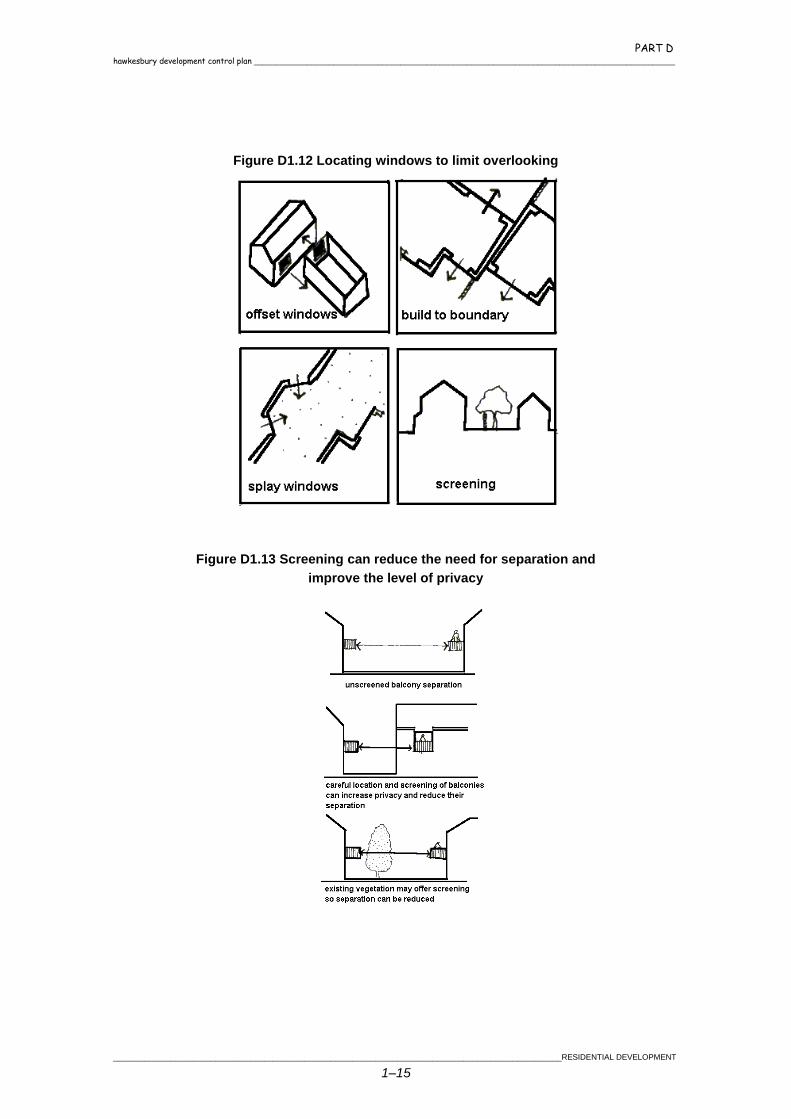
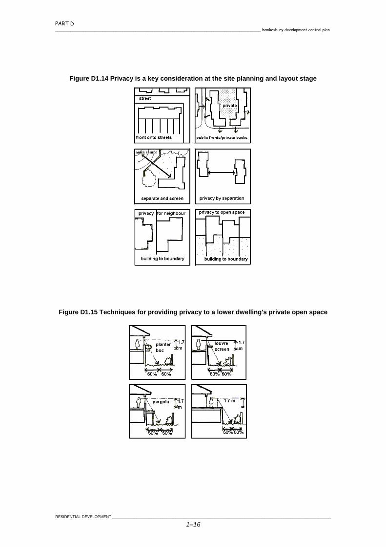
(a) Where there is potential for loss of privacy the proposal should incorporate some
of the techniques illustrated in Figure D1.13, Figure D1.15, Figure D1.16, Figure
D1.17, Figure D1.18 or similar.
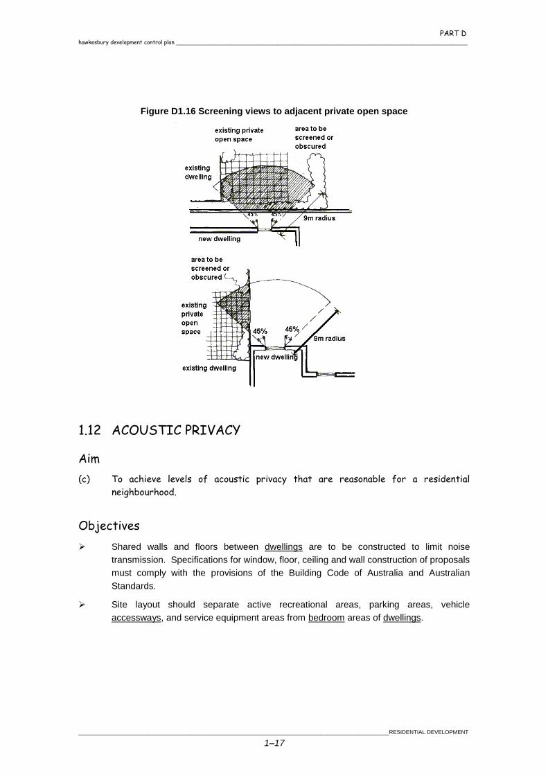
(b) Where there is no alternative to a window, it should be screened as shown in the
hatched area in Figure D1.16.
PART D hawkesbury development control plan _______________________________________________________________________________________________
_____________________________________________________________________________________________________RESIDENTIAL DEVELOPMENT
1–15
Figure D1.12 Locating windows to limit overlooking
Figure D1.13 Screening can reduce the need for separation and
improve the level of privacy
PART D _______________________________________________________________________________________________ hawkesbury development control plan
RESIDENTIAL DEVELOPMENT _____________________________________________________________________________________________________
1–16
Figure D1.14 Privacy is a key consideration at the site planning and layout stage
Figure D1.15 Techniques for providing privacy to a lower dwelling's private open space
PART D hawkesbury development control plan _______________________________________________________________________________________________
_____________________________________________________________________________________________________RESIDENTIAL DEVELOPMENT
1–17
Figure D1.16 Screening views to adjacent private open space
1.12 ACOUSTIC PRIVACY
Aim
(c) To achieve levels of acoustic privacy that are reasonable for a residential
neighbourhood.
Objectives
Shared walls and floors between dwellings are to be constructed to limit noise
transmission. Specifications for window, floor, ceiling and wall construction of proposals
must comply with the provisions of the Building Code of Australia and Australian
Standards.
Site layout should separate active recreational areas, parking areas, vehicle
accessways, and service equipment areas from bedroom areas of dwellings.
PART D _______________________________________________________________________________________________ hawkesbury development control plan
RESIDENTIAL DEVELOPMENT _____________________________________________________________________________________________________
1–18
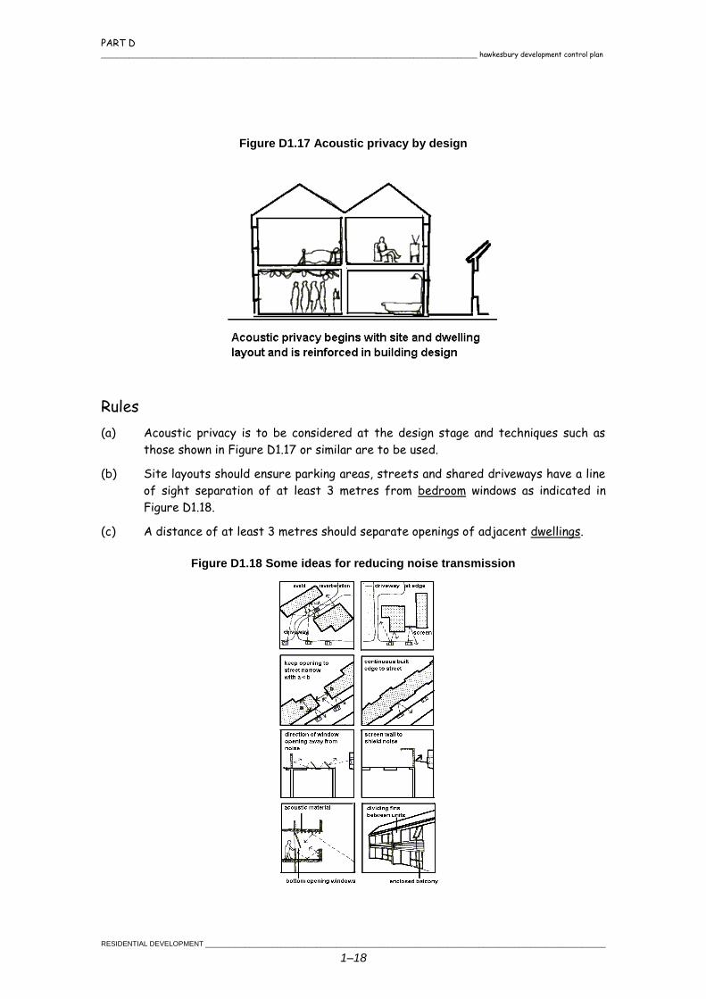
Figure D1.17 Acoustic privacy by design
Rules
(a) Acoustic privacy is to be considered at the design stage and techniques such as
those shown in Figure D1.17 or similar are to be used.
(b) Site layouts should ensure parking areas, streets and shared driveways have a line
of sight separation of at least 3 metres from bedroom windows as indicated in
Figure D1.18.
(c) A distance of at least 3 metres should separate openings of adjacent dwellings.
Figure D1.18 Some ideas for reducing noise transmission
PART D hawkesbury development control plan _______________________________________________________________________________________________
_____________________________________________________________________________________________________RESIDENTIAL DEVELOPMENT
1–19
1.13 EXTERNAL NOISE AND VIBRATION
Aims
(d) To ensure an acceptable level of amenity for all residents.
(e) To incorporate building construction and landscape techniques to act as a barrier
or buffer to reduce noise and vibration levels.
(f) To ensure that attenuation methods are consistent with existing town character
attributes and themes.
(g) To ensure that the attenuation measures of aircraft noise are not an unreasonable
interference to the activities of the household.
Objectives
Noise and vibration mitigation measures must be considered at the design stage for site
layout, orientation of buildings, location of sleeping, recreation, utility and work areas, as
shown in, and in the use of suitable construction techniques and materials.
Noise amelioration measures should not cause a greater nuisance from reflected sound
for existing development. Figure D1.20 shows examples of reflection and attenuation
as part of overall site design.
Rules
(a) A noise and vibration assessment must be undertaken by a
suitably qualified noise consultant for any proposed
residential development other than a single dwelling house
located within 100 metres of the railway line or within
Australian Noise Exposure Forecast (ANEF) 25 or
greater.
(b) Proposals must comply with the current Environment
Protection Authority criteria and the current relevant
Australian Standards for noise and vibration and quality
assurance and incorporate appropriate mitigation
measures.
PART D _______________________________________________________________________________________________ hawkesbury development control plan
RESIDENTIAL DEVELOPMENT _____________________________________________________________________________________________________
1–20
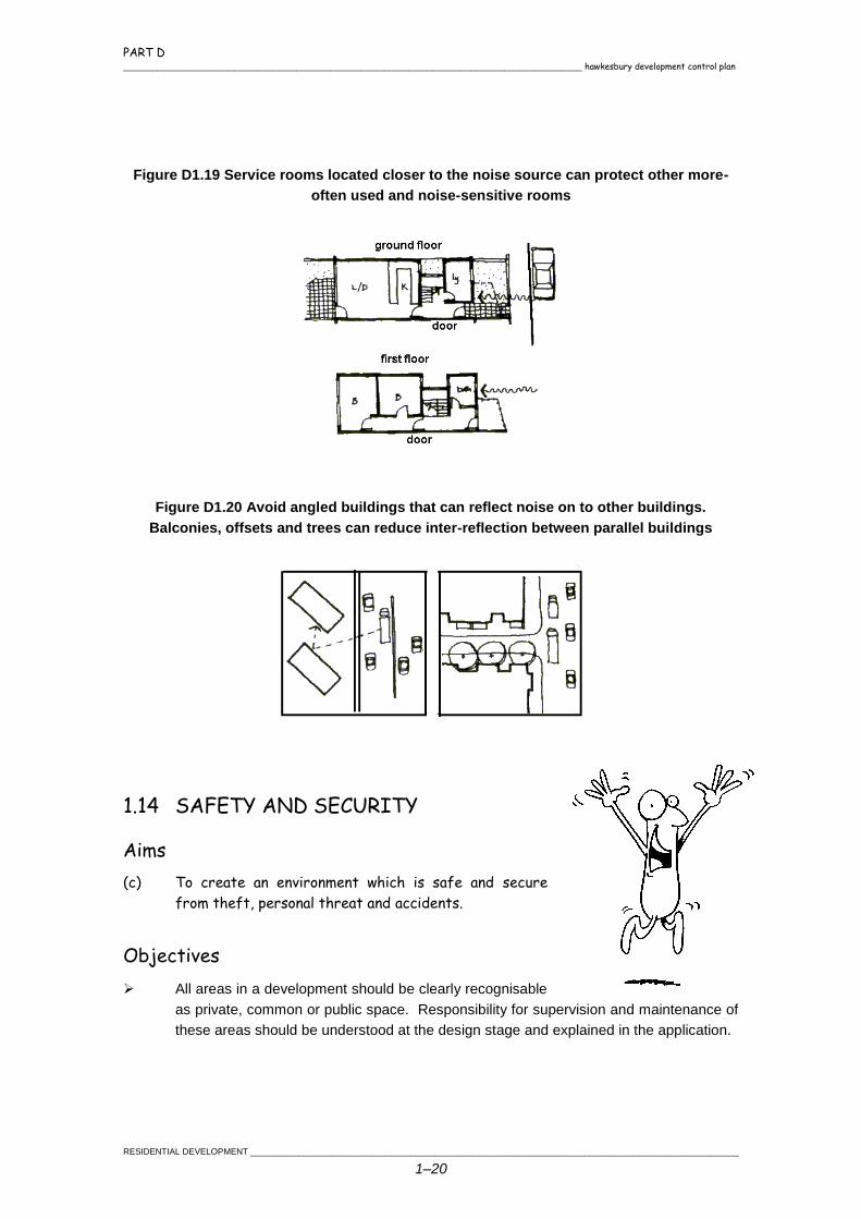
Figure D1.19 Service rooms located closer to the noise source can protect other more-
often used and noise-sensitive rooms
Figure D1.20 Avoid angled buildings that can reflect noise on to other buildings.
Balconies, offsets and trees can reduce inter-reflection between parallel buildings
1.14 SAFETY AND SECURITY
Aims
(c) To create an environment which is safe and secure
from theft, personal threat and accidents.
Objectives
All areas in a development should be clearly recognisable
as private, common or public space. Responsibility for supervision and maintenance of
these areas should be understood at the design stage and explained in the application.
PART D hawkesbury development control plan _______________________________________________________________________________________________
_____________________________________________________________________________________________________RESIDENTIAL DEVELOPMENT
1–21
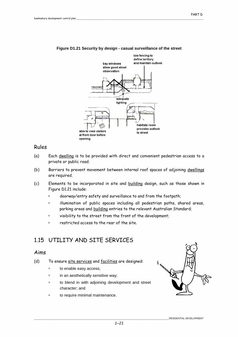
Figure D1.21 Security by design - casual surveillance of the street
Rules
(a) Each dwelling is to be provided with direct and convenient pedestrian access to a
private or public road.
(b) Barriers to prevent movement between internal roof spaces of adjoining dwellings
are required.
(c) Elements to be incorporated in site and building design, such as those shown in
Figure D1.21 include:
doorway/entry safety and surveillance to and from the footpath;
illumination of public spaces including all pedestrian paths, shared areas,
parking areas and building entries to the relevant Australian Standard;
visibility to the street from the front of the development;
restricted access to the rear of the site.
1.15 UTILITY AND SITE SERVICES
Aims
(d) To ensure site services and facilities are designed:
to enable easy access;
in an aesthetically sensitive way;
to blend in with adjoining development and street
character; and
to require minimal maintenance.
PART D _______________________________________________________________________________________________ hawkesbury development control plan
RESIDENTIAL DEVELOPMENT _____________________________________________________________________________________________________
1–22
(e) To ensure that there is no increase in the quantity of stormwater discharged from
any site and that its quality is improved.
(f) To ensure adequate supplies of water, sewer and electricity are available.
Rules
(a) Where reticulated water is not available, a minimum storage of 100000 litres must
be provided. A minimum of 10,000 litres must be available at all times for fire
fighting.
1.16 CABLES
Objectives
Electricity, telephone, television and other cables must be underground. Where there is
an existing connection of these cables directly from the service pole to the fascia of the
front dwelling, these lines only, may remain above ground.
Rules
(a) The design, location and construction of utility services must satisfactorily meet
the requirements of both the relevant servicing authority and Council.
1.17 RECYCLING, GARBAGE AND MAIL COLLECTION AREAS
Objectives
To ensure that each dwelling has arrangements for recycling, garbage and mail
collection.
Rules
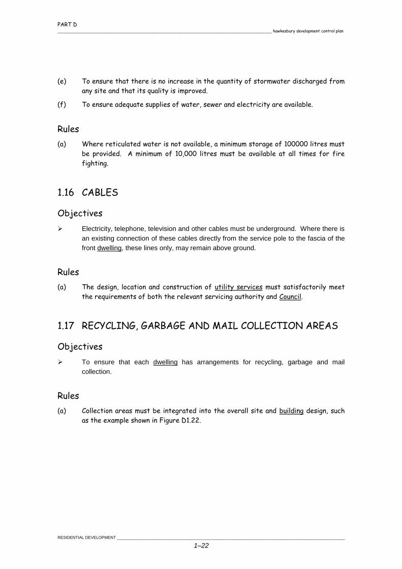
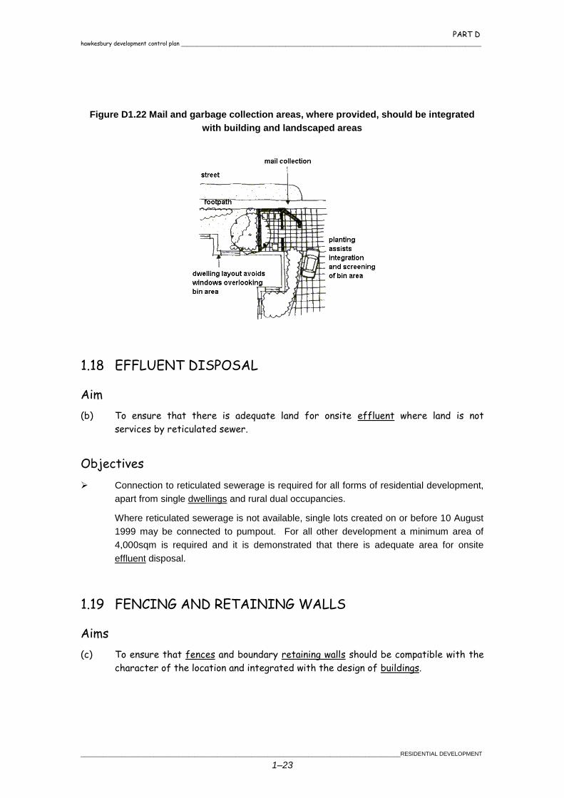
(a) Collection areas must be integrated into the overall site and building design, such
as the example shown in Figure D1.22.
PART D hawkesbury development control plan _______________________________________________________________________________________________
_____________________________________________________________________________________________________RESIDENTIAL DEVELOPMENT
1–23
Figure D1.22 Mail and garbage collection areas, where provided, should be integrated
with building and landscaped areas
1.18 EFFLUENT DISPOSAL
Aim
(b) To ensure that there is adequate land for onsite effluent where land is not
services by reticulated sewer.
Objectives
Connection to reticulated sewerage is required for all forms of residential development,
apart from single dwellings and rural dual occupancies.
Where reticulated sewerage is not available, single lots created on or before 10 August
1999 may be connected to pumpout. For all other development a minimum area of
4,000sqm is required and it is demonstrated that there is adequate area for onsite
effluent disposal.
1.19 FENCING AND RETAINING WALLS
Aims
(c) To ensure that fences and boundary retaining walls should be compatible with the
character of the location and integrated with the design of buildings.
PART D _______________________________________________________________________________________________ hawkesbury development control plan
RESIDENTIAL DEVELOPMENT _____________________________________________________________________________________________________
1–24
Objectives
Materials and colour that is compatible with the streetscape are to be used.
Common bricks or concrete blocks are to be painted, rendered or similarly treated.
Fences should be designed to cope with the nature, volume frequency of traffic noise
and pedestrian safety.
Rules
(a) Front fences where not screening private open space walls
are to be a maximum height of 1.2m if solid.
(b) Solid front fences may be 1.8m high and articulated if:
the site is located on a main or arterial road;
the site is not located within an established
heritage character;
the length is limited to 75% of the frontage where
private open space fronts the street and some
surveillance is maintained from the front dwelling;
and
fences do not exceed 10m in length without some
articulation or detailing to provide visual interest.
(c) The integration of trees and natural ground vegetation with the fence line is
desirable.
(d) The setback of the fence will be used for landscaping.
(e) Solid fences are to be 1 metre from the front boundary where not part of private
open space.
(f) Retaining walls shall:
not be taller than 500mm;
not cut through roots of any tree to be retained.
1.20 RURAL DUAL OCCUPANCIES
Aims
(g) To allow opportunities for an attached rural dual occupancy on rural land for
residential purposes.
(h) To ensure that rural dual occupancies are compatible in design with existing
dwellings.
PART D hawkesbury development control plan _______________________________________________________________________________________________
_____________________________________________________________________________________________________RESIDENTIAL DEVELOPMENT
1–25
Objectives
The attached rural dual occupancy is to be designed to appear as one dwelling through
the use of architectural features, compatible building materials and colour schemes.
To ensure that there is adequate area for the onsite
disposal of effluent for the dual occupancy.
Rules
(a) Attached dual occupancies shall be a single building
containing two dwellings and either share a common wall
or the main roof. Where the roof is shared, the
closest walls of the dwelling shall not be more than 6m
apart.
(b) Provision of a single driveway to service the dual
occupancy.


Chapter 2
INDUSTRIAL DEVELOPMENT

PART D hawkesbury development control plan _______________________________________________________________________________________________
______________________________________________________________________________________________________INDUSTRIAL DEVELOPMENT
2–1
2.1 GENERAL PRINCIPLES
This part of the DCP applies to all land zoned for
industrial purposes.
The general principles for industrial development
in Hawkesbury are to:
encourage economic development and
the creation of employment opportunities
to reduce the need for residents to
commute unreasonable distances to
obtain employment;
encourage good design and appearance
of industrial development for the benefit of
both developers and the public; and
balance these sometimes conflicting
objectives in favour of sound industrial and economic development.
2.2 BUILDING SETBACKS
Aims
(c) To ensure an attractive and maintained streetscape.
(d) To ensure that there is adequate vehicular sight distance at intersections.
(e) To minimise the cost of future widening to main or arterial roads.
(f) To provide adequate solar access to staff recreation areas.
Objectives
Buildings are sited so as to:
make adequate provision for landscaping; and
allow for adequate lines of sight for pedestrians, cyclists and motorists.
PART D _______________________________________________________________________________________________ hawkesbury development control plan
INDUSTRIAL DEVELOPMENT ______________________________________________________________________________________________________
2–2
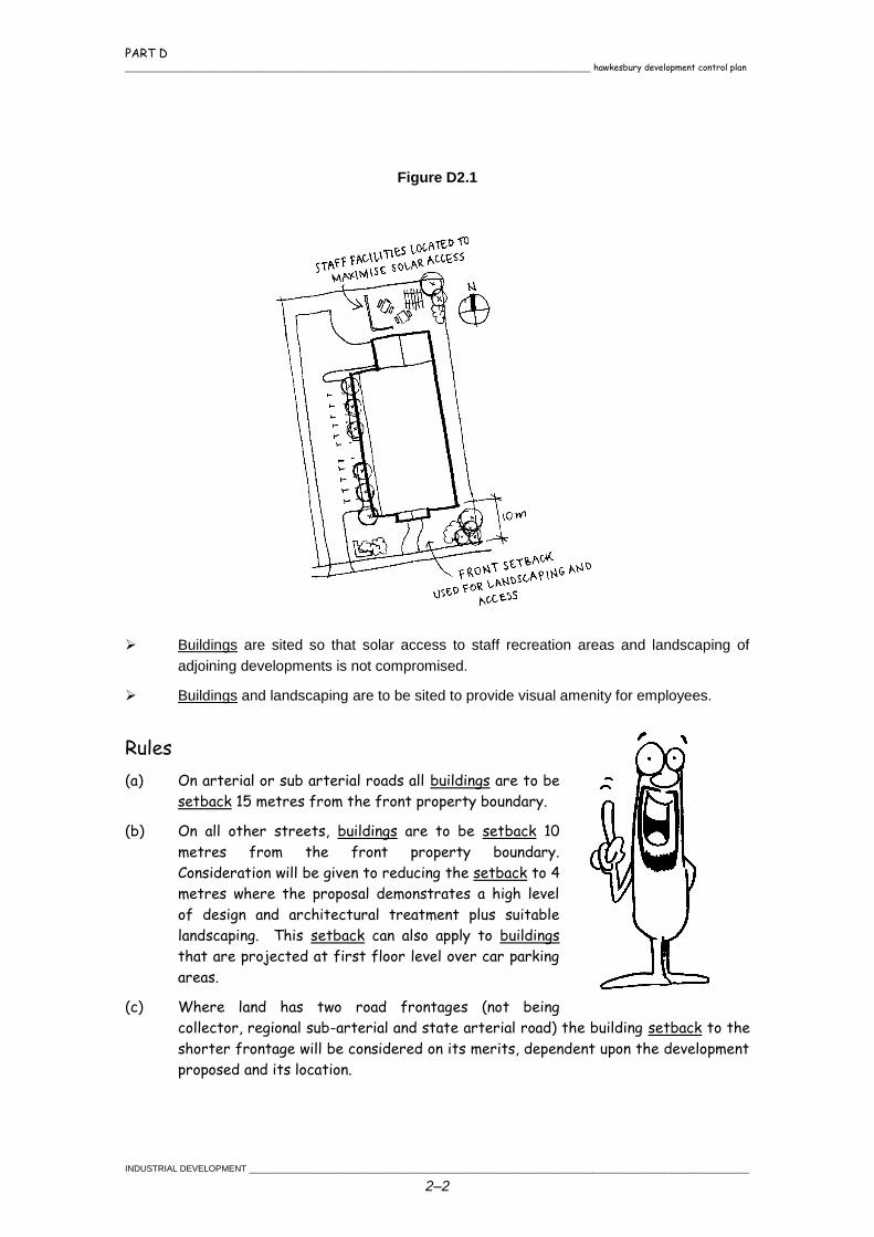
Figure D2.1
Buildings are sited so that solar access to staff recreation areas and landscaping of
adjoining developments is not compromised.
Buildings and landscaping are to be sited to provide visual amenity for employees.
Rules
(a) On arterial or sub arterial roads all buildings are to be
setback 15 metres from the front property boundary.
(b) On all other streets, buildings are to be setback 10
metres from the front property boundary.
Consideration will be given to reducing the setback to 4
metres where the proposal demonstrates a high level
of design and architectural treatment plus suitable
landscaping. This setback can also apply to buildings
that are projected at first floor level over car parking
areas.
(c) Where land has two road frontages (not being
collector, regional sub-arterial and state arterial road) the building setback to the
shorter frontage will be considered on its merits, dependent upon the development
proposed and its location.
PART D hawkesbury development control plan _______________________________________________________________________________________________
______________________________________________________________________________________________________INDUSTRIAL DEVELOPMENT
2–3
(d) The area between the street frontage and the minimum required building setback
is to be reserved for landscaping and access. The provision of car parking spaces
within this setback area will be considered provided the car spaces are not within
5m of the front boundary and are suitably screened by landscaping.
(e) Landscaping is required in the front setback. A landscape concept plan is required
in accordance with Part C Chapter 1 Landscaping.
2.3 RELATIONSHIP TO
ADJACENT DEVELOPMENT
Aims
(f) To protect the amenity of the adjacent
land users where necessary from the
effects of industrial development.
Objectives
Industrial land uses should be compatible with adjacent commercial, residential and/or
rural areas.
Rules
(a) The applicant may be required to indicate how the industrial land could be
developed and also show the location of landscaping, building and other site
planning techniques with the aim of minimising impact on adjoining commercial,
residential and/or rural uses.
2.4 BUILDING DESIGN AND CONSTRUCTION
Aims
(b) To ensure development is designed so it makes a positive contribution to the
streetscape.
(c) To provide attractive industrial building design through use of variation in facia
treatment, roof lines and selection of building materials.
(d) To ensure that service facilities are incorporated into the design of the
development.
PART D _______________________________________________________________________________________________ hawkesbury development control plan
INDUSTRIAL DEVELOPMENT ______________________________________________________________________________________________________
2–4
Objectives
The application is to demonstrate that the above aims are met.
Waste storage shall be in a location convenient to users and collection services.
Low maintenance materials should be used. Where possible materials should
incorporate the following:
use renewable resources;
be energy efficient;
be recycled or recyclable;
be non polluting; and
Non reflective materials should be used.
Rules
(a) Building facades to street frontages are to be constructed predominantly of face
brick, concrete panels or pre-coloured masonry blocks (not standard concrete
blocks) or glazing. Partial use of pre-coloured metallic sheeting for the street
façade will be considered where it enhances the architectural merit of the
building.
(b) Front elevations provided with visual relief by varying
the façade alignment, incorporating an entrance
treatment, and/or orientating office facilities along
the front façade. Roller shutters and loading docks
should generally not be located on the principle street
frontage.
(c) Walls separating factory units constructed in masonry
where required by the Building Code of Australia,
carried to the underside of the roof and sealed to
Council's satisfaction. Sections of units may be
partitioned with suitable materials.
(d) Where a lot contains a number of buildings, a colour
scheme or design feature should be used to unify all
buildings on the lot.
(e) The maximum reflectivity index permissible for any external glazing is 20%.
PART D hawkesbury development control plan _______________________________________________________________________________________________
______________________________________________________________________________________________________INDUSTRIAL DEVELOPMENT
2–5
2.5 FENCING
Aims
(f) To allow for security and ensure that fencing contributes to the streetscape and
amenity of the industrial areas.
Objectives
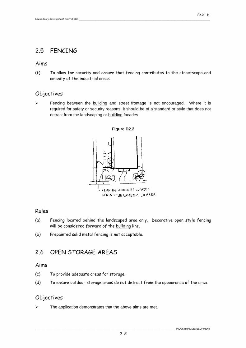
Fencing between the building and street frontage is not encouraged. Where it is
required for safety or security reasons, it should be of a standard or style that does not
detract from the landscaping or building facades.
Figure D2.2
Rules
(a) Fencing located behind the landscaped area only. Decorative open style fencing
will be considered forward of the building line.
(b) Prepainted solid metal fencing is not acceptable.
2.6 OPEN STORAGE AREAS
Aims
(c) To provide adequate areas for storage.
(d) To ensure outdoor storage areas do not detract from the appearance of the area.
Objectives
The application demonstrates that the above aims are met.
PART D _______________________________________________________________________________________________ hawkesbury development control plan
INDUSTRIAL DEVELOPMENT ______________________________________________________________________________________________________
2–6
Rules
(a) Open storage areas are to be screened from the road and adjoining land by screen
walls or other approved measures.
(b) Storage areas are to be located behind the building line.
2.7 ENVIRONMENTAL ISSUES
Aims
(e) To ensure noise levels generated by developments are
acceptable at other premises.
(f) To minimise impacts from chemical spills.
(g) To ensure air emissions are minimised.
Rules
(a) An acoustic report prepared by a qualified acoustic consultant submitted prior to
the approval of any noise generating development. The report shall include
background noise measurements, suitable noise criteria, an assessment of noise and
any noise control measures.
(b) Any machinery or activity considered to create a noise nuisance adequately sound-
proofed in accordance with the provisions of the Protection of the Environment Operations Act 1997 (POE Act).
(c) All chemical storage areas designed and maintained in accordance with Work Cover
Authority guidelines.
(d) Liquid waste sampling points provided for each industrial development in an easily
accessible location above ground.
(e) All roofing provided with adequate gutter and down pipes connected to the roof
water drainage system. Down pipes discharging to an open grated surface inlet pit.
(f) No industrial pollutants discharged to the stormwater and sewer without entering
into a Trade Waste Agreement with either Council or Sydney Water.
(g) The discharge of any pollutants into water courses as defined under the POE Act,
controlled to the satisfaction of Council and EPA at all times.
(h) Depending on the size, nature of use of the building, particular structures such as
bund walls, oil or grit separators, neutralisers, drainage provisions and the like may
be required.
Chapter 3
SUBDIVISION

PART D hawkesbury development control plan _______________________________________________________________________________________________
___________________________________________________________________________________________________________________ SUBDIVISION
3–1
3.1 GENERAL PRINCIPLES
The general principles for applying to subdivision in
Hawkesbury are to:
establish a consistent and coordinated approach
to the creation of residential, rural residential and
rural lots throughout Hawkesbury;
ensure that subdivision is undertaken in an
environmentally sustainable manner;
facilitate different subdivision forms which have
the effect of minimising environmental degradation;
address long term planning objectives as contained in Hawkesbury LEP by the creation
of lots in locations and of sizes consistent with those objectives;
ensure constructed vehicular access from gazetted public road system to each new lot;
ensure all lots created are physically capable of development;
adopt criteria for rural, rural-residential and residential lots which will ensure each lot is
provided with an appropriate level of amenity, services and access;
facilitate the supply of residential lots of a wide range of sizes and shapes which reflect
the statutory visions of Hawkesbury LEP, the availability of reticulated sewage and the
need for frontage to public roads; and
protect key cultural resources (places of environmental heritage value) from land use or
management practices which will lead to their degradation or destruction.
3.2 FLORA AND FAUNA PROTECTION
Aims
(i) To protect bushland, significant flora and fauna habitats and wildlife corridors
from the impacts of subdivision and subsequent development.
Objectives
The movement of fauna species on sites should be maximised so as to maintain
biological diversity within the subdivision and road network.
Opportunities for revegetation should be pursued as part of the subdivision process as
a trade off for site development and as a means of value adding to the environment
through the development process.
PART D _______________________________________________________________________________________________ hawkesbury development control plan
SUBDIVISION ___________________________________________________________________________________________________________________
3–2
Rules
(a) Any subdivision proposal which is likely to result in any
clearing of native vegetation or impact on any
environmentally sensitive area is to be accompanied by a
flora and fauna assessment report prepared by a suitably
qualified person. This report is to primarily address the
Eight Part Test pursuant to the Act (Section 5A) and State
Environmental Planning Policy 44 - Koala Habitat Protection.
(b) Vegetation cover should be retained where ever practicable
as it acts to stabilise soils, minimise runoff, acts as a
pollutant trap along watercourses and is important as a habitat for native fauna.
(c) Degraded areas are to be rehabilitated as part of the subdivision.
(d) Vegetation should be retained where it forms a link between other bush land areas.
(e) Vegetation which is scenically and environmentally significant should be retained.
(f) Vegetation which adds to the soil stability of the land should be retained.
(g) All subdivision proposals should be designed so as to minimise fragmentation of
bushland.
3.3 VISUAL AMENITY
Aims
(h) To ensure that subdivision proposals do not facilitate development which would
detrimentally impact upon important views and vistas.
(i) To ensure that subdivision proposals are designed so as to preserve and enhance
any visual landscapes.
Objectives
A subdivision proposal should be:
designed to have minimal impact on significant views and vistas; and
compatible with the cultural and landscape characteristics of the locality or
region.
Rules
(a) Building envelopes, accessways and roads shall avoid ridge tops and steep slopes.
(b) Subdivision of escarpments, ridges, and other visually interesting places should:
PART D hawkesbury development control plan _______________________________________________________________________________________________
___________________________________________________________________________________________________________________ SUBDIVISION
3–3
be managed in such a way that the visual impact rising from development on
newly created allotments is minimal; and
retain visually significant vegetation such as that found on ridge tops and
other visually prominent locations.
(c) Development Applications for subdivision shall take into consideration the
provisions of SREP20 in relation to scenic quality.
3.4 HERITAGE
Aims
(d) To protect heritage items, their settings and conservation areas.
(e) To ensure that the design of new subdivisions take into consideration and respect
the heritage significance of heritage items and other places and features of the
City's historical character.
Objectives
Subdivision should be sympathetically designed to minimise the impact on heritage
items of the subject land or adjoining lands.
The subdivision should maintain a reasonable curtilage around heritage items on the
subject land or surrounding lands.
Subdivisions should be sympathetically designed to ensure that the existing heritage
value of the streetscape and character of the area is maintained.
Rules
(a) A subdivision proposal on land which contains or is adjacent to
an item of environmental heritage as defined in Schedule 1 of
the Hawkesbury LEP should illustrate the means proposed to
preserve and protect such items. With such subdivisions a
Heritage Impact Statement may be required to determine the
heritage curtilage. Council staff and Council's Heritage
Advisor should be consulted in this regard.
3.5 UTILITY SERVICES
Aims
(f) To provide public utilities in a safe, efficient and cost effective manner.
(g) To provide public utilities in such a way as to maximise retention of vegetation.
PART D _______________________________________________________________________________________________ hawkesbury development control plan
SUBDIVISION ___________________________________________________________________________________________________________________
3–4
Objectives
All lots created for residential purposes should have an adequate provision of utility
services and not result in a detrimental impact on the environment.
The design and provision of public utilities should conform to the cost effective criteria of
the relevant servicing authority.
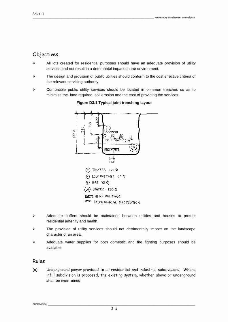
Compatible public utility services should be located in common trenches so as to
minimise the land required, soil erosion and the cost of providing the services.
Figure D3.1 Typical joint trenching layout
Adequate buffers should be maintained between utilities and houses to protect
residential amenity and health.
The provision of utility services should not detrimentally impact on the landscape
character of an area.
Adequate water supplies for both domestic and fire fighting purposes should be
available.
Rules
(a) Underground power provided to all residential and industrial subdivisions. Where
infill subdivision is proposed, the existing system, whether above or underground
shall be maintained.
PART D hawkesbury development control plan _______________________________________________________________________________________________
___________________________________________________________________________________________________________________ SUBDIVISION
3–5
(b) All lots created are to have the provision of power.
(c) Where reticulated water is not available, a minimum storage of 100,000 litres must
be provided. A minimum of 10,000 litres must be available at all times on Bushfire
Prone Land.
3.6 FLOODING, LANDSLIP & CONTAMINATED LAND
Aims
(d) Subdivision proposals should be designed to minimise the risk to life and/or
property from flooding, landslip and contaminated land.
Objectives
Subdivision of flood prone land should not result in increased risk to life or property both
on the subject land and adjoining lands.
Subdivision of land that has been identified as being prone to landslip should not
increase the risk to life or property on the subject land or adjoining lands.
Rules
(a) Compliance with clause 25 of Hawkesbury Local Environmental Plan 1989.
(b) Access to the subdivision shall be located above the 1% AEP flood level.
(c) Where a subdivision proposal is on land identified as being potentially subject to
landslip, the applicant shall engage a geotechnical consultant to prepare a report on
the viability of subdividing the land and provide recommendations as to the siting
and the type of buildings which could be permitted on the subject land.
(d) In the event that Council deems that there is the potential that land subject to a
subdivision application is contaminated then the applicant shall engage a suitably
qualified person to undertake a soil and ground water assessment.
(e) Contaminated Land shall be remediated prior to the issue of the Subdivision
Certificate.
3.7 RESIDENTIAL SUBDIVISION
3.7.1 Residential Local Street Design
Aims
(f) To create street networks in which the function of each street is clearly defined.
(g) To ensure that vehicular and pedestrian access is simple, safe and direct.
PART D _______________________________________________________________________________________________ hawkesbury development control plan
SUBDIVISION ___________________________________________________________________________________________________________________
3–6
(h) To minimise the impact of traffic on the residential amenity of the locality.
Objectives
Street widths should reflect the role and function of the street in the road hierarchy.
Streets should be designed to allow on street car parking.
Streets should be designed to cater for service vehicles.
Streets should be designed to provide interest and variety in the streetscape through
kerbs (where appropriate), landscaping and paving treatments. The street design
should be compatible with the existing road pattern in the locality.
Junctions along residential streets should be spaced to create safe and convenient
vehicle movements.
The street network should create a convenient route for residents between their home
and higher order roads.
The street network should facilitate walking and cycling within the neighbourhood and to
local activity centres.
The street network should take into account existing topography and existing open
space systems.
Streets should not operate as through traffic routes for externally generated traffic while
at the same time limiting the length of time local drivers need to spend in a low speed
environment.
Streets and lots should be located so that residential dwellings are not subjected to
unacceptable traffic noise.
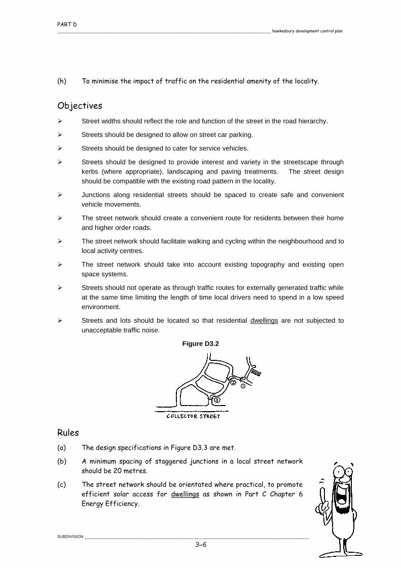
Figure D3.2
Rules
(a) The design specifications in Figure D3.3 are met.
(b) A minimum spacing of staggered junctions in a local street network
should be 20 metres.
(c) The street network should be orientated where practical, to promote
efficient solar access for dwellings as shown in Part C Chapter 6
Energy Efficiency.
PART D hawkesbury development control plan _______________________________________________________________________________________________
___________________________________________________________________________________________________________________ SUBDIVISION
3–7
(d) Cul-de-sacs for residential roads should have minimum seal radii of 8.5 metres and
boundary radii of 12.0 metres.
(e) Cul-de-sacs should not exceed 200 metres in length unless topographic constraints
render other options impracticable.
(f) Off street parking shall be provided in cul-de-sacs at the rate of 1 space per lot.
(g) Streets should be designed to allow for the provision of suitable and safe
conditions for street trees.
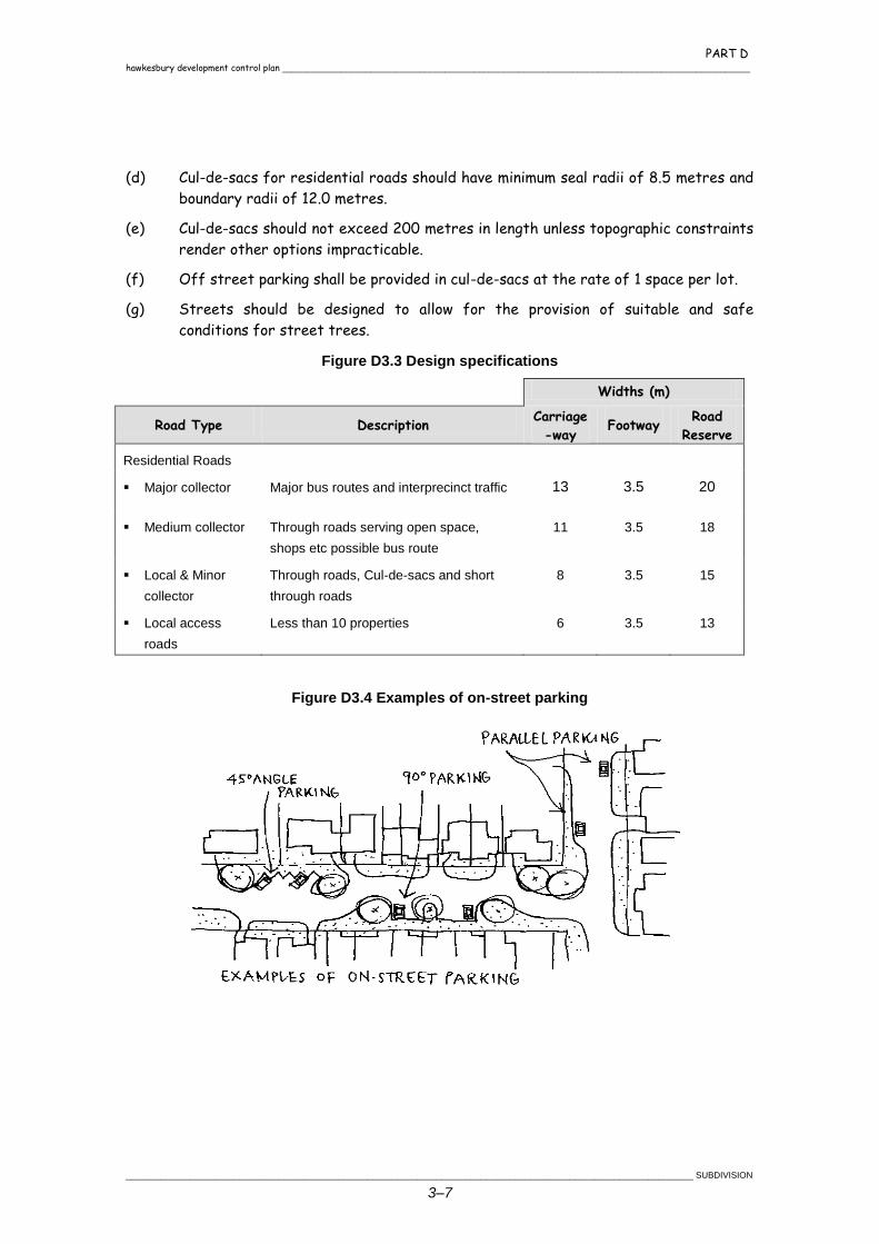
Figure D3.3 Design specifications
Widths (m)
Road Type Description Carriage
-way Footway
Road
Reserve
Residential Roads
Major collector Major bus routes and interprecinct traffic 13 3.5 20
Medium collector Through roads serving open space,
shops etc possible bus route
11 3.5 18
Local & Minor
collector
Through roads, Cul-de-sacs and short
through roads
8 3.5 15
Local access
roads
Less than 10 properties 6 3.5 13
Figure D3.4 Examples of on-street parking
PART D _______________________________________________________________________________________________ hawkesbury development control plan
SUBDIVISION ___________________________________________________________________________________________________________________
3–8
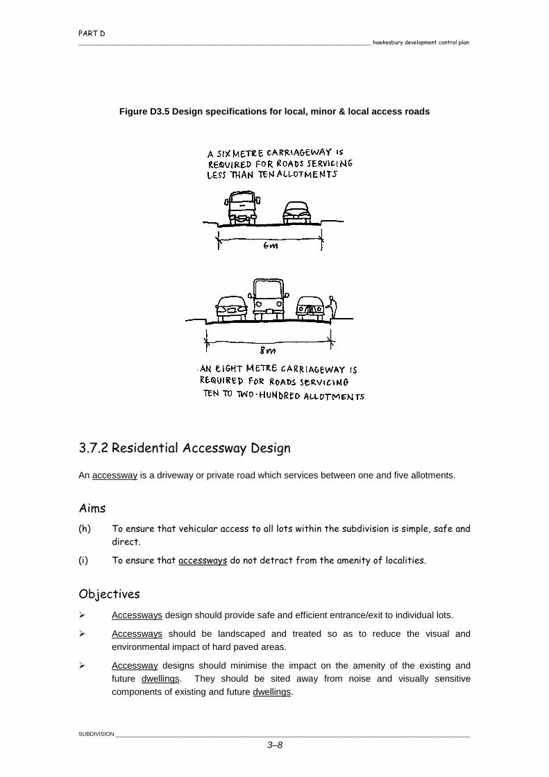
Figure D3.5 Design specifications for local, minor & local access roads
3.7.2 Residential Accessway Design
An accessway is a driveway or private road which services between one and five allotments.
Aims
(h) To ensure that vehicular access to all lots within the subdivision is simple, safe and
direct.
(i) To ensure that accessways do not detract from the amenity of localities.
Objectives
Accessways design should provide safe and efficient entrance/exit to individual lots.
Accessways should be landscaped and treated so as to reduce the visual and
environmental impact of hard paved areas.
Accessway designs should minimise the impact on the amenity of the existing and
future dwellings. They should be sited away from noise and visually sensitive
components of existing and future dwellings.
PART D hawkesbury development control plan _______________________________________________________________________________________________
___________________________________________________________________________________________________________________ SUBDIVISION
3–9
Accessways should provide interest and variety and avoid lengthy straight sections.
Rules
(a) Accessways should have a minimum width of 4 metres
and sealed pavement of 2.5 metres.
(b) Accessways should not serve more than 5 lots.
(c) Accessways should have a maximum grade of 25% (1:4)
at any point.
(d) Where the accessways is steep or fronts a local
collector or higher order road (greater than 3,000
vehicles per day) or a high pedestrian area, accessways
should be designed so that vehicles can be driven both
onto and off the property in a forward direction.
(e) Where vehicles would otherwise have to reverse more than 50 metres, a turning
area should be provided to enable the vehicles to enter and leave the site in a
forward direction and reduce the need to reverse over long distances.
(f) Refer to Part D Chapter 1 Residential Development for further requirements
regarding accessways should a subdivision be part of a residential development.
PART D _______________________________________________________________________________________________ hawkesbury development control plan
SUBDIVISION ___________________________________________________________________________________________________________________
3–10
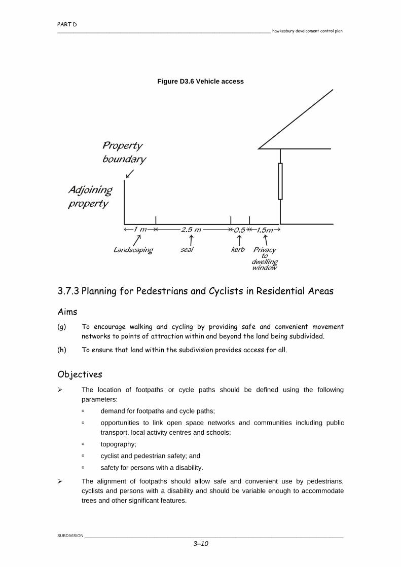
Figure D3.6 Vehicle access
3.7.3 Planning for Pedestrians and Cyclists in Residential Areas
Aims
(g) To encourage walking and cycling by providing safe and convenient movement
networks to points of attraction within and beyond the land being subdivided.
(h) To ensure that land within the subdivision provides access for all.
Objectives
The location of footpaths or cycle paths should be defined using the following
parameters:
demand for footpaths and cycle paths;
opportunities to link open space networks and communities including public
transport, local activity centres and schools;
topography;
cyclist and pedestrian safety; and
safety for persons with a disability.
The alignment of footpaths should allow safe and convenient use by pedestrians,
cyclists and persons with a disability and should be variable enough to accommodate
trees and other significant features.
PART D hawkesbury development control plan _______________________________________________________________________________________________
___________________________________________________________________________________________________________________ SUBDIVISION
3–11
Paths should be constructed to provide a stable surface for pedestrians, cyclists and
persons with a disability and which is easily maintained.
Rules
(a) No footpaths are required on streets with traffic volumes less than 300 vehicles
per day.
(b) Footpaths should be provided on one side of streets with traffic volumes between
300 vehicles per day and 2,000 vehicles per day, and on both sides of streets with
traffic volumes over 2,000 vehicles per day.
(c) Footpaths are to be designed in accordance with Australian Standard AS1428.2-
1992 Design for Access and Mobility.
3.7.4 Stormwater Management
Aims
(d) To control the flow of water into the natural and man made drainage systems in
such a way to minimise impacts from storm water runoff.
(e) To contribute positively to the environmental enhancement of catchment areas.
(f) To provide water quality management systems which:
ensure that disturbance to natural stream systems is minimal; and
storm water discharge to surface and underground receiving waters, both during
construction and during residential use of the subject land, does not degrade the
quality of the water at the receiving end.
Objectives
Drainage from subdivision sites should be consistent in both water quality and quantity
terms with the predevelopment storm water patterns.
Drainage systems should be designed so as to ensure safety and minimise the
likelihood of storm water inundation of existing and future dwellings.
Adequate provision should be made for measures during construction to ensure that the
landform is stabilised and erosion controlled.
Rules
(a) Where site topography prevents discharge of storm
water directly to the street gutter or a Council
controlled pipe system, inter allotment drainage provided
to accept run off from all existing or future impervious
PART D _______________________________________________________________________________________________ hawkesbury development control plan
SUBDIVISION ___________________________________________________________________________________________________________________
3–12
areas on the subject land. The design and construction of the inter allotment
drainage system should be in accordance with the requirements of the Australian
Rainfall and Runoff (1987).
(b) Where proposals require the creation of easements over downstream properties
for drainage purposes, a letter of consent from the owner(s) of the downstream
properties should be submitted with DAs.
(c) Stormwater piped in roads and through allotments in all residential subdivisions.
(d) For subdivision proposals comprising 5 lots or more or where Council deems it
necessary, a soil and water management plan should be prepared by a properly
qualified practitioner with the aim of minimising erosion and maximising the quality
of any water leaving the site.
3.7.5 Lot Size and Shape
Aims
(e) To ensure that newly created allotments have dimensions which allow flexibility
and choice of housing design whilst minimising development costs.
(f) To promote allotments of varying sizes which provide pleasant streetscapes,
satisfy user requirements and minimise environmental impacts.
Objectives
Lot sizes and dimensions should enable dwellings to be sited to:
protect natural and cultural features;
acknowledge site constraints including soil erosion and bush fire risk;
retain special features such as trees and views;
dispose of effluent on site where sewer not available; and
Provide for wildlife habitats and the growth of trees.
Lot sizes and configurations should be varied to provide a mix of allotment types which
create pleasant streetscapes and encourage a variety of housing
types.
Rules
(a) In calculating the area of a battle-axe or hatchet shaped
allotment the accessway is to be excluded. The area of an
allotment effected by a "right of carriage way" or private
road should also be excluded.
(b) Allotments should have a minimum width of 15 metres at the
building line. Council may consider a lesser dimension but only
as part of an integrated housing development.
PART D hawkesbury development control plan _______________________________________________________________________________________________
___________________________________________________________________________________________________________________ SUBDIVISION
3–13
(c) Lots should be able to accommodate a building envelope of 200m2 with a minimum
dimension of 10 metres.
(d) An allotment should not be less than 20 metres in depth to ensure there is some
flexibility in the choice of housing design and siting as well as the availability of
suitable space for other activities normally associated with a dwelling.
(e) Vegetation which adds significantly to the visual amenity of a locality and/or which
is environmentally significant should be conserved in the design of the subdivision
proposal.
(f) Lots should be designed to allow the construction of a dwelling with a maximum cut
or fill of 1 metre from the natural ground level.
3.7.6 Solar Access and Lot Orientation
Aims
(g) To encourage the design of subdivisions which maximise solar access.
(h) To ensure flexibility in the siting of buildings to take advantage of a northern
orientation.
(i) To maximise the number of allotments which have good solar access and therefore
which optimise the design performance of energy smart homes.
Objectives
Lots should be designed to maximise solar access.
Lots should be orientated to take advantage of micro climatic benefits and have
dimensions to allow adequate on site solar access, taking into account likely future
dwelling size and a relationship of each lot to the streets.
Lots are of a suitable shape to permit the location of a dwelling with suitable solar
access and private open space.
Rules
(a) Lots orientated to provide long access in a northerly direction (plus or minus 200).
(b) Eighty per cent of lots in a new subdivision having 5 star solar access, and the
remainder either 4 or 3 star.
(c) On a street running north-south, lots to be increased in width to enable private
open space on the northern side of the building envelope.
(d) Lots designed so that future buildings will not overshadow neighbouring houses to
the south, and have a sufficiently long northern facade to receive winter sun.
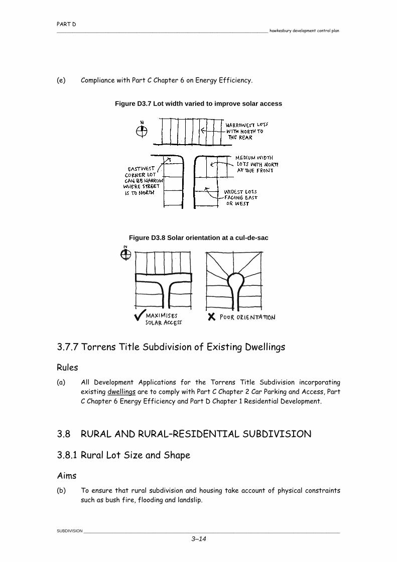
PART D _______________________________________________________________________________________________ hawkesbury development control plan
SUBDIVISION ___________________________________________________________________________________________________________________
3–14
(e) Compliance with Part C Chapter 6 on Energy Efficiency.
Figure D3.7 Lot width varied to improve solar access
Figure D3.8 Solar orientation at a cul-de-sac
3.7.7 Torrens Title Subdivision of Existing Dwellings
Rules
(a) All Development Applications for the Torrens Title Subdivision incorporating
existing dwellings are to comply with Part C Chapter 2 Car Parking and Access, Part
C Chapter 6 Energy Efficiency and Part D Chapter 1 Residential Development.
3.8 RURAL AND RURAL–RESIDENTIAL SUBDIVISION
3.8.1 Rural Lot Size and Shape
Aims
(b) To ensure that rural subdivision and housing take account of physical constraints
such as bush fire, flooding and landslip.
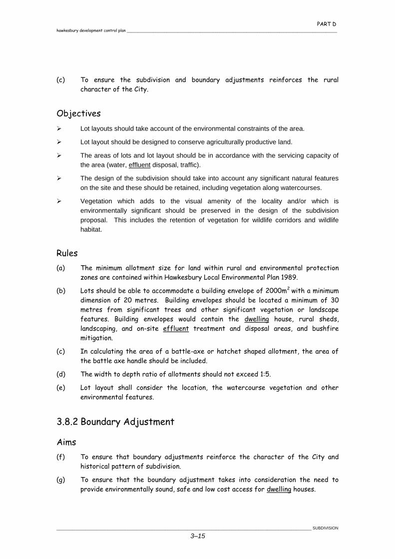
PART D hawkesbury development control plan _______________________________________________________________________________________________
___________________________________________________________________________________________________________________ SUBDIVISION
3–15
(c) To ensure the subdivision and boundary adjustments reinforces the rural
character of the City.
Objectives
Lot layouts should take account of the environmental constraints of the area.
Lot layout should be designed to conserve agriculturally productive land.
The areas of lots and lot layout should be in accordance with the servicing capacity of
the area (water, effluent disposal, traffic).
The design of the subdivision should take into account any significant natural features
on the site and these should be retained, including vegetation along watercourses.
Vegetation which adds to the visual amenity of the locality and/or which is
environmentally significant should be preserved in the design of the subdivision
proposal. This includes the retention of vegetation for wildlife corridors and wildlife
habitat.
Rules
(a) The minimum allotment size for land within rural and environmental protection
zones are contained within Hawkesbury Local Environmental Plan 1989.
(b) Lots should be able to accommodate a building envelope of 2000m2 with a minimum
dimension of 20 metres. Building envelopes should be located a minimum of 30
metres from significant trees and other significant vegetation or landscape
features. Building envelopes would contain the dwelling house, rural sheds,
landscaping, and on-site effluent treatment and disposal areas, and bushfire
mitigation.
(c) In calculating the area of a battle-axe or hatchet shaped allotment, the area of
the battle axe handle should be included.
(d) The width to depth ratio of allotments should not exceed 1:5.
(e) Lot layout shall consider the location, the watercourse vegetation and other
environmental features.
3.8.2 Boundary Adjustment
Aims
(f) To ensure that boundary adjustments reinforce the character of the City and
historical pattern of subdivision.
(g) To ensure that the boundary adjustment takes into consideration the need to
provide environmentally sound, safe and low cost access for dwelling houses.
PART D _______________________________________________________________________________________________ hawkesbury development control plan
SUBDIVISION ___________________________________________________________________________________________________________________
3–16
(h) To maintain historically significant views or vistas to or from a heritage item.
(i) To ensure that the land is capable of effluent disposal.
(j) To ensure that the environment will be improved as a result of the adjustment.
Objectives
Lot sizes should be compatible with the character of the surrounding area.
Lot sizes and lot layouts should take into account the environmental characteristics of
the area.
Rules
(a) Variations of less than 20% from the original lot sizes are considered to be
boundary adjustments. Adjustments of more than 20% are to be assessed under
clause 11 of Hawkesbury Local Environmental Plan 1989.
(b) The design of the boundary adjustment should provide environmentally sound, safe
and low cost access to dwelling sites.
(c) The design of the boundary adjustment should take into consideration a
historically significant view or vista to or from a heritage item.
(d) The land should be capable of on-site effluent where no reticulated sewerage
system is available.
3.8.3 Rural Road and Accessway Design
Aims
(e) To prevent the establishment of traffic generating development along main and
arterial roads.
(f) To provide environmentally sound, safe, low cost and convenient access to all
rural/rural residential subdivisions.
Objectives
Existing roads should be upgraded where necessary to accommodate increased traffic
arising from new subdivisions.
The impact of new road or accessway works on adjoining residents should be
minimised.
Road and accessway construction should take account of existing topography and
vegetation. Cut and fill should be minimised and vegetation retained where ever
practicable. The provision of under road fauna crossings may be required.
PART D hawkesbury development control plan _______________________________________________________________________________________________
___________________________________________________________________________________________________________________ SUBDIVISION
3–17
Rules
(a) The design specifications in Figure D3.9 at the end of
this clause are to be met.
(b) Where the road width is insufficient or unsatisfactory,
an applicant should dedicate or provide land required
for local road widening or new roads at no cost to
Council.
(c) Upgrading of the accessway from the nearest sealed
road to the proposed subdivision to an all weather
standard suitable for the expected traffic generation
arising from the subdivision. This work may require the
sealing of the pavement dependent upon traffic
generation.
(d) Where access to the subdivision is via a Crown or Reserve road in addition to the
above, the road should be fully constructed to a standard commensurate with
roads in the locality and linked to the nearest Council road. Prior to any
construction works being undertaken the relevant section of Crown road is to be
transferred to Council.
(e) The road fronting the subdivision shall be sealed into half width (minimum 3.5
metres). An all weather standard of road construction may be acceptable where
the expected traffic volume generated by the subdivision proposal is low and no
sealed roads in the vicinity.
(f) Water courses should be piped where they cross roads and the applicant should
create drainage easements generally 10 metres long and 4 metres wide over the
point of any discharge of any water from any public road onto private property.
(g) All internal driveways shall be constructed to an all weather standard suitable for
the expected traffic generation. An all weather access should also be provided
across the footway to any battle-axe lot. Such access should be sealed within the
vicinity of existing houses on adjoining lots where dust nuisance may occur and also
on steeply sloping land.
(h) Where 3 or more individual access handles are proposed, common roads are to be
provided.
(i) Battle axe handles shall have a minimum width of 6 metres.
(j) Accessways should have a maximum grade of 25% (1:4) and be sealed if the grade
exceeds 1:6, concrete if exceeds 1 in 5.
(k) Where an accessway meets a public road there should be a minimum sight distance
of 70 metres. This may be increased on roads with a high speed limit.
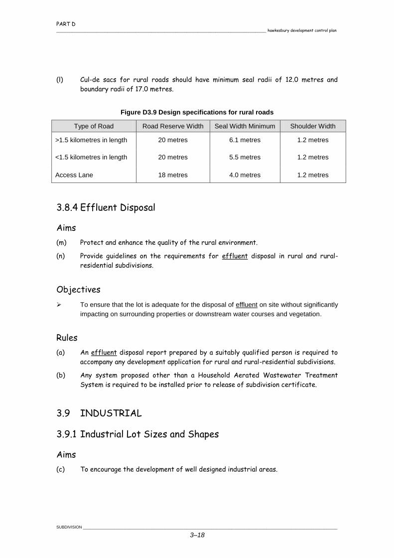
PART D _______________________________________________________________________________________________ hawkesbury development control plan
SUBDIVISION ___________________________________________________________________________________________________________________
3–18
(l) Cul-de sacs for rural roads should have minimum seal radii of 12.0 metres and
boundary radii of 17.0 metres.
Figure D3.9 Design specifications for rural roads
Type of Road Road Reserve Width Seal Width Minimum Shoulder Width
>1.5 kilometres in length 20 metres 6.1 metres 1.2 metres
<1.5 kilometres in length 20 metres 5.5 metres 1.2 metres
Access Lane 18 metres 4.0 metres 1.2 metres
3.8.4 Effluent Disposal
Aims
(m) Protect and enhance the quality of the rural environment.
(n) Provide guidelines on the requirements for effluent disposal in rural and rural-
residential subdivisions.
Objectives
To ensure that the lot is adequate for the disposal of effluent on site without significantly
impacting on surrounding properties or downstream water courses and vegetation.
Rules
(a) An effluent disposal report prepared by a suitably qualified person is required to
accompany any development application for rural and rural-residential subdivisions.
(b) Any system proposed other than a Household Aerated Wastewater Treatment
System is required to be installed prior to release of subdivision certificate.
3.9 INDUSTRIAL
3.9.1 Industrial Lot Sizes and Shapes
Aims
(c) To encourage the development of well designed industrial areas.
PART D hawkesbury development control plan _______________________________________________________________________________________________
___________________________________________________________________________________________________________________ SUBDIVISION
3–19
Objectives
Provision should be made for a variety of lot sizes.
The size of lots should provide sufficient space to accommodate the industrial
operations and buildings envisaged, which entails factors such as safe ingress and
egress, vehicular movement with the curtilage of the site, parking, deliveries, storage
and bin areas, boundary setback requirements and landscaped areas to be considered
in subdivision design.
Lots shall have dimensions which permit the safe manoeuvring of trucks within the lot
so that trucks and cars can leave the lot in a forward direction.
Rules
(a) Minimum width of lots in an industrial zone shall be 30 metres at the building line.
Lot widths of less than 30 metres will be considered where lots are part of an
integrated industrial development.
(b) Battle-axe shaped allotments shall comply with the minimum width at the building
line stated above. Battle-axe handles shall have a minimum width of 8 metres.
3.9.2 Industrial Access and Road Layout
Aims
(c) To provide for the safe and efficient movement of traffic to and from each
proposed lot within the industrial areas.
Objectives
Access from individual lots to major roads should be minimised. The use of minor
roads for such access is desirable where ever practicable.
Rules
(a) The design specifications for roads servicing industrial lots contained in Figure
D3.10 are met.
(b) Cul-de sacs for industrial roads should have minimum kerb radii of 13.5 metres and
boundary radii of 17.0 metres
(c) Battle-axe lots may be acceptable for light and service industries which are not
serviced by larger vehicles. Details such as the shape of the effective lot area,
the need for truncation in the lot and the width of the access handle will be
determined on a case by case basis.

PART D _______________________________________________________________________________________________ hawkesbury development control plan
SUBDIVISION ___________________________________________________________________________________________________________________
3–20
Figure D3.10 Design specifications for roads servicing industrial lots
Road Reserve Width Carriage Way Width Minimum Footpath
20 metres 13 metres 3.5 metres
Chapter 4
BROTHELS

PART D hawkesbury development control plan _______________________________________________________________________________________________
_____________________________________________________________________________________________________________________BROTHELS
4–1
4.1 INTRODUCTION
The gazettal of the Disorderly Houses Act 1995, means
that it is no longer illegal to operate a brothel, or for the
owner of a brothel to live on the earnings of prostitution.
Brothels do, however, require development consent from
Council before they can operate. They must also comply
with Council's planning controls. These controls are
contained within the Hawkesbury LEP and this chapter of
the DCP.
A brothel is permitted only with the consent of Council within the Business General 3(a) zone
and Business Special 3(b) zone. Consideration will not be given to Brothels in any other zone.
The planning controls are designed to ensure that brothels operate in appropriate locations so
that they minimise the effects on the community and do not result in the loss of any amenity.
Council takes the provisions of this DCP into consideration in determining DAs for the operation
of brothels.
4.2 OBJECTIVES
The general aims in relation to the development of brothels within the City are to:
to ensure that brothels are appropriately located so that they minimise offence to the
community and any adverse social impacts;
to ensure that the access to brothels is discreet and safe for patrons and staff;
to ensure that brothels are designed so as to minimise the impact and presence of the
development in the locality;
to ensure that there is adequate provision for
off-street car parking;
to ensure that the advertising of brothels is
discreet and does not cause offence to the
general public;
to promote the safe and healthy operation of
brothels;
to ensure that brothels operate at times where
they will have least impact on the community
and surrounding neighbourhood; and
to allow Council to monitor the operation of approved brothels in terms of compliance
with conditions of consent and complaints from the general public.
PART D _______________________________________________________________________________________________ hawkesbury development control plan
BROTHELS _____________________________________________________________________________________________________________________
4–2
4.3 KEY ASSESSMENT ISSUES
4.3.1 Locational Characteristics
Objectives
Brothels are to be located so that they minimise offence to the community and do not
create adverse social impacts.
Brothels are to be only located within the Business General 3(a) zone and Business
Special 3(b) zone.
Rules
(a) Except for access, brothels must not be located at street level.
(b) Brothels are not to be located in such concentration (either alone or in combination
with other sex related businesses) as to result in the creation of a "red light"
district.
(c) Brothels must not be located within 100 metres of detached dwellings, churches,
schools, hospitals and child care centres measured in a straight line from the
proposed development.
(d) Brothels must not adjoin a residential flat, an activity operated by a religious
institution, restaurant, supermarkets or video or amusement parlours/arcades.
4.3.2 Access
Objectives
Access to brothels is to be discreet.
Access to the premises must be discreetly illuminated so that people visiting the brothel
do not loiter outside the premises.
Rules
(a) Access to the brothel (except from an arcade) should not be common to other
commercial or residential uses.
(b) If access is via a side lane or rear entrance, the accessway is to be clearly lit to
avoid safety problems for patrons.
PART D hawkesbury development control plan _______________________________________________________________________________________________
_____________________________________________________________________________________________________________________BROTHELS
4–3
4.3.3 Design and Layout
Objectives
Brothels must be visually discreet and low key.
Rules
(a) Brothels must not contain more than six separate rooms
for the purposes of prostitution.
(b) Brothels must be provided with a waiting room of at
least 20m2 in size.
(c) All brothels must be fitted with the necessary
facilities and services for Class 5 buildings (an office
building used for professional or commercial premises)
under the BCA.
(d) All windows are to be covered by blinds or curtains at
all times with the covering material blending with the
external colours of the building.
4.3.4 Parking
Objectives
Brothels are to provide an adequate number of car parking spaces to meet parking
demand.
Rules
(a) Brothels are to be provided with car parking at the rate of two spaces per room
used for prostitution.
(b) Design and layout of car parking is to be in accordance with the car parking
standards as set out in Part C Chapter 2 of this DCP.
4.3.5 Hours of Operation
Objectives
Hours of operation will be determined at Council's discretion taking into consideration
other land uses within the neighbourhood and to avoid times of peak community
activity.
PART D _______________________________________________________________________________________________ hawkesbury development control plan
BROTHELS _____________________________________________________________________________________________________________________
4–4
4.3.6 Signage
Objectives
Signage is to be discreet so as not to cause concern to the general public.
Rules
(a) No chain bulb or flashing sign on the premises is permitted.
(b) The only signage which is to be permitted is a sign located either on the entrance
door or wall adjacent to the entrance to the premises.
(c) The sign is to have an area not in excess of 0.75 square metres.
(d) The sign is to detail the name of the premises, street address and telephone
number only. No potentially lewd, sexually suggestive or offensive writing or
pictures will be permitted.
4.3.7 Health and Safety Standards
Objectives
All brothels must operate within an acceptable level of
public health.
Rules
(a) Brothels should comply with the Health and Safety
Guidelines for Brothels in NSW prepared by the NSW
Health Department and the WorkCover Authority.
(b) All bars and food preparation areas must comply with
the requirements of the Food Act.
(c) The premises shall be ventilated in accordance with the
Building Code Of Australia.

Chapter 5
TELECOMMUNICATIONS

PART D hawkesbury development control plan _______________________________________________________________________________________________
________________________________________________________________________________________________TELECOMMUNICATIONS FACILITIES
5–1
5.1 OBJECTIVES FOR
TELECOMMUNICATIONS
FACILITIES
Since the introduction of the Telecommunications Act
1997, Council is able to require development consents
for some telecommunication facilities. In these cases,
the proponent is to consider this section of the DCP in
addition to statutory matters under the
Telecommunications Act 1997 and the EP&A Act 1979.
The general objectives for telecommunications facilities
development in Hawkesbury are to:
provide guidelines for assessment of proposals
for telecommunication facilities;
ensure that the location and siting of telecommunication facilities does not adversely
affect the environment; and
require development consent for development of telecommunication facilities other than
`low-impact' facilities or works, in accordance with the Telecommunications (Low-impact
Facilities) Determination 1997.
Mobile Phone Base Stations shall be located in accordance with the following table:
Zone Locational Criteria
Any land zoned Rural, Residential, Special Uses,
Open Space, Environmental Protection, Nature
Reserve, Proposed Road under HLEP 1989 and
land immediately adjacent to these zones.
A minimum of 300 metres from any school,
childcare centre or hospital.
Any land zoned Rural, Residential, Special Uses,
Open Space, Environmental Protection, Nature
Reserve, Proposed Road under HLEP 1989 and
land immediately adjacent to these zones.
A minimum of 300 metres from any residential
dwelling unless annual average exposure at any
such premises is less than 0.2 uw/cm2.
All zones, including the above. To minimise visual impact, no tower may be
constructed closer than 100 metres or three times
the height of the tower, whichever is the greater, to
any residential dwelling.
This criteria does not apply to residences in
business, industrial, nature reserves and special
use zones.
This condition does not apply in cases of co-
location or location on existing built structures.
PART D _______________________________________________________________________________________________ hawkesbury development control plan
TELECOMMUNICATIONS FACILITIES _______________________________________________________________________________________________
5–2
5.2 KEY ASSESSMENT ISSUES
To maintain the residential, rural and scenic significance of the area, the following criteria need
to be considered:
Proposals for telecommunication facilities should utilise buildings, structures or other
non-residential and non-community based features of the built environment for support
of towers, antennae and ground based facilities, wherever possible.
Proposals for towers greater than 5 metres in height are encouraged to locate in
commercial/industrial zones, and/or premises used for commercial premises.
Proposals for towers should provide evidence of investigation into co-locating with other
carriers, wherever possible.
Proposals for towers in rural zones should avoid locations in close proximity from any
residences.
Proposals for towers and/or other telecommunication works should avoid
environmentally sensitive lands including wetlands, creeks and protected habitats of
endangered flora and fauna.
Proposals for towers should be located to have minimal visual impact.
Proposals for aerial cabling will only be considered where there is existing aboveground
cables or wires within the same street or locality. Where underground services are
provided, every effort should be made to coordinate the provision of underground
telecommunication facilities.
Any proposal for a tower needs to justify the location in terms of “servicing areas”.
5.3 MATTERS FOR
CONSIDERATION
In determining a proposal for a telecommunications
facility, Council will have specific regard to the
following matters, in addition to those set out in
Section 79C of the Act:
the need for the proposal with respect to
expansion of the carrier's network and
alternatives examined within the proposed
area to be covered;
the proximity of the proposed facility to
residential and community facility land uses;
any guidelines, advice or supporting information submitted by the proponent or other
authorities which may be relevant;

PART D hawkesbury development control plan _______________________________________________________________________________________________
________________________________________________________________________________________________TELECOMMUNICATIONS FACILITIES
5–3
the visual impact of the proposal and measures to ameliorate this impact;
site access, security and landscaping proposals;
the impact of electromagnetic radiation on public health, safety and other electronic
communications; and
any submissions received from the public.

Chapter 6
DAM CONSTRUCTION

PART D hawkesbury development control plan _______________________________________________________________________________________________
____________________________________________________________________________________________________________DAM CONSTRUCTION
6–1
6.1 OBJECTIVES
The general objectives for dam construction in Hawkesbury are to:
ensure that any dam proposed is
compatible with the existing natural and
rural character of the site and the area
generally;
ensure that no adverse impact results on
local drainage or floodway characteristics in
a catchment from dam construction;
ensure that appropriate environmental
measures are applied to dam construction
sites in order to conserve the landscape
and protect the surrounding environment;
establish, maintain and promote appropriate
site rehabilitation or revegetation
techniques for dam construction;
maintain and enhance the visual and scenic quality of the locality by controlling form,
bulk and scale to complement the environment and have minimum environmental
impact;
ensure no adverse effects on adjoining properties (drainage, structure, stability, fences);
protect, restore and maintain the local non-urban character of areas and ensure viable
agricultural land is sustained;
protect the health and safety of human residents;
maintain water quality within the Hawkesbury Nepean Catchment area; and
ensure that degradation of the environment does not occur from acid sulphate soils,
sodic soil or saline soils.
6.2 LOCATIONAL PRINCIPLES
The following principles should be considered when
choosing the site of a dam:
a dam built in a depression is generally the
most favoured location due to its excellent
storage to excavation ratio;
steep sites (steeper than 15% slope) shall
be avoided;
PART D _______________________________________________________________________________________________ hawkesbury development control plan
DAM CONSTRUCTION ___________________________________________________________________________________________________________
6–2
ensure there is sufficient suitable soil material for wall construction. Sampling and
evaluation of the subsoil is essential to ensure the quality and quantity of soil material.
Rock, sand, gravel and soils prone to tunnelling failure are generally unsuitable, unless
specialised construction techniques are used;
the size of the catchment must be considered when planning dam capacity and spillway
size;
dam spillways must be located and designed to handle major storm flows safely;
when surplus water flows through the dam spillway, ensure there is a suitable place to
return it to its normal flow line without causing erosion. If it is near a property boundary,
ensure flows leave the property in the same place that they did before the dam was
built. Also flow should not be concentrated onto adjoining properties unless it occurred
prior to the construction of the dam;
if constructing a dam larger than 5 mega litres or with a wall height more than 4 metres
(measured vertically from the ground below the dam to the top of the wall at its highest
point), you should obtain further advice from the Soil Conservation Service, branch of
the Department of Land and Water Conservation (DLWC). Also the structural adequacy,
spillway capacity and completed work must be certified by a practising Civil Engineer;
dams on permanent watercourses, such as creeks, are not encouraged and generally
are only approved in upper catchments where their impacts are minimal, subject to the
protection of riparian rights of down stream property owners;
dams should not be constructed where they will affect wetlands by direct inundation or
through other means (altering surface or groundwater flows crucial to the maintenance
of wetlands);
dams should not be constructed where they will effect
or cause the likely inundation of any public road, public
way, right of way or accessway as a result of
backwater pondage;
dams for market gardens should be located at the
lowest point on the property so that all runoff can be
collected, and the dams act as a sediment and nutrient
trap prior to the water entering the down stream
catchment; and
dams located in long flat gullies should incorporate a
artificial wetland so as to reduce nutrient levels.
A poorly sited or constructed dam can be very expensive to build, of little long-term use, and
may cause severe land degradation problems. If you are in doubt, seek further advice from
DLWC or Council staff.
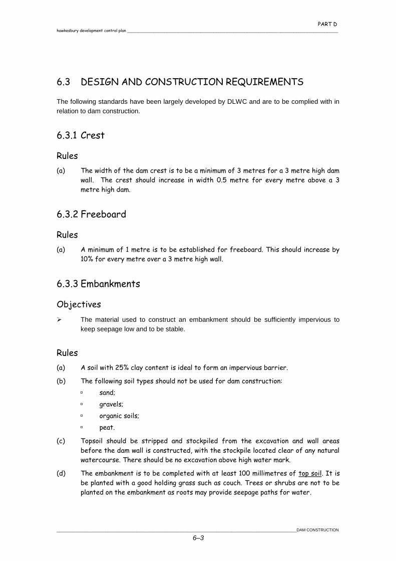
PART D hawkesbury development control plan _______________________________________________________________________________________________
____________________________________________________________________________________________________________DAM CONSTRUCTION
6–3
6.3 DESIGN AND CONSTRUCTION REQUIREMENTS
The following standards have been largely developed by DLWC and are to be complied with in
relation to dam construction.
6.3.1 Crest
Rules
(a) The width of the dam crest is to be a minimum of 3 metres for a 3 metre high dam
wall. The crest should increase in width 0.5 metre for every metre above a 3
metre high dam.
6.3.2 Freeboard
Rules
(a) A minimum of 1 metre is to be established for freeboard. This should increase by
10% for every metre over a 3 metre high wall.
6.3.3 Embankments
Objectives
The material used to construct an embankment should be sufficiently impervious to
keep seepage low and to be stable.
Rules
(a) A soil with 25% clay content is ideal to form an impervious barrier.
(b) The following soil types should not be used for dam construction:
sand;
gravels;
organic soils;
peat.
(c) Topsoil should be stripped and stockpiled from the excavation and wall areas
before the dam wall is constructed, with the stockpile located clear of any natural
watercourse. There should be no excavation above high water mark.
(d) The embankment is to be completed with at least 100 millimetres of top soil. It is
be planted with a good holding grass such as couch. Trees or shrubs are not to be
planted on the embankment as roots may provide seepage paths for water.
PART D _______________________________________________________________________________________________ hawkesbury development control plan
DAM CONSTRUCTION ___________________________________________________________________________________________________________
6–4
(e) The slope of the upstream embankment batters should be no steeper than the
ratio of 2.5 horizontal to 1.0 vertical, while the downstream batter should be no
steeper than 3.0 horizontal to 1.0 vertical.
6.3.4 Spillway
Objectives
An earth spillway is required on all dams in order to pass surplus runoff around the dam
which would otherwise pass over the embankment.
Rules
(a) The spillway should be a minimum of 3 metres in width
increasing in size dependent on the size of the dam
and catchment. Generally, spillways are to be
designed so as not to overflow more than half the
depth of the freeboard.
(b) The width of the outlet is not to be less than the inlet
width. The spillway also is not to direct flows onto the
downstream toe. The spillway area should be grassed,
stable and able to accept runoff flow. In some
instances it may be necessary to turf the spillway
area. The spillway cut batter should have a maximum
steepness of 2.5 horizontal to 1.0 vertical.
(c) A small diameter (100 millimetre) pipe be required
where spring flows or small flows of long duration
occur to ensure that the spillway does not erode.
(d) Where dams are to be constructed in gullies or water courses, a diversion weir is
to be constructed up stream of the dam. The weir is to incorporate two pipes 200
millimetres in diameter.
6.3.5 Cut-Off Trench
Objectives
All dams are required to have a cut-off trench.
Rules
(a) The cut-off trench is to be constructed along the entire length of the
embankment at a minimum width of 2 metres. The trench should be excavated at
least 1 metre into impervious soil and backfilled with impervious material.
PART D hawkesbury development control plan _______________________________________________________________________________________________
____________________________________________________________________________________________________________DAM CONSTRUCTION
6–5
6.3.6 Vegetation Filters and Tree Planting
Objectives
Water running into the dam should be passed through a fenced and well-grassed filter
zone. The vegetation in this area will filter out much of the unwanted material like silt,
fertiliser, manure, dead vegetation and litter and rubbish. Farm dams, where cultivating
exists, must include a silt trap.
Where silting of the dam is a problem, vegetation filters of stiff long-stemmed grasses
can be used with silt traps to reduce water velocity and cause more silt to be trapped
before it enters the dam. A typical silt trap is about one-tenth the size of the dam.
A fence around the dam wall and spillway can improve water quality downstream of the
dam. Spillways should be kept well-grassed and free from debris. A build-up of debris in
the spillway could reduce its capacity and cause the dam to be overtopped.
Trees around the dam can help reduce evaporation and reduce the growth of
undesirable water weeds and algae. Do not allow trees or shrubs to grow on or near the
wall. When trees growing on the wall die, the decomposing roots can form tunnels
which lead to seepage and leaks. Shrubs also provide cover for rabbits which can
damage the wall by burrowing.
Rules
(a) A gate should be provided in the fence so that the filter area can be renovated by
light grazing during rapid growth seasons. Prolonged grazing in dam catchments has
potential to cause algal and weed growth in the dam due to the introduction of
nutrients from manure.
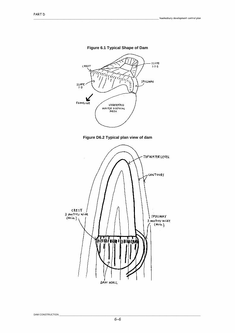
PART D _______________________________________________________________________________________________ hawkesbury development control plan
DAM CONSTRUCTION ___________________________________________________________________________________________________________
6–6
Figure 6.1 Typical Shape of Dam
Figure D6.2 Typical plan view of dam
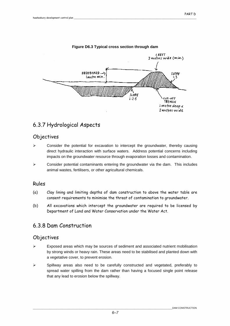
PART D hawkesbury development control plan _______________________________________________________________________________________________
____________________________________________________________________________________________________________DAM CONSTRUCTION
6–7
Figure D6.3 Typical cross section through dam
6.3.7 Hydrological Aspects
Objectives
Consider the potential for excavation to intercept the groundwater, thereby causing
direct hydraulic interaction with surface waters. Address potential concerns including
impacts on the groundwater resource through evaporation losses and contamination.
Consider potential contaminants entering the groundwater via the dam. This includes
animal wastes, fertilisers, or other agricultural chemicals.
Rules
(a) Clay lining and limiting depths of dam construction to above the water table are
consent requirements to minimise the threat of contamination to groundwater.
(b) All excavations which intercept the groundwater are required to be licensed by
Department of Land and Water Conservation under the Water Act.
6.3.8 Dam Construction
Objectives
Exposed areas which may be sources of sediment and associated nutrient mobilisation
by strong winds or heavy rain. These areas need to be stabilised and planted down with
a vegetative cover, to prevent erosion.
Spillway areas also need to be carefully constructed and vegetated, preferably to
spread water spilling from the dam rather than having a focused single point release
that any lead to erosion below the spillway.
PART D _______________________________________________________________________________________________ hawkesbury development control plan
DAM CONSTRUCTION ___________________________________________________________________________________________________________
6–8
Rules
(a) The dam wall is to be adequately compacted by track
rolling or a sheet foot roller or similar in layers no
greater than 150 millimetres.
(b) Erosion and sediment control devices are to be installed
and maintained to ensure that there is no increase in
downstream levels of nutrients, litter, vegetation debris
or other water borne pollutants.
Chapter 7
LANDFILL

PART D hawkesbury development control plan _______________________________________________________________________________________________
_______________________________________________________________________________________________________________________LANDFILL
7–1
7.1 GENERAL PRINCIPLES
The general principles applying to landfill in the City are to:
allow alteration of land where it enhances the
development and/or use of land;
ensure that no adverse impact results on local
drainage or floodway characteristics in a catchment
from landfill works;
ensure that fill material is satisfactory in terms of
compaction, type and characteristics in order to
mitigate against potential problems such as landslip,
soil erodibility, sedimentation or siltation of natural
watercourses or drainage lines;
ensure that appropriate environmental measures are applied to landfill/earthwork sites
in order to conserve the landscape and protect the surrounding environment;
establish, maintain and promote appropriate site rehabilitation or revegetation
techniques for landfill works in order to ensure properties are not sterilised for future
land uses and protect the surrounding environment;
maintain and enhance the visual and scenic quality of locality by controlling form, bulk
and scale to complement the environment and have minimum environmental impact;
ensure no adverse effects on adjoining properties (drainage, structure, stability, fences);
protect, restore and maintain the local non-urban character of areas and ensure viable
agricultural land is sustained;
protect the health and safety of human residents;
maintain water quality within the Hawkesbury Catchment area; and
ensure that degradation of the environment does not recur from acid sulphate soils,
sodic soil or saline soils.
7.2 TYPES OF LANDFILL
The placement of clean fill and fill containing demolition material is permissible with
Council's consent provided the placement and associated works conform to this section
of the DCP. Landfill development using clean fill and fill containing demolition/builders
material will only be approved where adverse impacts are unlikely. Appropriate
restrictions will be applied to any approval on the placement or development of
buildings upon such landfill.
PART D _______________________________________________________________________________________________ hawkesbury development control plan
LANDFILL ______________________________________________________________________________________________________________________
7–2
The placement of demolition material is also
possible for the creation of flood free vehicular
access. The fill material must be satisfactorily
compacted and treated to prevent runoff or
siltation problems. It must not adversely impact
upon the local drainage characteristics of the
catchment.
Filling, using demolition material on sites
situated in floodways or subject to high flood
velocities, will generally only be allowed where such fill is placed in trenches and
covered and compacted with a satisfactory depth covering of clean fill.
A person must not use land for burying unshredded used motor vehicle tyres. Shredded
for the purpose of this DCP means a motor vehicle tyre dissected into a minimum of 3
parts. A licence is required from the Environment Protection Authority for all tyre landfill
proposals.
The filling of land by the placement of shredded tyres is generally restricted to lands
above the 1 in 100 year flood frequency level. However, in cases where flood liable
lands are subject to very low velocity back-up water flooding, and where satisfactory
provision has been made for shredded tyre retention measures, such filling will be
considered by Council.
Objectives
The final land reclamation or finished contour surface levels (after backfilling of
trenches) of shredded tyre landfill operations or works must be a satisfactory minimum
height above the enclosed tyre particles to help assist in retention and compaction.
The placement of shredded tyres in excavated trenches must not generally exceed the
existing natural contour/ground level.
The development of a detention basin and/or associated diversion channels will be
required to direct upstream runoff from disturbed areas.
The placement of a bund wall around the site may be required to help direct runoff from
the disturbed excavation/landfill areas.
Rules
(a) The top 300 millimetres of fill must be topsoil in order
to ensure site revegetation.
(b) The minimum finished surface grade for tyre landfill
developments must be 2% in order to allow satisfactory
surface runoff and overcome potential ponding or water
logging above finished trenches/cells.
PART D hawkesbury development control plan _______________________________________________________________________________________________
_______________________________________________________________________________________________________________________LANDFILL
7–3
(c) The individual shredded tyre landfill trenches or cells should include a lateral drain
to allow sub-surface drainage.
(d) The provision of sedimentation traps and/or sedimentation detention basins will be
required for shredded tyre landfill works in order to trap sediments associated
with runoff from disturbed areas.
(e) Containment and treatment of leachate must be monitored after completion of
works by the owner for a period of 5 years after the completion of the works, with
copies of all tests lodged with Council every 6 months.
(f) The finished surface level will be subject to appropriate site
regeneration/revegetation. The site regeneration works must include the
spreading of topsoil and a combination of tube stock and seeding to help establish
vegetation cover. The interim site revegetation program should include quick
growing ground cover, particularly Japanese millet (in Spring/Summer) and Ryecorn
(in Autumn/Winter).
(g) Shredded tyre landfilling operations will not generally be approved on bushfire
prone lands due to the stockpiling of shredded tyres being an unacceptable high
fire hazard.
7.3 GENERAL LANDFILL REQUIREMENTS
7.3.1 Council Consent
Development consent may not be required for land filling when it is ancillary to another
development that is the subject of consent already issued under the Act. Any land filling in
these circumstances still require compliance with provisions of this DCP to prevent
environmental degradation. A further exception is turfing and/or top dressing works to a depth
less than 150 millimetres.
Any DA for landfill/earthworks should contain sufficient documentation to demonstrate that:
soil erosion will be controlled;
filling will have no adverse effect on the surrounding drainage systems (including
overland flow);
the height, scale and bulk of the fill will be in character with the surrounding topography
(batter slopes and finished levels are particularly important) and will not be visually
intrusive; and
that fill material will be capable of sustaining plant growth and the proposed plant
material is in character with the surrounding landscape.
PART D _______________________________________________________________________________________________ hawkesbury development control plan
LANDFILL ______________________________________________________________________________________________________________________
7–4
Council will not grant consent to any application for earthworks/landfilll which has the potential
to mar the landscape or landform, degrade or destroy neighbouring bushland, create siltation of
waterways and drainage lines, or pollute any waterway or drainage line. Any application shall
be required to satisfy Council that suitable environmental safeguards are to be implemented
during the filling operation and upon completion of such.
7.3.2 Riverbank/Foreshore Reshaping, Regrading and
Stabilisation
The filling, reshaping or regrading of foreshore/riverbank lands is only permissible in situations
where no material is removed from the subject property. Removal of sediment materials is
classified as an "extractive industry" and is a prohibited purpose in 7(d1) environmental
protection zones and in the river system.
The proposed filling, reshaping or regrading of foreshore/riverbank lands will require a report by
a qualified person in respect of the proposed works and the associated implications on the river
ecosystem. This report should incorporate the type, quality and quantity of such landfill works
with analysis of the river/foreshore ecosystem and morphology, hydraulic capacity, flood levels,
water flow velocities, channel protection/energy dissipation requirements, detention and storage
calculations, spillways, overflows and maintenance of water resources, sediment and pollution
control.
The concurrence from the NSW Public Works Department for tidal waters or DLWC for non-tidal
waters under the Rivers and Foreshores Improvement Act 1948 may also be required for the
filling, regrading or reshaping of foreshore lands below or above high mean mark.
7.3.3 Temporary Stockpiles
Any temporary stockpiling of fill material must also be identified in a DA, with supporting plans to
address the following matters/issues:
location and configuration of fill stockpiles;
land clearing and other proposed preparation requirements;
proposed depth of stockpiled materials;
proposed soil erosion/sedimentation mitigation measures;
possibility of leachate resulting from fill stockpiles and their potential effect on the
surrounding land, and ecosystems;
quality, quantity and characteristics of stockpiled fill material; and
proposed period of stockpiles.
PART D hawkesbury development control plan _______________________________________________________________________________________________
_______________________________________________________________________________________________________________________LANDFILL
7–5
7.3.4 Maintenance
A maintenance program should be required detailing the
frequency of inspection, and provisions for the repair of
damaged structures and vegetation must be provided.
The functioning of drainage systems which are installed
should be regularly checked.
Maintenance of healthy ground cover is desirable on
batters stabilised by vegetation. Mowing, intermittent
application of fertiliser and, where practical, irrigation may
assist in this respect.
A regular maintenance program should include
eradication of any declared noxious plants.
Batter sections which slump should be reshaped and stabilised as early as possible, before
adjacent sections are adversely affected.
7.3.5 Removal/Reinstatement or Removal/Rehabilitation
In some cases it may be necessary for unauthorised landfill to be removed from a site. In such
instances the applicant will be required to consult with the EPA to determine an approved
location to dispose of the subject filling material.
Documentation for removal of fill should include the following:
erosion control and water management plan, including a perimeter silt fence/bund,
sedimentation ponds, dust control details and site exit shaker ramps;
bulk earthworks plan showing existing and proposed levels, haulage tracks, proposed
site exit and details outlining the stages in which fill removal will take place;
drainage plan showing how drainage will be controlled on finished surface, as
previously specified;
temporary/interim erosion control plan, including cover crop planting details and erosion
control details;
details of soil decompaction, aeration, detoxification and nutrient reconditioning to
enable sustained plant growth; and
landscape plan showing planting details.
PART D _______________________________________________________________________________________________ hawkesbury development control plan
LANDFILL ______________________________________________________________________________________________________________________
7–6
7.3.6 Aboriginal/Archaeological Sites
Applicants for landfilll within the rural and environmental protection scenic areas of Hawkesbury
should consult with the National Parks and Wildlife Service to determine whether or not the
subject site is affected by an Aboriginal habitation site, or a matter of archaeological
significance.
7.3.7 Limited Consent
The filling, reshaping or associated alteration of land may be subject to a limited consent period
in order to guarantee timely completion of works. This limited period includes all landfill works
and final site rehabilitation works.
Council may extend or reduce this limited consent period for landfill developments where
circumstances warrant. Should an extension be required, applicants are required to lodge a
written request for an extension prior to the expiry of the limited consent date.