Embed Size (px)
Citation preview
PLANNING & TRANSPORTATION REGULATORY PANELPART ISECTION 1: APPLICATIONS FOR PLANNING PERMISSION
$ivsp5s01.docx
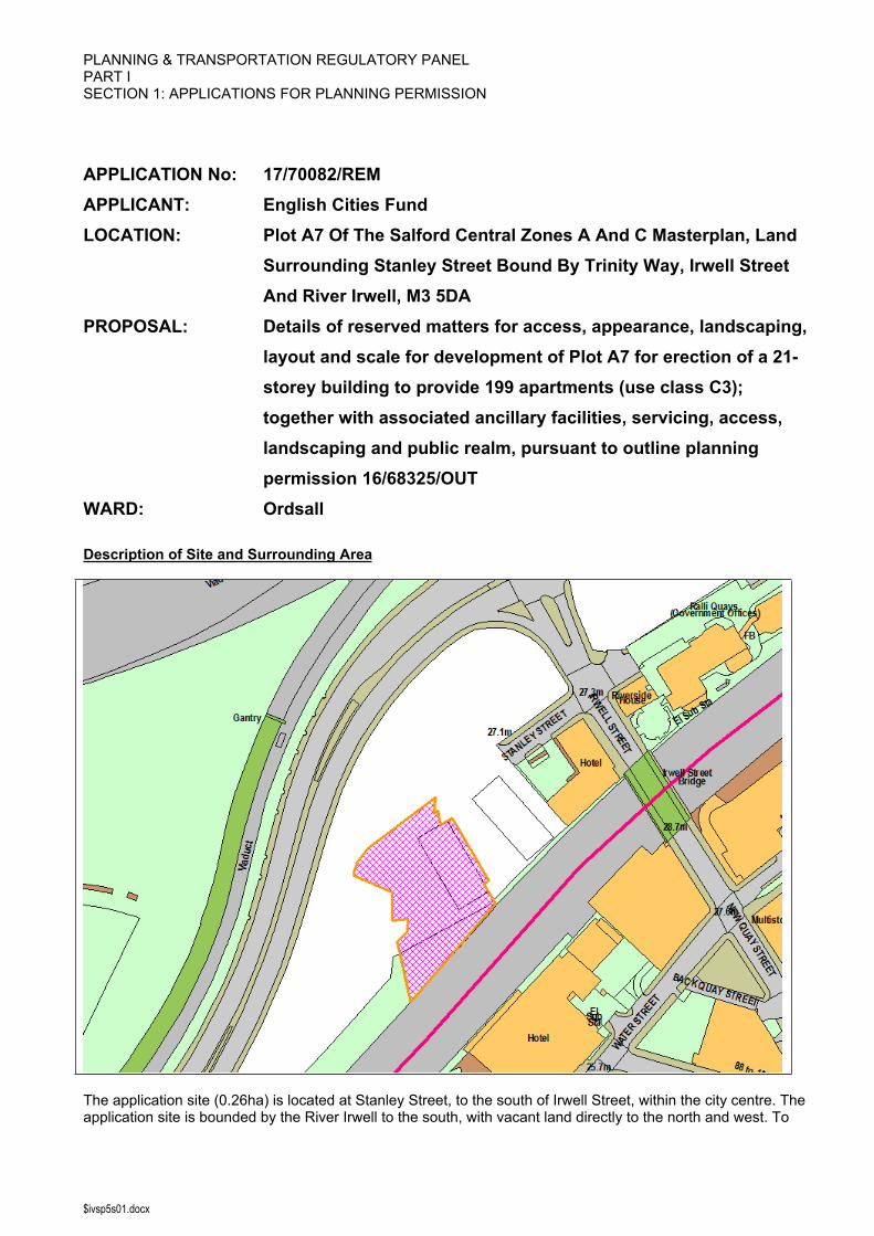
APPLICATION No: 17/70082/REMAPPLICANT: English Cities FundLOCATION: Plot A7 Of The Salford Central Zones A And C Masterplan, Land
Surrounding Stanley Street Bound By Trinity Way, Irwell Street And River Irwell, M3 5DA
PROPOSAL: Details of reserved matters for access, appearance, landscaping, layout and scale for development of Plot A7 for erection of a 21-storey building to provide 199 apartments (use class C3); together with associated ancillary facilities, servicing, access, landscaping and public realm, pursuant to outline planning permission 16/68325/OUT
WARD: Ordsall
Description of Site and Surrounding Area
The application site (0.26ha) is located at Stanley Street, to the south of Irwell Street, within the city centre. The application site is bounded by the River Irwell to the south, with vacant land directly to the north and west. To
$ivsp5s01.docx
the east of the site, two residential apartment blocks are currently under construction (Plots A5 and A6, comprising an 11 storey and a 16 storey block, approved under 15/66404/REM and 15/67019/REM respectively), and beyond this to the east is the Premier Inn at Irwell Street. On the facing bank of the Irwell to the south of the application site is the Manchester Marriott Victoria and Albert Hotel. Trinity Way lies beyond the vacant plots of land to the north and west of the application site, with the elevated rail viaduct lying beyond this which incorporates the line of the Ordsall Chord which is currently under construction.
The site is currently vacant comprising predominantly of hardstanding. It was formerly used as surface car parking serving commuters to the city centre, and more recently formed part of the construction compound for the Ordsall Chord. The majority of the site forms a plateau which is level with Stanley Street, with the remainder of the site comprising a steep sided embankment to the River Irwell.
There are a number of designated heritage assets within the vicinity of the application site, including the Grade II listed Irwell Street Bridge to the north east, and the Grade II Victoria and Albert Warehouses on the south bank of the Irwell which now form part of the Manchester Marriott Victoria and Albert Hotel. In addition, the Castlefield Conservation Area lies to the south of the application site encompassing the land on the south bank of the River Irwell from Irwell Street southwards.
Description of Proposal
This is a reserved matters application for access, appearance, landscaping, layout and scale for development of for the erection of a 21-storey building to provide 199 residential apartments together with associated ancillary facilities, servicing, access, landscaping and public realm, pursuant to outline planning permission 16/68325/OUT.
At ground floor the level, the block would comprise an entrance lobby with concierge reception and associated back of house facilities, a resident’s lounge area, gym and a cycle store, together with refuse and recycling storage and plant facilities. The principal entrance to the block would be located on the eastern side of the building, providing access to the entrance lobby. The cycle store would have external access from the western side of the building, with internal doors connecting to the lobby area for ease of access by residents. The cycle store would accommodate 60 secure cycle spaces.
The 199 apartments would be located across the 20 upper floors and would comprise a mix of one, two and three bedroom units as follows: 98 x one bed apartments (49.25%) 81 x two bed apartments (40.7%) 20 x three bed apartments (10.05%)
The block has been designed to form a trinity of three residential apartment buildings (Plots A5, A6 and A7) to be known as ‘Slate Yard’, with the buildings stepping up in scale from east to west. Areas of public realm and landscaping would surround the block, and this has been designed to ensure a high quality consistent treatment across this area as a whole.
The building is rectangular in plan form and at first floor level and above the upper storeys cantilever out over the ground floor level at the building’s northern and southern ends. In terms of its detailed design in terms of elevations and materials, this would reflect the same approach previously approved in relation to Plots A5 and A6 so that the three blocks are read together. The external treatment would therefore predominantly comprise a pearl white terracotta rain screen cladding, interspersed with copper toned metal cladding for contrast. At ground floor, the southern element of the block would comprise predominantly of expansive glazing serving the entrance lobby and resident’s lounge and gym. The elevations of the remaining areas of the ground floor accommodating plant and back of house facilities would be finished in obscured shuffle glazed panels set within dark grey/brown brick.
The following documents have been submitted in support of the application: Air Quality Technical Note Archaeological Survey Crime Impact Statement Design and Access Statement Drainage Strategy

$ivsp5s01.docx
Ecological Management Plan External Lighting Details Flood Risk Assessment Geo-Environmental Report Interim Travel Plan Noise Assessment Planning Statement Preliminary Ecological Appraisal Sustainability and Energy Statement Sustainability Checklist Transport Statement TV Reception Survey Wind Assessment Landscape Plans, Drawings and Specification
Publicity
Site Notice: Non HH Article 15 Date Displayed: 6 June 2017Reason: Article 13
Site Notice: Non HH setting of listed building Date Displayed: 6 June 2017Reason: Affecting setting of Listed Building
Press Advert: Manchester Weekly News Salford Edition Date Published: 8 June 2017Reason: Article 15 Standard Press Notice Affecting setting of Listed Building
Neighbour Notification
Notification letters were sent to a total of 11 neighbouring properties, including: Manchester Marriott Victoria and Albert Hotel, Water Street Premier Inn, Irwell Street Riverside House, Irwell Street Ralli Quays, Stanley Street
In addition two site notices were displayed within the vicinity of the application site, including one on the south side of the River Irwell within Manchester.
Representations
No representations have been received to date.
Relevant Site History
09/57950/EIAHYB - Outline application for a comprehensive phased regeneration of Salford Central, including selective demolition, for a mixed-use development of new, improved, altered and replacement buildings, for offices/commercial use (use classes A2 and B1, maximum 197,010sq.m), retail, food and drinkand entertainment (use classes A1, A3, A4 and A5, maximum 24,255sq.m), leisure (class D1), hotels (class C1maximum 140 and 250 bedrooms) and residential use (maximum 849 dwellings) together with associated car parking, landscaping and infrastructure. Detailed application for highway and associated works to Chapel Street (between Oldfield Rd and Trinity Way) and the laying out of public space at Stanley Street. Approved - 19 July 2010.
16/68325/OUT - Outline application for the comprehensive phased regeneration of Zone A/C of the Salford Central masterplan area for a residential led (maximum 843 dwellings) mixed use development including tall building (up to 100 metres / 33 storeys) and ground floor commercial units with potential for offices, retail, food and drink, entertainment and leisure uses (Use Classes A1, A2, A3, A4, A5, B1 and D1) together with associated car parking, landscaping and infrastructure. Approved - 25 May 2017.
$ivsp5s01.docx
Consultations
Design For Security -
No objections, subject to the development being designed and constructed in accordance with the recommendations contained within section 3.3 of the submitted Crime Impact Statement. Recommend that a condition is attached to reflect the physical security specification identified within section 4 of the Crime Impact Statement.
Canal And River Trust – No comments.
Environment Agency –
No objection. We have reviewed the submission of an Interpretative Geo-Environmental Report (dated Feb. 2017) by WSP-PB ltd and having assessed the report consider Plot A7 to be of low risk to the water environment.
Greater Manchester Archaeological Advisory Service –
No objection. There is no known archaeological interest and we consider that no further archaeological mitigation is required in this instance.
Greater Manchester Ecology Unit –
No objection. The Ecology Management Plan has been prepared by suitably qualified ecologists and represents a satisfactory and proportionate response to the ecological issues associated with this site, and to the ecology and landscape conditions set as part of the outline permission. The implementation of the Ecology Management Plan and the soft landscaping proposals will result in the development contributing to a net biodiversity gain in the area and mitigating any potential harm to ecological interests. Highlight that the adjacent river course is an important local asset and any pollution of the watercourse during site clearance and construction work should be avoided by the adoption and implementation of best practice methods for the control of pollution on construction sites.
Highways –
No objection, subject to conditions requiring i) delivery of a traffic management scheme to prevent on-street parking on Stanley Street, ii) submission of a Construction Method Statement, and iii) submission of a Travel Plan, and the inclusion of relevant informatives.
Historic England –
No objection. The proposal would not have a notable impact on the setting and significance of highly designated heritage assets.
Landscape Design –
No objection. The landscape/urban realm proposals are acceptable.
Manchester City Council – no comments received to date.
Manchester Airport –
No objection. Request an informative is attached to any grant of consent to advise the applicant of the requirement to contact Manchester Airport Airfield Safety and Compliance in advance of erecting a crane or other tall equipment on the site to establish whether a Tall Equipment Permit would be required, and whether any regulatory procedures or operating restrictions would need to be agreed in advance.
Senior Engineer Flood Risk Management –
$ivsp5s01.docx
No objection. A Flood Risk Assessment (FRA) and Drainage Strategy have been submitted as part of the application submission. The FRA confirms that plot levels will be above the 1 in 1,000 year flood level and therefore the site is deemed to be in Flood Zone 1. The Drainage Strategy and associated drainage layout drawing and calculations comply with the requirements of Condition 29 of the outline permission in this regard (16/68325/OUT).
United Utilities –
The drainage proposals have been reviewed and are acceptable in principle.
Urban Vision Environment (Air And Noise) –
Air Quality – no objection.
Noise – no objection, subject to receipt of additional information which demonstrates how the internal noise standard for living rooms of less than 35 dB Laeq,16 hour between 07.00 hours and 23:00 hours will be attained where practicable, in accordance with Condition 36 attached to permission 16/68325/OUT.
Urban Vision Environment (Land Contam) –
No objection. Conditions 28 and 29 attached to the outline permission address land contamination requirements.
Planning Policy
Development Plan Policy
Unitary Development Plan ST1 - Sustainable Urban NeighbourhoodsThis policy states that development will be required to contribute towards the creation and maintenance of sustainable urban neighbourhoods.
Unitary Development Plan ST4 - Key Tourism AreasThis policy states that the following areas will be protected and enhanced as tourism destinations and tourism development will be focused primarily within 1. Salford Quays 2. Chapel Street 3. Worsley Village, Barton Swing Aqueduct and the Bridgewater Canal Corridor.
Unitary Development Plan ST5 - Transport NetworksThis policy states that transport networks will be maintained and improved through a combination of measures including the extension of the network of pedestrian and cycling routes; the expansion and improvement of the public transport system and the enhancement of support facilities; the maintenance and improvement of the highway network; the provision of new road infrastructure where this will support the city’s economic regeneration; requiring development proposals, highway improvement schemes and traffic management measures to make adequate provision for the needs of the disabled, pedestrians and cyclists, and, wherever appropriate, 5nderuti the use of public transport; and the protection and enhancement of rail and water-based infrastructure to support the movement of freight and passengers.
Unitary Development Plan ST7 - Mixed-use DevelopmentThis policy states that mixed use development schemes that 5nderuti the need to travel will be focused towards specific areas including Chapel Street, Salford Quays, the Ordsall Lane riverside corridor, Lower Broughton, the town centres, neighbourhood centres and other locations well served by public transport.
Unitary Development Plan ST12 - Development DensityThis policy states that development within regional centres, town centre and close to key public transport routes and interchanges will be required to achieve a high density appropriate to the location and context.
Unitary Development Plan ST13 - Natural Environmental AssetsThis policy states that development that would result in an unacceptable impact on any of the city’s natural environmental assets will not be permitted.
Unitary Development Plan ST14 - Global Environment
$ivsp5s01.docx
This policy states that development will be required to 6nderuti its impact on the global environment. Major development proposals will be required to demonstrate how they will 6nderuti greenhouse gas emissions.
Unitary Development Plan MX1 - Development in Mixed-use AreasThis policy states that a wide range of uses and activities (housing, offices, tourism, leisure, culture, education, community facilities, retail, infrastructure, knowledge-based employment) are permitted within the identified mixed use areas (Chapel Street East. Chapel Street West, Salford Quays, Ordsall Lane Riverside Corridor).
Unitary Development Plan DES1 - Respecting ContextThis policy states that development will be required to respond to its physical context and respect the positive character of the local area in which it is situated and contribute towards a local identity and distinctiveness.
Unitary Development Plan DES2 - Circulation and MovementThis policy states that the design and layout of new development will be required to be fully accessible to all people, 6nderuti the movement of pedestrians and cyclists through and around the site safely, be well related to public transport and local amenities and 6nderuti potential conflicts between pedestrians, cyclists and other road users.
Unitary Development Plan DES3 - Design of Public SpaceThis policy states that development should include the provision of public space; designed to have a clear role and purpose which responds to local needs; reflects and enhances the character and identify of the area; is an integral part of and provide appropriate setting and an appropriate scale for the surrounding development; be attractive and safe; connect to establish pedestrian routes and public spaces and 6nderuti and make provision for maintenance requirements.
Unitary Development Plan DES4 - Relationship of Development to Public SpaceThis policy states that developments that adjoin a public space shall be designed to have a strong and positive relationship with that space by creating clearly defining public and private spaces, promoting natural surveillance and reduce the visual impact of car parking.
Unitary Development Plan DES5 - Tall BuildingsThis policy states that tall buildings will be permitted where: the scale of the development is appropriate; the location is highly accessible; the building would positively relate to adjacent public realm; is of high quality design; makes a positive contribution to the skyline; would not detract from important views; would not cause unacceptable overshadowing or overlooking, detrimental to the amenity of neighbouring occupiers; be no unacceptable impact on the setting of a listed building or value of a conservation area; be no unacceptable impact on microclimate; be no unacceptable impact on telecommunications; and there would be no unacceptable impact on aviation safety.
Unitary Development Plan DES6 - Waterside DevelopmentThis policy states that all new development adjacent to the Manchester Ship Canal will be required to facilitate pedestrian access to, along and, where appropriate, across the waterway. Schemes should incorporate a waterside walkway with pedestrian links between the walkway and other key pedestrian routes and incorporate ground floor uses and public space that generate pedestrian activity. Where it is inappropriate to provide a waterside walkway, an alternative route shall be provided. Development should protect, improve or provide wildlife habitats; conserve and complement any historic features; maintain and enhance waterside safety; and not affect the maintenance or integrity of the waterway or flood defences. All built development will face onto the water, and incorporate entrances onto the waterfront; be of the highest standard of design; be of a scale sufficient to frame the edge of the waterside; and enhance views from, of, across and along the waterway, and provide visual links to the waterside from surrounding areas.
Unitary Development Plan DES7 - Amenity of Users and NeighboursThis policy states that all new development, alterations and extensions to existing buildings will be required to provide potential users with a satisfactory level of amenity in terms of space, sunlight, daylight, privacy, aspect and layout. Development will not be permitted where it would have an unacceptable impact on the amenity of occupiers or users of other development.
Unitary Development Plan DES9 - Landscaping
$ivsp5s01.docx
This policy states that hard and soft landscaping should be provided where appropriate that is of a high quality and would enhance the design of the development, not detract from the safety and security of the area and would enhance the attractiveness and character of the built environment.
Unitary Development Plan DES10 - Design and CrimeThis policy states that developments must be designed to discourage crime, antisocial 7nderuti, and the fear of crime. Development should i) be clearly delineated ii) allow natural surveillance iii) avoid places of concealment iv) encourage activity within public areas.
Unitary Development Plan H1 - Provision of New Housing DevelopmentThis policy states that all new housing will contribute toward the provision of a balanced housing mix; be built of an appropriate density; provide a high quality residential environment; make adequate provision for open space; where necessary make a contribution to local infrastructure and facilities required to support the development; and be consistent with other policies of the UDP.
Unitary Development Plan H8 - Open Space Provision Associated with New Housing DevelopmentThis policy states that planning permission will only be granted where there is adequate and appropriate provision for formal and informal open space, and its maintenance over a twenty-year period. Standards to be reached will be based upon policy R2 and guidance contained within Supplementary Planning Documents.
Unitary Development Plan A2 - Cyclists, Pedestrians and the DisabledThis policy states that development proposals, road improvement schemes and traffic management measures will be required to make adequate provision for safe and convenient access by the disabled, other people with limited or impaired mobility, pedestrians and cyclists.
Unitary Development Plan A8 - Impact of Development on Highway NetworkThis policy states that development will not be permitted where it would i) have an unacceptable impact upon highway safety ii) cause an unacceptable restriction to the movement of heavy goods vehicles along Abnormal Load Routes.
Unitary Development Plan A10 - Provision of Car, Cycle and Motorcycle Parking in New DevelopmentsThis policy states that there should be adequate provision for disabled drivers, cyclists and motorcyclists, in accordance with the Council’s minimum standards; maximum car parking standards should not be exceeded; and parking facilities should be provided consistent with the provision and maintenance of adequate standards of safety and security.
Unitary Development Plan EN9 - Wildlife CorridorsThis policy states that development that would affect any land that functions as a wildlife corridor, or that provides an important link or stepping stone between habitats will not be permitted. Conditions and planning obligations may be used to protect, enhance or manage to facilitate the movement of flora and fauna where development is permitted.
Unitary Development Plan EN17 - Pollution ControlThis policy states that in areas where existing levels of pollution exceed local or national standards, planning permission will only be granted where the development incorporates adequate measures to ensure that there is no unacceptable risk or nuisance to occupiers, and that they are provided with an appropriate and satisfactory level of amenity.
Unitary Development Plan EN18 - Protection of Water ResourcesThis policy states that development will not be permitted where it would have an unacceptable impact on surface or ground water.
Unitary Development Plan EN19 - Flood Risk and Surface WaterThis policy states that any application for development that it is considered likely to be at risk of flooding or increase the risk of flooding elsewhere will need to be accompanied by a formal flood risk assessment. It should identify mitigation or other measures to be incorporated into the development or undertaking on other land, which are designed to reduce that risk of flooding to an acceptable level.
Unitary Development Plan EN23 - Environmental Improvement Corridors
$ivsp5s01.docx
This policy states that development along any of the city’s major road, rail and water corridors will be required to preserve, or make a positive contribution to the corridor’s environment and appearance.
Unitary Development Plan CH2 - Development Affecting the Setting of a Listed BuildingThis policy states that development will not be granted that would have an unacceptable impact on the setting of any listed building.
Unitary Development Plan CH5 - Archaeology and Ancient MonumentsThis policy states that planning permission will not be granted for development that would have an unacceptable impact on an ancient monument, site or feature of archaeological importance, or its setting. Planning conditions will be imposed to record and evaluate, excavate and preserve remains of local archaeological value, prior to the commencement of the development.
Unitary Development Plan R5 - Countryside Access NetworkThis policy states that planning permission will not be granted for development that would result in the permanent obstruction or closure of any part of the Countryside Access Network, unless an alternative route is provided that is equally attractive and convenient. New development that is proposed on a site needed for the provision of a new route or link as part of the Countryside Access Network will be required to incorporate that route/link as part of the development.
Unitary Development Plan DEV7 - Protection of Aviation Safety at Manchester AirportThis policy states that development that would have an unacceptable impact on the operational integrity or safety of Manchester Airport will not be permitted.
Other Material Planning Considerations
National Planning Policy
National Planning Policy Framework
Local Planning Policy
Supplementary Planning Document - Sustainable Design and ConstructionThis policy document expands on policies in Salford’s Unitary Development Plan to provide additional guidance for planners and developers on the integration of sustainable design and construction measures in new and existing developments.
Supplementary Planning Document - DesignThis document reflects the need to design in a way that allows the city to support its population socially and economically, working with and inviting those affected into an inclusive decision making process. Equally, development must contribute to the creation of an environmentally sustainable city supporting the natural environment minimising the effects of, and being more adaptable to, the potential impact of climate change.
Supplementary Planning Document - Nature Conservation and BiodiversityThis policy document expands on the policies of the Unitary Development Plan relating to the issues of nature conservation and biodiversity, and seeks to ensure that all stakeholders have a clear understanding of how those policies should be implemented and their desired outcome.
Supplementary Planning Document - Design and CrimeThis policy document contains a number policies used to assess and determine planning applications and is intended as a guide in designing out crime.
Planning Guidance - Flood Risk and DevelopmentThe overarching aim of the planning guidance is to ensure that new development in areas at risk of flooding in the city, is adequately protected from flooding and that the risks of flooding are not increased elsewhere as a result of new development.
Planning Guidance - HousingThe purpose of the guidance is to ensure that the residential development coming forward in Salford contributes to establishing and maintaining sustainable communities, tackles the specific housing and related issues that

$ivsp5s01.docx
face Salford, and helps to deliver the vision and strategy of the UDP, the Housing Strategy and the Community Plan.
Planning Guidance - Shaping Central Salford’s SpacesThe handbook builds on the principles set out in the Salford City Council urban design guide, Shaping Salford and defines the standards for those working with the built environment. This handbook should be used to set a benchmark for public realm improvements across the city. By adopting these standards this guide contributes to creating public spaces that are appealing and become well loved and used spaces at the heart of the community.
Planning Guidance - Salford CentralThis guidance sets out the broad parameters for the redevelopment of Salford Central for a mix of uses.
Planning Guidance - Salford Central Development FrameworkThis Development Framework promotes a comprehensive approach to regenerating Salford Central to ensure that the vision is delivered and that Salford is indeed transformed from the ‘World’s first industrial city to city beautiful’.
Planning Guidance - Irwell City ParkThis guidance relates to the intention to establish the Irwell City Park as an exciting and unique waterfront location within the Regional Centre.
It is not considered that there are any local finance considerations that are material to the application.
Appraisal
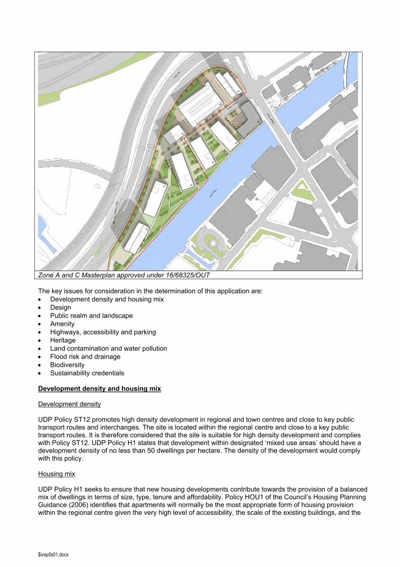
This is a reserved matters application and the principle of the development of this plot was approved under planning permission 16/68325/OUT. Application 16/68325/OUT was submitted to enable a variation of the approved mix of development and a reconfiguration of Zones A and C within the previously approved outline permission 09/57950/EIAHYB for the comprehensive phased regeneration of the Salford Central area. This was in order to reflect changes brought about through the development of the Ordsall Chord, together with shifting market conditions and the evolving townscape across the surrounding area. The revisions permitted under 16/68325/OUT allow for a greater proportion of residential apartments, changes to the layout and number of blocks and changes to the scale of the buildings across this part of the Salford Central area.
Outline permission 16/68325/OUT establishes the principle of the following quantum of development within Zones A and C (including those buildings currently under construction on Plots A5 and A6):
Up to 1,068 dwellings 502 one bed units (47%), 489 two bed units (45.8%), 77 three bed units (7.2%) Leisure and retail floorspace at ground floor Up to 755 car parking spaces with 637 located in a new multi-storey car park New pedestrian and cycle routes and connections to Irwell River Park Enhanced public realm and landscaping Allows for a possible new footbridge over the River Irwell
In relation to Plot A7, the illustrative masterplan underpinning the outline permission identified a series parameters in relation to each plot in terms of use class, quantum of floorspace and scale (in terms of both number of storeys and height). The proposed development would comprise 16,670sqm of floorspace within a 21 storey residential block with a height of 63.5m (excluding plant) and a ground floor footprint of 743sqm, and as such is in full compliance with the parameters for this plot defined as part of the outline permission.
$ivsp5s01.docx
Zone A and C Masterplan approved under 16/68325/OUT
The key issues for consideration in the determination of this application are: Development density and housing mix Design Public realm and landscape Amenity Highways, accessibility and parking Heritage Land contamination and water pollution Flood risk and drainage Biodiversity Sustainability credentials
Development density and housing mix
Development density
UDP Policy ST12 promotes high density development in regional and town centres and close to key public transport routes and interchanges. The site is located within the regional centre and close to a key public transport routes. It is therefore considered that the site is suitable for high density development and complies with Policy ST12. UDP Policy H1 states that development within designated ‘mixed use areas’ should have a development density of no less than 50 dwellings per hectare. The density of the development would comply with this policy.
Housing mix
UDP Policy H1 seeks to ensure that new housing developments contribute towards the provision of a balanced mix of dwellings in terms of size, type, tenure and affordability. Policy HOU1 of the Council’s Housing Planning Guidance (2006) identifies that apartments will normally be the most appropriate form of housing provision within the regional centre given the very high level of accessibility, the scale of the existing buildings, and the
$ivsp5s01.docx
need to support that area’s development as a vibrant ‘city centre’ location. Paragraph 4.7 of the reasoned justification to the policy does however state the need to ensure that developments within the regional centre provide a broad mix of dwelling types to support more mixed and sustainable communities. This will include the provision of larger dwellings that are more adaptable to a variety of needs and that have their own outdoor space such as roof terraces or gardens.
Policy HOU2 of the Housing Planning Guidance seeks to ensure that where apartments are considered appropriate they should provide a broad mix of dwelling sizes, both in terms of number of bedrooms and the net residential floorpsace. Studios and one bed apartments should not predominate and a significant proportion of three bedroom apartments should be provided where practicable. Paragraph 4.31 of the reasoned justification to this policy clarifies that the majority of apartments should have two or three bedrooms, with a floorspace typically of 57 square metres (sqm) or above. It also confirms that a significant proportion of three bedroom apartments should be provided unless it can be demonstrated that this is impracticable, and these should be in a mix of locations within the development rather than simply being in the form of penthouses.
The proposed development would comprise a total of 199 apartments with a mix of one, two and three bedroom units as follows: 98 x one bed apartments (49.25%) 81 x two bed apartments (40.7%) 20 x three bed apartments (10.05%)
The floorspace of the two bedroom apartments would range between 62 – 78sqm, and the floorspace of the three bedroom apartments would be 86sqm. As such, the proposal would be in full accordance with the policy requirements of UDP Policy H1, and Policies HOU1 and HOU2 of the Housing Planning Guidance in this regard.
The Planning Statement confirms that the apartments within this block would be for open market private ownership, in order to provide a balanced mix of dwellings across the area recognising that apartments within the blocks under construction on Plots A5 and A6 are private rented sector.
Design
UDP Policy DES1 states that development will be required to respond to its physical context, respect the positive character of the local area in which it is situated, and contribute towards local identity and distinctiveness. The policy advises that in assessing the extent to which any development complies with this policy, regard will be had to a number of factors, including the relationship to existing buildings and landscape, the character, scale and pattern of streets and building plots, and the quality and appropriateness of proposed materials. The NPPF identifies that planning should always seek to secure high quality design and a good standard of amenity for all existing and future occupants of land and buildings (paragraph 17).
The Design Supplementary Planning Document (SPD) ‘Shaping Salford’ seeks to ensure that new development within the City is both distinctive and fits in. The SPD advises that design of new development should honor Salford’s past and reflect its ambitions for the future. The SPD identifies the local character of Salford Quays as being “based on its large public spaces, expanses of waterside and exciting modern architecture with these elements combining to provide the backdrop for new developments in the area.” The SPD advises that the “area will take on a dense and compact city block character, generally eight to ten storeys, punctuated by appropriate landmark buildings and open spaces. Buildings must not be set in isolation but must be well connected with their neighbours. Building edges will, where possible, form the boundary between public and private space.”
Site layout
UDP Policy DES1 states that regard should be given to the character, scale and pattern of streets and building plots, including plot size; the relationship to existing buildings and other features that contribute to townscape quality and the impact on, and quality of, views and vistas. UDP Policy DES2 states that the design and layout of new development should enable pedestrians to orientate themselves, and navigate their way through an area by providing appropriate views, vistas and visual links.
The building would be rectangular in form and has been oriented at an angle to Stanley Street and to the adjacent block currently under construction on Plot A6, in order to maximise light, views and privacy for
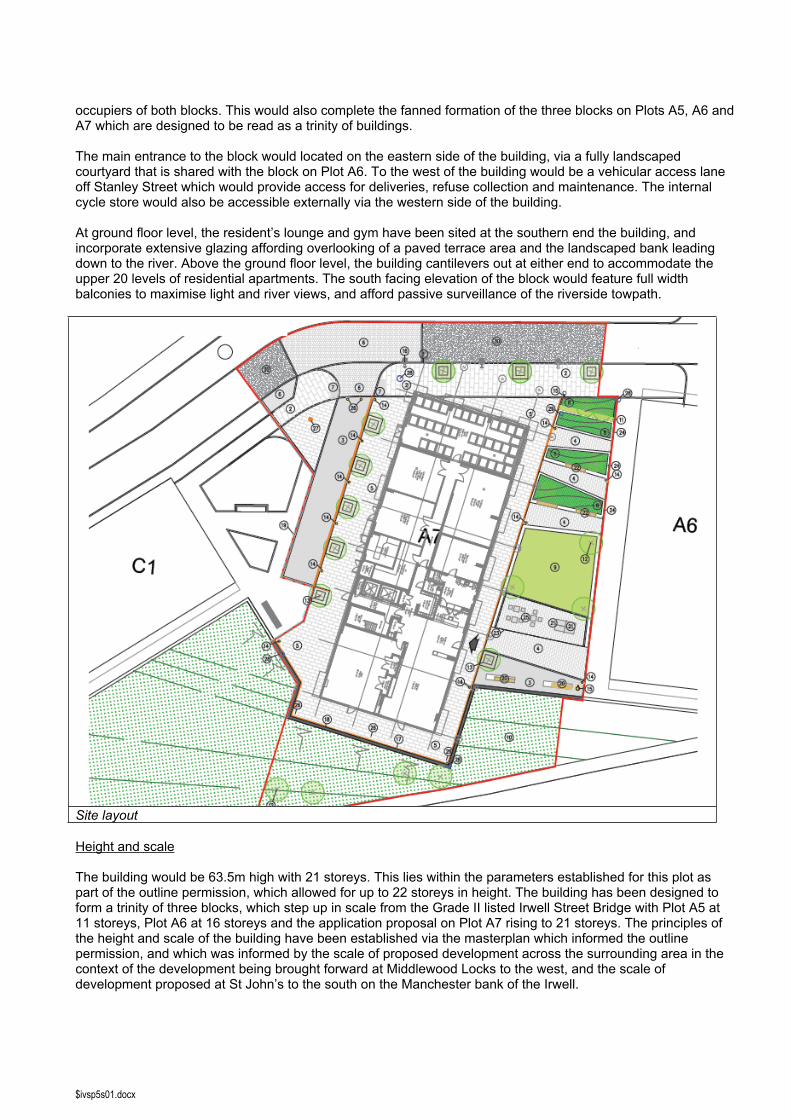
$ivsp5s01.docx
occupiers of both blocks. This would also complete the fanned formation of the three blocks on Plots A5, A6 and A7 which are designed to be read as a trinity of buildings.
The main entrance to the block would located on the eastern side of the building, via a fully landscaped courtyard that is shared with the block on Plot A6. To the west of the building would be a vehicular access lane off Stanley Street which would provide access for deliveries, refuse collection and maintenance. The internal cycle store would also be accessible externally via the western side of the building.
At ground floor level, the resident’s lounge and gym have been sited at the southern end the building, and incorporate extensive glazing affording overlooking of a paved terrace area and the landscaped bank leading down to the river. Above the ground floor level, the building cantilevers out at either end to accommodate the upper 20 levels of residential apartments. The south facing elevation of the block would feature full width balconies to maximise light and river views, and afford passive surveillance of the riverside towpath.
Site layout
Height and scale
The building would be 63.5m high with 21 storeys. This lies within the parameters established for this plot as part of the outline permission, which allowed for up to 22 storeys in height. The building has been designed to form a trinity of three blocks, which step up in scale from the Grade II listed Irwell Street Bridge with Plot A5 at 11 storeys, Plot A6 at 16 storeys and the application proposal on Plot A7 rising to 21 storeys. The principles of the height and scale of the building have been established via the masterplan which informed the outline permission, and which was informed by the scale of proposed development across the surrounding area in the context of the development being brought forward at Middlewood Locks to the west, and the scale of development proposed at St John’s to the south on the Manchester bank of the Irwell.
$ivsp5s01.docx
In this context, it is considered that the scale of the proposed development is appropriate in accordance with UDP Policies DES1 and DES5 in this regard.
Wind impact
A Wind Assessment has been submitted as part of the planning application, which assesses the wind conditions likely to arise from the proposed development as a tall building. The results indicate that the site and immediate surroundings present a wind environment that is generally suitable for a variety of pedestrian activities on the basis that the wind speed thresholds for each category are largely within the recommended frequency limits. The assessment identifies that the western side of the building is likely to experience wind disturbance associated with winds developing along the river and penetrating between the buildings from the south. Notwithstanding this, it confirms that in all cases and seasons, the conditions are largely suitable for standing and accessing buildings and for leisure walking. In relation to the landscaped courtyard to the east of the building, the assessment confirms that the area remains largely suitable for sitting in the summer, when this area would predominantly be used. In terms of pedestrian safety the results demonstrate that the site and its surroundings remain within the recommended safety criterion in this regard. In terms of mitigation measures, the assessment recommends that where possible the proposed trees within the pedestrian corridors between buildings are evergreen types so that they provide wind shelter to pedestrians throughout the year, and it also recommends that outdoor seating areas are located away from the identified windy areas and are provided with local wind shelter through low level screening and planting. The submitted landscaping scheme has sought to address these points in terms of the siting of the outdoor seating areas to the east of the building within a landscaped courtyard with screening afforded by raised planting areas, trees and vegetation. As such, it is considered that the proposed development would not result in any unacceptable impact on microclimate, in accordance with UDP Policy DES5 in this regard.
Detailed design and appearance
UDP Policy DES1 states that regard will be had to the quality and durability of proposed materials and their appropriateness to both the location and the type of development. Policy DES5, seeks to ensure that proposals for tall buildings are of high design quality and construction and make a positive contribution to the skyline.
The east and west side elevations of the block would feature projecting glazed balconies serving some of the apartments, and along these side elevations the window alignments are staggered as two storey groupings, with a four storey grouping to the uppermost levels, in order to introduce a horizontal rhythm to these side elevations and balance the verticality.
In terms of materials, this would reflect the same approach to materials previously approved in relation to Plots A5 and A6 so that the three blocks are read as a trinity. The external treatment would therefore predominantly comprise a distinctive pearl white terracotta rain screen cladding, interspersed with copper toned metal cladding for contrast. The south facing riverside elevation would feature full width balconies to each floor, and there would be projecting glazed balconies to the east and west side elevations. At ground floor, the southern element of the block would comprise predominantly of expansive glazing serving the entrance lobby and resident’s lounge and gym. The elevations of the remaining areas of the ground floor accommodating plant and back of house facilities would be finished in obscured shuffle glazed panels set within dark grey/brown brick. All external windows and doors would be grey powder coated aluminium.
As such, it is considered that the proposed development would achieve a high quality of design and materials and make a positive contribution to the townscape in this regard, in accordance with UDP Policy DES1.
Fire safety of proposed building materials is not a planning consideration, but notwithstanding this the applicant has confirmed that the proposed cladding materials would be fully compliant in this regard.
Design and crime
UDP Policy DES10 states that development will not be permitted unless it is designed to discourage crime, anti-social 13nderuti and the fear of crime. This approach is fully in accordance with NPPF paragraphs 58 and 69 which indicate that planning decisions should aim to ensure that developments “create safe and accessible environments where crime and disorder, and the fear of crime, do not undermine quality of life or community cohesion.” Further policy guidance is outlined in the council’s Design and Crime Supplementary Planning Document.
$ivsp5s01.docx
A Crime Impact Statement has been submitted as part of the planning application, prepared by Design for Security which is part of Greater Manchester Police. The Crime Impact Statement concludes that the proposed development will increase activity, surveillance and animation and will support the continued development of this part of the city as a vibrant, mixed use area. It identifies a series of positive elements of the scheme, namely that there will be a staffed concierge within the development, that apartments are all located at first floor or above, that the communal entrance is appropriately located and that secure cycle parking is provided. In relation to recommendations for crime prevention, the statement recommends the introduction of measures to prevent unauthorised parking as there is no car parking provision within the scheme. The landscaping scheme incorporates elements that would prevent parking within pedestrian areas around the building, and the applicant has confirmed that this issue will be addressed through the use of appropriate traffic regulation orders.
As such it is considered that the physical design of the proposed development has been designed to discourage crime and anti-social behavior and the fear of crime in accordance with the requirements of UDP Policy DES10 and the Design and Crime SPD.
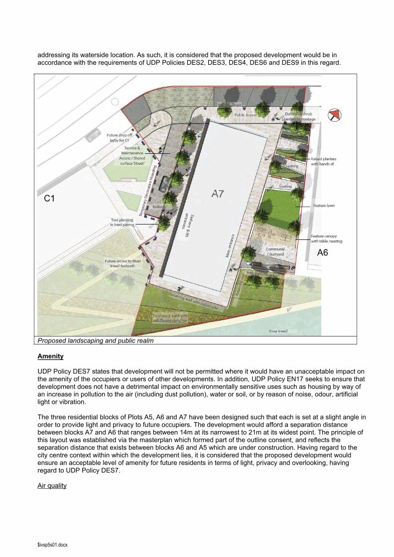
Public realm and landscape
UDP Policy DES9 seeks to ensure that developments incorporate appropriate hard and soft landscaping, with a design and palette of materials that reflects and enhances the character of the area and is appropriate to the design of the development. UDP Policy DES6 seeks to ensure that new waterside development positively addresses the waterfront, provides a safe and overlooked waterside walkway, and facilitates pedestrian routes to the waterside. This is complemented by the design objectives for Irwell River Park as set out within the Planning Guidance document.
The proposed landscaping around the building complements the wider landscaping proposals across the wider Zones A and C area, and reflects the previously granted consents in relation to Plots A5 and A6. The main entrance to the block would be accessed from a landscaped courtyard to the east of the building, which would sit between the proposed building and the block on Plot A6 which is currently under construction. This area would comprise hard landscaping with raised planters set within it comprising areas of lawn, feature planting and trees. Seating would be integrated into this design, with a communal courtyard space providing an area for outdoor seating and relaxation. This courtyard space would feature a covered canopy, outdoor seating and tables, a barbeque area and an outdoor table tennis table to provide an attractive space for outdoor recreation. Whilst this space would be predominantly for use by residents, it would form part of the open public realm and as such there would be public access through the space. To the south of the block, there would be a retaining wall with balustrade beyond which would lie a sloping bank of lawn and wildflower meadow extending down to the riverside towpath. To the western side of the building, the area would comprise predominantly of hard landscaping, with the vehicular access strip for deliveries and maintenance, and a paved area providing full access around the sides of the building, with trees set within the hard paving. A temporary decorative hoarding would be installed along the western boundary to offer screening from construction activities associated with the completion of the Ordsall Chord, and the future development of Plots C1 and C2 which will come forward as planning applications in due course. As these plots are developed, the landscaping would be extended to integrate with these future developments and provide access to the River Irwell footpath.
The development has been designed to positively address its frontage to the River Irwell. The building has been designed to afford surveillance of the riverside towpath, and the landscaping would complement this with the creation of terraces overlooking the riverside and a landscaped wildflower meadow bank extending down towards the riverside towpath. It has been previously confirmed through the Salford Central Masterplan that the Irwell River Park pedestrian and cycle route would be taken along Stanley Street at this stretch, recognising that Irwell Street Bridge provides insufficient clearance to accommodate the route through to Ralli Quays. The application proposal reflects this principle, and has been designed such that it would afford connection to a DDA compliant graded foot/cycle path which would run through the proposed pocket park to the south west of Plot A7 and would connect to the riverside route. The public realm along the western side of the proposed building would therefore represent the principal connection from the riverside route to Stanley Street where it would then run north east and crossing Irwell Street.
The proposed landscaping and public realm treatment has been reviewed by the Council’s Landscape Design team who have confirmed that the proposals are acceptable. It is considered that the proposal would create high quality new public realm which would afford high levels of pedestrian permeability around the building whilst also creating high quality areas for outdoor relaxation by residents of the development, and positively
$ivsp5s01.docx
addressing its waterside location. As such, it is considered that the proposed development would be in accordance with the requirements of UDP Policies DES2, DES3, DES4, DES6 and DES9 in this regard.
Proposed landscaping and public realm
Amenity
UDP Policy DES7 states that development will not be permitted where it would have an unacceptable impact on the amenity of the occupiers or users of other developments. In addition, UDP Policy EN17 seeks to ensure that development does not have a detrimental impact on environmentally sensitive uses such as housing by way of an increase in pollution to the air (including dust pollution), water or soil, or by reason of noise, odour, artificial light or vibration.
The three residential blocks of Plots A5, A6 and A7 have been designed such that each is set at a slight angle in order to provide light and privacy to future occupiers. The development would afford a separation distance between blocks A7 and A6 that ranges between 14m at its narrowest to 21m at its widest point. The principle of this layout was established via the masterplan which formed part of the outline consent, and reflects the separation distance that exists between blocks A6 and A5 which are under construction. Having regard to the city centre context within which the development lies, it is considered that the proposed development would ensure an acceptable level of amenity for future residents in terms of light, privacy and overlooking, having regard to UDP Policy DES7.
Air quality
$ivsp5s01.docx
An Air Quality Note has been submitted as part of the application submission, which is provided to consider whether there are any material changes subsequent to the previous air quality assessment undertaken in 2016 and submitted in support of the outline application 16/68325/OUT. The note takes into account changes to background pollution data provided by DEFRA which have been introduced since the 2016 based assessment. In addition, updated nitrogen dioxide concentrations provided by the Council have also been considered.Notwithstanding the changes in background pollution data, the note confirms that the findings of the 2016 based assessment are still valid and that an updated air quality assessment is not required. The note reiterates that the impact of road traffic associated with the proposed development would have negligible significance in terms of air quality and that subject to appropriate mitigation measures being put into place to tackle dust and particulates during the construction phase, there are no air quality constraints. The submitted information has been reviewed by the Council’s Air and Noise Consultant who agrees with its findings.
Noise
A Noise Assessment Report has been submitted as part of the application submission that has measured the current day and night time noise levels and assessed the impact of the development on the current noise climate. The assessment finds that the site is not significantly affected by noise levels, with the main source of noise being from road traffic.
Condition 61 attached to the original outline permission relating to the wider Salford Central site (09/57950/EIAHYB) required all development to comply with defined internal noise standards to ensure a satisfactory level of amenity for future residents. This defined that internal noise levels of less than 40dB Laeq,(16hour) be achieved within living areas between 07.00 and 23.00 hours. The two reserved matters applications for the residential blocks at Plots A5 and A6 were made pursuant to this consent and their specification designed to achieve this. As part of the new outline consent for Plots A – C which was granted in May 2017 (16/68325/OUT), the internal noise standards defined within the relevant condition (Condition 36) represented an uplift in the standard to be achieved, requiring that development pursuant to this condition be designed to achieve internal noise levels of less than 35dB Laeq,(16hour) within living areas between 07.00 and 23.00 hours. Due to an oversight by the applicant’s acoustic consultant, this uplift in the internal noise standard was initially overlooked as part of the noise assessment and the specification has been designed to the 40dB standard as per the original outline and as achieved in relation to Plots A5 and A6. After this was raised by the Council’s Air and Noise Consultant, the applicant’s noise consultant is undertaking additional detailed noise modeling that will seek to demonstrate how the 35dB standard will be achieved across the majority of apartments within the proposed development. This modeling is currently underway and will be reported within the Amendment Report to Panel. The Council’s Air and Noise Consultant has however indicated that in the event not all of the apartments would achieve the 35dB standard, where the applicant has sought to demonstrate that compliance with this standard has been maximized where feasible, then in this particular instance and having regard to the specific context of the site, no objection would be raised on noise grounds.
Highways, accessibility and parking
The NPPF (paragraph 35) identifies that development should be located and designed where practical to accommodate the efficient delivery of goods and supplies; give priority to pedestrian and cycle movements, and have access to high quality public transport facilities; create safe and secure layouts which minimise conflicts between traffic and cyclists or pedestrians, avoiding
street clutter and where appropriate establishing home zones; incorporate facilities for charging plug-in and other ultra-low emission vehicles; and consider the needs of people with disabilities by all modes of transport.
It also confirms that planning decisions should take account of whether the opportunities for sustainable transport modes have been taken up, that safe and suitable access to the site can be achieved for all people, and whether improvements can be undertaken within the transport network that cost effectively limit the significant impacts of the development. It confirms that development should only be prevented or refused on transport grounds where the residual cumulative impacts of development are severe (paragraph 32).
A Transport Statement and Travel Plan have been submitted as part of the application submission.
Sustainable access
$ivsp5s01.docx
The submitted Transport Statement details the accessibility of the site by sustainable modes of transport. The site occupies a highly sustainable location within the city centre, within walking distance of the wide range of retail, leisure and employment opportunities that this presents. In terms of access to public transport, the site is also accessible to a wide range of public transport options, including rail services at Salford Central, Manchester Victoria, Deansgate, Oxford Road and Piccaddilly, together with Metrolink services through the city centre providing connections across the wider conurbation. The area is also served by a wide range of bus services in the context of its central location. The Transport Statement also highlights the site’s accessibility by cycle, and the connections to Salford Quays which will be facilitated by the completion of Irwell River Park route providing an attractive riverside route for walking and cycling.
Car and cycle parking provision
The building would accommodate an internal cycle storage area at ground floor level with 60 secure cycle spaces. This would be accessible to residents via an internal access door from the building’s ground floor circulation space, and would also feature external access doors for ease of access for cycles. This level of provision would exceed the minimum standard identified within Appendix B of the UDP (40 spaces).
Given the site’s highly accessible city centre location, there would be no on-site car parking spaces provided. Car parking is available within the surrounding area in terms of the existing Salford New Bailey multi-storey car park at Irwell Street, and the masterplan establishes the principle of a further multi-storey car park to the north east of the application site on Plot A2, with an application for planning permission for this anticipated to be submitted shortly. This would provide short term parking for visitors, and offer the potential for the longer term lease of spaces by future occupiers.
Highway impact
The highway impact of the proposed development would be negligible on the basis that no on-site parking provision is proposed, and as such the impact would be limited to access for deliveries, refuse and maintenance which is to be accommodated via the dedicated service lane to the west of the building.
Travel plan
An Interim Travel Plan has been submitted with this application, which upon occupation of the development will be developed into a Full Travel Plan ensuring the long-term sustainability of transport modes by residents and visitors to the building, in accordance with the requirements of Condition 25 attached to the outline permission.
Assessment
The Council’s Highways Engineer has reviewed the submitted documents. They raise no objection to the proposed development subject to conditions requiring i) delivery of a traffic management scheme to prevent on-street parking on Stanley Street, ii) submission of a Construction Method Statement, and iii) submission of a Travel Plan, and the inclusion of relevant informatives.
In relation to the delivery of a traffic management scheme, it must be recognised that the works proposed to the adopted highway at Stanley Street lie within the application red line boundary. As such the applicant will be required to engage with the Local Highway Authority to agree the detail of the proposed works. Following further discussion with the Council’s Highways Engineer it is recognised that agreement regarding delivery of a traffic management scheme for the wider Stanley Street area can be secured via this mechanism. As such, it is not considered that a condition is necessary in this regard.
Condition 41 attached to the outline permission (16/68325/OUT) requires submission of a Construction Method Statement prior to commencement of development on any phase or plot, and similarly Condition 25 attached to the outline permission requires submission of a Travel Plan prior to first occupation of any phase or plot.
A number of informatives have been added to reflect the Highways Engineer’s other detailed comments.
As such, it is considered that the proposed development would comply with the requirements of UDP Policies A2, A8 and A10 in this regard.
Heritage

$ivsp5s01.docx
There are a number of designated heritage assets within the vicinity of the application site, including the Grade II listed Irwell Street Bridge to the north east, and the Grade II listed Victoria and Albert Warehouses on the south bank of the Irwell which now form part of the Manchester Marriott Victoria and Albert Hotel. In addition, the Castlefield Conservation Area lies to the south of the application site encompassing the land on the south bank of the River Irwell from Irwell Street southwards.
Section 66 of the Planning (Listed Buildings and Conservation Areas) Act 1990 states that when considering whether to grant planning permission for development which affects a listed building or its setting “special regard” will be given to the “desirability of preserving the building or its setting or any features of special architectural or historic interest which it possesses”.
Section 72 confirms that “special attention” is to be paid to the desirability of preserving or enhancing the character and appearance of a conservation area. The meaning of “preservation” is taken to be the avoidance of harm.
The implication of the wording “special regard” and “special attention” is that these factors should be given additional weight in decision making and not simply the same weight as any other material consideration.
Paragraph 132 of the NPPF states that when considering the impact of a proposed development on the significance of a designated heritage asset, great weight should be given to the asset’s conservation. It then continues to say that significance can be harmed or lost through alteration or destruction of the heritage asset or development within its setting and that as heritage assets are irreplaceable any harm or loss “should require clear and convincing justification”.
Paragraph 133 of the NPPF states that where a proposed development will lead to substantial harm to or total loss of significance of a designated heritage asset, permission should be refused unless it can be demonstrated that substantial harm or loss is outweighed by substantial public benefits. Paragraph 134 states that where a proposal leads to less than substantial harm to the significance of a designated heritage asset, this harm should be weighed against the public benefits of the proposal.
The significance of a heritage asset relates to the value of the asset because of its heritage interest which may be archaeological, architectural, artistic or historic. However, significance derives not only from an asset’s physical presence but also from its setting.
In the annex to the NPPF the setting of a heritage asset is described as “the surroundings in which a heritage asset is experienced. Its extent is not fixed and may change as the asset and its surroundings evolve. Elements of a setting may make a positive or negative contribution to the significance of an asset, may affect the ability to appreciate that significance or may be neutral”.
Historic England have reviewed the submission documents and raise no objection as they do not consider that proposal would result in any notable impact on the setting and significance of highly designated heritage assets. It is however the duty of the local planning authority to assess the impact of the proposed development on the identified heritage assets, having regard to the requirements of the NPPF and the Planning (Listed Buildings and Conservation Areas) Act 1990 in this regard.
The Grade II listed Irwell Street Bridge is a good example of late 19th century bridge construction and engineering incorporating both stone and metal work, which remains as originally constructed and which incorporates the Arms of both Salford and Manchester. The bridge therefore has high material, design and social significance with its structure retaining 19th century design and decoration that allows an interpretation of its significance and role in bringing the communities of Salford and Manchester together through improved connectivity across the Irwell. The Grade II listed former warehouses now form part of the Manchester Marriott hotel and have been adapted and extended as part of this conversion. They are considered to be good examples of early to mid 19th century warehouses and of medium significance.
The Castlefield Conservation Area extends over a large area and centres on the Roman remains of Mancunium. Of more relevance to this site, the River Irwell was made navigable in the 1720s and the first quay constructed in 1734. At the turn of the 19th century the Castlefield area was the hub of the canal network in Manchester. The world’s first railway station was opened within this area in 1830. The wider Conservation Area is of the highest significance in terms of both physical and social significance.
$ivsp5s01.docx
Whilst the development has no direct impact on the fabric of any heritage asset it will has the potential to impact on the setting of the designated heritage assets. In terms of the Grade II listed Irwell Street Bridge, it is not considered that the proposed development would result in any impact on its setting. The setting of the bridge is defined by its location surrounded by large scale development in terms of Ralli Quays and the Premier Inn, and as such it is not considered that the proposed development would result in any impact in this regard. In relation to the Grade II listed Victoria and Albert Warehouses and the Castlefield Conservation Area, the proposed development by virtue of its height and position will clearly be prominent within certain views of and from the warehouses and the wider conservation area. Notwithstanding this, the setting of these heritage assets is defined by their city centre location within a dense urban grain comprising a significant number of tall buildings. In this context, it is not considered that the proposal would result in harm to the setting of these designated heritage assets which is necessarily read in the context of their existing surroundings. The proposed development would result in the high quality redevelopment of this site which in its underutilized and overgrown state failed to result in any positive contribution of the setting of these heritage assets.
Greater Manchester Archaeological Advisory Service have reviewed the submitted Archaeological Watching Brief and confirm that they raise no objection to the proposed development on the basis that there is no known archaeological interest on this site and that as such they consider that no further archaeological mitigation is required in this instance.
In this context, the application proposal is considered to be in accordance with UDP Policies CH2 and CH8, and the relevant provisions of the NPPF in this regard.
Land contamination and water pollution
NPPF paragraph 121 states that planning decisions should ensure that the proposed site is suitable for its new use taking account of ground conditions, including pollution arising from previous uses and any proposals for mitigation including land remediation or impacts on the natural environment arising from that remediation.
A Phase 1 Geo-Environmental Site Investigation report undertaken for the wider site relating to the outline permission has been submitted as part of the application submission. This report concludes that there is a low to moderate risk to human health and a moderate risk to controlled waters on the basis that potentially contaminative sources are present on-site and that contaminants have been identified during previous site investigation works. Consequently, a Phase 2 Intrusive Investigation Geo-Environmental Report has been submitted. The submitted documents have been reviewed by the Council’s Contaminated Land Consultant who raises no objection, recognising that Conditions 28 and 29 attached to the outline permission address the land contamination requirements in this regard.
Flood risk and drainage
NPPF paragraph 103 indicates that local planning authorities, when determining planning applications, should ensure flood risk is not increased elsewhere and only consider development appropriate in areas at risk of flooding where it can be demonstrated that the most vulnerable development is located in areas of lowest flood risk, and where development is appropriately flood resilient and resistant. In addition, UDP Policy EN18 seeks to ensure that development would not have an unacceptable impact on surface or ground water. Salford’s Flood Risk and Development planning guidance expands further on these policies.
A Flood Risk Assessment (FRA) has been submitted as part of the application submission. This identifies the site as potentially at risk of fluvial flooding from the River Irwell in an extreme event based on the Environment Agency Flood Map for Planning indicating that the site lies within Flood Zone 2. However, based on an assessment of site levels against modelled flood levels it appears that the site is not affected by flooding in any of the Environment Agency modelled flood events including the 1 in 1000 storm. The FRA recommends in regards to mitigation that finished site and floor levels should be engineered to provide positive drainage and prevent ponding. The FRA also considers that due to site levels and the flood risk zone, a site evacuation plan and compensatory flood water storage is not required for the application site.
A Drainage Stategy has also been submitted as part of the application submission. In relation to surface water drainage, the report identifies that the proposed development is located on a principal aquifer and is in a high groundwater vulnerability zone and as such infiltration does not represent a suitable method for surface water

$ivsp5s01.docx
disposal. The report also identifies that outfall to the River Irwell has been considered, however this has been discounted as this would involve crossing land outside the applicant’s ownership.
As such, it is proposed that the development would discharge surface water drainage to the public sewer network. Foul water would be discharged to the combined sewer system connecting to the existing drain at Stanley Street. United Utilities have reviewed the submitted documents and confirmed that the drainage proposals are acceptable in principle.
The submitted documents have been reviewed by the Council’s Flood Risk and Drainage Engineer. In relation to the FRA, they note the FRA’s conclusion that plot levels will be above the 1 in 1,000 year flood level and therefore the site is deemed to be in Flood Zone 1. In relation to the Drainage Strategy and associated drainage layout drawing and calculations, the Council’s Flood Risk and Drainage Engineer confirms that this complies with the requirements of Condition 29 of the outline permission in this regard (16/68325/OUT). As such, no objection is raised. In addition, the Environment Agency has also confirmed no objection in relation to the proposals.
It is therefore considered that the proposed development would comply with UDP Policies EN18 and EN19 and the relevant parts of the NPPF.
Biodiversity
NPPF paragraph 109 identifies that the planning system should contribute to and enhance the natural and local environment by protecting and enhancing valued landscapes and minimising impacts on biodiversity and providing net gains in biodiversity where possible, contributing to the Government’s commitment to halt the overall decline in biodiversity.
The application site lies adjacent to the River Irwell and part of the site lies within an identified wildlife corridor area of search under UDP Policy EN9 associated with its riverside location. The policy seeks to ensure the protection and enhancement of the function of these areas as wildlife corridors for the movement of flora and fauna. A Preliminary Ecological Appraisal and Ecological Management Plan have been submitted in support of this application. The appraisal identifies the application site as dominated by compacted ground hard-standing with vegetated areas limited to the embankment next to the River Irwell which is dominated by dense bramble scrub and tall ruderal vegetation. The Ecological Management Plan identifies a series of measures that will contribute towards achieving a net biodiversity gain and mitigating any potential harm to ecological interests. These include the installation of bat boxes on south facing retaining walls by the riverside, ensuring that external lighting is directed away from the riverside to ensure the continued use of the river as a bat foraging and commuting route and the installation of bird boxes within the landscaping scheme. The document also confirms that the proposed landscaping planting within the areas of public realm and the creation of a wildflower meadow on the riverside embankment will provide new habitat for wildlife. In addition, it sets out the process for removal of giant hogweed and Himalayan balsam which are both present on the application site.
The submission documents have been reviewed by Greater Manchester Ecology Unit (GMEU). GMEU consider that the Ecology Management Plan has been prepared by suitably qualified ecologists and represents a satisfactory and proportionate response to the ecological issues associated with this site, and to the ecology and landscape conditions set as part of the outline permission. GMEU consider that the implementation of the Ecology Management Plan and the soft landscaping proposals will result in the development contributing to a net biodiversity gain in the area and mitigating any potential harm to ecological interests.
GMEU highlight that the adjacent river course is an important local asset and any pollution of the watercourse during site clearance and construction work should be avoided by the adoption and implementation of best practice methods for the control of pollution on construction sites. It is considered that this issue is effectively covered by Condition 41 of the outline permission in relation to the requirement for a Construction Method Statement, with point (ix) of this condition specifically identifying that the statement shall include measures to prevent the pollution of watercourses.
As such, it is considered that the application is in accordance with the requirements of the NPPF in this regard.
Sustainability credentials
$ivsp5s01.docx
The Sustainable Design and Construction SPD seeks to ensure that sustainable design and construction measures are integrated into new developments. An Energy and Sustainability Statement has been submitted as part of the application submission which details how that the proposed development will utilise energy efficient features to minimise its carbon and environmental footprint and meet the sustainable standards set out in Building Regulations. It also confirms the use of energy reduction measures and low carbon technology that will be incorporated within the proposed development to achieve a superior environmental performance. Passive measures will be incorporated within the design of the building in terms of enhanced insulation to the building envelope, windows with high thermal insulation, reduced air permeability, maximisation of daylight, and optimised glazing for solar energy transmittance. High efficiency systems, plant and controls will also be incorporated including optimised plant controls, Mechanical Ventilation with Heat Recovery systems serving the apartments to recover waste heat from the exhaust air that would otherwise be lost, energy efficient lighting with controls to limit energy use and energy efficient lifts. In terms of renewable technologies, roof mounted solar photovoltaic panels would be installed across the roof of the building. The report concludes that the proposed measures will meet the CO2 requirements for compliance with Building Regulations Part L 2013.
It is considered that the development would meet the Council’s aspirations in terms of sustainability and the requirements of the SPD and is therefore considered to be acceptable in this regard.
Recommendation
Planning permission be granted subject to the following planning conditions
1 The development hereby permitted shall be carried out in accordance with the plans and drawings listed within the submitted Plot A7 Drawing Schedule (dated 25th May 2017 / reference 08806ma).
Reason: For the avoidance of doubt and in the interest of proper planning.
Notes to Applicant
1. The erection and operation of cranes during construction may present a hazard to aircraft safety and a separate safeguarding assessment of any crane operations would need to be completed by Manchester Airport prior to any cranes being erected to ensure that aircraft safety is protected. The applicant should contact Manchester Airport Airfield Safety and Compliance (E: [email protected] / T: 0161 489 6114) at least 21 days in advance of intending to erect a crane or other tall equipment on the site to establish whether a Tall Equipment Permit would be required, and whether any regulatory procedures or operating restrictions would need to be agreed in advance. The applicant should review the guidance contained within the Manchester Airport document ‘Planes & Cranes – a guide to procedures for operation of cranes and tall equipment in the vicinity of Manchester Airport’ (September 2016).
2. United Utilities has advised that the level of cover to the water mains and sewers must not be compromised either during or after construction. A separate metered supply to each unit will be required at the applicant's expense and all internal pipe work must comply with current Water Supply (Water Fittings) Regulations 1999. The applicant should contact United Utilities on 03456 723 723 regarding connection to the water mains or public sewers.
3. It is the applicant's responsibility to demonstrate the exact relationship between any United Utilities' assets and the proposed development. United Utilities offer a fully supported mapping service and recommend the applicant contact its Property Searches Team on 0370 751 0101 to obtain maps of the site. Due to the public sewer transfer, not all sewers are currently shown on the statutory sewer records. If a sewer is discovered during construction please contact a Building Control Body to discuss the matter further.
4. If the applicant intends to offer wastewater assets forward for adoption by United Utilities, the proposed detailed design will be subject to a technical appraisal by an Adoptions Engineer to ensure that the proposal meets the requirements of Sewers for Adoption and United Utilities’ Asset Standards. The proposed design should give consideration to long term operability and give United Utilities a cost effective proposal for the life of the assets. Therefore, should this application be approved and the applicant wishes to progress a Section 104 agreement, it is strongly recommended that no construction commences until the detailed drainage design, submitted as part of the Section 104 agreement, has been assessed and accepted in
$ivsp5s01.docx
writing by United Utilities. Any works carried out prior to the technical assessment being approved is done entirely at the developers own risk and could be subject to change. Further information regarding Developer Services and Planning, can be found on United Utilities’ website at http://www.unitedutilities.com/builders-developers.aspx.
5. The developer should contact John Horrocks (T: 0161 603 4046) to arrange a full Dilapidation / Condition Survey of all adopted highways surrounding the site prior to works commencing on site. Applications for all forms of highway permits/licenses shall be made in advance of any works being undertaken on the adopted highway and no boundary fencing shall be erected or positioned on any part of the adopted highway without first seeking the relevant permits/licenses from the Local Highway Authority. All requests for general Information regarding the adopted highway network shall be directed to the Local Highway Authority (John Horrocks (T: 0161 603 4046)).
6. The applicant will need to enter into a S50, S177 and S278 agreement and to provide funding to facilitate associated highway works for the following:
(a) relocation and upgrading of lighting with the vicinity of the site along Stanley Street;(b) TROs along Stanley Street and on the full length of the service road;(c) if the upper floors of the building overhang the adopted highway, an Oversailing License will
need to be applied for;(d) to provided dropped crossings on pedestrian routes in the vicinity of the site;(e) to incorporate pedestrian / cycle links to Irwell River Park;(f) future maintenance of any proposed trees and lighting within the adopted highway.