Embed Size (px)
Citation preview
UNITED STATES ENVIRONMENTAL PROTECTION AGENCY REGION 2
PART I - THE DECLARATION
RECORD OF DECISION OPERABLE UNIT 2
SCORPIO RECYCLING INC. SITE TOA BAJA, PUERTO RICO

2
DECLARATION FOR THE RECORD OF DECISION SITE NAME AND LOCATION Scorpio Recycling Inc. Superfund Site Toa Baja, Puerto Rico STATEMENT OF BASIS AND PURPOSE This decision document presents the selected remedial action for the Operable Unit 2 (Soils) at the Scorpio Recycling Inc. Superfund Site (the Site), located in the Municipality of Toa Baja, Puerto Rico, which was chosen in accordance with the requirements of the Comprehensive Environmental Response, Compensation and Liability Act of 1980 (CERCLA), 42 U.S.C. § 9601-9675, as amended, and to the extent practicable by the National Oil and Hazardous Substances Pollution Contingency Plan (NCP), 40 C.F.R. Part 300. This decision document explains the factual and legal basis for selecting the remedy for the Site. This decision is based on the Administrative Record file for this Site. Refer to Appendix I of Part II – Decision Summary for copy of the Administrative Record Index for this Site. The Puerto Rico Environmental Quality Board (EQB) concurs with the selected remedy. Refer to Appendix II of Part II – Decision Summary for copy of the letter. ASSESSMENT OF SITE The United States Environmental Protection Agency (EPA), in consultation with EQB, has determined that actual or threatened releases of hazardous substances from the Site, if not addressed by the preferred remedy or one of the other active measures considered, may present a current or potential threat to human health and the environment. Therefore, remediation is necessary. This determination is based on the conclusions of the remedial investigation (RI), human health risk assessment (HHRA), and the screening level ecological risk assessment report. The selected remedy complies with Federal and Commonwealth requirements that are legally applicable or relevant and appropriate requirements (ARARs) to the remedial action and is cost effective. As such, the selected remedy will be protective of human health and the environment. Risks to human health due to direct contact, ingestion and inhalation would be eliminated since contaminated soils would be covered, and the exposure pathways would be eliminated. This alternative would also provide protection to the environment by eliminating the exposure pathways to ecological receptors. DESCRIPTION OF THE SELECTED REMEDY Based upon an evaluation of the various alternatives, EPA, in consultation with EQB, selects Alternative No. 3b, Cover with Gravel at the Industrial Area and Soil within the Conservation Area, as the preferred remedial alternative for soil contamination at this Site. Gravel would be used as the cover for contaminated soil at the industrial zone and common soil would be used as the cover at the conservation area. For this action, the term “soil cover” refers to both the gravel cover and the common soil cover. A geo-fabric demarcation layer would be installed between the contaminated soil and the soil cover. The cover would be graded for positive drainage and to match the natural drainage pattern to the extent possible. The soil cover within the conservation area would also be vegetated with native species for erosion control.
3
As part of the remedial design, soil samples will be obtained and analyzed to determine the lateral extent required for the soil cover. The remedial design would consist of both prescriptive and performance-based requirements as well as better defining an estimate of costs of the remedial action. A long-term inspection and maintenance program would be implemented to ensure the integrity of the soil cover. FIVE‐YEAR REVIEWS Five‐year reviews will be conducted at least every five years using data obtained from the maintenance and monitoring program. These reviews are important under this alternative because it is an additional mechanism to ensure protection of human health and the environment. INSTITUTIONAL CONTROLS Because contaminated soil exceeding health-based levels would be left on Site and the zoning of the area at the time of the implementation will be industrial and dedicated for conservation, deed restrictions would be sought to restrict future intrusive activities that could otherwise disturb the soil cover and expose any construction worker or future land users to contaminants at levels that may pose human health risks. Furthermore, the Commonwealth is in the process of changing the zoning on the parcels to prohibit residential use, and if possible we would further seek a deed restriction be placed on the Scorpio facility property and the southeastern corner of the Rosa del Monte property to prevent residential use in the future and to prevent conservation area from being used in any manner other than for conservation. ESTIMATED OUTCOMES OF SELECTED REMEDY The principal outcomes of the selected remedy are: 1) prevent or minimize exposure to contaminated soil at concentrations exceeding the cleanup levels for human receptors through ingestion, inhalation and direct contact and 2) prevent or minimize exposure to contaminated soil at concentrations exceeding the cleanup levels goals for ecological receptors through ingestion, inhalation and dermal contact. EPA REGION 2 CLEAN AND GREEN POLICY Consistent with EPA Region’s 2 “Clean and Green” Policy, the utilization of applicable green remediation practices shall be considered and, to the extent practical, incorporated into the detailed design of the selected remedy. Some examples of the operational practices that would be applicable are those that reduce emissions of air pollutants, minimize water consumption, incorporate native vegetation into revegetation plans, and consider beneficial reuse and/or recycling of materials, among others. STATUTORY DETERMINATIONS As required under Section 121 of CERCLA, remedial actions carried out under Section 104 or secured under Section 106 must be protective of human health and the environment and attain the levels or standards of control for hazardous substances, pollutants or contaminants specified by the ARARs of Federal environmental laws and Commonwealth environmental and facility siting laws, unless waivers are obtained. The selected remedy also must be cost-effective and utilize permanent solutions and alternative treatment technologies or resource recovery technologies to the maximum extent practicable. Finally, the statute includes a preference for remedies that employ treatment that permanently and significantly reduces the volume, toxicity or mobility of hazardous substances, as available. CERTIFICATION This decision document includes all the elements required to support the selected remedy in accordance with the Guide to Preparing Superfund Proposed Plans, Records of Decision, and Other Remedy Selection

Decision Documents [EPA 540-R-98-031 OSWER 9200.1-23P (July 1999)].
AUTHORIZING SIGNATURE
In accordance with the requirements of CERCLA and to the extent practicable the NCP, EPA, in consultation with EQB, has determined that the selected remedy for the Scorpio Recycling Inc. Superfund Site is required in order to protect human health and the environment.
Walter E. Mugdan, Dir ctor Emergency and Remedial Response Division EPA - Region 2
4

5
UNITED STATES ENVIRONMENTAL PROTECTION AGENCY REGION 2
PART II – DECISION SUMMARY
RECORD OF DECISION OPERABLE UNIT 2
SCORPIO RECYCLING INC. SUPERFUND SITE TOA BAJA, PUERTO RICO

6
TABLE OF CONTENTS SITE NAME AND LOCATION ....................................................................................................................... 2
STATEMENT OF BASIS AND PURPOSE ..................................................................................................... 2
ASSESSMENT OF SITE .................................................................................................................................. 2
DESCRIPTION OF THE SELECTED REMEDY ............................................................................................ 2
Five‐Year Reviews ......................................................................................................................................... 3
Institutional Controls ..................................................................................................................................... 3
Estimated Outcomes of Selected Remedy ..................................................................................................... 3
EPA Region 2 Clean and Green Policy ......................................................................................................... 3
STATUTORY DETERMINATIONS ............................................................................................................... 3
CERTIFICATION ............................................................................................................................................. 3
AUTHORIZING SIGNATURE ........................................................................................................................ 4
SITE NAME, LOCATION, AND DESCRIPTION .......................................................................................... 9
SITE HISTORY ................................................................................................................................................. 9
Preliminary Assessment – 1991 ..................................................................................................................... 9
Site Investigation – 1991/1993 ...................................................................................................................... 9
EQB’s Investigation – 1994 ........................................................................................................................... 9
EPA Expanded Site Investigation – 1999 .................................................................................................... 10
EPA HRS and National Priority List Inclusion – 1999/2000 ...................................................................... 10
EPA CERCLA Removal Action-2002 ......................................................................................................... 10
EPA Remedial Investigation/Feasibility Study, Operable Unit -1 Groundwater: 2006 .............................. 10
EPA RI/FS, OU- 2 Soils: 2010-2011 ........................................................................................................... 11
COMMUNITY PARTICIPATION ................................................................................................................. 11
SCOPE AND ROLE OF ACTION .................................................................................................................. 11
SITE CHARACTERISTICS ............................................................................................................................ 12
Conceptual Site Models ............................................................................................................................... 12
Site Overview ............................................................................................................................................... 12
Topography and Drainage........................................................................................................................ 13
Geology .................................................................................................................................................... 13
Hydrogeology .......................................................................................................................................... 14
Cultural Resource ..................................................................................................................................... 14
Sampling Strategy .................................................................................................................................... 14
Source of Contamination ......................................................................................................................... 16
Types of Contaminants and Migration .................................................................................................... 16
Current and Potential Future Land Use ....................................................................................................... 17
SUMMARY OF SITE RISKS ......................................................................................................................... 18

7
Human Health Risk Assessment .................................................................................................................. 18
Hazard Identification ............................................................................................................................... 18
Exposure Assessment............................................................................................................................... 19
Toxicity Assessment ................................................................................................................................ 20
Risk Characterization ............................................................................................................................... 23
Ecological Risk Assessment ........................................................................................................................ 27
Risk Assessment Summary .......................................................................................................................... 27
REMEDIAL ACTION OBJECTIVES ............................................................................................................ 27
DESCRIPTION OF THE ALTERNATIVES .................................................................................................. 29
Remedial Alternatives .................................................................................................................................. 29
Alternative 1 – No Action ............................................................................................................................ 29
Alternative 2 – Consolidation and Soil Cover ............................................................................................. 29
Alternative 3a – Soil Cover in the Industrial and Conservation Zoning Area ............................................. 30
Alternative 3b – Cover with Gravel at the Industrial Area and Soil within the Conservation Area ........... 31
COMPARATIVE ANALYSIS OF ALTERNATIVES ................................................................................... 33
Overall Protection of Human Health and the Environment ......................................................................... 33
Compliance with Applicable or Relevant and Appropriate Requirements (ARARs) ................................. 34
Long-Term Effectiveness and Permanence ................................................................................................. 34
Reduction of Toxicity, Mobility, or Volume Through Treatment ............................................................... 34
Short-Term Effectiveness ............................................................................................................................ 34
Implementability .......................................................................................................................................... 35
Cost .............................................................................................................................................................. 35
State/Support Agency Acceptance ............................................................................................................... 35
PRINCIPAL THREAT WASTES ................................................................................................................... 36
SELECTED REMEDY .................................................................................................................................... 36
Estimated Outcomes of Selected Remedy ....................................................................................................... 37
STATUTORY DETERMINATIONS ............................................................................................................. 37
Protection of Human Health and the Environment ...................................................................................... 37
Compliance with ARARs ............................................................................................................................ 37
Long-Term Effectiveness and Permanence ................................................................................................. 38
Reduction of T/M/V Through Treatment .................................................................................................... 38
Short-Term Effectiveness ............................................................................................................................ 38
Implementability .......................................................................................................................................... 39
Cost .............................................................................................................................................................. 39
Five Year Review Requirements ................................................................................................................. 39
DOCUMENTATION OF SIGNIFICANT CHANGES FROM PREFERRED ALTERNATIVE OF PROPOSED PLAN .......................................................................................................................................... 39
RESPONSIVENESS SUMMARY ..................................................................................................................45

8
APPENDIX I Administrative Record Index for Scorpio recycling Inc. Contamination Superfund Site
APPENDIX II Puerto Rico Environmental Quality Board’s Concurrence Letter APPENDIX III Figures APPENDIX IV Proposed Plan and Fact Sheet (Spanish) APPENDIX V Public Notices APPENDIX VI Public Meeting Attendance Sheet APPENDIX VII Transcript of the Public Meeting and Written Comments APENDIX VIII Soil Analytical Results Selected Tables and Figures

9
SITE NAME, LOCATION, AND DESCRIPTION The Scorpio Recycling Inc. (SRI) Superfund Site (Site) is located on State Road 2 at kilometer 19.7, interior (Acuña Street), in the Candelaria Ward of Toa Baja, Puerto Rico (Figure 1). The Site is defined as the SRI property and contaminated portions of two adjacent properties: Rosa del Monte Movers (the Rosa del Monte property) to the west and a battery crushing/sinkhole area (Battery Crushing/Sinkhole Area) to the south which is partially on a conservation area owned by the government of Puerto Rico (Figure 2). The SRI property is an inactive metal recycling facility which consists of a relatively flat nine-acre parcel which slopes gently to the north within its northern portion and to the south in its southern portion. Two and a half acres of the SRI property are owned by Astur Metals and 6.5 acres are owned by SRI. The SRI property was operated by Astur Metals, then SRI and then by Scrapyard Recycling Inc., pursuant to a lease agreement. The SRI property includes an administrative office, aluminum processing buildings, copper-brass sorting buildings, a maintenance shop and a scrap vehicle accumulation building. SITE HISTORY SRI began operations in 1972 under the name Astur Metals, Inc and was renamed SRI in 1988. From 1972 to 2010, the facility received and accumulated scrap metals which, upon receipt, were compacted, shredded and packed for shipping. During the Site’s early operations, crushed batteries led to sulfuric acid spills on the ground. Acidic runoff from the battery crushing area flowed into the conservation area. Battery recycling and crushing reportedly ceased in 1983. In addition, fluids from cars, tanks, appliances, electronics and other materials were allowed to drain to the ground. The scrap metals were stored at the facility prior to being sent offsite. Several piles of scrap metal, some as high as 100 feet, were inter-spaced with dirt pathways covering approximately four acres of land. Materials observed in these piles included crushed cars, gas tanks, propane tanks, appliances, computers, crushed generators, crushed trailers, metal storage tanks and metal pipes PRELIMINARY ASSESSMENT – 1991 The Puerto Rico Environmental Quality Board (EQB) conducted a Preliminary Assessment in 1991, which identified poor housekeeping practices including stained and corroded floors, spills, batteries on the ground and on pallets, lead battery cells open to the atmosphere, acidic runoff flowing into the sinkhole area, and stressed vegetation. SRI personnel used earthen material to cover the areas containing battery acids. SITE INVESTIGATION – 1991/1993 The U.S. Environmental Protection Agency (EPA) conducted a Site Investigation in October 1991 and July 1993. This investigation included soil and runoff/leachate sampling in the Battery Crushing/Sinkhole Area. Results showed high concentrations of barium, lead, and vanadium above EPA’s Soil Screening Levels for ingestion. In addition, water samples were collected from a series of small puddles in the area. The metals detected in the surface water included lead, antimony, cadmium, copper, nickel, silver, vanadium, zinc, and iron. The average pH in the water samples was 5. EQB’S INVESTIGATION – 1994 EQB collected samples of surface soil at the SRI property. Results indicated metal contamination in surface soils at concentrations greater than three times background at selected locations. Semivolatile organic compounds (SVOCs), pesticides, and polychlorinated biphenyls (PCBs) were also detected. Groundwater (tap water) samples were collected from one upgradient well (considered “background” or unaffected by the Site contaminants) and a downgradient supply well (Campanilla 7). These groundwater analyses identified lead at a concentration below drinking water standards. At the time of the EQB investigation, the batteries

10
were shipped unbroken to Brazil; however, poor handling practices during accumulation continued to result in battery acid being spilled on the ground. EPA EXPANDED SITE INVESTIGATION – 1999 In April 1999, an EPA contractor, Weston, conducted an Expanded Site Inspection to gather additional data necessary for a Hazard Ranking System (HRS) evaluation and to support the need for a Comprehensive Environmental Response, Compensation, and Liability Act (CERCLA) removal action. Surface and subsurface soil samples were collected from the Battery Crushing/Sinkhole Area and other areas throughout the Site, as well as groundwater samples from a nearby well. Volatile organic compounds (VOCs) and SVOCs were detected in soils at concentrations up to three times above background concentrations. Groundwater results did not indicate the presence of contaminants. In September 1999, an additional surface and subsurface soil sampling was conducted to evaluate the extent of contamination associated with the former battery salvage operation in the southwestern section of the SRI property. Elevated concentrations of lead and PCBs were found in the soils. EPA HRS AND NATIONAL PRIORITY LIST INCLUSION – 1999/2000 In October 1999, EPA prepared an HRS Report, which documented the Site’s location in a karst recharge area, its proximity to nearby drinking water sources, the populations served by those drinking water sources, and soil contamination at the Site. Due to the potential threat of lead migration into the groundwater, the Site was listed on the Superfund National Priorities List on February 4, 2000. EPA CERCLA REMOVAL ACTION-2002 In 2002, EPA’s Emergency and Remedial Response Division began a CERCLA removal action to excavate and remove the battery cases, miscellaneous debris and metal-contaminated soils in the southwestern portion of the SRI property and the sinkhole. Approximately 15,000 tons of contaminated soils were excavated and removed from the battery recycling area and the slope leading down to the Battery Crushing/Sinkhole Area. Contaminated soils were stabilized with trisodium phosphate in order to comply with Resource Conservation and Recovery Act waste determination prior to disposal at a non-hazard local landfill. A trench was also excavated to catch overland runoff from flowing into the sinkhole area. EPA conducted X-Ray Fluorescence screening analysis of soil samples for lead and cadmium to support the delineation of contamination in the excavated trench and to determine parameters for the on-site treatment (stabilization) of remaining contaminated soils. Confirmatory samples were collected to verify if the cleanup level of 400 parts per million (ppm) had been achieved for lead. Lead concentrations ranged from non-detect to 94,300 ppm and cadmium concentrations ranged from non-detect to 729 ppm. The results indicate that the entire source was not excavated. In addition, waste remains buried under a storage shed building and portions of the adjacent paved parking lot at Rosa del Monte Property. No removal action was performed in the large scrap pile areas. Removal actions ceased in June 2004. EPA REMEDIAL INVESTIGATION/FEASIBILITY STUDY, OPERABLE UNIT -1 GROUNDWATER: 2006 A Remedial Investigation/ Feasibility Study (RI/FS) was conducted for Operable Unit (OU) 1 from 2002 to 2006, to address groundwater contamination at the Site. The OU-1 RI included the following activities: (1) installation of monitoring wells at different locations (seven in total at the SRI property, Rosa del Monte property, and the Pan American Gun Club property (located southeast of the Site)); (2) bedrock borehole geophysics; (3) slug testing; (4) synoptic and continuous water level measurement; (5) well abandonment;

11
(6) two rounds of groundwater sampling at the seven newly-installed monitoring wells and three supply wells in the area; (7) a cultural resources survey; and (8) an ecological characterization. The groundwater data indicated that the groundwater was not impacted by Site related operations. The RI concluded that downward migration of contaminants was minimized by the presence of a semi-confining unit underlying the Site, the general immobility of metals in soil, depth to groundwater (greater than 100 feet), and potential neutralization of acids in the unsaturated zone. A No-Action Record of Decision (ROD) was issued for OU-1 on September 28, 2006. EPA RI/FS, OU- 2 SOILS: 2010-2011 A RI/FS for OU-2 was conducted from August to October 2010 and included the following field activities: (1) a topographic survey of the Site; (2) soil boring grid setup and survey in all areas (except the northern portion of the SRI property due to the presence of waste piles); and (3) a surface geophysical survey of sampling areas (except the northern portion of the SRI property). Soil samples were collected from 12 borings in the SRI buildings, 18 borings in the southern area of the SRI property; seven borings at the Rosa del Monte property, and 24 borings in the battery crushing/sinkhole area. Soil samples from contingency and background borings and two surface soil samples from a battery crushing/sinkhole area trench previously excavated by EPA were collected in January 2011. In October 2011, the soil boring grid for the northern area was adjusted to avoid the wastes piles, marked, and surveyed. In November 2011, 18 borings in the northern area of the SRI property were sampled and seven composite samples were collected from the waste piles (one from each pile) to characterize the waste for removal. Boring locations are presented in Figure 3. The RI results are presented in the summary discussion of the nature and extent of contamination. COMMUNITY PARTICIPATION The RI Report, the Human Health Risk Assessment (HHRA) Report, the Screening Level Ecological Risk Assessment (SLERA) Report, and the Proposed Plan (Appendix IV) for the Site were made available to the public in August 7, 2013. These documents along with the Administrative Record were made available to the public in the EPA Docket Room in Region 2, New York, Toa Baja Public Library, EQB’s Superfund File Room, and EPA Caribbean Environmental Protection Division’s Office. Refer to Appendix I for copy of the Administrative Record Index for the Site. A public notice (Appendix V) announcing the availability of these documents and the date of the public meeting was published in the El Vocero newspaper on August 7, 2013. A public comment period was held from August 7, 2013 to September 6, 2013. In addition, on August 14, 2013 a public meeting was held at the basketball court of Urbanización Altagracia in the Municipality of Toa Baja from 6:00-8:00 pm. The purpose of the public meeting was to present the Proposed Plan for the Site and provide the community with the opportunity to ask questions or provide comments on the Proposed Plan. Refer to Appendix VI for copy of the attendance signing sheet. EPA also used this meeting to solicit a wider cross-section of the community input on the proposed remedial alternative for the Site. At this meeting, representatives from EPA and EQB answered questions and received comments about the activities conducted at the Site and the remedial alternatives. No substantive comments were received during the meeting. Refer to Appendix VII for official transcript of the public meeting. EPA prepared a Responsiveness Summary addressing all comments received during the public comment period. The Responsiveness Summary is included in Part III of this ROD. SCOPE AND ROLE OF ACTION
12
The principal problem at the SRI Site is the presence of soil contamination at levels that represent an unacceptable risk to human health and the environment. Potential groundwater contamination was addressed in Operable Unit 1 and a No Action ROD signed in 2006. The Site consists of three main contaminated areas: the battery crushing/sinkhole area, SRI Property, and soil located beneath and adjacent to a structure at the Rosa del Monte property. The soil contamination has been defined in sufficient detail to complete the RI Report and prepare a Feasibility Study (FS) and a Baseline Risk Assessment (which includes the HHRA and SLERA). This action is for Operable Unit 2 at the Site. SITE CHARACTERISTICS CONCEPTUAL SITE MODELS The Conceptual Site Models (CSMs) are developed to integrate the different types of information collected during the RI, including geology, hydrogeology, Site background and setting, and the fate and transport of contaminants. Figure 4 presents the CSM for the Site. The SRI site is located within the North Coast Limestone Province, and is underlain by karst limestone bedrock. Limestone mogotes surround the Site on three sides; the southern portion of the Site slopes steeply to the southwest toward a sinkhole valley. Soils exist as blanket deposits on top of the bedrock that occur between the surrounding limestone mogotes. The blanket deposits consist of silty/sandy/clays and fill that grade to clay with depth; they are thicker in the center of the Site, and thin toward the slopes of the mogotes. The clay layer, which ranges from 45 to 75 feet thick, limits downward migration of contaminants. The water table exists at over 100 feet bgs under the SRI property, and at approximately 60 feet bgs in the sinkhole valley. Groundwater contamination is not a concern at the Site; a No Action ROD was signed for OU1 Groundwater in September 2006. Metals are the predominant Site contaminants; they are extensive over the entire Site in both surface and subsurface soil. The metal contaminants tend to adsorb to soil and have low mobility. Solution precipitation, adsorption, and complexation also reduce their mobility in the unsaturated zone. Disposal of battery acid at the battery/lead source area likely increased metal contaminants’ mobility, and potentially accelerated their downward migration in subsurface soil. This may explain why high levels of metals are found at depth in the clay deposits. However, the carbonates in the limestone system tend to buffer this excess acid at deeper depths. Metals mixed with fill, which was used along the border of the Rosa del Monte property, also contain high levels of metal contamination. Organic contamination - mainly PAHs, PCBs, and phthalates - is much less prevalent at the Site than metals. Surface soils organic contamination occurs only in the southern portion of the SRI site, under the Rosa del Monte warehouse, and in the northeastern portion of the battery/lead source area, and in the area of the trench. Organic contamination in the subsurface is limited to the northern portion of the battery/lead source area, the area on the SRI property just north of the battery/lead source area, and the trench area. Most PAHs, PCBs, and phthalates have little to no solubility and tend to sorb to soil. They are expected to be immobile and persist in soil for a long time. Concentrations of these organic contaminants in soils are expected to decrease slowly through biodegradation. The greatest potential for the transport of the Site related contaminants is from Site related dust in the atmosphere and surface runoff to the sinkhole area. The trench in the Battery Crushing/Sinkhole Area (just upgradient of sinkhole) appears to intercept overland runoff flowing from the battery/lead source area toward the sinkhole. SITE OVERVIEW The Site is located approximately four miles west of the municipality of Bayamón and lies within a chain of rugged limestone hills (known as mogotes) which flank the southern margin of the Atlantic coastal plain of northern Puerto Rico. The Site consists of a commercial/residential area bordered by Mitsubishi Motors and
13
a conservation area toward the sinkhole to the south, La Grande Movers to the north, a mogote and the Pan American Gun Club to the east, and the Rosa del Monte property to the west (Figure 2). The topographical elevation of the Mitsubishi facility is estimated to be 50-100 feet lower than the Site, whereas the Pan American Gun Club is 50-100 feet higher. The conservation area is heavily vegetated, consisting of low-lying brush and vines overlain by a dense layer of trees. The Site consists of three zoning areas: industrial, residential, and conservation as shown on Figure 3: industrial and residential zones at the SRI property; industrial zone at the Rosa del Monte property; and conservation zone at the Battery Crushing/Sinkhole Area. However, the Puerto Rico Commonwealth Government and the Municipality of Toa Baja have initiated the re-zoning of the SRI property from a mix of industrial and residential to solely industrial. SRI and its predecessor operated a scrap metal recycling facility at the Site since 1972. The Site has a long history of environmental problems and poor housekeeping practices. Scrap piles of various metals and un-recyclable debris covered the entire Site and reached heights of 100 feet. Eleven of these waste piles still exist on-site. Eight of these waste piles are distributed in the northeastern half of the Site with a maximum height of 30 feet and an estimated volume of 10,000 yd3 of contaminated soil and 6,450 yd3 of tires, 5,400 yd3 scrap metals and 800 yd3 other debris. Three other waste piles are located in the middle portion of the Site and contain over 900 yd3of primarily tires and demolition debris. Analytical results of composite soil samples from the waste piles in the northeastern half of the Site detected elevated levels of several metals, including antimony, arsenic, chromium, cobalt, cooper, lead, mercury, vanadium and zinc. Elevated organics were also detected in these waste pile soils, including PAHs, phthalates and PCBs. As part of the soil investigation, over 75 soil borings were advanced throughout the Site. The highest levels of soil contamination (primarily lead but other metals and organics were also detected) were found at depths of over 30 feet in the southern portion of the SRI property, straddling the Rosa del Monte property and into the battery crushing/sinkhole area. However, elevated levels of metals in soil are extensive across the Site in both the surface and subsurface soil with elevated levels of organics to a lesser extent than metals. The types of metals and organics detected in the Site soils are similar to those found in the waste pile soils. Other areas of the SRI property with elevated levels of metals and organics include the central area with the highest levels to the south/southeast of the maintenance building, and underlying the SRI property buildings, particularly the Aluminum Process Building. Topography and Drainage The Site is located on the eastern edge of the karst terrain of the North Coast Limestone Province (NLP). The prominent karst features in the Site vicinity are mogotes, an open-ended sinkhole valley and thick layers of blanket deposits, consisting mostly of silty clay. In general, the Site slopes toward the north at an elevation of approximately 246 feet (75 meters) above mean sea level. The Atlantic Ocean is approximately four miles north of the Site. Surface water runoff from the Site migrates north to the stormwater drainage area along State Route 2 and south to the conservation area. Geology The Site is situated along the north-central coast of Puerto Rico and lies within the NLP. The bedrock formations of the NLP consist of a sequence of limestone and terrigenous sediments of Oligocene to Pliocene age. Within the area of the Bayamón topographic quadrangle, the sequence is divided into six formations, which, in order of decreasing age, include: San Sebastián Formation, Lares Limestone, Mucarabones Sand, Cibao Formation, Aguada Limestone and Aymamón Limestone. The Site is surrounded by karst limestone features including mogotes, unconsolidated blanket deposits, and a densely vegetated sinkhole valley located southwest of the SRI property. Fractures or voids in the underlying limestone rocks of the sinkhole represent secondary porosity in the limestone through which
14
large amounts of groundwater may flow. The conservation area is 70 feet lower in elevation than the SRI property. Two prominent mogotes are present at the Site, one to the northwest of the Site at 90 feet (27 meters) above the SRI property and one to the southeast at 155 feet above the SRI property. The mogotes are composed of Aymamón Limestone at the top of the peaks and Aguada Limestone at the base; they are surrounded by blanket deposits. The soils in the immediate vicinity of the SRI property are classified as Matanzas clay, consisting of gently sloping soils at the foot of slopes and in small valleys between the limestone hills. The dominant soil type observed in borings at the SRI property, the Rosa del Monte property, and the conservation area was a reddish-brown silty clay or silt with limestone fragments. Hydrogeology The regional hydrogeology is characterized by an upper unconfined aquifer composed of the permeable parts of the Cibao Formation, the Aguada Formation, the Aymamón Limestone, and the upper permeable parts of the overlying unconsolidated deposits. The elevation of the upper aquifer’s water table surface is controlled by the surface topography and surface drainage features. The predominant flow direction is northward, toward the coastal plain, where the aquifer is dissected by stream channels. Groundwater discharges into the channels. The primary recharge area for the upper aquifer is the karst hills in which the Site is located. The lower aquifer of the NLP contains water under artesian pressure throughout the area where it is overlain by the semi-confining unit. Water in the lower aquifer ranges from fresh to brackish. The primary aquifer below the Site is unconfined and located within the limestone bedrock of the Aguada and Cibao Limestone Formations. The depth to water at the Site ranges from approximately 63 to 190 feet below ground surface (bgs). Groundwater flow beneath the Site flows north/northwest. Hydraulic conductivities for the Site range from 1.4 x 10⁻⁷ feet/second to 7.2 x 10⁻⁵ feet/second. An average groundwater flow velocity of 0.7 feet/day was calculated across the Site. Cultural Resource A Stage IA Cultural Resources Survey was performed during the OU1 RI in April 2002. The assessment revealed that 75 to 80 percent of the SRI site was of low archeological sensitivity, which included the Office Building, Copper-Brass Sorting Building, the Aluminum Processing Building, the Maintenance Shop, the scrap metal piles, and the access roads. Approximately 20 to 25 percent of the SRI site consists of a portion of an intact mogote. No standing structures within the SRI site are of historic significance or are potentially eligible for listing in the National Register of Historic Places. Sampling Strategy The nature and extent of contamination was assessed by comparing soil analytical results from samples collected at the Site to Site-specific screening criteria. Generally, the Site-specific screening criteria are the most stringent value of the following: human health criteria, ecological criteria, or Regional Screening Levels for Contaminants at Superfund sites for residential soil or for protection of groundwater. Appendix VIII provides soil analytical results for the SRI property, the Rosa del Monte property, the Battery Crushing/Sinkhole Area, and the soil/waste piles, including data exceedance tables and figures of soil boring and soil/waste pile sample locations, waste pile locations, and exceedances of metals and organics in surface and subsurface Site soil.

15
SRI Property Waste Piles Characterization Sample Results Seven surface soil samples were collected from the waste piles located on the northern portion of the SRI property. The waste piles that were sampled are assumed to be representative of all the piles that existed across the Site and are therefore considered source area samples. The results of the toxicity characteristic leaching procedure (TCLP) analyses indicate that the materials in the waste piles are non-hazardous and therefore not subject to RCRA. Eight metals exceeded screening criteria at significant concentrations: arsenic, cadmium, chromium, cobalt, copper, lead, nickel, and zinc. Mercury and antimony also exceeded their screening criteria in all samples, although at relatively lower levels. Barium and thallium exceeded screening criteria in only one of the samples. Aluminum, barium, iron, manganese, thallium, and vanadium also exceeded screening criteria but generally did not exceed the background levels. Organic compounds detected above screening criteria included one volatile organic compound (VOC) (carbon disulfide), eight semi-volatile organic compounds (SVOCs) (five polycyclic aromatic hydrocarbons [PAHs] and three phthalates), and two polychlorinated biphenyls (PCBs) (Aroclor 1248 and Aroclor 1254). Carbon disulfide and bis(2-ethylhexyl)phthalate were detected at significant concentrations above the screening criteria. Butyl benzyl phthalate, di-n-butyl phthalate, and naphthalene exceeded their screening criteria in every sample but at lower concentrations. Benzo(a)anthracene, benzo(a)pyrene and benzo(b)fluoranthene exceeded their screening criteria in only one sample. SRI Property Soil Boring Sample Results A total of 54 surface soil and 119 subsurface soil samples were collected from soil borings on the SRI property, including the southernmost part of the property once used for battery crushing operations, scrap yard areas in the center and north part of the property and inside and around various process and operations buildings (Figure 3). Eighteen metals exceeded their screening criteria in surface soils: aluminum, antimony, arsenic, barium, cadmium, chromium, cobalt, copper, iron, lead, manganese, mercury, nickel, selenium, silver, thallium, vanadium, and zinc. The same metals, except barium, selenium, vanadium and zinc, were found in subsurface soils. In addition, beryllium exceeded the criterion in one subsurface soil sample. The highest levels of metals exceeding the screening criteria were found in three main areas: the battery/lead source area, the Aluminum Processing Building, and south/southeast of the Maintenance Shop (Figure 2). Three VOCs, 14 SVOCs, 16 pesticides and two PCBs exceeded screening criteria in the surface soils. Two VOCs, five of the same SVOCs, four of the same pesticides, and two PCBs were detected in subsurface soil at concentrations exceeding screening criteria. Five organic compounds were detected: 1,4-dioxane, bis(2-ethylhexyl)phthalate, benzo(a)pyrene, n-nitroso-di-n-propylamine, and dieldrin. Rosa Del Monte Soil Boring Sample Results Seven surface soil and 41 subsurface soil samples were collected from throughout the Rosa del Monte property (Figure 3). Twelve metals exceeded their screening criteria in surface soils: aluminum, antimony, arsenic, cadmium, chromium, cobalt, copper, iron, lead, manganese, thallium, and vanadium. The suite of metals exceeding criteria in the subsurface was similar: aluminum, antimony, arsenic, cadmium, chromium, cobalt, copper, iron, lead, manganese, thallium, and zinc. There is a hotspot of surface soil contamination on the southwestern edge of the parking area.

16
This location receives runoff from the parking area and this runoff may be the source of metals contamination, although no PAHs, commonly indicative of runoff, were detected in this sample. In the subsurface, one sample located in the southeastern end of the warehouse was the most contaminated. This boring contained the maximum concentrations for nine of the 12 metals that exceeded criteria. There is no clear pattern to the distribution of metals in this boring (i.e., concentrations neither increase nor decrease consistently with depth). One SVOC (n-nitroso-di-n propylamine) and two pesticides (dieldrin and endrin aldehyde) were detected above screening criteria in the surface soils. One VOC (cis-1,3-dichloropropene), two SVOCs (bis(2-chloroethyl) ether and n-nitroso-di-n propylamine), and three pesticides (alpha-BHC, beta-BHC and dieldrin) were detected in subsurface soils at concentrations exceeding screening criteria. All of the organic compounds were detected at concentrations exceeding the criteria in three or fewer samples. None of the organic compounds were detected at significant concentrations or distributions on the Rosa del Monte property. Conservation Area Soil Boring And Trench Sample Results Twenty-four surface soil and 105 subsurface soil samples were collected from borings in the conservation area (Figure 3). Sixteen metals exceeded their screening criteria in surface soils: aluminum, antimony, arsenic, cadmium, chromium, cobalt, copper, iron, lead, manganese, mercury, nickel, selenium, thallium, vanadium, and zinc. Eleven metals exceeded criteria in subsurface soils: aluminum, antimony, arsenic, chromium, cobalt, copper, iron, lead, manganese, selenium, and thallium. The majority of the borings in the conservation area had exceedances of several metals. However, the heaviest metal contamination at this area is in the northeastern portion, closest to the SRI property. Six SVOCs (benzo(a)pyrene, bis(2-chloroethyl) ether, bis(2-ethylhexyl)phthalate, butyl benzyl phthalate, nitrobenzene, and n-nitroso-di-n propylamine), four pesticides (4-4’-DDD, 4,4’-DDE, 4,4’-DDT and dieldrin) and four PCBs (Aroclor 1248, 1254, 1260, and 1262) were detected above screening criteria in the surface soils. Four SVOCs (benzo(a)pyrene, bis(2-chloroethyl) ether, n-nitroso-di-n propylamine, and naphthalene), two pesticides (alpha-BHC and dieldrin) and three PCBs (Aroclor1248, -1254, and -1262) were detected in subsurface soil at concentrations exceeding screening criteria. However, organic compounds were not detected at significant concentrations in the conservation area. Source of Contamination The evaluation of the nature and extent of contamination focuses on contaminants that exceeded screening criteria, and that were found at significant distributions in the surface and subsurface soil within each area. Metals are the predominant contaminants at the Site: they are extensive over the entire Site in both surface and subsurface soil. The sources of metals at the Site are presumed to originate from the various types of metal wastes that were processed at the Site. Metals mixed with fill, which was used along the border of the Rosa del Monte property, also contain high levels of metal contamination. Types of Contaminants and Migration The subsurface migration of contaminants is a function of the chemical properties of the contaminants as well as the physical and hydrogeological characteristics of the Site. The primary fate and transport aspects of contaminants at the Site are summarized below. In general, metals, phthalates, PAHs, and PCBs were frequently detected in soils at concentrations exceeding screening criteria. The sources of metals are presumed to have originated from the various types

17
of metal wastes that were processed. Based on the nature of Site operations and the soil investigation results, significant amounts of lead, along with other metals, were introduced to the soils during recycling operations. The presence of high concentrations of lead and other metals in soils, and the very low concentrations detected in groundwater during the OU1 RI indicate that almost all the metals have been retained in the soil. The mechanisms for soil retention of metals include adsorption, precipitation, and oxidation-reduction. There is no clear pattern of metals concentration attenuating with depth, except in the scrap yard areas where lead and antimony levels decrease with depth. The metals detected in Site soils have not leached through soils to impact groundwater. Release of battery acid wastes mobilized the metals released to surface soil and potentially accelerated the downward migration into the subsurface soil. However, limestone fragments in Site soils would likely act as a natural carbonate buffer system that neutralized the acid. As shown in the RI data, the pH levels in soil and groundwater are generally neutral. Additionally, when battery acid wastes were released to the soil, limestone was dissolved and metals would precipitate as carbonate salts or hydroxide salts. The low solubility of carbonate salts would tend to mitigate the dissolution of metals and reduce the potential for metal migration through the unsaturated zone and into groundwater. The OU1 groundwater data confirmed that inorganic and organic contaminants were either not detected or detected at levels below their respective maximum contaminant levels (MCLs) (CDM Smith 2006). The high buffer capacity of the carbonate system is expected to continue to maintain the soil pH in a neutral range. Additionally, there is an impermeable, thick clay unit between the surface and the top of the groundwater. The thick clay deposit that blankets the Site ranges from 45 to 75 feet thick. This clay layer further prevents vertical migration of contaminants into the underlying groundwater. The organic compounds have very low solubility in water and have high Koc values and, therefore, high affinity for soil and low mobility. The organic compounds detected at the Site have relatively low vapor pressure, which indicates that these chemicals are not volatile. The Henry’s law constants for organic contaminants detected at the Site indicate they are unlikely to volatilize from water. PAHs (benzo[a]pyrene and chlorinated PAHs), PCBs, and phthalates have strong affinities for soil. They are expected to be immobile and persistent in soil for a long time. Concentrations of low- and intermediate-molecular weight phthalates in soils are expected to decrease slowly through biodegradation. Of all the organic contaminants, only Aroclor 1248 has high potential to bioaccumulate in animal tissues. The Site is surrounded by karst limestone features including mogotes, blanket deposits, and a sinkhole valley. The surface water runoff from the majority of the Site tends to follow the slope of the ground surface to the north. The runoff continues to flow over land along the open and closed storm water drains toward Route 2 to the north where it merges with other regional surface runoff. Along the southern portion of the Site, near the battery/lead source area, the surface runoff flows southwest, down the steep embankment, toward the sinkhole. The trench in the Battery Crushing/Sinkhole Area (just upgradient of sinkhole) appears to intercept overland runoff flowing from the battery/lead source area toward the sinkhole. The greatest potential for the transport of the Site related contaminants is from Site related dust in the atmosphere and surface runoff to the sinkhole area. Since Site contaminants have a high affinity for soil, they are generally adsorbed to soil and retarded due to their low solubility and adsorption on soils and clays in the unsaturated zone above the sinkhole. Metals that migrated to the vadose zone during recycling operations are not expected to be mobile and have likely reached steady state concentrations. This is reflected in the high levels of contaminants in soils but very low levels of contaminants in groundwater samples. CURRENT AND POTENTIAL FUTURE LAND USE The SRI Site is in a commercial/residential area bordered by Mitsubishi Motors and a sinkhole to the south, La Grande Movers to the north, a mogote and the Pan American Gun Club to the east, and La Rosa del
18
Monte Moving Company to the west. The Site is immediately surrounded by other industries and warehouses. The areas within the Site have been used only for commercial activities with the exception of the conservation area. The Site contains three zoned areas: industrial, residential and conservation. However the Puerto Rico Commonwealth Government and the Municipality of Toa Baja have initiated the re-zoning of the entire SRI property from industrial/residential to solely industrial. A deed restriction would be sought for the SRI property to prohibit residential use in the future (i.e. after the zoning is changed to industrial) and to prevent the conservation area from being rezoned for any other use other than for conservation. SUMMARY OF SITE RISKS As part of the RI/FS, EPA conducted a baseline risk assessment to estimate the current and future effects of contaminants on human health and the environment. A baseline risk assessment is an analysis of the potential adverse human health and ecological effects of releases of hazardous substances from a Site in the absence of any actions or controls to mitigate such releases, under current and future land uses. The baseline risk assessment includes a human health risk assessment and an ecological risk assessment. It provides the basis for taking action and identifies the contaminants and exposure pathways that need to be addressed by the remedial action. The risks and hazards for the Site which was presented in the baseline risk assessment will be summarized in this section HUMAN HEALTH RISK ASSESSMENT A four-step process is utilized for assessing Site related human health risks for a reasonable maximum exposure scenario: Hazard Identification – uses the analytical data collected to identify the contaminants of potential concern at the Site for each medium, with consideration of a number of factors explained below; Exposure Assessment - estimates the magnitude of actual and/or potential human exposures, the frequency and duration of these exposures, and the pathways (e.g., ingesting contaminated well-water) by which humans are potentially exposed; Toxicity Assessment - determines the types of adverse health effects associated with chemical exposures, and the relationship between magnitude of exposure (dose) and severity of adverse effects (response); and Risk Characterization - summarizes and combines outputs of the exposure and toxicity assessments to provide a quantitative assessment of Site related risks. The risk characterization also identifies contamination with concentrations which exceed acceptable levels, defined by the National Contingency Plan (NCP) as an excess lifetime cancer risk greater than 1 × 10⁻⁶ – 1 × 10⁻⁴, an excess of lifetime cancer risk greater than 1 × 10⁻⁶ (i.e., point of departure) combined with Site specific circumstances, or a Hazard Index greater than 1.0; contaminants at these concentrations are considered chemicals of concern (COCs) and are typically those that will require remediation at the Site. Furthermore, exposures from lead are not quantified following the exposure models for other contaminants (i.e., cancer risk and hazard index), due to the difficulty in identifying the threshold for lead. Health risks from lead are based on blood lead concentrations. The action levels for lead for residential and industrial soil are 400 and 800 mg/kg, respectively, based on the Office of Solid Waste and Emergency Response Directive 9355.4-12. For groundwater the action level for lead is 15 µg/L, based on the Puerto Rico Water Quality Standard and the Federal Maximum Contaminant Level. Also included in this section is a discussion of the uncertainties associated with these risks. Hazard Identification In this step, the chemicals of potential concern (COPCs) in each medium were identified based on such factors as toxicity, frequency of occurrence, fate and transport of the contaminants in the environment, concentrations, mobility, persistence, and bioaccumulation. The risk assessment focused on surface soil and subsurface soil contaminants related to the SRI property, the Rosa del Monte property and the conservation area which may pose significant risk to human health. Analytical information that was collected to determine the nature and extent of contamination revealed the presence of metals in the surface soil and subsurface soil at concentrations of potential concern.

19
A comprehensive list of all COPCs can be found in the baseline human health risk assessment (BHHRA), entitled “Final Human Health Risk Assessment – Scorpio Recycling, Inc. Site – OU2 Soil” (USEPA, 2012). This document is available in the Administrative Record file. This ROD focuses on a Site wide evaluation, which includes the SRI property, the Rosa del Monte property and the conservation area. The contaminated media, concentrations detected, and concentrations utilized to estimate potential risks and hazards for the COCs at the Site are presented in Table 1. Exposure Assessment Consistent with Superfund policy and guidance, the BHHRA is a baseline human health risk assessment and therefore assumes no remediation or institutional controls to mitigate or remove hazardous substance releases. Cancer risks and noncancer hazard indices were calculated based on an estimate of the reasonable maximum exposure (RME) expected to occur under current and future conditions at the Site. The RME is defined as the highest exposure that is reasonably expected to occur at a Site. For those contaminants for which the risk or hazard exceeded the acceptable levels, the central tendency estimate (CTE), or the average exposure, was also evaluated. The Site currently is zoned for mixed use, including industrial, residential and conservation, although the actual use is only industrial. The Commonwealth is currently in the process of seeking a change in the zoning to reflect the current land use, and it is anticipated that the future zoning for the property will be industrial only. The BHHRA evaluated potential risks to populations associated with both current and potential future zoning categories.
Table 1 Summary of Chemicals of Concern and
Medium-Specific Exposure Point Concentrations
Scenario Timeframe: Current/ Future Medium: Surface Soil Exposure Medium: Surface Soil – SRI Property
Exposure Point Chemical of Concern
Concentration Detected Concentration
Units Frequency
of Detection
Exposure Point Concentration
(EPC)
EPC Units Statistical Measure
Min Max
Surface Soil – SRI Property
Arsenic 2.2J 119 mg/kg 18/23 55 mg/kg 95% Cheb (Mean,SD)UCL
Antimony 0.73J 733J mg/kg 18/23 437 mg/kg 99% KM (Cheb)UCL
Lead 8.8 69,900 mg/kg 23/23 6,556 mg/kg Mean
Surface Soil – SRI Soil/Scrap Piles Lead 2.6 1,340 mg/kg 16/22 378 mg/kg Mean
Surface Soil – Battery Crushing/Sinkhole
Arsenic 6.1 36.6 mg/kg 20/24 21.6 mg/kg 95% Student’s-t UCL
Antimony 0.25J 74.1 mg/kg 23/24 26.1 mg/kg 97.5% KM (Cheb)UCL
Lead 2.3 21,800 mg/kg 21/24 2,307 mg/kg Mean
Summary of Chemicals of Concern and Medium-Specific Exposure Point Concentrations
This table presents the chemicals of concern (COCs) and exposure point concentrations (EPCs) for each of the COCs in surface soil from each area. The table includes the range of concentrations detected for each COC, as well as the frequency of detection (i.e., the number of times the chemical was detected in the samples collected at
the Site), the EPC and how it was derived. Cheb=Chebyshev
Exposure pathways were identified for each potentially exposed population and each potential exposure scenario for exposure to surface soil and subsurface soil. Exposure pathways assessed in the BHHRA are presented in Table 2 and included on-site exposure to contaminated surface and subsurface soil for

20
trespassers, commercial/industrial workers, and future residential exposure through incidental ingestion, dermal contact, and inhalation on the SRI property, the Rosa del Monte property and the conservation area. Typically, exposures are evaluated using a statistical estimate of the exposure point concentration, which is usually an upper-bound estimate of the average concentration for each contaminant, but in some cases may be the maximum detected concentration. A summary of the exposure point concentrations for the COCs in groundwater can be found in Table 1, while a comprehensive list of the exposure point concentrations for all COPCs can be found in the BHHRA. Toxicity Assessment Under current EPA guidelines, the likelihood of carcinogenic risks and noncancer hazards due to exposure to Site chemicals are considered separately. Consistent with current EPA policy, it was assumed that the toxic effects of the Site-related chemicals would be additive. Thus, cancer and noncancer risks associated with exposures to individual COPCs were summed to indicate the potential risks and hazards associated with mixtures of potential carcinogens and noncarcinogens, respectively. Toxicity data for the human health risk assessment were provided by the Integrated Risk Information System (IRIS) database, the Provisional Peer Reviewed Toxicity Database (PPRTV), or another source that is identified as an appropriate reference for toxicity values consistent with EPA’s directive on toxicity values. This information for the COCs is presented in Table 3 (noncancer toxicity data summary) and Table 4 (cancer toxicity data summary). Additional toxicity information for all COPCs is presented in the BHHRA.
21
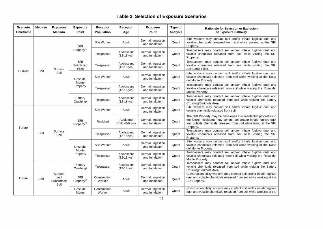
Table 2. Selection of Exposure Scenarios
Scenario Medium Exposure Exposure Receptor Receptor Exposure Type of Rationale for Selection or Exclusion Timeframe
Medium Point Population Age Route Analysis of Exposure Pathway
Current Soil Surface Soil
SRI Property(1)
Site Worker Adult Dermal, Ingestion and Inhalation Quant
Site workers may contact soil and/or inhale fugitive dust and volatile chemicals released from soil while working at the SRI Property.
Trespasser Adolescent (12-18 yrs)
Dermal, Ingestion and Inhalation Quant
Trespassers may contact soil and/or inhale fugitive dust and volatile chemicals released from soil while visiting the SRI Property.
SRI Soil/Scrap
Piles Trespasser Adolescent
(12-18 yrs) Dermal, Ingestion
and Inhalation Quant Trespassers may contact soil and/or inhale fugitive dust and volatile chemicals released from soil while visiting the SRI Soil/Scrap Piles.
Rosa del Monte
Property
Site Worker Adult Dermal, Ingestion and Inhalation Quant
Site workers may contact soil and/or inhale fugitive dust and volatile chemicals released from soil while working at the Rosa del Monte Property.
Trespasser Adolescent (12-18 yrs)
Dermal, Ingestion and Inhalation Quant
Trespassers may contact soil and/or inhale fugitive dust and volatile chemicals released from soil while visiting the Rosa del Monte Property.
Battery Crushing/ Trespasser Adolescent
(12-18 yrs) Dermal, Ingestion
and Inhalation Quant Trespassers may contact soil and/or inhale fugitive dust and volatile chemicals released from soil while visiting the Battery Crushing/Sinkhole Area.
Future
Soil Surface Soil
SRI Property(2)
Site Worker Adult Dermal, Ingestion and Inhalation Quant
Site workers may contact soil and/or inhale fugitive dust and volatile chemicals released from soil.
Resident Adult and Child (0-6 yrs)
Dermal, Ingestion and Inhalation Quant
The SRI Property may be developed into residential properties in the future. Residents may contact soil and/or inhale fugitive dust and volatile chemicals released from soil while living at the SRI Property.
Trespasser Adolescent (12-18 yrs)
Dermal, Ingestion and Inhalation Quant
Trespassers may contact soil and/or inhale fugitive dust and volatile chemicals released from soil while visiting the SRI Property.
Rosa del Monte
Property
Site Worker Adult Dermal, Ingestion and Inhalation Quant
Site workers may contact soil and/or inhale fugitive dust and volatile chemicals released from soil while working at the Rosa del Monte Property.
Trespasser Adolescent
(12-18 yrs) Dermal, Ingestion
and Inhalation Quant Trespassers may contact soil and/or inhale fugitive dust and volatile chemicals released from soil while visiting the Rosa del Monte Property.
Future
Battery
Crushing/ Trespasser Adolescent (12-18 yrs)
Dermal, Ingestion and Inhalation Quant
Trespassers may contact soil and/or inhale fugitive dust and volatile chemicals released from soil while visiting the Battery Crushing/Sinkhole Area.
Soil Surface
and Subsurface
Soil
SRI Property(2)
Construction Worker Adult Dermal, Ingestion
and Inhalation Quant
Construction/utility workers may contact soil and/or inhale fugitive dust and volatile chemicals released from soil while working at the SRI Property.
Rosa del
Monte Construction
Worker Adult Dermal, Ingestion and Inhalation Quant
Construction/utility workers may contact soil and/or inhale fugitive dust and volatile chemicals released from soil while working at the

22
Scenario Medium Exposure Exposure Receptor Receptor Exposure Type of Rationale for Selection or Exclusion Timeframe
Medium Point Population Age Route Analysis of Exposure Pathway
Property Rosa del Monte Property.
Quant = Quantitative risk analysis performed. (1)Excluding the SRI Soil/Scrap Piles (2) Assuming the SRI Soil/Scrap Piles to be removed in the future
Summary of Selection of Exposure Pathways The table describes the exposure pathways that were evaluated for the risk assessment, and the rationale for the inclusion of each pathway. Exposure media, exposure points, and
characteristics of receptor populations are included.

23
Table 3
Non-Cancer Toxicity Data Summary
Pathway: Oral/Dermal
Chemical of Concern
Chronic/ Subchronic
Oral RfD
Value
Oral RfD Units
Absorp. Efficiency (Dermal)
Adjusted RfD
( Dermal)
Adj. Dermal
RfD Units
Primary Target Organ
Combined Uncertainty /Modifying
Factors
Sources of RfD: Target Organ
Dates of RfD:
Arsenic Chronic 3.0E-04 mg/kg-day 1 3.0E-04 mg/kg-day Skin 3 IRIS 4/09/2012
Antimony Chronic 4.0E-04 mg/kg-day 0.15 6.0E-05 mg/kg-day Longevity/Blood 1000 ----- 4/09/2012
Lead ----- ----- ----- ----- ----- ----- ----- ----- ----- -----
Pathway: Inhalation
Chemical of Concern
Chronic/ Subchronic
Inhalation RfC
Inhalation RfC Units
Inhalation RfD
Inhalation RfD Units
Primary Target Organ
Combined Uncertainty
/Modifying Factors
Sources of RfD:
Target Organ
Dates:
Arsenic
Chronic 1.5E-05 mg/m3 ----- ----- Developmental/Cardiovascular System/CNS/
Lung/Skin
30 CalEPA 12/18/2008
Antimony ----- ----- ----- ----- ----- ----- ----- ----- -----
Lead ----- ----- ----- ----- ----- ----- ----- ----- -----
Key IRIS: Integrated Risk Information System, U.S. EPA CalEPA: California Environmental Protection Agency -----: No information available
Summary of Toxicity Assessment
This table provides non-carcinogenic risk information which is relevant to the contaminants of concern in surface soil. When available, the chronic toxicity data have been used to develop oral reference doses (RfDs) and inhalation reference doses (RfDi).
Risk Characterization Noncarcinogenic risks were assessed using a hazard index (HI) approach, based on a comparison of expected contaminant intakes and benchmark comparison levels of intake (reference doses, reference concentrations). Reference doses (RfDs) and reference concentrations (RfCs) are estimates of daily exposure levels for humans (including sensitive individuals) which are thought to be safe over a lifetime of exposure. The estimated intake of chemicals identified in environmental media (e.g., the amount of a chemical ingested from contaminated drinking water) is compared to the RfD or the RfC to derive the hazard quotient (HQ) for the contaminant in the particular medium. The HI is obtained by adding the hazard quotients for all compounds within a particular medium that impacts a particular receptor population. The HQ for oral and dermal exposures is calculated as below. The HQ for inhalation exposures is calculated using a similar model that incorporates the RfC, rather than the RfD. HQ = Intake/RfD Where: HQ = hazard quotient Intake = estimated intake for a chemical (mg/kg-day) RfD = reference dose (mg/kg-day)
24
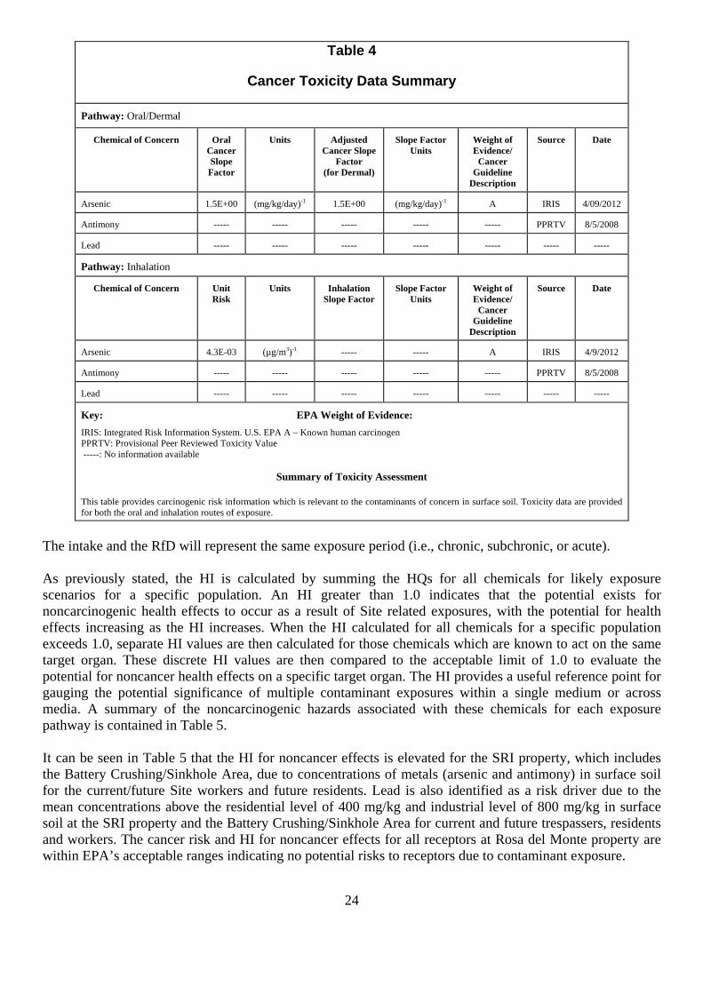
Table 4
Cancer Toxicity Data Summary
Pathway: Oral/Dermal
Chemical of Concern Oral Cancer Slope Factor
Units Adjusted Cancer Slope
Factor (for Dermal)
Slope Factor Units
Weight of Evidence/
Cancer Guideline
Description
Source Date
Arsenic 1.5E+00 (mg/kg/day)-1 1.5E+00 (mg/kg/day)-1 A IRIS 4/09/2012
Antimony ----- ----- ----- ----- ----- PPRTV 8/5/2008
Lead ----- ----- ----- ----- ----- ----- -----
Pathway: Inhalation
Chemical of Concern Unit Risk
Units Inhalation Slope Factor
Slope Factor Units
Weight of Evidence/
Cancer Guideline
Description
Source Date
Arsenic 4.3E-03 (µg/m3)-1 ----- ----- A IRIS 4/9/2012
Antimony ----- ----- ----- ----- ----- PPRTV 8/5/2008
Lead ----- ----- ----- ----- ----- ----- -----
Key: EPA Weight of Evidence: IRIS: Integrated Risk Information System. U.S. EPA A – Known human carcinogen PPRTV: Provisional Peer Reviewed Toxicity Value -----: No information available
Summary of Toxicity Assessment
This table provides carcinogenic risk information which is relevant to the contaminants of concern in surface soil. Toxicity data are provided for both the oral and inhalation routes of exposure.
The intake and the RfD will represent the same exposure period (i.e., chronic, subchronic, or acute). As previously stated, the HI is calculated by summing the HQs for all chemicals for likely exposure scenarios for a specific population. An HI greater than 1.0 indicates that the potential exists for noncarcinogenic health effects to occur as a result of Site related exposures, with the potential for health effects increasing as the HI increases. When the HI calculated for all chemicals for a specific population exceeds 1.0, separate HI values are then calculated for those chemicals which are known to act on the same target organ. These discrete HI values are then compared to the acceptable limit of 1.0 to evaluate the potential for noncancer health effects on a specific target organ. The HI provides a useful reference point for gauging the potential significance of multiple contaminant exposures within a single medium or across media. A summary of the noncarcinogenic hazards associated with these chemicals for each exposure pathway is contained in Table 5. It can be seen in Table 5 that the HI for noncancer effects is elevated for the SRI property, which includes the Battery Crushing/Sinkhole Area, due to concentrations of metals (arsenic and antimony) in surface soil for the current/future Site workers and future residents. Lead is also identified as a risk driver due to the mean concentrations above the residential level of 400 mg/kg and industrial level of 800 mg/kg in surface soil at the SRI property and the Battery Crushing/Sinkhole Area for current and future trespassers, residents and workers. The cancer risk and HI for noncancer effects for all receptors at Rosa del Monte property are within EPA’s acceptable ranges indicating no potential risks to receptors due to contaminant exposure.

25
Table 5
Risk Characterization Summary - Noncarcinogens Scenario Timeframe: Current/Future Receptor Population: Site Worker Receptor Age: Adult
Medium
Exposure Medium
Exposure Point Chemical of Concern Primary Target
Organ
Non-Carcinogenic Risk
Ingestion Dermal Inhalation Exposure
Routes Total
Surface Soil Surface Soil SRI Property Antimony Longevity/Blood 1E+00 ----- ----- 1E+00
Arsenic Skin/Developmental/Cardiovascular
System/CNS/Lung 2E-01 4E-02 3E-04 2E-01
Hazard Index Total= 1.2 Scenario Timeframe: Future Receptor Population: Resident Receptor Age: Lifetime (Child/Adult)
Medium Exposure Medium
Exposure Point Chemical of Concern Primary Target
Organ
Non-Carcinogenic Risk
Ingestion Dermal Inhalation Exposure
Routes Total
Surface Soil Surface Soil SRI Property Antimony Longevity/Blood 4E+00 ----- ----- 4E+00
Arsenic Skin/Developmental/Cardiovascular
System/CNS/Lung 2E+00 1E-01 9E-04 2E+00
Hazard Index Total= 6 ----- – not available at this time due to no reference dose being available – non-cancer hazards are underestimated
Summary of Risk Characterization - Non-Carcinogens
The table presents hazard quotients (HQs) for each route of exposure and the hazard index (sum of hazard quotients) for exposure to surface soil. The Risk Assessment Guidance for Superfund states that, generally, a hazard index (HI) greater than 1 indicates the potential for adverse non-cancer effects.
In addition to the calculated non-cancer hazard index, exposure to lead in the surface soil was evaluated. Lead concentrations in the SRI property and the battery crushing/sinkhole area, also known as the conservation area, exceeded the residential screening criteria of 400 mg/kg and the industrial screening
criteria of 800 mg/kg. Therefore, in addition to arsenic and antimony, lead is also a contaminant of concern.
For carcinogens, risks are generally expressed as the incremental probability of an individual developing cancer over a lifetime as a result of exposure to a carcinogen, using the cancer slope factor (SF) for oral and dermal exposures and the inhalation unit risk (IUR) for inhalation exposures. Excess lifetime cancer risk for oral and dermal exposures is calculated from the following equation, while the equation for inhalation exposures uses the IUR, rather than the SF: Risk = LADD x SF Where: Risk = a unitless probability (1 x 10⁻⁶) of an individual developing cancer LADD = lifetime average daily dose averaged over 70 years (mg/kg-day) SF = cancer slope factor, expressed as [1/(mg/kg-day)] These risks are probabilities that are usually expressed in scientific notation (such as 1 × 10⁻⁴). An excess lifetime cancer risk of 1 × 10⁻⁴ indicates that one additional incidence of cancer may occur in a population of 10,000 people who are exposed under the conditions identified in the assessment. Again, as stated in the National Contingency Plan, the point of departure is 10-6 and the acceptable risk range for Site related exposure is 10-6 to 10-4.

26
A summary of the estimated cancer risks are presented in Table 6. The results indicated that there are elevated cancer risks for future on-site residents on the SRI property due to arsenic in the surface soil.
Table 6 Risk Characterization Summary - Carcinogens
Scenario Timeframe: Future Receptor Population: Resident Receptor Age: Lifetime (Child/Adult)
Medium Exposure Medium
Exposure Point
Chemical of Concern Carcinogenic Risk
Ingestion Dermal Inhalation Exposure Routes Total
Surface Soil Surface Soil SRI Property Arsenic 9E-05 8E-06 2E-08 1E-04
Total Risk = 1E-04
Summary of Risk Characterization – Carcinogens The table presents cancer risks for surface soil exposure. As stated in the National Contingency Plan, the point of departure is 10-6 and the acceptable risk range for Site-related exposure is 10-6 to 10-4.
Uncertainties The procedures and inputs used to assess risks in this evaluation, as in all such assessments, are subject to a wide variety of uncertainties. In general, the main sources of uncertainty include: • environmental chemistry sampling and analysis • environmental parameter measurement • fate and transport modeling • exposure parameter estimation • toxicological data Two of the primary sources of uncertainty identified in the HHRA were associated with environmental sampling and bioavailability. Uncertainty in environmental sampling arises in part from the potentially uneven distribution of chemicals in the media sampled. Adequate Site characterization is particularly important when a primary source of contamination is buried debris, given the heterogeneity of contamination typically associated with debris. The likely heterogeneity of on-site subsurface conditions was recognized a potential source of uncertainty in the HHRA. This could result in either over- or under estimation of the concentrations present on the Site. However, samples were collected from known and suspected areas of contamination to delineate the nature and extent of contamination, the approach of using of a soil boring gird on 75‐foot nodes reduces sampling bias. The large number of soil samples taken from the Site further reduces uncertainty to an acceptable level in most cases. Another important source of uncertainty is bioavailability. Toxicity values are often based on observed dose‐response relationships when the chemical is dissolved in water or is in some other readily soluble form. For instance, the oral SF for arsenic is based on exposure of a large Taiwanese population to dissolved arsenic in drinking water. However, chemicals in soil may exist in forms that are not readily absorbed. In this risk assessment, intakes from metals such as arsenic, antimony, lead, and vanadium, and organics such as PAHs and pesticides from soil are not adjusted for relative bioavailability, which may overestimate risks. More specific information concerning uncertainty in the health risks is presented in the baseline human health risk assessment report.

27
ECOLOGICAL RISK ASSESSMENT A screening-level ecological risk assessment was conducted to evaluate the potential for ecological effects from exposure to surface soil in the Battery Crushing/Sinkhole Area (i.e., conservation area). Surface soil concentrations were compared to ecological screening values as an indicator of the potential for adverse effects to ecological receptors. Exposure to terrestrial wildlife via the ingestion of prey and direct soil ingestion to chemicals was also evaluated. A complete summary of all exposure scenarios can be found in the screening level ecological risk assessment (SLERA). The SLERA indicated that there is a potential for adverse effects to ecological receptors (invertebrates, reptiles, amphibians, birds and mammals) from exposure to contaminated surface soil. The surface soil screening criteria were exceeded for metals (antimony, copper, lead, mercury and zinc), pesticides (4,4’-DDE, 4,4’-DDT, dieldrin, endosulfan sulfate, endrin, endrin aldehyde and methoxychlor) and two semi-volatile organic compounds (bis(2-ethylhexyl)phthalate and butulbenzylphthalate), which resulted in HQs greater than the acceptable value of 1. Although there were fourteen chemicals which exceeded an HQ of 1, which indicates unacceptable risk for ecological receptors, only seven, antimony, copper, lead, mercury, zinc, bis(2-ethylhexyl)phthalate and butylbenzylphthalate were determined to be Site-related (COCs) and at concentrations that were high enough to cause unacceptable ecological effects. Although the habitat on the Site is of low quality, a remedial action to address the Site related contaminants is needed to reduce the risk to ecological receptors. Based on the results of the ecological risk assessment a remedial action is necessary to protect the environment from actual or threatened releases of hazardous substances. RISK ASSESSMENT SUMMARY In summary metals, specifically lead, arsenic and antimony in soil on the Site contributed to unacceptable risks and hazards to trespassers, Site workers, and future residents, as well as to ecological receptors. Based on the results of the human health and ecological risk assessments, the response action selected in the Record of Decision is necessary to protect the public health or welfare of the environment from actual or threatened releases of contaminants into the environment. REMEDIAL ACTION OBJECTIVES Remedial action objectives (RAOs) are specific goals to protect human health and the environment. These objectives are based on available information and standards, such as applicable or relevant and appropriate requirements (ARARs), to-be-considered (TBC) guidance and Site specific risk-based levels. The RAOs for the Site are:
• Prevent or minimize exposure to contaminated soil at concentrations exceeding the cleanup levels for human receptors through ingestion, inhalation and dermal contact.
• Prevent or minimize exposure to contaminated soil at concentrations exceeding the cleanup levels for ecological receptors through ingestion, inhalation and dermal contact.
To achieve the RAO, cleanup levels were developed to aid in defining the extent of contaminated soil requiring remedial action. Cleanup levels are chemical-specific remediation goals for each media and/or exposure route that are expected to be protective of human health and the environment. They have been derived based on comparison to applicable or relevant and appropriate requirements, risk-based levels (human health and ecological) and regional and Site background concentrations. Since the Site includes different zoning, Site specific risk assessments indicate different risks for different receptors in different

28
zoning areas. In order to achieve the protection of human health and the environment, two sets of cleanups levels were developed for this Site (Table 7)
Table 7 Preliminary Cleanup Levels for Scorpio Recycling Inc. Superfund Site
Chemical Name Cleanup Levels (mg/kg)
Ranges of Detected Concentration (mg/kg)
Rationale
Proposed Industrial Zone
Lead 800 2.6 - 69,900 Risk based cleanup value
Conservation Zone Lead 400 2.3 - 18,700J Risk based
cleanup value (residential)
Mercury 0.25 0.054J - 0.67
Site specific background concentration
Antimony 78 ND - 116 Risk based cleanup value
Copper 80 11.5 – 470J Risk based cleanup value
Zinc 160 13.9 - 950 Risk based cleanup value
Bis(2-Ethylhexyl) Phthalate 925 ND - 6,500 Risk based cleanup value
Butylbenzylphthalate 239 ND - 1,600 Risk based cleanup value
Note: J – estimated results ND – non-detect
For the areas zoned for industrial use, ecological usage was not considered viable due to limited available habitat. The human health risk assessment indicates that only lead would pose unacceptable risks to Site workers and construction workers for these areas. The cleanup levels for lead is based on the EPA industrial health risk screening value of 800 mg/kg, which is based on the anticipated change in zoning to prohibit residential use. Cleanup levels for arsenic and antimony were not developed. Although arsenic and antimony contribute to unacceptable risks and hazards to future residents, the Commonwealth is in the process of changing the zoning on the parcels to prohibit residential use. For the areas zoned for conservation use, the human health risk assessment evaluated the risks to trespassers. Only lead is identified as a contaminant that could potentially cause adverse health effects to trespassers. Under the SLERA, an evaluation was conducted, which identified VOCs, SVOCs, pesticides, metals as COPCs. However, it was subsequently determined that the VOCs and pesticides were present at levels below EPA’s acceptable criteria, and therefore only certain metals, including antimony, copper, lead, mercury and zinc, and two phthalates are identified as Site related contaminants that require remediation. The SLERA screening levels were also compared to the background metal concentrations. The higher values of the two sets of numbers were selected as the cleanup levels, except for lead, as discussed below. All conservation zone cleanup levels were based on risked based values, except mercury which is based on Site specific background.
29
For lead in the conservation zone, a cleanup value of 400 mg/kg is selected as the cleanup level. Evaluation for lead at a nearby Site showed that the human health based lead cleanup level would also be protective for local avian populations. Given the small size of the conservation area at the Scorpio Site and the limited habitat, use of the human health lead cleanup value of 400 mg/kg would also be protective of ecological receptors that may inhabit the Site. Areas of the Site with surface soil contaminated above the cleanup level were identified by comparing the analytical results of surface soil samples (from zero to two feet bgs) to the two sets of cleanup levels based on Site zoning and the risk assessments. It should be noted that even though cleanup levels were developed for the two phthalates, antimony, copper, mercury, and zinc in accordance with ecological risks, the extent of contamination is driven by lead and mercury. The extent of contamination is driven by lead for the industrial zoned area. PCB concentrations detected are below the TSCA regulatory concentration. Therefore the PCBs detected on Site are not subject to TSCA regulations. DESCRIPTION OF THE ALTERNATIVES REMEDIAL ALTERNATIVES Remedial alternatives were assembled by combining the retained remedial technologies and process options for the contaminated media and evaluated in the FS, as required in the NCP. The remedial alternatives which were evaluated to address soil contamination in the SRI Property, Battery Crushing/Sinkhole Area, and the Rosa del Monte Property are summarized below. ALTERNATIVE 1 – NO ACTION The No Action alternative is retained for comparison purposes as required by the NCP. No remedial action would be implemented as part of this alternative. It does not include any institutional controls or monitoring program. According to CERCLA, alternatives resulting in contaminants remaining above levels that allow for unrestricted use and unlimited exposure require that the Site be reviewed at least once every five years.
Table 8 Alternative 1 Cost Summary
Total Capital Cost $0 Operation and Maintenance
$0
Total Present Net Worth $0 Estimated Construction Time frame
0 years
ALTERNATIVE 2 – CONSOLIDATION AND SOIL COVER Alternative 2 consists of the consolidation and cover of contaminated soil currently located in two different areas. Under this alternative, contaminated soils from the industrial area at SRI property which are outside of the consolidation area would be excavated to one foot, except a small area of contaminated soils which is outside the main area of contamination which would be excavated to two feet bgs. An estimated 800 yd3 of soil would be excavated in total. These soils would be consolidated on Site at the southern portion of the SRI property at one location together with the soil segregated from the existing waste piles (see discussion below). The contaminated soil in the Battery Crushing/Sinkhole Area would be left in place and covered with one foot of clean common soil.
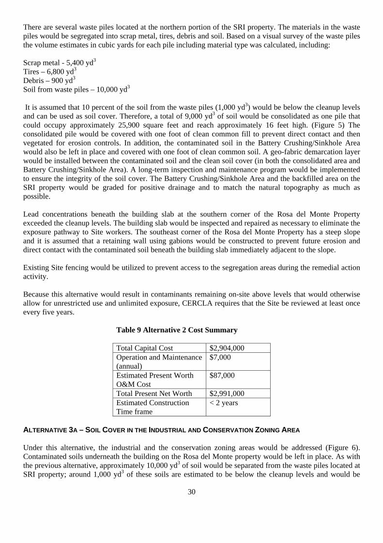
30
There are several waste piles located at the northern portion of the SRI property. The materials in the waste piles would be segregated into scrap metal, tires, debris and soil. Based on a visual survey of the waste piles the volume estimates in cubic yards for each pile including material type was calculated, including: Scrap metal - 5,400 yd3 Tires – 6,800 yd3 Debris – 900 yd3 Soil from waste piles – 10,000 yd3 It is assumed that 10 percent of the soil from the waste piles (1,000 yd3) would be below the cleanup levels and can be used as soil cover. Therefore, a total of 9,000 yd3 of soil would be consolidated as one pile that could occupy approximately 25,900 square feet and reach approximately 16 feet high. (Figure 5) The consolidated pile would be covered with one foot of clean common fill to prevent direct contact and then vegetated for erosion controls. In addition, the contaminated soil in the Battery Crushing/Sinkhole Area would also be left in place and covered with one foot of clean common soil. A geo-fabric demarcation layer would be installed between the contaminated soil and the clean soil cover (in both the consolidated area and Battery Crushing/Sinkhole Area). A long-term inspection and maintenance program would be implemented to ensure the integrity of the soil cover. The Battery Crushing/Sinkhole Area and the backfilled area on the SRI property would be graded for positive drainage and to match the natural topography as much as possible. Lead concentrations beneath the building slab at the southern corner of the Rosa del Monte Property exceeded the cleanup levels. The building slab would be inspected and repaired as necessary to eliminate the exposure pathway to Site workers. The southeast corner of the Rosa del Monte Property has a steep slope and it is assumed that a retaining wall using gabions would be constructed to prevent future erosion and direct contact with the contaminated soil beneath the building slab immediately adjacent to the slope. Existing Site fencing would be utilized to prevent access to the segregation areas during the remedial action activity. Because this alternative would result in contaminants remaining on-site above levels that would otherwise allow for unrestricted use and unlimited exposure, CERCLA requires that the Site be reviewed at least once every five years.
Table 9 Alternative 2 Cost Summary Total Capital Cost $2,904,000 Operation and Maintenance (annual)
$7,000
Estimated Present Worth O&M Cost
$87,000
Total Present Net Worth $2,991,000 Estimated Construction Time frame
< 2 years
ALTERNATIVE 3A – SOIL COVER IN THE INDUSTRIAL AND CONSERVATION ZONING AREA Under this alternative, the industrial and the conservation zoning areas would be addressed (Figure 6). Contaminated soils underneath the building on the Rosa del Monte property would be left in place. As with the previous alternative, approximately 10,000 yd3 of soil would be separated from the waste piles located at SRI property; around 1,000 yd3 of these soils are estimated to be below the cleanup levels and would be
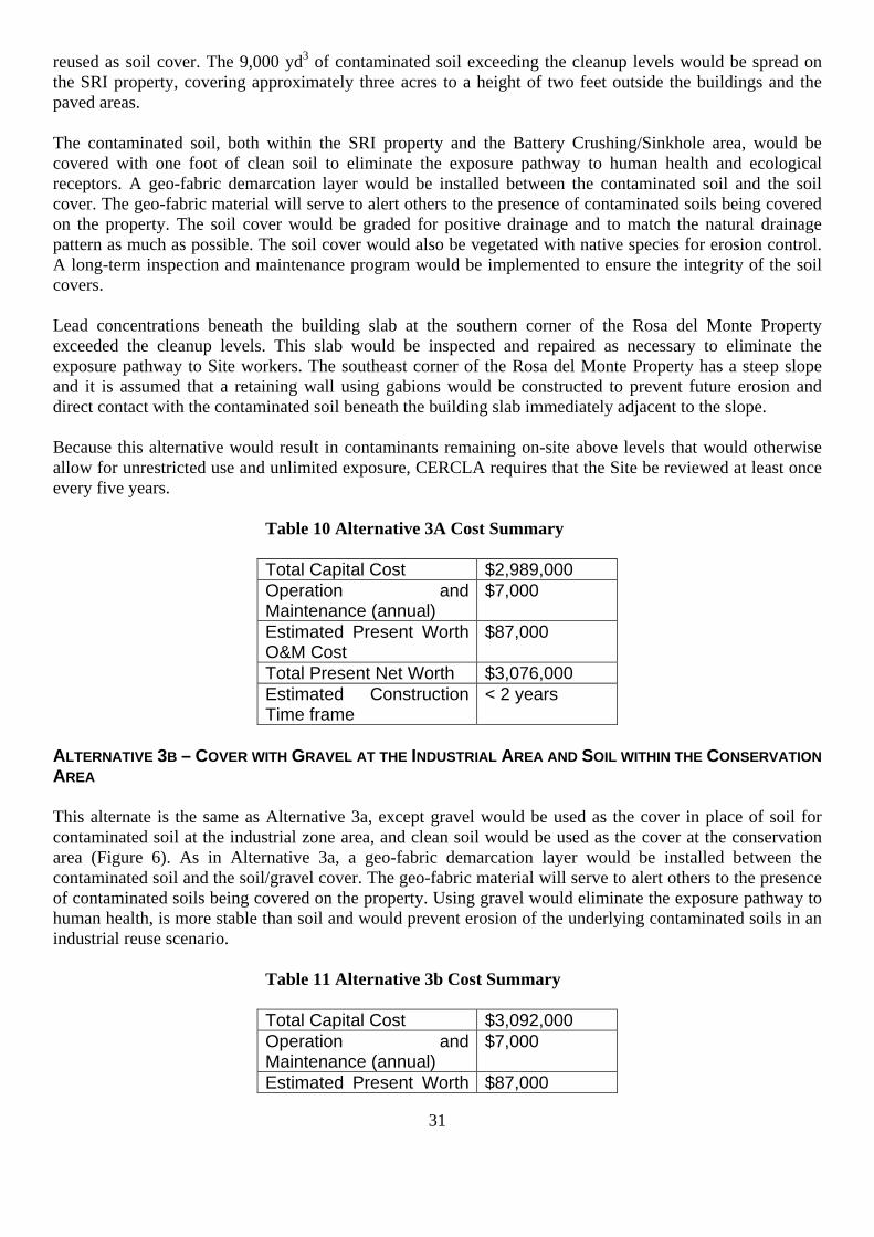
31
reused as soil cover. The 9,000 yd3 of contaminated soil exceeding the cleanup levels would be spread on the SRI property, covering approximately three acres to a height of two feet outside the buildings and the paved areas. The contaminated soil, both within the SRI property and the Battery Crushing/Sinkhole area, would be covered with one foot of clean soil to eliminate the exposure pathway to human health and ecological receptors. A geo-fabric demarcation layer would be installed between the contaminated soil and the soil cover. The geo-fabric material will serve to alert others to the presence of contaminated soils being covered on the property. The soil cover would be graded for positive drainage and to match the natural drainage pattern as much as possible. The soil cover would also be vegetated with native species for erosion control. A long-term inspection and maintenance program would be implemented to ensure the integrity of the soil covers. Lead concentrations beneath the building slab at the southern corner of the Rosa del Monte Property exceeded the cleanup levels. This slab would be inspected and repaired as necessary to eliminate the exposure pathway to Site workers. The southeast corner of the Rosa del Monte Property has a steep slope and it is assumed that a retaining wall using gabions would be constructed to prevent future erosion and direct contact with the contaminated soil beneath the building slab immediately adjacent to the slope. Because this alternative would result in contaminants remaining on-site above levels that would otherwise allow for unrestricted use and unlimited exposure, CERCLA requires that the Site be reviewed at least once every five years.
Table 10 Alternative 3A Cost Summary Total Capital Cost $2,989,000 Operation and Maintenance (annual)
$7,000
Estimated Present Worth O&M Cost
$87,000
Total Present Net Worth $3,076,000 Estimated Construction Time frame
< 2 years
ALTERNATIVE 3B – COVER WITH GRAVEL AT THE INDUSTRIAL AREA AND SOIL WITHIN THE CONSERVATION AREA This alternate is the same as Alternative 3a, except gravel would be used as the cover in place of soil for contaminated soil at the industrial zone area, and clean soil would be used as the cover at the conservation area (Figure 6). As in Alternative 3a, a geo-fabric demarcation layer would be installed between the contaminated soil and the soil/gravel cover. The geo-fabric material will serve to alert others to the presence of contaminated soils being covered on the property. Using gravel would eliminate the exposure pathway to human health, is more stable than soil and would prevent erosion of the underlying contaminated soils in an industrial reuse scenario.
Table 11 Alternative 3b Cost Summary Total Capital Cost $3,092,000 Operation and Maintenance (annual)
$7,000
Estimated Present Worth $87,000

32
O&M Cost Total Present Net Worth $3,179,000 Estimated Construction Time frame
< 2 years
Alternative 4 – Excavation and Offsite Disposal and Backfill Under Alternative 4, all contaminated soil exceeding the cleanup levels for lead in the proposed industrial zone (SRI Property) and the conservation zone (Battery Crushing/Sinkhole Area) would be excavated (Figure 7). In addition, the surface contaminated soils in the Battery Crushing/Sinkhole Area would be excavated to two feet bgs for all other cleanup levels. The existing building at the southern corner of the Rosa del Monte Property would be demolished in order to remove the contaminated soil underneath. The deepest excavation would be located under the Rosa del Monte building to approximately 47 feet bgs. Sheet piles may be installed to provide structural support for areas outside of the deep excavation. The total volume of soil to be excavated is estimated to be 24,400 yd3. As with other alternatives, the soil segregated from the waste piles would be approximately 10,000 yd3 and 10 percent of these soils (1,000 yd3) are assumed to be below the cleanup levels. These soils could be used as backfill. The excavated soil from other areas of the Site and the soil from the waste piles are estimated to be 33,400 yd3. The excavated area would be backfilled with clean common fill, graded for positive drainage to match the existing topography and vegetated for erosion control. The southeastern corner of the Rosa del Monte Property has a steep slope. It is assumed that a retaining wall using gabions would be constructed to prevent erosion. The building on the Rosa del Monte Property would be replaced in kind at the completion of the remediation. Soil samples would be collected and analyzed for TCLP analysis prior to offsite disposal. Soils that fail the TCLP analysis would be treated to confirm they do not exceed the TCLP requirements prior to offsite disposal. For cost estimating purposes, it is assumed that 10 percent of the excavated soil (2,440 yd3) would require treatment prior to disposal. For the portion of soils that fail TCLP, treatment would be conducted using either in-situ or ex-situ treatment technology prior to offsite disposal. A treatability study would be required to determine the proper chemical additives and dosage.
Table 12 Alternative 4 Cost Summary
Total Capital Cost $12,022,000 Operation and Maintenance (annual)
$0
Estimated Present Worth O&M Cost
$0
Total Present Net Worth
$12,022,000
Estimated Construction Time frame
< 2 years
There are several common elements which would be included as part of each remedial alternative, with the exception of No Action. The common elements include the items below.
• Segregation and Disposal of Waste Piles
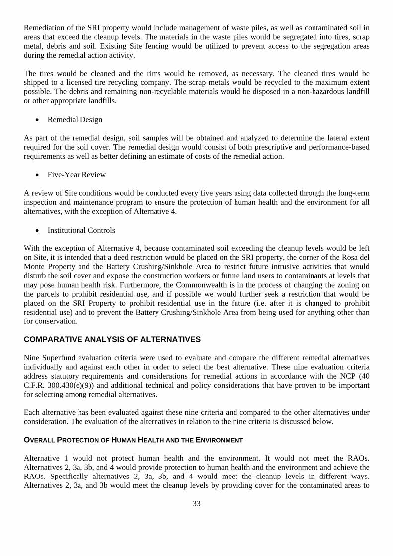
33
Remediation of the SRI property would include management of waste piles, as well as contaminated soil in areas that exceed the cleanup levels. The materials in the waste piles would be segregated into tires, scrap metal, debris and soil. Existing Site fencing would be utilized to prevent access to the segregation areas during the remedial action activity. The tires would be cleaned and the rims would be removed, as necessary. The cleaned tires would be shipped to a licensed tire recycling company. The scrap metals would be recycled to the maximum extent possible. The debris and remaining non-recyclable materials would be disposed in a non-hazardous landfill or other appropriate landfills.
• Remedial Design As part of the remedial design, soil samples will be obtained and analyzed to determine the lateral extent required for the soil cover. The remedial design would consist of both prescriptive and performance-based requirements as well as better defining an estimate of costs of the remedial action.
• Five-Year Review A review of Site conditions would be conducted every five years using data collected through the long-term inspection and maintenance program to ensure the protection of human health and the environment for all alternatives, with the exception of Alternative 4.
• Institutional Controls With the exception of Alternative 4, because contaminated soil exceeding the cleanup levels would be left on Site, it is intended that a deed restriction would be placed on the SRI property, the corner of the Rosa del Monte Property and the Battery Crushing/Sinkhole Area to restrict future intrusive activities that would disturb the soil cover and expose the construction workers or future land users to contaminants at levels that may pose human health risk. Furthermore, the Commonwealth is in the process of changing the zoning on the parcels to prohibit residential use, and if possible we would further seek a restriction that would be placed on the SRI Property to prohibit residential use in the future (i.e. after it is changed to prohibit residential use) and to prevent the Battery Crushing/Sinkhole Area from being used for anything other than for conservation. COMPARATIVE ANALYSIS OF ALTERNATIVES Nine Superfund evaluation criteria were used to evaluate and compare the different remedial alternatives individually and against each other in order to select the best alternative. These nine evaluation criteria address statutory requirements and considerations for remedial actions in accordance with the NCP (40 C.F.R. 300.430(e)(9)) and additional technical and policy considerations that have proven to be important for selecting among remedial alternatives. Each alternative has been evaluated against these nine criteria and compared to the other alternatives under consideration. The evaluation of the alternatives in relation to the nine criteria is discussed below. OVERALL PROTECTION OF HUMAN HEALTH AND THE ENVIRONMENT Alternative 1 would not protect human health and the environment. It would not meet the RAOs. Alternatives 2, 3a, 3b, and 4 would provide protection to human health and the environment and achieve the RAOs. Specifically alternatives 2, 3a, 3b, and 4 would meet the cleanup levels in different ways. Alternatives 2, 3a, and 3b would meet the cleanup levels by providing cover for the contaminated areas to

34
eliminate the exposure pathways to human or ecological receptors along with monitoring, institutional controls and five year reviews. Alternative 4 would meet the cleanup levels by disposing of the contaminated soil and providing a soil cover to backfill excavated areas.
COMPLIANCE WITH APPLICABLE OR RELEVANT AND APPROPRIATE REQUIREMENTS (ARARS) As required under Section 121 of CERCLA, remedial actions carried out under Section 104 or secured under Section 106 must be protective of human health and the environment and attain the levels or standards of control for hazardous substances, pollutants, or contaminants specified by the ARARs of federal environmental laws and commonwealth environmental and facility siting laws, unless waivers are obtained.
There are no chemical-specific ARARs for contaminated soil. Alternative 1 would not meet the risk-based cleanup levels since no action would be taken to remediate the Site. Alternatives 2, 3a, 3b, and 4 would meet the cleanup levels in different ways. Alternatives 2, 3a, and 3b would meet the cleanup levels by providing a soil cover over the contaminated soils to eliminate the exposure pathways to human or ecological receptors. Alternative 4 would meet the cleanup levels by excavation and offsite disposal of contaminated soils which exceed the cleanup levels. All active alternatives would meet the action-specific ARARs (technology‐based, establishing performance, design, or other similar action-specific controls and restrictions relevant to particular remedial actions) by following the health and safety regulations, waste handling, and disposal regulations. Location-specific ARARs (design requirements or activity restrictions based on the geographical or physical positions of the Site and its surrounding area) would be met for the conservation of karst regions under Alternatives 2, 3a, 3b, and 4. LONG-TERM EFFECTIVENESS AND PERMANENCE Alternative 1 would not be effective in the long-term since no remedial action would be performed. Alternatives 2, 3a, and 3b, would provide long-term effectiveness and permanence through the soil cover and reliance on monitoring, institutional controls and five year reviews, but to a lesser extent than Alternative 4. Under Alternatives 2, 3a, and 3b the SRI Property would be available for redevelopment for industrial purposes with some restrictions. Alternative 4 would provide the highest long-term effectiveness and permanence since both surface and subsurface contaminated soils would be excavated and disposed offsite. Under this alternative the SRI Property can be redeveloped for industrial use without any restrictions. Additionally, institutional controls, long-term inspection and maintenance would be required under Alternatives 2, 3a and 3b to ensure the protection of human health and ecological receptors in the long-term.
The reliability and adequacy of long-term effectiveness and permanence for Alternatives 2, 3a and 3b would also rely on the creation and effectiveness of the deed restrictions and the reliability of long-term inspection and maintenance of the soil covers.
REDUCTION OF TOXICITY, MOBILITY, OR VOLUME THROUGH TREATMENT Alternative 1 would not provide any reduction of toxicity, mobility, or volume (T/M/V). Alternatives 2, 3a and 3b would reduce the transport of fugitive dust and soil erosion through the soil cover. Alternative 4 would provide the highest reduction of T/M/V through treatment since the excavated soil that failed TCLP would be treated before the offsite disposal.
SHORT-TERM EFFECTIVENESS

35
Alternative 1 would not have short-term impacts since no action would be implemented. Alternatives 2, 3a and 3b would have significant impacts to the community during the construction period. Alternative 4 would have the greatest impact to the local community compared to Alternatives 2, 3a and 3b due to the larger amount of truck traffic for off‐site disposal of contaminated soil. However, mitigation measures would be put in place to minimize those impacts. For example, dust control measures through the use of dust suppression techniques (e.g., water or foam sprays) and soil erosion control measures such as minimizing open excavation areas and using silt fences would be implemented to minimize the migration of contaminated soil to the maximum extent possible. In addition, working hours would be coordinated with the local government and emergency response plans would be developed and followed. Health and safety measures would be implemented to prevent on‐site incidents and to protect construction workers, such as using personnel protective equipment to minimize exposure to contaminated materials or hazardous chemicals during remedial activities. IMPLEMENTABILITY All four alternatives are implementable. Alternative 1 would be the easiest to implement since no action would be taken. Alternatives 2, 3a, and 3b, would be similar to implement and pose considerably less implementation challenges than Alternative 4. Alternatives 2, 3a and 3b include: excavation, backfill, consolidation, and construction of the soil cover which are conventional remediation and construction technologies that have been widely implemented. Equipment, supplies, and services would be readily available. There would be no administrative difficulties associated with implementing this technology; however, there are some of the technical challenges associated with them, such as:
• Availability of recycling and disposal facilities for waste pile material • Ability to classify the disposal waste type for the non‐metallic debris • Accessibility and operation of excavation and backfill equipment on the steep slope in the
Conservation area • Difficulty in segregating tires, scrap metal, debris, and soil from the waste piles
Alternative 4 would be the most difficult to implement since it would involve deep excavation, demolition of a building and extensive transportation to dispose of all excavated soil offsite in landfills in Puerto Rico. COST Alternative 1 would not include any cost. Alternative 4 has substantially higher cost than Alternatives 2, 3a and 3b Costs for Alternatives 2, 3a and 3b are comparable. The cost estimates for all four alternatives are provided in Table 13. STATE/SUPPORT AGENCY ACCEPTANCE The Commonwealth of Puerto Rico concurs with the selected remedy (Appendix II).
Community Acceptance Community acceptance of the selected remedy was assessed during the public comment period (August 7, 2013 to September 6, 2013). EPA believes that the community generally supports the selected remedy. Specific responses to public comments are addressed in the Responsiveness Summary (refer to Part III).

36
Table 13 Cost Estimates
PRINCIPAL THREAT WASTES Principal threat wastes are those source materials considered to be highly toxic or highly mobile that generally cannot be reliably contained, or would present significant risk to environment human health or the environment should exposure occur. The principal threat concept is applied to the characterization of source materials at a Superfund site. A source material is material that includes or contains hazardous substances, pollutants, or contaminants that act as a reservoir for migration of contamination to groundwater, surface water or air, or acts as a source for direct exposure. No “threshold level” of toxicity/risk has been established to equate principal threat. Since the thresholds to identify principal threat waste were not exceeded, no principal threat waste is considered to be present at the Site. SELECTED REMEDY Based upon an evaluation of the various alternatives, EPA, in consultation with EQB, select the following remedy to address the contaminate soil: Alternative No. 3b, Cover with Gravel at the Industrial Area and Soil within the Conservation Area, is the preferred remedial alternative for soil contamination at this Site. Under Alternative 3b, approximately 10,000 yd3 of soil would be separated from the waste piles; 10 percent of these soils (1,000 yd3) are estimated to be below the cleanup levels and would be reused as soil cover.
Gravel would be used as the cover for contaminated soil at the industrial zone and common soil would be used as the cover at the conservation area. A geo-fabric demarcation layer would be installed between the contaminated soil and the soil cover. The cover would be graded for positive drainage and to match the natural drainage pattern to the extent possible. The soil cover within the conservation area would also be vegetated with native species for erosion control.
Contaminated soils underneath the building on the Rosa del Monte property would be left in place. The southeast corner of the Rosa del Monte property has a steep slope. It is assumed that a retaining wall using
Criteria Alternative 1 No
Action
Alternative 2 Consolidation
and Soil Cover
Alternative 3 Soil Cover Alternative 4
Excavation and Offsite Disposal Soil Soil and
Gravel Estimated Capital Cost $0 $2,904,000 $2,989,000 $3,092,000 $12,022,000
Estimated Annual O&M Cost
$0 $7,000 $7,000 $7,000 $0
Estimated Present Worth O&M Cost
$0 $87,000 $87,000 $87,000 $0
Estimated Present Worth
$0 $2,991,000 $3,076,000 $3,179,000 $12,022,000

37
gabions would be constructed to prevent future erosion and direct contact with the contaminated soil beneath the building slab immediately adjacent to the slope.
After the installation of the soil covers, contaminated soils exceeding the cleanup levels would remain on Site, including the 3-acre area on the SRI property and the conservation area. The Commonwealth is in the process of changing the zoning on the parcels to prohibit residential use, and we would further seek deed restrictions for these areas to restrict future intrusive activities that would disturb the soil cover and expose the construction worker or future land users to contaminants at levels that may pose human health risks. Furthermore, deed restrictions would be sought for the Site to prohibit residential use and to prevent the conservation area from being used other than for conservation. A long-term inspection and maintenance program would be implemented to ensure the integrity of the soil covers.
As part of the remedial design, soil samples will be obtained and analyzed to determine the lateral extent required for the soil cover. The remedial design would consist of both prescriptive and performance-based requirements as well as better defining an estimate of costs of the remedial action. The environmental benefits of the preferred remedy may be enhanced by consideration, during the design, of technologies and practices that are sustainable in accordance with EPA Region 2’s Clean and Green Energy Policy. This would include consideration of green remediation technologies and practices.
ESTIMATED OUTCOMES OF SELECTED REMEDY The principal outcomes of the selected remedy are: 1) to return the Site to a productive use; 2) to prevent or minimize exposure to contaminated soil at concentrations exceeding the cleanup levels for ecological receptors through ingestion, inhalation and dermal contact; 3) to seek deed restrictions on the SRI property, the corner of the Rosa del Monte property and the battery crushing/sinkhole property that will restrict future intrusive activities that could otherwise disturb the soil cover and expose the construction workers or future land users to contaminants at levels that may pose human health risk; 4) to seek deed restrictions on the SRI property that will prevent residential use and to prevent the battery crushing/sinkhole portion of the property from being used in any manner other than for conservation. STATUTORY DETERMINATIONS Under CERCLA §121 and the NCP, the lead agency must select remedies that are protective of human health and the environment, comply with applicable or relevant and appropriate requirements (unless a statutory waiver is justified), are cost-effective, and utilize permanent solutions and alternative treatment technologies or resource recovery technologies to the maximum extent practicable. In addition, CERCLA includes a preference for remedies that employ treatment that permanently and significantly reduces the volume, toxicity, or mobility of hazardous wastes as a principal element and a bias against offsite disposal of untreated wastes. The following sections discuss how the Selected Remedy meets these statutory requirements. PROTECTION OF HUMAN HEALTH AND THE ENVIRONMENT The selected remedy, Alternative 3b, will be protective of human health and the environment. Risks to human health due to direct contact, ingestion, and inhalation would be eliminated since contaminated soils would be covered, and the exposure pathways would be eliminated. This alternative would also provide protection to the environment by eliminating the exposure pathways to ecological receptors. This alternative would achieve the RAOs. COMPLIANCE WITH ARARS

38
There are no chemical-specific ARARs for the contaminated soil. The Selected Remedy 3b complies with all ARARs. This alternative would be implemented in compliance with all health and safety requirements and other action-specific ARARs. Location-specific ARARs including protection and conservation of karst regions within the Site would also be met as part of this alternative. Tables 14 and 15 summarize the action-specific and location-specific ARARs. LONG-TERM EFFECTIVENESS AND PERMANENCE This alternative would provide long-term effectiveness and permanence since the contaminated soils above the cleanup levels would be covered with soil or gravel. The institutional controls and a long-term inspection and maintenance program would be utilized to ensure continued protection of human health and the environment. Magnitude of Residual Risk – The magnitude of residual risk is low as long as the institutional controls and the long-term inspection and maintenance program are effectively implemented and the contaminated soils are effectively covered to eliminate the exposure pathways to human and ecological receptors. Adequacy of Controls – The controls are considered adequate as long as the institutional controls and the long-term inspection and maintenance program are effectively implemented. Reliability of Controls – The reliability of controls would depend on the reliability of institutional controls and the long-term inspection and maintenance program. The soil cover might be eroded in severe storm events or in a hurricane. If the remedy is funded through the Superfund program, EPA would be responsible for the first year of long-term inspection and maintenance; EQB would be responsible for the inspection and maintenance of the soil cover after the first year. Alternative 3 may not require much maintenance because the soil or gravel cover may be stable and protected by vegetation from erosion for many years without any need for maintenance. REDUCTION OF T/M/V THROUGH TREATMENT This alternative may provide limited reduction of mobility. The volume of contaminated soils would not be reduced, but simply moved and covered by clean soil or gravel. SHORT-TERM EFFECTIVENESS This alternative would include a significant amount of conventional construction work during waste segregation, spreading of contaminated soil, and cover of contaminated materials. These construction activities could have significant short-term impact to the communities, which would require mitigative measures. Heavy trucks would be driving back and forth daily in the community for approximately one year to transport materials (scrap metal, tires, and debris) for offsite disposal and to import clean soils or gravel for cover. During remedial operations, soil contaminants would be temporarily exposed and may migrate as dust or with stormwater runoff. Dust control measures through the use of dust suppression techniques (e.g., water or foam sprays) and soil erosion control measures such as using silt fences, would be implemented to minimize the migration of contaminated soil to the maximum extent possible. Working hours would be coordinated with the local government and emergency response plans would be developed and followed. Health and safety measures would be implemented to prevent on-site incidents and to protect construction workers, such as using PPE to minimize exposure to contaminated materials or hazardous chemicals during remedial activities.

39
IMPLEMENTABILITY Excavation, backfill, consolidation, and construction of the soil/gravel cover are conventional remediation and construction technologies that have been widely implemented. Equipment, supplies, and services would be readily available. There would be no administrative difficulties associated with implementing this technology; however, some of the technical challenges are summarized below.
• Availability of recycling and disposal facilities for waste pile materials • Ability to classify the disposal waste type for the non-metallic debris • Accessibility and operation of excavation and backfill equipment on the steep slope in the Battery
Crushing/Sinkhole Area • Difficulty in segregation of tires, scrap metal, debris, and soil from the waste piles at the Site • Space availability for the stockpiles of segregated waste materials prior to disposal and clean soil or
gravel for soil cover to minimize soil exposure COST A cost effective remedy is one whose costs are proportional to its overall effectiveness (NCP §§300.430(f)(1)(i)(B)). Overall effectiveness is based on the evaluations of the following: long-term effectiveness and permanence; reduction in toxicity, mobility, and volume through treatment; and short term effectiveness. Based on the comparison of overall effectiveness to cost, the selected remedy meets the statutory requirement that Superfund remedies be cost effective (NCP §§300.430(f)(1)(ii)(D)). The estimated cost does not include the costs associated with remedial design, and engineering support during remediation. The estimated remedial action capital cost for Alternative 3b is $3.09 million. The O&M cost for Alternative 3b is approximately $7,000 per year and $87,000 for 30 years assuming a discount rate of 7 percent. The overall present worth cost for Alternative 3b is $3.18 million. Table 16 present a disclosure of all costs associated with the selected alternative. FIVE YEAR REVIEW REQUIREMENTS Because the selected remedy results in contaminants remaining on-site above levels that allow for unrestricted use and unlimited exposure, a review of Site conditions would be conducted no less often than every five years after completion of the construction of the remedy. The Site reviews will include an evaluation of the remedy components to ensure that the remedy remains protective of human health and the environment. DOCUMENTATION OF SIGNIFICANT CHANGES FROM PREFERRED ALTERNATIVE OF PROPOSED PLAN The Proposed Plan for the Site was released for public comment on August 7, 2013, and the public comment period ran from that date through September 6, 2013. The Proposed Plan identified the selected remedy as the Preferred Alternative for the Site. All written and verbal comments submitted during the public comment period were reviewed by EPA. Upon review of these comments, EPA has determined that no significant changes to the remedy, as it was originally identified in the Proposed Plan, were necessary.

40
Table 14 Location-specific ARARs, Criteria and Guidance
Regulatory Level ARARs Status Requirement Synopsis Action to be Taken to Attain ARARs
Federal Statement on Procedures on Floodplain Management and Wetlands protection (40 CFR 6 Appendix A)
To Be Considered
This Statement of Procedures sets forth Agency policy and guidance for carrying out the provisions of Executive Orders 11988 and 11990.
Alternatives will take into consideration floodplain management and wetland protection.
Federal Policy on Floodplains and Wetland Assessments for CERCLA Actions (OSWER Directive 9280.0-12, 1985)
To Be Considered
Superfund actions must meet the substantive requirements of E.O. 11988, E.O. 11990, and 40 CFR part 6, Appendix A.
Alternatives will take into consideration floodplain management and wetland protection.
Federal National Environmental Policy Act (NEPA) (42 USC 4321; 40 CFR 1500 to 1508)
To Be Considered
This requirement sets forth EPA policy for carrying out the provisions of the Wetlands Executive Order (EO 11990) and Floodplain Executive Order (EO 11988).
The requirement will be considered during the development of alternatives.
Commonwealth of Puerto Rico
Act for the Protection and Preservation of Puerto Rico's Karst Region, August 21, 1999, No. 292
Applicable This regulation requires the protection and conservation of the karst regions physiography; and prevent the transportation and sale of natural materials without permits.
The requirement will be considered during the development of alternatives.
Acronyms:
ARARs - Applicable or Relevant and Appropriate Requirements OSHA - Occupational Safety and Health Administration CFR - Code of Federal Regulations RCRA - Resource Conservation and Recovery Act EPA - Environmental Protection Agency OSWER - Office of Solid Waste and Emergency Response

41
Table 15 Action-specific ARARs, Criteria and Guidance
Regulatory Level ARARs Status Requirement Synopsis Action to be Taken to Attain ARARs
General Site Remediation Federal OSHA Recording and Reporting
Occupational Injuries and Illnesses (29 CFR 1904)
Applicable This regulation outlines the record keeping and reporting requirements for an employer under OSHA.
These regulations apply to the companies contracted to implement the remedy. All applicable requirements will be met.
Federal OSHA Occupational Safety and Health Standards (29 CFR 1910)
Relevant and Appropriate
These regulations specify an 8-hour time-weighted average concentration for worker exposure to various organic compounds. Training requirements for workers at hazardous waste operations are specified in 29 CFR 1910.120.
Proper respiratory equipment will be worn if it is not possible to maintain the work atmosphere below the 8-hour time-weighted average at these specified concentrations.
Federal OSHA Safety and Health Regulations for Construction (29 CFR 1926)
Applicable This regulation specifies the type of safety equipment and procedures to be followed during Site remediation.
All appropriate safety equipment will be on-site, and appropriate procedures will be followed during remediation activities.
Commonwealth of Puerto Rico
Regulation of the Environmental Quality Board (EQB) for the Prevention and Control of Noise Pollution
Applicable This standard provides the standards and requirements for noise control.
This standard will be applied to any remediation activities performed at the Site.
Waste Disposal Commonwealth of Puerto Rico
EQB Regulation for the Control of Non-Hazardous Solid Waste (November 1997)
Applicable This regulation establishes standards for the generation, management, transportation, recovery, disposal and management of non-hazardous solid waste.
Control activities for the non-hazardous wastes must comply with the treatment and disposal standards.
Air Quality Management Federal Clean Air Act (CAA)—National Ambient
Air Quality Standards (NAAQs) (40 CFR 50)
Applicable These provide air quality standards for particulate matter, lead, NO2, SO2, CO, and volatile organic matter.
During excavation, treatment, and/or stabilization, air emissions will be properly controlled and monitored to comply with these standards.
Federal Standards of Performance for New Stationary Sources (40 CFR 60)
Relevant and Appropriate
Set the general requirements for air quality.
During excavation, treatment, and/or stabilization, air emissions will be properly controlled and monitored to comply with these

42
standards.
Federal National Emission Standards for Hazardous Air Pollutants (NESHAPS) (40 CFR 61)
Applicable These provide air quality standards for hazardous air pollutants.
During excavation, treatment, and/or stabilization, air emissions will be properly controlled and monitored to comply with these standards.
Commonwealth of Puerto Rico
EQB Regulation for the Control of Atmospheric Pollution (1995)
Applicable Describes requirements and procedures for obtaining air permits and certificates; rules that govern the emission of contaminants into the ambient atmosphere.
Need to meet fugitive emissions requirements during excavation, treatment, and/or stabilization. Need to meet visible emissions requirements for motor vehicles.
Acronyms:
ARARs - Applicable or Relevant and Appropriate Requirements NO2 - Nitrogen dioxide OSHA - Occupational Safety and Health Administration
SO2 - Sulfur dioxide
CFR - Code of Federal Regulations
CO - Carbon monoxide EPA - Environmental Protection Agency

43
Table 16 Cost Estimate for Alternative 3b
No. Description Cost
RA CONTRACTOR COSTS General Requirements Cost
01 General Conditions $686,000 02 Permits (Allowance) $20,000 03 Safety and Health Requirements $29,000 04 Temporary Facilities and Utilities $30,000 05 Surveying $87,000 06 Erosion Control $60,000 07 Decontamination $28,000
Site Preparation
08 Site Clearing and Grubbing $21,000 Segregation, Sampling, Installation of Gravel Cover
09 Segregation and Spreading of Waste Pile Materials $219,000 10 Waste Characterization Sampling $31,000 11 Gravel Cover Installation $409,000
Transportation and Disposal
12 Transportation and Disposal $542,000 Final Site Restoration
13 Final Site Restoration (Allowance) $50,000 Closure Documents
14 RA Report and As-Built Drawings (Allowance) $50,000 Subtotal RA Contractor Cost $2,262,000 G&A (5%) $114,000 Subtotal RA Contractor Cost with G&A $2,376,000 Profit, except on T&D (8%) $145,000 Profit, T&D, reduced fee (4%) $23,000 Subtotal RA Contractor Cost with Profit $2,544,000 Bond (1.5%) $39,000 Contingency (20%) $508,800 TOTAL RA CONTRACTOR COST $3,092,000 OPERATION AND MAINTENANCE COSTS (O&M) Annual Average O&M Cost $7,000
15 Total O&M Cost for 30-Year Default Period (Present Worth) $87,000
PRESENT WORTH Total Capital Cost $3,092,000 Total O&M Cost $87,000 Total Present Worth $3,179,000

44
Notes: 1. The project cost presented herein represents only a feasibility study level estimate, and is thus subject
to change pending the results of the soil sampling collected during the remedial design, which is intended to collect sufficient data to assist in the development of the remedial design and associated detailed cost estimate. The expected accuracy range of this cost estimate is -30% to +50%.
2. Remedial Design, and engineering support services costs are not included in this estimate.
3. Assume 1-foot soil cover in the conservation area, spreading the soil from the waste piles on the SRI property, and capping the spread soil with a 1-foot gravel cover.

45
UNITED STATES ENVIRONMENTAL PROTECTION AGENCY REGION 2
PART III – RESPONSIVENNES SUMMARY
RECORD OF DECISION OPERABLE UNIT OU2
SCORPIO RECYCLING INC. SUPERFUND SITE TOA BAJA, PUERTO RICO

46
RESPONSES TO PUBLIC COMMENTS PREPARED IN SUPPORTRESPONSES TO PUBLIC COMMENTS PREPARED IN SUPPORT
OF THE RESPONSIVENESS SUMMARY FOR THE RECORD OF DECISION
SCORPIO RECYCLING INC. SUPERFUND SITE – OU2 SOIL TOA BAJA, PUERTO RICO
On August 7, 2013, the U.S. Environmental Protection Agency (EPA) released for public comment the Proposed Plan for the Scorpio Recycling Inc. (SRI) Superfund Site (Site) – Operable Unit 2 Soil. During the public comment period, EPA held a public meeting on August 14, 2013 to discuss and accept comments regarding the Proposed Plan. EPA received verbal comments at the public meeting as well as written comments during the public comment period. This document summarizes comments from the public at the public meeting on August 14, 2013 and those submitted via mail. EPA’s responses are provided following each comment. The comments are grouped generally in the following categories: Background Information Results Alternative 3b
Background Information Comment 1: Does SRI have any other businesses or facilities? If so, does EPA evaluate such facilities? Response 1: Yes. The company has other facilities that were identified. Some of these facilities were investigated and samples were collected. Comment 2: It is unclear if the Site is already an industrial area and if there is an operating company. If so, does the presence of this company interfere with or preclude the remediation? Response 2: The Site has several lots with some classified as industrial and others residential. Although some lots at the SRI property are classified as residential all of them were used for industrial purposes. SRI’s operations ceased in 2010, and no further activities have taken place on these lots. Activities to be performed at the southeastern corner of Rosa del Monte property (an active facility) will be coordinated with the owners in order to minimize impact on their operations. Results Comment 1: Have other properties adjacent to the Site been impacted by the contamination? Response 1: No. The remedial investigations conducted at the Site showed that the contamination is within the SRI property-portion of the conservation area known as the battery crushing area and under one structure at Rosa del Monte property, all of which are part of the Site. Samples collected during the remedial investigation did not identify any other adjacent property impacted beyond the ones that will be included in the remediation. Comment 2: Has contamination affected the residents of the Altagracia residential development? Response 2: No. As part of the remedial investigation conducted at the Site, samples were collected at Santa Teresa Street, Altagracia residential development and the analysis of the samples did not show site-related contamination. Therefore, the contamination related to the SRI Site did not impact the Altagracia residential development. Comment 3: Is the land toward the conservation area contaminated?

47
Response 3: Yes. As presented in the figures in the Proposed Plan, some portion of the Site toward the conservation area/sinkhole is impacted and will need to be remediated. Institutional controls will also be utilized in this area. Comment 4: In which direction does the groundwater move? Response 4: The groundwater flow is in a northwest direction. Alternative 3b Comment 1: The material that is removed cannot be disposed of just anywhere; it has to be in a proper place so the contamination will not continue to spread contaminants to other areas. Response 1: Any material removed from the facility will be characterized before offsite disposal to determine if it is non-hazardous waste or hazardous waste. The offsite disposal of any material will comply with applicable laws and regulations and the disposal site needs to be approved by relevant agencies and currently in compliance. Comment 2: Who will pay for the implementation of the remedy? Response 2: The EPA has incurred all the costs associated with the investigations and the removal action taken to date at the Site. With the issuance of this OU 2 ROD, the EPA will seek alternatives to fund the remedy, which could include funds from potential responsible parties (PRPs), a 10% matching share from the Puerto Rican government (as required by law for fund-lead) and complete or partial federal funding. After the 10th year of operation the PR government will assume responsibility for the operation and maintenance. Under CERCLA, EPA has the authority to seek reimbursement from the PRPs of all cost associated with the Site. Comment 3: How long will it take to implement the remedy? Response 3: Once initiated, the actual implementation of the soil cover will take approximately two years. This time frame does not consider the time needed for the development of the remedial design and the remedial action documents, as well as the time needed to implement deed restrictions. Comment 4: Would EPA consider as part of the preferred alternative the cost associated with the excavation of contaminated soil beneath the Rosa del Monte affected structure and the replacement of the structure. Response 4: The Rosa del Monte structure prevents the exposure to contaminated soil beneath it. EPA’s selected alternative does not include the demolition of the structure nor the excavation of contaminated soil beneath the structure. The Rosa del Monte structure slab would be inspected and repaired as necessary to prevent any exposure pathway to Site workers. The southeast corner of the Rosa del Monte has a steep slope and it is assumed that a retaining wall using gabions would be constructed to prevent future erosion and direct contact with the contaminated soil beneath the building slab immediately adjacent to the slope. During the remedial design stage EPA will determine if any further excavation is needed that will make it necessary to demolish the structure. At this point in time EPA does not contemplate the demolition of the structure. Comment 5: Can any improvements to the Rosa del Monte Building be made? Response 5: Improvement, restoration or relocation of the structure could be done. If Rosa del Monte needs to relocate the building they can do it following the appropriate health and safety measures to protect workers and the environment and following the appropriate federal and state regulations. The deed restrictions that will be sought will include the area where the structure is located, and EPA will need to be

48
notified of the proposed actions and measures that will be implemented to comply with federal and state regulations. Comment 6: Would EPA consider any comments regarding the potential development of the structure above the contaminated soil at Rosa del Monte. Response 6: EPA has considered all comments provided. There is no current exposure to contaminated soil beneath the Rosa del Monte structure. Any demolition or modification of the structure on the Rosa del Monte property can be performed; however, these actions would need to comply with the institutional controls that would be in place at the Site, as well as federal and state regulations to protect the public health and the environment. During the remedial design stage, EPA will determine if any further excavation is needed that will make it necessary to demolish the structure. Comment 7: What would be the possibility of percolation and impact in groundwater? Response7: Based on the remedial investigation conducted during the groundwater study, several facts were identified that would prevent the migration of metal and its impact to the groundwater. A clay layer approximately 45 to 75 feet thick served as a barrier to any contaminants and minimized the migration of contaminants toward the groundwater. In addition, the Site related contaminants are metals which decreases their capacity to migrate. Groundwater samples collected during the remedial investigation conducted at the Site as part of the Operable Unit 1 did not detect contaminants that required remediation as indicated by EPA in it No Action ROD signed in 2007. Comment 8: Did the stakeholders or the owners die? Did EPA identify them? Response 8: No. EPA has identified the owner and operator of the SRI Property. They are still alive and EPA’s legal department has maintained contact with them. Comment 9: If PRPs do not paid for the remediation will we be paying for several years with Puerto Rico’s money, which comes from our jobs and our purchases? That’s not fair. Response 9: The EPA has incurred the entire cost associated with the investigations and the removal action taken at the Site. Once the ROD is signed the EPA will seek alternatives to fund the remedy which could include funds from the potential responsible parties (PRPs), 10% matching funds from the PR government, and complete or partial federal funding. EPA has identified PRPs, will continue reimbursement discussions and will take appropriate actions to seek their reimbursement of past and future costs. EPA will assess the capability of the PRPs and will seek reimbursement if it is financially feasible. Comment 10: Are the institutional controls imposed as part of the remediation. Response: Yes. Institutional controls will be established as part of the selected remedy. Contaminated soil exceeding the remediation goals will remain on the Site, but the Commonwealth is in the process of changing the zoning on the parcels to prohibit residential use, and if possible we would further seek a deed restriction on the SRI property, the southeastern corner of the Rosa del Monte property, and the conservation area to restrict residential use and future intrusive activities that would otherwise disturb the soil cover and expose residents or construction workers or other future land users to contaminants at levels that may pose human health risk. Furthermore, the deed restriction would seek to prevent the conservation area from being rezoned for use other than for conservation. Comment 11: Would there be limitations to avoid soil excavation? Response 11: Yes. We will seek to create a deed restriction that would be placed on the SRI property, the southeastern corner of the Rosa del Monte property and the conservation area to restrict future intrusive activities that could otherwise disturb the soil cover.

49
Comment 12: Who will impose the institutional controls limitations? Response 12: The remedy includes recommended institutional controls. This deed restriction will be sought from the current property owner with the support of the local and state government. Comment 13: Please indicate the size of the impacted area within the conservation area and if institutional controls will be put in place on a portion or the entire conservation area. Response 13: Documents included as part of the Administrative Record and the Proposed Plan (available as part of the repository of public documents) provide figures that show the anticipated areas impacted within the conservation areas. During the remedial design stage, EPA in consultation with the Puerto Rican Government will determination if institutional controls will cover only some portion or the entire conservation area.

APPENDIX I ADMINISTRATIVE RECORD INDEX FOR SCORPIO RECYCLING INC. CONTAMINATION SUPERFUND SITE
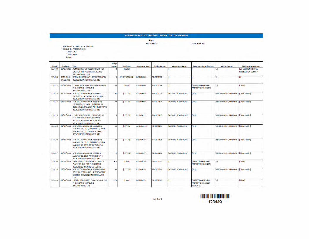


APPENDIX II PUERTO RICO ENVIRONMENTAL QUALITY BOARD’S CONCURRENCE LETTER

COMMONWEALTH OF
PUERTO RICO Environmental Quality Board
September 18, 2013
Dr. Adalberto Bosque, Ph.D. Remedial Project Manager (RPM) Environmental Protection Agency (EPA) Region 2 Caribbean Environmental Protection Division (CEPD) City View Plaza II - Suite 7000 # 48 Road 165 km 1.2 Gnaynabo, PR 00968-8069
RE: RECORD OF DECISION (ROD) SCORPIO RECYCLING, INC. (SRI) SUPERFUND SITE, OPERABLE UNIT-2 (OU-2), (SOIL) IN TOA BAJA, PUERTO RICO (PR)
Dear Dr. Bosque:
The Puerto Rico Environmental Quality Board (PREQB) Superfund Program, Remedial Project Management (RPM) Division received the above referenced document. The Record of Decision (ROD) is a public document that explains which cleanup alternatives will be used to clean up a Superfund Site and its purpose is to document the selected remedial action. Based upon an evaluation of various alternatives the Environmental Protection Agency (EPA), in consultation with the PREQB selected Altemative # 3b, Gravel Cover at the Industrial Area and Soil Cover within the designated Conservation Area as the preferred remedial alternative to address soil contaminatim1 at Scorpio Recycling Inc. (SRI), Superfund Site. After evaluating the whole document the Puerto Rico Environmental Quality Board (PREQB) concurs with the EPA's ROD prepared for Scorpio Recycling Inc. Operable Unit-2 (OU-2), (Soil).
If you have any questions, please do not hesitate to contact me at (787) 767-8181 extension 3236 or Ms. Amarilis Rodriguez Mendez, Environmental Compliance and Inspection Officer, PREQB Superfund Program at extension 3235 or by e-mail [email protected].
Cordially,
7~:/:2!:$~z e~:tJ Manager Environmental Emergencies Response Area
ymq/ann
c. Eng. Ram6n Torres, USEPA, CEPD Eng. Mel Haupttnan, USEPA-Region 2
PO Box 11488, SanJuan, PR 00910 Tel. 787-767-8181 • Fax 787-767-4861
A •

APPENDIX III FIGURES

Figure 1 Site Location
Figure 1 Site Location Map
Remedial Investigation/Feasibility Study Scorpio Recycling, Inc. Site, OU2-Soil
Toa Baja, Puerto Rico
~--------------------------------------------------------------~~th

Figure 2 Site Features
Legend
D SRI property boundary
n Other property boundary 0 360
-----====-------... F~t
Figure 2 Site Features and Source Areas
Scorpio Recycling, Inc. Site, OU2-Soil Toa Baja, Puerto Rico
L----------------------------------------------------~~th----------------~
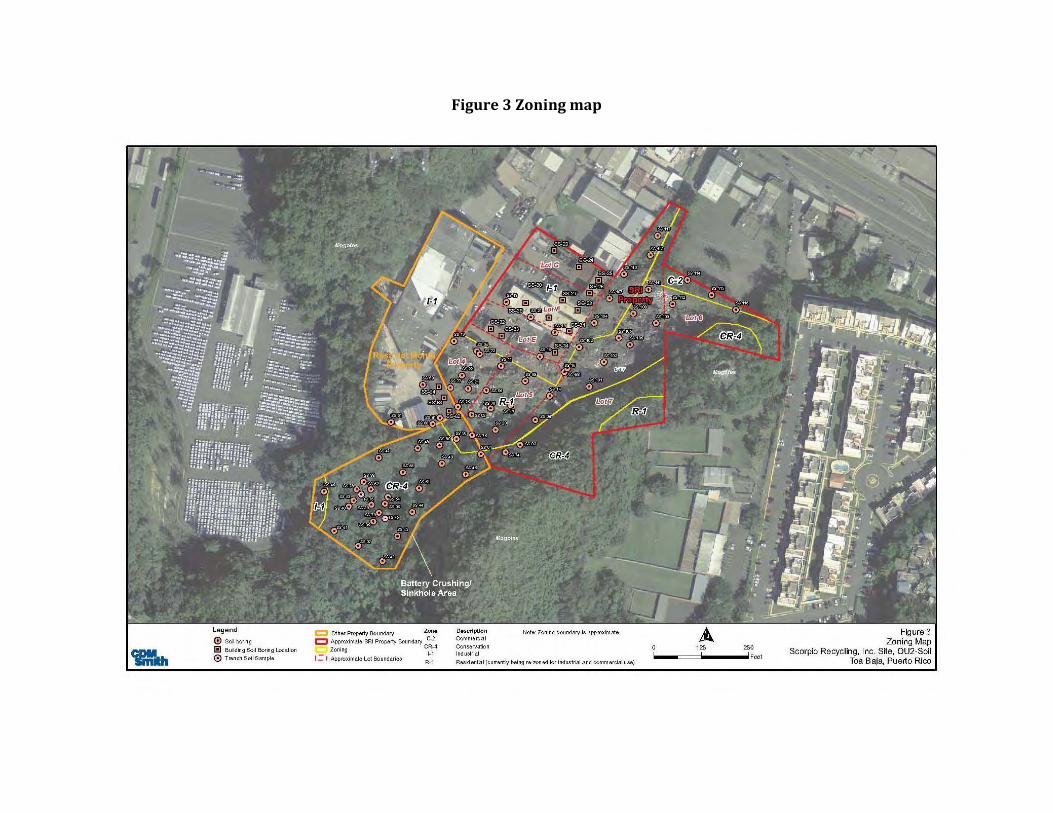
Figure 3 Zoning map
Legend
® Soil boring
liJ Building Soil Boring Location
0 Trench Soil Sample
c::::::l other Property Boundary Z.orto c::J Approximate SRI Property Boundary C-2
Zoning Cl~~4
I = I Approximate Lot Boundaries R-1
Doscripti.on C<>mmert:ial
Conservation Ind ustrial
Note: Zoning boundary is approximate
Resident ial (current ly being re-Z'Onad for i ndustrial .and commercial use)
126 260
-----====i ......... Fu t
Figure 3 Zoning Map
Scorpio Recycling, Inc. SHe, OU2-Soil Toa Baja, Puerto Rico

Figure 4 Conceptual Site Model
l£GEH> 0 Redsh&OM'!SiftyC&try . Giou'ldNtltO" Ia Rtttn4ring 8at!cnts6il
.\Veaflered l~sb'le D a aewy.'lead G:J P#.oedANbS Q Aguada}Cbao Utn.stO'Ie SOJa /lrcfb
Not to Scale
Figure 4 Conceptual Site Model
Soorpio Recycling Inc. Site. OU2-Soi Toa Baja. Puerto RJoo

Figure 5 Alternative 2 – Consolidation and Soil Cover
0 SoH OOring
[!] BuHding Soil &>ring Location
0 Tren<:h Soil Sample
C Other Property Boundary Conservation Zone
.:::::::1 Approximate SRI Property Boundary - Area to be <:.overed w~h dean soil Approximate zoning Proposed lndustnaJ Zo~e
i304. Consolidation Area Outline - Area to be remed~ateod lZZl NoeJ<cavation under the build ing
I = I Approximate Lot Boundaries 12iii5--===-----~12~eet
Figures Alternative 2 - Consolidation and Soil Cover
Scorpio Recycling, Inc. Site, OU2-Soil Toa Baja, Puerto Rico

Figure 6 Alternative 3 –Soil Cover
0 SoH OOring
[!] BuHding Soil &>ring Location
0 Tren<:h Soil Sample
C Other P10perty Boondary Conservation Zone
.::::::::1 A pproximate SRI Property Boundary - Area to be <:.overed w~h dean soil
Approximate Zoning t=f~ 11~d~!~~:~~~~ed ~ SoH Cover rz3 No ex<:avation underthe building
I = 1 App10ximate Lot Boundaries
125 Feel
Figure 6 Alternative 3 - Soil Cover
Scorpio Recycling, Inc. Site, OU2-Soil Toa Baja, Puerto Rico
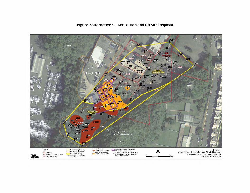
Figure 7Alternative 4 – Excavation and Off Site Disposal
0 Scilboring
1!1 Build ing Scil Boring Locatbn
0 TrM<:h Soil Sample
Approximate Zon ing
I:ZJ Building to be demolished
Propose-.1 1ndustria l Zone ~ Area to be remediat.e-.1
Numbers represent areas with different average depths of contamination for soil -...clumesestimates.
Figure 7 Atternative 4 - Excavation and Off-site Disposal
Scorpio Recycling, Inc. Site, OU2-Soil Toa Baja, Puerto Rico

APPENDIX IV
PROPOSED PLAN AND FACT SHEET
1 | P a g e
ENVIRONMENTAL PROTECTION AGENCY ANNOUNCES PROPOSED PLAN This Proposed Plan identifies the preferred remedy to address soil contamination at Operable Unit 2 (OU2) of the Scorpio Recycling Superfund Site (Site) in Toa Baja, Puerto Rico and provides the rationale for this preference. The U.S. Environmental Protection Agency’s (EPA’s) preferred remedy to address the soil contamination is Alternative No. 3b, Cover with Gravel within the Scorpio Recycling Inc. Property and Soil Cover within the Conservation Area. This remedy also includes institutional controls
1 to address certain
uncharacterized areas beneath buildings that might remain and to prevent the disturbance of the soil covers. This Proposed Plan includes summaries of all of the cleanup alternatives evaluated for the contaminated soils on the Site. This document is issued by the EPA, the lead agency for the Site activities, with the concurrence of the Puerto Rico Environmental Quality Board (PREQB), the support agency. The EPA is issuing this Proposed Plan as part of its community relations program under Section 117(a) of the Comprehensive Environmental Response, Compensation and Liability Act (CERCLA), commonly known as Superfund. This Proposed Plan summarizes information that can be found in greater detail in the remedial investigation (RI) and feasibility study (FS) reports and other documents contained in the administrative record for the Site. COMMUNITY ROLE IN SELECTION PROCESS
The EPA and PREQB rely on public input to ensure that the concerns of the community are considered in selecting an effective remedy for each Superfund site. To this end, the RI and FS reports and this Proposed Plan have been made available to the public for a public comment period that begins on
11
Institutional controls are non-engineered instruments,
such as administrative and legal controls, that help minimize the potential for human exposure to contamination and/or protect the integrity of the remedy. More information about Institutional Controls can be found at: http://www.epa.gov/fedfac/pdf/ic_ctzns_guide.pdf.
August 7, 2013 and concludes on September 6, 2013.
A public meeting to discuss this Proposed Plan is scheduled for August 14, 2013 at the basketball court of Urbanización Altamira from 6:00-8:00 pm. This public meeting is an opportunity for the community to provide verbal or written comments on this Proposed Plan. The EPA encourages the public to gain a more comprehensive understanding of the Site and the Superfund activities that have been conducted at the Site. The EPA, in consultation with PREQB, will select the final remedy for contaminated soils after reviewing and considering all information submitted during the 30-day public comment period. The EPA, in consultation with PREQB, may modify the preferred remedy or select another remedy presented in this Proposed Plan based on new information or public comments. Therefore, the public is encouraged to review and comment on all the alternatives presented in this document. Comments received at the public meeting, as well as
Superfund Program – Region 2 Scorpio Recycling Superfund Site Operable Unit 2: Soils August 2013
MARK YOUR CALENDAR PUBLIC COMMENT PERIOD
August 7, 2013 – September 6, 2013 The EPA will accept written comments on the Proposed Plan during the public comment period. Written comments should be addressed to: Adalberto Bosque, PhD Remedial Project Manager United States Environmental Protection Agency City View Plaza II Suite 7000 #48 PR-165 Km. 1.2 Guaynabo, PR 00968-8069 Telephone: (787) 977-5825 Fax: (787) 289-7104 e-mail: [email protected] PUBLIC MEETING August 14, 2013 at 6:00 pm Basketball Court of Urbanización Altagracia Toa Baja, Puerto Rico
2 | P a g e
written comments, will be documented in the “Responsiveness Summary” section of the Record of Decision (ROD), the document that formalizes the selection of the remedy.
For further information on the Site including the EPA’s preferred alternative for the Scorpio Superfund Site contact: Adalberto Bosque, PhD Remedial Project Manager (787) 977-5825
Ms. Brenda Reyes Community Relations (787)-977-5869
U.S. Environmental Protection Agency City View Plaza II- Suite 7000
48 RD, 165 Km. 1.2 Guaynabo, PR 00968-8069
(787) 977-5865 http://www.epa.gov/region02/superfund/npl/scorpio
SITE DESCRIPTION
Scorpio Recycling Inc. (SRI) is an inactive metal recycling facility, located at Acuña Street on State Road 2, kilometer 19.7, Candelaria Ward, Toa Baja, Puerto Rico (Figure 1). The Site is defined as the SRI property and contaminated portions of two adjacent properties: Rosa del Monte Movers (the Rosa del Monte property) to the west and the conservation area to the south (Figure 2). The Site contains three zoned areas: industrial, residential and conservation as shown on Figure 3. However the Puerto Rico Commonwealth Government and the Municipality of Toa Baja have initiated the re-zoning of the entire SRI property from industrial/residential to industrial.
The Site is approximately four miles west of the town of Bayamón and lies within a chain of rugged limestone hills (known as mogotes) which flank the southern margin of the Atlantic coastal plain of northern Puerto Rico.
The SRI property consists of a relatively flat nine-acre parcel which slopes gently to the north within its northern portion and to the south in its southern portion. Two and a half acres of the SRI property are owned by Astur Metals and 6.5 acres are owned by SRI’s consortium. The property was operated by Astur Metals, then SRI and then by Scrapyard Recycling Inc., pursuant to a lease agreement. The SRI property includes an administrative office, aluminum processing buildings, copper-brass sorting buildings, a maintenance shop and a scrap vehicle accumulation building. There are waste piles left at the Site by its previous operators which include approximately 10,000 yd
3 of soil, 5,400 yd
3 of Scrap
metals, 6,800 yd
3 of tires and
900 yd
3 of debris.
Topography and Drainage The Site is located on the eastern edge of the karst terrain of the North Coast Limestone Province (NLP). The prominent karst features in the Site vicinity are mogotes, an open-ended sinkhole valley and thick layers of blanket deposits, consisting mostly of silty clay. In general, the Site slopes toward the north at an elevation of approximately 246 feet (75 meters) above mean sea level. The Atlantic Ocean is approximately four miles north of the Site. Surface water runoff from the Site migrates north to the stormwater drainage along State Route 2 and south to the conservation area.
Geology The Site is situated along the north-central coast of Puerto Rico and lies within the NLP. The bedrock formations of the NLP consist of a sequence of
The administrative record file, which contains the information upon which the selection of the response action will be based, is available at the following locations: Toa Baja Municipal Library Calle Luis Munoz Rivera # 55 Toa Baja, Puerto Rico 00949 (787) 794-2145 Hours: Monday – Friday 9:00 am to 3:00 pm U.S Environmental Protection Agency City View Plaza II- Suite 7000 #48 PR-165 Km. 1.2 Guaynabo, PR 00968-8069 (787) 977-5865 Hours: Monday – Friday 9:00 am to 5:00 pm By Appointment Puerto Rico Environmental Quality Board Emergency Response and Superfund Program Edificio de Agencias Ambientales Cruz A. Matos Urbanización San José Industrial Park 1375 Avenida Ponce de León San Juan, PR 00926-2604 (787)767-8181 ext 3207 Hours: Monday – Friday 9:00 am to 3:00 pm By appointment U.S. EPA Records Center, Region 2 290 Broadway, 18th Floor New York, New York 10007-1866 (212) 637-4308 Hours: Monday-Friday – 9:00 am to 5:00 pm By appointment.
3 | P a g e
limestone and terrigenous sediments of Oligocene to Pliocene age. Within the area of the Bayamón topographic quadrangle, the sequence is divided into six formations, which, in order of decreasing age, include: San Sebastián Formation, Lares Limestone, Mucarabones Sand, Cibao Formation, Aguada Limestone and Aymamón Limestone.
The Site is surrounded by karst limestone features including mogotes, unconsolidated blanket deposits and a densely vegetated sinkhole valley located southwest of the SRI property.
Fractures or voids in the underlying limestone rocks of the sinkhole represent secondary porosity in the limestone through which large amounts of groundwater may flow. The conservation area is 70 feet lower in elevation than the SRI property. Two prominent mogotes are present at the Site, one to the northwest of the Site at 90 feet (27 meters) above the SRI property and one to the southeast at 155 feet above the SRI property. The mogotes are composed of Aymamón Limestone at the top of the peaks and Aguada Limestone at the base; they are surrounded by blanket deposits.
The soils in the immediate vicinity of the SRI property are classified as Matanzas clay, consisting of gently sloping soils at the foot of slopes and in small valleys between the limestone hills. The dominant soil type observed in borings at the SRI property, the Rosa del Monte property and the conservation area was a reddish-brown silty clay or silt with limestone fragments.
Hydrogeology The regional hydrogeology is characterized by an upper unconfined aquifer composed of the permeable parts of the Cibao Formation, the Aguada Formation, the Aymamón Limestone and the upper permeable parts of the overlying unconsolidated deposits. The elevation of the upper aquifer’s water table surface is controlled by the surface topography and surface drainage features. The predominant flow direction is northward, toward the coastal plain, where the aquifer is dissected by stream channels, Groundwater discharges into the channels. The primary recharge area for the upper aquifer is the karst hills in which the Site is located.
The lower aquifer of the NLP contains water under artesian pressure throughout the area where it is overlain by the semi-confining unit. Water in the lower aquifer ranges from fresh to brackish. The primary aquifer below the Site is unconfined and located within the limestone bedrock of the Aguada and Cibao Limestone Formations. The depth to
water at the Site ranges from approximately 63 to 190 feet below ground surface (bgs).
Ecological Reconnaissance Vegetated areas of the Site and those which provide marginal/suitable habitats extend in a southerly direction from a fence line which separates existing buildings from the remaining portion of the Site, toward and into the conservation area. The removal of scrap metal piles from the Site created conditions favorable for the colonization of pioneer/invasive vegetative species.
Information regarding threatened and endangered species and ecologically sensitive environments that may exist at or in the vicinity of the Site was obtained from different agencies. The US Fish and Wildlife Service reported that the Site is located within the habitat of the endangered Puerto Rican Boa (Epicrates inornatus). In addition, the endangered plants Vahl’s boxwood (Buxus vahlii), Palo de Rosa (Ottoschulzia rhodoxylon) and small trees/shrubs (Schoepfia areanaria and Daphnopsis helleriana) may also occur in the area. The Puerto Rico Department of Natural and Environment Resources (PRDNER) reported that a review of their records for the Site and surrounding area indicated no known occurrences of Puerto Rico-listed rare, threatened and/or endangered species. However, mogotes located on Site and in the surrounding areas are part of PRDNER’s Conservation Priority Karstic Areas of Puerto Rico, and are considered Special Planning Areas of the Karstic Zone of Puerto Rico.
Meteorology The climate for the Site is classified as tropical marine and is moderated by the nearly constant trade winds that originate in the northeast. The average annual maximum and minimum temperatures for the area are 86.3 degrees Fahrenheit (°F) and 69.1°F, respectively. The lowest temperatures occur in January, February and March, while the highest temperatures occur in July and August. The mean annual precipitation is 61 inches.
Demographics and Land Use The Site is surrounded by other industries and warehouses. Approximately 900 people live within 0.25 mile of the Site and 46,197 people live within one mile. According to the 2010 U.S. Census, the total population of the Municipality of Toa Baja was approximately 73,954. The population within a four-mile radius of the Site is about 155,000.
4 | P a g e
SITE HISTORY The facility began operations in 1972 under the name Astur Metals, Inc and was renamed SRI in 1988. From 1972 to 2010, the facility received and accumulated scrap metals which, upon receipt, were compacted, shredded and packed for shipping. During the Site’s early operations, crushed batteries led to sulfuric acid spills on the ground. Acidic runoff from the battery crushing area flowed into the conservation area where it could then infiltrate into the groundwater. Battery recycling and crushing reportedly ceased in 1983. In addition, fluids from cars, tanks, appliances, electronics and other materials were allowed to drain to the ground. The scrap metals were stored at the facility prior to being sent off-Site. Several piles of scrap metal, some as high as 100 feet, were inter-spaced with dirt pathways covering approximately four acres of land. Materials observed in these piles included crushed cars, gas tanks, propane tanks, appliances, computers, crushed generators, crushed trailers, metal storage tanks and metal pipes. The Site was listed on the Superfund National Priorities List on February 4, 2000 due to the potential migration of lead into the groundwater.
In 2002, EPA’s Emergency and Remedial Response Division (ERRD) excavated and removed approximately 15,000 tons of soil from the battery recycling area and the slope leading down to the sinkhole. Contaminated soil was stabilized with trisodium phosphate (TSP) prior to disposal at a landfill. The entire source was not excavated; waste remains buried under the Rosa del Monte storage shed building and portions of the adjacent paved Rosa del Monte parking lot. No removal action was performed in the large scrap pile areas. The removal actions ceased in June 2004
A groundwater investigation was conducted at the Site as part of the Operable Unit 1 (OU1) RI from 2002 to 2006. As a result of this investigation, it was concluded that groundwater was not impacted by Site-related contaminants. A No Action Record of Decision (ROD) for OU1 was signed in September 2006.
SRI ceased operations in 2010 due to bankruptcy.
In August 2010, the EPA initiated a RI to define the extent of soil contamination (OU2) at the Site. A total of 61 soil samples were collected (12 in the northern portion of the SRI property, 18 in the southern area of the SRI property; 7 in the Rosa del Monte property, 24 in the conservation area). Additional samples were collected in January 2011 including two surface soil samples at the conservation area trench previously excavated by EPA. .
In November 2011, 18 borings in the northern area of the SRI property were sampled and seven composite samples were collected from the soil/scrap piles (one from each pile) to characterize the waste for removal. Boring locations are presented in Figure 3.
NATURE AND EXTENT OF CONTAMINATION
The nature and extent of contamination was assessed by comparing soil analytical results from samples collected at the Site to Site-specific screening criteria. Generally, the Site-specific screening criteria are the most stringent value of the following: human health criteria, ecological criteria, or Regional Screening Levels for Contaminants at Superfund sites for residential soil or for protection of groundwater.
SRI Property Waste Piles Characterization Sample Results Seven surface soil samples were collected from the waste piles located on the northern portion of the SRI property. The waste piles that were sampled are assumed to be representative of all the piles that existed across the Site and are therefore considered source area samples. The results of the toxicity characteristic leaching procedure (TCLP) analyses indicate that the materials in the waste piles are non-hazardous.
Eight metals exceeded screening criteria at significant concentrations: arsenic, cadmium, chromium, cobalt, copper, lead, nickel and zinc. Mercury and antimony also exceeded their screening criteria in all samples, although at relatively lower levels. Barium and thallium exceeded screening criteria in only one of the samples. Aluminum, barium, iron, manganese, thallium and vanadium also exceeded screening criteria but generally did not exceed the background levels.
Organic compounds detected above screening criteria included one volatile organic compound (VOC) (carbon disulfide), eight semi-volatile organic compounds (SVOCs) (five polycyclic aromatic hydrocarbons [PAHs] and three phthalates) and two polychlorinated biphenyls (PCBs) (Aroclor 1248 and Aroclor 1254). Carbon disulfide and bis(2-ethylhexyl)phthalate were detected at significant concentrations above the screening criteria. Butyl benzyl phthalate, di-n-butyl phthalate and naphthalene exceeded their screening criteria in every sample but at lower concentrations. Benzo(a)anthracene, benzo(a)pyrene and benzo(b)fluoranthene exceeded their screening criteria in only one sample.
5 | P a g e
SRI Property Soil Boring Sample Results A total of 54 surface soil and 119 subsurface soil samples were collected from soil borings on the SRI property, including the southernmost part of the property once used for battery crushing operations, scrap yard areas in the center and north part of the property and inside and around various process and operations buildings (Figure 3).
Eighteen metals exceeded their screening criteria in surface soils: aluminum, antimony, arsenic, barium, cadmium, chromium, cobalt, copper, iron, lead, manganese, mercury, nickel, selenium, silver, thallium, vanadium and zinc. The same metals, except barium, selenium, vanadium and zinc, were found in subsurface soils. In addition, beryllium exceeded the criterion in one subsurface soil sample. The highest levels of metals exceeding the screening criteria were found in three main areas: the battery/lead source area, the Aluminum Processing Building and south/southeast of the Maintenance Shop (Figure 2).
Three VOCs, 14 SVOCs, 16 pesticides and two PCBs exceeded screening criteria in the surface soils. Two VOCs, five of the same SVOCs, four of the same pesticides and two PCBs were detected in subsurface soil at concentrations exceeding screening criteria. Five organic compounds were detected: 1,4-dioxane, bis(2-ethylhexyl)phthalate, benzo(a)pyrene, n-nitroso-di-n-propylamine and dieldrin.
Rosa del Monte Soil Boring Sample Results Seven surface soil and 41 subsurface soil samples were collected from throughout the Rosa del Monte property (Figure 3). Twelve metals exceeded their screening criteria in surface soils: aluminum, antimony, arsenic, cadmium, chromium, cobalt, copper, iron, lead, manganese, thallium and vanadium. The suite of metals exceeding criteria in the subsurface was similar: aluminum, antimony, arsenic, cadmium, chromium, cobalt, copper, iron, lead, manganese, thallium and zinc. There is a hotspot of surface soil contamination on the southwestern edge of the parking area. One sample had the maximum concentrations for nine of the 12 metals that exceeded criteria.
This location receives runoff from the parking area and this runoff may be the source of metals contamination, although no PAHs, commonly indicative of runoff, were detected in this sample. In the subsurface, one sample located in the southeastern end of the warehouse was the most contaminated. This boring contained the maximum concentrations for nine of the 12 metals that
exceeded criteria. There is no clear pattern to the distribution of metals in this boring (i.e., concentrations neither increase nor decrease consistently with depth).
One SVOC (n-nitroso-di-n propylamine) and two pesticides (dieldrin and endrin aldehyde) were detected above screening criteria in the surface soils. One VOC (cis-1,3-dichloropropene), two SVOCs (bis(2-chloroethyl) ether and n-nitroso-di-n propylamine) and three pesticides (alpha-BHC, beta-BHC and dieldrin) were detected in subsurface soils at concentrations exceeding screening criteria. All of the organic compounds were detected at concentrations exceeding the criteria in three or fewer samples. None of the organic compounds were detected at significant concentrations or distributions on the Rosa del Monte property.
Conservation Area Soil Boring Sample Results Twenty-four surface soil and 105 subsurface soil samples were collected from borings in the conservation area (Figure 3). Sixteen metals exceeded their screening criteria in surface soils: aluminum, antimony, arsenic, cadmium, chromium, cobalt, copper, iron, lead, manganese, mercury, nickel, selenium, thallium, vanadium and zinc. Eleven metals exceeded criteria in subsurface soils: aluminum, antimony, arsenic, chromium, cobalt, copper, iron, lead, manganese, selenium and thallium. The majority of the borings in the conservation area had exceedances of several metals. However, the heaviest metal contamination at this area is in the northeastern portion, closest to the SRI property.
Six SVOCs (benzo(a)pyrene, bis(2-chloroethyl) ether, bis(2-ethylhexyl)phthalate, butyl benzyl phthalate, nitrobenzene and n-nitroso-di-n propylamine), four pesticides (4-4’-DDD, 4,4’-DDE, 4,4’-DDT and dieldrin) and four PCBs (Aroclor 1248, 1254, 1260 and 1262) were detected above screening criteria in the surface soils. Four SVOCs (benzo(a)pyrene, bis(2-chloroethyl) ether, n-nitroso-di-n propylamine and naphthalene), two pesticides (alpha-BHC and dieldrin) and three PCBs (Aroclor1248, -1254 and -1262) were detected in subsurface soil at concentrations exceeding screening criteria. However, organic compounds were not detected at significant concentrations in the conservation area.
SCOPE AND ROLE OF THE ACTION
Site remedial activities are sometimes segregated into different phases, or operable units, so that remediation of different environmental media or areas of a site can proceed separately in an

6 | P a g e
expeditious manner. EPA has designated two operable units for this Site.
OU1 was performed to address the groundwater at the Site. OU2, which is the focus of this Proposed Plan, addresses soil contamination in the industrial and conservation areas.
SUMMARY OF SITE RISKS
Risk Summary The purpose of a baseline risk assessment is to identify potential cancer risks and non-cancer health hazards at a site assuming that no further remedial action is taken. A baseline human health risk assessment was performed at the Site to evaluate current and future cancer risks and non-cancer health hazards based on the results of the RI.
In addition, a screening-level ecological risk assessment was also conducted at the Site to assess the risk posed to ecological receptors due to Site-related contamination.
Human Health Risk Assessment A four-step human health risk assessment process was used for assessing Site-related cancer risks and noncancer health hazards. The four-step process is comprised of: Hazard Identification of Chemicals of Potential Concern (COPCs), Exposure Assessment, Toxicity Assessment and Risk Characterization.
The baseline human health risk assessment began
with selecting COPCs in the various soil and
subsurface soil that could potentially cause adverse
health effects in exposed populations. The current
and future land use scenarios included the following
exposure pathways and populations:
Site worker (adult): current/future ingestion, dermal contact and inhalation of soil particles and vapors for both surface and subsurface soil from SRI and Rosa del Monte properties;
Residents (child/adult): future ingestion, dermal contact and inhalation of soil particles and vapors for surface soil from the SRI property;
Trespassers (adolescent): current/ future ingestion, dermal contact and inhalation of soil particles and vapors for surface soil from SRI and Rosa del Monte properties as well as the conservation area, and
Construction Workers (adult): future ingestion, dermal contact and inhalation of soil particles
and vapors from both surface and subsurface soil for SRI and Rosa del Monte properties.
WHAT IS RISK AND HOW IS IT CALCULATED?
A Superfund baseline human health risk assessment is an analysis of the potential adverse health effects caused by hazardous substance releases from a site in the absence of any actions to control or mitigate these under current- and future-land uses. A four-step process is utilized for assessing site-related human health risks for reasonable maximum exposure scenarios.
Hazard Identification: In this step, the COPCs at the site in various media (i.e., soil, groundwater, surface water and air) are identified
based on such factors as toxicity, frequency of occurrence and fate and transport of the contaminants in the environment, concentrations of the contaminants in specific media, mobility, persistence and bioaccumulation.
Exposure Assessment: In this step, the different exposure pathways through which people might be exposed to the contaminants in air, water, soil, etc. identified in the previous step are evaluated. Examples of exposure pathways include incidental ingestion of and dermal contact with contaminated soil and ingestion of and dermal contact with contaminated groundwater. Factors relating to the exposure assessment include, but are not limited to, the concentrations in specific media that people might be exposed to and the frequency and duration of that exposure. Using these factors, a “reasonable maximum exposure” scenario, which portrays the highest level of human exposure that could reasonably be expected to occur, is calculated.
Toxicity Assessment: In this step, the types of adverse health effects associated with chemical exposures and the relationship between magnitude of exposure and severity of adverse effects are determined. Potential health effects are chemical-specific and may include the risk of developing cancer over a lifetime or other non-cancer health hazards, such as changes in the normal functions of organs within the body (e.g., changes in the effectiveness of the immune system). Some chemicals are capable of causing both cancer and non-cancer health hazards.
Risk Characterization: This step summarizes and combines outputs of the exposure and toxicity assessments to provide a quantitative assessment of site risks for all COPCs. Exposures are evaluated based on the potential risk of developing cancer and the potential for non-cancer health hazards. The likelihood of an individual developing cancer is expressed as a probability. For example, a 10-4 cancer risk means a “one-in-ten-thousand excess cancer risk”; or one additional cancer may be seen in a population of 10,000 people as a result of exposure to site contaminants under the conditions identified in the Exposure Assessment. Current Superfund regulations for exposures identify the range for determining whether remedial action is necessary as an individual excess lifetime cancer risk of 10-4 to 10-6, corresponding to a one-in-ten-thousand to a one-in-a-million excess cancer risk. For non-cancer health effects, a “hazard index” (HI) is calculated. The key concept for a non-cancer HI is that a threshold (measured as an HI of less than or equal to 1) exists below which non-cancer health hazards are not expected to occur. The goal of protection is 10-6 for cancer risk and an HI of 1 for a non-cancer health hazard. Chemicals that exceed a 10-4 cancer risk or an HI of 1 are
typically those that will require remedial action at the Site.

7 | P a g e
In this human health risk assessment, exposure point concentrations were estimated using either the maximum detected concentration of a contaminant or the 95% upper-confidence limit of the average concentration. Chronic daily intakes were calculated based on the reasonable maximum exposure (RME), which is the highest exposure reasonably anticipated to occur at the Site. The RME is intended to estimate a conservative exposure scenario that is still within the range of possible exposures. Central tendency exposure assumptions, which represent typical average exposures, were also developed. A complete summary of all exposure scenarios can be found in the Site baseline human health risk assessment report.
Surface Soil Risks and hazards were evaluated for current and future exposure to surface soil (Table 1). The COPCs identified in the surface soil were arsenic, antimony and lead. Although organics were detected at concentrations exceeding screening criteria during the RI none were identified as COPCs. The populations of interest included adult Site workers, child and adult residents, adolescent trespassers and adult construction workers. The cancer risks for all of the receptor populations evaluated were within or below the acceptable the EPA risk range of 10
-6 to
10-4
with the exception of the child/adult resident, which was above the acceptable cancer risk range (for further clarification, see the discussion regarding Risk Characterization in the discussion box on page 6 entitled, “What is Risk and How is it Calculated?”). The non-cancer hazard indexes (HIs) for the trespassers in all areas did not exceed the EPA acceptable value of 1, and thus there was no unacceptable non-cancer risk present. However, the Site workers and future child/adult resident populations were above the EPA acceptable value of 1. Lead exceeded the residential screening value of 400 mg/kg and the industrial screening value of 800 mg/kg. Arsenic was elevated in three isolated areas. Antimony was elevated in two isolated areas in the middle of the lead contamination area. Vanadium concentrations detected on the Site were similar to the concentrations detected off-Site, which indicates that vanadium is not a Site-related contaminant.
Subsurface Soil Risks and hazards were evaluated for the potential current and future exposure to subsurface soil (Table 2). The COPC identified in the subsurface soil was lead. Although organics were detected at concentrations exceeding screening criteria during the RI none were identified as COPCs The population of interest included adult construction
workers. The cancer risks were below or within the EPA acceptable ranges. The non-cancer hazards exceeded the EPA acceptable value of 1, based primarily on concentrations of vanadium. Vanadium concentrations detected on the Site were similar to the concentrations detected off-Site, which indicates that vanadium is not a Site-related contaminant. Lead exceeded the industrial screening value of 800 mg/kg.
Table 1 Summary of Cancer and Non-Cancer Risks (Surface Soil)
Receptor Hazard Index
Cancer Risk
SRI Property
Site worker – current 3 5 x 10⁻⁵
Site worker – future 2 4 x 10⁻⁵
Trespasser – current 1 6 x 10⁻⁶
Trespasser – future 0.9 4 x 10⁻⁶
Resident – future 24 2 x 10⁻⁴
Rosa del Monte Property
Site worker – current 2 2 x 10⁻⁵
Site worker – future 2 4 x 10⁻⁵
Trespasser – current 1 3 x 10⁻⁶
Trespasser - future 0.8 2 x 10⁻⁶
Conservation Area
Trespasser – current 1 3 x 10⁻⁶
Trespasser – future 1 3 x 10⁻⁶
Scrap Piles Trespasser - current 0.6 2 x 10
-6
Table 2 Summary of Cancer and Non-cancer Risks (Subsurface Soil)
Receptor Hazard Index
Cancer Risk
SRI Property Construction worker – future
2 1 x 10⁻⁶
Rosa del Monte Property Construction worker - future
2 1 x 10⁻⁶
Ecological Risk Assessment A screening-level ecological risk assessment (SLERA) was conducted at the undeveloped portions of the Site (conservation area) to evaluate the potential for ecological risks from the presence of contaminants in surface soil. The SLERA focused on evaluating the potential for impacts to sensitive ecological receptors from Site-related constituents of concern through exposure to soil. Surface soil concentrations were compared to ecological screening values as an indicator of the potential for adverse effects to ecological receptors. A complete
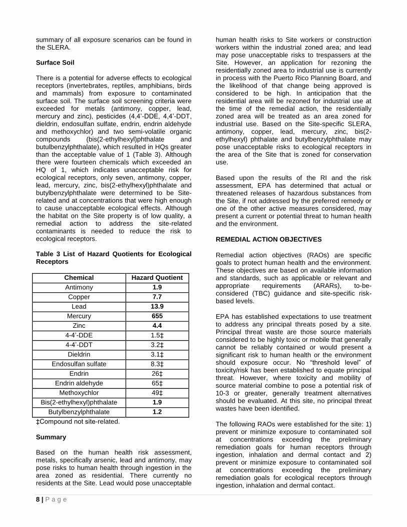
8 | P a g e
summary of all exposure scenarios can be found in the SLERA. Surface Soil There is a potential for adverse effects to ecological receptors (invertebrates, reptiles, amphibians, birds and mammals) from exposure to contaminated surface soil. The surface soil screening criteria were exceeded for metals (antimony, copper, lead, mercury and zinc), pesticides (4,4’-DDE, 4,4’-DDT, dieldrin, endosulfan sulfate, endrin, endrin aldehyde and methoxychlor) and two semi-volatile organic compounds (bis(2-ethylhexyl)phthalate and butulbenzylphthalate), which resulted in HQs greater than the acceptable value of 1 (Table 3). Although there were fourteen chemicals which exceeded an HQ of 1, which indicates unacceptable risk for ecological receptors, only seven, antimony, copper, lead, mercury, zinc, bis(2-ethylhexyl)phthalate and butylbenzylphthalate were determined to be Site-related and at concentrations that were high enough to cause unacceptable ecological effects. Although the habitat on the Site property is of low quality, a remedial action to address the site-related contaminants is needed to reduce the risk to ecological receptors. Table 3 List of Hazard Quotients for Ecological Receptors
Chemical Hazard Quotient
Antimony 1.9
Copper 7.7
Lead 13.9
Mercury 655
Zinc 4.4
4-4’-DDE 1.5‡
4-4’-DDT 3.2‡
Dieldrin 3.1‡
Endosulfan sulfate 8.3‡
Endrin 26‡
Endrin aldehyde 65‡
Methoxychlor 49‡
Bis(2-ethylhexyl)phthalate 1.9
Butylbenzylphthalate 1.2
‡Compound not site-related.
Summary Based on the human health risk assessment, metals, specifically arsenic, lead and antimony, may pose risks to human health through ingestion in the area zoned as residential. There currently no residents at the Site. Lead would pose unacceptable
human health risks to Site workers or construction workers within the industrial zoned area; and lead may pose unacceptable risks to trespassers at the Site. However, an application for rezoning the residentially zoned area to industrial use is currently in process with the Puerto Rico Planning Board, and the likelihood of that change being approved is considered to be high. In anticipation that the residential area will be rezoned for industrial use at the time of the remedial action, the residentially zoned area will be treated as an area zoned for industrial use. Based on the Site-specific SLERA, antimony, copper, lead, mercury, zinc, bis(2-ethylhexyl) phthalate and butylbenzylphthalate may pose unacceptable risks to ecological receptors in the area of the Site that is zoned for conservation use.
Based upon the results of the RI and the risk assessment, EPA has determined that actual or threatened releases of hazardous substances from the Site, if not addressed by the preferred remedy or one of the other active measures considered, may present a current or potential threat to human health and the environment.
REMEDIAL ACTION OBJECTIVES
Remedial action objectives (RAOs) are specific goals to protect human health and the environment. These objectives are based on available information and standards, such as applicable or relevant and appropriate requirements (ARARs), to-be-considered (TBC) guidance and site-specific risk-based levels.
EPA has established expectations to use treatment to address any principal threats posed by a site. Principal threat waste are those source materials considered to be highly toxic or mobile that generally cannot be reliably contained or would present a significant risk to human health or the environment should exposure occur. No “threshold level” of toxicity/risk has been established to equate principal threat. However, where toxicity and mobility of source material combine to pose a potential risk of 10-3 or greater, generally treatment alternatives should be evaluated. At this site, no principal threat wastes have been identified.
The following RAOs were established for the site: 1) prevent or minimize exposure to contaminated soil at concentrations exceeding the preliminary remediation goals for human receptors through ingestion, inhalation and dermal contact and 2) prevent or minimize exposure to contaminated soil at concentrations exceeding the preliminary remediation goals for ecological receptors through ingestion, inhalation and dermal contact.

9 | P a g e
PRELIMINARY REMEDIATION GOALS
To achieve the RAO, preliminary remediation goals (PRGs) were developed to aid in defining the extent of contaminated soil requiring remedial action. PRGs are chemical-specific remediation goals for each media and/or exposure route that are expected to be protective of human health and the environment. They have been derived based on comparison to applicable or relevant and appropriate requirements, risk-based levels (human health and ecological) and regional and Site background concentrations. Since the Site includes different zoning, Site-specific risk assessments indicate different risks for different receptors in different zoning areas. In order to achieve the protection of human health and the environment, two sets of PRGs were developed for this Site.
For the areas zoned for industrial use, ecological usage was not considered viable due to limited available habitat. The human health risk assessment indicates that only lead would pose unacceptable risks to Site workers and construction workers. The PRG for lead is based on the EPA industrial health risk screening value of 800 mg/kg (Table 4), which is based on the anticipated change in zoning to prohibit residential use.
For the areas zoned for conservation use, the human health risk assessment evaluated the risks to trespassers. Only lead is identified as a contaminant that could potentially cause adverse health effects to trespassers. Under the SLERA, an evaluation was conducted, which identified VOCs, SVOCs, pesticides, metals as COPCs. However, it was subsequently determined that the VOCs and pesticides were present at levels below EPA acceptable criteria , and therefore only certain metals, including antimony, copper, lead, mercury and zinc, and two phthalates are identified as Site-related contaminants that require remediation. The SLERA screening levels were also compared to the background metal concentrations. The higher values of the two sets of numbers were selected as the PRGs, except lead. All conservation zone PRGs were based on risked based values, except mercury which is based on site-specific background.
Remediation of the SRI property would include management of waste piles, as well as contaminated soil in areas that exceed the PRGs. It is estimated that approximately 10,000 yd
3 of
contaminated soil from the waste piles are located at the SRI property.
Table 4 Preliminary Remediation Goals
Note: J – estimated results ND – non-detect For lead in the conservation zone, a cleanup value of 400 mg/kg is selected as the PRG. This value is protective of both the trespasser and ecological receptors that may be exposed to lead in the conservation area. Areas of the Site with surface soil contaminated above the PRGs were identified by comparing the analytical results of surface soil samples (from zero to two feet bgs) to the two sets of PRGs based on Site zoning and the risk assessments. It should be noted that even though PRGs were developed for the two phthalates, antimony, copper, mercury and zinc in accordance with ecological risks, the extent of contamination is driven by mercury.
The extent of contamination is driven by lead for the industrial zoned area. SUMMARY OF REMEDIAL ALTERNATIVES
CERCLA '121(b)(1), 42 U.S.C. '9621(b)(1), mandates that remedial actions must be protective of human health and the environment, cost-effective, comply with ARARS and utilize permanent solutions
Chemical Name
Preliminary Remediation Goal (mg/kg)
Ranges of Detected Concentration (mg/kg)
Proposed Industrial Zone
Lead 800 2.6 - 69,900
Conservation Zone
Lead 400 2.3 - 18,700J
Mercury 0.25 0.054J - 0.67
Antimony 78 ND - 116
Copper 80 11.5 – 470J
Zinc 160 13.9 - 950
Bis(2-Ethylhexyl) Phthalate 925 ND - 6,500
Butylbenzylphthalate 239 ND - 1,600
10 | P a g e
and alternative treatment technologies and resource recovery alternatives to the maximum extent practicable. Section 121(b)(1) also establishes a preference for remedial actions which employ, as a principal element, treatment to permanently and significantly reduce the volume, toxicity, or mobility of the hazardous substances, pollutants and contaminants at a site. CERCLA '121(d), 42 U.S.C. '9621(d), further specifies that a remedial action must attain a level or standard of control of the hazardous substances, pollutants and contaminants which at least attains ARARs under federal and state laws, unless a waiver can be justified pursuant to CERCLA '121(d)(4), 42 U.S.C. '9621(d)(4).
Detailed descriptions of the remedial alternatives for addressing the soil contamination associated with the Site can be found in the FS report.
Each alternative, other than No Further Action, includes certain common elements that are discussed below.
Common Elements
Segregation and Disposal of Waste Piles Remediation of the SRI property would include management of waste piles, as well as contaminated soil in areas that exceed the PRGs. The materials in the waste piles would be segregated into tires, scrap metal, debris and soil.
Existing Site fencing would be utilized to prevent access to the segregation areas during the remedial action activity.
The tires would be cleaned and the rims would be removed, as necessary. The cleaned tires would be shipped to a licensed tire recycling company. The scrap metals would be recycled to the maximum extent possible. The debris and remaining non-recyclable materials would be disposed in a non-hazardous landfill or other appropriate landfills.
Pre-Design Investigation A pre-design investigation would be conducted to determine the final areas of excavation. Soil samples would be collected for Target Analyte List metal analysis for all active alternatives. TCLP analysis would be collected for Alternative 4. A bench-scale treatability study may be conducted for Alternative 4, as necessary, to select the amendment to be used for treating the soil exceeding TCLP requirements and to determine the required dosage. Background soil samples would be collected from several areas surrounding the Site for verification and re-evaluation of the Site-specific metal background levels, especially mercury.
Remedial Design Based on the pre-design investigation results, a remedial design would be prepared. The remedial design would consist of both prescriptive and performance-based standards required and estimated costs of the remedial action. The remedial design would also address treatment of TCLP waste if necessary. Five-Year Review A review of Site conditions would be conducted every five years using data collected through the long-term inspection and maintenance program to ensure the protection of human health and the environment. Institutional Controls Because contaminated soil exceeding the PRGs would be left on Site (under the Alternatives 2, 3a, and 3b) a deed restriction would be placed on the SRI property, the corner of the Rosa del Monte property and the conservation area to restrict future intrusive activities that would disturb the soil cover and expose the construction workers or future land users to contaminants at levels that may pose human health risk. Furthermore, a deed restriction would be placed on the SRI property to prevent the rezoning of this property for residential use (i.e. after it is changed to prohibit residential use) and to prevent the conservation area from being rezoned for use other than conservation.
The time frames presented below for construction do not include the time for pre-design investigations, remedial design or contract procurements.
Remedial Alternatives
Alternative 1 – No Further Action The Superfund program requires that the "no-action" alternative be considered as a baseline for comparison with the other alternatives. The no-action remedial alternative for soil does not include any physical remedial measures that address the problem of soil contamination at the site. Because this alternative would result in contaminants remaining at the site which are above levels that would otherwise allow for unrestricted use and unlimited exposure, CERCLA requires that the site be reviewed at least once every five years. If justified by the review, additional future remedial actions may be selected to remove, treat, or contain the contaminated soils.

11 | P a g e
A cost summary for Alternative 1 is provided in Table 5. Table 5 Alternative 1 Cost Summary
Total Capital Cost $0
Operation and Maintenance $0
Total Present Net Worth $0
Estimated Construction Time frame
0 years
Alternative No. 2 – Consolidation and Soil Cover Alternative 2 consists of the consolidation and soil cover of contaminated soil currently located in two different areas (Figure 4). Under this alternative, contaminated soils from the industrial area at SRI property which are outside of the consolidation area would be excavated to one foot except a small area of contaminated soils around SS-09 which is outside the main area of contamination and would be excavated to two feet bgs (Figure 3). An estimated 800 yd
3 of soil would be excavated. These soils
would be consolidated on Site at the southern portion of the SRI property at one location together with the soil segregated from the existing waste piles. The contaminated soil in the conservation area would be left in place and covered with one foot of clean common soil.
An estimated 10,000 yd3 of soil would be segregated
from the waste piles located at the northern portion of the SRI property; it is assumed that 10 percent of these soils would be below the PRGs and can be used as soil cover. Therefore, a total of 9,000 yd
3 of
soil form the excavate area and the waste piles would be consolidated as one soil pile that could occupy approximately 25,900 square feet and reach approximately 16 feet high. (see Figure 4) The consolidated soil pile would be covered with one foot of clean common fill to prevent direct contact and then vegetated for erosion controls. In addition, the contaminated soil in the conservation area would also be left in place and covered with one foot of clean common soil.
A geo-fabric demarcation layer would be installed between the contaminated soil and the clean soil cover (in both the consolidated area and conservation area). A long-term inspection and maintenance program would be implemented to ensure the integrity of the soil cover.
The conservation area and the backfilled area on the SRI property would be graded for positive drainage and to match the natural topography as much as possible. Lead concentrations beneath the building slab at the southern corner of the Rosa del Monte property exceeded the PRG. This slab would be inspected and repaired as necessary to eliminate the exposure pathway to Site workers. The southeast corner of the Rosa del Monte has a steep slope and it is assumed that a retaining wall using gabions would be constructed to prevent future erosion and direct contact with the contaminated soil beneath the building slab immediately adjacent to the slope.
After backfilling the excavated areas and installing soil covers, contaminated soils at depth exceeding the PRGs would remain on Site, including the excavated and backfilled area on the SRI property, the portion of Rosa del Monte property, the contaminated area in the conservation area and the consolidated soil pile. Because this alternative would result in contaminants remaining on-site above levels that would otherwise allow for unrestricted use and unlimited exposure, CERCLA requires that the Site be reviewed at least once every five years.
A cost summary for Alternative 2 is provided in Table 6. Table 6 Alternative 2 Cost Summary
Total Capital Cost $2,904,000
Operation and Maintenance (annual)
$7,000
Estimated Present Worth O&M Cost
$87,000
Total Present Net Worth $2,991,000
Estimated Construction Time frame
< 2 years
Alternative No. 3a – Soil Cover in the Industrial and Conservation Area Under this alternative, the industrial area, as well as the conservation area, would be addressed (Figure 5). Contaminated soils underneath the building on the Rosa del Monte property would be left in place. Approximately 10,000 yd
3 of soil would be separated
from the waste piles located at SRI property; 10 percent of these soils are estimated to be below the PRGs and would be reused as soil cover. The 9,000 yd
3 of contaminated soil exceeding the PRG would
be spread on the entire SRI property, covering approximately three acres to a height of two feet outside the buildings and the paved areas, see Figure 5.

12 | P a g e
The contaminated soil, both within the SRI property and the conservation area, would be covered with one foot of clean soil to eliminate the exposure pathway to human health and ecological receptors. A geo-fabric demarcation layer would be installed between the contaminated soil and the soil cover. The soil cover would be graded for positive drainage and to match the natural drainage pattern as much as possible. The soil cover would also be vegetated with native species for erosion control. A long-term inspection and maintenance program would be implemented to ensure the integrity of the soil covers.
Lead concentrations beneath the building slab at the southern corner of the Rosa del Monte property exceeded the PRG. This slab would be inspected and repaired as necessary to eliminate the exposure pathway to Site workers. The southeast corner of the Rosa del Monte has a steep slope and it is assumed that a retaining wall using gabions would be constructed to prevent future erosion and direct contact with the contaminated soil beneath the building slab immediately adjacent to the slope.
Because this alternative would result in contaminants remaining on-site above levels that would otherwise allow for unrestricted use and unlimited exposure, CERCLA requires that the Site be reviewed at least once every five years.
A cost summary for Alternative 3a is provided in Table 7.
Alternative No. 3b – Cover with Gravel at the Industrial Area and Soil within the Conservation Area This alternate is the same as Alternative No. 3a, except gravel would be used as the cover in place of soil for contaminated soil at the industrial zone and clean soil would be used as the cover at the
conservation area (Figure 5). Using gravel would eliminate the exposure pathway to human health, is more stable than soil and would prevent erosion of the underlying contaminated soils; therefore the gravel is more protective.
A cost summary for Alternative 3b is provided in Table 8.
Alternative No. 4 – Excavation and Off-Site Disposal and Backfill Under Alternative 4, all contaminated soil exceeding the PRG for lead in the proposed industrial zone (SRI property) (800 mg/kg) and the conservation area (400 mg/kg) would be excavated (Figure 6). In addition, the surface contaminated soils in the conservation area would be excavated to two feet bgs for all other PRGs. The existing building at the southern corner of the Rosa del Monte property would be demolished in order to remove the contaminated soil underneath. The deepest excavation would be located under the Rosa del Monte building to approximately 47 feet bgs. Sheet piles may be installed to provide structural support for areas outside of the deep excavation.
The total volume of soil to be excavated is estimated to be 24,400 yd
3. The soil segregated from the
waste piles would be approximately 10,000 yd3 and
10 percent of these soils are assumed to be below the PRGs and could be used as backfill. The excavated soil and the soil from the waste piles is estimated to be 33,400 yd
3. Soil samples would be
collected and analyzed in-situ (prior to excavation) and/or ex-situ (post-excavation) for TCLP analysis. Soils that fail the TCLP analysis would be treated to confirm they do not exceed the TCLP requirements prior to off-Site disposal. For cost estimating purposes, it is assumed that 10 percent of the excavated soil (2,440 yd
3) would require treatment
prior to disposal. The excavated area would be
Table 7 Alternative 3a Cost Summary
Total Capital Cost $2,989,000
Operation and Maintenance (annual)
$7,000
Estimated Present Worth O&M Cost
$87,000
Total Present Net Worth $3,076,000
Estimated Construction Time frame
< 2 years
Table 8 Alternative 3b Cost Summary
Total Capital Cost $3,092,000
Operation and Maintenance (annual)
$7,000
Estimated Present Worth O&M Cost
$87,000
Total Present Net Worth $3,179,000
Estimated Construction Time frame
< 2 years
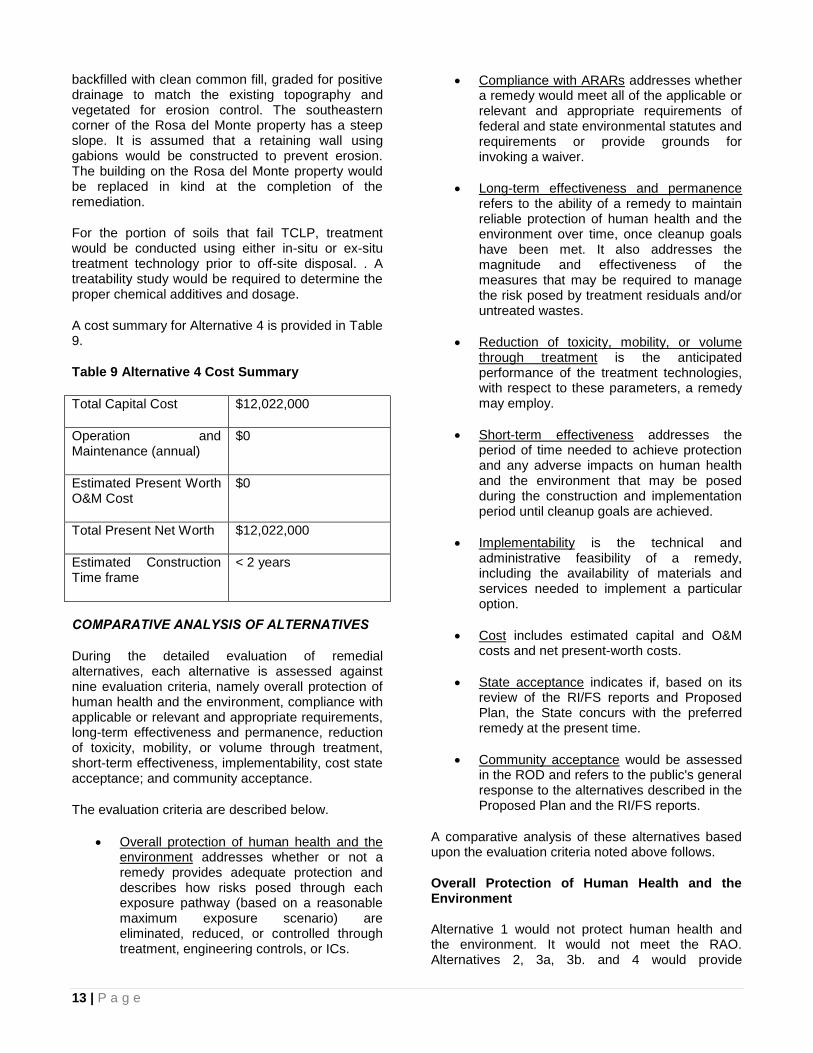
13 | P a g e
backfilled with clean common fill, graded for positive drainage to match the existing topography and vegetated for erosion control. The southeastern corner of the Rosa del Monte property has a steep slope. It is assumed that a retaining wall using gabions would be constructed to prevent erosion. The building on the Rosa del Monte property would be replaced in kind at the completion of the remediation.
For the portion of soils that fail TCLP, treatment would be conducted using either in-situ or ex-situ treatment technology prior to off-site disposal. . A treatability study would be required to determine the proper chemical additives and dosage.
A cost summary for Alternative 4 is provided in Table 9.
Table 9 Alternative 4 Cost Summary
Total Capital Cost $12,022,000
Operation and Maintenance (annual)
$0
Estimated Present Worth O&M Cost
$0
Total Present Net Worth $12,022,000
Estimated Construction Time frame
< 2 years
COMPARATIVE ANALYSIS OF ALTERNATIVES
During the detailed evaluation of remedial alternatives, each alternative is assessed against nine evaluation criteria, namely overall protection of human health and the environment, compliance with applicable or relevant and appropriate requirements, long-term effectiveness and permanence, reduction of toxicity, mobility, or volume through treatment, short-term effectiveness, implementability, cost state acceptance; and community acceptance.
The evaluation criteria are described below.
Overall protection of human health and the environment addresses whether or not a remedy provides adequate protection and describes how risks posed through each exposure pathway (based on a reasonable maximum exposure scenario) are eliminated, reduced, or controlled through treatment, engineering controls, or ICs.
Compliance with ARARs addresses whether a remedy would meet all of the applicable or relevant and appropriate requirements of federal and state environmental statutes and requirements or provide grounds for invoking a waiver.
Long-term effectiveness and permanence refers to the ability of a remedy to maintain reliable protection of human health and the environment over time, once cleanup goals have been met. It also addresses the magnitude and effectiveness of the measures that may be required to manage the risk posed by treatment residuals and/or untreated wastes.
Reduction of toxicity, mobility, or volume through treatment is the anticipated performance of the treatment technologies, with respect to these parameters, a remedy may employ.
Short-term effectiveness addresses the period of time needed to achieve protection and any adverse impacts on human health and the environment that may be posed during the construction and implementation period until cleanup goals are achieved.
Implementability is the technical and administrative feasibility of a remedy, including the availability of materials and services needed to implement a particular option.
Cost includes estimated capital and O&M costs and net present-worth costs.
State acceptance indicates if, based on its review of the RI/FS reports and Proposed Plan, the State concurs with the preferred remedy at the present time.
Community acceptance would be assessed in the ROD and refers to the public's general response to the alternatives described in the Proposed Plan and the RI/FS reports.
A comparative analysis of these alternatives based upon the evaluation criteria noted above follows.
Overall Protection of Human Health and the Environment Alternative 1 would not protect human health and the environment. It would not meet the RAO. Alternatives 2, 3a, 3b. and 4 would provide

14 | P a g e
protection to human health and the environment and achieve the RAO. Specifically alternatives 2, 3a, 3b, and 4 would meet the PRGs in different ways. Alternatives 2, 3a, and 3b would meet the PRGs by providing cover for the contaminated areas to eliminate the exposure pathways to human or ecological receptors. Alternative 4 would meet the PRGs by disposing of the contaminated soil and providing a soil cover, to backfill excavated areas.
Compliance with Applicable or Relevant and Appropriate Requirements As required under Section 121 of CERCLA, remedial actions carried out under Section 104 or secured under Section 106 must be protective of human health and the environment and attain the levels or standards of control for hazardous substances, pollutants, or contaminants specified by the Applicable or Relevant and Appropriate Requirements (ARARs) of federal environmental laws and commonwealth environmental and facility siting laws, unless waivers are obtained.
There are no chemical-specific ARARs for contaminated soil. Alternative 1 would not meet the risk-based PRGs since no action would be taken to remediate the Site. Alternatives 2, 3a., 3b. and 4 would meet the PRGs in different ways. Alternatives 2, 3a. and 3b. would meet the PRGs by providing a soil cover over the contaminated soils to eliminate the exposure pathways to human or ecological receptors. Alternative 4 would meet the PRGs by excavation and off-Site disposal of contaminated soils which exceed the PRGs.
All active alternatives, would meet the action-specific ARARs by following the health and safety regulations, waste handling and disposal regulations. Location-specific ARARs would be met for the conservation of karst regions under Alternatives 2, 3a, 3b, and 4.
Long-Term Effectiveness and Permanence Alternative 1 would not be effective in the long-term since no remedial action would be performed. Alternatives 2, 3a. and 3b. would provide long-term effectiveness and permanence through the soil cover, but to a lesser extent than Alternative 4. The SRI property would be available for redevelopment for industrial purpose with some restrictions. Alternative 4 would provide the highest long-term effectiveness and permanence since both surface and subsurface contaminated soils would be excavated and disposed off-Site. Under this alternative the SRI property can be redeveloped for industrial use without any restrictions. Additionally, institutional controls, long-term inspection and
maintenance would be required under Alternatives 2, 3a. and 3b. to ensure the protection of human health and ecological receptors in the long-term.
The reliability and adequacy of long-term effectiveness and permanence for Alternatives 2, 3a. and 3b. would also rely on effective long-term enforcement of deed restrictions and the reliability of long-term inspection and maintenance of the soil covers.
Reduction of Toxicity, Mobility, or Volume Through Treatment Alternative 1 would not provide any reduction of toxicity, mobility, or volume (T/M/V). Alternatives 2, 3a. and 3b. would reduce the transport of fugitive dust and soil erosion through the soil cover. Alternative 4 would provide the highest reduction of T/M/V through treatment since the excavated soil that failed TCLP would be treated before the offsite disposal. Short-Term Effectiveness
Alternative 1 would not have short-term impacts since no action would be implemented. Alternatives 2, 3a. and 3b. would have significant impacts to the community during the construction period. Alternative 4 would have the greatest impact to the local community compared to Alternatives 2, 3a. and 3b. due to the larger amount of truck traffic for
off‐site disposal of contaminated soil. However,
mitigation measures would be put in place to minimize those impacts. For example, dust control measures through the use of dust suppression techniques (e.g., water or foam sprays) and soil erosion control measures such as minimizing open excavation areas and using silt fences would be implemented to minimize the migration of contaminated soil to the maximum extent possible. In addition, working hours would be coordinated with the local government and emergency response plans would be developed and followed. Health and safety measures would be implemented to prevent
on‐site incidents and to protect construction workers, such as using personnel protective equipment to minimize exposure to contaminated materials or hazardous chemicals during remedial activities.
Implementability All four alternatives are implementable. Alternative 1 would be the easiest to implement since no action would be taken.
Alternatives 2, 3a, and 3b, would be similar to implement but considerably less than Alternative 4. These alternatives include: excavation, backfill,

15 | P a g e
consolidation, and construction of the soil cover which are conventional remediation and construction technologies that have been widely implemented. Equipment, supplies, and services would be readily available. There would be no administrative difficulties associated with implementing this technology; however, there are some of the technical challenges associated with them, such as:
Availability of recycling and disposal facilities for waste pile material
Ability to classify the disposal waste type for the non‐metallic debris
Accessibility and operation of excavation and backfill equipment on the steep slope in the Conservation area
Difficulty in segregating tires, scrap metal, debris, and soil from the waste piles
Alternative 4 would be the most difficult to implement since it would involve deep excavation, demolition of a building and extensive transportation to dispose of all excavated soil off-Site in landfills in Puerto Rico.
Cost Alternative 1 would not include any cost. Alternative 4 has higher cost than Alternatives 2, 3a. and 3b. Costs for Alternatives 2, 3a. and 3b. are comparable. The cost estimates for all four alternatives are provided in Table 10.
State Acceptance PREQB concurs with the proposed remedy.
Community Acceptance
Community acceptance of the preferred alternative would be assessed and documented in the ROD’s responsiveness summary following review of the public comments received on this Proposed Plan
SUMMARY OF THE PREFERRED ALTERNATIVE
Based upon an evaluation of the various alternatives, EPA, in consultation with PREQB, proposes the following remedy to address the contaminate soil:
Alternative No. 3b, Cover with Gravel at the Industrial Area and Soil within the Conservation Area, is the preferred remedial alternative for soil contamination at this Site. Under Alternative 3b, approximately 10,000 yd
3 of soil would be separated
from the waste piles; 10 percent of these soils are estimated to be below the PRGs and would be reused as soil cover.
Gravel would be used as the cover for contaminated soil at the industrial zone and common soil would be used as the cover at the conservation area. A geo-fabric demarcation layer would be installed between the contaminated soil and the soil cover. The cover would be graded for positive drainage and to match the natural drainage pattern to the extent possible. The soil cover within the conservation area would also be vegetated with native species for erosion control.
Contaminated soils underneath the building on the Rosa del Monte property would be left in place. The southeast corner of the Rosa del Monte property has a steep slope. It is assumed that a retaining wall using gabions would be constructed to prevent future erosion and direct contact with the contaminated soil beneath the building slab immediately adjacent to the slope.
After the installation of the soil covers, contaminated soils exceeding the PRGs would remain on Site, including the 3-acre area on the SRI property and the conservation area. Deed restrictions would be necessary for these areas to restrict future intrusive activities that would disturb the soil cover and expose the contraction worker or future land users to contaminants at levels that may pose human health risks. Furthermore, a deed restriction would be placed on the Site to prevent the rezoning of this property for residential use and to prevent conservation area from being rezoned for use other than conservation. A long-term inspection and maintenance program would be implemented to ensure the integrity of the soil covers.
A pre-design investigation would be conducted to determine the extent to which the soil cap would need to be placed. Soil samples would be collected for Target Analyte List metal analysis. Background soil samples would also be collected from several areas surrounding the Site for verification and re-evaluation of the Site-specific metal background levels, especially mercury.
The environmental benefits of the preferred remedy may be enhanced by consideration, during the design, of technologies and practices that are sustainable in accordance with EPA Region 2’s Clean and Green Energy Policy. This would include consideration of green remediation technologies and practices.
Based on the pre-design investigation results, a remedial design would be prepared. The remedial design would consist of both prescriptive and performance-based required and estimated costs of the remedial action.

16 | P a g e
Table-10 Cost Estimates
Because this remedy would result in contaminants remaining on-site above levels that would otherwise allow for unrestricted use and unlimited exposure, CERCLA requires that the site be reviewed at least once every five years after the initiation of the action.
Basis for the Remedy Preference
The Preferred Alternative is believed to provide the best balance of tradeoffs among the alternatives based on the information available to EPA at this time. EPA has determined that the preferred remedy will provide the greatest protection of human health and the environment, provide the greatest long-term effectiveness, be able to achieve the ARARs more quickly, or as quickly, as the other alternatives and is cost effective. The preferred alternative can change in response to public comment or new information.
Under the preferred remedy, gravel as a stable cover would prevent erosion of the underlying contaminated soil.
GLOSSARY
Applicable or Relevant and Appropriate Requirements (ARARs): These are Federal or State environmental rules and regulations that may pertain to the Site or a particular alternative.
Carcinogenic Risk: Cancer risks are expressed as a number reflecting the increased chance that a person will develop cancer if exposed to chemicals or substances. For example, the EPA’s acceptable risk range for Superfund hazardous waste sites is 1 x 10
-4 to 1 x 10
-6, meaning there is 1 additional
chance in 10,000 (1 x 10⁻⁴
) to 1 additional chance in 1 million (1 x 10
-6) that a person will develop cancer
if exposed to a site contaminant that is not remediated.
Comprehensive Environmental Response, Compensation and Liability Act (CERCLA): A
Federal law, commonly referred to as the
“Superfund” Program, passed in 1980 that provides for response actions at sites found to be contaminated with hazardous substances, pollutants or contaminants that endanger public health and safety or the environment.
Screening Level Ecological Risk Assessment (SLERA): An evaluation of the potential risk posed to the environment if remedial activities are not performed at a site.
Feasibility Study (FS): Analysis of the practicability of multiple remedial action options for a site.
Groundwater: Subsurface water that occurs in soils and geologic formations that are fully saturated.
Hazard Index (HI): A number indicative of non-carcinogenic health effects that is the ratio of the existing level of exposure to an acceptable level of exposure. A value equal to or less than one indicates that the human population is not likely to experience adverse effects.
Hazard Quotient (HQ): HQs are used to evaluate non-carcinogenic health effects and ecological risks. A value equal to or less than one indicates that the human or ecological population is not likely to experience adverse effects.
Institutional Controls (ICs): Administrative methods to prevent human exposure to contaminants, such as by restricting the use of groundwater for drinking water purposes.
Non-carcinogenic Risk: Non-cancer Hazards (or risk) are expressed as a quotient that compares the existing level of exposure to the acceptable level of exposure. There is a level of exposure (the reference dose) below which it is unlikely for even a sensitive population to experience adverse health effects. The EPA’s threshold level for non-carcinogenic risk at Superfund sites is 1.0, meaning
Criteria Alternative 1 No Action
Alternative 2 Consolidation and Soil Cover
Alternative 3 Soil Cover
Alternative 4 Excavation and Off-Site
Disposal Soil Soil and
Gravel
Estimated Capital Cost
$0 $2,904,000 $2,989,000 $3,092,000 $12,022,000
Estimated Annual O&M Cost
$0 $7,000 $7,000 $7,000 $0
Estimated Present Worth O&M Cost
$0 $87,000 $87,000 $87,000 $0
Estimated Present Worth
$0 $2,991,000 $3,076,000 $3,179,000 $12,022,000

17 | P a g e
that if the exposure exceeds the threshold; there may be a concern for potential non-cancer effects.
National Priorities List (NPL): A list developed by the EPA of uncontrolled hazardous substance release sites in the United States that are considered priorities for long-term remedial evaluation and response.
Operable Unit (OU): a discrete action that comprises an incremental step toward comprehensively addressing site problems. This discrete portion of a remedial response manages migration, or eliminates or mitigates a release, threat of a release, or pathway of exposure. The cleanup of a site can be divided into a number of operable units, depending on the complexity of the problems associated with the site.
Practical Quantitation Level (PQL): means the lowest concentration of a constituent that can be reliably achieved among laboratories within specified limits of precision and accuracy during routine laboratory operating conditions.
Present-Worth Cost: Total cost, in current dollars, of the remedial action. The present-worth cost includes capital costs required to implement the remedial action, as well as the cost of long-term operation, maintenance and monitoring.
Proposed Plan: A document used to describe a preferred remedial alternative and request public input regarding a proposed cleanup alternative for a site.
Public Comment Period: The time allowed for the members of a potentially affected community to express views and concerns regarding the EPA’s preferred remedial alternative.
Remedial Action Objectives (RAOs). Objectives of remedial actions that are developed based on contaminated media, contaminants of concern, potential receptors and exposure scenarios, human health and ecological risk assessment and attainment of regulatory cleanup levels.
Record of Decision (ROD): A legal document that describes the cleanup action or remedy selected for a site, the basis for choosing that remedy and public comments on the selected remedy.
Remedial Action: A cleanup to address hazardous substances at a site.
Remedial Investigation (RI): A study of a facility that supports the selection of a remedy where hazardous substances have been disposed or released. The RI
identifies the nature and extent of contamination at the facility and analyzes risk associated with COPCs.
United States Environmental Protection Agency (the EPA): The Federal agency responsible for administration and enforcement of CERCLA (and other environmental statutes and regulations) and final approval authority for the selected ROD.
Volatile Organic Compound (VOC): Type of chemical that readily vaporizes, often producing a distinguishable odor.
Water Table: The water table is an imaginary line marking the top of the water-saturated area within a rock column.
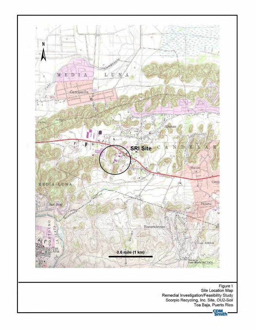
Figure 1 Site Location Map
Remedial Investigation/Feasibility Study Scorpio Recycling, Inc. Site, OU2-Soil
Toa Baja, Puerto Rico
~---------------------------------------------------------------~~th

Legend
D SRI property boundary
n Other property boundary 0 ~0
-----====----------Fret
Figure 2 Site Features and Source Areas
Scorpio Recycling, Inc. Site, OU2-Soil Toa Baja, Puerto Rico
L----------------------------------------------------~~.h----------------~
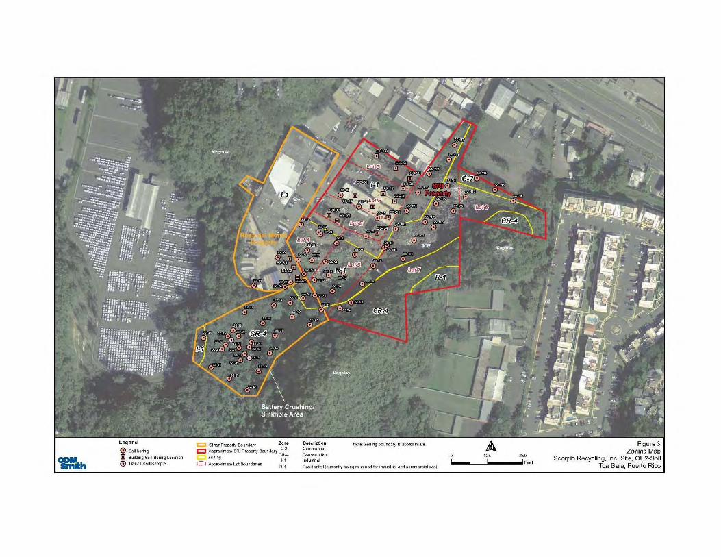
Legend
® Soil boring
l!l Building Soil Boring Location
0 Trench Soil Sample
c::::l other Property Boundary Zone
C Approximate SRI Property Boundary C-2
Zoning C~~~4 I = I Approximate Lot Boundaries
R-1
DQS.Crip1.ion Commercial
Conservation Industrial
Note: Zoning boundary is approximate
Residential (currentty being re-zoned for industrial and .commercial use)
125 250
-----===~ ......... F~t Figure 3
Zoning Map Scorpio Recycling, Inc. Stte, OU2-Soil
Toa Baja, Puerto Rico

SS-117
SS-113
SS-114
SS-115
SS-116SS-112
SS-111
SS-110
SS-107
SS-108
SS-109
SS-106SS-105
SS-104
SS-103
SS-102
SS-19
SS-21
SS-18
SS-15
SS-16
SS-101SS-09
SS-11
SS-17
SS-20
SS-04
SS-59
SS-22
SS-06
SS-02
SS-01
SS-50SS-60
SS-49
SS-48
SS-61
SS-47
SS-51
SS-44
SS-35
SS-38
SS-40
SS-36
SS-43
SS-42
SS-37
SS-41
SS-72
SS-77
SS-76
SS-71
SS-70
SS-75
SS-45
SS-39
SS-53
SS-78
SS-79
SS-52
SS-54
SS-14
SS-08
SS-03
SS-74
SS-13
SS-100
SS-46
SS-81
SS-23
SS-24
SS-25
SS-26
SS-27
SS-28
SS-29
SS-30
SS-31SS-32
SS-33
SS-34
SS-62
SS-63
SS-64
Mogotes
Mogotes
Mogotes
Conservation Zone
ProposedIndustrial Zone
Lot 6
Lot 7
Lot 4
Lot E
Lot F
Lot G
Lot 5
SS-55
TS-75
TS-76
SS-80
125 1250Feet
Other Property BoundaryLegend
Soil boringBuilding Soil Boring LocationTrench Soil Sample
Approximate SRI Property BoundaryApproximate Zoning
Rosa del MonteProperty
Figure 4Alternative 2 - Consolidation and Soil Cover
Scorpio Recycling, Inc. Site, OU2-SoilToa Baja, Puerto Rico
SRIProperty
Conservation Zone
No excavation under the building
Area to be covered with clean soil
Area to be remediatedConsolidation Area Outline
Proposed Industrial Zone
Approximate Lot Boundaries
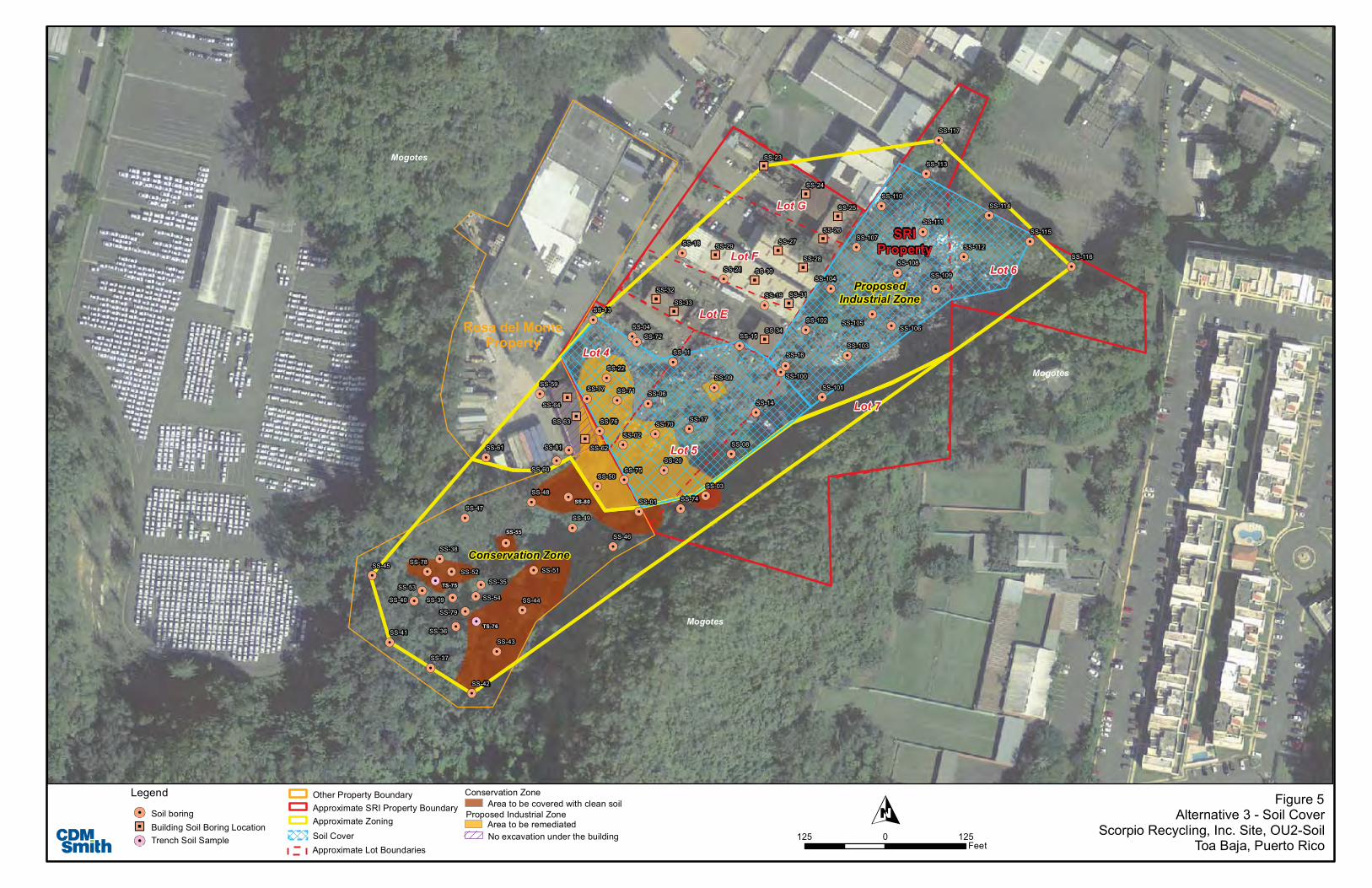
SS-117
SS-113
SS-114
SS-115
SS-116SS-112
SS-111
SS-110
SS-107
SS-108
SS-109
SS-106SS-105
SS-104
SS-103
SS-102
SS-19
SS-21
SS-18
SS-15
SS-16
SS-101SS-09
SS-11
SS-17
SS-20
SS-04
SS-59
SS-22
SS-06
SS-02
SS-01
SS-50SS-60
SS-49
SS-48
SS-61
SS-47
SS-51
SS-44
SS-35
SS-38
SS-40
SS-36
SS-43
SS-42
SS-37
SS-41
SS-72
SS-77
SS-76
SS-71
SS-70
SS-75
SS-45
SS-39
SS-53
SS-78
SS-79
SS-52
SS-54
SS-14
SS-08
SS-03
SS-74
SS-13
SS-100
SS-46
SS-81
SS-23
SS-24
SS-25
SS-26
SS-27
SS-28
SS-29
SS-30
SS-31SS-32
SS-33
SS-34
SS-62
SS-63
SS-64
Mogotes
Mogotes
Mogotes
Conservation Zone
ProposedIndustrial Zone
Lot 6
Lot 7
Lot 4
Lot E
Lot F
Lot G
Lot 5
SS-55
TS-75
TS-76
SS-80
125 1250Feet
Other Property BoundaryLegend
Soil boringBuilding Soil Boring LocationTrench Soil Sample
Approximate SRI Property BoundaryApproximate Zoning
Rosa del MonteProperty
Figure 5Alternative 3 - Soil Cover
Scorpio Recycling, Inc. Site, OU2-SoilToa Baja, Puerto Rico
SRIProperty
Conservation ZoneArea to be covered with clean soil
Soil Cover
Proposed Industrial Zone
Approximate Lot Boundaries
Area to be remediatedNo excavation under the building
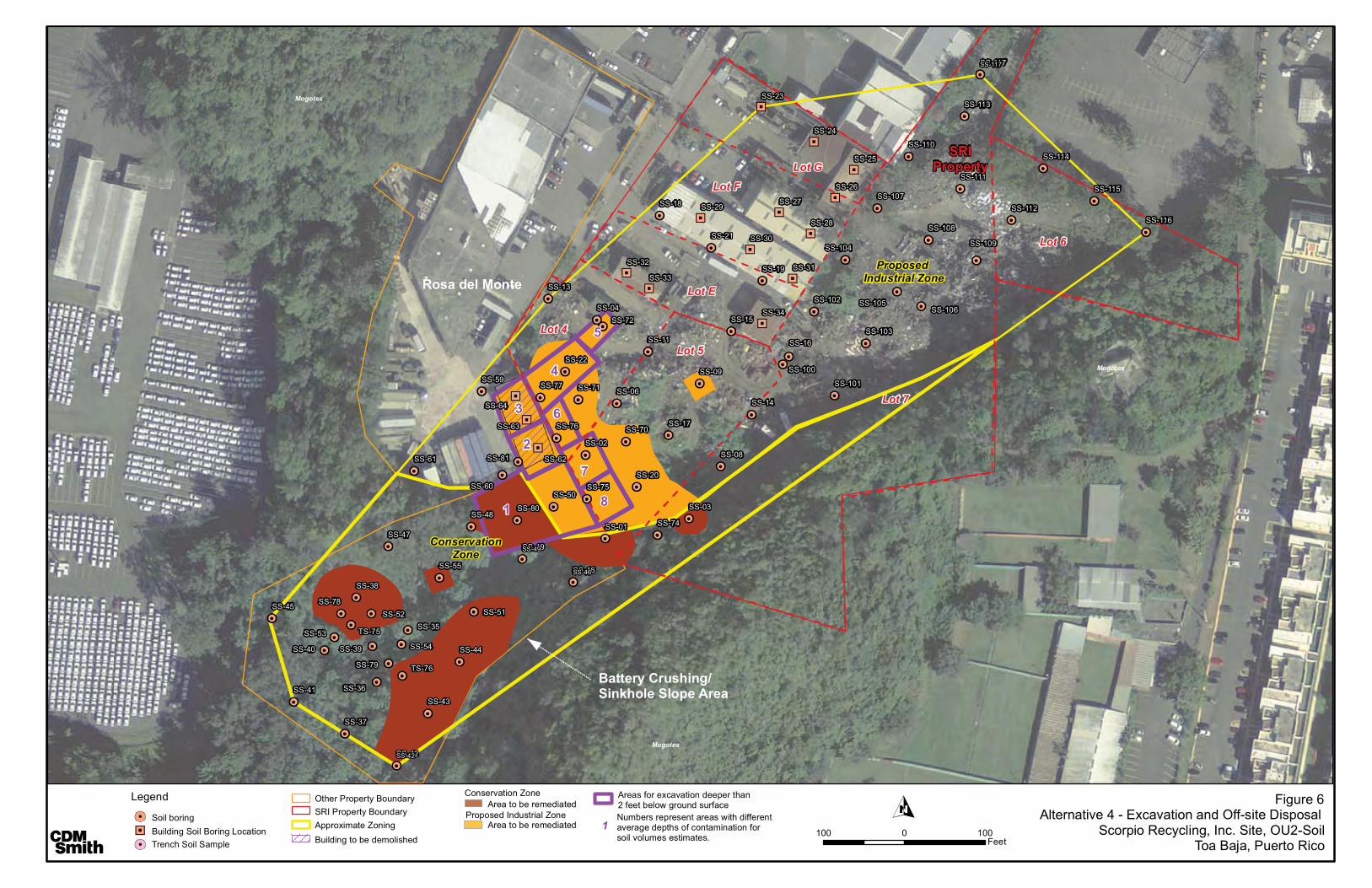
SS-117
SS-113
SS-114
SS-115
SS-116SS-112
SS-111
SS-110
SS-107
SS-108
SS-109
SS-106SS-105
SS-104
SS-103
SS-102
SS-19
SS-21
SS-18
SS-15
SS-16
SS-101SS-09
SS-11
SS-17
SS-20
SS-04
SS-59
SS-22
SS-06
SS-02
SS-01
SS-50SS-60
SS-49
SS-48
SS-61
SS-47
SS-55
SS-51
SS-44
SS-35
SS-38
SS-40
SS-36
SS-43
SS-42
SS-37
SS-41
SS-72
SS-77
SS-76
SS-71
SS-70
SS-75
SS-45
SS-39
TS-75SS-53
SS-78
SS-79 TS-76
SS-52
SS-54
SS-14
SS-08
SS-03
SS-74
SS-13
SS-100
SS-46
SS-80
SS-81
SS-23
SS-24
SS-25
SS-26
SS-27
SS-28
SS-29
SS-30
SS-31SS-32
SS-33
SS-34
SS-62
SS-63
SS-64
Mogotes
Mogotes
Mogotes
ConservationZone
Proposed Industrial Zone
SRIProperty
Lot 6
Lot 7
Lot 4
Lot E
Lot F
Lot G
Lot 5
SS-117
SS-49
SS-42
SS-46
5
4
6
7
8
3
2
1
100 1000Feet
Other Property BoundaryLegend
Soil boringBuilding Soil Boring LocationTrench Soil Sample
SRI Property Boundary
Rosa del Monte
Battery Crushing/Sinkhole Slope Area
Figure 6Alternative 4 - Excavation and Off-site Disposal
Scorpio Recycling, Inc. Site, OU2-SoilToa Baja, Puerto Rico
Approximate Zoning
Conservation Zone
Building to be demolished
Area to be remediated
Area to be remediatedProposed Industrial Zone
Areas for excavation deeper than 2 feet below ground surface
1Numbers represent areas with different average depths of contamination for soil volumes estimates.

1 | P a g e
LA AGENCIA FEDERAL DE PROTECCIÓN AMBIENTAL ANUNCIA PLAN PROPUESTO
El Plan Propuesto identifica la alternativa preferida para abordar la contaminación de suelos en la unidad de operaciones 2 (OU2) del Lugar de Reciclaje de Superfondo Scorpio en Toa Baja, Puerto Rico y provee las razones que sustentan esta preferencia. La alternativa preferida por la Agencia Federal de Protección Ambiental (EPA, por sus siglas en inglés) para abordar la contaminación de suelos es la Alternativa No. 3b, Cubrir con gravilla la propiedad de la compañía de Reciclaje Scorpio y cubrir con tierra el área de conservación. Este remedio también incluye controles institucionales
1 para
abordar ciertas áreas sin caracterizar debajo de edificios que podrían permanecer y para prevenir la perturbación de las cubiertas de suelo. Este plan propuesto incluye resúmenes de todas las alternativas de limpieza evaluadas para los suelos contaminados en el lugar. Este documento es publicado por la EPA, la agencia principal en las actividades del lugar, con la concurrencia de la Junta de Calidad Ambiental de Puerto Rico (JCA, por sus siglas en inglés), la agencia de apoyo. La EPA está emitiendo este plan propuesto como parte del programa de relaciones con la comunidad bajo la sección 117(a) de Respuesta Ambiental Comprensiva, Ley de Compensación y Responsabilidad (CERCLA, por sus siglas en inglés, comúnmente conocida como el programa de Superfondo). Este plan propuesto resume la información que puede ser encontrada con mayor detalle en la investigación de remediación (RI, por sus siglas en inglés) y los reportes del estudio de viabilidad (FS, por sus siglas en inglés) y otros documentos contenidos en el récord administrativo del lugar.
11
Los controles institucionales son instrumentos no
manipulados, tales como controles administrativos y legales, que ayudan a minimizar el potencial de exposición humana a contaminación y/o proteger la integridad de la alternativa. Más información sobre los controles institucionales puede ser encontrada en: http://www.epa.gov/fedfac/pdf/ic_ctzns_guide.pdf.
ROL DE LA COMUNIDAD EN EL PROCESO DE SELECCIÓN
La EPA y la JCA confían en la opinión del público para asegurar que las preocupaciones de la comunidad sean consideradas en la selección de una alternativa efectiva para cada Lugar de Superfondo. En este punto, los reportes de RI, FS y este plan propuesto se han hecho públicos para un periodo de comentarios del público que comienza el 7 de agosto de 2013 y termina el 6 de septiembre de 2013.
Una vista pública para discutir este plan propuesto se ha programado para el 14 de agosto de 2013 en la cancha de baloncesto de la Urbanización Altagracia de 6:00-8:00 pm. Esta vista pública es una oportunidad para que la comunidad provea comentarios verbales o escritos sobre este Plan Propuesto. La EPA anima al público a obtener una comprensión más completa sobre el lugar y sobre las actividades de Superfondo que se han realizado en el mismo.
Programa de Superfondo – Región 2 Lugar de Superfondo de Scorpio Recycling Unidad de Operaciones 2: Suelos Agosto 2013
ANOTE EN SU CALENDARIO PERIODO DE COMENTARIOS PÚBLICOS
7 de agosto de 2013–6 de septiembre de 2013 La EPA estará aceptando comentarios sobre el Plan Propuesto por escrito durante el periodo de comentarios. Los comentarios deberán ser dirigidos a: Adalberto Bosque, PhD Gerente de Proyectos Remediales Agencia Federal de Protección Ambiental de EU City View Plaza II Suite 7000 #48 PR-165 Km. 1.2 Guaynabo, PR 00968-8069 Teléfono: (787) 977-5825 Fax: (787) 289-7104 e-mail: [email protected] VISTA PUBLICA 14 agosto de 2013 a las 6:00 pm Cancha Bajo Techo, Urbanización Altagracia Toa Baja, Puerto Rico

2 | P a g e
La EPA, en consulta con la JCA, seleccionará la alternativa final para los suelos contaminados luego de revisar y considerar toda la información sometida durante los 30 días del periodo de comentario público. La EPA, en consulta con JCA, podrá modificar la alternativa preferida o seleccionar otra respuesta de acción presentada en este Plan Propuesto basado en nueva información obtenida o comentarios del público. Por lo tanto, se recomienda al público revisar y comentar sobre todas las alternativas presentadas en este Plan. Comentarios recibidos en la vista pública, así como comentarios escritos, serán documentados en la Sección "Resumen de Respuestas" del Registro de Decisión (ROD, por sus siglas en inglés), el documento que formaliza la selección de la alternativa.
Para más información sobre el Lugar, incluyendo la alternativa preferida por la EPA para el Lugar de Superfondo Scorpio contacte a:
Adalberto Bosque, PhD Gerente del Proyecto
(787) 977-5825
Ms. Brenda Reyes Relaciones con la
comunidad (787)-977-5869
Agencia Federal de Protección Ambiental
City View Plaza II- Suite 7000 48 RD, 165 Km. 1.2
Guaynabo, PR 00968-8069 (787) 977-5865
http://www.epa.gov/region02/superfund/npl/scorpio DESCRIPCIÓN DEL LUGAR
Scorpio Recycling Inc. (SRI) es una instalación de reciclaje de metal, localizada en la calle Acuña en la Carr. #2, Km 19.7, Barrio Candelaria, Toa Baja, Puerto Rico (Figura 1). El Lugar está definido como la propiedad de SRI y porciones contaminadas de dos propiedades adyacentes: Rosa del Monte (la propiedad Rosa del Monte) al oeste y el área de conservación al sur. (Figura 2). El Lugar tiene tres áreas zonificadas: industrial, residencial y de conservación como se muestra en la figura 3. Sin embargo, el gobierno de Puerto Rico y el municipio de Toa Baja han iniciado una re-zonificación entera de la propiedad de SRI de industrial/residencial a industrial.
El lugar está aproximadamente a cuatro millas al oeste del pueblo de Bayamón y se encuentra dentro de una cadena de colinas de piedra caliza (conocidas como mogotes) que flanquean el margen sur de la llanura costera del Atlántico en el norte de Puerto Rico.
La propiedad de SRI consiste de una parcela relativamente plana de nueve acres que desciende suavemente hacia el norte en su parte norte y al sur en su parte sur. Dos acres y medio de la propiedad SRI son propiedad de la compañía Astur Metals y 6.5 acres son propiedad de consorcio del SRI. La propiedad fue operada por Astur Metals, después por SRI y luego por Scrapyard Recycling Inc., en virtud de un contrato de arrendamiento. La propiedad SRI incluye una oficina administrativa, edificios de procesamiento de aluminio, edificios de clasificación de cobre, un taller de mantenimiento y un edificio de la acumulación de vehículos chatarra. Hay multiples pilas de residuos que quedan en el Lugar por parte de sus operadores anteriores, los cuales incluyen aproximadamente 10,000 yd
3 de
tierra, 5400 yd3 de chatarra, 6800 yd
3 de neumáticos
y 900 yd3 de escombros.
El archivo de expediente administrativo, que contiene la información sobre la que se basará la selección de las medidas de respuesta, está disponible en los siguientes lugares: Librería Municipal de Toa Baja Calle Luis Muñoz Rivera # 55 Toa Baja, Puerto Rico 00949 (787) 794-2145 Horario: lunes – viernes 9:00 am a 3:00 pm Agencia Federal de Protección Ambiental City View Plaza II- Suite 7000 #48 PR-165 Km. 1.2 Guaynabo, PR 00968-8069 (787) 977-5865 Horario: lunes – viernes 9:00 am a 5:00 pm Por Cita Junta de Calidad Ambiental de Puerto Rico Programa de Superfondo y Respuesta a Emergencias Edificio de Agencias Ambientales Cruz A. Matos Urbanización San José Industrial Park 1375 Avenida Ponce de León San Juan, PR 00926-2604 (787)767-8181 ext. 3207 Horario: lunes – viernes 9:00 am a 3:00 pm Por Cita Centro de Registros EPA, Región 2 290 Broadway, 18th Floor New York, New York 10007-1866 (212) 637-4308 Horario: lunes - viernes – 9:00 am a 5:00 pm Por Cita.

3 | P a g e
Topografía y drenaje El lugar está ubicado en el extremo este del terreno kárstico de la costa de la Provincia Kárstica del Norte (PNL, por sus siglas en inglés). Las características cársticas prominentes en los alrededores del Lugar son mogotes, una sumidero- valle abierto y las capas gruesas de depósitos de manta, que consiste principalmente de arcilla limosa. En general, el declive del Lugar es hacia el norte, a una altura de aproximadamente 246 pies (75 metros) sobre el nivel promedio del mar. El Océano Atlántico está a aproximadamente cuatro millas al norte del Lugar. La escorrentía superficial del Lugar drena al norte, al drenaje de aguas pluviales a lo largo de la Carr. #2 y al sur de la zona de conservación.
Geología El Lugar se encuentra a lo largo de la costa centro-norte de Puerto Rico y se encuentra dentro de la NLP. Las formaciones de la roca subterránea de la NLP consisten en una secuencia de piedra caliza y sedimentos terrígenos del Oligoceno al Plioceno. Dentro de la zona del cuadrante topográfico de Bayamón, la secuencia se divide en seis formaciones, que, en orden descendente de edad, incluyen: Formación de San Sebastián, La Piedra Caliza de Lares, La Arena de Mucarabones, Formación de Cibao, La Piedra Caliza de Aguada y La Piedra Caliza de Aymamón.
El Lugar está rodeado de piedra caliza cárstica, entre ellos los mogotes, los depósitos no consolidados de manta y una densa vegetación del valle-sumidero ubicado al suroeste de la propiedad de SRI.
Las fracturas o cavidades en las rocas calizas subyacentes al sumidero añaden porosidad secundaria en la piedra caliza a través del cual pueden fluir grandes cantidades de agua subterránea. El área de conservación está a 70 metros por debajo de la elevación de la propiedad. Dos mogotes prominentes están presentes en el Lugar, uno al noroeste del Lugar, de 90 pies (27 metros) sobre la propiedad SRI y uno hacia el sureste a 155 pies por encima de la propiedad de SRI. Los mogotes están compuestos de la piedra caliza de la formación Aymamón en la parte superior de los picos y de la Piedra Caliza de la formación Aguada en la base, ellos se encuentran rodeados de depósitos de manta.
Los suelos en las inmediaciones de la propiedad SRI se clasifican como arcilla Matanzas, que consiste en suelos levemente inclinados a los pies de las laderas y en los pequeños valles entre las
colinas de piedra caliza. El tipo de suelo predominante observado en perforaciones en la propiedad SRI, la propiedad Rosa del Monte y la zona de conservación era una arcilla limosa de color marrón rojizo o limo con fragmentos de piedra caliza.
Hidrogeología La hidrogeología regional se caracteriza por un acuífero no confinado superior compuesto de las partes permeables de la Formación Cibao, la Formación Aguada, la Piedra Caliza de Aymamón y las partes permeables superiores de los depósitos no consolidados que recubren. La elevación de la superficie del nivel freático del acuífero superior es controlada por la topografía de la superficie y las características de drenaje superficial. La dirección del flujo predominante es hacia el norte, hacia la llanura costera, donde el acuífero está cortado por cauces fluviales. El agua subterránea descarga en los canales. La principal área de recarga del acuífero superior es en las colinas kársticas en donde se encuentra el Lugar.
El acuífero inferior de la PNL contiene agua bajo presión artesiana en todo el área en la que está cubierta por la unidad de semi-confinamiento. El agua de los acuíferos inferiores va desde agua fresca a salada. El acuífero principal por debajo del Lugar no está confinado y está ubicado dentro de la Piedra Caliza de Aguada y de las formaciones de piedra caliza Cibao. La profundidad del agua en el lugar varía de aproximadamente 63 a 190 pies por debajo de la superficie del suelo (BGS, por sus siglas en inglés)
Reconocimiento Ecológico Las zonas con vegetación del Lugar y las que proporcionan hábitats marginales / adecuadas se extienden en dirección sur desde la cerca que separa los edificios existentes de la parte restante del Lugar, hacia y dentro del área de conservación. La eliminación de montones de chatarra en el Lugar creó condiciones favorables para la colonización de especies vegetales pioneras e invasoras
Información con respecto a las especies amenazadas y en peligro de extinción y los entornos ecológicamente sensibles que puedan existir en o en las proximidades del Lugar fue obtenida de las distintas agencias gubernamentales. La Agencia Federal de Pesca y Vida Silvestre informó que el Lugar se encuentra en el hábitat de la boa puertorriqueña (Epicrates inornatus). Además, las plantas en peligro Vahl boj (Buxus vahlii), Palo de Rosa (Ottoschulzia rhodoxylon) y árboles/arbustos pequeños (Schoepfia areanaria y Daphnopsis

4 | P a g e
helleriana) también pueden ocurrir en el área. El Departamento de Puerto Rico de Recursos Naturales y Medio Ambiente (DRNA, por sus siglas en inglés) informó que una revisión de sus registros para el Lugar y los alrededores indicaron no haber reportes de apariciones de especies raras, amenazadas y / o en peligro de extinción. Sin embargo, los mogotes que se encuentran en el Lugar y en las áreas circundantes son parte de las Áreas Prioritarias de Conservación kársticas del DRNA de Puerto Rico, y se consideran áreas de planificación especial de la zona kárstica de Puerto Rico.
Meteorología El clima para el lugar está clasificado como tropical marino y es moderado por los vientos alisios casi constantes que se originan en el noreste. Las temperaturas promedio máximas y mínimas anuales para la zona son 86.3 grados Fahrenheit (° F) y 69.1° C, respectivamente. Las temperaturas más bajas se dan en enero, febrero y marzo, mientras que las temperaturas más altas se registran en julio y agosto. La precipitación anual promedio es de 61 pulgadas.
Demografía y Uso de la Tierra El lugar está rodeado de otras industrias y almacenes. Aproximadamente 900 personas viven a 0.25 millas del Lugar y 46.197 personas viven dentro de una milla. Según el Censo de EE.UU. 2010, la población total del Municipio de Toa Baja fue de aproximadamente 73.954. La población dentro de un radio de cuatro millas del lugar es de aproximadamente 155,000.
HISTORIA DEL LUGAR La facilidad inició operaciones en 1972 bajo el nombre de Astur Metals, Inc. y pasó a llamarse SRI en 1988. De 1972 a 2010, la instalación recibió y acumuló chatarra que, una vez recibida, eran compactadas, trituradas y envasadas para su transporte. Durante las primeras operaciones del Lugar, baterías trituradas provocaron derrames de ácido sulfúrico en el suelo. El escurrimiento ácido de la zona de trituración de batería desembocaba en el área de conservación en el que se podría infiltrar en las aguas subterráneas. La trituración y el reciclaje de baterías cesaron en 1983. Además, permitían que los fluidos de los automóviles, tanques, electrodomésticos, aparatos electrónicos y otros materiales se drenaran hasta el suelo. Los metales de desecho se almacenaban en la instalación antes de ser enviados fuera del lugar. Varias pilas de chatarra, algunas de hasta 100 pies de altura que cubrían aproximadamente cuatro acres de terreno
fueron espaciados por caminos de tierra. Los materiales observados en estas pilas incluyeron coches aplastados, tanques de gas, tanques de propano, electrodomésticos, computadoras, generadores aplastados, remolques triturados, tanques de almacenamiento de metal y tubos de metal. Este Lugar fue incluido en la Lista de Prioridades Nacionales del Superfondo el 4 de febrero de 2000, debido a la posible migración de plomo al agua subterránea.
En el 2002, la División de Emergencia y Respuesta Remedial (ERRD, por sus siglas en inglés) excavaron y retiraron aproximadamente 15,000 toneladas de suelo de la zona de reciclaje de baterías y la pendiente que conduce al sumidero. La tierra contaminada se estabilizó con fosfato trisódico (TSP, por sus siglas en inglés) antes de su eliminación en un vertedero. La fuente no fue excavada totalmente; hubo desechos que se mantuvieron enterrados bajo el cobertizo del edificio Rosa del Monte y porciones del estacionamiento pavimentado Rosa del Monte. Ninguna acción de eliminación se realizó en las grandes áreas de pilas de chatarra. Las acciones de remoción cesaron en junio de 2004.
Una investigación del agua subterránea se llevó a cabo en el lugar como parte de la Unidad de Operaciones 1 (OU1) RI desde 2002 a 2006. Como resultado de esta investigación, se concluyó que el agua subterránea no se vio afectada por los contaminantes relacionados con el Lugar. Un Récord de Decisión (ROD) de No Acción para OU1 fue firmado en septiembre de 2006. SRI cesó sus operaciones en 2010 debido a la quiebra.
En agosto de 2010, la EPA inició un RI para definir el alcance de la contaminación del suelo (OU2) en el Lugar. Se recolectó un total de 61 muestras de suelo (12 en la parte norte de la propiedad SRI, 18 en la zona sur de la propiedad SRI, 7 en la propiedad Rosa del Monte, 24 en el área de conservación). Se recogieron muestras adicionales en enero de 2011, incluyendo dos muestras de suelo superficial en el área de la trinchera del área de conservación, previamente excavada por la EPA.
En noviembre de 2011, 18 perforaciones en la zona norte de la propiedad SRI se muestrearon y siete muestras compuestas se obtuvieron de los montones del suelo/desechos (uno de cada pila) para caracterizar los residuos para su eliminación. Ubicaciones de las perforaciones se presentan en la Figura 3.

5 | P a g e
NATURALEZA Y ALCANCE DE LA CONTAMINACIÓN
La naturaleza y el alcance de la contaminación se evaluaron mediante la comparación de los resultados analíticos de las muestras de suelo recogidas en el lugar a los criterios de detección en lugares específicos. En general, los criterios de selección en lugares específicos son el valor más estricto de los siguientes: criterios de salud humana, los criterios ecológicos, o los niveles de evaluación regionales para los contaminantes en los lugares Superfondo de suelo residencial o para la protección de las aguas subterráneas.
Resultados de Muestras de Caracterización en Pilas de Residuos en la Propiedad SRI Siete muestras de suelo superficial se obtuvieron de las pilas de residuos ubicados en la parte norte de la propiedad SRI. Las pilas de desechos de las que se tomaron muestras se supone que son representativas de todas las pilas que existían en todo el Lugar y por lo tanto se consideran muestras de la zona de origen. Los resultados del análisis del procedimiento de Lixiviación Característico de Toxicidad (TCLP, por sus siglas en inglés) indican que los materiales en las pilas de desechos no son peligrosos.
Ocho metales sobrepasaron los criterios de detección en concentraciones significativas: arsénico, cadmio, cromo, cobalto, cobre, plomo, níquel y zinc. El mercurio y antimonio también superaron sus criterios de detección en todas las muestras, aunque a niveles relativamente más bajos. Bario y talio sobrepasaron los criterios de detección en sólo una de las muestras. Aluminio, bario, hierro, manganeso, talio y vanadio también excedieron los criterios de detección, pero en general no superaron los niveles de fondo.
Los compuestos orgánicos detectados por encima de criterios de detección incluyen un compuesto orgánico volátil (VOC, por sus siglas en inglés) (disulfuro de carbono), ocho compuestos orgánicos semivolátiles (SVOC) (cinco hidrocarburos aromáticos policíclicos [PAH] y tres ftalatos) y dos bifenilos policlorados (PCB) (Aroclor 1248 y Aroclor 1254). El disulfuro de carbono y bis (2-etilhexil) ftalato se detectaron en concentraciones significativas por encima de los criterios de selección. Bencilo y butilo, ftalato de di-n-butil ftalato y naftaleno superó sus criterios de selección en todas las muestras, pero en concentraciones más bajas. Benzo(a)antraceno, benzo(a)pireno y benzo (b)fluoranteno superaron sus criterios de detección en una sola muestra.
Resultados de las Pruebas de Suelos en los Barrenos en la Propiedad SRI Un total de 54 muestras de superficie del suelo y 119 muestras del subsuelo se obtuvieron de perforaciones del suelo en la propiedad SRI, incluyendo la parte sur de la propiedad una vez utilizado para operaciones de trituración de baterías, chatarra de las zonas de patio en la parte central y norte de la propiedad y en el interior y alrededor de varios edificios de procesos y operaciones (Figura 3).
Dieciocho metales superaron sus criterios de detección en los suelos de superficie: aluminio, antimonio, arsénico, bario, cadmio, cromo, cobalto, cobre, hierro, plomo, manganeso, mercurio, níquel, selenio, plata, talio, vanadio y zinc. Los mismos metales, con la excepción de bario, selenio, vanadio y zinc, se encontraron en el subsuelo. Además, berilio superó el criterio en una muestra del suelo superficial. Los más altos niveles de metales que exceden los criterios de detección se encuentran en tres áreas principales: el área principal de las baterías / plomo, el edificio de procesamiento de aluminio y al sur/sureste del Taller de Mantenimiento (Figura 2).
Tres compuestos orgánicos volátiles, 14 SVOCs, 16 plaguicidas y dos PCB excedieron los criterios de detección en los suelos superficiales. Dos VOCs, cinco de los SVOCs, cuatro de los pesticidas y dos PCBs se detectaron en el subsuelo en concentraciones superiores a los criterios de detección. Se detectaron cinco compuestos orgánicos: 1,4-dioxano, cloruro de bis(2-etilhexil) ftalato, el benzo(a)pireno, N-nitroso-di-n-propilamina y la dieldrina.
Resultados de las muestras de suelo de Rosa del Monte Siete muestras de suelo de la superficie y 41 muestras de subsuelo se recopilaron de la propiedad Rosa del Monte (Figura 3). Doce metales excedieron su criterio de revisión en los suelos de superficie: aluminio, antimonio, arsénico, cadmio, cromo, cobalto, cobre, hierro, plomo, manganeso, talio y vanadio. El grupo de minerales que exceden su criterio en el subsuelo fue similar: aluminio, antimonio, arsénico, cadmio, cromo, cobalto, cobre, hierro, plomo, manganeso, talio y zinc. Hay un punto caliente de contaminación del suelo de la superficial en el borde suroeste del área del estacionamiento. Una muestra tenía el máximo de concentraciones para nueve de los 12 metales que excedieron los criterios.

6 | P a g e
Este lugar recibe escorrentía del área del estacionamiento y esta escorrentía podría ser el origen de la contaminación de metales, aunque no se detectaron PAHs en esta muestra, que comúnmente son indicativos de escorrentía. En el subsuelo, una muestra ubicada en el lado sureste del almacén era la más contaminada. Esta muestra contenía las concentraciones máximas para nueve de los 12 metales que excedieron los criterios. No hay un patrón claro de la distribución de metales en esta muestra (i.e., las concentraciones ni aumentan ni disminuyen con la profundidad).
Un SVOC (n-nitroso-di-n propilamina) y dos pesticidas (dieldrina y aldehído de endrina) fueron detectados sobre los criterios de detección en los suelos de superficie. Un VOC (cis-1,3- dicloropropeno), dos SVOCs (bis(2-cloroetil) éter y n-nitroso-di-n propilamina) y tres pesticidas (alpha-BHC, beta-BHC y dieldrina) fueron detectados en el subsuelo en concentraciones excediendo los criterios de detección. Todos los compuestos orgánicos se detectaron en concentraciones excediendo los criterios en tres muestras o menos. Ninguno de los compuestos orgánicos se detectó en concentraciones o distribuciones significativas en la propiedad de Rosa del Monte.
Resultados de las muestras de suelo del área de conservación Veinticuatro muestras de suelo de la superficial y 105 muestras subsuelo fueron recopiladas del área de conservación (Figura 3). Dieciséis metales excedieron sus criterios de detección en suelos de la superficie: aluminio, antimonio, arsénico, cadmio, cromo, cobalto, cobre, hierro, plomo, manganeso, mercurio, níquel, selenio, talio, vanadio y zinc. Once metales excedieron sus criterios en los suelos del subsuelo: aluminio, antimonio, arsénico, cromo, cobalto, cobre, hierro, plomo, manganeso, selenio y talio. La mayoría de estas muestras en el área de conservación tenían exceso de varios metales. Sin embargo, la mayor contaminación de metales está en la porción noreste, más cercana de la propiedad SRI.
Seis SVOCs (benzo(a)pireno, bis(2-cloroetil) éter, bis(2-etilhexil)ftalato, butilo bencilo ftalato, nitrobenceno y n-nitroso-di-n propilamina), cuatro pesticidas (4-4’-DDD, 4,4’-DDE, 4,4’-DDT y dieldrina) y cuatro PCBs (Aroclor 1248, 1254, 1260 y1262) fueron detectados sobre los criterios de detección en los suelos de superficie. Cuatro SVOCs (benzo(a)pireno, bis(2-cloroetil) éter, n-nitroso-di-n propilamina y naftalina), dos pesticidas (alpha-BHC y dieldrina) y tres PCBs (Aroclor1248, -1254 y -1262) fueron detectados en el subsuelo en concentraciones que exceden los criterios de
¿QUÉ ES EL RIESGO Y CÓMO SE CALCULA?
Una evaluación estándar de riesgos a la salud humana del Superfondo es un análisis de los potenciales efectos adversos a la salud causados por la liberación de sustancias peligrosas de un lugar en ausencia de cualquier acción para controlar o mitigar éstas bajo los usos actuales o futuros del terreno. Se usa un proceso de cuatro pasos para evaluar los riesgos de salud humana relacionadas al lugar para escenarios razonables de máxima exposición.
Identificación de peligro: En este paso, el COPCs en el lugar en
varios medios (i.e., suelo, agua subterránea y aire) son identificados en base a tales factores como toxicidad, frecuencia de ocurrencia y suerte y transporte de los contaminantes en el ambiente, concentraciones de los contaminantes en medios específicos, movilidad, persistencia y bioacumulación.
Evaluación de exposición: En este paso, los diferentes medios de exposición por los cuales las personas estar expuestas a los contaminantes en aire, agua, suelo, etc. identificados en el paso anterior son evaluados. Ejemplos de medios de exposición incluyen ingestion incidental de y contacto dermal con suelo contaminado e ingestion incidental de y contacto dermal con aguas subterráneas. Factores relacionados con la evaluación de exposición incluyen, pero no están limitados a, las concentraciones en medios específicos a las que las personas pueden estar expuestas y la frecuencia y duración de esa exposición. Usando estos factores, un scenario de “maxima exposición razonable”, el cual muestre el nivel más alto de exposición humana que podría esperarse razonablemente que suceda, es calculado.
Evaluación de toxicidad: En este paso, los tipos de efectos adversos a la saludos asociados con la exposición química y la relación entre la magnitud de la exposición y a la severidad de los efectos adversos se determina. Los efectos potenciales de salud son específicos por químico y pueden incluir el riesgo de desarrollar cáncer durante la vida u otros peligros no cancerígenos, tales como cambios en las funciones normales de los órganos dentro del cuerpo (por ejemplo, cambios en la efectividad del sistema inmunológico). Algunos químicos son capaces de causar ambos peligros de salud, cancerígenos y no cancerígenos.
Caracterización del riesgo: Este paso resume y combina resultados
de las evaluaciones de exposición y toxicidad para proveer una evaluación cuantitativa de los riesgos del lugar para todos los COPCs. Las exposiciones son evaluadas basadas en el riesgo potencial de desarrollar cáncer y el potencial para peligros de salud no cancerígenos. La probabilidad de que un individuo desarrolle cáncer se expresa como una probabilidad. Por ejemplo, un riesgo de cáncer 10
-4 significa un “un en diez mil en exceso de riesgo de
cáncer”; o un cáncer adicional puede ser visto en una población de 10,000 personas como resultado de una exposición a los contaminantes del lugares bajo las condiciones identificadas en la Evaluación de Exposición. Las regulaciones actuales de Superfondo para exposiciones identifican el rango para determinar si una acción remedial es necesaria como un riesgo de cáncer individual en exceso 10
-4 a 10
-6, correspondiendo a uno en diez mil
a uno en un millón riesgo en exceso de cáncer. Para peligros de salud no cancerígenos, un “índice de peligro” (HI) es calculado. El concepto clave para un HI no cancerígeno es que un límite (medido como un HI de menos o igual a 1) existe bajo el cual los peligros de salud no cancerígenos no se espera que sucedan. La meta de protección es 10
-6 para riesgo de cáncer y un HI de 1 para
el peligro de salud no cancerígeno. Los químicos que exceden un riesgo de cáncer 10
-4 o un HI de 1 son típicamente aquellos que
requerirán acción remedial en el Lugar.

7 | P a g e
detección. Sin embargo, los compuestos orgánicos no se detectaron en concentraciones significativas en el área de conservación.
ALCANCE Y ROL DE LA ACCIÓN
Las actividades remediales de un lugar en ocasiones son segregadas en diferentes fases, o unidades operables, para que la remediación de diferentes medios ambientales o áreas de un lugar puedan proceder por separado diligentemente. La EPA ha designado dos unidades operables para este Lugar.
El OU1 se llevó a cabo para investigar las aguas subterráneas en el Lugar. OU2, el cual es el enfoque de este Plan Propuesto, aborda la contaminación del suelo en áreas industriales y de conservación.
RESUMEN DE RIESGOS DEL LUGAR
Resumen de riesgo El propósito de la evaluación del riesgo estándar es identificar riesgos cancerígenos potenciales y peligros a la salud no-cancerígenos en un lugar asumiendo que no se tome más ninguna acción remedial. Una evaluación de riesgo humano estándar se llevó a cabo en el Lugar para evaluar riesgos cancerígenos actuales y futuros y peligros de salud no cancerígenos basados en los resultados del RI.
Además, una Evaluación de Riesgo Ecológico por Detección se llevó a cabo también en el Lugar para evaluar el riesgo que se presenta a los receptores ecológicos debido a la contaminación relacionada con el Lugar.
Evaluación de riesgos a la salud humana Una evaluación de cuatro pasos de riesgos a la salud humana fue usada para evaluar los riesgos de cáncer y peligros a la salud no cancerígenos. El proceso de cuatro pasos está compuesto por: Identificación de Peligro de los Químicos de Potencial Preocupación (COPCs, por sus siglas en inglés), Evaluación de Exposición, Evaluación de Toxicidad y Caracterización de Riesgo.
La evaluación de referencia de los riesgos de salud
humana comenzó seleccionando los COPCs en los
suelos y en el subsuelo que pudieran causar efectos
adversos a la salud en poblaciones expuestas. Los
escenarios actuales y futuros de uso de la tierra
incluyeron los siguientes medios de exposición y
poblaciones:
Trabajador del lugar (adulto): ingestión actual/futura, contacto dermal e inhalación de partículas del suelo y vapores para ambos la superficie del suelo y el subsuelo de las propiedades SRI y Rosa del Monte;
Residentes (niño/adulto): ingestión futura, contacto dermal e inhalación de partículas del suelo y vapores de la superficie de la propiedad SRI;
Intrusos (adolescentes): ingestión actual/futura, contacto dermal e inhalación de partículas del suelo y vapores para ambos la superficie del suelo y el subsuelo de las propiedades SRI y Rosa del Monte; así como del área de conservación, y
Trabajadores de la construcción (adulto): ingestión actual/futura, contacto dermal e inhalación de partículas del suelo y vapores para ambos la superficie del suelo y el subsuelo
En esta evaluación de riesgo a la salud humana, las concentraciones de los puntos de exposición fueron estimadas usando el máximo de concentración detectado de un contaminante o el 95% de límite de seguridad de la concentración promedio. Las ingestas diarias crónicas se calcularon basados en la exposición máxima razonable (RME, por sus siglas en inglés), el cual es la mayor exposición razonablemente anticipada que se espera que ocurra en el Lugar. El RME está diseñado para estimar un escenario conservador de exposición que esté aun en el rango de posibles exposiciones. Se desarrollaron además asunciones de exposición de tendencia central. Un resumen completo de todos los escenarios de exposición puede ser encontrado en el reporte de la evaluación de riesgos de salud del Lugar.
Suelo de la superficie Los riesgos y peligros fueron evaluados para la exposición actual y futura al suelo de superficie (Tabla 1). Los COPCs identificados en la superficie del suelo fueron arsénico, antimonio y plomo. Aunque se detectaron orgánicos en concentraciones mayores a los criterios de detección durante el RI ninguno se identificó como COPCs. Las poblaciones de interés incluyeron trabajadores del Lugar, residentes niños y adultos, intrusos adolescentes y trabajadores de la construcción adultos. Los riesgos de cáncer para todas las poblaciones receptoras evaluadas estuvieron dentro de o por debajo del rango aceptable de riesgo de la EPA de 10
-6 a 10
-4
con la excepción de un niño/adulto residente el cual fue sobre el rango aceptable de riesgo (para mayor clarificación, ver el encasillado de discusión en la página 6 titulada, “¿Qué es el riesgo y cómo se

8 | P a g e
calcula?”). Los índices de riesgo no cancerígeno (HI) para los intrusos en todas las áreas no excedió el valor aceptable de la EPA de 1. El plomo excedió el valor de revisión residencial de 400 mg/kg y el valor de revisión industrial de 800 mg/kg. El arsénico estaba elevado en dos áreas aisladas en el medio de una contaminación de plomo. Concentraciones de Vanadio se detectaron fuera del Lugar, lo que indica que el vanadio no es un contaminante relacionado con el Lugar.
Subsuelo Los riesgos y peligros fueron evaluados para la exposición actual y futura al subsuelo (Tabla 2). El COPC identificado en el subsuelo fue plomo. Aunque se detectaron orgánicos en concentraciones que exceden los criterios de revisión durante el RI ninguno fue identificado como COPC. La población de interés incluyó trabajadores de la construcción. Los riesgos de cáncer estaban por debajo o dentro de los rangos aceptables por la EPA. Los peligros no cancerígenos excedieron el valor aceptable de 1 de la EPA, basado principalmente en concentraciones de vanadio. Las concentraciones de vanadio detectado en el lugar fueron similares a las concentraciones detectadas fuera del Lugar, lo que indica que el vanadio no es un contaminante relacionado con el Lugar. El plomo excedió el valor de revisión industrial de 800 mg/kg.
Tabla 1 Resumen de riesgos cancerígenos y no cancerígenos (Suelo de la superficie)
Receptor Índice de Peligro
Riesgo de Cáncer
Propiedad SRI Trabajador del lugar – actual
3 5 x 10⁻⁵
Trabajador del lugar – futuro
2 4 x 10⁻⁵
Intruso – actual 1 6 x 10⁻⁶
Intruso – futuro 0.9 4 x 10⁻⁶
Residente– futuro 24 2 x 10⁻⁴
Propiedad Rosa del Monte
Trabajador del lugar – actual
2 2 x 10⁻⁵
Trabajador del lugar – futuro
2 4 x 10⁻⁵
Intruso– actual 1 3 x 10⁻⁶
Intruso – futuro 0.8 2 x 10⁻⁶
Área de conservación
Intruso – actual 1 3 x 10⁻⁶
Intruso – futuro 1 3 x 10⁻⁶
Pilas de basura Intruso – actual 0.6 2 x 10
-6
Tabla 2 Resumen de riesgos cancerígenos y no cancerígenos (Subsuelo)
Receptor Índice de Peligro
Riesgo de cáncer
Propiedad SRI Trabajador de la construcción – actual
2 1 x 10⁻⁶
Propiedad Rosa del Monte Trabajador de la construcción – futuro
2 1 x 10⁻⁶
Evaluación de riesgo ecológico Una Evaluación de Riesgo Ecológico (SLERA) se llevó a cabo en porciones no desarrolladas del Lugar (área de conservación) para evaluar el potencial de riesgos ecológicos de la presencia de contaminantes en el suelo de la superficie. La SLERA se enfocó en evaluar el potencial de impactos a receptores ecológicos sensibles de constituyentes de riesgo relacionados al lugar por medio de la exposición al suelo. Las concentraciones fueron comparadas a los valores de revisión como un indicador del potencial para efectos adversos a receptores ecológicos. Un resumen completo de todos los escenarios de exposición puede encontrarse en el SLERA. Suelo de Superficie Hay potencial de efectos adversos para receptores ecológicos (invertebrados, reptiles, anfibios, pájaros y mamíferos) de exposición a suelo de superficie contaminado. Los criterios de revisión fueron excedidos para los metales (antimonio, cobre, plomo, mercurio y zinc), pesticidas (4,4’-DDE, 4,4’-DDT, dieldrina, sulfato de endosulfán, endrina, aldehído de endrina y metoxicloro) y dos compuestos orgánicos semi-volátiles (bis(2-etilhexil)ftalato y butilbencilftalato), el cual result en HQ mayor a lo a los valores aceptables de 1 (Tabla 3). A pesar de que había catorce químicos que excedieron un HQ de 1, lo cual indica riesgo inaceptable para los receptores ecológicos, solo siete, antimonio, cobre, plomo, mercurio, zinc, bis(2-etilhexil)ftalato y butilbencilftalato se identificaron como relacionados al Lugar y en concentraciones que lo suficientemente altas para causar efectos ecológicos inaceptables. Aunque el hábitat en la propiedad del Lugar es de baja calidad, una acción remedial que aborde los contaminantes relacionados al lugar es requerida para reducir el riesgo para los receptores ecológicos.

9 | P a g e
Resumen Basado en la evaluación de riesgo a la salud humana, los metales, específicamente el arsénico, plomo y antimonio, pueden representar un riesgo a la salud humana por medio de la ingestión en el área clasificada como residencial. Actualmente no hay residentes en el Lugar. El plomo representaría riesgos a la salud humana inaceptables para los trabajadores del Lugar o trabajadores de la construcción dentro del área clasificada como industrial; y el plomo puede representar riesgos inaceptables para los intrusos en el Lugar. Sin embargo, una solicitud para relocalizar el área clasificada como residencial a una de uso industrial está actualmente en proceso con la Junta de Planificación de Puerto Rico, y la probabilidad de que ese cambio sea aprobado es alta. En anticipación de que el área residencial sea reclasificada para uso industrial al momento de la acción remedial, el área clasificada como residencial será tratada como una zona para uso industrial. Basado en el SLERA específico para el lugar, el antimonio, cobre, plomo, mercurio, zinc, bis(2-etilhexil)ftalato y butilbencilftalato pueden representar riesgos inaceptables para receptores ecológicos en el área del Lugar que está clasificada para uso de conservación.
Tabla 3 Lista de cocientes de peligro para receptores ecológicos
Químico Cociente de peligro
Antimonio 1.9
Cobre 7.7
Plomo 13.9
Mercurio 655
Zinc 4.4
4-4’-DDE 1.5‡
4-4’-DDT 3.2‡
Dieldrina 3.1‡
Sulfato de endosulfán 8.3‡
Endrina 26‡
Aldehído de Endrina 65‡
Metoxicloro 49‡
Bis(2-etilhexil)ftalato 1.9
Butilbencilftalato 1.2
‡Compuesto no relacionado al lugar.
Basado en los resultado del RI y en la evaluación de los riesgos, la EPA ha determinado que los escapes actuales o posibles de sustancias peligrosas en el Lugar, si no se abordan por el remedio de preferencia o uno de las otras medidas activas consideradas, puede presentar una amenaza actual
o potencial para la salud humana y para el ambiente.
OBJETIVOS DE ACCIÓN REMEDIAL
Los objetivos de acción remedial (RAOs, por sus siglas en inglés) son metas específicas para proteger la salud humana y el ambiente. Estos objetivos están basados en información disponible y estándares, tales como requisitos aplicables (ARARs, por sus siglas en inglés), guías a ser consideradas (TBC, por sus siglas en inglés) y niveles basados en el lugar específico.
La EPA ha establecido expectativas para usar tratamiento para abordar cualquier amenaza principal representada por un lugar. Los desperdicios de amenaza principal son aquellos materiales considerados altamente tóxicos o móviles que generalmente no pueden ser confiablemente contenidos o que representarían un riesgo significativo a la salud humana o al ambiente si ocurriese una exposición. No se ha establecido un “nivel límite” de toxicidad/riesgo para equiparar la amenaza principal. Sin embargo, donde la toxicidad y la movilidad de material de origen se combinan para representar un riesgo potencial de 10-3 o mayor, generalmente alternativas de tratamiento deben ser evaluadas. En este lugar, no se ha identificado desperdicio de amenaza principal.
Los siguiente RAOs fueron establecidos para el lugar: 1) prevenir o minimizar la exposición a suelo contaminado en concentraciones que excedan las metas preliminares de remediación para los receptores humanos mediante la ingestión, inhalación y contacto dermal y 2) prevenir o minimizar la exposición a suelo contaminado en concentraciones que excedan las metas preliminares de remediación para los receptores ecológicos mediante la ingestión, inhalación y el contacto dermal.
METAS PRELIMINARES DE REMEDIACIÓN
Para alcanzar el RAO, las metas preliminares de remediación (PRGs) fueron desarrolladas para ayudar a definir el alcance del suelo contaminado que necesite acción remedial. Los PRGs son metas remediales químico-específicas para cada medio y/o ruta de exposición que se espera que protejan la salud humana y el ambiente. Han sido derivados basados en comparación con requisitos aplicables o relevantes y apropiados, niveles basados en riesgos (salud humana y ecológica) y concentraciones de fondo regionales y del Lugar. Como el Lugar incluye diferentes zonas, evaluaciones de riesgo específicas al Lugar indican diferentes riesgos para diferentes receptores en distintas áreas. Para
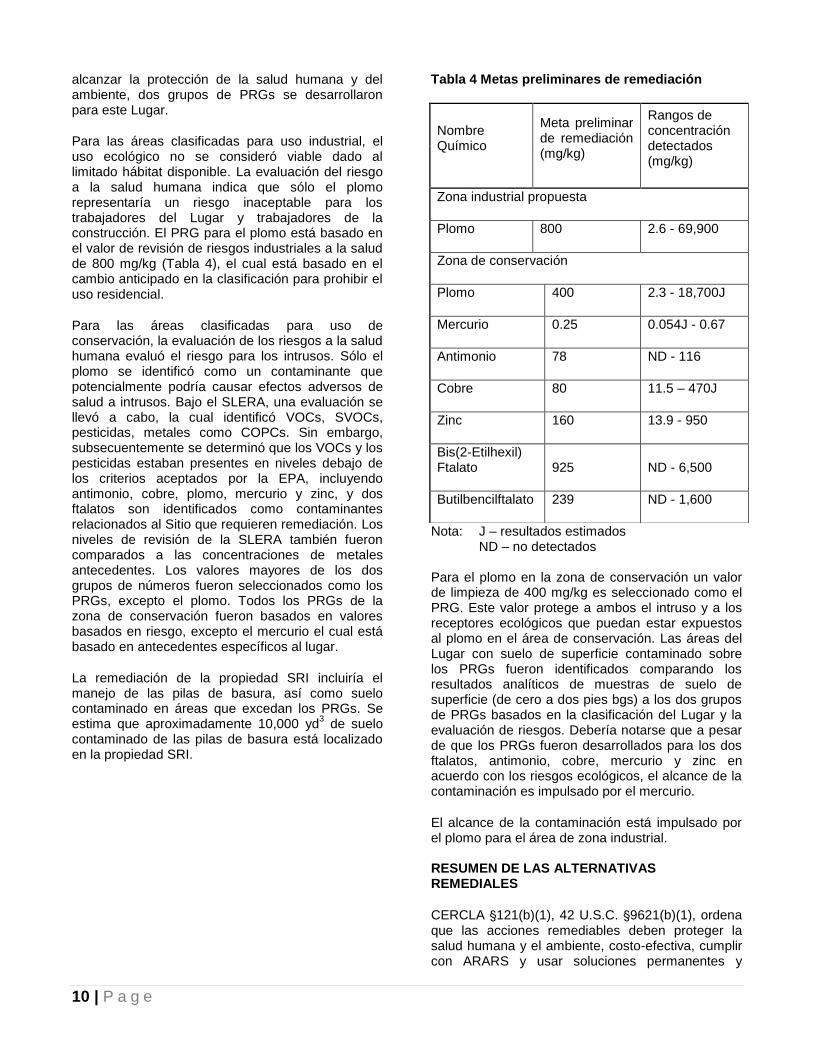
10 | P a g e
alcanzar la protección de la salud humana y del ambiente, dos grupos de PRGs se desarrollaron para este Lugar.
Para las áreas clasificadas para uso industrial, el uso ecológico no se consideró viable dado al limitado hábitat disponible. La evaluación del riesgo a la salud humana indica que sólo el plomo representaría un riesgo inaceptable para los trabajadores del Lugar y trabajadores de la construcción. El PRG para el plomo está basado en el valor de revisión de riesgos industriales a la salud de 800 mg/kg (Tabla 4), el cual está basado en el cambio anticipado en la clasificación para prohibir el uso residencial.
Para las áreas clasificadas para uso de conservación, la evaluación de los riesgos a la salud humana evaluó el riesgo para los intrusos. Sólo el plomo se identificó como un contaminante que potencialmente podría causar efectos adversos de salud a intrusos. Bajo el SLERA, una evaluación se llevó a cabo, la cual identificó VOCs, SVOCs, pesticidas, metales como COPCs. Sin embargo, subsecuentemente se determinó que los VOCs y los pesticidas estaban presentes en niveles debajo de los criterios aceptados por la EPA, incluyendo antimonio, cobre, plomo, mercurio y zinc, y dos ftalatos son identificados como contaminantes relacionados al Sitio que requieren remediación. Los niveles de revisión de la SLERA también fueron comparados a las concentraciones de metales antecedentes. Los valores mayores de los dos grupos de números fueron seleccionados como los PRGs, excepto el plomo. Todos los PRGs de la zona de conservación fueron basados en valores basados en riesgo, excepto el mercurio el cual está basado en antecedentes específicos al lugar.
La remediación de la propiedad SRI incluiría el manejo de las pilas de basura, así como suelo contaminado en áreas que excedan los PRGs. Se estima que aproximadamente 10,000 yd
3 de suelo
contaminado de las pilas de basura está localizado en la propiedad SRI.
Tabla 4 Metas preliminares de remediación
Nota: J – resultados estimados ND – no detectados Para el plomo en la zona de conservación un valor de limpieza de 400 mg/kg es seleccionado como el PRG. Este valor protege a ambos el intruso y a los receptores ecológicos que puedan estar expuestos al plomo en el área de conservación. Las áreas del Lugar con suelo de superficie contaminado sobre los PRGs fueron identificados comparando los resultados analíticos de muestras de suelo de superficie (de cero a dos pies bgs) a los dos grupos de PRGs basados en la clasificación del Lugar y la evaluación de riesgos. Debería notarse que a pesar de que los PRGs fueron desarrollados para los dos ftalatos, antimonio, cobre, mercurio y zinc en acuerdo con los riesgos ecológicos, el alcance de la contaminación es impulsado por el mercurio.
El alcance de la contaminación está impulsado por el plomo para el área de zona industrial. RESUMEN DE LAS ALTERNATIVAS REMEDIALES
CERCLA '121(b)(1), 42 U.S.C. '9621(b)(1), ordena que las acciones remediables deben proteger la salud humana y el ambiente, costo-efectiva, cumplir con ARARS y usar soluciones permanentes y
Nombre Químico
Meta preliminar de remediación (mg/kg)
Rangos de concentración detectados (mg/kg)
Zona industrial propuesta
Plomo 800 2.6 - 69,900
Zona de conservación
Plomo 400 2.3 - 18,700J
Mercurio 0.25 0.054J - 0.67
Antimonio 78 ND - 116
Cobre 80 11.5 – 470J
Zinc 160 13.9 - 950
Bis(2-Etilhexil) Ftalato 925 ND - 6,500
Butilbencilftalato 239 ND - 1,600

11 | P a g e
tecnologías de tratamiento alternativo y alternativas de recuperación de recursos al mayor alcance practicable. La Sección 121(b)(1) también establece una preferencia por las acciones remediales que emplean, como un elemento principal, tratamiento para reducir permanente y significativamente el volumen, la toxicidad o movilidad de las sustancias peligrosas y contaminantes en un lugar. CERCLA '121(d), 42 U.S.C. '9621(d), especifica además que una acción remedial debe alcanzar un nivel o estándar de control de las sustancias peligrosas y contaminantes que al menos alcance los ARAR bajo las leyes federales y estatales, a menos que una dispensa pueda ser justificada conforme a CERCLA '121(d)(4), 42 U.S.C. '9621(d)(4).
Las descripciones detalladas de las alternativas remediales para abordar la contaminación del suelo asociada con este Lugar pueden encontrarse en el informe FS.
Cada alternativa, que no sea No Requiere Acción, incluye ciertos elementos comunes que se discuten a continuación.
Elementos comunes
Segregación y eliminación de pilas de basura La remediación de la propiedad SRI incluiría el manejo de las pilas de basura, así como de los suelos contaminados en áreas que exceden los PRGs. Los materiales en las pilas de basura serían segregados entre gomas, restos de metal, desechos y tierra. La verja existente del Lugar sería usada para prevenir el acceso a las áreas de segregación durante la actividad de acción remedial.
Los neumáticos serían limpiados y los aros serían removidos, como sea necesario. Los neumáticos limpios serían enviados a una compañía certificada de reciclaje de neumáticos. Los restos de metal serían reciclados a la mayor extensión posible. Los desechos y los materiales no reciclables restantes serían desechados en un vertedero no peligroso o cualquier otro vertedero apropiado.
Investigación de Pre-diseño Una investigación de pre-diseño sería llevado a cabo para determinar las áreas finales para excavación. Muestras del suelo serían recopiladas en un análisis de metal Lista de Objetivo de Analito para todas las alternativas activas. El análisis TCLP sería recopilado para la Alternativa 4. Un estudio de tratabilidad a menor escala puede ser llevado a cabo para la Alternativa 4, como sea necesario,
para seleccionar la enmienda a ser usada para tratar el suelo que exceda los requisitos TCLP y para determinar la dosis requerida. Muestras de suelo antecedente de varias áreas de alrededor del Lugar serían recopiladas para verificación y re-evaluación de los niveles antecedentes de metales, especialmente mercurio. Diseño remedial Basado en los resultados de la investigación de pre-diseño, un diseño remedial sería preparado. El diseño remedial consistiría de ambos estándares prescriptivos y basados en el desempeño de los estándares requeridos y costos estimados de la acción remedial. El diseño remedial también abordaría el tratamiento de desperdicio TCLP si fuese necesario. Revisión de cinco años Una revisión de las condiciones del Lugar se llevaría a cabo cada cinco años usando datos recopilados a través del programa a largo plazo de inspección y mantenimiento para asegurar la protección de la salud humana y el ambiente. Controles institucionales Debido a que el suelo contaminado excede los PRGs sería dejado en el Lugar (bajo las Alternativas 2, 3a y 3b) una restricción a la escritura sería impuesta a la propiedad SRI, la esquina de la propiedad Rosa del Monte y el área de conservación para restringir futuras actividades intrusivas que podrían alterar la cubierta del suelo y exponer a los trabajadores de la construcción a futuros usuarios de la tierra a contaminantes en niveles que pueden representar un riesgo para la salud humana. Además, una restricción de la escritura sería impuesta a la propiedad SRI para prevenir la reclasificación de esta zona para uso residencial (i.e. después de que sea cambiado para prohibir uso residencial) y para prevenir que el área de conservación sea clasificada para otro uso que no sea conservación.
Los periodos de tiempo presentados a continuación no incluyen el tiempo para investigaciones de pre-diseño, diseño remedial o adquisiciones de contrato.
Alternativas remediales
Alternativa 1 – No requiere acción El programa de Superfondo requiere que la alternativa de “no acción” sea considerada como referencia para comparación con las otras alternativas. La alternativa remedial de no acción

12 | P a g e
para suelo no incluye ninguna medida remedial física que aborde el problema de la contaminación del suelo en el lugar. Debido a que esta alternativa resultaría en la permanencia de contaminantes en el lugar que están sobre niveles que de otra manera permitirían el uso sin restricciones y exposición ilimitada, CERCLA requiere que el lugar sea revisado al menos una vez cada cinco años. Si se justifica por la revisión acciones remediales adicionales futuras podrían ser seleccionadas para remover, tratar o contener los suelos contaminados. Un resumen del costo para la Alternativa 1 se provee en la Tabla 5.
Tabla 5 Alternativa 1 Resumen de costo
Costo capital total $0
Operación y mantenimiento
$0
Total del valor neto presente
$0
Tiempo estimado de construcción
0 años
Alternativa No. 2 – Consolidación y cubierta del suelo La Alternativa 2 consiste en la consolidación y cubierta de suelo sobre el suelo contaminado actualmente localizado en dos diferentes áreas (Figura 4). Bajo esta alternativa, los suelos contaminados del área industrial en la propiedad SRI que están fuera del área de consolidación serían excavados a un pie excepto un área pequeña de suelos contaminados alrededor de SS-09 que está fuera del área principal de contaminación y sería excavada a dos pies bgs (Figura 3). Un estimado de 800 yd
3 de suelo sería excavado. Estos
suelos serían consolidados en el Lugar en la porción sur de la propiedad SRI en una localidad junto con el suelo segregado de pilas de basura existentes. El suelo contaminado en el área de conservación sería dejado en su sitio y cubierto con un pie de suelo limpio común.
Un estimado de 10,000 yd3 de suelo sería
segregado de las pilas de basura localizadas en la porción norte de la propiedad SRI; se asume que 10 por ciento de estos suelos estarían por debajo de los PRGs y que pueden ser usados como cubierta
de suelo. Por lo tanto, un total de 9,000 yd3
de suelo forman el área de excavación y las pilas de basura se consolidarían en una sola pila que podría ocupar aproximadamente 25,900 pies cuadrados y alcanzar aproximadamente los 16 pies de alto (ver figura 4). La pila de suelo consolidada sería cubierta con un pie de relleno común para prevenir contacto directo y luego vegetada para control de erosión. Además, el suelo contaminado en el área de conservación también sería dejado en su lugar y cubierto con un pie de suelo limpio común.
Una capa de demarcación de geotextil sería instalada entre el suelo contaminado y la cubierta de suelo limpia (en ambos el área consolidada y el área de conservación). Una inspección a largo plazo sería implementada para asegurar la integredad de la cubierta del suelo.
El área de conservación y el área rellenada en la propiedad SRI serían calificadas para drenaje positivo y para que combinen con la topografía natural tanto como sea posible. Las concentraciones de plomo debajo de la losa del edificio en la esquina sur de la propiedad Rosa del Monte excedieron el los niveles de remedición como metas. Esta losa sería inspeccionada y reparada como sea necesario para eliminar el medio de la exposición para trabajadores del Lugar. La esquina sur de Rosa del Monte tiene una pendiente inclinada y se asume que una pared retenedora usando gaviones sería construida para prevenir futura erosión y contacto directo con el suelo contaminado debajo de la losa del edificio inmediatamente adjunto a la pendiente.
Después de llenar las áreas excavadas e instalar las cubiertas del suelo, los suelos contaminados a profundidad que excedan los PRGs permanecerían en el lugar, incluyendo el área excavada y rellenada en la propiedad SRI, la porción de Rosa del Monte, el área contaminada en el área de conservación y la pila de suelo consolidada. Porque esta alternativa resultaría en dejar los contaminantes en el lugar que están sobre niveles que de otra manera permitirían su uso sin restricciones y exposición ilimitada, CERCLA requiere que el lugar sea revisado el menos una vez cada cinco años.
Un resumen de costo para la Alternativa 2 se provee en la Tabla 6.

13 | P a g e
Tabla 6 Alternativa 2 Resumen de costo
Costo Capital Total $2,904,000
Operación y mantenimiento (anual)
$7,000
Costo O&M presente estimado
$87,000
Total del valor neto presente $2,991,000
Tiempo estimado de la construcción
< 2 años
Alternativa No. 3a – Cubierta del suelo en el área industrial y de conservación Bajo esta alternativa, el área industrial, así como el área de conservación, sería tendida (Figura 5). Los suelos contaminados debajo del edificio de la propiedad Rosa del Monte serían dejados en su sitio. Aproximadamente 10,000 yd
3 de suelo serían
separadas de las pilas de basura localizada en la propiedad SRI; se estima que 10 porciento de estos suelos están por debajo de los PRGs y serían reusados como cubierta de suelo. Las 9,000 yd
3 de
suelo contaminado que exceden los PRGs serían dispersadas en toda la propiedad SRI, cubriendo aproximadamente tres acres a una altura aproximada de dos pies afuera de los edificios y de las áreas pavimentadas, ver Figura 5.
El suelo contaminado, ambos dentro de la propiedad SRI y del área de conservación, sería cubierto con un pie de suelo limpio para eliminar el medio de exposición a la salud humana y a receptores ecológicos. La cubierta de suelo sería nivelada para facilitar el drenaje e igualar el patrón de drenaje natural tanto como sea posible. La cubierta de suelo también sería vegetada con
especies nativas para control de erosión. Un programa a largo plazo de inspección y
mantenimiento sería implementado para asegurar la integridad de las cubiertas del suelo.
Las concentraciones de plomo debajo de la losa del edificio en la esquina sur de la propiedad de Rosa del Monte excedieron el PRG. Esta losa sería inspeccionada y reparada como sea necesario para
eliminar el medio de exposición a los trabajadores del Lugar. La esquina sur de Rosa del Monte tiene una pendiente inclinada y se asume que una pared retenedora usando gaviones sería construida para prevenir futura erosión y contacto directo con el suelo contaminado debajo de la losa del edificio inmediatamente adjunto a la pendiente.
Porque esta alternativa resultaría en la permanencia de los contaminantes en el lugar que están sobre niveles que de otra manera permitirían el uso sin restricciones y exposición ilimitada, CERCLA requiere que el lugar sea revisado el menos una vez cada cinco años. Un resumen de costo para la Alternativa 3a se provee en la Tabla 7. Alternativa No. 3b – Cubrir con gravilla el área industrial y con suelo en el área de conservación Esta alternativa es la misma que la Alternativa No. 3a, excepto que la gravilla sería usada como la cubierta en vez de suelo para suelos contaminados en la zona industrial y suelo limpio sería usado como cubierta en el área de conservación (Figura 5). Usar gravilla eliminaría el medio de exposición para la salud humana, es más estable que el suelo y prevendría la erosión de los suelos contaminados subyacentes; por lo tanto, la gravilla es más protectora.
Un resumen de costo para la Alternativa 3b se provee en la Tabla 8.
Tabla 7 Alternativa 3a Resumen de costo
Costo Capital Total $2,989,000
Operación y mantenimiento (anual)
$7,000
Costo O&M presente estimado $87,000
Total del valor neto presente $3,076,000
Tiempo estimado de la construcción
< 2 años
Tabla 8 Alternativa 3b Resumen de costo
Costo Capital Total $3,092,000
Operación y Mantenimiento (anual)
$7,000
Costo O&M presente estimado $87,000
Total del valor neto presente $3,179,000
Tiempo estimado de la construcción
< 2 years

14 | P a g e
Alternativa No. 4 – Excavación y eliminación fuera del lugar y relleno Bajo la Alternativa 4, todo suelo contaminado que exceda el PRG de plomo en la zona industrial propuesta (propiedad SRI) (800 mg/kg) y el área de conservación (400 mg/kg) sería excavada (Figure 6). Además, los suelos contaminados de la superficie serían excavados a dos pies bgs para todos los otros PRGs. El edificio existente en la esquina sur de la propiedad Rosa del Norte sería demolido para remover el suelo contaminado debajo. La excavación más profunda estaría localizada debajo del edificio de Rosa del Monte a aproximadamente 47 pies bgs. Pilas de planchas podrían ser instaladas para proveer apoyo estructural para áreas fuera de la excavación profunda.
El total del volumen de los suelos a ser excavados está estimado a ser 24,400 yd
3. El suelo segregado
de las pilas de basura sería aproximadamente de 10,000 yd
3 y 10 porciento de estos suelos se asume
que están por debajo de los PRGs y que podrían ser usados como relleno. El suelo excavado y el suelo de las pilas de basura están estimados a ser 33,400 yd
3. Muestras de suelo serían recopiladas y
analizadas en el lugar (antes de la excavación) y/o fuera del sitio (después de la excavación) para análisis TCLP. Los suelos que fracasen en el análisis TCLP serían tratados para confirmar que no exceden los requisitos TCLP antes de la eliminación fuera del lugar. Para propósitos de estimar el costo, se asume que 10 por ciento del suelo excavado (2,440 yd
3) requeriría tratamiento antes de la
eliminación. El área excavada sería rellenada con relleno limpio común, calificado para drenaje positive para que combine con la topografía y vegetado para el control de la erosión. La esquina sureste de la propiedad Rosa del Monte tiene una pendiente inclinada. Se asume que una pared de retención usando gaviones serían construidos para prevenir la erosión. El edificio de la propiedad de Rosa del Monte sería reemplazado al momento de la culminación de la remediación.
Para la porción de terrenos que exceden los límites de TCLP, el tratamiento sería llevado a cabo usando tratamiento tecnológico en el lugar o fuera del lugar antes de la eliminación fuera del lugar. Un estudio de tratabilidad se requeriría para determinar los aditivos químicos y las dosis apropiadas.
Un resumen de costo para la Alternativa 4 se provee en la Tabla 9.
Tabla 9 Alternativa 4 Resumen de costo
Costo Capital Total $12,022,000
Operación y Mantenimiento (anual)
$0
Costo O&M presente estimado
$0
Total del valor neto presente
$12,022,000
Tiempo estimado de la construcción
< 2 years
ANÁLISIS COMPARATIVO DE LAS ALTERNATIVAS
Durante una evaluación detallada de las alternativas remediales, cada alternativa es evaluada contra nueve criterios de evaluación, principalmente protección general de la salud humana y del ambiente, cumplimiento con requisitos aplicables o relevantes y apropiados, efectividad a largo plazo y permanencia, reducción de toxicidad, movilidad o volumen mediante tratamiento, efectividad a corto plazo, implementabilidad, aceptación de estado de costo; y aceptación de la comunidad.
Los criterios de evaluación se describen a continuación.
La protección general de salud humana y el ambiente aborda si un remedio provee o no protección adecuada y describe cómo los riesgos que se presentan en cada medio de exposición (basado en un escenario razonable de máxima exposición) son eliminados, reducidos, o controlados por medio de tratamiento, controles de ingeniería, o ICs.
Cumplimiento con los ARARs aborda si un remedio cumplirá o no con todos los requisitos aplicables o relevantes y apropiados de estatutos y requerimientos federales y estatales o provee razones para solicitar una dispensa.
Efectividad a largo plazo y permanencia se refiere a la habilidad de un remedio de
15 | P a g e
mantener una protección de la salud humana y del ambiente confiable a través del tiempo, una vez que las metas de limpieza se hayan cumplido. Además, aborda la magnitud y la efectividad de las medidas que pueden ser requeridas para manejar el riesgo que representan los tratamientos residuales y/o desperdicios sin tratar.
Reducción de la toxicidad, movilidad o volumen por medio de tratamiento es el desempeño anticipado de las tecnologías de tratamiento, con respecto a estos parámetros, que un remedio pueda emplear.
Efectividad a corto plazo aborda el periodo de tiempo necesitado para alcanzar la protección y cualquier impacto adverso en la salud humana y el ambiente que puedan ocurrir durante la construcción y el periodo de implementación hasta que las metas de limpieza se alcancen.
Implementabilidad es la viabilidad técnica y administrativa de un remedio, incluyendo la disponibilidad de materiales y servicios necesitados para implementar una opción en particular.
Costo incluye el capital estimado y costo de O&M y costos presentes de valor neto.
Aceptación del estado indica si, basado en sus revisiones de los informes RI/FS y el Plan Propuesto, el Estado está de acuerdo con el remedio de preferencia al momento presente.
Aceptación de la comunidad sería evaluado en el ROD y se refiere a la respuesta general del público a las alternativas descritas en el Plan Propuesto y los informes RI/FS.
A continuación, un análisis comparativo de estas alternativas basado en los criterios de evaluación comentados anteriormente.
Protección general de la salud humana y el ambiente La Alternativa 1 no protegería la salud humana y el ambiente. No cumpliría con la RAO. Las Alternativas 2, 3a, 3b y 4 proveerían protección a la salud humana y al ambiente y lograrían la RAO. Específicamente las alternativas 2, 3a, 3b y 4 cumplirían con los PRGs en diferentes maneras. Las Alternativas 2, 3a y 3b cumplirían con los PRGs
proveyendo cubierta para las áreas contaminadas para eliminar los medios de exposición a receptores humanos y ecológicos. La Alternativa 4 cumpliría con los PRGs al eliminar el suelo contaminado y proveería una cubierta de suelo, para rellenar áreas excavadas.
Cumplimiento con los requisitos aplicables o relevantes y apropiados Como se requiere bajo la Sección 121 de CERCLA, las acciones remediales que se lleven a cabo bajo la Sección 104 o aseguradas bajo la Sección 106 deben ser protectoras de la salud humana y del ambiente y alcanzar niveles o estándares de control para las sustancias peligrosas, contaminantes especificados por los Requisitos Aplicables o Relevantes y Apropiados (ARARs) de las leyes ambientales federales y del estado libre asociado y leyes de sitiar instalaciones, a menos que se obtengan dispensas.
No hay ARARs para suelos contaminados que sean para químicos específicos. La Alternativa 1 no cumpliría con los PRGs basados en los riesgos ya que ninguna acción se tomaría para remediar el Lugar. Las Alternativas 2, 3a, 3b y 4 cumplirían con los PRGs en diferentes maneras. Las alternativas 2, 3a y 3b cumplirían los PRGs al proveer una cubierta para el suelo contaminado para eliminar los medios de exposición a los receptores humanos y ecológicos. La Alternativa 4 cumpliría los PRGs al excavar y con la eliminación fuera del lugar de los suelos contaminados que exceden los PRGs.
Todas las alternativas activas, cumplirían con los ARARs al seguir las regulaciones de salud y seguridad, y la regulación del manejo y eliminación de los desperdicios. ARARs específicos al lugar serían alcanzados para la conservación de las regiones de karso bajo las alternativas 2, 3a, 3b, y 4.
Efectividad a largo plazo y permanencia La Alternativa 1 no sería efectiva a largo plazo pues no se llevaría a cabo ninguna acción remedial. Las Alternativas 2, 3a y 3b proveerían efectividad a largo plazo y permanencia por medio de la cubierta del suelo, pero a un alcance menor que la Alternativa 4. La propiedad SRI estaría disponible para re-desarrollo para propósitos industriales con algunas restricciones. La Alternativa 4 proveería la mayor efectividad a largo plazo y permanencia pues ambos suelos de superficies y subsuelo serán excavados y eliminados fuera del Lugar. Bajo esta alternativa la propiedad SRI puede ser redesarrollada sin ninguna restricción. Además, los controles institucionales, la inspección a largo plazo y el mantenimiento sería
16 | P a g e
requerido bajo las Alternativas 2, 3a y 3b para asegurar la protección de la salud humana y de los receptores ecológicos a largo plazo.
La confiabilidad y adecuacidad de una efectividad a largo plazo y permanencia para las Alternativas 2, 3a y 3b también dependería de hacer cumplir a largo plazo efectivamente la restricción a las escrituras y la confiabilidad de la inspección y mantenimiento a largo plazo de las cubiertas de los suelos.
Reducción de la toxicidad, movilidad o volumen por medio de tratamiento La Alternativa 1 no provee ninguna reducción de toxicidad, movilidad o volumen (T/M/V). Las Alternativas 2, 3a y 3b reducirían el transporte de polvo fugitivo y erosión del suelo por medio de la cubierta de suelo. La Alternativa 4 proveería la mayor reducción de T/M/V por medio de tratamiento ya que los suelos excavados que exceden el TCLP serían tratados antes de la eliminación fuera del lugar. Efectividad a corto plazo
La Alternativa 1 no tendría impactos a corto plazo ya que no se implementaría ninguna acción. Las Alternativas 2, 3a y 3b tendrían un impacto significativo en la comunidad durante el periodo de la construcción. La Alternativa 4 tendría el mayor impacto en la comunidad local comparada con las Alternativas 2, 3a y 3b debido a la mayor cantidad de tráfico de camiones para la eliminación fuera del lugar para el suelo contaminado. Sin embargo, las medidas de la mitigación serían puestas en práctica para minimizar esos impactos. Por ejemplo, las medidas de control de polvo por medio del uso de técnicas de supresión de polvo (por ejemplo, agua o aerosol de agua o espuma) y medidas de erosión del suelo tales como minimizar áreas de excavación y usar rejas de limo sería implementado para minimizar la migración de suelo contaminado en la mayor medida posible. Además, las horas laborables se coordinarían con el gobierno local y los planes de respuesta de emergencia serían desarrollados y seguidos. Las medidas de salud y seguridad serían implementadas para prevenir incidentes en el lugar y para proteger trabajadores de la construcción, tal como usar equipo para proteger al personal para minimizar la exposición a materiales contaminados o químicos peligros durante actividades remediales.
Implementabilidad
Las cuatro alternativas son implementables. La Alternativa 1 sería la más fácil de implementar ya que no habría ninguna acción que tomar.
Las Alternativas 2, 3a y 3b serían similares de implementar pero considerablemente menos que la Alternativa 4. Estas alternativas incluyen: excavación, relleno, consolidación, y construcción d la cubierta del terreno los cuales son remediaciones convencionales y tecnologías de construcción que han sido implementadas ampliamente. El equipo, los suministros y los servicios estarían disponibles fácilmente. No habría dificultades administrativas asociada con la implementación de esta tecnología; sin embargo, hay algunos retos técnicos asociados con ellas, tales como:
Disponibilidad en instalaciones de reciclaje y eliminación de los materiales en las pilas de basura
Habilidad para clasificar el tipo de desperdicio para los escombros no metálicos
Accesibilidad y la operación de la excavación equipo para el relleno en la pendiente empanada en el área de Conservación
Dificultad para segregar neumáticos, pedazos de metal, escombros y suelos de las pilas de basura
La Alternativa 4 sería la más difícil de implementar ya que envuelve excavación profunda, demolición de un edificio y transportación extensiva para disponer del suelo excavado fuera del lugar en vertederos de Puerto Rico.
Costo La Alternativa 1 no tendría ningún costo. La Alternativa 4 tendría el costo más alto que las Alternativas 2, 3a y 3b. Los costos para las Alternativas 2, 3a y 3b son comparables. Los estimados de costos para las cuatro alternativas se proveen en la Tabla 10.
Aceptación del Estado PREQB concurre con el remedio propuesto.

17 | P a g e
Aceptación de la comunidad
La aceptación de la comunidad de la alternativa de preferencia sería evaluada y documentada en el resumen de respuestas del ROD luego de la revisión de los comentarios públicos recibidos en este Plan Propuesto.
RESUMEN DE LA ALTERNATIVA DE REFERENCIA
Basado en la evaluación de las varias alternativas, la EPA, en consulta con PREQB, propone el siguiente remedio para abordar el suelo contaminado:
Alternativa No. 3b, Cubrir con gravilla en el área industrial y con suelo el área de conservación, es la alternativa remedial de preferencia para la contaminación del suelo en este Lugar. Bajo la Alternativa 3b, aproximadamente 10,000 yd
3 del
terreno estarían separadas de las pilas de basura; se estima que el 10 porciento de estos suelos están por debajo de los PRGs y serían reusados como cubierta para el suelo.
La gravilla sería usada como la cubierta para el suelo contaminado en la zona industrial y suelo común sería usado como cubierta en el área de conservación. Una capa de demarcación de geotextil sería instalada entre el suelo contaminado y la cubierta de suelo. La cubierta sería calificada para drenaje positivo y para que combine con la topografía natural tanto como sea posible. La cubierta de suelo también sería vegetada con especies nativas para control de erosión.
Los suelos contaminados debajo del edificio en la propiedad Rosa del Monte se mantendrían en su lugar. La esquina sur de Rosa del Monte tiene una pendiente inclinada y se asume que una pared retenedora usando gaviones sería construida para prevenir futura erosión y contacto directo con el suelo contaminado debajo de la losa del edificio inmediatamente adjunto a la pendiente.
Después de la instalación de las cubiertas de suelo, los suelos contaminados excediendo los PRGs permanecerían en el lugar, incluyendo un área de 3 acres en la propiedad SRI y el área de conservación. Restricciones a las escrituras serían necesarias para estas áreas para restringir actividades futuras de intrusos que dañaría la cubierta del terreno y expondría a los trabajadores de la construcción o a usuarios futuros de la tierra a contaminantes en niveles que podrían representar un riesgo a la salud humana. Además, una restricción de la escritura sería impuesta a la propiedad SRI para prevenir la reclasificación de
esta zona para uso residencial y para prevenir que el área de conservación sea clasificada para otro uso que no sea conservación. Un programa de inspección y mantenimiento a largo plazo sería implementado para asegurar la integridad de las cubiertas del terreno.
Una investigación de pre-diseño sería llevado a cabo para determinar la extensión a la cual la capa del suelo necesitaría ser ubicada. Muestras del suelo serían recopiladas en un análisis de metal Lista de Objetivo de Analito. Muestras de suelo antecedente de varias áreas de alrededor del Lugar serían recopiladas para verificación y re-evaluación de los niveles antecedentes de metales, especialmente mercurio. Los beneficios ambientales del remedio de preferencia podría ser mejorado, durante el diseño, de tecnologías y prácticas que son sostenibles de acuerdo con la EPA Región 2 Clean and Green Energy Policy. Esto incluiría consideración de remediaciones tecnológicas y prácticas verdes.
Basada en los resultados de investigación de pre-diseño se prepararía un diseño remedial. El diseño remedial consistiría de ambos, costos prescriptivos y basados en el desempeño requerido y estimados de la acción remedial.
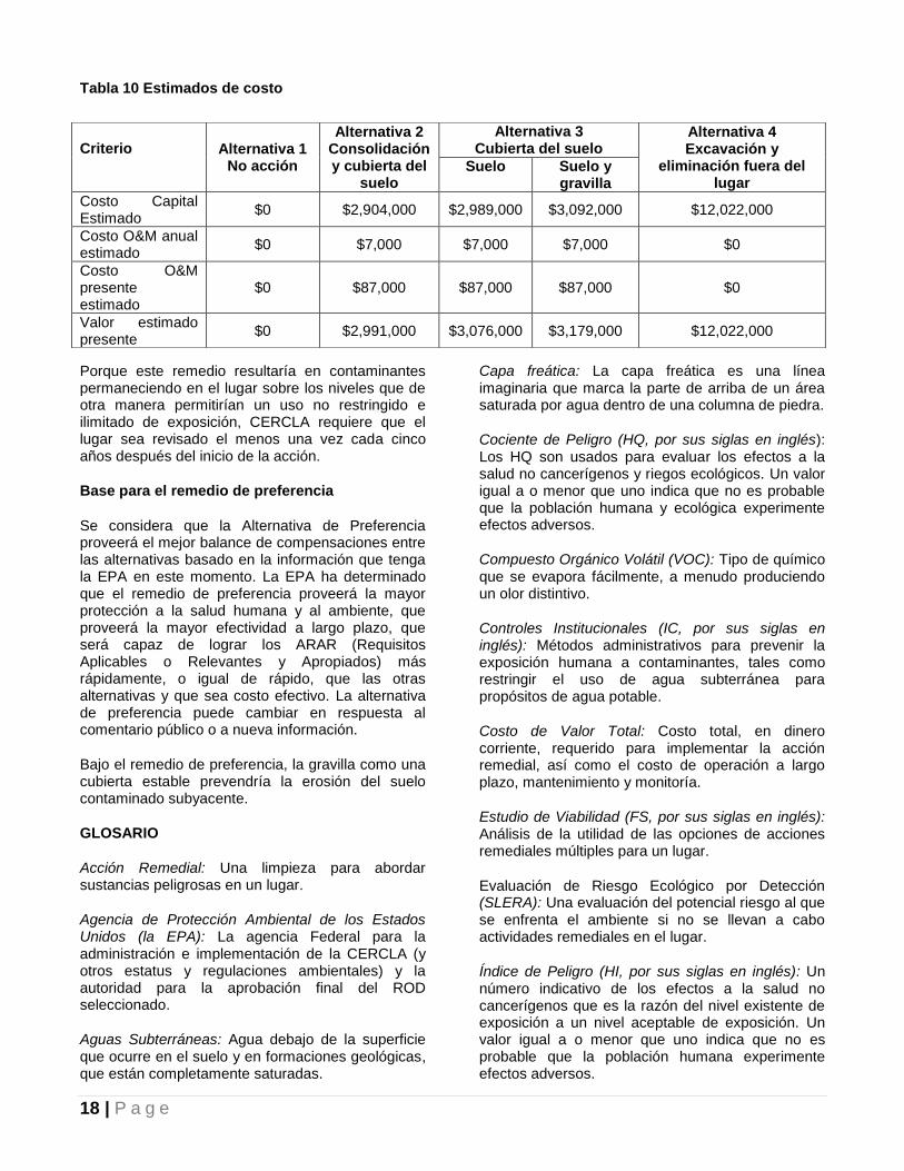
18 | P a g e
Tabla 10 Estimados de costo
Porque este remedio resultaría en contaminantes permaneciendo en el lugar sobre los niveles que de otra manera permitirían un uso no restringido e ilimitado de exposición, CERCLA requiere que el lugar sea revisado el menos una vez cada cinco años después del inicio de la acción.
Base para el remedio de preferencia
Se considera que la Alternativa de Preferencia proveerá el mejor balance de compensaciones entre las alternativas basado en la información que tenga la EPA en este momento. La EPA ha determinado que el remedio de preferencia proveerá la mayor protección a la salud humana y al ambiente, que proveerá la mayor efectividad a largo plazo, que será capaz de lograr los ARAR (Requisitos Aplicables o Relevantes y Apropiados) más rápidamente, o igual de rápido, que las otras alternativas y que sea costo efectivo. La alternativa de preferencia puede cambiar en respuesta al comentario público o a nueva información.
Bajo el remedio de preferencia, la gravilla como una cubierta estable prevendría la erosión del suelo contaminado subyacente.
GLOSARIO
Acción Remedial: Una limpieza para abordar sustancias peligrosas en un lugar.
Agencia de Protección Ambiental de los Estados Unidos (la EPA): La agencia Federal para la administración e implementación de la CERCLA (y otros estatus y regulaciones ambientales) y la autoridad para la aprobación final del ROD seleccionado.
Aguas Subterráneas: Agua debajo de la superficie que ocurre en el suelo y en formaciones geológicas, que están completamente saturadas.
Capa freática: La capa freática es una línea imaginaria que marca la parte de arriba de un área saturada por agua dentro de una columna de piedra.
Cociente de Peligro (HQ, por sus siglas en inglés): Los HQ son usados para evaluar los efectos a la salud no cancerígenos y riegos ecológicos. Un valor igual a o menor que uno indica que no es probable que la población humana y ecológica experimente efectos adversos.
Compuesto Orgánico Volátil (VOC): Tipo de químico que se evapora fácilmente, a menudo produciendo un olor distintivo.
Controles Institucionales (IC, por sus siglas en inglés): Métodos administrativos para prevenir la exposición humana a contaminantes, tales como restringir el uso de agua subterránea para propósitos de agua potable.
Costo de Valor Total: Costo total, en dinero corriente, requerido para implementar la acción remedial, así como el costo de operación a largo plazo, mantenimiento y monitoría.
Estudio de Viabilidad (FS, por sus siglas en inglés): Análisis de la utilidad de las opciones de acciones remediales múltiples para un lugar.
Evaluación de Riesgo Ecológico por Detección (SLERA): Una evaluación del potencial riesgo al que se enfrenta el ambiente si no se llevan a cabo actividades remediales en el lugar.
Índice de Peligro (HI, por sus siglas en inglés): Un número indicativo de los efectos a la salud no cancerígenos que es la razón del nivel existente de exposición a un nivel aceptable de exposición. Un valor igual a o menor que uno indica que no es probable que la población humana experimente efectos adversos.
Criterio Alternativa 1 No acción
Alternativa 2 Consolidación y cubierta del
suelo
Alternativa 3 Cubierta del suelo
Alternativa 4 Excavación y
eliminación fuera del lugar
Suelo Suelo y gravilla
Costo Capital Estimado
$0 $2,904,000 $2,989,000 $3,092,000 $12,022,000
Costo O&M anual estimado
$0 $7,000 $7,000 $7,000 $0
Costo O&M presente estimado
$0 $87,000 $87,000 $87,000 $0
Valor estimado presente
$0 $2,991,000 $3,076,000 $3,179,000 $12,022,000
19 | P a g e
Investigación Remedial (RI, por sus siglas en inglés): Un estudio de una instalación que apoya la selección de un remedio donde se han dispuesto o liberado sustancias peligrosas. El RI identifica la naturaleza y extensión de la contaminación en la instalación y analiza el riesgo asociado con los COPC.
Ley de Responsabilidad, Compensación y Recuperación Ambiental (Comprehensive Environmental Response Compensation and Liability Act, CERCLA por sus siglas en inglés). Una ley Federal, referida comúnmente como el Programa “Superfondo”, aprobada en el 1980 provee para acciones de respuesta en lugares que se encuentren contaminados con sustancias peligrosas o contaminantes que ponen en peligro la salud y la seguridad pública o del ambiente.
Lista de Prioridades Nacionales (NPL, por sus siglas en inglés): Una lista de desarrollada por la EPA de los lugares que liberan sustancias peligrosas no controladas en los Estados Unidos que son considerados prioridad para evaluación y respuesta remedial a largo plazo.
Nivel de Cuantificación Práctica (PQL, por sus siglas en inglés): significa que la menor concentración de un constituyente que puede ser alcanzada confiablemente entre laboratorios dentro de límites específicos de precisión y exactitud durante condiciones operacionales de rutina del laboratorio.
Objetivos de Acción Remedial (RAO, por sus siglas en inglés). Objetivos de acción remedial que son desarrollados basados en medios contaminados, contaminantes de riesgo, receptores potenciales y escenarios de exposición, evaluación de riesgos de salud humana y ecológica y logro de los niveles regulatorios de limpieza.
Periodo de Comentarios Públicos: El tiempo permitido para que los miembros de una comunidad potencialmente afectada expresen sus posturas y preocupaciones relacionadas a la alternativa preferida de la EPA.
Plan Propuesto: Un documento usado para describir una alternativa remedial preferida y solicitar insumo público relacionado a una alternativa de limpieza propuesta para un lugar.
Registro de la Decisión (ROD, por sus siglas en inglés): Un documento legal que describe la acción de limpieza o remedio seleccionado para un lugar, la base para escoger ese remedio y comentarios públicos acerca del remedio seleccionado.
Requisitos Aplicables o Relevantes y Apropiados (ARARs, por sus siglas en inglés): Éstos son reglas y regulaciones ambientales Federales o Estatales que pueden referirse al Lugar o a una alternativa particular.
Riesgo Cancerígeno: Los riesgos de cáncer están expresados como un número que refleja la posibilidad aumentada de que una persona desarrollará cáncer si se expone a químicos o sustancias. Por ejemplo, el rango aceptado de la EPA para el desperdicio peligroso del Superfondo es 1 x 10
-4 a 1 x 10
-6, lo que quiere decir que hay
una posibilidad adicional en 10,000 (1 x 10⁻⁴
) a 1 posibilidad adicional a un 1 millón (1 x 10
-6) que una
persona desarrollará cáncer si se expone a un contaminante de un lugar que no ha sido remediado.
Riesgo No cancerígeno: Peligros (o riesgos) no cancerígenos son expresados como un cociente que compara el nivel existente de exposición al nivel aceptable de exposición. Hay un nivel de exposición (la dosis de referencia) debajo del cual es poco probable que incluso una población sensible experimente efectos adversos de salud. El nivel límite de la EPA para riesgos no cancerígenos en lugares de Superfondo es de 1.0, significando que si la exposición supera el límite; puede haber la preocupación de efectos no-cancerígenos.
Unidad Operacional (OU, por sus siglas en inglés): una acción discreta que comprende un paso incrementado para abordar completamente los problemas del lugar. Esta porción discreta de respuesta remedial maneja la migración, o elimina o mitiga una liberación, o camino de exposición. La limpieza de un lugar puede ser dividida en un número de unidades operable, dependiendo de la complejidad de los problemas asociados con el lugar.

Figure 1 Site Location Map
Remedial Investigation/Feasibility Study Scorpio Recycling, Inc. Site, OU2-Soil
Toa Baja, Puerto Rico
~---------------------------------------------------------------~~th
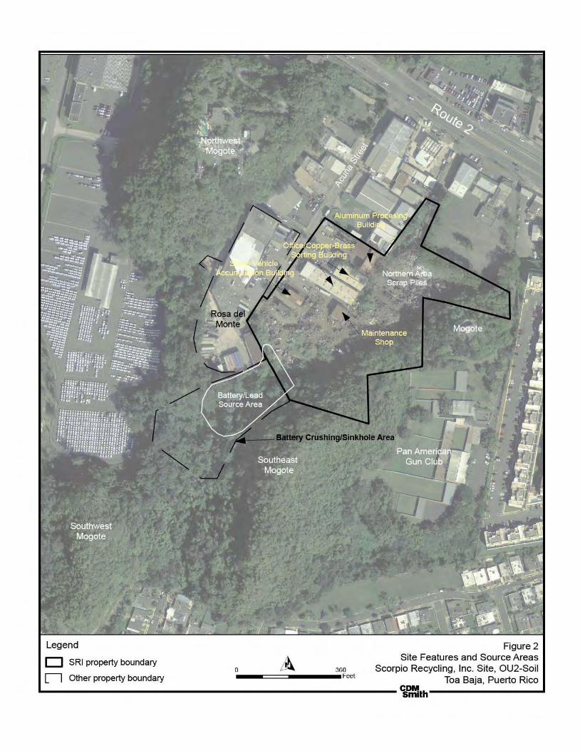
Legend
D SRI property boundary
n Other property boundary 0 ~0
-----====----------Fret
Figure 2 Site Features and Source Areas
Scorpio Recycling, Inc. Site, OU2-Soil Toa Baja, Puerto Rico
L----------------------------------------------------~~.h----------------~

Legend
® Soil boring
l!l Building Soil Boring Location
0 Trench Soil Sample
c::::l other Property Boundary Zone
C Approximate SRI Property Boundary C-2
Zoning C~~~4 I = I Approximate Lot Boundaries
R-1
DQS.Crip1.ion Commercial
Conservation Industrial
Note: Zoning boundary is approximate
Residential (currentty being re-zoned for industrial and .commercial use)
125 250
-----===~ ......... F~t Figure 3
Zoning Map Scorpio Recycling, Inc. Stte, OU2-Soil
Toa Baja, Puerto Rico

SS-117
SS-113
SS-114
SS-115
SS-116SS-112
SS-111
SS-110
SS-107
SS-108
SS-109
SS-106SS-105
SS-104
SS-103
SS-102
SS-19
SS-21
SS-18
SS-15
SS-16
SS-101SS-09
SS-11
SS-17
SS-20
SS-04
SS-59
SS-22
SS-06
SS-02
SS-01
SS-50SS-60
SS-49
SS-48
SS-61
SS-47
SS-51
SS-44
SS-35
SS-38
SS-40
SS-36
SS-43
SS-42
SS-37
SS-41
SS-72
SS-77
SS-76
SS-71
SS-70
SS-75
SS-45
SS-39
SS-53
SS-78
SS-79
SS-52
SS-54
SS-14
SS-08
SS-03
SS-74
SS-13
SS-100
SS-46
SS-81
SS-23
SS-24
SS-25
SS-26
SS-27
SS-28
SS-29
SS-30
SS-31SS-32
SS-33
SS-34
SS-62
SS-63
SS-64
Mogotes
Mogotes
Mogotes
Conservation Zone
ProposedIndustrial Zone
Lot 6
Lot 7
Lot 4
Lot E
Lot F
Lot G
Lot 5
SS-55
TS-75
TS-76
SS-80
125 1250Feet
Other Property BoundaryLegend
Soil boringBuilding Soil Boring LocationTrench Soil Sample
Approximate SRI Property BoundaryApproximate Zoning
Rosa del MonteProperty
Figure 4Alternative 2 - Consolidation and Soil Cover
Scorpio Recycling, Inc. Site, OU2-SoilToa Baja, Puerto Rico
SRIProperty
Conservation Zone
No excavation under the building
Area to be covered with clean soil
Area to be remediatedConsolidation Area Outline
Proposed Industrial Zone
Approximate Lot Boundaries

SS-117
SS-113
SS-114
SS-115
SS-116SS-112
SS-111
SS-110
SS-107
SS-108
SS-109
SS-106SS-105
SS-104
SS-103
SS-102
SS-19
SS-21
SS-18
SS-15
SS-16
SS-101SS-09
SS-11
SS-17
SS-20
SS-04
SS-59
SS-22
SS-06
SS-02
SS-01
SS-50SS-60
SS-49
SS-48
SS-61
SS-47
SS-51
SS-44
SS-35
SS-38
SS-40
SS-36
SS-43
SS-42
SS-37
SS-41
SS-72
SS-77
SS-76
SS-71
SS-70
SS-75
SS-45
SS-39
SS-53
SS-78
SS-79
SS-52
SS-54
SS-14
SS-08
SS-03
SS-74
SS-13
SS-100
SS-46
SS-81
SS-23
SS-24
SS-25
SS-26
SS-27
SS-28
SS-29
SS-30
SS-31SS-32
SS-33
SS-34
SS-62
SS-63
SS-64
Mogotes
Mogotes
Mogotes
Conservation Zone
ProposedIndustrial Zone
Lot 6
Lot 7
Lot 4
Lot E
Lot F
Lot G
Lot 5
SS-55
TS-75
TS-76
SS-80
125 1250Feet
Other Property BoundaryLegend
Soil boringBuilding Soil Boring LocationTrench Soil Sample
Approximate SRI Property BoundaryApproximate Zoning
Rosa del MonteProperty
Figure 5Alternative 3 - Soil Cover
Scorpio Recycling, Inc. Site, OU2-SoilToa Baja, Puerto Rico
SRIProperty
Conservation ZoneArea to be covered with clean soil
Soil Cover
Proposed Industrial Zone
Approximate Lot Boundaries
Area to be remediatedNo excavation under the building

SS-117
SS-113
SS-114
SS-115
SS-116SS-112
SS-111
SS-110
SS-107
SS-108
SS-109
SS-106SS-105
SS-104
SS-103
SS-102
SS-19
SS-21
SS-18
SS-15
SS-16
SS-101SS-09
SS-11
SS-17
SS-20
SS-04
SS-59
SS-22
SS-06
SS-02
SS-01
SS-50SS-60
SS-49
SS-48
SS-61
SS-47
SS-55
SS-51
SS-44
SS-35
SS-38
SS-40
SS-36
SS-43
SS-42
SS-37
SS-41
SS-72
SS-77
SS-76
SS-71
SS-70
SS-75
SS-45
SS-39
TS-75SS-53
SS-78
SS-79 TS-76
SS-52
SS-54
SS-14
SS-08
SS-03
SS-74
SS-13
SS-100
SS-46
SS-80
SS-81
SS-23
SS-24
SS-25
SS-26
SS-27
SS-28
SS-29
SS-30
SS-31SS-32
SS-33
SS-34
SS-62
SS-63
SS-64
Mogotes
Mogotes
Mogotes
ConservationZone
Proposed Industrial Zone
SRIProperty
Lot 6
Lot 7
Lot 4
Lot E
Lot F
Lot G
Lot 5
SS-117
SS-49
SS-42
SS-46
5
4
6
7
8
3
2
1
100 1000Feet
Other Property BoundaryLegend
Soil boringBuilding Soil Boring LocationTrench Soil Sample
SRI Property Boundary
Rosa del Monte
Battery Crushing/Sinkhole Slope Area
Figure 6Alternative 4 - Excavation and Off-site Disposal
Scorpio Recycling, Inc. Site, OU2-SoilToa Baja, Puerto Rico
Approximate Zoning
Conservation Zone
Building to be demolished
Area to be remediated
Area to be remediatedProposed Industrial Zone
Areas for excavation deeper than 2 feet below ground surface
1Numbers represent areas with different average depths of contamination for soil volumes estimates.

APPENDIX V
PUBLIC NOTICES


APPENDIX VI PUBLIC MEETING ATTENDANCE SHEET

Name
13 y,,..,_,,J \ <':1 GQ r<:: \ o-
l"'~ F
Scorpio Recycling Site
Operable Unit 2
Public Meeting - August 14, 2013, 6 to 8 p.m.
Address Phone
eo ~3 Sy'/0~ ft~. IOO,Sf·
~ o . ~ ~ t 9 s-s c::r J"~ ........ c..l'-'.o;i"'· f,~. ()'U
~0 clc_ k Fut!nh~
(;:)
(f7-72.lt?<..~o
11..,
tJ7, r;)5r-...7c ~v lct:tvlO$QJcubcoYb <:£.""' L£f e,;)7 3D ..;;~ r

6£.? /( 'lJ?\._
~hta:CP-.~' JJhrA lDyi.QQ fia41rh~ t2 £Jm;e jl
/Jf) £. U«-vj 1 1'1~2...
:Jt!Jsd gJ. /ee7E
Scorpio Recycling Site
Operable Unit 2
Public Meeting- August 14, 2013, 6 to 8 p.m.
. /(:~1(. ... .$.~ ::> ,.._ #..>- l Ll
w.)J/.4 A...l..o,..,_) /)
)A.ct~[.{P D tJi_ fa;.._ "-136?.
·~ 0-9 "--
Phone I Email
'?8 p 'ft! -O?)t I!:J,_,')<ie•~r<- (!: J'.<!'t, Alrj
l~-"1- h~-~2. febf!L(t)... ""'~~ -~ u -\ . cu--..
3 ( :5- ~o <=t ~ ~ ~.L,..e.! :;)CXJ? (J}juc..4·
o-50/5
-
~)7~6-.¥ ~~9' lwclc/z{Jrd. n;t
) "{o(O~~ ~66)
~,~ ... A, "- ' .. (.c.~

Scorpio Recycling Site
Operable Unit 2
Public Meeting- August 14, 2013, 6 to 8 p.m.
Name I Address
f-1, c.l~ \J cJ~ ~.,h~ I ~ J)M ~ , .+(
-~-u_J: BilgS\.I u _ 5 8-4-~)~ C)}L{ ~i'*
Phone I Email
4%1 :)-22. \t/OC I ut..iflY..fv,<J_,~oiiiJ, ~
'JR5 -oor+ (7f7)M--ftlo7 1/VlClJGW

APPENDIX VII
TRANSCRIPT OF THE PUBLIC MEETING AND WRITTEN COMMENTS

1 of 50
PUBLIC HEARING SUPERFUND PROGRAM - REGION 2
SCORPIO RECYCLING’S SUPERFUND PLACE OPERATIONS UNIT 2: SOIL
Date: August 14, 2013
Time: 6:00pm Place: Urbanización Altagracia
Brenda Reyes: Good afternoon, my name is Brenda Reyes of the
Environmental Protection Agency; I am a press and community relations
official. We welcome you to our meeting today for the Superfund facility the
Scorpio Recycling superfund site. Today we are presenting the proposed
plan. We would like to give you a copy of all the documents that are here at
the table. And if you have not yet signed in, we would like you to sign the
attendance sheet, especially that you give us your email, it is very
important to keep in touch during the process, in fact, that is how we found
some of you. So without any preamble, I leave you with Ramón Torres.
Ramón directs the Environmental Response and Remediation Branch of
EPA’s Caribbean Region.
Ramón Torres: Good afternoon as Brenda said my name is Ramón
Torres, I'm the head of the Superfund program, Environmental
Emergencies, Hazardous Waste Management and Brownfields for the
Caribbean, Puerto Rico and the Virgin Islands. And I welcome you here to
discuss the case of Scorpio’s Superfund site in this town of Toa Baja,
where I was born, I lived here, in “Pájaro” back here, so for me it is an
honor to work here and see that finally something will be done at this
Superfund site.

2 of 50
There are a couple of people here with me today who will discuss ... what
had happened at the Superfund site, in Scorpio. Many have known Scorpio
for many years as a recycler of metal and scrap metal, and many things
that were found there. So let's hear a little of its history. The findings that
were discovered and the cleanup alternatives that will be done. So it will be
interesting, I thank you for coming here, especially for taking a little time out
of your soap operas, which sometimes we prefer to watch, but we thank
you all a lot. But first I want to introduce some people who came with me
today. Here we have, Mr. Mel Hauptman from the New York’s office ... Mel
Hauptman is the Chief of the Pre-remedial Section in Superfund. He is the
one who practically enlisted the Superfund here. Beside him is Chuck
Nace, who is the risk assessor, he assessed all the data and supported the
decision that is being proposed. We have with us Engineer Adalberto
Bosque, he is the project manager of the case who handle it. I had the
honor of being one of the project managers and now he is. We also have
our contractors Brandon McDonald, Mike Valentino, Frances and José,
they have worked from the first day as well. Also, since this is an official
public meeting, we have a transcriber, because all this will be compiled into
a file, in a document, which will also be translated to English, it will be part
of the administrative record for this project, which will be available to all of
you, is Widy and her husband. We also have representatives from the
Environmental Quality Board; we have Amarilis, from the Environmental
Quality Board and a representative of the municipality of Toa Baja,
Rebecca Rivera, who helped us a lot in this case. So I will leave you with
Dr. Bosque, who will start the story, the novel, the drama of Scorpio and so
we will see what happens. Ok?

3 of 50
Dr. Adalberto Bosque: Good afternoon. Hello, good afternoon. Well, it's a
pleasure to be with you this afternoon, specifically discussing and
presenting the information collected by the Federal Environmental
Protection Agency during the course of the investigation, specifically what
is known as the operational unit number 2, the Scorpio Recycling case,
specifically on the investigation related to soil contamination at the Scorpio
facility.
During the course of the presentation, this afternoon, we will be presenting
in a summarized manner, not just the information collected during the
remedial investigation conducted at the site since 2010, 2009, 2007
through 2010, but we will also be presenting, based on the information
gathered, the results, specifically of the risk assessment that was carried
out at the site, both for exposure to human health and the effect it may
have on the ecosystem. And then we will be discussing specifically the
feasibility study that was completed, based on the information gathered,
which evaluated various alternatives to be implemented at the site. And
eventually, the main reason in this case this afternoon will be to present to
you the alternative that the Environmental Protection Agency is
recommending, in concurrence with the Environmental Quality Board, to be
implemented at Scorpio.
Extremely important before starting the presentation is for you to
understand ... for some of you it will be a review, for others it is possibly
new information ... practically it is the process that takes place in a location
that the Environmental Protection Agency understands as highly
contaminated and it is eventually included in the National Priority List. From
initial discovery, the discovery is the first little picture (he is referring to the

4 of 50
PowerPoint presentation being illustrated) an investigation is conducted, a
preliminary investigation of the area, to determine if the area requires or not
the performance of an investigation. Then the site is included on the
National Priority List as long as it goes through a process and eventually
qualifies for inclusion on the national priority list.
What is the Environmental Protection Agency’s National Priority List? It is
one of the mechanisms of the Environmental Protection Agency, under a
law known as CERCLA, provides the mechanism to the Environmental
Protection Agency to carry out an assessment of a place which is
understood that requires an investigation and eventually based on this
assessment, a possible remediation. In February 4, 2000, this site was
included in the National Priority List. It should be understood that as early
as the year two thousand (2000) studies were already being conducted by
the Environmental Protection Agency and the Environmental Quality Board.
Once included in the National Priority List, what is known as a remedial
investigation was performed, samples were taken from both surface soil,
soil at different depths, as in the case of this facility, groundwater samples
were collected and eventually, the information that is gathered is used to
perform a risk assessment to determine if the risk to human health,
ecosystem health, is acceptable or not acceptable. And, eventually the
feasibility study which presents the alternatives that would be considered to
remediate the impacted area. In this case we have passed that stage and
now are at the stage in which the Environmental Protection Agency submits
the document, called the Proposed Plan, for public comments. It was
published last week, and there is a comment period of 30 days in which
interested parties can submit any recommendation, any comments to the
5 of 50
action that the Federal Environmental Protection Agency is recommending.
After the 30 days comment period, the agency writes and prepares the
document, issues the document known as the Record of Decision. The
Record of Decision is the document that the Environmental Protection
Agency, in accordance with the Environmental Quality Board, finally, based
on the comments received, can modify, make any amendment, or
eventually modify or eventually select the alternative to be implemented at
the Scorpio site. Then comes the remedial design stage. After the
alternative is designed, it is implemented and subsequently comes the
operation and maintenance as long as it is considered reasonable based
on the alternative that is being recommended. Where is the Scorpio’s site?
We understand that all of you are from the area, and knows where the
Scorpio facility is. It's in Acuña Street, Road No. 2, kilometer 19.7, in the
Candelaria ward of the municipality of Toa Baja. When we talk about
Scorpio’s facilities, or the area, the site included in the National Priority List,
it is extremely important that we understand that when we say the
Superfund site not only includes Scorpio Recycling facility, which is now an
inactive facility, we are including a portion of the nearby properties that
have been impacted by contamination, specifically a portion of Rosa del
Monte and a portion of the conservation area south of Scorpio Recycling
facility. Extremely important, the Proposed Plan that you have possibly
mentions the term "sinkhole" or sumidero (sumidero in Spanish). In this
case we are talking about, the area south of the Scorpio facility which is
possibly a depression towards the southern area that was impacted by the
contamination originated at the facility. It is very important as well, to
mention that the town of Toa Baja, in coordination with the government of
Puerto Rico, began the process to reclassify some of the lots within the
6 of 50
facility of Scorpio that were originally classified as residential. The Scorpio
facility consists of industrial and residential lots. About a year ago the
process of reclassifying these lots began, so that all the facility becomes an
industrial area. The site map, now we can see Scorpio facility, which is
practically this area in the figure. Excuse me because it is possible that with
the brightness you cannot see much, this figure should be in the document
you have. (Pointing to the map on the screen) This is the Rosa del Monte
facility and the small structure, the conservation area, the area south of
Scorpio facility. It should be understood that the contamination extends to a
portion of ... there is a building in Rosa del Monte ... a building there, I
cannot say a warehouse, perhaps a workshop ... a workshop in the Rosa
del Monte area ... that underneath its foundation there is contaminated soil
specifically with lead. But such structure has a concrete floor and in this
case there is no direct exposure to the workers. (Pointing to the map) and
the conservation area mentioned above. This is another map, a lot closer.
Here we can see the street, we see Rosa del Monte, we can see it easily.
In this case, this aerial photo was probably taken in 2010, when they had
already removed a substantial part of the scrap piles of recycling material
that were being stored and handled their facility.
Historical background:: In 1972, based on the information we have, the
facility initiated operations at the area under the name of Astur Metals
Recycling Inc., then Scorpio Recycling Inc. and later Scrapyard Recycling
was the operator at the facility. This recycling facility operated from 1972 to
approximately 2010 at the site. At the beginning of its operation, based on
the information we have, they handled, recycled, received batteries
containing lead, which were ... the lead was removed, specifically in the

7 of 50
southern part of Scorpio’s facility, and based on the investigation
conducted by the Environmental Protection Agency, and after a removal
action at the site, it was determined, that there was enough lead containing
waste in the southern area of Scorpio’s facility sloping towards the
conservation area. We will see that later. In February 4, 2000 the facility
was included in the National Priority List of the Environmental Protection
Agency. It is important to mention, that prior to 2000, possibly in the year
91, year 93, later in the year 95, 96, the Environmental Protection Agency,
and the Environmental Quality Board completed various investigations to
obtain sufficient information to determine if the place was a candidate for
the National Priority List and they found ... or confirmed... high lead
concentrations in soil at the facility. Later we will be presenting
concentrations, and then we'll be discussing the standard or lead level that
we will be working with and that will be the remediation goal at the site.
From 2002 to 2006 the Environmental Protection Agency, specifically
conducted an investigation to determine if groundwater had been impacted
or not by contaminants that were present in the soil. This investigation
concluded that the groundwater was not impacted by contamination, that
contaminants practically ... we are talking about metals, that the thickness
of the soils between the surface or the impacted area to the groundwater
table, is approximately between 60 to a bit over one hundred feet thick and
that contamination has not moved to the groundwater. It means that
groundwater is not impacted. As a result, in September 2006 the
Environmental Protection Agency held through this same kind of process, a
meeting with the community. Some of you were present, in the Villa Real
saloon and later in September 2006 the Environmental Protection Agency,
with the concurrence of the Environmental Quality Board issued a no action

8 of 50
Record of Decision for specifically groundwater. And then, the
Environmental Protection Agency, in August 2010, initiated the
investigation associated to the impact of soil contaminants in the area.
When I say the area, I refer to the site, the facility, and places or adjacent
properties; to determine the magnitude and extent of contamination present
at the site. As part of the remedial investigation, the Environmental
Protection Agency conducted a soil sampling at the site. This sampling
included the property where Scorpio Recycling is located. The proposed
plan that you have, I understand, that maybe in the second figure, the
locations are shown, the circles represent the soil boring locations, in some
areas down to 47-50 feet deep to determine not only the vertical , but also
to determine the horizontal extension. It included part of Rosa del Monte
property, the southern area, the area that I already mentioned as the
conservation area, and background samples collected in areas that were
not impacted to order to be able to compare them with the concentrations
found at the Scorpio facility. Scorpio Recycling removed a lot of scrap
metal that they had accumulated in the facility, but mounds remained, piles,
distributed in the Scorpio property, containing tires and also some much
smaller metals, but also containing soil piles. As part of the investigation,
about 7 surface soil samples were collected from the soil piles, and
composite samples were grab to determine the presence or absence of
contaminants related to the Scorpio site. In the Scorpio facility, 54 surface
soil and a total of 119 subsurface soil samples were collected. That means
that about 54 sampling locations and 119 vertical samples were collected.
Regarding the conservation area that I mentioned before, the area of the
depression, 24 surface soil and 105 subsurface soil samples were collected
at various depths. In the area of Rosa del Monte seven surface soil

9 of 50
samples and 41 subsurface soil samples were collected to determine how
far in that direction the contamination extended, understanding that there
was knowledge that the area, specifically in Rosa del Monte, under the
structure that I mentioned before, there is contaminated soil. It is also
extremely important to mention that approximately in 2000, possibly from
2002 to 2004 the Environmental Protection Agency completed a removal
action for contaminated soil, specifically in this area here, between the
slope, where the slope starts in this area which was the area that was
previously identified as the area where the batteries were handled, and the
Environmental Protection Agency excavated, removed.... I think this
information is in the proposed plan, I understand that about 18 tons of soils
were removed. The Environmental Protection Agency found that there was
contamination and there was a need to make a short term removal action.
We say short because the remedial investigation is a long term action, the
removal action was performed because it was understood that the
concentrations present at the time deserved immediate action in the short
term. That action was completed; about 18 tons of contaminated soil were
removed. Eventually that material was disposed outside of the facility and
the ground was leveled, and subsequently began the soil investigation,
which is the reason for this meeting. Once the investigation was completed
and the extent and magnitude of the contamination was determined, and
the results were received, specifically, the contaminants of concern;
specifically lead, which is the main contaminant at the facility. What is
known as a risk assessment for both human health and the ecosystem was
performed at the site, in order to determine if existing concentrations, the
concentrations at current levels will represent a non-acceptable risk for
both people’s and the environment’s health. I mean, not accepted because
10 of 50
whenever we talk about risk there is always risk. I always say, when I talk
about my experience with the Environmental Protection Agency, that at the
first meeting I had of this kind, in a case for which the eventual action was
no action, nothing had to be done, people could live there, a community
member asked me "Engineer, is there risk or not in that place?" and I very
candidly said, "no, no risk" and I said it in the context that there could be a
school, people could live there and there was nothing to do. Automatically,
the risk assessor raised his hand and said: "I want to clarify the engineer’s
answer. When we talk about risk, the risk is acceptable or not acceptable,
there is always risk." When you get up from your bed is there risk or not?
Yes there is a risk that one could trip and fall. When you cross a street
there is a risk that a car could kill you, or getting hit. The risk is acceptable
or not acceptable. When a human health risk assessment is being
performed, there are two very important points... or two indexes ... that the
Environmental Protection Agency uses: number one, and very important,
even if nobody lives at the site, the agency assumes the worst case
scenario, what if a person lives in that place? What if people, not only
adults but children, live in the area? ...The same happens when dealing
with the groundwater. For contaminated groundwater one could say ‘’but
nobody is extracting and consuming contaminated groundwater?’’ or
‘’nobody lives in the impacted area?’’. The Environmental Protection
Agency, by law, has to evaluate each case assuming that there are people
living in that location and to determine two things: the potential of cancer
risk within the acceptable range, and what is known as the “hazard index”,
for substances that do not cause cancer. And that is how the evaluation is
performed to determine if a place requires or not a remediation. When
performing a risks assessment, different scenarios or situations are
11 of 50
considered; actual scenarios in the present and possible scenarios in the
future, adult workers that are therein the present and future workers. It
should be understood, in the whole place. With this in mind, different
exposition routes are evaluated, in this case, through ingestion, dermal
contact, inhalation, present and future, of soil particles and any other vapor
or any kind of contaminant that could affect an individual, a worker being
exposed to this impacted area. Also, another of the evaluated scenarios
was for residents, children and adults through the different exposure routes
previously mentioned: ingestion, dermal contact, inhalation of soil particles
and any other vapor or any kind of contaminant present in the site.
Independently that the Scorpio facility had lots or it has lots at the moment
classified as residential, the information that we have is that at no time
since the facility launched its operations, at least since 1972, no one has
lived in the site. We are talking about workers or people that could arrive or
that used to go to the facility or the impacted area. But regardless, the risks
assessment assumed that people lived in the site. Remember that we
mentioned earlier that the government of Puerto Rico and the Toa Baja
municipality already started a process of reclassification of those lots
currently classified as residential, to change all the Scorpio Recycling
facility lots into industrial, but not the conservation area. The conservation
area will remain as conservation area. The only lots that will be reclassified
are the residential lots so that the whole facility gets classified as industrial.
Another evaluated scenario is that for people entering the site, people that
could enter the conservation area and the impacted area, people that have
access. Construction workers or people that could perform any kind of
12 of 50
intrusive activity, that could remove or excavate or be in contact with the
contaminants present there.
The risk assessment summary concluded the following: the sampling was
done, surface soil, soil at different depths, the results for all evaluated
scenarios is that cancer risk for all potential recipients is below the level
that would represent an unacceptable risk. It is acceptable. The hazard
index for those substances that are non-carcinogenic for trespassers is not
exceeded. But it says that the hazard index ... and that is in the proposed
plan that you have, there is a small table that assigns values, when we
speak of the hazard index…the index value is 1. If you look on that little
table that has 2 or more than one ... it says current workers, future workers,
in that little table that you have in the material that you have, you will see
the numbers, which is practically the summary I am giving you. When
performing the assessment specifically for workers in the area and the
future population, and I made the clarification that nobody has lived there
and it is not expected that people will live there, because it is going to be
reclassified and a mechanism prevents the reclassification to residential. It
means that the Environmental Protection Agency has to take an action to
prevent such exposure.
Results for subsurface soils were practically the same, the hazard index
and cancer risks were under the acceptable level, and were exceeded for
present workers and future workers. The lead concentration exceeded the
value of 800 milligrams per kilogram in the area which is the limit or
standard used for cleaning in an industrial area. When it comes to the
residential zone, the cleaning level for lead, specifically, we are talking

13 of 50
about 400 milligrams per kilogram. For the residential area it is definitely
much more restrictive than for the industrial area.
We then established the objectives for the remedial action. These
objectives are: minimize, prevent, and minimize the exposure to
contaminated soil for people in all the possible scenarios mentioned above.
We are trying to minimize the exposure there. Remember, that the routes
of exposure are: inhalation, ingestion, dermal contact, it is also mentioned
injection, but those are the routes of exposure. It means that we must try to
prevent people of being exposed to these contaminants which are the
reason why we are taking this action. And the second objective is to
practically minimize the exposure of ecological receptors that may be in the
conservation area. Based on information we have obtained from the
Department of Natural and Environmental Resources, states that it is a
conservation area where there are endangered trees like the ”Palo de
Rosa”, it is an area where you can find the boa, and therefore has been
established as a conservation area. We must protect these receptors,
potential ecological receptors that could be in this area.
One of the tables that you have contains the preliminary remediation goals.
Very important, because in this case we are talking about, in the lead area,
we are talking about a cleanup level; the action level is 400 milligrams per
kilograms for the conservation area. Specifically, the remediation level for
lead is 400 milligrams per kilograms, to protect anyone who can get there,
who walks in and trespassers, as these are 400 parts per million. In the
industrial area the action level set to 800. For the ecological area or
conservation area, there were other contaminants that were detected, For
example, Mercury is 0.25 and here you have in the last column the
14 of 50
concentration range detected in the area. Speaking of the alternatives
presented in the feasibility study, and understanding that copies for all the
documents are available at the established repositories, where you can go
and get a copy of all documents generated throughout this investigation,
the feasibility study, the remedial investigation, the risk assessment, and
other documents that were taken into consideration in making this
recommendation. Four alternatives were evaluated in the feasibility study.
These are detailed in the document you have. The first alternative, I will
mention the alternatives and then I will explain them:
The first alternative…the Environmental Protection Agency Superfund
program, the law asks or requires the Superfund program to include the no
action alternative. Why is the no action included? Because that is the base
to compare what would happen if no action is taken. Whether you know
that you have to do something, but that is the base, if I do nothing, what
happens?
The second alternative that was evaluated for the area in question is the
consolidation, and covering, of the impacted soil. Later on I will be talking
about it; we will see some figures that are in the Proposed Plan document.
The alternative 3 was subdivided into two alternatives, 3a and 3b.
Alternative 3a proposes a soil cover in the industrial area and in the
conservation area. And I'll discuss it shortly. Alternative 3b is practically the
same as alternative 3a with the difference that in the industrial area,
specifically where the property of Scorpio Recycling is located, instead of
placing a soil cover over the impacted area gravel would be used. There is
a benefit to gravel, since it avoids erosion and is more stable and lasts
longer. Regardless of the selected alternative, remember, the operation

15 of 50
and maintenance must be performed to ensure that the contaminants
remains in place and that the action protects the human health and the
environment.
Alternative number 4 proposes the excavation and offsite disposal. The
contaminated soil is excavated and taken off site.
Jesús García Oyola: With respect to this approach you should explain to
the people that the material that is collected cannot be disposed just
anywhere, it has to be in a specific place because if you remove
contamination it will continue to spread contamination to other areas.
Dr. Adalberto Bosque: Very good point and I appreciate you bringing up
that point. Can you tell us your name if you please?
Jesús García Oyola: Yes, my name is Jesús García Oyola, I represent
legal services. Here with me is attorney Armando Cardona and colleague
Marco Antonio Chacón. We are from Arecibo, but since we have the same
problem with the incinerator in Arecibo, and we will have the problem that
you have here in Arecibo. Although we already have here another Battery
Recycling, in Arecibo, because it is adding another project, for which
incidentally the Environmental Quality Board has to give permits and we
are against these projects. And we are here with you so that the material
taken out of here does not spread further, because it will practically
continue to contaminate our soil.
Dr. Adalberto Bosque: Yes, good question. I appreciate that you have
provided that clarification. Any material removed from the facility, definitely,
a characterization has to be done, a characterization, to determine the best
way, the appropriate way, that meets all the regulations and laws and that it
16 of 50
is disposed and taken to a location approved by the relevant agencies and
that it is known to be in compliance. Not just that it is approved, but that it is
in compliance with the appropriate laws and regulations. In other words, no
soil is taken to any.... you know ... they are duly approved facilities that
meet federal and state laws; these are the places where we would be
sending the material. Thank you very much, you're right.
Well. The No Action alternative, do not include any cost since nothing is
done. Right? That is simple. Alternative No. 2 proposes consolidation and
soil covering of the impacted areas. It should be understood that this figure
you also have it, should be, I understand, figure number 4. Yes, it is figure
number 4 of your document, presents, alternative No. 2. Very important,
you will see it in the proposed plan more closely, that the colored areas,
represent areas that are impacted. Specifically here we see the
conservation areas impacted. We can see, specifically, the area where
Scorpio Recycling is located, and the building structure at the Rosa del
Monte facility. Specifically, in this figure when it comes to consolidating
what is being done is the following, consolidating.... In other words, the
conservation area would not be excavated, impacted soil in this area will
not be moved out of the conservation area to the area of consolidation,
here we see the consolidation area. Specifically, a membrane will be
placed and soil cover will be added to the conservation area where the
contaminated soil will be encapsulated. Then, vegetation will be planted;
establishing the necessary mechanisms to prevent erosion and providing
proper maintenance through the years. Regarding the waste piles and soil
that are in the inactive facility, in order to take action, the tires and all
material that could be taken out will need to be managed. Material
17 of 50
recovered will need to be decontaminated so it does not carry any
contamination. And eventually, recycle as much materials as possible such
as, tires, metals, any others material in the area. Subsequently consolidate
the soil in the piles in the consolidation area. Consolidating them in this
area, will include first an excavation of one foot in the impacted soils, the
excavated soil will be placed in the consolidation area, a synthetic
membrane will be placed in the area and last a soil cover will be deposited.
Based on the projections that we have, and the preliminary calculations it is
estimated that the consolidation area could be approximately 16 feet high
and have a volume of around 25,600 square feet.
That's what it is. Once encapsulated, a vegetation layer will be installed,
planting vegetation and establishing mechanisms to prevent erosion and to
maintain the area. The soil beneath the Rosa del Monte structure is
encapsulated. What is being recommended is to inspect the concrete floor
of the structure. If the concrete floor needs to be fixed, it will be fix it to
avoid any potential exposures and confirm that the contaminated soil is
covered. A retaining wall will be built on the side of the structure of Rosa
del Monte toward the sinkhole to try to prevent possible erosion in the
future.
Jesús García Oyola: Excuse me, just a second. That project, who will
make such a consolidation and that wall?
Eng. Adalberto Bosque: Well, good question. So far, the Environmental
Protection Agency has been the one who has paid all costs associated with
the investigation, both for groundwater, impacted soil and the removal
action of the contaminated soil that was already performed. When there is
a Superfund site where the Environmental Protection Agency cannot

18 of 50
identified who is the responsible party or if the responsible party does not
have the money to complete the remediation, the Environmental Protection
Agency is the agency who pays for the remediation. This is done by
establishing certain mechanisms under the Superfund law, CERCLA, which
establishes that in such cases the government of Puerto Rico would have
to contribute 10% of matching of the remediation costs to implement the
alternative. The Environmental Protection Agency conducts operation and
maintenance for 10 years and if the operation and maintenance is more
than 10 years, the federal government handled the operation and
maintenance to the government of Puerto Rico, and the government of
Puerto Rico would have to carry out, the operation and maintenance of
such a system to verify and ensure that the site complies with the
protection of the people’s and the environment’s health. Very important,
this alternative, or all alternatives except possibly number 4, consider the
establishment of institutional controls in the area. Institutional controls and
deed restriction will be implemented in the Deed Registry to avoid that
anyone would subsequently affect the integrity or remediation that is being
implemented in the area.
So far the EPA has funded the removal of the contaminated soil,
eventually, once the Record to Decision is signed... if a responsible party is
not financially capable to fund all or partially the Environmental Protection
Agency with the state matching of 10% will fund the implementation of the
remedy. EPA performs the operation and maintenance for 10 years and
then handled it to the government of Puerto Rico and they perform it after
that. This alternative, bear institutional controls in the area, to prevent that
eventually the integrity or remediation is impaired.

19 of 50
Jesús García Oyola: Yes. The concern, I'm sure, of the neighbors here
and ours is that if that is going to be done it must have a timeframe and
some areas could be affected. I would like to know, more or less, how long,
and how many months or weeks, or maybe years ..., more or less, it is
projected because within 10 years and one day, the project will be handed
to the government of Puerto Rico, but before that you must already have a
projection of what was said by you previously and we would like to know so
we can keep track. Because today you are here and we are here and do
not know whether we will be here tomorrow and we all want, all of us here
who contribute here, to follow up on the project so that it is carried out to a
successful completion and that the contamination that is there does not
spread to the county or area, or that it falls into a creek out there. That
contaminates our water.
Dr. Adalberto Bosque: Right. Good question. In the next table we present
the associated costs and the timeframe to implement the alternatives. Not
only has the associated costs, in this case, for consolidation of the
impacted soil ... Remember when I talk of consolidation, I mentioned that
the impacted soil, within the conservation area, would be encapsulated.
What would be consolidated? is the impacted area outside the
conservation area. The document, specifically mentions that at this point it
would be up to 2 feet deep. Specifically, at this point, and this remaining
area, it would be one foot. When we see this table, practically, what we are
saying is that once construction begins.... before touching that little point ...
After the Record of Decision, there is a process which is known as the
remedial design. A design of the action that was preselected.

20 of 50
A design, includes a pre-design, final design and then comes the remedial
action stage. The remedial action stage is when you document how you will
be doing what was designed. And eventually, that action is implemented.
Once started, we understand that the estimated construction time, to
implement this alternative ... construction, I am talking about construction,
I'm not talking about the time needed for the design or other matter, the
Environmental Protection Agency has to deal with stakeholders in the area,
or responsible parties. Construction is estimated to take approximately less
than 2 years to complete such a consolidation and take the necessary
remedial actions. That is if this was the selected alternative. The other
alternatives have other associated costs and other activities.
Ricardo Martínez: For the record, my name is Ricardo Martínez and I
represent Rosa del Monte. I have a concern that arises when the lawyer
was speaking. I understand that the most affected part in Rosa del Monte
has to be the subsoil under the workshop, which you already mentioned.
The concern is that we have plans to remove the workshop from where it is
now. In the future, of course, a construction in this area will also affect the
impacted area below the workshops. And I want that to be considered in
the costs or the remedial actions that you are taking into consideration.
Eng. Adalberto Bosque: Good point and I understand that it is on record.
Specifically in the area where your structure is, about 16 or 18 feet deep, is
the highest concentration detected. I understand that it is around 121,000

21 of 50
milligrams per kilograms. Regardless of the selected alternative, we are
recommending one. The selected alternative will include a deed restriction
that will prevent disturbance of the soil. Before any action takes place at the
Site, it must be notified. Which means, if you do any kind of construction,
soil movement or structure, number 1: the Environmental Protection
Agency needs to be notified, and number 2: you will have to take the
necessary measures to protect both workers, prevent spread of
contaminants, and avoid exposure to contaminated soil. Any action have to
take necessary measures to carry out work in a way that it does not affect
people’s and the environment’s health.
Ricardo Martínez: Exactly. But that will disqualify us from making any
improvements or construction in that area.
Dr. Adalberto Bosque: The point was taken. We will answer as part of the
administrative record that we have...
Ricardo Martínez: Perfect!
Dr.. Adalberto Bosque: ... we will be giving more information in that
regard.
Ricardo Martínez: One last question. Is the land north of Scorpio impacted
by the contamination?

22 of 50
Dr.. Adalberto Bosque: The areas impacted by the contamination were
defined in the remedial investigation. These areas include the Scorpio
Recycling facility
, portion of the conservation area, and a structure in Rosa del Monte
toward the slope... It is not the entire Rosa del Monte facility, but the soil
beneath one their structures toward the southern limit of Scorpios facility.
Such a structure was probably built in an area that was possibly a filled, in
an area impacted by the contamination. Samples collected at the Rosa del
Monte property showed that the contamination is concentrated toward the
structure therefore the rest of the Rosa del Monte property was not.
Ricardo Martínez: Perfect! And in addition to Scorpio and the Rosa del
Monte itself, have other properties north been impacted?
Eng. Adalberto Bosque: We completed a remedial investigation and
determined other than the areas already mentioned, these properties
where not impacted... the contaminants are only restricted and located
within this impacted areas. Other properties that are in the east or north
direction are not impacted. Thus although the Rosa del Monte property is
impacted it is only up to where the contamination was detected. We are not
saying the complete structure of Rosa del Monte was impacted. We're
talking specifically about a limited area within the facility of the Rosa del

23 of 50
Monte, and the area closest to the depression. Therefore an action must be
taken, and will be taken.
Ricardo Martínez: Okay. Well, finally, as you said, comments regarding
any alternative in terms of future development will be considered.
Dr. Adalberto Bosque: Yes. We need to understand that as a part of the
procedure that must be followed, as it is required or as part of this process,
the Environmental Protection Agency, will prepare a responsiveness
summary as part of the Record of Decision. All questions, everything here
is being recorded in order to be answered by the Environmental Protection
Agency. Your point is understood.
Good. On alternative No. 2, we mention the associated costs are 2.9,
almost 3 million dollars, for the implementation of consolidation and soil
covering in the area. The 3rd alternative is soil cover in the industrial area
and conservation area. Specifically all active alternatives, the 3a and 3b, as
well as alternative 2, the conservation area will be encapsulated with soil.
There will be a membrane. There will be about a foot of soil, vegetation will
be planted, and steps will be taken to prevent erosion and maintenance to
ensure that it maintains the integrity of the area.

24 of 50
In the area of Scorpio Recycling, what this alternative presents is the
following: it is estimated that there are approximately 10,000 cubic yards of
soil in these piles that are here. To perform a cost estimate, approximately
10% of these 10,000 tons, 10,000 cubic yards, can be used as cover
material and the rest would be... or practically what will be done with these
piles of soil is to distribute them in the area so the entire facility is on the
same level. This means between the existing ground level and the future
soil cover. The soil is distributed, the ground is leveled, a membrane is
placed, and then about a foot of clean soil is deposited, soil that has not
been impacted. Then eventually vegetation will be planted, both in the
conservation area, as in the area in the Scorpio Recycling facility. That
keeps the whole facility leveled and runoff control is maintained as well as
all mechanisms to prevent eventually any kind of exposure.
Carlos González: Good afternoon. For record purposes my name is Carlos
González, we are representing Pepsi Cola. You are talking about the area
being encapsulated. Correct? Basically, our raw material is water and we
have 2 wells in our facilities, one at 400 or 500 meters and another one
nearby. What would be the possibility of percolation to impact our wells, if
the soil is encapsulated?

25 of 50
Dr. Adalberto Bosque: Okay. Based on the information obtained during
the remedial investigation for groundwater and soil several points that are
extremely important were identified. Number one, the thickness of the clay
layer, is about 60, 70 or 100 feet thick, and the people from CDM Smith can
assist me with answering this ... serves as a barrier to any contaminants
that may migrate into groundwater. Groundwater is quite deep. No. 2; the
contaminants found are metal; therefore their migration capacity is
decreased. ...
Carlos Gonzalez: I said this because we are all here using water from the
north aquifer and basically from a hydrogeological point of view we are
toward this direction, I understand along that direction, from west to east,
heading north. That is why I ask the question.
Dr. Adalberto Bosque: Yes, and it's a good question, and that was the
reason why the Environmental Protection Agency conducted an
investigation for which they collected groundwater samples from seven
wells. And not only they sampled seven wells , but also other wells were
sampled in the area, both up gradient and down gradient, in order to
determine whether there had been an impact to groundwater, and if there
was the possibility of that impact . It must be understood that I'm describing
this in a brief manner. More detailed information is contained in the

26 of 50
documents found in the administrative record. And even in the document
that was issued for the groundwater investigation, if you’re interested I
understand that a copy is available on the disks that are in the
administrative record repositories, so they could be reviewed. If you need
further information we can meet in the office, and I will provide the
necessary information for you to carry out the assessment that you deem
necessary. Remember that the Environmental Protection Agency and the
Environmental Quality Board have already made an evaluation, but if you
want to review the documents, and I understand that it is wise, we can
make those documents available to you.
Carlos Gonzalez: Very nice, thank you.
Eng. Adalberto Bosque: We are at your service.
Ramón Torres: For the record, my name is Ramón Torres from EPA. I
want to answer something else about the groundwater question. I was the
project manager for the groundwater investigation at the Site. That place is
like a sandwich, the first seventy-something feet is clay and below the clay
there are about three hundred ... two hundred and something, two hundred
fifty feet … of bedrock, of stone, and below that is where the groundwater
is. The study showed that there is no possibility for direct migration of any

27 of 50
leachate, or leaching, of what is there. Also when we did the investigation,
there was not only lead, but there were also other products such as
solvents, the anti-frizz from cars, oil... It was a disaster. So what happens?
When we saw that the water was not impacted, we sampled wells within
the facility, which is hard enough, but we did manage to ensure that they
were not impacted. In fact, we sampled the Pepsi wells, and we asked you
for access to your wells. And we are clear that this will not happen because
our goal, pretty much what I was in charge of at the time, was to protect the
health of everyone, in terms of public supply wells from PRASA at
Campanilla 1, 3, 5, all these wells had to be clean of contaminants. We can
say, and it is in the Record of Decision from the operational unit 1, all the
findings which were related to groundwater. We can be clear and precise
about that. Additionally, now we are talking about soils where the major
contaminant is lead. Lead attaches to the soil, which is not easy to move
because it is a heavy metal that sticks as glue to the ground and will not
move. So in order for it to leach, it must find a good route to get around to
the inside. So in that sense you can be eased. That is why one of the
evaluations is to cover the impacted areas with soil like Dr. Bosque said,
and then encapsulate it; because it will not percolate.
28 of 50
Dr. Adalberto Bosque: It will not percolate. Lead, if it has acid, it will
probably dissolve and lowers a bit, but at some point based on the nature
of the soil will stop it, or it will be difficult for it to keep moving. We also
have available the Record of Decision from the operational unit number 1,
just in case you are interested in getting a copy we are available to provide
a copy and any documents you see fit.
Good. Alternative 3a, practically the associated cost … it says here the
construction time is less than 2 years, and the associated cost for the
implementation of this alternative 3a is 3 million and 76 thousand dollars
approximately. The whole ground is encapsulated, specifically the Scorpio
Recycling area and level throughout. Alternative 3b is almost the same as
option 3a. The difference is that the area where the Scorpio facility is,
instead of using soil, they would use gravel, pebbles, which provides more
stability and is better to prevent soil erosion and also lasts longer. The soil
in the conservation area impacted by the contamination, mentioned above,
would be encapsulated with a membrane, soil, and vegetation will be
planted, followed by maintenance and operation. In the area at the corner
of Rosa del Monte, is practically the same as mentioned: building
inspection, check that the floor of the building is in good condition, fix it, if
needed, and install retaining walls in the area surrounding the building

29 of 50
structure that leads to the conservation area to avoid future erosion in that
direction, to maintain the integrity, provide strength and stability in the area.
The costs associated with implementation of this alternative are
$3,179,000. Remember, there has to be, like the other alternatives, some
institutional controls which must be established to try to prevent not only
that in the future the integrity of the area will be affected, but also prevent
someone will later want to a request the area to be reclassified again as a
residential area. There will controls for the Scorpio property to keep it as an
industrial area and the conservation as they are.
Costs associated, as mentioned above, are $ 3,179,000 for the
implementation for alternative 3b.
The last alternative, is the alternative that proposes the excavation and
offsite disposal of contaminated soil. It should be understood, specifically in
the area, specifically in this zone, which was the area where the batteries
were crushed, the batteries were broken to remove the metal, in this zone
there is contamination up to approximately 47 feet deep. This means that if
the soil is to be excavated, an excavation of approximately forty seven feet
of depth will be needed. Forty something feet in this zone. The complete
removal of the contaminated soil under this alternative is being
30 of 50
recommended based on the information that we have. The material that is
being removed for disposal has to be sampled to determine if it’s
hazardousor not, and if it has to be treated before being taken off site, to
eventually dispose of it in an adequately approved facility. That process
has to be done. Under this alternative, as with the other alternatives, the
soil would have to be managed, the rubber, tires, metals, any material
there, decontaminated and recycled to the maximum extent possible.
Institutional controls will also need to be implemented. Under this
alternative the structure at Rosa del Monte would be demolished, removing
the contaminated soil beneath the building and reconstruction of a similar
structure. I can’t say equal, but similar. That is what is being
contemplated, the removal of the contaminated soil. How much does this
alternative cost? Well it costs approximately 12 million dollars. It includes
an excavation of up to 47 feet deep and all the logistic associated with
making an excavation in an industrial area, where there are others
structures. With all the logistic, an excavation of 47 feet deep would have
to be performed.
Which is the alternative that the Environmental Protection Agency and the
Environmental Quality Board are recommending? Alternative 3b is being
recommended. Alternative 3b, as we mentioned before entails the gravel

31 of 50
covering. Remember, all the material that can be removed is removed, all
the material that can be recycled, that can be managed, will be disposed of
properly. If it is to be disposed, well, it should be in a facility that is properly
accepted and that complies with all regulations. Covering the soil with
gravel and leveling all the facility’s ground, in the entire Scorpio Recycling
facility. Remember, the membrane that was mentioned before. And in
the conservation area we are talking about a foot of soil cover in those
areas that were impacted.
Operation and maintenance. The Environmental Protection Agency has as
a requirement in this type of action, when any kind of contaminant is left at
the site, every 5 years an evaluation shall be performed, what is known as
the 5 year review. When contaminants remain in the site, the
Environmental Protection Agency is required by law, to perform an
assessment every 5 years. That means, that every 5 years some
information has to be collected, indicating how it’s operating and how
effective the implemented alternative has been in those 5 years, and if it’s
necessary to make any modification, or change, or improvement to the
alternative that has been selected. In this case every 5 years the
Environmental Protection Agency would be performing a review to
determine, in consent with the Environmental Quality Board, is the selected

32 of 50
alternative, what is being performed is effective. It will also verify if the
alternative still complies with what is established concerning the protection
of human health and the environment. Will also need to comply with all
established laws and regulations, on the federal and state level. It assesses
also the long term permanency, the toxicity reduction, mobility, volume,
short term effectiveness. When the alternative is implemented, which are
the effects that the alternative can have as consequence of this
implementation at the moment that it is being performed.
Cost-effectiveness. When we talk about cost-effectiveness the cost vs. the
objective that wants to be attained is assessed. We want to obtain an
objective and the costs are evaluated as one of these criteria. The
concurrence of the state agencies, in this case the Environment Quality
Board is really important. The Environment Quality Board receives input
from other Puerto Rico government agencies. The Environment Quality
Board in this case was in accordance, concurred with the proposed plan.
Eventually when the Record of Decision is issued, the draft is
completed…it will be shared with Puerto Rico’s government. And the
government of Puerto Rico through the Environment Quality Board has to
provide a letter where it concurs or not. Provide its comments, or concur.
To be signed they have to concur with the selected alternative. Very

33 of 50
important for this process is the community’s agreement. That is why
under the Superfund Program a comment period is established. In the
Proposed Plan it was established the date for all of you to provide
comments. And this public meeting takes place to receive comments, input
from all of you that eventually have to be part of the responsiveness
summary. There is going to be a document, an attachment to the Record of
Decision. All that has been said here will be included in a document that
will be attached to that document known as the Record of Decision. Good?
The comments period started on August 7th and ends in September 6th,
2013. The Proposed Plan and the public notice that were issued indicate
where all of you can submit your comments. If you have written comments
you can submit them to the address included in the document you have
and in the public notice published in the newspaper. Repositories of the
administrative records are located in the Municipal Library, the
Environmental Protection Agency in Guaynabo, City View Plaza number 2,
office 7000, that is on the seventh floor, in Guaynabo, and in the
Environmental Quality Board, here you have the information, where you
can look for information; and in New York in the central offices for the
Environmental Protection Agency, there is a place where they also have
these documents.

34 of 50
We are going to place additional documents if someone wants to review
them, they are the same documents, but there are additional copies. If
someone wants to review these documents they can, and any question that
you may have you can call me. We thank the Environmental Quality
Board; we have Ms. Amarilys Rodríguez that was part of the process for
this Superfund Site, and all the people from the New York office that have
been involved in some manner. Also, we thank the municipality of Toa
Baja for the help they have given us in this process and to other people that
have been involved in some manner. With this I practically end the
presentation.
Ricardo Martínez: Ricardo Martínez from Rosa del Monte. Only one
petition, so it could be included in the petition we have. We want that this
petition to be included in alternative 3b, that I understand it is the one you
are recommending, the removal of the workshop at Rosa del Monte, where
we understand that the area has been impacted, the destruction and
removal of all the soil and construct the workshop again the same way or
better than the workshop is now. To be included in the notes you are
taking. Build the workshop again as it is or better. To be included in the
notes you are taking.
35 of 50
Eng. Adalberto Bosque: I understand that it is in the notes and has been
adequately documented; eventually the agency will be dealing with this and
answering this recommendation. Said recommendation will be taken into
consideration. Good? Any other question?
Marco Antonio Chacón Moya: Good evening. My name is Marco Antonio
Chacón Moya, I am from Hatillo. I am part of the legal services committee.
Lead…when the project is being developed, what they are demolishing, or
what they do, there is a part that detaches. I ask, did the employees have
special equipment? Did they shower after they finished working or did they
leave just like that and went to their homes taking lead with them and
affecting their families? Or did the person end up contaminated? And I am
worried about the wells, even though you explained the 200 feet process,
400, and the purer water is at 6,000 feet of depth. Could the wind have
taken that product, lead, volatile, and gotten to the opening of the well? Did
it impact employees from other companies that were nearby? I ask, did it
happen or not? Thanks, according to the report that the EPA submitted at
this public meeting, it is mentioned that they couldn’t identify a responsible
party for covering the cleaning costs that are estimated in three millions.
Did the stakeholders, the owners die? Did they do something to get to
them? Or not? That also worries me. Because then we will be paying for

36 of 50
it in several years with Puerto Rico’s money, which comes from our jobs,
our purchases. It’s not fair. Thank you.
Dr. Adalberto Bosque: Good exposition and it was recorded and will be
answered in more detail. When an investigation is performed, or when an
action is taken in a Superfund site the Environmental Protection Agency
tries to identify the responsible parties. In this case in particular we know
who operated on the site, Astur Metal, afterwards Scrapyard was the
operator of the facility. The Environmental Protection Agency has taken
technical and legal actions to determine, not only the responsible parties,
but also to look for in one way or the other, a way to finance the total or the
majority of the investment. I say the investment because we are protecting
our environment, so the protection of our environment is an investment. In
this case there are responsible parties: the company to Astur Metal, the
company Scorpio Recycling that subsequently changed Astur Metal to
Scorpio Recycling’s name and that subsequently to Scrapyard Recycling.
Yes, the remediation that will take place in this area will be costly.
In relation to the question about the employees, each facility has its own
procedures. When I say procedures I am not saying that they are correct
or incorrect. There is the Federal Occupational Safety and Health
Administration Agency and the government of Puerto Rico Health and
37 of 50
Safety Office in charge of the health and safety of the employees. For the
purpose of our investigation, the risk assessment is performed to determine
who can be exposed, how can he be affected, taking into consideration 30
years of exposure or another number of years of exposure to a
contaminant, a dose, the amount of concentration, to determine if the risk is
acceptable or if the risk is not acceptable. To take all the necessary
measures to prevent exposure. In relation to the use of personal protective
equipment by former employees, I understand that that question can be
answered with more detail when the information is available. When this
investigation is performed by the agency, samples are taken not only in the
facility, but in nearby properties to see if a contaminant migrated in any
direction. The information we have based on the investigation indicates
that the contaminants are practically in the area we are mentioning. Good?
Thank you a lot.
Sandra Guayo: Good evening, my name is Sandra Guayo, I am a resident
here at the Altagracia residential area. I would like to know at what
distance around the area the contaminants reached us.
Dr. Adalberto Bosque: Good, we can see … let me take out this little
thing, the pointer, the control … In the document that you have there is a
figure where the affected areas are presented. I mean affected, the area

38 of 50
that is contaminated, the area that is impacted. Yes, the maps have them
there … but in the exhibit that you have it shows a map with the impacted
areas. Specifically, the figure that you have, which is practically this one,
this figure…you are going to see it in aerial form. That figures presents, this
is the Acuña street, we have Rosa del Monte, we have the old Scorpio
Recycling facility, the Scorpio Recycling property, and we have this
depression, over here we have Mitsubishi. This means that the
contaminants are here, over here there are no contaminants and they are
only in this area. When I say they are only in that area, it is because
samples were taken at other points. And even background samples were
taken. And the background samples, where was it exactly, José? What
street is it? On Santa Teresa Street of this residential area, that is the area
closest to the impacted area, samples were taken and they are not
impacted. And it should be understood, as part of the remediation, when
the remediation is performed, some additional samples are taken to be
sure that the area that is to be encapsulated, eventually, is free of
contaminants outside of that area, to confirm. It is known already, that to
confirm that the entire area of contaminated soil is encapsulated additional
samples will be included.

39 of 50
Blanca Ortega: Good evening. My name is Blanca Ortega, I represent the
Rafael Cardona succession. Their lands are behind Scorpio. We would
like to know if these lands are contaminated. I have the property’s
blueprint.
Dr. Adalberto Bosque: Good, eventually it would be convenient if you
provide us the blueprints. We can provide you copies of reports and maps.
In this case we have here the facility. I don’t know if you’ve been to the
Scorpio Recycling facility and we have the southern area of the Scorpio
Recycling, and over here is Rosa del Monte, this area over here is
impacted by the contamination… we can see it.
Blanca Ortega: Thank you.
Luis Rodríguez: Yes, good evening. My name is Luis Rodríguez; I am a
resident, not specifically from this residential area, but from a community
that is close, the area of “La Fuente”. What brought me here is that I ask
myself if this company had any kind of activity that was performed outside
the impacted area and if it was evaluated. Because I remember that in the
area we live, since we bought that property, 17 to 20 years ago, there is a
gigantic waste pile, which has been removed…and removed. Still to this
day there is waste in the area and there are always people there removing

40 of 50
scrap, and I don’t know if it is associated to the same business. Maybe it
has nothing to do with this, but this is the question that brought me to this
public hearing. Because I wonder if we have a similar situation in an urban
area very close to this area. I don’t know if you are familiar with the area.
Dr. Adalberto Bosque: Well, specifically I don’t know the specific area that
you are mentioning.
Luis Rodríguez: When you get here that you see the Sears …
Brenda Reyes: I know, I know because I lived in “Jardines de Casa
Blanca” …
Luis Rodríguez: I live there.
Brenda Reyes: …since 2002 to…we sold in 2005 …
Luis Rodríguez: Well you know what I’m talking about …
Brenda Reyes: Yes, you are referring to the land that is next to “Fuente
Imperial”, that is one of the last entrances they built, between that and the
little mall, right?
Luis Rodríguez: It’s the strip of land by the mountain that is next to the
mall in the road that goes toward “Casa Blanca” and to the Shopping
Center area.

41 of 50
Brenda Reyes: Yes, it’s to the right.
Luis Rodríguez: That hill there has been a waste mound that is being
reduced, reduced, reduced, because they have been removing the metal.
But I don’t know…
Brenda Reyes: Ramón, you want to answer? Yes we know where it is. In
my case, Ramón and I lived near that area; he is from around here, so ….
Ramón Torres: Thanks for the comment. Ramón Torres for the record.
That was known as a satellite area that Scorpio had. And yes, at the
beginning of the investigation, when I was working on the investigation in
1999 or 2000, we identified that area, samples were taken and the results
were clean because what they piled were metals. It was scrap that they
threw there. Scorpio had another satellite in Isla Grande. You all know,
those of you who have been on cruises or to the airport, that ugly pile, well,
it was also removed. Scorpio has had a series of situations with metal
handling. That area was investigated and eliminated from our investigation
site. But samples were collected; nothing was detected, so we left it alone,
because it does not fit the requirements.

42 of 50
Luis Rodríguez: And, who has been working on the movement we have
seen for years? Are they rescuers? Or an institutional movement?
Because I see that the scarp is being removed and removed.
Ramón Torres: Honestly, we don’t know because, as I said, it is not
defined as the site, consequently we are not responsible under the
Superfund Program to secure the facility while we are performing the
investigations, etcetera, etcetera. If is Scorpio that is using it as a satellite
property, I don’t know. It could be him, I don’t know. We are speculating, I
can’t tell you who it is.
Luis Rodríguez: Ok. The other question I have is … and it is good you are
there because it has to do with the water that several people have asked
about the groundwater. I heard that it was mentioned that … and I agree,
we are talking about heavy metals, they are going to adhere to the soil, we
are not going to have migration to the groundwater, especially with the
bedrock issue and the distance we have. But it raises doubts when you
mentioned that if it was necessary to excavate in alternative number 4 I
heard a number of approximately 47 feet deep where there is
contamination. Is it because it was accumulating material that rose to the
height of this material? Or is it in some way that the contamination

43 of 50
descended 47 feet deep? And then we are saying that there is no
migration, I got confused with that detail.
Ramón Torres: No. And yes, you can be confused, as I would have been
too. Scorpio’s practices that brought us to investigate Scorpio, were their
handling practices for vehicles and batteries. Scorpio was not a battery
processor or battery recycling, they are not that. They did not work with
batteries as their principal activity. They removed batteries from the cars,
or someone brought batteries there … I remember as a boy that people
brought batteries here. They did excavate a pit and they threw the battery
acid to break the batteries and take out the lead for recycling. This practice
was stopped in 1980 because it was prohibited. Then they covered those
areas. And, what happens? With all this process it got contaminated. That
is why I say that when we are excavating we find that soil. Now, when we
performed the environmental investigation for groundwater, luckily, we
found that, thank God, we have the clay cover, the clay is like play dough,
and we have a big part of rock that does not allow flow. Because of this we
are protected. Back then, obviously, the soil investigation took a while
because Scorpio was still operating and they had those waste piles. We
had to take it out, remove it, that was the process we did to clean the land
and study it.
44 of 50
Luis Rodríguez: Then I would believe that given the conclusions for the
type of soil, where the contaminant is and what you explained … I mention
it because of the comment that I have heard about the concern for drinking
water, of the gentlemen from Pepsi Cola. You mentioned that there are
communities that benefit from the groundwater. Given those conclusions,
because of the type of soil and how the contamination is and the little
mobility it can have, wouldn’t it be considered then, for example, to take
water samples from the monitoring wells from time to time in that area and
analyze for soluble metals? Because the wells you drilled are there.
Ramón Torres: Good point. We have wells there, the wells we installed
during the groundwater investigation. It’s a good point. He is asking that
we do ground water monitoring in the area. Water monitoring at a certain
time. This is one of the comments he made.
Luis Rodríguez: Yes at a certain time so the people that benefit from it
and the communities can know how things are.
Ramón Torres: Good point. Thank you. One … I wanted … no, never
mind … I forgot what I was going to say, but oh well.
Dr. Adalberto Bosque: Good, talking a bit more about the depth … the
area that we mentioned, that is in the figure as the battery handling area,

45 of 50
we understand, based on the investigations that were performed, there is
an area that is fill. Because even when a soil removal was performed in
that area to a significant depth, we found a battery case, the box of a
broken battery and battery plastic at those depths. This means that there is
a lot of fill, because contaminated soil was being handled and pushed into
that area, let’s say generated soil, they kept moving soil material towards
that point, that slope, and up to that depth.. Good?
Armando Cardona Acabá: Yes, for the record, Armando Cardona Acabá.
We work with legal services of Puerto Rico. I have a few doubts, basically
three. First, is the area, I don’t have clear if the area is already zoned as an
industrial area and if there is an operating company. If so, does the
presence of these companies disturb or precluded the remediation? Joined
with the factor that it could be, for example heavy industrial, I do not know
what kind of industrial area it is, the types of operations that are performed
can affect the remediation in the future. I am also concerned about the fact
that there will be a limit to the future development of the area. But it is not
clear who is going to take it, if the government of Puerto Rico at the central
level, if the municipality, if EPA with the municipality and the central
government. So what will the future limitation be? That is my question.
Then the last question, this is more technical, it's about the depression. It

46 of 50
has been mentioned a lot. Was that depression created by a sinkhole? One
or several sinkholes that collapsed? I'm not sure if you understand my
question. So, is it a hole in the ground where you can, for example, retain
water when it rains a lot or not? Or is a slope that is drained? I have this
question too.
Ramón Torres: First, the area is being ... One of the things we found while
we were doing the assessment is that this area has many parcels,
countless parcels, and they have different zoning classification. It has
several residential lots though it has been operating since the 70s as an
industrial zone, and one of the things we're doing here is changing
everything so that it is all industrial 1, heavy industrial. That is why we are
reclassifying that property so that it is industrial as it is practically all that
row along Acuña street. We do not want anybody to build a condo there
because that is not it. So this area is considered industrial, because the
whole area is industrial. On the lien, who will be responsible? and why?
Well, obviously if the area is called industrial, then any reuse other than
industrial has to seek permission from the Planning Board, a query of
location, a zoning change, all those things. In other words, if there already
are constitutional arrangements, governmental that will enable you to
protect that. With regard to the "ravine" or the "sinkhole", it is not a
47 of 50
"sinkhole" as such, a "sinkhole" is a gap caused by karst in the area etc.,
and is not that. What is there is like a recharge area. In other words, when
it rains the water ponds and it's amazing because it is shaped like a little
well, but goes down because that area is sandy. If you go to the back of
Mitsubishi, where we installed one of the monitoring wells, across you
could see this area. That sandy area serves as a filter as it passes through
the different layers. Therefore it is not a direct route to the groundwater.
Armando Cardona Acabá: Are the limitations imposed part of the
remediation?
Ramón Torres: As part of the remediation, there are governmental
limitations that will be included, which are called institutional controls. And
those included deed restrictions to limit the use to industrial 1, besides
industrial 1cannot be used. That puts a lien on the property deed, or that's
one of the limitations.
Armando Cardona Acabá: Yes, but I'm talking, for example, of digging in
the area to make a building, I don’t know, that requires a basement.
Ramón Torres: No, because it also will stipulate the changes. For as there
will be different "layers", including a "layer" that levels the area, put a cap ...
correct me if I'm wrong ... a membrane then cover the ground with gravel.
48 of 50
That's obviously is going to be stipulated in the design and is going to be
put as a limitation, that you cannot build there and pierce the remedy. So
that's one of the limitations of use. What uses can it have? You have some
buildings there that can use it as a parking lot or a "shed" or something that
does not require deep foundations, etc. It is obviously limited to certain
uses because we have to protect that the remedy.
Armando Cardona Acabá: Yes, but these limitations are imposed by ...?
Ramón Torres: The Record of Decision imposes it as part of the remedy.
Armando Cardona Acabá: Ok, that was what I wanted to clarify.
Ramón Torres: Yes, those are some elements that are imposed. And
when we do the 5-year review, as explained by the engineer here, we are
going to ensure that nothing like that happens.
Armando Cardona Acabá: One question, and excuse me to bother you
with the question. In what direction does the groundwater move? ... In what
direction? Towards the north, right?
Dr. Adalberto Bosque: Well, elaborating a bit more on what engineer
Torres said. The Record of Decision will eventually choose the alternative
and what it comprises, or it will be part of this alternative. Regarding
institutional controls, the Record of Decision says "it has to be done".

49 of 50
Eventually, if it is the Environmental Protection Agency that requires the
action then we need it will to make the necessary contacts with state
agencies that are necessary for the establishment of such controls. Recall
that the agency relies on state agencies that have the authority by law of
the government of Puerto Rico to establish such charges or such
restrictions. Well? Are we good?
Amarilys Rodríguez: Good evening. Amarilys Rodriguez for the
Environmental Quality Board elaborating a bit about the question you
asked on the security and health of the employees. At least, the
Environmental Quality Board itself issued recommendations to the
employer, but is not our jurisdiction, as such, and it's up to federal OSHA
and state OSHA, which are offices that have responsibility for the health
and safety of employees. But we made several recommendations. And as
for the Environmental Quality Board, many inspections were made by the
Environmental Protection Agency and the Environmental Quality Board, not
only by the Superfund program, but the land pollution control program and
the legal division. And after five years spent on a Legal Proceeding, in 2010
a cease and desist order was issued by the Supreme Court and is being
met since 2010.

50 of 50
Dr. Adalberto Bosque: Well, I would like to go back a little in relation to
one of the questions concerning possible recycling facilities or the
management of metals. If anyone has any information or any questions
regarding any facility which could be similar to Scorpio or Scrapyard or any
other entity that you do not know and would like to investigate, you can
send us the information. You can call me, I can send you the information. I
might be contacting, Miss Amarilys Rodriguez from the Environmental
Quality Board, so she can try to get the information and respond. If anyone
has that information you can reach us in confidence and we would try to
see whether it is or not in that address, or any other company, that is
performing that kind of activity. Right.
Ramón Torres: Well, if there are no more questions we end the meeting.
Ramon Torres for the record. So thank you. Thanks for these two short
"painful" hours to hear all this technical information. But thanks a million for
being here. And do not hesitate if you have any doubts, questions,
concerns, do not hesitate to call us. Call the doctor, call me, or Amarilys.
We are here to serve you, thank you. My number? Yes, they're here, but if
you did not write down my number, it is 787-977-5807, Ramón Torres.
Please make sure everyone has signed to be on our "mailing list". Thanks
a lot, and good evening.

Page 1 of 51
VISTA PÚBLICA PROGRAMA DE SUPERFONDO – REGION 2
LUGAR DE SUPERFONDO DE SCORPIO RECYCLING UNIDAD DE OPERACIONES 2: SUELOS
Fecha: 14 de agosto 2013
Hora: 6:00pm Lugar: Urbanización Altagracia
Brenda Reyes: Buenas tardes, mi nombre es Brenda Reyes de la Agencia
Federal de Protección Ambiental, soy oficial de prensa y relaciones con la
comunidad. Le damos la más cordial bienvenida a nuestra reunión en el
día de hoy para la facilidad de Superfondo, el lugar de Superfondo de
Scorpio Recycling. En el día de hoy estamos presentando el plan
propuesto. Nos gustaría darle copia de todos los documentos que están
aquí en la mesa. Y si no han firmado también nos gustaría que nos
firmaran la hoja de asistencia, sobre todo que nos pongan su correo
electrónico, porque es muy importante para mantenernos comunicados en
el proceso, de hecho, así fue que dimos con algunos de ustedes. Así que
sin más preámbulo los dejo con Ramón Torres. Ramón dirige la división
de Remediación y Respuestas Ambientales de la Oficina del Caribe de la
EPA.
Ramón Torres: Buenas tardes, como dijo Brenda mi nombre es Ramón
Torres, yo soy el jefe del programa de Superfondo, Emergencias
Ambientales y Manejo de Desperdicios Peligrosos, y “Brownfields” del
Caribe, Puerto Rico e Islas Vírgenes. Y les doy la bienvenida aquí para
discutir este caso de Superfondo de Scorpio, en este pueblo de Toa Baja,
de donde yo soy oriundo, yo viví aquí, vivía aquí en Pajaro, acá atrás, así

Page 2 of 51
que para mí es un orgullo trabajar aquí y ver que por fin se va a hacer algo
en éste lugar de Superfondo.
Conmigo están una serie de personas que van a discutir… Vamos a
discutir más o menos qué fue lo que sucedió en el lugar de Superfondo, en
Scorpio. Muchos conocen a Scorpio por muchos años como una
recicladora de metales y de chatarra, y de muchas cosas que se
encontraron por allá. Así que vamos a escuchar un poquito la historia
sobre eso. Qué hallazgos se encontraron y cuáles van a ser las
alternativas de limpieza que se van a hacer. Así que va a ser interesante,
les doy gracias por venir para acá, especialmente por sacar un ratito de las
novelas, que uno a veces prefiere hacerlo, pero le damos mil gracias.
Pero antes que nada quiero presentar unas personas que vinieron.
Tenemos aquí al Sr. Mel Hauptman, de la oficina de Nueva York… “Mel
Hauptman is the Chief of Preremedial Section in” Superfondo. Él es el que
prácticamente enlistó este lugar en Superfondo. Al lado suyo está Chuck
Nace que es el evaluador de riesgo, el que evaluó toda la data y apoyó la
decisión que se está proponiendo. Tenemos con nosotros al Ingeniero
Adalberto Bosque, él es el gerente de proyecto del caso, estuvo
manejándolo. Yo tuve el honor de ser uno de los gerentes de proyectos, y
ahora es él. Tenemos también nuestros contratistas Brandon McDonald,
Mike Valentino, Frances y José, ellos han trabajado desde el día uno
también. Tenemos también, como esta es una reunión pública oficial,
tenemos una transcriptora, que todo esto se va a recopilar en un archivo,
en un documento, el cual va a ser traducido al inglés también, va a ser
parte del record administrativo de este proyecto, el cual va a estar a la
disponibilidad de todos ustedes, es Widy y su esposo. También tenemos
Page 3 of 51
Representantes de la Junta de Calidad Ambiental, tenemos a Amarilis de
la Junta de Calidad Ambiental y un representante del municipio de Toa
Baja, Rebecca Rivera, que han colaborado mucho con nosotros en este
caso.
Así que los voy a dejar con el Dr. Bosque, que es el que nos va a
comenzar la historia, la novela, el drama de Scorpio y así veremos a ver
qué va a suceder. ¿Ok?
Dr. Adalberto Bosque: Buenas tardes. Hello, buenas tardes. Bien, es un
placer estar con ustedes en esta tarde, específicamente dialogando y
presentándoles la información recopilada por la Agencia de Protección
Ambiental Federal durante el transcurso de la investigación,
específicamente lo que se conoce como la unidad operacional número 2,
del caso de Scorpio Recycling, específicamente en la investigación
relacionada al suelo impactado por contaminación en la facilidad de
Scorpio.
Durante el transcurso de la presentación de esta tarde le estaremos
presentando en una forma resumida, no solamente la información
recopilada durante la investigación remediativa llevada a cabo en el lugar
desde el año 2010, 2009, 2007 hasta el 2010, sino que también le
estaremos presentando, en base a la información recopilada cuáles fueron
los resultados, específicamente del avalúo de riesgo que se llevó a cabo
en el lugar, tanto para la exposición a la salud humana, como el efecto que
pueda haber en el ecosistema. Y posteriormente le estaremos hablando,
específicamente del estudio de viabilidad que se realizó en base a la
información recopilada donde se evaluaron diferentes alternativas para ser
implementadas en el lugar. Y eventualmente, la razón principal en este

Page 4 of 51
caso en esta tarde será presentarles a ustedes la alternativa que la
Agencia de Protección Ambiental Federal está recomendando en acuerdo
con la Junta de Calidad Ambiental para ser implantada en el caso de
Scorpio.
Sumamente importante antes de comenzar la presentación es que
podamos entender…para algunos de ustedes va a ser un repaso, para
otros de ustedes posiblemente es información nueva…prácticamente es el
proceso que se lleva a cabo en un lugar que la Agencia de Protección
Ambiental Federal entiende que está altamente contaminado y que
eventualmente se incluye en la lista nacional de prioridad. Desde
inicialmente su descubrimiento, su descubrimiento es el primer cuadrito (se
refiere a la presentación de Power Point que se está ilustrando) se hace
una investigación, una investigación preliminar del área, para determinar si
el área amerita o no que se lleve a cabo una investigación. Posteriormente
se incluye el lugar en la lista nacional de prioridad, siempre y cuando pase
un proceso y eventualmente cualifique para ser incluido en la lista nacional
de prioridad.
¿Qué es la lista nacional de prioridad de la Agencia de Protección
Ambiental Federal? Es uno de los mecanismos que la Agencia de
Protección Ambiental Federal, bajo una ley que se conoce como CERCLA,
que le provee el mecanismo a la Agencia de Protección Ambiental Federal
para que lleve a cabo una evaluación de aquel lugar que se entienda que
amerite una investigación y eventualmente en base a esa investigación,
una posible remediación. En este caso para el 4 de febrero, febrero 4 del
año 2000 se incluyó este lugar en la lista en la lista nacional de prioridad.
Entiéndase, con anticipación al año dos mil (2000) ya se estaban llevando

Page 5 of 51
a cabo estudios por la Agencia de Protección Ambiental Federal y por la
Junta de Calidad Ambiental. Una vez incluido en la lista nacional de
prioridad, se lleva a cabo lo que se conoce como una investigación
remediativa donde se toman muestras, tanto de suelo superficial, suelo a
diferentes profundidades, como el caso de esta facilidad, se toman
muestras de aguas subterráneas y eventualmente, esa información que se
recopila se utiliza para realizar un avalúo de riesgo, determinar si el riesgo
a la salud humana, salud al ecosistema, es aceptable o no aceptable. Y
eventualmente se produce el estudio de viabilidad donde se presentan las
alternativas que se pueden estar considerando para el área impactada. En
este caso ya nosotros pasamos esa etapa y estamos en este momento en
la etapa en la cual la Agencia de Protección Ambiental Federal somete
para comentario público el documento que se llama el plan propuesto. Eso
fue sacado ya públicamente la semana pasada, y hay un periodo de
comentario de 30 días en el cual las personas interesadas pueden someter
cualquier recomendación, cualquier comentario sobre la acción que la
Agencia de Protección Ambiental Federal está recomendando. Una vez
pase ese periodo de comentarios de 30 días, eventualmente la agencia
redacta y prepara el documento, emite el documento que se conoce como
Record de Decisión. Ese Record de Decisión es aquél documento donde
la Agencia de Protección Ambiental Federal en acuerdo con la Junta de
Calidad Ambiental finalmente, en base a los comentarios recibidos, puede
modificar, puede hacer cualquier enmienda, o eventualmente modificar o
eventualmente seleccionar la alternativa que se va a estar implementando
en el lugar en este caso de Scorpio. Posteriormente viene la parte de
diseño. Se diseña la alternativa, eventualmente se implementa la
alternativa y posteriormente viene la operación y mantenimiento hasta

Page 6 of 51
tanto y en cuanto se entienda razonable en base a la alternativa que se
esté recomendando. ¿Dónde quedan las facilidades de Scorpio?
Entendemos que todos ustedes son del área, la mayoría son del área,
conocen donde está la facilidad de Scorpio. Está en la Calle Acuña,
Carretera Número 2, Kilómetro 19.7, en el barrio Candelaria de este
municipio de Toa Baja. Cuando hablamos de las facilidades de Scorpio, o
del área, del lugar incluido en la lista nacional de prioridad, es sumamente
importante que entendamos que cuando hablamos del lugar del
Superfondo estamos incluyendo no solamente la facilidad de Scorpio
Recycling, que ya ésta es una facilidad inactiva, sino que también estamos
añadiendo propiedades aledañas que han sido impactadas por la
contaminación, específicamente una porción de Rosa del Monte y una
porción del área de conservación hacia el sur del área de la facilidad de
Scorpio Recycling. Sumamente importante en el plan propuesto que
ustedes tienen posiblemente se menciona el término de “sinkhole” o
sumidero (sumidero en español). En este caso estamos hablando del área
hacia el sur de la facilidad de Scorpio que posiblemente sea inclusive
también una depresión hacia el área sur que fue impactada por la
contaminación que fue originada en la facilidad. Es sumamente importante
también mencionar que el municipio de Toa Baja, en coordinación con el
gobierno de Puerto Rico, comenzó el proceso para reclasificar unos lotes
dentro de la facilidad de Scorpio que estaban clasificados como
residenciales. La facilidad de Scorpio tenía lotes industriales y lotes
residenciales. Hace aproximadamente un año se comenzó ya el proceso
de reclasificar esos lotes para que sea toda esa facilidad área industrial. El
mapa del lugar, en este momento podemos ver la facilidad de Scorpio, que
es prácticamente ésta área en ésta figura. Disculpen que posiblemente

Page 7 of 51
con la claridad de la luz no se pueda ver mucho, esa figura debe estar en
el documento que ustedes tienen. (Señalando al mapa en la pantalla)
Está la facilidad de Rosa del Monte y está la facilidad, el área de
conservación, el área al sur de la facilidad de Scorpio. Entiéndase la
contaminación incluye una porción de… hay un edificio en Rosa del
Monte…un edificio allí, no puedo decir un almacén, quizás un taller… un
taller en el área de Rosa del Monte…que debajo de su fundamento hay
terreno contaminado específicamente con plomo. Pero esa área tiene
cemento y en este caso no hay exposición directa a las personas que
están allí trabajando. (señala al mapa) Y el área de conservación que
mencionamos anteriormente. Esto es otro mapa, otro mapa mucho más
cercano. Aquí podemos ver la calle, podemos ver a Rosa del Monte,
podemos ver la facilidad. En este caso, esta foto posiblemente fue tomada
en el año 2010, entendemos cuando ya se habían removido bastante las
montañas de chatarra de material para reciclar que estaba siendo
almacenado y posteriormente manejado en la facilidad de Scorpio
Recycling.
Trasfondo histórico tenemos lo siguiente: En 1972, en base a la
información que nosotros tenemos, en 1972 comenzó la operación en el
área bajo el nombre de Astur Metals, posteriormente Scorpio Recycling Inc
y posteriormente Scrapyard Recycling fue el operador en dicha facilidad.
Ésta facilidad operó de 1972 a aproximadamente el 2010, operó dicha
facilidad en el lugar. A principio de su operación, en base a la información
que tenemos, manejaban, reciclaban, recibían baterías que contenían
plomo, las mismas eran…el plomo era removido, específicamente en la
parte sur de la facilidad de Scorpio, y en base a la investigación, la

Page 8 of 51
investigación que realizó la Agencia de Protección Ambiental Federal y
posteriormente una remoción en el lugar se determinó sí, que habían
bastante desperdicios que contenían plomo en ésta área sur de la facilidad
de Scorpio inclinándose hacia el área de conservación. Posteriormente la
estaremos viendo. Febrero 4 del año 2000 la facilidad fue incluida en la
lista nacional de prioridad de la Agencia de Protección Ambiental Federal.
Importante mencionar, previo al año 2000, posiblemente en el año 91, el
año 93, posteriormente el año 95, 96, la Agencia de Protección Ambiental
Federal y la Junta de Calidad Ambiental realizaron unas investigaciones, la
Agencia de Protección Ambiental Federal para obtener suficiente
información para determinar si el lugar ameritaba ser incluido en la lista
nacional de prioridad y se encontraron…o confirmaron…altas
concentraciones de plomo en el suelo en la facilidad. Posteriormente
estaremos hablando de concentraciones, y posteriormente estaremos
hablando del estándar o el nivel de plomo para el cual se estará trabajando
y se estará remediando en el lugar. Del 2002 al año 2006 la Agencia de
Protección Ambiental Federal llevó a cabo una investigación
específicamente para determinar si el agua subterránea había sido
impactada o no por los contaminantes que estaban presentes en el suelo.
Dicha investigación determinó que el agua subterránea no está impactada
por la contaminación, que los contaminantes prácticamente…estamos
hablando de metales, de que el espesor del área de suelo, entre la
superficie o el área impactada al área subterránea, es posiblemente de 60
a ciento y pico de pies de espesor y que la contaminación no se ha movido
al agua subterránea. Quiere decir que el agua subterránea no está
impactada. Por tal motivo en septiembre del año 2006 la Agencia de
Protección Ambiental Federal emite, pasa por este mismo tipo de proceso,

Page 9 of 51
tiene una reunión con la comunidad, algunos de ustedes estuvieron
presentes, en el salón de baile Villa Real y posteriormente en septiembre
2006 la Agencia de Protección Ambiental Federal en acuerdo con la Junta
de Calidad Ambiental emite el documento Record de Decisión de no
acción específicamente para el agua subterránea. Y posteriormente
prosigue la Agencia de Protección Ambiental Federal en agosto 2010
comienza los trabajos específicamente para llevar a cabo la investigación
relacionado al impacto de los contaminantes presentes en el suelo en el
área. Cuando digo área es el lugar, la facilidad, y lugares o propiedades
adyacentes para determinar hasta dónde se extendía cualquier
contaminación presente en el lugar. Para llevar a cabo la investigación
remediativa se llevó a cabo un muestreo. Ese muestreo incluyó la
propiedad donde está Scorpio Recycling. En el plan propuesto que
ustedes tienen, yo entiendo que posiblemente la segunda figura, presenta
los lugares, unos círculos que presentan las áreas donde se hicieron
barrenos en el suelo hasta posteriormente 47 a 50 pies de profundidad
desde la superficie para determinar no solamente la extensión en una
forma vertical, si no también determinar la extensión en una forma
horizontal. Incluyo parte de la propiedad de Rosa del Monte, incluyó el
área de conservación, el área que yo les mencioné el área clasificada
como área de depresión, e incluyó muestras tomadas, muestras de
trasfondo en áreas que no estaban impactadas para poder determinar
cuáles son las concentraciones de trasfondo para poderlas comparar con
las concentraciones encontradas en la facilidad de Scorpio. Dichas
muestras, se incluyeron específicamente en la facilidad de Scorpio
Recycling se encuentran, y entiéndase pues Scorpio Recycling removió la
mayor cantidad de metales, material que tenían en la facilidad, pero

Page 10 of 51
permanecieron montañas, pilas, distribuidas en la propiedad de Scorpio
conteniendo neumáticos y conteniendo también algunos metales mucho
más pequeños pero también conteniendo pilas de terreno. Como parte de
la investigación, se llevaron a cabo aproximadamente 7 muestras de
suelos superficial, se muestrearon las pilas, se hicieron muestras
compuestas para poder determinar la presencia o no de contaminantes
relacionados al caso de Scorpio. En el área de Scorpio se llevaron a cabo
54 muestras de suelo superficial y un total de 119 muestras de subsuelo.
Quiere decir que fueron aproximadamente 54 puntos de muestreo, 119
muestras en una forma vertical. Con relación al área de conservación que
yo les mencioné, el área de la depresión, se tomaron 24 muestras de suelo
superficial y 105 muestras de subsuelo, a diferentes profundidades. En el
área de Rosa del Monte se tomaron 7 muestras de suelo superficial y 41
muestras de subsuelo, para poder determinar hasta dónde en esa
dirección llegaba la contaminación, entendiendo que ya para esa fecha
había un conocimiento de que el área, específicamente de Rosa del
Monte, debajo de esa estructura que yo les mencioné, pues hay material
debajo de esa estructura. Sumamente importante también mencionar que
aproximadamente del año 2000 al año, posiblemente del 2002 al 2004 la
Agencia de Protección Ambiental Federal llevó a cabo una acción de
remoción de terreno contaminado, específicamente en ésta zona aquí,
entre la pendiente, cuando comienza la pendiente, en ésta zona donde era
el área que se había identificado como el área donde se manejaban las
baterías, y la Agencia de Protección Ambiental Federal hizo una
excavación removió….esa información yo creo que está en su plan
propuesto, yo entiendo que fueron como unas 18 toneladas de suelo, que
fueron removidas. La Agencia de Protección Ambiental Federal encontró

Page 11 of 51
que sí había contaminación, que había la necesidad de tomar una acción
de remoción a corto plazo. Decimos a corto ya que la investigación
remediativa es a largo plazo, la acción de remoción es porque se entiende
que las concentraciones presentes en ese momento ameritan una acción
inmediata, a corto plazo. Esa acción se llevó a cabo, se removieron
aproximadamente 18 toneladas de terreno contaminado, material
contaminado. Y eventualmente ese material se dispuso fuera de la
facilidad, se volvió a rellenar, a nivelar el terreno y posteriormente fue que
comenzó entonces la investigación que es razón de esta reunión.
Una vez llevada a cabo la investigación donde se determinó la extensión,
la magnitud de la contaminación, se recibieron resultados, específicamente
de los contaminantes en cuestión, específicamente estaremos viendo
plomo, que es el contaminante principal en la facilidad. En la facilidad se
llevó a cabo lo que se conoce como un avalúo de riesgo, tanto para la
salud humana como para el ecosistema, para poder determinar si las
concentraciones presentes, las concentraciones al nivel presente
representarían un riesgo no aceptado, tanto para la salud de las personas
como para el medio ambiente. Digo no aceptado porque siempre que
hablamos de riesgo siempre hay riesgo. Yo siempre digo, cuando hablo
de mi experiencia con la Agencia de Protección Ambiental Federal, la
primera reunión que yo tuve de esta índole, en un caso que eventualmente
la acción era no acción, no había que hacer nada, personas podían vivir
allí, una persona de la comunidad me preguntó “Ingeniero, ¿hay riesgo allí
o no hay riesgo en ese lugar?” Y yo muy cándidamente dije: “no, no hay
riesgo” y lo dije en el contexto que allí podía haber una escuela, podía vivir
gente y no había que hacer nada. Automáticamente el asesor de riesgo

Page 12 of 51
alzó la mano y dijo: “yo quiero aclarar la contestación del ingeniero.
Cuando hablamos de riesgo, el riesgo es aceptable, o no aceptable,
siempre hay riesgo.” Cuando uno se levanta de su cama ¿hay riesgo o no
hay riesgo? Sí hay riesgo que uno tropiece y se caiga. Cuando uno cruza
una calle hay un riesgo de que un automóvil lo mate a uno, lo atropelle. El
riesgo es aceptado o no aceptado. Cuando se lleva a cabo un avalúo de
riesgo a la salud humana hay 2 puntos bien importantes… o dos
índices…que la Agencia de Protección Ambiental Federal utiliza: número
uno, sumamente importante, independientemente que no viva nadie en el
sitio, la agencia asume el peor caso, ¿qué sucedería si una persona vive
en ese lugar? ¿Qué sucedería si personas, no solamente adultos sino
niños, viven en el área? Así también ocurre con el agua subterránea. Agua
subterránea contaminada pudiera ser que alguien diga “pero nadie está
extrayendo e ingiriendo agua subterránea contaminada” o “nadie vive en
esa área que está impactada.” La Agencia de Protección Ambiental
Federal, por mandato de ley, tiene que hacer una evaluación asumiendo
que hay personas viviendo en ese lugar y determinar dos cositas: el riesgo
o la probabilidad de exceso de cáncer dentro de un rango aceptable, y lo
que se conoce como el “hazard index”, índice de peligro, para sustancias
que no ocasionan cáncer. Y así se hace la evaluación para determinar si
el lugar amerita o no una remediación. En el caso de llevar a cabo un
avalúo de riesgo, se toman diferentes escenarios o situaciones. En este
caso los escenarios actuales en el presente, y posibles escenarios de
exposición en el futuro. En este caso, para este lugar, pues trabajadores
adultos que estén allí, tanto presentes, como futuros. Entiéndase en el
lugar completo. Para esto se evalúan diferentes rutas de exposición, en
este caso a través de la ingestión, contacto dermal, inhalación, presente y
Page 13 of 51
futura, tanto de partículas de suelo como cualquier tipo de vapor o
cualquier tipo de contaminante que pueda afectar un individuo, un
trabajador exponiéndose en esta área impactada. Así también, uno de los
escenarios evaluados fue residentes, niños y adultos a través de las
diferentes rutas de exposición ya previamente mencionadas: ingestión
contacto dermal, ingestión, inhalación, tanto de partículas de suelo o
cualquier otro contaminante presente en el lugar. Entiéndase la facilidad
de Scorpio independiente que había sido, o tenía lotes o tiene lotes hasta
el momento, clasificados como residenciales, la información que tenemos
es que en ningún momento desde que comenzó a operar la facilidad de
Scorpio Recycling, por lo menos en 1972 en ningún momento ha sido
utilizada como sitio para que personas vivan en el lugar. Estamos
hablando de trabajadores o personas que puedan llegar o iban a la
facilidad o al área que estaba impactada. Pero independientemente, el
avaluó de riesgo asumió también personas viviendo en el lugar.
Recuérdense, mencionamos anteriormente que el gobierno de Puerto Rico
y el municipio de Toa Baja comenzó ya un proceso de rezonificación de
aquellos lotes clasificados como residencial, para hacer todas las
facilidades de Scorpio Recycling industrial, no así el área de conservación.
El área de conservación se mantendría como área de conservación. Los
únicos lotes que se estarían reclasificando serían los lotes residenciales a
lotes industriales, para que toda la facilidad sea industrial. Otro escenario
evaluado son personas que ingresan al lugar, personas que puedan entrar
tanto al área de conservación, como al área que está impactada, personas
que tengan acceso. Y trabajadores de construcción o personas que
puedan llevar a cabo cualquier tipo de actividad que sea más intrusiva, que

Page 14 of 51
puedan remover o escavar o entrar en más contacto con los
contaminantes que están allí presentes.
El resumen de riesgo prácticamente determinó lo siguiente: se hizo el
muestreo, suelo superficial, suelo a diferentes profundidades.
Prácticamente para todos los escenarios dice: el riesgo de cáncer para
todos los posibles receptores está por debajo del nivel que representaría
un riesgo no aceptable. Es aceptable. El índice de peligro para aquellas
sustancias que son no cancerígenas que ingresan al área no excede.
Pero indicó que el índice de peligro…y eso está en el plan propuesto que
ustedes tienen, hay una tablita que le da unos valores, cuando hablamos
del índice de peligro el índice es 1, unidad. Si ustedes ven en esa tablita
que tienen 2 o más de uno…dice “current workers” trabajadores presentes,
trabajadores futuros, en esa tablita que ustedes tienen en ese material que
ustedes tienen ustedes van a ver los números, que es prácticamente el
resumen que yo les estoy dando. Cuando se lleva a cabo la evaluación
específicamente para trabajadores en el área y población futura, y ya hice
la aclaración de que allí no ha vivido gente y tampoco se espera que viva
gente porque se va a rezonificar y a establecer el mecanismo para que no
se pueda reclasificar de nuevo como residencial, y niños, esto estuvo por
encima del nivel aceptado por la Agencia de Protección Ambiental Federal.
Eso quiere decir que la Agencia de Protección Ambiental Federal tiene que
tomar una acción para tratar de remediar que exista esa exposición.
Subsuelos fue prácticamente lo mismo, el índice o el riesgo de cáncer bajo
el nivel aceptable, y eventualmente se excedió para los trabajadores y
personas que podrían eventualmente trabajar en construcción en el área.
El plomo excedió el valor de 800 miligramos por kilogramo en el área.

Page 15 of 51
Cuando hablamos de este nivel, de 800 miligramos por kilogramo, ese es
el límite o el estándar que se utiliza para limpieza en un área industrial.
Cuando hablamos de zona residencial el nivel de limpieza específicamente
para plomo estamos hablando de 400 miligramos por kilogramo.
Residencial definitivamente mucho más restrictivo que el área industrial.
Se establecen entonces unos objetivos de la acción remediativa. Esos
objetivos son prácticamente: minimizar, prevenir, minimizar la exposición
de suelo contaminado de posibles personas de los escenarios que
mencionamos anteriormente. Estamos tratando de minimizar que haya
exposición. Recuérdense, las rutas de exposición son: inhalación,
ingestión, contacto dermal, se habla también de inyección, pero esas son
las rutas de exposición. Quiere decir que hay que tratar de evitar que
personas se puedan exponer a estos contaminantes que son la razón por
la cual se está presentando ésta acción. Y el segundo objetivo es
prácticamente minimizar esa exposición para receptores ecológicos que
puedan haber en el área de conservación. El área de conservación, en
base a la información que nosotros tenemos obtenida por el Departamento
de Recursos Naturales y Ambientales, se indica que es un área de
conservación dónde hay ciertos árboles como el palo de rosa, es un área
donde se puede encontrar la boa, y por eso se ha establecido como un
área de conservación. Hay que proteger estos receptores, posibles
receptores ecológicos que haya en esta zona. Una de las tablas que
ustedes tienen son las metas preliminares de remediación. Sumamente
importante pues en este caso estamos hablando de en el área para plomo,
estamos hablando de un nivel de limpieza, el nivel de acción son 800
miligramos por kilogramo para el área de conservación. El nivel de

Page 16 of 51
remediación específicamente para plomo es 400 miligramos por kilogramo,
debido al hecho y para proteger cualquier persona que pueda entrar allí,
que vaya caminando y entre, pues esos son 400 partes por millón. En el
área industrial el nivel establecido son 800. Para el área ecológica o el
área de conservación, pues hay otros contaminantes que se determinaron,
Mercurio es .25 y aquí tienen en la última columna el rango de
concentración detectada en el área. Hablando de las alternativas
presentadas en el estudio de viabilidad, y entiéndase que todos los
documentos, hay unos lugares que fueron establecidos como repositorios,
donde usted puede ir y obtener copia de todos los documentos que se
generaron para llevar a cabo la investigación, tanto el estudio de viabilidad,
la investigación remediativa, el estudio de riesgo, y otros documentos que
se tomaron en consideración para hacer esta recomendación.
Alternativas evaluadas en el estudio de viabilidad fueron cuatro
alternativas. Esas están detalladas en el documento que ustedes tienen.
La primera alternativa, menciono las alternativas y posteriormente voy
sobre ellas:
La primera alternativa el programa de Superfondo, la agencia de Agencia
de Protección Ambiental Federal, la ley, le pide, o le exige al programa de
Superfondo que incluya la no acción. ¿Por qué se incluye la no acción?
Porque esa es la base para poder comparar qué sucedería si yo no tomo
ningún tipo de acción. Independientemente que uno sepa que tiene que
hacer algo, pero esa es la base, si no hago nada ¿qué sucede?
La segunda alternativa que se evalúo para el área en cuestión es la
consolidación, o cubierta, del suelo impactado. Posteriormente estaremos
yendo sobre eso, estaremos viendo unas figuras que están en su

Page 17 of 51
documento el plan propuesto. La alternativa 3 se organizó en dos, 3ª y 3b.
Siendo la 3ª cubierta del suelo en el área industrial y en el área de
conservación. Y le estaré mencionando próximamente. La alternativa 3b
es prácticamente lo mismo que la alternativa 3ª con la diferencia de que en
el área industrial, específicamente donde está la propiedad de Scorpio
Recycling en vez de suelo como material de cubierta para el área
impactada se estaría utilizando grava, y eventualmente hay un beneficio de
la grava, evita la erosión y es más estable, permanece por más tiempo,
debería permanecer por más tiempo. Independientemente la alternativa,
recuérdese, hay operación y mantenimiento que se le tiene que dar a la
alternativa seleccionada para asegurarse de que sigue manteniendo los
contaminantes en el lugar, sigue siendo una acción que protege la salud
de las personas y el medio ambiente.La alternativa número 4 es la
excavación y disposición fuera del lugar. El terreno contaminado se
excava y se lleva fuera del lugar.
Jesús García Oyola: Con relación a ese planteamiento de usted, debería
de explicarle a las personas que ese material que se recoge no se puede
tirar en ningún sitio, tiene que ser en un sitio específicamente porque la
contaminación si se saca de ahí la contaminación se va a seguir regando a
otras áreas la contaminación.
Dr. Adalberto Bosque: Muy buen punto y le agradezco que traiga ese
punto. ¿Puede decir su nombre si nos hace el favor?
Jesús García Oyola: Sí, mi nombre es Jesús García Oyola, yo represento
a servicios legales. Aquí está el Lcdo. Armando Cardona y el compañero
Marco Antonio Chacón. Somos de Arecibo, pero como en Arecibo
tenemos un problema del incinerador, y este problema que ustedes tienen
Page 18 of 51
aquí lo vamos a tener nosotros en Arecibo. Aunque ya tenemos un
“Battery Recycling” igual que aquí, en Arecibo, pues se está sumando a
otro proyecto, que precisamente Calidad Ambiental tiene que dar los
permisos y nosotros estamos en contra de esos proyectos. Y estamos
aquí con ustedes para que ese material que se saque de aquí no se siga
regando porque prácticamente va a seguir contaminando nuestro suelo.
Ing. Adalberto Bosque: Sí, buena pregunta. Le agradezco que haya
proveído esa aclaración. Cualquier material que se saque de la facilidad,
pues definitivamente, se tiene que hacer una caracterización, una
caracterización, para determinar la mejor forma, la forma apropiada, de
que cumpla con todas las leyes del reglamento y que se disponga o se
lleve finalmente a un sitio debidamente aprobado por las agencias
pertinentes y que se sepa que está en cumplimiento. No simplemente que
esté aprobado, que esté en cumplimiento con las leyes y reglamentos
apropiados. O sea, no se saca ningún suelo a ningún….tu sabes… son
facilidades debidamente aprobadas que cumplan con las leyes tanto
federales como estatales, a estos son los lugares que se estarían
enviando. Muchas gracias, está en lo correcto.
Bien. La alternativa de No Acción, pues definitivamente si no se hace
nada no conlleva costo. ¿Bien? Eso es sencillo. Alternativa Número 2 que
es la alternativa de consolidación y cubierta de suelos. Entiéndase, esta
figura ustedes también la tienen, debe ser, entiendo yo la figura número 4.
Sí, es la figura número 4 de su documento, presenta prácticamente un
diagrama de la alternativa número 2. Sumamente importante, cuando
nosotros en ésta figura, y ustedes lo ven en su plan propuesto, en los
documentos que ustedes pueden ver, los pueden ver con más

Page 19 of 51
detenimiento, ustedes ven que las áreas en colores, las áreas en colores,
¿que representan? Pues representan las áreas que están impactadas.
Las áreas de suelo que están impactadas. Específicamente aquí podemos
ver las áreas de conservación, las áreas que están impactadas. Podemos
ver también el área específicamente donde está Scorpio Recycling y una
porción del edificio, de la estructura que tiene Rosa del Monte en su
facilidad. Específicamente en esta figura cuando hablamos de
consolidación lo que se está haciendo es lo siguiente, consolidando…. O
sea el área de conservación no se estaría consolidando, no se estaría
moviendo suelo impactado del área de conservación a esta área de
consolidación, aquí podemos ver el área de consolidación. El área
específicamente del área de conservación se le estaría añadiendo un
“capping”, se le estaría encapsulando, se le estaría colocando una
membrana y eventualmente se estaría colocando suelo que no esté
contaminado, suelo que se traiga al área. Y eventualmente se estaría
sembrando vegetación y estableciendo los mecanismos necesarios para
que se pueda prevenir la erosión y darle el mantenimiento debido a través
de los años. Con relación a las pilas, las montañas de desperdicios y
suelo que están en la facilidad, pues prácticamente la Agencia de
Protección Ambiental Federal lo que está indicando es que, para tomar la
acción, primero que nada hay que remover todos los neumáticos, todos los
materiales que se puedan sacar. Todos los que puedan contaminar, hay
que limpiar, y estar seguros que no tengan ningún tipo de contaminación.
Y eventualmente tratar de reciclar la mayor cantidad de material que se
pueda reciclar, el neumático, metales, cualquier tipo de material que haya
en el área. Y el suelo que está en el área, las montañas de suelo que
están en el área, pues consolidarlas en esta zona. Consolidarlas en esta

Page 20 of 51
zona, llevar a cabo una excavación del suelo que está impactado en esta
área, hasta una profundidad de un pie de profundidad. Tomar ese suelo,
colocarlo en el área de consolidación, volver a poner una membrana en el
área, nivelar el terreno, el suelo. Y en el área de consolidación, que en
base a las proyecciones que se tienen, y los cómputos preliminares que se
tienen, se entiende que esa montaña, esta área de consolidación debe ser
de aproximadamente 16 pies de alto, por aproximadamente 25,600,
aproximadamente, pies cuadrado. Sería aproximadamente 25,600 pies
cuadrados por una altura de aproximadamente 16 pies de alto. Eso es lo
que está. Y el área, una vez encapsulada se estaría llevando a cabo una
capa de vegetación, sembrando vegetación y estableciendo los
mecanismos para prevenir erosión y darle mantenimiento al área. El área
que estamos hablando específicamente debajo de la facilidad de Rosa del
Monte, esa estructura que está allí, ese material esta encapsulado, está
allí en el área. Lo que se está recomendando eventualmente, es llevar a
cabo una inspección del concreto, del piso de dicha facilidad. Si hay que
arreglarlo, pues arreglarlo. Tomar las medidas necesarias para evitar que
haya algún tipo de exposición, estar seguros de que provee una cubierta.
Y estableciendo unos muros de retención, “retaining walls”, unos muros de
retención en el lado de la estructura de Rosa del Monte, para tratar de
evitar la posible erosión en el futuro. Tratar de solidificar esa área, tirando
desde la estructura de Rosa del Monte hacia el área del sumidero, o el
área de la depresión.
Jesús García Oyola: Perdona un segundito. Ese proyecto, ¿Quién va a
hacer esa consolidación y esa muralla?
Page 21 of 51
Ing. Adalberto Bosque: Bien, buena pregunta. Hasta el momento la
Agencia de Protección Ambiental Federal ha sido quien ha costeado todos
los costos asociados a la investigación, tanto del agua subterránea, como
la investigación del suelo impactado, así también la remoción del terreno
que se realizó. Eventualmente la Agencia de Protección Ambiental
Federal, una vez realice y se firme el Record de Decisión por la Agencia de
Protección Ambiental Federal…. Cuando hay un lugar de Superfondo o
que no se determina quién es la parte responsable, o que la parte
responsable no tenga el dinero para llevar a cabo la remediación, quien
costea dicha remediación es la Agencia de Protección Ambiental Federal.
Esto se hace estableciendo que hay ciertos mecanismos establecidos bajo
la ley de Superfondo, la ley CERCLA, que establece que en casos como
éste el gobierno de Puerto Rico tendría que contribuir con un 10% de
pareo de dicha remediación. Y al finalizar los 10 años…o sea la Agencia
de Protección Ambiental Federal costea los costos asociados, el gobierno
de Puerto Rico tiene que proveer 10% de lo que cueste la implementación
de dicha alternativa. La Agencia de Protección Ambiental Federal lleva a
cabo operación y mantenimiento por 10 años y si la operación y
mantenimiento es más de 10 años, eventualmente, a los 10 años con 1 día
la Agencia de Protección Ambiental Federal le pasa la operación y
mantenimiento al gobierno de Puerto Rico y el gobierno de Puerto Rico
tendría que llevar a cabo de ahí en adelante la operación y mantenimiento
de dicho sistema para verificar y garantizar que el lugar cumple con lo
establecido para la protección de la salud de las personas y el medio
ambiente. Sumamente importante esta alternativa, o mejor dicho todas las
alternativas posiblemente con la excepción de la número 4, consideran el
establecimiento de unos controles institucionales en el área. Controles

Page 22 of 51
institucionales, unos gravámenes que hay que hacerle en el Registro de la
Propiedad para tratar de evitar de que posteriormente haya alguien que
afecte, que lleve a cabo unas actividades que eventualmente afecten la
integridad o la remediación que se está implantando en el área.
Hasta el momento la EPA ha costeado la remoción del terreno,
eventualmente una vez firme el Record de Decisión…cuando hay una
unidad que no se determina la parte responsable es la EPA quien costea,
el gobierno de Puerto Rico tiene que parear 10% de lo que cueste la
implementación, la EPA lleva a cabo la operación 10 años y luego se lo
pasa al gobierno de Puerto Rico y ellos lo llevan a cabo luego de eso.
Esta alternativa, llevan los controles institucionales en el área, para evitar
que eventualmente se afecte la integridad o remediación.
Jesús García Oyola: Sí. La preocupación, estoy seguro que de los
vecinos de aquí y la nuestra, es que si todo eso se va a hacer tiene que
tener un tiempo y unas área que se van a afectar. Me gustaría saber, más
o menos, en cuánto tiempo, y la cantidad de meses o semanas, o quizás
de años… usted, más o menos, está proyectando ya, que de aquí a 10
años un día, se va a entregar ese proyecto al gobierno de Puerto Rico,
pero antes de eso tiene que ya haber una proyección de lo dicho por usted
anteriormente, y nos gustaría saber para nosotros darle seguimiento.
Porque hoy usted está aquí y nosotros estamos aquí y no sabemos
mañana si vamos a estar y queremos que todos los que estamos aquí
pongamos la piedrita para darle seguimiento a ese proyecto para que se
lleve a la feliz culminación y que la contaminación que hay ahí no se riegue
a nivel de área o de municipio o de zona, o que caiga en alguna quebrada
por ahí. Eso nos contamina el agua.

Page 23 of 51
Ing. Adalberto Bosque: Bien. Buena pregunta. En la próxima tabla que
habla específicamente a cerca de los costos asociados, la implementación
de las alternativas, no solamente presenta los costos asociados, en este
caso para la consolidación, la consolidación del terreno
impactado…Recuérdense, cuando yo hable de consolidación, mencioné
que el área, el terreno, asociado al área de conservación, allí se estaría
encapsulando lo que se estaría consolidando específicamente es el área
impactada fuera del área de consolidación. En el caso de ustedes, en el
documento menciona que específicamente en éste punto sería hasta 2
pies de profundidad. Específicamente en éste punto, y en este restante de
ésta área, sería un pie de profundidad. Cuando vemos esta tablita,
prácticamente, lo que estamos diciendo es que una vez se comience la
construcción….antes de tocar ese puntito…Cuando se lleva a cabo o se
selecciona una alternativa, después del Record de Decisión, hay un
proceso donde se lleva a cabo un diseño. Un diseño de la acción que se
seleccionó. Un diseño, viene un pre-diseño, viene un diseño y
posteriormente viene la parte de acción. La parte de acción es cuando se
redacta un documento donde eventualmente se dice cómo se va a estar
haciendo lo que se diseñó. Y eventualmente se implanta esa acción. Una
vez comenzada entendemos que el tiempo estimado de construcción, de
implantar esa alternativa…de construcción, estoy hablando de
construcción no estoy tocando el tiempo que se necesita para la parte de
diseño o cualquier otro asunto que tenga que lidiar la Agencia de
Protección Ambiental Federal con alguna de las partes interesadas en el
área, o responsables del área. La construcción se estima que tarda
aproximadamente menos de 2 años para llevar a cabo esa consolidación y
tomar las acciones necesarias para poder remediar. Esto es si fuera esa
Page 24 of 51
alternativa. La otra alternativa pues tiene otros costos asociados y otras
actividades.
Ricardo Martínez: Para cuestión de record, mi nombre es Ricardo
Martínez, represento a la Rosa del Monte. Tengo una preocupación que
me surge cuando el licenciado se estaba comunicando. Entiendo que la
parte más afectada en el área de la Rosa del Monte tiene que estar en el
subsuelo bajo el taller, que usted mismo lo definió. La preocupación va
directamente a que nosotros tenemos planes de remover el taller de donde
está ahora mismo. En el futuro, lógicamente, una construcción en esa
área va a afectar también el área impactada debajo de los talleres. Y
quisiera que eso también se considerara en término de los costos o de las
acciones remediativas que ustedes están tomando en consideración.
Ing. Adalberto Bosque: Buen punto y yo entiendo que está en record.
Está en record en el documento. Específicamente en el área donde está la
estructura de ustedes, aproximadamente a 16 o 18 pies de profundidad es
donde existe la concentración más alta. Yo entiendo que está como en
121,000 miligramos por kilogramo, aproximadamente 16 a 18 pies de
profundidad. Independientemente cuál sea la alternativa que se esté
seleccionando, nosotros estamos recomendando una. No es que
eventualmente no se puede llevar a cabo una acción. Va a haber un
gravamen, donde cualquier acción que se tenga que llevar a cabo allí, se
tiene que notificar. El registro de propiedad va a decir “cualquier tipo de
acción”… O sea, si va a hacer cualquier tipo de construcción, movimiento
de terreno o de estructura, número 1 la Agencia de Protección Ambiental
Federal tiene que tener conocimiento. Y número 2, se tienen que tomar las
medidas necesarias para proteger, tanto a los trabajadores, como evitar

Page 25 of 51
que los contaminantes se rieguen, que haya algún tipo de exposición. Se
tienen que tomar unas medidas necesarias para poder llevar a cabo un
trabajo que no afecte la salud de las personas ni el medio ambiente.
Ricardo Martínez: Por eso. Pero eso entonces nos va a inhabilitar a
nosotros de hacer cualquier tipo de mejora o construcción en esa área.
Ing. Adalberto Bosque: El punto fue tomado. Estaremos contestando
como parte del record administrativo que nosotros tenemos…
Ricardo Martínez: ¡Perfecto!
Ing. Adalberto Bosque: …estaremos dándole mayor información en esa
dirección.
Ricardo Martínez: Una última pregunta. Entiéndase, los terrenos que
están más al norte de Scorpio ¿también han sido impactados por esa
contaminación?
Ing. Adalberto Bosque: El área impactada la tenemos aquí. Está dentro
de las facilidades de Scorpio Recycling, está dentro del área de
conservación, y está en la esquina… O sea, no es en la facilidad de Rosa
del Monte, no. Estamos hablando de esa esquina. Esa esquina, que
entendemos que hay una estructura…entendemos ¿no? y usted es la
persona de Rosa del Monte… que está construida en un área que
posiblemente fue un relleno, o independientemente, en esa esquina que
fue impactada de una forma u otra. Esa esquina fue impactada. La
investigación que realizamos tomó muestras en el área de Rosa del Monte
y decimos que hacia allá no hay problemas de contaminación. O sea, que
hay área definitivamente en Rosa del Monte que no fue impactada o no ha
sido impactada. Pero hay un área específicamente en el área donde está

Page 26 of 51
esa estructura, que está hacia la esquina, tirando hacia Scorpio Recycling
que sabemos que hay contaminantes debajo de esa estructura.
Ricardo Martínez: ¡Perfecto! Y en adición de Scorpio y la Rosa del Monte
como tal, ¿las otras propiedades que están al norte también han sido
impactadas?
Ing. Adalberto Bosque: Se llevó a cabo una investigación y en esta
dirección, estas propiedades que están acá no están…los contaminantes
están solamente restringidos y ubicados específicamente donde está esta
área impactada. O sea, otras propiedades que están en dirección este o
dirección norte no están impactadas. Así también la propiedad de Rosa
del Monte está solamente hasta el área que se determinó que está la
contaminación. No estamos diciendo la facilidad completa de Rosa del
Monte, no. Estamos hablando de un área en específicamente limitada
dentro de las facilidades de Rosa del Monte, y el área que tira hacia la
depresión. Por lo tanto hay que tomar una acción, y se va a tomar una
acción.
Ricardo Martínez: Está bien. Pues por último, ya usted lo dijo, que van a
estar considerando cualquier alternativa en términos de que si en el futuro
se remueve esa área de ahí.
Ing. Adalberto Bosque: Sí. Entiéndase como parte del procedimiento
que se tiene que seguir, como antesala o como parte de este proceso, la
Agencia de Protección Ambiental Federal, cuando emite el Record de
Decisión tiene que contestar todas las preguntas. Todas las preguntas,
todo aquí se está grabando, en el sentido, se está tomando nota porque se

Page 27 of 51
tiene que contestar. La Agencia de Protección Ambiental Federal tiene
que contestar. Así sería. Su punto es entendido.
Bien. La alternativa número 2, mencionamos los costos asociados,
específicamente la alternativa número 2 son 2.9, casi 3 millones de
dólares, la implementación de la consolidación y cubierta de suelo en el
área. Alternativa 3a es cubierta del suelo en el área industrial y el área de
conservación. Específicamente en esta alternativa, tanto la alternativa 3a
como la alternativa 3b lo que busca es, específicamente el área de
conservación así como la alternativa 2, el área de conservación va a ser
encapsulada con terreno. Va a haber una membrana. Va a haber
aproximadamente un pie de suelo, se va a sembrar vegetación, y se van a
tomar las medidas necesarias para tratar de evitar la erosión y darle
mantenimiento para verificar que se mantenga la integridad del área.
Entonces, en el área específicamente de Scorpio Recycling, esta
alternativa lo que busca es lo siguiente: se entiende que aproximadamente
hay 10,000…es un aproximado…aproximadamente hay 10,000 yardas
cúbicas de terreno en estas montañas que están aquí. Para llevar a cabo
un estimado de costo, aproximadamente el 10% de esas 10,000 toneladas,
10,000 yardas cúbicas se pueden estar utilizando como material de
cubierta y que el resto se estaría… o prácticamente lo que se estaría
haciendo con estas pilas de terreno es prácticamente regarlas, distribuirlas
en el área para que de esta forma la facilidad entera sea el mismo nivel.
Que la facilidad tenga el mismo nivel distribuido en toda la facilidad.
Entiéndase entre el suelo existente y el suelo que eventualmente se va a
tener de cubierta. Se riega el terreno, se nivela, se le coloca una
membrana, y posteriormente aproximadamente un pie de suelo que esté

Page 28 of 51
limpio, suelo que no esté impactado. Y eventualmente se siembra
vegetación, tanto en el área de conservación, como en el área dónde se
regó y se estableció el área dentro de la facilidad de Scorpio Recycling.
Eso mantiene que la facilidad completa sea un área del mismo nivel y se
mantiene control de escorrentías y todos los mecanismos para prevenir
que haya eventualmente algún tipo de exposición.
Operación y mantenimiento en el área…
Carlos González: Buenas tardes. Para efectos de record mi nombre es
Carlos González, nosotros estamos representando a Pepsi cola. Usted
está hablando de que van a encapsular el área. Correcto, ¿verdad?
Nosotros, básicamente la materia prima de nosotros es agua y tenemos 2
pozos en nuestras facilidades, básicamente uno a 400 o 500 metros y
tenemos uno cerca. ¿Cuál sería la posibilidad por percolación, en lo que
ustedes llegan a encapsular, que nosotros seamos afectados con esa
situación?
Ing. Adalberto Bosque: Bien. En base a la investigación que se llevó a
cabo durante el proceso de la investigación, de la posible contaminación
del agua subterránea, los estudios que se llevaron a cabo determinaron
varios puntos que son sumamente importantes. Número uno, que el
espesor… ahí, en esa área, hay específicamente un área de “clay”, arcilla,
que tiene aproximadamente 60, 70 o 100 pies de espesor… y los de CDM
me pueden ayudar técnicamente en la contestación… que sirve como una
barrera para cualquier contaminante que pueda migrar hacia el agua
subterránea. El agua subterránea está bastante profunda. Número 2 los
contaminantes presente son metales, por lo tanto el que sigan

Page 29 of 51
migrando…ellos se unen al terreno y eso estaría evitando el movimiento
de esos contaminantes, y eventualmente el impacto al agua subterránea.
Carlos González: Se lo digo porque, estamos todos aquí alimentándonos
del acuífero del norte y básicamente desde un punto de vista
hidrogeológico estamos corriendo en esta dirección, entiendo yo que corre
en esa dirección, de oeste a este, en dirección a norte. Por eso le hago la
pregunta.
Ing. Adalberto Bosque: Sí, y es una buena pregunta, y esa fue la razón
por la cual la Agencia de Protección Ambiental Federal llevó a cabo una
investigación donde se hincaron 7 pozos de muestreo. Y no solamente se
hincaron 7 pozos de muestreo, sino que también se muestrearon otros
pozos en la periferia, aledaños, tanto gradiente arriba como gradiente
abajo, para poder determinar si había habido un impacto al agua
subterránea, y si había la posibilidad de ese impacto. Entiéndase, yo se lo
estoy describiendo en una forma somera. Información más detallada se
encuentra contenida en los documentos encontrados en los record
administrativos. E inclusive en el documento que se emitió para el agua
subterránea, cuando se hizo la investigación del agua subterránea, que si
interesa copia yo entiendo que en los discos que están en los record
administrativos se encuentra el estudio de investigación remediativa, que
los puede ver. Y si necesita información podemos reunirnos en la oficina,
para proveerle la información necesaria para que ustedes lleven a cabo la
evaluación que ustedes entiendan. Recuérdense que la Agencia de
Protección Ambiental Federal y la Junta de Calidad Ambiental hicieron una
evaluación, pero si ustedes entienden necesario, y entiendo que es

Page 30 of 51
prudente, que ustedes lleven a cabo cualquier documentación, que
verifiquen, etcétera, etcétera, le podemos hacer llegar esos documentos.
Carlos González: Muy amable, gracias.
Ing. Adalberto Bosque: A la orden estamos.
Ramos Torres: Para record, Ramón Torres de la EPA. Es para contestar
algo más sobre lo del agua subterránea. Yo fui encargado del proyecto de
evaluación del agua subterránea en ese lugar. Ese lugar es como un
sándwich, los primeros setenta y tantos pies es arcilla y debajo de la arcilla
hay sobre trecientos… doscientos y pico, doscientos cincuenta… pies de
“bedrock”, de piedra, y después de ahí es que está el agua subterránea.
El estudio reflejó que no hay manera de una migración directa, de ningún
“leachate”, o lixiviado, de lo que esté ahí. Además cuando lo hicimos no
era solamente plomo, si no que estábamos viendo los solventes, los “anti-
frizz” que tiran esos carros, el aceite…Eso era un desastre lo que había
allí. Entonces ¿qué pasa? Cuando vimos que el agua no estaba
impactada… nosotros hincamos pozos dentro de la facilidad, que bastante
difícil se nos hizo… pero se logró para asegurarnos de que no. De hecho,
los pozos de Pepsi nosotros los muestreamos, le pedimos muestras a
ustedes. Y estamos claros de que eso no va a pasar porque la protección
de nosotros, prácticamente lo que me competía en esos momentos era
proteger la salud de todos en términos de agua potable que tienen los
pozos de PRASA de Campanilla 1, 3, 5, todos esos pozos allí tenían que
estar bien claros. Podemos decir, y está en el Record de Decisión de la
unidad operacional 1 todos los hallazgos que se hicieron referentes al
agua subterránea. En eso podemos estar claros y precisos. Además,
ahora estamos hablando de suelos donde el contaminante mayor es

Page 31 of 51
plomo. Plomo se adhiere al terreno, que no es tan fácil de moverse porque
es un metal tan pesado que se pega como una pega al suelo y no se
mueve. O sea que para lixiviar, para bajar tiene que buscar una buena
ruta para meterse por ahí para dentro. Así que en ese sentido puede estar
tranquilo. Por eso una de las evaluaciones es tirar ese terreno como dijo el
Dr. Bosque y poner entonces una capa. Porque no va a percolar.
Ing. Adalberto Bosque: No va a percolar. El plomo, si tiene ácido,
posiblemente eso disuelve y baja un poquito, pero llega un momento que
de acuerdo a la naturaleza del terreno se aguanta, no sigue, o es difícil que
siga moviéndose.
El Record de Decisión de la unidad operacional número 1 también lo
tenemos disponible, si acaso le interesara obtener eventualmente copia
estamos a la disposición de proveerle una copia y cualquier documento
que usted entienda conveniente.
Bien. Alternativa 3a, prácticamente el costo asociado…aquí dice el tiempo
de construcción es menos de 2 años, y el costo asociado de la alternativa
3a son 3 millones 76 mil dólares aproximadamente, la implantación de esa
alternativa. Todo el terreno está encapsulado específicamente en el área
de Scorpio Recycling en el mismo nivel en todo el terreno. Alternativa 3b
es prácticamente lo mismo que la alternativa 3a. La diferencia es que el
área donde está la facilidad de Scorpio, en vez de utilizar suelo, se estaría
utilizando grava, gravilla, eso le da más estabilidad y es mejor para
prevenir la erosión del terreno y dura por más tiempo. Su estabilidad dura
por más tiempo. El terreno en el área de conservación, mencionamos
anteriormente, sería encapsulada con una membrana, terreno, se siembra
vegetación y se le dará operación y mantenimiento. En el área de la
Page 32 of 51
esquina de Rosa del Monte, es prácticamente lo mismo que mencionamos:
inspección del edificio, chequear que el piso del edificio esté bien,
arreglarlo si hay que arreglarlo y establecer estos muros de contención en
el área que va hacia el edificio de la estructura de Rosa del Monte para
tratar de evitar que en el futuro pueda haber algún tipo de erosión en esa
dirección, para mantener la integridad, darle fortaleza y estabilidad en esa
zona.
Costos asociados a la implementación de esta alternativa es 3 millones
179 mil dólares. Ese es el costo asociado. Recuérdense, tiene que haber
como en las otras alternativas, unos controles institucionales que se tienen
que establecer para tratar de evitar, no solamente que se afecte en el
futuro la integridad del área, sino que también evitar que en el futuro
alguien posteriormente quiera volver a reclasificar esa área. Que quiera
hacer una solicitud para que el área vuelva a reclasificarse en zona
residencial. Va a haber un gravamen para que el área se mantenga en
área como zona industrial.
Costos asociados, pues los mencioné anteriormente, tres millones ciento
setenta y nueve mil dólares es el costo asociado a la implementación de
esa alternativa 3b.
La última alternativa (4ta) es la alternativa de excavación y disposición
fuera del lugar. Entiéndase, específicamente en el área, en esta área aquí,
específicamente en esta zona, que era el área donde se trituraban las
baterías, se rompían las baterías para removerles el metal, en esta zona
hay contaminación hasta aproximadamente 47 pies de profundidad.
Quiere decir que si se fuera a excavar el terreno contaminado habría que
hacer una excavación de hasta aproximadamente cuarenta y pico pies de
Page 33 of 51
profundidad. Cuarenta y pico de pies en esta zona. Remoción completa en
esta zona bajo esta alternativa se está recomendando, en base a la
información que tenemos, una excavación de hasta 2 pies de profundidad.
Dos pies de profundidad, luego establecer la membrana, establecer un
material de relleno. El material que se esté removiendo para disposición
se tiene que muestrear para determinar si es peligroso, si es no peligroso,
si se tiene que tratar antes de sacar, para eventualmente disponerlo en
una facilidad debidamente aprobada. Ese procedimiento hay que
realizarlo. Esta alternativa, como las demás alternativas, habría que
manejar el terreno, la goma, los neumáticos, los metales, cualquier
material que haya allí, descontaminarlo y tratar de reciclar lo máximo
posible. Y los controles institucionales que habría que darle. Bajo esta
alternativa, esta alternativa indica que la estructura de Rosa del Monte se
estaría demoliendo, removiendo también debajo del edificio y
posteriormente reconstruyendo una estructura igual o similar. No puedo
decir que igual, pero similar. Eso lo que está contemplando la remoción
del terreno. Esa alternativa ¿cuánto cuesta? Pues tiene un costo de 12
millones de dólares aproximadamente. Y aparte de eso conlleva
excavación de hasta 47 pies de profundidad y toda la logística asociada a
realizar una excavación en un área que es industrial, que hay otra
estructura. Habría que hacer una excavación de 47 pies de profundidad
con toda la logística.
¿Cuál es la alternativa que la Agencia de Protección Ambiental Federal y
la Junta de Calidad Ambiental está recomendando? Se está
recomendando la alternativa 3b. La alternativa 3b, como mencionamos
anteriormente lo que conlleva va a ser la cubierta con grava.

Page 34 of 51
Recuérdense, se remueve todo el material que se pueda remover, todo el
material que se pueda reciclar, que se pueda manejar, disponerlo de una
forma apropiada. Si hay que disponerlo pues disponerlo en una facilidad
que sea debidamente aceptada y cumpla con la reglamentación. En la
cubierta con grava, el terreno se nivela en toda la facilidad, en todo el tope
de la facilidad de Scorpio Recycling. Cubierta con grava. Recuérdense, la
membrana que se mencionó anteriormente. La grava ubicada. Y en el
área de conservación, estamos hablando un pie de suelo. En el área de
conservación encima de aquellas áreas que están impactadas.
Operación y mantenimiento. La Agencia de Protección Ambiental Federal
tiene como requisito en este tipo de acción, donde permanece algún tipo
de contaminante en el lugar, que cada 5 años se lleve a cabo una
evaluación, lo que se conoce como evaluación de 5 años. Cuando se
mantienen contaminantes en el lugar, la Agencia de Protección Ambiental
Federal, por ley, tiene que llevar a cabo una evaluación cada 5 años. O
sea, cada 5 años tiene que haber recopilado una información que indique
cómo está operando y cuán efectiva ha sido la alternativa que se está
implementando, o que se implementó, que ha sido implementada en esos
5 años, y si hubiera la necesidad de hacer cualquier tipo de modificación, o
cambio, o mejora, en la alternativa que fue seleccionada. En este caso
cada 5 años la Agencia de Protección Ambiental Federal estaría llevando a
cabo la evaluación de 5 años para determinar, en anuencia con la Junta de
Calidad Ambiental, si la alternativa seleccionada, lo que se está llevando a
cabo se mantiene. Si la alternativa sigue todavía cumpliendo con lo
establecido con la protección de la salud humana, la salud de las
personas, del medio ambiente. Que cumpla con todas las leyes y
Page 35 of 51
reglamentos establecidos, tanto a nivel federal como a nivel estatal. Que
la alternativa sea efectiva. Se evalúa la permanencia a largo plazo, la
reducción de la toxicidad, movilidad, volumen y efectividad a corto plazo.
Cuando se implementa la alternativa, cuáles son los efectos que esa
alternativa puede traer como consecuencia de esa implementación en el
momento que se esté llevando a cabo.
Costo-efectividad. Cuando hablamos de costo-efectividad se evalúa el
costo vs la meta que se quiere obtener. Queremos obtener una meta y se
evalúa el costo como uno de los criterios. Y entendiendo que la
aceptación de agencias estatales, en este caso de la Junta de Calidad
Ambiental es sumamente importante. La Junta de Calidad Ambiental
recibe el insumo de otras agencias del gobierno de Puerto Rico. La Junta
de Calidad Ambiental en este caso estuvo de acuerdo, concurrió en este
plan propuesto. Eventualmente cuando se vaya a emitir el Record de
Decisión, que ya se tenga el borrador, se comparte con la Junta, con el
gobierno de Puerto Rico. Y el gobierno de Puerto Rico a través de la Junta
de Calidad Ambiental tiene que proveer una carta donde concurra, o no.
Provee sus comentarios, o concurre. Para que se firme debe de concurrir
con la alternativa seleccionada. Sumamente importante dentro de este
proceso es la aceptación de la comunidad. Por eso bajo el programa de
Superfondo se establece un periodo de comentarios. Según establecido en
el plan propuesto, se estableció la fecha para que ustedes puedan proveer
comentarios. Y se lleva a cabo esta reunión para poder recibir
comentarios, insumo de ustedes que eventualmente tienen que ser
parte…va a haber un documento, un anejo del Record de Decisión. Todo
lo que se ha dicho aquí va a estar incluido en un documento que va a ser

Page 36 of 51
un anejo de ese documento que se conoce como Record de Decisión.
¿Bien? Periodo de comentarios comenzó en agosto 7, termina en
septiembre 6. El plan propuesto y el anuncio público que se emitió indican
dónde usted puede someter sus comentarios. Si tiene comentarios
escritos puede someterlos a la dirección que se encuentra en el
documento que ustedes tienen y que fue publicado en el periódico. A
parte de eso la Agencia de Protección Ambiental Federal tiene varios
lugares donde se ha colocado información…información… en la Biblioteca
Municipal de éste municipio, en la Agencia de Protección Ambiental
Federal ubicada en Guaynabo, en City View Plaza número 2, oficina 7000,
eso es en el séptimo piso, en Guaynabo, aquí está la información; en la
Junta de Calidad Ambiental, aquí tienen la información, dónde usted puede
buscar información; y en Nueva York en las oficinas centrales de la
Agencia de Protección Ambiental Federal, es un lugar donde también
tienen estos documentos.
Vamos a estar colocando otros documentos adicionales por si alguien
quiere ver otros documentos, son los mismos documentos, pero hay otras
copias. Así si alguien quiere ver esos documento pueda ver esos
documentos, y cualquier pregunta que usted pueda tener así lo pueden
hacer, me pueden llamar. Agradecemos entonces a la Junta de Calidad
Ambiental, tenemos a la Srta. Amarilys Rodríguez que fue parte del
proceso de este Superfund Site, y todas las personas de la oficina de
Nueva York que han estado envueltos de una o de otra forma. Así
también como el municipio de Toa Baja por la ayuda que nos han brindado
en este proceso y a las demás personas que han estado envueltos de una
forma u otra. Con esto pues prácticamente termino la presentación.
Page 37 of 51
Ricardo Martínez: Ricardo Martínez de la Rosa del Monte. Solamente
una petición. Que se incluya en las notas la petición que tenemos.
Deseamos que se incluya en la alternativa 3b, que entiendo que es la que
ustedes están recomendando, la remoción del taller, donde entendemos
que ha sido impactado el área de Rosa del Monte mayormente, la
destrucción y remoción de todo el terreno y volver a construir el taller igual
o mejor de lo que está ahora mismo el taller. Para que se incluya en las
notas que se están tomando. Volver a construir el taller igual o mejor.
Para que se incluya en las notas que se están tomando.
Ing. Adalberto Bosque: En las notas entiendo que ha sido debidamente
anotado, y eventualmente la agencia estará atendiendo y contestando
dicha recomendación. Dicha recomendación se estará tomando en
consideración. ¿Bien? ¿Alguna otra pregunta?
Marco Antonio Chacón Moya: Buenas noches. Mi nombre es Marco
Antonio Chacón Moya, soy de Hatillo. Soy parte del comité de servicios
legales. El plomo mientras está desarrollando el proyecto, lo que están
rompiendo, o le que hagan, hay una parte que se desprende. Me pregunto
¿Los empleados tenían equipos especiales? ¿Se bañaban cuando
terminaban los trabajos o se iban así y fueron a sus casas llevando plomo
afectando o la familia? ¿o la persona quedó contaminada? Y me
preocupan los pozos, aunque explicaste el proceso de 200 pies, 400, y el
agua más pura está a los 6,000 pies de profundidad. ¿Si el viento pudo
haberse llevado ese producto, el plomo, volátil y llegar a dónde estaba la
entrada del pozo? ¿Impactaron a los empleados de las otras compañías
que estaban al lado? Me pregunto ¿se hizo o no se hizo? Entonces, de
acuerdo al informe que sometió EPA pidiendo las vistas públicas, se

Page 38 of 51
menciona que no pudieron identificar una parte responsable para sufragar
los costos de limpieza que se estiman en tres millones. ¿Se murieron los
accionistas, los dueños? ¿Hicieron gestiones para conseguirlos? ¿o no?
Me preocupa también eso. Porque entonces nosotros vamos a tener un
sinnúmero de años pagando a través del dinero de Puerto Rico, el cual se
nutre de nuestros empleos, de nuestras compras. No es justo. Gracias.
Ing. Adalberto Bosque: Buen planteamiento y se anotó y se estará
contestando en más detalle su planteamiento. Cuando se lleva a cabo una
investigación, o se toma una acción en un lugar de Superfondo la Agencia
de Protección Ambiental Federal trata de identificar las partes
responsables. En este caso en particular sabemos quién operó en el
lugar, Astur Metal, posteriormente Scorpio Recycling, y posteriormente
Scrapyard fue un operador de dicha facilidad. Actualmente, la Agencia de
Protección Ambiental Federal ha estado… hay una acción, que es una
acción técnica y hay otra acción que son acciones legales que toma la
Agencia de Protección Ambiental Federal para determinar, tiene unos
mecanismos para determinar, no solamente quienes son las partes
responsables, sino buscar de una forma u otra costear la totalidad o lo más
que se pueda de la inversión que se lleva a cabo. Digo la inversión,
porque estamos protegiendo nuestro medio ambiente, así que es una
inversión la protección de nuestro medio ambiente. En este caso sí hay
partes responsables. Hay partes responsables: la compañía Astur Metal, la
compañía Scorpio Recycling que posteriormente cambió Astur Metal a
nombre de Scorpio Recycling y posteriormente hubo una compañía que
operó, la última que operó Scrapyard Recycling. Sí, actualmente la
Agencia de Protección Ambiental Federal a través de su división legal está

Page 39 of 51
tramitando, está haciendo las acciones necesarias para ver de qué forma
se puede contestar este planteamiento, obtener lo que usted está
mencionando. Sí es sumamente costoso este tipo de remediación que se
lleva en el área.
Con la pregunta de los empleados, cada facilidad tiene unos
procedimientos. Cuando digo procedimientos no estoy diciendo que son
correctos o incorrectos. Está la Agencia Federal de Salud y Seguridad
Ocupacional, está el gobierno de Puerto Rico que tiene una agencia que
tiene que ver con salud ocupacional. Sí es factible que una persona que
se exponga a un contaminante, pues se exponga a ese contaminante, sí
sabemos que así lo puede hacer. Para cuestión de nuestra investigación,
la investigación…Por eso es que se lleva a cabo el avalúo de riesgo para
determinar quién se puede afectar, cómo se puede afectar, tomando en
consideración posiblemente 30 años de exposición o por cantidad de años
de exposición a un contaminante, una dosis, la cantidad de concentración,
para determinar si el riesgo es aceptable, o si el riesgo es no aceptable.
Tomar las medidas necesarias en el área. Con relación a personas que
puedan estar expuestos. Con relación a si los empleados usaban o no,
pues yo entiendo que esa pregunta, cuando venga la contestación hay que
buscar más información para poderle contestar de una forma más
completa, de una forma más concreta y clara, y que sea tal y como es la
información. Cuando se lleva a cabo esta investigación por la agencia, se
toman muestras no solamente en la facilidad, sino en propiedades
aledañas para ver si algún contaminante migró en cualquier dirección. La
información que tenemos en base a la investigación indica que los

Page 40 of 51
contaminantes están prácticamente en el área que estamos mencionando.
¿Bien? Muchas gracias.
Sandra Guayo: Buenas noches, mi nombre es Sandra Guayo, yo soy
residente aquí en la urbanización Altagracia. Yo quisiera saber a qué
distancia a la redonda los contaminantes llegaron hacia nosotros.
Ing. Adalberto Bosque: Bien podemos ver…déjame sacar el aparatito
este, el “pointer”, el control…En el documento que ustedes tienen hay una
figura donde se presentan las áreas afectadas. Digo afectada, el área que
está contaminada, el área que está impactada. Sí, los mapas los tienen
allí…pero en la figura que ustedes tienen están las áreas.
Específicamente la figura que ustedes tienen, que es prácticamente ésta,
ésta figura. La van a ver de una forma aérea, la van a ver mucho mejor de
una forma aérea. Esa figura presenta, esta es la calle Acuña, tenemos
Rosa del Monte, tenemos la antigua facilidad de Scorpio Recycling, la
propiedad de Scorpio Recycling, y tenemos ésta depresión, hacia acá
tenemos Mitsubishi. Quiere decir que los contaminantes están hasta aquí,
para acá no están los contaminantes, están solamente en ésta área.
Cuando yo digo que están solamente, es porque se tomaron muestras en
otros puntos. Y se tomaron inclusive muestras de trasfondo. Y la muestra
de trasfondo ¿exactamente dónde fue José? ¿Qué calle es? En la calle
Santa Teresa de esta urbanización, que es el área más cerca de esta área
impactada, se tomó muestra y no está impactada. Y entiéndase, como
parte de la remediación, cuando se lleva a cabo la remediación, se toman
unas muestras adicionales para estar seguros que el área que se
encapsule, eventualmente, que no haya contaminantes fuera de esa área.
Para confirmar. Ya se sabe, pero para poder confirmar, después que se
Page 41 of 51
lleva a cabo el encapsulado se incluyen unas muestras adicionales para
poder determinar de que fuera de esa área encapsulada no estén los
contaminantes.
Blanca Ortega: Buenas noches. Mi nombre es Blanca Ortega, represento
la sucesión Rafael Cardona. Los terrenos de ellos están a la parte de
atrás de Scorpio. Queríamos saber si estos terrenos están contaminados.
Tengo los planos de la propiedad.
Ing. Adalberto Bosque: Bien, eventualmente sería bueno que nos
proveyera copia de dichos planos. Podemos proveerle copias de reportes
o de mapas. En este caso tenemos aquí la facilidad. No sé si ha ido a la
facilidad de Scorpio Recycling. En esta área tenemos la facilidad de
Scorpio Recycling y tenemos el área al sur de Scorpio Recycling, aquí esta
Rosa del Monte, ésta área que está aquí está impactada por la
contaminación, que la podemos ver.
Blanca Ortega: Gracias.
Luis Rodríguez: Sí, buenas noches. Mi nombre es Luis Rodríguez, yo soy
residente, no específicamente de ésta urbanización, pero sí de una
comunidad bastante cercana que es el área de la Fuente. Lo que me trajo
aquí es que me pregunto si esta compañía tenía algún tipo de actividad
que fuera llevada a cabo fuera del área que se impactó y se evaluó.
Porque recuerdo que en el área donde nosotros vivimos, desde que
compramos esa propiedad, hará 17 a 20 años atrás, hay una montaña
gigantesca de chatarra, que se ha ido removiendo, removiendo y
removiendo. Todavía a estas alturas hay chatarra en el área y siempre
hay personas allí sacando chatarra y sacando chatarra, y no sé si está

Page 42 of 51
asociado al mismo negocio. A lo mejor no tiene nada que ver con esto,
pero es la pregunta que me trajo a esta vista pública. Porque me pregunto
si tenemos una situación semejante en un área urbana que está bien cerca
de aquí de esta área también. No sé si ustedes están familiarizados con el
área que les digo.
Ing. Adalberto Bosque: Bien, específicamente no sé el área específica
que está mencionando.
Luis Rodríguez: Cuando usted llega aquí que está el Sears…
Brenda Reyes: Yo sé, yo sé porque yo residía en Jardines de Casa
Blanca…
Luis Rodríguez: Ahí es donde yo vivo.
Brenda Reyes: …desde el 2002 al…nosotros vendimos en el 2005…
Luis Rodríguez: Pues ya tú sabes lo que estoy hablando…
Brenda Reyes: Sí, usted se está refiriendo al terreno que queda luego de
Fuente Imperial, que ahora es la entrada de las últimas que hicieron, entre
ahí y el molcito, ¿verdad?
Luis Rodríguez: Es el terreno que es en la montaña que queda al lado del
mall en la carretera que va hacia Casa Blanca y hacia el área del Shopping
Center.
Brenda Reyes: Sí, que queda a mano derecha.
Luis Rodríguez: Ese monte allí ha sido una montaña de chatarra que hay
ido reduciéndose, reduciéndose, reduciéndose, porque han ido
removiendo el metal. Pero yo no sé…
Page 43 of 51
Brenda Reyes: Ramón ¿tú quieres contestar? Sí sabemos dónde queda.
En mi caso, Ramón y yo vivimos cerca de la zona, él es de por aquí así
que…
Ramón Torres: Gracias por el comentario. Ramón Torres para record.
Eso se conocía como un área satélite que tenía Scorpio. Y sí al principio
de la investigación, cuando yo estuve trabajando en la investigación en el
1999 o 2000, identificamos esa área se hicieron unos muestreos y esa
área sale limpia porque lo que hacían era metales. Es una chatarra lo que
tiraban allí. Scorpio tenía otro satélite más que era en Isla Grande.
Ustedes saben, los que han ido a los cruceros o han ido al aeropuerto, esa
montaña feísima, pues también lo quitaron. Scorpio ha tenido una serie de
situaciones con el manejo de los metales. Esa área sí se investigó y se
eliminó del “site”, no es parte de la investigación. Yo lo investigué como un
anexo, pero eso no es parte del área de este “site” de investigación de
nosotros. Pero se hizo unos muestreos, no apareció nada, pues lo
dejamos tranquilo, porque no entra dentro de la definición.
Luis Rodríguez: Y ¿quién es que ha ido trabajando el movimiento que
hemos visto por años? ¿Son personas que son rescatadores? ¿o hay una
movida institucional? Porque yo veo que sacan chatarra y sacan chatarra
de allí.
Ramón Torres: Honestamente no sabemos porque, como le dije, no se
define como el “site”, por lo tanto nosotros somos responsables bajo el
programa de Superfondo de asegurarnos la seguridad de la facilidad
mientras estamos haciendo las investigaciones, etcétera, etcétera. Si es
Scorpio que está utilizándolo como propiedad satélite no sé. Será él, no
sé. Estamos especulando así que no te puedo decir quién.

Page 44 of 51
Luis Rodríguez: Ok. La otra pregunta que tengo es…y que bueno que
estés ahí porque tiene que ver con lo del agua, que varias personas han
preguntado la cuestión del agua subterránea. Escuché que se mencionó
que…y estoy de acuerdo, estamos hablando de metales pesados, se van a
adherir al terreno, no vamos a tener esta migración hacia el agua
subterránea, sobre todo con esta cuestión del “bedrock” y de la distancia
tan alta que tenemos. Pero me llega la duda cuando mencionaron que si
hubiera que escarbar en la alternativa número 4 escuché un número como
de 47 pies de profundidad donde había contaminación. ¿Es porque se fue
acumulando material que fue subiendo la altura de este material? ¿O es
que de alguna manera la contaminación bajó a 47 pies de profundidad? y
entonces estamos diciendo que no hay migración y me confundí con ese
detalle.
Ramón Torres: No. Y sí te puedes confundir como me hubiese
confundido yo también. Las prácticas de Scorpio, o sea lo que nos llevó a
nosotros a ver a Scorpio, eran las prácticas del manejo que utilizaban para
los vehículos, las baterías. Scorpio no era una procesadora de baterías.
O sea no es un “battery recycling”, eso no es. Ellos no bregaban con
baterías como principal. Ellos lo que hacían era que los carros que tenían
la batería se la sacaban, o alguien llevaba allí baterías… porque yo
recuerdo de chamaco que habían gente que llevaba baterías allí…Lo que
hacían era que excavaban una fosa y tiraban el ácido de la batería para
romperla y sacarle el plomo y reciclarlo. Esa práctica fue parada en el
1980 y pararon, porque eso está prohibido. Entonces lo que hicieron fue
que cubrieron esas áreas. Y ¿qué pasa? Con todo ese proceso se
contaminó. Por eso es que digo que cuando seguimos excavando

Page 45 of 51
seguimos encontrando ese terreno. Ahora, cuando hicimos la
investigación ambiental de agua, por suerte, encontramos que, gracias a
Dios, tenemos las cubiertas de arcilla, la arcilla es como una plastisina, y
tenemos la parte grande de piedra, que no permite que eso fluya. Por lo
tanto, en eso estamos protegidos. Para entonces, obviamente, se tardó un
poco la parte de investigación del suelo porque Scorpio seguía operando y
tenían, ustedes saben esas montañas de chatarra que tenía Scorpio allí.
Pues teníamos que sacarla, removerlo, o sea era un proceso para poder
llegar a limpiar el piso y estudiarlo.
Luis Rodríguez: Entonces entendería yo que, dada a las conclusiones por
el tipo de terreno y donde se encuentra el contaminante que ustedes
explicaron…lo traigo por los comentarios que he oído de la preocupación
del agua potable, del caballero de la Pepsi Cola. Ustedes mismos
mencionaron que hay comunidades que se nutren del agua subterránea.
Dada a esas conclusiones, por el tipo de terreno y cómo está esta
contaminación y la poca movilidad que puede tener, ¿no se consideraría
entonces, por ejemplo hincar pozos de monitoreo para cada cierto tiempo
tomar muestras de esa agua, de esa área, y poder hacer análisis de
metales solubles? Porque los pozos que ustedes hincaron están allí.
Ramón Torres: Buen punto. Tenemos pozos puestos, porque los pozos
que nosotros instalamos durante la investigación del agua subterránea. Es
un buen punto. Él está pidiendo que hagamos un “ground water
monitoring” en el área. Un monitoreo de agua a cierto tiempo. Ese es uno
de los comentarios que hizo.
Luis Rodríguez: Sí a cierto tiempo para que las personas que se nutren
de eso y las comunidades sepan cómo está la cosa.
Page 46 of 51
Ramón Torres: Buen punto. Gracias. Una…yo quería…no, never
mind…se me fue lo que iba a decir pero está bien.
Ing. Adalberto Bosque: Bien, abundando un poquito en cuanto a la
profundidad…el área que mencionamos, que está en la figura como área
de manejo de las baterías, entendemos, en base a las investigaciones que
se han estado llevando a cabo, que hay un área grande aquí que es
relleno. Porque aun cuando se llevó a cabo la remoción de terreno en esa
área, a bastante profundidad, se encontraron el “case” de la batería, la caja
de la batería rota, el plástico este de las baterías, en profundidades.
Quiere decir que entendemos que allí hay mucho relleno, porque según se
manejaba y se seguía empujando terreno impactado, vamos a decir
terreno generado, pues seguía tirando hacia ese lado, hacia esa
pendiente, y hacía esa profundidad desde el 1972. ¿Bien?
Armando Cardona Acabá: Sí, para fines de record, Armando Cardona
Acabá. Trabajamos con servicios legales de Puerto Rico. Tengo unas
cuantas dudas, básicamente tres. Una es el área, no tengo claro si el área
ya es zona industrial y si hay compañía operando. Si es así, esa presencia
de esas compañías ¿impiden o molestan la remediación? Unido también
con el factor de que pudiese ser, si es por ejemplo industrial pesado, no sé
qué tipo de zona industrial es, los tipos de operaciones que se llevan a
cabo pueden afectar en el futuro la remediación. Me preocupa también el
aspecto de que se van a tomar una serie de medidas de limitación en el
desarrollo del área futuro. Pero no está claro quién la va a tomar, si es el
gobierno de Puerto Rico a nivel central, si es el municipio, si es la EPA con
el municipio y el gobierno central. O sea ¿cómo es que se va a hacer ese
tipo de limitación futura? Esa es mi duda. Entonces la última duda, esta
Page 47 of 51
es más técnica, es sobre la depresión. Se ha mencionado mucho lo de la
depresión. Es depresión ¿fue creada por un sumidero? ¿Uno o varios
sumideros que se hundieron? No sé si me entienden la pregunta. O sea
¿es un hueco en el terreno donde se puede por ejemplo retener agua
cuando llueve mucho o no? ¿o es un declive que se desagua? Tengo esa
duda también.
Ramón Torres: Primero, el área se está… Una de las cosas que
encontramos mientras estuvimos haciendo la evaluación es que esa área
tiene muchas parcelas, un sinnúmero de parcelas, y tiene diferentes
zonificaciones. Tiene una zonificación residencial, que se ha estado
operando desde los 70 como industrial, y una de las cosas que estamos
haciendo es que vamos a cambiar todo para que sea industrial 1, industrial
pesado. Por eso es que estamos llevando al reúso de esa propiedad para
que sea industrial como es prácticamente toda esa hilera de Acuña. No
queremos que monten un condominio allí porque eso no es. Así que esta
área se considera industrial, porque ya toda esa área es industrial. Sobre
los gravamen, ¿quiénes van a ser responsables? y ¿por qué? Bueno, si
obviamente el área se denomina área industrial, pues cualquier reúso que
no sea industrial tiene que pedir autorización a la Junta de Planificación,
una consulta de ubicación, cambiar de rezonificación, todas esas cosas.
Os sea que hay ya unos mecanismos constitucionales, gubernamentales
que te van a permitir proteger eso. Con referente a lo del “ravine” o el
“sinkhole”, no es un “sinkhole” como tal, un “sinkhole” es un boquete
causado por el área kárstica etcétera, eso no es. Lo que hay ahí es como
un área de recargo, un “recharge area". o sea cuando llueve se empoza el
agua, y es increíble porque se forma como un pocito, pero va bajando

Page 48 of 51
porque esa área es arenosa. Si te tiras por la parte de atrás de la
Mitsubishi, donde instalamos nosotros uno de los pozos de monitoreo,
cruzas y ves esa área. Esa área es un área como arenosa, y eso sirve de
filtro y pasa a través de las diferentes capas. Por eso es que no es una
ruta directa al agua subterránea.
Armando Cardona Acabá: ¿Las limitaciones no se imponen como parte
de la remediación?
Ramón Torres: Como parte de la remediación sí hay unas limitaciones
gubernamentales que le llaman los controles institucionales. Y esos son la
rezonificación, o sea limitar el uso a industrial, besides industrial 1 no
puedes utilizarlo. Eso se le pone un gravamen en la escritura de la
propiedad, o sea que eso es una de las limitaciones.
Armando Cardona Acabá: Sí pero estoy hablando como por ejemplo de
excavar en el área para hacer una industria, que se yo que, que requiera
un sótano.
Ramón Torres: No, porque también se va a estipular los cambios. Porque
como van a haber diferentes “layers”, se van a tirar un “layer” se aplana el
área, se pone una capa…corrígeme si estoy equivocado…una membrana
entonces se pone suelo con gravilla. Eso obviamente va a estar estipulado
en el diseño y se va a poner como una limitación, que tú no puedes
construir ahí y perforarme el remedio. O sea esa es una de las
limitaciones de uso. ¿Qué usos puedes utilizar? Tienes unos edificios allí,
puedes utilizarlo como estacionamiento o como un “shed” o algo así que
no requiera una zapata profunda, etc. Se limita obviamente a unos usos
porque tenemos que proteger eso.

Page 49 of 51
Armando Cardona Acabá: Sí, pero ¿esas limitaciones las impone…?
Ramón Torres: Las impone el Record de Decisión y la impone como parte
del remedio.
Armando Cardona Acabá: Ok, eso era lo que quería aclarar.
Ramón Torres: Sí, esos son unos elementos que están impuestos. Y
cuando hacemos los 5 años de revisión, como dijo el ingeniero aquí, si
vamos nosotros a velar que no haya pasado nada de eso.
Armando Cardona Acabá: Una pregunta, y perdone que los moleste con
la pregunta. ¿En qué área se mueve ahí el agua subterránea? ¿En qué
dirección? ¿Hacia el norte no?
Ing. Adalberto Bosque: Bien, abundando un poquito más en lo que dijo el
ingeniero Torres. El Record de Decisión eventualmente escoge la
alternativa y lo que compone, o va a ser parte de dicha alternativa. Con
relación a los controles institucionales, el Record de Decisión dice “eso se
tiene que hacer”. Eventualmente si es la Agencia de Protección Ambiental
Federal la que toma la acción, pues la Agencia de Protección Ambiental
Federal tiene que hacer los contactos necesarios con las agencias
estatales que sean necesarias para que se establezcan dichos controles.
Recuérdense porque la agencia depende de las agencias estatales que
tienen la autoridad por ley del gobierno de Puerto Rico para establecer
dichos gravámenes o dichas restricciones. ¿Bien? ¿Estamos?
Amarilys Rodríguez: Buenas noches. Amarilys Rodríguez de la Junta de
Calidad Ambiental abundando un poco sobre la pregunta que usted hizo
sobre la seguridad y la salud de los empleados. Al menos la Junta de
Calidad Ambiental sí emitió unas recomendaciones al patrono, aunque no

Page 50 of 51
es nuestra injerencia, como tal, ya que le toca a OSHA federal y a OSHA
estatal, que son las oficinas que tienen que ver con la salud y seguridad de
los empleados. Pero sí se le hicieron varias recomendaciones. Y en
cuanto a la Junta de Calidad Ambiental se hicieron muchísimas,
muchísimas, inspecciones junto a la Agencia de Protección Ambiental
Federal y la Junta de Calidad Ambiental, no solamente del programa
Superfondo, sino el área de control de contaminación de terreno y entró la
división legal. Y después de 5 años que estuvimos con un caso legal en el
2010 fue que se emitió una orden de cese y desista que el tribunal
supremo emitió y se está cumpliendo desde 2010.
Ing. Adalberto Bosque: Bien, quisiera ir un poquito hacia atrás con
relación a una de las preguntas que hicieron con relación a posibles
facilidades de reciclaje o de manejo de metales. Si alguien tiene alguna
información o alguna duda con relación a alguna facilidad que pudiera ser
de Scorpio o de Scrapyard o de cualquier otra entidad que usted no sepa y
quisiera investigar y nos pueden hacer llegar esa información. Me pueden
llamar, me pueden enviar la información, su pedido. Yo pudiera estar
haciendo contacto con específicamente con la Srta. Amarilys Rodríguez de
la Junta de Calidad Ambiental que ella pueda tratar de obtener la
información y contestarle. Si alguien tiene esa información en confianza
nos la pueden hacer llegar, en confianza, y nosotros trataríamos de ver en
esa dirección si es o no es, o de cualquier otra compañía qué tipo de
actividad se está llevando a cabo. Bien.
Ramón Torres: Bien si no hay más pregunta damos por terminada la
reunión. Ramón Torres para el record. Así que muchísimas gracias, de
verdad. Gracias por estas dos horitas de “painful” de oír todo esto técnico.
Page 51 of 51
Pero gracias un millón por estar aquí. Y no duden, si tienen alguna duda,
pregunta, inquietud, no duden en llamarnos. Llamen al doctor, me llaman
a mí, a Amarilys. Estamos para servirle, muchísimas gracias. ¿Mi
número? Sí, están aquí, pero si no apunta mi número es el 787-977-5807,
Ramón Torres. Por favor asegúrense que todos hayan firmado para
tenerlos en nuestro “mailing list”. Gracias un millón, buenas noches.
APPENDIX VIII SOIL ANALYTICAL RESULTS - SELECTED TABLES AND FIGURES
VIII�A:�FINAL�REMEDIAL�INVESTIGATION�REPORT�(JUNE�27,�2012)�VIII�B:�FINAL�REVISED�FEASIBILITY�STUDY�REPORT�(JULY�9,�2013)�
����

VIII�A:�FINAL�REMEDIAL�INVESTIGATION�REPORT�(JUNE�27,�2012)�����

Table 4-3cAnalytical Results Exceedance Table
Surface Soil - Soil/Scrap Pile CharacterizationScorpio Recycling, Inc. Site, OU2-Soil
Toa Baja, Puerto Rico
VOCs (µg/kg)Carbon Disulfide 94.1 170 5.9 U 120 1,200 J 910 J 220 69 JSVOCs (µg/kg)Benzo(a)anthracene 150 99 120 64 77 280 70 67Benzo(a)pyrene 15 12 14 9.3 J 11 30 J 9 7.1Benzo(b)fluoranthene 150 68 81 74 J 82 160 34 28Bis(2-Ethylhexyl)Phthalate 925 44,000 3,900 2,400 920 5,200 790 1,100Butylbenzylphthalate 239 1,100 3,000 1,900 2,100 2,900 2,300 1,000Di-N-Butylphthalate 200 410 430 270 390 860 740 700Indeno(1,2,3-cd)pyrene 150 67 82 72 J 75 170 44 34Naphthalene 9.4 23 41 42 16 96 43 11PCBs (µg/kg)Aroclor 1248 104 50 110 J 93 220 280 17 860Aroclor 1254 110 26 JN 59 J 52 JN 140 JN 120 JN R RInorganics (mg/kg)Aluminum 50 9,280 J 7,990 J 8,260 J 6,260 J 9,110 J 7,370 J 7,420 JAntimony 0.27 0.69 J 3.1 4.3 2.1 3 2.7 1.3 JArsenic 0.39 0.89 J 2 J 2.1 0.96 J 1.9 J 1.6 J 1 JBarium 330 91.5 279 335 243 304 188 97.3Cadmium 0.36 2.8 J 10.2 J 9.2 J 9.2 J 8.7 J 8.4 J 3.2 JChromium 0.29 33.6 J 78 J 86.3 J 145 J 89.1 J 103 J 44 JCobalt 2.3 6.6 13.6 13.8 16 12.8 23.2 7Copper 28 130 J 759 J 415 J 462 J 462 J 1,220 J 2,370 JIron 5,400 95,800 J 119,000 J 139,000 J 182,000 J 118,000 J 137,000 J 105,000 JLead 11 307 J 1,010 J 1,340 J 775 J 1,130 J 980 J 461 JManganese 180 1,110 606 591 751 682 769 563Mercury 0.3 2 1.4 1.4 1.1 1.7 1.5 1.2Nickel 38 40.8 J 92.8 J 117 J 177 J 105 J 114 J 51.7 JThallium 0.078 0.12 J 0.041 J 0.042 J 0.048 J 0.052 J 0.049 J 0.038 JVanadium 7.8 45.6 J 50.4 J 45 J 103 J 62.3 J 70.9 J 37 JZinc 46 1,210 J 3,230 J 7,900 J 5,810 J 3,720 J 3,390 J 1,440 J
Notes:Highlight indicates exceedance.Shading indicates rejected value.VOCs - volatile organic compoundsSVOCs - semi-volatile organic compoundsPCBs - polychlorinated biphenyls U - non-detectID - identification J - estimated valueµg/kg - micrograms per kilogram N - tentatively identifiedmg/kg - milligrams per kilogram R - rejected value
ChemicalSurface Soil
Criteria
SP-10-6 inches
SP-40-6 inches
SP-30-6 inches
SP-20-6 inches
SP-70-6 inches
SP-60-6 inches
SP-50-6 inches
Scorpio Recycling Inc. Site, OU2-Soil Page 1 of 1

Table 4-3dAnalytical Results Exceedance Table
Surface Soil - SRI PropertyScorpio Recycling, Inc. Site, OU2-Soil
Toa Baja, Puerto Rico
VOCs (µg/kg)1,4-Dioxane 2.8 R R R R R R R R R 84 J R R R R R R R R R R R R R R R R R RMethyl Tert-Butyl Ether 56 5.5 U 5.3 U 5.5 U 5.6 U 6.1 5.3 UJ 610 5.4 U 1.8 J 7.3 99 0.42 J 2.4 J 4.4 U 5.8 U 6.3 U 4.8 U 4 U 7.2 U 5.4 U 5.1 U 5.9 U 4.9 U 4.9 U 4.7 U 5.6 U 4.9 U 6.3 UTetrachloroethene 46 0.93 U 1.2 U 1.2 U 1.1 U 1.1 UJ 1.2 U 1.1 U 1.2 U 0.81 U 95 1.1 U 0.98 U 1 U 1.1 U 0.88 U 1.2 U 1.3 U 1.1 U 1.3 U 1.2 U 1.2 U 1.2 U 0.92 U 0.98 U 1 U 1.1 U 0.89 U 1.1 USVOCs (µg/kg)2,4-Dinitrotoluene 5.6 4.1 UJ 110 U 3.7 J 26 J 7.7 U 4.2 UJ 4 U 29 3.8 U R 2,000 U 4.1 UJ 3.7 UJ 3.8 UJ 3.8 UJ R 3.9 UJ 3.6 UJ 3.7 UJ 4.3 UJ 6.9 J 4.3 UJ 4.1 UJ 3.9 U 3.9 U 3.9 U 4 U 4.3 UJ2-Chloronaphthalene 12.2 1,100 U 190 U 210 U 200 U 190 U 220 U 200 U 200 U 200 U 120 J 2,000 U 210 U 190 U 190 U 200 U 200 U 200 U 190 U 190 U 220 U 220 U 220 U 210 U 200 U 200 U 200 U 1,000 U 220 UBenzo(a)anthracene 150 14 350 J 390 21 28 4.3 J 4 U 40 6.4 17 J 2,000 U 4.1 U 3.7 U 26 11 18 J 8.7 3.6 UJ 3.7 U 4.3 U 3.7 J 3.4 J 4.1 UJ 3.9 U 1.6 J 2.3 J 4 U 4.3 UBenzo(a)pyrene 15 4.1 U 290 J 360 J 11 25 4.2 UJ 4 U 38 12 J 3.7 U 2,000 U 4.1 U 3.3 J 20 3.8 U 3.8 UJ 3.9 U 3.6 UJ 3.7 U 4.3 U 4.2 U 4.3 U 1.4 J 0.78 J R 3.9 U 4 U 4.3 UBenzo(b)fluoranthene 150 23 390 J 360 J 9.1 3.8 U 4.2 UJ 4 U 35 13 J 3.7 U 2,000 U 4.1 U 3.7 U 22 3.8 U 42 3.9 U 3.6 U 3.7 U 4.3 U 2 J 4.3 U 4.1 UJ 3.9 U R 3.9 U 4 U 4.3 UBis(2-Chloroethyl) Ether 0.062 0.83 U 23 U 0.83 U 0.81 U 0.77 U 0.85 U 0.8 U 0.78 U 0.77 U 0.75 U 2,000 U 0.84 U 0.75 U 0.76 U 0.78 U 0.77 U 0.8 U 0.73 U 0.74 U 0.88 U 0.86 U 1.3 0.84 U 0.79 U 0.79 U 0.79 U 0.81 U 0.88 UBis(2-Ethylhexyl)Phthalate 925 6,500 1,100 J 210 U 1,200 190 U 220 UJ 200 U 200 U 200 U 2,000 J 28,000 210 U 190 U 190 U 2,200 300 200 U 190 U 190 U 220 U 220 U 220 U 210 U 200 U 200 U 200 U 5,400 220 UButylbenzylphthalate 239 1,100 U 220 J 1,600 110 J 190 U 58 J 200 U 130 J 320 R 3,200 210 U 190 U 190 U 430 89 J 47 J 190 U 52 J 220 U 220 U 37 J 210 U 200 U 33 J 200 U 1,000 U 220 UDibenzo(a,h)anthracene 15 1,100 U 91 J 87 J 200 U 190 U 220 UJ 200 U 200 U 200 U R 2,000 U 210 U 190 U 190 U 200 U 200 U 200 U 190 U 190 U 220 U 220 U 220 U 210 U 200 U 200 U 200 U 1,000 U 220 UDi-N-Butylphthalate 200 430 J 190 U 500 200 U 190 U 220 UJ 200 U 200 U 200 U 190 U 2,000 U 210 U 190 U 190 U 200 U 200 U 200 U 190 U 190 U 220 U 220 U 220 U 210 U 200 U 200 U 200 U 1,000 U 220 UIndeno(1,2,3-cd)pyrene 150 4.1 U 260 J 340 J 7.8 3.8 U 4.2 UJ 4 U 30 18 J 3.7 U 2,000 U 4.1 U 3.7 U 18 3.8 U 55 J 3.9 U 3.6 UJ 3.7 U 4.3 U 4.2 U 3.3 J 1.4 J 1.2 J R 3.9 U 4 U 4.3 UNaphthalene 9.4 9.6 110 U 20 4 U 3.8 UJ 4.2 UJ 4 U 3.8 UJ 14 30 J 350 J 4.1 UJ 3.7 U 3.8 U 4.2 3.8 U 3.9 U 8.1 3.7 U 4.3 U 12 4.3 U 4.1 UJ 3.9 U 3.9 U 3.9 U 4 U 4.3 UJNitrobenzene 1.58 41 UJ 1,100 U 41 UJ 40 U 38 U 42 U 40 U 38 U 38 U 37 U 2,000 U 41 U 37 UJ 38 U 38 U 1.7 J 39 U 36 UJ 37 U 43 U 42 U 43 U 41 U 39 U 39 U 39 U 40 U 43 UN-Nitroso-Di-N-Propylamine 0.14 8.3 U 230 UJ 8.3 U 8.1 U 7.7 U 8.5 U 8 U 7.8 UJ 7.7 U 7.5 U 2,000 U 8.4 U 19 7.6 U 7.8 U 7.7 UJ 8 U 7.3 UJ 7.4 U 8.8 U 8.6 U 8.7 U 8.4 U 7.9 U 7.9 U 7.9 U 8.1 U 8.8 UPesticides (µg/kg)4,4'-DDD 21 45 NJ 3.8 U 4.8 4 U 3.8 U 4.2 UJ 4 U 3.8 U 3.8 UJ 680 JN R 2.1 J 3.7 U 3.8 UJ 3.8 U 10 3.9 U 3.6 U 3.7 U 2.6 J 11 3.2 J 4.1 U 3.9 U 3.9 U 3.9 U 4 U 4.4 UJ4,4'-DDE 21 480 J 3.8 U 7.9 NJ 4 U 1 J 4.2 UJ 4 U 3.8 U 3.8 UJ 140 JN 8.3 J 83 J 0.99 J 3.8 UJ 3.8 U 50 J 3.9 U 2.2 J 3.7 U 3.1 J 5.4 6.1 J 4.1 U 1.1 J 3.9 U 3.9 U 1.6 J 4.4 UJ4,4'-DDT 21 300 J 1.4 J R 4 U 3.8 U 4.2 UJ 4 U 3.8 U 3.8 UJ 970 JN 3.2 J 2.8 UJ 3.7 U 3.8 UJ 3.8 U 12 J 3.9 U 3.9 J 3.7 U 4.3 U 4.2 U 4.3 U 4.1 U 3.9 U 3.9 U 3.9 U 4 U 4.4 UJAldrin 0.68 2.1 U 1.9 U R 2 U 1.9 U 2.2 UJ 2 U 2 U 2 UJ 41 JN 2 UJ 2.1 UJ 1.9 U 2 UJ 1.6 J 2 U 2 U 1.9 U 1.9 U 2.2 U 2.2 U 2.2 U 2.1 U 2 U 2 U 2 U 2.1 U 2.3 UJAlpha-BHC 0.72 0.87 NJ 0.39 U R 0.41 U 0.39 U 0.44 UJ 0.41 U 0.39 U 0.39 UJ 3.8 U 0.4 UJ 0.53 JN 0.38 U 0.39 UJ 0.67 J 0.39 U 0.41 U 0.37 U 0.38 U 0.45 U 0.44 U 0.44 U 0.43 U 0.4 U R 0.4 U 0.41 U 0.45 UJAlpha-Chlordane 224 8.6 NJ 0.5 U 2.6 J 2 U 1.9 U 2.2 UJ 2 U 2 U 2 UJ 230 0.99 J 0.63 J 1.9 U 2 UJ 0.64 J 5.4 J 2 U 1.1 J 0.89 J 2.2 U 2.2 U 2.2 U 2.1 U 2 U 2 U 2 U 2.1 U 2.3 UJBeta-BHC 2.6 R 0.39 U 6.7 NJ 0.41 U 0.39 U 0.44 UJ 0.41 U 0.39 U 0.39 UJ 3.8 U 4.1 J R 0.38 U 0.39 UJ R R 0.41 U 0.37 U 1.6 0.83 0.44 U 0.44 U 0.43 U 0.4 U R 0.4 U 0.73 0.45 UJDieldrin 1.22 7.7 J 0.15 U 77 J 0.16 U 0.15 U 0.84 UJ 0.16 U 0.15 U 0.76 UJ 500 JN 1.7 NJ 2.8 JN 0.15 U 0.76 UJ R 3.9 R 2.7 JN R 0.87 U 0.84 U 0.86 U 0.83 U 0.77 U 2 1 1.3 J 0.88 UJEndosulfan I 119 2.1 U 1.9 U 2.1 U 2 U 1.9 U 2.2 UJ 2 U 2 U 2 UJ 170 JN 0.93 J 2.1 UJ 1.9 U 2 UJ 0.85 J 2 U 2 U 1.9 U 1.9 U 2.2 U 1.2 J 2.2 U 2.1 U 2 U 0.66 J 2 U 2.1 U 2.3 UJEndosulfan II 119 R 3.8 U 4.1 U 4 U 3.8 U 4.2 UJ 4 U 3.8 U 3.8 UJ 240 JN 3.8 UJ 4.2 UJ 3.7 U 3.8 UJ 3.8 U 3.8 U 3.9 U 1.4 J 3.7 U 4.3 U 4.2 U 4.3 U 4.1 U 3.9 U 3.9 U 3.9 U 4 U 4.4 UJEndosulfan Sulfate 35.8 4.2 U 3.8 U 4.1 U 4 U 3.8 U 4.2 UJ 4 U 3.8 U 3.8 UJ 980 JN 3.8 UJ 4.2 UJ 3.7 U 3.8 UJ 3.8 U 3.8 U 3.9 U 3.6 U 3.7 U 4.3 U 4.2 U 4.3 U 4.1 U 3.9 U 3.9 U 3.9 U 4 U 4.4 UJEndrin 10.1 7.1 J 3.8 U 4.1 U 4 U 3.8 U 4.2 UJ 4 U 3.8 U 3.8 UJ 1,000 JN 3.8 UJ 4.2 UJ 3.7 U 3.8 UJ 3.8 U 3.8 U 3.9 U 3.6 U 3.2 J 4.3 U 4.2 U 4.3 U 4.1 U 3.9 U 3.9 U 3.9 U 4 U 4.4 UJEndrin Aldehyde 10.5 23 NJ 2.1 J 12 NJ 4 U 3.8 U 4.2 UJ 4 U 3.8 U 3.8 UJ 2,400 3.8 UJ 4.2 UJ 3.7 U 3.8 UJ 3.8 U 3.8 U 3.9 U 3.6 U 3.7 U 4.3 U 1.8 J 4.3 U 4.1 U 3.9 U 3.4 J 3.9 U 4 U 4.4 UJGamma-BHC (Lindane) 5 0.42 U 0.39 U 0.42 U 0.41 U 0.39 U 0.44 UJ 0.41 U 0.39 U 0.39 UJ 11 0.4 UJ 0.43 UJ 0.38 U 0.39 UJ 0.4 U 0.39 U 0.41 U 0.37 U 0.38 U 0.45 U 0.44 U 0.44 U 0.43 U 0.4 U 0.4 U 0.4 U 0.41 U 0.45 UJHeptachlor Epoxide 53 R 1.9 U R 2 U 1.9 U 2.2 UJ 2 U 2 U 2 UJ 67 JN 2 UJ 5.7 J 1.9 U 2 J 2 U 2.4 2 U 1.9 U R 2.2 U 2.2 U 2.2 U 2.1 U 2 U 2 U 2 U 2.1 U 2.3 UJMethoxychlor 19.9 21 U 19 U 23 NJ 4.1 U 19 U 22 UJ 20 U 20 U 20 UJ 3,300 JN 20 UJ 21 UJ 19 U 20 UJ 20 U 20 U 20 U 19 U 19 U 22 U 22 U 22 U 21 U 20 U 20 U 20 U 21 U 23 UJPCBs (µg/kg)Aroclor 1248 104 0.41 U 0.38 U 0.41 U 0.4 U 5.4 29 J 7.8 0.38 U 0.38 UJ 3.7 UJ 430 J 0.42 UJ 0.37 U 0.38 UJ 49 16 210 J 4.4 140 J 49 J 0.42 U 20 2.7 NJ 0.39 U 27 0.39 UJ 0.4 UJ 0.44 UJAroclor 1254 110 0.41 U 0.38 U 0.41 U 0.4 U 5.6 14 J 0.4 U 0.38 U 0.38 UJ 3.7 UJ 3.8 UJ 0.42 UJ 0.37 U 7.5 J 53 34 39 2.6 200 J 93 J 0.42 U 12 7.2 0.39 U 25 0.39 UJ 0.4 UJ 5.1 JInorganics (mg/kg)Aluminum 50 18,000 7,210 28,900 6,970 12,400 14,500 11,900 9,250 14,900 7,830 4,850 14,400 12,300 9,660 6,060 15,800 12,700 4,000 5,230 16,400 19,300 11,400 13,500 17,700 5,350 5,530 7,990 9,890Antimony 0.27 66.2 12.2 J 116 1 J 1.7 J 0.73 J 0.9 J 0.89 J 1 J 2.9 J 32.3 J 0.82 J 0.79 J 1.3 J 0.77 J 27.9 J 2 J 56 J 1.3 J 18.5 2.8 0.99 J 0.63 0.26 1.2 0.4 0.72 J 0.9 JArsenic 0.39 31.5 26.9 J 20.6 29.8 J 32 J R 15.8 J 14.9 J 2.2 J 15.7 J R R 15.3 J R R 25.1 J R 27.6 J R 217 9.1 R 14.9 J 5.3 J 22 9 R 32Barium 330 33.4 21.8 J 51.6 2.7 J 21.4 J 24.7 U 14.6 J 2.2 J 52.4 12.7 J 58.9 1,260 2.1 J 22.6 U 22.4 U 43 37.6 23.9 J 25.3 U 10.8 J 11.2 J 138 15.8 J 6.2 J 8.8 J 19.7 J 19 J 2.7 JCadmium 0.36 2.1 1.9 6.6 0.24 J 0.24 J 0.28 J 0.3 J 0.21 J 0.36 J 0.76 5.8 0.2 J 0.15 J 0.42 0.21 J 1.2 0.3 J 0.68 0.23 J 4 J 0.27 J 0.099 J 0.08 J 0.32 U 0.2 J 0.17 J 0.3 J 0.14 JChromium 0.29 63.7 J 69.7 89.7 J 72.3 J 61.5 106 56.3 J 111 22.5 J 70.2 47 J 235 88.1 J 68.7 27.5 J 53.3 J 65.4 J 35.3 J 40.1 J 109 68.7 42.1 64.4 81.7 41 24 R 86.4Cobalt 2.3 8.9 8.7 5 0.78 J 2.1 J 8.4 1.3 J 1.1 J 9.5 1.8 J 22 1.8 J 1.3 J 4.8 3.5 3.2 4.5 4.7 3.4 17 J 7.1 2 J 3 2.1 U 4.8 3.7 9 0.41 JCopper 28 155 261 422 18.4 28.6 38.2 199 21.1 116 79.9 134 582 27.5 34.3 534 2,750 63.1 87.2 21.2 42 78.8 22.3 23.9 22 21.1 18.8 23.3 10.6Iron 5,400 31,500 J 45,500 51,900 J 31,200 24,000 45,100 41,800 39,800 24,900 36,900 46,300 79,000 41,500 32,000 13,100 38,100 32,100 14,700 15,700 61,400 43,800 31,600 41,300 34,300 15,800 13,100 19,700 33,200Lead 11 4,000 8,690 4,980 11.2 23.2 47.1 828 8.8 282 J 283 198 489 9.4 23.2 16.4 13,200 252 7,350 101 28.4 562 7.6 9.8 5.3 4.1 3.9 R 3.3Manganese 180 604 J 697 386 J 51.2 151 877 96.9 91.4 540 175 370 J 406 94.2 177 107 J 542 643 717 200 J 141 447 1,720 738 J 99.6 J 465 468 445 J 18Mercury 0.3 0.39 0.1 0.36 0.19 0.89 0.063 0.053 J 0.058 U 0.06 U 0.071 0.67 0.088 0.057 J 0.087 0.11 0.18 0.16 0.062 0.13 0.16 0.088 0.25 0.15 0.23 0.056 U 0.077 0.1 0.22Nickel 38 24.7 J 62.7 36.5 J 3.2 J 6.7 15 8.8 5 33.4 12.3 30.2 55.4 5.7 10.1 7.4 25.6 14.8 9.4 7.5 9.6 12.1 4.8 5.6 4.5 J 7.8 7.6 7.2 2.1 JSelenium 0.52 0.9 J 0.48 J 2.4 1.3 J 0.84 J 0.38 J 0.64 J 0.25 J 0.12 J 0.46 J 0.38 J 0.35 J 0.72 J 0.52 J 0.25 J 0.56 J 0.51 J 0.41 J 0.34 J 4.4 0.2 J 0.31 J 0.39 J 0.4 J 0.3 J 0.33 J 0.59 J 0.74 JSilver 4.2 0.17 J 0.61 J 0.53 J 1.2 U 1.2 U 0.18 J 1.2 U 1.2 U 1.1 U 0.12 J 1.1 U 0.32 J 1.2 U 1.1 U 1.1 U 1.2 1.2 U 0.1 J 1.3 U 1.4 U 1.1 U 0.086 J 1.1 U 1.1 U 1.1 U 1.2 U 1.2 U 0.093 JThallium 0.078 0.48 0.5 0.97 0.082 0.18 0.45 0.1 0.084 0.04 UJ 0.081 0.042 J 0.095 0.086 0.21 1.1 U 0.24 0.13 0.62 0.16 1.1 0.055 0.11 J 0.1 0.048 0.39 0.18 0.32 0.049 UVanadium 7.8 88.2 77 92.1 105 94.4 129 96.7 125 55.3 92.5 32.4 177 127 111 37.9 71.7 115 46.1 59 200 163 85.8 100 111 57.9 47.2 69.7 J 138Zinc 46 393 369 950 19.8 45.8 86.8 269 15.4 153 182 420 J 356 15 29.4 279 J 682 83.6 J 89.9 26.5 J 132 J 47.9 J 81.4 35.3 16.1 16.8 17 24.7 8.9Notes:SRI - Scorpio Recycling, Inc.Highlight indicates exceedance.Shading indicates rejected value.VOCs - volatile organic compoundsSVOCs - semi-volatile organic compoundsPCBs - polychlorinated biphenylsID - identificationµg/kg - micrograms per kilogrammg/kg - milligrams per kilogramJ - estimated valueU - non-detectN - tentatively identifiedR - rejected value
Surface Soil CriteriaChemical
SS-280-2 feet
SS-300-2 feet
SS-310-2 feet
SS-320-2 feet
SS-290-2 feet
SS-210-2 feet
SS-140-2 feet
SS-150-2 feet
SS-160-2 feet
SS-170-2 feet
SS-220-2 feet
SS-230-2 feet
SS-240-2 feet
SS-250-2 feet
SS-260-2 feet
SS-270-2 feet
SS-110-2 feet
SS-180-2 feet
SS-190-2 feet
SS-200-2 feet
SS-010-2 feet
SS-020-2 feet
SS-030-2 feet
SS-040-2 feet
SS-060-2 feet
SS-080-2 feet
SS-090-2 feet
SS-130-2 feet
Scorpio Recycling Inc. Site, OU2-Soil Page 1 of 2

Table 4-3dAnalytical Results Exceedance Table
Surface Soil - SRI PropertyScorpio Recycling, Inc. Site, OU2-Soil
Toa Baja, Puerto Rico
VOCs (µg/kg)1,4-Dioxane 2.8Methyl Tert-Butyl Ether 56Tetrachloroethene 46SVOCs (µg/kg)2,4-Dinitrotoluene 5.62-Chloronaphthalene 12.2Benzo(a)anthracene 150Benzo(a)pyrene 15Benzo(b)fluoranthene 150Bis(2-Chloroethyl) Ether 0.062Bis(2-Ethylhexyl)Phthalate 925Butylbenzylphthalate 239Dibenzo(a,h)anthracene 15Di-N-Butylphthalate 200Indeno(1,2,3-cd)pyrene 150Naphthalene 9.4Nitrobenzene 1.58N-Nitroso-Di-N-Propylamine 0.14Pesticides (µg/kg)4,4'-DDD 214,4'-DDE 214,4'-DDT 21Aldrin 0.68Alpha-BHC 0.72Alpha-Chlordane 224Beta-BHC 2.6Dieldrin 1.22Endosulfan I 119Endosulfan II 119Endosulfan Sulfate 35.8Endrin 10.1Endrin Aldehyde 10.5Gamma-BHC (Lindane) 5Heptachlor Epoxide 53Methoxychlor 19.9PCBs (µg/kg)Aroclor 1248 104Aroclor 1254 110Inorganics (mg/kg)Aluminum 50Antimony 0.27Arsenic 0.39Barium 330Cadmium 0.36Chromium 0.29Cobalt 2.3Copper 28Iron 5,400Lead 11Manganese 180Mercury 0.3Nickel 38Selenium 0.52Silver 4.2Thallium 0.078Vanadium 7.8Zinc 46Notes:SRI - Scorpio Recycling, Inc.Highlight indicates exceedance.Shading indicates rejected value.VOCs - volatile organic compoundsSVOCs - semi-volatile organic compoundsPCBs - polychlorinated biphenylsID - identificationµg/kg - micrograms per kilogrammg/kg - milligrams per kilogramJ - estimated valueU - non-detectN - tentatively identifiedR - rejected value
Surface Soil CriteriaChemical
R R R R R R R R 110 U 180 U 120 U 120 U 110 U 110 U 130 U 130 U 140 U 120 U 100 U 100 U 130 U 130 U 140 U 140 U 170 U 100 U5.9 U 6.2 U 5.3 U 4.2 U 4.6 U 4.7 U 4 U 3.7 U 5.4 U 9 U 1.3 J 6.2 U 5.4 U 5.6 U 6.7 U 2 J 7 U 5.9 U 5.1 U 5 U 52 6.3 U 7.1 U 6.9 U 8.5 U 5 U1.1 U 1.2 U 1.2 U 0.86 U 1.2 UJ 1 U 0.83 UJ 0.77 UJ 1 U 1.2 U 1.2 U 1.1 U 1.1 U 1.1 U 1 U 1.2 U 1.1 U 1.2 U 1 U 1.1 U 1.2 U 1.1 U 1.1 U 1.2 U 1.5 U 1.1 U
4.1 U 3.7 UJ 4.2 U 3.6 U 4 U 3.9 U 3.6 U 3.9 U 4 U 4.4 U 4.3 U 3.8 U 4.2 U 4.2 U 3.8 UJ 4.4 UJ 4.1 U 4.1 U 3.9 UJ 4.1 UJ 4.3 UJ 4.3 U 4.3 U 4.1 UJ 5.1 U 3.8 U210 U 190 U 220 U 180 U 210 U 200 U 180 U 200 U 200 U 220 U 220 U 200 U 220 U 220 U 190 U 230 U 210 U 210 U 200 U 210 U 220 U 220 U 220 U 210 U 260 U 200 U
11 3.2 J 15 25 0.97 J 140 0.65 J 1.3 J 4 U 4.4 U 8.8 3.8 U 4.2 U 4.2 U 3.8 U 4.4 U 4.1 U 4.1 U 3.9 U 4.1 U 4.3 U 4.3 U 4.3 U 4.1 U 120 3.8 U4.1 U 3.7 U 21 25 1.5 J 97 R 3.9 U 4 U 4.4 U 4.3 U 3.8 U 4.2 U 4.2 U 3.8 U 4.4 U 4.1 U 4.1 U 3.9 U 4.1 U 4.3 U 4.3 U 4.3 U 4.1 U 15 3.8 U4.1 U 3.7 U 24 24 1.9 J 120 1.8 J 3.4 J 4 U 4.4 U 4.3 U 3.8 U 4.2 U 4.2 U 3.8 U 4.4 U 4.1 U 4.1 U 3.9 U 4.1 U 4.3 U 4.3 U 4.3 U 4.1 U 120 3.8 U
0.84 U 0.75 U 1.5 0.44 J 0.82 U 3.2 R 0.78 U 0.81 U 0.88 U 0.86 U 0.77 U 0.86 U 0.86 U 0.77 U 0.9 U 0.83 U 0.83 U 0.79 U 0.83 U 0.88 U 0.88 U 0.87 U 0.82 U 1 U 0.77 U210 U 190 U 1,100 180 U 210 U 20,000 180 U 150 J 81 J 220 U 220 U 200 U 220 U 140 J 190 U 230 U 96 J 180 J 1,800 J 210 U 220 U 220 U 150 J 210 U 2,900 200 U210 U 190 U 240 270 210 U 590 180 U 200 U 200 U 220 U 220 U 200 U 220 U 220 U 190 U 230 U 210 U 210 U 200 U 210 U 220 U 220 U 220 U 210 U 2,400 200 U210 U 190 U 220 U 180 U 210 U 200 U 180 U 200 U 200 U 220 U 220 U 200 U 220 U 220 U 190 U 230 U 210 U 210 U 200 U 210 U 220 U 220 U 220 U 210 U 260 U 200 U210 U 190 U 220 U 180 U 210 U 200 U 180 U 200 U 99 J 220 U 220 U 200 U 220 U 100 J 190 U 230 U 210 U 210 U 200 U 210 U 220 U 220 U 220 U 210 U 250 J 200 U4.1 U 3.7 U 21 18 1.4 J 59 1.2 J 2.2 J 4 U 4.4 U 4.3 U 3.8 U 4.2 U 4.2 U 3.8 U 4.4 U 4.1 U 4.1 U 3.9 U 4.1 U 4.3 U 4.3 U 4.3 U 4.1 U 110 3.8 U4.1 U 3.7 UJ 5.1 3.6 U 4 U 410 3.6 UJ 3.9 U 4 U 4.4 U 4.3 U 3.8 U 4.2 U 4.2 U 3.8 U 4.4 U 4.1 U 4.1 U 3.9 U 4.1 U 4.3 U 4.3 U 4.3 U 4.1 U 24 3.8 U41 U 37 U 7.8 J 36 U 40 U 3.7 J R 39 U 8.1 U 8.8 U 8.6 U 7.7 U 8.6 U 8.6 U 7.7 U 9 U 8.3 U 8.3 U 7.9 U 8.3 U 8.8 U 8.8 U 8.7 U 8.2 U 10 U 7.7 U8.4 U 7.5 U 2.7 J 7.3 U 8.2 U 3.6 J R 3.5 J 8.1 U 8.8 U 8.6 U 7.7 U 8.6 U 8.6 U 7.7 U 9 U 8.3 U 8.3 U 7.9 U 8.3 U 8.8 U 8.8 U 8.7 U 8.2 U 10 U 7.7 U
4.1 U 1.9 J 2.8 J 0.3 UJ 1 U R 0.89 UJ 0.97 UJ 0.2 U 0.22 U 0.21 U 0.19 U 0.21 U 0.37 0.19 U 0.22 U 0.2 U 3.9 0.98 J 0.2 U 0.22 U 0.22 U 0.21 U 0.2 U 1.5 0.19 U4.1 U 2 J 7.5 J 1.2 J 1 U 4.5 NJ 0.89 UJ 0.74 UJ 0.2 U 0.35 0.21 U 0.19 U 0.21 U 0.25 0.19 U 0.22 U 0.12 J 2.8 0.2 UJ 0.2 U 0.22 U 0.22 U 0.21 U 0.2 U 1.3 0.19 U
R 3.7 U 28 J 2.9 J 0.42 U R 1 J R 0.2 U 0.22 U 0.21 U 0.12 J 0.21 U 0.83 0.19 U 0.22 U 0.2 U 8.5 1.7 J 0.2 U 0.22 U 0.22 U 0.21 U 0.2 U 2.4 0.19 U2.1 U 1.9 U 0.38 J R 0.52 U 0.42 UJ 0.46 UJ 0.2 UJ 0.1 U 0.11 U 0.11 U 0.098 U 0.11 U 0.11 U 0.097 U 0.11 U 0.1 U 0.1 U 0.1 UJ 0.1 U 0.11 U 0.11 U 0.11 U 0.1 U 0.13 U 0.099 U
0.43 U 0.38 U 0.54 U R 0.1 U 0.099 UJ 0.092 UJ 0.099 UJ 0.1 U 0.11 U 0.11 U 0.098 U 0.11 U 0.11 U 0.097 U 0.11 U 0.1 U 0.1 U 0.1 UJ 0.1 U 0.11 U 0.11 U 0.11 U 0.1 U 0.13 U 0.099 U0.91 J 1.9 U 1.1 J 0.46 J 0.52 U 1.4 J 0.32 J 1.1 J 0.1 U 0.11 U 0.11 U 0.098 U 0.11 U 0.11 U 0.097 U 0.11 U 0.1 U 0.1 U 0.1 UJ 0.1 U 0.11 U 0.11 U 0.11 U 0.1 U 0.13 U 0.099 U
2 R 1 NJ 0.86 J 0.61 NJ 1.4 NJ 0.38 J 1 NJ 0.1 U 0.11 U 0.11 U 0.098 U 0.11 U 0.11 U 0.097 U 0.11 U 0.1 U 0.1 U 0.1 UJ 0.13 0.11 U 0.38 0.11 U 0.1 U 0.13 U 0.099 U5.7 0.74 U 1.4 NJ R 0.2 U 4.2 J 0.69 J 3.6 J 0.2 U 0.22 U 0.21 U 0.19 U 0.21 U 0.21 U 0.19 U 0.22 U 0.2 U 0.2 U 0.2 UJ 0.2 U 0.22 U 0.22 U 0.21 U 0.2 U 0.26 U 0.19 U2.1 U 1.9 U 0.54 UJ 0.1 UJ 0.52 U 0.96 J 0.46 UJ 1 NJ 0.1 U 0.11 U 0.11 U 0.098 U 0.11 U 0.11 U 0.097 U 0.11 U 0.1 U 0.1 U 0.1 UJ 0.1 U 0.11 U 0.11 U 0.11 U 0.1 U 0.13 U 0.099 U4.1 U 3.7 U 1.1 UJ 0.19 UJ 1 U 1.9 NJ 0.89 J 0.97 UJ 0.2 U 0.22 U 0.21 U 0.19 U 0.21 U 0.21 U 0.19 U 0.22 U 0.2 U 0.2 U 0.2 UJ 0.2 U 0.22 U 0.22 U 0.21 U 0.2 U 0.26 U 0.19 U4.1 U 3.7 U R 0.9 J 1 U 0.42 UJ 0.3 UJ 0.97 J 0.2 U 0.22 U 0.21 U 0.19 U 0.21 U 0.21 U 0.19 U 0.22 U 0.2 U 0.2 U 0.2 UJ 0.2 U 0.22 U 0.22 U 0.21 U 0.2 U 0.26 U 0.19 U4.1 U 3.7 U 0.57 J 0.27 UJ 1 U 2.4 NJ 0.89 J 0.97 UJ 0.2 U 0.22 U 0.21 U 0.19 U 0.21 U 0.21 U 0.19 U 0.22 U 0.2 U 0.2 U 0.2 UJ 0.2 U 0.22 U 0.22 U 0.21 U 0.2 U 0.26 U 0.19 U4.1 U 3.7 U 1.1 UJ 0.9 UJ 1 UJ 6 J 0.89 UJ 0.97 UJ 0.2 U 0.22 U 0.21 U 0.19 U 0.21 U 0.21 U 0.19 U 0.22 U 0.2 U 0.2 U 0.2 UJ 0.2 U 0.22 U 0.22 U 0.21 U 0.2 U 0.26 U 0.19 U
0.43 U 0.38 U 0.11 UJ 0.092 UJ 0.1 U 0.099 UJ 0.092 UJ 0.099 UJ 0.1 U 0.11 U 0.11 U 0.098 U 0.11 U 0.11 U 0.097 U 0.11 U 0.1 U 0.1 U 0.1 UJ 0.1 U 0.11 U 0.11 U 0.11 U 0.1 U 0.13 U 0.099 U2.1 U 1.9 U R 0.26 UJ 0.52 U R 0.46 J R 0.1 U 0.11 U 0.11 U 0.098 U 0.11 U 0.11 U 0.097 U 0.11 U 0.1 U 0.1 U 0.1 UJ 0.1 U 0.11 U 0.11 U 0.11 U 0.1 U 0.13 U 0.099 U21 U 19 U 5.4 UJ 4.6 J 5.2 U 5 UJ 4.6 UJ 5 UJ 1 U 1.1 U 1.1 U 0.98 U 1.1 U 1.1 U 0.97 U 1.1 U 1 U 1 U 1 UJ 1 U 1.1 U 1.1 U 1.1 U 1 U 1.3 U 0.99 U
99 0.37 UJ 0.42 UJ 0.36 U 0.4 U 0.39 UJ 0.36 U 0.39 UJ 2 U 6 10 J 1.9 U 3.5 NJ 2.1 U 1.9 U 2.2 U 17 NJ 210 J 64 NJ 2 U 2.2 U 2.2 U 2.2 U 2 U 90 J 1.9 U0.41 U 0.37 UJ 21 J 120 J 0.4 U 0.39 UJ 6.6 14 J 2 U R R R 2.1 UJ R 1.9 U 2.2 U 2 U 98 JN R 2 U 2.2 U 2.2 U 2.2 U 2 U 53 JN 1.9 U
7,550 4,240 39,900 7,160 7,420 20,200 13,700 48,700 9,910 11,000 14,700 8,210 9,640 11,500 4,690 15,900 12,400 J 13,700 J 6,710 J 11,300 J 14,600 J 12,800 J 11,800 J 12,100 J 6,960 J 5,850 J1.4 J 0.49 R R 1.5 UJ R 733 J R 1.6 U 1.8 U 1.7 U 1.5 U 1.7 U 1.6 U 1.5 U 1.8 U 1.6 U 1.7 U 1.5 U 1.6 U 1.8 U 1.7 U 1.7 U 1.6 U 0.13 J 1.5 U
R 13 60.6 J- 24.4 J- 23.8 24.3 J- 119 15.5 1.7 J 0.74 J 2.9 2.6 4.5 6 0.84 J 3.3 2.1 J 0.84 J 2 J 2.9 4.3 6.3 1.8 J 1.3 J 7.5 3.211 J 11.1 J 161 U 136 U 26.9 U 152 U 29.6 52.5 1.4 J 37.1 6.2 U 1.9 J 6.3 U 1.8 J 5.6 U 10.3 2.2 J 6.1 U 2.6 J 4.6 J 2.1 J 6.5 U 2.8 J 4.8 J 12.9 5.7 U
0.32 J 0.064 J 11.6 U 9.8 U 1.9 UJ 10.9 U 2.3 J 7.9 J 2.1 U 0.45 J 2.2 U 2 U 2.3 U 2.2 U 2 U 2.3 U 2.2 U 2.2 U 2 U 2.2 U 2.4 U 2.3 U 2.3 U 2.2 U 2.4 U 2.1 UR 24.4 160 52.9 66.9 47.1 6.4 88.6 29.1 J 28.7 J 79 J 23.1 J 44.7 J 48.9 J 26.6 J 34.5 J 21.1 J 63.8 J 20.6 J 66.9 J 49.8 J 61.7 J 50.2 J 30.4 J 25.5 J 42.6 J
2.4 J 0.82 J 16.1 U 13.6 U 5.2 J 15.2 U 3.4 J 4.7 J 0.21 J 11.2 0.25 J 0.78 0.17 J 0.19 J 0.56 U 0.96 0.17 J 0.37 J 0.57 U 0.6 U 0.23 J 0.65 U 0.33 J 0.69 3.3 0.57 U233 10 387 1,110 25.9 J 291 483 J 2,000 J 9.1 7.2 11.6 R 8.6 R R 16.7 7 6.4 5.1 10.2 9.9 6.4 8.6 5.4 15.2 2.9
19,700 9,650 70,900 18,600 14,900 150,000 22,800 25,700 33,000 J 37,700 J 93,600 J 29,400 J 49,900 J 70,700 J 29,500 J 48,000 J 58,800 46,100 27,900 59,200 65,800 80,000 61,300 49,100 65,600 62,20077.1 3.7 13,600 1,900 22.6 22,300 69,900 2,390 R R R R R R R R 3.1 3.8 2.9 7 4 5.7 5.4 3.6 8.4 2.659.2 J 228 471 691 498 332 108 884 32.4 J 2,430 J 19.8 J 64.5 J 25.2 J 32 J 30.1 J 1,890 J 16.7 70.5 18.7 23.1 42.4 11 76.6 83.9 725 27.60.24 0.056 U 0.21 0.1 0.061 0.43 0.11 0.11 0.16 0.29 0.21 0.11 0.13 0.13 0.076 0.26 0.1 0.03 J 0.065 0.19 0.26 0.17 0.11 0.23 0.29 0.056 U
4.1 J 5 50.7 27 14.8 J 59.3 19 J 85.6 J R 6.4 R R R R R R 1.2 1.1 0.52 J 0.72 1.7 0.79 1.5 1.4 4 0.39 J1.1 J 0.55 1.9 J- 8.1 UJ 0.26 J 9.1 UJ 1.7 U 0.16 J 1.8 U 0.27 J 1.9 U 1.7 U 0.17 J 1.8 U 1.7 U 1.9 U 1.8 U 1.8 U 1.7 U 1.8 U 0.23 J 0.21 J 0.23 J 1.8 U 0.19 J 1.7 U1.3 U 1.1 U 16.1 U 13.6 U 2.7 UJ 15.2 U 6.6 J 2.9 UJ 0.59 U 0.022 J 0.036 J 0.56 U 0.63 U 0.61 U 0.56 U 0.019 J 0.61 U 0.61 U 0.57 U 0.6 U 0.67 U 0.65 U 0.64 U 0.61 U 0.67 U 0.57 U1.3 UJ 0.053 1.3 U 1.1 U 0.28 1.2 U 0.23 U 0.23 U 0.054 J 0.53 0.08 J 0.06 J 0.061 J 0.1 J 0.03 J 0.12 J 0.087 J 0.067 J 0.027 J 0.054 J 0.072 J 0.058 J 0.064 J 0.062 J 0.17 J 0.036 J58 J 34.9 173 52.9 J 77 67 J 6.1 J 38.7 34.3 J 51.3 J 87.4 J 33 J 75 J 87.8 J 24.5 J 57.5 J 41.8 J 64.2 J 28.3 J 79.9 J 66.9 J 82.7 J 65.1 J 38.7 J 38.1 J 34.7 J
47.3 12.8 462 810 19.6 J 418 83.6 J 4,010 J R R R R R R R R 3.6 5.5 4.8 2.8 6 1.9 12.4 3.6 59.8 J 1.8
0-2 feetSS-77
0-2 feetSS-75
0-2 feetSS-76SS-33
0-2 feetSS-34
0-2 feetSS-70
0-2 feetSS-74
0-2 feetSS-71
0-2 feetSS-1170-2 feet
SS-1140-2 feet
SS-1150-2 feet
SS-1160-2 feet
SS-1090-2 feet
SS-1110-2 feet
SS-1120-2 feet
SS-1130-2 feet
SS-1100-2 feet
SS-1040-2 feet
SS-1050-2 feet
SS-1060-2 feet
SS-1070-2 feet
SS-1080-2 feet
SS-1030-2 feet0-2 feet
SS-1010-2 feet
SS-1020-2 feet
SS-100
Scorpio Recycling Inc. Site, OU2-Soil Page 2 of 2

Table 4-3eAnalytical Results Exceedance Table
Subsurface Soil - SRI PropertyScorpio Recycling, Inc. Site, OU2-Soil
Toa Baja, Puerto Rico
VOCs (µg/kg)1,4-Dioxane 2.8 R R R R R R R R R R R R R R 110 U 110 UMethyl Tert-Butyl Ether 56 6 U 5 U 5.5 U 5.2 U 4.4 U 6 U 2 J 6.5 U 6.2 5 U 5 U 5.6 U 28 20 5.7 U 5.5 USVOCs (µg/kg)Benzo(a)pyrene 15 15 4.3 U 4 U 3.9 U 28 4.2 U 3.9 U 4.2 U 4 U 23 J 4 UJ 3.9 UJ 4.1 U 4.1 U 4.1 U 4.2 UBis(2-Chloroethyl) Ether 0.062 0.82 U 0.87 U R 0.8 U 0.83 U 0.85 U 0.78 U 0.85 U 0.93 0.84 U 0.81 U 0.8 U 0.83 U 0.84 U 0.84 U 0.85 UNaphthalene 9.4 23 4.3 U R 3.9 UJ 4.1 U 4.2 U 3.9 U 4.2 U 4 UJ 4.1 UJ 5.4 3.9 UJ 4.1 UJ 4.1 U 4.1 U 4.2 UNitrobenzene 1.58 40 U 43 UJ R 39 U 41 UJ 42 UJ 39 U 42 U 40 U 41 U 40 U 39 U 41 U 41 U 8.4 U 8.5 UN-Nitroso-Di-N-Propylamine 0.14 8.2 U 8.7 U R 8 UJ 8.3 U 8.5 U 7.8 U 8.5 U 8.2 U 8.4 U 8.1 U 8 U 8.3 U 8.4 U 8.4 U 8.5 UPesticides (µg/kg)4,4'-DDE 920 310 J 4.3 U 4 U 3.9 U 4.1 U 4.2 U 3.9 U 4.3 U 7 3,500 4 UJ 4 UJ 4.1 U 4.1 U 0.21 U 0.21 UAldrin 0.68 2.1 U 2.2 U 2.1 U 2 U 2.1 U 2.1 U 2 U 2.2 U 2.1 U 11 U 2.1 UJ 2 UJ 2.1 U 2.1 U 0.11 U 0.11 UAlpha-BHC 0.72 2.2 NJ 0.44 U 0.41 U 0.41 U 0.42 U 0.43 U 0.4 U 0.43 U 0.42 U 2.1 U 0.41 UJ 0.41 UJ 0.42 U 0.43 U 0.11 U 0.11 UDieldrin 1.22 R 0.17 U 0.16 U 0.16 U 0.16 U 0.17 U 0.15 U 0.17 U 0.16 U 0.83 U 0.8 UJ 0.79 UJ 0.16 U 0.17 U 0.21 U 0.21 UPCBs (µg/kg)Aroclor 1242 106 0.4 UJ 0.43 U 0.4 U 0.39 U 0.41 UJ 0.42 U 0.39 U 0.42 U 0.4 U 0.41 U 0.4 UJ 0.4 UJ 0.41 U 0.41 U 2.1 U 2.1 UAroclor 1254 110 0.4 UJ 0.43 U 0.4 U 0.39 U 0.41 UJ 0.42 U 0.39 U 0.42 U 0.4 U 0.41 U 3.1 J 3 J 0.41 U 0.41 U 2.1 U 2.1 UInorganics (mg/kg)Aluminum 7,700 15,300 J 8,040 4,460 19,600 9,650 13,500 12,300 6,850 11,200 8,830 18,100 11,600 12,600 15,000Antimony 3.1 130 J 2.6 J 1.6 J R 1.3 J 1.7 J 1.8 J 1.2 J 0.77 J 0.68 J 0.72 UJ 1.3 J 1.7 U 1.7 UArsenic 0.39 37.8 27.5 J 21.4 J 20 J 23.6 J 37.1 J 38.6 J 12.8 J R R 18.2 J 33.4 J 2.4 3.5Beryllium 16 0.31 J 0.29 J 0.3 J 0.6 J 0.62 U 0.63 U 0.13 J 0.055 J 0.61 U 0.56 U 0.68 U 0.63 U 0.62 U 0.62 UJCadmium 7 1.8 0.66 0.33 J 0.86 J 0.22 J 0.24 J 1.4 0.65 0.32 J 0.2 J 0.36 J 0.2 J 2.2 U 4.5 UChromium 0.29 71.5 J 40.1 39.4 104 J 130 J 150 J 76.1 42.2 108 86.5 138 J 59.7 J 63.6 J 74.3 JCobalt 2.3 9.2 5.2 3.9 18.8 1.1 J 2 J 2.4 J 2.4 J 3.2 2.8 1.9 J 2.6 J 0.33 J 0.46 JCopper 310 141 41.2 17 R 22.2 48.8 25.9 30.7 30.9 21.5 58.3 14 6.3 5.8 JIron 5,400 33,100 J 20,100 18,200 49,100 J 45,300 67,700 21,600 20,900 47,000 37,900 62,600 19,400 69,200 J 78,400 JLead 40 R 850 13.9 R 7.2 10.8 26.7 16.4 4.5 4 7.2 3 R 3.3 JManganese 180 590 J 742 580 2,340 J 109 242 73.3 202 189 181 179 29 73.1 J 130 JMercury 2.3 0.22 0.064 0.077 R 0.062 U 0.063 U 1.2 0.39 0.057 J 0.058 U 0.069 0.29 0.097 0.062 UNickel 150 20.1 J 27.7 13.6 R 5.3 13.7 5.4 6.4 8.6 6.2 12.3 3.6 J R 1.4 JSilver 12 0.43 J 1.2 U 1.1 U 1.2 U 1.2 U 1.3 U 1.3 U 1.2 U 0.065 J 0.34 J 1.4 U 1.3 U 0.013 J 0.023 JThallium 0.078 0.77 1 0.66 0.71 J 0.34 0.24 0.11 0.071 0.43 0.15 0.13 0.12 0.086 J 0.089 J
Notes:SRI - Scorpio Recycling, Inc.Highlight indicates exceedance.Shading indicates rejected value.ID - identificationVOCs - volatile organic compoundsSVOCs - semi-volatile organic compoundsPCBs - polychlorinated biphenylsµg/kg - micrograms per kilogrammg/kg - milligrams per kilogramU - non-detectJ - estimated valueN - tentatively identifiedR - rejected value
8 - 10 feetSB-03-A SB-03-B SB-04-A SB-04-B SB-09-B SB-100-A
8 - 10 feet 4 - 6 feetSB-100-BSubsurface
Soil CriteriaChemicalSB-08-A
8 - 10 feet 4 - 6 feetSB-08-B SB-09-A
8 - 10 feet 4 - 6 feetSB-06-A SB-06-B
4 - 6 feet 8 - 10 feet 4 - 6 feet 8 - 10 feet 4 - 6 feet 8 - 10 feet 4 - 6 feet 8 - 10 feet 4 - 6 feetSB-01-A SB-01-B SB-02-A SB-02-B
Scorpio Recycling Inc. Site, OU2-Soil Page 1 of 8

Table 4-3eAnalytical Results Exceedance Table
Subsurface Soil - SRI PropertyScorpio Recycling, Inc. Site, OU2-Soil
Toa Baja, Puerto Rico
VOCs (µg/kg)1,4-Dioxane 2.8Methyl Tert-Butyl Ether 56SVOCs (µg/kg)Benzo(a)pyrene 15Bis(2-Chloroethyl) Ether 0.062Naphthalene 9.4Nitrobenzene 1.58N-Nitroso-Di-N-Propylamine 0.14Pesticides (µg/kg)4,4'-DDE 920Aldrin 0.68Alpha-BHC 0.72Dieldrin 1.22PCBs (µg/kg)Aroclor 1242 106Aroclor 1254 110Inorganics (mg/kg)Aluminum 7,700Antimony 3.1Arsenic 0.39Beryllium 16Cadmium 7Chromium 0.29Cobalt 2.3Copper 310Iron 5,400Lead 40Manganese 180Mercury 2.3Nickel 150Silver 12Thallium 0.078
Notes:SRI - Scorpio Recycling, Inc.Highlight indicates exceedance.Shading indicates rejected value.ID - identificationVOCs - volatile organic compoundsSVOCs - semi-volatile organic compoundsPCBs - polychlorinated biphenylsµg/kg - micrograms per kilogrammg/kg - milligrams per kilogramU - non-detectJ - estimated valueN - tentatively identifiedR - rejected value
SubsurfaceSoil CriteriaChemical
160 U 110 U 110 U 120 U 140 U 110 U 130 U 100 U 100 U 120 U 140 U 180 U 150 U 150 U 130 U 120 U8.1 U 5.3 UJ 5.4 U 5.9 U 6.9 U 5.7 U 6.6 U 5 U 5.2 U 5.9 U 7.2 U 9.1 U 7.4 U 7.5 U 6.3 U 4.9 J
4 U 3.9 U 4.2 U 4.2 U 4.3 U 4.2 U 4.1 U 3.9 U 4.2 U 4.3 U 3.8 U 4 U 4 U 4.1 U 4.1 U 4.1 U0.8 U 0.79 U 0.85 U 0.86 U 0.87 U 0.86 U 0.82 U 0.79 U 0.85 U 0.87 U 0.77 U 0.81 U 0.81 U 0.83 U 0.83 U 0.82 U
4 U 3.9 U 4.2 U 4.2 U 4.3 U 4.2 U 4.1 U 3.9 U 4.2 U 4.3 U 3.8 U 4 U 4 U 4.1 U 4.1 U 4.1 U8 U 7.9 U 8.5 U 8.6 U 8.7 U 8.6 U 8.2 U 7.9 U 8.5 U 8.7 U 7.7 U 8.1 U 8.1 U 8.3 U 8.3 U 8.2 U8 U 7.9 U 8.5 U 8.6 U 8.7 U 8.6 U 8.2 U 7.9 U 8.5 U 8.7 U 7.7 U 8.1 U 8.1 U 8.3 U 8.3 U 8.2 U
0.12 J 0.19 U 0.21 U 0.58 0.21 U 0.21 U 0.2 U 0.2 U 0.21 U 0.22 U 8.5 0.2 U 0.78 0.2 U 0.2 U 0.2 U0.1 U 0.1 U 0.11 U 0.11 U 0.11 U 0.11 U 0.1 U 0.1 U 0.11 U 0.11 U 0.097 U 0.1 U 0.1 U 0.1 U 0.1 U 0.1 U0.1 U 0.1 U 0.11 U 0.11 U 0.11 U 0.11 U 0.1 U 0.1 U 0.11 U 0.11 U 0.097 U 0.1 U 0.1 U 0.1 U 0.1 U 0.1 U0.2 U 0.19 U 0.21 U 0.21 U 0.21 U 0.21 U 0.2 U 0.2 U 0.21 U 0.22 U 0.19 U 0.2 U 0.2 U 0.2 U 0.2 U 0.2 U
2 U 1.9 U 2.1 UJ 2.1 U 2.1 U 2.1 U 2 U 2 U 2.1 U 2.1 U 1.9 U 2 U 2 U 2 U 2 U 2 U2 U 1.9 U 2.1 UJ 22 2.1 U 2.1 U R 2 U R R 330 J 2 U R 2 U 2 U 2 U
8,170 6,950 10,800 10,600 11,100 11,200 7,580 7,990 10,400 11,000 5,660 5,650 9,110 3,920 9,790 4,5301.6 U 1.5 U 1.7 U 1.7 U 1.7 U 1.7 U 1.6 U 1.6 U 1.7 U 1.7 U 1.6 U 1.7 U 1.6 U 1.7 U 1.7 U 1.7 U1.5 J 0.76 J 4.3 3.1 6 3.5 4.2 3.9 8.2 6.2 0.64 J 1.5 J 3.3 2.2 J 4.8 3.4
0.37 J 0.26 J 0.62 U 0.64 UJ 0.63 U 0.64 UJ 0.6 U 0.61 UJ 0.63 U 0.61 UJ 0.58 U 0.61 UJ 0.6 U 0.62 UJ 0.61 U 0.61 UJ2.1 U 2.1 U 2.2 U 4.6 U 2.3 U 4.6 U 2.2 U 4.4 U 2.3 U 4.4 U 2.1 U 2.2 U 2.2 U 2.2 U 2.2 U 2.2 U
36.9 J 27.6 J 26.3 J 20.5 J 52.5 J 27.1 J 17.8 J 19.3 J 36.3 J 32.4 J 25.4 J 18.7 J 31.2 J 4.8 J 22.2 J 9.3 J5.2 0.72 J 0.28 J 0.27 J 0.31 J 0.37 J 0.6 U 0.61 UJ 0.23 J 0.37 J 0.2 J 0.61 UJ 0.6 U 0.62 UJ 0.17 J 0.61 UJ
R 2.6 J 11.1 7.6 J 7.1 6.6 J R 8.5 J 6.6 11.7 J R 1.6 J R 3.2 J R 3.5 J40,300 J 36,800 J 58,300 J 63,200 J 52,300 J 64,900 J 31,700 J 41,500 J 48,700 J 68,300 J 39,200 J 42,300 J 59,000 J 27,100 J 38,500 J 26,100 J
R 2.4 J R 4.5 J R 4.2 J R 1.9 J R 7.9 J R 2.3 J R 5.3 J R 2.3 J187 J 76.1 J 59.3 J 85.1 J 42.8 J 75.9 J 28 J 10.3 J 78.5 J 98.8 J 65 J 45.1 J 9.3 J 38.5 J 48.1 J 94.1 J
0.38 0.2 0.079 0.065 U 0.15 0.062 U 0.083 0.061 J 0.13 0.062 U 0.072 0.062 U 0.064 0.062 U 0.12 0.06 UR 1.8 J R 1.1 J R 1.6 J R 0.76 J R 2.7 J R 0.52 J R 0.88 J R 0.72 J
0.014 J 0.57 UJ 0.013 J 0.64 UJ 0.018 J 0.64 UJ 0.6 U 0.013 J 0.63 U 0.013 J 0.58 U 0.05 J 0.6 U 0.059 J 0.61 U 0.047 J0.19 J 0.086 J 0.11 J 0.1 J 0.11 J 0.12 J 0.059 J 0.068 J 0.12 J 0.11 J 0.067 J 0.066 J 0.062 J 0.049 J 0.095 J 0.084 J
SB-108-B8 - 10 feet
SB-106-A8 - 10 feet 4 - 6 feet
SB-106-B SB-107-A8 - 10 feet 4 - 6 feet
SB-107-B SB-108-A8 - 10 feet 4 - 6 feet
SB-103-B SB-104-A8 - 10 feet 4 - 6 feet
SB-104-B SB-105-A8 - 10 feet 4 - 6 feet
SB-105-BSB-101-A4 - 6 feet
SB-101-B SB-102-A8 - 10 feet 4 - 6 feet
SB-102-B SB-103-A8 - 10 feet 4 - 6 feet
Scorpio Recycling Inc. Site, OU2-Soil Page 2 of 8
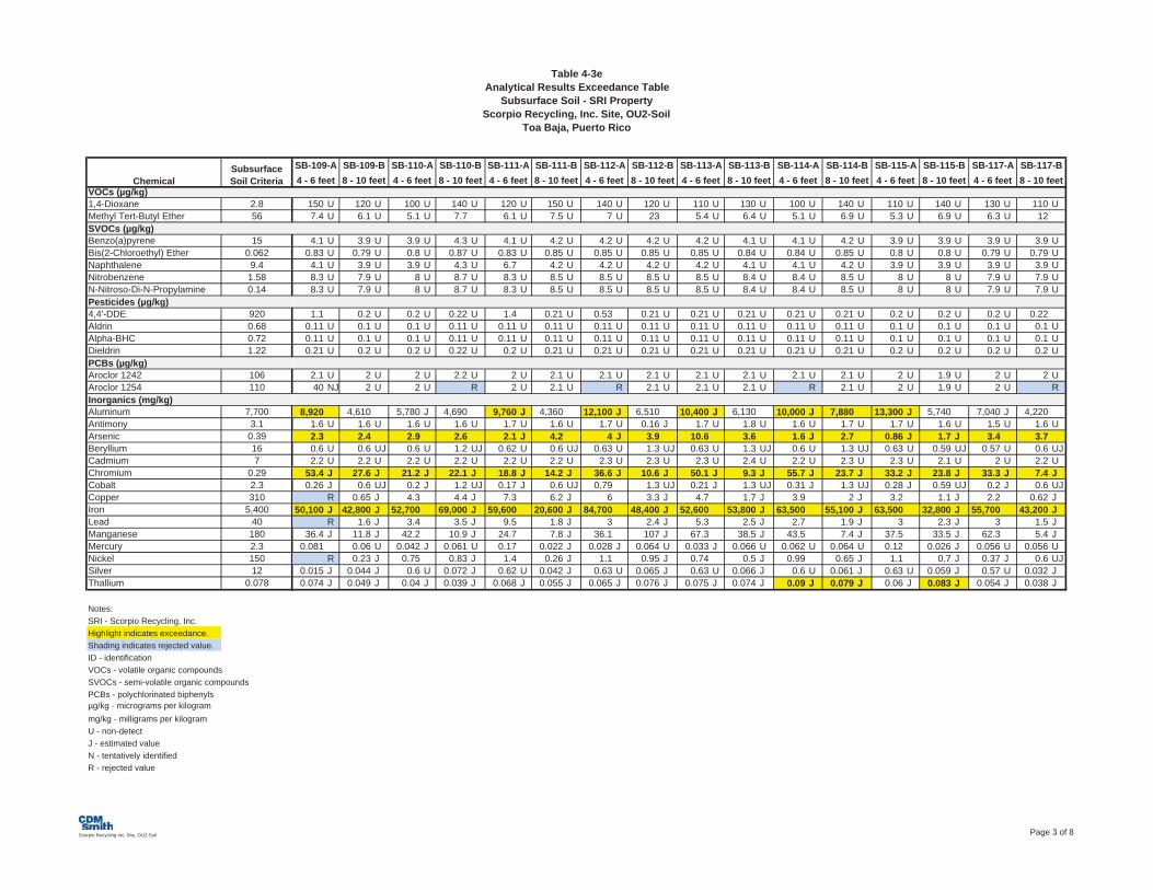
Table 4-3eAnalytical Results Exceedance Table
Subsurface Soil - SRI PropertyScorpio Recycling, Inc. Site, OU2-Soil
Toa Baja, Puerto Rico
VOCs (µg/kg)1,4-Dioxane 2.8Methyl Tert-Butyl Ether 56SVOCs (µg/kg)Benzo(a)pyrene 15Bis(2-Chloroethyl) Ether 0.062Naphthalene 9.4Nitrobenzene 1.58N-Nitroso-Di-N-Propylamine 0.14Pesticides (µg/kg)4,4'-DDE 920Aldrin 0.68Alpha-BHC 0.72Dieldrin 1.22PCBs (µg/kg)Aroclor 1242 106Aroclor 1254 110Inorganics (mg/kg)Aluminum 7,700Antimony 3.1Arsenic 0.39Beryllium 16Cadmium 7Chromium 0.29Cobalt 2.3Copper 310Iron 5,400Lead 40Manganese 180Mercury 2.3Nickel 150Silver 12Thallium 0.078
Notes:SRI - Scorpio Recycling, Inc.Highlight indicates exceedance.Shading indicates rejected value.ID - identificationVOCs - volatile organic compoundsSVOCs - semi-volatile organic compoundsPCBs - polychlorinated biphenylsµg/kg - micrograms per kilogrammg/kg - milligrams per kilogramU - non-detectJ - estimated valueN - tentatively identifiedR - rejected value
SubsurfaceSoil CriteriaChemical
150 U 120 U 100 U 140 U 120 U 150 U 140 U 120 U 110 U 130 U 100 U 140 U 110 U 140 U 130 U 110 U7.4 U 6.1 U 5.1 U 7.7 6.1 U 7.5 U 7 U 23 5.4 U 6.4 U 5.1 U 6.9 U 5.3 U 6.9 U 6.3 U 12
4.1 U 3.9 U 3.9 U 4.3 U 4.1 U 4.2 U 4.2 U 4.2 U 4.2 U 4.1 U 4.1 U 4.2 U 3.9 U 3.9 U 3.9 U 3.9 U0.83 U 0.79 U 0.8 U 0.87 U 0.83 U 0.85 U 0.85 U 0.85 U 0.85 U 0.84 U 0.84 U 0.85 U 0.8 U 0.8 U 0.79 U 0.79 U4.1 U 3.9 U 3.9 U 4.3 U 6.7 4.2 U 4.2 U 4.2 U 4.2 U 4.1 U 4.1 U 4.2 U 3.9 U 3.9 U 3.9 U 3.9 U8.3 U 7.9 U 8 U 8.7 U 8.3 U 8.5 U 8.5 U 8.5 U 8.5 U 8.4 U 8.4 U 8.5 U 8 U 8 U 7.9 U 7.9 U8.3 U 7.9 U 8 U 8.7 U 8.3 U 8.5 U 8.5 U 8.5 U 8.5 U 8.4 U 8.4 U 8.5 U 8 U 8 U 7.9 U 7.9 U
1.1 0.2 U 0.2 U 0.22 U 1.4 0.21 U 0.53 0.21 U 0.21 U 0.21 U 0.21 U 0.21 U 0.2 U 0.2 U 0.2 U 0.220.11 U 0.1 U 0.1 U 0.11 U 0.11 U 0.11 U 0.11 U 0.11 U 0.11 U 0.11 U 0.11 U 0.11 U 0.1 U 0.1 U 0.1 U 0.1 U0.11 U 0.1 U 0.1 U 0.11 U 0.11 U 0.11 U 0.11 U 0.11 U 0.11 U 0.11 U 0.11 U 0.11 U 0.1 U 0.1 U 0.1 U 0.1 U0.21 U 0.2 U 0.2 U 0.22 U 0.2 U 0.21 U 0.21 U 0.21 U 0.21 U 0.21 U 0.21 U 0.21 U 0.2 U 0.2 U 0.2 U 0.2 U
2.1 U 2 U 2 U 2.2 U 2 U 2.1 U 2.1 U 2.1 U 2.1 U 2.1 U 2.1 U 2.1 U 2 U 1.9 U 2 U 2 U40 NJ 2 U 2 U R 2 U 2.1 U R 2.1 U 2.1 U 2.1 U R 2.1 U 2 U 1.9 U 2 U R
8,920 4,610 5,780 J 4,690 9,760 J 4,360 12,100 J 6,510 10,400 J 6,130 10,000 J 7,880 13,300 J 5,740 7,040 J 4,2201.6 U 1.6 U 1.6 U 1.6 U 1.7 U 1.6 U 1.7 U 0.16 J 1.7 U 1.8 U 1.6 U 1.7 U 1.7 U 1.6 U 1.5 U 1.6 U2.3 2.4 2.9 2.6 2.1 J 4.2 4 J 3.9 10.6 3.6 1.6 J 2.7 0.86 J 1.7 J 3.4 3.70.6 U 0.6 UJ 0.6 U 1.2 UJ 0.62 U 0.6 UJ 0.63 U 1.3 UJ 0.63 U 1.3 UJ 0.6 U 1.3 UJ 0.63 U 0.59 UJ 0.57 U 0.6 UJ2.2 U 2.2 U 2.2 U 2.2 U 2.2 U 2.2 U 2.3 U 2.3 U 2.3 U 2.4 U 2.2 U 2.3 U 2.3 U 2.1 U 2 U 2.2 U
53.4 J 27.6 J 21.2 J 22.1 J 18.8 J 14.2 J 36.6 J 10.6 J 50.1 J 9.3 J 55.7 J 23.7 J 33.2 J 23.8 J 33.3 J 7.4 J0.26 J 0.6 UJ 0.2 J 1.2 UJ 0.17 J 0.6 UJ 0.79 1.3 UJ 0.21 J 1.3 UJ 0.31 J 1.3 UJ 0.28 J 0.59 UJ 0.2 J 0.6 UJ
R 0.65 J 4.3 4.4 J 7.3 6.2 J 6 3.3 J 4.7 1.7 J 3.9 2 J 3.2 1.1 J 2.2 0.62 J50,100 J 42,800 J 52,700 69,000 J 59,600 20,600 J 84,700 48,400 J 52,600 53,800 J 63,500 55,100 J 63,500 32,800 J 55,700 43,200 J
R 1.6 J 3.4 3.5 J 9.5 1.8 J 3 2.4 J 5.3 2.5 J 2.7 1.9 J 3 2.3 J 3 1.5 J36.4 J 11.8 J 42.2 10.9 J 24.7 7.8 J 36.1 107 J 67.3 38.5 J 43.5 7.4 J 37.5 33.5 J 62.3 5.4 J
0.081 0.06 U 0.042 J 0.061 U 0.17 0.022 J 0.028 J 0.064 U 0.033 J 0.066 U 0.062 U 0.064 U 0.12 0.026 J 0.056 U 0.056 UR 0.23 J 0.75 0.83 J 1.4 0.26 J 1.1 0.95 J 0.74 0.5 J 0.99 0.65 J 1.1 0.7 J 0.37 J 0.6 UJ
0.015 J 0.044 J 0.6 U 0.072 J 0.62 U 0.042 J 0.63 U 0.065 J 0.63 U 0.066 J 0.6 U 0.061 J 0.63 U 0.059 J 0.57 U 0.032 J0.074 J 0.049 J 0.04 J 0.039 J 0.068 J 0.055 J 0.065 J 0.076 J 0.075 J 0.074 J 0.09 J 0.079 J 0.06 J 0.083 J 0.054 J 0.038 J
SB-117-A8 - 10 feet 4 - 6 feet
SB-117-B8 - 10 feet
SB-113-B SB-114-A8 - 10 feet 4 - 6 feet
SB-114-B SB-115-A8 - 10 feet 4 - 6 feet
SB-115-BSB-111-A8 - 10 feet 4 - 6 feet
SB-111-B SB-112-A8 - 10 feet 4 - 6 feet
SB-112-B SB-113-A8 - 10 feet 4 - 6 feet
SB-109-A4 - 6 feet
SB-109-B SB-110-A8 - 10 feet 4 - 6 feet
SB-110-B
Scorpio Recycling Inc. Site, OU2-Soil Page 3 of 8

Table 4-3eAnalytical Results Exceedance Table
Subsurface Soil - SRI PropertyScorpio Recycling, Inc. Site, OU2-Soil
Toa Baja, Puerto Rico
VOCs (µg/kg)1,4-Dioxane 2.8Methyl Tert-Butyl Ether 56SVOCs (µg/kg)Benzo(a)pyrene 15Bis(2-Chloroethyl) Ether 0.062Naphthalene 9.4Nitrobenzene 1.58N-Nitroso-Di-N-Propylamine 0.14Pesticides (µg/kg)4,4'-DDE 920Aldrin 0.68Alpha-BHC 0.72Dieldrin 1.22PCBs (µg/kg)Aroclor 1242 106Aroclor 1254 110Inorganics (mg/kg)Aluminum 7,700Antimony 3.1Arsenic 0.39Beryllium 16Cadmium 7Chromium 0.29Cobalt 2.3Copper 310Iron 5,400Lead 40Manganese 180Mercury 2.3Nickel 150Silver 12Thallium 0.078
Notes:SRI - Scorpio Recycling, Inc.Highlight indicates exceedance.Shading indicates rejected value.ID - identificationVOCs - volatile organic compoundsSVOCs - semi-volatile organic compoundsPCBs - polychlorinated biphenylsµg/kg - micrograms per kilogrammg/kg - milligrams per kilogramU - non-detectJ - estimated valueN - tentatively identifiedR - rejected value
SubsurfaceSoil CriteriaChemical
R R R R 310 J 34 J R R R R R R R R R R4.8 U 0.44 J 1.9 J 2.3 J 3.8 J 1 J 700 850 7.1 U 6.4 U 5.4 J 14 5.7 UJ 6 U 0.69 J 1.9 J
3.9 U 4 U 2.5 J 2.9 J 4.1 U 4 U 4.4 U 4.3 UJ 4.2 U 4 U 3.6 U 4.5 4.1 J 4.2 U 4.4 UJ 4.3 UJ0.8 U 0.81 U 0.82 U 0.85 U 0.84 U 0.81 U 0.9 U 0.87 U 0.85 U 0.8 U 0.9 0.89 0.82 U 0.86 U 0.9 U 0.87 U3.9 UJ 4 UJ 4 U 4.2 U 4.1 UJ 4 UJ 4.4 UJ 4.3 UJ 4.2 UJ 4 UJ 3.6 U 4.1 U 4.1 U 4.2 UJ 4.4 UJ 4.3 UJ39 U 40 U 40 U 42 U 41 U 40 U 44 U 43 U 42 UJ 40 U 36 UJ 41 UJ 41 U 42 U 44 U 43 U8 UJ 8.1 UJ 8.2 U 8.5 U 8.4 UJ 8.1 UJ 9 U 8.7 U 8.5 U 8 U 7.4 U 32 8.2 U 8.6 U 9 U 8.7 U
3.9 U 4 U 4 UJ 4.2 UJ 4.1 U 4 U 4.4 U 4.3 U 4.2 U 4 UJ 3.6 U 4.1 U 4.1 UJ 4.3 UJ 4.4 U 4.3 U2 U 2.1 U 2.1 UJ 2.1 UJ 2.1 JN 2 U 2.3 U 2.2 U 2.2 U 2 UJ 1.9 U 2.1 U 2.1 UJ 2.2 UJ 2.3 U 2.2 U
0.4 U 0.41 U 0.41 UJ 0.43 UJ 0.43 U 0.41 U 0.46 U 0.44 U 0.43 U 0.41 UJ 0.38 U 0.42 U 0.42 UJ 0.44 UJ 0.46 U 0.44 U0.16 U 0.16 U 0.8 UJ 0.83 UJ 2 0.16 U 0.89 U 0.86 U 0.84 U 0.79 UJ 0.15 U 0.16 U 0.81 UJ 0.85 UJ 0.89 U 0.85 U
0.39 U 0.4 UJ 0.4 U 0.42 U 0.41 UJ 0.4 UJ 0.44 U 0.43 U 0.42 U 0.4 UJ 0.36 U 0.41 U 0.41 UJ 0.43 UJ 0.44 U 0.43 U0.39 U 0.4 UJ 0.4 U 0.42 U 0.41 UJ 0.4 UJ 0.44 U 0.43 U 0.42 U 0.4 UJ 0.36 U 0.41 U 0.41 UJ 0.43 UJ 0.44 U 0.43 U
11,600 16,400 8,180 4,620 18,600 13,900 18,900 15,500 11,300 15,400 17,400 5,970 7,830 12,5000.96 J 0.67 UJ 0.92 J 0.56 J 0.91 J 0.83 J 0.87 J 0.79 J 0.6 J 0.81 J 0.9 J 0.65 J 0.63 J 2.4 UJ
20 J 10.5 J 18.8 J 8.6 J 25.4 J 21.4 J R R R 14.5 J 13.3 J R R R0.071 J 0.13 J 0.071 J 0.043 J 0.12 J 0.12 J 0.67 U 0.62 U 0.58 U 0.59 U 0.6 U 0.58 U 0.62 U 0.6 U0.26 J 0.21 J 0.24 J 0.041 J 0.28 J 0.23 J 0.18 J 0.31 J 0.2 J 0.32 J 0.26 J 0.09 J 0.063 J 0.15 J142 197 77.1 J 32.9 J 177 147 159 J 169 J 97.8 136 J 119 J 18.5 27.2 J 119 J1.5 J 1.9 J 0.67 J 0.52 J 1.6 J 1.5 J 1 J 2.3 J 1.4 J 2.8 J 3 J 0.072 J 0.44 J 1.2 J
24.9 41.9 20 9.3 36 34.2 49.9 43.8 21.4 46.1 34.2 4.3 12.1 32.752,700 95,700 29,600 15,000 70,300 58,100 78,300 J 68,000 43,700 61,300 61,800 9,120 18,900 52,600
8.4 12.9 17.5 J R 8.7 7.4 3.8 J 4.9 2.7 17.4 8 1.7 3.3 3.7109 254 55 50.5 154 169 102 J 223 157 327 280 10.7 34.6 J 111 J0.11 0.063 U 0.06 U 0.17 0.063 U 0.06 U R 0.062 U 0.059 U 0.06 U 0.062 U 0.14 0.43 0.057 J6.4 10.4 2.9 J 2.2 J 9 8.6 10.3 10.1 4.9 9.8 9.4 0.89 J 5 U 7.81.2 U 1.2 U 1.2 U 1.2 U 0.089 J 1.1 U 1.3 U 0.16 J 0.13 J 0.27 J 1.2 U 1.2 U 1.2 U 1.2 U
0.12 0.2 0.23 0.05 UJ 0.12 0.13 0.11 0.14 0.13 0.15 0.18 0.047 U 0.053 0.088 J
SB-18-B SB-19-A8 - 10 feet 4 - 6 feet
SB-19-B8 - 10 feet
SB-16-A8 - 10 feet 4 - 6 feet
SB-16-B SB-17-A8 - 10 feet 4 - 6 feet
SB-17-B SB-18-A8 - 10 feet 4 - 6 feet
SB-13-B SB-14-A8 - 10 feet 4 - 6 feet
SB-14-B SB-15-A8 - 10 feet 4 - 6 feet
SB-15-BSB-11-A4 - 6 feet
SB-11-B SB-13-A8 - 10 feet 4 - 6 feet
Scorpio Recycling Inc. Site, OU2-Soil Page 4 of 8
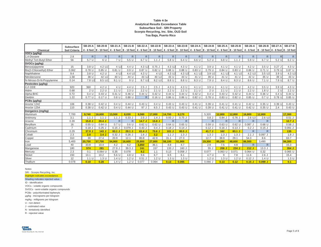
Table 4-3eAnalytical Results Exceedance Table
Subsurface Soil - SRI PropertyScorpio Recycling, Inc. Site, OU2-Soil
Toa Baja, Puerto Rico
VOCs (µg/kg)1,4-Dioxane 2.8Methyl Tert-Butyl Ether 56SVOCs (µg/kg)Benzo(a)pyrene 15Bis(2-Chloroethyl) Ether 0.062Naphthalene 9.4Nitrobenzene 1.58N-Nitroso-Di-N-Propylamine 0.14Pesticides (µg/kg)4,4'-DDE 920Aldrin 0.68Alpha-BHC 0.72Dieldrin 1.22PCBs (µg/kg)Aroclor 1242 106Aroclor 1254 110Inorganics (mg/kg)Aluminum 7,700Antimony 3.1Arsenic 0.39Beryllium 16Cadmium 7Chromium 0.29Cobalt 2.3Copper 310Iron 5,400Lead 40Manganese 180Mercury 2.3Nickel 150Silver 12Thallium 0.078
Notes:SRI - Scorpio Recycling, Inc.Highlight indicates exceedance.Shading indicates rejected value.ID - identificationVOCs - volatile organic compoundsSVOCs - semi-volatile organic compoundsPCBs - polychlorinated biphenylsµg/kg - micrograms per kilogrammg/kg - milligrams per kilogramU - non-detectJ - estimated valueN - tentatively identifiedR - rejected value
SubsurfaceSoil CriteriaChemical
R R R R R R R R R R R R R R R R5.7 U 6 U 7 U 5.5 U 6.7 U 1.1 J 5.8 U 6.4 U 6.6 U 5.2 U 6.8 U 1.1 J 5.9 U 6.7 U 5.2 U 6.2 U
3.8 U 4.2 UJ 4 UJ 4.4 U 4.3 UJ 0.75 J 4.3 UJ 4.3 U 4.1 U 3.9 U 4.1 U 4.1 U 4.2 U 3.5 U 0.27 J 4.3 U0.78 U 0.85 U 0.81 U 0.9 U 0.87 U 0.82 U 0.88 U 0.88 U 0.83 U 0.79 U 0.84 U 0.83 U 0.86 U 0.71 U 0.79 U 0.87 U3.8 U 4.2 U 4 UJ 4.4 UJ 4.3 U 4 UJ 4.3 UJ 4.3 UJ 4.1 UJ 3.9 UJ 4.1 UJ 4.1 UJ 4.2 UJ 3.5 UJ 3.9 U 4.3 UJ38 U 42 UJ 40 U 44 U 43 UJ 40 UJ 43 U 43 U 41 U 39 U 41 U 41 U 42 U 35 U 39 U 43 U7.8 UJ 8.5 UJ 8.1 U 9 U 8.7 UJ 8.2 UJ 8.8 U 8.8 U 8.3 U 7.9 U 8.4 U 8.3 U 8.6 U 7.1 U 7.9 U 8.7 U
360 4.2 U 4 U 4.4 U 2.5 J 2.5 J 4.3 U 4.3 U 4.1 U 3.9 U 4.1 U 4.1 U 4.2 U 3.5 U 3.9 U 4.3 U2 U 2.2 U 2.1 U 2.3 U 2.2 U 2.1 U 2.2 U 2.2 U 2.1 U 2 U 2.1 U 2.1 U 2.2 U 1.8 U 2 U 2.2 U
0.4 U 0.43 U 0.41 U 0.46 U 0.44 U 0.42 U 0.44 U 0.44 U 0.42 U 0.4 U 0.43 U 0.42 U 0.44 U 0.36 U 0.4 U 0.44 U0.77 U 0.17 U 0.8 U 0.88 U R 0.16 U 0.86 U 0.86 U 0.82 U 0.78 U 0.83 U 0.82 U 0.85 U 0.7 U 0.78 U 0.85 U
0.38 U 0.42 U 0.4 U 0.44 U 0.43 U 0.4 U 0.43 U 0.43 U 0.41 U 0.39 U 0.41 U 0.41 U 0.42 U 0.35 U 0.39 U 0.43 U0.38 U 0.42 U 0.4 U 0.44 U 97 J 6.5 J 0.43 U 0.43 U 0.41 U 0.39 U 0.41 U 0.41 U 0.42 U 0.35 U 2.4 0.43 U
9,740 16,600 13,500 8,030 9,580 17,000 14,700 9,170 5,320 12,800 12,800 16,800 12,800 17,3001.1 J 1.1 J 1.1 J 0.33 J 2.5 J 1.4 J 0.93 J 0.75 J 0.8 J 0.84 J 0.76 J 2.6 UJ 2.6 UJ 0.51 J
15.8 J 20.4 J R R 14.7 J 15.8 J R R R R R R R 10.7 J0.55 U 0.64 U 0.7 U 0.6 U 0.62 U 0.62 U 0.64 U 0.65 U 0.59 U 0.63 U 0.62 U 0.087 J 0.68 U 0.58 J0.18 J 0.25 J 0.15 J 0.079 J 0.43 J 0.4 J 0.18 J 0.14 J 0.12 J 0.16 J 0.13 J 0.2 J 0.15 J 0.091 J37.9 J 143 J 93.1 J 29.1 J 61.4 J 75.6 J 101 J 95.5 J 41.7 J 162 83.1 J R R 1352.9 3.4 J 0.32 J 0.26 J 1.6 J 3.2 1.1 J 1.3 J 1.3 J 1.3 J 1.3 J 2.1 J 0.097 J 1.8 J30 27.4 20.9 12.1 80.8 42.9 31.1 27.3 12.7 38.9 29.1 54.3 8.6 63.7
20,700 57,700 54,900 16,600 25,800 27,800 58,100 51,900 19,300 85,200 48,600 86,500 3,490 94,30033.8 10.4 4.2 4.2 3,850 36.1 4.8 4.7 2.9 7.5 4.8 R R 15.3574 281 27.9 J 39.3 J 241 157 133 J 160 J 55 J 206 J 224 J 212 J 13.3 J 354 J0.1 0.064 U 0.35 0.078 9.2 1.1 0.13 0.058 J 0.077 0.063 U 0.071 0.064 U 0.32 0.065 U
10.1 10.2 5.6 U 4.8 U 9.6 6.7 6.5 6.1 4.7 U 9 7.8 11.6 2.6 J 15.41.1 U 1.3 U 1.4 U 1.2 U 0.51 J 1.2 U 1.3 U 1.3 U 1.2 U 1.3 U 1.2 U 0.12 J 1.4 U 1.3 U
0.18 0.28 1.4 U 1.2 U 0.077 0.064 0.13 0.095 0.066 J 0.13 0.12 0.15 J 0.099 J 0.1
SB-26-A8 - 10 feet 4 - 6 feet
SB-26-B SB-27-A8 - 10 feet 4 - 6 feet
SB-27-B8 - 10 feet
SB-23-B SB-24-A8 - 10 feet 4 - 6 feet
SB-24-B SB-25-A8 - 10 feet 4 - 6 feet
SB-25-BSB-21-A8 - 10 feet 4 - 6 feet
SB-21-B SB-22-A8 - 10 feet 4 - 6 feet
SB-22-B SB-23-A8 - 10 feet 4 - 6 feet
SB-20-A4 - 6 feet
SB-20-B
Scorpio Recycling Inc. Site, OU2-Soil Page 5 of 8

Table 4-3eAnalytical Results Exceedance Table
Subsurface Soil - SRI PropertyScorpio Recycling, Inc. Site, OU2-Soil
Toa Baja, Puerto Rico
VOCs (µg/kg)1,4-Dioxane 2.8Methyl Tert-Butyl Ether 56SVOCs (µg/kg)Benzo(a)pyrene 15Bis(2-Chloroethyl) Ether 0.062Naphthalene 9.4Nitrobenzene 1.58N-Nitroso-Di-N-Propylamine 0.14Pesticides (µg/kg)4,4'-DDE 920Aldrin 0.68Alpha-BHC 0.72Dieldrin 1.22PCBs (µg/kg)Aroclor 1242 106Aroclor 1254 110Inorganics (mg/kg)Aluminum 7,700Antimony 3.1Arsenic 0.39Beryllium 16Cadmium 7Chromium 0.29Cobalt 2.3Copper 310Iron 5,400Lead 40Manganese 180Mercury 2.3Nickel 150Silver 12Thallium 0.078
Notes:SRI - Scorpio Recycling, Inc.Highlight indicates exceedance.Shading indicates rejected value.ID - identificationVOCs - volatile organic compoundsSVOCs - semi-volatile organic compoundsPCBs - polychlorinated biphenylsµg/kg - micrograms per kilogrammg/kg - milligrams per kilogramU - non-detectJ - estimated valueN - tentatively identifiedR - rejected value
SubsurfaceSoil CriteriaChemical
R R R R R R R R R R R R R R R4.7 U 5.5 U 5.7 U 5.5 U 5.8 U 7.4 U 6.4 U 6.5 U 5.3 U 6.5 U 5 U 6.1 U 6.4 U 6.2 U 5.1 U
3.9 U 4.1 U 4 U R 4.1 U 4.4 U 4.3 U 3.6 U R 4.2 U 4.1 U 3.8 U R 4.2 U 2.8 J0.8 U 0.84 U 0.81 U 0.79 U 0.84 U 0.9 U 0.87 U 0.73 U 0.81 U 0.85 U 0.83 U 0.77 U R 0.85 U 0.49 J3.9 UJ 4.1 UJ 7.2 3.9 U 4.1 U 4.4 UJ 4.3 U 3.6 UJ 4 UJ 4.2 UJ 4.1 UJ 3.8 UJ 4.4 U 4.2 U 4 U39 U 41 U 40 U 39 U 41 U 44 U 43 U 36 U 40 U 42 U 41 U 38 U 44 U 42 UJ 40 U8 U 8.4 U 8.1 U 7.9 U 8.4 U 9 U 8.7 U 7.3 U 8.1 U 8.5 U 8.3 U 7.7 U R 8.5 U 1.6 J
3.9 U 4.1 U 4 U 3.9 U 4.1 U 4.4 U 4.3 U 3.6 U 4 UJ 4.2 UJ 4.1 U 3.8 U 4.4 U 4.1 U 15 J2 U 2.1 U 2.1 U 2 U 2.1 U 2.3 U 2.2 U 1.8 U 2 UJ 2.2 UJ 2.1 U 1.9 U 2.3 U 2.1 U 0.51 UJ
0.41 U 0.42 U 0.41 U 0.4 U 0.43 U 0.46 U 0.44 U 0.37 U 0.41 UJ 0.43 UJ 0.42 U 0.39 U 0.45 U 0.43 U 0.1 UJ0.79 U 0.82 U 5.6 J 0.78 U 0.83 U 0.88 U 0.85 U 0.71 U 1.2 JN 0.84 UJ 0.81 U 0.76 U 0.88 U 0.83 U 0.15 UJ
0.39 U 0.41 U 0.4 U 0.39 UJ 0.41 U 0.44 UJ 0.43 UJ 0.36 UJ 0.4 UJ 0.42 UJ 0.41 U 0.38 U 0.44 UJ 0.41 U 0.4 UJ0.39 U 0.41 U 58 0.39 UJ 6.8 0.44 UJ 0.43 UJ 0.36 UJ 9.9 J 0.42 UJ 1.3 J 2.3 0.44 UJ 0.41 U 0.4 UJ
13,600 14,100 10,800 6,580 9,520 13,100 16,000 14,500 13,500 9,180 4,740 4,320 24,300 26,200 14,0000.58 0.49 0.42 J 2.2 U 1.2 J 0.87 J 0.85 J 0.82 J 0.92 J 0.71 J 0.57 J 0.54 2.6 UJ 2.5 UJ R17.4 J 8.9 J R 7.8 R R R R 52.8 R R 17.8 R R 29.5 J-0.26 J 0.22 J 0.024 J 0.56 U 0.51 J 0.066 J 0.053 J 0.1 J 0.64 U 0.61 U 0.57 U 0.56 U 0.1 J 0.071 J 15 U0.12 J 0.1 J 0.041 J 0.051 J 0.43 J 0.13 J 0.24 J 0.23 J 0.17 J 0.14 J 0.2 J 0.092 J 0.26 J 0.1 J 10.8 U
90 67.5 R 6 R R R R 152 129 11.6 52.9 R R 83.12.7 U 2.7 U 0.49 J 0.17 J 9.7 1.1 J 0.79 J 2.2 J 1.8 J 0.72 J 0.068 J 0.43 J 2.6 J 1.5 J 15 U
26.6 32.6 12.7 3.4 40.3 26.1 28.6 48.6 321 21.2 2.9 9.4 52.3 34.4 39.357,800 44,700 14,100 6,790 30,100 26,100 71,700 62,600 61,800 58,100 4,500 24,100 92,400 42,800 43,800
8.5 6.3 R 2.7 R R R R 57 5.4 1.5 3.6 R R 68.9128 J 220 J 7.1 J 4.1 502 J 71 J 71.6 J 299 J 23.4 70 5 53.9 381 J 171 J 215
0.091 0.06 U 0.48 0.42 0.087 0.073 0.07 0.066 U 0.21 0.19 0.065 0.058 U 0.065 U 0.065 U 0.0666 8.8 4.5 J 1.4 J 15.4 5.6 5.2 J 11.4 3.4 J 5.2 0.44 J 2 J 11.5 8.2 15 U
1.2 U 1.2 U 1.2 U 1.1 U 1.3 U 1.3 U 0.11 J 1.3 U 0.096 J 0.073 J 1.1 U 1.1 U 0.092 J 1.3 U 15 U0.19 0.12 1.2 UJ 1.1 U 0.49 0.14 J 0.36 0.2 J 0.062 0.086 0.046 UJ 0.037 J 0.18 J 0.13 J 1.2 U
SB-33-B SB-34-A8 - 10 feet 4 - 6 feet
SB-34-B SB-70-A8 - 10 feet 4 - 6 feet
SB-31-A8 - 10 feet 4 - 6 feet
SB-31-B SB-32-A8 - 10 feet 4 - 6 feet
SB-32-B SB-33-A8 - 10 feet 4 - 6 feet
SB-28-B SB-29-A8 - 10 feet 4 - 6 feet
SB-29-B SB-30-A8 - 10 feet 4 - 6 feet
SB-30-BSB-28-A4 - 6 feet
Scorpio Recycling Inc. Site, OU2-Soil Page 6 of 8

Table 4-3eAnalytical Results Exceedance Table
Subsurface Soil - SRI PropertyScorpio Recycling, Inc. Site, OU2-Soil
Toa Baja, Puerto Rico
VOCs (µg/kg)1,4-Dioxane 2.8Methyl Tert-Butyl Ether 56SVOCs (µg/kg)Benzo(a)pyrene 15Bis(2-Chloroethyl) Ether 0.062Naphthalene 9.4Nitrobenzene 1.58N-Nitroso-Di-N-Propylamine 0.14Pesticides (µg/kg)4,4'-DDE 920Aldrin 0.68Alpha-BHC 0.72Dieldrin 1.22PCBs (µg/kg)Aroclor 1242 106Aroclor 1254 110Inorganics (mg/kg)Aluminum 7,700Antimony 3.1Arsenic 0.39Beryllium 16Cadmium 7Chromium 0.29Cobalt 2.3Copper 310Iron 5,400Lead 40Manganese 180Mercury 2.3Nickel 150Silver 12Thallium 0.078
Notes:SRI - Scorpio Recycling, Inc.Highlight indicates exceedance.Shading indicates rejected value.ID - identificationVOCs - volatile organic compoundsSVOCs - semi-volatile organic compoundsPCBs - polychlorinated biphenylsµg/kg - micrograms per kilogrammg/kg - milligrams per kilogramU - non-detectJ - estimated valueN - tentatively identifiedR - rejected value
SubsurfaceSoil CriteriaChemical
R R R R R R R R R R R R R R5.1 U 6.3 U 6.2 U 5.1 U 4.8 U 6.2 U 4.2 U 6.2 U 2.9 U 4.3 U 11 U 5.6 U 4.8 U 5.4 U
1.4 J 3.5 U 4.7 U 3.8 U 3.6 U 4.2 J 33 J 15 J 9.2 J 4.2 U 4.4 U 3.8 U 4 U 3.8 U0.21 J 0.72 U 0.95 U 0.38 J 0.74 U 1 J 1.6 0.5 J 0.84 U 0.86 U 0.4 J 0.5 J 0.81 U 0.78 UJ4.1 UJ 3.5 U 4.7 U 3.8 U 3.6 UJ 4 UJ 14 11 5.2 4.2 U 4.4 U 3.8 U 4 U 3.8 UJ41 U 35 U 47 U 38 U 36 U R 6.5 J 4.5 J 41 U 42 U 44 U 38 U 40 U 38 UJ
0.38 J 1.2 J 0.86 J 0.77 J 7.4 U 2.3 J 9.8 2.4 J 2.7 J 0.56 J 0.74 J 0.85 J 0.54 J 7.8 UJ
1 UJ 0.88 UJ 1.2 UJ 0.95 UJ 0.91 U 4.9 J 160 200 180 1.7 J 1.1 UJ 0.95 UJ 0.4 J 0.96 U0.53 UJ 0.46 UJ 0.6 UJ 0.49 UJ 0.47 U 0.18 UJ 0.25 UJ 0.52 J 0.53 J 0.54 UJ 0.57 UJ 0.49 UJ 0.52 J 0.49 U0.11 UJ 0.091 UJ 0.12 UJ 0.098 UJ 0.093 U 0.1 UJ 0.1 UJ 0.1 UJ 0.11 UJ 0.11 UJ 0.11 UJ 0.098 UJ 0.1 UJ 0.099 U0.36 NJ 0.18 UJ 0.23 UJ 0.19 UJ 0.18 U 0.79 J 3.7 J 2.9 J 3.6 J 0.21 UJ 0.22 UJ 0.19 UJ 0.18 UJ 0.19 U
0.41 U 0.35 UJ R 0.38 UJ 0.36 U 0.4 U 0.41 UJ 0.4 U 0.41 UJ 0.42 UJ R 0.38 U 38 NJ 0.38 U12 0.35 UJ R 0.38 UJ 0.36 U 0.4 U 0.41 UJ 0.4 U 0.41 UJ 0.42 UJ R 0.38 U 0.4 U 0.38 U
9,280 8,850 24,800 10,400 11,700 17,800 19,600 17,600 17,600 28,900 24,800 8,050 7,140 6,200R R R R R 251 J R R R 9 UJ R R R R
35.7 J- 42.8 J- 28.5 J- 30.4 J- 18 42.3 J- 33.2 J- 163 J- 138 J- 40.2 J- 169 J- 29.5 14.3 300.28 J 14.3 U 0.32 J 0.081 J 2.8 U 1.2 J 0.25 J 0.57 J 0.51 J 0.31 J 23.2 3.2 U 2.9 U 3 U10.7 U 10.3 U 11.4 U 2.1 U 2 UJ 12.5 U 11.2 U 10.9 U 11.1 U 12 U 22.6 2.3 UJ 2.1 UJ 2.2 UJ58.8 74.5 60.9 54.6 47.4 65.3 75.9 287 257 65.1 393 50.7 28.9 48.714.9 U 14.3 U 15.8 U 2.9 U 3.8 J 17.3 U 15.5 U 15.2 U 15.5 U 16.7 U 236 6 J 3 J 4.6 J27.3 J 8.4 J 1,300 9.7 19 J 1,070 2,990 49.9 46.6 30.4 J 176 2,120 J 13.6 J 30.1 J
18,700 33,300 122,000 31,100 19,700 14,500 42,800 47,900 56,000 79,400 56,000 15,200 16,200 14,80049.6 14.3 U 2,200 3.6 18.1 65,700 29,400 19 17.6 55 30.3 7,110 109 1,060
1,660 74.1 804 94.8 386 423 825 506 452 1,860 783 1,010 406 5720.061 0.037 J 0.04 J 0.057 U 0.068 0.14 0.28 0.16 0.26 0.11 0.062 0.046 J 0.084 0.1215.5 14.3 U 31.6 3.6 11.7 J 20.4 56.6 19 17.4 17.3 259 20.4 J 10.3 J 12.1 J14.9 U 14.3 U 15.8 U 2.9 U 2.8 UJ 17.3 U 15.5 U 15.2 U 15.5 U 16.7 U 23.3 3.2 UJ 2.9 UJ 3 UJ1.3 1.1 U 1.3 U 0.23 U 0.24 1.4 U 1.2 U 1.2 U 1.2 U 1.5 24.7 0.78 0.29 0.44
SB-76-A28 - 30 feet 4 - 6 feet
SB-76-B SB-76-C8 - 10 feet 12 - 14 feet
SB-75-C SB-75-D12 - 14 feet 16 - 18 feet
SB-75-E SB-75-F20 - 22 feet 24 - 26 feet
SB-75-GSB-72-C4 - 6 feet 4 - 6 feet
SB-72-D SB-72-E8 - 10 feet 12 - 14 feet
SB-74-A SB-75-A4 - 6 feet 4 - 6 feet
SB-71-A
Scorpio Recycling Inc. Site, OU2-Soil Page 7 of 8

Table 4-3eAnalytical Results Exceedance Table
Subsurface Soil - SRI PropertyScorpio Recycling, Inc. Site, OU2-Soil
Toa Baja, Puerto Rico
VOCs (µg/kg)1,4-Dioxane 2.8Methyl Tert-Butyl Ether 56SVOCs (µg/kg)Benzo(a)pyrene 15Bis(2-Chloroethyl) Ether 0.062Naphthalene 9.4Nitrobenzene 1.58N-Nitroso-Di-N-Propylamine 0.14Pesticides (µg/kg)4,4'-DDE 920Aldrin 0.68Alpha-BHC 0.72Dieldrin 1.22PCBs (µg/kg)Aroclor 1242 106Aroclor 1254 110Inorganics (mg/kg)Aluminum 7,700Antimony 3.1Arsenic 0.39Beryllium 16Cadmium 7Chromium 0.29Cobalt 2.3Copper 310Iron 5,400Lead 40Manganese 180Mercury 2.3Nickel 150Silver 12Thallium 0.078
Notes:SRI - Scorpio Recycling, Inc.Highlight indicates exceedance.Shading indicates rejected value.ID - identificationVOCs - volatile organic compoundsSVOCs - semi-volatile organic compoundsPCBs - polychlorinated biphenylsµg/kg - micrograms per kilogrammg/kg - milligrams per kilogramU - non-detectJ - estimated valueN - tentatively identifiedR - rejected value
SubsurfaceSoil CriteriaChemical
R R R R R R R R R R5.5 U 7.6 U 6.9 U 3.8 U 3.1 U 5 U 4.9 U 5.4 U 6.1 U 6.4 U
2.2 J 1.7 J 4.2 U 1.7 J 4.6 1.9 J 2.8 J 2.4 J 4.1 U 4.2 U0.77 UJ 0.97 UJ 0.85 U 0.48 J 0.74 U 0.79 U 0.79 U 0.83 UJ 0.83 U 0.85 U3.8 U 4.8 U 4.2 U 3.8 U 3.6 U 3.9 U 8.8 66 5.2 1538 UJ 48 U 42 U 38 U 36 U 39 U 39 U 41 U 41 U 42 U
7.7 UJ 9.7 U 8.5 U 1.3 J 0.66 J 7.9 U 7.9 U 8.3 U 8.3 U 8.5 U
0.94 U 0.92 U R 0.96 UJ 0.91 UJ 0.97 U 5.5 J 2.5 1 U 1 U0.49 U 0.3 U 0.54 U 0.5 J 0.47 UJ 0.5 U 0.5 U 0.53 U 0.53 U 0.54 U
0.097 U 0.12 U 0.11 U 0.099 UJ 0.094 UJ 0.1 U 0.1 U 0.11 U 0.11 U 0.11 U0.19 U R R 0.68 NJ 0.18 UJ 0.19 U 0.32 NJ 0.27 J 0.2 U 0.21 U
35 1,300 7,000 0.38 UJ R 0.39 U 0.39 U 0.41 U 0.41 U 0.42 U0.38 U 4.8 U 21 U 11 J 2.5 J 0.39 U 0.39 U 0.41 U 0.41 U 0.42 U
7,770 12,500 15,300 11,700 6,070 5,610 11,900 11,700 24,700 48,400R 1.9 UJ R R R R R R R R
18.3 44.2 151 16.8 31.3 34.4 17.4 16.5 50.6 50.72.9 U 3.6 U 3.2 U 2.8 U 3 U 3.1 U 0.14 J 3 U 3.2 U 3.3 U2.1 UJ 2.6 UJ 2.3 UJ 2 UJ 2.1 UJ 2.2 UJ 2.2 UJ 2.2 UJ 2.3 UJ 2.4 UJ
51.7 69.5 R 45 57.5 61.6 40.7 38 135 1404.4 J 17.4 J 6.4 J 5 J 7.6 J 7.4 J 3.8 J 3.8 J 3.2 UJ 3.3 UJ
167 J 35.4 J 93.1 402 J 28.8 J 129 J 154 J 148 J 40.2 J 47.3 J15,000 18,200 26,500 24,200 14,100 10,700 17,000 16,800 63,200 72,3001,940 79.3 562 839 83.9 290 41 98.5 11.3 17.7
457 3,950 2,880 489 R 1,760 255 313 187 2020.091 0.2 0.11 0.047 J 0.085 0.072 0.13 0.13 0.067 0.1213.7 J 24.4 J 19.3 J 29.8 J 16.4 J 22.8 J 9.6 J 10.9 J 13.1 J 14.6 J2.9 UJ 3.6 UJ 3.2 UJ 2.8 UJ 3 UJ 3.1 UJ 3.1 UJ 3 UJ 3.2 UJ 3.3 UJ0.3 0.48 1.6 0.22 U 0.65 0.63 0.24 U 0.24 U 0.26 U 0.26 U
20 - 22 feet 24 - 26 feet 28 - 30 feetSB-77-F SB-77-GSB-77-DSB-76-D SB-76-E
16 - 18 feet 20 - 22 feetSB-76-F SB-77-A
24 - 26 feet 4 - 6 feetSB-77-ESB-77-B SB-77-C
8 - 10 feet 12 - 14 feet 16 - 18 feet
Scorpio Recycling Inc. Site, OU2-Soil Page 8 of 8

Table 4-3fAnalytical Results Exceedance Table
Surface Soil - Rosa del Monte PropertyScorpio Recycling, Inc. Site, OU2-Soil
Toa Baja, Puerto Rico
SVOCs (µg/kg)N-Nitroso-Di-N-Propylamine 0.14 R 7.7 U 7.6 U 8.1 U 7.3 U 7.1 U 2.4 JPesticides (µg/kg)Dieldrin 1.22 0.71 UJ 0.15 U 0.15 U 2.4 0.72 UJ 11 NJ 0.037 UEndrin Aldehyde 10.5 3.5 UJ 3.8 U 3.8 U 6.3 JN 3.6 UJ 13 J 0.93 UInorganics (mg/kg)Aluminum 50 6,270 5,020 9,990 5,390 3,480 3,710 9,030 JAntimony 0.27 0.8 1.5 J 0.82 26.4 J 1 0.67 RArsenic 0.39 11.7 15.3 J 18.6 13 J 15 8.6 RCadmium 0.36 0.16 J 0.19 J 0.27 J 0.65 0.2 J 0.21 J 0.076 JChromium 0.29 44.4 J 35.5 70.7 J 26.6 27.2 J 29.7 J 45.6 JCobalt 2.3 2.5 J 3.4 7.3 5 4.5 3.8 4.7 JCopper 28 25.1 15.7 J 41.9 30.6 J 19.9 19.1 22.9 JIron 5,400 18,200 J 13,200 33,200 J 12,200 12,500 J 11,900 J 14,000 JLead 11 17.3 R 8.4 R 4.1 21 13.3 JManganese 180 613 J 338 J 680 J 329 J 403 J 260 J 371 JThallium 0.078 0.18 0.3 J 0.34 0.18 J 0.25 0.12 0.17 JVanadium 7.8 71.5 51.1 131 48.2 48.7 48.6 74.7 J
Notes:Highlight indicates exceedance.Shading indicates rejected value.ID - identificationSVOCs - semi-volatile organic compoundsµg/kg - micrograms per kilogrammg/kg - milligrams per kilogramU - non-detectJ - estimated valueN - tentatively identifiedR - rejected value
0-2 feetSS-62
0-2 feetSS-61
0-2 feetSS-60
0-2 feetSurface Soil
CriteriaChemicalSS-81
0-2 feetSS-64
0-2 feetSS-63
0-2 feetSS-59
Scorpio Recycling Inc. Site, OU2-Soil Page 1 of 1

Table 4-3gAnalytical Results Exceedance Table
Subsurface Soil - Rosa del Monte PropertyScorpio Recycling, Inc. Site, OU2-Soil
Toa Baja, Puerto Rico
VOCs (µg/kg)cis-1,3-Dichloropropene 3 5.7 U 4.8 U 5.1 U 5.5 U 4.9 U 5.6 U 5.3 U 6.5 U 7 UJ 7.1 U 6.7 USVOCs (µg/kg)Bis(2-Chloroethyl) Ether 0.062 0.77 U 0.85 U 0.79 U 0.81 U 0.81 U 0.72 U 0.89 U 0.86 U 0.88 U 0.83 U 0.77 UN-Nitroso-Di-N-Propylamine 0.14 7.7 U 8.5 U 7.9 U 8.1 U 8.1 U 7.2 U 8.9 U 8.6 U 8.8 U 8.3 U 7.7 UPesticides (µg/kg)Alpha-BHC 0.72 0.39 UJ 0.43 U 0.4 U 0.41 U 0.41 U 0.37 U 0.45 U 0.44 U 0.45 U 0.42 UJ 0.39 UJBeta-BHC 2.6 0.39 UJ 0.43 U 0.4 U 0.41 U 0.41 U 0.37 U 0.45 U 0.44 U 0.45 U 0.42 UJ 0.39 UJDieldrin 1.22 0.76 UJ 0.17 U 0.16 U 0.16 U 0.16 U 0.14 U 0.18 U 0.17 U 0.17 U 0.82 UJ 0.76 UJInorganics (mg/kg)Aluminum 7,700 9,950 7,120 6,990 8,530 7,320 8,670 8,960 6,410 8,850 8,610 5,790Antimony 3.1 1.6 J 1.2 J 1.7 J 1.2 J 1.2 J 0.96 J 1.3 J 1 J 1.7 J 1.2 1.5 JArsenic 0.39 R 16.5 J 14.3 J 17.5 J 15 J 22.5 33.9 23.1 39.2 30.4 31.9Cadmium 7 0.83 0.24 J 0.19 J 0.24 J 0.17 J 0.25 J 0.31 J 0.3 J 0.39 J 1.3 1.7Chromium 0.29 54.5 J 45.6 43.6 44.7 42.9 47.8 J 63.8 J 38.6 J 45.7 J 82.3 J 52.6 JCobalt 2.3 6.4 J 5.6 4.7 6.3 5.1 4.8 11.3 5.1 7.1 8.3 11.5 JCopper 310 49.3 25.1 J 29.6 J 39.8 J 25.7 J 23.5 37.2 24.5 31.3 66 49.4Iron 5,400 20,100 J 19,300 18,600 23,000 18,000 20,300 J 32,500 J 18,700 J 23,500 J 39,500 J 25,600 JLead 40 82.2 R R R R 5.4 6.2 4.6 5.8 8.6 5.7 JManganese 180 2,110 J 389 J 377 J 652 374 J R R 494 J 612 J 1,010 J 629 JThallium 0.078 0.46 0.2 J 0.19 J 0.28 J 0.18 J 0.27 0.68 0.32 0.41 0.77 0.68Zinc 2,300 33.4 20.4 20.5 28.5 19.6 21.1 31.2 22.6 27 41.1 29.2
Notes:Highlight indicates exceedance.Shading indicates rejected value.ID - identificationVOCs - volatile organic compoundsSVOCs - semi-volatile organic compoundsµg/kg - micrograms per kilogrammg/kg - milligrams per kilogramU - non-detectJ - estimated valueN - tentatively identifiedR - rejected value
SB-61-D SB-61-E SB-61-F20 - 22 feet 24 - 26 feetChemical
SB-60-D SB-61-A SB-61-B SB-61-CSB-59-A SB-60-A SB-60-B SB-60-CSubsurfaceSoil Criteria 4 - 6 feet 4 - 6 feet 8 - 10 feet 12 - 14 feet 16 - 18 feet 4 - 6 feet 8 - 10 feet 12 - 14 feet 16 - 18 feet
Scorpio Recycling Inc. Site, OU2-Soil Page 1 of 4

Table 4-3gAnalytical Results Exceedance Table
Subsurface Soil - Rosa del Monte PropertyScorpio Recycling, Inc. Site, OU2-Soil
Toa Baja, Puerto Rico
VOCs (µg/kg)cis-1,3-Dichloropropene 3SVOCs (µg/kg)Bis(2-Chloroethyl) Ether 0.062N-Nitroso-Di-N-Propylamine 0.14Pesticides (µg/kg)Alpha-BHC 0.72Beta-BHC 2.6Dieldrin 1.22Inorganics (mg/kg)Aluminum 7,700Antimony 3.1Arsenic 0.39Cadmium 7Chromium 0.29Cobalt 2.3Copper 310Iron 5,400Lead 40Manganese 180Thallium 0.078Zinc 2,300
Notes:Highlight indicates exceedance.Shading indicates rejected value.ID - identificationVOCs - volatile organic compoundsSVOCs - semi-volatile organic compoundsµg/kg - micrograms per kilogrammg/kg - milligrams per kilogramU - non-detectJ - estimated valueN - tentatively identifiedR - rejected value
ChemicalSubsurfaceSoil Criteria
6.5 U 6.9 U 4.6 U 4.2 U 4.8 U 4.8 U 4.9 U 5.7 U 6.6 U 3.1 J
0.77 U 0.79 U 0.77 U 0.75 U 0.85 U 0.84 U 0.79 U 0.85 U 0.85 U 0.86 U7.7 U 7.9 U 7.7 U 7.5 U 8.5 U 8.4 U 7.9 U 8.5 U 8.5 U 8.6 U
0.39 UJ 0.4 UJ 0.39 U 0.38 U 2.7 J 1.5 0.4 U 0.43 U 0.43 U 0.660.39 UJ 0.4 UJ 0.39 U 0.38 U 4.1 1.6 J 0.4 U 0.43 U 0.43 U 0.44 U0.76 UJ 0.78 UJ 0.15 U 0.15 U 4.1 JN 3.9 J 0.16 U 0.17 U 0.17 U R
2,210 6,020 8,000 7,810 87,100 9,880 6,420 12,300 15,200 18,5001.1 J 0.31 U 2 J 3.7 J 195 J 1,420 275 J 1.5 11.6 23.9
R 6.4 14.3 J 14.4 J 22.6 J 120 31.8 J 16.5 39.4 341.3 0.36 J 0.22 J 0.3 J 2.4 11.3 6.1 0.43 J 0.51 1.4
25.7 J 12.3 J 50.7 52.8 62 28 30.6 67.4 120 92.36.9 J 3.1 4.4 5.3 5.1 10.2 2.9 2.8 J 1.5 J 37.5 7.6 22 J 30.4 J 4,280 J 746 7,680 J 704 224 343
7,140 J 6,010 J 19,300 18,200 72,900 19,300 12,400 26,300 80,300 49,0002.8 J 2.1 R R R 121,000 R 191 2,840 3,660
228 J 367 J 418 J 256 J 866 193 313 J 246 170 2390.93 0.28 0.22 J 0.45 J 0.3 J 0.58 0.18 J 0.14 0.2 0.25
8 13.8 20.1 31.4 3,350 732 792 634 188 442
SB-62-I32 - 34 feet 36 - 38 feet
SB-62-E SB-62-F20 - 22 feet 24 - 26 feet
SB-62-HSB-62-B4 - 6 feet 8 - 10 feet
SB-62-C SB-62-D12 - 14 feet 16 - 18 feet
SB-61-G SB-61-H28 - 30 feet 32 - 34 feet
SB-62-A
Scorpio Recycling Inc. Site, OU2-Soil Page 2 of 4

Table 4-3gAnalytical Results Exceedance Table
Subsurface Soil - Rosa del Monte PropertyScorpio Recycling, Inc. Site, OU2-Soil
Toa Baja, Puerto Rico
VOCs (µg/kg)cis-1,3-Dichloropropene 3SVOCs (µg/kg)Bis(2-Chloroethyl) Ether 0.062N-Nitroso-Di-N-Propylamine 0.14Pesticides (µg/kg)Alpha-BHC 0.72Beta-BHC 2.6Dieldrin 1.22Inorganics (mg/kg)Aluminum 7,700Antimony 3.1Arsenic 0.39Cadmium 7Chromium 0.29Cobalt 2.3Copper 310Iron 5,400Lead 40Manganese 180Thallium 0.078Zinc 2,300
Notes:Highlight indicates exceedance.Shading indicates rejected value.ID - identificationVOCs - volatile organic compoundsSVOCs - semi-volatile organic compoundsµg/kg - micrograms per kilogrammg/kg - milligrams per kilogramU - non-detectJ - estimated valueN - tentatively identifiedR - rejected value
ChemicalSubsurfaceSoil Criteria
5.4 U 5.6 U 7 U 6.7 U 5.8 U 6.6 U 6 U 5 U 5.5 U 6 UJ
0.79 U 0.87 U 0.92 U 0.78 U 0.84 U 0.79 U 0.81 U 0.79 U 0.83 U 0.83 U7.9 U 8.7 U 9.2 U 7.8 U 8.4 U 7.9 U 8.1 U 7.9 U 8.3 U 8.3 U
0.4 U 0.44 U 0.47 U 0.39 UJ 0.43 UJ 0.4 UJ 0.41 UJ 0.4 UJ 0.42 UJ 0.42 U0.4 U 0.44 U 0.47 U 0.39 UJ 0.43 UJ 0.4 UJ 0.41 UJ 0.4 UJ 0.42 UJ 0.42 U
0.16 U 0.86 U 0.91 U 0.77 UJ 0.83 UJ 0.78 UJ 0.8 UJ 0.78 UJ 0.82 UJ 0.16 U
6,180 12,100 15,100 4,680 8,640 7,170 6,620 21,700 10,400 18,0002 J 8.7 J 0.64 1.3 0.66 J 0.58 5.3 2.1 1.5 J 1.3 J
13.2 J R 13.5 18.3 R 12.7 10.9 7.7 R 24.30.14 J 0.62 0.6 0.26 J 0.23 J 0.22 J 0.28 J 0.6 0.59 0.21 J30.6 79.3 J 34.7 40.3 J 48.9 J 33.8 J 44.4 J 50.7 J 96.8 J 145 J0.78 J 21.2 8.7 6.6 12.2 J 8.2 4.5 2.4 J 1.7 J 1.8 J98.4 J 133 67.5 26.6 40.2 30.9 43.2 915 60.9 95
17,000 51,800 41,600 15,400 J 23,500 J 16,400 J 16,000 J 21,100 J 38,700 J 57,300 JR 2,600 3.9 10.4 5.3 J 10.8 389 1,190 115 14.1
70.1 J 2,050 340 380 J 619 J 448 J 416 J 318 J 114 J R0.27 J 0.76 0.24 0.22 0.31 0.27 0.19 0.11 0.13 0.1920.9 112 J 66.4 J 18.8 32.6 25.1 36.2 410 62.6 43.8
SB-63-F SB-63-G24 - 26 feet 28 - 30 feet
SB-63-C8 - 10 feet 12 - 14 feet
SB-63-D SB-63-E16 - 18 feet 20 - 22 feet
SB-62-L SB-63-A48 - 50 feet 4 - 6 feet
SB-63-BSB-62-J SB-62-K40 - 42 feet 44 - 46 feet
Scorpio Recycling Inc. Site, OU2-Soil Page 3 of 4

Table 4-3gAnalytical Results Exceedance Table
Subsurface Soil - Rosa del Monte PropertyScorpio Recycling, Inc. Site, OU2-Soil
Toa Baja, Puerto Rico
VOCs (µg/kg)cis-1,3-Dichloropropene 3SVOCs (µg/kg)Bis(2-Chloroethyl) Ether 0.062N-Nitroso-Di-N-Propylamine 0.14Pesticides (µg/kg)Alpha-BHC 0.72Beta-BHC 2.6Dieldrin 1.22Inorganics (mg/kg)Aluminum 7,700Antimony 3.1Arsenic 0.39Cadmium 7Chromium 0.29Cobalt 2.3Copper 310Iron 5,400Lead 40Manganese 180Thallium 0.078Zinc 2,300
Notes:Highlight indicates exceedance.Shading indicates rejected value.ID - identificationVOCs - volatile organic compoundsSVOCs - semi-volatile organic compoundsµg/kg - micrograms per kilogrammg/kg - milligrams per kilogramU - non-detectJ - estimated valueN - tentatively identifiedR - rejected value
ChemicalSubsurfaceSoil Criteria
5.6 U 5 U 5.2 U 5.7 U 5.2 U 3.8 U 3.3 U 3.3 U 4.2 U 3.5 U
0.73 U 0.8 U 0.79 U R 0.77 U 0.86 0.87 0.75 U 0.74 U 0.83 U7.3 U 8 U 7.9 U R 7.7 U 7.7 UJ 7.3 UJ 1.5 J 2 J 0.46 J
0.37 U 0.41 U 0.4 U 0.35 UJ 0.39 UJ 0.098 U 0.092 U 0.096 UJ 0.094 U 0.1 U0.37 U 0.41 U 0.4 U 0.35 UJ 0.39 UJ 0.098 U R 0.096 UJ 0.2 UJ 0.53 NJ0.14 U 0.16 U 0.16 U 0.69 UJ 0.76 UJ 0.038 U 0.036 U 0.037 UJ 0.036 U 0.041 U
5,410 15,200 9,520 2,560 11,100 J 5,710 J 6,610 J 6,330 J 11,000 J0.64 0.63 J 0.63 J 0.52 R R R R R
7.1 14.4 14.3 7.3 R R R 20.8 J 27.4 J0.064 J 0.086 J 0.059 J 0.11 J 0.082 J 0.11 J 0.073 J 0.094 J 0.098 J
30.9 J 62.8 J 41.9 J 20.4 J 46.8 J 44.2 J 29.3 J 52.6 J 78.3 J0.96 J 0.86 J 0.57 J 2.1 J 6.3 J 6.1 J 2.6 J 4.8 J 6.2 J
9.7 14.7 10.7 8.3 28.5 J 22.7 J 11.5 J 22.7 J 26.9 J14,600 J 21,700 J 19,000 J 7,000 J 17,400 J 8,780 J 9,200 J 9,750 J 17,500 J
38.8 4 5.4 14.3 R R 9.3 J 8.5 J 9.8 J90.4 J R R 172 J 590 J 564 J 261 J 456 J 442 J
0.067 0.15 0.11 0.12 0.23 J 0.26 J 0.19 J 0.27 J 0.27 J14.3 19 13.4 7.6 16.9 J 16 J 10.1 J 17 J 18.2 J
SB-81-ESB-81-BSB-63-J SB-64-A SB-81-CSB-64-B SB-81-A8 - 10 feet 12 - 14 feet
SB-63-I SB-81-D16 - 18 feet
SB-63-H20 - 22 feet32 - 34 feet 36 - 40 feet 42 - 44 feet 4 - 6 feet 8 - 10 feet 4 - 6 feet
Scorpio Recycling Inc. Site, OU2-Soil Page 4 of 4
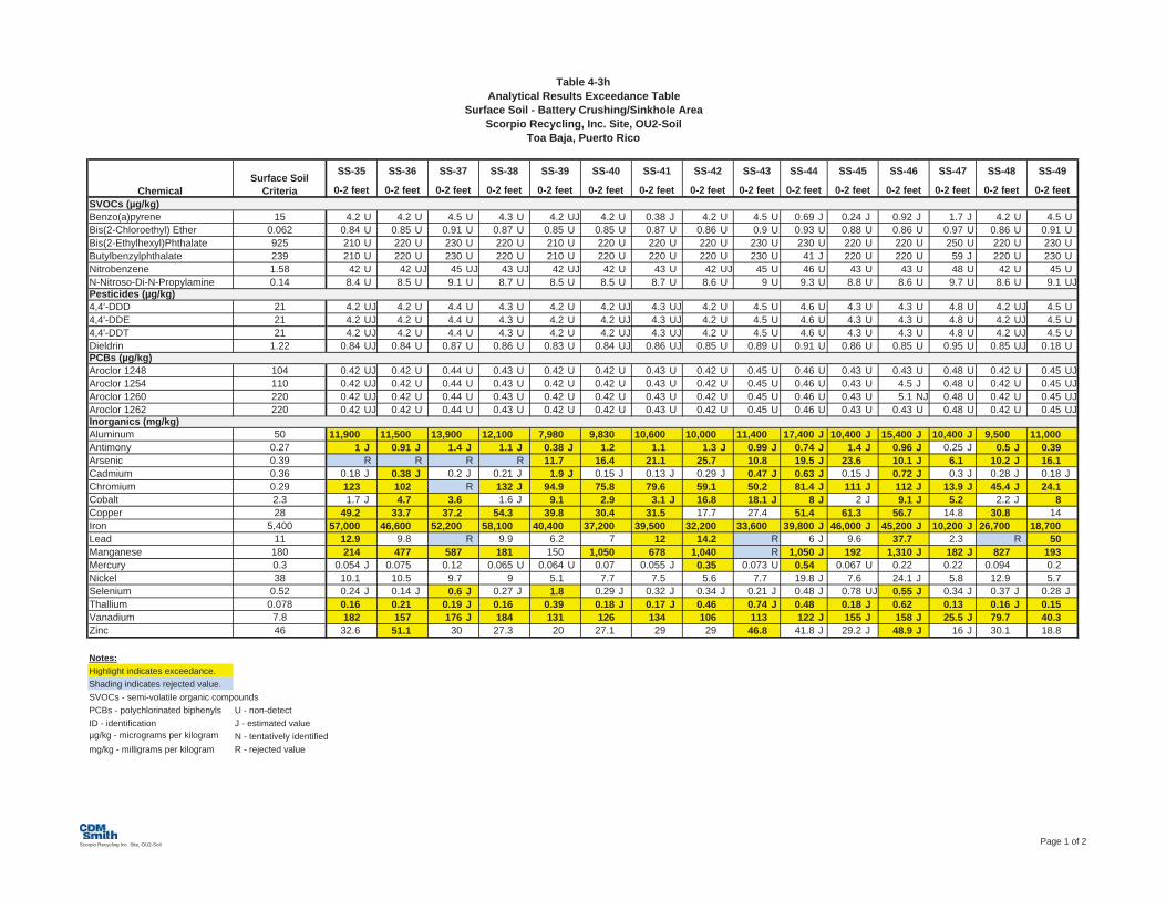
Table 4-3hAnalytical Results Exceedance Table
Surface Soil - Battery Crushing/Sinkhole AreaScorpio Recycling, Inc. Site, OU2-Soil
Toa Baja, Puerto Rico
SVOCs (µg/kg)Benzo(a)pyrene 15 4.2 U 4.2 U 4.5 U 4.3 U 4.2 UJ 4.2 U 0.38 J 4.2 U 4.5 U 0.69 J 0.24 J 0.92 J 1.7 J 4.2 U 4.5 UBis(2-Chloroethyl) Ether 0.062 0.84 U 0.85 U 0.91 U 0.87 U 0.85 U 0.85 U 0.87 U 0.86 U 0.9 U 0.93 U 0.88 U 0.86 U 0.97 U 0.86 U 0.91 UBis(2-Ethylhexyl)Phthalate 925 210 U 220 U 230 U 220 U 210 U 220 U 220 U 220 U 230 U 230 U 220 U 220 U 250 U 220 U 230 UButylbenzylphthalate 239 210 U 220 U 230 U 220 U 210 U 220 U 220 U 220 U 230 U 41 J 220 U 220 U 59 J 220 U 230 UNitrobenzene 1.58 42 U 42 UJ 45 UJ 43 UJ 42 UJ 42 U 43 U 42 UJ 45 U 46 U 43 U 43 U 48 U 42 U 45 UN-Nitroso-Di-N-Propylamine 0.14 8.4 U 8.5 U 9.1 U 8.7 U 8.5 U 8.5 U 8.7 U 8.6 U 9 U 9.3 U 8.8 U 8.6 U 9.7 U 8.6 U 9.1 UJPesticides (µg/kg)4,4'-DDD 21 4.2 UJ 4.2 U 4.4 U 4.3 U 4.2 U 4.2 UJ 4.3 UJ 4.2 U 4.5 U 4.6 U 4.3 U 4.3 U 4.8 U 4.2 UJ 4.5 U4,4'-DDE 21 4.2 UJ 4.2 U 4.4 U 4.3 U 4.2 U 4.2 UJ 4.3 UJ 4.2 U 4.5 U 4.6 U 4.3 U 4.3 U 4.8 U 4.2 UJ 4.5 U4,4'-DDT 21 4.2 UJ 4.2 U 4.4 U 4.3 U 4.2 U 4.2 UJ 4.3 UJ 4.2 U 4.5 U 4.6 U 4.3 U 4.3 U 4.8 U 4.2 UJ 4.5 UDieldrin 1.22 0.84 UJ 0.84 U 0.87 U 0.86 U 0.83 U 0.84 UJ 0.86 UJ 0.85 U 0.89 U 0.91 U 0.86 U 0.85 U 0.95 U 0.85 UJ 0.18 UPCBs (µg/kg)Aroclor 1248 104 0.42 UJ 0.42 U 0.44 U 0.43 U 0.42 U 0.42 U 0.43 U 0.42 U 0.45 U 0.46 U 0.43 U 0.43 U 0.48 U 0.42 U 0.45 UJAroclor 1254 110 0.42 UJ 0.42 U 0.44 U 0.43 U 0.42 U 0.42 U 0.43 U 0.42 U 0.45 U 0.46 U 0.43 U 4.5 J 0.48 U 0.42 U 0.45 UJAroclor 1260 220 0.42 UJ 0.42 U 0.44 U 0.43 U 0.42 U 0.42 U 0.43 U 0.42 U 0.45 U 0.46 U 0.43 U 5.1 NJ 0.48 U 0.42 U 0.45 UJAroclor 1262 220 0.42 UJ 0.42 U 0.44 U 0.43 U 0.42 U 0.42 U 0.43 U 0.42 U 0.45 U 0.46 U 0.43 U 0.43 U 0.48 U 0.42 U 0.45 UJInorganics (mg/kg)Aluminum 50 11,900 11,500 13,900 12,100 7,980 9,830 10,600 10,000 11,400 17,400 J 10,400 J 15,400 J 10,400 J 9,500 11,000Antimony 0.27 1 J 0.91 J 1.4 J 1.1 J 0.38 J 1.2 1.1 1.3 J 0.99 J 0.74 J 1.4 J 0.96 J 0.25 J 0.5 J 0.39Arsenic 0.39 R R R R 11.7 16.4 21.1 25.7 10.8 19.5 J 23.6 10.1 J 6.1 10.2 J 16.1Cadmium 0.36 0.18 J 0.38 J 0.2 J 0.21 J 1.9 J 0.15 J 0.13 J 0.29 J 0.47 J 0.63 J 0.15 J 0.72 J 0.3 J 0.28 J 0.18 JChromium 0.29 123 102 R 132 J 94.9 75.8 79.6 59.1 50.2 81.4 J 111 J 112 J 13.9 J 45.4 J 24.1Cobalt 2.3 1.7 J 4.7 3.6 1.6 J 9.1 2.9 3.1 J 16.8 18.1 J 8 J 2 J 9.1 J 5.2 2.2 J 8Copper 28 49.2 33.7 37.2 54.3 39.8 30.4 31.5 17.7 27.4 51.4 61.3 56.7 14.8 30.8 14Iron 5,400 57,000 46,600 52,200 58,100 40,400 37,200 39,500 32,200 33,600 39,800 J 46,000 J 45,200 J 10,200 J 26,700 18,700Lead 11 12.9 9.8 R 9.9 6.2 7 12 14.2 R 6 J 9.6 37.7 2.3 R 50Manganese 180 214 477 587 181 150 1,050 678 1,040 R 1,050 J 192 1,310 J 182 J 827 193Mercury 0.3 0.054 J 0.075 0.12 0.065 U 0.064 U 0.07 0.055 J 0.35 0.073 U 0.54 0.067 U 0.22 0.22 0.094 0.2Nickel 38 10.1 10.5 9.7 9 5.1 7.7 7.5 5.6 7.7 19.8 J 7.6 24.1 J 5.8 12.9 5.7Selenium 0.52 0.24 J 0.14 J 0.6 J 0.27 J 1.8 0.29 J 0.32 J 0.34 J 0.21 J 0.48 J 0.78 UJ 0.55 J 0.34 J 0.37 J 0.28 JThallium 0.078 0.16 0.21 0.19 J 0.16 0.39 0.18 J 0.17 J 0.46 0.74 J 0.48 0.18 J 0.62 0.13 0.16 J 0.15Vanadium 7.8 182 157 176 J 184 131 126 134 106 113 122 J 155 J 158 J 25.5 J 79.7 40.3Zinc 46 32.6 51.1 30 27.3 20 27.1 29 29 46.8 41.8 J 29.2 J 48.9 J 16 J 30.1 18.8
Notes:Highlight indicates exceedance.Shading indicates rejected value.SVOCs - semi-volatile organic compoundsPCBs - polychlorinated biphenyls U - non-detectID - identification J - estimated valueµg/kg - micrograms per kilogram N - tentatively identifiedmg/kg - milligrams per kilogram R - rejected value
ChemicalSurface Soil
Criteria
SS-35
0-2 feet 0-2 feet
SS-36 SS-37 SS-45
0-2 feet0-2 feet
SS-43
0-2 feet
SS-44
0-2 feet
SS-38
0-2 feet
SS-39
0-2 feet
SS-42
0-2 feet
SS-40
0-2 feet
SS-41
0-2 feet
SS-48
0-2 feet
SS-49
0-2 feet0-2 feet
SS-46
0-2 feet
SS-47
Scorpio Recycling Inc. Site, OU2-Soil Page 1 of 2

Table 4-3hAnalytical Results Exceedance Table
Surface Soil - Battery Crushing/Sinkhole AreaScorpio Recycling, Inc. Site, OU2-Soil
Toa Baja, Puerto Rico
SVOCs (µg/kg)Benzo(a)pyrene 15Bis(2-Chloroethyl) Ether 0.062Bis(2-Ethylhexyl)Phthalate 925Butylbenzylphthalate 239Nitrobenzene 1.58N-Nitroso-Di-N-Propylamine 0.14Pesticides (µg/kg)4,4'-DDD 214,4'-DDE 214,4'-DDT 21Dieldrin 1.22PCBs (µg/kg)Aroclor 1248 104Aroclor 1254 110Aroclor 1260 220Aroclor 1262 220Inorganics (mg/kg)Aluminum 50Antimony 0.27Arsenic 0.39Cadmium 0.36Chromium 0.29Cobalt 2.3Copper 28Iron 5,400Lead 11Manganese 180Mercury 0.3Nickel 38Selenium 0.52Thallium 0.078Vanadium 7.8Zinc 46
Notes:Highlight indicates exceedance.Shading indicates rejected value.SVOCs - semi-volatile organic compoundsPCBs - polychlorinated biphenyls U - non-detectID - identification J - estimated valueµg/kg - micrograms per kilogram N - tentatively identifiedmg/kg - milligrams per kilogram R - rejected value
ChemicalSurface Soil
Criteria
40 U 4.6 U 4.3 UJ 4.2 U 4.1 U 4.2 UJ 61 51 J 33 J8.2 U 0.93 UJ 0.87 U 0.85 U 0.83 U 0.85 U 1.2 J 1.2 U 1.9
1,500 240 U 220 UJ 220 U 210 U 220 U 1,700 310 U 330 U1,100 240 U 220 UJ 220 U 210 U 220 U 690 640 240 J
400 U 46 U 43 U 42 U 41 U 42 UJ 41 UJ 13 J 64 U82 U 9.3 U 8.7 U 8.5 U 8.3 U 8.5 UJ 6.6 J 12 U 18
0.81 U 4.6 UJ 4.3 U 4.2 U 4.1 U 4.2 U 1 U 2.6 J 252.2 JN 4.6 UJ 4.3 U 4.2 U 4.1 U 4.2 U 2.6 6 U 5112 JN 4.6 UJ 4.3 U 4.2 U 4.1 U 4.2 U R 6 U 29 J
3.2 J 0.92 UJ 0.85 U 0.84 U 0.81 U 0.17 U 1.1 NJ R 5.4 NJ
84 J 0.46 U 0.43 U 0.42 U 0.41 U 1.7 130 170 110 J98 J 0.46 U 0.43 U 0.42 U 0.41 U 1.1 0.41 U 160 100 J
0.4 UJ 0.46 U 0.43 U 0.42 U 0.41 U 0.42 U 250 NJ R 110470 J 0.46 U 0.43 U 0.42 U 0.41 U 0.42 U 0.41 U 6 U 6.4 U
19,800 12,900 15,300 J 12,700 J 8,110 J 10,100 14,000 J 27,700 21,00074.1 0.69 0.73 U 0.82 1.2 1.2 J 4.7 J 27.3 17.718.1 26.6 12.3 21.2 11.3 18.3 J 30.6 J 36.6 24.5
2.4 0.29 J 0.89 J 0.34 J 0.17 J 0.2 J R 2.4 1.886.1 40.9 J 60.2 109 78.9 96.4 J 118 J- 120 81.9
6.3 10.3 14.1 5.7 U 2.8 U 1.4 J 5 J- 8.6 9.2832 11.5 50.8 61.1 36.9 87 470 J 360 221
60,300 12,500 37,500 J 56,100 J 37,700 J 40,800 56,500 J 56,800 39,70021,800 4.4 8 10.6 16.7 18.5 18,700 J 4,400 3,320
640 363 1,340 J 231 J 111 J 136 649 J 657 6660.4 0.3 0.46 0.088 0.089 0.11 0.59 0.67 0.41
63.7 4.2 J 21 12.6 6.6 7.5 47.6 J 45.6 32.20.45 0.33 J 1 0.75 U 0.13 J 0.12 J 0.89 J 0.88 0.630.28 0.51 0.41 0.18 0.13 0.19 0.26 UJ 0.37 0.3688.7 35.2 95.9 J 188 J 110 J 139 88.3 171 116933 13.9 50.7 54.8 24 30.8 465 J- 604 356
TS-76
0-2 feet
SS-80
0-2 feet
SS-53
0-2 feet
SS-50
0-2 feet
SS-51
0-2 feet
TS-75
0-2 feet0-2 feet
SS-52 SS-54
0-2 feet
SS-55
0-2 feet
Scorpio Recycling Inc. Site, OU2-Soil Page 2 of 2

Table�4�3iAnalytical�Results�Exceedance�Table
Subsurface�Soil���Battery�Crushing/Sinkhole�AreaScorpio�Recycling,�Inc.�Site,�OU2�Soil
Toa�Baja,�Puerto�Rico
SVOCs (µg/kg)Benzo(a)pyrene 15 4.8 UJ 3.9 U 4.4 UJ 4.6 UJ 4.3 U 4.5 U 4.4 U 4.5 U 4.5 UBis(2-Chloroethyl) Ether 0.062 0.97 U 0.78 U 0.89 U 0.92 U 0.87 U 0.91 U 0.9 U 0.9 U 0.9 UNaphthalene 9.4 4.8 UJ 3.9 UJ 4.4 UJ 4.6 UJ 4.3 U 4.5 U 4.4 U 4.5 U 4.5 UJN-Nitroso-Di-N-Propylamine 0.14 9.7 U 7.8 U 8.9 U 9.2 U 8.7 U 9.1 U 9 U 9 U 9 UPesticides (µg/kg)Alpha-BHC 0.72 0.49 UJ 0.4 UJ 0.45 UJ 0.47 UJ 0.45 U 0.46 U 0.46 U 0.46 U 0.45 UDieldrin 1.22 0.96 UJ 0.77 UJ 0.88 UJ 0.91 UJ 0.87 U 0.89 U 0.89 U 0.89 U 0.88 UPCBs (µg/kg)Aroclor 1248 104 0.48 UJ 0.39 UJ 0.44 UJ 0.46 UJ 0.43 U 0.45 U 0.45 U 0.44 U 0.44 UAroclor 1254 110 0.48 UJ 0.39 UJ 0.44 UJ 0.46 UJ 0.43 U 0.45 U 0.45 U 0.44 U 0.44 UAroclor 1262 220 0.48 UJ 0.39 UJ 0.44 UJ 0.46 UJ 0.43 U 0.45 U 0.45 U 0.44 U 0.44 UInorganics (mg/kg)Aluminum 7,700 11,700 3,600 14,400 17,900 15,100 13,600 12,300 14,900Antimony 3.1 0.63 0.29 UJ 0.58 J 0.68 1 J 0.94 J 0.68 UJ 0.86 JArsenic 0.39 19.1 R R 18.1 21.9 27 23.8 RChromium 0.29 48.2 13 85.1 49.4 99.3 J 57.2 J 36 J 80.8 JCobalt 2.3 3.5 0.88 J 12.8 10.4 5 2.5 J 7.3 3.1Copper 310 123 7.4 143 395 47.1 29.3 29.2 35.4Iron 5,400 30,100 5,290 35,700 22,300 55,700 42,900 29,900 44,200Lead 40 23.7 1.7 U 19 20.5 5.1 4.1 1.4 8.5Manganese 180 172 250 639 1,010 235 115 113 469Selenium 5.2 0.23 J 0.31 J 0.57 J 0.35 J 0.4 0.39 0.65 J 0.29 JThallium 0.078 0.26 0.061 0.27 0.27 0.23 0.17 0.16 0.23
Notes:Highlight indicates exceedance.Shading indicates rejected value.ID - identificationSVOCs - semi-volatile organic compoundsPCBs - polychlorinated biphenylsµg/kg - micrograms per kilogrammg/kg - milligrams per kilogramU - non-detectJ - estimated valueN - tentatively identifiedR - rejected value
SB-36-A SB-36-B SB-36-C SB-36-D SB-37-AChemical
SubsurfaceSoil Criteria
SB-35-A SB-35-B SB-35-C SB-35-D4 - 6 feet 8 - 10 feet 12 - 14 feet 16 - 18 feet 4 - 6 feet 8 - 10 feet 12 - 14 feet 16 - 18 feet 4 - 6 feet
Page�1�of�12

Table�4�3iAnalytical�Results�Exceedance�Table
Subsurface�Soil���Battery�Crushing/Sinkhole�AreaScorpio�Recycling,�Inc.�Site,�OU2�Soil
Toa�Baja,�Puerto�Rico
SVOCs (µg/kg)Benzo(a)pyrene 15Bis(2-Chloroethyl) Ether 0.062Naphthalene 9.4N-Nitroso-Di-N-Propylamine 0.14Pesticides (µg/kg)Alpha-BHC 0.72Dieldrin 1.22PCBs (µg/kg)Aroclor 1248 104Aroclor 1254 110Aroclor 1262 220Inorganics (mg/kg)Aluminum 7,700Antimony 3.1Arsenic 0.39Chromium 0.29Cobalt 2.3Copper 310Iron 5,400Lead 40Manganese 180Selenium 5.2Thallium 0.078
Notes:Highlight indicates exceedance.Shading indicates rejected value.ID - identificationSVOCs - semi-volatile organic compoundsPCBs - polychlorinated biphenylsµg/kg - micrograms per kilogrammg/kg - milligrams per kilogramU - non-detectJ - estimated valueN - tentatively identifiedR - rejected value
ChemicalSubsurfaceSoil Criteria
4.2 U 4.3 U 4.6 U 4 UJ 4.2 UJ 3.9 UJ 4.4 UJ 4 UJ 4 UJ0.85 U 0.87 U 0.93 U 0.82 U 0.85 U 0.8 U 0.9 U 0.82 U 0.82 U
4.2 UJ 4.3 UJ 4.6 UJ 4 UJ 4.2 UJ 3.9 U 4.4 UJ 4 UJ 4 U8.5 U 8.7 U 9.3 U 8.2 U 8.5 U 8 U 9 U 8.2 U 8.2 U
0.43 U 0.45 U 0.46 U 0.43 U 0.44 U 0.42 U 0.48 U 0.42 U 0.43 U0.84 U 0.87 U 0.9 U 0.83 U 0.84 U 0.81 U 0.94 U 0.81 U 0.83 U
0.42 U 0.43 U 0.45 U 0.41 U 0.42 U 0.41 U 0.47 U 0.4 U 0.41 U0.42 U 0.43 U 0.45 U 0.41 U 0.42 U 0.41 U 0.47 U 0.4 U 0.41 U0.42 U 0.43 U 0.45 U 0.41 U 0.42 U 0.41 U 0.47 U 0.4 U 0.41 U
13,500 13,800 13,700 15,400 8,900 9,760 12,000 10,8000.95 J 0.34 UJ 0.78 J 0.86 J 0.83 J 1.1 J 0.93 J 0.96 J31.7 J R R R R 16.9 17.6 18.588.8 J 53 J 88.5 J 74.6 J 79.2 J 51.4 86.2 48.5
R 1.2 J 7.5 7.3 3 1.7 J 13.4 14.339.1 22.4 46.4 45.3 37 35.7 66.5 52.1
44,200 15,500 34,200 40,800 36,000 26,600 38,500 32,7001.8 1.3 U 1.8 9.1 3.1 R 6.8 9.6
182 129 226 1,100 329 R 2,120 5,3000.49 0.28 J 0.33 J 0.28 J 0.19 J 0.18 J 0.11 J 0.39 J
R 0.15 0.27 0.31 0.26 0.17 J 0.66 0.98
SB-37-B SB-39-A SB-39-BSB-37-C SB-37-D SB-38-A SB-38-B SB-38-C SB-38-D8 - 10 feet 12 - 14 feet 8 - 10 feet16 - 18 feet 4 - 6 feet 8 - 10 feet 12 - 14 feet 16 - 18 feet 4 - 6 feet
Page�2�of�12
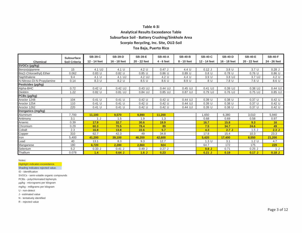
Table�4�3iAnalytical�Results�Exceedance�Table
Subsurface�Soil���Battery�Crushing/Sinkhole�AreaScorpio�Recycling,�Inc.�Site,�OU2�Soil
Toa�Baja,�Puerto�Rico
SVOCs (µg/kg)Benzo(a)pyrene 15Bis(2-Chloroethyl) Ether 0.062Naphthalene 9.4N-Nitroso-Di-N-Propylamine 0.14Pesticides (µg/kg)Alpha-BHC 0.72Dieldrin 1.22PCBs (µg/kg)Aroclor 1248 104Aroclor 1254 110Aroclor 1262 220Inorganics (mg/kg)Aluminum 7,700Antimony 3.1Arsenic 0.39Chromium 0.29Cobalt 2.3Copper 310Iron 5,400Lead 40Manganese 180Selenium 5.2Thallium 0.078
Notes:Highlight indicates exceedance.Shading indicates rejected value.ID - identificationSVOCs - semi-volatile organic compoundsPCBs - polychlorinated biphenylsµg/kg - micrograms per kilogrammg/kg - milligrams per kilogramU - non-detectJ - estimated valueN - tentatively identifiedR - rejected value
ChemicalSubsurfaceSoil Criteria
4.1 UJ 4.1 U 4.2 U 0.47 J 4.4 U 0.12 J 3.8 U 3.7 U 0.28 J0.83 U 0.82 U 0.85 U 0.86 U 0.89 U 0.8 U 0.78 U 0.76 U 0.86 U
4.1 U 4.1 UJ 4.2 UJ 4.2 U 4.4 U 3.9 U 3.8 UJ 3.7 UJ 4.2 U8.3 U 8.2 U 8.5 U 8.6 U 8.9 U 8 U 7.8 U 7.6 U 8.6 U
0.42 U 0.42 UJ 0.43 UJ 0.44 UJ 0.45 UJ 0.41 UJ 0.39 UJ 0.38 UJ 0.44 UJ0.82 U 0.81 UJ 0.84 UJ 0.85 UJ 0.87 UJ 0.79 UJ 0.76 UJ 0.75 UJ 0.85 UJ
0.41 U 0.41 U 0.42 U 0.42 U 0.44 UJ 0.39 U 0.38 U 0.37 U 0.42 U0.41 U 0.41 U 0.42 U 0.42 U 0.44 UJ 0.39 U 0.38 U 0.37 U 0.42 U0.41 U 0.41 U 0.42 U 0.42 U 0.44 UJ 0.39 U 0.38 U 0.37 U 0.42 U
11,100 9,570 9,890 11,200 1,650 6,380 3,010 5,9401 J 1.5 1.9 1.3 0.68 0.69 0.58 0.97
17.9 32.7 30.6 19.9 16.7 15.8 9.3 1660.3 70.5 78.4 89 7.5 34.7 24.6 4916.8 13.8 22.6 5.7 4.3 2.7 J 1.5 J 2.3 J62.7 42.3 49 34.8 17.8 15.4 10.3 23.3
41,200 39,100 46,200 42,600 5,420 17,400 8,550 21,20013.1 8.3 9.3 12.7 1.3 U 3.1 1.2 U 4.7
6,720 2,280 2,860 924 64.7 172 175 2290.33 J 0.41 J 0.49 J 0.27 J 9.8 J 0.71 0.25 J 1 J
1.4 0.64 J 1.6 J 0.23 0.21 J 0.19 0.17 J 0.18 J
SB-39-C SB-39-D SB-39-E SB-40-A SB-40-B SB-40-C SB-40-D SB-40-E SB-40-F12 - 14 feet 16 - 18 feet 20 - 22 feet 4 - 6 feet 8 - 10 feet 12 - 14 feet 16 - 18 feet 20 - 22 feet 24 - 26 feet
Page�3�of�12
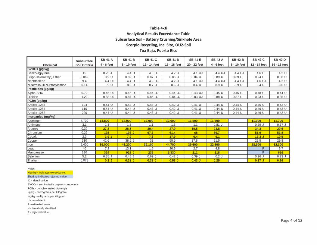
Table�4�3iAnalytical�Results�Exceedance�Table
Subsurface�Soil���Battery�Crushing/Sinkhole�AreaScorpio�Recycling,�Inc.�Site,�OU2�Soil
Toa�Baja,�Puerto�Rico
SVOCs (µg/kg)Benzo(a)pyrene 15Bis(2-Chloroethyl) Ether 0.062Naphthalene 9.4N-Nitroso-Di-N-Propylamine 0.14Pesticides (µg/kg)Alpha-BHC 0.72Dieldrin 1.22PCBs (µg/kg)Aroclor 1248 104Aroclor 1254 110Aroclor 1262 220Inorganics (mg/kg)Aluminum 7,700Antimony 3.1Arsenic 0.39Chromium 0.29Cobalt 2.3Copper 310Iron 5,400Lead 40Manganese 180Selenium 5.2Thallium 0.078
Notes:Highlight indicates exceedance.Shading indicates rejected value.ID - identificationSVOCs - semi-volatile organic compoundsPCBs - polychlorinated biphenylsµg/kg - micrograms per kilogrammg/kg - milligrams per kilogramU - non-detectJ - estimated valueN - tentatively identifiedR - rejected value
ChemicalSubsurfaceSoil Criteria
0.25 J 4.4 U 4.3 UJ 4.2 U 4.1 UJ 4.4 UJ 4.4 UJ 4.6 U 4.2 U0.9 U 0.89 U 0.87 U 0.86 U 0.84 U 0.89 U 0.89 U 0.94 U 0.86 U4.4 UJ 4.4 U 4.3 UJ 4.2 U 4.1 UJ 4.4 UJ 4.4 UJ 4.6 UJ 4.2 U
9 U 8.9 U 8.7 U 8.6 U 8.4 U 8.9 U 8.9 U 9.4 U 8.6 U
0.45 UJ 0.45 UJ 0.44 UJ 0.44 UJ 0.43 UJ 0.45 U 0.45 U 0.48 U 0.44 U0.88 UJ 0.87 UJ 0.86 UJ 0.84 UJ 0.83 UJ 0.88 U 0.87 U 0.93 U 0.85 U
0.44 U 0.44 U 0.43 U 0.42 U 0.41 U 0.44 U 0.44 U 0.46 U 0.42 U0.44 U 0.44 U 0.43 U 0.42 U 0.41 U 0.44 U 0.44 U 0.46 U 0.42 U0.44 U 0.44 U 0.43 U 0.42 U 0.41 U 0.44 U 0.44 U 0.46 U 0.42 U
14,800 12,900 12,000 12,000 11,500 11,300 11,000 11,7001.3 1.3 1.1 1.3 1.1 0.81 J 0.69 J 0.57 J
27.3 28.5 30.4 27.9 19.5 23.8 34.3 29.6135 103 J 67.7 61.4 68 56.7 51.9 53.83.9 J 7.9 7.3 17.9 6.4 6.1 13.3 J 10.5
42.6 38.5 J 33 55.5 37.8 21.5 22.5 29.859,000 45,200 39,100 44,700 39,600 32,600 28,900 32,300
7.2 13.1 1.9 20.6 2.7 4.8 R 5.7324 922 J 236 5,330 211 218 R 616
0.35 J 0.48 J 0.69 J 0.42 J 0.39 J 0.2 J 0.26 J 0.23 J0.3 J 0.38 J 0.38 J 0.53 J 0.43 J 0.25 0.37 J 0.26
SB-41-B SB-41-C SB-41-D SB-41-E SB-42-A SB-42-BSB-41-A SB-42-C SB-42-D12 - 14 feet 16 - 18 feet 20 - 22 feet 4 - 6 feet 8 - 10 feet 12 - 14 feet4 - 6 feet 8 - 10 feet 16 - 18 feet
Page�4�of�12
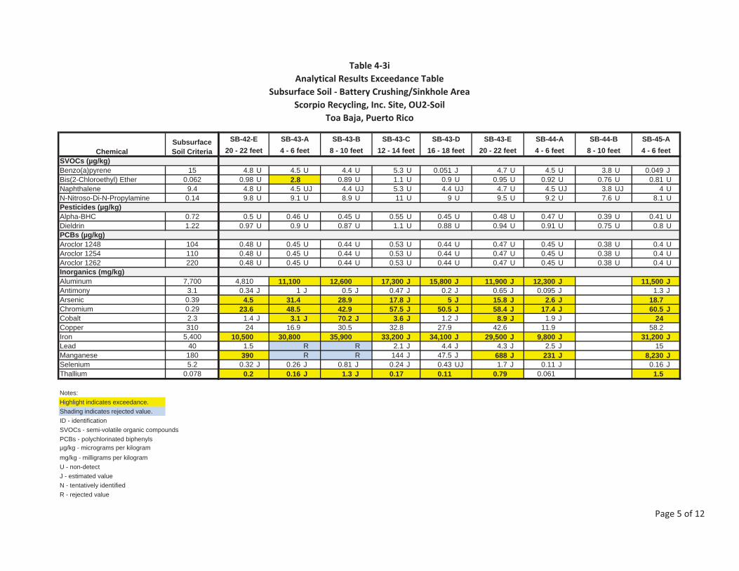
Table�4�3iAnalytical�Results�Exceedance�Table
Subsurface�Soil���Battery�Crushing/Sinkhole�AreaScorpio�Recycling,�Inc.�Site,�OU2�Soil
Toa�Baja,�Puerto�Rico
SVOCs (µg/kg)Benzo(a)pyrene 15Bis(2-Chloroethyl) Ether 0.062Naphthalene 9.4N-Nitroso-Di-N-Propylamine 0.14Pesticides (µg/kg)Alpha-BHC 0.72Dieldrin 1.22PCBs (µg/kg)Aroclor 1248 104Aroclor 1254 110Aroclor 1262 220Inorganics (mg/kg)Aluminum 7,700Antimony 3.1Arsenic 0.39Chromium 0.29Cobalt 2.3Copper 310Iron 5,400Lead 40Manganese 180Selenium 5.2Thallium 0.078
Notes:Highlight indicates exceedance.Shading indicates rejected value.ID - identificationSVOCs - semi-volatile organic compoundsPCBs - polychlorinated biphenylsµg/kg - micrograms per kilogrammg/kg - milligrams per kilogramU - non-detectJ - estimated valueN - tentatively identifiedR - rejected value
ChemicalSubsurfaceSoil Criteria
4.8 U 4.5 U 4.4 U 5.3 U 0.051 J 4.7 U 4.5 U 3.8 U 0.049 J0.98 U 2.8 0.89 U 1.1 U 0.9 U 0.95 U 0.92 U 0.76 U 0.81 U
4.8 U 4.5 UJ 4.4 UJ 5.3 U 4.4 UJ 4.7 U 4.5 UJ 3.8 UJ 4 U9.8 U 9.1 U 8.9 U 11 U 9 U 9.5 U 9.2 U 7.6 U 8.1 U
0.5 U 0.46 U 0.45 U 0.55 U 0.45 U 0.48 U 0.47 U 0.39 U 0.41 U0.97 U 0.9 U 0.87 U 1.1 U 0.88 U 0.94 U 0.91 U 0.75 U 0.8 U
0.48 U 0.45 U 0.44 U 0.53 U 0.44 U 0.47 U 0.45 U 0.38 U 0.4 U0.48 U 0.45 U 0.44 U 0.53 U 0.44 U 0.47 U 0.45 U 0.38 U 0.4 U0.48 U 0.45 U 0.44 U 0.53 U 0.44 U 0.47 U 0.45 U 0.38 U 0.4 U
4,810 11,100 12,600 17,300 J 15,800 J 11,900 J 12,300 J 11,500 J0.34 J 1 J 0.5 J 0.47 J 0.2 J 0.65 J 0.095 J 1.3 J
4.5 31.4 28.9 17.8 J 5 J 15.8 J 2.6 J 18.723.6 48.5 42.9 57.5 J 50.5 J 58.4 J 17.4 J 60.5 J
1.4 J 3.1 J 70.2 J 3.6 J 1.2 J 8.9 J 1.9 J 2424 16.9 30.5 32.8 27.9 42.6 11.9 58.2
10,500 30,800 35,900 33,200 J 34,100 J 29,500 J 9,800 J 31,200 J1.5 R R 2.1 J 4.4 J 4.3 J 2.5 J 15390 R R 144 J 47.5 J 688 J 231 J 8,230 J
0.32 J 0.26 J 0.81 J 0.24 J 0.43 UJ 1.7 J 0.11 J 0.16 J0.2 0.16 J 1.3 J 0.17 0.11 0.79 0.061 1.5
SB-43-D SB-43-E SB-44-A SB-44-B SB-45-ASB-42-E SB-43-A SB-43-B SB-43-C20 - 22 feet 4 - 6 feet 8 - 10 feet 4 - 6 feet20 - 22 feet 4 - 6 feet 8 - 10 feet 12 - 14 feet 16 - 18 feet
Page�5�of�12

Table�4�3iAnalytical�Results�Exceedance�Table
Subsurface�Soil���Battery�Crushing/Sinkhole�AreaScorpio�Recycling,�Inc.�Site,�OU2�Soil
Toa�Baja,�Puerto�Rico
SVOCs (µg/kg)Benzo(a)pyrene 15Bis(2-Chloroethyl) Ether 0.062Naphthalene 9.4N-Nitroso-Di-N-Propylamine 0.14Pesticides (µg/kg)Alpha-BHC 0.72Dieldrin 1.22PCBs (µg/kg)Aroclor 1248 104Aroclor 1254 110Aroclor 1262 220Inorganics (mg/kg)Aluminum 7,700Antimony 3.1Arsenic 0.39Chromium 0.29Cobalt 2.3Copper 310Iron 5,400Lead 40Manganese 180Selenium 5.2Thallium 0.078
Notes:Highlight indicates exceedance.Shading indicates rejected value.ID - identificationSVOCs - semi-volatile organic compoundsPCBs - polychlorinated biphenylsµg/kg - micrograms per kilogrammg/kg - milligrams per kilogramU - non-detectJ - estimated valueN - tentatively identifiedR - rejected value
ChemicalSubsurfaceSoil Criteria
4.1 U 0.34 J 0.22 J 0.43 J 0.12 J 4.6 U 1.2 J 0.094 J 0.063 J0.83 U 0.89 U 0.92 U 0.89 U 0.9 U 0.94 U 0.84 U 0.88 U 0.91 U
4.1 UJ 4.4 UJ 4.5 U 4.4 UJ 4.4 U 4.6 U 4.2 U 4.3 UJ 4.5 U8.3 U 8.9 U 9.2 U 8.9 U 9 U 9.4 U 8.4 U 8.8 U 9.1 U
0.42 U 0.45 U 0.47 U 0.45 U 0.45 U 0.48 U 0.43 U 0.45 U 0.46 U0.82 U 0.88 U 0.91 U 0.88 U 0.88 U 0.93 U 0.83 U 0.87 U 0.9 U
0.41 U 0.44 U 0.45 U 0.44 U 0.44 U 0.46 U 0.42 U 0.43 UJ 0.45 U0.41 U 0.44 U 0.45 U 0.44 U 0.44 U 0.46 U 0.42 U 0.43 UJ 0.45 U0.41 U 0.44 U 0.45 U 0.44 U 0.44 U 0.46 U 0.42 U 0.43 UJ 0.45 U
11,700 J 11,800 J 11,500 J 10,000 J 7,310 J 8,600 J 12,500 J 9,390 J0.7 J 0.57 J 0.75 J 0.77 J 1.2 J 1.3 J 1 J 0.2 J
26.8 26.8 25.8 29.1 14.6 J 14.1 J 16.1 J 5.5 J55.4 J 40.2 J 63.2 J 53.9 J 36.1 J 45.6 J 74.2 J 16.3 J
4.1 4 J 8.8 11.1 5.6 J 3 J 11.5 J 3.6 J22.6 J 33 43.5 65.8 23 37.8 48.8 6.9
34,500 J 28,700 J 31,500 J 31,500 J 18,200 J 23,700 J 33,500 J 9,340 J1.2 3.3 5 5 3.4 J 12.9 J 6.8 J 4.6 J
165 J 804 J 969 J 1,150 J 544 J 1,450 J 1,670 J 264 J0.4 J 0.64 J 0.8 J 0.95 J 0.47 J 0.46 J 0.41 J 0.38 UJ
0.17 J 0.2 J 0.42 J 1.5 J 0.4 0.22 1.4 0.18
SB-45-B SB-46-D SB-46-ESB-45-C SB-45-D SB-45-E SB-46-A SB-46-B SB-46-C8 - 10 feet 12 - 14 feet 20 - 22 feet16 - 18 feet 20 - 22 feet 4 - 6 feet 8 - 10 feet 12 - 14 feet 16 - 18 feet
Page�6�of�12

Table�4�3iAnalytical�Results�Exceedance�Table
Subsurface�Soil���Battery�Crushing/Sinkhole�AreaScorpio�Recycling,�Inc.�Site,�OU2�Soil
Toa�Baja,�Puerto�Rico
SVOCs (µg/kg)Benzo(a)pyrene 15Bis(2-Chloroethyl) Ether 0.062Naphthalene 9.4N-Nitroso-Di-N-Propylamine 0.14Pesticides (µg/kg)Alpha-BHC 0.72Dieldrin 1.22PCBs (µg/kg)Aroclor 1248 104Aroclor 1254 110Aroclor 1262 220Inorganics (mg/kg)Aluminum 7,700Antimony 3.1Arsenic 0.39Chromium 0.29Cobalt 2.3Copper 310Iron 5,400Lead 40Manganese 180Selenium 5.2Thallium 0.078
Notes:Highlight indicates exceedance.Shading indicates rejected value.ID - identificationSVOCs - semi-volatile organic compoundsPCBs - polychlorinated biphenylsµg/kg - micrograms per kilogrammg/kg - milligrams per kilogramU - non-detectJ - estimated valueN - tentatively identifiedR - rejected value
ChemicalSubsurfaceSoil Criteria
4.5 U 4.1 UJ 3.6 U 4.4 U 4.1 U 3.9 U 3.7 U 4.4 U 4.4 U0.91 U 0.83 U 0.73 U 0.9 U 0.82 U 0.79 U 0.76 U 0.89 U 0.9 U
4.5 UJ 4.1 UJ 3.6 U 4.4 U 4.1 U 3.9 U 3.7 U 4.4 UJ 4.4 UJ9.1 U 8.3 U 7.3 U 9 U 8.2 U 7.9 U 7.6 U 8.9 UJ 9 UJ
0.46 U 0.42 U 0.37 UJ 0.45 UJ 0.42 U 0.4 UJ 0.39 UJ 0.45 U 0.45 U0.89 U 0.82 U 0.72 UJ 0.88 UJ 0.81 U 0.78 UJ 0.75 UJ 0.17 U 0.18 U
0.45 U 0.41 U 0.36 U 0.44 U 0.41 U 0.39 U 0.37 U 0.44 UJ 0.44 UJ0.45 U 0.41 U 0.36 U 0.44 U 0.41 U 0.39 U 0.37 U 0.44 UJ 0.44 UJ0.45 U 0.41 U 0.36 U 0.44 U 0.41 U 0.39 U 0.37 U 0.44 UJ 0.44 UJ
8,460 J 3,420 J 6,280 12,600 6,190 10,400 4,080 10,7000.33 J 0.12 J 0.32 UJ 1.1 J 0.35 J 0.49 J 0.62 1.3
16 J 3.6 J 9.9 J 18.1 J 9.7 J 13.3 J 16.5 38.48.2 J 11.7 J 12.4 J 73.1 J 15.3 J 33.9 J 12 66.27.4 J 4.7 J 6 8.8 5.5 6.8 4.6 15.2
11.9 5.5 18 46.6 14.5 32.5 7 35.813,200 J 5,320 J 17,100 36,500 13,100 23,900 9,250 31,400
2.2 J 3.4 J R R R 20.7 J 47.9 22.9522 J 276 J 307 1,470 289 925 250 2,060
0.35 J 0.39 J 0.21 J 0.48 J 0.22 J 0.22 J 0.36 J 0.640.17 0.12 0.16 J 0.64 0.2 0.31 0.28 1.9
SB-47-A SB-47-B SB-47-C SB-48-A SB-48-B SB-48-C SB-48-D SB-49-A SB-49-B4 - 6 feet 8 - 10 feet 12 - 14 feet 4 - 6 feet 8 - 10 feet 12 - 14 feet 16 - 18 feet 4 - 6 feet 8 - 10 feet
Page�7�of�12

Table�4�3iAnalytical�Results�Exceedance�Table
Subsurface�Soil���Battery�Crushing/Sinkhole�AreaScorpio�Recycling,�Inc.�Site,�OU2�Soil
Toa�Baja,�Puerto�Rico
SVOCs (µg/kg)Benzo(a)pyrene 15Bis(2-Chloroethyl) Ether 0.062Naphthalene 9.4N-Nitroso-Di-N-Propylamine 0.14Pesticides (µg/kg)Alpha-BHC 0.72Dieldrin 1.22PCBs (µg/kg)Aroclor 1248 104Aroclor 1254 110Aroclor 1262 220Inorganics (mg/kg)Aluminum 7,700Antimony 3.1Arsenic 0.39Chromium 0.29Cobalt 2.3Copper 310Iron 5,400Lead 40Manganese 180Selenium 5.2Thallium 0.078
Notes:Highlight indicates exceedance.Shading indicates rejected value.ID - identificationSVOCs - semi-volatile organic compoundsPCBs - polychlorinated biphenylsµg/kg - micrograms per kilogrammg/kg - milligrams per kilogramU - non-detectJ - estimated valueN - tentatively identifiedR - rejected value
ChemicalSubsurfaceSoil Criteria
4.7 U 4 U 38 U 230 U 4.2 U 4.3 U R R R0.95 U 0.82 U 7.7 U 46 U 0.85 U 0.87 U 0.81 U 2 0.85 U
4.7 UJ 4 UJ 38 U 230 U 4.2 UJ 4.3 UJ 4 UJ 4.7 UJ 4.2 UJ9.5 UJ 8.2 UJ 77 U 460 U 8.5 U 8.7 U 8.1 U 9.5 U 8.5 U
0.48 U 0.42 U 0.39 U 6.8 J 0.43 U 0.44 U R 0.48 U 0.43 U0.19 U 0.16 U 7.2 J 4.5 JN 0.84 U 0.86 U 1.4 JN 1.7 JN 0.83 U
0.47 UJ 0.4 UJ 240 J 130 J 0.42 U 0.43 U 0.4 UJ 0.47 UJ 0.42 U0.47 UJ 0.4 UJ 160 J 82 J 0.42 U 0.43 U 12 J 120 J 0.42 U0.47 UJ 0.4 UJ 720 J 610 J 0.42 U 0.43 U 0.4 UJ 0.47 UJ 0.42 U
9,300 8,150 19,000 10,600 11,700 19,100 5,450 13,3000.73 0.47 J 117 6.6 5.8 J 24.9 J 89.5 J 1.2 J20.1 8 J 27.8 14 18.1 31.1 21.7 21.734.5 11.4 110 59.2 82.8 65.5 49.9 131
5.7 5.5 7.4 4.9 5.5 4.1 0.93 J 2.5 J19.2 8.5 941 214 105 J 517 J 337 J 38 J
15,900 8,640 67,500 29,600 33,100 J 55,100 J 15,300 J 54,700 J7.3 16.7 20,500 865 1,150 J 6,780 J 15,100 J 16.1 J
613 305 652 352 660 J 499 J 50.9 J 272 J0.59 0.82 J 0.73 0.49 0.44 0.64 0.85 0.22 J
0.5 0.27 0.41 0.15 0.21 J 0.25 0.37 0.2 J
SB-50-B SB-50-C SB-50-D SB-50-ESB-49-C SB-50-F SB-50-GSB-49-D SB-50-A4 - 6 feet 8 - 10 feet 12 - 14 feet 16 - 18 feet 20 - 22 feet 24 - 26 feet12 - 14 feet 16 - 18 feet 28 - 30 feet
Page�8�of�12

Table�4�3iAnalytical�Results�Exceedance�Table
Subsurface�Soil���Battery�Crushing/Sinkhole�AreaScorpio�Recycling,�Inc.�Site,�OU2�Soil
Toa�Baja,�Puerto�Rico
SVOCs (µg/kg)Benzo(a)pyrene 15Bis(2-Chloroethyl) Ether 0.062Naphthalene 9.4N-Nitroso-Di-N-Propylamine 0.14Pesticides (µg/kg)Alpha-BHC 0.72Dieldrin 1.22PCBs (µg/kg)Aroclor 1248 104Aroclor 1254 110Aroclor 1262 220Inorganics (mg/kg)Aluminum 7,700Antimony 3.1Arsenic 0.39Chromium 0.29Cobalt 2.3Copper 310Iron 5,400Lead 40Manganese 180Selenium 5.2Thallium 0.078
Notes:Highlight indicates exceedance.Shading indicates rejected value.ID - identificationSVOCs - semi-volatile organic compoundsPCBs - polychlorinated biphenylsµg/kg - micrograms per kilogrammg/kg - milligrams per kilogramU - non-detectJ - estimated valueN - tentatively identifiedR - rejected value
ChemicalSubsurfaceSoil Criteria
4.2 U 4.4 U 4.2 U 4.6 U 4.9 UJ 4.5 U 4.2 U 0.26 J 4.2 U 4.7 U0.86 U 0.9 U 0.85 UJ 0.93 UJ 1 UJ 0.91 UJ 0.85 U 0.82 U 0.85 U 0.95 U
4.2 UJ 4.4 UJ 4.2 U 4.6 U 4.9 UJ 4.5 U 4.2 UJ 4.1 U 4.2 U 4.7 UJ8.6 U 9 U 8.5 U 9.3 U 10 U 9.1 U 8.5 U 8.2 U 8.5 U 9.5 U
0.44 U 0.46 U 0.43 UJ 0.47 UJ 0.51 UJ 0.46 UJ 0.43 U 0.42 U 0.43 U 0.48 U0.84 U 0.89 U 0.84 UJ 0.91 UJ 0.99 UJ 0.9 UJ 0.84 U 0.81 U 0.84 U 0.93 U
0.42 U 0.45 U 0.42 U 0.46 U 0.49 U 0.45 U 0.42 U 0.41 U 0.42 U 0.47 U0.42 U 0.45 U 0.42 U 0.46 U 0.49 U 0.45 U 0.42 U 0.41 U 0.42 U 0.47 U0.42 U 0.45 U 0.42 U 0.46 U 0.49 U 0.45 U 0.42 U 0.41 U 0.42 U 0.47 U
15,300 16,300 9,930 7,700 8,150 6,400 11,100 J 8,980 J 9,280 J1.9 J 1.8 J 0.39 U 0.39 1.2 0.34 UJ 0.39 U 0.37 U 0.34 U21 38.1 10.1 2.6 11.6 7.5 J 5.1 1.2 17.9
146 45.3 19.9 11.7 23.2 15.5 J 14.8 8.3 28.65.3 J 12.1 5.9 5.5 7.2 3.7 5.4 3.2 5.5
46.3 J 57.1 J 11.5 128 256 48.5 11.6 7.8 30.960,200 J 36,100 J 13,400 6,220 13,600 13,700 10,100 J 4,460 J 29,800 J
16.5 J 27.6 J 3.1 30.3 J 82.9 16.3 J 3.1 2 4.21,010 J 9,740 J 306 222 J 300 353 312 J 234 J 497 J
0.75 U 0.66 J 0.14 J 0.088 J 0.47 0.3 J 1.5 0.59 0.830.31 J 0.67 0.18 0.1 0.16 0.12 J 0.2 0.07 0.31
SB-51-C SB-51-D SB-52-A SB-52-B SB-52-C SB-52-DSB-50-H SB-50-I SB-51-A SB-51-B16 - 18 feet 4 - 6 feet 8 - 10 feet 12 - 14 feet 16 - 18 feet32 - 34 feet 36 - 38 feet 4 - 6 feet 8 - 10 feet 12 - 14 feet
Page�9�of�12
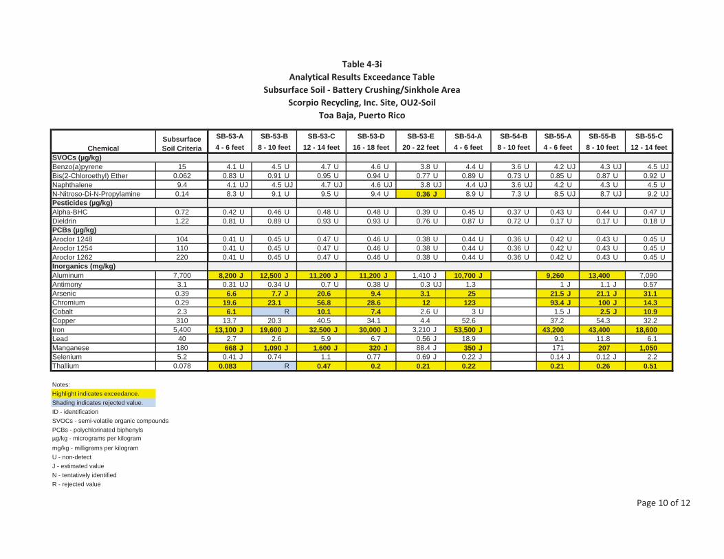
Table�4�3iAnalytical�Results�Exceedance�Table
Subsurface�Soil���Battery�Crushing/Sinkhole�AreaScorpio�Recycling,�Inc.�Site,�OU2�Soil
Toa�Baja,�Puerto�Rico
SVOCs (µg/kg)Benzo(a)pyrene 15Bis(2-Chloroethyl) Ether 0.062Naphthalene 9.4N-Nitroso-Di-N-Propylamine 0.14Pesticides (µg/kg)Alpha-BHC 0.72Dieldrin 1.22PCBs (µg/kg)Aroclor 1248 104Aroclor 1254 110Aroclor 1262 220Inorganics (mg/kg)Aluminum 7,700Antimony 3.1Arsenic 0.39Chromium 0.29Cobalt 2.3Copper 310Iron 5,400Lead 40Manganese 180Selenium 5.2Thallium 0.078
Notes:Highlight indicates exceedance.Shading indicates rejected value.ID - identificationSVOCs - semi-volatile organic compoundsPCBs - polychlorinated biphenylsµg/kg - micrograms per kilogrammg/kg - milligrams per kilogramU - non-detectJ - estimated valueN - tentatively identifiedR - rejected value
ChemicalSubsurfaceSoil Criteria
4.1 U 4.5 U 4.7 U 4.6 U 3.8 U 4.4 U 3.6 U 4.2 UJ 4.3 UJ 4.5 UJ0.83 U 0.91 U 0.95 U 0.94 U 0.77 U 0.89 U 0.73 U 0.85 U 0.87 U 0.92 U
4.1 UJ 4.5 UJ 4.7 UJ 4.6 UJ 3.8 UJ 4.4 UJ 3.6 UJ 4.2 U 4.3 U 4.5 U8.3 U 9.1 U 9.5 U 9.4 U 0.36 J 8.9 U 7.3 U 8.5 UJ 8.7 UJ 9.2 UJ
0.42 U 0.46 U 0.48 U 0.48 U 0.39 U 0.45 U 0.37 U 0.43 U 0.44 U 0.47 U0.81 U 0.89 U 0.93 U 0.93 U 0.76 U 0.87 U 0.72 U 0.17 U 0.17 U 0.18 U
0.41 U 0.45 U 0.47 U 0.46 U 0.38 U 0.44 U 0.36 U 0.42 U 0.43 U 0.45 U0.41 U 0.45 U 0.47 U 0.46 U 0.38 U 0.44 U 0.36 U 0.42 U 0.43 U 0.45 U0.41 U 0.45 U 0.47 U 0.46 U 0.38 U 0.44 U 0.36 U 0.42 U 0.43 U 0.45 U
8,200 J 12,500 J 11,200 J 11,200 J 1,410 J 10,700 J 9,260 13,400 7,0900.31 UJ 0.34 U 0.7 U 0.38 U 0.3 UJ 1.3 1 J 1.1 J 0.57
6.6 7.7 J 20.6 9.4 3.1 25 21.5 J 21.1 J 31.119.6 23.1 56.8 28.6 12 123 93.4 J 100 J 14.3
6.1 R 10.1 7.4 2.6 U 3 U 1.5 J 2.5 J 10.913.7 20.3 40.5 34.1 4.4 52.6 37.2 54.3 32.2
13,100 J 19,600 J 32,500 J 30,000 J 3,210 J 53,500 J 43,200 43,400 18,6002.7 2.6 5.9 6.7 0.56 J 18.9 9.1 11.8 6.1
668 J 1,090 J 1,600 J 320 J 88.4 J 350 J 171 207 1,0500.41 J 0.74 1.1 0.77 0.69 J 0.22 J 0.14 J 0.12 J 2.2
0.083 R 0.47 0.2 0.21 0.22 0.21 0.26 0.51
SB-54-B SB-55-A SB-55-B SB-55-CSB-53-A SB-53-B SB-53-C SB-53-D SB-53-E SB-54-A4 - 6 feet 4 - 6 feet 8 - 10 feet 12 - 14 feet8 - 10 feet 12 - 14 feet 16 - 18 feet 20 - 22 feet 4 - 6 feet 8 - 10 feet
Page�10�of�12
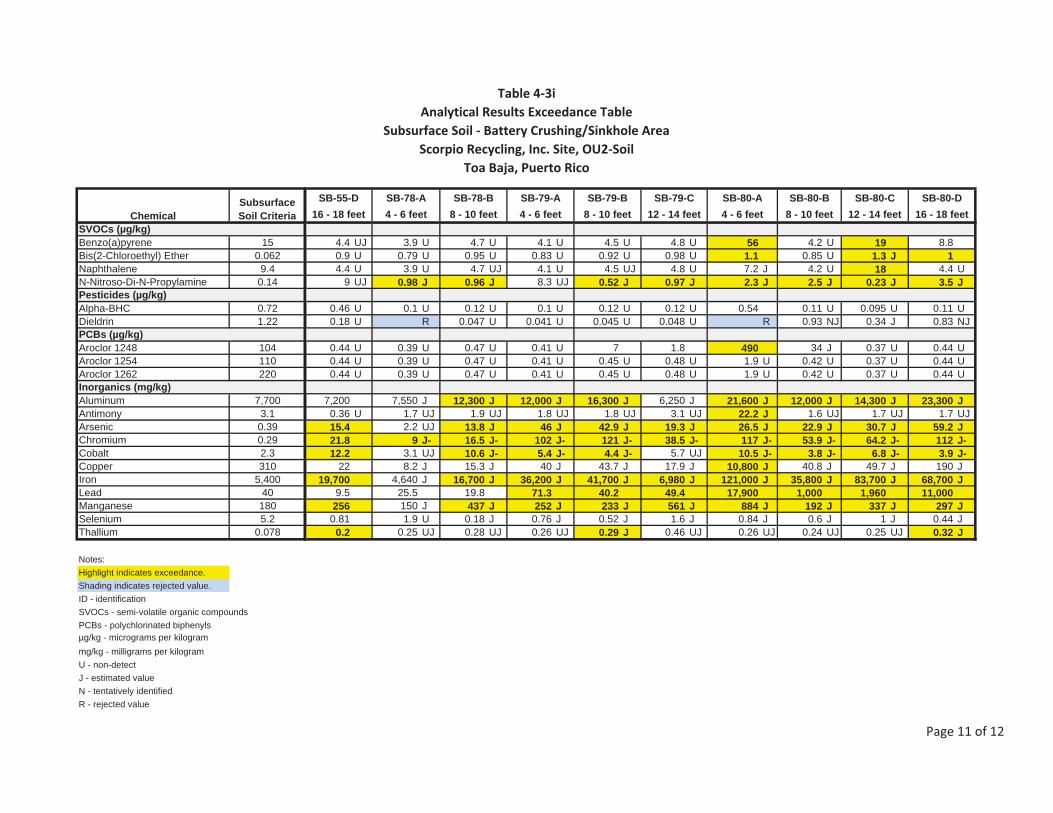
Table�4�3iAnalytical�Results�Exceedance�Table
Subsurface�Soil���Battery�Crushing/Sinkhole�AreaScorpio�Recycling,�Inc.�Site,�OU2�Soil
Toa�Baja,�Puerto�Rico
SVOCs (µg/kg)Benzo(a)pyrene 15Bis(2-Chloroethyl) Ether 0.062Naphthalene 9.4N-Nitroso-Di-N-Propylamine 0.14Pesticides (µg/kg)Alpha-BHC 0.72Dieldrin 1.22PCBs (µg/kg)Aroclor 1248 104Aroclor 1254 110Aroclor 1262 220Inorganics (mg/kg)Aluminum 7,700Antimony 3.1Arsenic 0.39Chromium 0.29Cobalt 2.3Copper 310Iron 5,400Lead 40Manganese 180Selenium 5.2Thallium 0.078
Notes:Highlight indicates exceedance.Shading indicates rejected value.ID - identificationSVOCs - semi-volatile organic compoundsPCBs - polychlorinated biphenylsµg/kg - micrograms per kilogrammg/kg - milligrams per kilogramU - non-detectJ - estimated valueN - tentatively identifiedR - rejected value
ChemicalSubsurfaceSoil Criteria
4.4 UJ 3.9 U 4.7 U 4.1 U 4.5 U 4.8 U 56 4.2 U 19 8.80.9 U 0.79 U 0.95 U 0.83 U 0.92 U 0.98 U 1.1 0.85 U 1.3 J 14.4 U 3.9 U 4.7 UJ 4.1 U 4.5 UJ 4.8 U 7.2 J 4.2 U 18 4.4 U
9 UJ 0.98 J 0.96 J 8.3 UJ 0.52 J 0.97 J 2.3 J 2.5 J 0.23 J 3.5 J
0.46 U 0.1 U 0.12 U 0.1 U 0.12 U 0.12 U 0.54 0.11 U 0.095 U 0.11 U0.18 U R 0.047 U 0.041 U 0.045 U 0.048 U R 0.93 NJ 0.34 J 0.83 NJ
0.44 U 0.39 U 0.47 U 0.41 U 7 1.8 490 34 J 0.37 U 0.44 U0.44 U 0.39 U 0.47 U 0.41 U 0.45 U 0.48 U 1.9 U 0.42 U 0.37 U 0.44 U0.44 U 0.39 U 0.47 U 0.41 U 0.45 U 0.48 U 1.9 U 0.42 U 0.37 U 0.44 U
7,200 7,550 J 12,300 J 12,000 J 16,300 J 6,250 J 21,600 J 12,000 J 14,300 J 23,300 J0.36 U 1.7 UJ 1.9 UJ 1.8 UJ 1.8 UJ 3.1 UJ 22.2 J 1.6 UJ 1.7 UJ 1.7 UJ15.4 2.2 UJ 13.8 J 46 J 42.9 J 19.3 J 26.5 J 22.9 J 30.7 J 59.2 J21.8 9 J- 16.5 J- 102 J- 121 J- 38.5 J- 117 J- 53.9 J- 64.2 J- 112 J-12.2 3.1 UJ 10.6 J- 5.4 J- 4.4 J- 5.7 UJ 10.5 J- 3.8 J- 6.8 J- 3.9 J-
22 8.2 J 15.3 J 40 J 43.7 J 17.9 J 10,800 J 40.8 J 49.7 J 190 J19,700 4,640 J 16,700 J 36,200 J 41,700 J 6,980 J 121,000 J 35,800 J 83,700 J 68,700 J
9.5 25.5 19.8 71.3 40.2 49.4 17,900 1,000 1,960 11,000256 150 J 437 J 252 J 233 J 561 J 884 J 192 J 337 J 297 J
0.81 1.9 U 0.18 J 0.76 J 0.52 J 1.6 J 0.84 J 0.6 J 1 J 0.44 J0.2 0.25 UJ 0.28 UJ 0.26 UJ 0.29 J 0.46 UJ 0.26 UJ 0.24 UJ 0.25 UJ 0.32 J
SB-78-B SB-79-A SB-79-B SB-79-C SB-80-A SB-80-BSB-55-D SB-78-A SB-80-C SB-80-D16 - 18 feet 4 - 6 feet 8 - 10 feet 16 - 18 feet4 - 6 feet 8 - 10 feet 12 - 14 feet 4 - 6 feet 8 - 10 feet 12 - 14 feet
Page�11�of�12

Table�4�3iAnalytical�Results�Exceedance�Table
Subsurface�Soil���Battery�Crushing/Sinkhole�AreaScorpio�Recycling,�Inc.�Site,�OU2�Soil
Toa�Baja,�Puerto�Rico
SVOCs (µg/kg)Benzo(a)pyrene 15Bis(2-Chloroethyl) Ether 0.062Naphthalene 9.4N-Nitroso-Di-N-Propylamine 0.14Pesticides (µg/kg)Alpha-BHC 0.72Dieldrin 1.22PCBs (µg/kg)Aroclor 1248 104Aroclor 1254 110Aroclor 1262 220Inorganics (mg/kg)Aluminum 7,700Antimony 3.1Arsenic 0.39Chromium 0.29Cobalt 2.3Copper 310Iron 5,400Lead 40Manganese 180Selenium 5.2Thallium 0.078
Notes:Highlight indicates exceedance.Shading indicates rejected value.ID - identificationSVOCs - semi-volatile organic compoundsPCBs - polychlorinated biphenylsµg/kg - micrograms per kilogrammg/kg - milligrams per kilogramU - non-detectJ - estimated valueN - tentatively identifiedR - rejected value
ChemicalSubsurfaceSoil Criteria
9.5 4.3 U 4.3 U0.89 U 0.96 J 1.3 J
4.4 U 4.3 UJ 4.3 UJ2.5 J 8.8 UJ 8.7 UJ
0.11 U 0.11 U 0.11 U0.4 NJ 0.043 U R
0.44 U 0.43 U 0.43 U0.44 U 0.43 U 0.43 U0.44 U 0.43 U 0.43 U
18,800 J 23,500 J 19,400 J2.6 J 1.8 UJ 1.8 UJ
49.7 J 62.3 J 85.1 J131 J- 168 J- 203 J-6.9 J- 3.8 J- 5.5 J-
337 J 97.7 J 103 J44,400 J 87,300 J 72,200 J28,900 1,080 13.5
498 J 288 J 400 J0.79 J 0.36 J 0.74 J0.29 J 0.38 J 0.67 J
SB-80-F SB-80-GSB-80-E20 - 22 feet 24 - 26 feet 28 - 30 feet
Page�12�of�12
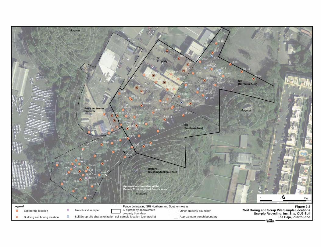
!.
!.!.
!.
!.
!.!.
!.!.!.
!.
!.
!.
!.
!.!.
!.
!.
!.!.
!.
!.
!.
!.
!.
!.
!.!.
!.
!.
!.
!.
!.
!.
!.
!.
!.
!.
!.
!.
!.
!.
!.
!.
!.
!.
!.
!.
!.
!.
!.
!.
!.
!.
!.
!.
!.
!.
!.
!.
!.
!.
!.!.
!.
!.!.
!.
!.
!.
!.
!.!.
!.
!.
!.
!.
!.
!.!.
"J
"J
"J
"J"J
"J
"J
"J
"J"J
"J
"J
"J
"J
"J
SP-6SP-4
SP-7SP-1
SP-2SP-3
SP-5
SB-81
SB-80
SB-46
SB-13
SB-74
SB-03
SB-08
SB-14
SB-54
SB-52
TS-76
SB-79
SB-78
SB-53 TS-75
SB-39
SB-45
SB-75
SB-70
SB-71
SB-76
SB-77
SB-72
SB-41
SB-37
SB-42
SB-43SB-36
SB-40
SB-38
SB-35
SB-44
SB-51
SB-55
SB-47
SB-61
SB-48
SB-49
SB-60
SB-50
SB-01
SB-02
SB-06
SB-22
SB-59
SB-04
SB-20
SB-17
SB-11
SB-09 SB-16
SB-15
SB-18
SB-21
SB-19
SB-100
SB-101
SB-102
SB-103
SB-104
SB-105SB-106
SB-109
SB-108
SB-107
SB-110
SB-111
SB-112SB-116
SB-115
SB-114
SB-113
SB-117
SB-64
SB-63
SB-62
SB-34
SB-33
SB-32 SB-31
SB-30
SB-29
SB-28
SB-27SB-26
SB-25
SB-24
SB-23
Figure 2-2Soil Boring and Scrap Pile Sample Locations
Scorpio Recycling, Inc. Site, OU2-SoilToa Baja, Puerto Rico
O0 250Feet
Rosa del Monte
Acuñ
a St
reet
Mogotes
Mogotes
Mogotes
Legend!. Trench soil sample
"J Building soil boring location
!. Soil boring location
!. Soil/Scrap pile characterization soil sample location (composite) Approximate trench boundary
Other property boundary
Property
SRIProperty
SRI(Northern Area)
SRI(Southern Area)
Battery Crushing/Sinkhole Area
Approximate boundary of the Battery Crushing/Lead Source Area
SRI property approximateproperty boundary
Fence delineating SRI Northern and Southern Areas
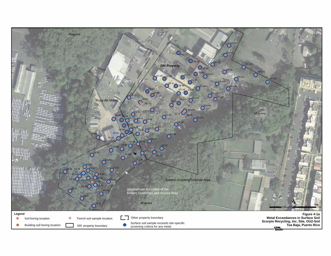
!.
!.
!.
!.
!.
!.
!.
!.
!.
!.
!.
!.
!.
!.
!.
!.
!.
!.
!.
!.
!.
!.!.
!.
!.
!.
!.!.
!.
!.
!.
!.
!.
!.
!.!.
!.
!.
!.
!.
!.
!.
!.
!.
!.
!.
!.!.
!.!.
!.
!.
!.!.
!.
!.
!.
!.
!.
!.
!.
!.
!.
!.
!.
!.
!.
!.
!.
!.
!.
!.
!.
!.
!.
!.
!.
!.
!.
!.
!.
!.
!.
!.
!.
!.
!.
!.
!.
!.
!.
!.
!.
!.
!.
!.
!.
!.
!.
!.
!.
!.
!.
!.
!.
!.
!.
!.!.
!.!.
!.!.
!.
!.!.!.
!.
!.
!.
!.
!.
!.!.
!
!.
!.
!.
!.
!.
!.!.
!.
!.
!.!.!. !.
!.
!.
!.!.!.!.!.
!.
!.
!.
!.
!.
!.
!.
!.
!.
!.
!.
!.
!.
!.!.
!.
!.!.
!.
!.
!.
!.
!.
!.
!.
!.
!.
!.
"J
"J
"J
"J"J
"J
"J
"J
"J"J
"J
"J
"J
"J
"J
!.
!.
!.
!.
!.!.
!.
!.
!.
!.
!.
!.!.
!.
!.
!.
!.
!.
!.
!.
!.
!.!.
!.
!.
!.
!.
!.
!.
!.
!.
!.
!.
!.
!.
!.
!.
!.
!.
!.
!.
!.
!.
!.
!.
!.
!.
!.
!.
!.
!.
!.
!.
!.
!.
!.
!.
!.!.
!.
!.!.
!.
!.
!.
!.
!.!.
!.
!.
!.
!.
!.
TS-76
TS-75
SS-81
SS-80
SS-79
SS-78
SS-77
SS-76
SS-75
SS-74
SS-72
SS-71
SS-70
SS-64
SS-63
SS-62
SS-61
SS-60
SS-59
SS-55
SS-54
SS-53
SS-52 SS-51
SS-50
SS-49
SS-48
SS-47
SS-46
SS-45
SS-44
SS-43
SS-42
SS-41
SS-40 SS-39
SS-38
SS-37
SS-36
SS-35
SS-34
SS-33
SS-32 SS-31
SS-30
SS-29
SS-28
SS-27SS-26
SS-25
SS-24
SS-23
SS-22
SS-21
SS-20
SS-19
SS-18
SS-17
SS-16
SS-15
SS-14
SS-13
SS-11
SS-09
SS-08
SS-06
SS-04
SS-03
SS-02
SS-01
SS-117
SS-116
SS-115
SS-114
SS-113
SS-112
SS-111
SS-110
SS-109
SS-108
SS-107
SS-106SS-105
SS-104
SS-103
SS-102
SS-101
SS-100
O0 250
Feet
Acuñ
a St
reet
Mogotes
Mogotes
Mogotes
Legend
"J Building soil boring location SRI roperty boundary
!. Trench soil sample location Other roperty boundary!. Soil boring location
Battery Crushing/Sinkhole Area
Rosa del Monte
Surface soil sample exceeds site-specific screening criteria for any metal
SRI Property
Approximate boundary of the Battery Crushing/Lead Source Area
p
p
Figure 4-1aMetal Exceedances in Surface Soil
Scorpio Recycling, Inc. Site, OU2-SoilToa Baja, Puerto Rico

!H
!H
!H
!H
!H
!H
!H
!H
!H
!H
!H
!H
!H
!H
!H
!H!H
!H!H
!H!H
!H
!H!H!H
!H
!H
!H
!H
!H
!H!H
!H
!H
!H
!H
!H
!H!H
!H
!H
!H!H!H
!H
!H
!H!H!H!H
!H
!H
!H
!H
!H
!H
!H
!H
!H
!H
!H
!H
!H
!H
!H
!H
!H!H
!H
!H!H
!H
!H
!H
!H
!H
!H
!H"J
"J
"J
"J"J
"J
"J
"J
"J"J
"J
"J
"J
"J
"J
!.
!.
!.
!.
!.!.
!.
!.
!.
!.
!.
!.!.
!.
!.
!.
!.
!.
!.
!.
!.
!.!.
!.
!.
!.
!.
!.
!.
!.
!.
!.
!.
!.
!.
!.
!.
!.
!.
!.
!.
!.
!.
!.
!.
!.
!.
!.
!.
!.
!.
!.
!.
!.
!.
!.
!.!.
!.
!.
!.
!.
!.
!.
!.!.
!.
!.
!.
!.
!.
SB-100-B
SB-81-E
SB-80-G
SB-79-C
SB-78-B
SB-77-G
SB-76-F
SB-75-G
SB-74-A
SB-72-E
SB-71-B
SB-70-A
SB-64-B
SB-63-J
SB-62-L
SB-61 -HSB-60-D
SB-59-A
SB-55-D
SB-54-BSB-53-E
SB-52-D SB-51-D
SB-50-I
SB-49-D
SB-48-D
SB-47-C
SB-46-E
SB-45-E
SB-44-B
SB-43-E
SB-42-E
SB-41-E
SB-40-F SB-39-E
SB-38-D
SB-37-D
SB-36-D
SB-35-D
SB-34-B
SB-33-B
SB-32-B SB-31-B
SB-30-B
SB-29-BSB-28-B
SB-27-BSB-26-B
SB-25-BSB-24-B
SB-23-B
SB-22-B
SB-21-B
SB-20-B
SB-19-B
SB-18-B
SB-17-B
SB-16-B
SB-15-B
SB-14-B
SB-13-B
SB-11-B
SB-09-B
SB-08-B
SB-06-B
SB-04-B
SB-03-B
SB-02-B
SB-01-B
SB-117-B
SB-116-B
SB-115-B
SB-114-B
SB-113-B
SB-112-B
SB-111-B
SB-110-B
SB-109-B
SB-108-B
SB-107-B
SB-106-BSB-105-B
SB-104-B
SB-103-B
SB-102-B
SB-101-B
O0 250
Feet
Acuñ
a St
reet
Mogotes
Mogotes
Mogotes
Legend
"J Building soil boring location
SRI roperty boundary
Soil Boring Depth (ft)B - 8-10 G - 28-30C - 12-14 H - 32-34D - 16-18 I - 36-38E - 20-22 J - 48-50F - 24-26
Other roperty boundary
Battery Crushing/Sinkhole Area
Rosa del Monte
!. Soil boring location Surface soil sample exceeds site-specific screening criteria for any metal
Approximate boundary of the Battery Crushing/Lead Source Area
SRI Property
Figure 4-1bMetal Exceedances in Subsurface SoilScorpio Recycling, Inc. Site, OU2-Soil
Toa Baja, Puerto Ricop
p
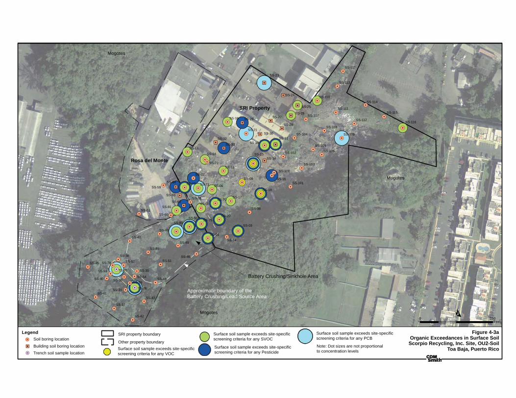
O0 250
Feet
Acuñ
a St
reet
Mogotes
Mogotes
Mogotes
Legend
"J
!.
!.
Rosa del Monte
SRI Property
Battery Crushing/Sinkhole Area
Approximate boundary of the Battery Crushing/Lead Source Area
!(!(
!(!(
!(
!(
!(
!(
!(!(
!(
!(!(
!(
!(
!(!(
!(
!(
!(
!(
!(!(
!(
!(
!(
!(
!(
!(
!(
!(!(
!(
!(
!(
!(
!(
!(
!(
!(
!(
!(
!(
!(
!(
!(
!(
!(!(
!(
!(
!(
!(
!(!(
!(
!(
!.
!.
!.
!.
!.
!.
!.
!.
!.
!.
!.
!.
!.
!.
!.
!.
!.
!.
!.
!.
!.
!.!.
!.
!.
!.
!.!.
!.
!.
!.
!.
!.
!.
!.!.
!.
!.
!.
!.
!.
!.
!.
!.
!.
!.
!.!.
!.!.
!.
!.
!.!.
!.
!.
!.
!.
!.
!.
!.
!.
!.
!.
!.
!.
!.
!.
!.
!.
!.
!.
!.
!.!.
!.
!.
!.
!.
!.
!.
!.
!.
!.
!.
!.
!.
!.
"J
"J
"J
"J"J
"J
"J
"J
"J"J
"J
"J
"J
"J
"J
!.
!.
!.
!.
!.!.
!.
!.
!.
!.
!.
!.!.
!.
!.
!.
!.
!.
!.
!.
!.
!.!.
!.
!.
!.
!.
!.
!.
!.
!.
!.
!.
!.
!.
!.
!.
!.
!.
!.
!.
!.
!.
!.
!.
!.
!.
!.
!.
!.
!.
!.
!.
!.
!.
!.
!.
!.!.
!.
!.!.
!.
!.
!.
!.
!.!.
!.
!.
!.
!.
!.
TS-76
TS-75
SS-81
SS-80
SS-79
SS-78
SS-77
SS-76
SS-75
SS-74
SS-72
SS-71
SS-70
SS-64
SS-63
SS-62
SS-61SS-60
SS-59
SS-55
SS-54
SS-53
SS-52 SS-51
SS-50
SS-49
SS-48
SS-47
SS-46
SS-45
SS-44
SS-43
SS-42
SS-41
SS-40 SS-39
SS-38
SS-37
SS-36
SS-35
SS-34
SS-33
SS-32 SS-31SS-30
SS-29
SS-28
SS-27SS-26
SS-25
SS-24
SS-23
SS-22
SS-21
SS-20
SS-19
SS-18
SS-17
SS-16
SS-15
SS-14
SS-13
SS-11
SS-09
SS-08
SS-06
SS-04
SS-03
SS-02
SS-01
SS-117
SS-116
SS-115
SS-114
SS-113
SS-112
SS-111
SS-110
SS-109
SS-108
SS-107
SS-106SS-105
SS-104
SS-103
SS-102
SS-101
SS-100
Figure 4-3aOrganic Exceedances in Surface SoilScorpio Recycling, Inc. Site, OU2-Soil
Toa Baja, Puerto Rico(
((
(Note: Dot sizes are not proportional to concentration levelsTrench soil sample location
Building soil boring location
Soil boring location
Surface soil sample exceeds site-specific screening criteria for any VOC
Surface soil sample exceeds site-specific screening criteria for any SVOC
Surface soil sample exceeds site-specific screening criteria for any Pesticide
Surface soil sample exceeds site-specific screening criteria for any PCB
SRI property boundary
Other property boundary
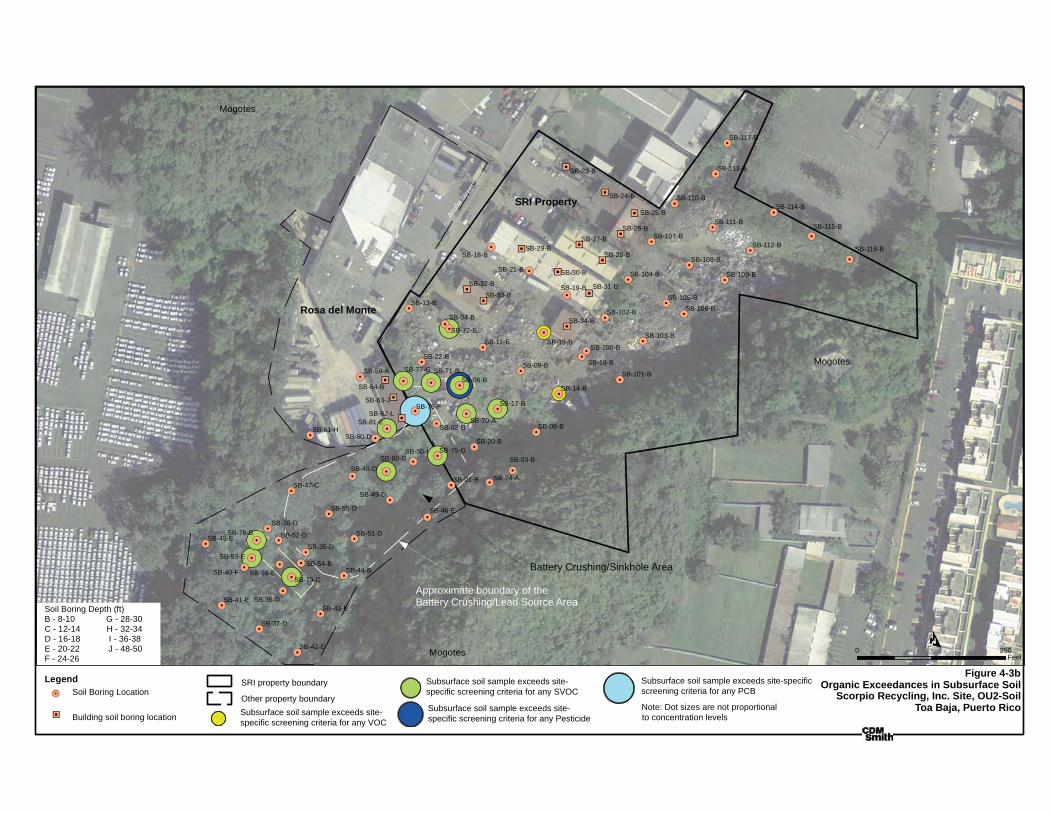
!(!(
!(
!(!(
!(
!(
!(!(!(
!(
!(
!(
!(!(
!(
"J
"J
"J
"J"J
"J
"J
"J
"J"J
"J
"J
"J
"J
"J
!.
!.
!.
!.
!.!.
!.
!.
!.
!.
!.
!.!.
!.
!.
!.
!.
!.
!.
!.
!.
!.!.
!.
!.
!.
!.
!.
!.
!.
!.
!.
!.
!.
!.
!.
!.
!.
!.
!.
!.
!.
!.
!.
!.
!.
!.
!.
!.
!.
!.
!.
!.
!.
!.
!.
!.!.
!.
!.
!.
!.
!.
!.
!.!.
!.
!.
!.
!.
!.
SB-100-B
SB-81-E
SB-80-G
SB-79-C
SB-78-B
SB-77-G
SB-76-F
SB-75-G
SB-74-A
SB-72-E
SB-71-B
SB-70-A
SB-64-B
SB-63-J
SB-62-L
SB-61-HSB-60-D
SB-59-A
SB-55-D
SB-54-BSB-53-E
SB-52-D SB-51-D
SB-50-I
SB-49-D
SB-48-D
SB-47-C
SB-46-E
SB-45-E
SB-44-B
SB-43-E
SB-42-E
SB-41-E
SB-40-F SB-39-E
SB-38-D
SB-37-D
SB-36-D
SB-35-D
SB-34-B
SB-33-B
SB-32-B SB-31-B
SB-30-B
SB-29-BSB-28-B
SB-27-BSB-26-B
SB-25-B
SB-24-B
SB-23-B
SB-22-B
SB-21-B
SB-20-B
SB-19-B
SB-18-B
SB-17-B
SB-16-B
SB-15-B
SB-14-B
SB-13-B
SB-11-B
SB-09-B
SB-08-B
SB-06-B
SB-04-B
SB-03-B
SB-02-B
SB-01-B
SB-117-B
SB-116-B
SB-115-B
SB-114-B
SB-113-B
SB-112-B
SB-111-B
SB-110-B
SB-109-B
SB-108-B
SB-107-B
SB-106-BSB-105-B
SB-104-B
SB-103-B
SB-102-B
SB-101-B
O0 250
Feet
Acuñ
a St
reet
Mogotes
Mogotes
Mogotes
Legend
"J
Soil Boring Depth (ft)B - 8-10 G - 28-30C - 12-14 H - 32-34D - 16-18 I - 36-38E - 20-22 J - 48-50F - 24-26
Battery Crushing/Sinkhole Area
Rosa del Monte
!.
Approximate boundary of the Battery Crushing/Lead Source Area
SRI Property
Figure 4-3bOrganic Exceedances in Subsurface Soil
Scorpio Recycling, Inc. Site, OU2-SoilToa Baja, Puerto Rico
(
((
(Note: Dot sizes are not proportional to concentration levelsSubsurface soil sample exceeds site-
specific screening criteria for any VOC
Subsurface soil sample exceeds site-specific screening criteria for any SVOC
Subsurface soil sample exceeds site-specific screening criteria for any Pesticide
Subsurface soil sample exceeds site-specific screening criteria for any PCB
SRI property boundary
Other property boundarySoil Boring Location
Building soil boring location
VIII�B:�FINAL�REVISED�FEASIBILITY�STUDY�REPORT�(JULY�9,�2013)�����
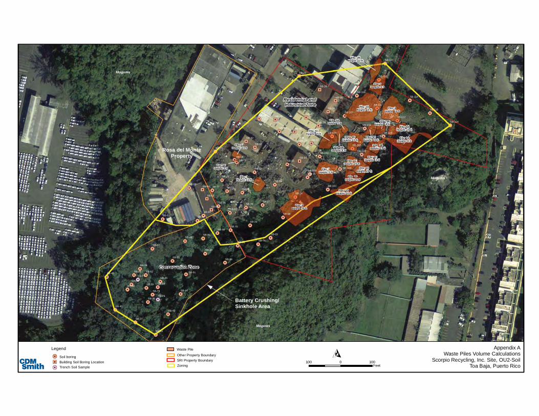
Mogotes
Mogotes
Mogotes
Conservation Zone
Residential and Industrial Zone
Pile: 1GHeight: 20 ft
Pile: 7Height: 7 ft
Pile: 1FHeight: 25 ft
Pile: 1DHeight: 25 ft
Pile: 1CHeight: 15 ft
Pile: 1BHeight: 12 ft
Pile: 6CHeight: 15 ft
Pile: 6BHeight: 8 ft
Pile: 4DHeight: 15 ft
Pile: 4AHeight: 16 ft
Pile: 3Height: 14 ft
Pile: 2BHeight: 12 ft
Pile: 5Height: 5 ft
Pile: 2AHeight: 12 ft
Pile: 4CHeight: 16 ft
Pile: 4BHeight: 18 ft
Pile: 1EHeight: 20 ft
Pile: 6AHeight: 7 ft
Pile: 1AHeight: 8 ft
Pile: 9Height: 12 ft
Pile: 8Height: 30 ft
Pile: 11Height: 10 ft
Pile: 10Height: 5 ft
SB-23
SB-24
SB-25
SB-26
SB-27
SB-28
SB-29
SB-30
SB-31SB-32
SB-33
SB-34
SB-62
SB-63
SB-64
SB-117
SB-113
SB-114
SB-115
SB-116
SB-112
SB-111
SB-110
SB-107
SB-108
SB-109
SB-106
SB-105
SB-104
SB-103
SB-102
SB-19
SB-21
SB-18
SB-15
SB-16
SB-101
SB-09
SB-11
SB-17
SB-20
SB-04
SB-59
SB-22
SB-06
SB-02
SB-01
SB-50
SB-60
SB-49
SB-48
SB-61
SB-47
SB-55
SB-51
SB-44
SB-35
SB-38
SB-40
SB-36
SB-43
SB-42
SB-37
SB-41
SB-72
SB-77
SB-76
SB-71
SB-70
SB-75
SB-45
SB-39
TS-75
SB-53
SB-78
SB-79
TS-76
SB-52
SB-54
SB-14
SB-08
SB-03
SB-74
SB-13
SB-100
SB-46
SB-80
SB-81
100 1000Feet
Other Property Boundary
Legend
Soil boringBuilding Soil Boring LocationTrench Soil Sample
SRI Property BoundaryZoning
Rosa del MonteProperty
Battery Crushing/Sinkhole Area
Appendix AWaste Piles Volume Calculations
Scorpio Recycling, Inc. Site, OU2-SoilToa Baja, Puerto Rico
Waste Pile