Embed Size (px)
Citation preview

International Conference on Soil Classification and Reclamation of Degraded Lands in Arid Environments
17-19 May, 2010 Abu Dhabi City, United Arab Emirates
1
PARTICIPATORY SOIL AND LAND EVALUATION MAPPING: AN
ALTERNATIVE APPROACH TO IMPROVE SOIL AND LAND EVALUATION
INFORMATION USEFULNESS TO DECISION MAKERS
Ivan Luiz Zilli BacicA, Juniele Rodrigues Pivetta
B and Roberta Pereira Martins
C
ACentro de Informações de Recursos Ambientais e de Hidrometeorologia de Santa
Catarina (CIRAM), Empresa de Pesquisa Agropecuária e Extensão Rural de Santa
Catarina (EPAGRI), Florianópolis, SC, Brasil, Emails [email protected];
[email protected]. BFellowship holder of Conselho Nacional de Desenvolvimento Científico e Tecnológico
(CNPq) at Centro de Informações de Recursos Ambientais e de Hidrometeorologia de
Santa Catarina (CIRAM), Empresa de Pesquisa Agropecuária e Extensão Rural de
Santa Catarina (EPAGRI), Florianópolis, SC, Brasil. Email: [email protected]. CFellowship holder of Conselho Nacional de Desenvolvimento Científico e Tecnológico
(CNPq) at Centro de Informações de Recursos Ambientais e de Hidrometeorologia de
Santa Catarina (CIRAM), Empresa de Pesquisa Agropecuária e Extensão Rural de
Santa Catarina (EPAGRI), Florianópolis, SC, Brasil. Email: [email protected].
Abstract Results of soil and land evaluation survey and mapping, which were expected to be
essential to rural land use and management planning, most of the time are not
adequately used by their potential users and rarely reach the decision makers. This may
reflect the poor communication between the main actors of the rural land use planning
process and inappropriate language of the presented results. When following traditional
methods, there is a risk that questions may be answered that have no relevance, and/or
that questions may not be answered properly according to the community expectation.
Therefore, it is important to change the strategies of communication and language of the
results to make information more useful to the decision makers. In this context, the
objective of this work was to test a participatory soil survey and land evaluation
methodology to make the information more useful and consequently more used by the
decision makers. This work shows the results obtained up to now in Barra Bonita
municipality, Santa Catarina State, southern Brazil. The study started with meetings,
interviews and questionnaires with local community, and the main demands for
information raised were the need for area expansion and management improvement of
pastures for milk production. But, instead of giving them information showing soil
types with technical language, and a general information about land evaluation, the
presented information shows what they want to know, namely spatial location of
potential new areas for pasture, what pasture type is better for different conditions and
what management is recommended for each area. In the final stage of the study,
participants positively evaluated the presented information.
INTRODUCTION
Land evaluation is the process of predicting land performance over time according to
specific land use types (VAN DIEPEN et al., 1991; ROSSITER, 1996). These
predictions should then be used to guide strategic land use and management decisions.
However, results from land inventories and soil and land evaluation surveys and
mapping, which were expected to be essential to rural land use and management

International Conference on Soil Classification and Reclamation of Degraded Lands in Arid Environments
17-19 May, 2010 Abu Dhabi City, United Arab Emirates
2
planning, most of the time are not adequately used by their potential users and rarely
reach the decision makers (ROSSITER, 1996; BOUMA, 1999; BACIC, 2003; BACIC
et al., 2003). This may reflect the low relevance of many land evaluation and soil survey
reports, the poor communication between the main actors of the land use planning
process (e.g. soil surveyors, farmers and rural extensionists) and inappropriate language
of the presented results. When following traditional methods, there is a risk that
questions may be answered that have no relevance, and/or that questions may not be
answered properly according to the community expectation.
BACIC (2003) suggests that the process should begin with a careful analysis of the
environment where the stakeholders live, and consequently, where decisions are made,
following a participatory and demand-driven methodology. Besides, it is important to
change the strategies of communication and language of the results. Therefore, it is
expected that the decision makers will be given the information they consider more
relevant and with more appropriate language.
In this context, the objective of this work was to test a participatory soil survey and land
evaluation methodology to make the information more useful and consequently more
used by the decision makers.
MATERIALS AND METHODS
This work is part of the project “Demand-driven land evaluation”, that is being
developed in Santa Catarina State, southern Brazil, by the “Empresa de Pesquisa
Agropecuária e Extensão Rural de Santa Catarina – EPAGRI”, with financial support
from the “Conselho Nacional de Desenvolvimento Científico e Tecnológico – CNPq”,
the “Ministério do Desenvolvimento Agrário/Secretaria de Agricultura Familiar –
MDA/SAF” and the “Ministério do Desenvolvimento Social e Combate a
Fome/Secretaria Nacional de Segurança Alimentar e Nutricional – MDS/SESAN”. The
project started on December/2007 and will last for 30 months. Three municipalities
were selected according to the following main criteria: (1) location on three different
regions in Santa Catarina State; and (2) acceptance and support of local teams
(extensionists), local government and primarily the communities. Following these
criteria and after several meetings, the following municipalities were selected: Lontras
(Upper Itajaí River Valley), Luzerna (Mid-West) and Barra Bonita (West), where
traditional soil and land evaluation maps and reports are available and were barely used.
This work shows the results obtained up to now in Barra Bonita municipality. The study
area, “Pomba Branca Microcatchment”, was selected in a meeting with local leaders.
The first step was to raise the demands for interpreted information (e.g. land evaluation,
climatic risks, production systems, economic information, amongst others), according to
the local decision makers (farmers, extensionists and local leaders) needs. The demands
were raised in meetings, after a presentation, questionnaire application and interviews.
At this time, in order to understand better the local conditions, the farmers also
answered general questions about farm size, number of people working in the farm,
main rural activities, if they wanted to improve or even abandon these activities, as well
as if they had the intension to start a new activity and which information would be
necessary to make this decision. The demanded information was then organized and
ordered following the priorities, according to the urgency and frequency. This paper
deals with the main demands raised, namely the need for area expansion, recommended
pasture species and management improvement of pastures for milk production.

International Conference on Soil Classification and Reclamation of Degraded Lands in Arid Environments
17-19 May, 2010 Abu Dhabi City, United Arab Emirates
3
The criteria to evaluate potential expansion areas for pasture and to indicate the better
species and management for different areas were defined based on literature and from
meetings with experts. The main criterion was defined as the slope degree. In areas with
slope degrees lower than 20%, it is possible to recommend both annual and perennial
pastures and no special conservation practices are needed. In this case, the land cover
produced by the pasture is considered to be enough to control the erosion. In areas with
slope degrees ranging from 20 to 30%, as the erosion susceptibility is higher, it is
recommended species with the following characteristics: erosion control potential, cattle
trampling resistance, resistant to environmental adversities, rapid growing and good soil
covering. In areas where the slope degrees vary from 30 to 45%, it is recommended the
use with perennial pastures due to the even higher erosion susceptibility and difficulties
to use agricultural mechanization. In areas where the slope degrees are higher than 45%,
it is not recommended pasture as land use, due to the high erosion susceptibility,
difficult workability and bad conditions to the animals. Another criterion to define
potential expansion areas was the land use. It was considered as potential areas only
those with annual crops, meadow and reforestation. Regarding the pasture management
improvement potential, it was considered the areas with continuous grazing (identified
as pastures in the land use map) associated to slope degree <30%.
As primary information, the soil and land use survey and mapping were used. The final
results about potential expansion areas and recommended species were obtained
overlaying the information described above.
Based on the criteria explained above, the following four classes were defined for the
study area:
• Class 1: < 20% slope degree associated to annual crops, meadow or reforestation;
• Class 2: 20-30% slope degree associated to annual crops, meadow or reforestation;
• Class 3: 30-45% slope degree associated to annual crops, meadow or reforestation;
• Class 4: <30% slope degree associated to pasture;
The Classes 1, 2 and 3 are considered the classes with potential for pasture area
expansion; Classe 4 is related to the potential for pasture management improvement.
Next, other meeting was organized, to present the demanded information, as well as to
assess the relevance and quality of the demanded information, to evaluate the tools and
methods used, and to re-evaluate the priorities according to the participants’ opinions.
RESULTS AND DISCUSSION
The study area The study area is the Pomba Branca microcatchment (460 ha), which is representative
of most of the Barra Bonita Municipality (107 km2) in western Santa Catarina State,
Brazil (Figure 1).
Barra Bonita city centre is located at 730masl. Applying the Köppen system, Barra
Bonita is included in Cfa climate, mesothermal humid, without defined dry season and
warm summer (temperatures above 22oC in the warmest month) (Santa Catarina, 1986).
The underlying geologic formation is the “Serra Geral”, composed of dark grayish to
black basalt (Silva and Bortoluzzi, 1987). There are, according to IBGE (2000), 1862
people living in rural areas and 256 in urban areas. The principal land uses are annual
crops (mainly maize, cassava, tobacco and beans), pasture for milk production and
swine (Santa Catarina, 2005; IBGE, 2000; IBGE, 2006).
Pomba Branca Microcatchment is characterized by small family farms, as the farms are
mostly smaller than 20ha and most of the labour is from family members. The main

International Conference on Soil Classification and Reclamation of Degraded Lands in Arid Environments
17-19 May, 2010 Abu Dhabi City, United Arab Emirates
4
commercial agricultural activities are milk production, tobacco, maize and beans. The
predominant soils in the study area are Cambissolos, Neossolos Litólicos and Neossolos
Regolíticos according to the Brazilian system (EMBRAPA, 2006), corresponding to
Inceptisols and Entisols in Soil Taxonomy (United States Department of Agriculture,
1999). Table 1 shows the Physiographic units distribution in the microcatchment, as
well as the main land evaluation classes according to the Santa Catarina System (Uberti
et al., 1991) and predominant slope degrees. The land use distribution in Pomba Branca
Microcatchment is shown in Table 2. The Physiographic and Land Use maps are shown
in Figures 2 and 3, respectively.
Land evaluation using traditional Santa Catarina method Land evaluations maps and reports in Santa Catarina State are prepared according to the
“Metodologia para Classificação da Aptidão de Uso das Terras do Estado de Santa
Catarina” (Methodology for Land Suitability Classification in Santa Catarina State)
(Uberti et al., 1991). It classifies land into one of five classes of physical suitability,
which are first defined in descriptive terms as follows:
• Class 1 - Good suitability for climatically adapted annual crops;
• Class 2 - Moderate suitability for climatically adapted annual crops;
• Class 3 - Restricted suitability for climatically adapted annual crops, moderate
suitability for fruit production and good suitability for pasture and reforestation;
• Class 4 - Restricted suitability for fruit production and moderate suitability for
pasture and reforestation;
• Class 5 - Permanent conservation areas.
To make the description operational, the following specific land characteristics are
measured for each map unit: slope gradient (d), effective soil depth (pr), stoniness (p),
susceptibility to erosion (e), fertility (f) and drainage conditions (h). These are
compared with defined limits for each suitability class, using the maximum limitation
method (Sys et al., 1991). There is no separate evaluation for different annual crops or
for fruit, horticulture, pasture, or forestry, and in addition there is no differentiation
between management levels or techniques.
Following this methodology and considering the land evaluation classes found in the
study area (Table 1), the recommendations for pasture would be that some areas have
good suitability (Classes 2 and 3) and others moderate suitability (Class 4). Therefore, it
is clear that those recommendations are not enough to answer to the farmers’ demands.
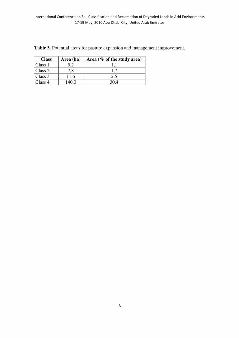
Potential areas for pasture expansion and recommended species and management Observing and analyzing information in Figure 4 and Table 3, it is possible to identify
the low potential of the study area to pasture expansion. Only 24,6 ha (5,3% of the study
area) is suitable to pasture expansion. Thus, this can just be an alternative for a small
number of farmers. But, considering that the main reason the farmers wanted to increase
their pasture area was to increase their profit, improving their financial conditions,
another possibility is to improve the pasture management. The potential in the area to
improve management is higher, as 30,4% (140 ha) of the study area currently with
pasture under continuous grazing could be changed to Voisin Grazing Management.
Following this recommended management, it will be possible to increase number of
animals, milk productivity, production and consequently the income. Table 4 shows the
recommended species and management for different conditions.

International Conference on Soil Classification and Reclamation of Degraded Lands in Arid Environments
17-19 May, 2010 Abu Dhabi City, United Arab Emirates
5
But is also important to emphasize that, even the management improvement will not be
the best option to all the farms. As the labour in the study area is based on the family
labour, some farms will not have enough people to carry on the additional work
demands. In these cases, other land use alternatives should be considered in following
stages of the project presented here.
CONCLUSIONS
The presented information showing clearly what the farmers wanted to know, instead of
giving them the traditional information showing soil types with technical language, and
general information about land evaluation, was positively evaluated by them. They
easily understood and considered the information useful to help them to make their
decisions.
As the specific conditions of each farm are different, there are no recommendations that
fit every individual situation. This paper showed alternatives like the potential for area
expansion and the management improvement of pastures, as possible options for some
farmers, but they should also receive a set of other realistic land use alternatives from
which they could choose from.
The methodology is based on several negotiation rounds, and up to the end of the
project it is expected to find in a collective way, different land use and management
techniques, new options to increase incomes without environmental damages,
improving the rural families’ social inclusion and their life quality.
REFERENCES
Bacic I.L.Z. 2003. Demand-driven land evaluation: with case studies in Santa Catarina,
Brazil. (Wageningen University and ITC: Wageningen and Enschede, The
Netherlands).
Bacic, I.L.Z., D.G. Rossiter and A.K. Bregt. 2003. The use of land evaluation
information by land use planners and decision-makers: a case study in Santa
Catarina, Brazil. Soil Use and Management 19: 12-18.
Bouma, J. 1999. Land evaluation for landscape units. In: Handbook of soil science, ed
Sumner, M.E., CRC Press, Boca Raton, FL, pp E393-E412.
EMBRAPA - Empresa Brasileira de Pesquisa Agropecuária. 2006. Centro Nacional de
Pesquisa de Solos. Sistema brasileiro de classificação de solos. 2.ed. Rio de Janeiro.
306p.
IBGE. 2000. Censo Demográfico do Brasil 2000 - Características da População e dos
Domicílios: Resultados do universo. Rio de Janeiro, IBGE. Available at:
http://www.ibge.gov.br/home/estatistica/populacao/censo2000/universo.php?tipo=31
o/tabela13_1.shtm&paginaatual=1&uf=42&letra=B. Verified on March, 2010.
IBGE. 2006. Censo Agropecuário 2006. Rio de Janeiro, IBGE. Available at:
http://www.sidra.ibge.gov.br/bda/pesquisas/ca/default.asp?o=2&i=P. Verified on:
March, 2010.
Rossiter, D.G. 1996. A theoretical framework for land evaluation (with discussion).
Geoderma 72: 165-202.

International Conference on Soil Classification and Reclamation of Degraded Lands in Arid Environments
17-19 May, 2010 Abu Dhabi City, United Arab Emirates
6
Santa Catarina. 1986. Atlas de Santa Catarina. Rio de Janeiro: Aerofoto Cruzeiro. 173p.
Santa Catarina. 2005. Secretaria de Estado da Agricultura e Desenvolvimento Rural.
LAC – Levantamento agropecuário de Santa Catarina: 2002-2003. Florianópolis:
Instituto Cepa-SC, Available at:
http://cepa.epagri.sc.gov.br/Publicacoes/lac_fev_2005.pdf. Verified on March, 2010.
Silva, L.C. and C.A. Bortoluzzi. 1987. Mapa geológico do Estado de Santa Catarina
escala 1:500000: texto explicativo. DNPM - 11o Distrito/Secr. Ciência Tecnologia,
Minas e Energia - Coordenadoria de Recursos Minerais, Florianópolis.
Sys, C., E. Van Ranst and J. Debaveye. 1991. Land evaluation, Part 1 : Principles in
land evaluation and crop production calculations. General Administration for
Development Cooperation, Brussels.
Uberti, A.A.A., I.L.Z. Bacic, J.A.V. Panichi, J.A. Laus Neto, J.M. Moser, M. Pundek
and S.L. Carriao. 1991. Metodologia para classificação da aptidão de uso das terras
do Estado de Santa Catarina. EMPASC/ACARESC, Florianópolis, Santa Catarina.
United States Department of Agriculture. 1999. Soil taxonomy: a basic system of soil
classification for making and interpreting soil surveys. Agriculture Handbook 436.
United States Department of Agriculture, Natural Resources Conservation Service,
Washington, D.C.
Van Diepen, C.A., H. Van Keulen, J. Wolf and J.A.A. Berkhout. 1991. Land evaluation:
from intuition to quantification. In: Advances In: Soil Science, ed Stewart, B.A.,
Springer, New York, pp 139-204.
ACKNOWLEDGEMENTS
This work was supported by CNPq, MDA/SAF, MDS/SESAN and Epagri.

International Conference on Soil Classification and Reclamation of Degraded Lands in Arid Environments
17-19 May, 2010 Abu Dhabi City, United Arab Emirates
7
TABLES
Table 1. Physiographic units distribution, slope degrees and land evaluation classes in
Pomba Branca Microcatchment.
Physiographic Units
Area (ha)
Area (%)
Slope Degrees (%)
Land evaluation classes according to Uberti et al. (1991)
Ee – Erosional
Hillslope
216 46,9 >30 4e (3dp)
Eec - (Erosional-
Colluvial Hillslope
109 23,7 20-30 3pe (3prp) (3dp)
Ce - Erosional
Summit
10 2,2 0-8 3prp
Ece1 – Colluvial-
Erosional Hillslope
1
96 20,9 0-8 2pr (2p)
Ece2 – Colluvial-
Erosional Hillslope
2
19 4,1 8-20 2de
Ep – Step Hillslope 10 2,2 8-20 2p (3prp)
TOTAL 460 100,0 - -
Table 2. Land Use in Pomba Branca Microcatcment.
Land Use Área (ha) Area (%)
Buildings 0,7 0,2
Fruit Trees 0,8 0,2
Water reservoir 6,0 1,3
Pasture 250,0 54,3
Meadow 15,0 3,3
Annual Crops 63,5 13,8
Forest 116,0 25,2
Reforestation 8,0 1,7
Total 460,0 100,0
International Conference on Soil Classification and Reclamation of Degraded Lands in Arid Environments
17-19 May, 2010 Abu Dhabi City, United Arab Emirates
8
Table 3. Potential areas for pasture expansion and management improvement.
Class Area (ha) Area (% of the study area) Class 1 5,2 1,1
Class 2 7,8 1,7
Class 3 11,6 2,5
Class 4 140,0 30,4

International Conference on Soil Classification and Reclamation of Degraded Lands in Arid Environments
17-19 May, 2010 Abu Dhabi City, United Arab Emirates
9
Table 4. Recommended pasture species and management
Slope Degree (%)
Grass Pasture Legume Pasture Recommended management
0 – 20% Avena sativa L. (Aveia branca);
Avena strigosa Sereb (Aveia
preta); Secale cereale L.
(Centeio); Lolium perenne L.
(Azevém); Braquiaria
decumbens Stapf. Prain
(Braquiária); Paspalum notatum
(Grama comum); Cynodon
nlemfuensis Vanderryst
(Tifton); Zea mays L. (Milho);
Sorghum Vulgare Pers (Sorgo);
Pennisetum purpureum Schum
(Capim Elefante); Festuca
arundinaceae Schreb (Festuca);
Braquiaria mutica (Angola);
Braquiaria humidicola
(Humidicola); Panicum
maximum (Colonião).
Vicia sativa
L.(Ervilhaca); Lotus
corniculatus
(Cornichão);
Trifolium repens L.
(Trevo branco);
Trifolium pratense
L.(Trevo vermelho);
Arahis pintoi
(Amendoim
forrageiro).
Voisin Grazing
Management
20 – 30% Braquiaria decumbens Stapf.
Prain (Braquiária); Cynodon
nlemfuensis Vanderryst
(Tifton); Pennisetum
purpureum Schum (Capim
Elefante); Festuca
arundinaceae Schreb (Festuca);
Braquiaria mutica (Angola);
Braquiaria humidicola
(Humidicola); Panicum
maximum (Colonião).
Lotus corniculatus
(Cornichão); Arahis
pintoi (Amendoim
forrageiro)
Voisin Grazing
Management
30 – 45% Panicum maximum (Colonião);
Braquiaria humidicola
(Humidicola); Braquiaria
mutica (Angola); Pennisetum
purpureum Schum (Capim
Elefante); Cynodon nlemfuensis
Vanderryst (Tifton).
Arahis pintoi
(Amendoim
forrageiro)
Continuous
Grazing

International Conference on Soil Classification and Reclamation of Degraded Lands in Arid Environments
17-19 May, 2010 Abu Dhabi City, United Arab Emirates
10
FIGURES
Figure 1. Location of Pomba Branca Microcatchment in Barra Bonita Municipality,
Santa Catarina State, southern Brazil.

International Conference on Soil Classification and Reclamation of Degraded Lands in Arid Environments
17-19 May, 2010 Abu Dhabi City, United Arab Emirates
11
Figure 2. Physiographic map

International Conference on Soil Classification and Reclamation of Degraded Lands in Arid Environments
17-19 May, 2010 Abu Dhabi City, United Arab Emirates
12
Figure 3. Land use map

International Conference on Soil Classification and Reclamation of Degraded Lands in Arid Environments
17-19 May, 2010 Abu Dhabi City, United Arab Emirates
13
Figure 4. Potential areas for pasture expansion and recommended species and
management