Embed Size (px)
Citation preview

PATH WALKABILITY ASSESSMENT FRAMEWORK BASED ON
DECISION TREE ANALYSIS OF PEDESTRIAN TRAVELERS‘ RETAIL
WALKING
AREZOU SHAFAGHAT
A thesis submitted in fulfilment of the
requirements for the award of the degree of
Doctor of Philosophy (Transportation Planning)
Faculty of Built Environment
Universiti Teknologi Malaysia
MARCH 2013

iii
To whom teach me since I was born

iv
ACKNOWLEDGEMENT
In preparing this thesis, I was in contact with many people, researchers, and
academicians who have contributed towards my understanding and thoughts. In
particular, I would like to express my deep appreciation to my supervisor Assoc.Prof.
Dr.Hasanuddin Bin Lamit and my Co-supervisor, Prof. Dr. Muhd Zaimi Abdul Majid
for their supports and guidance throughout my study.
I cannot forget my lovely mother and father for all which I have. I am also
very thankful to my husband Dr. Ali Keyvanfar for his patience. Without their
continued support and interest, this project would not have been the same as
presented here.

v
ABSTRACT
Better understanding of the association between built environment, walkability, and human
physical activity is a research issue for urban designers, urban planners, transportation planners,
and landscape architects. However, direct association between built environment and individual‘s
walking behavior which derives from personal reaction and perception was not yet studied in
urban design that integrate with multi-criteria decision making methods. To date, three models
have been developed to assess urban walkability using decision making methods, namely,
Pedestrian Infrastructure Prioritization Decision System, Pedestrian Safety Guide and
Countermeasure Selection System, and Pedestrian Performance Measure System. These models
are applicable in urban planning and transportation planning, but not useful for urban design.
Thus, this research aims to develop the path walkability assessment framework based on decision
tree analysis of pedestrians which is usable for urban designers. Six objectives were identified to
achieve the aim. Firstly, the study investigated walkability issues and problematic causes in
sustainable neighborhood development. This objective resulted with seventeen problematic
issues needed to be considered in the walkability assessment framework development. Second
objective was to establish the walkability assessment principles. The third objective was to
indicate the walkability assessment variables, including, walkability features, criteria, and sub-
criteria compatible with retail pedestrians. Fourth objective was to determine the most
appropriate decision making method and the system development process model for capturing
retail pedestrians‘ sequential route choice patterns. To address second, third, and fourth
objectives, literature reviews and expert inputs were conducted to validate the findings of the
literature reviews. The expert input sessions involved professionals, including, urban designers,
urban planners, transportation planners, landscape architects, and architects who are
knowledgeable and have experiences in urban assessment framework development. The
Grounded Group Decision Making method and Weighted Sum Method were applied to analyze
the collected data from the experts‘ inputs. In result, fourteen urban walkability principles
corresponding to the second objective were identified. Besides, five walkability features, eleven
walkability criteria, and fifty six walkability sub-criteria corresponding to the third objective
were determined. Corresponding to the fourth objective, the decision tree analysis model and the
prototyping system development process model have been approved by the aforementioned
group of experts. The fifth objective was to develop the Path Walkability Index (PAWDEX)
assessment framework. The framework was developed using Synectics method. The preliminary
framework validation was conducted in an expert input session engaging experts in urban design
who have extensive knowledge in using decision making methods and decision support tools.
Finally, the sixth objective was to validate the developed framework through pilot study within a
selected neighborhood area. The neighborhood area was selected based on suggestion by the
same experts involved in expert input study for the fifth objective. The framework users who
were three Urban Design Masters students were engaged to conduct the pilot study within nine
case studies in Taman Universiti neighborhood. Consequently, the PAWDEX assessment
framework was tested, and, usability of the framework was successfully confirmed by framework
users. Urban professionals may use this assessment framework for their decision making of
future corrective actions on neighborhood development and/or redevelopment.

vi
ABSTRAK
Pada masa ini, memahami dengan lebih mendalam perkaitan antara alam sekitar,
kebolehjalan kaki, dan aktiviti fizikal manusia yang lebih baik merupakan isu penyelidikan antara
perekabentuk bandar, perancang bandar, perancang pengangkutan, dan arkitek landskap. Selain
itu, perkaitan langsung antara alam sekitar dan tingkah laku berjalan individu yang terhasil dari
reaksi peribadi dan persepsi masih belum dikaji dalam rekabentuk bandar yang mengintegrasikan
kaedah membuat keputusan berdasarkan multi-kriteria. Sehingga kini, tiga model telah
dibangunkan untuk menilai kebolehjalan kaki bandar bergandingan dengan kaedah membuat
keputusan ini, iaitu Sistem Pembuat Keputusan Keutamman Infrastruktur Pejalan Kaki, Sistem
Pemilihan Langkah Balas dan Panduan Keselamatan Pejalan Kaki, dan Sistem Pengukuran
Prestasi Pejalan Kaki. Model-model tersebut terpakai untuk perancang bandar dan perancang
pengangkutan tetapi bukan untuk perekabentuk bandar. Oleh itu, kajian ini bertujuan untuk
membangunkan rangka kerja penilaian kebolehjalan kaki berdasarkan analisa pohon keputusan
pejalan kaki yang sesuai dipakai oleh pereka bandar. Enam objektif telah dikenalpasti untuk
memenuhi matlamat ini. Pertama, ialah mengkaji isu kebolehjalan kaki dan sebab-sebab
berkaitan kemampanan perbandaran dan pembangunan kejiranan. Kajian awalan dibuat untuk
mencapai objektif pertama dan menghasilkan tujuh belas isu yang perlu dikaji dalam penilaian
rangka kerja pembangunan kebolehjalan kaki. Objektif kedua adalah untuk menetapkan prinsip
penilaian kebolehjalan kaki. Objektif ketiga pula adalah untuk menentukan pembolehubah
penilaian kebolehjalan kaki, termasuk, ciri-ciri kebolehjalan kaki, kriteria dan sub-kriterianya
serasi dengan pejalan kaki runcit. Objektif keempat adalah untuk menentukan cara yang terbaik
untuk membuat keputusan dan model proses pembangunan sistem bagi merekod laluan turutan
yang biasa di ambil oleh pembeli yang berjalan kaki. Untuk mecapai matlamat objektif kedua,
ketiga dan keempat, kajian literatur dan sumbangan para pakar dijalankan untuk mengesahkan
hasil dari kajian literatur. Sesi input pakar adalah termasuk profesional dalam bidang rekabentuk
bandar, perancangan bandar, arkitek landskap serta arkitek yang berpengetahuan luas dan
berpengalaman dalam pembangunan kerangka penilaian perbandaran. Kaedah Pembuat
Keputusan Berkumpulan Tersirat dan Kaedah Jumlah Terwajar digunakan untuk menilai data
yang diperolehi dari para pakar. Hasilnya, empat belas prinsip kebolehjalan kaki yang berhubung
kait dengan objektif kedua di kenal pasti. Selain itu, lima sifat kebolehjalan kaki, sebelas kriteria
kebolehjalan kaki, dan lima puluh enam sub-kriteria kebolehjalan kaki yang berhubung kait
dengan objektif ketiga telah dikenalpasti. Berhubung dengan objektif keempat, model Analisa
Pohon Keputusan dan pembangunan sistem prototaip telah disahkan oleh kumpulan pakar
tersebut di atas. Objektif kelima adalah untuk membangunkan penilaian rangka kerja Indeks
Laluan Kebolehjalan kaki (ILK). Rangka kerja ini dibentuk menggunakan kaedah Synectics.
Pengesahan awal kerangka telah dijalankan dengan input pakar perekabentuk bandar yang
berpengetahuan tinggi berkaitan kaedah membuat keputusan perkakasan sokongan rekabentuk.
Akhir sekali, objektif keenam adalah untuk mengenalpasti atau mengesahkan rangka kerja yang
direkabentuk melalui satu kajian rintis dalam satu kawasan kejiranan yang dipilih. Kejiranan
yang di pilih adalah berasaskan kepada cadangan dari pakar perekabentuk bandar yang sama
yang dalam merujuk kepada objektif kelima. Pengguna kerangka yang digunapakai adalah tiga
pelajar Sarjana Rekabentuk Bandar untuk menjalankan kajian awal ke atas sembilan kajian kes di
kejiranan Taman Universiti. Rangka kerja penilaian ‗ILK‘ telah diuji dan kebolehgunaan rangka
kerja ini telah disahkan dengan jayanya sebelum ini oleh pengguna. Perekabentuk bandar boleh
menggunakan rangka kerja penilaian ini untuk membuat keputusan terhadap tindakan
pembetulan di dalam pembangunan kejiranan dan/atau pembangunan semula masa depan.

vii
TABLE OF CONTENTS
CHAPTER TITLE PAGE
DECLARATION ii
DEDICATION iii
ACKNOWLEDGEMENT iv
ABSTRACT v
ABSTRAK vi
TABLE OF CONTENTS vii
LIST OF TABLE xiv
LIST OF FIGURE xviii
LIST OF ABBREVIATIONS xxii
LIST OF APPENDICES
xxiii
1 INTRODUCTION 1
1.1 Introduction 1
1.2 Background of Study 3
1.3 The Problems with Walkability Assessment Tools 9
1.4 Importance of Urban Walkability Practices in Malaysia 12
1.5 Aim and Objectives of Study 15
1.6 Scope of Study 17
1.6.1 Scope on Retail (Shopping) Walking 17
1.6.2 Scope on System Development Process Models 19
1.6.3 Scope on End-users of the Framework 20
1.7 Research Methodology 20
1.8 Significance of Study 24

viii
1.8.1 Significance of Study on Pedestrian Decision-Tree
Patterns in a Micro-Scale Urban Area
25
1.8.2 Significance of Study on Urban Design Quality
and Individual Reactions
27
1.8.3 Significance of Study on Urban Development Life
Cycle
28
1.9 Thesis Outlines 30
2 LITERATURE REVIEW 32
2.1 Introduction 32
2.2 Definitions on Walkability 34
2.3 Urban Walkability Issues and Causes 35
2.4 Built Environment Assessment Models 42
2.5 Walkability Assessment Models 44
2.5.1Methodologies of Walkability Assessment
Models
47
2.6 Walkability Principles Associated with Sustainable
Urban Development Strategies
54
2.6.1 Walkability Principles Associated with New
Urbanism and Smart Growth
55
2.6.2 Walkability Principles in Assessment Models 57
2.7 Walkability Variables in Assessment Models 61
2.7.1Walkability Features in Assessment Framework
Development
62
2.7.2Walkability Features across Different Disciplines 63
2.7.2.1 Association Between Built
Environment and Travel Behavior
Studies and Walkability
64
2.7.2.2 Association Between Built
Environment and Walkability
67
2.7.2.3 Association Between Transportation
Planning and Walkability
71
2.7.2.4 Association between Urban Design and

ix
Walkability 72
2.7.3 Walkability Criteria in Assessment Framework
Development
72
2.7.4Walkability Sub-Criteria in Assessment
Framework Development
75
2.8 Decision Behavior Theory in Urban Studies 80
2.9 Decision Making 80
2.9.1 Decision Making Theory 81
2.10 Decision Making Tools and Techniques in Urban
Studies
83
2.10.1 Decision Making Tools and Techniques in
Urban Design and Planning
84
2.10.2 Decision Tree Analysis Method in Urban
Design
87
2.10.2.1 Attributes of Using Decision Tree
Analysis Method
90
2.10.2.2 Decision Tree Analysis in Urban
Walkability Study
95
2.11 Choice Theory in Urban Walkability Studies 92
2.11.1 Route Choice 93
2.11.2 Destination Choice 95
2.11.3 Activity Choice 95
2.11.4 Mode Choice 96
2.12 Decision Support Systems 98
2.13 Theoretical Framework of the Research 104
2.14 Summary of Chapter 107
3 RESEARCH METHODOLOGY 109
3.1 Introduction 109
3.2 Research Methodology Overview 110
3.2.1 System Life Cycle Process: Input-Process-
Output
110
3.2.2 Research Design 111

x
3.3 Methods and Techniques Used for Data Collection 131
3.3.1 Systematic Literature Review 131
3.3.1.2 Locating Sources for conducting
Systematic Literature Review
131
3.3.2 Group Decision Making 133
3.3.2.1 Respondent Sampling in Group Decision
Making
135
3.3.3 Synectics Close Group Discussion 136
3.4 Techniques and Methods on Data Analysis 137
3.4.1 Grounded Group Decision Making (GGDM)
Method
137
3.4.2 Weighted Sum Method (WSM) 141
3.5 Pilot Study Questioneries Design Validate the
Framework
142
3.6 Summary of Chapter 153
4 DATA COLLECTION AND ANALYSIS OF PHASE I
AND III OF RESEARCH METHODOLOGY FLOW
154
4.1 Introduction 154
4.2 Data Analysis of First Research Phase 154
4.2.1 Data Analysis on Walkability Issues and Causes 155
4.3 Data Analysis of Third Research Phase 161
4.3.1 Data Analysis of Expert Input on Urban
Walkability Principles
161
4.3.2 Operationalization of Urban Walkability
Variables
165
4.3.2.1 Data Analysis of Expert Input on Urban
Walkability Features
167
4.3.2.2 Data Analysis of Expert Input on Urban
Walkability Sub-criteria
171
4.3.2.3 Data Analysis of Expert Input on Urban
Walkability Criteria
175
4.3.2.4 Urban Walkability Variables Validation

xi
by Expert Input 176
4.3.2.5 Standardization of the Validated Urban
Walkability Variables
185
4.3.3 Data Analysis of Expert Input on Decision
Making Methods
178
4.3.3.1 Data Analysis of Expert Input on System
Development Process Models
183
4.4 Summary of Chapter 186
5 PATH WALKABILITY ASSESSMENT
FRAMEWORK DEVELOPMENT
187
5.1 Introduction 187
5.2 Fundamentals of Development of the Path Walkability
Assessment Framework
187
5.3 Stages of the Path Walkability Assessment Framework 192
5.4 Data Analysis Process of the Walkability Concepts 196
5.4.1.Data Analysis Process of the ‗Well-designed‘
Walkability Concept
196
5.4.2.Data Analysis Process of the ‗Most-in-Use‘
Walkability Concept
201
5.5 Established Path Walkability Assessment Framework 204
5.6 User Inputs in Validation of Path Walkability
Assessment Framework
207
5.7 Summary of Chapter 208
6 PILOT STUDY TO TEST PATH WALKABILITY
ASSESSMENT FRAMEWORK
209
6.1 Introduction 209
6.2 Site Selection to Pilot Study 209
6.2.1 Site Selection Procedure to Pilot Study 210
6.2.1.1 Stage 1: Data Analysis and Result of
Expert Inputs in Pilot Study Site
Screening
211
xii
6.2.1.2 Stage 2: Data Analysis and Result of
Expert Inputs in Pilot Study Site
Evaluation
212
6.2.1.3 Stage 3: Data Analysis and Result of
Expert Inputs in Pilot Study Site
Validation
214
6.2.2 Introducing the Selected Site to Pilot Study 218
6.3 Framework User Inputs on the Pilot Study 221
6.3.1 Goals Selection Stage in the Pilot Study (in
fulfillment of 1st Stage of the Framework
Development)
221
6.3.1.1 User Input on the Goals Selection (1st)
Stage of the Framework Implementation
222
6.3.2 Data collection Stage in the Pilot Study (in
implementation of 2nd
Stage of the Framework)
223
6.3.2.1 User Input on the Data Collection (2nd
)
Stage of the Framework Implementation
224
6.3.3 Data Processing Stage in the Pilot Study (in
fulfillment of 3rd
stage of the Framework
Development)
225
6.3.3.1 User Input on the Data Processing (3rd
)
Stage of the Framework Implementation
227
6.3.4 Output Results Stage in the Pilot Study (in
fulfillment of 4th
stage of the Framework
Development)
227
6.3.4.1 Output Results of the ‗Well-
designed‘PAWDEX
235
6.3.4.2 Output Results of the ‗Most-in-Use‘
PAWDEX
231
6.3.4.3 User Input on the Output Result (4th) Stage
of the Framework Implementation
236
6.4 Framework User Input on the Developed and Tested
Framework
237

xiii
6.5 Summary of Chapter 238
7 DISCUSSIONS ON DEVELOPING THE PATH
WALKABILITY ASSESSMENT FRAMEWORK
239
7.1 Introduction 239
7.2 Discussions on the Findings of the First Objective 239
7.3 Discussion on the Findings of the Second Objective 243
7.4.Discussion on the Findings of the Third Objective 245
7.5 Discussion on the Findings of the Fourth Objective 249
7.6 Discussion on the Findings of the Fifth Objective 251
7.7.Discussion on the Findings of the Sixth Objective 254
7.8 Path Walkability Assessment Framework as a Decision
Support System
258
7.9 Summary of Chapter 261
8 CONCLUSION AND RECOMMENDATIONS 262
8.1 Introduction 262
8.2 Conclusion on Research Objective s 262
8.3 Recommendations for Professionals 266
8.4 Limitations of Study 267
8.5 Further Research 269
REFERENCES 274
Appendices A-M 295-336

xiv
LIST OF TABLES
TABLE NO. TITLE PAGE
1.1 Walkability assessment models, descriptions walkability
principles/variables, methodologies, and assessment
methods
8
2.1 𝐶𝑂2 emissions (million metric ton of 𝐶𝑂2) (Adopted
from World Recourse Institute, 2007)
38
2.1 Gross Domestic Product, population growth,
urbanization rate and 𝐶𝑂2 emission in 1970 - 2020,
Malaysia (Adopeted from World Bank, 2011)
38
2.2 Classification of assessment methods (adopted from
COST 358, Pedestrians‘ Quality Needs, 2010)
42
2.3 Content Analysis on Walkability Assessment Models
using Audit and Observation Methodologies
52
2.4 Content Analysis on Walkability Assessment Models
using Audit and Observation Methodologies
(Continued)
53
2.5 Travel behavior studies in the scope of pedestrian
walking behavior
67
2.6 Pedestrian‘s environment recognition and Walking
Behavior
71
2.7 Walkability Criteria in Assessment Framework
Development
73
2.8 Walkability Criteria in Assessment Framework
Development (Continued)
74
2.9
Walkability Sub-Criteria in Assessment Framework

xv
Development 76
2.10 Decision Making Tools And Techniques in urban
studies
84
2.11 Studies used the Decision Tree Analysis models 90
3.1 The Structure of the Questionnaire Survey Form 145
3.2 Reliability Statistics 152
4.1 Summary of GGDM data analysis of expert inputs on
evidance study (in fulfillment of 1st research objective)
158
4.2 Summary of WSM data analysis of expert inputs on
evidance study (in fulfillment of 1st research objective)
160
4.3 Summary of GGDM data analysis of expert inputs on
walkability principles (in fulfillment of 2nd
research
objective)
163
4.4 Summary WSM data analysis of expert inputs on
wakability principles (in fulfillment of 2nd
research
objective)
164
4.5 Summary of GGDM data analysis of expert inputs on
urban walkability features (in fulfillment of 3rd
research
objective)
168
4.6 Summary of WSM data analysis of expert inputs on
urban wakability features (in fulfillment of 3rd
research
objective)
170
4.7 Results of brainstorming close group discussion with
experts on walkability sub-criteria validation (in
fulfillment of 3rd
research objective)
173
4.8 Results of brainstorming close group discussion with
experts on walkability sub-criteria validation
(Countinued)
174
4.9 Summaryof WSM data analysis of expert inputs on
urban wakability Criteria (in fulfillment of 3rd
research
objective)
175
4.10 Summary on walkability variables validations 177
4.11 Standardization of Urban Walkability Variables based
xvi
on Decision Tree Analysis model 179
4.12 Standardization of Urban Walkability Variables in the
Decision Tree Analysis model (Continued)
180
4.13 Summaryof GGDM data analysis of expert inputs on
decision making methods (in fulfillment of first part of
4th
research objective)
182
4.14 Summaryof WSM data analysis of expert inputs on
decision making methods (in fulfillment of first part of
4th
research objective)
183
4.15 Summaryof GGDM data analysis of expert inputs on
system development process models (in fulfillment of
second part of 4th research objective)
185
4.16 Summaryof WSM data analysis of expert inputs on
system development process models (in fulfillment of
second part of 4th research objective)
186
5.1 Summary of brainstorming sessions of the Synectics
procedure for indicating the stages in framework
developement
191
5.2 WSM Analysis process in the preliminary validation in
the overal feasibility of the framework
208
6.1 The result of brainstorming on the genarl criteria in site
selection
213
6.2 Evaluation of candidate large-scale shopping centers 214
6.3 The result of close group discussion with experts to
identify the weighting value for each criterion
215
6.4 Site Evaluation Process using WSM method 217
6.5 WSM results in feasibility validation of first stage of the
framework
223
6.6 WSM results in feasibility validation of second stage of
the framework
225
6.7
WSM results in feasibility validation of third stage of
the framework
227
6.8 Hierarchical Result of Most-in-Use PWDEX for

xvii
Walkability Index on Overall Neighborhood application 233
6.9 WSM results in feasibility validation of fourth stage of
the framework
236
6.10 Definitions of Usability Criteria 237
6.11 WSM results in usability validation of the developed
framework
239
7.1 Structuring the Walkability Variables in layers based on
Decision Tree Analysis model For PAWDEX
development
248
7.2 ‗Most-in-Use‘ PAWDEX and ‗Well-designed‘
PAWDEX System Characteristics
260

xviii
LIST OF FIGURES
FIGURE NO. TITLE PAGE
1.1 Association between Urban Design in the area of
‗walkability‘ and Urban Planning, Transportation
Planning, Architecture Landscape, and Architecture
which is inscribed by Urban Management
6
1.2 Urban development Percentage in Malaysia (Adopted
from World Bank report, 2008)
12
1.3 Population of Malaysia between 2000 and 2010
(Department of Statistics, 2010)
13
1.4 Urban Population of Malaysia between 2000 and 2010
(Adopted from World Bank, 2008)
13
1.5 Some existing sidewalk and paved verge physical and
environmental deficiencies in Malaysia, the City of
Skudai
15
1.6 Taxonomy of living activity in built environment study,
different purpose of walking activity, and various
typologies of travel walking
17
1.7 Scope of research on System Development Process
Models and its extent on prototype development
19
1.8 Research Methodology Flow Diagram 24
1.9 Path walkability assessment based on individuals‘
decision-tree patterns within three alternatives of
shopping centers
25
1.10 Proposed Framework on the Path Walkability
Assessment Framework, the Current Practice adopted

xix
from Ewing et al., 2005 28
1.11 Phases in Urban Development Life Cycle 29
2.1 Overview on Literature Review of Research 32
2.2 Levels of modifiable factors in walking behavior study 37
2.3 HDI versus Energy Consumption (Adopted from Dias et
al., 2006)
40
2.4 Quantification of causalities of deterioration in
transport-related environment (Adopted from Hayashi et
al. 1995)
42
2.5 Relation between objective and subjective measure
methods used in walkability studies (Adapted and
Modified from Pikora Corti et al. 2003)
43
2.6 Three alternative types of assessments (adopted from
COST 358, Pedestrians‘ Quality Needs, 2010)
45
2.7 Pedestrian Needs Hierarchy (Adopted from Babiano,
2003)
63
2.8 Conceptual Framework of Walkability and Walking
Behavior Study across disciplines
64
2.9 Two categories of decision making (Adopted from
Reiss, 1995)
83
2.10 Simon‘s Theory of decision making (Adopted from
Simon, 1967)
83
2.11 Waterfall Process Model 101
2.12 Prototyping Model 101
2.13 The Exploratory Model 102
2.14 The Spiral Process Model 102
2.15 The Reuse Process Model 103
2.16 Theoretical Framework on developing the Path
Walkability Assessment Framework
106
3.1 Methods and techniques used for data collection and
analysis
109
3.2 System Life Cycle with Input-Process-Output approach
in developing the Path Walkability Assessment Index

xx
Model 111
3.3 Research System Life Cycle 111
3.4 Flow of systematic review to address 1st Step 114
3.5 Flow of systematic review to address 3rd
Step 117
3.6 Flow of systematic review to address 4th
Step 118
3.7 Flow of systematic review to address 5th
Step 119
3.8 Research Methodology Flow 130
3.9 Grounded Group Desicion Making (GGDM) Model
process (adopted from Lamit et al., 2012)
141
3.10 Instructions on sorting walkability variables based on
decision tree analysis method
147
4.1 The Process of Deductive and Inductive
Operationalization of Walkability Variables based on
Decision Tree Analysis model of the PAWDEX
1663
5.1 Initial framework proposed by researcher in ‗Intro.‘
session of the brainstorming of the Synectics procedure
190
5.2 Framework stages resulted from ‗Round 1‘ of the
brainstorming of the Synectics procedure
190
5.3 Framework stages resulted from ‗Round 2‘ of the
brainstorming of the Synectics procedure
191
5.4 ‗Most-in-Use‘ PAWDEX Model and ‗Well-designed‘
PAWDEX Model
192
5.5 Single and Group clusters of PAWDEX 193
5.6 Decision Tree Structure of the Framework 195
5.7 Stages of the framework resulted from Synectics
procedure
196
5.8 The ‗Well-designed‘ PAWDEX Data Analysis scheme
based on Decision Tree Analysis method
197
5.9 The ‗Most-in-Use‘ PAWDEX Data Analysis scheme
based on Decision Tree Analysis method
202
5.10 Data Collection Stage of the Path Walkability
Assessment Framework
204
5.11 Data Processing Stage of the Path Walkability

xxi
Assessment Framework 205
5.12
Output Result Stage of the Path Walkability Assessment
Framework
206
6.1 Site Selection Procedure to Pilot Study 211
6.2 Taman Universiti neighborhood as the selected site for
the pilot study and locations of three shopping centers
220
6.3 Scatter-plot diagram resulted from regression analysis of
predicted overall neighborhood walkability based on
shopping center A walkability
228
6.4 Scatter-plot diagram resulted from regression analysis of
predicted overall neighborhood walkability based on
shopping center B walkability
229
6.5 Scatter-plot diagram resulted from regression analysis of
predicted overall neighborhood walkability based on
shopping center C walkability
229
6.6 Result of Well-designed‘ PAWDEX mind-maping 230
6.7 Walkability Index Destinations of the ‗Most-in-Use‘
PAWDEX
231
6.8 Result of mind-mapping for the Path Segment
Walkability Index of for shopping center A
234
6.9 Result of mind-mapping for the Path Segment
Walkability Index of for shopping center B
235
6.10 Result of mind-mapping for the Path Segment
Walkability Index of for shopping center C
235
6.11 Result of the Overall neighborhood Walkability Index
of ‗Most-in-Use‘ PAWDEX
236
8.1 PAWDEX Prototyping Development Process 271
8.2 Walkability dimensions distribution in overall
neighborhood area
272
8.3 Walkability dimensions distribution of path choice
making
273

xxii
LIST OF ABBREVIATIONS
CDC - National Centre for Chronic Disease Prevention and Health
Promotion
MCDM - Multi Criteria Decision Making
ISO - International Standardization Organization
WHO - World Health Organization
PNPFDG - Pedestrian Network Planning and Facilities Design Guide
NZTA - New Zealand Transport Agency
AASHTO - American Association of State Highway and
Transportation Officials
LCA - Life Cycle Analysis
HDI - Human Development Index
CRISP - Construction and City Related Sustainability Indicators
TRB - Transport Research Board
CABE - The Commission for Architecture and the Built
Environment
WSM - Weighted Sum Method
CGD - Close Group Discussion
GGDM - The Grounded Group Decision Making method
HCI - Human-Computer Interaction

xxiii
LIST OF APPENDICES
APPENDIX TITLE PAGE
A Content Analysis on Walkability Assessment Models 299
B Web-based Resources of Walkability Assessment
Models
312
C Expert Input Questionnaire For The First and Second
Objectives
312
D Expert Input Questionnaire For The Third Objective
– Part 1
314
E Expert Input Questionnaire For The Third Objective
– Part2
317
F Expert Input Questionnaire For The Fourth Objective 318
G Expert Input Questionnaire For The Fifth Objective –
Part 1
320
H Expert Input Questionnaire For The Fifth Objective –
Part 2
322
I Expert Input Questionnaire For The Sixth Objective 323
J Survey Questionnaire Form 326
K User Input Questionnaire For The Sixth Objective 328
L Example of PAWDEX Data Calculation 331
M PAWDEX Data Analysis 332

1
CHAPTER 1
INTRODUCTION
1.1Introduction
This chapter is an introductory explanation of the study accomplished in this
research. The chapter includes following sections; ‗Background of Study‘, ‗Problem
Statement‘, ‗Aim and Objectives‘, ‗Scope of Study‘, ‗Significance of Study, and
‗Thesis Outline‘. The chapter would hopefully help readers to have an overview on
this research.
The terminologies, ‗Walkability‘ and ‗Walking Behavior‘, have been
controversial issues in urban planning, urban design, transportation planning, and
public health studies which dates backs to early 2000. The National Centre for
Chronic Disease Prevention and Health Promotion (CDC) defines “Walkability is the
idea of quantifying the safety and desirability of the walking routes” (CDC, 2009).
Clifton and Livi (2007) express that the research involved with Walkability “…can
be considered in parallel with friendliness, because of variables included functional,
safety, aesthetic and destination as well as security, comfort and convenience,
continuity, system coherence, and attractiveness”.
Study on ‗Walkability‘ and ‗Walking Behavior‘ directly impact on initial urban
strategies included New Urbanism, Smart Growth, and Sustainability in future.
Professionals and practitioners of sustainable urban development attempt to
encourage individuals to walk rather than choosing other available modes of travel.
There has been a considerable amount of studies across disciplines since last decade
to understand better and measure more accurately the association between the built

2
environment walkability and individuals‘ walking behavior. Croucher et al. ( 2007)
and Clifton and Livi (2007) claim although many studies state that walking behavior
are influenced by neighborhood environment characteristics and form, understanding
accurately the terminologies ‗walkable‘ and ‗walkability‘ are still being investigated.
Saelens et al., (2003) conclude in their research that walkability was a great
importance in compliance with physical activity. In addition, Saelens et al., 2003
express that the residents live in a high walkable neighborhood have had ‗walking
trips‘ almost two times more than residents of low walkable neighborhoods.
Regarding a recent comprehensive review on neighborhood walkability, Moudon and
Lee (2003) and Clifton and Livi (2007) investigated the existing walkability
assessment tools on pedestrian Level-Of-Service indicators. They provided a
numerous walkability indicators in a form of checklist that deals with both walking
behavior approaches; including, transportation and recreation. However, this
checklist of walkability indicators would not be used in any neighborhood areas with
its own environmental, socio-economic, and cultural characteristics.
Policy-makers, urban planners and designers are investigating to find specific
assessment tools towards measuring ‗walkability‘ applicable for any neighborhood
areas. Professionals and practitioners in Malaysia across disciplines relevant to
sustainable urban development need such a reliable assessment tool as well. Such
tool able to measure ‗walkability‘ of a built environment affects individual‘s decision
making in their walking activity. Indeed, using this assessment tool aids
professionals as a design decision support tool which contributes to promote
neighborhoods towards a walkable and pedestrian-friendly environment.
Furthermore, this assessment tool would aid professionals and practitioners in
Malaysia to result with the effective solutions on encouraging people to walk more
and choose walking rather than other modes of travel. Eventually, it can rectify
health problems of Malaysian people, such as, overweight, obesity, and respiratory
disease.

3
1.2 Background of Study
There is a belief that some communities or neighborhoods are more or less
conducive to physical activities such as walking. A concept found in the literature is
‗walkability‘ or the ‗walkable environment‘. There are numerous studies on
walkability which have been considered from different perspectives. The previous
studies focused on identifying the walkability attributes (including, dimensions and
indicators), and the methodologies to measure walkability, and then, developing
walkability models, measure tools or instruments.
According to Handy (1996) ―because the pedestrian sees, hears, smells, and feels
much of the surrounding environment, urban form is likely to play a greater role in
the choice to walk‖. According to report by Parsons Brinckerhoff Quade and
Douglas Inc. (1993) on the pedestrian environment in Oregon, Portland, the high
quality of pedestrian environment can achieve 10% reduction in vehicle miles
traveled (Leslie et al., 2007). The factors evaluated included, ease of street crossing,
sidewalk continuity, street connectivity, and topography which may implement
walkability in a neighborhood. Bradshaw (1993) developed a rating system to
measure the walkability of a neighborhood. His walkability rating system evaluates
the aspects of proximity and connectivity, as the measures of walkability, and also
set of indicators including, density, persons per acre, parking spaces off-street per
household, number of sitting spots per household, chance of meeting someone while
walking, ranking of safety, responsiveness of transit services, number of
neighborhood places of significance, acres of parkland, and sidewalks. Cervero and
Radisch (1996) compared the choices between a pedestrian and an automobile-
oriented neighborhood in San Francisco. The indicators were calculated to measure
this walkability of the neighborhood are more in details than previous studies, which
added, mixed-use of land, grid-like street pattern, traditional design qualities,
integrated network of sidewalks and pedestrian paths walkability indicators.
Leyden (2003) states a walkable neighborhood is where enables residents to
perform daily activities such as going to shopping, park, and even work without need
to use a car. Leyden (2003) claims the walkable neighborhood as a traditional or
complete neighborhood can be found mostly in older cities in where have mixed-land

4
uses within walking distances. Takano et al., (2002) used the term ―walkable green
spaces‖ in their research as defined as ―…greenery filled public areas that are
nearby and easy to walk in such as parks and tree lined streets”. Saelens et al.
(2003) express that ―traditional neighborhoods purported to be highly walkable and
bikable are characterized by high population density, a good mixture of land-use,
high connectivity, and adequate bike/walk design including continuous sidewalks.
Connectivity has been defined as ―the ease of travel between two points. The degree
that streets or areas are interconnected and easily accessible to one another. An
example of high connectivity would be a dense grid pattern in a downtown area‖
(CDC, 2005).
Moreover, Saelens et al., (2003) concluded their research that walkability was a
great importance in compliance with physical activity, and residents live in a high
walkable neighborhood have had walking trips almost two times more than residents
of low walkable neighborhoods. Similarly, Berke et al. (2007) found these results in
their research; and also addressed that neighborhood characteristics are associated
with the frequency of walking for physical activity in older people. Ewing et al.,
(2007, 2002) studied on walkability in the context of much larger problem. This
study conducted on examining the links between urban sprawl and traffic, air
pollution, central city poverty and degradation of scenic areas to highlight
walkability aspects. The measures of their study included, residential density, and
neighborhood land mixed-use, strengths of centers, and accessibility of street
network.
Southworth (2005) in his paper ‗Designing the Walkable City‟ summarized six
key aspects contributing to walkability from a landscape architecture perspective,
including, connectivity of path network, linkage with other modes, fine-grained and
varied land use patterns, safety, quality of path, and path context.
The previous studies on walkability have developed diverse methodologies to
measure subjectively and objectively the association between built environment
walkability and people walking behavior. These research have used different
methods to capture and collect data; such as, Geographic Information System (GIS),
Audit Tool, Recall Questionnaire, Self-report Tool, and Sensor Motion. Every

5
measure tool can be used in research with specific purpose and subjects; thus,
choosing the most appropriate measurement tool compatible with aim of study, needs
to be considered intensively. Besides, measurement strategies need to be
incorporated at a cross-sectional level with practitioners who are seeking to develop
studies that investigate on individuals‘ behavior in differing environments (Humpel
et al., 2004). For instance, Lesli et al. (2007) in the research entitled ‗Walkability of
Local Communities‟ used GIS to measure the features of the built environment that
may influence adults‘ physical activity. This GIS-based tool was used to evaluate the
walkability principles, such as, connectivity, land use attributes, dwelling density,
and Net retail area. With a little improvement on previous studies, Moudon et al.
(2006) developed an audit tool to measure environmental variables of neighborhood
walkability associated with walking, and then, resulted with the values for residential
density, street-blocks lengths around homes, distance of daily retail facilities from
home to different destinations.
According to literature review, the study on walkability is one of the fastest
growing integrated issues in urban design, urban planning, transportation planning,
architecture, and landscape architect. Integration of diverse disciplines provides a
valuable starting point for multidisciplinary research on walkability. In addition,
integrating diverse disciplines safeguards the future performance of sustainable urban
management. Besides, this integration creates opportunities for better combination
within and between transport modes.
The current research focused on walkability in the perspective of Urban Design.
Figure1.1 illustrates the association between Urban Design in the area ‗walkability‘
across five disciplines, including Urban Planning, Transportation Planning,
Architecture Landscape, and Architecture. As can be seen in Figure1.1, the level of
association between disciplines is different which was depicted in different sizes and
patterns. The figure shows that walkability has been mostly considered in urban
planning. Then, walkability was taken account by urban design, transportation
planning and landscape architecture, respectively. It was undertaken a little in
architecture filed of research.

6
Figure 1.1: Association between Urban Design in the area of ‗walkability‘ and
Urban Planning, Transportation Planning, Architecture Landscape, and Architecture
which is inscribed by Urban Management
Table 1.1 provides some walkability measure tools developed by researchers.
The table presents a brief description for each about the goal of research, walkability
principles/variables, assessment methods, and data sources. Table 1.1 shows existing
models in walkability assessment models. These models are developed by difrent
research disiplines in urban management studies. Indeed detail reveiw on this models
will be elaborated in Chapter 2.
URBAN MANAGEMENT
URBAN DESIGN
Transportation Planning
Urban Planning
Landscape Architecture
Architecture

7
Table 1.1: Walkability assessment models, descriptions walkability principles/variables, methodologies, and assessment methods
Tool/Instrument Reference/
Year/Country
Goal of Research Walkability Principles / Variables Assessment Methods/ Data source
Pedestrian Location
Identifier 1
Moudon et al., 2002,
Washington State
Department Of
Transportation USA
This tool aids state and local authorities
in identifying suburban locations where
investments in pedestrian infrastructure
enhancement will lead to the most
increases in pedestrian travels.
It focuses on residential land development, and
captures the characteristics of land-use mixes
that have the highest potential for substantial
volumes of pedestrian trips.
It uses Census GIS Data and Aerial Photo
Analysis, that are explored to capture spatial
data to identify the most potentially areas
with high demand on pedestrian
infrastructure design and construction.
Pedestrian Location
Identifier 2
Moudon et al., 2002,
Washington State
Department Of
Transportation, USA
This tool aids pedestrian infrastructure
providers in allocating investments
suburban clusters and corridors
locations with potential increases in
pedestrian travel.
It focuses on residential land development, and
captures the characteristics of land-use mixes
that have the highest potential for substantial
volumes of pedestrian trips.
It uses Parcel Data and Tax lot level GIS
Spatial Analysis.
Pedestrian
Infrastructure
Prioritization Decision
System
Moudon et al., 2002,
Washington State
Department Of
Transportation, USA
It identifies the environmental and
policy variables that affect pedestrian
travel by ranking and prioritizing areas
that have latent pedestrian demand. This
tool aids pedestrian infrastructure
improvement in clusters or corridors.
It evaluates environmental factors affect
pedestrian travel demand: land uses and
development patterns, transportation facilities,
and policies.
It comprises open-ended responses and user-
weighting scores by using a checklist of
criteria.
Pedestrian Potential
Index
Portland Planning
Department, 1998,
Portland
It was used to prioritize pedestrian
projects improvements. It measures
potential pedestrian demands. The index
evaluates every street segment within
the City of Portland was assigned an
index value based on a number of
factors.
The measured factors categorized in three sets:
1-certain areas and corridors, Street segments;
2- proximity factors, walking distance of
destinations; 3- quantitative pedestrian
environmental variables travel behavior
It conducted a household activity filed
survey.
Pedestrian
Environmental Factor
Parsons Brinkerhoff,
Portland, 1993
It measures factors of pedestrian
friendliness.
The four main variable include; sidewalk
continuity, distance between intersections, and
grades, Ease of street crossings, Sidewalk
continuity, Local street characteristics ,
Topography
The points for a total LOS score out of 12
points added up together.
Bicycle and Pedestrian
Performance Measure
System (The Gainesville
Mobility Plan Prototype)
Linda B. Dixon,1996
Delaware Department of
Transportation, USA
LOS evaluations that indicate the degree
of accommodation for pedestrian along
a given corridor.
Totally 16 variables divided into two groups of
bicycle and pedestrian; including, facility
provided, conflicts, speed deferential,
maintenance, crossing width, amenities.
A composite score( 4-12) was created for
each zone. Points of scores added together
and then converted to LOS scaling tool.
Walking Permeability
Indices
Allen Andrew, 2001,
World Transport Policy
and Practice, Australia
It assesses degree to which walking is a
significant mode of transport.
Direct distance between origin and destination
divided by actual distance between origin and
destination.
Data from the 1996 census of population and
housing for Adelaide‘s metropolitan area
was examined
07

8
Pedestrian Level of
Service
Moe and Bracke, 2003,
City of Fort Collins,
USA
It provides pedestrian LOS Totally 8 criteria evaluated, including,
directness, continuity, security, sidewalk,
visual interest, and street crossing.
It determines an LOS for each criterion by a
matrix.
Qualitative Level of
Service
Jotin Khisty, 1997, TRB,
USA
It measures the qualitative aspects of
environment that impacts on pedestrian
behavior to supplement more
quantitative approaches.
The weighted variables are combined to
provide the rating from 0 to 5, Corresponding
to LOS A-F.
Each variable is weighted by using the
method of Constant-Sum Comparison.
Method is based on a questionnaire survey
which asks respondents to rank the variables.
Pedestrian Deficiency
Index
Portland Planning,
Department, 1998,
Portland
It was used to prioritize pedestrian
environment projects improvements. It
measurers the current deficiencies of
facilities.
Deficiency Index were chosen to measure
missing sidewalks, difficult and dangerous
street crossings (traffic speed, traffic volume,
roadway width, and locations with automobile-
pedestrian crashes), and lack of a connected
street network.
The questions mostly organized and
structured based on a point system.
Pedestrian Sketch-Plan
Method
Ercolano et al., 1997,
USA
It develops sketch-plan method for
forecasting pedestrian travel demand
projects for zones, nodes, and links,
based on vehicle volumes. The sketch-
plan method is introduced to estimate
peak-hour pedestrian trips for crossings
at intersections (node) and parallel
sidewalk-midblock (link) locations.
Method to identify walk trips based on
vehicular trips and land use patterns. It
measures different Pedestrian Trips; including,
Car-walk linked person-trips, Walk-only and
bike-only person-trips, Transit-walk linked
person-trips.
This tool integrates pedestrian travel into
routine trip estimating by applying standard
traffic data to quantify pedestrian trips.
Florida pedestrian Level
of Service
Landis, 2001, Florida
Department Of
Transportation, USA
It measures factors that correlate with
pedestrians‘ perceptions of safety and
comfort for street segments.
The method measures variables include width
of sidewalk, vehicle traffic of volume, vehicle
speed, presence of on-street parking, etc.
Regression analysis was used to weight the
variables.
The method uses field survey method of data
collection.
PEDSAFE
Harkey and Zeegeer,
2004, University of
North Carolina Highway
Safety Research Center,
USA
The PEDSAFE provides information on
the countermeasures available to prevent
pedestrian crashes and/or improve
motorist and pedestrian behavior,
highlights the purpose, considerations
and cost estimates associated with each
countermeasure.
The main categories of improvements include;
Pedestrian Facility Design, Roadway Design,
Intersection Design, Traffic, Calming, Traffic
Management, Signals and Signs.
It has the on-line based checklist for data
collection, and data analysis.
08

9
1.3 The Problems with Walkability Assessment Tools
Although empirical evidences investigated in background of study makes a
theoretical framework of positive association between walkability and walking
behavior, it could not find any ‗global‘ solution for this problem. The result of
investigation on previous researches in different disciplines (including, urban
planning, transportation planning, urban design, and urban management) shows
inconsistencies in built environment ‗perceptual qualities‘ and ‗qualitative variables
measurements‘. Indeed, the studies on perceptual qualities and qualitative variables
of built environment highlight that interpretation of these variables into quantifiable
variables was a very difficult work. Undoubtedly, the previous research constructed a
firm foundation in emerging to this research on understanding precisely association
between local neighborhood design and its residents‘ perceptions in route-choice
making to walk.
Most of the reviewed statically-driven studied have not interpreted the built
environment qualities into measurable variables. The research conducted by Ewing et
al. (2006) and Sealans et al. (2003) improved the previous research by indicating a
critical relationship between ‗perceptual qualities‘ and ‗personal reactions‘ in
walking behavior within a local neighborhood. It is while, path design in the scale of
local neighborhood has been rarely considered from the perspective of ‗urban
design‘. To date, only Ewing et al. (2007) proposed measurement protocols for such
‗perceptual qualities‘ and ‗personal reactions‘ as urban design attributes which yet
were not practically used in most of empirical studies.
Traditionally, a group of professionals in urban design and other related
disciplines are following general and same series of guidelines, codes, and standards
in sustainable neighborhood development. In fact, the decision made by this group
of professionals is being similarly applied in different neighborhoods with different
environmental, economic, demographic, and cultural characteristics. However, each
neighborhood has its own characteristics, and thus, it needs its adapted development
plan. In that manner, urban designers and urban planners can act more effectively in
neighborhood development plans. According to Park (2008), Coa et al., (2006), and
Boarnet et al, (2005) changing urban form cannot change people behavior, but

10
changing urban areas based on people attitudes, perception, and self-selection would
ameliorate their behavior in both travel and walking behavior, which is the duty of
urban designers and urban planners.
Moreover, Badland and Schofield (2005) state that researchers need more
detailed knowledge and information regarding global perspective in leading the
current trends in built environment and walking behavior research. Referring to
Badland and Schofield (2005), the majority of walking behavior studies is based on
country-specific and self-report cross-sectional designs, which need intensively to
inherent current certain and faults through consisting between studies, and making
inter-study comparison. Badland and Schofield (2005) claim that there is a crucial
need to enhance systematically existing assessment tools regarding the inclusive-user
approach.
To date, forty five (45) walkability assessment tools have been developed all
around the world. These assessment tools used different methods and techniques in
data collection and analysis; including, Geographic Information System (GIS), self-
report, field survey, recall report, sensor, and questionnaire to measure walking
activity. Amongst them, twenty four (24) assessment tools were developed as ‗audit
tools‘ (i.e. questionnaire-based tool) which sounds as a highly selected method. The
audit tools able to measure subjectively association between built environmental
variables and individuals‘ walking activity (Pikora et al., 2003; Clifton et al., 2007;
Reid, 2008; Millington et al., 2009, Forsyth et al., 2009; Forsyth et al., 2010; Cerin et
al., 2011).
The multi-criteria decision making (MCDM) approach has been applied in many
diverse built environment disciplines. The literature study shows that the walkability
assessment tools have used MCDM approach as well; albeit, the numbers of
assessment tools are very few. The literature study highlights only three (3)
assessment tools have been developed till now which integrate MCDM methods in
the development and implementation process. These assessment tools are; 1)
Pedestrian Infrastructure Prioritization (PIP) Decision System (Moudon et al, 2006)
by University of Washington, USA; 2) PEDSAFE (Harkey and Zegeer, 2004) by
University of North Carolina, USA; and 3) Pedestrian Performance Measure System

11
(Dixon et al, 2007) by University of Delaware, USA. These three assessment tools
have been developed in transportation planning and urban planning area of study.
However, there is no assessment tool within urban design perspective which has
being developed based on MCDM methods. Specifically, there is a big gap in urban
design studies in capturing individual‘s decision making patterns during their
walking trips.
Theory of decision making on human travel behavior covers two descriptive
focuses; including, how people actually make decisions, and how a normative vision
should be made based on their decision (Svenson, 1998). Sequential decision-making
is commonly associated in structural models (Svenson, 1998), which links residential
location and auto ownership to short-term travel decisions made in active
environments. Sequential linking occurs through; 1) Formation of strategy or routine,
2) Similar problems that appear in sequence, or 3) Early decisions that dictate
conditions for later decisions and help form choice sets (Shay, 2007). Indeed, the
sequential decision-making approach has been generated in ‗travel behavior‘ which
has a potential to be applied in ‗walking behavior‘, and also, in walkability
assessment tool development.
To sum up, pedestrian behavior is a complex and controversial issue in
walkability and walking behavior studies. Capturing and forecasting pedestrian‘s
sequential decision making during walking activity needs advanced modeling and
assessment tools. There is an absence of ‗walkability assessment tool‘ as the
‗decision support tool‘ which will be able to evaluate neighborhood‘s physical and
environmental qualities influencing residents‘ walking behavior warranting their
sequential decision making. In this regards, the current research proposes a ‗Path
Walkability Assessment Tool. This tool integrates multi-criteria decision making
(MCDM) methods with built environment walkability assessment. Also, this tool, as
a ‗decision support tool‘, aids urban designers for future neighborhood development
and redevelopment. Juxtaposing the outputs of this tool helps urban designers to
make future decisions on path development through implying much more
adaptability between local neighborhood environment characteristics and its
residents‘ needs, preferences, and perceptions. Besides, techniques and models to

12
incorporate resident‘s decision making behavior on route choice making still need to
be enhanced more which is in line with the aim of this research.
1.4 Importance of Urban Walkability Practices in Malaysia
Malaysian cities generally are car-oriented with low to moderated densities.
Confronted with increasing air pollution, fuel and energy sources consumption,
traffic congestion, and specially increasing obesity and respiratory problems, urban
planners and transportation planners are searching to find solutions to reduce these
problems; and in turn, enhance more urban environments for people walking
(Deakin, 1989). In fact, it is not easy to persuade government and local government
to invest more on pedestrian facilities, partly because walking travel mode is not
chosen usually as the main mode of travel to meet daily needs. This may make it
tough to convince spending public money in upgrading urban public environments
such as sidewalks and open spaces for people walking. In this regard, this research
planned to overcome this conflict by focusing on the priority areas where investment
in walking facilities will result the best and somewhat maximum benefit. According
to World Bank Report (World Bank, 2008), percentage of urban development in
Malaysia, in comparison with world and South Central Asia countries, was the
considerably highest in the years 2000, 2005, and 2010 (Figure1.2).
Figure1.2: Urban development Percentage in Malaysia (Adopted from World Bank
Report, 2008)

13
The most important feature about the urban development in Malaysia is the
urban population. There was an increase of 50.7% in proportion of urban population
in Malaysia from 1991-2000 (Ho, 2008). It is anticipated that 71% urban population
in 2010 will increase to 80% in 2020 (Ho, 2008) (Figure 1.3and Figure 1.4).
According to United Nations reports, population of Malaysia is comprised of 72%
(expected growth rate by 2015; +2.4%) urban and 28% rural (expected growth rate
by 2015; -1.2%). To balance the expected growth by 2020, it is necessary to
improve sustainable development practices.
Figure 1.3: Population of Malaysia
between 2000 and 2010 (Department of
Statistics, 2010)
Figure 1.4: Urban Population of
Malaysia between 2000 and 2010
(Adopted from World Bank, 2008)
On the other hand, overweight and obesity was found to be a major problem
among people, and particularly for the older age groups in Malaysia. In this regards,
the focus on overweight as a national public health problem has come about in
parallel with the emergence of heart disease as the primary cause of mortality since
the 1970s (Chee, 1990; Chee et al., 2004). In the 1990s, this focus was incorporated
into the national health agenda with the healthy lifestyle campaigns, which kicked off
in 1991, and continued till present. The Malaysian non-communicable disease
surveillance of 2005/2006 reported that 16.3% of Malaysian adults aged 25-64 years
were obese (MOH, 2006), representing a four-fold increase in the prevalence of
obesity in 10 years (4.4% in 1996, Malaysia Ministry of Health [MOH]), and an
approximate two-fold increase in overweight (from 16.6% to 30% in 1996 and 2006,
respectively). A national survey on the prevalence of obesity among Malaysian
adults recorded that there had been a 280% increase in obesity since the last survey

14
in 1996 (Lekhraj et al. 2007). As recently as 2010, the Ministry of Health, Malaysia
presented further statistics that showed that60% of Malaysians were overweight. In
Malaysia, overweight is an increasing problem in both urban and rural areas (Ismail
et al., 1995; Khor et al., 1999). Ng et al. (2005) found that 23.5% of male and 46.0%
of female adults had an overweight problem and exemplify that the mild to moderate
forms of obesity have reached alarming proportions in rural adult populations.
Regarding Chang et al. (2009) trend of overweight and obesity in Malaysia is of
concern, due to the influence of substantial weight gain on chronic diseases, such as
diabetes, heart disease, arthritis and stroke.
According to Mohd Din et al. (2001) walking accessibility has been recognized
as one of the important factors affects people‘s willingness to travel. Urban and
transportation planners evaluate pedestrian travel systems in Kuala Lumpur
particularly in the aspect of walking accessibility to different destinations, such as
transit terminals (Mohd Din et al., 2001). However, the lack of proper provisions for
pedestrians to cross roads or to walk along roads safely is a major contributing factor
to the high number of pedestrian casualties in Malaysia Jabatan Kerja Raya (1995).
According to Zaly Shah (2010), it is very important to encourage planners and
engineers to design complete streets, or streets that consider the needs of all urban
residents, specially, pedestrian travelers. Zaly Shah, states that ―access to good
pedestrian infrastructure is a social right of every individual similar…‖ (Zaly Shah ,
2010). Also, he claims that ― the problem with pedestrian planning, however, is not
due to lack of policies or standards, but it‘s more due to the lack of political will
which is indirectly related to the absence of an objective method of assessing the
provision of pedestrian walkways‖. Zaly Shah (2010) expresses without any
objective tools, assessments are done subjectively and, thus, are opened to query and
criticism.‖
Figure 1.5 illustrates some existing sidewalk and paved verge physical and
environmental deficiencies in Malaysia.

15
Figure 1.5: Some existing sidewalk and paved verge physical and environmental
deficiencies
Regarding the aforementioned ‗gap in research‘ and ‗need in practice‘, this study
planned to answer the following ‗Research Question‘,
―How can urban professionals (especially, urban designers and transportation
planners) improve the walkability of the neighborhoods based on its residents‟
decision-tree making patterns in fulfilling their walking needs, preferences, and
perceptions?‖
According to this research question, the study structured the aim and objectives
as explained in the next section.
1.5 Aim and Objectives of Study
According to evidence study presented in previous section, this research aimed
to develop the Path Walkability Assessment Framework based on Decision Tree
Analysis of pedestrians in their retail walking trips applicable for urban designers.
This research planned to develop the path walkability assessment framework which
is able to be used as a ‗design decision support tool‘ for urban designers to evaluate
the walkability performances of each path within a neighborhood. To address this
aim, six (6) objectives were outlined as the following;
Picture A) There is a sewer grate that overflows with water because it is blocked, especially during rainy days.
Picture B) The fence acts as a social divider. It makes it hard for pedestrian to blend and walk between the sides, thus, it makes that divvied more real.
Picture C) Pedestrians like shortcuts and go through the fence to reach their destination in a short distance and in a less time.
Picture D) The sidewalk is generally nice, but there are some big holes along it. Pedestrian may fall and break his ankle.

16
Objective 1: To investigate walkability issues and causes in sustainable urban
and neighborhood development.
Objective 2: To identify path walkability assessment principles compatible with
pedestrian retail travelers in the urban context.
Objective 3: To indicate path walkability assessment variables compatible with
pedestrian retail travelers in the urban context.
Objective 4: To determine a decision making method and a system development
process model compatible with capturing pedestrian retail travelers‘ perception
and sequential route choice patterns.
Objective 5: To develop the path walkability assessment framework based on
pedestrian retail travelers‘ decision tree analysis patterns.
Objective 6: To validate the path walkability assessment framework in a pilot
study.
To justify the objectives setting, this research used the established procedures in
its ‗sustainable assessment development‘. According to Lorenz and Lützkendorf
(2008), the ISO (International Standardization Organization) assessment
development process commonly involves, first: to translate principles of
sustainability, second: to investigate variables of sustainability, and finally: to
develop harmonized basis to measure the sustainability of the research object (i.e.
walkability in this study). The current research also followed this approach in the
path walkability assessment framework development.

17
1.6 Scope of Study
To develop the path walkability assessment framework, the research indicated
the following scopes of study; Scope on Retail (Shopping) Walking, Scope on
System Development Process Models, Scope on End-users of the Framework.
1.6.1 Scope on Retail (Shopping) Walking
According to reviewed literature on taxonomy of living activity in built
environment studies, there are two main categories; walking activity and cycling
activity. As mentioned in problem statement, the current research focuses on walking
activity with travel purpose which is the critical issue in many countries as well as
Malaysia. Thus, this research does not focus on walking with recreation purpose.
According to literature review, ‗travel walking activity‘ constitutes various
typologies based on various destinations in walking trips. The travel walking
typologies include, Walking for Shopping (i.e. Retail Walking), Walking to School,
Walking to Work, and Walking to Religious Place (such as, mosque, church, and
temple). Notably, the research considered the Walking to Metro/Bus/Taxi station
under typology of Walking to Work.
The typologies involved in ‗travel walking‘ have different characteristics. The
first typology, called ‗Walking for Shopping‘, is considered as a ‗Non-Scheduled
action‘; whereas, the other typologies are considered as a ‗Scheduled action‘. For
researchers in urban design and planning, it is not easy to deal with scheduled travel
walking activity, due to have regular and structured plan to do them. Meaning, the
schedule of going to school or work was determined by the related organizations, and
individuals just follow it. While, the non-Scheduled travel walking is a kind of ‗Open
Scheduled‘ activity that individuals modify and adapt it based on their desire, needs,
and attitude. This typology would be much more applicable for urban designers and
planners to infer with it. In fact, focus on ‗travel walking‘ may come up with more
fruitful results which affect positively on sustainable urban development. Moreover,

18
focus on ‗travel walking‘ will simultaneously increase the average of public health
and decreases auto-dependency in urban areas.
In this regard, Cervero (1996) states shopping services within neighborhoods
may motivate residents to choose walking rather than other motorized mode of
travel. Shopping centers located within 300 feet buffer zone able to encourage
residents to the non-auto traveling; while shopping services located between 300 feet
and 1 mile associated with more auto traveling and more different mode choices
Cervero (2002). Crane and Boarnet (2001a) state that alternatives to conventional
low density, single-use development offer potential benefits in reduced auto-
dependency; however, this matter within open-fine grid, short block, mixed used, and
higher density neighborhoods is an empirical question. Figure 1.6 illustrates the
summary of scope on ‗retail walking‘ for shopping.
Figure 1.6: Taxonomy of living activity in built environment study, different
purpose of walking activity, and various typologies of travel walking
Non-Scheduled action
Walking activity
Cycling activity
Living Activity in
Built Environment
Approach Travel
Recreation
Purpose
Exercise
Social
communication
Walking for Shopping
Walking to School
Walking to Work
Walking to Religious
Place
Scheduled action

19
1.6.2 Scope on System Development Process Models
According to reviewed literature on ‗system development process models‘, there
are numbers of process models used to analysis, design, development, and
maintenance of information systems. The most famous process models are,
Waterfall, Iterative, Prototyping, Exploratory, Spiral, and Reuse process model.
These models have similar goals and common tasks; however, each would be
adapted to the specific purpose of a research. The ‗Path Walkability Assessment
Framework‘ as a ‗decision support tool‘ needs to follow one of the most appropriate
system development process models. Regarding the aim and objectives of the
research, the most appropriate process model is ‗Prototyping Process Model‘. Dennis
et al., (2005) states that the ‗Prototyping Process Model‘ in comparison with other
existing process models has ‗Excellent‘ ability to develop a system with ‗Unclear
User Requirements‘ and ‗Unfamiliar Technology‘. In addition, Dennis et al., (2005)
claims that prototyping process model has ‗Excellent‘ ability with the system that are
‗Complex‘ and ‗Reliable‘, and also, has ‗Good‘ capabilities in ‗Short Time Schedule‘
and ‗Schedule Visibility‘. Based on aim and objectives of this research, two steps out
of six steps of prototype development have been accomplished. The two steps are;
Prototyping Requirements Study, and Prototyping Design. Indeed, the rest of steps
are not in the scope the current research, and can be conducted in further studies.
Figure 1.7 illustrates the scope of current research in system development, and
prototyping system design.
Figure 1.7: Scope of research on System Development Process Models and its extent
on prototype development
Decision Support System
Decision Support Tool
System Development
Prototyping Model
System
Design

20
1.6.3 Scope on End-users of the Framework
According to Haapio and Viitaniemi (2008), there are different possible end-
users for the assessment models/frameworks; including, urban design and planning
professionals, transportation planning professionals, contractors, consultants, facility
managers, researchers, authorities, and practitioners. This research, determined urban
design and planning professionals and transportation planning professionals, and
local authorities as the main end-users based on application of the final framework.
They may use this framework in the pre-design and design phases of project life
cycle. Local authorities may use the final framework in the operation phase, and as a
performance benchmarking tool.
1.7 Research Methodology
This section presents the research design and the methods used in this study.
Detailed explanation of the research methodology will be discussed in Chapter 3.
The research methodology engaged to achieve the aim and objectives of this research
was designed into five (5) phases, including fourteen (14) research steps. Basically,
‗Phase I‘ is a preliminary study of the research. ‗Phase I‘ is to investigate the ‗issues
and causes‘ of ‗walkability‘ in compliance with New Urbanism, Smart Growth,
Quality of Life, and Sustainable Urban Development. In forward, ‗Phase II‘ is
structured as the phase of literature review; accordingly, ‗Phase III‘ is the phase of
experts inputs on what reviewed in literature study. The ‗Phase IV‘ is the phase of
framework development. Finally, the ‗Phase V‘ is pilot study to validate and
minimize the unforeseen biases of ‗Phase V‘. The following present each phase of
research and involved steps in detail. The research methodology flow is illustrated in
Figure 1.8.
Phase I: Preliminary Study (to fulfill requirement of first objective)
Step 1: Evidence Study: This step conducted a Systematic Review on issues
and causes affect in development of a walkability assessment framework;
Codes: walkability assessment, path design assessment, public health, climate
changing, environment pollution, national and international thinking.

21
Step 2: Expert Input (Data Collection and Data Analysis): This step
conducted academic expert validation on the findings of the evidence study
(i.e. step 1). It includes field expert Delphi structured close group discussion.
It includes four (4) sessions of close group discussion within which totally
eight (8) experts have been participated. The participating experts were
selected who had experience in urban assessment model development and
implementation. Data analysis was conducted using Grounded Group
Decision Making (GGDM) method (Lamit et al., 2012).
Phase II: Literature Study
Step 3: Literature Study (to fulfill requirement of second objective):
This step conducted the Systematic Review Analysis on path walkability
assessment principles compatible with pedestrian retail travelers‘ decision
making analysis in urban context (Codes: walkability principles, mobility
principles, path/sidewalk design, retail walking behavior, pedestrian
decision making).
Step 4: Literature Study (to fulfill requirement of third objective):
This step conducted a Systematic Review Analysis on path walkability
assessment variables compatible with pedestrian retail travelers‘ decision
making analysis urban context (Codes: walkability variables, street design
variables, path/sidewalk design variables, path/sidewalk design standards
and guidelines, retail walking behavior, pedestrian decision making, and
etc.)
Step 5: Literature Study (to fulfill requirement of fourth objective):
This step conducted a Systematic Review Analysis on decision making
methods compatible with capturing pedestrian retail travelers‘ perception
and sequential route choice patterns (Codes: decision making theory,
decision making methods, decision tree analysis, sequential decision
making, pattern recognition, decision support systems, and etc.)
22
Phase III: Expert Input Collection and Analysis
Step 6: Expert Input‟s Data Collection (to fulfill requirement of second
objective): This step conducted to validate the literature review findings on
path walkability assessment principles compatible with pedestrian retail
travelers‘ decision making analysis in urban context. The data collected
using field-expert Delphi structured close group discussion, including four
(4) sessions of close group discussion. Eight (8) experts have been involved.
The participating experts were selected who had experience in urban
assessment model development and implementation..
Step 7: Expert Input‟s Data Collection (to fulfill requirement of third
objective): This step conducted to validate literature review findings on
path walkability assessment variables compatible with pedestrian retail
travelers‘ decision making analysis in urban context. The data collected
using field expert Delphi structured close group discussion, including, two
(2) sessions of close group discussions, one (1) round of brainstorming and
one round of validation. Totally eight (8) experts were invited who had
experience in urban assessment model development and implementation
across different disciplines (including, urban design, urban planning,
transportation planning, architecture, landscape architecture, and public
health).
Step 8: Expert Input‟s Data Collection (to fulfill requirement of fourth
objective): This step conducted the academic expert validation to literature
review findings on decision making methods compatible with capturing
pedestrian retail travelers‘ perception and sequential route choice patterns.
The data collected using field expert Delphi structured close group
discussion, including two (2) sessions of close group discussion. Eight (8)
experts have been engaged with who had a rich knowledge in decision
making methods and decision support tools.
Step 9: Data Analysis of Expert Inputs: This step conducted to analyze
the experts‘ validations to literature review findings accomplished in step 6,
step 7, and step 8. The research used Grounded Group Decision Making

23
(GGDM) method and Weighted Sum Method (WSM) to analyze the expert
inputs. Since GGDM is a relatively new method of data analysis, this study
applied WSM as control data analysis method.
Phase IV: Framework Development
Step 10: Framework Development: This step developed the ‗path
walkability assessment framework‘ based on pedestrian retail travelers‘
decision tree analysis‘. It includes Synectics Session with five (5)
professionals who had experience in assessment framework development.
Step 11: User Validation (Data Collection and Data Analysis): This step
conducted to validate the developed framework. The preliminary validation
was done by expected users of the framework. It includes a Delphi
structured close-group discussion with five (5) urban designers, urban
planners, and transportation planners who had knowledge in using and
implementing urban/neighborhood frameworks and models. The research
used Weighted Sum Method (WSM) to analyze the users‘ inputs.
Phase V: Framework Validation
Step 12: Case Study Site Selection: This step selected the appropriate
neighborhood sites to conduct the case study. It includes a brainstorming
discussion with five (5) urban designers, urban planners, and transportation
planners who are practicing urban/neighborhood design and development.
Step 13: Pilot Study: This step conducted the pilot study and established
the ‗Path Walkability Assessment Framework‘. This step was to address
unforeseen biases of the developed framework resulted from step 12.
Step 14: User Validation (Data Collection and Data Analysis): This step
conducted the validation of findings of pilot study. The validation was
conducted by expected framework-users. It includes a Delphi structured
close-group discussion with five (5) urban designers, urban planners, and
transportation planners who are practicing urban/neighborhood design and
development. The research used Weighted Sum Method (WSM) to analyze
the expert inputs.

24
Figure 1.8: Research Methodology Flow Diagram
1.8 Significant of Study
This section explains the significance of the current research. Indeed, this issue
is grounded in gap in research and need in practice sections. The research addresses
the following significance of studies, first, ‗Pedestrian Decision-Tree Patterns in a
Micro-Scale Urban Area‘, secondly, ‗Urban Design Quality and Individual
Reaction‘, and finally, ‗Urban Development Life Cycle‘.
Step 2: Expert Input (data collection and data analysis)
Step1: Evidence Study (Obj.1) Phase I
Preliminary Study
Step 9: Data Analysis of
Expert Input (Objs. 2,3,4)
Conclusion
Step 3: literature Review
(Obj.2)
Step 4: literature Review
(Obj.3)
Step 5: Literature Review
(Obj.4)
Step7: Data Collection of
Expert Input (Obj.3)
Step6: Data Collection
of Expert Input (Obj.2)
Step8: Data Collection of
Expert Input (Obj.4)
Step 11: User validation (data collection
and data analysis) (Obj.5)
Step 10: Framework Development (Obj.5)
Phase II Literature
Study
Phase III Expert Input
Data collection
and Data
analysis
Phase IV Framework
Development
Step 12: Case Study Site
Selection (Obj.6)
Step 13: Case Study
(Obj.6)
Step 14: User validation (data collection and data
analysis) (Obj.6)
Phase V Framework
Validation

25
1.8.1 Significance of Study on Pedestrian Decision-Tree Patterns in a Micro-
Scale Urban Area
Researchers have mostly considered pedestrian behavior in macro-scale urban
planning and transportation planning. They evaluated walkability of urban areas
quantitatively and physically. However, pedestrian behavior has been not sufficiently
considered in micro-scale urban design and qualitatively. Previous studies have
evaluated pedestrian walking behavior towards critical destinations within the urban
area, such as, transit station, school, shopping center, and park (For example, Frank
and Pivo (1994), Cervero (1996), Boarnet and Crane (2001). As justified earlier in
the scope of study, the current research focuses on ‗retail walking‘, hence, the
shopping centers are indicated as the targeted destinations in walkability assessment.
Since there is no scientific yet developing a walkability assessment framework
based on pedestrian decision tree patterns within the micro-scale urban area, this
research planned to conduct it. To capture much more accurately the pedestrian‘s
decision tree patterns, this research planned to indicate more than one (1) shopping
center as the targeted destination. Base on urban development polices, the maximum
number of mega-scale shopping center located in a neighborhood is three; thus, the
research determined three (3) ‗uni-functional‘ shopping centers as the targeted
destinations for pedestrian decision tree patterns analysis (Figure 1.9). As presented
in Chapter 6, the research explored pedestrian‘s decision tree patterns towards three
(3) ‗uni-functional‘ shopping centers as three (3) case study areas within a selected
neighborhood. The research claims that conducting pilot study in (3) case study areas
contribute to generalizability of the issue.
Figure 1.9: Path walkability assessment based on individuals‘ decision-tree
patterns within three alternatives of shopping centers

26
Moreover, the research highlights that capturing pedestrian‘s decision tree
patterns towards triple shopping centers of a neighborhood provides the following
advantages;
First, the final path walkability decision tree pattern of the surveyed
neighborhood completely matches with the overall lifestyle, preferences, and
attitudes of the residents. The final pattern essentially guides urban designers
and urban planners for their future corrective actions on enhancing walkability
and also upgrading walkability facilities within that surveyed neighborhood.
Greatly, this advantage aids urban designers and urban planners to provide a
unique pedestrian-context-oriented-design for that neighborhood. This advantage
aids them to rectify the problems with just implementing the ‗general‘
pedestrian-oriented design guidelines and standards which does not adequately
consider end-users and their attitudes and perceptions.
Second, the research specifically rectifies the problems with individuals‘ self-
selection behavior. The research extracted the strengths and weaknesses of each
three shopping centers in terms of quality of service to customers. It aids to
balance strengths and weaknesses of the shopping centers, and then, helps to
make a dipolar shopping land use within the neighborhood. Thus, the final
result of the research provides a balanced and equal chance for each shopping
center to be selected as walking destination. In a micro-scale, it can considerably
solve the self-selection problem of the neighborhood. Moreover, this
phenomenon helps residents to decide easier on their residential location based
on shopping center that is one of the most effective factors in residents‘ self-
selection (Handy et al, 2002).
Third, the research contributes urban designers and planners in managing
more wisely their sources and budget. According to Boarnet (2005), upgrading
and enhancing urban forms is costly, while improving the urban infrastructure is
considerably less costly. In this regard, this research provides a very trustable
guide for urban designers and planners regarding accurate investment on
redevelopment, reshaping, or corrective actions with the surveyed neighborhood.
Urban developers can follow the final output of this walkability framework to

27
achieve higher performance in enhancing walkability and walking facilities
within the targeted neighborhood, and also, to manage better their sources and
budget.
Fourth, the research claims that focusing on psychological and sociological
factors of residents‘ attitude and perception will lead to huge benefits in
improving quality of life, well-being, and health as the most important factors
(United Nations Development Programme, 2012).
Fifth, the final output of this walkability framework aids urban professionals
as a ‗Decision Support Tool‘. Using this tool helps them to make more precisely
decisions about enhance walkability within the targeted neighborhood.
1.8.2 Significance of Study on Urban Design Quality and Individual Reactions
Walking behavior quality measurement was published by Ewing et al., (2006).
The research yielded qualitative urban design concepts to measure its related
attributes. Regarding the results of this model, Ewing et al. (2006) developed urban
design attributes determining walkability through an ‗operational definition‘ and
‗measurement protocols‘. In fact, their study is the only existing study which
proposed measurement protocols for such perceptual qualities and personal reactions
as urban design attributes. This conceptual framework yet was not practically used in
most of empirical studies, specifically, in walkability assessment tool development
integrating with multi criteria decision making (MCDM) methods.
The current research improved the conceptual framework developed by Ewing et
al., (2006). Figure1.10. illustrates the conceptual framework of the current research
which includes two main sections:
The up-side section refers to previous practice conducted by Ewing et al.,
(2006). Bottom-side section proposes the development of a new ‗Walkability
Assessment Framework‘ which can be used a ‗decision support tool‘. This decision
support tool helps urban designers and planners to measure more accurately the
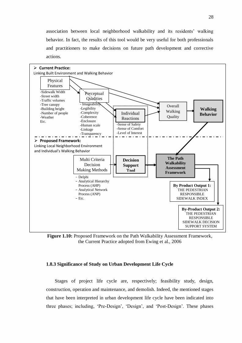
28
association between local neighborhood walkability and its residents‘ walking
behavior. In fact, the results of this tool would be very useful for both professionals
and practitioners to make decisions on future path development and corrective
actions.
Figure 1.10: Proposed Framework on the Path Walkability Assessment Framework,
the Current Practice adopted from Ewing et al., 2006
1.8.3 Significance of Study on Urban Development Life Cycle
Stages of project life cycle are, respectively; feasibility study, design,
construction, operation and maintenance, and demolish. Indeed, the mentioned stages
that have been interpreted in urban development life cycle have been indicated into
three phases; including, ‗Pre-Design‘, ‗Design‘, and ‗Post-Design‘. These phases
-Sidewalk Width -Street width -Traffic volumes -Tree canopy -Building height
-Number of people -Weather Etc.
Individual Reactions
-Sense of Safety -Sense of Comfort
-Level of Interest
- Imageability
-Legibility -Complexity -Coherence -Enclosure -Human scale -Linkage -Transparency
Overall
Walking
Quality
The Path
Walkability
Assessment
Framework
Multi Criteria
Decision
Making Methods
Decision
Support
Tool
By Product Output 1: THE PEDESTRIAN
RESPONSIBLE
SIDEWALK INDEX
By-Product Output 2: THE PEDESTRIAN
RESPONSIBLE SIDEWALK DECISION
SUPPORT SYSTEM
− Delphi − Analytical Hierarchy
Process (AHP) − Analytical Network
Process (ANP)
− Etc.
Current Practice: Linking Built Environment and Walking Behavior
Proposed Framework: Linking Local Neighborhood Environment and Individual’s Walking Behavior
Perceptual Qualities
Walking
Behavior
Physical
Features

29
cover a range of plans and actions towards supporting walking and walkability in
neighborhoods. Local governments as the head of development/redevelopment plans
to improve active living (i.e. walking) of residents within a neighborhood, follow
these phases and detailed components. Local governments consider effectively and
objectively the issues in measuring and implementing walking and its related
problems. The following describes these phases and involved components (Figure
1.11);
Pre-Design Phase: the investigation and analysis scheme comprises the
assessment of existing situation of sidewalk environment, and then, determines a
few options to enhance where the inclusive-design would benefit all end-users.
Design Phase: the choosing scheme involves selecting across prioritized
initiatives one option as the most appropriate and beneficial to improve the
existing path/sidewalk situation, and then implements the option practically.
Post-Design Phase: economical repair, reinforce, and maintenance for any
damaged or deficiencies, or defective conditions.
The current research planed to develop an assessment framework which
contributes urban designers, urban planners, and transportation planners in their
decision makings on corrective actions and development within the targeted
neighborhood in present and future. Thus, this assessment framework covers both
‘Design‘ and ‗Post-design‘ phases.
Figure 1.11: Phases in Urban Development Life Cycle
Path Walkability Assessment Framework
Pre-Design Phase
=>Investigation and Analysis
of options
Design Phase
=>Choosing an option and Implementation
Post-Design Phase
=>Construction, Maintenance,
and Repair
Design phase incorporates the design
principles; including, safety,
accessibility, connectivity,
pedestrian-friendly environment,
easily-used, multi-functionality,
continuity, Landscaping,
strengthening identity, generating
social communication, providing
facilities and amenities, well-
designed zones (i.e. furnishing, curb
and frontage zones), encroachment
policies
Post-Design phase deals with
economical repair, reinforce, and
maintenance for any damaged or
deficiencies, or defective conditions.
Pre-design phase deals with
investigating on feasibility and
practicality of the proposed design
alternatives
Consideration on social,
environmental and economical
aspects of design alternative, in
details.

30
To sum up, the current research across different stages of project life cycle
focused on the design stage and operation and maintenance stage based on possible
application of the final tool (will be explained in Chapter 5-Discussion). Indeed, this
is match with either expected end-users of the model and the mentioned class of the
model.
1.9 Thesis Outlines
The thesis outline includes the detail actions undertaken in the process of this
research. The following explains the action plans of each chapter, respectively.
Chapter one (1): Introduction,
This chapter presents introduction to the research. This chapter includes the
first phase of research methodology flow within which aim and objectives ,
scopes, brief research methodology, and significance of study are presented.
Chapter two (2): Literature Review,
This chapter presents critical reviews on the related literatures to each
objective. Validated finding of literature review is implemented in the final
model.
Chapter three (3): Research Methodology,
This chapter addresses the grounded research methodology of the study in
details. In this chapter methods and techniques undertaken to conduct the
research were explained. Mainly this chapter is presenting rational of research
methodology flow engaged in this study.
Chapter four (4): Data Collection and Analysis of Phase I and III of Research
Methodology Flow,
This chapter presents data collection and analysis on literature study and then
proceeds to develop the framework.

31
Chapter five (5): Path Walkability Assessment Framework Development,
This chapter presents validation done from literature finding and the
development of the framework.
Chapter six (6): Pilot Study to Test Path Walkability Assessment Framework,
This chapter addresses the pilot study to validate the developed framework,
and then, evaluates and analyzes the collected data from pilot study survey.
Chapter seven (7): Discussions on Developing the Path Walkability
Assessment Framework
This chapter discusses on strength and weakness of the final outputed
framework, and also, highlights its limitation faced in this research.
Chapter eight (8): Conclusion and Recommendations,
This chapter, as the final chapter, reviews objective findings of the research.
Furthermore, this chapter presents possibilities and potentials for further
research on this issue.

274
REFERENCES
1000 Friends of Oregon (1993). Making the Land use Transportation Air quality
Connection: The pedestrian Environmentm, Vol. 4. Parsons Brinckerhoff Quade
and Douglas, Inc.
AASHTO (American Association of State Highway and Transportation Officials),
website http://safety.transportation.org/guides.aspx accesed at January 2013
Abdul Ghani, N., Zaly, M. (2011). Incorporating Road Hierarchy into Pedestrian
Index, Kyoto Confrance, 5-8 October.
Abley, S. (2005). Walkability Scoping, Abley Transportation Consultants Limited,
Christchurch New Zealand.
Abley, S., Turner, Sh. And Singh, R. (2011), Predicting Walkability, IPENZ
Transportation Group Conference, Auckland, New Zealand
Addy, C.L., Wilson, D.K., Kirtland, K.A., Ainsworth, B.E., Sharpe, P., and Kimsey,
D. (2004). Associations of Perceived Social and Physical Environmental
Supports with Physical Activity and Walking Behaviour. American Journal of
Public Health,Vol. 94(3),440-443.
Aitkenhead, M.J. (2007). A coevolving decision tree classification method, Journal
of Expert systems with classification, Vol. 34, 18-27.
Alcalay, R, and Bell, R.A. (2000). Promoting Nutrition and Physical Activity
through Social Marketing: Current Practices and recommendations. Davis,
Califronia: Center for Advanced Studies in Nutrition and Social Marketing,
University of California.
Allan A. (2001). Walking as a local transport model choice in Adelaide. World
Transport Policy Practice, Vol. 7(2), 44–51.
Antonini, G., Bierlaire, M., and Weber, M. (2006). Discrete choice models of
pedestrian walking behavior. Transportation Research part B: Methodological,
Vol. 40 (3), 667-687.
Aragones-Beltran , P, Chaparro-Gonza lez, F., Pastor-Ferrando, J.P., and Rodrıguez-
Pozoa, F. (2010). An ANP-based approach for the selection of photovoltaic solar
power plant, investment projects, Renewable and Sustainable Energy Reviews.
Vol. 14, 249–264.
Axhausen, K., and Garling, T. (1992). Activity-based approaches to travel analysis:
Conceptual framework, Models, and research problems, Transport Reviews, Vol.
12 (4), 323-341.

275
Babiano, I.M. (2003). Sustainable + Mobility + Management: Pedestrian Space
Management as a Strategy in Achieving Sustainable Mobility, Susatinability
marketing Managmnet and Consumtion, summer academy, university of
St.Gallen
Badland, H., and Schofield, G. (2005). Transport, urban design, and physical
activity: an evidence based update. Transportation Research Part D: Transport
and Environment, 10(3), 177-96.
Bahl H.C., and Hunt, R.G. (1984). Decision Making Theory and decision support
Systems, DTABASE, Vol. 15 (4), 10-14.
Bassett, D.R. (2010). Pedometer-Measured Physical Activity and Health Behaviors
In U.S. Adults. Medicine and Science in Sports & Exercise, Vol. 42 (10),1819-
1825; summary available at www.ncbi.nlm.nih.gov/pubmed/20305579; at
www.dundeeopt.com/wp-content/uploads/2010/12/steps-per-day.pdf.
Bauman, A., Sallis, J.F., and Owen, N., (2002). Environmental and policy
measurement in physical activity research. In: G. Welk and D. Dale D., ed.
Physical Activity Assessment for Health-Related Research. Champaign IL:
Human Kinetics.
Beelen, R., Hoek, G., Van Den Brandt, P.A., Goldbohm, R.A., and Fischer R.
(2008). Long term effects of traffic related air pollution on mortality in a dutch
cohort (NLCS-AIR study). Environment Health Perspective, Vol. 116, 196-202.
Bentham, J. (1987). An introduction to the principles of Morals and Legislation in
J.S.Mill and J. Bentham Utilitarianism and other essays, Harmandsworth,
Penguin.
Berke, E. M., Koepsell, T. D., Moudon, A. V., Hoskins, R. E., and Larson, E. B.
(2007). Association of the built environment with physical activity and obesity
in older persons. American Journal of Public Health, Vol. 97(3), 486-492.
Berke, E. M., Koepsell, T. D., Moudon, A. V., Hoskins, R. E., and Larson, E. B.
(2007). Association of the built environment with physical activity and obesity
in older persons. American Journal of Public Health, Vol. 97(3), 486-492.
Beynon, M.J. (2005). A method of aggregation in DS/AHP for group decision-
making with the non-equivalent importance of individuals in the group,
Computers & Operations Research, 32, 1881–1896.
Bhat, C., and Singh, S. (2000). A comprehensive daily activity-travel generation
model system for workers, Transportation research part A: policy and Practice,
Vol. 1, 1-22.
Bierlaire, M., and Thomas, R. (2009). Pedestrian behavior, Models, Data Collection
and Applications, Chapter 1: Pedestrian Choices, Emerald Group Publishing
Limited, UK, ISBN; 98-1-84855-750-5
Boarnet, M. G., and Crane, R. (2001a). The influence of land use on travel behavior:
Specification and estimation strategies. Transportation Research A, Vol. 35.

276
Boarnet, M., Anderson, C., Day, K., Mcillan, T., and Alfonzo, M. (2005). Evaluation
of the California Safe Routes to School Legislation: Urban Form Changes and
Children‘s Active transportation to School, American Journal of Preventive
Medicine, Vol. 28
Boarnet, M., Day, K., Alfonzo, M., Forsyth, A., and Oakes, M. (2006). The Irvine-
Minnesota Inventory to Measure Built environment: Reliability Tests, American
Journal of Preventive Medicine, Vol. 30 (2)
Boitsidis, A.J. (2006). A decision Support system for identifying the habitat quality
and rehabilitation potential of Urban Rivers, Water and Environment Journal,
Vol. 20 (3), 130-140.
Borgers, A., and Timmermans, H. (1986). A model of pedestrian route choice and
demand for retail facilities within inner-city shopping areas. Geographic
Analysis, Vol. 18 (2), 115-128.
Borst, H.C., Miedema, H.M., De Veries, S.I., Graham, J.M., and Van Dongen, J.E.
(2008). Relationships between street characteristics and perceived attractiveness
for walking, reported by elderly people, Journal of Environmnetal Psycology,
Vol, 28(4), 353-361.
Bouzida, Y. and Cuppens, F. (2006). Neural Network vs. decision tree for instruction
detection IEEE/IST workshop on monitoring, attack detection and mitigation
Tubingen Germany
Bovy, P.H., and Stern, E. (1990). Route choice: Way finding in transport network:
Studies in operational regional Science, Vol. 9, Dordrecht, Kluwer Academic
Publishers.
Boyko C.T., Cooper R. and Davey C.I. (2005). Sustainability and Urban design
process engineering sustainability. Proceeding of the Institutions of Civil
Engineers, Sustainable Urban Environments, Part 2, Vol. 158 (ES3), 119-125.
Bradshaw, C. (1993). Creating and using a rating system for neighborhood
walkability: Towards an agenda for ‗‗local heroes. The 14th International
Pedestrian Conference, Boulder, CO.
Brady, E.T. and Gustke I. (1997). Using Decision trees to identify Tourism
Stakeholders, The case of two eastern North Carolina countries, Journal of
Tourism and Hospitality Research, Vol., 7 (3/4), 176-193/
Brown, B.B., Werner, C.M., Amburgey, J.W. and Szalay, C. (2007). Walkable route
perceptions and physical features: Converging evidence for en route walking
experiences. Environment and Behavior,Vol 39(1), 34-61.
Brownson, R., Hoehner, C., Brennan, L., Cook, R., Elliott, M., and McMullen, K.
(2004). Reliability of two instruments for auditing the environment for physical
activity. Journal of Physical Activity and Health, Vol.1, 191–208.
Brunekreef, B. and Holgate, S.T. (2002). Air pollution and health. Lancet, Vol. 360,
1233-1242.

277
Buchanan, L., and O'Connell, A. (2006). A brief history of decision making.
Harvard Business Review.Vol. 84(1), 32-41.
Bulut, E., Kan, D., Tuba, K., andShigeru, Y. (2012). Use of consistency index, expert
prioritization and direct numerical inputs for generic fuzzy-AHP modeling: A
process model for shipping asset management, Expert Systems with
Applications, Vol. 39, 1911–1923
Burton, N.W., Turrell, G, Oldenburg, B. and Sallis, J.F. (2005). The Relative
Contributions of Psychological, Social, and Environmental Variables to Explain
Participation in Walking, Moderate-, and Vigorous-Intensity Leisure-Time
Physical Activity. Journal of Physical Activty and Health, Vol. 2(2), 181-196.
Byrd, E.T. and Gustke, I. (2007). A brief history of decision making, Harvard
Business review, 32-42
Calthorpe, P., and Poticha, S. (1993). The next American metropolis, Ecology,
communities, and the America dream, New York, Priceton Architectural Press.
Canady, R.L. and Rettig, M.D. (1996). Teaching in the Block, Strategies for
Engaging Active Learners, Eye on Education, Larchmont, NY.
Carmona M., De Magalhaes, C., and Edwards, M. (2002). Stakeholder Views on
Value and Urban Design, Journal of Urban Design, Vol. 7 (2), 145-169.
Cerin, E., Chan, K., Macfarlane, D.J., Duncan J., Lee, K., and Lai, P. (2011).
Objective assessment of walking environments in ultra-dense cities:
Development and reliability of the Environment in Asia Scan Tool—Hong
Kongversion (EAST-HK), Health and Place, Vol. 17, 937–945.
Cervero, R. (2002). Built environments and mode choice: toward a normative
framework. Transportation Research Part D, Vol. 7: 265-284.
Cervero, R., and Radisch, C. (1996). Travel choices in pedestrian versus automobile
oriented neighborhoods, Transport Policy, Vol. 3 (3), 127-141.
Chang C.H., Chang K.H., and Whye Lian Ch. (2009). Adults‘ perceptions of being
overweight or obese: a focus group study, Asia Pac Journal Clin Nutr, Vol. 18
(2), 257-264.
Chee H.L. (1990) Health and health care in Malaysia: present trends and implications
for the future. Kuala Lumpur: Institute for Advanced Studies (University of
Malaya) Monograph Series SM No. 3.
Cheung, C., and Lam, W. (1998). Pedestrian route choices between escalator and
stairway in MTR stations, Journal of transportation Engineering, Vol. 124 (3),
177-285.
Chi, R. and Turban R. (1995). Distributed intelligent executive information systems.
Decision Support Systems,Vol. 14 (2) 117–130.
Chow, W.K., and Wong, L.T. (1998). Survey on the air diffusion devices for air-
conditioning systems in Hong Kong. Energy Engineering, Vol. 95 (6), 50–79.

278
Chwolka, A., and Raith, M.G. (2001). Group preference aggregation with the AHP-
implications for multiple-issue agendas, Journal of Operational research,
Vol.132, 176-186.
City of Fort Collins. (2002).Pedestrian level-of-service. Fort Collins, CO.
Clean Air Initiative for Asian Cities Center (2011). Retrieved from
http://www.pciaonline.org/node/114, accesed at May 2012
Cleland, V.J., Timperio, A., and Crawford, D. (2008). Are perceptions of the
physical and social environment associated with mothers walking for leisure and
for transport? A longitudinal study. Preventive Medicine, Vol. 47(2),188-193.
Clifton, K.J., Livi, S., L., Andrea D., and Rodriguez, D. (2007). The development
and testing of an audit for the pedestrian environment. Journal of Landscape and
Urban Planning, Vol. 80(1-2), 95-110.
Cohen M.D., March, J.G., and Olsen, J.P. (1972). A garbage can Model of
organization choice in administration Science Quarterly, Vol. 17 (1), 1-25.
Cohen, L., Manion, L., Morrison, K., Morrison, K.R.B. (2007). Research methods in
Education, Routledge
Compendium of Environmental Statistics Malaysia (2009). Website
http://www.statistics.gov.my/portal/index.php?option=com_content&view=articl
e&id=1141&lang=en, access at January 2013-03-24
Compendum of Environmental Statistics Malaysia (2009). Retrieved from
http://www.statistics.gov.my/portal/index.php?option=com_content&view=articl
e&id=1141&lang=en, accesed at Janaury 2012
Cook D.J., Mulrow C.D., Haynes R.B. (1997a). Systematic Reviews: Synthesis of
Best Evidence for Clinical Decisions. Annual Internal Medicine, Vol. 126:364-
371.
Cook, D. J., Greengold, N. L., Ellrodt, A.G., and Weingarten, S. R. (1997b). The
Relation Between Systematic Reviews and Practice Guidelines, Annals of
Internal Medicine, 127 (3), 210–216.
COST 358 Pedestrians‘ Quality Needs (2010) PQN Final Report - Part B4:
Documentation- Measuring Walking, WALK21, Cheltenham, UK; available at
www.walk21.com , accessed by November 2011.
Courtney J.F. (2001) Decision Making and Knowledge Management in Inquiring
Organizations, Journal of Decision Support Systems, Vol.31 (1), 17-38.
Coutinho-Rodrigues, J., Simão, A., Henggeler Antunes, C. (2011). A GIS-based
multicriteria spatial decision support system for planning urban infrastructures,
Decision Support Systems, Vol. 51, 720–726.
Craig, C. L., Marshall, A. L., Sjöström, M., Bauman, A. E., Booth, M. L., Ainsworth,
B. E., and Pratt, M. (2003). International physical activity questionnaire: 12-
country reliability and validity. Medicine and Science in Sports and Exercise,
Vol. 35(8), 1381-1395.

279
Crane, R., and Crepeau, R. (1998). Does neigbourhood design influence travel?
Behavioral analysus of travel diary and GIS data, UCTC working paper No.374,
University of California Tranportaion Center.
Croucher, K., Myers, L., Bretherton, J. (2007). The links between greenspace and
health: a critical literature review, University of York, 2007.
current practice, Computers, Environment and Urban Systems, Vol. 28, 291–310,
Curry, L.A., Nembhard, I. M., and Bradley, E. H. (2009). Qualitative and Mixed
Methods Provide Unique Contributions to Outcomes Research, Circulation.
Vol.119,1442-1452.
Daamen, W., Bovy, P., and Hoogendoorn, S. (2005). Influence of changes in level on
passenger route choice in railway stations, Transportation research record:
Journal of the Transportation Research Board, Vol.1930, 12-20.
Dannenberg, A. (2004). Assessing the walkability of the workplace: A new audit.
Presented at the 4th National Congress of Pedestrian Advocates, America
Walks.
Darker, C.D., Larkin, M., and French, D.P. (2007). An exploration of walking
behaviour--An interpretative phenomenological approach. Social Science and
Medicine, Vol 65(10), 2172-2183
De Bourdeaudhuij, I., Sallis, J., Saelens, B., (2003). Environmental correlates of
physical activity in a sample of Belgian adults. American Journal of Health
Promotion, Vol. 18, 83–92.
De Michelis, G. (1996) Co-ordination with Cooperation Processes in P.Humphrey,
I.Bannan, A.Mccosh, P. Migliarese J.CI. Pomerol (Eds.), in implementing
systems for support Management systems, London Chapman and Hall, 108-123
de vaus, D. (2002). Seurvey in Social Research, Allen and Unwin Publishers.
Deakin, E. (1989). Transportation and air quality in California: A Policy analysis,
Berkeley: University of California, Institution of transportation Studies
Deborah, A.C., Thomas, L.M., Amber, S. and Stephanie, W. (2007). Contribution of
Public Parks to Physical Activity. American Journal of Public Health, Vol.97(3),
509.
Dellaert B.G., Arentze, T.A., Bierlaire, M., Borgers, A. W., and Timmermans, H.J.,
(1998). Investigating consumers‘ tendency to combinemultiple shoping purposes
and destinations. Journal of marketing Research, Vol. 35(2), 177-188.
Dellaert, B.G., Boegers, A., and Timmermans, H., (1995), A day in the city: sing
Conjoint choice experiments to model urban tourists‘ choice of activity
packages. Tourism Management, Vol, 16 (5), 347-353.
Department of Statistics (2010). Population, Department of Statistics, Malaysia 2010,
http://www.statistics.gov.my/portal.index.php?option=com_content&view=cate
gorieis&id=35&itemid=53&lang=en

280
Dias R.A., Mattos C.R., and Balestieri J.A.P. (2006). The limits of human
development and the use of energy and natural resources, Energy Policy, Vol.
34 (9), 1026-1031.
Dixon, L., (1996). Bicycle and pedestrian level of service performance measures and
standards for congestion management systems. Transportation Research Record
1538, 1–9.
Drechsler, M., and Burgman, M.A. (2004). Combining Population viability analysis
with decision analysis biodiveristy and conservation, Biodiversity and
Conservation, Springer, Vol. 13, 115-139.
Duin, H., Baalsrud Hauge, J., Thoben, K. (2009). An ideation game conception based
on the Synectics method, On the Horizon, Vol. 17(4 ), 286 – 295.
Duncan, M.J., Spence, J.C., and Mummery, W.K. (2005). Perceived environment
and physical activity: a meta-analysis of selected environmental
characteristics,,International Journal of Behavioral Nutrition and Physical
Activity,Vol.2(11).
Ercolano J.M., Olson J.S., and Spring D.M. (1996). Sketchplan method for
estimating pedestrian traffic for central business districts and suburban growth
corridors. Transportation Research Record 1578, 38–47.
Ettema, D., and Timmermans, H., (1997), Activity-based approaches to travel
analysis, Bingley, UK: Emerald Group Publishing Limited.
Eves, F. F., Webb, O.J., and Mutrie, N., (2006), A workplace investigation to
promote stair climbing: Greater effects in the overweight, Obesity, Vol. 14 (12),
2210-2216.
Ewing, R. Pendall R., and Don Chen (2002), Measuring Sprawl and Its Impacts,
Smart Growth America, retrieved from www.smartgrowthamerica.org.
Ewing, R., Handy, S. Brownson, L, Clemente, and Otto, R. (2006). Identifying and
Measuring Urban Design Qualities Related to Walkability, Transportation
Research Board Annual Meeting, no.06-0264
Ewing, R., Schroeer, W., and Greene, W. (2007). School location and student travel
analysis of factors affecting mode choice, Transportation Research Board of the
National Academies 1895, 55-63.
Faludi, A. (1973) Planning Theory Oxfor, Pergamon Press.
Fesenmaier, D, (1988). Integrating activity patterns into destination choice models.
Journal of Leisure Research, Vol. 20 (3), 175-191.
Finucane M.M., Stevens G.A., Cowan M.J. (1980). National, regional, and global
trends in body-mass index since. Systematic analysis of health examination
surveys and epidemiological studies with 960 country-years and 9.1 million
participants. lancet, Vol. 377, 557-67.

281
Fishburn, P.C. (1967). Additive Utilities with Incomplete Product Set: Applications
to Priorities and Assignments, Operations Research Society of America (ORSA)
Publication, Baltimore, MD.
Flamm, B.J. (2006). Environmental Knowledge, Environmental Attitudes, and
Vehicle Ownership and Use. Dissertation, Deparment of City and Regional
Planning, University of California.
Forsyth, A., Krizek, K.J., and Agrawal, A.W. (2010), Measuring Walking and
Cycling Using The Pabs (Pedestrian And Bicycling Survey) Approach: A Low-
Cost Survey Method For Local Communities, Mineta Transportation Institute
College of Business, MTI Report 10-03.
Forsyth, A., Oakes, J. M., and Schmitz, K. H. (2009). Test–Retest Reliability of the
Twin Cities Walking Survey, Journal of Physical Activity and Health, Vol. 6,
119-131.
Fotheringham, A. (1986). Modelling Hierachical destination choice, Environment
and Planning A , Vol. 18 (3),401-418.
Frank, L. D., and Pivo, G. (1994). Impacts of mixed use and density on utilization of
three modes of travel: Single-occupant vehicle, transit, and walking.
Transportation Research Record 1466: 44-52.
Frank, L.D., Sallis, J, Saelens, R., Leary, L., Cain, K., Conway, T.L., and Hess, P.M.
(2011), application to the Neighborhood Quality of Life Study, Journal of Sports
and Medicine, Vol. 44(13), 924-933.
Frejinger, E. (2007), Random sampling of alternatives in a route choice context,
proceedings of European Transport Conference, Leiden, Netherlands.
Frejinger, E., and Bierlaire , M., (2007), Capturing correlation with subnetworks in
route choice models, Transportation research part B: Methodological, Vol. 41
(3), 363-378.
Friedl, M., and Brodley, C., (1997). Zecision tree classification of land cover from
remotely sensed data,‖ Remote Sens. Environ., Vol. 61(3), 399–409.
Fries, R. D., Hansen,M., Townshend, J., and Sohlberg, R. (1998). Global land cover
classification at 8 km spatial resolution: The use of data derived from land sat
imagery in decision tree classifiers,‖ Internatiol Journal of Remote Sensing, Vol.
19(16), 3141–3168.
Furuichi, M., and Koppelman, F. (1994). An analysis of air trevelers‘ departure
airport and destinatipon choice behavior. Transportation Research part A:
Policy and Practice, Vol. 28 (3)187-195.
Gallin, N. (2001). Quantifying Pedestrian friendliness- Guidelines for Assessing
Pedestrian level of Service, Journal Road and Transport research,10 (1).
Gass, S.I., and Rapcs´ak, T. (1988). A note on synthesizing group decisions,
Decision Support Systems, 22, 59–63
Geertman, S. and Stillwell, J. (2009). Planning support systems: an inventory of

282
Giles-Corti, B, Knuiman, M, Timperio, A, Niel, KV, Pikora, T, Bull, F, Shilton, T
and Bulsara, M. (2008). Evaluation of the implementation of a state government
community design policy aimed at increasing local walking: Design issues and
baseline results from RESIDE, Perth Western Australia. Preventive
Medicine,Vol 46( 1),46-54.
Giles-Corti, B. and Donovan, R.J. (2003). Relative Influences of Individual, Social
Environmental, and Physical Environmental Correlates of Walking. American
Journal of Public Health, Vol 93(9), 1583-1589.
Giles-Corti, B., and Donovan, R.J. (2002). The relative influence of individual,
social and physical environment determinants of physical activity. Social
Science and Medicine,Vol 54(12), 1793-1812.
Glanz, K, Rimer, B.K, and Lewis, F.M. (2002). The Scope of Health Behaviour and
Health Education. In: GLANZ, K., RIMER, B. K. & LEWIS, F. M. (eds.) Health
behavior and health education: theory, research, and practice. 3rd ed. ed. San
Francisco: Jossey-Bass.
Global Health Risk (2009). Retrieved from
http://www.who.int/healthinfo/global_burden_disease/global_health_risks/en/in
dex.html, accesed at December 2012
Gordon, W.J.J. (1961). Synectics, The Development of Creative Capacity, Harper,
New York, NY.
Gorry G.A. and Scott-Morton, M.S. (1971). A Framework for management
information systems in Sloa Management Review, Vol. 13 (1).
Granner, M.L., Sharpe, P.A. (2004). Monitoring physical activity: uses and
measurement issues with automated counters. Journal of Physical Activity and
Health 1, 131–141.
Green, P. J. (1982). The content of a college-level outdoor leadership course. Paper
presented at the Conference of the Northwest District Association for the
American Alliance for Health, Physical Education, Recreation, and Dance,
Spokane, WA.
Guttenplan, M., Landis, B.W., Crider, L., and McLeod, D.S. (2001). Multi-modal
level of service Analysis at planning level, Transportation Research Record:
Journal of the Transportation Research Board, Vol. (1776), 151-158.
Guy, Y., (1987). Pedestrian Route Choice in Central Jerusalem. Department of
Geography, Ben-Gurion University of the Negev, Beer Sheva (in Hebrew).
Haapio, A., Viitaniemi, P. (2008). A critical review of building environmental
assessment tools, Environmental Impact Assessment Review. Vol. 28, 469–482.
Hamada, T., Hagiwara, T., Teramoto, T., Morishita, S., Umetsu, M., and Ohgama,
M. (2008). A three-dimensional pedestrian-flow simulation for high-rising
buildings. In; H. Umeo, S. Morishita , K. Nishinari, T. Kumatsuzaki, S., Bandini
(Eds.) Cellular Automata: 8th
International Conference on Cellular Automata for

283
Research and Industry, ACRI 2008, Yokohama, Japan, September 23-26, 2008,
Proceedings, Vol. 5191 of Lecture Notes in Computer Science, Springer, 417-
424.
Hamilton, A., Mitchell, G., and Yli-Karjanmaa, S. (2002): The BEQUEST toolkit: a
decision support system for urban sustainability, Building Research &
Information, 30(2), 109-115.
Handy S.L. (1996), Urban Form and Pedestrian choices: Study of Austin
neighborhoods. Transportation Research Record. Transportation Research
Board, 135-144.
Handy, L.S., Boarnet, M.G., Ewing, R., and Killingsworth, R.E. (2002). How the
built environment affects physical activity. Views from Urban Planning.
American Journal of Preventive Medicine, 23(2S), 64-73.
Harkey D.L., Reinfurt D.W., Stewart R.J. (1998). The Bicycle Compatibility Index:
A Level of Service Concept. Washington, DC: Federal Highway Administration.
Harkey, D.L., and Zegeer, Ch. (2004). PEDSAFE: Pedestrian Safety Guide and
Countermeasure Selection System, report of Grant no. DTFH61-99-X-00003,
University of North Carolina, Highway Safety Research Center.
Hayashi, Y., Suparat, R., Mackett, R., Doi, K., Tomita, Y., Nakazawa N., Kato, H.,
and Anurak, K. (1995). Urbanization, Motorization and the Environment Nexus
– A International Comparative Study of London, Tokyo, Nagoya and Bangkok –
, Memoirs of School of Engineering, Nagoya University, Vol.46(1), 55-97.
Hayashi, Y., Suparat, R., Mackett, R., Doi, K., Tomita, Y., Nakazawa N., Kato, H.,
and Anurak, K. (1998), La liaison entre l‘urbanisation, la motorisation et
l‘enviroment. Une etude comparatibe internationale de Londres, Tokyo, Nagoya
et Bangkok, les Cahiers Scientifiques du Transport, Vol. 34, 75-107.
Henderson, KA (2006). Urban Parks and Trails and Physical Activity. Annals of
Leisure Research,Vol 9(4). 201-213.
Hill, M.R. (1982). Spatial Structure and Decision-Making of Pedestrian Route
Selection Through An Urban Environment, Ph.D. Thesis, University Microfilms
International.
Ho, C. S., and Fong, W. K. (2007). Planning for low carbon cities-the case of
Iskandar development region, Malaysia. Toward Establishing Sustainable
Planning and Governance II, Sungkyunkwan University, Seoul, Korea:
Sustainable Urban Development Institute.
http://www.fab.utm.my/download/Confrance Seminar/Sustainable-planning.pdf.
Ho, C.S., 2008, Urban governance and rapid urbanization issues in Malaysia, Journal
of Alam Bina, Vol, 13, 1-24.
Hoehner C.M., Ivy A. (2007). Brennan Ramirez LK, Handy SL, Brownson RC. The
Active Neighborhood Checklist: A reliable and user-friendly tool for assessing
activity-friendliness. American Journal of Health Promotion. 21(6), 534-537.

284
Hoogendoorn, S., and Bovy, P. (2004). Pedestrin route choice and activity
scheduling theory and models, Transportation Research part B, Vol.38169-190.
Hoogendoorn, S.P. (2001). Normative Pedestrian Flow Behavior: Theory and
Applications. Research Report Vk2001.002. Transportation and Traffic
Engineering Section, Delft University of Technology.
Huang, L.T. Gromila, M.M., and Ho, S.Y. (2007). Sequence analysis and rule
development of predicting protein stability change upon mutation decision tree
model, Journal of Molecular modeling, Vol. 13 (8), 879-890.
Huber, P. (1981) Robust Statistics, New York, Wiley Publshers.
Huisstede, B.M., Miedema, H.S., Verhagen A., Koes, B., Verhaar, J. (2007).
Humpel, N., Owen, N., Leslie, E., Marshall, A.L., Bauman, A.E., and Sallis, J.F.,
(2004). Associations of location and perceived environmental attributes with
walking in neighborhoods. American Journal of Health Promotion 18, 239–242.
Ismail M.N., Zawiah H., Chee S.S., and Ng K.K. (1995). Prevalence of obesity and
chronic energy deficiency (CED) in adult Malaysians. Malaysian Journal of
Natural: 1-9.
Ittelson, W. H. (1986). Cross cultural research in environment and behavior, Tucson;
University of Arizona Press.
Jabatan, K.R. (1995). Basic Guidelines on Pedestrian Facilities. Nota Teknik Jalan
18/97.
Jaskiewicz, F. (2000). Pedestrian Level of Service Based on Trip Quality,
Transportation Research Circular E-C019, TRB, National Research Council,
Washington DC.
Jones, P., and Patterson, J. (2007). The Development of a Practical Evaluation Tool
for Urban Sustainability, Indoor and Built Environment, Vol. (16 3), 255-272.
Jones, P., Koppelman, F., and Orfueil, J., (1990). Activity analysis, State-of-the-art
and future direction, In: P. Jones (Ed.), Developments in dynamic and activity-
based approaches to travel analysis.34-55.
Kandiah, M., Khalid, M., Shamsuddin, Kh., Jamaluddin, J., Megat Mohd Nordin,
N.A., Shuib, R., and Osman, I. (2004), Body mass index and factors related to
overweight among women workers in electronic factories in Peninsular
Malaysia, Asia Pacific Journal of Clinical Nutrition, Vol.13 (3), 248- 254.
Kaya, T., and Kahraman C. (2011). An integrated fuzzy AHP–ELECTRE
methodology for environmental impact assessment , Expert Systems with
Applications, Vol.38, 8553-8562.
Khawaja Kh., Dileep Kumar, H. (2012). GET ALONG WITH QUANTITATIVE
RESEARCH PROCESS, International Journal of Research in Management, Vol.
2 (2).
Khazanah Nasional, 2010, Opportunities and Risks Arising From Climate Change
for Malaysia, Khazanah Malaysia, Kuala Lumpur.

285
Khisty, C. J. (1997). Operationalizing Concepts of Equity for Public Project
Investment, Transportation Research Record 1559 (www.trb.org), 94-99.
Khor G.L., Azmi M.Y., Tee E.S., Kandiah M., Huang M.S. (1999). Prevalence of
overweight among Malaysian adults from rural communities. Asia Pacific
Journal of Clinical Nutrition, 8:272-279.
Kilgour, M. (2001). Coalition Analysis in Group Decision Support, Group Decision
and Negotiation, 10, 159–175.
Kim, J., and Kaplan, R. (2004). Physical and psychological factors in sense of
community - New urbanist Kentlands and nearby orchard village. Environment
and Behavior, 36, 507-542.
King, W.C., Brach, J.S., Belle, S., Killingsworth, R., Fenton, M., and Kriska, A.,
(2003). The relationship between convenience of destinations and walking levels
in older women. American Journal of Health Promotion , Vol. 18, 74– 82.
Kinsey M., Galea, E., Lawerence, P., Blackshields D., Hulse, L., Day, R., and Sharp,
G. (2008). Modeling pedestrian escalator behavior, Proceeding of the 4th
pedestrian and Evacuation Dynamics (PED) Conference, Springer, Berlin.
Kirtland, k.A., Porter, D.E., Addy, C.L., Neet, M.J., Williams, J.E., and Sharpe, P.A.
(2003). Neff, LI., Kimsey, C.J., Ainsworth, B.E., Environmental measures of
physical activity supports: perception versus reality. Prevntive Medicine. Vol.
24(4), 323-331.
Kitamura, R., and Fujii, S. (1998). Two computational process models of activity-
travel behavior, In: T. Garling, T. Laitila , K. Westin (Eds.) , Theoretical
foundations of travel choice modeling, 251-279.
Kockelman, K. M. (1997). Travel behavior as function of accessibility, land-use
mixing, and land- use balance: Evidence from San Francisco Bay area.
Transportation Research Record 1607: 116-25.
Krizek, K. (2006). Lifestyles, residential location decisions, and pedestrian and
transit activity. Transportation Research Record: Journal of Transportation
Research Board, 1981, 171-178
Kurose, S., Borgers, A.W. J., and Timmermans, H.J.P. (2001). Classifying pedestrian
shopping behavior according to implied heuristic choice rules, Environment and
Planning B: Planning and Design, Vol. 28, 405-418.
Lamit, H., Shafaghat, A., Abd. Majid, M.Z., Keyvanfar, A., Bin Ahmad, M.H., and
Malik, T. A. (2012). Grounded Group Decision Making (GGDM) Model,
Journal of Advanced Science Letter (Accepted and in press).
Landis, B. W. et.al. (2001). Modeling the roadside walking environment: A
Pedestrian Level of Service. Transportation Research Board, No. 01-0511.
Lee, J.S., Kawakubo, K., Kohri, S., Tsujii, H., Mori, K. and Akabayashi, A. (2007).
Association between residents' perception of the neighborhood's environments
and walking time in objectively different regions. Environmental Health and
Preventive Medicine,Vol. 12 (1), 3-10.

286
Lekhraj, R., Sanjay, R., Geok L.K., Azhar Md Z., Shafie O., Ramlee R., Sirajoon
N.G., and Jayanthi, K. (2007). A national Survey Study on the Prevalence of
Obesity among 16,127 Malaysians. Asia Pacific Journal of Clinical
Nutrition,Vol. 16(3), 561-566.
Leslie, E., Coffee, N., Frank, L, Owen, N., Bauman, A., and Hugo, G. (2007).
Walkability of Local Communities: Using Geographic Information Systems to
Objectively Assess Relevant Environmental Attributes. Health and Place, Vol.
13(1), 111-122.
Leyden, K. M. (2003). Social capital and the built environment: The importance of
walkable neighborhoods. American Journal of Public Health, 93(9), 1546-1551.
Lillis, J. and Pourmoradian, S. (2001). PEDSAFE: Development of a New Pedestrian
Auditing Method, University of Queensland, presented at the CAITR-2001
Conference.
little, R.J.A. (2002) statistical Analysis with Missing Dta,2nd
ed. Hoboken, NJ
Willey publishers.
Liu, W, and Li W. (2009). To Determine the Weight in a Weighted Sum Method for
Domain-Specific Keyword Extraction, IEEE, International Conference on
Computer Engineering and Technology.
Long, Y., Yizhen, G., Han, H. (2012). Spatiotemporal heterogeneity of urban
planning implementation effectiveness:Evidence from five urban master plans
of Beijing, Landscape and Urban Planning , Vol. 108, 103– 111
Lorenz, D. Lützkendorf, T. (2008). Sustainability in property valuation: theory and
practice, Journal of Property Investment and Finance, Vol.26 (6), 482 – 521.
Lu, B., Yang, G., Zhang, W., Zhang, D. (2011). A New Approach to Group
Decision-Making For Cooperative Monitoring And Diagnosis Of Manufacturing
Equipment, Advanced Science Letters, Vol.4(4-5), 1833-1837.
Lucey, T. (1997). Management Information Systems, Gosport, Hampshire, Ashford
Colour Press.
Lynch K. and Gary Hack, G. (1984). Site Planning. 3rd
ed. Maple-vail Inc.,
Cambridge, Massachusetts, Uited States of America.
Lynch, K., 1960, The image of the city , Cambridge, MA: The MIT Press.
Ma, J., Zhang, Q., Zhou, D., and Ping, Z. (2011). A Multiple Person Multiple
Attribute Decision Making Method Based on Preference Information and
Decision Matrix, Department of Information Systems, City University of Hong
Kong, Kowloon Tong, Hong Kong, China Malcolm.
MacGregor-Fors, I. (2011). Misconceptions or misunderstandings? On the
standardization of basic terms and definitions in urban ecology, Landscape and
Urban Planning, Vol. 100, 347–349.
Maghelal, P. K., and Capp, C.J. (2011). Walkability: A Review of Existing
Pedestrian Indices, URISA Journal, Vol. 23 (2), 5-19.

287
Marler R.T., Arora, J.S. (2010). The weighted sum method for multi-objective
optimization: new insights, Struct Multidisc Optim, 41:853–862.
Marshall, C., and Rossman, G. B. 2010. Designing qualitative research (5th ed.).
Thousand Oaks, CA: Sage.
Maslow, A.H. (1954). Motivation and Personality. Harper and Row, New York.
Max-Neef, M. (1992). Development and Human Needs. In Real-life economics:
McGlynn S., and Murian, P. (1994). The policies of Urban Design in Planning
practices and Research, Vol. 9 (3), 45.
McKenzie, T.M., Cohen, D.A., Amber, S., Stephanie, W., and Daniela, G. (2006).
System for Observing Play and Recreation in Communities (SOPARC):
Reliability and Feasibility Measures. Journal of Phyical activity and Health,
S208-S222 .
Merriam, S. B. (1998). Qualitative research and case study applications in education.
San Francisco, CA: Jossey-Bass.
Michael , Y.L., Keast, E.M., Chaudhury , H., Day, K., and Mahmood, A., and Sarte,
A.F. (2009). Revising the senior walking environmental assessment tool,
Prevention Medicine, Vol. 48(3), 247-249.
Michael , Yvonne L., Keast, E.M., Chaudhury, H., Day, K., Mahmood, A., and
Sarte , A.F.I; (2009). Revising the senior walking environmental assessment
tool, Preventive Medicine, Vol. 48 , 247–249.
Millington, C, Ward Thompson, C, Rowe, D., Aspinall, P., Fitzsimons, C, Nelson,
N., and Mutrie, N. (2009). Development of the Scottish Walkability Assessment
Tool (SWAT). Health and Place, 15(2), 474-481.
Millonig, A., Schechtner, K. (2005). Decision Loads and Route qualities for
Pedestrian-key requirements for the design of pedestrian navigation services, In:
N. Waldau, P., Gatterman, H., Knoflacher, M. Schrechnberg (Eds.), Pedestrian
and evacuation dynamics, 109-118.
Ministry of Health Malaysian. (2006). Overview NCD risk factors in Malaysia.
Kuala Lumpur: Disease Control Division, Ministry of Health Malaysia.
Mitroff I., and Linstone, H.A. (1993). The unbounded Mind, Breaking the Chains of
Traditional Business Thinking, New York, Oxford University Press.
Moe, R.A., and Bracke, K. (2003). Pedestrian Level of Service, Access at
http://www.fcgov.com/transportationplanning/downloads.php.
Mohd Din M.A, Karim M.R and Saritha, P. (2001). The Aspect of Walking
Accessibility In The Development Of GIS-Based Transit System Modelling In
Kuala Lumpur, ISSN: 1753- 8947 (Sent for publication to International Journal
of Digital Earth-Manuscript ID TJDE-2009-0057). (ISI-Cited Publication)
Mokhtarian, P.L. and Salmon. I. (2002). How derived is the demand for travel?
Some conceptual and measurement considerations; Transportation Research
part A, 33.

288
Morey, E., Shaw, W., and Rowe, R. (1991). A discrete-choice model of recreational
participation, site choice, and activity evaluation when complete trip data are not
available, Journal of Environmental Economics and management, Vol, 20 (2),
181-201.
Mota, J., Almeida, M., Santos, P. and Ribeiro, J.C. (2005). Perceived Neighborhood
Environments and physical activity in adolescents. Preventive Medicine,Vol.
41(5-6), 834-836.
Moudon A.V., Hess P., Matlick J.M., and Pergakes N. (2002). Pedestrian location
identification tools: identifying suburban areas with potentially high latent
demand for pedestrian travel. Transportation Research Record. Vol.1818:94-
101.
Moudon, A.V. and Lee, Ch. (2003). Walking and Bicycling: An Evaluation of
Environmental Audit Instruments, American Journal of Health Promotion, Vol.
18(1), 21-37.
Moudon, A.V., Lee, C., Cheadle, A., Garvin, C., Jonson, D., Schmid, T., Weathers,
R, and Lin, L. (2006). Operational Definitions of Walkable Neighborhood:
theoretical and Empirical Insights, Journal of Physical Activity and health, Vol.3
( 1), S99-S117.
Mulrow, C.D. (1994). Rationale for systematic reviews, BMJ 309:597-599.
Mulrow, C.D., Cook, D.J., Davidoff, F. (1997). Systematic Reviews: Critical Links
in the Great Chain of Evidence. Ann Intern Med, Vol. 126:389-391.
Multidisciplinary consensus on the terminology and classification of complaints of
the arm, neck and/or shoulder, Occup Environ Med. , Vol. 64(5): 313–319.
Naess, P. (2006). Accessibility, Activity Participation and Location of Activities:
Exploring the Links between Residential Location and Travel Behaviour, Urban
Study, Vol. 43(3), 627-652.
Nagel, K., and Barrett, C.L. (1997). Using micro-simulation feedback for trip
adaptation for realistic traffic in Dallas, International Journal of Modern physics
C. Vol. 3, 505-525
National Center for Bicycling and Walking (2002). Community Assessment Tool,
http://www.bikewalk.org/assers/pdf/CAT1.pdf.
National Centre for Chronic Disease Prevention and Health Promotion (CDC)
(2009). Retrieved from http://www.cdc.gov/chronicdisease/about/foa.htm,
accesed at Janaury 2012.
Neuman, W. L. (2005). Social Research Methods: Qualitative and Quantitative
Approaches (6th edition). USA: Allyn& Bacon.
New Zealand Transport Agency (2009). Retrieved from
http://www.nzta.govt.nz/resources/planning-policy-manual/index.html, accesed
at Janaury 2013.
Ng, K.W. T., Tee E. S., and Rosman, A. (1995). Rural communities in nutritional
transition: emergence of obesity, hypertension and hypercholesterolemia as

289
public health problems in three kampungs in Bagan Datoh, Perak. Malaysian
Journal of Nutrition, Vol. 1:129-39.
Nicoll, G. (2006). Taking the stairs.Environmental Features of Modern Physics C,
Vol. 8 (3), 505-525.
Nolan, V. (2003). Whatever Happened to Synectics?, Creativity and Innovation
Management, Vol. 21( 1), 25.
Numi, H. (1980). Approaches to collective decision making with Fuzzy preferences
relations, Fuzzy Sets and System, Vol.6, 249-259.
OHanlon, J., Scott, J. (2011). Institute for Public Administration, University of
Delaware, available at www.ipa.udel.edu, access in November 2011
Okada, E., and Asami, Y. (2007). A pedestrian route choice model to evaluate
alternative plans for regeneration of Galata region. ARI Bulletin of the Istanbul
Technical University, Vol.55, 11-32.
Oppermann, M. (1999). Predicting destination choice-A discussion of destination
loyalty, Journal of Vacation Marketing, Vol. 5 (1), 51-65.
Oxford English Dictionary (2009). 2nd Edition, Version 4.0, Oxford University
Press, ISBN-10: 0199563837
Ozer I. (2010). Multi-Criteria Group Decision Making Methods and Integrated Web-
Based Decision Support Systems, website
www.ruor.uottawa.ca/fr/.../TelferSchool_WP-10-12_Ozer_Lane.pdf?
Ozer, I. (2007). Multi-criteria group decision making methods using AHP and
integrated Web-based decision support systems, Masters Abstracts International.
46(3), 168.
P´erez,I.J., Cabrerizo, F.J., and Herrera-Viedma, E. (2010). A Mobile Decision
Support System for Dynamic Group Decision Making Problems, Vol. 40 , 1244
– 1256.
Painter K. (1996). The influence of street lighting improvements on crime, fear and
pedestrian street use, after dark, Landscape and Urban Planning, Vol. 35, 193-
201.
Park, S., Kang, J. (2011). Operationalizing Walkability: Pilot Study for a New
Composite Walkability Index Based on Walker Perception, Transportation
Research Board 11-4108
Patil, R. (2012). Effectiveness of Synectics Model (SM), Indian Streams Research
Journal, 1(12), 1-4.
Patton, M.Q. (2001). Qualitative research & evaluation methods, SAGE Publications,
Inc.688.
Phongsavan, P, Mclean, G andBauman, A. (2007). Gender differences in influences
of perceived environmental and psychosocial correlates on recommended level
of physical activity among New Zealanders. Psychology of Sport and
Exercise,Vol. 8(6), 939-950.

290
Pikora, T., Giles-Corti, B., Bull, FC. Jamrozik K., and Donovan, R. (2003).
Developing a Framework for Assessment of the Environmental Determinants of
Walking and Cycling. Social Science and Medicine. Vol. 56: 1693-1703.
Popkin B.M., Adair, L.S., Ng S.W. (2012). Global nutrition transition and the
pandemic of obesity in developing countries. Nutrition Review, Vol.70:3-21.
Pourebrahim, S., Hadipour, M., Mokhtar, M.B., and Mohamed, M.I. (2010). Analytic
network process for criteria selection in sustainable coastal land use planning,
Ocean and Coastal Management, Vol. 53,544 -551.
Preffer, J. (1981) Power in Organizations, Marshfield Pitman Publishing.
Proctor, T. 1999. Creative Problem Solving for Managers. London, UK: Routledge
Pursak, I. (2001) Where does knowledge Management Come from?, IBM Systems
Journal ,Vol. 40 (4).
Puy, N. (2008). Integrated Assessment of Forest Bio-energy Systems in
Mediterranean basin areas, the case of Catalonia and the use of Participatory IA-
focus Groups,Renewable and Sustainable Energy Reviews, Vol, 12 (5), 1451-
1464
Rebitzer, G., Ekvall, T., Frischknecht, R., Hunkeler, D., Norris.,G., Rydberg, T.,
Schmidt, W., Suhh, S., Weidema, B, and Pennington, W. (2004). Life cycle
assessment, Part 1: Framework, goal and scope definition, inventory analysis,
and applications. Environment International, vol. 30 , 701– 720
Reid, S. (2008). Fit for purpose: Evaluating Walkability. Proceedings of the
Institution of Civil Engineers-Engineering Sustainability, 161(2), 105-112.
Reiss, G. (1995). Project Management Demystified London E and FN Spon.
Rimer, B.K. (2008). Models of individuals health behaviour. In: Glanz, K., Rimer, B.
K. & Viswanath, K. (eds.) Health behavior and health education: theory,
research, and practice. 4th ed. ed. San Francisco: Jossey-Bass.
Rimer, BK and Glanz, K, (2005). Theory at Glance: A Guide for Health Promotion
Practice, Washington, DC, National Cancer Institute, National Institutes of
Health, U.S Department of Health and Human Services.
Robert, F.E. (2009). Consensus among Physiotherapists in the United Kingdom on
the Use of Normal Saline Instillation Prior to Endotracheal Suction: A Delphi
Study, Physiother Can., Vol. 61(2): 107–115.
Rodriguez, D., and Joo , J. (2004). The relationship between non-motorized mode
choice and the local physical environment. Transportation Research Part D:
Transport and Environment, Vol. 9 (2), 151-173.
Rosenberg D., Ding D., Sallis J.F., Kerr, J., Normanm G.J., Durant, N., Harris, S.K.,
and Saelens, B.E. (2009). Neighborhood Environment Walkability Scale for
Youth (NEWS-Y): Reliability and relationship with physical activity, Prevention
Medicine. Vol. 49(2-3), 213-218.

291
Roukes, N. 1988. Design Synectics: Stimulating Creativity in Design, Published by
Davis Publications
Rowley, A. (1994). Definitions of Urban Design, The nature and Concerns of Urban
design in planning practices and research, Vol. 9 (3), 179-198.
Saelens, B. E., Sallis, J. F., Black, J. B., and Chen. D. (2003a). Neighborhood-based
differences in physical activity: An environment scale evaluation. American
Journal of Public Health, Vol. 93(9): 1552-1558.
Saelens, Brian E.; Chapman James E.; Frank, Lawrence D.; Cain Kelli L.; Conway,
Terry L., King, Abby C. (2011). Assessing health-related resources in senior
living residences, Journal of Aging Studies, Vol. 25, 206–214.
Sallis, J. F., Prochaska, J.J. and Taylor, W. C. (1999). A review of correlates of
physical activity of children and adolescents. Medicine and Science in Sports
and Exercise, 963-75.
Sallis, J.F., Kraft, K., Linton, L.S. (2002). How the environment shapes physical
activity: a transdisciplinary research agenda. Preventive Medicine 22, 208–211.
Sarkar, S. (1995). Evaluation of safety for pedestrians at macro and microlevels in
urban areas. Transportation Research Record 1502.
Saunders, M., Lewis P., and Thornhill, A. (2009).Research Methods for Business
Students (5thedition). New Jersey: Prentice Hall.
Scarpa, R., and Thiene, M., (2005). Destination choice models for rock climbing in
the north eastern Alps: A latent-class approach based on intensity of preferences.
Land Economics, Vol. 81 (3), 426-444.
Schlossberg, M., and Brown, N. (2004). Comparing Transit-Oriented development
Sites by Walkability Indicators, Transportation Research Record1887.
Schurch, T.W. (1999). Reconsidering Urban Design, thoughts about its definition
and Status as a field of Profession, Journal of Urban Design, Vol.4 (1), 19.
Seilo, P.T. (2004). Walkability and Urban Form: A Gis-Based Analysis Of Nodal
Development In The Eugene-Springfield Metropolitan Area, thesis project for
the Department of Planning, Public Policy and Management and the Graduate
School of the University of Oregon.
Senevarante, P.N., and Morall, J.F. (1986). Analysis of factors affecting the choice of
route of pedestrians. Transportation Planning and Technology, Vol. 10, 147–
159.
Seneviratne , A., Kirchner, A., and Nishinari, K. (2002). CA approach to collective
phenomena in pedestrian dynamics, In: S. Bandidni , B. Chopard, M, Tomassini
(Eds.), Cellular Automata: 5th International Conference on Cellular Automata for
Research and industry, ACRI 2002, Geneva, Switzerland, October 9-11,
Proceeding, Vol. 2493 of Lecture Notes in Computer Science, Springer, 239-
248.
Shay, E. (2007). Homes, autos, and travel: Household decision chains, PhD Thesis,
University of North Carolina, Department of City and Regional Planning.

292
Shi, A. (2003). The impact of pollution pressure on global carbon dixide emissions,
1975-1996: evidence from poled cross-country data Ecol. Econ., Vol. 44, 29-42.
Shirvani, H. (1985). The urban dsign process, New York, Van Nostrand Reinhold.
Shriver, K. (2003). A Walkable Places Survey: approach and results.The Annual
Meeting of the Transportation Research Board, Washington, D.C.
Simard, M., Saatchi, S.S., and De Grandi, G. (2000). The Use of Decision Tree and
Multiscale Texture for Classification of JERS-1 SAR Data over Tropical Forest,
IEEE Transactions On Geoscience And Remote Sensing, Vol. 38 (5).
Simon, H.A. (1967). The sciences of the Artificial,3rd Ed. MIT Press
Siti Sa‘adiah H.N., Tahir A., Fatimah S., and Maimunah A.H. (1996). Exercise
among adults aged 18 years and above. National Health and Morbidity Survey,
Public Health Institute, Ministry of Health, Malaysia.Vol. 13.
Southworth, M. (2005). Designing the Walkable City. Journal of Urban Planning
and Development. Vol. 131(4), 246-257.
Stangor, Ch. (2007). Research Methods for the Behavioral Sciences, Third Edition,
Houghton Mifflin Company, University of Maryland.
Stangor, Charles, 2010, Research Methods for the behavioral Sciences, Wadsworth
Publishing; 4th edition.
Stewart, S. I, and Vogt, C. A. (1997). Multi-destination trip patterns, Annals of
Tourism Research, Vol. 24 (2),458-461.
Stoeglehner, G. and Naradoslwwsky, M. (2007). Implementing ecological foot
printing in decision maing processes, journal of Land use Policy, Vol. 25(3),
421-431.
Sugiyama, T. and Ward Thompson, C. (2008). Associations between characteristics
of neighbourhood open space and older people's walking. Urban Forestry &
Urban Greening, Vol 7(1), 41-51.
Sumsion T. (1998). The Delphi technique: an adaptive research tool. Journal of
Occup Ther, Vol. 61(1), 53-56.
Svenson, O. (1998). The perspective from behavioral decision theory. In: Garling, T.,
Laitila, T., and Westin, K. (Eds.), Theoretical Foundations of Travel Choice
Modeling; Amsterdam: Elsevier.
Swapanja I, and Shital J. (2012). Comparative Study of Software Development
Models, International Conference on Advances in Computing and Management
Takano, T., Nakamura, K., and Watanabe, M. (2002). Urban residential
environments and senior citizens_ longevity in megacity areas: the importance
of walkable green spaces. Journal of Epidemiology and Community Health, Vol.
56, 913–918.
Tanino, T. (1984). Fuzzy preference ordering in group decision making, Fuzzy Sets
and System, Vol.12,117-131
Tiesdell, S. (2002). The New Urbanism and English Residential Guidance, A review
Journal of Urban Design, Vol. 7 (4), 353-376.

293
Timmermans, H. (1996). A stated choice model of sequential mode and destination
choice behavior for shopping trips, Environment and Planning A, Vol. 28, 173-
184
Titze, S., Giles-Corti, B., Knuiman, M.W., Pikora, T.J., Timperio, A., Bull, F.C. and
Van Niel, K. (2010). Associations between intrapersonal and neighborhood
environmental characteristics and cycling for transport and recreation in adults:
Baseline results from the RESIDE study. Journal of Physical Activity and
Health, Vol 7(4), 423-431.
Titze, S., Stronegger, W., and Owen, N. (2005). Prospective study of individual,
social, and environmental predictors of physical activity: women's leisure
running. Psychology of Sport and Exercise, Vol. 6(3), 363-376.
Toshiaki, K., Naoki, K., Masaru, K., and Minoru, Y. (2000). A study on Walking
route choice between stairs and escalator considering disabled people, papers on
City Planning, Vol. 35, 358-588.
Tranfield, D., Denyer, D., and Smart, P. (2003). Towards a Methodology for
Developing Evidence-Informed Management Knowledge by Means of
Systematic Review, British Journal of Management, Vol.14, 207–222
Tsukagunchi, H., and Matsuda, K. (2002). Analysis on pedestrian route choice
behavior, proceeding of JSCE (Japan society of Civil Engineers), Vol. 709, 117-
126.
Tsukagunchi, H., and Matsuda, K. (2002). Analysis on pedestrian route choice
behavior, proceeding of JSCE (Japan society of Civil Engineers), Vol. 709,117-
126.
Turban, E., and Aronson, J.E. (1998). Decision Support Systems and Intelligent
Systems, 5th Ed., New Yourk: Prentice-Hall.
United Nations Development Programme (2007). Human Development Report 2007/
2008, United Nations Development Programme, New York, Available online:
http://hdr.undp.org/en/media/HDR_20072008_EN_Complete.pdf (accessed on
May 2012).
United States Green Building Council. (2008). LEED for Neighborhood
Development Rating System. Available:
http://www.usgbc.org/DisplayPage.aspx?CMSPageID=148. Accessed October
2011.
Untermann, R. (1984). Accommodating the pedestrian: Adapting towns and
Neighbourhoods for walking and bicycling.
Van Den Honert, R. C., and Lootsm, F.A. (1996). Group preference aggregation in
the multiplicative AHP, the model of the group decision process and Pareto
optimality, European Journal of Operational Research, Vol.96, 363-370.
Vancutsem,D., Engelke,D., Beck T. (ISOCARP) AMFM, Hyperborea,G., Nasursa
AMFM.( 2009). Validation Methodology - Plan4All (ECP-2008-GEO-318007),
eContentplus programme1,

294
Varkii, G.R. (1997). A procedural explanation for contemporary urban design in
journal of urban design, Vol. 2 (2).
Victoria TransportPolicy Institure (2008). website http://www.vtpi.org/, access at
September 2012
Vojnovic, I, Jackson-Elmoore, C, Holtrop, J. and Bruch, S. (2006). The renewed
interest in urban form and public health: Promoting increased physical activity in
Michigan. Cities, Vol 23(1), 1-17.
Walkability Checklist (2003). America Depertament of Transportation, Retrieved
from http://www.coloradodot.info/programs/bikeped/safe-routes/walk-to-
school/camera-ready-materials/walkability-checklist.pdf/view, accesed at May
2012.
Walliman, N. (2005). Your Research Project: A Step by Step Guide for the First-
Time Researcher (2nd edition). London: Sage.
Wellar, B. (2003). Basic walking security index. Available from
http://aix1.uottawa.ca/;wellarb/ WSIpsummary.htm, accessed on August 2011.
Wendel-Vos, G.C.W., Schuit, A.J., De Niet, R., Boshuizen, H.C., Saris, W.H.M. and
Kromhout, D. (2004). 'Factors of the physical environment associated with
walking and bicycling'. Medicine and Science in Sports and Exercise, Vol.
36(4), 725-730.
Wendel-Vos, W, Droomers, M, Kremers, S, Brug, J and Van Lenthe, F. (2007).
Potential environmental determinants of physical activity in adults: A systematic
review. Obesity Reviews,Vol.8(5), 425-440.
Whyte, W.H. (1980). The Social Life of Small Urban Spaces, Project for Public
Spaces.
Wolf, F. M., Shea, J. A., and. Albanese M. A. (2001). Toward Setting a Research
Agenda for Systematic Reviews of Evidence of the Effects of Medical
Education, Teaching and Learning in Medicine, 13 (1), 54–60.
Woodside, A., Lysonki, S., (1989), A genarl model of traveler destination choice,
Journal of Travel Choice, Vol. 27 (4), 8-14.
World Bank report (2008). World Development Indicators, World bank, Washington,
DC., USA, website www.worldbank.org.
Xu. Z. (2007). A survey of preference relations, International Journal of General
Systems, Vol.36, 179-203.
Yang, M.J., Yang, M.S., Shih, C.H., and Kawachi, I. (2002). Development and
validation of an instrument to measure perceived neighbourhood quality in
Taiwan, Journal of Epidemiol Community Health, Vol. 56, 492–496.
Yao, D. (2012). Evaluation Model of Highway NetworkPlanning Schemes based on
TOPSIS, IEEE, Computing and Processing (Hardware/Software)
Zachariadis, T. (2005). Assessing policies towards sustainable transport in Europe,
an Integrated Model in Energy Policy, Vol.33, 1509-1525.

295
Zaly, M. (2010). Rating Pedestrian Facility with P-Index and the Application of
Google Map. Monograph, Center for Innovative Planning and Development
(CIPD), Faculty of Built Environment, Universiti Teknologi MAlaysia.
Zegeer, Ch.V., Carter, D. L., Hunter, W.W, Stewart, J. R., Huang, H, Do, A. H, and
Sandt, L.S. (2006). Index for Assessing Pedestrian Safety at Intersections,
Transportation Research Record: Journal of the Transportation Research Board,
Vol. 982, 76-83.
Zeisel, J., (2006). Inquiry By Design: Environment/Behavior/Neuroscience in
Architecture, Interiors, Landscape, and Planning. New York: W.W. Norton and
Company.
Zhang, X., Jiang, H., Jin, J., Xu, X., Zhang, Q. (2012). Analysis of acid rain patterns
in northeastern China using a decision tree method, Atmospheric Environment,
Vol. 46, 590-596.
Zhu, W., Timmermans, H. (2005). Exploring pedestrian shopping decision processes
and application of gene expression programming, In: N. Waldua,P. Gatterman,
H., Knofiacher, M. Schreckenberg (Eds.), Pedestrian and evacuaton dynamics,
145-154.