Embed Size (px)
Citation preview
March 2018
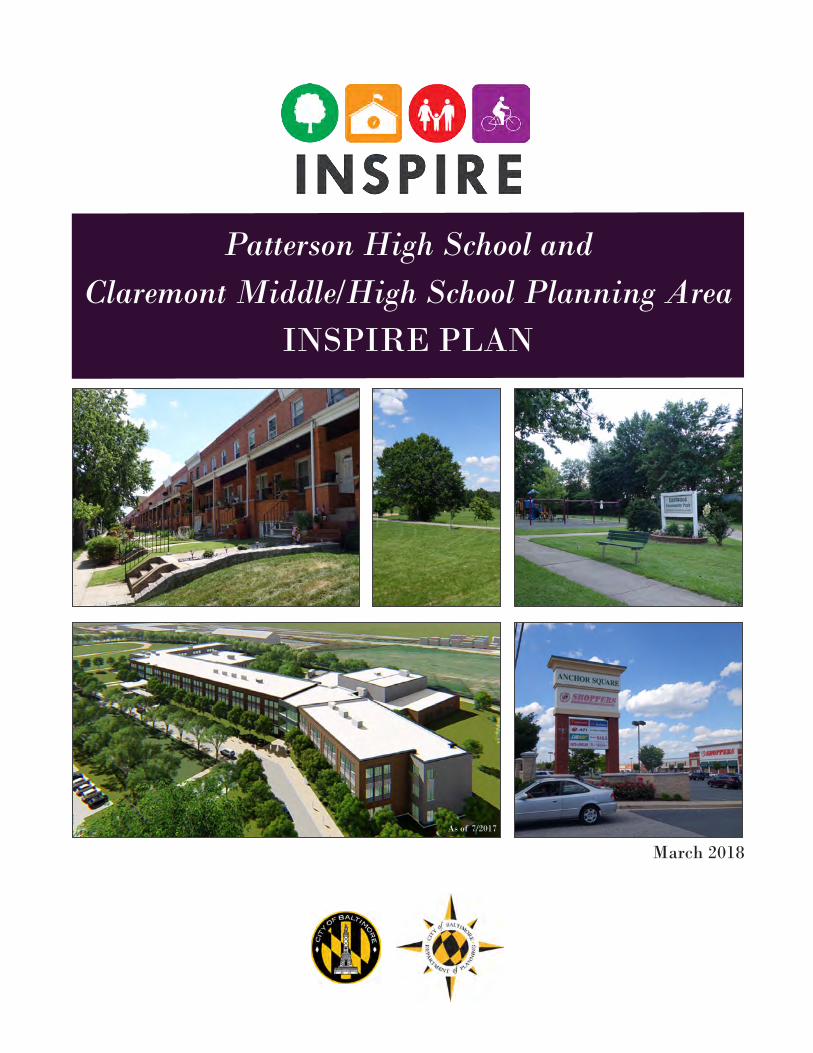
Patterson High School and Claremont Middle/High School Planning Area
INSPIRE PLAN
As of 7/2017
Patterson High School and Claremont Middle/High School Planning Area
INSPIRE PLAN
Presented to the Baltimore City Planning Commission
March 8, 2018
Published March 2018
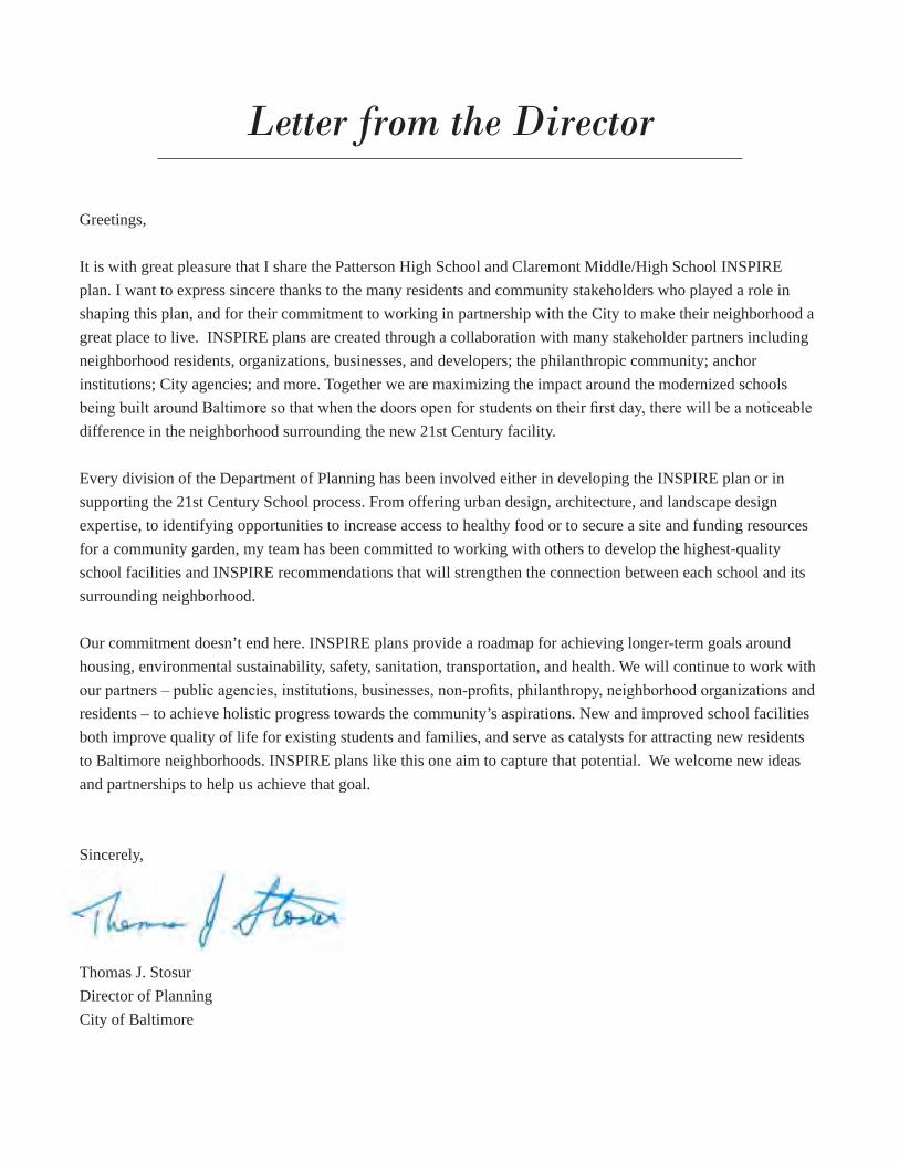
Greetings,
It is with great pleasure that I share the Patterson High School and Claremont Middle/High School INSPIRE plan. I want to express sincere thanks to the many residents and community stakeholders who played a role in shaping this plan, and for their commitment to working in partnership with the City to make their neighborhood a great place to live. INSPIRE plans are created through a collaboration with many stakeholder partners including neighborhood residents, organizations, businesses, and developers; the philanthropic community; anchor institutions; City agencies; and more. Together we are maximizing the impact around the modernized schools being built around Baltimore so that when the doors open for students on their first day, there will be a noticeable difference in the neighborhood surrounding the new 21st Century facility.
Every division of the Department of Planning has been involved either in developing the INSPIRE plan or in supporting the 21st Century School process. From offering urban design, architecture, and landscape design expertise, to identifying opportunities to increase access to healthy food or to secure a site and funding resources for a community garden, my team has been committed to working with others to develop the highest-quality school facilities and INSPIRE recommendations that will strengthen the connection between each school and its surrounding neighborhood.
Our commitment doesn’t end here. INSPIRE plans provide a roadmap for achieving longer-term goals around housing, environmental sustainability, safety, sanitation, transportation, and health. We will continue to work with our partners – public agencies, institutions, businesses, non-profits, philanthropy, neighborhood organizations and residents – to achieve holistic progress towards the community’s aspirations. New and improved school facilities both improve quality of life for existing students and families, and serve as catalysts for attracting new residents to Baltimore neighborhoods. INSPIRE plans like this one aim to capture that potential. We welcome new ideas and partnerships to help us achieve that goal.
Sincerely,
Thomas J. Stosur Director of Planning City of Baltimore
Letter from the Director
The Patterson High School and Claremont Middle/High School INSPIRE Plan was created by the Baltimore City Department of Planning, but is the result of a collaborative process involving significant community and City agency input. Carmen Morosan, Northeast District Planner, led the creation of this plan, along with Mary Colleen Buettner, INSPIRE Program Planner. The Department of Planning thanks everyone who attended workshops, shared their ideas, and provided support.
Special thanks go to:Mayor Catherine E. Pugh Councilman Zeke Cohen
The many residents and stakeholders who shared their vision and recommendations for their community, especially the members of the Bayview and Eastwood community associations.
The Patterson High School and the Claremont Middle/High School scholars, their parents, and school leadership and faculty for their dedication to making their school and community thrive.The Patterson High School Community Coordinator.The Southeast Community Development Corporation.
Thank you to these City agencies, from which staff helped develop this plan.Baltimore City Department of HealthBaltimore City Department of Housing and Community DevelopmentBaltimore City Department of Public WorksBaltimore City Department of Recreation and ParksBaltimore City Department of TransportationBaltimore City Public Schools SystemBaltimore Development Corporation
Acknowledgments
Images: Most images used in this plan are from the Department of Planning and the City of Baltimore. Other credits belong to: Stantec (cover page and page 14).
INSPIRE PLAN Patterson High School and Claremont Middle/High School (5)
Overview/Introduction 21st Century School Buildings Program........................................................................................................7INSPIRE Mission and Objectives ..................................................................................................................9INSPIRE Process .........................................................................................................................................11
INSPIRE Planning AreaPatterson Building Replacement ..................................................................................................................13Primary Routes to School ............................................................................................................................15Neighborhood History .................................................................................................................................16Key City and Neighborhood Data ................................................................................................................18Neighborhood Observations ........................................................................................................................20Existing Plans.............................................................................................................................................. 24
INSPIRE RecommendationsRecommendation Development and Overview ...........................................................................................26Standard Improvements – Primary Walking Routes ....................................................................................27Goals, Strategies, and Recommendations – Patterson Building Planning Area ..........................................28
Invest in Housing and Market-Strengthening Opportunities ............................................................29Improve Safety .................................................................................................................................32Create Connections and Access ........................................................................................................34Create Opportunities for Health and Well-Being .............................................................................36Improve Sanitation ...........................................................................................................................41
Potential INSPIRE Community Projects ....................................................................................................43
Plan Implementation Implementing Patterson Building Area Recommendations .........................................................................44
Appendix A: Maps .....................................................................................................................................48Appendix B: Programs & Initiatives ........................................................................................................55
Table of Contents
INSPIRE PLAN Patterson High School and Claremont Middle/High School (6)
Overview and Introduction
21st Century School Buildings Program
INSPIRE Mission and Objectives
INSPIRE Process
INSPIRE PLAN Patterson High School and Claremont Middle/High School (7)
In the fall of 2010, groundwork was laid to address Baltimore City’s aging and inadequate public school buildings. Community, education advocacy groups, the school system, and other stakeholders built a coalition of support for legislation and funding to modernize all of Baltimore’s public schools. The promise of replaced and renovated schools is meant to help transform student opportunities and achievement, provide jobs and resources to families, and help revitalize neighborhoods.
The 21st Century School Buildings Program (the Program) will support excellence in teaching and learning with flexible and adaptable space, learning areas designed for interaction and collaboration, and technology-equipped classrooms, enabling students to meet today’s—and tomorrow’s—high standards, and will provide communities with a shared public resource that will enrich their neighborhoods. Baltimore City will benefit for decades to come from this historic effort to provide the healthy, safe, efficient, and modern school buildings all children deserve. As a result, students in Baltimore City Public Schools will benefit from:
• Replaced or renovated school buildings across the city;
• School environments that support teaching and learning to prepare students for college and career success;
• Schools that become hubs of resources supporting entire communities;
• Modern, efficient, and inspiring educational facilities that also provide recreation and community use; and
• Partnerships that encourage businesses and neighborhood residents to connect with their local schools.
All of the major renovation and replacement projects in the Program will meet or exceed U.S. Green Building Council’s LEED-Silver standard. LEED stands for Leadership in Energy and Environmental Design; LEED-certified buildings are resource-efficient and save operating costs. Each school design team works with a sustainability consultant, to ensure certification.
Financing and Administering the ProgramThe Baltimore City Public School System Construction and Revitalization Act of 2013 resulted in a partnership between the City of Baltimore, the State of Maryland, and Baltimore City Public Schools, financing a program that is leveraging $60 million/year to provide approximately $1 billion in bond proceeds for school construction issued by the Maryland Stadium Authority. Additionally, the City of Baltimore, Baltimore City Public Schools, the Interagency Committee on Public School Construction, and Maryland Stadium Authority are partnering through a Memorandum of Understanding in order to manage and oversee the plan.
School construction is typically funded by municipalities and states on a project-by-project basis. Alternative financing for school construction using this method for the Program allows Baltimore City Public Schools to expedite the process of significantly renovating or replacing 23-28 school buildings over a seven year period.
Find out more about 21st Century Schools Building Program, partnerships, school project statuses, community engagement, job/contract opportunities, and more at http://baltimore21stcenturyschools.org.
21st Century School Buildings Program
INSPIRE PLAN Patterson High School and Claremont Middle/High School (8)
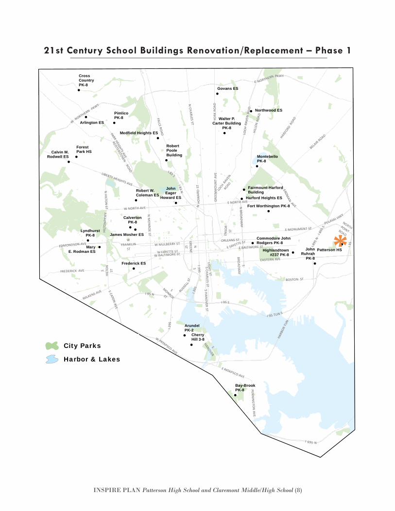
21st Century School Buildings Renovation/Replacement – Phase 1
!
!
!
!
!
!
!
!
!
!
!
!
!
!
!
!
!
!
!!
!!
!
!
!
!
!
!
EASTERN AVE
E BALTIMORE ST I895
N
I 295
N MO
NRO
E ST
W BALTIMORE ST
WNORTHERN
PKWY
I 895
S
N BROADW
AY
N CHARLES ST
EDMONDSON AVE
I 83 S
GREE
NM
OUN
T AV
E
PULASKI HWY
HARFORD
ROAD
PENN
ING
TON
AVE
REISTERSTOWN
ROAD
ORLEANS ST
FREDERICK AVE
W FAYETTE ST
E NORTH AVEN
GREENE
ST
WFRANKLIN
ST
I 95 N
FALLS ROAD
W PATAPSCO AVE
I 95 S
LOCH
RAVEN
ROAD
ERDMAN
AVE
LOCH
RAVE
NBL
VD
SHI
LTO
NST
LIBERTY HEIGHTS AVE
E FAYETTE STW MULBERRY ST
NORTHPOINTROADENSO
RST
N HILTON
ST
BELAIR ROAD
I 395
E PATAPSCO AVE
SMONROEST
BOSTON ST
WILKENS AVE
W NORTH AVE
S CHARLES ST
SBRO
ADWAY
E MONUMENT ST
I 695 N
HARB
OR T
UN
I 95 TUN S
S
HANOVER
SCATON
AVE
HILL
ENRO
AD
I 83 N
RUSSEL
LST
S HAN
OVER ST
NHO
WAR
DST
YORK
RO
AD
HILT
ON
PKW
Y
I 95
PARK HEIGHTS AVE
E NORTHERN PKWY
I395S
LIGH TS T
ForestPark HSCalvin M.
Rodwell ES
Govans ES
Medfield Heights ES
Harford Heights ES
Fort Worthington PK-8
MaryE. Rodman ES
LyndhurstPK-8
CrossCountryPK-8
PimlicoPK-8
Arlington ESWalter P.
Carter BuildingPK-8
Northwood ES
Fairmount-HarfordBuilding
MontebelloPK-8
JohnRuhrah
PK-8
Patterson HS
RobertPooleBuilding
Robert W.Coleman ES
JohnEager
Howard ES
CalvertonPK-8
James Mosher ES
Frederick ES
Bay-BrookPK-8
CherryHill 3-8
ArundelPK-2
Commodore JohnRodgers PK-8
Highlandtown#237 PK-8
City Parks
Harbor & Lakes
Schools - Phase 1!
!
!
!
!
!
!
!
!
!
!
!
!
!
!
!
!
!
!
!!
!!
!
!
!
!
!
!
EASTERN AVE
E BALTIMORE ST I895
N
I 295
N MO
NRO
E ST
W BALTIMORE ST
WNORTHERN
PKWY
I 895
S
N BROADW
AY
N CHARLES ST
EDMONDSON AVE
I 83 S
GREE
NM
OUN
T AV
E
PULASKI HWY
HARFORD
ROAD
PENN
ING
TON
AVE
REISTERSTOWN
ROAD
ORLEANS ST
FREDERICK AVE
W FAYETTE ST
E NORTH AVE
NGREEN
EST
WFRANKLIN
ST
I 95 N
FALLS ROAD
W PATAPSCO AVE
I 95 S
LOCH
RAVEN
ROAD
ERDMAN
AVE
LOCH
RAVE
NBL
VD
SHI
LTO
NST
LIBERTY HEIGHTS AVE
E FAYETTE STW MULBERRY ST
NORTHPOINTROADENSO
RST
N HILTON
ST
BELAIR ROAD
I 395
E PATAPSCO AVE
SMONROEST
BOSTON ST
WILKENS AVE
W NORTH AVE
S CHARLES ST
SBRO
ADWAY
E MONUMENT ST
I 695 N
HARB
OR T
UN
I 95 TUN S
S
HANOVER
SCATON
AVE
HILL
ENRO
AD
I 83 N
RUSSEL
LST
S HAN
OVER ST
NHO
WAR
DST
YORK
RO
AD
HILT
ON
PKW
Y
I 95
PARK HEIGHTS AVE
E NORTHERN PKWY
I395S
LIGH TS T
ForestPark HSCalvin M.
Rodwell ES
Govans ES
Medfield Heights ES
Harford Heights ES
Fort Worthington PK-8
MaryE. Rodman ES
LyndhurstPK-8
CrossCountryPK-8
PimlicoPK-8
Arlington ESWalter P.
Carter BuildingPK-8
Northwood ES
Fairmount-HarfordBuilding
MontebelloPK-8
JohnRuhrah
PK-8
Patterson HS
RobertPooleBuilding
Robert W.Coleman ES
JohnEager
Howard ES
CalvertonPK-8
James Mosher ES
Frederick ES
Bay-BrookPK-8
CherryHill 3-8
ArundelPK-2
Commodore JohnRodgers PK-8
Highlandtown#237 PK-8
City Parks
Harbor & Lakes
Schools - Phase 1!
*
INSPIRE PLAN Patterson High School and Claremont Middle/High School (9)
Each modernized 21st Century school represents tens of millions of dollars of public investment into the neighborhood it serves.
To leverage this investment, and to enhance the connection between the schools and the surrounding neighborhoods, the Department of Planning launched a new program called INSPIRE, which stands for Investing in Neighborhoods and Schools to Promote Improvement, Revitalization, and Excellence. This planning program focuses on the neighborhoods sur-rounding each of the schools, specifically the quarter- mile around the schools.
Focusing on a Quarter-MileFocusing on a limited geographic area allows plans to concentrate impact around the school so that assets and investments support the school as a community resource, build on each other, and continue to expand further into the neighborhood. Recommendations in the plan don’t simply stop at a quarter-mile marker; a guiding principle however, is considering concentra-tion of impact. In this way, the INSPIRE plans respond to the aspirations of the neighborhood and school stakeholders in a way that is achievable.
Making an ImpactINSPIRE plans seek to lead to improvements in the environment and in the quality of life for students,
their families, and neighborhood residents and busi-nesses. The plans will also articulate the community’s long-term vision for guiding private investment, and address environmental, social, and economic condi-tions.
To achieve this, there are two categories of recommendations.
• To strengthen the connection between the school and community, the first set of recom-mendations focuses on blocks that have been designated as “primary walking routes.” Stan-dard improvements along these routes will help ensure that students and other community members have safer and more walkable access to the school. See page 26 for details.
• To address environmental, social, and eco-nomic conditions, and to help guide future in-vestment, the second set of recommendations is divided into six goals. While all INSPIRE plans start with the same goals, community stakeholders help prioritize them; strategies and recommendations are developed in re-sponse to their input.
◦ Invest in housing and market- strengthening development opportunities
◦ Improve safety ◦ Improve sanitation
INSPIRE Mission and Objectives
INSPIRE PLAN Patterson High School and Claremont Middle/High School (10)
◦ Create environmentally-sustainable neighborhoods
◦ Create opportunities for health and wellness
◦ Create connections and access
Implementing the PlansImplementing recommendations that have been de-veloped in partnership with community stakeholders is arguably the most important step. Throughout the planning process, the Department of Planning has met with City agencies, neighborhood stakeholders, and others who are critical partners in ensuring that recom-mendations become reality.
City agencies and others have committed to start making improvements by allocating staffing resources
and capital dollars, and the Department of Planning is using General Obligation Bond funding (currently 2.5 million dollars per Fiscal Year starting in FY 2016) to support improvements along the primary walking routes and community-selected projects. In some cases, recommendations highlight efforts already happening, or suggest programmatic partnerships. In others, stakeholders can decide to organize neighbors to implement a recommendation. Full implementation of the plans requires the engagement of the private market, anchor institutions, and the philanthropic community. The plans provide clear priorities to guide that investment.
Pages 44-47 contains implementation tables for all of the recommendations, and shows commitments that have already been made.
INSPIRE PLAN Patterson High School and Claremont Middle/High School (11)
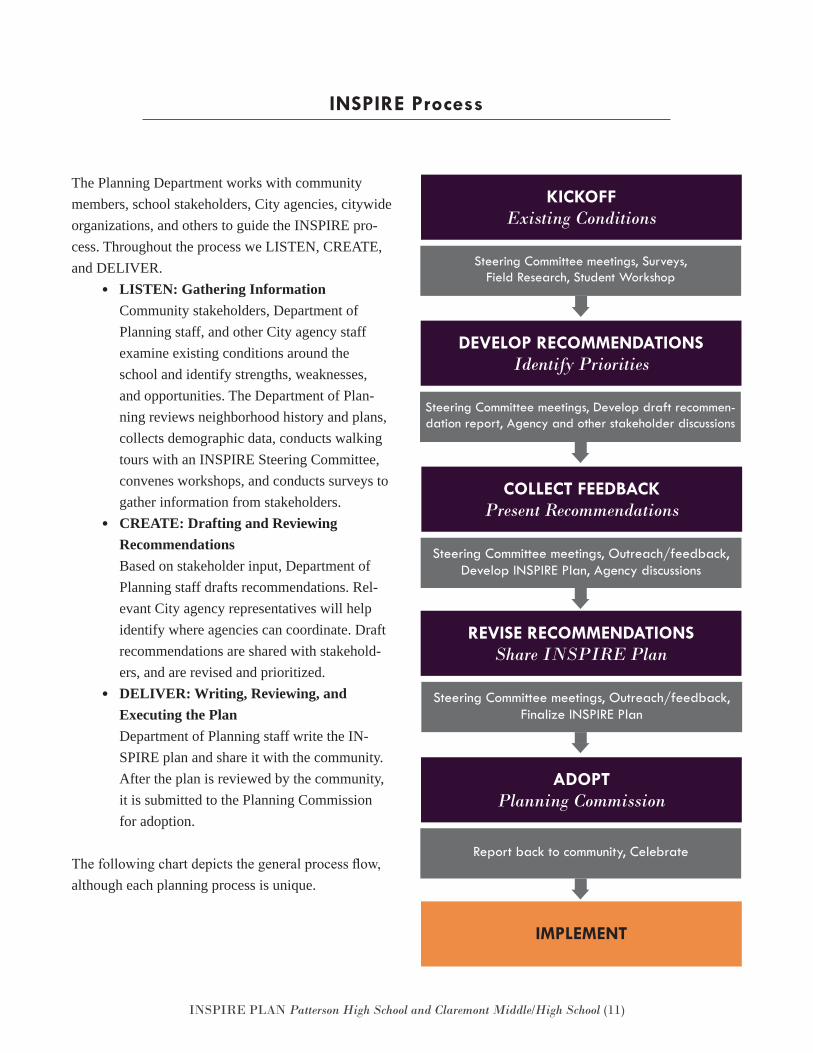
INSPIRE Process
The Planning Department works with community members, school stakeholders, City agencies, citywide organizations, and others to guide the INSPIRE pro-cess. Throughout the process we LISTEN, CREATE, and DELIVER.
• LISTEN: Gathering Information Community stakeholders, Department of Planning staff, and other City agency staff examine existing conditions around the school and identify strengths, weaknesses, and opportunities. The Department of Plan-ning reviews neighborhood history and plans, collects demographic data, conducts walking tours with an INSPIRE Steering Committee, convenes workshops, and conducts surveys to gather information from stakeholders.
• CREATE: Drafting and Reviewing Recommendations Based on stakeholder input, Department of Planning staff drafts recommendations. Rel-evant City agency representatives will help identify where agencies can coordinate. Draft recommendations are shared with stakehold-ers, and are revised and prioritized.
• DELIVER: Writing, Reviewing, and Executing the Plan Department of Planning staff write the IN-SPIRE plan and share it with the community. After the plan is reviewed by the community, it is submitted to the Planning Commission for adoption.
The following chart depicts the general process flow, although each planning process is unique.
KICKOFF Existing Conditions
Steering Committee meetings, Surveys, Field Research, Student Workshop
DEVELOP RECOMMENDATIONS Identify Priorities
Steering Committee meetings, Develop draft recommen-dation report, Agency and other stakeholder discussions
COLLECT FEEDBACKPresent Recommendations
Steering Committee meetings, Outreach/feedback, Develop INSPIRE Plan, Agency discussions
REVISE RECOMMENDATIONS Share INSPIRE Plan
Steering Committee meetings, Outreach/feedback, Finalize INSPIRE Plan
ADOPT Planning Commission
Report back to community, Celebrate
IMPLEMENT
INSPIRE PLAN Patterson High School and Claremont Middle/High School (12)
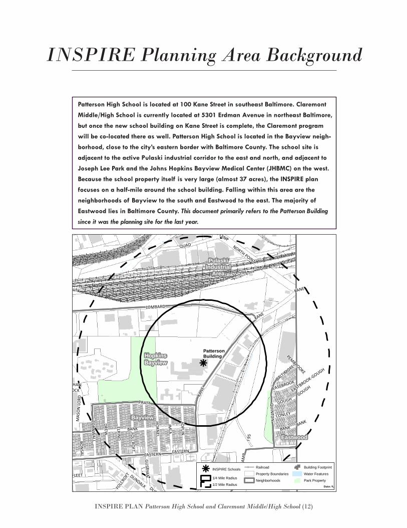
INSPIRE Planning Area Background
Patterson High School is located at 100 Kane Street in southeast Baltimore. Claremont
Middle/High School is currently located at 5301 Erdman Avenue in northeast Baltimore,
but once the new school building on Kane Street is complete, the Claremont program
will be co-located there as well. Patterson High School is located in the Bayview neigh-
borhood, close to the city’s eastern border with Baltimore County. The school site is
adjacent to the active Pulaski industrial corridor to the east and north, and adjacent to
Joseph Lee Park and the Johns Hopkins Bayview Medical Center (JHBMC) on the west.
Because the school property itself is very large (almost 37 acres), the INSPIRE plan
focuses on a half-mile around the school building. Falling within this area are the
neighborhoods of Bayview to the south and Eastwood to the east. The majority of
Eastwood lies in Baltimore County. This document primarily refers to the Patterson Building
since it was the planning site for the last year.
k
Eastwood
GracelandPark
Greektown
HopkinsBayview
Bayview
PulaskiIndustrial
Area
BALTIMORE
PEMBROOKE
KANE
KANE EASTBROOK-GOUGH
GUSRYAN
ELRINO
QUAD
QUAD
ANGLESEA
FOLC
ROFT
QUIN
TON
KANE
DUNDALK
MAS
ON
LORD
ERDMANQUADDEBELIUS
EASTERN
BANK
PRATT
JOPLIN
RAM
PIM
LA
FAIT
BON
SAL
HUDSON
BANK
FLEET
ERDMAN
OGDEN
EASTERN
FOLCRO
FT
DREW
NATHANSHOCK
GOUGH
GRACELAND
CORN
WALL
NORTH POINT
O'DONNELL
HORN
EL
GRACELAND
ERDMAN
BANK
I 95
CONLEY
DUNDALK
BUSHEY
GOUGH
EASTBROOK
HUDSON
I 95
NORTH POINT
LOMBARD
PattersonBuilding
k INSPIRE Schools
1/4 Mile Radius
1/2 Mile Radius
Railroad
Property Boundaries
Neighborhoods
Building Footprint
Water Features
Park PropertyDate: 9/27/2016
PattersonBuildingINSPIRE
k
Eastwood
GracelandPark
Greektown
HopkinsBayview
Bayview
PulaskiIndustrial
Area
BALTIMORE
PEMBROOKE
KANE
KANE EASTBROOK-GOUGH
GUSRYAN
ELRINO
QUAD
QUAD
ANGLESEA
FOLC
ROFT
QUIN
TON
KANE
DUNDALK
MAS
ON
LORD
ERDMANQUADDEBELIUS
EASTERN
BANK
PRATT
JOPLIN
RAM
P
IMLA
FAIT
BON
SAL
HUDSON
BANK
FLEET
ERDMANO
GDEN
EASTERN
FOLCRO
FT
DREW
NATHANSHOCK
GOUGH
GRACELAND
CORN
WALL
NORTH POINT
O'DONNELL
HORN
EL
GRACELAND
ERDMAN
BANK
I 95
CONLEY
DUNDALK
BUSHEY
GOUGH
EASTBROOK
HUDSON
I 95
NORTH POINT
LOMBARD
PattersonBuilding
k INSPIRE Schools
1/4 Mile Radius
1/2 Mile Radius
Railroad
Property Boundaries
Neighborhoods
Building Footprint
Water Features
Park PropertyDate: 9/27/2016
PattersonBuildingINSPIRE
INSPIRE PLAN Patterson High School and Claremont Middle/High School (13)
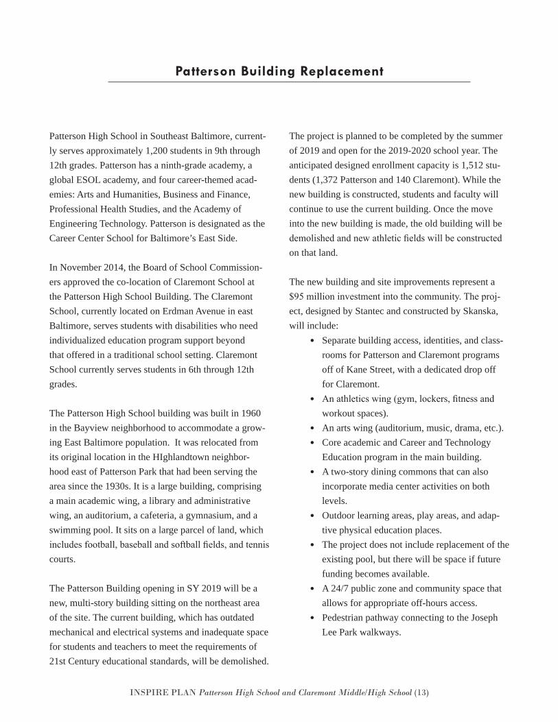
Patterson High School in Southeast Baltimore, current-ly serves approximately 1,200 students in 9th through 12th grades. Patterson has a ninth-grade academy, a global ESOL academy, and four career-themed acad-emies: Arts and Humanities, Business and Finance, Professional Health Studies, and the Academy of Engineering Technology. Patterson is designated as the Career Center School for Baltimore’s East Side.
In November 2014, the Board of School Commission-ers approved the co-location of Claremont School at the Patterson High School Building. The Claremont School, currently located on Erdman Avenue in east Baltimore, serves students with disabilities who need individualized education program support beyond that offered in a traditional school setting. Claremont School currently serves students in 6th through 12th grades.
The Patterson High School building was built in 1960 in the Bayview neighborhood to accommodate a grow-ing East Baltimore population. It was relocated from its original location in the HIghlandtown neighbor-hood east of Patterson Park that had been serving the area since the 1930s. It is a large building, comprising a main academic wing, a library and administrative wing, an auditorium, a cafeteria, a gymnasium, and a swimming pool. It sits on a large parcel of land, which includes football, baseball and softball fields, and tennis courts.
The Patterson Building opening in SY 2019 will be a new, multi-story building sitting on the northeast area of the site. The current building, which has outdated mechanical and electrical systems and inadequate space for students and teachers to meet the requirements of 21st Century educational standards, will be demolished.
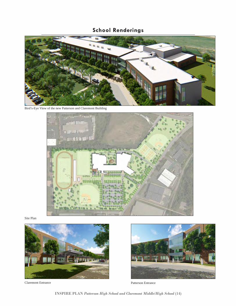
The project is planned to be completed by the summer of 2019 and open for the 2019-2020 school year. The anticipated designed enrollment capacity is 1,512 stu-dents (1,372 Patterson and 140 Claremont). While the new building is constructed, students and faculty will continue to use the current building. Once the move into the new building is made, the old building will be demolished and new athletic fields will be constructed on that land.
The new building and site improvements represent a $95 million investment into the community. The proj-ect, designed by Stantec and constructed by Skanska, will include:
• Separate building access, identities, and class-rooms for Patterson and Claremont programsoff of Kane Street, with a dedicated drop offfor Claremont.
• An athletics wing (gym, lockers, fitness andworkout spaces).
• An arts wing (auditorium, music, drama, etc.).• Core academic and Career and Technology
Education program in the main building.• A two-story dining commons that can also
incorporate media center activities on bothlevels.
• Outdoor learning areas, play areas, and adap-tive physical education places.
• The project does not include replacement of theexisting pool, but there will be space if futurefunding becomes available.
• A 24/7 public zone and community space thatallows for appropriate off-hours access.
• Pedestrian pathway connecting to the JosephLee Park walkways.
Patterson Building Replacement
INSPIRE PLAN Patterson High School and Claremont Middle/High School (14)
School Renderings
Claremont Entrance
Bird’s-Eye View of the new Patterson and Claremont Building
Site Plan
Patterson Entrance
INSPIRE PLAN Patterson High School and Claremont Middle/High School (15)
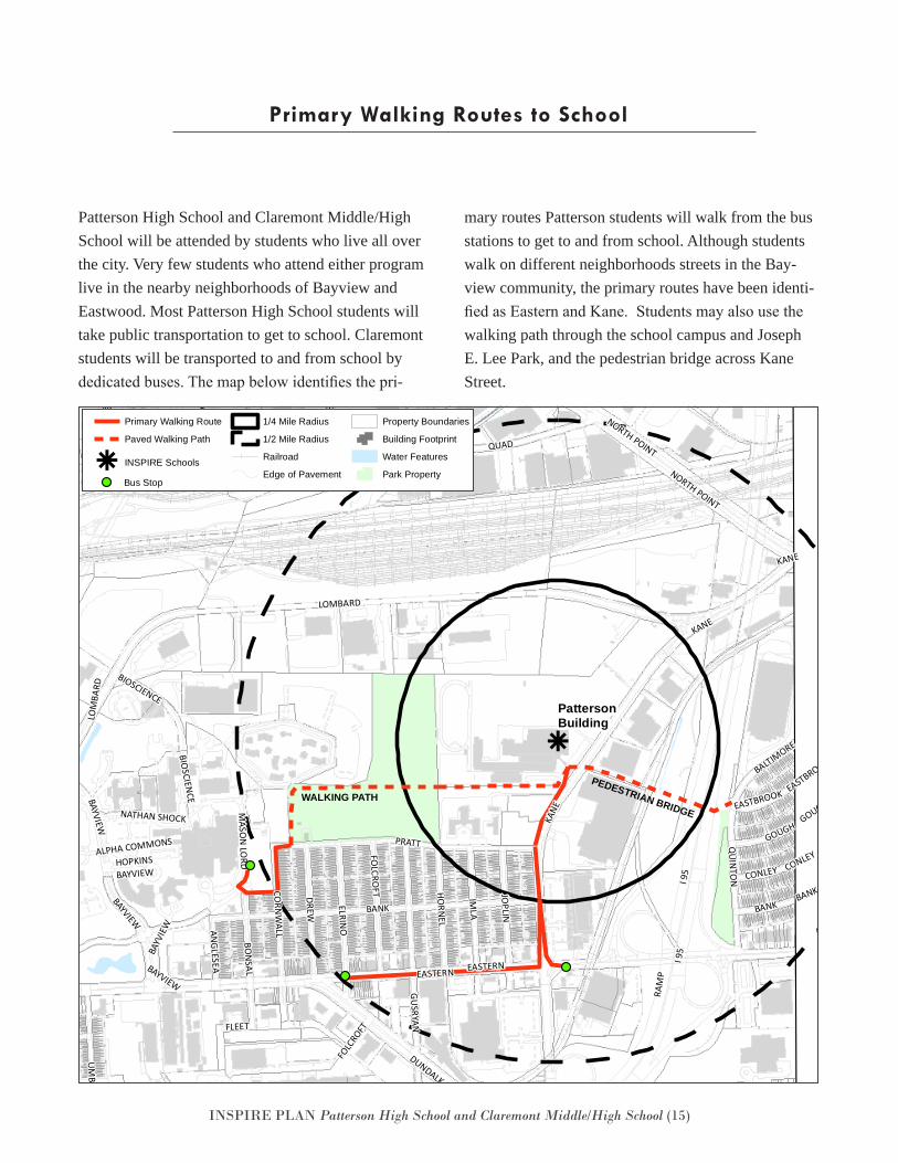
Patterson High School and Claremont Middle/High School will be attended by students who live all over the city. Very few students who attend either program live in the nearby neighborhoods of Bayview and Eastwood. Most Patterson High School students will take public transportation to get to school. Claremont students will be transported to and from school by dedicated buses. The map below identifies the pri-
mary routes Patterson students will walk from the bus stations to get to and from school. Although students walk on different neighborhoods streets in the Bay-view community, the primary routes have been identi-fied as Eastern and Kane. Students may also use the walking path through the school campus and Joseph E. Lee Park, and the pedestrian bridge across Kane Street.
Primary Walking Routes to School
k
PEDESTRIAN BRIDGEWALKING PATH
BALTIMORE
KANE
FOLCRO
FT JOPLIN
HORNEL
IMLA
ELRINO
ERDMAN
HOPKINSBAYVIEW
ALPHA COMMONS
QUAD
CORN
WALLANGLESEA
BONSAL
NATHAN SHOCKBAYVIEW
UMBRA
PULASKIFO
LCRO
FT
QUINTO
N
ARMISTEAD
MASO
N LORD
QUAD
KANE
GUSRYAN
RAMP
CONLEY
EASTERN
MAPLETON
DEBELIUS
I 895
ERDMAN
HUDSON
I 895
VILLAGER
BANK
EASTERN
DUNDALK
PRATT
ERDM
AN
DUNDALK
RAM
P
EASTBROOK
WRIGHT
BAYVIEW
FAIT
HUDSON
BANK
BAYV
IEW
FLEET
LOMBARD
OGDEN
DUNDALK
DREW
JOPLIN
NORTH POINT
ALRICKS
NORTH POINT
LOM
BARD
DEBELIUS
GOUGH
DILLON
BAYVIEW
O'DONNELL
PULASKI
BIOSCIEN
CE
GRACELAND
ERDMAN
BANK
I 95 CONLEY
I 95
GOUGH
EASTBROOK
HUDSON
BUSHEY
BIOSCIENCE
KANE
PattersonBuilding
Primary Walking Route
Paved Walking Path
k INSPIRE Schools
1/4 Mile Radius
1/2 Mile Radius
Railroad
Edge of Pavement
Property Boundaries
Building Footprint
Water Features
Park PropertyDate: 7/25/2017
PattersonBuildingINSPIRE Bus Stop
k
PEDESTRIAN BRIDGEWALKING PATH
BALTIMORE
KANE
FOLCRO
FT JOPLIN
HORNEL
IMLA
ELRINO
ERDMAN
HOPKINSBAYVIEW
ALPHA COMMONS
QUAD
CORN
WALLANGLESEA
BONSAL
NATHAN SHOCK
BAYVIEWUM
BRA
PULASKI
FOLC
ROFT
QUINTO
N
ARMISTEAD
MASO
N LORD
QUAD
KANE
GUSRYAN
RAMP
CONLEY
EASTERN
MAPLETON
DEBELIUS
I 895
ERDMAN
HUDSON
I 895
VILLAGER
BANK
EASTERN
DUNDALK
PRATTER
DMAN
DUNDALK
RAM
P
EASTBROOK
WRIGHT
BAYVIEW
FAIT
HUDSON
BANK
BAYV
IEW
FLEET
LOMBARD
OGDEN
DUNDALK
DREW
JOPLIN
NORTH POINT
ALRICKS
NORTH POINT
LOM
BARD
DEBELIUS
GOUGH
DILLON
BAYVIEW
O'DONNELL
PULASKI
BIOSCIEN
CE
GRACELAND
ERDMAN
BANK
I 95 CONLEY
I 95
GOUGH
EASTBROOK
HUDSON
BUSHEY
BIOSCIENCE
KANE
PattersonBuilding
Primary Walking Route
Paved Walking Path
k INSPIRE Schools
1/4 Mile Radius
1/2 Mile Radius
Railroad
Edge of Pavement
Property Boundaries
Building Footprint
Water Features
Park PropertyDate: 7/25/2017
PattersonBuildingINSPIRE Bus Stop
INSPIRE PLAN Patterson High School and Claremont Middle/High School (16)
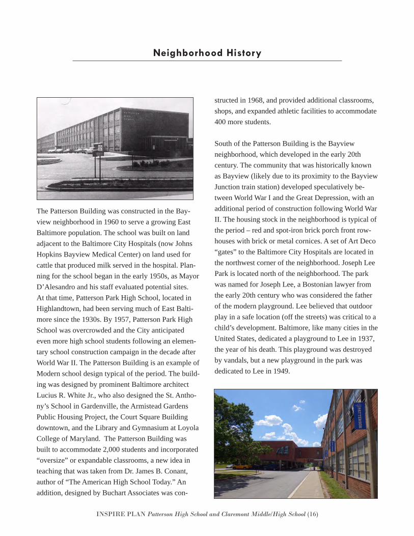
The Patterson Building was constructed in the Bay-view neighborhood in 1960 to serve a growing East Baltimore population. The school was built on land adjacent to the Baltimore City Hospitals (now Johns Hopkins Bayview Medical Center) on land used for cattle that produced milk served in the hospital. Plan-ning for the school began in the early 1950s, as Mayor D’Alesandro and his staff evaluated potential sites. At that time, Patterson Park High School, located in Highlandtown, had been serving much of East Balti-more since the 1930s. By 1957, Patterson Park High School was overcrowded and the City anticipated even more high school students following an elemen-tary school construction campaign in the decade after World War II. The Patterson Building is an example of Modern school design typical of the period. The build-ing was designed by prominent Baltimore architect Lucius R. White Jr., who also designed the St. Antho-ny’s School in Gardenville, the Armistead Gardens Public Housing Project, the Court Square Building downtown, and the Library and Gymnasium at Loyola College of Maryland. The Patterson Building was built to accommodate 2,000 students and incorporated “oversize” or expandable classrooms, a new idea in teaching that was taken from Dr. James B. Conant, author of “The American High School Today.” An addition, designed by Buchart Associates was con-
structed in 1968, and provided additional classrooms, shops, and expanded athletic facilities to accommodate 400 more students.
South of the Patterson Building is the Bayview neighborhood, which developed in the early 20th century. The community that was historically known as Bayview (likely due to its proximity to the Bayview Junction train station) developed speculatively be-tween World War I and the Great Depression, with an additional period of construction following World War II. The housing stock in the neighborhood is typical of the period – red and spot-iron brick porch front row-houses with brick or metal cornices. A set of Art Deco “gates” to the Baltimore City Hospitals are located in the northwest corner of the neighborhood. Joseph Lee Park is located north of the neighborhood. The park was named for Joseph Lee, a Bostonian lawyer from the early 20th century who was considered the father of the modern playground. Lee believed that outdoor play in a safe location (off the streets) was critical to a child’s development. Baltimore, like many cities in the United States, dedicated a playground to Lee in 1937, the year of his death. This playground was destroyed by vandals, but a new playground in the park was dedicated to Lee in 1949.
Neighborhood History
INSPIRE PLAN Patterson High School and Claremont Middle/High School (17)
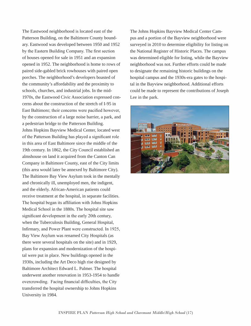
The Eastwood neighborhood is located east of the Patterson Building, on the Baltimore County bound-ary. Eastwood was developed between 1950 and 1952 by the Eastern Building Company. The first section of houses opened for sale in 1951 and an expansion opened in 1952. The neighborhood is home to rows of paired side-gabled brick rowhouses with paired open porches. The neighborhood’s developers boasted of the community’s affordability and the proximity to schools, churches, and industrial jobs. In the mid-1970s, the Eastwood Civic Association expressed con-cerns about the construction of the stretch of I-95 in East Baltimore; their concerns were pacified however, by the construction of a large noise barrier, a park, and a pedestrian bridge to the Patterson Building.Johns Hopkins Bayview Medical Center, located west of the Patterson Building has played a significant role in this area of East Baltimore since the middle of the 19th century. In 1862, the City Council established an almshouse on land it acquired from the Canton Can Company in Baltimore County, east of the City limits (this area would later be annexed by Baltimore City). The Baltimore Bay View Asylum took in the mentally and chronically ill, unemployed men, the indigent, and the elderly. African-American patients could receive treatment at the hospital, in separate facilities. The hospital began its affiliation with Johns Hopkins Medical School in the 1880s. The hospital site saw significant development in the early 20th century, when the Tuberculosis Building, General Hospital, Infirmary, and Power Plant were constructed. In 1925, Bay View Asylum was renamed City Hospitals (as there were several hospitals on the site) and in 1929, plans for expansion and modernization of the hospi-tal were put in place. New buildings opened in the 1930s, including the Art Deco high rise designed by Baltimore Architect Edward L. Palmer. The hospital underwent another renovation in 1953-1954 to handle overcrowding. Facing financial difficulties, the City transferred the hospital ownership to Johns Hopkins University in 1984.
The Johns Hopkins Bayview Medical Center Cam-pus and a portion of the Bayview neighborhood were surveyed in 2010 to determine eligibility for listing on the National Register of Historic Places. The campus was determined eligible for listing, while the Bayview neighborhood was not. Further efforts could be made to designate the remaining historic buildings on the hospital campus and the 1930s-era gates to the hospi-tal in the Bayview neighborhood. Additional efforts could be made to represent the contributions of Joseph Lee in the park.
INSPIRE PLAN Patterson High School and Claremont Middle/High School (18)
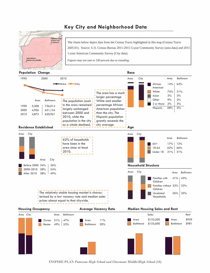
The relatively stable housing market is charac-terized by a low vacancy rate and median sales prices almost equal to that citywide.
Age
The charts below depict data from the Census Tracts highlighted in this map (Census Tracts
2605.01). Source: U.S. Census Bureau 2011-2015 5-year Community Survey (area data) and 2015
1-year American Community Survey (City data).
Figures may not sum to 100 percent due to rounding.
Household Structure
Residence Established
Race
Area Baltimore
African 12% 62% AmericanWhite 74% 31%Asian 2% 3%Other 9% 2%2 or More 2% 3%Hispanic 28% 5%
Families with 41% 43% ChildrenFamilies without 33% 22% ChildrenUnrelated 26% 35% Households
Area Baltimore
Population Change
Before 2000 34% 26% 2000-2010 28% 24%After 2010 38% 49%
Area City
Key City and Neighborhood Data
Area City
65+ 17% 12%18-64 62% 66%Under 18 21% 21%
Area BaltimoreArea CityArea City
Area City
Median Housing Sales and Rent
Area 11%Baltimore 20%
Average Vacancy Rate Housing Occupancy
Owner 51% 47%Renter 49% 53%
Area BaltimoreArea City
Area $123,200Baltimore $155,600
Area $959Baltimore $981
Sales Rent
1990 2000 2010
1990 5,308 736,0142000 4,906 651,1542010 4,875 620,961
Area Baltimore
Area City
The population count in the area remained largely unchanged between 2000 and 2010, while the population in the city as a whole declined.
The area has a much larger percentage White and smaller percentage African American population than the city. The Hispanic population greatly exceeds the city average.
62% of households have been in the area since at least 2010.
INSPIRE PLAN Patterson High School and Claremont Middle/High School (19)
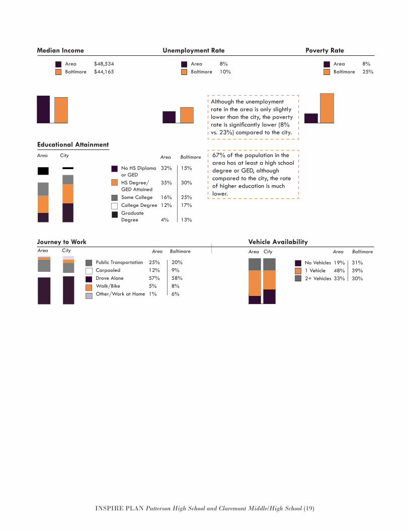
67% of the population in the area has at least a high school degree or GED, although compared to the city, the rate of higher education is much lower.
Journey to Work Vehicle Availability
No Vehicles 19% 31% 1 Vehicle 48% 39%2+ Vehicles 33% 30%
Area BaltimoreArea City
Unemployment Rate
Area 8%Baltimore 10%
Poverty Rate
Area 8%Baltimore 25%
Median Income
Area $48,534Baltimore $44,165
Educational Attainment Area City Area Baltimore
No HS Diploma 32% 15% or GEDHS Degree/ 35% 30% GED AttainedSome College 16% 25%College Degree 12% 17%Graduate Degree 4% 13%
Public Transportation 25% 20%Carpooled 12% 9%Drove Alone 57% 58%Walk/Bike 5% 8%Other/Work at Home 1% 6%
Area BaltimoreArea City
Although the unemployment rate in the area is only slightly lower than the city, the poverty rate is significantly lower (8% vs. 23%) compared to the city.
INSPIRE PLAN Patterson High School and Claremont Middle/High School (20)
Land Use and Housing Patterson High School is situated in a unique location in terms of neighboring land uses. While there are small residential neighborhoods nearby (Bayview and Eastwood), the school is also next to a heavily indus-trial area, a City park, and a golf driving range. The 130-acre Johns Hopkins Bayview Medical Center sitsnext to the park to the west.
Historically, the Bayview neighborhood was referred to as A-K, reflecting the fact that the first letters of the names given to the streets traversing the neighborhood were in alphabetical order. Even though the busy East-ern Avenue borders Bayview to the south and there is heavy truck traffic on Kane Street, the neighborhood is generally quiet and the atmosphere is neighborly on the interior streets.
Eastwood is a very small neighborhood, located at the eastern edge of the City. With just a few houses in the City, and flanked on the west side by the I-95 highway and by rail road tracks, the Eastwood neighborhood seems somewhat isolated from the rest of the city.
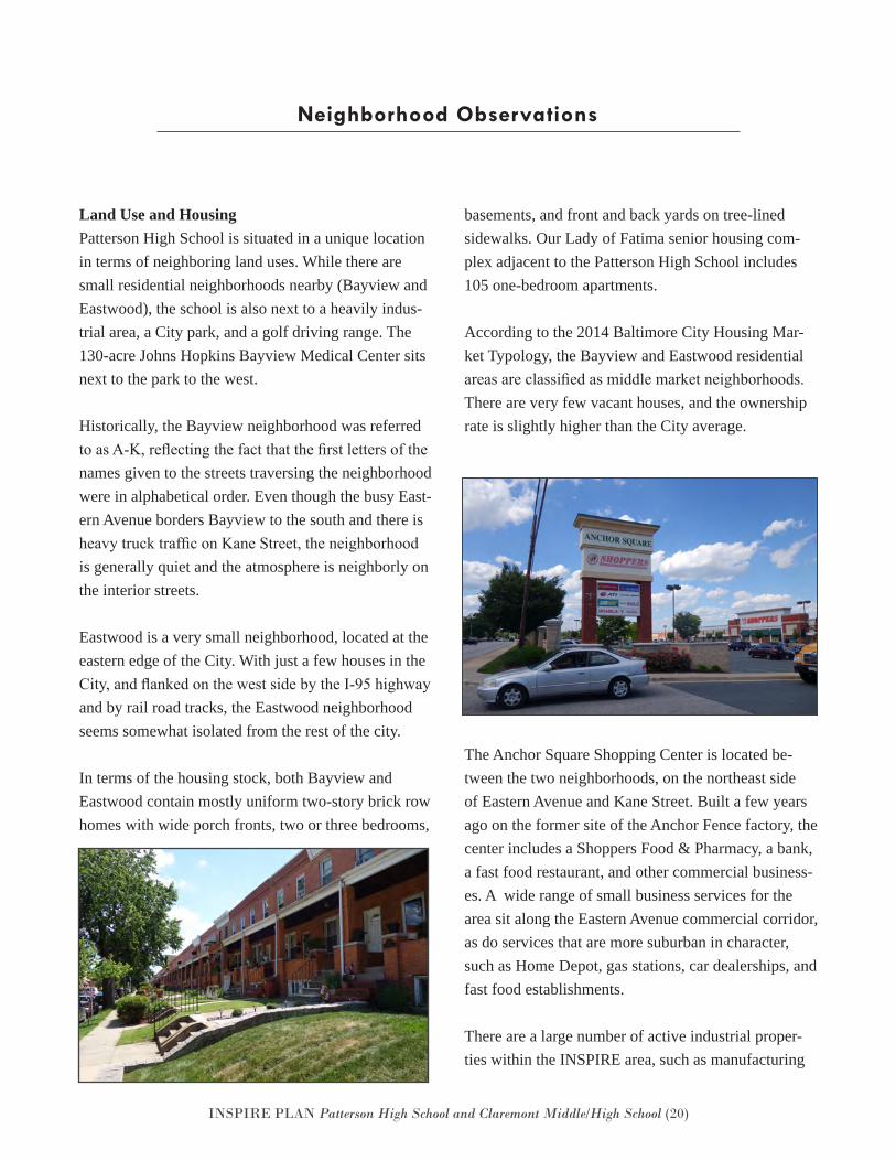
In terms of the housing stock, both Bayview and Eastwood contain mostly uniform two-story brick row homes with wide porch fronts, two or three bedrooms,
basements, and front and back yards on tree-lined sidewalks. Our Lady of Fatima senior housing com-plex adjacent to the Patterson High School includes 105 one-bedroom apartments.
According to the 2014 Baltimore City Housing Mar-ket Typology, the Bayview and Eastwood residential areas are classified as middle market neighborhoods. There are very few vacant houses, and the ownership rate is slightly higher than the City average.
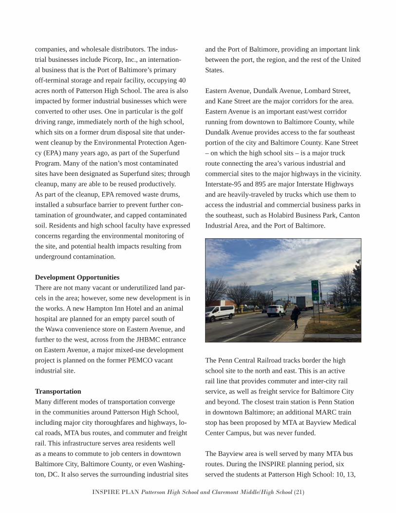
The Anchor Square Shopping Center is located be-tween the two neighborhoods, on the northeast side of Eastern Avenue and Kane Street. Built a few years ago on the former site of the Anchor Fence factory, the center includes a Shoppers Food & Pharmacy, a bank, a fast food restaurant, and other commercial business-es. A wide range of small business services for the area sit along the Eastern Avenue commercial corridor, as do services that are more suburban in character, such as Home Depot, gas stations, car dealerships, and fast food establishments.
There are a large number of active industrial proper-ties within the INSPIRE area, such as manufacturing
Neighborhood Observations
INSPIRE PLAN Patterson High School and Claremont Middle/High School (21)
companies, and wholesale distributors. The indus-trial businesses include Picorp, Inc., an internation-al business that is the Port of Baltimore’s primary off-terminal storage and repair facility, occupying 40 acres north of Patterson High School. The area is also impacted by former industrial businesses which were converted to other uses. One in particular is the golf driving range, immediately north of the high school, which sits on a former drum disposal site that under-went cleanup by the Environmental Protection Agen-cy (EPA) many years ago, as part of the Superfund Program. Many of the nation’s most contaminated sites have been designated as Superfund sites; through cleanup, many are able to be reused productively. As part of the cleanup, EPA removed waste drums, installed a subsurface barrier to prevent further con-tamination of groundwater, and capped contaminated soil. Residents and high school faculty have expressed concerns regarding the environmental monitoring of the site, and potential health impacts resulting from underground contamination.
Development OpportunitiesThere are not many vacant or underutilized land par-cels in the area; however, some new development is in the works. A new Hampton Inn Hotel and an animal hospital are planned for an empty parcel south of the Wawa convenience store on Eastern Avenue, and further to the west, across from the JHBMC entrance on Eastern Avenue, a major mixed-use development project is planned on the former PEMCO vacant industrial site.
TransportationMany different modes of transportation converge in the communities around Patterson High School, including major city thoroughfares and highways, lo-cal roads, MTA bus routes, and commuter and freight rail. This infrastructure serves area residents well as a means to commute to job centers in downtown Baltimore City, Baltimore County, or even Washing-ton, DC. It also serves the surrounding industrial sites
and the Port of Baltimore, providing an important link between the port, the region, and the rest of the United States.
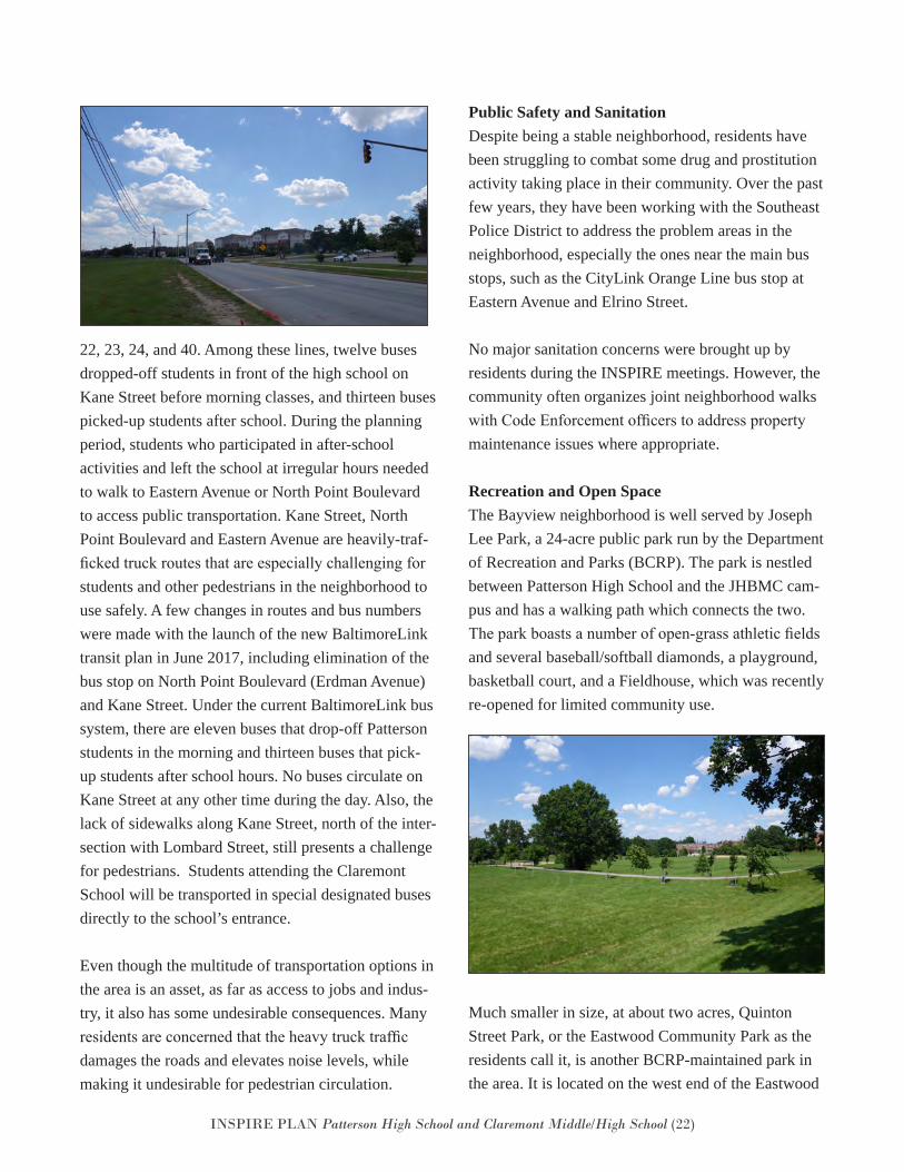
Eastern Avenue, Dundalk Avenue, Lombard Street, and Kane Street are the major corridors for the area. Eastern Avenue is an important east/west corridor running from downtown to Baltimore County, while Dundalk Avenue provides access to the far southeast portion of the city and Baltimore County. Kane Street – on which the high school sits – is a major truck route connecting the area’s various industrial and commercial sites to the major highways in the vicinity. Interstate-95 and 895 are major Interstate Highways and are heavily-traveled by trucks which use them to access the industrial and commercial business parks in the southeast, such as Holabird Business Park, Canton Industrial Area, and the Port of Baltimore.
The Penn Central Railroad tracks border the high school site to the north and east. This is an active rail line that provides commuter and inter-city rail service, as well as freight service for Baltimore City and beyond. The closest train station is Penn Station in downtown Baltimore; an additional MARC train stop has been proposed by MTA at Bayview Medical Center Campus, but was never funded.
The Bayview area is well served by many MTA bus routes. During the INSPIRE planning period, six served the students at Patterson High School: 10, 13,
INSPIRE PLAN Patterson High School and Claremont Middle/High School (22)
22, 23, 24, and 40. Among these lines, twelve buses dropped-off students in front of the high school on Kane Street before morning classes, and thirteen buses picked-up students after school. During the planning period, students who participated in after-school activities and left the school at irregular hours needed to walk to Eastern Avenue or North Point Boulevard to access public transportation. Kane Street, North Point Boulevard and Eastern Avenue are heavily-traf-ficked truck routes that are especially challenging for students and other pedestrians in the neighborhood to use safely. A few changes in routes and bus numbers were made with the launch of the new BaltimoreLink transit plan in June 2017, including elimination of the bus stop on North Point Boulevard (Erdman Avenue) and Kane Street. Under the current BaltimoreLink bus system, there are eleven buses that drop-off Patterson students in the morning and thirteen buses that pick-up students after school hours. No buses circulate on Kane Street at any other time during the day. Also, the lack of sidewalks along Kane Street, north of the inter-section with Lombard Street, still presents a challenge for pedestrians. Students attending the Claremont School will be transported in special designated buses directly to the school’s entrance.
Even though the multitude of transportation options in the area is an asset, as far as access to jobs and indus-try, it also has some undesirable consequences. Many residents are concerned that the heavy truck traffic damages the roads and elevates noise levels, while making it undesirable for pedestrian circulation.
Public Safety and SanitationDespite being a stable neighborhood, residents have been struggling to combat some drug and prostitution activity taking place in their community. Over the past few years, they have been working with the Southeast Police District to address the problem areas in the neighborhood, especially the ones near the main bus stops, such as the CityLink Orange Line bus stop at Eastern Avenue and Elrino Street.
No major sanitation concerns were brought up by residents during the INSPIRE meetings. However, the community often organizes joint neighborhood walks with Code Enforcement officers to address property maintenance issues where appropriate.
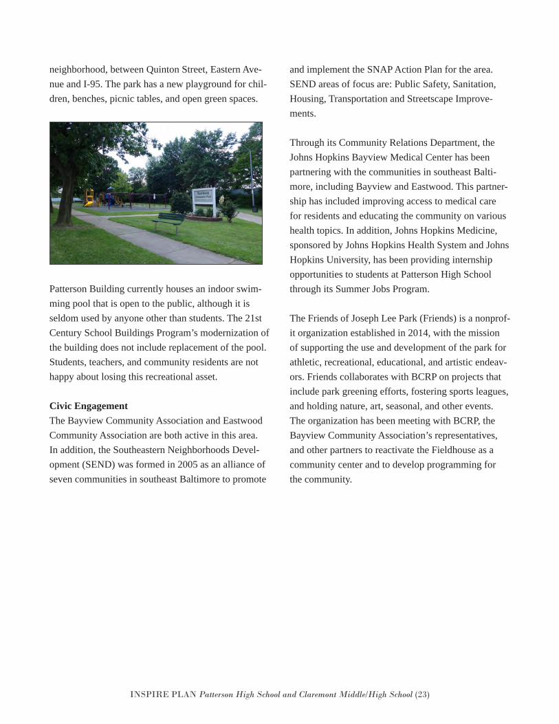
Recreation and Open SpaceThe Bayview neighborhood is well served by Joseph Lee Park, a 24-acre public park run by the Department of Recreation and Parks (BCRP). The park is nestled between Patterson High School and the JHBMC cam-pus and has a walking path which connects the two. The park boasts a number of open-grass athletic fields and several baseball/softball diamonds, a playground, basketball court, and a Fieldhouse, which was recently re-opened for limited community use.
Much smaller in size, at about two acres, Quinton Street Park, or the Eastwood Community Park as the residents call it, is another BCRP-maintained park in the area. It is located on the west end of the Eastwood
INSPIRE PLAN Patterson High School and Claremont Middle/High School (23)
neighborhood, between Quinton Street, Eastern Ave-nue and I-95. The park has a new playground for chil-dren, benches, picnic tables, and open green spaces.
Patterson Building currently houses an indoor swim-ming pool that is open to the public, although it is seldom used by anyone other than students. The 21st Century School Buildings Program’s modernization of the building does not include replacement of the pool. Students, teachers, and community residents are not happy about losing this recreational asset.
Civic EngagementThe Bayview Community Association and Eastwood Community Association are both active in this area. In addition, the Southeastern Neighborhoods Devel-opment (SEND) was formed in 2005 as an alliance of seven communities in southeast Baltimore to promote
and implement the SNAP Action Plan for the area. SEND areas of focus are: Public Safety, Sanitation, Housing, Transportation and Streetscape Improve-ments.
Through its Community Relations Department, the Johns Hopkins Bayview Medical Center has been partnering with the communities in southeast Balti-more, including Bayview and Eastwood. This partner-ship has included improving access to medical care for residents and educating the community on various health topics. In addition, Johns Hopkins Medicine, sponsored by Johns Hopkins Health System and Johns Hopkins University, has been providing internship opportunities to students at Patterson High School through its Summer Jobs Program.
The Friends of Joseph Lee Park (Friends) is a nonprof-it organization established in 2014, with the mission of supporting the use and development of the park for athletic, recreational, educational, and artistic endeav-ors. Friends collaborates with BCRP on projects that include park greening efforts, fostering sports leagues, and holding nature, art, seasonal, and other events. The organization has been meeting with BCRP, the Bayview Community Association’s representatives, and other partners to reactivate the Fieldhouse as a community center and to develop programming for the community.
INSPIRE PLAN Patterson High School and Claremont Middle/High School (24)
The only existing plan for the area is the Strategic Neighborhood Action Plan (SNAP). In 2002, Mayor Martin O’Malley launched the SNAP program to cre-ate comprehensive plans for select clusters of neigh-borhoods throughout the city. The communities in the southeast came together to form the Southeastern Neighborhoods Development (SEND), which was one of the clusters selected by the City to develop a comprehensive plan for the area. The neighborhoods included Bayview and Eastwood, as well as Greek-town, O’Donnell Heights, Saint Helena, Graceland Park, and Dundalk.
The SEND Plan, which was adopted by the Planning Commission in 2005, identified key assets in the cluster and developed recommendations for Housing, Commercial, Open Space and Recreation, Trans-portation, Public Safety and Sanitation. A few of the recommendations in this plan are based on strategies identified in the SEND Plan.
https://planning.baltimorecity.gov/sites/default/files/SoutheasternNeighborhoodsDevelop-ment%28SEND%29.pdf
Existing Plans
INSPIRE PLAN Patterson High School and Claremont Middle/High School (25)
INSPIRE Recommendations
Recommendation Development and Overview
Standard Improvements – Primary Walking Routes
Goals, Strategies, and Recommendations –
Patterson Building Planning Area
INSPIRE PLAN Patterson High School and Claremont Middle/High School (26)
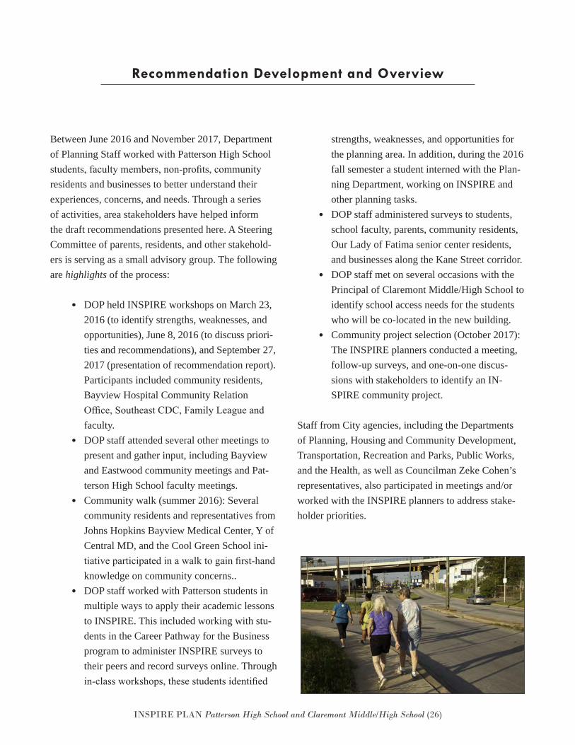
Between June 2016 and November 2017, Department of Planning Staff worked with Patterson High School students, faculty members, non-profits, community residents and businesses to better understand their experiences, concerns, and needs. Through a series of activities, area stakeholders have helped inform the draft recommendations presented here. A Steering Committee of parents, residents, and other stakehold-ers is serving as a small advisory group. The following are highlights of the process:
• DOP held INSPIRE workshops on March 23,2016 (to identify strengths, weaknesses, andopportunities), June 8, 2016 (to discuss priori-ties and recommendations), and September 27,2017 (presentation of recommendation report).Participants included community residents,Bayview Hospital Community RelationOffice, Southeast CDC, Family League andfaculty.
• DOP staff attended several other meetings topresent and gather input, including Bayviewand Eastwood community meetings and Pat-terson High School faculty meetings.
• Community walk (summer 2016): Severalcommunity residents and representatives fromJohns Hopkins Bayview Medical Center, Y ofCentral MD, and the Cool Green School ini-tiative participated in a walk to gain first-handknowledge on community concerns..
• DOP staff worked with Patterson students inmultiple ways to apply their academic lessonsto INSPIRE. This included working with stu-dents in the Career Pathway for the Businessprogram to administer INSPIRE surveys totheir peers and record surveys online. Throughin-class workshops, these students identified
strengths, weaknesses, and opportunities for the planning area. In addition, during the 2016 fall semester a student interned with the Plan-ning Department, working on INSPIRE and other planning tasks.
• DOP staff administered surveys to students,school faculty, parents, community residents,Our Lady of Fatima senior center residents,and businesses along the Kane Street corridor.
• DOP staff met on several occasions with thePrincipal of Claremont Middle/High School toidentify school access needs for the studentswho will be co-located in the new building.
• Community project selection (October 2017):The INSPIRE planners conducted a meeting,follow-up surveys, and one-on-one discus-sions with stakeholders to identify an IN-SPIRE community project.
Staff from City agencies, including the Departments of Planning, Housing and Community Development, Transportation, Recreation and Parks, Public Works, and the Health, as well as Councilman Zeke Cohen’s representatives, also participated in meetings and/or worked with the INSPIRE planners to address stake-holder priorities.
Recommendation Development and Overview
INSPIRE PLAN Patterson High School and Claremont Middle/High School (27)
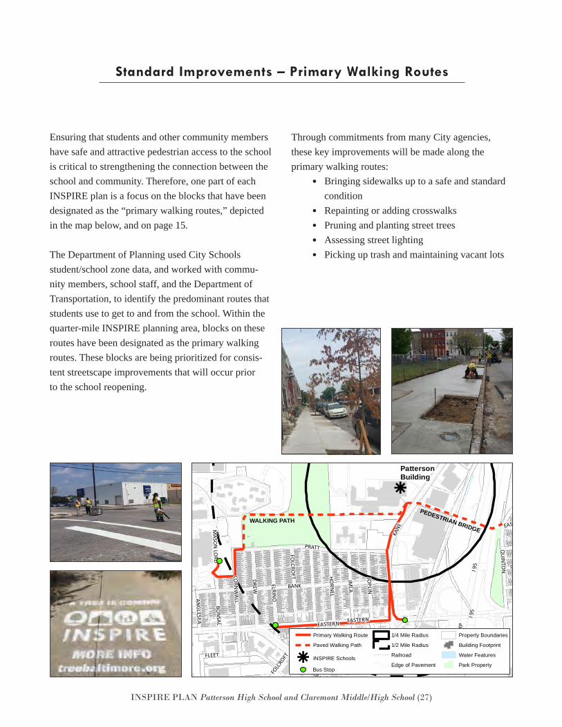
Standard Improvements – Primary Walking Routes
Ensuring that students and other community members have safe and attractive pedestrian access to the school is critical to strengthening the connection between the school and community. Therefore, one part of each INSPIRE plan is a focus on the blocks that have been designated as the “primary walking routes,” depicted in the map below, and on page 15.
The Department of Planning used City Schools student/school zone data, and worked with commu-nity members, school staff, and the Department of Transportation, to identify the predominant routes that students use to get to and from the school. Within the quarter-mile INSPIRE planning area, blocks on these routes have been designated as the primary walking routes. These blocks are being prioritized for consis-tent streetscape improvements that will occur prior to the school reopening.
Through commitments from many City agencies, these key improvements will be made along the primary walking routes:
• Bringing sidewalks up to a safe and standardcondition
• Repainting or adding crosswalks• Pruning and planting street trees• Assessing street lighting• Picking up trash and maintaining vacant lots
k
PEDESTRIAN BRIDGEWALKING PATH
BALTIMORE
KANE
FOLCRO
FT JOPLIN
HORNEL
IMLA
ELRINO
ERDMAN
HOPKINSBAYVIEW
ALPHA COMMONS
QUAD
CORN
WALLANGLESEA
BONSAL
NATHAN SHOCK
BAYVIEWUM
BRA
PULASKI
FOLC
ROFT
QUINTO
N
ARMISTEAD
MASO
N LORD
QUAD
KANE
GUSRYAN
RAMP
CONLEY
EASTERN
MAPLETON
DEBELIUS
I 895
ERDMAN
HUDSON
I 895
VILLAGER
BANK
EASTERN
DUNDALK
PRATT
ERDM
AN
DUNDALK
RAM
P
EASTBROOK
WRIGHT
BAYVIEW
FAIT
HUDSON
BANK
BAYV
IEW
FLEET
LOMBARD
OGDEN
DUNDALK
DREW
JOPLIN
NORTH POINT
ALRICKS
NORTH POINT
LOM
BARD
DEBELIUS
GOUGH
DILLON
BAYVIEW
O'DONNELL
PULASKI
BIOSCIEN
CE
GRACELAND
ERDMAN
BANK
I 95 CONLEY
I 95
GOUGH
EASTBROOK
HUDSON
BUSHEY
BIOSCIENCE
KANE
PattersonBuilding
Primary Walking Route
Paved Walking Path
k INSPIRE Schools
1/4 Mile Radius
1/2 Mile Radius
Railroad
Edge of Pavement
Property Boundaries
Building Footprint
Water Features
Park PropertyDate: 7/25/2017
PattersonBuildingINSPIRE Bus Stop
k
PEDESTRIAN BRIDGEWALKING PATH
BALTIMORE
KANE
FOLCRO
FT JOPLIN
HORNEL
IMLA
ELRINO
ERDMAN
HOPKINSBAYVIEW
ALPHA COMMONS
QUAD
CORN
WALLANGLESEA
BONSAL
NATHAN SHOCK
BAYVIEWUM
BRA
PULASKI
FOLC
ROFT
QUINTO
N
ARMISTEAD
MASO
NLO
RD
QUAD
KANE
GUSRYAN
RAMP
CONLEY
EASTERN
MAPLETON
DEBELIUS
I 895
ERDMAN
HUDSON
I 895
VILLAGER
BANK
EASTERN
DUNDALK
PRATT
ERDM
AN
DUNDALK
RAM
P
EASTBROOK
WRIGHT
BAYVIEW
FAIT
HUDSON
BANK
BAYV
IEW
FLEET
LOMBARD
OGDEN
DUNDALK
DREW
JOPLIN
NORTH POINT
ALRICKS
NORTH POINT
LOM
BARD
DEBELIUS
GOUGH
DILLON
BAYVIEW
O'DONNELL
PULASKI
BIOSCIEN
CE
GRACELAND
ERDMAN
BANK
I95 CONLEY
I95
GOUGH
EASTBROOK
HUDSON
BUSHEY
BIOSCIENCE
KANE
PattersonBuilding
Primary Walking Route
Paved Walking Path
k INSPIRE Schools
1/4 Mile Radius
1/2 Mile Radius
Railroad
Edge of Pavement
Property Boundaries
Building Footprint
Water Features
Park PropertyDate: 7/25/2017
PattersonBuildingINSPIRE Bus Stop
INSPIRE PLAN Patterson High School and Claremont Middle/High School (28)
Goals, Strategies, and Recommendations – Patterson Building Planning Area
The recommendations presented in the remainder of this report are in addition to those that address the issues along the school perimeter and primary routes listed on page 26. Many recommendations described could easily fit under more than one goal.
Recommendations for the Patterson Building Planning Area fall under these goals and strategies:
• Invest in Housing and Market-Strengthen-ing Opportunities◦ Support Home Improvement and Increase
Homeownership◦ Enhance Community’s Image◦ Promote Strategic Redevelopment Op-
portunities• Improve Safety
◦ Promote Safety at Key Locations◦ Increase Police Presence and Partnership
in the Neighborhood
• Create Connections and Access◦ Improve Pedestrian Safety and Walkabil-
ity in the Neighborhood: Improve KaneStreet
◦ Improve Pedestrian Safety and Walkabil-ity in the Neighborhood: Beyond KaneStreet
◦ Assess the Use and Safety on and near thePedestrian Bridge
◦ Increase and Improve Public Transporta-tion
• Create Opportunities for Health and Well-Being◦ Improve Recreational Opportunities◦ Build and Strengthen Community Assets
and Partnerships◦ Develop Community Information Sharing
Process of the Superfund Site Environ-mental Monitoring
• Improve Sanitation◦ Improve Neighborhood Appearance
INSPIRE PLAN Patterson High School and Claremont Middle/High School (29)
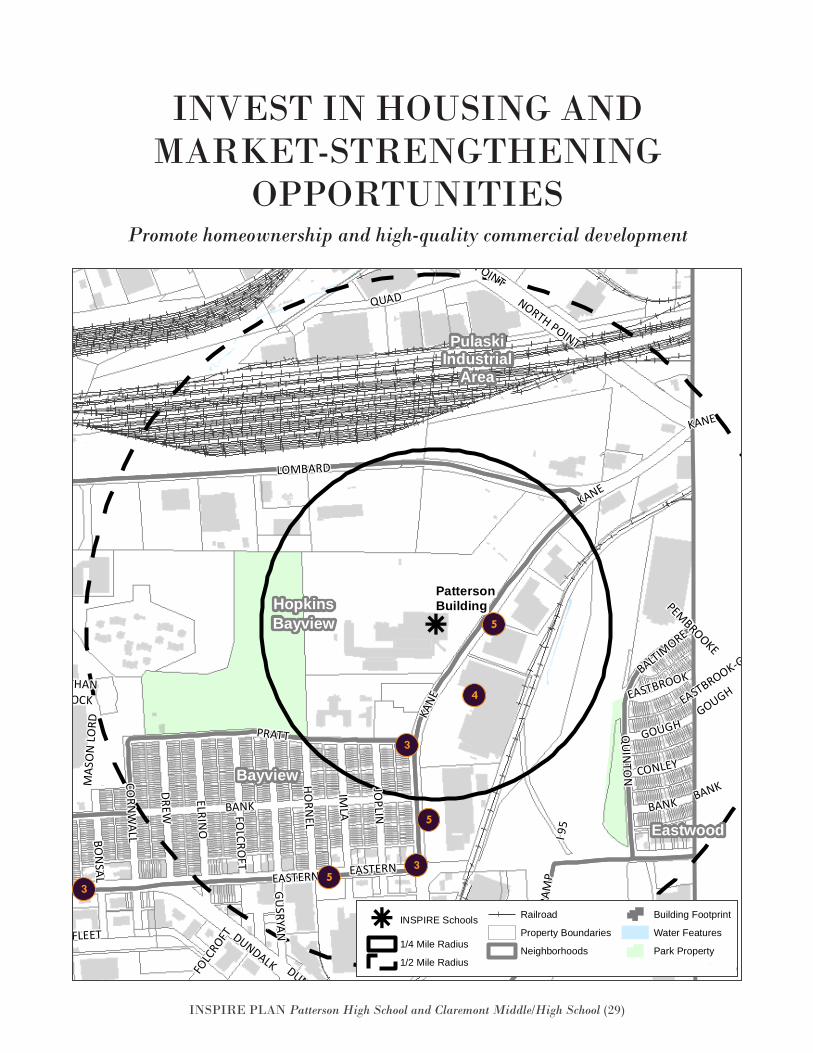
INVEST IN HOUSING AND MARKET-STRENGTHENING
OPPORTUNITIESPromote homeownership and high-quality commercial development
k
Eastwood
GracelandPark
Greektown
HopkinsBayview
Bayview
PulaskiIndustrial
Area
BALTIMORE
PEMBROOKE
KANE
KANE EASTBROOK-GOUGH
GUSRYAN
ELRINO
QUAD
QUAD
ANGLESEA
FOLC
ROFT
QUIN
TON
KANE
DUNDALK
MAS
ON
LORD
ERDMANQUADDEBELIUS
EASTERN
BANK
PRATT
JOPLIN
RAM
P
IMLA
FAIT
BON
SAL
HUDSON
BANK
FLEET
ERDMANO
GDEN
EASTERN
FOLCRO
FT
DREW
NATHANSHOCK
GOUGH
GRACELAND
CORN
WALL
NORTH POINT
O'DONNELL
HORN
EL
GRACELAND
ERDMAN
BANK
I 95
CONLEY
DUNDALK
BUSHEY
GOUGH
EASTBROOK
HUDSON
I 95
NORTH POINT
LOMBARD
PattersonBuilding
k INSPIRE Schools
1/4 Mile Radius
1/2 Mile Radius
Railroad
Property Boundaries
Neighborhoods
Building Footprint
Water Features
Park PropertyDate: 9/27/2016
PattersonBuildingINSPIRE
k
Eastwood
GracelandPark
Greektown
HopkinsBayview
Bayview
PulaskiIndustrial
Area
BALTIMORE
PEMBROOKE
KANE
KANE EASTBROOK-GOUGH
GUSRYAN
ELRINO
QUAD
QUAD
ANGLESEA
FOLC
ROFT
QUIN
TON
KANE
DUNDALK
MAS
ON
LORD
ERDMANQUADDEBELIUS
EASTERN
BANK
PRATT
JOPLIN
RAM
PIM
LA
FAIT
BON
SAL
HUDSON
BANK
FLEET
ERDMAN
OGDEN
EASTERN
FOLCRO
FT
DREW
NATHANSHOCK
GOUGH
GRACELAND
CORN
WALL
NORTH POINT
O'DONNELL
HORN
EL
GRACELAND
ERDMAN
BANK
I 95
CONLEY
DUNDALK
BUSHEY
GOUGH
EASTBROOK
HUDSON
I 95
NORTH POINT
LOMBARD
PattersonBuilding
k INSPIRE Schools
1/4 Mile Radius
1/2 Mile Radius
Railroad
Property Boundaries
Neighborhoods
Building Footprint
Water Features
Park PropertyDate: 9/27/2016
PattersonBuildingINSPIRE
5
5
5
4
3
3
3
INSPIRE PLAN Patterson High School and Claremont Middle/High School (30)
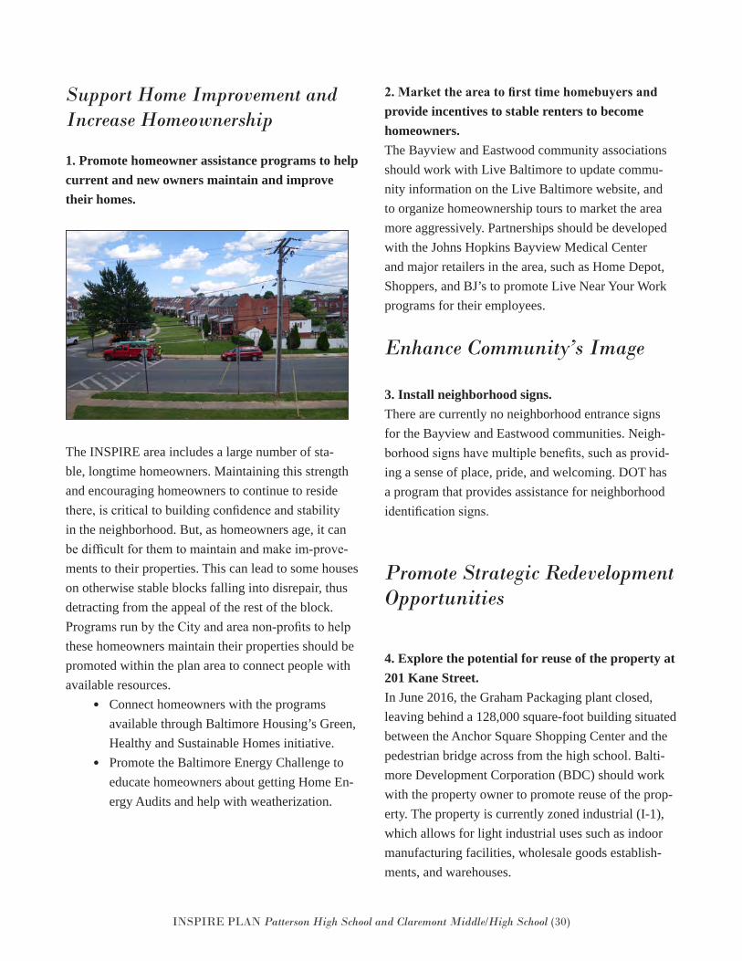
Support Home Improvement and Increase Homeownership
1. Promote homeowner assistance programs to help current and new owners maintain and improve their homes.
The INSPIRE area includes a large number of sta-ble, longtime homeowners. Maintaining this strength and encouraging homeowners to continue to reside there, is critical to building confidence and stability in the neighborhood. But, as homeowners age, it can be difficult for them to maintain and make im-prove-ments to their properties. This can lead to some houses on otherwise stable blocks falling into disrepair, thus detracting from the appeal of the rest of the block. Programs run by the City and area non-profits to help these homeowners maintain their properties should be promoted within the plan area to connect people with available resources.
• Connect homeowners with the programs available through Baltimore Housing’s Green, Healthy and Sustainable Homes initiative.
• Promote the Baltimore Energy Challenge to educate homeowners about getting Home En-ergy Audits and help with weatherization.
2. Market the area to first time homebuyers and provide incentives to stable renters to become homeowners. The Bayview and Eastwood community associations should work with Live Baltimore to update commu-nity information on the Live Baltimore website, and to organize homeownership tours to market the area more aggressively. Partnerships should be developed with the Johns Hopkins Bayview Medical Center and major retailers in the area, such as Home Depot, Shoppers, and BJ’s to promote Live Near Your Work programs for their employees.
Enhance Community’s Image
3. Install neighborhood signs.There are currently no neighborhood entrance signs for the Bayview and Eastwood communities. Neigh-borhood signs have multiple benefits, such as provid-ing a sense of place, pride, and welcoming. DOT has a program that provides assistance for neighborhood identification signs.
Promote Strategic Redevelopment Opportunities
4. Explore the potential for reuse of the property at 201 Kane Street.In June 2016, the Graham Packaging plant closed, leaving behind a 128,000 square-foot building situated between the Anchor Square Shopping Center and the pedestrian bridge across from the high school. Balti-more Development Corporation (BDC) should work with the property owner to promote reuse of the prop-erty. The property is currently zoned industrial (I-1), which allows for light industrial uses such as indoor manufacturing facilities, wholesale goods establish-ments, and warehouses.
INSPIRE PLAN Patterson High School and Claremont Middle/High School (31)
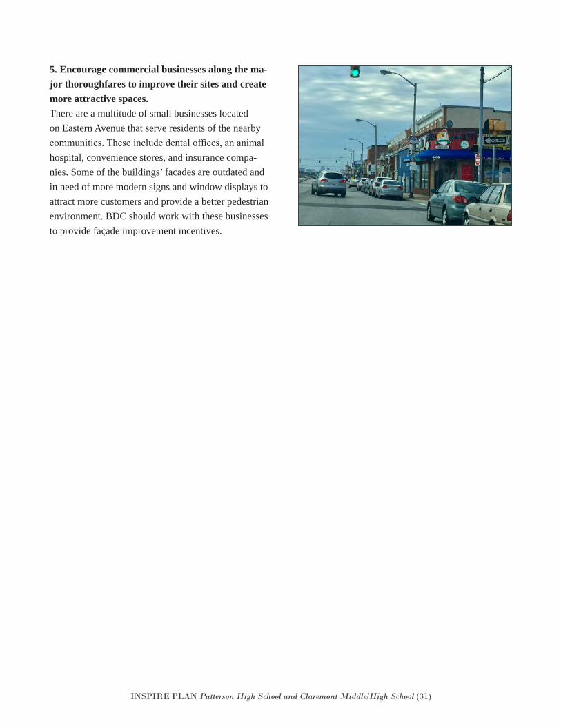
5. Encourage commercial businesses along the ma-jor thoroughfares to improve their sites and create more attractive spaces. There are a multitude of small businesses located on Eastern Avenue that serve residents of the nearby communities. These include dental offices, an animal hospital, convenience stores, and insurance compa-nies. Some of the buildings’ facades are outdated and in need of more modern signs and window displays to attract more customers and provide a better pedestrian environment. BDC should work with these businesses to provide façade improvement incentives.
INSPIRE PLAN Patterson High School and Claremont Middle/High School (32)
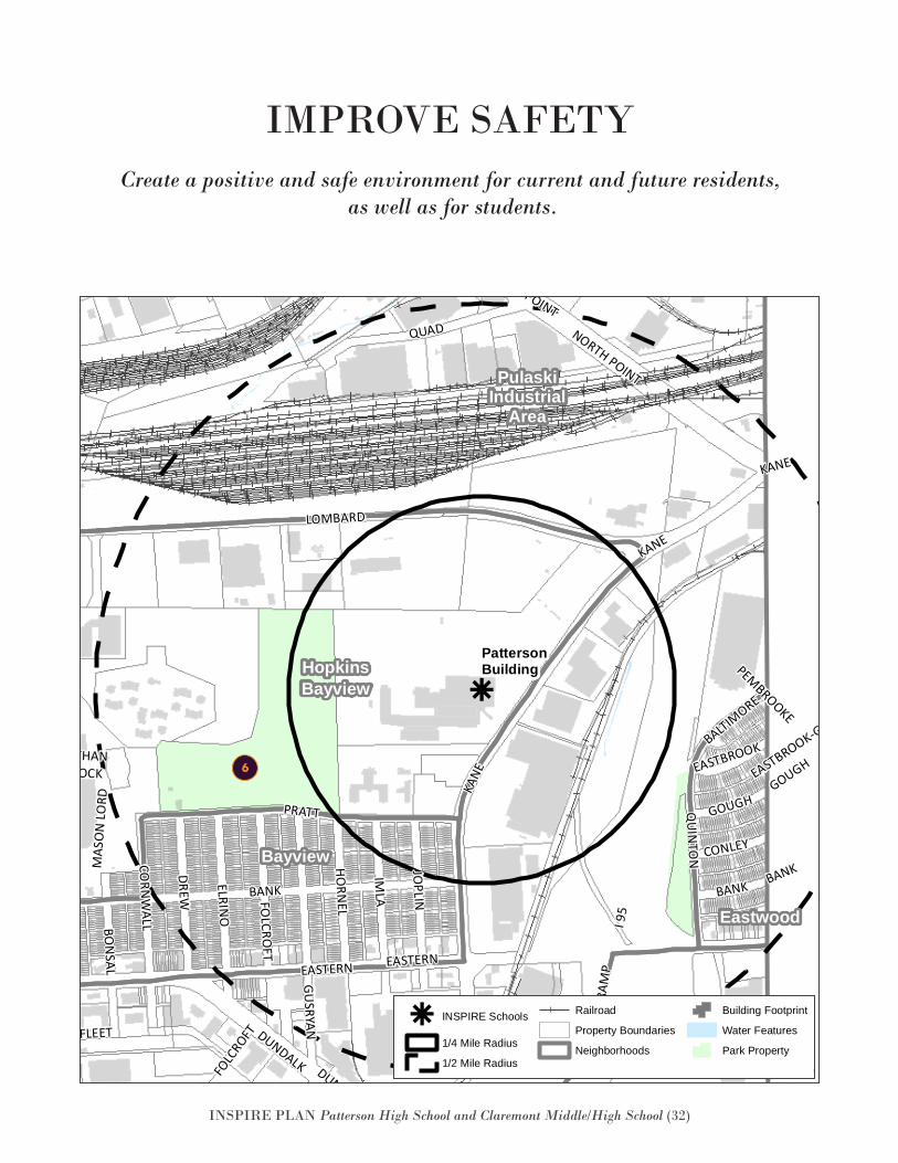
Create a positive and safe environment for current and future residents, as well as for students.
IMPROVE SAFETY
k
Eastwood
GracelandPark
Greektown
HopkinsBayview
Bayview
PulaskiIndustrial
Area
BALTIMORE
PEMBROOKE
KANE
KANE EASTBROOK-GOUGH
GUSRYAN
ELRINO
QUAD
QUAD
ANGLESEA
FOLC
ROFT
QUIN
TON
KANE
DUNDALK
MAS
ON
LORD
ERDMANQUADDEBELIUS
EASTERN
BANK
PRATT
JOPLIN
RAM
P
IMLA
FAIT
BON
SAL
HUDSON
BANK
FLEET
ERDMANO
GDEN
EASTERN
FOLCRO
FT
DREW
NATHANSHOCK
GOUGH
GRACELAND
CORN
WALL
NORTH POINT
O'DONNELL
HORN
EL
GRACELAND
ERDMAN
BANK
I 95
CONLEY
DUNDALK
BUSHEY
GOUGH
EASTBROOK
HUDSON
I 95
NORTH POINT
LOMBARD
PattersonBuilding
k INSPIRE Schools
1/4 Mile Radius
1/2 Mile Radius
Railroad
Property Boundaries
Neighborhoods
Building Footprint
Water Features
Park PropertyDate: 9/27/2016
PattersonBuildingINSPIRE
k
Eastwood
GracelandPark
Greektown
HopkinsBayview
Bayview
PulaskiIndustrial
Area
BALTIMORE
PEMBROOKE
KANE
KANE EASTBROOK-GOUGH
GUSRYAN
ELRINO
QUAD
QUAD
ANGLESEA
FOLC
ROFT
QUIN
TON
KANE
DUNDALK
MAS
ON
LORD
ERDMANQUADDEBELIUS
EASTERN
BANK
PRATT
JOPLIN
RAM
PIM
LA
FAIT
BON
SAL
HUDSON
BANK
FLEET
ERDMAN
OGDEN
EASTERN
FOLCRO
FT
DREW
NATHANSHOCK
GOUGH
GRACELAND
CORN
WALL
NORTH POINT
O'DONNELL
HORN
EL
GRACELAND
ERDMAN
BANK
I95
CONLEY
DUNDALK
BUSHEY
GOUGH
EASTBROOK
HUDSON
I95
NORTH POINT
LOMBARD
PattersonBuilding
k INSPIRE Schools
1/4 Mile Radius
1/2 Mile Radius
Railroad
Property Boundaries
Neighborhoods
Building Footprint
Water Features
Park PropertyDate: 9/27/2016
PattersonBuildingINSPIRE
6
INSPIRE PLAN Patterson High School and Claremont Middle/High School (33)
Promote Safety at Key Locations
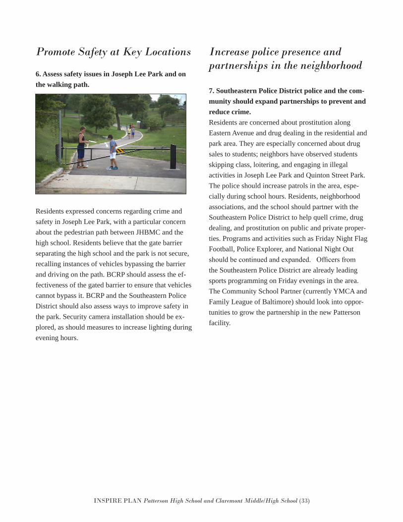
6. Assess safety issues in Joseph Lee Park and on the walking path.
Residents expressed concerns regarding crime and safety in Joseph Lee Park, with a particular concern about the pedestrian path between JHBMC and the high school. Residents believe that the gate barrier separating the high school and the park is not secure, recalling instances of vehicles bypassing the barrier and driving on the path. BCRP should assess the ef-fectiveness of the gated barrier to ensure that vehicles cannot bypass it. BCRP and the Southeastern Police District should also assess ways to improve safety in the park. Security camera installation should be ex-plored, as should measures to increase lighting during evening hours.
Increase police presence and partnerships in the neighborhood
7. Southeastern Police District police and the com-munity should expand partnerships to prevent and reduce crime. Residents are concerned about prostitution along Eastern Avenue and drug dealing in the residential and park area. They are especially concerned about drug sales to students; neighbors have observed students skipping class, loitering, and engaging in illegal activities in Joseph Lee Park and Quinton Street Park. The police should increase patrols in the area, espe-cially during school hours. Residents, neighborhood associations, and the school should partner with the Southeastern Police District to help quell crime, drug dealing, and prostitution on public and private proper-ties. Programs and activities such as Friday Night Flag Football, Police Explorer, and National Night Out should be continued and expanded. Officers from the Southeastern Police District are already leading sports programming on Friday evenings in the area. The Community School Partner (currently YMCA and Family League of Baltimore) should look into oppor-tunities to grow the partnership in the new Patterson facility.
INSPIRE PLAN Patterson High School and Claremont Middle/High School (34)
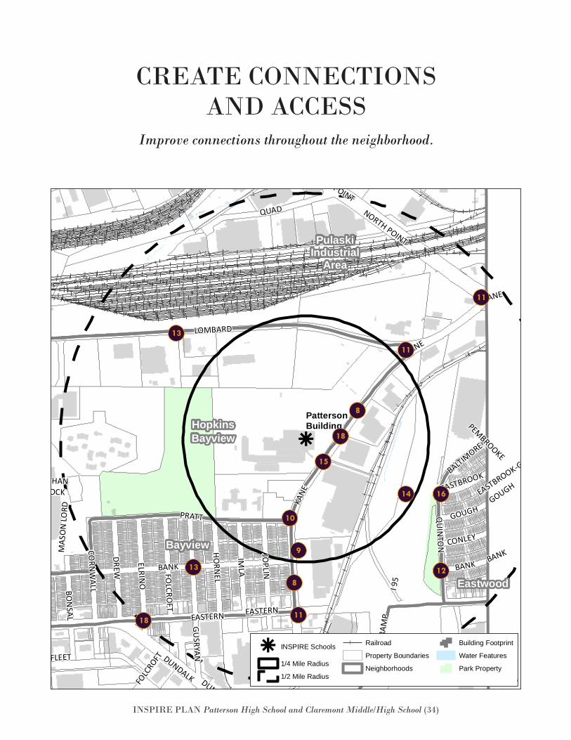
Improve connections throughout the neighborhood.
CREATE CONNECTIONS AND ACCESS
k
Eastwood
GracelandPark
Greektown
HopkinsBayview
Bayview
PulaskiIndustrial
Area
BALTIMORE
PEMBROOKE
KANE
KANE EASTBROOK-GOUGH
GUSRYAN
ELRINO
QUAD
QUAD
ANGLESEA
FOLC
ROFT
QUIN
TON
KANE
DUNDALK
MAS
ON
LORD
ERDMANQUADDEBELIUS
EASTERN
BANK
PRATT
JOPLIN
RAM
P
IMLA
FAIT
BON
SAL
HUDSON
BANK
FLEET
ERDMANO
GDEN
EASTERN
FOLCRO
FT
DREW
NATHANSHOCK
GOUGH
GRACELAND
CORN
WALL
NORTH POINT
O'DONNELL
HORN
EL
GRACELAND
ERDMAN
BANK
I 95
CONLEY
DUNDALK
BUSHEY
GOUGH
EASTBROOK
HUDSON
I 95
NORTH POINT
LOMBARD
PattersonBuilding
k INSPIRE Schools
1/4 Mile Radius
1/2 Mile Radius
Railroad
Property Boundaries
Neighborhoods
Building Footprint
Water Features
Park PropertyDate: 9/27/2016
PattersonBuildingINSPIRE
k
Eastwood
GracelandPark
Greektown
HopkinsBayview
Bayview
PulaskiIndustrial
Area
BALTIMORE
PEMBROOKE
KANE
KANE EASTBROOK-GOUGH
GUSRYAN
ELRINO
QUAD
QUAD
ANGLESEA
FOLC
ROFT
QUIN
TON
KANE
DUNDALK
MAS
ON
LORD
ERDMANQUADDEBELIUS
EASTERN
BANK
PRATT
JOPLIN
RAM
PIM
LA
FAIT
BON
SAL
HUDSON
BANK
FLEET
ERDMAN
OGDEN
EASTERN
FOLCRO
FT
DREW
NATHANSHOCK
GOUGH
GRACELAND
CORN
WALL
NORTH POINT
O'DONNELL
HORN
EL
GRACELAND
ERDMAN
BANK
I95
CONLEY
DUNDALK
BUSHEY
GOUGH
EASTBROOK
HUDSON
I95
NORTH POINT
LOMBARD
PattersonBuilding
k INSPIRE Schools
1/4 Mile Radius
1/2 Mile Radius
Railroad
Property Boundaries
Neighborhoods
Building Footprint
Water Features
Park PropertyDate: 9/27/2016
PattersonBuildingINSPIRE
11
11
11
13
8
8
9
18
18
1614
15
13 12
10
INSPIRE PLAN Patterson High School and Claremont Middle/High School (35)
Improve Pedestrian Safety and Walkability in the Neighborhood: Kane Street
8. Conduct a pedestrian-level lighting assessment on Kane Street, from Eastern Avenue to Patterson High School. Students and residents walk along the highly-traf-ficked Kane Street to get to bus stops and businesses on Eastern Avenue. That stretch only has lighting geared to the needs of vehicular traffic. Pedestrian lighting is necessary in order to create a safe and hospitable walking environment and to improve busi-ness visibility. This is especially critical during winter months when students and residents are more likely to walk after dark.
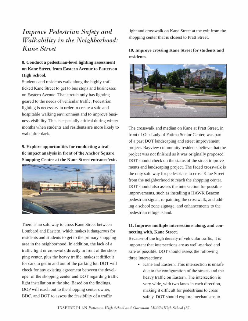
9. Explore opportunities for conducting a traf-fic impact analysis in front of the Anchor Square Shopping Center at the Kane Street entrance/exit.
There is no safe way to cross Kane Street between Lombard and Eastern, which makes it dangerous for residents and students to get to the primary shopping area in the neighborhood. In addition, the lack of a traffic light or crosswalk directly in front of the shop-ping center, plus the heavy traffic, makes it difficult for cars to get in and out of the parking lot. DOT will check for any existing agreement between the devel-oper of the shopping center and DOT regarding traffic light installation at the site. Based on the findings, DOP will reach out to the shopping center owner, BDC, and DOT to assess the feasibility of a traffic
light and crosswalk on Kane Street at the exit from the shopping center that is closest to Pratt Street.
10. Improve crossing Kane Street for students and residents.
The crosswalk and median on Kane at Pratt Street, in front of Our Lady of Fatima Senior Center, was part of a past DOT landscaping and street improvement project. Bayview community residents believe that the project was not finished as it was originally proposed. DOT should check on the status of the street improve-ments and landscaping project. The faded crosswalk is the only safe way for pedestrians to cross Kane Street from the neighborhood to reach the shopping center. DOT should also assess the intersection for possible improvements, such as installing a HAWK Beacon pedestrian signal, re-painting the crosswalk, and add-ing a school zone signage, and enhancements to the pedestrian refuge island.
11. Improve multiple intersections along, and con-necting with, Kane Street.Because of the high density of vehicular traffic, it is important that intersections are as well-marked and safe as possible. DOT should assess the following three intersections:
• Kane and Eastern: This intersection is unsafe due to the configuration of the streets and the heavy traffic on Eastern. The intersection is very wide, with two lanes in each direction, making it difficult for pedestrians to cross safely. DOT should explore mechanisms to

INSPIRE PLAN Patterson High School and Claremont Middle/High School (36)
provide a safer pedestrian experience, such as re-painting the crosswalks, assessing the pedestrian signals for sufficient lead time for students and residents to cross, and other improvements.
• Kane and Lombard: This intersection pres-ents the most challenges for pedestrians. Thisis a highly trafficked three-way, multi-laneintersection with complex signal phasing formotorists, but with no traffic control devicesfor pedestrians. DOT should explore pedes-trian safety mechanisms.
• Kane and North Point Boulevard: There iscurrently no crosswalk at this intersection andno sidewalk that leads to it past the inter-section of Kane and Lombard streets. DOTshould assess the feasibility of future pedestri-an improvements for the pedestrian walkwayand the intersection.
Improve Pedestrian Safety and Walkability in the Neighborhood: Beyond Kane Street
12. Add a crosswalk in front of the playground inQuinton Street Park.The Quinton Street Park is well-used by Eastwoodcommunity residents. The playground is located at thesouthern edge of the park on Quinton Street, wherethere is currently no safe way for children and parentsto cross the street into the neighborhood. Residentsclaim that they often witness children running across
the road from the playground into the neighborhood. DOT should assess the feasibility of a crosswalk at this location.
13. Assess Lombard and Bank streets for sidewalkupgrades and accessibility, and for enabling bicycleconnections.The community has identified the sidewalk on Lom-bard Street, from the intersection of Lombard withKane Street to Bayview Boulevard, as being in heavydisrepair with broken slabs and narrow width. DOTshould evaluate the sidewalk to determine the pos-sibility of including improvements in a future pavingseason. Because it is less congested than Eastern Av-enue, Lombard Street should be evaluated for a com-plete streets initiative to accommodate diverse modes,such as walking, biking, public transit and automobile.Bank Street should be evaluated for a bike route toconnect residents to the shopping center and school.
Assess the Use and Safety on and near the Pedestrian Bridge
14. Conduct a study to assess use of the pedestrianbridge and determine what safety improvementsshould be made.A pedestrian bridge located across from the highschool, is the only pedestrian connection betweenBayview and Eastwood, apart from the highly-traf-ficked Eastern Avenue to the south. Residents notethat it is used by the high school students but notoften by residents of the communities. The bridge,
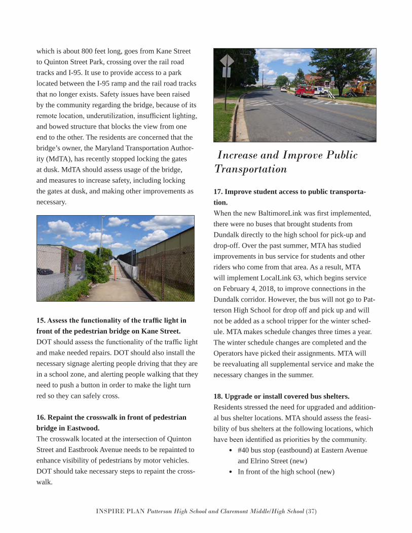
INSPIRE PLAN Patterson High School and Claremont Middle/High School (37)
which is about 800 feet long, goes from Kane Street to Quinton Street Park, crossing over the rail road tracks and I-95. It use to provide access to a park located between the I-95 ramp and the rail road tracks that no longer exists. Safety issues have been raised by the community regarding the bridge, because of its remote location, underutilization, insufficient lighting, and bowed structure that blocks the view from one end to the other. The residents are concerned that the bridge’s owner, the Maryland Transportation Author-ity (MdTA), has recently stopped locking the gates at dusk. MdTA should assess usage of the bridge, and measures to increase safety, including locking the gates at dusk, and making other improvements as necessary.
15. Assess the functionality of the traffic light infront of the pedestrian bridge on Kane Street.DOT should assess the functionality of the traffic lightand make needed repairs. DOT should also install thenecessary signage alerting people driving that they arein a school zone, and alerting people walking that theyneed to push a button in order to make the light turnred so they can safely cross.
16. Repaint the crosswalk in front of pedestrianbridge in Eastwood.The crosswalk located at the intersection of QuintonStreet and Eastbrook Avenue needs to be repainted toenhance visibility of pedestrians by motor vehicles.DOT should take necessary steps to repaint the cross-walk.
Increase and Improve Public Transportation
17. Improve student access to public transporta-tion.When the new BaltimoreLink was first implemented,there were no buses that brought students fromDundalk directly to the high school for pick-up anddrop-off. Over the past summer, MTA has studiedimprovements in bus service for students and otherriders who come from that area. As a result, MTAwill implement LocalLink 63, which begins serviceon February 4, 2018, to improve connections in theDundalk corridor. However, the bus will not go to Pat-terson High School for drop off and pick up and willnot be added as a school tripper for the winter sched-ule. MTA makes schedule changes three times a year.The winter schedule changes are completed and theOperators have picked their assignments. MTA willbe reevaluating all supplemental service and make thenecessary changes in the summer.
18. Upgrade or install covered bus shelters.Residents stressed the need for upgraded and addition-al bus shelter locations. MTA should assess the feasi-bility of bus shelters at the following locations, whichhave been identified as priorities by the community.
• #40 bus stop (eastbound) at Eastern Avenueand Elrino Street (new)
• In front of the high school (new)
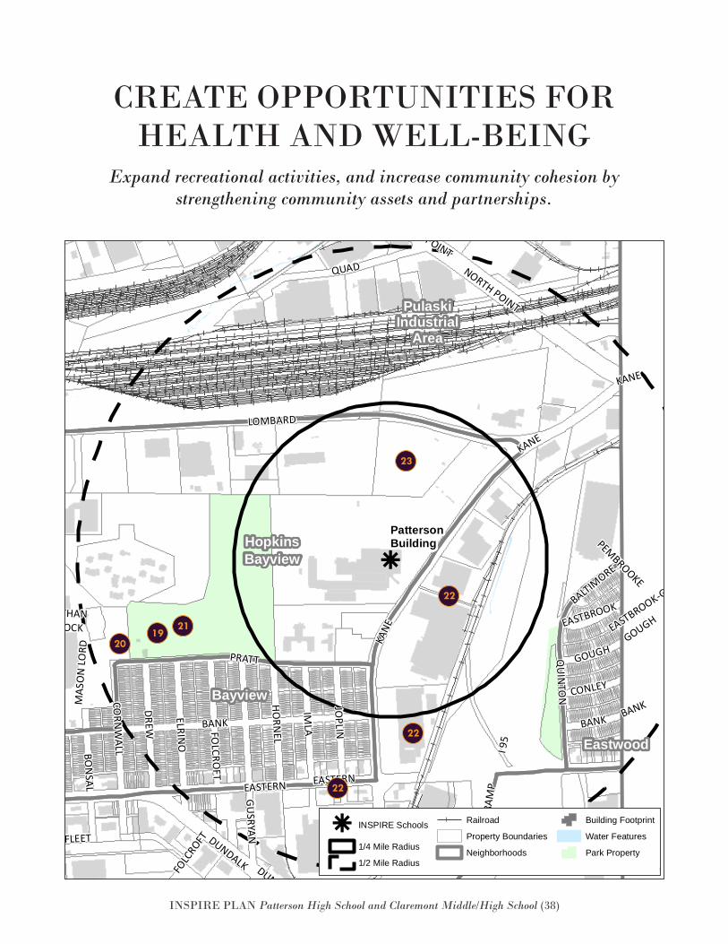
INSPIRE PLAN Patterson High School and Claremont Middle/High School (38)
Expand recreational activities, and increase community cohesion by strengthening community assets and partnerships.
CREATE OPPORTUNITIES FOR HEALTH AND WELL-BEING
k
Eastwood
GracelandPark
Greektown
HopkinsBayview
Bayview
PulaskiIndustrial
Area
BALTIMORE
PEMBROOKE
KANE
KANE EASTBROOK-GOUGH
GUSRYAN
ELRINO
QUAD
QUAD
ANGLESEA
FOLC
ROFT
QUIN
TON
KANE
DUNDALK
MAS
ON
LORD
ERDMANQUADDEBELIUS
EASTERN
BANK
PRATT
JOPLIN
RAM
P
IMLA
FAIT
BON
SAL
HUDSON
BANK
FLEET
ERDMANO
GDEN
EASTERN
FOLCRO
FT
DREW
NATHANSHOCK
GOUGH
GRACELAND
CORN
WALL
NORTH POINT
O'DONNELL
HORN
EL
GRACELAND
ERDMAN
BANK
I 95
CONLEY
DUNDALK
BUSHEY
GOUGH
EASTBROOK
HUDSON
I 95
NORTH POINT
LOMBARD
PattersonBuilding
k INSPIRE Schools
1/4 Mile Radius
1/2 Mile Radius
Railroad
Property Boundaries
Neighborhoods
Building Footprint
Water Features
Park PropertyDate: 9/27/2016
PattersonBuildingINSPIRE
k
Eastwood
GracelandPark
Greektown
HopkinsBayview
Bayview
PulaskiIndustrial
Area
BALTIMORE
PEMBROOKE
KANE
KANE EASTBROOK-GOUGH
GUSRYAN
ELRINO
QUAD
QUAD
ANGLESEA
FOLC
ROFT
QUIN
TON
KANE
DUNDALK
MAS
ON
LORD
ERDMANQUADDEBELIUS
EASTERN
BANK
PRATT
JOPLIN
RAM
PIM
LA
FAIT
BON
SAL
HUDSON
BANK
FLEET
ERDMAN
OGDEN
EASTERN
FOLCRO
FT
DREW
NATHANSHOCK
GOUGH
GRACELAND
CORN
WALL
NORTH POINT
O'DONNELL
HORN
EL
GRACELAND
ERDMAN
BANK
I95
CONLEY
DUNDALK
BUSHEY
GOUGH
EASTBROOK
HUDSON
I95
NORTH POINT
LOMBARD
PattersonBuilding
k INSPIRE Schools
1/4 Mile Radius
1/2 Mile Radius
Railroad
Property Boundaries
Neighborhoods
Building Footprint
Water Features
Park PropertyDate: 9/27/2016
PattersonBuildingINSPIRE
23
22
22
22
21
2019
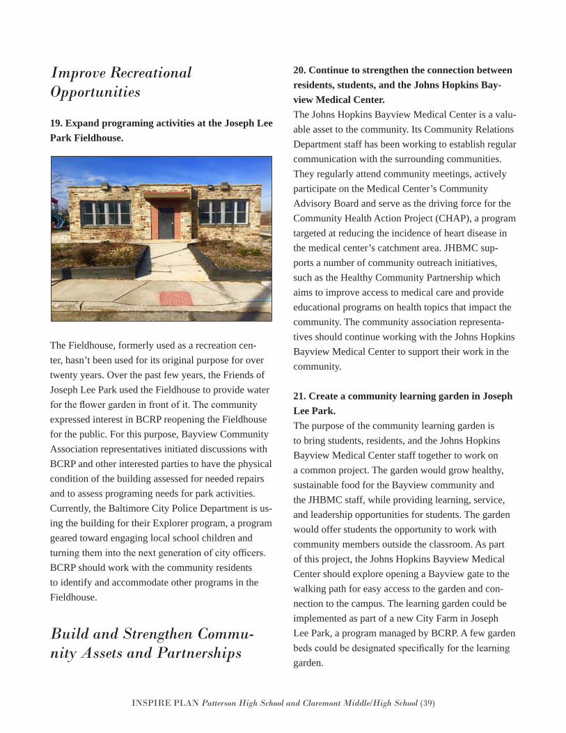
INSPIRE PLAN Patterson High School and Claremont Middle/High School (39)
Improve Recreational Opportunities
19. Expand programing activities at the Joseph LeePark Fieldhouse.
The Fieldhouse, formerly used as a recreation cen-ter, hasn’t been used for its original purpose for over twenty years. Over the past few years, the Friends of Joseph Lee Park used the Fieldhouse to provide water for the flower garden in front of it. The community expressed interest in BCRP reopening the Fieldhouse for the public. For this purpose, Bayview Community Association representatives initiated discussions with BCRP and other interested parties to have the physical condition of the building assessed for needed repairs and to assess programing needs for park activities. Currently, the Baltimore City Police Department is us-ing the building for their Explorer program, a program geared toward engaging local school children and turning them into the next generation of city officers. BCRP should work with the community residents to identify and accommodate other programs in the Fieldhouse.
Build and Strengthen Commu-nity Assets and Partnerships
20. Continue to strengthen the connection betweenresidents, students, and the Johns Hopkins Bay-view Medical Center.The Johns Hopkins Bayview Medical Center is a valu-able asset to the community. Its Community RelationsDepartment staff has been working to establish regularcommunication with the surrounding communities.They regularly attend community meetings, activelyparticipate on the Medical Center’s CommunityAdvisory Board and serve as the driving force for theCommunity Health Action Project (CHAP), a programtargeted at reducing the incidence of heart disease inthe medical center’s catchment area. JHBMC sup-ports a number of community outreach initiatives,such as the Healthy Community Partnership whichaims to improve access to medical care and provideeducational programs on health topics that impact thecommunity. The community association representa-tives should continue working with the Johns HopkinsBayview Medical Center to support their work in thecommunity.
21. Create a community learning garden in JosephLee Park.The purpose of the community learning garden isto bring students, residents, and the Johns HopkinsBayview Medical Center staff together to work ona common project. The garden would grow healthy,sustainable food for the Bayview community andthe JHBMC staff, while providing learning, service,and leadership opportunities for students. The gardenwould offer students the opportunity to work withcommunity members outside the classroom. As partof this project, the Johns Hopkins Bayview MedicalCenter should explore opening a Bayview gate to thewalking path for easy access to the garden and con-nection to the campus. The learning garden could beimplemented as part of a new City Farm in JosephLee Park, a program managed by BCRP. A few gardenbeds could be designated specifically for the learninggarden.
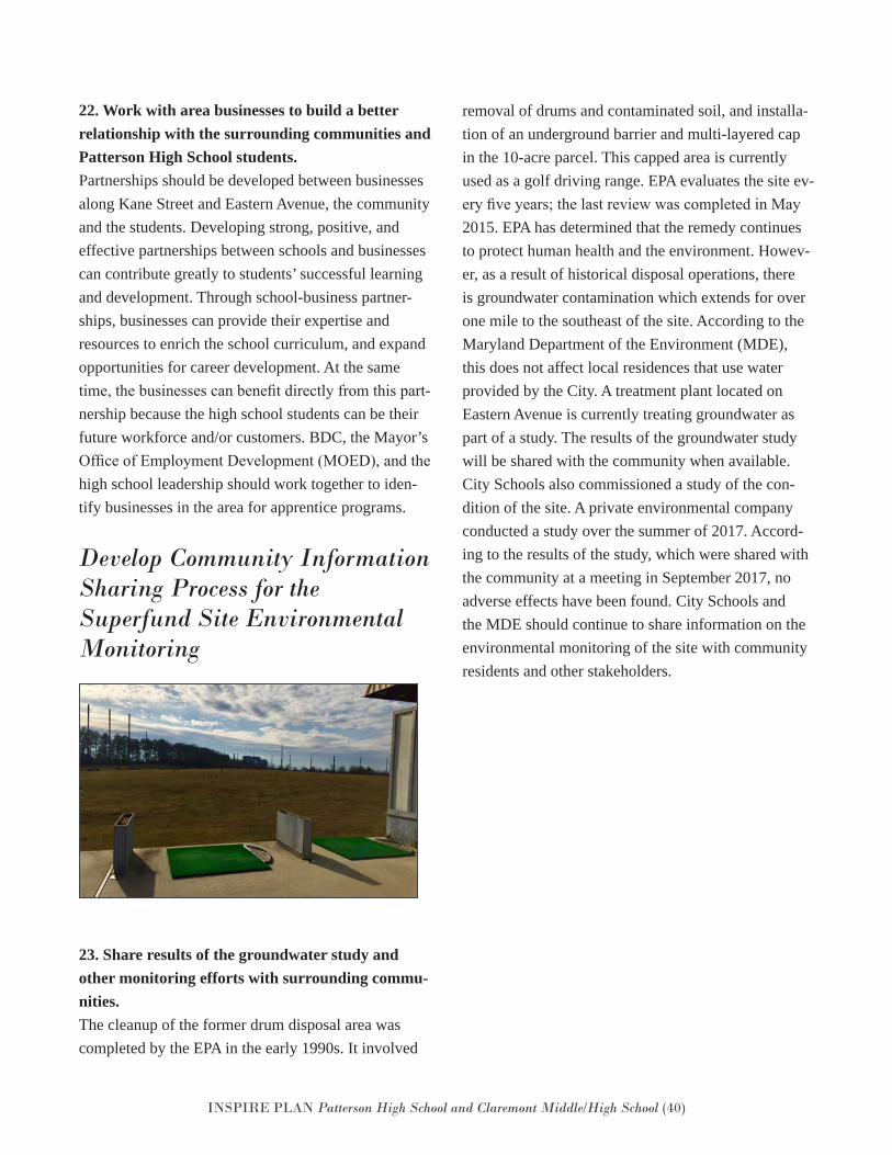
INSPIRE PLAN Patterson High School and Claremont Middle/High School (40)
22. Work with area businesses to build a betterrelationship with the surrounding communities andPatterson High School students.Partnerships should be developed between businessesalong Kane Street and Eastern Avenue, the communityand the students. Developing strong, positive, andeffective partnerships between schools and businessescan contribute greatly to students’ successful learningand development. Through school-business partner-ships, businesses can provide their expertise andresources to enrich the school curriculum, and expandopportunities for career development. At the sametime, the businesses can benefit directly from this part-nership because the high school students can be theirfuture workforce and/or customers. BDC, the Mayor’sOffice of Employment Development (MOED), and thehigh school leadership should work together to iden-tify businesses in the area for apprentice programs.
Develop Community Information Sharing Process for the Superfund Site Environmental Monitoring
23. Share results of the groundwater study andother monitoring efforts with surrounding commu-nities.The cleanup of the former drum disposal area wascompleted by the EPA in the early 1990s. It involved
removal of drums and contaminated soil, and installa-tion of an underground barrier and multi-layered cap in the 10-acre parcel. This capped area is currently used as a golf driving range. EPA evaluates the site ev-ery five years; the last review was completed in May 2015. EPA has determined that the remedy continues to protect human health and the environment. Howev-er, as a result of historical disposal operations, there is groundwater contamination which extends for over one mile to the southeast of the site. According to the Maryland Department of the Environment (MDE), this does not affect local residences that use water provided by the City. A treatment plant located on Eastern Avenue is currently treating groundwater as part of a study. The results of the groundwater study will be shared with the community when available. City Schools also commissioned a study of the con-dition of the site. A private environmental company conducted a study over the summer of 2017. Accord-ing to the results of the study, which were shared with the community at a meeting in September 2017, no adverse effects have been found. City Schools and the MDE should continue to share information on the environmental monitoring of the site with community residents and other stakeholders.
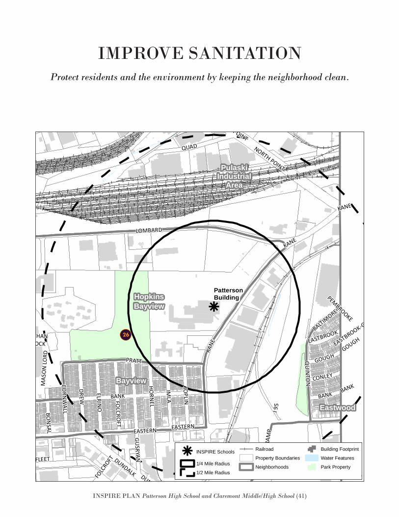
INSPIRE PLAN Patterson High School and Claremont Middle/High School (41)
Protect residents and the environment by keeping the neighborhood clean.
IMPROVE SANITATION
k
Eastwood
GracelandPark
Greektown
HopkinsBayview
Bayview
PulaskiIndustrial
Area
BALTIMORE
PEMBROOKE
KANE
KANE EASTBROOK-GOUGH
GUSRYAN
ELRINO
QUAD
QUAD
ANGLESEA
FOLC
ROFT
QUIN
TON
KANE
DUNDALK
MAS
ON
LORD
ERDMANQUADDEBELIUS
EASTERN
BANK
PRATT
JOPLIN
RAM
P
IMLA
FAIT
BON
SAL
HUDSON
BANK
FLEET
ERDMANO
GDEN
EASTERN
FOLCRO
FT
DREW
NATHANSHOCK
GOUGH
GRACELAND
CORN
WALL
NORTH POINT
O'DONNELL
HORN
EL
GRACELAND
ERDMAN
BANK
I 95
CONLEY
DUNDALK
BUSHEY
GOUGH
EASTBROOK
HUDSON
I 95
NORTH POINT
LOMBARD
PattersonBuilding
k INSPIRE Schools
1/4 Mile Radius
1/2 Mile Radius
Railroad
Property Boundaries
Neighborhoods
Building Footprint
Water Features
Park PropertyDate: 9/27/2016
PattersonBuildingINSPIRE
k
Eastwood
GracelandPark
Greektown
HopkinsBayview
Bayview
PulaskiIndustrial
Area
BALTIMORE
PEMBROOKE
KANE
KANE EASTBROOK-GOUGH
GUSRYAN
ELRINO
QUAD
QUAD
ANGLESEA
FOLC
ROFT
QUIN
TON
KANE
DUNDALK
MAS
ON
LORD
ERDMANQUADDEBELIUS
EASTERN
BANK
PRATT
JOPLIN
RAM
PIM
LA
FAIT
BON
SAL
HUDSON
BANK
FLEET
ERDMAN
OGDEN
EASTERN
FOLCRO
FT
DREW
NATHANSHOCK
GOUGH
GRACELAND
CORN
WALL
NORTH POINT
O'DONNELL
HORN
EL
GRACELAND
ERDMAN
BANK
I95
CONLEY
DUNDALK
BUSHEY
GOUGH
EASTBROOK
HUDSON
I95
NORTH POINT
LOMBARD
PattersonBuilding
k INSPIRE Schools
1/4 Mile Radius
1/2 Mile Radius
Railroad
Property Boundaries
Neighborhoods
Building Footprint
Water Features
Park PropertyDate: 9/27/2016
PattersonBuildingINSPIRE
26
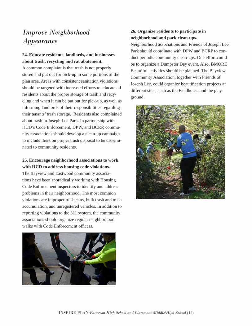
INSPIRE PLAN Patterson High School and Claremont Middle/High School (42)
Improve Neighborhood Appearance
24. Educate residents, landlords, and businessesabout trash, recycling and rat abatement.A common complaint is that trash is not properlystored and put out for pick-up in some portions of theplan area. Areas with consistent sanitation violationsshould be targeted with increased efforts to educate allresidents about the proper storage of trash and recy-cling and when it can be put out for pick-up, as well asinforming landlords of their responsibilities regardingtheir tenants’ trash storage. Residents also complainedabout trash in Joseph Lee Park. In partnership withHCD’s Code Enforcement, DPW, and BCRP, commu-nity associations should develop a clean-up campaignto include fliers on proper trash disposal to be dissemi-nated to community residents.
25. Encourage neighborhood associations to workwith HCD to address housing code violations.The Bayview and Eastwood community associa-tions have been sporadically working with HousingCode Enforcement inspectors to identify and addressproblems in their neighborhood. The most commonviolations are improper trash cans, bulk trash and trashaccumulation, and unregistered vehicles. In addition toreporting violations to the 311 system, the communityassociations should organize regular neighborhoodwalks with Code Enforcement officers.
26. Organize residents to participate inneighborhood and park clean-ups.Neighborhood associations and Friends of Joseph LeePark should coordinate with DPW and BCRP to con-duct periodic community clean-ups. One effort couldbe to organize a Dumpster Day event. Also, BMOREBeautiful activities should be planned. The BayviewCommunity Association, together with Friends ofJoseph Lee, could organize beautification projects atdifferent sites, such as the Fieldhouse and the play-ground.
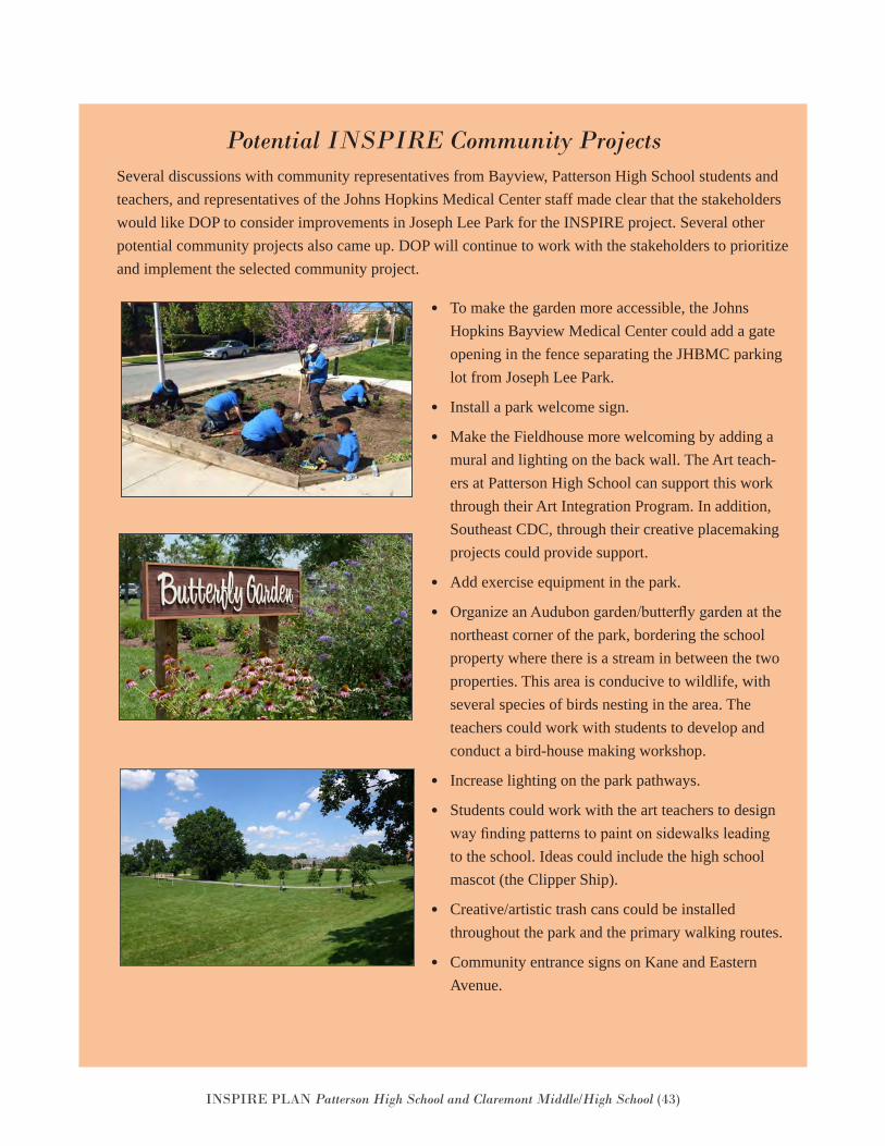
INSPIRE PLAN Patterson High School and Claremont Middle/High School (43)
Several discussions with community representatives from Bayview, Patterson High School students and teachers, and representatives of the Johns Hopkins Medical Center staff made clear that the stakeholders would like DOP to consider improvements in Joseph Lee Park for the INSPIRE project. Several other potential community projects also came up. DOP will continue to work with the stakeholders to prioritize and implement the selected community project.
Potential INSPIRE Community Projects
• To make the garden more accessible, the JohnsHopkins Bayview Medical Center could add a gateopening in the fence separating the JHBMC parkinglot from Joseph Lee Park.
• Install a park welcome sign.
• Make the Fieldhouse more welcoming by adding amural and lighting on the back wall. The Art teach-ers at Patterson High School can support this workthrough their Art Integration Program. In addition,Southeast CDC, through their creative placemakingprojects could provide support.
• Add exercise equipment in the park.
• Organize an Audubon garden/butterfly garden at thenortheast corner of the park, bordering the schoolproperty where there is a stream in between the twoproperties. This area is conducive to wildlife, withseveral species of birds nesting in the area. Theteachers could work with students to develop andconduct a bird-house making workshop.
• Increase lighting on the park pathways.
• Students could work with the art teachers to designway finding patterns to paint on sidewalks leadingto the school. Ideas could include the high schoolmascot (the Clipper Ship).
• Creative/artistic trash cans could be installedthroughout the park and the primary walking routes.
• Community entrance signs on Kane and EasternAvenue.
INSPIRE PLAN Patterson High School and Claremont Middle/High School (44)
INSPIRE plans are already beginning to be implemented. Although not
everything can happen right away, the Department of Planning is commit-
ted to continuing to work with community members to see recommendations
become reality.
The Department of Planning, community stakeholders, and others should con-
tinuously refer to this section to hold each other accountable. This section:
• Sets forth a desired time frame for implementation
• Identifies lead and support agencies/organizations
• Estimates the cost of implementation and identified or potential
funding sources
• Identifies commitments already made
As part of completing the plan, City agencies have already made some
funding and staffing commitments. Complete implementation however, will
require more resources.
We believe that the significant investment in Patterson High School and Cla-
remont Middle/High School, in addition to the commitments represented in
these tables, can encourage additional resources
Plan Implementation
TimeframeShort: 0-2 yearsMedium: 3-5 yearsLong: 5+ years
Estimated Cost of Improvements$ = Less than $5,000$$ = $5,001-$50,000$$$ = $50,001-$250,000$$$$ = $250,001 - $500,000$$$$$ = More than $500,000Lead Responsibility
Baltimore City AgenciesBCRP: Recreation and ParksBCPD: Police DepartmentDOP: Department of PlanningDOT: Department of TransportationDPW: Department of Public WorksHCD: Housing and Community DevelopmentBDC: Baltimore Development CorporationMOED: Mayor’s Office of Employment Development
OtherCBO: Community-Based OrganizationPrivate: Philanthropy, anchor institutions, investors, etc.Community: Residents, groups, businesses, etc.
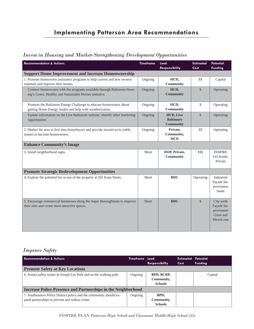
INSPIRE PLAN Patterson High School and Claremont Middle/High School (45)
Implementing Patterson Area Recommendations
Recommendation & Actions Timeframe LeadResponsibility
EstimatedCost
Potential Funding
Support Home Improvement and Increase Homeownership 1. Promote homeowner assistance programs to help current and new owners maintain and improve their homes.
Ongoing HCD,Community
$$ Capital
Connect homeowners with the programs available through Baltimore Hous-ing’s Green, Healthy and Sustainable Homes initiative.
Ongoing HCD,Community
$ Operating
Promote the Baltimore Energy Challenge to educate homeowners about getting Home Energy Audits and help with weatherization.
Ongoing HCD,Community
$ Operating
Update information on the Live Baltimore website; identify other marketing opportunities
Ongoing HCD, Live Baltimore
Community
$ Operating
2. Market the area to first time homebuyers and provide incentives to stable renters to become homeowners.
Ongoing Private,Community,
HCD
$$ Operating
Enhance Community’s Image
3. Install neighborhood signs. Short DOP, Private,Community
$$$ INSPIRE GO bonds,
Private
Promote Strategic Redevelopment Opportunities4. Explore the potential for re-use of the property at 201 Kane Street. Short BDC Operating Industrial
Façade Im-provement
funds
5. Encourage commercial businesses along the major thoroughfares to improve their sites and create more attractive spaces.
Short BDC $ City-wide Façade Im-provement Grant and
MicroLoan
Invest in Housing and Market-Strengthening Development Opportunities
Recommendation & Actions Timeframe LeadResponsibility
EstimatedCost
Potential Funding
Promote Safety at Key Locations6. Assess safety issues in Joseph Lee Park and on the walking path. Ongoing BPD, BCRP,
Community,Schools
Capital
Increase Police Presence and Partnerships in the Neighborhood7. Southeastern Police District police and the community should ex-pand partnerships to prevent and reduce crime.
Ongoing BPD, Community,
Schools
Improve Safety
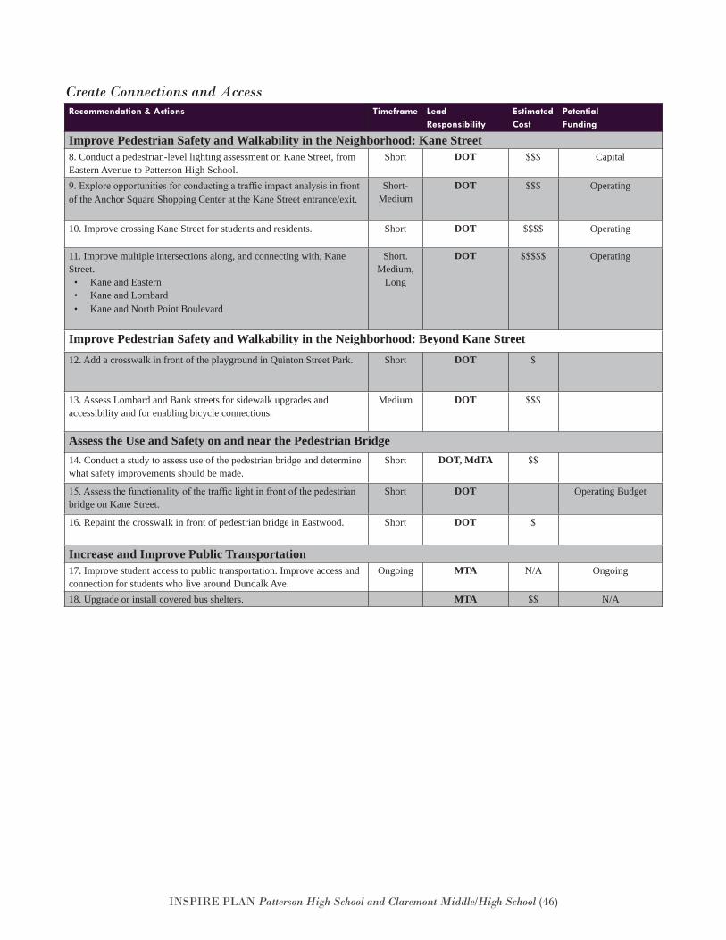
INSPIRE PLAN Patterson High School and Claremont Middle/High School (46)
Recommendation & Actions Timeframe LeadResponsibility
EstimatedCost
Potential Funding
Improve Pedestrian Safety and Walkability in the Neighborhood: Kane Street8. Conduct a pedestrian-level lighting assessment on Kane Street, from Eastern Avenue to Patterson High School.
Short DOT $$$ Capital
9. Explore opportunities for conducting a traffic impact analysis in front of the Anchor Square Shopping Center at the Kane Street entrance/exit.
Short-Medium
DOT $$$ Operating
10. Improve crossing Kane Street for students and residents. Short DOT $$$$ Operating
11. Improve multiple intersections along, and connecting with, Kane Street.
• Kane and Eastern• Kane and Lombard• Kane and North Point Boulevard
Short.Medium,
Long
DOT $$$$$ Operating
Improve Pedestrian Safety and Walkability in the Neighborhood: Beyond Kane Street12. Add a crosswalk in front of the playground in Quinton Street Park. Short DOT $
13. Assess Lombard and Bank streets for sidewalk upgrades and accessibility and for enabling bicycle connections.
Medium DOT $$$
Assess the Use and Safety on and near the Pedestrian Bridge14. Conduct a study to assess use of the pedestrian bridge and determine what safety improvements should be made.
Short DOT, MdTA $$
15. Assess the functionality of the traffic light in front of the pedestrian bridge on Kane Street.
Short DOT Operating Budget
16. Repaint the crosswalk in front of pedestrian bridge in Eastwood. Short DOT $
Increase and Improve Public Transportation17. Improve student access to public transportation. Improve access and connection for students who live around Dundalk Ave.
Ongoing MTA N/A Ongoing
18. Upgrade or install covered bus shelters. MTA $$ N/A
Create Connections and Access
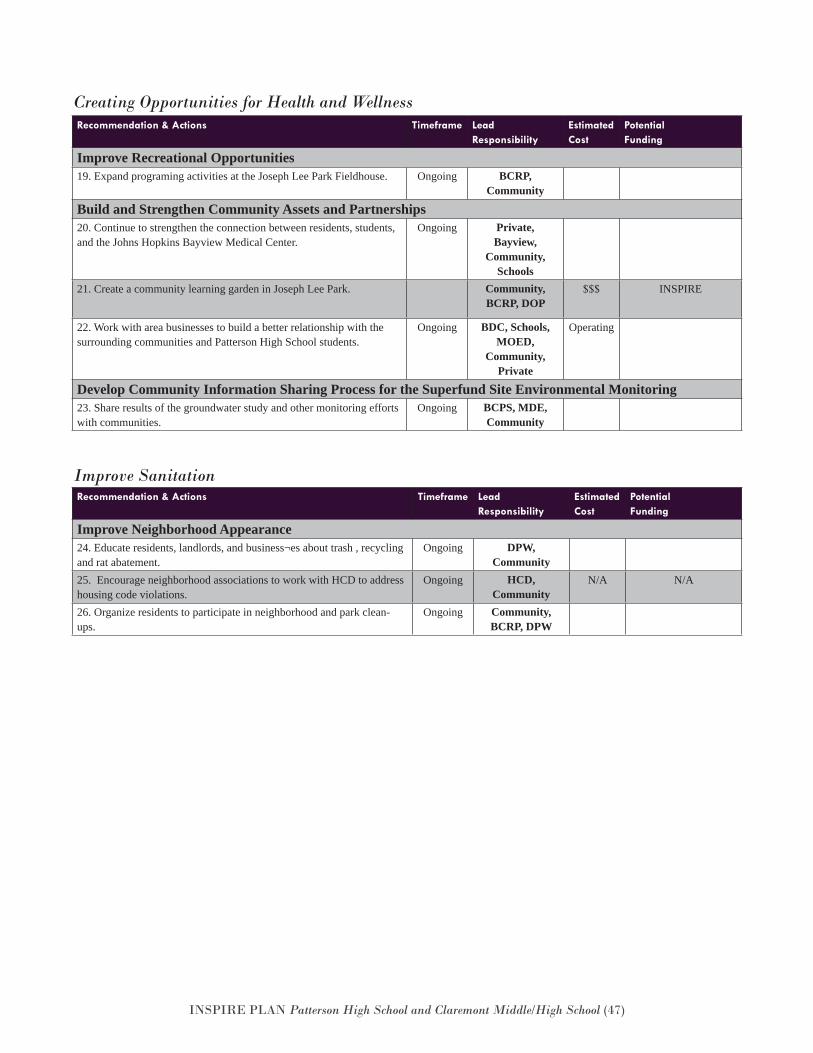
INSPIRE PLAN Patterson High School and Claremont Middle/High School (47)
Recommendation & Actions Timeframe LeadResponsibility
EstimatedCost
Potential Funding
Improve Neighborhood Appearance 24. Educate residents, landlords, and business¬es about trash , recycling and rat abatement.
Ongoing DPW, Community
25. Encourage neighborhood associations to work with HCD to address housing code violations.
Ongoing HCD, Community
N/A N/A
26. Organize residents to participate in neighborhood and park clean-ups.
Ongoing Community, BCRP, DPW
Improve Sanitation
Recommendation & Actions Timeframe LeadResponsibility
EstimatedCost
Potential Funding
Improve Recreational Opportunities19. Expand programing activities at the Joseph Lee Park Fieldhouse. Ongoing BCRP,
Community
Build and Strengthen Community Assets and Partnerships20. Continue to strengthen the connection between residents, students, and the Johns Hopkins Bayview Medical Center.
Ongoing Private,Bayview,
Community,Schools
21. Create a community learning garden in Joseph Lee Park. Community,BCRP, DOP
$$$ INSPIRE
22. Work with area businesses to build a better relationship with the surrounding communities and Patterson High School students.
Ongoing BDC, Schools, MOED,
Community, Private
Operating
Develop Community Information Sharing Process for the Superfund Site Environmental Monitoring23. Share results of the groundwater study and other monitoring efforts with communities.
Ongoing BCPS, MDE, Community
Creating Opportunities for Health and Wellness
INSPIRE PLAN Patterson High School and Claremont Middle/High School (48)
Appendix A: Maps
Zoning
Housing Market Typology
Food Environment
Part 1 Crime Incidents
Students – Patterson High School Students
BaltimoreLink Map
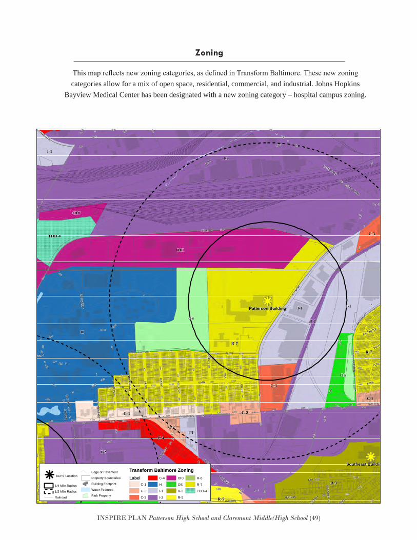
INSPIRE PLAN Patterson High School and Claremont Middle/High School (49)
This map reflects new zoning categories, as defined in Transform Baltimore. These new zoning categories allow for a mix of open space, residential, commercial, and industrial. Johns Hopkins
Bayview Medical Center has been designated with a new zoning category – hospital campus zoning.
Zoning
k
k
k
k
k
k
k
k
k
k
k
kk
k
k
k
k
k
kk
kk
k
k
k
k
k
k
k
k
k
k
k
k
k
k
kk
kk
k
k
kk
k
k
k
k
k
k k
k
k
k
k
k
k
k
k
k
k
kk
k
k
k
k
kk
k
kk
k
k
k
k
k
k
k
kk
k
k
k
k
k
k
kk
k
k
k
k
kk
k
k
k
k
k
k
k
k
k
k
k
k
k
k
k
k
k
k
k
k
k
k
k
k
k
k
k
k
k
k
k
k
k
kkk
k
k
kk
k
k
k
k
k
k
k
k
k
k
k
k
k
k
k
k
k
k
k
k
k
k
kkk
k
k
k
k
k
kk
k
k
k
k
k
k
k
k
kk
k
k
k
k
k
k
k
k
k
k
k
k
k
k
k
k
k
k
k
k
k
k
kk
k
k
k
k
k
kk
kk
k
k
k
k
k
k
k
k
k
k
k
k
k
k
kk
kk
k
k
kk
k
k
k
k
k
k k
k
k
k
k
k
k
k
k
k
k
kk
k
k
k
k
kk
k
kk
k
k
k
k
k
k
k
kk
k
k
k
k
k
k
kk
k
k
k
k
kk
k
k
k
k
k
k
k
k
k
k
k
k
k
k
k
k
k
k
k
k
k
k
k
k
k
k
k
k
k
k
k
k
k
kkk
k
k
kk
k
k
k
k
k
k
k
k
k
k
k
k
k
k
k
k
k
k
k
k
k
k
kkk
k
k
k
k
k
kk
k
k
k
k
k
k
k
k
kk
k
k
k
k
k
k
k
k
k
k
k
I-2
H
I-2
R-7
I-1
OIC
R-3
I-1
OS
R-7
OS
OS
C-4
C-4
I-1
C-1
R-7
C-3
I-1R-5
TOD-4
R-6
C-2
I-1
OIC
C-3
C-2
C-2
C-3C-2
I-2
R-6
Patterson Building
Southeast Building
-9
05700
100
300
6700
500
6500
6300
6600
5400
600
6200
5500
6800
700
800
6400
200
5600
400
5200
5900
900
5800
6000
5300
6100-9
-9
600
400
6000
5700
-9
6300
5900
5400
5700
-9
5300
5300
-9
6100300
6600
6000
200
62006300
800
6200
600
-9
5700
300
6600
700
6700
-9
5500
-9
100
-9
5900
6300
6600
100
6000
6700
300
400
-9
6600
6200
300
-9
5500
-9
-9
-9
-9
6000
500
5500
5800
6800
-9
-9
-9
600
5800
100
800
6700
800
200
300
6200
6400
400
-9
300
400
500
6000
66006500
400
300
700
5400
400
6700
400
6300
-9
6800
5500
-9
300
6400
-9
6000
300
300
300
6700
-9
-9
300
6400
-9
5900
-9
5400
700
-9
400
6300
6400
6400
6800
-9
700
600
-9
900
6700
-9
400
300
400
5500
900
0
5900
68005800
5500
900
6100
6200
-9
900
6500
300
6300
100
500
800
6300
6700
-9
6500
-9
400
5400
800
-9
600
5300
5800
800 6600
800
6800
6800
400
300
5700
5800
5900
-9
5900
5900
-9
67006800
-9
-9
500
6300 800
6700
6500
400
-9
5700
300
5400
6600
5600
5700
600
300
6500800
-9
6400
5800
I 95
KANE
EASTERN
I 895
LOMBARD
PRATT
ERDMAN
FAIT
GUSRYAN
DUNDALK
QUAD
PULASKI
IMLA
UM
BRA
BAYVIEW
NORTH POINT
HUDSON
ELRINO
DREW
JOPLIN
QU
INTO
N
BON
SAL
HORN
EL
FOLCRO
FT
CORN
WALL
DEBELIUS
BANK
ALRICKS
O'DONNELL
BIOSCIEN
CE
OG
DEN
GOUGH
CONLEY
ANG
LESEA
BUSHEY
BALTIM
ORE
EASTBROOK
RAMPPULASKI
HUDSON
I 95
FOLC
ROFT
QUAD
NORTH POINTNORTH POINT
BANK
DUNDALK
EASTERN
ERDMAN
BAYVIEW
ERDMAN
I 895
k BCPS Location
1/4 Mile Radius
1/2 Mile Radius
Railroad
Edge of Pavement
Property Boundaries
Building Footprint
Water Features
Park PropertyDate: 2/14/2018
INSPIRE: Investing in Neighborhoods & Schools to Promote Improvement, Revitalization, and Excellence
Transform Baltimore ZoningLabel
C-1
C-2
C-3
C-4
H
I-1
I-2
OIC
OS
R-3
R-5
R-6
R-7
# # # # # # # # # # # # #
# # # # # # # # # # # # #
# # # # # # # # # # # # #
# # # # # # # # # # # # #
# # # # # # # # # # # # #
# # # # # # # # # # # # #
# # # # # # # # # # # # #
TOD-4
Patterson HS100 Kane StreetBuilding # 405Program # 405
k
k
k
k
k
k
k
k
k
k
k
kk
k
k
k
k
k
kk
kk
k
k
k
k
k
k
k
k
k
k
k
k
k
k
kk
kk
k
k
kk
k
k
k
k
k
k k
k
k
k
k
k
k
k
k
k
k
kk
k
k
k
k
kk
k
kk
k
k
k
k
k
k
k
kk
k
k
k
k
k
k
kk
k
k
k
k
kk
k
k
k
k
k
k
k
k
k
k
k
k
k
k
k
k
k
k
k
k
k
k
k
k
k
k
k
k
k
k
k
k
k
kkk
k
k
kk
k
k
k
k
k
k
k
k
k
k
k
k
k
k
k
k
k
k
k
k
k
k
kkk
k
k
k
k
k
kk
k
k
k
k
k
k
k
k
kk
k
k
k
k
k
k
k
k
k
k
k
k
k
k
k
k
k
k
k
k
k
k
kk
k
k
k
k
k
kk
kk
k
k
k
k
k
k
k
k
k
k
k
k
k
k
kk
kk
k
k
kk
k
k
k
k
k
k k
k
k
k
k
k
k
k
k
k
k
kk
k
k
k
k
kk
k
kk
k
k
k
k
k
k
k
kk
k
k
k
k
k
k
kk
k
k
k
k
kk
k
k
k
k
k
k
k
k
k
k
k
k
k
k
k
k
k
k
k
k
k
k
k
k
k
k
k
k
k
k
k
k
k
kkk
k
k
kk
k
k
k
k
k
k
k
k
k
k
k
k
k
k
k
k
k
k
k
k
k
k
kkk
k
k
k
k
k
kk
k
k
k
k
k
k
k
k
kk
k
k
k
k
k
k
k
k
k
k
k
I-2
H
I-2
R-7
I-1
OIC
R-3
I-1
OS
R-7
OS
OS
C-4
C-4
I-1
C-1
R-7
C-3
I-1R-5
TOD-4
R-6
C-2
I-1
OIC
C-3
C-2
C-2
C-3C-2
I-2
R-6
Patterson Building
Southeast Building
-9
05700
100
300
6700
500
6500
6300
6600
5400
600
6200
5500
6800
700
800
6400
200
5600
400
5200
5900
900
5800
6000
5300
6100-9
-9
600
400
6000
5700
-9
6300
5900
5400
5700
-9
5300
5300
-9
6100300
6600
6000
200
62006300
800
6200
600
-9
5700
300
6600
700
6700
-9
5500
-9
100
-9
5900
6300
6600
100
6000
6700
300
400
-9
6600
6200
300
-9
5500
-9
-9
-9
-9
6000
500
5500
5800
6800
-9
-9
-9
600
5800
100
800
6700
800
200
300
6200
6400
400
-9
300
400
500
6000
66006500
400
300
700
5400
400
6700
400
6300
-9
6800
5500
-9
300
6400
-9
6000
300
300
300
6700
-9
-9
300
6400
-9
5900
-9
5400
700
-9
400
6300
6400
6400
6800
-9
700
600
-9
900
6700
-9
400
300
400
5500
900
0
5900
68005800
5500
900
6100
6200
-9
900
6500
300
6300
100
500
800
6300
6700
-9
6500
-9
400
5400
800
-9
600
5300
5800
800 6600
800
6800
6800
400
300
5700
5800
5900
-9
5900
5900
-9
67006800
-9
-9
500
6300 800
6700
6500
400
-9
5700
300
5400
6600
5600
5700
600
300
6500800
-9
6400
5800
I 95
KANE
EASTERN
I 895
LOMBARD
PRATT
ERDMAN
FAIT
GUSRYAN
DUNDALK
QUAD
PULASKI
IMLA
UM
BRA
BAYVIEW
NORTH POINT
HUDSON
ELRINO
DREW
JOPLIN
QU
INTO
N
BON
SAL
HORN
EL
FOLCRO
FT
CORN
WALL
DEBELIUS
BANK
ALRICKS
O'DONNELL
BIOSCIEN
CE
OG
DEN
GOUGH
CONLEY
ANG
LESEA
BUSHEY
BALTIM
ORE
EASTBROOK
RAMPPULASKI
HUDSON
I 95
FOLC
ROFT
QUAD
NORTH POINT
NORTH POINT
BANK
DUNDALK
EASTERN
ERDMAN
BAYVIEW
ERDMAN
I 895
k BCPS Location
1/4 Mile Radius
1/2 Mile Radius
Railroad
Edge of Pavement
Property Boundaries
Building Footprint
Water Features
Park PropertyDate: 2/14/2018
INSPIRE: Investing in Neighborhoods & Schools to Promote Improvement, Revitalization, and Excellence
Transform Baltimore ZoningLabel
C-1
C-2
C-3
C-4
H
I-1
I-2
OIC
OS
R-3
R-5
R-6
R-7
# # # # # # # # # # # # #
# # # # # # # # # # # # #
# # # # # # # # # # # # #
# # # # # # # # # # # # #
# # # # # # # # # # # # #
# # # # # # # # # # # # #
# # # # # # # # # # # # #
TOD-4
Patterson HS100 Kane StreetBuilding # 405Program # 405
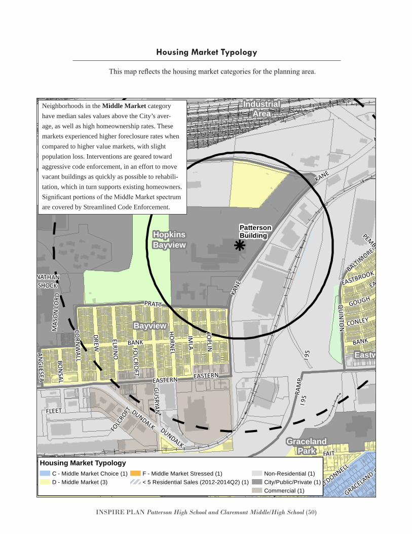
INSPIRE PLAN Patterson High School and Claremont Middle/High School (50)
Housing Market Typology
This map reflects the housing market categories for the planning area.
k
Eastwood
GracelandPark
Greektown
HopkinsBayview
Bayview
PulaskiIndustrial
Area
BALTIMORE
PEMBROOKE
KANE
KANE EASTBROOK-GOUGH
GUSRYAN
ELRINO
QUAD
QUAD
ANGLESEA
FOLC
ROFT
QUIN
TON
KANE
DUNDALK
MAS
ON
LORD
ERDMANQUADDEBELIUS
EASTERN
BANK
PRATT
JOPLIN
RAM
P
IMLA
FAIT
BON
SAL
HUDSON
BANK
FLEET
ERDMAN
OGDEN
EASTERN
FOLCRO
FT
DREW
NATHANSHOCK
GOUGH
GRACELAND
CORN
WALL
NORTH POINT
O'DONNELL
HORN
EL
GRACELAND
ERDMAN
BANK
I 95
CONLEY
DUNDALK
BUSHEY
GOUGH
EASTBROOK
HUDSON
I 95
NORTH POINT
LOMBARD
PattersonBuilding
k INSPIRE Schools
1/4 Mile Radius
1/2 Mile Radius
Railroad
Property Boundaries
Neighborhoods
Building Footprint
Water Features
Park PropertyDate: 9/27/2016
PattersonBuildingINSPIRE
Housing Market TypologyC - Middle Market Choice (1)D - Middle Market (3)
F - Middle Market Stressed (1)< 5 Residential Sales (2012-2014Q2) (1)
Non-Residential (1)City/Public/Private (1)Commercial (1)
Neighborhoods in the Middle Market category have median sales values above the City’s aver-age, as well as high homeownership rates. These markets experienced higher foreclosure rates when compared to higher value markets, with slight population loss. Interventions are geared toward aggressive code enforcement, in an effort to move vacant buildings as quickly as possible to rehabili-tation, which in turn supports existing homeowners. Significant portions of the Middle Market spectrum are covered by Streamlined Code Enforcement.
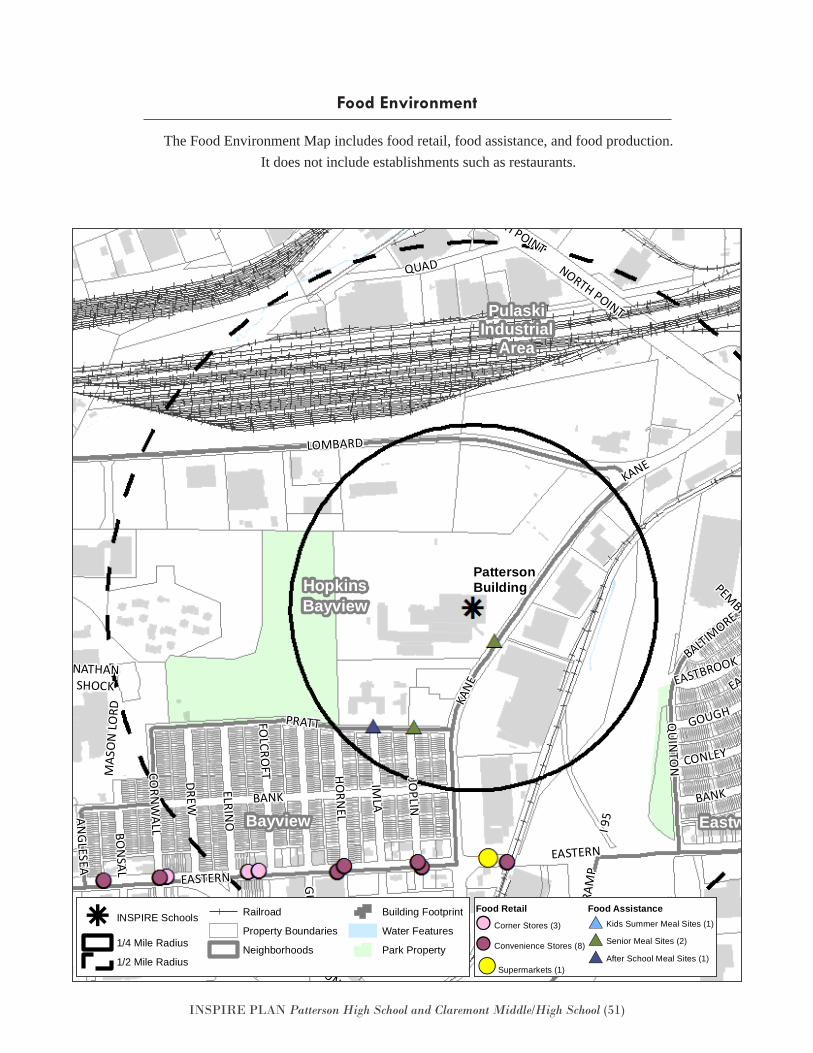
INSPIRE PLAN Patterson High School and Claremont Middle/High School (51)
The Food Environment Map includes food retail, food assistance, and food production. It does not include establishments such as restaurants.
Food Environment
Eastwood
GracelandPark
Greektown
HopkinsBayview
Bayview
PulaskiIndustrial
Area
BALTIMORE
PEMBROOKE
KANEKA
NE EASTBROOK-GOUGH
GUSRYAN
ELRINO
QUAD
QUAD
ANGLESEA
FOLC
ROFT
QUIN
TON
KANE
DUNDALK
MAS
ON
LORD
ERDMANQUADDEBELIUS
EASTERN
BANK
PRATT
JOPLIN
RAM
P
IMLA
FAIT
BON
SAL
HUDSON
BANK
FLEET
ERDMANO
GDEN
EASTERN
FOLCRO
FT
DREW
NATHANSHOCK
GOUGH
GRACELAND
CORN
WALL
NORTH POINT
O'DONNELL
HORN
EL
GRACELAND
ERDMAN
BANK
I 95
CONLEY
DUNDALK
BUSHEY
GOUGH
EASTBROOK
HUDSON
I 95
NORTH POINT
LOMBARD
PattersonBuilding
k INSPIRE Schools
1/4 Mile Radius
1/2 Mile Radius
Railroad
Property Boundaries
Neighborhoods
Building Footprint
Water Features
Park PropertyDate: 9/27/2016
PattersonBuildingINSPIRE
Food EnvironmentFood Retail
!! Corner Stores (3)
!! Convenience Stores (8)
!! Supermarkets (1)
Food Assistance
#* Kids Summer Meal Sites (1)
#* Senior Meal Sites (2)
#* After School Meal Sites (1)
Eastwood
GracelandPark
Greektown
HopkinsBayview
Bayview
PulaskiIndustrial
Area
BALTIMORE
PEMBROOKE
KANE
KANE EASTBROOK-GOUGH
GUSRYAN
ELRINO
QUAD
QUAD
ANGLESEA
FOLC
ROFT
QUIN
TON
KANE
DUNDALK
MAS
ON
LORD
ERDMANQUADDEBELIUS
EASTERN
BANK
PRATT
JOPLIN
RAM
P
IMLA
FAIT
BON
SAL
HUDSON
BANK
FLEET
ERDMAN
OGDEN
EASTERN
FOLCRO
FT
DREW
NATHANSHOCK
GOUGH
GRACELAND
CORN
WALL
NORTH POINT
O'DONNELL
HORN
EL
GRACELAND
ERDMAN
BANK
I 95
CONLEY
DUNDALK
BUSHEY
GOUGH
EASTBROOK
HUDSON
I 95
NORTH POINT
LOMBARD
PattersonBuilding
k INSPIRE Schools
1/4 Mile Radius
1/2 Mile Radius
Railroad
Property Boundaries
Neighborhoods
Building Footprint
Water Features
Park PropertyDate: 9/27/2016
PattersonBuildingINSPIRE
Food EnvironmentFood Retail
!! Corner Stores (3)
!! Convenience Stores (8)
!! Supermarkets (1)
Food Assistance
#* Kids Summer Meal Sites (1)
#* Senior Meal Sites (2)
#* After School Meal Sites (1)
Eastwood
GracelandPark
Greektown
HopkinsBayview
Bayview
PulaskiIndustrial
Area
BALTIMORE
PEMBROOKE
KANE
KANE EASTBROOK-GOUGH
GUSRYAN
ELRINO
QUAD
QUAD
ANGLESEA
FOLC
ROFT
QUIN
TON
KANE
DUNDALK
MAS
ON
LORD
ERDMANQUADDEBELIUS
EASTERN
BANK
PRATT
JOPLIN
RAM
P
IMLA
FAIT
BON
SAL
HUDSON
BANK
FLEET
ERDMAN
OGDEN
EASTERN
FOLCRO
FT
DREW
NATHANSHOCK
GOUGH
GRACELAND
CORN
WALL
NORTH POINT
O'DONNELLHO
RNEL
GRACELAND
ERDMAN
BANK
I 95
CONLEY
DUNDALK
BUSHEY
GOUGH
EASTBROOK
HUDSON
I 95
NORTH POINT
LOMBARD
PattersonBuilding
k INSPIRE Schools
1/4 Mile Radius
1/2 Mile Radius
Railroad
Property Boundaries
Neighborhoods
Building Footprint
Water Features
Park PropertyDate: 9/27/2016
PattersonBuildingINSPIRE
Food EnvironmentFood Retail
!! Corner Stores (3)
!! Convenience Stores (8)
!! Supermarkets (1)
Food Assistance
#* Kids Summer Meal Sites (1)
#* Senior Meal Sites (2)
#* After School Meal Sites (1)
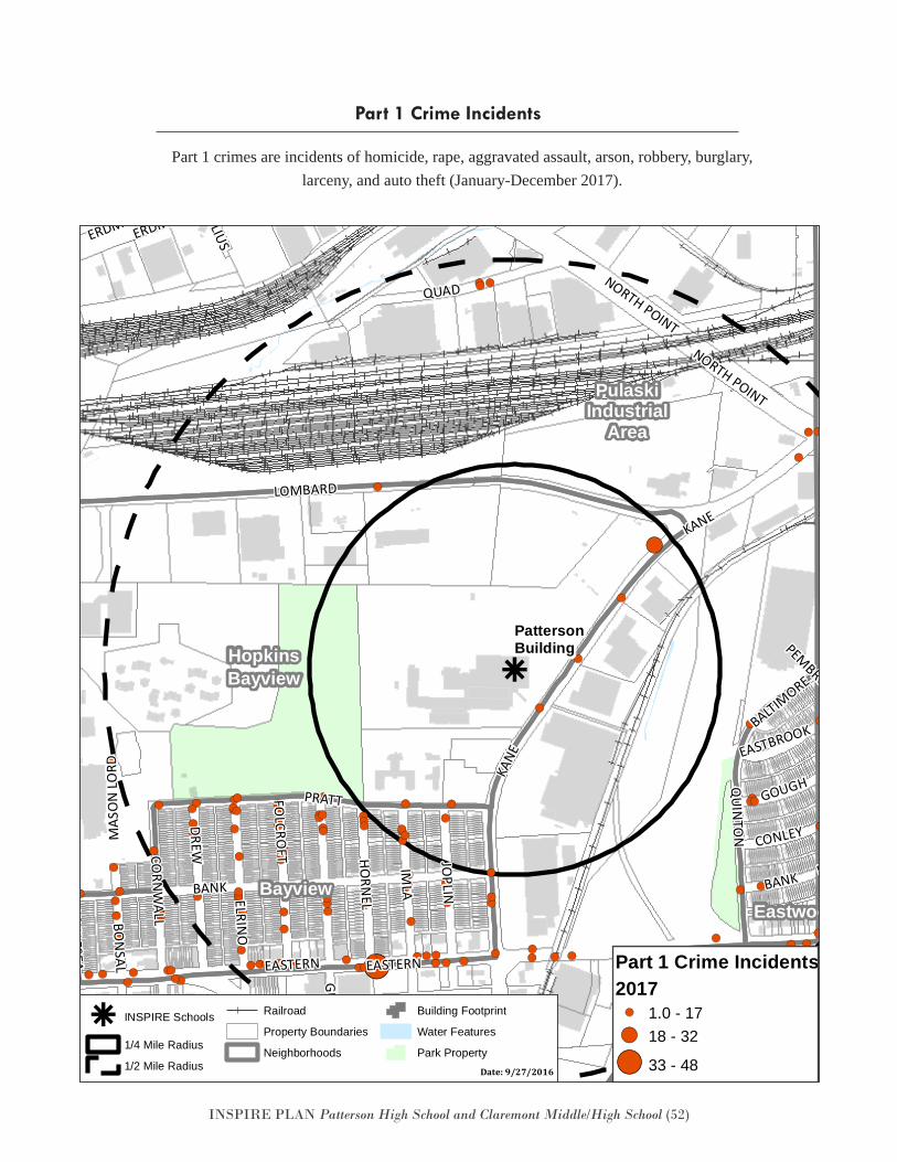
INSPIRE PLAN Patterson High School and Claremont Middle/High School (52)
Part 1 crimes are incidents of homicide, rape, aggravated assault, arson, robbery, burglary, larceny, and auto theft (January-December 2017).
Part 1 Crime Incidents
k
!( !(
!(
!(
!(!(
!(
!(
!(
!(
!(
!(
!(
!(
!(
!(!(
!(
!(
!(!(
!(
!(
!(
!(
!(!(
!(
!(!(
!(
!(
!(
!(
!(!(
!(
!(
!(!(
!(!(
!(
!(
!(
!(
!(
!(
!(
!(!(!(
!(!(
!(
!(
!(
!(!(
!(
!(
!(!(
!(
!(
!(
!(
!(
!(
!(
!(
!(!(
!(
!(
!(
!(
!(
!(!(
!(
!(
!(
!(
!(!(!(
!(
!(
!(
!(!(!( !(
!(
!(
!(
!(
!(!(
!(
!(
!(!(!(!(
!(
!(!(
!(!(
!(!(
!(!(
!(!(
!(
!(!(!(!(
!(
!(
!(!(!( !(!(!(
!(
!(!(
!(!(
!(
!(
!(
!(
!(
!(!(
!(
!(
!(
!(
!(
!(
!(!(
!(
!(!(!(
!(
!(
!(
!( !(
!(
!(
!(
!( !(
!(
!(
!(
!(
!(
!(
!(!(
!(
!(
!(!(
!(
!(!(
!(
!(
!(
!(
!(
!(
!(
!(
!(
!(
BALTIMORE
PEMBROOKE
KANE
FOLCRO
FT JOPLIN
HORN
EL
IMLAELRIN
O
ERDMAN
QUAD
QUAD
CORN
WALL
ANGLESEA
BON
SAL
BAYVIEW
FOLC
ROFT
QUIN
TON
DUNDALK
MAS
ON
LORD
KANE
GUSRYAN
EASTERN
I 95
QUADDEBELIUS
VILLAGER
BANK
EASTERN
PRATT
ERDM
AN
RAM
P
I 895
FAIT
HUDSON
BANK
BAYVIEW
FLEET
ERDMANO
GDEN
DUNDALK
DREW
NORTH POINT
NORTH POINT
ERDMAN
GOUGH
GRACELAND
NATHANSHOCK
I 895
O'DONNELL
BIOSCIEN
CE
GRACELAND
ERDMAN
BANK
CONLEY
I 95
GOUGH
BUSHEY
EASTBROOK
HUDSON
BIOSCIENCE
KANE
LOMBARD
PattersonBuilding
Armistead Gardens
Eastwood
GracelandPark
Greektown
HopkinsBayview
Bayview
Kresson
PulaskiIndustrial
Area
k INSPIRE Schools
1/4 Mile Radius
1/2 Mile Radius
Railroad
Property Boundaries
Neighborhoods
Building Footprint
Water Features
Park PropertyDate: 3/5/2018
PattersonBuildingINSPIRE
Part 1 Crime Incidents2017!( 1.0 - 17!( 18 - 32
!( 33 - 48
Eastwood
GracelandPark
Greektown
HopkinsBayview
Bayview
PulaskiIndustrial
Area
BALTIMORE
PEMBROOKE
KANE
KANE EASTBROOK-GOUGH
GUSRYAN
ELRINO
QUAD
QUAD
ANGLESEA
FOLC
ROFT
QUIN
TON
KANE
DUNDALK
MAS
ON
LORD
ERDMANQUADDEBELIUS
EASTERN
BANK
PRATT
JOPLIN
RAM
P
IMLA
FAIT
BON
SAL
HUDSON
BANK
FLEET
ERDMAN
OGDEN
EASTERN
FOLCRO
FT
DREW
NATHANSHOCK
GOUGH
GRACELAND
CORN
WALL
NORTH POINT
O'DONNELLHO
RNEL
GRACELAND
ERDMAN
BANK
I 95
CONLEY
DUNDALK
BUSHEY
GOUGH
EASTBROOK
HUDSON
I 95
NORTH POINT
LOMBARD
PattersonBuilding
k INSPIRE Schools
1/4 Mile Radius
1/2 Mile Radius
Railroad
Property Boundaries
Neighborhoods
Building Footprint
Water Features
Park PropertyDate: 9/27/2016
PattersonBuildingINSPIRE
Food EnvironmentFood Retail
!! Corner Stores (3)
!! Convenience Stores (8)
!! Supermarkets (1)
Food Assistance
#* Kids Summer Meal Sites (1)
#* Senior Meal Sites (2)
#* After School Meal Sites (1)
k
!( !(
!(
!(
!(!(
!(
!(
!(
!(
!(
!(
!(
!(
!(
!(!(
!(
!(
!(!(
!(
!(
!(
!(
!(!(
!(
!(!(
!(
!(
!(
!(
!(!(
!(
!(
!(!(
!(!(
!(
!(
!(
!(
!(
!(
!(
!(!(!(
!(!(
!(
!(
!(
!(!(
!(
!(
!(!(
!(
!(
!(
!(
!(
!(
!(
!(
!(!(
!(
!(
!(
!(
!(
!(!(
!(
!(
!(
!(
!(!(!(
!(
!(
!(
!(!(!( !(
!(
!(
!(
!(
!(!(
!(
!(
!(!(!(!(
!(
!(!(
!(!(
!(!(
!(!(
!(!(
!(
!(!(!(!(
!(
!(
!(!(!( !(!(!(
!(
!(!(
!(!(
!(
!(
!(
!(
!(
!(!(
!(
!(
!(
!(
!(
!(
!(!(
!(
!(!(!(
!(
!(
!(
!( !(
!(
!(
!(
!( !(
!(
!(
!(
!(
!(
!(
!(!(
!(
!(
!(!(
!(
!(!(
!(
!(
!(
!(
!(
!(
!(
!(
!(
!(
BALTIMORE
PEMBROOKE
KANE
FOLCRO
FT JOPLIN
HORN
EL
IMLAELRIN
O
ERDMAN
QUAD
QUAD
CORN
WALL
ANGLESEA
BON
SAL
BAYVIEW
FOLC
ROFT
QUIN
TON
DUNDALK
MAS
ON
LORD
KANE
GUSRYAN
EASTERN
I 95
QUADDEBELIUS
VILLAGER
BANK
EASTERN
PRATTER
DMAN
RAM
P
I 895
FAIT
HUDSON
BANK
BAYVIEW
FLEET
ERDMAN
OGDEN
DUNDALK
DREW
NORTH POINT
NORTH POINT
ERDMAN
GOUGH
GRACELAND
NATHANSHOCKI 8
95
O'DONNELL
BIOSCIEN
CE
GRACELAND
ERDMAN
BANK
CONLEY
I 95
GOUGH
BUSHEY
EASTBROOK
HUDSON
BIOSCIENCE
KANE
LOMBARD
PattersonBuilding
Armistead Gardens
Eastwood
GracelandPark
Greektown
HopkinsBayview
Bayview
Kresson
PulaskiIndustrial
Area
k INSPIRE Schools
1/4 Mile Radius
1/2 Mile Radius
Railroad
Property Boundaries
Neighborhoods
Building Footprint
Water Features
Park PropertyDate: 3/5/2018
PattersonBuildingINSPIRE
Part 1 Crime Incidents2017!( 1.0 - 17!( 18 - 32
!( 33 - 48
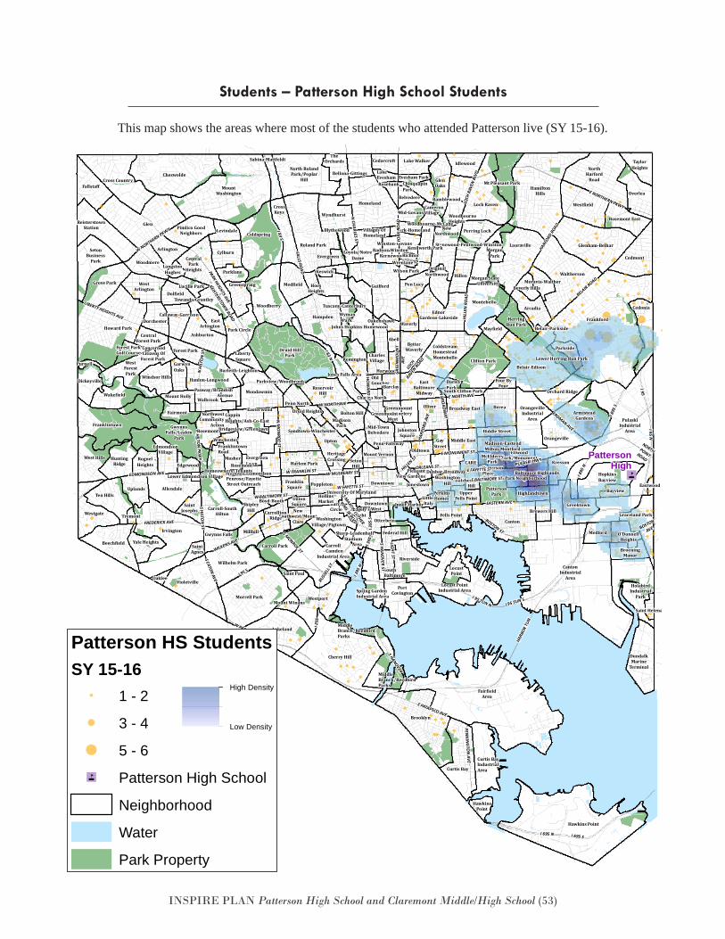
INSPIRE PLAN Patterson High School and Claremont Middle/High School (53)
Students – Patterson High School Students
This map shows the areas where most of the students who attended Patterson live (SY 15-16).
"4Patterson Park Neighborhood
BarreCircle
Belair-Parkside
Bellona-Gittings
Blythewood
Boyd-Booth
Bridgeview/Greenlawn
Butcher'sHill
CameronVillage
Charles North
ChinquapinPark
ConcernedCitizens Of
Forest Park
DarleyPark
Dunbar-Broadway
EastArlington
Easterwood
EdmondsonVillage Ellwood
Park/Monument
Evergreen
EvergreenLawn
Forest ParkGolf Course
FranklintownRoad
GarwynOaks
GreenmountCemeteryGreenmount
West
Greenspring
Harwood
HeritageCrossing
HoesHeights
Kernewood
LakeEvesham
LangstonHughes
LittleItaly
MadisonPark
MiddleBranch/ReedbirdParks
Midtown-Edmondson
Milton-Montford
MorganPark
Morgan StateUniversity
NewSouthwest/Mount
Clare
NorthwestCommunity
Action
Oakenshawe
OriginalNorthwood
Otterbein
Panway/BraddishAvenue
PattersonPlace
Penn-Fallsway
PerkinsHomes
PleasantView Gardens
Radnor-Winston
Ramblewood
RichnorSprings
Ridgely'sDelight
Rosebank
Rosemont
RosemontHomeowners/Tenants
Sandtown-Winchester
SouthBaltimore
Sharp-Leadenhall
South Clifton Park
StadiumArea
Stonewood-Pentwood-Winston
Towanda-GrantleyTuscany-Canterbury
University Of Maryland
Villages OfHomeland
Winston-Govans
WoodbourneHeightsWoodbourne-McCabe
WymanPark
Wrenlane
York-Homeland
OldGoucher
RUSS
ELL S
T
W NORTHERN PKWY
I 295
W BALTIMORE ST
PARK HEIGHTS AVE
S HAN
OVER ST
HARF
ORD RO
AD
PENN
ING
TON
AVE
N HI
LTO
N ST
S CATON AVE
S MONROE ST
N H
OW
ARD ST
I 83 S
I 95 S
EASTERN AVE
N M
ON
ROE ST
YORK
RO
AD
W PATAPSCO AVE
FALLS ROAD
I 95 N
HILL
EN R
OAD
HILLEN ST
PULASKI HWY
N BROADW
AY
LOCH
RAV
EN B
LVD
REISTERSTOWN ROAD
W FRANKLIN ST
S HILTO
N ST
ERDMAN AVE
W FAYETTE ST
E FAYETTE ST
E NORTH AVE
ORLEANS ST
E MONUMENT ST
W MULBERRY STEDMONDSON AVE
I 395
S
FREDERICK AVEHILTO
N PKW
Y
I 83 N
WILKENS AVE
LOCH
RAVEN
ROAD
N CHARLES ST
W NORTH AVEGR
EEN
MO
UN
TAV
E
LIGHT ST
HARF
ORD
AVE
BOSTON
AVE
BELAIR ROAD
E PATAPSCO AVE
LIBERTY HEIGHTS AVE
S MARTIN LUTHER
KING JR BLVDI 3
95
NORTHPOINTROAD
E NORTHERN PKWY
BOSTON ST
E BALTIMORE ST
I 95
I 695 SI 695 N
I 895
N
HARB
OR T
UN
I 895
S
I 395
N
I 95 TUN N I 95 TUN S
S HANOVER
PattersonHigh
Abell
Allendale
Arcadia
Arlington
ArmisteadGardens
Ashburton
Baltimore Highlands
Barclay
Beechfield
Berea
BetterWaverly
Beverly Hills
Biddle Street
Bolton Hill
Brewers Hill
Broadway East
BroeningManor
Brooklyn
Burleith-Leighton
Callaway-Garrison
Canton
CantonIndustrial
Area
Carroll- Camden
Industrial Area
Carroll Park
Carroll-SouthHilton Carrollton
Ridge
Cedarcroft
Cedmont
Cedonia
CentralForest Park
CentralPark
Heights
Cherry Hill
Cheswolde
Orchard Ridge
Clifton Park
Coldspring
ColdstreamHomesteadMontebello
CoppinHeights/Ash-Co-East
Cross Country
CrossKeys
Curtis Bay
Curtis BayIndustrialArea
Cylburn
Dickeyville
Dolfield
Dorchester
Downtown
Druid Heights
Druid HillPark
DundalkMarine
Terminal
EastBaltimore
Midway
Eastwood
EdnorGardens-Lakeside
FairfieldArea
Fairmont
Fallstaff
Federal Hill
Fells Point
Forest Park
Frankford
FranklinSquare
Franklintown
GayStreet
Glen
GlenOaks
Glenham-Belhar
Graceland Park
Greektown
Grove ParkGuilford
Gwynns Falls
GwynnsFalls/Leakin
Park
Hampden
Hanlon-Longwood
HamiltonHills
Harlem Park
HawkinsPoint
Hawkins Point
HerringRun Park
Highlandtown
Hillen
HolabirdIndustrial
Park
HollinsMarket
Homeland
HopkinsBayview
Howard Park
HuntingRidge
Idlewood
Inner Harbor
Irvington
Johns Hopkins Homewood
JohnstonSquare
Jones Falls Area
JonestownBayview
Kenilworth Park
Keswick
Kresson
Lake Walker
Lakeland
Lauraville
Levindale
LibertySquare
Loch Raven
LocustPoint
Locust PointIndustrial Area
Lower Herring Run Park
Loyola/NotreDame
Lucille Park
Madison-Eastend
Mayfield
McElderryPark
Medfield
Medford
Mid-Govans
Mid-TownBelvedere
MiddleBranch/ReedbirdParks
Middle East
Millhill
Mondawmin
Montebello
Moravia-Walther
Morrell Park
Mosher
Mount Holly
Mount Vernon
MountWashington
Mount Winans
Mt Pleasant Park
NewNorthwood
NorthHarford
Road
North RolandPark/Poplar
Hill
O'DonnellHeights
Oaklee
Oldtown
Oliver
Orangeville
OrangevilleIndustrial
Area
Overlea
Park Circle
Parklane
Parkside
Parkview/Woodbrook
PattersonPark
Pen Lucy
Penn North
Penrose/FayetteStreet Outreach
Perring LochPimlico Good
Neighbors
Poppleton
PortCovington
PulaskiIndustrial
Area
Purnell
ReisterstownStation
Remington
ReservoirHill
Riverside
RognelHeights
Roland Park
Rosemont East
Sabina-Mattfeldt
SaintAgnes
Saint Helena
SaintJosephs
Saint Paul
SetonBusiness
Park
SetonHill
ShipleyHill
Spring GardenIndustrial Area
TaylorHeights
Ten Hills
TheOrchards
Tremont
UnionSquare
UplandsUpper
Fells Point
Upton
Violetville
WakefieldWalbrook
Waltherson
WashingtonHill
WashingtonVillage/Pigtown
Waverly
WestArlington
WestForestPark
West Hills
Westfield
Westgate
Westport
Wilson Park
Winchester
Windsor Hills
Woodberry
Woodmere
Wyndhurst
Yale Heights
Lower Edmondson Village
Wilhelm Park
Edgewood
Evesham Park
Belvedere
CARE
DowntownWest
Belair-Edison
Four ByFour
CharlesVillage
Patterson HS StudentsSY 15-16
1 - 2
3 - 4
5 - 6
"4 Patterson High School
Neighborhood
Water
Park Property
Patterson High School Student Addresses
High Density
Low Density
"4Patterson Park Neighborhood
BarreCircle
Belair-Parkside
Bellona-Gittings
Blythewood
Boyd-Booth
Bridgeview/Greenlawn
Butcher'sHill
CameronVillage
Charles North
ChinquapinPark
ConcernedCitizens Of
Forest Park
DarleyPark
Dunbar-Broadway
EastArlington
Easterwood
EdmondsonVillage Ellwood
Park/Monument
Evergreen
EvergreenLawn
Forest ParkGolf Course
FranklintownRoad
GarwynOaks
GreenmountCemeteryGreenmount
West
Greenspring
Harwood
HeritageCrossing
HoesHeights
Kernewood
LakeEvesham
LangstonHughes
LittleItaly
MadisonPark
MiddleBranch/ReedbirdParks
Midtown-Edmondson
Milton-Montford
MorganPark
Morgan StateUniversity
NewSouthwest/Mount
Clare
NorthwestCommunity
Action
Oakenshawe
OriginalNorthwood
Otterbein
Panway/BraddishAvenue
PattersonPlace
Penn-Fallsway
PerkinsHomes
PleasantView Gardens
Radnor-Winston
Ramblewood
RichnorSprings
Ridgely'sDelight
Rosebank
Rosemont
RosemontHomeowners/Tenants
Sandtown-Winchester
SouthBaltimore
Sharp-Leadenhall
South Clifton Park
StadiumArea
Stonewood-Pentwood-Winston
Towanda-GrantleyTuscany-Canterbury
University Of Maryland
Villages OfHomeland
Winston-Govans
WoodbourneHeightsWoodbourne-McCabe
WymanPark
Wrenlane
York-Homeland
OldGoucher
RUSS
ELL S
T
W NORTHERN PKWY
I 295
W BALTIMORE ST
PARK HEIGHTS AVE
S HAN
OVER ST
HARF
ORD RO
AD
PENN
ING
TON
AVE
N HI
LTO
N ST
S CATON AVE
S MONROE ST
N H
OW
ARD ST
I 83 S
I 95 S
EASTERN AVE
N M
ON
ROE ST
YORK
RO
AD
W PATAPSCO AVE
FALLS ROAD
I 95 N
HILL
EN R
OAD
HILLEN ST
PULASKI HWY
N BROADW
AY
LOCH
RAV
EN B
LVD
REISTERSTOWN ROAD
W FRANKLIN ST
S HILTO
N ST
ERDMAN AVE
W FAYETTE ST
E FAYETTE ST
E NORTH AVE
ORLEANS ST
E MONUMENT ST
W MULBERRY STEDMONDSON AVE
I 395
S
FREDERICK AVE
HILTON
PKWY
I 83 N
WILKENS AVE
LOCH
RAVEN
ROAD
N CHARLES ST
W NORTH AVE
GREE
NM
OU
NT
AVE
LIGHT ST
HARF
ORD
AVE
BOSTON
AVE
BELAIR ROAD
E PATAPSCO AVE
LIBERTY HEIGHTS AVE
S MARTIN LUTHER
KING JR BLVD
I 395
NORTHPOINTROAD
E NORTHERN PKWY
BOSTON ST
E BALTIMORE ST
I 95
I 695 SI 695 N
I 895
N
HARB
OR T
UN
I 895
S
I 395
N
I 95 TUN N I 95 TUN S
S HANOVER
PattersonHigh
Abell
Allendale
Arcadia
Arlington
ArmisteadGardens
Ashburton
Baltimore Highlands
Barclay
Beechfield
Berea
BetterWaverly
Beverly Hills
Biddle Street
Bolton Hill
Brewers Hill
Broadway East
BroeningManor
Brooklyn
Burleith-Leighton
Callaway-Garrison
Canton
CantonIndustrial
Area
Carroll- Camden
Industrial Area
Carroll Park
Carroll-SouthHilton Carrollton
Ridge
Cedarcroft
Cedmont
Cedonia
CentralForest Park
CentralPark
Heights
Cherry Hill
Cheswolde
Orchard Ridge
Clifton Park
Coldspring
ColdstreamHomesteadMontebello
CoppinHeights/Ash-Co-East
Cross Country
CrossKeys
Curtis Bay
Curtis BayIndustrialArea
Cylburn
Dickeyville
Dolfield
Dorchester
Downtown
Druid Heights
Druid HillPark
DundalkMarine
Terminal
EastBaltimore
Midway
Eastwood
EdnorGardens-Lakeside
FairfieldArea
Fairmont
Fallstaff
Federal Hill
Fells Point
Forest Park
Frankford
FranklinSquare
Franklintown
GayStreet
Glen
GlenOaks
Glenham-Belhar
Graceland Park
Greektown
Grove ParkGuilford
Gwynns Falls
GwynnsFalls/Leakin
Park
Hampden
Hanlon-Longwood
HamiltonHills
Harlem Park
HawkinsPoint
Hawkins Point
HerringRun Park
Highlandtown
Hillen
HolabirdIndustrial
Park
HollinsMarket
Homeland
HopkinsBayview
Howard Park
HuntingRidge
Idlewood
Inner Harbor
Irvington
Johns Hopkins Homewood
JohnstonSquare
Jones Falls Area
JonestownBayview
Kenilworth Park
Keswick
Kresson
Lake Walker
Lakeland
Lauraville
Levindale
LibertySquare
Loch Raven
LocustPoint
Locust PointIndustrial Area
Lower Herring Run Park
Loyola/NotreDame
Lucille Park
Madison-Eastend
Mayfield
McElderryPark
Medfield
Medford
Mid-Govans
Mid-TownBelvedere
MiddleBranch/ReedbirdParks
Middle East
Millhill
Mondawmin
Montebello
Moravia-Walther
Morrell Park
Mosher
Mount Holly
Mount Vernon
MountWashington
Mount Winans
Mt Pleasant Park
NewNorthwood
NorthHarford
Road
North RolandPark/Poplar
Hill
O'DonnellHeights
Oaklee
Oldtown
Oliver
Orangeville
OrangevilleIndustrial
Area
Overlea
Park Circle
Parklane
Parkside
Parkview/Woodbrook
PattersonPark
Pen Lucy
Penn North
Penrose/FayetteStreet Outreach
Perring LochPimlico Good
Neighbors
Poppleton
PortCovington
PulaskiIndustrial
Area
Purnell
ReisterstownStation
Remington
ReservoirHill
Riverside
RognelHeights
Roland Park
Rosemont East
Sabina-Mattfeldt
SaintAgnes
Saint Helena
SaintJosephs
Saint Paul
SetonBusiness
Park
SetonHill
ShipleyHill
Spring GardenIndustrial Area
TaylorHeights
Ten Hills
TheOrchards
Tremont
UnionSquare
UplandsUpper
Fells Point
Upton
Violetville
WakefieldWalbrook
Waltherson
WashingtonHill
WashingtonVillage/Pigtown
Waverly
WestArlington
WestForestPark
West Hills
Westfield
Westgate
Westport
Wilson Park
Winchester
Windsor Hills
Woodberry
Woodmere
Wyndhurst
Yale Heights
Lower Edmondson Village
Wilhelm Park
Edgewood
Evesham Park
Belvedere
CARE
DowntownWest
Belair-Edison
Four ByFour
CharlesVillage
Patterson HS StudentsSY 15-16
1 - 2
3 - 4
5 - 6
"4 Patterson High School
Neighborhood
Water
Park Property
Patterson High School Student Addresses
High Density
Low Density
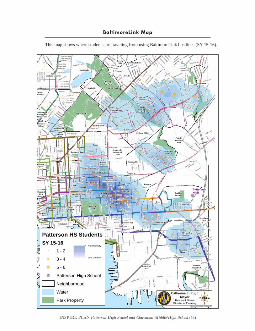
INSPIRE PLAN Patterson High School and Claremont Middle/High School (54)
This map shows where students are traveling from using BaltimoreLink bus lines (SY 15-16).
BaltimoreLink Map
"4
PON
CA S
T
EATON
ST
WELLS AV
SCHUCK ST
5TH AVE
S FAGLEY ST
CARDIFF AVE
PORTUGAL ST
HILLTOP AVE
MCKAY CT
MULLIKIN ST
WALDO CT
MANNASOTA
MILLER ST
MARSHALL CT
E PRATT ST
S GLO
VER ST
GLENARM AVE
CLYDE ST
KELW
AY R
OAD
S DEA
N ST
GRANITE AVE
LIST AVE
CONGRESS CTN
BETHEL ST
HARMONY CT
N REG
ESTER ST
N PO
RT ST
N CH
APEL ST
DOBLER AVE
TOONE STMOORINGS CT
EASTERN AVE
GROGAN AVE
N STREEPER ST
QUINTO
N ST
TOONE ST
E PRATT ST
LILLY
AN AVE
ELLIOTT ST
STRA
THDA
LE
S CASTLE ST
STIR
LIN
G S
T
MAHONEY AVE
KINSWAY
DOCKSIDE CIR
MCELDERRY ST
BOYER ST
EAST ST
HARGEST LANE
LINA CT
ELKA
DER
RO
AD
DUKER CTESSEX ST
KEENE AVE
N M
ADEIRA ST
N RO
SE ST
GRO
TON
RO
AD
N GLOVER ST
HALDANE ROAD
HAKESLEY PL
MCHENRY ROW
S STREEPER ST
BLUER
IDGE A
VE
SAINT CLAIR CT
S PORT ST
MUELLER ST
SPARK CT
LUERSSEN AVE
GUNTHER WAY
N SPRIN
G ST
HOPE ST
FOSTER AVE
HUDSON ST
N PO
RT ST
DILLON ST
N BRAD
FORD
ST
ELRINO
ST
ELLSWORTH ST
S MAD
EIRA ST
MARECO AVE
N CASTLE ST
LONG PL
CUBA ST
MCDO
NO
GH
ST
GLADDEN AVE
TIVOLY AVE
LLEWELYN AVE
GIBBONS AVE
N DU
RHAM
ST
BRANCH AVE
S EATON
ST
GRUN
DY ST
E OLIVER ST
DAKOTA AVE
MID
LINE R
OAD
CANF
IELD
AVE
GRANBY ST
BELAIR
E 28TH ST
ROCHESTER PL
CRYSTAL AVE
WILL
ET A
VE
MAPLE AVE
BENEFIT ST
BERGER AVE
PUM
PHREY ST
LEVERTON AVE
JEFFERSON ST
BANK ST
BELWOOD AVE
BANK ST
E PRESTON ST
FLEET ST
CLIFTWOOD AVE
ALICEANNA ST
ODELL AVE
ANNA PARK WAY
CHESTLE PL
E LOMBARD ST
BUNBURY WAY
E HOFFMAN ST
ROBERTS PL
N EAST AVE
MARKLEY AVE
OVERLAND AVE
JENIFER AVE
N D
EAN
ST
DREW ST
SEIDEL AVE
TRUESDALE AVE
FOLCRO
FT ST
CENTURY ROAD
PULASKI H
WY
ORLEANS ST
N N
EWKIRK ST
S LEHIG
H ST
AIKEN ST
KIM
BLE
ROAD
YOLA
ND
O R
OAD
LANCASTER ST
S MACO
N ST
BOYL
E ST
S ROBIN
SON
ST
REXM
ERE
ROAD
S QU
AIL ST
LAMLEY ST
CORN
WAL
L ST
S MILTO
N AVE
S LUZERN
E AVE
S POTO
MAC ST
S CURLEY ST
S KENW
OO
D AVE
S BRADFO
RD ST
S ROSE ST
S CAROLIN
E ST
S DECKER AVE
SAVAGE ST
S LAKEWO
OD AVE
S SPRING
ST
GARRETT A
VE
TOLN
A ST
S CHAPEL ST
S WO
LFE ST
OLD
HAM
ST
S BON
D ST
QUA
IL ST
KIRK AVE
CECIL
AVE
LAWNVIEW AVE
DILLON ST
WIL
LS S
T
BIDDISON LANE
CARBORE WAY
S DALLAS ST
N DU
NCAN
ST
KENH
ILL AVE
AISQU
ITH ST
MERTENS AVE
HOLBRO
OK ST
PILG
RIM
ROA
D
N D
ECKER AVE
N D
ALLAS ST N CU
RLEY STN
POTO
MAC ST
WOODST
OCK AVE
MARNE AVE
DILLON PL
E NORTH AVE
BARTON
AVE
MURA ST
ALRICKS WAYQUANTRIL WAY
BERYL AVE
HARP
ER ST
COOK
SIE
ST
FERNLEY ROAD
N CH
APEL ST
CAMBRIDGE ST
N CH
ESTER ST
KAVON AV
E
S DU
NCAN
ST
LEREW WAY
S DU
RHAM
ST
S EAST AVE
ESTHER PL
NOBLE ST
S BOU
LDIN
ST
E PRATT ST
RICH
ARDS
ON ST
BROWN AVE
ALTHEA
AVE
OMAHA AVE
TOW
SON
STGREENDALE ROAD
WATSON ST
S JAN
NEY ST
NEUTER AVE
MEDFORD ROAD
SPRINGFIELD AVE
S EDEN
ST
DETROIT AVE
SCHEELER AVE
E CHASE STHENNEMAN AVE
E 43RD ST
E PRESTON ST
HANE AVE
N BO
ULDIN
ST
JOPLIN
ST
BENJ
AMIN
ST
TUNLAW ROADST
EUAR
T ST
CHILTON ST
BRENDAN AVE
GRAC
E AVE
NORMAN AVE
GREENHILL
AVE
ROSS
ROA
DBREH
MS L
ANE
E 25TH ST
HARF
ORD
AVE
E 20TH ST
EIERMAN AVE
COOK AVE
RIVERVIEW AVE
BONVIEW AVE
N CLIN
TON
ST
N LIN
WO
OD
AVE
MOORES RUN DR
BOSTON ST
FORRESTER AVE
SHELDON AVE
S CON
KLING
ST
E 30TH ST
S HIG
HLAN
D AVE
N M
ILTON
AVE
NICHOLAS AVE
N LUZERNE AVE
N W
ASHIN
GTO
N ST
DILLER AVE
GRACELAND AVE
SCHA
UB A
VE
HARTWAIT ST
CLAYBURY AVE
ROBB ST
E 31ST ST
HAUB
ERT S
T
HECKEL AVE
N ED
EN ST
WHITW
OOD ROAD
SOM
ERSET ST
N BO
ND
ST
DELBERT AVE
BANK ST
VAIL
ST
N W
OLFE ST
DECA
TUR
ST
RUTLAN
D AVE
N CARO
LINE ST
JUNEWAY
N IRIS AVE
LOW
MAN
ST
N LEHIGH ST
EVANS WAY
ABERDEEN AVE
OAKLYN AVE
BELAIR ROAD
EASTERN AVE
MONTEBELLO TERR
CONLEY ST
HAMPNET
T AVE
CHANDLERY ST
ANG
LESE
A S
T
HORN
EL ST
CLIFTMONT AVE
RAVENWOOD AVE
EDGA
R TE
RR
LANDAY AVE
BEVERLY ROAD
E 29TH ST
CRAN
E ROA
D
O'DONNELL ST
N ROBIN
SON
ST
PARKSIDE PL
HILLTO
P AVE
REYN
OLDS
ST
WHITB
Y ROAD
ELMLEY AVE
EASTERN AVE
GOUGH ST
E MADISON ST
JUNEAU PL
THAMES ST
HARC
OU
RT R
OAD
BOSTON ST
LYNDALE AVE
LORELLY AVE
EASTBROOK AVE
BIDDISON AVE
CHAR
LTON
AVE
BAYLIS ST
EDIS
ON
HW
Y
LAKE AVE
TRIBUTARY ST
CRENSHAW AVE
PARKWOOD AVE
N JANNEY ST
HOMESTEAD ST
TOW
NWAY
MONTPELIER ST
ARGO
NNE D
R
ABBOTSTON STGORSUCH AVE
BUCKNELL ROAD
BON
SAL ST
SCHLEY AVE
S ANN
ST
VOG
T AV
E
S RE
GES
TER
ST
RICH
ARD
AVE
UPSHIRE ROAD
IDAHO AVE
HULL
ST
S ELLWO
OD AVE
S BROA
DWAY
TOD
D A
VE
S BETHEL ST
LERCH DR
IMLA ST
HARRIS AVE
HEWITT WAY
N GAY ST
WRIGHT AVE
BALFERN AVE
FRANKFORD AVE
HARFORD TE
RR
ARDLEY AVE
CARSWELL ST
E FAYETTE ST
BAYVIEW BLVD
FELL ST
LAKESIDE AVE
BALTIMORE AVE
ERDMAN AVE
HAMILTON AVE
DANVILLE AVE
COMMERCIAL AVE
NORTHGATE ROAD
RAYMONN AVE
TYNDALE AVE
ELSR
ODE
AVE
FAIT AVE
SUPPLY AVE
PARKMONT AVE
WOODLEA AVE
KINGSWAY ROAD
GREE
NCRES
T ROAD
SHIPVIEW WAY
SOU
THERN AVE
CEDARHURST ROAD
FORTVIEW WAY
WINDEMERE AVE
KNELL AVE
O'DONNELL ST
NORTHWICK ROAD
FRAILEY WAY
GRIND
ON
AVE
BUSHEY ST
CRESTO
N AVE
VALLEY VIEW AVE
SIPPLE AVE
BOWLAND AVE
E 35TH ST
WALTHER AVE
CEDGATE ROAD
ADLEIGH AVE
CHESTERFIELD AVE
MARL
UTH A
VE
RENWICK AVE
SERVICE DR
WHITE AVE
PLAINFIE
LD AVE
WILBUR AVE
GERMAN HILL ROAD
MAYFIELD AVE
KENYO
N AVE
E 33RD ST
GUNTHER AVE
DARLEY AVE
LOCHWOOD ROAD
PLUMER AVE
E FAYETTE ST
62ND
ST
ORLEANS ST
VALI
QUE
T AV
E
HALCYON AVE
INTE
RSTA
TE AV
E
BELGIAN AVE
E MONUMENT ST
REMMELL AVE
FOREST VIEW AVE
CLEVELAND AVE
DEEPWOOD ROAD
GUSRYAN
ST
HOMESDALE AVE
PINE AVE
KENTUCKY AVE
DUNCANWOOD LANE
SHADYSIDE ROAD
RALWORTH ROAD
GERLAND AVE
BERKSHIRE ROAD
ROBERTS AVE
ARIZONA AVE
LOCH
RAVE
N BLVD
POWELL AVE
ROSEKEMP AVESHEFFIELD ROAD
FILLMO
RE ST
E MONUMENT ST
PELHAM AVE
ANTHONY ST
ANNTANA AVE
GARY AVE
FURLEY AVE
EASTWOOD DR
SAYB
ROOK
ROA
D
N KRESSO
N ST
CONSTELLATION PLZA
RUECKERT AVE
DUNDALK AVE
HORNERS LANE
HOLDER
AVE
CEDONIA AVE
E BALTIMORE ST
ELMORA AVE
HILLBURN AVE
MORAVIA PARK DR
WEAVER AVE
HAZELWOOD AVE
MANNINGTON AVE
CHATFORD AVE
SAINT THOMAS AVE
ECHODALE AVE
THE ALAMEDA
ASBURY A
VE
DANVILLE AVE
STANWOOD AVE
N M
ACON
ST
HILL
EN R
OAD
MAINFIELD AVE
RICHMOND AVE
DUDLEY AVE
IONA TERR
HUDSON ST
ROUNDHILL ROAD
WEITZEL AVE
HAMILTON AVE
HAZE
LWOO
D CI
RRI
TTER
AVE
WALLACE ST
N H
AVEN ST
BOSTON AVE
FAIR
WOO
D AV
E
BIOSCIENCE DR
ARAB
IA A
VE
N BROADWAY
RADECKE AVE
BESSEMER AVE
E EAGER ST
MARY AVE
N E
LLW
OO
D A
VE
BARBARA AVE
E 32ND ST
WILKE AVE
CLOUGH ST
MAYVIEW AVE
HAVENWOOD ROAD
BELLE
VISTA AVE
MASON LORD DR
PENTWOOD ROAD
ANDR
E ST
SINCLA
IR LANE
MARBLE HALL ROAD
KEY
HW
Y
PEMBROKE AVE
ARMISTEAD WAY
S KRESSON
ST
GARDENWO
OD ROAD
MORAVIA ROAD
DULUTH AVE
LELAND AVE
SHAMROCK AVE
YOUNGSTOWN AVE
WILLSHIRE AVE
PARKSIDE DR
LASALLE AVE
HARFORD ROAD
E FEDERAL ST
HILL
TOP
DR
MCC
OMAS
ST
BAYONNE AVE
SUMMERFIELD AVE
DAYWALT AVE
GRENTON AVE
ANTHONY AVE
GREENHILL
AVE
KAVON AVE
MARX AVE
NEWHOLM
E AVE
PORTAL ST
EURITH AVE
VAN DEM
AN ST
S HAVEN
ST
BECKLEY ST
ARGONNE DR
BELAIR ROAD
LEAHY ST
NEWGATE AVE
KENNEWICK ROAD
S LINW
OO
D AVE
E COLD SPRING LANE
KANE
ST
MC CALLU
M DR
SEAFORTH ST
CURRAN DR
DENVIEW
WAY
ORVILLE AVE
N R
OSE
ST
NEW
KIRK STS PO
NCA ST
GOODNOW ROAD
NEW
VAIL ST
SHANNON DR
NORTH POINT ROAD
BOSTON ST
ERDMAN AVE
KEITH AVE
QUAD AVE
S CLINTO
N ST
PULASKI HWY
MORAVIA ROAD
BRO
ENIN
G H
WY
SAIN
T LO D
R
HOLABIRD AVE
OAK AVE
S NEW
KIRK ST
WHITMAN DR
PENTRIDGE ROAD
E MCCOMAS ST
KEY
HWY
E
INDIAN HEAD DR
SINCLAIR LANE
EDGEWATER ST
1ST ST
BOWLEYS LANE
E BIDDLE ST
E LOMBARD ST
Belair-Parkside
Eastwood
InnerHarbor
KenilworthPark
Milton-Montford
Moravia-Walther
PattersonPlace
PortCovington
PortCovington
Stonewood-Pentwood-Winston
Loca
lLin
k 52
PattersonHigh
LocalLink 57
LocalLink 57
LocalLink 28
Loca
lLin
k 59
LocalLink 62
LocalLink 65
Loca
lLin
k 71
LocalLink 65
LocalLink 30
LocalLink71
Loca
lLin
k 22
LocalLink 22
LocalLink 21
LocalLink 65
LocalLink 28
LocalLink 94
LocalLink 65
Loca
lLink
54
Loca
lLin
k 53
LocalLink 65
Loca
lLin
k 53
LocalLink 54
LocalLink 94
LocalLink 57
LocalLink 21
Loca
lLin
k 22
LocalLink 21
Loca
lLin
k 59
LocalLink 30
LocalLink 59
LocalLink 28
LocalLink 56LocalLink 56
Arcadia
ArmisteadGardens
BaltimoreHighlands
Patterson ParkNeighborhood
Berea
BetterWaverly
BeverlyHills
BiddleStreet
Brewers Hill
Broadway East
BroeningManor
Butcher'sHill
Canton
CantonIndustrial
Area
Cedmont
Cedonia
Orchard Ridge
Clifton ParkColdstreamHomesteadMontebello
Darley Park
Dunbar-Broadway
Dundalk Marine Terminal
EastBaltimore
Midway
EdnorGardens-Lakeside
EllwoodPark/Monument
Fells Point
Frankford
Gay Street
Glenham-Belhar
GracelandPark
Greektown
HerringRun Park
Highlandtown
Hillen
HolabirdIndustrial
Park
HopkinsBayview
InnerHarbor
JohnstonSquare
Jonestown Bayview
Kresson
Lauraville
Little Italy
LocustPoint
Locust PointIndustrial
Area
LowerHerring
Run Park
Madison-Eastend
Mayfield
McElderryPark
Medford
Middle East
Montebello
MorganPark
Morgan StateUniversity
New Northwood
O'DonnellHeights
Oldtown
Oliver
Orangeville
OrangevilleIndustrial
Area
OriginalNorthwood
Parkside
PattersonPark
PenLucy
PerkinsHomes
PleasantView
Gardens
PulaskiIndustrial
Area
Riverside
SaintHelena
SouthCliftonPark
UpperFells Point
Waltherson
WashingtonHill
WilsonPark
CARE
Belair-Edison
Four By Four
Patterson HS StudentsSY 15-16
1 - 2
3 - 4
5 - 6
"4 Patterson High School
Neighborhood
Water
Park Property
Patterson High School Student Addresses
High Density
Low Density
INSPIRE PLAN Patterson High School and Claremont Middle/High School (55)
This Appendix contains information about, and links to, the programs and initiatives mentioned in this plan.
Appendix B: Programs & Initiatives
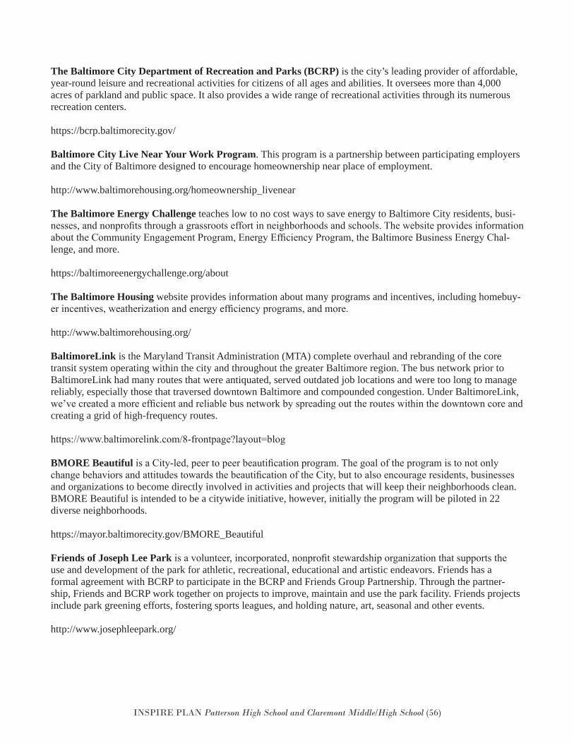
INSPIRE PLAN Patterson High School and Claremont Middle/High School (56)
The Baltimore City Department of Recreation and Parks (BCRP) is the city’s leading provider of affordable, year-round leisure and recreational activities for citizens of all ages and abilities. It oversees more than 4,000 acres of parkland and public space. It also provides a wide range of recreational activities through its numerous recreation centers.
https://bcrp.baltimorecity.gov/
Baltimore City Live Near Your Work Program. This program is a partnership between participating employers and the City of Baltimore designed to encourage homeownership near place of employment.
http://www.baltimorehousing.org/homeownership_livenear
The Baltimore Energy Challenge teaches low to no cost ways to save energy to Baltimore City residents, busi-nesses, and nonprofits through a grassroots effort in neighborhoods and schools. The website provides information about the Community Engagement Program, Energy Efficiency Program, the Baltimore Business Energy Chal-lenge, and more.
https://baltimoreenergychallenge.org/about
The Baltimore Housing website provides information about many programs and incentives, including homebuy-er incentives, weatherization and energy efficiency programs, and more.
http://www.baltimorehousing.org/
BaltimoreLink is the Maryland Transit Administration (MTA) complete overhaul and rebranding of the core transit system operating within the city and throughout the greater Baltimore region. The bus network prior to BaltimoreLink had many routes that were antiquated, served outdated job locations and were too long to manage reliably, especially those that traversed downtown Baltimore and compounded congestion. Under BaltimoreLink, we’ve created a more efficient and reliable bus network by spreading out the routes within the downtown core and creating a grid of high-frequency routes.
https://www.baltimorelink.com/8-frontpage?layout=blog
BMORE Beautiful is a City-led, peer to peer beautification program. The goal of the program is to not only change behaviors and attitudes towards the beautification of the City, but to also encourage residents, businesses and organizations to become directly involved in activities and projects that will keep their neighborhoods clean. BMORE Beautiful is intended to be a citywide initiative, however, initially the program will be piloted in 22 diverse neighborhoods.
https://mayor.baltimorecity.gov/BMORE_Beautiful
Friends of Joseph Lee Park is a volunteer, incorporated, nonprofit stewardship organization that supports the use and development of the park for athletic, recreational, educational and artistic endeavors. Friends has a formal agreement with BCRP to participate in the BCRP and Friends Group Partnership. Through the partner-ship, Friends and BCRP work together on projects to improve, maintain and use the park facility. Friends projects include park greening efforts, fostering sports leagues, and holding nature, art, seasonal and other events.
http://www.josephleepark.org/
INSPIRE PLAN Patterson High School and Claremont Middle/High School (57)
Johns Hopkins Bayview Medical Center Community Relations Department works to establish and foster communication between the Medical Center and surrounding communities. The department interfaces with a broad range of non-profit, business and community organizations to support initiatives that improve the well-being of the community, addressing health, housing, economic development, transportation and safety issues.
https://www.hopkinsmedicine.org/johns_hopkins_bayview/community_services/community_relations/index.html
Live Baltimore is a nationally recognized, independent nonprofit organization committed to promoting the ben-efits of Baltimore City living. Each year, Live Baltimore provides thousands of individuals with information on the city’s 250+ neighborhoods, rental living options, homebuying incentive programs, and historic tax credits.
https://livebaltimore.com/
The Mayor’s Office of Employment Development (MOED) coordinates and directs workforce development initiatives responsive to the needs of Baltimore City employers and job seekers in order to enhance and promote the local economy.
http://moed.baltimorecity.gov/
The Office of Sustainability – Green, Healthy, Smart Challenge Grant is a grant program for student-led sustainability projects in Baltimore City Public Schools. Students must be a part of an organized green team that meets to complete their project. The aim is to have projects encourage and assist schools in reaching Maryland Green School Certification.
http://www.baltimoresustainability.org/projects/green-schools-initiative/green-healthy-smart-challenge/
The Baltimore Development Corporation (BDC) is a non-profit organization, which serves as the economic development agency for the City of Baltimore. Its mission is to retain and expand existing businesses, support cultural resources, and attract new opportunities that spur economic growth and help create jobs. BDC serves as a one-stop shop for anyone interested in opening, expanding or relocating a business in Baltimore City.
http://baltimoredevelopment.com/
TreeBaltimore serves as the umbrella organization for all City agencies, private organizations, and individuals in their effort to increase the tree canopy of Baltimore. TreeBaltimore partners with individual homeowners, com-munities, schools, and businesses to increase the urban tree canopy through the establishment, management and preservation of trees. TreeBaltimore is a mayoral initiative led by the Baltimore City of Recreation and Parks in partnership with Blue Water Baltimore, the Parks & People Foundation, Baltimore Tree Trust and the Alliance for the Chesapeake Bay.
http://treebaltimore.org/
Vacants to Value (V2V) is Baltimore City’s initiative to Clean up and redevelop vacant properties. Strategies in-clude: Streamline the Disposition of City-Owned Properties; Streamline Code Enforcement in Stronger Markets; Facilitate Investment in Emerging Markets; market Homebuying Incentives; Support Large-Scale Redevelop-ment in Distressed Areas; Demolish and Maintain Severely Distressed Blocks; and, Provide Concentrated Green, Healthy and Sustainable Home and Neighborhood Improvements.
http://www.vacantstovalue.org/Default.aspx