Embed Size (px)
Citation preview

City of Brookhaven, GA Pavement Management Analysis Report
February 2017
City of Brookhaven Attn.: Richard Meehan, P.E., Project Manager
4362 Peachtree Road Brookhaven, GA 30319
IMS Infrastructure Management Services 1820 West Drake Drive, Suite 104, Tempe, AZ 85283
Phone: (480) 839-4347, Fax: (480) 839-4348 www.ims-rst.com

IMS Infrastructure Management Services BH_ Report_ Rev1 Page i
TABLE OF CONTENTS
TABLE OF CONTENTS I
1.0 PROJECT DESCRIPTION 1
1.1 Principles of Pavement Management 1
1.2 The Pavement Management Process 4
1.3 Functional Class Review 7
1.4 Assembly of Data into Supersegments 9
1.5 Understanding the Pavement Condition Index Score 11
2.0 ROADWAY NETWORK CONDITION AND FINDINGS 19
2.1 Roadway Network Size 19
2.2 Network Present Condition 20
2.3 Structural and Load Associated Distress Analysis 25
2.4 Condition by Functional Classification 28
2.5 Evaluating Quality of the Network and Reconstruction Backlog 28
3.0 REHABILITATION PLAN AND BUDGET DEVELOPMENT 30
3.1 Key Analysis Set Points 30
3.2 Fix All and Annual Estimates 33
3.3 Network Budget Analysis Models 34
3.4 Brookhaven Comparison to Other Agencies 38
3.5 Selection Summary and Post Rehabilitation Condition 40
3.6 Network Recommendations and Comments 43
APPENDED REPORTS Following Page 43
Appendix A Street Inventory and Condition Summary
Appendix B Street Inventory – Sorted by Supersegment (Project) Condition
Appendix C $4.0/$2.5M Rehabilitation Program by Segment
Appendix D $4.0/$2.5M Rehabilitation Program by Year
APPENDED MAPS Located on Thumb Drive
Functional Classification Designation
Pavement Condition Index and Rating by Segment Using PCI
Pavement Condition Index and Rating by Segment Using Descriptive Terms
Five Year Rehabilitation Plan for $4.0/$2.5M Budget
Five Year Post Rehab PCI for $4.0/$2.5M Budget

IMS Infrastructure Management Services BH_ Report_ Rev1 Page ii
Abbreviation
or Acronym Definition
$k Dollars in thousands ($,000)
$M Dollars in millions
%SP Percent Spreadability - component of deflection analysis
AC Asphalt Concrete - asphalt streets, f lexible pavements, also know n as ACP
ACP Asphalt Concrete Pavement - asphalt streets, f lexible pavements, also know n as AC
ART Arterial roadw ay functional classif ication
ASTM American Society of Testing Methods
Avg Average
BCI Base Curvature Index - component of deflection analysis
Brk Break
CAL Coarse Aggregate Loss
CDV Corrected Deduct Value - part of the ASTM D6433 PCI calculation
COL Collector roadw ay functional classif ication
Crk Crack
DeflCON Deflection Condition - structural load analysis based on traff ic loading and deflection
DMD Dynamic Maximum Deflection - temperature corrected deflection
Dvdd Slab Divided Slab
DynaCON Dynamic Condition - structural layer analysis
ft or FT Foot
ft2 or FT2 Square foot
FunCL Functional Classif ication
FWD Falling w eight deflectometer
GCI Gravel Condition Index
GFP Good - Fair - Poor
GIS Geographic Information System
GISID GIS segment identif ication number
H&V Horizontal and Vertical
IRI International Roughness Index
Jt Joint
L&T Longitudinal and Transverse
LAD Load associated distress
LOC Local roadw ay functional classif ication - same as RES
LOG Lip of Gutter
m Metre or meter
M Moderate
m2 square metre or square meter
MART Major arterial roadw ay functional classif ication
Max Maximum
MaxDV Maximum Deduct Value
MCOL Major collector roadw ay functional classif ication
mi or Mi Mile
Min Minimum
MnART Minor arterial roadw ay functional classif ication
MnCOL Minor collector roadw ay functional classif ication
MOD Moderate
NLAD Non-load associated distress
OCI Overall condition index, also know n as PCI
Olay Overlay
PART Primary arterial roadw ay functional classif ication
Pavetype Pavement Type
PCC Portland Cement Concrete - concrete streets
PCI Pavement Condition Index - generic term for OCI
R&R Remove and replace
RART Rural arterial roadw ay functional classif ication
PWF Priority Weighting Factor
Recon Reconstruction
Rehab Rehabilitation
RES Local roadw ay functional classif ication - same as LOC
RI or RCI Roughness Index
S Strong
SART Secondary arterial roadw ay functional classif ication
SCI Surface Curvature Index - componenent of deflection analysis
SDI Surface Distress Index
SI Structural Index
STA Station or chainage
Surf Trtmt Surface Treatment
TDV Total Deduct Value
W Weak

IMS Infrastructure Management Services BH_ Report_ Rev1 Page 1
1.0 PROJECT DESCRIPTION
1.1 PRINCIPLES OF PAVEMENT MANAGEMENT
Nationwide, billions of dollars have been invested in roadway networks by municipal, state, and federal
governments. Locally, the City of Brookhaven has over 120.4 miles of arterials and collectors roadways
plus an additional 100 miles of local roadways encompassing over 1.9M square yards of asphalt and
concrete surfacing. At a replacement cost exceeding $763K per mile – not including the value of the
land, the city has over $92.5 million invested in their paved roadway network.
Figure 1 – Replacement Value of Brookhaven Paved Roadway Network
Preservation of existing roads and street systems has become a major activity for all levels of
government. There is a shortage of funds to maintain street systems at the state and local government
levels. Therefore, funds that have been designated for pavements must be used as effectively as
possible. One proven method to obtain maximum value of available funds is through the use of a
pavement management system.
Pavement management is the process of planning, budgeting, funding, designing, constructing,
monitoring, evaluating, maintaining, and rehabilitating the pavement network to provide maximum
benefits with available funds.

IMS Infrastructure Management Services BH_ Report_ Rev1 Page 2
A pavement management system is a set of tools or methods that assist decision makers in finding
optimal strategies for providing and maintaining pavements in a serviceable condition over a given time
period.
As shown in Figure 2, streets that are repaired when they are in a good condition will cost less over their
lifetime than streets that are allowed to deteriorate to a poor condition. Without an adequate routine
pavement maintenance program, streets require more frequent reconstruction, thereby costing millions of
extra dollars. Over time, pavement quality drops until the pavement condition becomes unacceptable.
For each street, the shape of the curve, and hence, the rate of deterioration, is dependent on many
factors – foremost of which being the strength of the roadway structure and traffic loading. The key to a
successful pavement management program is to develop a reasonably accurate performance model of
the roadway, and then identify the optimal timing and rehabilitation strategy. The resultant benefit of this
exercise is realized by the long term cost savings and increase in pavement quality over time. As
illustrated in Figure 2, pavements typically deteriorate rapidly once they hit a specific threshold. A $1
investment after 40% lifespan is much more effective than deferring maintenance until heavier overlays or
possibly reconstruction are required just a few years later.
Figure 2 – Pavement Deterioration and Life Cycle Costs
Once implemented, an effective pavement information management system can assist agencies in
developing long-term rehabilitation programs and budgets. The key is to develop policies and practices
that delay the inevitable total reconstruction for as long as practical yet still remain within the target zone
for cost effective rehabilitation. That is, as each roadway approaches the steepest part of its deterioration
curve, apply a remedy that extends the pavement life, at a minimum cost, thereby avoiding costly heavy
overlays and reconstruction.

IMS Infrastructure Management Services BH_ Report_ Rev1 Page 3
The goal of a pavement management system is to identify the optimal level of funding, timing, and to
create a renewal strategy that agencies should adopt to keep their roadway network at a satisfactory level
of service. Figure 3 illustrates the concept of extending pavement life through the application of timely
rehabilitations.
Figure 3 – Pavement Life Cycle Curve
Ideally, the lower limit of the target zone shown in Figure 3 would have a minimum PCI value in the 65 to
75 range to keep as many streets as possible requiring a thin overlay or less. The upper limit would tend
to fall close to the higher end of the Very Good category – that is a pavement condition score
approaching 85. Other functions of a pavement management system include assessing the effectiveness
of maintenance activities, new technologies, and storing historical data and images.
For Brookhaven, a prioritization methodology based on pavement condition, pavement materials,
condition, and strength rating was used to analyze the network condition and develop the proposed 5
year rehabilitation plan.
The analysis methodologies and data collection technologies were based on the latest version of ASTM
D6433 Standard Practice for Roads and Parking Lots Pavement Condition Index Surveys (hereinafter
ASTM D6433) for assessment of pavement surface condition and the International Roughness Index (IRI)
for quantification of pavement roughness on all city streets. These measurements of pavement quality
are combined to form an overall 0 to 100 Pavement Condition Index (PCI), with 100 being the best.
Time
Pa
ve
me
nt
Qu
ali
ty
Target Zone for Pavement Rehabilitation
Un-rehabilitatedPavement Performance
Pavement Life Cycle Curve
Increased Pavement Life

IMS Infrastructure Management Services BH_ Report_ Rev1 Page 4
1.2 THE PAVEMENT MANAGEMENT PROCESS
The actual pavement management process involves three unique, but important steps, and is presented
graphically in Figure 4. Each activity builds on the previous, until the end result is a prioritized paving
and rehabilitation program.
Figure 4 – The Pavement Management Process
Highlights of the pavement management process include:
1. System Configuration – This step involves identifying all roadways in the city’s network,
assigning them a unique identifier, listing their physical characteristics (length, width, etc.) and
demographic attributes (pavement type, traffic, functional classification), and linking the network
to the city’s GIS map.
2. Field Surveys – Following a set of pre-defined assessment protocols matching the pavement
management software (ASTM D6433), a specialized piece of survey equipment – referred to as a
Laser Road Surface Tester (Laser RST, pictured on page 6) – is used to collect observations on
the condition of the pavement surface, as well as collect digital imagery and spatial coordinate
information. The Laser RST surveys each local street from end to end in a single pass, while all
other roadway classifications are completed in two passes.
Key pavement condition data elements collected by the Laser RST include:
Roughness Index – Roughness is measured following the industry standard “International
Roughness Index” (IRI), an open-ended score that measures the number of bumps per
mile and reports the value as millimeters/meter. The IRI value is converted to a 0 to 100
score and reported as the Roughness Index (RI) as follows:

IMS Infrastructure Management Services BH_ Report_ Rev1 Page 5
RI = (11.0 – 3.0 x ln(IRI)) x 10
where ln(IRI) is the natural logarithm of IRI.
In common terms, a newer street would have a Roughness Index above 85, while one
due for an overlay would be in the range 45 to 75. Failed streets typically have
roughness values below 45.
Surface Distress Index – The Laser RST collects surface distress observations based on
the extent and severity of distresses encountered along the length of the roadway. The
RST follows ASTM D6433 protocols for asphalt and concrete pavements. The surface
distress condition (cracking, potholes, raveling, and the like) is considered by the
traveling public to be the most important aspect in assessing pavement condition.
Presented on a 0 to 100 scale, the Surface Distress Index (SDI) is an aggregation of the
observed pavement defects. Within the SDI, not all distresses are weighted equally.
Certain load associated distresses (caused by traffic loading), such as rutting or alligator
cracking on asphalt streets, or divided slab on concrete streets, have a much higher
impact on the surface distress index than non-load associated distresses such as
raveling or patching. Even at low extents and moderate severity – less than 10% of the
total area – load associated distresses can drop the SDI considerably. ASTM D6433 also
has algorithms within it to correct for multiple or overlapping distresses within a segment.
For this project, extent and severity observations were collected, processed, and loaded
into the pavement management software. Within the software, the following distresses,
listed in order from greatest to lowest impact, are presented as a 0 to 10 rating for review
and reporting:
Alligator Cracking – Is quantified by the severity of the failure and number of square feet.
Even at low extents, this can have a large impact on the condition score as this distress
often represents a failure of the underlying base materials.
Wheel Path Rutting – Starting at a minimum depth of ¼ inch, wheel path ruts are
quantified by their depth and the number of square feet encountered. Like alligator
cracking, low densities of rutting can have a large impact on the final condition score.
Longitudinal, Transverse, Block (Map), and Edge Cracks – These are quantified by their
length and width. Longitudinal cracks that intertwine are the start of alligator cracking.
Patching – Patching is quantified by the extent and quality of patches. When the majority
of a roadway surface is covered by a patch, such as a large utility replacement, the rating
of the patch is minimized. All potholes are rated as patches as it is unlikely they will
remain unfilled until the street becomes selected for rehabilitation.
Distortions – All uneven pavement surfaces such as depressions, bumps, sags, swells,
heaves, and corrugations are included as distortions and are quantified by the severity
and extent of the affected area.
Raveling – Raveling is the loss of fine aggregate materials on the pavement surface and
is measured by the severity and number of square feet affected.

IMS Infrastructure Management Services BH_ Report_ Rev1 Page 6
Bleeding – Bleeding is the presence of free asphalt on the roadway surface caused by
too much asphalt in the pavement or insufficient voids in the matrix. The result is a
pavement surface with low skid resistance and is measured by the amount and severity
of the area.
Similar distresses were collected for concrete streets including divided slab, corner
breaks, joint spalling, faulting, polished aggregate, and scaling.
Structural Index – The network of streets was not tested for structural adequacy, instead,
the relationship between the final pavement condition score and amount of load
associated distresses was analyzed. Each pavement section was then assigned a
Weak, Moderate or Strong strength rating. The assigned structural index (30, 60 or 80
for weak, moderate and strong respectively) was not used in determining the overall
pavement condition score, but simply to classify the pavement strength and aid in
selecting appropriate rehabilitation strategies.
3. Analysis and Reporting – Following the field surveys, the condition data is assembled to create
a single score representing the overall condition of the pavement. The Pavement Condition Index
(PCI) is calculated as follows:
PCI = 33% Roughness Index + 67% Surface Distress Index
Development of the pavement management plan and budgets were completed using
Brookhaven-specific rehabilitation strategies, unit rates, priorities, and pavement performance
curves. The process was iterative in its attempt to obtain the greatest efficiency and cost benefit.
Figure 5 – Laser Road Surface Tester (Laser RST)

IMS Infrastructure Management Services BH_ Report_ Rev1 Page 7
1.3 FUNCTIONAL CLASS REVIEW
As part of the scope of this assignment, the functional classification designations currently used by the
city were reviewed for their suitability in the pavement analysis and updated for appropriate deterioration
model assignment. There is currently no uniform standard for functional classification designation used
by municipalities in the nation or within any given state and assignment of functional classifications is left
to the individual municipalities. The Federal Highway Administration (FHWA), American Public Works
Association (APWA) and Institute of Transportation Engineers (ITE) offer some broad guidelines on how
to assign classifications that were followed in this study. The city’s functional classification definitions
used in the assessment are as follows:
1. Arterial (ART) – all cross city corridors consisting of 4 or more lanes, generally spaced at 1 mile
intervals with daily traffic counts generally exceeding 20,000 vehicles per day and at least 2 to 4
lanes across, generally spaced on the 1 or ½ mile section line with daily traffic counts generally
between 10,000 and 20,000 vehicles per day. The ADT generally falls in the 5,000 to 20,000
vehicle per day range. They are typically spaced on the ½ or ¼ mile section line and on occasion.
Major cross city corridors with a landscaped median were also assigned to Major Arterials.
2. Collector (COL) - continuous and discontinuous cross city and inter-district corridors that are 2 to
4 lanes across and generally have a centerline stripe or a designated bus route. The ADT
generally falls in the 5,000 to 10,000 vehicle per day range. They are typically spaced on the ½ or
¼ mile section line and on occasion, may have a short non-landscaped median. Collectors are
also assigned to streets segments leading to, or adjacent to, a major traffic generator site such as
a regional shopping complex. Collectors that generally do not have a stripe are two lanes across
and have traffic volumes between 1,000 to 5,000 vehicles per day. Additionally, collectors form
the entrance to communities and may have a decorative landscaped median of short duration.
Collectors are neither transit bus nor truck routes, but may have residences adjacent to them.
3. Locals (LOC) – are the majority of the street segments consisting of all residential and frontage
roads not defined above or as an industrial/commercial.
Bicycle paths were not included in this study even though they are part of the overall transportation
network. The implication of this is that the final pavement management program and budget developed
under this program will not cover upkeep of bicycle paths. Also, non-city owned streets were not
surveyed as they are not maintained by the city.
The following figure (Figure 6) highlights the functional classifications used for the Brookhaven roadway
network. An electronic version of this map is appended to this report.

IMS Infrastructure Management Services BH_ Report_ Rev1 Page 8
Figure 6 – Brookhaven Functional Classification Designation

IMS Infrastructure Management Services BH_ Report_ Rev1 Page 9
1.4 ASSEMBLY OF DATA INTO SUPERSEGMENTS
The city’s GIS was used as the basis for segmenting the roadway network on a block-by-block basis.
Each segment was assigned a unique identifier referred to as a GISID, establishing a one-to-one
relationship between the GIS and the street inventory. The segments form the basic building block of the
pavement management system and are where all attribute and condition data are stored.
The centerline segments were aggregated together within the pavement management system to form
logical projects that the analysis and rehabilitation program are developed against.
In general:
Arterial projects run from major intersection to major intersection up to 1 mile in length.
Similar to arterials, collector streets within a neighborhood were aggregated together to form a
single project where practical.
Local streets along a homogenous route were aggregated together along with adjacent side
streets to form a small neighborhood based approach.
Projects in a common area forming a unique neighborhood or definable area were then linked together,
such that when one project is selected for rehabilitation, the other linked projects were also selected.
This allows the City to complete all streets in a neighborhood in a single year with all projects receiving
their appropriate treatment.
Segments were joined only when the pavement condition and functional classification were
homogeneous in nature such that when joined they have a relatively uniform condition that may be
rehabilitated using a single strategy.
The following figure (Figure 7) highlights the relationships between individual streets segments, the
project they are assigned to, as well as the other neighboring projects that have been linked to. An
electronic copy of this map is appended to this report.
Localized deviations from the creation of the supersegments and projects were made to accommodate
previous rehabilitation activities and future planned work.

IMS Infrastructure Management Services BH_ Report_ Rev1 Page 10
Figure 7 – Brookhaven Assembled SuperSegments by Condition Rating

IMS Infrastructure Management Services BH_ Report_ Rev1 Page 11
1.5 UNDERSTANDING THE PAVEMENT CONDITION INDEX SCORE
The following illustration compares the Pavement Condition Index (PCI) to commonly used descriptive
terms. The divisions between the terms are not fixed, but are meant to reflect common perceptions of
condition.
Figure 8 – Understanding the Pavement Condition Index (PCI) Score
The general idea of what these condition levels mean with respect to remaining life and typical
rehabilitation actions is included in the following table:
PCI Range
Description
Relative
Remaining Life
Definition
85 – 100 Excellent 15 to 25 Years Like new condition – little to no maintenance required when
new; routine maintenance such as crack and joint sealing.
75 – 85 Very Good 12 to 20 Years Routine maintenance such as patching and crack sealing with
surface treatments such as seal coats or slurries.
65 – 75 Good 10 to 15 Years Heavier surface treatments and thin overlays. Localized panel
replacements.
45 – 65 Fair to Marginal 7 to 12 Years Heavy surface-based inlays or overlays with localized repairs.
Moderate to extensive panel replacements.
30 – 45 Poor 5 to 10 Years Sections will require very thick overlays, surface replacement,
base reconstruction, and possible subgrade stabilization.
0 – 30 Very Poor 0 to 5 Years High percentage of full reconstruction.
IMS Infrastructure Management Services BH_ Report_ Rev1 Page 12
The images presented below provide a sampling of the Brookhaven streets that fall into the various
condition categories with a discussion of potential rehabilitation strategies.
Very Poor (PCI = 0 to 30) – Complete Reconstruction
Tripple Creek Court from East Nancy Creek Drive to North West End (GISID 1671, PCI = 24) - Rated
as Very Poor, this street displays extensive base failure as evidenced by the severe amount of fatigue
(alligator) cracking, wheel path rutting and patching. A mill and overlay on this street would not be
suitable as the base has failed and would not meet an extended service life of at least 15 years. The curb
lines are aged, but functioning at a minimal level as to provide satisfactory drainage and safety.
Deferral of reconstruction of streets rated as Very Poor will not cause a substantial decrease in pavement
quality as the streets have passed the opportunity for overlay-based strategies. Due to the high cost of
reconstruction, Very Poor streets are often deferred until full funding is available in favor of completing
more streets that can be rehabilitated at lower costs, resulting in a greater net benefit to the city. This
strategy however must be sensitive to citizen complaints forcing the street to be selected earlier. In
addition, this type of street can pose a safety hazard for bicyclists, motorcyclists and motorists, since
severe potholes and distortions may develop. It is important to consistently monitor these streets and
check for potholes or other structural deficiencies until the street is rebuilt.

IMS Infrastructure Management Services BH_ Report_ Rev1 Page 13
Poor (PCI = 30 to 45) – Last Opportunity for Surface Base Rehabilitation
Park Creek Lane from Northwest End to Park Creek Cove (GISID 3005, PCI = 30) – Rated as Poor,
this segment still has some remaining life before it becomes a critical reconstruction need. On this street,
the base is starting to fail extensively in the wheel paths where the drainage is poor and will continue to
spread across the full width of the pavement. Some of the distresses present in this segment include
linear and transverse cracking, alligator cracking, and raveling/weathering. If the drainage was repaired
and the failed area dug out, a grind and overlay or partial reconstruction would return this roadway to a
like new pavement. If left untreated, within a short period of time, a full reconstruction would be required.
This is the worst part of this segment.
On arterial roadways, Poor streets often require partial to full reconstruction – that is removal of the
pavement surface and base down to the subgrade and rebuilding from there. On local roadways, they
require removal of the pavement surface through grinding or excavation, base repairs, restoration of the
curb line and drainage, and then placement of a new surface.
In general, the service life of Poor streets is such that if deferred for too long, it would require a more
costly reconstruction. Streets rated as Poor are typically selected first for rehabilitation as they provide the
greatest cost/benefit to the City – that is the greatest increase in life per rehabilitation dollar spent.

IMS Infrastructure Management Services BH_ Report_ Rev1 Page 14
Marginal (PCI = 45 to 55) – Progressively Thicker Overlays, Often with Extensive Patching
Edenton Court from Brenton Drive to West Nancy Creek Drive (GISID 3023, PCI = 48) – Rated in the
Marginal category, these streets have distresses that tend to be localized and moderate in nature – that is
they do not extend the full length of the segment and can be readily dug out and repaired. This street
segment highlights this characteristic as the failed area does not quite extend the full length or width of
the roadway and is still serviceable. However, it also highlights the relationship between base and
pavement quality. Placing an overlay on this street without repairing the base would not achieve a full 15
year life as the failure would continue to occur over time.
Similar to streets rated as Poor, Marginal streets that display high amounts of load associated distresses
are selected as a priority for rehabilitation as they provide the greatest cost/benefit to the city. If left
untreated, Marginal streets with high amounts of load associated distresses would deteriorate to become
partial reconstruction candidates. Marginal streets that are failing due to materials issues or non-load
associated failures may become suitable candidates for thick overlays if deferred without a significant
cost increase.

IMS Infrastructure Management Services BH_ Report_ Rev1 Page 15
Fair (PCI = 55 to 65) – Thin to Moderate Overlays
Greenwood Close from Evergreen Drive to Driveway (GISID 3068, PCI = 55) – Rated in the Fair
category, these streets require thin to moderate overlays for asphalt and slab replacements for concrete
when they enter their need year (generally within 2-3 points of the lower PCI in the defined range).
Several distresses are present, but tend to be more localized and moderate in severity, and non-load
related (primarily longitudinal cracking at the joint, patching and rutting). On this segment of road, the
signs of deterioration are evident in the right hand travel lane of the pavement and are moderate in
severity indicating the base has not yet failed, a simple dig out and repair would remove the distressed
areas prior to an overlay.
Asphalt streets rated as Fair tend to receive a lower priority when developing a rehabilitation program.
The reason for this is the cost to complete an overlay now would be on the order of $11 to $19/yd2
depending on the functional classification. If deferred, the rehabilitation cost would only increase by about
$3 to $6/yd2 in about 5 to 10 years. Thus, the cost of deferral is low when compared to deferring a thick
overlay to a reconstruction with a two to threefold increase in cost. Rehabilitation of concrete roads has
limited options as it is difficult to complete surface-based overlays. Rehabilitation strategies tend to focus
on removal and replacement of whole or partial slabs and surface grinding to restore the longitudinal
profile of the roadway.
IMS Infrastructure Management Services BH_ Report_ Rev1 Page 16
Good (PCI = 65 to 75) – Surface Treatments to Thin Overlays
Tall Tree Drive from Roxboro Drive to East Roxboro Road (GISID 4841, PCI = 70) – Rated as Good,
this street displays small amounts of distresses that can easily be removed, replaced, and covered. The
existing cracks should be sealed and the pavement seal coated, with a heavier surface treatment such as
microsurfacing to fully waterproof the pavement and cover the crack sealant. The occasional dig out and
replacement may be required to correct localized deficiencies. Alternatively, depending on the extent of
the distressed areas, base strength and drainage, a thin overlay may be applied.
Streets rated as Good are ideal candidates for thinner surface-based rehabilitations and local repairs.
Depending on the amount of localized failures, a thin edge mill and overlay, or possibly a surface
treatment, would be a suitable rehabilitation strategy for
streets rated as Good. Streets that fall in the high 60 - low
70 PCI range provide the greatest opportunity for extending
pavement life at the lowest possible cost, thus applying the
principals of the perpetual life cycle approach to pavement
maintenance. The adjacent photo is a great example of a
street segment (not a Brookhaven Road) that displayed
low load associated distresses and thus, high structural
characteristics, and once the distressed areas were
replaced, a slurry seal was applied. The patching
accounted for less than 5 to 10% of the total area and
resulted in a good looking, watertight final surface at a much
lower cost than an overlay with less disruption to the
neighborhood and curb line. The patches were paver laid
and roller compacted.

IMS Infrastructure Management Services BH_ Report_ Rev1 Page 17
Very Good (PCI = 75 to 85) – Surface Treatments and Routine Maintenance
Waddeston Way from Cambridge Court to Johnson Ferry Road (GISID 2954, PCI = 77) – Rated as
Very Good, displaying minor amounts of cracking that are localized and in good condition (this is about
the worst part of the street). The ride is smooth, the surface is non-weathered, and the base is still
strong. This street is an example of a candidate for preventative maintenance and light weight surface
treatments to extend the life of a roadway. Asphalt streets rated as Very Good generally need lightweight
surface-based treatments such as surface seals, slurries or microsurfacing. Routine maintenance such
as crack sealing and localized repairs often precede surface treatments. The concept is to keep the
cracks as waterproof as possible through crack sealing and the application of a surface treatment. By
keeping water out of the base layers, the pavement life is extended without the need for thicker
rehabilitations such as overlays or reconstruction. Surface treatments also tend to increase surface
friction and visual appearance of the pavement surface but do not add structure or increase smoothness.
Surface treatments may include:
Double or single application of slurry seals (slurries are sand and asphalt cement mix).
Microsurfacing – asphalt cement and up to 3/8 sand aggregate.
Additional cost benefits of early intervention include:
Less use of non-renewable resources through thinner rehabilitation strategies.
Less build-up of crown for the first and possibly second rehabilitation cycle.
Less intrusive rehabilitation and easier to maintain access during construction.
Easier to maintain existing drainage patterns.

IMS Infrastructure Management Services BH_ Report_ Rev1 Page 18
Excellent (PCI = 85 to 100)
Humility Lane from Ashford Dunwoody Road to Hearst Drive (GISID 3352, PCI = 95) – Rated as
Excellent, displaying little to no surface distresses. The ride is smooth and the surface is non-weathered
and the base is strong. In a couple of years, this street segment would be an ideal candidate for routine
maintenance activities such as crack sealing.

IMS Infrastructure Management Services BH_ Report_ Rev1 Page 19
2.0 ROADWAY NETWORK CONDITION AND FINDINGS
2.1 ROADWAY NETWORK SIZE
The paved roadway network consists of three functional classes, covering approximately 120.4 miles of
pavement. The current average pavement condition index (PCI) of the roadway network is 66. The
network has two pavement types, asphalt and concrete, with asphalt being predominant. The following
table and figure summarize the functional classification splits within the system.
Figure 9 – Functional Classification Distribution by Area

IMS Infrastructure Management Services BH_ Report_ Rev1 Page 20
2.2 NETWORK PRESENT CONDITION
Figure 10 presented below shows the distribution of pavement condition for the roadway network in
Brookhaven on a 0 to 100 scale, 0 is the worst condition and 100 is the best condition. The average PCI
for the network is currently 66. While direct comparisons to other agencies is difficult due to variances in
ratings systems, overall, Brookhaven is slightly above the average of other agencies recently surveyed by
IMS, which typically fall in the 60 to 65 range.
Figure 10 – Roadway Network Present Status
The current PCI distribution exhibits a relatively young pavement network that has had effective
pavement maintenance efforts over time. The Brookhaven PCI distribution is beginning to shift to the
right (when compared to last survey), as a result of increased funding and maintenance activities.
IMS Infrastructure Management Services BH_ Report_ Rev1 Page 21
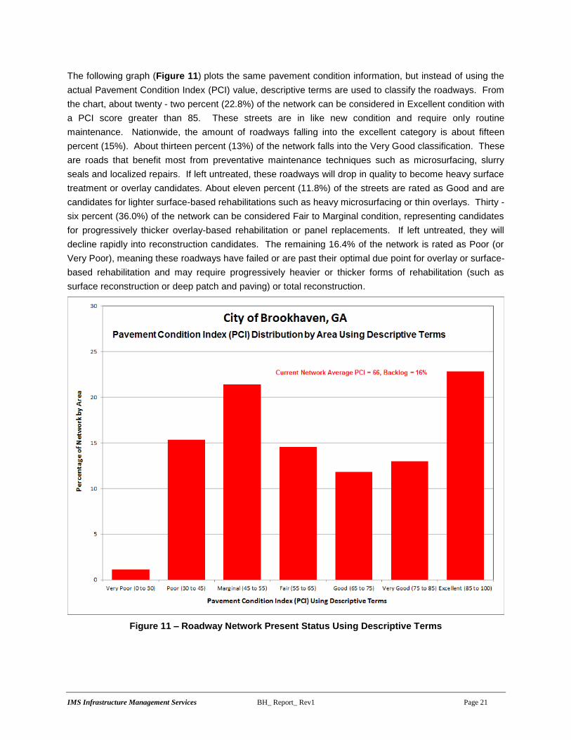
The following graph (Figure 11) plots the same pavement condition information, but instead of using the
actual Pavement Condition Index (PCI) value, descriptive terms are used to classify the roadways. From
the chart, about twenty - two percent (22.8%) of the network can be considered in Excellent condition with
a PCI score greater than 85. These streets are in like new condition and require only routine
maintenance. Nationwide, the amount of roadways falling into the excellent category is about fifteen
percent (15%). About thirteen percent (13%) of the network falls into the Very Good classification. These
are roads that benefit most from preventative maintenance techniques such as microsurfacing, slurry
seals and localized repairs. If left untreated, these roadways will drop in quality to become heavy surface
treatment or overlay candidates. About eleven percent (11.8%) of the streets are rated as Good and are
candidates for lighter surface-based rehabilitations such as heavy microsurfacing or thin overlays. Thirty -
six percent (36.0%) of the network can be considered Fair to Marginal condition, representing candidates
for progressively thicker overlay-based rehabilitation or panel replacements. If left untreated, they will
decline rapidly into reconstruction candidates. The remaining 16.4% of the network is rated as Poor (or
Very Poor), meaning these roadways have failed or are past their optimal due point for overlay or surface-
based rehabilitation and may require progressively heavier or thicker forms of rehabilitation (such as
surface reconstruction or deep patch and paving) or total reconstruction.
Figure 11 – Roadway Network Present Status Using Descriptive Terms
IMS Infrastructure Management Services BH_ Report_ Rev1 Page 22
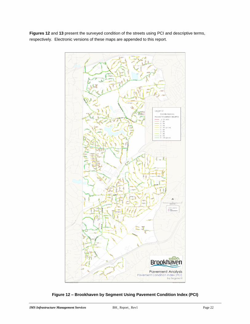
Figures 12 and 13 present the surveyed condition of the streets using PCI and descriptive terms,
respectively. Electronic versions of these maps are appended to this report.
Figure 12 – Brookhaven by Segment Using Pavement Condition Index (PCI)

IMS Infrastructure Management Services BH_ Report_ Rev1 Page 23
Figure 13 – Brookhaven Pavement Condition by Segment Using Descriptive Terms

IMS Infrastructure Management Services BH_ Report_ Rev1 Page 24
A typical roadway network, on average, will drop approximately 2 points per year without maintenance or
rehabilitation – meaning Brookhaven has effectively minimized any substantial drop in condition and has
increased the network average PCI since the last survey through the application of increased funding and
adequate maintenance activities. The long term focus for the health of Brookhaven’s roadway network
from a pavement management perspective is to ensure that the overall condition does not drop and that
the backlog does not grow excessively over time. By reducing the backlog below its current rate, the city
can save itself thousands of dollars by preventing roadway failure.
The role of the street network as a factor in the city’s well-being cannot be overstated. In simplest of
terms, roadways form the economic backbone of a community. They provide the means for goods to be
exchanged, commerce to flourish, commercial enterprises to generate revenue, and are appealing roads
for tourism. As such, they are an investment that needs to be maintained.
The overall condition of an agency’s infrastructure and transportation network is a key indicator of
economic prosperity. Roadway networks in general are one of the most important and dynamic sectors in
the global economy, having a strong influence on not only the economic well-being of a community, but a
strong impact on quality of life. Well-maintained road networks experience multiple socioeconomic
benefits through greater labor market opportunities and decreasing income gap. As a crucial link between
producers and their markets, quality road networks ensure straightforward access to goods and drive
global and local economies. Likewise, higher network quality has a strong correlation to improvements in
household consumption and income. Roads also act as a key element to social cohesion by acting as a
median for integration of bordering regions (Gertler). This social integration promotes a decreased gap in
income along with diversity and a greater sense of community that can play a large role in decreasing
rates of poverty (Amparo).
Conversely, deterioration of roads can have adverse effects on a community and may bring about
important and unanticipated welfare effects that the governments should be aware of when cutting
transportation budgets (Gertler). Poor road conditions increase fuel and tire consumption while shortening
intervals between vehicle repair and maintenance. In turn, these roads result in delayed or more
expensive deliveries for businesses and consumers (Economic Dependence on Good Roads). Economic
effects of poor road networks, such as time consuming and costly rehabilitation, can be reduced if a
proactive maintenance approach is successfully implemented. The Brookhaven road network has a high
percentage of streets that fall under the excellent categories, while the amount of Very poor streets is
minimal. However, the number of streets in the “Poor” and “Marginal” categories means the city has to
focus on arresting the growth in backlog with a long term goal of reducing it to an ideal number less than
or equal to 12%. Brookhaven trends normally when compared to agency of similar size (population).
When the centerline mileage is out of proportion to the population, an increased burden is placed on rate
payers to maintain the network.
The following plot Figure 14 presents a comparison of population versus centerline mileage of several
recent surveys. As can be seen, Brookhaven trends normally than a similar sized agency.

IMS Infrastructure Management Services BH_ Report_ Rev1 Page 25
Figure 14 – Agency Population Versus Centerline Mileage
The primary concern for the long term health of Brookhaven’s roadway network from a pavement
management perspective is twofold in nature:
The average width, as measured by IMS, of the Brookhaven roadway network is 27 feet. Most
agencies surveyed by IMS fall in the 35 to 40 foot range. This means, that even though the
centerline mileage is in line with other agencies, the pavement area to be maintained is much
less than the average agency. Narrow streets will often require additional milling and drainage
repair activities.
Over time, lightweight surface treatments and thin overlays will lose their effectiveness and not be
viable rehabilitation solutions. In the future, the annual budget will need to be increased, even if
the network does not get any larger, in order to check any reduction in pavement quality.
2.3 STRUCTURAL AND LOAD ASSOCIATED DISTRESS ANALYSIS
Structural testing and analysis was not performed for the city of Brookhaven. Instead, analysis of the
cause of pavement failure for these street segments was completed by examining the types of distresses
that have caused the PCI score to drop.

IMS Infrastructure Management Services BH_ Report_ Rev1 Page 26
Surface distresses may be categorized into two classifications – load associated distresses (LAD) and
non-load associated distresses (NLAD). Load associated distresses are those that are directly related to
traffic loading and structural capacity such as rutting and alligator cracking. Non-load associated
distresses are those that result from materials or environmental issues including shrinkage (transverse)
cracking, bleeding and raveling. Generally, load associated distresses affect the overall condition score
more than non-load associated distresses – as is the case in Brookhaven. For asphalt streets, roadways
were classified as Weak, Moderate, or Strong.
Weak pavements are those with a high ratio of load associated distresses compared to their PCI score
and generally require increased pavement thickness to achieve long-term pavement life. Strong
pavements are those that have a low LADD to PCI ratio and have suitable structural capacity to accept
lightweight surface treatments with minimal preparation. Moderate pavements are those that require
localized rehabilitation and/or increased thickness to achieve full pavement life. These are pavements
that are starting to display structural and base failures such as rutting or alligator cracking.
The purpose of the structural analysis is twofold:
The structural index provides input into which performance curve each segment is to use –
performance curves are used to predict pavement deterioration over time.
Structural analysis assists in rehabilitation selection by constraining inadequate pavement
sections from receiving too light of rehabilitation and conversely, identifying segments suitable for
lighter weight treatment.
The primary area of concern is the street segments that have a high pavement condition score (greater
than 65), yet exhibit low structural characteristics (weak to moderate pavement strengths). When an
overlay is to be applied, project level testing and design should be completed to ensure their structural
integrity is restored. The cause of this issue can generally be traced back to three primary sources:
Incorporation of streets into the network that were never designed to carry heavy loads resulting
in premature failure. This is common in rapidly expanding agencies that annex county roads.
Too thin of structural cross section and overlays – this is often caused by the use of standard
designs that simply result in inadequate structural capacities. A firm understanding of subgrade
and base conditions combined with a qualified structural design typically results in a thicker cross
section being specified, but increases the pavement life considerably.
Increase traffic loading beyond initial design limits, combined with ever-increasing truck weights
and tire pressures. Heavier garbage and recycling trucks, along with increased transit bus size
can dramatically alter pavement quality in a very short period of time.
On a recent study completed by IMS for the City of Longview, WA, garbage and recycle trucks account
for approximately 33% to 50% of the pavement damage done to a local street, yet represent only a
fraction of the traffic. The reason for this imbalance is that local streets were never designed for heavy
garbage or recycle trucks and cannot effectively withstand the structural loading – often following the
same wheel path.

IMS Infrastructure Management Services BH_ Report_ Rev1 Page 27
Figure 15 plots the relationship of the load associated distresses (shown in red) and non-load associated
distress (shown in blue) against pavement condition. As can be seen from the plot, at higher PCI scores,
it is the non-load associated distresses that have a higher concentration of deducts over the load
associated distresses. As the PCI score drops, the load associated distresses typically affect the PCI
score to a higher degree. This is indicative of a network that has good pavement performance for the first
half of a street’s life, and then suffers from progressive structural or base failures over time. High PCI
score (above 65) rehab selections should focus on pavement preservation activities such as surface
treatments or thin overlays, possibly with some localized pavement repairs and crack sealing.
The upper black diagonal line identifies segments that have a high ratio of load associated distresses
compared to their PCI score and are defined as weak. The lower black diagonal line identifies segments
that have a low ratio of load associated distresses compared to their PCI score and are defined as strong.
In between the two lines, and all segments with a PCI > 80 are assigned a moderate pavement strength.
The weak, moderate and strong ratings are required for performance curve assignment and rehabilitation
strategy selection within the pavement management software.
Figure 15 – Pavement Condition Index versus Sum of Distress Deducts

IMS Infrastructure Management Services BH_ Report_ Rev1 Page 28
2.4 CONDITION BY FUNCTIONAL CLASSIFICATION
Figure 16 highlights the pavement condition distribution by functional classifications. From the plot it is
apparent the collector roadways are in the best condition at an average PCI of 82. Arterial roadways
(shown in red) have an average PCI of 71, which is slightly above the overall network average of 66.
Arterial roadways are the streets that have the majority of traffic use and link various parts of the City
together. The local roadway network forms the majority of the Brookhaven’s street system. Local
roadways average PCI is 63.
Figure 16 – Condition Rating by Functional Classification
2.5 EVALUATING QUALITY OF THE NETWORK AND RECONSTRUCTION BACKLOG
The concept of the Pavement Condition Index (PCI) score, backlog percentage, and number of streets
rated as Excellent must be fully understood in order to understand and develop an effective pavement
management program. These three metrics should fall into certain ranges in order to measure the quality
and long term viability of a network.
The PCI score indicates the overall pavement condition and represents the amount of equity in the
system; it is the value most commonly considered when gauging the overall quality of a roadway network.
It may also be used to define a desired level of service: that is, an agency may wish to develop a
pavement management program such that in five years the overall network score meets a set minimum
value. Obviously, the higher the PCI score the better off the overall network condition is. Agencies with
an average PCI score above 80 (when considering surface distress, roughness and possibly strength) are

IMS Infrastructure Management Services BH_ Report_ Rev1 Page 29
rare and found only in a few select communities. Less than 1 in 20 communities surveyed by IMS have
that high of a condition average. Averages between 65 and 80 are indicative of either newer networks, or
ones that have an ongoing pavement rehabilitation program and tend to be funded close to their steady
state levels (meaning they are not decreasing in PCI score). Scores between 60 and 65 are common and
represent a reasonable average providing a satisfactory balance between levels of service and funding,
and when taken with the other two metrics may represent a well-managed and funded network. A
minimum score of 60 means that overall the network falls at the lower end of the range where light weight
surface treatments and thin overlays are the standard rehabilitation practice. Below a 60 means an
agency has to rely on more costly rehabilitations and reconstructions to address condition issues.
At the upper end of the condition scale, a minimum of 15% of the network should be rated as Excellent.
Generally, at or above 15%, means that a noticeable percentage of the roadway network is in like new
condition, requiring only routine maintenance. While higher percentages of streets rated as Excellent are
certainly desirable, the annual cost to maintain this rate is often cost prohibitive. Below 15% means the
agency is struggling to effectively rehabilitate their network on an annual basis.
Backlog roadways are those that have dropped sufficiently in quality to the point where surface based
rehabilitation efforts would no longer prove to be cost effective. These roadways are rated Poor or Very
Poor and will require either partial or total reconstruction. Backlog is expressed as the percentage of
roads requiring reconstruction as compared to the network totals.
It is the backlog, however, that defines the amount of legacy work an agency is facing and is willing to
accept in the future. It is the combination of the three metrics that presents the true picture of the
condition of a roadway network, and conversely defines improvement goals.
Generally, a backlog of 10% to 15% of the overall network is considered manageable from a funding point
of view with 12% being a realistic target. Backlog rates below 10%, again are certainly desirable, but
financially unachievable for a large percentage of agencies. Backlogs approaching 20% or more tend to
become unmanageable, unless aggressively checked through larger rehabilitation programs, and will
grow at an alarming rate. At about 20% backlog, the rate of decrease in average condition, and hence
growth in backlog, exceeds most agencies ability to arrest the decline and address the large volumes of
streets in need of rehabilitation. Basically, at 20% a tipping point has been met and the backlog tends to
increase faster than an agency’s ability to reconstruct their streets.
Brookhaven has met two of three metrics for evaluating the quality of its roadway network. Brookhaven’s
average pavement condition score is slightly above the minimum recommended target zone of 60 to 65
with an average score of 66. The number of streets rated as Excellent is above the minimum target of
15% at 22%. The backlog amount is (16%) which is above the recommended target of 12%.

IMS Infrastructure Management Services BH_ Report_ Rev1 Page 30
3.0 REHABILITATION PLAN AND BUDGET DEVELOPMENT
3.1 KEY ANALYSIS SET POINTS
Pavement management analysis requires user inputs in order to complete its condition forecasting and
prioritization. A series of operating parameters were developed in order to develop an efficient program
that is tailored to the city’s needs. Some of the highlights include:
Pavement performance curves are used to predict future pavement condition. Asphalt streets are
classified as weak, moderate or strong, and then assigned the appropriate pavement
performance curve to use in the analysis. The concept of load associated distresses does not
apply to concrete streets.
The shape of performance curves reflect the concept of deferred maintenance and salvage life.
Instead of dropping to an absolute PCI value of 0 after 40 years of service, the curves are
designed to become asymptotic to the age axis and have a whole life of approximately 40 to 60
years depending on pavement type. This indicates the concept that once a street deteriorates
past a specific threshold – about a PCI of 20, age becomes less important in rehabilitation
selection.
Priority ranking – analysis uses prioritization for rehab candidate selection. It is designed to
capture as many segments in their need year based on the incremental cost of deferral. The
higher the functional classification of a street, the higher priority a segment is given.
Pavement Performance Curves
The basic shape of the asphalt and concrete performance curves follows traditional sigmoidal
deterioration models such as those contained in MicroPAVER and other commonly used pavement
management applications. These curves were eventually loaded to the City of Brookhaven’s
Lucity pavement management program. The curves are constructed such that a typical overlay following
new pavement construction does not occur until 20 to 30 years have passed, and full reconstruction does
not occur until 40 to 65 years have passed or the street has a PCI below 10. Each street is assigned a
curve based on its pavement type, functional classification, and pavement strength as determined in
Section 2. The curves assume an ultimate life between 60 and 100 years and are designed to be
asymptotic to the X-axis (Time) to reflect the salvage value of the pavement once it has reached the end
of its service life with a PCI less than 10.
It is important to recognize that even though all streets fall into specific rating categories (as highlighted
by the horizontal black dotted lines in Figure 16 and their respective rehabilitation strategies, it is not until
a street falls to within a few points of the lower end of the range that it will become a critical need selected
for rehabilitation.

IMS Infrastructure Management Services BH_ Report_ Rev1 Page 31
Figure 17 – Asphalt (ACP) and Concrete (PCC) Performance Curves
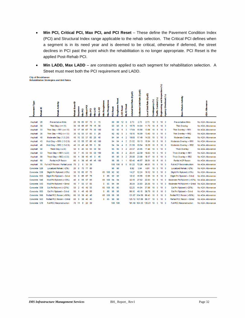
Rehabilitation Strategies and Unit Rates
The rehab strategies and unit rates used in the pavement analysis can be found on the following page.
Some important parameters include:
Rehab Code and Activity – The assigned identifier and name to each rehabilitation strategy.
The term “RR” refers to remove and replace – that is, structural patching. When this term is
present, additional funds have been assigned to the strategy to allow for an increased amount of
preparation work and patching. The relative terms of thin, moderate and thick are used to
describe the overlay thickness. This is to facilitate consistency in the naming convention, but
does not imply the same material thickness has to be used for each functional classification.
Unit Rates – The rehab costs are presented on a per square yard basis for each pavement type,
functional class, and rehab activity combination. The rates were initially developed using typical
national averages for similar activities and then adjusted to match the rates supplied by the City.
Rates include a 20% burden for miscellaneous activities (such as striping removal or loop
detector replacement), traffic control and engineering inspection. No money has been set aside
for contingency, ADA compliance or city overheads.
IMS Infrastructure Management Services BH_ Report_ Rev1 Page 32
Min PCI, Critical PCI, Max PCI, and PCI Reset – These define the Pavement Condition Index
(PCI) and Structural Index range applicable to the rehab selection. The Critical PCI defines when
a segment is in its need year and is deemed to be critical, otherwise if deferred, the street
declines in PCI past the point which the rehabilitation is no longer appropriate. PCI Reset is the
applied Post-Rehab PCI.
Min LADD, Max LADD – are constraints applied to each segment for rehabilitation selection. A
Street must meet both the PCI requirement and LADD.

IMS Infrastructure Management Services BH_ Report_ Rev1 Page 33
3.2 FIX ALL AND ANNUAL ESTIMATES
Three different approaches may be taken to identify and confirm the amount of funds the city needs to set
aside each year to maintain the roadway network at its current condition. All three are completed
externally to the pavement management system and are simply used to validate the final results.
Option 1 – Estimated Life Cycle Cost Based on Network Value
A ballpark value for the annual street maintenance budget may be quickly determined by taking the total
value of Brookhaven’s roadway network, estimated at $92.4M, and dividing that by the ultimate life of a
roadway – assumed to be 75 to 150 years for asphalt and concrete respectively (please note, the 75 to
150 year lifespan of the roadway is the theoretical life of the roadway surface from construction, until the
point at which there not usable surface remaining, it is not simply the lifespan of the pavement surface
until the next overlay). By this method, the annual budget is estimated at $1,230,000.
Pavement Type
Pavement
Value ($)
Ultimate Life Span
(yrs)
Life Cycle
Annual Cost
($/yr)
Asphalt Network 91,557,000 75 1,220,000
Concrete Network 939,000 150 10,000
All Streets 92,496,000 1,230,000
Option 2 – Estimated Life Cycle Cost Based on Current Condition
A second method to validate the annual budget is to identify the average network PCI and associated
rehabilitation requirements, and then estimate the number of miles required to be rehabilitated each year
based on a typical life cycle for that rehabilitation activity. For Brookhaven, the average PCI for asphalt
roads is 64, which places the city in the Moderate Overlay range, at an average cost of $14.35/yd2 for a
Moderate Overlay, the city needs to spend approximately $1.5M/year to maintain the current condition
average.
Pavement Type
Pavement
Condition
Index (PCI)
Typical Rehab Based
on Condition
Blended
Rehab Unit
Rate ($/yd2)
Average
Rehab Life
Cycle (yrs)
Miles To Do
Each Year (mi)
Cost Per Mile
($/mi)
Life Cycle
Annual Cost
($/yr)
Asphalt Network 64 Mod Overlay (2.0 - 3.0) 14.35 18 6.7 230,000 1,550,000
Concrete Network 94 Routine Maintenance 0.25 2 0.2 10,000 0
All Streets 1,550,000
Option 3 - Estimated Life Cycle Cost Based on Network Deficiency
The third methodology to confirm the required amount of annual funding is to identify the current network
deficiency, that is the amount required to rehabilitate all streets in the network assuming unlimited
funding, and then divide by the typical life cycle of each rehabilitation activity. This is referred to as the
Fix All Estimate and Life Cycle Cost. The rehab strategies listed in the table are generic in nature and not
necessarily the final set that was applied to Brookhaven. For Brookhaven, the Fix All Estimate for the
network deficiency is approximately $28.8 million and the Life Cycle Cost is $1.32 million/year, broken
down as follows:

IMS Infrastructure Management Services BH_ Report_ Rev1 Page 34
Asphalt Deficiency
Total Cost
($) % of Total MART MnART COL LOC
Life Cycle
(years)
Life Cycle
Cost ($)
Reconstruction (Base) 1,699,600 5.9 0 0 16,000 1,683,600 50 34,000
Reconstruction (Surface) 11,823,500 41.0 0 683,700 89,900 11,049,900 30 394,000
Thick Olay (> 2.0 - 3.0) 7,432,400 25.8 0 1,006,100 75,500 6,350,800 20 372,000
Mod Overlay (2.0 - 3.0) 4,408,400 15.3 0 1,082,400 371,100 2,954,900 18 245,000
Thin Overlay (1.5 - 2.0) 2,776,200 9.6 20,900 503,000 325,800 1,926,500 15 185,000
Surface Treatment 280,700 1.0 0 50,500 44,900 185,300 7 40,000
Slurry Seal 304,200 1.1 0 47,500 60,200 196,500 5 61,000
Routine Maintenance 93,200 0.3 0 18,700 19,800 54,700 2 47,000
Total Asphalt Network: 28,818,200 100 20,900 3,391,900 1,003,200 24,402,200 1,378,000
Concrete Deficiency
Total Cost
($) % of Total MART MnART COL LOC
Life Cycle
(years)
Life Cycle
Cost ($)
PCC Reconstruction 0 0.0 0 0 0 0 75 0
PCC Partial Recon 0 0.0 0 0 0 0 50 0
Extensive Pnl Rplcmnt 0 0.0 0 0 0 0 25 0
Moderate Pnl Rplcmnt 36,300 94.5 0 0 0 36,300 20 2,000
Slight Pnl Rplcmnt 0 0.0 0 0 0 0 15 0
Localized Rehab 0 0.0 0 0 0 0 10 0
Joint Rehab 0 0.0 0 0 0 0 5 0
Routine Maintenance 2,100 5.5 0 0 0 2,100 2 1,000
Total Concrete Network: 38,400 100 0 0 0 38,400 3,000
Total Network : 28,856,600 20,900 3,391,900 1,003,200 24,440,600 1,381,000
3.3 NETWORK BUDGET ANALYSIS MODELS
An analysis containing a total of 9 budget runs ($500K through $3.5M per year) plus Unlimited and Do
Nothing options was prepared for Brookhaven.
The analysis results are summarized below:
Unlimited - The Unlimited (or Fix All) budget assumes each street is rehabilitated with unlimited
funds available. The idea is to identify the upper limit of spending the city would require without any
constraints on budgets. For Brookhaven, the unlimited budget is approximately $99M over 5 years.
This increases the network PCI to a maximum of 90 and tapering off to an 87 in 5 years.
Do Nothing - This option identifies the effect of spending no capital for 5 years. After 5 years, the
Do Nothing option results in a PCI drop from a 66 to a 56.
$500K through $3.5M - Identifies the resultant network PCI at various funding levels.
Planned Program – Identifies the network performance at the City’s current level of dedicated
annual funding of $4.0M for 2017 ($2.5M annual budget and $1.5M special allocation designated
for backlog). Planned budget of $2.5M/year funding will be spent during 2018 - 2021. The planned
program with special allocation for backlog will result in a network average PCI of 75 in 5 years.

IMS Infrastructure Management Services BH_ Report_ Rev1 Page 35
The results of the analysis are summarized in Figure 17 below. The X-axis highlights the annual budget,
while the Y-axis plots the 5 Year Post Rehab PCI value. The diagonal blue line is the analysis results.
As can be seen from the plot, a budget of $1.40M per year (shown in red) would maintain the network at
its current PCI of 66, and the backlog would increase to 23%. Brookhaven planned program ($4.0M for
2017 followed by $2.5M per year) would increase the PCI to 75 and backlog would decrease to 10%.
Figure 17 – 5 Year Post Rehab Network PCI Analysis Results

IMS Infrastructure Management Services BH_ Report_ Rev1 Page 36
Figure 18 presents the resultant network backlog against annual budget. Similar to Figure 17, but
instead of plotting the average PCI score, the blue diagonal line represents the total backlog after 5 years.
A $2.0M annual budget would maintain the Backlog at 16% and increase the PCI to 70. Brookhaven
planned program would increase the average PCI to a 75 and decrease the backlog to 10%.
Figure 18 – 5 Year Post Rehab Network Backlog Results

IMS Infrastructure Management Services BH_ Report_ Rev1 Page 37
Figure 19 below presents the analysis results on an annual basis. This shows that if the budget falls
below $1.5M/year, over time the overall condition of the roads will deteriorate as the backlog increases.
However at $1.5M backlog will rise over 20%.
Figure 19 – 5 Year Annual PCI

IMS Infrastructure Management Services BH_ Report_ Rev1 Page 38
3.4 BROOKHAVEN COMPARISON TO OTHER AGENCIES
The following table presents the steady state versus actual funding levels of various agencies that use
similar reporting and analysis software. The list is by no means representing all agencies that use a
pavement management system, but rather is a sampling of what other agencies are doing.
In comparison to other agencies, Brookhaven’s steady state budget requirement of approximately
$10,000/mile is well below the sample average of $15,500. This is consistent with a smaller city network
that is narrow in width and places an emphasis on preventative maintenance over reconstruction.

IMS Infrastructure Management Services BH_ Report_ Rev1 Page 39
Figure 20 illustrates the overall network health of various agencies by developing a relative scoring
system (Network Index) that compares the Network average PCI and the agency’s Backlog (Very Poor
and Poor roadways). An agency with a PCI of 100 and no backlog would score a perfect Network Index
of 100. A very well managed network would score above 71, while one in healthy condition would fall
between 58 and 71, representing a PCI score of 65 with no more than 10% backlog up to a PCI of 75 with
only 5% backlog. The minimum target Network Index is 51 representing a PCI of 60 with 15% backlog.
Brookhaven’s current Network Index is 55 (shown by the blue square) placing it in at the upper-end of a
minimum network index.
Figure 20 – Network Index

IMS Infrastructure Management Services BH_ Report_ Rev1 Page 40
3.5 SELECTION SUMMARY AND POST REHABILITATION CONDITION
The following figure (Figure 21) compares the current network condition distribution against what the five-
year post rehabilitation distribution would be at a planned program budget of $4.0M/$2.5M per year. As
can be seen in the plot, two out of three metrics of qualitative assessment are met at that budget level.
Figure 21 – Five-Year Post Rehabilitation Condition Distribution

IMS Infrastructure Management Services BH_ Report_ Rev1 Page 41
Figure 22 and Figure 23 present the $4.0/$2.5M per year network rehabilitation plan by year and activity,
as well as how the network condition would appear on a segment by segment basis. Electronic versions
of these maps are appended to this report.
Figure 22 – Five-Year Rehabilitation Plan

IMS Infrastructure Management Services BH_ Report_ Rev1 Page 42
Figure 23 – Five-Year Post Rehabilitation Network Condition by Segment
IMS Infrastructure Management Services BH_ Report_ Rev1 Page 43
3.6 NETWORK RECOMMENDATIONS AND COMMENTS
The following recommendations are presented to Brookhaven as an output from the pavement analysis, and
must be read in conjunction with the attached reports.
1. Brookhaven should adopt a policy raising the existing PCI greater than or equal to 70 with a backlog
below 12%.
A budget of $4.0M in 2017 followed by $2.5M annually will increase the average
network PCI to a 75 and reduce the backlog to 10%.
2. The full suite of proposed rehabilitation strategies and unit rates should be reviewed annually as
these can have considerable effects on the final program.
3. All unit rates include a 20% burden in addition to their actual construction cost to cover traffic
control, miscellaneous activities, and inspection. The unit rates have no funding for ADA
compliance as these are assumed to be funded separately.
4. All costs are in constant 2016 dollars. No allowances have been made for inflation or fluctuations in
rehabilitation costs.
5. No allowance has been made for network growth or conversion of gravel roadways to pavement.
As the city expands or increases the amount of paved roads, increased budgets will be required.
6. No allowance has been made for routine maintenance activities such as asphalt crack sealing,
pothole filling, sweeping, striping or patching within the budget runs and analysis. These costs are
assumed to be outside the pavement management costs.
7. The city should resurvey their streets every few years to update the condition data and
rehabilitation program.

Appendix A
Street Inventory and Condition Summary

City of Brookhaven, GAAppendix A - Street Inventory and Condition Summary Condition Summary
Segm
ent I
D
GIS
ID
Stre
et N
umbe
r
Blo
ck N
umbe
r
Stre
et N
ame
From
Str
eet
To S
tree
t
Pave
men
t Len
gth
(ft)
Pave
men
t Wid
th (f
t)
Pave
men
t Are
a (y
d2)
Age
ncy
FunC
L C
d
Func
tiona
l Cla
ss
Pave
men
t Typ
e C
d
Pave
men
t Typ
e
Ow
ner
Stre
ngth
Rat
ing
Con
ditio
n R
atin
g
Rou
ghne
ss In
dex
(RI)
Surf
ace
Dis
tres
s In
dex
(SD
I)
Pave
men
t Con
ditio
n In
dex
(PC
I)
Ove
rrid
e PC
I
Cur
rent
PC
I
Surv
ey D
ate
Load
Ass
oc D
istr
esse
s (L
AD
)
Non
-Loa
d D
istr
esse
s (N
LAD
)
343245810 1452 10 5 9th St Park Ln Jefferson St 995 25 2,763 3 Local 1 Asphalt City 3 Good 75 61 66 66 9/5/2016 27.8 10.8
343246019 1453 10 10 9th St Jefferson St Clairmont Rd 366 25 1,016 3 Local 1 Asphalt City 3 Very Good 74 82 80 79 9/5/2016 1.6 16.1
343244419 2067 20 5 Afton Ln Folkstone Rd Buford Hwy 188 19 396 3 Local 1 Asphalt City 1 Poor 48 34 38 38 9/5/2016 48.2 18.2
343244421 2296 20 10 Afton Ln Folkstone Rd EAST END 366 14 570 3 Local 1 Asphalt City 1 Marginal 56 46 49 49 9/5/2016 49.0 5.2
420791600 1257 30 5 Alden Place Dr Caldwell Rd NW END 224 33 820 3 Local 1 Asphalt City 1 Poor 55 21 32 32 9/5/2016 67.1 11.8
442738590 3904 40 5 Alexandria Ct Osborne Rd EAST END 432 28 1,344 3 Local 1 Asphalt City 1 Poor 45 37 40 39 9/5/2016 55.1 7.9
343245548 3685 50 5 Alta Vista Dr Grant Dr Milowyn Pl 394 29 1,270 3 Local 1 Asphalt City 1 Poor 51 30 37 94 94 9/6/2016 53.7 16.7
445260866 3888 60 5 Antioch Dr Madison Ave Georgia Ave 1,171 20 2,602 3 Local 1 Asphalt City 2 Marginal 62 36 45 44 9/5/2016 38.2 25.8
445260865 3887 60 10 Antioch Dr Mabry Rd Madison Ave 491 21 1,147 3 Local 1 Asphalt City 3 Fair 60 53 55 55 9/5/2016 24.0 22.7
343245403 1260 70 5 Appalachee Dr Canoochee Dr Dresden Dr 545 25 1,513 3 Local 1 Asphalt City 1 Marginal 64 32 43 43 9/5/2016 44.6 23.0
343245397 1259 70 10 Appalachee Dr Etowah Dr Canoochee Dr 445 25 1,236 3 Local 1 Asphalt City 1 Marginal 74 25 41 41 9/5/2016 59.1 15.8
343251581 1258 70 15 Appalachee Dr Cartecay Dr Etowah Dr 438 26 1,265 3 Local 1 Asphalt City 3 Marginal 69 39 49 49 9/5/2016 36.1 24.7
343245427 3314 80 5 Apple Valley Rd E Osborne Rd NE END 548 35 2,131 3 Local 1 Asphalt City 3 Fair 61 53 56 56 9/5/2016 25.1 21.5
343245417 3315 80 10 Apple Valley Rd Oaklawn Ave E Osborne Rd 527 27 1,581 3 Local 1 Asphalt City 3 Marginal 65 49 54 54 9/5/2016 24.5 26.4
343245371 3316 80 15 Apple Valley Rd Park Ave Oaklawn Ave 255 26 735 3 Local 1 Asphalt City 1 Marginal 58 34 42 42 9/5/2016 41.0 24.6
343245370 3317 80 20 Apple Valley Rd Sunland Dr Park Ave 276 24 735 3 Local 1 Asphalt City 2 Marginal 53 39 44 44 9/5/2016 36.7 23.9
424395422 1461 80 25 Apple Valley Rd Parkside Dr Sunland Dr 541 25 1,504 3 Local 1 Asphalt City 2 Marginal 62 43 49 49 9/5/2016 39.5 17.9
424395423 1460 80 30 Apple Valley Rd Dresden Dr Parkside Dr 106 38 449 3 Local 1 Asphalt City 3 Fair 55 62 60 60 9/5/2016 28.1 9.6
343254419 1136 80 35 Apple Valley Rd Peachtree Vw Dresden Dr 411 36 1,645 3 Local 1 Asphalt City 1 Marginal 85 35 51 51 9/5/2016 54.9 10.0
343254420 1135 80 40 Apple Valley Rd Fernwood Cir Peachtree Vw 256 33 940 3 Local 1 Asphalt City 1 Poor 72 19 36 36 9/5/2016 57.3 23.9
442752274 3879 80 45 Apple Valley Rd N Druid Hills Rd Fernwood Cir 1,013 35 3,941 3 Local 1 Asphalt City 1 Marginal 79 33 48 48 9/5/2016 56.3 10.8
343245574 1480 90 5 Aragon Way N Thompson Rd Ashford Rd 937 26 2,706 3 Local 1 Asphalt City 1 Poor 53 27 36 36 9/5/2016 53.0 19.7
343245632 3224 100 10 Archway Dr Dresden Dr Archway Ln 577 27 1,730 3 Local 1 Asphalt City 2 Very Good 72 91 84 84 9/5/2016 0.0 9.4
343245761 3157 110 5 Ashburn Ln SOUTH END Duke Rd 996 22 2,434 3 Local 1 Asphalt City 2 Marginal 68 42 50 50 9/5/2016 45.0 13.2
500000050 20183 5620 5 Ashcroft Bend SOUTH END Marlow Pl 163 22 399 3 Local 1 Asphalt City 2 Excellent 89 98 95 95 9/5/2016 0.0 2.2
500000036 20028 5620 10 Ashcroft Bend Marlow Pl Danbury Parc Pl 395 23 1,009 3 Local 1 Asphalt City 3 Very Good 65 83 77 77 9/5/2016 14.0 2.7
343246544 1736 120 5 Ashentree Ct NW END Ashentree Dr 292 23 746 3 Local 1 Asphalt City 3 Fair 46 70 62 62 9/5/2016 25.5 4.8
343246547 1823 130 5 Ashentree Dr Ashentree Ct Chamblee Dunwoody Rd 436 25 1,212 3 Local 1 Asphalt City 3 Fair 66 60 62 62 9/5/2016 24.2 15.7
343246543 2751 130 10 Ashentree Dr W Nancy Creek Dr Ashentree Ct 511 27 1,534 3 Local 1 Asphalt City 3 Good 65 68 67 67 9/5/2016 10.9 20.8
343246533 2752 130 15 Ashentree Dr SW END W Nancy Creek Dr 620 26 1,791 3 Local 1 Asphalt City 3 Marginal 46 53 51 51 9/5/2016 8.9 38.1
408880286 1390 140 5 Ashford Club Ct WEST END Ashford Dunwoody Rd 367 30 1,223 3 Local 1 Asphalt City 3 Good 59 78 72 72 9/5/2016 16.9 4.8
343278971 572 150 5 Ashford Dunwoody Rd Ramp Ramp 382 88 3,735 1 Arterial 1 Asphalt City 2 Very Good 81 74 76 76 9/5/2016 0.0 25.7
422408573 1648 150 10 Ashford Dunwoody Rd Oak Forest Dr Lake Hearn Dr 1,009 65 7,286 1 Arterial 1 Asphalt City 3 Fair 73 50 58 57 9/5/2016 23.0 27.1
422408575 3070 150 15 Ashford Dunwoody Rd Oak Forest Dr Dunwoody Ln 634 24 1,690 1 Arterial 1 Asphalt City 3 Marginal 86 33 50 50 9/5/2016 28.4 38.7
424392357 3071 150 20 Ashford Dunwoody Rd Dunwoody Ln Rustic Ridge Dr 543 31 1,871 1 Arterial 1 Asphalt City 3 Fair 88 41 57 56 9/5/2016 26.5 32.2
424392358 3072 150 25 Ashford Dunwoody Rd Oconee Pass Rustic Ridge Dr 152 37 626 1 Arterial 1 Asphalt City 3 Fair 98 42 60 60 9/5/2016 23.5 34.8
408858181 3401 150 30 Ashford Dunwoody Rd Chaucer Ln Oconee Pass 658 32 2,341 1 Arterial 1 Asphalt City 3 Fair 85 47 59 59 9/5/2016 28.6 24.7
IMS Infrastructure Management Services BH_Analysis_Rev4 (002), App A - Inventory page 1 of 87

City of Brookhaven, GAAppendix A - Street Inventory and Condition Summary
Segm
ent I
D
GIS
ID
Stre
et N
umbe
r
Blo
ck N
umbe
r
Stre
et N
ame
From
Str
eet
To S
tree
t
Pave
men
t Len
gth
(ft)
Pave
men
t Wid
th (f
t)
Pave
men
t Are
a (y
d2)
Age
ncy
FunC
L C
d
Func
tiona
l Cla
ss
Pave
men
t Typ
e C
d
Pave
men
t Typ
e
343245810 1452 10 5 9th St Park Ln Jefferson St 995 25 2,763 3 Local 1 Asphalt
343246019 1453 10 10 9th St Jefferson St Clairmont Rd 366 25 1,016 3 Local 1 Asphalt
343244419 2067 20 5 Afton Ln Folkstone Rd Buford Hwy 188 19 396 3 Local 1 Asphalt
343244421 2296 20 10 Afton Ln Folkstone Rd EAST END 366 14 570 3 Local 1 Asphalt
420791600 1257 30 5 Alden Place Dr Caldwell Rd NW END 224 33 820 3 Local 1 Asphalt
442738590 3904 40 5 Alexandria Ct Osborne Rd EAST END 432 28 1,344 3 Local 1 Asphalt
343245548 3685 50 5 Alta Vista Dr Grant Dr Milowyn Pl 394 29 1,270 3 Local 1 Asphalt
445260866 3888 60 5 Antioch Dr Madison Ave Georgia Ave 1,171 20 2,602 3 Local 1 Asphalt
445260865 3887 60 10 Antioch Dr Mabry Rd Madison Ave 491 21 1,147 3 Local 1 Asphalt
343245403 1260 70 5 Appalachee Dr Canoochee Dr Dresden Dr 545 25 1,513 3 Local 1 Asphalt
343245397 1259 70 10 Appalachee Dr Etowah Dr Canoochee Dr 445 25 1,236 3 Local 1 Asphalt
343251581 1258 70 15 Appalachee Dr Cartecay Dr Etowah Dr 438 26 1,265 3 Local 1 Asphalt
343245427 3314 80 5 Apple Valley Rd E Osborne Rd NE END 548 35 2,131 3 Local 1 Asphalt
343245417 3315 80 10 Apple Valley Rd Oaklawn Ave E Osborne Rd 527 27 1,581 3 Local 1 Asphalt
343245371 3316 80 15 Apple Valley Rd Park Ave Oaklawn Ave 255 26 735 3 Local 1 Asphalt
343245370 3317 80 20 Apple Valley Rd Sunland Dr Park Ave 276 24 735 3 Local 1 Asphalt
424395422 1461 80 25 Apple Valley Rd Parkside Dr Sunland Dr 541 25 1,504 3 Local 1 Asphalt
424395423 1460 80 30 Apple Valley Rd Dresden Dr Parkside Dr 106 38 449 3 Local 1 Asphalt
343254419 1136 80 35 Apple Valley Rd Peachtree Vw Dresden Dr 411 36 1,645 3 Local 1 Asphalt
343254420 1135 80 40 Apple Valley Rd Fernwood Cir Peachtree Vw 256 33 940 3 Local 1 Asphalt
442752274 3879 80 45 Apple Valley Rd N Druid Hills Rd Fernwood Cir 1,013 35 3,941 3 Local 1 Asphalt
343245574 1480 90 5 Aragon Way N Thompson Rd Ashford Rd 937 26 2,706 3 Local 1 Asphalt
343245632 3224 100 10 Archway Dr Dresden Dr Archway Ln 577 27 1,730 3 Local 1 Asphalt
343245761 3157 110 5 Ashburn Ln SOUTH END Duke Rd 996 22 2,434 3 Local 1 Asphalt
500000050 20183 5620 5 Ashcroft Bend SOUTH END Marlow Pl 163 22 399 3 Local 1 Asphalt
500000036 20028 5620 10 Ashcroft Bend Marlow Pl Danbury Parc Pl 395 23 1,009 3 Local 1 Asphalt
343246544 1736 120 5 Ashentree Ct NW END Ashentree Dr 292 23 746 3 Local 1 Asphalt
343246547 1823 130 5 Ashentree Dr Ashentree Ct Chamblee Dunwoody Rd 436 25 1,212 3 Local 1 Asphalt
343246543 2751 130 10 Ashentree Dr W Nancy Creek Dr Ashentree Ct 511 27 1,534 3 Local 1 Asphalt
343246533 2752 130 15 Ashentree Dr SW END W Nancy Creek Dr 620 26 1,791 3 Local 1 Asphalt
408880286 1390 140 5 Ashford Club Ct WEST END Ashford Dunwoody Rd 367 30 1,223 3 Local 1 Asphalt
343278971 572 150 5 Ashford Dunwoody Rd Ramp Ramp 382 88 3,735 1 Arterial 1 Asphalt
422408573 1648 150 10 Ashford Dunwoody Rd Oak Forest Dr Lake Hearn Dr 1,009 65 7,286 1 Arterial 1 Asphalt
422408575 3070 150 15 Ashford Dunwoody Rd Oak Forest Dr Dunwoody Ln 634 24 1,690 1 Arterial 1 Asphalt
424392357 3071 150 20 Ashford Dunwoody Rd Dunwoody Ln Rustic Ridge Dr 543 31 1,871 1 Arterial 1 Asphalt
424392358 3072 150 25 Ashford Dunwoody Rd Oconee Pass Rustic Ridge Dr 152 37 626 1 Arterial 1 Asphalt
408858181 3401 150 30 Ashford Dunwoody Rd Chaucer Ln Oconee Pass 658 32 2,341 1 Arterial 1 Asphalt
Condition Details
IRI V
alue
(mm
/m)
Rut
ting
/ Tra
nsve
rse
Prof
ile
Tran
s-Lo
ng C
rk -
Line
ar C
rk
Alli
gato
r Crk
/ D
ivid
ed S
lab
Map
Crk
/ C
orne
r Bre
ak
Edge
Crk
/ Jo
int S
pall
Dis
tort
ions
/ Fa
ultin
g
Ble
edin
g / P
olis
hed
Agg
Rav
elin
g / S
calin
g
Patc
hing
3.1 10.0 8.9 7.9 9.7 10.0 10.0 10.0 10.0 9.2
3.2 10.0 8.0 10.0 10.0 10.0 10.0 10.0 10.0 9.8
6.7 10.0 8.4 5.2 9.1 10.0 10.0 10.0 9.8 10.0
5.5 10.0 9.4 5.3 10.0 10.0 10.0 10.0 9.9 9.8
5.6 9.0 9.3 4.3 10.0 10.0 10.0 10.0 8.9 10.0
7.4 9.2 9.1 5.7 10.0 10.0 10.0 10.0 9.8 9.5
6.3 10.0 8.7 7.2 10.0 10.0 10.0 10.0 8.8 6.8
4.6 10.0 7.9 7.0 8.9 10.0 10.0 10.0 9.4 9.0
4.9 10.0 7.7 7.7 10.0 10.0 10.0 10.0 9.2 9.9
4.3 10.0 7.2 7.4 10.0 10.0 9.5 10.0 9.8 8.2
3.2 10.0 8.0 6.3 10.0 10.0 10.0 10.0 10.0 7.2
3.7 10.0 8.4 7.7 7.8 10.0 9.4 10.0 10.0 8.8
4.6 10.0 8.9 8.0 7.8 10.0 10.0 10.0 9.9 9.4
4.2 10.0 8.7 7.6 8.7 10.0 10.0 10.0 8.4 9.9
5.1 9.3 7.9 7.4 10.0 10.0 10.0 10.0 8.6 8.9
5.9 10.0 8.7 7.4 9.7 10.0 10.0 10.0 7.8 8.6
4.6 9.4 8.6 7.6 9.3 10.0 9.9 10.0 9.4 8.8
5.6 10.0 8.9 7.2 10.0 10.0 10.0 10.0 9.9 10.0
2.4 10.0 8.7 5.1 10.0 10.0 10.0 10.0 10.0 9.3
3.4 10.0 7.0 4.9 10.0 10.0 10.0 10.0 10.0 9.3
2.8 9.9 8.7 4.8 10.0 10.0 10.0 10.0 10.0 9.5
5.8 9.5 8.3 5.8 9.7 10.0 9.6 10.0 9.2 9.5
4.6 10.0 9.0 10.0 10.0 10.0 10.0 10.0 9.7 10.0
3.8 10.0 9.3 6.1 9.0 10.0 9.9 10.0 9.5 9.3
2.6 10.0 9.7 10.0 10.0 10.0 10.0 10.0 10.0 10.0
4.1 10.0 9.8 8.6 10.0 10.0 10.0 10.0 9.7 10.0
10.7 10.0 9.6 7.6 10.0 10.0 10.0 10.0 9.8 9.8
4.0 10.0 9.5 7.6 8.0 10.0 10.0 10.0 9.9 10.0
4.2 10.0 8.9 8.9 8.0 10.0 10.0 10.0 9.9 10.0
7.1 10.0 7.9 9.1 6.4 10.0 10.0 10.0 9.7 10.0
7.0 10.0 9.5 8.3 10.0 10.0 10.0 10.0 9.8 10.0
2.7 10.0 7.8 10.0 9.9 10.0 10.0 9.8 8.9 10.0
3.3 9.4 8.2 8.7 9.3 10.0 9.8 10.0 8.4 9.6
2.3 10.0 6.4 7.2 10.0 10.0 9.9 10.0 8.3 10.0
2.2 10.0 8.5 7.4 9.9 10.0 10.0 10.0 6.5 9.9
1.6 10.0 8.3 7.6 10.0 10.0 10.0 10.0 6.2 10.0
2.4 10.0 8.5 7.2 10.0 10.0 10.0 10.0 7.7 9.9
IMS Infrastructure Management Services BH_Analysis_Rev4 (002), App A - Inventory page 2 of 87

City of Brookhaven, GAAppendix A - Street Inventory and Condition Summary
Segm
ent I
D
GIS
ID
Stre
et N
umbe
r
Blo
ck N
umbe
r
Stre
et N
ame
From
Str
eet
To S
tree
t
Pave
men
t Len
gth
(ft)
Pave
men
t Wid
th (f
t)
Pave
men
t Are
a (y
d2)
Age
ncy
FunC
L C
d
Func
tiona
l Cla
ss
Pave
men
t Typ
e C
d
Pave
men
t Typ
e
343245810 1452 10 5 9th St Park Ln Jefferson St 995 25 2,763 3 Local 1 Asphalt
343246019 1453 10 10 9th St Jefferson St Clairmont Rd 366 25 1,016 3 Local 1 Asphalt
343244419 2067 20 5 Afton Ln Folkstone Rd Buford Hwy 188 19 396 3 Local 1 Asphalt
343244421 2296 20 10 Afton Ln Folkstone Rd EAST END 366 14 570 3 Local 1 Asphalt
420791600 1257 30 5 Alden Place Dr Caldwell Rd NW END 224 33 820 3 Local 1 Asphalt
442738590 3904 40 5 Alexandria Ct Osborne Rd EAST END 432 28 1,344 3 Local 1 Asphalt
343245548 3685 50 5 Alta Vista Dr Grant Dr Milowyn Pl 394 29 1,270 3 Local 1 Asphalt
445260866 3888 60 5 Antioch Dr Madison Ave Georgia Ave 1,171 20 2,602 3 Local 1 Asphalt
445260865 3887 60 10 Antioch Dr Mabry Rd Madison Ave 491 21 1,147 3 Local 1 Asphalt
343245403 1260 70 5 Appalachee Dr Canoochee Dr Dresden Dr 545 25 1,513 3 Local 1 Asphalt
343245397 1259 70 10 Appalachee Dr Etowah Dr Canoochee Dr 445 25 1,236 3 Local 1 Asphalt
343251581 1258 70 15 Appalachee Dr Cartecay Dr Etowah Dr 438 26 1,265 3 Local 1 Asphalt
343245427 3314 80 5 Apple Valley Rd E Osborne Rd NE END 548 35 2,131 3 Local 1 Asphalt
343245417 3315 80 10 Apple Valley Rd Oaklawn Ave E Osborne Rd 527 27 1,581 3 Local 1 Asphalt
343245371 3316 80 15 Apple Valley Rd Park Ave Oaklawn Ave 255 26 735 3 Local 1 Asphalt
343245370 3317 80 20 Apple Valley Rd Sunland Dr Park Ave 276 24 735 3 Local 1 Asphalt
424395422 1461 80 25 Apple Valley Rd Parkside Dr Sunland Dr 541 25 1,504 3 Local 1 Asphalt
424395423 1460 80 30 Apple Valley Rd Dresden Dr Parkside Dr 106 38 449 3 Local 1 Asphalt
343254419 1136 80 35 Apple Valley Rd Peachtree Vw Dresden Dr 411 36 1,645 3 Local 1 Asphalt
343254420 1135 80 40 Apple Valley Rd Fernwood Cir Peachtree Vw 256 33 940 3 Local 1 Asphalt
442752274 3879 80 45 Apple Valley Rd N Druid Hills Rd Fernwood Cir 1,013 35 3,941 3 Local 1 Asphalt
343245574 1480 90 5 Aragon Way N Thompson Rd Ashford Rd 937 26 2,706 3 Local 1 Asphalt
343245632 3224 100 10 Archway Dr Dresden Dr Archway Ln 577 27 1,730 3 Local 1 Asphalt
343245761 3157 110 5 Ashburn Ln SOUTH END Duke Rd 996 22 2,434 3 Local 1 Asphalt
500000050 20183 5620 5 Ashcroft Bend SOUTH END Marlow Pl 163 22 399 3 Local 1 Asphalt
500000036 20028 5620 10 Ashcroft Bend Marlow Pl Danbury Parc Pl 395 23 1,009 3 Local 1 Asphalt
343246544 1736 120 5 Ashentree Ct NW END Ashentree Dr 292 23 746 3 Local 1 Asphalt
343246547 1823 130 5 Ashentree Dr Ashentree Ct Chamblee Dunwoody Rd 436 25 1,212 3 Local 1 Asphalt
343246543 2751 130 10 Ashentree Dr W Nancy Creek Dr Ashentree Ct 511 27 1,534 3 Local 1 Asphalt
343246533 2752 130 15 Ashentree Dr SW END W Nancy Creek Dr 620 26 1,791 3 Local 1 Asphalt
408880286 1390 140 5 Ashford Club Ct WEST END Ashford Dunwoody Rd 367 30 1,223 3 Local 1 Asphalt
343278971 572 150 5 Ashford Dunwoody Rd Ramp Ramp 382 88 3,735 1 Arterial 1 Asphalt
422408573 1648 150 10 Ashford Dunwoody Rd Oak Forest Dr Lake Hearn Dr 1,009 65 7,286 1 Arterial 1 Asphalt
422408575 3070 150 15 Ashford Dunwoody Rd Oak Forest Dr Dunwoody Ln 634 24 1,690 1 Arterial 1 Asphalt
424392357 3071 150 20 Ashford Dunwoody Rd Dunwoody Ln Rustic Ridge Dr 543 31 1,871 1 Arterial 1 Asphalt
424392358 3072 150 25 Ashford Dunwoody Rd Oconee Pass Rustic Ridge Dr 152 37 626 1 Arterial 1 Asphalt
408858181 3401 150 30 Ashford Dunwoody Rd Chaucer Ln Oconee Pass 658 32 2,341 1 Arterial 1 Asphalt
SuperSegment Details
Supe
rSeg
ID
SuperSeg Description Supe
rSeg
Len
gth
(ft)
Supe
rSeg
Are
a (y
d2)
Supe
rSeg
LA
D
Supe
rSeg
PC
I
3550 3550 - 9th St + Others 2406 6417 17 71
3550 3550 - 9th St + Others 2406 6417 17 71
1000 1000 - Folkstone Rd + Others 1533 3795 49 43
1000 1000 - Folkstone Rd + Others 1533 3795 49 43
1010 1010 - Alden Place Dr 224 820 67 32
1020 1020 - Alexandria Ct 432 1344 55 39
3240 3240 - Milowyn Pl + Others 1172 3431 62 94
1030 1030 - Antioch Dr + Others 2725 5791 39 48
1030 1030 - Antioch Dr + Others 2725 5791 39 48
1040 1040 - Appalachee Dr 1428 4014 46 44
1040 1040 - Appalachee Dr 1428 4014 46 44
1040 1040 - Appalachee Dr 1428 4014 46 44
1050 1050 - Apple Valley Rd 3934 13661 43 49
1050 1050 - Apple Valley Rd 3934 13661 43 49
1050 1050 - Apple Valley Rd 3934 13661 43 49
1050 1050 - Apple Valley Rd 3934 13661 43 49
1050 1050 - Apple Valley Rd 3934 13661 43 49
1050 1050 - Apple Valley Rd 3934 13661 43 49
1050 1050 - Apple Valley Rd 3934 13661 43 49
1050 1050 - Apple Valley Rd 3934 13661 43 49
1050 1050 - Apple Valley Rd 3934 13661 43 49
4170 4170 - Trentwood Pl + Others 2160 6239 60 36
1060 1060 - Archway Dr 577 1730 0 84
4190 4190 - Ashburn Ln + Others 1786 4717 52 43
3190 3190 - Danbury Parc Pl + Others 4367 11254 11 82
3190 3190 - Danbury Parc Pl + Others 4367 11254 11 82
1070 1070 - Ashentree Dr + Others 1860 5283 15 60
1070 1070 - Ashentree Dr + Others 1860 5283 15 60
1070 1070 - Ashentree Dr + Others 1860 5283 15 60
1070 1070 - Ashentree Dr + Others 1860 5283 15 60
1080 1080 - Ashford Club Ct 367 1223 17 72
1090 1090 - Ashford Dunwoody Rd 1391 11021 15 64
1090 1090 - Ashford Dunwoody Rd 1391 11021 15 64
1100 1100 - Ashford Dunwoody Rd 4379 16682 32 53
1100 1100 - Ashford Dunwoody Rd 4379 16682 32 53
1100 1100 - Ashford Dunwoody Rd 4379 16682 32 53
1100 1100 - Ashford Dunwoody Rd 4379 16682 32 53
IMS Infrastructure Management Services BH_Analysis_Rev4 (002), App A - Inventory page 3 of 87

City of Brookhaven, GAAppendix A - Street Inventory and Condition Summary Condition Summary
Segm
ent I
D
GIS
ID
Stre
et N
umbe
r
Blo
ck N
umbe
r
Stre
et N
ame
From
Str
eet
To S
tree
t
Pave
men
t Len
gth
(ft)
Pave
men
t Wid
th (f
t)
Pave
men
t Are
a (y
d2)
Age
ncy
FunC
L C
d
Func
tiona
l Cla
ss
Pave
men
t Typ
e C
d
Pave
men
t Typ
e
Ow
ner
Stre
ngth
Rat
ing
Con
ditio
n R
atin
g
Rou
ghne
ss In
dex
(RI)
Surf
ace
Dis
tres
s In
dex
(SD
I)
Pave
men
t Con
ditio
n In
dex
(PC
I)
Ove
rrid
e PC
I
Cur
rent
PC
I
Surv
ey D
ate
Load
Ass
oc D
istr
esse
s (L
AD
)
Non
-Loa
d D
istr
esse
s (N
LAD
)
343246455 1404 150 35 Ashford Dunwoody Rd Brenton Dr Chaucer Ln 319 26 923 1 Arterial 1 Asphalt City 3 Very Good 96 66 76 76 9/5/2016 6.7 27.6
343246452 1403 150 40 Ashford Dunwoody Rd Parkcrest Dr Brenton Dr 123 29 398 1 Arterial 1 Asphalt City 3 Good 97 59 71 71 9/5/2016 9.5 31.8
343246422 3402 150 45 Ashford Dunwoody Rd W Nancy Creek Dr Parkcrest Dr 840 30 2,800 1 Arterial 1 Asphalt City 2 Marginal 90 33 52 51 9/5/2016 43.8 23.5
408858243 1402 150 50 Ashford Dunwoody Rd Harts Mill Rd W Nancy Creek Dr 1,108 49 6,033 1 Arterial 1 Asphalt City 2 Marginal 80 31 47 47 9/5/2016 37.4 31.6
408858393 1647 150 55 Ashford Dunwoody Rd Woods Dr Harts Mill Rd 1,939 36 7,757 1 Arterial 1 Asphalt City 3 Excellent 94 84 87 87 9/5/2016 4.4 11.6
408880345 1646 150 60 Ashford Dunwoody Rd Ashford Creek Dr Woods Dr 237 50 1,318 1 Arterial 1 Asphalt City 2 Excellent 91 99 96 96 9/5/2016 0.0 1.4
424395374 3073 150 65 Ashford Dunwoody Rd Driveway Ashford Creek Dr 672 39 2,912 1 Arterial 1 Asphalt City 2 Excellent 100 98 99 99 9/5/2016 0.0 1.6
424395376 1645 150 70 Ashford Dunwoody Rd Woods Dr Driveway 168 38 708 1 Arterial 1 Asphalt City 3 Excellent 85 95 92 92 9/5/2016 1.1 3.9
424395256 3074 150 75 Ashford Dunwoody Rd Ramp Woods Dr 427 35 1,661 1 Arterial 1 Asphalt City 2 Excellent 89 96 94 94 9/5/2016 0.0 3.6
424395257 3075 150 80 Ashford Dunwoody Rd Johnson Ferry Rd Ramp 221 37 907 1 Arterial 1 Asphalt City 2 Excellent 79 93 88 88 9/5/2016 0.0 7.3
424395288 3069 150 85 Ashford Dunwoody Rd Johnson Ferry Rd Johnson Ferry Rd 216 40 960 1 Arterial 1 Asphalt City 2 Excellent 90 99 96 96 9/5/2016 0.0 1.1
408880288 3475 160 5 Ashford Dunwoody Rd Kadleston Way Johnson Ferry Rd 823 21 1,920 1 Arterial 1 Asphalt City 3 Fair 84 41 56 55 9/5/2016 32.3 26.3
408880289 3476 160 10 Ashford Dunwoody Rd Ashford Club Ct Kadleston Way 337 36 1,350 1 Arterial 1 Asphalt City 3 Good 89 65 73 73 9/5/2016 14.8 20.6
408880287 1347 160 15 Ashford Dunwoody Rd Brookhaven Trce Brookhaven Hills 793 34 2,996 1 Arterial 1 Asphalt City 3 Good 100 62 75 74 9/5/2016 21.0 16.9
408880284 3477 160 20 Ashford Dunwoody Rd Stratfield Dr Brookhaven Trce 785 35 3,052 1 Arterial 1 Asphalt City 3 Very Good 95 68 77 77 9/5/2016 10.1 21.9
424395331 3478 160 25 Ashford Dunwoody Rd Humility Ln Stratfield Dr 560 34 2,114 1 Arterial 1 Asphalt City 3 Good 86 67 73 73 9/5/2016 18.8 14.4
424395333 1346 160 30 Ashford Dunwoody Rd Brookhaven Close Humility Ln 378 41 1,723 1 Arterial 1 Asphalt City 3 Very Good 99 73 81 81 9/5/2016 11.9 15.6
442754892 3479 160 35 Ashford Dunwoody Rd Windsor Pkwy Brookhaven Close 900 24 2,400 1 Arterial 1 Asphalt City 3 Good 98 54 69 69 9/5/2016 34.5 11.1
343253113 3480 160 40 Ashford Dunwoody Rd Ferdinand Ave Windsor Pkwy 466 22 1,138 1 Arterial 1 Asphalt City 3 Very Good 100 73 82 82 9/5/2016 6.1 20.4
424395344 3481 160 45 Ashford Dunwoody Rd Oglethorpe Dr Ferdinand Ave 269 34 1,017 1 Arterial 1 Asphalt City 3 Very Good 100 71 80 80 9/5/2016 18.5 10.8
424395345 1345 160 50 Ashford Dunwoody Rd Peachtree Rd Oglethorpe Dr 1,147 29 3,696 1 Arterial 1 Asphalt City 3 Good 94 61 72 72 9/5/2016 25.5 13.0
465684478 3057 170 5 Ashford Knls Glen Arbor Ct NORTH END 321 34 1,212 3 Local 1 Asphalt City 1 Poor 55 31 39 39 9/5/2016 50.3 18.8
465684477 3058 170 10 Ashford Knls Glen Arbor Ct Ashford Trl 113 23 289 3 Local 1 Asphalt City 1 Marginal 55 48 50 50 9/5/2016 50.7 1.2
500000029 10008 5070 5 Ashford Park Ct Caldwell Rd NORTH END 636 21 1,485 3 Local 1 Asphalt City 3 Very Good 64 83 77 77 9/5/2016 12.7 4.3
343251415 1609 190 5 Ashford Pt SOUTH END Harts Mill Rd 357 30 1,190 3 Local 1 Asphalt City 1 Poor 32 37 35 35 9/5/2016 51.0 12.5
343245754 1465 200 5 Ashford Rd N Thompson Rd Caldwell Rd 1,216 30 4,054 3 Local 1 Asphalt City 3 Fair 74 56 62 62 9/5/2016 23.0 21.1
343245745 1464 200 10 Ashford Rd Winding Ln N Thompson Rd 245 30 816 3 Local 1 Asphalt City 2 Marginal 60 48 52 52 9/5/2016 41.7 10.5
442738805 3312 200 15 Ashford Rd Aragon Way Winding Ln 2,338 15 3,896 3 Local 1 Asphalt City 3 Marginal 64 46 52 52 9/5/2016 24.9 28.7
343245579 1463 200 20 Ashford Rd Redding Way Aragon Way 110 30 368 3 Local 1 Asphalt City 3 Very Good 70 89 83 83 9/5/2016 0.9 10.1
343245578 1462 200 25 Ashford Rd Trentwood Pl Redding Way 362 29 1,165 3 Local 1 Asphalt City 3 Very Good 69 88 82 82 9/5/2016 3.7 8.3
343245576 3313 200 30 Ashford Rd Dresden Dr Trentwood Pl 458 25 1,272 3 Local 1 Asphalt City 3 Very Good 70 89 83 83 9/5/2016 7.3 3.2
343251421 3056 210 5 Ashford Rdg Ashford Trl SE END 360 30 1,200 3 Local 1 Asphalt City 1 Poor 51 30 37 37 9/5/2016 55.5 14.2
343251422 2968 220 5 Ashford Trl Ashford Rdg EAST END 454 26 1,312 3 Local 1 Asphalt City 1 Poor 52 25 34 34 9/5/2016 52.2 22.5
398991583 2969 220 10 Ashford Trl Ashford Knls Ashford Rdg 1,343 24 3,582 3 Local 1 Asphalt City 1 Poor 51 22 31 31 9/5/2016 59.9 18.2
343246490 2970 220 15 Ashford Trl Harts Mill Rd Ashford Knls 390 26 1,127 3 Local 1 Asphalt City 3 Fair 67 51 56 56 9/5/2016 34.9 14.1
343245648 3710 230 5 Ashton Trce Mitchell Cv Osborne Rd 513 23 1,310 3 Local 1 Asphalt City 1 Marginal 63 29 40 40 9/5/2016 52.5 18.5
343246369 3684 240 5 Ashton Woods Dr Durden Dr Brookleigh Ln 504 24 1,343 3 Local 1 Asphalt City 3 Very Good 65 80 75 75 9/5/2016 17.6 1.9
IMS Infrastructure Management Services BH_Analysis_Rev4 (002), App A - Inventory page 4 of 87

City of Brookhaven, GAAppendix A - Street Inventory and Condition Summary
Segm
ent I
D
GIS
ID
Stre
et N
umbe
r
Blo
ck N
umbe
r
Stre
et N
ame
From
Str
eet
To S
tree
t
Pave
men
t Len
gth
(ft)
Pave
men
t Wid
th (f
t)
Pave
men
t Are
a (y
d2)
Age
ncy
FunC
L C
d
Func
tiona
l Cla
ss
Pave
men
t Typ
e C
d
Pave
men
t Typ
e
343246455 1404 150 35 Ashford Dunwoody Rd Brenton Dr Chaucer Ln 319 26 923 1 Arterial 1 Asphalt
343246452 1403 150 40 Ashford Dunwoody Rd Parkcrest Dr Brenton Dr 123 29 398 1 Arterial 1 Asphalt
343246422 3402 150 45 Ashford Dunwoody Rd W Nancy Creek Dr Parkcrest Dr 840 30 2,800 1 Arterial 1 Asphalt
408858243 1402 150 50 Ashford Dunwoody Rd Harts Mill Rd W Nancy Creek Dr 1,108 49 6,033 1 Arterial 1 Asphalt
408858393 1647 150 55 Ashford Dunwoody Rd Woods Dr Harts Mill Rd 1,939 36 7,757 1 Arterial 1 Asphalt
408880345 1646 150 60 Ashford Dunwoody Rd Ashford Creek Dr Woods Dr 237 50 1,318 1 Arterial 1 Asphalt
424395374 3073 150 65 Ashford Dunwoody Rd Driveway Ashford Creek Dr 672 39 2,912 1 Arterial 1 Asphalt
424395376 1645 150 70 Ashford Dunwoody Rd Woods Dr Driveway 168 38 708 1 Arterial 1 Asphalt
424395256 3074 150 75 Ashford Dunwoody Rd Ramp Woods Dr 427 35 1,661 1 Arterial 1 Asphalt
424395257 3075 150 80 Ashford Dunwoody Rd Johnson Ferry Rd Ramp 221 37 907 1 Arterial 1 Asphalt
424395288 3069 150 85 Ashford Dunwoody Rd Johnson Ferry Rd Johnson Ferry Rd 216 40 960 1 Arterial 1 Asphalt
408880288 3475 160 5 Ashford Dunwoody Rd Kadleston Way Johnson Ferry Rd 823 21 1,920 1 Arterial 1 Asphalt
408880289 3476 160 10 Ashford Dunwoody Rd Ashford Club Ct Kadleston Way 337 36 1,350 1 Arterial 1 Asphalt
408880287 1347 160 15 Ashford Dunwoody Rd Brookhaven Trce Brookhaven Hills 793 34 2,996 1 Arterial 1 Asphalt
408880284 3477 160 20 Ashford Dunwoody Rd Stratfield Dr Brookhaven Trce 785 35 3,052 1 Arterial 1 Asphalt
424395331 3478 160 25 Ashford Dunwoody Rd Humility Ln Stratfield Dr 560 34 2,114 1 Arterial 1 Asphalt
424395333 1346 160 30 Ashford Dunwoody Rd Brookhaven Close Humility Ln 378 41 1,723 1 Arterial 1 Asphalt
442754892 3479 160 35 Ashford Dunwoody Rd Windsor Pkwy Brookhaven Close 900 24 2,400 1 Arterial 1 Asphalt
343253113 3480 160 40 Ashford Dunwoody Rd Ferdinand Ave Windsor Pkwy 466 22 1,138 1 Arterial 1 Asphalt
424395344 3481 160 45 Ashford Dunwoody Rd Oglethorpe Dr Ferdinand Ave 269 34 1,017 1 Arterial 1 Asphalt
424395345 1345 160 50 Ashford Dunwoody Rd Peachtree Rd Oglethorpe Dr 1,147 29 3,696 1 Arterial 1 Asphalt
465684478 3057 170 5 Ashford Knls Glen Arbor Ct NORTH END 321 34 1,212 3 Local 1 Asphalt
465684477 3058 170 10 Ashford Knls Glen Arbor Ct Ashford Trl 113 23 289 3 Local 1 Asphalt
500000029 10008 5070 5 Ashford Park Ct Caldwell Rd NORTH END 636 21 1,485 3 Local 1 Asphalt
343251415 1609 190 5 Ashford Pt SOUTH END Harts Mill Rd 357 30 1,190 3 Local 1 Asphalt
343245754 1465 200 5 Ashford Rd N Thompson Rd Caldwell Rd 1,216 30 4,054 3 Local 1 Asphalt
343245745 1464 200 10 Ashford Rd Winding Ln N Thompson Rd 245 30 816 3 Local 1 Asphalt
442738805 3312 200 15 Ashford Rd Aragon Way Winding Ln 2,338 15 3,896 3 Local 1 Asphalt
343245579 1463 200 20 Ashford Rd Redding Way Aragon Way 110 30 368 3 Local 1 Asphalt
343245578 1462 200 25 Ashford Rd Trentwood Pl Redding Way 362 29 1,165 3 Local 1 Asphalt
343245576 3313 200 30 Ashford Rd Dresden Dr Trentwood Pl 458 25 1,272 3 Local 1 Asphalt
343251421 3056 210 5 Ashford Rdg Ashford Trl SE END 360 30 1,200 3 Local 1 Asphalt
343251422 2968 220 5 Ashford Trl Ashford Rdg EAST END 454 26 1,312 3 Local 1 Asphalt
398991583 2969 220 10 Ashford Trl Ashford Knls Ashford Rdg 1,343 24 3,582 3 Local 1 Asphalt
343246490 2970 220 15 Ashford Trl Harts Mill Rd Ashford Knls 390 26 1,127 3 Local 1 Asphalt
343245648 3710 230 5 Ashton Trce Mitchell Cv Osborne Rd 513 23 1,310 3 Local 1 Asphalt
343246369 3684 240 5 Ashton Woods Dr Durden Dr Brookleigh Ln 504 24 1,343 3 Local 1 Asphalt
Condition Details
IRI V
alue
(mm
/m)
Rut
ting
/ Tra
nsve
rse
Prof
ile
Tran
s-Lo
ng C
rk -
Line
ar C
rk
Alli
gato
r Crk
/ D
ivid
ed S
lab
Map
Crk
/ C
orne
r Bre
ak
Edge
Crk
/ Jo
int S
pall
Dis
tort
ions
/ Fa
ultin
g
Ble
edin
g / P
olis
hed
Agg
Rav
elin
g / S
calin
g
Patc
hing
1.7 10.0 7.4 9.4 10.0 9.9 10.0 10.0 8.8 10.0
1.7 10.0 7.0 9.2 10.0 9.7 10.0 10.0 8.6 10.0
2.1 10.0 8.5 6.3 10.0 10.0 10.0 10.0 7.9 9.2
2.7 10.0 8.2 6.7 10.0 10.0 10.0 10.0 6.8 9.5
1.8 9.9 8.7 9.7 10.0 10.0 10.0 10.0 9.8 10.0
2.0 10.0 9.8 10.0 10.0 10.0 10.0 10.0 10.0 10.0
1.6 10.0 9.9 10.0 10.0 10.0 10.0 10.0 9.8 10.0
3.2 10.0 9.5 10.0 10.0 10.0 10.0 10.0 10.0 9.9
2.1 10.0 9.6 10.0 10.0 10.0 10.0 10.0 10.0 10.0
4.8 10.0 9.3 10.0 10.0 10.0 10.0 10.0 9.7 10.0
2.1 10.0 9.9 10.0 10.0 10.0 10.0 10.0 10.0 10.0
2.4 10.0 8.6 7.0 9.4 9.8 10.0 9.8 7.9 9.8
2.1 10.0 9.0 8.8 9.9 9.5 10.0 10.0 7.8 10.0
1.5 10.0 9.3 8.1 10.0 9.7 10.0 10.0 8.0 10.0
1.8 10.0 7.4 9.1 10.0 9.9 10.0 10.0 9.7 10.0
2.3 9.9 9.0 8.7 10.0 10.0 9.6 10.0 8.8 9.6
1.6 10.0 9.1 8.8 9.4 10.0 10.0 10.0 9.1 10.0
1.6 10.0 9.4 6.9 10.0 9.8 10.0 10.0 8.9 9.7
1.4 10.0 7.7 9.6 10.0 9.5 10.0 10.0 9.7 10.0
1.3 10.0 9.2 8.5 10.0 9.5 9.9 10.0 9.2 10.0
1.8 9.9 9.3 7.8 10.0 9.4 10.0 9.9 8.8 10.0
5.6 10.0 7.8 5.0 9.9 10.0 10.0 10.0 9.8 10.0
5.6 10.0 10.0 5.7 10.0 10.0 10.0 10.0 9.8 9.0
6.0 9.7 9.6 9.1 10.0 10.0 10.0 10.0 9.8 9.9
10.7 9.2 8.9 6.1 10.0 10.0 9.4 10.0 9.3 10.0
3.3 10.0 8.7 7.7 10.0 10.0 10.0 10.0 8.1 10.0
4.8 10.0 8.8 6.7 10.0 10.0 10.0 10.0 9.8 9.0
4.3 10.0 8.0 8.3 7.8 10.0 9.9 10.0 9.9 9.0
4.6 10.0 8.9 9.9 10.0 10.0 10.0 10.0 9.8 10.0
3.7 10.0 9.1 9.6 10.0 10.0 10.0 10.0 9.8 10.0
3.9 10.0 9.7 9.3 10.0 10.0 10.0 10.0 9.8 10.0
6.1 10.0 8.3 4.6 10.0 10.0 10.0 10.0 9.8 9.8
6.1 10.0 7.3 5.1 10.0 10.0 9.7 10.0 9.9 9.8
6.3 9.3 8.0 5.5 9.7 10.0 9.9 10.0 9.9 9.0
3.9 10.0 8.2 6.5 10.0 10.0 10.0 10.0 10.0 10.0
4.4 9.9 8.1 5.0 10.0 10.0 10.0 10.0 9.4 9.9
4.2 10.0 9.9 8.5 10.0 10.0 9.8 10.0 9.8 9.8
IMS Infrastructure Management Services BH_Analysis_Rev4 (002), App A - Inventory page 5 of 87

City of Brookhaven, GAAppendix A - Street Inventory and Condition Summary
Segm
ent I
D
GIS
ID
Stre
et N
umbe
r
Blo
ck N
umbe
r
Stre
et N
ame
From
Str
eet
To S
tree
t
Pave
men
t Len
gth
(ft)
Pave
men
t Wid
th (f
t)
Pave
men
t Are
a (y
d2)
Age
ncy
FunC
L C
d
Func
tiona
l Cla
ss
Pave
men
t Typ
e C
d
Pave
men
t Typ
e
343246455 1404 150 35 Ashford Dunwoody Rd Brenton Dr Chaucer Ln 319 26 923 1 Arterial 1 Asphalt
343246452 1403 150 40 Ashford Dunwoody Rd Parkcrest Dr Brenton Dr 123 29 398 1 Arterial 1 Asphalt
343246422 3402 150 45 Ashford Dunwoody Rd W Nancy Creek Dr Parkcrest Dr 840 30 2,800 1 Arterial 1 Asphalt
408858243 1402 150 50 Ashford Dunwoody Rd Harts Mill Rd W Nancy Creek Dr 1,108 49 6,033 1 Arterial 1 Asphalt
408858393 1647 150 55 Ashford Dunwoody Rd Woods Dr Harts Mill Rd 1,939 36 7,757 1 Arterial 1 Asphalt
408880345 1646 150 60 Ashford Dunwoody Rd Ashford Creek Dr Woods Dr 237 50 1,318 1 Arterial 1 Asphalt
424395374 3073 150 65 Ashford Dunwoody Rd Driveway Ashford Creek Dr 672 39 2,912 1 Arterial 1 Asphalt
424395376 1645 150 70 Ashford Dunwoody Rd Woods Dr Driveway 168 38 708 1 Arterial 1 Asphalt
424395256 3074 150 75 Ashford Dunwoody Rd Ramp Woods Dr 427 35 1,661 1 Arterial 1 Asphalt
424395257 3075 150 80 Ashford Dunwoody Rd Johnson Ferry Rd Ramp 221 37 907 1 Arterial 1 Asphalt
424395288 3069 150 85 Ashford Dunwoody Rd Johnson Ferry Rd Johnson Ferry Rd 216 40 960 1 Arterial 1 Asphalt
408880288 3475 160 5 Ashford Dunwoody Rd Kadleston Way Johnson Ferry Rd 823 21 1,920 1 Arterial 1 Asphalt
408880289 3476 160 10 Ashford Dunwoody Rd Ashford Club Ct Kadleston Way 337 36 1,350 1 Arterial 1 Asphalt
408880287 1347 160 15 Ashford Dunwoody Rd Brookhaven Trce Brookhaven Hills 793 34 2,996 1 Arterial 1 Asphalt
408880284 3477 160 20 Ashford Dunwoody Rd Stratfield Dr Brookhaven Trce 785 35 3,052 1 Arterial 1 Asphalt
424395331 3478 160 25 Ashford Dunwoody Rd Humility Ln Stratfield Dr 560 34 2,114 1 Arterial 1 Asphalt
424395333 1346 160 30 Ashford Dunwoody Rd Brookhaven Close Humility Ln 378 41 1,723 1 Arterial 1 Asphalt
442754892 3479 160 35 Ashford Dunwoody Rd Windsor Pkwy Brookhaven Close 900 24 2,400 1 Arterial 1 Asphalt
343253113 3480 160 40 Ashford Dunwoody Rd Ferdinand Ave Windsor Pkwy 466 22 1,138 1 Arterial 1 Asphalt
424395344 3481 160 45 Ashford Dunwoody Rd Oglethorpe Dr Ferdinand Ave 269 34 1,017 1 Arterial 1 Asphalt
424395345 1345 160 50 Ashford Dunwoody Rd Peachtree Rd Oglethorpe Dr 1,147 29 3,696 1 Arterial 1 Asphalt
465684478 3057 170 5 Ashford Knls Glen Arbor Ct NORTH END 321 34 1,212 3 Local 1 Asphalt
465684477 3058 170 10 Ashford Knls Glen Arbor Ct Ashford Trl 113 23 289 3 Local 1 Asphalt
500000029 10008 5070 5 Ashford Park Ct Caldwell Rd NORTH END 636 21 1,485 3 Local 1 Asphalt
343251415 1609 190 5 Ashford Pt SOUTH END Harts Mill Rd 357 30 1,190 3 Local 1 Asphalt
343245754 1465 200 5 Ashford Rd N Thompson Rd Caldwell Rd 1,216 30 4,054 3 Local 1 Asphalt
343245745 1464 200 10 Ashford Rd Winding Ln N Thompson Rd 245 30 816 3 Local 1 Asphalt
442738805 3312 200 15 Ashford Rd Aragon Way Winding Ln 2,338 15 3,896 3 Local 1 Asphalt
343245579 1463 200 20 Ashford Rd Redding Way Aragon Way 110 30 368 3 Local 1 Asphalt
343245578 1462 200 25 Ashford Rd Trentwood Pl Redding Way 362 29 1,165 3 Local 1 Asphalt
343245576 3313 200 30 Ashford Rd Dresden Dr Trentwood Pl 458 25 1,272 3 Local 1 Asphalt
343251421 3056 210 5 Ashford Rdg Ashford Trl SE END 360 30 1,200 3 Local 1 Asphalt
343251422 2968 220 5 Ashford Trl Ashford Rdg EAST END 454 26 1,312 3 Local 1 Asphalt
398991583 2969 220 10 Ashford Trl Ashford Knls Ashford Rdg 1,343 24 3,582 3 Local 1 Asphalt
343246490 2970 220 15 Ashford Trl Harts Mill Rd Ashford Knls 390 26 1,127 3 Local 1 Asphalt
343245648 3710 230 5 Ashton Trce Mitchell Cv Osborne Rd 513 23 1,310 3 Local 1 Asphalt
343246369 3684 240 5 Ashton Woods Dr Durden Dr Brookleigh Ln 504 24 1,343 3 Local 1 Asphalt
SuperSegment Details
Supe
rSeg
ID
SuperSeg Description Supe
rSeg
Len
gth
(ft)
Supe
rSeg
Are
a (y
d2)
Supe
rSeg
LA
D
Supe
rSeg
PC
I
1100 1100 - Ashford Dunwoody Rd 4379 16682 32 53
1100 1100 - Ashford Dunwoody Rd 4379 16682 32 53
1100 1100 - Ashford Dunwoody Rd 4379 16682 32 53
1100 1100 - Ashford Dunwoody Rd 4379 16682 32 53
1110 1110 - Ashford Dunwoody Rd + Others 4121 16652 2 91
1110 1110 - Ashford Dunwoody Rd + Others 4121 16652 2 91
1110 1110 - Ashford Dunwoody Rd + Others 4121 16652 2 91
1110 1110 - Ashford Dunwoody Rd + Others 4121 16652 2 91
1110 1110 - Ashford Dunwoody Rd + Others 4121 16652 2 91
1110 1110 - Ashford Dunwoody Rd + Others 4121 16652 2 91
1110 1110 - Ashford Dunwoody Rd + Others 4121 16652 2 91
1120 1120 - Ashford Dunwoody Rd 3298 11431 19 71
1120 1120 - Ashford Dunwoody Rd 3298 11431 19 71
1120 1120 - Ashford Dunwoody Rd 3298 11431 19 71
1120 1120 - Ashford Dunwoody Rd 3298 11431 19 71
1120 1120 - Ashford Dunwoody Rd 3298 11431 19 71
1130 1130 - Ashford Dunwoody Rd 3160 9974 22 75
1130 1130 - Ashford Dunwoody Rd 3160 9974 22 75
1130 1130 - Ashford Dunwoody Rd 3160 9974 22 75
1130 1130 - Ashford Dunwoody Rd 3160 9974 22 75
1130 1130 - Ashford Dunwoody Rd 3160 9974 22 75
1170 1170 - Ashford Trl + Others 2981 8722 53 37
1170 1170 - Ashford Trl + Others 2981 8722 53 37
1140 1140 - Ashford Park Ct 636 1485 13 77
2760 2760 - Harts Mill Ln + Others 4850 14304 43 47
1150 1150 - Ashford Rd 3799 8766 26 56
1150 1150 - Ashford Rd 3799 8766 26 56
1150 1150 - Ashford Rd 3799 8766 26 56
1160 1160 - Ashford Rd 930 2805 5 82
1160 1160 - Ashford Rd 930 2805 5 82
1160 1160 - Ashford Rd 930 2805 5 82
1170 1170 - Ashford Trl + Others 2981 8722 53 37
1170 1170 - Ashford Trl + Others 2981 8722 53 37
1170 1170 - Ashford Trl + Others 2981 8722 53 37
1170 1170 - Ashford Trl + Others 2981 8722 53 37
3250 3250 - Mitchell Cv + Others 1410 4122 58 37
2400 2400 - Durden Rd + Others 1861 7002 11 67
IMS Infrastructure Management Services BH_Analysis_Rev4 (002), App A - Inventory page 6 of 87

City of Brookhaven, GAAppendix A - Street Inventory and Condition Summary Condition Summary
Segm
ent I
D
GIS
ID
Stre
et N
umbe
r
Blo
ck N
umbe
r
Stre
et N
ame
From
Str
eet
To S
tree
t
Pave
men
t Len
gth
(ft)
Pave
men
t Wid
th (f
t)
Pave
men
t Are
a (y
d2)
Age
ncy
FunC
L C
d
Func
tiona
l Cla
ss
Pave
men
t Typ
e C
d
Pave
men
t Typ
e
Ow
ner
Stre
ngth
Rat
ing
Con
ditio
n R
atin
g
Rou
ghne
ss In
dex
(RI)
Surf
ace
Dis
tres
s In
dex
(SD
I)
Pave
men
t Con
ditio
n In
dex
(PC
I)
Ove
rrid
e PC
I
Cur
rent
PC
I
Surv
ey D
ate
Load
Ass
oc D
istr
esse
s (L
AD
)
Non
-Loa
d D
istr
esse
s (N
LAD
)
343246911 3030 250 5 Ashwoody Ct Ashwoody Trl Shawnee Ln 329 25 915 3 Local 1 Asphalt City 1 Poor 42 26 31 94 94 9/6/2016 55.0 19.1
408880390 3029 250 10 Ashwoody Ct Shawnee Ln Candler Lake West 622 25 1,727 3 Local 1 Asphalt City 1 Poor 55 27 36 94 94 9/6/2016 52.8 20.5
470107557 1692 260 5 Ashwoody Trl SW END Oak Forest Dr 1,243 25 3,452 3 Local 1 Asphalt City 1 Marginal 80 30 47 94 94 9/6/2016 53.0 16.6
470107556 2965 260 10 Ashwoody Trl Oak Forest Dr Oak Forest Way 300 27 901 3 Local 1 Asphalt City 3 Marginal 70 45 53 53 9/5/2016 24.9 30.1
343246914 2966 260 15 Ashwoody Trl Ashwoody Ct Oak Forest Way 501 23 1,281 3 Local 1 Asphalt City 3 Fair 71 47 55 55 9/5/2016 10.5 42.3
433600783 2967 260 20 Ashwoody Trl Oak Forest Dr Ashwoody Ct 1,535 26 4,436 3 Local 1 Asphalt City 3 Fair 71 53 59 59 9/5/2016 27.3 20.1
343253670 179 270 5 Attaway Walk SOUTH END Pine Grove Ave 132 38 556 3 Local 1 Asphalt City 2 Marginal 41 54 50 49 9/5/2016 44.5 1.4
343245689 3900 280 5 Bailiff Ct WEST END Osborne Rd 759 25 2,108 3 Local 1 Asphalt City 1 Poor 50 26 34 33 9/5/2016 64.2 10.1
424395495 3732 3800 5 Bamby Ln Brookline Cir Skyland Dr 1,502 24 4,004 3 Local 1 Asphalt City 1 Marginal 56 33 41 40 9/5/2016 52.8 14.1
446992293 1234 290 5 Bankshill Row Daventry Way EAST END 75 57 472 3 Local 1 Asphalt City 1 Very Poor 20 16 18 18 9/5/2016 70.1 13.5
446992292 3720 300 5 Bankshill Row Chalfont Walk Daventry Way 286 26 827 3 Local 1 Asphalt City 1 Poor 50 19 29 29 9/5/2016 60.6 19.9
343245659 1235 300 10 Bankshill Row Newbridge Trce Chalfont Walk 289 23 738 3 Local 1 Asphalt City 1 Very Poor 64 5 25 24 9/5/2016 75.0 20.0
343246540 2901 310 5 Barkston Ct WEST END W Nancy Creek Dr 585 23 1,496 3 Local 1 Asphalt City 1 Very Poor 44 14 24 24 9/5/2016 68.1 18.1
470106937 1391 320 5 Bates Ct Bates Ct Bates Ct 1,583 26 4,574 3 Local 1 Asphalt City 1 Poor 59 27 38 37 9/5/2016 57.4 15.9
470106936 1252 320 10 Bates Ct Bates Ct Thompson Rd 71 41 324 3 Local 1 Asphalt City 3 Fair 43 68 60 60 9/5/2016 30.0 2.2
343282666 2900 330 5 Battleford Ct SOUTH END W Nancy Creek Dr 613 27 1,840 3 Local 1 Asphalt City 2 Marginal 55 41 46 46 9/5/2016 39.9 18.8
343246437 429 340 5 Becket Dr WEST END Dunwoody Ln 191 27 574 3 Local 1 Asphalt City 2 Excellent 90 99 96 96 9/5/2016 0.0 1.0
343246450 3013 340 10 Becket Dr Dunwoody Ln Chaucer Ln 1,365 24 3,641 3 Local 1 Asphalt City 2 Excellent 90 99 96 96 9/5/2016 0.0 0.7
500000002 1143 6000 5 Bellaire Dr Peachtree Rd Bellaire Dr 934 26 2,698 3 Local 1 Asphalt City 1 Poor 48 23 31 31 9/5/2016 55.4 21.5
343282657 3045 360 5 Berkford Cir E Nancy Creek Dr Brawley Way 998 26 2,883 3 Local 1 Asphalt City 3 Fair 80 53 62 62 9/5/2016 39.9 7.4
343246934 1660 360 10 Berkford Cir Brawley Way Berkford Ct 187 25 518 3 Local 1 Asphalt City 3 Good 86 69 74 74 9/5/2016 19.0 12.5
343246936 3044 360 15 Berkford Cir Berkford Ct Cranton Ct 878 26 2,537 3 Local 1 Asphalt City 3 Good 83 61 68 68 9/5/2016 31.1 8.1
343246956 3043 360 20 Berkford Cir E Nancy Creek Dr Cranton Ct 946 25 2,627 3 Local 1 Asphalt City 2 Marginal 67 44 52 52 9/5/2016 49.1 6.7
343246935 3028 370 5 Berkford Ct Berkford Cir EAST END 522 25 1,449 3 Local 1 Asphalt City 1 Very Poor 37 16 23 23 9/5/2016 69.0 14.9
343246542 2899 380 5 Beverly Woods Ct SW END Chamblee Dunwoody Rd 1,228 27 3,683 3 Local 1 Asphalt City 1 Poor 58 23 35 34 9/5/2016 59.3 17.5
442738607 3042 390 10 Blair Cir Durden Rd Donaldson Dr 1,083 24 2,887 3 Local 1 Asphalt City 3 Very Good 64 82 76 76 9/5/2016 12.2 5.6
500000033 10012 390 15 Blair Cir Johnson Ferry Rd Durden Rd 507 30 1,689 3 Local 1 Asphalt City 3 Excellent 77 92 87 87 9/5/2016 2.0 5.8
470878145 4419 400 5 Bluffhaven Way Johnson Ferry Rd Bluffhaven Way 248 23 633 3 Local 1 Asphalt City 3 Very Good 67 80 76 76 9/5/2016 5.3 14.7
470878143 4417 400 10 Bluffhaven Way Bluffhaven Way Canyon Ridge Ct 1,464 22 3,579 3 Local 1 Asphalt City 3 Fair 63 60 61 61 9/5/2016 35.0 4.8
470878144 4418 410 5 Bluffhaven Way Bluffhaven Way Canyon Ridge Ct 854 23 2,181 3 Local 1 Asphalt City 3 Good 72 71 71 71 9/5/2016 24.2 5.1
343245878 3683 420 5 Boland Dr Raven Hill Dr Canmont Dr 949 23 2,424 3 Local 1 Asphalt City 3 Good 76 70 72 72 9/5/2016 22.7 7.4
343282672 2897 430 5 Bonnington Ct Duncannon Ct W Nancy Creek Dr 516 24 1,377 3 Local 1 Asphalt City 3 Fair 77 57 64 64 9/5/2016 23.9 18.9
343282668 2898 430 10 Bonnington Ct Duncannon Ct SE END 387 29 1,247 3 Local 1 Asphalt City 1 Marginal 62 37 46 45 9/5/2016 43.5 19.3
343245766 3261 440 5 Bragg St Skyland Dr Duncan Dr 981 21 2,289 3 Local 1 Asphalt City 2 Excellent 90 100 97 97 9/5/2016 0.0 0.1
343245772 3260 440 10 Bragg St Duncan Dr Georgian Dr W 757 22 1,851 3 Local 1 Asphalt City 2 Excellent 90 100 97 97 9/5/2016 0.0 0.0
343246000 1493 440 15 Bragg St Georgian Dr E Georgian Dr W 183 25 509 3 Local 1 Asphalt City 2 Excellent 90 99 96 96 9/5/2016 0.0 1.3
343246001 3259 440 20 Bragg St Georgian Dr E Clairmont Rd 534 24 1,424 3 Local 1 Asphalt City 2 Excellent 90 100 97 96 9/5/2016 0.0 0.2
IMS Infrastructure Management Services BH_Analysis_Rev4 (002), App A - Inventory page 7 of 87

City of Brookhaven, GAAppendix A - Street Inventory and Condition Summary
Segm
ent I
D
GIS
ID
Stre
et N
umbe
r
Blo
ck N
umbe
r
Stre
et N
ame
From
Str
eet
To S
tree
t
Pave
men
t Len
gth
(ft)
Pave
men
t Wid
th (f
t)
Pave
men
t Are
a (y
d2)
Age
ncy
FunC
L C
d
Func
tiona
l Cla
ss
Pave
men
t Typ
e C
d
Pave
men
t Typ
e
343246911 3030 250 5 Ashwoody Ct Ashwoody Trl Shawnee Ln 329 25 915 3 Local 1 Asphalt
408880390 3029 250 10 Ashwoody Ct Shawnee Ln Candler Lake West 622 25 1,727 3 Local 1 Asphalt
470107557 1692 260 5 Ashwoody Trl SW END Oak Forest Dr 1,243 25 3,452 3 Local 1 Asphalt
470107556 2965 260 10 Ashwoody Trl Oak Forest Dr Oak Forest Way 300 27 901 3 Local 1 Asphalt
343246914 2966 260 15 Ashwoody Trl Ashwoody Ct Oak Forest Way 501 23 1,281 3 Local 1 Asphalt
433600783 2967 260 20 Ashwoody Trl Oak Forest Dr Ashwoody Ct 1,535 26 4,436 3 Local 1 Asphalt
343253670 179 270 5 Attaway Walk SOUTH END Pine Grove Ave 132 38 556 3 Local 1 Asphalt
343245689 3900 280 5 Bailiff Ct WEST END Osborne Rd 759 25 2,108 3 Local 1 Asphalt
424395495 3732 3800 5 Bamby Ln Brookline Cir Skyland Dr 1,502 24 4,004 3 Local 1 Asphalt
446992293 1234 290 5 Bankshill Row Daventry Way EAST END 75 57 472 3 Local 1 Asphalt
446992292 3720 300 5 Bankshill Row Chalfont Walk Daventry Way 286 26 827 3 Local 1 Asphalt
343245659 1235 300 10 Bankshill Row Newbridge Trce Chalfont Walk 289 23 738 3 Local 1 Asphalt
343246540 2901 310 5 Barkston Ct WEST END W Nancy Creek Dr 585 23 1,496 3 Local 1 Asphalt
470106937 1391 320 5 Bates Ct Bates Ct Bates Ct 1,583 26 4,574 3 Local 1 Asphalt
470106936 1252 320 10 Bates Ct Bates Ct Thompson Rd 71 41 324 3 Local 1 Asphalt
343282666 2900 330 5 Battleford Ct SOUTH END W Nancy Creek Dr 613 27 1,840 3 Local 1 Asphalt
343246437 429 340 5 Becket Dr WEST END Dunwoody Ln 191 27 574 3 Local 1 Asphalt
343246450 3013 340 10 Becket Dr Dunwoody Ln Chaucer Ln 1,365 24 3,641 3 Local 1 Asphalt
500000002 1143 6000 5 Bellaire Dr Peachtree Rd Bellaire Dr 934 26 2,698 3 Local 1 Asphalt
343282657 3045 360 5 Berkford Cir E Nancy Creek Dr Brawley Way 998 26 2,883 3 Local 1 Asphalt
343246934 1660 360 10 Berkford Cir Brawley Way Berkford Ct 187 25 518 3 Local 1 Asphalt
343246936 3044 360 15 Berkford Cir Berkford Ct Cranton Ct 878 26 2,537 3 Local 1 Asphalt
343246956 3043 360 20 Berkford Cir E Nancy Creek Dr Cranton Ct 946 25 2,627 3 Local 1 Asphalt
343246935 3028 370 5 Berkford Ct Berkford Cir EAST END 522 25 1,449 3 Local 1 Asphalt
343246542 2899 380 5 Beverly Woods Ct SW END Chamblee Dunwoody Rd 1,228 27 3,683 3 Local 1 Asphalt
442738607 3042 390 10 Blair Cir Durden Rd Donaldson Dr 1,083 24 2,887 3 Local 1 Asphalt
500000033 10012 390 15 Blair Cir Johnson Ferry Rd Durden Rd 507 30 1,689 3 Local 1 Asphalt
470878145 4419 400 5 Bluffhaven Way Johnson Ferry Rd Bluffhaven Way 248 23 633 3 Local 1 Asphalt
470878143 4417 400 10 Bluffhaven Way Bluffhaven Way Canyon Ridge Ct 1,464 22 3,579 3 Local 1 Asphalt
470878144 4418 410 5 Bluffhaven Way Bluffhaven Way Canyon Ridge Ct 854 23 2,181 3 Local 1 Asphalt
343245878 3683 420 5 Boland Dr Raven Hill Dr Canmont Dr 949 23 2,424 3 Local 1 Asphalt
343282672 2897 430 5 Bonnington Ct Duncannon Ct W Nancy Creek Dr 516 24 1,377 3 Local 1 Asphalt
343282668 2898 430 10 Bonnington Ct Duncannon Ct SE END 387 29 1,247 3 Local 1 Asphalt
343245766 3261 440 5 Bragg St Skyland Dr Duncan Dr 981 21 2,289 3 Local 1 Asphalt
343245772 3260 440 10 Bragg St Duncan Dr Georgian Dr W 757 22 1,851 3 Local 1 Asphalt
343246000 1493 440 15 Bragg St Georgian Dr E Georgian Dr W 183 25 509 3 Local 1 Asphalt
343246001 3259 440 20 Bragg St Georgian Dr E Clairmont Rd 534 24 1,424 3 Local 1 Asphalt
Condition Details
IRI V
alue
(mm
/m)
Rut
ting
/ Tra
nsve
rse
Prof
ile
Tran
s-Lo
ng C
rk -
Line
ar C
rk
Alli
gato
r Crk
/ D
ivid
ed S
lab
Map
Crk
/ C
orne
r Bre
ak
Edge
Crk
/ Jo
int S
pall
Dis
tort
ions
/ Fa
ultin
g
Ble
edin
g / P
olis
hed
Agg
Rav
elin
g / S
calin
g
Patc
hing
8.0 10.0 7.7 5.3 10.0 10.0 10.0 10.0 9.9 9.0
5.5 9.7 8.8 5.3 8.1 10.0 9.7 10.0 9.9 9.9
2.7 10.0 8.8 5.1 8.9 10.0 10.0 10.0 9.9 9.5
3.6 9.9 7.6 7.6 8.0 10.0 10.0 10.0 10.0 10.0
3.5 10.0 7.8 9.1 5.5 10.0 10.0 10.0 10.0 9.8
3.5 10.0 8.4 7.4 8.7 10.0 9.9 10.0 10.0 10.0
8.4 10.0 10.0 7.6 10.0 10.0 10.0 10.0 9.7 7.4
6.5 9.7 9.6 5.6 10.0 10.0 9.1 10.0 8.8 8.6
5.4 10.0 8.3 5.5 10.0 10.0 10.0 10.0 9.9 9.0
15.0 8.9 8.5 4.4 10.0 10.0 10.0 10.0 9.8 9.5
6.5 10.0 7.7 4.3 10.0 10.0 9.5 10.0 9.8 10.0
4.2 9.6 7.7 4.4 10.0 10.0 10.0 10.0 9.7 8.2
7.7 9.5 7.9 4.3 9.9 10.0 9.8 10.0 9.8 9.4
4.9 9.8 8.5 5.6 9.5 10.0 10.0 10.0 9.8 8.6
7.7 10.0 9.9 8.2 10.0 10.0 10.0 10.0 9.8 8.5
5.5 10.0 8.7 7.0 8.8 10.0 8.7 9.9 9.8 9.8
3.7 10.0 9.9 10.0 10.0 10.0 10.0 10.0 10.0 10.0
3.2 10.0 9.9 10.0 10.0 10.0 10.0 10.0 10.0 10.0
6.8 10.0 8.1 6.0 10.0 10.0 9.4 10.0 8.8 8.6
2.7 10.0 9.1 6.1 10.0 10.0 10.0 10.0 10.0 9.9
2.3 10.0 8.4 8.1 10.0 10.0 10.0 10.0 10.0 10.0
2.5 10.0 9.3 6.9 9.5 10.0 10.0 10.0 10.0 10.0
3.9 9.9 9.2 5.4 10.0 10.0 9.8 10.0 10.0 9.8
9.2 9.9 8.3 3.5 10.0 10.0 9.7 10.0 9.8 9.9
5.2 9.9 8.6 4.7 8.9 10.0 9.4 10.0 9.9 9.9
4.7 9.7 9.5 9.4 10.0 10.0 9.9 9.9 9.8 9.7
6.1 10.0 9.3 9.8 10.0 10.0 10.0 10.0 10.0 10.0
4.0 10.0 8.2 9.6 10.0 10.0 10.0 10.0 10.0 9.9
4.5 10.0 9.5 6.8 10.0 10.0 9.9 10.0 9.8 9.8
3.4 10.0 9.4 7.8 10.0 10.0 9.9 10.0 10.0 9.9
3.1 10.0 9.4 7.8 9.8 10.0 10.0 10.0 9.7 9.9
3.0 10.0 8.5 7.8 8.7 10.0 10.0 10.0 10.0 9.8
4.5 10.0 8.1 6.6 9.3 10.0 8.7 10.0 9.9 10.0
3.3 10.0 10.0 10.0 10.0 10.0 10.0 10.0 10.0 10.0
2.2 10.0 10.0 10.0 10.0 10.0 10.0 10.0 10.0 10.0
3.3 10.0 9.8 10.0 10.0 10.0 10.0 10.0 10.0 10.0
2.8 10.0 10.0 10.0 10.0 10.0 10.0 10.0 10.0 10.0
IMS Infrastructure Management Services BH_Analysis_Rev4 (002), App A - Inventory page 8 of 87

City of Brookhaven, GAAppendix A - Street Inventory and Condition Summary
Segm
ent I
D
GIS
ID
Stre
et N
umbe
r
Blo
ck N
umbe
r
Stre
et N
ame
From
Str
eet
To S
tree
t
Pave
men
t Len
gth
(ft)
Pave
men
t Wid
th (f
t)
Pave
men
t Are
a (y
d2)
Age
ncy
FunC
L C
d
Func
tiona
l Cla
ss
Pave
men
t Typ
e C
d
Pave
men
t Typ
e
343246911 3030 250 5 Ashwoody Ct Ashwoody Trl Shawnee Ln 329 25 915 3 Local 1 Asphalt
408880390 3029 250 10 Ashwoody Ct Shawnee Ln Candler Lake West 622 25 1,727 3 Local 1 Asphalt
470107557 1692 260 5 Ashwoody Trl SW END Oak Forest Dr 1,243 25 3,452 3 Local 1 Asphalt
470107556 2965 260 10 Ashwoody Trl Oak Forest Dr Oak Forest Way 300 27 901 3 Local 1 Asphalt
343246914 2966 260 15 Ashwoody Trl Ashwoody Ct Oak Forest Way 501 23 1,281 3 Local 1 Asphalt
433600783 2967 260 20 Ashwoody Trl Oak Forest Dr Ashwoody Ct 1,535 26 4,436 3 Local 1 Asphalt
343253670 179 270 5 Attaway Walk SOUTH END Pine Grove Ave 132 38 556 3 Local 1 Asphalt
343245689 3900 280 5 Bailiff Ct WEST END Osborne Rd 759 25 2,108 3 Local 1 Asphalt
424395495 3732 3800 5 Bamby Ln Brookline Cir Skyland Dr 1,502 24 4,004 3 Local 1 Asphalt
446992293 1234 290 5 Bankshill Row Daventry Way EAST END 75 57 472 3 Local 1 Asphalt
446992292 3720 300 5 Bankshill Row Chalfont Walk Daventry Way 286 26 827 3 Local 1 Asphalt
343245659 1235 300 10 Bankshill Row Newbridge Trce Chalfont Walk 289 23 738 3 Local 1 Asphalt
343246540 2901 310 5 Barkston Ct WEST END W Nancy Creek Dr 585 23 1,496 3 Local 1 Asphalt
470106937 1391 320 5 Bates Ct Bates Ct Bates Ct 1,583 26 4,574 3 Local 1 Asphalt
470106936 1252 320 10 Bates Ct Bates Ct Thompson Rd 71 41 324 3 Local 1 Asphalt
343282666 2900 330 5 Battleford Ct SOUTH END W Nancy Creek Dr 613 27 1,840 3 Local 1 Asphalt
343246437 429 340 5 Becket Dr WEST END Dunwoody Ln 191 27 574 3 Local 1 Asphalt
343246450 3013 340 10 Becket Dr Dunwoody Ln Chaucer Ln 1,365 24 3,641 3 Local 1 Asphalt
500000002 1143 6000 5 Bellaire Dr Peachtree Rd Bellaire Dr 934 26 2,698 3 Local 1 Asphalt
343282657 3045 360 5 Berkford Cir E Nancy Creek Dr Brawley Way 998 26 2,883 3 Local 1 Asphalt
343246934 1660 360 10 Berkford Cir Brawley Way Berkford Ct 187 25 518 3 Local 1 Asphalt
343246936 3044 360 15 Berkford Cir Berkford Ct Cranton Ct 878 26 2,537 3 Local 1 Asphalt
343246956 3043 360 20 Berkford Cir E Nancy Creek Dr Cranton Ct 946 25 2,627 3 Local 1 Asphalt
343246935 3028 370 5 Berkford Ct Berkford Cir EAST END 522 25 1,449 3 Local 1 Asphalt
343246542 2899 380 5 Beverly Woods Ct SW END Chamblee Dunwoody Rd 1,228 27 3,683 3 Local 1 Asphalt
442738607 3042 390 10 Blair Cir Durden Rd Donaldson Dr 1,083 24 2,887 3 Local 1 Asphalt
500000033 10012 390 15 Blair Cir Johnson Ferry Rd Durden Rd 507 30 1,689 3 Local 1 Asphalt
470878145 4419 400 5 Bluffhaven Way Johnson Ferry Rd Bluffhaven Way 248 23 633 3 Local 1 Asphalt
470878143 4417 400 10 Bluffhaven Way Bluffhaven Way Canyon Ridge Ct 1,464 22 3,579 3 Local 1 Asphalt
470878144 4418 410 5 Bluffhaven Way Bluffhaven Way Canyon Ridge Ct 854 23 2,181 3 Local 1 Asphalt
343245878 3683 420 5 Boland Dr Raven Hill Dr Canmont Dr 949 23 2,424 3 Local 1 Asphalt
343282672 2897 430 5 Bonnington Ct Duncannon Ct W Nancy Creek Dr 516 24 1,377 3 Local 1 Asphalt
343282668 2898 430 10 Bonnington Ct Duncannon Ct SE END 387 29 1,247 3 Local 1 Asphalt
343245766 3261 440 5 Bragg St Skyland Dr Duncan Dr 981 21 2,289 3 Local 1 Asphalt
343245772 3260 440 10 Bragg St Duncan Dr Georgian Dr W 757 22 1,851 3 Local 1 Asphalt
343246000 1493 440 15 Bragg St Georgian Dr E Georgian Dr W 183 25 509 3 Local 1 Asphalt
343246001 3259 440 20 Bragg St Georgian Dr E Clairmont Rd 534 24 1,424 3 Local 1 Asphalt
SuperSegment Details
Supe
rSeg
ID
SuperSeg Description Supe
rSeg
Len
gth
(ft)
Supe
rSeg
Are
a (y
d2)
Supe
rSeg
LA
D
Supe
rSeg
PC
I
1180 1180 - Ashwoody Ct 951 2642 54 94
1180 1180 - Ashwoody Ct 951 2642 54 94
1190 1190 - Ashwoody Trl 1243 3452 53 94
1200 1200 - Ashwoody Trl 2337 6618 24 57
1200 1200 - Ashwoody Trl 2337 6618 24 57
1200 1200 - Ashwoody Trl 2337 6618 24 57
1210 1210 - Attaway Walk 132 556 44 49
2810 2810 - Haven Glen Ln + Others 1525 4406 63 34
1220 1220 - Bamby Ln 1502 4004 53 40
1230 1230 - Newbridge Trce + Others 2258 6878 61 30
1230 1230 - Newbridge Trce + Others 2258 6878 61 30
1230 1230 - Newbridge Trce + Others 2258 6878 61 30
1240 1240 - Barkston Ct 585 1496 68 24
1250 1250 - Bates Ct 1654 4898 56 39
1250 1250 - Bates Ct 1654 4898 56 39
1260 1260 - Battleford Ct 613 1840 40 46
1270 1270 - Becket Dr 1557 4215 0 96
1270 1270 - Becket Dr 1557 4215 0 96
1280 1280 - Bellaire Dr + Others 1657 4063 59 31
1290 1290 - Berkford Cir + Others 3946 11217 46 54
1290 1290 - Berkford Cir + Others 3946 11217 46 54
1290 1290 - Berkford Cir + Others 3946 11217 46 54
1290 1290 - Berkford Cir + Others 3946 11217 46 54
1290 1290 - Berkford Cir + Others 3946 11217 46 54
1300 1300 - Beverly Woods Ct 1228 3683 59 34
1310 1310 - Blair Cir 1589 4576 8 80
1310 1310 - Blair Cir 1589 4576 8 80
1320 1320 - Bluffhaven Way + Others 3274 8441 22 70
1320 1320 - Bluffhaven Way + Others 3274 8441 22 70
1320 1320 - Bluffhaven Way + Others 3274 8441 22 70
1330 1330 - Boland Dr 949 2424 23 72
1340 1340 - Bonnington Ct + Others 1208 3841 32 55
1340 1340 - Bonnington Ct + Others 1208 3841 32 55
1350 1350 - Bragg St 2456 6074 0 96
1350 1350 - Bragg St 2456 6074 0 96
1350 1350 - Bragg St 2456 6074 0 96
1350 1350 - Bragg St 2456 6074 0 96
IMS Infrastructure Management Services BH_Analysis_Rev4 (002), App A - Inventory page 9 of 87
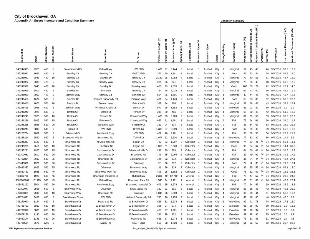
City of Brookhaven, GAAppendix A - Street Inventory and Condition Summary Condition Summary
Segm
ent I
D
GIS
ID
Stre
et N
umbe
r
Blo
ck N
umbe
r
Stre
et N
ame
From
Str
eet
To S
tree
t
Pave
men
t Len
gth
(ft)
Pave
men
t Wid
th (f
t)
Pave
men
t Are
a (y
d2)
Age
ncy
FunC
L C
d
Func
tiona
l Cla
ss
Pave
men
t Typ
e C
d
Pave
men
t Typ
e
Ow
ner
Stre
ngth
Rat
ing
Con
ditio
n R
atin
g
Rou
ghne
ss In
dex
(RI)
Surf
ace
Dis
tres
s In
dex
(SD
I)
Pave
men
t Con
ditio
n In
dex
(PC
I)
Ove
rrid
e PC
I
Cur
rent
PC
I
Surv
ey D
ate
Load
Ass
oc D
istr
esse
s (L
AD
)
Non
-Loa
d D
istr
esse
s (N
LAD
)
343244325 2328 450 5 Bramblewood Dr Buford Hwy NW END 1,476 21 3,444 3 Local 1 Asphalt City 2 Marginal 52 43 46 46 9/5/2016 37.9 19.1
343246933 1662 460 5 Brawley Cir Brawley Cir EAST END 372 30 1,241 3 Local 1 Asphalt City 1 Poor 57 22 34 34 9/5/2016 59.5 18.0
343246931 3041 460 10 Brawley Cir Brawley Dr Brawley Cir 2,181 25 6,058 3 Local 1 Asphalt City 2 Marginal 73 40 51 51 9/5/2016 43.7 15.9
343246932 3039 470 5 Brawley Cir Brawley Way Brawley Cir 284 26 821 3 Local 1 Asphalt City 1 Marginal 75 36 49 48 9/5/2016 50.6 13.5
343246929 3040 470 10 Brawley Cir Brawley Dr Brawley Way 405 23 1,035 3 Local 1 Asphalt City 3 Good 100 59 72 72 9/5/2016 27.1 14.0
343246925 3012 480 5 Brawley Dr SW END Brawley Cir 734 25 2,038 3 Local 1 Asphalt City 2 Marginal 67 42 50 50 9/5/2016 45.9 11.9
343246930 2959 490 5 Brawley Way Brawley Cir Berkford Cir 554 26 1,601 3 Local 1 Asphalt City 1 Marginal 49 44 46 45 9/5/2016 43.7 12.6
343246453 1672 500 5 Brenton Dr Ashford Dunwoody Rd Brenton Way 431 24 1,149 3 Local 1 Asphalt City 1 Poor 53 23 33 32 9/5/2016 53.6 23.7
343246460 1673 500 10 Brenton Dr Brenton Way Edenton Ct 367 24 980 3 Local 1 Asphalt City 2 Marginal 57 36 43 43 9/5/2016 38.8 25.4
343246426 2958 520 5 Brenton Way W Nancy Creek Dr Brenton Dr 677 25 1,882 3 Local 1 Asphalt City 3 Excellent 81 93 89 89 9/5/2016 3.3 3.3
343246240 3925 530 5 Breton Cir Breton Ct Rennes Dr 219 20 486 3 Local 1 Asphalt City 1 Marginal 68 30 43 42 9/5/2016 51.3 18.5
343246243 3926 530 10 Breton Cir Rennes Dr Chambord Way 1,483 23 3,789 3 Local 1 Asphalt City 3 Marginal 81 39 53 53 9/5/2016 38.0 22.7
343246236 3927 530 15 Breton Cir Finistere Ct Chambord Way 635 21 1,481 3 Local 1 Asphalt City 3 Fair 73 54 61 60 9/5/2016 34.0 11.8
343246235 3928 530 20 Breton Cir Woodrow Way Finistere Ct 313 24 834 3 Local 1 Asphalt City 3 Fair 81 54 63 63 9/5/2016 25.2 21.2
343246241 3899 540 5 Breton Ct NW END Breton Cir 1,333 27 3,999 3 Local 1 Asphalt City 1 Poor 62 29 40 39 9/5/2016 55.0 16.3
343253784 2002 550 5 Briarwood Ct Northeast Expy NW END 427 46 2,181 3 Local 1 Asphalt City 3 Fair 53 58 56 56 9/5/2016 20.3 21.9
343245294 2540 560 5 Briarwood Hills Dr Briarwood Rd Telford Dr 1,076 22 2,630 3 Local 1 Asphalt City 3 Very Good 77 82 80 80 9/5/2016 14.4 3.9
343245267 5123 580 5 Briarwood Rd N Druid Hills Rd Logan Cir 782 23 1,997 2 Collector 1 Asphalt City 1 Marginal 74 33 46 94 94 9/6/2016 50.6 16.5
343245289 2611 580 10 Briarwood Rd Limehurst Dr Logan Cir 1,053 31 3,628 2 Collector 1 Asphalt City 3 Good 95 54 67 94 94 9/6/2016 14.4 31.6
343245291 1925 580 15 Briarwood Rd Coosawattee Dr Briarwood Hills Dr 248 30 826 2 Collector 1 Asphalt City 3 Fair 84 50 61 94 94 9/6/2016 30.5 19.8
422300031 2610 580 20 Briarwood Rd Coosawattee Dr Briarwood Rd 743 25 2,065 2 Collector 1 Asphalt City 3 Fair 89 49 62 94 94 9/6/2016 34.2 17.1
442753854 2609 580 25 Briarwood Rd Briarwood Rd Coosawattee Dr 145 23 372 2 Collector 1 Asphalt City 1 Marginal 85 24 44 94 94 9/6/2016 49.4 27.1
423445336 1926 580 30 Briarwood Rd Coosawattee Dr Driveway 82 26 237 2 Collector 1 Asphalt City 1 Poor 74 8 30 94 94 9/6/2016 79.0 13.4
423445337 1927 580 35 Briarwood Rd Driveway Briarwood Way 111 26 319 2 Collector 1 Asphalt City 1 Marginal 87 35 52 94 94 9/6/2016 52.1 13.0
408860761 1928 580 40 Briarwood Rd Briarwood Park Rd Briarwood Way 498 25 1,382 2 Collector 1 Asphalt City 3 Good 76 62 67 94 94 9/6/2016 15.2 22.8
408860766 1929 580 45 Briarwood Rd Briarwood Industrial Ct Buford Hwy 2,336 49 12,719 1 Arterial 1 Asphalt City 3 Fair 78 47 57 94 94 9/6/2016 28.5 24.2
4088607661 101929 580 45 Briarwood Rd Buford Hwy Briarwood Park Rd 1,545 24 4,121 1 Arterial 1 Asphalt City 1 Marginal 68 31 43 94 94 9/6/2016 42.7 26.4
408851192 2504 580 50 Briarwood Rd Northeast Expy Briarwood Industrial Ct 603 25 1,674 1 Arterial 1 Asphalt City 3 Fair 70 54 59 59 9/5/2016 32.6 13.2
422300047 2598 590 5 Briarwood Way Driveway Drew Valley Rd 382 21 891 3 Local 1 Asphalt City 1 Marginal 53 38 43 42 9/5/2016 40.5 21.9
422300051 2599 590 10 Briarwood Way Briarwood Rd Driveway 1,045 26 3,020 3 Local 1 Asphalt City 1 Marginal 67 29 41 41 9/5/2016 55.8 15.7
442754891 3468 600 5 Brookhaven Close SW END Ashford Dunwoody Rd 745 26 2,153 3 Local 1 Asphalt City 1 Marginal 43 48 46 46 9/5/2016 45.6 6.7
343243940 1144 620 5 Brookhaven Dr Peachtree Rd W Brookhaven Dr 826 32 2,938 3 Local 1 Asphalt City 3 Very Good 92 71 78 78 9/5/2016 17.2 12.0
442738792 3869 620 10 Brookhaven Dr W Brookhaven Dr W Brookhaven Dr 325 27 974 3 Local 1 Asphalt City 2 Excellent 91 89 90 89 9/5/2016 0.0 11.3
442739918 3868 620 15 Brookhaven Dr W Brookhaven Dr E Brookhaven Dr 430 27 1,291 3 Local 1 Asphalt City 2 Excellent 91 99 97 97 9/5/2016 0.0 0.6
343859226 1145 620 20 Brookhaven Dr E Brookhaven Dr E Brookhaven Dr 296 29 952 3 Local 1 Asphalt City 2 Excellent 89 98 95 95 9/5/2016 0.0 1.9
408880174 1146 620 25 Brookhaven Dr E Brookhaven Dr Peachtree Rd 658 27 1,974 3 Local 1 Asphalt City 3 Very Good 76 83 81 81 9/5/2016 9.3 7.5
442738564 3678 1790 5 Brookhaven Dr Mabry Rd EAST END 553 28 1,720 3 Local 1 Asphalt City 3 Marginal 51 52 52 52 9/5/2016 25.7 22.2
IMS Infrastructure Management Services BH_Analysis_Rev4 (002), App A - Inventory page 10 of 87

City of Brookhaven, GAAppendix A - Street Inventory and Condition Summary
Segm
ent I
D
GIS
ID
Stre
et N
umbe
r
Blo
ck N
umbe
r
Stre
et N
ame
From
Str
eet
To S
tree
t
Pave
men
t Len
gth
(ft)
Pave
men
t Wid
th (f
t)
Pave
men
t Are
a (y
d2)
Age
ncy
FunC
L C
d
Func
tiona
l Cla
ss
Pave
men
t Typ
e C
d
Pave
men
t Typ
e
343244325 2328 450 5 Bramblewood Dr Buford Hwy NW END 1,476 21 3,444 3 Local 1 Asphalt
343246933 1662 460 5 Brawley Cir Brawley Cir EAST END 372 30 1,241 3 Local 1 Asphalt
343246931 3041 460 10 Brawley Cir Brawley Dr Brawley Cir 2,181 25 6,058 3 Local 1 Asphalt
343246932 3039 470 5 Brawley Cir Brawley Way Brawley Cir 284 26 821 3 Local 1 Asphalt
343246929 3040 470 10 Brawley Cir Brawley Dr Brawley Way 405 23 1,035 3 Local 1 Asphalt
343246925 3012 480 5 Brawley Dr SW END Brawley Cir 734 25 2,038 3 Local 1 Asphalt
343246930 2959 490 5 Brawley Way Brawley Cir Berkford Cir 554 26 1,601 3 Local 1 Asphalt
343246453 1672 500 5 Brenton Dr Ashford Dunwoody Rd Brenton Way 431 24 1,149 3 Local 1 Asphalt
343246460 1673 500 10 Brenton Dr Brenton Way Edenton Ct 367 24 980 3 Local 1 Asphalt
343246426 2958 520 5 Brenton Way W Nancy Creek Dr Brenton Dr 677 25 1,882 3 Local 1 Asphalt
343246240 3925 530 5 Breton Cir Breton Ct Rennes Dr 219 20 486 3 Local 1 Asphalt
343246243 3926 530 10 Breton Cir Rennes Dr Chambord Way 1,483 23 3,789 3 Local 1 Asphalt
343246236 3927 530 15 Breton Cir Finistere Ct Chambord Way 635 21 1,481 3 Local 1 Asphalt
343246235 3928 530 20 Breton Cir Woodrow Way Finistere Ct 313 24 834 3 Local 1 Asphalt
343246241 3899 540 5 Breton Ct NW END Breton Cir 1,333 27 3,999 3 Local 1 Asphalt
343253784 2002 550 5 Briarwood Ct Northeast Expy NW END 427 46 2,181 3 Local 1 Asphalt
343245294 2540 560 5 Briarwood Hills Dr Briarwood Rd Telford Dr 1,076 22 2,630 3 Local 1 Asphalt
343245267 5123 580 5 Briarwood Rd N Druid Hills Rd Logan Cir 782 23 1,997 2 Collector 1 Asphalt
343245289 2611 580 10 Briarwood Rd Limehurst Dr Logan Cir 1,053 31 3,628 2 Collector 1 Asphalt
343245291 1925 580 15 Briarwood Rd Coosawattee Dr Briarwood Hills Dr 248 30 826 2 Collector 1 Asphalt
422300031 2610 580 20 Briarwood Rd Coosawattee Dr Briarwood Rd 743 25 2,065 2 Collector 1 Asphalt
442753854 2609 580 25 Briarwood Rd Briarwood Rd Coosawattee Dr 145 23 372 2 Collector 1 Asphalt
423445336 1926 580 30 Briarwood Rd Coosawattee Dr Driveway 82 26 237 2 Collector 1 Asphalt
423445337 1927 580 35 Briarwood Rd Driveway Briarwood Way 111 26 319 2 Collector 1 Asphalt
408860761 1928 580 40 Briarwood Rd Briarwood Park Rd Briarwood Way 498 25 1,382 2 Collector 1 Asphalt
408860766 1929 580 45 Briarwood Rd Briarwood Industrial Ct Buford Hwy 2,336 49 12,719 1 Arterial 1 Asphalt
4088607661 101929 580 45 Briarwood Rd Buford Hwy Briarwood Park Rd 1,545 24 4,121 1 Arterial 1 Asphalt
408851192 2504 580 50 Briarwood Rd Northeast Expy Briarwood Industrial Ct 603 25 1,674 1 Arterial 1 Asphalt
422300047 2598 590 5 Briarwood Way Driveway Drew Valley Rd 382 21 891 3 Local 1 Asphalt
422300051 2599 590 10 Briarwood Way Briarwood Rd Driveway 1,045 26 3,020 3 Local 1 Asphalt
442754891 3468 600 5 Brookhaven Close SW END Ashford Dunwoody Rd 745 26 2,153 3 Local 1 Asphalt
343243940 1144 620 5 Brookhaven Dr Peachtree Rd W Brookhaven Dr 826 32 2,938 3 Local 1 Asphalt
442738792 3869 620 10 Brookhaven Dr W Brookhaven Dr W Brookhaven Dr 325 27 974 3 Local 1 Asphalt
442739918 3868 620 15 Brookhaven Dr W Brookhaven Dr E Brookhaven Dr 430 27 1,291 3 Local 1 Asphalt
343859226 1145 620 20 Brookhaven Dr E Brookhaven Dr E Brookhaven Dr 296 29 952 3 Local 1 Asphalt
408880174 1146 620 25 Brookhaven Dr E Brookhaven Dr Peachtree Rd 658 27 1,974 3 Local 1 Asphalt
442738564 3678 1790 5 Brookhaven Dr Mabry Rd EAST END 553 28 1,720 3 Local 1 Asphalt
Condition Details
IRI V
alue
(mm
/m)
Rut
ting
/ Tra
nsve
rse
Prof
ile
Tran
s-Lo
ng C
rk -
Line
ar C
rk
Alli
gato
r Crk
/ D
ivid
ed S
lab
Map
Crk
/ C
orne
r Bre
ak
Edge
Crk
/ Jo
int S
pall
Dis
tort
ions
/ Fa
ultin
g
Ble
edin
g / P
olis
hed
Agg
Rav
elin
g / S
calin
g
Patc
hing
6.0 10.0 9.2 7.1 7.9 10.0 10.0 10.0 9.9 8.9
5.3 9.6 8.6 5.7 8.9 10.0 8.2 10.0 9.9 10.0
3.3 9.8 8.5 6.5 9.3 10.0 9.3 10.0 10.0 9.7
3.2 10.0 8.3 5.0 10.0 10.0 10.0 10.0 10.0 9.9
1.5 10.0 8.3 7.3 10.0 10.0 10.0 10.0 10.0 10.0
3.9 10.0 8.6 5.8 10.0 9.9 10.0 10.0 9.9 9.6
6.5 10.0 8.8 5.7 9.6 10.0 9.8 10.0 9.9 10.0
5.9 8.8 7.9 6.8 8.9 10.0 10.0 10.0 9.9 8.6
5.2 10.0 7.1 6.6 9.7 10.0 9.3 10.0 9.8 10.0
4.0 10.0 9.8 9.7 10.0 10.0 10.0 10.0 9.8 10.0
3.9 10.0 8.3 4.9 10.0 10.0 10.0 10.0 9.1 10.0
2.7 10.0 8.2 6.2 9.2 10.0 10.0 10.0 9.2 10.0
3.3 10.0 9.1 7.2 9.8 10.0 10.0 10.0 9.4 9.3
2.6 10.0 8.9 7.5 8.6 10.0 10.0 10.0 9.2 10.0
4.6 10.0 8.0 5.2 10.0 10.0 10.0 10.0 9.9 9.2
5.8 10.0 9.7 8.7 7.3 10.0 10.0 10.0 9.3 9.0
3.0 10.0 9.6 8.6 10.0 10.0 10.0 10.0 9.9 9.9
3.3 10.0 8.3 6.8 10.0 10.0 9.2 10.0 9.4 8.3
1.8 10.0 6.3 9.2 10.0 9.8 9.9 10.0 9.7 9.5
2.4 10.0 8.4 8.2 10.0 10.0 10.0 10.0 8.8 8.4
2.1 10.0 8.4 7.1 10.0 10.0 9.9 10.0 9.2 9.5
2.4 10.0 7.4 6.0 10.0 10.0 10.0 10.0 8.9 8.8
3.2 9.8 9.1 5.2 10.0 10.0 10.0 10.0 8.8 6.3
2.2 10.0 9.0 6.7 10.0 10.0 10.0 10.0 9.1 7.6
3.0 10.0 7.4 8.6 10.0 9.9 10.0 10.0 9.7 9.9
2.9 9.7 8.6 7.6 10.0 10.0 10.0 10.0 7.7 9.7
3.8 10.0 7.8 6.1 10.0 10.0 9.9 9.7 8.6 9.5
3.6 10.0 8.5 7.3 10.0 10.0 9.2 9.9 9.8 10.0
5.9 10.0 8.4 8.1 8.5 10.0 7.3 10.0 9.9 9.7
3.9 10.0 8.2 6.6 9.8 10.0 7.3 10.0 10.0 9.6
7.8 10.0 9.3 5.5 10.0 10.0 10.0 10.0 9.8 9.9
2.0 10.0 8.6 8.3 10.0 10.0 10.0 9.8 10.0 10.0
2.0 10.0 8.6 10.0 10.0 10.0 10.0 9.9 10.0 10.0
2.0 10.0 9.9 10.0 10.0 10.0 10.0 10.0 10.0 10.0
2.9 10.0 9.9 10.0 10.0 10.0 10.0 9.8 10.0 10.0
3.0 10.0 9.2 9.1 10.0 10.0 10.0 10.0 9.8 10.0
6.2 9.4 7.9 8.3 9.1 10.0 10.0 10.0 9.9 9.7
IMS Infrastructure Management Services BH_Analysis_Rev4 (002), App A - Inventory page 11 of 87

City of Brookhaven, GAAppendix A - Street Inventory and Condition Summary
Segm
ent I
D
GIS
ID
Stre
et N
umbe
r
Blo
ck N
umbe
r
Stre
et N
ame
From
Str
eet
To S
tree
t
Pave
men
t Len
gth
(ft)
Pave
men
t Wid
th (f
t)
Pave
men
t Are
a (y
d2)
Age
ncy
FunC
L C
d
Func
tiona
l Cla
ss
Pave
men
t Typ
e C
d
Pave
men
t Typ
e
343244325 2328 450 5 Bramblewood Dr Buford Hwy NW END 1,476 21 3,444 3 Local 1 Asphalt
343246933 1662 460 5 Brawley Cir Brawley Cir EAST END 372 30 1,241 3 Local 1 Asphalt
343246931 3041 460 10 Brawley Cir Brawley Dr Brawley Cir 2,181 25 6,058 3 Local 1 Asphalt
343246932 3039 470 5 Brawley Cir Brawley Way Brawley Cir 284 26 821 3 Local 1 Asphalt
343246929 3040 470 10 Brawley Cir Brawley Dr Brawley Way 405 23 1,035 3 Local 1 Asphalt
343246925 3012 480 5 Brawley Dr SW END Brawley Cir 734 25 2,038 3 Local 1 Asphalt
343246930 2959 490 5 Brawley Way Brawley Cir Berkford Cir 554 26 1,601 3 Local 1 Asphalt
343246453 1672 500 5 Brenton Dr Ashford Dunwoody Rd Brenton Way 431 24 1,149 3 Local 1 Asphalt
343246460 1673 500 10 Brenton Dr Brenton Way Edenton Ct 367 24 980 3 Local 1 Asphalt
343246426 2958 520 5 Brenton Way W Nancy Creek Dr Brenton Dr 677 25 1,882 3 Local 1 Asphalt
343246240 3925 530 5 Breton Cir Breton Ct Rennes Dr 219 20 486 3 Local 1 Asphalt
343246243 3926 530 10 Breton Cir Rennes Dr Chambord Way 1,483 23 3,789 3 Local 1 Asphalt
343246236 3927 530 15 Breton Cir Finistere Ct Chambord Way 635 21 1,481 3 Local 1 Asphalt
343246235 3928 530 20 Breton Cir Woodrow Way Finistere Ct 313 24 834 3 Local 1 Asphalt
343246241 3899 540 5 Breton Ct NW END Breton Cir 1,333 27 3,999 3 Local 1 Asphalt
343253784 2002 550 5 Briarwood Ct Northeast Expy NW END 427 46 2,181 3 Local 1 Asphalt
343245294 2540 560 5 Briarwood Hills Dr Briarwood Rd Telford Dr 1,076 22 2,630 3 Local 1 Asphalt
343245267 5123 580 5 Briarwood Rd N Druid Hills Rd Logan Cir 782 23 1,997 2 Collector 1 Asphalt
343245289 2611 580 10 Briarwood Rd Limehurst Dr Logan Cir 1,053 31 3,628 2 Collector 1 Asphalt
343245291 1925 580 15 Briarwood Rd Coosawattee Dr Briarwood Hills Dr 248 30 826 2 Collector 1 Asphalt
422300031 2610 580 20 Briarwood Rd Coosawattee Dr Briarwood Rd 743 25 2,065 2 Collector 1 Asphalt
442753854 2609 580 25 Briarwood Rd Briarwood Rd Coosawattee Dr 145 23 372 2 Collector 1 Asphalt
423445336 1926 580 30 Briarwood Rd Coosawattee Dr Driveway 82 26 237 2 Collector 1 Asphalt
423445337 1927 580 35 Briarwood Rd Driveway Briarwood Way 111 26 319 2 Collector 1 Asphalt
408860761 1928 580 40 Briarwood Rd Briarwood Park Rd Briarwood Way 498 25 1,382 2 Collector 1 Asphalt
408860766 1929 580 45 Briarwood Rd Briarwood Industrial Ct Buford Hwy 2,336 49 12,719 1 Arterial 1 Asphalt
4088607661 101929 580 45 Briarwood Rd Buford Hwy Briarwood Park Rd 1,545 24 4,121 1 Arterial 1 Asphalt
408851192 2504 580 50 Briarwood Rd Northeast Expy Briarwood Industrial Ct 603 25 1,674 1 Arterial 1 Asphalt
422300047 2598 590 5 Briarwood Way Driveway Drew Valley Rd 382 21 891 3 Local 1 Asphalt
422300051 2599 590 10 Briarwood Way Briarwood Rd Driveway 1,045 26 3,020 3 Local 1 Asphalt
442754891 3468 600 5 Brookhaven Close SW END Ashford Dunwoody Rd 745 26 2,153 3 Local 1 Asphalt
343243940 1144 620 5 Brookhaven Dr Peachtree Rd W Brookhaven Dr 826 32 2,938 3 Local 1 Asphalt
442738792 3869 620 10 Brookhaven Dr W Brookhaven Dr W Brookhaven Dr 325 27 974 3 Local 1 Asphalt
442739918 3868 620 15 Brookhaven Dr W Brookhaven Dr E Brookhaven Dr 430 27 1,291 3 Local 1 Asphalt
343859226 1145 620 20 Brookhaven Dr E Brookhaven Dr E Brookhaven Dr 296 29 952 3 Local 1 Asphalt
408880174 1146 620 25 Brookhaven Dr E Brookhaven Dr Peachtree Rd 658 27 1,974 3 Local 1 Asphalt
442738564 3678 1790 5 Brookhaven Dr Mabry Rd EAST END 553 28 1,720 3 Local 1 Asphalt
SuperSegment Details
Supe
rSeg
ID
SuperSeg Description Supe
rSeg
Len
gth
(ft)
Supe
rSeg
Are
a (y
d2)
Supe
rSeg
LA
D
Supe
rSeg
PC
I
1360 1360 - Bramblewood Dr 1476 3444 38 46
1370 1370 - Brawley Cir + Others 4530 12793 45 50
1370 1370 - Brawley Cir + Others 4530 12793 45 50
1370 1370 - Brawley Cir + Others 4530 12793 45 50
1370 1370 - Brawley Cir + Others 4530 12793 45 50
1370 1370 - Brawley Cir + Others 4530 12793 45 50
1370 1370 - Brawley Cir + Others 4530 12793 45 50
2410 2410 - Brenton Dr + Others 1485 4174 42 40
2410 2410 - Brenton Dr + Others 1485 4174 42 40
1380 1380 - Brenton Way 677 1882 3 89
1390 1390 - Breton Cir + Others 3265 8439 36 53
1390 1390 - Breton Cir + Others 3265 8439 36 53
1390 1390 - Breton Cir + Others 3265 8439 36 53
1390 1390 - Breton Cir + Others 3265 8439 36 53
1400 1400 - Breton Ct 1333 3999 55 39
1410 1410 - Briarwood Ct 427 2181 20 56
4090 4090 - Briarwood Hills Dr + Others 1467 3542 11 82
1420 1420 - Briarwood Rd 3662 10826 30 94
1420 1420 - Briarwood Rd 3662 10826 30 94
1420 1420 - Briarwood Rd 3662 10826 30 94
1420 1420 - Briarwood Rd 3662 10826 30 94
1420 1420 - Briarwood Rd 3662 10826 30 94
1420 1420 - Briarwood Rd 3662 10826 30 94
1420 1420 - Briarwood Rd 3662 10826 30 94
1420 1420 - Briarwood Rd 3662 10826 30 94
1440 1440 - Briarwood Rd 2939 14393 29 90
1430 1430 - Briarwood Rd 1545 4121 43 94
1440 1440 - Briarwood Rd 2939 14393 29 90
1450 1450 - Briarwood Way 1427 3911 52 41
1450 1450 - Briarwood Way 1427 3911 52 41
1460 1460 - Brookhaven Close 745 2153 46 46
1470 1470 - Brookhaven Dr 2535 8129 8 85
1470 1470 - Brookhaven Dr 2535 8129 8 85
1470 1470 - Brookhaven Dr 2535 8129 8 85
1470 1470 - Brookhaven Dr 2535 8129 8 85
1470 1470 - Brookhaven Dr 2535 8129 8 85
1480 1480 - Brookhaven Dr 553 1720 26 52
IMS Infrastructure Management Services BH_Analysis_Rev4 (002), App A - Inventory page 12 of 87

City of Brookhaven, GAAppendix A - Street Inventory and Condition Summary Condition Summary
Segm
ent I
D
GIS
ID
Stre
et N
umbe
r
Blo
ck N
umbe
r
Stre
et N
ame
From
Str
eet
To S
tree
t
Pave
men
t Len
gth
(ft)
Pave
men
t Wid
th (f
t)
Pave
men
t Are
a (y
d2)
Age
ncy
FunC
L C
d
Func
tiona
l Cla
ss
Pave
men
t Typ
e C
d
Pave
men
t Typ
e
Ow
ner
Stre
ngth
Rat
ing
Con
ditio
n R
atin
g
Rou
ghne
ss In
dex
(RI)
Surf
ace
Dis
tres
s In
dex
(SD
I)
Pave
men
t Con
ditio
n In
dex
(PC
I)
Ove
rrid
e PC
I
Cur
rent
PC
I
Surv
ey D
ate
Load
Ass
oc D
istr
esse
s (L
AD
)
Non
-Loa
d D
istr
esse
s (N
LAD
)
416040870 3673 1800 5 Brookhaven Dr E Brookhaven Dr Farmington Ln 123 23 314 3 Local 1 Asphalt City 3 Fair 57 63 61 61 9/5/2016 24.0 12.6
343243954 3674 1800 10 Brookhaven Dr Mabry Rd Farmington Ln 2,351 26 6,791 3 Local 1 Asphalt City 3 Excellent 92 94 93 93 9/5/2016 5.0 1.2
343251520 3675 1800 15 Brookhaven Dr E Brookhaven Dr Mabry Rd 1,279 26 3,696 3 Local 1 Asphalt City 3 Excellent 83 87 86 86 9/5/2016 11.8 1.0
343251526 3676 1800 20 Brookhaven Dr E Brookhaven Dr Brookhaven Grn 381 26 1,100 3 Local 1 Asphalt City 3 Very Good 78 89 85 85 9/5/2016 9.9 1.6
343859228 3677 1810 5 Brookhaven Dr Brookhaven Dr E Brookhaven Dr 261 29 840 3 Local 1 Asphalt City 3 Fair 65 63 63 63 9/5/2016 13.5 23.7
343859223 3661 4470 5 Brookhaven Dr W Brookhaven Dr Brookhaven Dr 310 26 896 3 Local 1 Asphalt City 2 Excellent 90 100 97 97 9/5/2016 0.0 0.1
416040852 3655 4480 5 Brookhaven Dr W Brookhaven Dr W Brookhaven Dr 1,190 24 3,172 3 Local 1 Asphalt City 3 Excellent 86 95 92 92 9/5/2016 2.9 1.7
442739917 3660 4480 10 Brookhaven Dr Brookhaven Dr W Brookhaven Dr 312 32 1,111 3 Local 1 Asphalt City 2 Excellent 90 100 97 97 9/5/2016 0.0 0.0
408880159 1975 630 5 Brookhaven Garden Ln Cortez Ln EAST END 650 26 1,878 3 Local 1 Asphalt City 3 Fair 65 57 60 59 9/5/2016 16.8 26.2
408880251 3814 640 5 Brookhaven Gln Osborne Rd NE END 549 29 1,771 3 Local 1 Asphalt City 1 Poor 49 30 37 36 9/5/2016 51.2 18.3
470878288 95 4360 5 Brookhaven Hideaway Ct Standard Dr NORTH END 274 32 974 3 Local 1 Asphalt City 3 Marginal 40 59 53 53 9/5/2016 37.4 3.5
500000031 10010 5090 5 Brookhaven Hills WEST END Ashford Dunwoody Rd 325 24 868 3 Local 1 Asphalt City 3 Fair 40 66 57 57 9/5/2016 27.0 6.8
408880237 3813 660 5 Brookhaven Ln Mabry Rd EAST END 316 29 1,018 3 Local 1 Asphalt City 1 Poor 38 38 38 38 9/5/2016 47.2 15.1
343243992 3810 670 5 Brookhaven Ln WEST END Mabry Rd 379 29 1,223 3 Local 1 Asphalt City 2 Excellent 90 99 96 96 9/5/2016 0.0 1.3
408880285 3291 690 5 Brookhaven Trce SW END Ashford Dunwoody Rd 741 25 2,059 3 Local 1 Asphalt City 1 Poor 43 30 34 34 9/5/2016 61.8 8.7
465684350 1042 700 5 Brookhaven Walk Osborne Rd Osborne Rd 789 21 1,842 3 Local 1 Asphalt City 3 Marginal 55 49 51 51 9/5/2016 35.0 15.7
500000062 20213 6010 5 Brookhaven Walk Way Mabry Rd Brookhaven Walk Way 537 24 1,432 3 Local 1 Asphalt City 3 Very Good 67 85 79 79 9/5/2016 12.1 2.7
343246401 4455 710 5 Brooklawn Ct Brooklawn Rd NE END 347 29 1,118 3 Local 1 Asphalt City 1 Marginal 60 32 41 41 9/5/2016 56.3 11.8
408880368 4434 720 5 Brooklawn Rd Westbrooke Way Brooklawn Ct 1,369 25 3,804 3 Local 1 Asphalt City 3 Very Good 78 86 84 83 9/5/2016 11.4 2.4
343246398 4433 720 10 Brooklawn Rd Brooklawn Ct W Nancy Creek Dr 698 25 1,939 3 Local 1 Asphalt City 2 Excellent 78 93 88 88 9/5/2016 0.0 7.5
500000042 20120 5600 5 Brookleigh Ln Ashton Woods Dr Brookleigh Ln 72 29 232 3 Local 1 Asphalt City 3 Very Good 70 89 83 83 9/5/2016 5.6 5.2
500000043 20122 5600 10 Brookleigh Ln Brookleigh Ln Brookleigh Ln 480 24 1,281 3 Local 1 Asphalt City 2 Excellent 78 92 87 87 9/5/2016 0.0 7.8
500000044 20148 5610 5 Brookleigh Ln Canopy Chase Brookleigh Ln 584 23 1,493 3 Local 1 Asphalt City 2 Excellent 90 100 97 97 9/5/2016 0.0 0.0
500000040 20111 5610 10 Brookleigh Ln Brookleigh Ln EAST END 141 23 359 3 Local 1 Asphalt City 2 Excellent 90 100 97 97 9/5/2016 0.0 0.1
343244344 167 730 5 Brookshire Ln N Druid Hills Rd Fairway Cir 430 25 1,196 3 Local 1 Asphalt City 2 Excellent 83 89 87 87 9/5/2016 0.0 11.0
343244346 2527 730 10 Brookshire Ln Fairway Cir Fairway Cir 802 23 2,048 3 Local 1 Asphalt City 2 Excellent 90 99 96 96 9/5/2016 0.0 0.6
343246266 694 740 5 Browning Ln Tennyson Pl NORTH END 268 31 924 3 Local 1 Asphalt City 2 Excellent 90 99 96 96 9/5/2016 0.0 1.4
343246413 3139 750 5 Bubbling Creek Rd Runnymeade Rd Harts Mill Rd 976 25 2,711 3 Local 1 Asphalt City 3 Marginal 69 39 49 49 9/5/2016 32.3 29.2
343246356 3138 750 10 Bubbling Creek Rd Runnymeade Rd Shadow Ln 1,588 25 4,411 3 Local 1 Asphalt City 3 Marginal 72 37 49 49 9/5/2016 31.9 30.7
343246365 1610 750 15 Bubbling Creek Rd Shadow Ln Woodstream Cir 503 25 1,397 3 Local 1 Asphalt City 1 Marginal 56 36 42 42 9/5/2016 44.5 19.9
500000028 10003 5020 5 Buckhead Ct SOUTH END Buckhead Ln 459 22 1,122 3 Local 1 Asphalt City 3 Very Good 67 85 79 79 9/5/2016 9.8 4.8
500000026 10001 5010 5 Buckhead Ln Shady Valley Dr Buckhead Ct 176 23 449 3 Local 1 Asphalt City 2 Very Good 69 88 82 82 9/5/2016 0.0 12.0
500000027 10002 5010 10 Buckhead Ln SOUTH END Buckhead Ct 1,043 26 3,013 3 Local 1 Asphalt City 3 Good 60 79 73 72 9/5/2016 11.5 9.6
470107590 334 760 5 Buckhead Valley Ct Buckhead Valley Ln EAST END 169 35 657 3 Local 1 Asphalt City 3 Fair 52 69 63 63 9/5/2016 23.0 8.0
470107589 4828 770 5 Buckhead Valley Ln Buckhead Valley Ct Childers Rd 403 24 1,075 3 Local 1 Asphalt City 3 Good 57 77 70 70 9/5/2016 13.0 10.3
470107588 4829 770 10 Buckhead Valley Ln SOUTH END Buckhead Valley Ct 763 25 2,121 3 Local 1 Asphalt City 3 Fair 54 67 63 62 9/5/2016 27.5 5.7
343245468 2546 780 5 Burch Cir Drew Valley Rd Drew Valley Rd 1,852 26 5,350 3 Local 1 Asphalt City 2 Marginal 69 46 54 54 9/5/2016 45.8 7.9
IMS Infrastructure Management Services BH_Analysis_Rev4 (002), App A - Inventory page 13 of 87

City of Brookhaven, GAAppendix A - Street Inventory and Condition Summary
Segm
ent I
D
GIS
ID
Stre
et N
umbe
r
Blo
ck N
umbe
r
Stre
et N
ame
From
Str
eet
To S
tree
t
Pave
men
t Len
gth
(ft)
Pave
men
t Wid
th (f
t)
Pave
men
t Are
a (y
d2)
Age
ncy
FunC
L C
d
Func
tiona
l Cla
ss
Pave
men
t Typ
e C
d
Pave
men
t Typ
e
416040870 3673 1800 5 Brookhaven Dr E Brookhaven Dr Farmington Ln 123 23 314 3 Local 1 Asphalt
343243954 3674 1800 10 Brookhaven Dr Mabry Rd Farmington Ln 2,351 26 6,791 3 Local 1 Asphalt
343251520 3675 1800 15 Brookhaven Dr E Brookhaven Dr Mabry Rd 1,279 26 3,696 3 Local 1 Asphalt
343251526 3676 1800 20 Brookhaven Dr E Brookhaven Dr Brookhaven Grn 381 26 1,100 3 Local 1 Asphalt
343859228 3677 1810 5 Brookhaven Dr Brookhaven Dr E Brookhaven Dr 261 29 840 3 Local 1 Asphalt
343859223 3661 4470 5 Brookhaven Dr W Brookhaven Dr Brookhaven Dr 310 26 896 3 Local 1 Asphalt
416040852 3655 4480 5 Brookhaven Dr W Brookhaven Dr W Brookhaven Dr 1,190 24 3,172 3 Local 1 Asphalt
442739917 3660 4480 10 Brookhaven Dr Brookhaven Dr W Brookhaven Dr 312 32 1,111 3 Local 1 Asphalt
408880159 1975 630 5 Brookhaven Garden Ln Cortez Ln EAST END 650 26 1,878 3 Local 1 Asphalt
408880251 3814 640 5 Brookhaven Gln Osborne Rd NE END 549 29 1,771 3 Local 1 Asphalt
470878288 95 4360 5 Brookhaven Hideaway Ct Standard Dr NORTH END 274 32 974 3 Local 1 Asphalt
500000031 10010 5090 5 Brookhaven Hills WEST END Ashford Dunwoody Rd 325 24 868 3 Local 1 Asphalt
408880237 3813 660 5 Brookhaven Ln Mabry Rd EAST END 316 29 1,018 3 Local 1 Asphalt
343243992 3810 670 5 Brookhaven Ln WEST END Mabry Rd 379 29 1,223 3 Local 1 Asphalt
408880285 3291 690 5 Brookhaven Trce SW END Ashford Dunwoody Rd 741 25 2,059 3 Local 1 Asphalt
465684350 1042 700 5 Brookhaven Walk Osborne Rd Osborne Rd 789 21 1,842 3 Local 1 Asphalt
500000062 20213 6010 5 Brookhaven Walk Way Mabry Rd Brookhaven Walk Way 537 24 1,432 3 Local 1 Asphalt
343246401 4455 710 5 Brooklawn Ct Brooklawn Rd NE END 347 29 1,118 3 Local 1 Asphalt
408880368 4434 720 5 Brooklawn Rd Westbrooke Way Brooklawn Ct 1,369 25 3,804 3 Local 1 Asphalt
343246398 4433 720 10 Brooklawn Rd Brooklawn Ct W Nancy Creek Dr 698 25 1,939 3 Local 1 Asphalt
500000042 20120 5600 5 Brookleigh Ln Ashton Woods Dr Brookleigh Ln 72 29 232 3 Local 1 Asphalt
500000043 20122 5600 10 Brookleigh Ln Brookleigh Ln Brookleigh Ln 480 24 1,281 3 Local 1 Asphalt
500000044 20148 5610 5 Brookleigh Ln Canopy Chase Brookleigh Ln 584 23 1,493 3 Local 1 Asphalt
500000040 20111 5610 10 Brookleigh Ln Brookleigh Ln EAST END 141 23 359 3 Local 1 Asphalt
343244344 167 730 5 Brookshire Ln N Druid Hills Rd Fairway Cir 430 25 1,196 3 Local 1 Asphalt
343244346 2527 730 10 Brookshire Ln Fairway Cir Fairway Cir 802 23 2,048 3 Local 1 Asphalt
343246266 694 740 5 Browning Ln Tennyson Pl NORTH END 268 31 924 3 Local 1 Asphalt
343246413 3139 750 5 Bubbling Creek Rd Runnymeade Rd Harts Mill Rd 976 25 2,711 3 Local 1 Asphalt
343246356 3138 750 10 Bubbling Creek Rd Runnymeade Rd Shadow Ln 1,588 25 4,411 3 Local 1 Asphalt
343246365 1610 750 15 Bubbling Creek Rd Shadow Ln Woodstream Cir 503 25 1,397 3 Local 1 Asphalt
500000028 10003 5020 5 Buckhead Ct SOUTH END Buckhead Ln 459 22 1,122 3 Local 1 Asphalt
500000026 10001 5010 5 Buckhead Ln Shady Valley Dr Buckhead Ct 176 23 449 3 Local 1 Asphalt
500000027 10002 5010 10 Buckhead Ln SOUTH END Buckhead Ct 1,043 26 3,013 3 Local 1 Asphalt
470107590 334 760 5 Buckhead Valley Ct Buckhead Valley Ln EAST END 169 35 657 3 Local 1 Asphalt
470107589 4828 770 5 Buckhead Valley Ln Buckhead Valley Ct Childers Rd 403 24 1,075 3 Local 1 Asphalt
470107588 4829 770 10 Buckhead Valley Ln SOUTH END Buckhead Valley Ct 763 25 2,121 3 Local 1 Asphalt
343245468 2546 780 5 Burch Cir Drew Valley Rd Drew Valley Rd 1,852 26 5,350 3 Local 1 Asphalt
Condition Details
IRI V
alue
(mm
/m)
Rut
ting
/ Tra
nsve
rse
Prof
ile
Tran
s-Lo
ng C
rk -
Line
ar C
rk
Alli
gato
r Crk
/ D
ivid
ed S
lab
Map
Crk
/ C
orne
r Bre
ak
Edge
Crk
/ Jo
int S
pall
Dis
tort
ions
/ Fa
ultin
g
Ble
edin
g / P
olis
hed
Agg
Rav
elin
g / S
calin
g
Patc
hing
5.3 10.0 8.9 7.6 10.0 10.0 10.0 10.0 9.3 10.0
1.9 10.0 9.9 9.7 10.0 10.0 10.0 10.0 10.0 9.8
2.5 10.0 9.9 9.7 10.0 10.0 10.0 10.0 10.0 8.9
2.9 10.0 9.8 9.0 10.0 10.0 10.0 10.0 10.0 10.0
4.2 10.0 7.3 8.6 10.0 10.0 10.0 10.0 9.6 10.0
3.1 10.0 10.0 10.0 10.0 10.0 10.0 10.0 10.0 10.0
2.6 10.0 9.8 10.0 10.0 10.0 10.0 10.0 10.0 9.6
2.6 10.0 10.0 10.0 10.0 10.0 10.0 10.0 10.0 10.0
4.2 10.0 8.0 8.3 8.3 10.0 10.0 10.0 9.8 10.0
6.6 10.0 8.4 5.3 10.0 10.0 10.0 10.0 9.0 9.5
8.6 10.0 9.8 6.3 10.0 10.0 10.0 10.0 9.7 10.0
11.7 9.1 9.3 8.2 10.0 10.0 9.9 10.0 9.8 10.0
9.0 10.0 9.1 5.3 10.0 10.0 10.0 10.0 8.6 10.0
4.6 10.0 10.0 10.0 10.0 10.0 10.0 10.0 9.8 10.0
7.9 10.0 9.3 3.9 9.6 10.0 10.0 10.0 9.8 9.9
5.6 9.6 8.1 7.3 10.0 10.0 10.0 10.0 9.8 9.5
5.6 8.7 9.9 10.0 10.0 10.0 10.0 10.0 9.7 10.0
4.8 10.0 8.6 4.4 10.0 10.0 10.0 10.0 9.9 10.0
2.9 10.0 9.7 9.0 10.0 10.0 9.8 10.0 10.0 9.9
3.3 10.0 9.2 10.0 10.0 10.0 10.0 10.0 9.8 10.0
14.7 10.0 9.5 10.0 10.0 10.0 10.0 10.0 9.8 9.3
3.1 10.0 9.5 10.0 10.0 10.0 10.0 10.0 9.3 10.0
3.7 10.0 10.0 10.0 10.0 10.0 10.0 10.0 10.0 10.0
2.8 10.0 10.0 10.0 10.0 10.0 10.0 10.0 10.0 10.0
2.5 10.0 8.7 10.0 10.0 10.0 10.0 10.0 10.0 10.0
2.9 10.0 9.9 10.0 10.0 10.0 10.0 10.0 10.0 10.0
6.1 10.0 10.0 10.0 10.0 10.0 10.0 10.0 9.7 10.0
3.7 10.0 8.5 7.2 6.9 10.0 9.6 10.0 10.0 9.8
3.4 10.0 8.4 7.1 6.7 10.0 9.7 10.0 10.0 10.0
5.4 9.8 8.6 7.6 8.6 10.0 8.7 10.0 9.9 8.7
8.2 10.0 9.9 9.0 10.0 10.0 10.0 9.4 9.8 10.0
9.5 10.0 9.3 10.0 10.0 10.0 10.0 10.0 8.9 10.0
4.9 9.5 9.9 9.4 10.0 10.0 10.0 10.0 8.4 9.9
6.0 10.0 9.2 7.7 10.0 10.0 10.0 10.0 9.7 10.0
5.3 10.0 9.7 8.7 8.8 10.0 10.0 10.0 9.8 10.0
5.7 10.0 9.7 7.3 10.0 10.0 10.0 10.0 9.4 10.0
3.8 9.9 9.5 7.1 9.9 10.0 8.9 10.0 9.5 9.0
IMS Infrastructure Management Services BH_Analysis_Rev4 (002), App A - Inventory page 14 of 87

City of Brookhaven, GAAppendix A - Street Inventory and Condition Summary
Segm
ent I
D
GIS
ID
Stre
et N
umbe
r
Blo
ck N
umbe
r
Stre
et N
ame
From
Str
eet
To S
tree
t
Pave
men
t Len
gth
(ft)
Pave
men
t Wid
th (f
t)
Pave
men
t Are
a (y
d2)
Age
ncy
FunC
L C
d
Func
tiona
l Cla
ss
Pave
men
t Typ
e C
d
Pave
men
t Typ
e
416040870 3673 1800 5 Brookhaven Dr E Brookhaven Dr Farmington Ln 123 23 314 3 Local 1 Asphalt
343243954 3674 1800 10 Brookhaven Dr Mabry Rd Farmington Ln 2,351 26 6,791 3 Local 1 Asphalt
343251520 3675 1800 15 Brookhaven Dr E Brookhaven Dr Mabry Rd 1,279 26 3,696 3 Local 1 Asphalt
343251526 3676 1800 20 Brookhaven Dr E Brookhaven Dr Brookhaven Grn 381 26 1,100 3 Local 1 Asphalt
343859228 3677 1810 5 Brookhaven Dr Brookhaven Dr E Brookhaven Dr 261 29 840 3 Local 1 Asphalt
343859223 3661 4470 5 Brookhaven Dr W Brookhaven Dr Brookhaven Dr 310 26 896 3 Local 1 Asphalt
416040852 3655 4480 5 Brookhaven Dr W Brookhaven Dr W Brookhaven Dr 1,190 24 3,172 3 Local 1 Asphalt
442739917 3660 4480 10 Brookhaven Dr Brookhaven Dr W Brookhaven Dr 312 32 1,111 3 Local 1 Asphalt
408880159 1975 630 5 Brookhaven Garden Ln Cortez Ln EAST END 650 26 1,878 3 Local 1 Asphalt
408880251 3814 640 5 Brookhaven Gln Osborne Rd NE END 549 29 1,771 3 Local 1 Asphalt
470878288 95 4360 5 Brookhaven Hideaway Ct Standard Dr NORTH END 274 32 974 3 Local 1 Asphalt
500000031 10010 5090 5 Brookhaven Hills WEST END Ashford Dunwoody Rd 325 24 868 3 Local 1 Asphalt
408880237 3813 660 5 Brookhaven Ln Mabry Rd EAST END 316 29 1,018 3 Local 1 Asphalt
343243992 3810 670 5 Brookhaven Ln WEST END Mabry Rd 379 29 1,223 3 Local 1 Asphalt
408880285 3291 690 5 Brookhaven Trce SW END Ashford Dunwoody Rd 741 25 2,059 3 Local 1 Asphalt
465684350 1042 700 5 Brookhaven Walk Osborne Rd Osborne Rd 789 21 1,842 3 Local 1 Asphalt
500000062 20213 6010 5 Brookhaven Walk Way Mabry Rd Brookhaven Walk Way 537 24 1,432 3 Local 1 Asphalt
343246401 4455 710 5 Brooklawn Ct Brooklawn Rd NE END 347 29 1,118 3 Local 1 Asphalt
408880368 4434 720 5 Brooklawn Rd Westbrooke Way Brooklawn Ct 1,369 25 3,804 3 Local 1 Asphalt
343246398 4433 720 10 Brooklawn Rd Brooklawn Ct W Nancy Creek Dr 698 25 1,939 3 Local 1 Asphalt
500000042 20120 5600 5 Brookleigh Ln Ashton Woods Dr Brookleigh Ln 72 29 232 3 Local 1 Asphalt
500000043 20122 5600 10 Brookleigh Ln Brookleigh Ln Brookleigh Ln 480 24 1,281 3 Local 1 Asphalt
500000044 20148 5610 5 Brookleigh Ln Canopy Chase Brookleigh Ln 584 23 1,493 3 Local 1 Asphalt
500000040 20111 5610 10 Brookleigh Ln Brookleigh Ln EAST END 141 23 359 3 Local 1 Asphalt
343244344 167 730 5 Brookshire Ln N Druid Hills Rd Fairway Cir 430 25 1,196 3 Local 1 Asphalt
343244346 2527 730 10 Brookshire Ln Fairway Cir Fairway Cir 802 23 2,048 3 Local 1 Asphalt
343246266 694 740 5 Browning Ln Tennyson Pl NORTH END 268 31 924 3 Local 1 Asphalt
343246413 3139 750 5 Bubbling Creek Rd Runnymeade Rd Harts Mill Rd 976 25 2,711 3 Local 1 Asphalt
343246356 3138 750 10 Bubbling Creek Rd Runnymeade Rd Shadow Ln 1,588 25 4,411 3 Local 1 Asphalt
343246365 1610 750 15 Bubbling Creek Rd Shadow Ln Woodstream Cir 503 25 1,397 3 Local 1 Asphalt
500000028 10003 5020 5 Buckhead Ct SOUTH END Buckhead Ln 459 22 1,122 3 Local 1 Asphalt
500000026 10001 5010 5 Buckhead Ln Shady Valley Dr Buckhead Ct 176 23 449 3 Local 1 Asphalt
500000027 10002 5010 10 Buckhead Ln SOUTH END Buckhead Ct 1,043 26 3,013 3 Local 1 Asphalt
470107590 334 760 5 Buckhead Valley Ct Buckhead Valley Ln EAST END 169 35 657 3 Local 1 Asphalt
470107589 4828 770 5 Buckhead Valley Ln Buckhead Valley Ct Childers Rd 403 24 1,075 3 Local 1 Asphalt
470107588 4829 770 10 Buckhead Valley Ln SOUTH END Buckhead Valley Ct 763 25 2,121 3 Local 1 Asphalt
343245468 2546 780 5 Burch Cir Drew Valley Rd Drew Valley Rd 1,852 26 5,350 3 Local 1 Asphalt
SuperSegment Details
Supe
rSeg
ID
SuperSeg Description Supe
rSeg
Len
gth
(ft)
Supe
rSeg
Are
a (y
d2)
Supe
rSeg
LA
D
Supe
rSeg
PC
I
2570 2570 - Farmington Ln + Others 890 1933 23 68
1490 1490 - Brookhaven Dr + Others 4272 12427 8 88
1490 1490 - Brookhaven Dr + Others 4272 12427 8 88
1490 1490 - Brookhaven Dr + Others 4272 12427 8 88
1490 1490 - Brookhaven Dr + Others 4272 12427 8 88
1500 1500 - Brookhaven Dr + Others 1812 5179 2 94
1500 1500 - Brookhaven Dr + Others 1812 5179 2 94
1500 1500 - Brookhaven Dr + Others 1812 5179 2 94
2110 2110 - Cortez Ln + Others 2471 6803 20 60
2560 2560 - Dickson St + Others 1956 5230 51 36
1510 1510 - Brookhaven Hideaway Ct 274 974 37 53
1520 1520 - Brookhaven Hills 325 868 27 57
1530 1530 - Brookhaven Ln 316 1018 47 38
1540 1540 - Brookhaven Ln 379 1223 0 96
1550 1550 - Brookhaven Trce 741 2059 62 34
1560 1560 - Brookhaven Walk 789 1842 35 51
1570 1570 - Brookhaven Walk Way 537 1432 12 79
1580 1580 - Brooklawn Ct 347 1118 56 41
1590 1590 - Brooklawn Rd 2067 5743 8 85
1590 1590 - Brooklawn Rd 2067 5743 8 85
1600 1600 - Brookleigh Ln 552 1513 1 87
1600 1600 - Brookleigh Ln 552 1513 1 87
1610 1610 - Brookleigh Ln 725 1852 0 97
1610 1610 - Brookleigh Ln 725 1852 0 97
1620 1620 - Brookshire Ln 1232 3244 0 93
1620 1620 - Brookshire Ln 1232 3244 0 93
4110 4110 - Tennyson Pl + Others 1178 3299 0 95
1630 1630 - Bubbling Creek Rd 3067 8519 34 48
1630 1630 - Bubbling Creek Rd 3067 8519 34 48
1630 1630 - Bubbling Creek Rd 3067 8519 34 48
1640 1640 - Buckhead Ln + Others 1678 4585 10 75
1640 1640 - Buckhead Ln + Others 1678 4585 10 75
1640 1640 - Buckhead Ln + Others 1678 4585 10 75
1650 1650 - Buckhead Valley Ln + Others 1336 3853 23 65
1650 1650 - Buckhead Valley Ln + Others 1336 3853 23 65
1650 1650 - Buckhead Valley Ln + Others 1336 3853 23 65
1660 1660 - Burch Cir 1852 5350 46 54
IMS Infrastructure Management Services BH_Analysis_Rev4 (002), App A - Inventory page 15 of 87

City of Brookhaven, GAAppendix A - Street Inventory and Condition Summary Condition Summary
Segm
ent I
D
GIS
ID
Stre
et N
umbe
r
Blo
ck N
umbe
r
Stre
et N
ame
From
Str
eet
To S
tree
t
Pave
men
t Len
gth
(ft)
Pave
men
t Wid
th (f
t)
Pave
men
t Are
a (y
d2)
Age
ncy
FunC
L C
d
Func
tiona
l Cla
ss
Pave
men
t Typ
e C
d
Pave
men
t Typ
e
Ow
ner
Stre
ngth
Rat
ing
Con
ditio
n R
atin
g
Rou
ghne
ss In
dex
(RI)
Surf
ace
Dis
tres
s In
dex
(SD
I)
Pave
men
t Con
ditio
n In
dex
(PC
I)
Ove
rrid
e PC
I
Cur
rent
PC
I
Surv
ey D
ate
Load
Ass
oc D
istr
esse
s (L
AD
)
Non
-Loa
d D
istr
esse
s (N
LAD
)
343245473 2608 790 5 Bynum Rd Drew Valley Rd Drew Valley Rd 1,092 28 3,398 3 Local 1 Asphalt City 1 Poor 56 30 38 38 9/5/2016 53.0 17.1
343246175 4454 800 5 Byrnwyck Ct Byrnwyck Pl NW END 422 30 1,407 3 Local 1 Asphalt City 1 Poor 52 27 35 35 9/5/2016 57.6 15.3
343246170 702 810 5 Byrnwyck Pl Old Johnson Ferry Rd Byrnwyck Rd 223 28 693 3 Local 1 Asphalt City 2 Excellent 89 98 95 95 9/5/2016 0.0 2.2
343246171 703 810 10 Byrnwyck Pl Byrnwyck Rd Ives Trl 323 26 933 3 Local 1 Asphalt City 3 Fair 65 61 62 62 9/5/2016 11.9 27.4
343246173 4438 810 15 Byrnwyck Pl Ives Trl Byrnwyck Ct 273 28 851 3 Local 1 Asphalt City 1 Poor 51 30 37 37 9/5/2016 38.6 31.5
343246402 704 810 20 Byrnwyck Pl Byrnwyck Ct Byrnwyck Way 307 23 785 3 Local 1 Asphalt City 3 Marginal 60 46 51 51 9/5/2016 37.8 16.0
343246403 4437 810 25 Byrnwyck Pl Byrnwyck Way Downing Ln 344 23 880 3 Local 1 Asphalt City 1 Very Poor 46 11 23 23 9/5/2016 71.4 17.3
343253688 705 810 30 Byrnwyck Pl Downing Ln EAST END 202 24 538 3 Local 1 Asphalt City 1 Poor 62 16 31 31 9/5/2016 76.3 7.8
343246434 4432 820 5 Byrnwyck Rd WEST END Hovis Ct 543 26 1,569 3 Local 1 Asphalt City 2 Excellent 90 100 97 97 9/5/2016 0.0 0.0
343246431 4431 820 10 Byrnwyck Rd Preston Ct Hovis Ct 1,693 23 4,327 3 Local 1 Asphalt City 2 Excellent 84 94 91 91 9/5/2016 0.0 5.7
442738603 4430 820 15 Byrnwyck Rd Fernway Ct Preston Ct 1,123 23 2,871 3 Local 1 Asphalt City 2 Excellent 86 93 91 90 9/5/2016 0.0 6.9
343246178 4429 820 20 Byrnwyck Rd Byrnwyck Trl Fernway Ct 665 26 1,920 3 Local 1 Asphalt City 2 Excellent 81 89 86 86 9/5/2016 0.0 11.0
343246169 4428 820 25 Byrnwyck Rd Byrnwyck Pl Byrnwyck Trl 1,415 24 3,772 3 Local 1 Asphalt City 2 Excellent 90 100 97 96 9/5/2016 0.0 0.2
442738602 4422 830 5 Byrnwyck Trl Byrnwyck Rd NE END 501 27 1,504 3 Local 1 Asphalt City 2 Excellent 89 98 95 95 9/5/2016 0.0 1.7
343246404 4416 840 5 Byrnwyck Way Byrnwyck Pl NORTH END 479 27 1,438 3 Local 1 Asphalt City 3 Very Good 73 87 82 82 9/5/2016 7.1 6.0
343245801 3421 850 4 Caldwell Rd Caldwell Rd Parkridge Dr 159 32 566 3 Local 1 Asphalt City 3 Very Good 90 78 82 82 9/5/2016 18.0 3.6
343245792 3422 850 5 Caldwell Rd Templewood Dr Caldwell Rd 432 27 1,296 3 Local 1 Asphalt City 3 Excellent 85 87 86 86 9/5/2016 13.5 0.0
343245790 3306 850 10 Caldwell Rd Cravenridge Dr Templewood Dr 581 41 2,648 3 Local 1 Asphalt City 3 Excellent 98 90 93 93 9/5/2016 8.9 1.1
343245788 1470 850 15 Caldwell Rd Cynthia Dr Cravenridge Dr 353 41 1,609 3 Local 1 Asphalt City 3 Excellent 100 93 95 95 9/5/2016 7.1 0.1
343245785 1469 850 20 Caldwell Rd Redding Rd Cynthia Dr 538 37 2,212 3 Local 1 Asphalt City 3 Excellent 84 95 91 91 9/5/2016 5.4 0.0
343281886 3307 850 25 Caldwell Rd Ashford Rd Ashford Park Ct 887 30 2,957 3 Local 1 Asphalt City 2 Excellent 90 100 97 97 9/5/2016 0.0 0.1
420791597 1468 850 30 Caldwell Rd Alden Place Dr Ashford Rd 249 36 995 3 Local 1 Asphalt City 2 Excellent 85 95 92 92 9/5/2016 0.0 4.7
442738785 3308 850 35 Caldwell Rd Cheshire Way Alden Place Dr 2,535 37 10,420 3 Local 1 Asphalt City 3 Excellent 75 92 86 86 9/5/2016 8.3 0.2
343245434 3309 850 40 Caldwell Rd E Osborne Rd Cheshire Way 1,358 21 3,168 3 Local 1 Asphalt City 3 Marginal 76 41 53 52 9/5/2016 35.6 23.4
343245421 1467 850 45 Caldwell Rd Oaklawn Ave E Osborne Rd 240 19 507 3 Local 1 Asphalt City 3 Fair 78 50 59 59 9/5/2016 26.6 23.7
343245418 1466 850 50 Caldwell Rd Sunland Dr Oaklawn Ave 458 21 1,069 3 Local 1 Asphalt City 3 Fair 85 43 57 57 9/5/2016 33.8 23.1
343245386 3310 850 55 Caldwell Rd Sunland Dr Green Meadows Ln 665 22 1,627 3 Local 1 Asphalt City 3 Fair 59 58 58 58 9/5/2016 19.5 22.6
343245383 3311 850 60 Caldwell Rd Dresden Dr Green Meadows Ln 467 23 1,194 3 Local 1 Asphalt City 1 Marginal 70 29 43 43 9/5/2016 55.6 15.1
343246303 3689 860 5 Cambridge Ct SW END Waddeston Way 694 29 2,236 3 Local 1 Asphalt City 2 Marginal 70 42 51 51 9/5/2016 41.7 16.6
343245444 1263 870 5 Camille Dr E Osborne Rd NORTH END 208 21 486 3 Local 1 Asphalt City 3 Very Good 65 83 77 77 9/5/2016 4.6 12.2
343245440 1262 870 10 Camille Dr Wilford Dr E Osborne Rd 927 25 2,574 3 Local 1 Asphalt City 2 Marginal 70 39 49 49 9/5/2016 44.2 16.6
343245414 1261 870 15 Camille Dr Dresden Dr Wilford Dr 412 25 1,146 3 Local 1 Asphalt City 3 Marginal 70 42 51 51 9/5/2016 32.6 25.8
343246530 3027 880 5 Candler Lake Ct Candler Lake East NE END 390 29 1,256 3 Local 1 Asphalt City 3 Good 60 79 73 73 9/5/2016 6.8 14.2
343282658 3055 890 5 Candler Lake East E Nancy Creek Dr Candler Lake Ct 873 24 2,328 3 Local 1 Asphalt City 2 Marginal 90 36 54 54 9/5/2016 46.3 17.8
343246529 3054 890 10 Candler Lake East Candler Lake Ct Nancy Creek Way 707 27 2,120 3 Local 1 Asphalt City 3 Marginal 83 39 53 53 9/5/2016 39.9 21.4
343246524 3053 890 15 Candler Lake East W Nancy Creek Dr Nancy Creek Way 1,439 26 4,157 3 Local 1 Asphalt City 1 Marginal 85 34 51 51 9/5/2016 49.5 16.4
408880389 1657 900 5 Candler Lake West Hasty Ct Ashwoody Ct 402 20 894 3 Local 1 Asphalt City 1 Marginal 67 33 44 44 9/5/2016 48.3 18.4
IMS Infrastructure Management Services BH_Analysis_Rev4 (002), App A - Inventory page 16 of 87

City of Brookhaven, GAAppendix A - Street Inventory and Condition Summary
Segm
ent I
D
GIS
ID
Stre
et N
umbe
r
Blo
ck N
umbe
r
Stre
et N
ame
From
Str
eet
To S
tree
t
Pave
men
t Len
gth
(ft)
Pave
men
t Wid
th (f
t)
Pave
men
t Are
a (y
d2)
Age
ncy
FunC
L C
d
Func
tiona
l Cla
ss
Pave
men
t Typ
e C
d
Pave
men
t Typ
e
343245473 2608 790 5 Bynum Rd Drew Valley Rd Drew Valley Rd 1,092 28 3,398 3 Local 1 Asphalt
343246175 4454 800 5 Byrnwyck Ct Byrnwyck Pl NW END 422 30 1,407 3 Local 1 Asphalt
343246170 702 810 5 Byrnwyck Pl Old Johnson Ferry Rd Byrnwyck Rd 223 28 693 3 Local 1 Asphalt
343246171 703 810 10 Byrnwyck Pl Byrnwyck Rd Ives Trl 323 26 933 3 Local 1 Asphalt
343246173 4438 810 15 Byrnwyck Pl Ives Trl Byrnwyck Ct 273 28 851 3 Local 1 Asphalt
343246402 704 810 20 Byrnwyck Pl Byrnwyck Ct Byrnwyck Way 307 23 785 3 Local 1 Asphalt
343246403 4437 810 25 Byrnwyck Pl Byrnwyck Way Downing Ln 344 23 880 3 Local 1 Asphalt
343253688 705 810 30 Byrnwyck Pl Downing Ln EAST END 202 24 538 3 Local 1 Asphalt
343246434 4432 820 5 Byrnwyck Rd WEST END Hovis Ct 543 26 1,569 3 Local 1 Asphalt
343246431 4431 820 10 Byrnwyck Rd Preston Ct Hovis Ct 1,693 23 4,327 3 Local 1 Asphalt
442738603 4430 820 15 Byrnwyck Rd Fernway Ct Preston Ct 1,123 23 2,871 3 Local 1 Asphalt
343246178 4429 820 20 Byrnwyck Rd Byrnwyck Trl Fernway Ct 665 26 1,920 3 Local 1 Asphalt
343246169 4428 820 25 Byrnwyck Rd Byrnwyck Pl Byrnwyck Trl 1,415 24 3,772 3 Local 1 Asphalt
442738602 4422 830 5 Byrnwyck Trl Byrnwyck Rd NE END 501 27 1,504 3 Local 1 Asphalt
343246404 4416 840 5 Byrnwyck Way Byrnwyck Pl NORTH END 479 27 1,438 3 Local 1 Asphalt
343245801 3421 850 4 Caldwell Rd Caldwell Rd Parkridge Dr 159 32 566 3 Local 1 Asphalt
343245792 3422 850 5 Caldwell Rd Templewood Dr Caldwell Rd 432 27 1,296 3 Local 1 Asphalt
343245790 3306 850 10 Caldwell Rd Cravenridge Dr Templewood Dr 581 41 2,648 3 Local 1 Asphalt
343245788 1470 850 15 Caldwell Rd Cynthia Dr Cravenridge Dr 353 41 1,609 3 Local 1 Asphalt
343245785 1469 850 20 Caldwell Rd Redding Rd Cynthia Dr 538 37 2,212 3 Local 1 Asphalt
343281886 3307 850 25 Caldwell Rd Ashford Rd Ashford Park Ct 887 30 2,957 3 Local 1 Asphalt
420791597 1468 850 30 Caldwell Rd Alden Place Dr Ashford Rd 249 36 995 3 Local 1 Asphalt
442738785 3308 850 35 Caldwell Rd Cheshire Way Alden Place Dr 2,535 37 10,420 3 Local 1 Asphalt
343245434 3309 850 40 Caldwell Rd E Osborne Rd Cheshire Way 1,358 21 3,168 3 Local 1 Asphalt
343245421 1467 850 45 Caldwell Rd Oaklawn Ave E Osborne Rd 240 19 507 3 Local 1 Asphalt
343245418 1466 850 50 Caldwell Rd Sunland Dr Oaklawn Ave 458 21 1,069 3 Local 1 Asphalt
343245386 3310 850 55 Caldwell Rd Sunland Dr Green Meadows Ln 665 22 1,627 3 Local 1 Asphalt
343245383 3311 850 60 Caldwell Rd Dresden Dr Green Meadows Ln 467 23 1,194 3 Local 1 Asphalt
343246303 3689 860 5 Cambridge Ct SW END Waddeston Way 694 29 2,236 3 Local 1 Asphalt
343245444 1263 870 5 Camille Dr E Osborne Rd NORTH END 208 21 486 3 Local 1 Asphalt
343245440 1262 870 10 Camille Dr Wilford Dr E Osborne Rd 927 25 2,574 3 Local 1 Asphalt
343245414 1261 870 15 Camille Dr Dresden Dr Wilford Dr 412 25 1,146 3 Local 1 Asphalt
343246530 3027 880 5 Candler Lake Ct Candler Lake East NE END 390 29 1,256 3 Local 1 Asphalt
343282658 3055 890 5 Candler Lake East E Nancy Creek Dr Candler Lake Ct 873 24 2,328 3 Local 1 Asphalt
343246529 3054 890 10 Candler Lake East Candler Lake Ct Nancy Creek Way 707 27 2,120 3 Local 1 Asphalt
343246524 3053 890 15 Candler Lake East W Nancy Creek Dr Nancy Creek Way 1,439 26 4,157 3 Local 1 Asphalt
408880389 1657 900 5 Candler Lake West Hasty Ct Ashwoody Ct 402 20 894 3 Local 1 Asphalt
Condition Details
IRI V
alue
(mm
/m)
Rut
ting
/ Tra
nsve
rse
Prof
ile
Tran
s-Lo
ng C
rk -
Line
ar C
rk
Alli
gato
r Crk
/ D
ivid
ed S
lab
Map
Crk
/ C
orne
r Bre
ak
Edge
Crk
/ Jo
int S
pall
Dis
tort
ions
/ Fa
ultin
g
Ble
edin
g / P
olis
hed
Agg
Rav
elin
g / S
calin
g
Patc
hing
5.4 9.6 9.0 6.1 8.5 10.0 8.6 10.0 9.8 9.9
6.1 10.0 8.2 4.7 10.0 10.0 9.5 10.0 9.8 9.8
8.7 10.0 9.9 10.0 10.0 10.0 10.0 10.0 9.7 10.0
4.1 10.0 7.1 8.9 9.2 9.8 10.0 10.0 10.0 10.0
6.2 10.0 8.0 6.5 7.2 10.0 10.0 10.0 9.9 9.5
4.8 10.0 8.8 6.6 9.0 10.0 10.0 10.0 9.9 9.5
7.2 9.4 7.9 4.2 10.0 10.0 10.0 10.0 9.9 9.1
4.6 10.0 9.1 2.5 10.0 10.0 9.8 10.0 9.8 10.0
3.0 10.0 10.0 10.0 10.0 10.0 10.0 10.0 10.0 10.0
2.4 10.0 9.3 10.0 10.0 10.0 10.0 10.0 10.0 10.0
2.3 10.0 9.1 10.0 10.0 10.0 10.0 10.0 10.0 10.0
2.6 10.0 8.6 10.0 10.0 10.0 10.0 10.0 10.0 10.0
2.3 10.0 10.0 10.0 10.0 10.0 10.0 10.0 10.0 10.0
4.5 10.0 10.0 10.0 10.0 10.0 10.0 10.0 9.8 10.0
3.4 10.0 9.3 10.0 10.0 10.0 10.0 10.0 10.0 9.1
2.0 10.0 9.6 8.2 10.0 10.0 10.0 10.0 10.0 10.0
2.4 10.0 10.0 8.7 10.0 10.0 10.0 10.0 10.0 10.0
1.6 10.0 9.9 9.1 10.0 10.0 10.0 10.0 10.0 10.0
1.4 10.0 10.0 9.3 10.0 10.0 10.0 10.0 10.0 10.0
3.2 10.0 10.0 9.5 10.0 10.0 10.0 10.0 10.0 10.0
2.9 10.0 10.0 10.0 10.0 10.0 10.0 10.0 10.0 10.0
2.4 10.0 9.4 10.0 10.0 10.0 10.0 10.0 10.0 10.0
3.9 9.2 10.0 10.0 10.0 10.0 10.0 10.0 10.0 9.9
3.0 10.0 8.3 7.1 10.0 8.9 10.0 10.0 8.2 9.7
2.9 10.0 7.8 7.3 10.0 10.0 10.0 10.0 8.9 10.0
2.3 10.0 7.9 7.7 10.0 10.0 10.0 10.0 8.8 8.7
4.9 10.0 8.9 8.2 8.9 10.0 10.0 10.0 8.6 9.8
3.6 9.6 8.9 5.9 9.0 10.0 10.0 10.0 9.9 8.7
3.6 10.0 8.5 5.8 9.4 10.0 10.0 10.0 9.8 10.0
6.0 10.0 8.5 9.7 10.0 9.9 10.0 10.0 10.0 9.8
3.6 10.0 8.3 6.3 9.5 10.0 10.0 10.0 10.0 9.1
3.7 10.0 7.9 9.0 8.4 10.0 10.0 10.0 10.0 7.2
5.8 10.0 8.3 9.3 10.0 10.0 10.0 10.0 9.9 10.0
2.0 10.0 8.4 5.6 9.1 10.0 10.0 10.0 10.0 9.7
2.5 10.0 7.8 6.1 9.3 10.0 10.0 10.0 10.0 9.9
2.4 10.0 8.3 5.1 9.8 10.0 10.0 10.0 9.6 10.0
4.0 10.0 8.1 5.2 9.4 10.0 10.0 10.0 10.0 10.0
IMS Infrastructure Management Services BH_Analysis_Rev4 (002), App A - Inventory page 17 of 87

City of Brookhaven, GAAppendix A - Street Inventory and Condition Summary
Segm
ent I
D
GIS
ID
Stre
et N
umbe
r
Blo
ck N
umbe
r
Stre
et N
ame
From
Str
eet
To S
tree
t
Pave
men
t Len
gth
(ft)
Pave
men
t Wid
th (f
t)
Pave
men
t Are
a (y
d2)
Age
ncy
FunC
L C
d
Func
tiona
l Cla
ss
Pave
men
t Typ
e C
d
Pave
men
t Typ
e
343245473 2608 790 5 Bynum Rd Drew Valley Rd Drew Valley Rd 1,092 28 3,398 3 Local 1 Asphalt
343246175 4454 800 5 Byrnwyck Ct Byrnwyck Pl NW END 422 30 1,407 3 Local 1 Asphalt
343246170 702 810 5 Byrnwyck Pl Old Johnson Ferry Rd Byrnwyck Rd 223 28 693 3 Local 1 Asphalt
343246171 703 810 10 Byrnwyck Pl Byrnwyck Rd Ives Trl 323 26 933 3 Local 1 Asphalt
343246173 4438 810 15 Byrnwyck Pl Ives Trl Byrnwyck Ct 273 28 851 3 Local 1 Asphalt
343246402 704 810 20 Byrnwyck Pl Byrnwyck Ct Byrnwyck Way 307 23 785 3 Local 1 Asphalt
343246403 4437 810 25 Byrnwyck Pl Byrnwyck Way Downing Ln 344 23 880 3 Local 1 Asphalt
343253688 705 810 30 Byrnwyck Pl Downing Ln EAST END 202 24 538 3 Local 1 Asphalt
343246434 4432 820 5 Byrnwyck Rd WEST END Hovis Ct 543 26 1,569 3 Local 1 Asphalt
343246431 4431 820 10 Byrnwyck Rd Preston Ct Hovis Ct 1,693 23 4,327 3 Local 1 Asphalt
442738603 4430 820 15 Byrnwyck Rd Fernway Ct Preston Ct 1,123 23 2,871 3 Local 1 Asphalt
343246178 4429 820 20 Byrnwyck Rd Byrnwyck Trl Fernway Ct 665 26 1,920 3 Local 1 Asphalt
343246169 4428 820 25 Byrnwyck Rd Byrnwyck Pl Byrnwyck Trl 1,415 24 3,772 3 Local 1 Asphalt
442738602 4422 830 5 Byrnwyck Trl Byrnwyck Rd NE END 501 27 1,504 3 Local 1 Asphalt
343246404 4416 840 5 Byrnwyck Way Byrnwyck Pl NORTH END 479 27 1,438 3 Local 1 Asphalt
343245801 3421 850 4 Caldwell Rd Caldwell Rd Parkridge Dr 159 32 566 3 Local 1 Asphalt
343245792 3422 850 5 Caldwell Rd Templewood Dr Caldwell Rd 432 27 1,296 3 Local 1 Asphalt
343245790 3306 850 10 Caldwell Rd Cravenridge Dr Templewood Dr 581 41 2,648 3 Local 1 Asphalt
343245788 1470 850 15 Caldwell Rd Cynthia Dr Cravenridge Dr 353 41 1,609 3 Local 1 Asphalt
343245785 1469 850 20 Caldwell Rd Redding Rd Cynthia Dr 538 37 2,212 3 Local 1 Asphalt
343281886 3307 850 25 Caldwell Rd Ashford Rd Ashford Park Ct 887 30 2,957 3 Local 1 Asphalt
420791597 1468 850 30 Caldwell Rd Alden Place Dr Ashford Rd 249 36 995 3 Local 1 Asphalt
442738785 3308 850 35 Caldwell Rd Cheshire Way Alden Place Dr 2,535 37 10,420 3 Local 1 Asphalt
343245434 3309 850 40 Caldwell Rd E Osborne Rd Cheshire Way 1,358 21 3,168 3 Local 1 Asphalt
343245421 1467 850 45 Caldwell Rd Oaklawn Ave E Osborne Rd 240 19 507 3 Local 1 Asphalt
343245418 1466 850 50 Caldwell Rd Sunland Dr Oaklawn Ave 458 21 1,069 3 Local 1 Asphalt
343245386 3310 850 55 Caldwell Rd Sunland Dr Green Meadows Ln 665 22 1,627 3 Local 1 Asphalt
343245383 3311 850 60 Caldwell Rd Dresden Dr Green Meadows Ln 467 23 1,194 3 Local 1 Asphalt
343246303 3689 860 5 Cambridge Ct SW END Waddeston Way 694 29 2,236 3 Local 1 Asphalt
343245444 1263 870 5 Camille Dr E Osborne Rd NORTH END 208 21 486 3 Local 1 Asphalt
343245440 1262 870 10 Camille Dr Wilford Dr E Osborne Rd 927 25 2,574 3 Local 1 Asphalt
343245414 1261 870 15 Camille Dr Dresden Dr Wilford Dr 412 25 1,146 3 Local 1 Asphalt
343246530 3027 880 5 Candler Lake Ct Candler Lake East NE END 390 29 1,256 3 Local 1 Asphalt
343282658 3055 890 5 Candler Lake East E Nancy Creek Dr Candler Lake Ct 873 24 2,328 3 Local 1 Asphalt
343246529 3054 890 10 Candler Lake East Candler Lake Ct Nancy Creek Way 707 27 2,120 3 Local 1 Asphalt
343246524 3053 890 15 Candler Lake East W Nancy Creek Dr Nancy Creek Way 1,439 26 4,157 3 Local 1 Asphalt
408880389 1657 900 5 Candler Lake West Hasty Ct Ashwoody Ct 402 20 894 3 Local 1 Asphalt
SuperSegment Details
Supe
rSeg
ID
SuperSeg Description Supe
rSeg
Len
gth
(ft)
Supe
rSeg
Are
a (y
d2)
Supe
rSeg
LA
D
Supe
rSeg
PC
I
1670 1670 - Bynum Rd 1092 3398 53 38
1680 1680 - Byrnwyck Pl + Others 2818 8819 50 40
1690 1690 - Byrnwyck Rd + Others 6901 19356 0 93
1680 1680 - Byrnwyck Pl + Others 2818 8819 50 40
1680 1680 - Byrnwyck Pl + Others 2818 8819 50 40
1680 1680 - Byrnwyck Pl + Others 2818 8819 50 40
1680 1680 - Byrnwyck Pl + Others 2818 8819 50 40
1680 1680 - Byrnwyck Pl + Others 2818 8819 50 40
1690 1690 - Byrnwyck Rd + Others 6901 19356 0 93
1690 1690 - Byrnwyck Rd + Others 6901 19356 0 93
1690 1690 - Byrnwyck Rd + Others 6901 19356 0 93
1690 1690 - Byrnwyck Rd + Others 6901 19356 0 93
1690 1690 - Byrnwyck Rd + Others 6901 19356 0 93
1690 1690 - Byrnwyck Rd + Others 6901 19356 0 93
1700 1700 - Byrnwyck Way 479 1438 7 82
1710 1710 - Caldwell Rd 2064 8331 9 91
1710 1710 - Caldwell Rd 2064 8331 9 91
1710 1710 - Caldwell Rd 2064 8331 9 91
1710 1710 - Caldwell Rd 2064 8331 9 91
1710 1710 - Caldwell Rd 2064 8331 9 91
1720 1720 - Caldwell Rd 3670 14372 6 89
1720 1720 - Caldwell Rd 3670 14372 6 89
1720 1720 - Caldwell Rd 3670 14372 6 89
1730 1730 - Caldwell Rd 3189 7565 34 53
1730 1730 - Caldwell Rd 3189 7565 34 53
1730 1730 - Caldwell Rd 3189 7565 34 53
1730 1730 - Caldwell Rd 3189 7565 34 53
1730 1730 - Caldwell Rd 3189 7565 34 53
1740 1740 - Cambridge Ct 694 2236 42 51
1750 1750 - Camille Dr 1547 4205 36 53
1750 1750 - Camille Dr 1547 4205 36 53
1750 1750 - Camille Dr 1547 4205 36 53
1760 1760 - Candler Lake Ct 390 1256 7 73
1770 1770 - Candler Lake East 3019 8605 46 52
1770 1770 - Candler Lake East 3019 8605 46 52
1770 1770 - Candler Lake East 3019 8605 46 52
1780 1780 - Candler Lake West + Others 4202 10948 40 49
IMS Infrastructure Management Services BH_Analysis_Rev4 (002), App A - Inventory page 18 of 87

City of Brookhaven, GAAppendix A - Street Inventory and Condition Summary Condition Summary
Segm
ent I
D
GIS
ID
Stre
et N
umbe
r
Blo
ck N
umbe
r
Stre
et N
ame
From
Str
eet
To S
tree
t
Pave
men
t Len
gth
(ft)
Pave
men
t Wid
th (f
t)
Pave
men
t Are
a (y
d2)
Age
ncy
FunC
L C
d
Func
tiona
l Cla
ss
Pave
men
t Typ
e C
d
Pave
men
t Typ
e
Ow
ner
Stre
ngth
Rat
ing
Con
ditio
n R
atin
g
Rou
ghne
ss In
dex
(RI)
Surf
ace
Dis
tres
s In
dex
(SD
I)
Pave
men
t Con
ditio
n In
dex
(PC
I)
Ove
rrid
e PC
I
Cur
rent
PC
I
Surv
ey D
ate
Load
Ass
oc D
istr
esse
s (L
AD
)
Non
-Loa
d D
istr
esse
s (N
LAD
)
343246528 1656 900 10 Candler Lake West Navajo Trl Hasty Ct 571 21 1,333 3 Local 1 Asphalt City 2 Marginal 78 37 51 50 9/5/2016 39.0 23.8
343246527 3050 900 15 Candler Lake West Murphey Candler Ct Navajo Trl 469 22 1,148 3 Local 1 Asphalt City 3 Fair 85 47 59 59 9/5/2016 29.6 23.7
343246525 3051 900 20 Candler Lake West W Candlerlake Ct Murphey Candler Ct 723 25 2,009 3 Local 1 Asphalt City 3 Fair 80 49 59 59 9/5/2016 29.7 21.1
442738803 3052 900 25 Candler Lake West W Nancy Creek Dr W Candlerlake Ct 667 25 1,852 3 Local 1 Asphalt City 3 Fair 79 51 61 60 9/5/2016 31.2 17.4
343246523 1701 4490 5 Candlerlake Ct WEST END Candler Lake West 232 25 645 3 Local 1 Asphalt City 1 Poor 43 30 34 34 9/5/2016 51.8 18.6
343245628 1392 910 5 Canmont Dr Skyland Dr Stoland Dr 630 24 1,681 3 Local 1 Asphalt City 1 Marginal 58 41 46 46 9/5/2016 50.7 8.7
343245629 3433 910 10 Canmont Dr Stoland Dr Boland Dr 470 24 1,254 3 Local 1 Asphalt City 1 Marginal 72 37 49 49 9/5/2016 48.8 13.9
343245880 3432 910 15 Canmont Dr Boland Dr Clairmont Rd 468 26 1,351 3 Local 1 Asphalt City 3 Good 65 72 70 70 9/5/2016 19.8 7.9
343245399 1393 920 5 Canoochee Dr Ellijay Dr Appalachee Dr 620 26 1,791 3 Local 1 Asphalt City 2 Marginal 64 39 47 47 9/5/2016 42.2 19.2
343245401 1394 920 10 Canoochee Dr Appalachee Dr Oostanaula Dr 467 26 1,348 3 Local 1 Asphalt City 1 Poor 76 15 35 35 9/5/2016 57.9 27.1
343245407 3431 920 15 Canoochee Dr Oostanaula Dr Conasauga Ave 227 26 655 3 Local 1 Asphalt City 3 Very Good 70 89 83 83 9/5/2016 2.8 7.8
470878139 688 930 5 Canyon Ridge Ct Bluffhaven Way NORTH END 709 26 2,047 3 Local 1 Asphalt City 3 Very Good 71 86 81 81 9/5/2016 3.9 10.1
343245652 3922 940 10 Capital Club Cir Capital Club Cir Capital Club Cir 597 25 1,658 3 Local 1 Asphalt City 1 Poor 55 28 37 94 94 9/6/2016 56.2 15.7
442738589 3923 950 5 Capital Club Cir Capital Club Cir Capital Club Cir 646 25 1,795 3 Local 1 Asphalt City 1 Poor 54 23 33 94 94 9/6/2016 61.3 15.6
343245653 1121 950 10 Capital Club Cir Capital Club Cir Osborne Rd 143 25 397 3 Local 1 Asphalt City 2 Excellent 83 94 91 90 9/5/2016 0.0 5.8
343245621 3320 960 5 Carlton Pl Dresden Dr Skyland Dr 1,033 22 2,525 3 Local 1 Asphalt City 2 Excellent 89 98 95 95 9/5/2016 0.0 2.3
343254404 3430 970 5 Cartecay Dr Sylvan Cir Coosawattee Dr 809 26 2,336 3 Local 1 Asphalt City 1 Marginal 63 33 43 43 9/5/2016 47.9 18.7
343245333 3429 970 10 Cartecay Dr Coosawattee Dr Appalachee Dr 303 19 639 3 Local 1 Asphalt City 3 Fair 56 66 63 63 9/5/2016 18.6 15.0
343245336 3428 970 15 Cartecay Dr Appalachee Dr Oostanaula Dr 514 27 1,541 3 Local 1 Asphalt City 3 Good 59 70 67 67 9/5/2016 13.0 16.7
343246224 3944 980 5 Cates Ave Mae Ave Osborne Rd 632 19 1,333 3 Local 1 Asphalt City 3 Good 61 80 74 74 9/5/2016 13.5 6.3
343246152 1115 980 10 Cates Ave Francis St Mae Ave 325 16 578 3 Local 1 Asphalt City 3 Very Good 65 84 77 77 9/5/2016 7.2 9.2
343244029 1114 980 15 Cates Ave Victoria St Francis St 291 17 550 3 Local 1 Asphalt City 3 Good 76 67 70 70 9/5/2016 27.8 5.5
343244027 3945 980 20 Cates Ave Windsor Pkwy Victoria St 368 19 776 3 Local 1 Asphalt City 2 Marginal 46 48 48 48 9/5/2016 40.0 11.6
343245658 1043 990 5 Chalfont Walk Osborne Rd Bankshill Row 404 23 1,032 3 Local 1 Asphalt City 1 Poor 54 21 32 31 9/5/2016 66.8 12.6
343246231 4038 1000 5 Chambord Way Woodrow Way Breton Cir 889 24 2,370 3 Local 1 Asphalt City 3 Excellent 89 97 94 94 9/5/2016 0.9 1.8
343251242 2689 1010 5 Chamdun Pl WEST END Chamblee Dunwoody Rd 729 26 2,106 3 Local 1 Asphalt City 1 Poor 54 26 35 35 9/5/2016 58.9 14.7
343246449 3008 1030 5 Chaucer Ln Chaucer Wood Becket Dr 1,292 25 3,588 3 Local 1 Asphalt City 1 Marginal 72 30 44 44 9/5/2016 49.3 20.8
343246454 1680 1030 10 Chaucer Ln Becket Dr Ashford Dunwoody Rd 354 26 1,022 3 Local 1 Asphalt City 2 Marginal 56 41 46 46 9/5/2016 39.0 19.5
343246287 4457 1040 5 Chelsea Cres W Nancy Creek Dr EAST END 1,087 24 2,898 3 Local 1 Asphalt City 1 Poor 62 29 40 40 9/5/2016 51.2 19.7
343245678 1482 1050 5 Cheshire Way Caldwell Rd Green Meadows Ln 378 31 1,302 3 Local 1 Asphalt City 1 Marginal 71 33 46 45 9/5/2016 49.1 18.1
343245679 3284 1050 10 Cheshire Way Green Meadows Ln Valvedere Dr 634 26 1,830 3 Local 1 Asphalt City 2 Marginal 64 39 47 47 9/5/2016 43.2 18.0
343246520 3026 1060 5 Chesson Ct W Nancy Creek Dr NW END 291 34 1,101 3 Local 1 Asphalt City 1 Poor 42 32 35 35 9/5/2016 44.9 22.8
408881850 418 1080 5 Childers Rd Shady Valley Dr Hedge Rose Dr 401 25 1,113 3 Local 1 Asphalt City 1 Poor 51 30 37 36 9/5/2016 57.5 12.9
465683675 419 1080 10 Childers Rd Hedge Rose Dr Buckhead Valley Ln 195 22 476 3 Local 1 Asphalt City 1 Poor 44 35 38 38 9/5/2016 39.3 25.6
465683676 420 1080 15 Childers Rd Buckhead Valley Ln Childers Pl 55 24 147 3 Local 1 Asphalt City 3 Marginal 58 53 55 54 9/5/2016 30.2 16.9
470107596 421 1080 20 Childers Rd Childers Pl N Druid Hills Rd 396 22 968 3 Local 1 Asphalt City 1 Poor 41 36 38 37 9/5/2016 40.5 23.8
343246475 3141 1090 5 Chippewa Pl Iroquois Path Navajo Trl 728 27 2,185 3 Local 1 Asphalt City 1 Marginal 57 37 44 44 9/5/2016 50.9 11.6
IMS Infrastructure Management Services BH_Analysis_Rev4 (002), App A - Inventory page 19 of 87

City of Brookhaven, GAAppendix A - Street Inventory and Condition Summary
Segm
ent I
D
GIS
ID
Stre
et N
umbe
r
Blo
ck N
umbe
r
Stre
et N
ame
From
Str
eet
To S
tree
t
Pave
men
t Len
gth
(ft)
Pave
men
t Wid
th (f
t)
Pave
men
t Are
a (y
d2)
Age
ncy
FunC
L C
d
Func
tiona
l Cla
ss
Pave
men
t Typ
e C
d
Pave
men
t Typ
e
343246528 1656 900 10 Candler Lake West Navajo Trl Hasty Ct 571 21 1,333 3 Local 1 Asphalt
343246527 3050 900 15 Candler Lake West Murphey Candler Ct Navajo Trl 469 22 1,148 3 Local 1 Asphalt
343246525 3051 900 20 Candler Lake West W Candlerlake Ct Murphey Candler Ct 723 25 2,009 3 Local 1 Asphalt
442738803 3052 900 25 Candler Lake West W Nancy Creek Dr W Candlerlake Ct 667 25 1,852 3 Local 1 Asphalt
343246523 1701 4490 5 Candlerlake Ct WEST END Candler Lake West 232 25 645 3 Local 1 Asphalt
343245628 1392 910 5 Canmont Dr Skyland Dr Stoland Dr 630 24 1,681 3 Local 1 Asphalt
343245629 3433 910 10 Canmont Dr Stoland Dr Boland Dr 470 24 1,254 3 Local 1 Asphalt
343245880 3432 910 15 Canmont Dr Boland Dr Clairmont Rd 468 26 1,351 3 Local 1 Asphalt
343245399 1393 920 5 Canoochee Dr Ellijay Dr Appalachee Dr 620 26 1,791 3 Local 1 Asphalt
343245401 1394 920 10 Canoochee Dr Appalachee Dr Oostanaula Dr 467 26 1,348 3 Local 1 Asphalt
343245407 3431 920 15 Canoochee Dr Oostanaula Dr Conasauga Ave 227 26 655 3 Local 1 Asphalt
470878139 688 930 5 Canyon Ridge Ct Bluffhaven Way NORTH END 709 26 2,047 3 Local 1 Asphalt
343245652 3922 940 10 Capital Club Cir Capital Club Cir Capital Club Cir 597 25 1,658 3 Local 1 Asphalt
442738589 3923 950 5 Capital Club Cir Capital Club Cir Capital Club Cir 646 25 1,795 3 Local 1 Asphalt
343245653 1121 950 10 Capital Club Cir Capital Club Cir Osborne Rd 143 25 397 3 Local 1 Asphalt
343245621 3320 960 5 Carlton Pl Dresden Dr Skyland Dr 1,033 22 2,525 3 Local 1 Asphalt
343254404 3430 970 5 Cartecay Dr Sylvan Cir Coosawattee Dr 809 26 2,336 3 Local 1 Asphalt
343245333 3429 970 10 Cartecay Dr Coosawattee Dr Appalachee Dr 303 19 639 3 Local 1 Asphalt
343245336 3428 970 15 Cartecay Dr Appalachee Dr Oostanaula Dr 514 27 1,541 3 Local 1 Asphalt
343246224 3944 980 5 Cates Ave Mae Ave Osborne Rd 632 19 1,333 3 Local 1 Asphalt
343246152 1115 980 10 Cates Ave Francis St Mae Ave 325 16 578 3 Local 1 Asphalt
343244029 1114 980 15 Cates Ave Victoria St Francis St 291 17 550 3 Local 1 Asphalt
343244027 3945 980 20 Cates Ave Windsor Pkwy Victoria St 368 19 776 3 Local 1 Asphalt
343245658 1043 990 5 Chalfont Walk Osborne Rd Bankshill Row 404 23 1,032 3 Local 1 Asphalt
343246231 4038 1000 5 Chambord Way Woodrow Way Breton Cir 889 24 2,370 3 Local 1 Asphalt
343251242 2689 1010 5 Chamdun Pl WEST END Chamblee Dunwoody Rd 729 26 2,106 3 Local 1 Asphalt
343246449 3008 1030 5 Chaucer Ln Chaucer Wood Becket Dr 1,292 25 3,588 3 Local 1 Asphalt
343246454 1680 1030 10 Chaucer Ln Becket Dr Ashford Dunwoody Rd 354 26 1,022 3 Local 1 Asphalt
343246287 4457 1040 5 Chelsea Cres W Nancy Creek Dr EAST END 1,087 24 2,898 3 Local 1 Asphalt
343245678 1482 1050 5 Cheshire Way Caldwell Rd Green Meadows Ln 378 31 1,302 3 Local 1 Asphalt
343245679 3284 1050 10 Cheshire Way Green Meadows Ln Valvedere Dr 634 26 1,830 3 Local 1 Asphalt
343246520 3026 1060 5 Chesson Ct W Nancy Creek Dr NW END 291 34 1,101 3 Local 1 Asphalt
408881850 418 1080 5 Childers Rd Shady Valley Dr Hedge Rose Dr 401 25 1,113 3 Local 1 Asphalt
465683675 419 1080 10 Childers Rd Hedge Rose Dr Buckhead Valley Ln 195 22 476 3 Local 1 Asphalt
465683676 420 1080 15 Childers Rd Buckhead Valley Ln Childers Pl 55 24 147 3 Local 1 Asphalt
470107596 421 1080 20 Childers Rd Childers Pl N Druid Hills Rd 396 22 968 3 Local 1 Asphalt
343246475 3141 1090 5 Chippewa Pl Iroquois Path Navajo Trl 728 27 2,185 3 Local 1 Asphalt
Condition Details
IRI V
alue
(mm
/m)
Rut
ting
/ Tra
nsve
rse
Prof
ile
Tran
s-Lo
ng C
rk -
Line
ar C
rk
Alli
gato
r Crk
/ D
ivid
ed S
lab
Map
Crk
/ C
orne
r Bre
ak
Edge
Crk
/ Jo
int S
pall
Dis
tort
ions
/ Fa
ultin
g
Ble
edin
g / P
olis
hed
Agg
Rav
elin
g / S
calin
g
Patc
hing
2.9 10.0 8.1 6.3 8.4 10.0 9.7 10.0 10.0 10.0
2.4 10.0 8.0 7.0 8.6 10.0 10.0 10.0 10.0 10.0
2.8 10.0 8.3 7.4 8.6 10.0 10.0 10.0 10.0 9.5
2.8 10.0 7.8 7.0 10.0 10.0 9.9 10.0 10.0 9.9
7.7 9.8 8.8 5.2 8.5 9.9 10.0 10.0 9.9 9.8
5.1 9.6 9.6 7.0 9.1 10.0 10.0 10.0 9.9 8.0
3.4 10.0 8.3 6.0 10.0 10.0 9.6 10.0 10.0 9.3
4.1 10.0 9.1 8.8 10.0 10.0 10.0 10.0 9.9 9.0
4.3 10.0 8.7 6.2 9.1 10.0 9.4 10.0 9.3 10.0
3.1 10.0 7.7 5.3 9.2 10.0 10.0 10.0 9.3 8.6
4.2 10.0 9.8 10.0 10.0 10.0 10.0 10.0 8.9 9.6
3.5 10.0 8.7 9.6 10.0 10.0 10.0 10.0 10.0 10.0
5.5 9.4 8.1 7.6 10.0 10.0 8.0 10.0 9.9 8.5
5.7 9.7 8.1 5.8 10.0 10.0 7.8 10.0 9.9 9.9
5.7 10.0 9.5 10.0 10.0 10.0 10.0 10.0 9.7 10.0
3.3 10.0 9.8 10.0 10.0 10.0 10.0 10.0 9.9 10.0
4.4 10.0 8.7 8.1 8.8 10.0 7.9 9.7 9.9 8.3
5.3 10.0 9.0 9.4 9.1 10.0 9.0 10.0 9.6 9.3
4.9 10.0 8.7 9.1 8.9 10.0 10.0 10.0 9.9 9.5
4.8 10.0 9.3 9.0 10.0 10.0 10.0 10.0 9.8 9.6
4.2 10.0 9.0 10.0 10.0 10.0 10.0 10.0 9.8 9.1
3.1 10.0 9.3 7.2 10.0 10.0 10.0 10.0 10.0 10.0
7.1 10.0 8.7 7.3 10.0 10.0 10.0 10.0 9.8 8.4
5.8 10.0 8.6 4.2 10.0 10.0 10.0 10.0 9.8 8.9
5.3 10.0 10.0 10.0 10.0 10.0 10.0 10.0 9.7 9.9
5.7 10.0 8.3 4.3 10.0 10.0 9.9 10.0 9.8 9.9
3.4 10.0 7.4 5.3 10.0 10.0 10.0 10.0 10.0 9.7
5.4 10.0 7.7 6.1 10.0 10.0 10.0 10.0 9.8 10.0
4.6 9.7 8.8 5.6 8.3 10.0 9.4 10.0 9.9 10.0
3.5 9.4 9.0 6.6 8.9 10.0 10.0 10.0 9.3 8.8
4.3 10.0 8.6 5.9 9.2 10.0 10.0 10.0 9.6 9.8
8.1 10.0 7.7 5.5 10.0 10.0 10.0 10.0 9.2 10.0
6.3 8.7 9.0 6.9 10.0 10.0 10.0 10.0 9.2 8.3
7.7 8.9 8.6 8.2 10.0 10.0 10.0 10.0 7.4 8.6
5.1 10.0 8.8 7.4 10.0 10.0 9.4 10.0 8.6 10.0
8.2 9.5 8.6 6.7 8.6 10.0 10.0 10.0 9.1 9.7
5.3 9.8 8.7 5.1 10.0 10.0 10.0 10.0 9.9 9.9
IMS Infrastructure Management Services BH_Analysis_Rev4 (002), App A - Inventory page 20 of 87
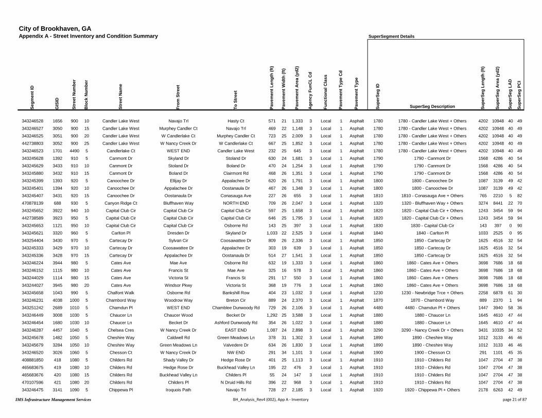
City of Brookhaven, GAAppendix A - Street Inventory and Condition Summary
Segm
ent I
D
GIS
ID
Stre
et N
umbe
r
Blo
ck N
umbe
r
Stre
et N
ame
From
Str
eet
To S
tree
t
Pave
men
t Len
gth
(ft)
Pave
men
t Wid
th (f
t)
Pave
men
t Are
a (y
d2)
Age
ncy
FunC
L C
d
Func
tiona
l Cla
ss
Pave
men
t Typ
e C
d
Pave
men
t Typ
e
343246528 1656 900 10 Candler Lake West Navajo Trl Hasty Ct 571 21 1,333 3 Local 1 Asphalt
343246527 3050 900 15 Candler Lake West Murphey Candler Ct Navajo Trl 469 22 1,148 3 Local 1 Asphalt
343246525 3051 900 20 Candler Lake West W Candlerlake Ct Murphey Candler Ct 723 25 2,009 3 Local 1 Asphalt
442738803 3052 900 25 Candler Lake West W Nancy Creek Dr W Candlerlake Ct 667 25 1,852 3 Local 1 Asphalt
343246523 1701 4490 5 Candlerlake Ct WEST END Candler Lake West 232 25 645 3 Local 1 Asphalt
343245628 1392 910 5 Canmont Dr Skyland Dr Stoland Dr 630 24 1,681 3 Local 1 Asphalt
343245629 3433 910 10 Canmont Dr Stoland Dr Boland Dr 470 24 1,254 3 Local 1 Asphalt
343245880 3432 910 15 Canmont Dr Boland Dr Clairmont Rd 468 26 1,351 3 Local 1 Asphalt
343245399 1393 920 5 Canoochee Dr Ellijay Dr Appalachee Dr 620 26 1,791 3 Local 1 Asphalt
343245401 1394 920 10 Canoochee Dr Appalachee Dr Oostanaula Dr 467 26 1,348 3 Local 1 Asphalt
343245407 3431 920 15 Canoochee Dr Oostanaula Dr Conasauga Ave 227 26 655 3 Local 1 Asphalt
470878139 688 930 5 Canyon Ridge Ct Bluffhaven Way NORTH END 709 26 2,047 3 Local 1 Asphalt
343245652 3922 940 10 Capital Club Cir Capital Club Cir Capital Club Cir 597 25 1,658 3 Local 1 Asphalt
442738589 3923 950 5 Capital Club Cir Capital Club Cir Capital Club Cir 646 25 1,795 3 Local 1 Asphalt
343245653 1121 950 10 Capital Club Cir Capital Club Cir Osborne Rd 143 25 397 3 Local 1 Asphalt
343245621 3320 960 5 Carlton Pl Dresden Dr Skyland Dr 1,033 22 2,525 3 Local 1 Asphalt
343254404 3430 970 5 Cartecay Dr Sylvan Cir Coosawattee Dr 809 26 2,336 3 Local 1 Asphalt
343245333 3429 970 10 Cartecay Dr Coosawattee Dr Appalachee Dr 303 19 639 3 Local 1 Asphalt
343245336 3428 970 15 Cartecay Dr Appalachee Dr Oostanaula Dr 514 27 1,541 3 Local 1 Asphalt
343246224 3944 980 5 Cates Ave Mae Ave Osborne Rd 632 19 1,333 3 Local 1 Asphalt
343246152 1115 980 10 Cates Ave Francis St Mae Ave 325 16 578 3 Local 1 Asphalt
343244029 1114 980 15 Cates Ave Victoria St Francis St 291 17 550 3 Local 1 Asphalt
343244027 3945 980 20 Cates Ave Windsor Pkwy Victoria St 368 19 776 3 Local 1 Asphalt
343245658 1043 990 5 Chalfont Walk Osborne Rd Bankshill Row 404 23 1,032 3 Local 1 Asphalt
343246231 4038 1000 5 Chambord Way Woodrow Way Breton Cir 889 24 2,370 3 Local 1 Asphalt
343251242 2689 1010 5 Chamdun Pl WEST END Chamblee Dunwoody Rd 729 26 2,106 3 Local 1 Asphalt
343246449 3008 1030 5 Chaucer Ln Chaucer Wood Becket Dr 1,292 25 3,588 3 Local 1 Asphalt
343246454 1680 1030 10 Chaucer Ln Becket Dr Ashford Dunwoody Rd 354 26 1,022 3 Local 1 Asphalt
343246287 4457 1040 5 Chelsea Cres W Nancy Creek Dr EAST END 1,087 24 2,898 3 Local 1 Asphalt
343245678 1482 1050 5 Cheshire Way Caldwell Rd Green Meadows Ln 378 31 1,302 3 Local 1 Asphalt
343245679 3284 1050 10 Cheshire Way Green Meadows Ln Valvedere Dr 634 26 1,830 3 Local 1 Asphalt
343246520 3026 1060 5 Chesson Ct W Nancy Creek Dr NW END 291 34 1,101 3 Local 1 Asphalt
408881850 418 1080 5 Childers Rd Shady Valley Dr Hedge Rose Dr 401 25 1,113 3 Local 1 Asphalt
465683675 419 1080 10 Childers Rd Hedge Rose Dr Buckhead Valley Ln 195 22 476 3 Local 1 Asphalt
465683676 420 1080 15 Childers Rd Buckhead Valley Ln Childers Pl 55 24 147 3 Local 1 Asphalt
470107596 421 1080 20 Childers Rd Childers Pl N Druid Hills Rd 396 22 968 3 Local 1 Asphalt
343246475 3141 1090 5 Chippewa Pl Iroquois Path Navajo Trl 728 27 2,185 3 Local 1 Asphalt
SuperSegment Details
Supe
rSeg
ID
SuperSeg Description Supe
rSeg
Len
gth
(ft)
Supe
rSeg
Are
a (y
d2)
Supe
rSeg
LA
D
Supe
rSeg
PC
I
1780 1780 - Candler Lake West + Others 4202 10948 40 49
1780 1780 - Candler Lake West + Others 4202 10948 40 49
1780 1780 - Candler Lake West + Others 4202 10948 40 49
1780 1780 - Candler Lake West + Others 4202 10948 40 49
1780 1780 - Candler Lake West + Others 4202 10948 40 49
1790 1790 - Canmont Dr 1568 4286 40 54
1790 1790 - Canmont Dr 1568 4286 40 54
1790 1790 - Canmont Dr 1568 4286 40 54
1800 1800 - Canoochee Dr 1087 3139 49 42
1800 1800 - Canoochee Dr 1087 3139 49 42
1810 1810 - Conasauga Ave + Others 765 2210 5 82
1320 1320 - Bluffhaven Way + Others 3274 8441 22 70
1820 1820 - Capital Club Cir + Others 1243 3454 59 94
1820 1820 - Capital Club Cir + Others 1243 3454 59 94
1830 1830 - Capital Club Cir 143 397 0 90
1840 1840 - Carlton Pl 1033 2525 0 95
1850 1850 - Cartecay Dr 1625 4516 32 54
1850 1850 - Cartecay Dr 1625 4516 32 54
1850 1850 - Cartecay Dr 1625 4516 32 54
1860 1860 - Cates Ave + Others 3698 7686 18 68
1860 1860 - Cates Ave + Others 3698 7686 18 68
1860 1860 - Cates Ave + Others 3698 7686 18 68
1860 1860 - Cates Ave + Others 3698 7686 18 68
1230 1230 - Newbridge Trce + Others 2258 6878 61 30
1870 1870 - Chambord Way 889 2370 1 94
4480 4480 - Chamdun Pl + Others 1447 3940 58 36
1880 1880 - Chaucer Ln 1645 4610 47 44
1880 1880 - Chaucer Ln 1645 4610 47 44
3290 3290 - Nancy Creek Dr + Others 3431 10335 34 52
1890 1890 - Cheshire Way 1012 3133 46 46
1890 1890 - Cheshire Way 1012 3133 46 46
1900 1900 - Chesson Ct 291 1101 45 35
1910 1910 - Childers Rd 1047 2704 47 38
1910 1910 - Childers Rd 1047 2704 47 38
1910 1910 - Childers Rd 1047 2704 47 38
1910 1910 - Childers Rd 1047 2704 47 38
1920 1920 - Chippewa Pl + Others 2178 6263 42 49
IMS Infrastructure Management Services BH_Analysis_Rev4 (002), App A - Inventory page 21 of 87

City of Brookhaven, GAAppendix A - Street Inventory and Condition Summary Condition Summary
Segm
ent I
D
GIS
ID
Stre
et N
umbe
r
Blo
ck N
umbe
r
Stre
et N
ame
From
Str
eet
To S
tree
t
Pave
men
t Len
gth
(ft)
Pave
men
t Wid
th (f
t)
Pave
men
t Are
a (y
d2)
Age
ncy
FunC
L C
d
Func
tiona
l Cla
ss
Pave
men
t Typ
e C
d
Pave
men
t Typ
e
Ow
ner
Stre
ngth
Rat
ing
Con
ditio
n R
atin
g
Rou
ghne
ss In
dex
(RI)
Surf
ace
Dis
tres
s In
dex
(SD
I)
Pave
men
t Con
ditio
n In
dex
(PC
I)
Ove
rrid
e PC
I
Cur
rent
PC
I
Surv
ey D
ate
Load
Ass
oc D
istr
esse
s (L
AD
)
Non
-Loa
d D
istr
esse
s (N
LAD
)
343246474 1607 1090 10 Chippewa Pl Oconee Pass Iroquois Path 459 26 1,327 3 Local 1 Asphalt City 2 Marginal 62 49 54 53 9/5/2016 42.5 8.3
408858182 1606 1090 15 Chippewa Pl SOUTH END Oconee Pass 272 25 754 3 Local 1 Asphalt City 1 Poor 34 26 29 28 9/5/2016 44.4 29.6
343244424 2003 1100 5 Clairmont Ct WEST END Clairmont Way 227 33 832 3 Local 1 Asphalt City 1 Poor 30 28 28 94 94 9/6/2016 55.0 17.3
343244428 1986 1110 5 Clairmont Pl WEST END Clairmont Way 241 33 884 3 Local 1 Asphalt City 1 Very Poor 32 9 17 98 98 9/6/2016 73.5 17.8
343244441 1987 1110 10 Clairmont Pl Clairmont Way EAST END 159 20 353 3 Local 1 Asphalt City 1 Very Poor 32 14 20 98 98 9/6/2016 65.2 21.0
343246020 1549 1120 5 Clairmont Rd 9th St Airport Rd 374 59 2,453 1 Arterial 1 Asphalt City 3 Marginal 80 35 50 49 9/5/2016 27.0 38.3
408871315 1548 1120 10 Clairmont Rd Tobey Rd 9th St 1,223 59 8,019 1 Arterial 1 Asphalt City 3 Fair 90 46 61 60 9/5/2016 21.2 32.4
424395631 1547 1120 15 Clairmont Rd Georgian Dr E Tobey Rd 430 45 2,152 1 Arterial 1 Asphalt City 3 Marginal 80 40 53 53 9/5/2016 21.4 39.0
343246004 1546 1120 20 Clairmont Rd Bragg St Georgian Dr E 1,112 50 6,179 1 Arterial 1 Asphalt City 3 Marginal 87 37 53 53 9/5/2016 31.9 31.4
343245999 1545 1120 25 Clairmont Rd Manville Dr Bragg St 468 56 2,912 1 Arterial 1 Asphalt City 3 Marginal 81 37 52 52 9/5/2016 30.6 32.0
343245883 1544 1120 30 Clairmont Rd Dresden Dr Manville Dr 450 59 2,951 1 Arterial 1 Asphalt City 1 Poor 64 25 38 38 9/5/2016 53.3 21.5
431175670 1349 1130 5 Clairmont Rd Canmont Dr Dresden Dr 389 58 2,505 1 Arterial 1 Asphalt City 1 Marginal 78 24 42 42 9/5/2016 41.0 35.0
431175673 1348 1130 10 Clairmont Rd Raven Hill Dr Canmont Dr 1,177 58 7,586 1 Arterial 1 Asphalt City 3 Fair 91 47 61 61 9/5/2016 16.5 36.5
343245870 3473 1130 15 Clairmont Rd Skyland Rd Raven Hill Dr 456 63 3,193 1 Arterial 1 Asphalt City 3 Marginal 84 35 51 51 9/5/2016 26.9 37.8
343245867 3474 1130 20 Clairmont Rd Buford Hwy Skyland Rd 831 59 5,448 1 Arterial 1 Asphalt City 1 Marginal 74 29 44 43 9/5/2016 51.4 19.9
408860620 2083 1140 5 Clairmont Way Clairmont Ct Clairmont Pl 395 23 1,010 3 Local 1 Asphalt City 3 Very Good 73 84 80 80 9/5/2016 3.5 12.4
343251664 2259 1140 10 Clairmont Way Somervale Ct Clairmont Ct 428 26 1,237 3 Local 1 Asphalt City 3 Very Good 75 84 81 81 9/5/2016 2.9 13.1
343251672 2258 1140 15 Clairmont Way Somervale Ct Clairmont Rd 1,113 25 3,091 3 Local 1 Asphalt City 3 Good 66 67 67 66 9/5/2016 12.9 20.5
431526690 118 1150 5 Clearview Dr N Druid Hills Rd EAST END 1,099 23 2,809 3 Local 1 Asphalt City 2 Marginal 57 37 44 44 9/5/2016 41.5 21.4
408860685 2494 3020 5 Cliff Valley Way Lenox Park Blvd Coosawattee Dr 2,055 40 9,133 3 Local 1 Asphalt City 2 Marginal 73 42 53 53 9/5/2016 39.5 18.0
343244353 1991 3020 10 Cliff Valley Way Coosawattee Dr Buford Hwy 1,078 40 4,792 3 Local 1 Asphalt City 2 Marginal 64 35 45 44 9/5/2016 39.0 26.1
442732583 3918 1160 5 Club Commons Cir Club Commons Cir Mabry Rd 1,369 24 3,650 3 Local 1 Asphalt City 1 Marginal 66 30 42 42 9/5/2016 54.3 15.4
422303872 1269 1820 5 Club Dr E Club Ct Peachtree Rd 723 17 1,366 3 Local 1 Asphalt City 1 Poor 50 22 32 31 9/5/2016 64.7 12.8
343244009 3883 1170 5 Club Pl Mabry Rd EAST END 655 26 1,891 3 Local 1 Asphalt City 1 Marginal 65 36 45 45 9/5/2016 48.5 15.4
343245692 3709 1180 5 Club Trce WEST END Osborne Rd 754 25 2,096 3 Local 1 Asphalt City 3 Fair 71 51 57 57 9/5/2016 34.5 14.7
442738787 3845 1190 5 Club Walk Dr WEST END Hermance Dr 792 25 2,199 3 Local 1 Asphalt City 3 Fair 61 63 62 62 9/5/2016 32.2 5.1
343245285 3844 1200 5 Colonial Dr Standard Dr Peachtree Rd 832 23 2,125 3 Local 1 Asphalt City 3 Fair 48 59 55 55 9/5/2016 22.3 18.7
343245271 123 1200 10 Colonial Dr Oglethorpe Ave Standard Dr 351 22 858 3 Local 1 Asphalt City 3 Good 71 74 73 73 9/5/2016 21.2 4.8
343245243 122 1200 15 Colonial Dr Pine Grove Ave Oglethorpe Ave 582 23 1,488 3 Local 1 Asphalt City 3 Very Good 76 76 76 76 9/5/2016 12.1 12.3
343254274 5173 1200 20 Colonial Dr Lenox Ridge Ct Pine Grove Ave 645 24 1,719 3 Local 1 Asphalt City 3 Good 63 68 66 66 9/5/2016 19.4 12.8
408880153 121 1200 25 Colonial Dr Lenox Ridge Ct Lenox Walk 575 24 1,534 3 Local 1 Asphalt City 3 Fair 63 54 57 57 9/5/2016 32.6 13.2
408880152 120 1200 30 Colonial Dr Lenox Walk Matthews St 183 23 469 3 Local 1 Asphalt City 3 Good 61 80 74 73 9/5/2016 7.6 12.6
343245248 119 1200 35 Colonial Dr Matthews St N Druid Hills Rd 438 21 1,022 3 Local 1 Asphalt City 3 Good 51 72 65 65 9/5/2016 23.0 4.7
343246534 2746 1210 5 Colt Dr NW END Remington Rd 491 25 1,364 3 Local 1 Asphalt City 3 Very Good 67 85 79 79 9/5/2016 1.1 13.5
343246518 2745 1210 10 Colt Dr Remington Rd Chamblee Dunwoody Rd 1,492 24 3,980 3 Local 1 Asphalt City 3 Good 79 69 72 72 9/5/2016 10.6 20.9
465684207 1363 1220 5 Conasauga Ave Canoochee Dr Dresden Dr 538 26 1,555 3 Local 1 Asphalt City 3 Very Good 72 86 82 81 9/5/2016 5.7 8.2
416039670 4858 1280 5 Converse Dr Converse Dr NE END 508 25 1,412 3 Local 1 Asphalt City 3 Fair 38 63 55 55 9/5/2016 34.1 2.5
IMS Infrastructure Management Services BH_Analysis_Rev4 (002), App A - Inventory page 22 of 87
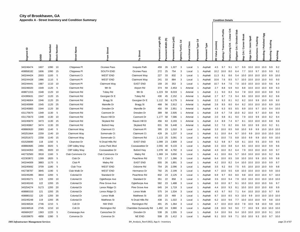
City of Brookhaven, GAAppendix A - Street Inventory and Condition Summary
Segm
ent I
D
GIS
ID
Stre
et N
umbe
r
Blo
ck N
umbe
r
Stre
et N
ame
From
Str
eet
To S
tree
t
Pave
men
t Len
gth
(ft)
Pave
men
t Wid
th (f
t)
Pave
men
t Are
a (y
d2)
Age
ncy
FunC
L C
d
Func
tiona
l Cla
ss
Pave
men
t Typ
e C
d
Pave
men
t Typ
e
343246474 1607 1090 10 Chippewa Pl Oconee Pass Iroquois Path 459 26 1,327 3 Local 1 Asphalt
408858182 1606 1090 15 Chippewa Pl SOUTH END Oconee Pass 272 25 754 3 Local 1 Asphalt
343244424 2003 1100 5 Clairmont Ct WEST END Clairmont Way 227 33 832 3 Local 1 Asphalt
343244428 1986 1110 5 Clairmont Pl WEST END Clairmont Way 241 33 884 3 Local 1 Asphalt
343244441 1987 1110 10 Clairmont Pl Clairmont Way EAST END 159 20 353 3 Local 1 Asphalt
343246020 1549 1120 5 Clairmont Rd 9th St Airport Rd 374 59 2,453 1 Arterial 1 Asphalt
408871315 1548 1120 10 Clairmont Rd Tobey Rd 9th St 1,223 59 8,019 1 Arterial 1 Asphalt
424395631 1547 1120 15 Clairmont Rd Georgian Dr E Tobey Rd 430 45 2,152 1 Arterial 1 Asphalt
343246004 1546 1120 20 Clairmont Rd Bragg St Georgian Dr E 1,112 50 6,179 1 Arterial 1 Asphalt
343245999 1545 1120 25 Clairmont Rd Manville Dr Bragg St 468 56 2,912 1 Arterial 1 Asphalt
343245883 1544 1120 30 Clairmont Rd Dresden Dr Manville Dr 450 59 2,951 1 Arterial 1 Asphalt
431175670 1349 1130 5 Clairmont Rd Canmont Dr Dresden Dr 389 58 2,505 1 Arterial 1 Asphalt
431175673 1348 1130 10 Clairmont Rd Raven Hill Dr Canmont Dr 1,177 58 7,586 1 Arterial 1 Asphalt
343245870 3473 1130 15 Clairmont Rd Skyland Rd Raven Hill Dr 456 63 3,193 1 Arterial 1 Asphalt
343245867 3474 1130 20 Clairmont Rd Buford Hwy Skyland Rd 831 59 5,448 1 Arterial 1 Asphalt
408860620 2083 1140 5 Clairmont Way Clairmont Ct Clairmont Pl 395 23 1,010 3 Local 1 Asphalt
343251664 2259 1140 10 Clairmont Way Somervale Ct Clairmont Ct 428 26 1,237 3 Local 1 Asphalt
343251672 2258 1140 15 Clairmont Way Somervale Ct Clairmont Rd 1,113 25 3,091 3 Local 1 Asphalt
431526690 118 1150 5 Clearview Dr N Druid Hills Rd EAST END 1,099 23 2,809 3 Local 1 Asphalt
408860685 2494 3020 5 Cliff Valley Way Lenox Park Blvd Coosawattee Dr 2,055 40 9,133 3 Local 1 Asphalt
343244353 1991 3020 10 Cliff Valley Way Coosawattee Dr Buford Hwy 1,078 40 4,792 3 Local 1 Asphalt
442732583 3918 1160 5 Club Commons Cir Club Commons Cir Mabry Rd 1,369 24 3,650 3 Local 1 Asphalt
422303872 1269 1820 5 Club Dr E Club Ct Peachtree Rd 723 17 1,366 3 Local 1 Asphalt
343244009 3883 1170 5 Club Pl Mabry Rd EAST END 655 26 1,891 3 Local 1 Asphalt
343245692 3709 1180 5 Club Trce WEST END Osborne Rd 754 25 2,096 3 Local 1 Asphalt
442738787 3845 1190 5 Club Walk Dr WEST END Hermance Dr 792 25 2,199 3 Local 1 Asphalt
343245285 3844 1200 5 Colonial Dr Standard Dr Peachtree Rd 832 23 2,125 3 Local 1 Asphalt
343245271 123 1200 10 Colonial Dr Oglethorpe Ave Standard Dr 351 22 858 3 Local 1 Asphalt
343245243 122 1200 15 Colonial Dr Pine Grove Ave Oglethorpe Ave 582 23 1,488 3 Local 1 Asphalt
343254274 5173 1200 20 Colonial Dr Lenox Ridge Ct Pine Grove Ave 645 24 1,719 3 Local 1 Asphalt
408880153 121 1200 25 Colonial Dr Lenox Ridge Ct Lenox Walk 575 24 1,534 3 Local 1 Asphalt
408880152 120 1200 30 Colonial Dr Lenox Walk Matthews St 183 23 469 3 Local 1 Asphalt
343245248 119 1200 35 Colonial Dr Matthews St N Druid Hills Rd 438 21 1,022 3 Local 1 Asphalt
343246534 2746 1210 5 Colt Dr NW END Remington Rd 491 25 1,364 3 Local 1 Asphalt
343246518 2745 1210 10 Colt Dr Remington Rd Chamblee Dunwoody Rd 1,492 24 3,980 3 Local 1 Asphalt
465684207 1363 1220 5 Conasauga Ave Canoochee Dr Dresden Dr 538 26 1,555 3 Local 1 Asphalt
416039670 4858 1280 5 Converse Dr Converse Dr NE END 508 25 1,412 3 Local 1 Asphalt
Condition Details
IRI V
alue
(mm
/m)
Rut
ting
/ Tra
nsve
rse
Prof
ile
Tran
s-Lo
ng C
rk -
Line
ar C
rk
Alli
gato
r Crk
/ D
ivid
ed S
lab
Map
Crk
/ C
orne
r Bre
ak
Edge
Crk
/ Jo
int S
pall
Dis
tort
ions
/ Fa
ultin
g
Ble
edin
g / P
olis
hed
Agg
Rav
elin
g / S
calin
g
Patc
hing
4.5 9.7 9.1 6.7 9.9 10.0 10.0 10.0 9.9 9.2
10.2 10.0 8.0 6.4 7.7 10.0 9.7 10.0 9.9 9.2
11.3 9.1 8.6 5.4 10.0 10.0 10.0 10.0 8.9 10.0
10.6 7.6 8.5 5.7 10.0 10.0 10.0 10.0 9.0 9.0
10.7 9.4 7.6 7.0 10.0 10.0 10.0 10.0 9.6 6.4
2.7 8.8 6.9 9.0 8.8 10.0 10.0 10.0 8.8 9.3
2.1 9.0 8.3 9.4 7.8 10.0 10.0 10.0 8.8 9.3
2.7 8.7 7.3 9.4 8.6 10.0 10.0 10.0 8.2 9.6
2.2 9.3 8.1 9.2 8.2 10.0 9.9 10.0 8.9 8.0
2.6 8.5 8.0 8.4 8.2 10.0 10.0 10.0 8.9 10.0
4.3 6.3 8.5 8.5 8.9 10.0 9.7 10.0 9.4 10.0
2.9 6.7 7.8 10.0 8.2 10.0 9.7 10.0 8.6 9.0
2.0 9.8 8.1 9.0 7.9 10.0 9.9 10.0 8.2 9.4
2.4 8.9 7.4 8.7 8.1 10.0 10.0 10.0 8.8 9.6
3.2 7.0 8.2 8.6 9.9 10.0 9.9 10.0 9.2 9.1
3.3 10.0 8.5 9.8 10.0 9.9 9.9 10.0 10.0 10.0
3.1 10.0 8.4 9.7 10.0 9.9 10.0 10.0 10.0 10.0
4.0 10.0 7.5 8.8 10.0 9.9 9.9 10.0 9.9 10.0
5.2 9.8 8.7 6.8 8.1 10.0 9.5 10.0 9.9 9.5
3.3 10.0 8.8 6.4 8.5 10.0 10.0 10.0 9.9 9.6
4.3 10.0 8.2 6.4 7.9 10.0 10.0 10.0 9.9 9.7
4.1 10.0 8.6 5.7 10.0 10.0 10.0 10.0 9.2 8.6
6.4 10.0 8.5 3.8 10.0 10.0 9.9 10.0 9.9 9.8
4.2 10.0 8.2 5.4 10.0 10.0 10.0 10.0 9.9 9.7
3.5 9.2 8.6 7.5 9.5 10.0 10.0 10.0 9.9 9.8
4.7 10.0 9.5 6.8 10.0 10.0 10.0 10.0 9.9 10.0
6.9 9.7 8.0 8.0 9.8 10.0 10.0 10.0 9.7 10.0
3.5 10.0 9.4 7.9 10.0 10.0 10.0 10.0 10.0 10.0
3.0 10.0 8.7 9.1 10.0 10.0 10.0 10.0 9.6 9.7
4.4 10.0 9.3 8.1 10.0 10.0 10.0 10.0 8.8 9.9
4.5 9.7 9.0 7.1 9.4 10.0 10.0 10.0 9.7 9.9
8.7 10.0 8.5 9.3 10.0 9.9 10.0 10.0 10.0 10.0
6.2 10.0 9.6 7.7 10.0 10.0 10.0 9.9 9.8 10.0
4.7 10.0 10.0 10.0 7.8 10.0 9.8 10.0 9.8 10.0
2.8 10.0 9.0 9.0 7.7 10.0 9.9 10.0 10.0 10.0
3.4 10.0 9.6 9.4 10.0 10.0 10.0 10.0 9.1 10.0
9.1 10.0 9.9 7.1 10.0 10.0 9.3 10.0 9.7 10.0
IMS Infrastructure Management Services BH_Analysis_Rev4 (002), App A - Inventory page 23 of 87

City of Brookhaven, GAAppendix A - Street Inventory and Condition Summary
Segm
ent I
D
GIS
ID
Stre
et N
umbe
r
Blo
ck N
umbe
r
Stre
et N
ame
From
Str
eet
To S
tree
t
Pave
men
t Len
gth
(ft)
Pave
men
t Wid
th (f
t)
Pave
men
t Are
a (y
d2)
Age
ncy
FunC
L C
d
Func
tiona
l Cla
ss
Pave
men
t Typ
e C
d
Pave
men
t Typ
e
343246474 1607 1090 10 Chippewa Pl Oconee Pass Iroquois Path 459 26 1,327 3 Local 1 Asphalt
408858182 1606 1090 15 Chippewa Pl SOUTH END Oconee Pass 272 25 754 3 Local 1 Asphalt
343244424 2003 1100 5 Clairmont Ct WEST END Clairmont Way 227 33 832 3 Local 1 Asphalt
343244428 1986 1110 5 Clairmont Pl WEST END Clairmont Way 241 33 884 3 Local 1 Asphalt
343244441 1987 1110 10 Clairmont Pl Clairmont Way EAST END 159 20 353 3 Local 1 Asphalt
343246020 1549 1120 5 Clairmont Rd 9th St Airport Rd 374 59 2,453 1 Arterial 1 Asphalt
408871315 1548 1120 10 Clairmont Rd Tobey Rd 9th St 1,223 59 8,019 1 Arterial 1 Asphalt
424395631 1547 1120 15 Clairmont Rd Georgian Dr E Tobey Rd 430 45 2,152 1 Arterial 1 Asphalt
343246004 1546 1120 20 Clairmont Rd Bragg St Georgian Dr E 1,112 50 6,179 1 Arterial 1 Asphalt
343245999 1545 1120 25 Clairmont Rd Manville Dr Bragg St 468 56 2,912 1 Arterial 1 Asphalt
343245883 1544 1120 30 Clairmont Rd Dresden Dr Manville Dr 450 59 2,951 1 Arterial 1 Asphalt
431175670 1349 1130 5 Clairmont Rd Canmont Dr Dresden Dr 389 58 2,505 1 Arterial 1 Asphalt
431175673 1348 1130 10 Clairmont Rd Raven Hill Dr Canmont Dr 1,177 58 7,586 1 Arterial 1 Asphalt
343245870 3473 1130 15 Clairmont Rd Skyland Rd Raven Hill Dr 456 63 3,193 1 Arterial 1 Asphalt
343245867 3474 1130 20 Clairmont Rd Buford Hwy Skyland Rd 831 59 5,448 1 Arterial 1 Asphalt
408860620 2083 1140 5 Clairmont Way Clairmont Ct Clairmont Pl 395 23 1,010 3 Local 1 Asphalt
343251664 2259 1140 10 Clairmont Way Somervale Ct Clairmont Ct 428 26 1,237 3 Local 1 Asphalt
343251672 2258 1140 15 Clairmont Way Somervale Ct Clairmont Rd 1,113 25 3,091 3 Local 1 Asphalt
431526690 118 1150 5 Clearview Dr N Druid Hills Rd EAST END 1,099 23 2,809 3 Local 1 Asphalt
408860685 2494 3020 5 Cliff Valley Way Lenox Park Blvd Coosawattee Dr 2,055 40 9,133 3 Local 1 Asphalt
343244353 1991 3020 10 Cliff Valley Way Coosawattee Dr Buford Hwy 1,078 40 4,792 3 Local 1 Asphalt
442732583 3918 1160 5 Club Commons Cir Club Commons Cir Mabry Rd 1,369 24 3,650 3 Local 1 Asphalt
422303872 1269 1820 5 Club Dr E Club Ct Peachtree Rd 723 17 1,366 3 Local 1 Asphalt
343244009 3883 1170 5 Club Pl Mabry Rd EAST END 655 26 1,891 3 Local 1 Asphalt
343245692 3709 1180 5 Club Trce WEST END Osborne Rd 754 25 2,096 3 Local 1 Asphalt
442738787 3845 1190 5 Club Walk Dr WEST END Hermance Dr 792 25 2,199 3 Local 1 Asphalt
343245285 3844 1200 5 Colonial Dr Standard Dr Peachtree Rd 832 23 2,125 3 Local 1 Asphalt
343245271 123 1200 10 Colonial Dr Oglethorpe Ave Standard Dr 351 22 858 3 Local 1 Asphalt
343245243 122 1200 15 Colonial Dr Pine Grove Ave Oglethorpe Ave 582 23 1,488 3 Local 1 Asphalt
343254274 5173 1200 20 Colonial Dr Lenox Ridge Ct Pine Grove Ave 645 24 1,719 3 Local 1 Asphalt
408880153 121 1200 25 Colonial Dr Lenox Ridge Ct Lenox Walk 575 24 1,534 3 Local 1 Asphalt
408880152 120 1200 30 Colonial Dr Lenox Walk Matthews St 183 23 469 3 Local 1 Asphalt
343245248 119 1200 35 Colonial Dr Matthews St N Druid Hills Rd 438 21 1,022 3 Local 1 Asphalt
343246534 2746 1210 5 Colt Dr NW END Remington Rd 491 25 1,364 3 Local 1 Asphalt
343246518 2745 1210 10 Colt Dr Remington Rd Chamblee Dunwoody Rd 1,492 24 3,980 3 Local 1 Asphalt
465684207 1363 1220 5 Conasauga Ave Canoochee Dr Dresden Dr 538 26 1,555 3 Local 1 Asphalt
416039670 4858 1280 5 Converse Dr Converse Dr NE END 508 25 1,412 3 Local 1 Asphalt
SuperSegment Details
Supe
rSeg
ID
SuperSeg Description Supe
rSeg
Len
gth
(ft)
Supe
rSeg
Are
a (y
d2)
Supe
rSeg
LA
D
Supe
rSeg
PC
I
1920 1920 - Chippewa Pl + Others 2178 6263 42 49
1920 1920 - Chippewa Pl + Others 2178 6263 42 49
1950 1950 - Clairmont Ct 227 832 55 94
1960 1960 - Clairmont Pl 400 1237 71 98
1960 1960 - Clairmont Pl 400 1237 71 98
1930 1930 - Clairmont Rd 4058 24666 29 53
1930 1930 - Clairmont Rd 4058 24666 29 53
1930 1930 - Clairmont Rd 4058 24666 29 53
1930 1930 - Clairmont Rd 4058 24666 29 53
1930 1930 - Clairmont Rd 4058 24666 29 53
1930 1930 - Clairmont Rd 4058 24666 29 53
1940 1940 - Clairmont Rd 2853 18733 32 52
1940 1940 - Clairmont Rd 2853 18733 32 52
1940 1940 - Clairmont Rd 2853 18733 32 52
1940 1940 - Clairmont Rd 2853 18733 32 52
1970 1970 - Clairmont Way 1936 5338 9 72
1970 1970 - Clairmont Way 1936 5338 9 72
1970 1970 - Clairmont Way 1936 5338 9 72
1990 1990 - Clearview Dr 1099 2809 41 44
2000 2000 - Cliff Valley Way 3133 13926 39 50
2000 2000 - Cliff Valley Way 3133 13926 39 50
2010 2010 - Club Commons Cir 1369 3650 54 42
1280 1280 - Bellaire Dr + Others 1657 4063 59 31
2020 2020 - Club Pl 655 1891 49 45
2030 2030 - Club Trce 754 2096 34 57
2040 2040 - Club Walk Dr 792 2199 32 62
2050 2050 - Colonial Dr 3606 9214 21 64
2050 2050 - Colonial Dr 3606 9214 21 64
2050 2050 - Colonial Dr 3606 9214 21 64
2050 2050 - Colonial Dr 3606 9214 21 64
2050 2050 - Colonial Dr 3606 9214 21 64
2050 2050 - Colonial Dr 3606 9214 21 64
2050 2050 - Colonial Dr 3606 9214 21 64
2060 2060 - Colt Dr 1983 5344 8 74
2060 2060 - Colt Dr 1983 5344 8 74
1810 1810 - Conasauga Ave + Others 765 2210 5 82
2070 2070 - Converse Dr 508 1412 34 55
IMS Infrastructure Management Services BH_Analysis_Rev4 (002), App A - Inventory page 24 of 87

City of Brookhaven, GAAppendix A - Street Inventory and Condition Summary Condition Summary
Segm
ent I
D
GIS
ID
Stre
et N
umbe
r
Blo
ck N
umbe
r
Stre
et N
ame
From
Str
eet
To S
tree
t
Pave
men
t Len
gth
(ft)
Pave
men
t Wid
th (f
t)
Pave
men
t Are
a (y
d2)
Age
ncy
FunC
L C
d
Func
tiona
l Cla
ss
Pave
men
t Typ
e C
d
Pave
men
t Typ
e
Ow
ner
Stre
ngth
Rat
ing
Con
ditio
n R
atin
g
Rou
ghne
ss In
dex
(RI)
Surf
ace
Dis
tres
s In
dex
(SD
I)
Pave
men
t Con
ditio
n In
dex
(PC
I)
Ove
rrid
e PC
I
Cur
rent
PC
I
Surv
ey D
ate
Load
Ass
oc D
istr
esse
s (L
AD
)
Non
-Loa
d D
istr
esse
s (N
LAD
)
343245315 3427 1290 5 Coosawattee Dr Tugaloo Dr Cartecay Dr 352 21 822 3 Local 1 Asphalt City 1 Poor 51 27 35 94 94 9/6/2016 55.6 17.2
442743726 2535 1290 10 Coosawattee Dr Coosawattee Dr Tugaloo Dr 412 19 869 3 Local 1 Asphalt City 1 Marginal 63 41 48 94 94 9/6/2016 47.4 11.8
375124518 1970 1290 15 Coosawattee Dr Noel Dr Coosawattee Dr 203 20 450 3 Local 1 Asphalt City 3 Very Good 80 77 78 94 94 9/6/2016 5.1 17.9
343245314 1969 1290 20 Coosawattee Dr Telford Dr Noel Dr 180 19 380 3 Local 1 Asphalt City 3 Fair 57 67 64 94 94 9/6/2016 15.8 16.7
343245296 2536 1290 25 Coosawattee Dr Wayside Dr Telford Dr 618 17 1,167 3 Local 1 Asphalt City 2 Marginal 57 47 51 94 94 9/6/2016 38.3 14.3
343245293 2537 1290 30 Coosawattee Dr Briarwood Rd Wayside Dr 633 23 1,617 3 Local 1 Asphalt City 3 Marginal 74 45 54 94 94 9/6/2016 36.5 18.8
445262507 2539 1310 5 Coosawattee Dr N Cliff Valley Way Doublegate Dr 1,405 26 4,058 3 Local 1 Asphalt City 1 Marginal 51 40 43 43 9/5/2016 48.1 12.4
343244318 2340 1320 5 Corporate Blvd Northeast Expy Buford Hwy 1,518 46 7,759 3 Local 1 Asphalt City 3 Marginal 56 47 50 94 94 9/6/2016 27.2 25.8
408880158 2525 1340 5 Cortez Ln Brookhaven Garden Ln Coosawattee Dr 264 22 646 3 Local 1 Asphalt City 3 Fair 61 59 59 59 9/5/2016 27.6 13.6
408880160 2523 1340 10 Cortez Ln Brookhaven Garden Ln Cortez Way 1,149 25 3,190 3 Local 1 Asphalt City 3 Fair 48 66 60 60 9/5/2016 23.3 10.9
408880156 2524 1340 15 Cortez Ln Cortez Way Drew Valley Rd 408 24 1,089 3 Local 1 Asphalt City 3 Fair 65 62 63 63 9/5/2016 10.8 27.2
343245454 2522 1340 20 Cortez Ln Drew Valley Rd Ewing Dr 488 27 1,465 3 Local 1 Asphalt City 2 Fair 71 48 55 55 9/5/2016 43.0 9.3
343245456 2521 1340 25 Cortez Ln Ewing Dr Nesbitt Dr 378 26 1,091 3 Local 1 Asphalt City 3 Marginal 53 39 44 44 9/5/2016 31.2 29.7
343245327 1931 1350 5 Cortez Way Noel Dr Cortez Way 205 16 365 3 Local 1 Asphalt City 2 Marginal 42 42 42 42 9/5/2016 39.1 19.3
408880157 2597 1350 10 Cortez Way Cortez Ln Noel Dr 619 19 1,307 3 Local 1 Asphalt City 3 Marginal 68 45 53 53 9/5/2016 35.8 18.9
343245560 3426 1360 5 Cotswold Dr Cove Cir Wawona Dr 792 25 2,200 3 Local 1 Asphalt City 1 Marginal 63 29 40 40 9/5/2016 53.0 17.8
343245496 1378 1370 5 Cove Cir Drew Valley Rd Wawona Ter 511 22 1,248 3 Local 1 Asphalt City 1 Marginal 65 30 41 41 9/5/2016 49.0 21.4
343245497 3449 1370 10 Cove Cir Wawona Ter Cotswold Dr 421 25 1,170 3 Local 1 Asphalt City 1 Marginal 70 31 44 44 9/5/2016 48.5 20.4
442752288 3448 1370 15 Cove Cir Cotswold Dr Wawona Dr 2,288 26 6,610 3 Local 1 Asphalt City 3 Marginal 69 48 55 55 9/5/2016 38.2 14.3
343245595 3447 1370 20 Cove Cir Cove Cir Wawona Dr 280 27 840 3 Local 1 Asphalt City 3 Marginal 69 46 53 53 9/5/2016 24.4 29.9
343245524 3446 1370 25 Cove Cir Drew Valley Rd Cove Cir 1,099 24 2,931 3 Local 1 Asphalt City 2 Marginal 60 43 48 48 9/5/2016 38.6 18.8
343246960 3025 1380 5 Cranton Ct Berkford Cir NORTH END 417 26 1,203 3 Local 1 Asphalt City 1 Poor 62 26 38 37 9/5/2016 66.1 8.1
343245789 3423 1390 5 Cravenridge Dr Tryon Rd Caldwell Rd 512 29 1,649 3 Local 1 Asphalt City 3 Fair 70 49 56 56 9/5/2016 34.1 16.4
442738811 3424 1390 10 Cravenridge Dr Pamela Dr Tryon Rd 605 20 1,345 3 Local 1 Asphalt City 3 Fair 71 51 57 57 9/5/2016 34.3 14.9
343245757 3425 1390 15 Cravenridge Dr Tryon Rd Pamela Dr 1,636 20 3,635 3 Local 1 Asphalt City 2 Marginal 67 41 50 49 9/5/2016 46.0 13.0
445260878 1227 1420 5 Crossway Dr NW END Redding Rd 318 30 1,061 3 Local 1 Asphalt City 1 Poor 48 32 38 37 9/5/2016 59.3 8.2
408860835 2493 1460 5 Curtis Dr Buford Hwy N Druid Hills Rd 3,389 30 11,296 3 Local 1 Asphalt City 3 Very Good 75 85 82 82 9/5/2016 11.9 2.7
343254345 1228 1470 5 Cynthia Dr Tryon Rd Caldwell Rd 514 26 1,484 3 Local 1 Asphalt City 3 Good 59 78 72 72 9/5/2016 4.6 17.4
500000064 20234 5630 5 Danbury Parc Pl Donaldson Dr Ellsworth Way 134 44 656 3 Local 1 Asphalt City 3 Marginal 37 61 53 53 9/5/2016 34.0 4.7
500000065 20235 5630 10 Danbury Parc Pl Ellsworth Way Inglewood Way 476 23 1,217 3 Local 1 Asphalt City 3 Very Good 69 89 82 82 9/5/2016 8.5 3.0
500000041 20112 5630 15 Danbury Parc Pl Inglewood Way Ashcroft Bend 658 22 1,607 3 Local 1 Asphalt City 3 Excellent 80 88 85 85 9/5/2016 9.7 2.6
500000037 20029 5630 20 Danbury Parc Pl Ashcroft Bend EAST END 132 23 336 3 Local 1 Asphalt City 2 Excellent 86 95 92 92 9/5/2016 0.0 4.6
446992291 1238 1510 5 Daventry Way WEST END Bankshill Row 254 32 902 3 Local 1 Asphalt City 1 Poor 39 22 28 28 9/5/2016 69.2 8.3
445259046 3915 1520 5 Devine Cir WEST END Osborne Rd 902 27 2,706 3 Local 1 Asphalt City 2 Excellent 89 98 95 95 9/5/2016 0.0 1.6
445259042 3916 1530 5 Devine Cir WEST END Osborne Rd 349 24 930 3 Local 1 Asphalt City 3 Good 63 74 70 70 9/5/2016 8.5 17.5
343245701 3715 1540 5 Dickson St SOUTH END Windsor Pkwy 562 25 1,561 3 Local 1 Asphalt City 1 Poor 44 30 35 34 9/5/2016 54.1 16.0
343245439 1475 1550 5 Dogwood Ter Wilford Dr E Osborne Rd 860 22 2,102 3 Local 1 Asphalt City 1 Poor 60 20 33 33 9/5/2016 53.8 25.8
IMS Infrastructure Management Services BH_Analysis_Rev4 (002), App A - Inventory page 25 of 87

City of Brookhaven, GAAppendix A - Street Inventory and Condition Summary
Segm
ent I
D
GIS
ID
Stre
et N
umbe
r
Blo
ck N
umbe
r
Stre
et N
ame
From
Str
eet
To S
tree
t
Pave
men
t Len
gth
(ft)
Pave
men
t Wid
th (f
t)
Pave
men
t Are
a (y
d2)
Age
ncy
FunC
L C
d
Func
tiona
l Cla
ss
Pave
men
t Typ
e C
d
Pave
men
t Typ
e
343245315 3427 1290 5 Coosawattee Dr Tugaloo Dr Cartecay Dr 352 21 822 3 Local 1 Asphalt
442743726 2535 1290 10 Coosawattee Dr Coosawattee Dr Tugaloo Dr 412 19 869 3 Local 1 Asphalt
375124518 1970 1290 15 Coosawattee Dr Noel Dr Coosawattee Dr 203 20 450 3 Local 1 Asphalt
343245314 1969 1290 20 Coosawattee Dr Telford Dr Noel Dr 180 19 380 3 Local 1 Asphalt
343245296 2536 1290 25 Coosawattee Dr Wayside Dr Telford Dr 618 17 1,167 3 Local 1 Asphalt
343245293 2537 1290 30 Coosawattee Dr Briarwood Rd Wayside Dr 633 23 1,617 3 Local 1 Asphalt
445262507 2539 1310 5 Coosawattee Dr N Cliff Valley Way Doublegate Dr 1,405 26 4,058 3 Local 1 Asphalt
343244318 2340 1320 5 Corporate Blvd Northeast Expy Buford Hwy 1,518 46 7,759 3 Local 1 Asphalt
408880158 2525 1340 5 Cortez Ln Brookhaven Garden Ln Coosawattee Dr 264 22 646 3 Local 1 Asphalt
408880160 2523 1340 10 Cortez Ln Brookhaven Garden Ln Cortez Way 1,149 25 3,190 3 Local 1 Asphalt
408880156 2524 1340 15 Cortez Ln Cortez Way Drew Valley Rd 408 24 1,089 3 Local 1 Asphalt
343245454 2522 1340 20 Cortez Ln Drew Valley Rd Ewing Dr 488 27 1,465 3 Local 1 Asphalt
343245456 2521 1340 25 Cortez Ln Ewing Dr Nesbitt Dr 378 26 1,091 3 Local 1 Asphalt
343245327 1931 1350 5 Cortez Way Noel Dr Cortez Way 205 16 365 3 Local 1 Asphalt
408880157 2597 1350 10 Cortez Way Cortez Ln Noel Dr 619 19 1,307 3 Local 1 Asphalt
343245560 3426 1360 5 Cotswold Dr Cove Cir Wawona Dr 792 25 2,200 3 Local 1 Asphalt
343245496 1378 1370 5 Cove Cir Drew Valley Rd Wawona Ter 511 22 1,248 3 Local 1 Asphalt
343245497 3449 1370 10 Cove Cir Wawona Ter Cotswold Dr 421 25 1,170 3 Local 1 Asphalt
442752288 3448 1370 15 Cove Cir Cotswold Dr Wawona Dr 2,288 26 6,610 3 Local 1 Asphalt
343245595 3447 1370 20 Cove Cir Cove Cir Wawona Dr 280 27 840 3 Local 1 Asphalt
343245524 3446 1370 25 Cove Cir Drew Valley Rd Cove Cir 1,099 24 2,931 3 Local 1 Asphalt
343246960 3025 1380 5 Cranton Ct Berkford Cir NORTH END 417 26 1,203 3 Local 1 Asphalt
343245789 3423 1390 5 Cravenridge Dr Tryon Rd Caldwell Rd 512 29 1,649 3 Local 1 Asphalt
442738811 3424 1390 10 Cravenridge Dr Pamela Dr Tryon Rd 605 20 1,345 3 Local 1 Asphalt
343245757 3425 1390 15 Cravenridge Dr Tryon Rd Pamela Dr 1,636 20 3,635 3 Local 1 Asphalt
445260878 1227 1420 5 Crossway Dr NW END Redding Rd 318 30 1,061 3 Local 1 Asphalt
408860835 2493 1460 5 Curtis Dr Buford Hwy N Druid Hills Rd 3,389 30 11,296 3 Local 1 Asphalt
343254345 1228 1470 5 Cynthia Dr Tryon Rd Caldwell Rd 514 26 1,484 3 Local 1 Asphalt
500000064 20234 5630 5 Danbury Parc Pl Donaldson Dr Ellsworth Way 134 44 656 3 Local 1 Asphalt
500000065 20235 5630 10 Danbury Parc Pl Ellsworth Way Inglewood Way 476 23 1,217 3 Local 1 Asphalt
500000041 20112 5630 15 Danbury Parc Pl Inglewood Way Ashcroft Bend 658 22 1,607 3 Local 1 Asphalt
500000037 20029 5630 20 Danbury Parc Pl Ashcroft Bend EAST END 132 23 336 3 Local 1 Asphalt
446992291 1238 1510 5 Daventry Way WEST END Bankshill Row 254 32 902 3 Local 1 Asphalt
445259046 3915 1520 5 Devine Cir WEST END Osborne Rd 902 27 2,706 3 Local 1 Asphalt
445259042 3916 1530 5 Devine Cir WEST END Osborne Rd 349 24 930 3 Local 1 Asphalt
343245701 3715 1540 5 Dickson St SOUTH END Windsor Pkwy 562 25 1,561 3 Local 1 Asphalt
343245439 1475 1550 5 Dogwood Ter Wilford Dr E Osborne Rd 860 22 2,102 3 Local 1 Asphalt
Condition Details
IRI V
alue
(mm
/m)
Rut
ting
/ Tra
nsve
rse
Prof
ile
Tran
s-Lo
ng C
rk -
Line
ar C
rk
Alli
gato
r Crk
/ D
ivid
ed S
lab
Map
Crk
/ C
orne
r Bre
ak
Edge
Crk
/ Jo
int S
pall
Dis
tort
ions
/ Fa
ultin
g
Ble
edin
g / P
olis
hed
Agg
Rav
elin
g / S
calin
g
Patc
hing
6.2 10.0 7.9 5.7 10.0 10.0 10.0 10.0 9.9 8.4
4.4 10.0 8.6 6.2 10.0 10.0 10.0 10.0 9.9 8.8
2.7 10.0 7.8 9.6 10.0 9.8 10.0 10.0 10.0 10.0
5.2 10.0 8.9 9.0 8.9 10.0 10.0 10.0 9.7 9.2
5.2 9.9 8.4 7.1 9.8 10.0 8.8 10.0 9.9 10.0
3.2 10.0 8.5 6.3 8.7 10.0 10.0 10.0 10.0 10.0
6.3 9.9 9.1 5.7 9.5 10.0 10.0 10.0 9.5 9.4
5.4 9.9 8.2 8.0 9.0 10.0 9.9 10.0 9.0 9.3
4.7 10.0 8.5 7.5 10.0 10.0 10.0 10.0 9.7 9.7
6.7 9.9 9.4 8.1 8.9 10.0 10.0 10.0 9.9 9.6
4.2 10.0 7.1 9.1 9.4 9.7 9.9 10.0 10.0 10.0
3.5 10.0 8.9 6.4 9.9 10.0 9.2 10.0 10.0 9.8
5.8 10.0 8.8 7.4 6.5 10.0 9.4 10.0 9.9 9.9
8.0 10.0 8.4 7.4 10.0 10.0 10.0 10.0 8.9 8.3
3.9 10.0 8.5 7.2 9.6 10.0 10.0 10.0 9.2 9.0
4.4 10.0 8.2 5.1 10.0 10.0 9.9 10.0 9.4 9.6
4.2 10.0 8.8 5.2 9.2 10.0 9.8 10.0 8.7 10.0
3.6 10.0 8.4 5.2 10.0 10.0 10.0 10.0 8.6 9.9
3.7 10.0 8.7 7.1 9.3 10.0 9.7 10.0 10.0 9.1
3.8 10.0 7.4 7.8 8.4 10.0 9.7 10.0 10.0 10.0
4.9 10.0 8.7 6.5 8.6 10.0 9.9 10.0 9.9 9.6
4.6 10.0 10.0 3.5 8.8 10.0 10.0 10.0 9.9 9.9
3.7 10.0 8.0 7.0 10.0 10.0 10.0 10.0 10.0 9.5
3.5 10.0 8.1 6.7 10.0 10.0 10.0 10.0 10.0 9.8
3.9 9.7 8.5 6.9 10.0 10.0 9.1 9.9 9.9 9.3
6.8 10.0 9.3 4.2 10.0 10.0 10.0 10.0 9.5 9.9
3.1 10.0 9.8 8.8 10.0 10.0 10.0 10.0 9.8 10.0
5.0 10.0 8.2 9.7 9.9 10.0 10.0 10.0 9.5 9.9
9.3 8.2 9.6 8.3 10.0 10.0 10.0 10.0 9.8 10.0
4.8 10.0 9.8 9.2 10.0 10.0 10.0 10.0 9.7 10.0
2.7 10.0 9.7 9.0 10.0 10.0 10.0 10.0 10.0 10.0
4.8 10.0 9.8 10.0 10.0 10.0 10.0 9.9 9.6 10.0
8.7 10.0 9.1 3.9 10.0 10.0 8.8 10.0 9.8 10.0
2.7 10.0 10.0 10.0 10.0 10.0 10.0 10.0 9.7 10.0
4.4 10.0 7.8 9.2 10.0 9.9 10.0 10.0 10.0 10.0
7.6 9.5 8.1 5.6 10.0 10.0 9.9 10.0 9.9 9.4
4.9 9.6 7.8 6.0 9.1 10.0 9.9 10.0 9.4 8.8
IMS Infrastructure Management Services BH_Analysis_Rev4 (002), App A - Inventory page 26 of 87
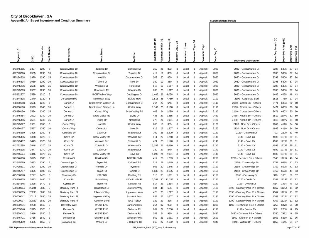
City of Brookhaven, GAAppendix A - Street Inventory and Condition Summary
Segm
ent I
D
GIS
ID
Stre
et N
umbe
r
Blo
ck N
umbe
r
Stre
et N
ame
From
Str
eet
To S
tree
t
Pave
men
t Len
gth
(ft)
Pave
men
t Wid
th (f
t)
Pave
men
t Are
a (y
d2)
Age
ncy
FunC
L C
d
Func
tiona
l Cla
ss
Pave
men
t Typ
e C
d
Pave
men
t Typ
e
343245315 3427 1290 5 Coosawattee Dr Tugaloo Dr Cartecay Dr 352 21 822 3 Local 1 Asphalt
442743726 2535 1290 10 Coosawattee Dr Coosawattee Dr Tugaloo Dr 412 19 869 3 Local 1 Asphalt
375124518 1970 1290 15 Coosawattee Dr Noel Dr Coosawattee Dr 203 20 450 3 Local 1 Asphalt
343245314 1969 1290 20 Coosawattee Dr Telford Dr Noel Dr 180 19 380 3 Local 1 Asphalt
343245296 2536 1290 25 Coosawattee Dr Wayside Dr Telford Dr 618 17 1,167 3 Local 1 Asphalt
343245293 2537 1290 30 Coosawattee Dr Briarwood Rd Wayside Dr 633 23 1,617 3 Local 1 Asphalt
445262507 2539 1310 5 Coosawattee Dr N Cliff Valley Way Doublegate Dr 1,405 26 4,058 3 Local 1 Asphalt
343244318 2340 1320 5 Corporate Blvd Northeast Expy Buford Hwy 1,518 46 7,759 3 Local 1 Asphalt
408880158 2525 1340 5 Cortez Ln Brookhaven Garden Ln Coosawattee Dr 264 22 646 3 Local 1 Asphalt
408880160 2523 1340 10 Cortez Ln Brookhaven Garden Ln Cortez Way 1,149 25 3,190 3 Local 1 Asphalt
408880156 2524 1340 15 Cortez Ln Cortez Way Drew Valley Rd 408 24 1,089 3 Local 1 Asphalt
343245454 2522 1340 20 Cortez Ln Drew Valley Rd Ewing Dr 488 27 1,465 3 Local 1 Asphalt
343245456 2521 1340 25 Cortez Ln Ewing Dr Nesbitt Dr 378 26 1,091 3 Local 1 Asphalt
343245327 1931 1350 5 Cortez Way Noel Dr Cortez Way 205 16 365 3 Local 1 Asphalt
408880157 2597 1350 10 Cortez Way Cortez Ln Noel Dr 619 19 1,307 3 Local 1 Asphalt
343245560 3426 1360 5 Cotswold Dr Cove Cir Wawona Dr 792 25 2,200 3 Local 1 Asphalt
343245496 1378 1370 5 Cove Cir Drew Valley Rd Wawona Ter 511 22 1,248 3 Local 1 Asphalt
343245497 3449 1370 10 Cove Cir Wawona Ter Cotswold Dr 421 25 1,170 3 Local 1 Asphalt
442752288 3448 1370 15 Cove Cir Cotswold Dr Wawona Dr 2,288 26 6,610 3 Local 1 Asphalt
343245595 3447 1370 20 Cove Cir Cove Cir Wawona Dr 280 27 840 3 Local 1 Asphalt
343245524 3446 1370 25 Cove Cir Drew Valley Rd Cove Cir 1,099 24 2,931 3 Local 1 Asphalt
343246960 3025 1380 5 Cranton Ct Berkford Cir NORTH END 417 26 1,203 3 Local 1 Asphalt
343245789 3423 1390 5 Cravenridge Dr Tryon Rd Caldwell Rd 512 29 1,649 3 Local 1 Asphalt
442738811 3424 1390 10 Cravenridge Dr Pamela Dr Tryon Rd 605 20 1,345 3 Local 1 Asphalt
343245757 3425 1390 15 Cravenridge Dr Tryon Rd Pamela Dr 1,636 20 3,635 3 Local 1 Asphalt
445260878 1227 1420 5 Crossway Dr NW END Redding Rd 318 30 1,061 3 Local 1 Asphalt
408860835 2493 1460 5 Curtis Dr Buford Hwy N Druid Hills Rd 3,389 30 11,296 3 Local 1 Asphalt
343254345 1228 1470 5 Cynthia Dr Tryon Rd Caldwell Rd 514 26 1,484 3 Local 1 Asphalt
500000064 20234 5630 5 Danbury Parc Pl Donaldson Dr Ellsworth Way 134 44 656 3 Local 1 Asphalt
500000065 20235 5630 10 Danbury Parc Pl Ellsworth Way Inglewood Way 476 23 1,217 3 Local 1 Asphalt
500000041 20112 5630 15 Danbury Parc Pl Inglewood Way Ashcroft Bend 658 22 1,607 3 Local 1 Asphalt
500000037 20029 5630 20 Danbury Parc Pl Ashcroft Bend EAST END 132 23 336 3 Local 1 Asphalt
446992291 1238 1510 5 Daventry Way WEST END Bankshill Row 254 32 902 3 Local 1 Asphalt
445259046 3915 1520 5 Devine Cir WEST END Osborne Rd 902 27 2,706 3 Local 1 Asphalt
445259042 3916 1530 5 Devine Cir WEST END Osborne Rd 349 24 930 3 Local 1 Asphalt
343245701 3715 1540 5 Dickson St SOUTH END Windsor Pkwy 562 25 1,561 3 Local 1 Asphalt
343245439 1475 1550 5 Dogwood Ter Wilford Dr E Osborne Rd 860 22 2,102 3 Local 1 Asphalt
SuperSegment Details
Supe
rSeg
ID
SuperSeg Description Supe
rSeg
Len
gth
(ft)
Supe
rSeg
Are
a (y
d2)
Supe
rSeg
LA
D
Supe
rSeg
PC
I
2080 2080 - Coosawattee Dr 2398 5306 37 94
2080 2080 - Coosawattee Dr 2398 5306 37 94
2080 2080 - Coosawattee Dr 2398 5306 37 94
2080 2080 - Coosawattee Dr 2398 5306 37 94
2080 2080 - Coosawattee Dr 2398 5306 37 94
2080 2080 - Coosawattee Dr 2398 5306 37 94
2090 2090 - Coosawattee Dr 1405 4058 48 43
2100 2100 - Corporate Blvd 1518 7759 27 94
2110 2110 - Cortez Ln + Others 2471 6803 20 60
2110 2110 - Cortez Ln + Others 2471 6803 20 60
2110 2110 - Cortez Ln + Others 2471 6803 20 60
2480 2480 - Nesbitt Dr + Others 3812 11077 31 50
2480 2480 - Nesbitt Dr + Others 3812 11077 31 50
2120 2120 - Noel Dr + Others 1869 4110 34 50
2120 2120 - Noel Dr + Others 1869 4110 34 50
2130 2130 - Cotswold Dr 792 2200 53 40
2140 2140 - Cove Cir 4599 12798 39 51
2140 2140 - Cove Cir 4599 12798 39 51
2140 2140 - Cove Cir 4599 12798 39 51
2140 2140 - Cove Cir 4599 12798 39 51
2140 2140 - Cove Cir 4599 12798 39 51
1290 1290 - Berkford Cir + Others 3946 11217 46 54
2150 2150 - Cravenridge Dr 2752 6628 41 53
2150 2150 - Cravenridge Dr 2752 6628 41 53
2150 2150 - Cravenridge Dr 2752 6628 41 53
2160 2160 - Crossway Dr 318 1061 59 37
2170 2170 - Curtis Dr 3389 11296 12 82
2180 2180 - Cynthia Dr 514 1484 5 72
3190 3190 - Danbury Parc Pl + Others 4367 11254 11 82
3190 3190 - Danbury Parc Pl + Others 4367 11254 11 82
3190 3190 - Danbury Parc Pl + Others 4367 11254 11 82
3190 3190 - Danbury Parc Pl + Others 4367 11254 11 82
1230 1230 - Newbridge Trce + Others 2258 6878 61 30
2190 2190 - Devine Cir 902 2706 0 95
3490 3490 - Osborne Rd + Others 3350 7932 8 75
2560 2560 - Dickson St + Others 1956 5230 51 36
4340 4340 - Wilford Dr + Others 1855 4645 54 37
IMS Infrastructure Management Services BH_Analysis_Rev4 (002), App A - Inventory page 27 of 87

City of Brookhaven, GAAppendix A - Street Inventory and Condition Summary Condition Summary
Segm
ent I
D
GIS
ID
Stre
et N
umbe
r
Blo
ck N
umbe
r
Stre
et N
ame
From
Str
eet
To S
tree
t
Pave
men
t Len
gth
(ft)
Pave
men
t Wid
th (f
t)
Pave
men
t Are
a (y
d2)
Age
ncy
FunC
L C
d
Func
tiona
l Cla
ss
Pave
men
t Typ
e C
d
Pave
men
t Typ
e
Ow
ner
Stre
ngth
Rat
ing
Con
ditio
n R
atin
g
Rou
ghne
ss In
dex
(RI)
Surf
ace
Dis
tres
s In
dex
(SD
I)
Pave
men
t Con
ditio
n In
dex
(PC
I)
Ove
rrid
e PC
I
Cur
rent
PC
I
Surv
ey D
ate
Load
Ass
oc D
istr
esse
s (L
AD
)
Non
-Loa
d D
istr
esse
s (N
LAD
)
343246488 1677 1580 5 Donaldson Dr Woodstream Cir Donaldson Dr 161 26 466 2 Collector 1 Asphalt City 3 Marginal 44 44 44 44 9/5/2016 27.9 28.1
343246367 3009 1580 10 Donaldson Dr Bubbling Creek Rd Woodstream Cir 1,117 25 3,103 2 Collector 1 Asphalt City 3 Good 83 66 71 71 9/5/2016 17.2 16.9
442738608 3010 1580 15 Donaldson Dr Park Creek Ln Bubbling Creek Rd 450 28 1,401 2 Collector 1 Asphalt City 3 Good 68 67 67 67 9/5/2016 21.8 11.2
343246360 1676 1580 20 Donaldson Dr Danbury Parc Pl Park Creek Ln 213 26 614 2 Collector 1 Asphalt City 3 Good 88 60 69 69 9/5/2016 12.4 27.9
343246355 1675 1580 25 Donaldson Dr Donaldson Park Dr Danbury Parc Pl 328 26 948 2 Collector 1 Asphalt City 3 Good 89 55 66 66 9/5/2016 26.6 18.3
408858343 3011 1580 30 Donaldson Dr Blair Cir Donaldson Park Dr 434 27 1,303 2 Collector 1 Asphalt City 3 Fair 78 57 64 64 9/5/2016 25.7 17.2
343246341 1674 1580 35 Donaldson Dr Donaldson Dr Blair Cir 496 31 1,708 2 Collector 1 Asphalt City 3 Fair 62 64 63 63 9/5/2016 27.9 8.6
408858366 1229 1580 40 Donaldson Dr Johnson Ferry Rd Donaldson Dr 413 33 1,514 2 Collector 1 Asphalt City 3 Fair 75 55 62 61 9/5/2016 30.2 14.7
343282687 3946 1590 5 Dorby Close Dorby Park Dr NE END 198 41 902 3 Local 1 Asphalt City 1 Marginal 54 41 45 45 9/5/2016 51.8 7.0
343282686 3838 1600 5 Dorby Park Dr Osborne Rd Dorby Close 389 22 951 3 Local 1 Asphalt City 2 Marginal 68 44 52 51 9/5/2016 40.3 16.1
343282685 3837 1600 10 Dorby Park Dr Dorby Close EAST END 237 33 870 3 Local 1 Asphalt City 1 Marginal 45 41 42 42 9/5/2016 42.8 15.8
343246407 695 1610 5 Downing Ln Ives Ct NORTH END 183 39 791 3 Local 1 Asphalt City 1 Poor 58 27 37 37 9/5/2016 61.4 11.3
343246405 4445 1610 10 Downing Ln Byrnwyck Pl Ives Ct 310 26 895 3 Local 1 Asphalt City 1 Marginal 75 29 44 44 9/5/2016 55.5 15.6
424393731 1105 1620 5 Dresden Dr Peachtree Rd Ramp 184 46 938 1 Arterial 1 Asphalt City 3 Marginal 49 55 53 53 9/5/2016 17.1 27.9
424395393 1106 1620 10 Dresden Dr Ramp Apple Valley Rd 546 43 2,611 1 Arterial 1 Asphalt City 3 Good 82 59 67 67 9/5/2016 24.0 16.5
343254415 3488 1620 15 Dresden Dr Apple Valley Rd Fernwood Cir 903 37 3,713 1 Arterial 1 Asphalt City 3 Very Good 77 86 83 83 9/5/2016 2.1 12.0
343254412 1335 1620 20 Dresden Dr Fernwood Cir Ellijay Dr 532 39 2,305 1 Arterial 1 Asphalt City 3 Very Good 74 87 83 83 9/5/2016 4.9 7.8
442755251 3487 1620 25 Dresden Dr Ellijay Dr Caldwell Rd 172 39 746 1 Arterial 1 Asphalt City 2 Marginal 57 45 49 49 9/5/2016 44.0 10.9
343245408 1336 1620 30 Dresden Dr Caldwell Rd Appalachee Dr 453 33 1,661 1 Arterial 1 Asphalt City 3 Fair 81 50 60 60 9/5/2016 33.6 16.1
465684227 1337 1620 35 Dresden Dr Appalachee Dr Camille Dr 511 40 2,270 1 Arterial 1 Asphalt City 3 Very Good 85 73 77 77 9/5/2016 7.4 19.6
343245413 1338 1620 40 Dresden Dr Camille Dr Conasauga Ave 189 38 797 1 Arterial 1 Asphalt City 3 Good 88 65 73 73 9/5/2016 12.2 22.6
343245415 1339 1620 45 Dresden Dr Conasauga Ave Grant Dr 129 38 543 1 Arterial 1 Asphalt City 3 Very Good 90 77 82 81 9/5/2016 11.6 11.1
424395448 3486 1620 50 Dresden Dr Grant Dr N Thompson Rd 442 34 1,669 1 Arterial 1 Asphalt City 3 Good 83 60 68 68 9/5/2016 10.7 28.8
343245557 1341 1620 60 Dresden Dr Thompson Rd Wayland Cir 719 37 2,955 1 Arterial 1 Asphalt City 2 Marginal 65 43 50 50 9/5/2016 43.4 13.9
343245565 3485 1620 65 Dresden Dr Wayland Cir Ashford Rd 630 37 2,592 1 Arterial 1 Asphalt City 3 Fair 82 55 64 64 9/5/2016 29.0 15.9
424395461 3484 1620 70 Dresden Dr Ashford Rd Winding Ln 973 40 4,325 1 Arterial 1 Asphalt City 3 Fair 79 49 59 59 9/5/2016 37.4 13.7
424395459 1342 1620 75 Dresden Dr Winding Ln Brookline Cir 575 43 2,747 1 Arterial 1 Asphalt City 3 Fair 66 51 56 56 9/5/2016 29.1 19.5
424395494 3483 1620 80 Dresden Dr Brookline Cir Carlton Pl 485 37 1,993 1 Arterial 1 Asphalt City 3 Fair 78 58 64 64 9/5/2016 23.9 18.5
343245616 3482 1620 85 Dresden Dr Carlton Pl Skyland Dr 378 36 1,512 1 Arterial 1 Asphalt City 3 Good 85 64 71 71 9/5/2016 7.4 28.3
343245631 1343 1620 90 Dresden Dr Skyland Dr Archway Dr 765 35 2,975 1 Arterial 1 Asphalt City 3 Marginal 68 47 54 54 9/5/2016 38.0 14.8
343245881 1344 1620 95 Dresden Dr Archway Dr Clairmont Rd 912 57 5,775 1 Arterial 1 Asphalt City 3 Good 79 61 67 67 9/5/2016 29.4 9.8
343245515 2607 1630 5 Drew Valley Rd E Drew Valley Rd Buford Hwy 491 27 1,473 3 Local 1 Asphalt City 3 Fair 56 58 57 57 9/5/2016 18.6 23.6
343245510 2606 1630 10 Drew Valley Rd Burch Cir E Drew Valley Rd 648 26 1,873 3 Local 1 Asphalt City 3 Good 77 60 66 66 9/5/2016 13.4 26.2
343245469 2605 1630 15 Drew Valley Rd Burch Cir Burch Cir 1,192 25 3,310 3 Local 1 Asphalt City 3 Fair 73 56 62 61 9/5/2016 14.7 29.5
343245463 2604 1630 20 Drew Valley Rd Poplar Springs Dr Burch Cir 632 25 1,757 3 Local 1 Asphalt City 3 Fair 63 59 60 60 9/5/2016 8.7 32.8
343245449 2603 1630 25 Drew Valley Rd Nesbitt Dr Poplar Springs Dr 387 25 1,074 3 Local 1 Asphalt City 3 Good 72 66 68 68 9/5/2016 12.4 21.8
343245446 2602 1630 30 Drew Valley Rd Briarwood Way Nesbitt Dr 882 26 2,547 3 Local 1 Asphalt City 3 Good 66 73 71 71 9/5/2016 17.2 9.8
IMS Infrastructure Management Services BH_Analysis_Rev4 (002), App A - Inventory page 28 of 87
City of Brookhaven, GAAppendix A - Street Inventory and Condition Summary
Segm
ent I
D
GIS
ID
Stre
et N
umbe
r
Blo
ck N
umbe
r
Stre
et N
ame
From
Str
eet
To S
tree
t
Pave
men
t Len
gth
(ft)
Pave
men
t Wid
th (f
t)
Pave
men
t Are
a (y
d2)
Age
ncy
FunC
L C
d
Func
tiona
l Cla
ss
Pave
men
t Typ
e C
d
Pave
men
t Typ
e
343246488 1677 1580 5 Donaldson Dr Woodstream Cir Donaldson Dr 161 26 466 2 Collector 1 Asphalt
343246367 3009 1580 10 Donaldson Dr Bubbling Creek Rd Woodstream Cir 1,117 25 3,103 2 Collector 1 Asphalt
442738608 3010 1580 15 Donaldson Dr Park Creek Ln Bubbling Creek Rd 450 28 1,401 2 Collector 1 Asphalt
343246360 1676 1580 20 Donaldson Dr Danbury Parc Pl Park Creek Ln 213 26 614 2 Collector 1 Asphalt
343246355 1675 1580 25 Donaldson Dr Donaldson Park Dr Danbury Parc Pl 328 26 948 2 Collector 1 Asphalt
408858343 3011 1580 30 Donaldson Dr Blair Cir Donaldson Park Dr 434 27 1,303 2 Collector 1 Asphalt
343246341 1674 1580 35 Donaldson Dr Donaldson Dr Blair Cir 496 31 1,708 2 Collector 1 Asphalt
408858366 1229 1580 40 Donaldson Dr Johnson Ferry Rd Donaldson Dr 413 33 1,514 2 Collector 1 Asphalt
343282687 3946 1590 5 Dorby Close Dorby Park Dr NE END 198 41 902 3 Local 1 Asphalt
343282686 3838 1600 5 Dorby Park Dr Osborne Rd Dorby Close 389 22 951 3 Local 1 Asphalt
343282685 3837 1600 10 Dorby Park Dr Dorby Close EAST END 237 33 870 3 Local 1 Asphalt
343246407 695 1610 5 Downing Ln Ives Ct NORTH END 183 39 791 3 Local 1 Asphalt
343246405 4445 1610 10 Downing Ln Byrnwyck Pl Ives Ct 310 26 895 3 Local 1 Asphalt
424393731 1105 1620 5 Dresden Dr Peachtree Rd Ramp 184 46 938 1 Arterial 1 Asphalt
424395393 1106 1620 10 Dresden Dr Ramp Apple Valley Rd 546 43 2,611 1 Arterial 1 Asphalt
343254415 3488 1620 15 Dresden Dr Apple Valley Rd Fernwood Cir 903 37 3,713 1 Arterial 1 Asphalt
343254412 1335 1620 20 Dresden Dr Fernwood Cir Ellijay Dr 532 39 2,305 1 Arterial 1 Asphalt
442755251 3487 1620 25 Dresden Dr Ellijay Dr Caldwell Rd 172 39 746 1 Arterial 1 Asphalt
343245408 1336 1620 30 Dresden Dr Caldwell Rd Appalachee Dr 453 33 1,661 1 Arterial 1 Asphalt
465684227 1337 1620 35 Dresden Dr Appalachee Dr Camille Dr 511 40 2,270 1 Arterial 1 Asphalt
343245413 1338 1620 40 Dresden Dr Camille Dr Conasauga Ave 189 38 797 1 Arterial 1 Asphalt
343245415 1339 1620 45 Dresden Dr Conasauga Ave Grant Dr 129 38 543 1 Arterial 1 Asphalt
424395448 3486 1620 50 Dresden Dr Grant Dr N Thompson Rd 442 34 1,669 1 Arterial 1 Asphalt
343245557 1341 1620 60 Dresden Dr Thompson Rd Wayland Cir 719 37 2,955 1 Arterial 1 Asphalt
343245565 3485 1620 65 Dresden Dr Wayland Cir Ashford Rd 630 37 2,592 1 Arterial 1 Asphalt
424395461 3484 1620 70 Dresden Dr Ashford Rd Winding Ln 973 40 4,325 1 Arterial 1 Asphalt
424395459 1342 1620 75 Dresden Dr Winding Ln Brookline Cir 575 43 2,747 1 Arterial 1 Asphalt
424395494 3483 1620 80 Dresden Dr Brookline Cir Carlton Pl 485 37 1,993 1 Arterial 1 Asphalt
343245616 3482 1620 85 Dresden Dr Carlton Pl Skyland Dr 378 36 1,512 1 Arterial 1 Asphalt
343245631 1343 1620 90 Dresden Dr Skyland Dr Archway Dr 765 35 2,975 1 Arterial 1 Asphalt
343245881 1344 1620 95 Dresden Dr Archway Dr Clairmont Rd 912 57 5,775 1 Arterial 1 Asphalt
343245515 2607 1630 5 Drew Valley Rd E Drew Valley Rd Buford Hwy 491 27 1,473 3 Local 1 Asphalt
343245510 2606 1630 10 Drew Valley Rd Burch Cir E Drew Valley Rd 648 26 1,873 3 Local 1 Asphalt
343245469 2605 1630 15 Drew Valley Rd Burch Cir Burch Cir 1,192 25 3,310 3 Local 1 Asphalt
343245463 2604 1630 20 Drew Valley Rd Poplar Springs Dr Burch Cir 632 25 1,757 3 Local 1 Asphalt
343245449 2603 1630 25 Drew Valley Rd Nesbitt Dr Poplar Springs Dr 387 25 1,074 3 Local 1 Asphalt
343245446 2602 1630 30 Drew Valley Rd Briarwood Way Nesbitt Dr 882 26 2,547 3 Local 1 Asphalt
Condition Details
IRI V
alue
(mm
/m)
Rut
ting
/ Tra
nsve
rse
Prof
ile
Tran
s-Lo
ng C
rk -
Line
ar C
rk
Alli
gato
r Crk
/ D
ivid
ed S
lab
Map
Crk
/ C
orne
r Bre
ak
Edge
Crk
/ Jo
int S
pall
Dis
tort
ions
/ Fa
ultin
g
Ble
edin
g / P
olis
hed
Agg
Rav
elin
g / S
calin
g
Patc
hing
7.5 8.9 6.7 8.7 9.8 9.8 10.0 10.0 9.9 9.6
2.5 10.0 9.3 8.7 9.3 10.0 9.9 10.0 8.8 9.6
3.8 10.0 9.3 7.8 10.0 10.0 10.0 10.0 9.0 10.0
2.2 10.0 7.2 8.8 9.6 9.9 10.0 10.0 9.5 10.0
2.1 10.0 8.9 7.3 10.0 10.0 10.0 10.0 8.3 10.0
2.9 10.0 8.8 7.4 9.8 10.0 10.0 10.0 8.8 10.0
4.5 10.0 9.2 7.2 10.0 10.0 10.0 10.0 9.7 9.9
3.1 10.0 8.8 7.0 9.6 10.0 10.0 10.0 9.5 10.0
5.7 10.0 9.3 5.3 10.0 10.0 10.0 10.0 9.8 9.3
3.8 9.1 8.0 8.3 10.0 10.0 10.0 10.0 10.0 8.2
7.5 10.0 8.8 6.2 9.0 10.0 10.0 10.0 9.9 9.4
5.1 9.8 8.7 5.0 10.0 10.0 9.4 10.0 9.9 9.4
3.1 10.0 8.2 4.6 10.0 10.0 9.8 10.0 9.8 10.0
6.6 10.0 7.3 8.4 9.9 10.0 9.8 10.0 9.0 10.0
2.6 10.0 9.0 7.6 9.2 10.0 10.0 10.0 9.2 10.0
3.0 10.0 9.1 9.8 10.0 10.0 10.0 10.0 9.2 10.0
3.2 10.0 9.6 9.8 10.0 10.0 9.6 10.0 9.1 10.0
5.2 8.8 9.1 7.2 10.0 10.0 9.4 10.0 9.3 10.0
2.7 10.0 8.8 7.5 9.8 10.0 9.9 10.0 9.0 9.1
2.4 10.0 7.8 9.4 9.8 10.0 10.0 10.0 9.8 9.8
2.2 10.0 9.3 9.1 7.9 10.0 10.0 10.0 9.0 9.6
2.0 10.0 9.2 8.8 10.0 10.0 10.0 10.0 9.1 10.0
2.5 10.0 7.5 9.0 9.6 10.0 10.0 10.0 8.8 9.9
4.2 9.6 8.9 6.9 10.0 10.0 9.9 10.0 9.2 9.1
2.6 9.8 8.8 8.6 10.0 10.0 10.0 10.0 8.8 8.3
2.8 10.0 8.8 7.7 10.0 10.0 10.0 10.0 9.2 8.2
4.1 9.6 8.6 7.8 10.0 10.0 9.9 10.0 8.5 9.7
2.9 9.8 8.1 8.2 10.0 10.0 9.7 10.0 9.3 9.7
2.4 10.0 8.0 9.3 9.2 10.0 10.0 10.0 8.5 10.0
3.9 9.0 8.5 8.0 10.0 10.0 10.0 10.0 9.5 9.0
2.8 8.3 9.4 8.7 9.6 10.0 10.0 10.0 9.5 10.0
5.4 10.0 8.4 9.2 8.2 10.0 10.0 10.0 9.9 8.6
3.0 10.0 8.4 9.7 7.5 10.0 9.8 10.0 10.0 8.9
3.3 10.0 8.3 9.6 7.2 10.0 9.8 10.0 10.0 8.8
4.4 10.0 7.4 9.8 7.9 10.0 9.8 10.0 9.9 9.3
3.5 10.0 7.9 8.8 9.2 10.0 10.0 10.0 10.0 9.9
4.1 10.0 9.0 9.6 10.0 10.0 10.0 10.0 9.6 8.4
IMS Infrastructure Management Services BH_Analysis_Rev4 (002), App A - Inventory page 29 of 87

City of Brookhaven, GAAppendix A - Street Inventory and Condition Summary
Segm
ent I
D
GIS
ID
Stre
et N
umbe
r
Blo
ck N
umbe
r
Stre
et N
ame
From
Str
eet
To S
tree
t
Pave
men
t Len
gth
(ft)
Pave
men
t Wid
th (f
t)
Pave
men
t Are
a (y
d2)
Age
ncy
FunC
L C
d
Func
tiona
l Cla
ss
Pave
men
t Typ
e C
d
Pave
men
t Typ
e
343246488 1677 1580 5 Donaldson Dr Woodstream Cir Donaldson Dr 161 26 466 2 Collector 1 Asphalt
343246367 3009 1580 10 Donaldson Dr Bubbling Creek Rd Woodstream Cir 1,117 25 3,103 2 Collector 1 Asphalt
442738608 3010 1580 15 Donaldson Dr Park Creek Ln Bubbling Creek Rd 450 28 1,401 2 Collector 1 Asphalt
343246360 1676 1580 20 Donaldson Dr Danbury Parc Pl Park Creek Ln 213 26 614 2 Collector 1 Asphalt
343246355 1675 1580 25 Donaldson Dr Donaldson Park Dr Danbury Parc Pl 328 26 948 2 Collector 1 Asphalt
408858343 3011 1580 30 Donaldson Dr Blair Cir Donaldson Park Dr 434 27 1,303 2 Collector 1 Asphalt
343246341 1674 1580 35 Donaldson Dr Donaldson Dr Blair Cir 496 31 1,708 2 Collector 1 Asphalt
408858366 1229 1580 40 Donaldson Dr Johnson Ferry Rd Donaldson Dr 413 33 1,514 2 Collector 1 Asphalt
343282687 3946 1590 5 Dorby Close Dorby Park Dr NE END 198 41 902 3 Local 1 Asphalt
343282686 3838 1600 5 Dorby Park Dr Osborne Rd Dorby Close 389 22 951 3 Local 1 Asphalt
343282685 3837 1600 10 Dorby Park Dr Dorby Close EAST END 237 33 870 3 Local 1 Asphalt
343246407 695 1610 5 Downing Ln Ives Ct NORTH END 183 39 791 3 Local 1 Asphalt
343246405 4445 1610 10 Downing Ln Byrnwyck Pl Ives Ct 310 26 895 3 Local 1 Asphalt
424393731 1105 1620 5 Dresden Dr Peachtree Rd Ramp 184 46 938 1 Arterial 1 Asphalt
424395393 1106 1620 10 Dresden Dr Ramp Apple Valley Rd 546 43 2,611 1 Arterial 1 Asphalt
343254415 3488 1620 15 Dresden Dr Apple Valley Rd Fernwood Cir 903 37 3,713 1 Arterial 1 Asphalt
343254412 1335 1620 20 Dresden Dr Fernwood Cir Ellijay Dr 532 39 2,305 1 Arterial 1 Asphalt
442755251 3487 1620 25 Dresden Dr Ellijay Dr Caldwell Rd 172 39 746 1 Arterial 1 Asphalt
343245408 1336 1620 30 Dresden Dr Caldwell Rd Appalachee Dr 453 33 1,661 1 Arterial 1 Asphalt
465684227 1337 1620 35 Dresden Dr Appalachee Dr Camille Dr 511 40 2,270 1 Arterial 1 Asphalt
343245413 1338 1620 40 Dresden Dr Camille Dr Conasauga Ave 189 38 797 1 Arterial 1 Asphalt
343245415 1339 1620 45 Dresden Dr Conasauga Ave Grant Dr 129 38 543 1 Arterial 1 Asphalt
424395448 3486 1620 50 Dresden Dr Grant Dr N Thompson Rd 442 34 1,669 1 Arterial 1 Asphalt
343245557 1341 1620 60 Dresden Dr Thompson Rd Wayland Cir 719 37 2,955 1 Arterial 1 Asphalt
343245565 3485 1620 65 Dresden Dr Wayland Cir Ashford Rd 630 37 2,592 1 Arterial 1 Asphalt
424395461 3484 1620 70 Dresden Dr Ashford Rd Winding Ln 973 40 4,325 1 Arterial 1 Asphalt
424395459 1342 1620 75 Dresden Dr Winding Ln Brookline Cir 575 43 2,747 1 Arterial 1 Asphalt
424395494 3483 1620 80 Dresden Dr Brookline Cir Carlton Pl 485 37 1,993 1 Arterial 1 Asphalt
343245616 3482 1620 85 Dresden Dr Carlton Pl Skyland Dr 378 36 1,512 1 Arterial 1 Asphalt
343245631 1343 1620 90 Dresden Dr Skyland Dr Archway Dr 765 35 2,975 1 Arterial 1 Asphalt
343245881 1344 1620 95 Dresden Dr Archway Dr Clairmont Rd 912 57 5,775 1 Arterial 1 Asphalt
343245515 2607 1630 5 Drew Valley Rd E Drew Valley Rd Buford Hwy 491 27 1,473 3 Local 1 Asphalt
343245510 2606 1630 10 Drew Valley Rd Burch Cir E Drew Valley Rd 648 26 1,873 3 Local 1 Asphalt
343245469 2605 1630 15 Drew Valley Rd Burch Cir Burch Cir 1,192 25 3,310 3 Local 1 Asphalt
343245463 2604 1630 20 Drew Valley Rd Poplar Springs Dr Burch Cir 632 25 1,757 3 Local 1 Asphalt
343245449 2603 1630 25 Drew Valley Rd Nesbitt Dr Poplar Springs Dr 387 25 1,074 3 Local 1 Asphalt
343245446 2602 1630 30 Drew Valley Rd Briarwood Way Nesbitt Dr 882 26 2,547 3 Local 1 Asphalt
SuperSegment Details
Supe
rSeg
ID
SuperSeg Description Supe
rSeg
Len
gth
(ft)
Supe
rSeg
Are
a (y
d2)
Supe
rSeg
LA
D
Supe
rSeg
PC
I
2200 2200 - Donaldson Dr 3612 11056 23 66
2200 2200 - Donaldson Dr 3612 11056 23 66
2200 2200 - Donaldson Dr 3612 11056 23 66
2200 2200 - Donaldson Dr 3612 11056 23 66
2200 2200 - Donaldson Dr 3612 11056 23 66
2200 2200 - Donaldson Dr 3612 11056 23 66
2200 2200 - Donaldson Dr 3612 11056 23 66
2200 2200 - Donaldson Dr 3612 11056 23 66
2210 2210 - Dorby Park Dr + Others 824 2723 45 46
2210 2210 - Dorby Park Dr + Others 824 2723 45 46
2210 2210 - Dorby Park Dr + Others 824 2723 45 46
1680 1680 - Byrnwyck Pl + Others 2818 8819 50 40
1680 1680 - Byrnwyck Pl + Others 2818 8819 50 40
2220 2220 - Dresden Dr + Others 958 4082 19 67
2220 2220 - Dresden Dr + Others 958 4082 19 67
2230 2230 - Dresden Dr 1435 6018 3 83
2230 2230 - Dresden Dr 1435 6018 3 83
2240 2240 - Dresden Dr 2614 10641 25 63
2240 2240 - Dresden Dr 2614 10641 25 63
2240 2240 - Dresden Dr 2614 10641 25 63
2240 2240 - Dresden Dr 2614 10641 25 63
2240 2240 - Dresden Dr 2614 10641 25 63
2240 2240 - Dresden Dr 2614 10641 25 63
2240 2240 - Dresden Dr 2614 10641 25 63
2250 2250 - Dresden Dr 2179 9664 33 59
2250 2250 - Dresden Dr 2179 9664 33 59
2250 2250 - Dresden Dr 2179 9664 33 59
2260 2260 - Dresden Dr 2540 12255 28 64
2260 2260 - Dresden Dr 2540 12255 28 64
2260 2260 - Dresden Dr 2540 12255 28 64
2260 2260 - Dresden Dr 2540 12255 28 64
2270 2270 - Drew Valley Rd + Others 4868 13912 17 62
2270 2270 - Drew Valley Rd + Others 4868 13912 17 62
2270 2270 - Drew Valley Rd + Others 4868 13912 17 62
2270 2270 - Drew Valley Rd + Others 4868 13912 17 62
2270 2270 - Drew Valley Rd + Others 4868 13912 17 62
2270 2270 - Drew Valley Rd + Others 4868 13912 17 62
IMS Infrastructure Management Services BH_Analysis_Rev4 (002), App A - Inventory page 30 of 87

City of Brookhaven, GAAppendix A - Street Inventory and Condition Summary Condition Summary
Segm
ent I
D
GIS
ID
Stre
et N
umbe
r
Blo
ck N
umbe
r
Stre
et N
ame
From
Str
eet
To S
tree
t
Pave
men
t Len
gth
(ft)
Pave
men
t Wid
th (f
t)
Pave
men
t Are
a (y
d2)
Age
ncy
FunC
L C
d
Func
tiona
l Cla
ss
Pave
men
t Typ
e C
d
Pave
men
t Typ
e
Ow
ner
Stre
ngth
Rat
ing
Con
ditio
n R
atin
g
Rou
ghne
ss In
dex
(RI)
Surf
ace
Dis
tres
s In
dex
(SD
I)
Pave
men
t Con
ditio
n In
dex
(PC
I)
Ove
rrid
e PC
I
Cur
rent
PC
I
Surv
ey D
ate
Load
Ass
oc D
istr
esse
s (L
AD
)
Non
-Loa
d D
istr
esse
s (N
LAD
)
343245304 2601 1630 35 Drew Valley Rd Briarwood Way Cortez Ln 280 26 810 3 Local 1 Asphalt City 3 Fair 50 62 58 58 9/5/2016 24.7 13.6
343245305 1930 1630 40 Drew Valley Rd Cortez Ln Bynum Rd 201 32 715 3 Local 1 Asphalt City 3 Good 67 66 66 66 9/5/2016 9.8 24.4
343245472 2600 1630 45 Drew Valley Rd Bynum Rd Bynum Rd 1,305 26 3,769 3 Local 1 Asphalt City 3 Fair 63 57 59 59 9/5/2016 24.7 18.2
343245474 1395 1630 50 Drew Valley Rd Bynum Rd Ewing Dr 375 25 1,042 3 Local 1 Asphalt City 3 Fair 73 59 64 63 9/5/2016 4.7 36.3
343245478 3419 1630 55 Drew Valley Rd Ewing Dr Nesbitt Dr 385 25 1,069 3 Local 1 Asphalt City 3 Good 74 67 69 69 9/5/2016 4.1 28.5
343245479 1396 1630 60 Drew Valley Rd Nesbitt Dr Thompson Rd 92 27 277 3 Local 1 Asphalt City 2 Good 59 78 71 71 9/5/2016 0.0 22.4
343245489 1397 1630 65 Drew Valley Rd Thompson Rd Poplar Springs Dr 274 24 730 3 Local 1 Asphalt City 3 Good 72 63 66 66 9/5/2016 11.8 25.6
343245491 1398 1630 70 Drew Valley Rd Poplar Springs Dr Cove Cir 599 24 1,598 3 Local 1 Asphalt City 1 Poor 61 29 40 39 9/5/2016 59.0 12.2
343245494 3418 1630 75 Drew Valley Rd Cove Cir Wawona Dr 809 26 2,337 3 Local 1 Asphalt City 3 Fair 73 51 58 58 9/5/2016 38.8 9.9
343245513 3417 1630 80 Drew Valley Rd Wawona Dr E Drew Valley Rd 254 23 648 3 Local 1 Asphalt City 2 Marginal 72 45 54 53 9/5/2016 47.2 8.2
343245516 3416 1630 85 Drew Valley Rd E Drew Valley Rd Cove Cir 283 23 724 3 Local 1 Asphalt City 1 Marginal 64 33 43 43 9/5/2016 59.8 6.8
408880162 3415 1630 90 Drew Valley Rd Cove Cir Skyland Trl 496 28 1,542 3 Local 1 Asphalt City 1 Marginal 78 36 50 50 9/5/2016 54.0 10.0
408880165 1399 1630 95 Drew Valley Rd SKYLAND DR SKYLAND TRL 995 28 3,096 3 Local 1 Asphalt City 2 Fair 70 48 55 55 9/5/2016 46.7 5.7
343245512 1990 1830 5 Drew Valley Rd Drew Valley Rd Drew Valley Rd 356 27 1,067 3 Local 1 Asphalt City 2 Marginal 52 51 51 51 9/5/2016 39.9 9.1
424393709 3663 3030 5 Druid Hills Rd Ramp Peachtree Rd 140 26 405 1 Arterial 1 Asphalt City 3 Fair 41 67 58 58 9/5/2016 15.4 17.6
424393710 1270 3030 10 Druid Hills Rd Apple Valley Rd Ramp 428 43 2,046 1 Arterial 1 Asphalt City 3 Very Good 75 88 84 84 9/5/2016 2.9 8.7
332408632 1271 3030 15 Druid Hills Rd Standard Dr Apple Valley Rd 167 43 796 1 Arterial 1 Asphalt City 3 Excellent 90 84 86 86 9/5/2016 7.4 8.5
343254398 3662 3030 20 Druid Hills Rd Star Dr Standard Dr 419 29 1,349 1 Arterial 1 Asphalt City 3 Good 89 65 73 73 9/5/2016 12.2 22.8
332408648 63 3030 25 Druid Hills Rd Sylvan Cir Star Dr 290 40 1,289 1 Arterial 1 Asphalt City 3 Excellent 92 85 87 87 9/5/2016 2.8 12.1
332408656 64 3030 30 Druid Hills Rd Thornwell Dr Sylvan Cir 95 36 381 1 Arterial 1 Asphalt City 3 Excellent 91 88 89 89 9/5/2016 1.8 10.2
343254400 65 3030 35 Druid Hills Rd Oglethorpe Ave Thornwell Dr 405 36 1,621 1 Arterial 1 Asphalt City 2 Excellent 94 84 87 87 9/5/2016 0.0 15.8
343245263 66 3030 40 Druid Hills Rd Briarwood Rd Oglethorpe Ave 68 36 273 1 Arterial 1 Asphalt City 2 Excellent 86 87 87 87 9/5/2016 0.0 12.7
343245261 67 3030 45 Druid Hills Rd Pine Grove Ave Briarwood Rd 344 30 1,148 1 Arterial 1 Asphalt City 3 Excellent 100 83 89 89 9/5/2016 0.6 16.3
343245259 68 3030 50 Druid Hills Rd Lindenwood Ln Pine Grove Ave 198 31 681 1 Arterial 1 Asphalt City 3 Excellent 100 86 91 91 9/5/2016 3.3 10.6
343245249 69 3030 55 Druid Hills Rd Colonial Dr Lindenwood Ln 388 33 1,423 1 Arterial 1 Asphalt City 3 Excellent 100 95 97 97 9/5/2016 0.1 4.9
343244349 5215 3030 60 Druid Hills Rd Brookshire Ln Colonial Dr 1,447 50 8,037 1 Arterial 1 Asphalt City 3 Excellent 94 83 87 87 9/5/2016 8.7 7.9
408880056 70 3030 65 Druid Hills Rd N Druid Hills Rd Brookshire Ln 717 47 3,743 1 Arterial 1 Asphalt City 2 Excellent 98 85 90 90 9/5/2016 0.0 14.7
343244334 5214 3030 75 Druid Hills Rd Curtis Dr Lenox Park Blvd 606 32 2,155 1 Arterial 1 Asphalt City 3 Very Good 93 80 85 84 9/5/2016 8.6 11.1
343244333 5213 3030 80 Druid Hills Rd Wright Ave Curtis Dr 897 35 3,489 1 Arterial 1 Asphalt City 3 Excellent 96 92 93 93 9/5/2016 0.7 7.3
343244312 72 3030 85 Druid Hills Rd Gail Dr Wright Ave 524 31 1,804 1 Arterial 1 Asphalt City 3 Excellent 100 92 95 95 9/5/2016 0.6 7.4
343244308 73 3030 90 Druid Hills Rd Goodwin Rd Gail Dr 252 36 1,006 1 Arterial 1 Asphalt City 3 Very Good 87 84 85 85 9/5/2016 2.5 13.5
431526702 74 3030 95 Druid Hills Rd Clearview Dr Goodwin Rd 394 35 1,533 1 Arterial 1 Asphalt City 3 Excellent 88 85 86 86 9/5/2016 5.3 9.4
431526688 75 3030 100 Druid Hills Rd E Roxboro Rd Clearview Dr 231 35 898 1 Arterial 1 Asphalt City 2 Very Good 68 87 80 80 9/5/2016 0.0 13.4
420791729 76 3030 105 Druid Hills Rd Childers Rd E Roxboro Rd 1,972 66 14,465 1 Arterial 1 Asphalt City 3 Excellent 95 81 86 86 9/5/2016 3.7 15.4
408880356 4453 1660 5 Duberry Ct Johnson Ferry Rd NORTH END 1,010 27 3,030 3 Local 1 Asphalt City 1 Marginal 69 36 47 47 9/5/2016 52.3 11.4
343245762 1581 1670 5 Duke Rd Tryon Rd Ashburn Ln 210 22 512 3 Local 1 Asphalt City 1 Poor 44 38 40 40 9/5/2016 39.9 22.4
343245763 1582 1670 10 Duke Rd Ashburn Ln Skyland Dr 442 20 982 3 Local 1 Asphalt City 2 Marginal 63 45 51 51 9/5/2016 42.8 12.1
IMS Infrastructure Management Services BH_Analysis_Rev4 (002), App A - Inventory page 31 of 87

City of Brookhaven, GAAppendix A - Street Inventory and Condition Summary
Segm
ent I
D
GIS
ID
Stre
et N
umbe
r
Blo
ck N
umbe
r
Stre
et N
ame
From
Str
eet
To S
tree
t
Pave
men
t Len
gth
(ft)
Pave
men
t Wid
th (f
t)
Pave
men
t Are
a (y
d2)
Age
ncy
FunC
L C
d
Func
tiona
l Cla
ss
Pave
men
t Typ
e C
d
Pave
men
t Typ
e
343245304 2601 1630 35 Drew Valley Rd Briarwood Way Cortez Ln 280 26 810 3 Local 1 Asphalt
343245305 1930 1630 40 Drew Valley Rd Cortez Ln Bynum Rd 201 32 715 3 Local 1 Asphalt
343245472 2600 1630 45 Drew Valley Rd Bynum Rd Bynum Rd 1,305 26 3,769 3 Local 1 Asphalt
343245474 1395 1630 50 Drew Valley Rd Bynum Rd Ewing Dr 375 25 1,042 3 Local 1 Asphalt
343245478 3419 1630 55 Drew Valley Rd Ewing Dr Nesbitt Dr 385 25 1,069 3 Local 1 Asphalt
343245479 1396 1630 60 Drew Valley Rd Nesbitt Dr Thompson Rd 92 27 277 3 Local 1 Asphalt
343245489 1397 1630 65 Drew Valley Rd Thompson Rd Poplar Springs Dr 274 24 730 3 Local 1 Asphalt
343245491 1398 1630 70 Drew Valley Rd Poplar Springs Dr Cove Cir 599 24 1,598 3 Local 1 Asphalt
343245494 3418 1630 75 Drew Valley Rd Cove Cir Wawona Dr 809 26 2,337 3 Local 1 Asphalt
343245513 3417 1630 80 Drew Valley Rd Wawona Dr E Drew Valley Rd 254 23 648 3 Local 1 Asphalt
343245516 3416 1630 85 Drew Valley Rd E Drew Valley Rd Cove Cir 283 23 724 3 Local 1 Asphalt
408880162 3415 1630 90 Drew Valley Rd Cove Cir Skyland Trl 496 28 1,542 3 Local 1 Asphalt
408880165 1399 1630 95 Drew Valley Rd SKYLAND DR SKYLAND TRL 995 28 3,096 3 Local 1 Asphalt
343245512 1990 1830 5 Drew Valley Rd Drew Valley Rd Drew Valley Rd 356 27 1,067 3 Local 1 Asphalt
424393709 3663 3030 5 Druid Hills Rd Ramp Peachtree Rd 140 26 405 1 Arterial 1 Asphalt
424393710 1270 3030 10 Druid Hills Rd Apple Valley Rd Ramp 428 43 2,046 1 Arterial 1 Asphalt
332408632 1271 3030 15 Druid Hills Rd Standard Dr Apple Valley Rd 167 43 796 1 Arterial 1 Asphalt
343254398 3662 3030 20 Druid Hills Rd Star Dr Standard Dr 419 29 1,349 1 Arterial 1 Asphalt
332408648 63 3030 25 Druid Hills Rd Sylvan Cir Star Dr 290 40 1,289 1 Arterial 1 Asphalt
332408656 64 3030 30 Druid Hills Rd Thornwell Dr Sylvan Cir 95 36 381 1 Arterial 1 Asphalt
343254400 65 3030 35 Druid Hills Rd Oglethorpe Ave Thornwell Dr 405 36 1,621 1 Arterial 1 Asphalt
343245263 66 3030 40 Druid Hills Rd Briarwood Rd Oglethorpe Ave 68 36 273 1 Arterial 1 Asphalt
343245261 67 3030 45 Druid Hills Rd Pine Grove Ave Briarwood Rd 344 30 1,148 1 Arterial 1 Asphalt
343245259 68 3030 50 Druid Hills Rd Lindenwood Ln Pine Grove Ave 198 31 681 1 Arterial 1 Asphalt
343245249 69 3030 55 Druid Hills Rd Colonial Dr Lindenwood Ln 388 33 1,423 1 Arterial 1 Asphalt
343244349 5215 3030 60 Druid Hills Rd Brookshire Ln Colonial Dr 1,447 50 8,037 1 Arterial 1 Asphalt
408880056 70 3030 65 Druid Hills Rd N Druid Hills Rd Brookshire Ln 717 47 3,743 1 Arterial 1 Asphalt
343244334 5214 3030 75 Druid Hills Rd Curtis Dr Lenox Park Blvd 606 32 2,155 1 Arterial 1 Asphalt
343244333 5213 3030 80 Druid Hills Rd Wright Ave Curtis Dr 897 35 3,489 1 Arterial 1 Asphalt
343244312 72 3030 85 Druid Hills Rd Gail Dr Wright Ave 524 31 1,804 1 Arterial 1 Asphalt
343244308 73 3030 90 Druid Hills Rd Goodwin Rd Gail Dr 252 36 1,006 1 Arterial 1 Asphalt
431526702 74 3030 95 Druid Hills Rd Clearview Dr Goodwin Rd 394 35 1,533 1 Arterial 1 Asphalt
431526688 75 3030 100 Druid Hills Rd E Roxboro Rd Clearview Dr 231 35 898 1 Arterial 1 Asphalt
420791729 76 3030 105 Druid Hills Rd Childers Rd E Roxboro Rd 1,972 66 14,465 1 Arterial 1 Asphalt
408880356 4453 1660 5 Duberry Ct Johnson Ferry Rd NORTH END 1,010 27 3,030 3 Local 1 Asphalt
343245762 1581 1670 5 Duke Rd Tryon Rd Ashburn Ln 210 22 512 3 Local 1 Asphalt
343245763 1582 1670 10 Duke Rd Ashburn Ln Skyland Dr 442 20 982 3 Local 1 Asphalt
Condition Details
IRI V
alue
(mm
/m)
Rut
ting
/ Tra
nsve
rse
Prof
ile
Tran
s-Lo
ng C
rk -
Line
ar C
rk
Alli
gato
r Crk
/ D
ivid
ed S
lab
Map
Crk
/ C
orne
r Bre
ak
Edge
Crk
/ Jo
int S
pall
Dis
tort
ions
/ Fa
ultin
g
Ble
edin
g / P
olis
hed
Agg
Rav
elin
g / S
calin
g
Patc
hing
6.5 10.0 9.3 7.6 8.7 10.0 9.9 10.0 9.9 10.0
4.0 10.0 9.4 9.0 7.9 10.0 10.0 10.0 8.6 10.0
4.4 10.0 9.1 7.8 8.6 10.0 9.9 10.0 9.4 9.7
3.3 10.0 9.1 9.7 5.7 10.0 10.0 10.0 9.0 9.8
3.3 10.0 8.8 10.0 7.8 10.0 10.0 10.0 8.8 9.5
5.0 10.0 9.6 10.0 6.8 10.0 10.0 10.0 9.8 10.0
3.4 10.0 8.0 8.8 8.2 10.0 10.0 10.0 10.0 10.0
4.6 10.0 8.6 4.4 10.0 10.0 9.7 10.0 9.9 9.8
3.4 10.0 8.8 6.6 10.0 10.0 9.4 10.0 9.9 9.9
3.4 10.0 9.0 5.3 10.0 10.0 10.0 10.0 10.0 10.0
4.3 10.0 9.3 4.5 10.0 10.0 9.6 10.0 9.8 9.8
2.9 10.0 8.7 4.6 10.0 10.0 10.0 10.0 10.0 10.0
3.6 10.0 9.3 5.3 10.0 10.0 10.0 10.0 10.0 10.0
6.1 10.0 9.7 6.0 8.9 10.0 10.0 10.0 9.9 10.0
15.9 10.0 8.0 8.5 10.0 10.0 10.0 10.0 9.8 10.0
3.1 10.0 9.3 9.8 10.0 10.0 10.0 10.0 9.5 9.9
2.1 10.0 9.5 9.4 10.0 10.0 10.0 9.8 9.3 9.8
2.1 10.0 7.3 8.9 10.0 10.0 10.0 10.0 9.8 9.9
1.9 10.0 8.6 9.7 10.0 10.0 10.0 9.9 9.8 10.0
2.0 10.0 8.8 9.8 10.0 10.0 10.0 10.0 9.9 10.0
1.8 10.0 9.1 10.0 10.0 10.0 10.0 10.0 8.4 10.0
2.3 10.0 9.5 10.0 10.0 10.0 10.0 10.0 8.4 10.0
1.5 10.0 9.4 10.0 10.0 10.0 10.0 9.8 8.0 9.9
1.3 10.0 9.7 10.0 10.0 10.0 10.0 10.0 8.5 9.6
1.4 10.0 9.4 10.0 10.0 10.0 10.0 10.0 9.9 10.0
1.8 9.9 9.5 9.3 10.0 10.0 10.0 10.0 9.2 10.0
1.6 10.0 8.7 10.0 10.0 10.0 10.0 10.0 9.3 10.0
1.9 10.0 9.3 9.1 10.0 10.0 10.0 9.9 9.1 10.0
1.7 10.0 9.1 10.0 10.0 10.0 10.0 10.0 9.9 10.0
1.4 10.0 9.1 10.0 10.0 10.0 10.0 10.0 9.9 9.9
2.3 10.0 9.4 10.0 10.0 10.0 9.6 10.0 8.4 10.0
2.2 10.0 9.7 9.5 10.0 10.0 10.0 10.0 8.7 10.0
6.8 10.0 9.2 10.0 10.0 10.0 10.0 9.8 8.9 10.0
1.8 10.0 8.7 9.6 10.0 10.0 10.0 10.0 9.1 10.0
3.7 10.0 8.6 5.0 10.0 10.0 9.8 10.0 10.0 9.8
7.5 10.0 7.7 6.0 9.6 10.0 10.0 10.0 9.7 10.0
4.4 10.0 8.6 7.7 10.0 10.0 9.0 10.0 9.9 8.5
IMS Infrastructure Management Services BH_Analysis_Rev4 (002), App A - Inventory page 32 of 87

City of Brookhaven, GAAppendix A - Street Inventory and Condition Summary
Segm
ent I
D
GIS
ID
Stre
et N
umbe
r
Blo
ck N
umbe
r
Stre
et N
ame
From
Str
eet
To S
tree
t
Pave
men
t Len
gth
(ft)
Pave
men
t Wid
th (f
t)
Pave
men
t Are
a (y
d2)
Age
ncy
FunC
L C
d
Func
tiona
l Cla
ss
Pave
men
t Typ
e C
d
Pave
men
t Typ
e
343245304 2601 1630 35 Drew Valley Rd Briarwood Way Cortez Ln 280 26 810 3 Local 1 Asphalt
343245305 1930 1630 40 Drew Valley Rd Cortez Ln Bynum Rd 201 32 715 3 Local 1 Asphalt
343245472 2600 1630 45 Drew Valley Rd Bynum Rd Bynum Rd 1,305 26 3,769 3 Local 1 Asphalt
343245474 1395 1630 50 Drew Valley Rd Bynum Rd Ewing Dr 375 25 1,042 3 Local 1 Asphalt
343245478 3419 1630 55 Drew Valley Rd Ewing Dr Nesbitt Dr 385 25 1,069 3 Local 1 Asphalt
343245479 1396 1630 60 Drew Valley Rd Nesbitt Dr Thompson Rd 92 27 277 3 Local 1 Asphalt
343245489 1397 1630 65 Drew Valley Rd Thompson Rd Poplar Springs Dr 274 24 730 3 Local 1 Asphalt
343245491 1398 1630 70 Drew Valley Rd Poplar Springs Dr Cove Cir 599 24 1,598 3 Local 1 Asphalt
343245494 3418 1630 75 Drew Valley Rd Cove Cir Wawona Dr 809 26 2,337 3 Local 1 Asphalt
343245513 3417 1630 80 Drew Valley Rd Wawona Dr E Drew Valley Rd 254 23 648 3 Local 1 Asphalt
343245516 3416 1630 85 Drew Valley Rd E Drew Valley Rd Cove Cir 283 23 724 3 Local 1 Asphalt
408880162 3415 1630 90 Drew Valley Rd Cove Cir Skyland Trl 496 28 1,542 3 Local 1 Asphalt
408880165 1399 1630 95 Drew Valley Rd SKYLAND DR SKYLAND TRL 995 28 3,096 3 Local 1 Asphalt
343245512 1990 1830 5 Drew Valley Rd Drew Valley Rd Drew Valley Rd 356 27 1,067 3 Local 1 Asphalt
424393709 3663 3030 5 Druid Hills Rd Ramp Peachtree Rd 140 26 405 1 Arterial 1 Asphalt
424393710 1270 3030 10 Druid Hills Rd Apple Valley Rd Ramp 428 43 2,046 1 Arterial 1 Asphalt
332408632 1271 3030 15 Druid Hills Rd Standard Dr Apple Valley Rd 167 43 796 1 Arterial 1 Asphalt
343254398 3662 3030 20 Druid Hills Rd Star Dr Standard Dr 419 29 1,349 1 Arterial 1 Asphalt
332408648 63 3030 25 Druid Hills Rd Sylvan Cir Star Dr 290 40 1,289 1 Arterial 1 Asphalt
332408656 64 3030 30 Druid Hills Rd Thornwell Dr Sylvan Cir 95 36 381 1 Arterial 1 Asphalt
343254400 65 3030 35 Druid Hills Rd Oglethorpe Ave Thornwell Dr 405 36 1,621 1 Arterial 1 Asphalt
343245263 66 3030 40 Druid Hills Rd Briarwood Rd Oglethorpe Ave 68 36 273 1 Arterial 1 Asphalt
343245261 67 3030 45 Druid Hills Rd Pine Grove Ave Briarwood Rd 344 30 1,148 1 Arterial 1 Asphalt
343245259 68 3030 50 Druid Hills Rd Lindenwood Ln Pine Grove Ave 198 31 681 1 Arterial 1 Asphalt
343245249 69 3030 55 Druid Hills Rd Colonial Dr Lindenwood Ln 388 33 1,423 1 Arterial 1 Asphalt
343244349 5215 3030 60 Druid Hills Rd Brookshire Ln Colonial Dr 1,447 50 8,037 1 Arterial 1 Asphalt
408880056 70 3030 65 Druid Hills Rd N Druid Hills Rd Brookshire Ln 717 47 3,743 1 Arterial 1 Asphalt
343244334 5214 3030 75 Druid Hills Rd Curtis Dr Lenox Park Blvd 606 32 2,155 1 Arterial 1 Asphalt
343244333 5213 3030 80 Druid Hills Rd Wright Ave Curtis Dr 897 35 3,489 1 Arterial 1 Asphalt
343244312 72 3030 85 Druid Hills Rd Gail Dr Wright Ave 524 31 1,804 1 Arterial 1 Asphalt
343244308 73 3030 90 Druid Hills Rd Goodwin Rd Gail Dr 252 36 1,006 1 Arterial 1 Asphalt
431526702 74 3030 95 Druid Hills Rd Clearview Dr Goodwin Rd 394 35 1,533 1 Arterial 1 Asphalt
431526688 75 3030 100 Druid Hills Rd E Roxboro Rd Clearview Dr 231 35 898 1 Arterial 1 Asphalt
420791729 76 3030 105 Druid Hills Rd Childers Rd E Roxboro Rd 1,972 66 14,465 1 Arterial 1 Asphalt
408880356 4453 1660 5 Duberry Ct Johnson Ferry Rd NORTH END 1,010 27 3,030 3 Local 1 Asphalt
343245762 1581 1670 5 Duke Rd Tryon Rd Ashburn Ln 210 22 512 3 Local 1 Asphalt
343245763 1582 1670 10 Duke Rd Ashburn Ln Skyland Dr 442 20 982 3 Local 1 Asphalt
SuperSegment Details
Supe
rSeg
ID
SuperSeg Description Supe
rSeg
Len
gth
(ft)
Supe
rSeg
Are
a (y
d2)
Supe
rSeg
LA
D
Supe
rSeg
PC
I
2270 2270 - Drew Valley Rd + Others 4868 13912 17 62
2280 2280 - Drew Valley Rd 3231 9201 23 59
2280 2280 - Drew Valley Rd 3231 9201 23 59
2280 2280 - Drew Valley Rd 3231 9201 23 59
2280 2280 - Drew Valley Rd 3231 9201 23 59
2280 2280 - Drew Valley Rd 3231 9201 23 59
2280 2280 - Drew Valley Rd 3231 9201 23 59
2280 2280 - Drew Valley Rd 3231 9201 23 59
2290 2290 - Drew Valley Rd 2837 8347 47 54
2290 2290 - Drew Valley Rd 2837 8347 47 54
2290 2290 - Drew Valley Rd 2837 8347 47 54
2290 2290 - Drew Valley Rd 2837 8347 47 54
2290 2290 - Drew Valley Rd 2837 8347 47 54
2270 2270 - Drew Valley Rd + Others 4868 13912 17 62
2300 2300 - Druid Hills Rd 5106 23193 5 87
2300 2300 - Druid Hills Rd 5106 23193 5 87
2300 2300 - Druid Hills Rd 5106 23193 5 87
2300 2300 - Druid Hills Rd 5106 23193 5 87
2300 2300 - Druid Hills Rd 5106 23193 5 87
2300 2300 - Druid Hills Rd 5106 23193 5 87
2300 2300 - Druid Hills Rd 5106 23193 5 87
2300 2300 - Druid Hills Rd 5106 23193 5 87
2300 2300 - Druid Hills Rd 5106 23193 5 87
2300 2300 - Druid Hills Rd 5106 23193 5 87
2300 2300 - Druid Hills Rd 5106 23193 5 87
2300 2300 - Druid Hills Rd 5106 23193 5 87
2300 2300 - Druid Hills Rd 5106 23193 5 87
2310 2310 - Druid Hills Rd 4876 25350 3 87
2310 2310 - Druid Hills Rd 4876 25350 3 87
2310 2310 - Druid Hills Rd 4876 25350 3 87
2310 2310 - Druid Hills Rd 4876 25350 3 87
2310 2310 - Druid Hills Rd 4876 25350 3 87
2310 2310 - Druid Hills Rd 4876 25350 3 87
2310 2310 - Druid Hills Rd 4876 25350 3 87
2320 2320 - Duberry Ct + Others 1893 5883 51 45
4200 4200 - Tryon Rd + Others 3666 10406 26 60
4200 4200 - Tryon Rd + Others 3666 10406 26 60
IMS Infrastructure Management Services BH_Analysis_Rev4 (002), App A - Inventory page 33 of 87

City of Brookhaven, GAAppendix A - Street Inventory and Condition Summary Condition Summary
Segm
ent I
D
GIS
ID
Stre
et N
umbe
r
Blo
ck N
umbe
r
Stre
et N
ame
From
Str
eet
To S
tree
t
Pave
men
t Len
gth
(ft)
Pave
men
t Wid
th (f
t)
Pave
men
t Are
a (y
d2)
Age
ncy
FunC
L C
d
Func
tiona
l Cla
ss
Pave
men
t Typ
e C
d
Pave
men
t Typ
e
Ow
ner
Stre
ngth
Rat
ing
Con
ditio
n R
atin
g
Rou
ghne
ss In
dex
(RI)
Surf
ace
Dis
tres
s In
dex
(SD
I)
Pave
men
t Con
ditio
n In
dex
(PC
I)
Ove
rrid
e PC
I
Cur
rent
PC
I
Surv
ey D
ate
Load
Ass
oc D
istr
esse
s (L
AD
)
Non
-Loa
d D
istr
esse
s (N
LAD
)
343245768 1583 1670 15 Duke Rd Skyland Dr Duncan Dr 981 21 2,289 3 Local 1 Asphalt City 1 Poor 62 25 37 37 9/5/2016 66.2 9.0
343245773 1584 1670 20 Duke Rd Duncan Dr Georgian Dr W 864 23 2,208 3 Local 1 Asphalt City 1 Poor 58 27 37 37 9/5/2016 65.3 7.7
343246005 1585 1670 25 Duke Rd Georgian Dr W Georgian Dr E 134 24 358 3 Local 1 Asphalt City 1 Marginal 47 37 40 40 9/5/2016 58.9 4.0
343281911 4044 1680 5 Dunbarton Trce WEST END Osborne Rd 848 27 2,544 3 Local 1 Asphalt City 1 Marginal 71 25 40 40 9/5/2016 57.3 17.7
343245771 3177 1690 5 Duncan Dr Duke Rd Georgian Ter 504 21 1,176 3 Local 1 Asphalt City 1 Poor 54 22 33 32 9/5/2016 71.5 6.3
343245770 3178 1690 10 Duncan Dr Bragg St Duke Rd 414 21 965 3 Local 1 Asphalt City 1 Marginal 67 28 41 40 9/5/2016 67.5 5.0
343282670 2769 1700 5 Duncannon Ct SOUTH END Bonnington Ct 304 36 1,217 3 Local 1 Asphalt City 3 Fair 62 54 57 57 9/5/2016 28.2 17.6
408849187 4827 5530 5 Dunex Hill Ln SE END Buford Hwy 403 23 1,031 3 Local 1 Asphalt City 1 Poor 52 29 37 37 9/5/2016 53.4 17.3
343246255 1253 1720 5 Dunlap Ct Hearst Dr NE END 102 44 498 3 Local 1 Asphalt City 1 Very Poor 27 21 23 23 9/5/2016 64.7 14.6
343246438 4444 1730 5 Dunwoody Ln Becket Dr Rustic Ridge Dr 515 23 1,317 3 Local 1 Asphalt City 2 Excellent 90 100 97 97 9/5/2016 0.0 0.0
343254450 3007 1730 10 Dunwoody Ln Rustic Ridge Dr Ashford Dunwoody Rd 1,253 26 3,619 3 Local 1 Asphalt City 2 Excellent 90 100 96 96 9/5/2016 0.0 0.5
343251501 402 1740 5 Dunwoody Pl Dunwoody Trl NORTH END 207 25 574 3 Local 1 Asphalt City 3 Very Good 70 90 83 83 9/5/2016 4.7 5.7
343243900 4817 1740 10 Dunwoody Pl Victor Rd Dunwoody Trl 730 29 2,353 3 Local 1 Asphalt City 3 Very Good 77 81 80 80 9/5/2016 16.5 2.6
343246959 2971 1750 5 Dunwoody Ter E Nancy Creek Dr NORTH END 337 30 1,123 3 Local 1 Asphalt City 1 Poor 53 25 34 34 9/5/2016 55.1 19.9
343251488 4731 1760 5 Dunwoody Trl Victor Rd Dunwoody Pl 901 24 2,404 3 Local 1 Asphalt City 3 Fair 73 47 56 56 9/5/2016 33.5 19.2
343246346 1230 1780 20 Durden Dr Johnson Ferry Rd Durden Rd 524 32 1,864 3 Local 1 Asphalt City 3 Fair 54 65 61 61 9/5/2016 11.9 23.1
500000034 10013 5110 5 Durden Rd Blair Cir Durden Dr 833 41 3,795 3 Local 1 Asphalt City 3 Good 55 73 67 67 9/5/2016 8.8 18.2
343246461 3022 1900 5 Edenton Ct Brenton Dr NORTH END 319 30 1,063 3 Local 1 Asphalt City 1 Poor 56 32 40 40 9/5/2016 42.7 25.2
343246462 3023 1900 10 Edenton Ct Brenton Dr W Nancy Creek Dr 368 24 982 3 Local 1 Asphalt City 3 Marginal 75 35 48 48 9/5/2016 31.9 33.6
424395431 1410 1910 5 Ellijay Dr Canoochee Dr Dresden Dr 541 26 1,564 3 Local 1 Asphalt City 3 Very Good 73 88 83 83 9/5/2016 9.1 3.3
343245375 3734 1910 10 Ellijay Dr Etowah Dr Canoochee Dr 423 25 1,174 3 Local 1 Asphalt City 2 Excellent 90 99 96 96 9/5/2016 0.0 1.0
343245317 3735 1910 15 Ellijay Dr Cartecay Dr Etowah Dr 446 26 1,289 3 Local 1 Asphalt City 3 Excellent 99 80 86 86 9/5/2016 18.9 1.2
500000052 20185 5640 5 Ellsworth Way Danbury Parc Pl NE END 241 23 617 3 Local 1 Asphalt City 2 Excellent 85 95 92 92 9/5/2016 0.0 4.7
500000038 20065 5640 10 Ellsworth Way Renfroe Pl Danbury Parc Pl 255 22 623 3 Local 1 Asphalt City 3 Excellent 76 92 86 86 9/5/2016 8.3 0.1
500000039 20066 5640 15 Ellsworth Way SW END Renfroe Pl 207 22 506 3 Local 1 Asphalt City 2 Excellent 90 99 96 96 9/5/2016 0.0 0.8
343246257 3396 1920 5 Epping Forest Dr Ragley Hall Rd Waddeston Way 1,340 35 5,209 3 Local 1 Asphalt City 3 Good 86 66 73 72 9/5/2016 18.5 15.7
343246304 3395 1920 10 Epping Forest Dr Waddeston Way Ragley Hall Rd 444 27 1,333 3 Local 1 Asphalt City 3 Good 79 61 67 67 9/5/2016 18.4 20.5
343246305 3394 1920 15 Epping Forest Dr Ragley Hall Rd Stratfield Dr 603 24 1,608 3 Local 1 Asphalt City 3 Very Good 82 74 76 76 9/5/2016 18.4 7.9
343246264 1129 1930 5 Eton Ct NW END Hampton Hall Dr 384 23 981 3 Local 1 Asphalt City 1 Very Poor 34 11 19 18 9/5/2016 77.1 11.9
442738582 3393 1940 5 Etowah Dr Ellijay Dr Appalachee Dr 481 26 1,389 3 Local 1 Asphalt City 3 Very Good 77 77 77 77 9/5/2016 15.8 7.1
343251584 1411 1940 10 Etowah Dr Appalachee Dr Oostanaula Dr 489 26 1,411 3 Local 1 Asphalt City 3 Marginal 52 43 46 46 9/5/2016 21.1 35.9
470878197 430 1950 5 Evergreen Dr Evergreen Dr Mill Creek Rd 421 28 1,310 2 Collector 1 Asphalt City 3 Marginal 54 55 55 54 9/5/2016 16.9 28.1
470878199 1156 1950 10 Evergreen Dr Evergreen Dr Evergreen Dr 93 29 300 2 Collector 1 Asphalt City 2 Marginal 61 44 49 49 9/5/2016 40.8 15.3
343245471 2534 1960 5 Ewing Dr Cortez Ln Drew Valley Rd 1,246 25 3,462 3 Local 1 Asphalt City 2 Marginal 71 34 46 46 9/5/2016 42.6 23.4
500000014 2490 6030 5 Executive Park Dr Sheridan Rd Executive Park West Dr 668 40 2,970 2 Collector 1 Asphalt City 3 Fair 73 52 59 59 9/5/2016 30.3 17.4
500000018 4654 6030 10 Executive Park Dr Executive Park West Dr Executive Park Dr 217 40 964 2 Collector 1 Asphalt City 3 Fair 74 49 57 57 9/5/2016 32.8 18.2
500000017 4653 6030 15 Executive Park Dr Executive Park Dr Executive Park North 277 40 1,231 2 Collector 1 Asphalt City 3 Good 86 59 68 68 9/5/2016 32.8 7.9
IMS Infrastructure Management Services BH_Analysis_Rev4 (002), App A - Inventory page 34 of 87

City of Brookhaven, GAAppendix A - Street Inventory and Condition Summary
Segm
ent I
D
GIS
ID
Stre
et N
umbe
r
Blo
ck N
umbe
r
Stre
et N
ame
From
Str
eet
To S
tree
t
Pave
men
t Len
gth
(ft)
Pave
men
t Wid
th (f
t)
Pave
men
t Are
a (y
d2)
Age
ncy
FunC
L C
d
Func
tiona
l Cla
ss
Pave
men
t Typ
e C
d
Pave
men
t Typ
e
343245768 1583 1670 15 Duke Rd Skyland Dr Duncan Dr 981 21 2,289 3 Local 1 Asphalt
343245773 1584 1670 20 Duke Rd Duncan Dr Georgian Dr W 864 23 2,208 3 Local 1 Asphalt
343246005 1585 1670 25 Duke Rd Georgian Dr W Georgian Dr E 134 24 358 3 Local 1 Asphalt
343281911 4044 1680 5 Dunbarton Trce WEST END Osborne Rd 848 27 2,544 3 Local 1 Asphalt
343245771 3177 1690 5 Duncan Dr Duke Rd Georgian Ter 504 21 1,176 3 Local 1 Asphalt
343245770 3178 1690 10 Duncan Dr Bragg St Duke Rd 414 21 965 3 Local 1 Asphalt
343282670 2769 1700 5 Duncannon Ct SOUTH END Bonnington Ct 304 36 1,217 3 Local 1 Asphalt
408849187 4827 5530 5 Dunex Hill Ln SE END Buford Hwy 403 23 1,031 3 Local 1 Asphalt
343246255 1253 1720 5 Dunlap Ct Hearst Dr NE END 102 44 498 3 Local 1 Asphalt
343246438 4444 1730 5 Dunwoody Ln Becket Dr Rustic Ridge Dr 515 23 1,317 3 Local 1 Asphalt
343254450 3007 1730 10 Dunwoody Ln Rustic Ridge Dr Ashford Dunwoody Rd 1,253 26 3,619 3 Local 1 Asphalt
343251501 402 1740 5 Dunwoody Pl Dunwoody Trl NORTH END 207 25 574 3 Local 1 Asphalt
343243900 4817 1740 10 Dunwoody Pl Victor Rd Dunwoody Trl 730 29 2,353 3 Local 1 Asphalt
343246959 2971 1750 5 Dunwoody Ter E Nancy Creek Dr NORTH END 337 30 1,123 3 Local 1 Asphalt
343251488 4731 1760 5 Dunwoody Trl Victor Rd Dunwoody Pl 901 24 2,404 3 Local 1 Asphalt
343246346 1230 1780 20 Durden Dr Johnson Ferry Rd Durden Rd 524 32 1,864 3 Local 1 Asphalt
500000034 10013 5110 5 Durden Rd Blair Cir Durden Dr 833 41 3,795 3 Local 1 Asphalt
343246461 3022 1900 5 Edenton Ct Brenton Dr NORTH END 319 30 1,063 3 Local 1 Asphalt
343246462 3023 1900 10 Edenton Ct Brenton Dr W Nancy Creek Dr 368 24 982 3 Local 1 Asphalt
424395431 1410 1910 5 Ellijay Dr Canoochee Dr Dresden Dr 541 26 1,564 3 Local 1 Asphalt
343245375 3734 1910 10 Ellijay Dr Etowah Dr Canoochee Dr 423 25 1,174 3 Local 1 Asphalt
343245317 3735 1910 15 Ellijay Dr Cartecay Dr Etowah Dr 446 26 1,289 3 Local 1 Asphalt
500000052 20185 5640 5 Ellsworth Way Danbury Parc Pl NE END 241 23 617 3 Local 1 Asphalt
500000038 20065 5640 10 Ellsworth Way Renfroe Pl Danbury Parc Pl 255 22 623 3 Local 1 Asphalt
500000039 20066 5640 15 Ellsworth Way SW END Renfroe Pl 207 22 506 3 Local 1 Asphalt
343246257 3396 1920 5 Epping Forest Dr Ragley Hall Rd Waddeston Way 1,340 35 5,209 3 Local 1 Asphalt
343246304 3395 1920 10 Epping Forest Dr Waddeston Way Ragley Hall Rd 444 27 1,333 3 Local 1 Asphalt
343246305 3394 1920 15 Epping Forest Dr Ragley Hall Rd Stratfield Dr 603 24 1,608 3 Local 1 Asphalt
343246264 1129 1930 5 Eton Ct NW END Hampton Hall Dr 384 23 981 3 Local 1 Asphalt
442738582 3393 1940 5 Etowah Dr Ellijay Dr Appalachee Dr 481 26 1,389 3 Local 1 Asphalt
343251584 1411 1940 10 Etowah Dr Appalachee Dr Oostanaula Dr 489 26 1,411 3 Local 1 Asphalt
470878197 430 1950 5 Evergreen Dr Evergreen Dr Mill Creek Rd 421 28 1,310 2 Collector 1 Asphalt
470878199 1156 1950 10 Evergreen Dr Evergreen Dr Evergreen Dr 93 29 300 2 Collector 1 Asphalt
343245471 2534 1960 5 Ewing Dr Cortez Ln Drew Valley Rd 1,246 25 3,462 3 Local 1 Asphalt
500000014 2490 6030 5 Executive Park Dr Sheridan Rd Executive Park West Dr 668 40 2,970 2 Collector 1 Asphalt
500000018 4654 6030 10 Executive Park Dr Executive Park West Dr Executive Park Dr 217 40 964 2 Collector 1 Asphalt
500000017 4653 6030 15 Executive Park Dr Executive Park Dr Executive Park North 277 40 1,231 2 Collector 1 Asphalt
Condition Details
IRI V
alue
(mm
/m)
Rut
ting
/ Tra
nsve
rse
Prof
ile
Tran
s-Lo
ng C
rk -
Line
ar C
rk
Alli
gato
r Crk
/ D
ivid
ed S
lab
Map
Crk
/ C
orne
r Bre
ak
Edge
Crk
/ Jo
int S
pall
Dis
tort
ions
/ Fa
ultin
g
Ble
edin
g / P
olis
hed
Agg
Rav
elin
g / S
calin
g
Patc
hing
4.6 10.0 8.9 5.4 10.0 10.0 8.0 10.0 9.9 9.2
5.1 10.0 9.2 5.7 10.0 10.0 8.2 10.0 9.8 8.9
7.0 10.0 9.6 4.3 10.0 10.0 10.0 10.0 9.8 9.7
3.5 10.0 8.7 4.3 9.7 10.0 10.0 10.0 9.0 10.0
5.8 10.0 9.3 3.8 10.0 10.0 10.0 10.0 9.9 8.8
3.9 10.0 9.4 3.3 10.0 10.0 10.0 10.0 10.0 10.0
4.6 9.7 9.4 7.8 7.8 10.0 10.0 10.0 9.8 9.6
6.1 9.7 9.4 8.4 7.8 10.0 9.9 10.0 9.9 5.7
12.5 8.8 9.1 4.7 10.0 10.0 10.0 10.0 8.7 10.0
2.9 10.0 10.0 10.0 10.0 10.0 10.0 10.0 10.0 10.0
3.0 10.0 10.0 10.0 10.0 10.0 10.0 10.0 10.0 10.0
4.4 10.0 9.5 9.5 10.0 10.0 10.0 10.0 9.7 10.0
2.9 10.0 9.7 8.4 10.0 10.0 10.0 10.0 10.0 10.0
5.9 9.6 8.2 4.9 10.0 10.0 10.0 10.0 9.0 10.0
3.3 10.0 8.6 6.9 10.0 10.0 9.9 10.0 8.5 9.9
5.8 10.0 7.1 9.3 10.0 10.0 10.0 10.0 10.0 9.4
5.5 10.0 7.8 9.1 10.0 10.0 10.0 10.0 10.0 10.0
5.4 9.4 7.2 6.3 10.0 10.0 10.0 10.0 9.5 10.0
3.2 10.0 6.7 6.8 8.7 10.0 10.0 10.0 10.0 10.0
3.3 10.0 9.6 9.2 10.0 10.0 10.0 10.0 10.0 9.9
2.2 10.0 9.9 10.0 10.0 10.0 10.0 10.0 10.0 10.0
1.6 10.0 9.9 8.1 10.0 10.0 10.0 10.0 10.0 10.0
3.1 10.0 9.4 10.0 10.0 10.0 10.0 10.0 10.0 10.0
3.8 10.0 10.0 9.2 10.0 10.0 10.0 10.0 10.0 10.0
2.3 10.0 9.9 10.0 10.0 10.0 10.0 10.0 10.0 10.0
2.3 9.2 9.0 8.9 8.9 10.0 10.0 10.0 9.7 10.0
2.8 10.0 9.0 8.2 7.8 10.0 10.0 10.0 10.0 10.0
2.6 10.0 9.3 8.2 9.6 10.0 10.0 10.0 10.0 10.0
10.2 9.5 9.3 2.8 10.0 10.0 9.9 10.0 8.9 10.0
2.9 10.0 9.9 8.4 9.8 10.0 10.0 10.0 9.0 10.0
6.0 9.9 7.8 9.0 6.9 10.0 9.9 10.0 9.8 8.8
5.7 10.0 6.8 8.9 9.8 9.8 9.3 10.0 9.8 10.0
4.7 10.0 8.4 6.3 10.0 10.0 10.0 10.0 9.5 9.5
3.5 9.9 8.2 6.7 8.4 10.0 9.9 10.0 10.0 9.0
3.4 10.0 9.1 7.2 10.0 10.0 9.7 10.0 8.2 10.0
3.2 10.0 8.0 6.7 10.0 10.0 10.0 10.0 9.5 10.0
2.3 10.0 9.3 8.0 10.0 10.0 8.8 10.0 9.6 9.5
IMS Infrastructure Management Services BH_Analysis_Rev4 (002), App A - Inventory page 35 of 87

City of Brookhaven, GAAppendix A - Street Inventory and Condition Summary
Segm
ent I
D
GIS
ID
Stre
et N
umbe
r
Blo
ck N
umbe
r
Stre
et N
ame
From
Str
eet
To S
tree
t
Pave
men
t Len
gth
(ft)
Pave
men
t Wid
th (f
t)
Pave
men
t Are
a (y
d2)
Age
ncy
FunC
L C
d
Func
tiona
l Cla
ss
Pave
men
t Typ
e C
d
Pave
men
t Typ
e
343245768 1583 1670 15 Duke Rd Skyland Dr Duncan Dr 981 21 2,289 3 Local 1 Asphalt
343245773 1584 1670 20 Duke Rd Duncan Dr Georgian Dr W 864 23 2,208 3 Local 1 Asphalt
343246005 1585 1670 25 Duke Rd Georgian Dr W Georgian Dr E 134 24 358 3 Local 1 Asphalt
343281911 4044 1680 5 Dunbarton Trce WEST END Osborne Rd 848 27 2,544 3 Local 1 Asphalt
343245771 3177 1690 5 Duncan Dr Duke Rd Georgian Ter 504 21 1,176 3 Local 1 Asphalt
343245770 3178 1690 10 Duncan Dr Bragg St Duke Rd 414 21 965 3 Local 1 Asphalt
343282670 2769 1700 5 Duncannon Ct SOUTH END Bonnington Ct 304 36 1,217 3 Local 1 Asphalt
408849187 4827 5530 5 Dunex Hill Ln SE END Buford Hwy 403 23 1,031 3 Local 1 Asphalt
343246255 1253 1720 5 Dunlap Ct Hearst Dr NE END 102 44 498 3 Local 1 Asphalt
343246438 4444 1730 5 Dunwoody Ln Becket Dr Rustic Ridge Dr 515 23 1,317 3 Local 1 Asphalt
343254450 3007 1730 10 Dunwoody Ln Rustic Ridge Dr Ashford Dunwoody Rd 1,253 26 3,619 3 Local 1 Asphalt
343251501 402 1740 5 Dunwoody Pl Dunwoody Trl NORTH END 207 25 574 3 Local 1 Asphalt
343243900 4817 1740 10 Dunwoody Pl Victor Rd Dunwoody Trl 730 29 2,353 3 Local 1 Asphalt
343246959 2971 1750 5 Dunwoody Ter E Nancy Creek Dr NORTH END 337 30 1,123 3 Local 1 Asphalt
343251488 4731 1760 5 Dunwoody Trl Victor Rd Dunwoody Pl 901 24 2,404 3 Local 1 Asphalt
343246346 1230 1780 20 Durden Dr Johnson Ferry Rd Durden Rd 524 32 1,864 3 Local 1 Asphalt
500000034 10013 5110 5 Durden Rd Blair Cir Durden Dr 833 41 3,795 3 Local 1 Asphalt
343246461 3022 1900 5 Edenton Ct Brenton Dr NORTH END 319 30 1,063 3 Local 1 Asphalt
343246462 3023 1900 10 Edenton Ct Brenton Dr W Nancy Creek Dr 368 24 982 3 Local 1 Asphalt
424395431 1410 1910 5 Ellijay Dr Canoochee Dr Dresden Dr 541 26 1,564 3 Local 1 Asphalt
343245375 3734 1910 10 Ellijay Dr Etowah Dr Canoochee Dr 423 25 1,174 3 Local 1 Asphalt
343245317 3735 1910 15 Ellijay Dr Cartecay Dr Etowah Dr 446 26 1,289 3 Local 1 Asphalt
500000052 20185 5640 5 Ellsworth Way Danbury Parc Pl NE END 241 23 617 3 Local 1 Asphalt
500000038 20065 5640 10 Ellsworth Way Renfroe Pl Danbury Parc Pl 255 22 623 3 Local 1 Asphalt
500000039 20066 5640 15 Ellsworth Way SW END Renfroe Pl 207 22 506 3 Local 1 Asphalt
343246257 3396 1920 5 Epping Forest Dr Ragley Hall Rd Waddeston Way 1,340 35 5,209 3 Local 1 Asphalt
343246304 3395 1920 10 Epping Forest Dr Waddeston Way Ragley Hall Rd 444 27 1,333 3 Local 1 Asphalt
343246305 3394 1920 15 Epping Forest Dr Ragley Hall Rd Stratfield Dr 603 24 1,608 3 Local 1 Asphalt
343246264 1129 1930 5 Eton Ct NW END Hampton Hall Dr 384 23 981 3 Local 1 Asphalt
442738582 3393 1940 5 Etowah Dr Ellijay Dr Appalachee Dr 481 26 1,389 3 Local 1 Asphalt
343251584 1411 1940 10 Etowah Dr Appalachee Dr Oostanaula Dr 489 26 1,411 3 Local 1 Asphalt
470878197 430 1950 5 Evergreen Dr Evergreen Dr Mill Creek Rd 421 28 1,310 2 Collector 1 Asphalt
470878199 1156 1950 10 Evergreen Dr Evergreen Dr Evergreen Dr 93 29 300 2 Collector 1 Asphalt
343245471 2534 1960 5 Ewing Dr Cortez Ln Drew Valley Rd 1,246 25 3,462 3 Local 1 Asphalt
500000014 2490 6030 5 Executive Park Dr Sheridan Rd Executive Park West Dr 668 40 2,970 2 Collector 1 Asphalt
500000018 4654 6030 10 Executive Park Dr Executive Park West Dr Executive Park Dr 217 40 964 2 Collector 1 Asphalt
500000017 4653 6030 15 Executive Park Dr Executive Park Dr Executive Park North 277 40 1,231 2 Collector 1 Asphalt
SuperSegment Details
Supe
rSeg
ID
SuperSeg Description Supe
rSeg
Len
gth
(ft)
Supe
rSeg
Are
a (y
d2)
Supe
rSeg
LA
D
Supe
rSeg
PC
I
2330 2330 - Duke Rd 1979 4855 65 37
2330 2330 - Duke Rd 1979 4855 65 37
2330 2330 - Duke Rd 1979 4855 65 37
2340 2340 - Dunbarton Trce 848 2544 57 40
2350 2350 - Duncan Dr 918 2142 70 36
2350 2350 - Duncan Dr 918 2142 70 36
1340 1340 - Bonnington Ct + Others 1208 3841 32 55
2360 2360 - Dunex Hill Ln 403 1031 53 37
2830 2830 - Hearst Dr + Others 2635 6635 26 58
2370 2370 - Dunwoody Ln 1768 4936 0 96
2370 2370 - Dunwoody Ln 1768 4936 0 96
2380 2380 - Dunwoody Pl 937 2926 14 80
2380 2380 - Dunwoody Pl 937 2926 14 80
2390 2390 - Dunwoody Ter 337 1123 55 34
4260 4260 - Victor Rd + Others 2029 5222 40 50
2400 2400 - Durden Rd + Others 1861 7002 11 67
2400 2400 - Durden Rd + Others 1861 7002 11 67
2410 2410 - Brenton Dr + Others 1485 4174 42 40
2410 2410 - Brenton Dr + Others 1485 4174 42 40
2420 2420 - Ellijay Dr 1410 4027 10 88
2420 2420 - Ellijay Dr 1410 4027 10 88
2420 2420 - Ellijay Dr 1410 4027 10 88
3190 3190 - Danbury Parc Pl + Others 4367 11254 11 82
3190 3190 - Danbury Parc Pl + Others 4367 11254 11 82
2430 2430 - Ellsworth Way + Others 396 1323 10 83
2440 2440 - Epping Forest Dr 2387 8150 18 72
2440 2440 - Epping Forest Dr 2387 8150 18 72
2440 2440 - Epping Forest Dr 2387 8150 18 72
2450 2450 - Eton Ct + Others 764 1995 75 21
2460 2460 - Etowah Dr 481 1389 16 77
3460 3460 - Oostanaula Dr + Others 1838 4814 33 48
2470 2470 - Evergreen Dr 514 1610 21 53
2470 2470 - Evergreen Dr 514 1610 21 53
2480 2480 - Nesbitt Dr + Others 3812 11077 31 50
2500 2500 - Executive Park Dr 2741 12441 35 59
2500 2500 - Executive Park Dr 2741 12441 35 59
2500 2500 - Executive Park Dr 2741 12441 35 59
IMS Infrastructure Management Services BH_Analysis_Rev4 (002), App A - Inventory page 36 of 87

City of Brookhaven, GAAppendix A - Street Inventory and Condition Summary Condition Summary
Segm
ent I
D
GIS
ID
Stre
et N
umbe
r
Blo
ck N
umbe
r
Stre
et N
ame
From
Str
eet
To S
tree
t
Pave
men
t Len
gth
(ft)
Pave
men
t Wid
th (f
t)
Pave
men
t Are
a (y
d2)
Age
ncy
FunC
L C
d
Func
tiona
l Cla
ss
Pave
men
t Typ
e C
d
Pave
men
t Typ
e
Ow
ner
Stre
ngth
Rat
ing
Con
ditio
n R
atin
g
Rou
ghne
ss In
dex
(RI)
Surf
ace
Dis
tres
s In
dex
(SD
I)
Pave
men
t Con
ditio
n In
dex
(PC
I)
Ove
rrid
e PC
I
Cur
rent
PC
I
Surv
ey D
ate
Load
Ass
oc D
istr
esse
s (L
AD
)
Non
-Loa
d D
istr
esse
s (N
LAD
)
500000016 4553 6030 20 Executive Park Dr Executive Park North Executive Park South 191 40 850 2 Collector 1 Asphalt City 3 Fair 79 54 62 62 9/5/2016 33.1 13.2
500000000 166 6030 25 Executive Park Dr Executive Park South Executive Park Dr 98 45 488 2 Collector 1 Asphalt City 3 Good 84 64 71 71 9/5/2016 23.5 12.5
500000022 5136 6030 30 Executive Park Dr Executive Park Dr Executive Park Dr 920 40 4,089 2 Collector 1 Asphalt City 2 Fair 77 45 56 55 9/5/2016 41.8 13.1
500000009 2321 6030 35 Executive Park Dr Executive Park Dr Executive Park Dr 370 45 1,849 2 Collector 1 Asphalt City 3 Fair 77 51 59 59 9/5/2016 34.9 14.4
500000008 2320 6030 40 Executive Park Dr Executive Park Dr E Executive Park 356 45 1,781 2 Collector 1 Asphalt City 3 Very Good 82 72 75 75 9/5/2016 21.4 6.6
500000007 2319 6030 45 Executive Park Dr E Executive Park Ramp 98 55 598 2 Collector 1 Asphalt City 3 Very Good 72 85 80 80 9/5/2016 5.9 9.5
500000010 2322 6030 50 Executive Park Dr Ramp N Druid Hills Rd 147 65 1,065 2 Collector 1 Asphalt City 3 Very Good 67 85 79 79 9/5/2016 2.7 12.0
500000019 4857 6040 5 Executive Park North Briarhill Ln Executive Park Dr 624 20 1,386 3 Local 1 Asphalt City 3 Marginal 53 54 54 53 9/5/2016 38.5 7.6
500000020 5134 6050 5 Executive Park South Chantilly Dr Executive Park South 1,323 26 3,822 3 Local 1 Asphalt City 3 Fair 74 59 64 64 9/5/2016 24.5 16.3
500000021 5135 6050 10 Executive Park South Executive Park South Executive Park Dr 284 26 822 3 Local 1 Asphalt City 2 Marginal 39 49 46 45 9/5/2016 36.0 15.2
343245252 1976 1970 5 Fairhill Ln Fairway Cir Fairway Cir 360 26 1,040 3 Local 1 Asphalt City 3 Fair 71 55 60 60 9/5/2016 24.0 20.6
343245287 1977 1970 10 Fairhill Ln Fairway Cir EAST END 86 25 238 3 Local 1 Asphalt City 1 Poor 52 18 29 29 9/5/2016 50.7 31.3
343245253 104 1980 5 Fairway Cir Fairhill Ln Lindenwood Ln 351 25 974 3 Local 1 Asphalt City 2 Excellent 84 94 91 91 9/5/2016 0.0 5.6
343244351 5184 1980 10 Fairway Cir Brookshire Ln Fairhill Ln 1,470 26 4,246 3 Local 1 Asphalt City 3 Excellent 84 92 89 89 9/5/2016 3.0 5.5
343244361 2543 1980 15 Fairway Cir Brookshire Ln Jonathon Ln 1,812 23 4,632 3 Local 1 Asphalt City 1 Marginal 60 38 45 45 9/5/2016 50.2 12.3
343244364 2544 1980 20 Fairway Cir Jonathon Ln Brookshire Ln 519 14 808 3 Local 1 Asphalt City 3 Marginal 68 35 46 46 9/5/2016 27.3 37.8
343244378 2545 1980 25 Fairway Cir Brookshire Ln Fairhill Ln 1,485 25 4,125 3 Local 1 Asphalt City 3 Marginal 66 45 52 52 9/5/2016 34.3 20.3
343281899 3882 5510 5 Fala Pl SOUTH END Windsor Pkwy 330 19 696 3 Local 1 Asphalt City 1 Poor 49 28 35 35 9/5/2016 60.8 10.7
343243956 3804 2000 5 Farmington Ln E Brookhaven Dr Mabry Rd 767 19 1,618 3 Local 1 Asphalt City 3 Good 73 68 69 69 9/5/2016 22.4 9.8
343245485 3444 2010 5 Fearn Cir Thompson Rd Thompson Rd 1,564 23 3,998 3 Local 1 Asphalt City 3 Marginal 55 49 51 51 9/5/2016 33.9 17.5
343246179 689 2030 5 Fernway Ct Byrnwyck Rd NORTH END 230 35 896 3 Local 1 Asphalt City 3 Excellent 84 94 91 91 9/5/2016 4.0 1.5
343254422 3729 2040 5 Fernwood Cir Apple Valley Rd Fernwood Cir 888 18 1,777 3 Local 1 Asphalt City 3 Marginal 54 50 51 51 9/5/2016 35.0 15.2
343254406 1379 2040 10 Fernwood Cir Sylvan Cir Fernwood Cir 156 23 398 3 Local 1 Asphalt City 2 Very Good 64 83 77 77 9/5/2016 0.0 17.1
343254410 3443 2050 5 Fernwood Cir Fernwood Cir Peachtree Vw 341 26 986 3 Local 1 Asphalt City 3 Fair 62 66 65 65 9/5/2016 11.8 22.1
343254413 1380 2050 10 Fernwood Cir Peachtree Vw Dresden Dr 432 26 1,247 3 Local 1 Asphalt City 3 Marginal 48 53 51 51 9/5/2016 18.3 28.8
343246237 3895 2060 5 Finistere Ct Breton Cir NE END 616 27 1,849 3 Local 1 Asphalt City 3 Marginal 66 37 46 46 9/5/2016 33.6 29.7
343246498 3243 2070 5 Flowerland Dr Harts Mill Rd Watkins Pl 1,487 20 3,305 3 Local 1 Asphalt City 1 Marginal 75 30 45 44 9/5/2016 52.8 17.6
424392641 1501 2070 10 Flowerland Dr Hartford Gln Harts Mill Rd 160 22 390 3 Local 1 Asphalt City 1 Marginal 36 44 42 41 9/5/2016 40.1 15.6
343244418 2499 2080 5 Folkstone Rd SE END Afton Ln 979 26 2,829 3 Local 1 Asphalt City 1 Marginal 56 36 43 43 9/5/2016 48.9 14.7
343246513 2767 2090 5 Foresta Ct SW END Granger Dr 705 25 1,960 3 Local 1 Asphalt City 1 Poor 59 27 37 37 9/5/2016 58.8 14.4
408880377 3021 2100 5 Fox Glen Ct Harts Mill Rd NORTH END 1,248 26 3,606 3 Local 1 Asphalt City 3 Marginal 71 40 51 50 9/5/2016 35.2 24.4
343246221 3714 2110 5 Francis St Cates Ave Osborne Rd 711 17 1,344 3 Local 1 Asphalt City 3 Fair 64 65 65 65 9/5/2016 16.7 17.9
343245719 3688 2120 5 Frontenac Ct NW END Woodrow Way 1,066 27 3,198 3 Local 1 Asphalt City 1 Marginal 67 34 45 45 9/5/2016 53.3 12.7
446990386 1178 2130 5 Fuller Rd Mabry Rd Brookhaven Row 900 25 2,500 3 Local 1 Asphalt City 2 Excellent 90 99 96 96 9/5/2016 0.0 1.0
446990466 1179 2130 10 Fuller Rd Brookhaven Ct Osborne Rd 217 25 604 3 Local 1 Asphalt City 2 Excellent 90 100 96 96 9/5/2016 0.0 0.4
343244313 5168 2140 5 Gail Dr N Druid Hills Rd EAST END 898 24 2,395 3 Local 1 Asphalt City 3 Good 66 67 66 66 9/5/2016 6.4 27.0
500000054 20200 5680 5 Gambrell Ln SOUTH END Marlow Pl 177 22 433 3 Local 1 Asphalt City 2 Excellent 89 98 95 95 9/5/2016 0.0 2.2
IMS Infrastructure Management Services BH_Analysis_Rev4 (002), App A - Inventory page 37 of 87

City of Brookhaven, GAAppendix A - Street Inventory and Condition Summary
Segm
ent I
D
GIS
ID
Stre
et N
umbe
r
Blo
ck N
umbe
r
Stre
et N
ame
From
Str
eet
To S
tree
t
Pave
men
t Len
gth
(ft)
Pave
men
t Wid
th (f
t)
Pave
men
t Are
a (y
d2)
Age
ncy
FunC
L C
d
Func
tiona
l Cla
ss
Pave
men
t Typ
e C
d
Pave
men
t Typ
e
500000016 4553 6030 20 Executive Park Dr Executive Park North Executive Park South 191 40 850 2 Collector 1 Asphalt
500000000 166 6030 25 Executive Park Dr Executive Park South Executive Park Dr 98 45 488 2 Collector 1 Asphalt
500000022 5136 6030 30 Executive Park Dr Executive Park Dr Executive Park Dr 920 40 4,089 2 Collector 1 Asphalt
500000009 2321 6030 35 Executive Park Dr Executive Park Dr Executive Park Dr 370 45 1,849 2 Collector 1 Asphalt
500000008 2320 6030 40 Executive Park Dr Executive Park Dr E Executive Park 356 45 1,781 2 Collector 1 Asphalt
500000007 2319 6030 45 Executive Park Dr E Executive Park Ramp 98 55 598 2 Collector 1 Asphalt
500000010 2322 6030 50 Executive Park Dr Ramp N Druid Hills Rd 147 65 1,065 2 Collector 1 Asphalt
500000019 4857 6040 5 Executive Park North Briarhill Ln Executive Park Dr 624 20 1,386 3 Local 1 Asphalt
500000020 5134 6050 5 Executive Park South Chantilly Dr Executive Park South 1,323 26 3,822 3 Local 1 Asphalt
500000021 5135 6050 10 Executive Park South Executive Park South Executive Park Dr 284 26 822 3 Local 1 Asphalt
343245252 1976 1970 5 Fairhill Ln Fairway Cir Fairway Cir 360 26 1,040 3 Local 1 Asphalt
343245287 1977 1970 10 Fairhill Ln Fairway Cir EAST END 86 25 238 3 Local 1 Asphalt
343245253 104 1980 5 Fairway Cir Fairhill Ln Lindenwood Ln 351 25 974 3 Local 1 Asphalt
343244351 5184 1980 10 Fairway Cir Brookshire Ln Fairhill Ln 1,470 26 4,246 3 Local 1 Asphalt
343244361 2543 1980 15 Fairway Cir Brookshire Ln Jonathon Ln 1,812 23 4,632 3 Local 1 Asphalt
343244364 2544 1980 20 Fairway Cir Jonathon Ln Brookshire Ln 519 14 808 3 Local 1 Asphalt
343244378 2545 1980 25 Fairway Cir Brookshire Ln Fairhill Ln 1,485 25 4,125 3 Local 1 Asphalt
343281899 3882 5510 5 Fala Pl SOUTH END Windsor Pkwy 330 19 696 3 Local 1 Asphalt
343243956 3804 2000 5 Farmington Ln E Brookhaven Dr Mabry Rd 767 19 1,618 3 Local 1 Asphalt
343245485 3444 2010 5 Fearn Cir Thompson Rd Thompson Rd 1,564 23 3,998 3 Local 1 Asphalt
343246179 689 2030 5 Fernway Ct Byrnwyck Rd NORTH END 230 35 896 3 Local 1 Asphalt
343254422 3729 2040 5 Fernwood Cir Apple Valley Rd Fernwood Cir 888 18 1,777 3 Local 1 Asphalt
343254406 1379 2040 10 Fernwood Cir Sylvan Cir Fernwood Cir 156 23 398 3 Local 1 Asphalt
343254410 3443 2050 5 Fernwood Cir Fernwood Cir Peachtree Vw 341 26 986 3 Local 1 Asphalt
343254413 1380 2050 10 Fernwood Cir Peachtree Vw Dresden Dr 432 26 1,247 3 Local 1 Asphalt
343246237 3895 2060 5 Finistere Ct Breton Cir NE END 616 27 1,849 3 Local 1 Asphalt
343246498 3243 2070 5 Flowerland Dr Harts Mill Rd Watkins Pl 1,487 20 3,305 3 Local 1 Asphalt
424392641 1501 2070 10 Flowerland Dr Hartford Gln Harts Mill Rd 160 22 390 3 Local 1 Asphalt
343244418 2499 2080 5 Folkstone Rd SE END Afton Ln 979 26 2,829 3 Local 1 Asphalt
343246513 2767 2090 5 Foresta Ct SW END Granger Dr 705 25 1,960 3 Local 1 Asphalt
408880377 3021 2100 5 Fox Glen Ct Harts Mill Rd NORTH END 1,248 26 3,606 3 Local 1 Asphalt
343246221 3714 2110 5 Francis St Cates Ave Osborne Rd 711 17 1,344 3 Local 1 Asphalt
343245719 3688 2120 5 Frontenac Ct NW END Woodrow Way 1,066 27 3,198 3 Local 1 Asphalt
446990386 1178 2130 5 Fuller Rd Mabry Rd Brookhaven Row 900 25 2,500 3 Local 1 Asphalt
446990466 1179 2130 10 Fuller Rd Brookhaven Ct Osborne Rd 217 25 604 3 Local 1 Asphalt
343244313 5168 2140 5 Gail Dr N Druid Hills Rd EAST END 898 24 2,395 3 Local 1 Asphalt
500000054 20200 5680 5 Gambrell Ln SOUTH END Marlow Pl 177 22 433 3 Local 1 Asphalt
Condition Details
IRI V
alue
(mm
/m)
Rut
ting
/ Tra
nsve
rse
Prof
ile
Tran
s-Lo
ng C
rk -
Line
ar C
rk
Alli
gato
r Crk
/ D
ivid
ed S
lab
Map
Crk
/ C
orne
r Bre
ak
Edge
Crk
/ Jo
int S
pall
Dis
tort
ions
/ Fa
ultin
g
Ble
edin
g / P
olis
hed
Agg
Rav
elin
g / S
calin
g
Patc
hing
2.8 10.0 8.5 7.0 10.0 10.0 9.5 10.0 9.8 10.0
2.4 10.0 8.4 7.6 10.0 10.0 10.0 10.0 10.0 10.0
3.0 10.0 8.4 6.8 10.0 10.0 10.0 10.0 9.9 8.8
3.0 10.0 8.4 6.5 10.0 10.0 10.0 10.0 9.8 10.0
2.5 10.0 9.2 7.9 10.0 10.0 10.0 10.0 10.0 10.0
3.4 9.4 8.9 10.0 10.0 10.0 10.0 9.9 10.0 10.0
9.1 10.0 8.7 9.7 10.0 10.0 10.0 10.0 9.7 10.0
5.8 10.0 9.1 8.3 10.0 10.0 7.8 10.0 9.9 9.2
3.3 10.0 8.5 7.6 10.0 10.0 10.0 10.0 9.1 10.0
8.8 10.0 8.2 8.0 10.0 10.0 9.0 10.0 9.9 8.8
3.5 10.0 8.8 7.8 8.4 10.0 9.7 10.0 9.6 10.0
6.1 10.0 7.6 6.6 10.0 10.0 9.4 10.0 7.7 8.4
3.8 10.0 9.3 10.0 10.0 10.0 10.0 10.0 10.0 10.0
2.4 10.0 9.4 9.7 10.0 10.0 10.0 10.0 9.9 10.0
4.8 10.0 8.8 6.7 9.9 10.0 8.9 10.0 9.5 8.8
3.8 10.0 7.4 7.8 9.0 10.0 10.0 10.0 7.9 9.3
4.0 10.0 8.8 7.6 9.4 10.0 10.0 10.0 8.7 8.7
6.5 9.4 8.8 4.6 10.0 10.0 10.0 10.0 9.7 9.9
3.4 10.0 9.0 7.8 9.7 10.0 10.0 10.0 9.9 10.0
5.5 10.0 8.7 6.9 9.7 10.0 10.0 10.0 9.0 9.7
8.1 10.0 10.0 10.0 10.0 10.0 9.4 10.0 9.7 10.0
5.7 9.8 8.5 7.3 10.0 10.0 10.0 10.0 9.5 9.2
10.3 10.0 9.6 10.0 7.7 10.0 10.0 10.0 9.7 10.0
4.5 10.0 8.9 10.0 7.7 10.0 10.0 10.0 9.8 8.5
6.8 9.9 6.8 8.7 9.5 10.0 10.0 10.0 10.0 9.5
4.1 10.0 9.2 6.7 6.7 10.0 10.0 10.0 9.1 9.9
3.1 10.0 7.9 5.5 10.0 9.6 9.9 10.0 9.9 9.3
9.5 10.0 9.2 6.0 10.0 10.0 10.0 10.0 8.4 10.0
5.4 9.6 8.4 6.0 9.7 10.0 9.7 10.0 9.9 9.6
4.9 10.0 8.3 4.2 10.0 10.0 10.0 10.0 9.9 9.9
3.5 9.7 9.1 7.0 6.8 10.0 9.9 10.0 10.0 9.8
4.3 10.0 8.9 8.4 8.5 10.0 9.9 10.0 9.8 10.0
3.9 10.0 8.4 4.8 10.0 10.0 9.9 10.0 10.0 9.9
3.7 10.0 10.0 10.0 10.0 10.0 10.0 10.0 9.8 10.0
2.1 10.0 10.0 10.0 10.0 10.0 10.0 10.0 10.0 10.0
4.1 10.0 8.7 9.5 7.3 10.0 9.8 10.0 9.7 9.9
4.4 10.0 9.9 10.0 10.0 10.0 10.0 10.0 9.7 10.0
IMS Infrastructure Management Services BH_Analysis_Rev4 (002), App A - Inventory page 38 of 87

City of Brookhaven, GAAppendix A - Street Inventory and Condition Summary
Segm
ent I
D
GIS
ID
Stre
et N
umbe
r
Blo
ck N
umbe
r
Stre
et N
ame
From
Str
eet
To S
tree
t
Pave
men
t Len
gth
(ft)
Pave
men
t Wid
th (f
t)
Pave
men
t Are
a (y
d2)
Age
ncy
FunC
L C
d
Func
tiona
l Cla
ss
Pave
men
t Typ
e C
d
Pave
men
t Typ
e
500000016 4553 6030 20 Executive Park Dr Executive Park North Executive Park South 191 40 850 2 Collector 1 Asphalt
500000000 166 6030 25 Executive Park Dr Executive Park South Executive Park Dr 98 45 488 2 Collector 1 Asphalt
500000022 5136 6030 30 Executive Park Dr Executive Park Dr Executive Park Dr 920 40 4,089 2 Collector 1 Asphalt
500000009 2321 6030 35 Executive Park Dr Executive Park Dr Executive Park Dr 370 45 1,849 2 Collector 1 Asphalt
500000008 2320 6030 40 Executive Park Dr Executive Park Dr E Executive Park 356 45 1,781 2 Collector 1 Asphalt
500000007 2319 6030 45 Executive Park Dr E Executive Park Ramp 98 55 598 2 Collector 1 Asphalt
500000010 2322 6030 50 Executive Park Dr Ramp N Druid Hills Rd 147 65 1,065 2 Collector 1 Asphalt
500000019 4857 6040 5 Executive Park North Briarhill Ln Executive Park Dr 624 20 1,386 3 Local 1 Asphalt
500000020 5134 6050 5 Executive Park South Chantilly Dr Executive Park South 1,323 26 3,822 3 Local 1 Asphalt
500000021 5135 6050 10 Executive Park South Executive Park South Executive Park Dr 284 26 822 3 Local 1 Asphalt
343245252 1976 1970 5 Fairhill Ln Fairway Cir Fairway Cir 360 26 1,040 3 Local 1 Asphalt
343245287 1977 1970 10 Fairhill Ln Fairway Cir EAST END 86 25 238 3 Local 1 Asphalt
343245253 104 1980 5 Fairway Cir Fairhill Ln Lindenwood Ln 351 25 974 3 Local 1 Asphalt
343244351 5184 1980 10 Fairway Cir Brookshire Ln Fairhill Ln 1,470 26 4,246 3 Local 1 Asphalt
343244361 2543 1980 15 Fairway Cir Brookshire Ln Jonathon Ln 1,812 23 4,632 3 Local 1 Asphalt
343244364 2544 1980 20 Fairway Cir Jonathon Ln Brookshire Ln 519 14 808 3 Local 1 Asphalt
343244378 2545 1980 25 Fairway Cir Brookshire Ln Fairhill Ln 1,485 25 4,125 3 Local 1 Asphalt
343281899 3882 5510 5 Fala Pl SOUTH END Windsor Pkwy 330 19 696 3 Local 1 Asphalt
343243956 3804 2000 5 Farmington Ln E Brookhaven Dr Mabry Rd 767 19 1,618 3 Local 1 Asphalt
343245485 3444 2010 5 Fearn Cir Thompson Rd Thompson Rd 1,564 23 3,998 3 Local 1 Asphalt
343246179 689 2030 5 Fernway Ct Byrnwyck Rd NORTH END 230 35 896 3 Local 1 Asphalt
343254422 3729 2040 5 Fernwood Cir Apple Valley Rd Fernwood Cir 888 18 1,777 3 Local 1 Asphalt
343254406 1379 2040 10 Fernwood Cir Sylvan Cir Fernwood Cir 156 23 398 3 Local 1 Asphalt
343254410 3443 2050 5 Fernwood Cir Fernwood Cir Peachtree Vw 341 26 986 3 Local 1 Asphalt
343254413 1380 2050 10 Fernwood Cir Peachtree Vw Dresden Dr 432 26 1,247 3 Local 1 Asphalt
343246237 3895 2060 5 Finistere Ct Breton Cir NE END 616 27 1,849 3 Local 1 Asphalt
343246498 3243 2070 5 Flowerland Dr Harts Mill Rd Watkins Pl 1,487 20 3,305 3 Local 1 Asphalt
424392641 1501 2070 10 Flowerland Dr Hartford Gln Harts Mill Rd 160 22 390 3 Local 1 Asphalt
343244418 2499 2080 5 Folkstone Rd SE END Afton Ln 979 26 2,829 3 Local 1 Asphalt
343246513 2767 2090 5 Foresta Ct SW END Granger Dr 705 25 1,960 3 Local 1 Asphalt
408880377 3021 2100 5 Fox Glen Ct Harts Mill Rd NORTH END 1,248 26 3,606 3 Local 1 Asphalt
343246221 3714 2110 5 Francis St Cates Ave Osborne Rd 711 17 1,344 3 Local 1 Asphalt
343245719 3688 2120 5 Frontenac Ct NW END Woodrow Way 1,066 27 3,198 3 Local 1 Asphalt
446990386 1178 2130 5 Fuller Rd Mabry Rd Brookhaven Row 900 25 2,500 3 Local 1 Asphalt
446990466 1179 2130 10 Fuller Rd Brookhaven Ct Osborne Rd 217 25 604 3 Local 1 Asphalt
343244313 5168 2140 5 Gail Dr N Druid Hills Rd EAST END 898 24 2,395 3 Local 1 Asphalt
500000054 20200 5680 5 Gambrell Ln SOUTH END Marlow Pl 177 22 433 3 Local 1 Asphalt
SuperSegment Details
Supe
rSeg
ID
SuperSeg Description Supe
rSeg
Len
gth
(ft)
Supe
rSeg
Are
a (y
d2)
Supe
rSeg
LA
D
Supe
rSeg
PC
I
2500 2500 - Executive Park Dr 2741 12441 35 59
2500 2500 - Executive Park Dr 2741 12441 35 59
2500 2500 - Executive Park Dr 2741 12441 35 59
2500 2500 - Executive Park Dr 2741 12441 35 59
2510 2510 - Executive Park Dr 601 3443 13 77
2510 2510 - Executive Park Dr 601 3443 13 77
2510 2510 - Executive Park Dr 601 3443 13 77
2520 2520 - Executive Park North 624 1386 39 53
2530 2530 - Executive Park South 1608 4644 27 61
2530 2530 - Executive Park South 1608 4644 27 61
2550 2550 - Fairway Cir + Others 4873 12607 43 47
2550 2550 - Fairway Cir + Others 4873 12607 43 47
2540 2540 - Fairway Cir 1820 5220 2 89
2540 2540 - Fairway Cir 1820 5220 2 89
2550 2550 - Fairway Cir + Others 4873 12607 43 47
2550 2550 - Fairway Cir + Others 4873 12607 43 47
2550 2550 - Fairway Cir + Others 4873 12607 43 47
2560 2560 - Dickson St + Others 1956 5230 51 36
2570 2570 - Farmington Ln + Others 890 1933 23 68
2580 2580 - Fearn Cir 1564 3998 34 51
1690 1690 - Byrnwyck Rd + Others 6901 19356 0 93
2590 2590 - Fernwood Cir 1044 2174 29 56
2590 2590 - Fernwood Cir 1044 2174 29 56
2600 2600 - Fernwood Cir 773 2233 15 57
2600 2600 - Fernwood Cir 773 2233 15 57
1390 1390 - Breton Cir + Others 3265 8439 36 53
4290 4290 - Flowerland Dr + Others 2889 6264 52 46
2750 2750 - Hartford Gln + Others 510 1778 43 44
1000 1000 - Folkstone Rd + Others 1533 3795 49 43
2610 2610 - Foresta Ct + Others 1333 3703 56 35
2760 2760 - Harts Mill Ln + Others 4850 14304 43 47
1860 1860 - Cates Ave + Others 3698 7686 18 68
2620 2620 - Frontenac Ct 1066 3198 53 45
2630 2630 - Fuller Rd 1117 3104 0 96
2630 2630 - Fuller Rd 1117 3104 0 96
2640 2640 - Gail Dr 898 2395 6 66
3190 3190 - Danbury Parc Pl + Others 4367 11254 11 82
IMS Infrastructure Management Services BH_Analysis_Rev4 (002), App A - Inventory page 39 of 87

City of Brookhaven, GAAppendix A - Street Inventory and Condition Summary Condition Summary
Segm
ent I
D
GIS
ID
Stre
et N
umbe
r
Blo
ck N
umbe
r
Stre
et N
ame
From
Str
eet
To S
tree
t
Pave
men
t Len
gth
(ft)
Pave
men
t Wid
th (f
t)
Pave
men
t Are
a (y
d2)
Age
ncy
FunC
L C
d
Func
tiona
l Cla
ss
Pave
men
t Typ
e C
d
Pave
men
t Typ
e
Ow
ner
Stre
ngth
Rat
ing
Con
ditio
n R
atin
g
Rou
ghne
ss In
dex
(RI)
Surf
ace
Dis
tres
s In
dex
(SD
I)
Pave
men
t Con
ditio
n In
dex
(PC
I)
Ove
rrid
e PC
I
Cur
rent
PC
I
Surv
ey D
ate
Load
Ass
oc D
istr
esse
s (L
AD
)
Non
-Loa
d D
istr
esse
s (N
LAD
)
500000053 20199 5680 10 Gambrell Ln Marlow Pl NORTH END 203 22 497 3 Local 1 Asphalt City 3 Very Good 75 82 80 80 9/5/2016 13.8 4.4
408880167 1254 2150 5 Gardenside Ct WEST END Skyland Trl 372 20 827 3 Local 1 Asphalt City 1 Poor 45 33 37 37 9/5/2016 55.3 12.2
343246149 3934 2160 10 Georgia Ave Madison Ave Antioch Dr 309 18 617 3 Local 1 Asphalt City 3 Very Good 70 89 82 82 9/5/2016 7.9 3.4
424395634 3167 2170 5 Georgian Dr E Duke Rd Clairmont Rd 697 22 1,703 3 Local 1 Asphalt City 1 Marginal 67 31 43 94 94 9/6/2016 49.8 19.4
343246002 3168 2170 10 Georgian Dr E Bragg St Duke Rd 521 20 1,157 3 Local 1 Asphalt City 1 Marginal 75 35 48 94 94 9/6/2016 51.7 13.2
408868258 1573 2180 5 Georgian Dr W Georgian Ter NORTH END 318 22 778 3 Local 1 Asphalt City 1 Marginal 68 37 47 47 9/5/2016 61.6 1.7
343246006 3158 2180 10 Georgian Dr W Duke Rd Georgian Ter 326 24 869 3 Local 1 Asphalt City 1 Marginal 72 35 47 47 9/5/2016 50.1 14.9
343246003 3159 2180 15 Georgian Dr W Bragg St Duke Rd 409 24 1,091 3 Local 1 Asphalt City 1 Marginal 54 37 42 42 9/5/2016 50.3 13.1
343245779 3253 2190 5 Georgian Ter Skyland Dr Duncan Dr 1,054 21 2,458 3 Local 1 Asphalt City 1 Marginal 72 32 45 45 9/5/2016 54.8 13.7
343245782 3252 2190 10 Georgian Ter Duncan Dr Georgian Dr W 926 21 2,161 3 Local 1 Asphalt City 1 Poor 57 25 36 36 9/5/2016 59.2 15.8
431526698 5126 5500 5 Goodwin Pl N Druid Hills Rd EAST END 310 24 826 3 Local 2 Concrete City 3 Fair 38 65 56 56 9/5/2016 17.8 16.3
404099949 4793 2210 5 Goodwin Rd Goodwin Rd Woodsdale Rd 470 18 941 3 Local 1 Asphalt City 3 Excellent 88 97 94 94 9/5/2016 0.2 2.9
343243908 4792 2210 10 Goodwin Rd Woodsdale Rd Shady Valley Dr 598 17 1,129 3 Local 1 Asphalt City 3 Excellent 83 93 90 90 9/5/2016 1.6 5.0
343254365 424 2210 15 Goodwin Rd Shady Valley Dr E Roxboro Rd 549 25 1,525 3 Local 1 Asphalt City 3 Very Good 78 81 80 80 9/5/2016 14.6 4.7
343244303 426 2210 20 Goodwin Rd E Roxboro Rd N Druid Hills Rd 351 24 935 3 Local 1 Asphalt City 3 Good 75 74 75 74 9/5/2016 20.7 5.0
343246514 2766 2220 5 Granger Ct WEST END Granger Dr 628 25 1,743 3 Local 1 Asphalt City 1 Poor 51 23 32 32 9/5/2016 53.8 23.0
343251676 2727 2230 5 Granger Dr Harts Mill Rd Granger Ct 1,752 25 4,866 3 Local 1 Asphalt City 3 Good 72 64 66 66 9/5/2016 26.3 10.0
343246515 1839 2230 10 Granger Dr Foresta Ct Granger Ct 419 24 1,118 3 Local 1 Asphalt City 3 Very Good 85 76 79 79 9/5/2016 20.1 3.6
343246506 2728 2230 15 Granger Dr Harts Mill Rd Foresta Ct 600 24 1,600 3 Local 1 Asphalt City 3 Good 71 74 73 73 9/5/2016 19.6 6.8
343245542 3392 2240 5 Grant Dr Thompson Rd Dresden Dr 1,279 24 3,410 3 Local 1 Asphalt City 3 Fair 53 60 58 58 9/5/2016 24.7 14.9
343245545 3391 2240 10 Grant Dr Thompson Rd Alta Vista Dr 846 25 2,351 3 Local 1 Asphalt City 3 Fair 62 52 55 55 9/5/2016 33.1 14.8
343245680 1441 2250 5 Green Meadows Ln Cheshire Way NE END 371 30 1,235 3 Local 1 Asphalt City 1 Marginal 65 34 44 44 9/5/2016 52.4 13.4
343245677 1440 2250 10 Green Meadows Ln Woody Trl Cheshire Way 480 25 1,332 3 Local 1 Asphalt City 1 Poor 48 35 39 39 9/5/2016 55.6 9.7
343245428 3353 2250 15 Green Meadows Ln E Osborne Rd Woody Trl 599 23 1,530 3 Local 1 Asphalt City 1 Marginal 44 39 41 41 9/5/2016 48.7 12.0
470111154 1439 2250 20 Green Meadows Ln E Osborne Rd E Osborne Rd 169 24 451 3 Local 1 Asphalt City 3 Good 73 63 66 66 9/5/2016 18.3 18.5
470111151 1438 2250 25 Green Meadows Ln Wilford Dr Green Meadows Ln 597 23 1,526 3 Local 1 Asphalt City 2 Marginal 47 48 48 47 9/5/2016 36.5 15.6
343245389 1437 2250 30 Green Meadows Ln Caldwell Rd Wilford Dr 224 19 472 3 Local 1 Asphalt City 3 Fair 41 66 58 58 9/5/2016 29.2 4.6
470878198 686 5400 5 Greenwood Close Evergreen Dr Driveway 249 21 582 3 Local 1 Asphalt City 3 Fair 41 65 57 57 9/5/2016 19.1 15.5
343245637 1237 2270 5 Grove St Pelly Cir Kendrick Rd 707 19 1,492 3 Local 1 Asphalt City 3 Good 64 67 66 66 9/5/2016 24.2 8.6
343246272 3831 2290 5 Hallcrest Dr Kennington Ct Hampton Hall Dr 692 25 1,922 3 Local 1 Asphalt City 3 Fair 80 51 61 61 9/5/2016 18.8 30.0
343246263 3832 2290 10 Hallcrest Dr Warrenhall Ln Kennington Ct 382 25 1,061 3 Local 1 Asphalt City 2 Marginal 72 40 50 50 9/5/2016 41.3 18.8
343246262 1157 2300 5 Hampton Hall Dr Warrenhall Ln Eton Ct 337 24 898 3 Local 1 Asphalt City 3 Very Good 77 80 79 79 9/5/2016 6.3 13.4
343246265 3830 2300 10 Hampton Hall Dr Eton Ct Hillstone Ct 379 25 1,054 3 Local 1 Asphalt City 3 Very Good 91 70 77 77 9/5/2016 6.4 23.6
343246273 4753 2300 15 Hampton Hall Dr Hillstone Ct Hallcrest Dr 738 24 1,968 3 Local 1 Asphalt City 3 Very Good 82 83 82 82 9/5/2016 3.3 14.0
343246275 4752 2300 20 Hampton Hall Dr Hallcrest Dr Hampton Hall Way 315 24 841 3 Local 1 Asphalt City 3 Very Good 77 86 83 83 9/5/2016 6.6 7.1
343246276 3242 2300 25 Hampton Hall Dr Hampton Hall Way Wynnton Dr 315 24 840 3 Local 1 Asphalt City 3 Very Good 74 77 76 76 9/5/2016 11.8 11.2
343246296 1412 2300 30 Hampton Hall Dr Wynnton Dr Ragley Hall Rd 426 25 1,184 3 Local 1 Asphalt City 3 Good 68 74 72 72 9/5/2016 13.0 12.6
IMS Infrastructure Management Services BH_Analysis_Rev4 (002), App A - Inventory page 40 of 87

City of Brookhaven, GAAppendix A - Street Inventory and Condition Summary
Segm
ent I
D
GIS
ID
Stre
et N
umbe
r
Blo
ck N
umbe
r
Stre
et N
ame
From
Str
eet
To S
tree
t
Pave
men
t Len
gth
(ft)
Pave
men
t Wid
th (f
t)
Pave
men
t Are
a (y
d2)
Age
ncy
FunC
L C
d
Func
tiona
l Cla
ss
Pave
men
t Typ
e C
d
Pave
men
t Typ
e
500000053 20199 5680 10 Gambrell Ln Marlow Pl NORTH END 203 22 497 3 Local 1 Asphalt
408880167 1254 2150 5 Gardenside Ct WEST END Skyland Trl 372 20 827 3 Local 1 Asphalt
343246149 3934 2160 10 Georgia Ave Madison Ave Antioch Dr 309 18 617 3 Local 1 Asphalt
424395634 3167 2170 5 Georgian Dr E Duke Rd Clairmont Rd 697 22 1,703 3 Local 1 Asphalt
343246002 3168 2170 10 Georgian Dr E Bragg St Duke Rd 521 20 1,157 3 Local 1 Asphalt
408868258 1573 2180 5 Georgian Dr W Georgian Ter NORTH END 318 22 778 3 Local 1 Asphalt
343246006 3158 2180 10 Georgian Dr W Duke Rd Georgian Ter 326 24 869 3 Local 1 Asphalt
343246003 3159 2180 15 Georgian Dr W Bragg St Duke Rd 409 24 1,091 3 Local 1 Asphalt
343245779 3253 2190 5 Georgian Ter Skyland Dr Duncan Dr 1,054 21 2,458 3 Local 1 Asphalt
343245782 3252 2190 10 Georgian Ter Duncan Dr Georgian Dr W 926 21 2,161 3 Local 1 Asphalt
431526698 5126 5500 5 Goodwin Pl N Druid Hills Rd EAST END 310 24 826 3 Local 2 Concrete
404099949 4793 2210 5 Goodwin Rd Goodwin Rd Woodsdale Rd 470 18 941 3 Local 1 Asphalt
343243908 4792 2210 10 Goodwin Rd Woodsdale Rd Shady Valley Dr 598 17 1,129 3 Local 1 Asphalt
343254365 424 2210 15 Goodwin Rd Shady Valley Dr E Roxboro Rd 549 25 1,525 3 Local 1 Asphalt
343244303 426 2210 20 Goodwin Rd E Roxboro Rd N Druid Hills Rd 351 24 935 3 Local 1 Asphalt
343246514 2766 2220 5 Granger Ct WEST END Granger Dr 628 25 1,743 3 Local 1 Asphalt
343251676 2727 2230 5 Granger Dr Harts Mill Rd Granger Ct 1,752 25 4,866 3 Local 1 Asphalt
343246515 1839 2230 10 Granger Dr Foresta Ct Granger Ct 419 24 1,118 3 Local 1 Asphalt
343246506 2728 2230 15 Granger Dr Harts Mill Rd Foresta Ct 600 24 1,600 3 Local 1 Asphalt
343245542 3392 2240 5 Grant Dr Thompson Rd Dresden Dr 1,279 24 3,410 3 Local 1 Asphalt
343245545 3391 2240 10 Grant Dr Thompson Rd Alta Vista Dr 846 25 2,351 3 Local 1 Asphalt
343245680 1441 2250 5 Green Meadows Ln Cheshire Way NE END 371 30 1,235 3 Local 1 Asphalt
343245677 1440 2250 10 Green Meadows Ln Woody Trl Cheshire Way 480 25 1,332 3 Local 1 Asphalt
343245428 3353 2250 15 Green Meadows Ln E Osborne Rd Woody Trl 599 23 1,530 3 Local 1 Asphalt
470111154 1439 2250 20 Green Meadows Ln E Osborne Rd E Osborne Rd 169 24 451 3 Local 1 Asphalt
470111151 1438 2250 25 Green Meadows Ln Wilford Dr Green Meadows Ln 597 23 1,526 3 Local 1 Asphalt
343245389 1437 2250 30 Green Meadows Ln Caldwell Rd Wilford Dr 224 19 472 3 Local 1 Asphalt
470878198 686 5400 5 Greenwood Close Evergreen Dr Driveway 249 21 582 3 Local 1 Asphalt
343245637 1237 2270 5 Grove St Pelly Cir Kendrick Rd 707 19 1,492 3 Local 1 Asphalt
343246272 3831 2290 5 Hallcrest Dr Kennington Ct Hampton Hall Dr 692 25 1,922 3 Local 1 Asphalt
343246263 3832 2290 10 Hallcrest Dr Warrenhall Ln Kennington Ct 382 25 1,061 3 Local 1 Asphalt
343246262 1157 2300 5 Hampton Hall Dr Warrenhall Ln Eton Ct 337 24 898 3 Local 1 Asphalt
343246265 3830 2300 10 Hampton Hall Dr Eton Ct Hillstone Ct 379 25 1,054 3 Local 1 Asphalt
343246273 4753 2300 15 Hampton Hall Dr Hillstone Ct Hallcrest Dr 738 24 1,968 3 Local 1 Asphalt
343246275 4752 2300 20 Hampton Hall Dr Hallcrest Dr Hampton Hall Way 315 24 841 3 Local 1 Asphalt
343246276 3242 2300 25 Hampton Hall Dr Hampton Hall Way Wynnton Dr 315 24 840 3 Local 1 Asphalt
343246296 1412 2300 30 Hampton Hall Dr Wynnton Dr Ragley Hall Rd 426 25 1,184 3 Local 1 Asphalt
Condition Details
IRI V
alue
(mm
/m)
Rut
ting
/ Tra
nsve
rse
Prof
ile
Tran
s-Lo
ng C
rk -
Line
ar C
rk
Alli
gato
r Crk
/ D
ivid
ed S
lab
Map
Crk
/ C
orne
r Bre
ak
Edge
Crk
/ Jo
int S
pall
Dis
tort
ions
/ Fa
ultin
g
Ble
edin
g / P
olis
hed
Agg
Rav
elin
g / S
calin
g
Patc
hing
3.1 10.0 9.5 8.6 10.0 10.0 10.0 10.0 10.0 10.0
7.4 10.0 8.9 5.5 10.0 10.0 10.0 10.0 9.3 8.7
4.5 10.0 9.7 10.0 10.0 10.0 9.6 10.0 9.8 9.4
3.9 10.0 9.0 5.1 9.4 10.0 10.0 10.0 8.5 9.9
3.1 10.0 9.3 5.4 10.0 10.0 10.0 10.0 8.6 9.3
3.8 10.0 9.8 3.9 10.0 10.0 10.0 10.0 10.0 9.9
3.4 10.0 8.7 5.0 10.0 10.0 10.0 10.0 9.2 10.0
5.7 9.9 9.0 5.5 10.0 10.0 9.9 10.0 9.1 9.6
3.5 10.0 8.6 5.0 10.0 10.0 9.9 10.0 9.6 9.5
5.2 9.8 8.1 5.1 10.0 10.0 9.8 10.0 9.9 9.2
9.9 10.0 7.2 8.1 10.0 9.8 10.0 9.5 9.9 10.0
3.0 10.0 9.8 10.0 10.0 10.0 10.0 10.0 9.8 10.0
2.5 10.0 9.5 10.0 10.0 9.6 10.0 10.0 9.8 10.0
2.9 10.0 9.4 8.5 10.0 10.0 10.0 10.0 10.0 10.0
3.1 10.0 9.4 8.1 10.0 10.0 9.8 10.0 10.0 10.0
6.2 9.7 7.8 5.2 9.1 10.0 10.0 10.0 9.9 9.7
3.4 10.0 9.1 7.9 9.5 10.0 10.0 10.0 10.0 9.3
2.3 10.0 9.6 8.0 10.0 10.0 10.0 10.0 10.0 10.0
3.5 10.0 9.2 8.2 10.0 10.0 9.8 10.0 10.0 10.0
5.9 9.8 9.0 9.2 8.8 9.9 9.2 10.0 9.9 8.8
4.5 9.3 9.1 8.5 9.0 10.0 9.7 10.0 9.6 8.8
4.2 10.0 8.8 5.9 9.4 10.0 9.9 10.0 9.9 8.8
6.8 10.0 9.1 6.4 9.7 10.0 8.4 10.0 9.9 9.0
7.5 10.0 9.0 6.2 9.4 10.0 9.3 10.0 9.9 9.3
3.3 10.0 8.3 8.2 9.0 10.0 10.0 10.0 10.0 10.0
7.0 9.4 9.2 6.9 8.5 10.0 10.0 10.0 9.8 10.0
8.2 10.0 9.6 7.2 10.0 10.0 9.8 10.0 9.8 10.0
8.3 10.0 8.2 8.3 10.0 10.0 9.7 10.0 9.9 10.0
4.2 10.0 9.5 7.7 10.0 10.0 10.0 10.0 9.2 9.9
2.7 10.0 8.7 8.2 6.4 10.0 10.0 10.0 10.0 9.9
3.4 10.0 9.3 6.9 7.6 10.0 10.0 10.0 10.0 8.7
3.0 10.0 8.4 9.5 10.0 9.8 10.0 10.0 9.9 10.0
2.0 10.0 7.2 9.6 10.0 9.5 10.0 10.0 9.7 10.0
2.6 10.0 8.3 9.8 10.0 9.9 10.0 10.0 9.9 10.0
3.0 10.0 9.6 9.3 9.3 10.0 10.0 10.0 10.0 10.0
3.2 10.0 9.2 8.8 9.1 10.0 10.0 10.0 10.0 10.0
3.8 10.0 8.9 8.7 9.3 10.0 10.0 10.0 10.0 10.0
IMS Infrastructure Management Services BH_Analysis_Rev4 (002), App A - Inventory page 41 of 87

City of Brookhaven, GAAppendix A - Street Inventory and Condition Summary
Segm
ent I
D
GIS
ID
Stre
et N
umbe
r
Blo
ck N
umbe
r
Stre
et N
ame
From
Str
eet
To S
tree
t
Pave
men
t Len
gth
(ft)
Pave
men
t Wid
th (f
t)
Pave
men
t Are
a (y
d2)
Age
ncy
FunC
L C
d
Func
tiona
l Cla
ss
Pave
men
t Typ
e C
d
Pave
men
t Typ
e
500000053 20199 5680 10 Gambrell Ln Marlow Pl NORTH END 203 22 497 3 Local 1 Asphalt
408880167 1254 2150 5 Gardenside Ct WEST END Skyland Trl 372 20 827 3 Local 1 Asphalt
343246149 3934 2160 10 Georgia Ave Madison Ave Antioch Dr 309 18 617 3 Local 1 Asphalt
424395634 3167 2170 5 Georgian Dr E Duke Rd Clairmont Rd 697 22 1,703 3 Local 1 Asphalt
343246002 3168 2170 10 Georgian Dr E Bragg St Duke Rd 521 20 1,157 3 Local 1 Asphalt
408868258 1573 2180 5 Georgian Dr W Georgian Ter NORTH END 318 22 778 3 Local 1 Asphalt
343246006 3158 2180 10 Georgian Dr W Duke Rd Georgian Ter 326 24 869 3 Local 1 Asphalt
343246003 3159 2180 15 Georgian Dr W Bragg St Duke Rd 409 24 1,091 3 Local 1 Asphalt
343245779 3253 2190 5 Georgian Ter Skyland Dr Duncan Dr 1,054 21 2,458 3 Local 1 Asphalt
343245782 3252 2190 10 Georgian Ter Duncan Dr Georgian Dr W 926 21 2,161 3 Local 1 Asphalt
431526698 5126 5500 5 Goodwin Pl N Druid Hills Rd EAST END 310 24 826 3 Local 2 Concrete
404099949 4793 2210 5 Goodwin Rd Goodwin Rd Woodsdale Rd 470 18 941 3 Local 1 Asphalt
343243908 4792 2210 10 Goodwin Rd Woodsdale Rd Shady Valley Dr 598 17 1,129 3 Local 1 Asphalt
343254365 424 2210 15 Goodwin Rd Shady Valley Dr E Roxboro Rd 549 25 1,525 3 Local 1 Asphalt
343244303 426 2210 20 Goodwin Rd E Roxboro Rd N Druid Hills Rd 351 24 935 3 Local 1 Asphalt
343246514 2766 2220 5 Granger Ct WEST END Granger Dr 628 25 1,743 3 Local 1 Asphalt
343251676 2727 2230 5 Granger Dr Harts Mill Rd Granger Ct 1,752 25 4,866 3 Local 1 Asphalt
343246515 1839 2230 10 Granger Dr Foresta Ct Granger Ct 419 24 1,118 3 Local 1 Asphalt
343246506 2728 2230 15 Granger Dr Harts Mill Rd Foresta Ct 600 24 1,600 3 Local 1 Asphalt
343245542 3392 2240 5 Grant Dr Thompson Rd Dresden Dr 1,279 24 3,410 3 Local 1 Asphalt
343245545 3391 2240 10 Grant Dr Thompson Rd Alta Vista Dr 846 25 2,351 3 Local 1 Asphalt
343245680 1441 2250 5 Green Meadows Ln Cheshire Way NE END 371 30 1,235 3 Local 1 Asphalt
343245677 1440 2250 10 Green Meadows Ln Woody Trl Cheshire Way 480 25 1,332 3 Local 1 Asphalt
343245428 3353 2250 15 Green Meadows Ln E Osborne Rd Woody Trl 599 23 1,530 3 Local 1 Asphalt
470111154 1439 2250 20 Green Meadows Ln E Osborne Rd E Osborne Rd 169 24 451 3 Local 1 Asphalt
470111151 1438 2250 25 Green Meadows Ln Wilford Dr Green Meadows Ln 597 23 1,526 3 Local 1 Asphalt
343245389 1437 2250 30 Green Meadows Ln Caldwell Rd Wilford Dr 224 19 472 3 Local 1 Asphalt
470878198 686 5400 5 Greenwood Close Evergreen Dr Driveway 249 21 582 3 Local 1 Asphalt
343245637 1237 2270 5 Grove St Pelly Cir Kendrick Rd 707 19 1,492 3 Local 1 Asphalt
343246272 3831 2290 5 Hallcrest Dr Kennington Ct Hampton Hall Dr 692 25 1,922 3 Local 1 Asphalt
343246263 3832 2290 10 Hallcrest Dr Warrenhall Ln Kennington Ct 382 25 1,061 3 Local 1 Asphalt
343246262 1157 2300 5 Hampton Hall Dr Warrenhall Ln Eton Ct 337 24 898 3 Local 1 Asphalt
343246265 3830 2300 10 Hampton Hall Dr Eton Ct Hillstone Ct 379 25 1,054 3 Local 1 Asphalt
343246273 4753 2300 15 Hampton Hall Dr Hillstone Ct Hallcrest Dr 738 24 1,968 3 Local 1 Asphalt
343246275 4752 2300 20 Hampton Hall Dr Hallcrest Dr Hampton Hall Way 315 24 841 3 Local 1 Asphalt
343246276 3242 2300 25 Hampton Hall Dr Hampton Hall Way Wynnton Dr 315 24 840 3 Local 1 Asphalt
343246296 1412 2300 30 Hampton Hall Dr Wynnton Dr Ragley Hall Rd 426 25 1,184 3 Local 1 Asphalt
SuperSegment Details
Supe
rSeg
ID
SuperSeg Description Supe
rSeg
Len
gth
(ft)
Supe
rSeg
Are
a (y
d2)
Supe
rSeg
LA
D
Supe
rSeg
PC
I
3190 3190 - Danbury Parc Pl + Others 4367 11254 11 82
3960 3960 - Skyland Trl + Others 2918 7748 40 53
1030 1030 - Antioch Dr + Others 2725 5791 39 48
2650 2650 - Georgian Dr E 1217 2860 51 94
2650 2650 - Georgian Dr E 1217 2860 51 94
2660 2660 - Georgian Dr W 1053 2738 53 45
2660 2660 - Georgian Dr W 1053 2738 53 45
2660 2660 - Georgian Dr W 1053 2738 53 45
2670 2670 - Georgian Ter 1980 4619 57 40
2670 2670 - Georgian Ter 1980 4619 57 40
5000 5000 - Goodwin Pl 310 826 18 56
2680 2680 - Goodwin Rd 1968 4530 10 84
2680 2680 - Goodwin Rd 1968 4530 10 84
2680 2680 - Goodwin Rd 1968 4530 10 84
2680 2680 - Goodwin Rd 1968 4530 10 84
2610 2610 - Foresta Ct + Others 1333 3703 56 35
2690 2690 - Granger Dr 2771 7583 24 70
2690 2690 - Granger Dr 2771 7583 24 70
2690 2690 - Granger Dr 2771 7583 24 70
2700 2700 - Grant Dr 2125 5761 28 57
2700 2700 - Grant Dr 2125 5761 28 57
2710 2710 - Green Meadows Ln + Others 2626 7110 47 44
2710 2710 - Green Meadows Ln + Others 2626 7110 47 44
2710 2710 - Green Meadows Ln + Others 2626 7110 47 44
2710 2710 - Green Meadows Ln + Others 2626 7110 47 44
2710 2710 - Green Meadows Ln + Others 2626 7110 47 44
2710 2710 - Green Meadows Ln + Others 2626 7110 47 44
2720 2720 - Greenwood Close 249 582 19 57
4070 4070 - Tallulah Dr + Others 1576 3618 26 60
2730 2730 - Hallcrest Dr 1074 2983 27 57
2730 2730 - Hallcrest Dr 1074 2983 27 57
2740 2740 - Hampton Hall Dr + Others 3666 10083 10 77
2740 2740 - Hampton Hall Dr + Others 3666 10083 10 77
2740 2740 - Hampton Hall Dr + Others 3666 10083 10 77
2740 2740 - Hampton Hall Dr + Others 3666 10083 10 77
2740 2740 - Hampton Hall Dr + Others 3666 10083 10 77
2740 2740 - Hampton Hall Dr + Others 3666 10083 10 77
IMS Infrastructure Management Services BH_Analysis_Rev4 (002), App A - Inventory page 42 of 87

City of Brookhaven, GAAppendix A - Street Inventory and Condition Summary Condition Summary
Segm
ent I
D
GIS
ID
Stre
et N
umbe
r
Blo
ck N
umbe
r
Stre
et N
ame
From
Str
eet
To S
tree
t
Pave
men
t Len
gth
(ft)
Pave
men
t Wid
th (f
t)
Pave
men
t Are
a (y
d2)
Age
ncy
FunC
L C
d
Func
tiona
l Cla
ss
Pave
men
t Typ
e C
d
Pave
men
t Typ
e
Ow
ner
Stre
ngth
Rat
ing
Con
ditio
n R
atin
g
Rou
ghne
ss In
dex
(RI)
Surf
ace
Dis
tres
s In
dex
(SD
I)
Pave
men
t Con
ditio
n In
dex
(PC
I)
Ove
rrid
e PC
I
Cur
rent
PC
I
Surv
ey D
ate
Load
Ass
oc D
istr
esse
s (L
AD
)
Non
-Loa
d D
istr
esse
s (N
LAD
)
343246297 3390 2300 35 Hampton Hall Dr Ragley Hall Rd Tanbark Ct 526 26 1,520 3 Local 1 Asphalt City 3 Good 79 73 75 75 9/5/2016 21.0 6.2
343246299 3241 2300 40 Hampton Hall Dr Tanbark Ct Johnson Ferry Rd 284 26 819 3 Local 1 Asphalt City 3 Fair 46 68 61 61 9/5/2016 13.3 18.4
343246278 4415 2310 5 Hampton Hall Way Hampton Hall Dr Johnson Ferry Rd 346 25 960 3 Local 1 Asphalt City 3 Very Good 73 91 85 85 9/5/2016 8.1 1.1
424392639 1678 2320 5 Hartford Gln WEST END Flowerland Dr 243 32 866 3 Local 1 Asphalt City 2 Marginal 63 38 46 46 9/5/2016 42.5 19.9
424392640 1679 2320 10 Hartford Gln Flowerland Dr EAST END 107 44 522 3 Local 1 Asphalt City 1 Marginal 60 36 44 44 9/5/2016 46.0 18.2
442752699 3006 2330 5 Harts Mill Ln Harts Mill Rd Harts Mill Rd 2,941 26 8,495 3 Local 1 Asphalt City 1 Marginal 70 36 47 47 9/5/2016 46.8 17.3
408880376 3068 2340 5 Harts Mill Rd Ashford Dunwoody Rd Ashford Lake Ct 255 33 936 2 Collector 1 Asphalt City 3 Fair 54 56 55 55 9/5/2016 25.1 18.9
408880374 1649 2340 10 Harts Mill Rd Ashford Lake Ct Bubbling Creek Rd 231 29 746 2 Collector 1 Asphalt City 3 Good 100 52 68 68 9/5/2016 37.1 10.7
465684015 3067 2340 15 Harts Mill Rd Bubbling Creek Rd Newhaven Cir 302 25 839 2 Collector 1 Asphalt City 3 Very Good 100 66 77 77 9/5/2016 26.1 7.8
465684016 3066 2340 20 Harts Mill Rd Newhaven Cir Fox Glen Ct 420 23 1,073 2 Collector 1 Asphalt City 3 Very Good 100 74 82 82 9/5/2016 6.9 19.5
343246483 3065 2340 25 Harts Mill Rd Fox Glen Ct Harts Mill Ln 487 23 1,244 2 Collector 1 Asphalt City 3 Very Good 100 69 79 79 9/5/2016 9.7 21.0
343246485 3064 2340 30 Harts Mill Rd Harts Mill Ln Harts Mill Ln 641 26 1,853 2 Collector 1 Asphalt City 3 Very Good 100 73 82 82 9/5/2016 8.9 18.3
343251414 1650 2340 35 Harts Mill Rd Harts Mill Ln Ashford Pt 133 34 503 2 Collector 1 Asphalt City 3 Good 100 60 73 73 9/5/2016 15.0 24.9
343251416 3063 2340 40 Harts Mill Rd Ashford Pt Ashford Trl 183 36 732 2 Collector 1 Asphalt City 3 Good 100 53 69 68 9/5/2016 30.2 16.7
343246489 1651 2340 45 Harts Mill Rd Ashford Trl Watkins Pl 452 23 1,155 2 Collector 1 Asphalt City 3 Very Good 98 65 76 76 9/5/2016 23.2 11.8
343246492 3062 2340 50 Harts Mill Rd Watkins Pl Flowerland Dr 443 23 1,131 2 Collector 1 Asphalt City 3 Very Good 100 63 75 75 9/5/2016 33.8 3.0
343246493 2796 2340 55 Harts Mill Rd Flowerland Dr Harts Mill Rd 230 24 614 2 Collector 1 Asphalt City 3 Very Good 98 66 77 77 9/5/2016 21.0 12.7
343246481 1663 2350 5 Hasty Ct WEST END Candler Lake West 243 25 674 3 Local 1 Asphalt City 1 Poor 36 23 27 27 9/5/2016 69.7 7.1
343281901 1130 2360 5 Haven Brook Ct Haven Brook Ln EAST END 239 32 850 3 Local 1 Asphalt City 3 Excellent 75 92 86 86 9/5/2016 2.1 6.4
343281902 1167 2370 5 Haven Brook Ln Osborne Rd Haven Brook Ct 214 25 593 3 Local 1 Asphalt City 1 Marginal 48 41 43 43 9/5/2016 52.5 6.4
442732581 3803 2370 10 Haven Brook Ln Haven Brook Pl Haven Brook Ct 225 25 625 3 Local 1 Asphalt City 3 Good 72 63 66 66 9/5/2016 32.1 4.5
343281904 3802 2370 15 Haven Brook Ln Haven Brook Pl EAST END 186 34 704 3 Local 1 Asphalt City 1 Poor 33 27 29 29 9/5/2016 68.3 5.0
343281903 3881 2380 5 Haven Brook Pl WEST END Haven Brook Ln 184 23 470 3 Local 1 Asphalt City 1 Marginal 49 48 49 48 9/5/2016 49.7 2.0
442738786 3705 2390 5 Haven Brook Way Osborne Rd EAST END 1,010 26 2,917 3 Local 1 Asphalt City 3 Marginal 62 50 54 54 9/5/2016 34.9 15.1
343251404 3801 2400 5 Haven Glen Ln WEST END Osborne Rd 766 27 2,298 3 Local 1 Asphalt City 1 Poor 48 27 34 34 9/5/2016 62.6 10.0
343244017 1131 2410 5 Havenridge Ct Havenridge Ln NORTH END 173 38 729 3 Local 1 Asphalt City 3 Very Good 68 87 81 81 9/5/2016 11.5 1.6
343244015 1168 2420 5 Havenridge Ln WEST END Havenridge Ct 179 36 715 3 Local 1 Asphalt City 2 Excellent 78 92 87 87 9/5/2016 0.0 7.8
465684120 3800 2420 10 Havenridge Ln Havenridge Ct Mabry Rd 118 23 303 3 Local 1 Asphalt City 3 Very Good 70 89 83 82 9/5/2016 8.1 3.0
433600565 3388 2430 5 Hearst Dr Lanier Dr Dunlap Ct 1,253 21 2,925 3 Local 1 Asphalt City 3 Fair 70 55 60 60 9/5/2016 24.9 19.7
433600560 3386 2430 10 Hearst Dr Lanier Dr Humility Ln 605 21 1,411 3 Local 1 Asphalt City 3 Fair 67 62 64 63 9/5/2016 13.6 24.5
343246254 3389 2430 20 Hearst Dr Dunlap Ct Humility Ln 676 24 1,801 3 Local 1 Asphalt City 3 Fair 62 59 60 60 9/5/2016 26.3 14.8
343251412 1160 2440 5 Hermance Dr Club Walk Dr Windsor Pkwy 566 26 1,636 3 Local 1 Asphalt City 3 Excellent 90 100 97 96 9/5/2016 0.2 0.0
384942215 1159 2440 10 Hermance Dr Crosswycke Forest Dr Club Walk Dr 1,369 33 5,019 3 Local 1 Asphalt City 3 Very Good 76 88 84 84 9/5/2016 9.4 2.7
343245672 1158 2440 15 Hermance Dr Savoy Ln Crosswycke Forest Dr 274 33 1,004 3 Local 1 Asphalt City 2 Excellent 90 99 96 96 9/5/2016 0.0 1.4
343245674 1415 2440 20 Hermance Dr Savoy Ln Hermance Dr 678 33 2,485 3 Local 1 Asphalt City 3 Very Good 67 86 80 80 9/5/2016 4.5 9.5
343245688 1414 2440 25 Hermance Dr Hermance Dr Hermance Dr 374 31 1,287 3 Local 1 Asphalt City 3 Excellent 78 92 88 88 9/5/2016 2.8 4.8
500000046 20171 2440 26 Hermance Dr Brookhaven Ave Hermance Dr 64 15 106 3 Local 1 Asphalt City 3 Marginal 44 54 50 50 9/5/2016 36.7 9.7
IMS Infrastructure Management Services BH_Analysis_Rev4 (002), App A - Inventory page 43 of 87

City of Brookhaven, GAAppendix A - Street Inventory and Condition Summary
Segm
ent I
D
GIS
ID
Stre
et N
umbe
r
Blo
ck N
umbe
r
Stre
et N
ame
From
Str
eet
To S
tree
t
Pave
men
t Len
gth
(ft)
Pave
men
t Wid
th (f
t)
Pave
men
t Are
a (y
d2)
Age
ncy
FunC
L C
d
Func
tiona
l Cla
ss
Pave
men
t Typ
e C
d
Pave
men
t Typ
e
343246297 3390 2300 35 Hampton Hall Dr Ragley Hall Rd Tanbark Ct 526 26 1,520 3 Local 1 Asphalt
343246299 3241 2300 40 Hampton Hall Dr Tanbark Ct Johnson Ferry Rd 284 26 819 3 Local 1 Asphalt
343246278 4415 2310 5 Hampton Hall Way Hampton Hall Dr Johnson Ferry Rd 346 25 960 3 Local 1 Asphalt
424392639 1678 2320 5 Hartford Gln WEST END Flowerland Dr 243 32 866 3 Local 1 Asphalt
424392640 1679 2320 10 Hartford Gln Flowerland Dr EAST END 107 44 522 3 Local 1 Asphalt
442752699 3006 2330 5 Harts Mill Ln Harts Mill Rd Harts Mill Rd 2,941 26 8,495 3 Local 1 Asphalt
408880376 3068 2340 5 Harts Mill Rd Ashford Dunwoody Rd Ashford Lake Ct 255 33 936 2 Collector 1 Asphalt
408880374 1649 2340 10 Harts Mill Rd Ashford Lake Ct Bubbling Creek Rd 231 29 746 2 Collector 1 Asphalt
465684015 3067 2340 15 Harts Mill Rd Bubbling Creek Rd Newhaven Cir 302 25 839 2 Collector 1 Asphalt
465684016 3066 2340 20 Harts Mill Rd Newhaven Cir Fox Glen Ct 420 23 1,073 2 Collector 1 Asphalt
343246483 3065 2340 25 Harts Mill Rd Fox Glen Ct Harts Mill Ln 487 23 1,244 2 Collector 1 Asphalt
343246485 3064 2340 30 Harts Mill Rd Harts Mill Ln Harts Mill Ln 641 26 1,853 2 Collector 1 Asphalt
343251414 1650 2340 35 Harts Mill Rd Harts Mill Ln Ashford Pt 133 34 503 2 Collector 1 Asphalt
343251416 3063 2340 40 Harts Mill Rd Ashford Pt Ashford Trl 183 36 732 2 Collector 1 Asphalt
343246489 1651 2340 45 Harts Mill Rd Ashford Trl Watkins Pl 452 23 1,155 2 Collector 1 Asphalt
343246492 3062 2340 50 Harts Mill Rd Watkins Pl Flowerland Dr 443 23 1,131 2 Collector 1 Asphalt
343246493 2796 2340 55 Harts Mill Rd Flowerland Dr Harts Mill Rd 230 24 614 2 Collector 1 Asphalt
343246481 1663 2350 5 Hasty Ct WEST END Candler Lake West 243 25 674 3 Local 1 Asphalt
343281901 1130 2360 5 Haven Brook Ct Haven Brook Ln EAST END 239 32 850 3 Local 1 Asphalt
343281902 1167 2370 5 Haven Brook Ln Osborne Rd Haven Brook Ct 214 25 593 3 Local 1 Asphalt
442732581 3803 2370 10 Haven Brook Ln Haven Brook Pl Haven Brook Ct 225 25 625 3 Local 1 Asphalt
343281904 3802 2370 15 Haven Brook Ln Haven Brook Pl EAST END 186 34 704 3 Local 1 Asphalt
343281903 3881 2380 5 Haven Brook Pl WEST END Haven Brook Ln 184 23 470 3 Local 1 Asphalt
442738786 3705 2390 5 Haven Brook Way Osborne Rd EAST END 1,010 26 2,917 3 Local 1 Asphalt
343251404 3801 2400 5 Haven Glen Ln WEST END Osborne Rd 766 27 2,298 3 Local 1 Asphalt
343244017 1131 2410 5 Havenridge Ct Havenridge Ln NORTH END 173 38 729 3 Local 1 Asphalt
343244015 1168 2420 5 Havenridge Ln WEST END Havenridge Ct 179 36 715 3 Local 1 Asphalt
465684120 3800 2420 10 Havenridge Ln Havenridge Ct Mabry Rd 118 23 303 3 Local 1 Asphalt
433600565 3388 2430 5 Hearst Dr Lanier Dr Dunlap Ct 1,253 21 2,925 3 Local 1 Asphalt
433600560 3386 2430 10 Hearst Dr Lanier Dr Humility Ln 605 21 1,411 3 Local 1 Asphalt
343246254 3389 2430 20 Hearst Dr Dunlap Ct Humility Ln 676 24 1,801 3 Local 1 Asphalt
343251412 1160 2440 5 Hermance Dr Club Walk Dr Windsor Pkwy 566 26 1,636 3 Local 1 Asphalt
384942215 1159 2440 10 Hermance Dr Crosswycke Forest Dr Club Walk Dr 1,369 33 5,019 3 Local 1 Asphalt
343245672 1158 2440 15 Hermance Dr Savoy Ln Crosswycke Forest Dr 274 33 1,004 3 Local 1 Asphalt
343245674 1415 2440 20 Hermance Dr Savoy Ln Hermance Dr 678 33 2,485 3 Local 1 Asphalt
343245688 1414 2440 25 Hermance Dr Hermance Dr Hermance Dr 374 31 1,287 3 Local 1 Asphalt
500000046 20171 2440 26 Hermance Dr Brookhaven Ave Hermance Dr 64 15 106 3 Local 1 Asphalt
Condition Details
IRI V
alue
(mm
/m)
Rut
ting
/ Tra
nsve
rse
Prof
ile
Tran
s-Lo
ng C
rk -
Line
ar C
rk
Alli
gato
r Crk
/ D
ivid
ed S
lab
Map
Crk
/ C
orne
r Bre
ak
Edge
Crk
/ Jo
int S
pall
Dis
tort
ions
/ Fa
ultin
g
Ble
edin
g / P
olis
hed
Agg
Rav
elin
g / S
calin
g
Patc
hing
2.8 10.0 9.2 8.3 10.0 10.0 10.0 10.0 10.0 9.6
7.1 10.0 7.8 8.7 10.0 10.0 10.0 10.0 9.8 10.0
6.4 10.0 10.0 9.2 10.0 10.0 10.0 10.0 9.8 10.0
4.4 10.0 9.5 5.7 8.7 10.0 10.0 10.0 8.5 10.0
4.8 10.0 9.8 5.4 10.0 10.0 10.0 10.0 7.0 10.0
3.7 10.0 8.6 6.2 8.8 10.0 9.1 10.0 10.0 9.7
5.8 10.0 8.3 8.3 9.6 10.0 10.0 9.9 9.6 9.0
1.5 10.0 8.7 6.5 10.0 10.0 10.0 10.0 10.0 9.8
1.4 10.0 9.2 7.4 10.0 10.0 10.0 10.0 9.7 10.0
1.5 10.0 8.8 9.3 10.0 10.0 10.0 9.7 8.5 10.0
1.4 10.0 7.8 9.7 10.0 8.5 10.0 10.0 9.4 10.0
1.4 10.0 8.1 9.1 10.0 10.0 10.0 10.0 9.4 10.0
1.2 10.0 8.2 8.5 10.0 10.0 10.0 10.0 8.1 10.0
1.4 10.0 9.2 7.3 10.0 10.0 10.0 10.0 8.1 9.6
1.6 10.0 9.3 7.9 10.0 9.8 10.0 10.0 8.8 9.8
1.1 10.0 9.6 6.6 10.0 10.0 10.0 10.0 10.0 10.0
1.6 10.0 8.4 9.5 10.0 7.3 9.6 10.0 10.0 9.9
9.6 10.0 9.3 3.1 10.0 10.0 10.0 10.0 9.8 9.9
6.2 9.9 9.2 9.9 10.0 10.0 10.0 10.0 10.0 10.0
6.9 10.0 9.3 5.0 10.0 10.0 10.0 10.0 9.8 9.7
3.4 9.9 9.4 6.9 10.0 10.0 10.0 10.0 10.0 10.0
10.5 7.5 9.5 8.0 10.0 10.0 8.4 10.0 9.9 8.4
6.6 10.0 9.9 5.0 10.0 10.0 10.0 10.0 9.8 10.0
4.5 10.0 8.2 6.6 10.0 10.0 10.0 10.0 9.8 9.9
6.8 9.6 9.0 5.5 10.0 10.0 10.0 10.0 9.6 8.3
5.6 10.0 9.9 8.9 10.0 10.0 10.0 10.0 9.8 10.0
5.2 10.0 9.4 10.0 10.0 10.0 10.0 10.0 9.4 10.0
4.8 10.0 9.8 9.2 10.0 10.0 10.0 10.0 9.7 10.0
3.6 10.0 8.7 7.6 8.5 10.0 9.9 10.0 9.8 10.0
4.0 9.8 8.1 8.8 8.3 10.0 10.0 10.0 9.9 10.0
4.5 10.0 8.5 7.8 9.7 10.0 9.3 10.0 9.8 10.0
3.6 10.0 10.0 10.0 10.0 10.0 10.0 10.0 10.0 10.0
3.0 10.0 9.7 9.7 10.0 10.0 10.0 10.0 9.9 9.2
4.0 10.0 10.0 10.0 10.0 10.0 10.0 10.0 9.7 10.0
5.1 9.9 8.8 9.8 10.0 9.9 10.0 10.0 10.0 9.9
4.3 10.0 9.5 9.7 10.0 10.0 10.0 10.0 9.8 10.0
7.7 10.0 10.0 6.3 10.0 10.0 10.0 10.0 8.3 10.0
IMS Infrastructure Management Services BH_Analysis_Rev4 (002), App A - Inventory page 44 of 87

City of Brookhaven, GAAppendix A - Street Inventory and Condition Summary
Segm
ent I
D
GIS
ID
Stre
et N
umbe
r
Blo
ck N
umbe
r
Stre
et N
ame
From
Str
eet
To S
tree
t
Pave
men
t Len
gth
(ft)
Pave
men
t Wid
th (f
t)
Pave
men
t Are
a (y
d2)
Age
ncy
FunC
L C
d
Func
tiona
l Cla
ss
Pave
men
t Typ
e C
d
Pave
men
t Typ
e
343246297 3390 2300 35 Hampton Hall Dr Ragley Hall Rd Tanbark Ct 526 26 1,520 3 Local 1 Asphalt
343246299 3241 2300 40 Hampton Hall Dr Tanbark Ct Johnson Ferry Rd 284 26 819 3 Local 1 Asphalt
343246278 4415 2310 5 Hampton Hall Way Hampton Hall Dr Johnson Ferry Rd 346 25 960 3 Local 1 Asphalt
424392639 1678 2320 5 Hartford Gln WEST END Flowerland Dr 243 32 866 3 Local 1 Asphalt
424392640 1679 2320 10 Hartford Gln Flowerland Dr EAST END 107 44 522 3 Local 1 Asphalt
442752699 3006 2330 5 Harts Mill Ln Harts Mill Rd Harts Mill Rd 2,941 26 8,495 3 Local 1 Asphalt
408880376 3068 2340 5 Harts Mill Rd Ashford Dunwoody Rd Ashford Lake Ct 255 33 936 2 Collector 1 Asphalt
408880374 1649 2340 10 Harts Mill Rd Ashford Lake Ct Bubbling Creek Rd 231 29 746 2 Collector 1 Asphalt
465684015 3067 2340 15 Harts Mill Rd Bubbling Creek Rd Newhaven Cir 302 25 839 2 Collector 1 Asphalt
465684016 3066 2340 20 Harts Mill Rd Newhaven Cir Fox Glen Ct 420 23 1,073 2 Collector 1 Asphalt
343246483 3065 2340 25 Harts Mill Rd Fox Glen Ct Harts Mill Ln 487 23 1,244 2 Collector 1 Asphalt
343246485 3064 2340 30 Harts Mill Rd Harts Mill Ln Harts Mill Ln 641 26 1,853 2 Collector 1 Asphalt
343251414 1650 2340 35 Harts Mill Rd Harts Mill Ln Ashford Pt 133 34 503 2 Collector 1 Asphalt
343251416 3063 2340 40 Harts Mill Rd Ashford Pt Ashford Trl 183 36 732 2 Collector 1 Asphalt
343246489 1651 2340 45 Harts Mill Rd Ashford Trl Watkins Pl 452 23 1,155 2 Collector 1 Asphalt
343246492 3062 2340 50 Harts Mill Rd Watkins Pl Flowerland Dr 443 23 1,131 2 Collector 1 Asphalt
343246493 2796 2340 55 Harts Mill Rd Flowerland Dr Harts Mill Rd 230 24 614 2 Collector 1 Asphalt
343246481 1663 2350 5 Hasty Ct WEST END Candler Lake West 243 25 674 3 Local 1 Asphalt
343281901 1130 2360 5 Haven Brook Ct Haven Brook Ln EAST END 239 32 850 3 Local 1 Asphalt
343281902 1167 2370 5 Haven Brook Ln Osborne Rd Haven Brook Ct 214 25 593 3 Local 1 Asphalt
442732581 3803 2370 10 Haven Brook Ln Haven Brook Pl Haven Brook Ct 225 25 625 3 Local 1 Asphalt
343281904 3802 2370 15 Haven Brook Ln Haven Brook Pl EAST END 186 34 704 3 Local 1 Asphalt
343281903 3881 2380 5 Haven Brook Pl WEST END Haven Brook Ln 184 23 470 3 Local 1 Asphalt
442738786 3705 2390 5 Haven Brook Way Osborne Rd EAST END 1,010 26 2,917 3 Local 1 Asphalt
343251404 3801 2400 5 Haven Glen Ln WEST END Osborne Rd 766 27 2,298 3 Local 1 Asphalt
343244017 1131 2410 5 Havenridge Ct Havenridge Ln NORTH END 173 38 729 3 Local 1 Asphalt
343244015 1168 2420 5 Havenridge Ln WEST END Havenridge Ct 179 36 715 3 Local 1 Asphalt
465684120 3800 2420 10 Havenridge Ln Havenridge Ct Mabry Rd 118 23 303 3 Local 1 Asphalt
433600565 3388 2430 5 Hearst Dr Lanier Dr Dunlap Ct 1,253 21 2,925 3 Local 1 Asphalt
433600560 3386 2430 10 Hearst Dr Lanier Dr Humility Ln 605 21 1,411 3 Local 1 Asphalt
343246254 3389 2430 20 Hearst Dr Dunlap Ct Humility Ln 676 24 1,801 3 Local 1 Asphalt
343251412 1160 2440 5 Hermance Dr Club Walk Dr Windsor Pkwy 566 26 1,636 3 Local 1 Asphalt
384942215 1159 2440 10 Hermance Dr Crosswycke Forest Dr Club Walk Dr 1,369 33 5,019 3 Local 1 Asphalt
343245672 1158 2440 15 Hermance Dr Savoy Ln Crosswycke Forest Dr 274 33 1,004 3 Local 1 Asphalt
343245674 1415 2440 20 Hermance Dr Savoy Ln Hermance Dr 678 33 2,485 3 Local 1 Asphalt
343245688 1414 2440 25 Hermance Dr Hermance Dr Hermance Dr 374 31 1,287 3 Local 1 Asphalt
500000046 20171 2440 26 Hermance Dr Brookhaven Ave Hermance Dr 64 15 106 3 Local 1 Asphalt
SuperSegment Details
Supe
rSeg
ID
SuperSeg Description Supe
rSeg
Len
gth
(ft)
Supe
rSeg
Are
a (y
d2)
Supe
rSeg
LA
D
Supe
rSeg
PC
I
2740 2740 - Hampton Hall Dr + Others 3666 10083 10 77
2740 2740 - Hampton Hall Dr + Others 3666 10083 10 77
2740 2740 - Hampton Hall Dr + Others 3666 10083 10 77
2750 2750 - Hartford Gln + Others 510 1778 43 44
2750 2750 - Hartford Gln + Others 510 1778 43 44
2760 2760 - Harts Mill Ln + Others 4850 14304 43 47
2770 2770 - Harts Mill Rd 3778 10826 20 75
2770 2770 - Harts Mill Rd 3778 10826 20 75
2770 2770 - Harts Mill Rd 3778 10826 20 75
2770 2770 - Harts Mill Rd 3778 10826 20 75
2770 2770 - Harts Mill Rd 3778 10826 20 75
2770 2770 - Harts Mill Rd 3778 10826 20 75
2770 2770 - Harts Mill Rd 3778 10826 20 75
2770 2770 - Harts Mill Rd 3778 10826 20 75
2770 2770 - Harts Mill Rd 3778 10826 20 75
2770 2770 - Harts Mill Rd 3778 10826 20 75
2770 2770 - Harts Mill Rd 3778 10826 20 75
1780 1780 - Candler Lake West + Others 4202 10948 40 49
2780 2780 - Haven Brook Ct 239 850 2 86
2790 2790 - Haven Brook Ln + Others 808 2391 51 46
2790 2790 - Haven Brook Ln + Others 808 2391 51 46
2790 2790 - Haven Brook Ln + Others 808 2391 51 46
2790 2790 - Haven Brook Ln + Others 808 2391 51 46
2800 2800 - Haven Brook Way 1010 2917 35 54
2810 2810 - Haven Glen Ln + Others 1525 4406 63 34
2820 2820 - Havenridge Ln + Others 470 1747 6 84
2820 2820 - Havenridge Ln + Others 470 1747 6 84
2820 2820 - Havenridge Ln + Others 470 1747 6 84
2830 2830 - Hearst Dr + Others 2635 6635 26 58
2830 2830 - Hearst Dr + Others 2635 6635 26 58
2830 2830 - Hearst Dr + Others 2635 6635 26 58
2840 2840 - Hermance Dr 3261 11432 5 86
2840 2840 - Hermance Dr 3261 11432 5 86
2840 2840 - Hermance Dr 3261 11432 5 86
2840 2840 - Hermance Dr 3261 11432 5 86
2840 2840 - Hermance Dr 3261 11432 5 86
2850 2850 - Hermance Dr 1038 3117 26 56
IMS Infrastructure Management Services BH_Analysis_Rev4 (002), App A - Inventory page 45 of 87
City of Brookhaven, GAAppendix A - Street Inventory and Condition Summary Condition Summary
Segm
ent I
D
GIS
ID
Stre
et N
umbe
r
Blo
ck N
umbe
r
Stre
et N
ame
From
Str
eet
To S
tree
t
Pave
men
t Len
gth
(ft)
Pave
men
t Wid
th (f
t)
Pave
men
t Are
a (y
d2)
Age
ncy
FunC
L C
d
Func
tiona
l Cla
ss
Pave
men
t Typ
e C
d
Pave
men
t Typ
e
Ow
ner
Stre
ngth
Rat
ing
Con
ditio
n R
atin
g
Rou
ghne
ss In
dex
(RI)
Surf
ace
Dis
tres
s In
dex
(SD
I)
Pave
men
t Con
ditio
n In
dex
(PC
I)
Ove
rrid
e PC
I
Cur
rent
PC
I
Surv
ey D
ate
Load
Ass
oc D
istr
esse
s (L
AD
)
Non
-Loa
d D
istr
esse
s (N
LAD
)
500000047 20172 2440 27 Hermance Dr Brookhaven Ave Hermance Dr 64 15 107 3 Local 1 Asphalt City 2 Very Good 68 87 81 80 9/5/2016 0.0 13.2
500000045 20170 2440 28 Hermance Dr Hermance Dr Hermance Dr 129 15 215 3 Local 1 Asphalt City 3 Fair 49 61 57 57 9/5/2016 28.3 11.1
343245687 1413 2440 30 Hermance Dr Hermance Dr Peachtree Rd 780 31 2,688 3 Local 1 Asphalt City 3 Fair 57 55 56 56 9/5/2016 26.3 18.6
408880359 4414 2450 5 Highgrove Way SE END Mill Creek Rd 809 27 2,427 3 Local 1 Asphalt City 2 Marginal 55 49 51 51 9/5/2016 40.0 11.1
343246268 4451 2460 5 Hillstone Ct Hampton Hall Dr NW END 380 24 1,015 3 Local 1 Asphalt City 1 Very Poor 34 18 23 23 9/5/2016 73.0 8.8
343245710 1120 2470 5 Hillview Ave SOUTH END Windsor Pkwy 515 21 1,202 3 Local 1 Asphalt City 1 Marginal 61 30 40 40 9/5/2016 40.4 29.5
343246435 4450 2490 5 Hovis Ct NW END Byrnwyck Rd 247 32 878 3 Local 1 Asphalt City 2 Excellent 90 99 96 96 9/5/2016 0.0 1.3
424395330 3352 2500 5 Humility Ln Ashford Dunwoody Rd Hearst Dr 694 20 1,541 3 Local 1 Asphalt City 3 Excellent 89 97 95 95 9/5/2016 1.1 1.4
408880240 3894 2510 5 Hunters Brook Ct Mabry Rd NE END 407 29 1,312 3 Local 1 Asphalt City 2 Excellent 88 97 94 94 9/5/2016 0.0 2.8
500000058 20205 5660 5 Inglewood Way SOUTH END Marlow Pl 183 22 448 3 Local 1 Asphalt City 2 Excellent 90 100 97 97 9/5/2016 0.0 0.0
500000059 20206 5660 10 Inglewood Way Marlow Pl Danbury Parc Pl 322 22 787 3 Local 1 Asphalt City 3 Excellent 79 93 88 88 9/5/2016 5.8 1.4
408880260 3383 2550 5 Inman Dr Woodrow Way Le Conte Ave 2,625 22 6,417 3 Local 1 Asphalt City 3 Good 71 69 70 69 9/5/2016 19.1 12.0
408880262 3384 2550 10 Inman Dr Le Conte Ave Saybrook Dr 697 18 1,395 3 Local 1 Asphalt City 3 Marginal 58 41 46 46 9/5/2016 32.6 26.6
343246248 3385 2550 15 Inman Dr Saybrook Dr Lanier Dr 3,092 18 6,183 3 Local 1 Asphalt City 2 Marginal 63 37 46 46 9/5/2016 43.4 19.5
343246476 1605 2560 5 Iroquois Path Chippewa Pl Shawnee Ln 719 25 1,996 3 Local 1 Asphalt City 3 Fair 59 59 59 59 9/5/2016 30.4 10.8
343246406 690 2570 5 Ives Ct NW END Downing Ln 208 35 809 3 Local 1 Asphalt City 1 Poor 45 22 29 29 9/5/2016 55.3 22.8
343246172 4421 2580 5 Ives Trl NW END Byrnwyck Pl 246 34 929 3 Local 1 Asphalt City 2 Marginal 52 47 49 48 9/5/2016 43.8 9.2
343246018 1494 2610 5 Jefferson St 9th St Jefferson St 322 22 787 3 Local 1 Asphalt City 3 Very Good 80 82 82 82 9/5/2016 10.9 6.7
343246022 1495 2610 10 Jefferson St Jefferson St 8th St 148 22 362 3 Local 1 Asphalt City 3 Fair 42 68 59 59 9/5/2016 20.5 11.9
343246322 1138 2620 5 Johnson Ferry Rd Ashford Dunwoody Rd Johnson Ferry Rd 1,068 58 6,881 1 Arterial 1 Asphalt City 1 Marginal 80 34 49 49 9/5/2016 46.9 19.1
343246323 3877 2620 10 Johnson Ferry Rd Johnson Ferry Rd Durden Dr 632 55 3,861 1 Arterial 1 Asphalt City 2 Marginal 87 34 52 52 9/5/2016 41.2 24.5
343246324 3876 2620 15 Johnson Ferry Rd Durden Dr Johnson Ferry Rd 620 35 2,412 1 Arterial 1 Asphalt City 2 Fair 87 42 57 56 9/5/2016 52.1 6.3
470878125 578 3810 3 Johnson Ferry Rd Johnson Ferry Rd Johnson Ferry Rd 269 30 896 1 Arterial 1 Asphalt City 2 Marginal 78 36 50 49 9/5/2016 44.2 19.8
470878124 579 3810 5 Johnson Ferry Rd Bluffhaven Way Johnson Ferry Rd 338 39 1,464 1 Arterial 1 Asphalt City 3 Good 91 65 74 74 9/5/2016 24.6 10.2
470878083 580 3810 10 Johnson Ferry Rd Mill Creek Rd Bluffhaven Way 2,540 23 6,491 1 Arterial 1 Asphalt City 3 Excellent 100 83 89 88 9/5/2016 4.2 12.8
424393938 581 3810 15 Johnson Ferry Rd Mill Creek Rd Telfair Way 444 34 1,677 1 Arterial 1 Asphalt City 3 Very Good 100 68 78 78 9/5/2016 21.8 10.6
343246284 582 3810 20 Johnson Ferry Rd Telfair Way Wood Valley Ct 191 34 723 1 Arterial 1 Asphalt City 3 Good 100 53 69 68 9/5/2016 25.9 20.9
343246269 583 3810 25 Johnson Ferry Rd Wood Valley Ct Duberry Ct 578 37 2,374 1 Arterial 1 Asphalt City 3 Good 100 61 74 74 9/5/2016 26.9 11.8
343246277 584 3810 30 Johnson Ferry Rd Duberry Ct Hampton Hall Way 631 34 2,383 1 Arterial 1 Asphalt City 3 Good 100 55 70 70 9/5/2016 23.5 21.7
424393960 1653 3810 35 Johnson Ferry Rd Hampton Hall Way Sunderland Way 243 41 1,107 1 Arterial 1 Asphalt City 3 Good 98 50 66 66 9/5/2016 38.6 11.0
424393961 1652 3810 40 Johnson Ferry Rd Sunderland Way Sunderland Way 74 39 322 1 Arterial 1 Asphalt City 3 Good 100 54 69 69 9/5/2016 35.2 10.5
343246300 3060 3810 45 Johnson Ferry Rd Sunderland Way Driveway 1,042 35 4,052 1 Arterial 1 Asphalt City 3 Very Good 100 68 79 79 9/5/2016 21.9 9.8
343246301 1654 3810 50 Johnson Ferry Rd Driveway Waddeston Way 606 31 2,087 1 Arterial 1 Asphalt City 2 Fair 94 41 58 58 9/5/2016 45.7 13.2
424395284 1655 3810 55 Johnson Ferry Rd Waddeston Way Ramp 816 32 2,902 1 Arterial 1 Asphalt City 3 Good 85 60 68 68 9/5/2016 34.8 5.3
424395285 3061 3810 60 Johnson Ferry Rd Ramp Ashford Dunwoody Rd 182 31 627 1 Arterial 1 Asphalt City 3 Marginal 26 58 47 47 9/5/2016 34.5 7.9
424395287 1139 3820 5 Johnson Ferry Rd Ashford Dunwoody Rd Ashford Dunwoody Rd 442 48 2,360 1 Arterial 1 Asphalt City 3 Fair 89 44 59 58 9/5/2016 40.5 15.8
442738570 2520 2630 5 Jonathon Ln Fairway Cir NORTH END 611 26 1,765 3 Local 1 Asphalt City 1 Poor 55 27 36 36 9/5/2016 58.5 14.2
IMS Infrastructure Management Services BH_Analysis_Rev4 (002), App A - Inventory page 46 of 87

City of Brookhaven, GAAppendix A - Street Inventory and Condition Summary
Segm
ent I
D
GIS
ID
Stre
et N
umbe
r
Blo
ck N
umbe
r
Stre
et N
ame
From
Str
eet
To S
tree
t
Pave
men
t Len
gth
(ft)
Pave
men
t Wid
th (f
t)
Pave
men
t Are
a (y
d2)
Age
ncy
FunC
L C
d
Func
tiona
l Cla
ss
Pave
men
t Typ
e C
d
Pave
men
t Typ
e
500000047 20172 2440 27 Hermance Dr Brookhaven Ave Hermance Dr 64 15 107 3 Local 1 Asphalt
500000045 20170 2440 28 Hermance Dr Hermance Dr Hermance Dr 129 15 215 3 Local 1 Asphalt
343245687 1413 2440 30 Hermance Dr Hermance Dr Peachtree Rd 780 31 2,688 3 Local 1 Asphalt
408880359 4414 2450 5 Highgrove Way SE END Mill Creek Rd 809 27 2,427 3 Local 1 Asphalt
343246268 4451 2460 5 Hillstone Ct Hampton Hall Dr NW END 380 24 1,015 3 Local 1 Asphalt
343245710 1120 2470 5 Hillview Ave SOUTH END Windsor Pkwy 515 21 1,202 3 Local 1 Asphalt
343246435 4450 2490 5 Hovis Ct NW END Byrnwyck Rd 247 32 878 3 Local 1 Asphalt
424395330 3352 2500 5 Humility Ln Ashford Dunwoody Rd Hearst Dr 694 20 1,541 3 Local 1 Asphalt
408880240 3894 2510 5 Hunters Brook Ct Mabry Rd NE END 407 29 1,312 3 Local 1 Asphalt
500000058 20205 5660 5 Inglewood Way SOUTH END Marlow Pl 183 22 448 3 Local 1 Asphalt
500000059 20206 5660 10 Inglewood Way Marlow Pl Danbury Parc Pl 322 22 787 3 Local 1 Asphalt
408880260 3383 2550 5 Inman Dr Woodrow Way Le Conte Ave 2,625 22 6,417 3 Local 1 Asphalt
408880262 3384 2550 10 Inman Dr Le Conte Ave Saybrook Dr 697 18 1,395 3 Local 1 Asphalt
343246248 3385 2550 15 Inman Dr Saybrook Dr Lanier Dr 3,092 18 6,183 3 Local 1 Asphalt
343246476 1605 2560 5 Iroquois Path Chippewa Pl Shawnee Ln 719 25 1,996 3 Local 1 Asphalt
343246406 690 2570 5 Ives Ct NW END Downing Ln 208 35 809 3 Local 1 Asphalt
343246172 4421 2580 5 Ives Trl NW END Byrnwyck Pl 246 34 929 3 Local 1 Asphalt
343246018 1494 2610 5 Jefferson St 9th St Jefferson St 322 22 787 3 Local 1 Asphalt
343246022 1495 2610 10 Jefferson St Jefferson St 8th St 148 22 362 3 Local 1 Asphalt
343246322 1138 2620 5 Johnson Ferry Rd Ashford Dunwoody Rd Johnson Ferry Rd 1,068 58 6,881 1 Arterial 1 Asphalt
343246323 3877 2620 10 Johnson Ferry Rd Johnson Ferry Rd Durden Dr 632 55 3,861 1 Arterial 1 Asphalt
343246324 3876 2620 15 Johnson Ferry Rd Durden Dr Johnson Ferry Rd 620 35 2,412 1 Arterial 1 Asphalt
470878125 578 3810 3 Johnson Ferry Rd Johnson Ferry Rd Johnson Ferry Rd 269 30 896 1 Arterial 1 Asphalt
470878124 579 3810 5 Johnson Ferry Rd Bluffhaven Way Johnson Ferry Rd 338 39 1,464 1 Arterial 1 Asphalt
470878083 580 3810 10 Johnson Ferry Rd Mill Creek Rd Bluffhaven Way 2,540 23 6,491 1 Arterial 1 Asphalt
424393938 581 3810 15 Johnson Ferry Rd Mill Creek Rd Telfair Way 444 34 1,677 1 Arterial 1 Asphalt
343246284 582 3810 20 Johnson Ferry Rd Telfair Way Wood Valley Ct 191 34 723 1 Arterial 1 Asphalt
343246269 583 3810 25 Johnson Ferry Rd Wood Valley Ct Duberry Ct 578 37 2,374 1 Arterial 1 Asphalt
343246277 584 3810 30 Johnson Ferry Rd Duberry Ct Hampton Hall Way 631 34 2,383 1 Arterial 1 Asphalt
424393960 1653 3810 35 Johnson Ferry Rd Hampton Hall Way Sunderland Way 243 41 1,107 1 Arterial 1 Asphalt
424393961 1652 3810 40 Johnson Ferry Rd Sunderland Way Sunderland Way 74 39 322 1 Arterial 1 Asphalt
343246300 3060 3810 45 Johnson Ferry Rd Sunderland Way Driveway 1,042 35 4,052 1 Arterial 1 Asphalt
343246301 1654 3810 50 Johnson Ferry Rd Driveway Waddeston Way 606 31 2,087 1 Arterial 1 Asphalt
424395284 1655 3810 55 Johnson Ferry Rd Waddeston Way Ramp 816 32 2,902 1 Arterial 1 Asphalt
424395285 3061 3810 60 Johnson Ferry Rd Ramp Ashford Dunwoody Rd 182 31 627 1 Arterial 1 Asphalt
424395287 1139 3820 5 Johnson Ferry Rd Ashford Dunwoody Rd Ashford Dunwoody Rd 442 48 2,360 1 Arterial 1 Asphalt
442738570 2520 2630 5 Jonathon Ln Fairway Cir NORTH END 611 26 1,765 3 Local 1 Asphalt
Condition Details
IRI V
alue
(mm
/m)
Rut
ting
/ Tra
nsve
rse
Prof
ile
Tran
s-Lo
ng C
rk -
Line
ar C
rk
Alli
gato
r Crk
/ D
ivid
ed S
lab
Map
Crk
/ C
orne
r Bre
ak
Edge
Crk
/ Jo
int S
pall
Dis
tort
ions
/ Fa
ultin
g
Ble
edin
g / P
olis
hed
Agg
Rav
elin
g / S
calin
g
Patc
hing
7.0 10.0 9.5 10.0 10.0 10.0 10.0 10.0 8.3 10.0
6.6 10.0 9.2 7.2 10.0 10.0 10.0 10.0 9.2 10.0
5.2 8.2 8.2 9.1 10.0 10.0 10.0 10.0 9.3 9.9
5.5 10.0 8.7 6.8 10.0 10.0 9.9 10.0 9.9 9.0
10.1 10.0 9.0 2.9 10.0 10.0 10.0 10.0 9.8 9.8
4.7 10.0 8.1 6.7 7.5 9.1 10.0 10.0 9.9 9.5
5.4 10.0 10.0 10.0 10.0 10.0 10.0 10.0 9.8 10.0
4.5 10.0 10.0 10.0 10.0 10.0 9.8 10.0 9.7 10.0
6.6 10.0 9.8 10.0 10.0 10.0 10.0 10.0 9.7 10.0
2.4 10.0 10.0 10.0 10.0 10.0 10.0 10.0 10.0 10.0
3.9 10.0 9.8 9.4 10.0 10.0 10.0 10.0 10.0 10.0
3.5 9.6 9.2 8.9 10.0 9.1 10.0 10.0 9.0 10.0
5.1 10.0 8.3 7.1 9.9 9.1 10.0 10.0 7.7 10.0
4.4 10.0 8.9 7.0 10.0 7.6 9.8 10.0 8.1 9.8
4.9 10.0 8.8 7.1 10.0 10.0 10.0 10.0 9.8 9.9
7.5 9.7 7.3 5.5 10.0 10.0 10.0 10.0 9.8 9.1
6.0 10.0 9.0 7.1 10.0 10.0 10.0 10.0 9.8 8.2
2.7 10.0 9.2 8.9 10.0 10.0 10.0 10.0 10.0 10.0
9.3 10.0 8.7 8.0 10.0 10.0 10.0 10.0 9.8 10.0
2.7 10.0 8.2 5.4 10.0 10.0 10.0 10.0 9.2 9.9
2.2 10.0 7.5 6.0 10.0 10.0 9.9 10.0 9.2 10.0
2.2 10.0 9.2 4.9 10.0 10.0 9.9 10.0 10.0 10.0
2.9 10.0 8.2 5.9 9.5 10.0 9.9 10.0 9.6 9.6
2.0 9.5 9.2 8.1 10.0 10.0 10.0 10.0 9.4 9.9
1.5 10.0 8.5 9.6 10.0 10.0 10.0 10.0 9.9 10.0
1.0 10.0 9.3 7.8 10.0 10.0 10.0 10.0 9.1 10.0
1.1 10.0 8.2 7.4 10.0 10.0 10.0 10.0 8.8 10.0
1.0 10.0 9.3 7.3 10.0 10.0 10.0 9.9 8.9 10.0
1.2 10.0 8.9 7.7 10.0 10.0 10.0 10.0 7.7 10.0
1.6 10.0 9.1 6.3 10.0 10.0 10.0 10.0 9.3 9.9
1.2 10.0 9.3 6.5 10.0 10.0 10.0 10.0 9.1 10.0
1.2 10.0 9.7 7.8 10.0 10.0 10.0 10.0 8.6 10.0
1.8 9.5 9.0 5.9 9.8 10.0 10.0 10.0 9.3 10.0
2.4 10.0 9.8 6.5 10.0 10.0 10.0 10.0 9.3 10.0
12.7 8.7 9.2 7.8 10.0 10.0 10.0 10.0 9.8 10.0
2.1 10.0 8.3 6.3 10.0 10.0 10.0 10.0 9.6 9.5
5.6 10.0 8.4 5.4 10.0 10.0 9.5 10.0 9.8 8.8
IMS Infrastructure Management Services BH_Analysis_Rev4 (002), App A - Inventory page 47 of 87

City of Brookhaven, GAAppendix A - Street Inventory and Condition Summary
Segm
ent I
D
GIS
ID
Stre
et N
umbe
r
Blo
ck N
umbe
r
Stre
et N
ame
From
Str
eet
To S
tree
t
Pave
men
t Len
gth
(ft)
Pave
men
t Wid
th (f
t)
Pave
men
t Are
a (y
d2)
Age
ncy
FunC
L C
d
Func
tiona
l Cla
ss
Pave
men
t Typ
e C
d
Pave
men
t Typ
e
500000047 20172 2440 27 Hermance Dr Brookhaven Ave Hermance Dr 64 15 107 3 Local 1 Asphalt
500000045 20170 2440 28 Hermance Dr Hermance Dr Hermance Dr 129 15 215 3 Local 1 Asphalt
343245687 1413 2440 30 Hermance Dr Hermance Dr Peachtree Rd 780 31 2,688 3 Local 1 Asphalt
408880359 4414 2450 5 Highgrove Way SE END Mill Creek Rd 809 27 2,427 3 Local 1 Asphalt
343246268 4451 2460 5 Hillstone Ct Hampton Hall Dr NW END 380 24 1,015 3 Local 1 Asphalt
343245710 1120 2470 5 Hillview Ave SOUTH END Windsor Pkwy 515 21 1,202 3 Local 1 Asphalt
343246435 4450 2490 5 Hovis Ct NW END Byrnwyck Rd 247 32 878 3 Local 1 Asphalt
424395330 3352 2500 5 Humility Ln Ashford Dunwoody Rd Hearst Dr 694 20 1,541 3 Local 1 Asphalt
408880240 3894 2510 5 Hunters Brook Ct Mabry Rd NE END 407 29 1,312 3 Local 1 Asphalt
500000058 20205 5660 5 Inglewood Way SOUTH END Marlow Pl 183 22 448 3 Local 1 Asphalt
500000059 20206 5660 10 Inglewood Way Marlow Pl Danbury Parc Pl 322 22 787 3 Local 1 Asphalt
408880260 3383 2550 5 Inman Dr Woodrow Way Le Conte Ave 2,625 22 6,417 3 Local 1 Asphalt
408880262 3384 2550 10 Inman Dr Le Conte Ave Saybrook Dr 697 18 1,395 3 Local 1 Asphalt
343246248 3385 2550 15 Inman Dr Saybrook Dr Lanier Dr 3,092 18 6,183 3 Local 1 Asphalt
343246476 1605 2560 5 Iroquois Path Chippewa Pl Shawnee Ln 719 25 1,996 3 Local 1 Asphalt
343246406 690 2570 5 Ives Ct NW END Downing Ln 208 35 809 3 Local 1 Asphalt
343246172 4421 2580 5 Ives Trl NW END Byrnwyck Pl 246 34 929 3 Local 1 Asphalt
343246018 1494 2610 5 Jefferson St 9th St Jefferson St 322 22 787 3 Local 1 Asphalt
343246022 1495 2610 10 Jefferson St Jefferson St 8th St 148 22 362 3 Local 1 Asphalt
343246322 1138 2620 5 Johnson Ferry Rd Ashford Dunwoody Rd Johnson Ferry Rd 1,068 58 6,881 1 Arterial 1 Asphalt
343246323 3877 2620 10 Johnson Ferry Rd Johnson Ferry Rd Durden Dr 632 55 3,861 1 Arterial 1 Asphalt
343246324 3876 2620 15 Johnson Ferry Rd Durden Dr Johnson Ferry Rd 620 35 2,412 1 Arterial 1 Asphalt
470878125 578 3810 3 Johnson Ferry Rd Johnson Ferry Rd Johnson Ferry Rd 269 30 896 1 Arterial 1 Asphalt
470878124 579 3810 5 Johnson Ferry Rd Bluffhaven Way Johnson Ferry Rd 338 39 1,464 1 Arterial 1 Asphalt
470878083 580 3810 10 Johnson Ferry Rd Mill Creek Rd Bluffhaven Way 2,540 23 6,491 1 Arterial 1 Asphalt
424393938 581 3810 15 Johnson Ferry Rd Mill Creek Rd Telfair Way 444 34 1,677 1 Arterial 1 Asphalt
343246284 582 3810 20 Johnson Ferry Rd Telfair Way Wood Valley Ct 191 34 723 1 Arterial 1 Asphalt
343246269 583 3810 25 Johnson Ferry Rd Wood Valley Ct Duberry Ct 578 37 2,374 1 Arterial 1 Asphalt
343246277 584 3810 30 Johnson Ferry Rd Duberry Ct Hampton Hall Way 631 34 2,383 1 Arterial 1 Asphalt
424393960 1653 3810 35 Johnson Ferry Rd Hampton Hall Way Sunderland Way 243 41 1,107 1 Arterial 1 Asphalt
424393961 1652 3810 40 Johnson Ferry Rd Sunderland Way Sunderland Way 74 39 322 1 Arterial 1 Asphalt
343246300 3060 3810 45 Johnson Ferry Rd Sunderland Way Driveway 1,042 35 4,052 1 Arterial 1 Asphalt
343246301 1654 3810 50 Johnson Ferry Rd Driveway Waddeston Way 606 31 2,087 1 Arterial 1 Asphalt
424395284 1655 3810 55 Johnson Ferry Rd Waddeston Way Ramp 816 32 2,902 1 Arterial 1 Asphalt
424395285 3061 3810 60 Johnson Ferry Rd Ramp Ashford Dunwoody Rd 182 31 627 1 Arterial 1 Asphalt
424395287 1139 3820 5 Johnson Ferry Rd Ashford Dunwoody Rd Ashford Dunwoody Rd 442 48 2,360 1 Arterial 1 Asphalt
442738570 2520 2630 5 Jonathon Ln Fairway Cir NORTH END 611 26 1,765 3 Local 1 Asphalt
SuperSegment Details
Supe
rSeg
ID
SuperSeg Description Supe
rSeg
Len
gth
(ft)
Supe
rSeg
Are
a (y
d2)
Supe
rSeg
LA
D
Supe
rSeg
PC
I
2850 2850 - Hermance Dr 1038 3117 26 56
2850 2850 - Hermance Dr 1038 3117 26 56
2850 2850 - Hermance Dr 1038 3117 26 56
2860 2860 - Highgrove Way 809 2427 40 51
2450 2450 - Eton Ct + Others 764 1995 75 21
2560 2560 - Dickson St + Others 1956 5230 51 36
1690 1690 - Byrnwyck Rd + Others 6901 19356 0 93
2870 2870 - Humility Ln 694 1541 1 95
2880 2880 - Mabry Ln + Others 1722 5111 2 94
3190 3190 - Danbury Parc Pl + Others 4367 11254 11 82
3190 3190 - Danbury Parc Pl + Others 4367 11254 11 82
2890 2890 - Inman Dr 2625 6417 19 69
3890 3890 - Saybrook Dr + Others 1902 4740 45 44
2900 2900 - Inman Dr 3092 6183 43 46
1920 1920 - Chippewa Pl + Others 2178 6263 42 49
1680 1680 - Byrnwyck Pl + Others 2818 8819 50 40
1680 1680 - Byrnwyck Pl + Others 2818 8819 50 40
3550 3550 - 9th St + Others 2406 6417 17 71
3550 3550 - 9th St + Others 2406 6417 17 71
2910 2910 - Johnson Ferry Rd + Others 2762 15513 45 52
2910 2910 - Johnson Ferry Rd + Others 2762 15513 45 52
2910 2910 - Johnson Ferry Rd + Others 2762 15513 45 52
2920 2920 - Johnson Ferry Rd 3147 8852 12 82
2920 2920 - Johnson Ferry Rd 3147 8852 12 82
2920 2920 - Johnson Ferry Rd 3147 8852 12 82
2930 2930 - Johnson Ferry Rd + Others 5181 20579 26 73
2930 2930 - Johnson Ferry Rd + Others 5181 20579 26 73
2930 2930 - Johnson Ferry Rd + Others 5181 20579 26 73
2930 2930 - Johnson Ferry Rd + Others 5181 20579 26 73
2930 2930 - Johnson Ferry Rd + Others 5181 20579 26 73
2930 2930 - Johnson Ferry Rd + Others 5181 20579 26 73
2930 2930 - Johnson Ferry Rd + Others 5181 20579 26 73
2930 2930 - Johnson Ferry Rd + Others 5181 20579 26 73
2930 2930 - Johnson Ferry Rd + Others 5181 20579 26 73
2930 2930 - Johnson Ferry Rd + Others 5181 20579 26 73
2910 2910 - Johnson Ferry Rd + Others 2762 15513 45 52
2550 2550 - Fairway Cir + Others 4873 12607 43 47
IMS Infrastructure Management Services BH_Analysis_Rev4 (002), App A - Inventory page 48 of 87

City of Brookhaven, GAAppendix A - Street Inventory and Condition Summary Condition Summary
Segm
ent I
D
GIS
ID
Stre
et N
umbe
r
Blo
ck N
umbe
r
Stre
et N
ame
From
Str
eet
To S
tree
t
Pave
men
t Len
gth
(ft)
Pave
men
t Wid
th (f
t)
Pave
men
t Are
a (y
d2)
Age
ncy
FunC
L C
d
Func
tiona
l Cla
ss
Pave
men
t Typ
e C
d
Pave
men
t Typ
e
Ow
ner
Stre
ngth
Rat
ing
Con
ditio
n R
atin
g
Rou
ghne
ss In
dex
(RI)
Surf
ace
Dis
tres
s In
dex
(SD
I)
Pave
men
t Con
ditio
n In
dex
(PC
I)
Ove
rrid
e PC
I
Cur
rent
PC
I
Surv
ey D
ate
Load
Ass
oc D
istr
esse
s (L
AD
)
Non
-Loa
d D
istr
esse
s (N
LAD
)
408880290 3283 2640 5 Kadleston Way Stratfield Dr Ashford Dunwoody Rd 566 27 1,696 3 Local 1 Asphalt City 3 Excellent 89 98 95 95 9/5/2016 1.4 0.2
343245641 3781 2650 5 Kendrick Rd Osborne Rd Grove St 1,192 24 3,179 3 Local 1 Asphalt City 2 Excellent 90 100 97 97 9/5/2016 0.0 0.0
343245642 1180 2650 10 Kendrick Rd Grove St Tallulah Dr 413 23 1,056 3 Local 1 Asphalt City 2 Excellent 90 99 96 96 9/5/2016 0.0 1.3
343245640 3414 2650 15 Kendrick Rd Tallulah Dr Peachtree Rd 487 23 1,245 3 Local 1 Asphalt City 3 Excellent 85 95 92 92 9/5/2016 1.8 3.2
343246270 3893 2660 5 Kennington Ct Hallcrest Dr Wynnton Dr 394 27 1,182 3 Local 1 Asphalt City 1 Marginal 66 38 47 47 9/5/2016 48.7 13.7
343246271 1132 2660 10 Kennington Ct SOUTH END Wynnton Dr 141 64 1,003 3 Local 1 Asphalt City 2 Good 67 68 68 68 9/5/2016 0.0 31.9
416040805 102 2680 3 Lake Blvd Lenox Park Blvd Lake Blvd 99 27 298 2 Collector 1 Asphalt City 2 Excellent 76 92 86 86 9/5/2016 0.0 8.4
408880136 101 2680 5 Lake Blvd Park Vista Dr Lake Blvd 1,170 35 4,552 2 Collector 1 Asphalt City 2 Excellent 89 98 95 95 9/5/2016 0.0 1.8
443674369 5187 2680 10 Lake Blvd Ramp Park Vista Dr 366 49 1,992 2 Collector 1 Asphalt City 2 Excellent 90 99 96 95 9/5/2016 0.0 1.5
443674368 100 2680 15 Lake Blvd E Roxboro Rd Ramp 195 33 717 2 Collector 1 Asphalt City 2 Excellent 89 98 95 95 9/5/2016 0.0 2.2
474613787 4403 2690 10 Lake Hearn Dr Perimeter Center Pkwy Perimeter Summit Pkwy 409 55 2,501 2 Collector 1 Asphalt City 3 Very Good 82 72 75 75 9/5/2016 18.2 10.3
474613790 4404 2700 5 Lake Hearn Dr Perimeter Center Pkwy Perimeter Summit Pkwy 354 48 1,890 2 Collector 1 Asphalt City 2 Excellent 76 92 87 87 9/5/2016 0.0 8.2
445260639 691 2700 15 Lake Hearn Dr Perimeter Summit Pkwy Ramp 2,256 61 15,291 2 Collector 1 Asphalt City 3 Excellent 82 86 85 85 9/5/2016 3.5 10.0
408880422 4402 2700 20 Lake Hearn Dr Ramp Parkside Pl 193 39 838 2 Collector 1 Asphalt City 2 Very Good 72 91 84 84 9/5/2016 0.0 9.4
423460880 4401 2700 25 Lake Hearn Dr Parkside Pl Ashford Dunwoody Rd 852 26 2,460 2 Collector 1 Asphalt City 3 Very Good 70 89 83 83 9/5/2016 2.6 8.4
500000001 692 6070 5 Lake Hearn Dr Perimeter Center Pkwy Perimeter Center Pkwy 600 72 4,800 2 Collector 1 Asphalt City 3 Good 96 56 69 69 9/5/2016 14.8 29.2
500000057 20203 5670 5 Lambert Ln SOUTH END Marlow Pl 180 23 461 3 Local 1 Asphalt City 3 Very Good 70 82 78 78 9/5/2016 16.9 1.6
500000060 20207 5670 10 Lambert Ln Marlow Pl NORTH END 163 23 417 3 Local 1 Asphalt City 3 Very Good 74 78 77 77 9/5/2016 18.9 2.9
500000035 20005 5560 10 Lanier Ct Lanier Dr EAST END 212 34 799 3 Local 1 Asphalt City 3 Fair 44 69 61 61 9/5/2016 22.3 8.9
433600564 3200 2720 5 Lanier Dr Lanier Dr Hearst Dr 518 17 979 3 Local 1 Asphalt City 3 Fair 87 54 65 65 9/5/2016 30.2 15.8
433600552 1519 2720 10 Lanier Dr Inman Dr Lanier Dr 349 17 659 3 Local 1 Asphalt City 3 Good 78 67 71 70 9/5/2016 22.6 10.6
433329891 1506 2720 15 Lanier Dr Windsor Pkwy Inman Dr 566 23 1,447 3 Local 1 Asphalt City 2 Marginal 69 48 55 55 9/5/2016 42.5 9.5
433329888 3262 2720 20 Lanier Dr Connecting Rd Windsor Pkwy 453 21 1,056 3 Local 1 Asphalt City 2 Marginal 72 44 54 53 9/5/2016 41.9 13.7
433600574 3265 2720 25 Lanier Dr Connecting Rd Connecting Rd 594 16 1,056 3 Local 1 Asphalt City 3 Good 71 63 65 65 9/5/2016 27.0 10.2
433600580 3266 2720 30 Lanier Dr Connecting Rd Connecting Rd 222 18 444 3 Local 1 Asphalt City 2 Marginal 79 29 46 46 9/5/2016 42.2 28.3
433600579 3268 2720 35 Lanier Dr Woodrow Way Connecting Rd 306 23 782 3 Local 1 Asphalt City 3 Fair 83 42 56 56 9/5/2016 41.6 16.3
433600588 3271 2720 45 Lanier Dr Connecting Rd Oglethorpe Dr 346 21 807 3 Local 1 Asphalt City 1 Marginal 68 31 44 43 9/5/2016 51.7 16.9
433600587 3272 2720 50 Lanier Dr State Hwy 141 Connecting Rd 515 20 1,144 3 Local 1 Asphalt City 2 Marginal 63 43 50 50 9/5/2016 44.4 12.1
433600593 3270 2730 5 Lanier Dr State Hwy 141 Connecting Rd 497 20 1,104 3 Local 1 Asphalt City 1 Poor 62 29 40 40 9/5/2016 54.5 16.9
433600592 3269 2730 10 Lanier Dr Connecting Rd Oglethorpe Dr 325 26 940 3 Local 1 Asphalt City 1 Marginal 74 26 42 42 9/5/2016 48.2 25.7
433600582 3267 2730 20 Lanier Dr Woodrow Way Connecting Rd 296 20 658 3 Local 1 Asphalt City 1 Marginal 67 41 50 49 9/5/2016 50.6 8.4
433600581 3264 2730 25 Lanier Dr Connecting Rd Connecting Rd 220 20 488 3 Local 1 Asphalt City 1 Fair 94 40 58 58 9/5/2016 57.2 2.6
433600577 3263 2730 30 Lanier Dr Connecting Rd Connecting Rd 613 17 1,158 3 Local 1 Asphalt City 2 Marginal 63 41 48 48 9/5/2016 42.4 16.9
433600569 1505 2730 35 Lanier Dr Connecting Rd Windsor Pkwy 454 19 958 3 Local 1 Asphalt City 3 Fair 79 49 59 59 9/5/2016 40.4 10.6
433600566 1518 2730 40 Lanier Dr Windsor Pkwy Inman Dr 562 18 1,124 3 Local 1 Asphalt City 1 Marginal 73 28 43 43 9/5/2016 55.3 16.4
433600559 1231 2730 45 Lanier Dr Lanier Mnr Lanier Dr 350 17 661 3 Local 1 Asphalt City 3 Fair 82 52 62 62 9/5/2016 31.8 15.9
433600561 1232 2730 50 Lanier Dr Lanier Dr Hearst Dr 518 24 1,382 3 Local 1 Asphalt City 1 Marginal 86 33 50 50 9/5/2016 53.3 14.1
IMS Infrastructure Management Services BH_Analysis_Rev4 (002), App A - Inventory page 49 of 87

City of Brookhaven, GAAppendix A - Street Inventory and Condition Summary
Segm
ent I
D
GIS
ID
Stre
et N
umbe
r
Blo
ck N
umbe
r
Stre
et N
ame
From
Str
eet
To S
tree
t
Pave
men
t Len
gth
(ft)
Pave
men
t Wid
th (f
t)
Pave
men
t Are
a (y
d2)
Age
ncy
FunC
L C
d
Func
tiona
l Cla
ss
Pave
men
t Typ
e C
d
Pave
men
t Typ
e
408880290 3283 2640 5 Kadleston Way Stratfield Dr Ashford Dunwoody Rd 566 27 1,696 3 Local 1 Asphalt
343245641 3781 2650 5 Kendrick Rd Osborne Rd Grove St 1,192 24 3,179 3 Local 1 Asphalt
343245642 1180 2650 10 Kendrick Rd Grove St Tallulah Dr 413 23 1,056 3 Local 1 Asphalt
343245640 3414 2650 15 Kendrick Rd Tallulah Dr Peachtree Rd 487 23 1,245 3 Local 1 Asphalt
343246270 3893 2660 5 Kennington Ct Hallcrest Dr Wynnton Dr 394 27 1,182 3 Local 1 Asphalt
343246271 1132 2660 10 Kennington Ct SOUTH END Wynnton Dr 141 64 1,003 3 Local 1 Asphalt
416040805 102 2680 3 Lake Blvd Lenox Park Blvd Lake Blvd 99 27 298 2 Collector 1 Asphalt
408880136 101 2680 5 Lake Blvd Park Vista Dr Lake Blvd 1,170 35 4,552 2 Collector 1 Asphalt
443674369 5187 2680 10 Lake Blvd Ramp Park Vista Dr 366 49 1,992 2 Collector 1 Asphalt
443674368 100 2680 15 Lake Blvd E Roxboro Rd Ramp 195 33 717 2 Collector 1 Asphalt
474613787 4403 2690 10 Lake Hearn Dr Perimeter Center Pkwy Perimeter Summit Pkwy 409 55 2,501 2 Collector 1 Asphalt
474613790 4404 2700 5 Lake Hearn Dr Perimeter Center Pkwy Perimeter Summit Pkwy 354 48 1,890 2 Collector 1 Asphalt
445260639 691 2700 15 Lake Hearn Dr Perimeter Summit Pkwy Ramp 2,256 61 15,291 2 Collector 1 Asphalt
408880422 4402 2700 20 Lake Hearn Dr Ramp Parkside Pl 193 39 838 2 Collector 1 Asphalt
423460880 4401 2700 25 Lake Hearn Dr Parkside Pl Ashford Dunwoody Rd 852 26 2,460 2 Collector 1 Asphalt
500000001 692 6070 5 Lake Hearn Dr Perimeter Center Pkwy Perimeter Center Pkwy 600 72 4,800 2 Collector 1 Asphalt
500000057 20203 5670 5 Lambert Ln SOUTH END Marlow Pl 180 23 461 3 Local 1 Asphalt
500000060 20207 5670 10 Lambert Ln Marlow Pl NORTH END 163 23 417 3 Local 1 Asphalt
500000035 20005 5560 10 Lanier Ct Lanier Dr EAST END 212 34 799 3 Local 1 Asphalt
433600564 3200 2720 5 Lanier Dr Lanier Dr Hearst Dr 518 17 979 3 Local 1 Asphalt
433600552 1519 2720 10 Lanier Dr Inman Dr Lanier Dr 349 17 659 3 Local 1 Asphalt
433329891 1506 2720 15 Lanier Dr Windsor Pkwy Inman Dr 566 23 1,447 3 Local 1 Asphalt
433329888 3262 2720 20 Lanier Dr Connecting Rd Windsor Pkwy 453 21 1,056 3 Local 1 Asphalt
433600574 3265 2720 25 Lanier Dr Connecting Rd Connecting Rd 594 16 1,056 3 Local 1 Asphalt
433600580 3266 2720 30 Lanier Dr Connecting Rd Connecting Rd 222 18 444 3 Local 1 Asphalt
433600579 3268 2720 35 Lanier Dr Woodrow Way Connecting Rd 306 23 782 3 Local 1 Asphalt
433600588 3271 2720 45 Lanier Dr Connecting Rd Oglethorpe Dr 346 21 807 3 Local 1 Asphalt
433600587 3272 2720 50 Lanier Dr State Hwy 141 Connecting Rd 515 20 1,144 3 Local 1 Asphalt
433600593 3270 2730 5 Lanier Dr State Hwy 141 Connecting Rd 497 20 1,104 3 Local 1 Asphalt
433600592 3269 2730 10 Lanier Dr Connecting Rd Oglethorpe Dr 325 26 940 3 Local 1 Asphalt
433600582 3267 2730 20 Lanier Dr Woodrow Way Connecting Rd 296 20 658 3 Local 1 Asphalt
433600581 3264 2730 25 Lanier Dr Connecting Rd Connecting Rd 220 20 488 3 Local 1 Asphalt
433600577 3263 2730 30 Lanier Dr Connecting Rd Connecting Rd 613 17 1,158 3 Local 1 Asphalt
433600569 1505 2730 35 Lanier Dr Connecting Rd Windsor Pkwy 454 19 958 3 Local 1 Asphalt
433600566 1518 2730 40 Lanier Dr Windsor Pkwy Inman Dr 562 18 1,124 3 Local 1 Asphalt
433600559 1231 2730 45 Lanier Dr Lanier Mnr Lanier Dr 350 17 661 3 Local 1 Asphalt
433600561 1232 2730 50 Lanier Dr Lanier Dr Hearst Dr 518 24 1,382 3 Local 1 Asphalt
Condition Details
IRI V
alue
(mm
/m)
Rut
ting
/ Tra
nsve
rse
Prof
ile
Tran
s-Lo
ng C
rk -
Line
ar C
rk
Alli
gato
r Crk
/ D
ivid
ed S
lab
Map
Crk
/ C
orne
r Bre
ak
Edge
Crk
/ Jo
int S
pall
Dis
tort
ions
/ Fa
ultin
g
Ble
edin
g / P
olis
hed
Agg
Rav
elin
g / S
calin
g
Patc
hing
3.8 10.0 10.0 10.0 10.0 10.0 9.8 10.0 10.0 10.0
3.5 10.0 10.0 10.0 10.0 10.0 10.0 10.0 10.0 10.0
5.4 10.0 10.0 10.0 10.0 10.0 10.0 10.0 9.8 10.0
6.0 10.0 9.6 9.9 10.0 10.0 10.0 10.0 10.0 10.0
4.0 10.0 8.9 5.6 9.3 10.0 9.3 10.0 9.9 10.0
3.9 10.0 6.5 10.0 10.0 10.0 10.0 10.0 9.3 10.0
6.4 10.0 9.2 10.0 10.0 10.0 10.0 9.9 9.8 10.0
3.1 10.0 10.0 10.0 10.0 10.0 10.0 9.9 9.8 10.0
2.1 10.0 10.0 10.0 10.0 10.0 10.0 10.0 9.8 10.0
3.9 10.0 9.7 10.0 10.0 10.0 10.0 10.0 10.0 10.0
2.5 10.0 8.7 8.4 10.0 10.0 10.0 10.0 10.0 9.7
3.3 10.0 9.0 10.0 10.0 10.0 10.0 10.0 10.0 10.0
2.6 10.0 9.0 9.6 10.0 10.0 10.0 10.0 9.7 10.0
6.7 10.0 9.0 10.0 10.0 10.0 10.0 10.0 9.7 10.0
4.2 10.0 9.0 9.8 10.0 9.9 10.0 10.0 10.0 9.9
1.7 10.0 6.6 8.5 9.7 10.0 10.0 10.0 9.9 10.0
3.6 10.0 9.9 8.3 10.0 10.0 10.0 9.9 10.0 10.0
3.2 10.0 9.8 8.6 10.0 10.0 10.0 10.0 9.8 9.4
9.1 10.0 9.0 7.8 10.0 10.0 10.0 10.0 9.8 10.0
2.2 10.0 8.8 7.2 10.0 9.4 10.0 10.0 8.9 10.0
2.9 10.0 9.7 7.9 10.0 9.6 10.0 10.0 8.5 10.0
3.7 10.0 9.4 6.9 10.0 10.0 9.0 10.0 9.2 9.5
3.4 10.0 9.5 5.9 10.0 10.0 9.8 10.0 8.2 10.0
3.5 10.0 9.4 7.7 10.0 9.7 9.6 10.0 9.0 10.0
2.8 10.0 7.4 5.8 10.0 10.0 10.0 10.0 8.7 10.0
2.5 10.0 8.6 5.8 10.0 10.0 10.0 10.0 9.0 10.0
3.8 10.0 7.9 5.1 10.0 10.0 10.0 10.0 10.0 9.6
4.4 9.9 8.6 6.0 10.0 10.0 9.9 10.0 9.8 9.6
4.5 10.0 9.0 5.5 10.0 10.0 10.0 10.0 8.4 8.9
3.2 10.0 8.6 5.3 10.0 10.0 10.0 10.0 7.4 9.8
3.9 10.0 9.6 4.9 10.0 10.0 10.0 10.0 9.1 10.0
1.8 10.0 9.7 4.3 10.0 10.0 10.0 10.0 10.0 10.0
4.4 10.0 8.0 5.8 10.0 10.0 10.0 10.0 9.8 10.0
2.8 10.0 8.7 6.0 10.0 10.0 10.0 10.0 10.0 9.9
3.3 10.0 8.7 5.9 10.0 10.0 8.9 10.0 9.0 9.2
2.6 10.0 8.0 7.1 10.0 9.9 10.0 10.0 10.0 9.7
2.3 10.0 8.2 5.4 10.0 10.0 9.6 10.0 10.0 9.5
IMS Infrastructure Management Services BH_Analysis_Rev4 (002), App A - Inventory page 50 of 87

City of Brookhaven, GAAppendix A - Street Inventory and Condition Summary
Segm
ent I
D
GIS
ID
Stre
et N
umbe
r
Blo
ck N
umbe
r
Stre
et N
ame
From
Str
eet
To S
tree
t
Pave
men
t Len
gth
(ft)
Pave
men
t Wid
th (f
t)
Pave
men
t Are
a (y
d2)
Age
ncy
FunC
L C
d
Func
tiona
l Cla
ss
Pave
men
t Typ
e C
d
Pave
men
t Typ
e
408880290 3283 2640 5 Kadleston Way Stratfield Dr Ashford Dunwoody Rd 566 27 1,696 3 Local 1 Asphalt
343245641 3781 2650 5 Kendrick Rd Osborne Rd Grove St 1,192 24 3,179 3 Local 1 Asphalt
343245642 1180 2650 10 Kendrick Rd Grove St Tallulah Dr 413 23 1,056 3 Local 1 Asphalt
343245640 3414 2650 15 Kendrick Rd Tallulah Dr Peachtree Rd 487 23 1,245 3 Local 1 Asphalt
343246270 3893 2660 5 Kennington Ct Hallcrest Dr Wynnton Dr 394 27 1,182 3 Local 1 Asphalt
343246271 1132 2660 10 Kennington Ct SOUTH END Wynnton Dr 141 64 1,003 3 Local 1 Asphalt
416040805 102 2680 3 Lake Blvd Lenox Park Blvd Lake Blvd 99 27 298 2 Collector 1 Asphalt
408880136 101 2680 5 Lake Blvd Park Vista Dr Lake Blvd 1,170 35 4,552 2 Collector 1 Asphalt
443674369 5187 2680 10 Lake Blvd Ramp Park Vista Dr 366 49 1,992 2 Collector 1 Asphalt
443674368 100 2680 15 Lake Blvd E Roxboro Rd Ramp 195 33 717 2 Collector 1 Asphalt
474613787 4403 2690 10 Lake Hearn Dr Perimeter Center Pkwy Perimeter Summit Pkwy 409 55 2,501 2 Collector 1 Asphalt
474613790 4404 2700 5 Lake Hearn Dr Perimeter Center Pkwy Perimeter Summit Pkwy 354 48 1,890 2 Collector 1 Asphalt
445260639 691 2700 15 Lake Hearn Dr Perimeter Summit Pkwy Ramp 2,256 61 15,291 2 Collector 1 Asphalt
408880422 4402 2700 20 Lake Hearn Dr Ramp Parkside Pl 193 39 838 2 Collector 1 Asphalt
423460880 4401 2700 25 Lake Hearn Dr Parkside Pl Ashford Dunwoody Rd 852 26 2,460 2 Collector 1 Asphalt
500000001 692 6070 5 Lake Hearn Dr Perimeter Center Pkwy Perimeter Center Pkwy 600 72 4,800 2 Collector 1 Asphalt
500000057 20203 5670 5 Lambert Ln SOUTH END Marlow Pl 180 23 461 3 Local 1 Asphalt
500000060 20207 5670 10 Lambert Ln Marlow Pl NORTH END 163 23 417 3 Local 1 Asphalt
500000035 20005 5560 10 Lanier Ct Lanier Dr EAST END 212 34 799 3 Local 1 Asphalt
433600564 3200 2720 5 Lanier Dr Lanier Dr Hearst Dr 518 17 979 3 Local 1 Asphalt
433600552 1519 2720 10 Lanier Dr Inman Dr Lanier Dr 349 17 659 3 Local 1 Asphalt
433329891 1506 2720 15 Lanier Dr Windsor Pkwy Inman Dr 566 23 1,447 3 Local 1 Asphalt
433329888 3262 2720 20 Lanier Dr Connecting Rd Windsor Pkwy 453 21 1,056 3 Local 1 Asphalt
433600574 3265 2720 25 Lanier Dr Connecting Rd Connecting Rd 594 16 1,056 3 Local 1 Asphalt
433600580 3266 2720 30 Lanier Dr Connecting Rd Connecting Rd 222 18 444 3 Local 1 Asphalt
433600579 3268 2720 35 Lanier Dr Woodrow Way Connecting Rd 306 23 782 3 Local 1 Asphalt
433600588 3271 2720 45 Lanier Dr Connecting Rd Oglethorpe Dr 346 21 807 3 Local 1 Asphalt
433600587 3272 2720 50 Lanier Dr State Hwy 141 Connecting Rd 515 20 1,144 3 Local 1 Asphalt
433600593 3270 2730 5 Lanier Dr State Hwy 141 Connecting Rd 497 20 1,104 3 Local 1 Asphalt
433600592 3269 2730 10 Lanier Dr Connecting Rd Oglethorpe Dr 325 26 940 3 Local 1 Asphalt
433600582 3267 2730 20 Lanier Dr Woodrow Way Connecting Rd 296 20 658 3 Local 1 Asphalt
433600581 3264 2730 25 Lanier Dr Connecting Rd Connecting Rd 220 20 488 3 Local 1 Asphalt
433600577 3263 2730 30 Lanier Dr Connecting Rd Connecting Rd 613 17 1,158 3 Local 1 Asphalt
433600569 1505 2730 35 Lanier Dr Connecting Rd Windsor Pkwy 454 19 958 3 Local 1 Asphalt
433600566 1518 2730 40 Lanier Dr Windsor Pkwy Inman Dr 562 18 1,124 3 Local 1 Asphalt
433600559 1231 2730 45 Lanier Dr Lanier Mnr Lanier Dr 350 17 661 3 Local 1 Asphalt
433600561 1232 2730 50 Lanier Dr Lanier Dr Hearst Dr 518 24 1,382 3 Local 1 Asphalt
SuperSegment Details
Supe
rSeg
ID
SuperSeg Description Supe
rSeg
Len
gth
(ft)
Supe
rSeg
Are
a (y
d2)
Supe
rSeg
LA
D
Supe
rSeg
PC
I
2940 2940 - Kadleston Way 566 1696 1 95
2950 2950 - Kendrick Rd 2093 5481 0 95
2950 2950 - Kendrick Rd 2093 5481 0 95
2950 2950 - Kendrick Rd 2093 5481 0 95
2960 2960 - Kennington Ct 535 2185 26 56
2960 2960 - Kennington Ct 535 2185 26 56
2970 2970 - Lake Blvd + Others 2287 8291 0 95
2970 2970 - Lake Blvd + Others 2287 8291 0 95
2970 2970 - Lake Blvd + Others 2287 8291 0 95
2970 2970 - Lake Blvd + Others 2287 8291 0 95
2990 2990 - Lake Hearn Dr + Others 1364 9191 13 74
2990 2990 - Lake Hearn Dr + Others 1364 9191 13 74
2980 2980 - Lake Hearn Dr 3301 18589 3 85
2980 2980 - Lake Hearn Dr 3301 18589 3 85
2980 2980 - Lake Hearn Dr 3301 18589 3 85
2990 2990 - Lake Hearn Dr + Others 1364 9191 13 74
3190 3190 - Danbury Parc Pl + Others 4367 11254 11 82
3190 3190 - Danbury Parc Pl + Others 4367 11254 11 82
3020 3020 - Lanier Mnr + Others 496 1780 28 56
3010 3010 - Lanier Dr + Others 2863 6250 42 56
3010 3010 - Lanier Dr + Others 2863 6250 42 56
3010 3010 - Lanier Dr + Others 2863 6250 42 56
3000 3000 - Lanier Dr + Others 4840 10596 44 51
3000 3000 - Lanier Dr + Others 4840 10596 44 51
3000 3000 - Lanier Dr + Others 4840 10596 44 51
3000 3000 - Lanier Dr + Others 4840 10596 44 51
3000 3000 - Lanier Dr + Others 4840 10596 44 51
3000 3000 - Lanier Dr + Others 4840 10596 44 51
3000 3000 - Lanier Dr + Others 4840 10596 44 51
3000 3000 - Lanier Dr + Others 4840 10596 44 51
3000 3000 - Lanier Dr + Others 4840 10596 44 51
3000 3000 - Lanier Dr + Others 4840 10596 44 51
3000 3000 - Lanier Dr + Others 4840 10596 44 51
3000 3000 - Lanier Dr + Others 4840 10596 44 51
3010 3010 - Lanier Dr + Others 2863 6250 42 56
3010 3010 - Lanier Dr + Others 2863 6250 42 56
3010 3010 - Lanier Dr + Others 2863 6250 42 56
IMS Infrastructure Management Services BH_Analysis_Rev4 (002), App A - Inventory page 51 of 87

City of Brookhaven, GAAppendix A - Street Inventory and Condition Summary Condition Summary
Segm
ent I
D
GIS
ID
Stre
et N
umbe
r
Blo
ck N
umbe
r
Stre
et N
ame
From
Str
eet
To S
tree
t
Pave
men
t Len
gth
(ft)
Pave
men
t Wid
th (f
t)
Pave
men
t Are
a (y
d2)
Age
ncy
FunC
L C
d
Func
tiona
l Cla
ss
Pave
men
t Typ
e C
d
Pave
men
t Typ
e
Ow
ner
Stre
ngth
Rat
ing
Con
ditio
n R
atin
g
Rou
ghne
ss In
dex
(RI)
Surf
ace
Dis
tres
s In
dex
(SD
I)
Pave
men
t Con
ditio
n In
dex
(PC
I)
Ove
rrid
e PC
I
Cur
rent
PC
I
Surv
ey D
ate
Load
Ass
oc D
istr
esse
s (L
AD
)
Non
-Loa
d D
istr
esse
s (N
LAD
)
500000048 20178 5540 10 Lanier Mnr Lanier Dr SE END 285 31 981 3 Local 1 Asphalt City 3 Marginal 43 58 53 53 9/5/2016 31.9 9.7
408880263 3459 2740 10 Le Conte Ave Windsor Pkwy Inman Dr 942 25 2,618 3 Local 1 Asphalt City 1 Marginal 60 38 46 45 9/5/2016 47.6 13.9
343243904 4963 2750 5 Lenox Crest WEST END Shady Valley Dr 331 31 1,140 3 Local 1 Asphalt City 3 Very Good 66 81 76 76 9/5/2016 15.1 4.2
397314380 180 2760 5 Lenox Park Blvd Lenox Park Blvd Lenox Park Blvd 1,798 34 6,793 2 Collector 1 Asphalt City 2 Excellent 87 96 93 93 9/5/2016 0.0 4.1
404094571 103 2760 10 Lenox Park Blvd Park Vista Dr Lenox Park Blvd 1,627 53 9,581 2 Collector 1 Asphalt City 2 Excellent 94 99 98 97 9/5/2016 0.0 0.6
442751112 5110 2770 5 Lenox Park Blvd Lenox Park Blvd Lenox Park Blvd 1,743 29 5,615 2 Collector 1 Asphalt City 3 Excellent 92 84 87 86 9/5/2016 12.3 3.7
408880051 5185 2780 5 Lenox Park Blvd Lynmoor Dr Park Vista Dr 380 62 2,614 2 Collector 1 Asphalt City 2 Excellent 90 99 96 96 9/5/2016 0.0 0.9
408880055 5186 2780 10 Lenox Park Blvd N Druid Hills Rd Lynmoor Dr 454 60 3,029 2 Collector 1 Asphalt City 2 Excellent 89 98 95 95 9/5/2016 0.0 1.8
408880147 115 2790 5 Lenox Ridge Ct SOUTH END Colonial Dr 464 30 1,545 3 Local 1 Asphalt City 1 Poor 43 35 37 37 9/5/2016 43.7 21.5
343253477 4966 2800 5 Lenox Valley Lenox Vw NW END 410 31 1,412 3 Local 1 Asphalt City 3 Very Good 66 85 79 78 9/5/2016 10.2 5.1
500000025 10000 5000 5 Lenox Vw Lenox Valley EAST END 495 22 1,211 3 Local 1 Asphalt City 2 Very Good 68 87 81 81 9/5/2016 0.0 12.7
408880154 5227 2810 5 Lenox Walk SOUTH END Colonial Dr 376 29 1,211 3 Local 1 Asphalt City 1 Marginal 60 37 45 44 9/5/2016 58.5 4.6
343245250 168 2830 5 Lindenwood Ln N Druid Hills Rd Fairway Cir 372 24 992 3 Local 1 Asphalt City 3 Fair 52 59 57 57 9/5/2016 33.2 7.4
343245254 2519 2830 10 Lindenwood Ln Fairway Cir EAST END 542 30 1,807 3 Local 1 Asphalt City 3 Good 69 73 72 72 9/5/2016 5.6 21.4
343245268 2542 2840 5 Logan Cir Briarwood Rd NW END 687 25 1,908 3 Local 1 Asphalt City 3 Fair 57 56 56 56 9/5/2016 36.8 7.6
408857987 1666 2850 5 Long Branch Ct Candler Lake West NORTH END 720 20 1,601 3 Local 1 Asphalt City 1 Poor 59 25 36 36 9/5/2016 55.4 19.8
343245240 5115 2870 5 Loraine St Pine Grove Ave Standard Dr 792 26 2,289 3 Local 1 Asphalt City 1 Poor 63 24 37 37 9/5/2016 60.6 15.3
442752682 5166 2880 5 Lynmoor Dr WEST END Lenox Park Blvd 1,688 24 4,502 3 Local 1 Asphalt City 3 Fair 57 60 59 59 9/5/2016 18.1 22.2
343246226 3826 2890 5 Lynwood Dr Silver Lake Dr Osborne Rd 2,419 16 4,300 3 Local 1 Asphalt City 3 Fair 67 64 65 64 9/5/2016 27.9 8.6
343243988 3799 2900 5 Mabry Ln SW END Mabry Rd 1,315 26 3,800 3 Local 1 Asphalt City 3 Excellent 89 97 95 95 9/5/2016 2.0 0.5
500000030 10009 5080 5 Mabry Oaks Dr Mabry Rd EAST END 800 24 2,134 3 Local 1 Asphalt City 2 Excellent 90 99 96 96 9/5/2016 0.0 1.3
343244019 1184 2910 5 Mabry Rd Wimberly Rd Antioch Dr 215 21 503 3 Local 1 Asphalt City 3 Good 74 67 69 69 9/5/2016 23.3 10.0
465684117 1183 2910 10 Mabry Rd Havenridge Ln Wimberly Rd 112 21 262 3 Local 1 Asphalt City 3 Fair 75 58 64 64 9/5/2016 30.3 11.3
465684119 1182 2910 15 Mabry Rd Club Pl Havenridge Ln 232 23 593 3 Local 1 Asphalt City 3 Good 70 73 72 72 9/5/2016 16.8 9.9
470878262 1181 2910 20 Mabry Rd Mabry Rd Club Pl 253 22 618 3 Local 1 Asphalt City 3 Fair 84 55 65 65 9/5/2016 32.2 12.5
470878263 3777 2910 25 Mabry Rd E Brookhaven Dr Mabry Rd 603 33 2,211 3 Local 1 Asphalt City 3 Fair 77 51 60 60 9/5/2016 36.4 12.2
343243994 3778 2910 30 Mabry Rd Brookhaven Ln Brookhaven Walk Way 1,079 27 3,238 3 Local 1 Asphalt City 1 Marginal 74 41 52 52 9/5/2016 50.8 7.9
442738563 4046 2910 35 Mabry Rd Hunters Brook Ct Brookhaven Ln 573 23 1,464 3 Local 1 Asphalt City 3 Good 84 62 69 69 9/5/2016 23.5 14.8
343255442 1039 2910 40 Mabry Rd Fuller Rd Hunters Brook Ct 1,087 23 2,777 3 Local 1 Asphalt City 3 Fair 78 49 58 58 9/5/2016 37.6 13.7
343243979 1038 2910 45 Mabry Rd Club Commons Cir Fuller Rd 148 23 378 3 Local 1 Asphalt City 3 Very Good 100 74 83 83 9/5/2016 23.9 1.6
343243972 3779 2910 50 Mabry Rd Farmington Ln Club Commons Cir 616 19 1,301 3 Local 1 Asphalt City 3 Fair 89 46 60 60 9/5/2016 44.5 9.6
343243958 3780 2910 55 Mabry Rd E Brookhaven Dr Farmington Ln 2,017 25 5,604 3 Local 1 Asphalt City 2 Marginal 69 46 54 53 9/5/2016 41.9 12.3
445260864 3933 2920 5 Madison Ave Georgia Ave Antioch Dr 754 17 1,425 3 Local 1 Asphalt City 1 Poor 62 21 34 34 9/5/2016 67.8 11.6
343246222 3930 2930 5 Mae Ave Cates Ave Osborne Rd 528 21 1,231 3 Local 1 Asphalt City 3 Good 59 72 68 68 9/5/2016 13.6 14.2
343245709 3931 2930 10 Mae Ave Victoria St Osborne Rd 1,026 21 2,395 3 Local 1 Asphalt City 3 Good 64 78 73 73 9/5/2016 19.7 2.6
343245708 3932 2930 15 Mae Ave Windsor Pkwy Victoria St 331 20 737 3 Local 1 Asphalt City 3 Good 67 74 72 72 9/5/2016 18.0 7.8
343245998 1566 2940 5 Manville Dr Archway Dr Clairmont Rd 908 22 2,220 3 Local 1 Asphalt City 2 Marginal 72 38 50 49 9/5/2016 46.6 15.1
IMS Infrastructure Management Services BH_Analysis_Rev4 (002), App A - Inventory page 52 of 87

City of Brookhaven, GAAppendix A - Street Inventory and Condition Summary
Segm
ent I
D
GIS
ID
Stre
et N
umbe
r
Blo
ck N
umbe
r
Stre
et N
ame
From
Str
eet
To S
tree
t
Pave
men
t Len
gth
(ft)
Pave
men
t Wid
th (f
t)
Pave
men
t Are
a (y
d2)
Age
ncy
FunC
L C
d
Func
tiona
l Cla
ss
Pave
men
t Typ
e C
d
Pave
men
t Typ
e
500000048 20178 5540 10 Lanier Mnr Lanier Dr SE END 285 31 981 3 Local 1 Asphalt
408880263 3459 2740 10 Le Conte Ave Windsor Pkwy Inman Dr 942 25 2,618 3 Local 1 Asphalt
343243904 4963 2750 5 Lenox Crest WEST END Shady Valley Dr 331 31 1,140 3 Local 1 Asphalt
397314380 180 2760 5 Lenox Park Blvd Lenox Park Blvd Lenox Park Blvd 1,798 34 6,793 2 Collector 1 Asphalt
404094571 103 2760 10 Lenox Park Blvd Park Vista Dr Lenox Park Blvd 1,627 53 9,581 2 Collector 1 Asphalt
442751112 5110 2770 5 Lenox Park Blvd Lenox Park Blvd Lenox Park Blvd 1,743 29 5,615 2 Collector 1 Asphalt
408880051 5185 2780 5 Lenox Park Blvd Lynmoor Dr Park Vista Dr 380 62 2,614 2 Collector 1 Asphalt
408880055 5186 2780 10 Lenox Park Blvd N Druid Hills Rd Lynmoor Dr 454 60 3,029 2 Collector 1 Asphalt
408880147 115 2790 5 Lenox Ridge Ct SOUTH END Colonial Dr 464 30 1,545 3 Local 1 Asphalt
343253477 4966 2800 5 Lenox Valley Lenox Vw NW END 410 31 1,412 3 Local 1 Asphalt
500000025 10000 5000 5 Lenox Vw Lenox Valley EAST END 495 22 1,211 3 Local 1 Asphalt
408880154 5227 2810 5 Lenox Walk SOUTH END Colonial Dr 376 29 1,211 3 Local 1 Asphalt
343245250 168 2830 5 Lindenwood Ln N Druid Hills Rd Fairway Cir 372 24 992 3 Local 1 Asphalt
343245254 2519 2830 10 Lindenwood Ln Fairway Cir EAST END 542 30 1,807 3 Local 1 Asphalt
343245268 2542 2840 5 Logan Cir Briarwood Rd NW END 687 25 1,908 3 Local 1 Asphalt
408857987 1666 2850 5 Long Branch Ct Candler Lake West NORTH END 720 20 1,601 3 Local 1 Asphalt
343245240 5115 2870 5 Loraine St Pine Grove Ave Standard Dr 792 26 2,289 3 Local 1 Asphalt
442752682 5166 2880 5 Lynmoor Dr WEST END Lenox Park Blvd 1,688 24 4,502 3 Local 1 Asphalt
343246226 3826 2890 5 Lynwood Dr Silver Lake Dr Osborne Rd 2,419 16 4,300 3 Local 1 Asphalt
343243988 3799 2900 5 Mabry Ln SW END Mabry Rd 1,315 26 3,800 3 Local 1 Asphalt
500000030 10009 5080 5 Mabry Oaks Dr Mabry Rd EAST END 800 24 2,134 3 Local 1 Asphalt
343244019 1184 2910 5 Mabry Rd Wimberly Rd Antioch Dr 215 21 503 3 Local 1 Asphalt
465684117 1183 2910 10 Mabry Rd Havenridge Ln Wimberly Rd 112 21 262 3 Local 1 Asphalt
465684119 1182 2910 15 Mabry Rd Club Pl Havenridge Ln 232 23 593 3 Local 1 Asphalt
470878262 1181 2910 20 Mabry Rd Mabry Rd Club Pl 253 22 618 3 Local 1 Asphalt
470878263 3777 2910 25 Mabry Rd E Brookhaven Dr Mabry Rd 603 33 2,211 3 Local 1 Asphalt
343243994 3778 2910 30 Mabry Rd Brookhaven Ln Brookhaven Walk Way 1,079 27 3,238 3 Local 1 Asphalt
442738563 4046 2910 35 Mabry Rd Hunters Brook Ct Brookhaven Ln 573 23 1,464 3 Local 1 Asphalt
343255442 1039 2910 40 Mabry Rd Fuller Rd Hunters Brook Ct 1,087 23 2,777 3 Local 1 Asphalt
343243979 1038 2910 45 Mabry Rd Club Commons Cir Fuller Rd 148 23 378 3 Local 1 Asphalt
343243972 3779 2910 50 Mabry Rd Farmington Ln Club Commons Cir 616 19 1,301 3 Local 1 Asphalt
343243958 3780 2910 55 Mabry Rd E Brookhaven Dr Farmington Ln 2,017 25 5,604 3 Local 1 Asphalt
445260864 3933 2920 5 Madison Ave Georgia Ave Antioch Dr 754 17 1,425 3 Local 1 Asphalt
343246222 3930 2930 5 Mae Ave Cates Ave Osborne Rd 528 21 1,231 3 Local 1 Asphalt
343245709 3931 2930 10 Mae Ave Victoria St Osborne Rd 1,026 21 2,395 3 Local 1 Asphalt
343245708 3932 2930 15 Mae Ave Windsor Pkwy Victoria St 331 20 737 3 Local 1 Asphalt
343245998 1566 2940 5 Manville Dr Archway Dr Clairmont Rd 908 22 2,220 3 Local 1 Asphalt
Condition Details
IRI V
alue
(mm
/m)
Rut
ting
/ Tra
nsve
rse
Prof
ile
Tran
s-Lo
ng C
rk -
Line
ar C
rk
Alli
gato
r Crk
/ D
ivid
ed S
lab
Map
Crk
/ C
orne
r Bre
ak
Edge
Crk
/ Jo
int S
pall
Dis
tort
ions
/ Fa
ultin
g
Ble
edin
g / P
olis
hed
Agg
Rav
elin
g / S
calin
g
Patc
hing
7.9 9.1 8.9 7.7 10.0 10.0 10.0 10.0 9.9 9.9
4.8 10.0 8.7 5.8 10.0 10.0 9.5 10.0 9.3 9.7
4.0 10.0 9.6 8.5 10.0 10.0 10.0 9.9 9.8 10.0
2.2 10.0 9.6 10.0 10.0 10.0 10.0 10.0 9.8 10.0
1.8 10.0 10.0 10.0 10.0 10.0 10.0 10.0 10.0 10.0
1.9 10.0 9.5 8.8 10.0 10.0 10.0 10.0 10.0 10.0
2.2 10.0 10.0 10.0 10.0 10.0 10.0 9.8 10.0 10.0
6.3 10.0 10.0 10.0 10.0 10.0 10.0 9.9 9.7 10.0
7.9 10.0 9.1 5.9 8.7 10.0 10.0 10.0 8.8 9.7
4.3 10.0 10.0 9.0 9.4 10.0 10.0 10.0 9.6 10.0
4.1 10.0 10.0 10.0 10.0 10.0 10.0 10.0 7.7 10.0
4.7 10.0 9.6 4.1 10.0 10.0 10.0 10.0 9.7 10.0
6.1 10.0 9.3 6.8 10.0 10.0 9.8 10.0 9.6 10.0
3.7 10.0 7.6 9.5 10.0 10.0 10.0 10.0 9.6 10.0
5.3 10.0 9.3 7.7 9.8 10.0 9.6 10.0 9.8 8.6
5.0 9.6 7.9 5.2 9.6 10.0 10.0 10.0 9.9 9.6
4.4 9.6 8.4 4.7 10.0 10.0 10.0 10.0 9.6 9.6
5.3 9.9 9.7 8.7 10.0 10.0 9.9 10.0 6.3 9.6
4.0 10.0 9.2 8.7 9.6 10.0 8.8 10.0 10.0 9.2
3.4 9.9 9.9 10.0 10.0 10.0 9.8 10.0 10.0 10.0
4.9 10.0 10.0 10.0 10.0 10.0 10.0 10.0 9.8 10.0
3.3 10.0 8.8 7.7 10.0 10.0 10.0 10.0 10.0 10.0
3.1 10.0 8.6 7.0 10.0 10.0 10.0 10.0 10.0 10.0
3.6 10.0 8.8 9.0 10.0 10.0 10.0 10.0 10.0 9.2
2.4 10.0 8.4 7.0 10.0 10.0 10.0 10.0 10.0 9.7
3.0 10.0 8.5 6.8 10.0 10.0 10.0 10.0 10.0 9.5
3.3 8.4 9.1 6.9 10.0 10.0 10.0 10.0 10.0 9.4
2.4 10.0 8.2 7.7 10.0 10.0 10.0 10.0 10.0 9.9
2.9 10.0 8.3 6.7 10.0 10.0 9.9 10.0 10.0 9.5
1.4 10.0 9.8 7.6 10.0 10.0 10.0 10.0 10.0 10.0
2.1 10.0 8.9 5.5 10.0 10.0 10.0 10.0 9.9 10.0
3.7 10.0 8.9 5.8 10.0 10.0 10.0 10.0 9.4 10.0
4.5 10.0 8.8 3.4 10.0 10.0 10.0 10.0 9.7 9.8
5.0 10.0 8.5 8.8 9.8 10.0 10.0 10.0 9.8 9.8
4.3 9.9 9.8 8.9 10.0 10.0 10.0 10.0 9.9 8.9
3.9 10.0 9.0 8.2 10.0 10.0 10.0 10.0 10.0 10.0
3.4 10.0 9.0 6.0 8.9 10.0 10.0 10.0 9.8 9.2
IMS Infrastructure Management Services BH_Analysis_Rev4 (002), App A - Inventory page 53 of 87

City of Brookhaven, GAAppendix A - Street Inventory and Condition Summary
Segm
ent I
D
GIS
ID
Stre
et N
umbe
r
Blo
ck N
umbe
r
Stre
et N
ame
From
Str
eet
To S
tree
t
Pave
men
t Len
gth
(ft)
Pave
men
t Wid
th (f
t)
Pave
men
t Are
a (y
d2)
Age
ncy
FunC
L C
d
Func
tiona
l Cla
ss
Pave
men
t Typ
e C
d
Pave
men
t Typ
e
500000048 20178 5540 10 Lanier Mnr Lanier Dr SE END 285 31 981 3 Local 1 Asphalt
408880263 3459 2740 10 Le Conte Ave Windsor Pkwy Inman Dr 942 25 2,618 3 Local 1 Asphalt
343243904 4963 2750 5 Lenox Crest WEST END Shady Valley Dr 331 31 1,140 3 Local 1 Asphalt
397314380 180 2760 5 Lenox Park Blvd Lenox Park Blvd Lenox Park Blvd 1,798 34 6,793 2 Collector 1 Asphalt
404094571 103 2760 10 Lenox Park Blvd Park Vista Dr Lenox Park Blvd 1,627 53 9,581 2 Collector 1 Asphalt
442751112 5110 2770 5 Lenox Park Blvd Lenox Park Blvd Lenox Park Blvd 1,743 29 5,615 2 Collector 1 Asphalt
408880051 5185 2780 5 Lenox Park Blvd Lynmoor Dr Park Vista Dr 380 62 2,614 2 Collector 1 Asphalt
408880055 5186 2780 10 Lenox Park Blvd N Druid Hills Rd Lynmoor Dr 454 60 3,029 2 Collector 1 Asphalt
408880147 115 2790 5 Lenox Ridge Ct SOUTH END Colonial Dr 464 30 1,545 3 Local 1 Asphalt
343253477 4966 2800 5 Lenox Valley Lenox Vw NW END 410 31 1,412 3 Local 1 Asphalt
500000025 10000 5000 5 Lenox Vw Lenox Valley EAST END 495 22 1,211 3 Local 1 Asphalt
408880154 5227 2810 5 Lenox Walk SOUTH END Colonial Dr 376 29 1,211 3 Local 1 Asphalt
343245250 168 2830 5 Lindenwood Ln N Druid Hills Rd Fairway Cir 372 24 992 3 Local 1 Asphalt
343245254 2519 2830 10 Lindenwood Ln Fairway Cir EAST END 542 30 1,807 3 Local 1 Asphalt
343245268 2542 2840 5 Logan Cir Briarwood Rd NW END 687 25 1,908 3 Local 1 Asphalt
408857987 1666 2850 5 Long Branch Ct Candler Lake West NORTH END 720 20 1,601 3 Local 1 Asphalt
343245240 5115 2870 5 Loraine St Pine Grove Ave Standard Dr 792 26 2,289 3 Local 1 Asphalt
442752682 5166 2880 5 Lynmoor Dr WEST END Lenox Park Blvd 1,688 24 4,502 3 Local 1 Asphalt
343246226 3826 2890 5 Lynwood Dr Silver Lake Dr Osborne Rd 2,419 16 4,300 3 Local 1 Asphalt
343243988 3799 2900 5 Mabry Ln SW END Mabry Rd 1,315 26 3,800 3 Local 1 Asphalt
500000030 10009 5080 5 Mabry Oaks Dr Mabry Rd EAST END 800 24 2,134 3 Local 1 Asphalt
343244019 1184 2910 5 Mabry Rd Wimberly Rd Antioch Dr 215 21 503 3 Local 1 Asphalt
465684117 1183 2910 10 Mabry Rd Havenridge Ln Wimberly Rd 112 21 262 3 Local 1 Asphalt
465684119 1182 2910 15 Mabry Rd Club Pl Havenridge Ln 232 23 593 3 Local 1 Asphalt
470878262 1181 2910 20 Mabry Rd Mabry Rd Club Pl 253 22 618 3 Local 1 Asphalt
470878263 3777 2910 25 Mabry Rd E Brookhaven Dr Mabry Rd 603 33 2,211 3 Local 1 Asphalt
343243994 3778 2910 30 Mabry Rd Brookhaven Ln Brookhaven Walk Way 1,079 27 3,238 3 Local 1 Asphalt
442738563 4046 2910 35 Mabry Rd Hunters Brook Ct Brookhaven Ln 573 23 1,464 3 Local 1 Asphalt
343255442 1039 2910 40 Mabry Rd Fuller Rd Hunters Brook Ct 1,087 23 2,777 3 Local 1 Asphalt
343243979 1038 2910 45 Mabry Rd Club Commons Cir Fuller Rd 148 23 378 3 Local 1 Asphalt
343243972 3779 2910 50 Mabry Rd Farmington Ln Club Commons Cir 616 19 1,301 3 Local 1 Asphalt
343243958 3780 2910 55 Mabry Rd E Brookhaven Dr Farmington Ln 2,017 25 5,604 3 Local 1 Asphalt
445260864 3933 2920 5 Madison Ave Georgia Ave Antioch Dr 754 17 1,425 3 Local 1 Asphalt
343246222 3930 2930 5 Mae Ave Cates Ave Osborne Rd 528 21 1,231 3 Local 1 Asphalt
343245709 3931 2930 10 Mae Ave Victoria St Osborne Rd 1,026 21 2,395 3 Local 1 Asphalt
343245708 3932 2930 15 Mae Ave Windsor Pkwy Victoria St 331 20 737 3 Local 1 Asphalt
343245998 1566 2940 5 Manville Dr Archway Dr Clairmont Rd 908 22 2,220 3 Local 1 Asphalt
SuperSegment Details
Supe
rSeg
ID
SuperSeg Description Supe
rSeg
Len
gth
(ft)
Supe
rSeg
Are
a (y
d2)
Supe
rSeg
LA
D
Supe
rSeg
PC
I
3020 3020 - Lanier Mnr + Others 496 1780 28 56
3030 3030 - Le Conte Ave 942 2618 48 45
3060 3060 - Lenox Vw + Others 1236 3762 8 78
3040 3040 - Lenox Park Blvd + Others 5168 21989 3 93
3040 3040 - Lenox Park Blvd + Others 5168 21989 3 93
3040 3040 - Lenox Park Blvd + Others 5168 21989 3 93
3050 3050 - Lenox Park Blvd 834 5643 0 96
3050 3050 - Lenox Park Blvd 834 5643 0 96
3070 3070 - Lenox Ridge Ct + Others 839 2756 50 40
3060 3060 - Lenox Vw + Others 1236 3762 8 78
3060 3060 - Lenox Vw + Others 1236 3762 8 78
3070 3070 - Lenox Ridge Ct + Others 839 2756 50 40
3080 3080 - Lindenwood Ln 914 2799 15 66
3080 3080 - Lindenwood Ln 914 2799 15 66
3090 3090 - Logan Cir 687 1908 37 56
1780 1780 - Candler Lake West + Others 4202 10948 40 49
3100 3100 - Loraine St 792 2289 61 37
3110 3110 - Lynmoor Dr 1688 4502 18 59
3120 3120 - Lynwood Dr + Others 2784 5111 27 64
2880 2880 - Mabry Ln + Others 1722 5111 2 94
3130 3130 - Mabry Oaks Dr 800 2134 0 96
3140 3140 - Mabry Rd 1416 4187 31 64
3140 3140 - Mabry Rd 1416 4187 31 64
3140 3140 - Mabry Rd 1416 4187 31 64
3140 3140 - Mabry Rd 1416 4187 31 64
3140 3140 - Mabry Rd 1416 4187 31 64
3150 3150 - Mabry Rd 2739 7479 41 58
3150 3150 - Mabry Rd 2739 7479 41 58
3150 3150 - Mabry Rd 2739 7479 41 58
3160 3160 - Mabry Rd 2782 7283 41 56
3160 3160 - Mabry Rd 2782 7283 41 56
3160 3160 - Mabry Rd 2782 7283 41 56
1030 1030 - Antioch Dr + Others 2725 5791 39 48
1860 1860 - Cates Ave + Others 3698 7686 18 68
3170 3170 - Mae Ave + Others 1939 4293 20 71
3170 3170 - Mae Ave + Others 1939 4293 20 71
3180 3180 - Manville Dr 908 2220 47 49
IMS Infrastructure Management Services BH_Analysis_Rev4 (002), App A - Inventory page 54 of 87

City of Brookhaven, GAAppendix A - Street Inventory and Condition Summary Condition Summary
Segm
ent I
D
GIS
ID
Stre
et N
umbe
r
Blo
ck N
umbe
r
Stre
et N
ame
From
Str
eet
To S
tree
t
Pave
men
t Len
gth
(ft)
Pave
men
t Wid
th (f
t)
Pave
men
t Are
a (y
d2)
Age
ncy
FunC
L C
d
Func
tiona
l Cla
ss
Pave
men
t Typ
e C
d
Pave
men
t Typ
e
Ow
ner
Stre
ngth
Rat
ing
Con
ditio
n R
atin
g
Rou
ghne
ss In
dex
(RI)
Surf
ace
Dis
tres
s In
dex
(SD
I)
Pave
men
t Con
ditio
n In
dex
(PC
I)
Ove
rrid
e PC
I
Cur
rent
PC
I
Surv
ey D
ate
Load
Ass
oc D
istr
esse
s (L
AD
)
Non
-Loa
d D
istr
esse
s (N
LAD
)
500000056 20202 5650 5 Marlow Pl Inglewood Way Lambert Ln 210 23 537 3 Local 1 Asphalt City 3 Very Good 81 78 79 79 9/5/2016 18.0 3.8
500000055 20201 5650 10 Marlow Pl Lambert Ln Gambrell Ln 220 23 563 3 Local 1 Asphalt City 3 Very Good 67 86 80 80 9/5/2016 5.6 8.4
500000049 20182 5650 15 Marlow Pl Gambrell Ln Ashcroft Bend 253 23 647 3 Local 1 Asphalt City 3 Very Good 76 76 76 76 9/5/2016 18.8 5.5
343245283 5113 2950 5 Matthews St Thornwell Dr Standard Dr 429 23 1,096 3 Local 1 Asphalt City 3 Good 65 77 73 73 9/5/2016 18.0 5.4
343245277 5114 2950 10 Matthews St Oglethorpe Ave Thornwell Dr 426 20 947 3 Local 1 Asphalt City 2 Excellent 83 94 90 90 9/5/2016 0.0 6.0
343245247 177 2950 15 Matthews St Pine Grove Ave Oglethorpe Ave 405 23 1,036 3 Local 1 Asphalt City 3 Very Good 68 82 78 78 9/5/2016 10.8 6.8
343245237 176 2950 20 Matthews St Colonial Dr Pine Grove Ave 671 23 1,715 3 Local 1 Asphalt City 3 Very Good 66 82 77 77 9/5/2016 10.6 7.1
343245236 175 2950 25 Matthews St SOUTH END Colonial Dr 219 22 536 3 Local 1 Asphalt City 3 Good 61 79 73 73 9/5/2016 16.3 4.6
442732576 3914 2960 5 Mendell Cir WEST END Osborne Rd 1,156 23 2,954 3 Local 1 Asphalt City 1 Marginal 62 38 46 46 9/5/2016 46.7 14.9
343251233 2763 2970 5 Mill Creek Ct Harts Mill Rd NORTH END 691 29 2,225 3 Local 1 Asphalt City 1 Poor 39 29 32 32 9/5/2016 57.7 13.6
424393939 710 2980 5 Mill Creek Rd Highgrove Way Johnson Ferry Rd 283 29 913 2 Collector 1 Asphalt City 3 Very Good 68 84 79 79 9/5/2016 10.9 4.9
465684147 4427 2980 10 Mill Creek Rd Saint James Xing Highgrove Way 548 29 1,765 2 Collector 1 Asphalt City 3 Good 66 79 75 75 9/5/2016 13.9 7.3
343254280 709 2980 15 Mill Creek Rd Tennyson Pl Saint James Xing 103 29 330 2 Collector 1 Asphalt City 3 Very Good 71 89 83 83 9/5/2016 2.4 8.5
343246164 706 2980 20 Mill Creek Rd Knollhaven Dr Tennyson Pl 558 26 1,612 2 Collector 1 Asphalt City 3 Very Good 79 85 83 83 9/5/2016 8.0 7.0
408880323 708 2980 25 Mill Creek Rd Evergreen Dr Knollhaven Dr 32 27 97 2 Collector 1 Asphalt City 3 Very Good 67 86 80 79 9/5/2016 4.0 10.3
408880331 707 2980 30 Mill Creek Rd SOUTH END Evergreen Dr 1,081 18 2,161 3 Local 1 Asphalt City 3 Good 59 78 72 72 9/5/2016 16.0 5.7
500000032 10011 5100 5 Mill Overlook Mill Creek Rd EAST END 659 27 1,977 3 Local 1 Asphalt City 3 Fair 61 62 62 61 9/5/2016 32.8 5.2
343245547 3319 2990 5 Milowyn Pl Thompson Rd Alta Vista Dr 778 25 2,160 3 Local 1 Asphalt City 1 Poor 64 13 30 94 94 9/6/2016 66.6 20.6
442738783 3909 3000 5 Mitchell Cv Ashton Trce NE END 680 27 2,041 3 Local 1 Asphalt City 1 Poor 55 24 34 34 9/5/2016 64.4 11.4
343251396 3910 3000 10 Mitchell Cv Ashton Trce SE END 217 32 771 3 Local 1 Asphalt City 1 Marginal 50 37 42 41 9/5/2016 53.0 9.8
343246526 1667 3010 5 Murphey Candler Ct WEST END Candler Lake West 174 41 793 3 Local 1 Asphalt City 3 Poor 44 36 39 38 9/5/2016 27.9 36.3
343246408 4767 4500 10 Nancy Creek Ct W Nancy Creek Dr W Nancy Creek Ct 780 24 2,081 3 Local 1 Asphalt City 3 Very Good 73 88 83 83 9/5/2016 11.3 0.2
408880383 1874 1840 5 Nancy Creek Dr Driveway Berkford Cir 97 24 259 3 Local 1 Asphalt City 2 Excellent 93 92 92 92 9/5/2016 0.0 7.9
343246955 3222 1840 10 Nancy Creek Dr Berkford Cir Dunwoody Ter 404 22 987 3 Local 1 Asphalt City 3 Very Good 87 78 81 81 9/5/2016 18.7 3.0
408880800 3221 1840 15 Nancy Creek Dr Dunwoody Ter Chamblee Dunwoody Rd 647 22 1,582 3 Local 1 Asphalt City 3 Very Good 80 83 82 82 9/5/2016 11.3 5.2
343282659 2953 1850 5 Nancy Creek Dr Candler Lake East Berkford Cir 298 26 860 3 Local 1 Asphalt City 3 Very Good 78 85 83 83 9/5/2016 9.4 5.5
343282656 1700 1850 10 Nancy Creek Dr Berkford Cir Nancy Creek Way 845 25 2,347 3 Local 1 Asphalt City 3 Very Good 82 80 81 81 9/5/2016 16.7 3.0
343246926 2952 1850 15 Nancy Creek Dr Nancy Creek Way Tripple Creek Ct 258 28 802 3 Local 1 Asphalt City 3 Very Good 85 81 82 82 9/5/2016 16.0 3.2
408880384 2951 1850 20 Nancy Creek Dr Tripple Creek Ct Driveway 232 29 748 3 Local 1 Asphalt City 3 Very Good 70 88 82 82 9/5/2016 7.2 5.1
343246286 440 4510 5 Nancy Creek Dr SW END Chelsea Cres 296 25 823 3 Local 1 Asphalt City 2 Very Good 75 77 77 76 9/5/2016 0.0 22.8
343246393 4763 4510 10 Nancy Creek Dr Chelsea Cres Oxford Cres 1,009 26 2,914 3 Local 1 Asphalt City 3 Fair 79 56 64 64 9/5/2016 18.9 25.0
343246396 4762 4510 15 Nancy Creek Dr Oxford Cres Old Johnson Ferry Rd 343 24 913 3 Local 1 Asphalt City 3 Good 77 62 67 67 9/5/2016 11.5 26.2
343246397 4761 4510 20 Nancy Creek Dr Old Johnson Ferry Rd Brooklawn Rd 537 27 1,611 3 Local 1 Asphalt City 2 Excellent 87 96 93 93 9/5/2016 0.0 3.6
343246410 441 4510 25 Nancy Creek Dr Brooklawn Rd The Ascent 1,213 28 3,775 3 Local 1 Asphalt City 3 Excellent 87 91 90 89 9/5/2016 6.6 2.4
343246418 2950 4510 30 Nancy Creek Dr The Ascent Parkcrest Dr 515 26 1,488 3 Local 1 Asphalt City 2 Excellent 100 97 98 98 9/5/2016 0.0 2.6
343246419 2949 4510 35 Nancy Creek Dr Parkcrest Dr Ashford Dunwoody Rd 928 24 2,475 3 Local 1 Asphalt City 3 Very Good 76 80 79 78 9/5/2016 16.3 3.9
343246425 1702 4510 40 Nancy Creek Dr Ashford Dunwoody Rd Brenton Way 491 25 1,365 3 Local 1 Asphalt City 2 Excellent 95 100 98 98 9/5/2016 0.0 0.1
IMS Infrastructure Management Services BH_Analysis_Rev4 (002), App A - Inventory page 55 of 87

City of Brookhaven, GAAppendix A - Street Inventory and Condition Summary
Segm
ent I
D
GIS
ID
Stre
et N
umbe
r
Blo
ck N
umbe
r
Stre
et N
ame
From
Str
eet
To S
tree
t
Pave
men
t Len
gth
(ft)
Pave
men
t Wid
th (f
t)
Pave
men
t Are
a (y
d2)
Age
ncy
FunC
L C
d
Func
tiona
l Cla
ss
Pave
men
t Typ
e C
d
Pave
men
t Typ
e
500000056 20202 5650 5 Marlow Pl Inglewood Way Lambert Ln 210 23 537 3 Local 1 Asphalt
500000055 20201 5650 10 Marlow Pl Lambert Ln Gambrell Ln 220 23 563 3 Local 1 Asphalt
500000049 20182 5650 15 Marlow Pl Gambrell Ln Ashcroft Bend 253 23 647 3 Local 1 Asphalt
343245283 5113 2950 5 Matthews St Thornwell Dr Standard Dr 429 23 1,096 3 Local 1 Asphalt
343245277 5114 2950 10 Matthews St Oglethorpe Ave Thornwell Dr 426 20 947 3 Local 1 Asphalt
343245247 177 2950 15 Matthews St Pine Grove Ave Oglethorpe Ave 405 23 1,036 3 Local 1 Asphalt
343245237 176 2950 20 Matthews St Colonial Dr Pine Grove Ave 671 23 1,715 3 Local 1 Asphalt
343245236 175 2950 25 Matthews St SOUTH END Colonial Dr 219 22 536 3 Local 1 Asphalt
442732576 3914 2960 5 Mendell Cir WEST END Osborne Rd 1,156 23 2,954 3 Local 1 Asphalt
343251233 2763 2970 5 Mill Creek Ct Harts Mill Rd NORTH END 691 29 2,225 3 Local 1 Asphalt
424393939 710 2980 5 Mill Creek Rd Highgrove Way Johnson Ferry Rd 283 29 913 2 Collector 1 Asphalt
465684147 4427 2980 10 Mill Creek Rd Saint James Xing Highgrove Way 548 29 1,765 2 Collector 1 Asphalt
343254280 709 2980 15 Mill Creek Rd Tennyson Pl Saint James Xing 103 29 330 2 Collector 1 Asphalt
343246164 706 2980 20 Mill Creek Rd Knollhaven Dr Tennyson Pl 558 26 1,612 2 Collector 1 Asphalt
408880323 708 2980 25 Mill Creek Rd Evergreen Dr Knollhaven Dr 32 27 97 2 Collector 1 Asphalt
408880331 707 2980 30 Mill Creek Rd SOUTH END Evergreen Dr 1,081 18 2,161 3 Local 1 Asphalt
500000032 10011 5100 5 Mill Overlook Mill Creek Rd EAST END 659 27 1,977 3 Local 1 Asphalt
343245547 3319 2990 5 Milowyn Pl Thompson Rd Alta Vista Dr 778 25 2,160 3 Local 1 Asphalt
442738783 3909 3000 5 Mitchell Cv Ashton Trce NE END 680 27 2,041 3 Local 1 Asphalt
343251396 3910 3000 10 Mitchell Cv Ashton Trce SE END 217 32 771 3 Local 1 Asphalt
343246526 1667 3010 5 Murphey Candler Ct WEST END Candler Lake West 174 41 793 3 Local 1 Asphalt
343246408 4767 4500 10 Nancy Creek Ct W Nancy Creek Dr W Nancy Creek Ct 780 24 2,081 3 Local 1 Asphalt
408880383 1874 1840 5 Nancy Creek Dr Driveway Berkford Cir 97 24 259 3 Local 1 Asphalt
343246955 3222 1840 10 Nancy Creek Dr Berkford Cir Dunwoody Ter 404 22 987 3 Local 1 Asphalt
408880800 3221 1840 15 Nancy Creek Dr Dunwoody Ter Chamblee Dunwoody Rd 647 22 1,582 3 Local 1 Asphalt
343282659 2953 1850 5 Nancy Creek Dr Candler Lake East Berkford Cir 298 26 860 3 Local 1 Asphalt
343282656 1700 1850 10 Nancy Creek Dr Berkford Cir Nancy Creek Way 845 25 2,347 3 Local 1 Asphalt
343246926 2952 1850 15 Nancy Creek Dr Nancy Creek Way Tripple Creek Ct 258 28 802 3 Local 1 Asphalt
408880384 2951 1850 20 Nancy Creek Dr Tripple Creek Ct Driveway 232 29 748 3 Local 1 Asphalt
343246286 440 4510 5 Nancy Creek Dr SW END Chelsea Cres 296 25 823 3 Local 1 Asphalt
343246393 4763 4510 10 Nancy Creek Dr Chelsea Cres Oxford Cres 1,009 26 2,914 3 Local 1 Asphalt
343246396 4762 4510 15 Nancy Creek Dr Oxford Cres Old Johnson Ferry Rd 343 24 913 3 Local 1 Asphalt
343246397 4761 4510 20 Nancy Creek Dr Old Johnson Ferry Rd Brooklawn Rd 537 27 1,611 3 Local 1 Asphalt
343246410 441 4510 25 Nancy Creek Dr Brooklawn Rd The Ascent 1,213 28 3,775 3 Local 1 Asphalt
343246418 2950 4510 30 Nancy Creek Dr The Ascent Parkcrest Dr 515 26 1,488 3 Local 1 Asphalt
343246419 2949 4510 35 Nancy Creek Dr Parkcrest Dr Ashford Dunwoody Rd 928 24 2,475 3 Local 1 Asphalt
343246425 1702 4510 40 Nancy Creek Dr Ashford Dunwoody Rd Brenton Way 491 25 1,365 3 Local 1 Asphalt
Condition Details
IRI V
alue
(mm
/m)
Rut
ting
/ Tra
nsve
rse
Prof
ile
Tran
s-Lo
ng C
rk -
Line
ar C
rk
Alli
gato
r Crk
/ D
ivid
ed S
lab
Map
Crk
/ C
orne
r Bre
ak
Edge
Crk
/ Jo
int S
pall
Dis
tort
ions
/ Fa
ultin
g
Ble
edin
g / P
olis
hed
Agg
Rav
elin
g / S
calin
g
Patc
hing
2.6 10.0 9.6 8.2 10.0 10.0 10.0 9.9 10.0 10.0
4.6 10.0 9.2 9.4 10.0 10.0 10.0 9.7 9.8 10.0
3.0 10.0 9.3 8.1 10.0 10.0 10.0 10.0 10.0 10.0
4.1 10.0 9.7 8.2 10.0 10.0 10.0 10.0 9.4 10.0
5.1 10.0 10.0 10.0 10.0 10.0 10.0 10.0 8.9 10.0
3.8 10.0 9.6 8.9 10.0 10.0 10.0 10.0 9.4 10.0
4.1 10.0 9.3 9.2 10.0 10.0 9.9 10.0 9.8 9.8
4.6 10.0 9.5 8.6 10.0 10.0 10.0 10.0 9.9 9.7
4.5 10.0 8.7 7.6 9.4 10.0 8.2 10.0 9.8 8.8
8.7 9.4 8.7 5.7 9.9 10.0 9.8 10.0 9.5 9.0
3.8 10.0 9.4 8.9 10.0 10.0 10.0 10.0 10.0 10.0
4.0 10.0 9.2 8.7 10.0 10.0 9.9 10.0 9.8 10.0
3.5 10.0 8.9 9.8 10.0 10.0 10.0 10.0 10.0 10.0
2.8 10.0 9.2 9.2 10.0 10.0 10.0 10.0 9.9 10.0
9.2 10.0 8.8 9.6 10.0 10.0 10.0 10.0 9.9 10.0
4.9 10.0 9.5 8.5 10.0 10.0 10.0 10.0 9.7 9.9
4.7 9.9 9.5 6.9 10.0 10.0 9.9 10.0 9.8 9.9
4.2 10.0 8.4 3.4 10.0 10.0 10.0 10.0 8.6 9.9
5.6 9.4 8.7 4.3 10.0 10.0 10.0 10.0 9.9 9.8
6.3 10.0 8.9 4.7 10.0 10.0 10.0 10.0 9.8 10.0
7.5 10.0 7.5 7.9 7.2 10.0 10.0 10.0 9.9 9.1
3.4 10.0 10.0 9.0 10.0 10.0 9.8 10.0 10.0 10.0
1.9 10.0 9.0 10.0 10.0 10.0 10.0 10.0 10.0 10.0
2.2 10.0 9.6 8.1 10.0 10.0 10.0 10.0 10.0 10.0
2.7 10.0 9.3 8.9 10.0 10.0 10.0 10.0 10.0 10.0
2.9 10.0 9.3 9.1 10.0 10.0 10.0 10.0 10.0 10.0
2.6 10.0 9.6 8.4 10.0 10.0 10.0 10.0 10.0 9.9
2.3 10.0 9.6 8.4 10.0 10.0 10.0 10.0 10.0 10.0
3.7 10.0 9.4 9.3 10.0 10.0 10.0 10.0 10.0 10.0
3.1 10.0 9.6 10.0 6.4 10.0 10.0 10.0 10.0 10.0
2.8 10.0 9.2 8.1 6.6 10.0 10.0 10.0 10.0 10.0
2.9 10.0 8.8 8.9 7.0 10.0 10.0 10.0 10.0 10.0
2.5 10.0 9.7 10.0 9.8 10.0 10.0 10.0 10.0 10.0
2.3 10.0 9.8 9.3 10.0 10.0 10.0 10.0 9.8 10.0
1.5 10.0 9.8 10.0 10.0 10.0 10.0 10.0 9.8 10.0
3.0 8.3 9.6 10.0 10.0 10.0 10.0 10.0 9.9 10.0
1.7 10.0 10.0 10.0 10.0 10.0 10.0 10.0 10.0 10.0
IMS Infrastructure Management Services BH_Analysis_Rev4 (002), App A - Inventory page 56 of 87

City of Brookhaven, GAAppendix A - Street Inventory and Condition Summary
Segm
ent I
D
GIS
ID
Stre
et N
umbe
r
Blo
ck N
umbe
r
Stre
et N
ame
From
Str
eet
To S
tree
t
Pave
men
t Len
gth
(ft)
Pave
men
t Wid
th (f
t)
Pave
men
t Are
a (y
d2)
Age
ncy
FunC
L C
d
Func
tiona
l Cla
ss
Pave
men
t Typ
e C
d
Pave
men
t Typ
e
500000056 20202 5650 5 Marlow Pl Inglewood Way Lambert Ln 210 23 537 3 Local 1 Asphalt
500000055 20201 5650 10 Marlow Pl Lambert Ln Gambrell Ln 220 23 563 3 Local 1 Asphalt
500000049 20182 5650 15 Marlow Pl Gambrell Ln Ashcroft Bend 253 23 647 3 Local 1 Asphalt
343245283 5113 2950 5 Matthews St Thornwell Dr Standard Dr 429 23 1,096 3 Local 1 Asphalt
343245277 5114 2950 10 Matthews St Oglethorpe Ave Thornwell Dr 426 20 947 3 Local 1 Asphalt
343245247 177 2950 15 Matthews St Pine Grove Ave Oglethorpe Ave 405 23 1,036 3 Local 1 Asphalt
343245237 176 2950 20 Matthews St Colonial Dr Pine Grove Ave 671 23 1,715 3 Local 1 Asphalt
343245236 175 2950 25 Matthews St SOUTH END Colonial Dr 219 22 536 3 Local 1 Asphalt
442732576 3914 2960 5 Mendell Cir WEST END Osborne Rd 1,156 23 2,954 3 Local 1 Asphalt
343251233 2763 2970 5 Mill Creek Ct Harts Mill Rd NORTH END 691 29 2,225 3 Local 1 Asphalt
424393939 710 2980 5 Mill Creek Rd Highgrove Way Johnson Ferry Rd 283 29 913 2 Collector 1 Asphalt
465684147 4427 2980 10 Mill Creek Rd Saint James Xing Highgrove Way 548 29 1,765 2 Collector 1 Asphalt
343254280 709 2980 15 Mill Creek Rd Tennyson Pl Saint James Xing 103 29 330 2 Collector 1 Asphalt
343246164 706 2980 20 Mill Creek Rd Knollhaven Dr Tennyson Pl 558 26 1,612 2 Collector 1 Asphalt
408880323 708 2980 25 Mill Creek Rd Evergreen Dr Knollhaven Dr 32 27 97 2 Collector 1 Asphalt
408880331 707 2980 30 Mill Creek Rd SOUTH END Evergreen Dr 1,081 18 2,161 3 Local 1 Asphalt
500000032 10011 5100 5 Mill Overlook Mill Creek Rd EAST END 659 27 1,977 3 Local 1 Asphalt
343245547 3319 2990 5 Milowyn Pl Thompson Rd Alta Vista Dr 778 25 2,160 3 Local 1 Asphalt
442738783 3909 3000 5 Mitchell Cv Ashton Trce NE END 680 27 2,041 3 Local 1 Asphalt
343251396 3910 3000 10 Mitchell Cv Ashton Trce SE END 217 32 771 3 Local 1 Asphalt
343246526 1667 3010 5 Murphey Candler Ct WEST END Candler Lake West 174 41 793 3 Local 1 Asphalt
343246408 4767 4500 10 Nancy Creek Ct W Nancy Creek Dr W Nancy Creek Ct 780 24 2,081 3 Local 1 Asphalt
408880383 1874 1840 5 Nancy Creek Dr Driveway Berkford Cir 97 24 259 3 Local 1 Asphalt
343246955 3222 1840 10 Nancy Creek Dr Berkford Cir Dunwoody Ter 404 22 987 3 Local 1 Asphalt
408880800 3221 1840 15 Nancy Creek Dr Dunwoody Ter Chamblee Dunwoody Rd 647 22 1,582 3 Local 1 Asphalt
343282659 2953 1850 5 Nancy Creek Dr Candler Lake East Berkford Cir 298 26 860 3 Local 1 Asphalt
343282656 1700 1850 10 Nancy Creek Dr Berkford Cir Nancy Creek Way 845 25 2,347 3 Local 1 Asphalt
343246926 2952 1850 15 Nancy Creek Dr Nancy Creek Way Tripple Creek Ct 258 28 802 3 Local 1 Asphalt
408880384 2951 1850 20 Nancy Creek Dr Tripple Creek Ct Driveway 232 29 748 3 Local 1 Asphalt
343246286 440 4510 5 Nancy Creek Dr SW END Chelsea Cres 296 25 823 3 Local 1 Asphalt
343246393 4763 4510 10 Nancy Creek Dr Chelsea Cres Oxford Cres 1,009 26 2,914 3 Local 1 Asphalt
343246396 4762 4510 15 Nancy Creek Dr Oxford Cres Old Johnson Ferry Rd 343 24 913 3 Local 1 Asphalt
343246397 4761 4510 20 Nancy Creek Dr Old Johnson Ferry Rd Brooklawn Rd 537 27 1,611 3 Local 1 Asphalt
343246410 441 4510 25 Nancy Creek Dr Brooklawn Rd The Ascent 1,213 28 3,775 3 Local 1 Asphalt
343246418 2950 4510 30 Nancy Creek Dr The Ascent Parkcrest Dr 515 26 1,488 3 Local 1 Asphalt
343246419 2949 4510 35 Nancy Creek Dr Parkcrest Dr Ashford Dunwoody Rd 928 24 2,475 3 Local 1 Asphalt
343246425 1702 4510 40 Nancy Creek Dr Ashford Dunwoody Rd Brenton Way 491 25 1,365 3 Local 1 Asphalt
SuperSegment Details
Supe
rSeg
ID
SuperSeg Description Supe
rSeg
Len
gth
(ft)
Supe
rSeg
Are
a (y
d2)
Supe
rSeg
LA
D
Supe
rSeg
PC
I
3190 3190 - Danbury Parc Pl + Others 4367 11254 11 82
3190 3190 - Danbury Parc Pl + Others 4367 11254 11 82
3190 3190 - Danbury Parc Pl + Others 4367 11254 11 82
3200 3200 - Matthews St 2151 5330 11 78
3200 3200 - Matthews St 2151 5330 11 78
3200 3200 - Matthews St 2151 5330 11 78
3200 3200 - Matthews St 2151 5330 11 78
3200 3200 - Matthews St 2151 5330 11 78
3210 3210 - Mendell Cir 1156 2954 47 46
3920 3920 - Sidestreet + Others 2010 6537 52 38
3220 3220 - Mill Creek Rd 1524 4717 10 79
3220 3220 - Mill Creek Rd 1524 4717 10 79
3220 3220 - Mill Creek Rd 1524 4717 10 79
3220 3220 - Mill Creek Rd 1524 4717 10 79
3220 3220 - Mill Creek Rd 1524 4717 10 79
3230 3230 - Mill Creek Rd + Others 1740 4138 24 67
3230 3230 - Mill Creek Rd + Others 1740 4138 24 67
3240 3240 - Milowyn Pl + Others 1172 3431 62 94
3250 3250 - Mitchell Cv + Others 1410 4122 58 37
3250 3250 - Mitchell Cv + Others 1410 4122 58 37
1780 1780 - Candler Lake West + Others 4202 10948 40 49
3260 3260 - Nancy Creek Ct 780 2081 11 83
3270 3270 - Nancy Creek Dr 1148 2829 13 83
3270 3270 - Nancy Creek Dr 1148 2829 13 83
3270 3270 - Nancy Creek Dr 1148 2829 13 83
3280 3280 - Nancy Creek Dr 1633 4758 14 81
3280 3280 - Nancy Creek Dr 1633 4758 14 81
3280 3280 - Nancy Creek Dr 1633 4758 14 81
3280 3280 - Nancy Creek Dr 1633 4758 14 81
3290 3290 - Nancy Creek Dr + Others 3431 10335 34 52
3290 3290 - Nancy Creek Dr + Others 3431 10335 34 52
3290 3290 - Nancy Creek Dr + Others 3431 10335 34 52
3300 3300 - Nancy Creek Dr 3194 9349 7 89
3300 3300 - Nancy Creek Dr 3194 9349 7 89
3300 3300 - Nancy Creek Dr 3194 9349 7 89
3300 3300 - Nancy Creek Dr 3194 9349 7 89
3310 3310 - Nancy Creek Dr 6157 18440 0 95
IMS Infrastructure Management Services BH_Analysis_Rev4 (002), App A - Inventory page 57 of 87

City of Brookhaven, GAAppendix A - Street Inventory and Condition Summary Condition Summary
Segm
ent I
D
GIS
ID
Stre
et N
umbe
r
Blo
ck N
umbe
r
Stre
et N
ame
From
Str
eet
To S
tree
t
Pave
men
t Len
gth
(ft)
Pave
men
t Wid
th (f
t)
Pave
men
t Are
a (y
d2)
Age
ncy
FunC
L C
d
Func
tiona
l Cla
ss
Pave
men
t Typ
e C
d
Pave
men
t Typ
e
Ow
ner
Stre
ngth
Rat
ing
Con
ditio
n R
atin
g
Rou
ghne
ss In
dex
(RI)
Surf
ace
Dis
tres
s In
dex
(SD
I)
Pave
men
t Con
ditio
n In
dex
(PC
I)
Ove
rrid
e PC
I
Cur
rent
PC
I
Surv
ey D
ate
Load
Ass
oc D
istr
esse
s (L
AD
)
Non
-Loa
d D
istr
esse
s (N
LAD
)
343246427 2948 4510 45 Nancy Creek Dr Brenton Way Edenton Ct 552 27 1,655 3 Local 1 Asphalt City 2 Excellent 90 100 97 97 9/5/2016 0.0 0.0
470107523 1703 4510 50 Nancy Creek Dr Edenton Ct Saint Clair Ct 464 25 1,288 3 Local 1 Asphalt City 2 Excellent 90 100 97 97 9/5/2016 0.0 0.0
408858050 1704 4510 55 Nancy Creek Dr Saint Clair Ct Chesson Ct 390 28 1,213 3 Local 1 Asphalt City 2 Excellent 90 100 97 97 9/5/2016 0.0 0.0
343246521 2947 4510 60 Nancy Creek Dr Chesson Ct Candler Lake West 292 28 909 3 Local 1 Asphalt City 2 Excellent 90 100 97 96 9/5/2016 0.0 0.2
343246522 1705 4510 65 Nancy Creek Dr Candler Lake West Candler Lake East 1,774 29 5,716 3 Local 1 Asphalt City 2 Excellent 90 99 96 96 9/5/2016 0.0 1.0
343282673 2946 4510 70 Nancy Creek Dr Candler Lake East Bonnington Ct 639 27 1,918 3 Local 1 Asphalt City 2 Excellent 82 90 87 87 9/5/2016 0.0 9.6
343282671 3220 4510 75 Nancy Creek Dr Bonnington Ct Battleford Ct 524 26 1,513 3 Local 1 Asphalt City 2 Excellent 90 100 97 97 9/5/2016 0.0 0.1
343282665 3219 4510 80 Nancy Creek Dr Battleford Ct Barkston Ct 368 25 1,022 3 Local 1 Asphalt City 2 Excellent 90 99 96 96 9/5/2016 0.0 0.5
343246541 3218 4510 85 Nancy Creek Dr Barkston Ct Ashentree Dr 662 25 1,840 3 Local 1 Asphalt City 2 Excellent 90 99 96 96 9/5/2016 0.0 0.6
408880387 1696 3050 5 Nancy Creek Way Candler Lake East E Nancy Creek Dr 941 25 2,614 3 Local 1 Asphalt City 3 Marginal 63 44 50 50 9/5/2016 37.3 19.0
343246471 1608 3070 5 Navajo Pl WEST END Navajo Trl 272 34 1,028 3 Local 1 Asphalt City 1 Poor 38 27 31 30 9/5/2016 41.1 32.1
343246470 1693 3080 5 Navajo Trl Oconee Pass Navajo Pl 742 26 2,145 3 Local 1 Asphalt City 3 Very Good 78 81 80 80 9/5/2016 18.5 0.7
343246472 2962 3080 10 Navajo Trl Navajo Pl Chippewa Pl 462 26 1,334 3 Local 1 Asphalt City 3 Excellent 76 90 85 85 9/5/2016 3.4 6.6
343246478 2961 3080 15 Navajo Trl Chippewa Pl Shawnee Ln 607 24 1,618 3 Local 1 Asphalt City 3 Very Good 73 87 82 82 9/5/2016 12.6 0.9
343246480 2960 3080 20 Navajo Trl Shawnee Ln Candler Lake West 1,128 24 3,007 3 Local 1 Asphalt City 3 Very Good 72 81 78 78 9/5/2016 13.0 6.0
343245475 2830 3090 5 Nesbitt Dr Cortez Ln Drew Valley Rd 1,343 27 4,029 3 Local 1 Asphalt City 3 Marginal 58 49 52 52 9/5/2016 17.9 32.9
343245450 2831 3090 10 Nesbitt Dr Drew Valley Rd Cortez Ln 357 26 1,031 3 Local 1 Asphalt City 3 Fair 67 56 59 59 9/5/2016 27.3 16.9
343254453 1041 3100 5 Newbridge Trce WEST END Bankshill Row 236 29 762 3 Local 1 Asphalt City 1 Very Poor 53 10 24 24 9/5/2016 59.4 30.6
343245660 4043 3100 10 Newbridge Trce Bankshill Row NE END 715 27 2,145 3 Local 1 Asphalt City 1 Poor 51 33 39 39 9/5/2016 50.0 17.1
465684017 3038 3110 5 Newhaven Cir Harts Mill Rd NORTH END 304 30 1,012 3 Local 1 Asphalt City 3 Marginal 47 53 51 51 9/5/2016 33.5 13.5
343245321 2829 3130 5 Noel Dr Coosawattee Dr Cortez Way 1,045 21 2,439 3 Local 1 Asphalt City 3 Marginal 60 45 50 50 9/5/2016 31.7 22.9
408880144 169 3140 5 Nottingham Ln SW END Park Vista Dr 604 26 1,746 3 Local 1 Asphalt City 3 Fair 62 65 64 64 9/5/2016 27.5 7.3
343246917 1668 3150 5 Oak Forest Ct WEST END Oak Forest Way 169 25 469 3 Local 1 Asphalt City 1 Marginal 67 29 41 41 9/5/2016 60.1 11.3
343246918 1669 3150 10 Oak Forest Ct Oak Forest Way EAST END 458 27 1,373 3 Local 1 Asphalt City 1 Poor 58 25 36 36 9/5/2016 62.3 12.8
470107558 3407 3160 5 Oak Forest Dr Oak Forest Dr Ashwoody Trl 1,587 24 4,231 3 Local 1 Asphalt City 1 Poor 62 23 35 94 94 9/6/2016 62.4 15.1
437233547 3408 3160 10 Oak Forest Dr Oak Forest Dr Oak Forest Dr 172 26 497 3 Local 1 Asphalt City 3 Marginal 71 38 49 94 94 9/6/2016 20.7 41.7
437233548 3240 3170 5 Oak Forest Dr Oak Forest Dr Ashwoody Trl 152 49 827 3 Local 1 Asphalt City 3 Marginal 40 49 46 94 94 9/6/2016 15.4 35.4
437233539 1502 3170 10 Oak Forest Dr Oak Forest Dr Ashwoody Trl 153 45 767 3 Local 1 Asphalt City 3 Marginal 70 46 54 94 94 9/6/2016 26.0 27.6
437233538 1503 3170 15 Oak Forest Dr Oak Forest Dr Oak Forest Dr 299 29 965 3 Local 1 Asphalt City 3 Marginal 77 44 55 94 94 9/6/2016 24.0 32.1
343246916 1697 3180 5 Oak Forest Way Ashwoody Trl Oak Forest Ct 266 39 1,152 3 Local 1 Asphalt City 1 Poor 53 28 36 94 94 9/6/2016 59.3 13.1
343282688 1265 3190 5 Oakbrook Way WEST END Osborne Rd 340 28 1,058 3 Local 1 Asphalt City 3 Very Good 70 89 83 83 9/5/2016 9.1 1.5
343245691 4042 3200 5 Oakland Trce WEST END Osborne Rd 825 25 2,293 3 Local 1 Asphalt City 1 Poor 55 20 31 94 94 9/6/2016 58.6 21.9
343254438 1365 3210 5 Oaklawn Ave Apple Valley Rd Caldwell Rd 728 25 2,023 3 Local 1 Asphalt City 3 Marginal 66 37 46 46 9/5/2016 25.9 37.5
343246459 1681 3220 5 Oconee Pass Ashford Dunwoody Rd Navajo Trl 345 29 1,112 3 Local 1 Asphalt City 2 Very Good 68 86 80 80 9/5/2016 0.0 13.6
343246465 1682 3220 10 Oconee Pass Navajo Trl Chippewa Pl 356 24 951 3 Local 1 Asphalt City 3 Very Good 71 86 81 81 9/5/2016 8.1 6.0
470108912 2999 3220 15 Oconee Pass Chippewa Pl Shawnee Ln 651 25 1,807 3 Local 1 Asphalt City 3 Very Good 78 76 77 76 9/5/2016 12.3 11.8
470108910 3142 3220 20 Oconee Pass Shawnee Ln EAST END 303 27 909 3 Local 1 Asphalt City 3 Very Good 82 81 82 82 9/5/2016 8.1 10.6
IMS Infrastructure Management Services BH_Analysis_Rev4 (002), App A - Inventory page 58 of 87
City of Brookhaven, GAAppendix A - Street Inventory and Condition Summary
Segm
ent I
D
GIS
ID
Stre
et N
umbe
r
Blo
ck N
umbe
r
Stre
et N
ame
From
Str
eet
To S
tree
t
Pave
men
t Len
gth
(ft)
Pave
men
t Wid
th (f
t)
Pave
men
t Are
a (y
d2)
Age
ncy
FunC
L C
d
Func
tiona
l Cla
ss
Pave
men
t Typ
e C
d
Pave
men
t Typ
e
343246427 2948 4510 45 Nancy Creek Dr Brenton Way Edenton Ct 552 27 1,655 3 Local 1 Asphalt
470107523 1703 4510 50 Nancy Creek Dr Edenton Ct Saint Clair Ct 464 25 1,288 3 Local 1 Asphalt
408858050 1704 4510 55 Nancy Creek Dr Saint Clair Ct Chesson Ct 390 28 1,213 3 Local 1 Asphalt
343246521 2947 4510 60 Nancy Creek Dr Chesson Ct Candler Lake West 292 28 909 3 Local 1 Asphalt
343246522 1705 4510 65 Nancy Creek Dr Candler Lake West Candler Lake East 1,774 29 5,716 3 Local 1 Asphalt
343282673 2946 4510 70 Nancy Creek Dr Candler Lake East Bonnington Ct 639 27 1,918 3 Local 1 Asphalt
343282671 3220 4510 75 Nancy Creek Dr Bonnington Ct Battleford Ct 524 26 1,513 3 Local 1 Asphalt
343282665 3219 4510 80 Nancy Creek Dr Battleford Ct Barkston Ct 368 25 1,022 3 Local 1 Asphalt
343246541 3218 4510 85 Nancy Creek Dr Barkston Ct Ashentree Dr 662 25 1,840 3 Local 1 Asphalt
408880387 1696 3050 5 Nancy Creek Way Candler Lake East E Nancy Creek Dr 941 25 2,614 3 Local 1 Asphalt
343246471 1608 3070 5 Navajo Pl WEST END Navajo Trl 272 34 1,028 3 Local 1 Asphalt
343246470 1693 3080 5 Navajo Trl Oconee Pass Navajo Pl 742 26 2,145 3 Local 1 Asphalt
343246472 2962 3080 10 Navajo Trl Navajo Pl Chippewa Pl 462 26 1,334 3 Local 1 Asphalt
343246478 2961 3080 15 Navajo Trl Chippewa Pl Shawnee Ln 607 24 1,618 3 Local 1 Asphalt
343246480 2960 3080 20 Navajo Trl Shawnee Ln Candler Lake West 1,128 24 3,007 3 Local 1 Asphalt
343245475 2830 3090 5 Nesbitt Dr Cortez Ln Drew Valley Rd 1,343 27 4,029 3 Local 1 Asphalt
343245450 2831 3090 10 Nesbitt Dr Drew Valley Rd Cortez Ln 357 26 1,031 3 Local 1 Asphalt
343254453 1041 3100 5 Newbridge Trce WEST END Bankshill Row 236 29 762 3 Local 1 Asphalt
343245660 4043 3100 10 Newbridge Trce Bankshill Row NE END 715 27 2,145 3 Local 1 Asphalt
465684017 3038 3110 5 Newhaven Cir Harts Mill Rd NORTH END 304 30 1,012 3 Local 1 Asphalt
343245321 2829 3130 5 Noel Dr Coosawattee Dr Cortez Way 1,045 21 2,439 3 Local 1 Asphalt
408880144 169 3140 5 Nottingham Ln SW END Park Vista Dr 604 26 1,746 3 Local 1 Asphalt
343246917 1668 3150 5 Oak Forest Ct WEST END Oak Forest Way 169 25 469 3 Local 1 Asphalt
343246918 1669 3150 10 Oak Forest Ct Oak Forest Way EAST END 458 27 1,373 3 Local 1 Asphalt
470107558 3407 3160 5 Oak Forest Dr Oak Forest Dr Ashwoody Trl 1,587 24 4,231 3 Local 1 Asphalt
437233547 3408 3160 10 Oak Forest Dr Oak Forest Dr Oak Forest Dr 172 26 497 3 Local 1 Asphalt
437233548 3240 3170 5 Oak Forest Dr Oak Forest Dr Ashwoody Trl 152 49 827 3 Local 1 Asphalt
437233539 1502 3170 10 Oak Forest Dr Oak Forest Dr Ashwoody Trl 153 45 767 3 Local 1 Asphalt
437233538 1503 3170 15 Oak Forest Dr Oak Forest Dr Oak Forest Dr 299 29 965 3 Local 1 Asphalt
343246916 1697 3180 5 Oak Forest Way Ashwoody Trl Oak Forest Ct 266 39 1,152 3 Local 1 Asphalt
343282688 1265 3190 5 Oakbrook Way WEST END Osborne Rd 340 28 1,058 3 Local 1 Asphalt
343245691 4042 3200 5 Oakland Trce WEST END Osborne Rd 825 25 2,293 3 Local 1 Asphalt
343254438 1365 3210 5 Oaklawn Ave Apple Valley Rd Caldwell Rd 728 25 2,023 3 Local 1 Asphalt
343246459 1681 3220 5 Oconee Pass Ashford Dunwoody Rd Navajo Trl 345 29 1,112 3 Local 1 Asphalt
343246465 1682 3220 10 Oconee Pass Navajo Trl Chippewa Pl 356 24 951 3 Local 1 Asphalt
470108912 2999 3220 15 Oconee Pass Chippewa Pl Shawnee Ln 651 25 1,807 3 Local 1 Asphalt
470108910 3142 3220 20 Oconee Pass Shawnee Ln EAST END 303 27 909 3 Local 1 Asphalt
Condition Details
IRI V
alue
(mm
/m)
Rut
ting
/ Tra
nsve
rse
Prof
ile
Tran
s-Lo
ng C
rk -
Line
ar C
rk
Alli
gato
r Crk
/ D
ivid
ed S
lab
Map
Crk
/ C
orne
r Bre
ak
Edge
Crk
/ Jo
int S
pall
Dis
tort
ions
/ Fa
ultin
g
Ble
edin
g / P
olis
hed
Agg
Rav
elin
g / S
calin
g
Patc
hing
2.5 10.0 10.0 10.0 10.0 10.0 10.0 10.0 10.0 10.0
2.1 10.0 10.0 10.0 10.0 10.0 10.0 10.0 10.0 10.0
2.9 10.0 10.0 10.0 10.0 10.0 10.0 10.0 10.0 10.0
3.0 10.0 10.0 10.0 10.0 10.0 10.0 10.0 10.0 10.0
3.0 10.0 10.0 10.0 10.0 10.0 10.0 10.0 9.8 10.0
2.6 10.0 8.9 10.0 10.0 10.0 10.0 10.0 9.9 10.0
3.3 10.0 10.0 10.0 10.0 10.0 10.0 10.0 10.0 10.0
2.6 10.0 10.0 10.0 10.0 10.0 10.0 9.9 10.0 10.0
2.6 10.0 10.0 10.0 10.0 10.0 10.0 9.9 10.0 10.0
4.4 10.0 8.4 6.3 9.4 10.0 10.0 10.0 9.4 10.0
8.9 9.6 7.8 6.5 7.6 10.0 10.0 10.0 9.8 9.7
2.9 10.0 9.9 8.2 10.0 10.0 10.0 10.0 10.0 9.9
3.0 10.0 9.9 10.0 9.0 10.0 10.0 10.0 10.0 9.6
3.4 10.0 9.9 8.7 10.0 10.0 10.0 10.0 10.0 10.0
3.4 9.7 9.3 9.0 10.0 10.0 10.0 10.0 9.9 10.0
5.2 10.0 7.7 8.5 7.5 10.0 9.9 10.0 9.9 9.7
4.0 10.0 8.3 8.2 9.4 10.0 9.0 10.0 10.0 9.7
6.0 10.0 7.5 4.6 10.0 10.0 10.0 10.0 8.1 9.3
6.1 10.0 8.8 5.9 10.0 10.0 9.6 10.0 8.6 9.3
7.0 10.0 8.5 6.7 9.9 10.0 10.0 10.0 9.8 10.0
4.8 9.7 9.0 7.8 9.1 10.0 9.9 10.0 8.2 9.2
4.5 9.4 9.2 7.9 10.0 10.0 10.0 10.0 9.9 10.0
3.9 10.0 8.6 4.3 10.0 10.0 10.0 10.0 10.0 9.7
5.1 10.0 8.5 3.8 10.0 10.0 10.0 10.0 9.9 10.0
4.6 10.0 8.5 4.0 9.8 10.0 10.0 10.0 9.7 9.7
3.5 10.0 7.3 7.9 6.5 10.0 10.0 10.0 9.8 10.0
8.5 9.8 9.4 8.7 4.6 10.0 10.0 10.0 9.8 10.0
3.6 10.0 7.6 7.4 8.5 10.0 10.0 10.0 10.0 10.0
3.0 10.0 8.8 7.8 6.6 10.0 10.0 10.0 9.3 9.8
6.0 9.4 8.5 5.4 10.0 10.0 10.0 10.0 9.9 9.0
7.0 9.0 10.0 10.0 10.0 10.0 10.0 10.0 9.7 10.0
5.6 10.0 7.4 4.8 10.0 10.0 9.8 10.0 9.8 9.3
4.0 10.0 7.3 9.3 7.4 10.0 10.0 10.0 9.7 7.6
6.5 10.0 8.5 10.0 10.0 10.0 10.0 10.0 9.8 10.0
3.5 10.0 9.2 9.4 10.0 10.0 10.0 10.0 10.0 9.7
2.9 10.0 9.4 8.8 8.7 10.0 10.0 10.0 10.0 10.0
2.5 10.0 8.7 9.2 10.0 10.0 10.0 10.0 10.0 10.0
IMS Infrastructure Management Services BH_Analysis_Rev4 (002), App A - Inventory page 59 of 87

City of Brookhaven, GAAppendix A - Street Inventory and Condition Summary
Segm
ent I
D
GIS
ID
Stre
et N
umbe
r
Blo
ck N
umbe
r
Stre
et N
ame
From
Str
eet
To S
tree
t
Pave
men
t Len
gth
(ft)
Pave
men
t Wid
th (f
t)
Pave
men
t Are
a (y
d2)
Age
ncy
FunC
L C
d
Func
tiona
l Cla
ss
Pave
men
t Typ
e C
d
Pave
men
t Typ
e
343246427 2948 4510 45 Nancy Creek Dr Brenton Way Edenton Ct 552 27 1,655 3 Local 1 Asphalt
470107523 1703 4510 50 Nancy Creek Dr Edenton Ct Saint Clair Ct 464 25 1,288 3 Local 1 Asphalt
408858050 1704 4510 55 Nancy Creek Dr Saint Clair Ct Chesson Ct 390 28 1,213 3 Local 1 Asphalt
343246521 2947 4510 60 Nancy Creek Dr Chesson Ct Candler Lake West 292 28 909 3 Local 1 Asphalt
343246522 1705 4510 65 Nancy Creek Dr Candler Lake West Candler Lake East 1,774 29 5,716 3 Local 1 Asphalt
343282673 2946 4510 70 Nancy Creek Dr Candler Lake East Bonnington Ct 639 27 1,918 3 Local 1 Asphalt
343282671 3220 4510 75 Nancy Creek Dr Bonnington Ct Battleford Ct 524 26 1,513 3 Local 1 Asphalt
343282665 3219 4510 80 Nancy Creek Dr Battleford Ct Barkston Ct 368 25 1,022 3 Local 1 Asphalt
343246541 3218 4510 85 Nancy Creek Dr Barkston Ct Ashentree Dr 662 25 1,840 3 Local 1 Asphalt
408880387 1696 3050 5 Nancy Creek Way Candler Lake East E Nancy Creek Dr 941 25 2,614 3 Local 1 Asphalt
343246471 1608 3070 5 Navajo Pl WEST END Navajo Trl 272 34 1,028 3 Local 1 Asphalt
343246470 1693 3080 5 Navajo Trl Oconee Pass Navajo Pl 742 26 2,145 3 Local 1 Asphalt
343246472 2962 3080 10 Navajo Trl Navajo Pl Chippewa Pl 462 26 1,334 3 Local 1 Asphalt
343246478 2961 3080 15 Navajo Trl Chippewa Pl Shawnee Ln 607 24 1,618 3 Local 1 Asphalt
343246480 2960 3080 20 Navajo Trl Shawnee Ln Candler Lake West 1,128 24 3,007 3 Local 1 Asphalt
343245475 2830 3090 5 Nesbitt Dr Cortez Ln Drew Valley Rd 1,343 27 4,029 3 Local 1 Asphalt
343245450 2831 3090 10 Nesbitt Dr Drew Valley Rd Cortez Ln 357 26 1,031 3 Local 1 Asphalt
343254453 1041 3100 5 Newbridge Trce WEST END Bankshill Row 236 29 762 3 Local 1 Asphalt
343245660 4043 3100 10 Newbridge Trce Bankshill Row NE END 715 27 2,145 3 Local 1 Asphalt
465684017 3038 3110 5 Newhaven Cir Harts Mill Rd NORTH END 304 30 1,012 3 Local 1 Asphalt
343245321 2829 3130 5 Noel Dr Coosawattee Dr Cortez Way 1,045 21 2,439 3 Local 1 Asphalt
408880144 169 3140 5 Nottingham Ln SW END Park Vista Dr 604 26 1,746 3 Local 1 Asphalt
343246917 1668 3150 5 Oak Forest Ct WEST END Oak Forest Way 169 25 469 3 Local 1 Asphalt
343246918 1669 3150 10 Oak Forest Ct Oak Forest Way EAST END 458 27 1,373 3 Local 1 Asphalt
470107558 3407 3160 5 Oak Forest Dr Oak Forest Dr Ashwoody Trl 1,587 24 4,231 3 Local 1 Asphalt
437233547 3408 3160 10 Oak Forest Dr Oak Forest Dr Oak Forest Dr 172 26 497 3 Local 1 Asphalt
437233548 3240 3170 5 Oak Forest Dr Oak Forest Dr Ashwoody Trl 152 49 827 3 Local 1 Asphalt
437233539 1502 3170 10 Oak Forest Dr Oak Forest Dr Ashwoody Trl 153 45 767 3 Local 1 Asphalt
437233538 1503 3170 15 Oak Forest Dr Oak Forest Dr Oak Forest Dr 299 29 965 3 Local 1 Asphalt
343246916 1697 3180 5 Oak Forest Way Ashwoody Trl Oak Forest Ct 266 39 1,152 3 Local 1 Asphalt
343282688 1265 3190 5 Oakbrook Way WEST END Osborne Rd 340 28 1,058 3 Local 1 Asphalt
343245691 4042 3200 5 Oakland Trce WEST END Osborne Rd 825 25 2,293 3 Local 1 Asphalt
343254438 1365 3210 5 Oaklawn Ave Apple Valley Rd Caldwell Rd 728 25 2,023 3 Local 1 Asphalt
343246459 1681 3220 5 Oconee Pass Ashford Dunwoody Rd Navajo Trl 345 29 1,112 3 Local 1 Asphalt
343246465 1682 3220 10 Oconee Pass Navajo Trl Chippewa Pl 356 24 951 3 Local 1 Asphalt
470108912 2999 3220 15 Oconee Pass Chippewa Pl Shawnee Ln 651 25 1,807 3 Local 1 Asphalt
470108910 3142 3220 20 Oconee Pass Shawnee Ln EAST END 303 27 909 3 Local 1 Asphalt
SuperSegment Details
Supe
rSeg
ID
SuperSeg Description Supe
rSeg
Len
gth
(ft)
Supe
rSeg
Are
a (y
d2)
Supe
rSeg
LA
D
Supe
rSeg
PC
I
3310 3310 - Nancy Creek Dr 6157 18440 0 95
3310 3310 - Nancy Creek Dr 6157 18440 0 95
3310 3310 - Nancy Creek Dr 6157 18440 0 95
3310 3310 - Nancy Creek Dr 6157 18440 0 95
3310 3310 - Nancy Creek Dr 6157 18440 0 95
3310 3310 - Nancy Creek Dr 6157 18440 0 95
3310 3310 - Nancy Creek Dr 6157 18440 0 95
3310 3310 - Nancy Creek Dr 6157 18440 0 95
3310 3310 - Nancy Creek Dr 6157 18440 0 95
3320 3320 - Nancy Creek Way 941 2614 37 50
3330 3330 - Navajo Pl 272 1028 41 30
3340 3340 - Navajo Trl 2939 8105 13 80
3340 3340 - Navajo Trl 2939 8105 13 80
3340 3340 - Navajo Trl 2939 8105 13 80
3340 3340 - Navajo Trl 2939 8105 13 80
2480 2480 - Nesbitt Dr + Others 3812 11077 31 50
2480 2480 - Nesbitt Dr + Others 3812 11077 31 50
1230 1230 - Newbridge Trce + Others 2258 6878 61 30
1230 1230 - Newbridge Trce + Others 2258 6878 61 30
2760 2760 - Harts Mill Ln + Others 4850 14304 43 47
2120 2120 - Noel Dr + Others 1869 4110 34 50
3350 3350 - Nottingham Ln 604 1746 28 64
3360 3360 - Oak Forest Ct 627 1842 62 37
3360 3360 - Oak Forest Ct 627 1842 62 37
3370 3370 - Oak Forest Dr 1759 4728 58 94
3370 3370 - Oak Forest Dr 1759 4728 58 94
3380 3380 - Oak Forest Dr 605 2559 22 94
3380 3380 - Oak Forest Dr 605 2559 22 94
3380 3380 - Oak Forest Dr 605 2559 22 94
3390 3390 - Oak Forest Way 266 1152 59 94
3400 3400 - Oakbrook Way 340 1058 9 83
3410 3410 - Oakland Trce 825 2293 59 94
4040 4040 - Sunland Dr + Others 1841 4808 38 44
3420 3420 - Oconee Pass 1655 4779 8 79
3420 3420 - Oconee Pass 1655 4779 8 79
3420 3420 - Oconee Pass 1655 4779 8 79
3420 3420 - Oconee Pass 1655 4779 8 79
IMS Infrastructure Management Services BH_Analysis_Rev4 (002), App A - Inventory page 60 of 87

City of Brookhaven, GAAppendix A - Street Inventory and Condition Summary Condition Summary
Segm
ent I
D
GIS
ID
Stre
et N
umbe
r
Blo
ck N
umbe
r
Stre
et N
ame
From
Str
eet
To S
tree
t
Pave
men
t Len
gth
(ft)
Pave
men
t Wid
th (f
t)
Pave
men
t Are
a (y
d2)
Age
ncy
FunC
L C
d
Func
tiona
l Cla
ss
Pave
men
t Typ
e C
d
Pave
men
t Typ
e
Ow
ner
Stre
ngth
Rat
ing
Con
ditio
n R
atin
g
Rou
ghne
ss In
dex
(RI)
Surf
ace
Dis
tres
s In
dex
(SD
I)
Pave
men
t Con
ditio
n In
dex
(PC
I)
Ove
rrid
e PC
I
Cur
rent
PC
I
Surv
ey D
ate
Load
Ass
oc D
istr
esse
s (L
AD
)
Non
-Loa
d D
istr
esse
s (N
LAD
)
343245246 5191 3240 5 Oglethorpe Ave Colonial Dr Matthews St 751 25 2,087 3 Local 1 Asphalt City 3 Marginal 50 47 48 48 9/5/2016 20.4 32.4
343245265 96 3240 10 Oglethorpe Ave Matthews St N Druid Hills Rd 448 24 1,194 3 Local 1 Asphalt City 2 Marginal 42 39 40 40 9/5/2016 31.1 29.4
500000061 20212 5770 5 Oglethorpe Way SOUTH END Windsor Pkwy 1,558 26 4,501 3 Local 1 Asphalt City 3 Very Good 68 86 80 80 9/5/2016 9.5 4.1
445267436 4426 3280 10 Old Johnson Ferry Rd Old Johnson Ferry Rd Byrnwyck Pl 811 25 2,252 3 Local 1 Asphalt City 3 Very Good 76 86 83 83 9/5/2016 2.3 11.7
408880370 4425 3280 15 Old Johnson Ferry Rd Byrnwyck Pl Westbrooke Way 403 42 1,881 3 Local 1 Asphalt City 2 Excellent 90 100 97 97 9/5/2016 0.0 0.0
408880367 4424 3280 20 Old Johnson Ferry Rd Westbrooke Way W Nancy Creek Dr 1,078 26 3,113 3 Local 1 Asphalt City 3 Excellent 81 92 88 88 9/5/2016 7.1 1.4
343245405 1420 3290 5 Oostanaula Dr Etowah Dr Canoochee Dr 440 23 1,125 3 Local 1 Asphalt City 2 Marginal 54 38 43 43 9/5/2016 40.0 22.0
343245341 1419 3290 10 Oostanaula Dr Cartecay Dr Etowah Dr 698 23 1,784 3 Local 1 Asphalt City 2 Marginal 62 43 50 49 9/5/2016 40.6 16.0
422298291 1418 3290 15 Oostanaula Dr SOUTH END Cartecay Dr 212 21 494 3 Local 1 Asphalt City 3 Fair 55 60 59 59 9/5/2016 22.9 16.6
343245425 3277 1860 5 Osborne Rd Apple Valley Rd Caldwell Rd 522 19 1,101 3 Local 1 Asphalt City 3 Fair 73 60 64 64 9/5/2016 35.3 4.9
470111153 3278 1860 10 Osborne Rd Caldwell Rd Green Meadows Ln 475 16 844 3 Local 1 Asphalt City 3 Good 69 71 71 70 9/5/2016 27.9 0.7
343245442 1488 1870 5 Osborne Rd Green Meadows Ln Dogwood Ter 459 23 1,173 3 Local 1 Asphalt City 2 Marginal 66 48 54 53 9/5/2016 42.1 10.2
442732565 3279 1870 10 Osborne Rd Dogwood Ter Camille Dr 461 23 1,178 3 Local 1 Asphalt City 2 Marginal 68 47 54 54 9/5/2016 41.8 11.6
445259039 3767 3310 5 Osborne Rd Devine Cir Devine Cir 353 24 940 3 Local 1 Asphalt City 3 Very Good 82 72 75 75 9/5/2016 12.3 15.8
445259040 1210 3310 10 Osborne Rd Lynwood Dr Devine Cir 708 22 1,731 3 Local 1 Asphalt City 3 Very Good 88 76 80 80 9/5/2016 9.9 14.4
343246229 1209 3310 15 Osborne Rd Mendell Cir Lynwood Dr 64 23 164 3 Local 1 Asphalt City 3 Very Good 77 81 80 80 9/5/2016 1.9 17.1
343246228 3768 3310 20 Osborne Rd Cates Ave Mendell Cir 607 20 1,350 3 Local 1 Asphalt City 3 Very Good 77 79 79 78 9/5/2016 4.8 16.1
343246225 1208 3310 25 Osborne Rd Mae Ave Cates Ave 276 21 643 3 Local 1 Asphalt City 3 Good 76 68 71 71 9/5/2016 9.4 22.6
343246223 1207 3310 30 Osborne Rd Francis St Mae Ave 330 20 734 3 Local 1 Asphalt City 3 Good 65 77 73 73 9/5/2016 5.7 17.3
343245706 3769 3310 35 Osborne Rd Victoria St Francis St 297 19 628 3 Local 1 Asphalt City 3 Good 70 74 73 73 9/5/2016 6.0 20.0
343245704 1206 3310 40 Osborne Rd Victoria St Victoria St 67 20 149 3 Local 1 Asphalt City 3 Very Good 64 82 76 76 9/5/2016 3.0 14.6
343245703 1205 3310 45 Osborne Rd Windsor Pkwy Victoria St 298 20 663 3 Local 1 Asphalt City 3 Good 71 76 74 74 9/5/2016 4.0 20.0
408880252 1204 3310 50 Osborne Rd Wimberly Rd Windsor Pkwy 210 28 655 2 Collector 1 Asphalt City 3 Very Good 78 82 81 80 9/5/2016 4.4 13.6
408880254 1203 3310 55 Osborne Rd Brookhaven Gln Wimberly Rd 153 27 460 2 Collector 1 Asphalt City 3 Good 86 69 74 74 9/5/2016 8.0 23.2
442739854 3770 3310 60 Osborne Rd Haven Brook Ln Brookhaven Gln 580 28 1,805 2 Collector 1 Asphalt City 3 Good 94 58 70 70 9/5/2016 10.3 31.7
343258470 1201 3310 70 Osborne Rd Oakland Trce Osborne Rd 243 28 755 2 Collector 1 Asphalt City 3 Very Good 91 73 79 78 9/5/2016 5.7 21.7
442738591 3771 3310 75 Osborne Rd Club Trce Oakland Trce 242 29 779 2 Collector 1 Asphalt City 3 Very Good 75 83 81 80 9/5/2016 3.4 13.2
343251406 1199 3310 85 Osborne Rd Bailiff Ct Haven Brook Way 238 27 714 2 Collector 1 Asphalt City 3 Very Good 90 69 76 76 9/5/2016 6.7 24.6
343245690 1198 3310 90 Osborne Rd Haven Glen Ln Manchester Way 272 23 695 2 Collector 1 Asphalt City 3 Fair 76 52 60 60 9/5/2016 30.9 17.2
343251403 1197 3310 95 Osborne Rd Alexandria Ct Haven Glen Ln 170 27 509 2 Collector 1 Asphalt City 3 Very Good 80 81 81 81 9/5/2016 4.0 15.2
343245654 3772 3310 100 Osborne Rd Capital Club Cir Alexandria Ct 227 22 554 2 Collector 1 Asphalt City 3 Very Good 79 77 78 78 9/5/2016 7.0 15.7
343245661 1196 3310 105 Osborne Rd Chalfont Walk Capital Club Cir 347 24 926 2 Collector 1 Asphalt City 3 Excellent 91 89 90 89 9/5/2016 2.1 8.9
343245657 1195 3310 110 Osborne Rd Ashton Trce Chalfont Walk 159 25 443 2 Collector 1 Asphalt City 3 Excellent 94 82 86 86 9/5/2016 3.6 14.2
442738588 3773 3310 115 Osborne Rd Oakbrook Way Ashton Trce 410 27 1,229 2 Collector 1 Asphalt City 3 Very Good 76 77 77 77 9/5/2016 5.5 17.6
446990459 1194 3310 120 Osborne Rd Dorby Park Dr Oakbrook Way 208 23 532 2 Collector 1 Asphalt City 3 Fair 83 56 65 65 9/5/2016 11.6 32.4
343253523 1193 3310 125 Osborne Rd Fuller Rd Dorby Park Dr 123 30 409 2 Collector 1 Asphalt City 3 Very Good 80 78 79 78 9/5/2016 4.5 17.5
343245635 1192 3310 130 Osborne Rd Kendrick Rd Fuller Rd 250 24 666 2 Collector 1 Asphalt City 3 Good 63 72 69 69 9/5/2016 10.5 17.5
IMS Infrastructure Management Services BH_Analysis_Rev4 (002), App A - Inventory page 61 of 87

City of Brookhaven, GAAppendix A - Street Inventory and Condition Summary
Segm
ent I
D
GIS
ID
Stre
et N
umbe
r
Blo
ck N
umbe
r
Stre
et N
ame
From
Str
eet
To S
tree
t
Pave
men
t Len
gth
(ft)
Pave
men
t Wid
th (f
t)
Pave
men
t Are
a (y
d2)
Age
ncy
FunC
L C
d
Func
tiona
l Cla
ss
Pave
men
t Typ
e C
d
Pave
men
t Typ
e
343245246 5191 3240 5 Oglethorpe Ave Colonial Dr Matthews St 751 25 2,087 3 Local 1 Asphalt
343245265 96 3240 10 Oglethorpe Ave Matthews St N Druid Hills Rd 448 24 1,194 3 Local 1 Asphalt
500000061 20212 5770 5 Oglethorpe Way SOUTH END Windsor Pkwy 1,558 26 4,501 3 Local 1 Asphalt
445267436 4426 3280 10 Old Johnson Ferry Rd Old Johnson Ferry Rd Byrnwyck Pl 811 25 2,252 3 Local 1 Asphalt
408880370 4425 3280 15 Old Johnson Ferry Rd Byrnwyck Pl Westbrooke Way 403 42 1,881 3 Local 1 Asphalt
408880367 4424 3280 20 Old Johnson Ferry Rd Westbrooke Way W Nancy Creek Dr 1,078 26 3,113 3 Local 1 Asphalt
343245405 1420 3290 5 Oostanaula Dr Etowah Dr Canoochee Dr 440 23 1,125 3 Local 1 Asphalt
343245341 1419 3290 10 Oostanaula Dr Cartecay Dr Etowah Dr 698 23 1,784 3 Local 1 Asphalt
422298291 1418 3290 15 Oostanaula Dr SOUTH END Cartecay Dr 212 21 494 3 Local 1 Asphalt
343245425 3277 1860 5 Osborne Rd Apple Valley Rd Caldwell Rd 522 19 1,101 3 Local 1 Asphalt
470111153 3278 1860 10 Osborne Rd Caldwell Rd Green Meadows Ln 475 16 844 3 Local 1 Asphalt
343245442 1488 1870 5 Osborne Rd Green Meadows Ln Dogwood Ter 459 23 1,173 3 Local 1 Asphalt
442732565 3279 1870 10 Osborne Rd Dogwood Ter Camille Dr 461 23 1,178 3 Local 1 Asphalt
445259039 3767 3310 5 Osborne Rd Devine Cir Devine Cir 353 24 940 3 Local 1 Asphalt
445259040 1210 3310 10 Osborne Rd Lynwood Dr Devine Cir 708 22 1,731 3 Local 1 Asphalt
343246229 1209 3310 15 Osborne Rd Mendell Cir Lynwood Dr 64 23 164 3 Local 1 Asphalt
343246228 3768 3310 20 Osborne Rd Cates Ave Mendell Cir 607 20 1,350 3 Local 1 Asphalt
343246225 1208 3310 25 Osborne Rd Mae Ave Cates Ave 276 21 643 3 Local 1 Asphalt
343246223 1207 3310 30 Osborne Rd Francis St Mae Ave 330 20 734 3 Local 1 Asphalt
343245706 3769 3310 35 Osborne Rd Victoria St Francis St 297 19 628 3 Local 1 Asphalt
343245704 1206 3310 40 Osborne Rd Victoria St Victoria St 67 20 149 3 Local 1 Asphalt
343245703 1205 3310 45 Osborne Rd Windsor Pkwy Victoria St 298 20 663 3 Local 1 Asphalt
408880252 1204 3310 50 Osborne Rd Wimberly Rd Windsor Pkwy 210 28 655 2 Collector 1 Asphalt
408880254 1203 3310 55 Osborne Rd Brookhaven Gln Wimberly Rd 153 27 460 2 Collector 1 Asphalt
442739854 3770 3310 60 Osborne Rd Haven Brook Ln Brookhaven Gln 580 28 1,805 2 Collector 1 Asphalt
343258470 1201 3310 70 Osborne Rd Oakland Trce Osborne Rd 243 28 755 2 Collector 1 Asphalt
442738591 3771 3310 75 Osborne Rd Club Trce Oakland Trce 242 29 779 2 Collector 1 Asphalt
343251406 1199 3310 85 Osborne Rd Bailiff Ct Haven Brook Way 238 27 714 2 Collector 1 Asphalt
343245690 1198 3310 90 Osborne Rd Haven Glen Ln Manchester Way 272 23 695 2 Collector 1 Asphalt
343251403 1197 3310 95 Osborne Rd Alexandria Ct Haven Glen Ln 170 27 509 2 Collector 1 Asphalt
343245654 3772 3310 100 Osborne Rd Capital Club Cir Alexandria Ct 227 22 554 2 Collector 1 Asphalt
343245661 1196 3310 105 Osborne Rd Chalfont Walk Capital Club Cir 347 24 926 2 Collector 1 Asphalt
343245657 1195 3310 110 Osborne Rd Ashton Trce Chalfont Walk 159 25 443 2 Collector 1 Asphalt
442738588 3773 3310 115 Osborne Rd Oakbrook Way Ashton Trce 410 27 1,229 2 Collector 1 Asphalt
446990459 1194 3310 120 Osborne Rd Dorby Park Dr Oakbrook Way 208 23 532 2 Collector 1 Asphalt
343253523 1193 3310 125 Osborne Rd Fuller Rd Dorby Park Dr 123 30 409 2 Collector 1 Asphalt
343245635 1192 3310 130 Osborne Rd Kendrick Rd Fuller Rd 250 24 666 2 Collector 1 Asphalt
Condition Details
IRI V
alue
(mm
/m)
Rut
ting
/ Tra
nsve
rse
Prof
ile
Tran
s-Lo
ng C
rk -
Line
ar C
rk
Alli
gato
r Crk
/ D
ivid
ed S
lab
Map
Crk
/ C
orne
r Bre
ak
Edge
Crk
/ Jo
int S
pall
Dis
tort
ions
/ Fa
ultin
g
Ble
edin
g / P
olis
hed
Agg
Rav
elin
g / S
calin
g
Patc
hing
6.4 10.0 9.1 10.0 6.9 10.0 9.9 10.0 8.5 7.5
8.1 10.0 9.3 8.1 6.7 10.0 10.0 10.0 8.9 8.5
5.4 10.0 9.7 9.7 10.0 10.0 10.0 10.0 9.8 9.2
3.1 10.0 8.7 9.8 9.9 10.0 10.0 10.0 10.0 10.0
2.9 10.0 10.0 10.0 10.0 10.0 10.0 10.0 10.0 10.0
2.6 9.3 10.0 10.0 10.0 10.0 10.0 10.0 9.7 10.0
5.8 10.0 8.7 7.5 8.1 10.0 8.8 10.0 9.9 9.2
4.5 10.0 8.7 8.5 9.0 10.0 8.3 10.0 9.9 8.3
5.5 10.0 9.1 8.6 8.4 10.0 9.1 10.0 9.9 9.6
3.3 9.6 9.8 7.1 10.0 9.4 10.0 10.0 9.5 10.0
3.7 7.9 9.9 9.3 10.0 9.8 10.0 10.0 10.0 10.0
4.1 10.0 8.8 6.6 10.0 10.0 10.0 10.0 9.9 9.0
3.8 10.0 8.6 6.7 10.0 10.0 9.5 10.0 10.0 9.3
2.5 10.0 9.2 8.8 9.1 10.0 10.0 10.0 9.1 10.0
2.1 10.0 9.2 9.1 9.4 10.0 10.0 10.0 9.3 9.9
2.9 10.0 8.1 9.8 9.8 10.0 10.0 10.0 9.9 10.0
2.9 10.0 8.1 9.6 10.0 10.0 10.0 10.0 9.9 10.0
3.0 10.0 7.3 9.1 10.0 10.0 10.0 10.0 9.8 10.0
4.2 10.0 7.9 9.6 10.0 9.9 10.0 10.0 9.9 9.8
3.6 10.0 7.7 9.4 10.0 10.0 10.0 10.0 9.8 10.0
6.0 10.0 8.2 9.7 10.0 10.0 10.0 10.0 10.0 10.0
3.6 10.0 7.6 9.6 9.8 10.0 10.0 10.0 10.0 10.0
2.9 10.0 8.4 9.7 10.0 10.0 9.9 10.0 9.9 9.9
2.3 10.0 7.2 9.2 10.0 9.9 10.0 10.0 9.8 10.0
1.8 10.0 6.4 9.1 10.0 9.8 10.0 10.0 9.4 10.0
2.0 10.0 7.4 9.5 10.0 9.9 10.0 10.0 9.8 10.0
3.2 10.0 8.5 9.7 9.9 10.0 10.0 10.0 9.9 10.0
2.0 10.0 7.2 9.4 9.9 9.9 10.0 10.0 9.8 10.0
3.1 10.0 8.7 7.3 10.0 10.0 10.0 10.0 8.7 9.5
2.7 10.0 8.3 9.6 10.0 10.0 10.0 10.0 9.7 10.0
2.8 10.0 8.1 9.4 10.0 9.8 10.0 10.0 9.8 10.0
2.0 10.0 9.0 9.8 10.0 10.0 10.0 10.0 9.9 10.0
1.8 10.0 8.3 9.7 10.0 9.9 10.0 10.0 9.8 10.0
3.0 10.0 7.9 9.7 10.0 10.0 9.9 10.0 9.8 9.8
2.5 10.0 6.3 9.1 10.0 9.9 10.0 10.0 9.4 9.7
2.7 10.0 8.1 9.6 9.9 10.0 10.0 10.0 9.7 10.0
4.4 10.0 8.1 9.2 10.0 9.9 10.0 10.0 9.6 9.7
IMS Infrastructure Management Services BH_Analysis_Rev4 (002), App A - Inventory page 62 of 87

City of Brookhaven, GAAppendix A - Street Inventory and Condition Summary
Segm
ent I
D
GIS
ID
Stre
et N
umbe
r
Blo
ck N
umbe
r
Stre
et N
ame
From
Str
eet
To S
tree
t
Pave
men
t Len
gth
(ft)
Pave
men
t Wid
th (f
t)
Pave
men
t Are
a (y
d2)
Age
ncy
FunC
L C
d
Func
tiona
l Cla
ss
Pave
men
t Typ
e C
d
Pave
men
t Typ
e
343245246 5191 3240 5 Oglethorpe Ave Colonial Dr Matthews St 751 25 2,087 3 Local 1 Asphalt
343245265 96 3240 10 Oglethorpe Ave Matthews St N Druid Hills Rd 448 24 1,194 3 Local 1 Asphalt
500000061 20212 5770 5 Oglethorpe Way SOUTH END Windsor Pkwy 1,558 26 4,501 3 Local 1 Asphalt
445267436 4426 3280 10 Old Johnson Ferry Rd Old Johnson Ferry Rd Byrnwyck Pl 811 25 2,252 3 Local 1 Asphalt
408880370 4425 3280 15 Old Johnson Ferry Rd Byrnwyck Pl Westbrooke Way 403 42 1,881 3 Local 1 Asphalt
408880367 4424 3280 20 Old Johnson Ferry Rd Westbrooke Way W Nancy Creek Dr 1,078 26 3,113 3 Local 1 Asphalt
343245405 1420 3290 5 Oostanaula Dr Etowah Dr Canoochee Dr 440 23 1,125 3 Local 1 Asphalt
343245341 1419 3290 10 Oostanaula Dr Cartecay Dr Etowah Dr 698 23 1,784 3 Local 1 Asphalt
422298291 1418 3290 15 Oostanaula Dr SOUTH END Cartecay Dr 212 21 494 3 Local 1 Asphalt
343245425 3277 1860 5 Osborne Rd Apple Valley Rd Caldwell Rd 522 19 1,101 3 Local 1 Asphalt
470111153 3278 1860 10 Osborne Rd Caldwell Rd Green Meadows Ln 475 16 844 3 Local 1 Asphalt
343245442 1488 1870 5 Osborne Rd Green Meadows Ln Dogwood Ter 459 23 1,173 3 Local 1 Asphalt
442732565 3279 1870 10 Osborne Rd Dogwood Ter Camille Dr 461 23 1,178 3 Local 1 Asphalt
445259039 3767 3310 5 Osborne Rd Devine Cir Devine Cir 353 24 940 3 Local 1 Asphalt
445259040 1210 3310 10 Osborne Rd Lynwood Dr Devine Cir 708 22 1,731 3 Local 1 Asphalt
343246229 1209 3310 15 Osborne Rd Mendell Cir Lynwood Dr 64 23 164 3 Local 1 Asphalt
343246228 3768 3310 20 Osborne Rd Cates Ave Mendell Cir 607 20 1,350 3 Local 1 Asphalt
343246225 1208 3310 25 Osborne Rd Mae Ave Cates Ave 276 21 643 3 Local 1 Asphalt
343246223 1207 3310 30 Osborne Rd Francis St Mae Ave 330 20 734 3 Local 1 Asphalt
343245706 3769 3310 35 Osborne Rd Victoria St Francis St 297 19 628 3 Local 1 Asphalt
343245704 1206 3310 40 Osborne Rd Victoria St Victoria St 67 20 149 3 Local 1 Asphalt
343245703 1205 3310 45 Osborne Rd Windsor Pkwy Victoria St 298 20 663 3 Local 1 Asphalt
408880252 1204 3310 50 Osborne Rd Wimberly Rd Windsor Pkwy 210 28 655 2 Collector 1 Asphalt
408880254 1203 3310 55 Osborne Rd Brookhaven Gln Wimberly Rd 153 27 460 2 Collector 1 Asphalt
442739854 3770 3310 60 Osborne Rd Haven Brook Ln Brookhaven Gln 580 28 1,805 2 Collector 1 Asphalt
343258470 1201 3310 70 Osborne Rd Oakland Trce Osborne Rd 243 28 755 2 Collector 1 Asphalt
442738591 3771 3310 75 Osborne Rd Club Trce Oakland Trce 242 29 779 2 Collector 1 Asphalt
343251406 1199 3310 85 Osborne Rd Bailiff Ct Haven Brook Way 238 27 714 2 Collector 1 Asphalt
343245690 1198 3310 90 Osborne Rd Haven Glen Ln Manchester Way 272 23 695 2 Collector 1 Asphalt
343251403 1197 3310 95 Osborne Rd Alexandria Ct Haven Glen Ln 170 27 509 2 Collector 1 Asphalt
343245654 3772 3310 100 Osborne Rd Capital Club Cir Alexandria Ct 227 22 554 2 Collector 1 Asphalt
343245661 1196 3310 105 Osborne Rd Chalfont Walk Capital Club Cir 347 24 926 2 Collector 1 Asphalt
343245657 1195 3310 110 Osborne Rd Ashton Trce Chalfont Walk 159 25 443 2 Collector 1 Asphalt
442738588 3773 3310 115 Osborne Rd Oakbrook Way Ashton Trce 410 27 1,229 2 Collector 1 Asphalt
446990459 1194 3310 120 Osborne Rd Dorby Park Dr Oakbrook Way 208 23 532 2 Collector 1 Asphalt
343253523 1193 3310 125 Osborne Rd Fuller Rd Dorby Park Dr 123 30 409 2 Collector 1 Asphalt
343245635 1192 3310 130 Osborne Rd Kendrick Rd Fuller Rd 250 24 666 2 Collector 1 Asphalt
SuperSegment Details
Supe
rSeg
ID
SuperSeg Description Supe
rSeg
Len
gth
(ft)
Supe
rSeg
Are
a (y
d2)
Supe
rSeg
LA
D
Supe
rSeg
PC
I
3430 3430 - Oglethorpe Ave 1199 3281 24 45
3430 3430 - Oglethorpe Ave 1199 3281 24 45
3440 3440 - Oglethorpe Way 1558 4501 10 80
3450 3450 - Old Johnson Ferry Rd 2291 7246 4 89
3450 3450 - Old Johnson Ferry Rd 2291 7246 4 89
3450 3450 - Old Johnson Ferry Rd 2291 7246 4 89
3460 3460 - Oostanaula Dr + Others 1838 4814 33 48
3460 3460 - Oostanaula Dr + Others 1838 4814 33 48
3460 3460 - Oostanaula Dr + Others 1838 4814 33 48
3470 3470 - Osborne Rd 996 1945 32 67
3470 3470 - Osborne Rd 996 1945 32 67
3480 3480 - Osborne Rd 920 2350 42 54
3480 3480 - Osborne Rd 920 2350 42 54
3490 3490 - Osborne Rd + Others 3350 7932 8 75
3490 3490 - Osborne Rd + Others 3350 7932 8 75
3490 3490 - Osborne Rd + Others 3350 7932 8 75
3490 3490 - Osborne Rd + Others 3350 7932 8 75
3490 3490 - Osborne Rd + Others 3350 7932 8 75
3490 3490 - Osborne Rd + Others 3350 7932 8 75
3490 3490 - Osborne Rd + Others 3350 7932 8 75
3490 3490 - Osborne Rd + Others 3350 7932 8 75
3490 3490 - Osborne Rd + Others 3350 7932 8 75
3500 3500 - Osborne Rd 3832 11131 8 76
3500 3500 - Osborne Rd 3832 11131 8 76
3500 3500 - Osborne Rd 3832 11131 8 76
3500 3500 - Osborne Rd 3832 11131 8 76
3500 3500 - Osborne Rd 3832 11131 8 76
3500 3500 - Osborne Rd 3832 11131 8 76
3500 3500 - Osborne Rd 3832 11131 8 76
3500 3500 - Osborne Rd 3832 11131 8 76
3500 3500 - Osborne Rd 3832 11131 8 76
3500 3500 - Osborne Rd 3832 11131 8 76
3500 3500 - Osborne Rd 3832 11131 8 76
3500 3500 - Osborne Rd 3832 11131 8 76
3500 3500 - Osborne Rd 3832 11131 8 76
3500 3500 - Osborne Rd 3832 11131 8 76
3500 3500 - Osborne Rd 3832 11131 8 76
IMS Infrastructure Management Services BH_Analysis_Rev4 (002), App A - Inventory page 63 of 87

City of Brookhaven, GAAppendix A - Street Inventory and Condition Summary Condition Summary
Segm
ent I
D
GIS
ID
Stre
et N
umbe
r
Blo
ck N
umbe
r
Stre
et N
ame
From
Str
eet
To S
tree
t
Pave
men
t Len
gth
(ft)
Pave
men
t Wid
th (f
t)
Pave
men
t Are
a (y
d2)
Age
ncy
FunC
L C
d
Func
tiona
l Cla
ss
Pave
men
t Typ
e C
d
Pave
men
t Typ
e
Ow
ner
Stre
ngth
Rat
ing
Con
ditio
n R
atin
g
Rou
ghne
ss In
dex
(RI)
Surf
ace
Dis
tres
s In
dex
(SD
I)
Pave
men
t Con
ditio
n In
dex
(PC
I)
Ove
rrid
e PC
I
Cur
rent
PC
I
Surv
ey D
ate
Load
Ass
oc D
istr
esse
s (L
AD
)
Non
-Loa
d D
istr
esse
s (N
LAD
)
465684347 1191 3310 135 Osborne Rd Brookhaven Walk Kendrick Rd 728 26 2,103 2 Collector 1 Asphalt City 3 Fair 70 55 60 60 9/5/2016 26.9 17.9
465684344 1190 3310 140 Osborne Rd Brookhaven Walk Brookhaven Walk 205 24 546 2 Collector 1 Asphalt City 3 Very Good 88 83 85 85 9/5/2016 4.1 12.9
465684343 3774 3310 145 Osborne Rd Pelly Cir Brookhaven Walk 198 23 505 2 Collector 1 Asphalt City 3 Fair 89 47 61 61 9/5/2016 23.1 30.1
446992299 1189 3310 150 Osborne Rd Pelly Cir Pelly Cir 194 30 645 2 Collector 1 Asphalt City 3 Fair 71 54 60 60 9/5/2016 27.4 18.1
375123255 1187 3310 160 Osborne Rd Tallulah Dr Pelly Cir 484 26 1,398 2 Collector 1 Asphalt City 3 Good 87 62 70 70 9/5/2016 13.2 25.1
470109196 1186 3310 165 Osborne Rd Brookhaven Park Pl Tallulah Dr 130 27 391 2 Collector 1 Asphalt City 3 Good 86 63 71 71 9/5/2016 12.0 25.0
470109223 1185 3310 170 Osborne Rd Peachtree Rd Brookhaven Park Pl 371 31 1,278 2 Collector 1 Asphalt City 1 Marginal 72 29 43 43 9/5/2016 44.2 26.8
343246394 4456 3320 5 Oxford Cres SW END W Nancy Creek Dr 696 36 2,786 3 Local 1 Asphalt City 1 Marginal 57 34 42 41 9/5/2016 48.8 17.4
408860435 3381 3330 5 Pamela Dr Tryon Rd Cravenridge Dr 759 26 2,194 3 Local 1 Asphalt City 3 Very Good 71 86 81 81 9/5/2016 7.9 6.1
470111124 1362 3340 5 Park Ave WEST END Apple Valley Rd 247 27 741 3 Local 1 Asphalt City 1 Poor 43 28 33 33 9/5/2016 64.1 7.5
343246357 3033 3350 5 Park Creek Cv WEST END Park Creek Ln 264 32 938 3 Local 1 Asphalt City 1 Poor 43 21 28 28 9/5/2016 69.3 9.9
343246358 3005 3360 5 Park Creek Ln NW END Park Creek Cv 419 26 1,211 3 Local 1 Asphalt City 1 Poor 48 21 30 29 9/5/2016 74.3 5.1
343246359 3004 3360 10 Park Creek Ln Park Creek Cv Donaldson Dr 540 23 1,381 3 Local 1 Asphalt City 2 Marginal 47 42 44 44 9/5/2016 39.2 18.5
343245813 1576 3370 3 Park Ln Park Ln 8th St 160 24 428 3 Local 1 Asphalt City 3 Good 62 67 65 65 9/5/2016 20.9 12.3
343245809 1575 3370 5 Park Ln 9th St Park Ln 295 23 753 3 Local 1 Asphalt City 3 Very Good 81 76 78 78 9/5/2016 4.0 20.1
343245808 1574 3370 10 Park Ln SOUTH END 9th St 120 23 307 3 Local 1 Asphalt City 3 Very Good 68 82 77 77 9/5/2016 7.8 10.0
408880048 5174 3380 5 Park Vista Dr Lenox Park Blvd Village Run 277 28 863 3 Local 1 Asphalt City 1 Poor 45 27 33 33 9/5/2016 57.0 15.8
408880135 128 3390 5 Park Vista Dr Lake Blvd Nottingham Ln 175 24 467 3 Local 1 Asphalt City 2 Excellent 90 100 97 97 9/5/2016 0.0 0.0
408880142 5164 3390 10 Park Vista Dr Nottingham Ln Lenox Park Blvd 1,659 25 4,609 3 Local 1 Asphalt City 2 Excellent 90 100 97 97 9/5/2016 0.0 0.0
465684539 5163 3400 5 Park Vista Dr Village Run Reserve Dr 533 27 1,600 3 Local 1 Asphalt City 1 Marginal 67 28 41 41 9/5/2016 59.1 13.0
465684541 5162 3400 10 Park Vista Dr Reserve Dr NE END 113 44 554 3 Local 1 Asphalt City 1 Poor 47 18 28 28 9/5/2016 65.0 16.6
343246451 1401 3410 5 Parkcrest Dr Rains Ct Ashford Dunwoody Rd 481 26 1,389 3 Local 1 Asphalt City 1 Marginal 64 30 41 94 94 9/6/2016 42.3 28.1
343246420 3406 3410 10 Parkcrest Dr W Nancy Creek Dr Rains Ct 1,529 23 3,908 3 Local 1 Asphalt City 1 Poor 56 26 36 94 94 9/6/2016 55.5 18.5
343245802 1423 3420 3 Parkridge Dr Parkridge Dr Caldwell Rd 134 50 746 3 Local 1 Asphalt City 1 Poor 43 33 36 36 9/5/2016 55.4 11.7
343245800 3380 3420 5 Parkridge Dr Templewood Dr Parkridge Dr 478 21 1,115 3 Local 1 Asphalt City 3 Good 86 59 68 68 9/5/2016 18.5 22.4
470108465 1422 3420 10 Parkridge Dr Tobey Rd Templewood Dr 1,596 25 4,434 3 Local 1 Asphalt City 2 Marginal 75 33 47 46 9/5/2016 43.8 23.3
470108466 1421 3420 15 Parkridge Dr Tryon Rd Tobey Rd 887 25 2,464 3 Local 1 Asphalt City 3 Fair 78 50 59 59 9/5/2016 30.1 20.3
465684327 1424 3430 5 Parkside Dr Apple Valley Rd Fernwood Cir 988 21 2,305 3 Local 1 Asphalt City 3 Marginal 54 44 47 47 9/5/2016 33.7 22.4
445260621 701 3440 5 Parkside Pl Ramp Lake Hearn Dr 196 40 870 3 Local 1 Asphalt City 2 Excellent 90 100 96 96 9/5/2016 0.0 0.3
445260623 700 3440 10 Parkside Pl Perimeter Summit Pkwy Ramp 1,228 62 8,456 3 Local 1 Asphalt City 3 Very Good 89 82 84 84 9/5/2016 10.5 8.0
343254418 3461 3450 5 Peachtree Vw Apple Valley Rd Fernwood Cir 992 21 2,314 3 Local 1 Asphalt City 1 Poor 61 28 39 39 9/5/2016 45.2 26.7
446992298 1123 3460 5 Pelly Cir Osborne Rd Osborne Rd 789 22 1,928 3 Local 1 Asphalt City 1 Poor 43 19 27 94 94 9/6/2016 64.7 16.7
500000070 20163 5760 10 Perimeter Center Pkwy Lake Hearn Dr Perimeter Center Pkwy 794 79 6,966 3 Local 2 Concrete City 2 Excellent 90 100 97 97 9/5/2016 0.0 0.0
422408576 715 3470 5 Perimeter Summit Pkwy Lake Hearn Dr Parkside Pl 2,350 28 7,311 2 Collector 1 Asphalt City 3 Very Good 90 82 85 84 9/5/2016 10.7 7.3
474613777 1707 3470 10 Perimeter Summit Pkwy Parkside Pl Ashford Dunwoody Rd 1,096 27 3,288 2 Collector 1 Asphalt City 3 Very Good 81 81 81 81 9/5/2016 12.8 6.3
474613778 2945 3480 5 Perimeter Summit Pkwy Parkside Pl Ashford Dunwoody Rd 1,111 34 4,199 2 Collector 1 Asphalt City 3 Very Good 74 90 84 84 9/5/2016 6.0 4.5
422408595 4408 3480 10 Perimeter Summit Pkwy Perimeter Summit Pkwy Parkside Pl 717 28 2,229 2 Collector 1 Asphalt City 3 Excellent 100 85 90 90 9/5/2016 5.7 9.1
IMS Infrastructure Management Services BH_Analysis_Rev4 (002), App A - Inventory page 64 of 87

City of Brookhaven, GAAppendix A - Street Inventory and Condition Summary
Segm
ent I
D
GIS
ID
Stre
et N
umbe
r
Blo
ck N
umbe
r
Stre
et N
ame
From
Str
eet
To S
tree
t
Pave
men
t Len
gth
(ft)
Pave
men
t Wid
th (f
t)
Pave
men
t Are
a (y
d2)
Age
ncy
FunC
L C
d
Func
tiona
l Cla
ss
Pave
men
t Typ
e C
d
Pave
men
t Typ
e
465684347 1191 3310 135 Osborne Rd Brookhaven Walk Kendrick Rd 728 26 2,103 2 Collector 1 Asphalt
465684344 1190 3310 140 Osborne Rd Brookhaven Walk Brookhaven Walk 205 24 546 2 Collector 1 Asphalt
465684343 3774 3310 145 Osborne Rd Pelly Cir Brookhaven Walk 198 23 505 2 Collector 1 Asphalt
446992299 1189 3310 150 Osborne Rd Pelly Cir Pelly Cir 194 30 645 2 Collector 1 Asphalt
375123255 1187 3310 160 Osborne Rd Tallulah Dr Pelly Cir 484 26 1,398 2 Collector 1 Asphalt
470109196 1186 3310 165 Osborne Rd Brookhaven Park Pl Tallulah Dr 130 27 391 2 Collector 1 Asphalt
470109223 1185 3310 170 Osborne Rd Peachtree Rd Brookhaven Park Pl 371 31 1,278 2 Collector 1 Asphalt
343246394 4456 3320 5 Oxford Cres SW END W Nancy Creek Dr 696 36 2,786 3 Local 1 Asphalt
408860435 3381 3330 5 Pamela Dr Tryon Rd Cravenridge Dr 759 26 2,194 3 Local 1 Asphalt
470111124 1362 3340 5 Park Ave WEST END Apple Valley Rd 247 27 741 3 Local 1 Asphalt
343246357 3033 3350 5 Park Creek Cv WEST END Park Creek Ln 264 32 938 3 Local 1 Asphalt
343246358 3005 3360 5 Park Creek Ln NW END Park Creek Cv 419 26 1,211 3 Local 1 Asphalt
343246359 3004 3360 10 Park Creek Ln Park Creek Cv Donaldson Dr 540 23 1,381 3 Local 1 Asphalt
343245813 1576 3370 3 Park Ln Park Ln 8th St 160 24 428 3 Local 1 Asphalt
343245809 1575 3370 5 Park Ln 9th St Park Ln 295 23 753 3 Local 1 Asphalt
343245808 1574 3370 10 Park Ln SOUTH END 9th St 120 23 307 3 Local 1 Asphalt
408880048 5174 3380 5 Park Vista Dr Lenox Park Blvd Village Run 277 28 863 3 Local 1 Asphalt
408880135 128 3390 5 Park Vista Dr Lake Blvd Nottingham Ln 175 24 467 3 Local 1 Asphalt
408880142 5164 3390 10 Park Vista Dr Nottingham Ln Lenox Park Blvd 1,659 25 4,609 3 Local 1 Asphalt
465684539 5163 3400 5 Park Vista Dr Village Run Reserve Dr 533 27 1,600 3 Local 1 Asphalt
465684541 5162 3400 10 Park Vista Dr Reserve Dr NE END 113 44 554 3 Local 1 Asphalt
343246451 1401 3410 5 Parkcrest Dr Rains Ct Ashford Dunwoody Rd 481 26 1,389 3 Local 1 Asphalt
343246420 3406 3410 10 Parkcrest Dr W Nancy Creek Dr Rains Ct 1,529 23 3,908 3 Local 1 Asphalt
343245802 1423 3420 3 Parkridge Dr Parkridge Dr Caldwell Rd 134 50 746 3 Local 1 Asphalt
343245800 3380 3420 5 Parkridge Dr Templewood Dr Parkridge Dr 478 21 1,115 3 Local 1 Asphalt
470108465 1422 3420 10 Parkridge Dr Tobey Rd Templewood Dr 1,596 25 4,434 3 Local 1 Asphalt
470108466 1421 3420 15 Parkridge Dr Tryon Rd Tobey Rd 887 25 2,464 3 Local 1 Asphalt
465684327 1424 3430 5 Parkside Dr Apple Valley Rd Fernwood Cir 988 21 2,305 3 Local 1 Asphalt
445260621 701 3440 5 Parkside Pl Ramp Lake Hearn Dr 196 40 870 3 Local 1 Asphalt
445260623 700 3440 10 Parkside Pl Perimeter Summit Pkwy Ramp 1,228 62 8,456 3 Local 1 Asphalt
343254418 3461 3450 5 Peachtree Vw Apple Valley Rd Fernwood Cir 992 21 2,314 3 Local 1 Asphalt
446992298 1123 3460 5 Pelly Cir Osborne Rd Osborne Rd 789 22 1,928 3 Local 1 Asphalt
500000070 20163 5760 10 Perimeter Center Pkwy Lake Hearn Dr Perimeter Center Pkwy 794 79 6,966 3 Local 2 Concrete
422408576 715 3470 5 Perimeter Summit Pkwy Lake Hearn Dr Parkside Pl 2,350 28 7,311 2 Collector 1 Asphalt
474613777 1707 3470 10 Perimeter Summit Pkwy Parkside Pl Ashford Dunwoody Rd 1,096 27 3,288 2 Collector 1 Asphalt
474613778 2945 3480 5 Perimeter Summit Pkwy Parkside Pl Ashford Dunwoody Rd 1,111 34 4,199 2 Collector 1 Asphalt
422408595 4408 3480 10 Perimeter Summit Pkwy Perimeter Summit Pkwy Parkside Pl 717 28 2,229 2 Collector 1 Asphalt
Condition Details
IRI V
alue
(mm
/m)
Rut
ting
/ Tra
nsve
rse
Prof
ile
Tran
s-Lo
ng C
rk -
Line
ar C
rk
Alli
gato
r Crk
/ D
ivid
ed S
lab
Map
Crk
/ C
orne
r Bre
ak
Edge
Crk
/ Jo
int S
pall
Dis
tort
ions
/ Fa
ultin
g
Ble
edin
g / P
olis
hed
Agg
Rav
elin
g / S
calin
g
Patc
hing
3.6 10.0 8.9 7.9 10.0 10.0 10.0 10.0 8.4 9.3
2.1 10.0 8.5 9.6 10.0 10.0 10.0 10.0 9.9 10.0
2.1 10.0 6.4 8.5 10.0 9.8 10.0 10.0 9.8 9.1
3.5 10.0 8.2 7.7 10.0 10.0 10.0 10.0 9.3 9.5
2.2 10.0 7.2 8.8 10.0 9.9 10.0 10.0 9.5 9.9
2.3 10.0 7.2 8.9 10.0 10.0 10.0 10.0 9.5 9.9
3.4 10.0 8.0 5.8 9.8 10.0 10.0 9.8 8.4 9.7
5.2 9.4 7.9 5.8 10.0 10.0 9.9 10.0 9.9 9.9
3.6 10.0 9.9 9.6 10.0 10.0 9.5 10.0 9.0 10.0
7.9 9.0 10.0 4.8 8.9 10.0 10.0 10.0 9.8 9.6
7.8 9.4 8.9 4.1 10.0 10.0 10.0 10.0 9.8 9.4
6.8 10.0 9.5 4.7 10.0 9.3 10.0 10.0 9.9 7.7
7.0 10.0 8.2 6.8 9.4 9.7 10.0 10.0 9.8 9.3
4.5 10.0 9.0 7.9 10.0 10.0 10.0 10.0 9.2 10.0
2.6 10.0 7.6 9.6 10.0 9.9 10.0 10.0 9.8 10.0
3.9 10.0 9.2 9.2 10.0 10.0 10.0 10.0 9.3 10.0
7.4 9.5 8.3 4.8 10.0 10.0 10.0 10.0 9.6 10.0
3.3 10.0 10.0 10.0 10.0 10.0 10.0 10.0 10.0 10.0
2.6 10.0 10.0 10.0 10.0 10.0 10.0 10.0 10.0 10.0
3.9 10.0 8.8 4.5 10.0 10.0 10.0 10.0 9.3 9.5
7.0 8.0 8.6 5.4 10.0 10.0 10.0 10.0 9.1 10.0
4.2 10.0 8.2 6.0 7.7 10.0 10.0 10.0 9.9 9.7
5.3 9.5 8.4 7.0 9.1 10.0 9.1 10.0 9.9 8.2
7.8 10.0 8.7 4.5 10.0 10.0 10.0 10.0 9.8 10.0
2.3 10.0 8.8 8.1 7.7 10.0 10.0 10.0 10.0 10.0
3.2 10.0 8.1 5.8 9.3 10.0 9.9 10.0 9.3 9.9
2.9 10.0 8.9 7.4 8.8 10.0 9.4 10.0 9.1 10.0
5.8 9.9 9.4 6.8 10.0 10.0 9.9 10.0 6.8 10.0
2.8 10.0 10.0 10.0 10.0 10.0 10.0 10.0 10.0 10.0
2.1 10.0 9.1 9.0 10.0 10.0 10.0 10.0 9.9 10.0
4.7 9.1 8.2 7.3 7.9 10.0 10.0 10.0 9.9 8.8
7.7 9.5 9.9 4.0 10.0 10.0 10.0 10.0 7.1 9.9
3.6 10.0 10.0 10.0 10.0 10.0 10.0 10.0 10.0 10.0
2.1 9.7 9.1 9.2 10.0 10.0 10.0 10.0 10.0 10.0
2.7 10.0 9.3 8.7 10.0 10.0 10.0 10.0 9.9 10.0
3.2 10.0 9.4 9.4 10.0 10.0 10.0 10.0 10.0 10.0
1.4 10.0 9.0 9.4 10.0 10.0 10.0 10.0 9.9 10.0
IMS Infrastructure Management Services BH_Analysis_Rev4 (002), App A - Inventory page 65 of 87

City of Brookhaven, GAAppendix A - Street Inventory and Condition Summary
Segm
ent I
D
GIS
ID
Stre
et N
umbe
r
Blo
ck N
umbe
r
Stre
et N
ame
From
Str
eet
To S
tree
t
Pave
men
t Len
gth
(ft)
Pave
men
t Wid
th (f
t)
Pave
men
t Are
a (y
d2)
Age
ncy
FunC
L C
d
Func
tiona
l Cla
ss
Pave
men
t Typ
e C
d
Pave
men
t Typ
e
465684347 1191 3310 135 Osborne Rd Brookhaven Walk Kendrick Rd 728 26 2,103 2 Collector 1 Asphalt
465684344 1190 3310 140 Osborne Rd Brookhaven Walk Brookhaven Walk 205 24 546 2 Collector 1 Asphalt
465684343 3774 3310 145 Osborne Rd Pelly Cir Brookhaven Walk 198 23 505 2 Collector 1 Asphalt
446992299 1189 3310 150 Osborne Rd Pelly Cir Pelly Cir 194 30 645 2 Collector 1 Asphalt
375123255 1187 3310 160 Osborne Rd Tallulah Dr Pelly Cir 484 26 1,398 2 Collector 1 Asphalt
470109196 1186 3310 165 Osborne Rd Brookhaven Park Pl Tallulah Dr 130 27 391 2 Collector 1 Asphalt
470109223 1185 3310 170 Osborne Rd Peachtree Rd Brookhaven Park Pl 371 31 1,278 2 Collector 1 Asphalt
343246394 4456 3320 5 Oxford Cres SW END W Nancy Creek Dr 696 36 2,786 3 Local 1 Asphalt
408860435 3381 3330 5 Pamela Dr Tryon Rd Cravenridge Dr 759 26 2,194 3 Local 1 Asphalt
470111124 1362 3340 5 Park Ave WEST END Apple Valley Rd 247 27 741 3 Local 1 Asphalt
343246357 3033 3350 5 Park Creek Cv WEST END Park Creek Ln 264 32 938 3 Local 1 Asphalt
343246358 3005 3360 5 Park Creek Ln NW END Park Creek Cv 419 26 1,211 3 Local 1 Asphalt
343246359 3004 3360 10 Park Creek Ln Park Creek Cv Donaldson Dr 540 23 1,381 3 Local 1 Asphalt
343245813 1576 3370 3 Park Ln Park Ln 8th St 160 24 428 3 Local 1 Asphalt
343245809 1575 3370 5 Park Ln 9th St Park Ln 295 23 753 3 Local 1 Asphalt
343245808 1574 3370 10 Park Ln SOUTH END 9th St 120 23 307 3 Local 1 Asphalt
408880048 5174 3380 5 Park Vista Dr Lenox Park Blvd Village Run 277 28 863 3 Local 1 Asphalt
408880135 128 3390 5 Park Vista Dr Lake Blvd Nottingham Ln 175 24 467 3 Local 1 Asphalt
408880142 5164 3390 10 Park Vista Dr Nottingham Ln Lenox Park Blvd 1,659 25 4,609 3 Local 1 Asphalt
465684539 5163 3400 5 Park Vista Dr Village Run Reserve Dr 533 27 1,600 3 Local 1 Asphalt
465684541 5162 3400 10 Park Vista Dr Reserve Dr NE END 113 44 554 3 Local 1 Asphalt
343246451 1401 3410 5 Parkcrest Dr Rains Ct Ashford Dunwoody Rd 481 26 1,389 3 Local 1 Asphalt
343246420 3406 3410 10 Parkcrest Dr W Nancy Creek Dr Rains Ct 1,529 23 3,908 3 Local 1 Asphalt
343245802 1423 3420 3 Parkridge Dr Parkridge Dr Caldwell Rd 134 50 746 3 Local 1 Asphalt
343245800 3380 3420 5 Parkridge Dr Templewood Dr Parkridge Dr 478 21 1,115 3 Local 1 Asphalt
470108465 1422 3420 10 Parkridge Dr Tobey Rd Templewood Dr 1,596 25 4,434 3 Local 1 Asphalt
470108466 1421 3420 15 Parkridge Dr Tryon Rd Tobey Rd 887 25 2,464 3 Local 1 Asphalt
465684327 1424 3430 5 Parkside Dr Apple Valley Rd Fernwood Cir 988 21 2,305 3 Local 1 Asphalt
445260621 701 3440 5 Parkside Pl Ramp Lake Hearn Dr 196 40 870 3 Local 1 Asphalt
445260623 700 3440 10 Parkside Pl Perimeter Summit Pkwy Ramp 1,228 62 8,456 3 Local 1 Asphalt
343254418 3461 3450 5 Peachtree Vw Apple Valley Rd Fernwood Cir 992 21 2,314 3 Local 1 Asphalt
446992298 1123 3460 5 Pelly Cir Osborne Rd Osborne Rd 789 22 1,928 3 Local 1 Asphalt
500000070 20163 5760 10 Perimeter Center Pkwy Lake Hearn Dr Perimeter Center Pkwy 794 79 6,966 3 Local 2 Concrete
422408576 715 3470 5 Perimeter Summit Pkwy Lake Hearn Dr Parkside Pl 2,350 28 7,311 2 Collector 1 Asphalt
474613777 1707 3470 10 Perimeter Summit Pkwy Parkside Pl Ashford Dunwoody Rd 1,096 27 3,288 2 Collector 1 Asphalt
474613778 2945 3480 5 Perimeter Summit Pkwy Parkside Pl Ashford Dunwoody Rd 1,111 34 4,199 2 Collector 1 Asphalt
422408595 4408 3480 10 Perimeter Summit Pkwy Perimeter Summit Pkwy Parkside Pl 717 28 2,229 2 Collector 1 Asphalt
SuperSegment Details
Supe
rSeg
ID
SuperSeg Description Supe
rSeg
Len
gth
(ft)
Supe
rSeg
Are
a (y
d2)
Supe
rSeg
LA
D
Supe
rSeg
PC
I
3510 3510 - Osborne Rd 2309 6866 24 61
3510 3510 - Osborne Rd 2309 6866 24 61
3510 3510 - Osborne Rd 2309 6866 24 61
3510 3510 - Osborne Rd 2309 6866 24 61
3510 3510 - Osborne Rd 2309 6866 24 61
3510 3510 - Osborne Rd 2309 6866 24 61
3510 3510 - Osborne Rd 2309 6866 24 61
3290 3290 - Nancy Creek Dr + Others 3431 10335 34 52
3520 3520 - Pamela Dr 759 2194 8 81
3530 3530 - Park Ave 247 741 64 33
3540 3540 - Park Creek Ln + Others 1223 3530 59 35
3540 3540 - Park Creek Ln + Others 1223 3530 59 35
3540 3540 - Park Creek Ln + Others 1223 3530 59 35
3550 3550 - 9th St + Others 2406 6417 17 71
3550 3550 - 9th St + Others 2406 6417 17 71
3550 3550 - 9th St + Others 2406 6417 17 71
3570 3570 - Park Vista Dr + Others 924 3016 60 36
3560 3560 - Park Vista Dr 1834 5076 0 97
3560 3560 - Park Vista Dr 1834 5076 0 97
3570 3570 - Park Vista Dr + Others 924 3016 60 36
3570 3570 - Park Vista Dr + Others 924 3016 60 36
3580 3580 - Parkcrest Dr + Others 2489 6999 56 94
3580 3580 - Parkcrest Dr + Others 2489 6999 56 94
3590 3590 - Parkridge Dr 3096 8760 38 52
3590 3590 - Parkridge Dr 3096 8760 38 52
3590 3590 - Parkridge Dr 3096 8760 38 52
3590 3590 - Parkridge Dr 3096 8760 38 52
3600 3600 - Parkside Dr 988 2305 34 47
3610 3610 - Parkside Pl + Others 1680 10125 9 85
3610 3610 - Parkside Pl + Others 1680 10125 9 85
3620 3620 - Peachtree Vw 992 2314 45 39
3630 3630 - Pelly Cir 789 1928 65 94
5010 5010 - Perimeter Center Pkwy 794 6966 0 97
3650 3650 - Perimeter Summit Pkwy + Others 6971 21363 8 85
3650 3650 - Perimeter Summit Pkwy + Others 6971 21363 8 85
3650 3650 - Perimeter Summit Pkwy + Others 6971 21363 8 85
3650 3650 - Perimeter Summit Pkwy + Others 6971 21363 8 85
IMS Infrastructure Management Services BH_Analysis_Rev4 (002), App A - Inventory page 66 of 87

City of Brookhaven, GAAppendix A - Street Inventory and Condition Summary Condition Summary
Segm
ent I
D
GIS
ID
Stre
et N
umbe
r
Blo
ck N
umbe
r
Stre
et N
ame
From
Str
eet
To S
tree
t
Pave
men
t Len
gth
(ft)
Pave
men
t Wid
th (f
t)
Pave
men
t Are
a (y
d2)
Age
ncy
FunC
L C
d
Func
tiona
l Cla
ss
Pave
men
t Typ
e C
d
Pave
men
t Typ
e
Ow
ner
Stre
ngth
Rat
ing
Con
ditio
n R
atin
g
Rou
ghne
ss In
dex
(RI)
Surf
ace
Dis
tres
s In
dex
(SD
I)
Pave
men
t Con
ditio
n In
dex
(PC
I)
Ove
rrid
e PC
I
Cur
rent
PC
I
Surv
ey D
ate
Load
Ass
oc D
istr
esse
s (L
AD
)
Non
-Loa
d D
istr
esse
s (N
LAD
)
474613781 714 3480 15 Perimeter Summit Pkwy Lake Hearn Dr Perimeter Summit Pkwy 1,697 23 4,336 2 Collector 1 Asphalt City 3 Excellent 97 86 90 90 9/5/2016 4.7 9.1
408880031 2518 3490 5 Pine Cone Ln SOUTH END Briarwood Rd 1,374 20 3,052 3 Local 1 Asphalt City 3 Fair 63 58 59 59 9/5/2016 33.5 9.0
343243934 97 3500 5 Pine Grove Ave Standard Dr Attaway Walk 969 23 2,476 3 Local 1 Asphalt City 3 Good 75 68 70 70 9/5/2016 25.3 6.9
343253669 98 3500 10 Pine Grove Ave Attaway Walk Loraine St 163 25 453 3 Local 1 Asphalt City 3 Very Good 67 84 79 78 9/5/2016 5.5 10.3
433599957 99 3500 15 Pine Grove Ave Loraine St Colonial Dr 354 26 1,022 3 Local 1 Asphalt City 2 Good 69 78 75 75 9/5/2016 0.0 22.0
343245245 5190 3500 20 Pine Grove Ave Colonial Dr Matthews St 733 23 1,873 3 Local 1 Asphalt City 3 Fair 46 70 62 62 9/5/2016 23.4 6.9
343245256 5189 3500 25 Pine Grove Ave Matthews St N Druid Hills Rd 437 22 1,069 3 Local 1 Asphalt City 3 Good 61 74 69 69 9/5/2016 16.3 10.1
443674432 4892 3520 5 Pine Ridge Rd Woods Cir Pine Ridge Rd 399 23 1,021 3 Local 1 Asphalt City 1 Marginal 51 36 41 40 9/5/2016 48.5 15.8
343245465 2530 3530 5 Poplar Springs Dr Drew Valley Rd Drew Valley Rd 1,628 21 3,798 3 Local 1 Asphalt City 1 Poor 52 27 35 35 9/5/2016 55.3 18.1
343246429 4449 3540 5 Preston Ct SOUTH END Byrnwyck Rd 260 32 926 3 Local 1 Asphalt City 2 Excellent 90 99 96 96 9/5/2016 0.0 1.4
343246295 3413 3550 5 Ragley Hall Rd Wycherly Ct Hampton Hall Dr 301 27 904 3 Local 1 Asphalt City 3 Good 88 63 71 71 9/5/2016 28.4 8.5
343246256 3412 3550 10 Ragley Hall Rd Epping Forest Dr Wycherly Ct 2,713 27 8,139 3 Local 1 Asphalt City 2 Marginal 81 40 53 53 9/5/2016 41.3 18.8
343246258 3411 3550 15 Ragley Hall Rd Epping Forest Dr Epping Forest Dr 3,052 26 8,816 3 Local 1 Asphalt City 2 Marginal 78 35 49 49 9/5/2016 42.9 22.3
343246421 3018 3560 5 Rains Ct SOUTH END Parkcrest Dr 479 32 1,702 3 Local 1 Asphalt City 1 Poor 45 20 28 94 94 9/6/2016 68.8 11.1
445260622 4397 3580 5 Ramp Lake Hearn Dr Parkside Pl 257 28 799 3 Local 1 Asphalt City 3 Very Good 70 89 83 83 9/5/2016 8.7 1.9
424395289 3400 3590 5 Ramp Johnson Ferry Rd Johnson Ferry Rd 374 56 2,324 1 Arterial 1 Asphalt City 2 Excellent 87 96 93 93 9/5/2016 0.0 3.7
424395286 3397 3590 10 Ramp Johnson Ferry Rd Ashford Dunwoody Rd 241 16 429 3 Local 1 Asphalt City 2 Excellent 89 98 95 95 9/5/2016 0.0 1.9
424393733 3633 3610 5 Ramp Dresden Dr Peachtree Rd 228 21 533 3 Local 1 Asphalt City 3 Excellent 83 94 90 90 9/5/2016 0.6 5.4
424393716 3631 3620 5 Ramp N Druid Hills Rd Peachtree Rd 285 23 728 3 Local 1 Asphalt City 2 Good 60 80 73 73 9/5/2016 0.0 20.4
424393713 3630 3620 10 Ramp Peachtree Rd N Druid Hills Rd 164 15 273 3 Local 1 Asphalt City 3 Good 60 79 73 73 9/5/2016 16.6 4.2
474618815 5101 3630 5 Ramp E Roxboro Rd Lake Blvd 224 15 373 2 Collector 1 Asphalt City 2 Excellent 90 99 96 96 9/5/2016 0.0 1.1
443674371 5102 3630 10 Ramp E Roxboro Rd Lake Blvd 232 14 360 2 Collector 1 Asphalt City 2 Excellent 89 98 95 94 9/5/2016 0.0 2.5
399731119 2191 5380 5 Ramp Northeast Expy N Druid Hills Rd 330 24 880 3 Local 1 Asphalt City 3 Fair 69 61 64 63 9/5/2016 21.5 17.4
423460881 4399 5520 5 Ramp Exit 29 Lake Hearn Dr 508 34 1,920 3 Local 1 Asphalt City 2 Excellent 90 99 96 95 9/5/2016 0.0 1.5
343245603 3379 3640 5 Raven Hill Dr Stoland Dr Boland Dr 351 22 858 3 Local 1 Asphalt City 1 Marginal 61 36 44 44 9/5/2016 47.8 16.0
343245871 3378 3640 10 Raven Hill Dr Boland Dr Clairmont Rd 364 26 1,053 3 Local 1 Asphalt City 1 Marginal 72 41 51 51 9/5/2016 51.0 8.4
343245786 1471 3650 5 Redding Rd Caldwell Rd Caldwell Rd 633 36 2,532 3 Local 1 Asphalt City 1 Marginal 68 28 41 41 9/5/2016 50.5 21.1
343258493 1400 3650 10 Redding Rd Crossway Dr Caldwell Rd 1,950 28 6,067 3 Local 1 Asphalt City 2 Marginal 72 43 52 52 9/5/2016 41.8 15.6
442732579 3409 3650 15 Redding Rd Redding Way Crossway Dr 1,727 28 5,374 3 Local 1 Asphalt City 3 Fair 68 56 60 60 9/5/2016 31.7 12.4
343245591 3410 3650 20 Redding Rd Redding Way SE END 372 28 1,156 3 Local 1 Asphalt City 2 Very Good 72 91 85 85 9/5/2016 0.0 9.3
442738807 3282 3660 5 Redding Way Ashford Rd Winding Ln 555 19 1,172 3 Local 1 Asphalt City 3 Excellent 83 94 90 90 9/5/2016 2.1 3.8
343245588 1483 3660 10 Redding Way Winding Ln Redding Rd 639 19 1,350 3 Local 1 Asphalt City 3 Excellent 88 97 94 94 9/5/2016 2.4 0.4
343246517 2681 3690 5 Remington Rd WEST END Colt Dr 1,838 25 5,106 3 Local 1 Asphalt City 3 Good 80 65 70 70 9/5/2016 24.2 10.8
343246535 1858 3690 10 Remington Rd Colt Dr Winchester Trl 342 26 987 3 Local 1 Asphalt City 3 Fair 84 52 62 62 9/5/2016 35.9 12.0
424392546 1859 3690 15 Remington Rd Winchester Trl Gramercy Cir 979 26 2,829 3 Local 1 Asphalt City 3 Good 85 67 73 73 9/5/2016 28.7 4.3
500000051 20184 6080 5 Renfroe Pl Ellsworth Way SE END 189 39 817 3 Local 1 Asphalt City 3 Good 70 76 74 74 9/5/2016 15.5 8.1
343246245 3892 3700 5 Rennes Ct Rennes Dr EAST END 487 30 1,623 3 Local 1 Asphalt City 1 Poor 52 14 27 27 9/5/2016 61.2 24.3
IMS Infrastructure Management Services BH_Analysis_Rev4 (002), App A - Inventory page 67 of 87

City of Brookhaven, GAAppendix A - Street Inventory and Condition Summary
Segm
ent I
D
GIS
ID
Stre
et N
umbe
r
Blo
ck N
umbe
r
Stre
et N
ame
From
Str
eet
To S
tree
t
Pave
men
t Len
gth
(ft)
Pave
men
t Wid
th (f
t)
Pave
men
t Are
a (y
d2)
Age
ncy
FunC
L C
d
Func
tiona
l Cla
ss
Pave
men
t Typ
e C
d
Pave
men
t Typ
e
474613781 714 3480 15 Perimeter Summit Pkwy Lake Hearn Dr Perimeter Summit Pkwy 1,697 23 4,336 2 Collector 1 Asphalt
408880031 2518 3490 5 Pine Cone Ln SOUTH END Briarwood Rd 1,374 20 3,052 3 Local 1 Asphalt
343243934 97 3500 5 Pine Grove Ave Standard Dr Attaway Walk 969 23 2,476 3 Local 1 Asphalt
343253669 98 3500 10 Pine Grove Ave Attaway Walk Loraine St 163 25 453 3 Local 1 Asphalt
433599957 99 3500 15 Pine Grove Ave Loraine St Colonial Dr 354 26 1,022 3 Local 1 Asphalt
343245245 5190 3500 20 Pine Grove Ave Colonial Dr Matthews St 733 23 1,873 3 Local 1 Asphalt
343245256 5189 3500 25 Pine Grove Ave Matthews St N Druid Hills Rd 437 22 1,069 3 Local 1 Asphalt
443674432 4892 3520 5 Pine Ridge Rd Woods Cir Pine Ridge Rd 399 23 1,021 3 Local 1 Asphalt
343245465 2530 3530 5 Poplar Springs Dr Drew Valley Rd Drew Valley Rd 1,628 21 3,798 3 Local 1 Asphalt
343246429 4449 3540 5 Preston Ct SOUTH END Byrnwyck Rd 260 32 926 3 Local 1 Asphalt
343246295 3413 3550 5 Ragley Hall Rd Wycherly Ct Hampton Hall Dr 301 27 904 3 Local 1 Asphalt
343246256 3412 3550 10 Ragley Hall Rd Epping Forest Dr Wycherly Ct 2,713 27 8,139 3 Local 1 Asphalt
343246258 3411 3550 15 Ragley Hall Rd Epping Forest Dr Epping Forest Dr 3,052 26 8,816 3 Local 1 Asphalt
343246421 3018 3560 5 Rains Ct SOUTH END Parkcrest Dr 479 32 1,702 3 Local 1 Asphalt
445260622 4397 3580 5 Ramp Lake Hearn Dr Parkside Pl 257 28 799 3 Local 1 Asphalt
424395289 3400 3590 5 Ramp Johnson Ferry Rd Johnson Ferry Rd 374 56 2,324 1 Arterial 1 Asphalt
424395286 3397 3590 10 Ramp Johnson Ferry Rd Ashford Dunwoody Rd 241 16 429 3 Local 1 Asphalt
424393733 3633 3610 5 Ramp Dresden Dr Peachtree Rd 228 21 533 3 Local 1 Asphalt
424393716 3631 3620 5 Ramp N Druid Hills Rd Peachtree Rd 285 23 728 3 Local 1 Asphalt
424393713 3630 3620 10 Ramp Peachtree Rd N Druid Hills Rd 164 15 273 3 Local 1 Asphalt
474618815 5101 3630 5 Ramp E Roxboro Rd Lake Blvd 224 15 373 2 Collector 1 Asphalt
443674371 5102 3630 10 Ramp E Roxboro Rd Lake Blvd 232 14 360 2 Collector 1 Asphalt
399731119 2191 5380 5 Ramp Northeast Expy N Druid Hills Rd 330 24 880 3 Local 1 Asphalt
423460881 4399 5520 5 Ramp Exit 29 Lake Hearn Dr 508 34 1,920 3 Local 1 Asphalt
343245603 3379 3640 5 Raven Hill Dr Stoland Dr Boland Dr 351 22 858 3 Local 1 Asphalt
343245871 3378 3640 10 Raven Hill Dr Boland Dr Clairmont Rd 364 26 1,053 3 Local 1 Asphalt
343245786 1471 3650 5 Redding Rd Caldwell Rd Caldwell Rd 633 36 2,532 3 Local 1 Asphalt
343258493 1400 3650 10 Redding Rd Crossway Dr Caldwell Rd 1,950 28 6,067 3 Local 1 Asphalt
442732579 3409 3650 15 Redding Rd Redding Way Crossway Dr 1,727 28 5,374 3 Local 1 Asphalt
343245591 3410 3650 20 Redding Rd Redding Way SE END 372 28 1,156 3 Local 1 Asphalt
442738807 3282 3660 5 Redding Way Ashford Rd Winding Ln 555 19 1,172 3 Local 1 Asphalt
343245588 1483 3660 10 Redding Way Winding Ln Redding Rd 639 19 1,350 3 Local 1 Asphalt
343246517 2681 3690 5 Remington Rd WEST END Colt Dr 1,838 25 5,106 3 Local 1 Asphalt
343246535 1858 3690 10 Remington Rd Colt Dr Winchester Trl 342 26 987 3 Local 1 Asphalt
424392546 1859 3690 15 Remington Rd Winchester Trl Gramercy Cir 979 26 2,829 3 Local 1 Asphalt
500000051 20184 6080 5 Renfroe Pl Ellsworth Way SE END 189 39 817 3 Local 1 Asphalt
343246245 3892 3700 5 Rennes Ct Rennes Dr EAST END 487 30 1,623 3 Local 1 Asphalt
Condition Details
IRI V
alue
(mm
/m)
Rut
ting
/ Tra
nsve
rse
Prof
ile
Tran
s-Lo
ng C
rk -
Line
ar C
rk
Alli
gato
r Crk
/ D
ivid
ed S
lab
Map
Crk
/ C
orne
r Bre
ak
Edge
Crk
/ Jo
int S
pall
Dis
tort
ions
/ Fa
ultin
g
Ble
edin
g / P
olis
hed
Agg
Rav
elin
g / S
calin
g
Patc
hing
1.7 10.0 8.9 9.5 10.0 10.0 10.0 10.0 10.0 10.0
4.5 9.9 9.1 7.6 9.8 10.0 10.0 10.0 9.8 8.9
3.2 10.0 9.1 9.5 10.0 10.0 7.2 10.0 10.0 9.9
3.9 10.0 8.7 9.5 10.0 10.0 10.0 10.0 10.0 10.0
3.8 10.0 8.0 10.0 10.0 10.0 10.0 10.0 9.0 10.0
7.9 10.0 9.3 8.1 10.0 10.0 10.0 10.0 9.8 9.5
4.7 10.0 9.3 8.6 10.0 10.0 10.0 10.0 9.1 9.7
6.3 10.0 8.3 6.9 9.8 10.0 8.0 10.0 9.8 9.6
6.0 9.9 8.4 5.5 9.5 10.0 10.0 10.0 9.5 8.8
5.8 10.0 10.0 10.0 10.0 10.0 10.0 10.0 9.7 10.0
2.1 10.0 9.0 7.2 10.0 10.0 10.0 10.0 10.0 10.0
2.7 10.0 8.5 6.4 8.8 10.0 9.9 10.0 10.0 9.4
2.9 10.0 8.2 6.0 8.5 10.0 9.9 10.0 10.0 9.7
7.4 8.6 8.7 5.6 10.0 10.0 9.8 10.0 9.9 8.8
4.4 10.0 10.0 9.1 10.0 10.0 10.0 10.0 9.7 10.0
3.2 10.0 9.5 10.0 10.0 10.0 10.0 10.0 10.0 10.0
5.9 10.0 10.0 10.0 10.0 10.0 10.0 10.0 9.7 10.0
4.2 10.0 9.3 10.0 10.0 10.0 10.0 10.0 10.0 10.0
5.6 10.0 8.4 10.0 10.0 10.0 10.0 9.6 9.0 10.0
7.3 10.0 9.6 8.3 10.0 10.0 10.0 10.0 9.8 10.0
3.1 10.0 9.9 10.0 10.0 10.0 10.0 10.0 10.0 10.0
4.0 10.0 9.9 10.0 10.0 10.0 10.0 10.0 9.7 10.0
3.8 10.0 8.3 7.9 10.0 10.0 10.0 10.0 9.3 10.0
4.0 10.0 10.0 10.0 10.0 10.0 10.0 10.0 9.8 10.0
4.7 10.0 8.1 5.6 10.0 10.0 9.4 10.0 9.9 10.0
3.4 10.0 9.0 5.9 10.0 10.0 8.7 10.0 9.9 9.9
3.9 10.0 7.5 5.0 10.0 10.0 9.9 10.0 9.8 10.0
3.4 10.0 8.9 6.5 9.3 10.0 9.9 10.0 9.5 9.2
3.8 10.0 9.1 7.8 9.0 10.0 9.9 10.0 10.0 8.9
4.1 10.0 9.0 10.0 10.0 10.0 10.0 10.0 9.7 10.0
6.1 10.0 10.0 10.0 10.0 9.5 10.0 10.0 9.3 10.0
2.8 10.0 10.0 10.0 10.0 9.5 10.0 10.0 10.0 10.0
2.7 10.0 8.8 8.7 10.0 10.0 8.4 10.0 9.8 10.0
2.5 10.0 9.0 6.4 10.0 10.0 10.0 10.0 9.2 10.0
2.4 10.0 9.5 7.5 10.0 10.0 9.6 10.0 10.0 9.9
3.6 10.0 9.5 8.5 10.0 10.0 10.0 10.0 9.2 10.0
6.0 10.0 8.5 5.1 7.9 10.0 10.0 10.0 9.9 8.5
IMS Infrastructure Management Services BH_Analysis_Rev4 (002), App A - Inventory page 68 of 87

City of Brookhaven, GAAppendix A - Street Inventory and Condition Summary
Segm
ent I
D
GIS
ID
Stre
et N
umbe
r
Blo
ck N
umbe
r
Stre
et N
ame
From
Str
eet
To S
tree
t
Pave
men
t Len
gth
(ft)
Pave
men
t Wid
th (f
t)
Pave
men
t Are
a (y
d2)
Age
ncy
FunC
L C
d
Func
tiona
l Cla
ss
Pave
men
t Typ
e C
d
Pave
men
t Typ
e
474613781 714 3480 15 Perimeter Summit Pkwy Lake Hearn Dr Perimeter Summit Pkwy 1,697 23 4,336 2 Collector 1 Asphalt
408880031 2518 3490 5 Pine Cone Ln SOUTH END Briarwood Rd 1,374 20 3,052 3 Local 1 Asphalt
343243934 97 3500 5 Pine Grove Ave Standard Dr Attaway Walk 969 23 2,476 3 Local 1 Asphalt
343253669 98 3500 10 Pine Grove Ave Attaway Walk Loraine St 163 25 453 3 Local 1 Asphalt
433599957 99 3500 15 Pine Grove Ave Loraine St Colonial Dr 354 26 1,022 3 Local 1 Asphalt
343245245 5190 3500 20 Pine Grove Ave Colonial Dr Matthews St 733 23 1,873 3 Local 1 Asphalt
343245256 5189 3500 25 Pine Grove Ave Matthews St N Druid Hills Rd 437 22 1,069 3 Local 1 Asphalt
443674432 4892 3520 5 Pine Ridge Rd Woods Cir Pine Ridge Rd 399 23 1,021 3 Local 1 Asphalt
343245465 2530 3530 5 Poplar Springs Dr Drew Valley Rd Drew Valley Rd 1,628 21 3,798 3 Local 1 Asphalt
343246429 4449 3540 5 Preston Ct SOUTH END Byrnwyck Rd 260 32 926 3 Local 1 Asphalt
343246295 3413 3550 5 Ragley Hall Rd Wycherly Ct Hampton Hall Dr 301 27 904 3 Local 1 Asphalt
343246256 3412 3550 10 Ragley Hall Rd Epping Forest Dr Wycherly Ct 2,713 27 8,139 3 Local 1 Asphalt
343246258 3411 3550 15 Ragley Hall Rd Epping Forest Dr Epping Forest Dr 3,052 26 8,816 3 Local 1 Asphalt
343246421 3018 3560 5 Rains Ct SOUTH END Parkcrest Dr 479 32 1,702 3 Local 1 Asphalt
445260622 4397 3580 5 Ramp Lake Hearn Dr Parkside Pl 257 28 799 3 Local 1 Asphalt
424395289 3400 3590 5 Ramp Johnson Ferry Rd Johnson Ferry Rd 374 56 2,324 1 Arterial 1 Asphalt
424395286 3397 3590 10 Ramp Johnson Ferry Rd Ashford Dunwoody Rd 241 16 429 3 Local 1 Asphalt
424393733 3633 3610 5 Ramp Dresden Dr Peachtree Rd 228 21 533 3 Local 1 Asphalt
424393716 3631 3620 5 Ramp N Druid Hills Rd Peachtree Rd 285 23 728 3 Local 1 Asphalt
424393713 3630 3620 10 Ramp Peachtree Rd N Druid Hills Rd 164 15 273 3 Local 1 Asphalt
474618815 5101 3630 5 Ramp E Roxboro Rd Lake Blvd 224 15 373 2 Collector 1 Asphalt
443674371 5102 3630 10 Ramp E Roxboro Rd Lake Blvd 232 14 360 2 Collector 1 Asphalt
399731119 2191 5380 5 Ramp Northeast Expy N Druid Hills Rd 330 24 880 3 Local 1 Asphalt
423460881 4399 5520 5 Ramp Exit 29 Lake Hearn Dr 508 34 1,920 3 Local 1 Asphalt
343245603 3379 3640 5 Raven Hill Dr Stoland Dr Boland Dr 351 22 858 3 Local 1 Asphalt
343245871 3378 3640 10 Raven Hill Dr Boland Dr Clairmont Rd 364 26 1,053 3 Local 1 Asphalt
343245786 1471 3650 5 Redding Rd Caldwell Rd Caldwell Rd 633 36 2,532 3 Local 1 Asphalt
343258493 1400 3650 10 Redding Rd Crossway Dr Caldwell Rd 1,950 28 6,067 3 Local 1 Asphalt
442732579 3409 3650 15 Redding Rd Redding Way Crossway Dr 1,727 28 5,374 3 Local 1 Asphalt
343245591 3410 3650 20 Redding Rd Redding Way SE END 372 28 1,156 3 Local 1 Asphalt
442738807 3282 3660 5 Redding Way Ashford Rd Winding Ln 555 19 1,172 3 Local 1 Asphalt
343245588 1483 3660 10 Redding Way Winding Ln Redding Rd 639 19 1,350 3 Local 1 Asphalt
343246517 2681 3690 5 Remington Rd WEST END Colt Dr 1,838 25 5,106 3 Local 1 Asphalt
343246535 1858 3690 10 Remington Rd Colt Dr Winchester Trl 342 26 987 3 Local 1 Asphalt
424392546 1859 3690 15 Remington Rd Winchester Trl Gramercy Cir 979 26 2,829 3 Local 1 Asphalt
500000051 20184 6080 5 Renfroe Pl Ellsworth Way SE END 189 39 817 3 Local 1 Asphalt
343246245 3892 3700 5 Rennes Ct Rennes Dr EAST END 487 30 1,623 3 Local 1 Asphalt
SuperSegment Details
Supe
rSeg
ID
SuperSeg Description Supe
rSeg
Len
gth
(ft)
Supe
rSeg
Are
a (y
d2)
Supe
rSeg
LA
D
Supe
rSeg
PC
I
3650 3650 - Perimeter Summit Pkwy + Others 6971 21363 8 85
3660 3660 - Pine Cone Ln 1374 3052 33 59
3670 3670 - Pine Grove Ave 2656 6892 18 69
3670 3670 - Pine Grove Ave 2656 6892 18 69
3670 3670 - Pine Grove Ave 2656 6892 18 69
3670 3670 - Pine Grove Ave 2656 6892 18 69
3670 3670 - Pine Grove Ave 2656 6892 18 69
4430 4430 - Woods Cir + Others 1154 2991 40 53
3680 3680 - Poplar Springs Dr 1628 3798 55 35
1690 1690 - Byrnwyck Rd + Others 6901 19356 0 93
3690 3690 - Ragley Hall Rd 3015 9044 40 55
3690 3690 - Ragley Hall Rd 3015 9044 40 55
3700 3700 - Ragley Hall Rd 3052 8816 43 49
3580 3580 - Parkcrest Dr + Others 2489 6999 56 94
3610 3610 - Parkside Pl + Others 1680 10125 9 85
2930 2930 - Johnson Ferry Rd + Others 5181 20579 26 73
1110 1110 - Ashford Dunwoody Rd + Others 4121 16652 2 91
2220 2220 - Dresden Dr + Others 958 4082 19 67
3710 3710 - Ramp 449 1001 5 73
3710 3710 - Ramp 449 1001 5 73
2970 2970 - Lake Blvd + Others 2287 8291 0 95
2970 2970 - Lake Blvd + Others 2287 8291 0 95
3720 3720 - Ramp 330 880 21 63
3730 3730 - Ramp 508 1920 0 95
3740 3740 - Stoland Dr + Others 2288 6850 54 45
3740 3740 - Stoland Dr + Others 2288 6850 54 45
3750 3750 - Redding Rd 4310 13972 39 53
3750 3750 - Redding Rd 4310 13972 39 53
3750 3750 - Redding Rd 4310 13972 39 53
3760 3760 - Redding Way + Others 1566 3678 2 90
3760 3760 - Redding Way + Others 1566 3678 2 90
3760 3760 - Redding Way + Others 1566 3678 2 90
3770 3770 - Remington Rd 3159 8922 27 70
3770 3770 - Remington Rd 3159 8922 27 70
3770 3770 - Remington Rd 3159 8922 27 70
2430 2430 - Ellsworth Way + Others 396 1323 10 83
3780 3780 - Rennes Dr + Others 1204 3893 38 43
IMS Infrastructure Management Services BH_Analysis_Rev4 (002), App A - Inventory page 69 of 87

City of Brookhaven, GAAppendix A - Street Inventory and Condition Summary Condition Summary
Segm
ent I
D
GIS
ID
Stre
et N
umbe
r
Blo
ck N
umbe
r
Stre
et N
ame
From
Str
eet
To S
tree
t
Pave
men
t Len
gth
(ft)
Pave
men
t Wid
th (f
t)
Pave
men
t Are
a (y
d2)
Age
ncy
FunC
L C
d
Func
tiona
l Cla
ss
Pave
men
t Typ
e C
d
Pave
men
t Typ
e
Ow
ner
Stre
ngth
Rat
ing
Con
ditio
n R
atin
g
Rou
ghne
ss In
dex
(RI)
Surf
ace
Dis
tres
s In
dex
(SD
I)
Pave
men
t Con
ditio
n In
dex
(PC
I)
Ove
rrid
e PC
I
Cur
rent
PC
I
Surv
ey D
ate
Load
Ass
oc D
istr
esse
s (L
AD
)
Non
-Loa
d D
istr
esse
s (N
LAD
)
343246244 3823 3710 5 Rennes Dr Rennes Ct NORTH END 296 32 1,052 3 Local 1 Asphalt City 3 Marginal 63 48 53 53 9/5/2016 7.4 44.4
343246242 3824 3710 10 Rennes Dr Breton Cir Rennes Ct 422 26 1,218 3 Local 1 Asphalt City 3 Fair 55 56 56 55 9/5/2016 33.5 10.9
343245564 3377 3730 5 Richwood Dr Wayland Cir Wayland Cir 1,012 26 2,924 3 Local 1 Asphalt City 1 Marginal 58 37 44 44 9/5/2016 46.3 16.8
343245799 3121 3740 5 Ringle Rd Surrey Ln Parkridge Cres 1,741 27 5,222 3 Local 1 Asphalt City 3 Marginal 76 44 55 54 9/5/2016 34.2 21.4
343245777 1622 3740 10 Ringle Rd Tobey Rd Surrey Ln 303 26 875 3 Local 1 Asphalt City 2 Fair 66 53 57 57 9/5/2016 44.2 2.9
343243912 380 3760 3 Roxboro Dr Roxboro Dr Woodsdale Rd 165 24 441 3 Local 1 Asphalt City 3 Marginal 72 44 54 53 9/5/2016 38.8 16.8
343243916 4850 3760 5 Roxboro Dr Woodsdale Rd Tall Tree Dr 714 27 2,143 3 Local 1 Asphalt City 3 Fair 75 56 63 62 9/5/2016 31.8 11.8
343243918 4849 3760 10 Roxboro Dr Tall Tree Dr E Roxboro Rd 441 25 1,224 3 Local 1 Asphalt City 2 Excellent 90 99 96 96 9/5/2016 0.0 1.1
443674372 185 1880 10 Roxboro Rd E Roxboro Rd Lake Blvd 63 53 369 1 Arterial 1 Asphalt City 1 Marginal 81 28 45 45 9/5/2016 53.1 19.2
474618817 186 1880 20 Roxboro Rd Lake Blvd Ramp 98 75 817 1 Arterial 1 Asphalt City 2 Marginal 79 40 53 53 9/5/2016 47.8 12.1
399718043 4726 1890 5 Roxboro Rd E Roxboro Rd Ramp 751 50 4,173 1 Arterial 1 Asphalt City 2 Excellent 90 97 95 94 9/5/2016 0.0 3.3
343243929 294 1890 10 Roxboro Rd Tall Tree Dr E Roxboro Rd 421 32 1,495 1 Arterial 1 Asphalt City 2 Excellent 96 97 97 97 9/5/2016 0.0 2.8
343243924 4985 1890 15 Roxboro Rd Wright Ave Tall Tree Dr 334 31 1,149 1 Arterial 1 Asphalt City 2 Excellent 89 98 95 94 9/5/2016 0.0 2.5
343243922 4986 1890 20 Roxboro Rd Roxboro Dr Wright Ave 490 29 1,579 1 Arterial 1 Asphalt City 2 Excellent 82 94 90 90 9/5/2016 0.0 6.3
343244306 293 1890 25 Roxboro Rd Goodwin Rd Roxboro Dr 460 27 1,380 1 Arterial 1 Asphalt City 3 Very Good 76 88 84 84 9/5/2016 8.2 4.0
343244297 292 1890 30 Roxboro Rd N Druid Hills Rd Goodwin Rd 454 38 1,918 1 Arterial 1 Asphalt City 2 Very Good 86 78 80 80 9/5/2016 0.0 22.5
443674375 184 3770 5 Roxboro Rd Ramp E Roxboro Rd 104 55 637 1 Arterial 1 Asphalt City 3 Excellent 84 95 91 91 9/5/2016 3.3 1.9
343246482 3137 3780 5 Runnymeade Rd Bubbling Creek Rd Shadow Ln 1,923 26 5,555 3 Local 1 Asphalt City 1 Poor 54 31 39 38 9/5/2016 42.5 26.4
343246487 2972 3780 10 Runnymeade Rd Shadow Ln Donaldson Dr 881 26 2,544 3 Local 1 Asphalt City 3 Marginal 66 46 53 53 9/5/2016 19.6 34.0
442754804 3405 3790 5 Rustic Ridge Dr Dunwoody Ln Ashford Dunwoody Rd 1,292 25 3,588 3 Local 1 Asphalt City 2 Excellent 83 94 90 90 9/5/2016 0.0 6.0
343246463 3017 3830 5 Saint Clair Ct Ashford Pl NW END 782 29 2,520 3 Local 1 Asphalt City 3 Marginal 71 45 53 53 9/5/2016 35.5 19.5
343254281 4769 3840 5 Saint James Xing NW END Mill Creek Rd 708 25 1,968 3 Local 1 Asphalt City 1 Marginal 39 41 41 40 9/5/2016 48.4 10.4
470107592 93 5370 5 Saxon Pl Saxon Valley Cir Saxon Pl 336 25 933 3 Local 1 Asphalt City 3 Good 56 70 65 65 9/5/2016 19.0 11.1
470107595 92 5370 10 Saxon Pl Saxon Pl N Druid Hills Rd 91 32 325 3 Local 1 Asphalt City 2 Good 59 78 72 71 9/5/2016 0.0 22.0
442738592 3376 3850 5 Saybrook Dr Oglethorpe Way Inman Dr 1,204 25 3,345 3 Local 1 Asphalt City 1 Marginal 62 34 43 43 9/5/2016 49.6 16.3
465684314 3375 3860 5 Shadecrest Dr Sunland Dr NORTH END 251 23 641 3 Local 1 Asphalt City 1 Poor 38 31 34 33 9/5/2016 65.9 2.8
343246486 3003 3870 5 Shadow Ln Bubbling Creek Rd Runnymeade Rd 755 26 2,181 3 Local 1 Asphalt City 3 Marginal 61 47 52 52 9/5/2016 21.1 31.9
408881853 387 3880 5 Shady Valley Dr Lenox Crest Goodwin Rd 559 21 1,303 3 Local 1 Asphalt City 3 Good 69 66 67 66 9/5/2016 24.4 9.9
343243902 386 3880 10 Shady Valley Dr Childers Rd Lenox Crest 311 22 760 3 Local 1 Asphalt City 3 Good 71 69 70 69 9/5/2016 13.0 18.0
343253476 385 3880 15 Shady Valley Dr Lenox Vw Childers Rd 242 26 699 3 Local 1 Asphalt City 3 Good 70 73 72 72 9/5/2016 22.4 4.2
408881859 384 3880 20 Shady Valley Dr Shady Valley Dr Lenox Vw 1,729 22 4,226 3 Local 1 Asphalt City 3 Fair 60 54 56 56 9/5/2016 35.7 9.9
343246910 3000 3890 5 Shawnee Ln Navajo Trl Ashwoody Ct 643 24 1,716 3 Local 1 Asphalt City 3 Very Good 70 86 81 81 9/5/2016 12.8 1.1
343246479 3001 3890 10 Shawnee Ln Navajo Trl Iroquois Path 1,092 25 3,034 3 Local 1 Asphalt City 3 Very Good 81 86 85 84 9/5/2016 6.5 7.3
470108911 3002 3890 15 Shawnee Ln Oconee Pass Iroquois Path 533 21 1,245 3 Local 1 Asphalt City 3 Excellent 77 92 87 87 9/5/2016 6.6 1.3
442738777 2781 3900 5 Sidestreet Sidestreet Cir NORTH END 496 29 1,599 3 Local 1 Asphalt City 2 Marginal 59 36 43 43 9/5/2016 40.7 23.7
343251235 2782 3900 10 Sidestreet Sidestreet Ct Sidestreet Cir 209 24 559 3 Local 1 Asphalt City 1 Marginal 65 30 41 41 9/5/2016 58.5 11.8
343251232 2783 3900 15 Sidestreet Huntington Chase Sidestreet Ct 273 25 759 3 Local 1 Asphalt City 1 Marginal 54 36 42 42 9/5/2016 46.2 17.6
IMS Infrastructure Management Services BH_Analysis_Rev4 (002), App A - Inventory page 70 of 87

City of Brookhaven, GAAppendix A - Street Inventory and Condition Summary
Segm
ent I
D
GIS
ID
Stre
et N
umbe
r
Blo
ck N
umbe
r
Stre
et N
ame
From
Str
eet
To S
tree
t
Pave
men
t Len
gth
(ft)
Pave
men
t Wid
th (f
t)
Pave
men
t Are
a (y
d2)
Age
ncy
FunC
L C
d
Func
tiona
l Cla
ss
Pave
men
t Typ
e C
d
Pave
men
t Typ
e
343246244 3823 3710 5 Rennes Dr Rennes Ct NORTH END 296 32 1,052 3 Local 1 Asphalt
343246242 3824 3710 10 Rennes Dr Breton Cir Rennes Ct 422 26 1,218 3 Local 1 Asphalt
343245564 3377 3730 5 Richwood Dr Wayland Cir Wayland Cir 1,012 26 2,924 3 Local 1 Asphalt
343245799 3121 3740 5 Ringle Rd Surrey Ln Parkridge Cres 1,741 27 5,222 3 Local 1 Asphalt
343245777 1622 3740 10 Ringle Rd Tobey Rd Surrey Ln 303 26 875 3 Local 1 Asphalt
343243912 380 3760 3 Roxboro Dr Roxboro Dr Woodsdale Rd 165 24 441 3 Local 1 Asphalt
343243916 4850 3760 5 Roxboro Dr Woodsdale Rd Tall Tree Dr 714 27 2,143 3 Local 1 Asphalt
343243918 4849 3760 10 Roxboro Dr Tall Tree Dr E Roxboro Rd 441 25 1,224 3 Local 1 Asphalt
443674372 185 1880 10 Roxboro Rd E Roxboro Rd Lake Blvd 63 53 369 1 Arterial 1 Asphalt
474618817 186 1880 20 Roxboro Rd Lake Blvd Ramp 98 75 817 1 Arterial 1 Asphalt
399718043 4726 1890 5 Roxboro Rd E Roxboro Rd Ramp 751 50 4,173 1 Arterial 1 Asphalt
343243929 294 1890 10 Roxboro Rd Tall Tree Dr E Roxboro Rd 421 32 1,495 1 Arterial 1 Asphalt
343243924 4985 1890 15 Roxboro Rd Wright Ave Tall Tree Dr 334 31 1,149 1 Arterial 1 Asphalt
343243922 4986 1890 20 Roxboro Rd Roxboro Dr Wright Ave 490 29 1,579 1 Arterial 1 Asphalt
343244306 293 1890 25 Roxboro Rd Goodwin Rd Roxboro Dr 460 27 1,380 1 Arterial 1 Asphalt
343244297 292 1890 30 Roxboro Rd N Druid Hills Rd Goodwin Rd 454 38 1,918 1 Arterial 1 Asphalt
443674375 184 3770 5 Roxboro Rd Ramp E Roxboro Rd 104 55 637 1 Arterial 1 Asphalt
343246482 3137 3780 5 Runnymeade Rd Bubbling Creek Rd Shadow Ln 1,923 26 5,555 3 Local 1 Asphalt
343246487 2972 3780 10 Runnymeade Rd Shadow Ln Donaldson Dr 881 26 2,544 3 Local 1 Asphalt
442754804 3405 3790 5 Rustic Ridge Dr Dunwoody Ln Ashford Dunwoody Rd 1,292 25 3,588 3 Local 1 Asphalt
343246463 3017 3830 5 Saint Clair Ct Ashford Pl NW END 782 29 2,520 3 Local 1 Asphalt
343254281 4769 3840 5 Saint James Xing NW END Mill Creek Rd 708 25 1,968 3 Local 1 Asphalt
470107592 93 5370 5 Saxon Pl Saxon Valley Cir Saxon Pl 336 25 933 3 Local 1 Asphalt
470107595 92 5370 10 Saxon Pl Saxon Pl N Druid Hills Rd 91 32 325 3 Local 1 Asphalt
442738592 3376 3850 5 Saybrook Dr Oglethorpe Way Inman Dr 1,204 25 3,345 3 Local 1 Asphalt
465684314 3375 3860 5 Shadecrest Dr Sunland Dr NORTH END 251 23 641 3 Local 1 Asphalt
343246486 3003 3870 5 Shadow Ln Bubbling Creek Rd Runnymeade Rd 755 26 2,181 3 Local 1 Asphalt
408881853 387 3880 5 Shady Valley Dr Lenox Crest Goodwin Rd 559 21 1,303 3 Local 1 Asphalt
343243902 386 3880 10 Shady Valley Dr Childers Rd Lenox Crest 311 22 760 3 Local 1 Asphalt
343253476 385 3880 15 Shady Valley Dr Lenox Vw Childers Rd 242 26 699 3 Local 1 Asphalt
408881859 384 3880 20 Shady Valley Dr Shady Valley Dr Lenox Vw 1,729 22 4,226 3 Local 1 Asphalt
343246910 3000 3890 5 Shawnee Ln Navajo Trl Ashwoody Ct 643 24 1,716 3 Local 1 Asphalt
343246479 3001 3890 10 Shawnee Ln Navajo Trl Iroquois Path 1,092 25 3,034 3 Local 1 Asphalt
470108911 3002 3890 15 Shawnee Ln Oconee Pass Iroquois Path 533 21 1,245 3 Local 1 Asphalt
442738777 2781 3900 5 Sidestreet Sidestreet Cir NORTH END 496 29 1,599 3 Local 1 Asphalt
343251235 2782 3900 10 Sidestreet Sidestreet Ct Sidestreet Cir 209 24 559 3 Local 1 Asphalt
343251232 2783 3900 15 Sidestreet Huntington Chase Sidestreet Ct 273 25 759 3 Local 1 Asphalt
Condition Details
IRI V
alue
(mm
/m)
Rut
ting
/ Tra
nsve
rse
Prof
ile
Tran
s-Lo
ng C
rk -
Line
ar C
rk
Alli
gato
r Crk
/ D
ivid
ed S
lab
Map
Crk
/ C
orne
r Bre
ak
Edge
Crk
/ Jo
int S
pall
Dis
tort
ions
/ Fa
ultin
g
Ble
edin
g / P
olis
hed
Agg
Rav
elin
g / S
calin
g
Patc
hing
4.4 10.0 5.8 9.4 8.3 10.0 10.0 10.0 9.6 9.9
5.5 10.0 8.7 6.7 10.0 10.0 10.0 10.0 9.9 10.0
5.1 9.7 8.8 6.4 8.7 10.0 9.9 10.0 9.9 9.1
3.1 10.0 8.4 7.4 9.2 10.0 9.6 10.0 9.3 9.3
4.0 10.0 9.8 6.5 9.9 10.0 10.0 10.0 9.9 8.8
3.4 10.0 8.8 6.1 9.1 10.0 10.0 10.0 9.7 10.0
3.1 10.0 9.1 7.5 9.2 10.0 10.0 10.0 10.0 9.1
3.3 10.0 10.0 10.0 10.0 10.0 10.0 10.0 9.8 10.0
2.6 10.0 7.6 4.7 10.0 10.0 10.0 10.0 10.0 10.0
2.8 10.0 8.7 5.2 10.0 10.0 10.0 9.9 9.8 10.0
2.0 10.0 9.6 10.0 10.0 10.0 10.0 10.0 10.0 10.0
1.7 10.0 9.7 10.0 10.0 10.0 10.0 10.0 10.0 10.0
2.3 10.0 9.7 10.0 10.0 10.0 10.0 10.0 10.0 10.0
2.6 10.0 9.4 10.0 10.0 10.0 10.0 9.9 9.8 10.0
3.0 9.1 9.5 10.0 10.0 10.0 10.0 9.9 10.0 10.0
2.3 10.0 7.4 10.0 10.0 10.0 10.0 9.7 10.0 10.0
2.7 10.0 9.8 9.7 10.0 10.0 10.0 10.0 9.9 10.0
5.7 10.0 8.6 6.5 7.3 10.0 10.0 10.0 9.9 9.1
4.1 10.0 8.6 8.3 6.0 10.0 9.8 10.0 9.9 9.8
3.7 10.0 9.3 10.0 10.0 10.0 10.0 10.0 10.0 10.0
3.6 9.8 8.0 6.9 9.5 10.0 9.9 10.0 9.8 9.8
8.7 9.6 8.8 5.7 10.0 10.0 10.0 10.0 9.8 9.8
5.4 10.0 9.6 8.6 8.9 10.0 10.0 10.0 9.8 9.4
9.6 10.0 9.7 10.0 6.7 10.0 10.0 10.0 9.7 10.0
4.5 10.0 8.7 6.4 10.0 10.0 8.7 10.0 8.9 9.4
8.9 10.0 10.0 4.3 10.0 10.0 10.0 10.0 9.5 8.9
4.6 10.0 8.7 8.5 6.2 10.0 9.5 10.0 9.9 9.6
3.8 9.5 8.9 8.5 10.0 10.0 9.4 10.0 9.9 9.9
3.5 10.0 7.8 9.3 10.0 10.0 9.4 10.0 10.0 9.8
3.6 10.0 9.5 7.8 10.0 10.0 10.0 10.0 10.0 10.0
4.7 9.1 9.0 7.6 9.9 10.0 9.6 10.0 9.7 10.0
3.6 10.0 10.0 9.1 10.0 10.0 9.4 10.0 9.8 10.0
2.6 10.0 9.1 10.0 10.0 10.0 9.1 10.0 10.0 10.0
3.8 10.0 9.8 10.0 10.0 10.0 9.1 10.0 10.0 10.0
4.9 10.0 7.7 6.3 9.1 10.0 10.0 10.0 9.8 9.6
4.2 10.0 8.6 4.2 10.0 10.0 10.0 10.0 9.9 10.0
5.7 10.0 8.6 5.4 8.9 10.0 10.0 10.0 9.8 10.0
IMS Infrastructure Management Services BH_Analysis_Rev4 (002), App A - Inventory page 71 of 87

City of Brookhaven, GAAppendix A - Street Inventory and Condition Summary
Segm
ent I
D
GIS
ID
Stre
et N
umbe
r
Blo
ck N
umbe
r
Stre
et N
ame
From
Str
eet
To S
tree
t
Pave
men
t Len
gth
(ft)
Pave
men
t Wid
th (f
t)
Pave
men
t Are
a (y
d2)
Age
ncy
FunC
L C
d
Func
tiona
l Cla
ss
Pave
men
t Typ
e C
d
Pave
men
t Typ
e
343246244 3823 3710 5 Rennes Dr Rennes Ct NORTH END 296 32 1,052 3 Local 1 Asphalt
343246242 3824 3710 10 Rennes Dr Breton Cir Rennes Ct 422 26 1,218 3 Local 1 Asphalt
343245564 3377 3730 5 Richwood Dr Wayland Cir Wayland Cir 1,012 26 2,924 3 Local 1 Asphalt
343245799 3121 3740 5 Ringle Rd Surrey Ln Parkridge Cres 1,741 27 5,222 3 Local 1 Asphalt
343245777 1622 3740 10 Ringle Rd Tobey Rd Surrey Ln 303 26 875 3 Local 1 Asphalt
343243912 380 3760 3 Roxboro Dr Roxboro Dr Woodsdale Rd 165 24 441 3 Local 1 Asphalt
343243916 4850 3760 5 Roxboro Dr Woodsdale Rd Tall Tree Dr 714 27 2,143 3 Local 1 Asphalt
343243918 4849 3760 10 Roxboro Dr Tall Tree Dr E Roxboro Rd 441 25 1,224 3 Local 1 Asphalt
443674372 185 1880 10 Roxboro Rd E Roxboro Rd Lake Blvd 63 53 369 1 Arterial 1 Asphalt
474618817 186 1880 20 Roxboro Rd Lake Blvd Ramp 98 75 817 1 Arterial 1 Asphalt
399718043 4726 1890 5 Roxboro Rd E Roxboro Rd Ramp 751 50 4,173 1 Arterial 1 Asphalt
343243929 294 1890 10 Roxboro Rd Tall Tree Dr E Roxboro Rd 421 32 1,495 1 Arterial 1 Asphalt
343243924 4985 1890 15 Roxboro Rd Wright Ave Tall Tree Dr 334 31 1,149 1 Arterial 1 Asphalt
343243922 4986 1890 20 Roxboro Rd Roxboro Dr Wright Ave 490 29 1,579 1 Arterial 1 Asphalt
343244306 293 1890 25 Roxboro Rd Goodwin Rd Roxboro Dr 460 27 1,380 1 Arterial 1 Asphalt
343244297 292 1890 30 Roxboro Rd N Druid Hills Rd Goodwin Rd 454 38 1,918 1 Arterial 1 Asphalt
443674375 184 3770 5 Roxboro Rd Ramp E Roxboro Rd 104 55 637 1 Arterial 1 Asphalt
343246482 3137 3780 5 Runnymeade Rd Bubbling Creek Rd Shadow Ln 1,923 26 5,555 3 Local 1 Asphalt
343246487 2972 3780 10 Runnymeade Rd Shadow Ln Donaldson Dr 881 26 2,544 3 Local 1 Asphalt
442754804 3405 3790 5 Rustic Ridge Dr Dunwoody Ln Ashford Dunwoody Rd 1,292 25 3,588 3 Local 1 Asphalt
343246463 3017 3830 5 Saint Clair Ct Ashford Pl NW END 782 29 2,520 3 Local 1 Asphalt
343254281 4769 3840 5 Saint James Xing NW END Mill Creek Rd 708 25 1,968 3 Local 1 Asphalt
470107592 93 5370 5 Saxon Pl Saxon Valley Cir Saxon Pl 336 25 933 3 Local 1 Asphalt
470107595 92 5370 10 Saxon Pl Saxon Pl N Druid Hills Rd 91 32 325 3 Local 1 Asphalt
442738592 3376 3850 5 Saybrook Dr Oglethorpe Way Inman Dr 1,204 25 3,345 3 Local 1 Asphalt
465684314 3375 3860 5 Shadecrest Dr Sunland Dr NORTH END 251 23 641 3 Local 1 Asphalt
343246486 3003 3870 5 Shadow Ln Bubbling Creek Rd Runnymeade Rd 755 26 2,181 3 Local 1 Asphalt
408881853 387 3880 5 Shady Valley Dr Lenox Crest Goodwin Rd 559 21 1,303 3 Local 1 Asphalt
343243902 386 3880 10 Shady Valley Dr Childers Rd Lenox Crest 311 22 760 3 Local 1 Asphalt
343253476 385 3880 15 Shady Valley Dr Lenox Vw Childers Rd 242 26 699 3 Local 1 Asphalt
408881859 384 3880 20 Shady Valley Dr Shady Valley Dr Lenox Vw 1,729 22 4,226 3 Local 1 Asphalt
343246910 3000 3890 5 Shawnee Ln Navajo Trl Ashwoody Ct 643 24 1,716 3 Local 1 Asphalt
343246479 3001 3890 10 Shawnee Ln Navajo Trl Iroquois Path 1,092 25 3,034 3 Local 1 Asphalt
470108911 3002 3890 15 Shawnee Ln Oconee Pass Iroquois Path 533 21 1,245 3 Local 1 Asphalt
442738777 2781 3900 5 Sidestreet Sidestreet Cir NORTH END 496 29 1,599 3 Local 1 Asphalt
343251235 2782 3900 10 Sidestreet Sidestreet Ct Sidestreet Cir 209 24 559 3 Local 1 Asphalt
343251232 2783 3900 15 Sidestreet Huntington Chase Sidestreet Ct 273 25 759 3 Local 1 Asphalt
SuperSegment Details
Supe
rSeg
ID
SuperSeg Description Supe
rSeg
Len
gth
(ft)
Supe
rSeg
Are
a (y
d2)
Supe
rSeg
LA
D
Supe
rSeg
PC
I
3780 3780 - Rennes Dr + Others 1204 3893 38 43
3780 3780 - Rennes Dr + Others 1204 3893 38 43
4320 4320 - Wayland Cir + Others 3351 8888 53 41
3790 3790 - Ringle Rd + Others 3974 10815 39 51
3790 3790 - Ringle Rd + Others 3974 10815 39 51
3800 3800 - Roxboro Dr 880 2584 33 61
3800 3800 - Roxboro Dr 880 2584 33 61
3810 3810 - Roxboro Dr 441 1224 0 96
3820 3820 - Roxboro Rd 161 1186 49 50
3820 3820 - Roxboro Rd 161 1186 49 50
3830 3830 - Roxboro Rd + Others 3014 12331 1 91
3830 3830 - Roxboro Rd + Others 3014 12331 1 91
3830 3830 - Roxboro Rd + Others 3014 12331 1 91
3830 3830 - Roxboro Rd + Others 3014 12331 1 91
3830 3830 - Roxboro Rd + Others 3014 12331 1 91
3830 3830 - Roxboro Rd + Others 3014 12331 1 91
3830 3830 - Roxboro Rd + Others 3014 12331 1 91
3840 3840 - Runnymeade Rd + Others 3558 10280 32 45
3840 3840 - Runnymeade Rd + Others 3558 10280 32 45
3850 3850 - Rustic Ridge Dr 1292 3588 0 90
3860 3860 - Saint Clair Ct 782 2520 35 53
3870 3870 - Saint James Xing 708 1968 48 40
3880 3880 - Saxon Pl 427 1258 14 67
3880 3880 - Saxon Pl 427 1258 14 67
3890 3890 - Saybrook Dr + Others 1902 4740 45 44
4040 4040 - Sunland Dr + Others 1841 4808 38 44
3840 3840 - Runnymeade Rd + Others 3558 10280 32 45
3900 3900 - Shady Valley Dr 2840 6988 30 61
3900 3900 - Shady Valley Dr 2840 6988 30 61
3900 3900 - Shady Valley Dr 2840 6988 30 61
3900 3900 - Shady Valley Dr 2840 6988 30 61
3910 3910 - Shawnee Ln 2269 5994 8 84
3910 3910 - Shawnee Ln 2269 5994 8 84
3910 3910 - Shawnee Ln 2269 5994 8 84
3920 3920 - Sidestreet + Others 2010 6537 52 38
3920 3920 - Sidestreet + Others 2010 6537 52 38
3920 3920 - Sidestreet + Others 2010 6537 52 38
IMS Infrastructure Management Services BH_Analysis_Rev4 (002), App A - Inventory page 72 of 87

City of Brookhaven, GAAppendix A - Street Inventory and Condition Summary Condition Summary
Segm
ent I
D
GIS
ID
Stre
et N
umbe
r
Blo
ck N
umbe
r
Stre
et N
ame
From
Str
eet
To S
tree
t
Pave
men
t Len
gth
(ft)
Pave
men
t Wid
th (f
t)
Pave
men
t Are
a (y
d2)
Age
ncy
FunC
L C
d
Func
tiona
l Cla
ss
Pave
men
t Typ
e C
d
Pave
men
t Typ
e
Ow
ner
Stre
ngth
Rat
ing
Con
ditio
n R
atin
g
Rou
ghne
ss In
dex
(RI)
Surf
ace
Dis
tres
s In
dex
(SD
I)
Pave
men
t Con
ditio
n In
dex
(PC
I)
Ove
rrid
e PC
I
Cur
rent
PC
I
Surv
ey D
ate
Load
Ass
oc D
istr
esse
s (L
AD
)
Non
-Loa
d D
istr
esse
s (N
LAD
)
343251236 1815 3910 5 Sidestreet Cir Sidestreet NW END 155 38 656 3 Local 1 Asphalt City 1 Marginal 47 38 41 41 9/5/2016 40.6 21.2
343251234 1816 3920 5 Sidestreet Ct Sidestreet SE END 185 36 740 3 Local 1 Asphalt City 1 Poor 52 29 37 36 9/5/2016 70.3 0.8
343245717 3821 3930 5 Silver Lake Dr Lynwood Dr NORTH END 915 21 2,135 3 Local 1 Asphalt City 1 Marginal 69 34 46 45 9/5/2016 55.7 10.2
343245716 3822 3930 10 Silver Lake Dr Fala Pl Lynwood Dr 365 20 811 3 Local 1 Asphalt City 3 Fair 58 66 63 63 9/5/2016 23.9 10.1
343245781 3162 3950 5 Skyland Dr Tobey Rd 8th St 1,963 22 4,799 3 Local 1 Asphalt City 2 Marginal 77 38 51 51 9/5/2016 40.3 21.5
343245778 3163 3950 10 Skyland Dr Georgian Ter Tobey Rd 382 24 1,020 3 Local 1 Asphalt City 2 Marginal 81 40 53 53 9/5/2016 46.3 14.0
343245767 3164 3950 15 Skyland Dr Duke Rd Georgian Ter 386 22 943 3 Local 1 Asphalt City 2 Marginal 59 45 50 49 9/5/2016 44.1 11.1
343245765 1572 3950 20 Skyland Dr Bragg St Duke Rd 410 23 1,048 3 Local 1 Asphalt City 3 Good 73 66 68 68 9/5/2016 11.6 22.4
367666024 3165 3950 25 Skyland Dr S Bamby Ln Bragg St 358 23 916 3 Local 1 Asphalt City 3 Marginal 76 38 51 50 9/5/2016 34.7 27.2
343245759 3371 3950 30 Skyland Dr S Bamby Ln Carlton Pl 270 23 690 3 Local 1 Asphalt City 3 Fair 65 59 61 61 9/5/2016 22.5 18.3
343245622 3372 3950 35 Skyland Dr Dresden Dr Carlton Pl 1,169 23 2,988 3 Local 1 Asphalt City 3 Fair 79 54 63 62 9/5/2016 24.5 21.2
442752290 3373 3950 40 Skyland Dr S Garden Ct Dresden Dr 533 24 1,421 3 Local 1 Asphalt City 2 Marginal 77 38 51 51 9/5/2016 45.4 16.6
422909404 1425 3950 45 Skyland Dr Skyland Dr Canmont Dr 815 31 2,807 3 Local 1 Asphalt City 2 Marginal 60 44 49 49 9/5/2016 39.3 16.6
343245599 1428 3950 50 Skyland Dr Skyland Ter Skyland Trl 108 33 394 3 Local 1 Asphalt City 3 Fair 74 49 57 57 9/5/2016 33.2 17.8
343245601 1478 3970 5 Skyland Ter Skyland Dr Stoland Dr 528 35 2,053 3 Local 1 Asphalt City 1 Marginal 73 33 46 46 9/5/2016 54.6 12.7
343245596 3289 3980 5 Skyland Trl Gardenside Ct Skyland Dr 1,350 24 3,600 3 Local 1 Asphalt City 2 Marginal 74 41 52 51 9/5/2016 39.8 19.5
408880161 3290 3980 10 Skyland Trl Drew Valley Rd Gardenside Ct 1,196 25 3,321 3 Local 1 Asphalt City 3 Fair 82 46 58 58 9/5/2016 37.2 16.4
343251667 2331 4020 5 Somervale Ct SOUTH END Clairmont Way 436 35 1,695 3 Local 1 Asphalt City 1 Poor 51 23 32 94 94 9/6/2016 65.0 12.3
470878286 5160 4060 5 Standard Dr Pine Grove Ave Brookhaven Hideaway Ct 139 23 356 3 Local 1 Asphalt City 2 Marginal 27 54 45 45 9/5/2016 36.1 9.6
404100266 129 4060 10 Standard Dr Brookhaven Hideaway Ct Loraine St 1,230 24 3,279 3 Local 1 Asphalt City 3 Good 68 69 69 69 9/5/2016 25.3 5.4
343245272 130 4060 15 Standard Dr Loraine St Colonial Dr 384 23 981 3 Local 1 Asphalt City 3 Good 74 74 74 73 9/5/2016 20.0 6.5
343245274 131 4060 20 Standard Dr Colonial Dr Thornwell Dr 164 29 528 3 Local 1 Asphalt City 2 Good 61 80 74 74 9/5/2016 0.0 20.0
343245282 3820 4060 25 Standard Dr Thornwell Dr Matthews St 450 24 1,200 3 Local 1 Asphalt City 3 Very Good 71 85 80 80 9/5/2016 5.9 9.5
343255436 3819 4060 30 Standard Dr Matthews St Brookhaven Heights Ct 369 25 1,026 3 Local 1 Asphalt City 3 Good 52 72 66 66 9/5/2016 12.2 15.4
343255437 1163 4060 35 Standard Dr Brookhaven Heights Ct N Druid Hills Rd 94 23 241 3 Local 1 Asphalt City 3 Very Good 69 88 81 81 9/5/2016 4.0 8.3
465684019 3370 4070 5 Star Dr N Druid Hills Rd Sylvan Cir 1,513 24 4,035 3 Local 1 Asphalt City 2 Excellent 90 99 96 95 9/5/2016 0.0 1.5
424393770 1112 5430 5 State Hwy 141 Glen Way Glen Way 140 94 1,464 1 Arterial 1 Asphalt City 3 Good 94 58 70 70 9/5/2016 10.1 31.6
343245627 3369 4080 5 Stoland Dr Raven Hill Dr Canmont Dr 817 24 2,179 3 Local 1 Asphalt City 1 Poor 65 28 40 40 9/5/2016 61.5 10.9
343245602 1430 4080 10 Stoland Dr Skyland Ter Raven Hill Dr 227 28 707 3 Local 1 Asphalt City 3 Marginal 57 48 51 51 9/5/2016 37.2 14.9
343246319 3437 4090 5 Stratfield Cir Stratfield Dr Stratfield Dr 1,523 25 4,231 3 Local 1 Asphalt City 1 Marginal 64 33 43 43 9/5/2016 51.4 15.7
343246306 3365 4100 5 Stratfield Dr NW END Epping Forest Dr 794 28 2,470 3 Local 1 Asphalt City 1 Marginal 70 30 43 43 9/5/2016 53.8 16.4
343246321 3366 4100 10 Stratfield Dr Kadleston Way Epping Forest Dr 730 26 2,108 3 Local 1 Asphalt City 1 Poor 63 27 39 39 9/5/2016 62.1 10.9
343246320 1431 4100 15 Stratfield Dr Stratfield Cir Kadleston Way 160 27 481 3 Local 1 Asphalt City 3 Fair 81 53 62 62 9/5/2016 33.0 14.2
343246316 3367 4100 20 Stratfield Dr Stratfield Cir Stratfield Cir 794 25 2,205 3 Local 1 Asphalt City 3 Marginal 72 43 53 53 9/5/2016 36.4 20.2
343246315 3368 4100 25 Stratfield Dr Ashford Dunwoody Rd Stratfield Cir 1,067 25 2,964 3 Local 1 Asphalt City 3 Excellent 82 94 90 90 9/5/2016 3.3 3.0
343246289 3036 4110 5 Sunderland Cir Sunderland Way Sunderland Ct 1,304 26 3,767 3 Local 1 Asphalt City 2 Marginal 73 37 49 49 9/5/2016 46.0 16.9
343246290 3035 4110 10 Sunderland Cir Sunderland Way Sunderland Ct 1,471 26 4,249 3 Local 1 Asphalt City 2 Marginal 75 44 55 54 9/5/2016 45.8 9.8
IMS Infrastructure Management Services BH_Analysis_Rev4 (002), App A - Inventory page 73 of 87
City of Brookhaven, GAAppendix A - Street Inventory and Condition Summary
Segm
ent I
D
GIS
ID
Stre
et N
umbe
r
Blo
ck N
umbe
r
Stre
et N
ame
From
Str
eet
To S
tree
t
Pave
men
t Len
gth
(ft)
Pave
men
t Wid
th (f
t)
Pave
men
t Are
a (y
d2)
Age
ncy
FunC
L C
d
Func
tiona
l Cla
ss
Pave
men
t Typ
e C
d
Pave
men
t Typ
e
343251236 1815 3910 5 Sidestreet Cir Sidestreet NW END 155 38 656 3 Local 1 Asphalt
343251234 1816 3920 5 Sidestreet Ct Sidestreet SE END 185 36 740 3 Local 1 Asphalt
343245717 3821 3930 5 Silver Lake Dr Lynwood Dr NORTH END 915 21 2,135 3 Local 1 Asphalt
343245716 3822 3930 10 Silver Lake Dr Fala Pl Lynwood Dr 365 20 811 3 Local 1 Asphalt
343245781 3162 3950 5 Skyland Dr Tobey Rd 8th St 1,963 22 4,799 3 Local 1 Asphalt
343245778 3163 3950 10 Skyland Dr Georgian Ter Tobey Rd 382 24 1,020 3 Local 1 Asphalt
343245767 3164 3950 15 Skyland Dr Duke Rd Georgian Ter 386 22 943 3 Local 1 Asphalt
343245765 1572 3950 20 Skyland Dr Bragg St Duke Rd 410 23 1,048 3 Local 1 Asphalt
367666024 3165 3950 25 Skyland Dr S Bamby Ln Bragg St 358 23 916 3 Local 1 Asphalt
343245759 3371 3950 30 Skyland Dr S Bamby Ln Carlton Pl 270 23 690 3 Local 1 Asphalt
343245622 3372 3950 35 Skyland Dr Dresden Dr Carlton Pl 1,169 23 2,988 3 Local 1 Asphalt
442752290 3373 3950 40 Skyland Dr S Garden Ct Dresden Dr 533 24 1,421 3 Local 1 Asphalt
422909404 1425 3950 45 Skyland Dr Skyland Dr Canmont Dr 815 31 2,807 3 Local 1 Asphalt
343245599 1428 3950 50 Skyland Dr Skyland Ter Skyland Trl 108 33 394 3 Local 1 Asphalt
343245601 1478 3970 5 Skyland Ter Skyland Dr Stoland Dr 528 35 2,053 3 Local 1 Asphalt
343245596 3289 3980 5 Skyland Trl Gardenside Ct Skyland Dr 1,350 24 3,600 3 Local 1 Asphalt
408880161 3290 3980 10 Skyland Trl Drew Valley Rd Gardenside Ct 1,196 25 3,321 3 Local 1 Asphalt
343251667 2331 4020 5 Somervale Ct SOUTH END Clairmont Way 436 35 1,695 3 Local 1 Asphalt
470878286 5160 4060 5 Standard Dr Pine Grove Ave Brookhaven Hideaway Ct 139 23 356 3 Local 1 Asphalt
404100266 129 4060 10 Standard Dr Brookhaven Hideaway Ct Loraine St 1,230 24 3,279 3 Local 1 Asphalt
343245272 130 4060 15 Standard Dr Loraine St Colonial Dr 384 23 981 3 Local 1 Asphalt
343245274 131 4060 20 Standard Dr Colonial Dr Thornwell Dr 164 29 528 3 Local 1 Asphalt
343245282 3820 4060 25 Standard Dr Thornwell Dr Matthews St 450 24 1,200 3 Local 1 Asphalt
343255436 3819 4060 30 Standard Dr Matthews St Brookhaven Heights Ct 369 25 1,026 3 Local 1 Asphalt
343255437 1163 4060 35 Standard Dr Brookhaven Heights Ct N Druid Hills Rd 94 23 241 3 Local 1 Asphalt
465684019 3370 4070 5 Star Dr N Druid Hills Rd Sylvan Cir 1,513 24 4,035 3 Local 1 Asphalt
424393770 1112 5430 5 State Hwy 141 Glen Way Glen Way 140 94 1,464 1 Arterial 1 Asphalt
343245627 3369 4080 5 Stoland Dr Raven Hill Dr Canmont Dr 817 24 2,179 3 Local 1 Asphalt
343245602 1430 4080 10 Stoland Dr Skyland Ter Raven Hill Dr 227 28 707 3 Local 1 Asphalt
343246319 3437 4090 5 Stratfield Cir Stratfield Dr Stratfield Dr 1,523 25 4,231 3 Local 1 Asphalt
343246306 3365 4100 5 Stratfield Dr NW END Epping Forest Dr 794 28 2,470 3 Local 1 Asphalt
343246321 3366 4100 10 Stratfield Dr Kadleston Way Epping Forest Dr 730 26 2,108 3 Local 1 Asphalt
343246320 1431 4100 15 Stratfield Dr Stratfield Cir Kadleston Way 160 27 481 3 Local 1 Asphalt
343246316 3367 4100 20 Stratfield Dr Stratfield Cir Stratfield Cir 794 25 2,205 3 Local 1 Asphalt
343246315 3368 4100 25 Stratfield Dr Ashford Dunwoody Rd Stratfield Cir 1,067 25 2,964 3 Local 1 Asphalt
343246289 3036 4110 5 Sunderland Cir Sunderland Way Sunderland Ct 1,304 26 3,767 3 Local 1 Asphalt
343246290 3035 4110 10 Sunderland Cir Sunderland Way Sunderland Ct 1,471 26 4,249 3 Local 1 Asphalt
Condition Details
IRI V
alue
(mm
/m)
Rut
ting
/ Tra
nsve
rse
Prof
ile
Tran
s-Lo
ng C
rk -
Line
ar C
rk
Alli
gato
r Crk
/ D
ivid
ed S
lab
Map
Crk
/ C
orne
r Bre
ak
Edge
Crk
/ Jo
int S
pall
Dis
tort
ions
/ Fa
ultin
g
Ble
edin
g / P
olis
hed
Agg
Rav
elin
g / S
calin
g
Patc
hing
6.9 10.0 8.7 5.9 8.2 10.0 10.0 10.0 9.9 10.0
6.0 10.0 10.0 5.4 10.0 10.0 10.0 10.0 9.9 6.9
3.7 9.9 8.7 5.5 10.0 10.0 10.0 10.0 10.0 8.8
5.1 9.8 8.9 8.1 10.0 10.0 9.5 10.0 9.8 10.0
2.9 10.0 8.4 7.1 10.0 10.0 8.6 10.0 8.4 9.7
2.6 10.0 9.0 6.3 10.0 10.0 10.0 10.0 8.9 8.8
4.9 10.0 9.2 6.7 10.0 10.0 10.0 10.0 9.1 8.6
3.3 10.0 7.3 9.2 10.0 9.9 9.9 10.0 9.9 9.7
3.0 10.0 7.0 7.3 10.0 9.8 10.0 10.0 9.4 9.2
4.1 10.0 8.4 8.0 10.0 10.0 9.9 10.0 9.0 9.7
2.8 10.0 8.4 8.6 8.5 10.0 9.6 10.0 10.0 9.0
2.9 10.0 8.7 6.8 8.9 10.0 10.0 10.0 10.0 8.3
4.8 10.0 8.5 6.5 9.3 10.0 10.0 10.0 9.9 9.5
3.2 10.0 9.3 8.1 7.8 10.0 10.0 10.0 10.0 8.2
3.3 9.7 9.1 6.1 10.0 10.0 8.3 10.0 9.1 10.0
3.3 10.0 9.2 6.5 8.3 10.0 9.9 10.0 9.3 9.5
2.6 10.0 9.1 7.7 8.4 10.0 9.9 10.0 10.0 8.3
6.3 10.0 9.5 4.7 10.0 10.0 10.0 10.0 8.6 8.5
12.2 10.0 8.9 8.7 10.0 10.0 6.7 10.0 9.8 10.0
3.8 10.0 9.4 8.9 10.0 10.0 8.1 10.0 9.9 9.8
3.3 10.0 9.2 8.5 10.0 10.0 9.4 10.0 10.0 9.9
5.1 10.0 8.0 10.0 10.0 10.0 10.0 10.0 9.3 10.0
3.5 10.0 8.8 9.4 10.0 10.0 10.0 10.0 10.0 10.0
6.0 10.0 9.1 8.9 8.6 10.0 10.0 10.0 9.8 9.9
4.9 10.0 9.1 9.6 10.0 10.0 10.0 10.0 9.8 10.0
4.3 10.0 10.0 10.0 10.0 10.0 10.0 10.0 9.8 10.0
1.8 10.0 7.6 9.0 8.5 10.0 10.0 10.0 9.4 10.0
4.2 10.0 8.8 4.5 9.9 10.0 9.8 10.0 9.9 9.4
5.3 10.0 9.4 6.3 8.5 10.0 10.0 10.0 9.8 10.0
4.2 9.8 8.7 5.7 10.0 10.0 9.3 10.0 9.0 9.7
3.6 10.0 8.4 4.7 9.4 10.0 10.0 10.0 9.9 10.0
4.4 10.0 8.8 3.8 10.0 10.0 10.0 10.0 9.8 10.0
2.6 10.0 9.0 6.7 8.9 10.0 10.0 10.0 10.0 10.0
3.4 10.0 8.6 6.4 9.0 10.0 10.0 10.0 9.4 10.0
3.1 10.0 9.8 9.7 9.9 10.0 10.0 10.0 9.8 10.0
3.3 10.0 8.0 6.0 9.9 10.0 10.0 10.0 9.9 9.3
3.1 10.0 8.8 6.0 10.0 10.0 9.9 10.0 9.9 9.4
IMS Infrastructure Management Services BH_Analysis_Rev4 (002), App A - Inventory page 74 of 87

City of Brookhaven, GAAppendix A - Street Inventory and Condition Summary
Segm
ent I
D
GIS
ID
Stre
et N
umbe
r
Blo
ck N
umbe
r
Stre
et N
ame
From
Str
eet
To S
tree
t
Pave
men
t Len
gth
(ft)
Pave
men
t Wid
th (f
t)
Pave
men
t Are
a (y
d2)
Age
ncy
FunC
L C
d
Func
tiona
l Cla
ss
Pave
men
t Typ
e C
d
Pave
men
t Typ
e
343251236 1815 3910 5 Sidestreet Cir Sidestreet NW END 155 38 656 3 Local 1 Asphalt
343251234 1816 3920 5 Sidestreet Ct Sidestreet SE END 185 36 740 3 Local 1 Asphalt
343245717 3821 3930 5 Silver Lake Dr Lynwood Dr NORTH END 915 21 2,135 3 Local 1 Asphalt
343245716 3822 3930 10 Silver Lake Dr Fala Pl Lynwood Dr 365 20 811 3 Local 1 Asphalt
343245781 3162 3950 5 Skyland Dr Tobey Rd 8th St 1,963 22 4,799 3 Local 1 Asphalt
343245778 3163 3950 10 Skyland Dr Georgian Ter Tobey Rd 382 24 1,020 3 Local 1 Asphalt
343245767 3164 3950 15 Skyland Dr Duke Rd Georgian Ter 386 22 943 3 Local 1 Asphalt
343245765 1572 3950 20 Skyland Dr Bragg St Duke Rd 410 23 1,048 3 Local 1 Asphalt
367666024 3165 3950 25 Skyland Dr S Bamby Ln Bragg St 358 23 916 3 Local 1 Asphalt
343245759 3371 3950 30 Skyland Dr S Bamby Ln Carlton Pl 270 23 690 3 Local 1 Asphalt
343245622 3372 3950 35 Skyland Dr Dresden Dr Carlton Pl 1,169 23 2,988 3 Local 1 Asphalt
442752290 3373 3950 40 Skyland Dr S Garden Ct Dresden Dr 533 24 1,421 3 Local 1 Asphalt
422909404 1425 3950 45 Skyland Dr Skyland Dr Canmont Dr 815 31 2,807 3 Local 1 Asphalt
343245599 1428 3950 50 Skyland Dr Skyland Ter Skyland Trl 108 33 394 3 Local 1 Asphalt
343245601 1478 3970 5 Skyland Ter Skyland Dr Stoland Dr 528 35 2,053 3 Local 1 Asphalt
343245596 3289 3980 5 Skyland Trl Gardenside Ct Skyland Dr 1,350 24 3,600 3 Local 1 Asphalt
408880161 3290 3980 10 Skyland Trl Drew Valley Rd Gardenside Ct 1,196 25 3,321 3 Local 1 Asphalt
343251667 2331 4020 5 Somervale Ct SOUTH END Clairmont Way 436 35 1,695 3 Local 1 Asphalt
470878286 5160 4060 5 Standard Dr Pine Grove Ave Brookhaven Hideaway Ct 139 23 356 3 Local 1 Asphalt
404100266 129 4060 10 Standard Dr Brookhaven Hideaway Ct Loraine St 1,230 24 3,279 3 Local 1 Asphalt
343245272 130 4060 15 Standard Dr Loraine St Colonial Dr 384 23 981 3 Local 1 Asphalt
343245274 131 4060 20 Standard Dr Colonial Dr Thornwell Dr 164 29 528 3 Local 1 Asphalt
343245282 3820 4060 25 Standard Dr Thornwell Dr Matthews St 450 24 1,200 3 Local 1 Asphalt
343255436 3819 4060 30 Standard Dr Matthews St Brookhaven Heights Ct 369 25 1,026 3 Local 1 Asphalt
343255437 1163 4060 35 Standard Dr Brookhaven Heights Ct N Druid Hills Rd 94 23 241 3 Local 1 Asphalt
465684019 3370 4070 5 Star Dr N Druid Hills Rd Sylvan Cir 1,513 24 4,035 3 Local 1 Asphalt
424393770 1112 5430 5 State Hwy 141 Glen Way Glen Way 140 94 1,464 1 Arterial 1 Asphalt
343245627 3369 4080 5 Stoland Dr Raven Hill Dr Canmont Dr 817 24 2,179 3 Local 1 Asphalt
343245602 1430 4080 10 Stoland Dr Skyland Ter Raven Hill Dr 227 28 707 3 Local 1 Asphalt
343246319 3437 4090 5 Stratfield Cir Stratfield Dr Stratfield Dr 1,523 25 4,231 3 Local 1 Asphalt
343246306 3365 4100 5 Stratfield Dr NW END Epping Forest Dr 794 28 2,470 3 Local 1 Asphalt
343246321 3366 4100 10 Stratfield Dr Kadleston Way Epping Forest Dr 730 26 2,108 3 Local 1 Asphalt
343246320 1431 4100 15 Stratfield Dr Stratfield Cir Kadleston Way 160 27 481 3 Local 1 Asphalt
343246316 3367 4100 20 Stratfield Dr Stratfield Cir Stratfield Cir 794 25 2,205 3 Local 1 Asphalt
343246315 3368 4100 25 Stratfield Dr Ashford Dunwoody Rd Stratfield Cir 1,067 25 2,964 3 Local 1 Asphalt
343246289 3036 4110 5 Sunderland Cir Sunderland Way Sunderland Ct 1,304 26 3,767 3 Local 1 Asphalt
343246290 3035 4110 10 Sunderland Cir Sunderland Way Sunderland Ct 1,471 26 4,249 3 Local 1 Asphalt
SuperSegment Details
Supe
rSeg
ID
SuperSeg Description Supe
rSeg
Len
gth
(ft)
Supe
rSeg
Are
a (y
d2)
Supe
rSeg
LA
D
Supe
rSeg
PC
I
3920 3920 - Sidestreet + Others 2010 6537 52 38
3920 3920 - Sidestreet + Others 2010 6537 52 38
3930 3930 - Silver Lake Dr 915 2135 56 45
3120 3120 - Lynwood Dr + Others 2784 5111 27 64
3940 3940 - Skyland Dr 4939 12404 33 56
3940 3940 - Skyland Dr 4939 12404 33 56
3940 3940 - Skyland Dr 4939 12404 33 56
3940 3940 - Skyland Dr 4939 12404 33 56
3940 3940 - Skyland Dr 4939 12404 33 56
3940 3940 - Skyland Dr 4939 12404 33 56
3940 3940 - Skyland Dr 4939 12404 33 56
3950 3950 - Skyland Dr 1455 4622 41 50
3950 3950 - Skyland Dr 1455 4622 41 50
3950 3950 - Skyland Dr 1455 4622 41 50
3740 3740 - Stoland Dr + Others 2288 6850 54 45
3960 3960 - Skyland Trl + Others 2918 7748 40 53
3960 3960 - Skyland Trl + Others 2918 7748 40 53
1980 1980 - Somervale Ct 436 1695 65 94
3970 3970 - Standard Dr 2830 7610 18 70
3970 3970 - Standard Dr 2830 7610 18 70
3970 3970 - Standard Dr 2830 7610 18 70
3970 3970 - Standard Dr 2830 7610 18 70
3970 3970 - Standard Dr 2830 7610 18 70
3970 3970 - Standard Dr 2830 7610 18 70
3970 3970 - Standard Dr 2830 7610 18 70
3980 3980 - Star Dr 1513 4035 0 95
3990 3990 - State Hwy 141 140 1464 10 70
3740 3740 - Stoland Dr + Others 2288 6850 54 45
3740 3740 - Stoland Dr + Others 2288 6850 54 45
4000 4000 - Stratfield Cir 1523 4231 51 43
4010 4010 - Stratfield Dr 2478 7264 50 46
4010 4010 - Stratfield Dr 2478 7264 50 46
4010 4010 - Stratfield Dr 2478 7264 50 46
4010 4010 - Stratfield Dr 2478 7264 50 46
4020 4020 - Stratfield Dr 1067 2964 3 90
4030 4030 - Sunderland Cir + Others 4244 11977 43 52
4030 4030 - Sunderland Cir + Others 4244 11977 43 52
IMS Infrastructure Management Services BH_Analysis_Rev4 (002), App A - Inventory page 75 of 87

City of Brookhaven, GAAppendix A - Street Inventory and Condition Summary Condition Summary
Segm
ent I
D
GIS
ID
Stre
et N
umbe
r
Blo
ck N
umbe
r
Stre
et N
ame
From
Str
eet
To S
tree
t
Pave
men
t Len
gth
(ft)
Pave
men
t Wid
th (f
t)
Pave
men
t Are
a (y
d2)
Age
ncy
FunC
L C
d
Func
tiona
l Cla
ss
Pave
men
t Typ
e C
d
Pave
men
t Typ
e
Ow
ner
Stre
ngth
Rat
ing
Con
ditio
n R
atin
g
Rou
ghne
ss In
dex
(RI)
Surf
ace
Dis
tres
s In
dex
(SD
I)
Pave
men
t Con
ditio
n In
dex
(PC
I)
Ove
rrid
e PC
I
Cur
rent
PC
I
Surv
ey D
ate
Load
Ass
oc D
istr
esse
s (L
AD
)
Non
-Loa
d D
istr
esse
s (N
LAD
)
343246291 4784 4120 5 Sunderland Ct WEST END Sunderland Cir 367 26 1,061 3 Local 1 Asphalt City 3 Fair 63 55 58 57 9/5/2016 24.7 20.6
343246292 3016 4120 10 Sunderland Ct Sunderland Cir Sunderland Cir 447 25 1,241 3 Local 1 Asphalt City 3 Fair 78 47 57 57 9/5/2016 35.5 17.9
343246293 1670 4120 15 Sunderland Ct Sunderland Cir EAST END 155 26 448 3 Local 1 Asphalt City 3 Marginal 58 53 55 54 9/5/2016 27.4 20.0
424393962 2955 4130 5 Sunderland Way Sunderland Way Sunderland Cir 89 30 298 3 Local 1 Asphalt City 3 Fair 71 55 60 60 9/5/2016 39.4 5.9
424393963 1706 4130 10 Sunderland Way Johnson Ferry Rd Sunderland Way 195 20 434 3 Local 1 Asphalt City 1 Marginal 53 39 44 43 9/5/2016 52.9 8.0
424393964 2944 4140 5 Sunderland Way Johnson Ferry Rd Sunderland Way 215 20 479 3 Local 1 Asphalt City 1 Marginal 42 42 42 42 9/5/2016 51.7 6.5
343245343 3364 4150 5 Sunland Dr Apple Valley Rd Shadecrest Dr 340 23 870 3 Local 1 Asphalt City 1 Marginal 45 38 40 40 9/5/2016 42.0 19.7
343245378 3363 4150 10 Sunland Dr Shadecrest Dr Caldwell Rd 521 22 1,274 3 Local 1 Asphalt City 2 Marginal 66 43 50 50 9/5/2016 38.5 18.8
343245798 3155 4170 5 Surrey Ln Ringle Rd 8th St 1,930 22 4,718 3 Local 1 Asphalt City 2 Marginal 57 39 45 45 9/5/2016 42.4 18.2
442752275 3913 4180 5 Sylvan Cir N Druid Hills Rd Fernwood Cir 1,621 13 2,342 3 Local 1 Asphalt City 1 Marginal 52 42 45 45 9/5/2016 44.8 12.8
343254407 3436 4180 10 Sylvan Cir Cartecay Dr Fernwood Cir 212 22 519 3 Local 1 Asphalt City 1 Marginal 72 42 52 52 9/5/2016 57.5 0.0
343254405 1387 4180 15 Sylvan Cir Star Dr Cartecay Dr 354 25 984 3 Local 1 Asphalt City 2 Marginal 49 47 48 47 9/5/2016 37.0 15.9
442739002 3435 4180 20 Sylvan Cir N Druid Hills Rd Star Dr 1,759 30 5,864 3 Local 1 Asphalt City 2 Marginal 63 46 52 52 9/5/2016 38.9 14.8
343243921 4841 4190 5 Tall Tree Dr Roxboro Dr E Roxboro Rd 1,070 23 2,735 3 Local 1 Asphalt City 3 Good 62 74 70 70 9/5/2016 13.1 12.5
343245638 1164 4200 5 Tallulah Dr Osborne Rd Kendrick Rd 870 22 2,126 3 Local 1 Asphalt City 3 Fair 70 50 56 56 9/5/2016 26.4 23.7
343246298 3686 4210 5 Tanbark Ct SOUTH END Hampton Hall Dr 298 32 1,059 3 Local 1 Asphalt City 1 Poor 54 31 39 39 9/5/2016 55.8 13.0
343246283 4413 4220 5 Telfair Way Johnson Ferry Rd SE END 476 27 1,429 3 Local 1 Asphalt City 1 Poor 53 23 33 33 9/5/2016 66.0 10.7
343245295 1973 4230 5 Telford Dr WEST END Briarwood Hills Dr 172 21 402 3 Local 1 Asphalt City 2 Excellent 87 96 93 93 9/5/2016 0.0 3.7
343245300 1974 4230 10 Telford Dr Briarwood Hills Dr Coosawattee Dr 218 21 509 3 Local 1 Asphalt City 3 Excellent 76 92 87 87 9/5/2016 5.0 3.2
343245791 3362 4240 5 Templewood Dr Caldwell Rd Parkridge Dr 711 25 1,975 3 Local 1 Asphalt City 3 Good 58 78 71 71 9/5/2016 12.7 9.7
343246165 4436 4250 5 Tennyson Pl Mill Creek Rd Browning Ln 678 24 1,807 3 Local 1 Asphalt City 2 Excellent 89 98 95 95 9/5/2016 0.0 2.1
343246267 4435 4250 10 Tennyson Pl Browning Ln EAST END 232 22 568 3 Local 1 Asphalt City 2 Excellent 89 98 95 95 9/5/2016 0.0 1.8
343246412 3046 4260 5 The Ascent W Nancy Creek Dr NORTH END 746 28 2,322 3 Local 1 Asphalt City 3 Good 67 65 66 65 9/5/2016 23.9 11.2
343245744 3275 3040 5 Thompson Rd Valvedere Dr Ashford Rd 2,152 31 7,413 3 Local 1 Asphalt City 3 Excellent 87 96 93 93 9/5/2016 3.2 0.5
343245575 3276 3040 10 Thompson Rd Aragon Way Valvedere Dr 659 28 2,051 3 Local 1 Asphalt City 2 Excellent 90 99 96 96 9/5/2016 0.0 0.9
343245569 1490 3040 15 Thompson Rd Trentwood Pl Aragon Way 485 27 1,456 3 Local 1 Asphalt City 2 Excellent 90 99 96 96 9/5/2016 0.0 1.0
424395449 1489 3040 20 Thompson Rd Dresden Dr Trentwood Pl 421 27 1,262 3 Local 1 Asphalt City 2 Excellent 90 99 96 96 9/5/2016 0.0 1.4
424395455 1474 4270 5 Thompson Rd Milowyn Pl Dresden Dr 610 25 1,695 3 Local 1 Asphalt City 3 Fair 79 51 60 60 9/5/2016 39.2 9.6
343245544 3299 4270 10 Thompson Rd Grant Dr Milowyn Pl 403 24 1,075 3 Local 1 Asphalt City 3 Very Good 80 74 76 76 9/5/2016 7.1 18.9
343281859 3300 4270 15 Thompson Rd Bates Ct Grant Dr 398 31 1,370 3 Local 1 Asphalt City 3 Fair 63 55 57 57 9/5/2016 27.0 18.4
343281860 3301 4270 20 Thompson Rd Fearn Cir Bates Ct 451 30 1,505 3 Local 1 Asphalt City 3 Good 65 79 74 74 9/5/2016 6.7 14.3
343245487 3302 4270 25 Thompson Rd Fearn Cir Fearn Cir 337 30 1,123 3 Local 1 Asphalt City 2 Marginal 67 43 51 51 9/5/2016 45.5 11.1
343245480 3303 4270 30 Thompson Rd Drew Valley Rd Fearn Cir 240 28 747 3 Local 1 Asphalt City 1 Marginal 65 41 49 49 9/5/2016 51.9 7.2
343245279 5159 4280 5 Thornwell Dr Standard Dr Matthews St 628 23 1,604 3 Local 1 Asphalt City 3 Good 60 73 68 68 9/5/2016 10.2 17.1
343254401 5158 4280 10 Thornwell Dr Matthews St N Druid Hills Rd 449 22 1,097 3 Local 1 Asphalt City 3 Very Good 65 83 77 77 9/5/2016 15.3 1.5
470108464 3120 4290 5 Tobey Rd Parkridge Dr Ringle Rd 343 26 990 3 Local 1 Asphalt City 3 Excellent 80 93 89 89 9/5/2016 1.4 5.6
343245776 1623 4290 10 Tobey Rd Ringle Rd Skyland Dr 355 27 1,065 3 Local 1 Asphalt City 3 Good 62 77 72 72 9/5/2016 17.1 6.1
IMS Infrastructure Management Services BH_Analysis_Rev4 (002), App A - Inventory page 76 of 87

City of Brookhaven, GAAppendix A - Street Inventory and Condition Summary
Segm
ent I
D
GIS
ID
Stre
et N
umbe
r
Blo
ck N
umbe
r
Stre
et N
ame
From
Str
eet
To S
tree
t
Pave
men
t Len
gth
(ft)
Pave
men
t Wid
th (f
t)
Pave
men
t Are
a (y
d2)
Age
ncy
FunC
L C
d
Func
tiona
l Cla
ss
Pave
men
t Typ
e C
d
Pave
men
t Typ
e
343246291 4784 4120 5 Sunderland Ct WEST END Sunderland Cir 367 26 1,061 3 Local 1 Asphalt
343246292 3016 4120 10 Sunderland Ct Sunderland Cir Sunderland Cir 447 25 1,241 3 Local 1 Asphalt
343246293 1670 4120 15 Sunderland Ct Sunderland Cir EAST END 155 26 448 3 Local 1 Asphalt
424393962 2955 4130 5 Sunderland Way Sunderland Way Sunderland Cir 89 30 298 3 Local 1 Asphalt
424393963 1706 4130 10 Sunderland Way Johnson Ferry Rd Sunderland Way 195 20 434 3 Local 1 Asphalt
424393964 2944 4140 5 Sunderland Way Johnson Ferry Rd Sunderland Way 215 20 479 3 Local 1 Asphalt
343245343 3364 4150 5 Sunland Dr Apple Valley Rd Shadecrest Dr 340 23 870 3 Local 1 Asphalt
343245378 3363 4150 10 Sunland Dr Shadecrest Dr Caldwell Rd 521 22 1,274 3 Local 1 Asphalt
343245798 3155 4170 5 Surrey Ln Ringle Rd 8th St 1,930 22 4,718 3 Local 1 Asphalt
442752275 3913 4180 5 Sylvan Cir N Druid Hills Rd Fernwood Cir 1,621 13 2,342 3 Local 1 Asphalt
343254407 3436 4180 10 Sylvan Cir Cartecay Dr Fernwood Cir 212 22 519 3 Local 1 Asphalt
343254405 1387 4180 15 Sylvan Cir Star Dr Cartecay Dr 354 25 984 3 Local 1 Asphalt
442739002 3435 4180 20 Sylvan Cir N Druid Hills Rd Star Dr 1,759 30 5,864 3 Local 1 Asphalt
343243921 4841 4190 5 Tall Tree Dr Roxboro Dr E Roxboro Rd 1,070 23 2,735 3 Local 1 Asphalt
343245638 1164 4200 5 Tallulah Dr Osborne Rd Kendrick Rd 870 22 2,126 3 Local 1 Asphalt
343246298 3686 4210 5 Tanbark Ct SOUTH END Hampton Hall Dr 298 32 1,059 3 Local 1 Asphalt
343246283 4413 4220 5 Telfair Way Johnson Ferry Rd SE END 476 27 1,429 3 Local 1 Asphalt
343245295 1973 4230 5 Telford Dr WEST END Briarwood Hills Dr 172 21 402 3 Local 1 Asphalt
343245300 1974 4230 10 Telford Dr Briarwood Hills Dr Coosawattee Dr 218 21 509 3 Local 1 Asphalt
343245791 3362 4240 5 Templewood Dr Caldwell Rd Parkridge Dr 711 25 1,975 3 Local 1 Asphalt
343246165 4436 4250 5 Tennyson Pl Mill Creek Rd Browning Ln 678 24 1,807 3 Local 1 Asphalt
343246267 4435 4250 10 Tennyson Pl Browning Ln EAST END 232 22 568 3 Local 1 Asphalt
343246412 3046 4260 5 The Ascent W Nancy Creek Dr NORTH END 746 28 2,322 3 Local 1 Asphalt
343245744 3275 3040 5 Thompson Rd Valvedere Dr Ashford Rd 2,152 31 7,413 3 Local 1 Asphalt
343245575 3276 3040 10 Thompson Rd Aragon Way Valvedere Dr 659 28 2,051 3 Local 1 Asphalt
343245569 1490 3040 15 Thompson Rd Trentwood Pl Aragon Way 485 27 1,456 3 Local 1 Asphalt
424395449 1489 3040 20 Thompson Rd Dresden Dr Trentwood Pl 421 27 1,262 3 Local 1 Asphalt
424395455 1474 4270 5 Thompson Rd Milowyn Pl Dresden Dr 610 25 1,695 3 Local 1 Asphalt
343245544 3299 4270 10 Thompson Rd Grant Dr Milowyn Pl 403 24 1,075 3 Local 1 Asphalt
343281859 3300 4270 15 Thompson Rd Bates Ct Grant Dr 398 31 1,370 3 Local 1 Asphalt
343281860 3301 4270 20 Thompson Rd Fearn Cir Bates Ct 451 30 1,505 3 Local 1 Asphalt
343245487 3302 4270 25 Thompson Rd Fearn Cir Fearn Cir 337 30 1,123 3 Local 1 Asphalt
343245480 3303 4270 30 Thompson Rd Drew Valley Rd Fearn Cir 240 28 747 3 Local 1 Asphalt
343245279 5159 4280 5 Thornwell Dr Standard Dr Matthews St 628 23 1,604 3 Local 1 Asphalt
343254401 5158 4280 10 Thornwell Dr Matthews St N Druid Hills Rd 449 22 1,097 3 Local 1 Asphalt
470108464 3120 4290 5 Tobey Rd Parkridge Dr Ringle Rd 343 26 990 3 Local 1 Asphalt
343245776 1623 4290 10 Tobey Rd Ringle Rd Skyland Dr 355 27 1,065 3 Local 1 Asphalt
Condition Details
IRI V
alue
(mm
/m)
Rut
ting
/ Tra
nsve
rse
Prof
ile
Tran
s-Lo
ng C
rk -
Line
ar C
rk
Alli
gato
r Crk
/ D
ivid
ed S
lab
Map
Crk
/ C
orne
r Bre
ak
Edge
Crk
/ Jo
int S
pall
Dis
tort
ions
/ Fa
ultin
g
Ble
edin
g / P
olis
hed
Agg
Rav
elin
g / S
calin
g
Patc
hing
4.4 10.0 9.3 8.6 7.5 10.0 8.5 10.0 9.8 10.0
2.8 10.0 8.9 6.5 8.3 10.0 10.0 10.0 10.0 10.0
5.0 10.0 7.6 7.3 10.0 10.0 10.0 10.0 9.8 10.0
3.5 10.0 9.4 6.1 10.0 10.0 10.0 10.0 9.8 10.0
5.9 10.0 9.1 5.3 10.0 10.0 9.1 10.0 9.8 10.0
8.1 10.0 9.3 5.4 10.0 10.0 10.0 10.0 9.9 9.3
7.4 10.0 7.7 7.8 10.0 10.0 10.0 10.0 9.8 7.5
4.1 10.0 7.7 7.9 10.0 10.0 10.0 10.0 9.9 7.8
5.2 9.8 8.8 7.1 9.0 10.0 9.9 10.0 9.3 8.7
6.1 10.0 8.9 7.3 10.0 10.0 9.5 10.0 9.3 8.3
3.4 10.0 10.0 4.5 10.0 10.0 10.0 10.0 10.0 9.7
6.7 10.0 9.5 6.5 10.0 10.0 9.7 10.0 7.9 10.0
4.4 10.0 8.6 6.4 10.0 10.0 10.0 10.0 9.4 9.7
4.5 9.9 9.4 8.8 10.0 10.0 10.0 10.0 8.6 9.9
3.7 10.0 9.2 8.6 6.9 10.0 10.0 10.0 10.0 8.5
5.7 10.0 8.5 4.5 10.0 10.0 10.0 10.0 9.8 9.9
5.9 9.3 8.7 4.3 10.0 10.0 10.0 10.0 9.9 9.7
3.4 10.0 9.8 10.0 10.0 10.0 10.0 10.0 9.6 10.0
4.6 10.0 9.8 10.0 10.0 10.0 9.4 10.0 9.7 9.9
5.5 10.0 8.9 8.9 10.0 10.0 10.0 10.0 9.8 9.8
4.6 10.0 9.9 10.0 10.0 10.0 10.0 10.0 9.8 10.0
3.6 10.0 10.0 10.0 10.0 10.0 10.0 10.0 9.7 10.0
3.9 10.0 8.9 8.9 9.6 10.0 8.2 10.0 10.0 10.0
2.5 10.0 9.9 9.7 10.0 10.0 10.0 10.0 10.0 10.0
2.3 10.0 9.9 10.0 10.0 10.0 10.0 10.0 10.0 10.0
2.4 10.0 9.9 10.0 10.0 10.0 10.0 10.0 10.0 10.0
6.3 10.0 10.0 10.0 10.0 10.0 10.0 10.0 9.7 10.0
2.8 9.2 8.9 7.0 10.0 10.0 9.9 10.0 9.9 9.8
2.7 10.0 7.6 9.4 10.0 9.9 9.9 10.0 10.0 9.9
4.4 10.0 8.6 7.7 8.8 10.0 10.0 10.0 9.9 9.5
4.2 10.0 8.3 9.4 9.9 10.0 10.0 10.0 10.0 10.0
3.9 10.0 8.8 6.2 10.0 10.0 10.0 10.0 9.7 9.0
4.2 10.0 9.8 5.7 10.0 10.0 8.8 10.0 9.1 10.0
4.8 10.0 9.7 10.0 10.0 10.0 10.0 9.9 7.4 8.7
6.9 10.0 9.9 9.0 10.0 10.0 10.0 10.0 9.8 9.3
3.1 10.0 9.3 9.9 10.0 10.0 10.0 10.0 10.0 10.0
4.6 10.0 9.4 8.3 10.0 10.0 10.0 10.0 9.8 10.0
IMS Infrastructure Management Services BH_Analysis_Rev4 (002), App A - Inventory page 77 of 87

City of Brookhaven, GAAppendix A - Street Inventory and Condition Summary
Segm
ent I
D
GIS
ID
Stre
et N
umbe
r
Blo
ck N
umbe
r
Stre
et N
ame
From
Str
eet
To S
tree
t
Pave
men
t Len
gth
(ft)
Pave
men
t Wid
th (f
t)
Pave
men
t Are
a (y
d2)
Age
ncy
FunC
L C
d
Func
tiona
l Cla
ss
Pave
men
t Typ
e C
d
Pave
men
t Typ
e
343246291 4784 4120 5 Sunderland Ct WEST END Sunderland Cir 367 26 1,061 3 Local 1 Asphalt
343246292 3016 4120 10 Sunderland Ct Sunderland Cir Sunderland Cir 447 25 1,241 3 Local 1 Asphalt
343246293 1670 4120 15 Sunderland Ct Sunderland Cir EAST END 155 26 448 3 Local 1 Asphalt
424393962 2955 4130 5 Sunderland Way Sunderland Way Sunderland Cir 89 30 298 3 Local 1 Asphalt
424393963 1706 4130 10 Sunderland Way Johnson Ferry Rd Sunderland Way 195 20 434 3 Local 1 Asphalt
424393964 2944 4140 5 Sunderland Way Johnson Ferry Rd Sunderland Way 215 20 479 3 Local 1 Asphalt
343245343 3364 4150 5 Sunland Dr Apple Valley Rd Shadecrest Dr 340 23 870 3 Local 1 Asphalt
343245378 3363 4150 10 Sunland Dr Shadecrest Dr Caldwell Rd 521 22 1,274 3 Local 1 Asphalt
343245798 3155 4170 5 Surrey Ln Ringle Rd 8th St 1,930 22 4,718 3 Local 1 Asphalt
442752275 3913 4180 5 Sylvan Cir N Druid Hills Rd Fernwood Cir 1,621 13 2,342 3 Local 1 Asphalt
343254407 3436 4180 10 Sylvan Cir Cartecay Dr Fernwood Cir 212 22 519 3 Local 1 Asphalt
343254405 1387 4180 15 Sylvan Cir Star Dr Cartecay Dr 354 25 984 3 Local 1 Asphalt
442739002 3435 4180 20 Sylvan Cir N Druid Hills Rd Star Dr 1,759 30 5,864 3 Local 1 Asphalt
343243921 4841 4190 5 Tall Tree Dr Roxboro Dr E Roxboro Rd 1,070 23 2,735 3 Local 1 Asphalt
343245638 1164 4200 5 Tallulah Dr Osborne Rd Kendrick Rd 870 22 2,126 3 Local 1 Asphalt
343246298 3686 4210 5 Tanbark Ct SOUTH END Hampton Hall Dr 298 32 1,059 3 Local 1 Asphalt
343246283 4413 4220 5 Telfair Way Johnson Ferry Rd SE END 476 27 1,429 3 Local 1 Asphalt
343245295 1973 4230 5 Telford Dr WEST END Briarwood Hills Dr 172 21 402 3 Local 1 Asphalt
343245300 1974 4230 10 Telford Dr Briarwood Hills Dr Coosawattee Dr 218 21 509 3 Local 1 Asphalt
343245791 3362 4240 5 Templewood Dr Caldwell Rd Parkridge Dr 711 25 1,975 3 Local 1 Asphalt
343246165 4436 4250 5 Tennyson Pl Mill Creek Rd Browning Ln 678 24 1,807 3 Local 1 Asphalt
343246267 4435 4250 10 Tennyson Pl Browning Ln EAST END 232 22 568 3 Local 1 Asphalt
343246412 3046 4260 5 The Ascent W Nancy Creek Dr NORTH END 746 28 2,322 3 Local 1 Asphalt
343245744 3275 3040 5 Thompson Rd Valvedere Dr Ashford Rd 2,152 31 7,413 3 Local 1 Asphalt
343245575 3276 3040 10 Thompson Rd Aragon Way Valvedere Dr 659 28 2,051 3 Local 1 Asphalt
343245569 1490 3040 15 Thompson Rd Trentwood Pl Aragon Way 485 27 1,456 3 Local 1 Asphalt
424395449 1489 3040 20 Thompson Rd Dresden Dr Trentwood Pl 421 27 1,262 3 Local 1 Asphalt
424395455 1474 4270 5 Thompson Rd Milowyn Pl Dresden Dr 610 25 1,695 3 Local 1 Asphalt
343245544 3299 4270 10 Thompson Rd Grant Dr Milowyn Pl 403 24 1,075 3 Local 1 Asphalt
343281859 3300 4270 15 Thompson Rd Bates Ct Grant Dr 398 31 1,370 3 Local 1 Asphalt
343281860 3301 4270 20 Thompson Rd Fearn Cir Bates Ct 451 30 1,505 3 Local 1 Asphalt
343245487 3302 4270 25 Thompson Rd Fearn Cir Fearn Cir 337 30 1,123 3 Local 1 Asphalt
343245480 3303 4270 30 Thompson Rd Drew Valley Rd Fearn Cir 240 28 747 3 Local 1 Asphalt
343245279 5159 4280 5 Thornwell Dr Standard Dr Matthews St 628 23 1,604 3 Local 1 Asphalt
343254401 5158 4280 10 Thornwell Dr Matthews St N Druid Hills Rd 449 22 1,097 3 Local 1 Asphalt
470108464 3120 4290 5 Tobey Rd Parkridge Dr Ringle Rd 343 26 990 3 Local 1 Asphalt
343245776 1623 4290 10 Tobey Rd Ringle Rd Skyland Dr 355 27 1,065 3 Local 1 Asphalt
SuperSegment Details
Supe
rSeg
ID
SuperSeg Description Supe
rSeg
Len
gth
(ft)
Supe
rSeg
Are
a (y
d2)
Supe
rSeg
LA
D
Supe
rSeg
PC
I
4030 4030 - Sunderland Cir + Others 4244 11977 43 52
4030 4030 - Sunderland Cir + Others 4244 11977 43 52
4030 4030 - Sunderland Cir + Others 4244 11977 43 52
4030 4030 - Sunderland Cir + Others 4244 11977 43 52
4030 4030 - Sunderland Cir + Others 4244 11977 43 52
4030 4030 - Sunderland Cir + Others 4244 11977 43 52
4040 4040 - Sunland Dr + Others 1841 4808 38 44
4040 4040 - Sunland Dr + Others 1841 4808 38 44
3790 3790 - Ringle Rd + Others 3974 10815 39 51
4050 4050 - Sylvan Cir 3947 9708 41 50
4050 4050 - Sylvan Cir 3947 9708 41 50
4050 4050 - Sylvan Cir 3947 9708 41 50
4050 4050 - Sylvan Cir 3947 9708 41 50
4060 4060 - Tall Tree Dr 1070 2735 13 70
4070 4070 - Tallulah Dr + Others 1576 3618 26 60
4470 4470 - Tanbark Ct + Others 492 1838 56 36
4080 4080 - Telfair Way 476 1429 66 33
4090 4090 - Briarwood Hills Dr + Others 1467 3542 11 82
4090 4090 - Briarwood Hills Dr + Others 1467 3542 11 82
4100 4100 - Templewood Dr 711 1975 13 71
4110 4110 - Tennyson Pl + Others 1178 3299 0 95
4110 4110 - Tennyson Pl + Others 1178 3299 0 95
4120 4120 - The Ascent 746 2322 24 65
4130 4130 - Thompson Rd 3717 12182 2 94
4130 4130 - Thompson Rd 3717 12182 2 94
4130 4130 - Thompson Rd 3717 12182 2 94
4130 4130 - Thompson Rd 3717 12182 2 94
4140 4140 - Thompson Rd 2440 7515 28 62
4140 4140 - Thompson Rd 2440 7515 28 62
4140 4140 - Thompson Rd 2440 7515 28 62
4140 4140 - Thompson Rd 2440 7515 28 62
4140 4140 - Thompson Rd 2440 7515 28 62
4140 4140 - Thompson Rd 2440 7515 28 62
4150 4150 - Thornwell Dr 1076 2701 12 72
4150 4150 - Thornwell Dr 1076 2701 12 72
4160 4160 - Tobey Rd 3034 8284 18 73
4160 4160 - Tobey Rd 3034 8284 18 73
IMS Infrastructure Management Services BH_Analysis_Rev4 (002), App A - Inventory page 78 of 87

City of Brookhaven, GAAppendix A - Street Inventory and Condition Summary Condition Summary
Segm
ent I
D
GIS
ID
Stre
et N
umbe
r
Blo
ck N
umbe
r
Stre
et N
ame
From
Str
eet
To S
tree
t
Pave
men
t Len
gth
(ft)
Pave
men
t Wid
th (f
t)
Pave
men
t Are
a (y
d2)
Age
ncy
FunC
L C
d
Func
tiona
l Cla
ss
Pave
men
t Typ
e C
d
Pave
men
t Typ
e
Ow
ner
Stre
ngth
Rat
ing
Con
ditio
n R
atin
g
Rou
ghne
ss In
dex
(RI)
Surf
ace
Dis
tres
s In
dex
(SD
I)
Pave
men
t Con
ditio
n In
dex
(PC
I)
Ove
rrid
e PC
I
Cur
rent
PC
I
Surv
ey D
ate
Load
Ass
oc D
istr
esse
s (L
AD
)
Non
-Loa
d D
istr
esse
s (N
LAD
)
343282679 3119 4290 15 Tobey Rd Skyland Dr Harrison Park Dr 2,336 24 6,229 3 Local 1 Asphalt City 3 Good 67 72 71 71 9/5/2016 21.2 6.6
343245572 3318 4300 5 Trentwood Pl N Thompson Rd Ashford Rd 1,223 26 3,533 3 Local 1 Asphalt City 1 Poor 59 24 36 36 9/5/2016 64.5 11.1
343246928 1671 4310 5 Tripple Creek Ct E Nancy Creek Dr NW END 462 25 1,285 3 Local 1 Asphalt City 1 Very Poor 46 14 24 24 9/5/2016 65.7 20.5
343245751 1459 4320 5 Tryon Pl SOUTH END Tryon Rd 790 26 2,282 3 Local 1 Asphalt City 1 Poor 51 29 36 36 9/5/2016 59.4 11.5
343254346 3298 4330 5 Tryon Rd Cynthia Dr Cravenridge Dr 366 28 1,138 3 Local 1 Asphalt City 3 Good 77 70 72 72 9/5/2016 17.1 13.0
343254344 3297 4330 10 Tryon Rd Pamela Dr Cynthia Dr 729 26 2,105 3 Local 1 Asphalt City 3 Fair 80 55 64 63 9/5/2016 32.4 12.2
343245756 3296 4330 15 Tryon Rd Cravenridge Dr Pamela Dr 1,511 27 4,532 3 Local 1 Asphalt City 3 Fair 74 51 58 58 9/5/2016 25.3 24.2
343245752 3295 4330 20 Tryon Rd Cravenridge Dr Tryon Pl 263 25 730 3 Local 1 Asphalt City 3 Fair 72 59 63 63 9/5/2016 9.3 32.0
343245753 3294 4330 25 Tryon Rd Tryon Pl Duke Rd 147 25 408 3 Local 1 Asphalt City 3 Fair 65 56 59 59 9/5/2016 9.9 34.0
343245324 2529 4340 5 Tugaloo Dr Coosawattee Dr EAST END 689 24 1,838 3 Local 1 Asphalt City 1 Marginal 56 37 43 43 9/5/2016 45.6 17.5
500000013 2456 6090 5 Tullie Cir Tullie Cir Tullie Rd 881 30 2,936 3 Local 1 Asphalt City 1 Marginal 77 39 51 51 9/5/2016 52.3 9.0
500000012 2455 6090 10 Tullie Cir Tullie Cir Tullie Rd 1,042 30 3,474 3 Local 1 Asphalt City 3 Good 89 60 69 69 9/5/2016 19.2 20.8
500000011 2454 6090 15 Tullie Cir Tullie Rd Northeast Expy 774 30 2,579 3 Local 1 Asphalt City 3 Very Good 87 76 79 79 9/5/2016 9.6 14.6
500000006 2264 6100 5 Tullie Rd N Druid Hills Rd Tullie Cir 437 38 1,844 3 Local 1 Asphalt City 3 Marginal 62 42 49 49 9/5/2016 30.0 27.6
500000005 2263 6100 10 Tullie Rd Tullie Cir Tullie Cir 961 30 3,203 3 Local 1 Asphalt City 3 Very Good 88 69 75 75 9/5/2016 11.9 19.0
500000067 31000 6110 5 Unknown Road Mabry Rd EAST END 550 25 1,528 3 Local 1 Asphalt City 2 Excellent 90 99 96 95 9/5/2016 0.0 1.5
343245681 3360 4370 5 Valvedere Dr Cheshire Way NORTH END 662 27 1,987 3 Local 1 Asphalt City 1 Poor 46 21 29 29 9/5/2016 69.6 9.8
343245445 3361 4370 10 Valvedere Dr Cheshire Way N Thompson Rd 931 20 2,070 3 Local 1 Asphalt City 1 Poor 52 22 32 32 9/5/2016 60.6 17.6
442707437 4739 4400 3 Victor Rd W Roxboro Rd Victor Rd 145 20 321 3 Local 1 Asphalt City 1 Very Poor 22 17 19 19 9/5/2016 80.2 2.4
404099921 470 4400 5 Victor Rd Victor Rd Dunwoody Trl 375 23 958 3 Local 1 Asphalt City 1 Marginal 67 28 40 40 9/5/2016 60.6 11.9
343251485 4738 4400 10 Victor Rd Dunwoody Trl Dunwoody Pl 484 24 1,289 3 Local 1 Asphalt City 3 Marginal 69 46 54 54 9/5/2016 30.2 23.6
343253454 471 4400 15 Victor Rd Dunwoody Pl EAST END 125 18 249 3 Local 1 Asphalt City 3 Fair 63 53 56 56 9/5/2016 27.6 19.4
343245705 3713 4410 5 Victoria St Cates Ave Osborne Rd 843 20 1,873 3 Local 1 Asphalt City 3 Good 64 77 73 73 9/5/2016 15.5 7.4
343245707 3712 4420 5 Victoria St Osborne Rd Mae Ave 581 18 1,161 3 Local 1 Asphalt City 3 Good 66 69 68 68 9/5/2016 20.5 10.6
343246307 2954 4520 5 Waddeston Way Cambridge Ct Johnson Ferry Rd 203 26 587 3 Local 1 Asphalt City 3 Very Good 70 80 77 77 9/5/2016 7.9 11.9
343246302 3281 4520 10 Waddeston Way Epping Forest Dr Cambridge Ct 574 35 2,234 3 Local 1 Asphalt City 1 Marginal 89 32 51 51 9/5/2016 59.0 8.7
343246259 3798 4530 5 Warrenhall Ln WEST END Hampton Hall Dr 527 22 1,288 3 Local 1 Asphalt City 2 Marginal 75 42 53 53 9/5/2016 39.7 18.3
343246261 3797 4530 10 Warrenhall Ln Hampton Hall Dr Hallcrest Dr 376 26 1,086 3 Local 1 Asphalt City 3 Fair 83 46 58 58 9/5/2016 38.2 15.4
343246246 3796 4530 15 Warrenhall Ln Hallcrest Dr SE END 431 26 1,246 3 Local 1 Asphalt City 3 Fair 71 53 59 59 9/5/2016 30.8 15.9
442738609 3140 4540 5 Watkins Pl Harts Mill Rd Flowerland Dr 1,401 19 2,958 3 Local 1 Asphalt City 1 Marginal 70 38 49 49 9/5/2016 50.5 11.1
343245594 3355 4550 5 Wawona Dr Cotswold Dr Cove Cir 910 23 2,325 3 Local 1 Asphalt City 2 Marginal 75 37 50 50 9/5/2016 45.6 17.2
343245520 1434 4550 10 Wawona Dr Wawona Ter Cotswold Dr 443 24 1,181 3 Local 1 Asphalt City 3 Fair 75 59 64 64 9/5/2016 28.9 12.6
343245518 1433 4550 15 Wawona Dr Drew Valley Rd Wawona Ter 493 25 1,369 3 Local 1 Asphalt City 3 Good 75 70 72 71 9/5/2016 10.4 19.8
343245498 3292 4560 5 Wawona Ter Cove Cir Wawona Dr 800 25 2,223 3 Local 1 Asphalt City 3 Very Good 69 88 82 82 9/5/2016 3.4 8.3
343245559 1388 4570 5 Wayland Cir Richwood Dr Dresden Dr 269 25 748 3 Local 1 Asphalt City 3 Fair 45 63 57 57 9/5/2016 32.2 4.8
343245563 3434 4570 10 Wayland Cir Richwood Dr Richwood Dr 1,715 22 4,193 3 Local 1 Asphalt City 1 Poor 58 29 39 38 9/5/2016 59.3 11.8
343284087 1389 4570 15 Wayland Cir Richwood Dr NORTH END 354 26 1,022 3 Local 1 Asphalt City 1 Poor 50 29 36 36 9/5/2016 57.8 13.1
IMS Infrastructure Management Services BH_Analysis_Rev4 (002), App A - Inventory page 79 of 87
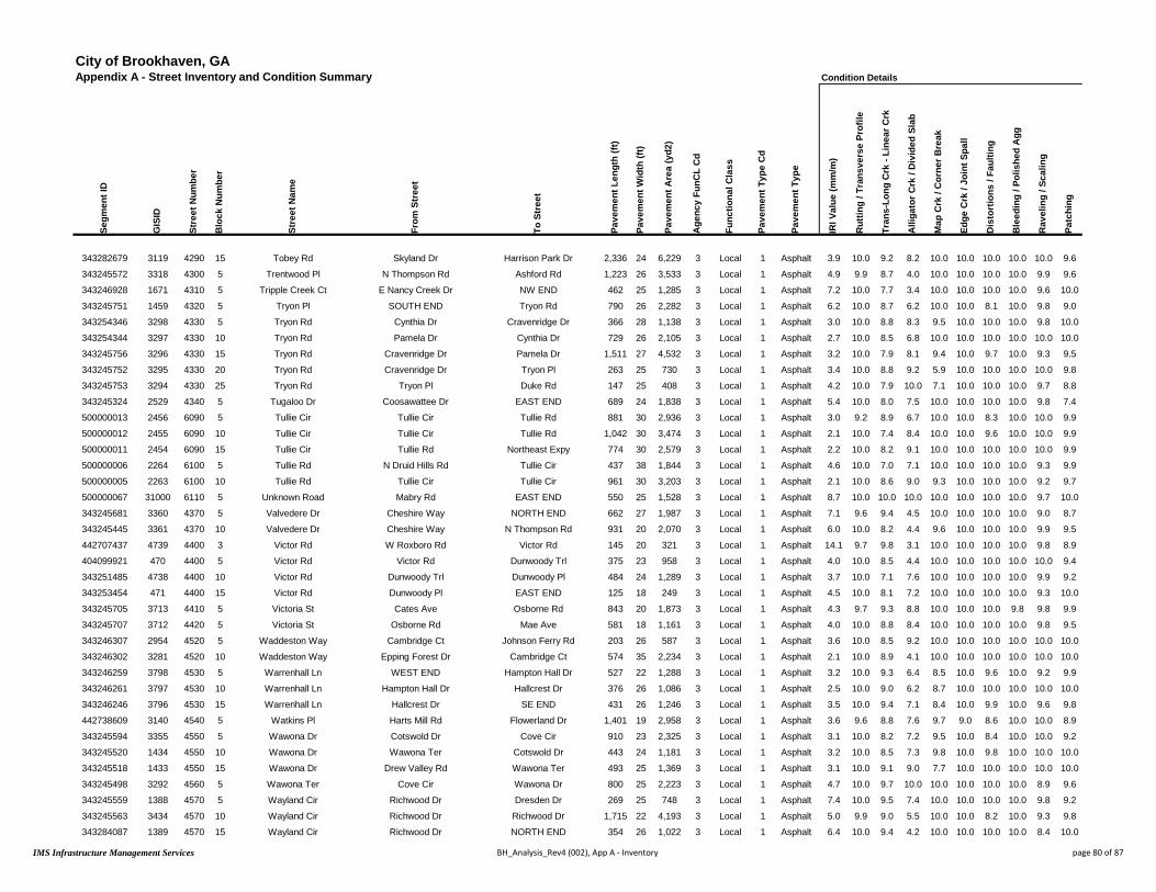
City of Brookhaven, GAAppendix A - Street Inventory and Condition Summary
Segm
ent I
D
GIS
ID
Stre
et N
umbe
r
Blo
ck N
umbe
r
Stre
et N
ame
From
Str
eet
To S
tree
t
Pave
men
t Len
gth
(ft)
Pave
men
t Wid
th (f
t)
Pave
men
t Are
a (y
d2)
Age
ncy
FunC
L C
d
Func
tiona
l Cla
ss
Pave
men
t Typ
e C
d
Pave
men
t Typ
e
343282679 3119 4290 15 Tobey Rd Skyland Dr Harrison Park Dr 2,336 24 6,229 3 Local 1 Asphalt
343245572 3318 4300 5 Trentwood Pl N Thompson Rd Ashford Rd 1,223 26 3,533 3 Local 1 Asphalt
343246928 1671 4310 5 Tripple Creek Ct E Nancy Creek Dr NW END 462 25 1,285 3 Local 1 Asphalt
343245751 1459 4320 5 Tryon Pl SOUTH END Tryon Rd 790 26 2,282 3 Local 1 Asphalt
343254346 3298 4330 5 Tryon Rd Cynthia Dr Cravenridge Dr 366 28 1,138 3 Local 1 Asphalt
343254344 3297 4330 10 Tryon Rd Pamela Dr Cynthia Dr 729 26 2,105 3 Local 1 Asphalt
343245756 3296 4330 15 Tryon Rd Cravenridge Dr Pamela Dr 1,511 27 4,532 3 Local 1 Asphalt
343245752 3295 4330 20 Tryon Rd Cravenridge Dr Tryon Pl 263 25 730 3 Local 1 Asphalt
343245753 3294 4330 25 Tryon Rd Tryon Pl Duke Rd 147 25 408 3 Local 1 Asphalt
343245324 2529 4340 5 Tugaloo Dr Coosawattee Dr EAST END 689 24 1,838 3 Local 1 Asphalt
500000013 2456 6090 5 Tullie Cir Tullie Cir Tullie Rd 881 30 2,936 3 Local 1 Asphalt
500000012 2455 6090 10 Tullie Cir Tullie Cir Tullie Rd 1,042 30 3,474 3 Local 1 Asphalt
500000011 2454 6090 15 Tullie Cir Tullie Rd Northeast Expy 774 30 2,579 3 Local 1 Asphalt
500000006 2264 6100 5 Tullie Rd N Druid Hills Rd Tullie Cir 437 38 1,844 3 Local 1 Asphalt
500000005 2263 6100 10 Tullie Rd Tullie Cir Tullie Cir 961 30 3,203 3 Local 1 Asphalt
500000067 31000 6110 5 Unknown Road Mabry Rd EAST END 550 25 1,528 3 Local 1 Asphalt
343245681 3360 4370 5 Valvedere Dr Cheshire Way NORTH END 662 27 1,987 3 Local 1 Asphalt
343245445 3361 4370 10 Valvedere Dr Cheshire Way N Thompson Rd 931 20 2,070 3 Local 1 Asphalt
442707437 4739 4400 3 Victor Rd W Roxboro Rd Victor Rd 145 20 321 3 Local 1 Asphalt
404099921 470 4400 5 Victor Rd Victor Rd Dunwoody Trl 375 23 958 3 Local 1 Asphalt
343251485 4738 4400 10 Victor Rd Dunwoody Trl Dunwoody Pl 484 24 1,289 3 Local 1 Asphalt
343253454 471 4400 15 Victor Rd Dunwoody Pl EAST END 125 18 249 3 Local 1 Asphalt
343245705 3713 4410 5 Victoria St Cates Ave Osborne Rd 843 20 1,873 3 Local 1 Asphalt
343245707 3712 4420 5 Victoria St Osborne Rd Mae Ave 581 18 1,161 3 Local 1 Asphalt
343246307 2954 4520 5 Waddeston Way Cambridge Ct Johnson Ferry Rd 203 26 587 3 Local 1 Asphalt
343246302 3281 4520 10 Waddeston Way Epping Forest Dr Cambridge Ct 574 35 2,234 3 Local 1 Asphalt
343246259 3798 4530 5 Warrenhall Ln WEST END Hampton Hall Dr 527 22 1,288 3 Local 1 Asphalt
343246261 3797 4530 10 Warrenhall Ln Hampton Hall Dr Hallcrest Dr 376 26 1,086 3 Local 1 Asphalt
343246246 3796 4530 15 Warrenhall Ln Hallcrest Dr SE END 431 26 1,246 3 Local 1 Asphalt
442738609 3140 4540 5 Watkins Pl Harts Mill Rd Flowerland Dr 1,401 19 2,958 3 Local 1 Asphalt
343245594 3355 4550 5 Wawona Dr Cotswold Dr Cove Cir 910 23 2,325 3 Local 1 Asphalt
343245520 1434 4550 10 Wawona Dr Wawona Ter Cotswold Dr 443 24 1,181 3 Local 1 Asphalt
343245518 1433 4550 15 Wawona Dr Drew Valley Rd Wawona Ter 493 25 1,369 3 Local 1 Asphalt
343245498 3292 4560 5 Wawona Ter Cove Cir Wawona Dr 800 25 2,223 3 Local 1 Asphalt
343245559 1388 4570 5 Wayland Cir Richwood Dr Dresden Dr 269 25 748 3 Local 1 Asphalt
343245563 3434 4570 10 Wayland Cir Richwood Dr Richwood Dr 1,715 22 4,193 3 Local 1 Asphalt
343284087 1389 4570 15 Wayland Cir Richwood Dr NORTH END 354 26 1,022 3 Local 1 Asphalt
Condition Details
IRI V
alue
(mm
/m)
Rut
ting
/ Tra
nsve
rse
Prof
ile
Tran
s-Lo
ng C
rk -
Line
ar C
rk
Alli
gato
r Crk
/ D
ivid
ed S
lab
Map
Crk
/ C
orne
r Bre
ak
Edge
Crk
/ Jo
int S
pall
Dis
tort
ions
/ Fa
ultin
g
Ble
edin
g / P
olis
hed
Agg
Rav
elin
g / S
calin
g
Patc
hing
3.9 10.0 9.2 8.2 10.0 10.0 10.0 10.0 10.0 9.6
4.9 9.9 8.7 4.0 10.0 10.0 10.0 10.0 9.9 9.6
7.2 10.0 7.7 3.4 10.0 10.0 10.0 10.0 9.6 10.0
6.2 10.0 8.7 6.2 10.0 10.0 8.1 10.0 9.8 9.0
3.0 10.0 8.8 8.3 9.5 10.0 10.0 10.0 9.8 10.0
2.7 10.0 8.5 6.8 10.0 10.0 10.0 10.0 10.0 10.0
3.2 10.0 7.9 8.1 9.4 10.0 9.7 10.0 9.3 9.5
3.4 10.0 8.8 9.2 5.9 10.0 10.0 10.0 10.0 9.8
4.2 10.0 7.9 10.0 7.1 10.0 10.0 10.0 9.7 8.8
5.4 10.0 8.0 7.5 10.0 10.0 10.0 10.0 9.8 7.4
3.0 9.2 8.9 6.7 10.0 10.0 8.3 10.0 10.0 9.9
2.1 10.0 7.4 8.4 10.0 10.0 9.6 10.0 10.0 9.9
2.2 10.0 8.2 9.1 10.0 10.0 10.0 10.0 10.0 9.9
4.6 10.0 7.0 7.1 10.0 10.0 10.0 10.0 9.3 9.9
2.1 10.0 8.6 9.0 9.3 10.0 10.0 10.0 9.2 9.7
8.7 10.0 10.0 10.0 10.0 10.0 10.0 10.0 9.7 10.0
7.1 9.6 9.4 4.5 10.0 10.0 10.0 10.0 9.0 8.7
6.0 10.0 8.2 4.4 9.6 10.0 10.0 10.0 9.9 9.5
14.1 9.7 9.8 3.1 10.0 10.0 10.0 10.0 9.8 8.9
4.0 10.0 8.5 4.4 10.0 10.0 10.0 10.0 10.0 9.4
3.7 10.0 7.1 7.6 10.0 10.0 10.0 10.0 9.9 9.2
4.5 10.0 8.1 7.2 10.0 10.0 10.0 10.0 9.3 10.0
4.3 9.7 9.3 8.8 10.0 10.0 10.0 9.8 9.8 9.9
4.0 10.0 8.8 8.4 10.0 10.0 10.0 10.0 9.8 9.5
3.6 10.0 8.5 9.2 10.0 10.0 10.0 10.0 10.0 10.0
2.1 10.0 8.9 4.1 10.0 10.0 10.0 10.0 10.0 10.0
3.2 10.0 9.3 6.4 8.5 10.0 9.6 10.0 9.2 9.9
2.5 10.0 9.0 6.2 8.7 10.0 10.0 10.0 10.0 10.0
3.5 10.0 9.4 7.1 8.4 10.0 9.9 10.0 9.6 9.8
3.6 9.6 8.8 7.6 9.7 9.0 8.6 10.0 10.0 8.9
3.1 10.0 8.2 7.2 9.5 10.0 8.4 10.0 10.0 9.2
3.2 10.0 8.5 7.3 9.8 10.0 9.8 10.0 10.0 10.0
3.1 10.0 9.1 9.0 7.7 10.0 10.0 10.0 10.0 10.0
4.7 10.0 9.7 10.0 10.0 10.0 10.0 10.0 8.9 9.6
7.4 10.0 9.5 7.4 10.0 10.0 10.0 10.0 9.8 9.2
5.0 9.9 9.0 5.5 10.0 10.0 8.2 10.0 9.3 9.8
6.4 10.0 9.4 4.2 10.0 10.0 10.0 10.0 8.4 10.0
IMS Infrastructure Management Services BH_Analysis_Rev4 (002), App A - Inventory page 80 of 87

City of Brookhaven, GAAppendix A - Street Inventory and Condition Summary
Segm
ent I
D
GIS
ID
Stre
et N
umbe
r
Blo
ck N
umbe
r
Stre
et N
ame
From
Str
eet
To S
tree
t
Pave
men
t Len
gth
(ft)
Pave
men
t Wid
th (f
t)
Pave
men
t Are
a (y
d2)
Age
ncy
FunC
L C
d
Func
tiona
l Cla
ss
Pave
men
t Typ
e C
d
Pave
men
t Typ
e
343282679 3119 4290 15 Tobey Rd Skyland Dr Harrison Park Dr 2,336 24 6,229 3 Local 1 Asphalt
343245572 3318 4300 5 Trentwood Pl N Thompson Rd Ashford Rd 1,223 26 3,533 3 Local 1 Asphalt
343246928 1671 4310 5 Tripple Creek Ct E Nancy Creek Dr NW END 462 25 1,285 3 Local 1 Asphalt
343245751 1459 4320 5 Tryon Pl SOUTH END Tryon Rd 790 26 2,282 3 Local 1 Asphalt
343254346 3298 4330 5 Tryon Rd Cynthia Dr Cravenridge Dr 366 28 1,138 3 Local 1 Asphalt
343254344 3297 4330 10 Tryon Rd Pamela Dr Cynthia Dr 729 26 2,105 3 Local 1 Asphalt
343245756 3296 4330 15 Tryon Rd Cravenridge Dr Pamela Dr 1,511 27 4,532 3 Local 1 Asphalt
343245752 3295 4330 20 Tryon Rd Cravenridge Dr Tryon Pl 263 25 730 3 Local 1 Asphalt
343245753 3294 4330 25 Tryon Rd Tryon Pl Duke Rd 147 25 408 3 Local 1 Asphalt
343245324 2529 4340 5 Tugaloo Dr Coosawattee Dr EAST END 689 24 1,838 3 Local 1 Asphalt
500000013 2456 6090 5 Tullie Cir Tullie Cir Tullie Rd 881 30 2,936 3 Local 1 Asphalt
500000012 2455 6090 10 Tullie Cir Tullie Cir Tullie Rd 1,042 30 3,474 3 Local 1 Asphalt
500000011 2454 6090 15 Tullie Cir Tullie Rd Northeast Expy 774 30 2,579 3 Local 1 Asphalt
500000006 2264 6100 5 Tullie Rd N Druid Hills Rd Tullie Cir 437 38 1,844 3 Local 1 Asphalt
500000005 2263 6100 10 Tullie Rd Tullie Cir Tullie Cir 961 30 3,203 3 Local 1 Asphalt
500000067 31000 6110 5 Unknown Road Mabry Rd EAST END 550 25 1,528 3 Local 1 Asphalt
343245681 3360 4370 5 Valvedere Dr Cheshire Way NORTH END 662 27 1,987 3 Local 1 Asphalt
343245445 3361 4370 10 Valvedere Dr Cheshire Way N Thompson Rd 931 20 2,070 3 Local 1 Asphalt
442707437 4739 4400 3 Victor Rd W Roxboro Rd Victor Rd 145 20 321 3 Local 1 Asphalt
404099921 470 4400 5 Victor Rd Victor Rd Dunwoody Trl 375 23 958 3 Local 1 Asphalt
343251485 4738 4400 10 Victor Rd Dunwoody Trl Dunwoody Pl 484 24 1,289 3 Local 1 Asphalt
343253454 471 4400 15 Victor Rd Dunwoody Pl EAST END 125 18 249 3 Local 1 Asphalt
343245705 3713 4410 5 Victoria St Cates Ave Osborne Rd 843 20 1,873 3 Local 1 Asphalt
343245707 3712 4420 5 Victoria St Osborne Rd Mae Ave 581 18 1,161 3 Local 1 Asphalt
343246307 2954 4520 5 Waddeston Way Cambridge Ct Johnson Ferry Rd 203 26 587 3 Local 1 Asphalt
343246302 3281 4520 10 Waddeston Way Epping Forest Dr Cambridge Ct 574 35 2,234 3 Local 1 Asphalt
343246259 3798 4530 5 Warrenhall Ln WEST END Hampton Hall Dr 527 22 1,288 3 Local 1 Asphalt
343246261 3797 4530 10 Warrenhall Ln Hampton Hall Dr Hallcrest Dr 376 26 1,086 3 Local 1 Asphalt
343246246 3796 4530 15 Warrenhall Ln Hallcrest Dr SE END 431 26 1,246 3 Local 1 Asphalt
442738609 3140 4540 5 Watkins Pl Harts Mill Rd Flowerland Dr 1,401 19 2,958 3 Local 1 Asphalt
343245594 3355 4550 5 Wawona Dr Cotswold Dr Cove Cir 910 23 2,325 3 Local 1 Asphalt
343245520 1434 4550 10 Wawona Dr Wawona Ter Cotswold Dr 443 24 1,181 3 Local 1 Asphalt
343245518 1433 4550 15 Wawona Dr Drew Valley Rd Wawona Ter 493 25 1,369 3 Local 1 Asphalt
343245498 3292 4560 5 Wawona Ter Cove Cir Wawona Dr 800 25 2,223 3 Local 1 Asphalt
343245559 1388 4570 5 Wayland Cir Richwood Dr Dresden Dr 269 25 748 3 Local 1 Asphalt
343245563 3434 4570 10 Wayland Cir Richwood Dr Richwood Dr 1,715 22 4,193 3 Local 1 Asphalt
343284087 1389 4570 15 Wayland Cir Richwood Dr NORTH END 354 26 1,022 3 Local 1 Asphalt
SuperSegment Details
Supe
rSeg
ID
SuperSeg Description Supe
rSeg
Len
gth
(ft)
Supe
rSeg
Are
a (y
d2)
Supe
rSeg
LA
D
Supe
rSeg
PC
I
4160 4160 - Tobey Rd 3034 8284 18 73
4170 4170 - Trentwood Pl + Others 2160 6239 60 36
4180 4180 - Tripple Creek Ct 462 1285 66 24
4190 4190 - Ashburn Ln + Others 1786 4717 52 43
4200 4200 - Tryon Rd + Others 3666 10406 26 60
4200 4200 - Tryon Rd + Others 3666 10406 26 60
4200 4200 - Tryon Rd + Others 3666 10406 26 60
4200 4200 - Tryon Rd + Others 3666 10406 26 60
4200 4200 - Tryon Rd + Others 3666 10406 26 60
4210 4210 - Tugaloo Dr 689 1838 46 43
4220 4220 - Tullie Cir 1923 6410 34 61
4220 4220 - Tullie Cir 1923 6410 34 61
4230 4230 - Tullie Rd + Others 2171 7626 16 70
4230 4230 - Tullie Rd + Others 2171 7626 16 70
4230 4230 - Tullie Rd + Others 2171 7626 16 70
4500 4500 - Unknown Road 550 1528 0 95
4250 4250 - Valvedere Dr 1594 4056 65 30
4250 4250 - Valvedere Dr 1594 4056 65 30
4260 4260 - Victor Rd + Others 2029 5222 40 50
4260 4260 - Victor Rd + Others 2029 5222 40 50
4260 4260 - Victor Rd + Others 2029 5222 40 50
4260 4260 - Victor Rd + Others 2029 5222 40 50
1860 1860 - Cates Ave + Others 3698 7686 18 68
3170 3170 - Mae Ave + Others 1939 4293 20 71
4270 4270 - Waddeston Way 778 2821 48 56
4270 4270 - Waddeston Way 778 2821 48 56
4280 4280 - Warrenhall Ln 1334 3620 36 57
4280 4280 - Warrenhall Ln 1334 3620 36 57
4280 4280 - Warrenhall Ln 1334 3620 36 57
4290 4290 - Flowerland Dr + Others 2889 6264 52 46
4300 4300 - Wawona Dr 1846 4876 32 59
4300 4300 - Wawona Dr 1846 4876 32 59
4300 4300 - Wawona Dr 1846 4876 32 59
4310 4310 - Wawona Ter 800 2223 3 82
4320 4320 - Wayland Cir + Others 3351 8888 53 41
4320 4320 - Wayland Cir + Others 3351 8888 53 41
4320 4320 - Wayland Cir + Others 3351 8888 53 41
IMS Infrastructure Management Services BH_Analysis_Rev4 (002), App A - Inventory page 81 of 87

City of Brookhaven, GAAppendix A - Street Inventory and Condition Summary Condition Summary
Segm
ent I
D
GIS
ID
Stre
et N
umbe
r
Blo
ck N
umbe
r
Stre
et N
ame
From
Str
eet
To S
tree
t
Pave
men
t Len
gth
(ft)
Pave
men
t Wid
th (f
t)
Pave
men
t Are
a (y
d2)
Age
ncy
FunC
L C
d
Func
tiona
l Cla
ss
Pave
men
t Typ
e C
d
Pave
men
t Typ
e
Ow
ner
Stre
ngth
Rat
ing
Con
ditio
n R
atin
g
Rou
ghne
ss In
dex
(RI)
Surf
ace
Dis
tres
s In
dex
(SD
I)
Pave
men
t Con
ditio
n In
dex
(PC
I)
Ove
rrid
e PC
I
Cur
rent
PC
I
Surv
ey D
ate
Load
Ass
oc D
istr
esse
s (L
AD
)
Non
-Loa
d D
istr
esse
s (N
LAD
)
500000015 2528 6130 5 Wayside Dr SE END Coosawattee Dr 1,373 22 3,356 3 Local 1 Asphalt City 2 Marginal 60 45 50 50 9/5/2016 42.2 13.0
343245409 1435 4600 5 Wilford Dr Green Meadows Ln Dogwood Ter 448 23 1,145 3 Local 1 Asphalt City 1 Marginal 59 40 47 46 9/5/2016 45.9 13.8
343245410 1436 4600 10 Wilford Dr Dogwood Ter Camille Dr 547 23 1,398 3 Local 1 Asphalt City 1 Poor 60 26 37 37 9/5/2016 59.4 14.8
343245500 2304 4610 5 Wilmont Dr WEST END Clairmont Rd 953 25 2,647 3 Local 1 Asphalt City 1 Poor 39 35 36 36 9/5/2016 49.5 15.9
408880253 3723 4620 5 Wimberly Rd Mabry Rd Osborne Rd 1,285 24 3,427 3 Local 1 Asphalt City 3 Marginal 74 45 54 54 9/5/2016 29.6 25.8
343246537 2665 4630 5 Winchester Trl Remington Rd Chamblee Dunwoody Rd 1,338 25 3,718 3 Local 1 Asphalt City 1 Marginal 66 28 40 40 9/5/2016 53.6 18.6
442732580 3326 4640 5 Winding Ln Redding Way Ashford Rd 2,443 25 6,787 3 Local 1 Asphalt City 3 Fair 63 63 63 63 9/5/2016 21.8 15.5
424395458 3327 4640 10 Winding Ln Dresden Dr Redding Way 1,069 27 3,208 3 Local 1 Asphalt City 3 Fair 65 64 65 64 9/5/2016 22.6 13.1
470878228 3908 4670 5 Windsor Lake Cv Windsor Lake Dr EAST END 277 31 953 3 Local 1 Asphalt City 3 Good 63 71 68 68 9/5/2016 20.4 8.6
470878229 3816 4680 5 Windsor Lake Dr Windsor Lake Cv EAST END 995 26 2,876 3 Local 1 Asphalt City 3 Fair 58 60 59 59 9/5/2016 26.3 13.8
470878230 3817 4680 10 Windsor Lake Dr Windsor Pkwy Windsor Lake Cv 1,165 24 3,106 3 Local 1 Asphalt City 3 Good 71 74 73 72 9/5/2016 17.6 8.9
470878221 1174 4690 5 Windsor Pkwy Windsor Pkwy Windsor Lake Dr 137 23 350 2 Collector 1 Asphalt City 2 Excellent 82 87 85 85 9/5/2016 0.0 13.2
470878220 3790 4690 10 Windsor Pkwy Windsor Lake Dr Antioch Dr 667 23 1,705 2 Collector 1 Asphalt City 2 Excellent 82 89 87 87 9/5/2016 0.0 10.7
343244021 3789 4690 15 Windsor Pkwy Antioch Dr Cates Ave 181 23 462 2 Collector 1 Asphalt City 2 Excellent 78 90 86 86 9/5/2016 0.0 10.3
343245702 1175 4690 20 Windsor Pkwy Cates Ave Osborne Rd 1,010 24 2,693 2 Collector 1 Asphalt City 2 Excellent 90 100 96 96 9/5/2016 0.0 0.4
343245700 1176 4690 25 Windsor Pkwy Osborne Rd Mae Ave 599 23 1,532 2 Collector 1 Asphalt City 2 Excellent 90 100 97 96 9/5/2016 0.0 0.2
343245711 1177 4690 30 Windsor Pkwy Mae Ave Hillview Ave 237 24 631 2 Collector 1 Asphalt City 2 Excellent 86 93 91 91 9/5/2016 0.0 7.1
343245712 1133 4690 35 Windsor Pkwy Hillview Ave Fala Pl 292 24 779 2 Collector 1 Asphalt City 2 Excellent 83 91 88 88 9/5/2016 0.0 9.2
343245713 1134 4690 40 Windsor Pkwy Fala Pl Hermance Dr 227 23 579 2 Collector 1 Asphalt City 2 Excellent 90 100 97 96 9/5/2016 0.0 0.2
343245715 3325 4690 45 Windsor Pkwy Hermance Dr Woodrow Way 626 22 1,530 2 Collector 1 Asphalt City 2 Excellent 90 99 96 96 9/5/2016 0.0 0.9
343245729 3324 4690 50 Windsor Pkwy Woodrow Way Le Conte Ave 349 22 854 2 Collector 1 Asphalt City 2 Excellent 82 94 90 90 9/5/2016 0.0 6.1
343245727 3323 4690 55 Windsor Pkwy Le Conte Ave Oglethorpe Way 452 24 1,205 2 Collector 1 Asphalt City 2 Excellent 94 99 97 97 9/5/2016 0.0 1.1
433329886 3322 4690 60 Windsor Pkwy Oglethorpe Way Lanier Dr 996 24 2,657 2 Collector 1 Asphalt City 2 Excellent 89 98 95 95 9/5/2016 0.0 1.8
433329855 3321 4690 70 Windsor Pkwy Lanier Dr Ashford Dunwoody Rd 800 26 2,311 2 Collector 1 Asphalt City 3 Excellent 89 97 95 94 9/5/2016 1.0 1.6
408880355 4783 4710 5 Wood Valley Ct Johnson Ferry Rd NORTH END 781 26 2,258 3 Local 1 Asphalt City 1 Marginal 64 35 44 44 9/5/2016 47.7 17.7
500000066 30000 6140 5 Wood Valley Ct Wood Valley Ct NORTH END 101 53 596 3 Local 1 Asphalt City 1 Poor 47 35 39 39 9/5/2016 61.5 3.3
343246239 3679 4730 5 Woodrow Way Chambord Way Breton Ct 361 25 1,003 3 Local 1 Asphalt City 1 Marginal 74 29 43 43 9/5/2016 48.9 22.6
343246230 3680 4730 10 Woodrow Way Chambord Way Breton Cir 1,336 26 3,859 3 Local 1 Asphalt City 1 Marginal 76 37 50 49 9/5/2016 50.3 13.1
343246232 3681 4730 15 Woodrow Way Breton Cir Inman Dr 369 27 1,108 3 Local 1 Asphalt City 1 Marginal 82 29 46 46 9/5/2016 60.2 11.3
343246233 3280 4730 20 Woodrow Way Frontenac Ct Inman Dr 1,094 24 2,917 3 Local 1 Asphalt City 1 Marginal 84 29 47 47 9/5/2016 54.0 16.7
343245718 1487 4730 25 Woodrow Way Windsor Pkwy Frontenac Ct 385 25 1,068 3 Local 1 Asphalt City 1 Marginal 70 36 47 47 9/5/2016 52.6 11.9
343245725 1486 4730 30 Woodrow Way Lanier Dr Windsor Pkwy 2,278 29 7,339 3 Local 1 Asphalt City 3 Excellent 88 97 94 94 9/5/2016 3.2 0.2
443674431 4938 4740 5 Woods Cir Woods Cir Pine Ridge Rd 371 23 947 3 Local 1 Asphalt City 2 Marginal 65 44 51 51 9/5/2016 44.5 11.2
443674429 331 4740 10 Woods Cir Pine Ridge Rd NE END 384 24 1,023 3 Local 1 Asphalt City 3 Good 71 66 68 68 9/5/2016 27.5 6.5
343243905 4736 4760 5 Woodsdale Rd Goodwin Rd Roxboro Dr 729 21 1,700 3 Local 1 Asphalt City 1 Marginal 53 40 44 44 9/5/2016 46.4 13.9
416040787 4735 4760 10 Woodsdale Rd Roxboro Dr Woodsdale Rd 489 28 1,522 3 Local 1 Asphalt City 3 Marginal 32 62 52 52 9/5/2016 21.7 16.7
343246368 3034 4770 5 Woodstream Cir Bubbling Creek Rd Donaldson Dr 1,388 25 3,855 3 Local 1 Asphalt City 3 Good 66 67 67 67 9/5/2016 20.7 11.9
IMS Infrastructure Management Services BH_Analysis_Rev4 (002), App A - Inventory page 82 of 87

City of Brookhaven, GAAppendix A - Street Inventory and Condition Summary
Segm
ent I
D
GIS
ID
Stre
et N
umbe
r
Blo
ck N
umbe
r
Stre
et N
ame
From
Str
eet
To S
tree
t
Pave
men
t Len
gth
(ft)
Pave
men
t Wid
th (f
t)
Pave
men
t Are
a (y
d2)
Age
ncy
FunC
L C
d
Func
tiona
l Cla
ss
Pave
men
t Typ
e C
d
Pave
men
t Typ
e
500000015 2528 6130 5 Wayside Dr SE END Coosawattee Dr 1,373 22 3,356 3 Local 1 Asphalt
343245409 1435 4600 5 Wilford Dr Green Meadows Ln Dogwood Ter 448 23 1,145 3 Local 1 Asphalt
343245410 1436 4600 10 Wilford Dr Dogwood Ter Camille Dr 547 23 1,398 3 Local 1 Asphalt
343245500 2304 4610 5 Wilmont Dr WEST END Clairmont Rd 953 25 2,647 3 Local 1 Asphalt
408880253 3723 4620 5 Wimberly Rd Mabry Rd Osborne Rd 1,285 24 3,427 3 Local 1 Asphalt
343246537 2665 4630 5 Winchester Trl Remington Rd Chamblee Dunwoody Rd 1,338 25 3,718 3 Local 1 Asphalt
442732580 3326 4640 5 Winding Ln Redding Way Ashford Rd 2,443 25 6,787 3 Local 1 Asphalt
424395458 3327 4640 10 Winding Ln Dresden Dr Redding Way 1,069 27 3,208 3 Local 1 Asphalt
470878228 3908 4670 5 Windsor Lake Cv Windsor Lake Dr EAST END 277 31 953 3 Local 1 Asphalt
470878229 3816 4680 5 Windsor Lake Dr Windsor Lake Cv EAST END 995 26 2,876 3 Local 1 Asphalt
470878230 3817 4680 10 Windsor Lake Dr Windsor Pkwy Windsor Lake Cv 1,165 24 3,106 3 Local 1 Asphalt
470878221 1174 4690 5 Windsor Pkwy Windsor Pkwy Windsor Lake Dr 137 23 350 2 Collector 1 Asphalt
470878220 3790 4690 10 Windsor Pkwy Windsor Lake Dr Antioch Dr 667 23 1,705 2 Collector 1 Asphalt
343244021 3789 4690 15 Windsor Pkwy Antioch Dr Cates Ave 181 23 462 2 Collector 1 Asphalt
343245702 1175 4690 20 Windsor Pkwy Cates Ave Osborne Rd 1,010 24 2,693 2 Collector 1 Asphalt
343245700 1176 4690 25 Windsor Pkwy Osborne Rd Mae Ave 599 23 1,532 2 Collector 1 Asphalt
343245711 1177 4690 30 Windsor Pkwy Mae Ave Hillview Ave 237 24 631 2 Collector 1 Asphalt
343245712 1133 4690 35 Windsor Pkwy Hillview Ave Fala Pl 292 24 779 2 Collector 1 Asphalt
343245713 1134 4690 40 Windsor Pkwy Fala Pl Hermance Dr 227 23 579 2 Collector 1 Asphalt
343245715 3325 4690 45 Windsor Pkwy Hermance Dr Woodrow Way 626 22 1,530 2 Collector 1 Asphalt
343245729 3324 4690 50 Windsor Pkwy Woodrow Way Le Conte Ave 349 22 854 2 Collector 1 Asphalt
343245727 3323 4690 55 Windsor Pkwy Le Conte Ave Oglethorpe Way 452 24 1,205 2 Collector 1 Asphalt
433329886 3322 4690 60 Windsor Pkwy Oglethorpe Way Lanier Dr 996 24 2,657 2 Collector 1 Asphalt
433329855 3321 4690 70 Windsor Pkwy Lanier Dr Ashford Dunwoody Rd 800 26 2,311 2 Collector 1 Asphalt
408880355 4783 4710 5 Wood Valley Ct Johnson Ferry Rd NORTH END 781 26 2,258 3 Local 1 Asphalt
500000066 30000 6140 5 Wood Valley Ct Wood Valley Ct NORTH END 101 53 596 3 Local 1 Asphalt
343246239 3679 4730 5 Woodrow Way Chambord Way Breton Ct 361 25 1,003 3 Local 1 Asphalt
343246230 3680 4730 10 Woodrow Way Chambord Way Breton Cir 1,336 26 3,859 3 Local 1 Asphalt
343246232 3681 4730 15 Woodrow Way Breton Cir Inman Dr 369 27 1,108 3 Local 1 Asphalt
343246233 3280 4730 20 Woodrow Way Frontenac Ct Inman Dr 1,094 24 2,917 3 Local 1 Asphalt
343245718 1487 4730 25 Woodrow Way Windsor Pkwy Frontenac Ct 385 25 1,068 3 Local 1 Asphalt
343245725 1486 4730 30 Woodrow Way Lanier Dr Windsor Pkwy 2,278 29 7,339 3 Local 1 Asphalt
443674431 4938 4740 5 Woods Cir Woods Cir Pine Ridge Rd 371 23 947 3 Local 1 Asphalt
443674429 331 4740 10 Woods Cir Pine Ridge Rd NE END 384 24 1,023 3 Local 1 Asphalt
343243905 4736 4760 5 Woodsdale Rd Goodwin Rd Roxboro Dr 729 21 1,700 3 Local 1 Asphalt
416040787 4735 4760 10 Woodsdale Rd Roxboro Dr Woodsdale Rd 489 28 1,522 3 Local 1 Asphalt
343246368 3034 4770 5 Woodstream Cir Bubbling Creek Rd Donaldson Dr 1,388 25 3,855 3 Local 1 Asphalt
Condition Details
IRI V
alue
(mm
/m)
Rut
ting
/ Tra
nsve
rse
Prof
ile
Tran
s-Lo
ng C
rk -
Line
ar C
rk
Alli
gato
r Crk
/ D
ivid
ed S
lab
Map
Crk
/ C
orne
r Bre
ak
Edge
Crk
/ Jo
int S
pall
Dis
tort
ions
/ Fa
ultin
g
Ble
edin
g / P
olis
hed
Agg
Rav
elin
g / S
calin
g
Patc
hing
4.8 10.0 9.2 6.1 9.0 10.0 9.7 10.0 9.9 9.9
5.0 9.7 8.4 6.7 10.0 10.0 10.0 10.0 9.9 8.7
4.8 10.0 8.2 5.0 10.0 10.0 10.0 10.0 9.9 8.8
8.8 9.7 8.6 6.9 9.3 10.0 9.9 10.0 9.9 8.1
3.3 9.5 7.7 8.2 10.0 10.0 9.9 8.7 9.7 9.3
4.1 10.0 7.8 4.9 9.9 10.0 9.6 10.0 9.9 10.0
4.4 10.0 9.3 8.3 8.4 10.0 9.9 10.0 9.8 9.5
4.1 10.0 9.2 8.2 9.2 10.0 10.0 10.0 9.6 9.4
4.4 10.0 9.1 8.0 10.0 10.0 10.0 10.0 9.8 10.0
5.0 9.5 8.4 7.8 10.0 10.0 10.0 10.0 9.8 10.0
3.5 10.0 8.9 8.5 10.0 10.0 10.0 10.0 10.0 9.7
2.6 10.0 8.4 10.0 10.0 10.0 10.0 10.0 10.0 10.0
2.6 10.0 8.7 10.0 10.0 10.0 10.0 10.0 10.0 10.0
2.9 10.0 8.7 10.0 10.0 10.0 10.0 10.0 10.0 10.0
2.0 10.0 10.0 10.0 10.0 10.0 10.0 10.0 10.0 10.0
2.5 10.0 10.0 10.0 10.0 10.0 10.0 10.0 10.0 10.0
2.3 10.0 9.1 10.0 10.0 10.0 10.0 10.0 10.0 10.0
2.5 10.0 8.9 10.0 10.0 10.0 10.0 10.0 10.0 10.0
2.5 10.0 10.0 10.0 10.0 10.0 10.0 10.0 10.0 10.0
2.1 10.0 9.9 10.0 10.0 10.0 10.0 10.0 10.0 10.0
2.7 10.0 9.4 10.0 10.0 10.0 10.0 9.7 10.0 10.0
1.8 10.0 9.9 10.0 10.0 10.0 10.0 9.9 10.0 10.0
2.2 10.0 9.8 10.0 10.0 10.0 10.0 10.0 10.0 10.0
2.8 9.9 9.8 10.0 10.0 10.0 10.0 10.0 10.0 10.0
4.3 9.8 7.9 5.6 10.0 10.0 10.0 10.0 9.8 9.8
7.0 10.0 9.7 4.3 10.0 10.0 10.0 10.0 9.8 9.4
3.3 10.0 7.8 6.0 10.0 10.0 10.0 10.0 9.1 8.9
3.0 10.0 8.8 5.2 10.0 10.0 10.0 10.0 9.4 9.7
2.6 10.0 8.9 4.0 10.0 10.0 10.0 10.0 9.6 10.0
2.4 10.0 8.8 4.9 8.9 10.0 10.0 9.9 9.8 9.6
3.6 10.0 8.5 4.7 10.0 10.0 10.0 10.0 10.0 10.0
3.9 10.0 10.0 9.7 10.0 10.0 10.0 10.0 10.0 10.0
4.1 10.0 8.7 5.7 10.0 10.0 10.0 10.0 9.8 9.8
3.5 10.0 9.2 8.0 10.0 10.0 8.9 10.0 10.0 10.0
5.9 9.9 9.1 5.9 9.0 10.0 9.7 10.0 9.9 9.7
10.6 10.0 8.9 7.9 9.7 10.0 10.0 10.0 8.9 9.9
4.0 10.0 9.0 9.0 9.4 10.0 8.6 10.0 9.9 10.0
IMS Infrastructure Management Services BH_Analysis_Rev4 (002), App A - Inventory page 83 of 87

City of Brookhaven, GAAppendix A - Street Inventory and Condition Summary
Segm
ent I
D
GIS
ID
Stre
et N
umbe
r
Blo
ck N
umbe
r
Stre
et N
ame
From
Str
eet
To S
tree
t
Pave
men
t Len
gth
(ft)
Pave
men
t Wid
th (f
t)
Pave
men
t Are
a (y
d2)
Age
ncy
FunC
L C
d
Func
tiona
l Cla
ss
Pave
men
t Typ
e C
d
Pave
men
t Typ
e
500000015 2528 6130 5 Wayside Dr SE END Coosawattee Dr 1,373 22 3,356 3 Local 1 Asphalt
343245409 1435 4600 5 Wilford Dr Green Meadows Ln Dogwood Ter 448 23 1,145 3 Local 1 Asphalt
343245410 1436 4600 10 Wilford Dr Dogwood Ter Camille Dr 547 23 1,398 3 Local 1 Asphalt
343245500 2304 4610 5 Wilmont Dr WEST END Clairmont Rd 953 25 2,647 3 Local 1 Asphalt
408880253 3723 4620 5 Wimberly Rd Mabry Rd Osborne Rd 1,285 24 3,427 3 Local 1 Asphalt
343246537 2665 4630 5 Winchester Trl Remington Rd Chamblee Dunwoody Rd 1,338 25 3,718 3 Local 1 Asphalt
442732580 3326 4640 5 Winding Ln Redding Way Ashford Rd 2,443 25 6,787 3 Local 1 Asphalt
424395458 3327 4640 10 Winding Ln Dresden Dr Redding Way 1,069 27 3,208 3 Local 1 Asphalt
470878228 3908 4670 5 Windsor Lake Cv Windsor Lake Dr EAST END 277 31 953 3 Local 1 Asphalt
470878229 3816 4680 5 Windsor Lake Dr Windsor Lake Cv EAST END 995 26 2,876 3 Local 1 Asphalt
470878230 3817 4680 10 Windsor Lake Dr Windsor Pkwy Windsor Lake Cv 1,165 24 3,106 3 Local 1 Asphalt
470878221 1174 4690 5 Windsor Pkwy Windsor Pkwy Windsor Lake Dr 137 23 350 2 Collector 1 Asphalt
470878220 3790 4690 10 Windsor Pkwy Windsor Lake Dr Antioch Dr 667 23 1,705 2 Collector 1 Asphalt
343244021 3789 4690 15 Windsor Pkwy Antioch Dr Cates Ave 181 23 462 2 Collector 1 Asphalt
343245702 1175 4690 20 Windsor Pkwy Cates Ave Osborne Rd 1,010 24 2,693 2 Collector 1 Asphalt
343245700 1176 4690 25 Windsor Pkwy Osborne Rd Mae Ave 599 23 1,532 2 Collector 1 Asphalt
343245711 1177 4690 30 Windsor Pkwy Mae Ave Hillview Ave 237 24 631 2 Collector 1 Asphalt
343245712 1133 4690 35 Windsor Pkwy Hillview Ave Fala Pl 292 24 779 2 Collector 1 Asphalt
343245713 1134 4690 40 Windsor Pkwy Fala Pl Hermance Dr 227 23 579 2 Collector 1 Asphalt
343245715 3325 4690 45 Windsor Pkwy Hermance Dr Woodrow Way 626 22 1,530 2 Collector 1 Asphalt
343245729 3324 4690 50 Windsor Pkwy Woodrow Way Le Conte Ave 349 22 854 2 Collector 1 Asphalt
343245727 3323 4690 55 Windsor Pkwy Le Conte Ave Oglethorpe Way 452 24 1,205 2 Collector 1 Asphalt
433329886 3322 4690 60 Windsor Pkwy Oglethorpe Way Lanier Dr 996 24 2,657 2 Collector 1 Asphalt
433329855 3321 4690 70 Windsor Pkwy Lanier Dr Ashford Dunwoody Rd 800 26 2,311 2 Collector 1 Asphalt
408880355 4783 4710 5 Wood Valley Ct Johnson Ferry Rd NORTH END 781 26 2,258 3 Local 1 Asphalt
500000066 30000 6140 5 Wood Valley Ct Wood Valley Ct NORTH END 101 53 596 3 Local 1 Asphalt
343246239 3679 4730 5 Woodrow Way Chambord Way Breton Ct 361 25 1,003 3 Local 1 Asphalt
343246230 3680 4730 10 Woodrow Way Chambord Way Breton Cir 1,336 26 3,859 3 Local 1 Asphalt
343246232 3681 4730 15 Woodrow Way Breton Cir Inman Dr 369 27 1,108 3 Local 1 Asphalt
343246233 3280 4730 20 Woodrow Way Frontenac Ct Inman Dr 1,094 24 2,917 3 Local 1 Asphalt
343245718 1487 4730 25 Woodrow Way Windsor Pkwy Frontenac Ct 385 25 1,068 3 Local 1 Asphalt
343245725 1486 4730 30 Woodrow Way Lanier Dr Windsor Pkwy 2,278 29 7,339 3 Local 1 Asphalt
443674431 4938 4740 5 Woods Cir Woods Cir Pine Ridge Rd 371 23 947 3 Local 1 Asphalt
443674429 331 4740 10 Woods Cir Pine Ridge Rd NE END 384 24 1,023 3 Local 1 Asphalt
343243905 4736 4760 5 Woodsdale Rd Goodwin Rd Roxboro Dr 729 21 1,700 3 Local 1 Asphalt
416040787 4735 4760 10 Woodsdale Rd Roxboro Dr Woodsdale Rd 489 28 1,522 3 Local 1 Asphalt
343246368 3034 4770 5 Woodstream Cir Bubbling Creek Rd Donaldson Dr 1,388 25 3,855 3 Local 1 Asphalt
SuperSegment Details
Supe
rSeg
ID
SuperSeg Description Supe
rSeg
Len
gth
(ft)
Supe
rSeg
Are
a (y
d2)
Supe
rSeg
LA
D
Supe
rSeg
PC
I
4330 4330 - Wayside Dr 1373 3356 42 50
4340 4340 - Wilford Dr + Others 1855 4645 54 37
4340 4340 - Wilford Dr + Others 1855 4645 54 37
4350 4350 - Wilmont Dr 953 2647 50 36
4360 4360 - Wimberly Rd 1285 3427 30 54
4370 4370 - Winchester Trl 1338 3718 54 40
4380 4380 - Winding Ln 3513 9995 22 63
4380 4380 - Winding Ln 3513 9995 22 63
4390 4390 - Windsor Lake Dr + Others 2437 6935 22 66
4390 4390 - Windsor Lake Dr + Others 2437 6935 22 66
4390 4390 - Windsor Lake Dr + Others 2437 6935 22 66
4400 4400 - Windsor Pkwy 6573 17288 0 94
4400 4400 - Windsor Pkwy 6573 17288 0 94
4400 4400 - Windsor Pkwy 6573 17288 0 94
4400 4400 - Windsor Pkwy 6573 17288 0 94
4400 4400 - Windsor Pkwy 6573 17288 0 94
4400 4400 - Windsor Pkwy 6573 17288 0 94
4400 4400 - Windsor Pkwy 6573 17288 0 94
4400 4400 - Windsor Pkwy 6573 17288 0 94
4400 4400 - Windsor Pkwy 6573 17288 0 94
4400 4400 - Windsor Pkwy 6573 17288 0 94
4400 4400 - Windsor Pkwy 6573 17288 0 94
4400 4400 - Windsor Pkwy 6573 17288 0 94
4400 4400 - Windsor Pkwy 6573 17288 0 94
2320 2320 - Duberry Ct + Others 1893 5883 51 45
2320 2320 - Duberry Ct + Others 1893 5883 51 45
4410 4410 - Woodrow Way 3545 9955 53 47
4410 4410 - Woodrow Way 3545 9955 53 47
4410 4410 - Woodrow Way 3545 9955 53 47
4410 4410 - Woodrow Way 3545 9955 53 47
4410 4410 - Woodrow Way 3545 9955 53 47
4420 4420 - Woodrow Way 2278 7339 3 94
4430 4430 - Woods Cir + Others 1154 2991 40 53
4430 4430 - Woods Cir + Others 1154 2991 40 53
4440 4440 - Woodsdale Rd 1218 3222 35 48
4440 4440 - Woodsdale Rd 1218 3222 35 48
4450 4450 - Woodstream Cir 1388 3855 21 67
IMS Infrastructure Management Services BH_Analysis_Rev4 (002), App A - Inventory page 84 of 87

City of Brookhaven, GAAppendix A - Street Inventory and Condition Summary Condition Summary
Segm
ent I
D
GIS
ID
Stre
et N
umbe
r
Blo
ck N
umbe
r
Stre
et N
ame
From
Str
eet
To S
tree
t
Pave
men
t Len
gth
(ft)
Pave
men
t Wid
th (f
t)
Pave
men
t Are
a (y
d2)
Age
ncy
FunC
L C
d
Func
tiona
l Cla
ss
Pave
men
t Typ
e C
d
Pave
men
t Typ
e
Ow
ner
Stre
ngth
Rat
ing
Con
ditio
n R
atin
g
Rou
ghne
ss In
dex
(RI)
Surf
ace
Dis
tres
s In
dex
(SD
I)
Pave
men
t Con
ditio
n In
dex
(PC
I)
Ove
rrid
e PC
I
Cur
rent
PC
I
Surv
ey D
ate
Load
Ass
oc D
istr
esse
s (L
AD
)
Non
-Loa
d D
istr
esse
s (N
LAD
)
343245443 1479 4780 5 Woody Trl Green Meadows Ln SE END 188 27 563 3 Local 1 Asphalt City 1 Very Poor 54 9 24 24 9/5/2016 81.3 9.6
413509777 323 4790 5 Wright Ave E Roxboro Rd N Druid Hills Rd 799 21 1,863 3 Local 1 Asphalt City 3 Good 67 65 66 66 9/5/2016 21.0 13.8
343246294 1256 4800 5 Wycherly Ct Ragley Hall Rd SE END 195 36 778 3 Local 1 Asphalt City 1 Poor 44 26 32 32 9/5/2016 56.7 17.4
343246769 2759 4810 5 Wyndale Ct WEST END Chamblee Dunwoody Rd 718 23 1,834 3 Local 1 Asphalt City 1 Poor 55 27 36 36 9/5/2016 56.1 16.9
343246274 3815 4820 5 Wynnton Dr Kennington Ct Hampton Hall Dr 1,095 24 2,919 3 Local 1 Asphalt City 3 Good 75 72 73 73 9/5/2016 9.3 18.7
IMS Infrastructure Management Services BH_Analysis_Rev4 (002), App A - Inventory page 85 of 87

City of Brookhaven, GAAppendix A - Street Inventory and Condition Summary
Segm
ent I
D
GIS
ID
Stre
et N
umbe
r
Blo
ck N
umbe
r
Stre
et N
ame
From
Str
eet
To S
tree
t
Pave
men
t Len
gth
(ft)
Pave
men
t Wid
th (f
t)
Pave
men
t Are
a (y
d2)
Age
ncy
FunC
L C
d
Func
tiona
l Cla
ss
Pave
men
t Typ
e C
d
Pave
men
t Typ
e
343245443 1479 4780 5 Woody Trl Green Meadows Ln SE END 188 27 563 3 Local 1 Asphalt
413509777 323 4790 5 Wright Ave E Roxboro Rd N Druid Hills Rd 799 21 1,863 3 Local 1 Asphalt
343246294 1256 4800 5 Wycherly Ct Ragley Hall Rd SE END 195 36 778 3 Local 1 Asphalt
343246769 2759 4810 5 Wyndale Ct WEST END Chamblee Dunwoody Rd 718 23 1,834 3 Local 1 Asphalt
343246274 3815 4820 5 Wynnton Dr Kennington Ct Hampton Hall Dr 1,095 24 2,919 3 Local 1 Asphalt
Condition Details
IRI V
alue
(mm
/m)
Rut
ting
/ Tra
nsve
rse
Prof
ile
Tran
s-Lo
ng C
rk -
Line
ar C
rk
Alli
gato
r Crk
/ D
ivid
ed S
lab
Map
Crk
/ C
orne
r Bre
ak
Edge
Crk
/ Jo
int S
pall
Dis
tort
ions
/ Fa
ultin
g
Ble
edin
g / P
olis
hed
Agg
Rav
elin
g / S
calin
g
Patc
hing
5.7 8.7 9.6 3.1 10.0 10.0 10.0 10.0 8.9 10.0
4.0 10.0 8.8 8.8 10.0 10.0 10.0 10.0 9.2 8.9
7.7 9.4 7.9 4.9 10.0 10.0 10.0 10.0 9.8 10.0
5.6 10.0 8.1 6.2 9.9 10.0 10.0 10.0 9.9 7.7
3.1 10.0 8.0 9.1 10.0 10.0 10.0 10.0 9.5 10.0
IMS Infrastructure Management Services BH_Analysis_Rev4 (002), App A - Inventory page 86 of 87

City of Brookhaven, GAAppendix A - Street Inventory and Condition Summary
Segm
ent I
D
GIS
ID
Stre
et N
umbe
r
Blo
ck N
umbe
r
Stre
et N
ame
From
Str
eet
To S
tree
t
Pave
men
t Len
gth
(ft)
Pave
men
t Wid
th (f
t)
Pave
men
t Are
a (y
d2)
Age
ncy
FunC
L C
d
Func
tiona
l Cla
ss
Pave
men
t Typ
e C
d
Pave
men
t Typ
e
343245443 1479 4780 5 Woody Trl Green Meadows Ln SE END 188 27 563 3 Local 1 Asphalt
413509777 323 4790 5 Wright Ave E Roxboro Rd N Druid Hills Rd 799 21 1,863 3 Local 1 Asphalt
343246294 1256 4800 5 Wycherly Ct Ragley Hall Rd SE END 195 36 778 3 Local 1 Asphalt
343246769 2759 4810 5 Wyndale Ct WEST END Chamblee Dunwoody Rd 718 23 1,834 3 Local 1 Asphalt
343246274 3815 4820 5 Wynnton Dr Kennington Ct Hampton Hall Dr 1,095 24 2,919 3 Local 1 Asphalt
SuperSegment Details
Supe
rSeg
ID
SuperSeg Description Supe
rSeg
Len
gth
(ft)
Supe
rSeg
Are
a (y
d2)
Supe
rSeg
LA
D
Supe
rSeg
PC
I
2710 2710 - Green Meadows Ln + Others 2626 7110 47 44
4460 4460 - Wright Ave 799 1863 21 66
4470 4470 - Tanbark Ct + Others 492 1838 56 36
4480 4480 - Chamdun Pl + Others 1447 3940 58 36
4490 4490 - Wynnton Dr 1095 2919 9 73
IMS Infrastructure Management Services BH_Analysis_Rev4 (002), App A - Inventory page 87 of 87

Appendix B
Street Inventory – Sorted by Supersegment (Project) Condition
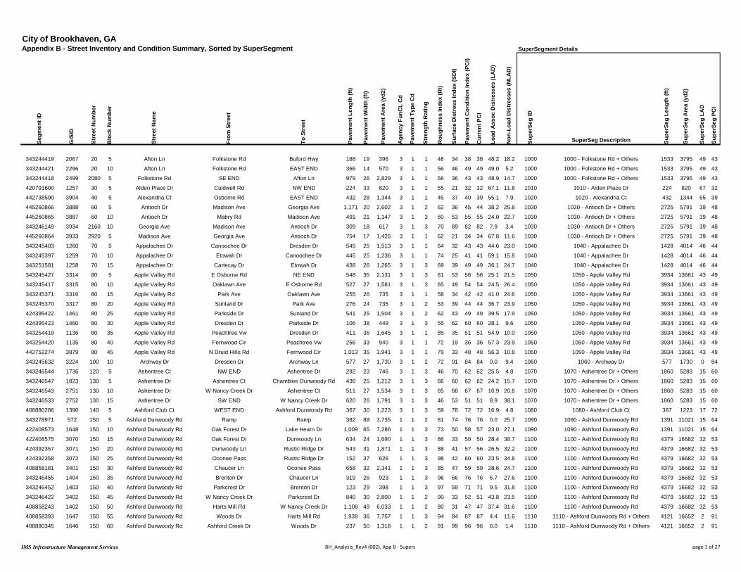
City of Brookhaven, GAAppendix B - Street Inventory and Condition Summary, Sorted by SuperSegment SuperSegment Details
Segm
ent I
D
GIS
ID
Stre
et N
umbe
r
Blo
ck N
umbe
r
Stre
et N
ame
From
Str
eet
To S
tree
t
Pave
men
t Len
gth
(ft)
Pave
men
t Wid
th (f
t)
Pave
men
t Are
a (y
d2)
Age
ncy
FunC
L C
d
Pave
men
t Typ
e C
d
Stre
ngth
Rat
ing
Rou
ghne
ss In
dex
(RI)
Surf
ace
Dis
tres
s In
dex
(SD
I)
Pave
men
t Con
ditio
n In
dex
(PC
I)
Cur
rent
PC
I
Load
Ass
oc D
istr
esse
s (L
AD
)
Non
-Loa
d D
istr
esse
s (N
LAD
)
Supe
rSeg
ID
SuperSeg Description Supe
rSeg
Len
gth
(ft)
Supe
rSeg
Are
a (y
d2)
Supe
rSeg
LA
D
Supe
rSeg
PC
I
343244419 2067 20 5 Afton Ln Folkstone Rd Buford Hwy 188 19 396 3 1 1 48 34 38 38 48.2 18.2 1000 1000 - Folkstone Rd + Others 1533 3795 49 43
343244421 2296 20 10 Afton Ln Folkstone Rd EAST END 366 14 570 3 1 1 56 46 49 49 49.0 5.2 1000 1000 - Folkstone Rd + Others 1533 3795 49 43
343244418 2499 2080 5 Folkstone Rd SE END Afton Ln 979 26 2,829 3 1 1 56 36 43 43 48.9 14.7 1000 1000 - Folkstone Rd + Others 1533 3795 49 43
420791600 1257 30 5 Alden Place Dr Caldwell Rd NW END 224 33 820 3 1 1 55 21 32 32 67.1 11.8 1010 1010 - Alden Place Dr 224 820 67 32
442738590 3904 40 5 Alexandria Ct Osborne Rd EAST END 432 28 1,344 3 1 1 45 37 40 39 55.1 7.9 1020 1020 - Alexandria Ct 432 1344 55 39
445260866 3888 60 5 Antioch Dr Madison Ave Georgia Ave 1,171 20 2,602 3 1 2 62 36 45 44 38.2 25.8 1030 1030 - Antioch Dr + Others 2725 5791 39 48
445260865 3887 60 10 Antioch Dr Mabry Rd Madison Ave 491 21 1,147 3 1 3 60 53 55 55 24.0 22.7 1030 1030 - Antioch Dr + Others 2725 5791 39 48
343246149 3934 2160 10 Georgia Ave Madison Ave Antioch Dr 309 18 617 3 1 3 70 89 82 82 7.9 3.4 1030 1030 - Antioch Dr + Others 2725 5791 39 48
445260864 3933 2920 5 Madison Ave Georgia Ave Antioch Dr 754 17 1,425 3 1 1 62 21 34 34 67.8 11.6 1030 1030 - Antioch Dr + Others 2725 5791 39 48
343245403 1260 70 5 Appalachee Dr Canoochee Dr Dresden Dr 545 25 1,513 3 1 1 64 32 43 43 44.6 23.0 1040 1040 - Appalachee Dr 1428 4014 46 44
343245397 1259 70 10 Appalachee Dr Etowah Dr Canoochee Dr 445 25 1,236 3 1 1 74 25 41 41 59.1 15.8 1040 1040 - Appalachee Dr 1428 4014 46 44
343251581 1258 70 15 Appalachee Dr Cartecay Dr Etowah Dr 438 26 1,265 3 1 3 69 39 49 49 36.1 24.7 1040 1040 - Appalachee Dr 1428 4014 46 44
343245427 3314 80 5 Apple Valley Rd E Osborne Rd NE END 548 35 2,131 3 1 3 61 53 56 56 25.1 21.5 1050 1050 - Apple Valley Rd 3934 13661 43 49
343245417 3315 80 10 Apple Valley Rd Oaklawn Ave E Osborne Rd 527 27 1,581 3 1 3 65 49 54 54 24.5 26.4 1050 1050 - Apple Valley Rd 3934 13661 43 49
343245371 3316 80 15 Apple Valley Rd Park Ave Oaklawn Ave 255 26 735 3 1 1 58 34 42 42 41.0 24.6 1050 1050 - Apple Valley Rd 3934 13661 43 49
343245370 3317 80 20 Apple Valley Rd Sunland Dr Park Ave 276 24 735 3 1 2 53 39 44 44 36.7 23.9 1050 1050 - Apple Valley Rd 3934 13661 43 49
424395422 1461 80 25 Apple Valley Rd Parkside Dr Sunland Dr 541 25 1,504 3 1 2 62 43 49 49 39.5 17.9 1050 1050 - Apple Valley Rd 3934 13661 43 49
424395423 1460 80 30 Apple Valley Rd Dresden Dr Parkside Dr 106 38 449 3 1 3 55 62 60 60 28.1 9.6 1050 1050 - Apple Valley Rd 3934 13661 43 49
343254419 1136 80 35 Apple Valley Rd Peachtree Vw Dresden Dr 411 36 1,645 3 1 1 85 35 51 51 54.9 10.0 1050 1050 - Apple Valley Rd 3934 13661 43 49
343254420 1135 80 40 Apple Valley Rd Fernwood Cir Peachtree Vw 256 33 940 3 1 1 72 19 36 36 57.3 23.9 1050 1050 - Apple Valley Rd 3934 13661 43 49
442752274 3879 80 45 Apple Valley Rd N Druid Hills Rd Fernwood Cir 1,013 35 3,941 3 1 1 79 33 48 48 56.3 10.8 1050 1050 - Apple Valley Rd 3934 13661 43 49
343245632 3224 100 10 Archway Dr Dresden Dr Archway Ln 577 27 1,730 3 1 2 72 91 84 84 0.0 9.4 1060 1060 - Archway Dr 577 1730 0 84
343246544 1736 120 5 Ashentree Ct NW END Ashentree Dr 292 23 746 3 1 3 46 70 62 62 25.5 4.8 1070 1070 - Ashentree Dr + Others 1860 5283 15 60
343246547 1823 130 5 Ashentree Dr Ashentree Ct Chamblee Dunwoody Rd 436 25 1,212 3 1 3 66 60 62 62 24.2 15.7 1070 1070 - Ashentree Dr + Others 1860 5283 15 60
343246543 2751 130 10 Ashentree Dr W Nancy Creek Dr Ashentree Ct 511 27 1,534 3 1 3 65 68 67 67 10.9 20.8 1070 1070 - Ashentree Dr + Others 1860 5283 15 60
343246533 2752 130 15 Ashentree Dr SW END W Nancy Creek Dr 620 26 1,791 3 1 3 46 53 51 51 8.9 38.1 1070 1070 - Ashentree Dr + Others 1860 5283 15 60
408880286 1390 140 5 Ashford Club Ct WEST END Ashford Dunwoody Rd 367 30 1,223 3 1 3 59 78 72 72 16.9 4.8 1080 1080 - Ashford Club Ct 367 1223 17 72
343278971 572 150 5 Ashford Dunwoody Rd Ramp Ramp 382 88 3,735 1 1 2 81 74 76 76 0.0 25.7 1090 1090 - Ashford Dunwoody Rd 1391 11021 15 64
422408573 1648 150 10 Ashford Dunwoody Rd Oak Forest Dr Lake Hearn Dr 1,009 65 7,286 1 1 3 73 50 58 57 23.0 27.1 1090 1090 - Ashford Dunwoody Rd 1391 11021 15 64
422408575 3070 150 15 Ashford Dunwoody Rd Oak Forest Dr Dunwoody Ln 634 24 1,690 1 1 3 86 33 50 50 28.4 38.7 1100 1100 - Ashford Dunwoody Rd 4379 16682 32 53
424392357 3071 150 20 Ashford Dunwoody Rd Dunwoody Ln Rustic Ridge Dr 543 31 1,871 1 1 3 88 41 57 56 26.5 32.2 1100 1100 - Ashford Dunwoody Rd 4379 16682 32 53
424392358 3072 150 25 Ashford Dunwoody Rd Oconee Pass Rustic Ridge Dr 152 37 626 1 1 3 98 42 60 60 23.5 34.8 1100 1100 - Ashford Dunwoody Rd 4379 16682 32 53
408858181 3401 150 30 Ashford Dunwoody Rd Chaucer Ln Oconee Pass 658 32 2,341 1 1 3 85 47 59 59 28.6 24.7 1100 1100 - Ashford Dunwoody Rd 4379 16682 32 53
343246455 1404 150 35 Ashford Dunwoody Rd Brenton Dr Chaucer Ln 319 26 923 1 1 3 96 66 76 76 6.7 27.6 1100 1100 - Ashford Dunwoody Rd 4379 16682 32 53
343246452 1403 150 40 Ashford Dunwoody Rd Parkcrest Dr Brenton Dr 123 29 398 1 1 3 97 59 71 71 9.5 31.8 1100 1100 - Ashford Dunwoody Rd 4379 16682 32 53
343246422 3402 150 45 Ashford Dunwoody Rd W Nancy Creek Dr Parkcrest Dr 840 30 2,800 1 1 2 90 33 52 51 43.8 23.5 1100 1100 - Ashford Dunwoody Rd 4379 16682 32 53
408858243 1402 150 50 Ashford Dunwoody Rd Harts Mill Rd W Nancy Creek Dr 1,108 49 6,033 1 1 2 80 31 47 47 37.4 31.6 1100 1100 - Ashford Dunwoody Rd 4379 16682 32 53
408858393 1647 150 55 Ashford Dunwoody Rd Woods Dr Harts Mill Rd 1,939 36 7,757 1 1 3 94 84 87 87 4.4 11.6 1110 1110 - Ashford Dunwoody Rd + Others 4121 16652 2 91
408880345 1646 150 60 Ashford Dunwoody Rd Ashford Creek Dr Woods Dr 237 50 1,318 1 1 2 91 99 96 96 0.0 1.4 1110 1110 - Ashford Dunwoody Rd + Others 4121 16652 2 91
IMS Infrastructure Management Services BH_Analysis_Rev4 (002), App B - Supers page 1 of 27
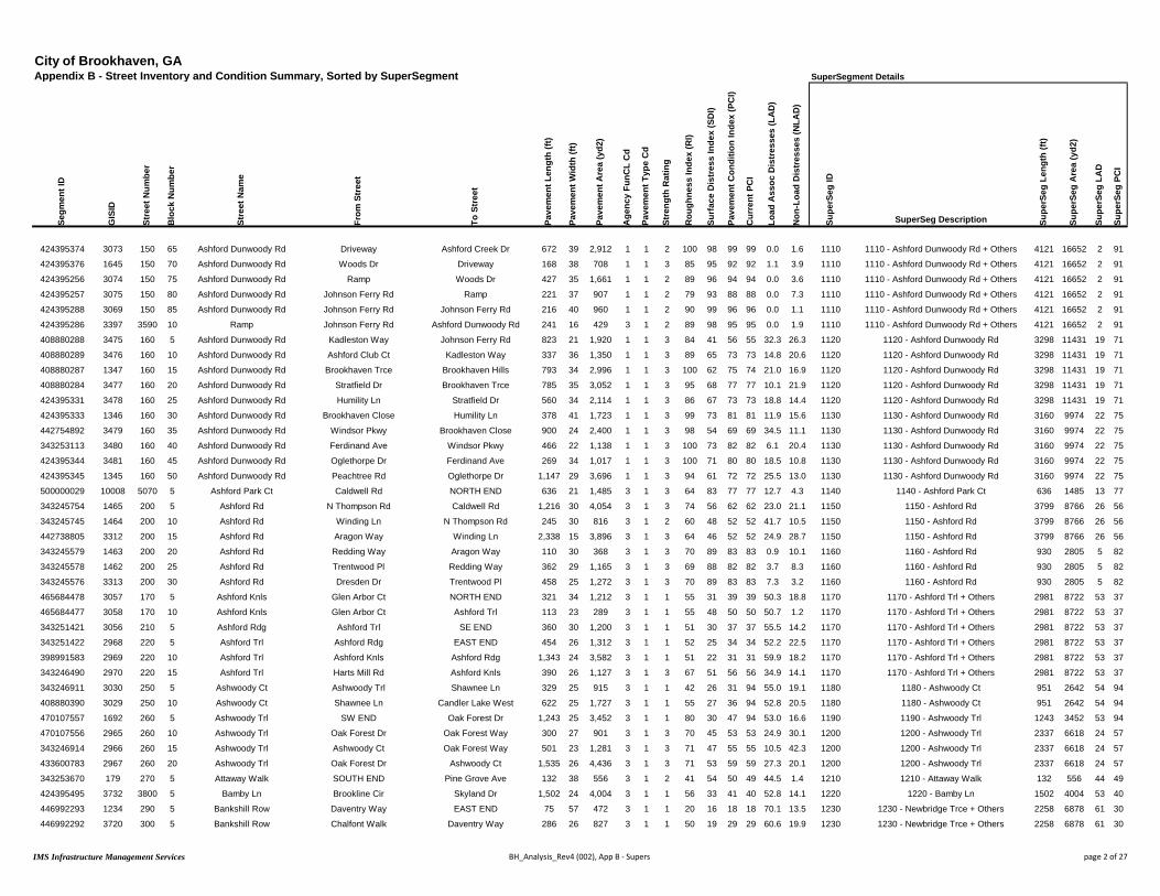
City of Brookhaven, GAAppendix B - Street Inventory and Condition Summary, Sorted by SuperSegment SuperSegment Details
Segm
ent I
D
GIS
ID
Stre
et N
umbe
r
Blo
ck N
umbe
r
Stre
et N
ame
From
Str
eet
To S
tree
t
Pave
men
t Len
gth
(ft)
Pave
men
t Wid
th (f
t)
Pave
men
t Are
a (y
d2)
Age
ncy
FunC
L C
d
Pave
men
t Typ
e C
d
Stre
ngth
Rat
ing
Rou
ghne
ss In
dex
(RI)
Surf
ace
Dis
tres
s In
dex
(SD
I)
Pave
men
t Con
ditio
n In
dex
(PC
I)
Cur
rent
PC
I
Load
Ass
oc D
istr
esse
s (L
AD
)
Non
-Loa
d D
istr
esse
s (N
LAD
)
Supe
rSeg
ID
SuperSeg Description Supe
rSeg
Len
gth
(ft)
Supe
rSeg
Are
a (y
d2)
Supe
rSeg
LA
D
Supe
rSeg
PC
I
424395374 3073 150 65 Ashford Dunwoody Rd Driveway Ashford Creek Dr 672 39 2,912 1 1 2 100 98 99 99 0.0 1.6 1110 1110 - Ashford Dunwoody Rd + Others 4121 16652 2 91
424395376 1645 150 70 Ashford Dunwoody Rd Woods Dr Driveway 168 38 708 1 1 3 85 95 92 92 1.1 3.9 1110 1110 - Ashford Dunwoody Rd + Others 4121 16652 2 91
424395256 3074 150 75 Ashford Dunwoody Rd Ramp Woods Dr 427 35 1,661 1 1 2 89 96 94 94 0.0 3.6 1110 1110 - Ashford Dunwoody Rd + Others 4121 16652 2 91
424395257 3075 150 80 Ashford Dunwoody Rd Johnson Ferry Rd Ramp 221 37 907 1 1 2 79 93 88 88 0.0 7.3 1110 1110 - Ashford Dunwoody Rd + Others 4121 16652 2 91
424395288 3069 150 85 Ashford Dunwoody Rd Johnson Ferry Rd Johnson Ferry Rd 216 40 960 1 1 2 90 99 96 96 0.0 1.1 1110 1110 - Ashford Dunwoody Rd + Others 4121 16652 2 91
424395286 3397 3590 10 Ramp Johnson Ferry Rd Ashford Dunwoody Rd 241 16 429 3 1 2 89 98 95 95 0.0 1.9 1110 1110 - Ashford Dunwoody Rd + Others 4121 16652 2 91
408880288 3475 160 5 Ashford Dunwoody Rd Kadleston Way Johnson Ferry Rd 823 21 1,920 1 1 3 84 41 56 55 32.3 26.3 1120 1120 - Ashford Dunwoody Rd 3298 11431 19 71
408880289 3476 160 10 Ashford Dunwoody Rd Ashford Club Ct Kadleston Way 337 36 1,350 1 1 3 89 65 73 73 14.8 20.6 1120 1120 - Ashford Dunwoody Rd 3298 11431 19 71
408880287 1347 160 15 Ashford Dunwoody Rd Brookhaven Trce Brookhaven Hills 793 34 2,996 1 1 3 100 62 75 74 21.0 16.9 1120 1120 - Ashford Dunwoody Rd 3298 11431 19 71
408880284 3477 160 20 Ashford Dunwoody Rd Stratfield Dr Brookhaven Trce 785 35 3,052 1 1 3 95 68 77 77 10.1 21.9 1120 1120 - Ashford Dunwoody Rd 3298 11431 19 71
424395331 3478 160 25 Ashford Dunwoody Rd Humility Ln Stratfield Dr 560 34 2,114 1 1 3 86 67 73 73 18.8 14.4 1120 1120 - Ashford Dunwoody Rd 3298 11431 19 71
424395333 1346 160 30 Ashford Dunwoody Rd Brookhaven Close Humility Ln 378 41 1,723 1 1 3 99 73 81 81 11.9 15.6 1130 1130 - Ashford Dunwoody Rd 3160 9974 22 75
442754892 3479 160 35 Ashford Dunwoody Rd Windsor Pkwy Brookhaven Close 900 24 2,400 1 1 3 98 54 69 69 34.5 11.1 1130 1130 - Ashford Dunwoody Rd 3160 9974 22 75
343253113 3480 160 40 Ashford Dunwoody Rd Ferdinand Ave Windsor Pkwy 466 22 1,138 1 1 3 100 73 82 82 6.1 20.4 1130 1130 - Ashford Dunwoody Rd 3160 9974 22 75
424395344 3481 160 45 Ashford Dunwoody Rd Oglethorpe Dr Ferdinand Ave 269 34 1,017 1 1 3 100 71 80 80 18.5 10.8 1130 1130 - Ashford Dunwoody Rd 3160 9974 22 75
424395345 1345 160 50 Ashford Dunwoody Rd Peachtree Rd Oglethorpe Dr 1,147 29 3,696 1 1 3 94 61 72 72 25.5 13.0 1130 1130 - Ashford Dunwoody Rd 3160 9974 22 75
500000029 10008 5070 5 Ashford Park Ct Caldwell Rd NORTH END 636 21 1,485 3 1 3 64 83 77 77 12.7 4.3 1140 1140 - Ashford Park Ct 636 1485 13 77
343245754 1465 200 5 Ashford Rd N Thompson Rd Caldwell Rd 1,216 30 4,054 3 1 3 74 56 62 62 23.0 21.1 1150 1150 - Ashford Rd 3799 8766 26 56
343245745 1464 200 10 Ashford Rd Winding Ln N Thompson Rd 245 30 816 3 1 2 60 48 52 52 41.7 10.5 1150 1150 - Ashford Rd 3799 8766 26 56
442738805 3312 200 15 Ashford Rd Aragon Way Winding Ln 2,338 15 3,896 3 1 3 64 46 52 52 24.9 28.7 1150 1150 - Ashford Rd 3799 8766 26 56
343245579 1463 200 20 Ashford Rd Redding Way Aragon Way 110 30 368 3 1 3 70 89 83 83 0.9 10.1 1160 1160 - Ashford Rd 930 2805 5 82
343245578 1462 200 25 Ashford Rd Trentwood Pl Redding Way 362 29 1,165 3 1 3 69 88 82 82 3.7 8.3 1160 1160 - Ashford Rd 930 2805 5 82
343245576 3313 200 30 Ashford Rd Dresden Dr Trentwood Pl 458 25 1,272 3 1 3 70 89 83 83 7.3 3.2 1160 1160 - Ashford Rd 930 2805 5 82
465684478 3057 170 5 Ashford Knls Glen Arbor Ct NORTH END 321 34 1,212 3 1 1 55 31 39 39 50.3 18.8 1170 1170 - Ashford Trl + Others 2981 8722 53 37
465684477 3058 170 10 Ashford Knls Glen Arbor Ct Ashford Trl 113 23 289 3 1 1 55 48 50 50 50.7 1.2 1170 1170 - Ashford Trl + Others 2981 8722 53 37
343251421 3056 210 5 Ashford Rdg Ashford Trl SE END 360 30 1,200 3 1 1 51 30 37 37 55.5 14.2 1170 1170 - Ashford Trl + Others 2981 8722 53 37
343251422 2968 220 5 Ashford Trl Ashford Rdg EAST END 454 26 1,312 3 1 1 52 25 34 34 52.2 22.5 1170 1170 - Ashford Trl + Others 2981 8722 53 37
398991583 2969 220 10 Ashford Trl Ashford Knls Ashford Rdg 1,343 24 3,582 3 1 1 51 22 31 31 59.9 18.2 1170 1170 - Ashford Trl + Others 2981 8722 53 37
343246490 2970 220 15 Ashford Trl Harts Mill Rd Ashford Knls 390 26 1,127 3 1 3 67 51 56 56 34.9 14.1 1170 1170 - Ashford Trl + Others 2981 8722 53 37
343246911 3030 250 5 Ashwoody Ct Ashwoody Trl Shawnee Ln 329 25 915 3 1 1 42 26 31 94 55.0 19.1 1180 1180 - Ashwoody Ct 951 2642 54 94
408880390 3029 250 10 Ashwoody Ct Shawnee Ln Candler Lake West 622 25 1,727 3 1 1 55 27 36 94 52.8 20.5 1180 1180 - Ashwoody Ct 951 2642 54 94
470107557 1692 260 5 Ashwoody Trl SW END Oak Forest Dr 1,243 25 3,452 3 1 1 80 30 47 94 53.0 16.6 1190 1190 - Ashwoody Trl 1243 3452 53 94
470107556 2965 260 10 Ashwoody Trl Oak Forest Dr Oak Forest Way 300 27 901 3 1 3 70 45 53 53 24.9 30.1 1200 1200 - Ashwoody Trl 2337 6618 24 57
343246914 2966 260 15 Ashwoody Trl Ashwoody Ct Oak Forest Way 501 23 1,281 3 1 3 71 47 55 55 10.5 42.3 1200 1200 - Ashwoody Trl 2337 6618 24 57
433600783 2967 260 20 Ashwoody Trl Oak Forest Dr Ashwoody Ct 1,535 26 4,436 3 1 3 71 53 59 59 27.3 20.1 1200 1200 - Ashwoody Trl 2337 6618 24 57
343253670 179 270 5 Attaway Walk SOUTH END Pine Grove Ave 132 38 556 3 1 2 41 54 50 49 44.5 1.4 1210 1210 - Attaway Walk 132 556 44 49
424395495 3732 3800 5 Bamby Ln Brookline Cir Skyland Dr 1,502 24 4,004 3 1 1 56 33 41 40 52.8 14.1 1220 1220 - Bamby Ln 1502 4004 53 40
446992293 1234 290 5 Bankshill Row Daventry Way EAST END 75 57 472 3 1 1 20 16 18 18 70.1 13.5 1230 1230 - Newbridge Trce + Others 2258 6878 61 30
446992292 3720 300 5 Bankshill Row Chalfont Walk Daventry Way 286 26 827 3 1 1 50 19 29 29 60.6 19.9 1230 1230 - Newbridge Trce + Others 2258 6878 61 30
IMS Infrastructure Management Services BH_Analysis_Rev4 (002), App B - Supers page 2 of 27

City of Brookhaven, GAAppendix B - Street Inventory and Condition Summary, Sorted by SuperSegment SuperSegment Details
Segm
ent I
D
GIS
ID
Stre
et N
umbe
r
Blo
ck N
umbe
r
Stre
et N
ame
From
Str
eet
To S
tree
t
Pave
men
t Len
gth
(ft)
Pave
men
t Wid
th (f
t)
Pave
men
t Are
a (y
d2)
Age
ncy
FunC
L C
d
Pave
men
t Typ
e C
d
Stre
ngth
Rat
ing
Rou
ghne
ss In
dex
(RI)
Surf
ace
Dis
tres
s In
dex
(SD
I)
Pave
men
t Con
ditio
n In
dex
(PC
I)
Cur
rent
PC
I
Load
Ass
oc D
istr
esse
s (L
AD
)
Non
-Loa
d D
istr
esse
s (N
LAD
)
Supe
rSeg
ID
SuperSeg Description Supe
rSeg
Len
gth
(ft)
Supe
rSeg
Are
a (y
d2)
Supe
rSeg
LA
D
Supe
rSeg
PC
I
343245659 1235 300 10 Bankshill Row Newbridge Trce Chalfont Walk 289 23 738 3 1 1 64 5 25 24 75.0 20.0 1230 1230 - Newbridge Trce + Others 2258 6878 61 30
343245658 1043 990 5 Chalfont Walk Osborne Rd Bankshill Row 404 23 1,032 3 1 1 54 21 32 31 66.8 12.6 1230 1230 - Newbridge Trce + Others 2258 6878 61 30
446992291 1238 1510 5 Daventry Way WEST END Bankshill Row 254 32 902 3 1 1 39 22 28 28 69.2 8.3 1230 1230 - Newbridge Trce + Others 2258 6878 61 30
343254453 1041 3100 5 Newbridge Trce WEST END Bankshill Row 236 29 762 3 1 1 53 10 24 24 59.4 30.6 1230 1230 - Newbridge Trce + Others 2258 6878 61 30
343245660 4043 3100 10 Newbridge Trce Bankshill Row NE END 715 27 2,145 3 1 1 51 33 39 39 50.0 17.1 1230 1230 - Newbridge Trce + Others 2258 6878 61 30
343246540 2901 310 5 Barkston Ct WEST END W Nancy Creek Dr 585 23 1,496 3 1 1 44 14 24 24 68.1 18.1 1240 1240 - Barkston Ct 585 1496 68 24
470106937 1391 320 5 Bates Ct Bates Ct Bates Ct 1,583 26 4,574 3 1 1 59 27 38 37 57.4 15.9 1250 1250 - Bates Ct 1654 4898 56 39
470106936 1252 320 10 Bates Ct Bates Ct Thompson Rd 71 41 324 3 1 3 43 68 60 60 30.0 2.2 1250 1250 - Bates Ct 1654 4898 56 39
343282666 2900 330 5 Battleford Ct SOUTH END W Nancy Creek Dr 613 27 1,840 3 1 2 55 41 46 46 39.9 18.8 1260 1260 - Battleford Ct 613 1840 40 46
343246437 429 340 5 Becket Dr WEST END Dunwoody Ln 191 27 574 3 1 2 90 99 96 96 0.0 1.0 1270 1270 - Becket Dr 1557 4215 0 96
343246450 3013 340 10 Becket Dr Dunwoody Ln Chaucer Ln 1,365 24 3,641 3 1 2 90 99 96 96 0.0 0.7 1270 1270 - Becket Dr 1557 4215 0 96
500000002 1143 6000 5 Bellaire Dr Peachtree Rd Bellaire Dr 934 26 2,698 3 1 1 48 23 31 31 55.4 21.5 1280 1280 - Bellaire Dr + Others 1657 4063 59 31
422303872 1269 1820 5 Club Dr E Club Ct Peachtree Rd 723 17 1,366 3 1 1 50 22 32 31 64.7 12.8 1280 1280 - Bellaire Dr + Others 1657 4063 59 31
343282657 3045 360 5 Berkford Cir E Nancy Creek Dr Brawley Way 998 26 2,883 3 1 3 80 53 62 62 39.9 7.4 1290 1290 - Berkford Cir + Others 3946 11217 46 54
343246934 1660 360 10 Berkford Cir Brawley Way Berkford Ct 187 25 518 3 1 3 86 69 74 74 19.0 12.5 1290 1290 - Berkford Cir + Others 3946 11217 46 54
343246936 3044 360 15 Berkford Cir Berkford Ct Cranton Ct 878 26 2,537 3 1 3 83 61 68 68 31.1 8.1 1290 1290 - Berkford Cir + Others 3946 11217 46 54
343246956 3043 360 20 Berkford Cir E Nancy Creek Dr Cranton Ct 946 25 2,627 3 1 2 67 44 52 52 49.1 6.7 1290 1290 - Berkford Cir + Others 3946 11217 46 54
343246935 3028 370 5 Berkford Ct Berkford Cir EAST END 522 25 1,449 3 1 1 37 16 23 23 69.0 14.9 1290 1290 - Berkford Cir + Others 3946 11217 46 54
343246960 3025 1380 5 Cranton Ct Berkford Cir NORTH END 417 26 1,203 3 1 1 62 26 38 37 66.1 8.1 1290 1290 - Berkford Cir + Others 3946 11217 46 54
343246542 2899 380 5 Beverly Woods Ct SW END Chamblee Dunwoody Rd 1,228 27 3,683 3 1 1 58 23 35 34 59.3 17.5 1300 1300 - Beverly Woods Ct 1228 3683 59 34
442738607 3042 390 10 Blair Cir Durden Rd Donaldson Dr 1,083 24 2,887 3 1 3 64 82 76 76 12.2 5.6 1310 1310 - Blair Cir 1589 4576 8 80
500000033 10012 390 15 Blair Cir Johnson Ferry Rd Durden Rd 507 30 1,689 3 1 3 77 92 87 87 2.0 5.8 1310 1310 - Blair Cir 1589 4576 8 80
470878145 4419 400 5 Bluffhaven Way Johnson Ferry Rd Bluffhaven Way 248 23 633 3 1 3 67 80 76 76 5.3 14.7 1320 1320 - Bluffhaven Way + Others 3274 8441 22 70
470878143 4417 400 10 Bluffhaven Way Bluffhaven Way Canyon Ridge Ct 1,464 22 3,579 3 1 3 63 60 61 61 35.0 4.8 1320 1320 - Bluffhaven Way + Others 3274 8441 22 70
470878144 4418 410 5 Bluffhaven Way Bluffhaven Way Canyon Ridge Ct 854 23 2,181 3 1 3 72 71 71 71 24.2 5.1 1320 1320 - Bluffhaven Way + Others 3274 8441 22 70
470878139 688 930 5 Canyon Ridge Ct Bluffhaven Way NORTH END 709 26 2,047 3 1 3 71 86 81 81 3.9 10.1 1320 1320 - Bluffhaven Way + Others 3274 8441 22 70
343245878 3683 420 5 Boland Dr Raven Hill Dr Canmont Dr 949 23 2,424 3 1 3 76 70 72 72 22.7 7.4 1330 1330 - Boland Dr 949 2424 23 72
343282672 2897 430 5 Bonnington Ct Duncannon Ct W Nancy Creek Dr 516 24 1,377 3 1 3 77 57 64 64 23.9 18.9 1340 1340 - Bonnington Ct + Others 1208 3841 32 55
343282668 2898 430 10 Bonnington Ct Duncannon Ct SE END 387 29 1,247 3 1 1 62 37 46 45 43.5 19.3 1340 1340 - Bonnington Ct + Others 1208 3841 32 55
343282670 2769 1700 5 Duncannon Ct SOUTH END Bonnington Ct 304 36 1,217 3 1 3 62 54 57 57 28.2 17.6 1340 1340 - Bonnington Ct + Others 1208 3841 32 55
343245766 3261 440 5 Bragg St Skyland Dr Duncan Dr 981 21 2,289 3 1 2 90 100 97 97 0.0 0.1 1350 1350 - Bragg St 2456 6074 0 96
343245772 3260 440 10 Bragg St Duncan Dr Georgian Dr W 757 22 1,851 3 1 2 90 100 97 97 0.0 0.0 1350 1350 - Bragg St 2456 6074 0 96
343246000 1493 440 15 Bragg St Georgian Dr E Georgian Dr W 183 25 509 3 1 2 90 99 96 96 0.0 1.3 1350 1350 - Bragg St 2456 6074 0 96
343246001 3259 440 20 Bragg St Georgian Dr E Clairmont Rd 534 24 1,424 3 1 2 90 100 97 96 0.0 0.2 1350 1350 - Bragg St 2456 6074 0 96
343244325 2328 450 5 Bramblewood Dr Buford Hwy NW END 1,476 21 3,444 3 1 2 52 43 46 46 37.9 19.1 1360 1360 - Bramblewood Dr 1476 3444 38 46
343246933 1662 460 5 Brawley Cir Brawley Cir EAST END 372 30 1,241 3 1 1 57 22 34 34 59.5 18.0 1370 1370 - Brawley Cir + Others 4530 12793 45 50
343246931 3041 460 10 Brawley Cir Brawley Dr Brawley Cir 2,181 25 6,058 3 1 2 73 40 51 51 43.7 15.9 1370 1370 - Brawley Cir + Others 4530 12793 45 50
343246932 3039 470 5 Brawley Cir Brawley Way Brawley Cir 284 26 821 3 1 1 75 36 49 48 50.6 13.5 1370 1370 - Brawley Cir + Others 4530 12793 45 50
343246929 3040 470 10 Brawley Cir Brawley Dr Brawley Way 405 23 1,035 3 1 3 100 59 72 72 27.1 14.0 1370 1370 - Brawley Cir + Others 4530 12793 45 50
IMS Infrastructure Management Services BH_Analysis_Rev4 (002), App B - Supers page 3 of 27
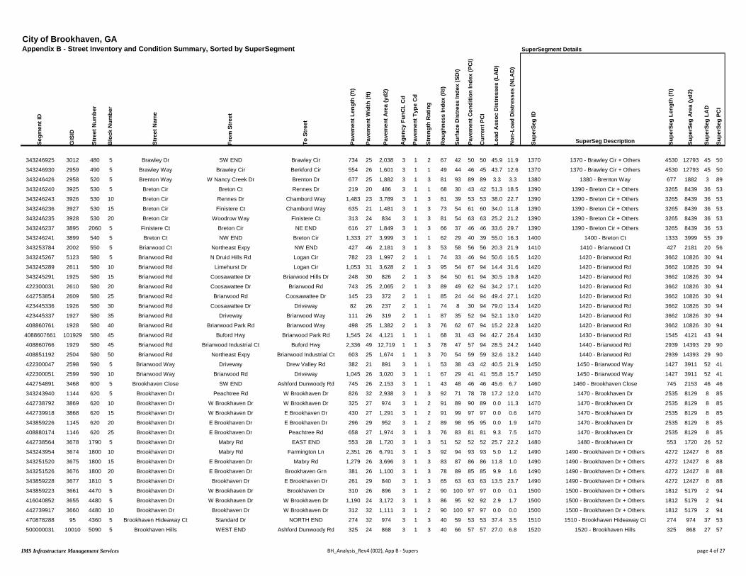
City of Brookhaven, GAAppendix B - Street Inventory and Condition Summary, Sorted by SuperSegment SuperSegment Details
Segm
ent I
D
GIS
ID
Stre
et N
umbe
r
Blo
ck N
umbe
r
Stre
et N
ame
From
Str
eet
To S
tree
t
Pave
men
t Len
gth
(ft)
Pave
men
t Wid
th (f
t)
Pave
men
t Are
a (y
d2)
Age
ncy
FunC
L C
d
Pave
men
t Typ
e C
d
Stre
ngth
Rat
ing
Rou
ghne
ss In
dex
(RI)
Surf
ace
Dis
tres
s In
dex
(SD
I)
Pave
men
t Con
ditio
n In
dex
(PC
I)
Cur
rent
PC
I
Load
Ass
oc D
istr
esse
s (L
AD
)
Non
-Loa
d D
istr
esse
s (N
LAD
)
Supe
rSeg
ID
SuperSeg Description Supe
rSeg
Len
gth
(ft)
Supe
rSeg
Are
a (y
d2)
Supe
rSeg
LA
D
Supe
rSeg
PC
I
343246925 3012 480 5 Brawley Dr SW END Brawley Cir 734 25 2,038 3 1 2 67 42 50 50 45.9 11.9 1370 1370 - Brawley Cir + Others 4530 12793 45 50
343246930 2959 490 5 Brawley Way Brawley Cir Berkford Cir 554 26 1,601 3 1 1 49 44 46 45 43.7 12.6 1370 1370 - Brawley Cir + Others 4530 12793 45 50
343246426 2958 520 5 Brenton Way W Nancy Creek Dr Brenton Dr 677 25 1,882 3 1 3 81 93 89 89 3.3 3.3 1380 1380 - Brenton Way 677 1882 3 89
343246240 3925 530 5 Breton Cir Breton Ct Rennes Dr 219 20 486 3 1 1 68 30 43 42 51.3 18.5 1390 1390 - Breton Cir + Others 3265 8439 36 53
343246243 3926 530 10 Breton Cir Rennes Dr Chambord Way 1,483 23 3,789 3 1 3 81 39 53 53 38.0 22.7 1390 1390 - Breton Cir + Others 3265 8439 36 53
343246236 3927 530 15 Breton Cir Finistere Ct Chambord Way 635 21 1,481 3 1 3 73 54 61 60 34.0 11.8 1390 1390 - Breton Cir + Others 3265 8439 36 53
343246235 3928 530 20 Breton Cir Woodrow Way Finistere Ct 313 24 834 3 1 3 81 54 63 63 25.2 21.2 1390 1390 - Breton Cir + Others 3265 8439 36 53
343246237 3895 2060 5 Finistere Ct Breton Cir NE END 616 27 1,849 3 1 3 66 37 46 46 33.6 29.7 1390 1390 - Breton Cir + Others 3265 8439 36 53
343246241 3899 540 5 Breton Ct NW END Breton Cir 1,333 27 3,999 3 1 1 62 29 40 39 55.0 16.3 1400 1400 - Breton Ct 1333 3999 55 39
343253784 2002 550 5 Briarwood Ct Northeast Expy NW END 427 46 2,181 3 1 3 53 58 56 56 20.3 21.9 1410 1410 - Briarwood Ct 427 2181 20 56
343245267 5123 580 5 Briarwood Rd N Druid Hills Rd Logan Cir 782 23 1,997 2 1 1 74 33 46 94 50.6 16.5 1420 1420 - Briarwood Rd 3662 10826 30 94
343245289 2611 580 10 Briarwood Rd Limehurst Dr Logan Cir 1,053 31 3,628 2 1 3 95 54 67 94 14.4 31.6 1420 1420 - Briarwood Rd 3662 10826 30 94
343245291 1925 580 15 Briarwood Rd Coosawattee Dr Briarwood Hills Dr 248 30 826 2 1 3 84 50 61 94 30.5 19.8 1420 1420 - Briarwood Rd 3662 10826 30 94
422300031 2610 580 20 Briarwood Rd Coosawattee Dr Briarwood Rd 743 25 2,065 2 1 3 89 49 62 94 34.2 17.1 1420 1420 - Briarwood Rd 3662 10826 30 94
442753854 2609 580 25 Briarwood Rd Briarwood Rd Coosawattee Dr 145 23 372 2 1 1 85 24 44 94 49.4 27.1 1420 1420 - Briarwood Rd 3662 10826 30 94
423445336 1926 580 30 Briarwood Rd Coosawattee Dr Driveway 82 26 237 2 1 1 74 8 30 94 79.0 13.4 1420 1420 - Briarwood Rd 3662 10826 30 94
423445337 1927 580 35 Briarwood Rd Driveway Briarwood Way 111 26 319 2 1 1 87 35 52 94 52.1 13.0 1420 1420 - Briarwood Rd 3662 10826 30 94
408860761 1928 580 40 Briarwood Rd Briarwood Park Rd Briarwood Way 498 25 1,382 2 1 3 76 62 67 94 15.2 22.8 1420 1420 - Briarwood Rd 3662 10826 30 94
4088607661 101929 580 45 Briarwood Rd Buford Hwy Briarwood Park Rd 1,545 24 4,121 1 1 1 68 31 43 94 42.7 26.4 1430 1430 - Briarwood Rd 1545 4121 43 94
408860766 1929 580 45 Briarwood Rd Briarwood Industrial Ct Buford Hwy 2,336 49 12,719 1 1 3 78 47 57 94 28.5 24.2 1440 1440 - Briarwood Rd 2939 14393 29 90
408851192 2504 580 50 Briarwood Rd Northeast Expy Briarwood Industrial Ct 603 25 1,674 1 1 3 70 54 59 59 32.6 13.2 1440 1440 - Briarwood Rd 2939 14393 29 90
422300047 2598 590 5 Briarwood Way Driveway Drew Valley Rd 382 21 891 3 1 1 53 38 43 42 40.5 21.9 1450 1450 - Briarwood Way 1427 3911 52 41
422300051 2599 590 10 Briarwood Way Briarwood Rd Driveway 1,045 26 3,020 3 1 1 67 29 41 41 55.8 15.7 1450 1450 - Briarwood Way 1427 3911 52 41
442754891 3468 600 5 Brookhaven Close SW END Ashford Dunwoody Rd 745 26 2,153 3 1 1 43 48 46 46 45.6 6.7 1460 1460 - Brookhaven Close 745 2153 46 46
343243940 1144 620 5 Brookhaven Dr Peachtree Rd W Brookhaven Dr 826 32 2,938 3 1 3 92 71 78 78 17.2 12.0 1470 1470 - Brookhaven Dr 2535 8129 8 85
442738792 3869 620 10 Brookhaven Dr W Brookhaven Dr W Brookhaven Dr 325 27 974 3 1 2 91 89 90 89 0.0 11.3 1470 1470 - Brookhaven Dr 2535 8129 8 85
442739918 3868 620 15 Brookhaven Dr W Brookhaven Dr E Brookhaven Dr 430 27 1,291 3 1 2 91 99 97 97 0.0 0.6 1470 1470 - Brookhaven Dr 2535 8129 8 85
343859226 1145 620 20 Brookhaven Dr E Brookhaven Dr E Brookhaven Dr 296 29 952 3 1 2 89 98 95 95 0.0 1.9 1470 1470 - Brookhaven Dr 2535 8129 8 85
408880174 1146 620 25 Brookhaven Dr E Brookhaven Dr Peachtree Rd 658 27 1,974 3 1 3 76 83 81 81 9.3 7.5 1470 1470 - Brookhaven Dr 2535 8129 8 85
442738564 3678 1790 5 Brookhaven Dr Mabry Rd EAST END 553 28 1,720 3 1 3 51 52 52 52 25.7 22.2 1480 1480 - Brookhaven Dr 553 1720 26 52
343243954 3674 1800 10 Brookhaven Dr Mabry Rd Farmington Ln 2,351 26 6,791 3 1 3 92 94 93 93 5.0 1.2 1490 1490 - Brookhaven Dr + Others 4272 12427 8 88
343251520 3675 1800 15 Brookhaven Dr E Brookhaven Dr Mabry Rd 1,279 26 3,696 3 1 3 83 87 86 86 11.8 1.0 1490 1490 - Brookhaven Dr + Others 4272 12427 8 88
343251526 3676 1800 20 Brookhaven Dr E Brookhaven Dr Brookhaven Grn 381 26 1,100 3 1 3 78 89 85 85 9.9 1.6 1490 1490 - Brookhaven Dr + Others 4272 12427 8 88
343859228 3677 1810 5 Brookhaven Dr Brookhaven Dr E Brookhaven Dr 261 29 840 3 1 3 65 63 63 63 13.5 23.7 1490 1490 - Brookhaven Dr + Others 4272 12427 8 88
343859223 3661 4470 5 Brookhaven Dr W Brookhaven Dr Brookhaven Dr 310 26 896 3 1 2 90 100 97 97 0.0 0.1 1500 1500 - Brookhaven Dr + Others 1812 5179 2 94
416040852 3655 4480 5 Brookhaven Dr W Brookhaven Dr W Brookhaven Dr 1,190 24 3,172 3 1 3 86 95 92 92 2.9 1.7 1500 1500 - Brookhaven Dr + Others 1812 5179 2 94
442739917 3660 4480 10 Brookhaven Dr Brookhaven Dr W Brookhaven Dr 312 32 1,111 3 1 2 90 100 97 97 0.0 0.0 1500 1500 - Brookhaven Dr + Others 1812 5179 2 94
470878288 95 4360 5 Brookhaven Hideaway Ct Standard Dr NORTH END 274 32 974 3 1 3 40 59 53 53 37.4 3.5 1510 1510 - Brookhaven Hideaway Ct 274 974 37 53
500000031 10010 5090 5 Brookhaven Hills WEST END Ashford Dunwoody Rd 325 24 868 3 1 3 40 66 57 57 27.0 6.8 1520 1520 - Brookhaven Hills 325 868 27 57
IMS Infrastructure Management Services BH_Analysis_Rev4 (002), App B - Supers page 4 of 27

City of Brookhaven, GAAppendix B - Street Inventory and Condition Summary, Sorted by SuperSegment SuperSegment Details
Segm
ent I
D
GIS
ID
Stre
et N
umbe
r
Blo
ck N
umbe
r
Stre
et N
ame
From
Str
eet
To S
tree
t
Pave
men
t Len
gth
(ft)
Pave
men
t Wid
th (f
t)
Pave
men
t Are
a (y
d2)
Age
ncy
FunC
L C
d
Pave
men
t Typ
e C
d
Stre
ngth
Rat
ing
Rou
ghne
ss In
dex
(RI)
Surf
ace
Dis
tres
s In
dex
(SD
I)
Pave
men
t Con
ditio
n In
dex
(PC
I)
Cur
rent
PC
I
Load
Ass
oc D
istr
esse
s (L
AD
)
Non
-Loa
d D
istr
esse
s (N
LAD
)
Supe
rSeg
ID
SuperSeg Description Supe
rSeg
Len
gth
(ft)
Supe
rSeg
Are
a (y
d2)
Supe
rSeg
LA
D
Supe
rSeg
PC
I
408880237 3813 660 5 Brookhaven Ln Mabry Rd EAST END 316 29 1,018 3 1 1 38 38 38 38 47.2 15.1 1530 1530 - Brookhaven Ln 316 1018 47 38
343243992 3810 670 5 Brookhaven Ln WEST END Mabry Rd 379 29 1,223 3 1 2 90 99 96 96 0.0 1.3 1540 1540 - Brookhaven Ln 379 1223 0 96
408880285 3291 690 5 Brookhaven Trce SW END Ashford Dunwoody Rd 741 25 2,059 3 1 1 43 30 34 34 61.8 8.7 1550 1550 - Brookhaven Trce 741 2059 62 34
465684350 1042 700 5 Brookhaven Walk Osborne Rd Osborne Rd 789 21 1,842 3 1 3 55 49 51 51 35.0 15.7 1560 1560 - Brookhaven Walk 789 1842 35 51
500000062 20213 6010 5 Brookhaven Walk Way Mabry Rd Brookhaven Walk Way 537 24 1,432 3 1 3 67 85 79 79 12.1 2.7 1570 1570 - Brookhaven Walk Way 537 1432 12 79
343246401 4455 710 5 Brooklawn Ct Brooklawn Rd NE END 347 29 1,118 3 1 1 60 32 41 41 56.3 11.8 1580 1580 - Brooklawn Ct 347 1118 56 41
408880368 4434 720 5 Brooklawn Rd Westbrooke Way Brooklawn Ct 1,369 25 3,804 3 1 3 78 86 84 83 11.4 2.4 1590 1590 - Brooklawn Rd 2067 5743 8 85
343246398 4433 720 10 Brooklawn Rd Brooklawn Ct W Nancy Creek Dr 698 25 1,939 3 1 2 78 93 88 88 0.0 7.5 1590 1590 - Brooklawn Rd 2067 5743 8 85
500000042 20120 5600 5 Brookleigh Ln Ashton Woods Dr Brookleigh Ln 72 29 232 3 1 3 70 89 83 83 5.6 5.2 1600 1600 - Brookleigh Ln 552 1513 1 87
500000043 20122 5600 10 Brookleigh Ln Brookleigh Ln Brookleigh Ln 480 24 1,281 3 1 2 78 92 87 87 0.0 7.8 1600 1600 - Brookleigh Ln 552 1513 1 87
500000044 20148 5610 5 Brookleigh Ln Canopy Chase Brookleigh Ln 584 23 1,493 3 1 2 90 100 97 97 0.0 0.0 1610 1610 - Brookleigh Ln 725 1852 0 97
500000040 20111 5610 10 Brookleigh Ln Brookleigh Ln EAST END 141 23 359 3 1 2 90 100 97 97 0.0 0.1 1610 1610 - Brookleigh Ln 725 1852 0 97
343244344 167 730 5 Brookshire Ln N Druid Hills Rd Fairway Cir 430 25 1,196 3 1 2 83 89 87 87 0.0 11.0 1620 1620 - Brookshire Ln 1232 3244 0 93
343244346 2527 730 10 Brookshire Ln Fairway Cir Fairway Cir 802 23 2,048 3 1 2 90 99 96 96 0.0 0.6 1620 1620 - Brookshire Ln 1232 3244 0 93
343246413 3139 750 5 Bubbling Creek Rd Runnymeade Rd Harts Mill Rd 976 25 2,711 3 1 3 69 39 49 49 32.3 29.2 1630 1630 - Bubbling Creek Rd 3067 8519 34 48
343246356 3138 750 10 Bubbling Creek Rd Runnymeade Rd Shadow Ln 1,588 25 4,411 3 1 3 72 37 49 49 31.9 30.7 1630 1630 - Bubbling Creek Rd 3067 8519 34 48
343246365 1610 750 15 Bubbling Creek Rd Shadow Ln Woodstream Cir 503 25 1,397 3 1 1 56 36 42 42 44.5 19.9 1630 1630 - Bubbling Creek Rd 3067 8519 34 48
500000028 10003 5020 5 Buckhead Ct SOUTH END Buckhead Ln 459 22 1,122 3 1 3 67 85 79 79 9.8 4.8 1640 1640 - Buckhead Ln + Others 1678 4585 10 75
500000026 10001 5010 5 Buckhead Ln Shady Valley Dr Buckhead Ct 176 23 449 3 1 2 69 88 82 82 0.0 12.0 1640 1640 - Buckhead Ln + Others 1678 4585 10 75
500000027 10002 5010 10 Buckhead Ln SOUTH END Buckhead Ct 1,043 26 3,013 3 1 3 60 79 73 72 11.5 9.6 1640 1640 - Buckhead Ln + Others 1678 4585 10 75
470107590 334 760 5 Buckhead Valley Ct Buckhead Valley Ln EAST END 169 35 657 3 1 3 52 69 63 63 23.0 8.0 1650 1650 - Buckhead Valley Ln + Others 1336 3853 23 65
470107589 4828 770 5 Buckhead Valley Ln Buckhead Valley Ct Childers Rd 403 24 1,075 3 1 3 57 77 70 70 13.0 10.3 1650 1650 - Buckhead Valley Ln + Others 1336 3853 23 65
470107588 4829 770 10 Buckhead Valley Ln SOUTH END Buckhead Valley Ct 763 25 2,121 3 1 3 54 67 63 62 27.5 5.7 1650 1650 - Buckhead Valley Ln + Others 1336 3853 23 65
343245468 2546 780 5 Burch Cir Drew Valley Rd Drew Valley Rd 1,852 26 5,350 3 1 2 69 46 54 54 45.8 7.9 1660 1660 - Burch Cir 1852 5350 46 54
343245473 2608 790 5 Bynum Rd Drew Valley Rd Drew Valley Rd 1,092 28 3,398 3 1 1 56 30 38 38 53.0 17.1 1670 1670 - Bynum Rd 1092 3398 53 38
343246175 4454 800 5 Byrnwyck Ct Byrnwyck Pl NW END 422 30 1,407 3 1 1 52 27 35 35 57.6 15.3 1680 1680 - Byrnwyck Pl + Others 2818 8819 50 40
343246171 703 810 10 Byrnwyck Pl Byrnwyck Rd Ives Trl 323 26 933 3 1 3 65 61 62 62 11.9 27.4 1680 1680 - Byrnwyck Pl + Others 2818 8819 50 40
343246173 4438 810 15 Byrnwyck Pl Ives Trl Byrnwyck Ct 273 28 851 3 1 1 51 30 37 37 38.6 31.5 1680 1680 - Byrnwyck Pl + Others 2818 8819 50 40
343246402 704 810 20 Byrnwyck Pl Byrnwyck Ct Byrnwyck Way 307 23 785 3 1 3 60 46 51 51 37.8 16.0 1680 1680 - Byrnwyck Pl + Others 2818 8819 50 40
343246403 4437 810 25 Byrnwyck Pl Byrnwyck Way Downing Ln 344 23 880 3 1 1 46 11 23 23 71.4 17.3 1680 1680 - Byrnwyck Pl + Others 2818 8819 50 40
343253688 705 810 30 Byrnwyck Pl Downing Ln EAST END 202 24 538 3 1 1 62 16 31 31 76.3 7.8 1680 1680 - Byrnwyck Pl + Others 2818 8819 50 40
343246407 695 1610 5 Downing Ln Ives Ct NORTH END 183 39 791 3 1 1 58 27 37 37 61.4 11.3 1680 1680 - Byrnwyck Pl + Others 2818 8819 50 40
343246405 4445 1610 10 Downing Ln Byrnwyck Pl Ives Ct 310 26 895 3 1 1 75 29 44 44 55.5 15.6 1680 1680 - Byrnwyck Pl + Others 2818 8819 50 40
343246406 690 2570 5 Ives Ct NW END Downing Ln 208 35 809 3 1 1 45 22 29 29 55.3 22.8 1680 1680 - Byrnwyck Pl + Others 2818 8819 50 40
343246172 4421 2580 5 Ives Trl NW END Byrnwyck Pl 246 34 929 3 1 2 52 47 49 48 43.8 9.2 1680 1680 - Byrnwyck Pl + Others 2818 8819 50 40
343246170 702 810 5 Byrnwyck Pl Old Johnson Ferry Rd Byrnwyck Rd 223 28 693 3 1 2 89 98 95 95 0.0 2.2 1690 1690 - Byrnwyck Rd + Others 6901 19356 0 93
343246434 4432 820 5 Byrnwyck Rd WEST END Hovis Ct 543 26 1,569 3 1 2 90 100 97 97 0.0 0.0 1690 1690 - Byrnwyck Rd + Others 6901 19356 0 93
343246431 4431 820 10 Byrnwyck Rd Preston Ct Hovis Ct 1,693 23 4,327 3 1 2 84 94 91 91 0.0 5.7 1690 1690 - Byrnwyck Rd + Others 6901 19356 0 93
442738603 4430 820 15 Byrnwyck Rd Fernway Ct Preston Ct 1,123 23 2,871 3 1 2 86 93 91 90 0.0 6.9 1690 1690 - Byrnwyck Rd + Others 6901 19356 0 93
IMS Infrastructure Management Services BH_Analysis_Rev4 (002), App B - Supers page 5 of 27

City of Brookhaven, GAAppendix B - Street Inventory and Condition Summary, Sorted by SuperSegment SuperSegment Details
Segm
ent I
D
GIS
ID
Stre
et N
umbe
r
Blo
ck N
umbe
r
Stre
et N
ame
From
Str
eet
To S
tree
t
Pave
men
t Len
gth
(ft)
Pave
men
t Wid
th (f
t)
Pave
men
t Are
a (y
d2)
Age
ncy
FunC
L C
d
Pave
men
t Typ
e C
d
Stre
ngth
Rat
ing
Rou
ghne
ss In
dex
(RI)
Surf
ace
Dis
tres
s In
dex
(SD
I)
Pave
men
t Con
ditio
n In
dex
(PC
I)
Cur
rent
PC
I
Load
Ass
oc D
istr
esse
s (L
AD
)
Non
-Loa
d D
istr
esse
s (N
LAD
)
Supe
rSeg
ID
SuperSeg Description Supe
rSeg
Len
gth
(ft)
Supe
rSeg
Are
a (y
d2)
Supe
rSeg
LA
D
Supe
rSeg
PC
I
343246178 4429 820 20 Byrnwyck Rd Byrnwyck Trl Fernway Ct 665 26 1,920 3 1 2 81 89 86 86 0.0 11.0 1690 1690 - Byrnwyck Rd + Others 6901 19356 0 93
343246169 4428 820 25 Byrnwyck Rd Byrnwyck Pl Byrnwyck Trl 1,415 24 3,772 3 1 2 90 100 97 96 0.0 0.2 1690 1690 - Byrnwyck Rd + Others 6901 19356 0 93
442738602 4422 830 5 Byrnwyck Trl Byrnwyck Rd NE END 501 27 1,504 3 1 2 89 98 95 95 0.0 1.7 1690 1690 - Byrnwyck Rd + Others 6901 19356 0 93
343246179 689 2030 5 Fernway Ct Byrnwyck Rd NORTH END 230 35 896 3 1 3 84 94 91 91 4.0 1.5 1690 1690 - Byrnwyck Rd + Others 6901 19356 0 93
343246435 4450 2490 5 Hovis Ct NW END Byrnwyck Rd 247 32 878 3 1 2 90 99 96 96 0.0 1.3 1690 1690 - Byrnwyck Rd + Others 6901 19356 0 93
343246429 4449 3540 5 Preston Ct SOUTH END Byrnwyck Rd 260 32 926 3 1 2 90 99 96 96 0.0 1.4 1690 1690 - Byrnwyck Rd + Others 6901 19356 0 93
343246404 4416 840 5 Byrnwyck Way Byrnwyck Pl NORTH END 479 27 1,438 3 1 3 73 87 82 82 7.1 6.0 1700 1700 - Byrnwyck Way 479 1438 7 82
343245801 3421 850 4 Caldwell Rd Caldwell Rd Parkridge Dr 159 32 566 3 1 3 90 78 82 82 18.0 3.6 1710 1710 - Caldwell Rd 2064 8331 9 91
343245792 3422 850 5 Caldwell Rd Templewood Dr Caldwell Rd 432 27 1,296 3 1 3 85 87 86 86 13.5 0.0 1710 1710 - Caldwell Rd 2064 8331 9 91
343245790 3306 850 10 Caldwell Rd Cravenridge Dr Templewood Dr 581 41 2,648 3 1 3 98 90 93 93 8.9 1.1 1710 1710 - Caldwell Rd 2064 8331 9 91
343245788 1470 850 15 Caldwell Rd Cynthia Dr Cravenridge Dr 353 41 1,609 3 1 3 100 93 95 95 7.1 0.1 1710 1710 - Caldwell Rd 2064 8331 9 91
343245785 1469 850 20 Caldwell Rd Redding Rd Cynthia Dr 538 37 2,212 3 1 3 84 95 91 91 5.4 0.0 1710 1710 - Caldwell Rd 2064 8331 9 91
343281886 3307 850 25 Caldwell Rd Ashford Rd Ashford Park Ct 887 30 2,957 3 1 2 90 100 97 97 0.0 0.1 1720 1720 - Caldwell Rd 3670 14372 6 89
420791597 1468 850 30 Caldwell Rd Alden Place Dr Ashford Rd 249 36 995 3 1 2 85 95 92 92 0.0 4.7 1720 1720 - Caldwell Rd 3670 14372 6 89
442738785 3308 850 35 Caldwell Rd Cheshire Way Alden Place Dr 2,535 37 10,420 3 1 3 75 92 86 86 8.3 0.2 1720 1720 - Caldwell Rd 3670 14372 6 89
343245434 3309 850 40 Caldwell Rd E Osborne Rd Cheshire Way 1,358 21 3,168 3 1 3 76 41 53 52 35.6 23.4 1730 1730 - Caldwell Rd 3189 7565 34 53
343245421 1467 850 45 Caldwell Rd Oaklawn Ave E Osborne Rd 240 19 507 3 1 3 78 50 59 59 26.6 23.7 1730 1730 - Caldwell Rd 3189 7565 34 53
343245418 1466 850 50 Caldwell Rd Sunland Dr Oaklawn Ave 458 21 1,069 3 1 3 85 43 57 57 33.8 23.1 1730 1730 - Caldwell Rd 3189 7565 34 53
343245386 3310 850 55 Caldwell Rd Sunland Dr Green Meadows Ln 665 22 1,627 3 1 3 59 58 58 58 19.5 22.6 1730 1730 - Caldwell Rd 3189 7565 34 53
343245383 3311 850 60 Caldwell Rd Dresden Dr Green Meadows Ln 467 23 1,194 3 1 1 70 29 43 43 55.6 15.1 1730 1730 - Caldwell Rd 3189 7565 34 53
343246303 3689 860 5 Cambridge Ct SW END Waddeston Way 694 29 2,236 3 1 2 70 42 51 51 41.7 16.6 1740 1740 - Cambridge Ct 694 2236 42 51
343245444 1263 870 5 Camille Dr E Osborne Rd NORTH END 208 21 486 3 1 3 65 83 77 77 4.6 12.2 1750 1750 - Camille Dr 1547 4205 36 53
343245440 1262 870 10 Camille Dr Wilford Dr E Osborne Rd 927 25 2,574 3 1 2 70 39 49 49 44.2 16.6 1750 1750 - Camille Dr 1547 4205 36 53
343245414 1261 870 15 Camille Dr Dresden Dr Wilford Dr 412 25 1,146 3 1 3 70 42 51 51 32.6 25.8 1750 1750 - Camille Dr 1547 4205 36 53
343246530 3027 880 5 Candler Lake Ct Candler Lake East NE END 390 29 1,256 3 1 3 60 79 73 73 6.8 14.2 1760 1760 - Candler Lake Ct 390 1256 7 73
343282658 3055 890 5 Candler Lake East E Nancy Creek Dr Candler Lake Ct 873 24 2,328 3 1 2 90 36 54 54 46.3 17.8 1770 1770 - Candler Lake East 3019 8605 46 52
343246529 3054 890 10 Candler Lake East Candler Lake Ct Nancy Creek Way 707 27 2,120 3 1 3 83 39 53 53 39.9 21.4 1770 1770 - Candler Lake East 3019 8605 46 52
343246524 3053 890 15 Candler Lake East W Nancy Creek Dr Nancy Creek Way 1,439 26 4,157 3 1 1 85 34 51 51 49.5 16.4 1770 1770 - Candler Lake East 3019 8605 46 52
408880389 1657 900 5 Candler Lake West Hasty Ct Ashwoody Ct 402 20 894 3 1 1 67 33 44 44 48.3 18.4 1780 1780 - Candler Lake West + Others 4202 10948 40 49
343246528 1656 900 10 Candler Lake West Navajo Trl Hasty Ct 571 21 1,333 3 1 2 78 37 51 50 39.0 23.8 1780 1780 - Candler Lake West + Others 4202 10948 40 49
343246527 3050 900 15 Candler Lake West Murphey Candler Ct Navajo Trl 469 22 1,148 3 1 3 85 47 59 59 29.6 23.7 1780 1780 - Candler Lake West + Others 4202 10948 40 49
343246525 3051 900 20 Candler Lake West W Candlerlake Ct Murphey Candler Ct 723 25 2,009 3 1 3 80 49 59 59 29.7 21.1 1780 1780 - Candler Lake West + Others 4202 10948 40 49
442738803 3052 900 25 Candler Lake West W Nancy Creek Dr W Candlerlake Ct 667 25 1,852 3 1 3 79 51 61 60 31.2 17.4 1780 1780 - Candler Lake West + Others 4202 10948 40 49
343246523 1701 4490 5 Candlerlake Ct WEST END Candler Lake West 232 25 645 3 1 1 43 30 34 34 51.8 18.6 1780 1780 - Candler Lake West + Others 4202 10948 40 49
343246481 1663 2350 5 Hasty Ct WEST END Candler Lake West 243 25 674 3 1 1 36 23 27 27 69.7 7.1 1780 1780 - Candler Lake West + Others 4202 10948 40 49
408857987 1666 2850 5 Long Branch Ct Candler Lake West NORTH END 720 20 1,601 3 1 1 59 25 36 36 55.4 19.8 1780 1780 - Candler Lake West + Others 4202 10948 40 49
343246526 1667 3010 5 Murphey Candler Ct WEST END Candler Lake West 174 41 793 3 1 3 44 36 39 38 27.9 36.3 1780 1780 - Candler Lake West + Others 4202 10948 40 49
343245628 1392 910 5 Canmont Dr Skyland Dr Stoland Dr 630 24 1,681 3 1 1 58 41 46 46 50.7 8.7 1790 1790 - Canmont Dr 1568 4286 40 54
343245629 3433 910 10 Canmont Dr Stoland Dr Boland Dr 470 24 1,254 3 1 1 72 37 49 49 48.8 13.9 1790 1790 - Canmont Dr 1568 4286 40 54
IMS Infrastructure Management Services BH_Analysis_Rev4 (002), App B - Supers page 6 of 27

City of Brookhaven, GAAppendix B - Street Inventory and Condition Summary, Sorted by SuperSegment SuperSegment Details
Segm
ent I
D
GIS
ID
Stre
et N
umbe
r
Blo
ck N
umbe
r
Stre
et N
ame
From
Str
eet
To S
tree
t
Pave
men
t Len
gth
(ft)
Pave
men
t Wid
th (f
t)
Pave
men
t Are
a (y
d2)
Age
ncy
FunC
L C
d
Pave
men
t Typ
e C
d
Stre
ngth
Rat
ing
Rou
ghne
ss In
dex
(RI)
Surf
ace
Dis
tres
s In
dex
(SD
I)
Pave
men
t Con
ditio
n In
dex
(PC
I)
Cur
rent
PC
I
Load
Ass
oc D
istr
esse
s (L
AD
)
Non
-Loa
d D
istr
esse
s (N
LAD
)
Supe
rSeg
ID
SuperSeg Description Supe
rSeg
Len
gth
(ft)
Supe
rSeg
Are
a (y
d2)
Supe
rSeg
LA
D
Supe
rSeg
PC
I
343245880 3432 910 15 Canmont Dr Boland Dr Clairmont Rd 468 26 1,351 3 1 3 65 72 70 70 19.8 7.9 1790 1790 - Canmont Dr 1568 4286 40 54
343245399 1393 920 5 Canoochee Dr Ellijay Dr Appalachee Dr 620 26 1,791 3 1 2 64 39 47 47 42.2 19.2 1800 1800 - Canoochee Dr 1087 3139 49 42
343245401 1394 920 10 Canoochee Dr Appalachee Dr Oostanaula Dr 467 26 1,348 3 1 1 76 15 35 35 57.9 27.1 1800 1800 - Canoochee Dr 1087 3139 49 42
343245407 3431 920 15 Canoochee Dr Oostanaula Dr Conasauga Ave 227 26 655 3 1 3 70 89 83 83 2.8 7.8 1810 1810 - Conasauga Ave + Others 765 2210 5 82
465684207 1363 1220 5 Conasauga Ave Canoochee Dr Dresden Dr 538 26 1,555 3 1 3 72 86 82 81 5.7 8.2 1810 1810 - Conasauga Ave + Others 765 2210 5 82
343245652 3922 940 10 Capital Club Cir Capital Club Cir Capital Club Cir 597 25 1,658 3 1 1 55 28 37 94 56.2 15.7 1820 1820 - Capital Club Cir + Others 1243 3454 59 94
442738589 3923 950 5 Capital Club Cir Capital Club Cir Capital Club Cir 646 25 1,795 3 1 1 54 23 33 94 61.3 15.6 1820 1820 - Capital Club Cir + Others 1243 3454 59 94
343245653 1121 950 10 Capital Club Cir Capital Club Cir Osborne Rd 143 25 397 3 1 2 83 94 91 90 0.0 5.8 1830 1830 - Capital Club Cir 143 397 0 90
343245621 3320 960 5 Carlton Pl Dresden Dr Skyland Dr 1,033 22 2,525 3 1 2 89 98 95 95 0.0 2.3 1840 1840 - Carlton Pl 1033 2525 0 95
343254404 3430 970 5 Cartecay Dr Sylvan Cir Coosawattee Dr 809 26 2,336 3 1 1 63 33 43 43 47.9 18.7 1850 1850 - Cartecay Dr 1625 4516 32 54
343245333 3429 970 10 Cartecay Dr Coosawattee Dr Appalachee Dr 303 19 639 3 1 3 56 66 63 63 18.6 15.0 1850 1850 - Cartecay Dr 1625 4516 32 54
343245336 3428 970 15 Cartecay Dr Appalachee Dr Oostanaula Dr 514 27 1,541 3 1 3 59 70 67 67 13.0 16.7 1850 1850 - Cartecay Dr 1625 4516 32 54
343246224 3944 980 5 Cates Ave Mae Ave Osborne Rd 632 19 1,333 3 1 3 61 80 74 74 13.5 6.3 1860 1860 - Cates Ave + Others 3698 7686 18 68
343246152 1115 980 10 Cates Ave Francis St Mae Ave 325 16 578 3 1 3 65 84 77 77 7.2 9.2 1860 1860 - Cates Ave + Others 3698 7686 18 68
343244029 1114 980 15 Cates Ave Victoria St Francis St 291 17 550 3 1 3 76 67 70 70 27.8 5.5 1860 1860 - Cates Ave + Others 3698 7686 18 68
343244027 3945 980 20 Cates Ave Windsor Pkwy Victoria St 368 19 776 3 1 2 46 48 48 48 40.0 11.6 1860 1860 - Cates Ave + Others 3698 7686 18 68
343246221 3714 2110 5 Francis St Cates Ave Osborne Rd 711 17 1,344 3 1 3 64 65 65 65 16.7 17.9 1860 1860 - Cates Ave + Others 3698 7686 18 68
343246222 3930 2930 5 Mae Ave Cates Ave Osborne Rd 528 21 1,231 3 1 3 59 72 68 68 13.6 14.2 1860 1860 - Cates Ave + Others 3698 7686 18 68
343245705 3713 4410 5 Victoria St Cates Ave Osborne Rd 843 20 1,873 3 1 3 64 77 73 73 15.5 7.4 1860 1860 - Cates Ave + Others 3698 7686 18 68
343246231 4038 1000 5 Chambord Way Woodrow Way Breton Cir 889 24 2,370 3 1 3 89 97 94 94 0.9 1.8 1870 1870 - Chambord Way 889 2370 1 94
343246449 3008 1030 5 Chaucer Ln Chaucer Wood Becket Dr 1,292 25 3,588 3 1 1 72 30 44 44 49.3 20.8 1880 1880 - Chaucer Ln 1645 4610 47 44
343246454 1680 1030 10 Chaucer Ln Becket Dr Ashford Dunwoody Rd 354 26 1,022 3 1 2 56 41 46 46 39.0 19.5 1880 1880 - Chaucer Ln 1645 4610 47 44
343245678 1482 1050 5 Cheshire Way Caldwell Rd Green Meadows Ln 378 31 1,302 3 1 1 71 33 46 45 49.1 18.1 1890 1890 - Cheshire Way 1012 3133 46 46
343245679 3284 1050 10 Cheshire Way Green Meadows Ln Valvedere Dr 634 26 1,830 3 1 2 64 39 47 47 43.2 18.0 1890 1890 - Cheshire Way 1012 3133 46 46
343246520 3026 1060 5 Chesson Ct W Nancy Creek Dr NW END 291 34 1,101 3 1 1 42 32 35 35 44.9 22.8 1900 1900 - Chesson Ct 291 1101 45 35
408881850 418 1080 5 Childers Rd Shady Valley Dr Hedge Rose Dr 401 25 1,113 3 1 1 51 30 37 36 57.5 12.9 1910 1910 - Childers Rd 1047 2704 47 38
465683675 419 1080 10 Childers Rd Hedge Rose Dr Buckhead Valley Ln 195 22 476 3 1 1 44 35 38 38 39.3 25.6 1910 1910 - Childers Rd 1047 2704 47 38
465683676 420 1080 15 Childers Rd Buckhead Valley Ln Childers Pl 55 24 147 3 1 3 58 53 55 54 30.2 16.9 1910 1910 - Childers Rd 1047 2704 47 38
470107596 421 1080 20 Childers Rd Childers Pl N Druid Hills Rd 396 22 968 3 1 1 41 36 38 37 40.5 23.8 1910 1910 - Childers Rd 1047 2704 47 38
343246475 3141 1090 5 Chippewa Pl Iroquois Path Navajo Trl 728 27 2,185 3 1 1 57 37 44 44 50.9 11.6 1920 1920 - Chippewa Pl + Others 2178 6263 42 49
343246474 1607 1090 10 Chippewa Pl Oconee Pass Iroquois Path 459 26 1,327 3 1 2 62 49 54 53 42.5 8.3 1920 1920 - Chippewa Pl + Others 2178 6263 42 49
408858182 1606 1090 15 Chippewa Pl SOUTH END Oconee Pass 272 25 754 3 1 1 34 26 29 28 44.4 29.6 1920 1920 - Chippewa Pl + Others 2178 6263 42 49
343246476 1605 2560 5 Iroquois Path Chippewa Pl Shawnee Ln 719 25 1,996 3 1 3 59 59 59 59 30.4 10.8 1920 1920 - Chippewa Pl + Others 2178 6263 42 49
343246020 1549 1120 5 Clairmont Rd 9th St Airport Rd 374 59 2,453 1 1 3 80 35 50 49 27.0 38.3 1930 1930 - Clairmont Rd 4058 24666 29 53
408871315 1548 1120 10 Clairmont Rd Tobey Rd 9th St 1,223 59 8,019 1 1 3 90 46 61 60 21.2 32.4 1930 1930 - Clairmont Rd 4058 24666 29 53
424395631 1547 1120 15 Clairmont Rd Georgian Dr E Tobey Rd 430 45 2,152 1 1 3 80 40 53 53 21.4 39.0 1930 1930 - Clairmont Rd 4058 24666 29 53
343246004 1546 1120 20 Clairmont Rd Bragg St Georgian Dr E 1,112 50 6,179 1 1 3 87 37 53 53 31.9 31.4 1930 1930 - Clairmont Rd 4058 24666 29 53
343245999 1545 1120 25 Clairmont Rd Manville Dr Bragg St 468 56 2,912 1 1 3 81 37 52 52 30.6 32.0 1930 1930 - Clairmont Rd 4058 24666 29 53
343245883 1544 1120 30 Clairmont Rd Dresden Dr Manville Dr 450 59 2,951 1 1 1 64 25 38 38 53.3 21.5 1930 1930 - Clairmont Rd 4058 24666 29 53
IMS Infrastructure Management Services BH_Analysis_Rev4 (002), App B - Supers page 7 of 27

City of Brookhaven, GAAppendix B - Street Inventory and Condition Summary, Sorted by SuperSegment SuperSegment Details
Segm
ent I
D
GIS
ID
Stre
et N
umbe
r
Blo
ck N
umbe
r
Stre
et N
ame
From
Str
eet
To S
tree
t
Pave
men
t Len
gth
(ft)
Pave
men
t Wid
th (f
t)
Pave
men
t Are
a (y
d2)
Age
ncy
FunC
L C
d
Pave
men
t Typ
e C
d
Stre
ngth
Rat
ing
Rou
ghne
ss In
dex
(RI)
Surf
ace
Dis
tres
s In
dex
(SD
I)
Pave
men
t Con
ditio
n In
dex
(PC
I)
Cur
rent
PC
I
Load
Ass
oc D
istr
esse
s (L
AD
)
Non
-Loa
d D
istr
esse
s (N
LAD
)
Supe
rSeg
ID
SuperSeg Description Supe
rSeg
Len
gth
(ft)
Supe
rSeg
Are
a (y
d2)
Supe
rSeg
LA
D
Supe
rSeg
PC
I
431175670 1349 1130 5 Clairmont Rd Canmont Dr Dresden Dr 389 58 2,505 1 1 1 78 24 42 42 41.0 35.0 1940 1940 - Clairmont Rd 2853 18733 32 52
431175673 1348 1130 10 Clairmont Rd Raven Hill Dr Canmont Dr 1,177 58 7,586 1 1 3 91 47 61 61 16.5 36.5 1940 1940 - Clairmont Rd 2853 18733 32 52
343245870 3473 1130 15 Clairmont Rd Skyland Rd Raven Hill Dr 456 63 3,193 1 1 3 84 35 51 51 26.9 37.8 1940 1940 - Clairmont Rd 2853 18733 32 52
343245867 3474 1130 20 Clairmont Rd Buford Hwy Skyland Rd 831 59 5,448 1 1 1 74 29 44 43 51.4 19.9 1940 1940 - Clairmont Rd 2853 18733 32 52
343244424 2003 1100 5 Clairmont Ct WEST END Clairmont Way 227 33 832 3 1 1 30 28 28 94 55.0 17.3 1950 1950 - Clairmont Ct 227 832 55 94
343244428 1986 1110 5 Clairmont Pl WEST END Clairmont Way 241 33 884 3 1 1 32 9 17 98 73.5 17.8 1960 1960 - Clairmont Pl 400 1237 71 98
343244441 1987 1110 10 Clairmont Pl Clairmont Way EAST END 159 20 353 3 1 1 32 14 20 98 65.2 21.0 1960 1960 - Clairmont Pl 400 1237 71 98
408860620 2083 1140 5 Clairmont Way Clairmont Ct Clairmont Pl 395 23 1,010 3 1 3 73 84 80 80 3.5 12.4 1970 1970 - Clairmont Way 1936 5338 9 72
343251664 2259 1140 10 Clairmont Way Somervale Ct Clairmont Ct 428 26 1,237 3 1 3 75 84 81 81 2.9 13.1 1970 1970 - Clairmont Way 1936 5338 9 72
343251672 2258 1140 15 Clairmont Way Somervale Ct Clairmont Rd 1,113 25 3,091 3 1 3 66 67 67 66 12.9 20.5 1970 1970 - Clairmont Way 1936 5338 9 72
343251667 2331 4020 5 Somervale Ct SOUTH END Clairmont Way 436 35 1,695 3 1 1 51 23 32 94 65.0 12.3 1980 1980 - Somervale Ct 436 1695 65 94
431526690 118 1150 5 Clearview Dr N Druid Hills Rd EAST END 1,099 23 2,809 3 1 2 57 37 44 44 41.5 21.4 1990 1990 - Clearview Dr 1099 2809 41 44
408860685 2494 3020 5 Cliff Valley Way Lenox Park Blvd Coosawattee Dr 2,055 40 9,133 3 1 2 73 42 53 53 39.5 18.0 2000 2000 - Cliff Valley Way 3133 13926 39 50
343244353 1991 3020 10 Cliff Valley Way Coosawattee Dr Buford Hwy 1,078 40 4,792 3 1 2 64 35 45 44 39.0 26.1 2000 2000 - Cliff Valley Way 3133 13926 39 50
442732583 3918 1160 5 Club Commons Cir Club Commons Cir Mabry Rd 1,369 24 3,650 3 1 1 66 30 42 42 54.3 15.4 2010 2010 - Club Commons Cir 1369 3650 54 42
343244009 3883 1170 5 Club Pl Mabry Rd EAST END 655 26 1,891 3 1 1 65 36 45 45 48.5 15.4 2020 2020 - Club Pl 655 1891 49 45
343245692 3709 1180 5 Club Trce WEST END Osborne Rd 754 25 2,096 3 1 3 71 51 57 57 34.5 14.7 2030 2030 - Club Trce 754 2096 34 57
442738787 3845 1190 5 Club Walk Dr WEST END Hermance Dr 792 25 2,199 3 1 3 61 63 62 62 32.2 5.1 2040 2040 - Club Walk Dr 792 2199 32 62
343245285 3844 1200 5 Colonial Dr Standard Dr Peachtree Rd 832 23 2,125 3 1 3 48 59 55 55 22.3 18.7 2050 2050 - Colonial Dr 3606 9214 21 64
343245271 123 1200 10 Colonial Dr Oglethorpe Ave Standard Dr 351 22 858 3 1 3 71 74 73 73 21.2 4.8 2050 2050 - Colonial Dr 3606 9214 21 64
343245243 122 1200 15 Colonial Dr Pine Grove Ave Oglethorpe Ave 582 23 1,488 3 1 3 76 76 76 76 12.1 12.3 2050 2050 - Colonial Dr 3606 9214 21 64
343254274 5173 1200 20 Colonial Dr Lenox Ridge Ct Pine Grove Ave 645 24 1,719 3 1 3 63 68 66 66 19.4 12.8 2050 2050 - Colonial Dr 3606 9214 21 64
408880153 121 1200 25 Colonial Dr Lenox Ridge Ct Lenox Walk 575 24 1,534 3 1 3 63 54 57 57 32.6 13.2 2050 2050 - Colonial Dr 3606 9214 21 64
408880152 120 1200 30 Colonial Dr Lenox Walk Matthews St 183 23 469 3 1 3 61 80 74 73 7.6 12.6 2050 2050 - Colonial Dr 3606 9214 21 64
343245248 119 1200 35 Colonial Dr Matthews St N Druid Hills Rd 438 21 1,022 3 1 3 51 72 65 65 23.0 4.7 2050 2050 - Colonial Dr 3606 9214 21 64
343246534 2746 1210 5 Colt Dr NW END Remington Rd 491 25 1,364 3 1 3 67 85 79 79 1.1 13.5 2060 2060 - Colt Dr 1983 5344 8 74
343246518 2745 1210 10 Colt Dr Remington Rd Chamblee Dunwoody Rd 1,492 24 3,980 3 1 3 79 69 72 72 10.6 20.9 2060 2060 - Colt Dr 1983 5344 8 74
416039670 4858 1280 5 Converse Dr Converse Dr NE END 508 25 1,412 3 1 3 38 63 55 55 34.1 2.5 2070 2070 - Converse Dr 508 1412 34 55
343245315 3427 1290 5 Coosawattee Dr Tugaloo Dr Cartecay Dr 352 21 822 3 1 1 51 27 35 94 55.6 17.2 2080 2080 - Coosawattee Dr 2398 5306 37 94
442743726 2535 1290 10 Coosawattee Dr Coosawattee Dr Tugaloo Dr 412 19 869 3 1 1 63 41 48 94 47.4 11.8 2080 2080 - Coosawattee Dr 2398 5306 37 94
375124518 1970 1290 15 Coosawattee Dr Noel Dr Coosawattee Dr 203 20 450 3 1 3 80 77 78 94 5.1 17.9 2080 2080 - Coosawattee Dr 2398 5306 37 94
343245314 1969 1290 20 Coosawattee Dr Telford Dr Noel Dr 180 19 380 3 1 3 57 67 64 94 15.8 16.7 2080 2080 - Coosawattee Dr 2398 5306 37 94
343245296 2536 1290 25 Coosawattee Dr Wayside Dr Telford Dr 618 17 1,167 3 1 2 57 47 51 94 38.3 14.3 2080 2080 - Coosawattee Dr 2398 5306 37 94
343245293 2537 1290 30 Coosawattee Dr Briarwood Rd Wayside Dr 633 23 1,617 3 1 3 74 45 54 94 36.5 18.8 2080 2080 - Coosawattee Dr 2398 5306 37 94
445262507 2539 1310 5 Coosawattee Dr N Cliff Valley Way Doublegate Dr 1,405 26 4,058 3 1 1 51 40 43 43 48.1 12.4 2090 2090 - Coosawattee Dr 1405 4058 48 43
343244318 2340 1320 5 Corporate Blvd Northeast Expy Buford Hwy 1,518 46 7,759 3 1 3 56 47 50 94 27.2 25.8 2100 2100 - Corporate Blvd 1518 7759 27 94
408880159 1975 630 5 Brookhaven Garden Ln Cortez Ln EAST END 650 26 1,878 3 1 3 65 57 60 59 16.8 26.2 2110 2110 - Cortez Ln + Others 2471 6803 20 60
408880158 2525 1340 5 Cortez Ln Brookhaven Garden Ln Coosawattee Dr 264 22 646 3 1 3 61 59 59 59 27.6 13.6 2110 2110 - Cortez Ln + Others 2471 6803 20 60
408880160 2523 1340 10 Cortez Ln Brookhaven Garden Ln Cortez Way 1,149 25 3,190 3 1 3 48 66 60 60 23.3 10.9 2110 2110 - Cortez Ln + Others 2471 6803 20 60
IMS Infrastructure Management Services BH_Analysis_Rev4 (002), App B - Supers page 8 of 27

City of Brookhaven, GAAppendix B - Street Inventory and Condition Summary, Sorted by SuperSegment SuperSegment Details
Segm
ent I
D
GIS
ID
Stre
et N
umbe
r
Blo
ck N
umbe
r
Stre
et N
ame
From
Str
eet
To S
tree
t
Pave
men
t Len
gth
(ft)
Pave
men
t Wid
th (f
t)
Pave
men
t Are
a (y
d2)
Age
ncy
FunC
L C
d
Pave
men
t Typ
e C
d
Stre
ngth
Rat
ing
Rou
ghne
ss In
dex
(RI)
Surf
ace
Dis
tres
s In
dex
(SD
I)
Pave
men
t Con
ditio
n In
dex
(PC
I)
Cur
rent
PC
I
Load
Ass
oc D
istr
esse
s (L
AD
)
Non
-Loa
d D
istr
esse
s (N
LAD
)
Supe
rSeg
ID
SuperSeg Description Supe
rSeg
Len
gth
(ft)
Supe
rSeg
Are
a (y
d2)
Supe
rSeg
LA
D
Supe
rSeg
PC
I
408880156 2524 1340 15 Cortez Ln Cortez Way Drew Valley Rd 408 24 1,089 3 1 3 65 62 63 63 10.8 27.2 2110 2110 - Cortez Ln + Others 2471 6803 20 60
343245327 1931 1350 5 Cortez Way Noel Dr Cortez Way 205 16 365 3 1 2 42 42 42 42 39.1 19.3 2120 2120 - Noel Dr + Others 1869 4110 34 50
408880157 2597 1350 10 Cortez Way Cortez Ln Noel Dr 619 19 1,307 3 1 3 68 45 53 53 35.8 18.9 2120 2120 - Noel Dr + Others 1869 4110 34 50
343245321 2829 3130 5 Noel Dr Coosawattee Dr Cortez Way 1,045 21 2,439 3 1 3 60 45 50 50 31.7 22.9 2120 2120 - Noel Dr + Others 1869 4110 34 50
343245560 3426 1360 5 Cotswold Dr Cove Cir Wawona Dr 792 25 2,200 3 1 1 63 29 40 40 53.0 17.8 2130 2130 - Cotswold Dr 792 2200 53 40
343245496 1378 1370 5 Cove Cir Drew Valley Rd Wawona Ter 511 22 1,248 3 1 1 65 30 41 41 49.0 21.4 2140 2140 - Cove Cir 4599 12798 39 51
343245497 3449 1370 10 Cove Cir Wawona Ter Cotswold Dr 421 25 1,170 3 1 1 70 31 44 44 48.5 20.4 2140 2140 - Cove Cir 4599 12798 39 51
442752288 3448 1370 15 Cove Cir Cotswold Dr Wawona Dr 2,288 26 6,610 3 1 3 69 48 55 55 38.2 14.3 2140 2140 - Cove Cir 4599 12798 39 51
343245595 3447 1370 20 Cove Cir Cove Cir Wawona Dr 280 27 840 3 1 3 69 46 53 53 24.4 29.9 2140 2140 - Cove Cir 4599 12798 39 51
343245524 3446 1370 25 Cove Cir Drew Valley Rd Cove Cir 1,099 24 2,931 3 1 2 60 43 48 48 38.6 18.8 2140 2140 - Cove Cir 4599 12798 39 51
343245789 3423 1390 5 Cravenridge Dr Tryon Rd Caldwell Rd 512 29 1,649 3 1 3 70 49 56 56 34.1 16.4 2150 2150 - Cravenridge Dr 2752 6628 41 53
442738811 3424 1390 10 Cravenridge Dr Pamela Dr Tryon Rd 605 20 1,345 3 1 3 71 51 57 57 34.3 14.9 2150 2150 - Cravenridge Dr 2752 6628 41 53
343245757 3425 1390 15 Cravenridge Dr Tryon Rd Pamela Dr 1,636 20 3,635 3 1 2 67 41 50 49 46.0 13.0 2150 2150 - Cravenridge Dr 2752 6628 41 53
445260878 1227 1420 5 Crossway Dr NW END Redding Rd 318 30 1,061 3 1 1 48 32 38 37 59.3 8.2 2160 2160 - Crossway Dr 318 1061 59 37
408860835 2493 1460 5 Curtis Dr Buford Hwy N Druid Hills Rd 3,389 30 11,296 3 1 3 75 85 82 82 11.9 2.7 2170 2170 - Curtis Dr 3389 11296 12 82
343254345 1228 1470 5 Cynthia Dr Tryon Rd Caldwell Rd 514 26 1,484 3 1 3 59 78 72 72 4.6 17.4 2180 2180 - Cynthia Dr 514 1484 5 72
445259046 3915 1520 5 Devine Cir WEST END Osborne Rd 902 27 2,706 3 1 2 89 98 95 95 0.0 1.6 2190 2190 - Devine Cir 902 2706 0 95
343246488 1677 1580 5 Donaldson Dr Woodstream Cir Donaldson Dr 161 26 466 2 1 3 44 44 44 44 27.9 28.1 2200 2200 - Donaldson Dr 3612 11056 23 66
343246367 3009 1580 10 Donaldson Dr Bubbling Creek Rd Woodstream Cir 1,117 25 3,103 2 1 3 83 66 71 71 17.2 16.9 2200 2200 - Donaldson Dr 3612 11056 23 66
442738608 3010 1580 15 Donaldson Dr Park Creek Ln Bubbling Creek Rd 450 28 1,401 2 1 3 68 67 67 67 21.8 11.2 2200 2200 - Donaldson Dr 3612 11056 23 66
343246360 1676 1580 20 Donaldson Dr Danbury Parc Pl Park Creek Ln 213 26 614 2 1 3 88 60 69 69 12.4 27.9 2200 2200 - Donaldson Dr 3612 11056 23 66
343246355 1675 1580 25 Donaldson Dr Donaldson Park Dr Danbury Parc Pl 328 26 948 2 1 3 89 55 66 66 26.6 18.3 2200 2200 - Donaldson Dr 3612 11056 23 66
408858343 3011 1580 30 Donaldson Dr Blair Cir Donaldson Park Dr 434 27 1,303 2 1 3 78 57 64 64 25.7 17.2 2200 2200 - Donaldson Dr 3612 11056 23 66
343246341 1674 1580 35 Donaldson Dr Donaldson Dr Blair Cir 496 31 1,708 2 1 3 62 64 63 63 27.9 8.6 2200 2200 - Donaldson Dr 3612 11056 23 66
408858366 1229 1580 40 Donaldson Dr Johnson Ferry Rd Donaldson Dr 413 33 1,514 2 1 3 75 55 62 61 30.2 14.7 2200 2200 - Donaldson Dr 3612 11056 23 66
343282687 3946 1590 5 Dorby Close Dorby Park Dr NE END 198 41 902 3 1 1 54 41 45 45 51.8 7.0 2210 2210 - Dorby Park Dr + Others 824 2723 45 46
343282686 3838 1600 5 Dorby Park Dr Osborne Rd Dorby Close 389 22 951 3 1 2 68 44 52 51 40.3 16.1 2210 2210 - Dorby Park Dr + Others 824 2723 45 46
343282685 3837 1600 10 Dorby Park Dr Dorby Close EAST END 237 33 870 3 1 1 45 41 42 42 42.8 15.8 2210 2210 - Dorby Park Dr + Others 824 2723 45 46
424393731 1105 1620 5 Dresden Dr Peachtree Rd Ramp 184 46 938 1 1 3 49 55 53 53 17.1 27.9 2220 2220 - Dresden Dr + Others 958 4082 19 67
424395393 1106 1620 10 Dresden Dr Ramp Apple Valley Rd 546 43 2,611 1 1 3 82 59 67 67 24.0 16.5 2220 2220 - Dresden Dr + Others 958 4082 19 67
424393733 3633 3610 5 Ramp Dresden Dr Peachtree Rd 228 21 533 3 1 3 83 94 90 90 0.6 5.4 2220 2220 - Dresden Dr + Others 958 4082 19 67
343254415 3488 1620 15 Dresden Dr Apple Valley Rd Fernwood Cir 903 37 3,713 1 1 3 77 86 83 83 2.1 12.0 2230 2230 - Dresden Dr 1435 6018 3 83
343254412 1335 1620 20 Dresden Dr Fernwood Cir Ellijay Dr 532 39 2,305 1 1 3 74 87 83 83 4.9 7.8 2230 2230 - Dresden Dr 1435 6018 3 83
442755251 3487 1620 25 Dresden Dr Ellijay Dr Caldwell Rd 172 39 746 1 1 2 57 45 49 49 44.0 10.9 2240 2240 - Dresden Dr 2614 10641 25 63
343245408 1336 1620 30 Dresden Dr Caldwell Rd Appalachee Dr 453 33 1,661 1 1 3 81 50 60 60 33.6 16.1 2240 2240 - Dresden Dr 2614 10641 25 63
465684227 1337 1620 35 Dresden Dr Appalachee Dr Camille Dr 511 40 2,270 1 1 3 85 73 77 77 7.4 19.6 2240 2240 - Dresden Dr 2614 10641 25 63
343245413 1338 1620 40 Dresden Dr Camille Dr Conasauga Ave 189 38 797 1 1 3 88 65 73 73 12.2 22.6 2240 2240 - Dresden Dr 2614 10641 25 63
343245415 1339 1620 45 Dresden Dr Conasauga Ave Grant Dr 129 38 543 1 1 3 90 77 82 81 11.6 11.1 2240 2240 - Dresden Dr 2614 10641 25 63
424395448 3486 1620 50 Dresden Dr Grant Dr N Thompson Rd 442 34 1,669 1 1 3 83 60 68 68 10.7 28.8 2240 2240 - Dresden Dr 2614 10641 25 63
IMS Infrastructure Management Services BH_Analysis_Rev4 (002), App B - Supers page 9 of 27

City of Brookhaven, GAAppendix B - Street Inventory and Condition Summary, Sorted by SuperSegment SuperSegment Details
Segm
ent I
D
GIS
ID
Stre
et N
umbe
r
Blo
ck N
umbe
r
Stre
et N
ame
From
Str
eet
To S
tree
t
Pave
men
t Len
gth
(ft)
Pave
men
t Wid
th (f
t)
Pave
men
t Are
a (y
d2)
Age
ncy
FunC
L C
d
Pave
men
t Typ
e C
d
Stre
ngth
Rat
ing
Rou
ghne
ss In
dex
(RI)
Surf
ace
Dis
tres
s In
dex
(SD
I)
Pave
men
t Con
ditio
n In
dex
(PC
I)
Cur
rent
PC
I
Load
Ass
oc D
istr
esse
s (L
AD
)
Non
-Loa
d D
istr
esse
s (N
LAD
)
Supe
rSeg
ID
SuperSeg Description Supe
rSeg
Len
gth
(ft)
Supe
rSeg
Are
a (y
d2)
Supe
rSeg
LA
D
Supe
rSeg
PC
I
343245557 1341 1620 60 Dresden Dr Thompson Rd Wayland Cir 719 37 2,955 1 1 2 65 43 50 50 43.4 13.9 2240 2240 - Dresden Dr 2614 10641 25 63
343245565 3485 1620 65 Dresden Dr Wayland Cir Ashford Rd 630 37 2,592 1 1 3 82 55 64 64 29.0 15.9 2250 2250 - Dresden Dr 2179 9664 33 59
424395461 3484 1620 70 Dresden Dr Ashford Rd Winding Ln 973 40 4,325 1 1 3 79 49 59 59 37.4 13.7 2250 2250 - Dresden Dr 2179 9664 33 59
424395459 1342 1620 75 Dresden Dr Winding Ln Brookline Cir 575 43 2,747 1 1 3 66 51 56 56 29.1 19.5 2250 2250 - Dresden Dr 2179 9664 33 59
424395494 3483 1620 80 Dresden Dr Brookline Cir Carlton Pl 485 37 1,993 1 1 3 78 58 64 64 23.9 18.5 2260 2260 - Dresden Dr 2540 12255 28 64
343245616 3482 1620 85 Dresden Dr Carlton Pl Skyland Dr 378 36 1,512 1 1 3 85 64 71 71 7.4 28.3 2260 2260 - Dresden Dr 2540 12255 28 64
343245631 1343 1620 90 Dresden Dr Skyland Dr Archway Dr 765 35 2,975 1 1 3 68 47 54 54 38.0 14.8 2260 2260 - Dresden Dr 2540 12255 28 64
343245881 1344 1620 95 Dresden Dr Archway Dr Clairmont Rd 912 57 5,775 1 1 3 79 61 67 67 29.4 9.8 2260 2260 - Dresden Dr 2540 12255 28 64
343245515 2607 1630 5 Drew Valley Rd E Drew Valley Rd Buford Hwy 491 27 1,473 3 1 3 56 58 57 57 18.6 23.6 2270 2270 - Drew Valley Rd + Others 4868 13912 17 62
343245510 2606 1630 10 Drew Valley Rd Burch Cir E Drew Valley Rd 648 26 1,873 3 1 3 77 60 66 66 13.4 26.2 2270 2270 - Drew Valley Rd + Others 4868 13912 17 62
343245469 2605 1630 15 Drew Valley Rd Burch Cir Burch Cir 1,192 25 3,310 3 1 3 73 56 62 61 14.7 29.5 2270 2270 - Drew Valley Rd + Others 4868 13912 17 62
343245463 2604 1630 20 Drew Valley Rd Poplar Springs Dr Burch Cir 632 25 1,757 3 1 3 63 59 60 60 8.7 32.8 2270 2270 - Drew Valley Rd + Others 4868 13912 17 62
343245449 2603 1630 25 Drew Valley Rd Nesbitt Dr Poplar Springs Dr 387 25 1,074 3 1 3 72 66 68 68 12.4 21.8 2270 2270 - Drew Valley Rd + Others 4868 13912 17 62
343245446 2602 1630 30 Drew Valley Rd Briarwood Way Nesbitt Dr 882 26 2,547 3 1 3 66 73 71 71 17.2 9.8 2270 2270 - Drew Valley Rd + Others 4868 13912 17 62
343245304 2601 1630 35 Drew Valley Rd Briarwood Way Cortez Ln 280 26 810 3 1 3 50 62 58 58 24.7 13.6 2270 2270 - Drew Valley Rd + Others 4868 13912 17 62
343245512 1990 1830 5 Drew Valley Rd Drew Valley Rd Drew Valley Rd 356 27 1,067 3 1 2 52 51 51 51 39.9 9.1 2270 2270 - Drew Valley Rd + Others 4868 13912 17 62
343245305 1930 1630 40 Drew Valley Rd Cortez Ln Bynum Rd 201 32 715 3 1 3 67 66 66 66 9.8 24.4 2280 2280 - Drew Valley Rd 3231 9201 23 59
343245472 2600 1630 45 Drew Valley Rd Bynum Rd Bynum Rd 1,305 26 3,769 3 1 3 63 57 59 59 24.7 18.2 2280 2280 - Drew Valley Rd 3231 9201 23 59
343245474 1395 1630 50 Drew Valley Rd Bynum Rd Ewing Dr 375 25 1,042 3 1 3 73 59 64 63 4.7 36.3 2280 2280 - Drew Valley Rd 3231 9201 23 59
343245478 3419 1630 55 Drew Valley Rd Ewing Dr Nesbitt Dr 385 25 1,069 3 1 3 74 67 69 69 4.1 28.5 2280 2280 - Drew Valley Rd 3231 9201 23 59
343245479 1396 1630 60 Drew Valley Rd Nesbitt Dr Thompson Rd 92 27 277 3 1 2 59 78 71 71 0.0 22.4 2280 2280 - Drew Valley Rd 3231 9201 23 59
343245489 1397 1630 65 Drew Valley Rd Thompson Rd Poplar Springs Dr 274 24 730 3 1 3 72 63 66 66 11.8 25.6 2280 2280 - Drew Valley Rd 3231 9201 23 59
343245491 1398 1630 70 Drew Valley Rd Poplar Springs Dr Cove Cir 599 24 1,598 3 1 1 61 29 40 39 59.0 12.2 2280 2280 - Drew Valley Rd 3231 9201 23 59
343245494 3418 1630 75 Drew Valley Rd Cove Cir Wawona Dr 809 26 2,337 3 1 3 73 51 58 58 38.8 9.9 2290 2290 - Drew Valley Rd 2837 8347 47 54
343245513 3417 1630 80 Drew Valley Rd Wawona Dr E Drew Valley Rd 254 23 648 3 1 2 72 45 54 53 47.2 8.2 2290 2290 - Drew Valley Rd 2837 8347 47 54
343245516 3416 1630 85 Drew Valley Rd E Drew Valley Rd Cove Cir 283 23 724 3 1 1 64 33 43 43 59.8 6.8 2290 2290 - Drew Valley Rd 2837 8347 47 54
408880162 3415 1630 90 Drew Valley Rd Cove Cir Skyland Trl 496 28 1,542 3 1 1 78 36 50 50 54.0 10.0 2290 2290 - Drew Valley Rd 2837 8347 47 54
408880165 1399 1630 95 Drew Valley Rd SKYLAND DR SKYLAND TRL 995 28 3,096 3 1 2 70 48 55 55 46.7 5.7 2290 2290 - Drew Valley Rd 2837 8347 47 54
424393709 3663 3030 5 Druid Hills Rd Ramp Peachtree Rd 140 26 405 1 1 3 41 67 58 58 15.4 17.6 2300 2300 - Druid Hills Rd 5106 23193 5 87
424393710 1270 3030 10 Druid Hills Rd Apple Valley Rd Ramp 428 43 2,046 1 1 3 75 88 84 84 2.9 8.7 2300 2300 - Druid Hills Rd 5106 23193 5 87
332408632 1271 3030 15 Druid Hills Rd Standard Dr Apple Valley Rd 167 43 796 1 1 3 90 84 86 86 7.4 8.5 2300 2300 - Druid Hills Rd 5106 23193 5 87
343254398 3662 3030 20 Druid Hills Rd Star Dr Standard Dr 419 29 1,349 1 1 3 89 65 73 73 12.2 22.8 2300 2300 - Druid Hills Rd 5106 23193 5 87
332408648 63 3030 25 Druid Hills Rd Sylvan Cir Star Dr 290 40 1,289 1 1 3 92 85 87 87 2.8 12.1 2300 2300 - Druid Hills Rd 5106 23193 5 87
332408656 64 3030 30 Druid Hills Rd Thornwell Dr Sylvan Cir 95 36 381 1 1 3 91 88 89 89 1.8 10.2 2300 2300 - Druid Hills Rd 5106 23193 5 87
343254400 65 3030 35 Druid Hills Rd Oglethorpe Ave Thornwell Dr 405 36 1,621 1 1 2 94 84 87 87 0.0 15.8 2300 2300 - Druid Hills Rd 5106 23193 5 87
343245263 66 3030 40 Druid Hills Rd Briarwood Rd Oglethorpe Ave 68 36 273 1 1 2 86 87 87 87 0.0 12.7 2300 2300 - Druid Hills Rd 5106 23193 5 87
343245261 67 3030 45 Druid Hills Rd Pine Grove Ave Briarwood Rd 344 30 1,148 1 1 3 100 83 89 89 0.6 16.3 2300 2300 - Druid Hills Rd 5106 23193 5 87
343245259 68 3030 50 Druid Hills Rd Lindenwood Ln Pine Grove Ave 198 31 681 1 1 3 100 86 91 91 3.3 10.6 2300 2300 - Druid Hills Rd 5106 23193 5 87
343245249 69 3030 55 Druid Hills Rd Colonial Dr Lindenwood Ln 388 33 1,423 1 1 3 100 95 97 97 0.1 4.9 2300 2300 - Druid Hills Rd 5106 23193 5 87
IMS Infrastructure Management Services BH_Analysis_Rev4 (002), App B - Supers page 10 of 27

City of Brookhaven, GAAppendix B - Street Inventory and Condition Summary, Sorted by SuperSegment SuperSegment Details
Segm
ent I
D
GIS
ID
Stre
et N
umbe
r
Blo
ck N
umbe
r
Stre
et N
ame
From
Str
eet
To S
tree
t
Pave
men
t Len
gth
(ft)
Pave
men
t Wid
th (f
t)
Pave
men
t Are
a (y
d2)
Age
ncy
FunC
L C
d
Pave
men
t Typ
e C
d
Stre
ngth
Rat
ing
Rou
ghne
ss In
dex
(RI)
Surf
ace
Dis
tres
s In
dex
(SD
I)
Pave
men
t Con
ditio
n In
dex
(PC
I)
Cur
rent
PC
I
Load
Ass
oc D
istr
esse
s (L
AD
)
Non
-Loa
d D
istr
esse
s (N
LAD
)
Supe
rSeg
ID
SuperSeg Description Supe
rSeg
Len
gth
(ft)
Supe
rSeg
Are
a (y
d2)
Supe
rSeg
LA
D
Supe
rSeg
PC
I
343244349 5215 3030 60 Druid Hills Rd Brookshire Ln Colonial Dr 1,447 50 8,037 1 1 3 94 83 87 87 8.7 7.9 2300 2300 - Druid Hills Rd 5106 23193 5 87
408880056 70 3030 65 Druid Hills Rd N Druid Hills Rd Brookshire Ln 717 47 3,743 1 1 2 98 85 90 90 0.0 14.7 2300 2300 - Druid Hills Rd 5106 23193 5 87
343244334 5214 3030 75 Druid Hills Rd Curtis Dr Lenox Park Blvd 606 32 2,155 1 1 3 93 80 85 84 8.6 11.1 2310 2310 - Druid Hills Rd 4876 25350 3 87
343244333 5213 3030 80 Druid Hills Rd Wright Ave Curtis Dr 897 35 3,489 1 1 3 96 92 93 93 0.7 7.3 2310 2310 - Druid Hills Rd 4876 25350 3 87
343244312 72 3030 85 Druid Hills Rd Gail Dr Wright Ave 524 31 1,804 1 1 3 100 92 95 95 0.6 7.4 2310 2310 - Druid Hills Rd 4876 25350 3 87
343244308 73 3030 90 Druid Hills Rd Goodwin Rd Gail Dr 252 36 1,006 1 1 3 87 84 85 85 2.5 13.5 2310 2310 - Druid Hills Rd 4876 25350 3 87
431526702 74 3030 95 Druid Hills Rd Clearview Dr Goodwin Rd 394 35 1,533 1 1 3 88 85 86 86 5.3 9.4 2310 2310 - Druid Hills Rd 4876 25350 3 87
431526688 75 3030 100 Druid Hills Rd E Roxboro Rd Clearview Dr 231 35 898 1 1 2 68 87 80 80 0.0 13.4 2310 2310 - Druid Hills Rd 4876 25350 3 87
420791729 76 3030 105 Druid Hills Rd Childers Rd E Roxboro Rd 1,972 66 14,465 1 1 3 95 81 86 86 3.7 15.4 2310 2310 - Druid Hills Rd 4876 25350 3 87
408880356 4453 1660 5 Duberry Ct Johnson Ferry Rd NORTH END 1,010 27 3,030 3 1 1 69 36 47 47 52.3 11.4 2320 2320 - Duberry Ct + Others 1893 5883 51 45
408880355 4783 4710 5 Wood Valley Ct Johnson Ferry Rd NORTH END 781 26 2,258 3 1 1 64 35 44 44 47.7 17.7 2320 2320 - Duberry Ct + Others 1893 5883 51 45
500000066 30000 6140 5 Wood Valley Ct Wood Valley Ct NORTH END 101 53 596 3 1 1 47 35 39 39 61.5 3.3 2320 2320 - Duberry Ct + Others 1893 5883 51 45
343245768 1583 1670 15 Duke Rd Skyland Dr Duncan Dr 981 21 2,289 3 1 1 62 25 37 37 66.2 9.0 2330 2330 - Duke Rd 1979 4855 65 37
343245773 1584 1670 20 Duke Rd Duncan Dr Georgian Dr W 864 23 2,208 3 1 1 58 27 37 37 65.3 7.7 2330 2330 - Duke Rd 1979 4855 65 37
343246005 1585 1670 25 Duke Rd Georgian Dr W Georgian Dr E 134 24 358 3 1 1 47 37 40 40 58.9 4.0 2330 2330 - Duke Rd 1979 4855 65 37
343281911 4044 1680 5 Dunbarton Trce WEST END Osborne Rd 848 27 2,544 3 1 1 71 25 40 40 57.3 17.7 2340 2340 - Dunbarton Trce 848 2544 57 40
343245771 3177 1690 5 Duncan Dr Duke Rd Georgian Ter 504 21 1,176 3 1 1 54 22 33 32 71.5 6.3 2350 2350 - Duncan Dr 918 2142 70 36
343245770 3178 1690 10 Duncan Dr Bragg St Duke Rd 414 21 965 3 1 1 67 28 41 40 67.5 5.0 2350 2350 - Duncan Dr 918 2142 70 36
408849187 4827 5530 5 Dunex Hill Ln SE END Buford Hwy 403 23 1,031 3 1 1 52 29 37 37 53.4 17.3 2360 2360 - Dunex Hill Ln 403 1031 53 37
343246438 4444 1730 5 Dunwoody Ln Becket Dr Rustic Ridge Dr 515 23 1,317 3 1 2 90 100 97 97 0.0 0.0 2370 2370 - Dunwoody Ln 1768 4936 0 96
343254450 3007 1730 10 Dunwoody Ln Rustic Ridge Dr Ashford Dunwoody Rd 1,253 26 3,619 3 1 2 90 100 96 96 0.0 0.5 2370 2370 - Dunwoody Ln 1768 4936 0 96
343251501 402 1740 5 Dunwoody Pl Dunwoody Trl NORTH END 207 25 574 3 1 3 70 90 83 83 4.7 5.7 2380 2380 - Dunwoody Pl 937 2926 14 80
343243900 4817 1740 10 Dunwoody Pl Victor Rd Dunwoody Trl 730 29 2,353 3 1 3 77 81 80 80 16.5 2.6 2380 2380 - Dunwoody Pl 937 2926 14 80
343246959 2971 1750 5 Dunwoody Ter E Nancy Creek Dr NORTH END 337 30 1,123 3 1 1 53 25 34 34 55.1 19.9 2390 2390 - Dunwoody Ter 337 1123 55 34
343246369 3684 240 5 Ashton Woods Dr Durden Dr Brookleigh Ln 504 24 1,343 3 1 3 65 80 75 75 17.6 1.9 2400 2400 - Durden Rd + Others 1861 7002 11 67
343246346 1230 1780 20 Durden Dr Johnson Ferry Rd Durden Rd 524 32 1,864 3 1 3 54 65 61 61 11.9 23.1 2400 2400 - Durden Rd + Others 1861 7002 11 67
500000034 10013 5110 5 Durden Rd Blair Cir Durden Dr 833 41 3,795 3 1 3 55 73 67 67 8.8 18.2 2400 2400 - Durden Rd + Others 1861 7002 11 67
343246453 1672 500 5 Brenton Dr Ashford Dunwoody Rd Brenton Way 431 24 1,149 3 1 1 53 23 33 32 53.6 23.7 2410 2410 - Brenton Dr + Others 1485 4174 42 40
343246460 1673 500 10 Brenton Dr Brenton Way Edenton Ct 367 24 980 3 1 2 57 36 43 43 38.8 25.4 2410 2410 - Brenton Dr + Others 1485 4174 42 40
343246461 3022 1900 5 Edenton Ct Brenton Dr NORTH END 319 30 1,063 3 1 1 56 32 40 40 42.7 25.2 2410 2410 - Brenton Dr + Others 1485 4174 42 40
343246462 3023 1900 10 Edenton Ct Brenton Dr W Nancy Creek Dr 368 24 982 3 1 3 75 35 48 48 31.9 33.6 2410 2410 - Brenton Dr + Others 1485 4174 42 40
424395431 1410 1910 5 Ellijay Dr Canoochee Dr Dresden Dr 541 26 1,564 3 1 3 73 88 83 83 9.1 3.3 2420 2420 - Ellijay Dr 1410 4027 10 88
343245375 3734 1910 10 Ellijay Dr Etowah Dr Canoochee Dr 423 25 1,174 3 1 2 90 99 96 96 0.0 1.0 2420 2420 - Ellijay Dr 1410 4027 10 88
343245317 3735 1910 15 Ellijay Dr Cartecay Dr Etowah Dr 446 26 1,289 3 1 3 99 80 86 86 18.9 1.2 2420 2420 - Ellijay Dr 1410 4027 10 88
500000039 20066 5640 15 Ellsworth Way SW END Renfroe Pl 207 22 506 3 1 2 90 99 96 96 0.0 0.8 2430 2430 - Ellsworth Way + Others 396 1323 10 83
500000051 20184 6080 5 Renfroe Pl Ellsworth Way SE END 189 39 817 3 1 3 70 76 74 74 15.5 8.1 2430 2430 - Ellsworth Way + Others 396 1323 10 83
343246257 3396 1920 5 Epping Forest Dr Ragley Hall Rd Waddeston Way 1,340 35 5,209 3 1 3 86 66 73 72 18.5 15.7 2440 2440 - Epping Forest Dr 2387 8150 18 72
343246304 3395 1920 10 Epping Forest Dr Waddeston Way Ragley Hall Rd 444 27 1,333 3 1 3 79 61 67 67 18.4 20.5 2440 2440 - Epping Forest Dr 2387 8150 18 72
343246305 3394 1920 15 Epping Forest Dr Ragley Hall Rd Stratfield Dr 603 24 1,608 3 1 3 82 74 76 76 18.4 7.9 2440 2440 - Epping Forest Dr 2387 8150 18 72
IMS Infrastructure Management Services BH_Analysis_Rev4 (002), App B - Supers page 11 of 27

City of Brookhaven, GAAppendix B - Street Inventory and Condition Summary, Sorted by SuperSegment SuperSegment Details
Segm
ent I
D
GIS
ID
Stre
et N
umbe
r
Blo
ck N
umbe
r
Stre
et N
ame
From
Str
eet
To S
tree
t
Pave
men
t Len
gth
(ft)
Pave
men
t Wid
th (f
t)
Pave
men
t Are
a (y
d2)
Age
ncy
FunC
L C
d
Pave
men
t Typ
e C
d
Stre
ngth
Rat
ing
Rou
ghne
ss In
dex
(RI)
Surf
ace
Dis
tres
s In
dex
(SD
I)
Pave
men
t Con
ditio
n In
dex
(PC
I)
Cur
rent
PC
I
Load
Ass
oc D
istr
esse
s (L
AD
)
Non
-Loa
d D
istr
esse
s (N
LAD
)
Supe
rSeg
ID
SuperSeg Description Supe
rSeg
Len
gth
(ft)
Supe
rSeg
Are
a (y
d2)
Supe
rSeg
LA
D
Supe
rSeg
PC
I
343246264 1129 1930 5 Eton Ct NW END Hampton Hall Dr 384 23 981 3 1 1 34 11 19 18 77.1 11.9 2450 2450 - Eton Ct + Others 764 1995 75 21
343246268 4451 2460 5 Hillstone Ct Hampton Hall Dr NW END 380 24 1,015 3 1 1 34 18 23 23 73.0 8.8 2450 2450 - Eton Ct + Others 764 1995 75 21
442738582 3393 1940 5 Etowah Dr Ellijay Dr Appalachee Dr 481 26 1,389 3 1 3 77 77 77 77 15.8 7.1 2460 2460 - Etowah Dr 481 1389 16 77
470878197 430 1950 5 Evergreen Dr Evergreen Dr Mill Creek Rd 421 28 1,310 2 1 3 54 55 55 54 16.9 28.1 2470 2470 - Evergreen Dr 514 1610 21 53
470878199 1156 1950 10 Evergreen Dr Evergreen Dr Evergreen Dr 93 29 300 2 1 2 61 44 49 49 40.8 15.3 2470 2470 - Evergreen Dr 514 1610 21 53
343245454 2522 1340 20 Cortez Ln Drew Valley Rd Ewing Dr 488 27 1,465 3 1 2 71 48 55 55 43.0 9.3 2480 2480 - Nesbitt Dr + Others 3812 11077 31 50
343245456 2521 1340 25 Cortez Ln Ewing Dr Nesbitt Dr 378 26 1,091 3 1 3 53 39 44 44 31.2 29.7 2480 2480 - Nesbitt Dr + Others 3812 11077 31 50
343245471 2534 1960 5 Ewing Dr Cortez Ln Drew Valley Rd 1,246 25 3,462 3 1 2 71 34 46 46 42.6 23.4 2480 2480 - Nesbitt Dr + Others 3812 11077 31 50
343245475 2830 3090 5 Nesbitt Dr Cortez Ln Drew Valley Rd 1,343 27 4,029 3 1 3 58 49 52 52 17.9 32.9 2480 2480 - Nesbitt Dr + Others 3812 11077 31 50
343245450 2831 3090 10 Nesbitt Dr Drew Valley Rd Cortez Ln 357 26 1,031 3 1 3 67 56 59 59 27.3 16.9 2480 2480 - Nesbitt Dr + Others 3812 11077 31 50
500000014 2490 6030 5 Executive Park Dr Sheridan Rd Executive Park West Dr 668 40 2,970 2 1 3 73 52 59 59 30.3 17.4 2500 2500 - Executive Park Dr 2741 12441 35 59
500000018 4654 6030 10 Executive Park Dr Executive Park West Dr Executive Park Dr 217 40 964 2 1 3 74 49 57 57 32.8 18.2 2500 2500 - Executive Park Dr 2741 12441 35 59
500000017 4653 6030 15 Executive Park Dr Executive Park Dr Executive Park North 277 40 1,231 2 1 3 86 59 68 68 32.8 7.9 2500 2500 - Executive Park Dr 2741 12441 35 59
500000016 4553 6030 20 Executive Park Dr Executive Park North Executive Park South 191 40 850 2 1 3 79 54 62 62 33.1 13.2 2500 2500 - Executive Park Dr 2741 12441 35 59
500000000 166 6030 25 Executive Park Dr Executive Park South Executive Park Dr 98 45 488 2 1 3 84 64 71 71 23.5 12.5 2500 2500 - Executive Park Dr 2741 12441 35 59
500000022 5136 6030 30 Executive Park Dr Executive Park Dr Executive Park Dr 920 40 4,089 2 1 2 77 45 56 55 41.8 13.1 2500 2500 - Executive Park Dr 2741 12441 35 59
500000009 2321 6030 35 Executive Park Dr Executive Park Dr Executive Park Dr 370 45 1,849 2 1 3 77 51 59 59 34.9 14.4 2500 2500 - Executive Park Dr 2741 12441 35 59
500000008 2320 6030 40 Executive Park Dr Executive Park Dr E Executive Park 356 45 1,781 2 1 3 82 72 75 75 21.4 6.6 2510 2510 - Executive Park Dr 601 3443 13 77
500000007 2319 6030 45 Executive Park Dr E Executive Park Ramp 98 55 598 2 1 3 72 85 80 80 5.9 9.5 2510 2510 - Executive Park Dr 601 3443 13 77
500000010 2322 6030 50 Executive Park Dr Ramp N Druid Hills Rd 147 65 1,065 2 1 3 67 85 79 79 2.7 12.0 2510 2510 - Executive Park Dr 601 3443 13 77
500000019 4857 6040 5 Executive Park North Briarhill Ln Executive Park Dr 624 20 1,386 3 1 3 53 54 54 53 38.5 7.6 2520 2520 - Executive Park North 624 1386 39 53
500000020 5134 6050 5 Executive Park South Chantilly Dr Executive Park South 1,323 26 3,822 3 1 3 74 59 64 64 24.5 16.3 2530 2530 - Executive Park South 1608 4644 27 61
500000021 5135 6050 10 Executive Park South Executive Park South Executive Park Dr 284 26 822 3 1 2 39 49 46 45 36.0 15.2 2530 2530 - Executive Park South 1608 4644 27 61
343245253 104 1980 5 Fairway Cir Fairhill Ln Lindenwood Ln 351 25 974 3 1 2 84 94 91 91 0.0 5.6 2540 2540 - Fairway Cir 1820 5220 2 89
343244351 5184 1980 10 Fairway Cir Brookshire Ln Fairhill Ln 1,470 26 4,246 3 1 3 84 92 89 89 3.0 5.5 2540 2540 - Fairway Cir 1820 5220 2 89
343245252 1976 1970 5 Fairhill Ln Fairway Cir Fairway Cir 360 26 1,040 3 1 3 71 55 60 60 24.0 20.6 2550 2550 - Fairway Cir + Others 4873 12607 43 47
343245287 1977 1970 10 Fairhill Ln Fairway Cir EAST END 86 25 238 3 1 1 52 18 29 29 50.7 31.3 2550 2550 - Fairway Cir + Others 4873 12607 43 47
343244361 2543 1980 15 Fairway Cir Brookshire Ln Jonathon Ln 1,812 23 4,632 3 1 1 60 38 45 45 50.2 12.3 2550 2550 - Fairway Cir + Others 4873 12607 43 47
343244364 2544 1980 20 Fairway Cir Jonathon Ln Brookshire Ln 519 14 808 3 1 3 68 35 46 46 27.3 37.8 2550 2550 - Fairway Cir + Others 4873 12607 43 47
343244378 2545 1980 25 Fairway Cir Brookshire Ln Fairhill Ln 1,485 25 4,125 3 1 3 66 45 52 52 34.3 20.3 2550 2550 - Fairway Cir + Others 4873 12607 43 47
442738570 2520 2630 5 Jonathon Ln Fairway Cir NORTH END 611 26 1,765 3 1 1 55 27 36 36 58.5 14.2 2550 2550 - Fairway Cir + Others 4873 12607 43 47
408880251 3814 640 5 Brookhaven Gln Osborne Rd NE END 549 29 1,771 3 1 1 49 30 37 36 51.2 18.3 2560 2560 - Dickson St + Others 1956 5230 51 36
343245701 3715 1540 5 Dickson St SOUTH END Windsor Pkwy 562 25 1,561 3 1 1 44 30 35 34 54.1 16.0 2560 2560 - Dickson St + Others 1956 5230 51 36
343281899 3882 5510 5 Fala Pl SOUTH END Windsor Pkwy 330 19 696 3 1 1 49 28 35 35 60.8 10.7 2560 2560 - Dickson St + Others 1956 5230 51 36
343245710 1120 2470 5 Hillview Ave SOUTH END Windsor Pkwy 515 21 1,202 3 1 1 61 30 40 40 40.4 29.5 2560 2560 - Dickson St + Others 1956 5230 51 36
416040870 3673 1800 5 Brookhaven Dr E Brookhaven Dr Farmington Ln 123 23 314 3 1 3 57 63 61 61 24.0 12.6 2570 2570 - Farmington Ln + Others 890 1933 23 68
343243956 3804 2000 5 Farmington Ln E Brookhaven Dr Mabry Rd 767 19 1,618 3 1 3 73 68 69 69 22.4 9.8 2570 2570 - Farmington Ln + Others 890 1933 23 68
343245485 3444 2010 5 Fearn Cir Thompson Rd Thompson Rd 1,564 23 3,998 3 1 3 55 49 51 51 33.9 17.5 2580 2580 - Fearn Cir 1564 3998 34 51
343254422 3729 2040 5 Fernwood Cir Apple Valley Rd Fernwood Cir 888 18 1,777 3 1 3 54 50 51 51 35.0 15.2 2590 2590 - Fernwood Cir 1044 2174 29 56
IMS Infrastructure Management Services BH_Analysis_Rev4 (002), App B - Supers page 12 of 27

City of Brookhaven, GAAppendix B - Street Inventory and Condition Summary, Sorted by SuperSegment SuperSegment Details
Segm
ent I
D
GIS
ID
Stre
et N
umbe
r
Blo
ck N
umbe
r
Stre
et N
ame
From
Str
eet
To S
tree
t
Pave
men
t Len
gth
(ft)
Pave
men
t Wid
th (f
t)
Pave
men
t Are
a (y
d2)
Age
ncy
FunC
L C
d
Pave
men
t Typ
e C
d
Stre
ngth
Rat
ing
Rou
ghne
ss In
dex
(RI)
Surf
ace
Dis
tres
s In
dex
(SD
I)
Pave
men
t Con
ditio
n In
dex
(PC
I)
Cur
rent
PC
I
Load
Ass
oc D
istr
esse
s (L
AD
)
Non
-Loa
d D
istr
esse
s (N
LAD
)
Supe
rSeg
ID
SuperSeg Description Supe
rSeg
Len
gth
(ft)
Supe
rSeg
Are
a (y
d2)
Supe
rSeg
LA
D
Supe
rSeg
PC
I
343254406 1379 2040 10 Fernwood Cir Sylvan Cir Fernwood Cir 156 23 398 3 1 2 64 83 77 77 0.0 17.1 2590 2590 - Fernwood Cir 1044 2174 29 56
343254410 3443 2050 5 Fernwood Cir Fernwood Cir Peachtree Vw 341 26 986 3 1 3 62 66 65 65 11.8 22.1 2600 2600 - Fernwood Cir 773 2233 15 57
343254413 1380 2050 10 Fernwood Cir Peachtree Vw Dresden Dr 432 26 1,247 3 1 3 48 53 51 51 18.3 28.8 2600 2600 - Fernwood Cir 773 2233 15 57
343246513 2767 2090 5 Foresta Ct SW END Granger Dr 705 25 1,960 3 1 1 59 27 37 37 58.8 14.4 2610 2610 - Foresta Ct + Others 1333 3703 56 35
343246514 2766 2220 5 Granger Ct WEST END Granger Dr 628 25 1,743 3 1 1 51 23 32 32 53.8 23.0 2610 2610 - Foresta Ct + Others 1333 3703 56 35
343245719 3688 2120 5 Frontenac Ct NW END Woodrow Way 1,066 27 3,198 3 1 1 67 34 45 45 53.3 12.7 2620 2620 - Frontenac Ct 1066 3198 53 45
446990386 1178 2130 5 Fuller Rd Mabry Rd Brookhaven Row 900 25 2,500 3 1 2 90 99 96 96 0.0 1.0 2630 2630 - Fuller Rd 1117 3104 0 96
446990466 1179 2130 10 Fuller Rd Brookhaven Ct Osborne Rd 217 25 604 3 1 2 90 100 96 96 0.0 0.4 2630 2630 - Fuller Rd 1117 3104 0 96
343244313 5168 2140 5 Gail Dr N Druid Hills Rd EAST END 898 24 2,395 3 1 3 66 67 66 66 6.4 27.0 2640 2640 - Gail Dr 898 2395 6 66
424395634 3167 2170 5 Georgian Dr E Duke Rd Clairmont Rd 697 22 1,703 3 1 1 67 31 43 94 49.8 19.4 2650 2650 - Georgian Dr E 1217 2860 51 94
343246002 3168 2170 10 Georgian Dr E Bragg St Duke Rd 521 20 1,157 3 1 1 75 35 48 94 51.7 13.2 2650 2650 - Georgian Dr E 1217 2860 51 94
408868258 1573 2180 5 Georgian Dr W Georgian Ter NORTH END 318 22 778 3 1 1 68 37 47 47 61.6 1.7 2660 2660 - Georgian Dr W 1053 2738 53 45
343246006 3158 2180 10 Georgian Dr W Duke Rd Georgian Ter 326 24 869 3 1 1 72 35 47 47 50.1 14.9 2660 2660 - Georgian Dr W 1053 2738 53 45
343246003 3159 2180 15 Georgian Dr W Bragg St Duke Rd 409 24 1,091 3 1 1 54 37 42 42 50.3 13.1 2660 2660 - Georgian Dr W 1053 2738 53 45
343245779 3253 2190 5 Georgian Ter Skyland Dr Duncan Dr 1,054 21 2,458 3 1 1 72 32 45 45 54.8 13.7 2670 2670 - Georgian Ter 1980 4619 57 40
343245782 3252 2190 10 Georgian Ter Duncan Dr Georgian Dr W 926 21 2,161 3 1 1 57 25 36 36 59.2 15.8 2670 2670 - Georgian Ter 1980 4619 57 40
404099949 4793 2210 5 Goodwin Rd Goodwin Rd Woodsdale Rd 470 18 941 3 1 3 88 97 94 94 0.2 2.9 2680 2680 - Goodwin Rd 1968 4530 10 84
343243908 4792 2210 10 Goodwin Rd Woodsdale Rd Shady Valley Dr 598 17 1,129 3 1 3 83 93 90 90 1.6 5.0 2680 2680 - Goodwin Rd 1968 4530 10 84
343254365 424 2210 15 Goodwin Rd Shady Valley Dr E Roxboro Rd 549 25 1,525 3 1 3 78 81 80 80 14.6 4.7 2680 2680 - Goodwin Rd 1968 4530 10 84
343244303 426 2210 20 Goodwin Rd E Roxboro Rd N Druid Hills Rd 351 24 935 3 1 3 75 74 75 74 20.7 5.0 2680 2680 - Goodwin Rd 1968 4530 10 84
343251676 2727 2230 5 Granger Dr Harts Mill Rd Granger Ct 1,752 25 4,866 3 1 3 72 64 66 66 26.3 10.0 2690 2690 - Granger Dr 2771 7583 24 70
343246515 1839 2230 10 Granger Dr Foresta Ct Granger Ct 419 24 1,118 3 1 3 85 76 79 79 20.1 3.6 2690 2690 - Granger Dr 2771 7583 24 70
343246506 2728 2230 15 Granger Dr Harts Mill Rd Foresta Ct 600 24 1,600 3 1 3 71 74 73 73 19.6 6.8 2690 2690 - Granger Dr 2771 7583 24 70
343245542 3392 2240 5 Grant Dr Thompson Rd Dresden Dr 1,279 24 3,410 3 1 3 53 60 58 58 24.7 14.9 2700 2700 - Grant Dr 2125 5761 28 57
343245545 3391 2240 10 Grant Dr Thompson Rd Alta Vista Dr 846 25 2,351 3 1 3 62 52 55 55 33.1 14.8 2700 2700 - Grant Dr 2125 5761 28 57
343245680 1441 2250 5 Green Meadows Ln Cheshire Way NE END 371 30 1,235 3 1 1 65 34 44 44 52.4 13.4 2710 2710 - Green Meadows Ln + Others 2626 7110 47 44
343245677 1440 2250 10 Green Meadows Ln Woody Trl Cheshire Way 480 25 1,332 3 1 1 48 35 39 39 55.6 9.7 2710 2710 - Green Meadows Ln + Others 2626 7110 47 44
343245428 3353 2250 15 Green Meadows Ln E Osborne Rd Woody Trl 599 23 1,530 3 1 1 44 39 41 41 48.7 12.0 2710 2710 - Green Meadows Ln + Others 2626 7110 47 44
470111154 1439 2250 20 Green Meadows Ln E Osborne Rd E Osborne Rd 169 24 451 3 1 3 73 63 66 66 18.3 18.5 2710 2710 - Green Meadows Ln + Others 2626 7110 47 44
470111151 1438 2250 25 Green Meadows Ln Wilford Dr Green Meadows Ln 597 23 1,526 3 1 2 47 48 48 47 36.5 15.6 2710 2710 - Green Meadows Ln + Others 2626 7110 47 44
343245389 1437 2250 30 Green Meadows Ln Caldwell Rd Wilford Dr 224 19 472 3 1 3 41 66 58 58 29.2 4.6 2710 2710 - Green Meadows Ln + Others 2626 7110 47 44
343245443 1479 4780 5 Woody Trl Green Meadows Ln SE END 188 27 563 3 1 1 54 9 24 24 81.3 9.6 2710 2710 - Green Meadows Ln + Others 2626 7110 47 44
470878198 686 5400 5 Greenwood Close Evergreen Dr Driveway 249 21 582 3 1 3 41 65 57 57 19.1 15.5 2720 2720 - Greenwood Close 249 582 19 57
343246272 3831 2290 5 Hallcrest Dr Kennington Ct Hampton Hall Dr 692 25 1,922 3 1 3 80 51 61 61 18.8 30.0 2730 2730 - Hallcrest Dr 1074 2983 27 57
343246263 3832 2290 10 Hallcrest Dr Warrenhall Ln Kennington Ct 382 25 1,061 3 1 2 72 40 50 50 41.3 18.8 2730 2730 - Hallcrest Dr 1074 2983 27 57
343246262 1157 2300 5 Hampton Hall Dr Warrenhall Ln Eton Ct 337 24 898 3 1 3 77 80 79 79 6.3 13.4 2740 2740 - Hampton Hall Dr + Others 3666 10083 10 77
343246265 3830 2300 10 Hampton Hall Dr Eton Ct Hillstone Ct 379 25 1,054 3 1 3 91 70 77 77 6.4 23.6 2740 2740 - Hampton Hall Dr + Others 3666 10083 10 77
343246273 4753 2300 15 Hampton Hall Dr Hillstone Ct Hallcrest Dr 738 24 1,968 3 1 3 82 83 82 82 3.3 14.0 2740 2740 - Hampton Hall Dr + Others 3666 10083 10 77
343246275 4752 2300 20 Hampton Hall Dr Hallcrest Dr Hampton Hall Way 315 24 841 3 1 3 77 86 83 83 6.6 7.1 2740 2740 - Hampton Hall Dr + Others 3666 10083 10 77
IMS Infrastructure Management Services BH_Analysis_Rev4 (002), App B - Supers page 13 of 27

City of Brookhaven, GAAppendix B - Street Inventory and Condition Summary, Sorted by SuperSegment SuperSegment Details
Segm
ent I
D
GIS
ID
Stre
et N
umbe
r
Blo
ck N
umbe
r
Stre
et N
ame
From
Str
eet
To S
tree
t
Pave
men
t Len
gth
(ft)
Pave
men
t Wid
th (f
t)
Pave
men
t Are
a (y
d2)
Age
ncy
FunC
L C
d
Pave
men
t Typ
e C
d
Stre
ngth
Rat
ing
Rou
ghne
ss In
dex
(RI)
Surf
ace
Dis
tres
s In
dex
(SD
I)
Pave
men
t Con
ditio
n In
dex
(PC
I)
Cur
rent
PC
I
Load
Ass
oc D
istr
esse
s (L
AD
)
Non
-Loa
d D
istr
esse
s (N
LAD
)
Supe
rSeg
ID
SuperSeg Description Supe
rSeg
Len
gth
(ft)
Supe
rSeg
Are
a (y
d2)
Supe
rSeg
LA
D
Supe
rSeg
PC
I
343246276 3242 2300 25 Hampton Hall Dr Hampton Hall Way Wynnton Dr 315 24 840 3 1 3 74 77 76 76 11.8 11.2 2740 2740 - Hampton Hall Dr + Others 3666 10083 10 77
343246296 1412 2300 30 Hampton Hall Dr Wynnton Dr Ragley Hall Rd 426 25 1,184 3 1 3 68 74 72 72 13.0 12.6 2740 2740 - Hampton Hall Dr + Others 3666 10083 10 77
343246297 3390 2300 35 Hampton Hall Dr Ragley Hall Rd Tanbark Ct 526 26 1,520 3 1 3 79 73 75 75 21.0 6.2 2740 2740 - Hampton Hall Dr + Others 3666 10083 10 77
343246299 3241 2300 40 Hampton Hall Dr Tanbark Ct Johnson Ferry Rd 284 26 819 3 1 3 46 68 61 61 13.3 18.4 2740 2740 - Hampton Hall Dr + Others 3666 10083 10 77
343246278 4415 2310 5 Hampton Hall Way Hampton Hall Dr Johnson Ferry Rd 346 25 960 3 1 3 73 91 85 85 8.1 1.1 2740 2740 - Hampton Hall Dr + Others 3666 10083 10 77
424392641 1501 2070 10 Flowerland Dr Hartford Gln Harts Mill Rd 160 22 390 3 1 1 36 44 42 41 40.1 15.6 2750 2750 - Hartford Gln + Others 510 1778 43 44
424392639 1678 2320 5 Hartford Gln WEST END Flowerland Dr 243 32 866 3 1 2 63 38 46 46 42.5 19.9 2750 2750 - Hartford Gln + Others 510 1778 43 44
424392640 1679 2320 10 Hartford Gln Flowerland Dr EAST END 107 44 522 3 1 1 60 36 44 44 46.0 18.2 2750 2750 - Hartford Gln + Others 510 1778 43 44
343251415 1609 190 5 Ashford Pt SOUTH END Harts Mill Rd 357 30 1,190 3 1 1 32 37 35 35 51.0 12.5 2760 2760 - Harts Mill Ln + Others 4850 14304 43 47
408880377 3021 2100 5 Fox Glen Ct Harts Mill Rd NORTH END 1,248 26 3,606 3 1 3 71 40 51 50 35.2 24.4 2760 2760 - Harts Mill Ln + Others 4850 14304 43 47
442752699 3006 2330 5 Harts Mill Ln Harts Mill Rd Harts Mill Rd 2,941 26 8,495 3 1 1 70 36 47 47 46.8 17.3 2760 2760 - Harts Mill Ln + Others 4850 14304 43 47
465684017 3038 3110 5 Newhaven Cir Harts Mill Rd NORTH END 304 30 1,012 3 1 3 47 53 51 51 33.5 13.5 2760 2760 - Harts Mill Ln + Others 4850 14304 43 47
408880376 3068 2340 5 Harts Mill Rd Ashford Dunwoody Rd Ashford Lake Ct 255 33 936 2 1 3 54 56 55 55 25.1 18.9 2770 2770 - Harts Mill Rd 3778 10826 20 75
408880374 1649 2340 10 Harts Mill Rd Ashford Lake Ct Bubbling Creek Rd 231 29 746 2 1 3 100 52 68 68 37.1 10.7 2770 2770 - Harts Mill Rd 3778 10826 20 75
465684015 3067 2340 15 Harts Mill Rd Bubbling Creek Rd Newhaven Cir 302 25 839 2 1 3 100 66 77 77 26.1 7.8 2770 2770 - Harts Mill Rd 3778 10826 20 75
465684016 3066 2340 20 Harts Mill Rd Newhaven Cir Fox Glen Ct 420 23 1,073 2 1 3 100 74 82 82 6.9 19.5 2770 2770 - Harts Mill Rd 3778 10826 20 75
343246483 3065 2340 25 Harts Mill Rd Fox Glen Ct Harts Mill Ln 487 23 1,244 2 1 3 100 69 79 79 9.7 21.0 2770 2770 - Harts Mill Rd 3778 10826 20 75
343246485 3064 2340 30 Harts Mill Rd Harts Mill Ln Harts Mill Ln 641 26 1,853 2 1 3 100 73 82 82 8.9 18.3 2770 2770 - Harts Mill Rd 3778 10826 20 75
343251414 1650 2340 35 Harts Mill Rd Harts Mill Ln Ashford Pt 133 34 503 2 1 3 100 60 73 73 15.0 24.9 2770 2770 - Harts Mill Rd 3778 10826 20 75
343251416 3063 2340 40 Harts Mill Rd Ashford Pt Ashford Trl 183 36 732 2 1 3 100 53 69 68 30.2 16.7 2770 2770 - Harts Mill Rd 3778 10826 20 75
343246489 1651 2340 45 Harts Mill Rd Ashford Trl Watkins Pl 452 23 1,155 2 1 3 98 65 76 76 23.2 11.8 2770 2770 - Harts Mill Rd 3778 10826 20 75
343246492 3062 2340 50 Harts Mill Rd Watkins Pl Flowerland Dr 443 23 1,131 2 1 3 100 63 75 75 33.8 3.0 2770 2770 - Harts Mill Rd 3778 10826 20 75
343246493 2796 2340 55 Harts Mill Rd Flowerland Dr Harts Mill Rd 230 24 614 2 1 3 98 66 77 77 21.0 12.7 2770 2770 - Harts Mill Rd 3778 10826 20 75
343281901 1130 2360 5 Haven Brook Ct Haven Brook Ln EAST END 239 32 850 3 1 3 75 92 86 86 2.1 6.4 2780 2780 - Haven Brook Ct 239 850 2 86
343281902 1167 2370 5 Haven Brook Ln Osborne Rd Haven Brook Ct 214 25 593 3 1 1 48 41 43 43 52.5 6.4 2790 2790 - Haven Brook Ln + Others 808 2391 51 46
442732581 3803 2370 10 Haven Brook Ln Haven Brook Pl Haven Brook Ct 225 25 625 3 1 3 72 63 66 66 32.1 4.5 2790 2790 - Haven Brook Ln + Others 808 2391 51 46
343281904 3802 2370 15 Haven Brook Ln Haven Brook Pl EAST END 186 34 704 3 1 1 33 27 29 29 68.3 5.0 2790 2790 - Haven Brook Ln + Others 808 2391 51 46
343281903 3881 2380 5 Haven Brook Pl WEST END Haven Brook Ln 184 23 470 3 1 1 49 48 49 48 49.7 2.0 2790 2790 - Haven Brook Ln + Others 808 2391 51 46
442738786 3705 2390 5 Haven Brook Way Osborne Rd EAST END 1,010 26 2,917 3 1 3 62 50 54 54 34.9 15.1 2800 2800 - Haven Brook Way 1010 2917 35 54
343245689 3900 280 5 Bailiff Ct WEST END Osborne Rd 759 25 2,108 3 1 1 50 26 34 33 64.2 10.1 2810 2810 - Haven Glen Ln + Others 1525 4406 63 34
343251404 3801 2400 5 Haven Glen Ln WEST END Osborne Rd 766 27 2,298 3 1 1 48 27 34 34 62.6 10.0 2810 2810 - Haven Glen Ln + Others 1525 4406 63 34
343244017 1131 2410 5 Havenridge Ct Havenridge Ln NORTH END 173 38 729 3 1 3 68 87 81 81 11.5 1.6 2820 2820 - Havenridge Ln + Others 470 1747 6 84
343244015 1168 2420 5 Havenridge Ln WEST END Havenridge Ct 179 36 715 3 1 2 78 92 87 87 0.0 7.8 2820 2820 - Havenridge Ln + Others 470 1747 6 84
465684120 3800 2420 10 Havenridge Ln Havenridge Ct Mabry Rd 118 23 303 3 1 3 70 89 83 82 8.1 3.0 2820 2820 - Havenridge Ln + Others 470 1747 6 84
343246255 1253 1720 5 Dunlap Ct Hearst Dr NE END 102 44 498 3 1 1 27 21 23 23 64.7 14.6 2830 2830 - Hearst Dr + Others 2635 6635 26 58
433600565 3388 2430 5 Hearst Dr Lanier Dr Dunlap Ct 1,253 21 2,925 3 1 3 70 55 60 60 24.9 19.7 2830 2830 - Hearst Dr + Others 2635 6635 26 58
433600560 3386 2430 10 Hearst Dr Lanier Dr Humility Ln 605 21 1,411 3 1 3 67 62 64 63 13.6 24.5 2830 2830 - Hearst Dr + Others 2635 6635 26 58
343246254 3389 2430 20 Hearst Dr Dunlap Ct Humility Ln 676 24 1,801 3 1 3 62 59 60 60 26.3 14.8 2830 2830 - Hearst Dr + Others 2635 6635 26 58
343251412 1160 2440 5 Hermance Dr Club Walk Dr Windsor Pkwy 566 26 1,636 3 1 3 90 100 97 96 0.2 0.0 2840 2840 - Hermance Dr 3261 11432 5 86
IMS Infrastructure Management Services BH_Analysis_Rev4 (002), App B - Supers page 14 of 27

City of Brookhaven, GAAppendix B - Street Inventory and Condition Summary, Sorted by SuperSegment SuperSegment Details
Segm
ent I
D
GIS
ID
Stre
et N
umbe
r
Blo
ck N
umbe
r
Stre
et N
ame
From
Str
eet
To S
tree
t
Pave
men
t Len
gth
(ft)
Pave
men
t Wid
th (f
t)
Pave
men
t Are
a (y
d2)
Age
ncy
FunC
L C
d
Pave
men
t Typ
e C
d
Stre
ngth
Rat
ing
Rou
ghne
ss In
dex
(RI)
Surf
ace
Dis
tres
s In
dex
(SD
I)
Pave
men
t Con
ditio
n In
dex
(PC
I)
Cur
rent
PC
I
Load
Ass
oc D
istr
esse
s (L
AD
)
Non
-Loa
d D
istr
esse
s (N
LAD
)
Supe
rSeg
ID
SuperSeg Description Supe
rSeg
Len
gth
(ft)
Supe
rSeg
Are
a (y
d2)
Supe
rSeg
LA
D
Supe
rSeg
PC
I
384942215 1159 2440 10 Hermance Dr Crosswycke Forest Dr Club Walk Dr 1,369 33 5,019 3 1 3 76 88 84 84 9.4 2.7 2840 2840 - Hermance Dr 3261 11432 5 86
343245672 1158 2440 15 Hermance Dr Savoy Ln Crosswycke Forest Dr 274 33 1,004 3 1 2 90 99 96 96 0.0 1.4 2840 2840 - Hermance Dr 3261 11432 5 86
343245674 1415 2440 20 Hermance Dr Savoy Ln Hermance Dr 678 33 2,485 3 1 3 67 86 80 80 4.5 9.5 2840 2840 - Hermance Dr 3261 11432 5 86
343245688 1414 2440 25 Hermance Dr Hermance Dr Hermance Dr 374 31 1,287 3 1 3 78 92 88 88 2.8 4.8 2840 2840 - Hermance Dr 3261 11432 5 86
500000046 20171 2440 26 Hermance Dr Brookhaven Ave Hermance Dr 64 15 106 3 1 3 44 54 50 50 36.7 9.7 2850 2850 - Hermance Dr 1038 3117 26 56
500000047 20172 2440 27 Hermance Dr Brookhaven Ave Hermance Dr 64 15 107 3 1 2 68 87 81 80 0.0 13.2 2850 2850 - Hermance Dr 1038 3117 26 56
500000045 20170 2440 28 Hermance Dr Hermance Dr Hermance Dr 129 15 215 3 1 3 49 61 57 57 28.3 11.1 2850 2850 - Hermance Dr 1038 3117 26 56
343245687 1413 2440 30 Hermance Dr Hermance Dr Peachtree Rd 780 31 2,688 3 1 3 57 55 56 56 26.3 18.6 2850 2850 - Hermance Dr 1038 3117 26 56
408880359 4414 2450 5 Highgrove Way SE END Mill Creek Rd 809 27 2,427 3 1 2 55 49 51 51 40.0 11.1 2860 2860 - Highgrove Way 809 2427 40 51
424395330 3352 2500 5 Humility Ln Ashford Dunwoody Rd Hearst Dr 694 20 1,541 3 1 3 89 97 95 95 1.1 1.4 2870 2870 - Humility Ln 694 1541 1 95
408880240 3894 2510 5 Hunters Brook Ct Mabry Rd NE END 407 29 1,312 3 1 2 88 97 94 94 0.0 2.8 2880 2880 - Mabry Ln + Others 1722 5111 2 94
343243988 3799 2900 5 Mabry Ln SW END Mabry Rd 1,315 26 3,800 3 1 3 89 97 95 95 2.0 0.5 2880 2880 - Mabry Ln + Others 1722 5111 2 94
408880260 3383 2550 5 Inman Dr Woodrow Way Le Conte Ave 2,625 22 6,417 3 1 3 71 69 70 69 19.1 12.0 2890 2890 - Inman Dr 2625 6417 19 69
343246248 3385 2550 15 Inman Dr Saybrook Dr Lanier Dr 3,092 18 6,183 3 1 2 63 37 46 46 43.4 19.5 2900 2900 - Inman Dr 3092 6183 43 46
343246322 1138 2620 5 Johnson Ferry Rd Ashford Dunwoody Rd Johnson Ferry Rd 1,068 58 6,881 1 1 1 80 34 49 49 46.9 19.1 2910 2910 - Johnson Ferry Rd + Others 2762 15513 45 52
343246323 3877 2620 10 Johnson Ferry Rd Johnson Ferry Rd Durden Dr 632 55 3,861 1 1 2 87 34 52 52 41.2 24.5 2910 2910 - Johnson Ferry Rd + Others 2762 15513 45 52
343246324 3876 2620 15 Johnson Ferry Rd Durden Dr Johnson Ferry Rd 620 35 2,412 1 1 2 87 42 57 56 52.1 6.3 2910 2910 - Johnson Ferry Rd + Others 2762 15513 45 52
424395287 1139 3820 5 Johnson Ferry Rd Ashford Dunwoody Rd Ashford Dunwoody Rd 442 48 2,360 1 1 3 89 44 59 58 40.5 15.8 2910 2910 - Johnson Ferry Rd + Others 2762 15513 45 52
470878125 578 3810 3 Johnson Ferry Rd Johnson Ferry Rd Johnson Ferry Rd 269 30 896 1 1 2 78 36 50 49 44.2 19.8 2920 2920 - Johnson Ferry Rd 3147 8852 12 82
470878124 579 3810 5 Johnson Ferry Rd Bluffhaven Way Johnson Ferry Rd 338 39 1,464 1 1 3 91 65 74 74 24.6 10.2 2920 2920 - Johnson Ferry Rd 3147 8852 12 82
470878083 580 3810 10 Johnson Ferry Rd Mill Creek Rd Bluffhaven Way 2,540 23 6,491 1 1 3 100 83 89 88 4.2 12.8 2920 2920 - Johnson Ferry Rd 3147 8852 12 82
424393938 581 3810 15 Johnson Ferry Rd Mill Creek Rd Telfair Way 444 34 1,677 1 1 3 100 68 78 78 21.8 10.6 2930 2930 - Johnson Ferry Rd + Others 5181 20579 26 73
343246284 582 3810 20 Johnson Ferry Rd Telfair Way Wood Valley Ct 191 34 723 1 1 3 100 53 69 68 25.9 20.9 2930 2930 - Johnson Ferry Rd + Others 5181 20579 26 73
343246269 583 3810 25 Johnson Ferry Rd Wood Valley Ct Duberry Ct 578 37 2,374 1 1 3 100 61 74 74 26.9 11.8 2930 2930 - Johnson Ferry Rd + Others 5181 20579 26 73
343246277 584 3810 30 Johnson Ferry Rd Duberry Ct Hampton Hall Way 631 34 2,383 1 1 3 100 55 70 70 23.5 21.7 2930 2930 - Johnson Ferry Rd + Others 5181 20579 26 73
424393960 1653 3810 35 Johnson Ferry Rd Hampton Hall Way Sunderland Way 243 41 1,107 1 1 3 98 50 66 66 38.6 11.0 2930 2930 - Johnson Ferry Rd + Others 5181 20579 26 73
424393961 1652 3810 40 Johnson Ferry Rd Sunderland Way Sunderland Way 74 39 322 1 1 3 100 54 69 69 35.2 10.5 2930 2930 - Johnson Ferry Rd + Others 5181 20579 26 73
343246300 3060 3810 45 Johnson Ferry Rd Sunderland Way Driveway 1,042 35 4,052 1 1 3 100 68 79 79 21.9 9.8 2930 2930 - Johnson Ferry Rd + Others 5181 20579 26 73
343246301 1654 3810 50 Johnson Ferry Rd Driveway Waddeston Way 606 31 2,087 1 1 2 94 41 58 58 45.7 13.2 2930 2930 - Johnson Ferry Rd + Others 5181 20579 26 73
424395284 1655 3810 55 Johnson Ferry Rd Waddeston Way Ramp 816 32 2,902 1 1 3 85 60 68 68 34.8 5.3 2930 2930 - Johnson Ferry Rd + Others 5181 20579 26 73
424395285 3061 3810 60 Johnson Ferry Rd Ramp Ashford Dunwoody Rd 182 31 627 1 1 3 26 58 47 47 34.5 7.9 2930 2930 - Johnson Ferry Rd + Others 5181 20579 26 73
424395289 3400 3590 5 Ramp Johnson Ferry Rd Johnson Ferry Rd 374 56 2,324 1 1 2 87 96 93 93 0.0 3.7 2930 2930 - Johnson Ferry Rd + Others 5181 20579 26 73
408880290 3283 2640 5 Kadleston Way Stratfield Dr Ashford Dunwoody Rd 566 27 1,696 3 1 3 89 98 95 95 1.4 0.2 2940 2940 - Kadleston Way 566 1696 1 95
343245641 3781 2650 5 Kendrick Rd Osborne Rd Grove St 1,192 24 3,179 3 1 2 90 100 97 97 0.0 0.0 2950 2950 - Kendrick Rd 2093 5481 0 95
343245642 1180 2650 10 Kendrick Rd Grove St Tallulah Dr 413 23 1,056 3 1 2 90 99 96 96 0.0 1.3 2950 2950 - Kendrick Rd 2093 5481 0 95
343245640 3414 2650 15 Kendrick Rd Tallulah Dr Peachtree Rd 487 23 1,245 3 1 3 85 95 92 92 1.8 3.2 2950 2950 - Kendrick Rd 2093 5481 0 95
343246270 3893 2660 5 Kennington Ct Hallcrest Dr Wynnton Dr 394 27 1,182 3 1 1 66 38 47 47 48.7 13.7 2960 2960 - Kennington Ct 535 2185 26 56
343246271 1132 2660 10 Kennington Ct SOUTH END Wynnton Dr 141 64 1,003 3 1 2 67 68 68 68 0.0 31.9 2960 2960 - Kennington Ct 535 2185 26 56
416040805 102 2680 3 Lake Blvd Lenox Park Blvd Lake Blvd 99 27 298 2 1 2 76 92 86 86 0.0 8.4 2970 2970 - Lake Blvd + Others 2287 8291 0 95
IMS Infrastructure Management Services BH_Analysis_Rev4 (002), App B - Supers page 15 of 27

City of Brookhaven, GAAppendix B - Street Inventory and Condition Summary, Sorted by SuperSegment SuperSegment Details
Segm
ent I
D
GIS
ID
Stre
et N
umbe
r
Blo
ck N
umbe
r
Stre
et N
ame
From
Str
eet
To S
tree
t
Pave
men
t Len
gth
(ft)
Pave
men
t Wid
th (f
t)
Pave
men
t Are
a (y
d2)
Age
ncy
FunC
L C
d
Pave
men
t Typ
e C
d
Stre
ngth
Rat
ing
Rou
ghne
ss In
dex
(RI)
Surf
ace
Dis
tres
s In
dex
(SD
I)
Pave
men
t Con
ditio
n In
dex
(PC
I)
Cur
rent
PC
I
Load
Ass
oc D
istr
esse
s (L
AD
)
Non
-Loa
d D
istr
esse
s (N
LAD
)
Supe
rSeg
ID
SuperSeg Description Supe
rSeg
Len
gth
(ft)
Supe
rSeg
Are
a (y
d2)
Supe
rSeg
LA
D
Supe
rSeg
PC
I
408880136 101 2680 5 Lake Blvd Park Vista Dr Lake Blvd 1,170 35 4,552 2 1 2 89 98 95 95 0.0 1.8 2970 2970 - Lake Blvd + Others 2287 8291 0 95
443674369 5187 2680 10 Lake Blvd Ramp Park Vista Dr 366 49 1,992 2 1 2 90 99 96 95 0.0 1.5 2970 2970 - Lake Blvd + Others 2287 8291 0 95
443674368 100 2680 15 Lake Blvd E Roxboro Rd Ramp 195 33 717 2 1 2 89 98 95 95 0.0 2.2 2970 2970 - Lake Blvd + Others 2287 8291 0 95
474618815 5101 3630 5 Ramp E Roxboro Rd Lake Blvd 224 15 373 2 1 2 90 99 96 96 0.0 1.1 2970 2970 - Lake Blvd + Others 2287 8291 0 95
443674371 5102 3630 10 Ramp E Roxboro Rd Lake Blvd 232 14 360 2 1 2 89 98 95 94 0.0 2.5 2970 2970 - Lake Blvd + Others 2287 8291 0 95
445260639 691 2700 15 Lake Hearn Dr Perimeter Summit Pkwy Ramp 2,256 61 15,291 2 1 3 82 86 85 85 3.5 10.0 2980 2980 - Lake Hearn Dr 3301 18589 3 85
408880422 4402 2700 20 Lake Hearn Dr Ramp Parkside Pl 193 39 838 2 1 2 72 91 84 84 0.0 9.4 2980 2980 - Lake Hearn Dr 3301 18589 3 85
423460880 4401 2700 25 Lake Hearn Dr Parkside Pl Ashford Dunwoody Rd 852 26 2,460 2 1 3 70 89 83 83 2.6 8.4 2980 2980 - Lake Hearn Dr 3301 18589 3 85
474613787 4403 2690 10 Lake Hearn Dr Perimeter Center Pkwy Perimeter Summit Pkwy 409 55 2,501 2 1 3 82 72 75 75 18.2 10.3 2990 2990 - Lake Hearn Dr + Others 1364 9191 13 74
474613790 4404 2700 5 Lake Hearn Dr Perimeter Center Pkwy Perimeter Summit Pkwy 354 48 1,890 2 1 2 76 92 87 87 0.0 8.2 2990 2990 - Lake Hearn Dr + Others 1364 9191 13 74
500000001 692 6070 5 Lake Hearn Dr Perimeter Center Pkwy Perimeter Center Pkwy 600 72 4,800 2 1 3 96 56 69 69 14.8 29.2 2990 2990 - Lake Hearn Dr + Others 1364 9191 13 74
433329888 3262 2720 20 Lanier Dr Connecting Rd Windsor Pkwy 453 21 1,056 3 1 2 72 44 54 53 41.9 13.7 3000 3000 - Lanier Dr + Others 4840 10596 44 51
433600574 3265 2720 25 Lanier Dr Connecting Rd Connecting Rd 594 16 1,056 3 1 3 71 63 65 65 27.0 10.2 3000 3000 - Lanier Dr + Others 4840 10596 44 51
433600580 3266 2720 30 Lanier Dr Connecting Rd Connecting Rd 222 18 444 3 1 2 79 29 46 46 42.2 28.3 3000 3000 - Lanier Dr + Others 4840 10596 44 51
433600579 3268 2720 35 Lanier Dr Woodrow Way Connecting Rd 306 23 782 3 1 3 83 42 56 56 41.6 16.3 3000 3000 - Lanier Dr + Others 4840 10596 44 51
433600588 3271 2720 45 Lanier Dr Connecting Rd Oglethorpe Dr 346 21 807 3 1 1 68 31 44 43 51.7 16.9 3000 3000 - Lanier Dr + Others 4840 10596 44 51
433600587 3272 2720 50 Lanier Dr State Hwy 141 Connecting Rd 515 20 1,144 3 1 2 63 43 50 50 44.4 12.1 3000 3000 - Lanier Dr + Others 4840 10596 44 51
433600593 3270 2730 5 Lanier Dr State Hwy 141 Connecting Rd 497 20 1,104 3 1 1 62 29 40 40 54.5 16.9 3000 3000 - Lanier Dr + Others 4840 10596 44 51
433600592 3269 2730 10 Lanier Dr Connecting Rd Oglethorpe Dr 325 26 940 3 1 1 74 26 42 42 48.2 25.7 3000 3000 - Lanier Dr + Others 4840 10596 44 51
433600582 3267 2730 20 Lanier Dr Woodrow Way Connecting Rd 296 20 658 3 1 1 67 41 50 49 50.6 8.4 3000 3000 - Lanier Dr + Others 4840 10596 44 51
433600581 3264 2730 25 Lanier Dr Connecting Rd Connecting Rd 220 20 488 3 1 1 94 40 58 58 57.2 2.6 3000 3000 - Lanier Dr + Others 4840 10596 44 51
433600577 3263 2730 30 Lanier Dr Connecting Rd Connecting Rd 613 17 1,158 3 1 2 63 41 48 48 42.4 16.9 3000 3000 - Lanier Dr + Others 4840 10596 44 51
433600569 1505 2730 35 Lanier Dr Connecting Rd Windsor Pkwy 454 19 958 3 1 3 79 49 59 59 40.4 10.6 3000 3000 - Lanier Dr + Others 4840 10596 44 51
433600564 3200 2720 5 Lanier Dr Lanier Dr Hearst Dr 518 17 979 3 1 3 87 54 65 65 30.2 15.8 3010 3010 - Lanier Dr + Others 2863 6250 42 56
433600552 1519 2720 10 Lanier Dr Inman Dr Lanier Dr 349 17 659 3 1 3 78 67 71 70 22.6 10.6 3010 3010 - Lanier Dr + Others 2863 6250 42 56
433329891 1506 2720 15 Lanier Dr Windsor Pkwy Inman Dr 566 23 1,447 3 1 2 69 48 55 55 42.5 9.5 3010 3010 - Lanier Dr + Others 2863 6250 42 56
433600566 1518 2730 40 Lanier Dr Windsor Pkwy Inman Dr 562 18 1,124 3 1 1 73 28 43 43 55.3 16.4 3010 3010 - Lanier Dr + Others 2863 6250 42 56
433600559 1231 2730 45 Lanier Dr Lanier Mnr Lanier Dr 350 17 661 3 1 3 82 52 62 62 31.8 15.9 3010 3010 - Lanier Dr + Others 2863 6250 42 56
433600561 1232 2730 50 Lanier Dr Lanier Dr Hearst Dr 518 24 1,382 3 1 1 86 33 50 50 53.3 14.1 3010 3010 - Lanier Dr + Others 2863 6250 42 56
500000035 20005 5560 10 Lanier Ct Lanier Dr EAST END 212 34 799 3 1 3 44 69 61 61 22.3 8.9 3020 3020 - Lanier Mnr + Others 496 1780 28 56
500000048 20178 5540 10 Lanier Mnr Lanier Dr SE END 285 31 981 3 1 3 43 58 53 53 31.9 9.7 3020 3020 - Lanier Mnr + Others 496 1780 28 56
408880263 3459 2740 10 Le Conte Ave Windsor Pkwy Inman Dr 942 25 2,618 3 1 1 60 38 46 45 47.6 13.9 3030 3030 - Le Conte Ave 942 2618 48 45
397314380 180 2760 5 Lenox Park Blvd Lenox Park Blvd Lenox Park Blvd 1,798 34 6,793 2 1 2 87 96 93 93 0.0 4.1 3040 3040 - Lenox Park Blvd + Others 5168 21989 3 93
404094571 103 2760 10 Lenox Park Blvd Park Vista Dr Lenox Park Blvd 1,627 53 9,581 2 1 2 94 99 98 97 0.0 0.6 3040 3040 - Lenox Park Blvd + Others 5168 21989 3 93
442751112 5110 2770 5 Lenox Park Blvd Lenox Park Blvd Lenox Park Blvd 1,743 29 5,615 2 1 3 92 84 87 86 12.3 3.7 3040 3040 - Lenox Park Blvd + Others 5168 21989 3 93
408880051 5185 2780 5 Lenox Park Blvd Lynmoor Dr Park Vista Dr 380 62 2,614 2 1 2 90 99 96 96 0.0 0.9 3050 3050 - Lenox Park Blvd 834 5643 0 96
408880055 5186 2780 10 Lenox Park Blvd N Druid Hills Rd Lynmoor Dr 454 60 3,029 2 1 2 89 98 95 95 0.0 1.8 3050 3050 - Lenox Park Blvd 834 5643 0 96
343243904 4963 2750 5 Lenox Crest WEST END Shady Valley Dr 331 31 1,140 3 1 3 66 81 76 76 15.1 4.2 3060 3060 - Lenox Vw + Others 1236 3762 8 78
343253477 4966 2800 5 Lenox Valley Lenox Vw NW END 410 31 1,412 3 1 3 66 85 79 78 10.2 5.1 3060 3060 - Lenox Vw + Others 1236 3762 8 78
IMS Infrastructure Management Services BH_Analysis_Rev4 (002), App B - Supers page 16 of 27

City of Brookhaven, GAAppendix B - Street Inventory and Condition Summary, Sorted by SuperSegment SuperSegment Details
Segm
ent I
D
GIS
ID
Stre
et N
umbe
r
Blo
ck N
umbe
r
Stre
et N
ame
From
Str
eet
To S
tree
t
Pave
men
t Len
gth
(ft)
Pave
men
t Wid
th (f
t)
Pave
men
t Are
a (y
d2)
Age
ncy
FunC
L C
d
Pave
men
t Typ
e C
d
Stre
ngth
Rat
ing
Rou
ghne
ss In
dex
(RI)
Surf
ace
Dis
tres
s In
dex
(SD
I)
Pave
men
t Con
ditio
n In
dex
(PC
I)
Cur
rent
PC
I
Load
Ass
oc D
istr
esse
s (L
AD
)
Non
-Loa
d D
istr
esse
s (N
LAD
)
Supe
rSeg
ID
SuperSeg Description Supe
rSeg
Len
gth
(ft)
Supe
rSeg
Are
a (y
d2)
Supe
rSeg
LA
D
Supe
rSeg
PC
I
500000025 10000 5000 5 Lenox Vw Lenox Valley EAST END 495 22 1,211 3 1 2 68 87 81 81 0.0 12.7 3060 3060 - Lenox Vw + Others 1236 3762 8 78
408880147 115 2790 5 Lenox Ridge Ct SOUTH END Colonial Dr 464 30 1,545 3 1 1 43 35 37 37 43.7 21.5 3070 3070 - Lenox Ridge Ct + Others 839 2756 50 40
408880154 5227 2810 5 Lenox Walk SOUTH END Colonial Dr 376 29 1,211 3 1 1 60 37 45 44 58.5 4.6 3070 3070 - Lenox Ridge Ct + Others 839 2756 50 40
343245250 168 2830 5 Lindenwood Ln N Druid Hills Rd Fairway Cir 372 24 992 3 1 3 52 59 57 57 33.2 7.4 3080 3080 - Lindenwood Ln 914 2799 15 66
343245254 2519 2830 10 Lindenwood Ln Fairway Cir EAST END 542 30 1,807 3 1 3 69 73 72 72 5.6 21.4 3080 3080 - Lindenwood Ln 914 2799 15 66
343245268 2542 2840 5 Logan Cir Briarwood Rd NW END 687 25 1,908 3 1 3 57 56 56 56 36.8 7.6 3090 3090 - Logan Cir 687 1908 37 56
343245240 5115 2870 5 Loraine St Pine Grove Ave Standard Dr 792 26 2,289 3 1 1 63 24 37 37 60.6 15.3 3100 3100 - Loraine St 792 2289 61 37
442752682 5166 2880 5 Lynmoor Dr WEST END Lenox Park Blvd 1,688 24 4,502 3 1 3 57 60 59 59 18.1 22.2 3110 3110 - Lynmoor Dr 1688 4502 18 59
343246226 3826 2890 5 Lynwood Dr Silver Lake Dr Osborne Rd 2,419 16 4,300 3 1 3 67 64 65 64 27.9 8.6 3120 3120 - Lynwood Dr + Others 2784 5111 27 64
343245716 3822 3930 10 Silver Lake Dr Fala Pl Lynwood Dr 365 20 811 3 1 3 58 66 63 63 23.9 10.1 3120 3120 - Lynwood Dr + Others 2784 5111 27 64
500000030 10009 5080 5 Mabry Oaks Dr Mabry Rd EAST END 800 24 2,134 3 1 2 90 99 96 96 0.0 1.3 3130 3130 - Mabry Oaks Dr 800 2134 0 96
343244019 1184 2910 5 Mabry Rd Wimberly Rd Antioch Dr 215 21 503 3 1 3 74 67 69 69 23.3 10.0 3140 3140 - Mabry Rd 1416 4187 31 64
465684117 1183 2910 10 Mabry Rd Havenridge Ln Wimberly Rd 112 21 262 3 1 3 75 58 64 64 30.3 11.3 3140 3140 - Mabry Rd 1416 4187 31 64
465684119 1182 2910 15 Mabry Rd Club Pl Havenridge Ln 232 23 593 3 1 3 70 73 72 72 16.8 9.9 3140 3140 - Mabry Rd 1416 4187 31 64
470878262 1181 2910 20 Mabry Rd Mabry Rd Club Pl 253 22 618 3 1 3 84 55 65 65 32.2 12.5 3140 3140 - Mabry Rd 1416 4187 31 64
470878263 3777 2910 25 Mabry Rd E Brookhaven Dr Mabry Rd 603 33 2,211 3 1 3 77 51 60 60 36.4 12.2 3140 3140 - Mabry Rd 1416 4187 31 64
343243994 3778 2910 30 Mabry Rd Brookhaven Ln Brookhaven Walk Way 1,079 27 3,238 3 1 1 74 41 52 52 50.8 7.9 3150 3150 - Mabry Rd 2739 7479 41 58
442738563 4046 2910 35 Mabry Rd Hunters Brook Ct Brookhaven Ln 573 23 1,464 3 1 3 84 62 69 69 23.5 14.8 3150 3150 - Mabry Rd 2739 7479 41 58
343255442 1039 2910 40 Mabry Rd Fuller Rd Hunters Brook Ct 1,087 23 2,777 3 1 3 78 49 58 58 37.6 13.7 3150 3150 - Mabry Rd 2739 7479 41 58
343243979 1038 2910 45 Mabry Rd Club Commons Cir Fuller Rd 148 23 378 3 1 3 100 74 83 83 23.9 1.6 3160 3160 - Mabry Rd 2782 7283 41 56
343243972 3779 2910 50 Mabry Rd Farmington Ln Club Commons Cir 616 19 1,301 3 1 3 89 46 60 60 44.5 9.6 3160 3160 - Mabry Rd 2782 7283 41 56
343243958 3780 2910 55 Mabry Rd E Brookhaven Dr Farmington Ln 2,017 25 5,604 3 1 2 69 46 54 53 41.9 12.3 3160 3160 - Mabry Rd 2782 7283 41 56
343245709 3931 2930 10 Mae Ave Victoria St Osborne Rd 1,026 21 2,395 3 1 3 64 78 73 73 19.7 2.6 3170 3170 - Mae Ave + Others 1939 4293 20 71
343245708 3932 2930 15 Mae Ave Windsor Pkwy Victoria St 331 20 737 3 1 3 67 74 72 72 18.0 7.8 3170 3170 - Mae Ave + Others 1939 4293 20 71
343245707 3712 4420 5 Victoria St Osborne Rd Mae Ave 581 18 1,161 3 1 3 66 69 68 68 20.5 10.6 3170 3170 - Mae Ave + Others 1939 4293 20 71
343245998 1566 2940 5 Manville Dr Archway Dr Clairmont Rd 908 22 2,220 3 1 2 72 38 50 49 46.6 15.1 3180 3180 - Manville Dr 908 2220 47 49
500000050 20183 5620 5 Ashcroft Bend SOUTH END Marlow Pl 163 22 399 3 1 2 89 98 95 95 0.0 2.2 3190 3190 - Danbury Parc Pl + Others 4367 11254 11 82
500000036 20028 5620 10 Ashcroft Bend Marlow Pl Danbury Parc Pl 395 23 1,009 3 1 3 65 83 77 77 14.0 2.7 3190 3190 - Danbury Parc Pl + Others 4367 11254 11 82
500000064 20234 5630 5 Danbury Parc Pl Donaldson Dr Ellsworth Way 134 44 656 3 1 3 37 61 53 53 34.0 4.7 3190 3190 - Danbury Parc Pl + Others 4367 11254 11 82
500000065 20235 5630 10 Danbury Parc Pl Ellsworth Way Inglewood Way 476 23 1,217 3 1 3 69 89 82 82 8.5 3.0 3190 3190 - Danbury Parc Pl + Others 4367 11254 11 82
500000041 20112 5630 15 Danbury Parc Pl Inglewood Way Ashcroft Bend 658 22 1,607 3 1 3 80 88 85 85 9.7 2.6 3190 3190 - Danbury Parc Pl + Others 4367 11254 11 82
500000037 20029 5630 20 Danbury Parc Pl Ashcroft Bend EAST END 132 23 336 3 1 2 86 95 92 92 0.0 4.6 3190 3190 - Danbury Parc Pl + Others 4367 11254 11 82
500000052 20185 5640 5 Ellsworth Way Danbury Parc Pl NE END 241 23 617 3 1 2 85 95 92 92 0.0 4.7 3190 3190 - Danbury Parc Pl + Others 4367 11254 11 82
500000038 20065 5640 10 Ellsworth Way Renfroe Pl Danbury Parc Pl 255 22 623 3 1 3 76 92 86 86 8.3 0.1 3190 3190 - Danbury Parc Pl + Others 4367 11254 11 82
500000054 20200 5680 5 Gambrell Ln SOUTH END Marlow Pl 177 22 433 3 1 2 89 98 95 95 0.0 2.2 3190 3190 - Danbury Parc Pl + Others 4367 11254 11 82
500000053 20199 5680 10 Gambrell Ln Marlow Pl NORTH END 203 22 497 3 1 3 75 82 80 80 13.8 4.4 3190 3190 - Danbury Parc Pl + Others 4367 11254 11 82
500000058 20205 5660 5 Inglewood Way SOUTH END Marlow Pl 183 22 448 3 1 2 90 100 97 97 0.0 0.0 3190 3190 - Danbury Parc Pl + Others 4367 11254 11 82
500000059 20206 5660 10 Inglewood Way Marlow Pl Danbury Parc Pl 322 22 787 3 1 3 79 93 88 88 5.8 1.4 3190 3190 - Danbury Parc Pl + Others 4367 11254 11 82
500000057 20203 5670 5 Lambert Ln SOUTH END Marlow Pl 180 23 461 3 1 3 70 82 78 78 16.9 1.6 3190 3190 - Danbury Parc Pl + Others 4367 11254 11 82
IMS Infrastructure Management Services BH_Analysis_Rev4 (002), App B - Supers page 17 of 27

City of Brookhaven, GAAppendix B - Street Inventory and Condition Summary, Sorted by SuperSegment SuperSegment Details
Segm
ent I
D
GIS
ID
Stre
et N
umbe
r
Blo
ck N
umbe
r
Stre
et N
ame
From
Str
eet
To S
tree
t
Pave
men
t Len
gth
(ft)
Pave
men
t Wid
th (f
t)
Pave
men
t Are
a (y
d2)
Age
ncy
FunC
L C
d
Pave
men
t Typ
e C
d
Stre
ngth
Rat
ing
Rou
ghne
ss In
dex
(RI)
Surf
ace
Dis
tres
s In
dex
(SD
I)
Pave
men
t Con
ditio
n In
dex
(PC
I)
Cur
rent
PC
I
Load
Ass
oc D
istr
esse
s (L
AD
)
Non
-Loa
d D
istr
esse
s (N
LAD
)
Supe
rSeg
ID
SuperSeg Description Supe
rSeg
Len
gth
(ft)
Supe
rSeg
Are
a (y
d2)
Supe
rSeg
LA
D
Supe
rSeg
PC
I
500000060 20207 5670 10 Lambert Ln Marlow Pl NORTH END 163 23 417 3 1 3 74 78 77 77 18.9 2.9 3190 3190 - Danbury Parc Pl + Others 4367 11254 11 82
500000056 20202 5650 5 Marlow Pl Inglewood Way Lambert Ln 210 23 537 3 1 3 81 78 79 79 18.0 3.8 3190 3190 - Danbury Parc Pl + Others 4367 11254 11 82
500000055 20201 5650 10 Marlow Pl Lambert Ln Gambrell Ln 220 23 563 3 1 3 67 86 80 80 5.6 8.4 3190 3190 - Danbury Parc Pl + Others 4367 11254 11 82
500000049 20182 5650 15 Marlow Pl Gambrell Ln Ashcroft Bend 253 23 647 3 1 3 76 76 76 76 18.8 5.5 3190 3190 - Danbury Parc Pl + Others 4367 11254 11 82
343245283 5113 2950 5 Matthews St Thornwell Dr Standard Dr 429 23 1,096 3 1 3 65 77 73 73 18.0 5.4 3200 3200 - Matthews St 2151 5330 11 78
343245277 5114 2950 10 Matthews St Oglethorpe Ave Thornwell Dr 426 20 947 3 1 2 83 94 90 90 0.0 6.0 3200 3200 - Matthews St 2151 5330 11 78
343245247 177 2950 15 Matthews St Pine Grove Ave Oglethorpe Ave 405 23 1,036 3 1 3 68 82 78 78 10.8 6.8 3200 3200 - Matthews St 2151 5330 11 78
343245237 176 2950 20 Matthews St Colonial Dr Pine Grove Ave 671 23 1,715 3 1 3 66 82 77 77 10.6 7.1 3200 3200 - Matthews St 2151 5330 11 78
343245236 175 2950 25 Matthews St SOUTH END Colonial Dr 219 22 536 3 1 3 61 79 73 73 16.3 4.6 3200 3200 - Matthews St 2151 5330 11 78
442732576 3914 2960 5 Mendell Cir WEST END Osborne Rd 1,156 23 2,954 3 1 1 62 38 46 46 46.7 14.9 3210 3210 - Mendell Cir 1156 2954 47 46
424393939 710 2980 5 Mill Creek Rd Highgrove Way Johnson Ferry Rd 283 29 913 2 1 3 68 84 79 79 10.9 4.9 3220 3220 - Mill Creek Rd 1524 4717 10 79
465684147 4427 2980 10 Mill Creek Rd Saint James Xing Highgrove Way 548 29 1,765 2 1 3 66 79 75 75 13.9 7.3 3220 3220 - Mill Creek Rd 1524 4717 10 79
343254280 709 2980 15 Mill Creek Rd Tennyson Pl Saint James Xing 103 29 330 2 1 3 71 89 83 83 2.4 8.5 3220 3220 - Mill Creek Rd 1524 4717 10 79
343246164 706 2980 20 Mill Creek Rd Knollhaven Dr Tennyson Pl 558 26 1,612 2 1 3 79 85 83 83 8.0 7.0 3220 3220 - Mill Creek Rd 1524 4717 10 79
408880323 708 2980 25 Mill Creek Rd Evergreen Dr Knollhaven Dr 32 27 97 2 1 3 67 86 80 79 4.0 10.3 3220 3220 - Mill Creek Rd 1524 4717 10 79
408880331 707 2980 30 Mill Creek Rd SOUTH END Evergreen Dr 1,081 18 2,161 3 1 3 59 78 72 72 16.0 5.7 3230 3230 - Mill Creek Rd + Others 1740 4138 24 67
500000032 10011 5100 5 Mill Overlook Mill Creek Rd EAST END 659 27 1,977 3 1 3 61 62 62 61 32.8 5.2 3230 3230 - Mill Creek Rd + Others 1740 4138 24 67
343245548 3685 50 5 Alta Vista Dr Grant Dr Milowyn Pl 394 29 1,270 3 1 1 51 30 37 94 53.7 16.7 3240 3240 - Milowyn Pl + Others 1172 3431 62 94
343245547 3319 2990 5 Milowyn Pl Thompson Rd Alta Vista Dr 778 25 2,160 3 1 1 64 13 30 94 66.6 20.6 3240 3240 - Milowyn Pl + Others 1172 3431 62 94
343245648 3710 230 5 Ashton Trce Mitchell Cv Osborne Rd 513 23 1,310 3 1 1 63 29 40 40 52.5 18.5 3250 3250 - Mitchell Cv + Others 1410 4122 58 37
442738783 3909 3000 5 Mitchell Cv Ashton Trce NE END 680 27 2,041 3 1 1 55 24 34 34 64.4 11.4 3250 3250 - Mitchell Cv + Others 1410 4122 58 37
343251396 3910 3000 10 Mitchell Cv Ashton Trce SE END 217 32 771 3 1 1 50 37 42 41 53.0 9.8 3250 3250 - Mitchell Cv + Others 1410 4122 58 37
343246408 4767 4500 10 Nancy Creek Ct W Nancy Creek Dr W Nancy Creek Ct 780 24 2,081 3 1 3 73 88 83 83 11.3 0.2 3260 3260 - Nancy Creek Ct 780 2081 11 83
408880383 1874 1840 5 Nancy Creek Dr Driveway Berkford Cir 97 24 259 3 1 2 93 92 92 92 0.0 7.9 3270 3270 - Nancy Creek Dr 1148 2829 13 83
343246955 3222 1840 10 Nancy Creek Dr Berkford Cir Dunwoody Ter 404 22 987 3 1 3 87 78 81 81 18.7 3.0 3270 3270 - Nancy Creek Dr 1148 2829 13 83
408880800 3221 1840 15 Nancy Creek Dr Dunwoody Ter Chamblee Dunwoody Rd 647 22 1,582 3 1 3 80 83 82 82 11.3 5.2 3270 3270 - Nancy Creek Dr 1148 2829 13 83
343282659 2953 1850 5 Nancy Creek Dr Candler Lake East Berkford Cir 298 26 860 3 1 3 78 85 83 83 9.4 5.5 3280 3280 - Nancy Creek Dr 1633 4758 14 81
343282656 1700 1850 10 Nancy Creek Dr Berkford Cir Nancy Creek Way 845 25 2,347 3 1 3 82 80 81 81 16.7 3.0 3280 3280 - Nancy Creek Dr 1633 4758 14 81
343246926 2952 1850 15 Nancy Creek Dr Nancy Creek Way Tripple Creek Ct 258 28 802 3 1 3 85 81 82 82 16.0 3.2 3280 3280 - Nancy Creek Dr 1633 4758 14 81
408880384 2951 1850 20 Nancy Creek Dr Tripple Creek Ct Driveway 232 29 748 3 1 3 70 88 82 82 7.2 5.1 3280 3280 - Nancy Creek Dr 1633 4758 14 81
343246287 4457 1040 5 Chelsea Cres W Nancy Creek Dr EAST END 1,087 24 2,898 3 1 1 62 29 40 40 51.2 19.7 3290 3290 - Nancy Creek Dr + Others 3431 10335 34 52
343246286 440 4510 5 Nancy Creek Dr SW END Chelsea Cres 296 25 823 3 1 2 75 77 77 76 0.0 22.8 3290 3290 - Nancy Creek Dr + Others 3431 10335 34 52
343246393 4763 4510 10 Nancy Creek Dr Chelsea Cres Oxford Cres 1,009 26 2,914 3 1 3 79 56 64 64 18.9 25.0 3290 3290 - Nancy Creek Dr + Others 3431 10335 34 52
343246396 4762 4510 15 Nancy Creek Dr Oxford Cres Old Johnson Ferry Rd 343 24 913 3 1 3 77 62 67 67 11.5 26.2 3290 3290 - Nancy Creek Dr + Others 3431 10335 34 52
343246394 4456 3320 5 Oxford Cres SW END W Nancy Creek Dr 696 36 2,786 3 1 1 57 34 42 41 48.8 17.4 3290 3290 - Nancy Creek Dr + Others 3431 10335 34 52
343246397 4761 4510 20 Nancy Creek Dr Old Johnson Ferry Rd Brooklawn Rd 537 27 1,611 3 1 2 87 96 93 93 0.0 3.6 3300 3300 - Nancy Creek Dr 3194 9349 7 89
343246410 441 4510 25 Nancy Creek Dr Brooklawn Rd The Ascent 1,213 28 3,775 3 1 3 87 91 90 89 6.6 2.4 3300 3300 - Nancy Creek Dr 3194 9349 7 89
343246418 2950 4510 30 Nancy Creek Dr The Ascent Parkcrest Dr 515 26 1,488 3 1 2 100 97 98 98 0.0 2.6 3300 3300 - Nancy Creek Dr 3194 9349 7 89
343246419 2949 4510 35 Nancy Creek Dr Parkcrest Dr Ashford Dunwoody Rd 928 24 2,475 3 1 3 76 80 79 78 16.3 3.9 3300 3300 - Nancy Creek Dr 3194 9349 7 89
IMS Infrastructure Management Services BH_Analysis_Rev4 (002), App B - Supers page 18 of 27

City of Brookhaven, GAAppendix B - Street Inventory and Condition Summary, Sorted by SuperSegment SuperSegment Details
Segm
ent I
D
GIS
ID
Stre
et N
umbe
r
Blo
ck N
umbe
r
Stre
et N
ame
From
Str
eet
To S
tree
t
Pave
men
t Len
gth
(ft)
Pave
men
t Wid
th (f
t)
Pave
men
t Are
a (y
d2)
Age
ncy
FunC
L C
d
Pave
men
t Typ
e C
d
Stre
ngth
Rat
ing
Rou
ghne
ss In
dex
(RI)
Surf
ace
Dis
tres
s In
dex
(SD
I)
Pave
men
t Con
ditio
n In
dex
(PC
I)
Cur
rent
PC
I
Load
Ass
oc D
istr
esse
s (L
AD
)
Non
-Loa
d D
istr
esse
s (N
LAD
)
Supe
rSeg
ID
SuperSeg Description Supe
rSeg
Len
gth
(ft)
Supe
rSeg
Are
a (y
d2)
Supe
rSeg
LA
D
Supe
rSeg
PC
I
343246425 1702 4510 40 Nancy Creek Dr Ashford Dunwoody Rd Brenton Way 491 25 1,365 3 1 2 95 100 98 98 0.0 0.1 3310 3310 - Nancy Creek Dr 6157 18440 0 95
343246427 2948 4510 45 Nancy Creek Dr Brenton Way Edenton Ct 552 27 1,655 3 1 2 90 100 97 97 0.0 0.0 3310 3310 - Nancy Creek Dr 6157 18440 0 95
470107523 1703 4510 50 Nancy Creek Dr Edenton Ct Saint Clair Ct 464 25 1,288 3 1 2 90 100 97 97 0.0 0.0 3310 3310 - Nancy Creek Dr 6157 18440 0 95
408858050 1704 4510 55 Nancy Creek Dr Saint Clair Ct Chesson Ct 390 28 1,213 3 1 2 90 100 97 97 0.0 0.0 3310 3310 - Nancy Creek Dr 6157 18440 0 95
343246521 2947 4510 60 Nancy Creek Dr Chesson Ct Candler Lake West 292 28 909 3 1 2 90 100 97 96 0.0 0.2 3310 3310 - Nancy Creek Dr 6157 18440 0 95
343246522 1705 4510 65 Nancy Creek Dr Candler Lake West Candler Lake East 1,774 29 5,716 3 1 2 90 99 96 96 0.0 1.0 3310 3310 - Nancy Creek Dr 6157 18440 0 95
343282673 2946 4510 70 Nancy Creek Dr Candler Lake East Bonnington Ct 639 27 1,918 3 1 2 82 90 87 87 0.0 9.6 3310 3310 - Nancy Creek Dr 6157 18440 0 95
343282671 3220 4510 75 Nancy Creek Dr Bonnington Ct Battleford Ct 524 26 1,513 3 1 2 90 100 97 97 0.0 0.1 3310 3310 - Nancy Creek Dr 6157 18440 0 95
343282665 3219 4510 80 Nancy Creek Dr Battleford Ct Barkston Ct 368 25 1,022 3 1 2 90 99 96 96 0.0 0.5 3310 3310 - Nancy Creek Dr 6157 18440 0 95
343246541 3218 4510 85 Nancy Creek Dr Barkston Ct Ashentree Dr 662 25 1,840 3 1 2 90 99 96 96 0.0 0.6 3310 3310 - Nancy Creek Dr 6157 18440 0 95
408880387 1696 3050 5 Nancy Creek Way Candler Lake East E Nancy Creek Dr 941 25 2,614 3 1 3 63 44 50 50 37.3 19.0 3320 3320 - Nancy Creek Way 941 2614 37 50
343246471 1608 3070 5 Navajo Pl WEST END Navajo Trl 272 34 1,028 3 1 1 38 27 31 30 41.1 32.1 3330 3330 - Navajo Pl 272 1028 41 30
343246470 1693 3080 5 Navajo Trl Oconee Pass Navajo Pl 742 26 2,145 3 1 3 78 81 80 80 18.5 0.7 3340 3340 - Navajo Trl 2939 8105 13 80
343246472 2962 3080 10 Navajo Trl Navajo Pl Chippewa Pl 462 26 1,334 3 1 3 76 90 85 85 3.4 6.6 3340 3340 - Navajo Trl 2939 8105 13 80
343246478 2961 3080 15 Navajo Trl Chippewa Pl Shawnee Ln 607 24 1,618 3 1 3 73 87 82 82 12.6 0.9 3340 3340 - Navajo Trl 2939 8105 13 80
343246480 2960 3080 20 Navajo Trl Shawnee Ln Candler Lake West 1,128 24 3,007 3 1 3 72 81 78 78 13.0 6.0 3340 3340 - Navajo Trl 2939 8105 13 80
408880144 169 3140 5 Nottingham Ln SW END Park Vista Dr 604 26 1,746 3 1 3 62 65 64 64 27.5 7.3 3350 3350 - Nottingham Ln 604 1746 28 64
343246917 1668 3150 5 Oak Forest Ct WEST END Oak Forest Way 169 25 469 3 1 1 67 29 41 41 60.1 11.3 3360 3360 - Oak Forest Ct 627 1842 62 37
343246918 1669 3150 10 Oak Forest Ct Oak Forest Way EAST END 458 27 1,373 3 1 1 58 25 36 36 62.3 12.8 3360 3360 - Oak Forest Ct 627 1842 62 37
470107558 3407 3160 5 Oak Forest Dr Oak Forest Dr Ashwoody Trl 1,587 24 4,231 3 1 1 62 23 35 94 62.4 15.1 3370 3370 - Oak Forest Dr 1759 4728 58 94
437233547 3408 3160 10 Oak Forest Dr Oak Forest Dr Oak Forest Dr 172 26 497 3 1 3 71 38 49 94 20.7 41.7 3370 3370 - Oak Forest Dr 1759 4728 58 94
437233548 3240 3170 5 Oak Forest Dr Oak Forest Dr Ashwoody Trl 152 49 827 3 1 3 40 49 46 94 15.4 35.4 3380 3380 - Oak Forest Dr 605 2559 22 94
437233539 1502 3170 10 Oak Forest Dr Oak Forest Dr Ashwoody Trl 153 45 767 3 1 3 70 46 54 94 26.0 27.6 3380 3380 - Oak Forest Dr 605 2559 22 94
437233538 1503 3170 15 Oak Forest Dr Oak Forest Dr Oak Forest Dr 299 29 965 3 1 3 77 44 55 94 24.0 32.1 3380 3380 - Oak Forest Dr 605 2559 22 94
343246916 1697 3180 5 Oak Forest Way Ashwoody Trl Oak Forest Ct 266 39 1,152 3 1 1 53 28 36 94 59.3 13.1 3390 3390 - Oak Forest Way 266 1152 59 94
343282688 1265 3190 5 Oakbrook Way WEST END Osborne Rd 340 28 1,058 3 1 3 70 89 83 83 9.1 1.5 3400 3400 - Oakbrook Way 340 1058 9 83
343245691 4042 3200 5 Oakland Trce WEST END Osborne Rd 825 25 2,293 3 1 1 55 20 31 94 58.6 21.9 3410 3410 - Oakland Trce 825 2293 59 94
343246459 1681 3220 5 Oconee Pass Ashford Dunwoody Rd Navajo Trl 345 29 1,112 3 1 2 68 86 80 80 0.0 13.6 3420 3420 - Oconee Pass 1655 4779 8 79
343246465 1682 3220 10 Oconee Pass Navajo Trl Chippewa Pl 356 24 951 3 1 3 71 86 81 81 8.1 6.0 3420 3420 - Oconee Pass 1655 4779 8 79
470108912 2999 3220 15 Oconee Pass Chippewa Pl Shawnee Ln 651 25 1,807 3 1 3 78 76 77 76 12.3 11.8 3420 3420 - Oconee Pass 1655 4779 8 79
470108910 3142 3220 20 Oconee Pass Shawnee Ln EAST END 303 27 909 3 1 3 82 81 82 82 8.1 10.6 3420 3420 - Oconee Pass 1655 4779 8 79
343245246 5191 3240 5 Oglethorpe Ave Colonial Dr Matthews St 751 25 2,087 3 1 3 50 47 48 48 20.4 32.4 3430 3430 - Oglethorpe Ave 1199 3281 24 45
343245265 96 3240 10 Oglethorpe Ave Matthews St N Druid Hills Rd 448 24 1,194 3 1 2 42 39 40 40 31.1 29.4 3430 3430 - Oglethorpe Ave 1199 3281 24 45
500000061 20212 5770 5 Oglethorpe Way SOUTH END Windsor Pkwy 1,558 26 4,501 3 1 3 68 86 80 80 9.5 4.1 3440 3440 - Oglethorpe Way 1558 4501 10 80
445267436 4426 3280 10 Old Johnson Ferry Rd Old Johnson Ferry Rd Byrnwyck Pl 811 25 2,252 3 1 3 76 86 83 83 2.3 11.7 3450 3450 - Old Johnson Ferry Rd 2291 7246 4 89
408880370 4425 3280 15 Old Johnson Ferry Rd Byrnwyck Pl Westbrooke Way 403 42 1,881 3 1 2 90 100 97 97 0.0 0.0 3450 3450 - Old Johnson Ferry Rd 2291 7246 4 89
408880367 4424 3280 20 Old Johnson Ferry Rd Westbrooke Way W Nancy Creek Dr 1,078 26 3,113 3 1 3 81 92 88 88 7.1 1.4 3450 3450 - Old Johnson Ferry Rd 2291 7246 4 89
343251584 1411 1940 10 Etowah Dr Appalachee Dr Oostanaula Dr 489 26 1,411 3 1 3 52 43 46 46 21.1 35.9 3460 3460 - Oostanaula Dr + Others 1838 4814 33 48
343245405 1420 3290 5 Oostanaula Dr Etowah Dr Canoochee Dr 440 23 1,125 3 1 2 54 38 43 43 40.0 22.0 3460 3460 - Oostanaula Dr + Others 1838 4814 33 48
IMS Infrastructure Management Services BH_Analysis_Rev4 (002), App B - Supers page 19 of 27
City of Brookhaven, GAAppendix B - Street Inventory and Condition Summary, Sorted by SuperSegment SuperSegment Details
Segm
ent I
D
GIS
ID
Stre
et N
umbe
r
Blo
ck N
umbe
r
Stre
et N
ame
From
Str
eet
To S
tree
t
Pave
men
t Len
gth
(ft)
Pave
men
t Wid
th (f
t)
Pave
men
t Are
a (y
d2)
Age
ncy
FunC
L C
d
Pave
men
t Typ
e C
d
Stre
ngth
Rat
ing
Rou
ghne
ss In
dex
(RI)
Surf
ace
Dis
tres
s In
dex
(SD
I)
Pave
men
t Con
ditio
n In
dex
(PC
I)
Cur
rent
PC
I
Load
Ass
oc D
istr
esse
s (L
AD
)
Non
-Loa
d D
istr
esse
s (N
LAD
)
Supe
rSeg
ID
SuperSeg Description Supe
rSeg
Len
gth
(ft)
Supe
rSeg
Are
a (y
d2)
Supe
rSeg
LA
D
Supe
rSeg
PC
I
343245341 1419 3290 10 Oostanaula Dr Cartecay Dr Etowah Dr 698 23 1,784 3 1 2 62 43 50 49 40.6 16.0 3460 3460 - Oostanaula Dr + Others 1838 4814 33 48
422298291 1418 3290 15 Oostanaula Dr SOUTH END Cartecay Dr 212 21 494 3 1 3 55 60 59 59 22.9 16.6 3460 3460 - Oostanaula Dr + Others 1838 4814 33 48
343245425 3277 1860 5 Osborne Rd Apple Valley Rd Caldwell Rd 522 19 1,101 3 1 3 73 60 64 64 35.3 4.9 3470 3470 - Osborne Rd 996 1945 32 67
470111153 3278 1860 10 Osborne Rd Caldwell Rd Green Meadows Ln 475 16 844 3 1 3 69 71 71 70 27.9 0.7 3470 3470 - Osborne Rd 996 1945 32 67
343245442 1488 1870 5 Osborne Rd Green Meadows Ln Dogwood Ter 459 23 1,173 3 1 2 66 48 54 53 42.1 10.2 3480 3480 - Osborne Rd 920 2350 42 54
442732565 3279 1870 10 Osborne Rd Dogwood Ter Camille Dr 461 23 1,178 3 1 2 68 47 54 54 41.8 11.6 3480 3480 - Osborne Rd 920 2350 42 54
445259042 3916 1530 5 Devine Cir WEST END Osborne Rd 349 24 930 3 1 3 63 74 70 70 8.5 17.5 3490 3490 - Osborne Rd + Others 3350 7932 8 75
445259039 3767 3310 5 Osborne Rd Devine Cir Devine Cir 353 24 940 3 1 3 82 72 75 75 12.3 15.8 3490 3490 - Osborne Rd + Others 3350 7932 8 75
445259040 1210 3310 10 Osborne Rd Lynwood Dr Devine Cir 708 22 1,731 3 1 3 88 76 80 80 9.9 14.4 3490 3490 - Osborne Rd + Others 3350 7932 8 75
343246229 1209 3310 15 Osborne Rd Mendell Cir Lynwood Dr 64 23 164 3 1 3 77 81 80 80 1.9 17.1 3490 3490 - Osborne Rd + Others 3350 7932 8 75
343246228 3768 3310 20 Osborne Rd Cates Ave Mendell Cir 607 20 1,350 3 1 3 77 79 79 78 4.8 16.1 3490 3490 - Osborne Rd + Others 3350 7932 8 75
343246225 1208 3310 25 Osborne Rd Mae Ave Cates Ave 276 21 643 3 1 3 76 68 71 71 9.4 22.6 3490 3490 - Osborne Rd + Others 3350 7932 8 75
343246223 1207 3310 30 Osborne Rd Francis St Mae Ave 330 20 734 3 1 3 65 77 73 73 5.7 17.3 3490 3490 - Osborne Rd + Others 3350 7932 8 75
343245706 3769 3310 35 Osborne Rd Victoria St Francis St 297 19 628 3 1 3 70 74 73 73 6.0 20.0 3490 3490 - Osborne Rd + Others 3350 7932 8 75
343245704 1206 3310 40 Osborne Rd Victoria St Victoria St 67 20 149 3 1 3 64 82 76 76 3.0 14.6 3490 3490 - Osborne Rd + Others 3350 7932 8 75
343245703 1205 3310 45 Osborne Rd Windsor Pkwy Victoria St 298 20 663 3 1 3 71 76 74 74 4.0 20.0 3490 3490 - Osborne Rd + Others 3350 7932 8 75
408880252 1204 3310 50 Osborne Rd Wimberly Rd Windsor Pkwy 210 28 655 2 1 3 78 82 81 80 4.4 13.6 3500 3500 - Osborne Rd 3832 11131 8 76
408880254 1203 3310 55 Osborne Rd Brookhaven Gln Wimberly Rd 153 27 460 2 1 3 86 69 74 74 8.0 23.2 3500 3500 - Osborne Rd 3832 11131 8 76
442739854 3770 3310 60 Osborne Rd Haven Brook Ln Brookhaven Gln 580 28 1,805 2 1 3 94 58 70 70 10.3 31.7 3500 3500 - Osborne Rd 3832 11131 8 76
343258470 1201 3310 70 Osborne Rd Oakland Trce Osborne Rd 243 28 755 2 1 3 91 73 79 78 5.7 21.7 3500 3500 - Osborne Rd 3832 11131 8 76
442738591 3771 3310 75 Osborne Rd Club Trce Oakland Trce 242 29 779 2 1 3 75 83 81 80 3.4 13.2 3500 3500 - Osborne Rd 3832 11131 8 76
343251406 1199 3310 85 Osborne Rd Bailiff Ct Haven Brook Way 238 27 714 2 1 3 90 69 76 76 6.7 24.6 3500 3500 - Osborne Rd 3832 11131 8 76
343245690 1198 3310 90 Osborne Rd Haven Glen Ln Manchester Way 272 23 695 2 1 3 76 52 60 60 30.9 17.2 3500 3500 - Osborne Rd 3832 11131 8 76
343251403 1197 3310 95 Osborne Rd Alexandria Ct Haven Glen Ln 170 27 509 2 1 3 80 81 81 81 4.0 15.2 3500 3500 - Osborne Rd 3832 11131 8 76
343245654 3772 3310 100 Osborne Rd Capital Club Cir Alexandria Ct 227 22 554 2 1 3 79 77 78 78 7.0 15.7 3500 3500 - Osborne Rd 3832 11131 8 76
343245661 1196 3310 105 Osborne Rd Chalfont Walk Capital Club Cir 347 24 926 2 1 3 91 89 90 89 2.1 8.9 3500 3500 - Osborne Rd 3832 11131 8 76
343245657 1195 3310 110 Osborne Rd Ashton Trce Chalfont Walk 159 25 443 2 1 3 94 82 86 86 3.6 14.2 3500 3500 - Osborne Rd 3832 11131 8 76
442738588 3773 3310 115 Osborne Rd Oakbrook Way Ashton Trce 410 27 1,229 2 1 3 76 77 77 77 5.5 17.6 3500 3500 - Osborne Rd 3832 11131 8 76
446990459 1194 3310 120 Osborne Rd Dorby Park Dr Oakbrook Way 208 23 532 2 1 3 83 56 65 65 11.6 32.4 3500 3500 - Osborne Rd 3832 11131 8 76
343253523 1193 3310 125 Osborne Rd Fuller Rd Dorby Park Dr 123 30 409 2 1 3 80 78 79 78 4.5 17.5 3500 3500 - Osborne Rd 3832 11131 8 76
343245635 1192 3310 130 Osborne Rd Kendrick Rd Fuller Rd 250 24 666 2 1 3 63 72 69 69 10.5 17.5 3500 3500 - Osborne Rd 3832 11131 8 76
465684347 1191 3310 135 Osborne Rd Brookhaven Walk Kendrick Rd 728 26 2,103 2 1 3 70 55 60 60 26.9 17.9 3510 3510 - Osborne Rd 2309 6866 24 61
465684344 1190 3310 140 Osborne Rd Brookhaven Walk Brookhaven Walk 205 24 546 2 1 3 88 83 85 85 4.1 12.9 3510 3510 - Osborne Rd 2309 6866 24 61
465684343 3774 3310 145 Osborne Rd Pelly Cir Brookhaven Walk 198 23 505 2 1 3 89 47 61 61 23.1 30.1 3510 3510 - Osborne Rd 2309 6866 24 61
446992299 1189 3310 150 Osborne Rd Pelly Cir Pelly Cir 194 30 645 2 1 3 71 54 60 60 27.4 18.1 3510 3510 - Osborne Rd 2309 6866 24 61
375123255 1187 3310 160 Osborne Rd Tallulah Dr Pelly Cir 484 26 1,398 2 1 3 87 62 70 70 13.2 25.1 3510 3510 - Osborne Rd 2309 6866 24 61
470109196 1186 3310 165 Osborne Rd Brookhaven Park Pl Tallulah Dr 130 27 391 2 1 3 86 63 71 71 12.0 25.0 3510 3510 - Osborne Rd 2309 6866 24 61
470109223 1185 3310 170 Osborne Rd Peachtree Rd Brookhaven Park Pl 371 31 1,278 2 1 1 72 29 43 43 44.2 26.8 3510 3510 - Osborne Rd 2309 6866 24 61
408860435 3381 3330 5 Pamela Dr Tryon Rd Cravenridge Dr 759 26 2,194 3 1 3 71 86 81 81 7.9 6.1 3520 3520 - Pamela Dr 759 2194 8 81
IMS Infrastructure Management Services BH_Analysis_Rev4 (002), App B - Supers page 20 of 27
City of Brookhaven, GAAppendix B - Street Inventory and Condition Summary, Sorted by SuperSegment SuperSegment Details
Segm
ent I
D
GIS
ID
Stre
et N
umbe
r
Blo
ck N
umbe
r
Stre
et N
ame
From
Str
eet
To S
tree
t
Pave
men
t Len
gth
(ft)
Pave
men
t Wid
th (f
t)
Pave
men
t Are
a (y
d2)
Age
ncy
FunC
L C
d
Pave
men
t Typ
e C
d
Stre
ngth
Rat
ing
Rou
ghne
ss In
dex
(RI)
Surf
ace
Dis
tres
s In
dex
(SD
I)
Pave
men
t Con
ditio
n In
dex
(PC
I)
Cur
rent
PC
I
Load
Ass
oc D
istr
esse
s (L
AD
)
Non
-Loa
d D
istr
esse
s (N
LAD
)
Supe
rSeg
ID
SuperSeg Description Supe
rSeg
Len
gth
(ft)
Supe
rSeg
Are
a (y
d2)
Supe
rSeg
LA
D
Supe
rSeg
PC
I
470111124 1362 3340 5 Park Ave WEST END Apple Valley Rd 247 27 741 3 1 1 43 28 33 33 64.1 7.5 3530 3530 - Park Ave 247 741 64 33
343246357 3033 3350 5 Park Creek Cv WEST END Park Creek Ln 264 32 938 3 1 1 43 21 28 28 69.3 9.9 3540 3540 - Park Creek Ln + Others 1223 3530 59 35
343246358 3005 3360 5 Park Creek Ln NW END Park Creek Cv 419 26 1,211 3 1 1 48 21 30 29 74.3 5.1 3540 3540 - Park Creek Ln + Others 1223 3530 59 35
343246359 3004 3360 10 Park Creek Ln Park Creek Cv Donaldson Dr 540 23 1,381 3 1 2 47 42 44 44 39.2 18.5 3540 3540 - Park Creek Ln + Others 1223 3530 59 35
343245810 1452 10 5 9th St Park Ln Jefferson St 995 25 2,763 3 1 3 75 61 66 66 27.8 10.8 3550 3550 - 9th St + Others 2406 6417 17 71
343246019 1453 10 10 9th St Jefferson St Clairmont Rd 366 25 1,016 3 1 3 74 82 80 79 1.6 16.1 3550 3550 - 9th St + Others 2406 6417 17 71
343246018 1494 2610 5 Jefferson St 9th St Jefferson St 322 22 787 3 1 3 80 82 82 82 10.9 6.7 3550 3550 - 9th St + Others 2406 6417 17 71
343246022 1495 2610 10 Jefferson St Jefferson St 8th St 148 22 362 3 1 3 42 68 59 59 20.5 11.9 3550 3550 - 9th St + Others 2406 6417 17 71
343245813 1576 3370 3 Park Ln Park Ln 8th St 160 24 428 3 1 3 62 67 65 65 20.9 12.3 3550 3550 - 9th St + Others 2406 6417 17 71
343245809 1575 3370 5 Park Ln 9th St Park Ln 295 23 753 3 1 3 81 76 78 78 4.0 20.1 3550 3550 - 9th St + Others 2406 6417 17 71
343245808 1574 3370 10 Park Ln SOUTH END 9th St 120 23 307 3 1 3 68 82 77 77 7.8 10.0 3550 3550 - 9th St + Others 2406 6417 17 71
408880135 128 3390 5 Park Vista Dr Lake Blvd Nottingham Ln 175 24 467 3 1 2 90 100 97 97 0.0 0.0 3560 3560 - Park Vista Dr 1834 5076 0 97
408880142 5164 3390 10 Park Vista Dr Nottingham Ln Lenox Park Blvd 1,659 25 4,609 3 1 2 90 100 97 97 0.0 0.0 3560 3560 - Park Vista Dr 1834 5076 0 97
408880048 5174 3380 5 Park Vista Dr Lenox Park Blvd Village Run 277 28 863 3 1 1 45 27 33 33 57.0 15.8 3570 3570 - Park Vista Dr + Others 924 3016 60 36
465684539 5163 3400 5 Park Vista Dr Village Run Reserve Dr 533 27 1,600 3 1 1 67 28 41 41 59.1 13.0 3570 3570 - Park Vista Dr + Others 924 3016 60 36
465684541 5162 3400 10 Park Vista Dr Reserve Dr NE END 113 44 554 3 1 1 47 18 28 28 65.0 16.6 3570 3570 - Park Vista Dr + Others 924 3016 60 36
343246451 1401 3410 5 Parkcrest Dr Rains Ct Ashford Dunwoody Rd 481 26 1,389 3 1 1 64 30 41 94 42.3 28.1 3580 3580 - Parkcrest Dr + Others 2489 6999 56 94
343246420 3406 3410 10 Parkcrest Dr W Nancy Creek Dr Rains Ct 1,529 23 3,908 3 1 1 56 26 36 94 55.5 18.5 3580 3580 - Parkcrest Dr + Others 2489 6999 56 94
343246421 3018 3560 5 Rains Ct SOUTH END Parkcrest Dr 479 32 1,702 3 1 1 45 20 28 94 68.8 11.1 3580 3580 - Parkcrest Dr + Others 2489 6999 56 94
343245802 1423 3420 3 Parkridge Dr Parkridge Dr Caldwell Rd 134 50 746 3 1 1 43 33 36 36 55.4 11.7 3590 3590 - Parkridge Dr 3096 8760 38 52
343245800 3380 3420 5 Parkridge Dr Templewood Dr Parkridge Dr 478 21 1,115 3 1 3 86 59 68 68 18.5 22.4 3590 3590 - Parkridge Dr 3096 8760 38 52
470108465 1422 3420 10 Parkridge Dr Tobey Rd Templewood Dr 1,596 25 4,434 3 1 2 75 33 47 46 43.8 23.3 3590 3590 - Parkridge Dr 3096 8760 38 52
470108466 1421 3420 15 Parkridge Dr Tryon Rd Tobey Rd 887 25 2,464 3 1 3 78 50 59 59 30.1 20.3 3590 3590 - Parkridge Dr 3096 8760 38 52
465684327 1424 3430 5 Parkside Dr Apple Valley Rd Fernwood Cir 988 21 2,305 3 1 3 54 44 47 47 33.7 22.4 3600 3600 - Parkside Dr 988 2305 34 47
445260621 701 3440 5 Parkside Pl Ramp Lake Hearn Dr 196 40 870 3 1 2 90 100 96 96 0.0 0.3 3610 3610 - Parkside Pl + Others 1680 10125 9 85
445260623 700 3440 10 Parkside Pl Perimeter Summit Pkwy Ramp 1,228 62 8,456 3 1 3 89 82 84 84 10.5 8.0 3610 3610 - Parkside Pl + Others 1680 10125 9 85
445260622 4397 3580 5 Ramp Lake Hearn Dr Parkside Pl 257 28 799 3 1 3 70 89 83 83 8.7 1.9 3610 3610 - Parkside Pl + Others 1680 10125 9 85
343254418 3461 3450 5 Peachtree Vw Apple Valley Rd Fernwood Cir 992 21 2,314 3 1 1 61 28 39 39 45.2 26.7 3620 3620 - Peachtree Vw 992 2314 45 39
446992298 1123 3460 5 Pelly Cir Osborne Rd Osborne Rd 789 22 1,928 3 1 1 43 19 27 94 64.7 16.7 3630 3630 - Pelly Cir 789 1928 65 94
422408576 715 3470 5 Perimeter Summit Pkwy Lake Hearn Dr Parkside Pl 2,350 28 7,311 2 1 3 90 82 85 84 10.7 7.3 3650 3650 - Perimeter Summit Pkwy + Others 6971 21363 8 85
474613777 1707 3470 10 Perimeter Summit Pkwy Parkside Pl Ashford Dunwoody Rd 1,096 27 3,288 2 1 3 81 81 81 81 12.8 6.3 3650 3650 - Perimeter Summit Pkwy + Others 6971 21363 8 85
474613778 2945 3480 5 Perimeter Summit Pkwy Parkside Pl Ashford Dunwoody Rd 1,111 34 4,199 2 1 3 74 90 84 84 6.0 4.5 3650 3650 - Perimeter Summit Pkwy + Others 6971 21363 8 85
422408595 4408 3480 10 Perimeter Summit Pkwy Perimeter Summit Pkwy Parkside Pl 717 28 2,229 2 1 3 100 85 90 90 5.7 9.1 3650 3650 - Perimeter Summit Pkwy + Others 6971 21363 8 85
474613781 714 3480 15 Perimeter Summit Pkwy Lake Hearn Dr Perimeter Summit Pkwy 1,697 23 4,336 2 1 3 97 86 90 90 4.7 9.1 3650 3650 - Perimeter Summit Pkwy + Others 6971 21363 8 85
408880031 2518 3490 5 Pine Cone Ln SOUTH END Briarwood Rd 1,374 20 3,052 3 1 3 63 58 59 59 33.5 9.0 3660 3660 - Pine Cone Ln 1374 3052 33 59
343243934 97 3500 5 Pine Grove Ave Standard Dr Attaway Walk 969 23 2,476 3 1 3 75 68 70 70 25.3 6.9 3670 3670 - Pine Grove Ave 2656 6892 18 69
343253669 98 3500 10 Pine Grove Ave Attaway Walk Loraine St 163 25 453 3 1 3 67 84 79 78 5.5 10.3 3670 3670 - Pine Grove Ave 2656 6892 18 69
433599957 99 3500 15 Pine Grove Ave Loraine St Colonial Dr 354 26 1,022 3 1 2 69 78 75 75 0.0 22.0 3670 3670 - Pine Grove Ave 2656 6892 18 69
343245245 5190 3500 20 Pine Grove Ave Colonial Dr Matthews St 733 23 1,873 3 1 3 46 70 62 62 23.4 6.9 3670 3670 - Pine Grove Ave 2656 6892 18 69
IMS Infrastructure Management Services BH_Analysis_Rev4 (002), App B - Supers page 21 of 27

City of Brookhaven, GAAppendix B - Street Inventory and Condition Summary, Sorted by SuperSegment SuperSegment Details
Segm
ent I
D
GIS
ID
Stre
et N
umbe
r
Blo
ck N
umbe
r
Stre
et N
ame
From
Str
eet
To S
tree
t
Pave
men
t Len
gth
(ft)
Pave
men
t Wid
th (f
t)
Pave
men
t Are
a (y
d2)
Age
ncy
FunC
L C
d
Pave
men
t Typ
e C
d
Stre
ngth
Rat
ing
Rou
ghne
ss In
dex
(RI)
Surf
ace
Dis
tres
s In
dex
(SD
I)
Pave
men
t Con
ditio
n In
dex
(PC
I)
Cur
rent
PC
I
Load
Ass
oc D
istr
esse
s (L
AD
)
Non
-Loa
d D
istr
esse
s (N
LAD
)
Supe
rSeg
ID
SuperSeg Description Supe
rSeg
Len
gth
(ft)
Supe
rSeg
Are
a (y
d2)
Supe
rSeg
LA
D
Supe
rSeg
PC
I
343245256 5189 3500 25 Pine Grove Ave Matthews St N Druid Hills Rd 437 22 1,069 3 1 3 61 74 69 69 16.3 10.1 3670 3670 - Pine Grove Ave 2656 6892 18 69
343245465 2530 3530 5 Poplar Springs Dr Drew Valley Rd Drew Valley Rd 1,628 21 3,798 3 1 1 52 27 35 35 55.3 18.1 3680 3680 - Poplar Springs Dr 1628 3798 55 35
343246295 3413 3550 5 Ragley Hall Rd Wycherly Ct Hampton Hall Dr 301 27 904 3 1 3 88 63 71 71 28.4 8.5 3690 3690 - Ragley Hall Rd 3015 9044 40 55
343246256 3412 3550 10 Ragley Hall Rd Epping Forest Dr Wycherly Ct 2,713 27 8,139 3 1 2 81 40 53 53 41.3 18.8 3690 3690 - Ragley Hall Rd 3015 9044 40 55
343246258 3411 3550 15 Ragley Hall Rd Epping Forest Dr Epping Forest Dr 3,052 26 8,816 3 1 2 78 35 49 49 42.9 22.3 3700 3700 - Ragley Hall Rd 3052 8816 43 49
424393716 3631 3620 5 Ramp N Druid Hills Rd Peachtree Rd 285 23 728 3 1 2 60 80 73 73 0.0 20.4 3710 3710 - Ramp 449 1001 5 73
424393713 3630 3620 10 Ramp Peachtree Rd N Druid Hills Rd 164 15 273 3 1 3 60 79 73 73 16.6 4.2 3710 3710 - Ramp 449 1001 5 73
399731119 2191 5380 5 Ramp Northeast Expy N Druid Hills Rd 330 24 880 3 1 3 69 61 64 63 21.5 17.4 3720 3720 - Ramp 330 880 21 63
423460881 4399 5520 5 Ramp Exit 29 Lake Hearn Dr 508 34 1,920 3 1 2 90 99 96 95 0.0 1.5 3730 3730 - Ramp 508 1920 0 95
343245603 3379 3640 5 Raven Hill Dr Stoland Dr Boland Dr 351 22 858 3 1 1 61 36 44 44 47.8 16.0 3740 3740 - Stoland Dr + Others 2288 6850 54 45
343245871 3378 3640 10 Raven Hill Dr Boland Dr Clairmont Rd 364 26 1,053 3 1 1 72 41 51 51 51.0 8.4 3740 3740 - Stoland Dr + Others 2288 6850 54 45
343245601 1478 3970 5 Skyland Ter Skyland Dr Stoland Dr 528 35 2,053 3 1 1 73 33 46 46 54.6 12.7 3740 3740 - Stoland Dr + Others 2288 6850 54 45
343245627 3369 4080 5 Stoland Dr Raven Hill Dr Canmont Dr 817 24 2,179 3 1 1 65 28 40 40 61.5 10.9 3740 3740 - Stoland Dr + Others 2288 6850 54 45
343245602 1430 4080 10 Stoland Dr Skyland Ter Raven Hill Dr 227 28 707 3 1 3 57 48 51 51 37.2 14.9 3740 3740 - Stoland Dr + Others 2288 6850 54 45
343245786 1471 3650 5 Redding Rd Caldwell Rd Caldwell Rd 633 36 2,532 3 1 1 68 28 41 41 50.5 21.1 3750 3750 - Redding Rd 4310 13972 39 53
343258493 1400 3650 10 Redding Rd Crossway Dr Caldwell Rd 1,950 28 6,067 3 1 2 72 43 52 52 41.8 15.6 3750 3750 - Redding Rd 4310 13972 39 53
442732579 3409 3650 15 Redding Rd Redding Way Crossway Dr 1,727 28 5,374 3 1 3 68 56 60 60 31.7 12.4 3750 3750 - Redding Rd 4310 13972 39 53
343245591 3410 3650 20 Redding Rd Redding Way SE END 372 28 1,156 3 1 2 72 91 85 85 0.0 9.3 3760 3760 - Redding Way + Others 1566 3678 2 90
442738807 3282 3660 5 Redding Way Ashford Rd Winding Ln 555 19 1,172 3 1 3 83 94 90 90 2.1 3.8 3760 3760 - Redding Way + Others 1566 3678 2 90
343245588 1483 3660 10 Redding Way Winding Ln Redding Rd 639 19 1,350 3 1 3 88 97 94 94 2.4 0.4 3760 3760 - Redding Way + Others 1566 3678 2 90
343246517 2681 3690 5 Remington Rd WEST END Colt Dr 1,838 25 5,106 3 1 3 80 65 70 70 24.2 10.8 3770 3770 - Remington Rd 3159 8922 27 70
343246535 1858 3690 10 Remington Rd Colt Dr Winchester Trl 342 26 987 3 1 3 84 52 62 62 35.9 12.0 3770 3770 - Remington Rd 3159 8922 27 70
424392546 1859 3690 15 Remington Rd Winchester Trl Gramercy Cir 979 26 2,829 3 1 3 85 67 73 73 28.7 4.3 3770 3770 - Remington Rd 3159 8922 27 70
343246245 3892 3700 5 Rennes Ct Rennes Dr EAST END 487 30 1,623 3 1 1 52 14 27 27 61.2 24.3 3780 3780 - Rennes Dr + Others 1204 3893 38 43
343246244 3823 3710 5 Rennes Dr Rennes Ct NORTH END 296 32 1,052 3 1 3 63 48 53 53 7.4 44.4 3780 3780 - Rennes Dr + Others 1204 3893 38 43
343246242 3824 3710 10 Rennes Dr Breton Cir Rennes Ct 422 26 1,218 3 1 3 55 56 56 55 33.5 10.9 3780 3780 - Rennes Dr + Others 1204 3893 38 43
343245799 3121 3740 5 Ringle Rd Surrey Ln Parkridge Cres 1,741 27 5,222 3 1 3 76 44 55 54 34.2 21.4 3790 3790 - Ringle Rd + Others 3974 10815 39 51
343245777 1622 3740 10 Ringle Rd Tobey Rd Surrey Ln 303 26 875 3 1 2 66 53 57 57 44.2 2.9 3790 3790 - Ringle Rd + Others 3974 10815 39 51
343245798 3155 4170 5 Surrey Ln Ringle Rd 8th St 1,930 22 4,718 3 1 2 57 39 45 45 42.4 18.2 3790 3790 - Ringle Rd + Others 3974 10815 39 51
343243912 380 3760 3 Roxboro Dr Roxboro Dr Woodsdale Rd 165 24 441 3 1 3 72 44 54 53 38.8 16.8 3800 3800 - Roxboro Dr 880 2584 33 61
343243916 4850 3760 5 Roxboro Dr Woodsdale Rd Tall Tree Dr 714 27 2,143 3 1 3 75 56 63 62 31.8 11.8 3800 3800 - Roxboro Dr 880 2584 33 61
343243918 4849 3760 10 Roxboro Dr Tall Tree Dr E Roxboro Rd 441 25 1,224 3 1 2 90 99 96 96 0.0 1.1 3810 3810 - Roxboro Dr 441 1224 0 96
443674372 185 1880 10 Roxboro Rd E Roxboro Rd Lake Blvd 63 53 369 1 1 1 81 28 45 45 53.1 19.2 3820 3820 - Roxboro Rd 161 1186 49 50
474618817 186 1880 20 Roxboro Rd Lake Blvd Ramp 98 75 817 1 1 2 79 40 53 53 47.8 12.1 3820 3820 - Roxboro Rd 161 1186 49 50
399718043 4726 1890 5 Roxboro Rd E Roxboro Rd Ramp 751 50 4,173 1 1 2 90 97 95 94 0.0 3.3 3830 3830 - Roxboro Rd + Others 3014 12331 1 91
343243929 294 1890 10 Roxboro Rd Tall Tree Dr E Roxboro Rd 421 32 1,495 1 1 2 96 97 97 97 0.0 2.8 3830 3830 - Roxboro Rd + Others 3014 12331 1 91
343243924 4985 1890 15 Roxboro Rd Wright Ave Tall Tree Dr 334 31 1,149 1 1 2 89 98 95 94 0.0 2.5 3830 3830 - Roxboro Rd + Others 3014 12331 1 91
343243922 4986 1890 20 Roxboro Rd Roxboro Dr Wright Ave 490 29 1,579 1 1 2 82 94 90 90 0.0 6.3 3830 3830 - Roxboro Rd + Others 3014 12331 1 91
343244306 293 1890 25 Roxboro Rd Goodwin Rd Roxboro Dr 460 27 1,380 1 1 3 76 88 84 84 8.2 4.0 3830 3830 - Roxboro Rd + Others 3014 12331 1 91
IMS Infrastructure Management Services BH_Analysis_Rev4 (002), App B - Supers page 22 of 27

City of Brookhaven, GAAppendix B - Street Inventory and Condition Summary, Sorted by SuperSegment SuperSegment Details
Segm
ent I
D
GIS
ID
Stre
et N
umbe
r
Blo
ck N
umbe
r
Stre
et N
ame
From
Str
eet
To S
tree
t
Pave
men
t Len
gth
(ft)
Pave
men
t Wid
th (f
t)
Pave
men
t Are
a (y
d2)
Age
ncy
FunC
L C
d
Pave
men
t Typ
e C
d
Stre
ngth
Rat
ing
Rou
ghne
ss In
dex
(RI)
Surf
ace
Dis
tres
s In
dex
(SD
I)
Pave
men
t Con
ditio
n In
dex
(PC
I)
Cur
rent
PC
I
Load
Ass
oc D
istr
esse
s (L
AD
)
Non
-Loa
d D
istr
esse
s (N
LAD
)
Supe
rSeg
ID
SuperSeg Description Supe
rSeg
Len
gth
(ft)
Supe
rSeg
Are
a (y
d2)
Supe
rSeg
LA
D
Supe
rSeg
PC
I
343244297 292 1890 30 Roxboro Rd N Druid Hills Rd Goodwin Rd 454 38 1,918 1 1 2 86 78 80 80 0.0 22.5 3830 3830 - Roxboro Rd + Others 3014 12331 1 91
443674375 184 3770 5 Roxboro Rd Ramp E Roxboro Rd 104 55 637 1 1 3 84 95 91 91 3.3 1.9 3830 3830 - Roxboro Rd + Others 3014 12331 1 91
343246482 3137 3780 5 Runnymeade Rd Bubbling Creek Rd Shadow Ln 1,923 26 5,555 3 1 1 54 31 39 38 42.5 26.4 3840 3840 - Runnymeade Rd + Others 3558 10280 32 45
343246487 2972 3780 10 Runnymeade Rd Shadow Ln Donaldson Dr 881 26 2,544 3 1 3 66 46 53 53 19.6 34.0 3840 3840 - Runnymeade Rd + Others 3558 10280 32 45
343246486 3003 3870 5 Shadow Ln Bubbling Creek Rd Runnymeade Rd 755 26 2,181 3 1 3 61 47 52 52 21.1 31.9 3840 3840 - Runnymeade Rd + Others 3558 10280 32 45
442754804 3405 3790 5 Rustic Ridge Dr Dunwoody Ln Ashford Dunwoody Rd 1,292 25 3,588 3 1 2 83 94 90 90 0.0 6.0 3850 3850 - Rustic Ridge Dr 1292 3588 0 90
343246463 3017 3830 5 Saint Clair Ct Ashford Pl NW END 782 29 2,520 3 1 3 71 45 53 53 35.5 19.5 3860 3860 - Saint Clair Ct 782 2520 35 53
343254281 4769 3840 5 Saint James Xing NW END Mill Creek Rd 708 25 1,968 3 1 1 39 41 41 40 48.4 10.4 3870 3870 - Saint James Xing 708 1968 48 40
470107592 93 5370 5 Saxon Pl Saxon Valley Cir Saxon Pl 336 25 933 3 1 3 56 70 65 65 19.0 11.1 3880 3880 - Saxon Pl 427 1258 14 67
470107595 92 5370 10 Saxon Pl Saxon Pl N Druid Hills Rd 91 32 325 3 1 2 59 78 72 71 0.0 22.0 3880 3880 - Saxon Pl 427 1258 14 67
408880262 3384 2550 10 Inman Dr Le Conte Ave Saybrook Dr 697 18 1,395 3 1 3 58 41 46 46 32.6 26.6 3890 3890 - Saybrook Dr + Others 1902 4740 45 44
442738592 3376 3850 5 Saybrook Dr Oglethorpe Way Inman Dr 1,204 25 3,345 3 1 1 62 34 43 43 49.6 16.3 3890 3890 - Saybrook Dr + Others 1902 4740 45 44
408881853 387 3880 5 Shady Valley Dr Lenox Crest Goodwin Rd 559 21 1,303 3 1 3 69 66 67 66 24.4 9.9 3900 3900 - Shady Valley Dr 2840 6988 30 61
343243902 386 3880 10 Shady Valley Dr Childers Rd Lenox Crest 311 22 760 3 1 3 71 69 70 69 13.0 18.0 3900 3900 - Shady Valley Dr 2840 6988 30 61
343253476 385 3880 15 Shady Valley Dr Lenox Vw Childers Rd 242 26 699 3 1 3 70 73 72 72 22.4 4.2 3900 3900 - Shady Valley Dr 2840 6988 30 61
408881859 384 3880 20 Shady Valley Dr Shady Valley Dr Lenox Vw 1,729 22 4,226 3 1 3 60 54 56 56 35.7 9.9 3900 3900 - Shady Valley Dr 2840 6988 30 61
343246910 3000 3890 5 Shawnee Ln Navajo Trl Ashwoody Ct 643 24 1,716 3 1 3 70 86 81 81 12.8 1.1 3910 3910 - Shawnee Ln 2269 5994 8 84
343246479 3001 3890 10 Shawnee Ln Navajo Trl Iroquois Path 1,092 25 3,034 3 1 3 81 86 85 84 6.5 7.3 3910 3910 - Shawnee Ln 2269 5994 8 84
470108911 3002 3890 15 Shawnee Ln Oconee Pass Iroquois Path 533 21 1,245 3 1 3 77 92 87 87 6.6 1.3 3910 3910 - Shawnee Ln 2269 5994 8 84
343251233 2763 2970 5 Mill Creek Ct Harts Mill Rd NORTH END 691 29 2,225 3 1 1 39 29 32 32 57.7 13.6 3920 3920 - Sidestreet + Others 2010 6537 52 38
442738777 2781 3900 5 Sidestreet Sidestreet Cir NORTH END 496 29 1,599 3 1 2 59 36 43 43 40.7 23.7 3920 3920 - Sidestreet + Others 2010 6537 52 38
343251235 2782 3900 10 Sidestreet Sidestreet Ct Sidestreet Cir 209 24 559 3 1 1 65 30 41 41 58.5 11.8 3920 3920 - Sidestreet + Others 2010 6537 52 38
343251232 2783 3900 15 Sidestreet Huntington Chase Sidestreet Ct 273 25 759 3 1 1 54 36 42 42 46.2 17.6 3920 3920 - Sidestreet + Others 2010 6537 52 38
343251236 1815 3910 5 Sidestreet Cir Sidestreet NW END 155 38 656 3 1 1 47 38 41 41 40.6 21.2 3920 3920 - Sidestreet + Others 2010 6537 52 38
343251234 1816 3920 5 Sidestreet Ct Sidestreet SE END 185 36 740 3 1 1 52 29 37 36 70.3 0.8 3920 3920 - Sidestreet + Others 2010 6537 52 38
343245717 3821 3930 5 Silver Lake Dr Lynwood Dr NORTH END 915 21 2,135 3 1 1 69 34 46 45 55.7 10.2 3930 3930 - Silver Lake Dr 915 2135 56 45
343245781 3162 3950 5 Skyland Dr Tobey Rd 8th St 1,963 22 4,799 3 1 2 77 38 51 51 40.3 21.5 3940 3940 - Skyland Dr 4939 12404 33 56
343245778 3163 3950 10 Skyland Dr Georgian Ter Tobey Rd 382 24 1,020 3 1 2 81 40 53 53 46.3 14.0 3940 3940 - Skyland Dr 4939 12404 33 56
343245767 3164 3950 15 Skyland Dr Duke Rd Georgian Ter 386 22 943 3 1 2 59 45 50 49 44.1 11.1 3940 3940 - Skyland Dr 4939 12404 33 56
343245765 1572 3950 20 Skyland Dr Bragg St Duke Rd 410 23 1,048 3 1 3 73 66 68 68 11.6 22.4 3940 3940 - Skyland Dr 4939 12404 33 56
367666024 3165 3950 25 Skyland Dr S Bamby Ln Bragg St 358 23 916 3 1 3 76 38 51 50 34.7 27.2 3940 3940 - Skyland Dr 4939 12404 33 56
343245759 3371 3950 30 Skyland Dr S Bamby Ln Carlton Pl 270 23 690 3 1 3 65 59 61 61 22.5 18.3 3940 3940 - Skyland Dr 4939 12404 33 56
343245622 3372 3950 35 Skyland Dr Dresden Dr Carlton Pl 1,169 23 2,988 3 1 3 79 54 63 62 24.5 21.2 3940 3940 - Skyland Dr 4939 12404 33 56
442752290 3373 3950 40 Skyland Dr S Garden Ct Dresden Dr 533 24 1,421 3 1 2 77 38 51 51 45.4 16.6 3950 3950 - Skyland Dr 1455 4622 41 50
422909404 1425 3950 45 Skyland Dr Skyland Dr Canmont Dr 815 31 2,807 3 1 2 60 44 49 49 39.3 16.6 3950 3950 - Skyland Dr 1455 4622 41 50
343245599 1428 3950 50 Skyland Dr Skyland Ter Skyland Trl 108 33 394 3 1 3 74 49 57 57 33.2 17.8 3950 3950 - Skyland Dr 1455 4622 41 50
408880167 1254 2150 5 Gardenside Ct WEST END Skyland Trl 372 20 827 3 1 1 45 33 37 37 55.3 12.2 3960 3960 - Skyland Trl + Others 2918 7748 40 53
343245596 3289 3980 5 Skyland Trl Gardenside Ct Skyland Dr 1,350 24 3,600 3 1 2 74 41 52 51 39.8 19.5 3960 3960 - Skyland Trl + Others 2918 7748 40 53
408880161 3290 3980 10 Skyland Trl Drew Valley Rd Gardenside Ct 1,196 25 3,321 3 1 3 82 46 58 58 37.2 16.4 3960 3960 - Skyland Trl + Others 2918 7748 40 53
IMS Infrastructure Management Services BH_Analysis_Rev4 (002), App B - Supers page 23 of 27

City of Brookhaven, GAAppendix B - Street Inventory and Condition Summary, Sorted by SuperSegment SuperSegment Details
Segm
ent I
D
GIS
ID
Stre
et N
umbe
r
Blo
ck N
umbe
r
Stre
et N
ame
From
Str
eet
To S
tree
t
Pave
men
t Len
gth
(ft)
Pave
men
t Wid
th (f
t)
Pave
men
t Are
a (y
d2)
Age
ncy
FunC
L C
d
Pave
men
t Typ
e C
d
Stre
ngth
Rat
ing
Rou
ghne
ss In
dex
(RI)
Surf
ace
Dis
tres
s In
dex
(SD
I)
Pave
men
t Con
ditio
n In
dex
(PC
I)
Cur
rent
PC
I
Load
Ass
oc D
istr
esse
s (L
AD
)
Non
-Loa
d D
istr
esse
s (N
LAD
)
Supe
rSeg
ID
SuperSeg Description Supe
rSeg
Len
gth
(ft)
Supe
rSeg
Are
a (y
d2)
Supe
rSeg
LA
D
Supe
rSeg
PC
I
470878286 5160 4060 5 Standard Dr Pine Grove Ave Brookhaven Hideaway Ct 139 23 356 3 1 2 27 54 45 45 36.1 9.6 3970 3970 - Standard Dr 2830 7610 18 70
404100266 129 4060 10 Standard Dr Brookhaven Hideaway Ct Loraine St 1,230 24 3,279 3 1 3 68 69 69 69 25.3 5.4 3970 3970 - Standard Dr 2830 7610 18 70
343245272 130 4060 15 Standard Dr Loraine St Colonial Dr 384 23 981 3 1 3 74 74 74 73 20.0 6.5 3970 3970 - Standard Dr 2830 7610 18 70
343245274 131 4060 20 Standard Dr Colonial Dr Thornwell Dr 164 29 528 3 1 2 61 80 74 74 0.0 20.0 3970 3970 - Standard Dr 2830 7610 18 70
343245282 3820 4060 25 Standard Dr Thornwell Dr Matthews St 450 24 1,200 3 1 3 71 85 80 80 5.9 9.5 3970 3970 - Standard Dr 2830 7610 18 70
343255436 3819 4060 30 Standard Dr Matthews St Brookhaven Heights Ct 369 25 1,026 3 1 3 52 72 66 66 12.2 15.4 3970 3970 - Standard Dr 2830 7610 18 70
343255437 1163 4060 35 Standard Dr Brookhaven Heights Ct N Druid Hills Rd 94 23 241 3 1 3 69 88 81 81 4.0 8.3 3970 3970 - Standard Dr 2830 7610 18 70
465684019 3370 4070 5 Star Dr N Druid Hills Rd Sylvan Cir 1,513 24 4,035 3 1 2 90 99 96 95 0.0 1.5 3980 3980 - Star Dr 1513 4035 0 95
424393770 1112 5430 5 State Hwy 141 Glen Way Glen Way 140 94 1,464 1 1 3 94 58 70 70 10.1 31.6 3990 3990 - State Hwy 141 140 1464 10 70
343246319 3437 4090 5 Stratfield Cir Stratfield Dr Stratfield Dr 1,523 25 4,231 3 1 1 64 33 43 43 51.4 15.7 4000 4000 - Stratfield Cir 1523 4231 51 43
343246306 3365 4100 5 Stratfield Dr NW END Epping Forest Dr 794 28 2,470 3 1 1 70 30 43 43 53.8 16.4 4010 4010 - Stratfield Dr 2478 7264 50 46
343246321 3366 4100 10 Stratfield Dr Kadleston Way Epping Forest Dr 730 26 2,108 3 1 1 63 27 39 39 62.1 10.9 4010 4010 - Stratfield Dr 2478 7264 50 46
343246320 1431 4100 15 Stratfield Dr Stratfield Cir Kadleston Way 160 27 481 3 1 3 81 53 62 62 33.0 14.2 4010 4010 - Stratfield Dr 2478 7264 50 46
343246316 3367 4100 20 Stratfield Dr Stratfield Cir Stratfield Cir 794 25 2,205 3 1 3 72 43 53 53 36.4 20.2 4010 4010 - Stratfield Dr 2478 7264 50 46
343246315 3368 4100 25 Stratfield Dr Ashford Dunwoody Rd Stratfield Cir 1,067 25 2,964 3 1 3 82 94 90 90 3.3 3.0 4020 4020 - Stratfield Dr 1067 2964 3 90
343246289 3036 4110 5 Sunderland Cir Sunderland Way Sunderland Ct 1,304 26 3,767 3 1 2 73 37 49 49 46.0 16.9 4030 4030 - Sunderland Cir + Others 4244 11977 43 52
343246290 3035 4110 10 Sunderland Cir Sunderland Way Sunderland Ct 1,471 26 4,249 3 1 2 75 44 55 54 45.8 9.8 4030 4030 - Sunderland Cir + Others 4244 11977 43 52
343246291 4784 4120 5 Sunderland Ct WEST END Sunderland Cir 367 26 1,061 3 1 3 63 55 58 57 24.7 20.6 4030 4030 - Sunderland Cir + Others 4244 11977 43 52
343246292 3016 4120 10 Sunderland Ct Sunderland Cir Sunderland Cir 447 25 1,241 3 1 3 78 47 57 57 35.5 17.9 4030 4030 - Sunderland Cir + Others 4244 11977 43 52
343246293 1670 4120 15 Sunderland Ct Sunderland Cir EAST END 155 26 448 3 1 3 58 53 55 54 27.4 20.0 4030 4030 - Sunderland Cir + Others 4244 11977 43 52
424393962 2955 4130 5 Sunderland Way Sunderland Way Sunderland Cir 89 30 298 3 1 3 71 55 60 60 39.4 5.9 4030 4030 - Sunderland Cir + Others 4244 11977 43 52
424393963 1706 4130 10 Sunderland Way Johnson Ferry Rd Sunderland Way 195 20 434 3 1 1 53 39 44 43 52.9 8.0 4030 4030 - Sunderland Cir + Others 4244 11977 43 52
424393964 2944 4140 5 Sunderland Way Johnson Ferry Rd Sunderland Way 215 20 479 3 1 1 42 42 42 42 51.7 6.5 4030 4030 - Sunderland Cir + Others 4244 11977 43 52
343254438 1365 3210 5 Oaklawn Ave Apple Valley Rd Caldwell Rd 728 25 2,023 3 1 3 66 37 46 46 25.9 37.5 4040 4040 - Sunland Dr + Others 1841 4808 38 44
465684314 3375 3860 5 Shadecrest Dr Sunland Dr NORTH END 251 23 641 3 1 1 38 31 34 33 65.9 2.8 4040 4040 - Sunland Dr + Others 1841 4808 38 44
343245343 3364 4150 5 Sunland Dr Apple Valley Rd Shadecrest Dr 340 23 870 3 1 1 45 38 40 40 42.0 19.7 4040 4040 - Sunland Dr + Others 1841 4808 38 44
343245378 3363 4150 10 Sunland Dr Shadecrest Dr Caldwell Rd 521 22 1,274 3 1 2 66 43 50 50 38.5 18.8 4040 4040 - Sunland Dr + Others 1841 4808 38 44
442752275 3913 4180 5 Sylvan Cir N Druid Hills Rd Fernwood Cir 1,621 13 2,342 3 1 1 52 42 45 45 44.8 12.8 4050 4050 - Sylvan Cir 3947 9708 41 50
343254407 3436 4180 10 Sylvan Cir Cartecay Dr Fernwood Cir 212 22 519 3 1 1 72 42 52 52 57.5 0.0 4050 4050 - Sylvan Cir 3947 9708 41 50
343254405 1387 4180 15 Sylvan Cir Star Dr Cartecay Dr 354 25 984 3 1 2 49 47 48 47 37.0 15.9 4050 4050 - Sylvan Cir 3947 9708 41 50
442739002 3435 4180 20 Sylvan Cir N Druid Hills Rd Star Dr 1,759 30 5,864 3 1 2 63 46 52 52 38.9 14.8 4050 4050 - Sylvan Cir 3947 9708 41 50
343243921 4841 4190 5 Tall Tree Dr Roxboro Dr E Roxboro Rd 1,070 23 2,735 3 1 3 62 74 70 70 13.1 12.5 4060 4060 - Tall Tree Dr 1070 2735 13 70
343245637 1237 2270 5 Grove St Pelly Cir Kendrick Rd 707 19 1,492 3 1 3 64 67 66 66 24.2 8.6 4070 4070 - Tallulah Dr + Others 1576 3618 26 60
343245638 1164 4200 5 Tallulah Dr Osborne Rd Kendrick Rd 870 22 2,126 3 1 3 70 50 56 56 26.4 23.7 4070 4070 - Tallulah Dr + Others 1576 3618 26 60
343246283 4413 4220 5 Telfair Way Johnson Ferry Rd SE END 476 27 1,429 3 1 1 53 23 33 33 66.0 10.7 4080 4080 - Telfair Way 476 1429 66 33
343245294 2540 560 5 Briarwood Hills Dr Briarwood Rd Telford Dr 1,076 22 2,630 3 1 3 77 82 80 80 14.4 3.9 4090 4090 - Briarwood Hills Dr + Others 1467 3542 11 82
343245295 1973 4230 5 Telford Dr WEST END Briarwood Hills Dr 172 21 402 3 1 2 87 96 93 93 0.0 3.7 4090 4090 - Briarwood Hills Dr + Others 1467 3542 11 82
343245300 1974 4230 10 Telford Dr Briarwood Hills Dr Coosawattee Dr 218 21 509 3 1 3 76 92 87 87 5.0 3.2 4090 4090 - Briarwood Hills Dr + Others 1467 3542 11 82
343245791 3362 4240 5 Templewood Dr Caldwell Rd Parkridge Dr 711 25 1,975 3 1 3 58 78 71 71 12.7 9.7 4100 4100 - Templewood Dr 711 1975 13 71
IMS Infrastructure Management Services BH_Analysis_Rev4 (002), App B - Supers page 24 of 27

City of Brookhaven, GAAppendix B - Street Inventory and Condition Summary, Sorted by SuperSegment SuperSegment Details
Segm
ent I
D
GIS
ID
Stre
et N
umbe
r
Blo
ck N
umbe
r
Stre
et N
ame
From
Str
eet
To S
tree
t
Pave
men
t Len
gth
(ft)
Pave
men
t Wid
th (f
t)
Pave
men
t Are
a (y
d2)
Age
ncy
FunC
L C
d
Pave
men
t Typ
e C
d
Stre
ngth
Rat
ing
Rou
ghne
ss In
dex
(RI)
Surf
ace
Dis
tres
s In
dex
(SD
I)
Pave
men
t Con
ditio
n In
dex
(PC
I)
Cur
rent
PC
I
Load
Ass
oc D
istr
esse
s (L
AD
)
Non
-Loa
d D
istr
esse
s (N
LAD
)
Supe
rSeg
ID
SuperSeg Description Supe
rSeg
Len
gth
(ft)
Supe
rSeg
Are
a (y
d2)
Supe
rSeg
LA
D
Supe
rSeg
PC
I
343246266 694 740 5 Browning Ln Tennyson Pl NORTH END 268 31 924 3 1 2 90 99 96 96 0.0 1.4 4110 4110 - Tennyson Pl + Others 1178 3299 0 95
343246165 4436 4250 5 Tennyson Pl Mill Creek Rd Browning Ln 678 24 1,807 3 1 2 89 98 95 95 0.0 2.1 4110 4110 - Tennyson Pl + Others 1178 3299 0 95
343246267 4435 4250 10 Tennyson Pl Browning Ln EAST END 232 22 568 3 1 2 89 98 95 95 0.0 1.8 4110 4110 - Tennyson Pl + Others 1178 3299 0 95
343246412 3046 4260 5 The Ascent W Nancy Creek Dr NORTH END 746 28 2,322 3 1 3 67 65 66 65 23.9 11.2 4120 4120 - The Ascent 746 2322 24 65
343245744 3275 3040 5 Thompson Rd Valvedere Dr Ashford Rd 2,152 31 7,413 3 1 3 87 96 93 93 3.2 0.5 4130 4130 - Thompson Rd 3717 12182 2 94
343245575 3276 3040 10 Thompson Rd Aragon Way Valvedere Dr 659 28 2,051 3 1 2 90 99 96 96 0.0 0.9 4130 4130 - Thompson Rd 3717 12182 2 94
343245569 1490 3040 15 Thompson Rd Trentwood Pl Aragon Way 485 27 1,456 3 1 2 90 99 96 96 0.0 1.0 4130 4130 - Thompson Rd 3717 12182 2 94
424395449 1489 3040 20 Thompson Rd Dresden Dr Trentwood Pl 421 27 1,262 3 1 2 90 99 96 96 0.0 1.4 4130 4130 - Thompson Rd 3717 12182 2 94
424395455 1474 4270 5 Thompson Rd Milowyn Pl Dresden Dr 610 25 1,695 3 1 3 79 51 60 60 39.2 9.6 4140 4140 - Thompson Rd 2440 7515 28 62
343245544 3299 4270 10 Thompson Rd Grant Dr Milowyn Pl 403 24 1,075 3 1 3 80 74 76 76 7.1 18.9 4140 4140 - Thompson Rd 2440 7515 28 62
343281859 3300 4270 15 Thompson Rd Bates Ct Grant Dr 398 31 1,370 3 1 3 63 55 57 57 27.0 18.4 4140 4140 - Thompson Rd 2440 7515 28 62
343281860 3301 4270 20 Thompson Rd Fearn Cir Bates Ct 451 30 1,505 3 1 3 65 79 74 74 6.7 14.3 4140 4140 - Thompson Rd 2440 7515 28 62
343245487 3302 4270 25 Thompson Rd Fearn Cir Fearn Cir 337 30 1,123 3 1 2 67 43 51 51 45.5 11.1 4140 4140 - Thompson Rd 2440 7515 28 62
343245480 3303 4270 30 Thompson Rd Drew Valley Rd Fearn Cir 240 28 747 3 1 1 65 41 49 49 51.9 7.2 4140 4140 - Thompson Rd 2440 7515 28 62
343245279 5159 4280 5 Thornwell Dr Standard Dr Matthews St 628 23 1,604 3 1 3 60 73 68 68 10.2 17.1 4150 4150 - Thornwell Dr 1076 2701 12 72
343254401 5158 4280 10 Thornwell Dr Matthews St N Druid Hills Rd 449 22 1,097 3 1 3 65 83 77 77 15.3 1.5 4150 4150 - Thornwell Dr 1076 2701 12 72
470108464 3120 4290 5 Tobey Rd Parkridge Dr Ringle Rd 343 26 990 3 1 3 80 93 89 89 1.4 5.6 4160 4160 - Tobey Rd 3034 8284 18 73
343245776 1623 4290 10 Tobey Rd Ringle Rd Skyland Dr 355 27 1,065 3 1 3 62 77 72 72 17.1 6.1 4160 4160 - Tobey Rd 3034 8284 18 73
343282679 3119 4290 15 Tobey Rd Skyland Dr Harrison Park Dr 2,336 24 6,229 3 1 3 67 72 71 71 21.2 6.6 4160 4160 - Tobey Rd 3034 8284 18 73
343245574 1480 90 5 Aragon Way N Thompson Rd Ashford Rd 937 26 2,706 3 1 1 53 27 36 36 53.0 19.7 4170 4170 - Trentwood Pl + Others 2160 6239 60 36
343245572 3318 4300 5 Trentwood Pl N Thompson Rd Ashford Rd 1,223 26 3,533 3 1 1 59 24 36 36 64.5 11.1 4170 4170 - Trentwood Pl + Others 2160 6239 60 36
343246928 1671 4310 5 Tripple Creek Ct E Nancy Creek Dr NW END 462 25 1,285 3 1 1 46 14 24 24 65.7 20.5 4180 4180 - Tripple Creek Ct 462 1285 66 24
343245761 3157 110 5 Ashburn Ln SOUTH END Duke Rd 996 22 2,434 3 1 2 68 42 50 50 45.0 13.2 4190 4190 - Ashburn Ln + Others 1786 4717 52 43
343245751 1459 4320 5 Tryon Pl SOUTH END Tryon Rd 790 26 2,282 3 1 1 51 29 36 36 59.4 11.5 4190 4190 - Ashburn Ln + Others 1786 4717 52 43
343245762 1581 1670 5 Duke Rd Tryon Rd Ashburn Ln 210 22 512 3 1 1 44 38 40 40 39.9 22.4 4200 4200 - Tryon Rd + Others 3666 10406 26 60
343245763 1582 1670 10 Duke Rd Ashburn Ln Skyland Dr 442 20 982 3 1 2 63 45 51 51 42.8 12.1 4200 4200 - Tryon Rd + Others 3666 10406 26 60
343254346 3298 4330 5 Tryon Rd Cynthia Dr Cravenridge Dr 366 28 1,138 3 1 3 77 70 72 72 17.1 13.0 4200 4200 - Tryon Rd + Others 3666 10406 26 60
343254344 3297 4330 10 Tryon Rd Pamela Dr Cynthia Dr 729 26 2,105 3 1 3 80 55 64 63 32.4 12.2 4200 4200 - Tryon Rd + Others 3666 10406 26 60
343245756 3296 4330 15 Tryon Rd Cravenridge Dr Pamela Dr 1,511 27 4,532 3 1 3 74 51 58 58 25.3 24.2 4200 4200 - Tryon Rd + Others 3666 10406 26 60
343245752 3295 4330 20 Tryon Rd Cravenridge Dr Tryon Pl 263 25 730 3 1 3 72 59 63 63 9.3 32.0 4200 4200 - Tryon Rd + Others 3666 10406 26 60
343245753 3294 4330 25 Tryon Rd Tryon Pl Duke Rd 147 25 408 3 1 3 65 56 59 59 9.9 34.0 4200 4200 - Tryon Rd + Others 3666 10406 26 60
343245324 2529 4340 5 Tugaloo Dr Coosawattee Dr EAST END 689 24 1,838 3 1 1 56 37 43 43 45.6 17.5 4210 4210 - Tugaloo Dr 689 1838 46 43
500000013 2456 6090 5 Tullie Cir Tullie Cir Tullie Rd 881 30 2,936 3 1 1 77 39 51 51 52.3 9.0 4220 4220 - Tullie Cir 1923 6410 34 61
500000012 2455 6090 10 Tullie Cir Tullie Cir Tullie Rd 1,042 30 3,474 3 1 3 89 60 69 69 19.2 20.8 4220 4220 - Tullie Cir 1923 6410 34 61
500000011 2454 6090 15 Tullie Cir Tullie Rd Northeast Expy 774 30 2,579 3 1 3 87 76 79 79 9.6 14.6 4230 4230 - Tullie Rd + Others 2171 7626 16 70
500000006 2264 6100 5 Tullie Rd N Druid Hills Rd Tullie Cir 437 38 1,844 3 1 3 62 42 49 49 30.0 27.6 4230 4230 - Tullie Rd + Others 2171 7626 16 70
500000005 2263 6100 10 Tullie Rd Tullie Cir Tullie Cir 961 30 3,203 3 1 3 88 69 75 75 11.9 19.0 4230 4230 - Tullie Rd + Others 2171 7626 16 70
343245681 3360 4370 5 Valvedere Dr Cheshire Way NORTH END 662 27 1,987 3 1 1 46 21 29 29 69.6 9.8 4250 4250 - Valvedere Dr 1594 4056 65 30
343245445 3361 4370 10 Valvedere Dr Cheshire Way N Thompson Rd 931 20 2,070 3 1 1 52 22 32 32 60.6 17.6 4250 4250 - Valvedere Dr 1594 4056 65 30
IMS Infrastructure Management Services BH_Analysis_Rev4 (002), App B - Supers page 25 of 27

City of Brookhaven, GAAppendix B - Street Inventory and Condition Summary, Sorted by SuperSegment SuperSegment Details
Segm
ent I
D
GIS
ID
Stre
et N
umbe
r
Blo
ck N
umbe
r
Stre
et N
ame
From
Str
eet
To S
tree
t
Pave
men
t Len
gth
(ft)
Pave
men
t Wid
th (f
t)
Pave
men
t Are
a (y
d2)
Age
ncy
FunC
L C
d
Pave
men
t Typ
e C
d
Stre
ngth
Rat
ing
Rou
ghne
ss In
dex
(RI)
Surf
ace
Dis
tres
s In
dex
(SD
I)
Pave
men
t Con
ditio
n In
dex
(PC
I)
Cur
rent
PC
I
Load
Ass
oc D
istr
esse
s (L
AD
)
Non
-Loa
d D
istr
esse
s (N
LAD
)
Supe
rSeg
ID
SuperSeg Description Supe
rSeg
Len
gth
(ft)
Supe
rSeg
Are
a (y
d2)
Supe
rSeg
LA
D
Supe
rSeg
PC
I
343251488 4731 1760 5 Dunwoody Trl Victor Rd Dunwoody Pl 901 24 2,404 3 1 3 73 47 56 56 33.5 19.2 4260 4260 - Victor Rd + Others 2029 5222 40 50
442707437 4739 4400 3 Victor Rd W Roxboro Rd Victor Rd 145 20 321 3 1 1 22 17 19 19 80.2 2.4 4260 4260 - Victor Rd + Others 2029 5222 40 50
404099921 470 4400 5 Victor Rd Victor Rd Dunwoody Trl 375 23 958 3 1 1 67 28 40 40 60.6 11.9 4260 4260 - Victor Rd + Others 2029 5222 40 50
343251485 4738 4400 10 Victor Rd Dunwoody Trl Dunwoody Pl 484 24 1,289 3 1 3 69 46 54 54 30.2 23.6 4260 4260 - Victor Rd + Others 2029 5222 40 50
343253454 471 4400 15 Victor Rd Dunwoody Pl EAST END 125 18 249 3 1 3 63 53 56 56 27.6 19.4 4260 4260 - Victor Rd + Others 2029 5222 40 50
343246307 2954 4520 5 Waddeston Way Cambridge Ct Johnson Ferry Rd 203 26 587 3 1 3 70 80 77 77 7.9 11.9 4270 4270 - Waddeston Way 778 2821 48 56
343246302 3281 4520 10 Waddeston Way Epping Forest Dr Cambridge Ct 574 35 2,234 3 1 1 89 32 51 51 59.0 8.7 4270 4270 - Waddeston Way 778 2821 48 56
343246259 3798 4530 5 Warrenhall Ln WEST END Hampton Hall Dr 527 22 1,288 3 1 2 75 42 53 53 39.7 18.3 4280 4280 - Warrenhall Ln 1334 3620 36 57
343246261 3797 4530 10 Warrenhall Ln Hampton Hall Dr Hallcrest Dr 376 26 1,086 3 1 3 83 46 58 58 38.2 15.4 4280 4280 - Warrenhall Ln 1334 3620 36 57
343246246 3796 4530 15 Warrenhall Ln Hallcrest Dr SE END 431 26 1,246 3 1 3 71 53 59 59 30.8 15.9 4280 4280 - Warrenhall Ln 1334 3620 36 57
343246498 3243 2070 5 Flowerland Dr Harts Mill Rd Watkins Pl 1,487 20 3,305 3 1 1 75 30 45 44 52.8 17.6 4290 4290 - Flowerland Dr + Others 2889 6264 52 46
442738609 3140 4540 5 Watkins Pl Harts Mill Rd Flowerland Dr 1,401 19 2,958 3 1 1 70 38 49 49 50.5 11.1 4290 4290 - Flowerland Dr + Others 2889 6264 52 46
343245594 3355 4550 5 Wawona Dr Cotswold Dr Cove Cir 910 23 2,325 3 1 2 75 37 50 50 45.6 17.2 4300 4300 - Wawona Dr 1846 4876 32 59
343245520 1434 4550 10 Wawona Dr Wawona Ter Cotswold Dr 443 24 1,181 3 1 3 75 59 64 64 28.9 12.6 4300 4300 - Wawona Dr 1846 4876 32 59
343245518 1433 4550 15 Wawona Dr Drew Valley Rd Wawona Ter 493 25 1,369 3 1 3 75 70 72 71 10.4 19.8 4300 4300 - Wawona Dr 1846 4876 32 59
343245498 3292 4560 5 Wawona Ter Cove Cir Wawona Dr 800 25 2,223 3 1 3 69 88 82 82 3.4 8.3 4310 4310 - Wawona Ter 800 2223 3 82
343245564 3377 3730 5 Richwood Dr Wayland Cir Wayland Cir 1,012 26 2,924 3 1 1 58 37 44 44 46.3 16.8 4320 4320 - Wayland Cir + Others 3351 8888 53 41
343245559 1388 4570 5 Wayland Cir Richwood Dr Dresden Dr 269 25 748 3 1 3 45 63 57 57 32.2 4.8 4320 4320 - Wayland Cir + Others 3351 8888 53 41
343245563 3434 4570 10 Wayland Cir Richwood Dr Richwood Dr 1,715 22 4,193 3 1 1 58 29 39 38 59.3 11.8 4320 4320 - Wayland Cir + Others 3351 8888 53 41
343284087 1389 4570 15 Wayland Cir Richwood Dr NORTH END 354 26 1,022 3 1 1 50 29 36 36 57.8 13.1 4320 4320 - Wayland Cir + Others 3351 8888 53 41
500000015 2528 6130 5 Wayside Dr SE END Coosawattee Dr 1,373 22 3,356 3 1 2 60 45 50 50 42.2 13.0 4330 4330 - Wayside Dr 1373 3356 42 50
343245439 1475 1550 5 Dogwood Ter Wilford Dr E Osborne Rd 860 22 2,102 3 1 1 60 20 33 33 53.8 25.8 4340 4340 - Wilford Dr + Others 1855 4645 54 37
343245409 1435 4600 5 Wilford Dr Green Meadows Ln Dogwood Ter 448 23 1,145 3 1 1 59 40 47 46 45.9 13.8 4340 4340 - Wilford Dr + Others 1855 4645 54 37
343245410 1436 4600 10 Wilford Dr Dogwood Ter Camille Dr 547 23 1,398 3 1 1 60 26 37 37 59.4 14.8 4340 4340 - Wilford Dr + Others 1855 4645 54 37
343245500 2304 4610 5 Wilmont Dr WEST END Clairmont Rd 953 25 2,647 3 1 1 39 35 36 36 49.5 15.9 4350 4350 - Wilmont Dr 953 2647 50 36
408880253 3723 4620 5 Wimberly Rd Mabry Rd Osborne Rd 1,285 24 3,427 3 1 3 74 45 54 54 29.6 25.8 4360 4360 - Wimberly Rd 1285 3427 30 54
343246537 2665 4630 5 Winchester Trl Remington Rd Chamblee Dunwoody Rd 1,338 25 3,718 3 1 1 66 28 40 40 53.6 18.6 4370 4370 - Winchester Trl 1338 3718 54 40
442732580 3326 4640 5 Winding Ln Redding Way Ashford Rd 2,443 25 6,787 3 1 3 63 63 63 63 21.8 15.5 4380 4380 - Winding Ln 3513 9995 22 63
424395458 3327 4640 10 Winding Ln Dresden Dr Redding Way 1,069 27 3,208 3 1 3 65 64 65 64 22.6 13.1 4380 4380 - Winding Ln 3513 9995 22 63
470878228 3908 4670 5 Windsor Lake Cv Windsor Lake Dr EAST END 277 31 953 3 1 3 63 71 68 68 20.4 8.6 4390 4390 - Windsor Lake Dr + Others 2437 6935 22 66
470878229 3816 4680 5 Windsor Lake Dr Windsor Lake Cv EAST END 995 26 2,876 3 1 3 58 60 59 59 26.3 13.8 4390 4390 - Windsor Lake Dr + Others 2437 6935 22 66
470878230 3817 4680 10 Windsor Lake Dr Windsor Pkwy Windsor Lake Cv 1,165 24 3,106 3 1 3 71 74 73 72 17.6 8.9 4390 4390 - Windsor Lake Dr + Others 2437 6935 22 66
470878221 1174 4690 5 Windsor Pkwy Windsor Pkwy Windsor Lake Dr 137 23 350 2 1 2 82 87 85 85 0.0 13.2 4400 4400 - Windsor Pkwy 6573 17288 0 94
470878220 3790 4690 10 Windsor Pkwy Windsor Lake Dr Antioch Dr 667 23 1,705 2 1 2 82 89 87 87 0.0 10.7 4400 4400 - Windsor Pkwy 6573 17288 0 94
343244021 3789 4690 15 Windsor Pkwy Antioch Dr Cates Ave 181 23 462 2 1 2 78 90 86 86 0.0 10.3 4400 4400 - Windsor Pkwy 6573 17288 0 94
343245702 1175 4690 20 Windsor Pkwy Cates Ave Osborne Rd 1,010 24 2,693 2 1 2 90 100 96 96 0.0 0.4 4400 4400 - Windsor Pkwy 6573 17288 0 94
343245700 1176 4690 25 Windsor Pkwy Osborne Rd Mae Ave 599 23 1,532 2 1 2 90 100 97 96 0.0 0.2 4400 4400 - Windsor Pkwy 6573 17288 0 94
343245711 1177 4690 30 Windsor Pkwy Mae Ave Hillview Ave 237 24 631 2 1 2 86 93 91 91 0.0 7.1 4400 4400 - Windsor Pkwy 6573 17288 0 94
343245712 1133 4690 35 Windsor Pkwy Hillview Ave Fala Pl 292 24 779 2 1 2 83 91 88 88 0.0 9.2 4400 4400 - Windsor Pkwy 6573 17288 0 94
IMS Infrastructure Management Services BH_Analysis_Rev4 (002), App B - Supers page 26 of 27

City of Brookhaven, GAAppendix B - Street Inventory and Condition Summary, Sorted by SuperSegment SuperSegment Details
Segm
ent I
D
GIS
ID
Stre
et N
umbe
r
Blo
ck N
umbe
r
Stre
et N
ame
From
Str
eet
To S
tree
t
Pave
men
t Len
gth
(ft)
Pave
men
t Wid
th (f
t)
Pave
men
t Are
a (y
d2)
Age
ncy
FunC
L C
d
Pave
men
t Typ
e C
d
Stre
ngth
Rat
ing
Rou
ghne
ss In
dex
(RI)
Surf
ace
Dis
tres
s In
dex
(SD
I)
Pave
men
t Con
ditio
n In
dex
(PC
I)
Cur
rent
PC
I
Load
Ass
oc D
istr
esse
s (L
AD
)
Non
-Loa
d D
istr
esse
s (N
LAD
)
Supe
rSeg
ID
SuperSeg Description Supe
rSeg
Len
gth
(ft)
Supe
rSeg
Are
a (y
d2)
Supe
rSeg
LA
D
Supe
rSeg
PC
I
343245713 1134 4690 40 Windsor Pkwy Fala Pl Hermance Dr 227 23 579 2 1 2 90 100 97 96 0.0 0.2 4400 4400 - Windsor Pkwy 6573 17288 0 94
343245715 3325 4690 45 Windsor Pkwy Hermance Dr Woodrow Way 626 22 1,530 2 1 2 90 99 96 96 0.0 0.9 4400 4400 - Windsor Pkwy 6573 17288 0 94
343245729 3324 4690 50 Windsor Pkwy Woodrow Way Le Conte Ave 349 22 854 2 1 2 82 94 90 90 0.0 6.1 4400 4400 - Windsor Pkwy 6573 17288 0 94
343245727 3323 4690 55 Windsor Pkwy Le Conte Ave Oglethorpe Way 452 24 1,205 2 1 2 94 99 97 97 0.0 1.1 4400 4400 - Windsor Pkwy 6573 17288 0 94
433329886 3322 4690 60 Windsor Pkwy Oglethorpe Way Lanier Dr 996 24 2,657 2 1 2 89 98 95 95 0.0 1.8 4400 4400 - Windsor Pkwy 6573 17288 0 94
433329855 3321 4690 70 Windsor Pkwy Lanier Dr Ashford Dunwoody Rd 800 26 2,311 2 1 3 89 97 95 94 1.0 1.6 4400 4400 - Windsor Pkwy 6573 17288 0 94
343246239 3679 4730 5 Woodrow Way Chambord Way Breton Ct 361 25 1,003 3 1 1 74 29 43 43 48.9 22.6 4410 4410 - Woodrow Way 3545 9955 53 47
343246230 3680 4730 10 Woodrow Way Chambord Way Breton Cir 1,336 26 3,859 3 1 1 76 37 50 49 50.3 13.1 4410 4410 - Woodrow Way 3545 9955 53 47
343246232 3681 4730 15 Woodrow Way Breton Cir Inman Dr 369 27 1,108 3 1 1 82 29 46 46 60.2 11.3 4410 4410 - Woodrow Way 3545 9955 53 47
343246233 3280 4730 20 Woodrow Way Frontenac Ct Inman Dr 1,094 24 2,917 3 1 1 84 29 47 47 54.0 16.7 4410 4410 - Woodrow Way 3545 9955 53 47
343245718 1487 4730 25 Woodrow Way Windsor Pkwy Frontenac Ct 385 25 1,068 3 1 1 70 36 47 47 52.6 11.9 4410 4410 - Woodrow Way 3545 9955 53 47
343245725 1486 4730 30 Woodrow Way Lanier Dr Windsor Pkwy 2,278 29 7,339 3 1 3 88 97 94 94 3.2 0.2 4420 4420 - Woodrow Way 2278 7339 3 94
443674432 4892 3520 5 Pine Ridge Rd Woods Cir Pine Ridge Rd 399 23 1,021 3 1 1 51 36 41 40 48.5 15.8 4430 4430 - Woods Cir + Others 1154 2991 40 53
443674431 4938 4740 5 Woods Cir Woods Cir Pine Ridge Rd 371 23 947 3 1 2 65 44 51 51 44.5 11.2 4430 4430 - Woods Cir + Others 1154 2991 40 53
443674429 331 4740 10 Woods Cir Pine Ridge Rd NE END 384 24 1,023 3 1 3 71 66 68 68 27.5 6.5 4430 4430 - Woods Cir + Others 1154 2991 40 53
343243905 4736 4760 5 Woodsdale Rd Goodwin Rd Roxboro Dr 729 21 1,700 3 1 1 53 40 44 44 46.4 13.9 4440 4440 - Woodsdale Rd 1218 3222 35 48
416040787 4735 4760 10 Woodsdale Rd Roxboro Dr Woodsdale Rd 489 28 1,522 3 1 3 32 62 52 52 21.7 16.7 4440 4440 - Woodsdale Rd 1218 3222 35 48
343246368 3034 4770 5 Woodstream Cir Bubbling Creek Rd Donaldson Dr 1,388 25 3,855 3 1 3 66 67 67 67 20.7 11.9 4450 4450 - Woodstream Cir 1388 3855 21 67
413509777 323 4790 5 Wright Ave E Roxboro Rd N Druid Hills Rd 799 21 1,863 3 1 3 67 65 66 66 21.0 13.8 4460 4460 - Wright Ave 799 1863 21 66
343246298 3686 4210 5 Tanbark Ct SOUTH END Hampton Hall Dr 298 32 1,059 3 1 1 54 31 39 39 55.8 13.0 4470 4470 - Tanbark Ct + Others 492 1838 56 36
343246294 1256 4800 5 Wycherly Ct Ragley Hall Rd SE END 195 36 778 3 1 1 44 26 32 32 56.7 17.4 4470 4470 - Tanbark Ct + Others 492 1838 56 36
343251242 2689 1010 5 Chamdun Pl WEST END Chamblee Dunwoody Rd 729 26 2,106 3 1 1 54 26 35 35 58.9 14.7 4480 4480 - Chamdun Pl + Others 1447 3940 58 36
343246769 2759 4810 5 Wyndale Ct WEST END Chamblee Dunwoody Rd 718 23 1,834 3 1 1 55 27 36 36 56.1 16.9 4480 4480 - Chamdun Pl + Others 1447 3940 58 36
343246274 3815 4820 5 Wynnton Dr Kennington Ct Hampton Hall Dr 1,095 24 2,919 3 1 3 75 72 73 73 9.3 18.7 4490 4490 - Wynnton Dr 1095 2919 9 73
500000067 31000 6110 5 Unknown Road Mabry Rd EAST END 550 25 1,528 3 1 2 90 99 96 95 0.0 1.5 4500 4500 - Unknown Road 550 1528 0 95
431526698 5126 5500 5 Goodwin Pl N Druid Hills Rd EAST END 310 24 826 3 2 3 38 65 56 56 17.8 16.3 5000 5000 - Goodwin Pl 310 826 18 56
500000070 20163 5760 10 Perimeter Center Pkwy Lake Hearn Dr Perimeter Center Pkwy 794 79 6,966 3 2 2 90 100 97 97 0.0 0.0 5010 5010 - Perimeter Center Pkwy 794 6966 0 97
IMS Infrastructure Management Services BH_Analysis_Rev4 (002), App B - Supers page 27 of 27

Appendix C
$4.0/$2.5M Rehabilitation Program by Segment

City of Brookhaven, GAAppendix C - Rehab Plan by Segment Brookhaven - $4.0 / $2.5M Program
Segm
ent I
D
GIS
ID
Stre
et N
umbe
r
Blo
ck N
umbe
r
Stre
et N
ame
From
Str
eet
To S
tree
t
Pave
men
t Len
gth
(ft)
Pave
men
t Wid
th (f
t)
Pave
men
t Are
a (y
d2)
Age
ncy
FunC
L C
d
Pave
men
t Typ
e C
d
Stre
ngth
Rat
ing
Cur
rent
PC
I
Supe
rSeg
ID
SuperSeg Description Supe
rSeg
Len
gth
(ft)
Supe
rSeg
Are
a (y
d2)
Supe
rSeg
PC
I
Sele
cted
Reh
ab Y
ear
Reh
ab C
ode
Reh
ab A
ctiv
ity
Segm
ent C
ost (
$)
Fina
l PC
I
343245810 1452 10 5 9th St Park Ln Jefferson St 995 25 2,763 3 1 3 66 3550 3550 - 9th St + Others 2406 6417 71 61
343246019 1453 10 10 9th St Jefferson St Clairmont Rd 366 25 1,016 3 1 3 79 3550 3550 - 9th St + Others 2406 6417 71 61
343244419 2067 20 5 Afton Ln Folkstone Rd Buford Hwy 188 19 396 3 1 1 38 1000 1000 - Folkstone Rd + Others 1533 3795 43 2020 60 Partial ACP Recon 15,367 95
343244421 2296 20 10 Afton Ln Folkstone Rd EAST END 366 14 570 3 1 1 49 1000 1000 - Folkstone Rd + Others 1533 3795 43 2020 60 Partial ACP Recon 22,120 95
420791600 1257 30 5 Alden Place Dr Caldwell Rd NW END 224 33 820 3 1 1 32 1010 1010 - Alden Place Dr 224 820 32 2017 60 Partial ACP Recon 31,817 91
442738590 3904 40 5 Alexandria Ct Osborne Rd EAST END 432 28 1,344 3 1 1 39 1020 1020 - Alexandria Ct 432 1344 39 2019 60 Partial ACP Recon 52,174 94
343245548 3685 50 5 Alta Vista Dr Grant Dr Milowyn Pl 394 29 1,270 3 1 1 94 3240 3240 - Milowyn Pl + Others 1172 3431 94 86
445260866 3888 60 5 Antioch Dr Madison Ave Georgia Ave 1,171 20 2,602 3 1 2 44 1030 1030 - Antioch Dr + Others 2725 5791 48 2017 50 Thick Olay (>2.0) 45,429 88
445260865 3887 60 10 Antioch Dr Mabry Rd Madison Ave 491 21 1,147 3 1 3 55 1030 1030 - Antioch Dr + Others 2725 5791 48 2017 50 Thick Olay (>2.0) 20,026 88
343245403 1260 70 5 Appalachee Dr Canoochee Dr Dresden Dr 545 25 1,513 3 1 1 43 1040 1040 - Appalachee Dr 1428 4014 44 2021 60 Partial ACP Recon 58,728 97
343245397 1259 70 10 Appalachee Dr Etowah Dr Canoochee Dr 445 25 1,236 3 1 1 41 1040 1040 - Appalachee Dr 1428 4014 44 2021 60 Partial ACP Recon 47,976 97
343251581 1258 70 15 Appalachee Dr Cartecay Dr Etowah Dr 438 26 1,265 3 1 3 49 1040 1040 - Appalachee Dr 1428 4014 44 2021 60 Partial ACP Recon 49,102 97
343245427 3314 80 5 Apple Valley Rd E Osborne Rd NE END 548 35 2,131 3 1 3 56 1050 1050 - Apple Valley Rd 3934 13661 49 35
343245417 3315 80 10 Apple Valley Rd Oaklawn Ave E Osborne Rd 527 27 1,581 3 1 3 54 1050 1050 - Apple Valley Rd 3934 13661 49 35
343245371 3316 80 15 Apple Valley Rd Park Ave Oaklawn Ave 255 26 735 3 1 1 42 1050 1050 - Apple Valley Rd 3934 13661 49 35
343245370 3317 80 20 Apple Valley Rd Sunland Dr Park Ave 276 24 735 3 1 2 44 1050 1050 - Apple Valley Rd 3934 13661 49 35
424395422 1461 80 25 Apple Valley Rd Parkside Dr Sunland Dr 541 25 1,504 3 1 2 49 1050 1050 - Apple Valley Rd 3934 13661 49 35
424395423 1460 80 30 Apple Valley Rd Dresden Dr Parkside Dr 106 38 449 3 1 3 60 1050 1050 - Apple Valley Rd 3934 13661 49 35
343254419 1136 80 35 Apple Valley Rd Peachtree Vw Dresden Dr 411 36 1,645 3 1 1 51 1050 1050 - Apple Valley Rd 3934 13661 49 35
343254420 1135 80 40 Apple Valley Rd Fernwood Cir Peachtree Vw 256 33 940 3 1 1 36 1050 1050 - Apple Valley Rd 3934 13661 49 35
442752274 3879 80 45 Apple Valley Rd N Druid Hills Rd Fernwood Cir 1,013 35 3,941 3 1 1 48 1050 1050 - Apple Valley Rd 3934 13661 49 35
343245574 1480 90 5 Aragon Way N Thompson Rd Ashford Rd 937 26 2,706 3 1 1 36 4170 4170 - Trentwood Pl + Others 2160 6239 36 2017 60 Partial ACP Recon 105,027 91
343245632 3224 100 10 Archway Dr Dresden Dr Archway Ln 577 27 1,730 3 1 2 84 1060 1060 - Archway Dr 577 1730 84 76
343245761 3157 110 5 Ashburn Ln SOUTH END Duke Rd 996 22 2,434 3 1 2 50 4190 4190 - Ashburn Ln + Others 1786 4717 43 2020 60 Partial ACP Recon 94,458 95
500000050 20183 5620 5 Ashcroft Bend SOUTH END Marlow Pl 163 22 399 3 1 2 95 3190 3190 - Danbury Parc Pl + Others 4367 11254 82 75
500000036 20028 5620 10 Ashcroft Bend Marlow Pl Danbury Parc Pl 395 23 1,009 3 1 3 77 3190 3190 - Danbury Parc Pl + Others 4367 11254 82 75
343246544 1736 120 5 Ashentree Ct NW END Ashentree Dr 292 23 746 3 1 3 62 1070 1070 - Ashentree Dr + Others 1860 5283 60 48
343246547 1823 130 5 Ashentree Dr Ashentree Ct Chamblee Dunwoody Rd 436 25 1,212 3 1 3 62 1070 1070 - Ashentree Dr + Others 1860 5283 60 48
343246543 2751 130 10 Ashentree Dr W Nancy Creek Dr Ashentree Ct 511 27 1,534 3 1 3 67 1070 1070 - Ashentree Dr + Others 1860 5283 60 48
343246533 2752 130 15 Ashentree Dr SW END W Nancy Creek Dr 620 26 1,791 3 1 3 51 1070 1070 - Ashentree Dr + Others 1860 5283 60 48
408880286 1390 140 5 Ashford Club Ct WEST END Ashford Dunwoody Rd 367 30 1,223 3 1 3 72 1080 1080 - Ashford Club Ct 367 1223 72 62
343278971 572 150 5 Ashford Dunwoody Rd Ramp Ramp 382 88 3,735 1 1 2 76 1090 1090 - Ashford Dunwoody Rd 1391 11021 64 48
422408573 1648 150 10 Ashford Dunwoody Rd Oak Forest Dr Lake Hearn Dr 1,009 65 7,286 1 1 3 57 1090 1090 - Ashford Dunwoody Rd 1391 11021 64 48
422408575 3070 150 15 Ashford Dunwoody Rd Oak Forest Dr Dunwoody Ln 634 24 1,690 1 1 3 50 1100 1100 - Ashford Dunwoody Rd 4379 16682 53 2019 50 Thick Olay (>2.0) 39,834 90
424392357 3071 150 20 Ashford Dunwoody Rd Dunwoody Ln Rustic Ridge Dr 543 31 1,871 1 1 3 56 1100 1100 - Ashford Dunwoody Rd 4379 16682 53 2019 50 Thick Olay (>2.0) 44,100 90
424392358 3072 150 25 Ashford Dunwoody Rd Oconee Pass Rustic Ridge Dr 152 37 626 1 1 3 60 1100 1100 - Ashford Dunwoody Rd 4379 16682 53 2019 50 Thick Olay (>2.0) 14,755 90
408858181 3401 150 30 Ashford Dunwoody Rd Chaucer Ln Oconee Pass 658 32 2,341 1 1 3 59 1100 1100 - Ashford Dunwoody Rd 4379 16682 53 2019 50 Thick Olay (>2.0) 55,178 90
343246455 1404 150 35 Ashford Dunwoody Rd Brenton Dr Chaucer Ln 319 26 923 1 1 3 76 1100 1100 - Ashford Dunwoody Rd 4379 16682 53 2019 50 Thick Olay (>2.0) 21,755 90
343246452 1403 150 40 Ashford Dunwoody Rd Parkcrest Dr Brenton Dr 123 29 398 1 1 3 71 1100 1100 - Ashford Dunwoody Rd 4379 16682 53 2019 50 Thick Olay (>2.0) 9,381 90
343246422 3402 150 45 Ashford Dunwoody Rd W Nancy Creek Dr Parkcrest Dr 840 30 2,800 1 1 2 51 1100 1100 - Ashford Dunwoody Rd 4379 16682 53 2019 50 Thick Olay (>2.0) 65,997 90
408858243 1402 150 50 Ashford Dunwoody Rd Harts Mill Rd W Nancy Creek Dr 1,108 49 6,033 1 1 2 47 1100 1100 - Ashford Dunwoody Rd 4379 16682 53 2019 50 Thick Olay (>2.0) 142,200 90
408858393 1647 150 55 Ashford Dunwoody Rd Woods Dr Harts Mill Rd 1,939 36 7,757 1 1 3 87 1110 1110 - Ashford Dunwoody Rd + Others 4121 16652 91 81
408880345 1646 150 60 Ashford Dunwoody Rd Ashford Creek Dr Woods Dr 237 50 1,318 1 1 2 96 1110 1110 - Ashford Dunwoody Rd + Others 4121 16652 91 81
IMS Infrastructure Management Services BH_Analysis_Rev4 (002), App C - Rehab by Segment page 1 of 25
City of Brookhaven, GAAppendix C - Rehab Plan by Segment Brookhaven - $4.0 / $2.5M Program
Segm
ent I
D
GIS
ID
Stre
et N
umbe
r
Blo
ck N
umbe
r
Stre
et N
ame
From
Str
eet
To S
tree
t
Pave
men
t Len
gth
(ft)
Pave
men
t Wid
th (f
t)
Pave
men
t Are
a (y
d2)
Age
ncy
FunC
L C
d
Pave
men
t Typ
e C
d
Stre
ngth
Rat
ing
Cur
rent
PC
I
Supe
rSeg
ID
SuperSeg Description Supe
rSeg
Len
gth
(ft)
Supe
rSeg
Are
a (y
d2)
Supe
rSeg
PC
I
Sele
cted
Reh
ab Y
ear
Reh
ab C
ode
Reh
ab A
ctiv
ity
Segm
ent C
ost (
$)
Fina
l PC
I
424395374 3073 150 65 Ashford Dunwoody Rd Driveway Ashford Creek Dr 672 39 2,912 1 1 2 99 1110 1110 - Ashford Dunwoody Rd + Others 4121 16652 91 81
424395376 1645 150 70 Ashford Dunwoody Rd Woods Dr Driveway 168 38 708 1 1 3 92 1110 1110 - Ashford Dunwoody Rd + Others 4121 16652 91 81
424395256 3074 150 75 Ashford Dunwoody Rd Ramp Woods Dr 427 35 1,661 1 1 2 94 1110 1110 - Ashford Dunwoody Rd + Others 4121 16652 91 81
424395257 3075 150 80 Ashford Dunwoody Rd Johnson Ferry Rd Ramp 221 37 907 1 1 2 88 1110 1110 - Ashford Dunwoody Rd + Others 4121 16652 91 81
424395288 3069 150 85 Ashford Dunwoody Rd Johnson Ferry Rd Johnson Ferry Rd 216 40 960 1 1 2 96 1110 1110 - Ashford Dunwoody Rd + Others 4121 16652 91 81
408880288 3475 160 5 Ashford Dunwoody Rd Kadleston Way Johnson Ferry Rd 823 21 1,920 1 1 3 55 1120 1120 - Ashford Dunwoody Rd 3298 11431 71 59
408880289 3476 160 10 Ashford Dunwoody Rd Ashford Club Ct Kadleston Way 337 36 1,350 1 1 3 73 1120 1120 - Ashford Dunwoody Rd 3298 11431 71 59
408880287 1347 160 15 Ashford Dunwoody Rd Brookhaven Trce Brookhaven Hills 793 34 2,996 1 1 3 74 1120 1120 - Ashford Dunwoody Rd 3298 11431 71 59
408880284 3477 160 20 Ashford Dunwoody Rd Stratfield Dr Brookhaven Trce 785 35 3,052 1 1 3 77 1120 1120 - Ashford Dunwoody Rd 3298 11431 71 59
424395331 3478 160 25 Ashford Dunwoody Rd Humility Ln Stratfield Dr 560 34 2,114 1 1 3 73 1120 1120 - Ashford Dunwoody Rd 3298 11431 71 59
424395333 1346 160 30 Ashford Dunwoody Rd Brookhaven Close Humility Ln 378 41 1,723 1 1 3 81 1130 1130 - Ashford Dunwoody Rd 3160 9974 75 65
442754892 3479 160 35 Ashford Dunwoody Rd Windsor Pkwy Brookhaven Close 900 24 2,400 1 1 3 69 1130 1130 - Ashford Dunwoody Rd 3160 9974 75 65
343253113 3480 160 40 Ashford Dunwoody Rd Ferdinand Ave Windsor Pkwy 466 22 1,138 1 1 3 82 1130 1130 - Ashford Dunwoody Rd 3160 9974 75 65
424395344 3481 160 45 Ashford Dunwoody Rd Oglethorpe Dr Ferdinand Ave 269 34 1,017 1 1 3 80 1130 1130 - Ashford Dunwoody Rd 3160 9974 75 65
424395345 1345 160 50 Ashford Dunwoody Rd Peachtree Rd Oglethorpe Dr 1,147 29 3,696 1 1 3 72 1130 1130 - Ashford Dunwoody Rd 3160 9974 75 65
465684478 3057 170 5 Ashford Knls Glen Arbor Ct NORTH END 321 34 1,212 3 1 1 39 1170 1170 - Ashford Trl + Others 2981 8722 37 2018 60 Partial ACP Recon 47,041 93
465684477 3058 170 10 Ashford Knls Glen Arbor Ct Ashford Trl 113 23 289 3 1 1 50 1170 1170 - Ashford Trl + Others 2981 8722 37 2018 60 Partial ACP Recon 11,217 93
500000029 10008 5070 5 Ashford Park Ct Caldwell Rd NORTH END 636 21 1,485 3 1 3 77 1140 1140 - Ashford Park Ct 636 1485 77 70
343251415 1609 190 5 Ashford Pt SOUTH END Harts Mill Rd 357 30 1,190 3 1 1 35 2760 2760 - Harts Mill Ln + Others 4850 14304 47 2017 50 Thick Olay (>2.0) 20,776 88
343245754 1465 200 5 Ashford Rd N Thompson Rd Caldwell Rd 1,216 30 4,054 3 1 3 62 1150 1150 - Ashford Rd 3799 8766 56 44
343245745 1464 200 10 Ashford Rd Winding Ln N Thompson Rd 245 30 816 3 1 2 52 1150 1150 - Ashford Rd 3799 8766 56 44
442738805 3312 200 15 Ashford Rd Aragon Way Winding Ln 2,338 15 3,896 3 1 3 52 1150 1150 - Ashford Rd 3799 8766 56 44
343245579 1463 200 20 Ashford Rd Redding Way Aragon Way 110 30 368 3 1 3 83 1160 1160 - Ashford Rd 930 2805 82 75
343245578 1462 200 25 Ashford Rd Trentwood Pl Redding Way 362 29 1,165 3 1 3 82 1160 1160 - Ashford Rd 930 2805 82 75
343245576 3313 200 30 Ashford Rd Dresden Dr Trentwood Pl 458 25 1,272 3 1 3 83 1160 1160 - Ashford Rd 930 2805 82 75
343251421 3056 210 5 Ashford Rdg Ashford Trl SE END 360 30 1,200 3 1 1 37 1170 1170 - Ashford Trl + Others 2981 8722 37 2018 60 Partial ACP Recon 46,575 93
343251422 2968 220 5 Ashford Trl Ashford Rdg EAST END 454 26 1,312 3 1 1 34 1170 1170 - Ashford Trl + Others 2981 8722 37 2018 60 Partial ACP Recon 50,922 93
398991583 2969 220 10 Ashford Trl Ashford Knls Ashford Rdg 1,343 24 3,582 3 1 1 31 1170 1170 - Ashford Trl + Others 2981 8722 37 2018 60 Partial ACP Recon 139,027 93
343246490 2970 220 15 Ashford Trl Harts Mill Rd Ashford Knls 390 26 1,127 3 1 3 56 1170 1170 - Ashford Trl + Others 2981 8722 37 2018 60 Partial ACP Recon 43,742 93
343245648 3710 230 5 Ashton Trce Mitchell Cv Osborne Rd 513 23 1,310 3 1 1 40 3250 3250 - Mitchell Cv + Others 1410 4122 37 2018 60 Partial ACP Recon 50,841 93
343246369 3684 240 5 Ashton Woods Dr Durden Dr Brookleigh Ln 504 24 1,343 3 1 3 75 2400 2400 - Durden Rd + Others 1861 7002 67 56
343246911 3030 250 5 Ashwoody Ct Ashwoody Trl Shawnee Ln 329 25 915 3 1 1 94 1180 1180 - Ashwoody Ct 951 2642 94 86
408880390 3029 250 10 Ashwoody Ct Shawnee Ln Candler Lake West 622 25 1,727 3 1 1 94 1180 1180 - Ashwoody Ct 951 2642 94 86
470107557 1692 260 5 Ashwoody Trl SW END Oak Forest Dr 1,243 25 3,452 3 1 1 94 1190 1190 - Ashwoody Trl 1243 3452 94 86
470107556 2965 260 10 Ashwoody Trl Oak Forest Dr Oak Forest Way 300 27 901 3 1 3 53 1200 1200 - Ashwoody Trl 2337 6618 57 45
343246914 2966 260 15 Ashwoody Trl Ashwoody Ct Oak Forest Way 501 23 1,281 3 1 3 55 1200 1200 - Ashwoody Trl 2337 6618 57 45
433600783 2967 260 20 Ashwoody Trl Oak Forest Dr Ashwoody Ct 1,535 26 4,436 3 1 3 59 1200 1200 - Ashwoody Trl 2337 6618 57 45
343253670 179 270 5 Attaway Walk SOUTH END Pine Grove Ave 132 38 556 3 1 2 49 1210 1210 - Attaway Walk 132 556 49 2018 50 Thick Olay (>2.0) 9,705 89
343245689 3900 280 5 Bailiff Ct WEST END Osborne Rd 759 25 2,108 3 1 1 33 2810 2810 - Haven Glen Ln + Others 1525 4406 34 2017 60 Partial ACP Recon 81,811 91
424395495 3732 3800 5 Bamby Ln Brookline Cir Skyland Dr 1,502 24 4,004 3 1 1 40 1220 1220 - Bamby Ln 1502 4004 40 2019 60 Partial ACP Recon 155,407 94
446992293 1234 290 5 Bankshill Row Daventry Way EAST END 75 57 472 3 1 1 18 1230 1230 - Newbridge Trce + Others 2258 6878 30 21
446992292 3720 300 5 Bankshill Row Chalfont Walk Daventry Way 286 26 827 3 1 1 29 1230 1230 - Newbridge Trce + Others 2258 6878 30 21
343245659 1235 300 10 Bankshill Row Newbridge Trce Chalfont Walk 289 23 738 3 1 1 24 1230 1230 - Newbridge Trce + Others 2258 6878 30 21
IMS Infrastructure Management Services BH_Analysis_Rev4 (002), App C - Rehab by Segment page 2 of 25

City of Brookhaven, GAAppendix C - Rehab Plan by Segment Brookhaven - $4.0 / $2.5M Program
Segm
ent I
D
GIS
ID
Stre
et N
umbe
r
Blo
ck N
umbe
r
Stre
et N
ame
From
Str
eet
To S
tree
t
Pave
men
t Len
gth
(ft)
Pave
men
t Wid
th (f
t)
Pave
men
t Are
a (y
d2)
Age
ncy
FunC
L C
d
Pave
men
t Typ
e C
d
Stre
ngth
Rat
ing
Cur
rent
PC
I
Supe
rSeg
ID
SuperSeg Description Supe
rSeg
Len
gth
(ft)
Supe
rSeg
Are
a (y
d2)
Supe
rSeg
PC
I
Sele
cted
Reh
ab Y
ear
Reh
ab C
ode
Reh
ab A
ctiv
ity
Segm
ent C
ost (
$)
Fina
l PC
I
343246540 2901 310 5 Barkston Ct WEST END W Nancy Creek Dr 585 23 1,496 3 1 1 24 1240 1240 - Barkston Ct 585 1496 24 2020 70 Full ACP Recon / Partial Local 73,014 97
470106937 1391 320 5 Bates Ct Bates Ct Bates Ct 1,583 26 4,574 3 1 1 37 1250 1250 - Bates Ct 1654 4898 39 2018 60 Partial ACP Recon 177,533 93
470106936 1252 320 10 Bates Ct Bates Ct Thompson Rd 71 41 324 3 1 3 60 1250 1250 - Bates Ct 1654 4898 39 2018 60 Partial ACP Recon 12,576 93
343282666 2900 330 5 Battleford Ct SOUTH END W Nancy Creek Dr 613 27 1,840 3 1 2 46 1260 1260 - Battleford Ct 613 1840 46 2017 50 Thick Olay (>2.0) 32,127 88
343246437 429 340 5 Becket Dr WEST END Dunwoody Ln 191 27 574 3 1 2 96 1270 1270 - Becket Dr 1557 4215 96 87
343246450 3013 340 10 Becket Dr Dunwoody Ln Chaucer Ln 1,365 24 3,641 3 1 2 96 1270 1270 - Becket Dr 1557 4215 96 87
500000002 1143 6000 5 Bellaire Dr Peachtree Rd Bellaire Dr 934 26 2,698 3 1 1 31 1280 1280 - Bellaire Dr + Others 1657 4063 31 2017 60 Partial ACP Recon 104,723 91
343282657 3045 360 5 Berkford Cir E Nancy Creek Dr Brawley Way 998 26 2,883 3 1 3 62 1290 1290 - Berkford Cir + Others 3946 11217 54 39
343246934 1660 360 10 Berkford Cir Brawley Way Berkford Ct 187 25 518 3 1 3 74 1290 1290 - Berkford Cir + Others 3946 11217 54 39
343246936 3044 360 15 Berkford Cir Berkford Ct Cranton Ct 878 26 2,537 3 1 3 68 1290 1290 - Berkford Cir + Others 3946 11217 54 39
343246956 3043 360 20 Berkford Cir E Nancy Creek Dr Cranton Ct 946 25 2,627 3 1 2 52 1290 1290 - Berkford Cir + Others 3946 11217 54 39
343246935 3028 370 5 Berkford Ct Berkford Cir EAST END 522 25 1,449 3 1 1 23 1290 1290 - Berkford Cir + Others 3946 11217 54 39
343246542 2899 380 5 Beverly Woods Ct SW END Chamblee Dunwoody Rd 1,228 27 3,683 3 1 1 34 1300 1300 - Beverly Woods Ct 1228 3683 34 2017 60 Partial ACP Recon 142,935 91
442738607 3042 390 10 Blair Cir Durden Rd Donaldson Dr 1,083 24 2,887 3 1 3 76 1310 1310 - Blair Cir 1589 4576 80 73
500000033 10012 390 15 Blair Cir Johnson Ferry Rd Durden Rd 507 30 1,689 3 1 3 87 1310 1310 - Blair Cir 1589 4576 80 73
470878145 4419 400 5 Bluffhaven Way Johnson Ferry Rd Bluffhaven Way 248 23 633 3 1 3 76 1320 1320 - Bluffhaven Way + Others 3274 8441 70 59
470878143 4417 400 10 Bluffhaven Way Bluffhaven Way Canyon Ridge Ct 1,464 22 3,579 3 1 3 61 1320 1320 - Bluffhaven Way + Others 3274 8441 70 59
470878144 4418 410 5 Bluffhaven Way Bluffhaven Way Canyon Ridge Ct 854 23 2,181 3 1 3 71 1320 1320 - Bluffhaven Way + Others 3274 8441 70 59
343245878 3683 420 5 Boland Dr Raven Hill Dr Canmont Dr 949 23 2,424 3 1 3 72 1330 1330 - Boland Dr 949 2424 72 62
343282672 2897 430 5 Bonnington Ct Duncannon Ct W Nancy Creek Dr 516 24 1,377 3 1 3 64 1340 1340 - Bonnington Ct + Others 1208 3841 55 43
343282668 2898 430 10 Bonnington Ct Duncannon Ct SE END 387 29 1,247 3 1 1 45 1340 1340 - Bonnington Ct + Others 1208 3841 55 43
343245766 3261 440 5 Bragg St Skyland Dr Duncan Dr 981 21 2,289 3 1 2 97 1350 1350 - Bragg St 2456 6074 96 87
343245772 3260 440 10 Bragg St Duncan Dr Georgian Dr W 757 22 1,851 3 1 2 97 1350 1350 - Bragg St 2456 6074 96 87
343246000 1493 440 15 Bragg St Georgian Dr E Georgian Dr W 183 25 509 3 1 2 96 1350 1350 - Bragg St 2456 6074 96 87
343246001 3259 440 20 Bragg St Georgian Dr E Clairmont Rd 534 24 1,424 3 1 2 96 1350 1350 - Bragg St 2456 6074 96 87
343244325 2328 450 5 Bramblewood Dr Buford Hwy NW END 1,476 21 3,444 3 1 2 46 1360 1360 - Bramblewood Dr 1476 3444 46 2017 50 Thick Olay (>2.0) 60,122 88
343246933 1662 460 5 Brawley Cir Brawley Cir EAST END 372 30 1,241 3 1 1 34 1370 1370 - Brawley Cir + Others 4530 12793 50 34
343246931 3041 460 10 Brawley Cir Brawley Dr Brawley Cir 2,181 25 6,058 3 1 2 51 1370 1370 - Brawley Cir + Others 4530 12793 50 34
343246932 3039 470 5 Brawley Cir Brawley Way Brawley Cir 284 26 821 3 1 1 48 1370 1370 - Brawley Cir + Others 4530 12793 50 34
343246929 3040 470 10 Brawley Cir Brawley Dr Brawley Way 405 23 1,035 3 1 3 72 1370 1370 - Brawley Cir + Others 4530 12793 50 34
343246925 3012 480 5 Brawley Dr SW END Brawley Cir 734 25 2,038 3 1 2 50 1370 1370 - Brawley Cir + Others 4530 12793 50 34
343246930 2959 490 5 Brawley Way Brawley Cir Berkford Cir 554 26 1,601 3 1 1 45 1370 1370 - Brawley Cir + Others 4530 12793 50 34
343246453 1672 500 5 Brenton Dr Ashford Dunwoody Rd Brenton Way 431 24 1,149 3 1 1 32 2410 2410 - Brenton Dr + Others 1485 4174 40 2019 56 Thick Olay + RR2 (>2.0) 22,021 91
343246460 1673 500 10 Brenton Dr Brenton Way Edenton Ct 367 24 980 3 1 2 43 2410 2410 - Brenton Dr + Others 1485 4174 40 2019 56 Thick Olay + RR2 (>2.0) 18,782 91
343246426 2958 520 5 Brenton Way W Nancy Creek Dr Brenton Dr 677 25 1,882 3 1 3 89 1380 1380 - Brenton Way 677 1882 89 82
343246240 3925 530 5 Breton Cir Breton Ct Rennes Dr 219 20 486 3 1 1 42 1390 1390 - Breton Cir + Others 3265 8439 53 40
343246243 3926 530 10 Breton Cir Rennes Dr Chambord Way 1,483 23 3,789 3 1 3 53 1390 1390 - Breton Cir + Others 3265 8439 53 40
343246236 3927 530 15 Breton Cir Finistere Ct Chambord Way 635 21 1,481 3 1 3 60 1390 1390 - Breton Cir + Others 3265 8439 53 40
343246235 3928 530 20 Breton Cir Woodrow Way Finistere Ct 313 24 834 3 1 3 63 1390 1390 - Breton Cir + Others 3265 8439 53 40
343246241 3899 540 5 Breton Ct NW END Breton Cir 1,333 27 3,999 3 1 1 39 1400 1400 - Breton Ct 1333 3999 39 2019 60 Partial ACP Recon 155,208 94
343253784 2002 550 5 Briarwood Ct Northeast Expy NW END 427 46 2,181 3 1 3 56 1410 1410 - Briarwood Ct 427 2181 56 44
343245294 2540 560 5 Briarwood Hills Dr Briarwood Rd Telford Dr 1,076 22 2,630 3 1 3 80 4090 4090 - Briarwood Hills Dr + Others 1467 3542 82 75
343245267 5123 580 5 Briarwood Rd N Druid Hills Rd Logan Cir 782 23 1,997 2 1 1 94 1420 1420 - Briarwood Rd 3662 10826 94 86
IMS Infrastructure Management Services BH_Analysis_Rev4 (002), App C - Rehab by Segment page 3 of 25

City of Brookhaven, GAAppendix C - Rehab Plan by Segment Brookhaven - $4.0 / $2.5M Program
Segm
ent I
D
GIS
ID
Stre
et N
umbe
r
Blo
ck N
umbe
r
Stre
et N
ame
From
Str
eet
To S
tree
t
Pave
men
t Len
gth
(ft)
Pave
men
t Wid
th (f
t)
Pave
men
t Are
a (y
d2)
Age
ncy
FunC
L C
d
Pave
men
t Typ
e C
d
Stre
ngth
Rat
ing
Cur
rent
PC
I
Supe
rSeg
ID
SuperSeg Description Supe
rSeg
Len
gth
(ft)
Supe
rSeg
Are
a (y
d2)
Supe
rSeg
PC
I
Sele
cted
Reh
ab Y
ear
Reh
ab C
ode
Reh
ab A
ctiv
ity
Segm
ent C
ost (
$)
Fina
l PC
I
343245289 2611 580 10 Briarwood Rd Limehurst Dr Logan Cir 1,053 31 3,628 2 1 3 94 1420 1420 - Briarwood Rd 3662 10826 94 86
343245291 1925 580 15 Briarwood Rd Coosawattee Dr Briarwood Hills Dr 248 30 826 2 1 3 94 1420 1420 - Briarwood Rd 3662 10826 94 86
422300031 2610 580 20 Briarwood Rd Coosawattee Dr Briarwood Rd 743 25 2,065 2 1 3 94 1420 1420 - Briarwood Rd 3662 10826 94 86
442753854 2609 580 25 Briarwood Rd Briarwood Rd Coosawattee Dr 145 23 372 2 1 1 94 1420 1420 - Briarwood Rd 3662 10826 94 86
423445336 1926 580 30 Briarwood Rd Coosawattee Dr Driveway 82 26 237 2 1 1 94 1420 1420 - Briarwood Rd 3662 10826 94 86
423445337 1927 580 35 Briarwood Rd Driveway Briarwood Way 111 26 319 2 1 1 94 1420 1420 - Briarwood Rd 3662 10826 94 86
408860761 1928 580 40 Briarwood Rd Briarwood Park Rd Briarwood Way 498 25 1,382 2 1 3 94 1420 1420 - Briarwood Rd 3662 10826 94 86
408860766 1929 580 45 Briarwood Rd Briarwood Industrial Ct Buford Hwy 2,336 49 12,719 1 1 3 94 1440 1440 - Briarwood Rd 2939 14393 90 81
4088607661 101929 580 45 Briarwood Rd Buford Hwy Briarwood Park Rd 1,545 24 4,121 1 1 1 94 1430 1430 - Briarwood Rd 1545 4121 94 84
408851192 2504 580 50 Briarwood Rd Northeast Expy Briarwood Industrial Ct 603 25 1,674 1 1 3 59 1440 1440 - Briarwood Rd 2939 14393 90 81
422300047 2598 590 5 Briarwood Way Driveway Drew Valley Rd 382 21 891 3 1 1 42 1450 1450 - Briarwood Way 1427 3911 41 2020 60 Partial ACP Recon 34,579 95
422300051 2599 590 10 Briarwood Way Briarwood Rd Driveway 1,045 26 3,020 3 1 1 41 1450 1450 - Briarwood Way 1427 3911 41 2020 60 Partial ACP Recon 117,205 95
442754891 3468 600 5 Brookhaven Close SW END Ashford Dunwoody Rd 745 26 2,153 3 1 1 46 1460 1460 - Brookhaven Close 745 2153 46 2017 50 Thick Olay (>2.0) 37,584 88
343243940 1144 620 5 Brookhaven Dr Peachtree Rd W Brookhaven Dr 826 32 2,938 3 1 3 78 1470 1470 - Brookhaven Dr 2535 8129 85 77
442738792 3869 620 10 Brookhaven Dr W Brookhaven Dr W Brookhaven Dr 325 27 974 3 1 2 89 1470 1470 - Brookhaven Dr 2535 8129 85 77
442739918 3868 620 15 Brookhaven Dr W Brookhaven Dr E Brookhaven Dr 430 27 1,291 3 1 2 97 1470 1470 - Brookhaven Dr 2535 8129 85 77
343859226 1145 620 20 Brookhaven Dr E Brookhaven Dr E Brookhaven Dr 296 29 952 3 1 2 95 1470 1470 - Brookhaven Dr 2535 8129 85 77
408880174 1146 620 25 Brookhaven Dr E Brookhaven Dr Peachtree Rd 658 27 1,974 3 1 3 81 1470 1470 - Brookhaven Dr 2535 8129 85 77
442738564 3678 1790 5 Brookhaven Dr Mabry Rd EAST END 553 28 1,720 3 1 3 52 1480 1480 - Brookhaven Dr 553 1720 52 39
416040870 3673 1800 5 Brookhaven Dr E Brookhaven Dr Farmington Ln 123 23 314 3 1 3 61 2570 2570 - Farmington Ln + Others 890 1933 68 57
343243954 3674 1800 10 Brookhaven Dr Mabry Rd Farmington Ln 2,351 26 6,791 3 1 3 93 1490 1490 - Brookhaven Dr + Others 4272 12427 88 81
343251520 3675 1800 15 Brookhaven Dr E Brookhaven Dr Mabry Rd 1,279 26 3,696 3 1 3 86 1490 1490 - Brookhaven Dr + Others 4272 12427 88 81
343251526 3676 1800 20 Brookhaven Dr E Brookhaven Dr Brookhaven Grn 381 26 1,100 3 1 3 85 1490 1490 - Brookhaven Dr + Others 4272 12427 88 81
343859228 3677 1810 5 Brookhaven Dr Brookhaven Dr E Brookhaven Dr 261 29 840 3 1 3 63 1490 1490 - Brookhaven Dr + Others 4272 12427 88 81
343859223 3661 4470 5 Brookhaven Dr W Brookhaven Dr Brookhaven Dr 310 26 896 3 1 2 97 1500 1500 - Brookhaven Dr + Others 1812 5179 94 86
416040852 3655 4480 5 Brookhaven Dr W Brookhaven Dr W Brookhaven Dr 1,190 24 3,172 3 1 3 92 1500 1500 - Brookhaven Dr + Others 1812 5179 94 86
442739917 3660 4480 10 Brookhaven Dr Brookhaven Dr W Brookhaven Dr 312 32 1,111 3 1 2 97 1500 1500 - Brookhaven Dr + Others 1812 5179 94 86
408880159 1975 630 5 Brookhaven Garden Ln Cortez Ln EAST END 650 26 1,878 3 1 3 59 2110 2110 - Cortez Ln + Others 2471 6803 60 48
408880251 3814 640 5 Brookhaven Gln Osborne Rd NE END 549 29 1,771 3 1 1 36 2560 2560 - Dickson St + Others 1956 5230 36 2017 60 Partial ACP Recon 68,731 91
470878288 95 4360 5 Brookhaven Hideaway Ct Standard Dr NORTH END 274 32 974 3 1 3 53 1510 1510 - Brookhaven Hideaway Ct 274 974 53 2019 50 Thick Olay (>2.0) 17,002 91
500000031 10010 5090 5 Brookhaven Hills WEST END Ashford Dunwoody Rd 325 24 868 3 1 3 57 1520 1520 - Brookhaven Hills 325 868 57 45
408880237 3813 660 5 Brookhaven Ln Mabry Rd EAST END 316 29 1,018 3 1 1 38 1530 1530 - Brookhaven Ln 316 1018 38 2018 60 Partial ACP Recon 39,515 93
343243992 3810 670 5 Brookhaven Ln WEST END Mabry Rd 379 29 1,223 3 1 2 96 1540 1540 - Brookhaven Ln 379 1223 96 87
408880285 3291 690 5 Brookhaven Trce SW END Ashford Dunwoody Rd 741 25 2,059 3 1 1 34 1550 1550 - Brookhaven Trce 741 2059 34 2017 60 Partial ACP Recon 79,917 91
465684350 1042 700 5 Brookhaven Walk Osborne Rd Osborne Rd 789 21 1,842 3 1 3 51 1560 1560 - Brookhaven Walk 789 1842 51 38
500000062 20213 6010 5 Brookhaven Walk Way Mabry Rd Brookhaven Walk Way 537 24 1,432 3 1 3 79 1570 1570 - Brookhaven Walk Way 537 1432 79 72
343246401 4455 710 5 Brooklawn Ct Brooklawn Rd NE END 347 29 1,118 3 1 1 41 1580 1580 - Brooklawn Ct 347 1118 41 2019 60 Partial ACP Recon 43,377 94
408880368 4434 720 5 Brooklawn Rd Westbrooke Way Brooklawn Ct 1,369 25 3,804 3 1 3 83 1590 1590 - Brooklawn Rd 2067 5743 85 77
343246398 4433 720 10 Brooklawn Rd Brooklawn Ct W Nancy Creek Dr 698 25 1,939 3 1 2 88 1590 1590 - Brooklawn Rd 2067 5743 85 77
500000042 20120 5600 5 Brookleigh Ln Ashton Woods Dr Brookleigh Ln 72 29 232 3 1 3 83 1600 1600 - Brookleigh Ln 552 1513 87 78
500000043 20122 5600 10 Brookleigh Ln Brookleigh Ln Brookleigh Ln 480 24 1,281 3 1 2 87 1600 1600 - Brookleigh Ln 552 1513 87 78
500000044 20148 5610 5 Brookleigh Ln Canopy Chase Brookleigh Ln 584 23 1,493 3 1 2 97 1610 1610 - Brookleigh Ln 725 1852 97 87
500000040 20111 5610 10 Brookleigh Ln Brookleigh Ln EAST END 141 23 359 3 1 2 97 1610 1610 - Brookleigh Ln 725 1852 97 87
IMS Infrastructure Management Services BH_Analysis_Rev4 (002), App C - Rehab by Segment page 4 of 25

City of Brookhaven, GAAppendix C - Rehab Plan by Segment Brookhaven - $4.0 / $2.5M Program
Segm
ent I
D
GIS
ID
Stre
et N
umbe
r
Blo
ck N
umbe
r
Stre
et N
ame
From
Str
eet
To S
tree
t
Pave
men
t Len
gth
(ft)
Pave
men
t Wid
th (f
t)
Pave
men
t Are
a (y
d2)
Age
ncy
FunC
L C
d
Pave
men
t Typ
e C
d
Stre
ngth
Rat
ing
Cur
rent
PC
I
Supe
rSeg
ID
SuperSeg Description Supe
rSeg
Len
gth
(ft)
Supe
rSeg
Are
a (y
d2)
Supe
rSeg
PC
I
Sele
cted
Reh
ab Y
ear
Reh
ab C
ode
Reh
ab A
ctiv
ity
Segm
ent C
ost (
$)
Fina
l PC
I
343244344 167 730 5 Brookshire Ln N Druid Hills Rd Fairway Cir 430 25 1,196 3 1 2 87 1620 1620 - Brookshire Ln 1232 3244 93 84
343244346 2527 730 10 Brookshire Ln Fairway Cir Fairway Cir 802 23 2,048 3 1 2 96 1620 1620 - Brookshire Ln 1232 3244 93 84
343246266 694 740 5 Browning Ln Tennyson Pl NORTH END 268 31 924 3 1 2 96 4110 4110 - Tennyson Pl + Others 1178 3299 95 86
343246413 3139 750 5 Bubbling Creek Rd Runnymeade Rd Harts Mill Rd 976 25 2,711 3 1 3 49 1630 1630 - Bubbling Creek Rd 3067 8519 48 2017 50 Thick Olay (>2.0) 47,334 89
343246356 3138 750 10 Bubbling Creek Rd Runnymeade Rd Shadow Ln 1,588 25 4,411 3 1 3 49 1630 1630 - Bubbling Creek Rd 3067 8519 48 2017 50 Thick Olay (>2.0) 77,016 89
343246365 1610 750 15 Bubbling Creek Rd Shadow Ln Woodstream Cir 503 25 1,397 3 1 1 42 1630 1630 - Bubbling Creek Rd 3067 8519 48 2017 50 Thick Olay (>2.0) 24,391 89
500000028 10003 5020 5 Buckhead Ct SOUTH END Buckhead Ln 459 22 1,122 3 1 3 79 1640 1640 - Buckhead Ln + Others 1678 4585 75 67
500000026 10001 5010 5 Buckhead Ln Shady Valley Dr Buckhead Ct 176 23 449 3 1 2 82 1640 1640 - Buckhead Ln + Others 1678 4585 75 67
500000027 10002 5010 10 Buckhead Ln SOUTH END Buckhead Ct 1,043 26 3,013 3 1 3 72 1640 1640 - Buckhead Ln + Others 1678 4585 75 67
470107590 334 760 5 Buckhead Valley Ct Buckhead Valley Ln EAST END 169 35 657 3 1 3 63 1650 1650 - Buckhead Valley Ln + Others 1336 3853 65 54
470107589 4828 770 5 Buckhead Valley Ln Buckhead Valley Ct Childers Rd 403 24 1,075 3 1 3 70 1650 1650 - Buckhead Valley Ln + Others 1336 3853 65 54
470107588 4829 770 10 Buckhead Valley Ln SOUTH END Buckhead Valley Ct 763 25 2,121 3 1 3 62 1650 1650 - Buckhead Valley Ln + Others 1336 3853 65 54
343245468 2546 780 5 Burch Cir Drew Valley Rd Drew Valley Rd 1,852 26 5,350 3 1 2 54 1660 1660 - Burch Cir 1852 5350 54 2020 50 Thick Olay (>2.0) 93,413 92
343245473 2608 790 5 Bynum Rd Drew Valley Rd Drew Valley Rd 1,092 28 3,398 3 1 1 38 1670 1670 - Bynum Rd 1092 3398 38 2018 60 Partial ACP Recon 131,887 93
343246175 4454 800 5 Byrnwyck Ct Byrnwyck Pl NW END 422 30 1,407 3 1 1 35 1680 1680 - Byrnwyck Pl + Others 2818 8819 40 2019 60 Partial ACP Recon 54,608 94
343246170 702 810 5 Byrnwyck Pl Old Johnson Ferry Rd Byrnwyck Rd 223 28 693 3 1 2 95 1690 1690 - Byrnwyck Rd + Others 6901 19356 93 84
343246171 703 810 10 Byrnwyck Pl Byrnwyck Rd Ives Trl 323 26 933 3 1 3 62 1680 1680 - Byrnwyck Pl + Others 2818 8819 40 2019 60 Partial ACP Recon 36,211 94
343246173 4438 810 15 Byrnwyck Pl Ives Trl Byrnwyck Ct 273 28 851 3 1 1 37 1680 1680 - Byrnwyck Pl + Others 2818 8819 40 2019 60 Partial ACP Recon 33,029 94
343246402 704 810 20 Byrnwyck Pl Byrnwyck Ct Byrnwyck Way 307 23 785 3 1 3 51 1680 1680 - Byrnwyck Pl + Others 2818 8819 40 2019 60 Partial ACP Recon 30,467 94
343246403 4437 810 25 Byrnwyck Pl Byrnwyck Way Downing Ln 344 23 880 3 1 1 23 1680 1680 - Byrnwyck Pl + Others 2818 8819 40 2019 60 Partial ACP Recon 34,154 94
343253688 705 810 30 Byrnwyck Pl Downing Ln EAST END 202 24 538 3 1 1 31 1680 1680 - Byrnwyck Pl + Others 2818 8819 40 2019 60 Partial ACP Recon 20,881 94
343246434 4432 820 5 Byrnwyck Rd WEST END Hovis Ct 543 26 1,569 3 1 2 97 1690 1690 - Byrnwyck Rd + Others 6901 19356 93 84
343246431 4431 820 10 Byrnwyck Rd Preston Ct Hovis Ct 1,693 23 4,327 3 1 2 91 1690 1690 - Byrnwyck Rd + Others 6901 19356 93 84
442738603 4430 820 15 Byrnwyck Rd Fernway Ct Preston Ct 1,123 23 2,871 3 1 2 90 1690 1690 - Byrnwyck Rd + Others 6901 19356 93 84
343246178 4429 820 20 Byrnwyck Rd Byrnwyck Trl Fernway Ct 665 26 1,920 3 1 2 86 1690 1690 - Byrnwyck Rd + Others 6901 19356 93 84
343246169 4428 820 25 Byrnwyck Rd Byrnwyck Pl Byrnwyck Trl 1,415 24 3,772 3 1 2 96 1690 1690 - Byrnwyck Rd + Others 6901 19356 93 84
442738602 4422 830 5 Byrnwyck Trl Byrnwyck Rd NE END 501 27 1,504 3 1 2 95 1690 1690 - Byrnwyck Rd + Others 6901 19356 93 84
343246404 4416 840 5 Byrnwyck Way Byrnwyck Pl NORTH END 479 27 1,438 3 1 3 82 1700 1700 - Byrnwyck Way 479 1438 82 75
343245801 3421 850 4 Caldwell Rd Caldwell Rd Parkridge Dr 159 32 566 3 1 3 82 1710 1710 - Caldwell Rd 2064 8331 91 84
343245792 3422 850 5 Caldwell Rd Templewood Dr Caldwell Rd 432 27 1,296 3 1 3 86 1710 1710 - Caldwell Rd 2064 8331 91 84
343245790 3306 850 10 Caldwell Rd Cravenridge Dr Templewood Dr 581 41 2,648 3 1 3 93 1710 1710 - Caldwell Rd 2064 8331 91 84
343245788 1470 850 15 Caldwell Rd Cynthia Dr Cravenridge Dr 353 41 1,609 3 1 3 95 1710 1710 - Caldwell Rd 2064 8331 91 84
343245785 1469 850 20 Caldwell Rd Redding Rd Cynthia Dr 538 37 2,212 3 1 3 91 1710 1710 - Caldwell Rd 2064 8331 91 84
343281886 3307 850 25 Caldwell Rd Ashford Rd Ashford Park Ct 887 30 2,957 3 1 2 97 1720 1720 - Caldwell Rd 3670 14372 89 81
420791597 1468 850 30 Caldwell Rd Alden Place Dr Ashford Rd 249 36 995 3 1 2 92 1720 1720 - Caldwell Rd 3670 14372 89 81
442738785 3308 850 35 Caldwell Rd Cheshire Way Alden Place Dr 2,535 37 10,420 3 1 3 86 1720 1720 - Caldwell Rd 3670 14372 89 81
343245434 3309 850 40 Caldwell Rd E Osborne Rd Cheshire Way 1,358 21 3,168 3 1 3 52 1730 1730 - Caldwell Rd 3189 7565 53 40
343245421 1467 850 45 Caldwell Rd Oaklawn Ave E Osborne Rd 240 19 507 3 1 3 59 1730 1730 - Caldwell Rd 3189 7565 53 40
343245418 1466 850 50 Caldwell Rd Sunland Dr Oaklawn Ave 458 21 1,069 3 1 3 57 1730 1730 - Caldwell Rd 3189 7565 53 40
343245386 3310 850 55 Caldwell Rd Sunland Dr Green Meadows Ln 665 22 1,627 3 1 3 58 1730 1730 - Caldwell Rd 3189 7565 53 40
343245383 3311 850 60 Caldwell Rd Dresden Dr Green Meadows Ln 467 23 1,194 3 1 1 43 1730 1730 - Caldwell Rd 3189 7565 53 40
343246303 3689 860 5 Cambridge Ct SW END Waddeston Way 694 29 2,236 3 1 2 51 1740 1740 - Cambridge Ct 694 2236 51 2019 50 Thick Olay (>2.0) 39,038 91
343245444 1263 870 5 Camille Dr E Osborne Rd NORTH END 208 21 486 3 1 3 77 1750 1750 - Camille Dr 1547 4205 53 2020 50 Thick Olay (>2.0) 8,486 92
IMS Infrastructure Management Services BH_Analysis_Rev4 (002), App C - Rehab by Segment page 5 of 25

City of Brookhaven, GAAppendix C - Rehab Plan by Segment Brookhaven - $4.0 / $2.5M Program
Segm
ent I
D
GIS
ID
Stre
et N
umbe
r
Blo
ck N
umbe
r
Stre
et N
ame
From
Str
eet
To S
tree
t
Pave
men
t Len
gth
(ft)
Pave
men
t Wid
th (f
t)
Pave
men
t Are
a (y
d2)
Age
ncy
FunC
L C
d
Pave
men
t Typ
e C
d
Stre
ngth
Rat
ing
Cur
rent
PC
I
Supe
rSeg
ID
SuperSeg Description Supe
rSeg
Len
gth
(ft)
Supe
rSeg
Are
a (y
d2)
Supe
rSeg
PC
I
Sele
cted
Reh
ab Y
ear
Reh
ab C
ode
Reh
ab A
ctiv
ity
Segm
ent C
ost (
$)
Fina
l PC
I
343245440 1262 870 10 Camille Dr Wilford Dr E Osborne Rd 927 25 2,574 3 1 2 49 1750 1750 - Camille Dr 1547 4205 53 2020 50 Thick Olay (>2.0) 44,942 92
343245414 1261 870 15 Camille Dr Dresden Dr Wilford Dr 412 25 1,146 3 1 3 51 1750 1750 - Camille Dr 1547 4205 53 2020 50 Thick Olay (>2.0) 20,009 92
343246530 3027 880 5 Candler Lake Ct Candler Lake East NE END 390 29 1,256 3 1 3 73 1760 1760 - Candler Lake Ct 390 1256 73 64
343282658 3055 890 5 Candler Lake East E Nancy Creek Dr Candler Lake Ct 873 24 2,328 3 1 2 54 1770 1770 - Candler Lake East 3019 8605 52 38
343246529 3054 890 10 Candler Lake East Candler Lake Ct Nancy Creek Way 707 27 2,120 3 1 3 53 1770 1770 - Candler Lake East 3019 8605 52 38
343246524 3053 890 15 Candler Lake East W Nancy Creek Dr Nancy Creek Way 1,439 26 4,157 3 1 1 51 1770 1770 - Candler Lake East 3019 8605 52 38
408880389 1657 900 5 Candler Lake West Hasty Ct Ashwoody Ct 402 20 894 3 1 1 44 1780 1780 - Candler Lake West + Others 4202 10948 49 34
343246528 1656 900 10 Candler Lake West Navajo Trl Hasty Ct 571 21 1,333 3 1 2 50 1780 1780 - Candler Lake West + Others 4202 10948 49 34
343246527 3050 900 15 Candler Lake West Murphey Candler Ct Navajo Trl 469 22 1,148 3 1 3 59 1780 1780 - Candler Lake West + Others 4202 10948 49 34
343246525 3051 900 20 Candler Lake West W Candlerlake Ct Murphey Candler Ct 723 25 2,009 3 1 3 59 1780 1780 - Candler Lake West + Others 4202 10948 49 34
442738803 3052 900 25 Candler Lake West W Nancy Creek Dr W Candlerlake Ct 667 25 1,852 3 1 3 60 1780 1780 - Candler Lake West + Others 4202 10948 49 34
343246523 1701 4490 5 Candlerlake Ct WEST END Candler Lake West 232 25 645 3 1 1 34 1780 1780 - Candler Lake West + Others 4202 10948 49 34
343245628 1392 910 5 Canmont Dr Skyland Dr Stoland Dr 630 24 1,681 3 1 1 46 1790 1790 - Canmont Dr 1568 4286 54 40
343245629 3433 910 10 Canmont Dr Stoland Dr Boland Dr 470 24 1,254 3 1 1 49 1790 1790 - Canmont Dr 1568 4286 54 40
343245880 3432 910 15 Canmont Dr Boland Dr Clairmont Rd 468 26 1,351 3 1 3 70 1790 1790 - Canmont Dr 1568 4286 54 40
343245399 1393 920 5 Canoochee Dr Ellijay Dr Appalachee Dr 620 26 1,791 3 1 2 47 1800 1800 - Canoochee Dr 1087 3139 42 2019 60 Partial ACP Recon 69,515 94
343245401 1394 920 10 Canoochee Dr Appalachee Dr Oostanaula Dr 467 26 1,348 3 1 1 35 1800 1800 - Canoochee Dr 1087 3139 42 2019 60 Partial ACP Recon 52,321 94
343245407 3431 920 15 Canoochee Dr Oostanaula Dr Conasauga Ave 227 26 655 3 1 3 83 1810 1810 - Conasauga Ave + Others 765 2210 82 75
470878139 688 930 5 Canyon Ridge Ct Bluffhaven Way NORTH END 709 26 2,047 3 1 3 81 1320 1320 - Bluffhaven Way + Others 3274 8441 70 59
343245652 3922 940 10 Capital Club Cir Capital Club Cir Capital Club Cir 597 25 1,658 3 1 1 94 1820 1820 - Capital Club Cir + Others 1243 3454 94 86
442738589 3923 950 5 Capital Club Cir Capital Club Cir Capital Club Cir 646 25 1,795 3 1 1 94 1820 1820 - Capital Club Cir + Others 1243 3454 94 86
343245653 1121 950 10 Capital Club Cir Capital Club Cir Osborne Rd 143 25 397 3 1 2 90 1830 1830 - Capital Club Cir 143 397 90 82
343245621 3320 960 5 Carlton Pl Dresden Dr Skyland Dr 1,033 22 2,525 3 1 2 95 1840 1840 - Carlton Pl 1033 2525 95 86
343254404 3430 970 5 Cartecay Dr Sylvan Cir Coosawattee Dr 809 26 2,336 3 1 1 43 1850 1850 - Cartecay Dr 1625 4516 54 40
343245333 3429 970 10 Cartecay Dr Coosawattee Dr Appalachee Dr 303 19 639 3 1 3 63 1850 1850 - Cartecay Dr 1625 4516 54 40
343245336 3428 970 15 Cartecay Dr Appalachee Dr Oostanaula Dr 514 27 1,541 3 1 3 67 1850 1850 - Cartecay Dr 1625 4516 54 40
343246224 3944 980 5 Cates Ave Mae Ave Osborne Rd 632 19 1,333 3 1 3 74 1860 1860 - Cates Ave + Others 3698 7686 68 58
343246152 1115 980 10 Cates Ave Francis St Mae Ave 325 16 578 3 1 3 77 1860 1860 - Cates Ave + Others 3698 7686 68 58
343244029 1114 980 15 Cates Ave Victoria St Francis St 291 17 550 3 1 3 70 1860 1860 - Cates Ave + Others 3698 7686 68 58
343244027 3945 980 20 Cates Ave Windsor Pkwy Victoria St 368 19 776 3 1 2 48 1860 1860 - Cates Ave + Others 3698 7686 68 58
343245658 1043 990 5 Chalfont Walk Osborne Rd Bankshill Row 404 23 1,032 3 1 1 31 1230 1230 - Newbridge Trce + Others 2258 6878 30 21
343246231 4038 1000 5 Chambord Way Woodrow Way Breton Cir 889 24 2,370 3 1 3 94 1870 1870 - Chambord Way 889 2370 94 87
343251242 2689 1010 5 Chamdun Pl WEST END Chamblee Dunwoody Rd 729 26 2,106 3 1 1 35 4480 4480 - Chamdun Pl + Others 1447 3940 36 2017 60 Partial ACP Recon 81,743 91
343246449 3008 1030 5 Chaucer Ln Chaucer Wood Becket Dr 1,292 25 3,588 3 1 1 44 1880 1880 - Chaucer Ln 1645 4610 44 2021 60 Partial ACP Recon 139,242 97
343246454 1680 1030 10 Chaucer Ln Becket Dr Ashford Dunwoody Rd 354 26 1,022 3 1 2 46 1880 1880 - Chaucer Ln 1645 4610 44 2021 60 Partial ACP Recon 39,661 97
343246287 4457 1040 5 Chelsea Cres W Nancy Creek Dr EAST END 1,087 24 2,898 3 1 1 40 3290 3290 - Nancy Creek Dr + Others 3431 10335 52 38
343245678 1482 1050 5 Cheshire Way Caldwell Rd Green Meadows Ln 378 31 1,302 3 1 1 45 1890 1890 - Cheshire Way 1012 3133 46 2017 50 Thick Olay (>2.0) 22,731 88
343245679 3284 1050 10 Cheshire Way Green Meadows Ln Valvedere Dr 634 26 1,830 3 1 2 47 1890 1890 - Cheshire Way 1012 3133 46 2017 50 Thick Olay (>2.0) 31,949 88
343246520 3026 1060 5 Chesson Ct W Nancy Creek Dr NW END 291 34 1,101 3 1 1 35 1900 1900 - Chesson Ct 291 1101 35 2017 56 Thick Olay + RR2 (>2.0) 21,102 88
408881850 418 1080 5 Childers Rd Shady Valley Dr Hedge Rose Dr 401 25 1,113 3 1 1 36 1910 1910 - Childers Rd 1047 2704 38 2018 60 Partial ACP Recon 43,195 93
465683675 419 1080 10 Childers Rd Hedge Rose Dr Buckhead Valley Ln 195 22 476 3 1 1 38 1910 1910 - Childers Rd 1047 2704 38 2018 60 Partial ACP Recon 18,474 93
465683676 420 1080 15 Childers Rd Buckhead Valley Ln Childers Pl 55 24 147 3 1 3 54 1910 1910 - Childers Rd 1047 2704 38 2018 60 Partial ACP Recon 5,705 93
470107596 421 1080 20 Childers Rd Childers Pl N Druid Hills Rd 396 22 968 3 1 1 37 1910 1910 - Childers Rd 1047 2704 38 2018 60 Partial ACP Recon 37,568 93
IMS Infrastructure Management Services BH_Analysis_Rev4 (002), App C - Rehab by Segment page 6 of 25
City of Brookhaven, GAAppendix C - Rehab Plan by Segment Brookhaven - $4.0 / $2.5M Program
Segm
ent I
D
GIS
ID
Stre
et N
umbe
r
Blo
ck N
umbe
r
Stre
et N
ame
From
Str
eet
To S
tree
t
Pave
men
t Len
gth
(ft)
Pave
men
t Wid
th (f
t)
Pave
men
t Are
a (y
d2)
Age
ncy
FunC
L C
d
Pave
men
t Typ
e C
d
Stre
ngth
Rat
ing
Cur
rent
PC
I
Supe
rSeg
ID
SuperSeg Description Supe
rSeg
Len
gth
(ft)
Supe
rSeg
Are
a (y
d2)
Supe
rSeg
PC
I
Sele
cted
Reh
ab Y
ear
Reh
ab C
ode
Reh
ab A
ctiv
ity
Segm
ent C
ost (
$)
Fina
l PC
I
343246475 3141 1090 5 Chippewa Pl Iroquois Path Navajo Trl 728 27 2,185 3 1 1 44 1920 1920 - Chippewa Pl + Others 2178 6263 49 34
343246474 1607 1090 10 Chippewa Pl Oconee Pass Iroquois Path 459 26 1,327 3 1 2 53 1920 1920 - Chippewa Pl + Others 2178 6263 49 34
408858182 1606 1090 15 Chippewa Pl SOUTH END Oconee Pass 272 25 754 3 1 1 28 1920 1920 - Chippewa Pl + Others 2178 6263 49 34
343244424 2003 1100 5 Clairmont Ct WEST END Clairmont Way 227 33 832 3 1 1 94 1950 1950 - Clairmont Ct 227 832 94 86
343244428 1986 1110 5 Clairmont Pl WEST END Clairmont Way 241 33 884 3 1 1 98 1960 1960 - Clairmont Pl 400 1237 98 90
343244441 1987 1110 10 Clairmont Pl Clairmont Way EAST END 159 20 353 3 1 1 98 1960 1960 - Clairmont Pl 400 1237 98 90
343246020 1549 1120 5 Clairmont Rd 9th St Airport Rd 374 59 2,453 1 1 3 49 1930 1930 - Clairmont Rd 4058 24666 53 2020 56 Thick Olay + RR2 (>2.0) 63,473 92
408871315 1548 1120 10 Clairmont Rd Tobey Rd 9th St 1,223 59 8,019 1 1 3 60 1930 1930 - Clairmont Rd 4058 24666 53 2020 56 Thick Olay + RR2 (>2.0) 207,496 92
424395631 1547 1120 15 Clairmont Rd Georgian Dr E Tobey Rd 430 45 2,152 1 1 3 53 1930 1930 - Clairmont Rd 4058 24666 53 2020 56 Thick Olay + RR2 (>2.0) 55,684 92
343246004 1546 1120 20 Clairmont Rd Bragg St Georgian Dr E 1,112 50 6,179 1 1 3 53 1930 1930 - Clairmont Rd 4058 24666 53 2020 56 Thick Olay + RR2 (>2.0) 159,885 92
343245999 1545 1120 25 Clairmont Rd Manville Dr Bragg St 468 56 2,912 1 1 3 52 1930 1930 - Clairmont Rd 4058 24666 53 2020 56 Thick Olay + RR2 (>2.0) 75,350 92
343245883 1544 1120 30 Clairmont Rd Dresden Dr Manville Dr 450 59 2,951 1 1 1 38 1930 1930 - Clairmont Rd 4058 24666 53 2020 56 Thick Olay + RR2 (>2.0) 76,359 92
431175670 1349 1130 5 Clairmont Rd Canmont Dr Dresden Dr 389 58 2,505 1 1 1 42 1940 1940 - Clairmont Rd 2853 18733 52 2018 50 Thick Olay (>2.0) 59,043 88
431175673 1348 1130 10 Clairmont Rd Raven Hill Dr Canmont Dr 1,177 58 7,586 1 1 3 61 1940 1940 - Clairmont Rd 2853 18733 52 2018 50 Thick Olay (>2.0) 178,803 88
343245870 3473 1130 15 Clairmont Rd Skyland Rd Raven Hill Dr 456 63 3,193 1 1 3 51 1940 1940 - Clairmont Rd 2853 18733 52 2018 50 Thick Olay (>2.0) 75,259 88
343245867 3474 1130 20 Clairmont Rd Buford Hwy Skyland Rd 831 59 5,448 1 1 1 43 1940 1940 - Clairmont Rd 2853 18733 52 2018 50 Thick Olay (>2.0) 128,410 88
408860620 2083 1140 5 Clairmont Way Clairmont Ct Clairmont Pl 395 23 1,010 3 1 3 80 1970 1970 - Clairmont Way 1936 5338 72 63
343251664 2259 1140 10 Clairmont Way Somervale Ct Clairmont Ct 428 26 1,237 3 1 3 81 1970 1970 - Clairmont Way 1936 5338 72 63
343251672 2258 1140 15 Clairmont Way Somervale Ct Clairmont Rd 1,113 25 3,091 3 1 3 66 1970 1970 - Clairmont Way 1936 5338 72 63
431526690 118 1150 5 Clearview Dr N Druid Hills Rd EAST END 1,099 23 2,809 3 1 2 44 1990 1990 - Clearview Dr 1099 2809 44 2020 56 Thick Olay + RR2 (>2.0) 53,842 92
408860685 2494 3020 5 Cliff Valley Way Lenox Park Blvd Coosawattee Dr 2,055 40 9,133 3 1 2 53 2000 2000 - Cliff Valley Way 3133 13926 50 34
343244353 1991 3020 10 Cliff Valley Way Coosawattee Dr Buford Hwy 1,078 40 4,792 3 1 2 44 2000 2000 - Cliff Valley Way 3133 13926 50 34
442732583 3918 1160 5 Club Commons Cir Club Commons Cir Mabry Rd 1,369 24 3,650 3 1 1 42 2010 2010 - Club Commons Cir 1369 3650 42 2020 60 Partial ACP Recon 141,666 95
422303872 1269 1820 5 Club Dr E Club Ct Peachtree Rd 723 17 1,366 3 1 1 31 1280 1280 - Bellaire Dr + Others 1657 4063 31 2017 60 Partial ACP Recon 53,021 91
343244009 3883 1170 5 Club Pl Mabry Rd EAST END 655 26 1,891 3 1 1 45 2020 2020 - Club Pl 655 1891 45 2021 60 Partial ACP Recon 73,390 97
343245692 3709 1180 5 Club Trce WEST END Osborne Rd 754 25 2,096 3 1 3 57 2030 2030 - Club Trce 754 2096 57 2018 40 Moderate Olay (1.5-2.0) 30,550 89
442738787 3845 1190 5 Club Walk Dr WEST END Hermance Dr 792 25 2,199 3 1 3 62 2040 2040 - Club Walk Dr 792 2199 62 51
343245285 3844 1200 5 Colonial Dr Standard Dr Peachtree Rd 832 23 2,125 3 1 3 55 2050 2050 - Colonial Dr 3606 9214 64 54
343245271 123 1200 10 Colonial Dr Oglethorpe Ave Standard Dr 351 22 858 3 1 3 73 2050 2050 - Colonial Dr 3606 9214 64 54
343245243 122 1200 15 Colonial Dr Pine Grove Ave Oglethorpe Ave 582 23 1,488 3 1 3 76 2050 2050 - Colonial Dr 3606 9214 64 54
343254274 5173 1200 20 Colonial Dr Lenox Ridge Ct Pine Grove Ave 645 24 1,719 3 1 3 66 2050 2050 - Colonial Dr 3606 9214 64 54
408880153 121 1200 25 Colonial Dr Lenox Ridge Ct Lenox Walk 575 24 1,534 3 1 3 57 2050 2050 - Colonial Dr 3606 9214 64 54
408880152 120 1200 30 Colonial Dr Lenox Walk Matthews St 183 23 469 3 1 3 73 2050 2050 - Colonial Dr 3606 9214 64 54
343245248 119 1200 35 Colonial Dr Matthews St N Druid Hills Rd 438 21 1,022 3 1 3 65 2050 2050 - Colonial Dr 3606 9214 64 54
343246534 2746 1210 5 Colt Dr NW END Remington Rd 491 25 1,364 3 1 3 79 2060 2060 - Colt Dr 1983 5344 74 66
343246518 2745 1210 10 Colt Dr Remington Rd Chamblee Dunwoody Rd 1,492 24 3,980 3 1 3 72 2060 2060 - Colt Dr 1983 5344 74 66
465684207 1363 1220 5 Conasauga Ave Canoochee Dr Dresden Dr 538 26 1,555 3 1 3 81 1810 1810 - Conasauga Ave + Others 765 2210 82 75
416039670 4858 1280 5 Converse Dr Converse Dr NE END 508 25 1,412 3 1 3 55 2070 2070 - Converse Dr 508 1412 55 2021 50 Thick Olay (>2.0) 24,657 94
343245315 3427 1290 5 Coosawattee Dr Tugaloo Dr Cartecay Dr 352 21 822 3 1 1 94 2080 2080 - Coosawattee Dr 2398 5306 94 86
442743726 2535 1290 10 Coosawattee Dr Coosawattee Dr Tugaloo Dr 412 19 869 3 1 1 94 2080 2080 - Coosawattee Dr 2398 5306 94 86
375124518 1970 1290 15 Coosawattee Dr Noel Dr Coosawattee Dr 203 20 450 3 1 3 94 2080 2080 - Coosawattee Dr 2398 5306 94 86
343245314 1969 1290 20 Coosawattee Dr Telford Dr Noel Dr 180 19 380 3 1 3 94 2080 2080 - Coosawattee Dr 2398 5306 94 86
343245296 2536 1290 25 Coosawattee Dr Wayside Dr Telford Dr 618 17 1,167 3 1 2 94 2080 2080 - Coosawattee Dr 2398 5306 94 86
IMS Infrastructure Management Services BH_Analysis_Rev4 (002), App C - Rehab by Segment page 7 of 25

City of Brookhaven, GAAppendix C - Rehab Plan by Segment Brookhaven - $4.0 / $2.5M Program
Segm
ent I
D
GIS
ID
Stre
et N
umbe
r
Blo
ck N
umbe
r
Stre
et N
ame
From
Str
eet
To S
tree
t
Pave
men
t Len
gth
(ft)
Pave
men
t Wid
th (f
t)
Pave
men
t Are
a (y
d2)
Age
ncy
FunC
L C
d
Pave
men
t Typ
e C
d
Stre
ngth
Rat
ing
Cur
rent
PC
I
Supe
rSeg
ID
SuperSeg Description Supe
rSeg
Len
gth
(ft)
Supe
rSeg
Are
a (y
d2)
Supe
rSeg
PC
I
Sele
cted
Reh
ab Y
ear
Reh
ab C
ode
Reh
ab A
ctiv
ity
Segm
ent C
ost (
$)
Fina
l PC
I
343245293 2537 1290 30 Coosawattee Dr Briarwood Rd Wayside Dr 633 23 1,617 3 1 3 94 2080 2080 - Coosawattee Dr 2398 5306 94 86
445262507 2539 1310 5 Coosawattee Dr N Cliff Valley Way Doublegate Dr 1,405 26 4,058 3 1 1 43 2090 2090 - Coosawattee Dr 1405 4058 43 2020 60 Partial ACP Recon 157,506 95
343244318 2340 1320 5 Corporate Blvd Northeast Expy Buford Hwy 1,518 46 7,759 3 1 3 94 2100 2100 - Corporate Blvd 1518 7759 94 87
408880158 2525 1340 5 Cortez Ln Brookhaven Garden Ln Coosawattee Dr 264 22 646 3 1 3 59 2110 2110 - Cortez Ln + Others 2471 6803 60 48
408880160 2523 1340 10 Cortez Ln Brookhaven Garden Ln Cortez Way 1,149 25 3,190 3 1 3 60 2110 2110 - Cortez Ln + Others 2471 6803 60 48
408880156 2524 1340 15 Cortez Ln Cortez Way Drew Valley Rd 408 24 1,089 3 1 3 63 2110 2110 - Cortez Ln + Others 2471 6803 60 48
343245454 2522 1340 20 Cortez Ln Drew Valley Rd Ewing Dr 488 27 1,465 3 1 2 55 2480 2480 - Nesbitt Dr + Others 3812 11077 50 36
343245456 2521 1340 25 Cortez Ln Ewing Dr Nesbitt Dr 378 26 1,091 3 1 3 44 2480 2480 - Nesbitt Dr + Others 3812 11077 50 36
343245327 1931 1350 5 Cortez Way Noel Dr Cortez Way 205 16 365 3 1 2 42 2120 2120 - Noel Dr + Others 1869 4110 50 37
408880157 2597 1350 10 Cortez Way Cortez Ln Noel Dr 619 19 1,307 3 1 3 53 2120 2120 - Noel Dr + Others 1869 4110 50 37
343245560 3426 1360 5 Cotswold Dr Cove Cir Wawona Dr 792 25 2,200 3 1 1 40 2130 2130 - Cotswold Dr 792 2200 40 2019 60 Partial ACP Recon 85,390 94
343245496 1378 1370 5 Cove Cir Drew Valley Rd Wawona Ter 511 22 1,248 3 1 1 41 2140 2140 - Cove Cir 4599 12798 51 36
343245497 3449 1370 10 Cove Cir Wawona Ter Cotswold Dr 421 25 1,170 3 1 1 44 2140 2140 - Cove Cir 4599 12798 51 36
442752288 3448 1370 15 Cove Cir Cotswold Dr Wawona Dr 2,288 26 6,610 3 1 3 55 2140 2140 - Cove Cir 4599 12798 51 36
343245595 3447 1370 20 Cove Cir Cove Cir Wawona Dr 280 27 840 3 1 3 53 2140 2140 - Cove Cir 4599 12798 51 36
343245524 3446 1370 25 Cove Cir Drew Valley Rd Cove Cir 1,099 24 2,931 3 1 2 48 2140 2140 - Cove Cir 4599 12798 51 36
343246960 3025 1380 5 Cranton Ct Berkford Cir NORTH END 417 26 1,203 3 1 1 37 1290 1290 - Berkford Cir + Others 3946 11217 54 39
343245789 3423 1390 5 Cravenridge Dr Tryon Rd Caldwell Rd 512 29 1,649 3 1 3 56 2150 2150 - Cravenridge Dr 2752 6628 53 38
442738811 3424 1390 10 Cravenridge Dr Pamela Dr Tryon Rd 605 20 1,345 3 1 3 57 2150 2150 - Cravenridge Dr 2752 6628 53 38
343245757 3425 1390 15 Cravenridge Dr Tryon Rd Pamela Dr 1,636 20 3,635 3 1 2 49 2150 2150 - Cravenridge Dr 2752 6628 53 38
445260878 1227 1420 5 Crossway Dr NW END Redding Rd 318 30 1,061 3 1 1 37 2160 2160 - Crossway Dr 318 1061 37 2018 60 Partial ACP Recon 41,170 93
408860835 2493 1460 5 Curtis Dr Buford Hwy N Druid Hills Rd 3,389 30 11,296 3 1 3 82 2170 2170 - Curtis Dr 3389 11296 82 75
343254345 1228 1470 5 Cynthia Dr Tryon Rd Caldwell Rd 514 26 1,484 3 1 3 72 2180 2180 - Cynthia Dr 514 1484 72 2021 26 Preventative Mntc 4,054 79
500000064 20234 5630 5 Danbury Parc Pl Donaldson Dr Ellsworth Way 134 44 656 3 1 3 53 3190 3190 - Danbury Parc Pl + Others 4367 11254 82 75
500000065 20235 5630 10 Danbury Parc Pl Ellsworth Way Inglewood Way 476 23 1,217 3 1 3 82 3190 3190 - Danbury Parc Pl + Others 4367 11254 82 75
500000041 20112 5630 15 Danbury Parc Pl Inglewood Way Ashcroft Bend 658 22 1,607 3 1 3 85 3190 3190 - Danbury Parc Pl + Others 4367 11254 82 75
500000037 20029 5630 20 Danbury Parc Pl Ashcroft Bend EAST END 132 23 336 3 1 2 92 3190 3190 - Danbury Parc Pl + Others 4367 11254 82 75
446992291 1238 1510 5 Daventry Way WEST END Bankshill Row 254 32 902 3 1 1 28 1230 1230 - Newbridge Trce + Others 2258 6878 30 21
445259046 3915 1520 5 Devine Cir WEST END Osborne Rd 902 27 2,706 3 1 2 95 2190 2190 - Devine Cir 902 2706 95 86
445259042 3916 1530 5 Devine Cir WEST END Osborne Rd 349 24 930 3 1 3 70 3490 3490 - Osborne Rd + Others 3350 7932 75 68
343245701 3715 1540 5 Dickson St SOUTH END Windsor Pkwy 562 25 1,561 3 1 1 34 2560 2560 - Dickson St + Others 1956 5230 36 2017 60 Partial ACP Recon 60,581 91
343245439 1475 1550 5 Dogwood Ter Wilford Dr E Osborne Rd 860 22 2,102 3 1 1 33 4340 4340 - Wilford Dr + Others 1855 4645 37 2018 60 Partial ACP Recon 81,590 93
343246488 1677 1580 5 Donaldson Dr Woodstream Cir Donaldson Dr 161 26 466 2 1 3 44 2200 2200 - Donaldson Dr 3612 11056 66 54
343246367 3009 1580 10 Donaldson Dr Bubbling Creek Rd Woodstream Cir 1,117 25 3,103 2 1 3 71 2200 2200 - Donaldson Dr 3612 11056 66 54
442738608 3010 1580 15 Donaldson Dr Park Creek Ln Bubbling Creek Rd 450 28 1,401 2 1 3 67 2200 2200 - Donaldson Dr 3612 11056 66 54
343246360 1676 1580 20 Donaldson Dr Danbury Parc Pl Park Creek Ln 213 26 614 2 1 3 69 2200 2200 - Donaldson Dr 3612 11056 66 54
343246355 1675 1580 25 Donaldson Dr Donaldson Park Dr Danbury Parc Pl 328 26 948 2 1 3 66 2200 2200 - Donaldson Dr 3612 11056 66 54
408858343 3011 1580 30 Donaldson Dr Blair Cir Donaldson Park Dr 434 27 1,303 2 1 3 64 2200 2200 - Donaldson Dr 3612 11056 66 54
343246341 1674 1580 35 Donaldson Dr Donaldson Dr Blair Cir 496 31 1,708 2 1 3 63 2200 2200 - Donaldson Dr 3612 11056 66 54
408858366 1229 1580 40 Donaldson Dr Johnson Ferry Rd Donaldson Dr 413 33 1,514 2 1 3 61 2200 2200 - Donaldson Dr 3612 11056 66 54
343282687 3946 1590 5 Dorby Close Dorby Park Dr NE END 198 41 902 3 1 1 45 2210 2210 - Dorby Park Dr + Others 824 2723 46 2017 50 Thick Olay (>2.0) 15,747 88
343282686 3838 1600 5 Dorby Park Dr Osborne Rd Dorby Close 389 22 951 3 1 2 51 2210 2210 - Dorby Park Dr + Others 824 2723 46 2017 50 Thick Olay (>2.0) 16,603 88
343282685 3837 1600 10 Dorby Park Dr Dorby Close EAST END 237 33 870 3 1 1 42 2210 2210 - Dorby Park Dr + Others 824 2723 46 2017 50 Thick Olay (>2.0) 15,188 88
IMS Infrastructure Management Services BH_Analysis_Rev4 (002), App C - Rehab by Segment page 8 of 25
City of Brookhaven, GAAppendix C - Rehab Plan by Segment Brookhaven - $4.0 / $2.5M Program
Segm
ent I
D
GIS
ID
Stre
et N
umbe
r
Blo
ck N
umbe
r
Stre
et N
ame
From
Str
eet
To S
tree
t
Pave
men
t Len
gth
(ft)
Pave
men
t Wid
th (f
t)
Pave
men
t Are
a (y
d2)
Age
ncy
FunC
L C
d
Pave
men
t Typ
e C
d
Stre
ngth
Rat
ing
Cur
rent
PC
I
Supe
rSeg
ID
SuperSeg Description Supe
rSeg
Len
gth
(ft)
Supe
rSeg
Are
a (y
d2)
Supe
rSeg
PC
I
Sele
cted
Reh
ab Y
ear
Reh
ab C
ode
Reh
ab A
ctiv
ity
Segm
ent C
ost (
$)
Fina
l PC
I
343246407 695 1610 5 Downing Ln Ives Ct NORTH END 183 39 791 3 1 1 37 1680 1680 - Byrnwyck Pl + Others 2818 8819 40 2019 60 Partial ACP Recon 30,700 94
343246405 4445 1610 10 Downing Ln Byrnwyck Pl Ives Ct 310 26 895 3 1 1 44 1680 1680 - Byrnwyck Pl + Others 2818 8819 40 2019 60 Partial ACP Recon 34,736 94
424393731 1105 1620 5 Dresden Dr Peachtree Rd Ramp 184 46 938 1 1 3 53 2220 2220 - Dresden Dr + Others 958 4082 67 53
424395393 1106 1620 10 Dresden Dr Ramp Apple Valley Rd 546 43 2,611 1 1 3 67 2220 2220 - Dresden Dr + Others 958 4082 67 53
343254415 3488 1620 15 Dresden Dr Apple Valley Rd Fernwood Cir 903 37 3,713 1 1 3 83 2230 2230 - Dresden Dr 1435 6018 83 74
343254412 1335 1620 20 Dresden Dr Fernwood Cir Ellijay Dr 532 39 2,305 1 1 3 83 2230 2230 - Dresden Dr 1435 6018 83 74
442755251 3487 1620 25 Dresden Dr Ellijay Dr Caldwell Rd 172 39 746 1 1 2 49 2240 2240 - Dresden Dr 2614 10641 63 47
343245408 1336 1620 30 Dresden Dr Caldwell Rd Appalachee Dr 453 33 1,661 1 1 3 60 2240 2240 - Dresden Dr 2614 10641 63 47
465684227 1337 1620 35 Dresden Dr Appalachee Dr Camille Dr 511 40 2,270 1 1 3 77 2240 2240 - Dresden Dr 2614 10641 63 47
343245413 1338 1620 40 Dresden Dr Camille Dr Conasauga Ave 189 38 797 1 1 3 73 2240 2240 - Dresden Dr 2614 10641 63 47
343245415 1339 1620 45 Dresden Dr Conasauga Ave Grant Dr 129 38 543 1 1 3 81 2240 2240 - Dresden Dr 2614 10641 63 47
424395448 3486 1620 50 Dresden Dr Grant Dr N Thompson Rd 442 34 1,669 1 1 3 68 2240 2240 - Dresden Dr 2614 10641 63 47
343245557 1341 1620 60 Dresden Dr Thompson Rd Wayland Cir 719 37 2,955 1 1 2 50 2240 2240 - Dresden Dr 2614 10641 63 47
343245565 3485 1620 65 Dresden Dr Wayland Cir Ashford Rd 630 37 2,592 1 1 3 64 2250 2250 - Dresden Dr 2179 9664 59 2021 50 Thick Olay (>2.0) 61,093 94
424395461 3484 1620 70 Dresden Dr Ashford Rd Winding Ln 973 40 4,325 1 1 3 59 2250 2250 - Dresden Dr 2179 9664 59 2021 50 Thick Olay (>2.0) 101,940 94
424395459 1342 1620 75 Dresden Dr Winding Ln Brookline Cir 575 43 2,747 1 1 3 56 2250 2250 - Dresden Dr 2179 9664 59 2021 50 Thick Olay (>2.0) 64,747 94
424395494 3483 1620 80 Dresden Dr Brookline Cir Carlton Pl 485 37 1,993 1 1 3 64 2260 2260 - Dresden Dr 2540 12255 64 50
343245616 3482 1620 85 Dresden Dr Carlton Pl Skyland Dr 378 36 1,512 1 1 3 71 2260 2260 - Dresden Dr 2540 12255 64 50
343245631 1343 1620 90 Dresden Dr Skyland Dr Archway Dr 765 35 2,975 1 1 3 54 2260 2260 - Dresden Dr 2540 12255 64 50
343245881 1344 1620 95 Dresden Dr Archway Dr Clairmont Rd 912 57 5,775 1 1 3 67 2260 2260 - Dresden Dr 2540 12255 64 50
343245515 2607 1630 5 Drew Valley Rd E Drew Valley Rd Buford Hwy 491 27 1,473 3 1 3 57 2270 2270 - Drew Valley Rd + Others 4868 13912 62 51
343245510 2606 1630 10 Drew Valley Rd Burch Cir E Drew Valley Rd 648 26 1,873 3 1 3 66 2270 2270 - Drew Valley Rd + Others 4868 13912 62 51
343245469 2605 1630 15 Drew Valley Rd Burch Cir Burch Cir 1,192 25 3,310 3 1 3 61 2270 2270 - Drew Valley Rd + Others 4868 13912 62 51
343245463 2604 1630 20 Drew Valley Rd Poplar Springs Dr Burch Cir 632 25 1,757 3 1 3 60 2270 2270 - Drew Valley Rd + Others 4868 13912 62 51
343245449 2603 1630 25 Drew Valley Rd Nesbitt Dr Poplar Springs Dr 387 25 1,074 3 1 3 68 2270 2270 - Drew Valley Rd + Others 4868 13912 62 51
343245446 2602 1630 30 Drew Valley Rd Briarwood Way Nesbitt Dr 882 26 2,547 3 1 3 71 2270 2270 - Drew Valley Rd + Others 4868 13912 62 51
343245304 2601 1630 35 Drew Valley Rd Briarwood Way Cortez Ln 280 26 810 3 1 3 58 2270 2270 - Drew Valley Rd + Others 4868 13912 62 51
343245305 1930 1630 40 Drew Valley Rd Cortez Ln Bynum Rd 201 32 715 3 1 3 66 2280 2280 - Drew Valley Rd 3231 9201 59 47
343245472 2600 1630 45 Drew Valley Rd Bynum Rd Bynum Rd 1,305 26 3,769 3 1 3 59 2280 2280 - Drew Valley Rd 3231 9201 59 47
343245474 1395 1630 50 Drew Valley Rd Bynum Rd Ewing Dr 375 25 1,042 3 1 3 63 2280 2280 - Drew Valley Rd 3231 9201 59 47
343245478 3419 1630 55 Drew Valley Rd Ewing Dr Nesbitt Dr 385 25 1,069 3 1 3 69 2280 2280 - Drew Valley Rd 3231 9201 59 47
343245479 1396 1630 60 Drew Valley Rd Nesbitt Dr Thompson Rd 92 27 277 3 1 2 71 2280 2280 - Drew Valley Rd 3231 9201 59 47
343245489 1397 1630 65 Drew Valley Rd Thompson Rd Poplar Springs Dr 274 24 730 3 1 3 66 2280 2280 - Drew Valley Rd 3231 9201 59 47
343245491 1398 1630 70 Drew Valley Rd Poplar Springs Dr Cove Cir 599 24 1,598 3 1 1 39 2280 2280 - Drew Valley Rd 3231 9201 59 47
343245494 3418 1630 75 Drew Valley Rd Cove Cir Wawona Dr 809 26 2,337 3 1 3 58 2290 2290 - Drew Valley Rd 2837 8347 54 39
343245513 3417 1630 80 Drew Valley Rd Wawona Dr E Drew Valley Rd 254 23 648 3 1 2 53 2290 2290 - Drew Valley Rd 2837 8347 54 39
343245516 3416 1630 85 Drew Valley Rd E Drew Valley Rd Cove Cir 283 23 724 3 1 1 43 2290 2290 - Drew Valley Rd 2837 8347 54 39
408880162 3415 1630 90 Drew Valley Rd Cove Cir Skyland Trl 496 28 1,542 3 1 1 50 2290 2290 - Drew Valley Rd 2837 8347 54 39
408880165 1399 1630 95 Drew Valley Rd SKYLAND DR SKYLAND TRL 995 28 3,096 3 1 2 55 2290 2290 - Drew Valley Rd 2837 8347 54 39
343245512 1990 1830 5 Drew Valley Rd Drew Valley Rd Drew Valley Rd 356 27 1,067 3 1 2 51 2270 2270 - Drew Valley Rd + Others 4868 13912 62 51
424393709 3663 3030 5 Druid Hills Rd Ramp Peachtree Rd 140 26 405 1 1 3 58 2300 2300 - Druid Hills Rd 5106 23193 87 77
424393710 1270 3030 10 Druid Hills Rd Apple Valley Rd Ramp 428 43 2,046 1 1 3 84 2300 2300 - Druid Hills Rd 5106 23193 87 77
332408632 1271 3030 15 Druid Hills Rd Standard Dr Apple Valley Rd 167 43 796 1 1 3 86 2300 2300 - Druid Hills Rd 5106 23193 87 77
IMS Infrastructure Management Services BH_Analysis_Rev4 (002), App C - Rehab by Segment page 9 of 25

City of Brookhaven, GAAppendix C - Rehab Plan by Segment Brookhaven - $4.0 / $2.5M Program
Segm
ent I
D
GIS
ID
Stre
et N
umbe
r
Blo
ck N
umbe
r
Stre
et N
ame
From
Str
eet
To S
tree
t
Pave
men
t Len
gth
(ft)
Pave
men
t Wid
th (f
t)
Pave
men
t Are
a (y
d2)
Age
ncy
FunC
L C
d
Pave
men
t Typ
e C
d
Stre
ngth
Rat
ing
Cur
rent
PC
I
Supe
rSeg
ID
SuperSeg Description Supe
rSeg
Len
gth
(ft)
Supe
rSeg
Are
a (y
d2)
Supe
rSeg
PC
I
Sele
cted
Reh
ab Y
ear
Reh
ab C
ode
Reh
ab A
ctiv
ity
Segm
ent C
ost (
$)
Fina
l PC
I
343254398 3662 3030 20 Druid Hills Rd Star Dr Standard Dr 419 29 1,349 1 1 3 73 2300 2300 - Druid Hills Rd 5106 23193 87 77
332408648 63 3030 25 Druid Hills Rd Sylvan Cir Star Dr 290 40 1,289 1 1 3 87 2300 2300 - Druid Hills Rd 5106 23193 87 77
332408656 64 3030 30 Druid Hills Rd Thornwell Dr Sylvan Cir 95 36 381 1 1 3 89 2300 2300 - Druid Hills Rd 5106 23193 87 77
343254400 65 3030 35 Druid Hills Rd Oglethorpe Ave Thornwell Dr 405 36 1,621 1 1 2 87 2300 2300 - Druid Hills Rd 5106 23193 87 77
343245263 66 3030 40 Druid Hills Rd Briarwood Rd Oglethorpe Ave 68 36 273 1 1 2 87 2300 2300 - Druid Hills Rd 5106 23193 87 77
343245261 67 3030 45 Druid Hills Rd Pine Grove Ave Briarwood Rd 344 30 1,148 1 1 3 89 2300 2300 - Druid Hills Rd 5106 23193 87 77
343245259 68 3030 50 Druid Hills Rd Lindenwood Ln Pine Grove Ave 198 31 681 1 1 3 91 2300 2300 - Druid Hills Rd 5106 23193 87 77
343245249 69 3030 55 Druid Hills Rd Colonial Dr Lindenwood Ln 388 33 1,423 1 1 3 97 2300 2300 - Druid Hills Rd 5106 23193 87 77
343244349 5215 3030 60 Druid Hills Rd Brookshire Ln Colonial Dr 1,447 50 8,037 1 1 3 87 2300 2300 - Druid Hills Rd 5106 23193 87 77
408880056 70 3030 65 Druid Hills Rd N Druid Hills Rd Brookshire Ln 717 47 3,743 1 1 2 90 2300 2300 - Druid Hills Rd 5106 23193 87 77
343244334 5214 3030 75 Druid Hills Rd Curtis Dr Lenox Park Blvd 606 32 2,155 1 1 3 84 2310 2310 - Druid Hills Rd 4876 25350 87 78
343244333 5213 3030 80 Druid Hills Rd Wright Ave Curtis Dr 897 35 3,489 1 1 3 93 2310 2310 - Druid Hills Rd 4876 25350 87 78
343244312 72 3030 85 Druid Hills Rd Gail Dr Wright Ave 524 31 1,804 1 1 3 95 2310 2310 - Druid Hills Rd 4876 25350 87 78
343244308 73 3030 90 Druid Hills Rd Goodwin Rd Gail Dr 252 36 1,006 1 1 3 85 2310 2310 - Druid Hills Rd 4876 25350 87 78
431526702 74 3030 95 Druid Hills Rd Clearview Dr Goodwin Rd 394 35 1,533 1 1 3 86 2310 2310 - Druid Hills Rd 4876 25350 87 78
431526688 75 3030 100 Druid Hills Rd E Roxboro Rd Clearview Dr 231 35 898 1 1 2 80 2310 2310 - Druid Hills Rd 4876 25350 87 78
420791729 76 3030 105 Druid Hills Rd Childers Rd E Roxboro Rd 1,972 66 14,465 1 1 3 86 2310 2310 - Druid Hills Rd 4876 25350 87 78
408880356 4453 1660 5 Duberry Ct Johnson Ferry Rd NORTH END 1,010 27 3,030 3 1 1 47 2320 2320 - Duberry Ct + Others 1893 5883 45 2021 60 Partial ACP Recon 117,602 97
343245762 1581 1670 5 Duke Rd Tryon Rd Ashburn Ln 210 22 512 3 1 1 40 4200 4200 - Tryon Rd + Others 3666 10406 60 48
343245763 1582 1670 10 Duke Rd Ashburn Ln Skyland Dr 442 20 982 3 1 2 51 4200 4200 - Tryon Rd + Others 3666 10406 60 48
343245768 1583 1670 15 Duke Rd Skyland Dr Duncan Dr 981 21 2,289 3 1 1 37 2330 2330 - Duke Rd 1979 4855 37 2018 60 Partial ACP Recon 88,848 93
343245773 1584 1670 20 Duke Rd Duncan Dr Georgian Dr W 864 23 2,208 3 1 1 37 2330 2330 - Duke Rd 1979 4855 37 2018 60 Partial ACP Recon 85,704 93
343246005 1585 1670 25 Duke Rd Georgian Dr W Georgian Dr E 134 24 358 3 1 1 40 2330 2330 - Duke Rd 1979 4855 37 2018 60 Partial ACP Recon 13,896 93
343281911 4044 1680 5 Dunbarton Trce WEST END Osborne Rd 848 27 2,544 3 1 1 40 2340 2340 - Dunbarton Trce 848 2544 40 2019 60 Partial ACP Recon 98,737 94
343245771 3177 1690 5 Duncan Dr Duke Rd Georgian Ter 504 21 1,176 3 1 1 32 2350 2350 - Duncan Dr 918 2142 36 2017 60 Partial ACP Recon 45,640 91
343245770 3178 1690 10 Duncan Dr Bragg St Duke Rd 414 21 965 3 1 1 40 2350 2350 - Duncan Dr 918 2142 36 2017 60 Partial ACP Recon 37,451 91
343282670 2769 1700 5 Duncannon Ct SOUTH END Bonnington Ct 304 36 1,217 3 1 3 57 1340 1340 - Bonnington Ct + Others 1208 3841 55 43
408849187 4827 5530 5 Dunex Hill Ln SE END Buford Hwy 403 23 1,031 3 1 1 37 2360 2360 - Dunex Hill Ln 403 1031 37 2017 60 Partial ACP Recon 40,015 91
343246255 1253 1720 5 Dunlap Ct Hearst Dr NE END 102 44 498 3 1 1 23 2830 2830 - Hearst Dr + Others 2635 6635 58 46
343246438 4444 1730 5 Dunwoody Ln Becket Dr Rustic Ridge Dr 515 23 1,317 3 1 2 97 2370 2370 - Dunwoody Ln 1768 4936 96 87
343254450 3007 1730 10 Dunwoody Ln Rustic Ridge Dr Ashford Dunwoody Rd 1,253 26 3,619 3 1 2 96 2370 2370 - Dunwoody Ln 1768 4936 96 87
343251501 402 1740 5 Dunwoody Pl Dunwoody Trl NORTH END 207 25 574 3 1 3 83 2380 2380 - Dunwoody Pl 937 2926 80 73
343243900 4817 1740 10 Dunwoody Pl Victor Rd Dunwoody Trl 730 29 2,353 3 1 3 80 2380 2380 - Dunwoody Pl 937 2926 80 73
343246959 2971 1750 5 Dunwoody Ter E Nancy Creek Dr NORTH END 337 30 1,123 3 1 1 34 2390 2390 - Dunwoody Ter 337 1123 34 2017 60 Partial ACP Recon 43,576 91
343251488 4731 1760 5 Dunwoody Trl Victor Rd Dunwoody Pl 901 24 2,404 3 1 3 56 4260 4260 - Victor Rd + Others 2029 5222 50 37
343246346 1230 1780 20 Durden Dr Johnson Ferry Rd Durden Rd 524 32 1,864 3 1 3 61 2400 2400 - Durden Rd + Others 1861 7002 67 56
500000034 10013 5110 5 Durden Rd Blair Cir Durden Dr 833 41 3,795 3 1 3 67 2400 2400 - Durden Rd + Others 1861 7002 67 56
343246461 3022 1900 5 Edenton Ct Brenton Dr NORTH END 319 30 1,063 3 1 1 40 2410 2410 - Brenton Dr + Others 1485 4174 40 2019 56 Thick Olay + RR2 (>2.0) 20,373 91
343246462 3023 1900 10 Edenton Ct Brenton Dr W Nancy Creek Dr 368 24 982 3 1 3 48 2410 2410 - Brenton Dr + Others 1485 4174 40 2019 56 Thick Olay + RR2 (>2.0) 18,821 91
424395431 1410 1910 5 Ellijay Dr Canoochee Dr Dresden Dr 541 26 1,564 3 1 3 83 2420 2420 - Ellijay Dr 1410 4027 88 80
343245375 3734 1910 10 Ellijay Dr Etowah Dr Canoochee Dr 423 25 1,174 3 1 2 96 2420 2420 - Ellijay Dr 1410 4027 88 80
343245317 3735 1910 15 Ellijay Dr Cartecay Dr Etowah Dr 446 26 1,289 3 1 3 86 2420 2420 - Ellijay Dr 1410 4027 88 80
500000052 20185 5640 5 Ellsworth Way Danbury Parc Pl NE END 241 23 617 3 1 2 92 3190 3190 - Danbury Parc Pl + Others 4367 11254 82 75
IMS Infrastructure Management Services BH_Analysis_Rev4 (002), App C - Rehab by Segment page 10 of 25

City of Brookhaven, GAAppendix C - Rehab Plan by Segment Brookhaven - $4.0 / $2.5M Program
Segm
ent I
D
GIS
ID
Stre
et N
umbe
r
Blo
ck N
umbe
r
Stre
et N
ame
From
Str
eet
To S
tree
t
Pave
men
t Len
gth
(ft)
Pave
men
t Wid
th (f
t)
Pave
men
t Are
a (y
d2)
Age
ncy
FunC
L C
d
Pave
men
t Typ
e C
d
Stre
ngth
Rat
ing
Cur
rent
PC
I
Supe
rSeg
ID
SuperSeg Description Supe
rSeg
Len
gth
(ft)
Supe
rSeg
Are
a (y
d2)
Supe
rSeg
PC
I
Sele
cted
Reh
ab Y
ear
Reh
ab C
ode
Reh
ab A
ctiv
ity
Segm
ent C
ost (
$)
Fina
l PC
I
500000038 20065 5640 10 Ellsworth Way Renfroe Pl Danbury Parc Pl 255 22 623 3 1 3 86 3190 3190 - Danbury Parc Pl + Others 4367 11254 82 75
500000039 20066 5640 15 Ellsworth Way SW END Renfroe Pl 207 22 506 3 1 2 96 2430 2430 - Ellsworth Way + Others 396 1323 83 75
343246257 3396 1920 5 Epping Forest Dr Ragley Hall Rd Waddeston Way 1,340 35 5,209 3 1 3 72 2440 2440 - Epping Forest Dr 2387 8150 72 63
343246304 3395 1920 10 Epping Forest Dr Waddeston Way Ragley Hall Rd 444 27 1,333 3 1 3 67 2440 2440 - Epping Forest Dr 2387 8150 72 63
343246305 3394 1920 15 Epping Forest Dr Ragley Hall Rd Stratfield Dr 603 24 1,608 3 1 3 76 2440 2440 - Epping Forest Dr 2387 8150 72 63
343246264 1129 1930 5 Eton Ct NW END Hampton Hall Dr 384 23 981 3 1 1 18 2450 2450 - Eton Ct + Others 764 1995 21 2018 70 Full ACP Recon / Partial Local 47,891 95
442738582 3393 1940 5 Etowah Dr Ellijay Dr Appalachee Dr 481 26 1,389 3 1 3 77 2460 2460 - Etowah Dr 481 1389 77 70
343251584 1411 1940 10 Etowah Dr Appalachee Dr Oostanaula Dr 489 26 1,411 3 1 3 46 3460 3460 - Oostanaula Dr + Others 1838 4814 48 2017 50 Thick Olay (>2.0) 24,633 88
470878197 430 1950 5 Evergreen Dr Evergreen Dr Mill Creek Rd 421 28 1,310 2 1 3 54 2470 2470 - Evergreen Dr 514 1610 53 2021 56 Thick Olay + RR2 (>2.0) 30,127 94
470878199 1156 1950 10 Evergreen Dr Evergreen Dr Evergreen Dr 93 29 300 2 1 2 49 2470 2470 - Evergreen Dr 514 1610 53 2021 56 Thick Olay + RR2 (>2.0) 6,899 94
343245471 2534 1960 5 Ewing Dr Cortez Ln Drew Valley Rd 1,246 25 3,462 3 1 2 46 2480 2480 - Nesbitt Dr + Others 3812 11077 50 36
500000014 2490 6030 5 Executive Park Dr Sheridan Rd Executive Park West Dr 668 40 2,970 2 1 3 59 2500 2500 - Executive Park Dr 2741 12441 59 44
500000018 4654 6030 10 Executive Park Dr Executive Park West Dr Executive Park Dr 217 40 964 2 1 3 57 2500 2500 - Executive Park Dr 2741 12441 59 44
500000017 4653 6030 15 Executive Park Dr Executive Park Dr Executive Park North 277 40 1,231 2 1 3 68 2500 2500 - Executive Park Dr 2741 12441 59 44
500000016 4553 6030 20 Executive Park Dr Executive Park North Executive Park South 191 40 850 2 1 3 62 2500 2500 - Executive Park Dr 2741 12441 59 44
500000000 166 6030 25 Executive Park Dr Executive Park South Executive Park Dr 98 45 488 2 1 3 71 2500 2500 - Executive Park Dr 2741 12441 59 44
500000022 5136 6030 30 Executive Park Dr Executive Park Dr Executive Park Dr 920 40 4,089 2 1 2 55 2500 2500 - Executive Park Dr 2741 12441 59 44
500000009 2321 6030 35 Executive Park Dr Executive Park Dr Executive Park Dr 370 45 1,849 2 1 3 59 2500 2500 - Executive Park Dr 2741 12441 59 44
500000008 2320 6030 40 Executive Park Dr Executive Park Dr E Executive Park 356 45 1,781 2 1 3 75 2510 2510 - Executive Park Dr 601 3443 77 70
500000007 2319 6030 45 Executive Park Dr E Executive Park Ramp 98 55 598 2 1 3 80 2510 2510 - Executive Park Dr 601 3443 77 70
500000010 2322 6030 50 Executive Park Dr Ramp N Druid Hills Rd 147 65 1,065 2 1 3 79 2510 2510 - Executive Park Dr 601 3443 77 70
500000019 4857 6040 5 Executive Park North Briarhill Ln Executive Park Dr 624 20 1,386 3 1 3 53 2520 2520 - Executive Park North 624 1386 53 2020 50 Thick Olay (>2.0) 24,203 93
500000020 5134 6050 5 Executive Park South Chantilly Dr Executive Park South 1,323 26 3,822 3 1 3 64 2530 2530 - Executive Park South 1608 4644 61 49
500000021 5135 6050 10 Executive Park South Executive Park South Executive Park Dr 284 26 822 3 1 2 45 2530 2530 - Executive Park South 1608 4644 61 49
343245252 1976 1970 5 Fairhill Ln Fairway Cir Fairway Cir 360 26 1,040 3 1 3 60 2550 2550 - Fairway Cir + Others 4873 12607 47 2017 50 Thick Olay (>2.0) 18,157 88
343245287 1977 1970 10 Fairhill Ln Fairway Cir EAST END 86 25 238 3 1 1 29 2550 2550 - Fairway Cir + Others 4873 12607 47 2017 50 Thick Olay (>2.0) 4,155 88
343245253 104 1980 5 Fairway Cir Fairhill Ln Lindenwood Ln 351 25 974 3 1 2 91 2540 2540 - Fairway Cir 1820 5220 89 82
343244351 5184 1980 10 Fairway Cir Brookshire Ln Fairhill Ln 1,470 26 4,246 3 1 3 89 2540 2540 - Fairway Cir 1820 5220 89 82
343244361 2543 1980 15 Fairway Cir Brookshire Ln Jonathon Ln 1,812 23 4,632 3 1 1 45 2550 2550 - Fairway Cir + Others 4873 12607 47 2017 50 Thick Olay (>2.0) 80,871 88
343244364 2544 1980 20 Fairway Cir Jonathon Ln Brookshire Ln 519 14 808 3 1 3 46 2550 2550 - Fairway Cir + Others 4873 12607 47 2017 50 Thick Olay (>2.0) 14,107 88
343244378 2545 1980 25 Fairway Cir Brookshire Ln Fairhill Ln 1,485 25 4,125 3 1 3 52 2550 2550 - Fairway Cir + Others 4873 12607 47 2017 50 Thick Olay (>2.0) 72,019 88
343281899 3882 5510 5 Fala Pl SOUTH END Windsor Pkwy 330 19 696 3 1 1 35 2560 2560 - Dickson St + Others 1956 5230 36 2017 60 Partial ACP Recon 27,011 91
343243956 3804 2000 5 Farmington Ln E Brookhaven Dr Mabry Rd 767 19 1,618 3 1 3 69 2570 2570 - Farmington Ln + Others 890 1933 68 57
343245485 3444 2010 5 Fearn Cir Thompson Rd Thompson Rd 1,564 23 3,998 3 1 3 51 2580 2580 - Fearn Cir 1564 3998 51 38
343246179 689 2030 5 Fernway Ct Byrnwyck Rd NORTH END 230 35 896 3 1 3 91 1690 1690 - Byrnwyck Rd + Others 6901 19356 93 84
343254422 3729 2040 5 Fernwood Cir Apple Valley Rd Fernwood Cir 888 18 1,777 3 1 3 51 2590 2590 - Fernwood Cir 1044 2174 56 43
343254406 1379 2040 10 Fernwood Cir Sylvan Cir Fernwood Cir 156 23 398 3 1 2 77 2590 2590 - Fernwood Cir 1044 2174 56 43
343254410 3443 2050 5 Fernwood Cir Fernwood Cir Peachtree Vw 341 26 986 3 1 3 65 2600 2600 - Fernwood Cir 773 2233 57 2017 36 Thin Olay + RR2 (<=1.5) 13,217 86
343254413 1380 2050 10 Fernwood Cir Peachtree Vw Dresden Dr 432 26 1,247 3 1 3 51 2600 2600 - Fernwood Cir 773 2233 57 2017 36 Thin Olay + RR2 (<=1.5) 16,716 86
343246237 3895 2060 5 Finistere Ct Breton Cir NE END 616 27 1,849 3 1 3 46 1390 1390 - Breton Cir + Others 3265 8439 53 40
343246498 3243 2070 5 Flowerland Dr Harts Mill Rd Watkins Pl 1,487 20 3,305 3 1 1 44 4290 4290 - Flowerland Dr + Others 2889 6264 46 2017 53 Thick Olay + RR1 (>2.0) 62,215 88
424392641 1501 2070 10 Flowerland Dr Hartford Gln Harts Mill Rd 160 22 390 3 1 1 41 2750 2750 - Hartford Gln + Others 510 1778 44 2020 56 Thick Olay + RR2 (>2.0) 7,475 92
343244418 2499 2080 5 Folkstone Rd SE END Afton Ln 979 26 2,829 3 1 1 43 1000 1000 - Folkstone Rd + Others 1533 3795 43 2020 60 Partial ACP Recon 109,784 95
IMS Infrastructure Management Services BH_Analysis_Rev4 (002), App C - Rehab by Segment page 11 of 25

City of Brookhaven, GAAppendix C - Rehab Plan by Segment Brookhaven - $4.0 / $2.5M Program
Segm
ent I
D
GIS
ID
Stre
et N
umbe
r
Blo
ck N
umbe
r
Stre
et N
ame
From
Str
eet
To S
tree
t
Pave
men
t Len
gth
(ft)
Pave
men
t Wid
th (f
t)
Pave
men
t Are
a (y
d2)
Age
ncy
FunC
L C
d
Pave
men
t Typ
e C
d
Stre
ngth
Rat
ing
Cur
rent
PC
I
Supe
rSeg
ID
SuperSeg Description Supe
rSeg
Len
gth
(ft)
Supe
rSeg
Are
a (y
d2)
Supe
rSeg
PC
I
Sele
cted
Reh
ab Y
ear
Reh
ab C
ode
Reh
ab A
ctiv
ity
Segm
ent C
ost (
$)
Fina
l PC
I
343246513 2767 2090 5 Foresta Ct SW END Granger Dr 705 25 1,960 3 1 1 37 2610 2610 - Foresta Ct + Others 1333 3703 35 2017 60 Partial ACP Recon 76,071 91
408880377 3021 2100 5 Fox Glen Ct Harts Mill Rd NORTH END 1,248 26 3,606 3 1 3 50 2760 2760 - Harts Mill Ln + Others 4850 14304 47 2017 50 Thick Olay (>2.0) 62,958 88
343246221 3714 2110 5 Francis St Cates Ave Osborne Rd 711 17 1,344 3 1 3 65 1860 1860 - Cates Ave + Others 3698 7686 68 58
343245719 3688 2120 5 Frontenac Ct NW END Woodrow Way 1,066 27 3,198 3 1 1 45 2620 2620 - Frontenac Ct 1066 3198 45 2021 60 Partial ACP Recon 124,119 97
446990386 1178 2130 5 Fuller Rd Mabry Rd Brookhaven Row 900 25 2,500 3 1 2 96 2630 2630 - Fuller Rd 1117 3104 96 87
446990466 1179 2130 10 Fuller Rd Brookhaven Ct Osborne Rd 217 25 604 3 1 2 96 2630 2630 - Fuller Rd 1117 3104 96 87
343244313 5168 2140 5 Gail Dr N Druid Hills Rd EAST END 898 24 2,395 3 1 3 66 2640 2640 - Gail Dr 898 2395 66 55
500000054 20200 5680 5 Gambrell Ln SOUTH END Marlow Pl 177 22 433 3 1 2 95 3190 3190 - Danbury Parc Pl + Others 4367 11254 82 75
500000053 20199 5680 10 Gambrell Ln Marlow Pl NORTH END 203 22 497 3 1 3 80 3190 3190 - Danbury Parc Pl + Others 4367 11254 82 75
408880167 1254 2150 5 Gardenside Ct WEST END Skyland Trl 372 20 827 3 1 1 37 3960 3960 - Skyland Trl + Others 2918 7748 53 38
343246149 3934 2160 10 Georgia Ave Madison Ave Antioch Dr 309 18 617 3 1 3 82 1030 1030 - Antioch Dr + Others 2725 5791 48 2017 50 Thick Olay (>2.0) 10,772 88
424395634 3167 2170 5 Georgian Dr E Duke Rd Clairmont Rd 697 22 1,703 3 1 1 94 2650 2650 - Georgian Dr E 1217 2860 94 86
343246002 3168 2170 10 Georgian Dr E Bragg St Duke Rd 521 20 1,157 3 1 1 94 2650 2650 - Georgian Dr E 1217 2860 94 86
408868258 1573 2180 5 Georgian Dr W Georgian Ter NORTH END 318 22 778 3 1 1 47 2660 2660 - Georgian Dr W 1053 2738 45 2021 60 Partial ACP Recon 30,192 97
343246006 3158 2180 10 Georgian Dr W Duke Rd Georgian Ter 326 24 869 3 1 1 47 2660 2660 - Georgian Dr W 1053 2738 45 2021 60 Partial ACP Recon 33,724 97
343246003 3159 2180 15 Georgian Dr W Bragg St Duke Rd 409 24 1,091 3 1 1 42 2660 2660 - Georgian Dr W 1053 2738 45 2021 60 Partial ACP Recon 42,339 97
343245779 3253 2190 5 Georgian Ter Skyland Dr Duncan Dr 1,054 21 2,458 3 1 1 45 2670 2670 - Georgian Ter 1980 4619 40 2019 60 Partial ACP Recon 95,406 94
343245782 3252 2190 10 Georgian Ter Duncan Dr Georgian Dr W 926 21 2,161 3 1 1 36 2670 2670 - Georgian Ter 1980 4619 40 2019 60 Partial ACP Recon 83,878 94
431526698 5126 5500 5 Goodwin Pl N Druid Hills Rd EAST END 310 24 826 3 2 3 56 5000 5000 - Goodwin Pl 310 826 56
404099949 4793 2210 5 Goodwin Rd Goodwin Rd Woodsdale Rd 470 18 941 3 1 3 94 2680 2680 - Goodwin Rd 1968 4530 84 77
343243908 4792 2210 10 Goodwin Rd Woodsdale Rd Shady Valley Dr 598 17 1,129 3 1 3 90 2680 2680 - Goodwin Rd 1968 4530 84 77
343254365 424 2210 15 Goodwin Rd Shady Valley Dr E Roxboro Rd 549 25 1,525 3 1 3 80 2680 2680 - Goodwin Rd 1968 4530 84 77
343244303 426 2210 20 Goodwin Rd E Roxboro Rd N Druid Hills Rd 351 24 935 3 1 3 74 2680 2680 - Goodwin Rd 1968 4530 84 77
343246514 2766 2220 5 Granger Ct WEST END Granger Dr 628 25 1,743 3 1 1 32 2610 2610 - Foresta Ct + Others 1333 3703 35 2017 60 Partial ACP Recon 67,649 91
343251676 2727 2230 5 Granger Dr Harts Mill Rd Granger Ct 1,752 25 4,866 3 1 3 66 2690 2690 - Granger Dr 2771 7583 70 59
343246515 1839 2230 10 Granger Dr Foresta Ct Granger Ct 419 24 1,118 3 1 3 79 2690 2690 - Granger Dr 2771 7583 70 59
343246506 2728 2230 15 Granger Dr Harts Mill Rd Foresta Ct 600 24 1,600 3 1 3 73 2690 2690 - Granger Dr 2771 7583 70 59
343245542 3392 2240 5 Grant Dr Thompson Rd Dresden Dr 1,279 24 3,410 3 1 3 58 2700 2700 - Grant Dr 2125 5761 57 44
343245545 3391 2240 10 Grant Dr Thompson Rd Alta Vista Dr 846 25 2,351 3 1 3 55 2700 2700 - Grant Dr 2125 5761 57 44
343245680 1441 2250 5 Green Meadows Ln Cheshire Way NE END 371 30 1,235 3 1 1 44 2710 2710 - Green Meadows Ln + Others 2626 7110 44 2021 60 Partial ACP Recon 47,931 97
343245677 1440 2250 10 Green Meadows Ln Woody Trl Cheshire Way 480 25 1,332 3 1 1 39 2710 2710 - Green Meadows Ln + Others 2626 7110 44 2021 60 Partial ACP Recon 51,695 97
343245428 3353 2250 15 Green Meadows Ln E Osborne Rd Woody Trl 599 23 1,530 3 1 1 41 2710 2710 - Green Meadows Ln + Others 2626 7110 44 2021 60 Partial ACP Recon 59,379 97
470111154 1439 2250 20 Green Meadows Ln E Osborne Rd E Osborne Rd 169 24 451 3 1 3 66 2710 2710 - Green Meadows Ln + Others 2626 7110 44 2021 60 Partial ACP Recon 17,503 97
470111151 1438 2250 25 Green Meadows Ln Wilford Dr Green Meadows Ln 597 23 1,526 3 1 2 47 2710 2710 - Green Meadows Ln + Others 2626 7110 44 2021 60 Partial ACP Recon 59,224 97
343245389 1437 2250 30 Green Meadows Ln Caldwell Rd Wilford Dr 224 19 472 3 1 3 58 2710 2710 - Green Meadows Ln + Others 2626 7110 44 2021 60 Partial ACP Recon 18,318 97
470878198 686 5400 5 Greenwood Close Evergreen Dr Driveway 249 21 582 3 1 3 57 2720 2720 - Greenwood Close 249 582 57 2017 36 Thin Olay + RR2 (<=1.5) 7,797 86
343245637 1237 2270 5 Grove St Pelly Cir Kendrick Rd 707 19 1,492 3 1 3 66 4070 4070 - Tallulah Dr + Others 1576 3618 60 49
343246272 3831 2290 5 Hallcrest Dr Kennington Ct Hampton Hall Dr 692 25 1,922 3 1 3 61 2730 2730 - Hallcrest Dr 1074 2983 57 43
343246263 3832 2290 10 Hallcrest Dr Warrenhall Ln Kennington Ct 382 25 1,061 3 1 2 50 2730 2730 - Hallcrest Dr 1074 2983 57 43
343246262 1157 2300 5 Hampton Hall Dr Warrenhall Ln Eton Ct 337 24 898 3 1 3 79 2740 2740 - Hampton Hall Dr + Others 3666 10083 77 70
343246265 3830 2300 10 Hampton Hall Dr Eton Ct Hillstone Ct 379 25 1,054 3 1 3 77 2740 2740 - Hampton Hall Dr + Others 3666 10083 77 70
343246273 4753 2300 15 Hampton Hall Dr Hillstone Ct Hallcrest Dr 738 24 1,968 3 1 3 82 2740 2740 - Hampton Hall Dr + Others 3666 10083 77 70
343246275 4752 2300 20 Hampton Hall Dr Hallcrest Dr Hampton Hall Way 315 24 841 3 1 3 83 2740 2740 - Hampton Hall Dr + Others 3666 10083 77 70
IMS Infrastructure Management Services BH_Analysis_Rev4 (002), App C - Rehab by Segment page 12 of 25
City of Brookhaven, GAAppendix C - Rehab Plan by Segment Brookhaven - $4.0 / $2.5M Program
Segm
ent I
D
GIS
ID
Stre
et N
umbe
r
Blo
ck N
umbe
r
Stre
et N
ame
From
Str
eet
To S
tree
t
Pave
men
t Len
gth
(ft)
Pave
men
t Wid
th (f
t)
Pave
men
t Are
a (y
d2)
Age
ncy
FunC
L C
d
Pave
men
t Typ
e C
d
Stre
ngth
Rat
ing
Cur
rent
PC
I
Supe
rSeg
ID
SuperSeg Description Supe
rSeg
Len
gth
(ft)
Supe
rSeg
Are
a (y
d2)
Supe
rSeg
PC
I
Sele
cted
Reh
ab Y
ear
Reh
ab C
ode
Reh
ab A
ctiv
ity
Segm
ent C
ost (
$)
Fina
l PC
I
343246276 3242 2300 25 Hampton Hall Dr Hampton Hall Way Wynnton Dr 315 24 840 3 1 3 76 2740 2740 - Hampton Hall Dr + Others 3666 10083 77 70
343246296 1412 2300 30 Hampton Hall Dr Wynnton Dr Ragley Hall Rd 426 25 1,184 3 1 3 72 2740 2740 - Hampton Hall Dr + Others 3666 10083 77 70
343246297 3390 2300 35 Hampton Hall Dr Ragley Hall Rd Tanbark Ct 526 26 1,520 3 1 3 75 2740 2740 - Hampton Hall Dr + Others 3666 10083 77 70
343246299 3241 2300 40 Hampton Hall Dr Tanbark Ct Johnson Ferry Rd 284 26 819 3 1 3 61 2740 2740 - Hampton Hall Dr + Others 3666 10083 77 70
343246278 4415 2310 5 Hampton Hall Way Hampton Hall Dr Johnson Ferry Rd 346 25 960 3 1 3 85 2740 2740 - Hampton Hall Dr + Others 3666 10083 77 70
424392639 1678 2320 5 Hartford Gln WEST END Flowerland Dr 243 32 866 3 1 2 46 2750 2750 - Hartford Gln + Others 510 1778 44 2020 56 Thick Olay + RR2 (>2.0) 16,599 92
424392640 1679 2320 10 Hartford Gln Flowerland Dr EAST END 107 44 522 3 1 1 44 2750 2750 - Hartford Gln + Others 510 1778 44 2020 56 Thick Olay + RR2 (>2.0) 10,005 92
442752699 3006 2330 5 Harts Mill Ln Harts Mill Rd Harts Mill Rd 2,941 26 8,495 3 1 1 47 2760 2760 - Harts Mill Ln + Others 4850 14304 47 2017 50 Thick Olay (>2.0) 148,316 88
408880376 3068 2340 5 Harts Mill Rd Ashford Dunwoody Rd Ashford Lake Ct 255 33 936 2 1 3 55 2770 2770 - Harts Mill Rd 3778 10826 75 66
408880374 1649 2340 10 Harts Mill Rd Ashford Lake Ct Bubbling Creek Rd 231 29 746 2 1 3 68 2770 2770 - Harts Mill Rd 3778 10826 75 66
465684015 3067 2340 15 Harts Mill Rd Bubbling Creek Rd Newhaven Cir 302 25 839 2 1 3 77 2770 2770 - Harts Mill Rd 3778 10826 75 66
465684016 3066 2340 20 Harts Mill Rd Newhaven Cir Fox Glen Ct 420 23 1,073 2 1 3 82 2770 2770 - Harts Mill Rd 3778 10826 75 66
343246483 3065 2340 25 Harts Mill Rd Fox Glen Ct Harts Mill Ln 487 23 1,244 2 1 3 79 2770 2770 - Harts Mill Rd 3778 10826 75 66
343246485 3064 2340 30 Harts Mill Rd Harts Mill Ln Harts Mill Ln 641 26 1,853 2 1 3 82 2770 2770 - Harts Mill Rd 3778 10826 75 66
343251414 1650 2340 35 Harts Mill Rd Harts Mill Ln Ashford Pt 133 34 503 2 1 3 73 2770 2770 - Harts Mill Rd 3778 10826 75 66
343251416 3063 2340 40 Harts Mill Rd Ashford Pt Ashford Trl 183 36 732 2 1 3 68 2770 2770 - Harts Mill Rd 3778 10826 75 66
343246489 1651 2340 45 Harts Mill Rd Ashford Trl Watkins Pl 452 23 1,155 2 1 3 76 2770 2770 - Harts Mill Rd 3778 10826 75 66
343246492 3062 2340 50 Harts Mill Rd Watkins Pl Flowerland Dr 443 23 1,131 2 1 3 75 2770 2770 - Harts Mill Rd 3778 10826 75 66
343246493 2796 2340 55 Harts Mill Rd Flowerland Dr Harts Mill Rd 230 24 614 2 1 3 77 2770 2770 - Harts Mill Rd 3778 10826 75 66
343246481 1663 2350 5 Hasty Ct WEST END Candler Lake West 243 25 674 3 1 1 27 1780 1780 - Candler Lake West + Others 4202 10948 49 34
343281901 1130 2360 5 Haven Brook Ct Haven Brook Ln EAST END 239 32 850 3 1 3 86 2780 2780 - Haven Brook Ct 239 850 86 79
343281902 1167 2370 5 Haven Brook Ln Osborne Rd Haven Brook Ct 214 25 593 3 1 1 43 2790 2790 - Haven Brook Ln + Others 808 2391 46 2017 53 Thick Olay + RR1 (>2.0) 11,165 88
442732581 3803 2370 10 Haven Brook Ln Haven Brook Pl Haven Brook Ct 225 25 625 3 1 3 66 2790 2790 - Haven Brook Ln + Others 808 2391 46 2017 53 Thick Olay + RR1 (>2.0) 11,767 88
343281904 3802 2370 15 Haven Brook Ln Haven Brook Pl EAST END 186 34 704 3 1 1 29 2790 2790 - Haven Brook Ln + Others 808 2391 46 2017 53 Thick Olay + RR1 (>2.0) 13,254 88
343281903 3881 2380 5 Haven Brook Pl WEST END Haven Brook Ln 184 23 470 3 1 1 48 2790 2790 - Haven Brook Ln + Others 808 2391 46 2017 53 Thick Olay + RR1 (>2.0) 8,849 88
442738786 3705 2390 5 Haven Brook Way Osborne Rd EAST END 1,010 26 2,917 3 1 3 54 2800 2800 - Haven Brook Way 1010 2917 54 2021 50 Thick Olay (>2.0) 50,921 94
343251404 3801 2400 5 Haven Glen Ln WEST END Osborne Rd 766 27 2,298 3 1 1 34 2810 2810 - Haven Glen Ln + Others 1525 4406 34 2017 60 Partial ACP Recon 89,185 91
343244017 1131 2410 5 Havenridge Ct Havenridge Ln NORTH END 173 38 729 3 1 3 81 2820 2820 - Havenridge Ln + Others 470 1747 84 76
343244015 1168 2420 5 Havenridge Ln WEST END Havenridge Ct 179 36 715 3 1 2 87 2820 2820 - Havenridge Ln + Others 470 1747 84 76
465684120 3800 2420 10 Havenridge Ln Havenridge Ct Mabry Rd 118 23 303 3 1 3 82 2820 2820 - Havenridge Ln + Others 470 1747 84 76
433600565 3388 2430 5 Hearst Dr Lanier Dr Dunlap Ct 1,253 21 2,925 3 1 3 60 2830 2830 - Hearst Dr + Others 2635 6635 58 46
433600560 3386 2430 10 Hearst Dr Lanier Dr Humility Ln 605 21 1,411 3 1 3 63 2830 2830 - Hearst Dr + Others 2635 6635 58 46
343246254 3389 2430 20 Hearst Dr Dunlap Ct Humility Ln 676 24 1,801 3 1 3 60 2830 2830 - Hearst Dr + Others 2635 6635 58 46
343251412 1160 2440 5 Hermance Dr Club Walk Dr Windsor Pkwy 566 26 1,636 3 1 3 96 2840 2840 - Hermance Dr 3261 11432 86 79
384942215 1159 2440 10 Hermance Dr Crosswycke Forest Dr Club Walk Dr 1,369 33 5,019 3 1 3 84 2840 2840 - Hermance Dr 3261 11432 86 79
343245672 1158 2440 15 Hermance Dr Savoy Ln Crosswycke Forest Dr 274 33 1,004 3 1 2 96 2840 2840 - Hermance Dr 3261 11432 86 79
343245674 1415 2440 20 Hermance Dr Savoy Ln Hermance Dr 678 33 2,485 3 1 3 80 2840 2840 - Hermance Dr 3261 11432 86 79
343245688 1414 2440 25 Hermance Dr Hermance Dr Hermance Dr 374 31 1,287 3 1 3 88 2840 2840 - Hermance Dr 3261 11432 86 79
500000046 20171 2440 26 Hermance Dr Brookhaven Ave Hermance Dr 64 15 106 3 1 3 50 2850 2850 - Hermance Dr 1038 3117 56 44
500000047 20172 2440 27 Hermance Dr Brookhaven Ave Hermance Dr 64 15 107 3 1 2 80 2850 2850 - Hermance Dr 1038 3117 56 44
500000045 20170 2440 28 Hermance Dr Hermance Dr Hermance Dr 129 15 215 3 1 3 57 2850 2850 - Hermance Dr 1038 3117 56 44
343245687 1413 2440 30 Hermance Dr Hermance Dr Peachtree Rd 780 31 2,688 3 1 3 56 2850 2850 - Hermance Dr 1038 3117 56 44
408880359 4414 2450 5 Highgrove Way SE END Mill Creek Rd 809 27 2,427 3 1 2 51 2860 2860 - Highgrove Way 809 2427 51 35
IMS Infrastructure Management Services BH_Analysis_Rev4 (002), App C - Rehab by Segment page 13 of 25

City of Brookhaven, GAAppendix C - Rehab Plan by Segment Brookhaven - $4.0 / $2.5M Program
Segm
ent I
D
GIS
ID
Stre
et N
umbe
r
Blo
ck N
umbe
r
Stre
et N
ame
From
Str
eet
To S
tree
t
Pave
men
t Len
gth
(ft)
Pave
men
t Wid
th (f
t)
Pave
men
t Are
a (y
d2)
Age
ncy
FunC
L C
d
Pave
men
t Typ
e C
d
Stre
ngth
Rat
ing
Cur
rent
PC
I
Supe
rSeg
ID
SuperSeg Description Supe
rSeg
Len
gth
(ft)
Supe
rSeg
Are
a (y
d2)
Supe
rSeg
PC
I
Sele
cted
Reh
ab Y
ear
Reh
ab C
ode
Reh
ab A
ctiv
ity
Segm
ent C
ost (
$)
Fina
l PC
I
343246268 4451 2460 5 Hillstone Ct Hampton Hall Dr NW END 380 24 1,015 3 1 1 23 2450 2450 - Eton Ct + Others 764 1995 21 2018 70 Full ACP Recon / Partial Local 49,551 95
343245710 1120 2470 5 Hillview Ave SOUTH END Windsor Pkwy 515 21 1,202 3 1 1 40 2560 2560 - Dickson St + Others 1956 5230 36 2017 60 Partial ACP Recon 46,649 91
343246435 4450 2490 5 Hovis Ct NW END Byrnwyck Rd 247 32 878 3 1 2 96 1690 1690 - Byrnwyck Rd + Others 6901 19356 93 84
424395330 3352 2500 5 Humility Ln Ashford Dunwoody Rd Hearst Dr 694 20 1,541 3 1 3 95 2870 2870 - Humility Ln 694 1541 95 87
408880240 3894 2510 5 Hunters Brook Ct Mabry Rd NE END 407 29 1,312 3 1 2 94 2880 2880 - Mabry Ln + Others 1722 5111 94 86
500000058 20205 5660 5 Inglewood Way SOUTH END Marlow Pl 183 22 448 3 1 2 97 3190 3190 - Danbury Parc Pl + Others 4367 11254 82 75
500000059 20206 5660 10 Inglewood Way Marlow Pl Danbury Parc Pl 322 22 787 3 1 3 88 3190 3190 - Danbury Parc Pl + Others 4367 11254 82 75
408880260 3383 2550 5 Inman Dr Woodrow Way Le Conte Ave 2,625 22 6,417 3 1 3 69 2890 2890 - Inman Dr 2625 6417 69 59
408880262 3384 2550 10 Inman Dr Le Conte Ave Saybrook Dr 697 18 1,395 3 1 3 46 3890 3890 - Saybrook Dr + Others 1902 4740 44 2021 56 Thick Olay + RR2 (>2.0) 26,738 94
343246248 3385 2550 15 Inman Dr Saybrook Dr Lanier Dr 3,092 18 6,183 3 1 2 46 2900 2900 - Inman Dr 3092 6183 46 2021 56 Thick Olay + RR2 (>2.0) 118,516 94
343246476 1605 2560 5 Iroquois Path Chippewa Pl Shawnee Ln 719 25 1,996 3 1 3 59 1920 1920 - Chippewa Pl + Others 2178 6263 49 34
343246406 690 2570 5 Ives Ct NW END Downing Ln 208 35 809 3 1 1 29 1680 1680 - Byrnwyck Pl + Others 2818 8819 40 2019 60 Partial ACP Recon 31,399 94
343246172 4421 2580 5 Ives Trl NW END Byrnwyck Pl 246 34 929 3 1 2 48 1680 1680 - Byrnwyck Pl + Others 2818 8819 40 2019 60 Partial ACP Recon 36,056 94
343246018 1494 2610 5 Jefferson St 9th St Jefferson St 322 22 787 3 1 3 82 3550 3550 - 9th St + Others 2406 6417 71 61
343246022 1495 2610 10 Jefferson St Jefferson St 8th St 148 22 362 3 1 3 59 3550 3550 - 9th St + Others 2406 6417 71 61
343246322 1138 2620 5 Johnson Ferry Rd Ashford Dunwoody Rd Johnson Ferry Rd 1,068 58 6,881 1 1 1 49 2910 2910 - Johnson Ferry Rd + Others 2762 15513 52 2019 50 Thick Olay (>2.0) 162,188 90
343246323 3877 2620 10 Johnson Ferry Rd Johnson Ferry Rd Durden Dr 632 55 3,861 1 1 2 52 2910 2910 - Johnson Ferry Rd + Others 2762 15513 52 2019 50 Thick Olay (>2.0) 91,005 90
343246324 3876 2620 15 Johnson Ferry Rd Durden Dr Johnson Ferry Rd 620 35 2,412 1 1 2 56 2910 2910 - Johnson Ferry Rd + Others 2762 15513 52 2019 50 Thick Olay (>2.0) 56,852 90
470878125 578 3810 3 Johnson Ferry Rd Johnson Ferry Rd Johnson Ferry Rd 269 30 896 1 1 2 49 2920 2920 - Johnson Ferry Rd 3147 8852 82 73
470878124 579 3810 5 Johnson Ferry Rd Bluffhaven Way Johnson Ferry Rd 338 39 1,464 1 1 3 74 2920 2920 - Johnson Ferry Rd 3147 8852 82 73
470878083 580 3810 10 Johnson Ferry Rd Mill Creek Rd Bluffhaven Way 2,540 23 6,491 1 1 3 88 2920 2920 - Johnson Ferry Rd 3147 8852 82 73
424393938 581 3810 15 Johnson Ferry Rd Mill Creek Rd Telfair Way 444 34 1,677 1 1 3 78 2930 2930 - Johnson Ferry Rd + Others 5181 20579 73 60
343246284 582 3810 20 Johnson Ferry Rd Telfair Way Wood Valley Ct 191 34 723 1 1 3 68 2930 2930 - Johnson Ferry Rd + Others 5181 20579 73 60
343246269 583 3810 25 Johnson Ferry Rd Wood Valley Ct Duberry Ct 578 37 2,374 1 1 3 74 2930 2930 - Johnson Ferry Rd + Others 5181 20579 73 60
343246277 584 3810 30 Johnson Ferry Rd Duberry Ct Hampton Hall Way 631 34 2,383 1 1 3 70 2930 2930 - Johnson Ferry Rd + Others 5181 20579 73 60
424393960 1653 3810 35 Johnson Ferry Rd Hampton Hall Way Sunderland Way 243 41 1,107 1 1 3 66 2930 2930 - Johnson Ferry Rd + Others 5181 20579 73 60
424393961 1652 3810 40 Johnson Ferry Rd Sunderland Way Sunderland Way 74 39 322 1 1 3 69 2930 2930 - Johnson Ferry Rd + Others 5181 20579 73 60
343246300 3060 3810 45 Johnson Ferry Rd Sunderland Way Driveway 1,042 35 4,052 1 1 3 79 2930 2930 - Johnson Ferry Rd + Others 5181 20579 73 60
343246301 1654 3810 50 Johnson Ferry Rd Driveway Waddeston Way 606 31 2,087 1 1 2 58 2930 2930 - Johnson Ferry Rd + Others 5181 20579 73 60
424395284 1655 3810 55 Johnson Ferry Rd Waddeston Way Ramp 816 32 2,902 1 1 3 68 2930 2930 - Johnson Ferry Rd + Others 5181 20579 73 60
424395285 3061 3810 60 Johnson Ferry Rd Ramp Ashford Dunwoody Rd 182 31 627 1 1 3 47 2930 2930 - Johnson Ferry Rd + Others 5181 20579 73 60
424395287 1139 3820 5 Johnson Ferry Rd Ashford Dunwoody Rd Ashford Dunwoody Rd 442 48 2,360 1 1 3 58 2910 2910 - Johnson Ferry Rd + Others 2762 15513 52 2019 50 Thick Olay (>2.0) 55,626 90
442738570 2520 2630 5 Jonathon Ln Fairway Cir NORTH END 611 26 1,765 3 1 1 36 2550 2550 - Fairway Cir + Others 4873 12607 47 2017 50 Thick Olay (>2.0) 30,815 88
408880290 3283 2640 5 Kadleston Way Stratfield Dr Ashford Dunwoody Rd 566 27 1,696 3 1 3 95 2940 2940 - Kadleston Way 566 1696 95 88
343245641 3781 2650 5 Kendrick Rd Osborne Rd Grove St 1,192 24 3,179 3 1 2 97 2950 2950 - Kendrick Rd 2093 5481 95 86
343245642 1180 2650 10 Kendrick Rd Grove St Tallulah Dr 413 23 1,056 3 1 2 96 2950 2950 - Kendrick Rd 2093 5481 95 86
343245640 3414 2650 15 Kendrick Rd Tallulah Dr Peachtree Rd 487 23 1,245 3 1 3 92 2950 2950 - Kendrick Rd 2093 5481 95 86
343246270 3893 2660 5 Kennington Ct Hallcrest Dr Wynnton Dr 394 27 1,182 3 1 1 47 2960 2960 - Kennington Ct 535 2185 56 41
343246271 1132 2660 10 Kennington Ct SOUTH END Wynnton Dr 141 64 1,003 3 1 2 68 2960 2960 - Kennington Ct 535 2185 56 41
416040805 102 2680 3 Lake Blvd Lenox Park Blvd Lake Blvd 99 27 298 2 1 2 86 2970 2970 - Lake Blvd + Others 2287 8291 95 85
408880136 101 2680 5 Lake Blvd Park Vista Dr Lake Blvd 1,170 35 4,552 2 1 2 95 2970 2970 - Lake Blvd + Others 2287 8291 95 85
443674369 5187 2680 10 Lake Blvd Ramp Park Vista Dr 366 49 1,992 2 1 2 95 2970 2970 - Lake Blvd + Others 2287 8291 95 85
443674368 100 2680 15 Lake Blvd E Roxboro Rd Ramp 195 33 717 2 1 2 95 2970 2970 - Lake Blvd + Others 2287 8291 95 85
IMS Infrastructure Management Services BH_Analysis_Rev4 (002), App C - Rehab by Segment page 14 of 25

City of Brookhaven, GAAppendix C - Rehab Plan by Segment Brookhaven - $4.0 / $2.5M Program
Segm
ent I
D
GIS
ID
Stre
et N
umbe
r
Blo
ck N
umbe
r
Stre
et N
ame
From
Str
eet
To S
tree
t
Pave
men
t Len
gth
(ft)
Pave
men
t Wid
th (f
t)
Pave
men
t Are
a (y
d2)
Age
ncy
FunC
L C
d
Pave
men
t Typ
e C
d
Stre
ngth
Rat
ing
Cur
rent
PC
I
Supe
rSeg
ID
SuperSeg Description Supe
rSeg
Len
gth
(ft)
Supe
rSeg
Are
a (y
d2)
Supe
rSeg
PC
I
Sele
cted
Reh
ab Y
ear
Reh
ab C
ode
Reh
ab A
ctiv
ity
Segm
ent C
ost (
$)
Fina
l PC
I
474613787 4403 2690 10 Lake Hearn Dr Perimeter Center Pkwy Perimeter Summit Pkwy 409 55 2,501 2 1 3 75 2990 2990 - Lake Hearn Dr + Others 1364 9191 74 63
474613790 4404 2700 5 Lake Hearn Dr Perimeter Center Pkwy Perimeter Summit Pkwy 354 48 1,890 2 1 2 87 2990 2990 - Lake Hearn Dr + Others 1364 9191 74 63
445260639 691 2700 15 Lake Hearn Dr Perimeter Summit Pkwy Ramp 2,256 61 15,291 2 1 3 85 2980 2980 - Lake Hearn Dr 3301 18589 85 77
408880422 4402 2700 20 Lake Hearn Dr Ramp Parkside Pl 193 39 838 2 1 2 84 2980 2980 - Lake Hearn Dr 3301 18589 85 77
423460880 4401 2700 25 Lake Hearn Dr Parkside Pl Ashford Dunwoody Rd 852 26 2,460 2 1 3 83 2980 2980 - Lake Hearn Dr 3301 18589 85 77
500000001 692 6070 5 Lake Hearn Dr Perimeter Center Pkwy Perimeter Center Pkwy 600 72 4,800 2 1 3 69 2990 2990 - Lake Hearn Dr + Others 1364 9191 74 63
500000057 20203 5670 5 Lambert Ln SOUTH END Marlow Pl 180 23 461 3 1 3 78 3190 3190 - Danbury Parc Pl + Others 4367 11254 82 75
500000060 20207 5670 10 Lambert Ln Marlow Pl NORTH END 163 23 417 3 1 3 77 3190 3190 - Danbury Parc Pl + Others 4367 11254 82 75
500000035 20005 5560 10 Lanier Ct Lanier Dr EAST END 212 34 799 3 1 3 61 3020 3020 - Lanier Mnr + Others 496 1780 56 44
433600564 3200 2720 5 Lanier Dr Lanier Dr Hearst Dr 518 17 979 3 1 3 65 3010 3010 - Lanier Dr + Others 2863 6250 56 2017 43 Mod Olay + RR1 (1.5-2.0) 15,609 87
433600552 1519 2720 10 Lanier Dr Inman Dr Lanier Dr 349 17 659 3 1 3 70 3010 3010 - Lanier Dr + Others 2863 6250 56 2017 43 Mod Olay + RR1 (1.5-2.0) 10,507 87
433329891 1506 2720 15 Lanier Dr Windsor Pkwy Inman Dr 566 23 1,447 3 1 2 55 3010 3010 - Lanier Dr + Others 2863 6250 56 2017 43 Mod Olay + RR1 (1.5-2.0) 23,071 87
433329888 3262 2720 20 Lanier Dr Connecting Rd Windsor Pkwy 453 21 1,056 3 1 2 53 3000 3000 - Lanier Dr + Others 4840 10596 51 36
433600574 3265 2720 25 Lanier Dr Connecting Rd Connecting Rd 594 16 1,056 3 1 3 65 3000 3000 - Lanier Dr + Others 4840 10596 51 36
433600580 3266 2720 30 Lanier Dr Connecting Rd Connecting Rd 222 18 444 3 1 2 46 3000 3000 - Lanier Dr + Others 4840 10596 51 36
433600579 3268 2720 35 Lanier Dr Woodrow Way Connecting Rd 306 23 782 3 1 3 56 3000 3000 - Lanier Dr + Others 4840 10596 51 36
433600588 3271 2720 45 Lanier Dr Connecting Rd Oglethorpe Dr 346 21 807 3 1 1 43 3000 3000 - Lanier Dr + Others 4840 10596 51 36
433600587 3272 2720 50 Lanier Dr State Hwy 141 Connecting Rd 515 20 1,144 3 1 2 50 3000 3000 - Lanier Dr + Others 4840 10596 51 36
433600593 3270 2730 5 Lanier Dr State Hwy 141 Connecting Rd 497 20 1,104 3 1 1 40 3000 3000 - Lanier Dr + Others 4840 10596 51 36
433600592 3269 2730 10 Lanier Dr Connecting Rd Oglethorpe Dr 325 26 940 3 1 1 42 3000 3000 - Lanier Dr + Others 4840 10596 51 36
433600582 3267 2730 20 Lanier Dr Woodrow Way Connecting Rd 296 20 658 3 1 1 49 3000 3000 - Lanier Dr + Others 4840 10596 51 36
433600581 3264 2730 25 Lanier Dr Connecting Rd Connecting Rd 220 20 488 3 1 1 58 3000 3000 - Lanier Dr + Others 4840 10596 51 36
433600577 3263 2730 30 Lanier Dr Connecting Rd Connecting Rd 613 17 1,158 3 1 2 48 3000 3000 - Lanier Dr + Others 4840 10596 51 36
433600569 1505 2730 35 Lanier Dr Connecting Rd Windsor Pkwy 454 19 958 3 1 3 59 3000 3000 - Lanier Dr + Others 4840 10596 51 36
433600566 1518 2730 40 Lanier Dr Windsor Pkwy Inman Dr 562 18 1,124 3 1 1 43 3010 3010 - Lanier Dr + Others 2863 6250 56 2017 43 Mod Olay + RR1 (1.5-2.0) 17,921 87
433600559 1231 2730 45 Lanier Dr Lanier Mnr Lanier Dr 350 17 661 3 1 3 62 3010 3010 - Lanier Dr + Others 2863 6250 56 2017 43 Mod Olay + RR1 (1.5-2.0) 10,539 87
433600561 1232 2730 50 Lanier Dr Lanier Dr Hearst Dr 518 24 1,382 3 1 1 50 3010 3010 - Lanier Dr + Others 2863 6250 56 2017 43 Mod Olay + RR1 (1.5-2.0) 22,034 87
500000048 20178 5540 10 Lanier Mnr Lanier Dr SE END 285 31 981 3 1 3 53 3020 3020 - Lanier Mnr + Others 496 1780 56 44
408880263 3459 2740 10 Le Conte Ave Windsor Pkwy Inman Dr 942 25 2,618 3 1 1 45 3030 3030 - Le Conte Ave 942 2618 45 2021 60 Partial ACP Recon 101,589 97
343243904 4963 2750 5 Lenox Crest WEST END Shady Valley Dr 331 31 1,140 3 1 3 76 3060 3060 - Lenox Vw + Others 1236 3762 78 71
397314380 180 2760 5 Lenox Park Blvd Lenox Park Blvd Lenox Park Blvd 1,798 34 6,793 2 1 2 93 3040 3040 - Lenox Park Blvd + Others 5168 21989 93 83
404094571 103 2760 10 Lenox Park Blvd Park Vista Dr Lenox Park Blvd 1,627 53 9,581 2 1 2 97 3040 3040 - Lenox Park Blvd + Others 5168 21989 93 83
442751112 5110 2770 5 Lenox Park Blvd Lenox Park Blvd Lenox Park Blvd 1,743 29 5,615 2 1 3 86 3040 3040 - Lenox Park Blvd + Others 5168 21989 93 83
408880051 5185 2780 5 Lenox Park Blvd Lynmoor Dr Park Vista Dr 380 62 2,614 2 1 2 96 3050 3050 - Lenox Park Blvd 834 5643 96 85
408880055 5186 2780 10 Lenox Park Blvd N Druid Hills Rd Lynmoor Dr 454 60 3,029 2 1 2 95 3050 3050 - Lenox Park Blvd 834 5643 96 85
408880147 115 2790 5 Lenox Ridge Ct SOUTH END Colonial Dr 464 30 1,545 3 1 1 37 3070 3070 - Lenox Ridge Ct + Others 839 2756 40 2019 60 Partial ACP Recon 59,966 94
343253477 4966 2800 5 Lenox Valley Lenox Vw NW END 410 31 1,412 3 1 3 78 3060 3060 - Lenox Vw + Others 1236 3762 78 71
500000025 10000 5000 5 Lenox Vw Lenox Valley EAST END 495 22 1,211 3 1 2 81 3060 3060 - Lenox Vw + Others 1236 3762 78 71
408880154 5227 2810 5 Lenox Walk SOUTH END Colonial Dr 376 29 1,211 3 1 1 44 3070 3070 - Lenox Ridge Ct + Others 839 2756 40 2019 60 Partial ACP Recon 47,002 94
343245250 168 2830 5 Lindenwood Ln N Druid Hills Rd Fairway Cir 372 24 992 3 1 3 57 3080 3080 - Lindenwood Ln 914 2799 66 56
343245254 2519 2830 10 Lindenwood Ln Fairway Cir EAST END 542 30 1,807 3 1 3 72 3080 3080 - Lindenwood Ln 914 2799 66 56
343245268 2542 2840 5 Logan Cir Briarwood Rd NW END 687 25 1,908 3 1 3 56 3090 3090 - Logan Cir 687 1908 56 43
408857987 1666 2850 5 Long Branch Ct Candler Lake West NORTH END 720 20 1,601 3 1 1 36 1780 1780 - Candler Lake West + Others 4202 10948 49 34
IMS Infrastructure Management Services BH_Analysis_Rev4 (002), App C - Rehab by Segment page 15 of 25
City of Brookhaven, GAAppendix C - Rehab Plan by Segment Brookhaven - $4.0 / $2.5M Program
Segm
ent I
D
GIS
ID
Stre
et N
umbe
r
Blo
ck N
umbe
r
Stre
et N
ame
From
Str
eet
To S
tree
t
Pave
men
t Len
gth
(ft)
Pave
men
t Wid
th (f
t)
Pave
men
t Are
a (y
d2)
Age
ncy
FunC
L C
d
Pave
men
t Typ
e C
d
Stre
ngth
Rat
ing
Cur
rent
PC
I
Supe
rSeg
ID
SuperSeg Description Supe
rSeg
Len
gth
(ft)
Supe
rSeg
Are
a (y
d2)
Supe
rSeg
PC
I
Sele
cted
Reh
ab Y
ear
Reh
ab C
ode
Reh
ab A
ctiv
ity
Segm
ent C
ost (
$)
Fina
l PC
I
343245240 5115 2870 5 Loraine St Pine Grove Ave Standard Dr 792 26 2,289 3 1 1 37 3100 3100 - Loraine St 792 2289 37 2018 60 Partial ACP Recon 88,838 93
442752682 5166 2880 5 Lynmoor Dr WEST END Lenox Park Blvd 1,688 24 4,502 3 1 3 59 3110 3110 - Lynmoor Dr 1688 4502 59 46
343246226 3826 2890 5 Lynwood Dr Silver Lake Dr Osborne Rd 2,419 16 4,300 3 1 3 64 3120 3120 - Lynwood Dr + Others 2784 5111 64 54
343243988 3799 2900 5 Mabry Ln SW END Mabry Rd 1,315 26 3,800 3 1 3 95 2880 2880 - Mabry Ln + Others 1722 5111 94 86
500000030 10009 5080 5 Mabry Oaks Dr Mabry Rd EAST END 800 24 2,134 3 1 2 96 3130 3130 - Mabry Oaks Dr 800 2134 96 87
343244019 1184 2910 5 Mabry Rd Wimberly Rd Antioch Dr 215 21 503 3 1 3 69 3140 3140 - Mabry Rd 1416 4187 64 53
465684117 1183 2910 10 Mabry Rd Havenridge Ln Wimberly Rd 112 21 262 3 1 3 64 3140 3140 - Mabry Rd 1416 4187 64 53
465684119 1182 2910 15 Mabry Rd Club Pl Havenridge Ln 232 23 593 3 1 3 72 3140 3140 - Mabry Rd 1416 4187 64 53
470878262 1181 2910 20 Mabry Rd Mabry Rd Club Pl 253 22 618 3 1 3 65 3140 3140 - Mabry Rd 1416 4187 64 53
470878263 3777 2910 25 Mabry Rd E Brookhaven Dr Mabry Rd 603 33 2,211 3 1 3 60 3140 3140 - Mabry Rd 1416 4187 64 53
343243994 3778 2910 30 Mabry Rd Brookhaven Ln Brookhaven Walk Way 1,079 27 3,238 3 1 1 52 3150 3150 - Mabry Rd 2739 7479 58 44
442738563 4046 2910 35 Mabry Rd Hunters Brook Ct Brookhaven Ln 573 23 1,464 3 1 3 69 3150 3150 - Mabry Rd 2739 7479 58 44
343255442 1039 2910 40 Mabry Rd Fuller Rd Hunters Brook Ct 1,087 23 2,777 3 1 3 58 3150 3150 - Mabry Rd 2739 7479 58 44
343243979 1038 2910 45 Mabry Rd Club Commons Cir Fuller Rd 148 23 378 3 1 3 83 3160 3160 - Mabry Rd 2782 7283 56 41
343243972 3779 2910 50 Mabry Rd Farmington Ln Club Commons Cir 616 19 1,301 3 1 3 60 3160 3160 - Mabry Rd 2782 7283 56 41
343243958 3780 2910 55 Mabry Rd E Brookhaven Dr Farmington Ln 2,017 25 5,604 3 1 2 53 3160 3160 - Mabry Rd 2782 7283 56 41
445260864 3933 2920 5 Madison Ave Georgia Ave Antioch Dr 754 17 1,425 3 1 1 34 1030 1030 - Antioch Dr + Others 2725 5791 48 2017 50 Thick Olay (>2.0) 24,879 88
343246222 3930 2930 5 Mae Ave Cates Ave Osborne Rd 528 21 1,231 3 1 3 68 1860 1860 - Cates Ave + Others 3698 7686 68 58
343245709 3931 2930 10 Mae Ave Victoria St Osborne Rd 1,026 21 2,395 3 1 3 73 3170 3170 - Mae Ave + Others 1939 4293 71 61
343245708 3932 2930 15 Mae Ave Windsor Pkwy Victoria St 331 20 737 3 1 3 72 3170 3170 - Mae Ave + Others 1939 4293 71 61
343245998 1566 2940 5 Manville Dr Archway Dr Clairmont Rd 908 22 2,220 3 1 2 49 3180 3180 - Manville Dr 908 2220 49 2018 50 Thick Olay (>2.0) 38,765 89
500000056 20202 5650 5 Marlow Pl Inglewood Way Lambert Ln 210 23 537 3 1 3 79 3190 3190 - Danbury Parc Pl + Others 4367 11254 82 75
500000055 20201 5650 10 Marlow Pl Lambert Ln Gambrell Ln 220 23 563 3 1 3 80 3190 3190 - Danbury Parc Pl + Others 4367 11254 82 75
500000049 20182 5650 15 Marlow Pl Gambrell Ln Ashcroft Bend 253 23 647 3 1 3 76 3190 3190 - Danbury Parc Pl + Others 4367 11254 82 75
343245283 5113 2950 5 Matthews St Thornwell Dr Standard Dr 429 23 1,096 3 1 3 73 3200 3200 - Matthews St 2151 5330 78 71
343245277 5114 2950 10 Matthews St Oglethorpe Ave Thornwell Dr 426 20 947 3 1 2 90 3200 3200 - Matthews St 2151 5330 78 71
343245247 177 2950 15 Matthews St Pine Grove Ave Oglethorpe Ave 405 23 1,036 3 1 3 78 3200 3200 - Matthews St 2151 5330 78 71
343245237 176 2950 20 Matthews St Colonial Dr Pine Grove Ave 671 23 1,715 3 1 3 77 3200 3200 - Matthews St 2151 5330 78 71
343245236 175 2950 25 Matthews St SOUTH END Colonial Dr 219 22 536 3 1 3 73 3200 3200 - Matthews St 2151 5330 78 71
442732576 3914 2960 5 Mendell Cir WEST END Osborne Rd 1,156 23 2,954 3 1 1 46 3210 3210 - Mendell Cir 1156 2954 46 2017 50 Thick Olay (>2.0) 51,569 88
343251233 2763 2970 5 Mill Creek Ct Harts Mill Rd NORTH END 691 29 2,225 3 1 1 32 3920 3920 - Sidestreet + Others 2010 6537 38 2018 60 Partial ACP Recon 86,357 93
424393939 710 2980 5 Mill Creek Rd Highgrove Way Johnson Ferry Rd 283 29 913 2 1 3 79 3220 3220 - Mill Creek Rd 1524 4717 79 71
465684147 4427 2980 10 Mill Creek Rd Saint James Xing Highgrove Way 548 29 1,765 2 1 3 75 3220 3220 - Mill Creek Rd 1524 4717 79 71
343254280 709 2980 15 Mill Creek Rd Tennyson Pl Saint James Xing 103 29 330 2 1 3 83 3220 3220 - Mill Creek Rd 1524 4717 79 71
343246164 706 2980 20 Mill Creek Rd Knollhaven Dr Tennyson Pl 558 26 1,612 2 1 3 83 3220 3220 - Mill Creek Rd 1524 4717 79 71
408880323 708 2980 25 Mill Creek Rd Evergreen Dr Knollhaven Dr 32 27 97 2 1 3 79 3220 3220 - Mill Creek Rd 1524 4717 79 71
408880331 707 2980 30 Mill Creek Rd SOUTH END Evergreen Dr 1,081 18 2,161 3 1 3 72 3230 3230 - Mill Creek Rd + Others 1740 4138 67 56
500000032 10011 5100 5 Mill Overlook Mill Creek Rd EAST END 659 27 1,977 3 1 3 61 3230 3230 - Mill Creek Rd + Others 1740 4138 67 56
343245547 3319 2990 5 Milowyn Pl Thompson Rd Alta Vista Dr 778 25 2,160 3 1 1 94 3240 3240 - Milowyn Pl + Others 1172 3431 94 86
442738783 3909 3000 5 Mitchell Cv Ashton Trce NE END 680 27 2,041 3 1 1 34 3250 3250 - Mitchell Cv + Others 1410 4122 37 2018 60 Partial ACP Recon 79,211 93
343251396 3910 3000 10 Mitchell Cv Ashton Trce SE END 217 32 771 3 1 1 41 3250 3250 - Mitchell Cv + Others 1410 4122 37 2018 60 Partial ACP Recon 29,922 93
343246526 1667 3010 5 Murphey Candler Ct WEST END Candler Lake West 174 41 793 3 1 3 38 1780 1780 - Candler Lake West + Others 4202 10948 49 34
343246408 4767 4500 10 Nancy Creek Ct W Nancy Creek Dr W Nancy Creek Ct 780 24 2,081 3 1 3 83 3260 3260 - Nancy Creek Ct 780 2081 83 76
IMS Infrastructure Management Services BH_Analysis_Rev4 (002), App C - Rehab by Segment page 16 of 25

City of Brookhaven, GAAppendix C - Rehab Plan by Segment Brookhaven - $4.0 / $2.5M Program
Segm
ent I
D
GIS
ID
Stre
et N
umbe
r
Blo
ck N
umbe
r
Stre
et N
ame
From
Str
eet
To S
tree
t
Pave
men
t Len
gth
(ft)
Pave
men
t Wid
th (f
t)
Pave
men
t Are
a (y
d2)
Age
ncy
FunC
L C
d
Pave
men
t Typ
e C
d
Stre
ngth
Rat
ing
Cur
rent
PC
I
Supe
rSeg
ID
SuperSeg Description Supe
rSeg
Len
gth
(ft)
Supe
rSeg
Are
a (y
d2)
Supe
rSeg
PC
I
Sele
cted
Reh
ab Y
ear
Reh
ab C
ode
Reh
ab A
ctiv
ity
Segm
ent C
ost (
$)
Fina
l PC
I
408880383 1874 1840 5 Nancy Creek Dr Driveway Berkford Cir 97 24 259 3 1 2 92 3270 3270 - Nancy Creek Dr 1148 2829 83 76
343246955 3222 1840 10 Nancy Creek Dr Berkford Cir Dunwoody Ter 404 22 987 3 1 3 81 3270 3270 - Nancy Creek Dr 1148 2829 83 76
408880800 3221 1840 15 Nancy Creek Dr Dunwoody Ter Chamblee Dunwoody Rd 647 22 1,582 3 1 3 82 3270 3270 - Nancy Creek Dr 1148 2829 83 76
343282659 2953 1850 5 Nancy Creek Dr Candler Lake East Berkford Cir 298 26 860 3 1 3 83 3280 3280 - Nancy Creek Dr 1633 4758 81 74
343282656 1700 1850 10 Nancy Creek Dr Berkford Cir Nancy Creek Way 845 25 2,347 3 1 3 81 3280 3280 - Nancy Creek Dr 1633 4758 81 74
343246926 2952 1850 15 Nancy Creek Dr Nancy Creek Way Tripple Creek Ct 258 28 802 3 1 3 82 3280 3280 - Nancy Creek Dr 1633 4758 81 74
408880384 2951 1850 20 Nancy Creek Dr Tripple Creek Ct Driveway 232 29 748 3 1 3 82 3280 3280 - Nancy Creek Dr 1633 4758 81 74
343246286 440 4510 5 Nancy Creek Dr SW END Chelsea Cres 296 25 823 3 1 2 76 3290 3290 - Nancy Creek Dr + Others 3431 10335 52 38
343246393 4763 4510 10 Nancy Creek Dr Chelsea Cres Oxford Cres 1,009 26 2,914 3 1 3 64 3290 3290 - Nancy Creek Dr + Others 3431 10335 52 38
343246396 4762 4510 15 Nancy Creek Dr Oxford Cres Old Johnson Ferry Rd 343 24 913 3 1 3 67 3290 3290 - Nancy Creek Dr + Others 3431 10335 52 38
343246397 4761 4510 20 Nancy Creek Dr Old Johnson Ferry Rd Brooklawn Rd 537 27 1,611 3 1 2 93 3300 3300 - Nancy Creek Dr 3194 9349 89 81
343246410 441 4510 25 Nancy Creek Dr Brooklawn Rd The Ascent 1,213 28 3,775 3 1 3 89 3300 3300 - Nancy Creek Dr 3194 9349 89 81
343246418 2950 4510 30 Nancy Creek Dr The Ascent Parkcrest Dr 515 26 1,488 3 1 2 98 3300 3300 - Nancy Creek Dr 3194 9349 89 81
343246419 2949 4510 35 Nancy Creek Dr Parkcrest Dr Ashford Dunwoody Rd 928 24 2,475 3 1 3 78 3300 3300 - Nancy Creek Dr 3194 9349 89 81
343246425 1702 4510 40 Nancy Creek Dr Ashford Dunwoody Rd Brenton Way 491 25 1,365 3 1 2 98 3310 3310 - Nancy Creek Dr 6157 18440 95 86
343246427 2948 4510 45 Nancy Creek Dr Brenton Way Edenton Ct 552 27 1,655 3 1 2 97 3310 3310 - Nancy Creek Dr 6157 18440 95 86
470107523 1703 4510 50 Nancy Creek Dr Edenton Ct Saint Clair Ct 464 25 1,288 3 1 2 97 3310 3310 - Nancy Creek Dr 6157 18440 95 86
408858050 1704 4510 55 Nancy Creek Dr Saint Clair Ct Chesson Ct 390 28 1,213 3 1 2 97 3310 3310 - Nancy Creek Dr 6157 18440 95 86
343246521 2947 4510 60 Nancy Creek Dr Chesson Ct Candler Lake West 292 28 909 3 1 2 96 3310 3310 - Nancy Creek Dr 6157 18440 95 86
343246522 1705 4510 65 Nancy Creek Dr Candler Lake West Candler Lake East 1,774 29 5,716 3 1 2 96 3310 3310 - Nancy Creek Dr 6157 18440 95 86
343282673 2946 4510 70 Nancy Creek Dr Candler Lake East Bonnington Ct 639 27 1,918 3 1 2 87 3310 3310 - Nancy Creek Dr 6157 18440 95 86
343282671 3220 4510 75 Nancy Creek Dr Bonnington Ct Battleford Ct 524 26 1,513 3 1 2 97 3310 3310 - Nancy Creek Dr 6157 18440 95 86
343282665 3219 4510 80 Nancy Creek Dr Battleford Ct Barkston Ct 368 25 1,022 3 1 2 96 3310 3310 - Nancy Creek Dr 6157 18440 95 86
343246541 3218 4510 85 Nancy Creek Dr Barkston Ct Ashentree Dr 662 25 1,840 3 1 2 96 3310 3310 - Nancy Creek Dr 6157 18440 95 86
408880387 1696 3050 5 Nancy Creek Way Candler Lake East E Nancy Creek Dr 941 25 2,614 3 1 3 50 3320 3320 - Nancy Creek Way 941 2614 50 37
343246471 1608 3070 5 Navajo Pl WEST END Navajo Trl 272 34 1,028 3 1 1 30 3330 3330 - Navajo Pl 272 1028 30 21
343246470 1693 3080 5 Navajo Trl Oconee Pass Navajo Pl 742 26 2,145 3 1 3 80 3340 3340 - Navajo Trl 2939 8105 80 73
343246472 2962 3080 10 Navajo Trl Navajo Pl Chippewa Pl 462 26 1,334 3 1 3 85 3340 3340 - Navajo Trl 2939 8105 80 73
343246478 2961 3080 15 Navajo Trl Chippewa Pl Shawnee Ln 607 24 1,618 3 1 3 82 3340 3340 - Navajo Trl 2939 8105 80 73
343246480 2960 3080 20 Navajo Trl Shawnee Ln Candler Lake West 1,128 24 3,007 3 1 3 78 3340 3340 - Navajo Trl 2939 8105 80 73
343245475 2830 3090 5 Nesbitt Dr Cortez Ln Drew Valley Rd 1,343 27 4,029 3 1 3 52 2480 2480 - Nesbitt Dr + Others 3812 11077 50 36
343245450 2831 3090 10 Nesbitt Dr Drew Valley Rd Cortez Ln 357 26 1,031 3 1 3 59 2480 2480 - Nesbitt Dr + Others 3812 11077 50 36
343254453 1041 3100 5 Newbridge Trce WEST END Bankshill Row 236 29 762 3 1 1 24 1230 1230 - Newbridge Trce + Others 2258 6878 30 21
343245660 4043 3100 10 Newbridge Trce Bankshill Row NE END 715 27 2,145 3 1 1 39 1230 1230 - Newbridge Trce + Others 2258 6878 30 21
465684017 3038 3110 5 Newhaven Cir Harts Mill Rd NORTH END 304 30 1,012 3 1 3 51 2760 2760 - Harts Mill Ln + Others 4850 14304 47 2017 50 Thick Olay (>2.0) 17,669 88
343245321 2829 3130 5 Noel Dr Coosawattee Dr Cortez Way 1,045 21 2,439 3 1 3 50 2120 2120 - Noel Dr + Others 1869 4110 50 37
408880144 169 3140 5 Nottingham Ln SW END Park Vista Dr 604 26 1,746 3 1 3 64 3350 3350 - Nottingham Ln 604 1746 64 53
343246917 1668 3150 5 Oak Forest Ct WEST END Oak Forest Way 169 25 469 3 1 1 41 3360 3360 - Oak Forest Ct 627 1842 37 2018 60 Partial ACP Recon 18,205 93
343246918 1669 3150 10 Oak Forest Ct Oak Forest Way EAST END 458 27 1,373 3 1 1 36 3360 3360 - Oak Forest Ct 627 1842 37 2018 60 Partial ACP Recon 53,296 93
470107558 3407 3160 5 Oak Forest Dr Oak Forest Dr Ashwoody Trl 1,587 24 4,231 3 1 1 94 3370 3370 - Oak Forest Dr 1759 4728 94 86
437233547 3408 3160 10 Oak Forest Dr Oak Forest Dr Oak Forest Dr 172 26 497 3 1 3 94 3370 3370 - Oak Forest Dr 1759 4728 94 86
437233548 3240 3170 5 Oak Forest Dr Oak Forest Dr Ashwoody Trl 152 49 827 3 1 3 94 3380 3380 - Oak Forest Dr 605 2559 94 87
437233539 1502 3170 10 Oak Forest Dr Oak Forest Dr Ashwoody Trl 153 45 767 3 1 3 94 3380 3380 - Oak Forest Dr 605 2559 94 87
IMS Infrastructure Management Services BH_Analysis_Rev4 (002), App C - Rehab by Segment page 17 of 25
City of Brookhaven, GAAppendix C - Rehab Plan by Segment Brookhaven - $4.0 / $2.5M Program
Segm
ent I
D
GIS
ID
Stre
et N
umbe
r
Blo
ck N
umbe
r
Stre
et N
ame
From
Str
eet
To S
tree
t
Pave
men
t Len
gth
(ft)
Pave
men
t Wid
th (f
t)
Pave
men
t Are
a (y
d2)
Age
ncy
FunC
L C
d
Pave
men
t Typ
e C
d
Stre
ngth
Rat
ing
Cur
rent
PC
I
Supe
rSeg
ID
SuperSeg Description Supe
rSeg
Len
gth
(ft)
Supe
rSeg
Are
a (y
d2)
Supe
rSeg
PC
I
Sele
cted
Reh
ab Y
ear
Reh
ab C
ode
Reh
ab A
ctiv
ity
Segm
ent C
ost (
$)
Fina
l PC
I
437233538 1503 3170 15 Oak Forest Dr Oak Forest Dr Oak Forest Dr 299 29 965 3 1 3 94 3380 3380 - Oak Forest Dr 605 2559 94 87
343246916 1697 3180 5 Oak Forest Way Ashwoody Trl Oak Forest Ct 266 39 1,152 3 1 1 94 3390 3390 - Oak Forest Way 266 1152 94 86
343282688 1265 3190 5 Oakbrook Way WEST END Osborne Rd 340 28 1,058 3 1 3 83 3400 3400 - Oakbrook Way 340 1058 83 76
343245691 4042 3200 5 Oakland Trce WEST END Osborne Rd 825 25 2,293 3 1 1 94 3410 3410 - Oakland Trce 825 2293 94 86
343254438 1365 3210 5 Oaklawn Ave Apple Valley Rd Caldwell Rd 728 25 2,023 3 1 3 46 4040 4040 - Sunland Dr + Others 1841 4808 44 2021 56 Thick Olay + RR2 (>2.0) 38,772 94
343246459 1681 3220 5 Oconee Pass Ashford Dunwoody Rd Navajo Trl 345 29 1,112 3 1 2 80 3420 3420 - Oconee Pass 1655 4779 79 71
343246465 1682 3220 10 Oconee Pass Navajo Trl Chippewa Pl 356 24 951 3 1 3 81 3420 3420 - Oconee Pass 1655 4779 79 71
470108912 2999 3220 15 Oconee Pass Chippewa Pl Shawnee Ln 651 25 1,807 3 1 3 76 3420 3420 - Oconee Pass 1655 4779 79 71
470108910 3142 3220 20 Oconee Pass Shawnee Ln EAST END 303 27 909 3 1 3 82 3420 3420 - Oconee Pass 1655 4779 79 71
343245246 5191 3240 5 Oglethorpe Ave Colonial Dr Matthews St 751 25 2,087 3 1 3 48 3430 3430 - Oglethorpe Ave 1199 3281 45 2021 56 Thick Olay + RR2 (>2.0) 39,998 94
343245265 96 3240 10 Oglethorpe Ave Matthews St N Druid Hills Rd 448 24 1,194 3 1 2 40 3430 3430 - Oglethorpe Ave 1199 3281 45 2021 56 Thick Olay + RR2 (>2.0) 22,884 94
500000061 20212 5770 5 Oglethorpe Way SOUTH END Windsor Pkwy 1,558 26 4,501 3 1 3 80 3440 3440 - Oglethorpe Way 1558 4501 80 73
445267436 4426 3280 10 Old Johnson Ferry Rd Old Johnson Ferry Rd Byrnwyck Pl 811 25 2,252 3 1 3 83 3450 3450 - Old Johnson Ferry Rd 2291 7246 89 81
408880370 4425 3280 15 Old Johnson Ferry Rd Byrnwyck Pl Westbrooke Way 403 42 1,881 3 1 2 97 3450 3450 - Old Johnson Ferry Rd 2291 7246 89 81
408880367 4424 3280 20 Old Johnson Ferry Rd Westbrooke Way W Nancy Creek Dr 1,078 26 3,113 3 1 3 88 3450 3450 - Old Johnson Ferry Rd 2291 7246 89 81
343245405 1420 3290 5 Oostanaula Dr Etowah Dr Canoochee Dr 440 23 1,125 3 1 2 43 3460 3460 - Oostanaula Dr + Others 1838 4814 48 2017 50 Thick Olay (>2.0) 19,640 88
343245341 1419 3290 10 Oostanaula Dr Cartecay Dr Etowah Dr 698 23 1,784 3 1 2 49 3460 3460 - Oostanaula Dr + Others 1838 4814 48 2017 50 Thick Olay (>2.0) 31,145 88
422298291 1418 3290 15 Oostanaula Dr SOUTH END Cartecay Dr 212 21 494 3 1 3 59 3460 3460 - Oostanaula Dr + Others 1838 4814 48 2017 50 Thick Olay (>2.0) 8,624 88
343245425 3277 1860 5 Osborne Rd Apple Valley Rd Caldwell Rd 522 19 1,101 3 1 3 64 3470 3470 - Osborne Rd 996 1945 67 56
470111153 3278 1860 10 Osborne Rd Caldwell Rd Green Meadows Ln 475 16 844 3 1 3 70 3470 3470 - Osborne Rd 996 1945 67 56
343245442 1488 1870 5 Osborne Rd Green Meadows Ln Dogwood Ter 459 23 1,173 3 1 2 53 3480 3480 - Osborne Rd 920 2350 54 2019 50 Thick Olay (>2.0) 20,484 91
442732565 3279 1870 10 Osborne Rd Dogwood Ter Camille Dr 461 23 1,178 3 1 2 54 3480 3480 - Osborne Rd 920 2350 54 2019 50 Thick Olay (>2.0) 20,571 91
445259039 3767 3310 5 Osborne Rd Devine Cir Devine Cir 353 24 940 3 1 3 75 3490 3490 - Osborne Rd + Others 3350 7932 75 68
445259040 1210 3310 10 Osborne Rd Lynwood Dr Devine Cir 708 22 1,731 3 1 3 80 3490 3490 - Osborne Rd + Others 3350 7932 75 68
343246229 1209 3310 15 Osborne Rd Mendell Cir Lynwood Dr 64 23 164 3 1 3 80 3490 3490 - Osborne Rd + Others 3350 7932 75 68
343246228 3768 3310 20 Osborne Rd Cates Ave Mendell Cir 607 20 1,350 3 1 3 78 3490 3490 - Osborne Rd + Others 3350 7932 75 68
343246225 1208 3310 25 Osborne Rd Mae Ave Cates Ave 276 21 643 3 1 3 71 3490 3490 - Osborne Rd + Others 3350 7932 75 68
343246223 1207 3310 30 Osborne Rd Francis St Mae Ave 330 20 734 3 1 3 73 3490 3490 - Osborne Rd + Others 3350 7932 75 68
343245706 3769 3310 35 Osborne Rd Victoria St Francis St 297 19 628 3 1 3 73 3490 3490 - Osborne Rd + Others 3350 7932 75 68
343245704 1206 3310 40 Osborne Rd Victoria St Victoria St 67 20 149 3 1 3 76 3490 3490 - Osborne Rd + Others 3350 7932 75 68
343245703 1205 3310 45 Osborne Rd Windsor Pkwy Victoria St 298 20 663 3 1 3 74 3490 3490 - Osborne Rd + Others 3350 7932 75 68
408880252 1204 3310 50 Osborne Rd Wimberly Rd Windsor Pkwy 210 28 655 2 1 3 80 3500 3500 - Osborne Rd 3832 11131 76 67
408880254 1203 3310 55 Osborne Rd Brookhaven Gln Wimberly Rd 153 27 460 2 1 3 74 3500 3500 - Osborne Rd 3832 11131 76 67
442739854 3770 3310 60 Osborne Rd Haven Brook Ln Brookhaven Gln 580 28 1,805 2 1 3 70 3500 3500 - Osborne Rd 3832 11131 76 67
343258470 1201 3310 70 Osborne Rd Oakland Trce Osborne Rd 243 28 755 2 1 3 78 3500 3500 - Osborne Rd 3832 11131 76 67
442738591 3771 3310 75 Osborne Rd Club Trce Oakland Trce 242 29 779 2 1 3 80 3500 3500 - Osborne Rd 3832 11131 76 67
343251406 1199 3310 85 Osborne Rd Bailiff Ct Haven Brook Way 238 27 714 2 1 3 76 3500 3500 - Osborne Rd 3832 11131 76 67
343245690 1198 3310 90 Osborne Rd Haven Glen Ln Manchester Way 272 23 695 2 1 3 60 3500 3500 - Osborne Rd 3832 11131 76 67
343251403 1197 3310 95 Osborne Rd Alexandria Ct Haven Glen Ln 170 27 509 2 1 3 81 3500 3500 - Osborne Rd 3832 11131 76 67
343245654 3772 3310 100 Osborne Rd Capital Club Cir Alexandria Ct 227 22 554 2 1 3 78 3500 3500 - Osborne Rd 3832 11131 76 67
343245661 1196 3310 105 Osborne Rd Chalfont Walk Capital Club Cir 347 24 926 2 1 3 89 3500 3500 - Osborne Rd 3832 11131 76 67
343245657 1195 3310 110 Osborne Rd Ashton Trce Chalfont Walk 159 25 443 2 1 3 86 3500 3500 - Osborne Rd 3832 11131 76 67
442738588 3773 3310 115 Osborne Rd Oakbrook Way Ashton Trce 410 27 1,229 2 1 3 77 3500 3500 - Osborne Rd 3832 11131 76 67
IMS Infrastructure Management Services BH_Analysis_Rev4 (002), App C - Rehab by Segment page 18 of 25

City of Brookhaven, GAAppendix C - Rehab Plan by Segment Brookhaven - $4.0 / $2.5M Program
Segm
ent I
D
GIS
ID
Stre
et N
umbe
r
Blo
ck N
umbe
r
Stre
et N
ame
From
Str
eet
To S
tree
t
Pave
men
t Len
gth
(ft)
Pave
men
t Wid
th (f
t)
Pave
men
t Are
a (y
d2)
Age
ncy
FunC
L C
d
Pave
men
t Typ
e C
d
Stre
ngth
Rat
ing
Cur
rent
PC
I
Supe
rSeg
ID
SuperSeg Description Supe
rSeg
Len
gth
(ft)
Supe
rSeg
Are
a (y
d2)
Supe
rSeg
PC
I
Sele
cted
Reh
ab Y
ear
Reh
ab C
ode
Reh
ab A
ctiv
ity
Segm
ent C
ost (
$)
Fina
l PC
I
446990459 1194 3310 120 Osborne Rd Dorby Park Dr Oakbrook Way 208 23 532 2 1 3 65 3500 3500 - Osborne Rd 3832 11131 76 67
343253523 1193 3310 125 Osborne Rd Fuller Rd Dorby Park Dr 123 30 409 2 1 3 78 3500 3500 - Osborne Rd 3832 11131 76 67
343245635 1192 3310 130 Osborne Rd Kendrick Rd Fuller Rd 250 24 666 2 1 3 69 3500 3500 - Osborne Rd 3832 11131 76 67
465684347 1191 3310 135 Osborne Rd Brookhaven Walk Kendrick Rd 728 26 2,103 2 1 3 60 3510 3510 - Osborne Rd 2309 6866 61 49
465684344 1190 3310 140 Osborne Rd Brookhaven Walk Brookhaven Walk 205 24 546 2 1 3 85 3510 3510 - Osborne Rd 2309 6866 61 49
465684343 3774 3310 145 Osborne Rd Pelly Cir Brookhaven Walk 198 23 505 2 1 3 61 3510 3510 - Osborne Rd 2309 6866 61 49
446992299 1189 3310 150 Osborne Rd Pelly Cir Pelly Cir 194 30 645 2 1 3 60 3510 3510 - Osborne Rd 2309 6866 61 49
375123255 1187 3310 160 Osborne Rd Tallulah Dr Pelly Cir 484 26 1,398 2 1 3 70 3510 3510 - Osborne Rd 2309 6866 61 49
470109196 1186 3310 165 Osborne Rd Brookhaven Park Pl Tallulah Dr 130 27 391 2 1 3 71 3510 3510 - Osborne Rd 2309 6866 61 49
470109223 1185 3310 170 Osborne Rd Peachtree Rd Brookhaven Park Pl 371 31 1,278 2 1 1 43 3510 3510 - Osborne Rd 2309 6866 61 49
343246394 4456 3320 5 Oxford Cres SW END W Nancy Creek Dr 696 36 2,786 3 1 1 41 3290 3290 - Nancy Creek Dr + Others 3431 10335 52 38
408860435 3381 3330 5 Pamela Dr Tryon Rd Cravenridge Dr 759 26 2,194 3 1 3 81 3520 3520 - Pamela Dr 759 2194 81 74
470111124 1362 3340 5 Park Ave WEST END Apple Valley Rd 247 27 741 3 1 1 33 3530 3530 - Park Ave 247 741 33 2017 60 Partial ACP Recon 28,747 91
343246357 3033 3350 5 Park Creek Cv WEST END Park Creek Ln 264 32 938 3 1 1 28 3540 3540 - Park Creek Ln + Others 1223 3530 35 2017 60 Partial ACP Recon 36,407 91
343246358 3005 3360 5 Park Creek Ln NW END Park Creek Cv 419 26 1,211 3 1 1 29 3540 3540 - Park Creek Ln + Others 1223 3530 35 2017 60 Partial ACP Recon 47,003 91
343246359 3004 3360 10 Park Creek Ln Park Creek Cv Donaldson Dr 540 23 1,381 3 1 2 44 3540 3540 - Park Creek Ln + Others 1223 3530 35 2017 60 Partial ACP Recon 53,601 91
343245813 1576 3370 3 Park Ln Park Ln 8th St 160 24 428 3 1 3 65 3550 3550 - 9th St + Others 2406 6417 71 61
343245809 1575 3370 5 Park Ln 9th St Park Ln 295 23 753 3 1 3 78 3550 3550 - 9th St + Others 2406 6417 71 61
343245808 1574 3370 10 Park Ln SOUTH END 9th St 120 23 307 3 1 3 77 3550 3550 - 9th St + Others 2406 6417 71 61
408880048 5174 3380 5 Park Vista Dr Lenox Park Blvd Village Run 277 28 863 3 1 1 33 3570 3570 - Park Vista Dr + Others 924 3016 36 2017 60 Partial ACP Recon 33,496 91
408880135 128 3390 5 Park Vista Dr Lake Blvd Nottingham Ln 175 24 467 3 1 2 97 3560 3560 - Park Vista Dr 1834 5076 97 87
408880142 5164 3390 10 Park Vista Dr Nottingham Ln Lenox Park Blvd 1,659 25 4,609 3 1 2 97 3560 3560 - Park Vista Dr 1834 5076 97 87
465684539 5163 3400 5 Park Vista Dr Village Run Reserve Dr 533 27 1,600 3 1 1 41 3570 3570 - Park Vista Dr + Others 924 3016 36 2017 60 Partial ACP Recon 62,102 91
465684541 5162 3400 10 Park Vista Dr Reserve Dr NE END 113 44 554 3 1 1 28 3570 3570 - Park Vista Dr + Others 924 3016 36 2017 60 Partial ACP Recon 21,503 91
343246451 1401 3410 5 Parkcrest Dr Rains Ct Ashford Dunwoody Rd 481 26 1,389 3 1 1 94 3580 3580 - Parkcrest Dr + Others 2489 6999 94 86
343246420 3406 3410 10 Parkcrest Dr W Nancy Creek Dr Rains Ct 1,529 23 3,908 3 1 1 94 3580 3580 - Parkcrest Dr + Others 2489 6999 94 86
343245802 1423 3420 3 Parkridge Dr Parkridge Dr Caldwell Rd 134 50 746 3 1 1 36 3590 3590 - Parkridge Dr 3096 8760 52 37
343245800 3380 3420 5 Parkridge Dr Templewood Dr Parkridge Dr 478 21 1,115 3 1 3 68 3590 3590 - Parkridge Dr 3096 8760 52 37
470108465 1422 3420 10 Parkridge Dr Tobey Rd Templewood Dr 1,596 25 4,434 3 1 2 46 3590 3590 - Parkridge Dr 3096 8760 52 37
470108466 1421 3420 15 Parkridge Dr Tryon Rd Tobey Rd 887 25 2,464 3 1 3 59 3590 3590 - Parkridge Dr 3096 8760 52 37
465684327 1424 3430 5 Parkside Dr Apple Valley Rd Fernwood Cir 988 21 2,305 3 1 3 47 3600 3600 - Parkside Dr 988 2305 47 2017 50 Thick Olay (>2.0) 40,244 89
445260621 701 3440 5 Parkside Pl Ramp Lake Hearn Dr 196 40 870 3 1 2 96 3610 3610 - Parkside Pl + Others 1680 10125 85 78
445260623 700 3440 10 Parkside Pl Perimeter Summit Pkwy Ramp 1,228 62 8,456 3 1 3 84 3610 3610 - Parkside Pl + Others 1680 10125 85 78
343254418 3461 3450 5 Peachtree Vw Apple Valley Rd Fernwood Cir 992 21 2,314 3 1 1 39 3620 3620 - Peachtree Vw 992 2314 39 2018 60 Partial ACP Recon 89,802 93
446992298 1123 3460 5 Pelly Cir Osborne Rd Osborne Rd 789 22 1,928 3 1 1 94 3630 3630 - Pelly Cir 789 1928 94 86
500000070 20163 5760 10 Perimeter Center Pkwy Lake Hearn Dr Perimeter Center Pkwy 794 79 6,966 3 2 2 97 5010 5010 - Perimeter Center Pkwy 794 6966 97
422408576 715 3470 5 Perimeter Summit Pkwy Lake Hearn Dr Parkside Pl 2,350 28 7,311 2 1 3 84 3650 3650 - Perimeter Summit Pkwy + Others 6971 21363 85 78
474613777 1707 3470 10 Perimeter Summit Pkwy Parkside Pl Ashford Dunwoody Rd 1,096 27 3,288 2 1 3 81 3650 3650 - Perimeter Summit Pkwy + Others 6971 21363 85 78
474613778 2945 3480 5 Perimeter Summit Pkwy Parkside Pl Ashford Dunwoody Rd 1,111 34 4,199 2 1 3 84 3650 3650 - Perimeter Summit Pkwy + Others 6971 21363 85 78
422408595 4408 3480 10 Perimeter Summit Pkwy Perimeter Summit Pkwy Parkside Pl 717 28 2,229 2 1 3 90 3650 3650 - Perimeter Summit Pkwy + Others 6971 21363 85 78
474613781 714 3480 15 Perimeter Summit Pkwy Lake Hearn Dr Perimeter Summit Pkwy 1,697 23 4,336 2 1 3 90 3650 3650 - Perimeter Summit Pkwy + Others 6971 21363 85 78
408880031 2518 3490 5 Pine Cone Ln SOUTH END Briarwood Rd 1,374 20 3,052 3 1 3 59 3660 3660 - Pine Cone Ln 1374 3052 59 47
343243934 97 3500 5 Pine Grove Ave Standard Dr Attaway Walk 969 23 2,476 3 1 3 70 3670 3670 - Pine Grove Ave 2656 6892 69 58
IMS Infrastructure Management Services BH_Analysis_Rev4 (002), App C - Rehab by Segment page 19 of 25

City of Brookhaven, GAAppendix C - Rehab Plan by Segment Brookhaven - $4.0 / $2.5M Program
Segm
ent I
D
GIS
ID
Stre
et N
umbe
r
Blo
ck N
umbe
r
Stre
et N
ame
From
Str
eet
To S
tree
t
Pave
men
t Len
gth
(ft)
Pave
men
t Wid
th (f
t)
Pave
men
t Are
a (y
d2)
Age
ncy
FunC
L C
d
Pave
men
t Typ
e C
d
Stre
ngth
Rat
ing
Cur
rent
PC
I
Supe
rSeg
ID
SuperSeg Description Supe
rSeg
Len
gth
(ft)
Supe
rSeg
Are
a (y
d2)
Supe
rSeg
PC
I
Sele
cted
Reh
ab Y
ear
Reh
ab C
ode
Reh
ab A
ctiv
ity
Segm
ent C
ost (
$)
Fina
l PC
I
343253669 98 3500 10 Pine Grove Ave Attaway Walk Loraine St 163 25 453 3 1 3 78 3670 3670 - Pine Grove Ave 2656 6892 69 58
433599957 99 3500 15 Pine Grove Ave Loraine St Colonial Dr 354 26 1,022 3 1 2 75 3670 3670 - Pine Grove Ave 2656 6892 69 58
343245245 5190 3500 20 Pine Grove Ave Colonial Dr Matthews St 733 23 1,873 3 1 3 62 3670 3670 - Pine Grove Ave 2656 6892 69 58
343245256 5189 3500 25 Pine Grove Ave Matthews St N Druid Hills Rd 437 22 1,069 3 1 3 69 3670 3670 - Pine Grove Ave 2656 6892 69 58
443674432 4892 3520 5 Pine Ridge Rd Woods Cir Pine Ridge Rd 399 23 1,021 3 1 1 40 4430 4430 - Woods Cir + Others 1154 2991 53 39
343245465 2530 3530 5 Poplar Springs Dr Drew Valley Rd Drew Valley Rd 1,628 21 3,798 3 1 1 35 3680 3680 - Poplar Springs Dr 1628 3798 35 2017 60 Partial ACP Recon 147,393 91
343246429 4449 3540 5 Preston Ct SOUTH END Byrnwyck Rd 260 32 926 3 1 2 96 1690 1690 - Byrnwyck Rd + Others 6901 19356 93 84
343246295 3413 3550 5 Ragley Hall Rd Wycherly Ct Hampton Hall Dr 301 27 904 3 1 3 71 3690 3690 - Ragley Hall Rd 3015 9044 55 39
343246256 3412 3550 10 Ragley Hall Rd Epping Forest Dr Wycherly Ct 2,713 27 8,139 3 1 2 53 3690 3690 - Ragley Hall Rd 3015 9044 55 39
343246258 3411 3550 15 Ragley Hall Rd Epping Forest Dr Epping Forest Dr 3,052 26 8,816 3 1 2 49 3700 3700 - Ragley Hall Rd 3052 8816 49 33
343246421 3018 3560 5 Rains Ct SOUTH END Parkcrest Dr 479 32 1,702 3 1 1 94 3580 3580 - Parkcrest Dr + Others 2489 6999 94 86
445260622 4397 3580 5 Ramp Lake Hearn Dr Parkside Pl 257 28 799 3 1 3 83 3610 3610 - Parkside Pl + Others 1680 10125 85 78
424395289 3400 3590 5 Ramp Johnson Ferry Rd Johnson Ferry Rd 374 56 2,324 1 1 2 93 2930 2930 - Johnson Ferry Rd + Others 5181 20579 73 60
424395286 3397 3590 10 Ramp Johnson Ferry Rd Ashford Dunwoody Rd 241 16 429 3 1 2 95 1110 1110 - Ashford Dunwoody Rd + Others 4121 16652 91 81
424393733 3633 3610 5 Ramp Dresden Dr Peachtree Rd 228 21 533 3 1 3 90 2220 2220 - Dresden Dr + Others 958 4082 67 53
424393716 3631 3620 5 Ramp N Druid Hills Rd Peachtree Rd 285 23 728 3 1 2 73 3710 3710 - Ramp 449 1001 73 2018 26 Preventative Mntc 1,989 74
424393713 3630 3620 10 Ramp Peachtree Rd N Druid Hills Rd 164 15 273 3 1 3 73 3710 3710 - Ramp 449 1001 73 2018 26 Preventative Mntc 746 74
474618815 5101 3630 5 Ramp E Roxboro Rd Lake Blvd 224 15 373 2 1 2 96 2970 2970 - Lake Blvd + Others 2287 8291 95 85
443674371 5102 3630 10 Ramp E Roxboro Rd Lake Blvd 232 14 360 2 1 2 94 2970 2970 - Lake Blvd + Others 2287 8291 95 85
399731119 2191 5380 5 Ramp Northeast Expy N Druid Hills Rd 330 24 880 3 1 3 63 3720 3720 - Ramp 330 880 63 52
423460881 4399 5520 5 Ramp Exit 29 Lake Hearn Dr 508 34 1,920 3 1 2 95 3730 3730 - Ramp 508 1920 95 86
343245603 3379 3640 5 Raven Hill Dr Stoland Dr Boland Dr 351 22 858 3 1 1 44 3740 3740 - Stoland Dr + Others 2288 6850 45 2021 60 Partial ACP Recon 33,301 97
343245871 3378 3640 10 Raven Hill Dr Boland Dr Clairmont Rd 364 26 1,053 3 1 1 51 3740 3740 - Stoland Dr + Others 2288 6850 45 2021 60 Partial ACP Recon 40,869 97
343245786 1471 3650 5 Redding Rd Caldwell Rd Caldwell Rd 633 36 2,532 3 1 1 41 3750 3750 - Redding Rd 4310 13972 53 39
343258493 1400 3650 10 Redding Rd Crossway Dr Caldwell Rd 1,950 28 6,067 3 1 2 52 3750 3750 - Redding Rd 4310 13972 53 39
442732579 3409 3650 15 Redding Rd Redding Way Crossway Dr 1,727 28 5,374 3 1 3 60 3750 3750 - Redding Rd 4310 13972 53 39
343245591 3410 3650 20 Redding Rd Redding Way SE END 372 28 1,156 3 1 2 85 3760 3760 - Redding Way + Others 1566 3678 90 82
442738807 3282 3660 5 Redding Way Ashford Rd Winding Ln 555 19 1,172 3 1 3 90 3760 3760 - Redding Way + Others 1566 3678 90 82
343245588 1483 3660 10 Redding Way Winding Ln Redding Rd 639 19 1,350 3 1 3 94 3760 3760 - Redding Way + Others 1566 3678 90 82
343246517 2681 3690 5 Remington Rd WEST END Colt Dr 1,838 25 5,106 3 1 3 70 3770 3770 - Remington Rd 3159 8922 70 59
343246535 1858 3690 10 Remington Rd Colt Dr Winchester Trl 342 26 987 3 1 3 62 3770 3770 - Remington Rd 3159 8922 70 59
424392546 1859 3690 15 Remington Rd Winchester Trl Gramercy Cir 979 26 2,829 3 1 3 73 3770 3770 - Remington Rd 3159 8922 70 59
500000051 20184 6080 5 Renfroe Pl Ellsworth Way SE END 189 39 817 3 1 3 74 2430 2430 - Ellsworth Way + Others 396 1323 83 75
343246245 3892 3700 5 Rennes Ct Rennes Dr EAST END 487 30 1,623 3 1 1 27 3780 3780 - Rennes Dr + Others 1204 3893 43 2020 56 Thick Olay + RR2 (>2.0) 31,106 92
343246244 3823 3710 5 Rennes Dr Rennes Ct NORTH END 296 32 1,052 3 1 3 53 3780 3780 - Rennes Dr + Others 1204 3893 43 2020 56 Thick Olay + RR2 (>2.0) 20,163 92
343246242 3824 3710 10 Rennes Dr Breton Cir Rennes Ct 422 26 1,218 3 1 3 55 3780 3780 - Rennes Dr + Others 1204 3893 43 2020 56 Thick Olay + RR2 (>2.0) 23,344 92
343245564 3377 3730 5 Richwood Dr Wayland Cir Wayland Cir 1,012 26 2,924 3 1 1 44 4320 4320 - Wayland Cir + Others 3351 8888 41 2020 60 Partial ACP Recon 113,480 95
343245799 3121 3740 5 Ringle Rd Surrey Ln Parkridge Cres 1,741 27 5,222 3 1 3 54 3790 3790 - Ringle Rd + Others 3974 10815 51 36
343245777 1622 3740 10 Ringle Rd Tobey Rd Surrey Ln 303 26 875 3 1 2 57 3790 3790 - Ringle Rd + Others 3974 10815 51 36
343243912 380 3760 3 Roxboro Dr Roxboro Dr Woodsdale Rd 165 24 441 3 1 3 53 3800 3800 - Roxboro Dr 880 2584 61 49
343243916 4850 3760 5 Roxboro Dr Woodsdale Rd Tall Tree Dr 714 27 2,143 3 1 3 62 3800 3800 - Roxboro Dr 880 2584 61 49
343243918 4849 3760 10 Roxboro Dr Tall Tree Dr E Roxboro Rd 441 25 1,224 3 1 2 96 3810 3810 - Roxboro Dr 441 1224 96 87
443674372 185 1880 10 Roxboro Rd E Roxboro Rd Lake Blvd 63 53 369 1 1 1 45 3820 3820 - Roxboro Rd 161 1186 50 2017 50 Thick Olay (>2.0) 8,701 85
IMS Infrastructure Management Services BH_Analysis_Rev4 (002), App C - Rehab by Segment page 20 of 25

City of Brookhaven, GAAppendix C - Rehab Plan by Segment Brookhaven - $4.0 / $2.5M Program
Segm
ent I
D
GIS
ID
Stre
et N
umbe
r
Blo
ck N
umbe
r
Stre
et N
ame
From
Str
eet
To S
tree
t
Pave
men
t Len
gth
(ft)
Pave
men
t Wid
th (f
t)
Pave
men
t Are
a (y
d2)
Age
ncy
FunC
L C
d
Pave
men
t Typ
e C
d
Stre
ngth
Rat
ing
Cur
rent
PC
I
Supe
rSeg
ID
SuperSeg Description Supe
rSeg
Len
gth
(ft)
Supe
rSeg
Are
a (y
d2)
Supe
rSeg
PC
I
Sele
cted
Reh
ab Y
ear
Reh
ab C
ode
Reh
ab A
ctiv
ity
Segm
ent C
ost (
$)
Fina
l PC
I
474618817 186 1880 20 Roxboro Rd Lake Blvd Ramp 98 75 817 1 1 2 53 3820 3820 - Roxboro Rd 161 1186 50 2017 50 Thick Olay (>2.0) 19,264 85
399718043 4726 1890 5 Roxboro Rd E Roxboro Rd Ramp 751 50 4,173 1 1 2 94 3830 3830 - Roxboro Rd + Others 3014 12331 91 79
343243929 294 1890 10 Roxboro Rd Tall Tree Dr E Roxboro Rd 421 32 1,495 1 1 2 97 3830 3830 - Roxboro Rd + Others 3014 12331 91 79
343243924 4985 1890 15 Roxboro Rd Wright Ave Tall Tree Dr 334 31 1,149 1 1 2 94 3830 3830 - Roxboro Rd + Others 3014 12331 91 79
343243922 4986 1890 20 Roxboro Rd Roxboro Dr Wright Ave 490 29 1,579 1 1 2 90 3830 3830 - Roxboro Rd + Others 3014 12331 91 79
343244306 293 1890 25 Roxboro Rd Goodwin Rd Roxboro Dr 460 27 1,380 1 1 3 84 3830 3830 - Roxboro Rd + Others 3014 12331 91 79
343244297 292 1890 30 Roxboro Rd N Druid Hills Rd Goodwin Rd 454 38 1,918 1 1 2 80 3830 3830 - Roxboro Rd + Others 3014 12331 91 79
443674375 184 3770 5 Roxboro Rd Ramp E Roxboro Rd 104 55 637 1 1 3 91 3830 3830 - Roxboro Rd + Others 3014 12331 91 79
343246482 3137 3780 5 Runnymeade Rd Bubbling Creek Rd Shadow Ln 1,923 26 5,555 3 1 1 38 3840 3840 - Runnymeade Rd + Others 3558 10280 45 2021 56 Thick Olay + RR2 (>2.0) 106,472 94
343246487 2972 3780 10 Runnymeade Rd Shadow Ln Donaldson Dr 881 26 2,544 3 1 3 53 3840 3840 - Runnymeade Rd + Others 3558 10280 45 2021 56 Thick Olay + RR2 (>2.0) 48,760 94
442754804 3405 3790 5 Rustic Ridge Dr Dunwoody Ln Ashford Dunwoody Rd 1,292 25 3,588 3 1 2 90 3850 3850 - Rustic Ridge Dr 1292 3588 90 81
343246463 3017 3830 5 Saint Clair Ct Ashford Pl NW END 782 29 2,520 3 1 3 53 3860 3860 - Saint Clair Ct 782 2520 53 40
343254281 4769 3840 5 Saint James Xing NW END Mill Creek Rd 708 25 1,968 3 1 1 40 3870 3870 - Saint James Xing 708 1968 40 2019 60 Partial ACP Recon 76,381 94
470107592 93 5370 5 Saxon Pl Saxon Valley Cir Saxon Pl 336 25 933 3 1 3 65 3880 3880 - Saxon Pl 427 1258 67 55
470107595 92 5370 10 Saxon Pl Saxon Pl N Druid Hills Rd 91 32 325 3 1 2 71 3880 3880 - Saxon Pl 427 1258 67 55
442738592 3376 3850 5 Saybrook Dr Oglethorpe Way Inman Dr 1,204 25 3,345 3 1 1 43 3890 3890 - Saybrook Dr + Others 1902 4740 44 2021 56 Thick Olay + RR2 (>2.0) 64,114 94
465684314 3375 3860 5 Shadecrest Dr Sunland Dr NORTH END 251 23 641 3 1 1 33 4040 4040 - Sunland Dr + Others 1841 4808 44 2021 56 Thick Olay + RR2 (>2.0) 12,285 94
343246486 3003 3870 5 Shadow Ln Bubbling Creek Rd Runnymeade Rd 755 26 2,181 3 1 3 52 3840 3840 - Runnymeade Rd + Others 3558 10280 45 2021 56 Thick Olay + RR2 (>2.0) 41,803 94
408881853 387 3880 5 Shady Valley Dr Lenox Crest Goodwin Rd 559 21 1,303 3 1 3 66 3900 3900 - Shady Valley Dr 2840 6988 61 50
343243902 386 3880 10 Shady Valley Dr Childers Rd Lenox Crest 311 22 760 3 1 3 69 3900 3900 - Shady Valley Dr 2840 6988 61 50
343253476 385 3880 15 Shady Valley Dr Lenox Vw Childers Rd 242 26 699 3 1 3 72 3900 3900 - Shady Valley Dr 2840 6988 61 50
408881859 384 3880 20 Shady Valley Dr Shady Valley Dr Lenox Vw 1,729 22 4,226 3 1 3 56 3900 3900 - Shady Valley Dr 2840 6988 61 50
343246910 3000 3890 5 Shawnee Ln Navajo Trl Ashwoody Ct 643 24 1,716 3 1 3 81 3910 3910 - Shawnee Ln 2269 5994 84 77
343246479 3001 3890 10 Shawnee Ln Navajo Trl Iroquois Path 1,092 25 3,034 3 1 3 84 3910 3910 - Shawnee Ln 2269 5994 84 77
470108911 3002 3890 15 Shawnee Ln Oconee Pass Iroquois Path 533 21 1,245 3 1 3 87 3910 3910 - Shawnee Ln 2269 5994 84 77
442738777 2781 3900 5 Sidestreet Sidestreet Cir NORTH END 496 29 1,599 3 1 2 43 3920 3920 - Sidestreet + Others 2010 6537 38 2018 60 Partial ACP Recon 62,060 93
343251235 2782 3900 10 Sidestreet Sidestreet Ct Sidestreet Cir 209 24 559 3 1 1 41 3920 3920 - Sidestreet + Others 2010 6537 38 2018 60 Partial ACP Recon 21,696 93
343251232 2783 3900 15 Sidestreet Huntington Chase Sidestreet Ct 273 25 759 3 1 1 42 3920 3920 - Sidestreet + Others 2010 6537 38 2018 60 Partial ACP Recon 29,458 93
343251236 1815 3910 5 Sidestreet Cir Sidestreet NW END 155 38 656 3 1 1 41 3920 3920 - Sidestreet + Others 2010 6537 38 2018 60 Partial ACP Recon 25,461 93
343251234 1816 3920 5 Sidestreet Ct Sidestreet SE END 185 36 740 3 1 1 36 3920 3920 - Sidestreet + Others 2010 6537 38 2018 60 Partial ACP Recon 28,721 93
343245717 3821 3930 5 Silver Lake Dr Lynwood Dr NORTH END 915 21 2,135 3 1 1 45 3930 3930 - Silver Lake Dr 915 2135 45 2021 60 Partial ACP Recon 82,879 97
343245716 3822 3930 10 Silver Lake Dr Fala Pl Lynwood Dr 365 20 811 3 1 3 63 3120 3120 - Lynwood Dr + Others 2784 5111 64 54
343245781 3162 3950 5 Skyland Dr Tobey Rd 8th St 1,963 22 4,799 3 1 2 51 3940 3940 - Skyland Dr 4939 12404 56 42
343245778 3163 3950 10 Skyland Dr Georgian Ter Tobey Rd 382 24 1,020 3 1 2 53 3940 3940 - Skyland Dr 4939 12404 56 42
343245767 3164 3950 15 Skyland Dr Duke Rd Georgian Ter 386 22 943 3 1 2 49 3940 3940 - Skyland Dr 4939 12404 56 42
343245765 1572 3950 20 Skyland Dr Bragg St Duke Rd 410 23 1,048 3 1 3 68 3940 3940 - Skyland Dr 4939 12404 56 42
367666024 3165 3950 25 Skyland Dr S Bamby Ln Bragg St 358 23 916 3 1 3 50 3940 3940 - Skyland Dr 4939 12404 56 42
343245759 3371 3950 30 Skyland Dr S Bamby Ln Carlton Pl 270 23 690 3 1 3 61 3940 3940 - Skyland Dr 4939 12404 56 42
343245622 3372 3950 35 Skyland Dr Dresden Dr Carlton Pl 1,169 23 2,988 3 1 3 62 3940 3940 - Skyland Dr 4939 12404 56 42
442752290 3373 3950 40 Skyland Dr S Garden Ct Dresden Dr 533 24 1,421 3 1 2 51 3950 3950 - Skyland Dr 1455 4622 50 34
422909404 1425 3950 45 Skyland Dr Skyland Dr Canmont Dr 815 31 2,807 3 1 2 49 3950 3950 - Skyland Dr 1455 4622 50 34
343245599 1428 3950 50 Skyland Dr Skyland Ter Skyland Trl 108 33 394 3 1 3 57 3950 3950 - Skyland Dr 1455 4622 50 34
343245601 1478 3970 5 Skyland Ter Skyland Dr Stoland Dr 528 35 2,053 3 1 1 46 3740 3740 - Stoland Dr + Others 2288 6850 45 2021 60 Partial ACP Recon 79,681 97
IMS Infrastructure Management Services BH_Analysis_Rev4 (002), App C - Rehab by Segment page 21 of 25

City of Brookhaven, GAAppendix C - Rehab Plan by Segment Brookhaven - $4.0 / $2.5M Program
Segm
ent I
D
GIS
ID
Stre
et N
umbe
r
Blo
ck N
umbe
r
Stre
et N
ame
From
Str
eet
To S
tree
t
Pave
men
t Len
gth
(ft)
Pave
men
t Wid
th (f
t)
Pave
men
t Are
a (y
d2)
Age
ncy
FunC
L C
d
Pave
men
t Typ
e C
d
Stre
ngth
Rat
ing
Cur
rent
PC
I
Supe
rSeg
ID
SuperSeg Description Supe
rSeg
Len
gth
(ft)
Supe
rSeg
Are
a (y
d2)
Supe
rSeg
PC
I
Sele
cted
Reh
ab Y
ear
Reh
ab C
ode
Reh
ab A
ctiv
ity
Segm
ent C
ost (
$)
Fina
l PC
I
343245596 3289 3980 5 Skyland Trl Gardenside Ct Skyland Dr 1,350 24 3,600 3 1 2 51 3960 3960 - Skyland Trl + Others 2918 7748 53 38
408880161 3290 3980 10 Skyland Trl Drew Valley Rd Gardenside Ct 1,196 25 3,321 3 1 3 58 3960 3960 - Skyland Trl + Others 2918 7748 53 38
343251667 2331 4020 5 Somervale Ct SOUTH END Clairmont Way 436 35 1,695 3 1 1 94 1980 1980 - Somervale Ct 436 1695 94 86
470878286 5160 4060 5 Standard Dr Pine Grove Ave Brookhaven Hideaway Ct 139 23 356 3 1 2 45 3970 3970 - Standard Dr 2830 7610 70 60
404100266 129 4060 10 Standard Dr Brookhaven Hideaway Ct Loraine St 1,230 24 3,279 3 1 3 69 3970 3970 - Standard Dr 2830 7610 70 60
343245272 130 4060 15 Standard Dr Loraine St Colonial Dr 384 23 981 3 1 3 73 3970 3970 - Standard Dr 2830 7610 70 60
343245274 131 4060 20 Standard Dr Colonial Dr Thornwell Dr 164 29 528 3 1 2 74 3970 3970 - Standard Dr 2830 7610 70 60
343245282 3820 4060 25 Standard Dr Thornwell Dr Matthews St 450 24 1,200 3 1 3 80 3970 3970 - Standard Dr 2830 7610 70 60
343255436 3819 4060 30 Standard Dr Matthews St Brookhaven Heights Ct 369 25 1,026 3 1 3 66 3970 3970 - Standard Dr 2830 7610 70 60
343255437 1163 4060 35 Standard Dr Brookhaven Heights Ct N Druid Hills Rd 94 23 241 3 1 3 81 3970 3970 - Standard Dr 2830 7610 70 60
465684019 3370 4070 5 Star Dr N Druid Hills Rd Sylvan Cir 1,513 24 4,035 3 1 2 95 3980 3980 - Star Dr 1513 4035 95 86
424393770 1112 5430 5 State Hwy 141 Glen Way Glen Way 140 94 1,464 1 1 3 70 3990 3990 - State Hwy 141 140 1464 70 57
343245627 3369 4080 5 Stoland Dr Raven Hill Dr Canmont Dr 817 24 2,179 3 1 1 40 3740 3740 - Stoland Dr + Others 2288 6850 45 2021 60 Partial ACP Recon 84,571 97
343245602 1430 4080 10 Stoland Dr Skyland Ter Raven Hill Dr 227 28 707 3 1 3 51 3740 3740 - Stoland Dr + Others 2288 6850 45 2021 60 Partial ACP Recon 27,440 97
343246319 3437 4090 5 Stratfield Cir Stratfield Dr Stratfield Dr 1,523 25 4,231 3 1 1 43 4000 4000 - Stratfield Cir 1523 4231 43 2020 60 Partial ACP Recon 164,195 95
343246306 3365 4100 5 Stratfield Dr NW END Epping Forest Dr 794 28 2,470 3 1 1 43 4010 4010 - Stratfield Dr 2478 7264 46 2017 50 Thick Olay (>2.0) 43,126 88
343246321 3366 4100 10 Stratfield Dr Kadleston Way Epping Forest Dr 730 26 2,108 3 1 1 39 4010 4010 - Stratfield Dr 2478 7264 46 2017 50 Thick Olay (>2.0) 36,806 88
343246320 1431 4100 15 Stratfield Dr Stratfield Cir Kadleston Way 160 27 481 3 1 3 62 4010 4010 - Stratfield Dr 2478 7264 46 2017 50 Thick Olay (>2.0) 8,398 88
343246316 3367 4100 20 Stratfield Dr Stratfield Cir Stratfield Cir 794 25 2,205 3 1 3 53 4010 4010 - Stratfield Dr 2478 7264 46 2017 50 Thick Olay (>2.0) 38,499 88
343246315 3368 4100 25 Stratfield Dr Ashford Dunwoody Rd Stratfield Cir 1,067 25 2,964 3 1 3 90 4020 4020 - Stratfield Dr 1067 2964 90 83
343246289 3036 4110 5 Sunderland Cir Sunderland Way Sunderland Ct 1,304 26 3,767 3 1 2 49 4030 4030 - Sunderland Cir + Others 4244 11977 52 37
343246290 3035 4110 10 Sunderland Cir Sunderland Way Sunderland Ct 1,471 26 4,249 3 1 2 54 4030 4030 - Sunderland Cir + Others 4244 11977 52 37
343246291 4784 4120 5 Sunderland Ct WEST END Sunderland Cir 367 26 1,061 3 1 3 57 4030 4030 - Sunderland Cir + Others 4244 11977 52 37
343246292 3016 4120 10 Sunderland Ct Sunderland Cir Sunderland Cir 447 25 1,241 3 1 3 57 4030 4030 - Sunderland Cir + Others 4244 11977 52 37
343246293 1670 4120 15 Sunderland Ct Sunderland Cir EAST END 155 26 448 3 1 3 54 4030 4030 - Sunderland Cir + Others 4244 11977 52 37
424393962 2955 4130 5 Sunderland Way Sunderland Way Sunderland Cir 89 30 298 3 1 3 60 4030 4030 - Sunderland Cir + Others 4244 11977 52 37
424393963 1706 4130 10 Sunderland Way Johnson Ferry Rd Sunderland Way 195 20 434 3 1 1 43 4030 4030 - Sunderland Cir + Others 4244 11977 52 37
424393964 2944 4140 5 Sunderland Way Johnson Ferry Rd Sunderland Way 215 20 479 3 1 1 42 4030 4030 - Sunderland Cir + Others 4244 11977 52 37
343245343 3364 4150 5 Sunland Dr Apple Valley Rd Shadecrest Dr 340 23 870 3 1 1 40 4040 4040 - Sunland Dr + Others 1841 4808 44 2021 56 Thick Olay + RR2 (>2.0) 16,674 94
343245378 3363 4150 10 Sunland Dr Shadecrest Dr Caldwell Rd 521 22 1,274 3 1 2 50 4040 4040 - Sunland Dr + Others 1841 4808 44 2021 56 Thick Olay + RR2 (>2.0) 24,417 94
343245798 3155 4170 5 Surrey Ln Ringle Rd 8th St 1,930 22 4,718 3 1 2 45 3790 3790 - Ringle Rd + Others 3974 10815 51 36
442752275 3913 4180 5 Sylvan Cir N Druid Hills Rd Fernwood Cir 1,621 13 2,342 3 1 1 45 4050 4050 - Sylvan Cir 3947 9708 50 34
343254407 3436 4180 10 Sylvan Cir Cartecay Dr Fernwood Cir 212 22 519 3 1 1 52 4050 4050 - Sylvan Cir 3947 9708 50 34
343254405 1387 4180 15 Sylvan Cir Star Dr Cartecay Dr 354 25 984 3 1 2 47 4050 4050 - Sylvan Cir 3947 9708 50 34
442739002 3435 4180 20 Sylvan Cir N Druid Hills Rd Star Dr 1,759 30 5,864 3 1 2 52 4050 4050 - Sylvan Cir 3947 9708 50 34
343243921 4841 4190 5 Tall Tree Dr Roxboro Dr E Roxboro Rd 1,070 23 2,735 3 1 3 70 4060 4060 - Tall Tree Dr 1070 2735 70 2020 26 Preventative Mntc 7,472 78
343245638 1164 4200 5 Tallulah Dr Osborne Rd Kendrick Rd 870 22 2,126 3 1 3 56 4070 4070 - Tallulah Dr + Others 1576 3618 60 49
343246298 3686 4210 5 Tanbark Ct SOUTH END Hampton Hall Dr 298 32 1,059 3 1 1 39 4470 4470 - Tanbark Ct + Others 492 1838 36 2017 60 Partial ACP Recon 41,091 91
343246283 4413 4220 5 Telfair Way Johnson Ferry Rd SE END 476 27 1,429 3 1 1 33 4080 4080 - Telfair Way 476 1429 33 2017 60 Partial ACP Recon 55,467 91
343245295 1973 4230 5 Telford Dr WEST END Briarwood Hills Dr 172 21 402 3 1 2 93 4090 4090 - Briarwood Hills Dr + Others 1467 3542 82 75
343245300 1974 4230 10 Telford Dr Briarwood Hills Dr Coosawattee Dr 218 21 509 3 1 3 87 4090 4090 - Briarwood Hills Dr + Others 1467 3542 82 75
343245791 3362 4240 5 Templewood Dr Caldwell Rd Parkridge Dr 711 25 1,975 3 1 3 71 4100 4100 - Templewood Dr 711 1975 71 61
343246165 4436 4250 5 Tennyson Pl Mill Creek Rd Browning Ln 678 24 1,807 3 1 2 95 4110 4110 - Tennyson Pl + Others 1178 3299 95 86
IMS Infrastructure Management Services BH_Analysis_Rev4 (002), App C - Rehab by Segment page 22 of 25

City of Brookhaven, GAAppendix C - Rehab Plan by Segment Brookhaven - $4.0 / $2.5M Program
Segm
ent I
D
GIS
ID
Stre
et N
umbe
r
Blo
ck N
umbe
r
Stre
et N
ame
From
Str
eet
To S
tree
t
Pave
men
t Len
gth
(ft)
Pave
men
t Wid
th (f
t)
Pave
men
t Are
a (y
d2)
Age
ncy
FunC
L C
d
Pave
men
t Typ
e C
d
Stre
ngth
Rat
ing
Cur
rent
PC
I
Supe
rSeg
ID
SuperSeg Description Supe
rSeg
Len
gth
(ft)
Supe
rSeg
Are
a (y
d2)
Supe
rSeg
PC
I
Sele
cted
Reh
ab Y
ear
Reh
ab C
ode
Reh
ab A
ctiv
ity
Segm
ent C
ost (
$)
Fina
l PC
I
343246267 4435 4250 10 Tennyson Pl Browning Ln EAST END 232 22 568 3 1 2 95 4110 4110 - Tennyson Pl + Others 1178 3299 95 86
343246412 3046 4260 5 The Ascent W Nancy Creek Dr NORTH END 746 28 2,322 3 1 3 65 4120 4120 - The Ascent 746 2322 65 55
343245744 3275 3040 5 Thompson Rd Valvedere Dr Ashford Rd 2,152 31 7,413 3 1 3 93 4130 4130 - Thompson Rd 3717 12182 94 86
343245575 3276 3040 10 Thompson Rd Aragon Way Valvedere Dr 659 28 2,051 3 1 2 96 4130 4130 - Thompson Rd 3717 12182 94 86
343245569 1490 3040 15 Thompson Rd Trentwood Pl Aragon Way 485 27 1,456 3 1 2 96 4130 4130 - Thompson Rd 3717 12182 94 86
424395449 1489 3040 20 Thompson Rd Dresden Dr Trentwood Pl 421 27 1,262 3 1 2 96 4130 4130 - Thompson Rd 3717 12182 94 86
424395455 1474 4270 5 Thompson Rd Milowyn Pl Dresden Dr 610 25 1,695 3 1 3 60 4140 4140 - Thompson Rd 2440 7515 62 51
343245544 3299 4270 10 Thompson Rd Grant Dr Milowyn Pl 403 24 1,075 3 1 3 76 4140 4140 - Thompson Rd 2440 7515 62 51
343281859 3300 4270 15 Thompson Rd Bates Ct Grant Dr 398 31 1,370 3 1 3 57 4140 4140 - Thompson Rd 2440 7515 62 51
343281860 3301 4270 20 Thompson Rd Fearn Cir Bates Ct 451 30 1,505 3 1 3 74 4140 4140 - Thompson Rd 2440 7515 62 51
343245487 3302 4270 25 Thompson Rd Fearn Cir Fearn Cir 337 30 1,123 3 1 2 51 4140 4140 - Thompson Rd 2440 7515 62 51
343245480 3303 4270 30 Thompson Rd Drew Valley Rd Fearn Cir 240 28 747 3 1 1 49 4140 4140 - Thompson Rd 2440 7515 62 51
343245279 5159 4280 5 Thornwell Dr Standard Dr Matthews St 628 23 1,604 3 1 3 68 4150 4150 - Thornwell Dr 1076 2701 72 62
343254401 5158 4280 10 Thornwell Dr Matthews St N Druid Hills Rd 449 22 1,097 3 1 3 77 4150 4150 - Thornwell Dr 1076 2701 72 62
470108464 3120 4290 5 Tobey Rd Parkridge Dr Ringle Rd 343 26 990 3 1 3 89 4160 4160 - Tobey Rd 3034 8284 73 64
343245776 1623 4290 10 Tobey Rd Ringle Rd Skyland Dr 355 27 1,065 3 1 3 72 4160 4160 - Tobey Rd 3034 8284 73 64
343282679 3119 4290 15 Tobey Rd Skyland Dr Harrison Park Dr 2,336 24 6,229 3 1 3 71 4160 4160 - Tobey Rd 3034 8284 73 64
343245572 3318 4300 5 Trentwood Pl N Thompson Rd Ashford Rd 1,223 26 3,533 3 1 1 36 4170 4170 - Trentwood Pl + Others 2160 6239 36 2017 60 Partial ACP Recon 137,126 91
343246928 1671 4310 5 Tripple Creek Ct E Nancy Creek Dr NW END 462 25 1,285 3 1 1 24 4180 4180 - Tripple Creek Ct 462 1285 24 2020 70 Full ACP Recon / Partial Local 62,706 97
343245751 1459 4320 5 Tryon Pl SOUTH END Tryon Rd 790 26 2,282 3 1 1 36 4190 4190 - Ashburn Ln + Others 1786 4717 43 2020 60 Partial ACP Recon 88,560 95
343254346 3298 4330 5 Tryon Rd Cynthia Dr Cravenridge Dr 366 28 1,138 3 1 3 72 4200 4200 - Tryon Rd + Others 3666 10406 60 48
343254344 3297 4330 10 Tryon Rd Pamela Dr Cynthia Dr 729 26 2,105 3 1 3 63 4200 4200 - Tryon Rd + Others 3666 10406 60 48
343245756 3296 4330 15 Tryon Rd Cravenridge Dr Pamela Dr 1,511 27 4,532 3 1 3 58 4200 4200 - Tryon Rd + Others 3666 10406 60 48
343245752 3295 4330 20 Tryon Rd Cravenridge Dr Tryon Pl 263 25 730 3 1 3 63 4200 4200 - Tryon Rd + Others 3666 10406 60 48
343245753 3294 4330 25 Tryon Rd Tryon Pl Duke Rd 147 25 408 3 1 3 59 4200 4200 - Tryon Rd + Others 3666 10406 60 48
343245324 2529 4340 5 Tugaloo Dr Coosawattee Dr EAST END 689 24 1,838 3 1 1 43 4210 4210 - Tugaloo Dr 689 1838 43 2020 60 Partial ACP Recon 71,319 95
500000013 2456 6090 5 Tullie Cir Tullie Cir Tullie Rd 881 30 2,936 3 1 1 51 4220 4220 - Tullie Cir 1923 6410 61 48
500000012 2455 6090 10 Tullie Cir Tullie Cir Tullie Rd 1,042 30 3,474 3 1 3 69 4220 4220 - Tullie Cir 1923 6410 61 48
500000011 2454 6090 15 Tullie Cir Tullie Rd Northeast Expy 774 30 2,579 3 1 3 79 4230 4230 - Tullie Rd + Others 2171 7626 70 60
500000006 2264 6100 5 Tullie Rd N Druid Hills Rd Tullie Cir 437 38 1,844 3 1 3 49 4230 4230 - Tullie Rd + Others 2171 7626 70 60
500000005 2263 6100 10 Tullie Rd Tullie Cir Tullie Cir 961 30 3,203 3 1 3 75 4230 4230 - Tullie Rd + Others 2171 7626 70 60
500000067 31000 6110 5 Unknown Road Mabry Rd EAST END 550 25 1,528 3 1 2 95 4500 4500 - Unknown Road 550 1528 95 86
343245681 3360 4370 5 Valvedere Dr Cheshire Way NORTH END 662 27 1,987 3 1 1 29 4250 4250 - Valvedere Dr 1594 4056 30 21
343245445 3361 4370 10 Valvedere Dr Cheshire Way N Thompson Rd 931 20 2,070 3 1 1 32 4250 4250 - Valvedere Dr 1594 4056 30 21
442707437 4739 4400 3 Victor Rd W Roxboro Rd Victor Rd 145 20 321 3 1 1 19 4260 4260 - Victor Rd + Others 2029 5222 50 37
404099921 470 4400 5 Victor Rd Victor Rd Dunwoody Trl 375 23 958 3 1 1 40 4260 4260 - Victor Rd + Others 2029 5222 50 37
343251485 4738 4400 10 Victor Rd Dunwoody Trl Dunwoody Pl 484 24 1,289 3 1 3 54 4260 4260 - Victor Rd + Others 2029 5222 50 37
343253454 471 4400 15 Victor Rd Dunwoody Pl EAST END 125 18 249 3 1 3 56 4260 4260 - Victor Rd + Others 2029 5222 50 37
343245705 3713 4410 5 Victoria St Cates Ave Osborne Rd 843 20 1,873 3 1 3 73 1860 1860 - Cates Ave + Others 3698 7686 68 58
343245707 3712 4420 5 Victoria St Osborne Rd Mae Ave 581 18 1,161 3 1 3 68 3170 3170 - Mae Ave + Others 1939 4293 71 61
343246307 2954 4520 5 Waddeston Way Cambridge Ct Johnson Ferry Rd 203 26 587 3 1 3 77 4270 4270 - Waddeston Way 778 2821 56 42
343246302 3281 4520 10 Waddeston Way Epping Forest Dr Cambridge Ct 574 35 2,234 3 1 1 51 4270 4270 - Waddeston Way 778 2821 56 42
343246259 3798 4530 5 Warrenhall Ln WEST END Hampton Hall Dr 527 22 1,288 3 1 2 53 4280 4280 - Warrenhall Ln 1334 3620 57 43
IMS Infrastructure Management Services BH_Analysis_Rev4 (002), App C - Rehab by Segment page 23 of 25

City of Brookhaven, GAAppendix C - Rehab Plan by Segment Brookhaven - $4.0 / $2.5M Program
Segm
ent I
D
GIS
ID
Stre
et N
umbe
r
Blo
ck N
umbe
r
Stre
et N
ame
From
Str
eet
To S
tree
t
Pave
men
t Len
gth
(ft)
Pave
men
t Wid
th (f
t)
Pave
men
t Are
a (y
d2)
Age
ncy
FunC
L C
d
Pave
men
t Typ
e C
d
Stre
ngth
Rat
ing
Cur
rent
PC
I
Supe
rSeg
ID
SuperSeg Description Supe
rSeg
Len
gth
(ft)
Supe
rSeg
Are
a (y
d2)
Supe
rSeg
PC
I
Sele
cted
Reh
ab Y
ear
Reh
ab C
ode
Reh
ab A
ctiv
ity
Segm
ent C
ost (
$)
Fina
l PC
I
343246261 3797 4530 10 Warrenhall Ln Hampton Hall Dr Hallcrest Dr 376 26 1,086 3 1 3 58 4280 4280 - Warrenhall Ln 1334 3620 57 43
343246246 3796 4530 15 Warrenhall Ln Hallcrest Dr SE END 431 26 1,246 3 1 3 59 4280 4280 - Warrenhall Ln 1334 3620 57 43
442738609 3140 4540 5 Watkins Pl Harts Mill Rd Flowerland Dr 1,401 19 2,958 3 1 1 49 4290 4290 - Flowerland Dr + Others 2889 6264 46 2017 53 Thick Olay + RR1 (>2.0) 55,683 88
343245594 3355 4550 5 Wawona Dr Cotswold Dr Cove Cir 910 23 2,325 3 1 2 50 4300 4300 - Wawona Dr 1846 4876 59 46
343245520 1434 4550 10 Wawona Dr Wawona Ter Cotswold Dr 443 24 1,181 3 1 3 64 4300 4300 - Wawona Dr 1846 4876 59 46
343245518 1433 4550 15 Wawona Dr Drew Valley Rd Wawona Ter 493 25 1,369 3 1 3 71 4300 4300 - Wawona Dr 1846 4876 59 46
343245498 3292 4560 5 Wawona Ter Cove Cir Wawona Dr 800 25 2,223 3 1 3 82 4310 4310 - Wawona Ter 800 2223 82 75
343245559 1388 4570 5 Wayland Cir Richwood Dr Dresden Dr 269 25 748 3 1 3 57 4320 4320 - Wayland Cir + Others 3351 8888 41 2020 60 Partial ACP Recon 29,030 95
343245563 3434 4570 10 Wayland Cir Richwood Dr Richwood Dr 1,715 22 4,193 3 1 1 38 4320 4320 - Wayland Cir + Others 3351 8888 41 2020 60 Partial ACP Recon 162,730 95
343284087 1389 4570 15 Wayland Cir Richwood Dr NORTH END 354 26 1,022 3 1 1 36 4320 4320 - Wayland Cir + Others 3351 8888 41 2020 60 Partial ACP Recon 39,664 95
500000015 2528 6130 5 Wayside Dr SE END Coosawattee Dr 1,373 22 3,356 3 1 2 50 4330 4330 - Wayside Dr 1373 3356 50 34
343245409 1435 4600 5 Wilford Dr Green Meadows Ln Dogwood Ter 448 23 1,145 3 1 1 46 4340 4340 - Wilford Dr + Others 1855 4645 37 2018 60 Partial ACP Recon 44,444 93
343245410 1436 4600 10 Wilford Dr Dogwood Ter Camille Dr 547 23 1,398 3 1 1 37 4340 4340 - Wilford Dr + Others 1855 4645 37 2018 60 Partial ACP Recon 54,264 93
343245500 2304 4610 5 Wilmont Dr WEST END Clairmont Rd 953 25 2,647 3 1 1 36 4350 4350 - Wilmont Dr 953 2647 36 2017 60 Partial ACP Recon 102,739 91
408880253 3723 4620 5 Wimberly Rd Mabry Rd Osborne Rd 1,285 24 3,427 3 1 3 54 4360 4360 - Wimberly Rd 1285 3427 54 41
343246537 2665 4630 5 Winchester Trl Remington Rd Chamblee Dunwoody Rd 1,338 25 3,718 3 1 1 40 4370 4370 - Winchester Trl 1338 3718 40 2019 60 Partial ACP Recon 144,302 94
442732580 3326 4640 5 Winding Ln Redding Way Ashford Rd 2,443 25 6,787 3 1 3 63 4380 4380 - Winding Ln 3513 9995 63 52
424395458 3327 4640 10 Winding Ln Dresden Dr Redding Way 1,069 27 3,208 3 1 3 64 4380 4380 - Winding Ln 3513 9995 63 52
470878228 3908 4670 5 Windsor Lake Cv Windsor Lake Dr EAST END 277 31 953 3 1 3 68 4390 4390 - Windsor Lake Dr + Others 2437 6935 66 56
470878229 3816 4680 5 Windsor Lake Dr Windsor Lake Cv EAST END 995 26 2,876 3 1 3 59 4390 4390 - Windsor Lake Dr + Others 2437 6935 66 56
470878230 3817 4680 10 Windsor Lake Dr Windsor Pkwy Windsor Lake Cv 1,165 24 3,106 3 1 3 72 4390 4390 - Windsor Lake Dr + Others 2437 6935 66 56
470878221 1174 4690 5 Windsor Pkwy Windsor Pkwy Windsor Lake Dr 137 23 350 2 1 2 85 4400 4400 - Windsor Pkwy 6573 17288 94 83
470878220 3790 4690 10 Windsor Pkwy Windsor Lake Dr Antioch Dr 667 23 1,705 2 1 2 87 4400 4400 - Windsor Pkwy 6573 17288 94 83
343244021 3789 4690 15 Windsor Pkwy Antioch Dr Cates Ave 181 23 462 2 1 2 86 4400 4400 - Windsor Pkwy 6573 17288 94 83
343245702 1175 4690 20 Windsor Pkwy Cates Ave Osborne Rd 1,010 24 2,693 2 1 2 96 4400 4400 - Windsor Pkwy 6573 17288 94 83
343245700 1176 4690 25 Windsor Pkwy Osborne Rd Mae Ave 599 23 1,532 2 1 2 96 4400 4400 - Windsor Pkwy 6573 17288 94 83
343245711 1177 4690 30 Windsor Pkwy Mae Ave Hillview Ave 237 24 631 2 1 2 91 4400 4400 - Windsor Pkwy 6573 17288 94 83
343245712 1133 4690 35 Windsor Pkwy Hillview Ave Fala Pl 292 24 779 2 1 2 88 4400 4400 - Windsor Pkwy 6573 17288 94 83
343245713 1134 4690 40 Windsor Pkwy Fala Pl Hermance Dr 227 23 579 2 1 2 96 4400 4400 - Windsor Pkwy 6573 17288 94 83
343245715 3325 4690 45 Windsor Pkwy Hermance Dr Woodrow Way 626 22 1,530 2 1 2 96 4400 4400 - Windsor Pkwy 6573 17288 94 83
343245729 3324 4690 50 Windsor Pkwy Woodrow Way Le Conte Ave 349 22 854 2 1 2 90 4400 4400 - Windsor Pkwy 6573 17288 94 83
343245727 3323 4690 55 Windsor Pkwy Le Conte Ave Oglethorpe Way 452 24 1,205 2 1 2 97 4400 4400 - Windsor Pkwy 6573 17288 94 83
433329886 3322 4690 60 Windsor Pkwy Oglethorpe Way Lanier Dr 996 24 2,657 2 1 2 95 4400 4400 - Windsor Pkwy 6573 17288 94 83
433329855 3321 4690 70 Windsor Pkwy Lanier Dr Ashford Dunwoody Rd 800 26 2,311 2 1 3 94 4400 4400 - Windsor Pkwy 6573 17288 94 83
408880355 4783 4710 5 Wood Valley Ct Johnson Ferry Rd NORTH END 781 26 2,258 3 1 1 44 2320 2320 - Duberry Ct + Others 1893 5883 45 2021 60 Partial ACP Recon 87,639 97
500000066 30000 6140 5 Wood Valley Ct Wood Valley Ct NORTH END 101 53 596 3 1 1 39 2320 2320 - Duberry Ct + Others 1893 5883 45 2021 60 Partial ACP Recon 23,132 97
343246239 3679 4730 5 Woodrow Way Chambord Way Breton Ct 361 25 1,003 3 1 1 43 4410 4410 - Woodrow Way 3545 9955 47 2017 53 Thick Olay + RR1 (>2.0) 18,883 88
343246230 3680 4730 10 Woodrow Way Chambord Way Breton Cir 1,336 26 3,859 3 1 1 49 4410 4410 - Woodrow Way 3545 9955 47 2017 53 Thick Olay + RR1 (>2.0) 72,651 88
343246232 3681 4730 15 Woodrow Way Breton Cir Inman Dr 369 27 1,108 3 1 1 46 4410 4410 - Woodrow Way 3545 9955 47 2017 53 Thick Olay + RR1 (>2.0) 20,860 88
343246233 3280 4730 20 Woodrow Way Frontenac Ct Inman Dr 1,094 24 2,917 3 1 1 47 4410 4410 - Woodrow Way 3545 9955 47 2017 53 Thick Olay + RR1 (>2.0) 54,916 88
343245718 1487 4730 25 Woodrow Way Windsor Pkwy Frontenac Ct 385 25 1,068 3 1 1 47 4410 4410 - Woodrow Way 3545 9955 47 2017 53 Thick Olay + RR1 (>2.0) 20,107 88
343245725 1486 4730 30 Woodrow Way Lanier Dr Windsor Pkwy 2,278 29 7,339 3 1 3 94 4420 4420 - Woodrow Way 2278 7339 94 86
443674431 4938 4740 5 Woods Cir Woods Cir Pine Ridge Rd 371 23 947 3 1 2 51 4430 4430 - Woods Cir + Others 1154 2991 53 39
IMS Infrastructure Management Services BH_Analysis_Rev4 (002), App C - Rehab by Segment page 24 of 25
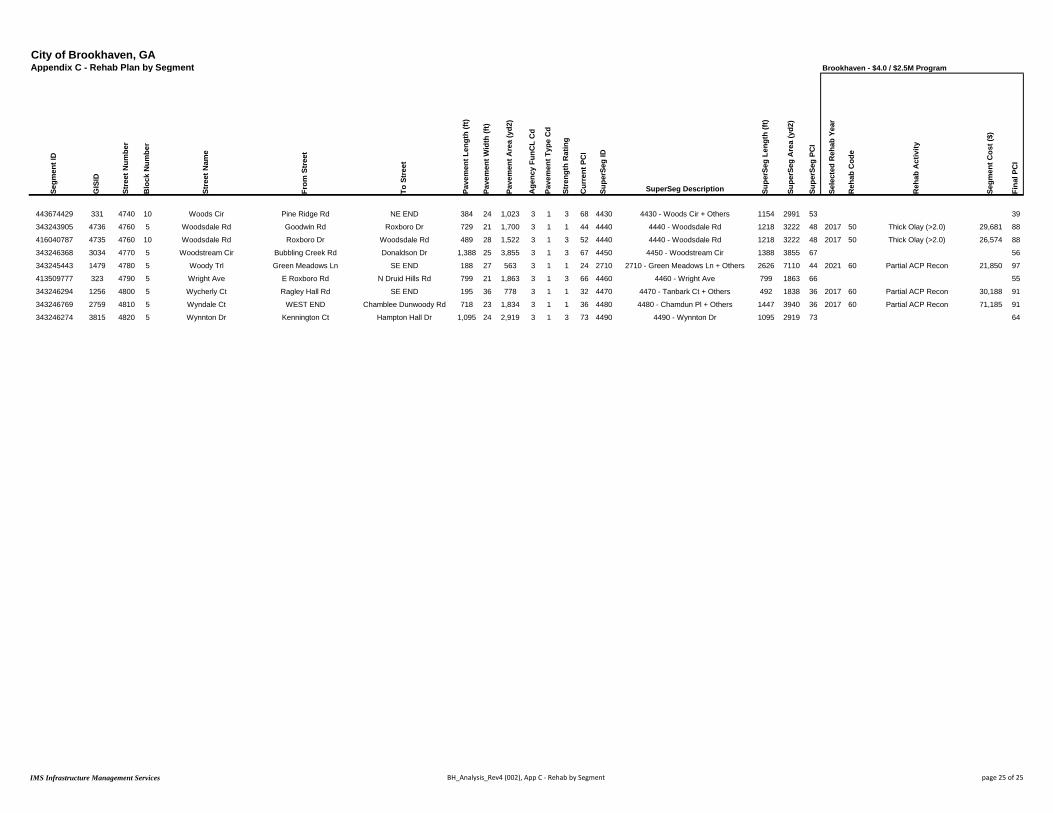
City of Brookhaven, GAAppendix C - Rehab Plan by Segment Brookhaven - $4.0 / $2.5M Program
Segm
ent I
D
GIS
ID
Stre
et N
umbe
r
Blo
ck N
umbe
r
Stre
et N
ame
From
Str
eet
To S
tree
t
Pave
men
t Len
gth
(ft)
Pave
men
t Wid
th (f
t)
Pave
men
t Are
a (y
d2)
Age
ncy
FunC
L C
d
Pave
men
t Typ
e C
d
Stre
ngth
Rat
ing
Cur
rent
PC
I
Supe
rSeg
ID
SuperSeg Description Supe
rSeg
Len
gth
(ft)
Supe
rSeg
Are
a (y
d2)
Supe
rSeg
PC
I
Sele
cted
Reh
ab Y
ear
Reh
ab C
ode
Reh
ab A
ctiv
ity
Segm
ent C
ost (
$)
Fina
l PC
I
443674429 331 4740 10 Woods Cir Pine Ridge Rd NE END 384 24 1,023 3 1 3 68 4430 4430 - Woods Cir + Others 1154 2991 53 39
343243905 4736 4760 5 Woodsdale Rd Goodwin Rd Roxboro Dr 729 21 1,700 3 1 1 44 4440 4440 - Woodsdale Rd 1218 3222 48 2017 50 Thick Olay (>2.0) 29,681 88
416040787 4735 4760 10 Woodsdale Rd Roxboro Dr Woodsdale Rd 489 28 1,522 3 1 3 52 4440 4440 - Woodsdale Rd 1218 3222 48 2017 50 Thick Olay (>2.0) 26,574 88
343246368 3034 4770 5 Woodstream Cir Bubbling Creek Rd Donaldson Dr 1,388 25 3,855 3 1 3 67 4450 4450 - Woodstream Cir 1388 3855 67 56
343245443 1479 4780 5 Woody Trl Green Meadows Ln SE END 188 27 563 3 1 1 24 2710 2710 - Green Meadows Ln + Others 2626 7110 44 2021 60 Partial ACP Recon 21,850 97
413509777 323 4790 5 Wright Ave E Roxboro Rd N Druid Hills Rd 799 21 1,863 3 1 3 66 4460 4460 - Wright Ave 799 1863 66 55
343246294 1256 4800 5 Wycherly Ct Ragley Hall Rd SE END 195 36 778 3 1 1 32 4470 4470 - Tanbark Ct + Others 492 1838 36 2017 60 Partial ACP Recon 30,188 91
343246769 2759 4810 5 Wyndale Ct WEST END Chamblee Dunwoody Rd 718 23 1,834 3 1 1 36 4480 4480 - Chamdun Pl + Others 1447 3940 36 2017 60 Partial ACP Recon 71,185 91
343246274 3815 4820 5 Wynnton Dr Kennington Ct Hampton Hall Dr 1,095 24 2,919 3 1 3 73 4490 4490 - Wynnton Dr 1095 2919 73 64
IMS Infrastructure Management Services BH_Analysis_Rev4 (002), App C - Rehab by Segment page 25 of 25
Appendix D
$4.0/$2.5M Rehabilitation Program by Year

City of Brookhaven, GAAppendix D - Rehab Plan by Year Brookhaven - $4.0 / $2.5M Program
Segm
ent I
D
GIS
ID
Stre
et N
umbe
r
Blo
ck N
umbe
r
Stre
et N
ame
From
Str
eet
To S
tree
t
Pave
men
t Len
gth
(ft)
Pave
men
t Wid
th (f
t)
Pave
men
t Are
a (y
d2)
Age
ncy
FunC
L C
d
Pave
men
t Typ
e C
d
Stre
ngth
Rat
ing
Cur
rent
PC
I
Supe
rSeg
ID
SuperSeg Description Supe
rSeg
Len
gth
(ft)
Supe
rSeg
Are
a (y
d2)
Supe
rSeg
PC
I
Sele
cted
Reh
ab Y
ear
Reh
ab C
ode
Reh
ab A
ctiv
ity
Segm
ent C
ost (
$)
Fina
l PC
I
420791600 1257 30 5 Alden Place Dr Caldwell Rd NW END 224 33 820 3 1 1 32 1010 1010 - Alden Place Dr 224 820 32 2017 60 Partial ACP Recon 31,817 91
445260866 3888 60 5 Antioch Dr Madison Ave Georgia Ave 1,171 20 2,602 3 1 2 44 1030 1030 - Antioch Dr + Others 2725 5791 48 2017 50 Thick Olay (>2.0) 45,429 88
445260865 3887 60 10 Antioch Dr Mabry Rd Madison Ave 491 21 1,147 3 1 3 55 1030 1030 - Antioch Dr + Others 2725 5791 48 2017 50 Thick Olay (>2.0) 20,026 88
343246149 3934 2160 10 Georgia Ave Madison Ave Antioch Dr 309 18 617 3 1 3 82 1030 1030 - Antioch Dr + Others 2725 5791 48 2017 50 Thick Olay (>2.0) 10,772 88
445260864 3933 2920 5 Madison Ave Georgia Ave Antioch Dr 754 17 1,425 3 1 1 34 1030 1030 - Antioch Dr + Others 2725 5791 48 2017 50 Thick Olay (>2.0) 24,879 88
343282666 2900 330 5 Battleford Ct SOUTH END W Nancy Creek Dr 613 27 1,840 3 1 2 46 1260 1260 - Battleford Ct 613 1840 46 2017 50 Thick Olay (>2.0) 32,127 88
500000002 1143 6000 5 Bellaire Dr Peachtree Rd Bellaire Dr 934 26 2,698 3 1 1 31 1280 1280 - Bellaire Dr + Others 1657 4063 31 2017 60 Partial ACP Recon 104,723 91
422303872 1269 1820 5 Club Dr E Club Ct Peachtree Rd 723 17 1,366 3 1 1 31 1280 1280 - Bellaire Dr + Others 1657 4063 31 2017 60 Partial ACP Recon 53,021 91
343246542 2899 380 5 Beverly Woods Ct SW END Chamblee Dunwoody Rd 1,228 27 3,683 3 1 1 34 1300 1300 - Beverly Woods Ct 1228 3683 34 2017 60 Partial ACP Recon 142,935 91
343244325 2328 450 5 Bramblewood Dr Buford Hwy NW END 1,476 21 3,444 3 1 2 46 1360 1360 - Bramblewood Dr 1476 3444 46 2017 50 Thick Olay (>2.0) 60,122 88
442754891 3468 600 5 Brookhaven Close SW END Ashford Dunwoody Rd 745 26 2,153 3 1 1 46 1460 1460 - Brookhaven Close 745 2153 46 2017 50 Thick Olay (>2.0) 37,584 88
408880285 3291 690 5 Brookhaven Trce SW END Ashford Dunwoody Rd 741 25 2,059 3 1 1 34 1550 1550 - Brookhaven Trce 741 2059 34 2017 60 Partial ACP Recon 79,917 91
343246413 3139 750 5 Bubbling Creek Rd Runnymeade Rd Harts Mill Rd 976 25 2,711 3 1 3 49 1630 1630 - Bubbling Creek Rd 3067 8519 48 2017 50 Thick Olay (>2.0) 47,334 89
343246356 3138 750 10 Bubbling Creek Rd Runnymeade Rd Shadow Ln 1,588 25 4,411 3 1 3 49 1630 1630 - Bubbling Creek Rd 3067 8519 48 2017 50 Thick Olay (>2.0) 77,016 89
343246365 1610 750 15 Bubbling Creek Rd Shadow Ln Woodstream Cir 503 25 1,397 3 1 1 42 1630 1630 - Bubbling Creek Rd 3067 8519 48 2017 50 Thick Olay (>2.0) 24,391 89
343245678 1482 1050 5 Cheshire Way Caldwell Rd Green Meadows Ln 378 31 1,302 3 1 1 45 1890 1890 - Cheshire Way 1012 3133 46 2017 50 Thick Olay (>2.0) 22,731 88
343245679 3284 1050 10 Cheshire Way Green Meadows Ln Valvedere Dr 634 26 1,830 3 1 2 47 1890 1890 - Cheshire Way 1012 3133 46 2017 50 Thick Olay (>2.0) 31,949 88
343246520 3026 1060 5 Chesson Ct W Nancy Creek Dr NW END 291 34 1,101 3 1 1 35 1900 1900 - Chesson Ct 291 1101 35 2017 56 Thick Olay + RR2 (>2.0) 21,102 88
343282687 3946 1590 5 Dorby Close Dorby Park Dr NE END 198 41 902 3 1 1 45 2210 2210 - Dorby Park Dr + Others 824 2723 46 2017 50 Thick Olay (>2.0) 15,747 88
343282686 3838 1600 5 Dorby Park Dr Osborne Rd Dorby Close 389 22 951 3 1 2 51 2210 2210 - Dorby Park Dr + Others 824 2723 46 2017 50 Thick Olay (>2.0) 16,603 88
343282685 3837 1600 10 Dorby Park Dr Dorby Close EAST END 237 33 870 3 1 1 42 2210 2210 - Dorby Park Dr + Others 824 2723 46 2017 50 Thick Olay (>2.0) 15,188 88
343245771 3177 1690 5 Duncan Dr Duke Rd Georgian Ter 504 21 1,176 3 1 1 32 2350 2350 - Duncan Dr 918 2142 36 2017 60 Partial ACP Recon 45,640 91
343245770 3178 1690 10 Duncan Dr Bragg St Duke Rd 414 21 965 3 1 1 40 2350 2350 - Duncan Dr 918 2142 36 2017 60 Partial ACP Recon 37,451 91
408849187 4827 5530 5 Dunex Hill Ln SE END Buford Hwy 403 23 1,031 3 1 1 37 2360 2360 - Dunex Hill Ln 403 1031 37 2017 60 Partial ACP Recon 40,015 91
343246959 2971 1750 5 Dunwoody Ter E Nancy Creek Dr NORTH END 337 30 1,123 3 1 1 34 2390 2390 - Dunwoody Ter 337 1123 34 2017 60 Partial ACP Recon 43,576 91
343245252 1976 1970 5 Fairhill Ln Fairway Cir Fairway Cir 360 26 1,040 3 1 3 60 2550 2550 - Fairway Cir + Others 4873 12607 47 2017 50 Thick Olay (>2.0) 18,157 88
343245287 1977 1970 10 Fairhill Ln Fairway Cir EAST END 86 25 238 3 1 1 29 2550 2550 - Fairway Cir + Others 4873 12607 47 2017 50 Thick Olay (>2.0) 4,155 88
343244361 2543 1980 15 Fairway Cir Brookshire Ln Jonathon Ln 1,812 23 4,632 3 1 1 45 2550 2550 - Fairway Cir + Others 4873 12607 47 2017 50 Thick Olay (>2.0) 80,871 88
343244364 2544 1980 20 Fairway Cir Jonathon Ln Brookshire Ln 519 14 808 3 1 3 46 2550 2550 - Fairway Cir + Others 4873 12607 47 2017 50 Thick Olay (>2.0) 14,107 88
343244378 2545 1980 25 Fairway Cir Brookshire Ln Fairhill Ln 1,485 25 4,125 3 1 3 52 2550 2550 - Fairway Cir + Others 4873 12607 47 2017 50 Thick Olay (>2.0) 72,019 88
442738570 2520 2630 5 Jonathon Ln Fairway Cir NORTH END 611 26 1,765 3 1 1 36 2550 2550 - Fairway Cir + Others 4873 12607 47 2017 50 Thick Olay (>2.0) 30,815 88
408880251 3814 640 5 Brookhaven Gln Osborne Rd NE END 549 29 1,771 3 1 1 36 2560 2560 - Dickson St + Others 1956 5230 36 2017 60 Partial ACP Recon 68,731 91
343245701 3715 1540 5 Dickson St SOUTH END Windsor Pkwy 562 25 1,561 3 1 1 34 2560 2560 - Dickson St + Others 1956 5230 36 2017 60 Partial ACP Recon 60,581 91
343281899 3882 5510 5 Fala Pl SOUTH END Windsor Pkwy 330 19 696 3 1 1 35 2560 2560 - Dickson St + Others 1956 5230 36 2017 60 Partial ACP Recon 27,011 91
343245710 1120 2470 5 Hillview Ave SOUTH END Windsor Pkwy 515 21 1,202 3 1 1 40 2560 2560 - Dickson St + Others 1956 5230 36 2017 60 Partial ACP Recon 46,649 91
343254410 3443 2050 5 Fernwood Cir Fernwood Cir Peachtree Vw 341 26 986 3 1 3 65 2600 2600 - Fernwood Cir 773 2233 57 2017 36 Thin Olay + RR2 (<=1.5) 13,217 86
343254413 1380 2050 10 Fernwood Cir Peachtree Vw Dresden Dr 432 26 1,247 3 1 3 51 2600 2600 - Fernwood Cir 773 2233 57 2017 36 Thin Olay + RR2 (<=1.5) 16,716 86
343246513 2767 2090 5 Foresta Ct SW END Granger Dr 705 25 1,960 3 1 1 37 2610 2610 - Foresta Ct + Others 1333 3703 35 2017 60 Partial ACP Recon 76,071 91
343246514 2766 2220 5 Granger Ct WEST END Granger Dr 628 25 1,743 3 1 1 32 2610 2610 - Foresta Ct + Others 1333 3703 35 2017 60 Partial ACP Recon 67,649 91
470878198 686 5400 5 Greenwood Close Evergreen Dr Driveway 249 21 582 3 1 3 57 2720 2720 - Greenwood Close 249 582 57 2017 36 Thin Olay + RR2 (<=1.5) 7,797 86
343251415 1609 190 5 Ashford Pt SOUTH END Harts Mill Rd 357 30 1,190 3 1 1 35 2760 2760 - Harts Mill Ln + Others 4850 14304 47 2017 50 Thick Olay (>2.0) 20,776 88
408880377 3021 2100 5 Fox Glen Ct Harts Mill Rd NORTH END 1,248 26 3,606 3 1 3 50 2760 2760 - Harts Mill Ln + Others 4850 14304 47 2017 50 Thick Olay (>2.0) 62,958 88
442752699 3006 2330 5 Harts Mill Ln Harts Mill Rd Harts Mill Rd 2,941 26 8,495 3 1 1 47 2760 2760 - Harts Mill Ln + Others 4850 14304 47 2017 50 Thick Olay (>2.0) 148,316 88
IMS Infrastructure Management Services BH_Analysis_Rev4 (002), App D - Rehab by Year page 1 of 7

City of Brookhaven, GAAppendix D - Rehab Plan by Year Brookhaven - $4.0 / $2.5M Program
Segm
ent I
D
GIS
ID
Stre
et N
umbe
r
Blo
ck N
umbe
r
Stre
et N
ame
From
Str
eet
To S
tree
t
Pave
men
t Len
gth
(ft)
Pave
men
t Wid
th (f
t)
Pave
men
t Are
a (y
d2)
Age
ncy
FunC
L C
d
Pave
men
t Typ
e C
d
Stre
ngth
Rat
ing
Cur
rent
PC
I
Supe
rSeg
ID
SuperSeg Description Supe
rSeg
Len
gth
(ft)
Supe
rSeg
Are
a (y
d2)
Supe
rSeg
PC
I
Sele
cted
Reh
ab Y
ear
Reh
ab C
ode
Reh
ab A
ctiv
ity
Segm
ent C
ost (
$)
Fina
l PC
I
465684017 3038 3110 5 Newhaven Cir Harts Mill Rd NORTH END 304 30 1,012 3 1 3 51 2760 2760 - Harts Mill Ln + Others 4850 14304 47 2017 50 Thick Olay (>2.0) 17,669 88
343281902 1167 2370 5 Haven Brook Ln Osborne Rd Haven Brook Ct 214 25 593 3 1 1 43 2790 2790 - Haven Brook Ln + Others 808 2391 46 2017 53 Thick Olay + RR1 (>2.0) 11,165 88
442732581 3803 2370 10 Haven Brook Ln Haven Brook Pl Haven Brook Ct 225 25 625 3 1 3 66 2790 2790 - Haven Brook Ln + Others 808 2391 46 2017 53 Thick Olay + RR1 (>2.0) 11,767 88
343281904 3802 2370 15 Haven Brook Ln Haven Brook Pl EAST END 186 34 704 3 1 1 29 2790 2790 - Haven Brook Ln + Others 808 2391 46 2017 53 Thick Olay + RR1 (>2.0) 13,254 88
343281903 3881 2380 5 Haven Brook Pl WEST END Haven Brook Ln 184 23 470 3 1 1 48 2790 2790 - Haven Brook Ln + Others 808 2391 46 2017 53 Thick Olay + RR1 (>2.0) 8,849 88
343245689 3900 280 5 Bailiff Ct WEST END Osborne Rd 759 25 2,108 3 1 1 33 2810 2810 - Haven Glen Ln + Others 1525 4406 34 2017 60 Partial ACP Recon 81,811 91
343251404 3801 2400 5 Haven Glen Ln WEST END Osborne Rd 766 27 2,298 3 1 1 34 2810 2810 - Haven Glen Ln + Others 1525 4406 34 2017 60 Partial ACP Recon 89,185 91
433600564 3200 2720 5 Lanier Dr Lanier Dr Hearst Dr 518 17 979 3 1 3 65 3010 3010 - Lanier Dr + Others 2863 6250 56 2017 43 Mod Olay + RR1 (1.5-2.0) 15,609 87
433600552 1519 2720 10 Lanier Dr Inman Dr Lanier Dr 349 17 659 3 1 3 70 3010 3010 - Lanier Dr + Others 2863 6250 56 2017 43 Mod Olay + RR1 (1.5-2.0) 10,507 87
433329891 1506 2720 15 Lanier Dr Windsor Pkwy Inman Dr 566 23 1,447 3 1 2 55 3010 3010 - Lanier Dr + Others 2863 6250 56 2017 43 Mod Olay + RR1 (1.5-2.0) 23,071 87
433600566 1518 2730 40 Lanier Dr Windsor Pkwy Inman Dr 562 18 1,124 3 1 1 43 3010 3010 - Lanier Dr + Others 2863 6250 56 2017 43 Mod Olay + RR1 (1.5-2.0) 17,921 87
433600559 1231 2730 45 Lanier Dr Lanier Mnr Lanier Dr 350 17 661 3 1 3 62 3010 3010 - Lanier Dr + Others 2863 6250 56 2017 43 Mod Olay + RR1 (1.5-2.0) 10,539 87
433600561 1232 2730 50 Lanier Dr Lanier Dr Hearst Dr 518 24 1,382 3 1 1 50 3010 3010 - Lanier Dr + Others 2863 6250 56 2017 43 Mod Olay + RR1 (1.5-2.0) 22,034 87
442732576 3914 2960 5 Mendell Cir WEST END Osborne Rd 1,156 23 2,954 3 1 1 46 3210 3210 - Mendell Cir 1156 2954 46 2017 50 Thick Olay (>2.0) 51,569 88
343251584 1411 1940 10 Etowah Dr Appalachee Dr Oostanaula Dr 489 26 1,411 3 1 3 46 3460 3460 - Oostanaula Dr + Others 1838 4814 48 2017 50 Thick Olay (>2.0) 24,633 88
343245405 1420 3290 5 Oostanaula Dr Etowah Dr Canoochee Dr 440 23 1,125 3 1 2 43 3460 3460 - Oostanaula Dr + Others 1838 4814 48 2017 50 Thick Olay (>2.0) 19,640 88
343245341 1419 3290 10 Oostanaula Dr Cartecay Dr Etowah Dr 698 23 1,784 3 1 2 49 3460 3460 - Oostanaula Dr + Others 1838 4814 48 2017 50 Thick Olay (>2.0) 31,145 88
422298291 1418 3290 15 Oostanaula Dr SOUTH END Cartecay Dr 212 21 494 3 1 3 59 3460 3460 - Oostanaula Dr + Others 1838 4814 48 2017 50 Thick Olay (>2.0) 8,624 88
470111124 1362 3340 5 Park Ave WEST END Apple Valley Rd 247 27 741 3 1 1 33 3530 3530 - Park Ave 247 741 33 2017 60 Partial ACP Recon 28,747 91
343246357 3033 3350 5 Park Creek Cv WEST END Park Creek Ln 264 32 938 3 1 1 28 3540 3540 - Park Creek Ln + Others 1223 3530 35 2017 60 Partial ACP Recon 36,407 91
343246358 3005 3360 5 Park Creek Ln NW END Park Creek Cv 419 26 1,211 3 1 1 29 3540 3540 - Park Creek Ln + Others 1223 3530 35 2017 60 Partial ACP Recon 47,003 91
343246359 3004 3360 10 Park Creek Ln Park Creek Cv Donaldson Dr 540 23 1,381 3 1 2 44 3540 3540 - Park Creek Ln + Others 1223 3530 35 2017 60 Partial ACP Recon 53,601 91
408880048 5174 3380 5 Park Vista Dr Lenox Park Blvd Village Run 277 28 863 3 1 1 33 3570 3570 - Park Vista Dr + Others 924 3016 36 2017 60 Partial ACP Recon 33,496 91
465684539 5163 3400 5 Park Vista Dr Village Run Reserve Dr 533 27 1,600 3 1 1 41 3570 3570 - Park Vista Dr + Others 924 3016 36 2017 60 Partial ACP Recon 62,102 91
465684541 5162 3400 10 Park Vista Dr Reserve Dr NE END 113 44 554 3 1 1 28 3570 3570 - Park Vista Dr + Others 924 3016 36 2017 60 Partial ACP Recon 21,503 91
465684327 1424 3430 5 Parkside Dr Apple Valley Rd Fernwood Cir 988 21 2,305 3 1 3 47 3600 3600 - Parkside Dr 988 2305 47 2017 50 Thick Olay (>2.0) 40,244 89
343245465 2530 3530 5 Poplar Springs Dr Drew Valley Rd Drew Valley Rd 1,628 21 3,798 3 1 1 35 3680 3680 - Poplar Springs Dr 1628 3798 35 2017 60 Partial ACP Recon 147,393 91
443674372 185 1880 10 Roxboro Rd E Roxboro Rd Lake Blvd 63 53 369 1 1 1 45 3820 3820 - Roxboro Rd 161 1186 50 2017 50 Thick Olay (>2.0) 8,701 85
474618817 186 1880 20 Roxboro Rd Lake Blvd Ramp 98 75 817 1 1 2 53 3820 3820 - Roxboro Rd 161 1186 50 2017 50 Thick Olay (>2.0) 19,264 85
343246306 3365 4100 5 Stratfield Dr NW END Epping Forest Dr 794 28 2,470 3 1 1 43 4010 4010 - Stratfield Dr 2478 7264 46 2017 50 Thick Olay (>2.0) 43,126 88
343246321 3366 4100 10 Stratfield Dr Kadleston Way Epping Forest Dr 730 26 2,108 3 1 1 39 4010 4010 - Stratfield Dr 2478 7264 46 2017 50 Thick Olay (>2.0) 36,806 88
343246320 1431 4100 15 Stratfield Dr Stratfield Cir Kadleston Way 160 27 481 3 1 3 62 4010 4010 - Stratfield Dr 2478 7264 46 2017 50 Thick Olay (>2.0) 8,398 88
343246316 3367 4100 20 Stratfield Dr Stratfield Cir Stratfield Cir 794 25 2,205 3 1 3 53 4010 4010 - Stratfield Dr 2478 7264 46 2017 50 Thick Olay (>2.0) 38,499 88
343246283 4413 4220 5 Telfair Way Johnson Ferry Rd SE END 476 27 1,429 3 1 1 33 4080 4080 - Telfair Way 476 1429 33 2017 60 Partial ACP Recon 55,467 91
343245574 1480 90 5 Aragon Way N Thompson Rd Ashford Rd 937 26 2,706 3 1 1 36 4170 4170 - Trentwood Pl + Others 2160 6239 36 2017 60 Partial ACP Recon 105,027 91
343245572 3318 4300 5 Trentwood Pl N Thompson Rd Ashford Rd 1,223 26 3,533 3 1 1 36 4170 4170 - Trentwood Pl + Others 2160 6239 36 2017 60 Partial ACP Recon 137,126 91
343246498 3243 2070 5 Flowerland Dr Harts Mill Rd Watkins Pl 1,487 20 3,305 3 1 1 44 4290 4290 - Flowerland Dr + Others 2889 6264 46 2017 53 Thick Olay + RR1 (>2.0) 62,215 88
442738609 3140 4540 5 Watkins Pl Harts Mill Rd Flowerland Dr 1,401 19 2,958 3 1 1 49 4290 4290 - Flowerland Dr + Others 2889 6264 46 2017 53 Thick Olay + RR1 (>2.0) 55,683 88
343245500 2304 4610 5 Wilmont Dr WEST END Clairmont Rd 953 25 2,647 3 1 1 36 4350 4350 - Wilmont Dr 953 2647 36 2017 60 Partial ACP Recon 102,739 91
343246239 3679 4730 5 Woodrow Way Chambord Way Breton Ct 361 25 1,003 3 1 1 43 4410 4410 - Woodrow Way 3545 9955 47 2017 53 Thick Olay + RR1 (>2.0) 18,883 88
343246230 3680 4730 10 Woodrow Way Chambord Way Breton Cir 1,336 26 3,859 3 1 1 49 4410 4410 - Woodrow Way 3545 9955 47 2017 53 Thick Olay + RR1 (>2.0) 72,651 88
343246232 3681 4730 15 Woodrow Way Breton Cir Inman Dr 369 27 1,108 3 1 1 46 4410 4410 - Woodrow Way 3545 9955 47 2017 53 Thick Olay + RR1 (>2.0) 20,860 88
343246233 3280 4730 20 Woodrow Way Frontenac Ct Inman Dr 1,094 24 2,917 3 1 1 47 4410 4410 - Woodrow Way 3545 9955 47 2017 53 Thick Olay + RR1 (>2.0) 54,916 88
IMS Infrastructure Management Services BH_Analysis_Rev4 (002), App D - Rehab by Year page 2 of 7

City of Brookhaven, GAAppendix D - Rehab Plan by Year Brookhaven - $4.0 / $2.5M Program
Segm
ent I
D
GIS
ID
Stre
et N
umbe
r
Blo
ck N
umbe
r
Stre
et N
ame
From
Str
eet
To S
tree
t
Pave
men
t Len
gth
(ft)
Pave
men
t Wid
th (f
t)
Pave
men
t Are
a (y
d2)
Age
ncy
FunC
L C
d
Pave
men
t Typ
e C
d
Stre
ngth
Rat
ing
Cur
rent
PC
I
Supe
rSeg
ID
SuperSeg Description Supe
rSeg
Len
gth
(ft)
Supe
rSeg
Are
a (y
d2)
Supe
rSeg
PC
I
Sele
cted
Reh
ab Y
ear
Reh
ab C
ode
Reh
ab A
ctiv
ity
Segm
ent C
ost (
$)
Fina
l PC
I
343245718 1487 4730 25 Woodrow Way Windsor Pkwy Frontenac Ct 385 25 1,068 3 1 1 47 4410 4410 - Woodrow Way 3545 9955 47 2017 53 Thick Olay + RR1 (>2.0) 20,107 88
343243905 4736 4760 5 Woodsdale Rd Goodwin Rd Roxboro Dr 729 21 1,700 3 1 1 44 4440 4440 - Woodsdale Rd 1218 3222 48 2017 50 Thick Olay (>2.0) 29,681 88
416040787 4735 4760 10 Woodsdale Rd Roxboro Dr Woodsdale Rd 489 28 1,522 3 1 3 52 4440 4440 - Woodsdale Rd 1218 3222 48 2017 50 Thick Olay (>2.0) 26,574 88
343246298 3686 4210 5 Tanbark Ct SOUTH END Hampton Hall Dr 298 32 1,059 3 1 1 39 4470 4470 - Tanbark Ct + Others 492 1838 36 2017 60 Partial ACP Recon 41,091 91
343246294 1256 4800 5 Wycherly Ct Ragley Hall Rd SE END 195 36 778 3 1 1 32 4470 4470 - Tanbark Ct + Others 492 1838 36 2017 60 Partial ACP Recon 30,188 91
343251242 2689 1010 5 Chamdun Pl WEST END Chamblee Dunwoody Rd 729 26 2,106 3 1 1 35 4480 4480 - Chamdun Pl + Others 1447 3940 36 2017 60 Partial ACP Recon 81,743 91
343246769 2759 4810 5 Wyndale Ct WEST END Chamblee Dunwoody Rd 718 23 1,834 3 1 1 36 4480 4480 - Chamdun Pl + Others 1447 3940 36 2017 60 Partial ACP Recon 71,185 91
465684478 3057 170 5 Ashford Knls Glen Arbor Ct NORTH END 321 34 1,212 3 1 1 39 1170 1170 - Ashford Trl + Others 2981 8722 37 2018 60 Partial ACP Recon 47,041 93
465684477 3058 170 10 Ashford Knls Glen Arbor Ct Ashford Trl 113 23 289 3 1 1 50 1170 1170 - Ashford Trl + Others 2981 8722 37 2018 60 Partial ACP Recon 11,217 93
343251421 3056 210 5 Ashford Rdg Ashford Trl SE END 360 30 1,200 3 1 1 37 1170 1170 - Ashford Trl + Others 2981 8722 37 2018 60 Partial ACP Recon 46,575 93
343251422 2968 220 5 Ashford Trl Ashford Rdg EAST END 454 26 1,312 3 1 1 34 1170 1170 - Ashford Trl + Others 2981 8722 37 2018 60 Partial ACP Recon 50,922 93
398991583 2969 220 10 Ashford Trl Ashford Knls Ashford Rdg 1,343 24 3,582 3 1 1 31 1170 1170 - Ashford Trl + Others 2981 8722 37 2018 60 Partial ACP Recon 139,027 93
343246490 2970 220 15 Ashford Trl Harts Mill Rd Ashford Knls 390 26 1,127 3 1 3 56 1170 1170 - Ashford Trl + Others 2981 8722 37 2018 60 Partial ACP Recon 43,742 93
343253670 179 270 5 Attaway Walk SOUTH END Pine Grove Ave 132 38 556 3 1 2 49 1210 1210 - Attaway Walk 132 556 49 2018 50 Thick Olay (>2.0) 9,705 89
470106937 1391 320 5 Bates Ct Bates Ct Bates Ct 1,583 26 4,574 3 1 1 37 1250 1250 - Bates Ct 1654 4898 39 2018 60 Partial ACP Recon 177,533 93
470106936 1252 320 10 Bates Ct Bates Ct Thompson Rd 71 41 324 3 1 3 60 1250 1250 - Bates Ct 1654 4898 39 2018 60 Partial ACP Recon 12,576 93
408880237 3813 660 5 Brookhaven Ln Mabry Rd EAST END 316 29 1,018 3 1 1 38 1530 1530 - Brookhaven Ln 316 1018 38 2018 60 Partial ACP Recon 39,515 93
343245473 2608 790 5 Bynum Rd Drew Valley Rd Drew Valley Rd 1,092 28 3,398 3 1 1 38 1670 1670 - Bynum Rd 1092 3398 38 2018 60 Partial ACP Recon 131,887 93
408881850 418 1080 5 Childers Rd Shady Valley Dr Hedge Rose Dr 401 25 1,113 3 1 1 36 1910 1910 - Childers Rd 1047 2704 38 2018 60 Partial ACP Recon 43,195 93
465683675 419 1080 10 Childers Rd Hedge Rose Dr Buckhead Valley Ln 195 22 476 3 1 1 38 1910 1910 - Childers Rd 1047 2704 38 2018 60 Partial ACP Recon 18,474 93
465683676 420 1080 15 Childers Rd Buckhead Valley Ln Childers Pl 55 24 147 3 1 3 54 1910 1910 - Childers Rd 1047 2704 38 2018 60 Partial ACP Recon 5,705 93
470107596 421 1080 20 Childers Rd Childers Pl N Druid Hills Rd 396 22 968 3 1 1 37 1910 1910 - Childers Rd 1047 2704 38 2018 60 Partial ACP Recon 37,568 93
431175670 1349 1130 5 Clairmont Rd Canmont Dr Dresden Dr 389 58 2,505 1 1 1 42 1940 1940 - Clairmont Rd 2853 18733 52 2018 50 Thick Olay (>2.0) 59,043 88
431175673 1348 1130 10 Clairmont Rd Raven Hill Dr Canmont Dr 1,177 58 7,586 1 1 3 61 1940 1940 - Clairmont Rd 2853 18733 52 2018 50 Thick Olay (>2.0) 178,803 88
343245870 3473 1130 15 Clairmont Rd Skyland Rd Raven Hill Dr 456 63 3,193 1 1 3 51 1940 1940 - Clairmont Rd 2853 18733 52 2018 50 Thick Olay (>2.0) 75,259 88
343245867 3474 1130 20 Clairmont Rd Buford Hwy Skyland Rd 831 59 5,448 1 1 1 43 1940 1940 - Clairmont Rd 2853 18733 52 2018 50 Thick Olay (>2.0) 128,410 88
343245692 3709 1180 5 Club Trce WEST END Osborne Rd 754 25 2,096 3 1 3 57 2030 2030 - Club Trce 754 2096 57 2018 40 Moderate Olay (1.5-2.0) 30,550 89
445260878 1227 1420 5 Crossway Dr NW END Redding Rd 318 30 1,061 3 1 1 37 2160 2160 - Crossway Dr 318 1061 37 2018 60 Partial ACP Recon 41,170 93
343245768 1583 1670 15 Duke Rd Skyland Dr Duncan Dr 981 21 2,289 3 1 1 37 2330 2330 - Duke Rd 1979 4855 37 2018 60 Partial ACP Recon 88,848 93
343245773 1584 1670 20 Duke Rd Duncan Dr Georgian Dr W 864 23 2,208 3 1 1 37 2330 2330 - Duke Rd 1979 4855 37 2018 60 Partial ACP Recon 85,704 93
343246005 1585 1670 25 Duke Rd Georgian Dr W Georgian Dr E 134 24 358 3 1 1 40 2330 2330 - Duke Rd 1979 4855 37 2018 60 Partial ACP Recon 13,896 93
343246264 1129 1930 5 Eton Ct NW END Hampton Hall Dr 384 23 981 3 1 1 18 2450 2450 - Eton Ct + Others 764 1995 21 2018 70 Full ACP Recon / Partial Local 47,891 95
343246268 4451 2460 5 Hillstone Ct Hampton Hall Dr NW END 380 24 1,015 3 1 1 23 2450 2450 - Eton Ct + Others 764 1995 21 2018 70 Full ACP Recon / Partial Local 49,551 95
343245240 5115 2870 5 Loraine St Pine Grove Ave Standard Dr 792 26 2,289 3 1 1 37 3100 3100 - Loraine St 792 2289 37 2018 60 Partial ACP Recon 88,838 93
343245998 1566 2940 5 Manville Dr Archway Dr Clairmont Rd 908 22 2,220 3 1 2 49 3180 3180 - Manville Dr 908 2220 49 2018 50 Thick Olay (>2.0) 38,765 89
343245648 3710 230 5 Ashton Trce Mitchell Cv Osborne Rd 513 23 1,310 3 1 1 40 3250 3250 - Mitchell Cv + Others 1410 4122 37 2018 60 Partial ACP Recon 50,841 93
442738783 3909 3000 5 Mitchell Cv Ashton Trce NE END 680 27 2,041 3 1 1 34 3250 3250 - Mitchell Cv + Others 1410 4122 37 2018 60 Partial ACP Recon 79,211 93
343251396 3910 3000 10 Mitchell Cv Ashton Trce SE END 217 32 771 3 1 1 41 3250 3250 - Mitchell Cv + Others 1410 4122 37 2018 60 Partial ACP Recon 29,922 93
343246917 1668 3150 5 Oak Forest Ct WEST END Oak Forest Way 169 25 469 3 1 1 41 3360 3360 - Oak Forest Ct 627 1842 37 2018 60 Partial ACP Recon 18,205 93
343246918 1669 3150 10 Oak Forest Ct Oak Forest Way EAST END 458 27 1,373 3 1 1 36 3360 3360 - Oak Forest Ct 627 1842 37 2018 60 Partial ACP Recon 53,296 93
343254418 3461 3450 5 Peachtree Vw Apple Valley Rd Fernwood Cir 992 21 2,314 3 1 1 39 3620 3620 - Peachtree Vw 992 2314 39 2018 60 Partial ACP Recon 89,802 93
424393716 3631 3620 5 Ramp N Druid Hills Rd Peachtree Rd 285 23 728 3 1 2 73 3710 3710 - Ramp 449 1001 73 2018 26 Preventative Mntc 1,989 74
424393713 3630 3620 10 Ramp Peachtree Rd N Druid Hills Rd 164 15 273 3 1 3 73 3710 3710 - Ramp 449 1001 73 2018 26 Preventative Mntc 746 74
IMS Infrastructure Management Services BH_Analysis_Rev4 (002), App D - Rehab by Year page 3 of 7

City of Brookhaven, GAAppendix D - Rehab Plan by Year Brookhaven - $4.0 / $2.5M Program
Segm
ent I
D
GIS
ID
Stre
et N
umbe
r
Blo
ck N
umbe
r
Stre
et N
ame
From
Str
eet
To S
tree
t
Pave
men
t Len
gth
(ft)
Pave
men
t Wid
th (f
t)
Pave
men
t Are
a (y
d2)
Age
ncy
FunC
L C
d
Pave
men
t Typ
e C
d
Stre
ngth
Rat
ing
Cur
rent
PC
I
Supe
rSeg
ID
SuperSeg Description Supe
rSeg
Len
gth
(ft)
Supe
rSeg
Are
a (y
d2)
Supe
rSeg
PC
I
Sele
cted
Reh
ab Y
ear
Reh
ab C
ode
Reh
ab A
ctiv
ity
Segm
ent C
ost (
$)
Fina
l PC
I
343251233 2763 2970 5 Mill Creek Ct Harts Mill Rd NORTH END 691 29 2,225 3 1 1 32 3920 3920 - Sidestreet + Others 2010 6537 38 2018 60 Partial ACP Recon 86,357 93
442738777 2781 3900 5 Sidestreet Sidestreet Cir NORTH END 496 29 1,599 3 1 2 43 3920 3920 - Sidestreet + Others 2010 6537 38 2018 60 Partial ACP Recon 62,060 93
343251235 2782 3900 10 Sidestreet Sidestreet Ct Sidestreet Cir 209 24 559 3 1 1 41 3920 3920 - Sidestreet + Others 2010 6537 38 2018 60 Partial ACP Recon 21,696 93
343251232 2783 3900 15 Sidestreet Huntington Chase Sidestreet Ct 273 25 759 3 1 1 42 3920 3920 - Sidestreet + Others 2010 6537 38 2018 60 Partial ACP Recon 29,458 93
343251236 1815 3910 5 Sidestreet Cir Sidestreet NW END 155 38 656 3 1 1 41 3920 3920 - Sidestreet + Others 2010 6537 38 2018 60 Partial ACP Recon 25,461 93
343251234 1816 3920 5 Sidestreet Ct Sidestreet SE END 185 36 740 3 1 1 36 3920 3920 - Sidestreet + Others 2010 6537 38 2018 60 Partial ACP Recon 28,721 93
343245439 1475 1550 5 Dogwood Ter Wilford Dr E Osborne Rd 860 22 2,102 3 1 1 33 4340 4340 - Wilford Dr + Others 1855 4645 37 2018 60 Partial ACP Recon 81,590 93
343245409 1435 4600 5 Wilford Dr Green Meadows Ln Dogwood Ter 448 23 1,145 3 1 1 46 4340 4340 - Wilford Dr + Others 1855 4645 37 2018 60 Partial ACP Recon 44,444 93
343245410 1436 4600 10 Wilford Dr Dogwood Ter Camille Dr 547 23 1,398 3 1 1 37 4340 4340 - Wilford Dr + Others 1855 4645 37 2018 60 Partial ACP Recon 54,264 93
442738590 3904 40 5 Alexandria Ct Osborne Rd EAST END 432 28 1,344 3 1 1 39 1020 1020 - Alexandria Ct 432 1344 39 2019 60 Partial ACP Recon 52,174 94
422408575 3070 150 15 Ashford Dunwoody Rd Oak Forest Dr Dunwoody Ln 634 24 1,690 1 1 3 50 1100 1100 - Ashford Dunwoody Rd 4379 16682 53 2019 50 Thick Olay (>2.0) 39,834 90
424392357 3071 150 20 Ashford Dunwoody Rd Dunwoody Ln Rustic Ridge Dr 543 31 1,871 1 1 3 56 1100 1100 - Ashford Dunwoody Rd 4379 16682 53 2019 50 Thick Olay (>2.0) 44,100 90
424392358 3072 150 25 Ashford Dunwoody Rd Oconee Pass Rustic Ridge Dr 152 37 626 1 1 3 60 1100 1100 - Ashford Dunwoody Rd 4379 16682 53 2019 50 Thick Olay (>2.0) 14,755 90
408858181 3401 150 30 Ashford Dunwoody Rd Chaucer Ln Oconee Pass 658 32 2,341 1 1 3 59 1100 1100 - Ashford Dunwoody Rd 4379 16682 53 2019 50 Thick Olay (>2.0) 55,178 90
343246455 1404 150 35 Ashford Dunwoody Rd Brenton Dr Chaucer Ln 319 26 923 1 1 3 76 1100 1100 - Ashford Dunwoody Rd 4379 16682 53 2019 50 Thick Olay (>2.0) 21,755 90
343246452 1403 150 40 Ashford Dunwoody Rd Parkcrest Dr Brenton Dr 123 29 398 1 1 3 71 1100 1100 - Ashford Dunwoody Rd 4379 16682 53 2019 50 Thick Olay (>2.0) 9,381 90
343246422 3402 150 45 Ashford Dunwoody Rd W Nancy Creek Dr Parkcrest Dr 840 30 2,800 1 1 2 51 1100 1100 - Ashford Dunwoody Rd 4379 16682 53 2019 50 Thick Olay (>2.0) 65,997 90
408858243 1402 150 50 Ashford Dunwoody Rd Harts Mill Rd W Nancy Creek Dr 1,108 49 6,033 1 1 2 47 1100 1100 - Ashford Dunwoody Rd 4379 16682 53 2019 50 Thick Olay (>2.0) 142,200 90
424395495 3732 3800 5 Bamby Ln Brookline Cir Skyland Dr 1,502 24 4,004 3 1 1 40 1220 1220 - Bamby Ln 1502 4004 40 2019 60 Partial ACP Recon 155,407 94
343246241 3899 540 5 Breton Ct NW END Breton Cir 1,333 27 3,999 3 1 1 39 1400 1400 - Breton Ct 1333 3999 39 2019 60 Partial ACP Recon 155,208 94
470878288 95 4360 5 Brookhaven Hideaway Ct Standard Dr NORTH END 274 32 974 3 1 3 53 1510 1510 - Brookhaven Hideaway Ct 274 974 53 2019 50 Thick Olay (>2.0) 17,002 91
343246401 4455 710 5 Brooklawn Ct Brooklawn Rd NE END 347 29 1,118 3 1 1 41 1580 1580 - Brooklawn Ct 347 1118 41 2019 60 Partial ACP Recon 43,377 94
343246175 4454 800 5 Byrnwyck Ct Byrnwyck Pl NW END 422 30 1,407 3 1 1 35 1680 1680 - Byrnwyck Pl + Others 2818 8819 40 2019 60 Partial ACP Recon 54,608 94
343246171 703 810 10 Byrnwyck Pl Byrnwyck Rd Ives Trl 323 26 933 3 1 3 62 1680 1680 - Byrnwyck Pl + Others 2818 8819 40 2019 60 Partial ACP Recon 36,211 94
343246173 4438 810 15 Byrnwyck Pl Ives Trl Byrnwyck Ct 273 28 851 3 1 1 37 1680 1680 - Byrnwyck Pl + Others 2818 8819 40 2019 60 Partial ACP Recon 33,029 94
343246402 704 810 20 Byrnwyck Pl Byrnwyck Ct Byrnwyck Way 307 23 785 3 1 3 51 1680 1680 - Byrnwyck Pl + Others 2818 8819 40 2019 60 Partial ACP Recon 30,467 94
343246403 4437 810 25 Byrnwyck Pl Byrnwyck Way Downing Ln 344 23 880 3 1 1 23 1680 1680 - Byrnwyck Pl + Others 2818 8819 40 2019 60 Partial ACP Recon 34,154 94
343253688 705 810 30 Byrnwyck Pl Downing Ln EAST END 202 24 538 3 1 1 31 1680 1680 - Byrnwyck Pl + Others 2818 8819 40 2019 60 Partial ACP Recon 20,881 94
343246407 695 1610 5 Downing Ln Ives Ct NORTH END 183 39 791 3 1 1 37 1680 1680 - Byrnwyck Pl + Others 2818 8819 40 2019 60 Partial ACP Recon 30,700 94
343246405 4445 1610 10 Downing Ln Byrnwyck Pl Ives Ct 310 26 895 3 1 1 44 1680 1680 - Byrnwyck Pl + Others 2818 8819 40 2019 60 Partial ACP Recon 34,736 94
343246406 690 2570 5 Ives Ct NW END Downing Ln 208 35 809 3 1 1 29 1680 1680 - Byrnwyck Pl + Others 2818 8819 40 2019 60 Partial ACP Recon 31,399 94
343246172 4421 2580 5 Ives Trl NW END Byrnwyck Pl 246 34 929 3 1 2 48 1680 1680 - Byrnwyck Pl + Others 2818 8819 40 2019 60 Partial ACP Recon 36,056 94
343246303 3689 860 5 Cambridge Ct SW END Waddeston Way 694 29 2,236 3 1 2 51 1740 1740 - Cambridge Ct 694 2236 51 2019 50 Thick Olay (>2.0) 39,038 91
343245399 1393 920 5 Canoochee Dr Ellijay Dr Appalachee Dr 620 26 1,791 3 1 2 47 1800 1800 - Canoochee Dr 1087 3139 42 2019 60 Partial ACP Recon 69,515 94
343245401 1394 920 10 Canoochee Dr Appalachee Dr Oostanaula Dr 467 26 1,348 3 1 1 35 1800 1800 - Canoochee Dr 1087 3139 42 2019 60 Partial ACP Recon 52,321 94
343245560 3426 1360 5 Cotswold Dr Cove Cir Wawona Dr 792 25 2,200 3 1 1 40 2130 2130 - Cotswold Dr 792 2200 40 2019 60 Partial ACP Recon 85,390 94
343281911 4044 1680 5 Dunbarton Trce WEST END Osborne Rd 848 27 2,544 3 1 1 40 2340 2340 - Dunbarton Trce 848 2544 40 2019 60 Partial ACP Recon 98,737 94
343246453 1672 500 5 Brenton Dr Ashford Dunwoody Rd Brenton Way 431 24 1,149 3 1 1 32 2410 2410 - Brenton Dr + Others 1485 4174 40 2019 56 Thick Olay + RR2 (>2.0) 22,021 91
343246460 1673 500 10 Brenton Dr Brenton Way Edenton Ct 367 24 980 3 1 2 43 2410 2410 - Brenton Dr + Others 1485 4174 40 2019 56 Thick Olay + RR2 (>2.0) 18,782 91
343246461 3022 1900 5 Edenton Ct Brenton Dr NORTH END 319 30 1,063 3 1 1 40 2410 2410 - Brenton Dr + Others 1485 4174 40 2019 56 Thick Olay + RR2 (>2.0) 20,373 91
343246462 3023 1900 10 Edenton Ct Brenton Dr W Nancy Creek Dr 368 24 982 3 1 3 48 2410 2410 - Brenton Dr + Others 1485 4174 40 2019 56 Thick Olay + RR2 (>2.0) 18,821 91
343245779 3253 2190 5 Georgian Ter Skyland Dr Duncan Dr 1,054 21 2,458 3 1 1 45 2670 2670 - Georgian Ter 1980 4619 40 2019 60 Partial ACP Recon 95,406 94
343245782 3252 2190 10 Georgian Ter Duncan Dr Georgian Dr W 926 21 2,161 3 1 1 36 2670 2670 - Georgian Ter 1980 4619 40 2019 60 Partial ACP Recon 83,878 94
IMS Infrastructure Management Services BH_Analysis_Rev4 (002), App D - Rehab by Year page 4 of 7

City of Brookhaven, GAAppendix D - Rehab Plan by Year Brookhaven - $4.0 / $2.5M Program
Segm
ent I
D
GIS
ID
Stre
et N
umbe
r
Blo
ck N
umbe
r
Stre
et N
ame
From
Str
eet
To S
tree
t
Pave
men
t Len
gth
(ft)
Pave
men
t Wid
th (f
t)
Pave
men
t Are
a (y
d2)
Age
ncy
FunC
L C
d
Pave
men
t Typ
e C
d
Stre
ngth
Rat
ing
Cur
rent
PC
I
Supe
rSeg
ID
SuperSeg Description Supe
rSeg
Len
gth
(ft)
Supe
rSeg
Are
a (y
d2)
Supe
rSeg
PC
I
Sele
cted
Reh
ab Y
ear
Reh
ab C
ode
Reh
ab A
ctiv
ity
Segm
ent C
ost (
$)
Fina
l PC
I
343246322 1138 2620 5 Johnson Ferry Rd Ashford Dunwoody Rd Johnson Ferry Rd 1,068 58 6,881 1 1 1 49 2910 2910 - Johnson Ferry Rd + Others 2762 15513 52 2019 50 Thick Olay (>2.0) 162,188 90
343246323 3877 2620 10 Johnson Ferry Rd Johnson Ferry Rd Durden Dr 632 55 3,861 1 1 2 52 2910 2910 - Johnson Ferry Rd + Others 2762 15513 52 2019 50 Thick Olay (>2.0) 91,005 90
343246324 3876 2620 15 Johnson Ferry Rd Durden Dr Johnson Ferry Rd 620 35 2,412 1 1 2 56 2910 2910 - Johnson Ferry Rd + Others 2762 15513 52 2019 50 Thick Olay (>2.0) 56,852 90
424395287 1139 3820 5 Johnson Ferry Rd Ashford Dunwoody Rd Ashford Dunwoody Rd 442 48 2,360 1 1 3 58 2910 2910 - Johnson Ferry Rd + Others 2762 15513 52 2019 50 Thick Olay (>2.0) 55,626 90
408880147 115 2790 5 Lenox Ridge Ct SOUTH END Colonial Dr 464 30 1,545 3 1 1 37 3070 3070 - Lenox Ridge Ct + Others 839 2756 40 2019 60 Partial ACP Recon 59,966 94
408880154 5227 2810 5 Lenox Walk SOUTH END Colonial Dr 376 29 1,211 3 1 1 44 3070 3070 - Lenox Ridge Ct + Others 839 2756 40 2019 60 Partial ACP Recon 47,002 94
343245442 1488 1870 5 Osborne Rd Green Meadows Ln Dogwood Ter 459 23 1,173 3 1 2 53 3480 3480 - Osborne Rd 920 2350 54 2019 50 Thick Olay (>2.0) 20,484 91
442732565 3279 1870 10 Osborne Rd Dogwood Ter Camille Dr 461 23 1,178 3 1 2 54 3480 3480 - Osborne Rd 920 2350 54 2019 50 Thick Olay (>2.0) 20,571 91
343254281 4769 3840 5 Saint James Xing NW END Mill Creek Rd 708 25 1,968 3 1 1 40 3870 3870 - Saint James Xing 708 1968 40 2019 60 Partial ACP Recon 76,381 94
343246537 2665 4630 5 Winchester Trl Remington Rd Chamblee Dunwoody Rd 1,338 25 3,718 3 1 1 40 4370 4370 - Winchester Trl 1338 3718 40 2019 60 Partial ACP Recon 144,302 94
343244419 2067 20 5 Afton Ln Folkstone Rd Buford Hwy 188 19 396 3 1 1 38 1000 1000 - Folkstone Rd + Others 1533 3795 43 2020 60 Partial ACP Recon 15,367 95
343244421 2296 20 10 Afton Ln Folkstone Rd EAST END 366 14 570 3 1 1 49 1000 1000 - Folkstone Rd + Others 1533 3795 43 2020 60 Partial ACP Recon 22,120 95
343244418 2499 2080 5 Folkstone Rd SE END Afton Ln 979 26 2,829 3 1 1 43 1000 1000 - Folkstone Rd + Others 1533 3795 43 2020 60 Partial ACP Recon 109,784 95
343246540 2901 310 5 Barkston Ct WEST END W Nancy Creek Dr 585 23 1,496 3 1 1 24 1240 1240 - Barkston Ct 585 1496 24 2020 70 Full ACP Recon / Partial Local 73,014 97
422300047 2598 590 5 Briarwood Way Driveway Drew Valley Rd 382 21 891 3 1 1 42 1450 1450 - Briarwood Way 1427 3911 41 2020 60 Partial ACP Recon 34,579 95
422300051 2599 590 10 Briarwood Way Briarwood Rd Driveway 1,045 26 3,020 3 1 1 41 1450 1450 - Briarwood Way 1427 3911 41 2020 60 Partial ACP Recon 117,205 95
343245468 2546 780 5 Burch Cir Drew Valley Rd Drew Valley Rd 1,852 26 5,350 3 1 2 54 1660 1660 - Burch Cir 1852 5350 54 2020 50 Thick Olay (>2.0) 93,413 92
343245444 1263 870 5 Camille Dr E Osborne Rd NORTH END 208 21 486 3 1 3 77 1750 1750 - Camille Dr 1547 4205 53 2020 50 Thick Olay (>2.0) 8,486 92
343245440 1262 870 10 Camille Dr Wilford Dr E Osborne Rd 927 25 2,574 3 1 2 49 1750 1750 - Camille Dr 1547 4205 53 2020 50 Thick Olay (>2.0) 44,942 92
343245414 1261 870 15 Camille Dr Dresden Dr Wilford Dr 412 25 1,146 3 1 3 51 1750 1750 - Camille Dr 1547 4205 53 2020 50 Thick Olay (>2.0) 20,009 92
343246020 1549 1120 5 Clairmont Rd 9th St Airport Rd 374 59 2,453 1 1 3 49 1930 1930 - Clairmont Rd 4058 24666 53 2020 56 Thick Olay + RR2 (>2.0) 63,473 92
408871315 1548 1120 10 Clairmont Rd Tobey Rd 9th St 1,223 59 8,019 1 1 3 60 1930 1930 - Clairmont Rd 4058 24666 53 2020 56 Thick Olay + RR2 (>2.0) 207,496 92
424395631 1547 1120 15 Clairmont Rd Georgian Dr E Tobey Rd 430 45 2,152 1 1 3 53 1930 1930 - Clairmont Rd 4058 24666 53 2020 56 Thick Olay + RR2 (>2.0) 55,684 92
343246004 1546 1120 20 Clairmont Rd Bragg St Georgian Dr E 1,112 50 6,179 1 1 3 53 1930 1930 - Clairmont Rd 4058 24666 53 2020 56 Thick Olay + RR2 (>2.0) 159,885 92
343245999 1545 1120 25 Clairmont Rd Manville Dr Bragg St 468 56 2,912 1 1 3 52 1930 1930 - Clairmont Rd 4058 24666 53 2020 56 Thick Olay + RR2 (>2.0) 75,350 92
343245883 1544 1120 30 Clairmont Rd Dresden Dr Manville Dr 450 59 2,951 1 1 1 38 1930 1930 - Clairmont Rd 4058 24666 53 2020 56 Thick Olay + RR2 (>2.0) 76,359 92
431526690 118 1150 5 Clearview Dr N Druid Hills Rd EAST END 1,099 23 2,809 3 1 2 44 1990 1990 - Clearview Dr 1099 2809 44 2020 56 Thick Olay + RR2 (>2.0) 53,842 92
442732583 3918 1160 5 Club Commons Cir Club Commons Cir Mabry Rd 1,369 24 3,650 3 1 1 42 2010 2010 - Club Commons Cir 1369 3650 42 2020 60 Partial ACP Recon 141,666 95
445262507 2539 1310 5 Coosawattee Dr N Cliff Valley Way Doublegate Dr 1,405 26 4,058 3 1 1 43 2090 2090 - Coosawattee Dr 1405 4058 43 2020 60 Partial ACP Recon 157,506 95
500000019 4857 6040 5 Executive Park North Briarhill Ln Executive Park Dr 624 20 1,386 3 1 3 53 2520 2520 - Executive Park North 624 1386 53 2020 50 Thick Olay (>2.0) 24,203 93
424392641 1501 2070 10 Flowerland Dr Hartford Gln Harts Mill Rd 160 22 390 3 1 1 41 2750 2750 - Hartford Gln + Others 510 1778 44 2020 56 Thick Olay + RR2 (>2.0) 7,475 92
424392639 1678 2320 5 Hartford Gln WEST END Flowerland Dr 243 32 866 3 1 2 46 2750 2750 - Hartford Gln + Others 510 1778 44 2020 56 Thick Olay + RR2 (>2.0) 16,599 92
424392640 1679 2320 10 Hartford Gln Flowerland Dr EAST END 107 44 522 3 1 1 44 2750 2750 - Hartford Gln + Others 510 1778 44 2020 56 Thick Olay + RR2 (>2.0) 10,005 92
343246245 3892 3700 5 Rennes Ct Rennes Dr EAST END 487 30 1,623 3 1 1 27 3780 3780 - Rennes Dr + Others 1204 3893 43 2020 56 Thick Olay + RR2 (>2.0) 31,106 92
343246244 3823 3710 5 Rennes Dr Rennes Ct NORTH END 296 32 1,052 3 1 3 53 3780 3780 - Rennes Dr + Others 1204 3893 43 2020 56 Thick Olay + RR2 (>2.0) 20,163 92
343246242 3824 3710 10 Rennes Dr Breton Cir Rennes Ct 422 26 1,218 3 1 3 55 3780 3780 - Rennes Dr + Others 1204 3893 43 2020 56 Thick Olay + RR2 (>2.0) 23,344 92
343246319 3437 4090 5 Stratfield Cir Stratfield Dr Stratfield Dr 1,523 25 4,231 3 1 1 43 4000 4000 - Stratfield Cir 1523 4231 43 2020 60 Partial ACP Recon 164,195 95
343243921 4841 4190 5 Tall Tree Dr Roxboro Dr E Roxboro Rd 1,070 23 2,735 3 1 3 70 4060 4060 - Tall Tree Dr 1070 2735 70 2020 26 Preventative Mntc 7,472 78
343246928 1671 4310 5 Tripple Creek Ct E Nancy Creek Dr NW END 462 25 1,285 3 1 1 24 4180 4180 - Tripple Creek Ct 462 1285 24 2020 70 Full ACP Recon / Partial Local 62,706 97
343245761 3157 110 5 Ashburn Ln SOUTH END Duke Rd 996 22 2,434 3 1 2 50 4190 4190 - Ashburn Ln + Others 1786 4717 43 2020 60 Partial ACP Recon 94,458 95
343245751 1459 4320 5 Tryon Pl SOUTH END Tryon Rd 790 26 2,282 3 1 1 36 4190 4190 - Ashburn Ln + Others 1786 4717 43 2020 60 Partial ACP Recon 88,560 95
343245324 2529 4340 5 Tugaloo Dr Coosawattee Dr EAST END 689 24 1,838 3 1 1 43 4210 4210 - Tugaloo Dr 689 1838 43 2020 60 Partial ACP Recon 71,319 95
343245564 3377 3730 5 Richwood Dr Wayland Cir Wayland Cir 1,012 26 2,924 3 1 1 44 4320 4320 - Wayland Cir + Others 3351 8888 41 2020 60 Partial ACP Recon 113,480 95
IMS Infrastructure Management Services BH_Analysis_Rev4 (002), App D - Rehab by Year page 5 of 7

City of Brookhaven, GAAppendix D - Rehab Plan by Year Brookhaven - $4.0 / $2.5M Program
Segm
ent I
D
GIS
ID
Stre
et N
umbe
r
Blo
ck N
umbe
r
Stre
et N
ame
From
Str
eet
To S
tree
t
Pave
men
t Len
gth
(ft)
Pave
men
t Wid
th (f
t)
Pave
men
t Are
a (y
d2)
Age
ncy
FunC
L C
d
Pave
men
t Typ
e C
d
Stre
ngth
Rat
ing
Cur
rent
PC
I
Supe
rSeg
ID
SuperSeg Description Supe
rSeg
Len
gth
(ft)
Supe
rSeg
Are
a (y
d2)
Supe
rSeg
PC
I
Sele
cted
Reh
ab Y
ear
Reh
ab C
ode
Reh
ab A
ctiv
ity
Segm
ent C
ost (
$)
Fina
l PC
I
343245559 1388 4570 5 Wayland Cir Richwood Dr Dresden Dr 269 25 748 3 1 3 57 4320 4320 - Wayland Cir + Others 3351 8888 41 2020 60 Partial ACP Recon 29,030 95
343245563 3434 4570 10 Wayland Cir Richwood Dr Richwood Dr 1,715 22 4,193 3 1 1 38 4320 4320 - Wayland Cir + Others 3351 8888 41 2020 60 Partial ACP Recon 162,730 95
343284087 1389 4570 15 Wayland Cir Richwood Dr NORTH END 354 26 1,022 3 1 1 36 4320 4320 - Wayland Cir + Others 3351 8888 41 2020 60 Partial ACP Recon 39,664 95
343245403 1260 70 5 Appalachee Dr Canoochee Dr Dresden Dr 545 25 1,513 3 1 1 43 1040 1040 - Appalachee Dr 1428 4014 44 2021 60 Partial ACP Recon 58,728 97
343245397 1259 70 10 Appalachee Dr Etowah Dr Canoochee Dr 445 25 1,236 3 1 1 41 1040 1040 - Appalachee Dr 1428 4014 44 2021 60 Partial ACP Recon 47,976 97
343251581 1258 70 15 Appalachee Dr Cartecay Dr Etowah Dr 438 26 1,265 3 1 3 49 1040 1040 - Appalachee Dr 1428 4014 44 2021 60 Partial ACP Recon 49,102 97
343246449 3008 1030 5 Chaucer Ln Chaucer Wood Becket Dr 1,292 25 3,588 3 1 1 44 1880 1880 - Chaucer Ln 1645 4610 44 2021 60 Partial ACP Recon 139,242 97
343246454 1680 1030 10 Chaucer Ln Becket Dr Ashford Dunwoody Rd 354 26 1,022 3 1 2 46 1880 1880 - Chaucer Ln 1645 4610 44 2021 60 Partial ACP Recon 39,661 97
343244009 3883 1170 5 Club Pl Mabry Rd EAST END 655 26 1,891 3 1 1 45 2020 2020 - Club Pl 655 1891 45 2021 60 Partial ACP Recon 73,390 97
416039670 4858 1280 5 Converse Dr Converse Dr NE END 508 25 1,412 3 1 3 55 2070 2070 - Converse Dr 508 1412 55 2021 50 Thick Olay (>2.0) 24,657 94
343254345 1228 1470 5 Cynthia Dr Tryon Rd Caldwell Rd 514 26 1,484 3 1 3 72 2180 2180 - Cynthia Dr 514 1484 72 2021 26 Preventative Mntc 4,054 79
343245565 3485 1620 65 Dresden Dr Wayland Cir Ashford Rd 630 37 2,592 1 1 3 64 2250 2250 - Dresden Dr 2179 9664 59 2021 50 Thick Olay (>2.0) 61,093 94
424395461 3484 1620 70 Dresden Dr Ashford Rd Winding Ln 973 40 4,325 1 1 3 59 2250 2250 - Dresden Dr 2179 9664 59 2021 50 Thick Olay (>2.0) 101,940 94
424395459 1342 1620 75 Dresden Dr Winding Ln Brookline Cir 575 43 2,747 1 1 3 56 2250 2250 - Dresden Dr 2179 9664 59 2021 50 Thick Olay (>2.0) 64,747 94
408880356 4453 1660 5 Duberry Ct Johnson Ferry Rd NORTH END 1,010 27 3,030 3 1 1 47 2320 2320 - Duberry Ct + Others 1893 5883 45 2021 60 Partial ACP Recon 117,602 97
408880355 4783 4710 5 Wood Valley Ct Johnson Ferry Rd NORTH END 781 26 2,258 3 1 1 44 2320 2320 - Duberry Ct + Others 1893 5883 45 2021 60 Partial ACP Recon 87,639 97
500000066 30000 6140 5 Wood Valley Ct Wood Valley Ct NORTH END 101 53 596 3 1 1 39 2320 2320 - Duberry Ct + Others 1893 5883 45 2021 60 Partial ACP Recon 23,132 97
470878197 430 1950 5 Evergreen Dr Evergreen Dr Mill Creek Rd 421 28 1,310 2 1 3 54 2470 2470 - Evergreen Dr 514 1610 53 2021 56 Thick Olay + RR2 (>2.0) 30,127 94
470878199 1156 1950 10 Evergreen Dr Evergreen Dr Evergreen Dr 93 29 300 2 1 2 49 2470 2470 - Evergreen Dr 514 1610 53 2021 56 Thick Olay + RR2 (>2.0) 6,899 94
343245719 3688 2120 5 Frontenac Ct NW END Woodrow Way 1,066 27 3,198 3 1 1 45 2620 2620 - Frontenac Ct 1066 3198 45 2021 60 Partial ACP Recon 124,119 97
408868258 1573 2180 5 Georgian Dr W Georgian Ter NORTH END 318 22 778 3 1 1 47 2660 2660 - Georgian Dr W 1053 2738 45 2021 60 Partial ACP Recon 30,192 97
343246006 3158 2180 10 Georgian Dr W Duke Rd Georgian Ter 326 24 869 3 1 1 47 2660 2660 - Georgian Dr W 1053 2738 45 2021 60 Partial ACP Recon 33,724 97
343246003 3159 2180 15 Georgian Dr W Bragg St Duke Rd 409 24 1,091 3 1 1 42 2660 2660 - Georgian Dr W 1053 2738 45 2021 60 Partial ACP Recon 42,339 97
343245680 1441 2250 5 Green Meadows Ln Cheshire Way NE END 371 30 1,235 3 1 1 44 2710 2710 - Green Meadows Ln + Others 2626 7110 44 2021 60 Partial ACP Recon 47,931 97
343245677 1440 2250 10 Green Meadows Ln Woody Trl Cheshire Way 480 25 1,332 3 1 1 39 2710 2710 - Green Meadows Ln + Others 2626 7110 44 2021 60 Partial ACP Recon 51,695 97
343245428 3353 2250 15 Green Meadows Ln E Osborne Rd Woody Trl 599 23 1,530 3 1 1 41 2710 2710 - Green Meadows Ln + Others 2626 7110 44 2021 60 Partial ACP Recon 59,379 97
470111154 1439 2250 20 Green Meadows Ln E Osborne Rd E Osborne Rd 169 24 451 3 1 3 66 2710 2710 - Green Meadows Ln + Others 2626 7110 44 2021 60 Partial ACP Recon 17,503 97
470111151 1438 2250 25 Green Meadows Ln Wilford Dr Green Meadows Ln 597 23 1,526 3 1 2 47 2710 2710 - Green Meadows Ln + Others 2626 7110 44 2021 60 Partial ACP Recon 59,224 97
343245389 1437 2250 30 Green Meadows Ln Caldwell Rd Wilford Dr 224 19 472 3 1 3 58 2710 2710 - Green Meadows Ln + Others 2626 7110 44 2021 60 Partial ACP Recon 18,318 97
343245443 1479 4780 5 Woody Trl Green Meadows Ln SE END 188 27 563 3 1 1 24 2710 2710 - Green Meadows Ln + Others 2626 7110 44 2021 60 Partial ACP Recon 21,850 97
442738786 3705 2390 5 Haven Brook Way Osborne Rd EAST END 1,010 26 2,917 3 1 3 54 2800 2800 - Haven Brook Way 1010 2917 54 2021 50 Thick Olay (>2.0) 50,921 94
343246248 3385 2550 15 Inman Dr Saybrook Dr Lanier Dr 3,092 18 6,183 3 1 2 46 2900 2900 - Inman Dr 3092 6183 46 2021 56 Thick Olay + RR2 (>2.0) 118,516 94
408880263 3459 2740 10 Le Conte Ave Windsor Pkwy Inman Dr 942 25 2,618 3 1 1 45 3030 3030 - Le Conte Ave 942 2618 45 2021 60 Partial ACP Recon 101,589 97
343245246 5191 3240 5 Oglethorpe Ave Colonial Dr Matthews St 751 25 2,087 3 1 3 48 3430 3430 - Oglethorpe Ave 1199 3281 45 2021 56 Thick Olay + RR2 (>2.0) 39,998 94
343245265 96 3240 10 Oglethorpe Ave Matthews St N Druid Hills Rd 448 24 1,194 3 1 2 40 3430 3430 - Oglethorpe Ave 1199 3281 45 2021 56 Thick Olay + RR2 (>2.0) 22,884 94
343245603 3379 3640 5 Raven Hill Dr Stoland Dr Boland Dr 351 22 858 3 1 1 44 3740 3740 - Stoland Dr + Others 2288 6850 45 2021 60 Partial ACP Recon 33,301 97
343245871 3378 3640 10 Raven Hill Dr Boland Dr Clairmont Rd 364 26 1,053 3 1 1 51 3740 3740 - Stoland Dr + Others 2288 6850 45 2021 60 Partial ACP Recon 40,869 97
343245601 1478 3970 5 Skyland Ter Skyland Dr Stoland Dr 528 35 2,053 3 1 1 46 3740 3740 - Stoland Dr + Others 2288 6850 45 2021 60 Partial ACP Recon 79,681 97
343245627 3369 4080 5 Stoland Dr Raven Hill Dr Canmont Dr 817 24 2,179 3 1 1 40 3740 3740 - Stoland Dr + Others 2288 6850 45 2021 60 Partial ACP Recon 84,571 97
343245602 1430 4080 10 Stoland Dr Skyland Ter Raven Hill Dr 227 28 707 3 1 3 51 3740 3740 - Stoland Dr + Others 2288 6850 45 2021 60 Partial ACP Recon 27,440 97
343246482 3137 3780 5 Runnymeade Rd Bubbling Creek Rd Shadow Ln 1,923 26 5,555 3 1 1 38 3840 3840 - Runnymeade Rd + Others 3558 10280 45 2021 56 Thick Olay + RR2 (>2.0) 106,472 94
343246487 2972 3780 10 Runnymeade Rd Shadow Ln Donaldson Dr 881 26 2,544 3 1 3 53 3840 3840 - Runnymeade Rd + Others 3558 10280 45 2021 56 Thick Olay + RR2 (>2.0) 48,760 94
343246486 3003 3870 5 Shadow Ln Bubbling Creek Rd Runnymeade Rd 755 26 2,181 3 1 3 52 3840 3840 - Runnymeade Rd + Others 3558 10280 45 2021 56 Thick Olay + RR2 (>2.0) 41,803 94
IMS Infrastructure Management Services BH_Analysis_Rev4 (002), App D - Rehab by Year page 6 of 7
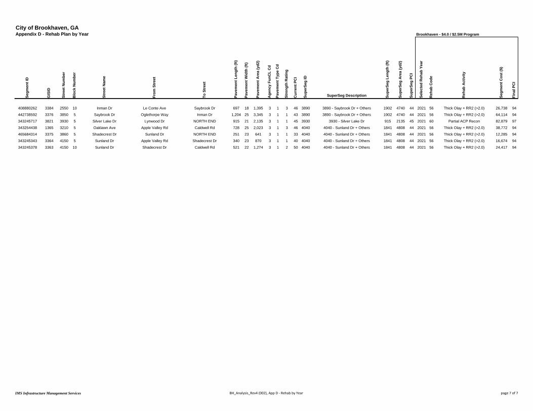
City of Brookhaven, GAAppendix D - Rehab Plan by Year Brookhaven - $4.0 / $2.5M Program
Segm
ent I
D
GIS
ID
Stre
et N
umbe
r
Blo
ck N
umbe
r
Stre
et N
ame
From
Str
eet
To S
tree
t
Pave
men
t Len
gth
(ft)
Pave
men
t Wid
th (f
t)
Pave
men
t Are
a (y
d2)
Age
ncy
FunC
L C
d
Pave
men
t Typ
e C
d
Stre
ngth
Rat
ing
Cur
rent
PC
I
Supe
rSeg
ID
SuperSeg Description Supe
rSeg
Len
gth
(ft)
Supe
rSeg
Are
a (y
d2)
Supe
rSeg
PC
I
Sele
cted
Reh
ab Y
ear
Reh
ab C
ode
Reh
ab A
ctiv
ity
Segm
ent C
ost (
$)
Fina
l PC
I
408880262 3384 2550 10 Inman Dr Le Conte Ave Saybrook Dr 697 18 1,395 3 1 3 46 3890 3890 - Saybrook Dr + Others 1902 4740 44 2021 56 Thick Olay + RR2 (>2.0) 26,738 94
442738592 3376 3850 5 Saybrook Dr Oglethorpe Way Inman Dr 1,204 25 3,345 3 1 1 43 3890 3890 - Saybrook Dr + Others 1902 4740 44 2021 56 Thick Olay + RR2 (>2.0) 64,114 94
343245717 3821 3930 5 Silver Lake Dr Lynwood Dr NORTH END 915 21 2,135 3 1 1 45 3930 3930 - Silver Lake Dr 915 2135 45 2021 60 Partial ACP Recon 82,879 97
343254438 1365 3210 5 Oaklawn Ave Apple Valley Rd Caldwell Rd 728 25 2,023 3 1 3 46 4040 4040 - Sunland Dr + Others 1841 4808 44 2021 56 Thick Olay + RR2 (>2.0) 38,772 94
465684314 3375 3860 5 Shadecrest Dr Sunland Dr NORTH END 251 23 641 3 1 1 33 4040 4040 - Sunland Dr + Others 1841 4808 44 2021 56 Thick Olay + RR2 (>2.0) 12,285 94
343245343 3364 4150 5 Sunland Dr Apple Valley Rd Shadecrest Dr 340 23 870 3 1 1 40 4040 4040 - Sunland Dr + Others 1841 4808 44 2021 56 Thick Olay + RR2 (>2.0) 16,674 94
343245378 3363 4150 10 Sunland Dr Shadecrest Dr Caldwell Rd 521 22 1,274 3 1 2 50 4040 4040 - Sunland Dr + Others 1841 4808 44 2021 56 Thick Olay + RR2 (>2.0) 24,417 94
IMS Infrastructure Management Services BH_Analysis_Rev4 (002), App D - Rehab by Year page 7 of 7