Embed Size (px)
Citation preview
Cities Alliance Project Output
Detailed Project for Tajganj, Agra for Taj Trapezium Zone (TTZ)
Citywide Slum Upgrading Plan (CSUP) for the Heritage City of
Agra (India)
P120112
This project output was created with Cities Alliance grant funding.
Detail Project report-Tajganj 1 | P a g e
LIST OF TABLES:-
Table 1: Population Growth and Projection Page 16
Table 2: Land use as per Master plan 2021 Page 17
Table 3: List of the laws and the institutions established Page 25
Table 4: General City level information Page 26
Table 5: Household and population with growth rate Page 28
Table 6: Slum wise population and house Page 43
Table 7: Caste and category Page 45
Table 8: Status of literacy Page 46
Table 9: Employment status in slums Page 47
Table 10: Slum wise occupation Page 48
Table11: Income details Page 50
Table 12: Status of municipal water supply Page 51
Table 13: Sewer line status Page 52
Table 14: Status of Community toilet complex and its use Page 53
Table15: Housing details Page 57
Table 16: Land Tenure status Page 58
Table 17: Activity wise timeline for project implementation Page 67
LIST OF FIGURES:-
Figure 1: Site Location of BSUP projects in Agra Page 10
Figure 2: Population decadal growth trends Page 14
Figure 3: District Map of Agra Page 16
Figure 4: Municipal Boudnary of Agra city Page 18
Figure 5: Water Supply Zones of Agra Page 19
Figure 6: Sanitary wards/Zones of Agra city Page 20
Figure 7: Drainage Zones of Agra city Page 21
Figure 8: Citywide road networks of the City Page 22
Figure 9: Poster of DEcentralsied Waste Water treatment System in kachhpura Page 32
Figure 10: City ward map with Slums (79 Wards out of 90) Page 40
Figure 11-: Map Showing Location of Settlements In The Taj Ganj Area Page 44
Figure 12: Map of Taj East drain with respect to slum location Page 55
Figure 13: Street paving designs Page 61
Detail Project report-Tajganj 2 | P a g e
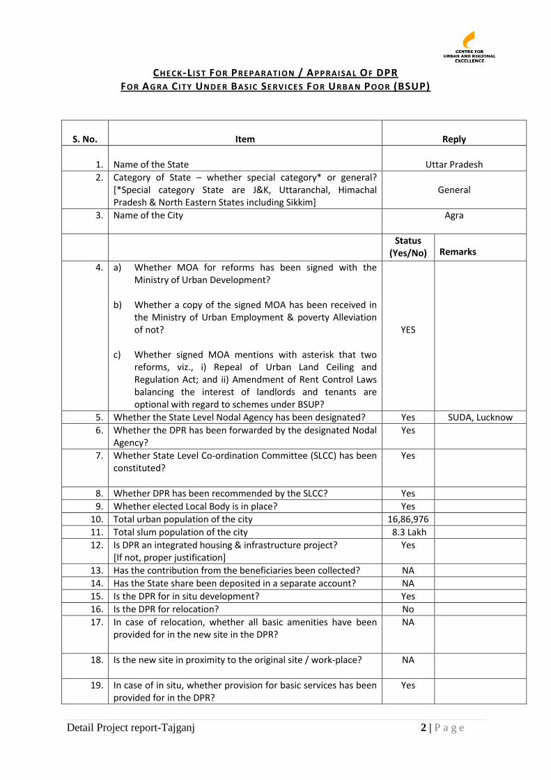
CHECK-L I ST FOR PREPA RATION / APPRAISA L OF DPR FOR AGRA C ITY UNDE R BASIC SE RVICES FOR URBA N POOR (BSUP)
S. No.
Item
Reply
1.
Name of the State
Uttar Pradesh
2. Category of State – whether special category* or general? [*Special category State are J&K, Uttaranchal, Himachal Pradesh & North Eastern States including Sikkim]
General
3. Name of the City Agra
Status (Yes/No) Remarks
4. a) Whether MOA for reforms has been signed with the Ministry of Urban Development?
b) Whether a copy of the signed MOA has been received in
the Ministry of Urban Employment & poverty Alleviation of not?
c) Whether signed MOA mentions with asterisk that two
reforms, viz., i) Repeal of Urban Land Ceiling and Regulation Act; and ii) Amendment of Rent Control Laws balancing the interest of landlords and tenants are optional with regard to schemes under BSUP?
YES
5. Whether the State Level Nodal Agency has been designated? Yes SUDA, Lucknow
6. Whether the DPR has been forwarded by the designated Nodal Agency?
Yes
7. Whether State Level Co-ordination Committee (SLCC) has been constituted?
Yes
8. Whether DPR has been recommended by the SLCC? Yes
9. Whether elected Local Body is in place? Yes
10. Total urban population of the city 16,86,976
11. Total slum population of the city 8.3 Lakh
12. Is DPR an integrated housing & infrastructure project? [If not, proper justification]
Yes
13. Has the contribution from the beneficiaries been collected? NA
14. Has the State share been deposited in a separate account? NA
15. Is the DPR for in situ development? Yes
16. Is the DPR for relocation? No
17. In case of relocation, whether all basic amenities have been provided for in the new site in the DPR?
NA
18. Is the new site in proximity to the original site / work-place? NA
19. In case of in situ, whether provision for basic services has been provided for in the DPR?
Yes
Detail Project report-Tajganj 3 | P a g e
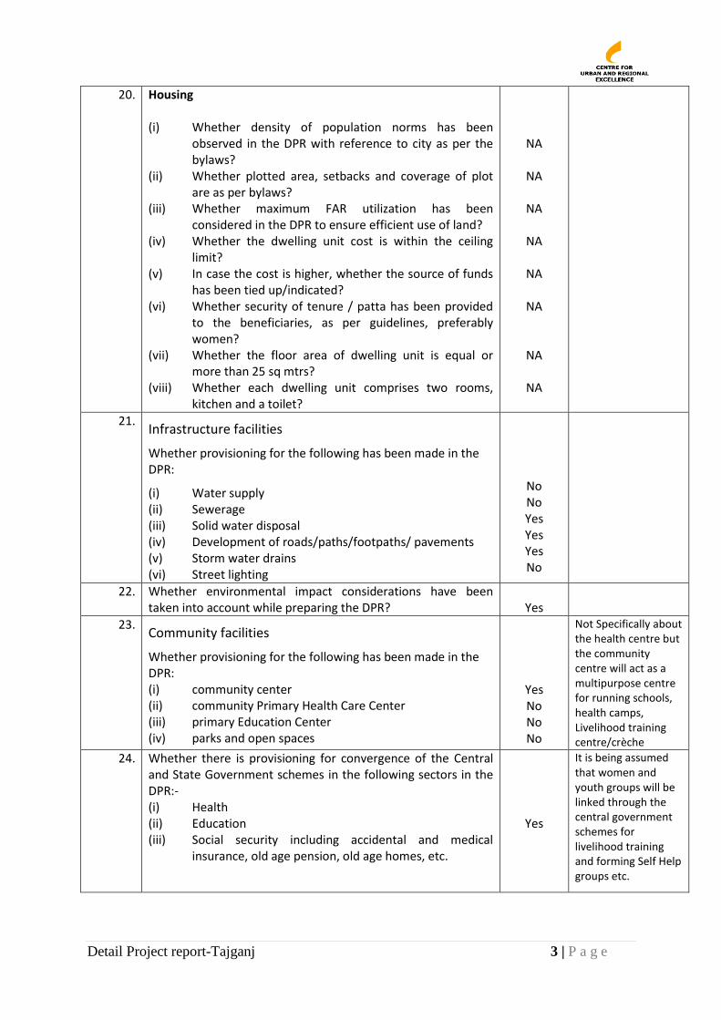
20. Housing (i) Whether density of population norms has been
observed in the DPR with reference to city as per the bylaws?
(ii) Whether plotted area, setbacks and coverage of plot are as per bylaws?
(iii) Whether maximum FAR utilization has been considered in the DPR to ensure efficient use of land?
(iv) Whether the dwelling unit cost is within the ceiling limit?
(v) In case the cost is higher, whether the source of funds has been tied up/indicated?
(vi) Whether security of tenure / patta has been provided to the beneficiaries, as per guidelines, preferably women?
(vii) Whether the floor area of dwelling unit is equal or more than 25 sq mtrs?
(viii) Whether each dwelling unit comprises two rooms, kitchen and a toilet?
NA
NA
NA
NA
NA
NA
NA
NA
21. Infrastructure facilities
Whether provisioning for the following has been made in the DPR:
(i) Water supply (ii) Sewerage (iii) Solid water disposal (iv) Development of roads/paths/footpaths/ pavements (v) Storm water drains (vi) Street lighting
No No Yes Yes Yes No
22. Whether environmental impact considerations have been taken into account while preparing the DPR?
Yes
23. Community facilities
Whether provisioning for the following has been made in the DPR: (i) community center (ii) community Primary Health Care Center (iii) primary Education Center (iv) parks and open spaces
Yes No No No
Not Specifically about the health centre but the community centre will act as a multipurpose centre for running schools, health camps, Livelihood training centre/crèche
24. Whether there is provisioning for convergence of the Central and State Government schemes in the following sectors in the DPR:- (i) Health (ii) Education (iii) Social security including accidental and medical
insurance, old age pension, old age homes, etc.
Yes
It is being assumed that women and youth groups will be linked through the central government schemes for livelihood training and forming Self Help groups etc.
Detail Project report-Tajganj 4 | P a g e
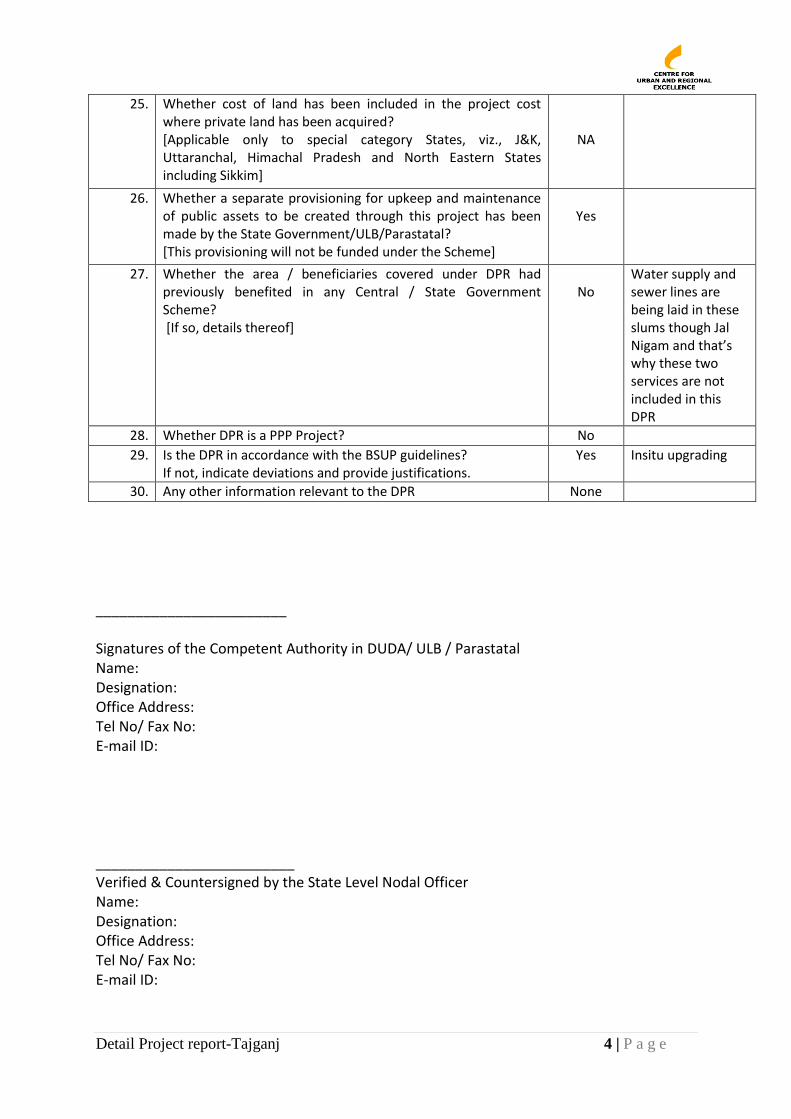
25. Whether cost of land has been included in the project cost where private land has been acquired? [Applicable only to special category States, viz., J&K, Uttaranchal, Himachal Pradesh and North Eastern States including Sikkim]
NA
26. Whether a separate provisioning for upkeep and maintenance of public assets to be created through this project has been made by the State Government/ULB/Parastatal? [This provisioning will not be funded under the Scheme]
Yes
27. Whether the area / beneficiaries covered under DPR had previously benefited in any Central / State Government Scheme? [If so, details thereof]
No
Water supply and sewer lines are being laid in these slums though Jal Nigam and that’s why these two services are not included in this DPR
28. Whether DPR is a PPP Project? No
29. Is the DPR in accordance with the BSUP guidelines? If not, indicate deviations and provide justifications.
Yes
Insitu upgrading
30. Any other information relevant to the DPR None
________________________ Signatures of the Competent Authority in DUDA/ ULB / Parastatal Name: Designation: Office Address: Tel No/ Fax No: E-mail ID: _________________________ Verified & Countersigned by the State Level Nodal Officer Name: Designation: Office Address: Tel No/ Fax No: E-mail ID:
Detail Project report-Tajganj 5 | P a g e
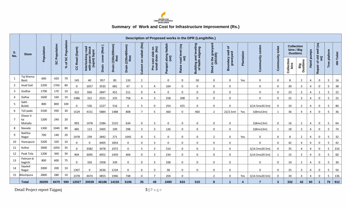
Summary of Work and Cost for Infrastructure Improvement (Rs.)
S. No.
Slum
Po
pu
lati
on
SC
Po
pu
lati
on
% o
f S
C P
op
ula
tio
n Description of Proposed works in the DPR (Length/No.)
CC
Ro
ad
(S
qm
t)
Inle
rlo
ck
ing
ro
ad
wit
h p
av
er
blo
ck
(sq
mt)
Sq
mt
Dra
in
co
ve
r (R
mt
)
Dra
in (
15
0x
200
mm
)
Rm
t
Dra
in (
23
0x
46
0m
m)
Rm
t
Cu
lve
rt o
n n
all
ah
(N
o)
Pre
ca
st
sla
b o
n
sm
all
dra
in
(No
)
Pa
rap
et
alo
ng
Nalla
h
(mt)
Rais
e r
oa
d l
eve
l (s
q
mt)
Bu
ild
ing
an
d l
ev
elin
g
of
Nall
h e
dg
ein
g
Sh
ed
in
th
e g
rav
ya
rd
(20
/15
ft)
Bo
un
da
ry w
all o
f
gra
ve
ya
rd
Pla
nta
tio
n
Co
mm
un
ity c
en
tre
Co
mm
un
ity t
oil
et
Collection bins / Big Dustbins
Han
d p
um
ps
Rep
air
of
old
we
ll (
sq
mt)
Tre
e p
lafo
rm
HH
To
ile
t
Co
lle
cti
on
bin
s
Big
Du
stb
ins
1 Taj Khema Basti
600 420 70 145 40 957 85 133 2 0 0 50 0 0 Yes 0 0 8 2 4 0 5 16
2 Asad Gali 2200 1760 80 0 1057 3535 681 67 3 4 164 0 0 0 0 0 0 30 3 4 0 5 38
3 Gudhai 1700 170 10 322 836 2847 451 211 0 4 0 0 0 0 0 0 0 23 3 4 1 5 22
4 Dalhai 1600 160 10 1486 312 2521 225 758 4 3 258 208 0 0 0 0 0 22 3 4 0 5 22
5 Sekh Bulaki
800 800 100 0 536 1227 516 0 5 0 254 425 0 0 0 1(14.5mx20.5m) 0 10 2 4 0 5 80
6 Teli pada 3100 930 30 1529 4151 5884 1488 808 7 5 360 0 460 2 22/2.5mt Yes 1(8mx13m) 1 36 4 4 0 5 36
7 Diwan Ji ka Mohalla
1200 240 20 993 1478 2584 1525 634 0 3 0 0 0 0 0 1(8mx13m) 0 16 2 4 0 5 64
8 Navada 1300 1040 80 485 113 2405 109 298 3 3 126 0 0 0 0 1(8mx13m) 1 18 2 4 0 5 74
9 Nathha Nagar
700 140 20 2478 239 2842 271 1045 0 5 0 0 0 2 0 Yes 0 0 8 2 4 0 5 32
10 Hazzupura 3200 320 10 0 0 4405 1854 0 0 3 0 0 0 0 0 0 0 42 4 4 0 5 42
11 Kolhai 3000 1050 35 0 3382 3478 1972 0 5 3 514 0 0 2 0 1(14.5mx20.5m) 0 35 4 4 0 5 210
12 Paak Tola 1200 360 30 904 3095 4052 1459 404 0 3 234 0 0 0 0 1(14.5mx20.5m) 1 15 2 4 0 5 60
13 Patiram ki bagichi
800 600 75 0 326 1958 339 0 0 3 338 0 0 0 0 0 0 10 2 4 0 5 30
14 Sayeed Nagar
2000 200 10 1307 0 2636 1234 0 6 3 38 0 0 0 0 0 0 25 3 4 0 5 50
15 Bilochpura 2800 280 10 2378 4474 4855 1946 748 0 7 204 0 2 0 Yes 1(14.5mx20.5m) 0 34 4 4 0 5 136
Total 26200 8470 590 12027 20039 46186 14155 5106 35 49 2490 633 510 8 1 4 7 3 332 42 60 1 75 912
Detail Project report-Tajganj 6 | P a g e
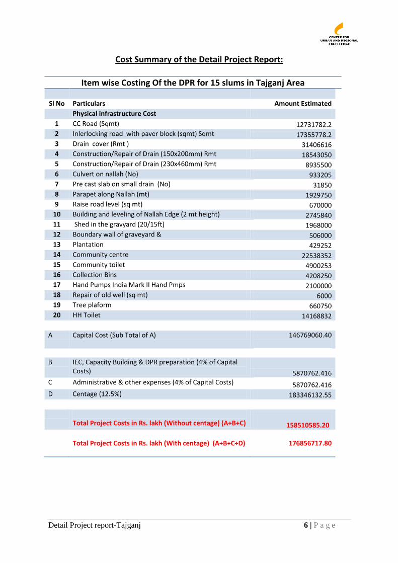
Cost Summary of the Detail Project Report:
Item wise Costing Of the DPR for 15 slums in Tajganj Area
Sl No Particulars Amount Estimated
Physical infrastructure Cost
1 CC Road (Sqmt) 12731782.2 2 Inlerlocking road with paver block (sqmt) Sqmt 17355778.2 3 Drain cover (Rmt ) 31406616 4 Construction/Repair of Drain (150x200mm) Rmt 18543050 5 Construction/Repair of Drain (230x460mm) Rmt 8935500 6 Culvert on nallah (No) 933205 7 Pre cast slab on small drain (No) 31850 8 Parapet along Nallah (mt) 1929750 9 Raise road level (sq mt) 670000
10 Building and leveling of Nallah Edge (2 mt height) 2745840 11 Shed in the gravyard (20/15ft) 1968000 12 Boundary wall of graveyard & 506000 13 Plantation 429252 14 Community centre 22538352 15 Community toilet 4900253 16 Collection Bins 4208250 17 Hand Pumps India Mark II Hand Pmps 2100000 18 Repair of old well (sq mt) 6000 19 Tree plaform 660750 20 HH Toilet 14168832
A Capital Cost (Sub Total of A) 146769060.40
B IEC, Capacity Building & DPR preparation (4% of Capital
Costs) 5870762.416 C Administrative & other expenses (4% of Capital Costs) 5870762.416 D Centage (12.5%) 183346132.55
Total Project Costs in Rs. lakh (Without centage) (A+B+C)
158510585.20
Total Project Costs in Rs. lakh (With centage) (A+B+C+D)
176856717.80
Detail Project report-Tajganj 7 | P a g e
Detailed Project Report for Insitu Upgrading Of Slums in Agra
11.. BACKGROUND
1.1. Introduction
Agra, the city of Tajmahal, is a global tourist destination, and offers huge potential for
developing a strong and broad-based tourism-centric city economy. The main constraints to
realising the growth potential of Agra include its poor infrastructure facilities and ineffective
services; in particular sanitation, which has restricted tourism to the city.
Agra, because of its tourism potential, has also attracted large number of poor migrants,
many of whom are living in slums and underserved settlements without access to adequate
basic services living in its 4171 slums. The numbers of slums have consistently been
increasing from 378 in 2006 (CURE) and 252 listed with the District Urban Development
Agency (DUDA) in 2001.
Numbers of people living in slums varies. As per the City Development Plan (CDP) for Agra
prepared in 2007, an estimated 1.2 million people or 9% of total Agra population was living
in slums and slum like areas. DUDA estimate for 252 slums was approximately 5.5 lakhs
people or nearly 44% of the total city population.
As per Census 2011, Agra’s population (provisional) is 1686976, having increased from
1275134 in 2001. This suggests a growth rate of 32.2 %. If slum and population in the city
has also grown at the same rate, it is expected that the total slum population of Agra may
be 727100. As per the data collected during slum mapping of Agra, 2011, the total
population in slums an estimated 830174 which is higher than expected clearly indicating
that the slums are cropping up at a faster pase than expected.
While all of Agra continues to be poorly served in terms of infrastructure services, slums in
particular have substandard housing, lack of services and highly unsanitary living conditions.
Agra has been identified as a Mission City under the Jawaharlal Nehru National Urban
Renewal Mission (JNNURM) by the Ministry of Urban Development and under the Rajiv
Awas Jozana (RAY) for affordable housing for the poor by the Ministry of Housing and Urban
Poverty Alleviation (MoHUPA).
Agra Nagar Nigam (ANN) and District Urban Development Authority (DUDA) in Agra have
been implementing several state slum development initiatives. ANN has also been
implementing a Citywide Slum Upgrading Project (CSUP) for inclusive and participatory slum
1 CURE has mapped all the slums of Agra under Rajiv Awas Yozana (RAY) (2011)
Detail Project report-Tajganj 8 | P a g e
development since 2006 in partnership with the Centre for Urban and Regional Excellence
(CURE), a development NGO, and with the financial and technical assistance of Cities
Alliance, Water and Sanitation Program (WSP), United States Agency for International
Development (USAID) and National Institute of Urban Affairs (NIUA).
1.2. Taj Trapezium Zone (TTZ)
Taj Trapezium Zone (TTZ) is a trapezoid shaped, defined area of 10,400 sq km around the Taj
Mahal. It is a buffer zone designed to protect this historic monument from pollution. Within
the TTZ there are over 40 protected monuments including three World Heritage Sites — the
Taj Mahal, Agra Fort and Fatehpur Sikri.
Under a Supreme Court of India ruling, December 30, 1996, several industries were banned
from being located/ operating within the TTZ. This was aimed at protecting the Taj Mahal
from being damaged by polluted air from these units. The industries banned were those that
used coal/ coke as fuel. The industries were required to either relocate or switch to natural
gas or face closure. The TTZ protection area authority has the power to monitor the
implementation of schemes implemented for the protection of the Taj Mahal and
protection/improvement of the environment; take all necessary steps to ensure compliance
of specified emission-standards by motor vehicles and ensuring compliance of fuel quality
standards; and deal with all environmental issues related to the area.
The Agra Master Plan in compliance with the above has further created some zoning
restrictions in the TTZ; designating the area Industry free, earmarking spaces for parks and
river development, including supporting tourism, creating a ring road by pass to the city to
reduce traffic congestion. It also recommends a traffic and transportation plan with
underground/multi-storied parking be proposed to meet the parking requirements and
transport centres or nagars. The Agra Master Plan also lays out the parameters to make
River Yamuna pollution free by creating spaces for treatment plants.
Detail Project report-Tajganj 9 | P a g e
2. Programes for Urban and Slum Development in Agra
2.1. National Missions for Slum Development and Poverty Reduction
As India is urbanizing, problems of cities and slums are growing. The Government of India
has been implementing several Missions to promote inclusive, sustainable and equitable,
reform-linked-urban development. Two key urban development initiatives include the
Jawaharlal National Urban Renewal Mission (JNNURM) and its sub-mission, Basic Services for
the Urban Poor (BSUP) and the Rajiv Awas Jozana (RAY).
2.1.1. Jawaharlal Nehru National Urban Renewal Mission (JNNURM)
In November 2005, the Government of India launched the Jawaharlal National Urban
Renewal Mission (JNNURM) to incentivize large urban areas to undertake institutional,
structural and fiscal reforms critical for improved and sustainable urban services, and to
address issues of urban poverty and equity. The Mission made available resources to 63
large cities for implementing these reforms. It also set up a Sub Mission II to specifically
focus on services to the urban poor.
To encourage reforms and fast track planned development of the cities and efficiency in
urban infrastructure and urban services delivery mechanisms and accountability of ULBs /
parastatal agencies towards citizens the following objectives have been framed out:
• Focused attention to the integrated development of infrastructure services covered
under the Mission,
• Establishment of linkages between asset-creation and its management through a
slew of reforms for long-term project sustainability,
• Ensuring adequate funds to meet the deficiencies in urban infrastructural services,
• Planned development of identified cities including peri-urban areas, out growths and
urban corridors leading to dispersed urbanization,
• Scale-up delivery of civic amenities and provision of utilities with emphasis on
universal access to the urban poor,
• Special focus on urban renewal programme for the old city areas to reduce
congestion, and
• Provision of basic services to the urban poor including security of tenure at
affordable prices, improved housing, water supply and sanitation, and ensuring
delivery of other existing universal services of the government for education, health
and social security.
As per the selection criteria of JNNURM towns, Agra comes under category B as million plus
city and has also importance of being a world-class architectural heritage site. Hence
considering its population size and tourism potential, Agra is one of the 7 cities of Uttar
Pradesh selected under JNNURM.
Detail Project report-Tajganj 10 | P a g e
2.1.2. Basic Service for the Urban Poor (BSUP)
The sub-missions on Basic Services for the Urban Poor (BSUP), is administered by the
Ministry of Housing and Urban Poverty Alleviation (MoHUPA). Its focus is on improving
access of slum communities and low-income settlements to municipal services under a 7
point charter. Designed to focus a comprehensive set of interventions on slum communities;
housing, water supply, sanitation, transport, education, health and social welfare, BSUP is
expected to ensure the following outcomes for the poor:
Access to land tenure/ legal and affordable housing with in-house basic services that
will allow poor to live as legitimate citizens and with dignity.
Access to basic municipal services of water supply, toilets, wastewater drainage, solid
waste management, power, roads, transport, etc. on an equitable basis.
Integration and mainstreaming slums with municipal supply networks for sustainable
change.
Improved access to social services of education, health and welfare to reduce urban
poverty.
Empowerment and voice to demand services on an equitable basis and participate in
processes of city governance.
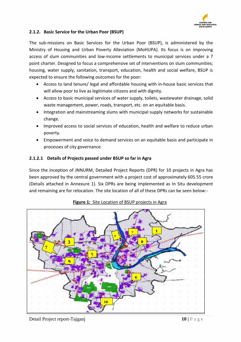
2.1.2.1 Details of Projects passed under BSUP so far in Agra Since the inception of JNNURM, Detailed Project Reports (DPR) for 10 projects in Agra has
been approved by the central government with a project cost of approximately 605.55 crore
(Details attached in Annexure 1). Six DPRs are being implemented as In Situ development
and remaining are for relocation. The site location of all of these DPRs can be seen below:-
Figure 1: Site Location of BSUP projects in Agra
2
3
4
1
5
6
7
8
9
10
Detail Project report-Tajganj 11 | P a g e
2.1.3. Rajiv Awas Jozana (RAY)
Recently, the Ministry of Housing and Urban Poverty Alleviation has launched the Rajiv Awas
Yojana (RAY), a Mission to ensure affordable housing to all slum dwellers in 30 selected
cities. Towards implementation of RAY, the city governments are required to create spatial
and household databases and prepare a citywide slum upgrading plan.
The main objective of RAY is to build slum free cities by providing housing, access to basic
urban services and social services at equitable levels as in the rest of the city. RAY is
futuristic, in that it seeks to put in place strategies for prevention of new slum development
by creating adequate and affordable housing with services, progressively for new migrants.
This can only be achieved by creating a Slum Free City Plan, followed by a set of prioritized
projects for implementation with a plan for their operation and maintenance.
In its initial pilot phase, RAY is implementing some innovative pilots in cities to build a
learning curve for the Mission.
Agra is one of the Mission Cities under RAY. It is being assisted by the Regional Centre for
Urban and Environmental Studies (RCUES) and the Centre for Urban and Regional Excellence
(CURE) in the preparation of a data base on slums and the a plan for a Slum Free City.
2.1.3.1 Slum Free City Plan for Agra: Vision
Under RAY, Agra City has been with the technical support of the Regional Centre for Urban
and Environmental Studies (RCUES) and CURE, has been developing a plan for a Slum Free
Agra. The vision is to achieve a slum free city by upgrading, redeveloping or resettling all
slums in the City, authorised and unauthorised, in a phased and incremental manner and
through provision of appropriate/secure land tenure and network services.
2.2. State Programes for Slum Development
The State of Uttar Pradesh (UP) has also launched several Programes aimed at improving
access of urban poor and marginal communities to housing and basic services.
2.2.1 Manywar Shri Kanshi Ramji Shahri Garib Awas Jozana The state government has initiated a special scheme for housing with land rights in the state
of Uttar Pradesh. In this scheme government is providing houses in multistory apartments
1. Taj Nagri Phase II 2. kalindi Vihar Phase II 3. Sastripuram 4. Naraich
5. Sarai Khwaja 6. Gobar Chauki 7. Bodla 8. Nariach 9. Devretha 10 Deori Road
Detail Project report-Tajganj 12 | P a g e
specially designed for urban poor especially widows and disabled. The implementing agency
for this scheme is Uttar Pradesh Awas Vikas parishad.
2.2.2 Shri Kanshiram Ji Shahri Dalit Bahulya Basti Samagra Vikas Jozana
Uttar Pradesh government has launched an ambitious scheme for the redevelopment of
urban slums, predominantly inhabited by dalits. The scheme has been named as Shri
Kanshiram Ji Shahri Dalit Bahulya Basti Samagra Vikas Jozana (Urban dalit dominated slum
composite development scheme). In the first phase, 250 slums would be identified across 72
districts of Uttar Pradesh by the respective. In Agra three slums has been selected for this
scheme which would be would be institutionalized by providing social welfare support under
18 heads, including medical, health, education, ration card, scholarship and street lighting.
2.2.3 Bheem Nagri Programme
The Bheem Nagri is program for integrated infrastructure and social development in slums of
SC categories. Every year a cluster of slums are selected for overall infrastructure
development and providing social welfare benefits to the slum dwellers. After a long phase
of development activities, a massive celebration is planned on the day of Ambedkar jayanthi.
2.2.4 Malin Basti Sudhar Aur Nipatan Yojana2
This is a very old scheme for slum improvement and clearance in respect of any area, any
buildings used or intended or likely to be used as dwelling houses are unfit for human
habitation. Such scheme may provide for the reservation f sites for, and the construction and
provision of roads, streets, lanes and open spaces and other amenities, and the enlargement
of the existing roads, streets, lanes, open spaces and other amenities in the area.
2.3. Statutory Provisions for Slum Upgrading
2.3.1 The U.P. Slum Areas (Improvement and Clearance), Act 1962 The State Government of Uttar Pradesh (UP) is implementing the U.P. Slum Areas
(Improvement and Clearance), Act 1962 (subsequently amended) for improving slum areas.
Under the Act, a Municipal Corporation is required to identify and designate as a slum, an
area that lacks access to basic conditions required for decent living, resettle slum dwellers
on the same or other land through redevelopment and provisioning of tenure on the
redeveloped/resettled land. The specific provisions of the Act are given below:
Declaration of slum areas (U.P. Act No.18 of 19623 as amended up to U.P. Act of
1986)
Where the competent authority upon information received or otherwise in its possession is
satisfied as respects any area that a majority of the buildings in that area are (a) by reason of
2 The Uttar Pradesh Avas Evam Vikas Parishad Adhiniyam, 1965
3 State of Urban Health in Uttar Pradesh, Ministry of Health and Family Welfare, Government of India. 2006
Detail Project report-Tajganj 13 | P a g e
dilapidation, overcrowding, faulty arrangement of design of such buildings or faulty
arrangement of streets, lack of ventilation, light or sanitation facilities, or any combination of
these factors, detrimental to safety, health or morals of the inhabitants in that area; or (b)
otherwise in any respect unfit for human habitation; it may, by notification in the official
Gazette, declare such area to be a slum area.
Clearance and Redevelopment of Area
UP Slum Areas (Clearance and Improvement) Act empowers Competent Authority to declare
a slum area to be clearance area in accordance with the provisions within the Act. All
buildings in the clearance area have to be demolished in pursuance to the provisions of
section 12 by the owner or occupier as the case may be, failing which the Competent
Authority has the power to demolish the same and offer temporary alternative
accommodation to the occupier of the building. Competent Authority has the power to re-
develop the clearance area in accordance with the Plan prepared by it. Where the Competent
Authority is not able to re-develop a land within a period of 2 years, the State Government
may require the redevelopment of the land to be completed within a specified period.
Detail Project report-Tajganj 14 | P a g e
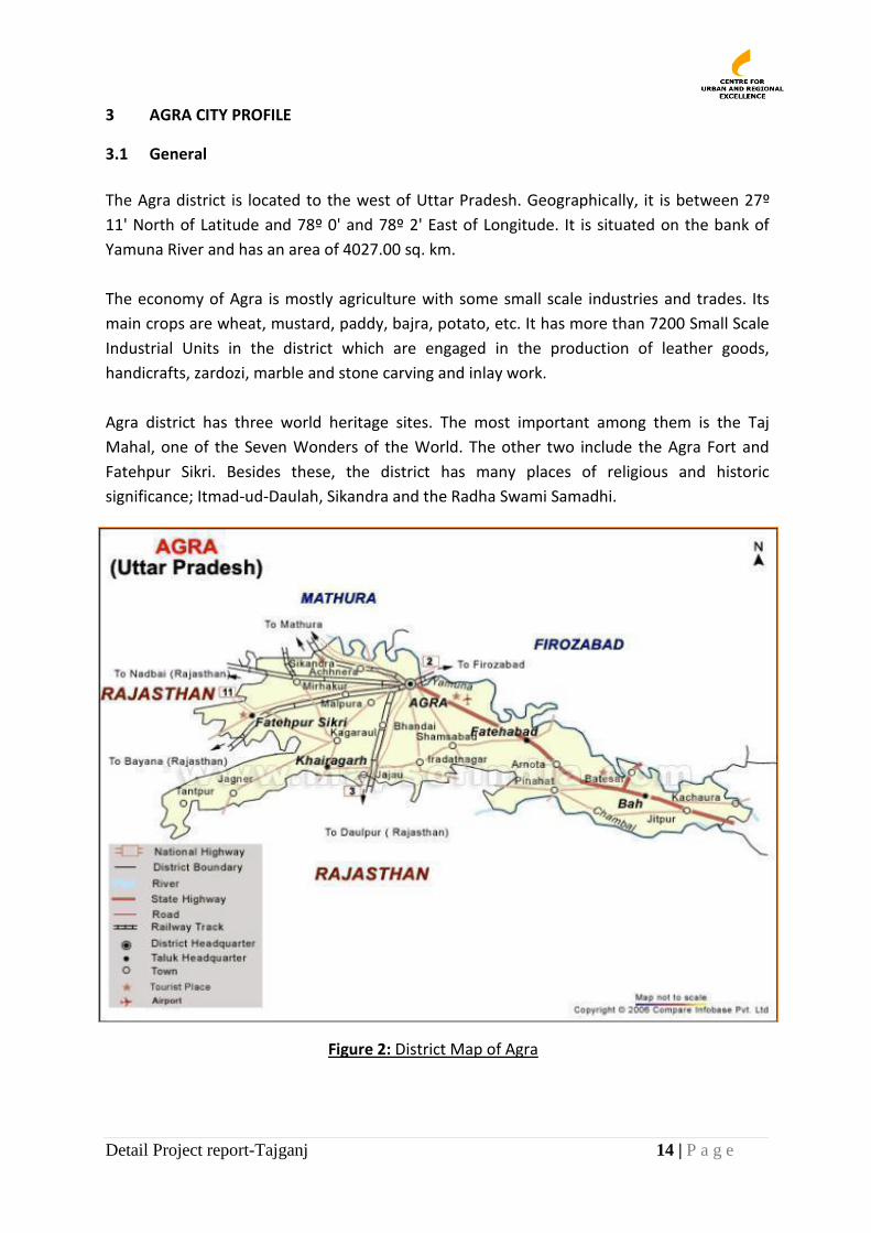
3 AGRA CITY PROFILE
3.1 General
The Agra district is located to the west of Uttar Pradesh. Geographically, it is between 27º
11' North of Latitude and 78º 0' and 78º 2' East of Longitude. It is situated on the bank of
Yamuna River and has an area of 4027.00 sq. km.
The economy of Agra is mostly agriculture with some small scale industries and trades. Its
main crops are wheat, mustard, paddy, bajra, potato, etc. It has more than 7200 Small Scale
Industrial Units in the district which are engaged in the production of leather goods,
handicrafts, zardozi, marble and stone carving and inlay work.
Agra district has three world heritage sites. The most important among them is the Taj
Mahal, one of the Seven Wonders of the World. The other two include the Agra Fort and
Fatehpur Sikri. Besides these, the district has many places of religious and historic
significance; Itmad-ud-Daulah, Sikandra and the Radha Swami Samadhi.
Figure 2: District Map of Agra
Detail Project report-Tajganj 15 | P a g e
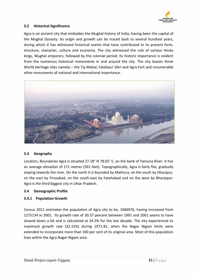
3.2 Historical Significance
Agra is an ancient city that embodies the Mughal history of India, having been the capital of
the Mughal Dynasty. Its origin and growth can be traced back to several hundred years,
during which it has witnessed historical events that have contributed to its present form,
structure, character, culture and economy. The city witnessed the rule of various Hindu
kings, Mughal emporers, followed by the colonial period. Its historic importance is evident
from the numerous historical monuments in and around the city. The city boasts three
World Heritage sites namely – the Taj Mahal, Fatehpur Sikri and Agra Fort and innumerable
other monuments of national and international importance.
3.3 Geography
Location, Boundaries Agra is situated 27.18° N 78.02° E, on the bank of Yamuna River. It has
an average elevation of 171 metres (561 feet). Topographically, Agra is fairly flat, gradually
sloping towards the river. On the north it is bounded by Mathura, on the south by Dhaulpur,
on the east by Firozabad, on the south-east by Fatehabad and on the west by Bharatpur.
Agra is the third biggest city in Uttar Pradesh.
3.4 Demographic Profile
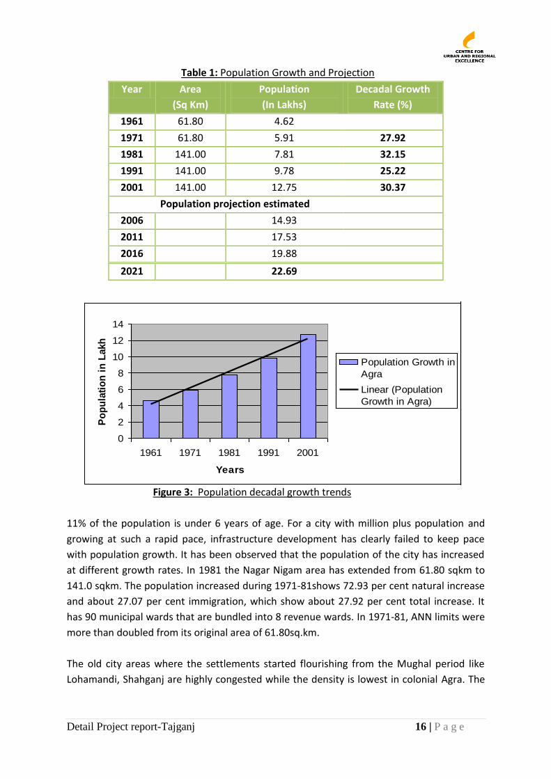
3.4.1 Population Growth
Census 2011 estimates the population of Agra city to be, 1686976, having increased from
1275134 in 2001. Its growth rate of 30.37 percent between 1991 and 2001 seems to have
slowed down a bit and is calculated at 24.3% for the last decade. The city experienced its
maximum growth rate (32.15%) during 1971-81, when the Nagar Nigam limits were
extended to incorporate more than 100 per cent of its original area. Most of this population
lives within the Agra Nagar Nigam area.
Detail Project report-Tajganj 16 | P a g e
Table 1: Population Growth and Projection
Year Area
(Sq Km)
Population
(In Lakhs)
Decadal Growth
Rate (%)
1961 61.80 4.62
1971 61.80 5.91 27.92
1981 141.00 7.81 32.15
1991 141.00 9.78 25.22
2001 141.00 12.75 30.37
Population projection estimated
2006 14.93
2011 17.53
2016 19.88
2021 22.69
Figure 3: Population decadal growth trends
11% of the population is under 6 years of age. For a city with million plus population and
growing at such a rapid pace, infrastructure development has clearly failed to keep pace
with population growth. It has been observed that the population of the city has increased
at different growth rates. In 1981 the Nagar Nigam area has extended from 61.80 sqkm to
141.0 sqkm. The population increased during 1971-81shows 72.93 per cent natural increase
and about 27.07 per cent immigration, which show about 27.92 per cent total increase. It
has 90 municipal wards that are bundled into 8 revenue wards. In 1971-81, ANN limits were
more than doubled from its original area of 61.80sq.km.
The old city areas where the settlements started flourishing from the Mughal period like
Lohamandi, Shahganj are highly congested while the density is lowest in colonial Agra. The
Chart Title
0
2
4
6
8
10
12
14
1961 1971 1981 1991 2001
Years
Po
pu
lati
on
in
Lakh
Population Growth in
Agra
Linear (Population
Growth in Agra)
Detail Project report-Tajganj 17 | P a g e
large open areas between the fort and the Taj has remained undeveloped because it is the
most low-lying area and hence more prone to floods.
3.4.2 Land Use Master Plan of 2021 takes into account the requirements of urban population of 22.5 lakh
as estimated by 2021(Master plan 2021) and focusing on city’s historical and archaeological
significance. The total future land requirement for the city is 200.36 sq km. The percentage
breakups for the proposed Land use are given in the table.
Table 2: Land use as per Master plan 2021
3.5 Socio Economic Profile
3.5.1 Sex ratio
The sex ratio measures the extent of prevailing equity between males and females in the
project area. As per the Census 2001, the sex ratio in the city is 846 females per thousand
males, which is less than the district figure of 898 females per thousand males (Census of
India 2001).
3.5.2 Literacy
As per the Census 2001, the literacy rate in the city is 60.14 per cent, which is less than the
literacy rate of the district (64.97per cent). The comparison among the male and female
literacy rate shows that the percentage of male literates is quite high (59.04 per cent) in
comparison to the percentage of female literates (40.96 per cent). (Source- Census of India
2011)
3.5.3 City Economic Profile
Agra is basically a commercial city. The major part of its industrial activity is in the form of
small-scale and house-hold industries. The important industries are textile, leather,
foundries, diesel engines, generator sets, electrical goods, fans, pipes, C.I, casting, leather
goods including shoes, steel rolling, packaging materials, etc. The major handicrafts are
marble, leather, carpet, brassware, and artistic zari and jewellery crafts. With work force
Land Use Percentage
Residential 49.53
Commercial 2.72
Industrial 8.01
Office 2.54
Tourism 0.89
Public 8.80
Traffic and transportation 10.79
Recreation & Open spaces 4.37
Other open spaces 2.10
Other 10.25
Total 100
Detail Project report-Tajganj 18 | P a g e
participation rate of 25.5 per cent, majority of work force (about 89%) is engaged in tertiary
sector. There are 5263 small scale industrial units with investment of Rs. 263.15 crore. Apart
from these units there are over 750 cottage units producing petha. Most of these units are
in the narrow lanes of the centuries-old Noori Darwaza Market.
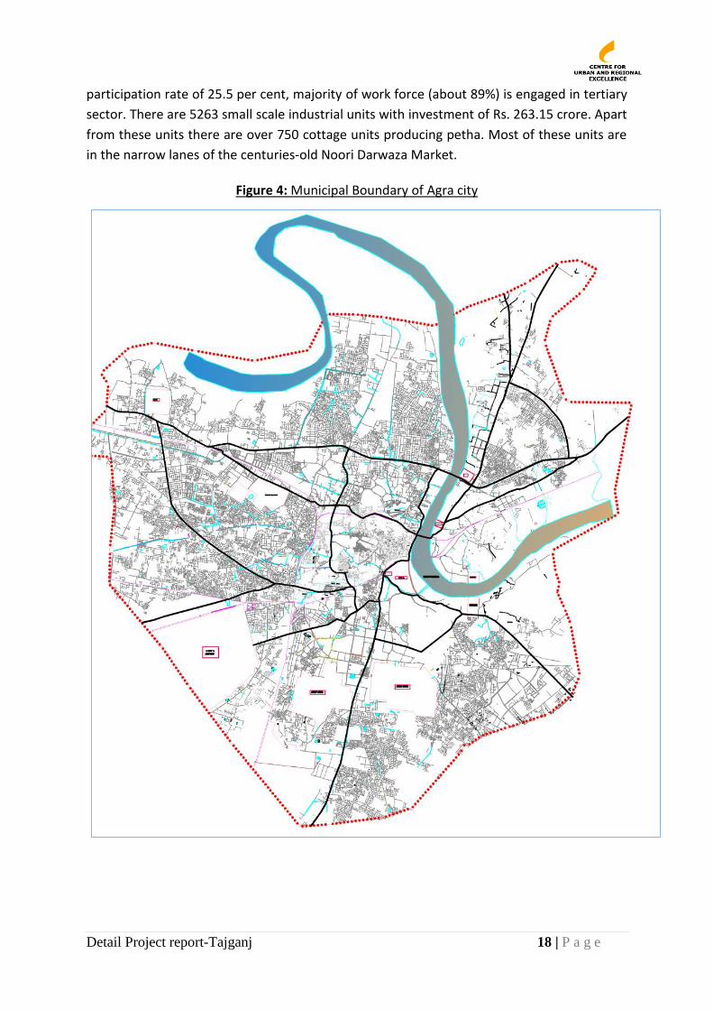
Figure 4: Municipal Boundary of Agra city
Detail Project report-Tajganj 19 | P a g e
3.6 Infrastructure
3.6.1 Water Supply
The source of water supply in the city is mainly surface water. The river Yamuna is the only
surface water source, which enters the town from northeast corner, flow towards south of
the city for some distance and then turns towards left.
Uttar Pradesh Jal Nigam (UPJN) is the nodal agency for developing water infrastructure in
Agra. These are then transferred by UPJN to Agra Jalkal department for local operation and
maintenance. Jalkal department is responsible for supplying potable water in adequate
quantity and to maintain the sewerage system of the City efficiently.
As per the CDP (2006), Agra city’s total water demand in 2011 was an estimated 395 MLD
(including 10% wastage). There are 2 water treatment plants in the City, at Jeoni Mandi and
Sikandra. Together they have an output of 270 MLD; indicating a current shortage of water
supply in the City. As per estimate U.P. Jal Sansthan 70% of the area is covered by piped
water supply however in some of the areas the water supply is uneven.
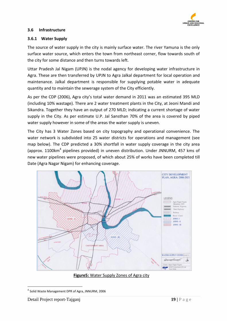
The City has 3 Water Zones based on city topography and operational convenience. The
water network is subdivided into 25 water districts for operations and management (see
map below). The CDP predicted a 30% shortfall in water supply coverage in the city area
(approx. 1100km4 pipelines provided) in uneven distribution. Under JNNURM, 457 kms of
new water pipelines were proposed, of which about 25% of works have been completed till
Date (Agra Nagar Nigam) for enhancing coverage.
4 Solid Waste Management DPR of Agra, JNNURM, 2006
Figure5: Water Supply Zones of Agra city
Detail Project report-Tajganj 20 | P a g e
3.6.2 Sanitation
Agra ranked 113 in a Sanitation Rating undertaken by the MoUD for the JNNURM cities, and
categorised under the category black i.e. “in need of considerable improvements”. Just
59.63% of households have private toilets. Of the 117 community toilets that serve the poor,
75% are in bad conditions which are used by a small percentage of population approximately
10%. The remaining households are reportedly defecating in the open. Recently, the ANN
has undertaken construction/renovation of 24 community toilets at a cost of Rs1crore to
provide access of poor to sanitation facilities. 75% of community toilets reportedly continue
to be in bad state due to lack of maintenance. (Source: Agra Nagar Nigam).
3.6.3 Sewerage
Agra has an underground sewerage system, which was constructed by Agra Jal Nigam and is
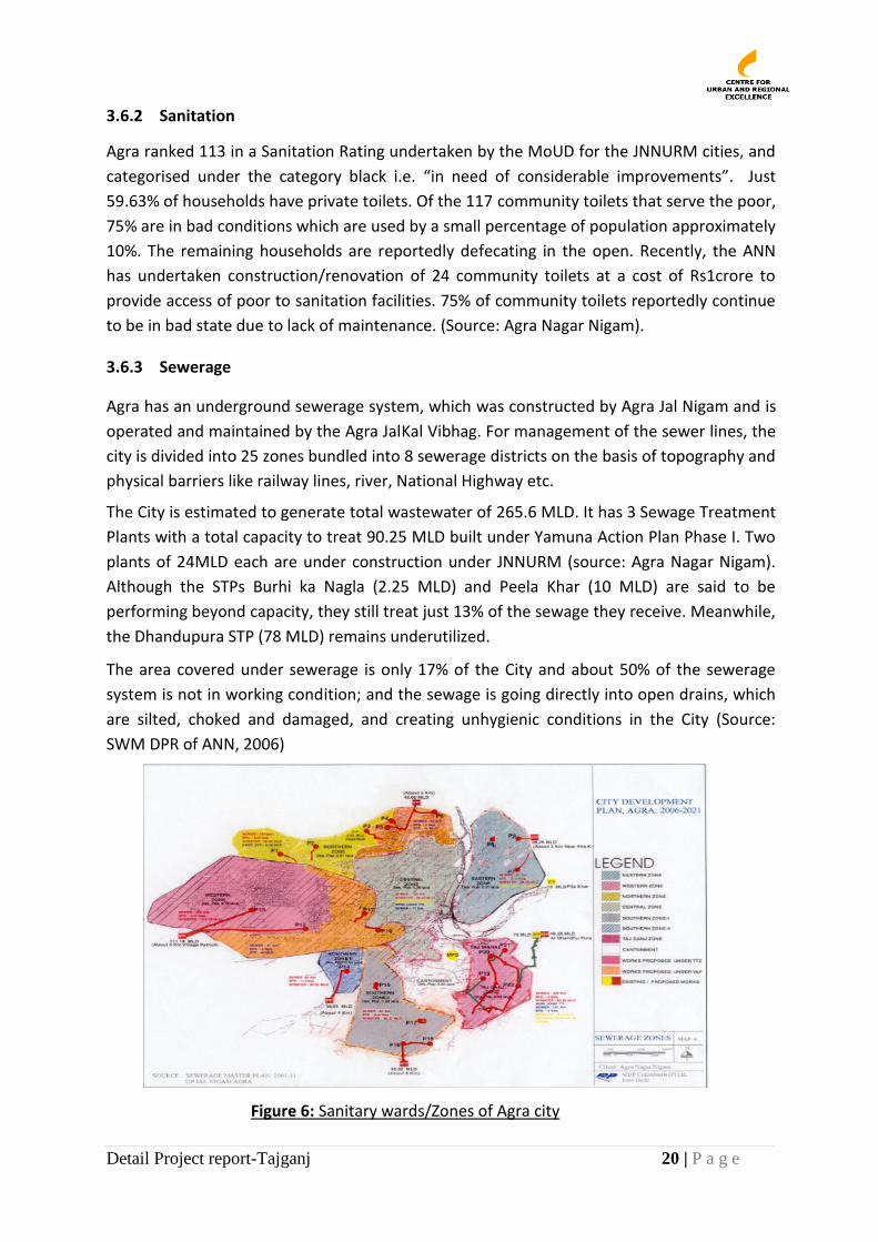
operated and maintained by the Agra JalKal Vibhag. For management of the sewer lines, the
city is divided into 25 zones bundled into 8 sewerage districts on the basis of topography and
physical barriers like railway lines, river, National Highway etc.
The City is estimated to generate total wastewater of 265.6 MLD. It has 3 Sewage Treatment
Plants with a total capacity to treat 90.25 MLD built under Yamuna Action Plan Phase I. Two
plants of 24MLD each are under construction under JNNURM (source: Agra Nagar Nigam).
Although the STPs Burhi ka Nagla (2.25 MLD) and Peela Khar (10 MLD) are said to be
performing beyond capacity, they still treat just 13% of the sewage they receive. Meanwhile,
the Dhandupura STP (78 MLD) remains underutilized.
The area covered under sewerage is only 17% of the City and about 50% of the sewerage
system is not in working condition; and the sewage is going directly into open drains, which
are silted, choked and damaged, and creating unhygienic conditions in the City (Source:
SWM DPR of ANN, 2006)
Figure 6: Sanitary wards/Zones of Agra city
Detail Project report-Tajganj 21 | P a g e
3.6.4 Storm water Drains
Fifthly nallahs or drains crisis cross almost whole length and breadth of the city. Apart from
the poor image of the city, these create unhygienic living conditions. The maintenance of the
nallah’s is poor and smaller nallahs have been encroached. This prevents cleaning and
maintenance of the nallahs causing floods and overflowing in the heavy flow conditions
mainly the monsoons.
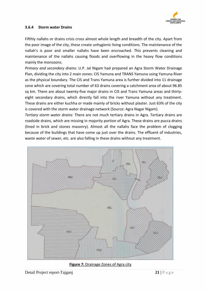
Primary and secondary drains: U.P. Jal Nigam had prepared an Agra Storm Water Drainage
Plan, dividing the city into 2 main zones: CIS Yamuna and TRANS Yamuna using Yamuna River
as the physical boundary. The CIS and Trans Yamuna area is further divided into 11 drainage
zone which are covering total number of 63 drains covering a catchment area of about 96.85
sq km. There are about twenty-five major drains in CIS and Trans Yamuna areas and thirty-
eight secondary drains, which directly fall into the river Yamuna without any treatment.
These drains are either kuchha or made mainly of bricks without plaster. Just 63% of the city
is covered with the storm water drainage network (Source: Agra Nagar Nigam).
Tertiary storm water drains: There are not much tertiary drains in Agra. Tertiary drains are
roadside drains, which are missing in majority portion of Agra. These drains are pucca drains
(lined in brick and stones masonry). Almost all the nallahs face the problem of clogging
because of the buildings that have come up just over the drains. The effluent of industries,
waste water of sewer, etc. are also falling in these drains without any treatment.
Figure 7: Drainage Zones of Agra city
Detail Project report-Tajganj 22 | P a g e
3.6.5 Solid Waste Management
ANN is the nodal agency responsible for solid waste management in the city. A total of
783MT/day of waste is generated in the city from various sources which includes waste from
domestic, industrial, commercial, public institutions; drain silt, street sweeping etc. Of the
total waste generated, just 629 MT/day is collected. Despite the 200 open dumps, 9 dhalaos,
116 dustbins spread all over the city and ANN’s nearly 2865 sweepers (safai karamcharis),
and a fleet of 96 vehicles to carry out MSWM activities, waste in the city is not being
regularly removed and dumped at the one authorized dumping site a few kilometers away
from the city. (Source: Agra Nagar Nigam, SWM DPR, 2006)
DPR of Solid Waste Management in Agra of Rs. 30.84 Crore was sanctioned by Govt. of India.
In this DPR provision of collection of waste, storage, transportation, and installation of
composting plant and development of land fill site has been made. C&DS, U.P. Jal Nigam
awarded work of Land fill site and processing plant to M/s Ultra Urban Infratech Ltd., Noida
(Hanjer Biotech Energies Ltd., Mumbai). The work of windrow, segregation platform, tipping
platform, composting plant etc. for 500 TPD has been completed at site.
3.6.6 Roads
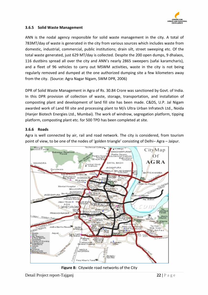
Agra is well connected by air, rail and road network. The city is considered, from tourism
point of view, to be one of the nodes of ‘golden triangle’ consisting of Delhi– Agra – Jaipur.
Figure 8: Citywide road networks of the City
Detail Project report-Tajganj 23 | P a g e
The road network of the city offers poor level of service affecting safety, efficiency and
economy of traffic operation within the city.
The total road length maintained by Agra Nagar Nigam is 1724 km out of which 840 km is
bituminized, 270m is concrete cemented, 320 km is kharanja and 294 km is covered by
kuchha roads. The total maintenance cost of roads is Rs. 759.88.The width of existing roads
is varying from 7m to 18m.
3.6.7 Electricity
Recently electricity has been privatized in the City. Torrent Power is the agency that is the
distributing company for electricity. According to the company, the estimated demand in the
city for power is about 420 MVA with an annual power consumption of about 1900 MUs.
The customer base of company stands at 2.8 lakhs. Based on the average people/service
ratio of other cities, it is estimated that there is a potential of converting 1.5 lakh illegal
consumers into legal customers. To expedite this process of converting illegal customers into
legal customers, Torrent Power Agra has launched Project RAY – “Roshan Agra Yojana” - RAY
of light / hope for the under privileged.5
3.6.8 Social Infrastructure
3.6.8.1 Education
As per Census 2001, the literacy rate in the city was 60.14 per cent, less than the literacy rate
of the district (64.97per cent). This is despite the fact that Agra is an educational hub for the
district and educational institutes are spread throughout the city except in certain rural
areas. These educational institutes number 100 Aganwadi/Balwadis, 978 nurseries, 618
primary schools, 263 secondary school, 194 high secondary school, 46 vocational
educational centres, 9 degree colleges/universities6.
3.6.8.2 Health
Health facilities in the city include a Medical College, 1 district hospital, 127 private hospitals,
101 government hospitals, 13 dispensaries, 1 maternity hospital, 5 child health care centres,
123 nursing homes and several private clinics. Besides these, there are hospitals for the
armed forces in the cantonment area, for police personnel in the police lines and for railway
staff in railway lines. (Source: SWM DPR for Agra, 2006). Despite these, access to health
facilities is poor.
5 http://www.torrentpower.com/agra/pdfs/roshan-agra-yojana.pdf
6 www.agra.nic.in
Detail Project report-Tajganj 24 | P a g e
3.7 Master Plan 2021
Agra Master Plan 2021 envisages an urban area of the order of 20,000 ha which has been
subdivided into various land uses as given in the previous section (3.4.2). Agra master plan
map is attached as Annexure 2. It is also estimated the housing shortage for the plan period
of the order of 2.5 lakh. The important policy decisions relevant for the purpose of
preparation of CDP are as under:
Industries: Non-pollutant industries are allowed to function in the city, industries related to software technology and information technology be promoted, other polluting industries in the city be considered to be relocated Tourism: Proper access for the monuments and the places of heritage value, a barrage to be constructed downstream of Taj so that Yamuna river retains water and the river is used for the recreational purposes, area north of Taj Mahal across the river be developed as a National Park so that it attracts the tourists, in order to attract tourists international Golf course and stadium be constructed, land measuring about 175 ha on Fatehabad road be used for tourism related recreational activities, Agra be connected internationally by setting up an international airport, taj ganj area near Taj Mahal be developed and beautified so that this can be a centre of handicraft and cottage industry for the tourist TTZ area: Industrial units falling in this area be relocated in a phased manner, parks and river development be undertaken as a part of tourism attraction, river Yamuna should be made pollution free by establishing treatment plants, traffic and transportation, ring road is proposed in order to by-pass the Agra city and avoids congestion in the city area, where ever necessary underground/multi-storied parking be proposed to meet the parking requirements, on the out-skirts of the city transport nagars are proposed on the Mathura road Gwalior road and Kanpur road. Water Supply: In order to reduce the water losses during distribution network needs to be improved and worn out/rusted pipes needs to be replaced, proper water harvesting techniques be adopted for ground water conservation and recharge, sewerage and drainage, sewer lines be laid in a planned manner so that the sewer is properly collected and disposed, the sewer flowing in drains be treated at suitable locations and the treated sewer be allowed to fall downstream of Yamuna, sufficient number of sewerage treatment plants be constructed As far as possible on both the sides of open drain three metres of strip be reserved for tree plantation. Solid Waste Management: A plan be prepared for solid waste management and disposal, proper arrangement be made for collection and disposal of solid waste, arrangement be made for instruments, vehicles, machines and manpower for the disposal of solid waste, Rain Water Harvesting: Natural ponds be preserved, the land surrounding the natural ponds be used for recreational purposes.
Detail Project report-Tajganj 25 | P a g e
3.8 Institutional Arrangements
The urban local bodies in the state of Uttar Pradesh are governed by two important legislation
viz. UP Municipal Corporations Adhiniyam, 1959 and UP Municipalities Act. 1916. These two acts
specify the governance framework, spatial jurisdiction and the functional domain of the
urban local bodies.
Table 3: List of the laws and the institutions established
A number of institutions are involved include the state government departments, local bodies and parastatals. The main organisation which is responsible for urban governance and civic management is the Agra Municipal Corporation. Slum development planning and implementation in Agra is the responsibility of District
Urban Development Agency (DUDA). DUDA is housed within the Agra Nagar Nigam (ANN),
but reports to the District Magistrate. ANN is responsible for all municipal services in the City
including services to slums. ANN is also the nodal department for the implementation of
JNNURM, BSUP and RAY missions and hence oversees the activities of slum development
under DUDA. DUDA is headed by a Project Officer and has set up a Project Implementation
Unit as required under RAY.
Sl No Legislation Established there under Legislation Organization
1 UP Municipal Corporations Adhiniyam,1959 Agra Nagar Nigam
2 UP Municipalities Act, 1916 Surrounding Municipalities
3 UP Water Supply and Sewerage Act, 1975 Jal Nigam
4 UP Water Supply and Sewerage Act, 1975 Jal Sansthan (Now JalKal)
5 UP Development Authorities Act. 1974 Agra Development Authority
6 Water (Prevention and Control of Pollution) Act, 1974
UP Pollution Control Board
Detail Project report-Tajganj 26 | P a g e
Table 4: General City level information
S. No. Description
1 State UTTAR PRADESH
2 Name of City/Town AGRA
a Total population in
the City (2011) Total
16,86,976
b Total Area of the city
(Agra Municipal Area) 141 Sq Km
c No of HH 221423 (ANN Tax Dept)
d No of Properties 271423
e No of Election Ward 90
3. Services available
3.1 Accessibility to Safe
Water
released capacity: 101.7 MLD
Domestic Connection (Jalkal)
138783
Hand pumps 7099
Different water sources in the city and their capacity to serve the present population.
Demand of Drinking water of Agra is 142 Cusecs out of which Ganga water meets 140 Cusecs. There are 2 water treatment plants namely: Jeoni Mandi and Sikandra. Both plants give an output of 270 MLD. Total water demand is 320 MLD and thus based on treatment and loss 352 MLD is raw water demand.
Population Covered
by public water
supply
85% population is covered with piped water supply network.
3.2 Sewerage Connection
Detail out the area covered with sewerage connection in the city/town
There are 25 sewerage zones in Agra. Total waste water generated is 153 MLD. The existing sewerage system is spread over an area of 1400 Ha but devoid of proper household connections, sewerage is disposed in open drains. Area covered under proper sewerage system is only 17%.
Capacity of Treatment plant
90.25 MLD. Three sewerage treatment plants are present in Agra.
3.3 Storm water drainage
facilities
Average annual Ra infall 600 mm
Detail Project report-Tajganj 27 | P a g e
S. No. Description
Total length of pucca covered drain
900 Km
No of Flood points in the city
10
Average frequency of flooding
2
Coverage of storm water drainage networks
52%
Detail out the areas covered with storm water drains
The city is divided into 2 major zones for storm water disposal
through natural as well as 60 cm width open drains.
Ultimate disposal point of drain
From 25 major drains and 38 secondary drains in CIS and Trans
yamuna areas the discharge falls into the river Yamuna.
3.4 Solid Waste
Total Waste Generated in the city/ Day
Waste generated daily is 783 MT.
Total Waste Collected in the city/ Day
About 629 MT of waste is transported in a day of the total waste
Location of site for disposal /management of wastes
The present dumping site is at shahdara near jarnah nallah on Agra-
Firozabad road.
Resources: lorries/trucks- 15, mini lorries-12, dumper placers-20, tipper trucks-
15, Total Staff (Working)- 2855
3.5 Roads Total Length of Road
Network 1724 Km
3.6 Slums
Number of slum
clusters
417, as per Slum free City plan under RAY; 2011. Out of 90 wards, 79
Slum population of the city and % to total city population
Total slum population: 8.3 lakh population and 49 % to the city’s population. The House hold size is 6.70 and their sex ratio is 850 with a literacy of about 74%
BPL families 21,000 families are living under below poverty line in Agra city.
(CDP)
Detail Project report-Tajganj 28 | P a g e
4 SLUM PROFILE OF THE CITY
Slums in Agra are mostly low-income settlements without access to adequate basic services.
Unlike the typical squatter settlements, land here is mostly owned by residents. A few are
village type of settlements that have been incorporated within the urban boundaries of Agra
when the city limits were expanded. Because Agra does not have a clear slum definition,
various types of low-income settlements have all been categorized as slums.
4.1 Numbers and Locations
As per the survey undertaken by RCUES and CURE (2011), Agra had 417 slum settlements
(Annexure 3), up from 378 since 2007 (CURE) and DUDA list of 252 slums prepare about
fifteen years ago. Of the 252 slums listed under DUDA only 213 could be located and
mapped. Of the others; 7 were listed twice, 10 are fully upgraded into upscale colonies and
no longer have slums, 6 merged with neighbouring settlements to form single areas and
remaining 16 not located. 60 new slums have also been identified in the latest survey. (Map
of listed/non listed slum as Annexure 4)
4.2 Slum Households and Population
There is no survey based information on the numbers of households and population in
slums. In a rapid assessment by RCUES-CURE, the information was generated using
community processes and validated from electoral rolls with the ward councilors. This data
suggests that there may be 123846 households with a slum population of 830174 in the City.
Slum households may therefore comprise 49.2% of total city population. Population of
people living Below the Poverty Line (BPL) estimated using the same method above,
indicates that just 1% of the total slum population may comprise the BPL households.
Table 5: Household and population with growth rate
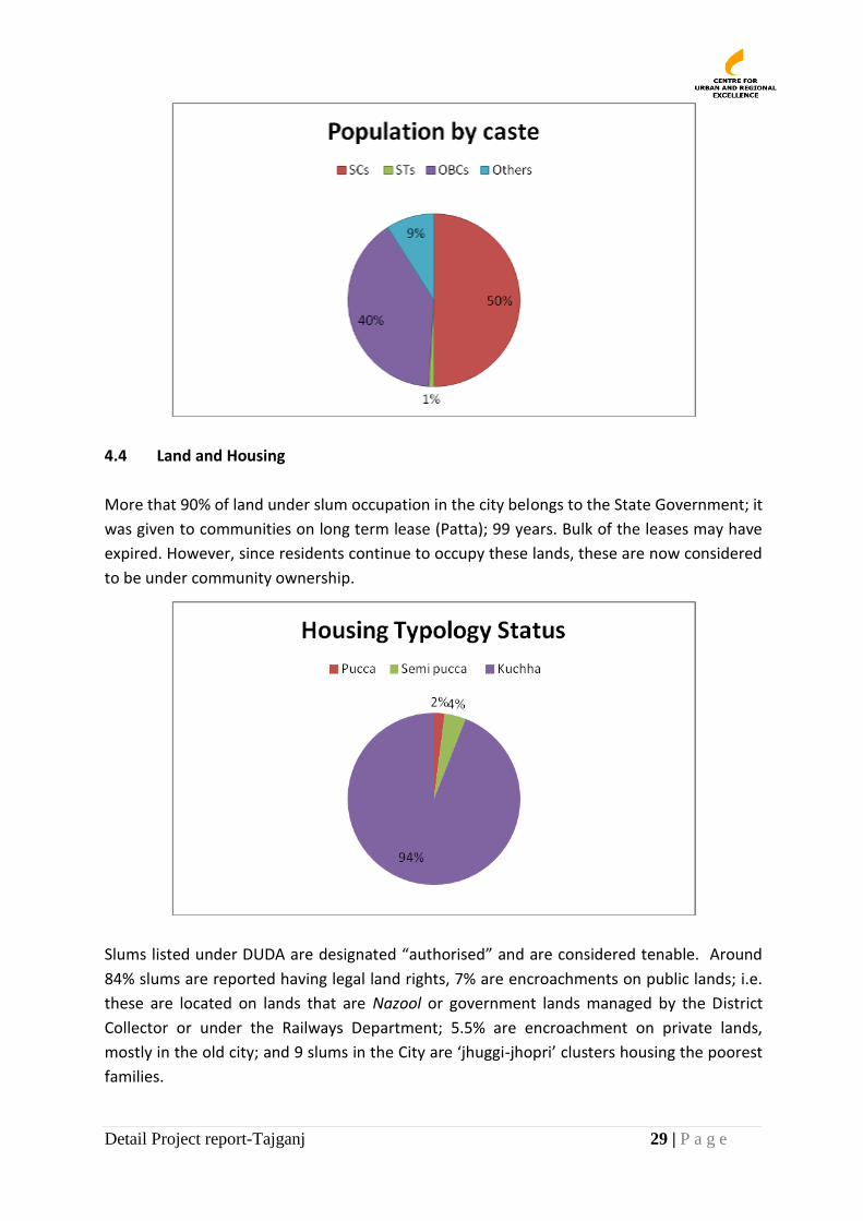
4.3 Social Composition
A significant proportion of slum dwellers in the City belongs to the backward and schedule
castes. Percentage of SC and OBC population in the slums has been estimated at 50% and
40% respectively. Data suggests that the SC population in the slums is significantly higher
than that in the rest of the City (21.5%).
Population of Agra
as per Census 2011
City Growth
Rate
Total estimated
slum population
from mapping study
% of slum dwellers to
total city population
(estimates)
1686976 30.37% 830174 49.2%
Detail Project report-Tajganj 29 | P a g e
4.4 Land and Housing
More that 90% of land under slum occupation in the city belongs to the State Government; it
was given to communities on long term lease (Patta); 99 years. Bulk of the leases may have
expired. However, since residents continue to occupy these lands, these are now considered
to be under community ownership.
Slums listed under DUDA are designated “authorised” and are considered tenable. Around
84% slums are reported having legal land rights, 7% are encroachments on public lands; i.e.
these are located on lands that are Nazool or government lands managed by the District
Collector or under the Railways Department; 5.5% are encroachment on private lands,
mostly in the old city; and 9 slums in the City are ‘jhuggi-jhopri’ clusters housing the poorest
families.
Detail Project report-Tajganj 30 | P a g e
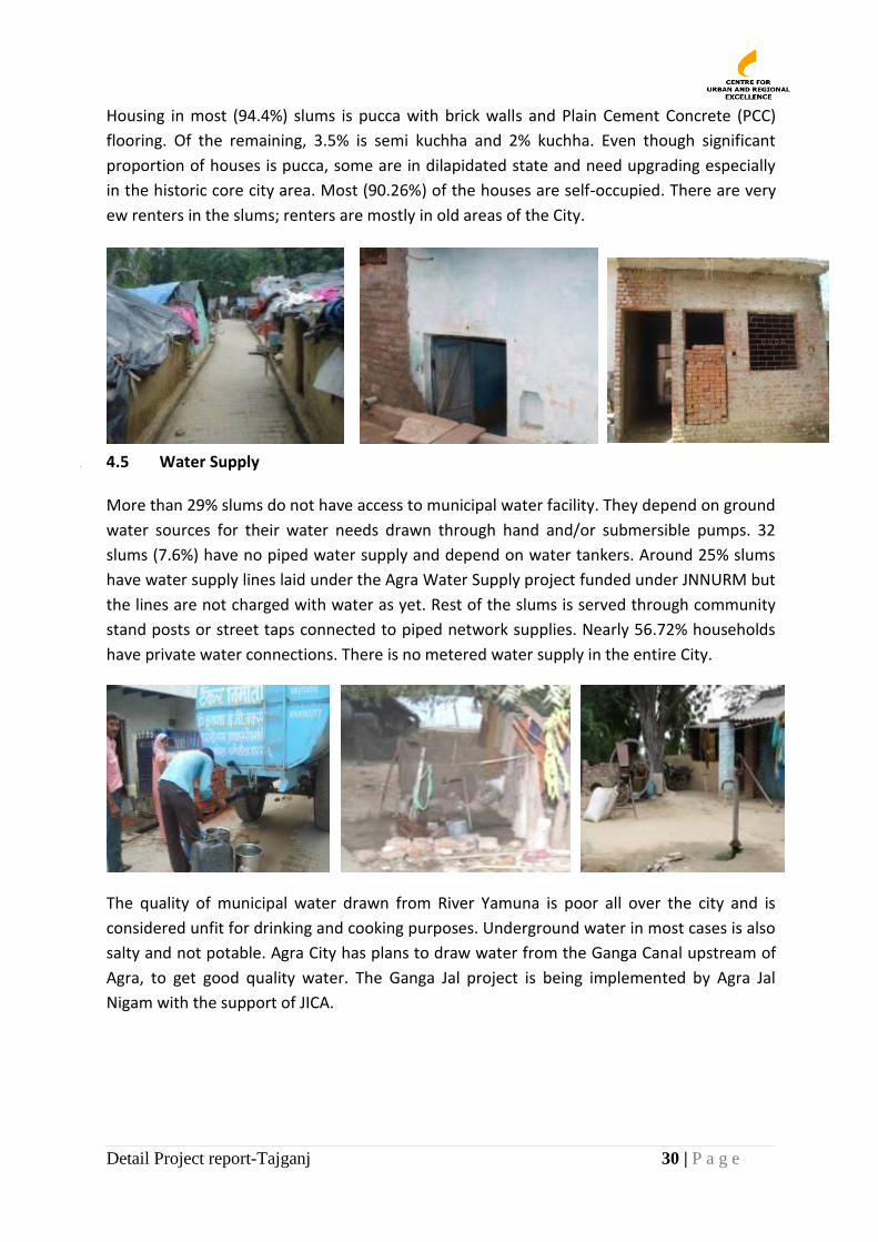
Housing in most (94.4%) slums is pucca with brick walls and Plain Cement Concrete (PCC)
flooring. Of the remaining, 3.5% is semi kuchha and 2% kuchha. Even though significant
proportion of houses is pucca, some are in dilapidated state and need upgrading especially
in the historic core city area. Most (90.26%) of the houses are self-occupied. There are very
ew renters in the slums; renters are mostly in old areas of the City.
4.5
4.6 4.5 Water Supply
More than 29% slums do not have access to municipal water facility. They depend on ground
water sources for their water needs drawn through hand and/or submersible pumps. 32
slums (7.6%) have no piped water supply and depend on water tankers. Around 25% slums
have water supply lines laid under the Agra Water Supply project funded under JNNURM but
the lines are not charged with water as yet. Rest of the slums is served through community
stand posts or street taps connected to piped network supplies. Nearly 56.72% households
have private water connections. There is no metered water supply in the entire City.
The quality of municipal water drawn from River Yamuna is poor all over the city and is
considered unfit for drinking and cooking purposes. Underground water in most cases is also
salty and not potable. Agra City has plans to draw water from the Ganga Canal upstream of
Agra, to get good quality water. The Ganga Jal project is being implemented by Agra Jal
Nigam with the support of JICA.
Detail Project report-Tajganj 31 | P a g e
4.6 Sanitation
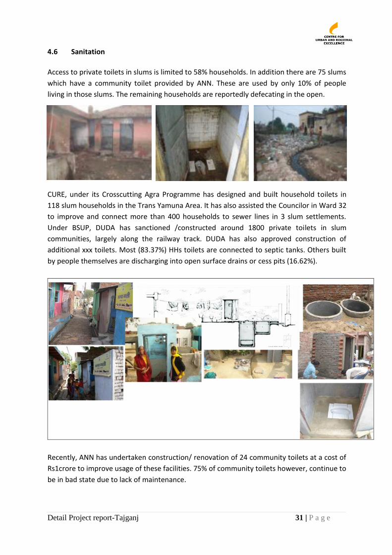
Access to private toilets in slums is limited to 58% households. In addition there are 75 slums
which have a community toilet provided by ANN. These are used by only 10% of people
living in those slums. The remaining households are reportedly defecating in the open.
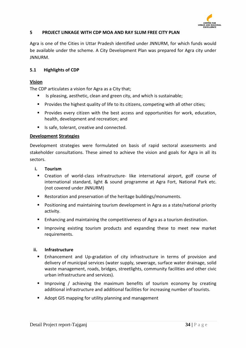
CURE, under its Crosscutting Agra Programme has designed and built household toilets in
118 slum households in the Trans Yamuna Area. It has also assisted the Councilor in Ward 32
to improve and connect more than 400 households to sewer lines in 3 slum settlements.
Under BSUP, DUDA has sanctioned /constructed around 1800 private toilets in slum
communities, largely along the railway track. DUDA has also approved construction of
additional xxx toilets. Most (83.37%) HHs toilets are connected to septic tanks. Others built
by people themselves are discharging into open surface drains or cess pits (16.62%).
Recently, ANN has undertaken construction/ renovation of 24 community toilets at a cost of
Rs1crore to improve usage of these facilities. 75% of community toilets however, continue to
be in bad state due to lack of maintenance.

Detail Project report-Tajganj 32 | P a g e
4.7 Roads and Drains
Most (93%) slums have a motorable approach road. In slum roads, 90.9% are either made of
brick kharanja, concrete paver blocks or cement concrete. Remaining 9.1% roads are
kuchha.
Types of drains generally correspond to the types of roads; roads have drains, kuccha roads
have kuccha drains. All drains are open. Most surface or grey water from homes passes
through these formal/informal drains to fall into larger drains (mostly kuchha) to ultimately
discharge sewage into the river without any treatment. Most surface drains are chocked due
to irregular cleaning. Water logging is thus a common problem in most slums both because
of improper surface drainage and bad road levels. This according to residents causes houses
to flood during the rains.
CURE, with support of ANN and funds from Water Trust UK, has built the first Decentralized
Waste Water Treatment System (DEWAT) on one of the City drains that flows into the River
Yamuna, significantly improving the quality of slum dwellers in the adjoining slum.
Figure 9: Poster of Decentralsied Waste Water treatment System in kachhpura, Agra

Detail Project report-Tajganj 33 | P a g e
4.8 Power Supply and Street Lights
Power supply in the city has been privatized recently. The company (Torrent Power) is
gradually extending legal power connections to all households including in slums. Almost all
slums now have access to power supply. Metering of power has started for slum households,
who shall get power at a subsidized rate. 98.32% slums also have street lights on roads, not
all of which work. The street lighting was poor and number of street light poles inadequate.
4.9 Social Infrastructure
4.9.1 Education
Literacy rates in slums are lower than in the rest of the City. 54.16% men and 45.83% women
are literate. 26.72% people are illiterate. Data on education suggests that about 5% children
may be out of school and possibly at work (source: Nagar Shiksha Adhikari, Agra).
Government has provided 168 pre-primary schools/anganwadis, 55 primary schools and 17
higher secondary schools near the slum communities. In addition, there are private
educational institutions that include 10 pre-primary schools, 152 primary and 60 higher
secondary schools within the slums. About 15% slum population is of children between 0-6
years of age. The sex ratio in slums is 860 per 1000 males.
4.9.2 Health
Only 8 slums have a government health facility within the slum area. 333 slums have access
to government hospitals and 369 have access to private clinics within a 5 km distance.
Majority of slum residents rely on private services for health care due to lack of public
services, inadequate staff and amenities in government health centres.
4.9.3 Livelihoods
About half the slum population (44%) works as skilled unskilled labour usually as daily
wagers. 26.22% are self-employed, contributing to the leather industry. Less than 5%
worked as casual labour. About 27% were salaried workers and even had formal government
jobs. The unemployment rate in the slums is 36.5%.
In majority of slums, women were found engaged in income generating work either as daily
wage labour, washerwomen, shoe making, whip making, pottery, housemaids, chain making,
making shoe boxes, shelling peanuts and chana, cake bags, newspaper bags, laundry bags for
hotels, knitting and sewing, dairy, making toilet brushes, agarbatti making, statue-making
(glass work), shoe cover making etc.
Agra has the lowest total work participation rate amongst the million plus cities; 25.3%. It
also has the lowest male work participation rate among the cities at 42.1%.
Detail Project report-Tajganj 34 | P a g e
5 PROJECT LINKAGE WITH CDP MOA AND RAY SLUM FREE CITY PLAN
Agra is one of the Cities in Uttar Pradesh identified under JNNURM, for which funds would
be available under the scheme. A City Development Plan was prepared for Agra city under
JNNURM.
5.1 Highlights of CDP
Vision
The CDP articulates a vision for Agra as a City that;
Is pleasing, aesthetic, clean and green city, and which is sustainable;
Provides the highest quality of life to its citizens, competing with all other cities;
Provides every citizen with the best access and opportunities for work, education, health, development and recreation; and
Is safe, tolerant, creative and connected.
Development Strategies
Development strategies were formulated on basis of rapid sectoral assessments and
stakeholder consultations. These aimed to achieve the vision and goals for Agra in all its
sectors.
i. Tourism
Creation of world-class infrastructure- like international airport, golf course of international standard, light & sound programme at Agra Fort, National Park etc. (not covered under JNNURM)
Restoration and preservation of the heritage buildings/monuments.
Positioning and maintaining tourism development in Agra as a state/national priority activity.
Enhancing and maintaining the competitiveness of Agra as a tourism destination.
Improving existing tourism products and expanding these to meet new market requirements.
ii. Infrastructure
Enhancement and Up-gradation of city infrastructure in terms of provision and delivery of municipal services (water supply, sewerage, surface water drainage, solid waste management, roads, bridges, streetlights, community facilities and other civic urban infrastructure and services).
Improving / achieving the maximum benefits of tourism economy by creating additional infrastructure and additional facilities for increasing number of tourists.
Adopt GIS mapping for utility planning and management
Detail Project report-Tajganj 35 | P a g e
iii. Urban poor
Provision of basic services in slum areas
Slum improvement and rehabilitation programme to cover the whole cross-section of the urban poor
Community empowerment for establishing linkages between community and bankers so as to facilitate assistance to beneficiaries.
Identify institutions for imparting specialized training to the community for improving their skills and talents
Improvement of housing conditions
iv. Inner city Development
Augmentation of existing water and sewer lines, maintain and lay new drains
Efficient disposal of solid waste to maintain the hygiene of the area
Shifting of non-conforming household/small industrial units to planned new areas
Strengthening the road surface and traffic management plan for smooth flow of traffic
Identify and revitalize the heritage buildings of the inner city
Urban Reforms
The CDP also envisaged instituting mandatory urban reforms under JNNURM. A few state
level reforms that would be critical for the success of JNNURM and also facilitate municipal-
parastatal coordination were also flagged out.
Implementation of the 74th Constitutional Amendment Act (CAA): The Government
of Uttar Pradesh, in order to facilitate urban development in Agra agreed to fully
implement the 74th CAA and to devolve all functions and powers to the city
Repeal of ULCA, Rent Act, Rationalization of Stamp Duty, bringing it down to 5
percent.
The Agra Nagar Nigam which carries out various civic functions in the city was to implement
the following reforms:
Rationalization of property tax and implementation of IT and GIS based property tax collection system.
Full implementation of Double Entry Accounting System.
Introduction of e-governance in all its functions.
Implementation of Ward Committees and their Byelaws to ensure the committees become operational and function properly.
Detail Project report-Tajganj 36 | P a g e
Besides reforms, the following were recommended for improving the effectiveness of the
municipal functions:
Coordinated implementation with all concerned parastatal, for smooth functioning
of all civic activities / works / projects, and with all surrounding municipalities/
cantonment boards so that inter-jurisdictional issues as well as functional overlap is
addressed.
Facilitate capacity building for all staff, creating aware about new developments in
the urban / municipal sector in India.
Develop a data base for all properties owned by the Corporation for property
portfolio management.
Create an MIS to bring together all data readily.
Engage private sector participation in the provisioning of civic services.
Involving NGOs and CBOs to mobilize people for participatory planning, budgeting,
implementation, selection of contractors or private service providers, monitoring
projects, provision and maintenance of services, etc.
Project Cost & City Investment Plan
The projects costs under Sub- Mission-I is approximately Rs. 7373.79 crores and under Sub
Mission II is Rs. 480.85 crores.
The City Investment Plan (CIP) gives an estimate of the level and quantum of investment
required to implement the strategies in specific sectors in the CDP over a specified
timeframe to attain the sustainable growth and to achieve the agenda goals. The CIP is
worked out duly considering the advice of Technical Experts, our recommendations based on
a thorough assessment of existing situation and the constant interaction with different
Stakeholders. The projects for system and infrastructure augmentation are derived based on
a broad demand - supply gap assessment for each of the service sector. Cost of all these
projects have been estimated in CIP and a suitable phasing for different years in the project
period have been worked out. Unit costs adapted are based on estimates of similar projects
planned/executed by MNN and other respective departments.
Detail Project report-Tajganj 37 | P a g e
5.2 Sub Mission 1 – Urban Infrastructure and Urban Governance
Action Plan and strategy formulation
The following sectoral action plans have been devised to improve the urban living conditions
in the city and help it achieve the vision envisaged for it.
Water Supply: Augmenting the present UG sources of water and identifying sources
of surface water, strengthening of existing piping and distribution system and laying
of new systems of distribution to fulfil the stated objectives
Sewerage: Zoning of the city based on natural features so as to increase efficiency in
networking and disposal, renovation and strengthening of existing network, provision
of Sewage treatment Plants on zonal basis, complete segregation of sewerage and
drainage networks.
Strom water Drainage: Strengthening of the Nalahs in the city to cater to and act as a
drainage system, segregation of Industrial effluent and storm water, water recharging
through SW Drainage system and restoration of city’s natural drainage systems
Solid waste management: To consolidate and improve the collection system from
weekly to daily basis, segregation of municipal and bio-waste, to achieve segregation
and maximize reuse, recovery and recycling of solid waste.
Urban Transport: Improving and strengthening existing road system, ensuring
increase of passenger traffic in share of public transport system, strengthening the
Public road transport system in the medium term (2006-24), while developing a fully
operational Mass Transit system by 2034 to ensure 50% share of Public transport in
the city traffic.
5.3 Sub Mission II – Basic Services to Urban Poor
Slums in Agra have grown from 10 Slum pockets in 1950 to 252 Slum pockets in 2001 and
417in 2011. At the time of CDP preparation, Agra had an estimated 378 slums; 252 listed
with the DUDA and the rest non-listed identified in a slum mapping study undertaken by
CURE. The total estimated population living in the 378 slums as reported by residents was
862,040. The population was estimated using the official household size for the city at 6.54.
There are now 417 slums in the City. Details of these will be provided in the next section on
the DPR.
The unlisted slums are often missed for basic services and benefits under various
governments’ Programes dew to flaws in the current planning process and government
policies practiced so far. Because these settlements have been receiving poor quality services
it has created poor environmental and hygiene conditions in the slums and an inequitable
city.
An example of NGO managed service delivery and community mobilization program in Agra
is presented in the box below.
Detail Project report-Tajganj 38 | P a g e
CENTRE FOR URBAN AND REGIONAL EXCELLNECE (CURE)
Cross cutting Agra Programme (CAP) is a slum upgrading programme being implemented by the Agra Nagar Nigam with the support of Centre for Urban and Regional Excellence (CURE) an NGO. CAP has mobilized communities and engaged them in the process of planning for development of their settlements.
As part of slum upgrading prgramme, the following slum upgrading tasks were undertaken by CURE with a view to demonstrate inclusive planning and development. Most of the tasks were undertaken in the Kachhpura area, part of the CAP and the Mughal Heritage Walk project. Upgrading activities were also scaled up to other slum sites; Katra Wazir Khan and Ward 32 to validate the principles of slum upgrading planning and implementation.
Community Action Plan: Slum action plans are developed through a consultative/participatory process through street and community meetings that involve all groups and are consolidated into ward plans with intra community groups discussing crosscutting issues.
Mughal heritage Walk: The MHW is a unique community tourism experience of the Mughal history of Agra. Residents, who were trained to organize heritage walks and manage the MHW business enterprise, recognized it as an opportunity. The physical infrastructure works involved laying of pathways, development of the community courtyard and façade decoration with Sanjhi motifs along the walk route. Its community development initiatives included training of youth as tour animators, street theater artist and local art and souvenir development.
Toilets in Home: Slums have been upgraded with toilets – at home, community and school. Communities have participated in the design, construction, operations management and oversight. A Toilet Savings Group enabled women to save-up for home toilets with matching/upfront contribution from project funds for a functional unit (pan, plumbing, septic tank). Toilets were customized to home spaces - inside rooms, courtyards, terraces, etc. with technical innovations to minimize damage to standing structures and designed so these could be built incrementally. Low-budget options were created using local material. Successful installation of the first septic tank, pan, pipes and manholes signalled the start of Swatch Galli, the street where all houses have personal toilets, extending to more such streets.
DEWAT: To treat the gray water from toilets, the large city drain passing by the settlement has been linked to a Decentralized Waste Water Treatment System (DEWAT) to treat through anaerobic processes, septic tank and waste water outflows, both from Kachhpura and upstream flows, bringing Biochemical Oxygen Demand levels to acceptable standards.
Courtyard Development: The central courtyard in the settlement was improved using community attributes in the design, material, and overall development of the area. In a series of community meetings people developed the courtyard plans with the help of technical engineers and architects, and based on shared concerns, current usages, climatic responses to various materials etc. The authenticity of the area was preserved by using materials used historically and by discretely incorporating them with construction technology.
CURE’s initiative in Agra was recognized in 2008 as a Good Practice by UN Habitat – Dubai Municipality Awards and as a Best Practice by the Department of Administrative Reforms and Public Grievance, Government of India. It has also been shortlisted for the National Urban Water Awards (NUWA), 2011 by the ministry of Urban Development.
Besides the above, it has been shared and disseminated at various workshops, seminars, training Programes, both nationally and internationally at the Metropolis Commission Meeting in Barcelona and Norwegian University of Science and Technology.
Detail Project report-Tajganj 39 | P a g e
The work of NGOs has contributed to the generation of data on unregistered slums, status
of services in these settlements and their vulnerability. Key issues and challenges identified
in the CDP under BSUP were;
Lack of Reliable Data on Slums
All slums are not equal in terms of need. Slums in the city are not homogenous and
there is a wide disparity between services to slum dwellers and the formal city.
The unlisted slums are the most vulnerable. On the basis of certain parameters, the
CDP categorized slums into most, moderate and less vulnerable and recommended
that their needs be addressed accordingly and with variable programmatic
interventions.
CDP proposed the following interventions in slums areas.
Improve Access to Basic Infrastructure Facilities: Although most of the slums are
located in the core areas of the city, they are characterized by poor quality of life
induced by inadequate basic infrastructure. Absence of dustbins, drains, surfaced roads
and solid waste collection systems lead to poor quality of living. All slums need to get
access to basic services.
Improve Access to Sanitation: The poorest households do not have access to toilets.
Non existence of public toilets is the reason for open defection. Sanitation services must
be key intervention priority in slums
Access to Water Supply: Slum people depend mostly on public stand posts for water
supply that adds to their poor health conditions. There is need to improve access to
water supply in slums.
Availability of Health and Education Facilities: There is an absence of health facilities
and education institutions near /in slum communities’ poor people which needs to be
addressed.
5.4 Status of MoA under BSUP
MoA has been signed for the project “Basic Services to the Urban Poor”.
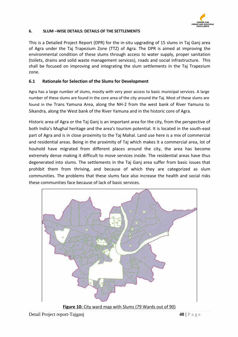
Detail Project report-Tajganj 40 | P a g e
6. SLUM –WISE DETAILS: DETAILS OF THE SETTLEMENTS This is a Detailed Project Report (DPR) for the in-situ upgrading of 15 slums in Taj Ganj area of Agra under the Taj Trapezium Zone (TTZ) of Agra. The DPR is aimed at improving the environmental condition of these slums through access to water supply, proper sanitation (toilets, drains and solid waste management services), roads and social infrastructure. This shall be focused on improving and integrating the slum settlements in the Taj Trapezium zone.
6.1 Rationale for Selection of the Slums for Development
Agra has a large number of slums, mostly with very poor access to basic municipal services. A large
number of these slums are found in the core area of the city around the Taj. Most of these slums are
found in the Trans Yamuna Area, along the NH-2 from the west bank of River Yamuna to
Sikandra, along the West bank of the River Yamuna and in the historic core of Agra.
Historic area of Agra or the Taj Ganj is an important area for the city, from the perspective of
both India’s Mughal heritage and the area’s tourism potential. It is located in the south-east
part of Agra and is in close proximity to the Taj Mahal. Land use here is a mix of commercial
and residential areas. Being in the proximity of Taj which makes it a commercial area, lot of
houhold have migrated from different places around the city, the area has become
extremely dense making it difficult to move services inside. The residential areas have thus
degenerated into slums. The settlements in the Taj Ganj area suffer from basic issues that
prohibit them from thriving, and because of which they are categorized as slum
communities. The problems that these slums face also increase the health and social risks
these communities face because of lack of basic services.
Figure 10: City ward map with Slums (79 Wards out of 90)
Detail Project report-Tajganj 41 | P a g e
As per the Master Plan this Area falls in Zone 6, which is mostly residential with medium
density, permitting low rise housing. The Master Plan has envisaged commercial activities in
the area such as the Bazaar Street along the main road mostly catering to the surrounding
settlements. Land is also provided for various categories of hotels in the area.
The slum settlements in the Tajganj area are mostly aligned to the Taj East Drain that flows
directly into the Yamuna River. The drain is approximately 8 feet wide and 8 feet in depth in
average. It causes serious problems during the monsoon as it causes flooding in the area
and has been responsible for many accidents.
6.2 Methodology For DPR Preparation
This DPR has been prepared using ground evidence and participatory processes as described
below:
6.2.1 Data Generation
Data for the preparation of the DPR has been collected through participatory processes. This
has included information at the area level and at the household level.
6.2.1.1 Review of Government Schemes and Programs for TTZ
Information and maps at the area level have been collected from various service delivery
agencies/ departments. This includes the various development schemes proposed in the city
in general and for the TTZ in particular city to understand the broad framework within which
slum development shall happen. All the schemes of the Central, State and City Government
for the area improvement, including for slums improvement are being implemented here.
6.2.1.2 Household and Rapid Assessments
Primary data is being collected through household surveys with the support of the
community. Youth from the community have been identified to undertake the surveys. In
order to prepare the DPR, a rapid assessment for the area was made using qualitative tools
and Focus Group Discussions on a set of key parameters developed in consultation with
ANN and DUDA.
6.2.1.3 Participatory Learning and Action Tools
CURE’s field facilitators trained in the use of Participatory Learning and Action (PLA) tools,
interacted with the community on key problems and solutions. PLA tools used were:
transect walks, chapatti diagrams, resource mapping, seeds techniques, etc. These helped
communities identify and prioritize their needs. The information collected has been
quantified and analysed for the purpose of this Plan.
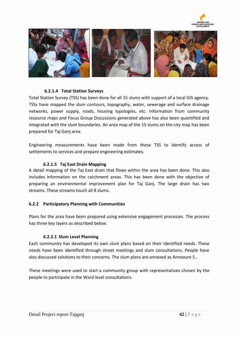
Detail Project report-Tajganj 42 | P a g e
6.2.1.4 Total Station Surveys
Total Station Survey (TSS) has been done for all 15 slums with support of a local GIS agency.
TSSs have mapped the slum contours, topography, water, sewerage and surface drainage
networks, power supply, roads, housing typologies, etc. Information from community
resource maps and Focus Group Discussions generated above has also been quantified and
integrated with the slum boundaries. An area map of the 15 slums on the city map has been
prepared for Taj Ganj area.
Engineering measurements have been made from these TSS to identify access of
settlements to services and prepare engineering estimates.
6.2.1.5 Taj East Drain Mapping
A detail mapping of the Taj East drain that flows within the area has been done. This also
includes information on the catchment areas. This has been done with the objective of
preparing an environmental improvement plan for Taj Ganj. The large drain has two
streams. These streams touch all 8 slums.
6.2.2 Participatory Planning with Communities
Plans for the area have been prepared using extensive engagement processes. The process
has three key layers as described below.
6.2.2.1 Slum Level Planning
Each community has developed its own slum plans based on their identified needs. These
needs have been identified through street meetings and slum consultations. People have
also discussed solutions to their concerns. The slum plans are annexed as Annexure 5..
These meetings were used to start a community group with representatives chosen by the
people to participate in the Ward level consultations.
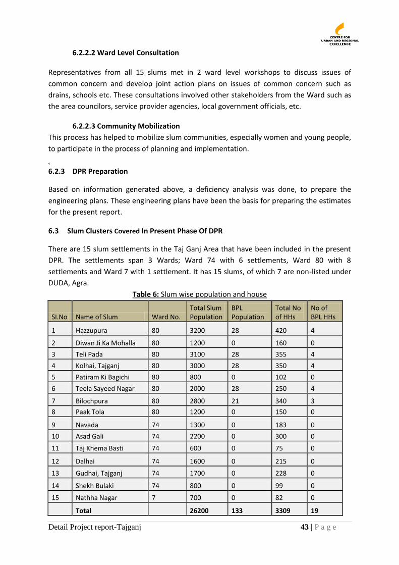
Detail Project report-Tajganj 43 | P a g e
6.2.2.2 Ward Level Consultation Representatives from all 15 slums met in 2 ward level workshops to discuss issues of
common concern and develop joint action plans on issues of common concern such as
drains, schools etc. These consultations involved other stakeholders from the Ward such as
the area councilors, service provider agencies, local government officials, etc.
6.2.2.3 Community Mobilization
This process has helped to mobilize slum communities, especially women and young people,
to participate in the process of planning and implementation. <
6.2.3 DPR Preparation
Based on information generated above, a deficiency analysis was done, to prepare the
engineering plans. These engineering plans have been the basis for preparing the estimates
for the present report. ,
6.3 Slum Clusters Covered In Present Phase Of DPR
There are 15 slum settlements in the Taj Ganj Area that have been included in the present
DPR. The settlements span 3 Wards; Ward 74 with 6 settlements, Ward 80 with 8
settlements and Ward 7 with 1 settlement. It has 15 slums, of which 7 are non-listed under
DUDA, Agra.
Table 6: Slum wise population and house
SI.No Name of Slum Ward No. Total Slum Population
BPL Population
Total No of HHs
No of BPL HHs
1 Hazzupura 80 3200 28 420 4
2 Diwan Ji Ka Mohalla 80 1200 0 160 0
3 Teli Pada 80 3100 28 355 4
4 Kolhai, Tajganj 80 3000 28 350 4
5 Patiram Ki Bagichi 80 800 0 102 0
6 Teela Sayeed Nagar 80 2000 28 250 4
7 Bilochpura 80 2800 21 340 3
8 Paak Tola 80 1200 0 150 0
9 Navada 74 1300 0 183 0
10 Asad Gali 74 2200 0 300 0
11 Taj Khema Basti 74 600 0 75 0
12 Dalhai 74 1600 0 215 0
13 Gudhai, Tajganj 74 1700 0 228 0
14 Shekh Bulaki 74 800 0 99 0
15 Nathha Nagar 7 700 0 82 0
Total 26200 133 3309 19
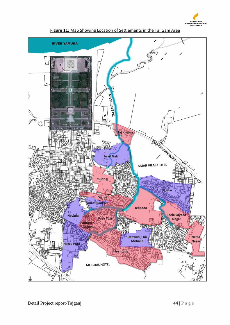
Detail Project report-Tajganj 44 | P a g e
Figure 11: Map Showing Location of Settlements in the Taj Ganj Area
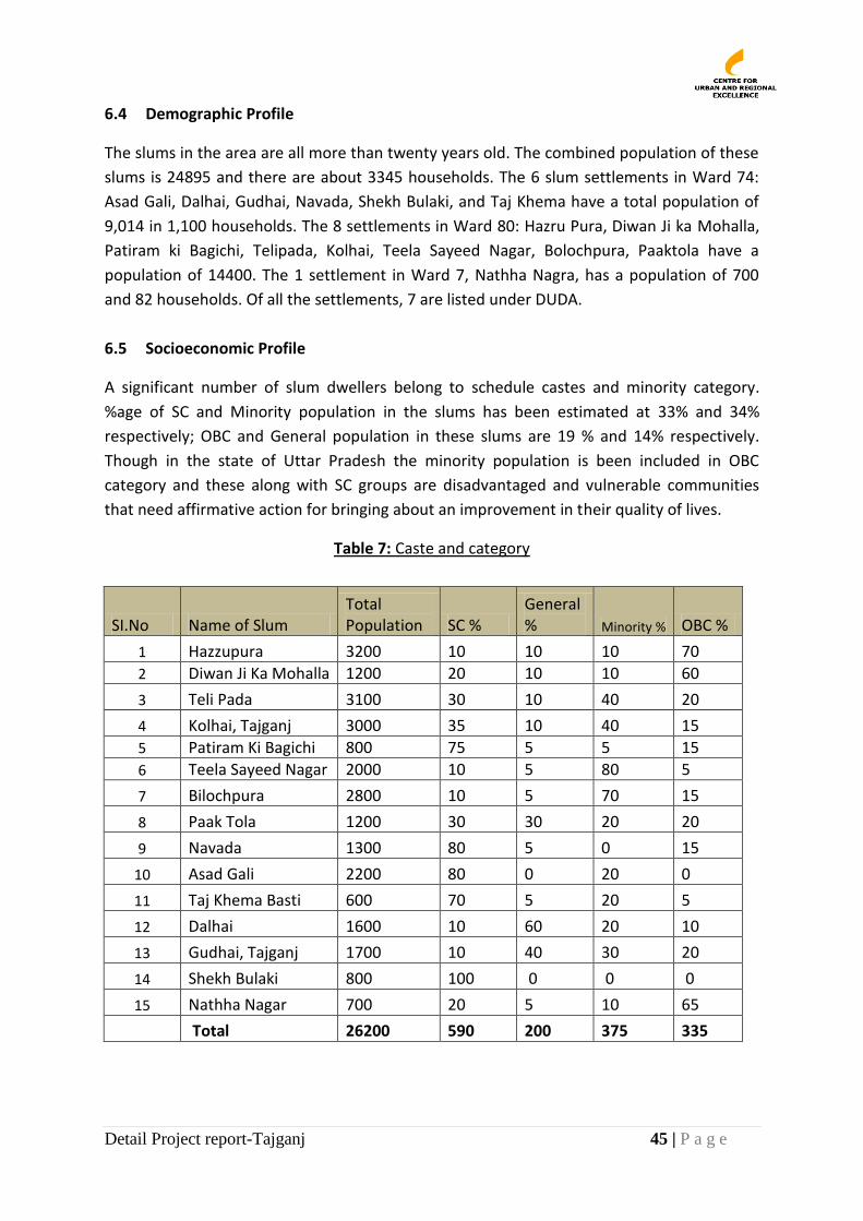
Detail Project report-Tajganj 45 | P a g e
6.4 Demographic Profile
The slums in the area are all more than twenty years old. The combined population of these
slums is 24895 and there are about 3345 households. The 6 slum settlements in Ward 74:
Asad Gali, Dalhai, Gudhai, Navada, Shekh Bulaki, and Taj Khema have a total population of
9,014 in 1,100 households. The 8 settlements in Ward 80: Hazru Pura, Diwan Ji ka Mohalla,
Patiram ki Bagichi, Telipada, Kolhai, Teela Sayeed Nagar, Bolochpura, Paaktola have a
population of 14400. The 1 settlement in Ward 7, Nathha Nagra, has a population of 700
and 82 households. Of all the settlements, 7 are listed under DUDA.
6.5 Socioeconomic Profile
A significant number of slum dwellers belong to schedule castes and minority category.
%age of SC and Minority population in the slums has been estimated at 33% and 34%
respectively; OBC and General population in these slums are 19 % and 14% respectively.
Though in the state of Uttar Pradesh the minority population is been included in OBC
category and these along with SC groups are disadvantaged and vulnerable communities
that need affirmative action for bringing about an improvement in their quality of lives.
Table 7: Caste and category
SI.No Name of Slum Total Population SC %
General % Minority % OBC %
1 Hazzupura 3200 10 10 10 70
2 Diwan Ji Ka Mohalla 1200 20 10 10 60
3 Teli Pada 3100 30 10 40 20
4 Kolhai, Tajganj 3000 35 10 40 15
5 Patiram Ki Bagichi 800 75 5 5 15
6 Teela Sayeed Nagar 2000 10 5 80 5
7 Bilochpura 2800 10 5 70 15
8 Paak Tola 1200 30 30 20 20
9 Navada 1300 80 5 0 15
10 Asad Gali 2200 80 0 20 0
11 Taj Khema Basti 600 70 5 20 5
12 Dalhai 1600 10 60 20 10
13 Gudhai, Tajganj 1700 10 40 30 20
14 Shekh Bulaki 800 100 0 0 0
15 Nathha Nagar 700 20 5 10 65
Total 26200 590 200 375 335
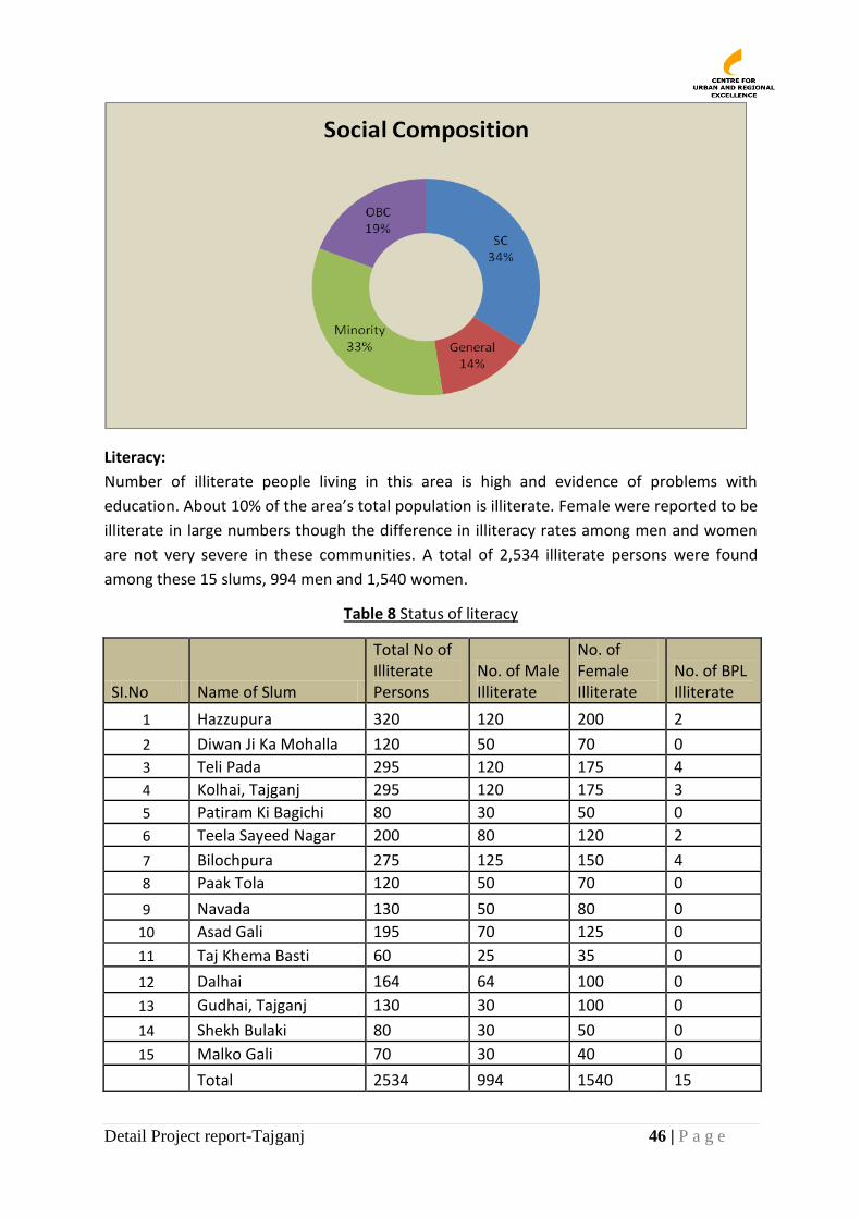
Detail Project report-Tajganj 46 | P a g e
Literacy:
Number of illiterate people living in this area is high and evidence of problems with
education. About 10% of the area’s total population is illiterate. Female were reported to be
illiterate in large numbers though the difference in illiteracy rates among men and women
are not very severe in these communities. A total of 2,534 illiterate persons were found
among these 15 slums, 994 men and 1,540 women.
Table 8 Status of literacy
SI.No Name of Slum
Total No of Illiterate Persons
No. of Male Illiterate
No. of Female Illiterate
No. of BPL Illiterate
1 Hazzupura 320 120 200 2
2 Diwan Ji Ka Mohalla 120 50 70 0
3 Teli Pada 295 120 175 4
4 Kolhai, Tajganj 295 120 175 3
5 Patiram Ki Bagichi 80 30 50 0
6 Teela Sayeed Nagar 200 80 120 2
7 Bilochpura 275 125 150 4
8 Paak Tola 120 50 70 0
9 Navada 130 50 80 0
10 Asad Gali 195 70 125 0
11 Taj Khema Basti 60 25 35 0
12 Dalhai 164 64 100 0
13 Gudhai, Tajganj 130 30 100 0
14 Shekh Bulaki 80 30 50 0
15 Malko Gali 70 30 40 0
Total 2534 994 1540 15
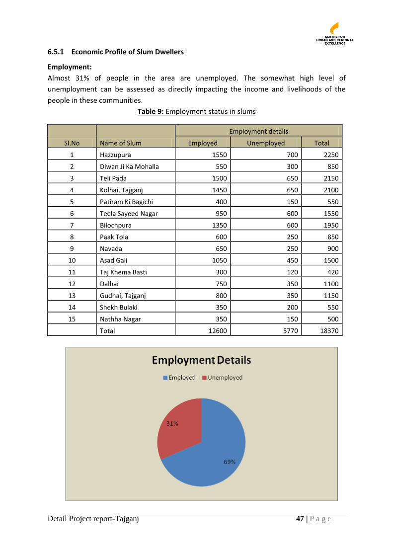
Detail Project report-Tajganj 47 | P a g e
6.5.1 Economic Profile of Slum Dwellers
Employment:
Almost 31% of people in the area are unemployed. The somewhat high level of
unemployment can be assessed as directly impacting the income and livelihoods of the
people in these communities.
Table 9: Employment status in slums
SI.No Name of Slum
Employment details
Employed Unemployed Total
1 Hazzupura 1550 700 2250
2 Diwan Ji Ka Mohalla 550 300 850
3 Teli Pada 1500 650 2150
4 Kolhai, Tajganj 1450 650 2100
5 Patiram Ki Bagichi 400 150 550
6 Teela Sayeed Nagar 950 600 1550
7 Bilochpura 1350 600 1950
8 Paak Tola 600 250 850
9 Navada 650 250 900
10 Asad Gali 1050 450 1500
11 Taj Khema Basti 300 120 420
12 Dalhai 750 350 1100
13 Gudhai, Tajganj 800 350 1150
14 Shekh Bulaki 350 200 550
15 Nathha Nagar 350 150 500
Total 12600 5770 18370
Detail Project report-Tajganj 48 | P a g e
Traditional livelihoods in these areas are evident. Men in these communities are generally
employed in shoemaking, marble works, and rickshaw pulling. While these are all suitable
for making a living, these are also skilled professions and community members have
expressed interest in being provided the skills to learn how to thrive in these businesses.
Women do not enter the workforce because they would like to stay within their
communities during the day but they do engage themselves in household works such as zari
Zardiozi, garland making, inlay etc.
Occupation Status
About 69% people in these slums are employed (salaried, self-employed or working in other
businesses). Among the employed, most of the houses were reported to be engaged in
some or the other household work (42%). About 28% houses are in regular wage, 20%
salaried. About 10% population works as casual labour.
Table 10: Slum wise occupation
SI.No Name of Slum
Occupational status No of HHs
Self-employed Salaried
Regular wage
Casual labour Others Total
1 Hazzupura 190 40 180 10 0 420
2 Diwan Ji Ka Mohalla 50 30 80 0 0 160
3 Teli Pada 150 70 70 65 0 355
4 Kolhai, Tajganj 110 50 150 40 0 350
5 Patiram Ki Bagichi 20 30 40 12 0 102
6 Teela Sayeed Nagar 125 60 25 40 0 250
7 Bilochpura 235 70 20 15 0 340
8 Paak Tola 60 60 15 15 0 150
9 Navada 50 70 50 13 0 183
10 Asad Gali 110 60 80 50 0 300
11 Taj Khema Basti 30 10 20 15 0 75
12 Dalhai 105 45 45 20 0 215
13 Gudhai, Tajganj 90 35 85 18 0 228
14 Shekh Bulaki 20 10 55 14 0 99
15 Nathha Nagar 25 20 20 17 0 82
Total 1370 660 935 344 0 3309
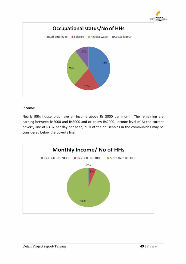
Detail Project report-Tajganj 49 | P a g e
Income:
Nearly 95% households have an income above Rs 3000 per month. The remaining are
earning between Rs2000 and Rs3000 and or below Rs2000. Income level of At the current
poverty line of Rs.32 per day per head, bulk of the households in the communities may be
considered below the poverty line.
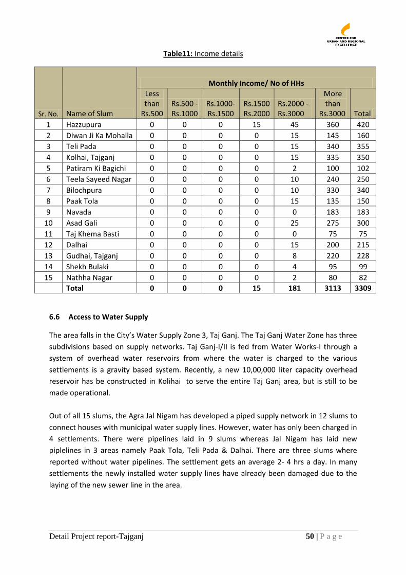
Detail Project report-Tajganj 50 | P a g e
Table11: Income details
Sr. No. Name of Slum
Monthly Income/ No of HHs
Less than
Rs.500 Rs.500 -Rs.1000
Rs.1000-Rs.1500
Rs.1500 Rs.2000
Rs.2000 - Rs.3000
More than
Rs.3000 Total
1 Hazzupura 0 0 0 15 45 360 420
2 Diwan Ji Ka Mohalla 0 0 0 0 15 145 160
3 Teli Pada 0 0 0 0 15 340 355
4 Kolhai, Tajganj 0 0 0 0 15 335 350
5 Patiram Ki Bagichi 0 0 0 0 2 100 102
6 Teela Sayeed Nagar 0 0 0 0 10 240 250
7 Bilochpura 0 0 0 0 10 330 340
8 Paak Tola 0 0 0 0 15 135 150
9 Navada 0 0 0 0 0 183 183
10 Asad Gali 0 0 0 0 25 275 300
11 Taj Khema Basti 0 0 0 0 0 75 75
12 Dalhai 0 0 0 0 15 200 215
13 Gudhai, Tajganj 0 0 0 0 8 220 228
14 Shekh Bulaki 0 0 0 0 4 95 99
15 Nathha Nagar 0 0 0 0 2 80 82
Total 0 0 0 15 181 3113 3309
6.6 Access to Water Supply
The area falls in the City’s Water Supply Zone 3, Taj Ganj. The Taj Ganj Water Zone has three
subdivisions based on supply networks. Taj Ganj-I/II is fed from Water Works-I through a
system of overhead water reservoirs from where the water is charged to the various
settlements is a gravity based system. Recently, a new 10,00,000 liter capacity overhead
reservoir has be constructed in Kolihai to serve the entire Taj Ganj area, but is still to be
made operational.
Out of all 15 slums, the Agra Jal Nigam has developed a piped supply network in 12 slums to
connect houses with municipal water supply lines. However, water has only been charged in
4 settlements. There were pipelines laid in 9 slums whereas Jal Nigam has laid new
piplelines in 3 areas namely Paak Tola, Teli Pada & Dalhai. There are three slums where
reported without water pipelines. The settlement gets an average 2- 4 hrs a day. In many
settlements the newly installed water supply lines have already been damaged due to the
laying of the new sewer line in the area.
Detail Project report-Tajganj 51 | P a g e
Table 12: Status of municipal water supply
S. No. Name of the Slum Water supply Municipal Pipe
Line New Lines or Old
lines Functional
1 Hazzupura Yes Old Yes 2 Diwanji Ka Muhalla No NA NA 3 Teli Pada Yes Both No 4 Kolhai Yes Old No 5 Patiram Ki Bagichi Yes Old Yes 6 Teela Shayeed Nagar Yes Old No 7 Bilochpura No NA NA 8 Paak Tola Yes Both No 9 Navada Yes Old No
10 Asad Gali Yes Old Yes 11 Taj Khema Basti Yes Old Yes 12 Dalhai Yes Both No 13 Gudhai, Tajganj Yes Old No 14 Shekh Bulaki Yes Old No 15 Nathha Nagar No NA NA
Most residents use underground water, the quality of which varies from potable to brackish.
There are more than 100 government hand pumps in the area, of which majority are non-
functional. Some of them have been rebored but water couldn’t be charged. Water is also
supplied, albeit erratically, through government tankers but mostly in summary. Few houses
have installed private submersible pumps. These are shared by a cluster of houses. Others
buy water used for drinking and cooking purpose form private water tankers and pay Rs.
600 per month. In summer, due to scarcity of water, the monthly expense goes up.
Without doubt, the biggest complaint that the members of these settlements have concerns
the quality and availability of water. Tap water, which comes from the municipal tap, is not
available in all homes or is only accessible for a few hours a day. This causes problems with
carrying out daily activities such as washing, bathing; even brushing ones teeth. The families
who do not have constant access to this water have to go to the nearest house that receives
water in order to fill buckets of water for their every day needs. This wastes time that could
be used in more productive manners such as income generating activities.
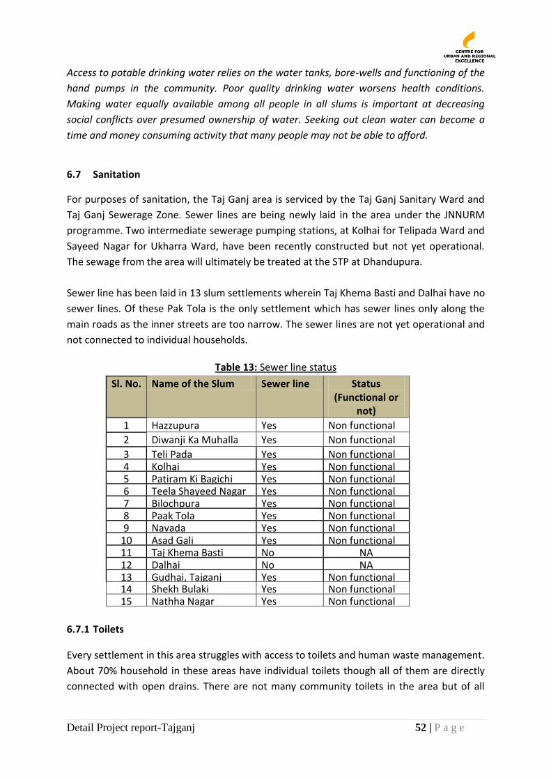
Detail Project report-Tajganj 52 | P a g e
Access to potable drinking water relies on the water tanks, bore-wells and functioning of the
hand pumps in the community. Poor quality drinking water worsens health conditions.
Making water equally available among all people in all slums is important at decreasing
social conflicts over presumed ownership of water. Seeking out clean water can become a
time and money consuming activity that many people may not be able to afford.
6.7 Sanitation
For purposes of sanitation, the Taj Ganj area is serviced by the Taj Ganj Sanitary Ward and
Taj Ganj Sewerage Zone. Sewer lines are being newly laid in the area under the JNNURM
programme. Two intermediate sewerage pumping stations, at Kolhai for Telipada Ward and
Sayeed Nagar for Ukharra Ward, have been recently constructed but not yet operational.
The sewage from the area will ultimately be treated at the STP at Dhandupura.
Sewer line has been laid in 13 slum settlements wherein Taj Khema Basti and Dalhai have no
sewer lines. Of these Pak Tola is the only settlement which has sewer lines only along the
main roads as the inner streets are too narrow. The sewer lines are not yet operational and
not connected to individual households.
Table 13: Sewer line status
Sl. No. Name of the Slum Sewer line Status (Functional or
not)
1 Hazzupura Yes Non functional
2 Diwanji Ka Muhalla Yes Non functional
3 Teli Pada Yes Non functional 4 Kolhai Yes Non functional 5 Patiram Ki Bagichi Yes Non functional 6 Teela Shayeed Nagar Yes Non functional 7 Bilochpura Yes Non functional 8 Paak Tola Yes Non functional 9 Navada Yes Non functional
10 Asad Gali Yes Non functional 11 Taj Khema Basti No NA 12 Dalhai No NA 13 Gudhai, Tajganj Yes Non functional 14 Shekh Bulaki Yes Non functional 15 Nathha Nagar Yes Non functional
6.7.1 Toilets
Every settlement in this area struggles with access to toilets and human waste management.
About 70% household in these areas have individual toilets though all of them are directly
connected with open drains. There are not many community toilets in the area but of all
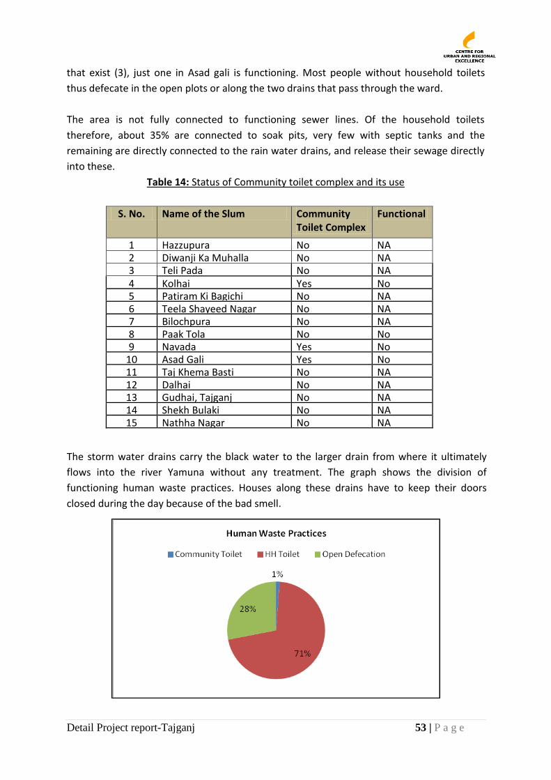
Detail Project report-Tajganj 53 | P a g e
that exist (3), just one in Asad gali is functioning. Most people without household toilets
thus defecate in the open plots or along the two drains that pass through the ward.
The area is not fully connected to functioning sewer lines. Of the household toilets
therefore, about 35% are connected to soak pits, very few with septic tanks and the
remaining are directly connected to the rain water drains, and release their sewage directly
into these.
Table 14: Status of Community toilet complex and its use
S. No. Name of the Slum Community Toilet Complex
Functional
1 Hazzupura No NA 2 Diwanji Ka Muhalla No NA 3 Teli Pada No NA 4 Kolhai Yes No 5 Patiram Ki Bagichi No NA 6 Teela Shayeed Nagar No NA 7 Bilochpura No NA 8 Paak Tola No No 9 Navada Yes No
10 Asad Gali Yes No 11 Taj Khema Basti No NA 12 Dalhai No NA 13 Gudhai, Tajganj No NA 14 Shekh Bulaki No NA 15 Nathha Nagar No NA
The storm water drains carry the black water to the larger drain from where it ultimately
flows into the river Yamuna without any treatment. The graph shows the division of
functioning human waste practices. Houses along these drains have to keep their doors
closed during the day because of the bad smell.

Detail Project report-Tajganj 54 | P a g e
The lack of toilets in the community affects the health of the people. It also adds to the time for defecation; long trips to toilets or open areas, and the general discomfort or embarrassment for women in particular.
All houses must have toilets and these must be connected to a functioning sewer line. This
will ensure that community members don’t have health problems from open sewage in the
drains. Families can save on paying a private sweeper, and it will remove the smell that
results from sewage entering the drains. Till sewer lines are installed and all houses assisted
to get a personal toilet, slums need to have access to a way of disposing of waste properly.
The access to this fundamental aspect of sanitation needs to be available in every household
to provide more hygienic conditions which will also help reduce the cost of health care.
6.7.2 Drainage
The Taj East drain passes through most of the settlements (8) in the area. It is 4888 meters7
in length and carries surface water and sewage from the Taj Ganj area and other parts of the
city having a total catchment of 931 hac and ultimately falls into river Yamuna without
treatment. Many settlements, especially those in Ward 74, are aligned along the big drain.
Besides carrying the black water into the river untreated, the drain is so large that during the
monsoon season children sometimes fall in and drown.
The Taj East drain is in appalling condition. There is visible waste, both human and
nonhuman, in the drain. In the section between Taj Khema and Navada, there is severe
nonhuman waste blockage and several animals were found lounging, eating, and defecating
in the water. This water flows into the Yamuna River untreated and therefore contributes to
poor health. Being such a large drain without proper parapet/border leads to flooding of the
adjoining roads and houses during monsoons and many children were reported to be
drowned in the drains especially in Sekh Bulalki, Navada and Patiram ki Bagichi.
All the surface drains in the settlements are open. Many are also damaged or kuchha. This
affects their capacity to function properly. Damaged and shallow drains are susceptible to
water-logging, which causes damage through flooding houses as well as making conditions
much less sanitary.
7 City Development Plan, Agra 2006
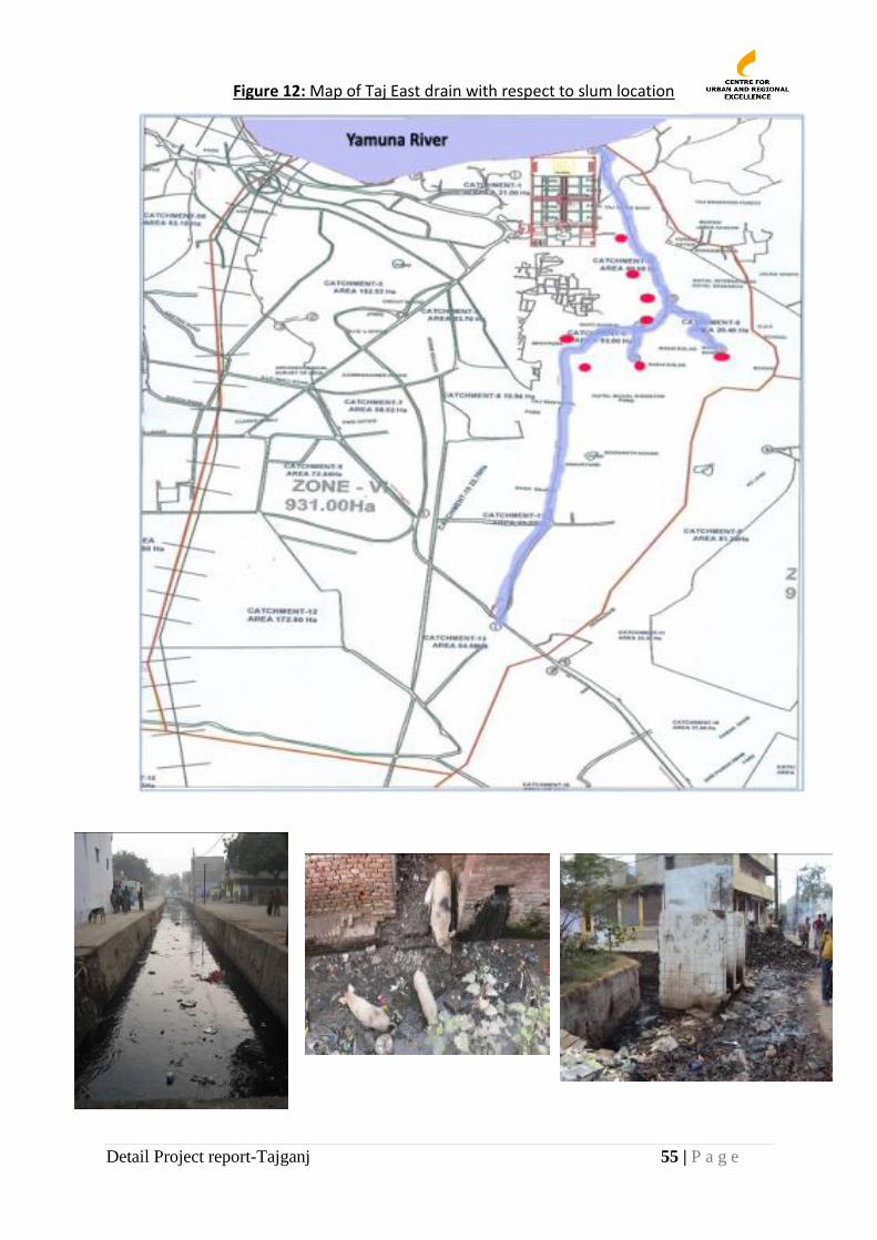
Detail Project report-Tajganj 55 | P a g e
Figure 12: Map of Taj East drain with respect to slum location
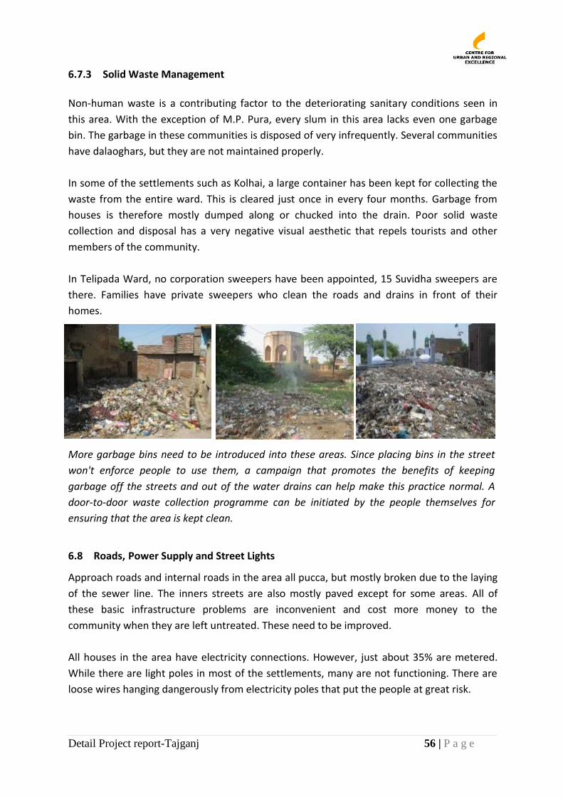
Detail Project report-Tajganj 56 | P a g e
6.7.3 Solid Waste Management
Non-human waste is a contributing factor to the deteriorating sanitary conditions seen in
this area. With the exception of M.P. Pura, every slum in this area lacks even one garbage
bin. The garbage in these communities is disposed of very infrequently. Several communities
have dalaoghars, but they are not maintained properly.
In some of the settlements such as Kolhai, a large container has been kept for collecting the
waste from the entire ward. This is cleared just once in every four months. Garbage from
houses is therefore mostly dumped along or chucked into the drain. Poor solid waste
collection and disposal has a very negative visual aesthetic that repels tourists and other
members of the community.
In Telipada Ward, no corporation sweepers have been appointed, 15 Suvidha sweepers are
there. Families have private sweepers who clean the roads and drains in front of their
homes.
More garbage bins need to be introduced into these areas. Since placing bins in the street
won't enforce people to use them, a campaign that promotes the benefits of keeping
garbage off the streets and out of the water drains can help make this practice normal. A
door-to-door waste collection programme can be initiated by the people themselves for
ensuring that the area is kept clean.
6.8 Roads, Power Supply and Street Lights
Approach roads and internal roads in the area all pucca, but mostly broken due to the laying
of the sewer line. The inners streets are also mostly paved except for some areas. All of
these basic infrastructure problems are inconvenient and cost more money to the
community when they are left untreated. These need to be improved.
All houses in the area have electricity connections. However, just about 35% are metered.
While there are light poles in most of the settlements, many are not functioning. There are
loose wires hanging dangerously from electricity poles that put the people at great risk.
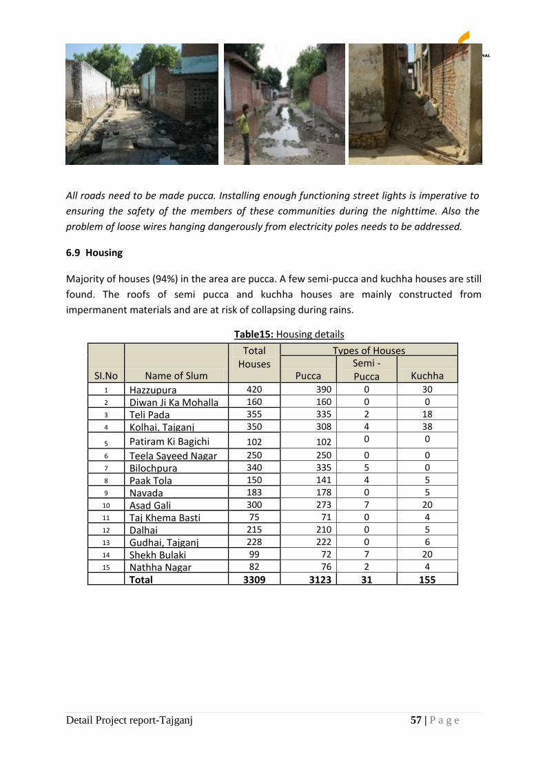
Detail Project report-Tajganj 57 | P a g e
All roads need to be made pucca. Installing enough functioning street lights is imperative to
ensuring the safety of the members of these communities during the nighttime. Also the
problem of loose wires hanging dangerously from electricity poles needs to be addressed.
6.9 Housing
Majority of houses (94%) in the area are pucca. A few semi-pucca and kuchha houses are still
found. The roofs of semi pucca and kuchha houses are mainly constructed from
impermanent materials and are at risk of collapsing during rains.
Table15: Housing details
SI.No Name of Slum
Total Houses
Types of Houses
Pucca Semi - Pucca Kuchha
1 Hazzupura 420 390 0 30 2 Diwan Ji Ka Mohalla 160 160 0 0 3 Teli Pada 355 335 2 18 4 Kolhai, Tajganj 350 308 4 38
5 Patiram Ki Bagichi 102 102 0 0
6 Teela Sayeed Nagar 250 250 0 0 7 Bilochpura 340 335 5 0 8 Paak Tola 150 141 4 5 9 Navada 183 178 0 5
10 Asad Gali 300 273 7 20 11 Taj Khema Basti 75 71 0 4 12 Dalhai 215 210 0 5 13 Gudhai, Tajganj 228 222 0 6 14 Shekh Bulaki 99 72 7 20 15 Nathha Nagar 82 76 2 4
Total 3309 3123 31 155
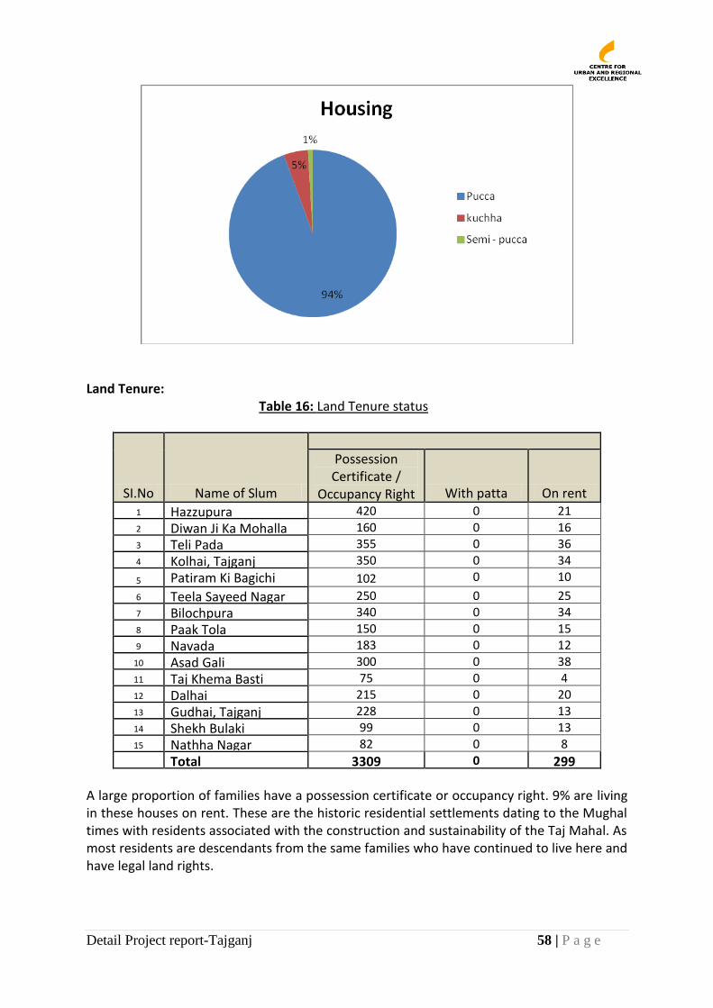
Detail Project report-Tajganj 58 | P a g e
Land Tenure:
Table 16: Land Tenure status
SI.No Name of Slum
Possession Certificate /
Occupancy Right With patta On rent 1 Hazzupura 420 0 21 2 Diwan Ji Ka Mohalla 160 0 16 3 Teli Pada 355 0 36 4 Kolhai, Tajganj 350 0 34
5 Patiram Ki Bagichi 102 0 10
6 Teela Sayeed Nagar 250 0 25 7 Bilochpura 340 0 34 8 Paak Tola 150 0 15 9 Navada 183 0 12
10 Asad Gali 300 0 38 11 Taj Khema Basti 75 0 4 12 Dalhai 215 0 20 13 Gudhai, Tajganj 228 0 13 14 Shekh Bulaki 99 0 13 15 Nathha Nagar 82 0 8
Total 3309 0 299 A large proportion of families have a possession certificate or occupancy right. 9% are living in these houses on rent. These are the historic residential settlements dating to the Mughal times with residents associated with the construction and sustainability of the Taj Mahal. As most residents are descendants from the same families who have continued to live here and have legal land rights.
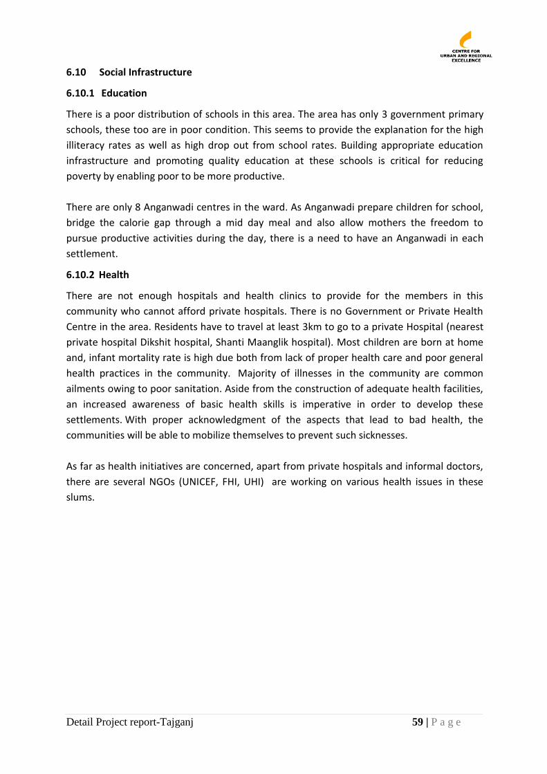
Detail Project report-Tajganj 59 | P a g e
6.10 Social Infrastructure
6.10.1 Education
There is a poor distribution of schools in this area. The area has only 3 government primary
schools, these too are in poor condition. This seems to provide the explanation for the high
illiteracy rates as well as high drop out from school rates. Building appropriate education
infrastructure and promoting quality education at these schools is critical for reducing
poverty by enabling poor to be more productive.
There are only 8 Anganwadi centres in the ward. As Anganwadi prepare children for school,
bridge the calorie gap through a mid day meal and also allow mothers the freedom to
pursue productive activities during the day, there is a need to have an Anganwadi in each
settlement.
6.10.2 Health
There are not enough hospitals and health clinics to provide for the members in this
community who cannot afford private hospitals. There is no Government or Private Health
Centre in the area. Residents have to travel at least 3km to go to a private Hospital (nearest
private hospital Dikshit hospital, Shanti Maanglik hospital). Most children are born at home
and, infant mortality rate is high due both from lack of proper health care and poor general
health practices in the community. Majority of illnesses in the community are common
ailments owing to poor sanitation. Aside from the construction of adequate health facilities,
an increased awareness of basic health skills is imperative in order to develop these
settlements. With proper acknowledgment of the aspects that lead to bad health, the
communities will be able to mobilize themselves to prevent such sicknesses.
As far as health initiatives are concerned, apart from private hospitals and informal doctors,
there are several NGOs (UNICEF, FHI, UHI) are working on various health issues in these
slums.
Detail Project report-Tajganj 60 | P a g e
77.. PROJECT DESCRIPTION: THE PROPOSAL
This proposal is about in situ upgrading of 15 slums Taj Ganj Area around the Taj Mahal
which falls under the Taj Trapezium Zone which aims to improve the environments around
Taj Mahal, in the process improving the living conditions of the poor living in slum
settlements in Taj Ganj. All slum clusters developed through in situ development will be
linked to the city services’ networks for water supply, sewerage, power, and would include
upgrading of approach roads, inner streets, lining and covering of drains, building of
Household and community toilets, provision of social infrastructure, and promotion of
livelihoods of the poor for sustainable poverty reduction. This proposal will include a
significant component of plantation for environment up gradation.
The primary focus of the current DPR is on improving the environmental conditions of the
Taj Ganj area by improving the slum environments by introducing appropriate sanitation and
environmental improvement services.
7.1 Sanitation: An Open Defecation Free Area
To overall sanitation objective shall be to make the area Open Defecation Free. The AJN is
lay-ing underground sever lines in the entire area. These sewer lines are passing by many of
these settlements. In 13 slums, new sewer lines have also been taken inside the settlements.
Under the project all 15 slums shall be connected to the underground city sewerage
networks as and when these are extended to the area and the system is charged. Eventually,
there shall be 100% coverage for sewerage in the slums in the area.
Meanwhile, about 530 (16%) households that do not have individual toilets in their homes
shall be supported under the DPR to construct toilets connected to the sewer line. Toilets in
homes currently unconnected to the sewer lines shall also be assisted to make the
connection. The households will get appropriate subsidies for this purpose as per city/state
rules and programmes. The remaining funds shall be facilitated through micro-finance,
personal savings in SHGs and or a Toilet Credit Fund set up under the project.
Although community toilets are not recommended under new Missions such as RAY and the
National and City Sanitation Policy, an interim arrangement will be needed before all houses
have toilets. Under the DPR, new community toilets shall be built at appropriate locations
identified by the community or old ones demolished and rebuilt with improved designs.
Surface Drain Improvements About 80% of internal drains and cross drains in the slums are
U shaped drains. 20% of the V shaped drains shall be converted into U shaped drains with
proper gradient with the re-laying of the proposed roads and streets. The U shaped drains
shall be repaired where needed and all the drains shall be covered with precast RCC slabs
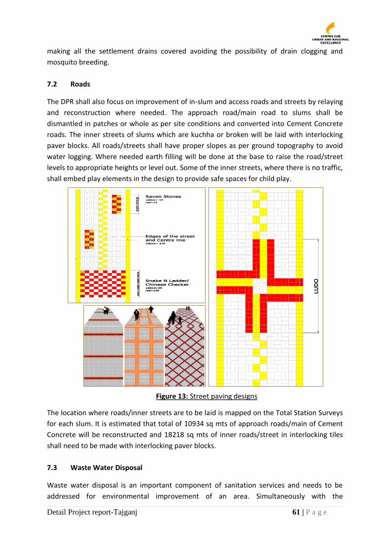
Detail Project report-Tajganj 61 | P a g e
making all the settlement drains covered avoiding the possibility of drain clogging and
mosquito breeding.
7.2 Roads
The DPR shall also focus on improvement of in-slum and access roads and streets by relaying
and reconstruction where needed. The approach road/main road to slums shall be
dismantled in patches or whole as per site conditions and converted into Cement Concrete
roads. The inner streets of slums which are kuchha or broken will be laid with interlocking
paver blocks. All roads/streets shall have proper slopes as per ground topography to avoid
water logging. Where needed earth filling will be done at the base to raise the road/street
levels to appropriate heights or level out. Some of the inner streets, where there is no traffic,
shall embed play elements in the design to provide safe spaces for child play.
Figure 13: Street paving designs
The location where roads/inner streets are to be laid is mapped on the Total Station Surveys
for each slum. It is estimated that total of 10934 sq mts of approach roads/main of Cement
Concrete will be reconstructed and 18218 sq mts of inner roads/street in interlocking tiles
shall need to be made with interlocking paver blocks.
7.3 Waste Water Disposal
Waste water disposal is an important component of sanitation services and needs to be
addressed for environmental improvement of an area. Simultaneously with the
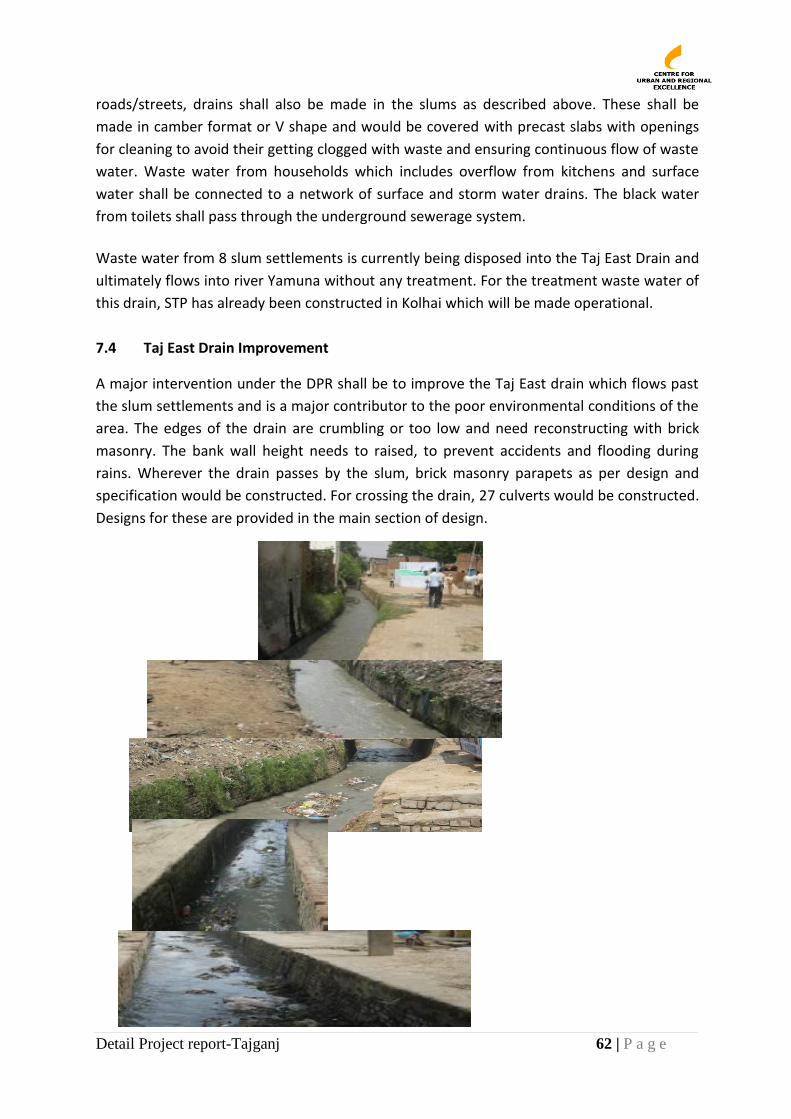
Detail Project report-Tajganj 62 | P a g e
roads/streets, drains shall also be made in the slums as described above. These shall be
made in camber format or V shape and would be covered with precast slabs with openings
for cleaning to avoid their getting clogged with waste and ensuring continuous flow of waste
water. Waste water from households which includes overflow from kitchens and surface
water shall be connected to a network of surface and storm water drains. The black water
from toilets shall pass through the underground sewerage system.
Waste water from 8 slum settlements is currently being disposed into the Taj East Drain and
ultimately flows into river Yamuna without any treatment. For the treatment waste water of
this drain, STP has already been constructed in Kolhai which will be made operational.
7.4 Taj East Drain Improvement
A major intervention under the DPR shall be to improve the Taj East drain which flows past
the slum settlements and is a major contributor to the poor environmental conditions of the
area. The edges of the drain are crumbling or too low and need reconstructing with brick
masonry. The bank wall height needs to raised, to prevent accidents and flooding during
rains. Wherever the drain passes by the slum, brick masonry parapets as per design and
specification would be constructed. For crossing the drain, 27 culverts would be constructed.
Designs for these are provided in the main section of design.
Detail Project report-Tajganj 63 | P a g e
Efficient Septage Management: An efficient septage management system will be set up by
connecting household toilets to sewer lines so that human waste does not flow directly into
surface drains. Surface drains with grey water shall be connected to storm water drains.
7.5 Solid Waste Management
Solid waste management has been identified by communities as a key problem issue that
needs to be addressed urgently. Waste generated from these settlements includes waste
from kitchen, leather waste, sari/cloth pieces, polythene, organic waste etc.
An efficient door-to-door waste collection and segregation service shall be initiated in
partnership with the local communities. This shall include creating awareness about solid
waste disposal practices in the settlements. Where D2D collection is not happening, two
dustbins (one for wet and one for dry waste) for every 30 households would also be
provided to dump the household waste.
One big collection bin shall be provided in each slum and placed at a common collection
point from where ANN will collect the waste regularly and dispose off at the nearest
dumping ground/ landfill sites. This shall be done through a PPP contract.
The dustbins shall be cleared regularly by municipal and private sweepers on payment basis.
ANN will appoint at least 2 sweepers per settlement for regular cleaning of street and drains.
Households shall be mobilised to pay a nominal monthly payment for clearance as decided
by the community.
7.6 Landscaping and Tree Plantation
Landscaping shall be a part of the project, to improve the overall area environment. These
shall also help provide shade and add greenery to the area and slum settlements. A
landscaping plan shall be prepared in consultation with the community and the area
improved through people’s participation.
Plantation shall be done in along the Taj East Drain and in the open spaces used for waste
disposal to create green and clean community spaces. Trees with tree guards shall be
provided in the graveyards in the area as well.
Platforms shall be created around existing big trees in the slums using brick masonry with
sandstone cladding. These platforms shall also provide seating places for community and
hence shall include some street furniture.
Courtyards and open spaces within slums shall also be rebuilt with brick or paver blocks and shall have some benches for seating.
Detail Project report-Tajganj 64 | P a g e
7.7 Social Infrastructure
The following social infrastructure shall also be improved.
Community cum Livelihood Centre: Six multipurpose community centres shall be
constructed in the slums at identified locations. These multipurpose spaces would be
used for community gatherings, trainings, health camps, etc. These shall also be
designed to provide spaces for vending by poor people.
Construction of Shed in Graveyard: Open sheds as per design agreed upon by the
management committee of the graveyard shall be built in 4 graveyards in the slums
in this area. Boundary wall of the graveyards would also be constructed using brick
masonry.
Well Platform: An old large octagonal well exists in Gudhai and serves as a
community chowk. A well platform shall be made along with repairing and plastering
of walls of the well.
Health and Education: There are 3 government primary schools in this Area, the
buildings of which are in dilapidated condition. Building renovation shall be
undertaken by the District Education Department. Under this DPR, the approach road
of one of the schools in Navada shall be made.
As there are inadequate health and Education facilities in these slums, the Multipurpose
Community Centre, constructed under this DPR, would also be used for setting up health
services, organizing health camps, vocational/educational training Programes.
7.8 Water Supply Agra Jal Nigam is implementing water supply project in the entire city and all slums and
households would be connected to city networks for water supply by AJN under JNNURM.
Water pipelines are being laid by the department in all settlements. Under the DPR the
effort shall be to ensure pipelines are laid in all slums and all houses have access to in-house
drinking water supply. People shall invest in their own water connections and shall pay a
user charge as appropriate and as in the rest of the City.
Till such time as water supply is efficiently delivered in the area, as part of this DPR 4 hand
pumps would be provided in each slum settlement. In areas where roads/streets have been
laid, the community tap points have sunk very low. These shall be raised by 2 feet to ensure
these come above the water level.
7.9 Housing While housing shall not be part of the DPR, it has been found that 186 houses are
kuchha/semi pucca. DUDA shall cover these under RAY or MKMBAY housing programme.
Detail Project report-Tajganj 65 | P a g e
8. PROJECT MANAGEMENT
8.1 Project Implementation Mechanism
Implementing Agency
The project shall be implemented by DUDA under the supervision and guidance of the
District Magistrate. DUDA shall implement the project in partnership with appropriate
agencies and support of a local NGO for community mobilization.
DUDA shall undertake the following processes for implementation of the DPR:-
Community mobilization and organization
Community participation shall form the core of the implementation of this DPR. Issues
included in this DPR have been identified by CURE through participatory planning in the 15
slums that has also facilitated the start of the process of community engagement.
Community shall be further mobilized and /strengthened with support of local NGO(s) or
CBO(s). The NGO shall be identified by DUDA using appropriate procedure.
Strengthening community structures
The existing community based organizations in the settlements shall be strengthened. A
range of community groups shall be formed in each settlement for implementing the various
activities such as; self-help group, housing savings groups, microenterprise groups,
community monitoring committees, toilet saving groups, D2D collection groups, tree
plantation groups, etc.
A Slum level committee shall also be constituted that shall work on the overall vision of the
area and be part of developing the implementation plan. This committee shall be
representative of the various groups in the community, especially the usually excluded and
marginal groups.
All slum committees from the 15 slums shall be federated and shall meet monthly to take
stock of/monitor progress under the project and shall submit a progress report to DUDA.
Community contracting arrangements
The implementing agency shall enter into work contracts, directly or through the contractor,
for implementation of physical works. DUDA shall also directly contract community groups
for small works. Slum Committees in these cases will be responsible for selection of sub
contractors or may do this using personal labour. For community contracts, DUDA shall take
permission to lend money to the group in advance.
For all other contracts, DUDA shall hire local contractors in consultation with the community
to ensure transparency. It shall be mandatory for the external contractor to hire local labour,
in particular women, from the communities and/or sub-contract local contractors for
promoting livelihoods among the slum families. It will be ensured that the hired
Detail Project report-Tajganj 66 | P a g e
labour/contractors get timely and proper payment at approved rates by the Slums
Committee.
Community monitoring of physical works
The community shall be responsible for overseeing implementation of civil works in their
slums and shall identify lane/area supervisors who shall monitor implementation.
Community Monitoring Groups or lane supervisors shall be informed of the contractual
obligations under each contract by DUDA project engineers/planners/architects and inform
DUDA in case of deficiencies. DUDA shall take immediate steps to rectify the problem and
inform the community on action taken.
Community managed O&M
The community monitoring groups and CBOs will help the community develop O&M plans
for common facilities such as for cleaning of roads and drains, repair of dust bins,
replacement of lights, maintenance of community toilets and community centres etc. DUDA
shall where possible enter into contracts with community groups for the maintenance of
various services.
Training and capacity building
The slum dwellers and the local community leaders will need training, capacity building to
empower them to get adequate services to improve their quality of life, their social well
being and financial status. Special programmes are proposed to provide training of
community people. These shall include meetings, workshops, experience exchange visits
under the DPR.
Convergence with Social Service Provider Agencies
Consultations shall be held with key social service provider departments to prepare plans for
improving access to schools and primary health care through augmentation of existing
resources and/or development of new infrastructure. For this a committee shall be
constituted under the District Magistrate.
8.2 Technical Support
The NGO partner shall provide technical assistance to families to customize the toilets to
spaces in their homes and to make the appropriate connections to sewer lines so that these
make good fits. DUDA shall ensure appropriate linkages with concerned departments to
ensure that people are able to access legitimate connections quickly. 8.3 Financial Arrangements: Toilet Credit Fund
DUDA shall assist the slum families to access credit for construction of toilets, houses etc.
DUDA may either connect families to microfinance agencies or housing banks. They will also
set up a Toilet Credit Fund using a small corpus fund. This shall help poor people to access
loans. The NGO partner shall set up mechanisms for collection and repayment of loans.
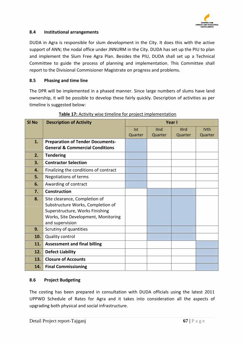
Detail Project report-Tajganj 67 | P a g e
8.4 Institutional arrangements
DUDA in Agra is responsible for slum development in the City. It does this with the active
support of ANN; the nodal office under JNNURM in the City. DUDA has set up the PIU to plan
and implement the Slum Free Agra Plan. Besides the PIU, DUDA shall set up a Technical
Committee to guide the process of planning and implementation. This Committee shall
report to the Divisional Commisioner Magistrate on progress and problems.
8.5 Phasing and time line
The DPR will be implemented in a phased manner. Since large numbers of slums have land
ownership, it will be possible to develop these fairly quickly. Description of activities as per
timeline is suggested below:
Table 17: Activity wise timeline for project implementation
Sl No Description of Activity Year I
Ist Quarter
IInd Quarter
IIIrd Quarter
IVth Quarter
1. Preparation of Tender Documents-General & Commercial Conditions
2. Tendering
3. Contractor Selection
4. Finalizing the conditions of contract
5. Negotiations of terms
6. Awarding of contract
7. Construction
8. Site clearance, Completion of Substructure Works, Completion of Superstructure, Works Finishing Works, Site Development, Monitoring and supervision
9. Scrutiny of quantities
10. Quality control
11. Assessment and final billing
12. Defect Liability
13. Closure of Accounts
14. Final Commissioning
8.6 Project Budgeting The costing has been prepared in consultation with DUDA officials using the latest 2011
UPPWD Schedule of Rates for Agra and it takes into consideration all the aspects of
upgrading both physical and social infrastructure.

Detail Project report-Tajganj 68 | P a g e
9. DESIGN & COSTING
A. Designs of the following are attached below:
Coomutnity cnetre (Type 1) (20.5 mt x 14.5 mt)
Communtity Centre (Type 2) (8 mt x 13 mt)
Communtiy Toilet complex (Type 1) (16 seater Lienar)
Communtiy Toilet complex (Type 2) (16 seater square)
Communtiy Toilet complex (Type 3) (8 seater)
Plateform around tree
Well platform
Shed in the graveyard
Retining wall/boundary wall in the graveyard
Drain parapet
Culvert
U shaped Drain
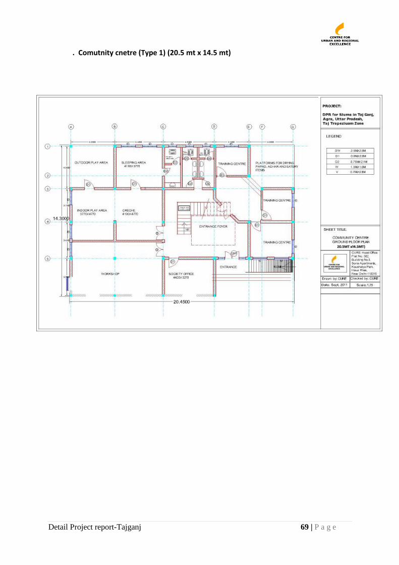
Detail Project report-Tajganj 69 | P a g e
. Comutnity cnetre (Type 1) (20.5 mt x 14.5 mt)
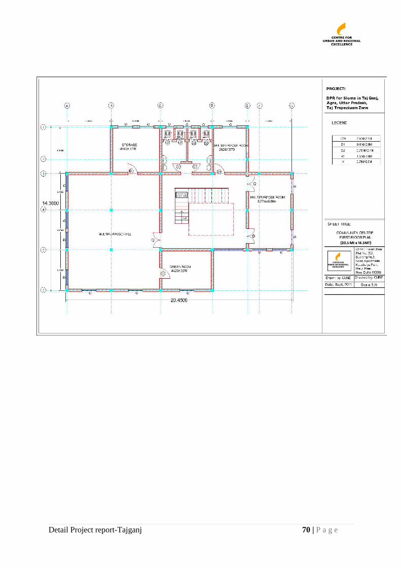
Detail Project report-Tajganj 70 | P a g e
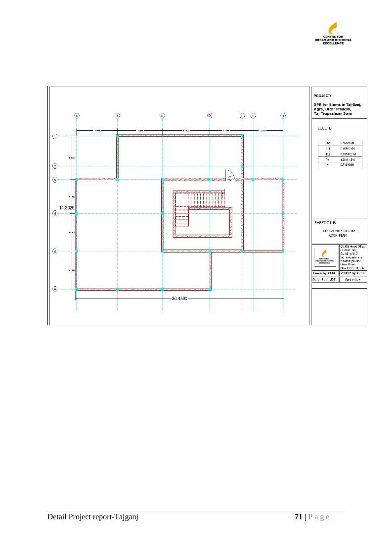
Detail Project report-Tajganj 71 | P a g e
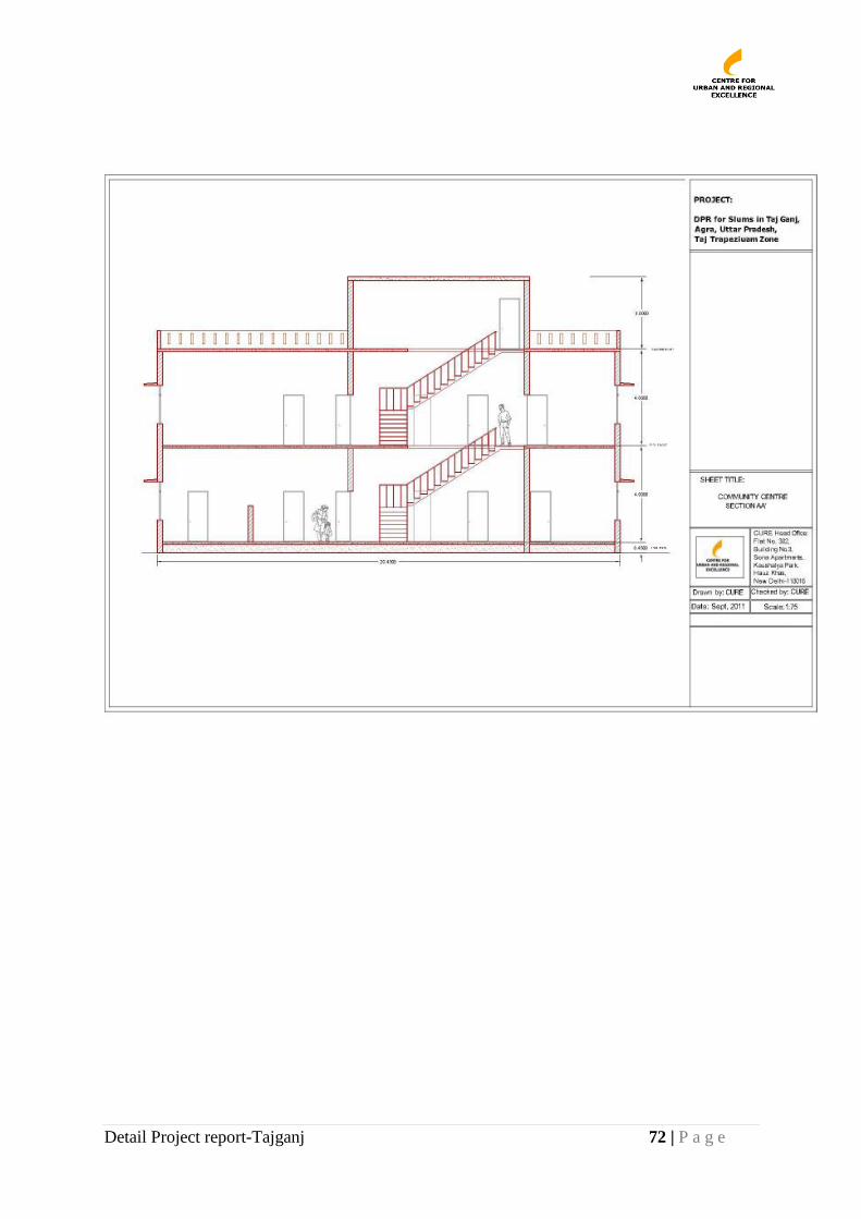
Detail Project report-Tajganj 72 | P a g e
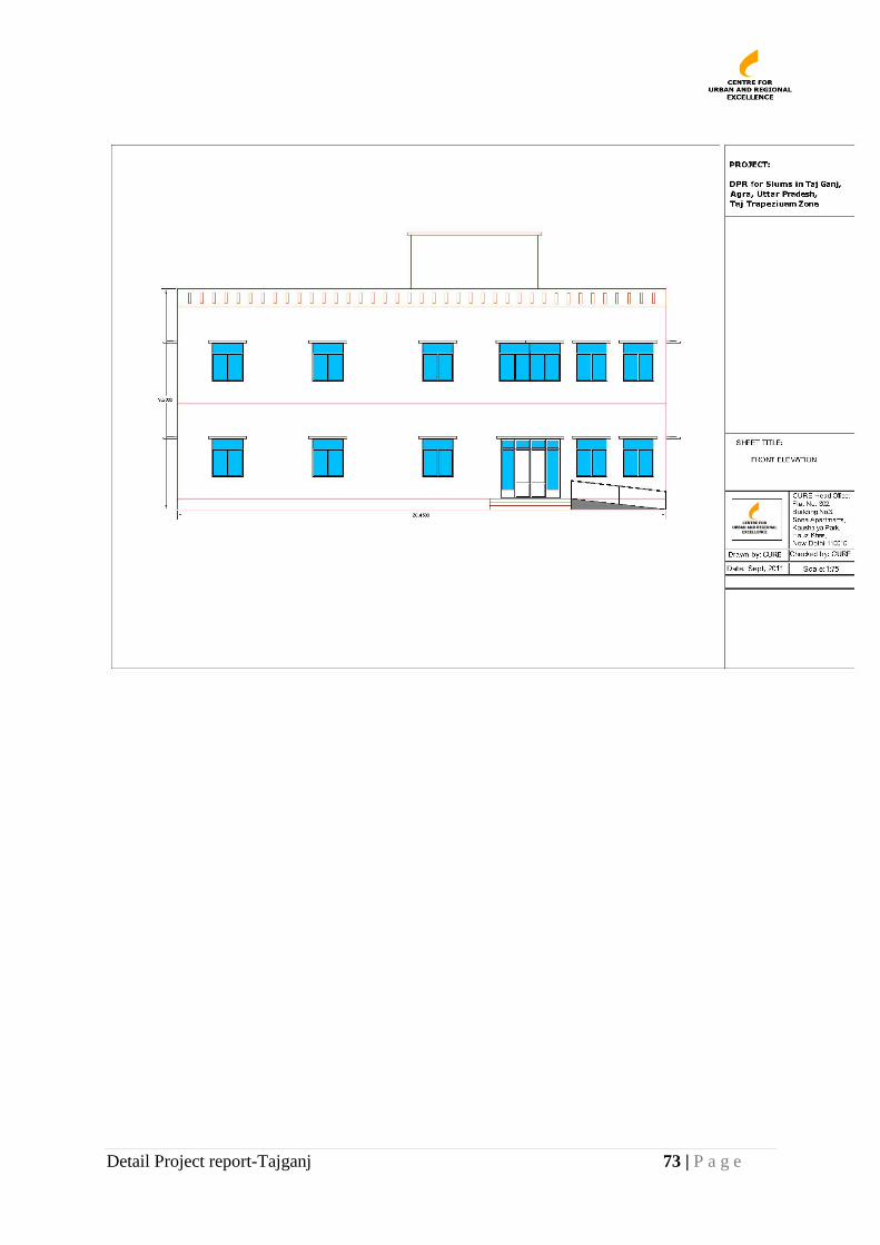
Detail Project report-Tajganj 73 | P a g e
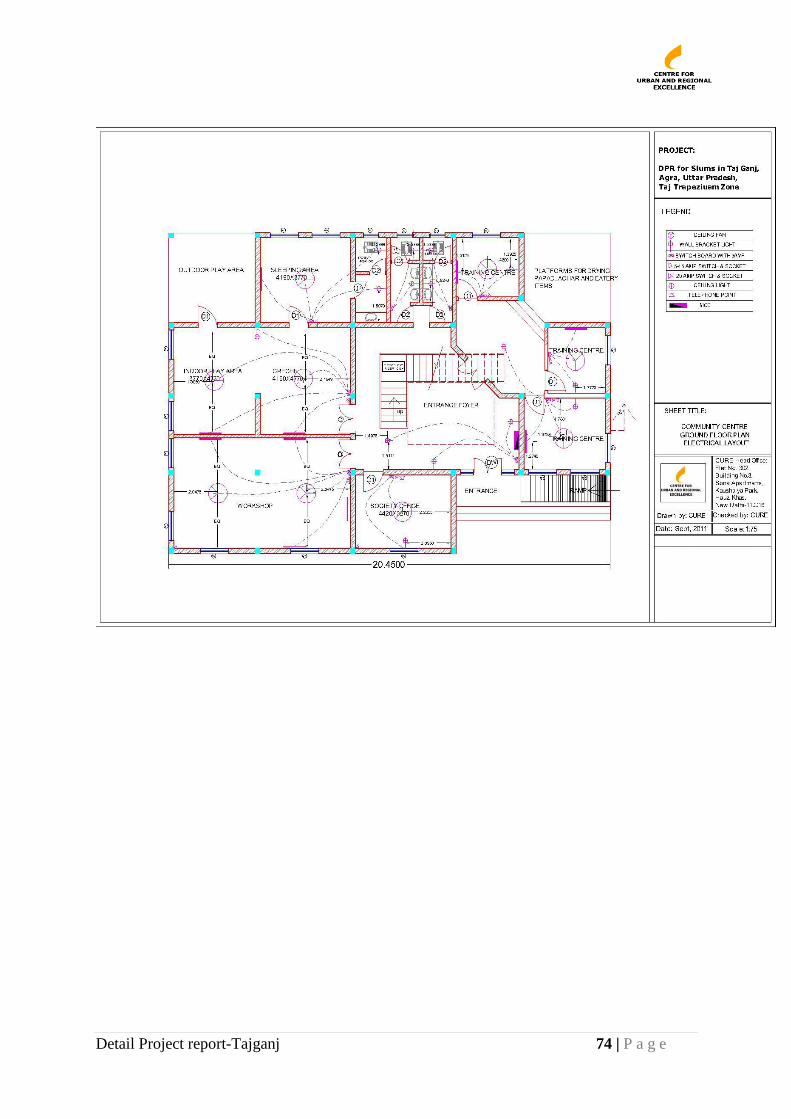
Detail Project report-Tajganj 74 | P a g e
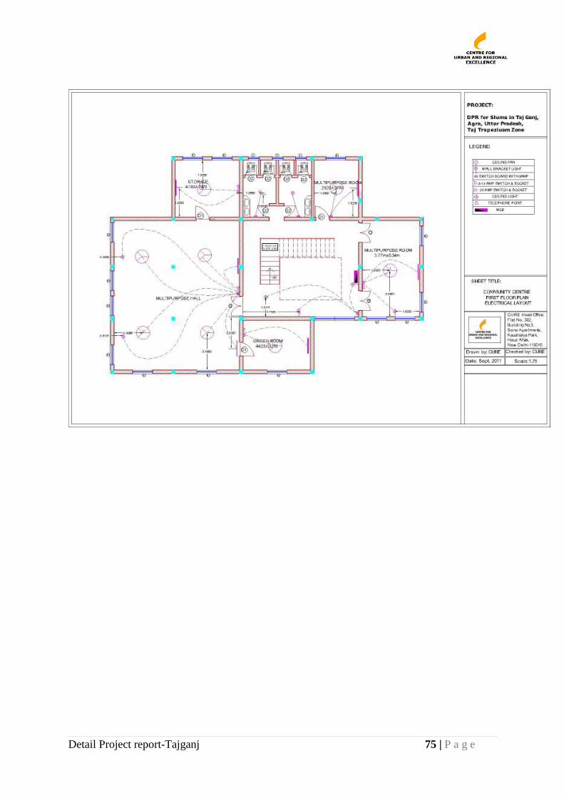
Detail Project report-Tajganj 75 | P a g e
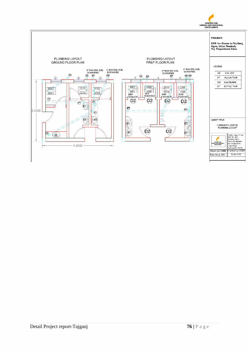
Detail Project report-Tajganj 76 | P a g e

Detail Project report-Tajganj 77 | P a g e
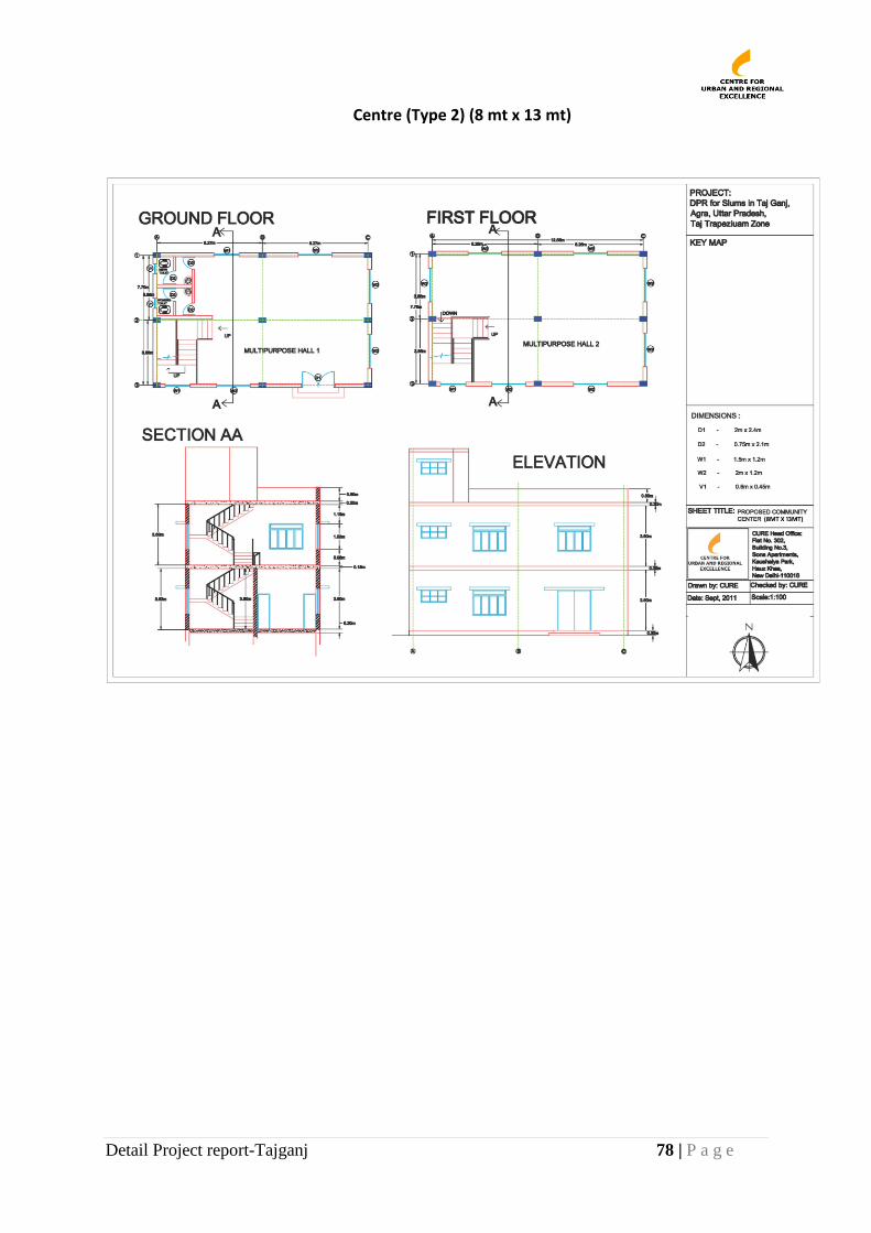
Detail Project report-Tajganj 78 | P a g e
Centre (Type 2) (8 mt x 13 mt)
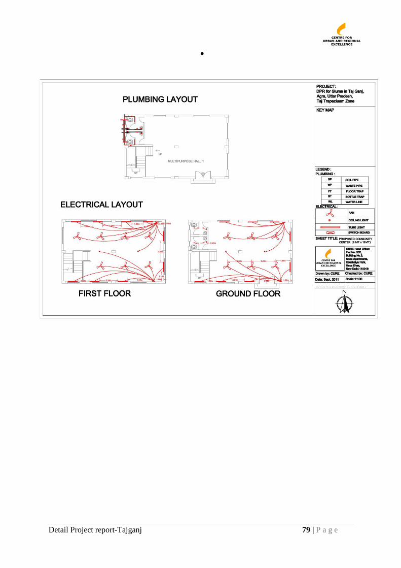
Detail Project report-Tajganj 79 | P a g e
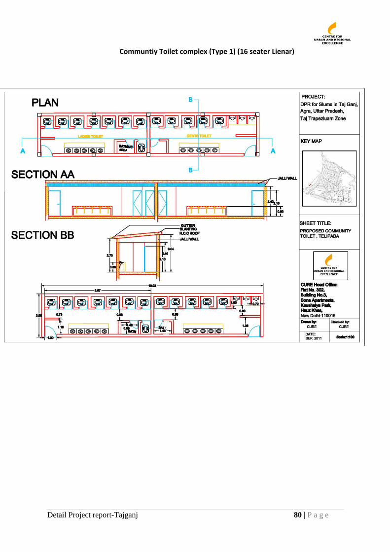
Detail Project report-Tajganj 80 | P a g e
Communtiy Toilet complex (Type 1) (16 seater Lienar)
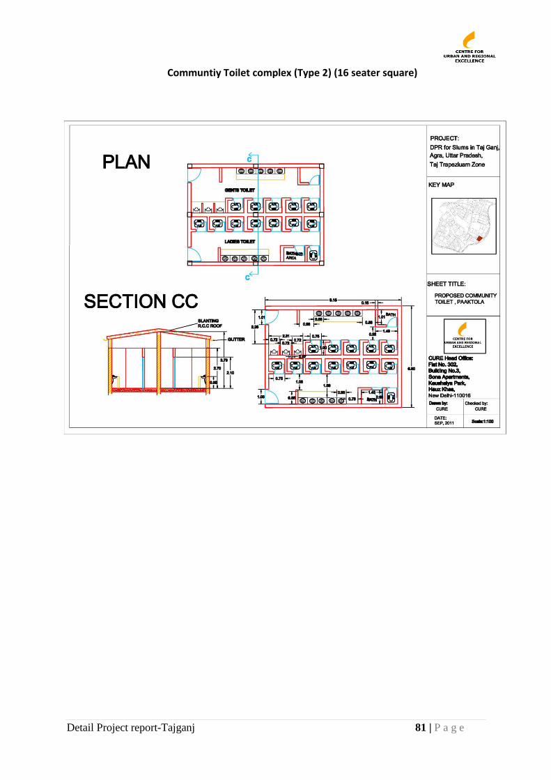
Detail Project report-Tajganj 81 | P a g e
Communtiy Toilet complex (Type 2) (16 seater square)
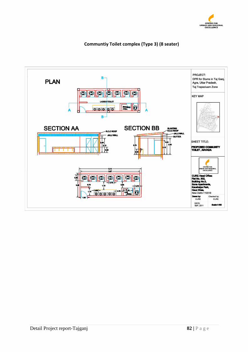
Detail Project report-Tajganj 82 | P a g e
Communtiy Toilet complex (Type 3) (8 seater)
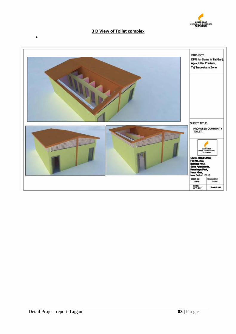
Detail Project report-Tajganj 83 | P a g e
3 D View of Toilet complex
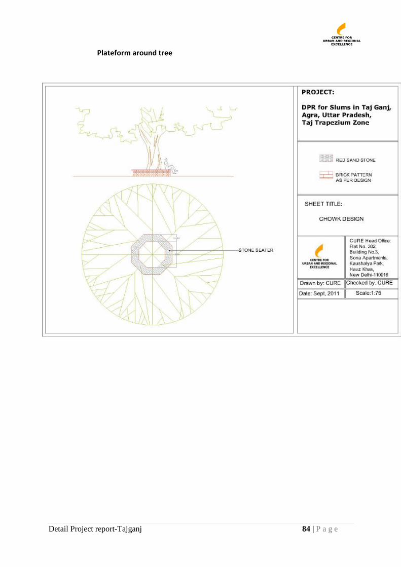
Detail Project report-Tajganj 84 | P a g e
Plateform around tree
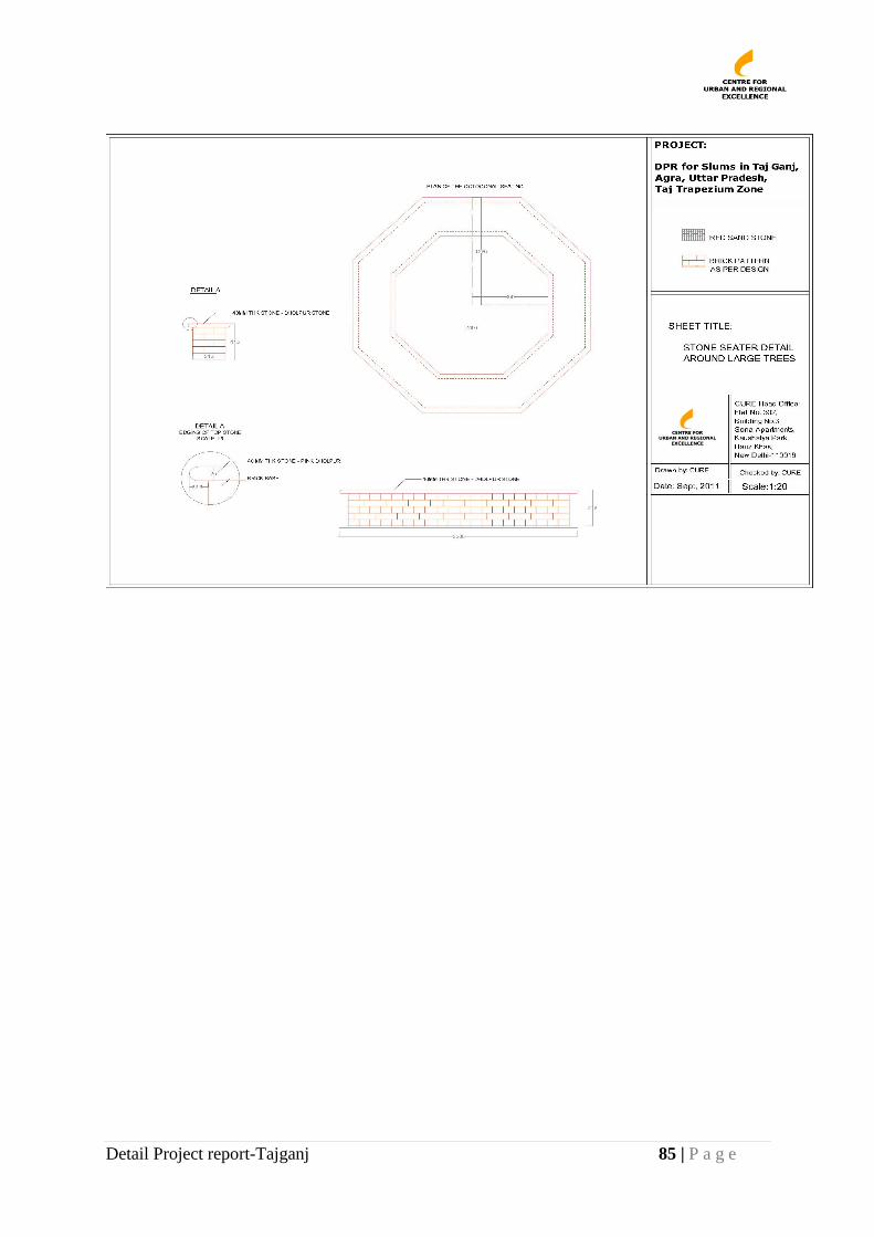
Detail Project report-Tajganj 85 | P a g e
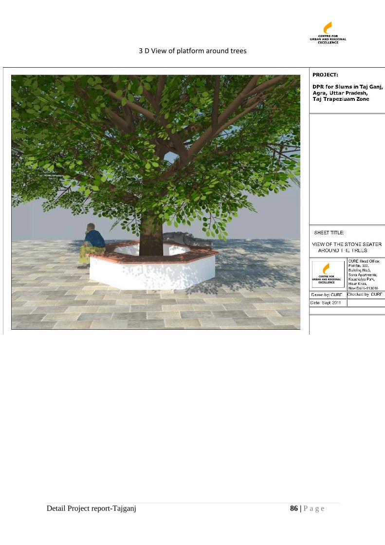
Detail Project report-Tajganj 86 | P a g e
3 D View of platform around trees
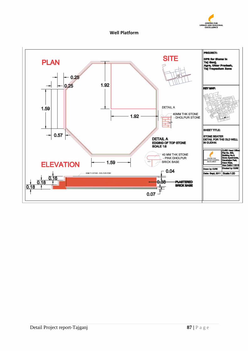
Detail Project report-Tajganj 87 | P a g e
Well Platform
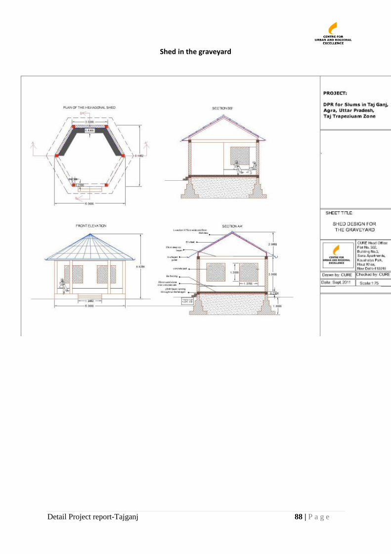
Detail Project report-Tajganj 88 | P a g e
Shed in the graveyard
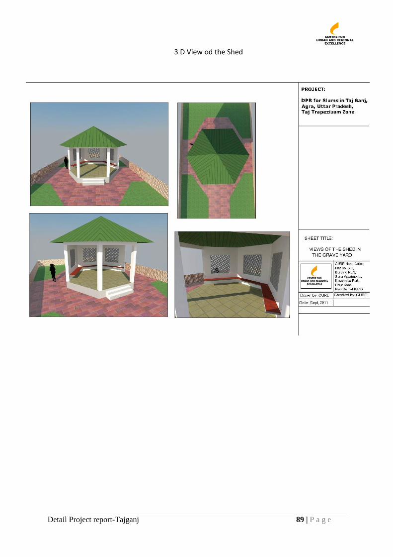
Detail Project report-Tajganj 89 | P a g e
3 D View od the Shed
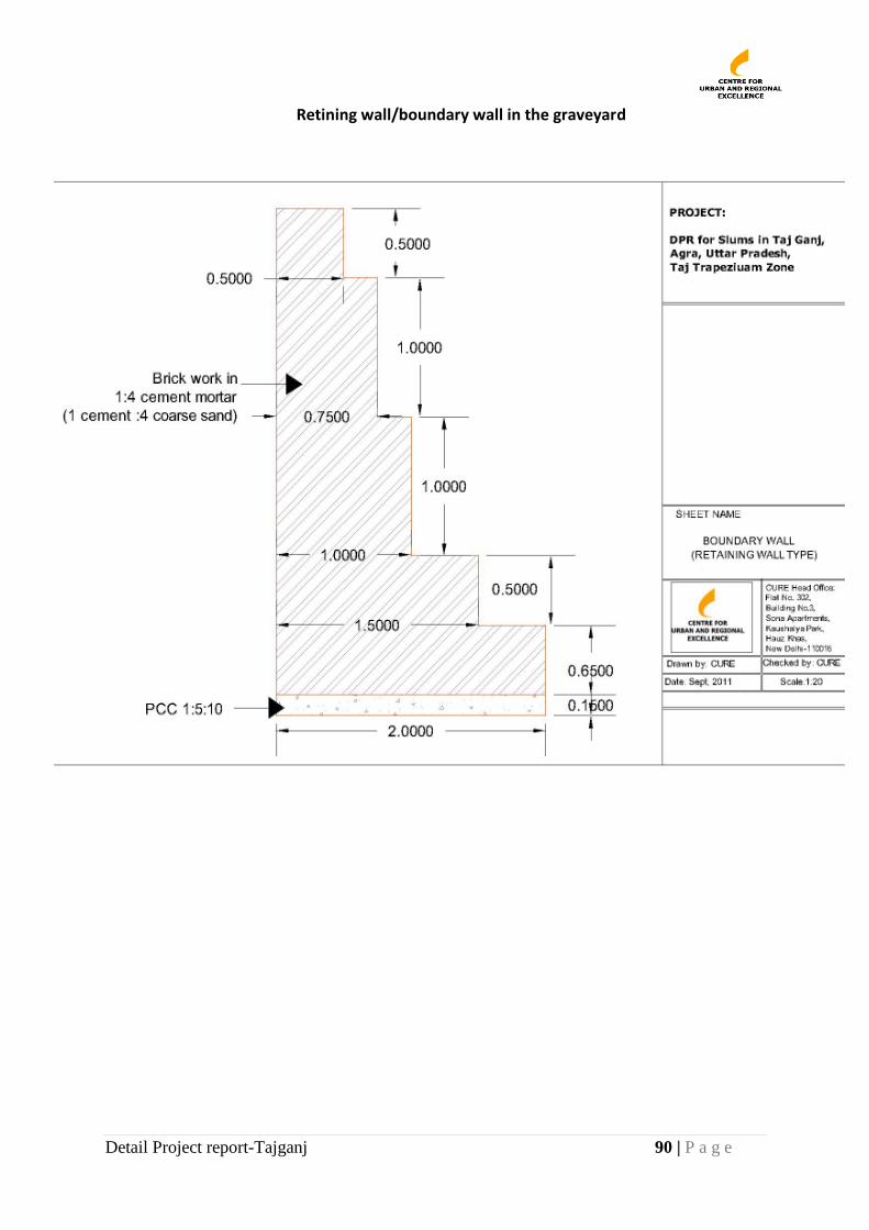
Detail Project report-Tajganj 90 | P a g e
Retining wall/boundary wall in the graveyard
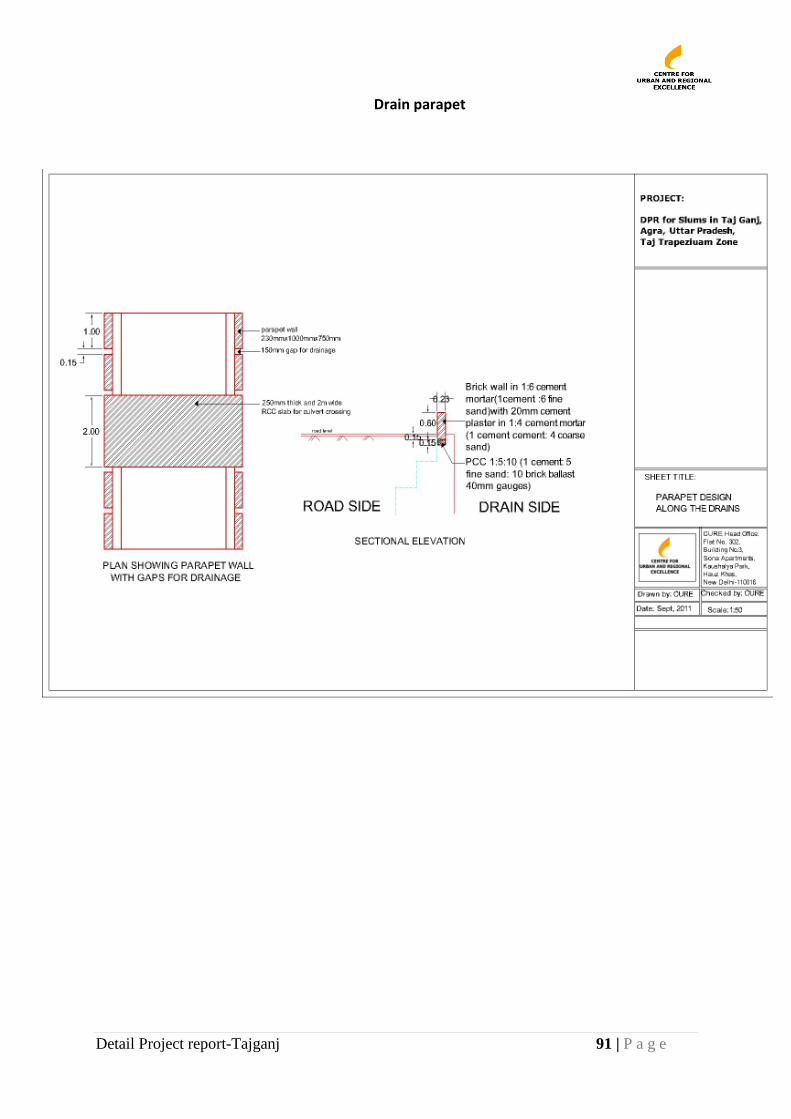
Detail Project report-Tajganj 91 | P a g e
Drain parapet

Detail Project report-Tajganj 92 | P a g e
Culvert
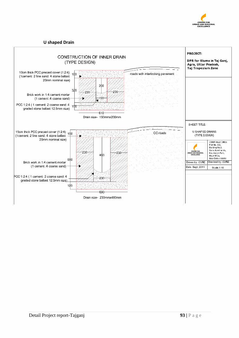
Detail Project report-Tajganj 93 | P a g e
U shaped Drain
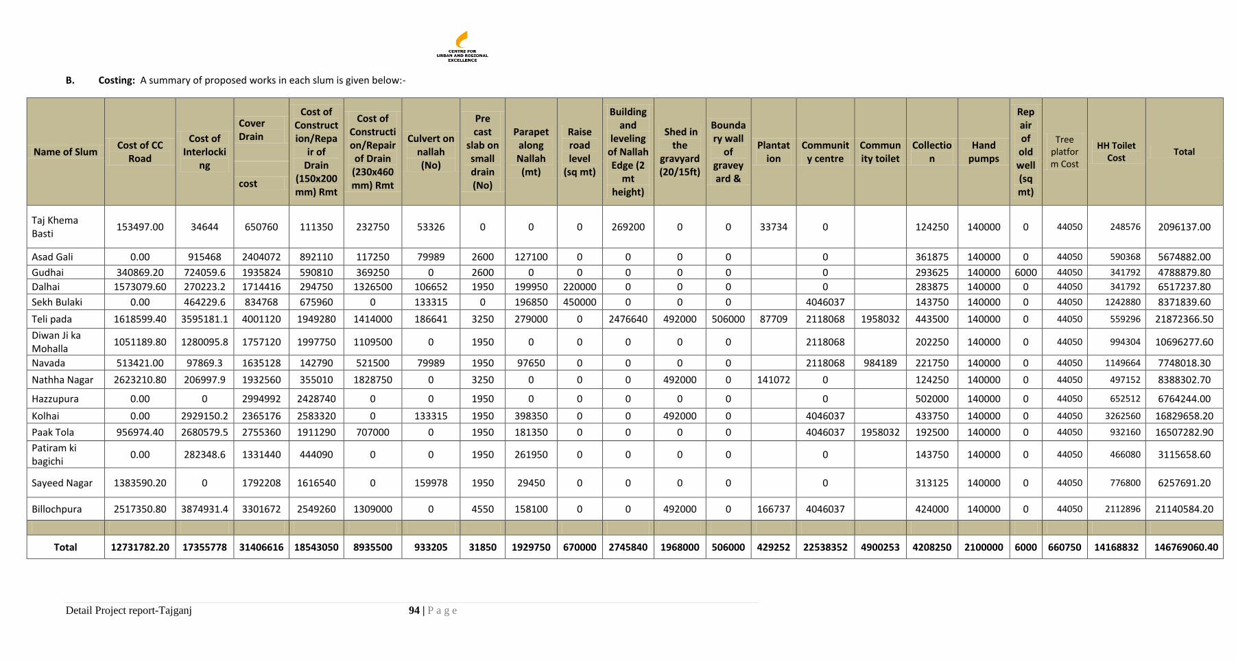
Detail Project report-Tajganj 94 | P a g e
B. Costing: A summary of proposed works in each slum is given below:-
Name of Slum Cost of CC
Road
Cost of Interlocki
ng
Cover Drain
Cost of Construction/Repa
ir of Drain
(150x200mm) Rmt
Cost of Construction/Repair of Drain
(230x460mm) Rmt
Culvert on nallah (No)
Pre cast
slab on small drain (No)
Parapet along Nallah (mt)
Raise road level
(sq mt)
Building and
leveling of Nallah Edge (2
mt height)
Shed in the
gravyard (20/15ft)
Boundary wall
of graveyard &
Plantation
Community centre
Community toilet
Collection
Hand pumps
Repair of
old well (sq mt)
Tree platform Cost
HH Toilet Cost
Total
cost
Taj Khema Basti
153497.00 34644 650760 111350 232750 53326 0 0 0 269200 0 0 33734 0 124250 140000 0 44050 248576 2096137.00
Asad Gali 0.00 915468 2404072 892110 117250 79989 2600 127100 0 0 0 0 0 361875 140000 0 44050 590368 5674882.00
Gudhai 340869.20 724059.6 1935824 590810 369250 0 2600 0 0 0 0 0 0 293625 140000 6000 44050 341792 4788879.80
Dalhai 1573079.60 270223.2 1714416 294750 1326500 106652 1950 199950 220000 0 0 0 0 283875 140000 0 44050 341792 6517237.80
Sekh Bulaki 0.00 464229.6 834768 675960 0 133315 0 196850 450000 0 0 0 4046037 143750 140000 0 44050 1242880 8371839.60
Teli pada 1618599.40 3595181.1 4001120 1949280 1414000 186641 3250 279000 0 2476640 492000 506000 87709 2118068 1958032 443500 140000 0 44050 559296 21872366.50
Diwan Ji ka Mohalla
1051189.80 1280095.8 1757120 1997750 1109500 0 1950 0 0 0 0 0 2118068 202250 140000 0 44050 994304 10696277.60
Navada 513421.00 97869.3 1635128 142790 521500 79989 1950 97650 0 0 0 0 2118068 984189 221750 140000 0 44050 1149664 7748018.30
Nathha Nagar 2623210.80 206997.9 1932560 355010 1828750 0 3250 0 0 0 492000 0 141072 0 124250 140000 0 44050 497152 8388302.70
Hazzupura 0.00 0 2994992 2428740 0 0 1950 0 0 0 0 0 0 502000 140000 0 44050 652512 6764244.00
Kolhai 0.00 2929150.2 2365176 2583320 0 133315 1950 398350 0 0 492000 0 4046037 433750 140000 0 44050 3262560 16829658.20
Paak Tola 956974.40 2680579.5 2755360 1911290 707000 0 1950 181350 0 0 0 0 4046037 1958032 192500 140000 0 44050 932160 16507282.90
Patiram ki bagichi
0.00 282348.6 1331440 444090 0 0 1950 261950 0 0 0 0 0 143750 140000 0 44050 466080 3115658.60
Sayeed Nagar 1383590.20 0 1792208 1616540 0 159978 1950 29450 0 0 0 0 0 313125 140000 0 44050 776800 6257691.20
Billochpura 2517350.80 3874931.4 3301672 2549260 1309000 0 4550 158100 0 0 492000 0 166737 4046037 424000 140000 0 44050 2112896 21140584.20
Total 12731782.20 17355778 31406616 18543050 8935500 933205 31850 1929750 670000 2745840 1968000 506000 429252 22538352 4900253 4208250 2100000 6000 660750 14168832 146769060.40

Detail Project Report-Tajganj