Embed Size (px)
Citation preview

“Spatial practices and renewal policies in peripheral largehousing estates. A case study of Lyon”
Matteo Del Fabbro*
© by the author
(*) Gran Sasso Science Institute, viale Crispi 7, 67100 L'Aquila, ITALY. [email protected]
Paper presented at the RC21 International Conference on “The Ideal City: between myth and reality.Representations, policies, contradictions and challenges for tomorrow's urban life” Urbino (Italy) 27-29August 2015. http://www.rc21.org/en/conferences/urbino2015/

Abstract . The paper analyses the inhabitants' perceptions and representations of a
neighbourhood in Saint-Priest, a municipality of Lyon metropolitan area, France. This
neighbourhood is currently undergoing an urban renewal, within the Urban Policy (Politique
de la Ville) national framework. Using a qualitative approach – comprising interviews,
observations and workshops, during a five-month fieldwork – I focused on the senses of
place of two large housing estates (grands ensembles). While the dwellers developed an
attachment to these residential areas, other citizens convey a negative image, comprising
perceived insecurity and criticism of spatial practices. It is found therefore that, within an
Urban Policy unit, diverse and conflicting local identities coexist. This is relevant as long as
the rationale of the renewal is to foster the emergence of a new, shared identity for the
neighbourhood. Finally, this case study allows to put forward the hypothesis that the
phenomenon of conflicting senses of place was under-estimated during the policy-making
process.
Key-words: sense of place; local identity; Lyon; urban renewal; grands ensembles; Politique
de la Ville
Abbreviations:
ACSE: Agence nationale pour la cohésion sociale et l'égalité des chances (National Agency for
Social Cohesion and Equal Opportunities)
ANRU: Agence Nationale pour la Rénovation Urbaine (National Agency for Urban Renewal)
CUCS: Contrat Urbain de Cohésion Sociale (Social Cohesion Urban Contract)
DSU: Développement Social Urbain (Urban Social Development = Urban Policy local
office)
HLM: Habitation à Loyer Modéré (Rent Controlled Housing = public housing)
INSEE: Institut National de la Statistique et des Études Économiques (National Institute for
Statistics and Economic Studies = official statistical institute)
ORU: Opération de Renouvellement Urbain (Urban Renewal Operation)
PNRU: Programme National de Rénovation Urbaine (Urban Renewal National Programme)
ZUS: Zone Urbaine Sensible (Socially Sensitive Area)
2

1. Introduction
This paper presents a research undertaken between February and June 2012 in the town
centre of Saint-Priest, a municipality of Lyon metropolitan area, France. My role there was
that of a researcher – in the framework of my Master's thesis project – and of an urban
practitioner – as I was collaborating with Robins des Villes, a Lyon-based association. Since
2003, Saint-Priest town centre had been undergoing a vast public-led renewal, within the
Urban Policy (Politique de la Ville) national scheme. This Policy identified a nationwide
“priority geography”, composed of all the neighbourhoods presenting issues of poverty,
social exclusion and access to rights. The paper's area of study is concerned by two
different policy frameworks, the Contrat Urbain de Cohésion Sociale (Social Cohesion Urban
Contract, CUCS) and the Opération de Renouvellement Urbain (Urban Renewal Operation,
ORU). The former is directed to tackle social issues, while the latter is related to physical
renewal. The director of Saint-Priest town centre's Urban Policy office is charged with the
implementation of a territorial strategy (projet de territoire) built both on CUCS and ORU.
The ORU involved the demolition of six residential buildings, the local primary school, and
twelve single houses1; the refurbishment of public spaces and private residential estates; the
construction of a new school, of denser residential blocks (with an expected increase of
2000 inhabitants), and of a 700 m soft mobility avenue. The urban renewal of Saint-Priest
town centre was first approved in 2001, works began in 2003, and the project was refunded
in 2007 by the newly-born National Agency for Urban Renewal (ANRU), within the Urban
Renewal National Programme (PNRU); it is a long-term process, as the delivery of the new
residential blocks is predicted for 2020 (Agence Nationale pour la Rénovation Urbaine &
Commune de Saint-Priest, 2007) .
Within this context, Robins des Villes was given the responsibility by the Urban Policy
local office (DSU) to set up an intervention to foster resident awareness about the ongoing
urban renewal. These actions go under the name of accompagnement à la transformation urbaine
(which stands for “accompanying [inhabitants] towards urban transformation”), a policy
that is implemented in parallel with urban renewals and that aims at softening the negative
1 Demolitions implied the relocation of 450 households, who were proposed different solutions accordingto socio-demographic features, until they agreed on a new place to move to. Around one third of themmoved to the other Urban Policy neighbourhood of Saint-Priest, one third remained in the town centreand one third moved to other neighbourhoods of the town or other towns of the metropolitan area.
3

impacts on everyday life and social cohesion of those who live in the area. According to
this objective, the DSU wanted to know more about the “sense of place” and the “local
identities” attached to the neighbourhood by the inhabitants (Veschambre, 2008; Scarpelli
& Romano, 2011; Bertier, Marchal & Stébé, 2014) . The DSU, in fact, lacked a precise
knowledge about the ways in which residents had been developing their attachment to the
space and to perceived landmarks. Their knowledge was limited to the observation that the
neighbourhood, as a whole, lacked a clear identity:
The town centre and even the whole of Saint-Priest – It is more about the
juxtaposition of sub-neighbourhoods rather than a real collective identity. And it is
indeed our concern, to go from juxtaposition to a town centre appropriated by the
entire population of Saint-Priest. […] Thus the ORU and the actions accompanying
urban transformation [accompagnement à la transformation urbaine] are opportunities to
enable people to express themselves and say that they too, have something to share,
even if it isn’t pretty, even if it is not recognised, visible… that there are identities
after all, but one has to reveal those identities2.
(N. Rochette, Urban Policy officer, 29 February 2012)
In other words, the idea is to redesign a satellite town's centre, seeking to transform it
from a socially disadvantaged neighbourhood – yet hosting administrative and commercial
“central” functions – to an attractive area for all citizens, more socially mixed (Blanc, 2010;
Lelévrier, 2013) and renewed in its physical outlook. The desire to grasp a local identity is
thus functional both to the current situation – to help residents preserve their sense of the
place – and to the forthcoming one – to prepare the context in which this sense of place
will interact with that of newcomers.
The aim of the paper is to question, through a ground-based approach, the major
hypotheses held by the local Urban Policy office (DSU): that (a) residents have developed
an attachment to the places – albeit not publicly recognised – and that (b) this attachment
is not homogeneous for the whole neighbourhood but rather fragmented in “sub-
neighbourhoods”. Due to time constraints, I have not focused on the whole
neighbourhood but on a part of it. The object of study has been defined as the senses of
2 All translations from French and Italian into English by the author.
4

place of Saint-Priest town centre, whereas the complete study area corresponds to the
neighbourhood as established by the Politique de la Ville. Besides the main argumentation,
another hypothesis will be finally put forward about the role that the specific action of
accompagnement à la transformation urbaine fulfilled within the overall urban renewal policy.
The paper is divided into six parts. In section 2, the study area will be put in context
with its main geographical and social features. In particular, attention will be devoted to
urban typologies and socio-demographic profile. Section 3 explains the methodological
approach, detailing the procedure followed and the techniques adopted. Section 4 illustrates
the results of the empirical research. Section 5 analyses the results, showing how different
and sometimes conflicting senses of place coexist in the same neighbourhood. Section 6
concludes the paper summarizing the main findings and suggesting further paths of
research.
2. Framing the study area
Lyon metropolitan area has around 1.5 million inhabitants and is the second largest
urban agglomeration in France. The town of Saint-Priest counts some 40,000 inhabitants
and is situated in the south-eastern part of the metropolitan area, 13 km from Lyon city
centre. The study area is 50 ha (123 Acres) wide and hosted – before relocations – nearly
7,000 inhabitants (17 % of municipal population). It is called town centre (centre ville) even
though it doesn't have many features generally associated with this denomination: in fact, it
is the geographical and administrative centre of the town, but not the most lively or the
most ancient part. As shown by Image 1, Urban Policy neighbourhoods are concentrated in
the first-ring municipalities (the so-called banlieue), where large-scale residential
developments were built in a relatively short period of time, between the 1960s and 1970s,
to accommodate important flows of immigration and urbanisation. The typical form that
these developments took was the grand ensemble, a combination of repetitive, massive and
sometimes high-rise buildings, where factory workers and immigrants – especially from
former colonial territories – were concentrated. Phenomena of socio-spatial segregation,
social weakness and discrimination developed in and towards these places, which eventually
also led to violent demonstrations. Lyon metropolitan area has a major role in this history,
as what occurred in 1981 in Vénissieux is remembered at the national level as the first
5
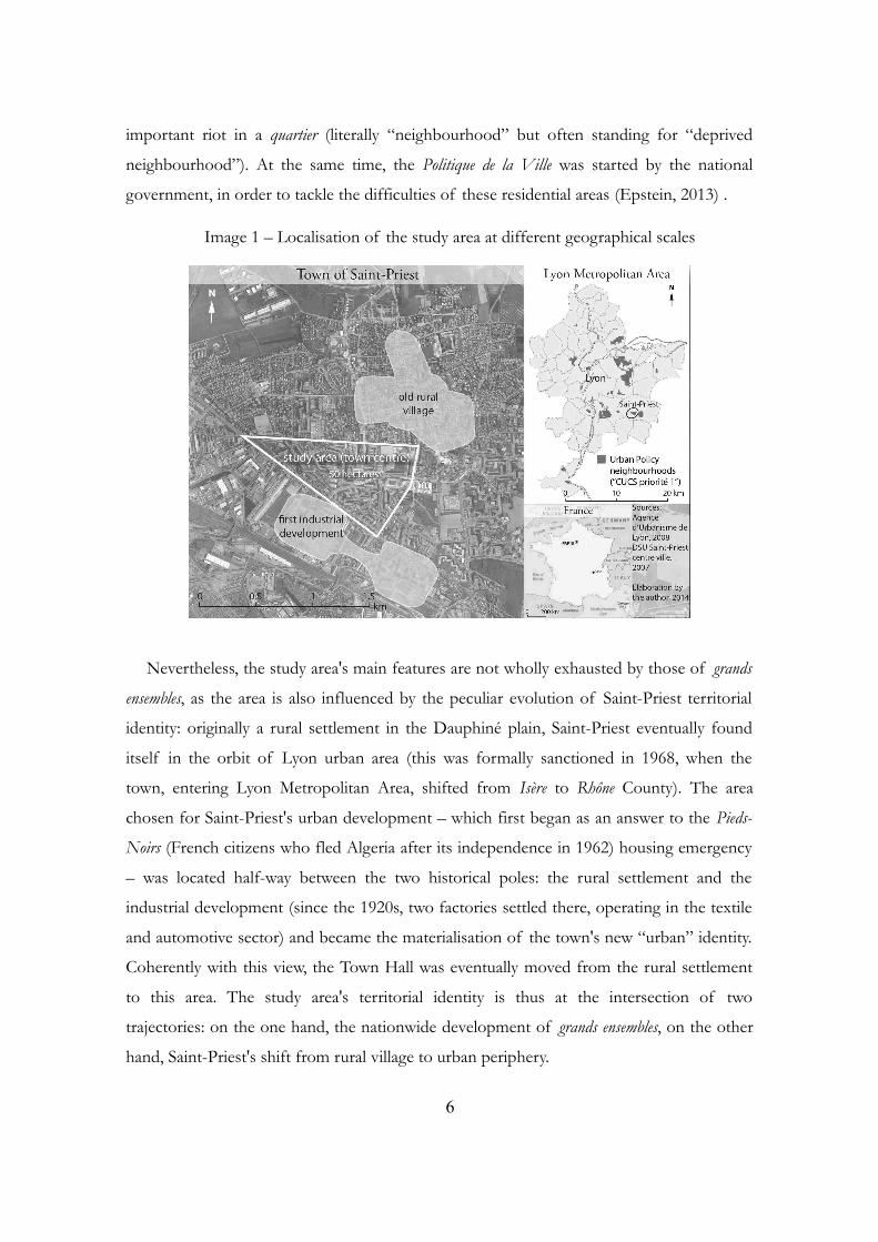
important riot in a quartier (literally “neighbourhood” but often standing for “deprived
neighbourhood”). At the same time, the Politique de la Ville was started by the national
government, in order to tackle the difficulties of these residential areas (Epstein, 2013) .
Image 1 – Localisation of the study area at different geographical scales
Nevertheless, the study area's main features are not wholly exhausted by those of grands
ensembles, as the area is also influenced by the peculiar evolution of Saint-Priest territorial
identity: originally a rural settlement in the Dauphiné plain, Saint-Priest eventually found
itself in the orbit of Lyon urban area (this was formally sanctioned in 1968, when the
town, entering Lyon Metropolitan Area, shifted from Isère to Rhône County). The area
chosen for Saint-Priest's urban development – which first began as an answer to the Pieds-
Noirs (French citizens who fled Algeria after its independence in 1962) housing emergency
– was located half-way between the two historical poles: the rural settlement and the
industrial development (since the 1920s, two factories settled there, operating in the textile
and automotive sector) and became the materialisation of the town's new “urban” identity.
Coherently with this view, the Town Hall was eventually moved from the rural settlement
to this area. The study area's territorial identity is thus at the intersection of two
trajectories: on the one hand, the nationwide development of grands ensembles, on the other
hand, Saint-Priest's shift from rural village to urban periphery.
6

These dynamics lead to an urban landscape dominated by massive and serial buildings,
called grands ensembles. In these large housing estates, single buildings are in relation among
themselves to shape common spaces at the ground level, but the estates as a whole are
spatially unrelated between each other. Consequently, public space is not articulated on
traditional elements such as streets and squares, to the point that it is possible to speak of
“absence of streets” (Raulin, 2007: 96) . Indeed, the architectural inspiration of this urban
typology is Modernism, whose adversity to “street” – in the sense of a clearly oriented
physical structure characterised by buildings on both sides – is explicit since the 1933
Athens Charter. However, two additional urban typologies can be observed within the area:
“alignments of single houses” and “dense urban fabric”, for the most part pre-existing the
great shift to urbanisation that took place between 1962 and 1977.
Image 2 – Urban landscapes shaping Saint-Priest town centre (2012)
As visible in Image 2, the provision of public facilities is not negligible: the area hosts
the Town Hall, the civic library, the post office, a primary school, two civic centres, a
stadium with a sport centre and a municipal theatre. Besides this, a considerable amount of
HLM is present. There are fewer privately-run services here, especially commercial ones.
Although two weekly street markets are held within the town centre, yet the number and
7

quality of shops and leisure activities is generally low. The dependence on the core city
Lyon is thus very strong for spare time activities, such as shopping, leisure, cultural
activities; less pronounced for access to public services such education, health, welfare. As
for the job offer, the town is highly integrated within the metropolitan area: only 36 % of
the resident employees work in Saint-Priest. This mobility is not due to a lack of jobs in
Saint-Priest, as the town hosts 4,4 % of all the jobs present in the metropolitan area,
against 2,7 % of the population.
Chart 1 – Multidimensional profile of the study area (percentages, 2009)
To give a precise picture of the study area from a quantitative point of view is not
straightforward: despite the available data, only one dataset, referred to 2007-2009,
provides information based on the current Urban Policy perimeter3. This dataset compares
3 In the Politique de la Ville webGIS, data for this neighbourhood are not available(http://sig.ville.gouv.fr/Territoire/8269058, page viewed on 3 November 2014). Moreover, it must beacknowledged that the geographical units used by the census do not exactly overlay with Urban Policy
8

all the Urban Policy neighbourhoods of the metropolitan area and contains variables that
are often different or differently measured from those used by the census, that is why some
values are lacking at the municipal level. We observe in Chart 1 that the values concerning
family structure, income and education level constantly reveal a worse situation for the
study area, in comparison with the municipality and the metropolitan average. The high
level of unemployment also represents a frailty and furthermore, among the employees, the
share of less remunerative and lower skills jobs is well above the municipal and
metropolitan average. These combined data suggest that the town centre is affected by
remarkable social weakness. However, we also observe that the study area's per capita
income is higher than the Urban Policy neighbourhoods' average, which conveys a more
faceted image of its socio-economic conditions: although enduring difficulties, the
neighbourhood displays some vitality and dynamism. The French survey system excludes
measures related to ethnicity; nevertheless, historically the neighbourhood was populated
by displaced people (Pieds Noirs) and immigrants. The Saint-Priest “mosaic” (Roussé, 2000)
is composed of mostly North Africans (Algerians, Tunisians, Moroccans) along with
people of Turkish, Portuguese, Spanish, Italian and sub-Saharan descent.
Given that the research area is very narrow, such a multi-dimensional contextualisation
is important in order to put in relation the micro-phenomena observed with broader
dimensions. Having done this, in the next section I will present the research undertaken,
starting from the methodological approach.
3. A multi-step qualitative approach
The fieldwork lasted five months, during which I was living in Lyon city and I spent, in
average, two days a week in the study area. Given that the research had tight time
constraints, I needed to select a portion of the neighbourhood to concentrate my analysis.
In fact, the in-depth, qualitative methodology used by Robins des Villes – and adopted by
me – was time-demanding and it would not have been possible to enquire about the whole
neighbourhood in the duration imposed on the research. So, as a first step I approached
the study area by myself, through observations and ethnographic interviews, seeking to
units, making data from census not wholly reliable to describe this area, and that the Urban Policy zoningwas originally smaller than the current one, many pieces of information being available only for theprevious perimeter.
9

identify some particularly relevant places. As a second step, I took part in the workshops
organized by the urban practitioners team and I used them to verify whether, and how, the
places previously singled out could be considered socially meaningful and identity loaded
for a broader public.
As for the first step – observations and interviews – I designed and carried them out
independently. The places to observe (Image 3) were selected according to the urban
landscape analysis (see Image 2) and I adopted the observation grid proposed by C.
Caniglia Rispoli & A. Signorelli (2008) , which focuses on the physical characteristics of the
place, the type of people frequenting it and the interactions occurring among them. This
system helps structure the notes taken throughout the day by the observer. Afterwards,
following informal contacts with users of the places, I carried out some ethnographic
interviews, mostly of common people (Pavanello, 2010) .
Image 3 – Localisation of the fieldwork's main places
The interviews were non-directive and that is why not all of them turned out to be
relevant for the research , because not all of them dealt with the research object, i.e.
perceptions of places comprised in the study area. Through the interviews, I singled out two places
that appeared to have a special relevance: the residential estates of Bellevue and Les Alpes;
both of them were built in the 1960s and are exemplary of the grands ensembles urban
typology. To select the portion of neighbourhood on which to focus the research, I gave
10

importance to the results of ethnographic interviews rather than observations, because in
this way I did not select the “relevant” places according to my interpretation, but I had
them singled out directly by neighbourhood users (Caniglia Rispoli & Signorelli, 2008: 67) .
To counter-balance the risk that this “sampling” be biased by the partiality of the
interviewees, on the one hand I deepened, as much as possible, the analysis of the selected
places through qualitative data collection, on the other hand I broadened, as much as
possible, the context where to locate them through the afore seen quantitative indicators,
so that my observations – so limited in their actual extent – could be put in relation with
much wider phenomena.
The second phase of the research, the professional workshops, was organised and
conducted by the urban practitioners team. Not only did Robins des Villes work as a team,
but the association itself implemented the actions in agreement with Urban Policy officers
and other local partners (civic centres, local school, etc.). It was so decided that, through
the workshops, three main different public would be approached: residents of the town
centre, residents of Saint-Priest and Municipality representatives. The workshops used
varying techniques, adapted to the public and the situation, yet the use of one tool was
constant, that of photo-elicitation. This tool proposed a set of pictures of different places
within the study area and asked the participants to freely pick one or two and explain their
choice, on a dedicated blank space below the image. The visualization of a familiar place
helps “elicit” ideas much more easily than verbal techniques (Cuisenier, Conord, Piette et
al., 2007) . The pictures, selected by the team from a photographic database produced by a
professional photographer, were conceived not as mere supports of recognition but as
evocative images, capable of reviving memories, emotions, and experiences. This is why the
analysis has not been based on a simple counting, but on the combination of the image
and the comment accompanying it, explaining the reasons for the image choice.
Having seen what methodology I adopted, to which techniques I had recourse and how
they were used in different phases, I will present the results of the fieldwork in the next
section.
4. Reaching out to the inhabitants
Given the methodological procedure, among the material collected, I will only present
11

what is relevant in relation with the portion of neighbourhood selected. Similarly, the
workshops' outcomes covered many places throughout the study area and also outside it,
but I will present only the perceptions referring to Les Alpes and Bellevue residential
estates. As the former was under demolition, it was possible to carry out an observation
session only in Bellevue, which I will illustrate below.
4.1. Observations and ethnographic interviews
Monnet square4, where the observation took place on the 11 and 12 April, is a public
space in Bellevue residential estate and is formed by six long and four-storey buildings,
arranged in a closed, rectangular disposition. This space is open to public access, but
functionally, it is strictly linked with the buildings surrounding: it seems to be more a
residential facility. Flats are private: these are not social housings but condominiums. The
open space is publicly owned and constituted by a street enclosing a small garden with a
playground for kids. Thus, the voices and behaviours that I observed and interacted with
are those of residents or habitual users of these spaces.
The first interesting observation was that only a few cars went through the square,
which made the environment safe for children to play, not only in the playground but also
in the street. An important and unexpected fact was the presence of informal economical
activities. These consisted of small drug deals by some youngsters5, and washing and fixing
cars by some adults. The first phenomenon gave rise to other specific social interactions:
starting from 11 am and throughout the day, some “sentinels” watched the main accesses
to the square; while at the centre of it, in the garden, others gathered. The central position
of the youngsters in the space works as gathering or greeting point. Some other young men
come and stop there for some time, while others simply say “hi” from the side-walk. This
naturally constitutes a form of spatial control by the youngsters in the garden. It must be
noted how I was an object of different attempts at “classification”, as residents wanted to
understand who I was and what I was doing there (Fava, 2013) . A man who was washing
cars asked me if I was a surveyor. Later, as some young men gathered in the middle of the
garden, one of them came quite aggressively towards me accusing me of being a
4 In the context of Robins des Villes intervention, “Square Monnet” has been renamed “Square desCouleurs”.
5 It seems unlikely that they deal important amounts of drug, as the local police station and the town hallare only a few steps away.
12

policeman. The very first thing that he told me after I replied I was not a policeman, was:
“We are working people, we do work”. This gives a suggestion of how they think
“ordinary” people think of them: as jobless and wasting their time (Tucci, 2010). I was
invited then to join his friends in the garden and, even if not so easily, I was finally “re-
classified”, as a student and somebody in contact with the municipality. Once I joined
them, I was able to see how they behave and what they usually do there: listening to French
rap music, chatting and smoking hashish. They were curious about me, especially about my
education level and employment perspectives.
The observation and the interaction with users of Monnet square/Bellevue, revealed
that this is a lively place, where some noteworthy social interactions occur. It can be
defined as a “closed” space towards the outside, and an “appropriated” space inside.
Closed in a physical sense, because the spatial organization favours interactions within
these six buildings, but is unrelated to the surrounding urban fabric, but it is also closed in a
social sense, because barely anybody, be it pedestrian or car driver, goes through the square:
the great majority of people visible in public space are residents. Within the residential
estate, a phenomenon of appropriation of space was highlighted, defined as “practical
utilization of the places” (Caniglia Rispoli & Signorelli, 2008: 54) . The young men
occupying part of the playground, as well as the men fixing and washing cars, are turning
some portions of the space from their original functions into something else, more useful
to their own purposes or needs.
The time spent on the field and the interactions with locals, such as the ones described
above, gave me the possibility to get in touch with users of the places and ask them for an
ethnographic interview, during which I first enquired about the interviewee's personal and
family history, his/her residential trajectory, and in a second time, I proceeded to ask
whether he/she feels attached to some particular places in Saint-Priest, whether there are
places where he/she feels at ease or unease and so on. Here, I will present the two most
relevant interviews, in which places comprised in the study area were spontaneously cited
as meaningful.
The first one was with a man of French origin, former owner of a commercial activity
in Salengro square, born around 1950, who was raised and lived for around thirty years in
Saint-Priest. After he got married, in 1980, he moved with his family to Saint-Pierre de
Chandieu, a suburban smaller town 10 km away. His workplace remained in the town
13
centre: he had taken over the management of the shop from his father and had passed it
over to his children in 2008. In 2012, he kept coming to the shop to help. He voices the
opinions of a resident and a retailer until his thirties and since then only of a retailer. What
was interesting in his case, was the representation he gave of Bellevue estate, which is a few
hundred meters away from Salengro square; nevertheless, he spoke explicitly of a divide
between the square and Bellevue, using the words “cut” (coupure), “frontier” (frontière) and
“barrier” (barrière):
Let’s take Bellevue, that used to make up the countryside before. In the beginning
there were immigrant workers - Portuguese, Italian, Spanish - good people. Now that
there are other occupants, they have kind of stripped this place of its essence, which
was quite lively, with their actions.
The essence? In what sense?
The environment is unhealthy… They have group meetings, and then they are kind of
monopolising places that we… we are a little uneasy passing by and then, you have the
fact that it’s badly maintained, the alleys are dirty sometimes, the iron doors are falling
apart…
(G., male, 62, retailer and former dweller, 11 May 2012)
He clarified that this “cut” divides two places that he perceives as more comfortable:
Salengro square, where his shop is, and the town hall. Since Bellevue is on the route from
the square to the town hall, he feels a sense of insecurity as he goes through it. Asked
about this “cut”, he was even able to identify where it starts: “from the cobbler shop”.
Another interview was with a man of Algerian origin, born and raised in Saint-Priest.
He changed six different neighbourhoods within the town, first with his parents and then
after marriage with his own family: Les Alpes (where his parents entered in 1965, as soon
as it was built), the railway station neighbourhood, Diderot, Bel Air (the other Urban Policy
neighbourhood of Saint-Priest), Bellevue and in 2012 he had been living for two years in a
single house in the town centre. His workplace was also located in the neighbourhood,
since he was a watchman of a municipal premises located there. He voices the opinions of
a resident and worker of the town centre. Among all the different neighbourhoods where
he has lived, he stressed a special attachment to Les Alpes, a high-rise building that, just in
14

spring 2012, in agreement with the ORU, was being demolished. He recalls his life at Les
Alpes as a very positive period because there was mutual help between dwellers, everybody
knew one another and it was, definitely, a “family atmosphere” (ambiance famille). However,
he added that when he, with his parents, left Les Alpes (in 1985), this “family atmosphere”
had gone, it had changed for the worse:
It was over. After that, it was each one for himself. […] When I left, there were others
who left as well. Who were about to leave. Others whom we didn’t know came by,
they didn’t have the same mentality.
(M., male, 41, dweller, 13 May 2012)
The kind of social relations that he experienced successively were always contrasted
with Les Alpes' positive exception. Let us retain this particular identity associated with Les
Alpes estate, and see if and how it was shared by other people. More generally, in the next
sub-section I will proceed to illustrate the second step of the research, in which the results
emerged from the ethnographic interviews will be analysed through the results of the
workshops, having in mind two questions: Are these places (Les Alpes and Bellevue)
relevant for a broader public? If so, how are they represented by different groups of
citizens?
4.2. Urban practitioners workshops
Two workshops were held in L'Olivier civic centre: one with undifferentiated users and
one with a group of teenagers. In the first one, around 40 people, of all ages, took part.
This civic centre is considered to be the “community centre” of Bellevue and Les Alpes
estates. Thus, the voices collected in this workshop are mainly those of current or former
residents or users of these residential estates. Since the total number of commented
pictures was 88 within a set of 23 pictures, the “random” possibility that each picture be
chosen was 3.8 times. We can argue that, if the number of choices is remarkably higher, a
clear preference for those pictures (NB: pictures, not places) is manifested. Four images
stand out: those reproducing “greenery and pedestrian path” (9 choices), “street market”
(8), and two images representing Les Alpes (7 each). However, both pictures with 7 choices
showed Les Alpes estate only in the background and choices split between those
15

commenting on Les Alpes and those commenting on the content in the foreground. On
the other hand, one comment was made about Les Alpes on a picture not showing it. For
the picture showing greenery, most comments (7 on 9) praised trees and grass, without
recognising the place. In the case of street market, all comments referred to the subject of
the picture. Another picture showing Les Alpes (the demolition site) collected 5 comments,
all related to the content of the picture. A similar number of comments (5 or 4) was
attributed to other places: two commercial activities, the town hall, Bellevue (square
Monnet) and a wooden single house. We infer that the two most relevant pictures were not
chosen primarily for the place displayed; instead they represented either a wish (to have
more green spaces in the neighbourhood) or a periodical event marking local life (weekly
street market). Taking into account comments that instead referred to places, we find
various places of everyday life, among which Les Alpes and Bellevue residential estates.
Let us turn now to the comments associated with Les Alpes (12 comments)and Bellevue
(8 comments). The former was a place was present only in occupants' memory, as they had
been relocated and the building was being demolished right then. The latter, on the other
hand, was a lived in place, only marginally involved in the renewal program. Consequently,
many comments about Les Alpes mentioned the memories linked to it, though with
varying attitudes: 4 comments contained regret or criticism; 3 of them expressed
acceptance of the transformation and openness towards the future. The importance of the
building was also affirmed as a visual landmark. As for Bellevue, comments were mostly
limited to a recognition of the place and, in a few cases, told something of the everyday
activities of residents. What we found then among users of L'Olivier civic centre is an
attachment especially to Les Alpes. The demolition is more or less accepted but in any case
raises sentiments and memories.
The second workshop at L'Olivier was organised with a group of eight teenagers, who
frequented the civic centre for diverse activities on a weekly basis. The set of pictures was
made up of only 11 pictures out of the initial 23, mostly because the first workshop was
also used also as a test, after which a further selection of images was done. Since the total
of commented pictures was 16, the “random possibility” of each image being chosen was
1.5 times. All comments but one were related to the place represented in the pictures. The
most chosen image was that of Bellevue (3 choices). The comments expressed a positive
feeling linked to the recognition of the place. Five other places were recognised as places
16

of everyday activities: another picture of Bellevue, the street market, the greenery (whose
location was this time recognised), the playground near Les Alpes and another residential
estate, Alpes-Azur. Only one picture representing Les Alpes estate was present here, and
when it was selected it was not for Les Alpes but for the foreground. This confirms the
intuitive result that the attention of teenagers focused more on the present than on the
past, as long as they had not directly experienced relocation.
Image 5 – The graffiti as a process of appaesamento by teenagers
Teenagers were also invited to draw a “mental map” of the town centre, displaying the
places they knew, how they liked them and what they did there (for instance, whether they
met friends). The outcome was very heterogeneous, nevertheless the place represented by
all of them was the place of residence, Bellevue. Two mental maps expressed the
attachment to it by reproducing a graffiti that had been drawn by them on a wall of the
residential estate (Image 5). This can be seen as a process of appaesamento: “a process
through which a portion of space is invested with value by a human subject” (Caniglia
Rispoli & Signorelli, 2008: 55) . The perception of teenagers is quite coherent with that of
L'Olivier users: the residential estates are positively depicted, as environments of everyday
life; at the same time they are not the exclusive contexts of “public life” within the
neighbourhood.
One workshop was organised at the weekly street market in Buisson square (see Image
17

3), which attracts customers from the whole town and is considered to be mainly
frequented by customers from Saint-Priest, whereas the Sunday street market, in Salengro
square, attracts customers from neighbouring towns as well. The opinions collected at the
market can be regarded then as those of residents both of the town centre and of other
parts of Saint-Priest. The same set of 11 pictures was used, the total of commented
pictures was 20 and the “random possibility” to be chosen 1.8. The most chosen pictures
were again those showing Bellevue residential estate (4 and 3 choices). However, not all
comments were about the specific place shown, there were more general comments
concerning the neighbourhood, if not the whole city. Some asked for more and safer places
for children, others criticised the grands ensembles' urban typology. The most commented
place turned out to be the town hall, with 3 comments about it. Remarkably, the same
picture in which teenagers spoke of the playground, the adults commented about Les
Alpes. On the other hand, the wooden single house received positive comments. If we look
at the number of comments recognizing places, none of these stood out as particularly
relevant. Several places were recognised, among which the town hall, Les Alpes, Bellevue
and the wooden single house.
Nevertheless, the comments related to Bellevue were quite interesting, since they
expressed different points of view on the place. Some criticised the presence of satellite
dishes on the balconies. One resident gave her explanation of what was going on in
Bellevue: “They let the neighbourhood rot. They will tear us apart, same as Les Alpes”.
These comments shared the perception of Bellevue as a problematic area, with issues at
stake, but framed the problem differently: some focused on the normative (“they should
forbid all this”) and more visible part of it, whereas others described the social dynamics
negatively affecting the area. Many criticisms on the grands ensembles urban landscape were
collected: this perception clung to the architectural features of a specific building (the town
hall), to a widespread spatial practice (installation of satellite dish in the balconies) and was
made explicit in some general statements (“too much concrete, too many high-rise
buildings”). However, this was not completely unanimous, as some commented positively
on the images of the grands ensembles. The image emerging from this workshop is
ambivalent: on the one hand, an attachment to the places is again manifested, even if quite
diverse (from a positive attachment, to regretting the demolition, to the account of
problematic social dynamics). On the other hand, several criticisms were expressed towards
18

the low architectural and urban value of the grands ensembles and towards some spatial
practices of its occupants.
The last workshop that I will present was organised with representatives of the
Municipality: one employee from the Local Democracy Department, the elected Deputy
for Social Cohesion and 4 neighbourhood councillors6, whose opinion is that of residents
of the town centre who, at the same time, are involved in the administrative process. The
set of pictures this time was formed by 13 of the initial 23, plus 3 new pictures, added
following the suggestions of the participants of the previous workshops. The commented
choices were 17 and the “random possibility” 1.1. The most relevant pictures were Les
Alpes and the town hall (3 choices each). In this workshop all choices were motivated by
the place shown in the picture. In the case of the image showing Les Alpes and the
tramway, all comments pointed at the building. The most relevant places were thus the
town hall – expectable as the participants were representatives of the municipality – and
Les Alpes. All comments about Les Alpes stressed the positive aspects of the urban
renewal program, which included the demolition of the building. These comments revealed
a quite detailed knowledge of the ORU and a perspective projected in the middle-long
term. The same point of view can be found in the comments about Bellevue. The
municipality representatives showed good knowledge of the situation, which according to
them needed the attention of public actors. Similarly, Les Alpes building was mainly looked
at not as a place where people had actually lived, but as a part of a broader public
intervention aimed at renewing the whole town centre. Municipality representatives view
Bellevue and Les Alpes as places that needed or need to be transformed. In the case of Les
Alpes, the image is a detached one, compared to the sorrow and regret expressed by its
former occupants. A sense of relief was observed , for having finally removed a sign of
social and urban failure, to be replaced by a much more attractive urban environment.
Having gone through the perceptions of place expressed by different groups of
inhabitants, I will summarize the main findings in the next section and try to sketch out the
sense of place or local identity attributed to the area analysed.
6 The city of Saint-Priest is divided into eight administrative districts, each of them having a Council, aconsultative body formed by voluntary residents not elected. Its role is to foster democratic participation,by debating neighbourhood-scale spatial and social improvements.
19

5. Conflicting senses of places
Two estates of Saint-Priest town centre were selected, through in-depth, non-directive
interviews. Analysing the choices made by inhabitants/users during the workshops,
through photo-elicitation, it was observed that both estates (Les Alpes and Bellevue) can be
counted among the meaningful places of the town centre, such as other places of “public
life”: shops, the town hall, the marketplace that are not subject to urban transformation
(Robins des Villes, 2013) . The second question was: How are these places represented by
different groups of inhabitants/users? To answer this we need to summarize the various
senses of place that emerged during the research.
An attachment to these places was expressed by those who had lived and were still living
there. In particular, concerning Les Alpes, the ongoing demolition raised feelings of regret
and sorrow, linked to the memories of growing up, living or frequenting the place. These
feelings did trigger diverse reactions: from refusal and criticism to acceptance and openness
towards the future. On the other hand, at the marketplace where inhabitants of other
neighbourhoods gathered, several criticisms were expressed towards the grands ensembles
urban landscape, of which Les Alpes and Bellevue are an example. Some negative
comments were recorded about Bellevue; however, these were not related to the
architectural features but to a particular spatial practice judged unsuitable. The shift from a
purely architectural criticism to a remark concerning the dwellers' behaviour contributes to
shape a negative image of the place as a whole. Another negative representation of
Bellevue bore the fear of being robbed when going through this area and the worry of
“slipping into lateral streets”. This perception can easily be associated with the illegal
activities that I observed in the area. However, the representation of “insiders” (dwellers
and habitual users), among which teenagers, was strikingly opposite to this, in the sense
that the place was never described as dangerous or unsafe. As for residents who are
involved in local administration, their perception of these places was shaped by an implicit
affirmation of the public institution's responsibility to intervene and reinvigorate social
cohesion in socially weak areas. Les Alpes and Bellevue were considered as relevant issues
calling for public intervention: in the case of Les Alpes this was under accomplishment,
whereas Bellevue still stood out as a public issue and was defined “a challenge for the
municipality”. A “barrier”, a “cut” between Salengro square and Bellevue was also
20

mentioned, that would begin past a shop at a crossroad. Indeed, in the landscape analysis,
the change from “dense urban fabric” to “grands ensembles” occurred precisely at that point:
from a wide, open square, surrounded by shops at street level and residential buildings
organised around streets and a square, one passes abruptly to a completely residential
environment, with serial and massive buildings, mostly unrelated to street orientation.
Moreover, the highest level of social weakness, within the town centre, is concentrated in
this area (Bellevue). Since 1997, this, in fact, has made up the previous, smaller Urban
Policy zone (ZUS). Therefore, three different spatial descriptions converge to mark a
shifting-point within the neighbourhood: a socio-institutional analysis by the Politique de la
Ville previous to 1997; a study of urban landscape as visible in 2012; and a perception of a
long-lasting user of the place.
All the evidence gathered shows that Les Alpes and Bellevue are object of diverse and
conflicting representations by different groups of citizens. For instance, Les Alpes building
was defined by L'Olivier users as a “landmark” or a “monument” condensing the history
of the place, whereas other citizens compared it to the Chinese Wall, as a suffocating
element that impedes the view. Municipality representatives' gaze, looking at grands ensembles
mostly as containers of social and urban issues, is also inconsistent with residents' positive
attachment, hardly regarded as a potential contribution to social development. The
evidence also highlights that the ORU operational perimeter is cross-cut by other perceived
boundaries that might have social implications.
What is remarkable is that, as in the first urban development of the 1960s and 1970s
this area was born marked by social heterogeneity, fifty years later, it is still characterised by
a fragmented identity. The evolution of the population dwelling in this area seems to have
followed a path-dependent trajectory: what initially could have been “simple” differences
of social conditions and national origins seem to have fossilized into well differentiated local
identities – embodied in different spatial practices and perceptions of place – and
coexisting close to each other but hardly mixing. Bellevue estate could sustain the
hypothesis of a path-dependent social evolution: since it was built to accommodate a
displaced population (Pieds-Noirs), it is plausible that it was perceived as a temporary
housing solution and consequently it endured a lack of involvement in the management of
common spaces. Today, the phenomenon of appropriation of space witnesses a persisting
21

carelessness towards common spaces by the residents7.
6. Conclusion
This research has brought to light two main findings related to the initial hypothesis of
the Urban Policy local office, which wanted to know more about the attachment of
residents to the town centre, that is, about its local identity. As far as two important
residential estates are concerned – Les Alpes and Bellevue – it was found that residents
have indeed developed a remarkable attachment to these places, notwithstanding the low
architectural and urban value of the buildings and the social difficulties of a higher-than-
average share of residents. However, it was also found that the representation of these
places is not unanimous and shared, but rather a contrasted one. In fact, other
representations pointed at negative features of these residential estates, such as perceived
insecurity and aesthetic decay. The differentiation between positive and negative
representations followed rather blurred edges: negative comments were expressed both by
residents/users of the town centre and non residents/users; the neighbourhood
councillors expressed mostly negative representations but also a few positive images related
to the grands ensembles. The only homogeneous perception was that of grands ensembles
dwellers, who expressed positive comments about “their” place.
Since these two estates make up only a part of the study area, they can not be
representative of the senses of place of the whole town centre. Nevertheless, they are
representative of a characteristic dynamic: that of the coexistence of conflicting senses of
place within a narrow area, in spite of which it has been selected as an Urban Policy unit.
This fact is relevant as long as one of the urban renewal objectives is to overcome urban
and social fragmentation and foster the emergence of a new, shared identity for the town
centre. If the actions of accompagnement à la transformation urbaine aim at accompanying the
physical renewal with the mingling of a less fragmented identity for the neighbourhood,
then the state of things that I observed is not encouraging, it is instead rather problematic
for the achievement of this objective.
If in 2012, well after the beginning of the works and several “participative” actions
(Donzelot & Epstein, 2006; Bresson, 2007) , the Urban Policy local office felt the need to
7 The appropriation is likely to be favoured by the peculiar (closed) spatial organization and by the propertyregime of the (publicly owned) common spaces.
22

get a more precise idea of the neighbourhood's “local identity”, then one can put forward
the hypothesis that the phenomenon of conflicting senses of place was under-estimated, if
not ignored, during the policy-making process. Indeed, without a cognitive frame stressing
the importance of self-representation as a developmental tool, the role of actions such as
the one described in this paper can be only ancillary in regards to the supposedly “real”
transformation, i.e. the physical renewal (Blanc, 2006) . In a context of urban and social
transformation, having an insight on how inhabitants represent themselves and the
environment they live in can be a key-element of a successful development policy: “[L]ocal
agents' awareness of their knowledge and preferences is a primary driver of development –
both of its economic and social dimensions, and both in the deprived areas of
agglomerations and in lagging regions” (Barca, 2011: 219) .
However, since the research was carried out, the ground reality has been transforming:
demolitions have continued, public spaces have been renovated, and construction sites
have been opened. There is still time for this urban renewal to meet its goals, both the
physical and the social ones. In the French administrative and professional world the debate
around the “renewal” of the Politique de la Ville itself has been very lively. The challenge is
there; and is a relevant one not only at the national but at the European level, as
demonstrated by the recent “Cities of Tomorrow” Conference, held by the European
Commission to debate the implementation of an Urban Agenda for the European Union,
where the French minister in charge of the Politique de la Ville was among the speakers of
the opening session. Will this policy succeed in creating the conditions for shared new
identities to emerge and for new opportunities to arise for the socially weak populations;
or, instead, will it favour a gentrification-like process, concentrating disadvantaged people
in other deprived districts – these are open questions that deserve future research and
evaluation.
References
Agence Nationale pour la Rénovation Urbaine & Commune de Saint-Priest. (2007).
Convention du Projet de renouvellement urbain Saint-Priest Centre. Lyon.
Barca, F. (2011). Alternative Approaches to Development Policies: Intersections and
Divergences. In OECD (Ed.), Building Resilient Regions for Stronger Economies. Paris:
23

OECD.
Bertier, M., Marchal, H. & Stébé, J.-M. (2014). La patrimonialisation contre la ségrégation:
le cas des grands ensembles français. Métropolitiques. Retrieved from
metropolitiques.eu website: http://www.metropolitiques.eu/La-patrimonialisation-
contre-la.html
Blanc, M. (2006). Politique de la ville et Soziale Stadt, une comparaison franco-allemande.
Pensée plurielle, 12(2), 45.
Blanc, M. (2010). The Impact of Social Mix Policies in France. Housing Studies, 25(2), 257-
272.
Bresson, M. (2007). Peut-on parler d'un échec de la participation dans les quartiers
« sensibles » en France ? Réflexion sur la pluralité des attentes et les confusions
autour de ce thème. Pensée plurielle, 15(2), 121.
Caniglia Rispoli, C. & Signorelli, A. (Eds.). (2008). La ricerca interdisciplinare tra antropologia
urbana e urbanistica. Milano: Guerini.
Cuisenier, J., Conord, S., Piette, A. et al. (2007). Arrêt sur images: photographie et
anthropologie. Ethnologie française, 37(1).
Donzelot, J. & Epstein, R. (2006). Démocratie et participation : l'exemple de la rénovation
urbaine. Esprit, 7(5).
Epstein, R. (2013). La rénovation urbaine. Démolition-reconstruction de l'état. Paris: Presses de
Sciences Po.
Fava, F. (2013). "Chi sono per i miei interlocutori?" L'antropologo, il campo e i legami
emergenti. Archivio Antropologico Mediterraneo on line, 15(2).
Lelévrier, C. (2013). Social mix neighbourhood policies and social interaction: The
experience of newcomers in three new renewal developments in France. Cities,
35(0), 409-416.
Pavanello, M. (2010). Fare antropologia. Metodi per la ricerca etnografica. Bologna: il Mulino.
Raulin, A. (2007). Anthropologie urbaine. Paris: Armand Colin.
Robins des Villes. (2013). Visions de san-priots sur leur centre-ville. Lyon: Robins des
Villes.
Roussé, C. (2000). Saint-Priest ville mosaique: populations, identités, interculturalité: 1945-1980.
Lyon: Presses Universitaire de Lyon.
Scarpelli, F. & Romano, A. (Eds.). (2011). Voci della città. Roma: Carocci.
24

Tucci, I. (2010). Les descendants de migrants maghrébins en France et turcs en Allemagne:
deux types de mise à distance sociale? Revue Francaise de Sociologie, 51(1), 3-38.
Veschambre, V. (2008). Traces et mémoires urbaines. Enjeux sociaux de la patrimonialisation et de la
démolition. Rennes: Presses Universitaires de Rennes.
25