Embed Size (px)
Citation preview

GeotechnicalEngineering
EnvironmentalEngineering
Hydrogeology
GeologicalEngineering
Materials Testing
Building Science
Paterson Group Inc.Consulting Engineers28 Concourse Gate - Unit 1Ottawa (Nepean), OntarioCanada K2E 7T7
Tel: (613) 226-7381Fax: (613) 226-6344www.patersongroup.ca
patersongroup
Modified Phase I - Environmental Site Assessment5341 Boundary Road
Ottawa, Ontario
Prepared For
The Properties Group Management Ltd.
September 27, 2010
Report: PE2098-1

patersonOttawa Kingston North Bay
Modified Phase I - Environmental Site Assessment5341 Boundary Road
Ottawa, Ontario
Report: PE2098-1September 27, 2010 Page i
TABLE OF CONTENTS
PAGE
EXECUTIVE SUMMARY . . . . . . . . . . . . . . . . . . . . . . . . . . . . . . . . . . . . . . . . ii
1.0 INTRODUCTION . . . . . . . . . . . . . . . . . . . . . . . . . . . . . . . . . . . . . . . . . . . . . . 1
2.0 SITE INFORMATION . . . . . . . . . . . . . . . . . . . . . . . . . . . . . . . . . . . . . . . . . . 1
3.0 SCOPE OF WORK . . . . . . . . . . . . . . . . . . . . . . . . . . . . . . . . . . . . . . . . . . . . 2
4.0 METHOD OF INVESTIGATION
4.1 Historical Research . . . . . . . . . . . . . . . . . . . . . . . . . . . . . . . . . . . . . . 3
4.2 Field Assessment . . . . . . . . . . . . . . . . . . . . . . . . . . . . . . . . . . . . . . . . 4
5.0 FINDINGS OF THE ENVIRONMENTAL ASSESSMENT
5.1 Historical Review . . . . . . . . . . . . . . . . . . . . . . . . . . . . . . . . . . . . . . . . 5
5.2 Exterior Assessment . . . . . . . . . . . . . . . . . . . . . . . . . . . . . . . . . . . . . . 7
5.3 Adjacent Properties . . . . . . . . . . . . . . . . . . . . . . . . . . . . . . . . . . . . . . 8
5.4 Subsurface Investigation . . . . . . . . . . . . . . . . . . . . . . . . . . . . . . . . . . 9
6.0 ASSESSMENT AND CONCLUSION
6.1 Assessment . . . . . . . . . . . . . . . . . . . . . . . . . . . . . . . . . . . . . . . . . . . 12
6.2 Conclusion . . . . . . . . . . . . . . . . . . . . . . . . . . . . . . . . . . . . . . . . . . . . 12
7.0 STATEMENT OF LIMITATIONS . . . . . . . . . . . . . . . . . . . . . . . . . . . . . . . . . 13
APPENDICES
Appendix 1 Soil Profile and Test Data Sheets
Symbols and Terms
Analytical Test Results
Appendix 2 Aerial Photographs
Figure 1 - Key Plan
Drawing PE2098-1 - Site Plan

patersonOttawa Kingston North Bay
Modified Phase I - Environmental Site Assessment5341 Boundary Road
Ottawa, Ontario
Report: PE2098-1September 27, 2010 Page ii
EXECUTIVE SUMMARY
Assessment
Phase I - Environmental Site Assessment
The purpose of the Phase I-ESA was to research the past and current uses of the subject
property and neighbouring sites to identify environmental concerns with the potential to impact
the subject site.
Based on the site observations, potential environmental concerns were identified with the
presence of fill material on the subject property and with a gasoline service station to the west
of the site. A subsurface investigation was recommended and conducted to address the
above noted concern.
Subsurface Investigation
A subsurface investigation was conducted for the subject site to investigate the quality of the
fill material present on the subject property and to determine if the site had been impacted by
the gasoline service station to the west of Boundary Road.
Visual and/or olfactory observations did not indicate the presence of contamination or
deleterious fill material in any of the soil samples from the test pits. The Gastech vapour
readings were found to range from 0 to 15 ppm. These readings are considered to be
representative of background conditions.
Soil
Five (5) soil samples were submitted for petroleum hydrocarbon (PHCs), benzene, toluene,
ethylbenzene and xylenes (BTEX) or metals analysis. All of the test results are in compliance
with the selected MOE Table 2 standards. The analytical test results also meet the impending
2009 MOE Standards.
Conclusion
The intent of the subsurface investigation has been to determine whether the subject site has
been significantly impacted by the presence of fill material on the subject property or by the
gasoline service station to the west of Boundary Road, further west of the site. Based on our
field observations and analytical test results, in our opinion, the subject property has not been
significantly impacted. In our opinion, no further investigation is required at this time.

patersonOttawa Kingston North Bay
Modified Phase I - Environmental Site Assessment5341 Boundary Road
Ottawa, Ontario
Report: PE2098-1September 27, 2010 Page 1
1.0 INTRODUCTION
At the request of Simplicity Developments, Paterson Group conducted a Modified
Phase I - Environmental Site Assessment (ESA) of the property at 5341 Boundary
Road, in the City of Ottawa, Ontario. For the purposes of this report, the north portion
of the property at 5329 Boundary Road, which is to be severed and transferred to the
subject property and the portion of the property at 5341 Boundary Road which is to be
severed and transferred to the property at 5329 Boundary Road are included in the
lands defined by the site.
This report has been prepared specifically and solely for the above noted project which
is described herein. It contains all of our findings and results of the environmental
conditions at this site.
2.0 SITE INFORMATION
Address: 5341 Boundary Road, Ottawa, Ontario.
Location: Located southeast of the intersection of Boundary Road
and Highway 417, in the City of Ottawa, Ontario. Refer to
Figure 1 - Key Plan in Appendix 2 for the site location.
Latitude and Longitude: 45° 20' 50" N, 75° 26' 23" W
Site Description:
Configuration: Irregular.
Area: 22.4 Hectares (approximate).
Zoning: RH - Rural Heavy Industrial Zone.
Current Use: The majority of the subject site is vacant land. A Rogers
telecommunications tower is present on the central portion
of the site, near the south property boundary.
Services: The subject site is located in a privately serviced area.

patersonOttawa Kingston North Bay
Modified Phase I - Environmental Site Assessment5341 Boundary Road
Ottawa, Ontario
Report: PE2098-1September 27, 2010 Page 2
3.0 SCOPE OF WORK
The scope of work for this Modified Phase I - Environmental Site Assessment was as
follows:
‘ Investigate the existing conditions present at the subject property by carrying out
a field study and historical review in accordance with CSA Z768-01.
‘ Conduct a subsurface investigation, to assess the quality of the fill material on
the subject site and from the presence of a retail fuel outlet to the southwest of
the site.
‘ Present the results of our findings in a comprehensive report.
‘ Provide a preliminary environmental site evaluation based on our findings.
‘ Provide preliminary remediation recommendations and further investigative work
if contamination is encountered or suspected.

patersonOttawa Kingston North Bay
Modified Phase I - Environmental Site Assessment5341 Boundary Road
Ottawa, Ontario
Report: PE2098-1September 27, 2010 Page 3
4.0 PHASE I - ENVIRONMENTAL SITE ASSESSMENT
4.1 Historical Research
The methodology for the Phase I - Environmental Site Assessment program was
carried out in two segments. The first consisted of a historical review which included
a brief research of the past use of the site. This portion of the program was carried out
by Paterson personnel from the Environmental Division. The following is a list of the
key information sources reviewed by our firm.
Federal Records
‘ Air photos at the Energy Mines and Resources Air Photo Library.
‘ National Archives.
‘ Maps and photographs (Geological Survey of Canada surficial and subsurface
mapping).
‘ PCB Waste Storage Site Inventory.
Provincial Records
‘ MOE document titled “Waste Disposal Site Inventory in Ontario”.
‘ MOE Brownfields Environmental Site Registry.
‘ Office of Technical Standards and Safety Authority, Fuels Safety Branch.
Municipal Records
‘ The Corporation of the City of Ottawa.
‘ City of Ottawa document entitled “Old Landfill Management Strategy; Phase 1 -
Identification of Sites, City of Ottawa, Ontario”; finalised October 2004.
Local Information Sources
‘ Other Environmental Reports.

patersonOttawa Kingston North Bay
Modified Phase I - Environmental Site Assessment5341 Boundary Road
Ottawa, Ontario
Report: PE2098-1September 27, 2010 Page 4
4.2 Field Assessment
The second segment of the Phase I - ESA consisted of a site visit which included a
cursory assessment of the environmental conditions of the subject property. The field
assessment was carried out on September 13, 2010 by personnel from the
Environmental Division.
As part of the field assessment, the site was inspected for signs of the following:
‘ Evidence of previous or existing fuel storage tanks.
‘ On-site use or storage of hazardous materials.
‘ On-site handling or disposal of liquid or solid waste materials.
‘ Above-ground piping systems, including pumps, valves and joints.
‘ Truck or rail loading or unloading areas.
‘ Electrical conduits, abandoned pipelines or pumping stations.
‘ Remnants of old buildings.
‘ Signs of surficial contamination (ie. staining, distressed vegetation).
‘ Unnaturally discoloured, ponded or flowing waters.
‘ Surficial drainage, wetlands, natural waterways or watercourses through the
properties (i.e. ditches, creeks, ponds, poor drainage).
‘ Any evidence of potable water supply wells or groundwater monitoring wells (such
as leak detection monitoring wells for underground storage tank systems, or
abandoned systems).
‘ Any abnormal odours associated with the site, whether from on-site or off-site
sources.
‘ The presence of any recent soil disturbances such as soil removal, filling, tilling,
grading, etc.
‘ Asbestos containing materials (ACMs).
‘ Urea formaldehyde foam insulation (UFFI).
‘ PCB containing products.
‘ Ozone depleting substances (ODS).
‘ Lead-containing materials.
‘ Current use of neighbouring properties.

patersonOttawa Kingston North Bay
Modified Phase I - Environmental Site Assessment5341 Boundary Road
Ottawa, Ontario
Report: PE2098-1September 27, 2010 Page 5
5.0 FINDINGS OF THE ENVIRONMENTAL ASSESSMENT
5.1 Historical Review
Air Photo Research
Historical air photos, from the national air photo library, were reviewed for the subject
property and adjacent sites. A summary of our findings is presented below.
1945 The subject site and neighbouring properties appear to be vacant or used
for agricultural purposes. Several farmsteads are present further to the
south and west of the site. Boundary Road is present to the west of the
site.
1969 No significant changes have been made to the subject site or
neighbouring properties.
1975 Highway 417 has been constructed to the north of the site. No other
significant changes have been made to the subject site or neighbouring
properties.
1986 No significant changes were made to the subject site or use of the
neighbouring properties. The northern portion of the subject site and the
adjacent land to the north are not covered in this aerial photograph.
1993 Some soil disturbance appears to have occurred on the west portion of
the site. The present day gasoline service station appears to be present
to the west of Boundary Road, further west of the site. What appears to
be the present day equipment rental yard is present further south of the
site. No other significant changes were made to the subject site or use
of the neighbouring properties.
2002 (City of Ottawa website) Further soil disturbance (suspected excavation)
appears to have occurred on the west portion of the subject site. What
appears to be a radio tower is present near the centre of the site. An
access roadway has been constructed from Boundary Road to the radio
tower on the south portion of the site. No other significant changes were
made to the subject site or use of the neighbouring properties.

patersonOttawa Kingston North Bay
Modified Phase I - Environmental Site Assessment5341 Boundary Road
Ottawa, Ontario
Report: PE2098-1September 27, 2010 Page 6
2005 (City of Ottawa website) Further excavation appears to have occurred on
the west portion of the subject site. No other significant changes were
made to the subject site or use of the neighbouring properties.
2008 (City of Ottawa website) Some filling of the excavated area on the west
portion of the site appears to have occurred. The present day auto body
shop appears to be present near the southwest portion of the site. No
other significant changes were made to the subject site or use of the
adjacent properties to the north, east and west.
Laser copies of some of the aerial photographs reviewed are included in Appendix 2.
National Archives
City directories and fire insurance plans (FIPs) are not available for the area of the
subject property.
Natural Resources Canada (NRCAN)
The Geological Survey of Canada website on the Urban Geology of the National
Capital Area was consulted as part of this assessment. Based on the information from
NRCAN, bedrock in the area of the site consists of shale of the Carlsbad Formation.
Based on the maps, the thickness of overburden ranges from 15 to 50 m and consists
of deltaic and estuarian Deposits of nearshore marine sediments on the northern
portion of the site and marine deposits of clay and silt of offshore marine sediments on
the southern portion of the property.
PCB Inventory
A search of national PCB waste storage sites was conducted. No PCB waste storage
sites are located in the immediate vicinity of the subject property.
Ontario Ministry of Environment (MOE)
The Ontario Ministry of Environment document entitled “Waste Disposal Site Inventory
in Ontario, 1991" was reviewed as part of the historical research. This document
includes all recorded active and closed waste disposal sites, industrial manufactured
gas plants, and coal tar distillation plants in the Province of Ontario. No active or
closed waste disposal sites or any of the other listed sites were identified in the vicinity
of the subject site.

patersonOttawa Kingston North Bay
Modified Phase I - Environmental Site Assessment5341 Boundary Road
Ottawa, Ontario
Report: PE2098-1September 27, 2010 Page 7
A search of the MOE Brownfields environmental site registry was conducted
electronically on August 31, 2010. No record of site conditions (RSC) were listed in the
data base for properties in the vicinity of the subject site.
Technical Standards and Safety Authority (TSSA)
The TSSA, Fuels Safety Branch in Toronto, was contacted on August 31, 2010 to
inquire about current and former underground storage tanks, spills and incidents for the
subject site and neighbouring properties. A response from the TSSA indicated there
are no records for the subject site. The property addressed 5336 Boundary Road,
located approximately 40 m southwest of the site, has a record of 4 active underground
tanks and an active cylinder exchange program. The property addressed 5425
Boundary Road, located approximately 200 m south of the site, has a record of three
(3) active underground tanks.
City of Ottawa Old Landfill Document
The document prepared by Golder Associates entitled “Old Landfill Management
Strategy, Phase I - Identification of Sites, City of Ottawa”, was reviewed. No former
landfills were identified in the immediate vicinity of the subject property.
Previous Engineering Reports
Paterson has conducted various environmental assessments in the vicinity of the
subject property. A review of our files did not indicate any environmental concerns with
respect to the subject land.
5.2 Exterior Assessment
The site inspection was conducted on September 13, 2010.
Site
The majority of the site was vacant at the time of the site inspection. A Rogers
telecommunications tower is present on the south portion of the site, near the
approximate longitudinal (east/west) centre. An access laneway leading from
Boundary Road to the telecommunications tower is present on the southern portion of
the site. The east portion (approximately 1/6th) of the site was gravel covered, while the
western portion of the site was covered with mature trees. An area of ponded water
surrounded by berms was present separating the east and west portions of the site.

patersonOttawa Kingston North Bay
Modified Phase I - Environmental Site Assessment5341 Boundary Road
Ottawa, Ontario
Report: PE2098-1September 27, 2010 Page 8
A second area of ponded water was present on either side of the access road to the
Bell Tower. The site was at grade relative to the adjacent properties. The general site
topography is flat, while the regional topography is generally flat. Site drainage
consists primarily of infiltration.
Potential Environmental Concerns
‘ Fuels and Chemical Storage
No apparent signs of underground storage tanks (USTs) or aboveground storage
tanks (ASTs) were observed at the time of the assessment. No fuels or chemicals
were observed on the exterior of the property.
‘ Waste Management
No waste is currently being produced on site.
‘ Polychlorinated Biphenyls (PCBs)
No potential sources of PCBs were observed on site.
‘ Wastewater Discharges
No wastewater is currently generated or disposed of on site.
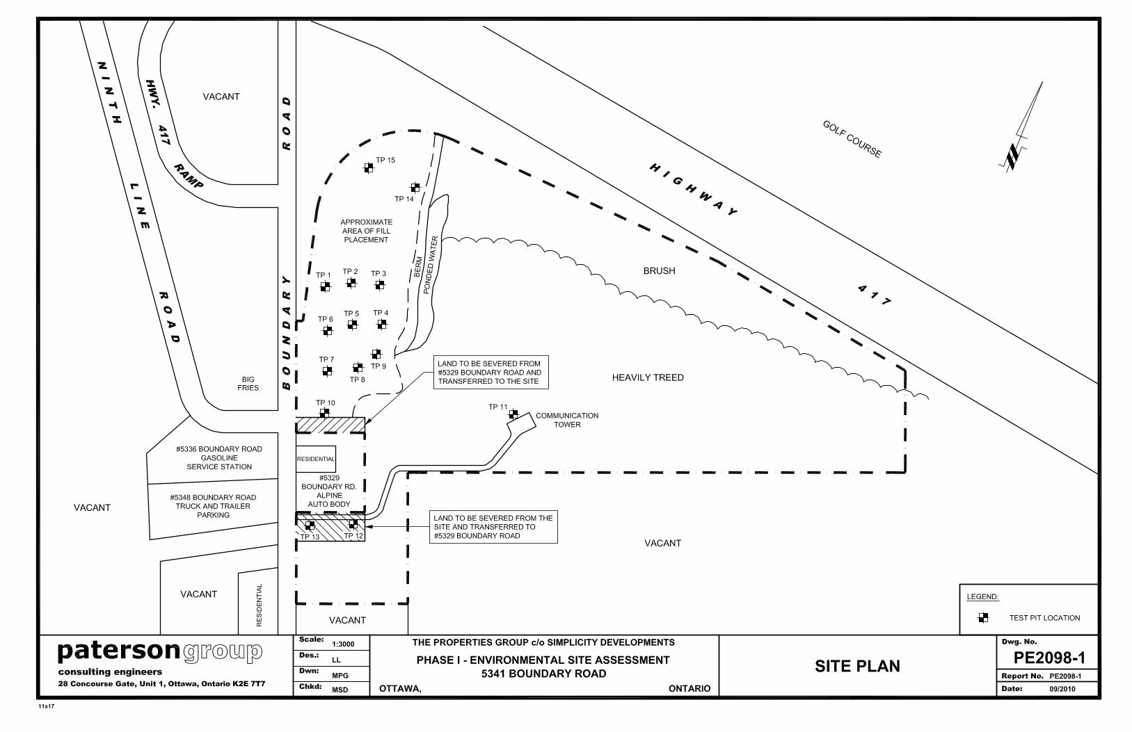
5.3 Adjacent Properties
Land use adjacent to the subject site was as follows:
‘ North - Vacant land followed by Highway 417 and Grey Hawk Golf Club;
‘ East - Vacant land followed by Highway 417;
‘ South - Residential dwelling, Alpine auto body and vacant land;
‘ West - Boundary Road followed by a gasoline service station, vacant land and
highway interchanges.
The current use of the property west of Boundary Road as a gasoline service station
and the property southwest of the site as an auto body have the potential to have
impacted the subject site. Land use adjacent to the subject site is illustrated on
Drawing No. PE2098-1 - Site Plan in Appendix 2.

patersonOttawa Kingston North Bay
Modified Phase I - Environmental Site Assessment5341 Boundary Road
Ottawa, Ontario
Report: PE2098-1September 27, 2010 Page 9
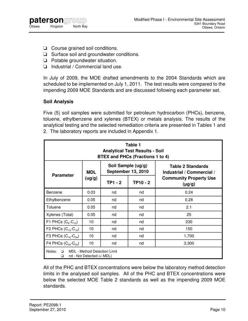
5.4 Subsurface Investigation
The subsurface investigation was conducted on September 13, 2010 and consisted of
the placement of 15 test pits on the subject property (TP1 to TP15). TP1 through TP9,
TP 14, and TP15 were placed to assess the fill material on the western portion of the
subject property. TP10 was placed to assess the service station west of Boundary
Road. TP12 and TP13 were placed to assess the body shop southwest of the site. TP
11 was placed closer to the centre of the site for site coverage and to determine the
native soil conditions. The test pit locations are illustrated on Drawing PE2098-1 - Site
Plan in Appendix 2. The test pits were completed with a rubber tired backhoe under
full time supervision by Paterson personnel.
The soil profile on the west portion of the site generally consists of fill underlain by
native silty clay. The fill generally consists of sandy silt with gravel, cobbles and
boulders. Trace amounts of asphalt and brick were observed in the test pits on the
west portion of the property. The soil profile on the remainder of the site consists of
topsoil over silty sand overlying native clay. Specific details of the soil profile at each
test hole location can be seen on the Soil Profile and Test Data sheets in Appendix 1.
Groundwater was observed to be infiltrating in to the test pits at depths ranging from
2.8 to 3.5 m below surface grade. No sheen or odours were observed in the
groundwater from any of the test holes.
The test pits were completed to depths ranging from 2.0 to 3.7 m below the existing
grade. A total of 29 soil samples were recovered from the test pits by means of grab
sampling. Upon recovery, all samples were immediately sealed in appropriate
containers to facilitate the preliminary screening procedure. The depths at which the
grab samples were obtained from the boreholes are shown as “ G ”, on the Soil Profile
and Test Data sheet in Appendix 1.
No unusual visual or olfactory observations were made with regard to the soil samples
obtained from the test pits, with the exception of TP1, which had a slight hydrocarbon
odour. The combustible vapour readings for most samples ranged from 0 to 15 ppm.
These readings are not considered to be representative of elevated concentrations of
volatile substances, such as gasoline.
The remediation standards for the subject property were obtained from Table 2 of the
document entitled “Soil, Ground Water and Sediment Standards for Use Under Part
XV.1 of the Environmental Protection Act”, prepared by the Ontario Ministry of
Environment (MOE), March 9, 2004. The MOE Table 2 Standards are based on the
following considerations:
patersonOttawa Kingston North Bay
Modified Phase I - Environmental Site Assessment5341 Boundary Road
Ottawa, Ontario
Report: PE2098-1September 27, 2010 Page 10
‘ Course grained soil conditions.
‘ Surface soil and groundwater conditions.
‘ Potable groundwater situation.
‘ Industrial / Commercial land use.
In July of 2009, the MOE drafted amendments to the 2004 Standards which are
scheduled to be implemented on July 1, 2011. The test results were compared to the
impending 2009 MOE Standards and are discussed following each parameter set.
Soil Analysis
Five (5) soil samples were submitted for petroleum hydrocarbon (PHCs), benzene,
toluene, ethylbenzene and xylenes (BTEX) or metals analysis. The results of the
analytical testing and the selected remediation criteria are presented in Tables 1 and
2. The laboratory reports are included in Appendix 1.
Table 1
Analytical Test Results - Soil
BTEX and PHCs (Fractions 1 to 4)
ParameterMDL
(ug/g)
Soil Sample (ug/g)
September 13, 2010Table 2 Standards
Industrial / Commercial /
Community Property Use
(µg/g)TP1 - 2 TP10 - 2
Benzene 0.03 nd nd 0.24
Ethylbenzene 0.05 nd nd 0.28
Toluene 0.05 nd nd 2.1
Xylenes (Total) 0.05 nd nd 25
F1 PHCs (C6-C10) 10 nd nd 230
F2 PHCs (C10-C16) 10 nd nd 150
F3 PHCs (C16-C34) 10 nd nd 1,700
F4 PHCs (C34-C50) 10 nd nd 3,300
Notes: ‘ MDL - Method Detection Limit
‘ nd - Not Detected (< MDL)
All of the PHC and BTEX concentrations were below the laboratory method detection
limits in the analysed soil samples. All of the PHC and BTEX concentrations were
below the selected MOE Table 2 standards as well as the impending 2009 MOE
standards.

patersonOttawa Kingston North Bay
Modified Phase I - Environmental Site Assessment5341 Boundary Road
Ottawa, Ontario
Report: PE2098-1September 27, 2010 Page 11
Table 2
Analytical Test Results - Soil
Metals
ParameterMDL
(ug/g)
Soil Samples - (ug/g)
September 13, 2010
MOE Table 2
Industrial / Commercial /
Community Property Use
(µg/g)TP3 - 1 TP9 - 1 TP15 - 1
Antimony 1 nd nd nd 40
Arsenic 1 6 3 2 40
Barium 10 114 156 139 1500
Beryllium 0.5 0.5 0.6 0.5 1.2
Boron (avail.) 0.5 nd nd nd 2.0
Cadmium 0.5 nd nd nd 12
Chromium 5 37 50 48 750
Chromium VI 0.4 nd nd nd 8.0
Cobalt 5 8 11 10 80
Copper 5 21 32 25 225
Lead 1 31 43 27 1000
Mercury 0.1 nd nd nd 10
Molybdenum 1 nd 1 nd 40
Nickel 5 19 31 27 150
Selenium 1 nd nd nd 10
Silver 0.3 nd nd nd 40
Thallium 1 nd nd nd 32
Vanadium 10 37 50 48 200
Zinc 20 59 82 64 600
Notes:
‘ MDL - Method Detection Limit; nd - Not Detected (< MDL)
‘ nv - No current MOE standard;
‘ Bold - exceed MOE Table 2 standards.
No metal parameters were detected in excess of the selected MOE Table 2 standards
for the soil samples analysed. The metals analytical results also met the impending
2009 MOE Table 2 standards.

patersonOttawa Kingston North Bay
Modified Phase I - Environmental Site Assessment5341 Boundary Road
Ottawa, Ontario
Report: PE2098-1September 27, 2010 Page 12
6.0 ASSESSMENT AND CONCLUSION
6.1 Assessment
Phase I - Environmental Site Assessment
The purpose of the Phase I-ESA was to research the past and current uses of the
subject property and neighbouring sites to identify environmental concerns with the
potential to impact the subject site.
Based on the site observations, potential environmental concerns were identified with
the presence of fill material on the subject property and with a gasoline service station
to the west of the site. A subsurface investigation was recommended and conducted
to address the above noted concern.
Subsurface Investigation
A subsurface investigation was conducted for the subject site to investigate the quality
of the fill material present on the subject property and to determine if the site had been
impacted by the gasoline service station to the west of Boundary Road.
Visual and/or olfactory observations did not indicate the presence of contamination or
deleterious fill material in any of the soil samples from the test pits. The Gastech
vapour readings were found to range from 0 to 15 ppm. These readings are
considered to be representative of background conditions.
Soil
Five (5) soil samples were submitted for petroleum hydrocarbon (PHCs), benzene,
toluene, ethylbenzene and xylenes (BTEX) or metals analysis. All of the test results
are in compliance with the selected MOE Table 2 standards. The analytical test results
also meet the impending 2009 MOE Standards.
6.2 Conclusion
The intent of the subsurface investigation has been to determine whether the subject
site has been significantly impacted by the presence of fill material on the subject
property or by the gasoline service station to the west of Boundary Road, further west
of the site. Based on our field observations and analytical test results, in our opinion,
the subject property has not been significantly impacted. In our opinion, no further
investigation is required at this time.

patersonOttawa Kingston North Bay
Modified Phase I - Environmental Site Assessment5341 Boundary Road
Ottawa, Ontario
Report: PE2098-1September 27, 2010 Page 13
7.0 STATEMENT OF LIMITATIONS
This Modified Phase I - Environmental Site Assessment (ESA) report has been
prepared in general accordance with the agreed scope-of-work and the requirements
of CSA Z768-01. The conclusions presented herein are based on information gathered
from a limited historical review along with the field inspection and testing program. The
findings of the Phase I - ESA are based on a review of readily available geological,
historical, and regulatory information and a cursory review made at the time of the field
assessment. The historical research relies on information supplied by others, such as
local, provincial, and federal agencies and was limited within the scope-of-work, time,
and budget of the project herein.
The client should be aware that any information pertaining to soils and all test hole logs
are furnished as a matter of general information only and test hole descriptions or logs
are not to be interpreted as descriptive of conditions at locations other than those
described by the test holes themselves.
This report was prepared for the sole use of The Properties Group and Simplicity
Developments. Permission and notification from the above noted parties and this firm
will be required to release this report to any other party.
Paterson Group Inc.
Luke Lopers, BASc.
Mark D’Arcy, P.Eng
Report Distribution:
‘ The Properties Group c/o Simplicity Developments (5 copies)
‘ Paterson Group Inc. (1 copy)

APPENDIX 1
SOIL PROFILE AND TEST DATA SHEETS
SYMBOLS AND TERMS
ANALYTICAL TEST RESULTS

RECOVERY
NUMBER
STRATA PLOT
13 Sep 10Backhoe
Constr
uction
Consulting
DEPTH(m)
ELEV.
HOLE NO.
SOIL PROFILE AND TEST DATA
Lower Explosive Limit %
Full Gas Resp. Methane Elim.
G
FILL: Brown silty sand withtrace clay, gravel and boulders
Brown SANDY SILT
Grey-brown SILTY CLAY
End of Test Pit
2.20
2.90
or RQD
GROUND SURFACE
3.60
G
2
1
20 40 60 80
100 200 300 400 500
Monitori
ng W
ell
Phase I - Environmental Site Assessment
TP 1
SOIL DESCRIPTION
5341 Boundary Road
BORINGS BY
28 Concourse Gate, Unit 1, Ottawa, ON K2E 7T7
Engineers
SAMPLE
(m)
DATE
DATUM
REMARKS
Gastech 1314 Rdg. (ppm)
FILE NO.
%
N VALUE
0
1
2
3
Pen. Resist. Blows/0.3m
50 mm Dia. Cone
PE2098
patersongroup
TYPE
Ottawa, Ontario

13 Sep 10Backhoe
Constr
uction
Consulting
DEPTH(m)
ELEV.(m)
RECOVERY
SOIL PROFILE AND TEST DATA
Lower Explosive Limit %
Full Gas Resp. Methane Elim.
FILL: Grey silty sand withclay, boulders
Brown SANDY SILT
- with clay by 2.8m depth
End of Test Pit
2.30
3.30
G
G
STRATA PLOT
2
NUMBER
GROUND SURFACE
HOLE NO.
20 40 60 80
or RQD
1
DATE
Monitori
ng W
ell
Phase I - Environmental Site Assessment
100 200 300 400 500
Engineers
28 Concourse Gate, Unit 1, Ottawa, ON K2E 7T7
BORINGS BY
5341 Boundary Road
TP 2
SOIL DESCRIPTION
SAMPLE
%
DATUM
REMARKS
Gastech 1314 Rdg. (ppm)
Ottawa, Ontario
N VALUE
FILE NO.
0
1
2
3
TYPE
50 mm Dia. Cone
Pen. Resist. Blows/0.3m
PE2098
patersongroup

STRATA PLOT
13 Sep 10Backhoe
Constr
uction
Consulting
DEPTH(m)
ELEV.
RECOVERY
or RQD
SOIL PROFILE AND TEST DATA
Lower Explosive Limit %
Full Gas Resp. Methane Elim.
FILL: Silty clay with topsoiland boulders
Grey SILTY CLAY
End of Test Pit
(GW L@ 3.5m depth)
2.20
3.70
G
G
NUMBER
2
GROUND SURFACE
HOLE NO.
20 40 60 80
1
(m)
Monitori
ng W
ell
Phase I - Environmental Site Assessment
100 200 300 400 500
Engineers
28 Concourse Gate, Unit 1, Ottawa, ON K2E 7T7
BORINGS BY
5341 Boundary Road
TP 3
SOIL DESCRIPTION
SAMPLE
%
DATE
DATUM
REMARKS
Gastech 1314 Rdg. (ppm)
N VALUE
FILE NO.
0
1
2
3
Ottawa, Ontario
50 mm Dia. Cone
Pen. Resist. Blows/0.3m
PE2098
patersongroup
TYPE

13 Sep 10Backhoe
Constr
uction
Consulting
DEPTH(m)
ELEV.(m)
RECOVERY
SOIL PROFILE AND TEST DATA
Lower Explosive Limit %
Full Gas Resp. Methane Elim.
FILL: Silty sand with organicsand boulders, trace concrete
Grey SANDY SILT, someclay
End of Test Pit
1.50
2.80
G
G
STRATA PLOT
2
NUMBER
GROUND SURFACE
HOLE NO.
20 40 60 80
or RQD
1
DATE
Monitori
ng W
ell
Phase I - Environmental Site Assessment
100 200 300 400 500
Engineers
28 Concourse Gate, Unit 1, Ottawa, ON K2E 7T7
BORINGS BY
5341 Boundary Road
TP 4
SOIL DESCRIPTION
SAMPLE
%
DATUM
REMARKS
Gastech 1314 Rdg. (ppm)
Ottawa, Ontario
N VALUE
FILE NO.
0
1
2
TYPE
50 mm Dia. Cone
Pen. Resist. Blows/0.3m
PE2098
patersongroup

13 Sep 10Backhoe
Constr
uction
Consulting
DEPTH(m)
ELEV.(m)
RECOVERY
SOIL PROFILE AND TEST DATA
Lower Explosive Limit %
Full Gas Resp. Methane Elim.
FILL: Grey silty clay withsand, trace boulders and bricks
Brown SILTY SAND, traceboulders
End of Test Pit
2.50
3.50
G
G
STRATA PLOT
2
NUMBER
GROUND SURFACE
HOLE NO.
20 40 60 80
or RQD
1
DATE
Monitori
ng W
ell
Phase I - Environmental Site Assessment
100 200 300 400 500
Engineers
28 Concourse Gate, Unit 1, Ottawa, ON K2E 7T7
BORINGS BY
5341 Boundary Road
TP 5
SOIL DESCRIPTION
SAMPLE
%
DATUM
REMARKS
Gastech 1314 Rdg. (ppm)
Ottawa, Ontario
N VALUE
FILE NO.
0
1
2
3
TYPE
50 mm Dia. Cone
Pen. Resist. Blows/0.3m
PE2098
patersongroup

STRATA PLOT
13 Sep 10Backhoe
Constr
uction
Consulting
DEPTH(m)
ELEV.
RECOVERY
or RQD
SOIL PROFILE AND TEST DATA
Lower Explosive Limit %
Full Gas Resp. Methane Elim.
FILL: Mixture of sandy silt,clay, boulders
SILTY SAND, trace boulders
End of Test Pit
(GWL @ 2.8m depth)
2.80
3.30
G
G
NUMBER
2
GROUND SURFACE
HOLE NO.
20 40 60 80
1
(m)
Monitori
ng W
ell
Phase I - Environmental Site Assessment
100 200 300 400 500
Engineers
28 Concourse Gate, Unit 1, Ottawa, ON K2E 7T7
BORINGS BY
5341 Boundary Road
TP 6
SOIL DESCRIPTION
SAMPLE
%
DATE
DATUM
REMARKS
Gastech 1314 Rdg. (ppm)
N VALUE
FILE NO.
0
1
2
3
Ottawa, Ontario
50 mm Dia. Cone
Pen. Resist. Blows/0.3m
PE2098
patersongroup
TYPE
RECOVERY
NUMBER
STRATA PLOT
13 Sep 10Backhoe
Constr
uction
Consulting
DEPTH(m)
ELEV.
HOLE NO.
SOIL PROFILE AND TEST DATA
Lower Explosive Limit %
Full Gas Resp. Methane Elim.
G
FILL: Sand with boulders,trace brick
FILL: Grey silty clay, traceasphalt, organics and boulders
Brown SAND
End of Test Pit
1.10
3.50
or RQD
GROUND SURFACE
3.70
G
2
1
20 40 60 80
100 200 300 400 500
Monitori
ng W
ell
Phase I - Environmental Site Assessment
TP 7
SOIL DESCRIPTION
5341 Boundary Road
BORINGS BY
28 Concourse Gate, Unit 1, Ottawa, ON K2E 7T7
Engineers
SAMPLE
(m)
DATE
DATUM
REMARKS
Gastech 1314 Rdg. (ppm)
FILE NO.
%
N VALUE
0
1
2
3
Pen. Resist. Blows/0.3m
50 mm Dia. Cone
PE2098
patersongroup
TYPE
Ottawa, Ontario

RECOVERY
NUMBER
STRATA PLOT
13 Sep 10Backhoe
Constr
uction
Consulting
DEPTH(m)
ELEV.
HOLE NO.
SOIL PROFILE AND TEST DATA
Lower Explosive Limit %
Full Gas Resp. Methane Elim.
G
FILL: Brown sandy silt, someboulders, brick and concrete
Brown SAND
Grey SILTY CLAY
End of Test Pit
2.00
2.40
or RQD
GROUND SURFACE
2.90
G
2
1
20 40 60 80
100 200 300 400 500
Monitori
ng W
ell
Phase I - Environmental Site Assessment
TP 8
SOIL DESCRIPTION
5341 Boundary Road
BORINGS BY
28 Concourse Gate, Unit 1, Ottawa, ON K2E 7T7
Engineers
SAMPLE
(m)
DATE
DATUM
REMARKS
Gastech 1314 Rdg. (ppm)
FILE NO.
%
N VALUE
0
1
2
Pen. Resist. Blows/0.3m
50 mm Dia. Cone
PE2098
patersongroup
TYPE
Ottawa, Ontario

RECOVERY
NUMBER
STRATA PLOT
13 Sep 10Backhoe
Constr
uction
Consulting
DEPTH(m)
ELEV.
HOLE NO.
SOIL PROFILE AND TEST DATA
Lower Explosive Limit %
Full Gas Resp. Methane Elim.
G
FILL: Silty sand, trace brickand boulders
Brown SILTY SAND
Grey SILTY CLAY
End of Test Pit
2.50
2.80
or RQD
GROUND SURFACE
3.10
G
2
1
20 40 60 80
100 200 300 400 500
Monitori
ng W
ell
Phase I - Environmental Site Assessment
TP 9
SOIL DESCRIPTION
5341 Boundary Road
BORINGS BY
28 Concourse Gate, Unit 1, Ottawa, ON K2E 7T7
Engineers
SAMPLE
(m)
DATE
DATUM
REMARKS
Gastech 1314 Rdg. (ppm)
FILE NO.
%
N VALUE
0
1
2
3
Pen. Resist. Blows/0.3m
50 mm Dia. Cone
PE2098
patersongroup
TYPE
Ottawa, Ontario

Full Gas Resp.
(m)ELEV.
Consulting
Lower Explosive Limit %
Constr
uction
Methane Elim.
(m)
DATUM
SOIL PROFILE AND TEST DATA
FILL: Brown sandy silt withorganics, boulders, brick andasphalt
Grey-brown SAND
Grey SILTY CLAY
End of Test Pit
1.60
2.00
DEPTH
REMARKS
GROUND SURFACE
HOLE NO.
20 40 60 80
or RQD
RECOVERY
NUMBER
STRATA PLOT
13 Sep 10Backhoe
2.50
DATE
Monitori
ng W
ell
Phase I - Environmental Site AssessmentEngineers
28 Concourse Gate, Unit 1, Ottawa, ON K2E 7T7
BORINGS BY
5341 Boundary Road
TP10
SOIL DESCRIPTION
SAMPLE
patersongroup
Gastech 1314 Rdg. (ppm)
%
TYPE
100 200 300 400 500
FILE NO.
Ottawa, Ontario
0
1
2
PE2098
N VALUE
50 mm Dia. Cone
Pen. Resist. Blows/0.3m

RECOVERY
NUMBER
STRATA PLOT
13 Sep 10Backhoe
Constr
uction
Consulting
DEPTH(m)
ELEV.
HOLE NO.
SOIL PROFILE AND TEST DATA
Lower Explosive Limit %
Full Gas Resp. Methane Elim.
G
TOPSOIL
Brown SILTY SAND
Grey SILTY CLAY
End of Test Pit
0.30
1.50
or RQD
GROUND SURFACE
2.10
G
2
1
20 40 60 80
100 200 300 400 500
Monitori
ng W
ell
Phase I - Environmental Site Assessment
TP11
SOIL DESCRIPTION
5341 Boundary Road
BORINGS BY
28 Concourse Gate, Unit 1, Ottawa, ON K2E 7T7
Engineers
SAMPLE
(m)
DATE
DATUM
REMARKS
Gastech 1314 Rdg. (ppm)
FILE NO.
%
N VALUE
0
1
2
Pen. Resist. Blows/0.3m
50 mm Dia. Cone
PE2098
patersongroup
TYPE
Ottawa, Ontario

Full Gas Resp.
DEPTH(m)
ELEV.
REMARKS
Lower Explosive Limit %
Backhoe
Methane Elim.
DATE
SOIL PROFILE AND TEST DATA
Water
Grey SILTY CLAY, TRACESAND
End of Test Pit
0.30
2.00
G 1
Consulting
Constr
uction
GROUND SURFACE
HOLE NO.
20 40 60 80
or RQD
RECOVERY
NUMBER
STRATA PLOT
13 Sep 10
DATUM
(m)
Monitori
ng W
ell
Phase I - Environmental Site AssessmentEngineers
28 Concourse Gate, Unit 1, Ottawa, ON K2E 7T7
BORINGS BY
5341 Boundary Road
TP12
SOIL DESCRIPTION
SAMPLE
patersongroup
Gastech 1314 Rdg. (ppm)
%
TYPE
100 200 300 400 500
FILE NO.
Ottawa, Ontario
0
1
2
PE2098
N VALUE
50 mm Dia. Cone
Pen. Resist. Blows/0.3m

Full Gas Resp.
DEPTH(m)
ELEV.
REMARKS
Lower Explosive Limit %
Backhoe
Methane Elim.
DATE
SOIL PROFILE AND TEST DATA
Water
Grey SILTY CLAY
End of Test Pit
0.30
2.00
G 1
Consulting
Constr
uction
GROUND SURFACE
HOLE NO.
20 40 60 80
or RQD
RECOVERY
NUMBER
STRATA PLOT
13 Sep 10
DATUM
(m)
Monitori
ng W
ell
Phase I - Environmental Site AssessmentEngineers
28 Concourse Gate, Unit 1, Ottawa, ON K2E 7T7
BORINGS BY
5341 Boundary Road
TP13
SOIL DESCRIPTION
SAMPLE
patersongroup
Gastech 1314 Rdg. (ppm)
%
TYPE
100 200 300 400 500
FILE NO.
Ottawa, Ontario
0
1
2
PE2098
N VALUE
50 mm Dia. Cone
Pen. Resist. Blows/0.3m

STRATA PLOT
(m)DEPTH
Consulting
Constr
uction
13 Sep 10
NUMBER
RECOVERY
or RQD
20 40 60 80
HOLE NO.
Backhoe
SOIL PROFILE AND TEST DATA
ELEV.
Lower Explosive Limit %
Full Gas Resp.
Brown SILTY SAND
1.60
2.50
Grey SILTY CLAY
G
FILL: Sitly clay, some shalefragments, trace sand, brickand organics
End of Test Pit
GROUND SURFACE
2.10
3
2
1
G
G
FILE NO.
Phase I - Environmental Site Assessment
Monitori
ng W
ell
Methane Elim.
100 200 300 400 500
TP14
SOIL DESCRIPTION
5341 Boundary Road
BORINGS BY
28 Concourse Gate, Unit 1, Ottawa, ON K2E 7T7
Engineers
SAMPLE
REMARKS
DATUM
DATE
(m)50 mm Dia. Cone
Gastech 1314 Rdg. (ppm)
0
1
2
%
N VALUE
Pen. Resist. Blows/0.3m
PE2098
patersongroup
TYPE
Ottawa, Ontario

Full Gas Resp.
(m)ELEV.
Consulting
Lower Explosive Limit %
Constr
uction
Methane Elim.
(m)
DATUM
SOIL PROFILE AND TEST DATA
FILL: Sandy silt, some clayand organics
Brown SILTY SAND
Red SILTY CLAY
End of Test Pit
1.80
2.20
DEPTH
REMARKS
GROUND SURFACE
HOLE NO.
20 40 60 80
or RQD
RECOVERY
NUMBER
STRATA PLOT
13 Sep 10Backhoe
2.80
DATE
Monitori
ng W
ell
Phase I - Environmental Site AssessmentEngineers
28 Concourse Gate, Unit 1, Ottawa, ON K2E 7T7
BORINGS BY
5341 Boundary Road
TP15
SOIL DESCRIPTION
SAMPLE
patersongroup
Gastech 1314 Rdg. (ppm)
%
TYPE
100 200 300 400 500
FILE NO.
Ottawa, Ontario
0
1
2
PE2098
N VALUE
50 mm Dia. Cone
Pen. Resist. Blows/0.3m

SYMBOLS AND TERMS
SOIL DESCRIPTION Behavioural properties, such as structure and strength, take precedence over particle gradation in
describing soils. Terminology describing soil structure are as follows:
Desiccated - having visible signs of weathering by oxidation of clay
minerals, shrinkage cracks, etc.
Fissured - having cracks, and hence a blocky structure.
Varved - composed of regular alternating layers of silt and clay.
Stratified - composed of alternating layers of different soil types, e.g. silt
and sand or silt and clay.
Well-Graded - Having wide range in grain sizes and substantial amounts of
all intermediate particle sizes (see Grain Size Distribution).
Uniformly-Graded - Predominantly of one grain size (see Grain Size Distribution).
The standard terminology to describe the strength of cohesionless soils is the relative density, usually
inferred from the results of the Standard Penetration Test (SPT) ‘N’ value. The SPT N value is the
number of blows of a 63.5 kg hammer, falling 760 mm, required to drive a 51 mm O.D. split spoon
sampler 300 mm into the soil after an initial penetration of 150 mm.
Relative Density ‘N’ Value Relative Density %
Very Loose <4 <15
Loose 4-10 15-35
Compact 10-30 35-65
Dense 30-50 65-85
Very Dense >50 >85
The standard terminology to describe the strength of cohesive soils is the consistency, which is based on
the undisturbed undrained shear strength as measured by the in situ or laboratory vane tests,
penetrometer tests, unconfined compression tests, or occasionally by Standard Penetration Tests.
Consistency Undrained Shear Strength (kPa) ‘N’ Value
Very Soft <12 <2
Soft 12-25 2-4
Firm 25-50 4-8
Stiff
Very Stiff
50-100
100-200
8-15
15-30
Hard >200 >30

SYMBOLS AND TERMS (continued)
SOIL DESCRIPTION (continued) Cohesive soils can also be classified according to their “sensitivity”. The sensitivity is the ratio between
the undisturbed undrained shear strength and the remoulded undrained shear strength of the soil.
Terminology used for describing soil strata based upon texture, or the proportion of individual particle
sizes present is provided on the Textural Soil Classification Chart at the end of this information package.
ROCK DESCRIPTION The structural description of the bedrock mass is based on the Rock Quality Designation (RQD).
The RQD classification is based on a modified core recovery percentage in which all pieces of sound core
over 100 mm long are counted as recovery. The smaller pieces are considered to be a result of closely-
spaced discontinuities (resulting from shearing, jointing, faulting, or weathering) in the rock mass and are
not counted. RQD is ideally determined from NXL size core. However, it can be used on smaller core
sizes, such as BX, if the bulk of the fractures caused by drilling stresses (called “mechanical breaks”) are
easily distinguishable from the normal in situ fractures.
RQD % ROCK QUALITY
90-100 Excellent, intact, very sound
75-90 Good, massive, moderately jointed or sound
50-75 Fair, blocky and seamy, fractured
25-50 Poor, shattered and very seamy or blocky, severely fractured
0-25 Very poor, crushed, very severely fractured
SAMPLE TYPES
SS - Split spoon sample (obtained in conjunction with the performing of the Standard
Penetration Test (SPT))
TW - Thin wall tube or Shelby tube
PS - Piston sample
AU - Auger sample or bulk sample
WS - Wash sample
RC - Rock core sample (Core bit size AXT, BXL, etc.). Rock core samples are
obtained with the use of standard diamond drilling bits.

SYMBOLS AND TERMS (continued)
GRAIN SIZE DISTRIBUTION
MC% - Natural moisture content or water content of sample, %
LL - Liquid Limit, % (water content above which soil behaves as a liquid)
PL - Plastic limit, % (water content above which soil behaves plastically)
PI - Plasticity index, % (difference between LL and PL)
Dxx - Grain size which xx% of the soil, by weight, is of finer grain sizes
These grain size descriptions are not used below 0.075 mm grain size
D10 - Grain size at which 10% of the soil is finer (effective grain size)
D60 - Grain size at which 60% of the soil is finer
Cc - Concavity coefficient = (D30)2 / (D10 x D60)
Cu - Uniformity coefficient = D60 / D10
Cc and Cu are used to assess the grading of sands and gravels:
Well-graded gravels have: 1 < Cc < 3 and Cu > 4
Well-graded sands have: 1 < Cc < 3 and Cu > 6
Sands and gravels not meeting the above requirements are poorly-graded or uniformly-graded.
Cc and Cu are not applicable for the description of soils with more than 10% silt and clay
(more than 10% finer than 0.075 mm or the #200 sieve)
CONSOLIDATION TEST
p’o - Present effective overburden pressure at sample depth
p’c - Preconsolidation pressure of (maximum past pressure on) sample
Ccr - Recompression index (in effect at pressures below p’c)
Cc - Compression index (in effect at pressures above p’c)
OC Ratio Overconsolidaton ratio = p’c / p’o
Void Ratio Initial sample void ratio = volume of voids / volume of solids
Wo - Initial water content (at start of consolidation test)
PERMEABILITY TEST
k - Coefficient of permeability or hydraulic conductivity is a measure of the ability of
water to flow through the sample. The value of k is measured at a specified unit
weight for (remoulded) cohesionless soil samples, because its value will vary
with the unit weight or density of the sample during the test.


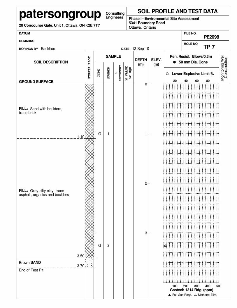
Order Date: 14-Sep-2010 Report Date: 20-Sep-2010
Fax: (613) 226-6344Phone: (613) 226-7381
Client PO: 9282
This Certificate of Analysis contains analytical data applicable to the following samples as submitted:
Custody: 77047
Attn: Luke LopersNepean, ON K2E 7T728 Concourse Gate, Unit 1
Certificate of Analysis
Paracel ID Client ID
Paterson Group Consulting Engineers
Order #: 1038072Project: PE2098
1038072-01 TP1-21038072-02 TP3-11038072-03 TP9-11038072-04 TP10-21038072-05 TP15-1
Approved By:Mark Foto, M.Sc. For Dale Robertson, BScLaboratory Director
Page 1 of 8
Any use of these results implies your agreement that our total liabilty in connection with this work, however arising shall be limited to the amount paid by you for this work, and that our employees or agents shall not under circumstances be liable to you in connection with this work
Certificate of AnalysisClient:
Report Date: 20-Sep-2010Order Date:14-Sep-2010
Client PO: 9282 Project Description: PE2098Paterson Group Consulting Engineers
Order #: 1038072
Analysis Summary TableAnalysis Method Reference/Description Extraction Date Analysis Date
MOE (HWE), EPA 200.8 - ICP-MS 15-Sep-10 15-Sep-10Boron, availableEPA 8260 - P&T GC-MS 14-Sep-10 19-Sep-10BTEXCWS Tier 1 - P&T GC-FID 14-Sep-10 19-Sep-10CCME PHC F1CWS Tier 1 - GC-FID, extraction 15-Sep-10 16-Sep-10CCME PHC F2 - F4MOE E3056 - Extraction, colourimetric 15-Sep-10 15-Sep-10Chromium, hexavalentEPA 7471A - CVAA, digestion 15-Sep-10 15-Sep-10MercuryEPA 6020 - Digestion - ICP-MS 15-Sep-10 15-Sep-10MetalsGravimetric, calculation 15-Sep-10 15-Sep-10Solids, %
Page 2 of 8

Certificate of AnalysisClient:
Report Date: 20-Sep-2010Order Date:14-Sep-2010
Client PO: 9282 Project Description: PE2098Paterson Group Consulting Engineers
Order #: 1038072
Client ID: TP1-2 TP3-1 TP9-1 TP10-2Sample Date: 13-Sep-1013-Sep-1013-Sep-1013-Sep-10
1038072-01 1038072-02 1038072-03 1038072-04Sample ID:MDL/Units Soil Soil Soil Soil
Physical Characteristics% Solids 83.391.185.483.30.1 % by Wt.
MetalsAntimony -<1<1-1 ug/g dry
Arsenic -36-1 ug/g dry
Barium -156114-10 ug/g dry
Beryllium -0.60.5-0.5 ug/g dry
Boron, available -<0.5<0.5-0.5 ug/g dry
Cadmium -<0.5<0.5-0.5 ug/g dry
Chromium -5037-5 ug/g dry
Chromium (VI) -<0.4<0.4-0.4 ug/g dry
Cobalt -118-1 ug/g dry
Copper -3221-5 ug/g dry
Lead -4331-1 ug/g dry
Mercury -<0.1<0.1-0.1 ug/g dry
Molybdenum -1<1-1 ug/g dry
Nickel -3119-5 ug/g dry
Selenium -<1<1-1 ug/g dry
Silver -<0.3<0.3-0.3 ug/g dry
Thallium -<1<1-1 ug/g dry
Vanadium -5037-10 ug/g dry
Zinc -8259-20 ug/g dry
VolatilesBenzene <0.03--<0.030.03 ug/g dry
Ethylbenzene <0.05--<0.050.05 ug/g dry
Toluene <0.05--<0.050.05 ug/g dry
m,p-Xylenes <0.05--<0.050.05 ug/g dry
o-Xylene <0.05--<0.050.05 ug/g dry
Xylenes, total <0.10--<0.100.10 ug/g dry
Toluene-d8 Surrogate 99.2% - - 99.5%HydrocarbonsF1 PHCs (C6-C10) <10--<1010 ug/g dry
F2 PHCs (C10-C16) <10--<1010 ug/g dry
F3 PHCs (C16-C34) <10--<1010 ug/g dry
F4 PHCs (C34-C50) <10--<1010 ug/g dry
Page 3 of 8

Certificate of AnalysisClient:
Report Date: 20-Sep-2010Order Date:14-Sep-2010
Client PO: 9282 Project Description: PE2098Paterson Group Consulting Engineers
Order #: 1038072
Client ID: TP15-1 - - -Sample Date: ---13-Sep-10
1038072-05 - - -Sample ID:MDL/Units Soil - - -
Physical Characteristics% Solids ---89.60.1 % by Wt.
MetalsAntimony ---<11 ug/g dry
Arsenic ---21 ug/g dry
Barium ---13910 ug/g dry
Beryllium ---0.50.5 ug/g dry
Boron, available ---<0.50.5 ug/g dry
Cadmium ---<0.50.5 ug/g dry
Chromium ---485 ug/g dry
Chromium (VI) ---<0.40.4 ug/g dry
Cobalt ---101 ug/g dry
Copper ---255 ug/g dry
Lead ---271 ug/g dry
Mercury ---<0.10.1 ug/g dry
Molybdenum ---<11 ug/g dry
Nickel ---275 ug/g dry
Selenium ---<11 ug/g dry
Silver ---<0.30.3 ug/g dry
Thallium ---<11 ug/g dry
Vanadium ---4810 ug/g dry
Zinc ---6420 ug/g dry
Page 4 of 8

Certificate of AnalysisClient:
Report Date: 20-Sep-2010Order Date:14-Sep-2010
Client PO: 9282 Project Description: PE2098Paterson Group Consulting Engineers
Order #: 1038072
Method Quality Control: Blank Analyte Result
ReportingLimit Units
SourceResult %REC
%RECLimit RPD
RPDLimit Notes
HydrocarbonsF1 PHCs (C6-C10) ND 10 ug/gF2 PHCs (C10-C16) ND 10 ug/gF3 PHCs (C16-C34) ND 10 ug/gF4 PHCs (C34-C50) ND 10 ug/g
MetalsAntimony ND 1 ug/gArsenic ND 1 ug/gBarium ND 10 ug/gBeryllium ND 0.5 ug/gBoron, available ND 0.5 ug/gCadmium ND 0.5 ug/gChromium (VI) ND 0.4 ug/gChromium ND 5 ug/gCobalt ND 1 ug/gCopper ND 5 ug/gLead ND 1 ug/gMercury ND 0.1 ug/gMolybdenum ND 1 ug/gNickel ND 5 ug/gSelenium ND 1 ug/gSilver ND 0.3 ug/gThallium ND 1 ug/gVanadium ND 10 ug/gZinc ND 20 ug/g
VolatilesBenzene ND 0.03 ug/gEthylbenzene ND 0.05 ug/gToluene ND 0.05 ug/gm,p-Xylenes ND 0.05 ug/go-Xylene ND 0.05 ug/gXylenes, total ND 0.10 ug/gSurrogate: Toluene-d8 7.92 99.0 76-118ug/g
Page 5 of 8

Certificate of AnalysisClient:
Report Date: 20-Sep-2010Order Date:14-Sep-2010
Client PO: 9282 Project Description: PE2098Paterson Group Consulting Engineers
Order #: 1038072
Method Quality Control: Duplicate Analyte Result
ReportingLimit Units
SourceResult %REC
%RECLimit RPD
RPDLimit Notes
HydrocarbonsF1 PHCs (C6-C10) ND 10 ug/g dry ND 32F2 PHCs (C10-C16) 3010 10 ug/g dry 1710 50 QR-0454.9F3 PHCs (C16-C34) 2110 10 ug/g dry 1220 50 QR-0453.2F4 PHCs (C34-C50) ND 10 ug/g dry ND 50
MetalsAntimony ND 1 ug/g dry ND 26Arsenic 1.1 1 ug/g dry 1.4 3526.4Barium 108 10 ug/g dry 115 345.8Beryllium ND 0.5 ug/g dry ND 25Boron, available ND 0.5 ug/g dry ND 35Cadmium 1.08 0.5 ug/g dry 1.15 335.9Chromium (VI) ND 0.4 ug/g dry ND 35Chromium 13.7 5 ug/g dry 14.2 323.2Cobalt 3.4 1 ug/g dry 3.4 321.9Copper 26.2 5 ug/g dry 27.0 322.9Lead 97.3 1 ug/g dry 99.9 442.6Mercury 0.148 0.1 ug/g dry 0.139 356.3Molybdenum 1.2 1 ug/g dry ND 29 QR-01Nickel 8.5 5 ug/g dry 8.8 293.1Selenium ND 1 ug/g dry 1.0 28 QR-01200.0Silver ND 0.3 ug/g dry ND 28Thallium ND 1 ug/g dry ND 27Vanadium 14.1 10 ug/g dry 14.6 273.2Zinc 474 20 ug/g dry 486 272.4
Physical Characteristics% Solids 100 0.1 % by Wt. 89.5 2511.1
VolatilesBenzene ND 0.03 ug/g dry ND 50Ethylbenzene ND 0.05 ug/g dry ND 34Toluene ND 0.05 ug/g dry ND 32m,p-Xylenes ND 0.05 ug/g dry ND 35o-Xylene ND 0.05 ug/g dry ND 50Surrogate: Toluene-d8 10.1 ug/g dry 99.9 76-118ND
Page 6 of 8

Certificate of AnalysisClient:
Report Date: 20-Sep-2010Order Date:14-Sep-2010
Client PO: 9282 Project Description: PE2098Paterson Group Consulting Engineers
Order #: 1038072
Method Quality Control: Spike Analyte Result
ReportingLimit Units
SourceResult %REC
%RECLimit RPD
RPDLimit Notes
HydrocarbonsF1 PHCs (C6-C10) 95 ND 95.1 80-12010 ug/gF2 PHCs (C10-C16) 66 ND 82.4 61-12910 ug/gF3 PHCs (C16-C34) 165 ND 82.7 61-12910 ug/gF4 PHCs (C34-C50) 120 ND 100 61-12910 ug/g
MetalsAntimony 54.5 ND 109 80-120ug/LArsenic 47.8 ND 95.6 80-120ug/LBarium 49.0 ND 97.9 80-120ug/LBeryllium 42.8 ND 85.6 80-120ug/LBoron, available 4.45 ND 89.0 70-1220.5 ug/gCadmium 45.5 ND 90.9 80-120ug/LChromium (VI) 0.2 ND 98.0 89-123mg/LChromium 47.7 ND 95.4 80-120ug/LCobalt 46.8 ND 93.6 80-120ug/LCopper 47.3 ND 94.5 80-120ug/LLead 50.5 ND 101 80-120ug/LMercury 1.60 ND 107 72-1280.1 ug/gMolybdenum 46.2 ND 92.3 80-120ug/LNickel 46.0 ND 92.0 80-120ug/LSelenium 46.6 ND 93.1 80-120ug/LSilver 45.2 ND 90.4 80-120ug/LThallium 58.7 ND 117 80-120ug/LVanadium 46.9 ND 93.8 80-120ug/LZinc 43.1 ND 86.2 80-120ug/L
VolatilesBenzene 0.607 ND 65.0 55-1410.03 ug/gEthylbenzene 2.12 ND 95.5 61-1390.05 ug/gToluene 8.26 ND 76.5 54-1360.05 ug/gm,p-Xylenes 6.11 ND 90.8 61-1390.05 ug/go-Xylene 2.74 ND 102 60-1420.05 ug/gSurrogate: Toluene-d8 7.84 98.0 76-118ug/g
Page 7 of 8

Certificate of AnalysisClient:
Report Date: 20-Sep-2010Order Date:14-Sep-2010
Client PO: 9282 Project Description: PE2098Paterson Group Consulting Engineers
Order #: 1038072
Sample and QC Qualifiers Notes2- QR-01 : Duplicate RPD is high, however, the sample result is less than 10x the MDL.
3- QR-04 : Duplicate results exceeds RPD limits due to non-homogeneous matrix.
Sample Data RevisionsNone
Work Order Revisions/Comments:None
Other Report Notes:
MDL: Method Detection Limitn/a: not applicable
Source Result: Data used as source for matrix and duplicate samples%REC: Percent recovery.RPD: Relative percent difference.Soil results are reported on a dry weight basis when the units are denoted with 'dry'.Where %Solids is reported, moisture loss includes the loss of volatile hydrocarbons.CCME PHC additional information:
- The method for the analysis of PHCs complies with the Reference Method for the CWS PHC and is validated for use in the laboratory. All prescribed quality criteria identified in the method has been met.- F1 range corrected for BTEX.- F2 to F3 ranges corrected for appropriate PAHs where available.
- In the case where F4 and F4G are both reported, the greater of the two results is to be used for comparison to CWS PHC criteria.- The gravimetric heavy hydrocarbons (F4G) are not to be added to C6 to C50 hydrocarbons.
Page 8 of 8


APPENDIX 2
AERIAL PHOTOGRAPHS
FIGURE 1 - KEY PLAN
DRAWING PE2098-1 - TEST HOLE LOCATION PLAN

AERIAL PHOTOGRAPH
1945
SITE

AERIAL PHOTOGRAPH
1969
SITE

AERIAL PHOTOGRAPH
1975
SITE

AERIAL PHOTOGRAPH
1986
SITE

AERIAL PHOTOGRAPH
1993
SITE

SITE
FIGURE 1
KEY PLAN
SITE